Embed Size (px)
Citation preview
The Yellowbush Creek Camp Site (33Ms29), A Late Archaic Maple Creek
phase site in Southern Ohio
By: Craig S. Keener, Kevin Nye, and Joshua Niedermier
Professional Archaeological Services Team
Introduction
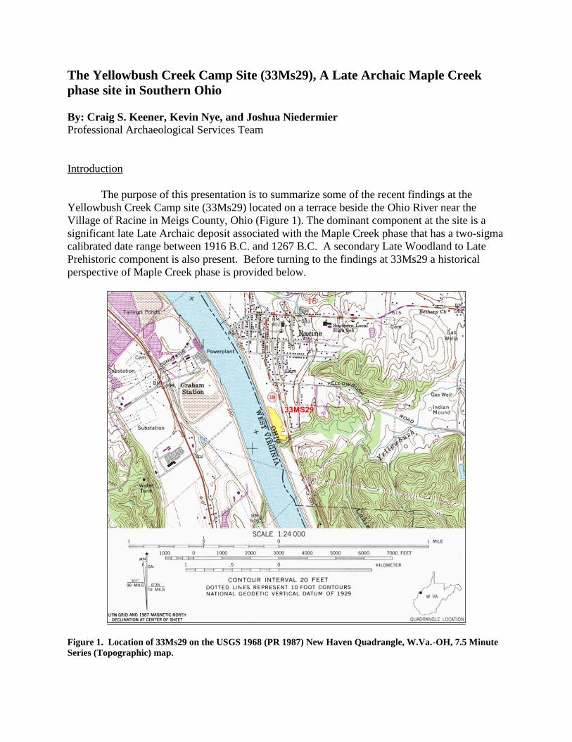
The purpose of this presentation is to summarize some of the recent findings at the
Yellowbush Creek Camp site (33Ms29) located on a terrace beside the Ohio River near the
Village of Racine in Meigs County, Ohio (Figure 1). The dominant component at the site is a
significant late Late Archaic deposit associated with the Maple Creek phase that has a two-sigma
calibrated date range between 1916 B.C. and 1267 B.C. A secondary Late Woodland to Late
Prehistoric component is also present. Before turning to the findings at 33Ms29 a historical
perspective of Maple Creek phase is provided below.
Figure 1. Location of 33Ms29 on the USGS 1968 (PR 1987) New Haven Quadrangle, W.Va.-OH, 7.5 Minute
Series (Topographic) map.
2
The Maple Creek Phase
The Maple Creek phase, centered in southwest Ohio, was first defined by Vickery (1976,
1980) as a regional manifestation of Winters’s (1969) Riverton Culture. Winters’s model is
based on Late Archaic settlement patterns along the Wabash Valley of east central Illinois that
date between 1590 B.C. and 1160 B.C. Using radiocarbon dates from the Maple Creek site
(33Ct52) and temporally diagnostic artifacts such as Merom-Trimble points Vickery placed the
date range of the Maple Creek phase between 1700 B.C. and 1000 B.C. In addition to the
Merom-Trimble point styles, McWhinney points were also common. A chipped flint microtool
industry dominated by drills, gravers, and microperforators, not on true blades, represents the
flint assemblages of this phase. Manos are also present, but other ground stones are more
uncommon, although celts are more frequent that axes. Atlatl parts and bell pestles are absent or
very rare (Vickery 1980: 28).
Vickery (1980, 2008) suggests that the Maple Creek settlement system is based on large
base camps in riverine settings and smaller camps (ancillary camps) in the surrounding uplands.
The base camp makes up the bulk of the excavated information associated with this phase, based
on findings at the Maple Creek site and Logan (33Ct30). These large sized camps, which
typically contain middens, burials, structure/habitation areas, and numerous pit features, are
situated along the valley floors of major drainages. Vickery (1980) has suggested two types of
base camps a “regional” and “local” type, both of which are located along the valley floors of
major rivers. The main difference between these two is size as the regional base camp represents
an aggregation of many bands coming together for a semi-permanent (six months or longer)
camp. The local base camp is associated with a single band, is occupied on a seasonal basis, and
is likely of shorter duration than the regional type (Vickery 1980:54-55; 2008:23). Ancillary
sites were not extensively studied, but Vickery suggests that these sites may represent “stations”
that involved a variety of extractive activities that were conducted so as to support the primary
base camps (Vickery 2008:23).
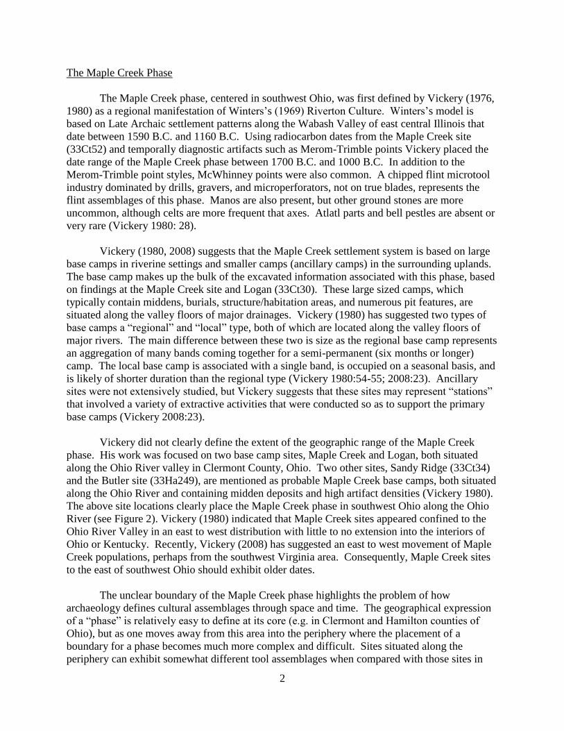
Vickery did not clearly define the extent of the geographic range of the Maple Creek
phase. His work was focused on two base camp sites, Maple Creek and Logan, both situated
along the Ohio River valley in Clermont County, Ohio. Two other sites, Sandy Ridge (33Ct34)
and the Butler site (33Ha249), are mentioned as probable Maple Creek base camps, both situated
along the Ohio River and containing midden deposits and high artifact densities (Vickery 1980).
The above site locations clearly place the Maple Creek phase in southwest Ohio along the Ohio
River (see Figure 2). Vickery (1980) indicated that Maple Creek sites appeared confined to the
Ohio River Valley in an east to west distribution with little to no extension into the interiors of
Ohio or Kentucky. Recently, Vickery (2008) has suggested an east to west movement of Maple
Creek populations, perhaps from the southwest Virginia area. Consequently, Maple Creek sites
to the east of southwest Ohio should exhibit older dates.
The unclear boundary of the Maple Creek phase highlights the problem of how
archaeology defines cultural assemblages through space and time. The geographical expression
of a “phase” is relatively easy to define at its core (e.g. in Clermont and Hamilton counties of
Ohio), but as one moves away from this area into the periphery where the placement of a
boundary for a phase becomes much more complex and difficult. Sites situated along the
periphery can exhibit somewhat different tool assemblages when compared with those sites in
3
the core due to overlap and/or direct exchange with adjacent neighboring cultural phases. The
lack of any defined borders for the Maple Creek phase, which was directly related to the limited
amount of Maple Creek sites identified and excavated by 1980, has resulted in the continued
revision of the regional expression of this phase over the past 30 years as new data has been
discovered.
Figure 2. View of significant Maple Creek phase and late Late Archaic sites in southern Ohio and in
northeastern Kentucky.
In the mid-1980s to early1990s additional Maple Creek sites were found in Kentucky,
and which were situated further to the west in Boone and Carroll counties (e.g. the Glacken site
[15Be272][Boisvert 1986] and Hayes site [15Cl67][Hall 2005]), into the interior south of the
Ohio River Valley (e.g. Pine Crest Shelter [15Le70][O’Steen et al. 1991], Skidmore Shelter
[15Po17][Cowan 1976]), and to the east, most notably with the intensive excavations at the
Grayson site (15Cr73) in Carter County, Kentucky (Ledbetter and O’Steen 1992; Clay 2009).
Grayson (see Figure 2), one of the better excavated sites, is a multi-component Late Archaic
(Maple Creek phase), Terminal Archaic (Cogswell phase), and late Late Woodland site. The
Maple Creek component contained a midden, numerous features, which included many large
storage pits, hearths, earth ovens, roasting pits, post molds, a cache, and two burials. Two semi-
circular structures were identified, one of which contained an interior hearth. A total of 33
Merom-Trimble points, and one McWhinney point were recovered. Radiocarbon dates from two
features containing Merom-Trimble points yielded uncalibrated dates of 1611 B.C. +/- 86 years,
and 1460 B.C. +/- 142 years (Ledbetter and O’Steen 1992). Grayson was interpreted as a small
base camp, occupied during the fall and winter, which was re-used multiple times. The findings
at Grayson and Glacken (also interpreted as a base camp) challenge the perception that large
Maple Creek base camps were confined to the Ohio River, as both of these sites are located
along upland tributaries of the Ohio River (Boisvert 1986; Ledbetter and O’Steen 1992).
4
In Ohio the Houpt site (33Bu477) was intensively excavated in 1994 and was interpreted
as a small upland encampment associated with the Maple Creek phase (Duerksen and Doershuk
1994, 1998). Two features containing Merom-Trimble style points were dated to 1520 B.C. and
1150 B.C. (calibrated). Duerksen and Doershuk interpreted the site as a small short term
extraction camp focused on hunting activities which would fit the definition of Vickery’s
“ancillary” camp. Located on a hummock along the Mill Creek valley, a secondary tributary of
the Ohio River, the site is important as it demonstrates use of the interior during the Maple Creek
phase. Small Maple Creek phase-related ancillary sites in the uplands/interior, away from the
Ohio River, are still understudied. Duerksen and Doershuk’s (1998) work represents the lone
publication on this particular site type in Ohio.
In the 2000s new information would be obtained further to the east on the Ohio side of
the Ohio River at Davisson Farm (33Le619), 33Le680, and Yellowbush Creek (33Ms29) (Figure
1) (Brown 2009; Keener 2003; Keener and Pecora 2003; Keener et al. 2010; Purtill 2002, 2008,
2009; Purtill and Norr 2001). All three sites are located along the valley floor of the Ohio River
and represent late Late Archaic occupations and potential Maple Creek phase sites. At Davisson
Farm, interpreted as a base camp, most of the dated features (a total of five) had two sigma
calibrated ranges that fell between 1900 B.C. to 1140 B.C. (Purtill 2008). Site 33Le680, was
interpreted as a series of short term field camp occupations which contained six dated features
with two sigma calibrated ranges that fell between 1690 to 900 B.C. (Purtill 2002; Keener et al.
2010). These two sites, while containing numerous features, did not have middens, burials or
formal structures, although some evidence of auxiliary structures, such as wind breaks, and the
possible presence of lean-to structures were evident.
While Merom-Trimble points were found at both Davisson Farm and 33Le680, they were
found in small numbers. At Davisson Farm four Merom-Trimble points were recovered in
contrast to 21 Brewerton points. The low percentage of Merom-Trimble points at the site
appears to be one of the key reasons why Purtill (2008) does not place the site into Maple Creek,
but rather chooses not to ascribe the site to any particular phase. Site 33Le680 also has a limited
Merom-Trimble assemblage with only one point recovered, but overall there were few diagnostic
projectile points obtained at the site. Three Brewertons and one Buck Creek Barbed represent
the extent of the Late Archaic point assemblage. A flint micro-tool assemblage, however, is
present at the site with modified flakes, scrapers, and drill being manufactured from small flint
cobbles acquired from the nearby Ohio River. Only a limited ground stone tool assemblage was
recovered with celts more abundant than stone axes. Interpreted as a field camp, it was
suggested that the site represented a short term hunting site that was used multiple times (Keener
et al. 2010). As a field camp, 33Le680 probably best equates with Vickery’s (1980) description
of an “ancillary” site, a site that would be a subsidiary to an associated base camp in the local
region, such as Grayson. Contrary to Vickery’s suggestion (1980, 2008) that ancillary sites are
located in the uplands, 33Le680 is situated in the bottomland of the Ohio River. If small hunting
and gathering camps are radiating outward from established base camps then their location in the
broad resource rich bottomlands along the Ohio River should be just as common.
The findings prior and during the excavations at 33Ms29 have extended the Maple Creek
phase to the west (Carroll County, Kentucky) and east (to the confluence of the Big Sandy and
Ohio Rivers), and into the interior away from the Ohio River valley. Site 33Ms29 provides

5
strong evidence that the Maple Creek phase extends further to the east along the Ohio River, as it
lies approximately 80 km (50 mi) upstream from the Big Sandy confluence. The following
summary details the findings at 33Ms29 and how it fits into the existing Maple Creek settlement
model.
Investigation History at 33Ms29
Site 33Ms29 was first identified by Claude White in 1978 during a Phase I Cultural
Resource Management (CRM) survey for a nearby sewer line in the Village of Racine based on
local informant testimony and the collection of a small amount of flint debitage (n=6) from the
surface (White 1978). The site was located outside White’s survey area and, consequently, was
not rigorously tested nor evaluated. It was considered small in size and limited to the southern
end of the field it was located in, near the confluence of Yellowbush Creek and the Ohio River.
The Ohio Department of Natural Resources (ODNR) obtained ownership of the field containing
33Ms29 in 1999 in order to develop a boat ramp and parking lot area to access the Ohio River.
To fulfill Section 106 requirements, a CRM survey was conducted on the 8.9 ha (22 acre) parcel
of land. The Phase I survey (Keener 2003) was performed by Professional Archaeological
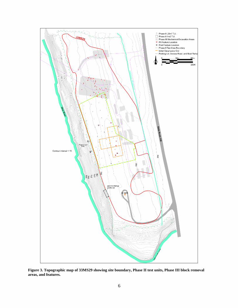
Services Team (PAST) in 2003. Testing found that 33Ms29 was much larger and extensive than
what had previously been recorded, discovering that the site stretched the length of the field and
roughly measured 345m (1,132ft) long by 97.5m (320ft) wide with a total area of 26,325m2
(283,369ft2) (Figure 3). Testing recovered a large number of prehistoric artifacts (n=510) that
included a small assemblage of plain and cordmarked pottery sherds (n=22). Test unit
excavations and bucket auger sampling found artifact deposits extending 1 m below surface and
a possible feature location (Keener 2003). The site was considered potentially eligible to the
National Register of Historic Places (NRHP) and was recommended for further work.
Due to the large size of the site, there was little ODNR could do to avoid impacting it
with the proposed boat ramp; however, they wanted to continue with the project and to ascertain
where the main deposits of the site were located. The Phase II assessment, consequently, had
two goals: 1) to determine if the site was eligible, and 2) to better understand the parameters of
the deposit (Keener and Pecora 2003). Geophysical survey and hand testing at first were focused
on the boat ramp and access area which was originally proposed to be placed in the central
portion of the field, and which also represented the center of the site (see delineated area in
Figure 3). Test units (1m2 and .25m
2 in size) were positioned at probable cultural anomalies and
within high artifact density locations. Hand excavations quickly found significant deposits that
included 14 prehistoric features and the presence of a 50 cm (19.6in) thick midden that was
evident between 30 cm to 80 cm (11.8in to 31.5in) below surface. The midden contained FCR
with small amounts of fragmentary burned bone, debitage, and pottery. Pit features and posts
were found throughout the midden matrix at different levels. Besides the features identified by
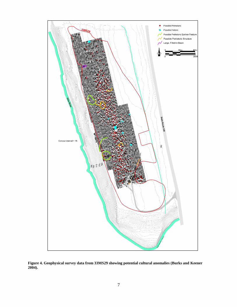
the hand testing, the initial geophysical survey indicated numerous other potential cultural
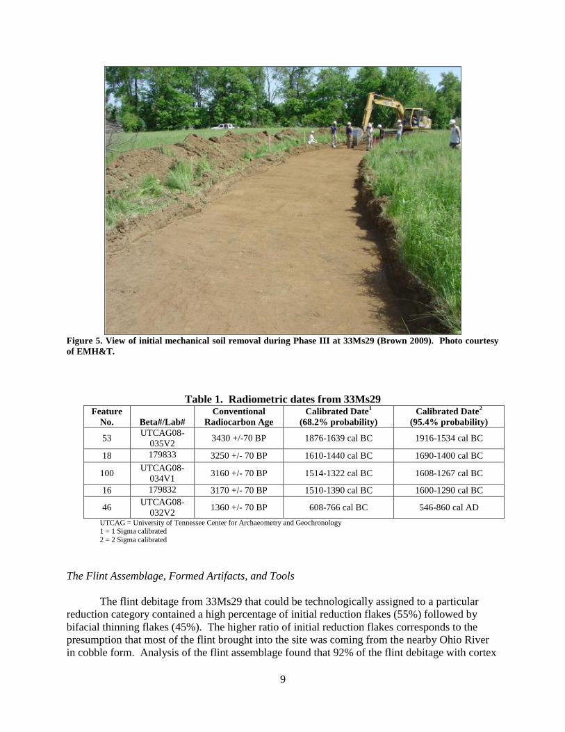
anomalies including possible post formations indicative of structures. Radiocarbon dates from
two features (see Table 1) which contained pottery, yielded two-sigma calibrated date ranges
6
Figure 3. Topographic map of 33MS29 showing site boundary, Phase II test units, Phase III block removal
areas, and features.
7
Figure 4. Geophysical survey data from 33MS29 showing potential cultural anomalies (Burks and Keener
2004).
8
between 1690 to 1290 B.C. indicating a late Late Archaic association (Keener and Pecora 2003).
Numerous tools and diagnostic artifacts were recovered that included six Merom style points,
four found in midden context. The site was determined eligible to the NRHP.
With particularly dense deposits in the center of the site ODNR decided to expand
geophysical testing to cover most of the remaining portions of the site to help assist possible
revisions to the construction plans. In all a total of 20,600 m2 (221,744ft
2) of the site area was
examined with a gradiometer. Figure 4 shows the results of this survey, which found extensive
evidence of potential cultural anomalies. A total of 245 anomalies, shown in red on Figure 4,
were considered possible prehistoric pits, while four probable post mold cluster areas suggested
the potential for structures (Burks and Keener 2004). Numerous other cultural anomalies were
not marked. The data indicated extensive occupation, with anomalies (presumed features)
overlapping anomalies along the landform, particularly in the central and southern portions of
33Ms29. Based on this information ODNR decided to move the boat ramp and access area to the
northern end of the site where there were significantly fewer features. In addition to the lower
number of features it was felt the midden deposit at the northern end of the site was less
substantial. Parking was positioned in the eastern half of the field in a swale and along the
eastern edge of the site where artifact densities were low. The final plans for the boat ramp
project area are shown on Figure 3.
Obviously, most Phase III archaeological investigations where a site will be fully
impacted by a project would target the core area of a site. But since ODNR was able to change
their construction plans and avoid the heart of the site, only the peripheral areas of 33Ms29 were
investigated. The central and southern portions of the site were to be left untouched and
preserved. Consequently, the midden area was not revisited and only the limited amount of
testing conducted in the Phase II and geophysical survey of this area serve as a representative
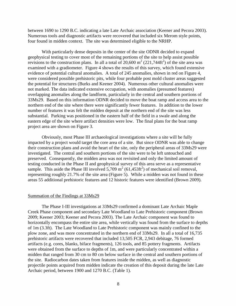
sample. This aside the Phase III involved 5,709 m2 (61,453ft
2) of mechanical soil removal,
representing roughly 21.7% of the site area (Figure 5). While a midden was not found in these
areas 55 additional prehistoric features and 12 historic features were identified (Brown 2009).
Summation of the Findings at 33Ms29
The Phase I-III investigations at 33Ms29 confirmed a dominant Late Archaic Maple
Creek Phase component and secondary Late Woodland to Late Prehistoric component (Brown
2009; Keener 2003; Keener and Pecora 2003). The Late Archaic component was found to
horizontally encompass the entire site area, while vertically was found from the surface to depths
of 1m (3.3ft). The Late Woodland to Late Prehistoric component was mainly confined to the
plow zone, and was more concentrated in the northern end of 33Ms29. In all a total of 16,735
prehistoric artifacts were recovered that included 13,505 FCR, 2,943 debitage, 76 formed
artifacts (e.g. cores, blanks, biface fragments), 126 tools, and 85 pottery fragments. Artifacts
were obtained from the surface to depths of 1m, and were particularly concentrated within a
midden that ranged from 30 cm to 80 cm below surface in the central and southern portions of
the site. Radiocarbon dates taken from features inside the midden, as well as diagnostic
projectile points acquired from midden indicate the creation of this deposit during the late Late
Archaic period, between 1900 and 1270 B.C. (Table 1).
9
Figure 5. View of initial mechanical soil removal during Phase III at 33Ms29 (Brown 2009). Photo courtesy
of EMH&T.
Table 1. Radiometric dates from 33Ms29 Feature
No.
Beta#/Lab#
Conventional
Radiocarbon Age
Calibrated Date1
(68.2% probability)
Calibrated Date2
(95.4% probability)
53 UTCAG08-
035V2 3430 +/-70 BP 1876-1639 cal BC 1916-1534 cal BC
18 179833 3250 +/- 70 BP 1610-1440 cal BC 1690-1400 cal BC
100 UTCAG08-
034V1 3160 +/- 70 BP 1514-1322 cal BC 1608-1267 cal BC
16 179832 3170 +/- 70 BP 1510-1390 cal BC 1600-1290 cal BC
46 UTCAG08-
032V2 1360 +/- 70 BP 608-766 cal BC 546-860 cal AD
UTCAG = University of Tennessee Center for Archaeometry and Geochronology 1 = 1 Sigma calibrated
2 = 2 Sigma calibrated
The Flint Assemblage, Formed Artifacts, and Tools
The flint debitage from 33Ms29 that could be technologically assigned to a particular
reduction category contained a high percentage of initial reduction flakes (55%) followed by
bifacial thinning flakes (45%). The higher ratio of initial reduction flakes corresponds to the
presumption that most of the flint brought into the site was coming from the nearby Ohio River
in cobble form. Analysis of the flint assemblage found that 92% of the flint debitage with cortex
10
exhibited a water worn surface indicative of a cobble taken from a stream or riverbed. FCR
recovered form the site also showed a similar result with those pieces containing the original
external surface exhibiting a water worn cobble form (Keener 2003; Keener and Pecora 2003).
The bifacial thinning flake assemblage and extensive amount of broken flake and shatter debris
(n=1,391) indicate that flint cobbles underwent all stages of reduction with the goal being the
production of tools. Non-tool formed artifacts were limited to cores (n=26) and biface fragments
(n=50). The biface fragments represented non-descript pieces that could not be assigned to a
particular form. No blanks or pre-forms were recovered suggesting a focus on making tools for
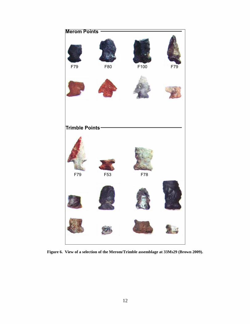
immediate use. Brown (2009) noted that the Merom-Trimble points appeared to be made from
flakes, most likely large interior flakes. A flake to point progression that bypasses the blank/pre-
form stage may be the result of utilization of small river cobbles whether by choice or necessity.
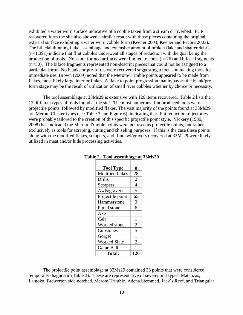
The tool assemblage at 33Ms29 is extensive with 126 items recovered. Table 2 lists the
13 different types of tools found at the site. The most numerous flint produced tools were
projectile points, followed by modified flakes. The vast majority of the points found at 33Ms29
are Merom Cluster types (see Table 3 and Figure 6), indicating that flint reduction trajectories
were probably tailored to the creation of this specific projectile point style. Vickery (1980,
2008) has indicated the Merom-Trimble points were not used as projectile points, but rather
exclusively as tools for scraping, cutting and chiseling purposes. If this is the case these points
along with the modified flakes, scrapers, and flint awl/gravers recovered at 33Ms29 were likely
utilized in meat and/or hide processing activities.
Table 2. Tool assemblage at 33Ms29
Tool Type
n
Modified flakes 28
Drills 2
Scrapers 4
Awls/gravers 5
Projectile point 65
Hammerstone 3
Pitted stone 6
Axe 1
Celt 1
Worked stone 2
Cupstones 5
Gorget 1
Worked Slate 2
Game Ball 1
Total: 126
The projectile point assemblage at 33Ms29 contained 33 points that were considered
temporally diagnostic (Table 3). These are representative of seven point types: Matanzas,
Lamoka, Brewerton side notched, Merom/Trimble, Adena Stemmed, Jack’s Reef, and Triangular

11
cluster. The majority of these points (n= 27) are Late Archaic in age and of these are dominated
by Merom Cluster types (n= 24, 72.7% of the point assemblage). Figure 6 shows a
representative sample of the Merom assemblage at 33Ms29. Merom Cluster points were
recovered in six feature contexts, two of which had late Late Archaic radiocarbon dates (Table
1). Vickery (1980, 2008) has noted that Meroms, along with McWhinney points, are the
defining point styles for the Maple Creek phase. No McWhinney points have been recovered at
33Ms29. McWhinney points also tend to be lacking or absent at other eastern Maple Creek sites
(e.g. 33Le680 and Grayson) (Keener et al. 2010; Ledbetter and O’Steen 1992).
Table 3. Projectile point list, typology and age range for 33Ms29
Description n Temporal Period Time Range*
Matanzas Cluster 1 Late Archaic 3,700 B.C. to 2,000 B.C.
Lamoka 1 Late Archaic 3,500 B.C. to 2,500 B.C.
Brewerton Side
Notched
1 Late Archaic 2,980 B.C. to 1,723 B.C.
Merom Cluster 24 Late Archaic: Riverton Culture 1,600 B.C. to 800 B.C.
Adena Stemmed 1 Early Woodland 800 B.C. to 300 B.C.
Jack’s Reef 1 Late Woodland A.D. 500 to A.D. 1,000
Triangular Cluster 4 Late Woodland to Late
Prehistoric
A.D. 800 to Historic
*Justice (1987)
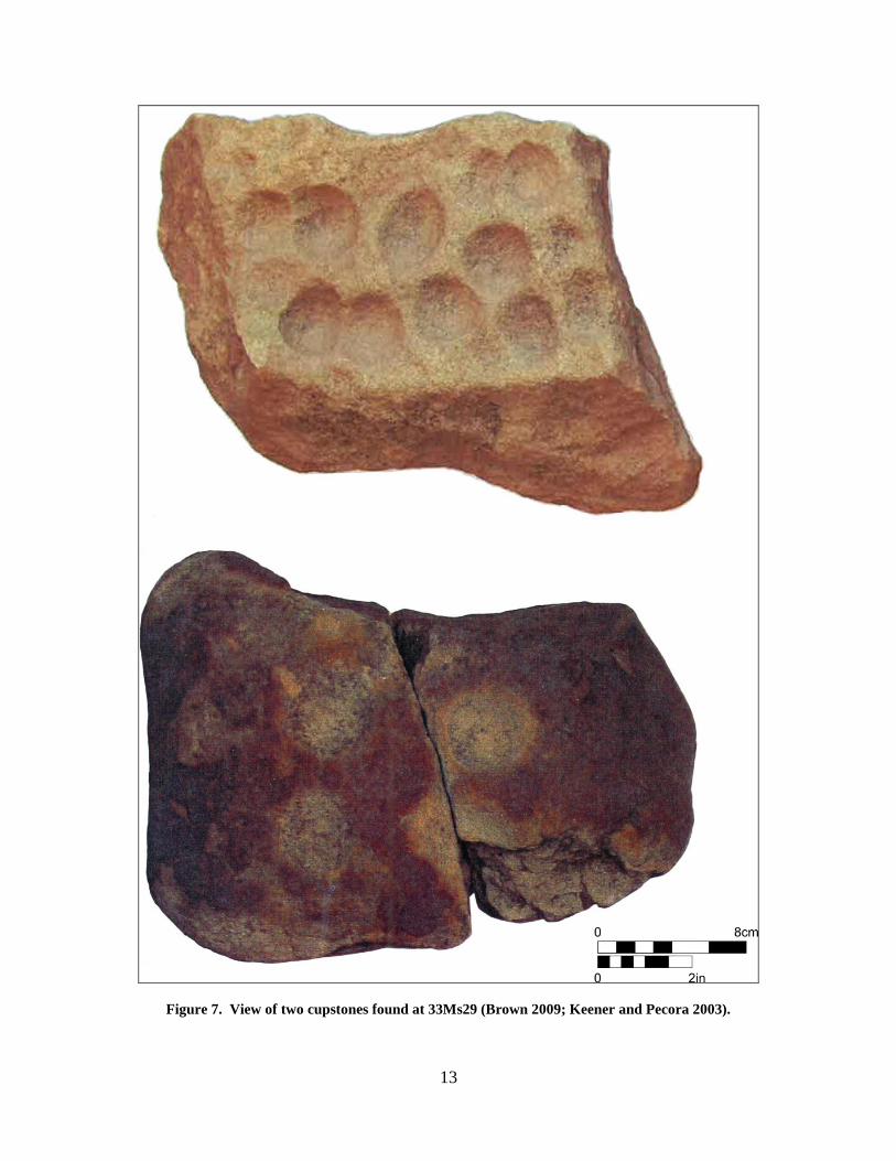
The groundstone tool assemblage is of moderate size (n= 22). The most common items were
pitted stones (n=6), followed by cupstones (n=5) (see Figure 7). The cupstones are probably
related to nut processing. An ethnobotanical analysis of nine prehistoric feature locations by
Annette Erickson of Hocking College found hickory and/or walnut nutshell evident in eight of
the feature samples (Brown 2009). Additional ground stone items recovered included several
hammerstones, an axe, celt, gorget, game ball, and several worked pieces of slate and stone.
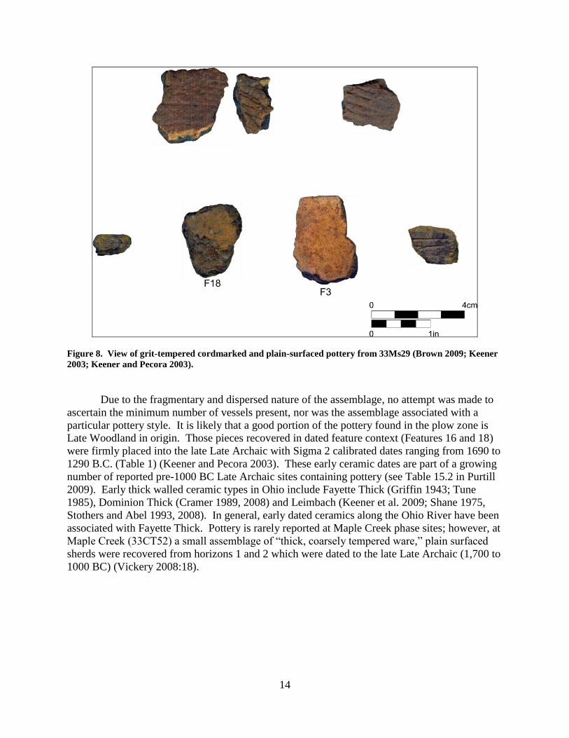
Pottery Assemblage
Pottery (n=85) fragments were found across the length of 33Ms29 within the plow zone,
midden layer, and three of the features in the central portion of the site (Features 3, 16, and 18)
(Figure 8) (Brown 2009; Keener 2003; Keener and Pecora 2003). All but one of the pieces were
small body sherd fragments. The lone exception was a very small and deteriorated rim piece.
The assemblage, excluding sherdlets and exfoliated pieces, included 20 cordmarked sherds with
grit temper, 47 plain surfaced sherds with grit temper including one with incised decoration, and
a single plain surfaced sherd with grit/grog temper. Grit size ranged from 0.43 to 2.0 mm. The
average thickness of cord-marked pieces is 5.9 mm with a range of 3.4 mm to 8.1 mm. The plain
smooth variety possessed an average thickness of 7.3 mm with a range of 3.8 mm to 10.6 mm.
Measurable pieces from the plow zone were thinner on average (mean thickness = 6.1 mm)
versus those found in the lower level midden (mean thickness = 6.8 mm). Pottery found in three
features located in the midden, possessed thickness ranges of 8.9 mm to 10.5 mm (Keener and
Pecora 2003).
12
Figure 6. View of a selection of the Merom/Trimble assemblage at 33Ms29 (Brown 2009).
13
Figure 7. View of two cupstones found at 33Ms29 (Brown 2009; Keener and Pecora 2003).
14
Figure 8. View of grit-tempered cordmarked and plain-surfaced pottery from 33Ms29 (Brown 2009; Keener
2003; Keener and Pecora 2003).
Due to the fragmentary and dispersed nature of the assemblage, no attempt was made to
ascertain the minimum number of vessels present, nor was the assemblage associated with a
particular pottery style. It is likely that a good portion of the pottery found in the plow zone is
Late Woodland in origin. Those pieces recovered in dated feature context (Features 16 and 18)
were firmly placed into the late Late Archaic with Sigma 2 calibrated dates ranging from 1690 to
1290 B.C. (Table 1) (Keener and Pecora 2003). These early ceramic dates are part of a growing
number of reported pre-1000 BC Late Archaic sites containing pottery (see Table 15.2 in Purtill
2009). Early thick walled ceramic types in Ohio include Fayette Thick (Griffin 1943; Tune
1985), Dominion Thick (Cramer 1989, 2008) and Leimbach (Keener et al. 2009; Shane 1975,
Stothers and Abel 1993, 2008). In general, early dated ceramics along the Ohio River have been
associated with Fayette Thick. Pottery is rarely reported at Maple Creek phase sites; however, at
Maple Creek (33CT52) a small assemblage of “thick, coarsely tempered ware,” plain surfaced
sherds were recovered from horizons 1 and 2 which were dated to the late Late Archaic (1,700 to
1000 BC) (Vickery 2008:18).
15
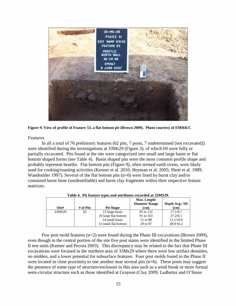
Figure 9. View of profile of Feature 53, a flat bottom pit (Brown 2009). Photo courtesy of EMH&T.
Features
In all a total of 76 prehistoric features (62 pits, 7 posts, 7 undetermined [not excavated])
were identified during the investigations at 33Ms29 (Figure 3), of which 69 were fully or
partially excavated. Pits found at the site were categorized into small and large basin or flat
bottom shaped forms (see Table 4). Basin shaped pits were the most common profile shape and
probably represent hearths. Flat bottom pits (Figure 9), often termed earth ovens, were likely
used for cooking/roasting activities (Keener et al. 2010; Heyman et al. 2005; Shott et al. 1989;
Wandsnider 1997). Several of the flat bottom pits (n=6) were lined by burnt clay and/or
contained burnt bone (unidentifiable) and burnt clay fragments within their respective feature
matrixes.
Table 4. Pit feature types and attributes recorded at 33MS29.
Site#
# of Pits
Pit Shape
Max. Length/
Diameter Range
(cm)
Depth Avg./ SD
(cm)
33MS29 62 15 large basin
10 large flat bottom
24 small basin
13 small flat bottom
95 to 132
91 to 163
31 to 88
29 to 87
17.1/9.7
27.2/8.1
13.1/10.0
28.9/16.2
Few post mold features (n=2) were found during the Phase III excavations (Brown 2009),
even though in the central portion of the site five post stains were identified in the limited Phase
II test units (Keener and Pecora 2003). This discrepancy may be related to the fact that Phase III
excavations were focused in the northern area of 33Ms29 where there were low artifact densities,
no midden, and a lower potential for subsurface features. Four post molds found in the Phase II
were located in close proximity to one another near several pits (n=6). These posts may suggest
the presence of some type of structure/enclosure in this area such as a wind break or more formal
semi-circular structure such as those identified at Grayson (Clay 2009; Ledbetter and O’Steen
16
1992). This is also supported by the geophysical data, which has a cluster of features at this
location that may be indicative of a structure (see Figure 4, southern most possible structure
location) (Burks and Keener 2004). The geophysical data also indicated several other possible
structure locations based on circular or arc shaped anomaly patterns. Most of these are located in
the central portion of the site in the midden. Ground truthing of these possible structures,
however, has not been completed to verify this.
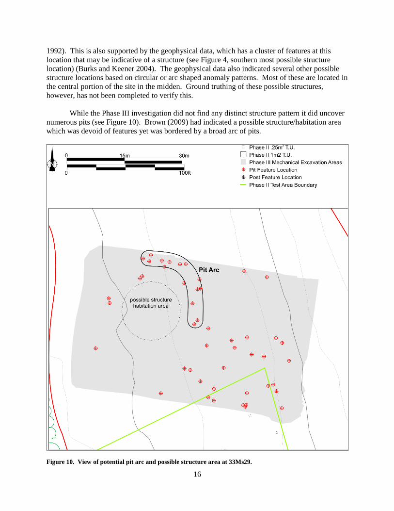
While the Phase III investigation did not find any distinct structure pattern it did uncover
numerous pits (see Figure 10). Brown (2009) had indicated a possible structure/habitation area
which was devoid of features yet was bordered by a broad arc of pits.
Figure 10. View of potential pit arc and possible structure area at 33Ms29.
17
Faunal and Floral Data
Fragmentary burnt bone was found throughout the midden deposit and in several pit
contexts. None of this material was identifiable. Late Archaic and Maple Creek sites with
recorded faunal material typically contain a large percentage of deer and elk remains, between 70
to 87% of the faunal assemblage (Vickery 1980, 2008). Bone tool assemblages are also found at
these sites such as bone fishhooks, needles, perforators, awls, flutes, drilled teeth, antler scrapers,
and turtle carapace containers (Vickery 1980). A few (n=3) turtle carapace fragments were
recovered from Feature 18 in the midden area of 33Ms29 (Keener and Pecora 2003). The lack of
well preserved faunal remains is likely associated with the acidic soil properties evident at the
site (Brown 2009). Other notable eastern Maple Creek sites lack faunal remains due to poor
preservation such as 33Le680 (Keener et al. 2010) and Grayson (Ledbetter and O’Steen 1992).
Floral remains were dominated by nutshell, exclusively hickory and walnut (Brown 2009;
Keener and Pecora 2003). A total of 521 nutshell fragments were recovered that included
hickory (n=133, 6.5g), walnut (n=89, 4g), and walnut family (n=299, 39g). The bulk of the
nutshell (36g, 73%) was recovered from the midden area in features identified during the Phase
II investigation (Keener and Pecora 2003). The nutshell remains and cupstones present at the
site indicate that the Late Archaic occupants were incorporating nut mast resources into
subsistence activities. Only a small number of seed types (n=3) were recovered and from only
two features (Features 53 and 97). Feature 53 contained one bedstraw and seven maygrass
seeds. Feature 97 contained a large number of sumac seeds (n=316). The ethnobotanical
examination points to a late fall/winter and summer occupation of the site.
Significance and Interpretation of 33Ms29
Four late Late Archaic dated contexts, and a large Merom/Trimble point and micro tool
assemblage firmly place 33Ms29 within the parameters of the Maple Creek phase as advanced
by Vickery (1980, 2008). However, contrary to Vickery (2008), the continued findings of Maple
Creek sites in Kentucky and eastward along the Ohio River have not produced an east to west
trend of date chronologies. Older and more recent dated sites do not appear to exhibit any
discernible regional movement pattern and with so few sites possessing dated contexts it may be
some time before this premise can be properly accessed. The radiometric dates at 33Ms29 are
more comparable to Grayson than to the core area of the phase. Site 33Ms29 is similar to the
Maple Creek site with the recovery of pottery, which to the authors’ knowledge has not been
found at any other Maple Creek phase site.
At first glance, the finding of a large midden with numerous features, a large complex
and diverse tool assemblage, and possible structures at 33Ms29 are very similar to the findings at
Maple Creek, Logan, and Grayson. These attributes of the site meet the definition of Vickery’s
(1980, 2008) base camp for the Maple Creek settlement pattern (Keener and Pecora 2003). Yet
while the limited Phase II excavations in the core of the site demonstrated intensive occupation,
it also found that features were identified at different levels within the midden, overlapping each
other, indicating multiple occupations. This is also supported by the geophysical data that
reveals a massive number of probable features in the central and southern portion of the site.
Ledbetter and O’Steen (1992:27) have pointed out the problems associated with a site like
18
33Ms29, and for that matter the Maple Creek site itself, that rather than representing aggregated
base camps, the middens and numerous features may actually constitute a series of much smaller
re-occupations of a particular landform over a extended period of time. Brown’s (2009)
excavation in the northern end of the site, which did not contain a midden, resulted in his
conclusion that this portion of the site may be more representative of a specialized camp, which
is more reflective of Vickery’s ancillary site type. Only until the core area containing the
midden is excavated more thoroughly will we better know which one of these interpretations is
right or if both may apply at such a large site. Fortunately, approximately two thirds of the site,
containing the core area of the midden, remains unexcavated and preserved for potential future
research.
To conclude, the CRM investigations at 33Ms29 have contributed greatly to late Late
Archaic studies along the Ohio River in southern Ohio. Much appreciation must be given to
ODNR for the amount of time, expense and patience involved with their project, which has
contributed to the field of archaeology and to a greater understanding of the prehistory of the
area. Acknowledgement should also be given to OHPO which advocated that an article detailing
with the findings be presented for publication to the Ohio Archaeological Council web page.
References Cited
Boisvert, Richard A.
1986 Late Archaic Settlement Models in the Middle Ohio Valley: A Perspective from Big
Bone Lick Kentucky. Unpublished Ph.D. dissertation, Department of Anthropology,
University of Kentucky, Lexington.
Brown, Joel
2009 Phase III Data Recover for Prehistoric Period Archaeological Site 33-Ms-29 Located
Within the Approximately 8.9 ha (22 a.) Ohio Department of Natural Resources Ohio
River Boat Access in the Village of Racine, Meigs County, Ohio. EMH&T. Copy on
file at the Ohio Historic Preservation Office, Columbus.
Burks, Jarrod and Craig S. Keener
2004 Additional Geophysical Survey Work on 33MS29 Located at the Proposed Ohio River
Boat Access in Racine, Sutton Township, Meigs County, Ohio. Professional
Archaeological Services Team. Copy on file at the Ohio Historic Preservation Office,
Columbus.
Clay, R. Berle
2009 Where Have All the Houses Gone? Webb’s Adena House in Historical Context.
Southeastern Archaeology 28(1): 43-63.
Cowan, C. Wesley
1976 Test Excavations in the Proposed Red River Lake, Kentucky: 1974 Season. Ms. On file,
Office of State Archaeology, University of Kentucky, Lexington.
19
Cramer, Ann C.
1989 The Dominion Land Company Site: An Early Adena Mortuary Manifestation in Franklin
County, Ohio. Unpublished Masters thesis, Kent State University, Kent, Ohio.
2008 The Dominion Land Company Site: An Early Adena Mortuary Manifestation in Franklin
County, Ohio. In Transitions: Archaic and Early Woodland Research In The Ohio
Country, edited by M. P. Otto and B. G. Redmond, pp.284-333. Ohio University Press,
Athens, and The Ohio Archaeological Council, Columbus.
Duerksen, Ken and John Doershuk
1994 Report on the Archaeological Data Recovery of 33BU477, a Late Maple Creek Phase
Occupation in Butler County, Ohio. Report on file at the Ohio Historic Preservation
Office.
1998 The Houpt Site and The Late Archaic of Southwestern Ohio. Midcontinental Journal of
Archaeology 23(1):101-112.
Griffin, James B.
1943 Adena Village Pottery from Fayette County, Kentucky. The University of Kentucky
Reports in Anthropology and Archaeology 5(7):666-670.
Hall, Christopher T.
2005 Phase III Archaeological Investigations at the Hayes Site (15Cl67), Carroll County,
Kentucky. Cultural Resource Analysts, Lexington.
Heyman, Marjorie, Elliot M. Abrams, and AnnCorinne Freter
2005 Late Archaic Community Aggregation and Feasting in the Hocking Valley. In The
Emergence of the Moundbuilders: The Archaeology of Tribal Societies in Southeastern
Ohio, edited by E. M. Abrams and A. Freter, pp. 67-81. Ohio University Press, Athens.
Justice, Noel D.
1987 Stone Age Spear and Arrow Points of the Midcontinental and Eastern United States: A
Modern Survey and Reference. Indiana University Press, Bloomington.
Keener, Craig S.
2003 Phase I Cultural Resource Management Survey for a Proposed 8.9 ha (22 a.) Ohio River
Boat Access, in Racine, in Sutton Township, Meigs County, Ohio. Professional
Archaeological Services Team. Copy on file at the Ohio Historic Preservation Office,
Columbus.
Keener, Craig S. and Albert P. Pecora
2003 Phase II Archaeological Assessment of Site 33Ms29 located at the Proposed Ohio River
Boat Access in Racine, Sutton Township, Meigs County, Ohio. Professional
Archaeological Services Team. Copy on file at the Ohio Historic Preservation Office,
Columbus.
20
Keener, Craig S., Kevin Nye, and Joshua Niedermier
2009 The Settler’s Ridge Site, An Early Woodland Leimbach Phase Upland Encampment in
Northern Ohio. North American Archaeologist 30(1):23-56.
2010 Phase III Archaeological Mitigation of Sites 33-LE-680, 33-LE-683, 33LE-684, and 33-
LE-685 in the Village of South Point, Lawrence County, Ohio. Professional
Archaeological Services Team. Copy on file at the Ohio Historic Preservation Office,
Columbus.
Ledbetter, R. Jerald, and Lisa D. O’Steen
1992 The Grayson Site: Late Archaic and Late Woodland Occupations in the Little Sandy
Drainage. In Current Archaeological Research in Kentucky 2, edited by D. Pollack and
A. G. Henderson, pp.13-42. Kentucky Heritage Council, Frankfort.
O’Steen, Lisa D., Kristen J. Gremillion, and R. Jerald Ledbetter
1991 Archaeological Testing of Five Sites in the Big Sinking Creek Oil Field, Lee County,
Kentucky. United States Forest Service, Department of Agriculture, Winchester,
Kentucky.
Purtill, Matthew
2002 Phase II Archaeological Investigations at Sites 33LE680, 33LE683, 33LE684, and
33LE685 within the Proposed South Point Industrial Park, Lawrence County, Ohio. Gray
& Pape, Inc. Copy on file at the Ohio Historic Preservation Office, Columbus.
2008 Down by the River: Late Archaic Through Terminal Archaic Dynamics at the Davisson
Farm Site (33LE619), Lawrence County, Ohio. In Transitions: Archaic and Early
Woodland Research in the Ohio Country, edited by M. P. Otto and B. G. Redmond, pp.
41-78. Ohio University Press, Athens and The Ohio Archaeological Council, Columbus.
2009 The Ohio Archaic: A Review. In Archaic Societies: Diversity and Complexity Across the
Midcontinent, edited by T. E. Emerson, D. L. McElrath, A. C. Fortier, pp. 565-606. State
University of New York, Albany.
Purtill, Matthew and J. A. Norr
2001 Phase I and Preliminary Phase II Cultural Resources Investigations and Evaluation of
the Proposed South Point Industrial Park, Lawrence County, Ohio. Gray and Pape, Inc.
Copy on file at the Ohio Historic Preservation Office, Columbus.
Shane, Orrin. C.
1975 The Leimbach Site: An Early Woodland Village in Lorain County, Ohio. In Studies in
Ohio Archaeology (revised edition), edited by O.H. Prufer and D.H. McKenzie, pp.121-
186. The Kent State University Press, Kent, Ohio.
21
Shott, Michael. J., Rolfe D. Mandel, Gerald Oetelaar, Nancy O’Malley, Mary L. Powell, and Dee
Anne Wymer
1989 Childers and Woods: Two Late Woodland Sites in the Upper Ohio Valley, Mason
County, West Virginia. Archaeological Report 200. Program for Cultural Resource
Assessment, University of Kentucky, Lexington.
Stothers, David. M. and Timothy J. Abel
1993 Archaeological Reflections of the Late Archaic and Early Woodland Time Periods in the
Western Lake Erie Region. Archaeology of Eastern North America 21: 25-109.
2008 Early Woodland Prehistory (1000-1 BC) in the Western Lake Erie Drainage Basin. In
Transitions: Archaic and Early Woodland Research in the Ohio Country, edited by M. P.
Otto and B. G. Redmond, pp. 79-116. Ohio University Press, Athens and The Ohio
Archaeological Council, Columbus.
Tune, Teresa W.
1985 Fayette Thick: A New Vessel Form for an Old Ceramic Type. In Woodland Period
Research in Kentucky, edited by D. Pollack, T. Sanders, and C. Hockensmith, pp. 43-61.
The Kentucky Heritage Council, Frankfort.
Vickery, Kent D.
1976 An Approach to Inferring Archaeological Site Variability. Unpublished Ph.D.
dissertation. Dept. of Anthropology, Indiana University, Bloomington.
1980 Preliminary Definitions of Archaic Study Units in Southwestern Ohio. Copy on file at
the Ohio Historic Preservation Office, Columbus.
2008 Archaic Manifestations in Southwestern Ohio and Vicinity. In Transitions: Archaic and
Early Woodland Research in the Ohio Country, edited by M.P. Otto and B. G. Redmond,
pp. 1-28. Ohio University Press, Athens and The Ohio Archaeological Council,
Columbus.
Wandsnider, LuAnn
1997 The Roasted and the Boiled: Food Composition and Heat Treatment with Special
Emphasis on Pit Hearth Cooking. Journal of Anthropological Archaeology 16:1-48.
White, Claude F.
1978 An Archaeological Impact Assessment of the Syracuse-Racine Regional Sewer Works
Project (C 391150), Sutton Township, Meigs County, Ohio. Copy on file at the Ohio
Historic Preservation Office, Columbus.
Winters, Howard Dalton
1969 The Riverton Culture: A Second Millennium Occupation in the Central Wabash
Valley. Illinois State Museum Reports of Investigations, No. 13. Springfield, Illinois.


![[David Ledbetter] Bach's Well-Tempered Clavier Th(BookFi.org)](https://img.pdfslide.us/doc/110x75/55cf99c3550346d0339f0cd1/david-ledbetter-bachs-well-tempered-clavier-thbookfiorg.jpg)