Embed Size (px)
Citation preview

The Western Australian South Coast M
acro Corridor Network: A Bioregional Strategy for Nature Conservation
January 2006 — Albany, W
estern AustraliaThe Departm
ent of Environment and Conservation (W
A) and South Coast Natural Resource M
anagement Inc.
A BIOREGIONAL STRATEGY FOR NATURE CONSERVATION
JANUARY 2006ALBANY – WESTERN AUSTRALIA
The Western Australian South Coast Macro Corridor Network
South Coast Natural Resource Management Inc
444 Albany HighwayAlbany, Western Australia
Ph: 08 9892 8537Fax: 08 9841 2707
Email: [email protected]: southcoastnrm.com.au
This project was delivered by the Western Australian Department of Conservation and Land Management and funded by the Western Australian and Australian Governments through
the Natural Heritage Trust and the National Action Plan for Salinity and Water Quality.
ISBN 978-0-9804630-0-2

This project was delivered by the Western Australian Department of Conservation and Land Management and funded by the Western Australian and Australian Governments through the Natural Heritage Trust and
the National Action Plan for Salinity and Water Quality.
NAME CHANGES 2006–07
The former Department of Conservation and Land Management (CALM) is ■
now the Department of Environment and Conservation (DEC).
The former South Coast Regional Initiative Planning Team (SCRIPT) is now ■
South Coast Natural Resource Management Inc.
Original names which were correct as at January 2006 are used ■
throughout this report.
USE OF THIS REPORT
Information contained in this report may be copied or reproduced for study, research information or educational purposes, subject to inclusion of an acknowledgement of the source.
DISCLAIMER
This report was prepared for the general purpose of providing a history and understanding of the development of the South Coast Macro Corridor Network. The main body of the document incorporates an account of the South Coast Macro Corridor Project 1999–2002, but additional content addresses application of the Macro Corridor Network up to January 2006. Every effort has been made to ensure that the information in the report is current at this date; however, participating organisations and persons associated with the preparation of the report do not assume any liability whatsoever resulting from the use and or reliance upon its content. The views expressed do not necessarily represent the views of the participating organisations.
RECOMMENDED REFERENCE
Wilkins, P., Gilfi llan, S., Watson, J. and Sanders, A. (ed). 2006. The Western Australian South Coast Macro Corridor Network – a bioregional strategy for nature conservation, Department of Conservation and Land Management (CALM) and South Coast Regional Initiative Planning Team (SCRIPT), Albany, Western Australia.
Published by the Department of Environment and Conservation (Western Australia) and South Coast Natural Resource Management Inc., 2007Artwork and typesetting by South Coast Natural Resource Management Inc., 2007Cover satellite image Copyright 2007 TerraMetrics, Inc. (http://www.truearth.com)Other images courtesy of the Department of Environment and Conservation (Western Australia) and South Coast Natural Resource Management Inc.Printed by Advance Press, BassendeanISBN 978-0-9804630-0-2

A bioregionAl strAtegy for nAture conservAtion
JAnuAry 2006AlbAny – Western AustrAliA
the Western Australian south coast Macro corridor network

ii
High nature conservation values in the area arise from the existence of a number of large, intact
protected areas, centres of floristic endemism, areas of high floristic
diversity and important refuges for threatened
fauna species, including Gondwanan relicts.
– John Watson
It is vital that we continue to promote and protect the South Coast bioregional Macro Corridor Network not only for its biodiversity conservation outcomes but also because ultimately our social and economic futures will also benefit.
Context and AcknowledgementsWhilst the concept of vegetation corridor connectivity in parts of the study area was recognised in the early 1970s, and the potential for interconnection of corridors across the whole south coast region was recognised in the mid to late 1980s, the specific reference to ‘macro’ corridors did not occur until around 1997.
the significance of this concept as an important component of the fledgling natural resource management (nrM) initiatives of the time and as an important way to raise community awareness regarding the values of landscape connectivity led to successful application for a natural Heritage trust (nHt) bushcare grant in 1999. Hence the south coast Macro corridor Project was born.
upon exhaustion of the nHt funds in 2001, additional funds were provided by the Director of nature conservation, Western Australian Department of conservation and land Management (cAlM), which enabled continuation of the project through 2002 in order to advance more fully the establishment of a network of long term monitoring sites within the Macro corridor network.
Due to staff changes, the rapidly changing arrangements for nrM delivery in Australia and the resulting focus on urgent progress towards the preparation of a regional nrM strategy, a detailed report on the Macro corridor Project was never completed.
through preparation of The South Coast Regional Strategy for NRM (scriPt 2005), the significance of the regional scale macro corridor concept as an adjunct to the existing and proposed protected area network (primarily national parks and nature reserves) has become more widely apparent as a strategy towards achieving the best long-term outcomes for biodiversity conservation. the potential importance of the proposed monitoring site network has also become more apparent in the face of a suite of threats to biodiversity including the effects of climate change.

iii
As a result, the south coast regional initiative Planning team (scriPt), the regional nrM organisation, has supported further work to finally publish the Macro corridor Project report and to bring subsequent development of the network up to date as at January 2006. consultant Angela sanders, who has extensive experience of the south coast region and who has been involved in several of the more localised aspects of biodiversity conservation, voluntary conservation of private lands and corridors, was commissioned to re-edit the draft report in close consultation with cAlM south coast regional Manager, John Watson, who initiated the concept and Macro corridor Project in 1997.
one of the challenges in re-editing and updating this report has been to set the Macro corridor Project (1999–2002) against the historical evolution of the corridor network concept in the region from the early 1970s through to 2005, as well as to look forward to its evolution as a strategic regional tool for biodiversity conservation well into the 21st century.
the original nHt funded project officer, Peter Wilkins, who subsequently became senior ranger of the fitzgerald river national Park before moving to south Australia, pioneered the gis and community consultation components of the project over the first two years 1999–2001, and the bulk of the project work described here is his work. Additional work towards designing and establishing a long term monitoring site network during 2001–02 was undertaken by sandra gilfillan, who later worked on a threatened species pilot project for the south coast region. sandra was also one of many to be involved with early attempts at converting the original Macro corridor draft report to suit a wider audience.
significant input to the process was also received from Jude Allan (in particular assisting John Watson with development of the original grant application), ian Herford (initial project coordinator), Alan Danks (project supervisor from 2000 plus editorial input), shane french and steve Jones (cAlM gis section, Perth), sandra Maciejewski (additional editing/updating work in 2003), Deon utber (improvement of mapping) and sarah comer (technical and editorial input at all stages). there were many more officers from within cAlM and other agencies and many others from outside the agencies who contributed to varying degrees along the way. Whilst there are far too many to list individually, sincere thanks are due to all.
special thanks are also due to scriPt ceo, rob edkins, for his encouragement and support to see the Macro corridor report published at long last so as to provide a significant tool alongside the region’s nrM investment Plan (2005), which is now being implemented. thanks are also extended to Kristina fleming, scriPt business Manager, for her ongoing encouragement towards the report reaching a wider audience.
finally, due thanks are extended to all funding support:
nHt bushcare funds 1999–2001■■
cAlM nature conservation Programme 2001/2002■■
scriPt report editing, updating and publication■■
Having finally brought all the threads together, we hope that you enjoy and find good value in this report on the Western Australian south coast Macro corridor network as an important bioregional strategy for nature conservation in the years to come.
LEAD WRITERS
it is important to appreciate that the various sections of this report were initially compiled by different lead writers with varying degrees of subsequent editorial amendment as required.
Where possible original writing styles, descriptions of project rationale and strategies have been retained, especially in sections 1, 2 and 3. in a few instances additional comments or footnotes have been added where current (2006) information is useful. such additions are clearly identified.
Section Lead WriterS
conteXt AnD AcKnoWleDgeMents John Watson
overvieW John Watson
section 1 introDuction AnD bAcKgrounD sandra gilfillan and Peter Wilkins
section 2 tHe soutH coAst MAcro corriDor ProJect (1999–2002) Peter Wilkins
section 3 DeveloPing long terM ecologicAl Monitoring sites sandra gilfillan
section 4 evolving use AnD APPlicAtion of tHe MAcro corriDor concePt into tHe 21st century John Watson

Context and aCknowledgements
seCtIon 1
IntRodUCtIon and BaCkgRoUnd � � � � � � � � � � � � � � � � � � � � � � � � � � � � � � � � � � � � � � � � � � � � � � � � � � � � � � � � � � � � � � � � � � � � � � � � � � � � � � � � � � �91.1 Evolution of the South Coast Macro Corridor Concept (1970s–1999) . . . . . . . . . . . . . . . . . . . . . . . . . . . . . . . . . . . . . . . . . . . . . . . . . . . . . . .101.2 Background Theory . . . . . . . . . . . . . . . . . . . . . . . . . . . . . . . . . . . . . . . . . . . . . . . . . . . . . . . . . . . . . . . . . . . . . . . . . . . . . . . . . . . . . . . . . . .12
Context . . . . . . . . . . . . . . . . . . . . . . . . . . . . . . . . . . . . . . . . . . . . . . . . . . . . . . . . . . . . . . . . . . . . . . . . . . . . . . . . . . . . . . . . . . . . . . . . . . .12Key Assumptions . . . . . . . . . . . . . . . . . . . . . . . . . . . . . . . . . . . . . . . . . . . . . . . . . . . . . . . . . . . . . . . . . . . . . . . . . . . . . . . . . . . . . . . . . . . .12Landscape Scale Biodiversity Conservation . . . . . . . . . . . . . . . . . . . . . . . . . . . . . . . . . . . . . . . . . . . . . . . . . . . . . . . . . . . . . . . . . . . . . . . . . .13Landscape Fragmentation . . . . . . . . . . . . . . . . . . . . . . . . . . . . . . . . . . . . . . . . . . . . . . . . . . . . . . . . . . . . . . . . . . . . . . . . . . . . . . . . . . . . .13Landscape Connectivity . . . . . . . . . . . . . . . . . . . . . . . . . . . . . . . . . . . . . . . . . . . . . . . . . . . . . . . . . . . . . . . . . . . . . . . . . . . . . . . . . . . . . . . .14
1.3 The Macro Corridor Network Area . . . . . . . . . . . . . . . . . . . . . . . . . . . . . . . . . . . . . . . . . . . . . . . . . . . . . . . . . . . . . . . . . . . . . . . . . . . . . . . .15Climate . . . . . . . . . . . . . . . . . . . . . . . . . . . . . . . . . . . . . . . . . . . . . . . . . . . . . . . . . . . . . . . . . . . . . . . . . . . . . . . . . . . . . . . . . . . . . . . . . . .16Geology . . . . . . . . . . . . . . . . . . . . . . . . . . . . . . . . . . . . . . . . . . . . . . . . . . . . . . . . . . . . . . . . . . . . . . . . . . . . . . . . . . . . . . . . . . . . . . . . . . .17Landforms and Soils . . . . . . . . . . . . . . . . . . . . . . . . . . . . . . . . . . . . . . . . . . . . . . . . . . . . . . . . . . . . . . . . . . . . . . . . . . . . . . . . . . . . . . . . . .19
1.4 Biogeographic Regionalisation of Australia (IBRA) Regions and Subregions . . . . . . . . . . . . . . . . . . . . . . . . . . . . . . . . . . . . . . . . . . . . . . . . . . .191.5 Regional Native Plant Communities and Flora . . . . . . . . . . . . . . . . . . . . . . . . . . . . . . . . . . . . . . . . . . . . . . . . . . . . . . . . . . . . . . . . . . . . . . . .21
Pre-European Native Vegetation . . . . . . . . . . . . . . . . . . . . . . . . . . . . . . . . . . . . . . . . . . . . . . . . . . . . . . . . . . . . . . . . . . . . . . . . . . . . . . . . . .21Current Native Vegetation . . . . . . . . . . . . . . . . . . . . . . . . . . . . . . . . . . . . . . . . . . . . . . . . . . . . . . . . . . . . . . . . . . . . . . . . . . . . . . . . . . . . . .23
1.6 Fauna . . . . . . . . . . . . . . . . . . . . . . . . . . . . . . . . . . . . . . . . . . . . . . . . . . . . . . . . . . . . . . . . . . . . . . . . . . . . . . . . . . . . . . . . . . . . . . . . . . . .251.7 Threats to Flora and Fauna . . . . . . . . . . . . . . . . . . . . . . . . . . . . . . . . . . . . . . . . . . . . . . . . . . . . . . . . . . . . . . . . . . . . . . . . . . . . . . . . . . . . .281.8 Threatened Ecological Communities (TECs) . . . . . . . . . . . . . . . . . . . . . . . . . . . . . . . . . . . . . . . . . . . . . . . . . . . . . . . . . . . . . . . . . . . . . . . . .321.9 Protected Area System (existing and proposed) . . . . . . . . . . . . . . . . . . . . . . . . . . . . . . . . . . . . . . . . . . . . . . . . . . . . . . . . . . . . . . . . . . . . . . .331.10 Human Demography . . . . . . . . . . . . . . . . . . . . . . . . . . . . . . . . . . . . . . . . . . . . . . . . . . . . . . . . . . . . . . . . . . . . . . . . . . . . . . . . . . . . . . . . . .361.11 Rural Industry . . . . . . . . . . . . . . . . . . . . . . . . . . . . . . . . . . . . . . . . . . . . . . . . . . . . . . . . . . . . . . . . . . . . . . . . . . . . . . . . . . . . . . . . . . . . . . .37
seCtIon 2
the soUth Coast maCRo CoRRIdoR PRojeCt (1999–2002) � � � � � � � � � � � � � � � � � � � � � � � � � � � � � � � � � � � � � � � � � � � � � � � � � � � � � � � � � � � � �392.1 Project Development and Funding . . . . . . . . . . . . . . . . . . . . . . . . . . . . . . . . . . . . . . . . . . . . . . . . . . . . . . . . . . . . . . . . . . . . . . . . . . . . . . . .402.2 Project Objectives . . . . . . . . . . . . . . . . . . . . . . . . . . . . . . . . . . . . . . . . . . . . . . . . . . . . . . . . . . . . . . . . . . . . . . . . . . . . . . . . . . . . . . . . . . . .402.3 Methods . . . . . . . . . . . . . . . . . . . . . . . . . . . . . . . . . . . . . . . . . . . . . . . . . . . . . . . . . . . . . . . . . . . . . . . . . . . . . . . . . . . . . . . . . . . . . . . . . . .412.4 Results . . . . . . . . . . . . . . . . . . . . . . . . . . . . . . . . . . . . . . . . . . . . . . . . . . . . . . . . . . . . . . . . . . . . . . . . . . . . . . . . . . . . . . . . . . . . . . . . . . . .462.5 Promotion . . . . . . . . . . . . . . . . . . . . . . . . . . . . . . . . . . . . . . . . . . . . . . . . . . . . . . . . . . . . . . . . . . . . . . . . . . . . . . . . . . . . . . . . . . . . . . . . .532.6 Outcomes 1999–2002 . . . . . . . . . . . . . . . . . . . . . . . . . . . . . . . . . . . . . . . . . . . . . . . . . . . . . . . . . . . . . . . . . . . . . . . . . . . . . . . . . . . . . . . .56
seCtIon 3
deVeloPment oF long-teRmeCologICal monItoRIng sItes (2001–2002) � � � � � � � � � � � � � � � � � � � � � � � � � � � � � � � � � � � � � � � � � � � � � � � �573.1 Introduction . . . . . . . . . . . . . . . . . . . . . . . . . . . . . . . . . . . . . . . . . . . . . . . . . . . . . . . . . . . . . . . . . . . . . . . . . . . . . . . . . . . . . . . . . . . . . . . .583.2 Objectives . . . . . . . . . . . . . . . . . . . . . . . . . . . . . . . . . . . . . . . . . . . . . . . . . . . . . . . . . . . . . . . . . . . . . . . . . . . . . . . . . . . . . . . . . . . . . . . . .593.3 Methods . . . . . . . . . . . . . . . . . . . . . . . . . . . . . . . . . . . . . . . . . . . . . . . . . . . . . . . . . . . . . . . . . . . . . . . . . . . . . . . . . . . . . . . . . . . . . . . . . . .603.4 Results and Discussion . . . . . . . . . . . . . . . . . . . . . . . . . . . . . . . . . . . . . . . . . . . . . . . . . . . . . . . . . . . . . . . . . . . . . . . . . . . . . . . . . . . . . . . .653.5 Recommendations . . . . . . . . . . . . . . . . . . . . . . . . . . . . . . . . . . . . . . . . . . . . . . . . . . . . . . . . . . . . . . . . . . . . . . . . . . . . . . . . . . . . . . . . . . .68
seCtIon 4
eVolVIng Use and aPPlICatIons oF the maCRo CoRRIdoR ConCePt Into the 21st CentURY � � � � � � � � � � � � � � � � � � � � � � � � � � � � � � � � �694.1 Global Recognition of Large Scale Connectivity Needs . . . . . . . . . . . . . . . . . . . . . . . . . . . . . . . . . . . . . . . . . . . . . . . . . . . . . . . . . . . . . . . . . .704.2 South Coast Initiatives to Retain Connectivity . . . . . . . . . . . . . . . . . . . . . . . . . . . . . . . . . . . . . . . . . . . . . . . . . . . . . . . . . . . . . . . . . . . . . . . .714.3 Initiatives to Enhance Connectivity . . . . . . . . . . . . . . . . . . . . . . . . . . . . . . . . . . . . . . . . . . . . . . . . . . . . . . . . . . . . . . . . . . . . . . . . . . . . . . . .714.4 Use as a Strategic Planning Tool . . . . . . . . . . . . . . . . . . . . . . . . . . . . . . . . . . . . . . . . . . . . . . . . . . . . . . . . . . . . . . . . . . . . . . . . . . . . . . . . .724.5 Community Values of the Macro Corridor Network . . . . . . . . . . . . . . . . . . . . . . . . . . . . . . . . . . . . . . . . . . . . . . . . . . . . . . . . . . . . . . . . . . . . .734.6 The Network as Part of a Bioregional Monitor of Change . . . . . . . . . . . . . . . . . . . . . . . . . . . . . . . . . . . . . . . . . . . . . . . . . . . . . . . . . . . . . . . .734.7 Final Comment . . . . . . . . . . . . . . . . . . . . . . . . . . . . . . . . . . . . . . . . . . . . . . . . . . . . . . . . . . . . . . . . . . . . . . . . . . . . . . . . . . . . . . . . . . . . . .74
seCtIon 5
ReFeRenCes � � � � � � � � � � � � � � � � � � � � � � � � � � � � � � � � � � � � � � � � � � � � � � � � � � � � � � � � � � � � � � � � � � � � � � � � � � � � � � � � � � � � � � � � � � � � � � � � � � �755.1 Literature Cited . . . . . . . . . . . . . . . . . . . . . . . . . . . . . . . . . . . . . . . . . . . . . . . . . . . . . . . . . . . . . . . . . . . . . . . . . . . . . . . . . . . . . . . . . . . . . .765.2 Personal Communication . . . . . . . . . . . . . . . . . . . . . . . . . . . . . . . . . . . . . . . . . . . . . . . . . . . . . . . . . . . . . . . . . . . . . . . . . . . . . . . . . . . . . . .81
iv
CONTENTS Page

FIgUResFigure 1: South Coast vegetation corridors as identified by Watson (1991) . . . . . . . . . . . . . . . . . . . . . . . . . . . . . . . . . . . . . . . . . . . . . . . . . . .11Figure 2: The Macro Corridor Network area . . . . . . . . . . . . . . . . . . . . . . . . . . . . . . . . . . . . . . . . . . . . . . . . . . . . . . . . . . . . . . . . . . . . . . . . .16Figure 3: Average annual rainfall (mm) isohyets in the area (Water Authority 1987) . . . . . . . . . . . . . . . . . . . . . . . . . . . . . . . . . . . . . . . . . . . . .16Figure 4: Major geological units of the area (re-worked from Green & Wetherley 2000) . . . . . . . . . . . . . . . . . . . . . . . . . . . . . . . . . . . . . . . . . .17Figure 5: Biogeographic sub regions and their percentage of the area . . . . . . . . . . . . . . . . . . . . . . . . . . . . . . . . . . . . . . . . . . . . . . . . . . . . . .19Figure 6: 1:250,000 vegetation association . . . . . . . . . . . . . . . . . . . . . . . . . . . . . . . . . . . . . . . . . . . . . . . . . . . . . . . . . . . . . . . . . . . . . . . . .22Figure 7: 1996 woody vegetation data . . . . . . . . . . . . . . . . . . . . . . . . . . . . . . . . . . . . . . . . . . . . . . . . . . . . . . . . . . . . . . . . . . . . . . . . . . . . .24Figure 8: CALM managed estate (2005) within the area and surrounds . . . . . . . . . . . . . . . . . . . . . . . . . . . . . . . . . . . . . . . . . . . . . . . . . . . . .34Figure 9: CALM managed estate and proposed additions to conservation estate within the area . . . . . . . . . . . . . . . . . . . . . . . . . . . . . . . . . . .35Figure 10: Areas of native vegetation greater than 1,500 ha in size and continuity of vegetation in the area . . . . . . . . . . . . . . . . . . . . . . . . . . . .44Figure 11: Chains of woody vegetation greater than 30 ha in size and spaced less than 1 km apart . . . . . . . . . . . . . . . . . . . . . . . . . . . . . . . . .45Figure 12: Zones where woody vegetation is strategically located to improve landscape connectivity within the area . . . . . . . . . . . . . . . . . . . . .48Figure 13: Macro Corridors identified by the Macro Corridor GIS tool and their priority status . . . . . . . . . . . . . . . . . . . . . . . . . . . . . . . . . . . . . .52Figure 14: Example of how the Macro Corridor zone information can help identify native vegetation at a local level that is important for regional
scale connectivity . . . . . . . . . . . . . . . . . . . . . . . . . . . . . . . . . . . . . . . . . . . . . . . . . . . . . . . . . . . . . . . . . . . . . . . . . . . . . . . . . . . . .54Figure 15: Potential monitoring site locations taking into account the ten Beard 1:250,000 vegetation units constituting greater than 3% of the
area and the latitudinal and longitudinal variation . . . . . . . . . . . . . . . . . . . . . . . . . . . . . . . . . . . . . . . . . . . . . . . . . . . . . . . . . . . . . .62Figure 16: Proposed network of long-term ecological monitoring sites (numbers correspond to Table 7) . . . . . . . . . . . . . . . . . . . . . . . . . . . . . .66Figure 17: Macro Corridor Network and long term monitoring sites . . . . . . . . . . . . . . . . . . . . . . . . . . . . . . . . . . . . . . . . . . . . . . . . . . . . . . . . .67Figure A7-1: The quadrat and transect structure used at each survey site . . . . . . . . . . . . . . . . . . . . . . . . . . . . . . . . . . . . . . . . . . . . . . . . . . . . .102Figure A7-2: The zig-zag sampling procedure (from McDonald et al. 1998) . . . . . . . . . . . . . . . . . . . . . . . . . . . . . . . . . . . . . . . . . . . . . . . . . . . .104Figure A7-3: Crown types. The rows show different crown types for different leaf sizes (large to small, left to right). Acacia phyllodes are in the right
hand row (from McDonald et al. 1998). . . . . . . . . . . . . . . . . . . . . . . . . . . . . . . . . . . . . . . . . . . . . . . . . . . . . . . . . . . . . . . . . . . . .105Figure A7-4: The method of estimation of cover of ground layer, non-woody vegetation. The length of intercepted foliage is measured along a tape
and foliage cover calculated (from MacDonald et al. 1998). . . . . . . . . . . . . . . . . . . . . . . . . . . . . . . . . . . . . . . . . . . . . . . . . . . . . . .105Figure A7.3-1: Estimating the abundance of coarse fragments . . . . . . . . . . . . . . . . . . . . . . . . . . . . . . . . . . . . . . . . . . . . . . . . . . . . . . . . . . . . . .109Figure A7.4-1: Examples of profiles across terrain divided into morphological types of landform element. Note that the boundary between crest and
slope elements is at the end of the curvature of the crest. Each slope element is treated as if it were straight. . . . . . . . . . . . . . . . . .110Figure A7.6: Sampling design of invertebrate pits . . . . . . . . . . . . . . . . . . . . . . . . . . . . . . . . . . . . . . . . . . . . . . . . . . . . . . . . . . . . . . . . . . . . . .112
taBlesTable 1 Reasons that plants or animals must move through a landscape (adapted from Harris & Scheck 1991) . . . . . . . . . . . . . . . . . . . . . . .14Table 2 Macro corridors identified by the GIS process . . . . . . . . . . . . . . . . . . . . . . . . . . . . . . . . . . . . . . . . . . . . . . . . . . . . . . . . . . . . . . . . .47Table 3 Nature Conservation Values of protected and other identified areas within the macro corridor network area . . . . . . . . . . . . . . . . . . .49Table 4 Priority Status of Macro Corridors . . . . . . . . . . . . . . . . . . . . . . . . . . . . . . . . . . . . . . . . . . . . . . . . . . . . . . . . . . . . . . . . . . . . . . . . .51Table 5 Beard’s 1:250,000 vegetation units constituting greater than 3% of the area . . . . . . . . . . . . . . . . . . . . . . . . . . . . . . . . . . . . . . . . . .61Table 6 Plant Communities representing greater than 3% of the area and associated potential monitoring sites within CALM or CALM proposed
managed estate greater than 1,500 ha. . . . . . . . . . . . . . . . . . . . . . . . . . . . . . . . . . . . . . . . . . . . . . . . . . . . . . . . . . . . . . . . . . . . . .63Table 7 Potential network of long-term ecological monitoring sites and the actions taken for each site (As at 2003) . . . . . . . . . . . . . . . . . . . .65
aPPendICesAppendix 1: The IUCN Red List categories (1994) used for Western Australian Fauna . . . . . . . . . . . . . . . . . . . . . . . . . . . . . . . . . . . . . . . . . . . . .84Appendix 2a: Threatened Fauna Of The Macro Corridor Network Area As Of November 2004. . . . . . . . . . . . . . . . . . . . . . . . . . . . . . . . . . . . . . . .88Appendix 2b: Specially Protected And Priority Mammals, Birds And Reptiles Of The Macro Corridor Network Area As Of November 2004 . . . . . . . . .89Appendix 3: Shapefiles used in the development of the Macro Corridor Project Geographical Information System (GIS) . . . . . . . . . . . . . . . . . . . . .90Appendix 4: Metadata Statements for the South Coast Macro Corridor Project . . . . . . . . . . . . . . . . . . . . . . . . . . . . . . . . . . . . . . . . . . . . . . . . . .94Appendix 5: Development Of The High Nature Conservation Area Database . . . . . . . . . . . . . . . . . . . . . . . . . . . . . . . . . . . . . . . . . . . . . . . . . . . .96Appendix 6: Established Ecological Monitoring Sites Within And Surrounding The South Coast Region . . . . . . . . . . . . . . . . . . . . . . . . . . . . . . . . .98Appendix 7: Methods Of Baseline Information Collected On Long-Term Monitoring Sites . . . . . . . . . . . . . . . . . . . . . . . . . . . . . . . . . . . . . . . . . .101
v

vi
OVERVIEW
the seeds of the Western Australian south coast Macro corridor network concept were first sown in the 1970s when it was recognised that a continuous strip of vegetation along the fitzgerald river valley linked the fitzgerald river national Park with lake Magenta nature reserve some 25 km to the north. the theory of landscape connectivity underpins the concept, which evolved in tandem with a growing recognition of the important part that off-reserve remnant vegetation could play in the development of corridors between existing protected areas (mainly national parks and nature reserves) in the south coast region of Western Australia. the concept of the Macro corridor network was essentially a culmination of local, state and international developments in landscape-scale nature conservation.
the Macro corridor network detailed in this report lies on the central south coast of Western Australia. it is within the south West botanical Province, which is recognised as a biodiversity hotspot of international significance. High nature conservation values in the area arise from the existence of a number of large, intact protected areas such as the stirling range and fitzgerald river national Parks, centres of floristic endemism, areas of high floristic diversity and important refuges for threatened fauna species, including gondwanan relicts.
Approximately 800,000 ha of natural vegetation in the area is managed by the Western Australian Department of conservation and land Management (cAlM), including state forest, timber reserve, national Park, nature reserve and Miscellaneous reserves with some conservation Parks being proposed for the area. this is anticipated to increase to approximately 1.1 million hectares (20% of the area) with the implementation of the proposed additions to conservation estate outlined in the south coast regional Management Plan (cAlM 1991).
to help address the threats to biodiversity through habitat fragmentation, the Macro corridor Project was designed to identify a potential regional-scale Macro corridor network of native vegetation extending some 700 km from israelite bay, east of esperance and westwards through Albany along Western Australia’s southern coastline, with inland linkages along major river systems to protected areas and other uncleared bushland.

vii
the project identified 21 potential vegetation corridors that could be defined as macro corridors, all of which have regional nature conservation significance and strategic spatial significance within the south coast region. these were prioritised according to predicted nature conservation values at a landscape scale.
A secondary objective of the project was to establish a strategic network of monitoring sites across the area with a latitudinal, longitudinal and altitudinal spread to serve as a baseline network to monitor long-term change. these monitoring sites were chosen to be representative of the vegetation units across the area. this network comprises a combination of previously established sites and new sites identified during the project. baseline data was collected from most of the new sites to augment that available for the established sites. recommendations were made for the future development of an effective monitoring program.
the identification of a Macro corridor network was completed in 2002 and since then it has been used in many ways. its usefulness as a planning tool to help retain and enhance vegetation connectivity has been highlighted in various projects including the lowlands coastal Management Plan and Watershed torbay catchment restoration Plan.
scriPt has also recognised the importance of the Macro corridor network in its regional nrM strategy and regional investment Plan.
the network is also seen as a key component in the lower great southern regional strategy, being prepared by the Department of Planning and infrastructure as a broad level guide to land use planning in the city of Albany and the shires of Plantagenet, cranbrook and Denmark.
Although the body of this report focuses on the Macro corridor Project 1999–2002 (sections 1 and 2) and the identification and establishment of monitoring sites in 2003 (section 3), it is clear that the significance of the Macro corridor network remains a very powerful concept in the context of natural resource management and in particular long term biodiversity conservation. it is also clear that the corridor network remaining in the region would be the envy of many other parts of the world where such a high degree of vegetation connectivity between major protected areas no longer exists.
it is vital that we continue to promote and protect the south coast bioregional Macro corridor network not only for its biodiversity conservation outcomes but also because ultimately our social and economic futures will
also benefit.

viii

9
In 1978, the Fitzgerald River National Park was designated as one of 12 Australian Biosphere Reserves. – Watson & Sanders
EvoLuTIon of ThE SouTh CoAST MACRo CoRRIDoR ConCEpTin 1997, the international union for conservation of nature (iucn) World commission of Protected Areas (WcPA) symposium in Albany, Western Australia, endorsed a strategy for a global network of bioregional initiatives through macro-scale corridors around the world.
this approach sought to maintain biological diversity across entire landscapes, while at the same time meeting the needs of the community.
KEy ELEMEnTS of ThE AppRoACh InCLuDED:
well-protected core ecosystems■■
buffer or transition zones■■
corridors that connect core ecosystems■■
cooperative programs that foster ■■
collaboration among all landholders.
BIogEogRAphIC REgIonALISATIon of AuSTRALIA (IBRA)Western Australia as a whole has 26 of Australia’s 54 biogeographic regions, which have been divided into subregions or provinces. Within the project area there are five regions comprising seven subregions, all of which are restricted to Western Australia.
the esperance region occupies just under half (45.9%) of the area, the Mallee (29.4%) and Jarrah forest regions (17.5%) also occupy a significant proportion.
SECTION 1
INTRODUCTION AND BACKGROUND
Lead Writers: Sandra Gilfillan and Peter Wilkins

10
SECTION 1: INTRODUCTION and BACKGROUND
concept, which was a significant factor in the introduction of a moratorium on further land clearing introduced by the state government of the day in 1983.
upon the creation of the Department of conservation and land Management (cAlM) in 1985, an early priority for the department’s south coast region was the preparation of a regional management plan. the planning process began in 1987, a draft management plan was released in 1989 and the final plan was released in 1992 (cAlM 1991). it was soon recognised that within the region there were several river corridors similar to the fitzgerald river valley, some wide road reserves and a fairly continuous coastal strip of uncleared land between Albany and esperance. A section of the regional Management Plan was therefore entitled, vegetation and reserve corridors.
in 1989, an international conference was held in Western Australia on the role of corridors in nature conservation (saunders & Hobbs 1991), involving wide ranging discussions on the inventory, value, potential and management of corridors around the world. one paper within this conference was an outline by John Watson of cAlM’s major planning review of the south coast region’s system of protected areas. this paper identified the regional potential for the establishment of major ‘corridor’ reserves as links or conduits to improve habitat connectivity and the movement of fauna between parks and reserves across the entire south coast region (Watson 1991) (figure 1).
to investigate this further a save the bush river corridor Project was initiated to assess any special conservation values of four of the river corridors (b, c, H and i of figure 1). this project increased local awareness of corridor values and identified them as important habitats in their own right, as well as potential areas to enhance landscape connectivity (leighton & Watson 1992).
1.1 Evolution of thE South CoaSt MaCro Corridor ConCEpt (1970s–1999)
the theory of landscape connectivity underpins the south coast Macro corridor concept which evolved in tandem with a growing recognition of the potential for off-reserve remnant vegetation to play an important part in the development of corridors between existing protected areas (mainly national parks and nature reserves) in the south coast region of Western Australia.
As early as the mid to late 1970s, local botanist Ken newbey recognised that vegetation along the fitzgerald river valley linked the fitzgerald river national Park with lake Magenta nature reserve some 25 km to the north.
in 1978, the fitzgerald river national Park was designated as one of 12 Australian biosphere reserves under unesco Man and the biosphere (MAb) Program (sanders 1996; Watson & sanders 1997). At the time of nomination the focus of biosphere reserves was primarily upon the recognition of outstanding representative areas of Australia’s biodiversity. However, in the early 1980s, a global review of the biosphere reserve concept placed greater emphasis on the need for biosphere reserves to comprise not only a pristine core area (or areas), but also surrounding buffer zones and a transition zone, or zone of cooperation leading out into the broader landscape beyond the core (batisse 1982). some remnant vegetation within the buffer zone of the fitzgerald biosphere reserve comprised corridors linking nature reserves and the fitzgerald river national Park (e.g. the fitzgerald river corridor as recognised by newbey) and therefore further fostered the concept of non-protected area remnant vegetation linking major protected areas.
in the mid 1980s, moves were made by a small group of people in the local fitzgerald area community to recognise a buffer zone and zone of cooperation for the biosphere reserve. this recognition coincided with the development of the landcare movement, especially in the shire of Jerramungup. there were also proposals for further agricultural land releases within the proposed buffer zone of the national Park, especially along its northern boundary. this further raised awareness of the biosphere

11
fIguRE 1: south Coast vegetation corridors as identified by watson (1991)

12
Parallel to these local developments, an international biosphere conference during 1995 in seville, spain, developed a new global strategy for biosphere reserves with one of the recommendations being to:
encourage participation of Biosphere Reserves in a national program of ecological and environmental monitoring AND the development of linkages between Biosphere Reserves and other monitoring sites and networks. (italics and capitals added)
in 1997, the international union for conservation of nature (iucn) World commission of Protected Areas (WcPA) symposium in Albany, Western Australia, endorsed a strategy for a global network of bioregional initiatives through macro-scale corridors around the world (Miller & Hamilton 1997). this approach sought to maintain biological diversity across entire landscapes, while at the same time meeting the needs of the community. Key elements of the approach include:
well-protected core ecosystems■■
buffer or transition zones■■
corridors that connect core ecosystems■■
cooperative programs that foster collaboration among ■■
all landholders.
in 1999, a special issue of the iucn PArKs journal was devoted to the bioregional approach to protected areas. four case studies from around the world were chosen to illustrate the growth of the concept, including the Western Australian south coast Macro corridor Project (Watson & Wilkins 1999).
thus, the concept of a south coast Macro corridor network was a culmination of local, state and international developments in landscape and bioregional scale nature conservation, and out of this the 1999–2002 south coast
Macro corridor Project was developed.
1.2 BaCkground thEory
ConTExTHabitat fragmentation and loss are widely regarded as key reasons for the continuing decline in biodiversity around the globe (e.g. saunders et al. 1987). over the past two decades, the science of conservation biology has shown that isolated reserves are inadequate to address the formidable challenge of conserving most living species through the next millennium (soule & terborgh 1999). the notion that designated protected areas, such as national parks and nature reserves, may not in themselves be adequate to ensure long-term conservation of flora and fauna (bennett 1997) has highlighted the importance of off-reserve conservation on a landscape scale.
increased landscape connectivity, or ‘the degree to which the landscape facilitates or impedes movement among resource patches’ (taylor et al. 1993) is now recognised internationally as an important factor in abating the loss of biodiversity through habitat fragmentation. it is a fundamental component in the planning and designing of modern protected area networks for the long-term conservation of many of the world’s significant threatened fauna in fragmented landscapes, including the tiger, african elephant, cougar, black bear, giant panda and koala. increasingly, connectivity is being seen as a key element in an integrated landscape approach to conservation, such that habitats can function as integrated systems within the landscape allowing continuity of populations, communities and ecological processes (bennett 1997; 1999).
KEy ASSuMpTIonS the key assumptions in regard to landscape connectivity are that landscape patterns that promote connectivity for species, communities and ecological processes are a key element in nature conservation, and ‘Populations, communities and ecological processes are more likely to be maintained in landscapes that comprise an interconnected system of habitats, than in landscapes where natural habitats occur as dispersed ecologically-isolated fragments’ (bennett 1999), or more simply ‘movements of individuals between patches of habitat enhances the maintenance of regional biotic diversity’ (nichols & Margules 1991).

13
comprehensive discussions on landscape connectivity can be found in the following publications: Nature Conservation: The Role of Remnants of Native Vegetation (saunders et al. 1987), Nature Conservation 2: the Role of Corridors (saunders & Hobbs 1991), Nature Conservation 3: the Reconstruction of Fragmented Ecosystems (saunders et al. 1993) and Linkages in the Landscape (bennett 1999).
LAnDSCApE SCALE BIoDIvERSITy ConSERvATIonA landscape can be defined as a mosaic of heterogeneous landforms, vegetation types and land uses (noss 1990). the relevance of landscape structure to biodiversity has been well established in the scientific literature (e.g. forman & godron 1986). consequently, landscape-scale conservation, through the integrated management of the entire landscape, including protected areas and off-reserve areas of habitat, is seen as an important way of maintaining biodiversity and ecosystem function.
the concept of biodiversity conservation at multiple scales developed from an expansion of the definition of biodiversity to encompass genes, species, communities, ecosystems and landscapes. each of these levels of biological organisation exhibits characteristic and complex composition, structure and function (noss 1990, 2002). the need to conserve dynamic, multiscale ecological patterns and processes that sustain the full compliment of
biota and their supporting natural systems is increasingly being seen as a fundamental objective of nature conservation (Poiani et al. 2000).
LAnDSCApE fRAgMEnTATIon Within a landscape, habitat loss and fragmentation through land clearance is recognised as a major threat to the conservation of biodiversity (iucn 1980). land clearance for agriculture and residential development has drastically reduced the degree of landscape connectivity for wildlife over much of southern and eastern Australia. fragmentation acting in combination with the effects of any or all of the following: altered fire regimes, altered land management, introduced plants, animals and diseases, human exploitation, rising underground water tables and climatic change, helps to steadily push many native species towards extinction. the presence of these threats is a major problem for nature conservation within the south West land division of Western Australia.
the process of fragmentation has three recognisable components, habitat loss, habitat reduction and increased isolation of habitats (bennett 1999). in fragmented landscapes, features such as the size, shape, heterogeneity, configuration and connectivity of suitable habitat patches will have major influences on the persistence of taxa whose survival and movements are limited by such fragmentation. the fact that fragmentation is detrimental to biodiversity and ecosystem function is

14
supported by both theoretical (e.g. equilibrium theory of island biogeography and the concept of metapopulation) and empirical evidence (bennett 1999).
LAnDSCApE ConnECTIvITyconnectivity is fundamental to nature conservation because both plants and animals need to be able to move through landscapes. this necessity is easier to see for most vertebrate animals, as they are more obviously mobile. types of movements that animals make vary from extremely frequent, but short daily or regular foraging movements measured in minutes, to dispersal and migratory movements, or expansion of a species range to accommodate climate change (measured in decades or more) (table 1) (Harris & scheck 1991).
Plants, although sessile for most of their life cycle, must also be able to ‘move’ in their reproductive and dispersal phases (Harris & scheck 1991). enhanced connectivity can therefore benefit plants indirectly through the ability of animal pollinators and seed dispersers to move more freely through the landscape, and directly by allowing seed dispersal to suitable habitat patches. the increased ability of plants to move in this way can ultimately lead to range expansions in the event of climate change, for example.
one local example of the importance of retaining connectivity is a species of mallee eucalypt that shows a gradual gradation, seen by its leaf form, from Eucalyptus pleurocarpa which grows in the stirling range national Park, to E. tetragona found at condingup to the east and then further east to E. extrica (n. McQuoid pers. comm.). these types of gradation, and presumably their inherent adaptive evolution, would not be possible in a highly fragmented landscape.
the potential benefits of connectivity thus include:
assisting movement of both plants and animals ■■
through disturbed landscapes
increasing immigration rates to habitat isolates ■■
thus maintaining higher species richness and diversity, reducing the risk of extinction, allowing re-establishment following local extinction and enhancing genetic variation
facilitating the continuity of natural ecological ■■
processes (e.g. pollination, dispersal, predation, and nutrient cycling) in developed landscapes
provision of habitat for many species■■
provision of ecosystem services such as the ■■
maintenance of water quality, reduction of erosion and stability of hydrological cycles.
Whilst the benefits of connectivity appear to be relatively straightforward, the way in which connectivity is achieved is a more complex issue. connectivity is not just synonymous with the traditional concept of habitat corridors, (i.e. a continuous, often linear connection of favoured habitat through an inhospitable environment). other ways to achieve connectivity include making use of stepping stones–a sequence of discrete patches of favoured habitat across the landscape–and habitat mosaics which may consist of a matrix of undisturbed habitat and modified (not totally removed) habitat with indistinct boundaries.
the degree to which a site, landscape or network is connected and the ability of organisms to move, disperse, migrate or re-colonise varies with the species. for instance, a landscape that is fragmented to a mammal may be continuous to a small terrestrial insect. thus, the design and management of habitat links must be considered in light of the wide ranging life-history, characteristics and ecological processes occurring within the landscape (Poiani et al. 2000), and of the many different scales at which ecological processes operate
TABLE 1 Reasons that plants or animals must move through a landscape (adapted from harris & scheck 1991)
reason for movement animal or plant time interval distanceto forage for resources that are patchy in space animal daily km to 10skmto exploit sporadic resources in time animal daily/monthly m to kmto exploit seasonal environments (migration) animal seasonal 100s of kmAccommodate different life stages plant and animal seasonal km to 100s kmcolonise new environments plant and animal - local to 100s kmextend distributional range plant and animal - local to 100s kmAccommodate climate change plant and animal decades km to 100s km

15
(bennett 1999). However, this level of knowledge is often unavailable or incomplete and there is little experimental evidence addressing the requirements for suitable linkages. therefore the best approach to compensate for the effects of habitat loss and fragmentation is to focus on linkages that maintain the integrity of ecological processes and continuity of biological communities at the biogeographic or regional scale. However, regional or biogeographical linkages are difficult to reconstruct, and consequently high priority must be given to their identification, protection and maintenance before their ecological function is lost and major changes occur in patterns of biodiversity (bennett 1999).
Although a crucial assumption is that increased landscape connectivity is beneficial to nature conservation, a number of possible disadvantages of connectivity have been outlined by some authors (Aars & ims 1999; bienen 2002; Plummer & Mann 1995; simberloff & cox 1987; simberloff et al. 1992) including:
facilitation of the spread of pests, weeds, exotic ■■
species and disease
facilitation of the spread of fire or other abiotic ■■
disturbances
increased genetic homogeneity (e.g. hybridisation ■■
between previously disjunct taxonomic forms or interbreeding of distinct subpopulations within a metapopulation)
formation of ‘sink’ habitats within linkages where ■■
mortality exceeds reproductive output.
both the potential advantages and disadvantages of increased landscape connectivity are largely theoretical and there is an urgent need for them to be addressed through experimental studies (bennett 1999; Aars & ims 1999; Plummer & Mann 1995). some scientists believe that because of this lack of evidence the large cost of implementing corridors as a conservation strategy is unwarranted (Plummer & Mann 1995; simberloff et al. 1992). However, much of the criticism of increased connectivity comes from trying to assess the benefits of linkages only in terms of their ability to facilitate direct movements of individual animals (i.e. corridors), and ignoring other ways in which they may enhance connectivity, for example through stepping stones and habitat mosaics.
1.3 thE MaCro Corridor nEtwork arEa
the south coast Macro corridor network lies on the central south coast of Western Australia (figure 2). it is within the south West botanical Province which is recognised as a biodiversity hotspot of international significance (Myers et al. 2000) and includes the southern portion of the Western Australian wheatbelt. High nature conservation values in the area arise from the existence of a number of large, intact protected areas, centres of floristic endemism, areas of high floristic diversity and important refuges for threatened fauna species, including gondwanan relicts.
the original area boundary was to be equivalent to that portion of the cAlM south coast region from cape Arid to Hay river west of Albany (figure 2). A technical Advisory group (tAg) that was formed for the project (see section 2.1) expanded the area to match the 1999 boundaries of the south coast nrM region (figure 2). this boundary better fitted the extent to which satellite imagery and subsequent digital geographical information was available at the commencement of the project. it also meant that linkages with forested areas to the west of Albany could be included.
the amended area includes the catchments of all southerly flowing rivers from the Walpole area in the west to cape Arid national Park, some 700 km to the east, and covers an area of 5.4 million hectares.
As the boundary is essentially an administrative one, it does not take into consideration biological linkages that occur with adjoining regions. to better appreciate the possibility of inter-regional linkages, a 30 km buffer was therefore added to the boundary when carrying out data
collation and information processing.

16
fIguRE 2: the macro Corridor network area
CLIMATEthe annual rainfall distribution of the area is typical of a Mediterranean climate, with cool to cold wet winters and warm to hot dry summers. the summer period is regularly affected by remnants of cyclonic low-pressure systems
which can produce considerable amounts of rain and cause local flooding.
rainfall generally decreases northward and eastward across the region from approximately 1,400 mm per year in Walpole to 400 mm at ravensthorpe and less than 300 mm north of salmon gums. However, the mean rainfall does increase moderately towards esperance from ravensthorpe to approximately 600 mm mean annual rainfall at cape Arid east of esperance (figure 3).
fIguRE 3: average annual rainfall (mm) isohyets in the area (water authority 1987)
yearly maximum and minimum temperatures are influenced by distance from the coast, with inland parts of

17
the region experiencing a far greater range in mean temperatures than the coastal areas (cAlM 1991). Mean maximum temperatures range from approximately 19.5°c at Albany to 23.2°c at salmon gums, whilst the mean minimum temperatures for the same two locations are 11.6°c and 9°c respectively. Highest temperatures throughout the region range from 39.9°c at Albany to the mid-40s at most other locations, whilst the lowest temperatures range from –6.1°c at salmon gums to 2.7°c at Albany (bureau of Meteorology).
Annual weather patterns can vary considerably in the south coast region from a very dry season one year to very wet in another. this is probably related to oscillations in southern barometric pressure between the Pacific ocean and the indian ocean, which causes the weather phenomena called el nino and la nina (bureau of Meteorology website).
the leeuwin current is the dominant ocean current off the Western Australian coast, running southwards from indonesia to cape leeuwin and eastwards along the south coast to the great Australian bight. this current is generated by the tidal effects of the el nino and transports warm, clear, low nutrient and low salinity tropical water along the continental shelf of the Western Australian coast. it is responsible for the existence of coral reefs and some tropical marine species off the western south coast. An el nino event can weaken the leeuwin current, thereby reducing the extent to which it affects the south coast and hindering the survival or growth of some marine species.
climate change is now an accepted phenomenon and one possible scenario based on a csiro climate change model of 1992 predicts an increase in global temperature of 1°c to 2°c, which translates into a marked southern shift of regional isotherms and a contraction of the area of lower temperatures in winter in south-west Western Australia (newman & Pouliquen-young 1997). further discussion on climate change is given in section 1.7.
gEoLogythe following summaries for geology, landforms and soils were compiled from cAlM (1991), green & Wetherley
(2000) and scriPt (2000).
the geological history of the area extends back to the late Archaean (approximately 3,100 million years ago). since then, the area has experienced several stages of
tectonic activity producing four major geological units that make up the area in the present day. these are the yilgarn craton, the Albany-fraser Province, the Mt barren group (including the stirling range formation) and the bremer basin (green & Wetherley 2000). these units, and their interfaces, determine to a large extent the nature of major landforms in the region (figure 4).
fIguRE 4: major geological units of the area (re-worked from green & wetherley 2000)
yILgARn CRATon
the rocks of the yilgarn craton formed around 2,600–3,100 million years ago and are among the oldest on earth. two major rock types occur within the yilgarn craton, greenstones and yilgarn granites. the greenstones are the oldest and were originally deposited as layers of sediment (silt, sand and gravel) on an ancient sea bed and were then overlain with lava and exposed to heat and pressure to form new minerals and textures. Within the area greenstones occur mainly around ravensthorpe. the yilgarn granites are composed of granite and

18
granitic gneisses with feldspars, quartz and minor biotite outcrops. in most areas the granites are covered with weathered soils and only appear at the surface as scattered isolated hills with boldly rounded shapes.
ALBAny-fRASER pRovInCE
in the Albany area the Albany-fraser Province is an east/west trending belt of rocks that extends from Windy Harbour, west of the area, to bremer bay, where it is becomes submerged by the southern ocean. it swings north-east and re-emerges around esperance and runs along the south-east edge of the yilgarn craton. it is primarily made up of various forms of granites, gneisses and some dolerite dykes.
the Albany-fraser Province was shaped by the Albany-fraser orogeny (1,345–1,140 million years ago) that occurred during Antarctic and Australian sub-continental movements. sediments derived from granites and greenstones of the yilgarn craton deposited along the southern flank of the craton were deformed and intruded by bodies of molten granite.
MounT BARREn gRoup
the deformed sediments, derived from the yilgarn craton, now form the mountains to the north of Doubtful island
bay which culminate in the Mount barrens and the peaks and ridges of the stirling range (stirling range formation). un-deformed granitic plutons intruded the region towards the end of the orogeny creating the Porongurup range and the coastal hills around Albany.
BREMER BASIn
the bremer basin formed as a result of slumping along the southern margin of the yilgarn craton during the break up of Australia and Antarctica in the early tertiary (42 million years ago). the sea encroached over the land inundating valleys that had been eroded and reached as far inland as the southern stirling range. Deposits from the old seabed irregularly overlie the Albany-fraser Province and at this time most of the current mountain peaks were isolated islands.
the bremer basin is characterised by two sedimentary formations, the Werillup formation and Pallinup siltstone. the Werillup formation is comprised of dark clay, siltstone, sandstone and lignite (brown coal). it also includes the nanarup limestone, a highly fossiliferous rock. the Pallinup siltstone overlies this formation and consists of a light coloured siltstone and white, brown or red spongolite that can be seen exposed in some of the river gorges.

19
LAnDfoRMS AnD SoILSlandforms in the area include sand dunes (mobile and stable), hills, headlands, valleys, breakaways, granite outcrops, coastal plains, mountains, inlets and river valleys.
the long history of igneous intrusion, deformation, erosion and sedimentation in the area has, together with the influence of climate and local relief, created a wide diversity of soils. the rocks of all four geological units have been deeply eroded and weathered and are overlain in part by weathered profiles forming various types of soils. these include red earths, red duplex soils, red and yellow duplex soils, yellow sands, yellow duplex soils, shallow sandy soils, laterite residuals and calcareous loams. unconsolidated sands occur on granitic and limestone headlands and cliffs along the coast (cAlM 1991). landforms and soils are described in more detail in section 1.5.
1.4 BiogEographiC rEgionaliSation of auStralia (iBra) rEgionS and SuBrEgionS
Western Australia as a whole has 26 of Australia’s 54 biogeographic regions, which have been divided into subregions or provinces as described below (thackway & creswell 1995, environment Australia 2000). Within the project area there are five regions comprising seven subregions (figure 5), all of which are restricted to Western Australia. the esperance region occupies just under half (45.9%) of the area, the Mallee (29.4%) and Jarrah forest regions (17.5%) also occupy a significant proportion. the remaining biogeographic regions occupy only small portions of the area – Warren (2.9%) and Avon Wheatbelt (4.3%).
fIguRE 5: Biogeographic sub regions and their percentage of the area

20
A review of the nature conservation issues that each of Western Australia’s subregions faced was produced in 2002. the following descriptions are taken from this review (May & McKenzie 2002).
Esperance 1 (ESp1– fitzgerald subregion): the fitzgerald subregion is characterised by myrtaceous and proteaceous scrub and mallee heaths on sandplain overlying eocene sediments and is rich in endemics. it has variable relief, comprising subdued relief on the sandplains of the coastal region, punctuated with metamorphosed granite and quartzite ranges both inland and on the coastal plain. it lies mainly on the bremer basin and, in the eastern and western sections of the subregion, within the Albany-fraser orogen of the yilgarn craton. it has extensive western plains over eocene marine sediment basement with small areas of gneiss outcropping. Archaean greenstones – sand sheets with varying levels of laterisation with gravel soils also occurs. the subregion is dominated by yellow duplex soils and deep and shallow sands on the plains and dissected areas and by shallow sandy soils on the mountain ranges.
vegetation types are diverse, often cryptic and significantly endemically localised in nature. eucalypts dominate most systems in an unparalleled array of diversity. broadly the types include coastal dune woodland, shrubland, heathland and mallee shrubland; mallet and moort woodlands on gravel rises, clay sheets, colluvial slopes and greenstone; yate and york gum woodland on alluvials; Jarrah/Marri woodland in the west and goldfields woodland and mallee systems mixing with south coast and wheatbelt taxa on greenstone in the east. the subregion has a temperate Mediterranean climate with 350–700 mm annual rainfall.
Esperance (ESp2– recherché Subregion). the recherché subregion has variable relief, comprising the Quaternary coastal sandplains and dunes overlying Proterozoic gneiss and granite as well as eocene and more recent coastal limestones. numerous granitic islands occur in the near shore area of this subregion. vegetation types are diverse and comprise heath, coastal dune scrub, mallee, mallee-heath and granite heath. the climate is temperate Mediterranean with 400–700 mm annual rainfall.
Mallee 1 (Mal1 – Eastern Mallee Subregion): soils of this subregion comprise calcareous clays and loams as duplex soils that often contain sheet and modular kankar, outcrops of metamorphosed sandstone, and white and
yellow sandplains and loamy plains with numerous salt pans (pan fields). Mallee occurs on sandplains, samphire around small salt lakes, mallee and patches of woodland on clay, scrub-heath on sandstone and Mallee with boree (Melaleuca pauperiflora) on calcareous clay and loam. the climate is semi-arid (Dry) Warm Mediterranean with an annual rainfall of 250–500 mm.
Mallee 2 (Mal2 – western Mallee Subregion): this subregion has more relief than its eastern counterpart and comprises clays and silts underlain by Kankar, exposed granite, sandplains and laterite pavements. salt lake systems occur on a granite basement. Mallee communities occur on a variety of surfaces, Eucalyptus woodlands occur mainly on fine-textured soils with scrub-heath on sands and laterite. the climate is Warm Mediterranean with 300–500 mm rainfall.
Jarrah forest 2 (Jf2 – Southern Jarrah forest Subregion): the eastern part of Jf2 occurs within the area and is characterised by a broad plateau that slopes gently to the south coast. Drainage is dissected in the west, but broadening and levelling of the surface in the east causes poor drainage with some large (e.g. lake Muir) and numerous small wetlands. ironstone is buried beneath sands. Jarrah-Marri forests occur on laterite gravels and, in the north-eastern part Marri-Wandoo woodlands occur on clayey soils. eluvial and alluvial deposits support Agonis shrublands. in areas of Mesozoic sediments Jarrah forests occur in a mosaic with a variety of species-rich shrublands. there are extensive areas of swamp vegetation in the south-east dominated by paperbarks (Melaleuca species) and swamp yate (Eucalyptus occidentalis). the understorey component of the forest and woodland reflects the more mesic nature of this area. the majority of the diversity in the communities occurs on the lower slopes or near granite soils where there are rapid changes in site conditions. the climate is Warm
Mediterranean with 600–1,000 mm annual rainfall.
warren (w): the eastern end of this subregion is contained within the Macro corridor network area. it consists of dissected undulating country on the Albany orogen with loamy soils supporting Karri Eucalyptus diversicolor forest, laterites supporting Jarrah E. marginata and Marri E. calophylla forest. leached sandy soils occur in depressions and plains and support paperbark/sedge swamps with Holocene marine dunes supporting Agonis flexuosa woodlands. the climate is Moderate Mediterranean with 1,000–1,400 mm annual rainfall.

21
avon wheatbelt 2 (aw2 – re-juvenated drainage Subregion): the southern most portion only of this subregion occurs within the Macro corridor network area. this is an area of active drainage dissecting a tertiary plateau in the yilgarn craton. it is generally an undulating landscape of low relief with no connected drainage and with salt lake chains occurring as remnants of ancient drainage systems that now only function in very wet years. lateritic uplands are dominated by yellow sandplain. the vegetation is a mosaic of scrub on residual lateritic uplands and derived sandplain and woodland on Quaternary alluvials and eluvials. the climate is semi-arid
(Dry) Warm Mediterranean which receives an annual rainfall of 300–500 mm.
1.5 rEgional nativE plant CoMMunitiES and flora
pRE-EuRopEAn nATIvE vEgETATIonone hundred and twenty different plant communities have been identified within the area using 1:250,000 scale maps produced by beard (1972–80). figure 6 represents the probable distribution of native vegetation types prior to broad-scale clearing for agriculture within the area.
the diversity of plant communities for each biogeographic subregion has been broadly described in section 1.5. Prior to clearing generally the wetter far western part of the area was characterised by tall forests of karri on loamy soils, jarrah/marri woodlands on leached sands, jarrah forest on ironstone gravels and marri/wandoo woodlands on loamy soils. Paperbark and sedge swamps occurred in the valleys. north of the stirling range the vegetation included scrub-heath on sandplains, Acacia-Allocasuarina thickets on ironstone gravels, woodlands of york gum, salmon gum and wandoo on loams and salt tolerant species on saline soils. Much of the coastal sandplain from west of Albany to east of esperance was characterised by scrub and mallee-heath with tallerack Eucalyptus tetragona as the dominant species and mallees, particularly E. redunca and E. incrassata occupied the

22
fIguRE 6: 1:250,000 vegetation association

23
valleys. Eucalyptus eremophila predominated in the valleys and scrub-heath and Allocasurina thickets occurred on the plateau.
CuRREnT nATIvE vEgETATIonland clearing began slowly in the first half of the last century, then with the advent of heavy machinery clearing accelerated and 54% of all clearing was carried out after 1945. clearing peaked in the 1960s when the government of the day made one million acres (405,000 ha) of land available annually for wheat and sheep farms under what was known as ‘conditional purchase’ with the condition being that the land had to be fenced and cleared. by the late 1970s, most large-scale clearing had ceased, but by then about 90% of the original wheatbelt vegetation had been removed (saunders & ingram 1995). Within the Macro corridor network area almost three million hectares (55%) of the original vegetation has been cleared, mainly for agricultural purposes (figure 7). the greatest extent of clearing occurred in the ‘wheatbelt area’ of the region, which receives between 300 mm and 600 mm annual rainfall (figure 3).
some vegetation types were selectively cleared as the underlying soils were seen as the most suitable for agricultural production. these included Eucalyptus tetragona heath/scrub on sandy soils with gravel over clay, E. redunca mallee scrub on sandy clay, E. decipiens myrtaceous/proteaceous heaths on deep white sands, Eucalyptus marginata (Mallee/tree) scrub heath on sandy gravel over clay and gravel and the Banksia speciosa and Melaleuca pulchella proteaceous/myrtaceous heaths around esperance. Woodlands, particularly E. occidentalis, with native grasslands on heavy soils were targeted early on in the period of clearing (M. grant pers. comm.; saunders & ingram 1995). As a consequence, the native vegetation that remains does not represent a full compliment of the original vegetation types.
broad scale clearing has largely ceased now with a moratorium on new land releases imposed in 1983 (cAlM 1991). the vegetation remaining on agricultural land is largely fragmented and varies in condition depending on the size of the patch and whether it has been fenced to exclude stock (connell & AtA environmental 2001; griffin 1995). Approximately 36% of the remaining native vegetation in the area is on public land (crown reserves including national parks, nature reserves, shire reserves and unallocated crown land).
fLoRA
the flora of the south-west of Western Australia, in general, is characterised by high levels of species diversity and a high proportion of endemic species, which has been calculated at 68% by Marchant (1973) and at 83% by beard (1981). in some genera (e.g. Banksia, Caladenia and Leucopogon), more than 90% of the southern Western Australian species are endemic (Marchant 1991).
High floral species diversity is also characteristic of the area. for example, Walpole-nornalup national Park contains a startling array of orchids (104 species) in addition to many other geographically restricted species (cAlM 1992). the stirling range national Park contains 1,530 plant species, 82 of which are endemic as well as several endemic montane plant communities. this park is also an area of particular richness for Proteacea and Epacridaceae families. the fitzgerald river national Park contains almost 20% of the known flora of the south West botanical Province comprising 1,748 species, which includes 75 endemics (chapman & newbey 1995a). the Mallee heath and banksia scrubland of the esperance sandplain are also rich in species. other areas of high floristic diversity include the ravensthorpe range and the Mt. Manypeaks–Waychinicup national Park area.

24
fIguRE 7: 1996 woody vegetation data

25
DECLARED RARE fLoRA (DRf)
flora can be listed as rare (threatened) under the Western Australian Wildlife Conservation Act 1950. such Declared rare flora are ranked into threat categories (critically endangered, endangered or vulnerable – refer to Appendix 1) using iucn criteria (iucn 1994). A further category, Data Deficient, is used where not enough information is known to allow a species to be categorised. cAlM also maintains a supplementary listing referred to as the Priority flora list and species may be listed as Priority 1 to Priority 4 with Priority 1 as highest priority. Priority flora are not scheduled under the Act and do not have the same legal status and hence protection as Declared rare flora.
eighty-nine species of declared rare and threatened flora are known in the area and many of these are endemic with limited distributions. there are many other plants which are regarded as priority species that need more research to evaluate their status. important refugia for threatened flora in the area include the stirling range national Park, the Pallinup/cape riche area and the quartzite ranges of the fitzgerald river national Park. Many other species occur in small populations with restricted distributions in small reserves or in remnant vegetation on private land.
two major threats to the flora within the area are the small population sizes and restricted distributions of many species and the pathogen Phytophthora cinnamomi. this pathogen is particularly prevalent in the stirling range and is a threat to the persistence of many upland species (e.g. Dryandra montana). salinity is not directly threatening any species in the area at present, but it poses a significant potential threat. A more comprehensive discussion of threats to flora is presented in section 1.7.
1.6 faunain contrast to flora, the area is characterised by a low level of faunal endemism, which is the case for all Mediterranean climates throughout Australia. this is particularly apparent for birds and mammals and less so for reptiles and frogs (lambeck 1992). the low level of endemism within this climatic zone suggests that the distribution of many vertebrate species in the area may be largely a consequence of historical and biogeographic factors rather than a result of adaptations to local ecological conditions (lambeck 1992).
Many species once had wider distributions before european colonisation and some are now restricted to small patches of bushland within the area. the most restricted of these are gilbert’s Potoroo Potorous gilbertii at two Peoples bay nature reserve and the noisy scrub-bird Atrichornis clamosus also at two Peoples bay nature reserve as well as the nearby Waychinicup national Park and Mt Manypeaks nature reserve.
A number of invertebrate species also have restricted distributions as a result of evolutionary isolation.

26
these species are relicts from the gondwanan phase of geological history and are restricted to areas with microhabitats similar to the cooler, moister gondwanan environment. the stirling range national Park is particularly important as it provides refugial habitats for a number of gondwanan relictual taxa (e.g. the Mygalomorph spiders and several species of snail). similar relictual species are found in the wetter forests in the western part of the area.
several species of fauna occur which have wide distributions that include much of Western Australia or the whole of Australia, for example the red-capped Plover Charadrius ruficapillus and echidna Tachyglossus aculeatus. some species are also found in south-eastern Australia but not in intervening areas. it is thought that the higher rainfall on the south coast of Australia in the past enabled a more continuous distribution of mesic adapted fauna. However, these areas are now separated by extensive arid and semi-arid regions resulting in disjunct distributions (Wilson 1984). examples include Quenda or southern brown bandicoot Isoodon obesulus, Heath rat Pseudomys shortridgei, tiger snake Notechis scutatus and the pygopodid Aprasia striolata. broadly, faunal assemblages within the area change from west to east, mainly as a result of climate (particularly the amount and timing of rainfall) and proximity to other biogeographic regions which act as source areas. this is particularly so for mammals and reptiles (gilfillan 2000).
Mammals typical of the southern forest occur in the western part of the area with the ranges of many of these species extending further east along the coastal strip due to the moister conditions near the coast (e.g. brush-tailed Phascogale Phascogale tapoatafa, bush rat Rattus fuscipes, Mardo or yellow-footed Antechinus Antechinus flavipes (christensen et al. 1985), ring-tailed Possum Pseudocheirus occidentalis (Jones et al. 1994; barrett 1996) and Quokka Setonix brachyurus (t. friend pers. comm.).
the reptile faunal assemblage of the south coastal area west of Denmark contains many elements of the southern forest region (How et al. 1987) and this assemblage is impoverished compared to areas further east.
At two Peoples bay nature reserve, storr (in bannister 1970) found a reptile fauna assemblage typical of ‘wet south coastal’ areas that was characterised by:
poverty of the arid adapted families, geckonidae and ■■
Agamidae, which occur on the drier coastal plains immediately to the east and north-east
among skinks, richness in ■■ Egernia spp., but poverty in Ctenotus species
occurrence of ■■ Egernia luctosa, Lerista microtis microtis (as L. microtis) and Elapognathus minor
absence of genera otherwise distributed throughout ■■
the state e.g. Gehyra, Menetia and Pseudechis.
the fitzgerald river national Park to the east represents a transition from the wetter southern forests to the drier country to the north and east. Mammals of the wetter south-west still occur here but many are at the eastern limit of their range (e.g. Water rat Hydromys chrysogaster at the gairdner river (chapman & newbey 1995a). in addition, there are remnants of the fauna of the wheatbelt including tammar Wallaby Macropus eugenii and the threatened red-tailed Phascogale or Wambenger Phascogale calura.
east of the fitzgerald river national Park the fauna generally comprises more arid adapted species with more reptile species from the geckonidae and Agamidae families occurring, particularly in the north. cape le grand national Park, to the east of esperance, represents the eastern most limits of several species common further west e.g. the skinks Acritoscincus trilineatum (Leiolopsima trilineatum) and Egernia kingii, and the pygopod Aprasia striolata.
Most birds have broad distributions and within the area there is only one species confined to the bassian Zone1 (noisy scrub-bird Atrichornis clamosus) and only two species restricted to the eyrean Zone2 (gilbert’s Whistler Pachycephala inornata and southern Whiteface Aphelocephala leucopsis) (smith 1987). thus the area contains an intermingling of bassian and eyrean species. A large percentage of these are nomadic to varying degrees, most obviously the waterbirds and honeyeaters, and a number are regular transcontinental migratory waders.
1 bassian Zone – in WA this encompasses an area southwest of a line from about geraldton to esperance
2 eyrean Zone – in WA this cover the remainder of the state except the Kimberley region (serventy & Whittell 1976)

27
in contrast to mammals and reptiles, assemblages of frogs change little over the area, except for the transition from winter rainfall to arid zone rainfall patterns. Most frog species inhabiting the forest region also extend along the south coast and into the wheatbelt region, although population densities are generally lower in the latter area (D. roberts pers. comm.). the eastern limit of six south-west frog species coincides with the eastern limit of granitic outcrops in the coastal region east of esperance (storr et al. 1981) (e.g. banjo frog Lymnodynastes dorsalis and slender tree frog Litoria adelaidensis) and cape le grand national Park is the eastern limit of Quacking frog Crinia georgiana (Kitchener et al. 1975).
threatened and Priority Fauna
the conservation status of threatened fauna in Western Australia is listed under the Western Australian Wildlife Conservation Act 1950 (the Act) and ranked according to the iucn criteria (iucn 1994). the iucn red list categories (1994) used for WA fauna are given in Appendix 1. in addition to the state listing, recommendations are made by cAlM to the commonwealth government (environment Australia) which lists threatened fauna under the Environment Protection and Biodiversity Conservation Act 1999.
threatened species are defined as ‘fauna that is rare or is likely to become extinct’ and are listed under the Act. there are eight mammals, 11 birds, one frog and three invertebrates within the area that are recognised as threatened species under the Act (Appendix 2a). no reptiles are considered as threatened. in addition seven mammals, 14 birds and three reptiles are listed as specially protected, priority or conservation dependent (Appendix 2b). the fact that there is a relatively high number of threatened species within the area, relative to other areas in WA, is thought to be due the area acting as a refuge for remnants of once much more widespread populations.
two areas in particular within the area stand out as strongholds for a number of these threatened species. two Peoples bay nature reserve supports the gilbert’s Potoroo Potorous gilbertii and noisy scrub-bird Atrichornis clamosus and fitzgerald river national Park supports the Dibbler Parantechinus apicalis, Heath Mouse Pseudomys shortridgei and Western ground Parrot Pezoporus wallicus flaviventris. therefore, these protected areas are
extremely important for the conservation of threatened fauna.
recovery Plans or interim recovery Plans exist for all of the above species and much work aimed at their recovery has already been undertaken. existing populations of many threatened species are being regularly monitored and surveys to locate new populations are being carried out. translocation to new areas using both captive bred and wild animals are being implemented for a number of species. Dibblers were released in the proposed Peniup nature reserve in october 2001, 2002 and 2003 and 51 were captured there in september 2004 (t. friend pers. comm.). ongoing monitoring, most recently in January 2005, indicated that the Dibbler population is well established there.
owing to the successful Peniup release, Dibblers were translocated to the stirling range national Park in october 2004 and they are yet to be monitored. the numbat is maintaining a population in stirling range national Park after its release in 1998. A group of black-flanked Wallabies Petrogale lateralis were released in cape le grand national Park in october 2003. there have been several reintroductions of noisy scrub-bird Atrichornis clamosus to Mt Manypeaks and bald island, and other releases between oyster Harbour and cheyne beach, that continue to be monitored.

28
1.7 thrEatS to flora and faunathe major threatening processes that have led to detrimental impacts on flora and fauna include the following:
loss of native vegetation through land clearance■■
fragmentation of the remaining vegetation■■
changes in fire regimes■■
disease■■
environmental weed invasion■■
changing hydrological processes/salinity■■
predation by introduced animals■■
introduced herbivores■■
climate change.■■
LoSS AnD fRAgMEnTATIon of nATIvE vEgETATIon
land clearance has undoubtedly been the major threatening process for flora and fauna in the area in the past. Although clearing has largely ceased the resulting fragmentation and isolation of native vegetation continues to threaten the long-term viability of wildlife populations. Habitat loss has played a major role in the decline of most threatened species in the area including gilbert’s Potoroo Potorous gilbertii (courtenay et al. 1998), noisy scrub bird Atrichornis clamosus (Danks et al. 1996) and Malleefowl Leipoa ocellata (benshemesh 2000).
fIRE
fire is a natural environmental factor affecting the composition and structure of plant communities and species and plant communities have evolved a diverse array of structural, physical and behavioural adaptations to persist under a range of fire regimes (Knight 1998). However, changes in burning regimes as land management passed from the Aboriginal people to european settlers resulted in more frequent, larger and more intense wildfire events. this change also reduced the area of long unburnt plant communities that provided habitat for many threatened fauna species e.g. noisy scrub bird (Danks et al., 1996), Western ground Parrot (garnett 1992), and the stirling range Moggridgea spider (barrett 1996). there are also many flora species that appear to be threatened by inappropriate fire regimes.
DISEASE
Pathogens such as Phytophthora cinnamomi, which cause dieback, are a major threat to native flora, particularly the families of Proteaceae, epacridaceae, Papilionaceae and Myrtaceae. Phytophthora is a water mould that grows in the soil and parasitises plants via the roots, eventually killing susceptible plant species. there are probably as many as 2,000 plant species susceptible to Phytophthora Dieback in Western Australia. so far nothing can be done to eradicate Phytophthora Dieback from areas which it has affected. cAlM has a strict Phytophthora Dieback hygiene policy in place, which aims to manage the transportation of soil and to reduce the chance of

29
further spreading the disease. the chemical phosphite confers temporary resistance on susceptible plants and aerial spraying of declared rare flora in the stirling range national Park has been operational for the last five years (smith et al. 2004). it is highly likely that changes in the structure and composition of plant communities caused by Phytophthora Dieback will also affect some fauna species. the Honey Possum Tarsipes rostratus is likely to be affected by the removal of nectar producing species such as Banksia.
the introduced chytrid fungus (Batrachochytrium sp.), which causes a skin disease called chytridiomycosis, is spreading east across the area and is a potential threat to amphibians. there is epidemiological, pathological and experimental evidence that some amphibian populations suddenly decline due to mass mortalities caused by this disease (berger et al. 1999).
EnvIRonMEnTAL WEED InvASIon
environmental weeds are another significant threat to remnant populations of threatened plants, and to a number of threatened ecological communities in south-western WA (brown et al. 1998). the invasion of weeds is often the result of habitat degradation following inappropriate fire regimes, increased nutrients, (especially through agricultural fertilisers) and damage to habitat from grazing, particularly where remnants of native vegetation are small. the invasive and vigorous nature of weeds allows them to out-compete many of the slower growing native species. environmental weeds that impact on ecosystem diversity, particularly on ecosystems with limited distributions or which are highly vulnerable due to fragmentation, are of particular concern (cAlM 1999). However there is a lack of research that directly documents the impacts of invasive weeds at the ecosystem level.
More than 1,350 taxa have been identified in Western Australia as either potential or existing environmental weeds (cAlM 1999). these taxa are from 107 families and 588 genera and include native species that exhibit weed characteristics. no comprehensive list of environmental weeds exists for the area but it contains a number of exotic species that have been identified for priority research and management by the national Weeds strategy (Anon. 1997), including blackberry Rubus fruticosa sensu lato, gorse Ulex euopaeus and bridal creeper Asparagus aspargoides. A number of woody perennials native to
the eastern states have weed potential including golden Wattle Acacia pycantha, sydney golden Wattle A. longifolia and victorian tea tree Leptospermum laevigatum (craig 2000).
SALInITy
Western Australia has the largest area of dryland salinity in Australia and the highest risk of increased salinity in the next 50 years. An estimated 4.3 million hectares (16%) of the south-west region of WA have a high potential of developing salinity from shallow water tables (nlWrA 2000). As at 2000, the risk is predominantly in the eastern wheatbelt in valley floors and adjacent areas with predicted salinity expansion by 2050 being mainly in the great southern and south coast regions.
the current extent of dryland salinity has been mapped for the south coast hydrologic region, which includes much of the area (ferdowsian et al. 1996). Within this region, it is estimated that 16.8% of the area of cleared land will be affected by secondary salinity by 2010–20. the area contains a natural Diversity recovery catchment for the protection of natural and biophysical diversity (the lake Warden catchment system) north-west of esperance, which is also listed under the ramsar convention as a Wetland of international significance.
the impacts of salinity on biodiversity have been well documented and they include direct effects on the soil biota, including those species involved in important system functions such as fixing nitrogen for use by plants and the loss of populations of all but the most salt tolerant plant species in low lying areas. no plant species within the area is known to be under direct threat from increased salinity at present, however salinity poses a real potential threat. other direct effects of salinity include loss of waterbirds and freshwater invertebrates from hyper-saline wetlands. A 50% decline in the number of waterbird species occurring in freshwater wetlands in the south-west of WA has been recorded (Halse et al. 1993). less direct effects include a probable loss of the freshwater invertebrate prey of the Water rat Hydromys chrysogaster causing its demise in agricultural areas (sanders 1991) and a loss of habitat through salinity for the slender tree frog Litoria adelaidensis and the long-necked swamp tortoise Chelodina oblonga.

30
fERAL pREDAToRS
the introduced cat Felis catus and european red fox Vulpes vulpes are widely documented as causing decline in native wildlife populations. both of these animals are common and widespread in the area.
Predation by the fox has been implicated as a factor in the decline of critical weight range (3.5–5.5 kg) mammals and some ground birds in Western Australia (burbidge & McKenzie 1989; garnett 1992). the experimental removal of foxes has been shown to increase populations of native mammals (e.g. rock Wallaby Petrogale lateralis) (Kinnear et al. 1988).
the impact of predation by the feral cat can be strongly inferred from historical, circumstantial and observational evidence. on the mainland, feral cats impact most heavily on mammals weighing less than 220 g and have been implicated in the decline and extinction of species of Western Australian rodents. ground foraging and nesting birds weighing less than 200 g are also vulnerable to cat predation (Dickman 1996).
cAlM’s Western shield program is a broad-scale baiting regime which uses 10803 to control fox numbers in selected conservation estate. unpublished results of the Western shield fauna monitoring program in the fitzgerald river national Park indicate spectacular recoveries in numbers of many mammal species, especially those in the critical weight range (cAlM 2003).
unfortunately, a similar program to control cats has not yet been achieved due to difficulties in designing effective and target-specific baits.
3 1080 – sodium fluoroacetate, used in poison baits to control foxes in Western Australia
InTRoDuCED hERBIvoRES
the european rabbit Oryctolagus cuniculus can occur in very high numbers on deep sandy soils in remnant vegetation on agricultural land. they also occur on mountain tops of the stirling range (barrett 1996) where they are a potential threat to the persistence of some species of threatened flora (e.g. Leucopogon gnaphthalioide (s. barrett pers. comm.)). grazing by rabbits can cause floristic and structural changes in plant communities by causing an increase in species favoured by grazing and a decrease in species intolerant of grazing, and it can also decrease the recruitment of woody perennials.
the potential impacts of rabbits on fauna include direct competition for food and shelter, changes in vegetation structure through grazing and the maintenance of a prey base for feral predators. While the rabbit has not been directly implicated in the decline of threatened fauna species in the area, its potential impact, both past and present, cannot be ignored. Almost no quantitative data exists on the critical level of unacceptable secondary damage to fauna caused by the rabbits and this damage is commonly chronic and subtle and is difficult to measure and differentiate from damage done by other threatening processes (Armstrong 1998).
CLIMATE ChAngE
changes in global climatic systems in the future constitute another major predicted threat. there is considerable uncertainty about the likely rate and magnitude of greenhouse induced climate changes, especially at regional levels, but it is clear that there is a potential for significant impact on the status of flora and fauna throughout the world (bennett 1999). one possible scenario, based on a csiro climate change model of 1992, predicts an increase in global temperature of 1°c to 2°c translating into a marked southern shift of regional isotherms and a contraction of the area of lower temperatures in winter in south-west Western Australia (newman & Pouliquen-young 1997).
the south-west of Western Australia (west of Albany in the area) has experienced a 20% decline in winter rainfall over the last 30 years. At present, it is believed that this change is primarily the result of natural climate change and a return to wetter conditions is likely in the next decade or

31
so. However, predictive models also indicate a regional decline in rainfall of 7.5% by 2030 and of 25% by 2070 and also warmer conditions (csiro 1996).
if on the other hand rainfall increases, especially during warm summer conditions, then there would be the potential for an increase in the distribution of the pathogen Phytophthora cinnamomi and an increase in the geographical area exposed to its infection. the pathogen is currently restricted to areas of greater than 400 mm annual average rainfall.
if climatic change does occur, the present geographic distributions of many species will be climatically unsuitable within a very short time and changes in distribution will occur (bennett 1999). A number of models exist for predicting geographical shifts of species under proposed climate changes: newman & Poulequin-young (1997) for Dryandra species; bennett et al. (1991) for victorian mammals. However, simple models of predicted change for species and communities are seen by some to be of little value, arguing instead that individual species will respond to changes, in particular, climate parameters which effect their growth or reproduction and therefore will migrate at different rates (Hobbs & Hopkins 1991). rates of species movements will vary greatly depending on the mode of dispersal employed by each plant and animal species.
those groups likely to be most affected by climate change include geographically localised taxa, peripheral or disjunct populations, specialised species, poor dispersers, genetically impoverished species and montane and alpine species (Peters & Darling 1985).
the effectiveness of corridors in assisting migration in response to climate change is uncertain, and may be reduced by the following factors:
the required rate of range expansion may be too great ■■
to keep up with climate change
range expansion may be limited by ecological or ■■
anthropogenic factors despite the existence of seemingly suitable linkages
many species are codependent and therefore require ■■
shifts of whole assemblages to maintain inter-relationships.
However, if we assume that corridors will allow movement of at least some of the biota, then they will certainly be of importance in assisting the maintenance of species assemblages under climatic change, especially if they extend in a three dimensional network (i.e. latitudinally, longitudinally and altitudinally) across the region.

32
1.8 thrEatEnEd ECologiCal CoMMunitiES (tECS)
An ecological community can be listed as threatened by the Western Australian Minister for the environment and recommendations for listing are made by the cAlM tec scientific Advisory committee. tecs may then be endorsed by the commonwealth Minister and listed under the Environment Protection and Biodiversity Conservation Act 1999. A threatened ecological community may be placed in one of the following categories: Presumed totally Destroyed, critically endangered, endangered or vulnerable. ecological communities that do not meet survey criteria are listed in a Priority ecological community list (Priority 1, 2 and 3). those that are inadequately known, are rare but not threatened, or meet criteria for near threatened, or that have recently been removed from the threatened list, are placed in Priority 4 and these ecological communities require regular monitoring. conservation Dependent ecological communities are placed in Priority 5.
there are three tecs in the area that have been endorsed by the WA Minister for the environment. these are: the Montane thicket and Heath of the south West botanical Province, Above Approximately 900 m Above sea level, the Mt. lindesay – little lindesay vegetation complex and the thumb Peak – Mid Mount barren – Woolburnup Hill (central barren ranges) Eucalyptus acies mallee community.
the Montane thicket tec is found on five peaks within the stirling range national Park. it includes a number of Drf including Dryandra montana, Sphenatoma drummondii and Andersonia axilliflora and priority taxa Adenanthos filifolius, Calothamnus crassus and Andersonia echinocephala. this community is threatened by disease caused by Phytophthora cinnamomi, inappropriate fire regimes and disturbance from recreational activity. the Montane thicket tec has critically endangered status under the cAlM listing and an endangered status under the Environment Protection and Biodiversity Conservation Act 1999 and it was the first tec within the area to be endorsed under the commonwealth legislation. A recovery team has developed an interim recovery Plan for the community and will incorporate measures for the control of threatening processes (barrett 1999).
the little lindesay vegetation complex is listed as endangered as it has a limited current distribution and exists at only two sites in the Mt lindesay area. it is threatened by disease caused by Phytophthora cinnamomi and inappropriate fire occurrence.
the Eucalyptus acies mallee heath is listed as vulnerable and includes the following threatened flora, Coopernookia georgei, Daviesia obovata and Grevillea infundibularis.
two other ecological communities within the area have been put forward by the tec Advisory committee for consideration and are awaiting endorsement. these are the Montane mallee thicket community and Reedia spathacea – Empodisma gracillimum – Schoenus multiglumis dominated peat paluslopes and sandy mud floodplains of the Warren biogeographical region.

33
1.9 protECtEd arEa SyStEM (ExiSting and propoSEd)
in Western Australia, terrestrial protected areas are vested in the conservation commission of Western Australia (ccWA) and managed by cAlM under the Conservation and Land Management Act 1984. the Act lists eight categories of conservation land to which the legislation applies, five of these are found in the area: state forest, timber reserve, national Park, nature reserve and Miscellaneous reserves (cAlM 1991) and there are some proposed conservation Parks in the area.
Within these protected lands in the area approximately 800,000 ha of natural vegetation is managed by cAlM. this area will increase to approximately 1.1 million hectares (20% of the area) with the implementation of proposed additions (figures 8 and 9) to conservation estate outlined within the cAlM south coast regional Management Plan (cAlM 1991).
State ForeSt and timber reServeS
these areas are managed for one or more of the following purposes: conservation, recreation and timber production on a sustained yield basis, water catchment protection or any other purpose described by the regulations (cAlM 1991).
there are several state forest and timber reserves within the region (figure 8). Most of the state forests between Denmark and Walpole in the west of the region are now gazetted as national Park. this proposal will link other national Parks to create the Walpole Wilderness Area, a massive area (approximately 500,000 ha) of continuous conservation reserve that extends from the Hay river, east of Denmark towards Augusta.
nationaL ParkS
these are areas managed for wildlife conservation, scientific study and public enjoyment and have important conservation, cultural and scenic values. they are nationally or internationally unique in terms of landscape and/or biota and are usually of a sufficient size to accommodate recreation or historical uses without significantly detracting from their conservation values (cAlM 1991).
there are 14 national Parks in or immediately adjacent to the region (figure 8). of these, the most significant in terms of size are the fitzgerald river, stirling range and cape Arid national Parks. collectively these represent a major proportion of the nature conservation values within the area and each of them is sufficiently large to maintain viable populations of many species.
nature reServeS
nature reserves are managed for wildlife conservation and scientific study and have important conservation value, either as part of a reserve system, as a remnant or because of particular species. they have no historical commitment to recreational activities (cAlM 1991).there are more than 150 nature reserves in and adjacent to the area (figure 8). lake Magenta and Dundas nature reserves protect large areas of semi-arid habitats adjacent to the area. Most of the remaining nature reserves are small but provide valuable refuges for many rare or threatened flora and fauna species (e.g. two Peoples bay nature reserve). in terms of landscape connectivity, many nature reserves have an additional function in that they act as important nodes of habitat or stepping stones between larger protected areas.
miSceLLaneouS reServeS
these include lands that do not satisfy the criteria for the previous categories and are managed for their natural values and may accommodate a range of land uses that do not conflict with their purpose (cAlM 1991). there are a few Miscellaneous reserves within the area.
conServation ParkS
these are managed for wildlife conservation, scientific study and public enjoyment. they are generally not nationally or internationally unique in terms of landscape and/or biota and are generally less than 1,000 ha in size and/or have been affected by past activities or land uses (cAlM 1991).
As at 2005, there are no conservation Parks within or adjacent to the area although some bushland patches are proposed as conservation Parks in the south coast regional Management Plan (cAlM 1991).
the protected area estate is recognised as perhaps the most valuable asset for the maintenance and management of biodiversity, as well as key ecological

34
fIguRE 8: Calm managed estate (2005) within the area and surrounds

35
fIguRE 9: Calm managed estate and proposed additions to conservation estate within the area

36
processes (bridgewater et al. 1996). However, since the present system was not necessarily designed to fulfil this task, but rather grew out of opportunities created by soils too poor to farm and landscapes too difficult to clear, it is doubtful whether the present protected area system is adequate to maintain full biodiversity.
the representativeness of the protected area system may be stated as the proportion of the total land area reserved, or in some way protected, within the system of reserves. However, this is a very broad approach that can be biased by large reserves containing only a few of the communities and ecosystems of the bioregion. A more meaningful indication of representativeness is the proportion (and viability) of the bioregion’s communities and ecosystems which are protected in the reserve system.
According to thackway & cresswell (1995), 28.01% of the esperance Plains (the ibrA region that falls wholly within the area) is within protected areas. Although this exceeds the nominal ‘high reservation’ status of greater than 10% used in the ibrA framework, the diversity of geological, geographical, pedological and meteorological systems that are present within the area have created a diversity of plants and animals that has been described as mega in world standards. thus a complex system of protected areas is probably necessary on the south coast to adequately represent the region’s very high levels of diversity and endemism, and to protect the number of species now threatened by human induced changes.
1.10 huMan dEMographyinformation in section 1.11 is largely derived from scriPt (2000).
As of 2001, approximately 57,400 people lived in the area, with just over half living in the urban areas of Albany and esperance. Most inland shires have declining populations while coastal shires are increasing in population. there is a migration of youth out of the region for tertiary education, travel and employment. statistics suggest that some of these return to regional centres in their late twenties and early thirties (scriPt 2000). there are more young males than females in the age group 20–29, particularly in the inland broad-acre agricultural shires of broomehill, gnowangerup, tambellup and cranbrook. indigenous people make up about 3.6% of the population and are significantly younger than the population as a whole.
the largest employment sector is agriculture, forestry and fisheries (approximately 20%). All other sectors have fairly low employment rates with the retail trade the second highest at 13%, with the remaining being under 10%.

37
1.11 rural induStryemployment in the rural section is mainly derived from agriculture (which includes sheep, cattle and dairy production, cropping and farm forestry), horticulture, other forestry and fisheries.
Sheep – the area continues to produce over a quarter of the state’s wool, with meat being a secondary industry to wool.
Beef and dairy – beef production varies greatly with market prices. low beef prices in recent years have resulted in some high rainfall area farmers releasing pasture to the production of timber products. there is a small dairy industry in the area.
Cropping – Wheat and barley have been the dominant crops in the area with canola becoming an important crop since the late 1980s. lupins and oats are other secondary crops.
horticulture – A rapidly expanding industry in the area that involves the production of fruit, vegetables, wine and flowers. fruit, vegetables and viticulture production are valued at $8–10 million; the floriculture industry is valued at about $1 million and increasing.
timber production – investor companies have established large areas of tasmanian blue gum Eucalyptus globulus on farmland in high rainfall (greater than 600 mm) zones in the area. in 1997, investment in the Albany area by the blue gum industry was estimated at $46 million which included 216 full-time and over 500 part-time jobs. it is estimated that employment within the blue gum industry will increase to 1,425 full time jobs.
other farm forestry options being developed include oil Mallee Eucalypt spp., Maritime Pine Pinus pinaster, and sandalwood Santalum spicatum. generally these options are for areas that receive less than 600 mm of rainfall.

38

39
puRpoSEthe main purpose for the project was to identify a potential regional-scale Macro corridor network of native vegetation stretching some 700 km from israelite bay, east of esperance and westwards through Albany along Western Australia’s southern coastline, with inland linkages along major river systems to protected areas and other uncleared bushland.
oBjECTIvEA major objective of the development of the network was to enhance connectivity between existing protected areas in order to maintain regional biodiversity and ecosystem function.
METhoDSMapping and data■■
existing databases■■
Databases created within the project■■
Defining viability■■
identifying the Macro corridor network■■
Developing a tool to identify ■■
strategically important native vegetation for regional landscape connectivity
ASSIgnIng nATuRE ConSERvATIon vALuES To AREASthrough identifying the highest priority macro corridors, this project has the potential to provide guidance on a regional level as to where protection and enhancement of corridors might be targeted.
Patches of native vegetation as small as one hectare can have significant conservation value. – Gilfedder & Kirkpatrick
SECTION 2
The South Coast Macro Corridor Project (1999–2002)
Lead Writer: Peter Wilkins

40
SECTION 2: The South Coast Macro Corridor Project (1999–2002)
2.2 proJECt oBJECtivESthe long-term goal of the project was to improve the long-term future of wildlife within national parks and nature reserves within the south coast region of Western Australia by further developing and promoting the potential to improve landscape connectivity via a three dimensional (latitudinal, longitudinal and altitudinal), regional-scale bush corridor network.
the main objective of the project was to identify a potential regional-scale Macro corridor network of native vegetation stretching some 700 km from israelite bay, east of esperance and westwards through Albany along Western Australia’s southern coastline, with inland linkages along major river systems to protected areas and other uncleared bushland.
A secondary objective of this project was to establish a strategic network of monitoring sites across the area with a latitudinal, longitudinal and altitudinal spread to serve as a baseline network to monitor long-term change. this network of sites was to be expanded upon that already established in the fitzgerald biosphere reserve by sanders (1996, 1997).
Working with the philosophy of landscape connectivity was the logical choice for the Macro corridor Project. the size of the area, the diversity of wildlife species and lack of general information about the requirements of movement for species, meant that an ecological approach (e.g. focal species approach (lambeck 1997)) was not achievable within the timeframe of the Project. the project therefore focussed on identifying the best potential for improving landscape connectivity for wildlife by examining the spatial attributes of vegetation such as patch size and proximity to other patches of native vegetation.
2.1 proJECt dEvElopMEnt and funding
After developing a project concept in 1997, cAlM south coast region was successful in obtaining a two-year natural Heritage trust (nHt) bushcare grant in 1998 to fund the south coast Macro corridor Project. With the appointment of a full time Project officer, the project commenced in mid 1999 and was managed through the Albany cAlM office.
the project was extended for a further year from mid 2001 to mid 2002 through a combination of additional nHt funds and direct departmental funding.
the Macro corridor Project was a landscape scale, nature conservation initiative and it was deemed essential for the initiative to involve the wider community so as to gain a broad appreciation of issues, pool intelligence and experience and aid in the promotion of the project.
An initial strategy saw the establishment of a select group of representatives from relevant government agencies and community groups, to form a Macro corridor technical Advisory group (tAg). this group provided a source of knowledge and experience which helped to direct the development of the project.
the tAg comprised representatives from the following agencies and groups:
Department of conservation and land Management■■
forest Products commission■■
Department of Agriculture Western Australia■■
Water and rivers commission (Department of ■■
environment)
south coast regional initiative Planning team (scriPt)■■
community members■■
city of Albany■■
greening Australia■■

41
2.3 MEthodS
maPPing and data
one of the major difficulties for the project was the limited availability of data that was consistent across the entire area. for example, good quality vegetation mapping existed for only some of the catchments in the area. At the time that the project began, the most complete and consistent digital mapping of vegetation was the 1996 Woody vegetation mapping produced by the land Monitor Project for south west Western Australia (figure 7). this was the primary dataset on which geographical information systems (gis) analysis for the south coast Macro corridor Project was based.
that data did have limitations since the classification as perennial vegetation relied on the spectral contrasts of cover types resulting from physical differences on the ground and effectively required a certain density of vegetation. Hence thin, scattered vegetation with a high proportion of soil background (e.g. after recent fire) may be omitted. the data included plantations and other non-natural stands of woody vegetation and it was based, in part, on various assumptions and predictions (renzullo & Wallace 2001). As a consequence plantation data from 2000 was compared with the 1996 woody vegetation data and it was found that the relatively small area of woody vegetation that was plantation would not significantly affect the final results and it was therefore not clipped out of the woody vegetation data set.
the cAlM gis section vectorised the 1996 woody vegetation data which made it possible to calculate the area of polygons and distances between polygons in Arcview 3.2 software. this was necessary for determining spatial relationships between vegetation polygons. the shapefiles used in the project are outlined in Appendix 3.
the area crossed two Australian Map grid (AMg) zones. therefore, to accurately calculate areas and distances it was necessary to use Albers equal-area conic projection. the standard parallels used were –32.0 and –34.0. the Arcview extension prjctr.avx made it possible to project the data to the Albers projection. the extension was obtained from the cAlM gis section in Perth. All datasets
were projected back to geographic projection (latitudes/longitudes) at the completion of the analysis.
exiSting databaSeS
A large body of information was available in the form of existing databases, or in a form that could be collated and brought together into a database, that would improve knowledge of biodiversity and ecological function within the area. the existing databases accessed were the threatened ecological communities database and the declared rare and priority flora database.
the threatened ecological community database was developed by the WA threatened species and communities unit of cAlM in Perth and the latest product was released late in 2000. the database listed all threatened ecological communities that had been endorsed by the state Minister under the WA Wildlife Conservation Act or the commonwealth Minister under the Environment Protection and Biodiversity Conservation Act 1999. it also listed potential threatened ecological communities in a priority ecological community list (priority 1, 2 and 3) (see section 1.8). the database included detailed descriptions of the communities, why they were considered threatened and their current status.
Declared rare and priority flora information (see section 1.5) was accessed via the Wildlife Administration section of cAlM who manage Western Australia’s declared rare flora database. this data was also used as a criterion to identify off reserve areas of high nature conservation value.
databaSeS created Within the Project
two new databases were developed during this project, the threatened fauna database and the representativeness of ecosystems database.
the main purposes of the threatened fauna database were to:
produce maps of species distributions using gis as an ■■
aid to achieving the objectives of the Macro corridor Project
provide a complete database for any situation where ■■
knowledge of the distribution of threatened fauna within cAlM’s south coast region is required.

42
this data helped identify the current, and in some cases, historical distribution of threatened species. the data was accurate enough to be linked to good vegetation mapping in order to identify preferred habitats. it could also be predictive, identifying areas of vegetation with the potential to provide habitat for particular threatened species. the database was also used to identify areas of high nature conservation value in the area.
the cAlM gis section developed information about the representativeness of vegetation communities for the macro corridor area and cAlM south coast region combined. this was developed using the beard 1:250,000 vegetation community mapping and cAlM managed lands and waters cadastral information.
for each vegetation unit, the area in which it was located within cAlM managed lands (statewide) was expressed as a percentage of the total statewide occurrence. the percentages were categorised into 0% – not represented in cAlM managed reserves; less than 10% – inadequately represented in protected areas: and greater than 10% – may be adequately represented.
this representativeness information was used as one of a number of criteria to develop a gis dataset which identified areas of high nature conservation value outside cAlM managed estate. the Albany Hinterland catchment (community) group also used this information to help
target devolved grant funds for nature conservation priorities. the information has also been used by cAlM’s south coast regional office in Albany for assessing various land use proposals, especially opportunities to add areas to the protected area network.
deFining viabiLity in termS oF Patch Size
viability in the context of this project refers to the survival of natural organisms in time. there are many factors that affect the viability of species including habitat variability, isolation, climate, threats, food availability and population size. the key factor for viability in fragmented environments appears to be area of habitat (safstrom & craig 1996). factors that generally correlate positively with habitat size are diversity in plant communities, the likelihood of rare or specialised habitats, species richness, population size and resistance to natural disturbances (bennett 1999).
the most obvious (and at this stage probably the most correct) rule of thumb for optimal habitat size is ‘the bigger the better’. unfortunately this definition cannot be used in a gis. the minimum area of habitat used as a guide for viability of a range of species over time by the macro corridor project was set at greater than 1,500 ha. this figure has been recommended as the minimum area for subregional reserves in the Western Australian wheatbelt (Kitchener et al. 1982).

43
it was also important to define a minimum patch size. it has been recognised that patches of native vegetation as small as one hectare can have significant conservation value, often only requiring fencing or other simple protection. gilfedder & Kirkpatrick (1998) found, in a study of remnant vegetation in tasmania, that those remnants regarded as badly degraded were often rich in threatened species, though poor in native species as a whole and often badly weed invaded. the authors also found that tiny remnants could survive in good condition for many decades, despite being surrounded by cultivated land. However, 30 ha has been recommended by Kitchener et al. (1982) as a minimum viable patch size for the Western Australian wheatbelt. in addition, a vegetation survey of the Albany Hinterland found a clear relationship between the area of a remnant and its ecological condition, irrespective of security in tenure (connell & AtA environmental 2001).
the Albany Hinterland survey found that almost all remnants within or greater than the size range of 20–50 ha were in good to very good condition and 8,249 (82%) of 10,033 remnants less than 20 ha were degraded or very degraded. for the Macro corridor Project, a decision was made to use a minimum patch size of 30 ha in the process of identifying the potential of remnants to improve landscape connectivity for wildlife. nevertheless, the project recognised that degraded patches of native vegetation of one hectare or less could also have significant conservation value, at least for some specific vegetation types.
identiFying the macro corridor netWork
As a first step to the analysis the woody vegetation data was queried using the above criteria to show all vegetation polygons greater than 1,500 ha in size.
the result (figure 10) generally confirms previous corridor assessments based on visual interpretation of aerial photography and satellite imagery in the south coast region shown previously in figure 1 (Watson 1991).
figure 10 illustrates areas of vegetation that are the same colour as being continuous, and changes in colour indicate breaks in the vegetation continuity. in this case, a break is defined as greater than one pixel or approximately 30 m. the figure also illustrates some of the major landscape connectivity issues that exist in the area. the stirling range (illustrated as red) and Porongurup national
Parks (within the purple patch below the stirling range national Park) are isolated from other large areas of native vegetation. Perhaps more importantly, the Jarrah forests (in orange) are discontinuous with the remainder of the vegetation in the area.
one positive aspect of the analysis, in terms of nature conservation, is the amount of natural vegetation where the degree of landscape connectivity remains relatively high. in particular the coastal vegetation which is shown as almost continuous between Wilson inlet (east of Denmark) and cape Arid east of esperance. several inlets, main roads, fire scars and urban settlements (e.g. Albany) cause the few gaps in continuity. inland, the coastal vegetation of fitzgerald river national Park remains connected to lake Magenta nature reserve via the fitzgerald river foreshore and to frank Hann national Park via the ravensthorpe range. the vegetation along the Pallinup river foreshore provides a high degree of connectivity between the coast and corackerup nature reserve and the proposed Peniup nature reserve.
the result of this first query provided the foundation, or core, from which to analyse landscape connectivity between protected areas in the area using other existing patches of native vegetation. this involved selecting all those vegetation polygons that were equal to, and greater than 30 ha, and less than 1,500 ha in size and determining their proximity, firstly to the core vegetation polygons greater than 1,500 ha in size and, secondly, to each other.
various proximity values (i.e. 250, 500, 750 and 1,000 m), were used in the assessment. the results from the 250 m analysis generally showed very little connectivity between polygons with the exception of those in the Porongurup area, where chains of polygons extended from the forest through the Porongurup range to Manypeaks and the coast. there were significant improvements in connectivity in the up to 750 m analysis and little difference between 750 m and 1,000 m analyses.
figure 11 illustrates the results in the western portion of the area using a proximity value of 1 km. chains of woody vegetation or stepping stone linkages (in blue) are clearly visible, many of which have the potential to improve connectivity between core areas of native vegetation (green).

44
fIguRE 10: areas of native vegetation greater than 1,500 ha in size and continuity of vegetation in the area

45
fIguRE 11: Chains of woody vegetation greater than 30 ha in size and spaced less than 1 km apart

46
deveLoPing a tooL to identiFy StrategicaLLy imPortant native vegetation For regionaL LandScaPe connectivity
the final step in the development of the Macro corridor network was to create a simplified gis product that could be used by community groups and others to identify patches of native vegetation that are important for maintaining and improving regional landscape connectivity. this process also identified the gaps in vegetation cover. the metadata statement for the Macro corridor Project is given in Appendix 4.
the product was developed using the 1 km proximity result. A grid with cells of 3x3 km was placed over the 1 km result chains of blue and the percentage of woody vegetation within each grid cell was calculated. All grid cells with less than 13% of woody vegetation were removed. this percentage was determined through a subjective process in order to make the final product as simple as possible.
the remaining grid cells were tagged as being either a strategic Zone A, strategic Zone b or Zone c as follows:
strategic Zone A cells were identified firstly by intercepting them with the core polygons of native vegetation and secondly through a visual process which located the cells where large remnants (greater than 30 ha) and protected areas created the most direct link between core areas.
strategic Zone b cells were identified as having large areas (greater than 30 ha) of woody vegetation and protected areas, but which did not create the most direct link between protected areas.
Zone c cells were identified as all other grid cells that included greater than 13% woody vegetation.
2.4 rESultS
deFinition oF macro corridor zoneS
the Macro corridor Project identified at least 21 potential vegetation corridors that could be defined as macro corridors, all of which have regional nature conservation significance and strategic spatial significance within the south coast region (figure 13; table 2). three categories of strategic Zones were identified. these are defined below:
Strategic Zone a: contains areas of woody vegetation where polygons greater than 30 ha in size are spaced no greater than 1 km apart and potentially form the most strategic link between major protected areas.
Strategic Zone B: contains areas of woody vegetation where polygons greater than 30 ha in size are spaced no greater than 1 km apart and potentially provide good nodes of habitat which are within 1 km of vegetation within strategic Zone A.
Strategic Zone C: contains areas of woody vegetation where polygons greater than 30 ha in size are spaced greater than 1 km from the woody vegetation within strategic Zones A and b. the vegetation within Zone c potentially provides habitat for wildlife at the local scale, but requires closer assessment to determine its value for a regional scale Macro corridor network. these zones are mapped in figure 12.
two macro corridors, the forest to fitzgerald corridor and the coastal corridor, stand out from the others for their significance in spatial scale and number of protected areas they potentially link.
the coastal corridor is the longest of all corridors in the area and spans approximately 500 km from Walpole in the west to cape Arid national Park in the east. it links, almost continuously, three ibrA sub regions (Jf2, esP1 and esP2). in general, much of this corridor is protected to some degree either as cAlM managed estate, shire reserve or unallocated crown land. further to this, cAlM, in the south coast regional Management Plan proposes to include significant amounts of the coastal unallocated and allocated crown land as national park or nature reserve. As a whole this corridor is a very high priority linkage as it links two high nature conservation value protected areas (two Peoples bay nature reserve and the fitzgerald river national Park), as well as numerous other protected

47
areas (i.e. Waychinicup national Park/Mt. Manypeaks nature reserve, stokes national Park, cape le grand national Park and cape Arid national Park). this corridor can be divided into three sections linking major nodes along the corridor. the two Peoples bay nature reserve to fitzgerald river national Park corridor is continuous and is reasonably wide for most of its length. it does have some weaknesses such as the thinning of corridor width caused by cleared land close to the edge of some estuaries, and the occurrence of mobile sand dunes. the forest to two Peoples bay nature reserve corridor has a break at the city of Albany, as does the fitzgerald river to cape Arid national Park at esperance. the latter is generally narrower than the other two sections.
the forest to fitzgerald corridor is approximately 145 km in length and includes four ibrA bioregions (i.e. Warren, Jarrah forest, esperance Plains and Mallee). this corridor is generally not well connected and currently exists as a series of stepping stones. the inland location of this corridor and the east to west orientation across a climatic gradient may be important in the advent of climate change. taken as a whole, this corridor constitutes a very high priority status, as it links two high nature
conservation value protected areas, the stirling range and fitzgerald river national Parks. several protected areas form nodes within this linkage and can be used to divide this corridor into sections. the forest to stirling range national Park corridor contains a major break at the western end of the stirling range. this linkage is given a high priority status as it links a high nature conservation protected area with the massive expanse of contiguous protected area in the southern forest region. the stirling range national Park to corackerup/Peniup corridor also contains a break at the eastern end of the stirling range national Park, and the corackerup/Peniup to fitzgerald river national Park corridor has a break between the proposed Peniup nature reserve and the fitzgerald river national Park. (the forest to fitzgerald Corridor and ravensthorpe range Corridor to the east have progressively become the focus of the on-going gondwana link project described in Section 4.3 – J. watson.)
TABLE 2 macro corridors identified by the gIs process
MaCro Corridor lEngth (kM) dEgrEE of fragMEntationcoastal corridor: 512
forest to two Peoples bay nature reserve• 115 near continuoustwo Peoples bay to fitzgerald river national Park• 132 continuousfitzgerald river national Park to cape Arid national Park• 265 near continuous
esperance Mallee corridor 65 fragmentedforest to fitzgerald corridor: 146
forest to stirling range national Park• 66 fragmentedstirling range nP to fitzgerald river national Park • 80 fragmented
fitzgerald river corridor 15 near continuousgordon river corridor 62 fragmentedgordon/franklin corridor 30 fragmentedHassell national Park corridor 52 near continuousJerdacuttup river corridor 20 near continuousKalgan river corridor 55 fragmentedlake Magenta-King lakes 50 fragmentedlort river corridor 70 near continuousMarbellup link 25 fragmentedMunglinup river corridor 47 near continuousoldfield river corridor 41 near continuousPallinup river corridor 22 near continuousPhillips river corridor 52 near continuousPorongurup range corridor 90 fragmentedravensthorpe range corridor 50 continuoussalmon gums corridor 57 fragmentedsouth stirlings link 8 near continuousyoung river corridor 65 near continuous

48
fIguRE 12: Zones where woody vegetation is strategically located to improve landscape connectivity within the area

49
aSSigning nature conServation vaLueS to areaS
through identifying the highest priority macro corridors, this project has the potential to provide guidance on a regional level as to where protection and enhancement of corridors might be targeted.
A major objective of the development of the Macro corridor network was to enhance connectivity between existing protected areas in order to maintain regional biodiversity and ecosystem function, hence the determination of a priority status for each of the corridors was assessed by considering whether or not a particular corridor linked areas with considerable nature conservation value.
Within the area three protected areas are already well recognised as places with a high nature conservation value based on their well-documented biological values and nature conservation significance with regard to the number of threatened species they contain. these are two Peoples bay nature reserve, the stirling range and the fitzgerald river national Parks.
there was also a need to quantitatively assign nature conservation values to other areas including those that were proposed for protection because of their high biodiversity or other nature conservation value (e.g. the ravensthorpe range). the quantitative measure used here is the number of threatened flora and fauna species that occur in each of these areas (table 3). this information was obtained from cAlM’s Declared rare and Priority flora Database and from the threatened fauna Database
created for this project (see section 2.3). single records of fauna species for an area were not included in the table below.
forty-seven areas were identified as containing at least one species of threatened flora or fauna. to assess nature conservation values most relevant to the development of regional linkages, the number of threatened fauna species only was used to assign rankings to areas. the decision to use only fauna species in this assessment was based on the following rationale.
the stirling range national Park contains an exceptionally large number of species of threatened flora (25), which is ten more than the next highest ranked area, the fitzgerald river national Park. the inclusion of threatened flora species in the assignment of nature conservation values would therefore be highly skewed towards the stirling range national Park. However, many of the threatened flora species in the stirling range are high altitude adapted species that are essentially isolated within the park through evolutionary processes and therefore have limited capacity for range expansion (barrett 1996).
under possible climate change scenarios of warmer temperatures these species would probably suffer range contractions to higher altitudes. the only possible method of range expansion for these species would be via bird assisted seed dispersal to other mountain ranges with suitable habitats (e.g. barren ranges in the fitzgerald river national Park which contains an overlap of endemic species with the stirling range mountain areas (barrett 1996)). the very limited mobility of these species, and of plants in general compared to fauna species makes them
TABLE 3 nature Conservation Values of protected and other identified areas within the macro corridor network area
arEa number of threatened fauna Species number of threatened flora SpeciesCr En vu total Cr En vu total
bakers Junction nr 0 0 1 1 0 1 1 2beaumont nr 0 0 0 0 0 1 0 1birdwood nr 0 0 0 0 1 0 0 1camel lake nr 0 0 0 0 1 0 0 1cape Arid nP* 0 2 3 5 0 0 1 1cape le grand nP 0 0 1 1 1 1 1 3cheadenup nr 0 0 0 0 0 1 1 2cheyne rd. nr 0 0 2 2 0 1 0 1chorkerup nr 0 0 0 0 1 0 0 1corackerup nr/Proposed Peniup nr** 0 1 2 2 0 1 1 2Dunn rock nr 0 1 0 1 1 1 0 2fitzgerald river nP 0 3 5 8 1 9 5 15forest 0 2 5 7 1 3 9 13
Cr = Critically Endangered, En = Endangered, vu = vulnerable np = national park, nr = nature reserve.

50
arEa number of threatened fauna Species number of threatened flora SpeciesCr En vu total Cr En vu total
Denmark catchment state forest 0 1 3 4 0 0 5 5D’entrecasteaux nP*** 0 1 1 2 0 0 4 4frankland sate forest 0 1 2 3 0 0 1 1gladstone state forest 0 0 1 1 0 0 2 2granite Peaks state forest 0 1 1 2 0 0 4 4Keystone state forest 0 0 1 1 0 0 0 0lake Muir nr 0 0 0 0 0 0 3 3lake Muir sate forest 0 2 2 4 1 0 3 4Mount frankland nP 0 1 2 3 0 1 2 3Palgarup state forest 0 0 1 1 0 1 2 3shannon nP 0 0 0 0 0 0 1 1shannon state forest 0 0 0 0 0 0 0 3tingle state forest 0 1 3 4 0 0 0 0tone state forest 0 0 1 1 0 1 2 3Walpole-nornalup nP 0 1 2 3 0 0 1 1West frankland state forest 0 0 0 0 0 0 1 1yellerup nr 0 0 1 1 0 0 0 0frank Hann nP 0 1 0 1 0 1 0 1granite Hill nr 0 0 0 0 0 0 2 2gum link rd. nr 0 0 0 0 0 0 1 1Hassell nP 0 0 0 0 0 1 0 1Helms Arboretum 0 1 0 1 0 0 0 0Jeffrey lagoon nr 0 0 0 0 0 0 1 1Jerdacuttup lakes nr 0 0 1 1 0 0 0 0Kalgan Plains nr 0 0 0 0 1 0 1 2Kodjinup nr 0 0 0 0 0 0 0 1Kwornicup nr 0 0 0 0 0 0 1 1lake Ace nr 0 0 0 0 1 0 0 1lake King nr 0 0 0 0 3 0 2 5lake Magenta nr* 0 1 4 5 0 0 0 0lake Pleasant view 0 0 1 1 0 0 0 0Mill brook nr 0 0 0 0 0 1 2 3north sister lake 0 0 1 1 0 0 0 0owingup nr 0 0 1 1 0 0 0 0Pallarup nr 0 0 0 0 1 1 0 2Peak charles nP 0 0 0 0 1 0 0 1Porongurup nP 0 1 2 3 0 2 1 3ravensthorpe range 0 1 3 4 0 4 0 4ridley south nr 0 0 0 0 0 0 1 1shark lake nr 0 1 1 1 0 0 0 0sheepwash creek nr 0 0 0 0 0 0 1 1south sister nr 0 0 0 0 0 1 0 1south stirling nr 0 0 0 0 0 1 0 1stirling range nP**** 0 3 4 7 9 8 8 25stokes nP 0 0 0 0 0 1 0 1toompup nr 0 0 0 0 1 0 0 1torndirrup nP 0 2 0 2 0 0 0 0tPb/Waychinicup/Manypeaks 1 3 6 10 0 2 5 7two Peoples bay nr (tPb) 1 1 6 8 0 1 3 4Waychinicup nP 0 2 4 6 0 2 3 5Mt Manypeaks nr 0 1 3 4 0 0 1 1truslove townsite nr 0 0 0 0 0 0 1 1West cape Howe nP 0 1 1 2 0 0 0 0William bay nP 0 0 2 2 0 0 1 1
Cr = Critically Endangered, En = Endangered, vu = vulnerable np = national park, nr = nature reserve.*chuditch release **Dibbler release ***only section of D’entrecasteaux nP that occurs in area plus the buffer ****numbat release
TABLE 3 (cont’d) Nature Conservation Values of protected and other identified areas within the macro corridor network area

51
less critical for inclusion in criteria for prioritising areas to be used in turn for prioritising regional linkages. it was thus decided that the number of threatened fauna species was sufficient for this purpose. (More recent work (2005) under the regional threatened Species and Communities pilot project has confirmed the validity of the threatened fauna distribution patterns used by wilkins in 1999/2000 – S gilfillan.)
A ranking was therefore given to each of these areas based on the following criteria:
very high nature Conservation value: contains ≥ 20% of the total number (23, Appendix 2b) of threatened fauna species present in the project area (≥ 5 species).
high nature Conservation value: contains 10–19% of the total number of threatened fauna species present in the area (2–4 species).
based on these criteria six areas were designated as very High nature conservation value Areas:
cape Arid national Park1.
fitzgerald river national Park2.
forest area3.
lake Magenta nature reserve4.
stirling range national Park5.
two Peoples bay/Waychinicup/Mt Manypeaks area6.
A further seven areas were designated as High nature conservation value Areas:
cheyne rd. nature reserve1.
corackerup nature reserve / proposed Peniup nature 2. reserve
Porongurup national Park3.
ravensthorpe range4.
torndirrup national Park5.
West cape Howe national Park6.
William bay national Park7.
the level of priority of linkages was determined by the following criteria:
very high priority = links two very high nature conservation value areas.
high priority = links one very high nature conservation value area with a high nature conservation value area.
Moderate priority = links one very high or high nature conservation value with any protected area.
priority = all other linkages identified.
As all linkages have been identified as having a potential to form regionally important linkages by the Macro corridor network gis process described in this report, they should
TABLE 4 Priority status of macro Corridors
Macro Corridors vEry high priority
links two or more very high nature conservation value areas.
high priority
links one very high nature conservation value area with a high nature conservation value area.
ModEratE priority
links a high nature conservation value areas with any protected area.
coastal corridor:forest to two Peoples bay corridor ■
two Peoples bay to fitzgerald corridor ■
fitzgerald to cape Arid corridor ■
forest to fitzgerald corridor:forest to stirling range corridor ■
stirling range to fitzgerald corridor ■
fitzgerald river corridor ■
Jerdacuttup river corridor ■
Kalgan river corridor ■
lake Magenta-King lakes ■
Marbellup link ■
Phillips river corridor ■
Porongurup range corridor ■
ravensthorpe range corridor ■
south stirlings link ■

52
fIguRE 13: macro Corridors identified by the macro Corridor gIs tool and their priority status

53
all be afforded some degree of priority. the remaining linkages can therefore be assigned the status of ‘priority’.
the resulting priority status of macro corridors is shown in table 4 and figure 13.
the linkages identified through this process of prioritisation have exceptional biological value and have the potential to create linkages of bioregional proportions.
the prioritisation process adopted here has identified a concentration of priority corridors in the western section of the area. this may be a result of a lack of information regarding threatened species locations for the area east of the fitzgerald river national Park. However, even if this area has less nature conservation value in terms of the number of threatened species, linkages in this area could still be extremely important under a scenario of climate change. this area represents a transition zone between the arid interior and the more mesic south-west (south West interzone (beard 1981)). in the event of the climate becoming warmer and drier possible contraction of more mesic species and expansion of more arid adapted species, southward and westward, would be facilitated greatly by linkages within this part of the area.
uSing the macro corridor giS aS a tooL For achieving Strategic LandScaPe management at a more LocaL ScaLe
the Macro corridor gis has been used in a number of community projects to target the expenditure of funds towards areas that will contribute to strategic landscape management, specifically in the context of regional connectivity.
for example a demonstration high nature conservation value database was developed for the Albany Hinterland subregion for assessing the nature conservation value of off-reserve patches of native vegetation (Appendix 5). this information was used to target the expenditure of devolved grant monies for privately owned remnant vegetation which were within macro corridor zones A or b and which were known to have high nature conservation values (figure 14).
2.5 proMotion A major component of the Macro corridor Project was the promotion of the macro corridor concept to the community. the ultimate success and implementation of the project was reliant on the uptake of the concept by the community. for uptake to occur it was necessary for the community to have a good understanding of the issues involved with landscape connectivity and the relationship with nature conservation. A communication strategy was developed and a number of activities were undertaken to promote the concept including presentations at local workshops, meetings and conferences, and several articles were also published.
LocaL WorkShoPS
Workshops to promote the Macro corridor Project were run in Albany, Jerramungup and esperance in september 2000. the target audience of these workshops was the natural resource management coordinators and officers within the south coast region.
the western location of the project officer and the long, linear dimensions of the area meant that the communication effort was strongly biased toward the western half. With the exception of the Albany and esperance workshops, the remaining workshops and meetings in small rural centres were poorly attended. unfortunately the timing coincided with preparations for a predicted locust plague which caused low attendances.
PubLiShed articLeS and media contact
An article written by Watson and Wilkins (1999) was published in the international journal, PARKS (iucn). this article was entitled, The Western Australian South Coast Macro Corridor Project – a bioregional strategy for nature conservation. the abstract for this paper is as follows:
An innovative strategy of ‘bioregional initiatives’ to improve the viability of protected areas has been widely accepted by environmental land managers around the world. The South Coast Region of Western Australia has outstanding biodiversity values with an extremely high degree of endemism, much of which is represented within the Fitzgerald River National Park Biosphere Reserve, an internationally significant protected area.

54
fIguRE 14: example of how the macro Corridor zone information can help identify native vegetation at a local level that is important for regional scale connectivity

55
The wider community of the South Coast Region and relevant government agencies are working together on a bioregional initiative called the ‘Macro Corridor Project’. This is a bold program which aims to increase viability of the existing protected area network by either maintaining existing linkages or re-establishing new linkages between the biosphere reserve, major national parks, nature reserves and other remnant vegetation across the Region.
A paper (Maciejewski et al. 1999) was published in the state landcare conference Proceedings entitled Towards Strategic and Integrated Landscape Management: The Western Australian South Coast Macro Corridor Network.
An article entitled Linking the Landscape was published in cAlM’s Landscope Magazine in 2001 (Wilkins 2001). the article outlined how the project was making it easier for native animals to move between reserves thus increasing their chances of long-term survival.
two Abc radio interviews were conducted in the esperance and geraldton areas.
meetingS and conFerenceS
the project was promoted at numerous meetings during its development including the regional nrM group (i.e. scriPt), community groups, agency staff and meetings with individuals. the project was also presented at the state landcare conference in esperance, Western Australia, in september 1999.
Dr gomboso (at the time senior Policy Adviser to cAlM’s Director of nature conservation) presented a poster on the topic, towards A biodiversity conservation strategy for Western Australia: A focus on ecological restoration at the society for ecological restoration international conference, in liverpool, england, in september 2000. the poster included a range of initiatives currently being undertaken by cAlM that address ecological restoration at a landscape scale. these included: Western shield, Project eden, Western everlasting, land for Wildlife, salinity, nature-based tourism and the Western Australian south coast Macro corridor Project (Dr gomboso pers. comm.).
the esperance landcare conference, cAlM Wildlife information Day, Albany Hinterland forum, coastal Managers forum, scriPt forum and the Jurien bay presentation were major highlights of the public promotion program. Approximately 1,500 individual people contacts
were made by the project officer through personal liaison, guest presentations, gis demonstrations, phone calls and educational workshops.
the scriPt network created the ideal platform from which to achieve community education and support and liaison with other agencies. the scriPt network is very large and is in contact with approximately 4,000 south coast community members through its regular newsletter Southern Prospects Review. it also meets on a quarterly basis where many sectors of the community are represented.
in summary, the public communication strategy reached a wide range of people, government agencies and community groups both within the area and outside. Promotional activities occurred with more than 40 relevant government agency and community groups as well as at least 10,500 individual people contacts made through various strategies. this is reflected in the number of people within the south coast community that at least know of the project which includes the regional bodies and strategies that recognise the macro corridor concept (e.g. cAlM, scriPt and the Southern Shores coastal planning and management strategy), the percentage (approximately 60%) of nHt bushcare projects (around 2001) and others (e.g. the gondwana link Project) that have used the Macro corridor framework for their development, and projects that are using the framework to strategically target devolved grant funds (e.g. the Albany Hinterland catchment group). in addition the representatives of the tAg played an important role in conveying the development of the project to respective organisations.

56
2.6 outCoMES 1999–2002the major outcomes and achievements of the project are given below.
the project provided guidance at a regional level as to ■■
where protection and enhancement of major corridor linkages should be targeted.
A methodology was developed to prioritise macro ■■
corridors based on predicted nature conservation values at a landscape scale. this was based upon the fauna values of the protected areas being connected.
the macro corridor gis that was generated for this ■■
project has also been used in community endeavours to help target the expenditure of devolved funds towards areas that will contribute to strategic landscape management and biodiversity protection. (An example of such use by the Albany Hinterland group is given in section 2.4.)
A database of existing and new monitoring sites across ■■
the area was established using a combination of beard’s vegetation mapping, ibrA subregional reports and existing sites (see section 3 following).
baseline data were also collected for a sub-set of the ■■
new monitoring sites.
the public communication strategy has reached a wide ■■
range of people, government agencies and community groups both within the area and outside.
the iucn ■■ PARKS and the Landscope articles were two major highlights of the promotional program, reaching out to state and international audiences.
the esperance landcare conference, cAlM Wildlife ■■
information Day, Albany Hinterland forum, coastal Managers forum, scriPt forum and the Jurien bay presentation were major highlights of the public promotion program.

57
Biological efficiency, productivity or balance (of living organisms) will indicate the overall health or
integrity of the ecosystem. – Spellerberg
goALthe goal of a long-term ecological monitoring program is to monitor the natural range of temporal variability of ecosystems by documenting the rates and types of changes that occur in response to natural processes.
InfLuEnCIng fACToRSPossible factors which may influence the long-term maintenance of ecological integrity in the south coast region on a regional scale include:
climate change■■
increase in connectivity■■
changes in ground water salinity■■
disease spread and occurrence■■
SECTION 3
DEVELOPMENT OF LONG-TERM ECOLOGICAL MONITORING SITES (2001–2002)
Lead Writer: Sandra Gilfillan

58
SECTION 3: DEVELOPMENT OF LONG-TERM ECOLOGICAL MONITORING SITES (2001–2002)
or integrity, the direct surveillance of its biological characteristics is likely to be the best way to establish whether the assumptions behind our management activities are valid.
long-term ecological monitoring programs have been undertaken and promoted for many years on an international level, particularly in the usA and europe. the usA has a national network of long-term ecological monitoring sites, which are fairly representative of the ecosystems of north America (spellerberg 1991). global networks of monitoring sites which gather information on parameters such as climate change, biodiversity and forest health include global terrestrial observing system (gtos) and biodiversity resources for inventory and Monitoring (briM). briM is a sub-program of Man and the biosphere Program which seeks to facilitate the sharing of scientific data worldwide. the integration and interpretation of the data collected will provide scientists, land managers and policy makers with a better understanding of global environmental conditions, biological diversity, ecosystem management and environmental sustainability.
ecological monitoring can be carried out at a number of different scales (gaines et al. 1999; noss 1990), including landscape, community or ecosystem, species or population and genetic. this project is concerned with monitoring at the first two scales only.
As has been seen in the previous section, the development of a strategic regional scale Macro corridor network involved the baseline mapping of landscape elements such as remnant vegetation and vegetation types. the project therefore provides baseline information on landscape diversity, and as such, has the potential to enable the monitoring of trends at a landscape scale.
the system of long-term ecological monitoring sites referred to in this section is intended to measure changes in factors such as species richness, community composition and vegetation structure of ecosystems. As these ecosystems or communities are embedded within the landscape, this network of sites will contribute to monitoring of the area both on a landscape scale, as well as on an ecosystem or community scale.
3.1 introduCtionMonitoring can be broadly defined as the process by which we keep the characteristics of the environment in view, or as surveillance to detect changes in relation to baseline data or some defined standards (spellerberg 1991; new 1998). environmental monitoring measures physical attributes such as temperature or chemistry. these parameters are relatively easy to measure but do not tell us much about the responses of ecosystems or species. ecological (or biological) monitoring attempts to measure change to living organisms using the logic that they will integrate the impact of many variables, and their biological efficiency, productivity or balance will indicate the overall health or integrity of the ecosystem (spellerberg 1991). these two terms can be defined as:
health■■ – the maintenance of the structural and functional attributes including natural variability and succession of a particular ecosystem (cairns Jr 1993)
integrity■■ (the ecological integrity of an ecosystem) – the ability to maintain component species and processes, within its natural range of variability, over long timeframes (Poiani et al. 2000).
the goal of a long-term ecological monitoring program is to monitor the natural range of temporal variability of ecosystems by documenting the rates and types of changes that occur in response to natural processes, such as succession and disturbance, through the systematic resurvey of representative sites. once a baseline is established it can be used to detect changes in biodiversity that result from human disturbance. these monitoring programs are commonly projected over 50–200 years or more (solbrig 1991; Hopkins & McKenzie 1994; elzinga et al. 2001).
this form of monitoring program does not specifically evaluate current management practices or necessarily result in a management decision, although it may provide important information for future management direction by describing system functions and fluctuations.
Monitoring thus provides essential data on how systems are changing and how fast (spellerberg 1991). As we manage the environment to maintain ecosystem health

59
the following are attributes required of long-term monitoring sites and monitoring techniques if they are to be effective in determining change:
sites should consist of permanently1. marked sampling units – permanent sampling units are effective at measuring statistical change from year to year; markers must be non-destructive and easily seen.
sites and sampling units should be relocatable – the 2. production of accurate site location maps and spatial locations (global Positioning system coordinates) are essential for re-locating sites.
sampling should be non-destructive – the need for 3. continued sampling of the same place requires that nothing should be damaged or removed from the site.
sampling should be carried out using standardised 4. techniques that are user friendly – sampling techniques should be straightforward with no ambiguity about the technique; this requires the accurate recording of techniques used and recording sheets and techniques descriptions should be easily interpreted.
3.2 oBJECtivES A fundamental objective of nature conservation at the bioregional level is to achieve ecological integrity of a whole regional ecosystem. in order to measure whether component species and processes are indeed being maintained, a series of monitoring sites needs to be established across the area.
A major objective of the Macro corridor Project was stated as:
To monitor long-term ecological change of regionally representative ecosystems in order to assess the maintenance of ecological integrity or health of these ecosystems by establishment of a strategic network of ecological monitoring sites across the area.
it is clear from this definition that the aim of monitoring is not to measure any specific management practice or the effect of specific local factors. However, the following are possible factors that may influence the long-term maintenance of ecological integrity in the south coast region on a regional scale:
climate change■■
increase in connectivity■■
changes in ground water salinity■■
disease spread and occurrence■■
this list of is by no means exhaustive and there are other potential factors, which may yet be unknown, that could impact on biodiversity and ecosystem function on a regional scale.
in addition to identifying potential monitoring sites a further objective of the project was to identify and locate the sites on the ground and carry out the collection of baseline data.

60
3.3 MEthodS
identiFying the monitoring SiteS
Prior to the design and commencement of the project, a number of established monitoring sites existed within the area (Appendix 6). it was felt that these could form the basis of a comprehensive network that could be used as a guide for any future monitoring involving both agency staff and community groups. this, along with the establishment of new sites identified by this project, would ensure that there was a strategic approach to monitoring such that any local monitoring could also contribute to the management of regionally important habitats, species and processes and also contribute to a greater understanding of ecological change on a regional scale.
the selection of potential areas for monitoring within the area was performed using a gis (Arcview) and the following information:
J.s beard 1:250,000 vegetation mapping of Western ■■
Australia
cadastral information regarding the location of cAlM ■■
managed land
location of previously established permanently marked ■■
long-term monitoring sites
basic knowledge of associated survey methodologies ■■
and species to be sampled
remnant vegetation 2000 mapping (land Monitor) ■■
sites were intended to measure change on a regional scale, therefore they must be located so as to sample patterns of variation in regional biological diversity. thus, knowledge of regional patterns of species composition, climatic gradients, landforms, soils, fire history and geomorphology was required. However, no regional biological surveys had been carried out within the area, thus regional patterns of species richness and abundance were not known. the only regional-scale patterns of biological or physical features available for the area were beards 1: 250,000 scale vegetation mapping (beard 1972–80) and the geological survey of WA geological maps.
As vegetation types are known to reflect regional patterns of the physical factors listed above (beard 1990), beard’s 1:250,000 vegetation mapping was chosen as the data
set to stratify the area for site selection. sites strategically located within these vegetation units should result in a network of sites representative of regional ecosystems. this information had the added advantage that it was digitised in gis format.
longitudinal and latitudinal variation reflects climate gradients within the area. longitude reflects the main gradient for rainfall with decreasing annual average rainfall from west to east (∼1400 mm at Walpole and ∼600 mm at esperance). A latitudinal gradient also exists such that coastal areas receive higher rainfall than inland areas. the temperature gradient is not nearly so pronounced as the rainfall gradient and is affected primarily by longitude also, although coastal influences ameliorate the high summer maxima and low winter minima experienced by inland areas. considering the important role that longitudinal and latitudinal variation plays in climatic gradients these factors were also included in the site selection process in addition to beards 1:250,000 vegetation classifications.
SELECTIon CRITERIA
given the availability of regional datasets, potential locations for the establishment of regional long-term monitoring sites were based on the following three criteria:
Selection Criterion 1: stratifying the area into beard’s 1:250,000 vegetation units – representation of beard’s 1:250,000 major vegetation units (i.e. those which constitute greater than 3% of the area prior to agricultural clearing). Within these vegetation units, consideration of latitudinal and longitudinal variation.
in order to sample regional variation in ecosystems, the scale of sampling should be such that it incorporates major vegetation units and major climatic gradients. one hundred and twenty vegetation units described by beard (1972–80) exist within the area and 96 were represented within cAlM managed land. those constituting greater than 3% of the area were selected, which resulted in ten vegetation units being chosen, which account for over 70% of the area (table 5, figure 15).
site locations were also chosen to cover latitudinal and longitudinal variation within these ten vegetation units. this was based on visual inspection of the map. vegetation units with obvious latitudinal or longitudinal gradients

61
were assigned more than one site location to account for this variation.
this process resulted in 20 site locations across the area. Whilst representing major regional ecosystems, this number was also deemed reasonable in terms of the logistics of sampling.
ideally other factors, such as altitudinal variation that may influence patterns of regional ecosystems (barrett 1996) could have been used as additional factors in the site selection process. However a decision was made not to include additional factors, as taking into consideration time and resource constraints there would have been too many sites to cover all the variations within each vegetation unit.
Selection Criterion 2: location within cAlM managed estate and proposed cAlM managed estate.
cadastral information was used to identify cAlM managed estate or proposed changes or additions to cAlM managed estate within each of the ten vegetation units.
Selection Criterion 3: location of remnant vegetation greater than 1,500 ha and greater than 300 m from edge of remnant vegetation or from the boundary of a vegetation unit.
remnant vegetation patches less than 1,500 ha were deemed unsuitable for the location of long-term monitoring sites due to their vulnerability to site specific impacts such as fox predation, competition with rabbits and weed invasion, which are greatly exacerbated by edge effects. the location of sites greater than 300 m from edges was introduced to decrease these effects. the locations of patches of remnant vegetation greater than 1,500 ha were identified by querying the remnant vegetation 2000 shapefile.
two vegetation units identified through selection criterion 1 (‘Medium woodland: Wandoo and yate (3.5%)’ and ‘shrublands; heath with scattered Nuytsia floribunda on sandplain (10.0%)’) were omitted from the site selection process at this step as no reserves or patches of remnant vegetation larger than 1,500 ha occurred within these vegetation units. this left eight vegetation units that could be used for further site selection.
Potential site locations were then chosen across the area that were within the identified eight vegetation units and covered latitudinal and longitudinal variation within each unit and were situated within cAlM or proposed cAlM estate and were greater than 1,500 ha (figure 15).
ESTABLIShED MonIToRIng SITES
A number of survey sites existed within the area and have provided baseline data on various ecological parameters (Appendix 6). some of those sites were initially set up with the intention of long-term ecological monitoring (e.g. a subset of chapman & newbey (1995a) and sanders (1997) sites in the fitzgerald biosphere). other sites were set up to meet other specific objectives, but had the potential to be used as monitoring sites as they were permanently marked (e.g. barrett 1996). Many of the other sites constituted one-off surveys and were not permanently marked but provided useful sites with baseline data if they could be re-located and permanently marked for future monitoring.
examples of established monitoring sites within the area included:
Fitzgerald Biosphere sites
A concentration of survey work had been carried out within the fitzgerald biosphere. chapman & newbey (1995a) conducted biological surveys of fitzgerald
TABLE 5 Beard’s 1:250,000 vegetation units constituting greater than 3% of the area
Beards vegetation units % of Macro Corridor project areashrublands; tallerack mallee-heath 16.0
shrublands; heath with scattered Nuytsia floribunda on sandplain 10.0
shrublands; mallee scrub, Eucalyptus eremophila 9.2Medium forest: jarrah-marri 8.4shrublands; mallee scrub, black marlock 7.8Mosaic: shrubland; mallee scrub, black marlock/shrublands: tallerack mallee heath 4.5
shrublands; mallee scrub, Eucalyptus eremophila & forrest’s marlock (E. forrestiana) 4.3Mosaic: medium woodland: salmon gum and red mallee/ shrubland: mallee scrub Eucalyptus eremophila 3.8
Medium woodland: wandoo and yate 3.5
shrublands: jarrah/mallee heath 3.2

62
fIguRE 15: Potential monitoring site locations taking into account the ten Beard 1:250,000 vegetation units constituting greater than 3% of the area and the latitudinal and longitudinal variation

63
area (core and buffer) 1985–87. they established 84 quadrats and 225 plotless sites. During 1982–84 and 1987 chapman & newbey (1995b) sampled sites within the ravensthorpe range (buffer zone), and in 1991 leighton & Watson (1992) established one site within the corackerup creek corridor and two sites within the fitzgerald river corridor (buffer zone). in the 1990s, sanders (1996) established ten sites within the buffer and transition zone and sanders (1997) re-monitored a subset of chapman & newbey (1995a) sites plus an additional seven sites within the buffer zone (corackerup nature reserve and ravensthorpe range), which were set up as permanent long-term monitoring sites.
Western Shield sites
these monitoring sites were specifically set up in 1997 for monitoring the impacts of a reduction in fox predation on medium sized mammals through the introduction of widespread fox baiting under cAlM’s Western shield Program. the sites were chosen in major protected areas where aerial fox baiting was carried out on a regular basis.
Mountain sites
in 1995–96, a comprehensive biological survey of mountains within the south coast region was carried out with the main objectives of assessing their nature conservation values and describing and quantifying threats to the areas (barrett 1996). these sites were
permanently marked and included quadrat based flora surveys and vertebrate and litter invertebrate sampling.
for each site location identified above a monitoring site was sought with the following additional preferential criteria:
the site had been set up initially as a long-term 1. monitoring site (i.e. it was already permanently marked)
the site had been sampled more than once2.
as much information as possible had been collected 3. on site (e.g. the availability of vegetation and fauna baseline data had preference over just vegetation baseline data)
TABLE 6 Plant Communities representing greater than 3% of the area and associated potential monitoring sites within Calm or Calm proposed managed estate greater than 1,500 ha�
Shrublands; tallerack mallee-heath (16.0%)stirling range national Park (Western shield site)
fitzgerald river national Park (chapman & newbey 1995a and sanders 1997 site 51A)southern fitzgerald river national Park – Pt. Anne (chapman & newbey (1995a) site 37A)Jerdacuttup lakes nature reserve (sanders (1996) site nr11)
Medium forest: jarrah-marri (8.4%)Mt. lindesay (Western shield site)
Porongurup nature reserve (Western shield site)
Shrublands; mallee scrub, black marlock (7.8%)corackerup nature reserve (Western shield site)
Kundip nature reserve (new)
beaumont nature reserve (new)
Shrublands; mallee scrub, Eucalyptus eremophila (9.2%)lake Magenta nature reserve (new)
griffiths nature reserve (new)
southern portion of frank Hann national Park (new)
Mosaic: shrubland; mallee scrub, black marlock/Shrublands: tallerack mallee heath (4.5%)
Proposed Peniup nature reserve (Western shield site)
fitzgerald river national Park – chapman & newbey (1995a) site 15bcocanarup timber reserve (new)
Shrublands; mallee scrub, Eucalyptus eremophila and forrest’s marlock (E. forrestiana) (4.3%)
Proposed cAlM nth of cheadenup nature reserve (new)
bishops nature reserve (new)
Mosaic: medium woodland: salmon gum and red mallee/shrubland: mallee scrub E. eremophila (3.8%)
cAlM proposed extension of Peak charles national Park (new)
shrubland: jarrah/mallee heath (3.2%)
stirling range national Park (barrett 1996, Mondurup Pk site)
cape riche / Pallinup river (Wellstead community site)

64
on the basis of these criteria, 11 established sites were chosen across the area (table 6). this left the addition of nine new sites to fulfil the criteria of representation of beard’s vegetation units plus longitudinal and latitudinal variation.
neW monitoring SiteS
new sites were established at the selected site locations with the following additional constraints:
the need to be accessible via four wheel drive vehicle1.
the need to be away from possible future disturbance 2. (e.g. fire breaks and road realigning)
the nine new sites chosen are listed in table 7 below.
ground truthing and coLLection oF baSeLine data
After the process of site selection via the gis, the next step in the process was to ground-truth sites. for most established sites, ground-truthing was not critical, as information was already available for these sites on vegetation type and accessibility. However, this did not apply to the Western shield sites as, although these were established sites, they provided data on small and medium-sized mammals sampled from a 5 km long transect and had no quadrats established for monitoring vegetation. it was therefore thought necessary that these sites be ground-truthed to assess the suitability of the vegetation type.
the initial intention of the project was to identify and locate new sites on the ground and to carry out the collection of baseline data. However, after a number of sites had been visited it became clear that, although some sites fell into a particular beard vegetation unit on the gis system, on the ground, the site was not of that vegetation type. for example, the griffiths nature reserve site fell into beards vegetation unit shrublands; mallee scrub, Eucalyptus eremophila. this vegetation unit is described by beard as ‘Eucalyptus eremophila is dominant and characteristic with a Melaleuca understorey’. However, within griffiths nature reserve the mallee formation was predominantly Eucalyptus forrestiana with E. eremophila mostly occurring on the roadsides.
Another example was the cAlM proposed extension of Peak charles national Park in the north east of the area. Here quite a large area of the south-east corner of this proposed reserve falls into beards ‘Mosaic: medium
woodland: salmon gum and red mallee/shrubland: mallee scrub Eucalyptus eremophila.’ this vegetation unit is described by beard as ‘somewhat flat or gently undulating country covered with mallee of Eucalyptus eremophila or of E. oleosa (red mallee) – E. flocktoniae with patches of woodland of the last two named species and E. salmonophloia (salmon gum) or E. diptera’. on-ground inspection of this area found only one very small patch of salmon gum approximately 100 m across. Much of the area was Allocasurina woodland with very little mallee or woodland formation. the interpretation of beard’s description of mosaic may also have been a problem in this case.
At other sites, mosaic clearly meant very small-scale patchiness. for example in the vegetation unit ‘Mosaic: shrubland; mallee scrub, black marlock/shrublands: tallerack mallee heath’, black marlock (E. redunca) and tallerack (E. tetragona) occurred as a tight mosaic, such that one 20 m2 quadrat sampled both components of the mosaic. it became clear that this was not the definition of the term ‘mosaic’ in the vegetation unit ‘Mosaic: medium woodland: salmon gum and red mallee/shrubland: mallee scrub Eucalyptus eremophila’ and thus the description was misleading in this respect. this latter case may have been an example of misinterpretation of beard’s maps rather than any inaccuracy in the maps.
the lack of correlation with beard’s mapping on the ground, in some instances, raises the question of the accuracy of these maps. this problem is more than one of scale. obviously mapping at a larger scale than 1:250,000 would have picked up a greater variety of plant associations in an area. However, although it may be expected that all small patches of vegetation types may not be identified at a 1:250,000 scale, it would be expected that a point on the map which has been identified as a particular vegetation association, should consist predominantly of that vegetation association. As discussed, this was not the case for two potential monitoring site locations in the eastern portion of the area.
thus, in the future, caution is needed when using beard’s 1:250,000 vegetation mapping as a precise data set of vegetation associations, and care should be taken in the interpretation of this data set. this may be of greater concern in the eastern portion of the area.
the difficulties encountered with the mapping made site selection on the ground, or the decision not to locate

65
a site where intended, difficult and time consuming. consequently, as only limited time was available for this process, not all sites could be visited or ground-truthed. of the new sites selected, two were not visited and therefore it remains unknown as to whether these sites are suitable in terms of vegetation type and accessibility. the unknown suitability of vegetation types also applies to the Western shield sites not visited (three sites). table 7 summarises the sites to be potentially used in the monitoring network and the actions taken for each site.
the following information was collected as baseline data at six of the nine new sites.
QuaLitative data:photopoints■■
aerial photographs■■
site descriptions (soil, landform and slope)■■
Quantitative data:species richness of plants■■
cover of vegetation stratum■■
species richness and abundance of invertebrates■■
Details of methods of the collection of baseline data are given in Appendix 7.
3.4 rESultS and diSCuSSion
pRopoSED nETWoRK of MonIToRIng SITES
the final selection from existing established sites and the creation of new sites resulted in a network of monitoring sites that were representative of regional ecosystems (table 7; figures 16 and 17).
TABLE 7 Potential network of long-term ecological monitoring sites and the actions taken for each site (as at 2003)
Monitoring site actions taken Site #Established sitesstirling range national Park – Western shield site
base line data collected oct 2001
8
fitzgerald river national Park – chapman & newbey, 1995a and sanders, 1997 – site 51A
not visited 13
southern fitzgerald river national Park (Pt. Anne) – chapman & newbey, 1995a – site 37A
not visited 14
Jerdacuttup lakes nature reserve – sanders, 1996 – site nr11
not visited 16
Mt. lindesay – Western shield site not visited 19
Porongurup national Park – Western shield site
baseline data collected oct 2001
7
corackerup nature reserve – Western shield site
not visited 18
Proposed Peniup nature reserve – Western shield site
site established but no baseline data collected
9
fitzgerald river national Park – chapman & newbey, 1995a – site 15b
not visited 15
stirling range national Park – barrett, 1996 – Mondurup Pk site
not visited 12
cape riche / Pallinup river – Wellstead community site
not visited 17
new sitesKundip nature reserve not visited 11
beaumont nature reserve visited and new site selected in Muntz rd. nature reserve baseline data collected sept 2001
1
lake Magenta nature reserve not visited 10
griffiths nature reserve visited but vegetation type not suitable
southern portion of frank Hann national Park
baseline data collected oct 2001
5
cocanarup timber reserve site established but no baseline data collected
6
Proposed cAlM reserve nth of cheadenup nature reserve
baseline data collected oct 2001
4
bishops nature reserve baseline data collected sept 2001
2
cAlM proposed extension of Peak charles national Park
visited but vegetation type not suitable
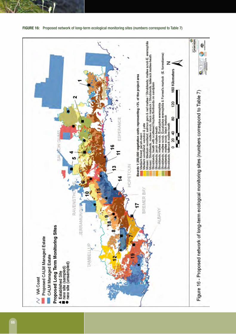
66
fIguRE 16: Proposed network of long-term ecological monitoring sites (numbers correspond to table 7)

67
fIguRE 17: macro Corridor network and long term monitoring sites

68
the 18 sites listed above (20 minus the two sites visited and deemed unsuitable) represent a proposed system of regional long-term ecological monitoring sites for the area. this system should provide a representation of regional ecosystems and enable detection of ecosystem change on a regional scale.
ProbLemS encountered With the coLLection oF baSeLine data
no specific problems were encountered with the physical collection of baseline data. However, interpretation and analysis of the data revealed several problems that may hinder the accurate or unequivocal detection of change at these sites. these problems are:
the use of a vegetation cover measure that is an ■■
estimate rather than a real measure may make the statistically based detection of change difficult
the number of quadrats sampled (three) was the ■■
maximum that could be sampled within the time and resource constraints of the project; however, although three quadrats are better then one for detecting change, this is a low number as the greater the number of quadrats the more accurately change may be detected
the abundance of invertebrates sampled in a number ■■
of the eastern sites was very low; this may have been a factor of low temperatures during the sampling season (september 2001).
the following outcomes were achieved during the project in relation to the monitoring network:
A database was developed of existing and new 1. monitoring sites within the area.
A gis tool was developed that can be used to select 2. discrete areas or sites across the area that are representative of the area. the criteria used here for the site selection process could be diversified to include variables such as altitude to provide a more comprehensive system of sites if more resources became available.
baseline data was collected for a subset of the new 3. monitoring sites.
recognition of the limitations of beard’s 1:250,000 4. vegetation mapping.
3.5 rECoMMEndationSDuring the project a few problems were encountered and the following recommendations are made to improve the future monitoring program:
further work is needed to establish new monitoring ■■
sites that are ground-truthed to ensure that the network is truly representative of the area.
the objective for monitoring may need to be refined ■■
further so that specific outcomes can be measured and therefore change can be unequivocally detected.
the use of a measure for vegetation cover that can ■■
statistically detect change should be investigated further.
the number of quadrats sampled may need to be ■■
increased in future monitoring.
the costs of the above two recommendations may ■■
be quite high and should be factored into any further cost/benefit analysis.
Although many of the established sites were not ■■
included in the regional monitoring network, it is nevertheless strongly recommended that sites already set up as permanent monitoring sites continue to be sampled at regular intervals to provide information on long-term changes within these communities; for example, the mountain top sites (barrett 1996) could act as an early warning for climate change.
seasonal sampling should be built in to the monitoring ■■
program.
consideration should be given to integrating this ■■
regional network of monitoring sites into a global system of monitoring such as briM, a sub program of the Man and the biosphere Program.

69
The Macro Corridor Network has been recognised in other localised or landscape scale planning processes.
– John Watson
gLoBAL RECognITIonthere has been growing recognition that better protection is required, for example through the presence of buffer zones around protected areas in order to reduce external impacts, and through establishment and protection of vegetated corridor links or secure stepping stones between remnant patches in disturbed landscapes
SouTh CoAST InITIATIvESrather than simply target development of the most obvious nearby portions of uncleared crown reserves within the coastal Macro corridor, it has been possible to negotiate designs which minimise impact on the width of the corridor.
gonDWAnA LInKthe gondwana link project is an exciting partnership between various non-government conservation organisations.
it has now broadened its horizons to a longer Karri-to-Kalgoorlie linkage via the stirling range and corackerup and then along the north-east axis via Jerramungup to the fitzgerald river national Park and then via the ravensthorpe area to the southern goldfields.
CoMMunITy vALuESthere are many other major corridor linkages, then even more localised connecting linkages right down to the farm paddock level.
the network provides a sound basis for the maxim to ‘think globally, act locally’ in the context of providing a degree of ownership or belonging to the entire regional network.
SECTION 4
EVOLVING USE AND APPLICATIONS OF THE MACRO CORRIDOR CONCEPT INTO THE 21st CENTURY
Lead Writer: John Watson

70
SECTION 4: EVOLVING USE AND APPLICATIONS OF THE MACRO CORRIDOR CONCEPT INTO THE 21st CENTURY
network in Western Australia is recognised in many parts of the world as crucial to long term biodiversity conservation and to the socioeconomic values and ecosystem services that protected areas provide.
there was also a strong focus at the congress on change into the 21st century including a plenary presentation looking at potential scenarios for protected areas through to 2023 (Mcneely & schutyser 2003). A recurring focus within discussions on change was the inevitability of global climate change as a threatening process for biodiversity.
based on the growing recognition of the importance of landscape and regional connectivity for biodiversity conservation and similar growth in recognition of the threat of global climate change, in this final section of the Macro corridor report we address :
initiatives and actions to retain ■■ existing connectivity in the south coast region
initiatives to ■■ enhance existing connectivity
use of the Macro corridor network and concept as a ■■
planning tool
broader ■■ community values of the Macro corridor network
the potential of the network as a key part of a broader ■■
bioregional network to monitor change.
each is now addressed in turn.
4.1 gloBal rECognition of largE SCalE ConnECtivity nEEdS
only some 30–40 years ago, there was a belief that the world’s biodiversity could be adequately protected into the future by simply establishing national parks and other conservation reserves in such a way that they included representation of all major landforms and vegetation associations. since then, however, there has been growing recognition that better protection is required, for example through the presence of buffer zones around protected areas in order to reduce external impacts (the original biosphere reserve concept) and through establishment and protection of vegetated corridor links or secure stepping stones between remnant patches in disturbed landscapes. it is also now recognised that community awareness of and support for protected areas are essential.
every ten years or so the World commission on Protected Areas (WcPA), a commission of the World conservation union (iucn), convenes a World Parks congress which brings together managers, researchers, policy makers, indigenous owners, users, non-government organisations (ngos) and many others, all of whom have a direct reliance on, responsibility for, or interest in, protected areas in different parts of the world. the 5th World Parks congress was held in Durban, south Africa, in september 2003, which was shortly after completion of the Western Australian south coast Macro corridor Project 1999–2002. it attracted some 2600 participants, of whom around 50 were from Australia (iucn 2005).
these global congresses provide an overview of what trends, issues and initiatives have emerged in protected areas around the world over the previous decade, what new issues and potential threats to protected areas are emerging, and what strategies need to be put in place to address change over the ensuing ten years and beyond. At the Durban congress there was a strong focus on protected areas as integral parts of total landscapes with one of the seven major workshop themes focusing on linkages in the landscape/seascape. it was apparent from the presentations in this theme that the type of landscape and bioregional approach of our Macro corridor

71
4.2 South CoaSt initiativES to rEtain ConnECtivity
Whilst use of the Macro corridor concept as a planning tool is explored more fully in section 4.4, at a more local level there have already been several instances where awareness of the concept has helped reduce the impact of incremental vegetation clearing upon the existing corridor network.
for example, the town of Hopetoun sits within the important coastal macro corridor a few kilometres to the east of the fitzgerald river national Park. there are several records for threatened species of flora or fauna (including chuditch) in the section of corridor around Hopetoun. in response to an increase in local population as a result of a significant new mining operation for nickel in the bandalup Hill area to the north, there was a need to release more blocks of land for future housing on and around the outskirts of Hopetoun. there have also been growing requirements for additional services for the expanding community such as improved water and power supplies and refuse disposal.
rather than simply target development of the most obvious nearby portions of uncleared crown reserves within the coastal Macro corridor, it has been possible to negotiate designs which minimise impact on the width of the corridor. Hence the coastal corridor will not suffer further significant narrowing at this point which would have occurred otherwise.
4.3 initiativES to EnhanCE ConnECtivity
At a local level there have now been numerous instances where undisturbed or regenerating natural vegetation adjacent to or within a macro corridor has been purchased as a public or private conservation reserve, has been adopted under one of the range of conservation covenant schemes available for private land, or has been designated as a land for Wildlife property in voluntary association with the land owner or land manager. in many of these instances, awareness of the Macro corridor network has assisted a win-win outcome for both the land owners and the granting organisations and authorities.
At a broader scale, several land conservation district committees and similar organisations have developed catchment or landscape scale proposals for various funding opportunities to address natural resource management issues such as soil conservation and rising groundwater salinity. these have usually included strategic revegetation and in many cases linkages with existing major corridors or other areas of uncleared vegetation.
A local community group, the friends of the Porongurup range inc., has purchased and promoted a private conservation reserve, twin creeks, as part of a wildlife corridor link to the Porongurup national Park some 4 km to the south. the private reserve is also partially linked to the Kalgan river macro corridor to the north-east and hence is

72
an important stepping stone between the Porongurup and stirling range national Parks.
the most ambitious and well known project is the gondwana link project. initially this focused on a potential linkage between the stirling range national Park and the western boundary of the fitzgerald river national Park via the corackerup and proposed Peniup nature reserves. the gondwana link project is an exciting partnership between various non-government conservation organisations, including the Australian bush Heritage fund, greening Australia and the Wilderness society, as well as the local community. it has recently broadened its horizons to a longer Karri-to-Kalgoorlie linkage via the stirling range and corackerup and then along the north-east axis via Jerramungup to the fitzgerald river national Park and then via the ravensthorpe area to the southern goldfields. A focus in recent times has been on purchase of lands to consolidate existing connectivity in the corackerup-Peniup sector (figure 12).
the Macro corridor network has also been recognised in other localised or landscape scale planning processes such the lowlands coastal Management Plan (Henke 2003) and Watershed torbay catchment restoration Plan (read 2004), both located between Albany and Denmark. the lowlands reserve is recognised as a vital macro corridor link for the movement of both plants and animals between West cape Howe national Park and the nullaki Peninsula to the west. Within the torbay catchment, an analysis of remnant woody vegetation showed the high potential for adding to biodiversity and habitat value through bio-geographic planning for corridors.
4.4 uSE aS a StratEgiC planning tool
the Macro corridor concept has also been used as a planning tool by scriPt in order to target more strategic use of devolved local scale grants. While the proximity of a macro corridor or other major vegetation connection is certainly not mandatory for strategic use of funds (there will always be some localised areas of conservation importance in the landscape between macro corridors (e.g. threatened flora or special localised fauna habitats), nevertheless the strategic long term significance of the Macro corridor network is a key factor. scriPt has also recognised the importance of the Macro corridor network in the South Coast Regional Strategy for NRM (scriPt 2004) and its regional nrM investment Plan (scriPt 2005).
the Department of environment is now using the datasets as input to their assessment of land clearing applications. the network is also seen as a key component in the Lower Great Southern Regional Strategy being prepared by the Department of Planning and infrastructure as a broad level guide to land use planning in the city of Albany and the shires of Plantagenet, cranbrook and Denmark (Western Australian Planning commission 2005).

73
4.5 CoMMunity valuES of thE MaCro Corridor nEtwork
the Macro corridor network should not be thought of in isolation from the rest of the south coast landscape. there are many other major corridor linkages, then even more localised connecting linkages right down to the farm paddock level. figures 10, 11 and 14 earlier in the report demonstrate this very effectively. thus, most areas within the regional landscape are ultimately connected to others via this local, dendritic network and then via the Macro corridor network at a regional scale. Hence, the network provides a sound basis for the maxim to ‘think globally, act locally’ – at least in the context of providing a degree of ownership or belonging to the entire regional network.
the Malleefowl Preservation group is carrying out staged strategic revegetation in part of this local, dendritic network to facilitate the movement of malleefowl in the north ongerup area. Here malleefowl exist in isolated patches of bushland within a farmland matrix and several kilometres of corridors have been planted to assist their dispersal to larger areas of vegetation such as the tieline road nature reserve (Harold & Dennings 1998).
4.6 thE nEtwork aS part of a BiorEgional Monitor of ChangE
As indicated briefly in section 4.1, the consequences of global climate change are seen by the iucn and WcPA as key challenges for the world’s protected area network in the 21st century. there is increasing acceptance in Australia (natural resource Management Ministerial council 2004) and in Western Australia (indian ocean climate initiative Panel 2002; McKellar 2004) that climate change is occurring at a rapid rate – in geoclimatic timescales – and that among the many impacts there will be extra pressures upon biodiversity.
Without debating the predicted changes in detail, it does appear that in the south west of Western Australia there will be a reduction in rainfall away from the coast and a general mean temperature rise. this will result in a general movement of climatic zones to the south, to the west and upwards. Hence, in order to survive in the longer term we can expect similar movement of plants and animals to evolve.
the Macro corridor network could provide a valuable basis on which to monitor any discernible wildlife movement and to monitor biodiversity change generally, especially if a monitoring network is established in conjunction with more isolated control sites in the core areas of large protected areas. this was one of the underlying rationales for the monitoring network being proposed in section 3.2 above. the identification of the Macro corridor network has added value in this regard, in that it is essentially three dimensional extending longitudinally, latitudinally and altitudinally across the entire region.
As pointed out in the 2004 nrM Ministerial council report, whereas enhanced connectivity should increase the opportunity for dispersal and adaptation of endemic species to climate change, it may also increase the opportunity for more aggressive competing organisms, including predators and pathogens, to spread. there is some debate on the potential of corridors to exacerbate the spread of wildlife disease (bienen 2002). thus, additional monitoring sites within major corridors may also provide an early warning system of such threats.
the south coast region of the south West global biodiversity hotspot (Myers et al. 2000) contains a high concentration of endemic or threatened species with even more localised concentrations in areas such as the stirling

74
range national Park, fitzgerald river national Park and the two Peoples bay/Waychinicup area near Albany (Hopper & gioia 2004). these various regional ‘hotspots’ are also linked by macro corridors that were classified to be of very high priority and hence the focus of long term monitoring maybe better skewed more towards the western part of the study region.
4.7 final CoMMEntAlthough the body of this report focuses on the Macro corridor Project 1999–2002 and the identification and establishment of monitoring sites in 2001–2002, it is clear that the Macro corridor network remains a very useful tool and concept in the context of natural resource management and in particular long term biodiversity conservation. it is also clear that the framework in this region would be the envy of many other parts of the world where such a high degree of vegetation connectivity between major protected areas no longer exists.
With publication and dissemination of this report, it is likely that new applications will emerge and that the project will assume a greater input to on-going integrated natural resource management planning and investment across the region. it is therefore vital that we continue to promote and protect our bioregional Macro corridor network not only for its biodiversity conservation outcomes but also because ultimately our social and economic futures will also benefit.

75
SECTION 5
REFERENCES

76
SECTION 5: REFERENCES
bennett, A.f. (1997). Habitat linkages – a key element in an integrated landscape approach to conservation. Parks 7(1): 43–49.
bennett, A.f. (1999). linkages in the landscape: the role of corridors and connectivity in Wildlife Conservation. iucn, gland, switzerland & cambridge, uK.
bennett, s., brereton, r., Mansergh, i., berwick, s., sandiford, K. & Wellington, c. (1991). the potential effect of the enhanced greenhouse climate change on selected victorian fauna. Arthur Rylah Institute for Environmental Research. Technical Report Series No. 123.
benshemesh, J. (2000). National Recovery Plan for Malleefowl. national Parks and Wildlife service, sA.
berger, l., speare, r. & Hyatt, A. (1999). chytrid fungi and amphibian declines: overview, implications and future directions in Declines and Disappearances of Australian frogs. A. campbell (ed) environment Australia, canberra, Act.
bienen (2002). conservation corridors and the spread of infectious disease. Conservation in Practice 3: 10–17.
brereton, r., bennett, s. & Mansergh, i. (1995). enhanced greenhouse climate change and its potential effect on selected fauna of south-eastern Australia: a trend analysis. Biological Conservation 72: 339–354.
bridgewater, P., Phillips, A., green, M. & Amos, b. (1996). Biosphere reserves and the IUCN system of protected area management categories. Australian nature conservation Agency, the World conservation union and the unesco Man and the biosphere Programme. canberra, Act.
brown, A., thomson-Dans, c. & Marchant, n. (eds) (1998). Western Australia’s Threatened Flora. Department of conservation and land Management Perth, WA.
burbidge, A.A. & McKenzie, n.l. (1989). Patterns in the modern decline of Western Australia’s vertebrate fauna: causes and conservation implications. Biological Conservation 50: 143–198.
5.1 litEraturE CitEdAars, J. & ims, r.A. (1999). the effect of habitat corridors on rates of transfer and interbreeding between vole demes. Ecology 80(5): 1648–1655.
Anon. (1997). The National Weed Strategy. A strategic Approach to Weed Problems of national significance. the commonwealth of Australia, canberra, Act.
Armstrong, r. (1998). Western Shield – Bringing Back Wildlife from the Brink of Extinction. fox and rabbit control Workshop Proceedings. A project of the south coast regional initiative, Albany, WA.
bannister, J.l. (1970). Report on Biological Survey, Two Peoples Bay Reserve. (no. 27956) february 3–17, 1970. Western Australian Museum, Perth, WA.
barrett, s. (1996) A Biological Survey of Mountains in South Western Australia. Department of conservation and land Management, Perth, WA.
barrett, s. (1999). Montane Heath and thicket of the south West botanical Province, above approximately 900 m above sea level (eastern stirling range Montane Heath and thicket community). Interim Recovery Plan No. 52. Department of conservation and land Management, Perth, WA.
batisse, M. (1982). the biosphere reserve: A tool for environmental conservation and Management. Environmental Conservation 9(2): 101–111.
beard, J.s. (1972–1980). Vegetation Survey of Western Australia 1:250000 series. vegmap Publications, Applecross, WA.
beard, J.s. (1981). vegetation survey of Western Australia, 1:1000 000 series. explanatory notes to sheet 7. The Vegetation of the Swan Area. university of WA Press, Perth, WA.
beard, J.s. (1990). Plant Life of Western Australia. Kangaroo Press, nsW.

77
cairns, Jr. J. (1993). the current state of watersheds in the united states: ecological and institutional concerns. in Watershed 1993: A national conference on watershed management. usePA, Washington, Dc, usA.
Department of conservation and land Management. (1991). South Coast Region, Regional Management Plan 1992–2002. Management Plan no. 24. Department of conservation and land Management, Perth, WA.
Department of conservation and land Management. (1992). Walpole-Nornalup National Park Management Plan 1992–2002. Management Plan no. 22. Department of conservation and land Management, Perth, WA.
Department of conservation and land Management. (1999). Environmental Weed Strategy for Western Australia. environment Protection branch, Department of conservation and land Management, Perth, WA.
Department of conservation and land Management. (2000). fauna Management course notes. Department of conservation and land Management, Perth, WA.
Department of conservation and land Management. (2003). Independent Review of Western Shield. report of the review Panel. Possingham, H. (chair), Jarman, P & Kearns, A. Department of conservation and land Management, Perth, WA.
chapman, A. & newbey, K.r. (1995a). A biological survey of the fitzgerald area, Western Australia. CALMScience, supplement 3: 1–258.
chapman, A. & newbey, K.r. (1995b). A vertebrate survey and some notes on the vegetation of the ravensthorpe range, Western Australia. CALMScience 1(4): 465–508.
christensen, P., Annels, A., liddelow, g. & skinner, P. (1985). vertebrate fauna of the southern forests of Western Australia. A survey. Forests Department of Western Australia. Bulletin 94. Perth, WA.
city of Albany. (2003). Lowlands Coastal Reserve Management Plan – a plan to guide coastal and marine management within the Lowlands Reserve 2003. Prepared by David Henke, Albany, WA.
connell, s. & AtA environmental. (2000). vegetation survey of the Albany Hinterland. unpublished Draft report, Albany, WA.
courtney, J., start, t. & burbidge, A.A. (1998). gilbert’s Potoroo recovery Plan 1998–2000. Western Australian Wildlife Management Program No. 32, Department of conservation and land Management, Perth, WA.
craig, g. (2000). Vegetation and Flora of the South Coast – A Review. south coast Management group, Albany, WA.
csiro. 2001. climate change scenarios for the Australian region, canberra, Act. Website: http://www.dar.csiro.au/publications/scenarios.htm
Danks, A., burbidge, A.A., burbidge, A.H. & smith, g.t. (1996). Noisy Scrub-bird Recovery Plan. Wildlife Management Plan no. 12. Department of conservation and land Management, Perth, WA.
Dickman, c.r. (1996). impacts of feral cats in Overview of the Impacts of Feral Cats on Australian Native Fauna. Australian nature conservation Agency, canberra, Act.
elzinga, c.l., salzer, D.W., Willoughby, J.W. & gibbs, J.P. (2001). Monitoring Plant and Animal Populations. blackwell science inc.
environment Australia. (2000). Revision of the Interim Biogeographic Regionalisation of Australia (IBRA) and the Development of Version 5.1. – Summary Report. Department of environment and Heritage, canberra, Act.
ferdowsian, r., george, r., lewis, r., Mcfarlane, D., short, r. & speed, r. (1996). the extent of dryland salinity in Western Australia in Proceedings of the 4th National Workshop on the Productive Use and Rehabilitation of Saline Lands, Albany, WA.
forman, r.t.t. & godron, M. (1986). Landscape Ecology. John Wiley & sons inc., new york, usA.
gaines, W.l., Harrod, r.J. & lehmkuhl, J.f. (1999). Monitoring biodiversity: Quantification and interpretation. unpublished report. united states Department of Agriculture. general technical report PnW-gtr-443.

78
garnett, s. (1992). The Action Plan for Australian Birds. Australian national Parks and Wildlife service, canberra, Act.
gilfedder, l. & Kirkpatrick, J.b. (1998). factors influencing the integrity of remnants in subhumid tasmania. Biological Conservation 84: 89–96.
gilfillan, s. (2000). Terrestrial Fauna of the South Coast – A Review. south coast Management group, Albany, WA.
green, b. & Wetherley, s. (2000). Geology, Landforms and Mineral Extraction in the South Coast – A Review. south coast Management group, Albany, WA.
griffin, e.A. (1995). Distribution and Ecological Significance of On-Farm Bush Remnants in the Southern Wheatbelt Region of Western Australia, Phase III. Division of regional operations Department of Agriculture, Western Australia and Australian nature conservation Agency, canberra, Act.
Halse, s.A., Williams, M.r., Jaensch, r.P. & lane J.A.K. (1993). Wetland characteristics and waterbirds use of wetlands in south-western Australia. Wildlife Research 20: 103–126.
Harold, g. & Dennings, s. (1998). The First Five Years. Malleefowl Preservation group, ongerup, WA.
Harris, l.D. & scheck, J. (1991). from implications to applications: the dispersal corridor principle applied to the conservation of biodiversity in Nature Conservation 2: The Role of Corridors. saunders, D.A. & Hobbs, r.J. (eds), surrey beatty & sons, nsW.
Hobbs, r.J. & Hopkins, A.J.M. (1991). the role of conservation corridors in a changing climate. in Nature Conservation 2: The Role of Corridors. saunders, D.A. & Hobbs, r.J. (eds). surrey beatty & sons, nsW.
Hopkins, A. & McKenzie, n. (1994). Options for long-term monitoring of arid and semi-arid terrestrial ecosystems in Australia. background paper prepared for the national Workshop on long-term Monitoring of Australian biodiversity, 10–11 May 1994, canberra, Act.
Hopper, s.D. & gioia. P. (2004). the southwest Australian floristic region: evolution and conservation of a global Hot spot of biodiversity. Annual Review of Ecology, Evolution and. Systematics. 35: 623–650.
How, r.A., Dell, J. & Humphreys, W.f. (1987). the ground vertebrate fauna of costal areas between busselton and Albany, Western Australia. Records of the Western Australian Museum. 13(4): 553–574.
indian ocean climate initiative. (2002). Climate variability and change in south west Western Australia, indian ocean climate initiative Panel, september 2002, Perth, WA.
indian ocean climate initiative. (2005). Bulletin No 6, August 2005, Perth, WA.
iucn. (1980). The World Conservation Strategy. iucn, uneP, WWf, gland, switzerland.
iucn. (1994). 1994 IUCN Red List Categories. Prepared by the iucn species survival commission, iucn, gland, switzerland.
iucn. (2005). Benefits Beyond Boundaries. Proceedings of the vth iucn World Parks Progress, iucn, gland, switzerland.
Jones, b.A., How, r.A. & Kitchener, D.J. (1994). A field study of Pseudocheirus occidentalis (Marsupialia: Petauridae). i. Distribution and habitat. Wildlife Research 21: 175–87.
Kinnear, J.e., onus, M.l. & bromilow, r.n. (1988). fox control and rock wallaby population dynamics. Australian Wildlife Research 15: 435–447.
Kitchener, D.J., chapman, A. & Dell, J. (1975). A biological survey of cape le grand national Park. Records of the Western Australian Museum, supplement no. 1.
Kitchener, D.J., Dell, J., Muir, b.g. & Palmer, M. (1982). birds in Western Australian Wheatbelt reserves – implications for conservation. Biological Conservation 22: 127–163.
Knight, J. (ed) (1998). Environment Western Australia 1998: State of the Environment Report. Department of environmental Protection, Perth, WA.
lambeck, r.J. (1992). the role of faunal Diversity in ecosystem function in Biodiversity of Mediterranean Ecosystems in Australia. Hobbs, r.J. (ed). surrey beatty & sons, nsW.

79
lambeck, r.J. (1997). focal species: A Multi-species umbrella for nature conservation. Conservation Biology 11: 849–856.
leighton, s. & Watson, J. (1992). A preliminary biological survey of four river foreshore reserves along the south coast of Western Australia. ‘Save the Bush’ South Coast River Corridor Project. Department of conservation and land Management south coast regional office, Albany, WA.
Maciejewski, s, Wilkins, P & claymore K. (1999). towards strategic and integrated landscape Management: the Western Australian south coast Macro corridor network. WA Bankwest Landcare Conference ‘Where the Community Counts’. conference Proceedings, esperance, WA.
Marchant, n. (1973). species Diversity in the southwestern flora. Journal of the Royal Society of Western Australia 56: 23–30.
Marchant, n. (1991). the vascular flora of southwestern Australia. Association of Societies for Growing Australian Plants 1991 Conference, Perth, WA.
May, J.e. & McKenzie, n.l. (2002). A Biodiversity Audit of Western Australia’s Biogeographical Subregions in 2002. Department of conservation and land Management, Perth, WA.
McKellar, r. 2004. (draft) Western Australian Greenhouse Biodiversity Strategy, Department of conservation and land management, Perth, WA.
Mcneely, J.A. & schutyser, f. (eds) 2003. Protected Areas in 2023: Scenarios for An Uncertain Future, iucn, gland, switzerland.
Miller, K. & Hamilton, l. (1997). scaling up: elements of a strategy for protected areas in the 21st century in Protected Areas in the 21st Century: From Islands to Networks. World commission on Protected Areas Mid term symposium, iucn, 1997, Albany, WA.
Myers, n., Mittermeier, r.A., Mittermeier, c.g., da fonseca, g.A.b. & Kent, J. (2000). biodiversity hotspots for conservation priorities. Nature 404: 803–808.
natural resource Management Ministerial council (2004). National Biodiversity and Climate Change Action Plan
2004–2007, Australian government, Department of environment and Heritage, canberra, Act.
new, t.r. (1998). Invertebrate Surveys for Conservation. oxford university Press.
newman, P. & Pouliquen-young, o. (1997). the implications of climate change for land-based nature conservation strategies. first interim report. unpublished. institute for science and technology Policy. Murdoch university, Perth, WA.
nicoles, A.o. & Margules, c.r. (1991). the design of studies to demonstrate the biological importance of corridors in Nature Conservation 2: The Role of Corridors. saunders, D.A. & Hobbs, r.J. (eds), surrey beatty & sons, nsW.
nlWrA. (2000). Australian Dryland Salinity Assessment 2000: extent, impacts, processes, monitoring and management options. national land and Water resources Audit, canberra, Act.
noss, r.f. (1990). indicators for monitoring biodiversity: a hierarchical approach. Conservation Biology 4(4): 355–367.
noss, r.f. (2002). context matters. considerations for large-scale conservation. Conservation in Practice 3: 10–19.
Peters, r.l. & Darling, J.D.s. (1985). the greenhouse effect and nature reserves. Bioscience 35: 707–717.
Plummer, M.l. & Mann, c. c. (1995). Are wildlife corridors the right path? Science 270 (5241).
Poiani, K.A., richter, b.D., Anderson, M.g. & richter, H.e. (2000). biodiversity conservation at multiple scales: functional sites, landscapes and networks. BioScience 50 (2): 133–146.
reid, v. & Associates. (2004). Watershed Torbay Restoration Plan. report prepared for the Department of environment, Perth, WA.
renzullo, l.J. & Wallace, J.f. (2001). Vegetation and Change 1988–2000 – Mt. Barker Landsat scene (111–084). csiro Mathematical and information sciences, Perth, WA.

80
safstrom, r. & craig, g.f. (1996). Environmental Evaluation of Native Vegetation in the Wheatbelt of Western Australia – Principles and Criteria used to Appraise Land Clearing Proposals. Prepared for the Western Australian Department of environmental Protection, Perth, WA.
sanders, A. (1991). Oral Histories Documenting Changes in Wheatbelt Wetlands. occasional Paper 2/91. Department of conservation and land Management, Perth, WA.
sanders, A. (1996). Conservation Value of Fitzgerald Biosphere Reserve Buffer/Transition Zone Phases I–IV. Department of conservation and land Management, Albany in conjunction with Australian nature conservation Agency, canberra, Act.
sanders, A. (1997). Monitoring in the Fitzgerald Biosphere Reserve. Department of conservation and land Management, Albany in conjunction with environment Australia, canberra, Act.
saunders, D., Arnold, g., burbidge, A. & Hopkins, A. (eds) (1987). Nature Conservation: The Role of Remnants of Native Vegetation. surrey beatty & sons, nsW.
saunders, D.A. & Hobbs, r.J. (eds) (1991). Nature Conservation 2: The Role of Corridors. surrey beatty & sons, nsW.
saunders, D.A. & ingram, J.A. (1995). Birds of Southwestern Australia: An atlas of changes in the distribution and abundance of the wheatbelt avifauna. surrey beatty & sons, nsW.
saunders, D.A., Hobbs. r.J. & ehrlich, P.r. (eds) (1993). Nature Conservation 3: The Reconstruction of Fragmented Landscapes. surrey beatty & sons, nsW.
serventy, D.l. & Whittell, H.M. (1976). Birds of Western Australia. university of WA Press, Perth, WA.
scriPt. (2000). DRAFT Southern Prospects Regional Strategy – A Regional Strategy to Guide Sustainable use of Natural Resources, Protect Conservation Values and Develop Vibrant Rural Communities on the South Coast of Western Australia 2000–2005. south coast regional initiative Planning team, Albany, WA.
scriPt. (2004). Southern Prospects 2004–2009. Draft for public comment. south coast regional initiative Planning team, Albany, WA.
scriPt (2005). The First NRM Investment Plan for the South Coast Region of WA for the period 2005/06 to 2007/08. south coast regional initiative Planning team, Albany, WA.
simberloff, D.s. & cox, J. (1987). consequences and costs of conservation corridors. Conservation Biology 1: 63–71.
simberloff, D.s., farr, J.A., cox, J. & Melman, D.W. (1992). Movement corridors: conservation bargains or poor investments? Conservation Biology 6: 493–504.
smith, g.t. (1987). the changing environment for birds in the south-west of Western Australia: some management implications in Nature Conservation: the Role of Remnants of Native Vegetation. saunders et al. (eds). surrey beatty & sons, nsW.
smith, r., barrett, s. & freebury, g. (2004). Phosphite Program report for the 2003/04 financial year. unpublished report. Department of conservation and land Management, Albany, WA.
solbrig, o.t. (ed) (1991). From genes to ecosystems: a research agenda for biodiversity. report of a iubs-scoPe-unesco workshop, Harvard forest, Petersham, MA, usA.
soule, M.e. & terborgh, J. (1999). conserving nature at regional and continental scales – a scientific program for north America. BioScience 49(10): 809–817.
spellerberg, i. f. (1991). Monitoring Ecological Change. cambridge university Press.
storr, g.M., Hanlon, t.M.s. & Harold, g. (1981). Herpetofauna of the shores and hinterland of the great Australian bight. Records of the Western Australian Museum 9(1): 23–39.
taylor, P.D., fahrig, l., Henein, K. & Merriam, g. (1993). connectivity is a vital element of landscape structure. Oikos 68: 181–189.
thackway, r. & cresswell, i.D. (eds) (1995). An Interim Biogeographic Regionalisation for Australia: A Framework for Setting Priorities in the National Reserve System

81
Cooperative Program. Australian nature conservation Agency, canberra, Act.
Water Authority. (1987). rainfall isohyets in Data Druid volume 1, April 2000, Perth, WA.
Watson, J. (1991). the identification of river foreshore corridors for nature conservation in the south coast region of Western Australia in Nature Conservation 2: The Role of Corridors. saunders, D. A. & Hobbs, r. J. (eds). surrey beatty & sons, nsW.
Watson, J. & sanders, A. (1997). fitzgerald river national Park biosphere reserve 1978–1997: the evolution of integrated protected area management. Parks 7(1): 9–19.
Watson, J. & Wilkins, P.J. (1999). the Western Australian south coast Macro corridor Project – A bioregional strategy for nature conservation. Parks 9(3): 7–16.
Western Australian Planning commission (2005). Lower Great Southern Strategy draft for public comment, september 2005, Perth, WA.
Wilkins, P. (2001). linking the landscape. Landscope 16(4): 41–46.
Wilson, s. (1984). endemic reptiles of south Western Australia. Wildlife Australia Autumn 1984: 20–21.
5.2 pErSonal CoMMuniCationsarah barrett conservation officer (flora) cAlM
tony friend senior researcher cAlM
Jay gomboso senior Policy Adviser cAlM
Malcom grant conservation officer cAlM
Dale roberts university of WA
nathan McQuoid greening Australia WA

82

83
APPENDICES

84
the categorieS
ExtinCt (Ex) – A taxon is extinct when there is no reasonable doubt that the last individual has died.
ExtinCt in thE wild (Ew) – A taxon is extinct in the wild when it is known only to survive in cultivation, in captivity or as a naturalised population (or populations) well outside the past range. A taxon is presumed extinct in the wild when exhaustive surveys in known and/or expected habitat, at appropriate times (diurnal, seasonal, annual), throughout its historic range have failed to record an individual. surveys should be over a time frame appropriate to the taxon’s life cycle and life form.
CritiCally EndangErEd (Cr) – A taxon is critically endangered when it is facing an extremely high risk of extinction in the wild in the immediate future, as defined by any of the criteria (A–e) as described below.
EndangErEd (En) – A taxon is endangered when it is not critically endangered but is facing a very high risk of extinction in the wild in the near future, as defined by any of the criteria (A–e) as described below.
vulnEraBlE (vu) – A taxon is vulnerable when it is not critically endangered or endangered but is facing a high risk of extinction in the wild in the medium-term future, as defined by any of the criteria (A–e) as described below.
lowEr riSk (lr) – A taxon is lower risk when it has been evaluated, does not satisfy the criteria for any of the categories critically endangered, endangered or vulnerable. taxa included in the lower risk category can be separated into three subcategories:
Conservation dependent (cd). 1. taxa which are the focus of a continuing taxon-specific or habitat-specific conservation programme targeted towards the taxon in question, the cessation of which would result in the taxon qualifying for one of the threatened categories above within a period of five years.
near threatened (nt)2. . taxa which do not qualify for conservation Dependent, but which are close to qualifying for vulnerable.
least Concern (lc).3. taxa which do not qualify for conservation Dependent or near threatened.
data dEfiCiEnt (dd) A taxon is Data Deficient when there is inadequate information to make a direct, or indirect, assessment of its risk of extinction based on its distribution and/or population status. A taxon in this category may be well studied, and its biology well known, but appropriate data on abundance and/or distribution is lacking. Data Deficient is therefore not a category of threat or lower risk. listing of taxa in this category indicates that more information is required and acknowledges the possibility that future research will show that threatened classification is appropriate. it is important to make positive use of whatever data are available. in many cases great care should be exercised in choosing between DD and threatened status. if the range of a taxon is suspected to be relatively circumscribed, if a considerable period of time has elapsed since the last record of the taxon, threatened status may well be justified.
not EvaluatEd (nE) A taxon is not evaluated when it is has not yet been assessed against the criteria.
AppEnDIx 1: ThE IuCn RED LIST CATEgoRIES (1994) uSED foR WESTERn AuSTRALIAn fAunA

85
the criteria For criticaLLy endangered, endangered and vuLnerabLe
CRITICALLY ENDANGERED (CR)
A taxon is critically endangered when it is facing an extremely high risk of extinction in the wild in the immediate future, as defined by any of the following criteria (A–e):
Population reduction in the form of either of the A) following:
An observed, estimated, inferred or suspected 1. reduction of at least 80% over the last ten years or three generations, whichever is the longer, based on (and specifying) any of the following:
direct observationa)
an index of abundance appropriate for the taxonb)
a decline in area of occupancy, extent of c) occurrence and/or quality of habitat
actual or potential levels of exploitationd)
the effects of introduced taxa, hybridisation, e) pathogens, pollutants, competitors or parasites.
A reduction of at least 80%, projected or suspected 2. to be met within the next ten years or three generations, whichever is the longer, based on (and specifying) any of (b), (c), (d) or (e) above.
extent of occurrence estimated to be less than 100 b) km2 or area of occupancy estimated to be less than 10 km2, and estimates indicating any two of the following:
severely fragmented or known to exist at only a 1. single location.
continuing decline, observed, inferred or projected, 2. in any of the following:
extent of occurrencea)
area of occupancyb)
area, extent and/or quality of habitatc)
number of locations or subpopulationsd)
number of mature individualse)
extreme fluctuations in any of the following:3.
extent of occurrencea)
area of occupancyb)
number of locations or subpopulationsc)
number of mature individualsd)
Population estimated to number less than 250 mature c) individuals and either:
An estimated continuing decline of at least 25% 1. within three years or one generation, whichever is longer or
A continuing decline, observed, projected, or 2. inferred, in numbers of mature individuals and population structure in the form of either:
severely fragmented (i.e. no subpopulation a) estimated to contain more than 50 mature individuals)
all individuals are in a single subpopulation b)
Population estimated to number less than 50 mature D) individuals.
Quantitative analysis showing the probability of e) extinction in the wild is at least 50% within ten years or three generations, whichever is the longer.

86
ENDANGERED (EN)
A taxon is endangered when it is not critically endangered but is facing a very high risk of extinction in the wild in the near future, as defined by any of the following criteria (A–e):
Population reduction in the form of either of the A) following:
An observed, estimated, inferred or suspected 1. reduction of at least 50% over the last ten years or three generations, whichever is the longer, based on (and specifying) any of the following:
direct observationa)
an index of abundance appropriate for the taxonb)
a decline in area of occupancy, extent of c) occurrence and/or quality of habitat
actual or potential levels of exploitationd)
the effects of introduced taxa, hybridisation, e) pathogens, pollutants, competitors or parasites.
A reduction of at least 50%, projected or suspected 2. to be met within the next ten years or three generations, whichever is the longer, based on (and specifying) any of (b), (c), (d), or (e) above.
extent of occurrence estimated to be less than 5000 b) km2 or area of occupancy estimated to be less than 500 km2, and estimates indicating any two of the following:
severely fragmented or known to exist at no more 1. than five locations.
continuing decline, inferred, observed or projected, 2. in any of the following:
extent of occurrencea)
area of occupancyb)
area, extent and/or quality of habitatc)
number of locations or subpopulationsd)
number of mature individualse)
extreme fluctuations in any of the following: 3.
extent of occurrencea)
area of occupancyb)
number of locations or subpopulationsc)
number of mature individualsd)
Population estimated to number less than 2500 c) mature individuals and either:
An estimated continuing decline of at least 20% 1. within five years or two generations, whichever is longer, or
A continuing decline, observed, projected, or 2. inferred, in numbers of mature individuals and population structure in the form of either:
severely fragmented (i.e. no subpopulation a) estimated to contain more than 250 mature individuals)
all individuals are in a single subpopulation.b)
Population estimated to number less than 250 mature D) individuals.
Quantitative analysis showing the probability of e) extinction in the wild is at least 20% within 20 years or five generations, whichever is the longer.

87
VULNERABLE (VU)
A taxon is vulnerable when it is not critically endangered or endangered but is facing a high risk of extinction in the wild in the medium-term future, as defined by any of the following criteria (A–e):
Population reduction in the form of either of the A) following:
An observed, estimated, inferred or suspected 1. reduction of at least 20% over the last ten years or three generations, whichever is the longer, based on (and specifying) any of the following:
direct observationa)
an index of abundance appropriate for the taxonb)
a decline in area of occupancy, extent of c) occurrence and/or quality of habitat
actual or potential levels of exploitationd)
the effects of introduced taxa, hybridisation, e) pathogens, pollutants, competitors or parasites.
A reduction of at least 20%, projected or suspected 2. to be met within the next ten years or three generations, whichever is the longer, based on (and specifying) any of (b), (c), (d) or (e) above.
extent of occurrence estimated to be less than 20,000 b) km2 or area of occupancy estimated to be less than 2000 km2, and estimates indicating any two of the following:
severely fragmented or known to exist at no more 1. than ten locations.
continuing decline, inferred, observed or projected, 2. in any of the following:
extent of occurrencea)
area of occupancyb)
area, extent and/or quality of habitatc)
number of locations or subpopulationsd)
number of mature individualse)
extreme fluctuations in any of the following:3.
extent of occurrencea)
area of occupancyb)
number of locations or subpopulationsc)
number of mature individualsd)
Population estimated to number less than 10,000 c) mature individuals and either:
An estimated continuing decline of at least 10% 1. within ten years or three generations, whichever is longer, or
A continuing decline, observed, projected, or 2. inferred, in numbers of mature individuals and population structure in the form of either:
severely fragmented (i.e. no subpopulation a) estimated to contain more than 1000 mature individuals)
all individuals are in a single subpopulation b)
Population very small or restricted in the form of either D) of the following:
Population estimated to number less than 1000 1. mature individuals.
Population is characterised by an acute restriction 2. in its area of occupancy (typically less than 100 km2) or in the number of locations (typically less than five). such a taxon would thus be prone to the effects of human activities (or stochastic events whose impact is increased by human activities) within a very short period of time in an unforeseeable future, and is thus capable of becoming critically endangered or even extinct in a very short period.
Quantitative analysis showing the probability of e) extinction in the wild is at least 10% within 100 years.

88
(LiSted under the WeStern auStraLian WiLdLiFe conServation act 1950 according to the iucn red LiSt categorieS – See aPPendix 1)
thrEatEnEd MaMMalSchuditch Dasyurus geoffroii vulnerAbleDibbler Parantechinus apicalis enDAngereDred-tailed Phascogale Phascogale calura enDAngereDnumbat Myrmecobius fasciatus vulnerAbleWestern ringtail Possum Pseudochierus occidentalis vulnerAblegilbert’s Potoroo Potorous gilberti criticAlly enDAngereDrecherche rock-wallaby Petrogale lateralis hackettii vulnerAbleblack-flanked rock-wallaby Petrogale lateralis lateralis vulnerAbleQuokka Setonix brachyurus vulnerAbleHeath rat Pseudomys shortridgei vulnerAble
thrEatEnEd BirdSMalleefowl Leipoa ocellata vulnerAblerecherche cape barren goose Cereopis novaehollandiae grisea vulnerAbleAustralasian bittern Botaurus poicilptilus vulnerAblebaudin’s black cockatoo Calyptorhynchus baudini enDAngereDcarnaby’s black cockatoo Calyptorhynchus latirostris enDAngereDWestern ground Parrot Pezoporus wallicus flaviventris criticAlly enDAngereDnoisy scrub-bird Atrichornis clamosus vulnerAbleWestern bristlebird Dasyornis longirostris vulnerAbleWestern Whipbird Psophodes nigrogularis nigrogularis vulnerAble
thrEatEnEd frogSsunset frog Spicospina flammocaerulea vulnerAble
thrEatEnEd invErtEBratESstirling range rhytidid snail undescribed rhytidid sp.(WAM#2295–69) criticAlly enDAngereDstirling range Moggridgea spider Moggridgea sp. (b.y.Main 1990/24, 25) enDAngereDWestern Archaeid spider Austrarchaea mainae vulnerAble
AppEnDIx 2A: ThREATEnED fAunA of ThE MACRo CoRRIDoR nETWoRK AREA AS of novEMBER 2004.

89
priority MaMMalSbrush-tailed Phascogale Phascogale tapoatafa Priority 3Quenda Isoodon obesulus fusciventer Priority 5Woylie Bettongia penicillata Priority 5tammar Wallaby Macropus eugenii derbianus Priority 5Western brush Wallaby Macropus irma Priority 4Water rat Hydromys chrysogaster Priority 4Western Mouse Pseudomys occidentalis Priority 4
SpECially protECtEd and priority BirdSblack bittern (south west population) Ixobrychus flavicollis Priority 2little bittern Ixobrychus minutus Priority 4Peregrine falcon Falco peregrinus specially Protectedbustard Ardeotis australis Priority 4eastern curlew Numenius madagascariensis Priority 4Hooded Plover Charadrius rubricollis rubricollis Priority 4bush stonecurlew Burhinus grallarius Priority 4forest red-tailed black cockatoo Calyptorhynchus banksii naso Priority 3naretha blue bonnet Northiella haematogaster narethae specially ProtectedMajor Mitchell’s cockatoo Cacuata leadbeateri specially Protectedbarking owl Ninox connivens connivens Priority 2Masked owl Tyto novaehollandiae Priority 3shy Heathwren (western) Hylacola cauta whitlocki Priority 4rufous fieldwren (western wheatbelt) Calamanthus campestris montanellus Priority 4White-browed babbler (western wheatbelt) Pomatostomus superciliosus ashbyi Priority 4Western Whipbird (western mallee subsp.) Psophodes nigrogularis oberon Priority 4
SpECially protECtEd and priority BirdScrested shrike-tit (south-western subsp.) Falcunculus frontatus leucogaster Priority 4crested bellbird (southern) Oreoica gutturalis gutturalis Priority 4
priority rEptilESsouthern Death Adder (southwest population) Acanthophis antarcticus Priority 3short-nosed snake Elapognathus minor Priority 2lake cronin snake Paraplocephalus atriceps Priority 3elapid snake Parasuta spectabilis bushi Priority 1recherche Dugite Pseudonaja affinis tanneri Priority 2ravensthorpe range lerista Lerista viduata Priority 1gecko (unnamed species) Phyllodactylus sp ‘Cape Le Grand” Priority 2
AppEnDIx 2B: SpECIALLy pRoTECTED AnD pRIoRITy MAMMALS, BIRDS AnD REpTILES of ThE MACRo CoRRIDoR nETWoRK AREA AS of novEMBER 2004

90
AppEnDIx 3: ShApEfILES uSED In ThE DEvELopMEnT of ThE MACRo CoRRIDoR pRojECT gEogRAphICAL InfoRMATIon SySTEM (gIS)
desc
riptio
nfi
le n
ame
Scal
e of
Ca
ptur
eEx
tent
Cust
odia
nla
st
Mod
ified
Stat
usfo
rmat
Com
men
ts
adm
inis
trat
ion
Boun
darie
sib
rA r
egio
n bo
unda
ries
ibra
.ll
WA
Ju
n-99
conv
ersi
on to
.shp
Dgn
Acqu
ired
thro
ugh
cAlM
gis
loca
l gov
t. bo
unda
ries
lgaw
a898
sW
fe
b-99
conv
ersi
on to
.shp
Dgn
Acqu
ired
thro
ugh
cAlM
gis
cAlM
reg
iona
l bo
unda
ries
regd
ist.l
l
WA
Ju
n-99
conv
ersi
on to
.shp
Dgn
Acqu
ired
thro
ugh
cAlM
gis
WA
stat
e bo
unda
ryw
a_st
ate
W
A
Aug-
99oK
Poly
.shp
Acqu
ired
thro
ugh
cAlM
gis
arcv
iew
cAlM
add
ed fu
nctio
nalit
y ex
tens
ion
cAlM
.avx
no
v-98
oK
Acqu
ired
thro
ugh
cAlM
gis
Xtoo
ls e
xten
sion
Xtoo
lsm
h.av
x
nov-
98oK
Ac
quire
d th
roug
h cA
lM g
is
defa
ult.p
rj
May
-99
oK
Acqu
ired
thro
ugh
cAlM
gis
Proj
ecto
r ext
ensi
onpr
jctr.
avx
no
v-99
oK
Acqu
ired
thro
ugh
cAlM
gis
vege
tatio
nW
oody
veg
etat
ion
cove
r 19
96Al
bveg
25 m
pix
elAl
bany
DolA
/csi
rooc
t-99
oKPo
lygo
nPo
lygo
nise
d by
cAl
M, A
cqui
red
thro
ugh
cAlM
gis
bl
aveg
25 m
pix
el
DolA
/csi
rooc
t-99
oKPo
lygo
nPo
lygo
nise
d by
cAl
M, A
cqui
red
thro
ugh
cAlM
gis
dw
eveg
25 m
pix
elDw
ellin
gup
DolA
/csi
rooc
t-99
Po
lygo
nPo
lygo
nise
d by
cAl
M, A
cqui
red
thro
ugh
cAlM
gis
es
pveg
25 m
pix
eles
pera
nce
DolA
/csi
rooc
t-99
Po
lygo
nPo
lygo
nise
d by
cAl
M, A
cqui
red
thro
ugh
cAlM
gis
ka
tveg
25 m
pix
elKa
tann
ing
DolA
/csi
rooc
t-99
Po
lygo
nPo
lygo
nise
d by
cAl
M, A
cqui
red
thro
ugh
cAlM
gis
m
anve
g25
m p
ixel
Do
lA/c
siro
oct-9
9
Poly
gon
Poly
goni
sed
by c
AlM
, Acq
uire
d th
roug
h cA
lM g
is
mor
veg
25 m
pix
el
DolA
/csi
rooc
t-99
Po
lygo
nPo
lygo
nise
d by
cAl
M, A
cqui
red
thro
ugh
cAlM
gis
m
unve
g25
m p
ixel
Do
lA/c
siro
oct-9
9
Poly
gon
Poly
goni
sed
by c
AlM
, Acq
uire
d th
roug
h cA
lM g
is
narv
eg25
m p
ixel
narr
ogin
DolA
/csi
rooc
t-99
Po
lygo
nPo
lygo
nise
d by
cAl
M, A
cqui
red
thro
ugh
cAlM
gis
pe
mve
g25
m p
ixel
Pem
bert
onDo
lA/c
siro
oct-9
9
Poly
gon
Poly
goni
sed
by c
AlM
, Acq
uire
d th
roug
h cA
lM g
is
perv
eg25
m p
ixel
Do
lA/c
siro
oct-9
9
Poly
gon
Poly
goni
sed
by c
AlM
, Acq
uire
d th
roug
h cA
lM g
is
swcv
eg25
m p
ixel
Do
lA/c
siro
oct-9
9
Poly
gon
Poly
goni
sed
by c
AlM
, Acq
uire
d th
roug
h cA
lM g
is
wal
veg
25 m
pix
elW
alpo
leDo
lA/c
siro
oct-9
9
Poly
gon
Poly
goni
sed
by c
AlM
, Acq
uire
d th
roug
h cA
lM g
isbe
ard’
s ve
geta
tion
– 3
mill
ion
scal
ebe
ard_
3 m
?so
uthe
rn W
A?
Jun-
99oK
Poly
gon.
shp
Acqu
ired
thro
ugh
cAlM
gis
bear
d’s
vege
tatio
n-25
0000
sca
le
Decl
ared
rar
e fl
ora
alb_
rare
v
Alba
nycA
lMJu
n-99
oKdb
f to
Poin
t.shp
Acqu
ired
thro
ugh
cAlM
, Joh
n ri
ley/
Mic
hael
Mef
fert
es
p_ra
rev
es
pera
nce
cAlM
Jun-
99oK
dbf t
o Po
int.s
hpAc
quire
d th
roug
h cA
lM, J
ohn
rile
y/ M
icha
el M
effe
rt
wal
_rare
v
Wal
pole
cAlM
Jun-
99oK
dbf t
o Po
int.s
hpAc
quire
d th
roug
h cA
lM, J
ohn
rile
y/ M
icha
el M
effe
rtPl
anta
tions
broa
dlea
f
Alba
ny H
inte
rland
(m
ainl
y)
Jun-
98
Poly
gon
Acqu
ired
thro
ugh
cAlM
gis
Alba
ny H
inte
rland
ve
geta
tion
map
ping
albh
int1
?Al
bany
Hin
terla
nd?
Jul-9
9
Dgn
Acqu
ired
thro
ugh
cAlM
gis
, rea
dme
file
on c
D

91
desc
riptio
nfi
le n
ame
Scal
e of
Ca
ptur
eEx
tent
Cust
odia
nla
st
Mod
ified
Stat
usfo
rmat
Com
men
ts
al
bhin
t2?
Alba
ny H
inte
rland
?Ju
l-99
Dg
nAc
quire
d th
roug
h cA
lM g
is, r
eadm
e fil
e on
cD
al
bhin
t3?
Alba
ny H
inte
rland
?Ju
l-99
Dg
nAc
quire
d th
roug
h cA
lM g
is, r
eadm
e fil
e on
cD
al
bhin
t4?
Alba
ny H
inte
rland
?Ju
l-99
Dg
nAc
quire
d th
roug
h cA
lM g
is, r
eadm
e fil
e on
cD
?es
pe?
espe
ranc
e?
Jul-9
9
Ac
quire
d th
roug
h cA
lM g
is?
jerr
?Je
rram
ungu
p?
Jul-9
9
Ac
quire
d th
roug
h cA
lM g
is?
rave
?ra
vens
thor
pe?
Jul-9
9
Ac
quire
d th
roug
h cA
lM g
is?
raw
arv
??
?Ju
l-99
Acqu
ired
thro
ugh
cAlM
gis
Plan
tatio
nsco
nife
rous
Al
bany
Hin
terla
nd
(mai
nly)
Ju
n-98
Po
lygo
nAc
quire
d th
roug
h cA
lM g
is
faun
a ra
re a
nd e
ndan
gere
d fa
una
r&e_
faun
aso
uth
coas
t reg
ion
cAlM
nov-
99oK
Poin
t.shp
Acqu
ired
thro
ugh
Pete
r ore
ll, c
AlM
geol
ogy
WA
geol
ogy
geoo
bs95
sW
Ju
l-99
oKPo
lygo
n.sh
pAc
quire
d th
roug
h cA
lM g
is
Soils
no
te r
eadm
e fil
e on
cD
calm
sys
?cl
ippe
d to
scr
egio
nAg
WA
Jul-9
9oK
Dgn
Acqu
ired
thro
ugh
cAlM
gis
, Dra
ft s
oil l
ands
cape
sys
tem
s,
Agric
. are
a
calm
aas
?cl
ippe
d to
scr
egio
nAg
WA
Jul-9
9oK
Dgn
Acqu
ired
thro
ugh
cAlM
gis
, Atla
s of
Aus
tral
ian
soils
, re
mai
nder
.
imag
ery
sate
llite
imag
ery
brem
er b
aybr
emer
bay
25 m
pix
elbr
emer
bay
Ju
l-99
oKbi
lAc
quire
d th
roug
h gr
aem
e be
hn ,
cAlM
espe
ranc
ees
pera
nce
25 m
pix
eles
pera
nce
Ju
l-99
oKbi
lAc
quire
d th
roug
h gr
aem
e be
hn ,
cAlM
Mal
colm
Mal
colm
25 m
pix
elM
alco
lm
Jul-9
9oK
bil
Acqu
ired
thro
ugh
grae
me
behn
, cA
lMM
t bar
ker
mtb
arke
r25
m p
ixel
Mt b
arke
r
Jul-9
9oK
bil
Acqu
ired
thro
ugh
grae
me
behn
, cA
lMne
wde
gate
new
dega
te25
m p
ixel
new
dega
te
rave
nsth
orpe
rave
nsth
orpe
25 m
pix
elra
vens
thor
pe
Aeria
l Pho
togr
aphy
Pana
iram
a –
blac
kwoo
d 19
97
1:50
000
Do
lA
Pana
iram
a –
brem
er b
ay
1:50
000
Do
lA
inco
mpl
ete,
to b
e or
dere
d w
hen
finis
hed.
Pana
iram
a –
espe
ranc
e no
rth
1998
1:
5000
0
DolA
Pana
iram
a –
espe
ranc
e so
uth
1998
1:
5000
0
DolA
Pana
iram
a –
grea
t so
uthe
rn 1
996/
98
1:50
000
Do
lA

92
desc
riptio
nfi
le n
ame
Scal
e of
Ca
ptur
eEx
tent
Cust
odia
nla
st
Mod
ified
Stat
usfo
rmat
Com
men
ts
Pana
iram
a –
rave
nsth
orpe
nor
th 1
998
1:
5000
0
DolA
Pana
iram
a –
rave
nsth
orpe
sou
th 1
998
1:
5000
0
DolA
Pana
iram
a –
new
dega
te
nort
h 19
97/9
9
1:50
000
Do
lA
Pana
iram
a –
new
dega
te
sout
h 19
97
1:50
000
Do
lA
Cada
stre
and
tenu
re
cada
stre
199
7ca
d_19
97?
sW?
Jun-
99oK
Poly
gon.
shp
Acqu
ired
thro
ugh
cAlM
gis
cada
stre
199
8ca
d_st
hc?
sW
sep-
99oK
Poly
gon.
shp
Acqu
ired
thro
ugh
cAlM
gis
cAlM
lan
ds 1
998
clw
498l
l?
sWcA
lMJu
l-99
oKPo
lygo
n.sh
pAc
quire
d th
roug
h cA
lM g
isot
her c
row
n re
serv
esoc
res
?sW
?Ju
l-99
oKPo
lygo
n.sh
pAc
quire
d th
roug
h cA
lM g
is
road
s/hy
drol
M
ajor
riv
ers
wcm
ajlin
W
este
rn s
creg
ion
?no
v-99
oKsh
p lin
esAc
quire
d th
roug
h ca
lm g
is.
Maj
or r
iver
sw
cmaj
txt
W
este
rn s
creg
ion
?De
c-99
oKsh
p te
xtAc
quire
d th
roug
h ca
lm g
is.
Min
or d
rain
age
wcm
inlin
W
este
rn s
creg
ion
?Ja
n-00
oKsh
p lin
esAc
quire
d th
roug
h ca
lm g
is.
Min
or d
rain
age
wcm
intx
t
Wes
tern
scr
egio
n?
feb-
00oK
shp
text
Acqu
ired
thro
ugh
calm
gis
.co
astli
neco
astln
W
A?
Jun-
99oK
Dgn
Acqu
ired
thro
ugh
calm
gis
.ro
ads
cogr
dslin
?W
este
rn s
creg
ion
?Ju
l-99
oKsH
P lin
esAc
quire
d th
roug
h ca
lm g
is.
road
nam
esco
grds
txt
?W
este
rn s
creg
ion
?Ju
l-99
oKsH
P te
xtAc
quire
d th
roug
h ca
lm g
is.
Mis
c. r
oads
, cre
eks,
W
etla
nds,
Airs
trip
s h5
016
?
?Ju
l-99
oKDg
nAc
quire
d th
roug
h ca
lm g
is.
Mis
c. r
oads
, cre
eks,
W
etla
nds,
Airs
trip
s h5
113
??
Jul-9
9oK
Dgn
Acqu
ired
thro
ugh
calm
gis
.
Mis
c. r
oads
, cre
eks,
W
etla
nds,
Airs
trip
s h5
114
??
Jul-9
9oK
Dgn
Acqu
ired
thro
ugh
calm
gis
.
Mis
c. r
oads
, cre
eks,
W
etla
nds,
Airs
trip
s h5
115
??
Jul-9
9oK
Dgn
Acqu
ired
thro
ugh
calm
gis
.
Mis
c. r
oads
, cre
eks,
W
etla
nds,
Airs
trip
s h5
116
??
Jul-9
9oK
Dgn
Acqu
ired
thro
ugh
calm
gis
.
Mis
c. r
oads
, cre
eks,
W
etla
nds,
Airs
trip
s i5
003a
2?
?Ju
l-99
oKDg
nAc
quire
d th
roug
h ca
lm g
is.
Mis
c. r
oads
, cre
eks,
W
etla
nds,
Airs
trip
s i5
004
??
Jul-9
9oK
Dgn
Acqu
ired
thro
ugh
calm
gis
.
Mis
c. r
oads
, cre
eks,
W
etla
nds,
Airs
trip
s i5
007a
1?
?Ju
l-99
oKDg
nAc
quire
d th
roug
h ca
lm g
is.
Mis
c. r
oads
, cre
eks,
W
etla
nds,
Airs
trip
s i5
008
??
Jul-9
9oK
Dgn
Acqu
ired
thro
ugh
calm
gis
.

93
desc
riptio
nfi
le n
ame
Scal
e of
Ca
ptur
eEx
tent
Cust
odia
nla
st
Mod
ified
Stat
usfo
rmat
Com
men
ts
Mis
c. r
oads
, cre
eks,
W
etla
nds,
Airs
trip
s i5
012
??
Jul-9
9oK
Dgn
Acqu
ired
thro
ugh
calm
gis
.
Mis
c. r
oads
, cre
eks,
W
etla
nds,
Airs
trip
s i5
101
??
Jul-9
9oK
Dgn
Acqu
ired
thro
ugh
calm
gis
.
Mis
c. r
oads
, cre
eks,
W
etla
nds,
Airs
trip
s i5
102
??
Jul-9
9oK
Dgn
Acqu
ired
thro
ugh
calm
gis
.
Mis
c. r
oads
, cre
eks,
W
etla
nds,
Airs
trip
s i5
103
??
Jul-9
9oK
Dgn
Acqu
ired
thro
ugh
calm
gis
.
Mis
c. r
oads
, cre
eks,
W
etla
nds,
Airs
trip
s i5
104
??
Jul-9
9oK
Dgn
Acqu
ired
thro
ugh
calm
gis
.
Mis
c. r
oads
, cre
eks,
W
etla
nds,
Airs
trip
s i5
105
??
Jul-9
9oK
Dgn
Acqu
ired
thro
ugh
calm
gis
.
Mis
c. r
oads
, cre
eks,
W
etla
nds,
Airs
trip
s i5
106
??
Jul-9
9oK
Dgn
Acqu
ired
thro
ugh
calm
gis
.
Mis
c. r
oads
, cre
eks,
W
etla
nds,
Airs
trip
s i5
107
??
Jul-9
9oK
Dgn
Acqu
ired
thro
ugh
calm
gis
.
Deta
iled
catc
hmen
ts a
nd
sub-
catc
hmen
ts
? De
taile
d ?
sWAg
WA
?no
t ava
ilabl
e
Data
not
yet
com
plet
e- a
vaila
ble ∼
Aug
1999
topo
grap
hy
cont
ours
cog_
ln?
sW?
Jun-
99oK
shp
lines
10 m
con
tour
inte
rval
Acq
uire
d th
roug
h cA
lM g
isco
ntou
rsco
g_tx
t?
sW?
Jun-
99oK
shp
text
Acqu
ired
thro
ugh
cAlM
gis
.sp
ot H
eigh
ts
250K
WA
Ausl
ig?
oKPo
int
Cultu
ral h
erita
ge
Abor
igin
al s
acre
d si
tes
scr_7
99
sout
h co
ast r
egio
n
oct-9
9oK
shp
poly
gons
Acqu
ired
thro
ugh
cAlM
gis
, ste
ve J
ones
. not
e M
etad
ata
and
site
att
ribut
e de
scrip
tions
with
file
.
Sout
h Co
ast M
anag
emen
t gro
up d
atas
et10
0000
sc
Mg
oct-9
9
2500
0
scM
goc
t-99
50
000
sc
Mg
oct-9
9
Agric
ultu
re W
este
rn
Aust
ralia
sc
Mg
oct-9
9
Wat
ers
& r
iver
s co
mm
sc
Mg
oct-9
9
agric
ultu
re w
este
rn a
ustr
alia
Al
bany
Hin
terla
nd
boun
dary
albh
in∼1
?Al
bany
Hin
terla
ndAg
WA
sep-
99oK
shp
poly
gon
from
AgW
A, A
lban
y
scri
Pt b
ound
ary
scrib
ndy3
_re
gion
?sc
riPt
scr
egio
nAg
WA
Jun-
99oK
shp
poly
gon
from
AgW
A, A
lban
y

94
AppEnDIx 4: METADATA STATEMEnTS foR ThE SouTh CoAST MACRo CoRRIDoR pRojECT
METADATA STATEMEnTS – DEpARTMEnT of ConSERvATIon AnD LAnD MAnAgEMEnT, WA
title: the south coast Macro corridor Project
Custodian: cAlM south coast region
Jurisdiction: Western Australia
abstract: the broad aim of the project was to improve the long-term viability of the region’s terrestrial biota by identifying and promoting the potential to improve landscape connectivity on a regional scale.
existing and potential large scale corridors connecting the larger areas of remnant vegetation with significant conservation value were identified, mapped and prioritised in a network of ‘macro’ corridors.
Search words(s): connectivity, corridors, landscape networks,
geographic Extent: originally the Project Area boundary was to be equivalent to that of the cAlM south coast region from cape Arid to Hay river west of Albany (see figure 1 of the main report). A technical Advisory group (tAg) that was formed for the project expanded the Project Area to match the boundaries of the south coast regional initiative Planning team’s (scriPt) nrM region (see figure 1 of the main report). this boundary better fitted the extent to which satellite imagery and subsequent digital geographical information was available at the commencement of the project. it also meant that linkages with forested areas to the west of Albany could be included.
the amended Project Area includes the catchments of all southerly flowing rivers from the Walpole area in the west to cape Arid national Park, some 700 km to the east, and covers an area of 5.4 million hectares.
As the boundary is essentially an administrative one, it does not take into consideration the biological linkages
that occur with adjoining regions. to better appreciate the possibility of inter-regional linkages, a 30 km buffer was added to the boundary when carrying out data collation and information processing.
Beginning date: June 1999 Ending date: December 2002
update frequency: HAs not been uPDAteD since coMPletion
Comments on data used: one of the major difficulties for the project was the limited availability of data that was consistent across the entire Project Area. for example, good quality vegetation mapping existed for only some of the catchments in the Project Area. At the time that the project began, the most complete and consistent digital mapping of vegetation was the 1996 Woody vegetation mapping produced by the land Monitor Project for south west Western Australia. this was the primary dataset on which gis analysis for the south coast Macro corridor Project was based.
that data does have limitations since the classification as ‘perennial vegetation’ relies on the spectral contrasts of cover types resulting from physical differences on the ground, and effectively requires a certain density of vegetation. Hence thin, scattered vegetation with a high proportion of soil background (e.g. after recent fire) may be omitted. the data includes plantations and other non-natural stands of woody vegetation and it is based, in part, on various assumptions and predictions (renzullo & Wallace 2001).
current plantation data (2000) was compared with the 1996 Woody vegetation data. it was found that the relatively small area of woody vegetation that was plantation would not significantly affect the final results and therefore was not clipped out of the Woody vegetation data set.
the cAlM geographical information system (gis) section vectorised the 1996 Woody vegetation data, which made it possible to calculate the area of polygons and distances between polygons in Arcview 3.2 software. this was necessary for determining spatial relationships between vegetation polygons.

95
Pixels used are broader than actual remnant vegetation boundaries – caution is required with use.
exPLanation oF macro corridor zoneS
Strategic Zone a: contains areas of woody vegetation where polygons >30 ha in size are spaced <1 km apart and potentially form the most strategic link between major protected areas.
Strategic Zone B: contains areas of woody vegetation where polygons >30 ha in size are spaced <1 km apart and potentially provide good nodes of habitat which are within <1 km of vegetation within strategic Zone A.
Zone C: contains areas of woody vegetation where polygons >30 ha in size are spaced >1 km from the woody vegetation in strategic Zones A and b, and also contains areas of woody vegetation where polygons >30 ha in size are space <1 km apart but the total area of woody vegetation is <10% of a 900 ha grid cell. the vegetation within Zone c potentially provides habitat value for wildlife at the local scale but requires closer assessment to determine its value for a regional scale Macro corridor network.
Stored data formats: sHAPefile
available data formats:
datum and projection: Wgs84
access Constraint: not to be copied without permission from cAlM Albany
lineage: see excel file given in Appendix 3 of the main report for details of datasets used.
positional accuracy: not relevant attribute accuracy: relates to accuracy of individual datasets used. logical Consistency: Completeness:
Contact organisation: Department of conservation and land Management south coast region 120 Albany Highway Albany WA 6330
Contact person: sarah comer
Mail address: Department of conservation and land Management south coast region Albany Highway Albany WA 6330
locality: south coast region State: Western Australia Country: Australia postcode: 6330
telephone: (08) 9842 4500 facsimile: (08) 9841 3329 Email address: [email protected]
Metadata date: May 2004

96
A template dataset needed to be built prior to assessing nature conservation values. the following flow diagram illustrates the gis process.All Datasets were projected into Albers equal area-conic projection.the demonstration nature conservation value database has been developed using the above proforma and the following nature conservation criteria:
union
union 2
Beard 1:250,000 veg map
woody vegcalculate area
tag all records in a new field with ‘wv”
plantation calculate area
tag all records in a new field with ‘pla”
Nature Conservation Proforma
ShapefileWith the following fields: beard veg. codes and descriptions, total woody veg area, total plantation area, veg type i.e. plantation or other, cadastre area. calculated the area of each new polygon and keep in a new area field.
union 1Merge ‘wv’ and ‘pla’ tags
into one field
union
union
Clip to proJECt arEa
Cadastre calculate area and keep
AppEnDIx 5: DEvELopMEnT of ThE hIgh nATuRE ConSERvATIon AREA DATABASE

97
Presence of Declared Rare and Priority Flora
Declared rare flora (Drf) and priority flora data was overlaid onto the proforma. using the ‘select by theme’ function, each woody vegetation polygon that intercepted with or was within 100 m of a Drf species was tagged with a number one in a new field called ‘Drf’. Where two Drf species occurred in the same polygon the polygon was tagged with a number two and so on until no more Drf species occurred.
this was repeated for priority species; however each polygon was tagged with 0.5 regardless of the number of priority species that may have occurred within a polygon.
the reasoning behind using the ‘within 100 m’ criteria was mainly to account for inaccuracies of the site location data.
Presence of Threatened Fauna
At the completion of the threatened fauna database, the same process as above for Drf will identify which woody vegetation polygons have threatened fauna records. Polygons with threatened fauna will score one. Accurate historical data could be incorporated as it may indicate potential habitat for some species.
Representativeness of Beard’s 1:250 000 plant communities within CALM managed estate
representativeness percentages were inserted into the proforma attribute table and saved in a new field. these figures were categorised into three groups:
0% = unreserved: areas of woody vegetation that were ■■
unreserved, these were tagged with a score of two
0–10% = inadequately reserved: vegetation ■■
communities that were inadequately reserved were tagged with a score of one
10–100% = adequately reserved: these polygons were ■■
not scored
Threatened Ecological Communities (TEC)
this data should be incorporated within the proforma. each woody vegetation polygon that is identified as a tec should be scored with one.
Priority Wetlands
Wetlands that have been given a priority status according to their nature conservation value should be scored with one within the proforma.
Area and Shape of Woody Vegetation Polygons
the area and shape of woody vegetation polygons were not included into the nature conservation value database for the simple reason that these are very difficult to value. Area is important for long-term viability of species but an area of bush that is adequate for one species may not be for another. shape is especially significant when designing a protected area; however the Macro corridor Project does not recognise shape as being significant because corridors of vegetation naturally have poor edge to area ratios. each patch of bush is however recognised as having potential to improve landscape connectivity.
once all the polygons were allocated a number these were tallied into a new field, and then displayed as categories in Arcview.
the assumption used for the demonstration database was that any polygon with a score of one or greater had especially high nature conservation value and should be targeted for protection.
A major limitation with this data is that it is biased to areas where nature conservation values, in particular the presence of threatened species and the representation of beard’s vegetation Associations at a 1:250,000 scale, are well known and it under represents areas where little or nothing is known. therefore areas that score less than one should not be seen as having no significant nature conservation value but should be treated as an area where information is lacking.

98
AppEnDIx 6: ESTABLIShED ECoLogICAL MonIToRIng SITES WIThIn AnD SuRRounDIng ThE SouTh CoAST REgIon
Sour
ceSu
rvey
nam
epe
riod
Spec
ific
obje
ctiv
eBi
ota
Met
hodo
logy
Met
hod
of m
arki
ng*B
arre
tt
(199
6) C
alM
un
publ
.
A bi
olog
ical
sur
vey
of
Mou
ntai
ns in
sou
th
Wes
tern
Aus
tral
ia
Mar
199
5 –
June
199
6bi
olog
ical
sur
vey
to c
ompi
le
and
colle
ct d
ata
to a
sses
s th
e na
ture
con
serv
atio
n va
lues
of t
he
mou
ntai
ns a
nd to
des
crib
e an
d qu
antif
y th
reat
s to
thes
e ar
eas
flor
a10
x10
m q
uad,
pho
to p
oint
- alu
min
ium
dro
pper
s on
4 c
orne
rs o
f qu
adra
ts, q
uadr
at n
o. o
n n
W c
orne
r (t
his
gPs’
d)
pits
rem
oved
faun
ael
liott
s, p
its, h
air t
ubes
, x 2
nig
hts,
inco
nsis
tent
bet
wee
n si
tes
no b
ird s
ampl
ing
inve
rt16
cup
s, 1
2x12
m g
rid x
10
days
An
ts, a
rach
nids
and
gas
trop
ods
to g
enus
or s
peci
es
* le
ight
on
& w
atso
n
(199
2)
‘sav
e th
e bu
sh’ s
outh
co
ast r
iver
cor
ridor
Pr
ojec
t
June
-Dec
19
91bi
olog
ical
sur
vey
to id
entif
y sp
ecia
l con
serv
atio
n va
lues
of
cor
ridor
s, id
entifi
catio
n of
re
quire
men
ts fo
r pro
tect
ion
and
man
agem
ent o
f cor
ridor
s
flor
aco
llect
ion
of a
ll sp
ecie
s in
eac
h ve
geta
tion
asso
ciat
ion
fairl
y de
taile
d de
scrip
tions
of g
rid
loca
tions
lat/
long
s fo
r grid
s to
0.1
of 1
min
ute
accu
racy
(100
m)
faun
aPi
t grid
(4 p
er s
ite in
eac
h ve
geta
tion
asso
ciat
ion)
: 2x
lines
of
5 pi
ts (2
0 l)
, lin
es a
nd p
its 2
0 m
apa
rt w
ith d
rift f
ence
. el
liott
s: 2
0 m
ediu
m s
ized
pla
ced
in a
circ
uit a
roun
d pi
ts
bird
s: re
cord
ed in
eac
h ve
geta
tion
asso
ciat
ion
inve
rtPi
t tra
ps (s
mal
l pla
stic
cup
s)
*San
ders
(1
996)
cons
erva
tion
valu
e of
fitz
gera
ld
bios
pher
e re
serv
e bu
ffer/
tran
sitio
n Zo
ne P
hase
s i-i
v
Mar
ch 1
993
– oc
tobe
r 199
5to
pro
vide
a s
ound
bio
logi
cal b
asis
fo
r man
agem
ent o
f unc
lear
ed
land
s w
ithin
the
fitz
gera
ld
bios
pher
e bu
ffer/
tran
sitio
n zo
ne
flor
aM
uir,
1977
, hab
itat c
lass
ifica
tion
and
spec
ies
pres
ent
asse
ssed
in 3
0 m
str
ip e
ach
side
of f
auna
trap
ping
tran
sect
not p
erm
anen
tly m
arke
d
lat /
long
s av
aila
ble
faun
ast
anda
rd tr
anse
ct o
f pits
and
elli
otts
adj
acen
t to
each
oth
er
x 6
nigh
ts
bird
s op
port
unis
tic
*San
ders
(1
997)
Mon
itorin
g in
the
fitz
gera
ld b
iosp
here
re
serv
e.
1996
– 1
997
re-s
ampl
ing
of a
sub
set o
f ch
apm
an &
new
bey
(199
5a) s
ites
flor
a10
x1 m
qua
d, p
hoto
poi
ntAs
per
cha
pman
& n
ewbe
y (1
995a
)fa
una
As p
er c
hapm
an &
new
bey
1995
a, ty
pe A
qua
drat
sin
vert
16x1
00 m
l cup
s, a
grid
x 5
day
s
*Cha
pman
&
new
bey
(199
5a)
A bi
olog
ical
sur
vey
of
the
fitz
gera
ld a
rea,
W
este
rn A
ustr
alia
.
July
198
5 –
June
198
7su
rvey
and
set
up
of a
num
ber
long
-term
mon
itorin
g si
tes
bird
sop
port
unis
tic, b
irds
of in
lets
and
7 p
oint
sur
vey
Deta
iled
map
s of
eac
h si
te w
ith
each
pit
trap
map
ped
and
each
flor
a qu
adra
t map
ped
site
refe
renc
e m
arke
d w
ith s
tar
pick
et
flor
a pl
ot m
arke
d w
ith s
tar p
icke
t
Pits
stil
l in
grou
nd
fish
rote
none
, dip
-net
s 17
site
s no
t inc
lude
d in
gis
flor
a33
‘A’ Q
uads
300
x300
m
10x1
m, a
nd d
escr
iptio
n of
who
le q
uad
faun
a2
lines
of 6
pits
x 5
0 m
of d
rift f
ence
, 1 c
age
at ti
mes
, 2x5
ni
ghts
bi
rds;
Who
le o
f qua
drat
, 2x
5 da
ysfl
ora
37 ‘b
’ Qua
ds 5
0x60
m
10x1
m, &
des
crip
tion
of w
hole
qua
dfa
una
2x3
grid
of u
nfen
ced
Pits
, 10
m a
part
, 2x5
nigh
tsfl
ora
3 ‘e
’ Qua
ds 3
00x3
00 m
10
x1 m
, & d
escr
iptio
n of
who
le q
uad
faun
a1
line
of 2
0 el
liott
s, 1
0 m
apa
rtfl
ora
225
Plot
less
site
s 0.
5 ha
10
x1 m
* in
dica
tes
that
the
loca
tions
of t
he m
onito
ring
site
s fo
r tha
t par
ticul
ar s
urve
y ha
ve b
een
adde
d to
a g
iS d
atab
ase,
Cal
M a
lban
y.

99
Sour
ceSu
rvey
nam
epe
riod
Spec
ific
obje
ctiv
eBi
ota
Met
hodo
logy
Met
hod
of m
arki
ng*C
hapm
an
& n
ewbe
y (1
995b
)
A ve
rteb
rate
faun
a su
rvey
and
som
e no
tes
on th
e ve
geta
tion
of th
e ra
vens
thor
pe r
ange
.
Ph.1
19
82 –
198
4,
inte
rmitt
ent.
Ph2.
oc
t. 19
87 –
De
c 19
87.
vert
ebra
te fa
una
surv
ey
reas
sess
the
dist
ribut
ion
and
abun
danc
e of
Pse
udom
ys
shor
trid
gei w
ithin
the
rave
nsth
orpe
ran
ge
flor
a
faun
a
stru
ctur
e (M
uir,
1977
) bi
rds;
mis
t net
ted
and
oppo
rtun
istic
sig
htin
gs
nigh
t sea
rche
s fo
r fro
gs a
nd re
ptile
s, b
at tr
aps
lat/
long
s av
aila
ble
Ph.1
type
‘A’:
9 sh
erm
ann
and
9 sn
ap tr
aps
alte
rnat
ing
10 m
apa
rt
bird
s, f
lora
ty
pe ‘b
’: Pi
ts 5
0 m
of f
ence
x 5
pits
, bird
s, f
lora
Ph.2
type
‘c’:
1 ca
ge tr
ap a
ssoc
iate
d w
ith ‘A
’ & ‘b
’ 20
elli
ott t
raps
x 1
0 m
apa
rt, b
irds,
flo
ra
*wes
tern
Sh
ield
Wes
tern
shi
eld
faun
a M
onito
ring
Prog
ram
.19
97 –
on
goin
gto
mon
itor t
he p
opul
atio
n re
spon
se
of m
ediu
m s
ized
mam
mal
s to
the
redu
ctio
n in
pre
datio
n by
foxe
s du
e to
wid
espr
ead
fox
baiti
ng
faun
asm
all a
nd m
ediu
m s
ized
mam
mal
s 5
km li
ne o
f 50
trap
poi
nts
spac
ed e
very
100
m, 1
elli
ott a
nd
1 sh
effie
ld tr
ap p
lace
d to
geth
er
Perm
anen
tly m
arke
d w
ith d
ropp
er a
t ea
ch tr
ap s
ite
gPs
for e
ach
trap
site
frie
ndgi
lber
t’s P
otor
oo
Mon
itorin
g si
tes.
ongo
ing
to m
onito
r the
pop
ulat
ion
of
gilb
ert’s
Pot
oroo
(Pot
orou
s gi
lber
tii) a
t tw
o Pe
ople
s ba
y n
r
faun
ash
effie
ld tr
aps
Perm
anen
tly m
arke
d w
ith d
ropp
ers
at e
ach
trap
site
and
gPs
’d
Smith
A lo
ng-te
rm p
it tr
ap
mon
itorin
g pr
ogra
m
at to
rndi
rrup
na
tiona
l Par
k
1986
–200
1sp
ecifi
cally
to tr
ap th
e Di
bble
r (P
aran
tech
inus
api
calis
)fa
una
6 lin
es o
f 10
or 1
3 pi
tstr
ap s
ites
gPs’
d
leig
hton
&M
erce
r (1
999)
faun
a su
rvey
of c
ape
rich
e (W
ells
tead
co
mm
unity
)
1999
–
ongo
ing?
surv
ey w
ith in
tent
ion
of lo
ng-te
rm
mon
itorin
gfl
ora
five
site
s, 1
0 m
X10
m p
lots
(pre
senc
e of
spe
cies
), tr
anse
ct
alon
g al
titud
inal
gra
dien
t als
oPi
ts s
till i
n gr
ound
and
site
s pe
rman
ently
mar
ked
faun
aPi
ts, e
lliot
ts, c
ages
(2 s
izes
) bi
rds
also
*Mck
enzi
e &
rob
inso
n (1
987)
A bi
olog
ical
sur
vey
of
the
nulla
rbor
reg
ion
sout
h Au
stra
lia a
nd
Wes
tern
Aus
tral
ia in
19
84
1984
surv
ey to
ass
ess
the
adeq
uacy
of
the
rese
rve
syst
em o
f the
nu
llarb
or re
gion
flor
a2x
2 km
qua
d, p
hoto
poi
nttr
aplin
es p
erm
anen
tly m
arke
d an
d su
rvey
edfa
una
2 or
3, 5
0 m
line
s of
6Pi
ts x
4 d
ays
and
nigh
ts
bird
s, m
ostly
com
plet
ed b
efor
e 10
am b
ut o
ppor
tuni
stic
w
ithin
qua
drat
s du
ring
the
day
*Bur
bidg
eA
biol
ogic
al s
urve
y of
cap
e Ar
id n
atio
nal
Park
.
com
plet
ed
but t
o be
w
ritte
n up
.
biol
ogic
al s
urve
yfl
ora
vasc
ular
pla
nts
Perm
anen
tly m
arke
d an
d gP
s’d
faun
ael
liott
s, b
irds
inve
rtAn
ts
dank
sin
vert
ebra
te s
urve
y of
two
Peop
les
bay
natu
re r
eser
ve
??in
vert
ebra
te s
urve
yin
vert
Pits
*gib
son
vege
tatio
n M
onito
ring
ongo
ing
long
-term
cha
nge
veg
long
-term
veg
mon
itorin
g qu
adra
ts 1
0x10
mPe
rman
ently
mar
ked
and
gPs’
d
hopp
er
(198
1)A
Pit t
rap
surv
ey
of tw
o Pe
ople
s ba
y na
ture
res
erve
.
1981
surv
eyfa
una
smal
l mam
mal
s, re
ptile
s an
d fr
ogs
not p
erm
anen
tly m
arke
d la
t/lo
ngs?
* in
dica
tes
that
the
loca
tions
of t
he m
onito
ring
site
s fo
r tha
t par
ticul
ar s
urve
y ha
ve b
een
adde
d to
a g
iS d
atab
ase,
Cal
M a
lban
y.

100
Sour
ceSu
rvey
nam
epe
riod
Spec
ific
obje
ctiv
eBi
ota
Met
hodo
logy
Met
hod
of m
arki
nggi
lfilla
n (1
999)
Mon
itorin
g th
e ef
fect
s of
redu
ced
rabb
it nu
mbe
rs d
ue
to r
cD o
n na
tive
flora
and
faun
a in
th
e st
irlin
g ra
nge
nP
and
a re
mna
nt
vege
tatio
n si
te
1997
–98
to m
onito
r the
abu
ndan
ce a
nd
dive
rsity
of v
erte
brat
e fa
una
and
vege
tatio
n co
mm
ensu
rate
with
ch
ange
s in
rabb
it ab
unda
nce
flor
agr
ound
laye
r veg
etat
ion
mea
sure
d in
1 m
2 plo
ts. o
ne p
lot a
t ea
ch p
it fe
nce
line
Pits
stil
l in
grou
nd
Deta
iled
map
of s
ite lo
catio
n gP
s (g
ener
al s
ite)
no m
arke
rsfa
una
Mam
mal
s, re
ptile
s an
d fr
ogs
3 lin
es o
f 15–
20 p
it fe
nces
20
m a
part
(eac
h pi
t fen
ce
com
pris
ed 2
x 20
l b
ucke
ts. o
ne e
lliot
t at e
ach
fenc
e an
d on
e ca
ge tr
ap a
t eve
ry fi
fth
fenc
e.
new
bey
& B
radb
y (1
987)
biol
ogic
al s
urve
y re
port
sto
kes
natio
nal P
ark
biol
ogic
al s
urve
y (o
ccur
renc
e an
d di
strib
utio
n of
vas
cula
r pla
nts
and
vert
ebra
te fa
una)
flor
a12
site
s-st
ruct
ural
(Mui
r 197
7), e
stim
atio
n of
abu
ndan
ce
and
spec
ies
pres
ent
site
map
s av
aila
ble.
st
ar p
icke
t on
each
pit
line.
si
te lo
catio
n de
scrip
tions
giv
en.
faun
a12
site
s w
ith 1
2 pi
ts (p
vc p
ipe
14 c
m d
iam
, 60
cm d
epth
), 2
x lin
es o
f 6, p
its 1
0 m
apa
rt, l
ines
100
m a
part
, drif
t fen
ce
4 el
liott
s an
d 1
cage
trap
per
site
kitc
hene
r et
al. (
1975
)A
biol
ogic
al s
urve
y of
cap
e le
gra
nd
natio
nal P
ark
biol
ogic
al s
urve
yfl
ora
Plan
ts c
olle
cted
onl
y to
pro
vide
des
crip
tion
of v
eget
atio
n su
rrou
ndin
g th
e tr
aplin
esno
t per
man
ently
mar
ked
site
loca
lity
desc
riptio
n gi
ven,
no
lat
/ lon
gs g
iven
faun
a27
trap
lines
one
in e
ach
maj
or v
eget
atio
n ty
pe: 2
0 tr
aps
set
in li
ne c
onsi
stin
g of
elli
otts
alte
rnat
ing
with
bre
akba
ck s
et 1
0 m
apa
rt, p
it an
d ca
ge tr
aps
asso
ciat
ed w
ith e
ach
trap
line.
bi
rds
cens
used
in e
ach
maj
or v
eget
atio
n ty
pe
fish
col
lect
ed u
sing
rot
enon
e*
indi
cate
s th
at th
e lo
catio
ns o
f the
mon
itorin
g si
tes
for t
hat p
artic
ular
sur
vey
have
bee
n ad
ded
to a
giS
dat
abas
e, C
alM
alb
any.

101
contentS1.0 Established Sites2.0 New sites 2.1 Survey Site Description 2.2 Quadrat Description 2.2.1. Number of quadrats per site and sampling design 2.2.2. Size of Quadrats 2.2.3. Marking and Labelling 2.3 Quadrat Based Measurements 2.3.1. General 2.3.2. Vegetation Description a. Floristics b. Vertical Structure c. Vegetation Cover 2.3.3. Land Surface, Landform and Soil a. Surface Coarse Fragments b. Landform c. Soil2.4 Invertebrate Sampling 2.4.1. Sample Design and Methods 2.4.2. Sample Collection 2.4.3. Sorting and IdentificationReferencesAppendicesAppendix 7.1: Growth FormAppendix 7.2: Vegetation ClassificationAppendix 7.3: Surface Coarse FragmentsAppendix 7.4: Morphological TypeAppendix 7.5: The Recommended Field Texture Grades for Determining Soil TypeAppendix 7.6: Invertebrate Collecting Methods
1.0 ESTABLIShED SITES
for already established sites, information was collated on the following:
location■■
baseline data collected■■
vegetation type■■
soil type■■
number of times sampled■■
how the site was marked or mapped■■
2.0 nEW SITES
information collected on five new sites included:
site descriptions■■
floristics■■
cover of each vegetation stratum■■
soil and landform description■■
abundance and richness of invertebrates■■
sampling occurred from september to november 2001.
Methods for site descriptions, vegetation descriptions and soil and landform descriptions were based on those set up by cAlM’s Wheatbelt region for the assessing the nature conservation values of crown lands (Prowse 2000). Data required for the description of sites, vegetation and soils generally follows the methods and coding of McDonald et al. (1998). the relevant sections of McDonald et al. (1998) have been included in this document. if any clarifications are required the appropriate page number(s) have also been included. the methodology and coding of McDonald et al. (1990) is identical to McDonald et al. (1998); however page numbers differ.
the methods were modified slightly to suit the objectives
of the current project.
2.1 SuRvEy SITE DESCRIpTIon
the following information was recorded for each site surveyed:
reserve number ■■ [reserve details] reserve no
reserve name ■■ [reserve details] reserve name
location number ■■ [reserve details] location no
shire ■■ [reserve details] Shire
land district ■■ [reserve details] land district
cAlM district name ■■ [reserve details] district name
District number ■■ [reserve details] district number
the appropriate 1:50 000 topographic survey ■■
mapsheet name and number ) (record more than one if necessary) [reserve details] topo Map name;
[reserve details] topo Map no.
2.2 QuADRAT DESCRIpTIon
2.2.1 number oF QuadratS Per Site and SamPLing deSign
sampling of the physical, soil, floristic and vegetation structural attributes at each survey site was quadrat based.
the sampling design was one of stratified random sampling. the project area was stratified into vegetation units and three quadrats were then randomly placed
AppEnDIx 7: METhoDS of BASELInE InfoRMATIon CoLLECTED on Long-TERM MonIToRIng SITES

102
within this vegetation unit at each site (assessed visually) by randomly placing the first quadrat and then situating the next two quadrats at a set distances apart (200–300 m).
the three quadrats at each site are not true replicates as they do not have exactly the same species composition, structure etc (this is impossible to do considering the nature of the vegetation types i.e. small scale changes in species); however, they should give a better indication of change on a site than if only one quadrat was used. for example, if a species is present in all quadrats at time 1 and absent form all quadrats at time 2 it suggests more confidently that species may have disappeared form the site than if only one quadrat were used.
2.2.2 Size oF QuadratS
each quadrat consisted of a combination of two nested quadrats and a transect. the first quadrat measured 20 m by 20 m (400 m2). the second quadrat, measuring 10 m by 10 m (100 m2), was nested within the northwest corner of the first (400 m2) quadrat (figure 1). A transect was established that diagonally intersects both nested quadrats, with its origin in the northwest corner.
fIguRE A7-1: the quadrat and transect structure used at each survey site
2.2.3 marking and LabeLLing
All quadrats were marked with a galvanised steel star picket with a unique site identifier punched directly into the star picket to facilitate future relocation. the marker was placed in the corner common to the nested quadrats and at the start of the transect. the alignment of the
transect was documented with a magnetic compass bearing.
2.3 QuADRAT BASED MEASuREMEnTS
2.3.1 generaL
A colour photograph of each quadrat was taken from the star picket in the direction of the transect (a photopoint). the photograph showed the galvanised steel star picket in the foreground and showed the general appearance of the vegetation at the survey site.
All photographs were taken with a standard 35 mm slr camera using colour negative (print) film (100AsA). the following information was recorded for each photo:
film number■■
negative number■■
reserve number■■
site identifier (quadrat number, non-indigenous and/or ■■
Aboriginal cultural heritage)Date■■
Magnetic compass bearing of photo (to nearest ten ■■
degrees)
in addition the following general information was recorded for each quadrat:
unique quadrat identifier (ltM = long term Monitoring) ■■
and two digits plus vA or vb or vc (i.e. vegetation A,b,c) [Quadrat description] Quadrat numberDate■■ [Quadrat description] datesurveyor(s) name(s)■■ [Quadrat description] Collectorreserve number■■ [Quadrat description] reserve numberreserve name■■ [Quadrat description] reserve namelocation using a gPs [Quadrat description] latitude; [Quadrat description] longitude; duration of gpS averaging (minutes) [Quadrat description] duration for survey sites the gPs fixes should be averaged over a the time taken to complete the tasks at that site (this was generally 15–20 minutes). the latitude and longitude refers to the position is of star picket.
An air photo reference (McDonald et al. 1998 p.7)■■
film number – give film number of photo, for ■◆
example WA3998 [Quadrat description] air photo film no.

103
run number – give number of run■◆ [Quadrat description] air photo run no.
frame number – give number of individual photo■◆ [Quadrat description] air photo frame no.
Aspect (McDonald et al. p.87)■■
give as a compass bearing to nearest ten degrees. ■■
on level lands, less than 1% slope, aspect need not be recorded [Quadrat description] aspect
elevation (McDonald et al. pp.87–88)■■
elevation value ■■ [Quadrat description] Elevation aSl. give in meters above sea level
A full vegetation description and vegetation name ■■
[Quadrat description] full vegetation description; [Quadrat description] Brief vegetation description
An estimate of the number of years (range) since the ■■
most recent fire [Quadrat descriptions] years Since fire
Percentage cover of plant litter■■ [Quadrat descriptions]% litter Cover
Percentage cover of bare ground ■■ [Quadrat descriptions]% Bare ground Cover
2.3.2 vegetation deScriPtion
the following elements of the vegetation present at a survey site were quantified and described using the methodology and coding of McDonald et al. (1998) and Muir (1977), see Appendix 1 and 2.
floristicsA)
All vascular plant species were identified to the species and subspecies level, where possible, within or overhanging the 100 m2 quadrat.
Any additional plant species were identified within or overhanging the 400 m2 quadrat i.e. species not recorded from the 100 m2 quadrat. these species were annotated as being from the 400 m2 quadrat [vegetation descriptions] Quadrat Size.
Plant collection and identification was carried out by ellen Hickman. three specimens for each species were collected and after identification were processed through
cAlM’s Albany regional Herbarium. one specimen was lodged at the Albany regional Herbarium, one at cAlM’s Herbarium in Perth and one kept to be included in a reference collection for the project.
the stratum occupied by each of the species identified above was recorded [vegetation descriptions] Stratum. Stratum: 1 = tallest dominant, 2 = middle, between upper and 1 m, 3 = lower, up to 1 m, 4 = non woody, ground.
vertical Structureb)
for each of the species in the tallest stratum within the 400 m2 quadrat, the following was calculated and recorded:
growth form, ■■ [vegetation descriptions] growth form
Average height, ■■ [vegetation descriptions] average height
Height class and name, ■■ [vegetation descriptions] height Class
for each of the species in the other strata within the 100 m2 quadrat the following was calculated and recorded:
growth form, ■■ [vegetation descriptions] growth form
Average height, ■■ [vegetation descriptions] average height
Height class and name, ■■ [vegetation descriptions]
height Class
growth form – Definitions of the most common growth forms are given in Appendix 1. average height – the average height of each stratum was estimated, including all species within that stratum. height class – Height class and name was determined as given in Appendix 2.
vegetation Coverc)
in order to detect change, a cover measure that visually estimates percentage cover is not suitable. the method used for estimating cover provided a value that, while not a calculation of true cover, was to some degree repeatable as it involved the measurement of actual crown gaps and widths along the fixed transect.

104
for each stratum (except 4 – ground layer non-woody), the transect was used to record a minimum of 12 measurements of actual crown widths and gaps (as below). this data was used to calculate and record the following for each stratum:
Average crown width and gap ■■ [Crown Cover data] av Crown width; [Crown Cover data] av Crown gap
crown separation ratio ■■ [Crown Cover data] Crown Separation ratio
Percentage crown cover ■■ [Crown Cover data] % Crown Cover
crown cover class ■■ [Crown Cover data] Crown Cover Class
Crown separation ratio (C) the crown separation ratio was calculated as the ratio of the mean distance between crowns relative to the mean crown size, ie. crown widths and gaps were measured to determine C [Crown Cover data] Crown Separation ratio.
there were three key elements the field estimation of C:
A zig-zag transect was sampled as shown in figure 1. 2 below. transect PQ was established and starting at a crown near P (in this case A), the next crown encountered was selected going towards or across the transect line and in the direction P ⇐ Q.
fIguRE A7-2: the zig-zag sampling procedure (from mcdonald et al� 1998)
crown widths and gaps were measured for each 2. stratum separately irrespective of species, 12 measurements were taken between P and Q.
Where crown overlap occurred, the crown gap had a 3. negative value; the greater the overlap the greater the negative value.
Crown separation ratio (C) = Mean B / Mean a Where b is the crown gap and A is the crown cover
percentage Crown Cover was calculated using the crown separation ratio (c) as shown below:
Crown cover % = k / (1=C)2
where the constant k = 80.6 for samples along a zig-zag transect as shown in figure 2 [Crown Cover data] % Crown Cover.
crown widths and gaps were measured using a tape measure and two people. A person stood at either side of the crown gap or width, looking up to determine where the crown begins or ends, and the measurement was recorded. the crown gaps were measured in the direction of travel according to the zig-zag pattern and the crown gaps at their widest.
Percentage foliage■■ cover [Crown Cover data] % foliage Cover
because some mallee species have very sparse crowns (e.g. Eucalyptus tetragona) the added estimate of crown type was made (figure 3). this was then used to calculate:
percentage foliage cover = % crown cover x crown type

105
40%
45%
50%
55%
60%
65%
70%
fIguRE A7-3: Crown types� the rows show different crown types for different leaf sizes (large to small, left to right)� Acacia phyllodes are in the right hand row (from mcdonald et al� 1998)�
ground layer, non woody stratum (stratum 4): foliage cover of the ground layer was accurately estimated by using foliar intercepts along the transect. A 5 m tape was placed along the transect from its start. looking vertically down on the tape and foliage, the amount of foliage intercepted along the tape is estimated and expressed as a percentage of the transect length (figure 4).
fIguRE A7-4: the method of estimation of cover of ground layer, non-woody vegetation� the length of intercepted foliage is measured along a tape and foliage cover calculated (from macdonald et al� 1998)�
2.3.3 Land SurFace, LandForm and SoiL
Surface Coarse fragmentsA)
the abundance of different categories of surface coarse fragments (gravel, stones and boulders) were recorded as per Appendix 3. [Soil and landform data] Surface gravel abundance; [Soil and landform data] Surface Stone abundance; [Soil and landform data] Surface Boulder abundance
landformb)
slope class, morphological type and landform element were recorded (see McDonald et al. pp.11–34).
slope class [Soil and landform data] landform Slope Class
slope classes were recorded as per McDonald et al. ■■
(1998).
the slope was observed and recorded as precisely as ■■
the chosen survey method permitted.
the observation spanned no less than 20 m so as ■■
not to be influenced too much by features of the microrelief that occurred within the landform element.
Morphological type [Soil and landform data] landform Morphology
landform elements fell into morphological types as given in Appendix 4 and ten types were distinguished.
Soilc)
soil colour and type were recorded as in Appendix 5 [Soil and landform data] Soil type.
2.4 InvERTEBRATE SAMpLIng
Methods for invertebrate collecting were based on that developed by cAlMscience Division for sampling of invertebrates in the tingle forests. the following methods description is extracted from van Heuke (2001), modified slightly to suit the current project.

106
2.4.1 SamPLe deSign and methodS
each sampling site comprised a sampling unit of 16 pitfall traps, each pitfall trap was a cup 90 mm diameter and 110 mm deep, placed inside a sleeve of Pvc piping, with the top level with the surface of the A soil horizon, so as to minimise disturbance to the soil. the diameter of these cups was chosen to be larger than the largest invertebrate species that were expected to be collected during this study (i.e. orthopterans, carabid beetles and mygalomorph spiders). this avoided any possible sampling bias that may have occurred if pitfall traps with smaller diameters were used. lids consisting of 90 cm diameter plastic petri dish were placed over the pit and supported with three metal ‘bobby pins’ so that the lid sat approximately 1.5 cm above the lip of the cup. this allowed large insects, but excluded things like small mammals (particularly honey possums) and frogs.
four co-dominant eucalypt trees were selected per site, four pitfall traps were established around each tree, two pitfalls in the litter near the tree butt and two pitfalls 10 m away in shallower litter or bare ground (see Appendix 6). traps were opened for a ten day period and each trap was half filled with antifreeze (ethylene glycol) mixed with 50% water as a preservative. At the end of each trapping period the contents of each trap was fine sieved (0.2 mm x 0.2 mm mesh size) to collect all meso and macro-invertebrates which were then transferred to a solution of 70% ethanol for transportation to the laboratory. four traps from the butts of two trees were then bulked into one sample. the four shallow litter or bare ground traps from two trees were similarly bulked into a single sample. the collection of the 16 traps around the four trees at each site resulted in four samples, two butt litter samples and shallow litter or bare ground samples.
traps were closed by removing the trapping cups from the Pvc tubes and filling with soil and surface litter to allow normal surface activity of the litter invertebrates between trapping sessions.
2.4.2 SamPLe coLLection
the method of collection of invertebrate samples in the field is outlined in the Invertebrate Collecting Methods Sheet for Use in the Field (see Appendix 6).
2.4.3 Sorting and identiFication
each sample was kept separate and was sorted using a binocular microscope, usually using the 6.5 x 10 objectives. All macro and meso-invertebrate specimens (those greater than 0.2 mm body dimensions) were identified and separated to order level using the keys of Harvey & yen (1989). for each invertebrate order the number of individuals and the number of different morphospecies (oliver & beattie 1993) were determined within each sample to estimate sample richness. (these morphospecies were not described nor kept separate). for each sample the orders were kept in separate vials and labelled with site, Date, collector and survey.
REfEREnCES
Harvey, M. s, & yen, A. l. (1989). Worms to Wasps: An Illustrated Guide to Australian Terrestrial Invertebrates. oxford university Press, Melbourne, vic.
McDonald, r.c., isbell, r.f., speight, J.g., Walker, J. & Hopkins, M.s. (1998). Australian Soil and Land Survey Field Handbook. [second edition]. csiro, Australia.
Muir, b. g. (1977). Biological Survey of the Western Australian Wheatbelt. Part 2: Vegetation and Habitat of Bendering Reserve. [supplement no.3]. records of the Western Australian Museum, Perth, WA.
oliver, i. & beattie, A.J.(1993). A possible method for the rapid assessment of biodiversity. conservation biology 7(3): 562–568.
Prowse, c. (2000). Methods for assessing the Nature Conservation Values of Crown Lands within the Wheatbelt Region of CALM. [unpublished report]. Department of conservation and land Management, Perth, WA.
van Heuke, P. (2001). Mesoarthropod standard survey. [unpublished report]. Department of conservation and land Management.

107
tree woody plant more than 2 m tall with a single stem or branches well above the base
Mallee tree woody perennial plant usually of the genus Eucalyptus; multi-stemmed with fewer than five trunks of which at least three exceed 100 mm in diameter at breast height; usually 8 m or more tall
Shrub woody plant multi stemmed at the base (or within 200 mm from ground level) or, if single stemmed, less than 2 m tall
Mallee shrub commonly less than 8 m tall, usually with five or more trunks, of which at least three of the largest do not exceed 100 mm in diameter at breast height
heath shrub shrub usually less than 2 m tall, commonly with ericoid leaves
Chenopod shrub xeromorphic single or multistemmed halophytes exhibiting drought and salt tolerance
tussock grass forms discrete but open tussocks usually with distinctive shoot, or if not, then not forming a hummock; these are common agricultural grasses
hummock grass coarse xeromorphic grass with a mound like form often dead in the middle; genera are Triodia and Plectrachne
Sod grass grass of short to medium height forming compact tussocks in close contact at their base and uniting as a densely interfacing leaf canopy
Sedge* herbaceous, usually perennial, erect plant generally with a tufted habit and of the families cyperaceae and restionaceae.
rush herbaceous, usually perennial, erect plant; rushes are grouped in the families Juncaceae, typaceae, restionaceae and the genus Lomandra
forb herbaceous or slightly woody, annual or sometimes perennial plant; not a grass
fern characterised by large usually branched leaves (fronds), herbaceous to arborescent and terrestrial to aquatic; spores in sporangia in the leaves
Moss small plant usually with a slender leaf-bearing stem with no true vascular tissue
vine climbing, twining, winding or sprawling plant usually with a wooden stem
*the following will help differentiate between grasses and sedges that are not flowering.
grasses Sedgesleaf sheath always split leaf sheath never split (except restionaceae)ligule present usually no liguleleaf usually flat leaf not always flatsteam cross-section circular stem cross-section circular, triangular or polygonalevenly spaced internodes extended internode below inflorescence
AppEnDIx 7.1: gRoWTh foRM

108
lifE forM/hEight ClaSS Canopy CovErdEnSE:
70–100% dMid-dEnSE30–70% c
SparSE10–30% i
vEry SparSE2–10% r
t trees > 30 m
M trees 15–30 m
la trees 5–15 m
lB trees < 5 m
Dense tall forest
Dense forest
Dense low forest A
Dense low forest b
tall forest
forest
low forest A
low forest b
tall Woodland
Woodland
low Woodland A
low Woodland b
open tall Woodland
open Woodland
open low Woodland A
open low Woodland b
kt Mallee tree form
kS Mallee Shrub form
Dense tree Mallee
Dense shrub Mallee
tree Mallee
shrub Mallee
open tree Mallee
open shrub Mallee
very open tree Mallee
very open shrub Mallee
S Shrubs
Sa Shrubs 1.5–2.0 m
SB Shrubs 1.0–1.5 m
SC Shrubs 0.5–1.0 m
Sd Shrubs 0.0–0.5 m
Dense thicket
Dense Heath A
Dense Heath b
Dense low Heath c
Dense low Heath D
thicket
Heath A
Heath b
low Heath c
low Heath D
scrub
low scrub A
low scrub b
Dwarf scrub c
Dwarf scrub D
open scrub
open low scrub A
open low scrub b
open Dwarf scrub c
open Dwarf scrub D
p Mat plants
h hummock grass
gt Bunch grass >0.5 m
gl Bunch grass <1.5 m
J herbaceous species
Dense Mat Plants
Dense Hummock grass
Dense tall grass
Dense low grass
Dense Herbs
Mat Plants
Mid-dense Hummock grass
tall grass
low grass
Herbs
open Mat Plants
Hummock grass
open tall grass
open low grass
open Herbs
very open Mat Plants
open Hummock grass
very open tall grass
very open low grass
very open Herbs
vt Sedges >0.5 m
vl Sedges <0.5 m
Dense tall sedges
Dense low sedges
tall sedges
low sedges
open tall sedges
open low sedges
very open tall sedges
very open low sedges
x ferns
Mosses, liverworts
Dense ferns
Dense Mosses
ferns
Mosses
open ferns
open Mosses
very open ferns
very open Mosses
AppEnDIx 7.2: vEgETATIon CLASSIfICATIon By MuIR, 1977

109
course fragments are particles coarser than 2 mm. they include unattached rock fragments and other fragments such as charcoal and shells.
Table 4a: Abundance of coarse fragments
no coarse fragments 00.
very slightly; or very few, <2% 1. for example very slightly fine gravelly; very few small pebbles
slightly; or few, 2–10% 2. for example slightly stony, few stones
no qualifier; or common 10–20%3.
Moderately; or Many 20–50%4.
very; or Abundant 50–90%5.
extremely; or very abundant >90%6.
Size of coarse fragments the average maximum dimension of fragments is used to determine the class interval.
fine gravelly; or small pebbles 2–6 mm1.
Medium gravelly; or medium pebbles 6–20 mm2.
coarse gravelly; or large pebbles 20–60 mm3.
cobbly; or cobbles 60–200 4. mm
stony; or stones 200–600 5. mm
bouldery; or boulders 600 mm–2 6. m
large boulders >2 m7.
fIguRE A7.3-1: estimating the abundance of coarse fragments
AppEnDIx 7.3: SuRfACE CoARSE fRAgMEnTS

110
AppEnDIx 7.4: MoRphoLogICAL TypE
deFinitionS oF morPhoLogicaL tyPeS
Symbol Morphological type definitionC crest stands above all, or almost all points in the adjacent terrain; it is characteristically smoothly convex
upwards in down-slope profile or in contour, or both; the margin of a crest element should be drawn at the limit of observed curvature
h Hillock compound landform element comprising a narrow crest and short adjoining slopes, the crest length being less than the width of the landform element
r ridge compound landform element comprising a narrow crest and short adjoining slopes, the crest length being greater than the width of the landform element
S simple slope slope element adjacent below a crest or flat and adjacent above a flat or depressionu upper slope slope element adjacent below a crest or flat but not adjacent above a flat or depressionM Mid-slope slope element not adjacent below a crest or flat and nit adjacent above a flat or depressionl lower slope slope element not adjacent below a crest or flat but adjacent above a flat or depressionf flat Planar landform element that is neither a crest nor a depression and is level or very gently inclinedv open depression
(vale)landform element that stands below or almost all adjacent terrain; an open depression extends at the same elevation, or lower beyond the locality where it is observed
d closed depression landform element that stands below all adjacent terrain
fIguRE A7.4-1: examples of profiles across terrain divided into morphological types of landform element� note that the boundary between crest and slope elements is at the end of the curvature of the crest� each slope element is treated as if it were straight�

111
AppEnDIx 7.5: ThE RECoMMEnDED fIELD TExTuRE gRADES foR DETERMInIng SoIL TypE
field texture grade Behaviour of moist bolus approximate clay content (%)S sand coherence nil to very slight, cannot be moulded; sand grains of medium size;
single sand grains adhere to the fingerscommonly less than 5%
lS loamy sand slight coherence; sand grains of medium size; can be sheared between the thumb and forefinger to give a minimal ribbon of about 5 mm
About 5%
CS clayey sand slight coherence; sand grains of medium size; sticky when wet; many sand grain stick to the fingers; will form minimal ribbon of 5–15 mm; discolours fingers with clay stain
5–10%
Sl sandy loam bolus coherent but very sandy to touch; will form a ribbon of 15–25 mm; dominant sand grains are of medium size and are readily visible
10–20%
l loam bolus coherent and rather spongy; smooth feel when manipulated but with no obvious sandiness or silkiness; may be somewhat greasy to the touch if much organic matter present; will form ribbon of about 25 mm
About 25%
Zl silty loam coherent bolus; very smooth to often silky when manipulated; will form ribbon of about 25 mm
About 25% and with silt 25% or more
SCl sandy clay loam strong coherent bolus, sandy to touch; medium size sand grains visible in finer matrix; will form ribbon of 25–40 mm
20–30%
Cl clay loam coherent plastic bolus, smooth to manipulate; will form a ribbon of 40–50 mm 30–35%ClS clay loam sand coherent plastic bolus, medium size sand grains visible in finer matrix; will form
ribbon of 40–50 mm30–35%
ZCl silty clay loam coherent smooth bolus, plastic and often silky to the touch; will form a ribbon of 40–50 mm
30–35% and with silt 25% or more
lC light clay Plastic bolus; smooth to touch; slight resistance to shearing between thumb and forefinger; will form a ribbon of 50–75 mm
35–40%
lMC light medium clay Plastic bolus; smooth to touch; slight to moderate resistance to ribboning shear; will form a ribbon of about 75 mm
40–45%
MC Medium clay smooth plastic bolus; handles like plasticine and can be moulded into rods without fracture; has moderate resistance to ribboning shear; will form ribbon of 75 mm or more
45–55%
MhC Medium heavy clay smooth plastic bolus; handles like plasticine; can be moulded into rods without fracture; has moderate to firm resistance to ribboning shear; will form a ribbon of 75 mm or more
50% or more
hC Heavy clay smooth plastic bolus; handles like stiff plasticine; can be moulded into rods without fracture; has firm resistance to ribboning shear; will form ribbon of 75 mm or more
50% or more
All the above field texture grades on which sand is recorded, for example ls, sl, are defined as having medium sized sand. coarse or fine sand grades can be given as below: k course sandy – coarse sand is obviously coarse to touch. sand grains are very readily seen with the naked eye. f fine sandy fine – sand can be felt and often heard when manipulated. sand grains are clearly evident under a ×10 hand lens.

112
each site has 16 pits arranged as follows:
fIguRE A7.6: sampling design of invertebrate pits
trees are assigned a letter from A–b.
two pits are placed near the base of the four trees which are approx 15–20 m apart, and two pits are placed about 10 m away from each of the four trees in litter. this results in 16 pits at each site.
each pit has a marked dropper placed next to it.
each pit is a cup set into the ground within a Pvc pipe sleeve.
the cup is filled with a solution of ethylene glycol (50% ethylene glycol and 50% water).
the pits are left open for ten days.
on the tenth day the invertebrates are removed from the cups as follows:
remove cup from Pvc sleeve. leave the Pvc sleeve in 1. place and fill in with soil. leave dropper in place also.
combine the following pits to make four samples:2.
sample 1 = A1 + A2 + b1 + b2 = 1 tree base sample sample 2 = A3 + A4 + b3 + b4 = 1 litter sample sample 3 = c1 + c2 + D1 + D2 = 1 tree base sample sample 4 = c3 + c4 + D3 + D4 = 1 litter sample
for each sample sieve off the ethylene glycol solution 3. into a waste container and wash the invertebrates left in the sieve thoroughly with water in a squirt bottle. Place the contents of the sieve into the appropriate collecting vial (120 ml plastic screw lid container) using a funnel and 70% alcohol. screw lid tightly in place.
Make sure the correct label is used for each sample.
AppEnDIx 7.6: InvERTEBRATE CoLLECTIng METhoDS
invertebrate coLLecting methodS Sheet For uSe in the FieLd

This project was delivered by the Western Australian Department of Conservation and Land Management and funded by the Western Australian and Australian Governments through the Natural Heritage Trust and
the National Action Plan for Salinity and Water Quality.
NAME CHANGES 2006–07
The former Department of Conservation and Land Management (CALM) is ■
now the Department of Environment and Conservation (DEC).
The former South Coast Regional Initiative Planning Team (SCRIPT) is now ■
South Coast Natural Resource Management Inc.
Original names which were correct as at January 2006 are used ■
throughout this report.
USE OF THIS REPORT
Information contained in this report may be copied or reproduced for study, research information or educational purposes, subject to inclusion of an acknowledgement of the source.
DISCLAIMER
This report was prepared for the general purpose of providing a history and understanding of the development of the South Coast Macro Corridor Network. The main body of the document incorporates an account of the South Coast Macro Corridor Project 1999–2002, but additional content addresses application of the Macro Corridor Network up to January 2006. Every effort has been made to ensure that the information in the report is current at this date; however, participating organisations and persons associated with the preparation of the report do not assume any liability whatsoever resulting from the use and or reliance upon its content. The views expressed do not necessarily represent the views of the participating organisations.
RECOMMENDED REFERENCE
Wilkins, P., Gilfi llan, S., Watson, J. and Sanders, A. (ed). 2006. The Western Australian South Coast Macro Corridor Network – a bioregional strategy for nature conservation, Department of Conservation and Land Management (CALM) and South Coast Regional Initiative Planning Team (SCRIPT), Albany, Western Australia.
Published by the Department of Environment and Conservation (Western Australia) and South Coast Natural Resource Management Inc., 2007Artwork and typesetting by South Coast Natural Resource Management Inc., 2007Cover satellite image Copyright 2007 TerraMetrics, Inc. (http://www.truearth.com)Other images courtesy of the Department of Environment and Conservation (Western Australia) and South Coast Natural Resource Management Inc.Printed by Advance Press, BassendeanISBN 978-0-9804630-0-2

The Western Australian South Coast M
acro Corridor Network: A Bioregional Strategy for Nature Conservation
January 2006 — Albany, W
estern AustraliaThe Departm
ent of Environment and Conservation (W
A) and South Coast Natural Resource M
anagement Inc.
A BIOREGIONAL STRATEGY FOR NATURE CONSERVATION
JANUARY 2006ALBANY – WESTERN AUSTRALIA
The Western Australian South Coast Macro Corridor Network
South Coast Natural Resource Management Inc
444 Albany HighwayAlbany, Western Australia
Ph: 08 9892 8537Fax: 08 9841 2707
Email: [email protected]: southcoastnrm.com.au
This project was delivered by the Western Australian Department of Conservation and Land Management and funded by the Western Australian and Australian Governments through
the Natural Heritage Trust and the National Action Plan for Salinity and Water Quality.
ISBN 978-0-9804630-0-2