Embed Size (px)
Citation preview

THE WESTERN ARCTIC CLAIMTHE INUVIALUIT
FINAL AGREEMENT

THE WESTERN ARCTIC CLAIMTHE INUVIALUIT
FINAL AGREEMENT

© Published under the authority of theHon John C Munro, PC., M PMinister of Indian Affairs andNorthern DevelopmentOttawa, 1984QS - 5201 - 001 - EE - A2
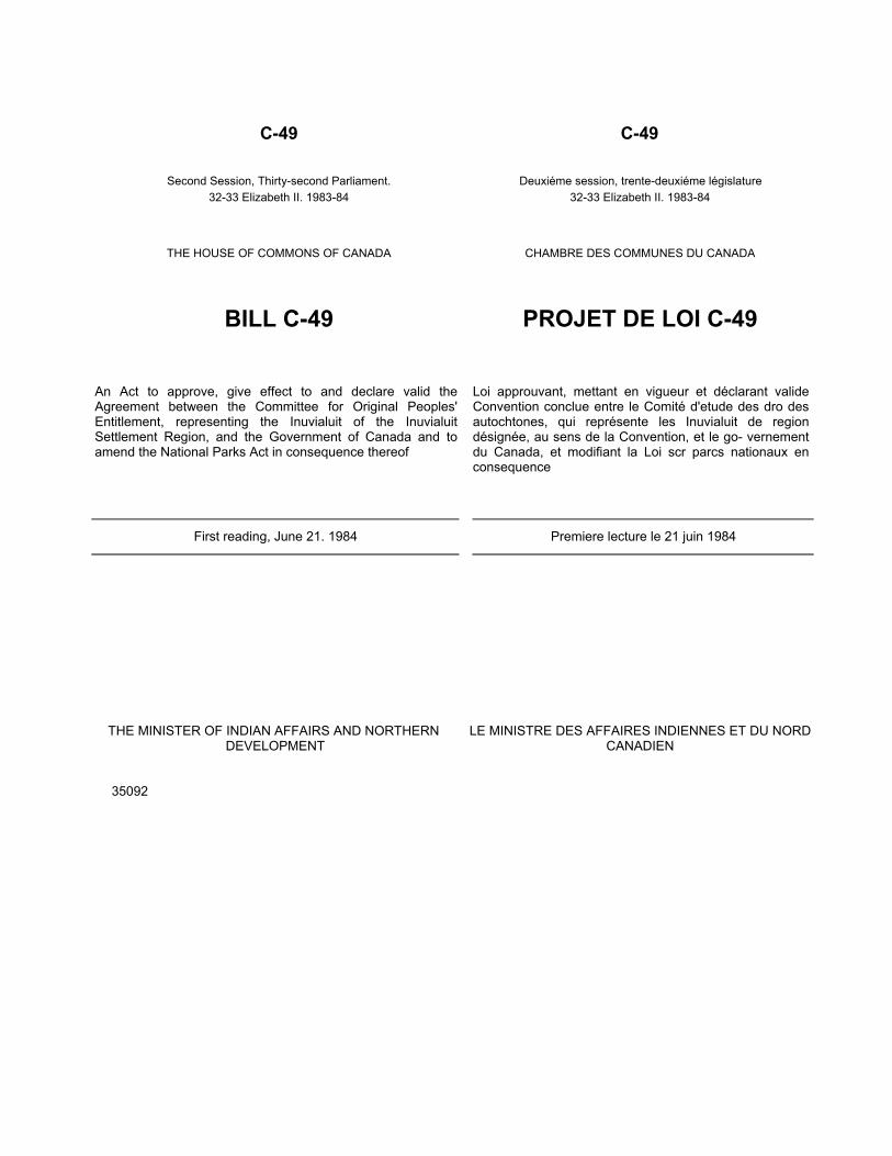
C-49 C-49
Second Session, Thirty-second Parliament.32-33 Elizabeth II. 1983-84
Deuxiéme session, trente-deuxiéme législature32-33 Elizabeth II. 1983-84
THE HOUSE OF COMMONS OF CANADA CHAMBRE DES COMMUNES DU CANADA
BILL C-49 PROJET DE LOI C-49
An Act to approve, give effect to and declare valid theAgreement between the Committee for Original Peoples'Entitlement, representing the Inuvialuit of the InuvialuitSettlement Region, and the Government of Canada and toamend the National Parks Act in consequence thereof
Loi approuvant, mettant en vigueur et déclarant valideConvention conclue entre le Comité d'etude des dro desautochtones, qui représente les Inuvialuit de regiondésignée, au sens de la Convention, et le go- vernementdu Canada, et modifiant la Loi scr parcs nationaux enconsequence
First reading, June 21. 1984 Premiere lecture le 21 juin 1984
THE MINISTER OF INDIAN AFFAIRS AND NORTHERN DEVELOPMENT
35092
LE MINISTRE DES AFFAIRES INDIENNES ET DU NORDCANADIEN

2nd Session. 32nd Parliament32-33 Elizabeth II, 1983-84
THE HOUSE OF COMMONS OF CANADA
BILL C-49
An Act to approve, give-effect to and declare valid theAgreement between the Committee for OriginalPeoples' Entitlement. representing the Inuvialuit of theInuvialuit Settlement Region, and the Government ofCanada and to amend the National Parks Act inconsequence thereof
WHEREAS the Committee for Original Peoples'Entitlement and the Government of Canada haveentered into an Agreement respecting certain lands inthe Northwest Territories and Yukon Territory in and towhich the Inuvialuit have claimed an interest based ontraditional use and occupancy;
AND WHEREAS, in exchange for the surrender of thatinterest, the Government of Canada has assumedcertain obligations under the Agreement in favour ofthe Inuvialuit of the Inuvialuit Settlement Region;
AND WHEREAS the Agreement provides, among otherthings, for the grant to or the setting aside for theInuvialuit of certain lands in the Inuvialuit SettlementRegion. for the right of the Inuvialuit to hunt, fish, trapand carry on commercial activity within the InuvialuitSettlement Region in accordance with the regimesestablished therein, for measures to preserve Inuvialuitcultural identity and values within a changing northernsociety, to enable the Inuvialuit to be equal andmeaningful participants in the northern and nationaleconomy and society and to protect and preserve theArctic wildlife, environment and biological productivityand for
5
10
15
20
25
2e session. 32e législature,32-33 Elizabeth ll, 1983-84
CHAMBRE DES COMMUNES
PROJET DE LOI C-49
Loi approuvant. mettant en vigueur et déclarantvalide la Convention conclue entre le Comité d'etudedes droits des autochtones, qui représente lesInuvialuit de la region désignée, au sens de laConvention. et le gouvernement du Canada, etmodifiant la Loi sur les parcs nationaux enconsequence
Attendu:que le Comité d'étude des droits des autochthoneset le gouvemement du Canada ont conclu uneConvention relativement a certaines terres situeésdans les territoires du Nord-Ouest et le territoire duYukon, sur lesquelles les Inuvialuit revendiquent unintérêt en raison de leur utilisation et occupationtraditionnelles de ces terres;
qu'en contrepartie de la cession de cet intérêt, legouvernment du Canada a contracté, aux termes dela Convention, certaines obligations en faveur desInuvialuit de la région désignée. au sens de laconvention:
que la Convention prévoit. entre autres, I'octroi ou lamise de cote pour les Inuvialuit de certaines terresde la region désignée, au sens de la Convention,leur droit d'y chasser. d'y pêcher, d'y piéger et de s'ylivrer a des activités commerciales. conformémentaux régimes qu'elle institue. les moyens deconserver l'identité culturelle et les vaieurs desInuvialuit au sein d'une société nordique en voied'évolution, de permettre aux Inuvialuit d'être desparticipants à part entiére de la société ainsi que del'économie nordiques et nationales et de protéger lafaune, I'environ-nement el la productivité biologiquede I'Arctique. de même que le paiement d'uneindemnité Inuvialuit;
5
10
15
20
25
30

RECOMMENDATIONHer Excellency the Governor General recommends to theHome or Commons the appropriation of public revenueunder the circumstances. in the manner and for thepurposes set out in a measure entitled "An Act toapprove, give effect to and declare valid the Agreementbetween the Committee for Original Peoples' Entitlement,representing the Inuvialuit of the Inuvialuit SettlementRegion, and the Government or Canada and to amendthe National Parks Act in consequence thereof".
RECOMMANDATIONSon Excellence le gouverneur général recommande a laChambre des communes l'affectation de deniers publics dansles circonstances de la maniére et aux fins prévues dans unemesure .intitulee approuvant, mettant en vigueur et déclarantvalide la Convenor conclue entre le Comité d'étude des droitsdes autochtones représente les Inuvialuit de la régiondésignée, au sens de la Convestion. et le gouvernement daCanada, et modifiant la Loi sur les parcs nationauxconséquences.

2 Western Arctic (Inuvialuit) Claims Settlement 32-33 ELIZ II
Short title
Definitions"Agreement"•Convention•
"Territory"•Territoire•
the payment to the Inuvialuit of certaincompensation;AND WHEREAS the Agreement furtherprovides, in consideration or the rights andbenefits set forth therein, for the surrender bythe Inuvialuit of all their native claims, rights,title and interests, whatever they may be, inand to the Territory:AND WHEREAS the Governments of theNorthwest Territories and Yukon Territory havebeen consulted and have participated indiscussions concerning matters affecting themand over which they have jurisdiction in relationto the Agreement:AND WHEREAS it is expedient that Parliamentapprove, give effect to and declare valid theAgreement:
NOW, THEREFORE, Her Majesty, by and withthe advice and consent of the Senate andHouse of Commons of Canada, enacts asfollows:
SHORT TITLE
1. This Act may be cited as the Western Arctic(Inuvialuit) Claims Settlement Act.
INTERPRETATION
2. In this Act,"Agreement" means the agreement betweenthe Committee for Original Peoples'Entitlement, representing the Inuvialuit of theInuvialuit Settlement Region, and theGovernment of Canada dated June 5. 1984,tabled in the House of Commons by theMinister of Indian Affairs and NorthernDevelopment on 19 June 1984 and recordedas document number 322-7/20;"Territory" means the Northwest Territories,Yukon Territory and adjacent off-shore areas,not forming part of the Northwest Territories orYukon Territory. within the sovereignty orjurisdiction of Canada.
5
10
15
20
25
30
35
que la Convention prévoit en outre l'abandonpar les Inuvialuit, en contrepartie des droitset des avantages qu'elle leur accorde. detoutes leurs revendications, tous droits, titreset intérêts ancestraux, quels qu'ils soient, surles terres du Territoire;que les gouvernements des territoires duNord-Ouest et du territoire du Yukon ont étéconsultés et ont participé aux négotiationssur les points les concernant et sur lesquelsils ont compétence pour ce qui est de laConvention;qu'il y a lieu pour le Parlement d'approu-ver,de mettre en vigueur et de déclarer valide laConvention,
Sa Majesté, sur l'avis et avec leconsentement du Sénat et de la Chambredes communes du Canada, décrète :
TITRE ABRÉGÉ
1. Loi sur le règlement des revendicationsdes Inuvialuit de la région ouest del'Arctique.
DÉFINITIONS
2. Les définitions qui suivent s'appliquent àla présente convention :«Convention» la convention conclue entre leComité d'étude des droits des autochtones,qui représente les Inuvialuit de la régiondésignée, au sens de la Convention, et legouvernement du Canada, en date du 5 juin1984, déposée devant la Chambre descommunes par le ministre des Affairesindiennes et du Nord canadien le................... et enregistrée sous le numéro……………..;•Territoire» ensemble des territoires duNord-Ouest, du territoire du Yukon et, endehors d'eux, des zones extracôtièrescontiguës qui relèvent de la souveraineté oude la compétence du Canada.
5
10
15
titre arbrege20
Definitions
•Convention»"Agreement"25
30
•Territoire."Territor35

1983-84 Inuvialuit de la région visée par le règlement 3
Agreementapproved
'onferral ofrights andBenefits
tinguishmentclaims
Exemptionon taxation
Regulations
sistencyconflict
ruction
AGREEMENT
3. (I) The Agreement is hereby approved,given effect and declared valid.
(2) On the extinguishment of the nativeclaims, rights, title and interests referred to insubsection (3), the beneficiaries under theAgreement shall have the rights, privilegesand benefits set out in the Agreementincluding the land title provided bysubsections 7(1) and (2) of the Agreement.
(3) All native claims, rights, title and interests,whatever they may be, in and to the Territory,of all Inuvialuit, wherever the may be, arehereby extinguished, but nothing in this Actprejudices the rights of such persons asCanadian citizens and they shall continue tobe entitled to all of the rights and benefits ofall other citizens as well as to those resultingfrom their status as aboriginal people ofCanada and from other legislation applicableto them from time to time.
(4) The financial compensation provided bythe Government of Canada pursuant tosection 15 of the Agreement and the fundsprovided by the Government of Canadapursuant to subsections 16(8) and 17(3) of theAgreement are exempt from taxation in themanner and to the extent set out in thatsection and those subsections, respectively.
(5) The Governor in Council may make suchregulations as are necessary for the purposeof carrying out the Agreement or for givingeffect to any of the provisions thereof.
CONSTRUCTION
4. Where there is any inconsistency or conflictbetween this Act or the Agreement and theprovisions of any other law applying to theTerritory, this Act or the Agreement prevails tothe extent of the inconsistency or conflict.
5. Nothing in this Act or the Agreement shallbe interpreted as granting any rights,privileges or benefits in respect of any areabeyond the limits of the sovereignty orjurisdiction of Canada.
5
10
15
20
25
30
35
40
CONVENTION
3. (1) La Convention est approuvée, mise envigueur et déclarée valide.
(2) Les bénéficiaires aux termes de laConvention ont, à compter de l'extinction desrevendications, droits, litres et intérétsancestraux visés au paragraphe (3). lesdroits privileges et avantages qu'elle prévoity com- le titre de propriété des terres visepar les paragraphes 7(1) et (2) de laConvention.
(3) La présente loi éteint toutes lesrevendications, tous droits, titres et intérétsancestraux, quels qu'ils soient, sur les terresdu Territoire, de tous les Inuvialuit ou qu'ilssoient, mais elle n'a pas pour effet de porteratteinte a leurs droits en tant que citoyenscanadiens et ils continuent de bénéficier desmémes droits et avantages que tous lesautres ainsi que de ceux découlant de leurstatut de peuples autochtones du Canada etde toute autre loi qui leur est applicable.
(4) L'indemnité pécuniaire qu'accorde legouvernement du Canada en application del'article 15 de la Convention ainsi que lesfonds qu'il accorde aux termes desparagraphes 16(8) et 17(3) sont exemptsd'impôt suivant les modalités prévues a cetarticle et a ces paragraphes respectivement.
(5) Le gouverneur en conseil peut établir lesrèglements nécessaires a l'application de laConvention, ou de l'une de ses dispositions.
INTERPRÉTATION
4. Les dispositions de la présente loi ou de laConvention I'emportent sur les dispositionsincompatibles de toute autre loi quis'applique au Territoire.
5. Ni la présente loi ni la Convention n'ontpour effet d'accorder des droits. privilèges ouavantages à l’égard d'une region ne relevantpas de la souveraineté ou de la competencedu Canada.
Approbation
Acquistion cedroits etavantages5
10 Extinction desrevendications
15
20
Exemptionfiscale
25
Reglements
30
Incompatibilite
35Interpretation

4 Western Arctic (Inuvialuit) Claims Settlement 32-33 ELIz II
Payments outof C.R.F.
R.S.c. N-13
APPROPRIATION
6. There shall be paid out of the ConsolidatedRevenue Fund such sums as may be requiredto meet the monetary obligations of Canadaunder section 15 and subsection 16(8) and17(3) of the Agreement.
CONSEQUENTIAL AMENDMENT
National Parks Act
7. The schedule to the National Parks Act isamended by adding thereto the following Part:
"PART XI
NATIONAL PARK IN YUKON TERRITORY
(1) NORTHERN YUKON NATIONAL PARK
(All latitudes and longitudes referred to hereinare determined according to North AmericanDatum of 1927 and all topographical featuresare according to National Topographic SeriesMaps 117B/9, 117A/12, 117A/11, 117A/14Eand W., 117D/3E and W., 117D/6Eand W.,117D/5E, 117D/11W, 117D/12W, 117D/12WHerschel, and 117C/9E, 117C/9W produced ata scale of 1:50,-000 by the Department ofEnergy, Mines and Resources at Ottawa.) That certain parcel of land in or near theYukon Territory being more particularlydescribed as follows:Commencing at the point of intersection of theCanada-United States International Boundaryat monument number 26 of said boundary andthe line of watershed separating the streamsflowing into the Porcupine River System fromthose flowing into the Beaufort Sea;
Thence generally easterly following said line ofwatershed to triangulation station Pete 51-A,number 568051, having a latitude of68º37'17.08385" and a longitude of139º44'37.86856", said station established byGeodetic Survey of the said Department;
5
10
15
20
25
30
35
AFFECTATION DE 'FONDS
6. Sont prélevées, sur le Trésor, les sommesnécessaires pour satisfaire aux obligationscontractées par le Canada aux termes del'article 15 et des paragraphes 16(8) et 17(3)de la Convention.
MODIFICATION CORRÉLATIVE
Lot sur les parcs nationaux
7. L'annexe de la Lot sur les pares nationauxest modifiée par adjonction de ce qui suit :
•PARTIE XIPARC NATIONAL DU TERRITOIRE DU
YUKON
(1) PARC NATIONAL DU NORD DUYUKON
Toutes les latitudes et longitudes indiquéesci-aprés font référence au systèmegeodesique nord-américain de 1927 et tousles accidents topographiques indiqués sontconfermes aux cartes du Système nationalde référence topographique 117B/9,117A/12, 117A/11, 117A/14E et W, 117D/3Eet W,15 117D/6Eet W, 117D/5E, 117D/11W,117D/12W, 117D/12W (île Herschel),117C/9E et 117C/9W établies selon uneéchelle de 1/50000 par le ministére del'Energie, des Mines et des Ressources(Ottawa).La parcelle de terre en cause, située dans leterritoire du Yukon ou a proximité de celui-ci,peut étre plus exactement décrite comme ilsuit: commençant prés de la borne 26 aI'intersection de la frontière canado-américaine et de la ligne de partage deseaux séparant les cours d'eau se jetant dansle bassin de la rivière Porcupine des coursd'eau se déversant dans la mer de Beaufort;
de là en direction générale est, le long deladite ligne de partage des eaux, jusqu'à lastation de triangulation Pete 51-A, numéro568051, située à 68°37'17.08385" de latitudenord et 139°44'37.86856" de longitudeouest, ladite station ayant été établie par la
Paiments le Tre
5
S R.c N
10
15
20
25
30
35

EXPLANATORY NOTEClause 7: New. This amendment, which a consequential onthe Agreement approved, given effect and declared valid bythis Act. would establish a new National Park in the YukonTerritory.
NOTE EXPLICATIVEArticle 7. — Nouveau. Découle de la Conventios approuvée,mise en vigueur et déclarée valide par la présente loi. Portecréation d'un parc national dans le territoire du Yukon.

1983-84Inuvialuit de la région visée par le règlement
Thence due north along said longitude139°44'37.86856" to its intersection with the rightshoreline of Babbage River;
Thence generally northeasterly following said rightshoreline or eastern shoreline of said river to PhillipsBay in the Beaufort Sea, said right shoreline oreastern shoreline extending to the low water mark ofsaid Phillips Bay at approximate latitude 69°14'55"and approximate longitude 138•26'20";
Thence southwesterly and generally northwesterlyfollowing said low water mark to its intersection withthe most northerly position of Catton Point;
Thence northwesterly in a straight line, in theWorkboat Passage between Herschel Island and themainland, to the low water mark at the most easterlyposition of an unnamed island lying southerly ofAvadlek Spit, said position being at approximatelatitude 69°22'20" and approximate longitude139°18'40";
Thence westerly following said low water mark on thenortherly side of said unnamed island, continuingwesterly across the waters and following the lowwater marks on the north sides of the other unnamedislands leading towards Nunaluk Spit;
Thence generally westerly following said low watermark on the north side of said Nunaluk Spit and thecoast of the Beaufort Sea to its intersection with theCanada-United States International Boundary;
Thence south along said International Boundary tothe point of commencement; said parcel including allshoals, islands, sandbars and spits that may beperiodically exposed at low tide within 3.5 kilometresof the shore and all islands, sandbars and spits lyingwithin Phillips Bay, but not including Herschel Islandand its sandbars, spits and immediately adjoiningislets.
5
10
15
20
25
30
35
40
Division des levés géodésiques du Ministèresusmentionné;
de là franc nord, le long d'une ligne pas-sant parladite longitude 139°44'37.86856", jusqu'à sonpoint d'intersection avec la rive droite de la rivièreBabbage;
de là en direction générale nord-est, le longde ladite rive droite ou de la rive est de cetterivière, jusqu'à la baie Phillips, dans la mer deBeaufort (ladite rive s'étendant jusqu'à la laissede basse mer dans ladite baie), à un point situé àenviron 69*14'55" de latitude nord et à peu près138°26'20" de longitude ouest;
de là vers le sud-ouest et en direction généralenord-ouest, le long de ladite laisse de basse mer,jusqu'à son point d'intersection avec le point leplus au nord de la pointe Catton;
de là vers le nord-ouest en ligne droite, à traversla passe Workboat située entre l'île Herschel et laterre ferme, jusqu'à la laisse de basse mer, aupoint le plus à l'est d'une île) innommée située ausud de la flèche Avadlek, soit à environ 69°22'20"de latitude nord et à peu près 139•18'40" delongitude ouest;
de là vers l'ouest, le long de ladite laisse debasse mer, du côté nord de ladite île innommée,puis vers l'ouest à travers les eaux, puis le longde la laisse de basse mer sur le côté nordd'autres îles innommées, jusqu'à la flècheNunaluk;
de là en direction général ouest, le long de laditelaisse de basse mer (du côte nord de laditeflèche) et de la côte de la mer de 35 Beaufort,jusqu’ à la frontière canado-américaine;
de là vers le sud, le long de ladite frontière,jusqu’au point de départ;ladite parcelle comprenant tous les hauts-fonds,îles, bancs de sable et flèches se trouvant dansla baie Phillips, mais excluant l’île Herschel ainsique les bancs de sable, les flèches et les îlots quilui sont immédiatement adjacents.
5
10
15
20
25
30
35
40
45
6 Western Arctic (Inuvialuit) daims Seuttement 32-33 ELIZ II
oming into e
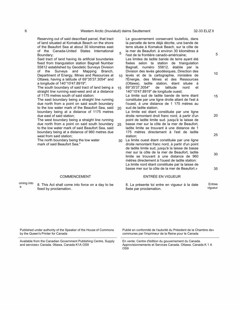
Reserving out of said described parcel, that tractof land situated at Komakuk Beach on the shoreof the Beaufort Sea at about 30 kilometres eastof the Canada-United States InternationalBoundary; Said tract of land having its artificial boundariesfixed from triangulation station Bagnall Number55812 established by Geodetic Surveys Divisionof the Surveys and Mapping Branch,Department of Energy, Mines and Resources atOttawa, having a latitude of 69°35'37.3054" anda longitude of 140°10'47.8919"; The south boundary of said tract of land being astraight line running east-west and at a distanceof 1175 metres south of said station: The east boundary being a straight line runningdue north from a point on said south boundaryto the low water mark of the Beaufort Sea, saidboundary being at a distance of 1175 metresdue east of said station; The west boundary being a straight line runningdue north from a point on said south boundaryto the low water mark of said Beaufort Sea, saidboundary being at a distance of 960 metres duewest from said station;The north boundary being the low watermark of said Beaufort Sea."
COMMENCEMENT
8. This Act shall come into force on a day to befixed by proclamation.
5
10
15
20
25
30
Le gouvernement conservant toutefois, dansla parcelle de terre déjà décrite, une bande deterre située à Komakuk Beach, sur la côte dela mer de Beaufort. à environ 30 kilomètres àl'est de ta frontière canado-américaine; Les limites de ladite bande de terre ayant étéfixées selon ta station de triangulationBagnall, numéro 55812, établie par laDivision des levés géodésiques, Direction deslevés et de la cartographie, ministère del'Énergie, des Mines et des Ressources(Ottawa), ladite station, étant située à69°35'37.3054" de latitude nord et140°10'47.8919" de longitude ouest; La limite sud de ladite bande de terre étantconstituée par une ligne droite allant de l'est àl'ouest, à une distance de 1 175 mètres ausud de ladite station; La limite est étant constituée par une lignedroite remontant droit franc nord, à partir d'unpoint de ladite limite sud. jusqu'à la laisse debasse mer sur la côte de la mer de Beaufort,ladite limite se trouvant à une distance de 1175 mètres directement à l'est de laditestation; La limite ouest étant constituée par une lignedroite remontant franc nord, à partir d'un pointde ladite limite sud, jusqu'à la laisse de bassemer sur la côte de la mer de Beaufort, laditelimite se trouvant à une distance de 960mètres directement à l'ouest de ladite station:La limite nord étant constituée par la laisse debasse mer sur la côte de la mer de Beaufort.»
ENTRÉE EN VIGUEUR
8. La présente toi entre en vigueur à la datefixée par proclamation.
5
10
15
20
25
30
35
Entreevigueur
Published under authority of the Speaker of the House of Commonsby the Queen's Printer for Canada
Publié en conformité de l'autorité du Président de la Chambre de»communes par l'imprimeur de la Reine pour le Canada
Available from the Canadian Government Publishing Centre, Supplyand services» Canada. 0ttawa, Canada K1A OS9
En vente: Centre d'édition du gouvernement du Canada.Approvisionnements et Services Canada. Ottawa. Canada K 1 AOS9

C-102
Second Session. Thirty-third Parliament,35-36-37 Elisabeth II. 1986-87-88
THE HOUSE OF COMMONS OF CANADA
BILL C-102
An Act 10 amend the Western Arctic (Inuvialuit) ClaimsSettlement Act
C-102
Deuxième session, trente-troisième législature,35- 36-37 Elizabeth 11. 1986-87-88
CHAMBRE DES COMMUNES DU CANADA
PROJET DE LOI C-102
Loi modifiant la Loi sur le règlement des revendicationsdes Inuvialuit de la région ouest de l'Arctique
AS PASSED BY THE HOUSE 0F COMMONSMARCH 23, 1988
ADOPTÉ PAR LA CHAMBRE DES COMMUNESLE 23 MARS 1988
23288

c 24
greementnventions
mendingreementventiondificative
2nd Session, 33rd Parliament,35-36-37 Elizabeth II. 1986-87-88
THE HOUSE OF COMMONS OF CANADA
BILL C-102
An Act to amend the Western Arctic (Inuvialuit)Claims Settlement Act
Her Majesty, by and with the advice and consentof the Senate and House of Commons ofCanada, enacts as follows:
1. The definition "Agreement" in section 2 of theWestern Arctic (Inuvialuit) Claims Settlement Actis repealed and the following substituted therefor:“"Agreement" means the agreement between theCommittee for Original Peoples’ Entitlement,representing the Inuvialuit of the InuvialuitSettlement Region, and the Government ofCanada dated June 5, 1984, tabled in the Houseof Commons for the Minister of Indian Affairs andNorthern Development on June 19, 1984 andrecorded as document number 322-7/20 andincludes an Amending Agreement;"Amending Agreement" means (a) the Amending Agreement between theInuvialuit Regional Corporation, representing theInuvialuit, and the Government of Canada,approved by Order in Council P.C. 1985-1144,tabled in the House of Commons for the Ministerof Indian Affairs and Northern Development onDecember 14, 1987 and recorded as documentnumber 332-4/43, (b) the Amending Agreement between theInuvialuit Regional Corpo-
5
10
15
20
25
30
2e session, 33e législature,35-36-37 Elizabeth 11, 1986-87-88
CHAMBRE DES COMMUNES DU CANADA
PROJET DE LOI C-102
Loi modifiant la Loi sur le règlement desrevendications des Inuvialuit de la région ouest
de l'Arctique
Sa Majesté, sur l'avis et avec le consentement duSénat et de la Chambre des communes du
Canada, édicté :
1. La définition de «Convention», à l'article 2 dela Loi sur le règlement des revendications desInuvialuit de la région ouest de l'Arctique, estabrogée et remplacée par ce qui suit :«Convention» La convention conclue entre leComité d'étude des droits des autochtones, quireprésente les Inuvialuit de la région désignée,au sens de la Convention, et le gouvernementdu Canada, en date du 5 juin 1984, déposéedevant la Chambre des communes au nom duministre des Affaires indiennes et du Nordcanadien le 19 juin 1984 et enregistrée sous lenuméro 322-7/20 ou une Conventionmodificative.«Convention modificative» :a) La convention modificative conclue entre laSociété régionale inuvialuit, au nom desInuvialuit, et le gouvernement du Canada,approuvée par le décret C.P. 1985-1144,déposée devant la Chambre des communes aunom du ministre des Affaires indiennes et duNord canadien le 14 décembre 1987 etenregistrée sous le numéro 332-4/43;
5
•Convention“Agreement”
10
15
20•Conventionmodificauve
25
30

C. 16 Western Arctic (Inuvialuit) Claims Settlement 35-36-37 ELIZ II
ration, representing the Inuvialuit, andthe Government of Canada, approvedby Order in Council P.C. 1987-26.tabled in the House of Commons for theMinister of Indian Affairs and NorthernDevelopment on December 14, 1987and recorded as document number 332-4/43A, (c) the Amending Agreement betweenthe Inuvialuit Regional Corporation,representing the Inuvialuit, and theGovernment of Canada, dated May 11.1987. tabled in the House of Commonsfor the Minister of Indian Affairs andNorthern Development on December14. 1987 and recorded as documentnumber 332-4/43B. and (d) any other Amending Agreementmade pursuant to subsection 3(13) ofthe Agreement;"
b) la convention modificative conclueentre la Société régionale inuvialuit, aunom des Inuvialuit, et le gouverne-ment du Canada, approuvée par ledécret C.P. 1987-26, déposée devantla Chambre des communes au nom duministre des Affaires indiennes et duNord canadien le 14 décembre 1987 etenregistrée sous le numéro 332-4/43A;c) la convention modificative conclueentre la Société régionale inuvialuit., aunom des Inuvialuit, et le gouverne-ment du Canada, en date du 11 mai1987, déposée devant la Chambre descommunes au nom du ministre desAffaires indiennes et du Nord cana-dien le 14 décembre 1987 et enregis-trée sous le numéro 332-4/43B: d) toute autre convention modificativeapportée en conformité avec leparagraphe 3(13) de la Convention.»
QUEEN'S PRINTER FOR CANADA © IMPRIMEUR DE LA REINE POUR LE CANADAOTTAWA, 1988


AMENDING AGREEMENT
BETWEEN:
INUVIALUIT REGIONAL CORPORATION (hereinafterreferred to as "the IRC"), represented bythe Chief Regional Councillor,
AND:
THE GOVERNMENT OF CANADA (hereinafter referredto as "Canada"), represented by the Ministerof Indian Affairs and Northern Development.
WHEREAS the Committee for Original Peoples' Entitlementand Canada entered into an Agreement dated June 5, 1984,which was tabled in the House of Commons for the Ministerof Indian Affairs and Northern Development, on June 19, 1984and recorded as document number 322-7/20, and which wasapproved, given effect, and declared valid by the WesternArctic (Inuvialuit) Claims Settlement Act, S.C. 1984, c. 24;
AND WHEREAS subsection 3(13) of the said Agreement providesthat its provisions may be amended with the consent of Canadaand the Inuvialuit, as represented by the Inuvialuit RegionalCorporation;
AND WHEREAS the parties wish to amend the said Agreement;
NOW THEREFORE, the IRC and Canada agree as follows:
1. Subsection 3(13) of the said Agreement is revoked andthe following substituted therefor:
"3(13) The provisions of this Agreement may beamended with the consent of Canada as representedby the Governor in Council and the Inuvialuitas represented by the Inuvialuit RegionalCorporation."
2. Subsection 3(16) of the said Agreement is revoked andthe following substituted therefor:
"3(16) Where any amendment to this Agreementrequires consequential legislation to achieveits effect, Canada agrees to take all reasonablesteps to put in place suitable legislation forthwith."

- 2 -
3. Canada shall recommend to Parliament that this Amending Agreement be approved, given effect and declared valid by suitable legislation.
Signed at HULL this 11th day of MAY, 1987.
WHEREAS the Agreement between the Committee forOriginal People's Entitlement and the Government ofCanada dated June 5, 1984, tabled in the House of Commonsfor the Minister of Indian Affairs and NorthernDevelopment on June 19, 1984, and recorded as documentnumber 322-7/20 (hereinafter referred to as the Agreementwas approved , given effect, and declared valid by theWestern Arctic (Inuvialuit) Claims Settlement Act beingchapter 24 of the Statutes of Canada, 1984 as amended byAn Act to amend the Western Arctic (Inuvialuit) ClaimsSettlement Act, being chapter 16 of the Statutes ofCanada, 1988;
WHEREAS subsection 3(13) of the Agreementprovides that its provisions may be amended with theconsent of the Government of Canada and the Inuvialuit,as represented by the Inuvialuit Regional Corporation;
AND WHEREAS the parties wish to make amendmentsto the Agreement;
THEREFORE, HER EXCELLENCY THE GOVERNOR GENERALIN COUNCIL, on the recommendation of the Minister ofIndian Affairs and Northern Development, pursuant tosubsection 3(13) of the Agreement between the Committeefor Original People's Entitlement and the Government ofCanada, is pleased hereby:
(a) to consent that the Agreement be amended,
substantially in accordance with the amendingagreement set out in the schedule hereto; and
(b) to authorize the Minister of Indian Affairs and
Northern Development, on behalf of the Government ofCanada, to execute the said amending agreement.

AMENDING AGREEMENT
BETWEEN:
INUVIALUIT REGIONAL CORPORATION (hereinafterreferred to as "the IRC"), represented bythe Chief Regional Councillor,
AND:
THE GOVERNMENT OF CANADA (hereinafter referredto as "Canada"), represented by the Ministerof Indian Affairs and Northern Development.
WHEREAS the Committee for Original Peoples' Entitlementand Canada entered into an Agreement dated June 5, 1984,which was tabled in the House of Commons for the Ministerof Indian Affairs and Northern Development, on June 19, 1984and recorded as document number 322-7/20, and which wasapproved, given effect, and declared valid by the WesternArctic (Inuvialuit) Claims Settlement Act, S.C. 1984, c. 24;
AND WHEREAS subsection 3(13) of the said Agreement providesthat its provisions may be amended with the consent of Canadaand the Inuvialuit, as represented by the Inuvialuit RegionalCorporation?
AND WHEREAS the parties wish to make amendments to the saidAgreement ;
NOW THEREFORE, the IRC and Canada agree as follows:
1.Section 5 of the said Agreement is revoked and thefollowing substituted therefor:
"5(1) The Inuvialuit are best able to determine who should beeligible under the Inuvialuit Land Rights Settlement, but thereshould also be objective criteria by which an individual may havedetermined the right to be a beneficiary.
5(2) A person shall be eligible to enroll as a beneficiary and,accordingly, to have his name placed on the Official EligibilityList as amended from time to time if, as of the date of theSettlement Legislation (July 25, 1984), that person is a livingCanadian citizen and:
(a) is on the Official Voters List used for approving thisAgreement; or
(b) is considered to be of Inuvialuit ancestry or isconsidered by reason of Inuvialuit custom or tradition to beInuvialuit and is accepted in either case as a member of anInuvialuit Community Corporation; or

-2-
(c) produces evidence satisfactory to the Enrolment Authorityreferred to in subsection (5), or its successor established bythe Inuvialuit, that he has one-quarter or more Inuvialuitblood and,
(i) was born in the Inuvialuit Settlement Region orInuvik, or
(ii) has been a resident of the Inuvialuit SettlementRegion or Inuvik for a total of at least ten years, or
(iii) if under ten years of age, is ordinarily residentin the Inuvialuit Settlement Region or Inuvik; or
(d) is an adopted child, under the laws of any jurisdiction oraccording to Inuvialuit custom, of a person who qualifiesunder paragraph (a), (b), or (c).
5(3) A person shall be eligible to enroll as a beneficiary and,accordingly, to have his name placed on the Official EligibilityList as amended from time to time if that person is a Canadiancitizen and is a descendant, as determined from time to time bythe appropriate community corporation or the IRC, as the case maybe, of a person eligible for enrolment under paragraph 2(a), (b),(c), or (d).
5(4) An Enrolment Committee shall be established in eachInuvialuit community for the purpose of preparing initial lists ofall members of the community whom it believes qualify under theinitial eligibility criteria, and it shall forward such lists tothe Enrolment Authority referred to in subsection (5) togetherwith validating documentation and information.
5(5) An Enrolment Authority, comprising two representatives ofCOPE and one representative of the Government, shall beresponsible for the initial enrolment process according to therequirements and standards that the Authority establishes. Itshall prepare and publish the initial Official Eligibility Listand the initial Official Enrolment List; after doing so, itsmandate will expire and it shall forthwith forward all its recordsto its successor established by the Inuvialuit.
5(6) Any person eligible to enrol pursuant to subsection (2), (3)or (7) shall have the right to enrol at any time after attainingthe age of eighteen (18) years. Such choice shall be exercised bysignature of a document in form prescribed by the EnrolmentAuthority or its successor established by the Inuvialuit, and suchname shall be placed on the Official Enrolment List, as amendedfrom time to time.
5(7) The Inuvialuit shall determine the eligibility and enrolmentof future beneficiaries, those born after July 25, 1984.

-3-
5(8) Any person who has been denied eligibility or enrolment as abeneficiary may appeal the denial to the Arbitration Boardpursuant to section 18.
5(9) Canada shall pay the expenses incurred for the initialenrolment of beneficiaries.
5(10) Native persons may be enrolled in only one Canadian LandClaims Settlement for which they qualify. Persons who qualify tobe enrolled in more than one settlement may choose the one inwhich they shall be enrolled. Persons who choose to be enrolledin the Inuvialuit Settlement may, within ten years afterenrolment, at their option, choose to relinquish their entitlementunder the Inuvialuit Settlement in favour of enrolment in anothersettlement for which they qualify. On notice in writing by theperson so opting or on notification and verification by theappropriate enrolling authority of another native settlement thatthe person so opting has applied and been enrolled in that othersettlement, the person's entitlement under this Settlement shallcease.
5(11) The Inuvialuit hereby offer to enroll in the InuvialuitSettlement any native person of an aboriginal group proximate tothe Inuvialuit Settlement Region who, at the time this Agreementis executed, is otherwise ineligible but is residing in orproximate to the Inuvialuit Settlement Region with their legallymarried husband or wife who is an eligible Inuvialuk.
5(12) The offer under subsection (11) may be acted on for aperiod of ten (10) years after the date of execution of thisAgreement.
5(13) Subject to paragraph 2(d), the offer under subsection (11)does not extend to other non-Inuvialuit relatives, present orfuture, of any native person. "
2. Paragraph 6(4)(a) is repealed and the following issubstituted therefor:
(a) the Inuvialuit enrolled in the Inuvialuit Land RightsSettlement shall share equally in the benefits received by thevarious Inuvialuit corporations and distributed through theInuvialuit Trust; therefore, each eligible Inuvialuk, uponattaining eighteen (18) years of age, shall be entitled to enrolas a beneficiary and, upon enrolment, to receive a life interestonly in the same number of trust units, which units shall be non-transferable, in the Inuvialuit Trust. Any profits derived fromany development of Inuvialuit lands and distributed through theInuvialuit Trust shall be shared equally by all enrolledInuvialuit, but each community corporation shall have control overany development activity approved by the Inuvialuit LandAdministration or the Inuvialuit Regional Corporation in respectof the block of land selected near that community pursuant toparagraph 7(1)(a);"

- 4 -
3. Paragraph 6(4)(d) is repealed.
4. Paragraph 6(4)(e) is relettered as paragraph 6(4)(d).
Signed at Ottawa this 23rd day of August , 1988.

WHEREAS the Agreement between the Committeefor Original Peoples' Entitlement and the Government ofCanada dated June 5, 1984, tabled in the House ofCommons for the Minister of Indian Affairs and NorthernDevelopment on June 19, 1984 and recorded as documentnumber 322-7/20, hereinafter referred to as theAgreement, was approved, given effect, and declaredvalid by the Western Arctic (Inuvialuit) ClaimsSettlement Act, chapter 24 of the Statutes of Canada,1984;
WHEREAS subsection 3(13) of the Agreementprovides that its provisions may be amended with theconsent of Canada and the Inuvialuit, as represented bythe Inuvialuit Regional Corporation;
AND WHERAS the parties wish to amend theAgreement.
THEREFORE, HER EXCELLENCY THE GOVERN0RGENERAL IN COUNCIL, on the recommendation of theMinister of Indian Affairs and Northern Development, ispleased hereby to make the annexed Order consenting toamendments of the Inuvialuit Final Agreement.
AMENDING AGREEMENT
BETWEEN:
INUVIALUIT REGIONAL CORPORATION (hereinafterreferred to as "the IRC"), represented bythe Chief Regional Councillor,
AND:
THE GOVERNMENT OF CANADA (hereinafter referredto as "Canada"), represented by the Ministerof Indian Affairs and Northern Development.
WHEREAS the Committee for Original Peoples' Entitlementand Canada entered into an Agreement dated June 5, 1984,which was tabled in the House of Commons for the Ministerof Indian Affairs and Northern Development, on June 19, 1984and recorded as document number 322-7/20, and which wasapproved, given effect, and declared valid by the WesternArctic (Inuvialuit) Claims Settlement Act, S.C. 1984, c. 24;
AND WHEREAS subsection 3(13) of the said Agreement providesthat its provisions may be amended with the consent of Canadaand the Inuvialuit, as represented by the Inuvialuit RegionalCorporation;
AND WHEREAS the parties wish to amend the said Agreement;
NOW THEREFORE, the IRC and Canada agree that the amendmentson the following fourteen pages be made;

-1-
AMENDMENTS TO THE INUVIALUIT FINAL AGREEMENT
SECTION
TABLE OF CONTENTS
S.7 and J-6|Table ofContents
E-l
Definitions:Inuvialuit pg 2
3(14) pg 3
3(15) pg 3
5(2)(b)
5(2)(c)
5(3)
5(4)
CHANGES TO BE MADE
TABLE OF CONTENTS ADDED
DeSalis - no space
replace "Territorial Lands Act","Yukon Placer Mining Act" with"Prohibition and Withdrawal ofCertain Lands from Disposal Order,1980. No. I".
delete "or" and add "ororganizations" after trusts todefinition of Inuvialuit
delete "Directors"; add "RegionalCouncillors" delete"shareholders"; add "members'"
delete "shareholders;" add"embers'" delete "itsshareholders"; add "members" (4thline)
delete 5(2)(b) and replace with"(b) is considered to be ofInuvialuit ancestry or isconsidered by reason of Inuvialuitcustom or tradition to beInuvialuit and is accepted ineither case as a member of anInuvialuit Community Corporation;or"
Add "or its successor" after"referred to in subsection (4)"
delete comma after communitycorporations; add "or theInuvialuit Regional Corporation,as appropriate,"
delete "within three months of thecoming into force of thesettlement legislation"; add "byDecember 31. 1987"

-2-
AMMENDMENTS TO THE INUVIALUIT FINAL AGREEMENT
SECTION CHANGES TO BE MADE
5(10)
6(1)(a)
6(1)(a)
6(1)(b)
6(1)(b)
6(1 )(a) ,(c) ,(d) ,(e)
6(1)(f)
6 (4) (a)
7(5)
7(5)
7(18) (a)
7(21 )
7(21)
7(22)
7(23).7(24),7(25)
7(27).7(28)
7(28)
replace "a spouse" with "theirlegally married husband or wife”
punctuation: add comma after"share capital"
change "settlement lands" to read"Inuvialuit lands"
delete "ie not for profit"
punctuation: add commas after"corporation" and after "sharecapital"
delete IRC, ILC, TIC, IDC
spell in full ILC, IDC, IIC, IRC
development typo; add "p"
add "paragraph" before eachreference to (1)(b) land
Add words "or Inuvialuit LandCorporation" following "InuvialuitRegional Corporation" twice
add "where the access would be"following the words "to exerciserights"
provisions typo; add "i"
delete "made applicable to"; add"enacted for"
add "paragraph" before thereference to 1( a) and 1(b) lands:delete "HTC"
add "paragraph" before anyreference to 1( a) or 1(b) lands
add "twenty" (20)add "(5)" after five
delete "resale"; add "sale"

-3-
AMENDMENTS TO THE FINAL AGREEMENT
SECTION
7(33)(a)
7(38)
7(40)
7(61)
7(41)
7(60)(e)
7(64)(a)
7(64),(b),(c),(d)
7(64)(d)
7(65) title andsection
7(80)
7(82)
7(85)(a)
7(88)
7(88)
7(89), 7(91)
7(94)
CHANGES TO BE MADE
add (1) to read "one (1)"
delete "IDC"; spell in full
delete "IDC"; spell in full
delete "IDC"; spell in full
Inuvialuit typo; add "i"
delete (ILA)
delete (ILA)
delete ILA; spell in full
add "forty-two (42)”
Desalis to be spelled DeSalis
add "the" before "Pingo CanadianLandmark"
after "Government" add "of" theNorthwest Territoires
delete "function"; add "rights"
add "paragraph" before referenceto 1(b) landsadd "device" after "navigation aidor safety"
delete "Area,"; add "AreasNumbers 1 and 2 as shown in AnnexD,"
add "paragraph" before reference(1)(b) lands
delete "their lands with respectto the holders of rights" add "therights of interest holders'*

-4-
AMENDMENTS TO THE INUVIALUIT FINAL AGREEMENT
SECTION CHANGES TO BE MADE
7(98)
7(102)(a)ii
7(105)(a)
7(105)(a) ,(b)
8(1)
8(1),8(3),8(4), 8(5)
9(3)(c)
9(3)(d)
9(3)(e)
9(3)(f)
9(8) (new)
10(1), 10(2), 10(3),10(3)(a), 10(7)
10(8)
delete" from and includingJuly 25,1985" add "from any dateon or after July 25, 1984"
add comma after sand and gravel
delete "Inuvialuit" before words"Participation Agreement"
delete ILA: spell in full
delete "No. 2"; add "Number 2"
add "as shown" before words "inAnnex D"
delete "except the community siteshown in Annex H-2 and describedin Annex H-3" add "except surfacetitle (including sand and gravel)to the part lying within theproposed Pingo Canadian LandmarkSite shown in Annex H-2 anddescribed in Annex H-4
delete ", except the communitysite shown in Annex 1-2 anddescribed in Annex 1-3
delete ", except the communitysite shown in Annex J-2 anddescribed in Annex J-3
delete", except the communitysite shown in Annex K-2 anddescribed in Annex K-3
Maps showing the selectionsidentified in 9(3), (4) and (5)signed by the parties to thisagreement are recorded in theCanada Lands Survey Records atOttawa as No's. 69419, 69420,69421, 69422 and 69423
delete ILA; spell in full
correction: delete section 8; add“section 18"
-5-
AMENDMENTS TO THE INUVIALUIT FINAL AGREEMENT
SECTION CHANGES TO BE MADE
11(3)
11(5)
11(6)
11(7)
11(16)
11(16)
11(18)
11(18)
11(19)
11(21)
11(29)
12(3)(c)
12(4)
add "(3); add "(1)"
add "(3)'
add "the"1 before Government of theYukondelete "the" before "Yukon"
delete "one" to read "where any ofthe parties"
correction: delete "subsection(14)": add "subsection (15)"
delete "declines out": add"declines to carry out"
delete "Of the three (3) membersappointed by Canada, one shall bedesignated by the TerritorialGovernment in whose jurisdictionthe development being reviewed isto be located";
add "of the three (3) permanentmembers appointed by Canada, eachof the Governments of theNorthwest Territories and theYukon shall designate one (1)."
delete Inuvialuit: in lastsentence add "natives" (shall bemaintained)
delete "subsections (6) to (9)";add "subsections (6) to (10)"
delete "anyone" add "any of theparties"
add "within" to read "in writingwithin thirty (30) days"
conservation typo; add "r"
delete Disposition: add "Disposal"
-6-
AMENDMENTS TO THE FINAL AGREEMENT
SECTION CHANGES TO BE MADE
12(9)
12(14)(a)
12(15)(b)
12(17)
12(19)
12(27)(a)
12(27)(a)
12(38)
12(39)
12(41)(c)(ii)(F)
12(41)(c)(ii)(F)
12(43)
12(56)(d)
delete "in addition to its otherduties and functions" followingWildlife Management AdvisoryCouncil
add (40) to ready "forty (40)" …
add (6) to read "six (6)" ...
delete (15); add (13)
make "the screening and reviewprocess set out in Section 11"subsection (a)
delete colon following the phrase"section 11"; add semi-colon
add colon after words "subject to"
correct subsection letters tocorrespond to change
capital letter: Settlement
delete "Inuvialuit" before"Settlement"
delete "parks"; add "for theseparks" after "objectives."
delete '"game"; add "wildlife"add "Fisheries Joint ManagementCommittee"
delete "and" add period after"birds"
delete period; add semi colonafter "birds"
delete "the parks", add "the saidparks".
delete "in the Yukon North Slope";add "referred to in subsection14(3)"

-7-
AMENDMENTS TO THE INUVIALUIT FINAL AGREEMENT
SECTION CHANGES TO BE MADE
14(3)
14(4)
14(13)
14(19)
14(23)
14(31)
14(34)
14(36)(c)(ii)(F)
14(36)(c)(ii)(F)
14(46)
14(46)
14(47)
14(62)
14(66)
14(67)
14(69)
14(70)
delete and: add "or"
delete "structures"; add "bodies"
Inuvialuit typo: delete "u"
add "established by subsection(45)" after (NWT)add "established by subsection(61)" after Committee
add "of wildlife" after"harvesting"
delete last sentence starting"Subsection 12(39) applies"
spell IDC in full
delete "and"; add period after"birds"
delete period: add semi colonafter "birds"
add "six" ( )
amend to read: "The Council shallinitially have seven (7) members:the Chairman of the Council, one(1) representing Canada, two (2)representing the Government of theNorthwest Territories, and three(3) representing the Inuvialuit.
add "including the adjacent nearshore and offshore waters" afterwords "Northwest Territories"
add "(4)", "(2)", "(4)"
add "thirty"
add "thirty"
add "thirty"
add "thirty"

-8-
AMENDMENTS TO THE FINAL AGREEMENT
SECTION CHANGES TO BE MADE
14(73)
14(74)(a)
14(75)
14(76)(h)
14(76)(i)
14(78)
14(82)
14(87)
15(2)
15(2)
15(4)
15(4)
15(9)
16(3)
delete "incorporated pursuant tothe Societies Ordinancesof the Northwest Territories": add"shall be established and" afterGame Council
add", including those referred toin Sections 11, 12 and 14;" at endof paragraph
delete "incorporated under theSocieties Ordinance of theappropriate Territory"
add "s" on Councilchange "and" to "or"
delete Wildlife AdvisoryManagement Council; add "WildlifeManagement Advisory Council"
add "(NWT and North Slope)" after"Councils"
add "(I)" to read "one (1)"add "(2)" to read "two (2)"
add "(I)" to read "one (1)"
delete '"The Settlement Legislationshall provide that"
change "$45 million" to read"Forty-five (45) million dollars"
delete "The Settlement Legislationshall provide that"
change "$30 million" to readThirty (30) million dollars"
change $9,675,000 to read "Ninemillion six hundred and seventyfive thousand (9,675,000) dollars"
add "(5)" to read "five (5)"
-9-
AMENDMENTS TO THE FINAL AGREEMENT
SECTION CHANGES TO BE MADE
16(3)
16(8)
16(8)(a)
16(13)
16(l3)(c)
17(3)
17(3)
18(3)
18(4)
18(5)
18(6)
18(6)
18(12)
delete "subsection (1)"; add"subsection (2)"
spell IDC in full
spell IDC in fullchange $10 million to read "Ten(10) million dollars"
add (10)" to read "ten (10)"add (25)" to read "twenty-five(25)
add (15)" to read "fifteen (15)"add (10)" to read "ten (10)"
replace "of $7.5 million and makeappropriate financial provision atthe time of the SettlementLegislation" with "and shalldeposit therein $7.5 million
replace 17(3) with "Canada Shallestablish a Social DevelopmentFund and deposit therein Sevenmillion five hundred thousand(7,500,000) dollars. The fundshall be incorporated, non-profitand tax exempt.
add "(11)" to read "eleven (11)"
add "(5)" to read "five (5)"add "(3)" to read "three (3)"
add "(3)" to read "three (3)"
add "(5)" to read "five (5)"add "(2)" to read "two (2)"
add "from time to time" after"Inuvialuit Settlement Region"add "in the Region" after "withregard to assets"
add "(5)" to read "five (5)"add "(2)" to read "two (2)"Capital letter: Territory

-10-
AMENDMENTS TO THE FINAL AGREEMENT
SECTION CHANGES TO BE MADE
18(13)
18(17)
18(35(b)(i)
18(35)(b)(ii)
18(35)(b)(iii)
18(35)(b)(iii)
18(35)(b)(iv)
18(35)(b)(v)
18(35)(d)
18(35)(f)
19(l)(b)
19(l)(b)
19(13)
add "(7)" to read "seven (7)"add "(2)" to read "two (2)"
delete thirty (30); add fifteen(15)
delete "(subsection 7(61) to(64))"; add "(subsections 7(61) to(63))"
delete "(subsections 7(65) and(66))"; add "(subsection 7(64))"
delete "(subsections 7(67) to(71))";add "(subsections 7(65) to (69))"
delete space in De Salis to readDeSalis
delete "(subsections 7(72) to77))";add "(subsections 7(70) to (76)"
delete "(subsections 7(78) to(81))";add "(subsections 7(77) to (81))"
delete (subsections 7(27) to(42)); add "(subsections 7(27) to(40))"
delete (subsections 7(50) to(60)); add "(subsections 7(50) to(58))"
add "on" to read " to vote on thesubstance"
delete 19(1)(b); add “that bestefforts are to be made to explainthe substance and effect of thisAgreement to all Inuvialuiteligible to vote; and"
add "thirty" to read "thirty (30)"

-11-
AMENDMENTS TO THE FINAL AGREEMENT
SECTION CHANGES TO BE MADE
19(16)
19(19)(d)
19(19)(e)
20(3)
ANNEX A-1 Pg 39
ANNEX A-1 Pg 40
ANNEX D
ANNEX E Pg 49
ANNEX E Pg 49
ANNEX H-2 Pg 67
ANNEX J Pg 81
ANNEX J-5 Pg 87
ANNEX J-5 Pg 87
ANNEX K Pg 91
ANNEX K-6 Pg 103
ANNEX M Pg 105
Signature Page
Signature Page
Signature Page
add "ten" to read "ten (10)"
add "fifteen" to read "fifteen(15)"
add "seven" to read "seven (7)"
delete thereof; add "hereof"
delete Amundson; add "Amundsen"
add "unless agreed otherwise"between shall and revert
delete No.: add "Number"
line of Babbage River adjusted/
Watershed boundary - reviseAnnexes A and E to accord withlegal description - see attached
add hyphen between H and 2
delete (7) (1) (a); add "7(1)(a)"
change Desalis Bay to readDeSalis Bay
delete space in DeSalis
delete (7) (1) (a); add "7(1)(a)"
add hyphen between K and 6
delete quotation marks after Act.
add "P.M. Trudeau and Mr. Reisman"signatures.
add "Signed at Tuktoyaktuk,Northwest Territories, this 5thday of June, 1984"
indicate signatures of PrimeMinister and Mr. Reisman addedafter June 5 signing

-12-
AMENDMENTS TO THE FINAL AGREEMENT
SECTION
ANNEX F-1 Pg 53
ANNEX f-2 pg 55
ANNEX G-2 Pg 60
ALL RELEVANT SECTIONS
CHANGES TO BE HADE
add "thence westerly alonglatitude 68° 20 to itsintersection with longitude 136°15."'
following the words fifthly add"Commencing at the point on thesouthwesterly bank of Shallow Bayat latitude 68° 46' andapproximate longitude 135° 41'50";
thence westerly along latitude 68°46' to a point on the easterlybank of an unnamed channel atapproximate longitude 135° 43'30";
thence northeasterly andsoutheasterly along thesinuosities of the banks of saidunnamed channel and Shallow Bay tothe point of commencement.
following Sixthly delete 134° 40'add; "135° 40,"
Fourthly:delete 69° 02' 10; add "69° 01'"delete 69° 01'; add "69° 02' 10"
Change reference to Government ofthe Yukon Territory to readGovernment of Yukon Territory.
In all other respects, the Agreement shall remain infull force and effect.
-13- ANNEX E
YUKON NORTH SHORE(Approximate only)

ANNEX A -14-
ADJUSTED BOUNDARY (See Areas A-1)ORIGINAL BOUNDARY (See Areas A-2)
INUVIALUIT SETTLEMENT REGION

-15-


TABLE OF CONTENTS
SECTIONS1. Principles .............................................................2. Definitions ............................................................3. Agreement and Legislative Approval ...................4. Citizens’ Rights and Programs ............................5. Eligibility and Enrolment ......................................6. Corporate Structures ...........................................7. Inuvialuit and Crown Land ...................................Total Land Settlement and Adjustment ....................General Access to and Across Inuvialuit Lands .......Public Right of Entry on Inuvialuit Lands to Fish ......Sand and Gravel ......................................................Conveyance of Lands ..............................................Expropriation ...........................................................Municipal Requirements for Land ............................Public Road Right of Way ........................................De Salis Bay Land Selection ...................................Pingo Canadian Landmark ......................................Nelson Head Canadian Landmark ...........................Land Use Planning ..................................................Water Management .................................................Administration of Existing Rights .............................Application of Laws to Inuvialuit Lands ....................Interim Land Regime ...............................................8. Husky Lakes/Cape Bathurst Areas ......................9. Selection of Inuvialuit Lands ................................10. Participation Agreements ...................................11. Environmental Impact Screening andReview Process .......................................................12. Yukon North Slope .............................................Principles .................................................................Disposal of Land ......................................................National Park ...........................................................Territorial Park .........................................................Area East of the Babbage River ..............................Inuvialuit Harvesting Rights .....................................Economic Benefits ...................................................Wildlife Management Advisory Council (North Slope)Yukon North Slope Annual Conference ...................13. Wildlife Compensation .......................................Definitions and General Principles ...........................Wildlife Impact Assessment .....................................Financial Responsibility ...........................................Liability for Damage .................................................
113344
5667899
10101011111112121313
1414
15
1618181818191919212122
22
22222323
Recourses of the Inuvialuit ......................................Procedure for Claims. Mediation and Arbitration .....Legal Rights and Recourses ....................................
14. Wildlife Harvesting and Management ................Principles .................................................................Harvesting Rights ....................................................Fisheries ..................................................................Management Processes ..........................................Wildlife Management Advisory Council (NWT) ........Fisheries Joint Management Committee .................Inuvialuit Game Council ...........................................Inuvialuit Hunters and Trappers Committees ...........Research Advisory Council ......................................
15. Financial Compensation ....................................16. Economic Measures ..........................................17. Inuvialuit Social Development Program .............
18. Arbitration ..........................................................Definitions ................................................................Arbitration Board ......................................................Formation of Panels .................................................Initiation of Arbitration ..............................................Procedure and Evidence .........................................Award and Costs .....................................................Review .....................................................................Jurisdiction of Board ................................................
19. Agreement Approval Process ............................20. Transitional and Consequential Provisions ........
ANNEXES
A. Inuvialuit Settlement Region (map) ......................
A-1. Description of the Inuvialuit Settlement Region
(Adjusted Boundary) ..........................................
A-2. Description of the Inuvialuit Settlement Region
(Original Boundary) ............................................
B. Traditional Inuvialuit Lands (map) ........................
C. Inuvialuit Lands Selected Pursuant
to 7(1 )() and 7(1 )(b) (map) ...............................
D. Husky Lakes/Cape Bathurst Areas (map) ............
D-1. Cape Bathurst 7(1)(a) Land (description) .........
232424
25252526272829303031
313233
333333343434353535
35
37
38
39
41
42
43
4445
D-2. Husky Lakes Management Areas (description)
E. Yukon North Slope (map) ......................................
E-1. Territorial Lands Act
Yukon Placer Mining Act ...................................
F. Aklavik 7(1)(a), 7(1)(b) Land Selection (map) ........
F-1. Aklavik 7(1)(a) Land (description) .......................
F-2. Aklavik 7(1)(b) Land (description) .......................
G. Inuvik 7(1)(a). 7(1)(b) Land Selection (map) .........
G-1. Inuvik 7(1)(a) Land (description) ........................
G-2. Inuvik 7(1)(b) Land (description) ........................
H. Tuktoyaktuk 7(1)(a) Land Selection (map) .............
H-1. Tuktoyaktuk 7(1)(a) Land (description) ..............
H-2. Tuktoyaktuk Community Site
Proposed Pingo Canadian Landmark Site
(map) .................................................................
H-3. Tuktoyaktuk Community Site (description) .........
H-4. Pingo Canadian Landmark Site (description) .....
H-5. Tuktoyaktuk 7(1)(b) Land Selections (map) .......
H-6. Tuktoyaktuk 7(1)(b) Land (description) ..............
I. Paulatuk 7(1)(a) Land Selection (map) ...................
I-1. Paulatuk 7(1)(a) Land (description) .....................
I-2. Paulatuk Community Site (map) ..........................
I-3. Paulatuk Community Site (description) ................
I-4. Paulatuk 7(1)(b) Land Selection (map) ................
I-5. Paulatuk 7(1)(b) Land (description) .....................
J. Sachs Harbour 7(1)(a) Land Selection (map) ........
J-1. Sachs Harbour 7(1)(a) Land (description) ..........
J-2. Sachs Harbour Community Site (map) ................
J-3. Sachs Harbour Community Site (description) .....
J-4. Sachs Harbour 7(1)(b) Land Selection (map) .....
J-5. Sachs Harbour 7(1)(b) Land (description) . .........
J-6. De Salis Bay Land Selection (map) ....................
46
49
50
52
53
54
57
58
59
65
66
67
68
69
70
71
74
75
76
77
78
79
81
82
83
84
85
86
89
J-7. Proposed Nelson Head Canadian
Landmark Site (map) ...........................................
K. Holman 7(1)(a) Land Selection (map) ......................
K-1. Holman 7(1)(a) Land (description).........................
K-2. Holman Community Site (map) .............................
K-3. Holman Community Site (description) ..................
K-4. Holman 7(1)(b) Land Selection (map) ..................
K-5. Holman 7(1)(b) Land (description) ........................
K-6. Wynniatt Region Adjustment Area (map) .............
L Porcupine Caribou Management Agreement ............
M. Definition of Minerals Relating to 7(1 )(b) Title ........
N. Financial Compensation ..........................................
O. Schedule of Maximum Amounts Permitted to
be Outstanding ........................................................
P. Existing Subsurface Rights on Inuvialuit Lands
Dispositions under Canada Oil and Gas Act ...........
Dispositions under Canada Mining Regulations
Q. Existing Surface Rights on Inuvialuit Lands ............
R. Existing Government Reservations on
Inuvialuit Lands .......................................................
S. Old Crow/Inuvialuit Reciprocal Harvesting
Agreement ..............................................................
90
91
92
94
95
96
97
103
104
105
106
107
108
109
110
111
113

INUVIALUT FINAL AGREEMENT
BETWEEN:
The Committee for Original Peoples' Entitlement(hereinafter referred to as "COPE"). representing theInuvialuit of the Inuvialuit Settlement Region
AND:
The Government of Canada (hereinafter referred to as"Canada"), represented by the Minister of Indian Affairsand Northern Development
WHEREAS the Inuvialuit claim an interest in certainlands in the Northwest Territories and the Yukon Ter-ritory based on traditional use and occupancy of thoselands and seek a land rights settlement in respectthereof:
AND WHEREAS COPE and Canada have entered intonegotiations directed towards a Final Agreement to pro-vide rights, benefits and compensation in exchange forthe interest of the Inuvialuit in the Northwest Territoriesand Yukon Territory, as contemplated by the FederalGovernment policy statement of August 8. 1973:
AND WHEREAS it is understood and agreed that thisAgreement will be subject to legislative approval of theParliament of Canada, under which legislation that in-terest will cease to exist:
AND WHEREAS the parties have earlier reached anagreement on the principles to be applied in reachingthis Agreement, which principles are reflected in theAgreement in Principle signed on October 31, 1978;
AND WHEREAS the Governments of the Northwest Ter-ritories and Yukon Territory have been consulted andhave participated in discussions concerning matters affec-ting them and over which they have jurisdiction:
AND WHEREAS COPE declares that it has beenauthorized by the Inuvialuit. after the approval process.to sign this Agreement.
AND WHEREAS Canada has authorized the Ministerof Indian Affairs and Northern Development to sign thisAgreement;
NOW. THEREFORE, COPE AND CANADA AGREEAS FOLLOWS:
PRINCIPLES
1. The basic goals expressed by the Inuvialuit andrecognized by Canada in concluding this Agreementare:
(a) to preserve Inuvialuit cultural identity and valueswithin a changing northern society;
(b) to enable Inuvialuit to be equal and meaningfulparticipants in the northern and national economy andsociety: and
(c) to protect and preserve the Arctic wildlife, environ-ment and biological productivity.
DEFINITIONS
2. In this Agreement.
"Arbitration Board" means the body established bysubsection 18(2);
"bank means, when used to describe a boundary, theordinary or mean low water mark;
"Canada means the Government of Canada:
"conservation" means the management of the wildlifepopulations and habitat to ensure the maintenance ofthe quality, including the long term optimum produc-tivity. of these resources and to ensure the efficientutilization of the available harvest:
"COPE" means the Committee for Original Peoples' En-titlement, a society incorporated under the SocietiesOrdinance of the Northwest Territories:
"developer" means a person, the government or anyother legal entity owning, operating or causing to beoperated any development in whole or in part in theInuvialuit Settlement Region, and includes any co-contractant of such owner or operator. For greater certainty. "developer" includes any Inuvialuit developer:
"development" means:
(a) any commercial or industrial undertaking or ven-ture. including support and transportation facilitiesrelating to the extraction of non-renewable resourcesfrom the Beaufort Sea. other than commercial wildlifeharvesting; or
(b) any government project, undertaking or constru-tion whether federal, territorial, provincial, municipal.local or by any Crown agency or corporation, exceptgovernment projects within the limits of communitiesnot directly affecting wildlife resources outside thoselimits and except government wildlife enhancementprojects;
"exclusive right to harvest" means the sole right toharvest the wildlife referred to in paragraphs l2(24)(5)and (c) and 14(6)(b) to (d). to be allocated the totalallowable harvest and to permit non-lnuvialuit toharvest any such wildlife:
"fish" includes shellfish, crustaceans and marine animalsand the eggs. spawn, spat and juvenile stages of fish.shellfish, crustaceans and marine animals:
"furbearers" means all species of game that are or maybe harvested by trapping and. for greater certainly butwithout limiting the generality of the foregoing, in-cludes: Castor including beaver; Alopex including whitefox. arctic fox: Lutra including otter. Lynx includinglynx: Martes including martens and fishers. Mephitis including skunk: Mustela including ermine, weasel, leastweasel and mink: Ondatra including muskrat.Tamiasciurus including red squirrel: Vuipes includingred. cross, black and silver fox. Gulo including
1

wolverine: Caws inducting wolves and coyotes: Mar-mota including marmots; Lepus including hares;Spermophilus including ground squirrels: but does notinclude members of the genus Ursus including blackand grizzly bears;
"game" means wildlife other than fish, migratory non-game birds and migratory insectivorous birds;
"General Hunting Licence" means a General HuntingLicence issued pursuant to the Territorial Game Or-dinance. R.O.N.W.T. 1974. c. G-1. as set forth in no. 1of column 1 and nos. 1(a). 1(b), 1(c) and 1(d) of columnII in Schedule A of that Ordinance in respect of the1975/76. 1976/77 and 1977/78 licence years;
"Government" means the Government of Canada;
"Inuvialuit means those people known as Inuvialuit,Inuit or Eskimo who are beneficiaries under this Agree-ment by reason of the settlement of their claim totraditional use and occupancy of the land in the In-uvialuit Settlement Region and who are represented byCOPE and. where the context requires, includes theInuvialuit Regional Corporation, the Inuvialuit Land Corporation, the Inuvialuit Development Corporation, theInuvialuit Investment Corporation, the Inuvialuit com-munity corporations and any other corporations ortrusts controlled by the Inuvialuit that may beestablished by or pursuant to this Agreement;
"Inuvialuit community" means any of the communities ofAklavik, Holman, Inuvik, Paulatuk. Sachs Harbour orTuktoyaktuk;
"Inuvialuit corporations'* means the Inuvialuit Land Cor-poration. the Inuvialuit Development Corporation, theInuvialuit Investment Corporation, the InuvialuitRegional Corporation, the Inuvialuit community cor-porations. and any other corporations controlled by theInuvialuit established by or pursuant to thisAgreement;
"Inuvialuit lands" means all lands to be provided to theInuvialuit by or pursuant to this Agreement;
"Inuvialuit Land Rights Settlement" or "Settlement"means the process through which the Inuvialuit claimbased on traditional use and occupancy of certainlands in the Northwest Territories and the Yukon Ter-ritory has been settled and includes the Agreement inPrinciple, this Agreement, the Settlement Legislationand all negotiations in connection therewith;
"Inuvialuit Nunangat" means the document entitled "TheProposal for an Agreement in Principle to achieve theSettlement of Inuvialuit Land Rights in the WesternArctic Region of the Northwest Territories and YukonTerritory Between the Government of Canada and TheCommittee for Original Peoples' Entitlement", datedMay 13. 1977;
"Inuvialuit Settlement Region" means that portion of theNorthwest Territories. Yukon Territory and adjacent off-shore area shown in Annex A and described inAnnex A-1;
"Inuvialuk" means an individual member of theInuvialuit;
"migratory game birds", "migratory insectivorous birds"and "migratory non-game birds" have the meaningsassigned to them by section 3 of the Migratory BirdsConvention Act. R.S.C. 1970. c. M-12;
"Minister means the Minister of Indian Affairs and Nor-them Development;
"navigable" means, with respect to a river, lake or otherbody of water, capable of navigation in its naturalstate and ordinary volume by boats or other watercraft used for public or commercial purposes in the In-uvialuit Settlement Region;
"preferential right to harvest", with respect to theInuvialuit includes the right to harvest wildlife for sub-sistence usage and to be allocated, subject to conserva-tion. quantities of wildlife sufficient to fulfil Inuvialuitrequirements for subsistence usage before there is anyallocation for other purposes in areas where the In-uvialuit will have harvesting rights;
"Review Board" means the Environmental Impact ReviewBoard established by subsection 11(18);
"Screening Committee" means the Environmental ImpactScreening Committee established by subsection 11 (3);
"Settlement Legislation" means the legislation to be pro-posed to the Parliament of Canada approving, giving ef-fect to and declaring valid the provisions of thisAgreement;
"shoreline" means, when used to describe a boundary.the mean or ordinary high water mark;
"subsistence usage" means:(a) with respect to wildlife other than migratory gamebirds, migratory non-game birds and migratory insec-tivorous birds, subject to international conventions, thetaking of wildlife by Inuvialuit for their personal use forfood and clothing and includes the taking of wildlife forthe purpose of trade, barter and. subject to section 12.sale among Inuvialuit and trade, barter and sale to anyperson of the non-edible by-products of wildlife that areincidental to the taking of wildlife by Inuvialuit for theirpersonal use; and
(b) with respect to migratory game birds, migratorynon-game birds and migratory insectivorous birds, sub-ject to the Migratory Birds Convention Act. the takingof such birds by Inuvialuit for their personal use forfood and clothing, and includes the taking of suchbirds for the purpose of trade and barter among theInuvialuit and trade, barter and sale to any person ofthe non-edible parts of such birds to the extent permitted under regulations made pursuant to MigratoryBirds Convention Act:
"Western Arctic Region" means that portion or meInuvialuit Settlement Region other than the YukonTerritory;
"wildlife" means all fauna in a wild state other thanreindeer.
2

AGREEMENT AND LEGISLATIVE APPROVAL
3. (1) Canada shall recommend to Parliament that thisAgreement be approved, given effect and declared validby suitable legislation.
3. (2) For greater certainty, it is the intention of theparties that this Agreement be a land claims agreementwithin the meaning of subsection 35(3) of the Constitu-tion Act, 1982.
3. (3) The Settlement Legislation approving, giving effectto and declaring valid this Agreement shall provide that,where there is inconsistency or conflict between eitherthe Settlement Legislation or this Agreement and the pro-visions of any other federal territorial, provincial ormunicipal law. or any by-law or regulation, the Settle-ment Legislation or this Agreement shall prevail to theextent of the inconsistency or conflict.
3. (4) Subject to the Settlement Legislation and in con-sideration of the rights and benefits in favour of the In-uvialuit set forth in this Agreement, the Inuvialuit cede,release, surrender and convey all their aboriginal claims.rights, title and interests, whatever they may be, in andto the Northwest Territories and Yukon Territory and ad-jacent offshore areas, not forming part of the NorthwestTerritories or Yukon Territory, within the sovereignty orjurisdiction of Canada.
3. (5) The Settlement Legislation approving, giving effectto and declaring valid this Agreement shall extinguish all.aboriginal claims, rights, title and interests whatever theymay be of all Inuvialuit in and to the Northwest Territoriesand Yukon Territory and adjacent offshore areas,not forming pan of the Northwest Territories or YukonTerritory, within the sovereignty or jurisdiction of Canada.
3. (6) Nothing in this Agreement or in the SettlementLegislation shall remove from the Inuvialuit their identityas an aboriginal people of Canada nor prejudice theirability to participate in or benefit from any future con-stitutional rights for aboriginal people that may be ap-plicable to them.
3. (7) The Settlement of the Inuvialuit land rights claimis without prejudice to:
(a) the aboriginal rights of any other native peoplesbased on traditional use and occupancy of lands: and
(b) their negotiation of a land claims settlement inrespect thereof.
3. (8) Any rights and benefits extended in the InuvialuitSettlement Region to other native peoples on the basis oftraditional use and occupancy in accordance with thepolicy of Canada as stated in its Land Claims SettlementPolicy of 1981 shall not prejudice the Inuvialuit withrespect to any rights they receive under this Agreementand the Settlement Legislation.
3. (9) Nothing in this Agreement constitutes an admis-sion by Canada or the Inuvialuit that any other nativepeoples have a demonstrated traditional use and occupancy within the Inuvialuit Settlement Region.
3. (10) The Inuvialuit may from time to time enter intoagreements, such as that shown in Annex S. withorganizations representing neighbouring native groups toresolve mutual or overlapping interests or to share rights.privileges and benefits. Such agreements may be amend-ed from time to time with the consent of the signatories.For greater certainty, the agreement shown in Annex S isincluded for the purpose of information only and doesnot form pan of this Agreement.
3. (11) The Settlement Legislation shall provide thatCanada recognizes and gives, grants and provides to theInuvialuit the rights, privileges and benefits specified inthis Agreement in consideration of the cession, release.surrender and conveyance referred to in subsection (4).
3. (12) Subject to the provisions of this Agreement andthe Settlement Legislation, the governments of the Nor-thwest Territories and Yukon Territory will continue tohave the jurisdiction they have had with respect to gamemanagement and may continue to pass legislation withrespect to-game management that is not inconsistentwith this Agreement and the Settlement Legislation.
3. (13) The provisions of this Agreement may beamended with the consent of Canada and the Inuvialuit,as represented by the Inuvialuit Regional Corporation.
3. (14) AS authority for the execution by the Inuvialuitof any amending agreement or instrument. Canada shallbe entitled to rely on the certified extract of a resolutionof the Board of Directors of the Inuvialuit Regional Cor-poration, supported by a shareholders' resolution certifiedto meet the requirements of subsection (l5).
3. (IS) A shareholders' resolution authorizing agree-ment by the Inuvialuit Regional Corporation to anamendment of this Agreement must be supported by amajority of its shareholders representing communitiesconstituting at least fifty per cent of the Inuvialuitpopulation resident in the Inuvialuit communities.
3. (16) Where any amendment of this Agreement re-quires legislation to achieve its effect. Canada agrees totake ail reasonable steps to put in place suitable legisla-tion forthwith.
3. (17) Where any amendment of this Agreement hasapplication to the governments of the Northwest Ter-ritories and Yukon Territory. Canada shall consult withthose governments before agreeing to any suchamendment.
CITIZENS' RIGHTS AND PROGRAMS
4. (1) Nothing contained in this Agreement prejudicesthe rights of the Inuvialuit as Canadian citizens. and theyshall continue to be entitled to ail of the rights andbenefits of other citizens under any legislation applicableto them from time to time.
4. (2) Existing and new programs and funding bygovernments, and the obligations generally of govern-ments. shall continue to apply to the Inuvialuit on the
3

same basis as to the other Inuit of Canada, subject tothe criteria established from time to time for the applica-tion of such programs.
4. (3) Canada agrees that where restructuring of thepublic institutions of government is considered for theWestern Arctic Region, the Inuvialuit shall not be treatedless favourably than any other native groups or nativepeople with respect to the governmental powers andauthority conferred on them.
ELIGIBILITY AND ENROLMENT
5. (1) The Inuvialuit are best able to determine whoshould be eligible under the Inuvialuit Land Rights Settle-ment, but there should also be objective criteria bywhich an individual may have determined the right to bea beneficiary.
5. (2) A person shall be eligible to be enrolled as abeneficiary if. as of the date of the Settlement Legislation,that person is a living Canadian citizen and:
(a) is on the Official Voters List used for approving thisAgreement: or
(b) is of Inuvialuit ancestry or is considered by reasonof Inuvialuit custom or tradition to be Inuvialuit and isaccepted as a member of an Inuvialuit community cor-poration; or
(c) produces evidence satisfactory to the EnrolmentAuthority referred to in subsection (4) that he hasone-quarter or more Inuvialuit blood and,
(i) was born in the Inuvialuit Settlement Region or In-uvik, or
(ii) has been a resident of the Inuvialuit SettlementRegion or Inuvik for a total of at least ten years, or
(iii) if under ten years of age, is ordinarily resident inthe Inuvialuit Settlement Region or Inuvik; or
(d) is an adopted child, under the laws of any jurisdic-tion or according to Inuvialuit custom, of a person whoqualifies under paragraph (a), (b). or (c).
5. (3) A person shall be eligible to be enrolled as abeneficiary if that person is a Canadian citizen and is adescendant, as determined from time to time by the ap-propriate community corporation, of a person eligible forenrolment under paragraph (2)(a). (b). (c) or (d).
5. (4) An Enrolment Authority, comprising tworepresentatives of COPE and one representative of theGovernment, shall be responsible for the enrolment pro-cess according to the requirements and standards thatthe Authority establishes. It shall also prepare andpublish the official enrolment list within three months ofthe coming into force of the Settlement Legislation.
5. (5) An Enrolment Committee shall be established ineach Inuvialuit community for the purpose of preparinglists of all members of the community whom it believesqualify under the eligibility criteria, and it shall forwardsuch lists to the Enrolment Authority, together withvalidating documentation and information.
5. (6) The Inuvialuit shall determine the eligibility offuture beneficiaries.
5. (7) Any person who has been denied enrolment as abeneficiary may appeal the denial to the ArbitrationBoard pursuant to section 18.
5. (8) Canada shall pay the expenses incurred for theinitial enrolment of beneficiaries.
5. (9) Native persons may be enrolled in only oneCanadian Land Claims Settlement for which they qualifyPersons who qualify to be enrolled in more than one settlement may choose the one in which they shall beenrolled. Persons who choose to be enrolled in the In-uvialuit Settlement may. within ten years after enrolment.at their option, choose to relinquish their entitlementunder the Inuvialuit Settlement in favour of enrolment inanother settlement for which they qualify. On notice inwriting by the person so opting or on notification andverification by the appropriate enrolling authority ofanother native settlement that the person so opting hasapplied and been enrolled in that other settlement, theperson's entitlement under this Settlement shall cease.
5. (10) The Inuvialuit hereby offer to enroll in the In-uvialuit Settlement any native person of an aboriginalgroup proximate to the Inuvialuit Settlement Region who,at the time this Agreement is executed, is otherwise in-eligible but is residing in or proximate to the InuvialuitSettlement Region with a spouse who is an eligibleInuvialuk.
5. (11) The offer under subsection (10) may be actedon for a period of ten (10) years after the date of execu-tion of this Agreement
5. (12) Subject to paragraph (2)(d). the offer undersubsection (10) does not extend to other non-Inuvialuitrelatives, present or future, of any native person.
CORPORATE STRUCTURES
6. (1) The following bodies shall be responsible for themanagement of the compensation and benefits receivedby the Inuvialuit pursuant to this Agreement:
(a) the Inuvialuit Regional Corporation ("IRC"). a cor-poration without share capital, to receive initially theSettlement lands and financial compensation fortransfer, in respect of lands, to the Inuvialuit Land Corporation and, in respect of financial compensation, tothe Inuvialuit Development Corporation and the Inuvialuit Investment Corporation; also. to administer In-uvialuit lands through its division, the Inuvialuit LandAdministration, and to take responsibility for mattersrelated to the supervision, management and administration of such lands, and to hold 100% of thevoting common shares in each of the development, investment and land corporations.
(b) One Inuvialuit community corporation without sharecapital, for each community, together to control the Inuvialuit Regional Corporation;
4

(c) the Inuvialuit Land Corporation ("ILC'). a corporationto own the lands received in the Settlement;
(d) the Inuvialuit Development Corporation ("IDC"). acorporation to receive a portion of the financial com-pensation and to carry on business either directly orthrough ownership of shares in. or participation in ven-tures with. other businesses;
(e) the Inuvialuit Investment Corporation ("IIC"), a cor-poration to receive a portion of the financial compensa-tion and to invest in portfolio securities of whatsoevernature; and
(f) the Inuvialuit Trust, owning 100% of the non-votingpreferred shares of the ILC, IDC and IIC. of which thecapital and income beneficiaries would be the IRC andthe eligible individual Inuvialuit beneficiaries holdingtrust unit certificates.
6. (2) Subject to subsection (1). the internal structuresand the powers and responsibilities of the bodies describ-ed in chat subsection shall be determined by theInuvialuit.
6. (3) The rule against perpetuities shall not apply tothe Inuvialuit Trust.
6. (4) The following principles shall apply to the bodiesdescribed in subsection (1):
(a) the Inuvialuit enrolled in the Inuvialuit Land RightsSettlement shall share equally in the benefits receivedby the various Inuvialuit corporations and distributedthrough the Inuvialuit Trust: therefore, each Inuvialukenrolled shall be entitled, subject to paragraph (d). toreceive a life interest only in the same number of trustunits, which units shall be non-transferable, in the In-uvialuit Trust. Any profits derived from any develop-ment of Inuvialuit lands and distributed through the In-uvialuit Trust shall be shared equally by all enrolled In-uvialuit, but each community corporation shall havecontrol over any development activity approved by theInuvialuit Land Administration or the InuvialuitRegional Corporation in respect of the block of landselected near that community pursuant toparagraph 7(1)(a);
(b) no tax shall be levied by federal, territorial, provin-cial or municipal governments in respect of any tran-sactions occurring from time to time whereby sharesor interests are allotted and issued by the Inuvialuitcorporations or are received by any of the Inuvialuitwho became enrolled under the Settlement from timeto time, whether they are received directly from any ofthe Inuvialuit corporations or by a trustee acting onbehalf of such Inuvialuit;
(c) control of the Inuvialuit corporations shall be vestedin the Inuvialuit beneficiaries through the InuvialuitRegional Corporation and their community corpora-tions. Control of each community corporation shall bevested in the Inuvialuit resident in chat community;
(d) an Inuvialuk enrolled pursuant to section 5 Is. onattaining 18 years of age. entitled to receive a life in-
terest in trust units in the Inuvialuit Trust in the samenumber as is received by each other enrolled Inuvialuk;and
(e) restrictions shall be placed by the InuvialuitRegional Corporation from time to time on any finan-cial distributions from the Inuvialuit corporations to en-courage the preservation of the financial compensationfor the benefit of future generations of Inuvialuit.
6. (5) The financial compensation received by the In-uvialuit Regional Corporation on behalf of the Inuvlaluitpursuant to subsection 15(2) shall, when transferred tothe Inuvialuit Development Corporation and the InuvialuitInvestment Corporation, be added to the stated capitalaccounts maintained for the class or classes of shares ofthe Inuvialuit Development Corporation and the InuvialuitInvestment Corporation respectively, as received fromtime to time by each corporation, and shall constitutepaid-up capital in respect of such class or classes ofshares of the corporations for purposes of the IncomeTax Act; and the adjusted cost base to the InuvialuitRegional Corporation of such shares shall be equal tosuch paid up capital.
6. (6) The Inuvialuit Investment Corporation, the In-uvialuit Development Corporation and the Inuvialuit LandCorporation shall be deemed to be Canadian ControlledPrivate Corporations within the meaning of paragraph125(6)(a) of the Income Tax Act of Canada.
INUVIALUIT AND CROWN LAND
7. (1) The Inuvialuit shall, by virtue of the SettlementLegislation, be granted title to:
(a)(i) 4.200 square miles of lands, more or less. in feesimple absolute (which for greater certainty includes ailminerals whether solid, liquid or gaseous and allgranular materials) selected in the Western ArcticRegion in blocks of 700 square miles more or less neareach of the six communities, subject to subsurfacealienations listed in. Annex P and -existing surface rightsfor limited terms listed in Annexes Q and R. beingthose lands referred to in subsection 9(3).
(ii) A single block of 800 square miles, more or less. ofland in fee simple absolute (which for greater certaintyincludes ail minerals whether solid, liquid or gaseousand all granular materials) in Cape Bathurst. beingthose lands referred to in subsection 9(4) where, subjectto subsection 8(5), any alienations shall be ter-minated by Canada, and the present moratorium onexploration and development shall continue until thetime of conveyance: and
(b) 30.000 square miles, more or less. or lands in feesimple absolute, (less oil. gas. related hydrocarbons.coal. native sulphur and minerals as defined in AnnexM), being those lands referred to in subsection 9(5)subject to alienations for limited terms listed in Annexes Q and R. and without prejudice to the holders ofvalid subsisting rights granted pursuant to the Ter-
5

ritorial Lands Act or regulations made thereunder andother appropriate legislation. For greater certainty, areference in this paragraph to "right" includes renewal,whether it takes place before or after July 13, 1978.
7. (2) The Inuvialuit shall by virtue of the SettlementLegislation, be granted title In fee simple absolute to thebeds of all lakes, rivers, and other water bodies found inInuvialuit lands.
7. (3) For greater certainty, the Crown shall retainownership to all waters in the Inuvialuit SettlementRegion.
7. (4) Title to Inuvialuit lands shall be subject toeasements, servitudes, and rights-of-way listed inAnnex R.
Total Land Settlement and Adjustment
7. (5) The Inuvialuit shall, by virtue of the SettlementLegislation, be granted a total of 35.000 square miles ofland, plus or minus a margin of error of 1 %. If the finalground survey shows a square mileage in excess of35,350,. the Inuvialuit Regional Corporation shall promptlyreconvey to Canada an area of (1)(b) land equal to theexcess. If the final ground survey shows a square mileageless than 34.650, Canada shall promptly convey to theInuvialuit Regional Corporation an area of (1)(b) and equalto the deficiency. These adjustments shall be made utilizingland located in the Wynniatt Region adjustment area shownin Annex K-6.
7. (6) Legal descriptions for paragraphs (1)(a) and (1)(b)lands, being those referred to in Annexes F-l. F-2. G-1.G-2. H-1. H-6. I-1, I-5, 1-1, J-5, K-1 and K-5. have beenaccepted by the parties. The parties have agreed that thedescriptions may be modified subsequently by mutualconsent to ensure that the descriptions accord with theresults or the ground survey.
7. (7) Canada shall, at its expense, undertake to com-plete the necessary ground surveys if and as needed asquickly as possible following the execution of thisAgreement.
7. (8) In any ground surveys, all parallels of latitudeidentified in the land descriptions of selections under thisAgreement are to be determined in such a manner that theyare parallel with boundaries of grid areas as defined by theCanada Oil and Gas Land Regulations.
7. (9) Canada shall, to the extent legally possible, makeavailable to the Inuvialuit Land Administration recordsregarding resource information related to substancesowned by the Inuvialuit pursuant to paragraphs (1)(a)and (1)(b). For greater certainty, this subsection applies tolands where there are existing alienations referred to inAnnexes P. Q and R.
7. (10) If Canada is exploring for or producingresources to which it retains title in a given area and theInuvialuit are not exploring for or producing resources towhich they have title in that area. the Inuvialuit shallrenounce and release Canada from any and all claims.
suits or demands far alleged damage or loss arising fromdisturbance of their resources.
7. (11) If the Inuvialuit are exploring for or producingresources to which they retain title in a given area andCanada is not exploring for or producing resources towhich it has title in that area, Canada shall renounce andrelease the Inuvialuit from any and all claims, suits ordemands for alleged damage or loss arising from distur-bance of its resources.
7. (12) If. from time to time. both Canada and the In-uvialuit are exploring for or producing their respectiveresources, they shall make every effort to respect eachother's interests. If a conflict arises, they shall use theirbest efforts, during a period of ninety (90) days fromnotice of commencement given by either parry to theother, to negotiate a work program protecting theirrespective interests. In the event of failure to conclude amutually acceptable work program within this period,either party may refer the issue to the Arbitration Boardpursuant to section 18.
General Access to and Across Inuvialuit Lands
7. (13) Canada reserves a right of access on Inuvialuitlands to the extent of 100 feet of land in widthmeasured from the edge of the water of the sea coastand navigable rivers and navigable lakes that can beentered from such rivers. The right is limited to the useof rivers, lakes, water bodies, sea coast and inlets fortravel, recreation or emergency, and does not' permit anyperson using it to engage in any development activity or toharvest wildlife.
7. (14) Public access to unoccupied Inuvialuit lands forpurposes of entry or crossing shall be available asfollows:
(a) the public may enter and stay on Inuvialuit landswithout prior notice for a limited time for emergencypurposes;
(b) the public may cross Inuvialuit lands without priornotice to exercise a right on adjacent lands; and
(c) the public may enter on Inuvialuit lands for recrea-tion, and prior notice and permission is required onlyfor recreational use that is more than casual and in-dividual in nature.
7. (15) The rights of public access set out in subsection(14) are subject to the following conditions:
(a) there be no significant damage to the lands:(b) there be no abuse or extension of the right.(c) there be no mischief committed on the lands, and(d) there be no significant interference with inuvialuituse of and peaceable enjoyment of the lands.
7. (16) Agents or employees of governments shall havethe right to enter on and cross Inuvialuit lands forlegitimate government purposes relating to the manage-ment of their programs or enforcement of their laws. and
6

such access, where applicable, shall be in accordancewith appropriate laws or approved procedures.
7. (17) Without restricting the generality of subsection(16) and without limiting the authority to enter on landsgiven to the Department of National Defence by the Na-tional Defence Act, access to Inuvialuit lands for militaryexercises conducted by the Department of NationalDefence shall take place on the conclusion of ar-rangements with the Inuvialuit relating to contact per-sons, areas, timing and appropriate compensation. Agree-ment by the Inuvialuit shall not be unreasonablywithheld.
7. (18) Private access of a commercial nature to In-uvialuit lands shall be available as follows:
(a) access by commercial interests in order to reachnon-Inuvialuit lands to exercise rights of a casualnature relating to investigative and preliminary workon those lands; subject to the same conditions as setout in subsection (15);
(b) access by commercial interests in order to reachnon-inuvialuit lands to exercise rights where the accesswould be significant but temporary; subject to a rightof way agreement being negotiated with the Inuvialuitthat would provide for
(i) a location least harmful to the Inuvialuit andsuitable to the commercial interest, and
(ii) matters relating to damage, mitigation, restorationand loss of use;
(c) access by commercial interests in order to reachnon-Inuvialuit lands to exercise rights where the accesswould require a permanent right of way, subject toParticipation Agreements as provided by section 10;and
(d) access by commercial interests in order to enter onInuvialuit lands to exercise interests in or on thoselands, subject to Participation Agreements as providedby section 10.
7. (19) Access for the purposes of subsection (18) re-quires that prior notice be given to the Inuvialuit.
7. (20) The following conditions apply to the accessprovisions set out in subsections (14) to (19):
(a) the granting of access by the Inuvialuit does notcreate responsibility on their part for damages sufferedby the user;
(b) users of access rights are responsible for damagescaused to the land; and
(c) the user who fails to comply with the access provi-sions may be removed from the land.
7. (21) Except for subsection (17) and the provision forParticipation Agreements in paragraphs 18(c) and (d), theforegoing provisions relating to access constitute an in-terim measure and shall cease to have force and effectwhen and to the extent that laws of general application
relating to access to private lands are made applicable tolands in the Western Arctic Region.
Public Right of Entry on Inuvialuit Lands to Fish
7. (22) Every person fishing in waters located whollywithin (1)(a) or (1)(b) lands shall be required first toregister with the appropriate Hunters and TrappersCommittee (HTC) or its designated agent.
7. (23) Entry across and on (1)(a) lands for the pur-pose of fishing shall be granted at the sole discretionof the Inuvialuit.
7. (24) The Inuvialuit agree to allow persons to enteron (1)(b) lands for the purpose of sport and commer-cial fishing in waters within (1)(b) lands and Crownlands beyond (1)(b) lands and to allow those personsto erect temporary facilities and carry out other ac-tivities ancillary to sport and commercial fishingwhere:
(a) the persons are duly licenced to fish by the ap-propriate governmental authority;
(b) the persons register with the appropriate personor body in accordance with the registration systemreferred to in paragraph 14(64)(d); and
(c) the persons do not fish in an area in whichfishing is prohibited.
7. (25) A person shall be subject to the law respec-ting trespass on private land if he gains entry to (1)(b)lands under subsection (24) and:
(a) engages in any activity other than sport or com-mercial fishing or activities ancillary to sport or com-mercial fishing;
(b) contravenes any of the terms and conditions ofhis fishing licence;
(c) fails to comply with any conditions of or restric-tions on access set by the Fisheries Joint Manage-ment Committee to be established pursuant tosubsection 14(61);
(d) diminishes the value of the land to the Inuvialuit.or
(e) interferes with the right of the Inuvialuit to theuse and enjoyment of their land beyond interferenceunavoidably caused by his presence for the purposeof fishing.
7. (26) The granting of the right of public entry shallnot place the Inuvialuit under any legal or statutoryduty to any person and. for greater certainty, the rightof public entry shall not be construed to create anyright in favour of any person or interfere with or affectthe Inuvialuit rights and title to the land beyond thegranting of such entry. Persons using the right of en-try do so at their own risk and have no right of actionagainst the Inuvialuit for alleged loss or damage aris-ing therefrom.
7

Sand and Gravel
7. (27) With respect to sand and gravel on Inuvialuitlands, as a first priority the Inuvialuit shall reservesupplies of sand and gravel of appropriate quality andwithin reasonable transport distances on Inuvialuitlands in order to meet public community needs in theWestern Arctic Region and in Inuvik. based onreasonable 20 year forecasts of the volumes requiredfrom Inuvialuit lands. The forecasts shall be preparedjointly by the Inuvialuit and the appropriate levels ofgovernment on the basis of community estimates ofrequirements, and shall be revised from time to timeas required but in any event, not less frequently thanonce every five years.
7. (28) As a second priority, the Inuvialuit shall reserveadequate supplies of sand and gravel of appropriatequality on Inuvialuit lands for the direct private and cor-porate needs of the Inuvialuit and not for sale. based onreasonable 20 year forecasts of required volumesprepared by the Inuvialuit Land Administration.
7. (29) As a third priority, the Inuvialuit shall makeavailable sand and gravel for any project approved by anappropriate governmental agency.
7. (30) The Inuvialuit and the appropriate level ofgovernment may jointly identify certain zones within theWestern Arctic Region including, for greater certainty, In-uvialuit lands, where sand and gravel may not be remov-ed, or may not be removed during certain periods of theyear, for environmental reasons or because of other con-flicting uses of such land.
7. (31) For greater certainty, the sand and graveldeposits within Inuvialuit lands, known collectively as theYa Ya Lakes eskers. shall be dedicated to sand andgravel development, subject to normal pit development,restoration measures and laws of general application.
7. (32) The right to remove sand and gravel from In-uvialuit lands requires a licence or concession obtainedfrom the Inuvialuit Land Administration. A licence or con-cession may stipulate the required payment of a royaltyto the Inuvialuit Land Administration, not exceeding$0.75 per cubic yard multiplied by b/a, where "a"means the Gross National Product of Canada in currentdollars for the year 1982 and "b" means the Gross Na-tional Product of Canada in current dollars for the yearprevious to the year in which the royalties arc beingcharged.
7. (33) For the purposes of subsection (32):
(a) a licence is a non-exclusive right to remove a cer-tain volume of sand and gravel for a specific purposeduring a period not exceeding one year from a specificsand and gravel pit; and
(b) a concession is the exclusive right to explore.develop and produce sand and gravel from an area fora period specified in the concession.
7. (34) A licence or concession may stipulate paymentsto cover reasonable administrative costs and. where theyare applicable and justified, reasonable land reclamationcosts in relation to the sand and gravel deposit for whichthe licence or concession has been granted.
7. (35) In granting a licence, the Inuvialuit Land Ad-ministration shall, to the extent of its legal capability, en-sure that sand and gravel is made available to interestedparties at reasonable prices.
7. (36) Before issuing a licence, the Inuvialuit Land Ad-ministration shall require the applicant to establish thatthe proposed project has been approved by the ap-propriate level of government and that a contract hasbeen awarded.
7. (37) Notwithstanding subsection (36). the InuvialuitLand Administration shall, subject to reasonable rules ofpit management, issue a licence to any person for personal use in amounts not exceeding 50 cubic yardsannually.
7. (38) Any concession granted by the Inuvialuit LandAdministration to the Inuvialuit Development Corporation(IDC) shall contain the specific provision that the IDC shallmake sand and gravel available at reasonable prices tointerested parties bearing in mind the priorities set out insubsections (27) to (29). Reasonable prices shall not ex-ceed levels that would result in a rate of return in excessof 20%, after tax, on the capital employed by the holderin his sand and gravel business.
7. (39) The rate of return referred to in subsection (38)shall be determined in accordance with generally accep-table accounting principles on the basis of actual datafor past years and reasonable forecasts for future yearswith the aim of averaging the rate of return over the lifeof the concession. For the purpose of determiningreasonable prices, the concession holder shall not take in-to account any general annual overhead and manage-ment costs in excess of 15% of total costs.
7. (40) Any concession referred to in subsection (38)shall establish that the IDC maintains for inspection bythe Inuvialuit Land Administration and the appropriategovernment officials the necessary financial recordsrelated to the royalty payments, profits and rate ofreturn of the operations.
7. (41) Where the Minister is of the opinion that theIDC. under a concession, is providing sand and gravel inan unreliable or inefficient manner or at excessive prices.he may notify the Inuvialuit Land Administration inwriting whereupon it shall terminate the concession andoffer it on a competitive bid basis. Neither Canada theconcession holder nor any third party shall have anyright, claim or recourse against the Inuvialuit arising fromalleged damage or loss resulting from such termination
7. (42) The provisions of this Agreement respectingsand and gravel, except subsection (41). are subject tothe arbitration process set out in section 18
8

Conveyance of Lands
7. (43) The Inuvialuit Land Corporation and other cor-porations controlled by the Inuvialuit may. from time totime, exchange lands with Canada.
7. (44) Subject to any agreements that the Inuvialuithave entered into or may enter into with other nativegroups in adjoining land claims areas respecting the ac-quisition or disposition of their respective interests inand, title to Inuvialuit lands may not be conveyed ex-cept to Inuvialuit individuals or corporations controlled the Inuvialuit or Her Majesty in right of Canada. Forgreater certainty, leases and other rights to use andoccupy Inuvialuit lands for any purpose and dispositions ofrights to explore, develop and produce resources owned the Inuvialuit may be made by the Inuvialuit to persons orcorporations in accordance with this Agreementand laws of general application.
7. (45) The transfer or grant of Inuvialuit lands pur-suant to subsection (44) and subsections (50) to (81)snail be exempt from tax. For greater certainty, thetransfer to and the receipt by the Inuvialuit of the proceedsof such transfers or grants and any distributionsthereof by Inuvialuit corporations shall be exempt fromtax, Including income tax. by federal, provincial, territorialor municipal governments. The Inuvialuit corporationsshall separately account for such proceeds and anytransfer or distribution thereof.
7. (46) For the purposes of the Income Tax Act, there .shall be deemed to be no cost with respect to any ac-question or deemed acquisition of Canadian resource pro-perties. as defined in paragraph 66(15)(c) of the IncomeTax Act, by the Inuvialuit under this Agreement.however, net proceeds up to a total of $10 millionreceived by the Inuvialuit from the disposition of Cana-dian resource properties relating to lands described insubsections 9(3) and 9(4) shall be deemed, for thepurposes of the Income Tax Act, not to be proceeds of thedisposition of Canadian resource properties, and thoseproceeds, their transfer to and receipt by the Inuvialuitand any distribution thereof by Inuvialuit corporationsshall be exempt from tax. including income tax, byfederal, territorial, provincial or municipal governments.he Inuvialuit corporations shall separately account forsuch proceeds and any transfer or distribution thereof.
7. (47) No federal, territorial, provincial or municipalcharge, levy or tax of any kind whatsoever shall bepayable on Inuvialuit lands or based on the value orassessed value of Inuvialuit lands and. without limitingthe generality of the foregoing, no capital, wealth, realty.school. water or business tax shall be payable on Invialuitlands or based on the value or assessed value ofInuvialuit lands.
7. (48) For the purposes of subsection (47), "land" doeslot include buildings on land. and all royalties, rents.profits and other revenues or gain derived from Inuvialuitlands shall be taxable under laws of general applicationexcept as otherwise provided by this Agreement.
7. (49) No federal, territorial, provincial or municipalcharge, levy or tax shall be payable in respect of thetransfer to or receipt by the Inuvialuit Regional Corpora-tion or the Inuvialuit Land Corporation of Inuvialuit landsunder the Settlement.
Expropriation
7. (50) No Inuvialuit lands may be expropriated exceptby order of the Governor in Council.
7. (51) Canada recognizes the desire of the Inuvialuit toretain their lands and therefore agrees that any ex-propriation shall provide suitable alternative lands in theWestern Arctic Region, considered to be satisfactory bythe Inuvialuit. in place of the expropriated lands if it isreasonably possible to so provide.
7. (52) If suitable alternative lands considered to besatisfactory by the Inuvialuit cannot reasonably be pro-vided pursuant to subsection (51). monetary compensa-tion shall be payable, together with interest, as con-templated by the Expropriation Act of Canada.
7. (53) The monetary compensation payable on an expropriation shall reflect the fair market value of the landsexpropriated but shall take into account that such valueis low relative to other areas in Canada and that thisAgreement is intended to constitute a fair exchange bet-ween the Inuvialuit and Canada. Where a cost base isagreed on. the compensation payable on an expropria-tion shall be an amount equal to the greater of the fairmarket value and that cost base.
7. (54) On an expropriation of Inuvialuit lands, compen-sation shall be payable for the loss of the use of the land. Panof the land value, in addition to other landvalues, shall consist of its intrinsic value for wildlife.
7. (55) Compensation for actual harvesting loss shall beprovided for Inuvialuit harvesters under section 13 andshall not be considered in determining the value of theland under expropriation.
7. (56) Where Inuvialuit lands are expropriated, the ex-clusive harvesting rights set out in paragraph 14(6)(d)shall continue to apply For greater certainty. the exerciseof such rights by the Inuvialuit is subject to the laws ofgeneral application respecting public safety andconservation.
7. (57) On an expropriation, any disagreement betweenCanada and the Inuvialuit concerning the following mat-ters shall be referred to the Arbitration Board pursuantto section 18:
(a) whether it is reasonably possible for the Govern-ment to provide suitable alternative lands satisfactoryto the Inuvialuit.
(b) the compensation and interest payable in the eventthat suitable alternative lands are not available. and
(c) any other matters arising on expropriation. includingpayment of the costs of any arbitration.
9

7. (58) Compensation for expropriation, whether in theform of suitable alternative lands or money, shall be taxfree to the Inuvialuit.
7. (59) Where lands arc required to be conveyed pur-suant to subsections (61) to (81). the provisions ofsubsections (50) to (58) do not apply.
7. (60) For the purposes of subsections (61) to (81). thefollowing provisions apply:
(a) where Inuvialuit lands are appropriated if possible.equivalent alternative lands in the Western ArcticRegion suitable to the Inuvialuit shall be provided;
(b) if the parties cannot agree on appropriateequivalent lands, the matter shall be referred to the Ar-bitration Board pursuant to section 18 and the ar-bitrator shall decide the issue of equivalence andwhether payment shall be made in land or money;
(c) the value of the lands shall be based on their worthbefore being required for government purposes, andshall include, in addition to other land values, their in-trinsic value for wildlife;
(d) compensation for actual harvesting loss shall beprovided to Inuvialuit harvesters under section 13 andshall not be considered in determining the value of theland under subsections (61) to (81);
(e) lands acquired by the Inuvialuit Land Administration(ILA) through exchange by virtue of subsections (61) to(81) shall be deemed to be Inuvialuit lands and receiptof compensation for appropriation in whatever formshall be tax free to the Inuvialuit; and
(f) on appropriated lands, the exclusive harvestingrights set out in paragraph 14(6)(d) shall continue toapply. For greater certainty, the exercise of such rightsby the Inuvialuit is subject to the laws of general ap-plication respecting public safety and conservation.
Municipal Requirements for Land
7. (61) Where any government or municipality, in-cluding any settlement, hamlet, or town. demonstrates aneed, arising out of the provision of government services.for Inuvialuit lands within the area of or adjacent to themunicipal jurisdiction to meet public convenience andnecessity, and such lands cannot reasonably be obtainedfrom other sources, the Inuvialuit Land Administration.on receipt of notice of the extent and location of thelands so required, undertakes to negotiate in good faiththe terms and conditions, including nominal rent. onwhich the government might obtain the lands by sale.lease or other disposition or arrangement.
7. (62) Failing successful conclusion of negotiationsunder subsection (61) within a period of ninety (90) daysfollowing receipt of the notice referred to in that subsection. either party may refer the matter to the ArbitrationBoard pursuant to section 18 and subsection (60).
7. (63) Each party shall submit its final offer to the arbitrator who may select the one considered more
reasonable or. after mediation, make a compromise rul-ing bearing in mind. on the one hand. the governmentaluse for which the land is required and, on the other, thedesire of the Inuvialuit to retain their lands.
Public Road Right of Way
7. (64) For the purposes of appropriating lands for apublic road right of way. the following procedures apply:
(a) the Government shall consult with the InuvialuitLand Administration (ILA) on all matters of interest orconcern to the Inuvialuit concerning road developmentbefore approval is given by the Government to anyroad project;
(b) where approval is given to commence the develop-ment of a particular road project, the Government shallnegotiate with the ILA for the acquisition of thenecessary public road right of way on the basis ofcompensating the Inuvialuit by providing, if possible.alternative land of equivalent value in the Western Arctic Region that is suitable to the Inuvialuit;
(c) the Government shall give notice to the ILA of theamounts and location of land it requires and shall atthe same time make an offer to the ILA of suitablealternative land in the Western Arctic Region and hav-ing equivalent value to that of the land being acquired;and
(d) where the Government and the ILA are not able toconclude an agreement as to the location or amountsof suitable alternative land within 42 days from thedate of the notice referred to in paragraph (c), the mat-ter shall be referred to the Arbitration Board pursuantto section 18 and subsection (60).
De Salis Bay Land Selection
7. (65) The Inuvialuit undertake that their land titleto the area adjacent to De Salis Bay. as shown in An-nex J-6. shall not impede development in that area.
7. (66) The Government shall determine whether anydevelopment can be provided for by way of Participa-tion Agreements under section 10 or whether con-veyance of title by the Inuvialuit is necessary.
7. (67) Land identified in subsection (65) may be occupied by the Government or its designate on a tem-porary basis, as required, subject to reasonable en-vironmental terms and conditions consistent with ap-propriate government land use regulations existing atthe time the occupation is approved.
7. (68) Where a portion of the lands Identified insubsection (65) is required to be conveyed to the Govern-ment. the Inuvialuit shall make the lands available to theGovernment within sixty (60) days or receiving written-notice to do so, without penalty or any kind
7. (69) Lands conveyed pursuant to subsection (68)shall be replaced with equivalent lands in the WesternArctic Region agreeable to the parties. If the parties can
10

not agree on appropriate equivalent lands, the mattershall be referred to the Arbitration Board pursuant tosection 18 and subsection (60).
Pingo Canadian Landmark
7. (70) The pingos in the area shown in Annex H-2 anddescribed in Annex H-4 shall be protected by theMinister of the Environment of Canada by the establish-ment of a Pingo Canadian Landmark as described in An-nex H-4.
7. (71) Canada shall continue to retain title to the sur-face of the land in the area referred to in subsection (70).including sand and gravel. Canada shall transfer ad-ministration for this area to the Minister of the Environ-ment under subsection 35(1) of the Public Works Act forthe purpose of establishment as a Canadian Landmark.The Minister of the Environment shall assume respon-sibility for the protection of this area on the execution ofthis Agreement. For greater certainty, the Inuvialuit shallbe granted title to the subsurface of the land comprisingthe Landmark.
7. (72) As the area shown in Annex H-2 and describedin Annex H-4 was an approved Inuvialuit land selection.the Inuvialuit shall be granted (1)(b) title to land ofequivalent value in the Western Arctic Region that issuitable to the Inuvialuit. If the parties cannot agree onequivalent land. the matter shall be referred to the Ar-bitration Board pursuant to section 18 andsubsection (60).
7. (73) The Pingo Canadian Landmark shall be manag-ed under the National Parks Act, in consultation with theInuvialuit Land Administration and the people ofTuktoyaktuk, as a joint management regime.
7. (74) If there is any disagreement with respect to themanagement of the Pingo Canadian Landmark, thereshall be a right of appeal to the Minister of the Environ-ment who shall make the Final decision.
7. (75) Any future exploration for or extraction of thesubsurface resources or the Pingo Canadian Landmarkshall be carried out from outside the site in a mannerthat does not damage the pingos.
7. (76) The Inuvialuit shall have priority with respect toemployment and any economic opportunities relating tothe Pingo Canadian Landmark.
Nelson Head Canadian Landmark
7. (77) It is acknowledged that the Minister of the En-vironment is interested in establishing a federally ownedCanadian Landmark at the southern end of Banks Island.The approximate boundaries proposed, as shown in An-nex J-7. encompass an area of approximately 70 squaremiles and include the sea cliffs at Nelson Head and CapeLambton. Durham Heights at 2.450 feet elevation and ap-proximately 25 miles of seacoast. The Inuvialuit shall begranted (l)(b) title to this area pursuant to thisAgreement.
7. (78) If and when the Minister of the Environment'sCanadian Landmark Program takes effect and thatMinister has the authority to require the area. the In-uvialuit shall convey (1)(b) title to the land within sixty(60) days of receipt of written notice to that effect.
7. (79) The Inuvialuit shall be granted title to equivalentland in the Western Arctic Region that is agreeable tothe Inuvialuit and Canada. If the parties cannot agree onequivalent land. the matter shall be referred to theArbitration Board pursuant to section 18 andsubsection (60).
7. (80) The management and economic provisions insubsections (73) and (76) that apply to Pingo CanadianLandmark shall apply to the area described insubsection (77).
7. (81) The Inuvialuit Land Administration shall ensurethat. within the area described in subsection (77), no ac-tivity is permitted prior to the conveyance referred to insubsection (78) that renders the land unsuitable as aCanadian Landmark. This obligation and the right of theMinister of the Environment to require a conveyanceunder subsection (78) shall terminate on the expiration often (10) years after the date of the execution of thisAgreement.
Land Use Planning
7. (82) It is agreed that. for the purpose of coordinatingland use planning for the Beaufort Sea Region, there shallbe area-specific groups dealing only with the InuvialuitSettlement Region and that native participation, includingInuvialuit participation, in each such group shall be equalto government participation. Where a Land Use PlanningCommission or similar body is established for the YukonTerritory and the Northwest Territories, the area-specificgroups shall be a part thereof. For the purpose or landuse planning in the Yukon Territory and the NorthwestTerritories, it is also agreed that. for areas south or thewatershed and north of the Porcupine and Bell Rivers inthe Yukon Territory, and for areas in the Western ArcticRegion in the Northwest Territories, native representationshall be equal to that of the government. The representation of the Government of Yukon Territory for mattersnorth of the watershed and of the Government the Nor-thwest Territories for matters in the Western ArcticRegion shall increase as their respective jurisdictions in-crease and shall form a majority of government participa-tion for matters exclusively within their respectivejurisdictions.
7. (83) The Inuvialuit agree that they shall not berepresented on any Land Use Planning Commissions orsimilar bodies referred to in subsection (32) for areas outside the Inuvialuit Settlement Region unless it isestablished that activities in adjacent areas affect their in-Teresa within the Inuvialuit Settlement Region. They alsoagree that. in the Yukon Territory, their interest for purr-poses of land use planning does not extend to any areassouth of the Porcupine and Bell Rivers.
11

7. (84) The Commissions or bodies referred to insubsection (82) shall make every endeavor to co-ordinate their work in order to achieve consistency.
Water Management
7. (85) Notwithstanding Inuvialuit ownership of beds ofrivers, lakes and other water bodies.
(a) Canada shall retain the right to manage and controlwaters, waterways, beds of rivers, lakes and waterbodies for the purpose of the management of fish.migratory game birds, migratory non-game birds, andmigratory insectivorous birds and their habitat, and theInuvialuit shall not impede or interfere with that right.For greater certainty. Canada retains the right to enteron Inuvialuit lands for the purposes of conductingfisheries research and management related activities.and the right to erect small scale temporary campsand installations. Canada shall consult with the In-uvialuit Land Administration with respect to the carry-in out of these rights;
(b) Canada shall retain the right to manage and controlwaters, waterways, beds of rivers, lakes and waterbodies for the purpose of carrying out governmentalfunctions relating to navigation, transportation, floodcontrol and similar matters. The Inuvialuit shall not im-pede or interfere with Canada's carrying out of thesefunctions. Canada shall consult with the Inuvialuit LandAdministration with respect to the carrying out ofthese functions, where such functions result in damageto the Inuvialuit or their lands or significant impact onthe Inuvialuit or their use of their lands, they shall beentitled to compensation, the nature and amount ofwhich shall be negotiated between the Inuvialuit LandAdministration and the Government with ultimaterecourse to the courts: and
(c) the appropriate government shall control andmanage the waters and water beds and adjacent landsfor the purpose of ensuring the protection of communi-ty water supplies from contamination and degradation.Such management shall ensure that community re-quirements are met first. The appropriate governmentshall consult with the Inuvialuit Land Administrationwith regard to the manner in which it manages com-munity water supplies.
7. (86) Those pans of Inuvialuit lands that lie withinthe Andersen River Bird Sanctuary and the Banks IslandBird Sanctuaries shall continue to be subject to the rightof management of Canada under the Migratory BirdSanctuary Regulations.
7 (87) Canada reserves the right to establish andoperate new meteorological and climatological stationson lands received by the Inuvialuit pursuant toparagraph (1)(b). subject to conditions, including the pay-ment of compensation, to be negotiated by Canada andthe Inuvialuit. In the event of disagreement, the matter inquestion shall be referred to the Arbitration Board pur-suant to section 18.
7. (88) To provide the Government with flexibility toreact quickly in order to meet its responsibilities fornavigation and safety, the Inuvialuit agree that, withrespect to navigable waters, the Government mayestablish navigation aids and safety devices along theshorelines of navigable waters anywhere in unoccupiedInuvialuit (1)(b) lands except the Husky Lakes AreasNumbers 1 and 2 as shown in Annex D, without havingto receive the prior consent of the Inuvialuit. If any suchnavigation aid or safety remains for more than one yearat any particular site. the Government shall give noncethereof to the Inuvialuit and the Inuvialuit shall have theoption of requiring expropriation of that site.
7. (89) Canada and the Inuvialuit agree that Canadawill have the right to conduct or authorize dredgingoperations for purposes of transportation on all navigablewaters situated within Inuvialuit (1)(b) lands, except theHusky Lakes Areas Numbers 1 and 2 as shown inAnnex D.
7. (90) Inuvialuit ownership of the beds of rivers, lakesand other water bodies does not provide the Inuvialuitwith a proprietary interest in fish or give them the exclusive right to harvest fish.
7. (91) Subject to subsection (92). and notwithstandingCanada's ownership of water within (1)(b) lands, the In-uvialuit right to hunt. fish and trap on Inuvialuit lands asset out in section 14 and, in particular, the exclusiveright set out in paragraph 14(6)(d). shall extend to allrivers, lakes and other water bodies within Inuvialuitlands.
7. (92) Where Canada retains ownership of the watersand beds of water bodies within the Husky Lakes AreasNumbers 1 and 2 as shown in Annex D. the Inuvialuitshall not have the exclusive right to harvest migratorygame birds thereon, but Canada shall endeavour to en-sure. by means of regulations pursuant to the MigratoryBirds Convention Act. that the Inuvialuit and personswith rights recognized by subsections 14(15) to (18) arethe only persons allowed to harvest such birds
Administration of Existing Rights
7. (93) Subject to the provisions of this Agreement.with respect to Inuvialuit lands selected pursuant toparagraph (1)(a), any holder of valid oil and gas. coal.mineral and quarrying rights referred to in Annex P. andwith respect to Inuvialuit lands selected pursuant toparagraph (1)(b), any holder of valid quarrying rightsissued before December 31. 1983. shall be entitled to en-joy such rights without alteration or interruption untiltheir termination. For greater certainty the reference •inthis subsection to "right" includes renewal. whether ittakes place before or alter July 13, 1973
7. (94) Canada shall, on behalf of me Inuvialuit. continue to administer their lands with respect to theholders of rights referred to in subsection (93) wherelegislation allows discretionary decisions to be made withrespect to such administration, no decisions shall be
12

made without the consent of the Inuvialuit where the effectthereof is to offer the Crown share for bids. to waiveroyalties or other payments in the nature of royalties orto prejudice the economic interest of the Inuvialuit. Noother such decisions shall be made affecting Inuvialuitrights without prior consultation with the Inuvialuit LandAdministration. Where, however, the holder of the rightsand the Inuvialuit agree that the Inuvialuit should ad-ministerthe rights or a renegotiated version of the rightsdirectly and both parties so inform the Minister inwriting, the Minister shall transfer such administration tothe Inuvialuit
7. (95) Canada shall, as soon as possible, remit to theInuvialuit any royalties, fees. rentals, bonuses or otherpayments in lieu of royalties accruing after the date ofhis Agreement from the rights referred to in subsection(93). Any royalties accruing from oil and gas productionunder community sites shall be included in the remit-ances. For greater certainty, the Inuvialuit shall receiveand manage the Crown Share within the meaning of sec-tion 27 of the Canada Oil and Gas Act. (S.C.1980-81-82-83, c. 81).
7. (96) The amounts payable to the Inuvialuit undersubsection (95) shall be calculated on the basis of thelaws and regulations in force on December 31, 1983 ap-plicable to Crown lands in the Northwest Territories.
Application of Laws to Inuvialuit Lands
7. (97) Except as otherwise provided in this Agreement,Inuvialuit lands shall be subject to the laws of generalapplication applicable to private lands from time to timein force, including, without restricting the generality ofthe foregoing, territorial laws and ordinances chat applyor are made to apply generally to private lands.
7. (98) Without limiting the application of subsection(97). it may be agreed that laws and regulations thatapply only to Crown lands shall apply to Inuvialuit landsif the Inuvialuit or the appropriate minister so requestand the other party consents.
7. (99) Where the Inuvialuit dispose of new rightsrespecting oil. gas. coal, minerals, sand and gravel androck on Inuvialuit lands, the Inuvialuit Land Administra-tion may set terms and conditions with respect to theenvironment and safety that equal or exceed the stan-dards provided for under the laws of general applicationreferred to in subsection (97).
7. (100) The parties to this Agreement agree that In-uvialuitlands shall be considered, accepted and deemednot to be lands reserved for Indians.
7. (101) Subject to this Agreement, the Inuvialuit shallcontinue to enjoy all of the rights of any property ownerunder the laws of general application.
Interim Land Regime
7. (102) The Government shall, on receiving Cabinet ap-proval to proceed to execute this Agreement, withdraw
from disposition under the Territorial Lands Act, asquickly as possible:
(a) the Inuvialuit land selections referred to in subsec-tions 9(3) and (4). except
(i) oil, gas and minerals included within oil. gas andmineral leases or permits referred to in Annex P. ex-cept those surrendered to Canada between October31. 1978 and the date of the execution of thisAgreement,
(ii) sand and gravel and
(iii) the surface of the lands listed in Annexes Q andR; and
(b) the Inuvialuit land selections referred to in subsec-tion 9(5), except
(i) oil, gas. related hydrocarbons, coal. native sulphurand minerals as defined in Annex M.
(ii) sand and gravel, and
(iii) the surface of the lands listed in Annexes Qand R.
7. (103) Between the date of the execution of thisAgreement and the coming into force of the SettlementLegislation, sand and gravel permits shall be issued inrespect of Inuvialuit lands referred to in subsections 9(3)to (5) only on the basis of the provisions of subsections(27) to (42) or by Canada with the consent of COPE. butsuch consent shall not be unreasonably withheld inrespect of the issuance of permits for sand and gravelfrom reasonable sources of supply to meet usual governmental needs. No sand and gravel permit shall be issuedby Canada to a third party for a period longer than oneyear.
7. (104) Between the date of the execution of thisAgreement and the coming into force of the SettlementLegislation, as oil. gas and mineral leases and permitsreferred to in subsection (102) terminate. Canada shallwithdraw the lands that were subject to the leases andpermits from further disposition. Those lands shall not bedisposed of without the consent of COPE.
7. (105) Between the date of the execution of thisAgreement and the coming into force of the SettlementLegislation, no surface rights shall be created by Canadawith respect to Inuvialuit land selections referred to insubsections 9(3) to (5) without the consent of COPE, ex-cept as follows:
(a) with respect to the surface leases and licences setout in Annex Q. the consent of COPE to any replace-ment thereof will first be sought, but if COPE withholdssuch consent, the Minister may issue a lease or licencefor a term ending not later than December 31, 1984Such lease or licence shall be issued on the conditionthat a Participation Agreement, as contemplated bysection 10. will be entered into between COPE. ILA andthe applicant for the lease or licence, if COPE so re-quests; an
•13

(b) if the applicant and COPE cannot agree as to theterms of the Participation Agreement, the Minister mayrequire, as a condition of issuing the lease or licence,that the applicant enter into a Participation Agreementcontaining any terms proposed by COPE, ILA and theapplicant that in the opinion of the Minister, arereasonable and appropriate.
7. (106) No government reservations shall be createdon Inuvialuit lands between the date of the execution ofthis Agreement and the coming into force of the Settle-ment Legislation without the consent of COPE. If at anytime in the future those reservations or any portionsthereof described in Annex R are no longer needed forthe purpose for which they were being used as ofOctober 31. 1978, they shall be terminated and removedas an encumbrance against the title of the Inuvialuitlands received under the Settlement Legislation.
7. (107) No lease or licence issued pursuant to subsec-tion (105) without the consent of COPE shall extendbeyond December 31, 1984, and no such lease or licenceshall include any right to the renewal thereof.
7. (108) Between the date of the execution of thisAgreement and the coming into force of the SettlementLegislation, with respect to the lands referred to insubsections 9(3) to (5). where any surface lease or licenceceases or expires, and where the Minister does notreplace the surface lease or licence provided by subsec-tion (105), the lands covered by the lease or licence shallbe withdrawn from further disposition if COPE so re-quests. Those lands shall not be disposed of without theconsent of COPE.
7. (109) From the date of the coming into force of theSettlement Legislation, no further surface rights on In-uvialuit lands shall be created other than by the In-uvialuit, and the Inuvialuit shall have the full rights ofownership as provided by the Settlement Legislation withrespect to those lands, subject to existing surface rights.
7. (110) The withdrawal of lands from disposition pur-suant to subsection (102) shall continue until revoked byOrder in Council.
7. (111) Prior to the coming into force of the Settle-ment Legislation, no revocation of the withdrawal refer-red to in subsection (110) shall be made without the con-sent of COPE.
7. (112) Subsection (111) does not apply afterMarch 27. 1986.
HUSKY LAKES/CAPE BATHURST AREAS
8. (1) With respect to Area Number 2 in Annex D, ap-proval for any development activity shall be withheldunless the developer proves that the proposed develop-ment activity meets acceptable environmental standardsand accounts for his standard of performance. Thecriteria for establishing acceptable environmental stan-dards for the project and evaluating the developers stan-
dard of performance shall be set by the EnvironmentalImpact Review Board.
8. (2) Where approval is withheld pursuant to subsection (1). there shall be a right of appeal to the Ministerwho shall make the final decision. The procedure on ap-peal shall be the same as that provided in section 45 ofthe Territorial Land Use Regulations as amended fromtime to time.
8. (3) Where permits are relinquished by oil and gasdevelopers within Area Number 2 in Annex D. the rele-vant areas shall not be opened for future oil and gasdevelopment by Canada without prior consultation withthe Inuvialuit Land Administration. For greater certainty.the Minister shall not enter into exploration agreementsfor those areas nor permit Petro Canada to select thoseareas nor issue oil and gas leases for those areas withoutthe agreement of the Inuvialuit Land Administration or. ifthe Inuvialuit Land Administration does not agree.without the approval of the Governor in Council.
8. (4) No dredging or development activity, such as thebuilding of drilling platforms or fuel storage facilities,shall be earned on in the waters of the areas shown asAreas Number 1 and Number 2 in Annex D.
8. (5) The title to the 800 square miles of land selectedin Cape Bathurst (the "Cape Bathurst selection") pursuantto subparagraph 7(1)(a)(ii),. shown as Area Number 3 inAnnex D. shall be subject to permits 4954 and 4955. asapproximately shown in the parts marked "a" withinArea Number 3 in Annex D.
8. (6) Any new subsurface development with respect tothe Cape Bathurst selection shall be subject to the con-sent of Canada.
8. (7) Where Canada wishes to approve development ofland under permits numbered 4954 and 4955. any ap-proval for access shall be withheld unless the developerproves that the proposed development activity meets ac-ceptable environmental standards and accounts for hisstandard of performance. The criteria for establishing ac-ceptable environmental standards for the project andevaluating the developer's standard of performance shallbe set by the Environmental Impact Review Board. Theprovisions of subsection (2) apply with such modificationsas the circumstances require.
SELECTION OF INUVIALUIT LANDS
9. (1) Inuvialuit lands selected for conveyance onpassage of the Settlement Legislation nave been selectedfrom the lands traditionally used and occupied by the In-uvialuit. as shown in Annex 3, unless otherwise agreed
9. (2) Land selections by the Inuvialuit were based onthe following criteria:
(a) lands of importance to the Inuvialuit for reasons orbiological productivity or traditional pursuits, includinghunting, trapping and fishing;
14

(b) areas that may be important to the Inuvialuit forthe future development of tourism or that may offerother economic opportunities for the Inuvialuit;
(c) areas of importance to the Inuvialuit because of theproduction of the wildlife and protection of the habitat;
(d) historic Inuvialuit sites or burial grounds;
(e) any areas that might be used by new Inuvialuitcommunities to be created in the future:
(f) lands that do not contain proved oil and gasreserves;
(g) lands that were not privately owned and lands thatdid not constitute public works as of July 13, 1978.The Inuvialuit may select and own the subsurfacebelow privately owned lands and public work siteswithin paragraph 7(1)(a) lands if such subsurfaceownership does not interfere with the private andpublic work use of the surface; and
(h) in the selection of lands under paragraphs (a) to (e).it is understood that the Inuvialuit shall acquire certainnon-renewable substances that may provide economicopportunities.
9. (3) The Inuvialuit lands selected by agreement bet-ween COPE and Canada pursuant to subparagraph7(1)(a)(i) are:
(a) the block of land near Aklavik shown in Annex Fand described in Annex F-1;
(b) the block of land near Inuvik shown in Annex Gand described in Annex G-1;
(c) the block of land near Tuktoyaktuk shown in AnnexH and described in Annex H-1, except the communitysite shown in Annex H-2 and described in Annex H-3;
(d) the block of land near Paulatuk shown in Annex Iand described in Annex I-1. except the community siteshown in Annex I-2 and described in Annex 1-3;
(e) the block of land near Sachs Harbour shown in An-nex J and described in Annex J-1. except the communi-ty site shown in Annex J-2 and described in Annex J-3;and
(f) the block of land near Holman shown in Annex Kand described in Annex K-1. except the community siteshown in Annex K-2 and described in Annex K-3.
9. (4) The Inuvialuit land selected by agreement bet-ween COPE and Canada pursuant to subparagraph7(1)(a)(ii) is the block of land shown in Annex D as AreaNumber 3 and described in Annex D-1.
9. (5) The Inuvialuit lands selected by agreement bet-ween COPE and Canada pursuant to paragraph 7(1)(b)are:
(a) the block of land near Aklavik shown in Annex Fand described in Annex F-2;
(b) the blocks of land near Inuvik shown in Annex Gand described in Annex G-2;
(c) the block of land near Tuktoyaktuk shown in AnnexH-5 and described in Annex H-6:
(d) the block of land near Paulatuk shown in Annex I-4and described in Annex I-5;
(e) the block of land near Sachs Harbour shown in An-nex J-4 and described in Annex J-5; and
(f) the blocks of land on Victoria Island shown in An-nex K-4 and described in Annex K-5.
9. (6) All Inuvialuit lands have been selected on thebasis of negotiations between Canada and COPE. as ap-proved by the Minister.
9. (7) All Inuvialuit lands so selected shall be transfer-red to the Inuvialuit Land Corporation, or the InuvialuitRegional Corporation for the Inuvialuit Land Corporation.pursuant to the provisions of this Agreement and theSettlement Legislation.
PARTICIPATION AGREEMENTS
10. (1) For the purposes of exploration, developmentand production activities by holders of valid rights or in-terests issued by Canada on 7(1)(a) lands and holders ofpetroleum, coal or mineral rights or interests issued byCanada on 7(1)(b) lands, access on and across Inuvialuitlands shall be guaranteed by the Inuvialuit Land Ad-ministration (ILA), subject to the payment by thedeveloper of fair compensation to the Inuvialuit for suchaccess, for any damage to Inuvialuit lands and for anydiminution of the value of their interests in their lands.
10. (2) Except as otherwise agreed by the ILA, beforeexercising his guaranteed right of access, a developermust have concluded a valid Participation Agreementwith the ILA setting out the rights and obligations of theparties respecting the activity for which the access is be-ing granted.
10. (3) The ILA shall have the right to negotiate withthe developer/applicant an appropriate land rent (not toinclude royalty revenues) and a Participation Agreementthat may include specific terms and conditions respectingthe nature and magnitude of the land use for which theaccess is being sought. Without limiting their generality.the terms and conditions may also include:
(a) costs associated with any ILA inspection of thedevelopment work sites and the nature and scope ofsuch inspection:
(b) wildlife compensation, restoration and mitigation;
(c) employment, service and supply contracts;
(d) education and training; and
(e) equity participation or other similar types of par-ticipatory benefits.
10. (4) The term of a Participation Agreement may continue until the termination date of the right issued or theinterests accorded by Canada to which me ParticipationAgreement relates.
15

10. (5) The area to which a Participation Agreement ap-plies is the area in which the activities of the holder ofthe right or interest take place and the area affording ac-cess thereto and egress therefrom.
10. (6) The parties to a Participation Agreement shallhave the right to monitor and where necessary, inspectany activity undertaken under the terms of that Par-ticipation Agreement.
10. (7) Except where the Inuvialuit and industry haveconcluded a voluntary co-operation agreement referred toin subsection 16(12). Canada, after negotiating with theILA, shall determine procedures and timetables for con-cluding Participation Agreements including the timeperiod for the negotiation and arbitration phases. Suchprocedures and timetables shall be reasonable, shallreflect the size and nature of the different types of pro-jects and shall generally accord with government ap-proval schedules, including both statutory and ad-ministrative schedules. The fundamental objective is toconduct the negotiations in a fair and expeditious man-ner. ensuring that negotiations between the Inuvialuitand industry proceed concurrently with the governmentapproval process.
10. (8) Where the parties have not been able to agreeon a Participation Agreement, the matter shall be refer-red to the Arbitration Board pursuant to section 18. TheArbitration Board shall have before it as the basis of itsarbitration the last comprehensive proposal put forwardby each of the parties. The panics shall promptly submitto the Arbitration Board the reasons for their positions.
10. (9) The Arbitration Board may select the proposal itconsiders the more reasonable or may. after consultationwith the parties make a compromise ruling.
ENVIRONMENTAL IMPACT SCREENING ANDREVIEW PROCESS
11. (1) The developments subject to environmental impact:screening include:
(a) developments described in subsection 13(7);
(b) developments in the Yukon North Slope regiondescribed in section 12;
(c) developments in the Inuvialuit Settlement Region inrespect of which the Inuvialuit request environmentalimpact screening; and
(d) subject to any agreement between the Inuvialuitand the Dene/Metis, developments in areas includingthe Aklavik land selections where the traditionalharvest of the Dene/Metis may be adversely affected.on request by the Dene/Metis or by the Inuvialuit.
11. (2) Each development subject to screening shall bedealt with in accordance with the procedures, principles.criteria and provisions applicable under this Agreement.Except for screening and review for the purposes ofwildlife compensation, the process described in this sec-tion applies only to onshore development. There shall be
a similar process in the Yukon Territory in the area southof the watershed and north of the Porcupine and BellRivers, in which native and government representationshall be equal.
11. (3) There is hereby established the EnvironmentalImpact Screening Committee, to be made up of seven (7)permanent members. Canada and the Inuvialuit shalleach appoint three (3) permanent members. Of the threepermanent members appointed by Canada, each of theGovernments of the Northwest Territories and the YukonTerritory shall designate one. Additional members maybe designated from time to time pursuant tosubsection (8).
11. (4) A Chairman shall be appointed by Canada, withthe consent of the Inuvialuit. Where the parties cannotagree on a Chairman, the Chief justice of either of theTerritories may appoint a Chairman at the request of oneof the parties.
11. (5) The permanent members shall be appointed.remunerated and replaced by the respective appointingparties. The term of office of all permanent members, in-cluding the Chairman, shall be three years and they areeligible to be re-appointed on the expiration of the term.
11. (6) Each screening shall be carried out by a panelof five (5) of the permanent members, two (2) appointeesof Canada, two (2) appointees of the Inuvialuit, and theChairman, plus. if applicable, additional membersdesignated pursuant to subsection (8). Of the two perma-nent members appointed by Canada, one shall bedesignated by the Territorial Government in whosejurisdiction the development being screened is to belocated. The representation of Government of the YukonTerritory for matters north of the watershed and of theGovernment of the Northwest Territories for matters inthe Western Arctic Region shall increase as their respective jurisdictions increase and shall form a majority ofthe appointees of Canada for matters exclusively withintheir respective jurisdictions.
11. (7) Where any of the parties fails to nominate asufficient number of persons within a reasonable time.the Committee may discharge its responsibilities with suchmembers as have been appointed.
11. (8) Where an organization recognized for an adja-cent comprehensive land claims settlement considers thata development being screened is capable of having anegative environmental impact to the detriment or nativepersons using or occupying the Inuvialuit SettlementRegion and the organization represents those native per-sons, it shall have the right, at us expense to designatefor the screening panel one (1) additional member ormore than one if so agreed by way of agreement bet-ween the Inuvialuit and the duly authorized organizationrepresenting the native group in question. Canada shallhave the right to designate additional members sufficientto attain representation on the panel equivalent to thatof the natives.
•16

11. (9) As adjacent land claims are settled, therepresentation on panels available to other nativeorganizations by virtue of subsection (8) shall ceaseunless like representation is available to the Inuvialuit onlike panels dealing with adjacent land areas used or oc-cupied by the Inuvialuit
11. (10) All members of the Screening Committee shallhave one vote except the Chairman who shall vote onlyin the case of a deadlock.
11. (11) The Screening Committee may establish andadopt by-laws and rules for its internal management andprocedures in order to ensure reasonable and expeditiousconsideration of applications.
11. (12) The proponents of a development required tobe screened shall submit a project description to theScreening Committee during the preliminary planningstage containing the following information:
(a) the purpose of the project;
(b) the nature and extent of the proposed development;
(c) the rationale for the site selection: and
(d) information and technical data in sufficient detail topermit an adequate preliminary assessment of the pro-ject and its environmental impact.
11. (13) On receipt of a project description, the Screen-ing Committee shall expeditiously determine if the pro-posed development could have a significant negative en-vironmental impact and shall indicate in writing to thegovernmental authority competent to authorize thedevelopment that, in its view:
(a) the development will have no such significantnegative impact and may proceed without environmen-tal impact assessment and review under thisAgreement,
(b) the development could have significant negative im-pact and is subject to assessment and review underthis Agreement: or
(c) the development proposal has deficiencies of anature that warrant a termination of its considerationand the submission of another project description.
11. (14) For the purposes of paragraph 13(a). theScreening Committee shall take into account any priorgovernmental development or environmental impactreview process that. in its opinion, adequately encompassed the assessment and review function.
11. (15) where a proposed development is or may besubject to a governmental development or environmentalimpact review process, and in the opinion of the Screen-ing Committee that review process adequately encom-passes or will encompass the assessment and reviewfunction, the Screening Committee shall refer the pro-posal to the body carrying out that review process.
11. (16) If. in the opinion of the Screening Committee.the review process referred to in subsection (14) does notor will not adequately encompass the assessment and
review function, or if the review body declines to carryout such functions, the proposal shall be referred to theReview Board for a public review.
11. (17) Decisions of the Screening Committee shall bemade by majority vote of the panel appointed, shall bein writing and shall be signed by all panel members.
11. (18) The Environmental Impact Review Board ishereby established to be the review body for anydevelopment referred to it pursuant to this Agreement.The Review Board shall have seven (7) permanentmembers, three (3) appointed by Canada, three (3) ap-pointed by the Inuvialuit and a Chairman appointed byCanada, with the consent of the Inuvialuit. Of the three(3) members appointed by Canada, one shall bedesignated by the Territorial Government in whosejurisdiction the development being reviewed is to belocated. The representation of the Government of theYukon Territory for matters north of the watershed andof the Government of the Northwest Territories for matters in the Western Arctic Region shall increase as theirrespective jurisdictions increase and shall form a majorityof appointees for matters exclusively within their respective jurisdictions. The membership of the Review Boardmay be increased or decreased from time to time at thediscretion of Canada, but the same proportion ofrepresentation for Canada and the Inuvialuit shall bemaintained.
11. (19) The Review Board shall deal with each develop-ment subject to environmental assessment and review inaccordance with the applicable provisions of this Agree-ment. For greater certainty, subsections (6) to (9) applyto the constitution of the Review Board panels, with suchmodifications as the circumstances require.
11. (20) The permanent members of the Review Boardshall be appointed, remunerated and replaced by therespective appointing parties. The term of office of allpermanent members, including the Chairman, shall bethree (3) years and they are eligible to be re-appointedon the expiration of the term.
11. (21) Where any of the parties fails to nominate asufficient number of persons within a reasonable time.the Review Board may discharge its responsibilities withsuch members as have been appointed
11. (22) A person may be a member of both theScreening Committee and the Review Board.
11. (23) Canada shall provide to the Review Board thestaff required to enable it to fulfil its functions. TheReview Board may establish and adopt by-laws and rulesfor its internal management and us procedures
11. (24) The Review Board shall expeditiously review anprojects referred to it and on the basis of the evidenceand information before it shall recommend whether ornot the development should proceed and. if it should, orwhat terms and conditions, including mitigative andremedial measures. The Review Board may also recommend that the development should be subject to further
17

assessment and review and, if so, the data or informa-tion required.
11. (25) Decisions of the Review Board shall be madeby majority vote of the panel appointed, shall be inwriting and shall be signed by all panel members.
11. (26) A register shall be kept of all decisions of theReview Board. The data used by the Review Board shallbe retained and made available to the public on request.
11. (27) The decision containing the recommendationsof the Review Board shall be transmitted to the govern-mental authority competent to authorize the develop-ment That authority, consistent with the provisions ofthis section and after considering, among other factors,the recommendations of the Review Board, shall decidewhether or not, on the basis of environmental impactconsiderations, the development should proceed and, ifso, on what terms and conditions, including mitigativeand remedial measures.
11. (28) If, pursuant to subsection (27). the competentgovernmental authority decides that further impactassessment and review is required, the proposed develop-ment shall be subject to further impact assessment andreview based on the same or different information, re-quirements or specifications as the governmental authori-ty considers appropriate.
11. (29) If the competent governmental authority is un-willing or unable to accept any recommendations of theReview Board or wishes to modify any such recommen-dations, it shall give reasons in writing within thirty (30)days. stating why it has not accepted the recommendations.
11. (30) The decision of the competent governmentalauthority shall be transmitted to the interested partiesand made public.
11. (31) No licence or approval shall be issued thatwould have the effect of permitting any proposeddevelopment to proceed unless the provisions of this sec-tion have been complied with.
11. (32) For greater certainty, nothing in this sectionrestricts the power or obligation of the Government tocarry out environmental impact assessment and reviewunder the laws and policies of Canada.
YUKON NORTH SLOPE
12. (1) For the purposes of this section, "Yukon NorthSlope" means all those lands between the jurisdictionalboundaries of Alaska and the Yukon Territory and theNorthwest Territories, north of the height of land dividingthe watersheds of the Porcupine River and the BeaufortSea. and including adjacent nearshore and offshorewaters and islands.
Principles
12. (2) The Yukon North Slope shall fall under a specialconservation regime whose dominant purpose is the conservation of wildlife, habitat and traditional native use.
12. (3) Subject to subsections (5) to (15):
(a) all development proposals relating to the YukonNorth Slope shall be screened to determine whetherthey could have a significant negative impact on thewildlife, habitat or ability of the natives to harvestwildlife:
(b) other uses within the Yukon North Slope shall beconsidered and may be permitted if it is shown thatthere would be no significant negative impact onwildlife, habitat or native harvesting.
(c) other uses within the Yukon North Slope that mayhave a significant negative impact on wildlife, habitator native harvesting shall be permitted if it is decidedthat public convenience and necessity outweigh conser-vation or native harvesting interests in the area: and
(d) development proposals relating to the Yukon NorthSlope that may have a significant negative impact shallbe subject to a public environmental impact assess-ment and review process.
Disposal of Land
12. (4) Subject to this section, the withdrawal fromdisposition under the Territorial Lands Act of certainlands described in the Prohibition and Withdrawal of Cer-tain Lands from Disposal Order (SOR/80-198,27 March, 1980. as set out in Annex E-1), within theYukon North Slope shall be maintained.
National Park
12 (5) Canada agrees to establish, under the NationalParks Act, the Settlement Legislation or such otherlegislation as may be appropriate or necessary, a Na-tional Park comprising the western portion of the YukonNorth Slope shown in Annex E and more particularlydescribed as the area bounded to the south by theheight of land being the watershed and to the east bythe eastern shoreline of the Babbage River.
12. (6) The planning for the National Park and themanagement thereof shall have as their objects to pro-tect the wilderness characteristics of the area, maintain-ing its present undeveloped state to the greatest extentpossible, and to protect and manage the wildlife popula-tions and the wildlife habitat within the area.
12. (7) Except as provided in subsection (14). the Na-tional Park shall be zoned and managed as a wildernessoriented park.
12. (8) Development activities inconsistent with the purposes of the National Park shall be prohibited, and anychange in the character of the National Park shall requirethe consent of the Inuvialuit.
12. (9) The Wildlife Management Advisory Councilestablished by subsection (46). in addition to its otherduties and functions, shall advise the appropriateminister on park planning and management The Councilshall recommend a management plan for the NationalPark.
18

12. (10) No lands forming part of the National Parkshall be removed from National Park status without theconsent of the Inuvialuit.
12. (11) Canada agrees that prior to the establishmentof the National Park, the lands comprising it shall bemaintained in a manner that recognizes their future useand protects the land and its habitat for this purpose.
12. (12) Nothing inconsistent with the provisions of thisAgreement shall be permitted between the date of theexecution of this Agreement and the coming into force ofappropriate legislation creating the Park.
12. (13) The rights provided to the Inuvialuit under thisAgreement in respect of the National Park shall take ef-fect as of the date of the coming into force of the Settle-ment Legislation. For greater certainty, the Governmentof the Yukon Territory shall retain its present jurisdictionuntil the creation of the National Park.
12. (14) If it is determined pursuant to section 11 thatan area identified in Annex E as Stokes Point is requiredfor limited scale use and temporary use purposes in sup-port of hydrocarbon development, the use shall be per-mitted on the following conditions:
(a) the land to be used does not exceed forty acresand any additional land that is required to satisfy thelicencing requirements of the Yukon Territorial WaterBoard;
(b) the use of the land is such as not to prevent itsrestoration to the state it was in prior to such use: and
(c) the activity must not be on a scale and of a natureas to significantly derogate from the quality andcharacter of the adjacent Park lands.
12. (15) In subsection (14).
(a) "limited scale use" includes the storage of fuel andsupplies, emergency repairs and maintenance facilities.transhipment depots, caches and similar uses: and
(b) "temporary use" means a period of active occupa-tion that. in the aggregate, does not exceed six years.
Territorial Park
12. (16) The parties agree that Herschel Island is to beestablished as the Herschel Island Territorial Park and. inestablishing that Park, the Government of the Yukon Ter-ritory will consult the Inuvialuit.
12. (17) Except for the lands adjacent to Pauline Cove.the park regime on Herschel Island shall be no lessstringent than that of the National Park pursuant tosubsections (5) to (13).
12. (18) Within the lands adjacent to Pauline Cove. thehistoric resources shall be protected in a manner no lessstringent than that of the regime of a National HistoricPark as set out in the National Parks Act.
12. (19) Any development activity proposed within thelands adjacent to Pauline Cove shall be subject to thescreening and review process set out in section 11: and
•
(a) the criteria set out in subsection (23) shall apply; and
(b) the terms and conditions governing such develop-ment shall be no less stringent than those under theTerritorial Land Use Regulations in force at the time.
Area East of the Babbage River
12. (20) The parties agree that the area east of theBabbage River extending to the jurisdictional boundarybetween the Yukon Territory and the Northwest Ter-ritories. but not including the adjacent nearshore and offshore waters, shall be designated as an area in whichcontrolled development may take place, subject to theprovisions of this Agreement and to laws of generalapplication.
12. (21) Any development activity proposed for thearea referred to in subsection (20) shall be subject to thescreening and review process set out in section 11.
12. (22) Any development activity proposed for the adjacent nearshore and offshore waters shall be subject tothe normal government process and the wildlife compen-sation provisions of section 13.
12. (23) The appropriate review board shall take intoaccount the following criteria in its consideration of anydevelopment proposal:
(a) analysis of the significance of the pan or parts ofthe Yukon North Slope proposed for development usefrom the standpoint of conservation and harvestinginterests;
(b) evaluation of practical alternative locations and ofthe relative commercial and economic merits of andenvironmental impact on such locations compared tothe pan or pans of the area proposed for utilisation inthe application:
(c) evaluation of the environmental and social impacts of the proposed development:
(d) weighing of the interests of users, conservationistsand harvesters in the Yukon North Slope against publicconvenience and necessity for development:
(e) evaluation of the ability of the applicant todemonstrate that he has. or will acquire, the provencapability to carry out the project in accordance, withestablished standards of performance, safeguard andother requirements and to carry out the necessary environmental mitigation and restoration: and
(f) requirements for effective machinery to ensure thatthe development proceeds in accordance with anyestablished terms and conditions
Inuvialuit Harvesting Rights
12. (24) Subject to the laws of general applicationrespecting public safety and conservation, the Inuvialuitright to harvest on the Yukon North Slope includes
(a) subject to the collective harvesting rights in favourof ail native peoples under the Porcupine Caribou
19
Management Agreement referred to in Annex L thepreferential right to harvest all species of wildlife, ex-cept migratory non-game birds and migratory insec-tivorous birds, for subsistence usage throughout theYukon North Slope;
(b) the exclusive right to harvest furbearers and polarbear; and
(c) the exclusive right to harvest game within the Na-tional Park, the Territorial Park and adjacent islands.
12. (25) Where harvesting rights are extended to othernative peoples pursuant to subsection (33) and subsec-tions 14(17) and (18), their requirements as to sub-sistence usage shall be taken into account in setting sub-sistence quotas and the subsistence requirements of allnative peoples shall be accommodated within conserva-tion limits.
12. (26) Sport fishing shall be permitted throughout theYukon North Slope including the National Park and theTerritorial Park.
12. (27) Where, in the exercise of their exclusive rightto harvest game within the National Park and the Ter-ritorial Park, the Inuvialuit wish to permit:
(a) persons who are not beneficiaries of the InuvialuitSettlement or adjacent land claims settlements toharvest any such game. prior approval of theappropriate minister is required and that minister maygrant the privilege on any terms and conditions hestipulates; and
(b) persons who are beneficiaries of adjacent landclaims settlements to harvest any such game. thosepersons, if so permitted, may harvest game on thesame basis as the Inuvialuit
12. (28) Where, in the exercise of their exclusive rightto harvest polar bear in the Yukon North Slope outsidethe National Park. the Inuvialuit permit persons who arenot beneficiaries of the Inuvialuit Settlement or adjacentland claims settlements to harvest any such polar bear.the harvesting shall be regulated by the competentauthority under the laws of general application.
12. (29) Where, in the exercise of their exclusive rightto harvest furbearers in the Yukon North Slope outsidethe National Park, the Inuvialuit permit non-Inuvialuit toharvest any such furbearers, the harvesting shall be sub-ject to any approval or notification required by the ap-propriate government and shall be regulated by the com-petent authority under the laws of general application.
12. (30) For greater certainty, the Inuvialuit shall makeno gain or profit from the granting of permission to non-Inuvialuit to harvest furbearers except where it is par ofa reciprocal arrangement with beneficiaries from an adja-cent land claims settlement.
12. (31) The Inuvialuit may trade and barter game pro-ducts with other Inuvialuit beneficiaries in the YukonNorth Slope.
12. (32) Subject to the provisions of the MigratoryBirds Convention Act and any regulations thereunder, theInuvialuit may for subsistence usage sell game productsto other Inuvialuit beneficiaries in the National Park.
12. (33) Where native beneficiaries in adjacent landclaims settlements acquire rights to game resourceswithin the Yukon North Slope on the basis of traditionaluse and occupancy, those beneficiaries shall be entitledto exchange game products with the Inuvialuit on thesame basis as that provided for the Inuvialuit under thisAgreement.
12. (34) Where, in the final settlement of the landclaims of adjacent native groups, provision is made forthe exchange of game products with the Inuvialuit. theright of the Inuvialuit to exchange amongst themselvesshall be extended to those other native beneficiaries.
12. (35) Subject to the provisions of the MigratoryBirds Convention Act, any regulations thereunder andother similar laws of general application, the right toharvest includes the right to sell the non-edible productsof legally harvested game.
12. (36) The right to harvest game includes the right touse present and traditional methods of harvesting andthe right to possess and use ail equipment reasonablyneeded to exercise that right, subject to internationalagreements to which Canada is a party and to laws ofgeneral application respecting public safety and conserva-tion. The right to harvest game includes the right topossess and transport legally harvested game within andbetween the Yukon Territory and the NorthwestTerritories.
12. (37) Subject to subsection (38). the right to harvestgame includes the right to travel and establish camps asnecessary to exercise that right.
12. (38) In the National Park referred to in subsection(5) and the Territorial Park referred to in subsection (16the Inuvialuit have the right to use existing hunting.fishing and trapping facilities associated with their gameharvesting activities and to establish new facilities afterconsultation with the management authority The loca-tion of new facilities shall be determined on the basis ofthe parks' management objectives.
12. (39) The Inuvialuit need not obtain permits, licencesor other authorization to harvest game. but may be re-quired to show proof of status as Inuvialuit beneficiariesWhere, for the purpose of conservation, permits, licencesor other authorizations are required by the appropriateminister or on the recommendation of the WildlifeManagement Advisory Council or the Porcupine CaribouManagement Board, the Inuvialuit shall have the right toreceive such permits, licences or other authorizationsfrom the local authority at no cost.
12. (40) Nothing in this Agreement or the SettlementLegislation shall prevent any person from taking gamefor survival in an emergency
20

12. (41) Within their respective jurisdictions, govern-ments shall determine the harvestable quotas for wildlifespecies based on the principles of conservation and thefollowing procedures:
(a) the Wildlife Management Advisory Council (NorthSlope) established by subsection (46) shall determinethe total allowable harvest for game according to con-servation criteria and such other factors as it considersappropriate. The Council shall make its recommenda-tions to the appropriate minister, who shall, if he dif-fers in opinion with the Council, set forth to the Coun-cil his reasons and afford the Council a further con-sideration of the matter;
(b) in determining the total allowable harvest, conserva-tion shall be the only consideration. For greater certain-ty. where the Inuvialuit have the exclusive right toharvest, they shall be entitled to harvest the totalallowable harvest;
(c) for the purposes of management and in order toprotect the interest of the Inuvialuit harvesters, sub-sistence quotas for the wildlife referred to in paragraph(24)(a) shall be jointly established by the Inuvialuit andthe governments having jurisdiction over species orspecies groups of subsistence value, as follows:
(i) within the total allowable harvest for game. theWildlife Management Advisory Council (North Slope)shall determine the subsistence quotas according tothe criteria and factors it considers appropriate in ad-dition to chose referred to in subparagraph (ii). TheCouncil shall make its recommendations to the ap-propriate minister, who shall, if he differs in opinionfrom the Council, set forth to the Council his reasonsand afford the Council further consideration of thematter, and
(ii) in determining the subsistence quota, the follow-ing criteria shall be taken into account by the Coun-cil or. where appropriate, by the Porcupine CaribouManagement Board, and the appropriate minister:
(A) the food and clothing requirements of theInuvialuit,
(B) the usage patterns and levels of harvest of theInuvialuit.
(C) the requirements for particular wildlife speciesfor subsistence usage.
(D) the availability of wildlife populations to meetsubsistence usage requirements including theavailability of species from time to time.
(E) the projections for changes in wildlife popula-tions. and
(F) the national and international obligations ofCanada with respect to migratory game birds.
(d) the allocation of the Inuvialuit quotas amongstthemselves shall be the responsibility of the Inuvialuit.
Economic Benefits
12. (42) The parties agree that the predominantnumber of persons employed in the operation andmanagement of the parks referred to in subsections (5)and (16) should be Inuvialuit. The appropriate govern-ment shall provide training to assist the Inuvialuit inqualifying for such employment.
12. (43) To the extent that the management regime ofthe parks provides for economic activities, the partiesagree that opportunities should be provided to the In-uvialuit on a preferred basis.
12. (44) The Inuvialuit shall be invited to participate inthe planning process for any development on the landsavailable for development adjacent to Pauline Cove onHerschel Island and in the economic opportunities arisingout of such development. Subject to all applicablelaws. the Inuvialuit shall have the right of first refusalwith respect to any activities in the nature of guidingrelated to wildlife within the Yukon North Slope.
12. (45) The Inuvialuit and the Council for Yukon In-dians may enter into bilateral agreements, such as theagreement dated March 15, 1984 between the Councilfor Yukon Indians and the Inuvialuit. whereby the nativegroups may share in the rights, privileges and benefits af-forded Inuvialuit beneficiaries in the Yukon North Slope.
Wildlife Management Advisory Council (North Slope)
12. (46) In order to provide for joint planning by thenative people and the governments in the Yukon NorthSlope with respect to the principles set out in subsec-tions (2) and (3), a Wildlife Management Advisory Councilshall be established as soon after the execution of thisAgreement as is practicable.
12. (47) The Council shall have as permanent membersa Chairman and an equal number of native and govern-ment members.
12. (48) The permanent members of the Council shallinclude at least one person designated by the Govern-ment of the Yukon Territory and one person designatedby the Minister of the Environment of Canada.
12. (49) In addition to permanent members of theCouncil representing government, temporary membersmay be co-opted from government departments as theymay be required from time to time.
12. (50) The permanent members of the Council ap-pointed to represent the native interests shall include per-sons designated by the Inuvialuit, and, subject toagreements, by other native groups that have acquiredharvesting rights in the Yukon North Slope under theirland claims settlements.
12. (51) The Chairman of the Council shall be ap-pointed by the Government of the Yukon Territory, withthe consent of the native members and Canada
21

12. (52) The permanent members of the Council shalleach have one (1) vote. The Chairman shall have a voteonly in case of a deadlock. Temporary members shall nothave a vote.
12. (53) The Council may establish rules and adopt by-laws regulating its procedures.
12. (54) The Government of the Yukon Territory agreesto provide a secretariat to assist in meeting the ad-ministrative needs of the Council
12. (55) Each party shall pay the remuneration and ex-penses of the members of the Council that it appoints ordesignates.
12. (56) The Council shall provide advice to the ap-propriate ministers on all matters relating to wildlifepolicy and the management regulation and administra-tion of wildlife, habitat and harvesting for the YukonNorth Slope and, without restricting the generality of theforegoing, the Council shall:
(a) provide advice on issues pertaining to the YukonNorth Slope to the Porcupine Caribou ManagementBoard, the Yukon Land Use Planning Commission, theReview Board and other appropriate groups;
(b) prepare a wildlife conservation and managementplan for the Yukon North Slope for recommendation tothe appropriate authorities as a means for achievingand maintaining the principles of conservation set outin subsections (2) and (3);
(c) determine and recommend appropriate quotas forInuvialuit harvesting of game in the Yukon North Slope;and
(d) advise on measures required to protect habitat thatif critical for wildlife or harvesting in the Yukon NorthSlope including those referred to in subsection 14(3).
Yukon North Slope Annual Conference
12. (57) There shall be a Yukon North Slope AnnualConference, to be held once a year in the Yukon Ter-ritory, to promote public discussion among natives.governments, and the private sector with respect tomanagement co-ordination for the Yukon North Slope.
12. (58) Each Yukon North Slope Annual Conferenceshall be attended by representatives of native groupswith an interest in the Yukon North Slope, at least onesenior official from each appropriate government depart-ment and representatives of other interested parties, asselected by the Chairman, including industry and specialinterest groups.
12. (59) A Chairman shall be named at each YukonNorth Slope Annual Conference to hold office until thenext Annual Conference. The first Chairman shall be ap-pointed by the Government of the Yukon Territory, thesecond Chairman shall be appointed by the nativegroups that have an interest in the Yukon North Slopeand. thereafter, the Chairman shall be appointed bythose parties on an alternating basis.
12. (60) The Government of the Yukon Territory agreesto provide administrative support services for the YukonNorth Slope Annual Conference.
12. (61) During the third Yukon North Slope AnnualConference, Canada, the Government of the Yukon Ter-ritory and the Inuvialuit shall collectively review the pro-ceedings and results of past Conferences and determinewhether the objective in having such Conferences warrants their continuation and, where the Conferences arecontinued, such a review shall be carried out every threeyears thereafter.
WILDLIFE COMPENSATION
13. (1) The objectives of this section are:
(a) to prevent damage to wildlife and its habitat and toavoid disruption of Inuvialuit harvesting activities byreason of development; and
(b) if damage occurs, to restore wildlife and its habitatas far as is practicable to its original state and to com-pensate Inuvialuit hunters, trappers and fishermen forthe loss of their subsistence or commercial harvestingopportunities.
Definitions and General Principles
13. (2) In this section,
"actual wildlife harvest loss" means provable loss ordiminution of wildlife harvesting, or damage to property used in harvesting wildlife, or both
"future harvest loss" means provable damage to habitator disruption of harvestable wildlife having aforeseeable negative impact on future wildlifeharvesting.
13. (3) Subject to this section, the Inuvialuit shall becompensated for actual wildlife harvest loss resultingfrom development in the Inuvialuit Settlement Region.
13. (4) Subject to this section, the Inuvialuit shallbenefit from environmental protection measures designedto reduce future harvest loss resulting from developmentin the Inuvialuit Settlement Region.
13. (5) The provisions of this section do not apply todevelopment activities on lands owned by the Inuvialuitunder paragraph 7(1)(a) except developments proposedfor lands presently the subject of outstanding leases orother existing rights.
13. (6) Where, in accordance with section 10. Participa-tion Agreements are entered into that by voluntaryagreement establish mitigative and remedial obligationsfor developers, subsection (16) does not apply
Wildlife Impact Assessment
13. (7) Every proposed development or consequence tothe Inuvialuit Settlement Region that is likely to cause anegative environmental impact shall be screened by theScreening Committee to determine whether the develop-
22
ment could have a significant negative impact on presentor future wildlife harvesting.
13. (8) If the Screening Committee determines that aproposed development could have a significant negativeimpact on present or future wildlife harvesting, it shallrefer the proposal for an environmental impact assess-ment and review in the manner provided by subsections(9) and (10).
13. (9) Where a proposed development is subject to en-vironmental impact review that. in the opinion of theScreening Committee, adequately encompasses or will en-compass the assessment and review function and in-dudes or will include in its evaluation adequate termsand conditions of development and limits of liability, theScreening Committee shall refer the proposal to the bodycarrying out the environmental impact review.
13. (10) If, in the opinion of the Screening Committee,the review body does not or will not adequately incor-porate within its review each element of the process setout in subsection (9). or if the review body declines to doso, the proposal shall be referred to the Review Board.
13. (11) Where, pursuant to subsection (10). a proposalis referred to the Review Board, it shall, on the basis ofthe evidence and information before it recommend tothe government authority empowered to approve theproposed development:
(a) terms and conditions relating to the mitigative andremedial measures that it considers necessary tominimize any negative impact on wildlife harvesting;and
(b) an estimate of the potential liability of thedeveloper, determined on a worst case scenario, takinginto consideration the balance between economic fac-tors. including the ability of the developer to pay. andenvironmental factors.
13. (12) The Government agrees that every proposeddevelopment of consequence to the Inuvialuit SettlementRegion that is within its jurisdiction and that could havea significant negative impact on wildlife habitat or onpresent or future wildlife harvesting will be authorizedonly after due scrutiny of and attention to all en-vironmental concerns and subject to reasonablemitigative and remedial provisions being imposed.
Financial Responsibility
13. (13) Every developer, other than a government butincluding a Crown corporation, shall be required to provefinancial responsibility before being authorized to under-take any development in the Inuvialuit SettlementRegion.
13. (14) The government authority empowered to per-mit the development and set the terms and conditionsthereof may require a developer to provide for and en-sure financial responsibility with respect to the obliga-tions and undertakings provided in this section in the
form of a letter of credit guarantee or indemnity bond orany other form satisfactory to the government authority.
Liability for Damage
13. (15) Where it is established that actual wildlifeharvest loss or future harvest loss was caused bydevelopment, the liability of the developer shall be ab-solute and he shall be liable without proof of fault ornegligence for compensation to the Inuvialuit and for thecost of mitigative and remedial measures as follows:
(a) where the loss was caused by one developer, thatdeveloper shall be liable;
(b) where the toss was caused by more than onedeveloper, those developers shall be jointly and several-ly liable; and
(c) where the loss was caused by development general-ly, but is not attributable to any specific developer, thedevelopers whose activities were of such nature andextent that they could reasonably be implicated in theloss shall be jointly and severally liable.
13. (16) Subject to subsections (5) and (6). if anydeveloper who has caused actual wildlife harvest loss orfuture harvest loss is unable or fails to meet his respon-sibilities therefor. Canada acknowledges that. where itwas involved in establishing terms and conditions for thedevelopment, it has a responsibility to assume thedeveloper's liability for mitigative and remedial measuresto the extent practicable.
13. (17) No recourse pursuant to subsection (18) maybe taken against a developer unless a claim is madeunder subsection (19) within three years from the timewhen the loss in respect of which the recourse is exercised occurred or first occurred, as the case may be, orcould reasonably be expected to have become known tothose affected thereby.
Recourses of the Inuvialuit
13. (18) Where actual wildlife harvest loss or futureharvest loss results from development, the Inuvialuit mayexercise the following recourses:
(a) respecting actual wildlife harvest loss. Inuvialuithunters, trappers and fishermen who depend on hun-ting, trapping or fishing for a material part of theirgross income have the right to obtain compensationfor damage to or loss of harvesting equipment and forloss or reduction of hunting, trapping or fishing in-come. Inuvialuit claimants may act individually or collectively or through duly authorized representatives.subject to the right of the other parties to verify therepresentative quality or capacity of the group orrepresentative and the validity of the claims The typesof compensation that may be claimed include the costof temporary or permanent relocation, replacement orequipment, reimbursement in kind subject toharvestable quotas, provision of such wildlife products
23

as may be obtainable under existing Acts and regula-tions. payment in lump sum or by instalments or anyreasonable combination thereof. The claimant shall beentitled to indicate his preference as to type of com-pensation in making his claim, but the compensationaward shall be subject to subsections (22) and (23);
(b) respecting actual wildlife harvest loss, Inuvialuitwho harvest renewable resources for subsistence pur-poses have the right to obtain compensation fordamage to or loss of harvesting equipment and for anymaterial reduction in wildlife take or harvest. Inuvialuitclaimants may act individually or collectively orthrough duly authorized representatives, subject to theright of the other parties to verify the representativequality or capacity of the group or representative andthe validity of the claims. For greater certainty, thesubsistence harvester may claim compensationmeasured by reference to his prior total take orharvest, notwithstanding that some pan or all of itmay have been directed to or used by others. Thetypes of compensation that may be claimed includethe cost of temporary or permanent relocation, replace-ment of equipment, reimbursement in kind subject toharvestable quotas, provision of such wildlife productsas may be obtainable under existing Acts and regula-tions or. as a last resort, cash payment in lump sumor by instalments or any reasonable combinationthereof. The claimant shall be entitled to indicate hispreference as to type of compensation in making hisclaim, but the compensation award shall be subject tosubsections (22) and (23); and
(c) respecting future harvest loss, any definable In-uvialuit group or community affected, including con-sumers of renewable resource products, collectively orthrough duly authorized representatives, subject to theright of the other parties to verify the representativequality or capacity of the group or representative andthe validity of the claims, have the right to seekrecommendations of the Arbitration Board pursuant tosection 18 with respect to remedial measures, to theextent reasonably practicable, including cleanup.habitat restoration and reclamation. Such recourseshall be governed by subsection (24). The obligation ofa developer for the taking of mitigative and remedialmeasures is subject to any limits established by theauthority empowered to approve the proposeddevelopment.
Procedure for Claims. Mediation and Arbitration
13. (19) Every claim for actual wildlife harvest loss orfuture harvest loss alleged to have resulted from develop-ment shall be made in writing by the appropriate In-uvialuit claimant by means of a notice given by the clai-mant to the developer.
13. (20) During the sixty (60) day period following thegiving of the notice referred to In subsection (19). theclaimant and developer shall attempt to settle the claimand. for that purpose may, by mutual consent, appoint a
mediator. If the claim is not settled within that period.the claimant may forward his allegations in writing tothe Arbitration Board for hearing and decision in accor-dance with section 18.
13. (21) In order to succeed before the ArbitrationBoard, the claimant must prove, on a balance ofprobabilities:
(a) actual wildlife harvest loss or future harvest loss orboth; and
(b) that the actual wildlife harvest loss or futureharvest loss or both results from development.
13. (22) Where recourse is claimed pursuant toparagraph (18)(a) or (b), the onus is on the claimant toprove the loss on a balance of probabilities. The Arbitra-tion Board shall take into account the priorities expressed by the claimant as to the nature of the compensationdesired, but if it rules in favour of the claimant it mustselect the most reasonable type of compensation giventhe nature and extent of the loss.
13. (23) In making an award on a claim pursuant toparagraph (18)(a) or (b), the Arbitration Board shallestimate the duration of the impact of the developmenton wildlife harvesting and determine compensation accor-dingly. Saving in exceptional circumstances, the awardfor compensation should not be made with the intentionof providing a guaranteed income in perpetuity and com-pensation should be on the basis of a diminishing scalefor a limited time. The claimant shall, as far asreasonable in the circumstances, mitigate his damagesand should subsequent events, including the effect of anymitigative or remedial measures, materially affect theclaim. any party to the original proceedings may causethe hearing to be reopened in order that the decisionmay be rescinded or appropriately varied.
13. (24) Where recourse is claimed pursuant toparagraph (18)(c) and a governmental authority hasjurisdiction to enforce mitigative and remedial measures.the Arbitration Board, having regard to the terms andconditions established by the authority empowered toauthorize the development, shall recommend to thatauthority appropriate remedial measures if it is satisfiedthat the claimant has proven, on a balance of pro-babilities. future harvest loss resulting from development.where the government authority does not comply withthose recommendations, it shall give the reasons thereforin writing within sixty (60) days after the making of therecommendations.
Legal Rights and Recourses
13. (25) The wildlife compensation provisions and pro-cedures in this section are without prejudice to the legalrights and recourses of the parties, but where the provi-sions of subsections (19) to (23) are applied, the decisionof the Arbitration Board is final and binding on the parties to the arbitration, subject only to the review provi-sions of this Agreement.
24

WILDLIFE HARVESTING AND MANAGEMENT
Principles
14. (1) a basic goal of the Inuvialuit Land RightsSettlement is to protect and preserve the Arctic wildlife,environment and biological productivity through the ap-plication of conservation principles and practices.
14. (2) In order to achieve effective protection of theecosystems in the Inuvialuit Settlement Region, thereshould be an integrated wildlife and land managementgime, to be attained through various means, includingthe coordination of legislative authorities.
14. (3) It is recognized that in the future it may bedesirable to apply special protective measures underws. from time to time In force, to lands determined tobe important from the standpoint of wildlife, research orharvesting. The appropriate ministers shall consult with.e Inuvialuit Game Council from time to time on theapplication of such legislation.
14. (4) It is recognized that one of the means ofprotecting and preserving the Arctic wildlife, environmentand biological productivity is to ensure the effectiveintegration of the Inuvialuit into all bodies, functions anddecisions pertaining to wildlife management and landmanagement in the Inuvialuit Settlement Region.
14. (5) The relevant knowledge and experience of boththe Inuvialuit and the scientific communities should beemployed in order to achieve conservation.
Harvesting Rights
14. (6) This Agreement provides the Inuvialuit withcertain harvesting rights to wildlife in the Western ArcticRegion. The exercise of the Inuvialuit rights to harvest issubject to laws of general application respecting publicsafety and conservation. Nothing in this section gives theInuvialuit a proprietary interest in any wildlife. Subject tothe qualifications set out in subsections (15) to (18),these harvesting rights include:
(a) the preferential right to harvest all species ofwildlife, except migratory non-game birds andmigratory insectivorous birds, for subsistence usagethroughout the Western Arctic Region:
(b) the exclusive right to harvest furbearers. includingblack and grizzly bears, throughout the Western ArcticRegion;
(c) the exclusive right to harvest polar bear and musk-ox throughout the Western Arctic Region; and
(d) the exclusive right to harvest game on Inuvialuitlands and. if agreed on. other areas.
14. (7) Where harvesting rights are extended to othernative peoples pursuant to subsections (15) to (18). theirrequirements as to subsistence usage shall be taken intoaccount when setting subsistence quotas and the sub-sistence quotas and subsistence requirements of ail the
native peoples shall be accommodated within conserva-tion limits.
14. (8) Where, in the exercise of their exclusive right toharvest referred to in paragraphs (6)(b). (c) and (d), the In-uvialuit permit persons other than natives to harvest,harvesting by those persons shall be subject to the lawsof general application.
14. (9) Where, in the exercise of their harvesting rights.the Inuvialuit permit native beneficiaries of adjacent landclaims settlements to harvest wildlife within the WesternArctic Region, those beneficiaries shall be treated on thesame basis as the Inuvialuit subject only to providingreasonable notice to the Government of the NorthwestTerritories.
14. (10) For greater certainty, the Inuvialuit shall deriveno gain or profit from the granting of permission to non-Inuvialuit to harvest furbearers, except where it is pan ofa reciprocal arrangement with beneficiaries of adjacentland claims settlements.
14. (11) Subject to the Migratory Birds Convention Actand any regulations thereunder, the Inuvialuit may sellthe non-edible products of legally harvested game.
14. (12) Subject to the Migratory Birds Convention Actand regulations thereunder, the Inuvialuit may sell, tradeand barter game among Inuvialuit beneficiaries.
14. (13) Where native beneficiaries of adjacent landclaims settlements acquire rights to game resourceswithin the Western Arctic Region on the basis of tradi-tional use and occupancy, those beneficiaries shall bepermitted to exchange game products with the Inuvialuiton the same basis as that provided for the Inuvialuitunder this Agreement Where, in the final settlement ofthe land claims of adjacent native groups, provision ismade for the exchange of game products with the In-uvialuit, the right of the Inuvialuit to exchange amongstthemselves shall be extended to those other nativebeneficiaries.
14. (14) Between the date of the execution of thisAgreement and the coming into force of the SettlementLegislation, governments, including the Governments ofthe Yukon Territory and Northwest Territories, shall con-sult with COPE when proposing any legislative or ad-ministrative change with respect to the harvesting ofwildlife, and shall endeavour to respect the views, positions and recommendations of COPE on any matterrespecting the harvesting of wildlife by the Inuvialuit.Canada agrees that. during this period, the status quowill be maintained in respect of wildlife legislation andregulations, to the extent necessary to ensure that therights in respect of wildlife that the Inuvialuit receive pur-suant to the Settlement, and in particular those providedby sections 12 and this section, are not prejudiced.
14. (15) As provided in subsection 3(10). agreementsmay be entered into with native groups in adjacent landclaims areas respecting harvesting and wildlife manage-
25

ment, such as the agreement set out as an example inAnnex S.
14. (16) It is acknowledged that Canada may, throughsettlements, provide harvesting rights for other nativepeoples to certain species of wildlife in the Inuvialuit Set-tlement Region, but any such rights shall be limited tospecies and areas traditionally used by such other nativepeoples. The interests of the Inuvialuit shall be protectedby making the exercise of any such rights in the In-uvialuit Settlement Region subject to the same conditionsthat apply to the Inuvialuit and subject to the conditionthat such other native peoples provide the Inuvialuit, inthe regions of those other native peoples, with reciprocalharvesting rights to species and in areas traditionallyharvested by the Inuvialuit
14. (17) Native persons who are not eligible to beenrolled in the Inuvialuit Land Rights Settlement but whocan demonstrate that, at the time of this Agreement,they have traditionally harvested and currently harvestcertain wildlife species within certain areas of the In-uvialuit Settlement Region, may continue to harvest suchwildlife within those areas on the same basis as the In-uvialuit if the same privilege is extended by those othernative people to Inuvialuit persons in areas outside theInuvialuit Settlement Region.
14. (18) Persons holding a General Hunting Licence asof the date of execution of this Agreement who, reside inor near the Western Arctic Region, who are not eligibleto be enrolled in the Inuvialuit Settlement and who candemonstrate that they have, on a regular basis, huntedcaribou on Inuvialuit lands for their personal consump-tion shall be guaranteed access to those lands by the In-uvialuit to harvest caribou for that purpose. For greatercertainty, such access shall be subject to the preferentialright of the Inuvialuit to harvest for subsistence usageset out in paragraph (6)(a).
14. (19) It is agreed that the Wildlife Management Ad-visory Council (NWT) established by subsection (45) andthe Fisheries Joint Management Committee established bysubsection (61), shall, within their respective jurisdictions.serve as the mechanisms to facilitate the distribution ofthe harvest limits or the harvest for subsistence purposesamong all the native peoples living in the vicinity of theInuvialuit Settlement Region who traditionally depend ona common wildlife resource for food and clothing.
14. (20) Canada agrees to take all reasonable steps toensure, by means of the agreements referred to insubsection (39). that all native peoples who traditionallyharvest caribou from a specific herd are able to obtainan equitable share of caribou for food.
14. (21) Subject to this Agreement, the harvestingrights of a person holding a General Hunting Licence whoresides in or near the Western Arctic Region shall not beprejudicially affected.
14. (22) For greater certainty, the Inuvialuit shall con-tinue to have the right to qualify outside the WesternArctic Region for a General Hunting Licence under the
Territorial Game Ordinance, R.O.N.W.T. 1974. C. G-1.until such Licence is superseded by the settlement ofother native claims.
14. (23) The provisions of subsections 12(36) and (37)and 12(39) and (40) apply, with such modifications asthe circumstances require, to harvesting under thissection.
Fisheries
14. (24) The Inuvialuit may. without restriction, sell.trade or barter fish and marine mammal products ac-quired in subsistence fisheries to other Inuvialuit,regardless of residence, subject only to regulations toprotect public health, to prevent sale, trade or barter topersons who do not qualify and to permit the acquisitionof information necessary for the management of thefishery.
14. (25) Where native beneficiaries in adjacent landclaims settlements acquire rights to harvest fishresources for subsistence within the Inuvialuit SettlementRegion on the basis of traditional use and occupancy,those beneficiaries shall be entitled to exchange fish andmarine mammal products with the Inuvialuit on thesame basis as that provided for the Inuvialuit under thisAgreement.
14. (26) Where, in the final settlements of the landclaims of native groups adjacent to the Inuvialuit Settle-ment Region, provisions are made for the exchange offish products with the Inuvialuit, the Inuvialuit shall beentitled to participate in the exchange under the condi-tions provided by those settlements, but in no case shallthat right exceed the right granted to the Inuvialuit of ex-change amongst themselves.
14. (27) Subject to the Fisheries Act and any regula-tions thereunder, the right to harvest fish and marinemammals includes the right to sell the non-edible pro-ducts of legally harvested fish and marine mammals.
14. (28) The right to harvest fish and marine mammalsincludes the right to possess and transport legallyharvested fish and marine mammals across jurisdictionalboundaries between the Yukon Territory and the Nor-thwest Territories.
14. (29) The Inuvialuit shall have first priority for theharvest of marine mammals, including first priority of access to all harvestable quotas for marine mammalswithin the Inuvialuit Settlement Region and the right toharvest a subsistence quota, to be set jointly by the In-uvialuit and the Government. They shall also have theright to harvest any portion of any commercial or otherquotas that they can reasonably be expected to harvestwithin the quota year. The harvestable quotas for marinemammals shall be set jointly by the Inuvialuit and theGovernment according to the principles of conservation
14. (30) All harvesting of fish is subject to the prin-ciples of conservation and the harvestable quotas set inaccordance with those principles.
26

14. (31) The Inuvialuit shall have the preferential rightwithin the Inuvialuit Settlement Region to harvest fish forsubsistence usage including trade, barter and sale toother Inuvialuit If subsistence quotas are required to beset out in order to ensure conservation of the resource.they shall be set jointly by the Inuvialuit and the Govern-ment pursuant to subsections (61) to (72). Subsection12(39) applies with such modifications as the cir-cumstances require, to the subsistence harvest of fishand marine mammals pursuant to subsection (29).
14. (32) The Inuvialuit, whether individuals.cooperatives, corporations or collectives. shall be issued,subject to restrictions imposed by harvestable quotas.non-transferable licences to harvest under the commercialquota for any waters within the Inuvialuit SettlementRegion, including the offshore, a total weight of fish perspecies equal to the weight of the largest annual com-mercial harvest of that species from those waters takenby the Inuvialuit in the preceding three years.
14. (33) Where the Inuvialuit wish to commerciallyharvest fish beyond the amounts fixed by subsection(32). they shall be treated on the same basis as otherapplicants.
14. (34) The Government agrees to implement suitablearrangements for the IDC commercial fishery within theInuvialuit Settlement Region in order to accommodatethe special economic and marketing features of thefishery.
14. (35) For greater certainty, subsections (24) to (34)apply to the entire Inuvialuit Settlement Region.
Management Processes
14. (36) Within their respective jurisdictions, thegovernments having responsibility for wildlife manage-ment shall determine the harvestable quotas for wildlifespecies based on the principles of conservation and thefollowing procedures:
(a) the Wildlife Management Advisory Council (NWT)shall determine the total allowable harvest for gameaccording to conservation criteria and such other fac-tors as it considers appropriate. The Council shall makeits recommendations to the appropriate minister, whoshall, if he differs in opinion from the Council, set forthto the Council his reasons and afford the Council a fur-ther consideration of the matter;
(b) in determining the total allowable harvest, conserva-tion shall be the only consideration. For greater certain-ty, where the Inuvialuit have the exclusive right toharvest, they shall be entitled to harvest the totalallowable harvest;
(c) for the purposes of management and in order toprotect the interest of the Inuvialuit harvesters, sub-sistence quotas for the wildlife referred to in paragraph(6)(a) shall be jointly established by the Inuvialuit andthe governments having jurisdiction over species orspecies groups of subsistence value, as follows:
(i) within the total allowable harvest for game. theWildlife Management Advisory Council (NWT) shalldetermine the subsistence quotas according to thecriteria and factors it considers appropriate in addi-tion to those referred to in subparagraph (ii). TheCouncil shall make its recommendations to the ap-propriate minister who shall, if he differs in opinionfrom the Council, set forth to the Council his reasonsand afford the Council a further consideration of thematter, and
(ii) in determining the subsistence quotas, the follow-ing criteria shall be taken into account by the Council or,where appropriate, the Porcupine CaribouManagement Board, and the appropriate minister:
(A) the food and clothing requirements of theInuvialuit,
(B) the usage patterns and levels of harvest of theInuvialuit,
(C the requirements for particular wildlife speciesfor subsistence usage.
(D) the availability of the wildlife populations tomeet subsistence usage requirements including theavailability of species from time to time.
(E) the projections for changes in wildlife popula-tions, and
(F) the national and international obligations ofCanada with respect to migratory game birds.
(d) the allocation of the Inuvialuit quotas amongstthemselves shall be the responsibility of the InuvialuitGame Council and Hunters and Trappers Committees.
14. (37) Recognizing the present restrictions of theMigratory Birds Convention Act Canada undertakes toexplore means to permit the Inuvialuit to legally huntmigratory game birds in the spring. Canada undertakes.if and when implementing any amendments to that Act.to develop in consultation with the Inuvialuit through theWildlife Management Advisory Council (NWT) appropriatesubsistence harvest regulations.
14. (38) Canada undertakes to endeavour to obtainchanges to other international conventions and ar-rangements and to explore other alternatives in order toachieve greater flexibility in the use of wildlife resourcesby the Inuvialuit. Canada undertakes to consult the In-uvialuit Game Council prior to any new internationalagreements that might affect the harvesting of wildlife inthe Inuvialuit Settlement Region.
14. (39) Canada undertakes to ensure that wildlifemanagement and habitat management produce an in-tegrated result with respect to migratory species" withinthe Yukon Territory, the Northwest Territories and the ad-jacent offshore. In respect of migratory species that crossinternational boundaries, such as the Porcupine Caribouherd, Canada shall endeavour to include the countriesconcerned in cooperative management agreements andarrangements designed to maintain acceptable wildlife
27

populations in all jurisdictions affected, including safeharvesting levels within each jurisdiction. Canada shallendeavour to have included in any such agreements pro-visions respecting joint research objectives and relatedmatters respecting the control of access to wildlifepopulations.
14. (40) The principles of caribou herd management, asgenerally expressed in Inuvialuit Nunangat, are acceptedand in furtherance of those principles Canada shallendeavour to enter into agreements with all jurisdictionswhere lands support the herds and the caribou areharvested for subsistence. Canada shall endeavour to in-volve the native people who traditionally harvest cariboufor subsistence in the formulation of such agreementsand in the management of the caribou.
14. (41) Canada shall in cooperation with otherjurisdictions, implement the Porcupine Caribou Manage-ment Agreement set out in Annex L
14. (42) The Inuvialuit shall have first priority in theWestern Arctic Region for guiding, outfitting or othercommercial activities related to wildlife as authorized bygovernments from time to time.
14. (43) The preferential treatment received by theInuvialuit shall not prejudice or affect the right or ability ofany other native group to obtain like or more favourabletreatment under its land claim settlement or other agree-ment and until such settlement or agreement, the priori-ty given the Inuvialuit by subsection (42) shall not applyso as to favour the Inuvialuit over any other nativegroup in the Western Arctic Region.
14. (44) If any other native group is granted preferen-tial economic treatment affecting the Western ArcticRegion, the Inuvialuit shall be granted preferential treat-ment in that other native group's region to the same ef-fect and extent and shall be treated no less favourably inthe Western Arctic Region than that other native group.
Wildlife Management Advisory Council (NWT)
14. (45) A Council to be known as the Wildlife Manage-ment Advisory Council (NWT) is to be established as soonas possible after the execution of this Agreement
14. (46) The Council shall initially have six (6)members: one (1) representing Canada, two (2) represen-ting the Government of the Northwest Territories andthree (3) representing the Inuvialuit
14. (47) The Council shall have jurisdiction in respect ofthat portion of the Inuvialuit Settlement Region that fallswithin the Northwest Territories.
14. (48) The Council shall have as permanent membersa Chairman and an equal number of native and govern-ment members.
14. (49) The permanent government members of theCouncil shall include persons designated by the Govern-ment of the Northwest Territories, and one persondesignated by the Minister of the Environment ofCanada.
14. (50) In addition to permanent members of theCouncil temporary members may be coupled fromgovernment departments or native groups, as they maybe required from time to time.
14. (51) The permanent members of the Council ap-pointed to represent the native interests shall include per-sons designated by the Inuvialuit
14. (52) Other native groups that have acquiredharvesting rights in the Western Arctic Region under theirland claims settlements shall be entitled to designate arepresentative.
14. (53) Pursuant to subsections (39) to (41). wherenative people adjacent to the Western Arctic Regionharvest a game resource in common with the Inuvialuit,those native people shall be entitled to membership onthe Council on an equitable basis with the Inuvialuit forthe consideration of the harvestable quotas and alloca-tion of the subsistence quotas for that game resource.
14. (54) The Chairman of the Council shall be ap-pointed by the Government of the Northwest Territories,with the consent of the Inuvialuit and Canada.
14. (55) The permanent members of the Council shalleach have one (1) vote. The Chairman shall have a voteonly in case of a deadlock. Temporary members shall nothave a vote.
14. (56) The Council may establish rules and adopt by-laws regulating its procedures, including the holding ofpublic hearings.
14. (57) The Government of the Northwest Territoriesagrees to provide a secretariat to assist in meeting theadministrative needs of the Council.
14. (58) Meetings of the Council shall be held once ayear or more often as the appropriate minister or theCouncil decides.
14. (59) Each party shall pay the remuneration and expenses of the members of the Council that it appoints ordesignates.
14. (60) The Council shall, on request, provide advice tothe appropriate ministers on all matters relating towildlife policy and the management, regulation and ad-ministration of wildlife, habitat and harvesting for theWestern Arctic Region and. without restricting thegenerality of the foregoing, the Council shall:
(a) provide advice on issues pertaining to the WesternArctic Region to wildlife management boards. land usecommissions, the Screening Committee and ReviewBoard and any other appropriate bodies.
(b) prepare a wildlife conservation and managementplan for the Western Arctic Region for recommendationto the appropriate authorities as a means for achievingand maintaining the principles set out in subsections(1) to (5);
(c) determine and recommend appropriate quotas forInuvialuit harvesting in the Western Arctic Region:
28
(d) determine and recommend harvestable quotas formigratory game species referred to in subsections (39)and (40) where they are harvested by native peoplesother than the Inuvialuit, whether inside or outside theWestern Arctic Region;
(e) review and advise the Government on any proposedCanadian position for international purposes that af-fects wildlife in the Western Arctic Region;
(f) review and advise the appropriate government onexisting or proposed wildlife legislation;
(g) advise on measures required to protect habitat thatis critical for wildlife or harvesting in the Western Arc-tic Region; and
(h) request from time to time. if appropriate, the par-ticipation of the local Hunters and Trappers Commit-tees in the regulation of the subsistence harvest andthe collection of subsistence harvest information.
Fisheries Joint Management Committee
14.(61) To assist Canada and the Inuvialuit in ad-ministering the rights and obligations relating to fisheriesunder this Agreement and to assist the Minister ofFisheries and Oceans of Canada in carrying out hisresponsibilities for the management of fisheries, theMinister of Fisheries and Oceans shall establish aFisheries Joint Management Committee to advise him onmatters relating to Inuvialuit and Inuvialuit SettlementRegion fisheries.
14. (62) The Committee shall have a Chairman and four(4) members. The Inuvialuit Game Council and theGovernment shall each appoint two (2) members. TheChairman shall be appointed by the four (4) members.Through bilateral agreements between native groups.membership may be extended to include other nativerepresentatives who have recognized traditional interestswithin the Inuvialuit Settlement Region, provided thatequal representation between government and nativemembership is maintained.
14. (63) The members of the Committee shall eachhave one (1) vote. The Chairman shall have a vote onlyin the case of a deadlock.
14. (64) The Committee shall, among its otheractivities:
(a) review Information on the state of fishing in waterson 7(l)(a) and 7(1)(b) lands and Crown lands in anyareas where the Inuvialuit have an interest and fisheryrelated activities on 7(1)(a) and 7(1)(b) lands:
(b) identify areas of waters on 7(1)(a) and 7(1)(b) landswhere fishing has taken place and predict wherefishing may in the future take place:
(c) determine current harvest levels:
(d) develop, maintain and control a public registrationsystem for fishing in waters on 7(1)(a) and 7(1)(b) landsand for entry on 7(1)(b) lands for the purpose offishing;
(e) restrict and regulate the public right to enter on7(1)(b) lands for the purpose of fishing where suchrestriction and regulation is required for the conserva-tion of a stock, to prevent serious conflict with In-uvialuit activities, to prevent interference with other In-uvialuit use of the land to which they have title or toprevent unreasonable interference with Inuvialuit useand enjoyment of the land;
(f) deny entry to persons who abuse the right;
(g) allocate subsistence quotas among communities;
(h) determine the reporting requirements and reviewthe role of the Hunters and Trappers Committees inregulating the subsistence harvest and collection ofharvest statistics;
(i) make recommendations to the Minister of Fisheriesand Oceans on subsistence quotas for fish. harvestablequotas for marine mammals. Inuvialuit commercialfishing, allocation of the preferential fishing licences tobe granted under subsections (29) to (32). regulationsregarding sport and commercial fishing in waters on7(1)(a) and (b) lands and the identification of waterswhere such fishing may be prohibited; and
(j) advise the Minister of Fisheries and Oceans onregulations, research policies and administration offisheries generally affecting the Inuvialuit SettlementRegion, and on any new international agreements be-ing developed that might apply to Inuvialuit fisheries.
14. (65) Recommendations of the Fisheries JointManagement Committee pursuant to paragraph (64)(i)shall be forwarded to the Minister of Fisheries andOceans, who shall implement, vary or reject them.
14. (66) Where the Minister of Fisheries and Oceansvaries or rejects a recommendation of the Fisheries JointManagement Committee he shall provide the Committeewith written reasons for his decision within thirty (30)days after the recommendation is made.
14. (67) On receiving the decision of the Minister ofFisheries and Oceans to vary or reject a recommendation.the Fisheries Joint Management Committee shall considerthe decision and within thirty (30) days submit a furtherrecommendation to that Minister.
14. (68) On receiving the further recommendation ofthe Fisheries Joint Management Committee, the Ministerof Fisheries and Oceans shall implement, vary or reject it
14. (69) Where the Minister of Fisheries and Oceansvanes or rejects the further recommendation of the Com-mittee, he shall provide the Committee with writtenreasons for his decision within thirty (30) days after therecommendation is made.
14. (70) The Minister of Fisheries and Oceans may atany time request that the Fisheries Joint ManagementCommittee provide him with a recommendation on anymatter referred to in paragraph (64)(i) and the Committeeshall provide that Minister with such a recommendationwithin thirty (30) days after receiving the request.
29

14. (71) Where the good management of the resourceso requires, the Minister of Fisheries and Oceans maymake and implement an interim decision, which shall beeffective until the procedure described in subsections (65)to (70) is completed.
14. (72) No interim decision may be made or im-plemented under subsection (71) unless the Minister ofFisheries and Oceans gives the Fisheries Joint Manage-ment Committee a reasonable opportunity to providehim with a recommendation.
Inuvialuit Game Council
14. (73) The Inuvialuit Game Council incorporated pur-suant to the Societies Ordinance of the Northwest Ter-ritories shall have a Chairman and at least one represen-tative from each of the Hunters and Trappers Committeesreferred to in subsection (75).
14. (74) For the purposes of this Agreement the In-uvialuit Game Council shall represent the collective In-uvialuit interest in wildlife. Without limiting the generalityof the foregoing, the Inuvialuit Game Council shallamong its other activities:
(a) appoint Inuvialuit members for all joint government/Inuvialuit bodies having an interest in wildlife;
(b) advise the appropriate governments through theWildlife Management Advisory Councils (NWT andNorth Slope) or otherwise as appropriate on policy.legislation, regulation and administration respectingwildlife, conservation, research, management andenforcement,
(c) assign community hunting and trapping areaswithin the Inuvialuit Settlement Region for the pur-poses of Inuvialuit wildlife harvesting whereappropriate;
(d) review and advise through the Wildlife ManagementAdvisory Councils (NWT and North Slope) or otherwiseas appropriate, the appropriate governments on ex-isting or proposed wildlife legislation;
(e) review and advise the government on any proposedCanadian position for international purposes that af-fects wildlife in the Inuvialuit Settlement Region;
(f) where appropriate, allocate Inuvialuit quotas amongthe communities;
(g) appoint members whenever possible or appropriatefor any Canadian delegation that deals with interna-tional matters affecting wildlife harvesting by theInuvialuit;
(h) appoint members for any committee or groupwhose purpose is to investigate any aspect of wildlifeusage in the Inuvialuit Settlement Region; and
(i) on request, assist the Wildlife Management AdvisoryCouncils (NWT and North Slope) in carrying out theirfunctions.
Inuvialuit Hunters and Trappers Committees
14. (75) Each Inuvialuit Community Corporation shallestablish a community Hunters and Trappers Committeeincorporated under the Societies Ordinance of the ap-propriate Territory and determine the qualifications formembership therein In determining those qualifications.regard shall be had to any agreements between the In-uvialuit and other native groups.
14. (76) A Hunters and Trappers Committee shall.among its other activities:
(a) advise the Inuvialuit Game Council on all local mat-ters within the Committee's area of responsibility;
(b) advise the Inuvialuit Game Council on the divisionof the Inuvialuit Settlement Region into communityhunting and trapping areas;
(c) advise the Inuvialuit Game Council on the re-quirements of subsistence users in regard to fish andthe animals referred to in paragraphs (6)(a), (b) and (c);
(d) sub-allocate the subsistence quota allocated foranimals referred to in paragraph (6)(a) within its areaof responsibility;
(e) sub-allocate any Inuvialuit quota set for fish and theanimals referred to in paragraphs (6)(a). (b) and (c);
(f) make by-laws, subject to the laws of general applica-tion, governing the exercise of the Inuvialuit rights toharvest referred to in paragraphs (6)(a), (b). (c) and (d);
(g) encourage and promote Inuvialuit involvement inconservation research, management enforcement andutilization in relation to the wildlife resources in the In-uvialuit Settlement Region;
(h) assist in providing harvest data on request by theWildlife Management Advisory Councils (NWT andNorth Slope) or by the Fisheries Joint ManagementCommittee; and
(i) on request assist the Wildlife Advisory ManagemertCouncils (NWT and North Slope) in carrying out theirfunctions.
14. (77) By-laws made under paragraph (76)(f) shall beenforceable under the Wildlife Ordinance of the North-west Territories.
14. (78) Local Hunters and Trappers Committees shallbe responsible for the sub-allocation of community sharesof subsistence and other quotas among individuals andshall participate in the regulation of the subsistenceharvest and the collection of harvest information asdetermined from time to time by the Fisheries JointManagement Committee and Wildlife Management Advisory Councils (NWT and North Slope)
14. (79) The administrative and operational costs of the Inuvialuit Game Council and the Hunters and TrappersCommittees shall be borne by the Government of theNorthwest Territories.
30

Research Advisory Council
14. (80) Comprehensive and continuous research andscientific investigation are required in the Inuvialuit Settle-ment Region to provide information on which decisionsaffecting wildlife and the environment can be based.Whenever possible, studies should be undertaken by ex-isting public and private institutions.
14. (81) There shall be a central coordinating agencyknown as the the Research Advisory Council comprisingall persons conducting research in the Inuvialuit Settle-ment Region who wish to participate.
14. (82) The Executive Committee of the Council shallhave one (1) member from the Department of Fisheriesand Oceans, one (1) from the Department of Environ-ment, one (1) from the Department of Indian Affairs andNorthern Development, one (1) from the Government ofthe Northwest Territories, one (1) from the Government ofthe Yukon Territory, one (1) from private industry, one (1)from the Association of Canadian Universities for Nor-thern Studies and two (2) members designated by theInuvialuit
14. (83) The Executive Committee of the Council shalldetermine its own duties and functions and make itsown by-laws and rules of procedure.
14. (84) The Research Advisory Council may:
(a) collect and collate existing research data, identifygaps therein and make recommendations on anyresearch required, including research to complete thedata base;
(b) at the request of government, industry, nativegroups or others, commission special studies, on a costrecovery basis, to fill particular needs;
(c) serve as a repository for research studies and otherrelevant information; and
(d) consider any other pertinent matter referred to it bythe Executive Committee of the Council.
14. (85) The budget for the operation and maintenanceof the staff and facilities of the Research Advisory Councilshall be provided by the Government of the NorthwestTerritories.
14. (86) Travel and accommodation costs incurred bythe members of the Research Advisory Council in carry-ing out their duties and functions shall be borne by thegovernments or bodies from which the Council membersare drawn.
14. (87) Subject to any agreement between the In-uvialuit and the Dene/Metis and subject to subsection11(8). it is agreed that the Dene/Metis traditionalharvesters shall have the right to appoint one (1) votingmember as an additional member on all regional Coun-cils, Committees or Boards referred to in sections 11,12and this section. That member shall have a vote only onmatters concerning species and the harvesting andhabitat of species traditionally harvested by the Dene/Metis in the Inuvialuit Settlement Region. These rightsshall be accorded to the Dene/Metis on condition that
they accord the same rights to the Inuvialuit Where anadditional member is appointed pursuant to this subsec-tion. Canada shall have the right to designate or appointits own additional member in order to attain representation equivalent to that of the natives.
FINANCIAL COMPENSATION
15. (1) In this section, "corporation" means the In-uvialuit Regional Corporation.
15. (2) Canada shall make capital transfer payments tothe corporation as financial compensation under this Settlement in accordance with the agreed schedule ofpayments set forth in Annex N, commencing December31, 1984. Such payments are valued at $45 million as ofDecember 31. 1977.
15. (3) Where legislation allowing Canada to meet theschedule of payments set forth in Annex N is not inforce, all outstanding amounts shall be increased at therate of 8% compounded semi-annually until such time asthe legislation comes into force.
15. (4) The corporation shall have the right to borrowany amount or amounts from Canada at any time ortimes commencing January 1. 1985. but such borrowingshall not, in the aggregate, including principal outstan-ding together with unpaid interest exceed the Scheduleof Maximum Amount Permitted to be Outstanding forthe year set forth in Annex 0 and shall not exceed $30million in the aggregate in any fiscal year (April 1 toMarch 31).
15. (5) Interest on amounts borrowed pursuant tosubsection (4) at 8% per annum calculated semi-annually.not in advance, shall be due and payable on December31 of each year. Where the amount of principal outstan-ding on December 30 in any year is greater than theMaximum Amount Permitted to be Outstanding for thesubsequent year. the difference shall be due and payableon December 31 of that year.
15. (6) The principal of any loan outstanding or anypart thereof may be repaid at any time without notice.penalty or bonus.
15. (7) The corporation may exercise the right to bor-row referred to in subsection (4) by giving to Canadafour (4) months notice in writing setting out the amountrequired and the date on which it is required, and onthat date Canada shall lend to the corporation theamount required.
15. (8) Canada shall have the right to set off amountsdue to the corporation pursuant to Annex N againstamounts of principal that become due and payable toCanada pursuant to subsection (5) and against any in-terest due and payable.
15. (9) It is recognized that since the execution or theAgreement in Principle. Canada has advanced to the Inuvialuit Development Corporation interest free loans inthe amount of $9,675,000.
31

15. (10) Subject to subsection (3). on December 31.1984. Canada shall set off against the initial amountpayable to the corporation pursuant to subsection (2) theamounts of the interest free loans owing by the In-uvialuit Development Corporation pursuant to subsection(9) in payment and satisfaction of those loans. Amountsdue pursuant to subsection (2) shall be paid to the cor-poration. subject to any other rights of set off byCanada.
15. (11) The financial compensation paid pursuant tosubsection (2), the transfer to and receipt by the corpora-tion or any other Inuvialuit corporation of the financialcompensation and any corporate distribution by the cor-poration or any other Inuvialuit corporation of the finan-cial compensation shall be exempt from tax, including in-come tax. by federal territorial, provincial and municipalgovernments.
15. (12) For greater certainty, any income earned fromfinancial compensation received and invested or other-wise utilized by any Inuvialuit corporation shall be subject to thetax laws of general application.
ECONOMIC MEASURES
16. (1) In this section.
"government" means the Government of Canada, theGovernment of the Northwest Territories and the Govern-ment of the Yukon Territory;
"Inuvialuit" includes individual Inuvialuit, partnerships ofInuvialuit, any corporation or entity the majority ofwhich is owned by Inuvialuit and ventures in which theInuvialuit have an interest greater than 50%.
16. (2) Canada and the Inuvialuit agree that theeconomic measures set out in this section should relateto and support achievement of the following objectives:
(a) full Inuvialuit participation in the northern Canadianeconomy: and
(b) Inuvialuit integration into Canadian society throughdevelopment of an adequate level of economic self-reliance and a solid economic base.
16. (3) A full and complete public review of the efficacyof the provisions of this section shall be carried out inthe year 2000 by the Government and the Inuvialuit. If itis the view of the Government, after the review, that theobjectives of subsection (1) have been adequately met.the obligations of the Government under this section, ex-cept under subsections (13) and (14). shall cease com-mencing January 1, 2001 So long as these obligations re-main in effect, a like review shall be held every five yearsthereafter.
16. (4) The government agrees to provide the Inuvialuitwith the opportunity to participate in economic planningin the Inuvialuit Settlement Region.
16. (5) In the application of any government programsin the Inuvialuit Settlement Region regard shall be had tothe objectives set out in subsection (2).
16. (6) In particular, and without limiting the generalityof the foregoing, the government agrees:
(a) to use its best efforts to overcome any institutionalprejudices that may exist against the Inuvialuit;
(b) to facilitate Inuvialuit access to governmentaleconomic assistance programs of general application;and
(c) to take the measures it considers reasonable to af-ford economic opportunities to Inuvialuit with respectto employment and projects within the Inuvialuit Settlement Region.
16. (7) With respect to any business activity contemplated by the Inuvialuit, the government agrees touse its best efforts to:
(a) provide the Inuvialuit. on request, with access toany available and releasable information or data:
(b) direct the Inuvialuit to the appropriate contacts orsources of information; and
(c) facilitate expeditious consideration by the govern-ment of Inuvialuit applications.
16. (8) In order to expand the role of the InuvialuitDevelopment Corporation and its subsidiaries in the supp-ly and delivery of goods and services in the InuvialuitSettlement Region and the Inuvialuit communities, tostrengthen the economic viability of the renewableresource sector in the Inuvialuit Settlement Region, todiversify the economy of the Western Arctic, and toassist the IDC and the Inuvialuit in contributing to thedevelopment of the private sector, the Government shall:
(a) provide the IDC with an Economic EnhancementFund of $10 million within three months after the dateof the execution of this Agreement, to be used to support projects approved by the IDC Board of Directorsand to be exempt from tax on initial receipt;
(b) notify the Inuvialuit or all Government contractssubject to public tender that relate to activities in theInuvialuit Settlement Region and the Inuvialuit com-munities. Where the Inuvialuit submit the best bid hav-ing regard to price, quality, delivery and otherstipulated conditions, the contract shall be awarded tothe Inuvialuit. and
(c) notify the Inuvialuit Development Corporation of instances where federal government procurement orgoods and services related to activities in the InuvialuitSettlement Region takes place on a basis other thanpublic tender. If the Inuvialuit are capable of supplyingthose goods and services on a reasonable basis, theyshall receive a reasonable share or the contracts 50awarded.
16. (9) Where the Government, in respect 3: renewableor non-renewable resource development on Crown landsinvites parties to apply for leases, licences, permits concessions or other rights and the Inuvialuit submit thebest proposal in respect of all the specifications and con-ditions. the Inuvialuit shall be awarded the rights inquestion.
32

16. (10) Where the Inuvialuit. on their own initiative.submit a proposal for the right to engage in resourcedevelopment on Crown lands, and that proposal is thebest overall proposal, the Inuvialuit shall be awarded theright.
16. (11) With respect to Crown lands and paragraph7(1)(b) lands within the Inuvialuit Settlement Region.general guidelines developed by governments relating tosocial and economic interests, including employment,education, training and business opportunities to favournatives, shall be considered and applied, as reasonablyas possible, to each application for exploration, develop-ment or production rights.
16. (12) The Inuvialuit Land Administration and theholders of rights on Inuvialuit lands may voluntarilyconclude cooperation agreements with regard to the objec-tives referred to in subsection (11) and such other mat-ters as they consider appropriate. To the extent thatthose agreements conform with government re-quirements. the government may accept them as sufficientto satisfy its approval process.
16. (13) The Inuvialuit Development Corporation may atany time hold up to ten prospecting permits and twenty-five mining claims under appropriate legislation, andthose permits and claims are subject to the followingconditions:
(a) the requirements for exploratory and representationwork shall be modified in such a way that prospectingand exploration can be carried out without necessarilyincurring significant financial outlays or obligations;
(b) an exploration program must be carried out andresults reported in accordance with the regulations ap-plicable from time to time; and
(c) all royalties and payments in lieu of royalties withrespect to mining or exploration shall be waived forthe first fifteen years of production, starting with theinitial year in which royalties would be paid. for thefirst ten productive mineral leases taken out by the In-uvialuit Development Corporation in the Inuvialuit Set-tlement Region.
16. (14) Canada shall issue to the Inuvialuit, from timeto time. local use coal permits, free of royalty and othercharges, to explore, develop and mine coal in the In-uvialuit Settlement Region for community use andregional industrial use by the Inuvialuit Development Cor-poration. under the Territorial Coal Regulations.
INUVIALUIT SOCIAL DEVELOPMENT PROGRAM
17. (1) It is acknowledged that the health, education.housing and standards of living of the Inuvialuit need tobe improved. Canada agrees to provide special fundingas described in subsection (3) to contribute to the ac-complishment of these social goals by the Inuvialuit.
17. (2) The Inuvialuit Social Development Program shallpertain to social concerns such as housing, health.
welfare, mental health education, elders and themaintenance of traditional practices and perspectiveswithin the Inuvialuit Settlement Region.
17. (3) Canada shall establish a Social DevelopmentFund and shall deposit therein $7.5 million. The Fundshall be incorporated, non-profit and tax exempt.
17. (4) The Social Development Fund shall be used witha view to satisfying the social concerns set out in subsection (2) and shall be administered by trustees designatedby the Inuvialuit Regional Corporation from time to time.The Fund shall be administered by COPE until such timeas the trustees are so designated.
ARBITRATION
Definitions
18. (1) In this section.
"Court" has the meaning given that term by theJudicature Ordinance of the Northwest Territories or itssuccessor;
“Inuvialuit" includes Inuvialuit acting individually, collec-tively or through duly authorized representatives;
"Judge" has the meaning given that term by thejudicature Ordinance of the Northwest Territories or itssuccessor;
"panel" means a panel of the Arbitration Board formedpursuant to this section.
Arbitration Board
18. (2) A quasi-judicial arbitration body is herebyestablished to be known as the Arbitration Board.
18. (3) The Arbitration Board shall have eleven (1 1)members, including a Chairman and a Vice-Chairman.
18. (4) Canada shall appoint five (5) members of the Ar-bitration Board, among whom shall be the Chairman andthe Vice-Chairman. The Chairman and Vice-Chairmanmust. however, be acceptable to the Inuvialuit and In-dustry. Of the three (3) other members appointed byCanada, each of the Government of the Northwest Ter-ritories and the Government of the Yukon Territory shalldesignate one. where the parties cannot agree on aChairman or Vice-Chairman or both. the Chief Justice ofeither of the Territories may appoint a Chairman or Vice-Chairman or both at the request of one of the parties.
18. (5) Each of the Inuvialuit and Industry shall appointthree (3) members of the Arbitration Board.
18. (6) For the purposes of subsections (4) and (5). "In-dustry" means the five (5) largest commercial and in-dustrial entities in the Inuvialuit Settlement Region withregard to assets, but not more than two (2) of such entitles shall be controlled by Inuvialuit.
18. (7) Each member shall be remunerated and replaced by the parry that appointed him. The term or office orall members, including the Chairman and the Vice-
33

Chairman, shall be three years and they are eligible to bere-appointed on the expiration of the term.
18. (8) A register shall be kept of all decisions of theArbitration Board. The data used by the ArbitrationBoard shall be retained and made available to the publicon request
18. (9) The Arbitration Board may establish and adoptby-laws and rules for its internal management and itsprocedures.
18. (10) Canada shall provide the Arbitration Boardwith the staff required to enable it to fulfill its functions.
18. (11) Canada's obligation to fund the ArbitrationBoard shall be limited to the remuneration of membersappointed and staff provided by Canada and to the ex-pense of the Board's premises. It is not intended that theArbitration Board involve significant expense to Canadaunless Canada deems it necessary or advisable to expandthe Board's role or jurisdiction.
Formation of Panels
18. (12) Any issue for arbitration involving the In-uvialuit and Industry or the Inuvialuit and Canada shallbe referred to a panel of five (5) members of the Arbitra-tion Board, two (2) of whom shall be designated by eachof the interested parties, and the Chairman or Vice-Chairman. as designated by the Chairman. If one of theinterested parties is Canada, one of its panel membersshall be designated by the Territorial Government inwhose jurisdiction the matter arose. The representation ofthe Government of the Yukon Territory for matters northof the watershed and of the Government of the Nor-thwest Territories for matters in the Western ArcticRegion shall increase as their respective jurisdictions in-crease and shall form a majority of Canada's membersfor matters exclusively within their respective jurisdic-tions. The membership of the Arbitration Board may beincreased from time to time at the discretion of Canada.but the same proportion of representation for Canadaand the Inuvialuit shall be maintained.
18. (13) If the issue for arbitration involves the In-uvialuit Industry and Canada as interested parties, thepanel shall consist of seven (7) members with each partydesignating two (2) members and the Chairman or Vice-Chairman. as designated by the Chairman, shall sit asthe seventh member. Subsection (12) applies to themembers designated by Canada.
18. (14) Each panel shall have all the powers andauthority of the full Arbitration Board. Where any partyfails to designate members for a panel, the panel mayproceed without those members as if it were a full panel.The Chairman or Vice-Chairman, as the case may be,shall have a vote only in the case of a deadlock.
Initiation of Arbitration
18. (15) Except as otherwise provided by this Agree-ment, Canada, the Inuvialuit or Industry may initiate ar
bitration by giving notice to the other party to thedispute and a copy to the Chairman of the ArbitrationBoard for circulation to all members of the Board. Wherea matter for arbitration is within the jurisdiction of theGovernment of the Northwest Territories or Yukon Ter-ritory. Canada agrees to initiate arbitration on request bythe Territorial Government.
18. (16) Any party may intervene to participate in anarbitration after giving written notice to the Chairman, ifit satisfies the Chairman that its interests are affected.Where the Government of the Yukon Territory or theGovernment of the Northwest Territories satisfies theChairman that its interests are affected, it may par-ticipate in the arbitration as a party.
18. (17) Within thirty (30) days after receipt by theChairman of a copy of the notice referred to in subsec-tion (15), the Chairman shall
(a) name the interested parties to the dispute and bywritten notice require each of them to designate panelmembers; and
(b) name any other participants in the arbitration pro-cess and define their status.
18. (18) Where any interested parry fails to nominateits members within fifteen (15) days after receipt of thenotice of the Chairman referred to in subsection (17). thearbitration may commence and proceed without thosemembers and the panel has the like power to act and tomake an award as if it were fully constituted.
18. (19) The hearing of the Arbitration Board shall commence within thirty (30) days after receipt by the Chair-man of the notice referred to in subsection (15).
18. (20) For the purposes of subsections (12) to (19),"Industry" means the particular firm or entity involved inthe issue under arbitration.
Procedure and Evidence
18. (21) The hearing of the Arbitration Board shall cornmence with the party initiating the arbitration presentingits case summarized in writing and supported bywitnesses available for cross-examination. The other partyor parties shall similarly present their cases followed byany intervenor. The claimant shall have a final right ofrebuttal after which argument shall be made by the parties in the same order, consisting of a summary of thefacts alleged and an explanation of any legal propositionsadvanced.
18. (22) Where a member of the Arbitration Boardrefuses to act or is incapable of acting. the party bywhom the member was appointed shall appoint amember in his stead. Where the Chairman or Vice-Chairman refuses to act or is incapable or acting. Canadashall promptly appoint a replacement.
18. (23) Where a Judge is satisfied on evidence submitted by a party that a member of the Arbitration Boardhas been guilty of misconduct in the arbitration, the
34

judge may remove the member and may require the par-ty who named the member to appoint a replacement.
18. (24) Where any member of a panel refuses to act,is removed or is incapable of acting and the party hav-ing the right to appoint a person to fill the vacancy hasnot made the appointment, the panel may continuewithout the member and has the like power to act andto make an award as if it were fully constituted.
18. (25) The Arbitration Board may:
(a) administer oaths and solemn affirmations to theparties and witnesses;
(b) subpoena witnesses or documents;
(c) state an award as to the whole or any pan of thedispute;
(d) correct any clerical mistake, error or omission in anaward; and
(e) require a special study on the issue by the ResearchAdvisory Council established by subsection 14(81).
18. (26) Witnesses shall be examined under oath orsolemn affirmation.
Award and Costs
18. (27) The panel shall make its award in writingwithin three (3) months after the hearing or at any otherdate to which all the parties to the arbitration agree inwriting.
18. (28) Notice of the award shall be delivered to allparties to the arbitration and shall be enforced in thesame manner as a judgement or an order of a Court
18. (29) Subject to subsection (31), the award of the Ar-bitration Board is final and binding on all parties and onany persons claiming under the parties.
18. (30) The costs of the arbitration are at the discre-tion of the Arbitration Board and the Board may directby whom and in what manner the costs or any panthereof shall be paid.
Review
18. (31) The award of the Arbitration Board is subjectto review by the Federal Court of Appeal under section28 of the Federal Court Act.
Jurisdiction of Board
18. (32) The Arbitration Board shall have jurisdiction toarbitrate any difference between the Inuvialuit and In-dustry or Canada as to the meaning, interpretation, ap-plication or implementation of this Agreement.
18. (33) It is agreed that this arbitration process shallnot apply to the rights of any other native group con-firmed by any other settlement legislation without theirconsent. It is runner agreed that the arbitration processis without prejudice to the right of other native peoplesto determine, in their land claims settlements, the ap-
propriate mechanism for resolving disputes involvingtheir rights.
18. (34) Nothing in this Agreement precludes the Coun-cil for Yukon Indians, the Inuvialuit and Canada fromadopting, at a future date, an arbitration process to includeOld Crow beneficiaries with the Inuvialuit on anyArbitration Board to deal with the rights of Old Crowbeneficiaries and Inuvialuit beneficiaries in the Yukonnorth of the Porcupine and Bell Rivers.
18. (35) The Arbitration Board shall also have jurisdic-tion to arbitrate the following matters:
(a) enrolment disputes (subsection 5(7))
(b) disputes relating to the following land matters.
(i) municipal needs (subsections 7(61) to (63)).
(ii) requirements for roads (subsection 7(64)).
(iii) De Salis Bay land selection (subsections 7(65) to(69)).
(iv) Pingo Landmark (subsections 7(70) to (76)). and
(v) Nelson Head Landmark (subsections 7(77) to (81));
(c) conflicting subsurface resource claims(subsection 7(12));
(d) sand and gravel disputes (subsections 7(27) to (42));
(e) compensation for land taken for meteorological sta-tions (subsection 7(87));
(f) expropriation of Inuvialuit lands (subsections 7(50) to(58)) and, more particularly,
(i) whether alternative land exists,
(ii) valuation and compensation, and
(iii) other matters, including costs;
(g) the terms and conditions of ParticipationAgreements (section 10); and
(h) wildlife compensation awards, recommendationsand decisions (section 13).
AGREEMENT APPROVAL PROCESS
19. (1) The purpose of this section is to set out theprocess to be followed by Canada and COPE in seekingapproval of this Agreement. The parties agree that theprinciples guiding this process are:
(a) that best efforts are to be made to ensure that allInuvialuit eligible to vote on the approval of this Agree-ment are informed of that right;
(b) that best efforts are to be made to explain to all In-uvialuit eligible to vote on the substance and effect orthis Agreement; and
(c) that the voting process is to be conducted in a fairand proper manner.
19. (2) When agreement has been achieved betweenthe negotiators of Canada and COPE on all substantive
35

matters relating to this Agreement, the negotiators shallsubmit the document evidencing the agreement to theirrespective principals for approval.
19. (3) On behalf of Canada, the Minister shall seek ap-propriate authority to sign this Agreement in its finallegal form.
19. (4) On the signing of this Agreement by Canadaand COPE. the Minister shall forthwith submit legislationto Parliament to give effect to this Agreement.
19. (5) When approval has been given by the Govern-ment to sign this Agreement, COPE shall seek thenecessary approvals from the Inuvialuit according to theapproval process set out in this section.
19. (6) The preparation of the final legal text for thisAgreement shall proceed concurrently with the approvalprocess described in subsections (2) to (5).
19. (7) The Inuvialuit approval process shall adhere tothe following principles:
(a) all Inuvialuit who are entitled to approve this Agree-ment shall have
(i) reasonable opportunity to be informed of the con-tents of this Agreement, including the opportunity toread the text of this Agreement.
(ii) reasonable opportunity to be informed of the ap-proval process,
(iii) reasonable opportunity to discuss the contents ofthis Agreement,
(iv) reasonable opportunity to vote,
(v) reasonable assurance of due process, and
(vi) reasonable assurance that an individual's vote re-mains confidential;
(b) the procedures to be followed shall be designed toensure due process and to protect against any pro-cedural irregularities chat might affect the process orgive rise to legitimate grievances; and
(c) documentation of ail events, decisions and relatedmatters in respect of the Inuvialuit approval process isto be maintained and, if requested, made available forreview by Canada.
19. (8) An Approval Authority comprising two represen-tatives of COPE and two representatives of the Govern-ment shall be responsible for deciding on and controllingmatters relating to the Inuvialuit approval process, in-cluding maintaining documentary evidence andestablishing the Official Voters List of individuals eligibleto participate in approving this Agreement.
19. (9) Only individuals whose names appear or the Of-ficial Voters List shall be eligible to vote. Eligible in-dividuals are those who
(a) are living at the time of voting;
(b) are Canadian citizens;
(c) have reached the age of 18 years as ofDecember 31, 1983; and
(d) are of Inuvialuit ancestry by blood or adoption.
19. (10) Individuals not eligible to vote under subsec-tion (9) are eligible to vote if they are considered, byreason of Inuvialuit custom, tradition or community acceptance. to be Inuvialuit
19. (11) The Approval Authority shall take ailreasonable steps to solicit the names of all potential In-uvialuit voters and shall prepare a preliminary voters listcomprising all individuals who. in the opinion of the ADproval Authority, are eligible to vote. The names shall besubmitted to Canada for its approval.
19. (12) After the preliminary voters list is approved byCanada, it shall be made available for public review:
(a) by posting it in public places, including within theInuvialuit communities of Inuvik. Aklavik, Paulatuk.Sachs Harbour, Tuktoyaktuk and Holman;
(b) by direct notification in writing to the individuals onthe list;
(c) by COPE community fieldwork; and
(d) by any other means that Canada considers ap-propriate and necessary.
19. (13) The Approval Authority shall allow a period ofthirty (30) days from the publication of the preliminaryvoters list under paragraph (12)(a):
(a) for individuals not on the preliminary voters list toapply to be placed on the list; and
(b) for individuals to register objections to names ap-pearing on the preliminary voters list.
19. (14) Appeals may be made orally or in writing andshall be heard by the Approval Authority in the mannerconsidered appropriate to the circumstances of the par-ticular appeal.
19. (15) After consideration of the appeal, the ApprovalAuthority shall recommend to Canada acceptance or re-diction of the appeal and Canada shall decide the matter
19. (16) The Approval Authority shall publish the finalOfficial Voters List within ten (10) days after the reviewof all appeals is completed.
19. (17) An Inuvialuit on the Official Voters List shall beafforded a reasonable opportunity to review thesubstance and details of this Agreement by the followingmeans:
(a) the provision of a copy of this Agreement, onrequest;
(b) the distribution of information material preparedjointly by Canada and COPE. including non technicalsummaries of the Agreement in English French andInvialuktun:;
(c) public meetings conducted jointly by Canada andCOPE in the Inuvialuit communities on a predeterminedschedule; and
(d) such other means as Canada and COPE considerappropriate.
36

19. (18) The Voting Process shall afford all eligiblevoters a reasonable opportunity to vote on whether toapprove the signing of this Agreement.
19. (19) There shall be a confidential approval processas follows:
(a) the Approval Authority shall prepare an officialballot written in English. French-and two dialects of In-uvialuktun; such ballots shall be numbered but shall beuntraceable to an individual;
(b) counting of the ballots shall be done in a mannerconsistent with federal electoral procedures, whereappropriate;
(c) any individual on the Official Voters List may sub-mit his ballot in one of the following ways:
(i) by mail. if the ballot is signed in the presence of aCommissioner of Oaths.
(ii) to an official in each community duly authorizedby the Approval Authority to receive ballots, or
(iii) to the voting officials, being one from COPE, onefrom Canada and one from the Government of theNorthwest Territories, who shall together visit each ofthe communities on specified dates to receive ballots;
(d) notice of the commencement of voting shall begiven at least fifteen (15) days in advance by postingin a public place in each of the communities of Inuvik,Aklavik, Paulatuk, Sachs Harbour. Tuktoyaktuk andHolman. Notification shall be given to eligible voters byregistered mail or such other means as Canada con-siders appropriate and necessary; and
(e) a dosing date for voting shall be determined by theApproval Authority, to be not later than seven (7) daysafter completion of the tour of the communities by thevoting officials. The closing date shall be included inthe notice referred to in paragraph (d).
19. (20) Canada and COPE agree that this Agreementshall be considered to be approved by the Inuvialuit if:
(a) at least two-thirds of the voters approve this Agree-ment; and
(b) the number of such voters is greater than 50% ofthe eligible voters on the Official Voters List.
19. (21) The results of the voting shall be published bythe Approval Authority in the communities identified inparagraph (19)(d) by such means as Canada considersappropriate and necessary.
19. (22) The Directors of COPE shall verify this Agree-ment, authorize signing by COPE where the results of thevote permit it and appoint signatories on behalf of COPE.
19. (23) The costs incurred by Canada. COPE and theGovernment of the Northwest Territories in conductingthe approval process set out in this section shall beborne by Canada.
TRANSITIONAL AND CONSEQUENTIALPROVISIONS
20. (1) This Agreement is not intended to inhibit or ad-vance the devolution or transfer of the jurisdiction orpowers of Canada on or to the Government of the YukonTerritory or the Government of the Northwest Territories.
20. (2) Canada agrees that, where its jurisdiction orpowers devolve on or are transferred to other govern-ments. it shall ensure that such devolution or transferdoes not prejudicially affect the carrying out of its obliga-tions under this Agreement.
20. (3) It is acknowledged that the governments af-fected by this Agreement have agreed that. pending thecoming into force of the Settlement Legislation, they shallnot act in a manner inconsistent with this Agreementand. in particular, with sections 11, 12 and 14 thereof.
37
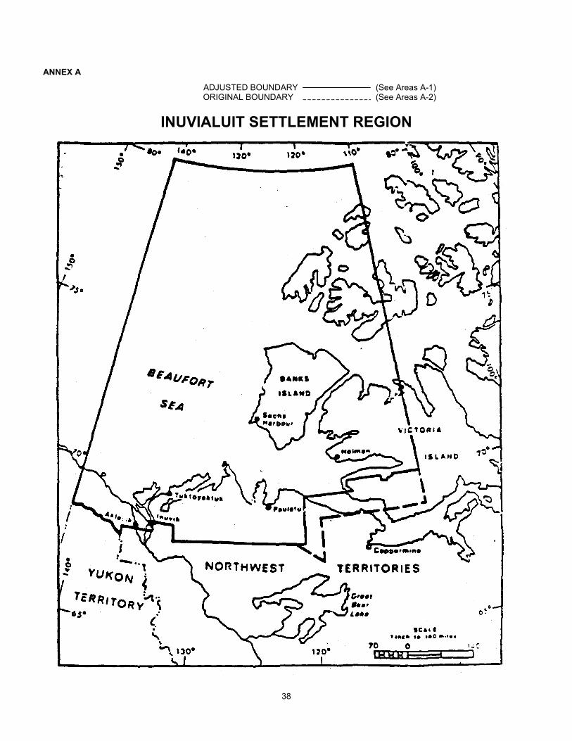
ANNEX A
ADJUSTED BOUNDARY (See Areas A-1)ORIGINAL BOUNDARY (See Areas A-2)
INUVIALUIT SETTLEMENT REGION
38
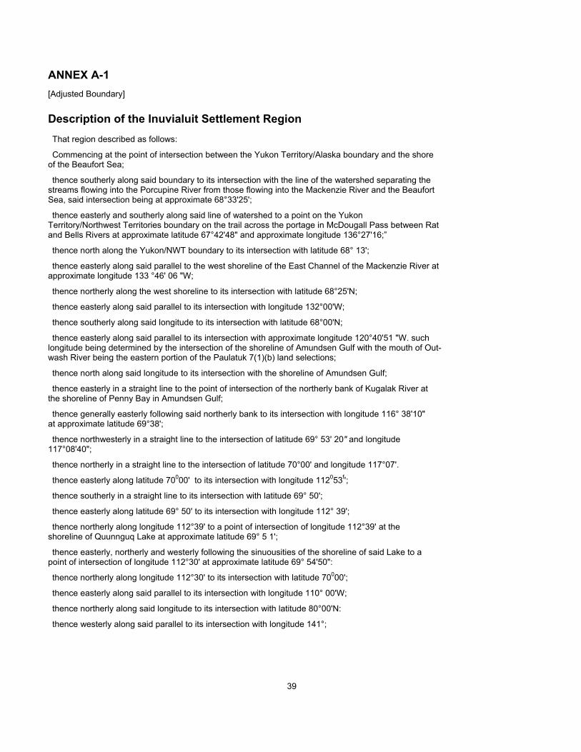
ANNEX A-1[Adjusted Boundary]
Description of the Inuvialuit Settlement RegionThat region described as follows:
Commencing at the point of intersection between the Yukon Territory/Alaska boundary and the shoreof the Beaufort Sea;
thence southerly along said boundary to its intersection with the line of the watershed separating thestreams flowing into the Porcupine River from those flowing into the Mackenzie River and the BeaufortSea, said intersection being at approximate 68°33'25';
thence easterly and southerly along said line of watershed to a point on the YukonTerritory/Northwest Territories boundary on the trail across the portage in McDougall Pass between Ratand Bells Rivers at approximate latitude 67°42'48" and approximate longitude 136°27'16;”
thence north along the Yukon/NWT boundary to its intersection with latitude 68° 13';
thence easterly along said parallel to the west shoreline of the East Channel of the Mackenzie River atapproximate longitude 133 °46' 06 "W;
thence northerly along the west shoreline to its intersection with latitude 68°25'N;
thence easterly along said parallel to its intersection with longitude 132°00'W;
thence southerly along said longitude to its intersection with latitude 68°00'N;
thence easterly along said parallel to its intersection with approximate longitude 120°40'51 "W. suchlongitude being determined by the intersection of the shoreline of Amundsen Gulf with the mouth of Out-wash River being the eastern portion of the Paulatuk 7(1)(b) land selections;
thence north along said longitude to its intersection with the shoreline of Amundsen Gulf;
thence easterly in a straight line to the point of intersection of the northerly bank of Kugalak River atthe shoreline of Penny Bay in Amundsen Gulf;
thence generally easterly following said northerly bank to its intersection with longitude 116° 38'10"at approximate latitude 69°38';
thence northwesterly in a straight line to the intersection of latitude 69° 53' 20" and longitude117°08'40";
thence northerly in a straight line to the intersection of latitude 70°00' and longitude 117°07'.
thence easterly along latitude 70000' to its intersection with longitude 112053f';
thence southerly in a straight line to its intersection with latitude 69° 50';
thence easterly along latitude 69° 50' to its intersection with longitude 112° 39';
thence northerly along longitude 112°39' to a point of intersection of longitude 112°39' at theshoreline of Quunnguq Lake at approximate latitude 69° 5 1';
thence easterly, northerly and westerly following the sinuousities of the shoreline of said Lake to apoint of intersection of longitude 112°30' at approximate latitude 69° 54'50":
thence northerly along longitude 112°30' to its intersection with latitude 70000';
thence easterly along said parallel to its intersection with longitude 110° 00'W;
thence northerly along said longitude to its intersection with latitude 80°00'N:
thence westerly along said parallel to its intersection with longitude 141°;
39

thence southerly along said meridian of longitude to the point of commencement, without prejudice.however, to any negotiations or to any positions that have been or may be adopted by Canada respectingthe limits of maritime jurisdiction in this area.
Pursuant to the TFN/COPE Agreement dated May 19, 1984, in the event that TFN has not concluded aFinal Settlement with Canada containing the Inuvialuit rights referred to in that Agreement within tenyears from the proclamation of the legislation giving effect to the Inuvialuit Final Agreement, the InuvialuitSettlement Region boundary shall unless agreed otherwise, revert to the "original boundary" as shown inAnnex A and described in Annex A-2.
40

ANNEX A-2[Original Boundary]
Description of the Inuvialuit Settlement RegionThat region described as follows:
Commencing at the point of intersection between the Yukon Territory/Alaska boundary and the shoreof the Beaufort Sea;
thence southerly along said boundary to its intersection with the line of the watershed separating thestreams flowing into the Porcupine River from those flowing into the Mackenzie River and the BeaufortSea, said intersection being at approximate 68°33'25";
thence easterly and southerly along said line of watershed to a point on the Yukon Territory/NWTboundary on the trail across the portage in McDougall Pass between Rat and Bell Rivers at approximatelatitude 67°42'48" and approximate longitude 136Q27f16"
thence north along the Yukon/NWT boundary to its intersection with latitude 68° 13';
thence easterly along said parallel to the west shoreline of the East Channel of the Mackenzie River atapproximate longitude 133°46'06"W;
thence northerly along the west shoreline to its intersection with latitude 68°25'N;
thence easterly along said parallel to its intersection with longitude 132°00'W;
thence southerly along said longitude to its intersection with latitude 68°00'N;
thence easterly along said parallel to its intersection with longitude 121°10'W;
thence south-easterly to the point 67°00'N latitude and 119°00'W longitude.
thence north along said longitude to its intersection with latitude 69°00'N;
thence easterly along said parallel to its intersection with longitude 110°00'W;
thence northerly along said longitude to its intersection with latitude 80°00'N;
thence westerly along said parallel to its intersection with the Canada/United States boundary;
thence southerly along said boundary to the point of commencement.
41
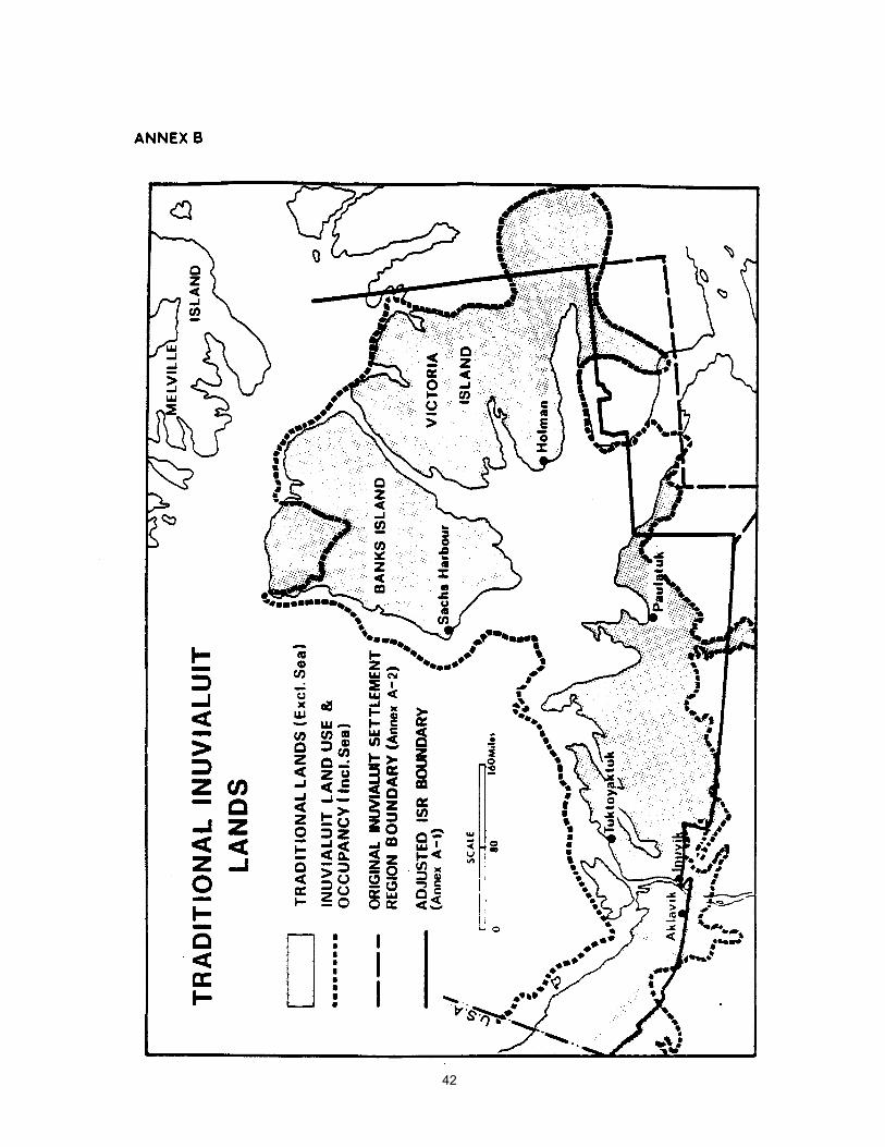
42
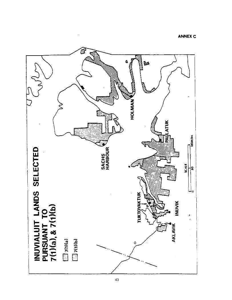
43

44

ANNEX D-1Cape Bathurst 7(1)(a) LandIn the Northwest Territories;
in the District of Mackenzie and the District of Franklin;
All that parcel of land more particularly described as follows: all topographic features hereinafter refer-red to being according to edition 2 of the Franklin Bay map sheet number 97C of the NationalTopographic System, produced at a scale of 1:250,000 by the Surveys and Mapping Branch, Departmentof Energy, Mines and Resources at Ottawa; edition 3 of the Malloch Hill map sheet number 97F. the CapeDalhousie map sheet number 107E and edition 2 of the Stanton map sheet number 107D. the last 3 mapsheets being of the National Topographic System, produced at a scale of 1:250.000 by the Army SurveyEstablishment, Royal Canadian Engineers, at Ottawa;
Commencing at a point being the intersection of the latitude 69°59'00"N with the shoreline of Liverpool Bay at approximate longitude128°20'32"'W;
thence northerly and northeasterly along the sinuosities of the shoreline of Liverpool Bay and Har-rowby Bay to a point being the intersection of said shoreline with latitude 70°12'40" at approximatelongitude 127°31'15"W
thence easterly along latitude 70° 12'40 "N to its intersection with the shoreline of Harrowby Bay atapproximate longitude 127°29'45"W;
thence northwesterly, northerly and southeasterly along the sinuosities of the shoreline of HarrowbyBay, Liverpool Bay. Amundsen Gulf and Franklin Bay to a point being the intersection of the westernshoreline of Franklin Bay with latitude 69°59'00"N at approximate longitude 126°53'06"W;
thence westerly along latitude 69°59'00"N to the point of commencement;
INCLUDING
Baillie Islands and all islands which lie in whole or in pan within two miles of the above describedshoreline and containing about 801 square miles.
45
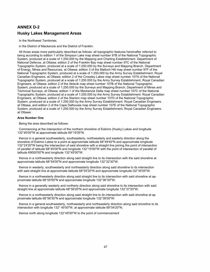
ANNEX D-2Husky Lakes Management AreasIn the Northwest Territories;
in the District of Mackenzie and the District of Franklin:
All those areas more particularly described as follows: all topographic features hereinafter referred tobeing according to edition 1 of the Simpson Lake map sheet number 97B of the National TopographicSystem, produced at a scale of 1:250,000 by the Mapping and Charting Establishment. Department ofNational Defence, at Ottawa; edition 2 of the Franklin Bay map sheet number 97C of the NationalTopographic System, produced at a scale of 1:250.000 by the Surveys and Mapping Branch. Departmentof Energy, Mines and Resources, at Ottawa; edition 3 of the Malloch Hill map sheet number 97F of theNational Topographic System, produced at a scale of 1:250,000 by the Army Survey Establishment. RoyalCanadian Engineers, at Ottawa; edition 2 of the Crossley Lakes map sheet number 107A of the NationalTopographic System, produced at a scale of 1:250.000 by the Army Survey Establishment, Royal CanadianEngineers, at Ottawa: edition 2 of the Aklavik map sheet number 107B of the National TopographicSystem, produced at a scale of 1:250.000 by the Surveys and Mapping Branch, Department of Mines andTechnical Surveys, at Ottawa: edition 1 of the Mackenzie Delta map sheet number 107C of the NationalTopographic System, produced at a scale of 1:250.000 by the Army Survey Establishment. Royal CanadianEngineers, at Ottawa; edition 2 of the Stanton map sheet number 107D of the National TopographicSystem, produced at a scale of 1:250.000 by the Army Survey Establishment. Royal Canadian Engineers.at Ottawa, and edition 2 of the Cape Dalhousie map sheet number 107E of the National TopographicSystem, produced at a scale of 1:250.000 by the Army Survey Establishment, Royal Canadian Engineers.at Ottawa:
Area Number One
Being the area described as follows:
Commencing at the intersection of the northern shoreline of Eskimo (Husky) Lakes and longitude132°45'00"W at approximate latitude 69°15'05"N:
thence in a general southwesterly, southeasterly, northwesterly and easterly direction along theshoreline of Eskimo Lakes to a point at approximate latitude 68°49'40"N and approximate longitude132°24'20"W being the intersection of said shoreline with a straight line joining the point of intersectionof parallel of latitude 68°45'00"N and longitude 132°15'00"W with the point of intersection of parallel oflatitude 69000'00"N and longitude 132°45'00"W:
thence in a northwesterly direction along said straight line to its intersection with the said shoreline atapproximate latitude 68°54'00"N and approximate longitude 132°32'30"W;
thence in westerly, southwesterly and northeasterly direction along said shoreline to its intersectionwith said straight line at approximate latitude 68°55'20''N and approximate longitude l32°35'05"W;
thence in a northwesterly direction along said straight line to its intersection with said shoreline at ap-proximate latitude 68°55'50"N and approximate longitude 132°36''20"W;
thence in a generally westerly and northerly direction along said shoreline to its intersection with saidstraight line at approximate latitude 68°56'20"N and approximate longitude 132°37'20"W;
thence in a northwesterly direction along said straight line to its intersection with said shoreline at approximate latitude 68°56'35"N and approximate longitude 132°38'00"W:
thence in a general southwesterly, northwesterly and northeasterly direction along said shoreline to itsintersection with longitude 132° 45'00"W, at approximate latitude 69°04'20"N;
thence north along longitude 132°45'00"W to the point of commencement
47

Area Number Two
Being the area described as follows:
Commencing at a point being the intersection of longitude l32°45'00"W with the northerly shorelineof the Eskimo (Husky) Lakes at approximate latitude 69° 15'05"N;
thence south along longitude 132°45'W to its intersection with latitude 69°00'N;;
thence in a southeasterly direction to a point being the intersection of longitude 132°15'W andlatitude 68°45'N;
thence north along longitude 132°15'W to its intersection with latitude 69°00'N:
thence in a northeasterly direction to a point being the intersection of latitude 69°15'N and longitude131°45'W;
thence easterly along latitude 69°15'N to its intersection with longitude 131°30'W;
thence south along longitude 131°30'W to its intersection with the latitude 68°28'N;
thence easterly along latitude 68°28'N to its intersection with longitude 130°30'W;
thence north along longitude 130°30'W to its intersection with latitude 69°00'N;
thence easterly along said latitude 69°00'N to its intersection with longitude 129°30'W;
thence northerly along longitude 129°30'W to its intersection with latitude 69°12'N;
thence easterly along latitude 69°12'N to its intersection with longitude 128°42'30"W;;
thence south along longitude 128°42'30"W to its intersection with the latitude 68°36'N;
thence westerly along latitude 68°36'N to its intersection with longitude 129°20'W;
thence north along longitude 129°20'W to its intersection with latitude 68°48'N;
thence westerly along latitude 68°48'N to its intersection with longitude 129°45'W:
thence south along longitude 129°45'W to its intersection with latitude 68°15'N;
thence easterly along latitude 68°15'N to its intersection with longitude 127°45'W;
thence north along longitude 127°45'W to its intersection with latitude 68°30'N;
thence easterly along latitude 68°30'N to its intersection with longitude 127°30'W;
thence north along longitude 127°30'W to its intersection with latitude 69°00'N;
thence westerly along latitude 69°00'N to its intersection with longitude 128°00'W:
thence north along longitude 128°00'W to its intersection with latitude 69°30'N;
thence easterly along said latitude 69°30'N to its intersection with longitude 127°15'W;
thence south along longitude 127°15'W to its intersection with latitude 69°21’N;
thence easterly, along latitude 69°21’N to its intersection with longitude 127°00W:
thence south along longitude 127°00'W to its intersection with latitude 69°10'N:
thence easterly along latitude 69010/N to its intersection with longitude 126°35'W:
thence south along longitude 126°35'W to its intersection with latitude 69°05'N;
thence easterly along latitude 69°05'N to its intersection with longitude 126°20'W;
thence south along longitude 126°20'W to its intersection with latitude 69°00'N.
thence easterly along said latitude 69°00'N to its intersection with longitude 126°00'W.
47
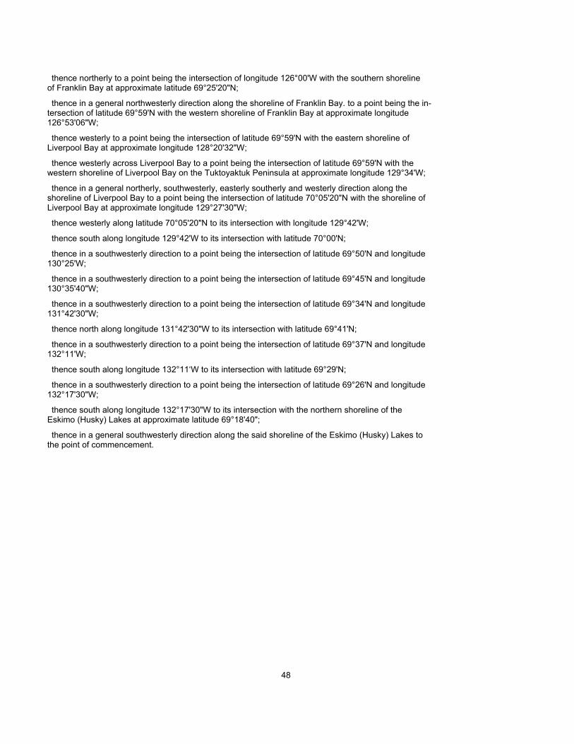
thence northerly to a point being the intersection of longitude 126°00'W with the southern shorelineof Franklin Bay at approximate latitude 69°25'20"N;
thence in a general northwesterly direction along the shoreline of Franklin Bay. to a point being the in-tersection of latitude 69°59'N with the western shoreline of Franklin Bay at approximate longitude126°53'06"W;
thence westerly to a point being the intersection of latitude 69°59'N with the eastern shoreline ofLiverpool Bay at approximate longitude 128°20'32"W;
thence westerly across Liverpool Bay to a point being the intersection of latitude 69°59'N with thewestern shoreline of Liverpool Bay on the Tuktoyaktuk Peninsula at approximate longitude 129°34'W;
thence in a general northerly, southwesterly, easterly southerly and westerly direction along theshoreline of Liverpool Bay to a point being the intersection of latitude 70°05'20"N with the shoreline ofLiverpool Bay at approximate longitude 129°27'30"W;
thence westerly along latitude 70°05'20"N to its intersection with longitude 129°42'W;
thence south along longitude 129°42'W to its intersection with latitude 70°00'N;
thence in a southwesterly direction to a point being the intersection of latitude 69°50'N and longitude130°25'W;
thence in a southwesterly direction to a point being the intersection of latitude 69°45'N and longitude130°35'40"W;
thence in a southwesterly direction to a point being the intersection of latitude 69°34'N and longitude131°42'30"W;
thence north along longitude 131°42'30"W to its intersection with latitude 69°41'N;
thence in a southwesterly direction to a point being the intersection of latitude 69°37'N and longitude132°11'W;
thence south along longitude 132°11‘W to its intersection with latitude 69°29'N;
thence in a southwesterly direction to a point being the intersection of latitude 69°26'N and longitude132°17'30"W;
thence south along longitude 132°17'30"W to its intersection with the northern shoreline of theEskimo (Husky) Lakes at approximate latitude 69°18'40";
thence in a general southwesterly direction along the said shoreline of the Eskimo (Husky) Lakes tothe point of commencement.
48
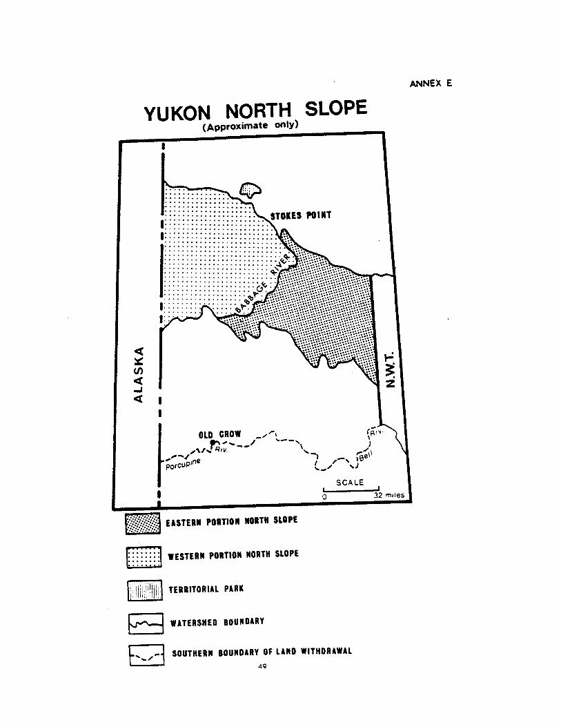

ANNEX E-1Registration SOR/80-198 27 March, 1980
Territorial Lands ActYukon Placer Mining ActProhibition and Withdrawal of Certain Lands from Disposal Order, 1980. No. 1
P.C 1980-679 20 March, 1980
His Excellency the Governor General in Council, on the recommendation of the Minister of IndianAffairs and Northern Development, pursuant to section 19 of the Territorial Lands Act and section 93 ofthe Yukon Placer Mining Act, is pleased hereby to revoke Order in Council P.C 1978-2195 of 5th July.1978* and to make the annexed Order prohibiting entry on certain lands in the Yukon Territory.
ORDER PROHIBITING ENTRY ON CERTAIN LANDS IN THE YUKON TERRITORY
Short Title
1. This Order may be cited as the Prohibition and Withdrawal of Certain Lands from Disposal Order,1980. No. 1.
Yukon Placer Mining Act
2. Pursuant to section 93 of the Yukon Placer Mining Act, entry is hereby prohibited on the landsdescribed in the schedule for the purpose of locating a claim or prospecting for gold or other preciousminerals or stones.
Territorial Lands Act
3. Pursuant to section 19 of the Territorial Lands Act, for the reason that the lands described in Part1 of the schedule are required for a National Park and other conservation purposes, the said lands, in-cluding all mines and minerals, whether solid liquid or gaseous, and all easement, servitudes and other in-terests in real property, are hereby withdrawn from disposal under the Territorial Lands Act
SCHEDULE
Part One
In the Yukon Territory,adjoining the easterly, northerly, and westerly boundaries of said Territory.
Firstly,
All that parcel of land more particularly described as follows:Commencing at a point on the International Boundary between Alaska and the Yukon Territory atMonument number 51 at approximate latitude 67025'00<" and longitude 141° 00'00";
thence in a northeasterly, easterly and southerly direction along the left bank of the Porcupine Riverfor a distance of 130 miles, more or less. to a point at approximate latitude 67°17'00" andlongitude 137°37'00", said point being at the confluence of the Bell River with the Porcupine River:
thence in a northeasterly direction to the left bank of the Bell River and then in a northeasterly.southerly and northeasterly direction along the said left bank for a distance of approximately 80miles to a point on the left bank of an unnamed creek at approximate latitude 67°41'00" andlongitude 136° 37'00";
thence in an easterly, northerly and easterly direction along the left bank of said creek and the southshore of Summit Lake to a point on the Boundary between the Yukon Territory and the NorthwestTerritories at approximate latitude 67°42'30" and longitude 136°27'00":
50
thence due north along said boundary to the shore of Mackenzie Bay of the Beaufort Sea at approx-imate latitude 68°52'30" and longitude 136°27'00";
thence in a northwesterly direction along the shore of the Beaufort Sea to a point on the Interna-tional Boundary between Alaska and the Yukon Territory at approximate latitude 69°39'00" andlongitude 141°00'00";
thence due south along the said International Boundary to the point of commencement.
Secondly,
The islands within three statute miles of the shore of the Beaufort Sea west of the boundary betweenthe Yukon Territory and the Northwest Territories, and Herschel Island.
SAVING, EXCEPTING AND RESERVING thereout and therefrom all lands and buildings shown as reserv-ed for any department of the Government of Canada or for the Government of the Yukon Territory orfor the Northern Canada Power Commission in the Territorial Lands Property Registers in the LandManagement Division of the Northern Affairs Program of the Department of Indian Affairs andNorthern Development at Ottawa.
SAVING. EXCEPTING AND RESERVING thereout and therefrom all lands within a radius of two milesfrom the southwest comer of Lot 1, Group 1302. in the settlement of Old Crow. as said Lot is shownon plan of record number 42622 in the Canada Lands Surveys Records at Ottawa.
Part Two
In the Yukon Territory, in Group 1302. all that strip of land lying four and five tenths metres on eitherside of the centre line of an electrical power distribution line extending from The Yukon Electrical CompanyLimited's power house in the Settlement of. Old Crow approximately five and six tenths kilometres to theCanadian National Railway Company's Microwave Station on Crow Mountain, as the centre line of the saiddistribution line is shown on drawing number 6312 of record on file number 8-3-1302-0-6 in the LandManagement Division of the Department of Indian Affairs and Northern Development at Ottawa.
SAVING. EXCEPTING AND RESERVING thereout and therefrom all mines and minerals whether solid, li-quid or gaseous, and the right to work the same.
51

52
ANNEX F-1Aklavik 7(1)(a) LandIn the Northwest Territories;
in the District of Mackenzie:
in the Mackenzie Delta:
All that parcel of land in the Mackenzie Delta according to edition 1 of the National TopographicSeries Maps of Aklavik — 107B and Blow River — 117A, produced at a scale of 1:250,000 by the Surveysand Mapping Branch, Department of Energy, Mines and Resources, Ottawa, as said parcel may be moreparticularly described as follows:
Commencing at a point on the Northwest Territories — Yukon Territory boundary at latitude 68°46'and approximate longitude 136°27'16";
thence easterly along latitude 68°46' to its intersection with longitude 135°40';
thence south along longitude 135°40' to its intersection with latitude 68°35';
thence easterly along latitude 68°35' to its intersection with longitude 135°30';
thence south along longitude 135°30' to its intersection with latitude 68°32';
thence easterly along latitude 68°32' to its intersection with longitude 135°25';
thence south along longitude 135°25' to its intersection with latitude 68°20';
thence westerly along latitude 68°20' to its intersection with longitude 135°15';
thence north along longitude 136°15' to its intersection with latitude 68°30';
thence westerly along latitude 68°30' to its intersection with the Yukon Territory — NorthwestTerritories boundary, at approximate longitude 136°27'16".
thence north along said boundary to the point of commencement;
said parcel containing about 643 square miles.
53

ANNEX F-2Aklavik 7(1)(b) LandIn the Northwest Territories;
in the District of Mackenzie;
in the Mackenzie Delta;
All those parcels of land in the Mackenzie Delta according to edition 1 of the National TopographicSeries Map of Tent Island — 117A/16E and Shallow Bay — 107B/13W reproduced at a scale of 1:50.000by the Army Survey Establishment, R.C.E. Ottawa, and to Maps of Mount David Gilbert — 117A/9E,Leland Channel — 107B/12E and 107B/12W and Beaver House Creek 107B/5E produced at a scale of .1:50,000 by the Surveys and Mapping Branch of the Department of Energy. Mines and Resources, Ottawa,as said parcels may be described under Firstly to Twelfthly as follows:
Firstly, (according to said map 117A/16E)
Commencing at a point on the Yukon Territory — Northwest Territories boundary at latitude 68°46'and approximate longitude 136°27'16';
thence north along said boundary to its intersection with the southerly bank of an unnamed streamat approximate latitude 68°46'50", as said stream connects Moose Channel to Ministicoog Channel:
thence easterly and southerly along said southerly bank to its intersection with latitude 68°46' at ap-proximate longitude 136°24';
thence westerly along latitude 68°46' to the point of commencement;
Secondly, (according to said maps 117A/16E, 117A/9E and 107B/12W)
Commencing at the point of intersection of latitude 68°46' and longitude 136° 10;
thence westerly along latitude 68°46' to its intersection with the southerly bank of said unnamedstream at approximate longitude 136° 23';
thence generally easterly following the sinuosities of said southerly bank to its intersection with thewesterly bank of said Ministicoog Channel at approximate latitude 68°47'10" and approximate longitude136°10'05";
thence southeasterly following said bank of Ministicoog Channel to its intersection with latitude68°46' at approximate longitude 136°09'20";
thence westerly following parallel of latitude 68046' to the point of commencement;
Thirdly, (according to said map 107B/13W)
Commencing at a point on the northwesterly bank of an unnamed channel at latitude 68° 46' and ap-proximate longitude 135° 53'20". said unnamed channel connecting west Channel and Anderton Channel:
thence westerly along latitude 68°46' to the northeasterly bank of said unnamed Channel at approximate longitude 135°55'40";
thence northerly, westerly, northwesterly and southeasterly along the sinuosities of the banks of saidunnamed channel, Anderton Channel and West Channel to the point of commencement:
Fourthly, (according to said map 107B/13W)
Commencing at a point on the easterly bank of an unnamed channel at latitude 68°46' and approximate latitude 135° 50'40", said unnamed channel connecting. Shallow Bay and West Channel:
thence northeasterly and southerly along the sinuosities of the banks of said unnamed channel andShallow Bay to a point at latitude 68°46' and approximate longitude 135°43'50".
54

thence westerly along latitude 68°46' to the point of commencement;
Fifthly, (according to said map 107B/13W)
Commencing at the point on the southwesterly bank of Shallow Bay at latitude 68°46' and approx-imate longitude 135°41'50";
Sixthly, (according to said maps 107B/13W and 107B/12W)
Commencing at a point on the southwesterly bank of Shallow Bay at longitude 135°40' and approx-imate latitude 68°45'50";
thence southeasterly, northwesterly and southwesterly along the sinuousities of the banks of ShallowBay. Hvatum Channel and an unnamed channel to a point at longitude 134°40' and approximate latitude68°45'13";
thence north along longitude 135°40' to the point of commencement
Seventhly, (according to said maps 107B/13W and 107B/12W)
Commencing at a point on the south bank of an unnamed channel at longitude 135°40" and approx-imate latitude 68°45'10";
thence southeasterly and southwesterly along the bank of said unnamed channel to a point atlongitude 135°40' and approximate latitude 68°44';
thence north along longitude 135°40' to the point of commencement;
Eighthly, (according to said map 107B/12W)
Commencing at a point on the westerly bank of an unnamed channel at longitude 135°40' and ap-proximate latitude 68°43' 35 ";
thence in a general southerly direction along said unnamed channel and Hvatum Channel to a pointon the west bank of Hvatum Channel at latitude 68°35' and approximate longitude 135°36',
thence westerly along latitude 68°35' to its intersection with longitude 135°40';
thence north along longitude 135°40' to the point of commencement;
Ninthly, (according to said map 107B/12W)
Commencing at the point of intersection of the easterly bank of Hvatum Channel with latitude 68° 3 5'.approximate longitude 135°35'45";
thence northerly following said easterly bank to its intersection with the southerly bank of an unnam-ed stream at approximate latitude 68°35'04" and approximate longitude 135°35'45";
thence easterly and northeasterly following the said southerly bank to its intersection with thesoutherly bank of Leland Channel at approximate latitude 68°35'20'' and approximate longitude135°32'30"
thence southeasterly following the southerly bank of said Channel to its intersection with latitude68°35' at approximate longitude 135°31'30";
thence westerly along parallel of latitude 68°35' to the point of commencement;
Tenthly, (according to said map 107B/12E)
Commencing at the point of intersection of latitude 68°32' and longitude 135°30':
thence north along said longitude to its intersection with the southerly bank of Leland Channel at approximate latitude 68°34'40";
thence generally southerly following said bank to its intersection with longitude 135°25' at approximate latitude 68°32'01";
thence south along longitude 135°25' to its intersection with latitude 68°32';
55
thence westerly along latitude 68°32' to the point of commencement;
Eleventhly, (according to said map 107B/12E and 107B/5E)
Commencing at the point of intersection of the southerly bank of Leland Channel and longitude135°25' at approximate latitude 68°32'0l";
thence generally southerly following the sinuosities of the southwesterly bank of said Channel to thewesterly bank of an unnamed channel at approximate latitude 68°30' and approximate longitude135°19'56";
thence generally southwesterly along the westerly bank of said unnamed channel and the easterlybank of the Lelland Channel to the easterly bank of the West Channel of the Mackenzie River at approx-imate latitude 68°24'57" and approximate longitude 135°24'59"
thence northwesterly following the easterly bank of the West Channel to its intersection with longitude135°25'. approximate latitude 68°25';
thence north along longitude 135°25' to the point of commencement;
Twelfthly, (according to said map 107B/5E)
Commencing at the point of intersection of latitude 68°20' and longitude 135°25';
thence north along longitude 135°25' to its intersection with the southwesterly bank of West Channelat approximate latitude 68°22'50";
thence generally southeasterly following the sinuosities of said bank to its intersection with latitude68°20', approximate longitude 135° 13' 40";
thence westerly along latitude 68°20' to the point of commencement.
The said parcels described under Firstly to Twelfthly having a total area of 38 square miles more orless.
56


ANNEX G-1Inuvik 7(1)(a) LandIn the Northwest Territories;
in the District of Mackenzie:
in the Mackenzie Delta and Caribou Hills;
All that parcel of land in the Mackenzie Delta and Caribou Hills according to National TopographicSeries Maps of Aklavik — 107B. edition 1 and Mackenzie Delta — 107C, edition 2. produced at a scale of1:250,000 by the Surveys and Mapping Branch of the Department of Energy. Mines and Resources. Ot-tawa, as said parcel may be more particularly described as follows:
Commencing at the point of intersection of latitude 69°10'30" and longitude 134°15';
thence south along longitude 134° 15' to its intersection with latitude 68° 50';
thence easterly along latitude 68° 50' to its intersection with longitude 134°00';
thence south along longitude 134°00' to its intersection with latitude 68°40':
thence easterly along latitude 68°40' to its intersection with longitude 133°45';
thence south along longitude 133°45' to its intersection with latitude 68°25';
thence westerly along latitude 68°25' to its intersection with longitude 133° 55';
thence north along longitude 133°55' to its intersection with latitude 68°30';
thence westerly along latitude 68°30' to its intersection with longitude 134° 15';
thence north along longitude 134° 15' to its intersection with latitude 68°34';
thence westerly along latitude 68°34' to its intersection with longitude 134°20';
thence north along longitude 134°20' to its intersection with latitude 68°40';
thence westerly along latitude 68°40' to its intersection with longitude 134°37f30";
thence north along longitude 134°37'30" to its intersection with latitude 68°43';
thence westerly along latitude 68°43' to its intersection with longitude 134°45';
thence north along longitude 134°45' to its intersection with latitude 68°44/;
thence westerly along latitude 68°44' to its intersection with longitude 134°47/30'r;
thence north along longitude 134°47'30" to its intersection with latitude 68°54';
thence westerly along latitude 68°54' to its intersection with longitude 135°03'45";
thence north along longitude 135°03'45" to its intersection with latitude 69°01';
thence easterly along latitude 69°01' to its intersection with longitude 134° 53'45";
thence north along longitude 134°53'45" to its intersection with latitude 69°06';
thence easterly along latitude 69°06' to its intersection with longitude 134°35';
thence north along longitude 134°35' to its intersection with latitude 69° 10'30".
thence easterly along latitude 69° 10' 30" to the point of commencement;
said parcel containing about 761 square miles.
58
ANNEX G-2Inuvik 7(1)(b) LandIn the Northwest Territories;
in the District of Mackenzie;
in the Mackenzie Delta;
All those parcels of lands in the Mackenzie Delta according to edition 1 of the National TopographicSeries Maps of Tununuk — 107C/3E and 107C/3W. Ellice Island — 107C/4E, Shallow Bay — 107B/13E,Wolverine Lakes — 107B/14W. Reindeer Station - 107B/11E and 107B/11W. Schooner Channel 107B/6Eand Inuvik — l07B/7 produced at a scale of 1:50.000. as said parcels may be more particularly describedunder Firstly to Eleventhly as follows:
Firstly, (according to said Map 107C/3E produced by the Army Survey Establishment, R.C.E.. Ottawa)
Commencing at the point of intersection of the westerly bank of Mackenzie River with latitude69°10'30", approximate longitude 134° 16';
thence northerly to a point on the southerly bank of an unnamed stream at approximate latitude69°11' and approximate longitude 134° 16';
thence southwesterly following the said bank of said stream to its intersection with latitude69°10'30' and approximate longitude 134° 19'20";
thence easterly along said latitude 69°10'30" to the point of commencement;
Secondly, (according to said Map 107C/3W produced by said Army Survey Establishment)
Commencing at the point of intersection of an unnamed creek with latitude 69°06' at approximatelongitude 134°51';
thence northwesterly following said creek to its intersection with the shoreline of an unnamed lake atapproximate latitude 69°06'05" and approximate longitude 134° 51 '05";
thence generally easterly and northerly following said shoreline of said lake to its intersection withlatitude 69°10'30" at approximate longitude 134°39';
thence easterly along latitude 69° 10'30" to its intersection with longitude 134°35';
thence south along longitude 134°35' to its intersection with latitude 69°06';
thence westerly along latitude 69°06' to the point of commencement;
Thirdly, (according to said map 107C/3W produced by said Army Survey Establishment)Commencing at the point of intersection of latitude 69°01' and longitude 134°53'45'',
thence westerly along latitude 69°01' to its intersection with the easterly bank of an unnamedstream at approximate longitude 134°58'20";
thence northerly following said bank of said stream to a point on the southerly bank of an unnamedchannel that leads to the East Channel of Mackenzie River, said point being at approximate latitude69°02' 25 " and longitude 134° 59' 55";
thence generally northeasterly following said bank of said unnamed Channel to its intersection withlongitude 134° 53 '45" at approximate latitude 69004/55";
thence south along longitude 134°53'45" to the point of commencement:
Fourthly, (according to said maps 107C/3W. 107C/4E and 107B/13E produced by said Army SurveyEstablishment)
59

Commencing at the point of intersection of latitude 69002'10" and the westerly bank of the unnamedchannel mentioned in Thirdly at approximate longitude 134°59'50";
thence northerly and westerly following said westerly bank to the mouth of an unnamed stream atapproximate latitude 69°01' and approximate longitude 135°02'50";
thence generally westerly following the southerly bank of said unnamed stream to its intersection withanother unnamed stream at approximate latitude 69002'30" and approximate longitude 135°10' 05";
thence generally southerly following the easterly bank of said unnamed stream to the shoreline of anunnamed lake at approximate latitude 69°00'55" and approximate longitude 135°09':
thence generally southeasterly following the sinuosities of the said shoreline to its intersection withlongitude 135°03'45" at approximate latitude 68059'35";
thence northerly along longitude 135°03'45" to its intersection with latitude 69°01';
thence easterly along latitude 69°01' to the point of commencement;
Fifthly, (according to said map 107B/13E produced by said Army Survey Establishment)
Commencing at the intersection of longitude 135°03'45" and the shoreline of the lake, mentioned inFourthly, at approximate latitude 68° 58'55";
thence south along said longitude to its intersection with the southeasterly bank of an unnamedstream at approximate latitude 68° 55'55";
thence southwesterly, northwesterly and southeasterly following said bank of said unnamed stream toits intersection with an unnamed creek at approximate latitude 68°56' and approximate longitude135°05';
thence southerly and northwesterly following said creek to its intersection with the shoreline of an un-named lake at approximate latitude 68°56'05' and approximate longitude 135°06'20";
thence northeasterly, northwesterly, westerly, northerly and easterly following the sinuosities of theeastern shoreline of said lake to its intersection with latitude 68°57' at approximate longitude 135°05';
thence northeasterly in a straight line across the land to a point on the southerly shoreline of anotherunnamed lake at longitude 135°04'20" and approximate latitude 68°57'05";
thence northerly following the shoreline of said unnamed lake to its intersection with longitude135°04'20" at approximate latitude 68°57'15";
thence northwesterly in a straight line to its intersection with the shoreline of a small lake at its mostsoutheasterly end at approximate latitude 68057'45" and approximate longitude 135°04'25";
thence northwesterly following the eastern shoreline of said lake to its intersection with latitude68°58'15" at approximate longitude 135°05'45";
thence easterly along latitude 68°58'15" to its intersection with the shoreline of the unnamed lakementioned herein for the point of commencement;
thence southeasterly, easterly and northerly following the shoreline of said lake to the point ofcommencement;
Sixthly, (according to said maps 107B/13E and 107B/14W reproduced by said Army SurveyEstablishment)
Commencing at the point of intersection of latitude 68°54' and longitude 135°03'45".
thence north along longitude 135°03'45" to its intersection with the southeasterly bank of the unnamed stream, mentioned inFifthly, at approximate latitude 68° 55'40":
thence southwesterly following said bank to its intersection with the easterly bank of Reindeer Channelat approximate latitude 68°53'40" and longitude 135° 10',
60

thence southerly and generally easterly following the sinuosities of said bank to its intersection withlatitude 68°54” at approximate longitude 134° 55'15”;
thence westerly along latitude 68° 54' to the point of commencement;
Seventhly, (according to said maps 107B/14W and 107B/11W reproduced by said Army Survey Establish-ment and by the Surveys and Mapping Branch of the Department of Energy. Mines and Resources.Ottawa)
Commencing at the point of intersection of latitude 68°54' and longitude 134° 47'30":
thence westerly along latitude 68°54' to its intersection with the easterly bank of Reindeer Channel atapproximate longitude 134°54';
thence southwesterly following the bank of said Channel to the mouth of an unnamed creek at ap-proximate longitude 134°56';
thence generally southerly following said creek to its intersection with an unnamed stream at approx-imate latitude 68°48' and longitude 134°50';
thence westerly across said stream to the mouth of unnamed creek at approximate latitude 68°48'and approximate longitude 134°50f45"f;
thence generally southwesterly following said unnamed creek to the mouth of Axel Creek at approx-imate latitude 68°44' 55" and longitude 134°54' 58";
thence generally southeasterly following said creek to its intersection with longitude 134°37'30" atapproximate latitude 68°40'40";
thence north along longitude 134°37'30" to its intersection with latitude 68°43';
thence westerly along latitude 68° 43' to its intersection with longitude 134° 45';
thence north along longitude 134°45' to its intersection with latitude 68°44';
thence westerly along latitude 68°44' to its intersection with longitude 134°47'30";
thence north along longitude 134° 47'30" to the point of commencement;
Eighthly, (according to said maps 107B/11W and 107B/11E produced by said Surveys and Mapping Branch)
Commencing at the point of intersection of latitude 68°40' and longitude 134°20';
thence westerly along latitude 68°40' to its intersection with the last creek mentioned in Seventhly.at approximate longitude 134037'27";
thence southerly following said creek to its mouth in Amagokvik Channel;
thence generally southeasterly following the northerly bank of Amagogvik Channel and that of TummaChannel to its intersection with longitude 134°20' at approximate latitude 60Q33'59";
thence north along longitude 134°20' to the place of commencement;
Ninthly, (according to said map 107B/11E produced by said Surveys and Mapping Branch)Commencing at the point of intersection of latitude 68°34' and longitude 134° 15';
thence south along said longitude 134°15' to its intersection with the westerly bank Middle Channelat approximate latitude 68°32'40":
thence southerly following said bank to the mouth of Pederson Channel at approximate latitude68°30'40" and approximate longitude 134°16':
thence generally westerly following the sinuosities of the northerly bank or said Channel to its intersec-tion with longitude 134°20'30" at approximate latitude 68°31'40";
61
thence north along said longitude to its intersection with the southerly shoreline of an unnamed lakeat approximate latitude 68°31 '45";
thence northeasterly following the southeasterly shoreline of said lake to the most northerly positionof a small inlet at approximate latitude 68°33'05" and approximate longitude 134° 18'05";
thence generally northerly in a straight line across the lands and joining the most southwesterly posi-tions of two small unnamed lakes, the last position being at approximate latitude 68° 33'20" andlongitude 134°17'30";
thence north in a straight line to the intersection of a small unnamed creek and longitude134°17'20";
thence northerly following said creek to its mouth in Tumma Channel;
thence north across said Channel to its northerly bank at approximate latitude 68°33'55";
thence westerly following the bank of said Channel to its intersection with longitude 134°20' at ap-proximate latitude 68°33'59";
thence north along longitude 134°20' to its intersection with latitude 68°34';
thence easterly along latitude 68°34' to the point of commencement;
Tenthly, (according to said map 107B/6E produced by said Surveys and Mapping Branch)
Commencing at the point of intersection of latitude 68°30' with the west bank of Oniak Channel atapproximate longitude 134°00'40";
thence westerly along latitude 68°30' to its intersection with the east bank of Middle Channel at ap-proximate latitude 134°05';
thence southerly, easterly and northerly following the east bank of Middle Channel and the north andwest banks of Oniak Channel to the point of commencement;
Eleventhly, (according to said maps 107B/6E and 107B/7 produced by said Surveys and Mapping Branch)Commencing at the point of intersection of latitude 68°30' and longitude 133°55';
thence south along longitude 133°55' to its intersection with latitude 68°25';
thence easterly along latitude 68°25' to its intersection with the west bank of the East Channel ofMackenzie River at approximate longitude 133° 48';
thence southerly following said bank to the mouth of a small creek at approximate latitude 68°23'and approximate longitude 133046'10'',
thence westerly following said creek to the easterly end of an unnamed channel at approximatelatitude 68°23'02" and approximate longitude 133°46'40"
thence westerly following said channel to its intersection with longitude 133° 48'15" and approximatelatitude 68° 23';
thence north along longitude 133°48' 5" to its intersection with the northerly shoreline of an unnamed lake at approximate latitude 68°23'05";
thence generally northerly and westerly following the sinuosities of the shoreline of said lake to apoint at latitude 68024'10" and approximate longitude 133°52'15";
thence northwesterly in a straight line across said lake to the mouth of a small creek at approximatelatitude 68°24'15'' and approximate longitude 133°53'20";
thence southwesterly following said creek to its intersection with the shoreline of a small lake
thence generally westerly following the northerly shoreline of said lake to its intersection with anothersmall creek;
62

thence northwesterly following said creek to the shoreline of an unnamed lake at approximate latitude68° 24'13" and approximate longitude 133° 53';
thence generally westerly following the sinuosities of the shoreline of said lake to the northerly bankof an unnamed stream that leads to Oniak Channel at approximate latitude 68°24'10" and approximatelongitude 133°55';
thence generally northerly following the easterly bank of said stream to the easterly bank of OniakChannel and northerly following the bank of Oniak Channel to its intersection with latitude 68°30' at ap-proximate longitude 133°59'30'':
thence easterly along said latitude 68° 30' to the place of commencement.
The said parcels described under Firstly to Eleventhly having a total area of 110 square miles more orless.
AND
(Southeast)
In the Northwest Territories:
in the District of Mackenzie;
in the Caribou Hills:
All that parcel of land in the Caribou Hills according to edition 1 of the National Topographic SeriesMap 107B/7 produced at a scale of 1:50,000 by the Surveys and Mapping Branch of the Department ofEnergy, Mines and Resources. Ottawa and which may be more particularly described as follows:
Commencing at the point of intersection of latitude 68°28' and longitude 133°37'30'',
thence south along longitude 133°37'30" to its intersection with latitude 68°25';
thence westerly along latitude 68°25' to its intersection with longitude 133°45';
thence north along longitude 133°45' to its intersection with latitude 68°28';
thence easterly along latitude 68°28' to the place of commencement;
said parcel containing about 11 square miles.
AND
(Northeast)
in the Northwest Territories:
in the District of Mackenzie;
in the Mackenzie Delta:
All those parcels of land in the Mackenzie Delta and Kittigazuit Bay according to edition 1 of the Na-tional Topographic Series Map of Mackenzie Delta 107C produced at a scale of 1:250,000 by the ArmySurvey Establishment. R.C.E., Ottawa which may be more particularly described under Firstly and Secondlyas follows:
Firstly,
Commencing at a point on the shoreline of Kittigazuit Bay at latitude 69° 20' and approximatelongitude 133°46';
thence easterly along latitude 69°20' to its intersection with longitude 133°30'.
thence south along said longitude 133°30' to its intersection with latitude 69°03'.
thence westerly along latitude 69°03' to its intersection with longitude l33°47'30".
thence south along longitude 133°47'30'' to its intersection with latitude 69°00'.
thence westerly along latitude 69°00' to its intersection with longitude 134°15';
63
thence north along longitude 134° 15' to its intersection with the southerly bank of Mackenzie Riverat approximate latitude 69° 10';
thence generally northeasterly following the said bank to the mouth of an unnamed channel at ap-proximate latitude 69°10'35";
thence generally northerly following the easterly bank of said channel to its intersection with saidbank of Mackenzie River;
thence generally northeasterly following said bank of said river to the point of commencement;
Secondly,
All those islands in Kittigazuit Bay that lies close to the shore of the parcel described in Firstly, betweenlongitudes 133°46' and 133°55' and between latitudes 69°19' and 69°21';
LESS
The waters and bed of KIttigazuit Bay and inlets thereto:
the remainder containing together about 350 square miles.
The lands described in Annex G-2 comprising 471 square miles more or less.
64


ANNEX H-1Tuktoyaktuk 7(1)(a) LandIn the Northwest Territories;
in the District of Mackenzie;
in the Mackenzie Delta;
All that parcel of land according to edition 1 of the Mackenzie Delta map sheet number 107C of theNational Topographic System, produced at a scale of 1:250,000 by the Army Survey Establishment. R.C.E..at Ottawa, and which may be more particularly described as follows:
Commencing at a point on the southeasterly shoreline of Kittigazuit Bay at latitude 69°20'N and ap-proximate longitude 133°46'W;
thence in a general northeasterly direction along the Kittigazuit Bay shoreline and the Kugmallit Bayshoreline to its intersection with latitude 69°40'N at approximate longitude 132°20'5"W;
thence easterly along latitude 69°40N to its intersection with longitude 132° 17'30";
thence south along longitude to the shoreline of Eskimo Lakes at approximate latitude 69° 18'40"N;
thence in a general southwesterly direction along the said shoreline of Eskimo Lakes to its intersectionwith latitude 69°10'N at approximate longitude 132° 51 '00''W;
thence westerly along latitude 69°10'N to its intersection with longitude 133°30'W;
thence north along longitude 133°30'W to its intersection with latitude 69°20'N;
thence westerly along latitude 69°20'N to the point of commencement;
together with the whole of Hendrickson Island being situated at approximate latitude 69°30'N andapproximate longitude 133°35'W: and including all islands in Tuktoyaktuk Harbour and those islandssituated in whole or in pan within two miles of the shorelines described.
LESS
Firstly,
That parcel of land lying between latitudes 69°26'N and 69°28'N and between longitudes132°47'30'W and 132°50'W;
said parcel containing about 2.76 square miles.
Secondly,
That parcel comprising the Community Site of Tuktoyaktuk being described as follows:
Commencing at the intersection of latitude 69°24'13"N with the west shoreline of the peninsula onwhich the community of Tuktoyaktuk is situated, the said point being at approximate longitude133°02'W;
thence in a general northerly, easterly and southerly direction following the shoreline around thepeninsula on which the community of Tuktoyaktuk is situated to the intersection of the east shoreline ofsaid peninsula with latitude 69°24 '13";
thence west along said latitude 69°24'13"N to the point of commencement: said parcel containingabout 3 square miles.
The remainder containing 691 square miles more or less.
66

ANNEX H-3Tuktoyaktuk Community SiteIn the Northwest Territories;
in the District of Mackenzie:
in the Mackenzie Delta;
All that parcel of land more particularly described as follows: all topographic features hereinafter refer-red to being according to edition 1 of the Kittlgazuit map sheet number 107C/7E of the NationalTopographic System, produced at a scale of 1:50,000 by the Army Survey Establishment, R.C.E.. at Ottawaand edition 1 of the map sheet number 107C/8W of the National Topographic System produced at a scaleof 1 :50.000 by the Army Survey Establishment R.C.E., at Ottawa.
Commencing at the intersection of latitude 69°24'13"N with the west shoreline of the peninsula onwhich the community of Tuktoyaktuk is situated, the said point being at approximate longitude133°02'W";
thence in a general northerly, easterly and southerly direction following the shoreline around thepeninsula on which the said community is situated to the intersection of the east shoreline of said penin-sula with latitude 69°24'13"N;
thence west along latitude 69°24'13"N to the point of commencement; said parcel containing about3 square miles.
68

ANNEX H-4Pingo Canadian Landmark SiteIn the Northwest Territories:
in the District of Mackenzie:
in the Mackenzie Delta;
All that parcel of land more particularly described as follows: all topographic features hereinafter refer-red to being according to edition 1 of the Mackenzie Delta map sheet number 107C of the NationalTopographical System, produced at a scale of 1:250.000 by the Army Survey Establishment, Royal Cana-dian Engineers, at Ottawa;
Commencing at the point located at latitude 69°22'50" and longitude 133°07'00"W;
thence in a northeasterly direction a distance of 2.2 miles more or less to a point located at latitude69°23' 30 "N and longitude 133°01' 50 ''W;
thence in a northerly direction a distance of 2.0 miles more or less along the shore of an unnamedbay to a point located on the coast at approximate latitude 69°24'43"N and longitude 133°03'20"W;
thence in a northerly direction a distance of 0.4 miles more or less to a point located on the coast atapproximate latitude 69°25'01"N and longitude 133°03'46"W;
thence in a westerly direction a distance of 0.5 miles more or less to a point located at latitude69°24' 57"N and longitude 133004'54"W;
thence in a northwesterly direction a distance of 0.2 miles more or less to a point located on thecoast of Kugmallit Bay on the Beaufort Sea at approximate latitude 69°25'00"N and longitude133°05'25"W;
thence in a westerly direction a distance of 0.8 miles more or less to a point located at latitude69°24'58"N and longitude 133°07'20"W;
thence in a southwesterly direction a distance of 2.5 miles more or less to a point located at latitude69°23' 47"N and longitude 133°12'30"W;
thence in a southeasterly direction a distance of 0.5 miles more or less to a point located at latitude69°23'30"N and longitude 133° 11 '22"W;
thence in a southeasterly direction a distance of 1.1 miles more or less to a point located at latitude69°23'10"N and longitude 133°08/45"W;
thence in a southeasterly direction a distance of 0.8 miles more or less to the point ofcommencement:
said parcel containing about 6.34 square miles.
69


ANNEX H-6Tuktoyaktuk7(1)(b) LandIn the Northwest Territories;
in the District of Mackenzie and the District of Franklin;
All that parcel of land more particularly described as follows: all topographic features hereinafter refer-red to being according to edition 1 of the Simpson Lake map sheet number 97B of the NationalTopographic System, produced at a scale of 1:250,000 by the Mapping and Charting Establishment,Department of National Defence, at Ottawa; edition 2 of the Franklin Bay map sheet number 97C of theNational Topographic System, produced at a scale of 1:250,000 by the Surveys and Mapping Branch,Department of Energy, Mines and Resources, at Ottawa; edition 3 of the Malloch Hill map sheet number97F of the National Topographic System, produced at a scale of 1:250.000 by the Army Survey Establish-ment, Royal Canadian Engineers, at Ottawa, edition 2 of the Crossley Lakes map sheet number 107A ofthe National Topographic System, produced at a scale of 1:250.000 by the Army Survey EstablishmentRoyal Canadian Engineers, at Ottawa; edition 2 of the Aklavik map sheet number 107B of the NationalTopographic System, produced at a scale of 1:250.000 by the Surveys and Mapping Branch, Departmentof Mines and Technical Surveys, at Ottawa: edition 1 of the Mackenzie Delta map sheet number 107C ofthe National Topographic System, produced at a scale of 1:250.000 by the Army Survey Establishment.Royal Canadian Engineers, at Ottawa: edition 2 of the Stanton map sheet number 107D of the NationalTopographic System, produced at a scale of 1:250.000 by the Army Survey Establishment, Royal CanadianEngineers, at Ottawa, and edition 2 of the Cape Dalhousie map sheet number 107E of the NationalTopographic System, produced at a scale of 1:250.000 by the Army Survey Establishment, Royal CanadianEngineers, at Ottawa:
Commencing at a point being the intersection of latitude 69°10'N with the western shoreline of theEskimo (Husky) Lakes at approximate longitude 132°51 '00";
thence westerly along latitude 69°10'N to its intersection with longitude 133° 21 'W:
thence south along longitude 133°21 'W to its intersection with the latitude 69°00'N;
thence in a southwesterly direction to a point being the intersection of latitude 68°50'N and longitude133°35'W:
thence in a southeasterly direction to a point being the intersection of latitude 68°45'N and longitude133°27'30"W;
thence in a southeasterly direction to a point being the intersection of latitude 68°43'N and longitude 133°15'W:
thence south along longitude 133°15'W to its intersection with the latitude 68°40'N:
thence easterly along latitude 68°40'N to its intersection with longitude 132°30'W;
thence north along longitude 132°30'W to its intersection with latitude 68045'N;
thence easterly along latitude 68°45'N to its intersection with longitude 132015'W;
thence north along longitude 132°15'W to its intersection with the latitude 69°00'N;
thence in a northeasterly direction to a point being the intersection of latitude 69°15'N and longitude131°45'W;
thence easterly along latitude 69°15'N to its intersection with longitude 131°30'W;
thence south along longitude 131°30'W to its intersection with latitude 68°28'N;
thence easterly along latitude 68028'N to its intersection with longitude 130°30'W:
thence north along longitude 130°30'W to its intersection with latitude 69°00'N;
thence easterly along latitude 69°00'N to its intersection with longitude 129°30'W;
71

thence north along longitude 129°30'W to its intersection with latitude 69°12'N;
thence easterly along latitude 69°12'N to its intersection with longitude 128° 42'30";
thence south along longitude 128°42'30"W to its intersection with latitude 68°36'N;
thence westerly along latitude 68°36'N to its intersection with longitude 129°20'W;
thence north along longitude 129°20'W to its intersection with latitude 68°48'N;
thence westerly along latitude 68°48'N to its Intersection with longitude 129°45'W:
thence south along longitude 129°45'W to its intersection with latitude 68°15'N;
thence easterly along latitude 68°15'N to its intersection with longitude 127°45'W;
thence north along longitude 127°45'W to its intersection with latitude 68°30'N;
thence easterly along latitude 68°30'N to its intersection with longitude 127°30'W;
thence north along longitude 127°30'W to its intersection with latitude 69°00'N;
thence westerly along latitude 69°00'N to its intersection with longitude 128°00'W:
thence north along longitude 128°00'W to its intersection with latitude 69°30'N;
thence easterly along latitude 69°30'N to its intersection with longitude 127°15'W;
thence south along longitude 127°15'W to its intersection with latitude 69°21 'N;
thence easterly along latitude 69°21 'N to its intersection with longitude 127°00'W:
thence south along longitude 127°00'W to its intersection with latitude 69°10'N;
thence easterly along latitude 69°10'N to its intersection with longitude 126°35'W;
thence south along longitude 126°35'W to its intersection with latitude 69°05'N:
thence easterly along latitude 69°05'N to its intersection with longitude 126°20'W:
thence south along longitude 126°20'W to its intersection with latitude 69°00'N;
thence easterly along latitude 69°00'N to its intersection with longitude 126°00'W;
thence northerly to a point being the intersection of longitude 126°00'W with the shoreline ofFranklin Bay at approximate latitude 69°25'20";
thence in a general northwesterly direction along the shoreline of Franklin Bay. to a point being the in-tersection for the latitude 69°59'N with the western shoreline of Franklin Bay at approximate longitude126°53'06"W;
thence westerly to a point being the intersection of latitude 69°59'N with the eastern shoreline ofLiverpool Bay at approximate longitude 128020'32"W;
thence westerly across Liverpool Bay to a point being the intersection of latitude 69°59'N with thewestern shoreline of Liverpool Bay on the Tuktoyaktuk Peninsula at approximate longitude 129°34'W;
thence in a general northerly and southwesterly direction along the said shoreline of Liverpool Bay toa point being the intersection of the latitude 70°05' 20 "N with the shoreline of Liverpool Bay at approximate longitude 129°27'30"W;
thence westerly along latitude 70°05'20"N to its intersection with longitude 129°42'W;;
thence south along longitude 129°42'W to its intersection with latitude 70°00'N:
thence in a southwesterly direction to a point being the intersection of latitude 69°50'N and longitude130°25'W;
thence in a southwesterly direction to a point being the intersection of latitude 69°45'N and longitude130°35'40"W;
72

thence in a southwesterly direction to a point being the intersection of latitude 69°34'N and longitude 131°42'30"W
thence north along longitude 131°42'30"W to its intersection with the shoreline of the Beaufort Seaat approximate latitude 69° 50'20";
thence in a general southwesterly direction along the shoreline of Beaufort Sea and several unnamedbays to its intersection with latitude 69°40'00"N at approximate longitude 132°20'45"W;
thence easterly along latitude 69°40'00"N to its intersection with longitude 132° 17'30"N;
thence south along latitude 132°17'30"W to its intersection with the northern shoreline of the Eskimo(Husky) Lakes at approximate latitude 69° 18' 40"N;
thence in a general southwesterly direction along the shoreline of the Eskimo (Husky) Lakes to thepoint of commencement;
INCLUDING
All of the islands lying within the area so described and all of the islands lying in whole or in partwithin two miles of the above described shorelines;
AND
(Mayogiak)
In the Northwest Territories;
in the District of Mackenzie;
in the Mackenzie Delta;
All that parcel of land more particularly described as follows: all topographic features hereinafter refer-red to being according to edition 1 of the Mackenzie Delta map sheet number 107C of the NationalTopographic System, produced at a sale of 1:250,000 by the Army Survey Establishment, Royal CanadianEngineers, at Ottawa;
that parcel of land lying between the latitude 69026'00"N and the latitude 69°28'00"N and betweenlongitude 132°47'30"W and longitude 132 50'00"W;
and containing about 2.76 square miles.
LESS
Firstly, the waters and the bed of Eskimo (Husky) lakes. Liverpool Bay and Wood Bay:
secondly, those islands within the Eskimo (Husky) Lakes forming part of the Tuktoyaktuk 7(1)(a) landsin the vicinity of longitude 132°44/50"W and latitude 69°14'N.
The remainder containing about 10,348 square miles.
73


ANNEX I-1Paulatuk 7(1)(a) LandIn the Northwest Territories;
in the District of Mackenzie and the District of Franklin:
In the vicinity of Paulatuk;
All that parcel being described as follows: topographic features hereinafter referred to being accordingto edition 2 of the Brock River map sheet number 97D of the National Topographic System, produced at ascale of 1:250,000 by the Surveys and Mapping Branch. Department of Energy. Mines and Resources, atOttawa and edition 2 of the Franklin Bay map sheet number 97C of the National Topographic System, pro-duced at a scale of 1:250,000 by the Surveys and Mapping Branch, Department of Energy. Mines andResources, at Ottawa:
Commencing at the point of intersection of the shoreline of Argo Bay with longitude 124°30'W at ap-proximate latitude 69°22 '10";
thence south along longitude 124°30'W to its intersection with latitude 69°04'30"N in Binamé Lake:
thence easterly along latitude 69°04'30"N to its intersection with longitude 123°10'W:
thence north along longitude 123°10'W to its intersection with the shoreline of Brock Lagoon at ap-proximate latitude 69°30'N;
thence in a general westerly direction along the sinuosities of the shoreline of Brock Lagoon, DarnleyBay and Argo Bay to the point of commencement,
including all islands situated in whole or in part within two miles of said shoreline:
LESS
The Community Site of Paulatuk being described as follows:
Commencing at a point on the westerly shoreline of Paulatuk peninsula at latitude 69°21 '32" andapproximate longitude 124°04'48"W;
thence southeasterly to a point on the easterly shoreline of Paulatuk peninsula at latitude69°21 '13"N and approximate longitude 124°03'35"W;
thence in a general southerly direction along said shoreline of Paulatuk peninsula to its intersectionwith latitude 69°20'46"N at approximate longitude 124°03'05"W;
thence in a southwesterly direction to a point having latitude 69020/06''N and longitude124°04'32"W;
thence northwesterly to a point on the shoreline of Paulatuk peninsula at latitude 69°20/37"N andapproximate longitude 124°06' 20"W;
thence in a general northeasterly direction along the sinuosities of the shoreline of Paulatuk peninsulato the point of commencement;
said parcel less the community site of Paulatuk containing about 707 square miles.
75
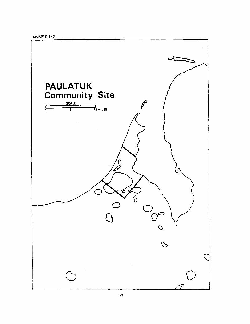

ANNEX I-3Paulatuk Community SiteIn the Northwest Territories;
in the District of Mackenzie;
on Paulatuk Peninsula;
All that parcel more particularly described as follows: ail topographic features hereinafter referred tobeing according to edition 1 of the Paulatuk map sheet number 97C/8 of the National TopographicSystem, produced at a scale of 1:50,000 by the Surveys and Mapping Branch. Department of Energy.Mines and Resources, at Ottawa.
Commencing at a point on the westerly shoreline of Paulatuk peninsula at latitude 69°21 '32"N andapproximate longitude 124°04'48"W;
thence southeasterly to a point on the easterly shoreline of Paulatuk peninsula at latitude69°21'13"N and approximate longitude 124°03'35"W;
thence in a general southerly direction along said shoreline of Paulatuk peninsula to its intersectionwith latitude 69°20'46"N at approximate longitude 124°03'05"W;
thence in a southwesterly direction to a point having latitude 69°20'06"N and longitude124°04'32";
thence northwesterly to a point on the shoreline of Paulatuk peninsula at latitude 69°20'37"N andapproximate longitude 124°06f20"W;
thence in a general northeasterly direction along the shoreline of Paulatuk peninsula to the point ofcommencement;
said parcel containing about 1 square mile.
77
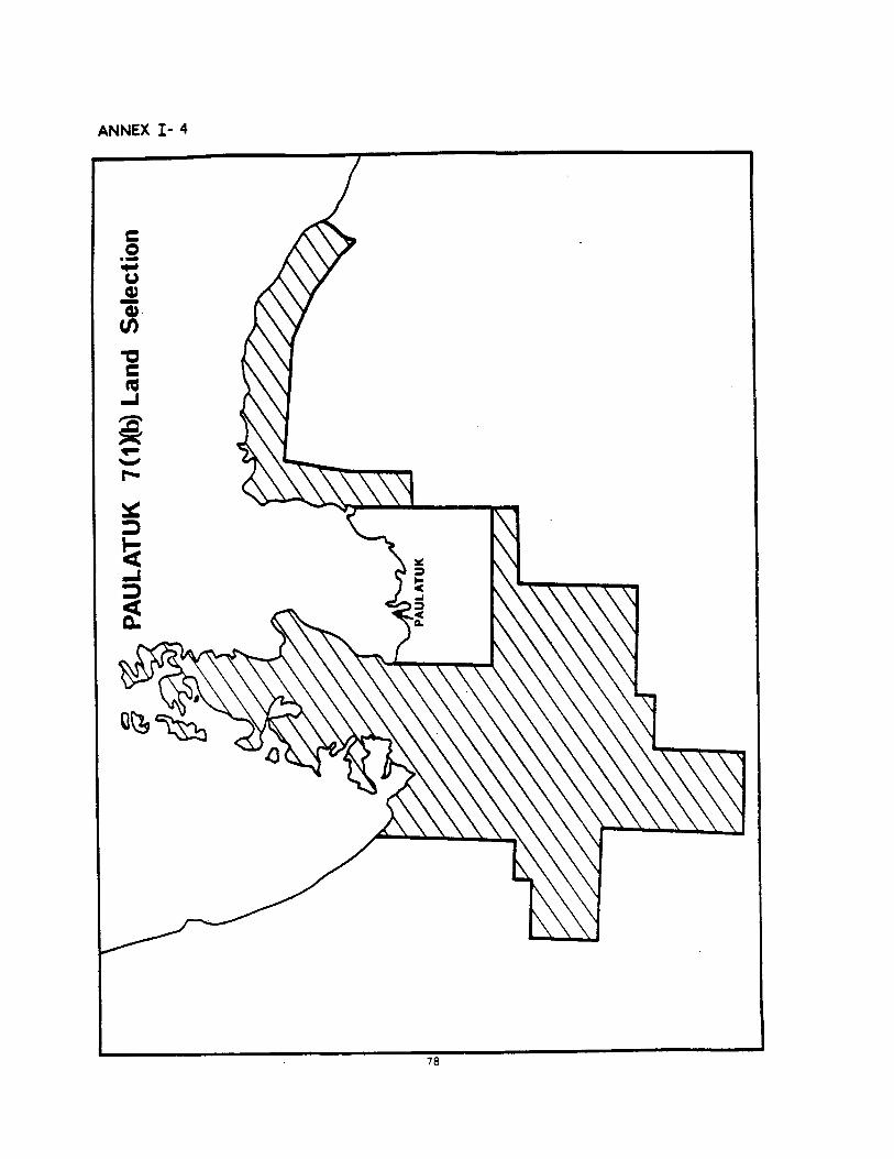

ANNEX I-5Paulatuk 7(1)(b) Land(Northeast)
in the Northwest Territories;
in the District of Mackenzie and the District of Franklin;
in the vicinity of Melville Hills;
All that parcel of land more particularly described as follows: all topographic features hereinafter refer-red to, being according to edition 2 of the Brock River map sheet number 97D of the NationalTopographic System, produced at a scale of 1:250.000 by the Surveys and Mapping Branch, Departmentof Energy. Mines and Resources, at Ottawa;
Commencing at a point being the intersection of the shoreline of Amundsen Gulf and the mouth ofOutwash River at approximate latitude 69° 33/ 24 "N approximate longitude 120°40'51"W:
thence southwesterly along said river to latitude 69°27'46"N at approximate longitude120° 52'00 "W;
thence northwesterly along a straight line to its intersection with the Roscoe River and latitude69°30'32"N at approximate longitude 120059'14"W;
thence northwesterly along a straight line to latitude 69°36'36"N and longitude 121°22'30"W:
thence northwesterly along a straight line to latitude 69° 40'15" and longitude 121°43'26"W;
thence westerly along a straight line to latitude 69°42'00"N and longitude 122°46'30"W;
thence southerly along a straight line to latitude 69°30'00"N and longitude 122°51'00"W;
thence south along longitude 122°00"W to latitude 69°19'00"N;
thence westerly along latitude 69° 19'00 "N to longitude 123° 10' 00 "W;
thence north along longitude 123° 10'00"W to its intersection with the shoreline of Brock Lagoon atapproximate latitude 69°30'N;
thence in a general northerly and westerly direction along the shoreline of Brock Lagoon to theshoreline of Darnley Bay;
thence in a general northerly and easterly direction along the sinuosities of the shoreline of DarnleyBay and Amundsen Gulf to the point of commencement.
including all islands situated in whole or in part within two miles of said shoreline.and containing about 726 square miles;
AND
(Parry Peninsula)
In the Northwest Territories;
in the District of Mackenzie and the District of Franklin:
in the area of Melville Hills;
All that parcel of land more particularly described as follows: all topographical features hereinafterreferred to being according to edition 1 of the Erly Lake map sheet number 97A of the NationalTopographic System, produced at a scale of 1:250.000 by the Army Survey Establishment. Royal CanadianEngineers, at Ottawa: edition 1 of the Simpson Lake map sheet number 97B of the National TopographicSystem, produced at a scale of 1:250.000 by the Mapping and Charting Establishment. Department or Na-tional Defence at Ottawa: edition 2 of the Franklin Bay map sheet number 97C of the NationalTopographic System, produced at a scale of 1:250.000 by the Surveys and Mapping Branch. Department:of Energy. Mines and Resources, at Ottawa: edition 2 of the Brock River map sheet number 97D of the
79

National Topographic System, produced at a scale of 1:250.000 by the Surveys and Mapping Branch.Department of Energy. Mines and Resources, at Ottawa: edition 3 of the Malloch Hill map sheet number97F of the National Topographic System, produced at a scale of 1:250,000 by the Army Survey Establish-ment, Royal Canadian Engineers, at Ottawa:
Commencing at a point being the intersection of the shoreline of Franklin Bay and longitude126°00'00"W at approximate latitude 69°25'20"N;
thence in a general easterly and northerly direction along the sinuosities of Franklin Bay, Langton Bayand the western shoreline of Parry Peninsula to its most northerly tip at Cape Parry; thence in a generalsoutherly direction along the sinuosities of the eastern shoreline of said peninsula. Darnley Bay and ArgoBay to a point being the intersection of the shoreline of said Argo Bay with longitude 124°30'00"W atapproximate latitude 69°22'10"N;
thence south along longitude 124°30'00"W to latitude 69°04'30"N;;
thence easterly along latitude 69°04'30"N to longitude 123°10'00"W;
thence south along longitude 123°10'00"W to latitude 69°00'00"N;
thence westerly along latitude 69°00'00"N to longitude 123°50'00"W;
thence south along longitude 123°50'00"W to latitude 68°39'00"N;
thence westerly along latitude 68°39'00"N to longitude 124°45'00"W;
thence south along longitude l24°45'00'W to latitude 68°35'30"N;
thence westerly along latitude 68° 35' 30 "N to longitude 125° 12'30 "W;
thence south along longitude 125° 12' 30 "W to latitude 68°19'00"N;
thence westerly along latitude 68° 19'00"N to longitude 125°52'30"W;
thence north along longitude 125° 52'20"W to latitude 68°44'30";
thence westerly along latitude 68°44'30"IN to longitude 126°47'30"W;
thence north along longitude 126°47'320"W to latitude 68° 57'00"N;
thence easterly along latitude 68°57'00"N to longitude 126°20'00"W;
thence north along longitude 126°20'00"W to latitude 69°00'00"N;
thence easterly along latitude 69°00'00"N to longitude 126°00'00"W;
thence north along longitude 126°00'00"W to the point of commencement.
INCLUDING
Booth Islands and all islands situated in whole or in part within two miles of the above describedshorelines;
LESS
Clapperton Island and that part of Parry Peninsula more particularly described as follows:
Commencing at a point being the Intersection of the shoreline of Franklin Bay (easterly or BoothIslands) and the latitude 70°07'5l"N at approximate longitude 124°42'16"W:
thence southeasterly along a straight line to a point being the intersection of the shoreline of an un-named bay and latitude 70°06'13"N at approximate longitude 124°37'10"W;
thence southwesterly, northerly and northeasterly along the sinuosities of the shoreline or that part orParry Peninsula to the point of commencement;
the remainder containing about 4,138 square miles.
The lands described in Annex 1-5 comprising 4.864 square miles more or less
80

81
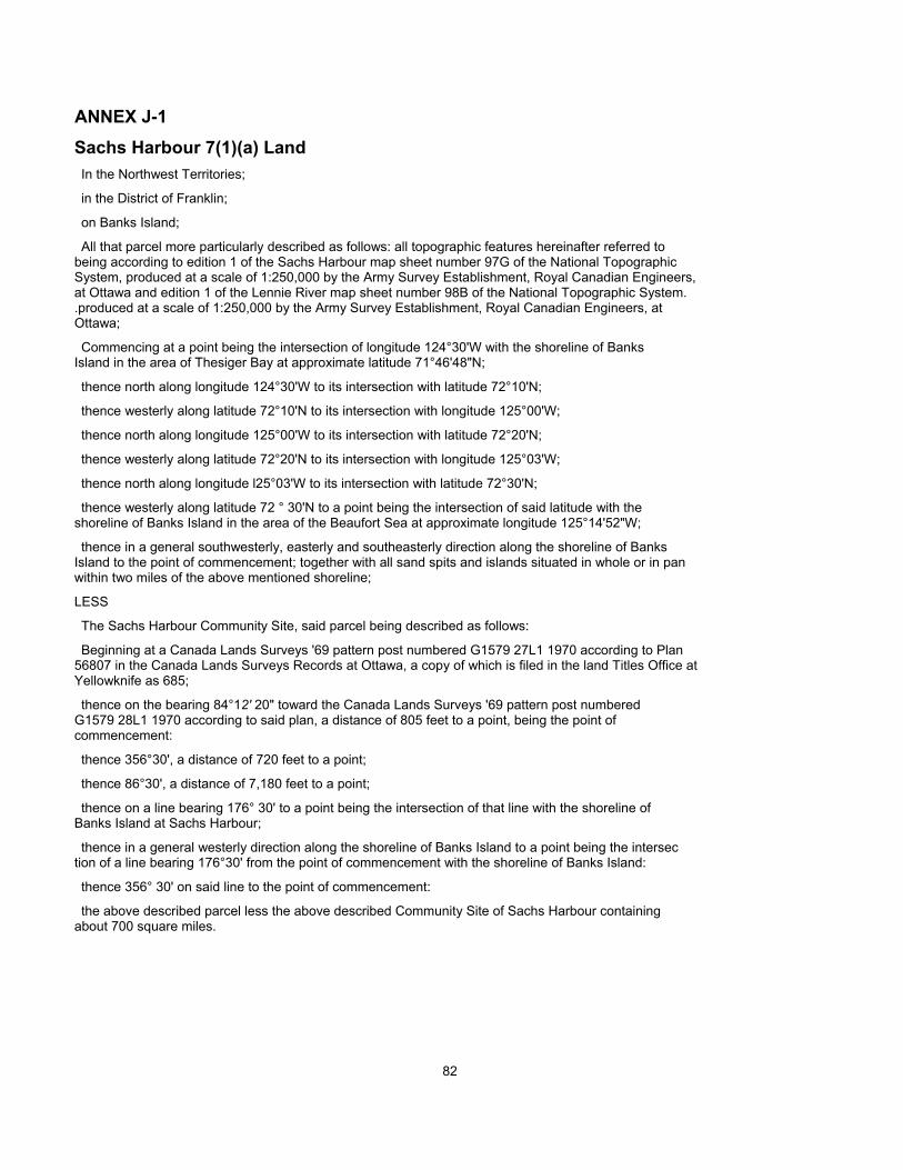
ANNEX J-1Sachs Harbour 7(1)(a) LandIn the Northwest Territories;
in the District of Franklin;
on Banks Island;
All that parcel more particularly described as follows: all topographic features hereinafter referred tobeing according to edition 1 of the Sachs Harbour map sheet number 97G of the National TopographicSystem, produced at a scale of 1:250,000 by the Army Survey Establishment, Royal Canadian Engineers,at Ottawa and edition 1 of the Lennie River map sheet number 98B of the National Topographic System..produced at a scale of 1:250,000 by the Army Survey Establishment, Royal Canadian Engineers, atOttawa;
Commencing at a point being the intersection of longitude 124°30'W with the shoreline of BanksIsland in the area of Thesiger Bay at approximate latitude 71°46'48"N;
thence north along longitude 124°30'W to its intersection with latitude 72°10'N;
thence westerly along latitude 72°10'N to its intersection with longitude 125°00'W;
thence north along longitude 125°00'W to its intersection with latitude 72°20'N;
thence westerly along latitude 72°20'N to its intersection with longitude 125°03'W;
thence north along longitude l25°03'W to its intersection with latitude 72°30'N;
thence westerly along latitude 72 ° 30'N to a point being the intersection of said latitude with theshoreline of Banks Island in the area of the Beaufort Sea at approximate longitude 125°14'52"W;
thence in a general southwesterly, easterly and southeasterly direction along the shoreline of BanksIsland to the point of commencement; together with all sand spits and islands situated in whole or in panwithin two miles of the above mentioned shoreline;
LESS
The Sachs Harbour Community Site, said parcel being described as follows:
Beginning at a Canada Lands Surveys '69 pattern post numbered G1579 27L1 1970 according to Plan56807 in the Canada Lands Surveys Records at Ottawa, a copy of which is filed in the land Titles Office atYellowknife as 685;
thence on the bearing 84°12' 20" toward the Canada Lands Surveys '69 pattern post numberedG1579 28L1 1970 according to said plan, a distance of 805 feet to a point, being the point ofcommencement:
thence 356°30', a distance of 720 feet to a point;
thence 86°30', a distance of 7,180 feet to a point;
thence on a line bearing 176° 30' to a point being the intersection of that line with the shoreline ofBanks Island at Sachs Harbour;
thence in a general westerly direction along the shoreline of Banks Island to a point being the intersection of a line bearing 176°30' from the point of commencement with the shoreline of Banks Island:
thence 356° 30' on said line to the point of commencement:
the above described parcel less the above described Community Site of Sachs Harbour containingabout 700 square miles.
82

ANNEX J-3Sachs Harbour Community SiteIn the Northwest Territories;
in the District of Franklin;
on Banks Island at approximate latitude 71°59'N. approximate longitude 125°15'W:
All that parcel of land more particularly described as follows:
Beginning at a Canada Lands Surveys '69 pattern post numbered G1579 27L1 1970 according to Plan56807 in the Canada Lands Surveys Records at Ottawa, a copy of which is filed in the Land Titles Officeat Yellowknife as 685;
thence on the bearing 84° 12' 20" toward the Canada Lands Surveys '69 pattern post numberedG1579 28L1 1970 according to said plan, a distance of 805 feet to a point, being the point ofcommencement;
thence 356°30', a distance of 720 feet to a point;
thence 86°30', a distance of 7,180 feet to a point;
thence on a line bearing 176° 30' to a point being the intersection of that line with the shoreline ofBanks Island at Sachs Harbour;
thence in a general westerly direction along the shoreline of Banks Island to a point being the intersec-tion of a line bearing 176° 30' from the point of commencement, with the shoreline of Banks Island:
thence 356° 30' on said line to the point of commencement;
said parcel containing about 1 square mile.
84


ANNEX J-5Sachs Harbour 7(1)(b) Land(Main)
In the Northwest Territories;
in the District of Franklin;
on Banks Island;
All that parcel of land more particularly described as follows: all topographical features hereinafterreferred to being according to edition 2 of the Deans Dundas Bay map sheet number 88B: edition 1 of theDe Salis Bay map sheet number 97H; edition 1 of the Sachs Harbour map sheet number 97G: edition 1 ofthe Jesse Harbour map sheet number 98A; edition 1 of the Lennie River map sheet number 98B: edition 1of the Bernard Island map sheet number 98C and edition 1 of the Bernard River map sheet number 98D.all seven map sheets of the National Topographic System, produced at a scale of 1:250,000 by the ArmySurvey Establishment, Royal Canadian Engineers, at Ottawa;
Commencing at a point being the intersection of the shoreline of Banks Island in the vicinity ofTreadwell Point and latitude 71°41'00"N at approximate longitude 120°22'45"W:
thence westerly along latitude 71°41'00"N to its intersection with longitude 121°30'00"W;:
thence north along longitude 121°30'00"W to its intersection with latitude 71°51'30"N;
thence westerly along latitude 71°51'30"N to its intersection with longitude 123° 35'00"W;
thence south along longitude 123°34'00"W to its intersection with latitude 71°37'45"N;
thence easterly along latitude 71°37'45"N to its intersection with longitude 122°26'30"N;thence south along longitude 122°26'30"W to its intersection with latitude 71°33'30"N;
thence southwesterly along a straight line to the horizontal control monument at approximate latitude71028'45"N and approximate longitude 123°29'00"W;
thence southeasterly along a straight line to the height of land at approximate latitude 71°22'30"Nand approximate longitude 123° 21 '45"W;
thence southeasterly along a straight line to the height of land at approximate latitude 71°15'30"Wand approximate longitude 123 ° 16' 30 'W;
thence southeasterly along a straight line to the height of land at approximate latitude 71°13'45"Nand approximate longitude 123000'45"W;
thence easterly along a straight line to its intersection with the shoreline of Banks Island at the mouthof the Nelson River at approximate latitude 71°13'15"N and approximate longitude 122027/00"W;
thence southwesterly and northwesterly along the sinuosities of said shoreline to its intersection withlongitude 124° 30'00"W at approximate latitude 71°46'48"N;
thence north along longitude 124°30'00"W to its intersection with latitude 72°10'00"N:
thence westerly along latitude 72°10'00"N to its intersection with longitude 125°00'00"W;
thence north along longitude 125°00'00"W to its intersection with latitude 72°20'00"N;
thence westerly along latitude 72°20'00"N to its intersection with longitude 125°03'00"W:
thence north along longitude 125°03'00"W to its intersection with latitude 72°30'00"N;
thence westerly along latitude 72030'00"N to a point being the intersection of latitude 72° 30'00"with the shoreline of Banks Island in the area of the Beaufort Sea at approximate longitude 125°14'52"
thence in a general northeasterly direction along the sinuosities of said shoreline to a point being theintersection of said shoreline and the mouth of the Bernard River at the latitude 73°35'30"N and approximate longitude 124°00'30"W;
86

thence easterly along latitude 73°35'30"N to its intersection with longitude 122°57'45"W;
thence south along longitude 122°57'45"W to its intersection with latitude 72054'30"N;
thence easterly along latitude 72°54'30"N to its intersection with longitude 122°00'00"W;
thence south along longitude 122°00'00"W to its intersection with latitude 72° 11'15"N;
thence westerly along latitude 72°11'15"N to its intersection with longitude 123°50'00"W;
thence southeasterly along a straight line to a point being the intersection of latitude 72°00'00"Nand longitude 123°38'00"W;
thence easterly along latitude 72°00'00"N to its intersection with longitude 120°49'30"W;
thence north along longitude 120°49'30"W to its intersection with latitude 72°26'30'N;
thence easterly along latitude 72°26'30"N to its intersection with longitude 120°02'30"W;
thence southeasterly along a straight line to its intersection with the shoreline of Banks Island at themouth of an unnamed brook flowing into Prince of Wales Strait in the vicinity of Jesse Bay at approximatelatitude 72°14'00"N and approximate longitude 119° 55'30"W;
thence westerly, northerly and southerly along the sinuosities of the shoreline of Banks Island to thepoint of commencement;
INCLUDING
Norway Island and Bernard Island in the vicinity of Burnett Bay in the area of the Beaufort Sea;
TOGETHER
with all islands situated in whole or in part within two miles of the above described shorelines,the whole containing about 6.999 square miles;
AND
(De Salis Bay)
In the Northwest Territories;
in the District of Franklin;
on Banks Island;
All that parcel of land more particularly described as follows: all topographic features hereinafter refer-red to. being according to edition 1 of the Cape Collinson map sheet number 97H/6; edition 1 of the CapeCardwell map sheet number 97H/7 and edition 1 of the map sheet number 97H/10, all three map sheetsof the National Topographic System, produced at a scale of 1:50.000 by the Surveys and Mapping Branch.Department of Energy. Mines and Resources, at Ottawa;
Commencing at a point being the intersection of the shoreline of Banks Island in the area of Amund-sen Gulf and the mouth of Cardwell Brook at approximate latitude 71°25'15''N and approximatelongitude 121°05'15^"W;
thence northerly along said brook to its confluence with an unnamed brook at approximate latitude71 °35' 00"N and approximate longitude 121 ° 12' 50 "W;
thence southwesterly along said unnamed brook to an unnamed lake at approximate latitude71°33'50"N and approximate longitude 121°21'00"W;
thence southwesterly along a straight line to the confluence of two unnamed brooks at approximatelatitude 71° 33'15"N and approximate longitude 121°21'45"W:
thence southwesterly along a straight line to a point on the northern bank of Windrum Lagoon at ap-proximate latitude 71030'15"N and longitude 121°47'15"W;
87

thence southwesterly along a straight line to a height of land at approximate latitude 71°26'15"Nand approximate longitude 122° 16' 30 "W;
thence southeasterly along a straight line to its intersection with the shoreline of Banks Island at themouth of an unnamed creek at approximate latitude 71°18'45"N and approximate longitude 122° 00'45"W;
thence in a general northeasterly (including Windrum Lagoon), southeasterly (including KangirkualukPoint) and northeasterly direction along the shoreline of Banks Island to the point of commencement;
together with all islands situated in whole or in pan within two miles of the above described shoreline;
and containing about 194 square miles.
The lands described in Annex J-5 comprising 7193 square mites more or less.
88
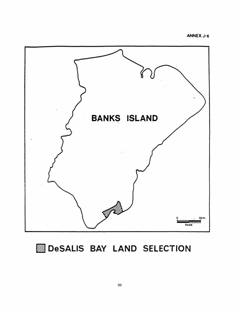
89

90

91

ANNEX K-1Holman 7(1)(a) LandIn the Northwest Territories;
in the District of Franklin;
on Victoria Island;
All those parcels of land on Diamond Jenness Peninsula according to edition 1 of the NationalTopographic Series Maps of Holman Island — 87F and Walker Bay — 87G. produced at a scale of1:250,000 by the Army Survey Establishment, R.C.E. at Ottawa, as said parcels may be more particularlydescribed as follows:
Commencing at the point of intersection of longitude 117°49' with the shoreline of Amundsen Gulf.approximate latitude 70°44'40";
thence northeasterly in a straight line to the intersection of longitude 117°13'30" with the shorelineof Minto Inlet at approximate latitude 71° 13';
thence generally northeasterly following the sinuosities of the shoreline of Minto Inlet to a point at theintersection of said shoreline and a latitude determined by producing the latitude west from the height ofland at approximate latitude 71° 17'30" and approximate longitude 116°28'50" the point being at ap-proximate longitude 116°46'30";
thence easterly along the last aforesaid latitude to the last aforesaid height of land;
thence southeasterly in a straight line to a height of land at approximate latitude 71°l2'55" and ap-proximate longitude 116 ° 19' 00<r;
thence southeasterly in a straight line to a height of land at approximate latitude 71°07' and approx-imate longitude 116°03';
thence south along longitude 116°03' to its intersection with latitude 7l°05';
thence westerly along latitude 71°05' to its intersection with longitude 116° 43'30";
thence south along longitude 116°43'30" to its intersection with latitude 7l°02';
thence southwesterly in a straight line to the intersection of latitude 70° 50'45" and longitude117°00';
thence westerly along latitude 70° 50'45" to its intersection with longitude 117° 16':
thence south along longitude 117° 16' to its intersection with latitude 70°47'30";
thence westerly along latitude 70°47'30'' to its intersection with the shoreline of an unnamed lake atapproximate longitude 117° 18' 50 ";
thence generally westerly and southerly following the sinuosities of the shoreline of said unnamed laketo its intersection with latitude 70°40';
thence easterly along latitude 70°40' to its intersection with longitude 117° 16':
thence south along longitude 117° 16' to its intersection with the shoreline of Safety Channel at ap-proximate latitude 70°36'48";
thence in a general westerly and northwesterly, direction following the sinuosities of the shoreline ofVictoria Island to the point of commencement;
and including Holman Island and all other islands situated in whole or in part within two miles or theabove described shorelines in Minto Inlet and Amundsen Gulf;
92

LESS
Holman Community Site being:
That parcel of land on Diamond Jenness Peninsula according to edition 1 of National TopographicSeries Map of Holman Island — 87E/19 produced at a scale of 1:50.000 by the Mapping and Chartingestablishment. Department of National Defence. Ottawa, as said parcel may be more particularly describedas follows:
Commencing at the point of intersection of latitude 70°44'49" and longitude 117°48'25";thence on an azimuth of 87°00', a distance of 1.28 miles to a point;
thence on an azimuth of 177°00'. a distance of 0.56 miles more or less to the intersection with theshoreline of Kings Bay:
thence southerly, northerly and westerly, following the sinuosities of the shoreline of Kings Bay andQueens Bay to its intersection with latitude 70°43'57";
thence westerly along latitude 70°43 '57" to its intersection with the shoreline of Amundsen Gulf;
thence northeasterly and northwesterly following the shoreline of Amundsen Gulf and that of lacksBay to its intersection with longitude 117°48' 25";
thence north along longitude 117°48'25" a distance of 0.34 miles more or less to the point ofcommencement;
the remainder containing about 708 square miles.
93

94
ANNEX K-3Holman Community SiteIn the Northwest Territories;
in the District of Franklin;
on Victoria Island;
All that parcel of land on Diamond Jenness Peninsula according to edition 1 of the NationalTopographic Series Maps of Holman Island — 87F/19 produced at a scale of 1:50.000 by the Mappingand Charting Establishment Department of National Defence, Ottawa, as said parcel may be more par-ticularly described as follows:
Commencing at the point of intersection of latitude 70°44'49" and longitude 117°48'25";
thence on an azimuth of 87°00' a distance of 1.28 miles to a point;
thence on an azimuth of 177°00' a distance of 0.56 miles more or less to the intersection of theshoreline of Kings Bay;
thence southerly, northerly and westerly following the sinuosities of the shoreline Kings Bay andQueens Bay to its intersection with latitude 70°43'57";
thence westerly along said latitude 70°43°57" to its intersection with the shoreline of Amundsen Gulf:
thence northeasterly and northwesterly following the shoreline of Amundsen Gulf and of Jacks Bay toits intersection with longitude 117°48'25":
thence north along longitude 117°48'25" a distance of 0.34 miles, more or less to the point ofcommencement;
said parcel containing about 1 square mile.
95


ANNEX K-5Holman 7(1 )(b) Land
(West Diamond Jenness Peninsula)
In the Northwest Territories;
In the District of Franklin;
on Victoria Island;
All that parcel of land on Diamond Jenness Peninsula according to edition 1 of the NationalTopographic Series Maps of Holman Island — 87F and Walker Bay — 87G. produced at a scale of1:250,000 by the Army Survey Establishment, R.C.E. at Ottawa, as said parcel may be more particularlydescribed as follows:
Commencing at the point of intersection of longitude 117° 13'30" and the shoreline of Minto Inlet atapproximate latitude 71°13';
thence southwesterly in a straight line to the intersection of longitude 117°49' with the shoreline ofAmundsen Gulf at approximate latitude 70°44'40";
thence northwesterly and northeasterly following the sinuosities of the shoreline of Amundsen Gulf andMinto Inlet to the point of commencement;
including all islands situated in whole or in part within two miles of the said shoreline;
said parcel containing about 427 square miles;
AND
(North Prince Albert Sound)
in the Northwest Territories;
in the District of Franklin;
on Victoria Island:
All those parcels of land on Diamond Jenness Peninsula and in Prince Albert Sound according to edi-tion 1 of the National Topographic Series Maps of Holman Island — 87F and Prince Albert Sound — 87E,produced at a scale of 1:250,000 by the Army Survey Establishment, R.C.E. at Ottawa, as said parcelsmay be more particularly described under Firstly, and Secondly as follows:
Firstly,
Commencing at the point of intersection of longitude 117°l6 with the shoreline of Safely Channel atapproximate latitude 70°36'48";
thence north along longitude 117°16' to its intersection with latitude 70°40':
thence westerly along latitude 70°40' to its intersection with the shoreline of an unnamed lake at ap-proximate longitude 117° 22' 46 ";
thence generally northeasterly, northwesterly and easterly following the sinuosities of the shoreline ofsaid lake to its intersection with latitude 70°43° at approximate longitude 117° 18'53";
thence easterly in a straight line to the intersection of latitude 70°43'40" and longitude 115°51'40";
thence south along longitude 115°51 '40" to its intersection with latitude 70°40'40";
thence easterly in a straight line to the intersection of latitude 70°41'20" and longitude 115°17'50".
thence northeasterly in a straight line to the intersection of latitude 70°42'40" and longitude114°53'10";
thence northeasterly in a straight line to the intersection of latitude 70°46'30" and longitude114°04'50";
97

thence easterly in a straight line to the intersection of latitude 70°46'20" and longitude 113°37'20";
thence southeasterly in a straight line to the intersection of latitude 70°42'35" and longitude113°00';
thence south along longitude 113°00' to intersection with latitude 70°39'45";
thence southeasterly in a straight line to the intersection of latitude 70°37'05"" and longitude112°21'10";
thence south along longitude 112°21'10" to its intersection with the shoreline of Prince Albert Soundat approximate latitude 70°31'24";
then generally westerly following the sinuosities of the shoreline of Prince Albert Sound to the point ofcommencement;
Secondly,
Those islands within the waters of Prince Albert Sound that lie north of latitude 70°23'45", west oflongitude 112°21' 10" and east of a line joining the point of commencement described in Firstly and thepoint of intersection of latitude 70°23'45" and longitude 117°37'; and including also the Horizon Isletsat approximate latitude 70°20' and approximate longitude 117°21';
said parcels containing together about 821 square miles;
AND
(Southeast Prince Albert Sound)
In the Northwest Territories;
in the District of Franklin;
on Victoria Island;
All those parcels of lands on Wollaston Peninsula Victoria Island and in Prince Albert Sound accordingto edition 1 of the National Topographic Series Maps of Prince Albert Sound — 87E and Kagloryuak River— 77F, produced at a scale of 1:250,.000 by the Army Survey Establishment, R.C.E. at Ottawa, as saidparcels may be more particularly described under Firstly and Secondly as follows;
Firstly,
Commencing at the point of intersection of longitude 113°36'30" with the shoreline of Prince AlbertSound at approximate latitude 70°16'00";
thence generally easterly and westerly following the sinuosities of the shoreline of Prince Albert Soundto its intersection with latitude 70°23'45" at approximate longitude 111° 57'45";
thence easterly along latitude 70°23'45" to its intersection with longitude 111°22'30";
thence south along longitude 111°22'30" to its intersection with latitude 70°09'30"
thence westerly along latitude 70°09'30" to its intersection with longitude 113°36'30";
thence northerly in a straight line to the point of commencement;
Secondly,
Those islands within the waters of Prince Albert Sound that lie south of latitude 70°23'45" and eastof longitude 113°36'30";
said parcels containing together about 462 square miles;
98

AND
(Tahiryuak Lake)
In the Northwest Territories;
in the District of Franklin;
on Victoria Island;
All that parcel of land on Victoria Island according to edition 1 of the National Topographic SeriesMaps of Prince Albert Sound — 87E and Kagloryuak River — 77F, produced at a scale of 1:250,000 bythe Army Survey Establishment, R.C.E. at Ottawa, as said parcel may be more particularly described asfollows:
Commencing at the point of intersection of longitude 111°57'30" with the shoreline of TahiryuakLake at approximate latitude 70° 52'40";
thence south along longitude 111°57'30" to its intersection with latitude 70°49'10";
thence westerly along latitude 70°49'10" to its intersection with longitude 112°17'00";
thence north along longitude 112° 17' 00" to its intersection with the shoreline of an unnamed lake atapproximate latitude 70°52'45";
thence generally northerly and following the sinuosities of the easterly shoreline of said lake to its in-tersection with longitude 112°18'35" at approximate latitude 70°54°24";
thence north along longitude 112° 18'35" to its intersection with the shoreline of Tahiryuak Lake atapproximate latitude 70° 56'07";
thence northeasterly, northwesterly, easterly and generally southeasterly following the sinuosities ofthe shoreline of said lake to the point of commencement;
said parcel containing about 43 square miles;
AND
(Quunnguq Lake)
In the Northwest Territories;
in the District of Franklin;
on Victoria Island;
All those parcels of Lands on Wollaston Peninsula according to edition 1 of the National TopographicSeries Map of Read Island — 87D. produced at a scale of 1:250,000 by the Army Survey Establishment.R.C.E. at Ottawa, as said parcels may be more particularly described under Firstly and Secondly as follows:
Firstly,
Commencing at the point of intersection of longitude 112°39' and the shoreline of Quunnguq Lake at ap-proximate latitude 69°51';
thence south along longitude of 112°39' to its intersection with latitude 69°50'00";thence westerly along latitude 69°50'00' to its intersection with longitude 112°53';
thence north along longitude 112°53' to its intersection with latitude 70°00' thence easterly alonglatitude 70°00' to its intersection with longitude 112°30';
thence south along longitude 112°30' to its intersection with the shoreline of said lake at approximate latitude 69° 58';
thence generally westerly, southerly and easterly, following the sinuosities of the shoreline or said laketo the point of commencement;
99

Secondly,
Commencing at the point of intersection of longitude 112°30' with the shoreline of said lake at ap-proximate latitude 69° 54 '50";
thence south along longitude 112° 30' to its intersection with the shoreline of said lake at approx-imate latitude 69°54'00";
thence generally westerly and easterly following the sinuosities of the shoreline of said lake to thepoint of commencement;
said parcels containing together about 54 square miles;
AND
(Wollaston Peninsula)
In the Northwest Territories;
in the District of Franklin;
on Victoria Island;
All that parcel of land on Wollaston Peninsula according to edition 1 of the National TopographicSeries Maps of Penny Bay — 87C, Holman Island — 87F and Prince Albert Sound— 87E, produced at ascale of 1:250,000 by the Army Survey Establishment. R.C.E. at Ottawa, as said parcel may be more par-ticularly described as follows:
Commencing at the point of intersection of the northerly bank of Kugaluk River and the shoreline ofPenny Bay. in Amundsen Gulf;
thence generally northwesterly and northeasterly following the sinuosities of the shoreline of PennyBay, Amundsen Gulf and Prince Albert Sound to its intersection with an unnamed creek at approximatelatitude 70°14'15" and approximate longitude 115°44'54";
thence southerly, following said creek to its intersection with latitude 70°09'40" at approximatelongitude 115°42'00";
thence southwesterly in a straight line to the intersection of latitude 70°07'10" and longitude116°12'50";
thence southwesterly in a straight line to the intersection of latitude 70°03'50" and longitude116°42'10";
thence southwesterly in a straight line to the intersection of latitude 70°00'30" and longitude117°06'45";
thence southerly in a straight line to the intersection of latitude 69° 53 '20" and longitude117°08'40";
thence southeasterly in a straight line to the intersection of the northerly bank of Kugaluk River andlongitude 116°37'50", at approximate latitude 69°38';
thence generally westerly following said northerly bank to the point of commencement;
including Bell Island and all islands which are situated in whole or in pan within two miles of theabove described shoreline;
said parcel containing about 375 square miles;
100

AND
(Prince of Wales Strait)
In the Northwest Territories;
in the District of Franklin;
on Victoria Island;
All that parcel of land on Prince Albert Peninsula according to edition 2 of the National TopographicSeries Maps of Deans Dundas Bay — 88B and White Sand Creek — 88C produced at a scale of 1:250,000by the Army Survey Establishment, R.C.E. at Ottawa, as said parcel may be more particularly described asfollows:
Commencing at a point on the southeasterly shore of Prince of Wales Strait at the mouth of an un-named creek at approxiate longitude 116° 19' and approximate latitude 73°05'00";
thence easterly and southerly following the said creek to a fork at approximate latitude 72° 59 '20"and approximate longitude 116°25'00";
thence southwesterly along a straight line to a fork of two unnamed creeks at approximate latitude72°58'30" and approximate longitude 116°32'00";
thence generally southerly and westerly following an unnamed creek to its beginning at the east endof an unnamed lake at approximate latitude 72°56'30" and approximate longitude 116° 44';
thence westerly and northeasterly following the shoreline of said lake to the most northerly point onthe shore of said lake;
thence on an azimuth of 45°00' in a straight line to its intersection with an unnamed creek at ap-proximate latitude 72°58' and approximate longitude 116°42';
thence northerly following said creek to the shoreline of Prince of Wales Strait at approximate latitude73°00'15" and approximate longitude 116°45'20";
thence northeasterly following the shoreline of said strait to the point of commencement;
including all islands situated in whole or in part within two miles of said shoreline;
said parcel containing about 38 square miles;
AND
(Minto Inlet — Wynniatt Bay)
In the Northwest Territories;
in the District of Franklin;
on Victoria Island;
All those parcels of lands on Natkusiak Peninsula. Prince Albert Peninsula. Victoria Island and inAmundsen Gulf, Walker Bay, Minto Inlet, Glenelg Bay and Wynniatt Bay according to edition 1 of the Na-tional Topographic Series Maps of Walker Bay — 87G. Deans Dundas Bay — 88B, Saneraun Hills — 87H,Richard Collinson Inlet — 88A and Wynniatt Bay — 78B produced at a scale of 1:250.000 by the ArmySurvey Establishment, R.C.E. at Ottawa, as said parcels may be more particularly described under Firstlyand Secondly as follows:
Firstly,
Commencing at the point of intersection of latitude 72°24'30"r and the shoreline of Prince or WalesStrait at approximate longitude 118°32'40";
thence easterly along latitude 72°24'30" to its intersection with longitude 117° 53'00";
thence south along longitude 117°53'00" to its intersection with latitude 71°48'00"
thence easterly along latitude 71°48'00'' to its intersection with longitude 117°14'00",
thence south along longitude 117°14'00" to its intersection with latitude 71°43'00",
thence easterly in a straight line to the intersection of latitude 71°42'45'' and longitude 114°54'30"
101

thence northeasterly in a straight line to the intersection of latitude 72°05'20" and longitude113°01'45";
thence northeasterly in a straight line to the intersection with the shoreline of Wynniatt Bay andlatitude 72°48'50" at approximate longitude 111°40'44";
thence generally southerly, northeasterly and southeasterly following the sinuosities of the shoreline ofWynniatt Bay. Glenelg Bay and an unnamed Inlet to its intersection with longitude 110°19'30" at approx-imate latitude 72°26'04";
thence south along longitude 110° 19' 30" to its intersection with latitude 72° 15'40";
thence westerly in a straight line to a survey monument at approximate latitude 72° 16'00" and ap-proximate longitude 110°57'43";
thence southwesterly in a straight line to a height of land at approximate latitude 72° 13'05" and ap-proximate longitude 111°40'40";
thence westerly in a straight line to a height of land at approximate latitude 72° 13'10" and approx-imate longitude 112°00';
thence southwesterly in a straight line to the most easterly point of an unnamed lake at approximatelatitude 72°01'15" and approximate longitude 112°36'20":
thence southwesterly in a straight line to a height of land at approximate latitude 71° 38'20" and ap-proximate longitude 113°08'30";
thence southwesterly in a straight line to the mouth of an unnamed creek entering an unnamed lakeat approximate latitude 71°25'00" and approximate longitude 113°57'00";
thence westerly in a straight line to a height of land at approximate latitude 71°25'40" and approx-imate longitude 114° 34' 00 ";
thence southwesterly in a straight line to a height of land at approximate latitude 71°12'55" and ap-proximate longitude 116° 19' 00";
thence northwesterly in a straight line to a height of land at approximate latitude 71°17'30" and ap-proximate longitude 116° 28' 50 ";
thence westerly along the last aforesaid latitude to its intersection of the shoreline of Minto Inlet atapproximate longitude 116°46'30";
thence generally northeasterly, southwesterly, northwesterly and northerly, following the sinuosities ofthe shoreline of Minto Inlet, Boot Inlet, Fish Bay. Goose Bay. Amundsen Gulf. Walker Bay. Prince of WalesStrait and Deans. Dundas Bay to the point of commencement.
and including all islands lying within Minto Inlet, Boot Inlet, Walker Bay. Glenelg Bay. Wynniatt Bay.and including Ramsay Island at approximate latitude 71°33'/00'' and approximate longitude 119°07'00",and including all other islands situated in whole or in part within two miles of the above describedshoreline;
Secondly,
That parcel of land on Natkusiak Peninsula which may be more particularly described as follows:
Commencing at the point of intersection of longitude 110°00'00" with the shoreline of Hadley Bay atapproximate latitude 72° 58' 45";
thence south along longitude 110°00'00" to its intersection with the shoreline of Wynniatt Bay at ap-proximate latitude 72°45'00";
thence southwesterly, northeasterly, northerly, northwesterly and easterly following the sinuosities ofthe shoreline of Wynniatt Bay and Hadley Bay to the point of commencement.
said parcels containing about 5.319 square miles.
The lands described in Annex K-5 comprising 7.539 square miles more or less.
102

103

ANNEX LPorcupine Caribou Management AgreementThe Porcupine Caribou Management Agreement, when complete, will be incorporated by reference into
the completed or ongoing COPE, CYI and Dene/Metis Settlement agreements respectively.
104
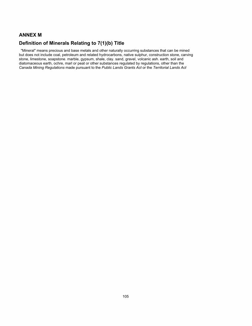
ANNEX MDefinition of Minerals Relating to 7(1)(b) Title"Mineral" means precious and base metals and other naturally occurring substances that can be mined
but does not include coal, petroleum and related hydrocarbons, native sulphur, construction stone, carvingstone, limestone, soapstone. marble, gypsum, shale, clay. sand, gravel, volcanic ash. earth, soil anddiatomaceous earth, ochre, marl or peat or other substances regulated by regulations, other than theCanada Mining Regulations made pursuant to the Public Lands Grants Act or the Territorial Lands Act
105

ANNEX NFinancial CompensationThe schedule of capital transfer payments shall be: an initial payment of $12 million on December 31,1984; three annual payments of $1 million, from December 31. 1985 to December 31, 1987: five annualpayments of $5 million from December 31. 1988 to December 31. 1992; four annual payments of $20million from December 31. 1993 to December 31. 1996: and a final payment on December 31. 1997 of$32 million. All payments are to be made on the last business day prior to December 31 of the respectiveyear.
106

ANNEX OSchedule of Maximum Amounts Permitted to be Outstanding
January 1, 1985 — December 31, 1985January 1, 1986 — December 31, 1986January 1, 1987 — December 31, 1987January 1, 1988 — December 31, 1988January 1, 1989 — December 31, 1989January 1, 1990 — December 31, 1990January 1, 1991 — December 31, 1991January 1, 1992 — December 31, 1992January 1, 1993 — December 31, 1993January 1, 1994 — December 31, 1994January 1, 1995 — December 31, 1995January 1, 1996 — December 31, 1996January 1, 1997 — December 31, 1997January 1, 1998 — December 31, 1998
$Millions65.07769.38774.04979.09180.54382.11283.80985.65287.64174.77760.89645.86329.611
0
107

ANNEX PExisting Subsurface Rights on Inuvialuit LandsDispositions under Canada Oil and Gas Act
REPRESENTATIVE OFINTEREST OWNER
Shell Canada ResourcesLimited
Shell Canada ResourcesLimited
Gulf Canada ResourcesInc.
Esso Resources CanadaLtd.
Shell Canada ResourcesLtd.
Gulf Canada ResourcesInc.
Esso Resources CanadaLtd.
Suncor Inc.
Petro-Canada Inc.
Esso Resources CanadaLtd.
Esso Resources CanadaLtd.
Esso Resources CanadaLtd.
Esso Resources CanadaLtd.
Gulf Canada ResourcesInc.
Chevron Canada Ltd.
Petro-Canada Inc.
EXPLORATIONAGREEMENT NO.
221
222
224
101
222
225
102
211
212
101
102
103
106
225
227
212
EXPIRY DATE
Sept 5. 1987
Sept 5. 1987
Sept 5. 1987
June 1. 1987
Sept 5. 1987
Sept. 5. 1987
June 1. 1987
March 4. 1988
Sept 1. 1988
June 1. 1987
June 1. 1987
June 1. 1987
June 1. 1987
Sept 5. 1987
Sept 5. 1987
Sept 1. 1988
LOCATION
Aklavik 7(1)(a) Annex F-1East portion of block
Aklavik 7(1)(b) Annex F-2North and East of 7(1 )(a)block
Inuvik 7(1)(a) Annex G-1Most of block
Inuvik 7(1)(b) Annex G-2NW of 7(1)(a) block
W of 7(1)(a) block
N and W of 7(1)(a) block
Tuktoyaktuk 7(1)(a)Annexes H-1, H-3, H-4All of block
Hendrickson Island
Tuktoyaktuk 7(l)(b)Annex H-6. South ofFranklin Bay
South of Tuktoyaktuk7(1)(a) block
South of Tuktoyaktuk7(1)(a) block
North of Liverpool Bay
Warren Point
East of Parsons Lake
Char Point
Paulatuk 7(1)(b) Annex I-5South of Franklin Bay
108

Dispositions under Canada Mining Regulations
REPRESENTATIVE OFINTEREST OWNER
Petro-CanadaExploration Inc
REPRESENTATIVE OFINTEREST OWNER
Panarctic Oil Ltd.
LICENCE NO.
156
PERMIT NO.
975
EXPIRY DATE
April 27. 1984
EXPIRY DATE
Jan. 31. 1988
LOCATION
N.T.S. 117-A-9(Aklavik 7(1)(a) and 7(1)(b))
LOCATION
N.T.S. 78-B-4(Holman 7(1)(b))
109

ANNEX QExisting Surface Rights on Inuvialuit Lands
LESSEE1. Northwestel
2. Richard White
LEASE #/EXPIRY DATE3599/31-12-85
3410/30-05-86
LOCATION/MAPS. of Paulatuk7(1)(a) 97C/8-4
Ya Ya Lake7(1)(b) 107C/3-8
110

ANNEX R
Existing Government Reservations on Inuvialuit Lands
DEPARTMENT
1. GNWT
2. DOE
3. DND
4. DOE
5. DOT
6. DOT
7. DOT
8. DIAND
9. DIAND
10. DEMR
11. DOE
12. DOT
13. DOT
14. DIAND
15. DND
16. DOE
PURPOSE
Airport — Transferred toCommissioner OIC PC 1979-3019
Arctic Seal Research Program
DEW Line Site
Stream Gauging Station
Navigational Aid
Buoy Cache Site
Buoy Cache Site
NCPC Right of Way
Inuvik Research Lab
Involuted HillTest Site
CWS Landing and Laboratory
Navigational Aid
Navigational Aids
DND DEW Line Site (inactive)
DEW Line Site
Water Survey of CanadaWater Gauging Station
LOCATION
Holman Island7(1)(a) 87F/15-1
Brown's Harbour7(1)(b) 97F/1-2
Cape Parry7(1)(b) 97F/1-5
S. Shore Big River7(1)(b) 98A/5-1
M. 993.3 MackenzieRiver 7(1)(a)107B/6-1
Mi. 1006 MackenzieRiver 7(1)(a)107B/11-1
Mi. 1025 MackenzieRiver 7(1)(a)107B/14
Inuvik toTuktoyaktuk 7(1)(a)and (b) 107B/15-3
YaYa Lake 7(1)(a)and (b) 107C/3-9
TuktoyaktukPeninsula7(1)(a) 107C/8-1
Anderson River Delta7(1)(b) 107C/9-2
Tuktoyaktuk (7)(a)Lot 6. Group 1455107C/9-4
Tuktoyaktuk 7(1)(a)Lots 2.3.4.5Group 1 107C/9
Malloch Hill 7(1)(a)70°01 ' - 126° 58'
Nicholson Peninsula7(1)(b) 107D/16-2
Anderson River7(1)(b) 107A/9-1
111
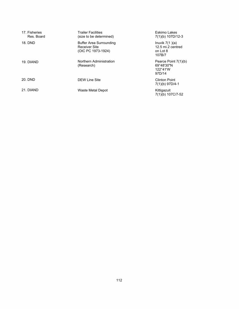
17. FisheriesRes. Board
18. DND
19. DIAND
20. DND
21. DIAND
Trailer Facilities(size to be determined)
Buffer Area SurroundingReceiver Site(OIC PC 1973-1924)
Northern Administration(Research)
DEW Line Site
Waste Metal Depot
Eskimo Lakes7(1)(b) 107D/12-3
Inuvik 7(1 )(a)12.5 mi.2 centredon Lot 8107B/7
Pearce Point 7(1)(b)69°48'30"N122°41'W97D/14
Clinton Point7(1)(b) 97D/4-1
Kittigazuit7(1)(b) 107C/7-52
112

ANNEX SOld Crow/Inuvialuit Reciprocal Harvesting AgreementWHEREAS: The Inuvialuit recognizes and support the claim of the Old Crow People for exclusive hun-
ting, trapping and fishing rights yet to be negotiated with the Government of Canada to the south of theWatershed between the flats and the North Slope and
WHEREAS: The Old Crow people and CYI recognizing and support the exclusive rights of the Inuvialuitas contained in the Inuvialuit Agreement-in-Principle to the north of the Watershed;
Therefore the Inuvialuit and the Old Crow People agree:
1. The Inuvialuit shall hunt, trap and fish only to the north of the Watershed Boundary. Inuvialuit canhunt, trap or fish south of the Watershed Boundary only with permission of Old Crow.
2. The Old Crow people agree to hunt, trap and fish only to the south of the Watershed Boundary.
Old Crow People can hunt, trap or fish to the north of the Watershed Boundary only with the consentof the Inuvialuit Game Council.
This Agreement, upon ratification by the respective communities and organizations shall be included inany Land Claim Agreements and settlements which the Inuvialuit and Old Crow People reach with theGovernment of Canada.
Nothing in this agreement keeps Inuvialuit and Old Crow People from entering into further agreementsto share wildlife.
It is understood that a Cooperative Caribou Agreement for the sharing of caribou shall supercede thisagreement with respect to caribou.
August 18, 1979
for Old Crow
signed by:
Johnny AbelChief
Peter BenjaminMember — J.P.G.
Renie FrostMember — J.P.G.
Margaret NjootliMember — J.P.G.
Lazarus CharlieMember — J.P.G.
Bruce CharlieMember — J.P.G.
for C.Y.I.Harry AllenPresident
for Inuvialuit
signed by:
Nellie CournoyeaMember — J.P.G.
Barbara AllenMember - J.P.G.
Tom Arey Jr.Member — J.P.G.
Roy HansenMember - J.P.G.
Danny GordonMember — J.P.G.
for C.O.P.E.Sam RaddiPresident
Peter GreenVice-President
113

Principles Concerning the Area of the YukonNorth of the Porcupine River1. The entire area is of special importance for wildlife production and hunting, trapping and fishing of the
native peoples and as such must be given special recognition and protected status.
2. The Inuvialuit and the Old Crow people represent the predominant, if not the only. native groups in thearea.
3. The Inuvialuit and Old Crow people agree that the area to the north of the Watershed between the flatsand the North Slope shall be dedicated as a National Wilderness area.
4. The Inuvialuit support the claim of the Old Crow people for Fee Simple land to the Old Crow Flats.
5. The Inuvialuit support the Old Crow position that any area to the south of the Watershed Boundary tothe Porcupine River that is not Old Crow Fee Simple land shall be protected through a publicdedication.
6. The Inuvialuit and Old Crow people agree to negotiate, in the future, agreements for cooperativemanagement between the Inuvialuit area in the North Slope and the Old Crow area to the south of theWatershed.
114