Embed Size (px)
Citation preview

2006
The Werowocomoco (44GL32) Research Project:
Background and 2003 Archaeological Field Season Results
College of William & Mary
Department of Anthropology
Archaeological Research Report Series
Number 1
Commonwealth of Virginia
Department of Historic Resources
Research Report Series
Number 17


2006
The Werowocomoco (44GL32) Research Project:
Background and 2003 Archaeological Field Season Results
Authors
Martin D. Gallivan Thane Harpole David A. Brown
Danielle Moretti-Langholtz E. Randolph Turner, III
Project web site
http://powhatan.wm.edu/
College of William & Mary
Department of Anthropology
Williamsburg, Virginia
Archaeological Research Report Series
Number 1
Commonwealth of Virginia
Department of Historic Resources
Richmond, Virginia
Research Report Series
Number 17

i

ii
ACKNOWLEDGEMENTS
The research at Werowocomoco has received vital assistance from numerous individuals and several insti-tutions. The project would not have been possible without the continued support and encouragement of land own-ers, Bob and Lynn Ripley. Their active participation in the research has greatly strengthened our efforts, and we are most appreciative. By partnering with the Werowocomoco Research Group from the inception of the project, the Virginia Indian community has likewise played an essential role. We thank Reeva Tilley, former Chair of the Virginia Council on Indians, and the other members of the Council who met with us in November 2002 to initiate this partnership in an executive session of the Council. The members of the project’s Virginia Indian Advisory Board, in particular, have given generously of their time to meet regularly with the research team, to serve as liai-sons to the larger Virginia Indian community, and to offer thoughtful guidance to the Werowocomoco Research Group. Virginia Indian Advisory Board members include Jeff Brown (Pamunkey), Mark Custalow (Mattaponi), Kerry Canaday (Chickahominy), Lee Lockamy (Nansemond), Chief Anne Richardson (Rappahannock), Reggie Tupponce (Upper Mattaponi), and ex-officio advisors Chief Steve Adkins (Chickahominy), Chief Ken Adams (Upper Mattaponi), and Chief Emeritus Oliver Perry (Nansemond). We also thank Deanna Beacham, a member of the Werowocomoco Research Group in 2003 and 2004, for the considerable time and energy she contributed to the project. Especially critical to the research was institutional support from the College of William & Mary, the Vir-ginia Department of Historic Resources (VDHR), the Virginia Foundation for the Humanities (VFH), and the Vir-ginia Council on Indians (VCI). The College's Vice President for Public Affairs, William Walker, was instrumental in organizing our May 2003 press conference which drew so much attention to the project. Provost Geoffrey Feiss, Interim Dean of the Faculty of Arts and Sciences Barbara Watkinson, and Anthropology Department Chair To-moko Hamada provided financial support critical to the success of the William & Mary 2003 Archaeological Field School. Provost Feiss, Dean Watkinson, and Professor Hamada also played important roles in our efforts to de-velop partnerships with the Virginia Indian Community. Virginia Department of Historic Resources Director Kathleen Kilpatrick ensured from the beginning that the project receive all available departmental support possible. VDHR has provided essential funding for the fieldwork, analysis, and publication of the Werowocomoco research. We are also appreciative that the VDHR and the College supported the project through their web sites and publica-tions which assisted us in presenting to the public the importance of Werowocomoco as a symbol of Virginia Indi-ans and Virginia history. Funding for our public outreach during the early phases of the project was provided by the Virginia Foundation for the Humanities. David Bearinger of the VFH has been particularly supportive of our efforts, taking the time to meet with the project team and to visit the site. VFH funding allowed us to engage in a series of public outreach efforts, including the creation of a web site (http://powhatan.wm.edu/). The field research reported in this volume represents the efforts of the Werowocomoco Research Group (Martin D. Gallivan, E. Randolph Turner III, Danielle Moretti-Langholtz, David A. Brown, and Thane Harpole) working in conjunction with the William & Mary 2003 Archaeological Field School. The excavation crew in-cluded Werowocomoco Research Group members David Brown and Thane Harpole, who served as teaching assis-tants alongside Daniel Sayers of the William and Mary graduate anthropology program. Jennifer Ogborne, also of the William and Mary graduate anthropology program, directed the field laboratory. Through their professional-ism and dedication, Dan and Jen have made considerable contributions to our understanding of Werowocomoco’s archaeological record. With Jen’s continued role as database manager and artifact analyst she has contributed more to the archaeological research at the site than anyone outside the Werowocomoco Research Group. The Werowocomoco field crew included students enrolled in the Archaeological Field Methods class: Justin Arocho, Brendan Burke, Edward Dunlap, James Goodwin, Nicola Harrison, Aaron Henry, Virginia Horner, Rachel Istvan, Jacqueline Langholtz, Mindy Lechman, Erin Patterson, Jennifer Props, Michael Rodgers, Sarah Tolbert, Cynthia Volbrecht, and Matthew Whalen. We are greatly appreciative of the field school student’s efforts during the 2003 summer at the Werowocomoco site. Through sometimes difficult field conditions, the students and staff succeeded in producing first-rate archaeological research. We appreciate the efforts of Brian Heinsman and Erin Patterson who produced the graphics for this report. Finally, we also thank Two Rivers Multimedia who provided video documentation of the project’s inaugural season.


iv
TABLE OF CONTENTS
Acknowledgements ........................................................................................................ ii Table of Contents ........................................................................................................... iv Chapter 1: Introduction .................................................................................................. 2 Chapter 2: Werowocomoco in the Contact Period ......................................................... 8 Chapter 3: Archaeological Survey Results..................................................................... 36 Chapter 4: Field Research Design and Excavation Results............................................ 50 Chapter 5: Conclusion .................................................................................................... 88 References ...................................................................................................................... 92


2
Arriving at Werawocomoco, their emperour proudly
lying uppon a Bedstead a foote high upon tenne or
twelve Mattes, richly hung with manie Chaynes of great
Pearles about his necke, and covered with a great Cov-
ering of rahaughcums [racoons]: At his heade sat a
woman, at his feete another, on each side sitting uppon a
Matte uppon the ground were raunged his chiefe men on
each side the fire, tenne in a ranke, and behinde them as
many yong women, each a great Chaine of white Beades
over their shoulders, their heades painted in redde, and
[he] with such a grave and Majesticall countenance, as
drave me into admiration to see such state in a naked
Salvage, [. . .] hee kindly welcomed me with good
wordes, and great Platters of sundrie Victuals, assuring
mee his friendship, and my libertie within foure dayes . . .
. I requited his discourse, seeing what pride hee had in
his great and spacious Dominions, seeing that all hee
knewe were under his Territories. In describing to him
the territories of Europe, which was subject to our great
King whose subject I was, [and] the innumerable multi-
tude of his ships. . . hee desired me to forsake Paspa-
hegh, and to live with him upon his River, a Countrie
called Capahowasicke: hee promised to give me Corne,
Venison, or what I wanted to feede us, Hatchets and
Copper wee should make him, and none should disturbe
us. This request I promised to performe (Smith
1986a:53-57). Even with its archaic spelling and unfamiliar phras-ing, Jamestown colonist John Smith’s True Relation offers a compelling sketch of his initial arrival at the Powhatan village of Werowocomoco and his introduc-tion to Powhatan, the paramount leader or Mamana-
towick of the Powhatan chiefdom. Late in 1607, while exploring the Chickahominy River, Smith was cap-tured by a hunting party of Pamunkeys, Mattaponis, Paspaheghs, Chickahominies, Kiskiacks, and Youghta-nunds led by Powhatan’s brother Opechancanough. Opechancanough brought Smith before Powhatan at the chief's principal residence in Werowocomoco (Smith 1986a:91). Werowocomoco, located on the north shore of the York River (then the Pamunkey River), served as the capital of the Powhatan polity that dominated much of coastal Virginia by the early seventeenth century and included a population of perhaps 15,000 Algonquin-speaking Natives. In the woods outside Werowoco-moco, Smith underwent a conjuration ritual orches-trated by Powhatan priests and intended to divine colo-
nists’ intentions. Upon entering Werowocomoco, Smith faced Powhatan, apparently the first Englishman to do so. Amidst a protracted series of events in De-cember 1607 that included feasting, oration, and ritual, Powhatan’s daughter Pocahontas reportedly rescued Smith from imminent execution by her father. Follow-ing this event Powhatan, also known as Wahun-senacawh, declared that he and Smith were now friends and Smith a subordinate chief. After Powhatan freed Smith, the English visited Werowocomoco on several occasions in 1608 and 1609. In 1609, Powhatan decided to distance himself from the English at Jamestown, moving west onto the upper Chicka-hominy River to Orapaks.
Amidst these events of colonial contact, Natives and newcomers sought to influence one another through a
CHAPTER 1
_________________
INTRODUCTION
Figure 1-1. Inset from John Smith’s (1986b) Map of Vir-
ginia depicting the interior of Powhatan’s house at
Werowocomoco.

3
negotiated discourse of speech, ceremony, and ex-change. Despite considerable scholarship aimed at explaining these events (e.g., Axtell 2001; Barbour 1964; Feest 1978; Rountree 1989, 1990; Williamson 2003), much remains to be learned regarding the cul-tural perspectives of Powhatan participants. Written accounts, such as those by colonists John Smith (1986a, 1986b, 1986c, 1986d), William Strachey (1953), and Henry Spelman (1998), offer invaluable evidence from this period, though these narratives are often tinged with a strong colonialist bias. Under-standing the Chesapeake Contact period more fully requires detailed archaeological study of Powhatan settlements in an effort to consider Native culture his-tory on its own terms. Today, Werowocomoco represents a place with considerable significance for several communities. To archaeologists interested in chiefdom dynamics and the North American colonial encounter, the site represents a Native political center infused with social history leading up to and including colonial contact. From the historian's perspective, the village served witness to Contact period events at the roots of the colonial American experience. To the general public, the site offers an entrée into the Native world of the Chesapeake, a world known mostly from the towering personalities of Powhatan (Wahunsenacawh) and Pocahontas and from pop cul-ture references to their initial meeting with Smith at Werowocomoco. In fact, Smith’s ostensible rescue by Pocahontas has now entered the realm of American folklore, in recent years providing the basis of popular histories (e.g., Price 2003), academic scholarship (e.g., Townsend 2004; Gunn-Allen 2003; Mossiker 1996), historical fiction (e.g., Vollmann 2001), and children’s literature (e.g., Fritz 1987). Much of this recent inter-est in events at Werowocomoco was likely triggered by the international popularity of the 1995 Disney film Pocahontas and the legions of children, now young adults, raised on this story. The 2005 film The New
World, directed by Terrence Malick and starring Colin Farrell, may broaden popular interest in this history as well. The site also encompasses a historical setting that, for contemporary Virginia Indian communities, is charged with political authority and sacred power. Despite the growing recognition among archaeologists and historians that our research has a profound effect on descendant communities, sustained efforts by schol-ars to collaborate with Native Americans in eastern North America have been unusual or episodic. Vir-ginia’s Native communities’ growing insistence that
their voices be included in historical accounts of the Chesapeake region has provided an unusual opportu-nity for collaboration tied to the Werowocomoco re-search. Recognizing this opportunity, the Werowoco-moco Research Group has worked to develop a long-term research project accountable to and in close part-nership with Virginia’s tribes.
History of the Project
To establish the location of Werowocomoco, ethno-historians (e.g., Tyler 1901; Rountree 1990:41) and archaeologists (e.g., Turner and Opperman 1993; McCary 1981) have compared early seventeenth-century maps of Virginia such as those associated with Tindall (1608), Zuñiga (1608), and Smith (1986b) with modern cartography. Though precise map projections of historic sites are fraught with difficulties, the over-whelming consensus among these scholars is that the Purtan Bay vicinity represents the most likely location of Werowocomoco. Similarly, early historical ac-counts are consistent with this location, including one by Smith (1986b:147) placing Pamunkey territory 25 miles upriver and the village of Kiskiack 10 to 12 miles down river. The core of Pamunkey territory was located some 25 miles west of modern-day Purtan Bay, beginning at West Point and extending further west up the Pamunkey River. Recent archaeological research conducted by the William and Mary Center for Ar-chaeological Research (Underwood et al. 2003) places the village of Kiskiack just over 11 miles east of Pur-tan Bay at what is now the U.S. Naval Weapons Sta-tion in York County, again a close match with Smith’s distances. Drawing on his repeated visits to the vil-lage, Smith (1986a:63) described Werowocomoco as 12 miles from Jamestown and beside a broad, shallow bay fed by three creeks -- a landscape that fits the Pur-tan Bay vicinity more closely than any other portion of the York River drainage. Werowocomoco first appeared in the Common-wealth's archaeological inventory files as site 44GL32. In 1977, Virginia Commonwealth University archae-ologist L. Daniel Mouer described the site as the "possible location of Werowocomoco" after finding Native American artifacts there. A brief survey by the Gloucester County Archaeological Project followed in 1978-79. Just over two decades later, in 2001, Fairfield Foundation archaeologists David Brown, Thane Har-pole, and Anthony Smith visited the site and met with owners Bob and Lynn Ripley to discuss the 1978-79 survey. At that time, Lynn Ripley showed them a re-markable collection of artifacts she had amassed over the years as she walked her property. Recognizing the potential significance of this collection, Brown and Harpole contacted the Virginia Department of Historic

4
Miles
0 10 20 30
77° 76° 75° 74°78°
36°
36°
30'
30'
37°
38°
39°
78° 77° 76° 75° 74°
39°
38°
37°
Smith's "Captivity Trail," Dec. 1607
Tockwogh
Ozinies
Kuskarawaok
Nacotchtank
Moysons
Patuxent
Tauxenent
CecowocomocoPatawomeck
Mahaskahoa
Nandtaughtacund
Rappahannock
Onawmanient
Cuttatawomen
Wighcomoco
Opiscopank
Cinquaoteck
Rassawek
Powhatan
Werowocomoco
Appamattuck
Weyanock
Quiyoughcohannock
Chiskiack
Jamestown
Occohannock
Accomac
Kecoughtan
Warraskoyack
Nansemond Chesapeake
Roanoke River
Meherrin River
Nottoway
River
Blackwater
River
James River
Chickahominy
River
PamunkeyRiver
Mattap
oni River
Rappahanock
Potomac River
Patapsco River
APPALACHIAN
MOUNTAINS
Chesapeake Bay
Cape Henry
Cape Charles
MONACANS
MANNAHOACKS
Delaware Bay
Susqueha
nna River
Delaware River
MARYLAND
DELAWARE
PENNSYLVANIA
NEW JERSEY
VIRGINIA
NORTH CAROLINA
N
40 50
Tauxania
Hassinnungae
Shackaconia
River
Paspahegh
Arrohateck
Massimacack
OrapaksPiankatank
Moraughtacund
Pissaseck
Cuttatawomen
Wiccocomico
Sekakawon
Acquintanacsuck
Chickacoan
Kupkipcock
Uttamusak
Menapucunt
"King's House" Depicted on Smith's
Map of Virginia
Figure 1-2. Map of Eastern Virginia, circa 1607, depicting principal native villages (“Kings’ Houses on Smith’s
(1612) Map of Virginia) and Smith’s 1607-1608 Captivity Route (taken from the Zuñiga (1608) Map).

5
Resources (DHR) in 2001. Shortly thereafter, Randolph Turner, Director of DHR’s Tidewater Re-gional Office visited the site and confirmed that many of the artifacts dated to the Late Woodland/Contact periods (ca. A.D. 900 to the early seventeenth century). The sheer volume of Native American artifacts in the collection indicated a major village site. With the support of the owners and assistance from DHR, Brown and Harpole conducted a comprehensive archaeological survey of the site, summarized in chap-ter 3. In 2002, the DHR, Brown and Harpole, the Col-lege of William and Mary, and the Virginia Indian community entered into a partnership and formed the Werowocomoco Research Group (WRG). In addition to Turner, Brown, and Harpole, members of the Werowocomoco Research Group include Martin Galli-van, an assistant professor at the College of William and Mary, and Danielle Moretti-Langholtz, Director of the American Indian Resource Center at the College of William and Mary. An archaeologist with research interests in the Late Woodland and Contact period Chesapeake, Gallivan serves as field director of the Werowocomoco project. Moretti-Langholtz has devel-oped close ties to Virginia Indian communities in the context of oral history and ethnohistory projects span-ning more than a decade. By adding a cultural anthro-pologist with long-standing relationships with the Vir-ginia Indian community to the project team, the Werowocomoco Research Group has made a commit-ment to build partnerships with descendant Native communities.
Partnerships with the Virginia Indian Community
From its inception, the Werowocomoco Research Group has worked toward a new model of archaeologi-cal research on Native sites in the Chesapeake that includes close Native collaboration at every stage. With some notable exceptions, archaeological research in Virginia is generally conducted by academics, cul-tural resource managers, and avocationalists without the awareness or involvement of tribal communities. This is due partly to long-standing archaeological prac-tice of working without tribal consultation and to the lack of Federal recognition for the Virginia tribes, eight of which have received formal recognition from the Commonwealth of Virginia. The WRG is hopeful that the Werowocomoco research may serve as a posi-tive example of a nascent trend in Virginia archae-ology toward the greater inclusion of Native voices. With this goal in mind, in November of 2002, the WRG met with the Virginia Council on Indians (VCI), a state advisory board on Indian affairs in the Com-
monwealth, to inform the Council that we had identi-fied a site we believed to be Werowocomoco. The WRG requested that our presentation be received in a VCI executive session to ensure that information per-taining to the project be presented to tribal leaders for each of the eight state recognized tribes prior to any public announcement about the location of the site and future investigations. During the WRG presentation we discussed our survey results and assessment of the site’s significance. We also sought the advice of the VCI in arranging a meeting with tribal leaders so that they would learn of the site directly from the research team and before any media coverage appeared. Addi-tionally, we introduced the Council to the members of the research group as well as Lynn Ripley, and out-lined a long-term plan to study Werowocomoco with the close involvement of the Native community. The Council, under the leadership of Reeva Tilley (Rappahannock Tribe) expressed their support for the project and offered important guidance on future Na-tive involvement. These discussions included plans for a subsequent visit to the site and for the formation of an all-Native advisory board to the research team. In February 2003, the Werowocomoco Research Group presented a detailed project proposal to tribal chiefs, members of the Virginia Council on Indians, and other representatives of Virginia's state-recognized tribes in meetings held at the College of William and Mary. College officials, including then Dean of the Faculty Geoffrey Feiss and Anthropology Department Chair Tomoko Hamada, offered their support for the project. Presentations to the community outlined cur-rent understanding of the site and its significance from the point of view of academic researchers. The re-search team discussed a multi-year research design for the site centered on William and Mary field schools. Together with the property owners, the WRG then hosted an event at the site, giving community represen-tatives the chance to see the location first-hand. Rep-resentatives from the Pamunkey, Upper Mattaponi, Chickahominy, Eastern Chickahominy, Nansemond, Rappahannock, and Monacan tribes attended the meet-ings. During these meetings Lynn Ripley asked that the Virginia Indians consider Werowocomoco as a place where members of their communities were al-ways welcome. The research team listened carefully to the tribal representatives as they discussed their own perspectives on Werowocomoco. These perspectives varied, though many included a powerful connection to Werowocomoco as the historic center of the Powhatan chiefdom and as a modern place for renewing Virginia Indians’ influence on representations of the Native past. Others encouraged us to pursue research that

6
focuses on the power and social complexity of the Powhatan chiefdom. Representatives from six of the Powhatan descen-dent communities subsequently formed an all-Native Virginia Indian Advisory Board to guide WRG’s ef-forts. Virginia Indian Advisory Board members in-clude Jeff Brown (Pamunkey), Mark Custalow (Mattaponi), Kerry Canaday (Chickahominy), Lee Lockamy (Nansemond), Chief Anne Richardson (Rappahannock), Reggie Tupponce (Upper Matta-poni), and ex-officio advisors Chief Steve Adkins (Chickahominy), Chief Ken Adams (Upper Matta-poni), and Chief Emeritus Oliver Perry (Nansemond). The Virginia Indian Advisory Board (VIAB) has since met regularly with the WRG, receiving updates and reports on the research and advising the research team as we have formulated our research goals and policies. In keeping with the goals of our partnership the re-search team shares all information we have on the pro-ject with the advisory board, including minutes of all meetings and financial reports of all activities. The advisory board has served as the critical linkage be-tween the research team and the tribal communities. Among other decisions, the VIAB has been central to the creation of a policy for the accidental discovery of human remains on site, a policy that involves close consultation with the Native community. In response to the Ripleys’ invitation, the advisory board has also facilitated regular Native visitation to the site. These visits have includes a week-long open house for mem-bers of the Virginia Indian community to visit the site during the archaeological field season.
Archaeological Investigations at Werowocomoco
The following volume describes the results of our first season of archaeological excavations at the
Werowocomoco site (44GL32) in a project that seeks to develop a new model of archaeological research in Virginia predicated on close collaboration with Native communities. To date (through 2006), we have com-pleted a comprehensive shovel-test survey and four field seasons confirming the site’s research potential. Our research has been oriented toward two broad themes: 1) a community-oriented perspective on the development of the Powhatan chiefdom from A.D. 1200 - 1609 and, 2) a study of the material conse-quences of the Chesapeake colonial encounter from the vantage of a Native center. Thus far, our field research indicates that the site was a remarkably large village circa 1607 containing evidence of substantial land-scape modification dating to the Late Woodland (AD 900 – 1607) and Contact (AD 1607 – 1646) periods.
Our study focuses on questions of the social dy-namics of chiefdom polities. Anthropological archae-ologists’ “political” models of chiefdoms generally emphasize the means through which chiefly elites came to dominate power relations through control of the political economy, military power, and ideology (Earle 1997; Drennan and Uribe 1987). Recent chief-dom literature focuses on the elite strategies and social processes creating permanent, centralized decision-making authority. With the shift in archaeology away from positivist approaches and toward humanistic per-spectives, researchers have begun to emphasize chief-dom polities’ historical trajectories and the hegemony, domination, and subordination inherent in these histo-ries (Emerson 1997:18). Interpretations of North American chiefly centers such as Cahokia (e.g., Pau-ketat 1994) demonstrate that elites often recognized the ideological power of place, transforming settle-ments into politicized locations by segmenting sacred space and by constructing monumental architecture requiring massed labor. Such studies often begin with the notion of a “cultural landscape” as both an ideo-logically-motivated representation of the world (Cosgrove 1984) and a physical expression of mean-ings negotiated in the past (Ucko and Layton 1999). In addition to being politicized spaces, chiefly cen-ters often represented key nodes in a regional political economy dominated by elites. Prestige-good exchange models (e.g., Friedman and Rowlands 1977; Earle 1991) highlight an association between exotic, ritually-charged materials and elites within chiefdom societies. Prestige goods may serve as status markers symboliz-ing rank or wealth items distributed to meet social ob-ligations (Emerson 1997:33). These items are thus central to the reproduction of hierarchical social orders in many North American chiefdoms. Such strategies of “wealth finance” are often complemented by strate-
Figure 1-3. William and Mary Dean of the Faculty Geoffrey
Feiss welcomes representatives from the Virginia Indian
Community to the College.

7
gies of “staple finance” whereby elites induce in-creased production of subsistence goods that are in turn expropriated (D’Altroy and Earle 1985). With these themes in mind, our investigations have focused on evidence of the settlement’s spatial organi-zation, exchange relations, and subsistence patterns during the periods immediately before and after James-town’s settlement. Our intent is to contribute to an understanding of how social power came to be concen-trated within and exercised from Werowocomoco. We are particularly interested in addressing a related set of
the questions: Did Powhatan and the residents of Werowocomoco remake the village’s cultural land-scape when he moved there prior to 1607? What does Werowocomoco’s archaeological record indicate re-garding exchange of powerful prestige goods before and after Jamestown’s settlement? Is there evidence that the residents at Werowocomoco intensified pro-duction of maize and other staples during the Late Woodland / Contact period transition? Does Werowo-comoco’s archaeological record include evidence of status differences or hierarchical social orders?

8
The following discussion places the recent exca-vations at Werowocomoco in the larger context of eth-nohistorical and archaeological research on the Contact period Chesapeake. The chapter begins with a narra-tive of events that occurred at Werowocomoco as re-ported by English colonists before turning to ethnohis-torical and archaeological research concerning this history. This summary draws on sources that largely exclude a Virginia Indian perspective. Our hope is that as the Werowocomoco research develops, we will be able to incorporate archaeological information and contemporary discourse that offers more of the Native view on the Chesapeake colonial encounter. Though the English colonists’ experiences at Werowocomoco were limited largely to six events that occurred from December 1607 through sometime in 1609, a close reading of the documentary records indicates that the village represented a central place in the Powhatan political and spiritual world.
Our reading of these texts emphasizes references
to Werowocomoco’s location, the colonial entangle-ments that began there, and the materiality of this in-teraction. By “materiality” we refer to the ways in which early colonial connections were expressed mate-rially (e.g., through exchanged items) and influenced by the meanings associated with some categories of material culture (e.g., copper ornaments and maize kernels). As an exercise in historical anthropology, our research begins with the events of colonial contact witnessed by English colonists. We are, of course, mindful of the personal and rhetorical elements that shaped the Jamestown accounts as well as the English colonialist lens that influenced their creation. Our un-derstanding of Werowocomoco’s history emphasizes the village as an origin point of colonial entanglements that were marked by myriad Native responses and the newly-hybridized cultural practices of Natives and newcomers alike. Such a reading differs in subtle but important ways from a perspective that emphasizes the village as a site of fleeting encounters between inde-pendent, bounded cultural wholes (Silliman 2005).
During the early seventeenth century the Native
political dynamics of the Powhatan world of Tsena-commacah (i.e., the Virginia Tidewater) were centered on the overwhelming authority of the individual named Wahunsenacawh or Powhatan. Wahunsenacawh was
known as the Mamanatowick or “great king” of Tide-water Indians referred to by the English (and by Wa-hunsenacawh himself) as “Powhatans.” The Powhatans included those Algonquin speakers of Tide-water Virginia that came under the political influence of the Mamanatowick during the late sixteenth century, the years immediately preceding the settlement of Jamestown. Residing in dozens of settlements and grouped into about thirty-two political districts, ap-proximately 15,000 Powhatans lived in settlements that lined the banks of the principal rivers of the Vir-ginia Coastal Plain circa 1607 (Rountree and Turner 2002). Their mixed horticultural-foraging subsistence economy centered on riverine villages occupied for most of the year. Households dispersed during the winter months for hunting camps located in the inte-rior.
Powhatan social organization was defined by
sharp inequities of status, authority, and wealth that included weroances whom the English described vari-ously as kings, commanders, or chiefs. As the Mama-
natowick, Wahunsenacawh’s authority permeated a polity stretching from the James River to the Poto-mac’s southern shores and from the Fall Line to the Eastern Shore (Turner 1993). By the height of his power, Wahunsenacawh had moved from his natal village at the falls of the James River to Werowoco-moco on the York. This relocation may have been due in part to Werowocomoco’s central location vis-à-vis the river systems of the Chesapeake (Gallivan 1997). Other factors tied to the unusual cultural landscape of Werowocomoco that apparently drew Wahunsenacawh to Werowocomoco are beginning to emerge from our archaeological study of the site as well. From Werowocomoco Wahunsenacawh dominated a social network through which gifts, tribute, and power flowed.
Given the ethnohistorical indications of a three-
tiered hierarchy incorporating the Mamanatowick,
weroances with regional authority, and those with lo-calized power, the Powhatans appear to have been an almost archetypal complex, or paramount, chiefdom (Rountree and Turner 1998; Earle 1978; Wright 1984). As envisaged in Smith’s (1986b) Map of Virginia, the Powhatan polity consisted of “kings’ houses” (depicted with icons of yihakans – Native houses) where
CHAPTER 2
_________________
WEROWOCOMOCO IN THE CONTACT PERIOD:
COLONIAL NARRATIVES, ETHNOHISTORY, AND ARCHAEOLOGY

9
weroances resided, and “ordinary houses” (depicted as points surrounded by circles) along Coastal Plain riv-ers (Figure 2-1). Tribute in the form of surplus staples flowed from commoners to weroances and from weroances to the Mamanatowick. Weroances domi-nated exchange of wealth items (i.e., prestige good exchange) through which copper, shell, puccoon, pearls, and other items circulated (Rountree 1993). These materials expressed elite social status due to their color symbolism, rarity, production process, and sources at the edges of Tsenacommacah (Gallivan and Klein 2004). In mortuary rituals reserved for weroances, the Powhatans interred remains with such prestige goods in temples constructed for this purpose.
Thus, the documentary records suggest that the Powhatans of the early seventeenth century Virginia Tidewater comprised a complex chiefdom structured by social stratification, political hierarchy, and a politi-cal economy dominated by elites (Rountree and Turner 2002, 1994; Rountree 1989; Turner 1976; Potter 1993; Binford 1964). Recent ethnohistorical and archaeo-logical research (e.g., Williamson 2003; Gallivan 2003; Mallios 1998; Gleach 1997) building on earlier studies and summarized below indicates that the Werowocomoco project arrives at a time in Powhatan scholarship when new interpretive possibilities
abound. A close reading and analysis of the ethnohis-torical accounts represents a critical departure point for this effort. The following traces the Jamestown narra-tives as they touched Werowocomoco before turning to recent ethnohistorical and archaeological research focused on the Virginia Tidewater. Ultimately, the archaeological record offers the greatest potential to yield new information about Powhatan cultural prac-tices and representations during the early colonial Con-tact period.
Under the command of Christopher Newport, the Virginia Company’s fleet of three ships arrived at the mouth of the Chesapeake Bay in late April 1607. Shortly thereafter a group of Indians briefly attacked the English from shore (Percy 1998:90; Smith 1986a:27). Four days later a party of colonists visited the village of the Kecoughtans on the James River and was received cordially. The events of spring 1607 included a series of encounters, some violent, others peaceful, that ushered in the early seventeenth-century Contact period. Intermittent contacts between Indians and Europeans during the shadowy sixteenth century had already shaped Powhatans’ perceptions of the English colonists and, likewise, English colonists’ ex-pectations of the Powhatans. In addition to poorly-documented visits by European vessels during this century, close, and ultimately violent encounters sur-rounded the failed Spanish Jesuit mission to Virginia of 1570 - 1571 and the unsuccessful Roanoke colony of the 1580s in the nearby Outer Banks. On May 14, 1607 the Jamestown colonists started constructing
James Fort in the territory of the Paspaheghs. Over the next half century the Jamestown colony would struggle with starvation, infighting, unstable leadership, and relations with diverse groups of Virginia Algonguians that alternated between violence and alliance, tolerance and manipulation, cohabitation and apartheid. Even-tually the colonists discovered a means of economic viability in tobacco production, becoming a successful royal colony that expanded outward from Jamestown, consuming Native lands in the process. The Powhatans’ efforts to resist this gradual invasion, in-cluding coordinated attacks in 1622 and again in 1644, ultimately failed.
During the colony’s initial years, though, this out-
come seemed far from likely. Colonists’ accounts im-ply that on many occasions Wahunsenacawh and other Native leaders held the upper hand. Heavily reliant on Native generosity and on unreliable supplies from England, the colonists struggled. Smith’s (1986a, 1986b, 1986c, 1986d) four published accounts of his
Arriving at Werowocomoco
Figure 2-1. Key from Smith’s Map of Virginia.

10
experiences in Virginia from 1607 – 1609 describe events that swing from the horrific to the comedic to the heroic. It is largely from Smith’s accounts that scholars draw an understanding of events that occurred at Werowocomoco, beginning with his captivity narra-tive of December 1607 and ending with the 1609 de-parture of Wahunsenacawh from the village. Smith described these events several times, producing ac-counts that are both detailed and inconsistent. Smith took pains to portray himself as a man of action capa-ble of producing results. Despite indications that he inflated his own importance and misconstrued ele-ments of the Powhatan society, he emerges as a savvy culture broker capable of adapting to novel circum-stances.
Smith was well prepared to do so. He originally left England in 1596 at age 16 to volunteer in France with forces battling for Dutch independence from Spain. Four years later he joined Austrian forces to fight the Ottoman Turks. Promoted to “Captain” while fighting in Hungary, Smith was subsequently wounded in battle, captured, and sold as a slave to the Turks. Smith’s (1986e) narrative of this experience recounts his escape by beating his owner to death before mak-
ing his way back to England in 1604. As a proud and boastful man, Smith wrote of events that reflect his exploits in a heroic light. The notion that Smith em-bellished his accounts for dramatic effect is implied by the four separate instances in which young women appeared and saved him at moments of peril, with the most famous of these occurring at Werowocomoco (Townsend 2004:53). Read with an eye focused on Native cultural practices, though, the accounts offer a good starting point for considering events at Werowo-comoco. The Captivity Narrative
The earliest, and best known, events at the village of Werowocomoco began during December of 1607 when Smith was captured, brought to the village, and released after a period of captivity lasting roughly four weeks (Smith 1986a:43-59, 1986c:212-213, 1986d:146-151). Nearly half of the original colonists were dead by this time as a result of starvation, dis-ease, and hostilities with the Powhatans. Wahun-senacawh was apparently following the colony’s strug-gles to acquire food carefully, sending gifts of maize and other provisions at strategic moments that kept at least some of the colonists from starvation. He re-ceived copper objects, glass beads, and iron hatchets in return. In a contentious move with Smith at the center, Edward Wingfield had recently been replaced as presi-dent of the colony’s ruling council. The new presi-dent, John Ratcliffe, placed Smith in charge of rela-tions with the Natives.
On December 10th Smith took nine men and the
colony’s shallop westward five miles up the James to the mouth of the Chickahominy River. His principal intention was to explore the Chickahominy River for a possible route to the Pacific, though it is also clear Smith sought to reconnoiter as much of the surround-ing territory as possible. After Smith’s party passed a series of villages, the densely populated Moysenec peninsula, and the village of Apocant 50 miles from the Chickahominy’s mouth, the river became too nar-row for the shallop. Smith arranged for two men from Apocant to guide him and two other colonists, Thomas Emry and John Robinson, further upriver.
The next day the five men set forth in a canoe.
After traveling another 12 miles upriver, the group came to shore to eat. In the meantime and unbe-knownst to Smith, the men he had left behind at Apo-cant were attacked by a group of Chickahominies when they went ashore. One of the colonists, George Casson, was captured, tortured, and killed. Upriver, Smith was on foot with one of his guides and separated from Emry and Robinson when he heard a loud cry
Figure 2-2. Cover page from Smith’s True Relation, his
earliest account of events in Virginia.

11
from their direction. Thinking that his guide had be-trayed him, Smith trained his gun on the man, who immediately urged him to run. At this point Smith was struck with an arrow in the leg. After returning fire with his pistol several times, new attackers appeared, sending volleys of arrows in his direction. Seizing his guide as a shield, Smith was immediately surrounded by a force of 200 Natives led by Opechancanough, the Pamunkey weroance and brother of Wahunsenacawh. The guide shouted that Smith was a leader of the Eng-lish and therefore should not be killed. A standoff ensued as Smith demanded that he be allowed to return to the canoe while Opechancanough insisted that Smith lay down his arms or be killed just as his two compatriots had already been slain. This ended when Smith, still holding his guide, fell into the mud and became stuck. Smith promptly threw down his weapon and surrendered.
Brought before Opechancanough, Smith pulled out his compass and began to explain its use and the motion of planets in the solar system. This effort to impress and mystify Opechancanough apparently drew from the experiences of the Roanoke colonists years earlier (Barbour 1986:102). Smith was then conducted to a hunting camp named Rassawek six miles from
where he was seized. At the camp the Powhatan men formed a ring and performed a dance. Smith noted that the men were painted red on their heads and shoul-ders with animal skins on their arms and birds’ wings tied to their hair. After being fed well, Smith con-versed with Opechancanough about English ships, James Fort’s defenses, and a place called Ocanahonan where men wore English clothes—possibly a reference to refugees from the Roanoke colony. Opechan-canough agreed to Smith’s request that he be allowed to write a letter to Jamestown about his status. In the letter, which was brought to Jamestown by some of Opechancanough’s men, Smith mentioned his fear of an imminent attack on the fort. Subsequently Smith was conducted along a circuitous route that included a series of locations along the Pamunkey and Mattaponi rivers where he was brought before several weroances. At one settlement he was asked to demonstrate the effectiveness of his pistol from a distance beyond its range. In order to hide its limitations, Smith covertly broke the weapon. At the village of Toppahannock on the Rappahannock River Smith was presented to the weroance in order to determine whether Smith was in fact the European who had previously killed a Toppa-hannock leader. On finding that he was not the man, the Powhatans turned toward Werowocomoco.
Before entering Werowocomoco Smith faced a
ceremony apparently intended to determine the colo-nists’ intentions (1986d:149). This ceremony occurred either sometime prior to his tour of Powhatan villages or during his stay at Pamunkey, Smith’s various ac-counts are inconsistent on the timing. Smith was placed before a fire in a longhouse, his guards leaving his side. A “great grim fellow” entered painted black, his head adorned with stuffed snake and weasels sur-rounded by feathers. The man, evidently a Powhatan priest, began his invocation and surrounded the fire with a circle of corn meal. Six more priests entered the structure in groups of three, painted half black and half red with white paint around their eyes. Next the priests sat down with Smith. After singing a song, the man Smith identified as the chief priest began to encir-cle the corn meal with two rings of corn kernels, all the while alternating between short speeches and songs (see Figure 2-4). The priests then added short sticks between the rings of corn kernels. They continued the ceremony for three days, resting and eating only dur-ing the evenings.
In a welcome bit of exegesis, Smith (1986d:150)
offers his understanding of these events: the ceremony was a means of determining whether Smith intended the Powhatans any harm. As a cosmological map of the Powhatan world, the circle of meal stood for
Figure 2-3. Inset from engraving by Robert Vaughan
accompanying Smith's (1624) Generall Historie of Vir-
ginia, New-England, and the Summer Isles.

12
Tsenacommacah, the Powhatans’ domain. The circles of corn represented the edge of the ocean and the sticks represented the colonists’ country. Smith notes that the Powhatans’ imagined the world to be flat and round, like a platter, with Tidewater Virginia in the center. Smith was then brought before Opitchapam, Wahunsenacawh’s brother. After a feast, Smith’s cap-tors then took him to Werowocomoco where he con-fronted the Mamanatowick for the first time.
Arriving at Werowocomoco, Smith reported that he was met by 200 “courtiers” who studied him closely as Wahunsenacawh prepared to receive him (1986d:150). Elsewhere Smith numbered the “able” male population of Werowocomoco at 40, a relatively small number compared to other districts Smith visited (Smith 1986c:147, 1986d:104). Smith was eventually taken to Wahunsenacawh’s house where he met the Mamanatowick and his impressive retinue of men and women. The length of the Mamanatowick’s residence impressed Smith (1986d:126), stretching as it did some
30 to 40 yards on the long axis. Other colonists con-firmed that the houses of chiefs were broader and longer than those of ordinary Powhatans (e.g., Spel-man 1998:487).
In his original account (1986a) Smith describes
events at Werowocomoco as including feasting and a series of conversations between the Mamanatowick
and his captive. When Wahunsenacawh inquired as to why the colonists had come, Smith replied that they had been driven by Spanish enemies, bad weather, and damaged vessels to the area. His recent exploration, Smith explained, was aimed at discovering a passage to the west and at avenging the death of one of the colonists at the hands of the Monacans, enemies of the Powhatans. Wahunsenacawh responded by describing the coastal region, Tsenacommacah, under his com-mand and the people within and around these domains. Smith answered with an account of the territories of Europe and the ferocity of Captain Newport, Smith’s “father.” Wahunsenacawh then insisted that Smith and the English leave Jamestown and move their settle-ment to Capahosic, downstream of Werowocomoco. Wahunsenacawh would see to it that the colonists were fed and protected if they followed these instructions and provided Wahunsenacawh with hatchets and cop-per. Smith was then released and escorted back to Jamestown.
In a later version of these events published in 1624
as part of the Generall Historie Smith added an ac-count of his “rescue” by Pocahontas from execution by Wahunsenacawh. Considering the amount of attention that has been paid this event, it is remarkable how little Smith wrote about it. Smith refers to himself in the third person:
[H]aving feasted him after their best barba-rous manner they could, a long consultation was held, but the conclusion was, two great stones were brought before Powhatan: then as many as could layd hands on him, dragged him to them, and thereon laid his head, and being ready with their clubs, to beate out his braines, Pocahontas the Kings dearest daugh-ter, when no intreaty could prevaile, got his head in her armes, and laid her owne upon his to save him from death: whereat the Emper-our was contented he should live to make him hatchets, and her bells, beads, and copper; for they thought him as well of all occupations as themselves (Smith 1986d:151).
Two days later Smith experienced a final cere-
mony involving the Mamanatowick before being re-leased. Wahunsenacawh brought Smith to a large
Figure 2-4. Powhatan “Divination” Circle and Exegesis,
modified from Fausz 1985:240.
Corn Kernels
Sticks
Fire
SEAENGLANDSEA
TSENACOMMACAH
Corn Kernels
Corn Meal

13
structure in the woods and sat him before a fire. Soon thereafter Wahunsenacawh appeared from behind a mat in the structure with two hundred others, all painted black. Wahunsenacawh approached Smith, promising friendship and instructing him to obtain two cannons and a grindstone at Jamestown as recompense for the territory of Capahosic. Wahunsenacawh de-clared that he would “for ever esteeme him [i.e., Smith] as his sonne Nantaquod” (Smith 1986d:151). Smith departed for Jamestown soon thereafter.
Wahunsenacawh Meets Nantoquoud’s Father
In February 1608 the Jamestown colonists re-ceived word from Wahunsenacawh that he wanted to meet Smith’s “father” Newport (Smith 1986a:63-79, 1986c:215-217). Newport and Smith soon left by boat for Werowocomoco with 30 to 40 men. Arriving at Werowocomoco, Smith led 20 armed men ashore to revisit the Mamanatowick while Newport remained behind. Smith (1986a:63) offers a brief description of Werowocomoco’s setting at this point in the narrative. Werowocomoco was situated on a bay fed by three creeks. The bay itself was “all ooze” for a mile and a half. As Smith and his men attempted to enter the vil-lage, they found themselves mistakenly on one of the three creeks located within a mile of the village itself. Smith was then guided into the village by one of Wa-hunsenacawh’s sons.
Upon arriving at Wahunsenacawh’s house, Smith
gave the Mamanatowick a suit of red cloth, a white greyhound, and a hat. Three of his “nobles” accepted the gifts with speeches of alliance and friendship. Wa-hunsenacawh inquired as to Newport’s location, and Smith replied that he would arrive the following day. When invited inside to eat, Smith warily allowed his men to enter the structure in pairs only. Wahun-senacawh then asked Smith and his men to lay down their arms, noting that as his subjects, this was ex-pected. Smith countered that only enemies would de-mand such an action. In an apparent effort to assure Wahunsenacawh, Smith explained that the colonists’ planned to hand over a boy to live among the Powhatans. Smith also offered to subjugate the Monacans and Susquehannocks for Wahunsenacawh. This evidently pleased the Mamanatowick, and he de-clared Smith to be a Powhatan weroance. The colo-nists were no longer to be considered Tassantasses (strangers) or Paspaheghs (the territory in which Jamestown was located) but Powhatans. As Powhatan’s people, the colonists would be allowed to have corn, women, and land.
Smith then spent the evening in one of Wahun-
senacawh’s lodges, feasting and conversing with Wa-
hunsenacawh. The following day, Wahunsenacawh brought Smith to the river and, pointing to his canoes, described the system of tribute through which he re-ceived shell beads, copper, and deer skins. Seeing that Newport was coming ashore, Wahunsenacawh left Smith so that he could receive Newport at his house. Upon meeting Wahunsenacawh, Newport offered to have Thomas Savage live with Wahunsenacawh as his son. When Wahunsenacawh repeated his request that the colonists lay down their arms, Newport sent his men back to the water. This occurred despite Smith’s objection to their retreating the considerable space from Wahunsenacawh’s residence to the water, a dis-tance that Smith (1986a:69) described as “thirty score.”
On their third day at Werowocomoco, Newport
began to trade with Wahunsenacawh, seeking to obtain food for hatchets and copper pots. Objecting to the idea of haggling, Wahunsenacawh demanded that Newport lay out all of the items the English brought for trade. Wahunsenacawh, as the Mamanatowick, would choose what he wanted and reciprocate with corn as he saw fit. Newport went along with this ar-rangement and received an unimpressive four bushels of corn from Wahunsenacawh. Annoyed at Newport’s perceived ineptitude at negotiating with Wahun-senacawh, Smith pulled out some blue beads. Wahun-senacawh demanded that Smith offer the beads in trade, but Smith answered that they were far too valu-able for this. Piquing Wahunsenacawh’s interest in the beads, Smith was eventually able to obtain 200 – 300 bushels of corn in return for the beads. On the fourth day at Werowocomoco, Smith had difficulty getting back to his ship. Becoming mired in the ooze once again, Smith waited until midnight for the tide to rise.
During the next days the colonists discussed with
Wahunsenacawh plans for a joint attack on the Monacans. They also received several invitations from Opechancanough to visit him. Eventually Newport acquiesced and the colonists traveled up the York River to visit the Mamanatowick’s brother at Pamun-key. After several days of feasting and trading with Opechancanough (trade centered on Smith’s blue beads), the colonists traveled back down the river, briefly stopped at Werowocomoco, then returned to Jamestown.
The “Maskarado” and an Invitation Refused
By the fall of 1608 Smith had been made president of the Jamestown colony and Newport had returned to Virginia with a second relief supply. Newport brought more colonists, including Germans and Poles who would come to play a role at Werowocomoco. New-

14
port also carried instructions from the Virginia Com-pany to find something of value in the colony and to crown Wahunsenacawh as a vassal to King James. Smith (1986c:235-236, 1986d:182-183) objected vehe-mently to the coronation as a time-consuming distrac-tion, objections that were overruled by Newport. Smith was able to convince Newport that Smith should travel to Werowocomoco to invite Wahunsenacawh to come to Jamestown for the coronation, thus minimiz-ing the colonists’ efforts somewhat.
Smith took an overland route from Jamestown to
Werowocomoco. Upon arriving, Smith and his four men learned that Powhatan was not present but would be sent for. While waiting, Smith experienced a re-markable ceremony he labeled a “Virginia maskarado.” Smith was brought to a field and placed before a fire. Soon he heard a “hideous noise” as thirty Powhatans ran shrieking from the woods and into the field. Assuming that he was under attack, Smith pre-pared to defend himself. In one (though not all) of Smith’s (1986d:182-183) versions of the events, Poca-hontas then appeared and explained to Smith that no harm was intended. Noting the men, women, and chil-dren in attendance, Smith let down his guard. Pres-ently the thirty young women formed a ring around the fire and began to dance and sing. The women were clothed only with a few leaves and adorned with white, red, and black paint. The group’s leader wore deer antlers on her head while others carried bows and ar-rows, clubs, and swords. After an hour of impassioned and solemn performance, the women left the same way they arrived. Smith reported that the women then of-fered themselves to him with the entreaty, “Love you not me”?
The next day, Wahunsenacawh arrived. Smith
offered him presents and assistance in attacking the Monacans, Wahunsenacawh’s enemy. He also invited him to come to Jamestown for the coronation. Wahun-senacawh angrily refused the invitation and the mili-tary assistance, insisting that he could avenge the inju-ries caused by the Monacans on his own. Wahun-senacawh demanded that Newport travel to Werowo-comoco in eight days for the ceremony. Smith re-turned to Jamestown with the message.
Newport’s “Coronation” of Wahunsenacawh
The fourth event at Werowocomoco recorded in the Jamestown chronicles entailed Wahunsenacawh’s coronation, a ceremony Smith describes in a single paragraph (1986c:237, 1986d:184). During a cere-mony that must have been somewhat strange for all involved, Christopher Newport presented gifts to Powhatan, including a pitcher, a basin, a bed, and a red
cloak. Powhatan did not completely comply with the English efforts to crown him:
but a foule trouble there was to make him kneele to receive his Crowne, he neither knowing the majesty nor meaning of a Crowne, nor bending of the knee, endured so many perswasions, examples, and instruc-tions, as tyred them all; at last by leaning hard on his shoulders, he a little stooped, and three having the crowne in their hands put it on his head, when by the warning of a Pistoll the Boats were prepared with such a volley of shot, that the King start up in a horrible feare, till he saw all was well (Smith 1986d:184). Powhatan then gave his shoes and his mantle to
Newport in return. He also provided seven or eight bushels of corn and admonished the colonists not to pursue their plans to travel west to the Monacans’ ter-ritory. Smith’s tone here is clearly one of contempt for Newport and bemusement with the turn of events.
Smith’s Aborted Raid on Werowocomoco
The next event involving the colonists at Werowo-comoco occurred late in December 1608 through Janu-ary 1609, following a period when Wahunsenacawh had commanded his people to cease trading with the colonists and allow them to starve (Smith 1986c:245-250, 1986d:205-206). In a situation of growing des-peration, Smith led a party to Nansemond village and obtained a large quantity of corn by firing muskets, burning a house, and threatening to burn the entire village. Seeking to repeat this successful tactic, Smith argued that the colonists should return to Werowoco-moco in order to capture Wahunsenacawh and all of his provisions. Other members of the colonial leader-ship opposed the plan as overly provocative. Wahun-senacawh nonetheless provided an opening for another visit to Werowocomoco when he sent word to James-town that he would provision the settlement if the colonists built an English-style house for him at Werowocomoco and send a grindstone, fifty swords, guns, a rooster, a hen, copper, and beads. The colo-nists decided to send the requested assistance and ma-terials minus the swords and guns. Smith sent three “Dutchman” (i.e., recently-arrived German glassmak-ers) and two Englishmen to build the house, thinking that the project would provide an opening to surprise Wahunsenacawh. Before setting out for Werowoco-moco Smith sent an additional fourteen or fifteen colo-nists to assist in the house construction effort.
On December 29, 1608, a year away from his
original visit to and captivity in Werowocomoco, Smith traveled by river back to Wahunsenacawh’s

15
residence, arriving on January 12, 1609. Once again, the tide was out, forcing Smith and his men to slog through the mud (covered with ice this time) to enter the village. Smith and his men quartered in the first house they found. The next day Wahunsenacawh met the colonists and asked when they planned to leave, feigning ignorance of his offer of provisions. When Smith reminded him of this, Wahunsenacawh repeated his demand for guns and swords, pointing out that corn was more valuable than these items since corn could be eaten. Smith responded that he had no swords or guns to spare but had sacrificed to have his men build Wahunsenacawh a house and expected friendship in return. Wahunsenacawh promised to provision the colonists and raised his own doubts about the purpose of their settlement:
Some doubt I have of your comming hither, that makes me not so kindly seeke to relieve you as I would: for many doe informe me, your comming hither is not for trade, but to invade my people, and possesse my Country, who dare not come to bring you corne, seeing you thus armed with your men. To free us of this feare, leave aboord your weapons, for here they are needlesse, we being all friends, and for ever Powhatans (Smith 1986d:195).
Smith soon learned that the German craftsmen had informed Wahunsenacawh of the colonists’ plans and how to counter them.
Wahunsenacawh then gave the colonists corn in
return for a copper kettle and discussed war and peace with the colonists, urging that they choose the latter:
Captaine Smith, you may understand that I having seene the death of all my people thrice, and not anyone living of those three generations but my selfe; I know the differ-ence of Peace and Warre better then any in my Country. But now I am old and ere long must die, my brethren, namely Opitchapam, Opechancanough, and Kekataugh, my two sisters, and their two daughters, are distinctly each others successors. I wish their experi-ence no lesse then mine, and your love to them no lesse then mine to you. But this bruit from Nandsamund, that you are come to de-stroy my Country, so much affrighteth all my people as they dare not visit you. What will it availe you to take that by force you may quickly have by love, or to destroy them that provide you food. What can you get by warre, when we can hide our provisions and fly to the woods? whereby you must famish by wronging us your friends. And why are you thus jealous of our loves seeing us unarmed,
and both doe, and are willing still to feede you, with that you cannot get but by our la-bours? Thinke you I am so simple, not to know it is better to eate good meate, lye well, and sleepe quietly with my women and chil-dren, laugh and be merry with you, have cop-per, hatchets, or what I want being your friend: then be forced to flie from all, to lie cold in the woods, feede upon Acomes, rootes, and such trash, and be so hunted by you, that I can neither rest, eate, nor sleepe; but my tyred men must watch, and if a twig but breake, every one cryeth there commeth Captaine Smith: then must I fly I know not whether: and thus with miserable feare, end my miserable life, leaving my pleasures to such youths as you, which through your rash unadvisednesse may quickly as miserably end, for want of that, you never know where to finde. Let this therefore assure you of our loves, and every yeare our friendly trade shall furnish you with Come; and now also, if you would come in friendly manner to see us, and not thus with your guns and swords as to in-vade your foes (Smith 1986d:196).
Whether Wahunsenacawh was referring to waves
of death from epidemics, starvation, or warfare or whether he was reflecting on his own seniority is un-clear. His description of successors implies a matrilin-eal descent pattern in which his sisters’ children repre-sented the next generation. The violence at Nanse-mond apparently left a strong impression on Wahun-senacawh, or so Smith (chief proponent of these tac-tics) would have us believe.
Wahunsenacawh implored Smith to disarm. Sens-
ing a pending ambush and concerned that he was vul-nerable in Wahunsenacawh’s house with only one other colonist (John Russell) at his side, Smith refused and quietly sent word for more of the colonists to come to shore in order to ambush Wahunsenacawh before he had the opportunity. Immediately after the Mamana-
towick slipped away, Smith began to hear Wahun-senacawh’s men surround the structure. Smith and Russell rushed out, fired a warning shot, and ran to meet the other colonists assembled nearby. Wahun-senacawh quickly sent an “ancient orator” to Smith with a gift of pearls to explain that Smith had misun-derstood the Powhatans’ intentions, which were simply to guard the corn Wahunsenacawh had given to the English. Cocking their weapons, the colonists con-vinced the Powhatans to transport the corn to barges waiting on the shore. As the tide was out and the

16
barges were stuck in the mud, the colonists waited until evening in the village.
At this point in the narrative, we find another dis-
crepancy in Smith’s writings about the role played by Pocahontas in events at Werowocomoco. Where she is not mentioned in Smith’s initial recounting of this visit to Werowocomoco, Pocahontas intervenes once again in a later account (Smith 1986d), written in 1624 after she had died. In this account Smith reported that as the evening meal approached, Pocahontas secretly ap-proached him and reported that her father planned to have him killed at dinner. Urging him to flee, Poca-hontas became upset when Smith tried to reward her with a small gift, possibly of copper or beads (Smith did not specify). Pocahontas responded that she would be killed if she were seen with the objects. When food was brought to him, Smith had the Powhatans taste it first. Smith sent word (with a double meaning, per-haps) that he was ready for Wahunsenacawh, yet no attack came.
Wahunsenacawh Abandons Werowocomoco
After Smith left Werowocomoco in January 1609, interaction between the colonists and the Powhatans on the York River became particularly violent. Upon Smith’s departure from Werowocomoco, Wahun-senacawh sent two of the Germans to Jamestown to collect weapons (Smith 1986c:250-256, 1986d:199-206). The Germans claimed, falsely, that Smith had requested the weapons, and Councilor Winne at James-town agreed to the request. At the same time, several other colonists decided to abandon the “misery” of Jamestown for Werowocomoco. The day after the Germans departed for Werowocomoco, six or seven men stole swords, pike heads, firearms, shot, and pow-der as gifts for Wahunsenacawh.
In the meantime, Smith and his party sailed up-
stream from Werowocomoco in an effort to obtain corn from Opechancanough at Pamunkey. The colo-nists met Wahunsenacawh’s brother and obtained the corn through trade. In the midst of a subsequent speech delivered by Opechancanough, Smith realized that several hundred warriors were quietly assembling nearby. Fearing an attack, Smith seized Opechan-canough and threatened to shoot him. The Pamunkeys immediately backed down. While Smith later slept at Pamunkey, some warriors attempted unsuccessfully to surprise and kill him. An additional attempt to kill Smith and his men, this time through poisoning, suc-ceeded only in making the men sick. The colonists then traveled along the Pamunkey and Mattaponi riv-ers and forcibly obtained corn at several villages, re-
fraining from doing so only when moved by the tears of women and children.
Smith then headed back downstream for Werowo-
comoco. After sending two men ashore to reconnoiter the town, Smith learned that Wahunsenacawh had abandoned his new house and the village entirely. Apparently, the Germans had convinced Wahun-senacawh that he should leave the settlement with all of his provisions. The colonists returned to Jamestown with the enormous store of food they had obtained on the trip. Subsequently Wahunsenacawh moved west-ward to Orapax located on the upper reaches of the Chickahominy River. Smith (1986d:126) described Wahunsenacawh’s departure from Werowocomoco in the following way:
At Werowcomoco on the Northside of the river Pamaunkee, was his residence, when I was delivered him prisoner, some 14 myles from James Towne, where for the most part, he was resident, but at last he tooke so little pleasure in our neare neighbourhood, that he retired himselfe to Orapakes, in the desert betwixt Chickahamania and Youghtanund.
From 1609 until his death in 1618, Wahun-senacawh’s centrality to Powhatan politics and interac-tion with the English declined with his move west. By 1614, Wahunsenacawh apparently shifted his residence once again, this time to Matchcot on the Pamunkey River (Smith 1986d:245). Reference to Matchcot, “the chiefest residency Powhatan had” (Hamor 1998: 807), came amidst another well-known episode in the James-town chronicles that featured Pocahontas, but not John
Figure 2-5. DeBry engraving of Pocahontas’ capture.

17
Smith. After (apparently) saving Smith at Werowoco-moco on the two occasions described above, Pocahon-tas was kidnapped by colonist Samuel Argall in 1613 and brought to Jamestown in an effort to force Wahun-senacawh to return English prisoners and stolen arms and to send additional supplies of corn. Wahun-senacawh paid part of the ransom and requested that Pocahontas be treated well. The following year, Tho-mas Dale brought Pocahontas and 150 men by ship up the York River seeking Wahunsenacawh, the remain-der of the ransom, and compliance from the Powhatans.
Their destination, Wahunsenacawh’s “chief habi-
tation” in Smith’s (19086d:244-245) retelling of the event, was likely not Werowocomoco since he had left the village several years earlier. Dale’s party came under attack from bowmen on shore as they headed up the York. Responding in kind, Dale’s men went ashore and burned forty houses in an unnamed town on
the York. Though they never reached Wahun-senacawh, the colonists were able to meet with two of Pocahontas’ brothers who were allowed to see their sister. Pocahontas assured her brothers that she had been treated well and told them of her desire to marry Englishman John Rolfe. After the colonists met with Opechancanough at Matchcot on the Pamunkey River and received promises of peaceful relations, the colo-nists returned to Jamestown with Pocahontas. Wahun-senacawh subsequently sent word that he approved of the proposed marriage. Rolfe and Pocahontas married on April 5, 1614 after Pocahontas was baptized, usher-ing in a period of relatively harmony between the colo-nists and the Powhatans. Pocahontas, her husband, and their young son traveled to England in 1616 in an effort to raise funds for the Virginia Company. She died in England of pneumonia or tuberculosis in 1617 as the family was embarking on the voyage back to Virginia.
As part of the accounts of Jamestown’s early days, these events at Werowocomoco represent important elements in the inter-societal relations of the Chesa-peake Contact period. The narratives are generally read by scholars in four distinct ways. Archaeologists (e.g., Turner 1976; Potter 1993; Binford 1964) and cultural anthropologists (e.g., Rountree and Turner 2002; Rountree 1989; Feest 1990) draw from the ac-counts an image of a Powhatan ‘ethnographic present’ on the eve of contact that encapsulates the social struc-tures of an eastern Algonquian chiefdom. Related ar-chaeological studies apply a cultural ecological per-spective that provides a foundation for archaeologists’ use of a direct historic approach that works backward into prehistory. Ethnohistorians (e.g., Rountree 1993; Axtell 2001; Fausz 1985; Kupperman 2000) have em-phasized the narrative flow of events surrounding Jamestown’s settlement in an effort to understand the history of Native communities overshadowed by the English colonial perspective. One theme emerging from these studies is the contingent (i.e., unpredict-able) nature of early colonial history in the Chesa-peake. The ultimate English devastation of Native societies and usurpation of their lands was by no means assured during Jamestown’s early days.
A third set of readings draws on the modern fasci-
nation with Pocahontas and, to a lesser extent John
Smith, prompting not only the well-known popular treatments but a series of scholarly studies (e.g., Barbour 1970; LeMay 1992; Mossiker 1996; Faery 1999; Strong 1999; Tilton 1994; Vaughan 1975) that includes two recent publications (Townsend 2004; Gunn-Allen 2003). Much of this scholarship focuses on Pocahontas’ purported rescue of John Smith at Werowocomoco, placing this event in the context of Pocahontas’ remarkable biography.
A fourth set of studies draws from approaches in
historical anthropology that assume culture is a histori-cal product and that history is culturally-ordered (Sahlins 1985). This research alternates between his-torical narrative and social theories concerning cos-mology, political economy, and cultural practice in an effort to unpack meaning in the Jamestown narratives that might otherwise be missed. Historical anthropo-logical studies emphasize Powhatan symbolic systems and Native agency that shaped early colonial-era his-tory, starting with the assumption that the Powhatans’ actions in the novel circumstances of the period ac-corded with deeply-rooted cultural structures (Williamson 1992:368-369).
For example, Williamson’s (2003) recent study of
Powhatan power and authority forces a reconsideration of the basis of Powhatan leadership, the relationship
Ethnohistorical Perspectives on Werowocomoco

18
between political leaders and religious specialists, and the importance of ritual and cosmology. Her close reading of Powhatan ethnohistory suggests that reli-gious figures in the Powhatan world represented the authority behind the power exercised by weroances
and the Mamanatowick.
On a complementary track, Gleach’s “ethno-ethnohistory” identifies culturally-informed strategies on the part of both the Powhatans and the English that indicate both sought to “civilize” the other. This effort to correct and refine cultural transgressions combined ritual, speech, material exchange, and violence. Gleach’s analysis of Powhatan categories of power suggests that the authority of Wahunsenacawh and the weroances of the Chesapeake region ultimately flowed from their connections to the sacred, a connection that manifested itself in culturally appropriate behavior. By the early seventeenth century, Wahunsenacawh possessed an overwhelming authority due to its basis in the sacred. Wahunsenacawh apparently drew his spiritual authority from a sacred status, while his inher-ited political status as a weroance gave him power over districts in the core region of his chiefdom (Gleach 1997:32). Likewise, Mallios’ (1998) micro-social analysis of exchange events involving the Jamestown colonists and the earlier Spanish Jesuit Mission and Roanoke colony indicates that European colonists re-peatedly violated indigenous gift-exchange rules, unin-tentionally provoking Native attacks. Drawing on ideas from Mauss (1954), Mallios noted that gift-giving for the Powhatans created and sustained social ties through practices organized around chiefly pre-rogatives and the social obligation to reciprocate.
The following summarizes scholarship drawn
from each of these perspectives on the Powhatans. Ultimately, our intention with the Werowocomoco investigation is to contribute to the historical anthro-pology of the Powhatans in ways that builds on the fourth set of studies mentioned above. A close reading of the early Jamestown narratives with a central focus on Werowocomoco allows us to probe three issues critical to our archaeological study: the village’s loca-tion, colonial entanglements between Natives and new-comers that began at Werowocomoco, and the materi-ality of these early colonial-era intersections.
Werowocomoco’s Location
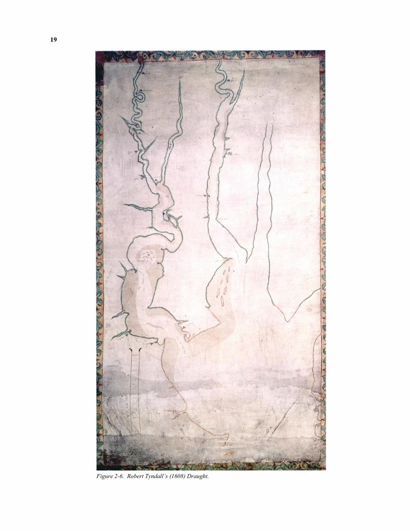
Efforts to identify Werowocomoco’s location draw on the Jamestown narratives and early maps of the region. Primary cartographic sources for Werowo-comoco’s location include Tindall’s 1608 Draft of Vir-ginia, the 1608 Zuñiga Map, and Smith’s 1612 Map of
Virginia. Tindall’s Draft (Figure 2-6) represents the
oldest surviving map prepared by a Jamestown colo-nist (Mook 1943). The enigmatic Zuñiga Map (Figure 2-7) was originally identified in a Spanish archive with an accompanying 1608 letter to Philip III of Spain from Don Pedro de Zuñiga, Spain’s ambassador to England, informing him of developments at James-town. The map appears to be a copy of a sketch John Smith sent to England along with his True Relation
(Barbour 1969:238). Smith’s formal Map of Virginia (Figure 2-8) was subsequently published in 1612 ac-companied by text describing the Powhatans. This map went through at least eleven revisions and multi-ple printings (Stephenson and McKee 2000:28). The Zuñiga, Smith, and Tindall maps are oriented such that west is at the top, reflecting a reference point from the Chesapeake Bay or the Atlantic Ocean.
Robert Tindall, one of the original colonists, ac-companied Christopher Newport to the villages of Powhatan and Werowocomoco (Barbour 1969:104-107). Tindall describes himself in a letter as “gunner to Prince Henry” and later references indicate he be-came a master mariner (Mook 1943:373). Tindall’s map includes a remarkable amount of accurate detail given its early date, depicting the James from its mouth to the village of “Poetan” (i.e., Powhatan) symbolized with an icon of a yihakan. “Prince Henry’s River” (i.e., the York) extends from its mouth to a lo-cation west of the Pamunkey – Mattaponi confluence. The village of “Pamonke” (i.e., Pamunkey) appears in a location west of this confluence in the vicinity of the contemporary Pamunkey Reservation. Downstream from the Pamunkey – Mattaponi confluence on the north side of the York Tindall depicted a second vil-lage labeled Poetan, this one signified by four Native houses. The shoreline at Poetan suggests a bay fed by three streams that enter in the vicinity of the village. Scholars (e.g., Brown 1890:151,188; Tyler 1901; Mook 1943:379) have long agreed that “Poetan” repre-sents another name for Werowocomoco given that the village was known primarily as Powhatan’s residence and Tindall was known to have visited the location. The only other York River settlement depicted on the map is “Chescoyak” (i.e., Kiskiack), a village that functioned almost as a gateway to Werowocomoco for the English who generally traveled by boat (Underwood et al. 2003). Consistent with other early maps, Kiskiack is placed on the southwest side of the York just upstream of its mouth. Recent research con-ducted by the William and Mary Center for Archaeo-logical Research (Underwood et al. 2003) has identi-fied the archaeological site of Kiskiack on the grounds of the Naval Weapons Station, a location that corre-sponds closely with Tindall’s Draft.
19
Figure 2-6. Robert Tyndall’s (1608) Draught.

20
Figure 2-7. Zuñiga’s (1608) Map of Virginia.

21
Figure 2-8. Smith’s (1612) Map of Virginia.

22
Miles
0 10 20
Nottoway
River
Blackwater
River
James RiverChickahominy
River
PamunkeyRiver
Mattap
oni River
Rappahanock River
Chesapeake Bay
N
York R
iver
Potomac River
WerowocomocoSite
(44GL32)
Meherrin River
Figure 2-9. Modern Map of Virginia Tidewater with Werowocomoco Site Location.
Tindall’s Draft lacks a scale, making distances on the map unclear. However, by using the approxi-mately 25 mile distance from the Mattaponi-Pamunkey confluence (today’s West Point) to “Tindall’s Point” (today’s Gloucester Point) as a gauge, distances from Poetan / Werowocomoco to other reference points on the York may be estimated accurately. The distance from Pamunkey village to the Pamunkey – Mattaponi confluence is approximately 5 linear miles or 10 – 15 miles by river. The distance from the Pa-munkey – Mattaponi confluence to Poetan / Werowo-comoco is 11 miles, while the distance from Poetan / Werowocomoco to Chescoyak / Kiskiack is approxi-mately 10 miles, and the distance from Tindall’s /
Gloucester Point is approximately 14.5 miles. These closely match distances from Purtan Bay as measured on a modern map of the York: Purtan is 11 miles be-low West Point, 11 miles above the Naval Weapons Station at Indian Field Creek, and 14 miles upriver from Gloucester Point. Tindall’s Map also accords well with the York River shoreline at Purtan Bay, which is fed by Purtan, Leigh, and Bland Creeks. Given this rather remarkable congruence, it is not sur-prising that scholars have long agreed that Purtan Bay represents the location of Werowocomoco (Brown 1890; Tyler 1901; Mook 1943; Lewis and Loomie 1953; Montague 1972; McCary 1981; Noël Hume 1994; Rountree 1990).
23
The Zuñiga Map adds additional detail to the York River landscape and expands the region covered to include areas to the south of the James described by Roanoke colonists as well as the Rappahannock and Potomac drainages. The map is consistent with Tin-dall’s in the relative placement of Jamestown, Werowocomoco, Kiskiack, and the Mattaponi-Pamunkey confluence. The Zuñiga Map includes the names of 68 villages Smith visited prior to June 1608 and additional names beyond the core James / York area apparently drawn from Native informants and from reports of the Roanoke Colony (Barbour 1969:238). Notations on the map include the expres-sion “20 miles aboue this C. S. [word crossed out] was taken” and dotted lines that trace the route on which Captain Smith was taken during his captivity. Several villages, including Kiskiack on the York, are identified as a scatter of dots (apparently depicting houses) lining the riverfront or embayed areas along the river. Addi-tional notation on the map includes the path Smith took during his December 1607 - January 1608 captiv-ity and scattered dots that appear to represent dispersed house locations in some Powhatan villages. At Werowocomoco the cartographer added an unusual set of symbols that appear as dots surrounding a double “D” shaped pattern. Within the two “D”s are three additional dots. The significance of this notation is unclear, but its large size clearly conveys its strategic importance alongside Jamestown.
Clearly a rough sketch drawn by someone with
much greater familiarity with the James and York than areas beyond these rivers, the document is particularly valuable as an informal map drawn by hand “in the field” rather than as a formal, engraved map. The map apparently reflects Smith’s recordation of a Chesa-peake landscape that he experienced first-hand more broadly than any other colonist while Powhatan re-sided at Werowocomoco. As Turner and Opperman (1993:72) have noted, the chaotic mix of dots, blobs, and odd marks on the Zuñiga map likely reflects Smith’s efforts to characterize an unfamiliar landscape of dispersed Native villages and community forms with which he was unfamiliar.
Smith’s later Map of Virginia clearly evolved out
of some version of the Zuñiga Map, though the later document had changed considerably as it was stan-dardized according to the formal mapmaking style of early seventeenth-century England. Where Smith had
experienced the Chesapeake landscape while passing through it (as indicated by the captivity trail on the Zuñiga Map) the formalized Map of Virginia effec-tively obscured the events leading to its creation. This concealment parallels a broader colonial process: be-ginning in the fifteenth century European colonists’ narrative accounts of new places were replaced by maps, documents that “colonized” space in the process (de Certeau 1984:118-122). Named places associated with varied topologies, histories, and memories were conflated through their inclusion on the same Cartesian plane. Smith’s Map of Virginia achieves this by ex-cluding much of the detail found on the Zuñiga Map, detail that may prove valuable in understanding the Chesapeake cultural landscape circa 1607.
Even so, Smith’s 1612 Map of Virginia is invalu-
able for its comprehensive coverage of the Chesapeake region and its accurate rendering of Virginia Tidewater geography. Distances on the map from Werowoco-moco closely match those on the Tindall Map. Werowocomoco is depicted as 14 miles upstream from Tyndall’s Point and 9 miles above Kiskiack. It is also 11 miles below the confluence of the Pamunkey River (labeled here as the “Youghtanund”) and the Matta-poni. The shoreline includes a bay and indentations suggesting three creeks. The map has, however, ex-cluded most of the notations found on the Zuñiga Map. Settlements are depicted as either points (ordinary houses) or yihakans (kings’ houses). The map implies a uniformity and spatial boundedness to Native settle-ments that fail to match the archaeology of Contact period settlements. Such settlements generally consist of dispersed villages with variable communal organi-zation (e.g., Lucketti et al. 1994; Mouer et al. 1992; Underwood et al. 2003), a topic we turn to below.
The cartographic sources may be combined with
other written references to Werowocomoco’s land-scape in order to determine whether Purtan Bay matches these descriptions. From Smith’s second visit to Werowocomoco we learn that that the village was situated on a shallow bay some 12 miles from Jamestown that was choked with “ooze” and fed by three creeks. In the text of his Map of Virginia (1986b:173) Smith modifies this distance slightly to 14 miles while Strachey (1953:57) places the distances at “some 15 or 16 myles.” Smith described the conflu-ence of the Pamunkey and Mattaponi rivers and Native settlements in this region, noting,

24
Figure 2-10. Distances Along the York River. The Purtan Bay area accords well with cartographic and ethnohistorical ref-
erences to Werowocomoco’s location.
York R
iver
Indian Field
Creek
(Kiskiack)
Purtan Bay
(Werowocomoco)
Gloucester Point
West
Point
Pamunkey
River
Mattaponi River
25 Mile Arc from
Pamunkey-Mattaponi
Confluence
11 Mile Arc North from
Indian Field Creek
(Kiskiack)
5 0 5 10
Miles
N
25 Mile Arc from
Purton Bay
(Werowocomoco)
Pamunkey Indian
Reservation

25
Where this river is divided the Country is called Pamaunke, and nourished 300 able men. About 25 miles lower on the North side of this river is Werawocomoco, where their great king inhabited when Captain Smith was delivered him prisoner; yet there are not past 40 able men. But now he hath abandoned that, and liveth at Orapakes by Youghtanund in the wilderness; 10 or 12 myles lower on the South side of the river is Chiskiak, which hath some 40 or 50 men (1986b:147).
Smith also offers some indications of Werowoco-moco’s layout by describing the Mamanatowick’s house as situated thirty score from the water. Whether this refers to a distance of 600 feet or 600 paces (or roughly 1500 to 1800 feet) is left unclear in the text, yet the implication is that Powhatan met Smith and Newport in a structure spatially removed from the riv-erfront.
Smith’s references to the shallow bay fed by three
creeks fits the Purtan Bay area well. Purtan Bay is located 13 miles northeast of Jamestown, again, ac-cording with the Map of Virginia. On first glance, Smith’s reference to Werowocomoco as 25 miles be-low “where the river is divided” is puzzling. Traveling 25 miles below the Pamunkey – Mattaponi confluence on the York takes one to Gloucester Point. The three early seventeenth-century maps of the area described above consistently place Powhatan villages (including Werowocomoco) well upstream of this location. In fact, if the village of Kiskiack was indeed roughly 10 to 12 miles downstream of Gloucester Point that would place it at the York River mouth. Returning to the text, though, it is clear from the first sentence in the passage that Smith is referring to the “Country called Pamunkey” rather than the confluence of the Matta-poni and Pamunkey rivers (Montague 1972). The core of Pamunkey territory was located some distance west of the Pamunkey River’s mouth. In fact, the village labeled “Pamonke” on the Tindall’s map of the York was located approximately 21 – 26 miles upstream from what is today Purtan Bay.
Taken together, the documentary and cartographic
sources leave no doubt that the Purtan Bay vicinity represents the most likely location of Werowocomoco (cf. Turner et al. 2005 for a more detailed discussion).
Werowocomoco as a Point of Colonial Intersection
The early colonial history at Werowocomoco indi-cates that the village served as a central stage for con-tact-era political theater directed by the Mamanatowick and, at times, by the colonists. Chief Powhatan or-chestrated the colonists’ exposure to Powhatan ritual,
exchange, and the built environment such that Werowocomoco emerges from the documents as a place of considerable power. The colonists were duly impressed by the Mamanatowick’s retinue, his resi-dence, and the volume of maize obtained through ex-change with the Powhatans at the village. Across ver-bal discourse, exchange, and ritual, the two communi-ties negotiated with one another in a classic example of inter-cultural contact. Read carefully, this history runs counter to the notion that the early colonial Chesa-peake entailed simply a dichotomous confrontation of English colonizer and Powhatan Native, each con-ceived as bounded, homogenous entities existing largely independent of one another and of the seven-teenth-century Chesapeake. An alternative conception of Werowocomoco emphasizes the village as a space of struggle and negotiation that essentially created and sustained new colonial identities and political strate-gies amidst the changing relations of colonialism.
The most prominent events involving such an in-
tertwined colonial relationship occurred when Powhatan effectively transformed Smith into a Powhatan weroance and when the colonists struggled to crown Powhatan as a vassal of King James. Powhatan’s efforts to transform Smith may or may not have involved his daughter Pocahontas. For over a century, scholars have debated whether or not Poca-hontas truly did “rescue” Smith during the 1607 winter while more recently researchers have focused on the significance of the overall captivity narrative to Powhatan culture and history. From the mid-nineteenth century historians have suggested that Smith invented or exaggerated Pocahontas’ role in the captivity narrative to enhance his importance and to enliven the story (Barbour 1986:lxiii-lxiv). Others have pointed out that notions of romantic involvement between Pocahontas and Smith are likely overblown given Pocahontas’ young age. Recently Rountree (1990:38-39) and Townsend (2004:52-56) have dis-missed Pocahontas’ purported role in the event based partly on Smith’s silence on the matter in his initial report. Rountree adds that the overall narrative, during which Powhatan first feasted and then reportedly planned to bludgeon Smith, appears inconsistent and is therefore doubtful. Townsend notes that on four dif-ferent occasions during his travels in Europe and North America Smith reported that a young woman inter-vened on his behalf during a moment of peril, raising questions as to the veracity of all of these events.
Whether or not Pocahontas truly played the spe-
cific role described in Smith’s Generall Historie may not be particularly important. More significant, per-haps, is the idea that during his period of captivity

26
Smith was adopted as a Powhatan, an interpretation that has received some consensus among scholars (e.g., Barbour 1970:23-26; Rountree 1990). Williamson (1992) and Gleach (1997:120) have both developed this theme. Williamson suggests that the Powhatans adopted Smith in order to establish a political alliance with the English cemented through the creation of a father-son relationship between Powhatan and Smith. In this reading, Powhatan’s offer of Capahosic and of abundant corn placed him in the superior position as creditor to the English. Rather than a potential love interest, Pocahontas thus became Smith’s sister, an interpretation which accords well with aspects of their subsequent interaction. Gleach similarly suggests that Powhatan sought to adopt Smith and the English col-ony through these events in and around Werowoco-moco. He reads the captivity narrative as a protracted rite of passage in which Smith was separated from his old status through capture, held in a liminal state as he was paraded through various villages, and finally rein-tegrated into his new status as a Powhatan weroance at Werowocomoco (cf. Turner 1967). As part of this process, the “divination” at the initial stage of this process was in fact designed to incorporate a danger-ously liminal Smith safely into the Powhatan world through the mimetic process of map making.
Read in this light, Smith’s first experience at
Werowocomoco represents Powhatan’s efforts to, in effect, colonize the English by creating lasting social and political dependencies through the metaphor of kinship and the material of food and prestige goods. In a similar vein, the English sought to confer a politi-cally-subservient status on Powhatan through the power of ritual in his “coronation” ceremony. In both instances, many of the symbolic and material cues of the intended relationships were no doubt misunder-stood. Nonetheless, the struggles and negotiations between the English and Powhatans from 1607 to 1609, reflected in long speeches, material exchanges, tactical maneuvers, and in sacred ritual, meant that Werowocomoco served as the locus of new social con-nections and novel cultural meanings central to early colonial history in the Chesapeake. Powhatan sought copper, iron tools, and swords from the English while the colonists desperately needed food. By obtaining symbolically powerful prestige goods, Powhatan en-hanced his ability to exercise regional authority and, briefly, to expand this authority. Judging from his rhetoric at Werowocomoco, the arrival of the English, “strangers” defined by their profound difference, partly shaped Powhatan’s efforts to create a “Powhatan” so-cial identity that included all residents in the Virginia Tidewater.
Today we follow the English colonial accounts and use the convenient shorthand label “Powhatan” to refer to the residents of the Virginia Tidewater, yet a close reading of the Jamestown accounts indicates that the Virginia Algonguians by no means comprised a bounded, uniform society sharing uniform, agreed upon political strategies vis-à-vis the colonists. In fact, Native references to a “Powhatan” social identity come almost exclusively from Wahunsenacawh himself. By enhancing Powhatan’s power and by giving the Vir-ginia Algonguians a reason to unite as “Powhatans”, the presence of the English altered the Native culture history in ways that are masked by the use of the Powhatan label.
The Materiality of Colonial Entanglements at
Werowocomoco
The early colonial history at Werowocomoco had a material component that reveals much about Powhatan cultural practices and symbolic systems. As outlined in the narrative accounts, Powhatan estab-lished the structure of exchange relations during Smith’s captivity at Werowocomoco. Powhatan feasted Smith while he was held captive then promised to feed the remainder of the Jamestown colonists if they reciprocated with large guns. This relationship was structured around the Powhatans providing food for items with symbolic resonance (including copper and glass beads) and those with practical uses (including swords and iron tools). As the recipient of such valuable prestige items, the Mamanatowick held a position of power over the colonists. The colonists’ repeatedly failed to appreciate the social consequences of these exchanges (Mallios 1998). During the second encounter at Werowocomoco, Newport initially sought to bargain with Powhatan in order to obtain as much corn as possible while surrendering as little of the cop-per and glass beads the Powhatans sought. In chastis-ing the English during this event, Powhatan sought to educate the colonists about gift exchange and his in-herently superior position as the Mamanatowick in the resulting relationships. In fact, Smith and Newport’s efforts to obtain corn from Werowocomoco in ex-change for copper kettles, iron hatchets, and glass beads reveal just how differently the Powhatans and the English conceptualized such trade. The Powhatans’ approach to exchange with the English emphasized an etiquette of gift giving that reflected and created social relationships between giver and re-ceiver (Mauss 1954). As noted in Mallios’ (1998) study of exchange relations during the Contact period, by seeking to maximize their returns the English (and particularly Smith) appear to be largely unaware of the social webs that suspended exchange within the Powhatan world.

27
Also apparent in these exchanges is a Powhatan
color symbolism defining value and meaning in terms quite different than those of the colonists. During the Contact-era Chesapeake, copper objects represented a symbol and source of power (Gallivan and Klein 2004; Hantman 1990; Potter 1989:153-4). Copper body adornment, in particular, represented the province of weroances and priests – i.e., those capable of control-ling its power (Gleach 1997:56). Copper’s power de-rived from its origins in spiritual beings at the edge of the world that controlled forces of nature (Miller and Hamel 1986). The red metal mediated between white and black, a pattern of color symbolism observed in Powhatan ritual and numerous events at Werowoco-moco (Hamel 1983; Miller and Hamel 1986; Pietak 1999). In Native societies, red could represent both a soul’s liminal state and the substance that resolved that liminality (Claassen 1998:206). By contrast, white beads – shell or glass – linked the underwater world, the sky, fertility, and individual and social well being (Claassen 1998:205-6; Miller and Hamel 1986:324-5; Pietek 1999:12). In Hamell’s historical reconstruction
of bead symbolism among Northeastern Indians, white shell represented long life and success in hunting and fishing, warfare, and courtship (Hamell 1983:25). The blue glass beads Smith traded so effectively at Werowocomoco likely figured into Powhatan color symbolism as a color akin to black (Gleach 1997:56). The Mamanatowick, Powhatan warriors, and ritual participants were often adorned in black and red. In the Huskanaw, the Powhatans’ male right of passage, boys were painted black during the phase of the ritual in which they were said to be dead. As with red and white, black’s symbolic connotations likely varied according to context, but it appears for the Powhatans to be associated with death and with sacred power.
Powhatan’s efforts to acquire copper objects repre-sented a critical strategy as he consolidated his central role in the regional political economy. Prior to the arrival of Jamestown colonists who brought large amounts of copper for trading, the Monacans probably served as a source of this symbolically-potent material for the Indians of the Coastal Plain (Hantman 1990). Powhatan initially sought to monopolize the flow of
The following summary of Werowocomoco’s archaeological context discusses late precontact devel-opments in the Virginia Tidewater before turning to studies of archaeological sites, material culture, and regional-scale patterns associated with the Contact period. We conclude by summarizing a recent effort to reinterpret Chesapeake archaeology and ethnohistory. This discussion draws heavily from previous summa-ries published elsewhere (Gallivan 2003:11-43; Turner 1992; Hodges 1993).
Late Precontact Developments in Tidewater Archaeologists’ interpretations of the Powhatan
chiefdom generally invoke a long-term process whereby acceleration of population growth and the intensification of subsistence production spurred the formation of complex polities. Much of this research draws upon a combination of regional settlement pat-tern studies and ethnohistorical analysis, quite different sources of historical knowledge whose linkage poses epistemological challenges.
Regional archaeological survey in several areas
suggests to archaeologists that the chiefdom societies of the Chesapeake—most prominently the Powhatans—emerged out of a social transition
whereby Middle Woodland (500 B.C. - A.D. 900) “harvesters of the Chesapeake” became Late Wood-land (A.D. 900 - 1500) village agriculturalists (Potter 1993:139; Binford 1964; Turner 1976; Dent 1995). Prior to this transformation, a focus on estuarine re-sources and settlement along major waterways in the Coastal Plain began during the Late Archaic (3000 B.C. - 1000 B.C.) and Early Woodland (1000 B.C. - 500 B.C.) periods throughout the Middle Atlantic Coast region, likely driven by a subsistence emphasis on shellfish and anadromous fish. Paralleling this trend, an Early Woodland shift to lowland, estuarine areas is apparent in regional settlement patterns (e.g., Steponaitis 1987). Detailed analysis of shell midden formation has produced similar evidence of increasing exploitation of oysters during the Late Archaic and Early Woodland periods in the Potomac River basin (Waselkov 1982:207). Archaeological evidence of intensive shellfish exploitation is contemporaneous with a stabilization of the Chesapeake region’s shore-lines, making it difficult to separate the possible cul-tural transition from natural processes that heighten the visibility of post-Middle Archaic shoreline sites and submerged or destroyed earlier ones (Klein and Klatka 1991:165). Regardless of the timing of its commence-ment, extensive use of estuarine environments was in
Archaeological Research and Werowocomoco

28
place in the Virginia Coastal Plain by the later centu-ries of the Middle Woodland period.
Survey data along the south shore of the Potomac
River record late precontact settlement patterns that oscillated between population concentration and dis-persal (Potter 1993). During the early Late Woodland centuries, large sites disappeared as newly agricultural populations dispersed in intermediate-sized settlements along the floodplains and neck lands of the Coan River. For the period between A.D. 1300 - 1500 a settlement pattern matching that described in colonial accounts emerged, with a large and internally dis-persed village along the Coan River. The villages of the terminal Late Woodland contained a diversity and abundance of artifacts in the context of midden depos-its, suggesting settlements occupied for a substantial portion of the year and favored locations which drew populations for multiple reoccupations. The survey data also suggest that population growth accelerated with the establishment of relatively sedentary commu-nities during the final precontact centuries.
Interpretations of such regional settlement patterns
generally envision the development of complex poli-ties from the interplay between high population densi-ties, social circumscription, hostilities across the fall line, and control of important resources and communi-cation arteries by inner Coastal Plain groups (Potter 1993:168; Binford 1964; Turner 1976). This control likely conveyed a selective advantage on groups like the Powhatan on the James and the Patawomekes on the Potomac in the sixteenth century’s competitive social climate. Some researchers have suggested that chiefdom polities ultimately arose as a solution to so-cial and ecological problems posed by the sixteenth century cultural landscape in the Chesapeake (e.g., Potter 1993:149). In the Potomac River Valley the palisaded Potomac Creek (44ST2) and Accokeek Creek (18PR8) sites appear as fortified settlements of Piedmont emigrants in a hostile inner Coastal Plain (Potter 1993:120-121; Blanton 1999). The lack of subsurface storage at these locations raises the possi-bility that chiefs were present who controlled surplus maize production in above ground cribs (Potter 1993:120-121). In some Eastern Woodlands settings, a political economy in which chiefs dominated house-hold production resulted in the absence of subsurface storage pits (DeBoer 1988; Ward 1985).
The inner Coastal Plain represented the primary
ecological setting for chiefdom emergence in the Chesapeake with its dense population concentrations during the Late Woodland period (Turner 1976:68, 205). Due to the high agricultural productivity of
floodplain soils and the increased numbers of settle-ments adjacent to rivers, competition for fertile land may have induced warfare, as indicated by the pres-ence of fortified floodplain sites in the final Late Woodland centuries. The demographically large inner Coastal Plain groups who controlled Piedmont / Coastal Plain exchange appear to have prevailed in this hostile context, which spurred the formation of com-plex societies (1976:267).
The increasingly-limited spatial distribution of
Late Woodland (A.D. 900 - 1500) ceramic wares com-pared with Middle Woodland (500 B.C. - A.D. 900) patterns appears to have paralleled increased territori-ality critical to the late precontact emergence of re-gionally-distinct Native polities (Turner 1993). By the end of the Middle Woodland period, shell-tempered Mockley ceramics, generally with cord-marked sur-faces, appeared throughout the Virginia Coastal Plain. The Townsend tradition developed after (and possibly out of) Mockley at the beginning of the Late Wood-land period, with most of these shell-tempered ceram-ics exhibiting a fabric-impressed surface. During the opening centuries of the Late Woodland period, Rap-pahannock fabric-impressed pottery, a sub-category of the shell-tempered Townsend series, occurred across much of the coastal Middle Atlantic. By the end of the Late Woodland period this widespread uniformity was replaced by ceramic types with more restricted distri-butions. In Tidewater Virginia these included Roa-noke ceramics—shell-tempered and simple-stamped—that dominated the lower James River valley. Sand and crushed quartz-tempered Gaston ceramics with simple-stamped surfaces appeared in the inner Coastal Plain of the James and York River drainages. Rappa-hannock fabric-impressed pottery continued in use throughout the lower York, Rappahannock, and Poto-mac. Sand and crushed quartz-tempered Potomac Creek pottery, a ware with distinctive rim decorations, occurred in the Potomac’s inner Coastal Plain.
Several excavations have produced information
regarding Coastal Plain burial practices. Where ethno-historical accounts clearly distinguish between ritual practices associated with the burials of Powhatan com-moners and chiefs, Coastal Plain mortuary archaeology generally does not record the clear expression of social differentiation until the Contact period. Ossuary bur-ial, which comprises the final step of a two-stage ritual process, represents the most common mortuary prac-tice of the Late Woodland Coastal Plain (Boyd and Boyd 1992:261-263; Curry 1999; Jirikowic 1990; Turner 1992). While colonial accounts mention both primary interments and secondary burial ritual, it is not entirely clear whether either practice conferred a
29
higher status. The accounts are consistent in noting that chiefly interments occurred above ground in tem-ples reserved for this use and attended by priests. Dis-articulated bone bundles, articulated burials, and cre-mated remains have all been identified in Coastal Plain ossuaries, which usually date to the final Late Wood-land centuries and the early colonial era. Individuals from all age groups and both sexes appear within ossu-aries, providing no evidence of the exclusion of social categories from this institution.
Funerary objects rarely accompany precontact
ossuary burial, though the contact era “Paspahegh” site (44JC308) located near Jamestown (most likely the Paspahegh village of Cinquoteck) did include ossuary burials associated with European-produced copper artifacts (Lucketti et al. 1994:164). Amateur archae-ologists uncovered a clearly high status burial contain-ing copper and shell funerary objects in the Potomac drainage, again dating to the early colonial era. The increased occurrence of copper in ossuary burial on the Potomac Neck after A.D. 1630 may signal widespread access to this material and the end of chiefs’ monopoli-zation of the prestige goods trade in copper (Potter 1989). Early colonial accounts emphasize the place-ment of shell beads and copper objects with the high status burials in the Coastal Plain. The paucity of pre-contact evidence of high status burials may be a prod-uct of the Powhatans’ practice of placing chiefs in above ground temples which have escaped archaeo-logical detection or the limited sample of excavated precontact burials. In support of the latter possibility, a Late Woodland component at the Great Neck site (44VB7) exhibits a notable exception to the pattern in which precontact burials lack clear evidence of status differences. Excavators identified three forms of Great Neck burial associated with a fifteenth-century pali-saded village, one of which incorporated copper funer-ary objects (Hodges 1993).
Generally, then, late precontact archaeological
studies record a social transformation in the Coastal Plain from a foraging and hunting economy drawing upon the rich and diverse Chesapeake estuary to a sub-sistence economy which complemented these re-sources with maize-bean-squash horticulture concen-trated in floodplain locations. By the final precontact centuries, relatively large communities dotted the river banks of the Coastal Plain, with palisaded settlements near the fall line. Colonial accounts likewise note the presence of fortified settlements on the James, includ-ing Powhatan village where the man who would be-come paramount chief was born. An overall pattern of late precontact increase in population density is evi-dent, with an acceleration of population growth in the
final precontact centuries. Political complexity most likely arose near the fall line amidst rich and diverse resources, high population densities, and a proximity to the trading and raiding Piedmont Indians.
Excavated Protohistoric and Contact Period Sites
Archaeologists have investigated relatively few sites in the Virginia Tidewater dating to the early sev-enteenth-century Contact period or the Protohistoric sixteenth century, an era marked by intermittent or indirect encounters between Natives and European colonists. As summarized by Hodges (1993) and Turner and Opperman (1993), several small-scale ex-cavations conducted prior to 1990 identified evidence of European trade items in Native contexts that date to the Protohistoric and Contact periods. Recent studies that offer a more comprehensive glimpse at Tidewater settlement organization and material culture during this period include excavations along the James River at Jordan’s Point and near the Chickahominy River mouth and along the York River on the Naval Weap-ons Station.
Investigations in the vicinity of Jordan’s Point, a
small prominence reaching into a bay formed by the confluence of the James and Appomattox rivers, have identified Native American and European colonial settlements from the sixteenth and seventeenth centu-ries (e.g., Mouer et al. 1992; McLearan and Mouer 1994; Morgan et al. 1995). Virginia Commonwealth University’s large-scale excavations at the Jordan’s Journey sites documented an early seventeenth-century English settlement superimposed on a dispersed, Pro-tohistoric Native American settlement. Jordan’s Jour-ney graphically records the early seventeenth-century English strategy of establishing plantations in the same prime agricultural land that previously had been cleared and farmed by Native Americans (Turner 1993:87). The Indian settlement at Jordan’s Point, likely a Weyanoke village, consisted of houses, pit features, and burials spread around Jordan’s Point be-yond the boundaries of several numbered archaeologi-cal sites. The sites yielded evidence of approximately 30 well-defined domestic structures. The structures vary widely, though most are elliptical in plan and lack evidence of associated storage pits, burials, or other sub-surface features. No radiocarbon dates are avail-able from the sites, yet the predominance of Gaston simple-stamped ceramics, the lack of European trade goods, and the spatial correlation of the Indian settle-ment with the early seventeenth-century English one suggests that the village has a sixteenth-century date immediately prior to Jamestown’s settlement (Mouer et al. 1992:161).

30
Large-scale excavations at a site located along the Chickahominy River near its confluence with the James uncovered extensive evidence of a village dat-ing to the early years of the Jamestown Colony. Based on map projections, the settlement is most likely the Paspahegh village of Cinquoteck (Lucketti et al. 1994). Located five miles from Jamestown, the settlement offers some of the best archaeological evidence of a group under Powhatan’s influence living in close prox-imity to Jamestown. The Native community residing at the site interacted intensively with English colonists, as reflected in the written accounts and in the presence of European copper artifacts in burial contexts. Radio-carbon dates, the predominance of Roanoke simple-stamped ceramics, and the absence of artifacts diag-nostic of earlier periods indicate that Cinquoteck’s archaeological deposits date almost exclusively to the early colonial period (Lucketti et al. 1994:183).
The village, only a portion of which was exca-
vated, was organized according to a dispersed settle-ment pattern of houses interspersed with burial grounds. The excavations identified 48 structures across the site. With the exception of 25 burials, the site lacked pit features dating to the Contact period. Two of the largest structures at the site contained inter-nal partitions conforming to ethnohistoric descriptions of chiefs’ houses (Lucketti et al. 1994:307). In addi-tion, the varied mortuary patterning at the site suggests the expression of social differentiation. Copper funer-ary objects were included with three of the 21 exca-vated burial features, prompting the excavators to sug-gest that the site’s mortuary rituals expressed at least two distinct levels of social ranking. An analysis of the copper ornaments associated with human burials indicates that most of the objects came from European sources.
Recent investigations by the William and Mary
Center for Archaeological Research (WMCAR) at the Naval Weapons Station Yorktown on the York River have resulted in the most intensive and comprehensive archaeological survey in the Virginia Tidewater (Underwood et al. 2003). Of the 366 sites identified on the property, at least 20 have yielded evidence diag-nostic of the protohistoric sixteenth century or the early seventeenth-century Contact period. The Naval Weapons Station’s York River shoreline includes areas that correspond with the location of the Powhatan vil-lage of Kiskiack as depicted on the Tindall, Zuñiga, and Smith maps. Drawing from such cartographic sources, various researchers (Mook 1943; McCary 1981) have long agreed that Kiskiack lies on this por-tion of the York. WMCAR’s recent testing of sites on an embayment of tidal creeks along the York added a
carefully-documented set of archaeological evidence that confirms Kiskiack’s location. Recovered artifacts included items believed to have originated at James-town, including pieces of sheet copper, lead shot, and English flint fragments. These materials came from unplowed, midden contexts associated with small, in-tensively occupied areas that were likely part of a dis-persed settlement organization. Compositional analy-sis of the copper, presented to the public in the summer of 2004, indicated that the material matched the signa-ture of copper sheets from Jamestown. These results establish a temporal and material link between James-town and Kiskiack, paralleling documentary accounts that place Jamestown colonists in Kiskiack on numer-ous occasions (often on the way to Werowocomoco). The discovery of Jamestown copper in non-burial con-texts offers unprecedented evidence of the materials’ widespread distribution in the Chesapeake following a breakdown in Powhatan’s control of trade with the English, supporting arguments made by Potter (1989) some years ago.
No discussion of Contact period settlements in the
Virginia Tidewater would be complete without men-tion of the excavations conducted by the Association for the Preservation of Virginia Antiquities at James Fort itself (Kelso and Straube 2004). The recent redis-covery and decade-long study of the fort has yielded an incredibly rich body of evidence from the first years of the Jamestown colony, the years coinciding with colonial interactions at Werowocomoco. The James-town Rediscovery team has uncovered a number of features associated with the triangular James Fort, in-cluding several hundred feet of palisade walls, the east cannon bulwark, and several house cellars. The initial field seasons at Jamestown focused on locating the Fort and confirming that a substantial portion remained on dry land and had not been inundated by the rising James River (Kelso and Straube 2004:11).
Subsequent expansion of the excavations has ex-
posed materials from an early Fort period (1607 – 1623) that contrasts considerably with contexts dating to the Post-Fort period (1624 – 1660+) (Mallios and Straube 2000:27). The archaeological record of the Fort period is characterized by substantial amounts of copper scraps, glass beads, arms and armor, and wild fauna. Fully half of the pottery dating to this period is Native. The Fort period assemblage speaks to regular, bilateral exchanges involving the movement of copper and glass beads to the Powhatans and Native ceramic vessels (containing food) and wild fauna that flowed to the colonists (Mallios and Straube 2000:29). Material from contexts dating to a transitional era at the end of the Fort period included an even greater percentage

31
(70% of the assemblage) of Native ceramics while wild fauna continued to dominate the assemblage. Fewer copper and glass beads occurred in these con-texts than in the preceding period. The Post-Fort pe-riod included relatively few Native ceramics (20%), little copper, and few glass beads. Domesticated fauna dominates the Post-Fort assemblage. These trends point toward a pattern in which material culture associ-ated with Native communities was at first pervasive in the Fort. Subsequently, exchange relations that had been bilateral became unidirectional. Food apparently moved from Native communities into the Fort while fewer trade goods moved in the opposite direction. Finally, evidence of even these connections dwindles in contexts post-dating 1623. For the first 16 years of Jamestown, though, the archaeology of the Fort re-cords a thoroughly hybridized context. In fact, the prevalence of Native pottery at the Fort during the early seventeenth century parallels references in the documentary records to Powhatans residing at the Fort, possibly including Indian women who lived with colo-nists (Mallios and Straube 2000:38-39).
Artifact Studies
Studies of Contact period material culture have focused on Native ceramic traditions (e.g., Mouer et al. 1999) and trade items of the early colonial era (e.g., Potter 1989; Hantman 1990). A recent series of inno-vative analyses spawned by the excavations at James-town (Hudgins 2004; Mallios and Emmet 2004; Blanton et al. 2001; Lapham 2001) and at the Native village of Kiskiack on the York River (Blanton and Hudgins n.d.) have added nuanced understandings of the material culture from this period. Together these studies offer promising directions for understanding the ways that pottery, stone tools, copper objects, and glass beads expressed and channeled the hybridized social entanglements of the early colonial era.
Not surprisingly, the ceramic traditions of Native
communities in early colonial Tidewater Virginia re-flect both continuities and changes from precontact styles. A trend in Townsend and Potomac Creek ce-ramics toward plain and smoothed-over surfaces is apparent in a number of sites dating to the sixteenth and early seventeenth centuries (Hodges 1993:19-20). This trend may in fact have led to the development of the “colonoware” tradition of low-fired, hand-built earthenware with plain or burnished surfaces. Though these ceramics, which include a wide range of attrib-utes (Henry 1980), are commonly dated to the latter half of the seventeenth century when Werowocomoco had long-since ceased to be a Native settlement, the early seventeenth century represents a critical period of transformation in Native ceramic that probably set the
stage for the subsequent appearance of colonoware. Initially defined as “Colono-Indian ware”, these ce-ramics typically combine elements of European vessel form with the production methods, pastes, and tempers of Native American wares (Noel Hume 1962). Draw-ing on the well-documented history of pottery produc-tion on the Pamunkey Reservation in King William County, Noel Hume concluded that colonoware cham-ber pots, plates, cups, porringers, and pipkins were likely produced by Native potters and marketed to English colonists and (eventually) Euro-Americans.
In subsequent archaeological research, several
historical archaeologists (Ferguson 1992; Deetz 1988) have called this interpretation into question. Fergu-son’s research on South Carolina plantation sites iden-tified a clear association between colonoware and the quarters of enslaved Africans. Building on Ferguson’s research, Deetz suggested that the amount of colonoware in Virginia exceeded the production capac-ity of Virginia Indians. Since colonoware ceramics appear in the archaeological record in large numbers beginning in the late seventeenth century, a period that saw a sharp increase in the numbers of enslaved Afri-cans brought to the colony, Deetz argued that it was likely slaves who produced and used the ware.
A number of archaeologists (e.g., Hodges 1993;
Mouer et al. 1999) have, in turn, challenged this inter-pretation with evidence linking locally-made earthen-wares of the historic period with long-standing Native ceramic traditions. In northern Virginia, Camden ware appears in seventeenth and eighteenth century Native settlements and shares attributes with precon-tact Potomac Creek ware and colonoware (MacCord 1969). The coastal region of the James and York riv-ers contains “Colono-Indian ware” matching Noel Hume’s classic descriptions—shell-tempered, plain or burnished—that is similar to the Townsend and Roa-noke wares found in the region prehistorically. A sur-vey of the Pamunkey Indian Reservation identified several sites with colonoware pottery, including a pit containing abundant colonoware, unfired clay tem-pered with shell, and pearlware, linking this tradition to historic-era Virginia Indians (McCarthy and Hodges 1980). To the south, Courtland pottery with fine sand temper, plain and burnished surfaces, and European vessel forms appears on seventeenth- and eighteenth-century Nottoway and Meherrin Indian settlements (Binford 1964). Early Courtland vessels resemble the protohistoric Branchville type and exhibit a trend from plain surface treatments during the seventeenth century to burnished surfaces during the eighteenth century (Mouer et al. 1999:84-85). Noting that historical ar-chaeologists in the Chesapeake have a “blind spot” that

32
masks the contributions of Native Americans during the historic era, the eight authors of Mouer et al. 1999 argue convincingly that Native contributions to the colonoware traditions of the Chesapeake cannot be so easily dismissed.
As noted above, copper played a critical role in
early colonial entanglements centered on Werowoco-moco and Jamestown. The recent identification of scrap copper at Jamestown, and of Jamestown copper in Native village sites on the James (Cinquoteck) and the York (Kiskiack) indicates that this material may allow archaeologists to trace Contact period exchange alluded to in the documentary accounts. Potter’s (1989) identification of the copper trade’s historical dynamics and Hantman’s (1990) recognition of its political importance have pointed out ways that Con-tact period interaction has a fundamentally material dimension. Mallios (1998) has added a study of early exchange relations involving Europeans and Virginia Algonguians, interaction that often included copper objects. His interpretations of these historical data suggest that Native actions that included gift giving, hospitality, admonishment, theft, and violence re-sponded to coherent and consistent cultural logics that the English often missed. Subsequent archaeological research (Mallios and Emmett 2004; Hudgins 2004) building on these arguments has added important de-tails. The inundation of copper in the Chesapeake fol-lowing Wahunsenacawh’s 1609 departure from Werowocomoco undermined Powhatan authority structures and contributed to the social havoc of the Contact period (Mallios and Emmett 2004). Hudgins’ (2004) archival research and recent spectro-graphic studies of copper at Jamestown and Kiskiack has added several new elements to the story of copper during the Contact period. In addition to being a criti-cal item of trade with Native communities, scrap cop-per at Jamestown served as an ingredient needed in colonists’ efforts to identify zinc among the minerals present in Virginia. As an essential component in brass, zinc was critical for early English industrial pro-duction involving cast items such as cannons, caul-drons, and bells. In short, the archaeological recovery of copper opens a range of research avenues in the study of the early colonial Chesapeake.
Regional Studies of Contact Period Landscapes
Several efforts to characterize the Contact period landscape have contributed insights critical to under-standing social interaction at the communal and re-gional scales. Turner and Opperman (1993) laid the foundations for characterizing communal organization in the Contact period Chesapeake with their compila-tion of Native and English settlement data from the
Virginia Company period (1607 -1624). Turner and Opperman note that Native settlements of the Late Woodland and Contact period across the Chesapeake were often internally dispersed affairs that are difficult to recognize archaeologically. In fact, the Cinquoteck site mentioned above was not recognized as the sprawling Contact period site that it is until large areas were stripped of plow zone soils, exposing an array of features. Nucleated communities are present in the Contact period, yet Turner and Opperman’s efforts to account for the settlements on Smith’s Map of Virginia with identified archaeological sites indicates that they are atypical. In addition, the frequent reoccupation of favored locations plus the considerable diversity of Native settlement forms complicates efforts to identify and characterize Native villages.
A cultural ecological study that addresses re-
gional-scale dynamics of the Contact period has dem-onstrated that the worst droughts of the past 800 years coincided with the failures of the late sixteenth-century Roanoke Island's “Lost Colony” and the early seven-teenth-century “starving time” at Jamestown (Blanton 2000). Researchers analyzed bald cypress tree rings recovered from southeast Virginia to construct a tem-perature and precipitation history during the period from A.D. 1185 - 1984 (Stahle et al. 1998). This inno-vative analysis concluded that extreme drought must be considered as one of the factors in the failure of the Roanoke colony and the starvation of early Jamestown colony. Documentary accounts point to the sensitivity of Tidewater Indians’ subsistence system to prolonged periods of low rainfall. Droughts forced Roanoke and Jamestown colonists to depend upon a badly strained Native subsistence economy for provisions, as alluded to in colonial histories. The recent tree-ring research adds a detailed climatological context for the Roanoke Colony’s failure and the high mortality rates at James-town.
The study also indicates that year-to-year fluctua-
tions in temperatures and rainfall have long character-ized the Chesapeake region, fluctuations that required Native Americans to develop social means of alleviat-ing resource shortfalls. The bald cypress tree ring re-cord that Blanton and colleagues evaluated indicates that substantial annual fluctuation in rainfall has char-acterized the most recent 800 years in the region. Short term climatic events, such as the droughts identi-fied in the study, become critical in the fine-grained analysis of historical sequences captured by the docu-mentary record of the late sixteenth and early seven-teenth centuries. Spanish Jesuit missionaries’ descrip-tions of Virginia in 1570 as a land “chastened” with famine and death (Lewis and Loomie 1953:89) hint at

33
the impact of periodic droughts in the region. While such events may be implicated in long term culture change, they must be viewed in tandem with evidence from the social environment. As in other regions (e.g., Braun and Plog 1982), technological and social prac-tices related to storage, inter-group alliance, and re-gional exchange played a role in limiting the impact of unusual climatological conditions, since a considerable degree of temperature and precipitation variance was normal in the region.
As mentioned above, Blanton and his WMCAR
colleagues (Underwood et al. 2003) contributed an-other important body of data illuminating key aspects of the Contact period regional landscape with their survey at the Naval Weapons Station Yorktown. Com-bining their results with previous survey at the installa-tion, the study identified 366 sites across 10,000+ acres of riverine and upland areas. As the surveyed area is a mere 10 miles from Purtan Bay this study provides a rich, long-term context for settlement patterns associ-ated with the Werowocomoco site. The survey identi-fied an increasing number of sites through time with dramatic increases at the outset of the Middle Wood-land period (500 B.C. – A.D. 900) and during the Pro-tohistoric period (A.D. 1500 – 1607). Late Woodland (A.D. 900 – 1500) sites are distinguished by middens and features pointing toward greater sedentism. Until the Protohistoric period, site locations frequently keyed off of estuarine resource locations that shifted over time with rising sea levels (Blanton 1996). The survey identified a remarkable number of Protohistoric sites, including settlements that were generally located closer to the York River than those of earlier periods. WMCAR’s confirmation of Kiskiack’s location, hinted at previously (McCary 1981), represents a major con-tribution of the study. In addition, the excavations of household clusters associated with Kiskiack produced evidence conforming to Turner and Opperman’s (1993) model of internally-dispersed Powhatan com-munities.
A Recent Reinterpretation
Recent research drawing on the archaeological record of the James River valley by one of the authors of this volume (Gallivan 2003) has offered several new ideas regarding the origins and dynamics of the Powhatan chiefdom and the Monacan Indian polity of the Virginia Piedmont. The departure point for this study was the contrast between the written accounts of the Powhatans and Monacans and the archaeological record of the region. As noted by Turner (1986), the early colonial accounts of these societies emphasize social relationships involving political hierarchy while the region’s archaeological record lacks some attrib-
utes typically associated with hierarchical chiefdom polities. Other regions of Native North America with such polities, notably the Mississippian Southeast, include evidence of monumental architecture, ranked site sizes, sharply differing burial practices, and high volumes of symbolic prestige good exchange. The James River study indicates that the complex polities of the Chesapeake region developed with a culture history distinct from that of other regions. As a result, understanding the Powhatan chiefdom requires an ap-preciation of political dynamics drawn from this unique history rather than a generic, neo-evolutionary sequence. The study identified a set of social changes that coincided with the establishment of relatively large and permanent village communities in the James River Valley during the Late Woodland II centuries between A.D. 1200 and A.D. 1500. Changes in do-mestic production, community organization, and re-gional exchange that accompanied the establishment of village communities each contributed to social inequal-ity political hierarchy. During the subsequent Proto-historic and Contact periods, villages containing par-ticularly large residential structures and centrally-controlled stores are apparent archaeologically.
Documentary references from the Contact period
complement this evidence by demonstrating how weroances and the Mamanatowick manipulated funds of power originating in the domestic sphere. These sources record tribute payments that Powhatan ex-tracted from weroances and that weroances drew from domestic groups. Such tribute included domestic sta-ples – corn, meat, and deer skins – along with prestige items such as copper and pearls. Central storage of these items occurred in above-ground storehouses con-structed by the Mamanatowick and, on a smaller scale, by weroances. In fact, weroances’ considerable tribute demands may have induced some domestic groups to conceal corn and other valuables in storage pits in or-der to avoid tribute payment. Strachey noted of the Powhatans that,
Their corn and (indeed) their copper, hatch-etts, howes, beades, perle and most things with them of value according to their own estymation, they hide one from the knowl-edge of another in the grownd within the woods, and so keepe them all yeare, or untill they have fit use for them . . . and when they take them forth they scarse make their women privie to the storehowse (1953:115).
Where storage pits located within house interiors
offered adequate protection for surpluses of the Late Woodland II period, Powhatans elected to hide corn and other valuables away from the village during the

34
early colonial era. Similar tactics aimed at avoiding the loss of surpluses appeared amidst the colonists’ efforts to extract corn from Powhatan village at the James River falls, “Trade they would not, and finde their corn we could not; for they had hid it in the woods” (Smith 1986d:185).
Viewed in tandem, the archaeological and ethno-
historical evidence indicates that colonial-era weroances successfully intervened in the domestic economy in order to extract surpluses. Through gift-giving, feast sponsorship, and other forms of patron-age, surpluses that remained within the domestic realm during the Late Woodland period became funds of power wielded in the political arena after A.D. 1500. Ethnohistoric references hinting that some Powhatan households and communities took steps to counter this process through concealment indicate that, even in the Coastal Plain, weroances had not established complete control over the domestic economy. Nonetheless, the Powhatans altered their use of storage pits rather dra-matically during the colonial era, concealing them in the woods rather than placing them within their houses in response to elites’ intervention in the domestic sphere.
Complementary evidence from communal and
regional spheres records the development of a new social landscape during the Protohistoric period. Within village settlements the archaeological record points to the advent of palisade construction, possible communal feasting, and elite mortuary ritual during the Late Woodland II phase, though each took on a greater prominence during the Protohistoric period. Palisades distinguished a space dominated by chiefly elites and served as defensive features. Mortuary practices con-veyed greater social differences during the Contact period. Prestige goods with a sparse distribution in the precontact era assumed a more prominent role during
the early colonial era. The communal feasts that drew upon the surpluses of a horticultural economy became a critical part in the events of contact involving weroances and the colonists. In short, through their association with palisade construction, elite mortuary ritual, and communal feasting, select villages of the early colonial era became physical landscapes that embodied expressions of sacred and political authority.
Documentary accounts suggest that Wahun-
senacawh effectively built an individual-centered au-thority upon the foundation of communal will ex-pressed by the priests and other quioccosuks—men granted a sacred status by the huskanaw rite of pas-sage. Powhatan pursued strategies designed to en-hance his own centrality within social networks that encompassed the English by building alliances and demanding objects of power. In effect, the English briefly became Powhatan's subjects as the Mamana-
towick played the weroance’s traditional role of a cul-ture broker capable of assimilating the unrefined strangers into the Powhatan world. Powhatan had pur-sued similar strategies to build networks of power dur-ing the protohistoric era prior to the settlement of the Jamestown colony, precluding the notion that the colo-nists’ arrival somehow produced the Mamanatowick and his paramountcy. Nonetheless, through his role in the Protohistoric and Contact period events that com-prise his reign, Powhatan revealed himself as a canny manipulator of both the communal symbols that were central to Powhatan culture and the individual-centered power that came to dominate the early colonial en-counter. The intermittent violence and profound other-ness that attended European visits during the Protohis-toric and Contact periods likely contributed to the con-solidation of chiefly authority in the Chesapeake, per-haps by encouraging some Virginia Algonquians to invest in the Mamanatowick and their weroances an unprecedented measure of authority.

35
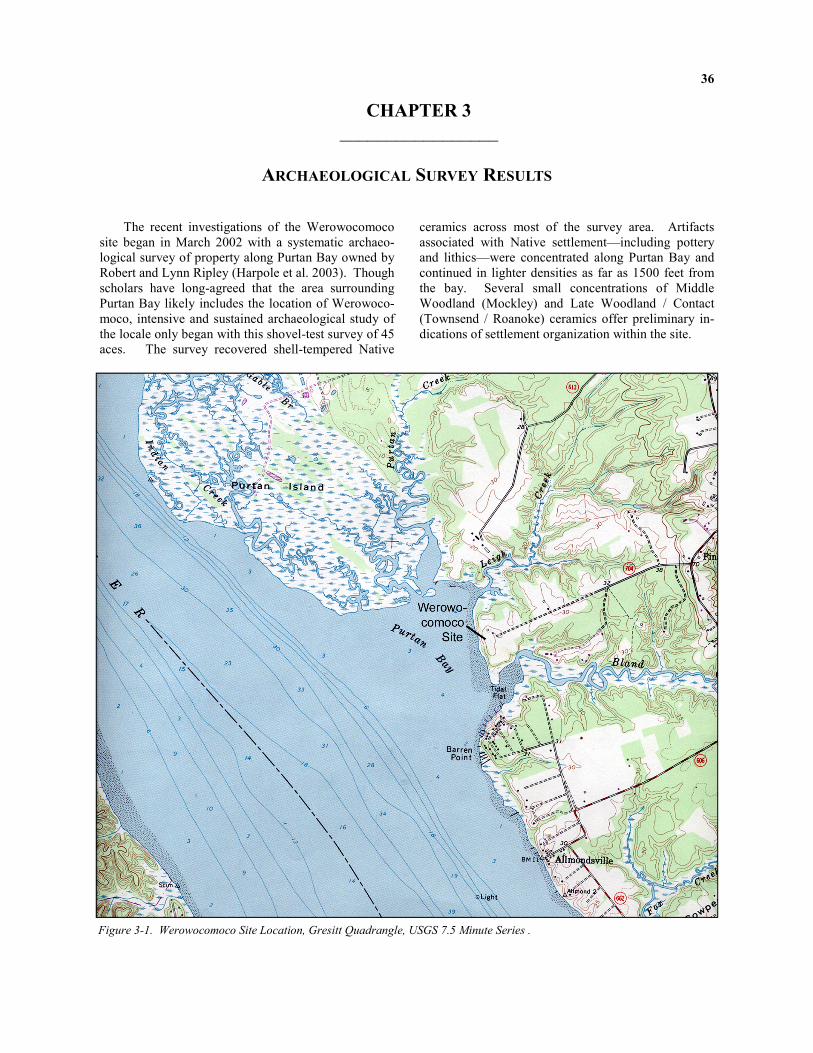
36
The recent investigations of the Werowocomoco site began in March 2002 with a systematic archaeo-logical survey of property along Purtan Bay owned by Robert and Lynn Ripley (Harpole et al. 2003). Though scholars have long-agreed that the area surrounding Purtan Bay likely includes the location of Werowoco-moco, intensive and sustained archaeological study of the locale only began with this shovel-test survey of 45 aces. The survey recovered shell-tempered Native
ceramics across most of the survey area. Artifacts associated with Native settlement—including pottery and lithics—were concentrated along Purtan Bay and continued in lighter densities as far as 1500 feet from the bay. Several small concentrations of Middle Woodland (Mockley) and Late Woodland / Contact (Townsend / Roanoke) ceramics offer preliminary in-dications of settlement organization within the site.
CHAPTER 3
_________________
ARCHAEOLOGICAL SURVEY RESULTS
Figure 3-1. Werowocomoco Site Location, Gresitt Quadrangle, USGS 7.5 Minute Series .

37
The artifact distribution parallels a dispersed vil-lage focused around a core area along the river, a lay-out consistent with Turner and Opperman’s (1993) and Underwood et al.’s (2003) models of Contact period communities. The distribution of Late Woodland / Contact period diagnostic artifacts, including a concen-tration of materials approximately 1000 feet east of Purtan Bay, point toward a varied and complex settle-
ment landscape. The survey and earlier surface collec-tions on the site also record a history of Native settle-ment from the Archaic period through Contact and historic occupations beginning in the late seventeenth century. The following summarizes the environmental setting, property history, surface collections, and sur-vey results.
The Ripley property is located along Purtan Bay on the northeast shore of the York River in Gloucester County, Virginia. Purtan Bay is bounded by the exten-sive saltwater marshes of Purtan Island upstream and by Barren Point downstream. The Bay ranges from 2 to 6 feet in depth and has an average tidal range of approximately 3 feet. Three primary creeks empty into the Bay: Purtan, Leigh, and Bland. Tidal influence is significant along both the bay and the creeks. The surveyed landform varies in elevation from 10 to 30 feet above mean sea level (AMSL) and is bounded by Leigh Creek, Purtan Bay, and Bland Creek, and by the 30 foot contour line on the northeast. This area con-sists mainly of plowed fields, landscaped yard, and
wooded areas along the river and creeks. Route 704 (Ginny Hill Road) is a straight gravel driveway bisect-ing the project area from northeast to southwest. One modern home, a garage, a doghouse, and an equipment shed are located in the central portion of the survey area north of the driveway. Most of the landscaped yard lies between the house and Purtan Bay, and on the north side of Route 704 whereas plowed fields lie to the south of Route 704. The main portion of the sur-vey area consists of a flat terrace, approximately 20 feet AMSL. Fifteen hundred feet east of the bay, the land rises to another terrace at approximately 30 feet AMSL. Soils within the project area are generally Suffolk fine sandy loam with 2-6% slope.
Figure 3-2. Aerial View of Purtan Bay and the Werowocomoco site, looking north.
Environmental Setting of the Property

38
Little was recorded regarding the site during the seventeenth century following Wahunsenacawh’s 1609 departure from Werowocomoco. English colonists’ earliest settlement in Gloucester County began during the late 1630s, a process that intensified a decade later. By 1650 colonists patented thousands of acres every year, and numerous settlers began to construct houses and plant tobacco fields. The first mention of the prop-erty in historic documents dates to November 1652 when William Roberts secured a modest patent for 200 acres located "On the N side of York R. at the mouth of Jones [now Bland] Crk. & NW side, adjoining Edw. West and E upon a White Marsh" (Gloucester County Plat Book [GCPB] 160; Mason 1965:I:64). This land was later included in John Stubbs’ 1714 patent for 300 acres described as:
Escheat land formerly in possession of Wm. Roberts dece'd, and for which Justophineca Bennitt, Wm. Sawer, John Absalom & Mary his wife obtained Certificate Oct. 1707. Since sold to Stubbs by Certificate 21st of October, 1708. (GCPB 10:214; Mason 1965:I:71). It is unclear whether Roberts lived on the prop-
erty, but based on these land transactions some indi-viduals probably did occupy part of the land. The documents offer no other information about these early settlers, though surface collection by the landowners and artifacts found during shovel testing do offer some evidence for a late seventeenth / early eighteenth-century occupation on the property.
Documentation of the site resumes in the 1760s
when Richard Taliaferro was listed as a resident of Petsworth Parish, the Gloucester County parish that included the survey area (Chamberlayne 1933:319). In 1770 records indicate that Taliaferro owned 415 acres of land encompassing the neck of land between Bland and Leigh creeks (Mason 1965:I:102). Taliaferro died in 1789, but his wife Elizabeth continued to own the property until 1804 (Gloucester County Land Tax Re-cords [GCLTR] 1793-1804). Their son, John, owned the property from 1805 to 1814, and then sold the farm to William Caffee (GCLTR 1805-15). The exact loca-tion of the Taliaferro farmstead is unknown, though the archaeological record indicates that the primary occupation area on the property shifted westward dur-ing this period to an area fronting the York River.
William Caffee owned the property, with minor
changes, until his death in 1839 (GCLTR 1840). The
property was subsequently listed under the estate of William Caffee until sold to Archer Bland in 1860 (GCLTR 1860). Although the records clearly indicate the Taliaferro and Caffee families lived on the prop-erty, building values were not recorded until the 1820s, when Caffee's lands contained $1000 in buildings (GCLTR 1825). An 1855 plat depicts a detailed repre-sentation of the Taliaferro/Caffee dwelling house that also appears in slightly different form on an 1848 plat of a neighboring property (GC PB 2:115, 1:260-1). This house survived with extensive alterations until the late 1960s.
The 1865 will of Archer Bland divided the prop-
erty between his wife and children, though the final dissolution of the property took several years (Gloucester County Will Book A:4). The primary tracts containing the survey area devolved to Archer Bland's children, Schuyler and Julia Leigh Stubblefield (GCLTR 1874). The majority of the property re-mained in the Bland and Stubblefield families until the middle of the twentieth century. Bounded as it is by creeks and the York River on three sides, the current property encompasses much of the former Taliaferro/Caffee/Bland estate, and preserves a rural landscape that has seen few changes since the middle of the eighteenth century.
Soon after Robert and Lynn Ripley purchased the
property in 1996, Lynn began to collect artifacts from the fields, forests, and beaches on the property. Ini-tially recovering mostly mid-eighteenth through twen-tieth-century ceramics and bottle glass, Lynn also be-gan to recover Native projectile points and fragments of Native ceramics. Lynn assembled a sizable collec-tion of Native materials over several years, including shell-tempered pottery dating to the Middle Woodland, Late Woodland, and Contact periods. Most of the Native ceramics, projectile points, and lithic debitage were recovered on the shore of Purtan Bay, indicating that some erosion of Native features and living sur-faces has occurred along the York River bluff. The surface collection suggests that primary occupations occurred along the edge of this bluff above Purtan Bay during the Middle Woodland through Contact periods, and from the late eighteenth to twentieth centuries.
The Native materials, particularly the shell-
tempered/fabric-impressed, plain, and simple stamped sherds, indicate that the site includes a sizable settle-ment dating to the Late Woodland and Contact peri-
History of the Property after Wahunsenacawh

39
ods. A minority of the ceramics are decorated with incised lines and motifs common to the Late Woodland Chesapeake. A preliminary study (Tolbert nd) of this shell-tempered pottery indicates that roughly half of the material may be classified as Rappahannock fabric-impressed pottery, with plain, cord-marked (i.e., Mockley), and simple stamped (i.e., Roanoke) surfaces present in lower frequencies. A shift from bag-shaped to globular vessel forms is apparent in the morphology of Middle Woodland Mockley cord-marked ceramics and Late Woodland Rappahannock fabric-impressed pottery. Comparison of the Mockley, Rappahannock, and Roanoke sherds indicates that vessel diameter in-creased from the Middle Woodland through Late Woodland periods. Projectile points recovered in the collection include a variety of forms, some dating to the Early Archaic period. The majority of the points, though, are quartzite triangles diagnostic of the Middle and Late Woodland periods. Items in the collection likely dating to the Contact period include a blue glass bead and fragments of sheet copper. Analysis of the copper to determine whether the material originated
from the early seventeenth-century trade between colo-nists and Native communities is currently underway.
Figure 3-3. Scrap copper collected from surface and plow
zone excavations.
Prior to the survey of the Werowocomoco site and the creation of the Werowocomoco Research Group, fragmentary human remains and an associated cache of artifacts were recovered by collectors at the site. The burial included poorly-preserved bones and teeth of a 2 – 4 year old child of probable Native American ances-try. Materials associated with the burial, described in detail below, include European-produced metal objects and glass beads dating to the early seventeenth cen-tury. The cache and human remains were recovered from a feature located 1400 feet from the York on an elevated terrace overlooking the site. All of the soil was screened through 1/16-inch window screen. No photographs were taken or drawings made document-ing the removal of the materials.
The human remains and associated objects are
critical elements of the site’s history and powerful symbols for contemporary Native communities in Vir-ginia. Though the Native American Graves Protection and Repatriation Act (NAGPRA) does not apply to Virginia’s tribes (which have not yet obtained Federal recognition), the research team’s policy on human re-mains operates as if the law does apply. The Werowo-comoco Research Group informed the Virginia Coun-
cil on Indians of the burial and artifact cache at the site prior to commencing any excavation or studies. We have subsequently met with the project’s Virginia In-dian Advisory Board and discussed the ultimate dispo-sition of the human remains and associated materials. Our goal has been to develop a plan for the human remains and associated materials that is respectful of the Virginia Indian community’s wishes while also meeting our ethical obligations as stewards of archaeo-logical information from the site. Our Virginia Indian advisors have expressed a strong sense that the objects represent items sacred to Powhatan descendants. Un-der NAGPRA, the materials would likely be accorded the status of associated funerary objects. Given the strong convictions of the contemporary community, it is also possible that the materials would today be con-sidered objects of cultural patrimony. Objects of cul-tural patrimony have ongoing historical, traditional, or cultural importance central to a tribe itself, rather than the property of an individual tribal member. Upon completion of an inventory, the Werowocomoco Re-search Group and landowners delegated decisions per-taining to the reinterment of the remains and associated objects to the Virginia Indian Advisory Board.
Burial and Artifact Cache

40
The human remains include ten bone fragments and nine teeth. Biological anthropologist Lesley Ran-kin-Hill’s (2004) assessment of these remains is sum-marized in table 3-1. Though the remains were frag-mentary, the dentition indicates that they are from a child aged 2 – 4 years. Native ancestry is indicated by a shovel-shaped incisor. Copper staining on one of the bones implies that it was in contact with some of the copper-alloy objects described below.
Objects associated with this burial included an
iron lathing hammer, a copper-alloy skillet, a copper-alloy spoon, copper-alloy beads, two copper-alloy “King’s Touch” tokens, and several thousand white and blue glass beads. Though uncommon in the Chesapeake region, such a combination of materials has been found in other Middle Atlantic and Northeast burial contexts dating to the Contact period (e.g., Pietak 1999, Rubertone 2001). These objects include materials critical to early exchange relations in the Chesapeake—copper, glass, and iron—as well as ma-terials that embody the red, white, and black color symbolism that recurs throughout Powhatan cosmol-ogy.
The wrought iron lathing hammer has a hatchet
end used to cut strips of lath for plaster and a hammer end to drive nails. Impressions of wood in the corro-
sion on one side of the hammer suggest that it may have been placed in a box or laid on a board, which later decayed in the ground. Lathing hammers are not unusual on seventeenth-century sites, and they saw use as all-purpose hatchets and hammers, and as trade items (Gaynor 1993:348).
The near-complete copper-alloy skillet measures 3
1/4" (82mm) tall and 6 3/16" (156mm) in diameter. The pot, missing its handle, is heavily worn and slightly misshapen, and bears a blackish residue on the exterior that may have resulted from use in a fire. The bowl was hammered out of single sheet of copper alloy with an everted rim that was rolled over a copper wire for strength (Straube 2004). Based on similar objects recovered from early seventeenth century sites, the rivets likely attached three iron strap-like legs (now missing) to the sides. A leg repair is suggested by the extra rivet located at one leg attachment.
The two fragments of a copper-alloy 'seal-top'
spoon have a fig-shaped bowl and flat-topped baluster finial. This style was common during the sixteenth and early seventeenth centuries (Cotter 1994:189; Noel Hume 1991:181). The spoon is stamped in the bowl with a maker's mark, an “R B” within a square-topped shield. The bowl shows evidence of use, while the handle is broken and partially missing. Similar spoons
Table 3-1. Summary of Human Remains Recovered from the Burial and Artifact Cache.
Element n Size (mm) Comments
Right rib fragment 1 0.7 x 3.3 Juvenile individual based on size and features.
Femoral head metaphysic 1 1.4 x 1.2 Probable right femur. Fovea Capitis present.
Possible endocranial or ilium fragment 1 2.3 x 2.1 Flat bone fragment. Too fragmentary to determine age.
Possible innominate 1 - Probable pubis or ischium.
Endocranial layer fragment 1 3.9 x 1.3 Possible occipital.
Probable cranial fragment 1 - Possible ilium fragment.
Right tibia or femur 1 - Long bone shaft with observable nutrient foramen. Flattened appearance. Green stain on proximal end possibly due to contact with a copper alloy object.
Basilar portion of crania 1 2.5 x 0.7 Probable mastoid.
Small bone fragments 2 - Unidentifiable.
First deciduous molars 2 - Roots broken off, crowns complete. Minimum age: one year.
Second deciduous molars 2 - Dentin layer established. Minimum age: one year.
Deciduous molar 1 - Shell only.
First permanent molars 4 - Crowns partially developed. Age: one to three years.
Deciduous canine crowns 2 - Dentin and pulp chamber established. Broken roots. Minimum age: nine months.
Deciduous canine 1 - Complete root (curved). Enamel exfoliating Age: one – three years.
Deciduous central incisor 1 - Crown broken in half. Labial and lingual sides present. Shovel-shaped lingual side indicates possible Native American ancestry.

41
with an identical maker’s mark have been recovered from the early seventeenth-century occupation at the Jordan's Journey site (Straube 2004).
The two copper-alloy tokens were stamped on one
side with a crown above an entwined rose and thistle, identical to the motif used on the halfpenny acknowl-edging the union of England and Scotland during the reign of James I (Straube 2004). Similar objects re-covered from James Fort and from the Piscataway Creek site in Maryland have been identified as “King’s Touch” tokens (Kelso and Straube 1997:25). The to-kens relate to an English royal ceremony originating in the fourteenth century that imbued the monarch with healing powers. The King’s touch was said to cure scrofula, or tuberculosis of the neck. After the cere-mony diseased attendees were handed a token of the ceremony. Recent excavations at James Fort have recovered twenty-three of these tokens in contexts dat-ing circa to 1610 (Straube 2004). A similar set of eighteen tokens, pierced and comprising a necklace, were located in a seventeenth-century Indian ossuary on the banks of Piscataway Creek in Maryland (Ferguson 1940). The tokens were presumably brought to Virginia for trade with Native communities. The examples found at the Werowocomoco site are both pierced in the middle with two holes, suggesting they were modified and used in a necklace or other form of body adornment.
Copper-alloy beads in the form of short tubes
were also part of the cache, including nine complete beads and three fragments. The beads are between 14 and 16 millimeters long and are made of thin pieces of rolled copper. Several of the beads have a fibrous thread inside them, which suggests that they were held together in a necklace. An analysis of the thread from several of the beads indicates the fibers are linen flax of probable European origin (Williams 2005). An on-going analysis of the copper from these objects will help determine whether the objects are European or Native in origin. Given the proximity of the copper beads, tokens, and glass beads, it is likely that the ob-jects were strung together on a complex decorative necklace.
The largest number of artifacts in the cache, a total
of 3,951, consist of small blue and white glass beads and one large chevron bead. The following summa-rizes Lapham’s (2004) detailed assessment beads from the cache. This assessment indicates that four bead varieties were present, including 3,631 small white glass beads in two variants and 320 blue glass beads. Labeled according to the Kidd and Kidd (1970) classi-fication system, these beads fall under the IIa56,
IVa11, IVa11*, and IVk_* varieties (table 3-2). This classification system distinguishes bead varieties based on manufacturing processes. shape, size, and color. All of the beads in the cache were produced using the drawing process.
Lapham classified all but two of the 3,631 white
glass beads in the assemblage under the IVa11 variety. These are small, circular beads comprised of three lay-ers of glass. Two other white beads, labeled IVa11* were virtually identical but exhibited a transposed se-quence of glass layers (a colorless glass between two opaque white glass layers). These white bead varieties are common on early to middle seventeenth-century sites in the Middle Atlantic and Northeast, though few have been recovered from the James Fort site. The IVa11 variety comprises only 1% of the Early Fort period (1607 – 1623) assemblage and 4% of the Post-Fort period (1624 – 1660) assemblage (Lapham 2001).
The small blue glass beads present in the assem-
blage were all of the IIa56 variety. This bead type typically occurs in small numbers on early to late sev-enteenth-century sites in the Middle Atlantic and Northeast. A considerable amount of IIa56 blue glass beads have been excavated from Early Fort contexts at Jamestown—a full 26% of the assemblage (Lapham 2004:3). These beads, though, are entirely absent from the Post-Fort period.
The final bead variety, a large, spherical chevron bead, designated IVk__*, does not conform to the Kidd classification system. These beads are referred to as chevrons due to the star-like pattern apparent when viewed from their ends (Lapham 2004:5). The bead includes an opaque white glass layer contained be-tween two translucent dark blue layers (Munsell hue 5 PB 2/8). It differs from other identified chevron va-rieties in that it lacks the typical color sequence of 4 – 5 layers commonly seen in a dark blue chevron. The bead is the only documented example in the region of a 16-point star-shaped mold containing two colors and three layers of glass (Lapham 2004:5). Similar dark blue chevrons (Kidd varieties IVk3 and IVk4) have been recovered from early-to-mid seventeenth-century Native American sites in the Northeast. These beads typically derive from Dutch-supplied Polychrome Ho-rizon assemblages dating to A.D. 1609-1624 and from Iroquois sites in New York dating circa A.D. 1620-1650 (Fitzgerald et al. 1995; Kenyon and Kenyon 1983). Chevrons are also present on early seven-teenth-century Monongahela and Susquehannock sites in Pennsylvania and the upper Potomac River Valley in Maryland (Kent 1983; Lapham and Johnson 2002; Sempowski 1994; Wall and Lapham 2003). Excava-

42
Figure 3-4. Metal objects from artifact cache: lathing hammer, skillet, spoon, beads, and Touch Tokens.

43
Figure 3-5. Glass beads from artifact cache.

44
Kidd Variety Description Est. Count
n=3,951
Examined n=846
Mean Diam. (mm)
Mean Length (mm)
IVa11 Very small-small, circular, 3-layer white beads (C/W/C) 3629 823 2.41 1.49
IVa11* Very small-small, circular, 3-layer white beads (W/C/W) 2 2 2.41 1.45
IIa56 Very small-small, circular, translucent dark blue beads 319 20 2.63 1.50
IVk_* Lg., spherical, 3-layer translucent dark blue beads (B/W/B) 1 1 8.76 7.89
Figure 3-2. Beads Recovered from Artifact cache. Data Drawn from Lapham (2004).
tions by the William and Mary Center for Archaeologi-cal Research at the Thomas Wharf site on the Eastern Shore near Nassawadox, Virginia, recovered one chev-ron bead (Blanton 1999; Lapham 1998). The sporadic occurrence of spherical-shaped chevron beads in the Middle Atlantic may be tied to the predominance of English (as opposed to Dutch) trade in the region. Excavations at James Fort, from the Early Fort and later periods, have not recovered similar chevrons.
The glass bead varieties recovered from Werowo-comoco have occurred in other contexts across the Atlantic seaboard dating from the early and middle seventeenth century. The numbers of small, dark blue beads in Early Fort period contexts (A.D. 1607-1623) at Jamestown identical to those recovered at Werowo-comoco point toward links between the two assem-blages. However, the small white bead variety (IVa11) recovered from Werowocomoco was present within Early Fort period contexts at Jamestown only in low numbers. This variety is more common during the Post-Fort period (A.D. 1624-1660), though even dur-ing this interval the variety is relatively uncommon. Spherical chevrons have not yet appeared in the exca-
vations at Jamestown. Given its unique role in early exchange relations in the Chesapeake, Werowoco-moco’s assemblage may very well differ from other Middle Atlantic sites of the early seventeenth century. The burial and associated funerary items are evi-dence of Werowocomoco’s unique status in the ar-chaeological record of the Chesapeake region. Likely an early seventeenth-century context, it is not clear whether the burial dates to the years before or after 1609 when Wahunsenacawh ended his residency at the village. The materials included with the burial came from sources beyond the known Powhatan world and possibly beyond the world of English colonists given the enigmatic origins of the chevron bead. As dis-cussed in chapter 2, the color symbolism in the artifact cache suggests a complex suite of ideas associated with life, death, and liminality. The burial at Werowo-comoco marked the death of a person with consider-able importance in the Powhatan world during the sev-enteenth century. Given the status of Werowocomoco as Powhatan’s residence, the buried child may, in fact, have been related to Wahunsenacawh’s lineage.
Survey Goals, Methods, and Results
As discussed above, written records and carto-graphic sources indicate that the Ripley property likely contained Powhatan's village of Werowocomoco. Sur-face collection by the landowners revealed the pres-ence of cultural materials diagnostic of the Late Wood-land / Contact period throughout the property, specifi-cally within the plowed fields south of Route 704 (Ginny Hill Road) and along the shoreline of Purtan Bay. The archaeological survey of the Werowoco-moco site, conducted by DATA Investigations and described in detail in Harpole et al. 2003, sought to define these archaeological resources more precisely in order to assess their research potential. Bearing in mind the length of known use and occupation, the sur-vey strategy sought the maximum information from
the site with the least amount of intrusive disturbance through excavation. Specifically, the shovel test sur-vey was designed to determine the site’s boundaries and to identify artifact concentrations that might corre-spond with elements of a Late Woodland / Contact period community.
Early colonial sources document Powhatan settle-
ments comprised of residential cores surrounded by a dispersed arrangement of households and associated horticultural plots. Given the social and political im-portance of Werowocomoco during the early seven-teenth century, this community model may not apply to the settlement. In fact, Werowocomoco may have included a more consciously-ordered landscape than

45
other contemporary villages. Artifact concentrations identified during the survey provide a departure point for evaluating the settlement’s spatial configuration.
There is no documentary evidence that the prop-
erty was inhabited by English settlers during the first half of the seventeenth century. By the middle seven-teenth through early eighteenth centuries, most Tide-water settlements were small farmsteads situated on large parcels held by middling planters and worked by indentured servants and slaves. Typically, these farm-steads consisted of a house, several outbuildings, and a few acres of fields (Brown et al. 1986:131). The devo-tion to tobacco monoculture during this period re-quired the clearance of large tracts of land. Archaeo-logically, such sites are often difficult to locate due to the use of earthfast construction, which left only ephemeral subsurface indications of their existence, and a lack of extensive material possessions among the majority of settlers.
By the 1760s it appears that Richard Taliaferro
had settled on the property (Chamberlayne 1933:319; Mason 1965:I:102), though the location of his dwelling within the 400-acre property is unknown. The sizable landholdings of Richard Taliaferro suggest a farmstead of some means that would have included numerous outbuildings and the use of slave labor. The dispersal of these buildings throughout the landscape should be reflected in varying concentrations of artifacts found in the plowzone and yard areas. By the early nineteenth century, it is clear that the primary occupation within the survey area is in the modern landscaped yard, close to the York River. At the center of this farmstead was the Caffee house, a timber-framed structure on a brick foundation or piers that was sketched in 1855 and sur-vived until the 1960s.
Field Methods
The archaeological survey was undertaken to as-sess the boundaries of the Werowocomoco site (44GL32) as well as the archaeological research poten-tial of the property. The study included shovel testing, mechanical stripping of a discreet, previously dis-turbed area, and sampling of previously removed soils. The survey grid was oriented along Route 704, which bisects the property and the natural landform. Grid north is perpendicular to Route 704 and is approxi-mately 18 degrees west of magnetic north, and 24 de-grees west of true north. Every 50 feet along this grid shovel tests (approximately one foot in diameter) were excavated to sterile subsoil or cultural feature. All excavated soils were screened through ¼ inch mesh screen to ensure uniform recovery of cultural materi-
als. Soil profiles for each shovel test were recorded along with an interim artifact inventory.
An approximately 120' x 45' area in the southwest
portion of the survey area was previously disturbed by construction activities related to a shoreline stabiliza-tion project. Significant portions of this area had been stripped to sterile subsoil prior to the survey. The plowed soils that had been removed were placed in a berm surrounding the edges of the impacted area. A sample of the removed plowed soils (approximately 5%) was screened through ¼ inch mesh screen. The area was then cleared of remaining rip-rap and soil with a backhoe and cleaned by hand. Features identi-fied during this process were mapped and photo-graphed prior to sampling.
Survey Results
A total of 603 shovel test pits were excavated, of which 504 yielded artifacts and 42 identified features. Fragments of brick and sherds of Native pottery were common throughout much of the surveyed area, with lithic debitage, bottle glass, and European ceramics also retrieved in significant numbers. In the Damage Assessment area, four cultural features were identified. One feature was sampled and appears to be a small pit dating to the late eighteenth or early nineteenth cen-tury. The shovel testing indicates that plowing was widespread across the survey area.
The shovel tests were excavated in three different types of land coverage: open field and pasture, land-scaped yard, and young (<40 years) forest. Shovel tests excavated in the open field and pasture environ-ments are primarily composed of two strata: plowzone (Ap horizon) and subsoil (C horizon). The plowzone is typically composed of dark brown to yellowish brown sandy loam, and varies between 0.4' and 1.4' in thickness. The underlying subsoil generally consists of a yellowish brown to brownish yellow sandy clay start-ing between 0.6’ and 1.2’ below ground surface.
Shovel tests excavated in the landscaped yard in-
cluded a thin root mat within a matrix of dark grayish brown or dark brown sandy loam. This layer typically overlay an historic plowzone extending to a depth of 0.8' to 2.1' and composed mainly of brown to dark brown sandy loam. The plowzone attained significant depth in portions of the yard area, particularly north of the main house. The landform exhibits a slight dip in this area, such that plowing and erosion filled in por-tions of the natural drainage system. Below the rem-nant plowzone is yellowish brown or brownish yellow clayey sand subsoil.

46
Figure 3-6. Map of Survey Area.
Positiv
e STP
Negativ
e STP
Positiv
e STP w
ith Feature
Negativ
e STP w
ith Feature
WELL
HOUSE
GARAGE
WELL
ORCHARD
BARN
TU 2.0
TU 1.5
PASTURE
PASTURE
DOG KENNEL
FOREST
FOREST
FOREST
FOREST
RIP-R
AP M
ITIG
ATIO
N
AREA
BLAND C
REEK
LEIG
H
CREEK
YARD
PURTON BAY
FIELD
FIELD
Excavated Test U
nits
WEROWOCOMOCO SITE
44GL32
0200
ft MN
GN
21°

47
Shovel tests excavated in the wooded areas typi-cally included a thin upper layer of root mat/humus mixed within a matrix of dark brown or very dark gray sandy loam. Below the topsoil is a layer that varied between brown and pale brown loamy sands, and ex-tending to a depth of 0.9’ to 1.2’ below ground surface. This layer represents an older plowzone, although por-tions of the forested areas were probably unplowed and exhibit natural soil horizons. Subsoil, a layer of yel-lowish brown sandy clay, was encountered below the old plowzone.
Artifact Concentration Analysis
The archaeological survey provided information about the location of both Native and Euro-American occupation and activity areas. Though artifacts were recovered across the entire 45-acre survey area, dis-tinct concentrations associated with varying temporal / cultural periods were identified.
The concentrations of Native artifacts were de-
fined primarily by the recovery of prehistoric ceramic sherds with identifiable surface treatment and temper relating to one of two specific periods. Six distinct
concentrations were identified, two with Middle Woodland diagnostics and four containing ceramics dating to the Late Woodland and Contact periods.
Native materials occurred in light densities across
much of the site with higher densities along Purtan Bay. The two Middle Woodland concentrations, lo-cated in the northern part of the survey area and along the edge of the York River bluff, were identified based on the presence of shell-tempered ceramics with net-impressed and cord-marked surfaces from the Mockley series. Both areas are relatively small, suggesting a less intensive occupation during the Middle Woodland period. Late Woodland diagnostic ceramics are also present in both areas.
Four disparate concentrations dating to the combined Late Woodland and Contact periods were identified across the survey area. Diagnostic ceramics from these centuries, including Townsend and Roanoke wares, occur before and after 1607 in the Virginia Tidewater. The two largest areas (II and III) were ad-jacent to the bluffs above the York River and represent a more intensive occupation, possibly the residential
Shell-tempered Native Ceramic FragmentsFound in Shovel Tests
2 fragments
2.5 fragments
3 fragments
3.5 fragments
4 fragments
GN
MN
(APPROX)
25.35°
300.0 ft0.0 ft 200.0 ft100.0 ft
0 200 400 600 800 1000 1200 1400 1600 1800
1400
1600
1800
2000
2200
2400
2600
2800
Figure 3-7. Distribution of Shell-tempered Pottery at the Werowocomoco Site.

48
Figure 3-8. Artifact Concentrations Identified by the Werowocomoco Survey.

49
core of the village. A small concentration (IV) was identified in the northern portion of the property, near one of the Middle Woodland concentrations, while the final Late Woodland/Contact area (I) was located sev-eral hundred feet east of the York River in a present-day pasture. These concentrations were identified based on varying quantities of simple-stamped, fabric-impressed, plain, and incised shell-tempered prehis-toric ceramic found in shovel tests.
Historic artifacts were found in abundance across the 45-acre survey area, in particular brick, coal, glass, and ceramic. The survey identified eight distinct con-centrations of historical artifacts which were tempo-rally or functionally related. These included one late seventeenth-century component, six eighteenth-century components, five nineteenth-century components, and two twentieth-century components.
The only area suggesting a seventeenth-century
occupation was located in the pasture area several hun-dred feet east of the York River (I). While eighteenth-century artifacts predominate, the ceramics from this area of the property also suggest that colonists may have established a small farmstead here during the late seventeenth century, an occupation that continued through the middle of the eighteenth century. Several
fragments of cut nails were recovered, but little else suggests a longer occupation. Area I appears to repre-sent the earliest Euro-American occupation of the site.
During the eighteenth century, the primary settle-
ment focus on the property appears to have shifted westward towards the York River. Areas III, IV, and VII represent the primary occupation areas of the site beginning in the late eighteenth century and extending to the present. The size and varying nature of these concentrations suggest the presence of a large farm-stead with outbuildings and activity areas.
Areas II and V, located on the northern and south-
ern edges of the survey area, respectively, probably represent outlying activity areas, outbuildings, or ten-ant structures associated with the farmstead of the eighteenth and early nineteenth centuries. Area VI, represented by oyster and clam shell and a few nine-teenth-century artifacts, may represent a zone of his-toric trash deposition. This indistinct scatter is located several hundred feet southwest of a late nineteenth-century farmhouse. Finally, Area VIII surrounds the location of a late nineteenth- to early twentieth-century store and wharf site. Extensive early twentieth-century refuse was noted on the surface.
The archaeological survey indicates that the site includes an extensive array of prehistoric occupations spanning the Middle Woodland through Contact peri-ods and covering the majority of the 45-acre project area. Historical occupations are also present, ranging from the late seventeenth through twentieth centuries. Within the Werowocomoco site are the remains of a dispersed Contact period village in addition to smaller prehistoric occupations dating throughout the Middle and Late Woodland periods. Historic farmsteads, as-sociated buildings, and activity areas dating to the late seventeenth through twentieth centuries are also pre-sent. Features identified during the survey suggest
good preservation of cultural remains from both the Native and historic occupations.
Complementing the evidence discussed here, sev-eral informal surveys conducted around Purtan Bay have also identified Native American occupations, though none have recovered Late Woodland / Contact period diagnostics in concentrations that approach those found at 44GL32. The assemblage of surface-collected artifacts combined with the material recov-ered during the shovel-test survey record spatially ex-tensive occupation of the site during the era of Wahun-senacawh’s presence at Werowocomoco.
Conclusions

50
CHAPTER 4
_________________
RESEARCH DESIGN AND EXCAVATION RESULTS
The documentary accounts of seventeenth-century events at Werowocomoco describe the Powhatans’ efforts to probe the colonists’ intentions and to absorb them into the social world of Tsenacomacoh. Though much is known about the Powhatan chiefdom and its central role in the early colonial history of North America from English documentary sources, this his-tory is most often framed by seventeenth-century colo-nialist narratives and a series of events involving Eng-lish colonists. Ethnohistorians have long studied ac-counts of culture contact at Werowocomoco (e.g., Ax-tell 2001; Gleach 1997; Rountree 1989, 1990; Roun-tree and Turner 2002; Williamson 2003:34-35), yet the village’s archaeological record has remained, until recently, unknown. Assuming, as we do, that the ma-terial world structured daily practices and experiences at Werowocomoco and that culture and history have a materiality oft-neglected by historical researchers, the village’s archaeological record becomes central to un-derstanding Chesapeake colonial encounters. Building on the earlier efforts of Virginia Common-wealth University archaeologist Daniel Mouer, the archaeological survey of 44GL32 indicates that the site comprised a large, dispersed village dating to the Late Woodland through Contact periods. Subsequent colo-nial, nineteenth, and twentieth-century deposits are also, not surprisingly, present in discrete portions of the site. Combining these survey results with docu-mentary and cartographic evidence discussed above, it becomes clear that the site likely represents the loca-tion of Werowocomoco, Powhatan’s seat of power during the early seventeenth century. Archaeological excavations at the Werowocomoco site hold the prom-ise of adding significantly to our understanding of Na-tive perspectives on colonial encounters in the Chesa-peake by expanding our frame of reference beyond an
event-based perspective centered on the colonizers. Excavations at the Werowocomoco site took place throughout the month of June 2003 under the auspices of the William and Mary Department of Anthropol-ogy’s archaeological field school directed by Assistant Professor Martin Gallivan. The excavation crew in-cluded Werowocomoco Research Group members David Brown and Thane Harpole, who served as field directors alongside Daniel Sayers of the William and Mary graduate anthropology program. Jennifer Og-borne, also of the William and Mary graduate anthro-pology program, directed the field laboratory. Field crew included students enrolled in the Archaeological Field Methods class: Justin Arocho, Brendan Burke, Edward Dunlap, James Goodwin, Nicola Harrison, Aaron Henry, Virginia Horner, Rachel Istvan, Jacque-line Langholtz, Mindy Lechman, Erin Patterson, Jenni-fer Props, Michael Rodgers, Sarah Tolbert, Cynthia Volbrecht, and Matthew Whalen. Robert and Lynn Ripley, owners of the property, graciously opened their home to us and contributed greatly to the excavation effort. Lynn Ripley joined the field crew for the length of the excavation. Robert Ripley provided regular and much-needed logistical support and guidance. Randolph Turner and Danielle Moretti-Langholtz as-sisted with public relations and public outreach related to the project. The following describes the results of the Werowo-comoco Research Group’s first field season at the site, including research themes relevant to the investigation, the field research design, the results of block excava-tions in four distinct areas of the site, and a preliminary interpretation of these results that will guide our future excavation strategies.
Introduction

51
Topics related to Werowocomoco’s culture history, colonial encounters in the Chesapeake, Powhatan chiefdom dynamics, and the cultural landscapes of political centers guide our long-term research goals at the Werowocomoco site. An initial priority of our investigations centered on confirming the identity of the site as Werowocomoco and on tracing the settle-ment’s occupation history during the Late Woodland and Contact periods. The cartographic, ethnohistori-cal, and archaeological evidence reviewed in chapter 2 strongly suggests that the location represents the Con-tact period village of Werowocomoco. As noted in chapter 2’s review of the region’s culture history, re-cent research into the Powhatan past indicates that archaeological study of Werowocomoco should shed light on the issues of chiefdom formation and Contact period interaction. Our shovel test survey also sup-ports the inference that the 44GL32 site represents Werowocomoco. Collections from the site have yielded copper, iron, and glass items (albeit in limited numbers) that are likely trade goods received by Wa-hunsenacawh and the Contact-period community. The cache of artifacts associated with the remains of a ju-venile individual aged 2 – 4 identified along the east-ern edges of this landform discussed in chapter 3 lends additional support to the notion that the site represents a prominent early seventeenth-century Powhatan com-munity. It should be noted that several aspects of Werowo-comoco’s history indicate that archaeological study of this settlement may prove challenging. Jamestown colonists documented Wahunsenacawh’s (i.e., chief Powhatan’s) residence at Werowocomoco only from 1607 - 1609. Wahunsenacawh probably resided at Werowocomoco some years prior to this brief interval, and a community of some size likely persisted at Pur-tan Bay after his departure. Colonists’ population esti-mates of Werowocomoco suggest a modest community with “40 able men” (Smith 1986a:147) or about 150 - 200 total residents depending upon the ratio of young men to the district’s overall population and variation in community size tied to the seasonal settlement round. The most common diagnostic artifacts from this era, Rappahannock plain and fabric-impressed pottery (a variety of Townsend ware), Roanoke simple-stamped pottery, and small triangular projectile points, all span the Late Woodland / Contact period centuries, making precise chronology construction challenging. Like-
wise, radiocarbon dates from the Contact period often include sizable error factors due to the vagaries of the radiocarbon calibration curve circa A.D. 1600. Fi-nally, excavation of other Contact period settlements in the Chesapeake, including Paspahegh (Luccketti et al. 1994) and Jordan’s Point (Mouer et al. 1992), recov-ered relatively low densities of Native American mate-rials. These excavations identified few feature con-texts beyond postmolds and burials, requiring exposure of large blocks to produce an understanding of material culture use and settlement organization. As important as Werowocomoco’s brief historical association with Wahunsenacawh and events of culture contact involv-ing Jamestown colonists is the late precontact history of the settlement. By tracing the culture history of Werowocomoco during the centuries immediately pre-ceding the Contact period we hope to better understand the reasons why chief Powhatan chose to reside there. In addition to our focus on the settlement’s culture history, we are particularly intrigued by the ways in which Powhatan-Anglo interaction at Werowocomoco shaped Contact period dynamics in the Chesapeake region. Colonial documentary sources record a regular series of encounters at Werowocomoco that introduced copper, iron, and glass trade goods into the village, exchange events that undoubtedly impacted the ar-chaeological record. Ethnohistorical studies (e.g., Rountree 1990; Gleach 1997; Mallios 1998; William-son 2003) suggest that the Powhatan Indians and the English sought to “civilize” one another through such exchanges at Werowocomoco as well as through the ceremony and public discourse accompanying it. As part of this process Wahunsenacawh attempted to en-hance his own status by monopolizing the flow of Eng-lish trade goods flowing into the region, a cultural strategy that succeeded for a brief period, then ulti-mately failed (Potter 1989; Hantman 1990). Important events tied to these dynamics occurred along the shores of the York River at Werowocomoco. Since Werowocomoco represented the Powhatan chiefdom’s political center in the early days of the co-lonial era, the site also offers an ideal place to study the chiefdom from a community-based perspective. Archaeologists’ “political” models of chiefdoms em-phasize the means by which chiefly elites came to dominate power relations through control of political economy, military power, and ideology (e.g., Earle
Research Topics

52
1997; Drennan and Uribe 1987). Chiefdom studies have recently focused on elite strategies and social processes that constructed and legitimized a perma-nent, centralized decision-making authority in the form of chiefs and a supporting elite. Some of these studies draw on a notion of “ideology” that represents the con-tradictory as coherent and the historically-contingent as permanent and natural (Althusser and Balibar 1971; Shanks and Tilley 1982). Others seek to study the materiality of hegemony and agency, domination and resistance expressed in the archaeological record (Emerson 1997:18). Understanding the ways in which authority and ideology were exercised from Werowo-comoco necessarily entails a long-term goal requiring several seasons beyond the one reported here. A final long-term research focus of our investiga-tions at the site involves Werowocomoco’s changing “cultural landscape” (i.e., the physical layout of the village) during the years immediately before and after Jamestown’s settlement. Cultural landscapes strongly influence social histories, in some settings conveying and reinforcing structures of authority. Though they exist in the empirical realm and have measurable prop-erties, such spaces become meaningful through per-sonal experiences as they structure social actions and
representations and are, in turn, structured by them. Space is thus a social product, generated through prac-tices that mediate subjects (i.e., historical actors) and objects (i.e., spatial arrangements). In this way, cul-tural landscapes may be studied in terms of three di-mensions: as perceived, conceived, and lived (Lefebvre 1991:38-46). This notion of landscape provides a point of depar-ture for archaeologists seeking to understand the con-solidation of social power in a place like Werowoco-moco. Drawing ideas from diverse academic disci-plines (e.g., Bradley 2000; Cosgrove 1984; Casey 1997) archaeologists have recently begun to think criti-cally about the social and symbolic implications of spatial arrangements, landscape features, and cultural perceptions of space. Such spatial arrangements may inculcate, embody, and habituate cultural notions, seamlessly linking the material and ideal in the proc-ess. As discussed in chapter 2, one early map of Werowocomoco, Zuñiga’s, raises the possibility that unusual landscape features marked the community. As a center of considerable Native authority in the Chesa-peake, Werowocomoco’s cultural landscape may in-deed have reflected the village’s status as a place of power.
Though these over-arching research topics remain central to our excavation strategies, we oriented our initial field season toward three, more modest goals: evaluating the integrity of archaeological features and activity areas at 44GL32, developing a baseline under-standing of the site’s occupation history, and probing the spatial and functional organization of the Contact period settlement. Our approach to these topics at Werowocomoco centered on block excavations in four different areas of the site (Figure 4-1). This strategy was designed to produce information regarding the integrity of features and activity areas by exposing large areas of sub-plow zone deposits while spreading these exposures across several different parts of the site in an effort to understand something of the site’s overall layout. We began by establishing five perma-nent data (consisting of a piece of rebar set in poured concrete) at the site. Since the initial archaeological survey of the property was conducted using English rule, we continued to use feet rather than the typical standard of metric measurement. The four excavation
blocks opened up 1400 square feet, uncovering fea-tures and intact cultural horizons from Late Wood-land / Contact period occupations of the site as well as preceding and subsequent occupations. Excavation blocks were selected 1) to maximize our understanding of spatial variation across the land form, 2) to cover areas containing Late Woodland / Contact period diagnostics, and 3) to investigate portions of the settlement referenced in early colonial documents. The first two excavation areas included two blocks located approximately 1000 feet from Purtan Bay within an area currently in pasture, areas labeled the Pasture West and Pasture East blocks. These blocks were closely spaced to allow an (initially) inexperi-enced field crew to benefit from the close supervision of the field school staff. Our survey indicated that these areas contained concentrations of Native pottery dating to the Late Woodland / Contact period centu-ries. John Smith’s (1986a:69) description of Werowo-
Research Design

53
N2350,
E150
N1898
E150
N2350
E603
N2070
E890
N2070
E1300
WEROWOCOMOCO SITE
44GL32
Excavated U
nits
Structures
Datum Point
0200
ftMN
GN
21°
Purton Bay
Bland C
reek
Unim
proved R
oad
Riverfront
Block
Cornfield Block
Pasture
West Block
Pasture
East Block
Figure 4-1. The Werowocomoco site and its environs with the four excavation blocks of the 2003 Field Season.

54
comoco mentions that Wahunsenacawh’s massive house was situated “thirty score” from the water. De-pending upon whether Smith was referring to feet or to paces and upon the location of Smith’s starting point on the various bodies of water adjacent to the settle-ment, the house probably stood between 600 to 1800 feet from the 1607 shoreline of Purtan Bay. Some of the earliest European artifacts recovered during the survey appeared in this area as well, predominantly eighteenth-century materials suggesting the presence of an earthfast residence and other structures. Across the Chesapeake region it is not uncommon to find the earliest colonial settlements in areas cleared and inhab-ited by Native communities during the late precontact and Contact periods (e.g., Potter and Waselkov 1994). Shovel-tests in the vicinity of the third excavation block, located on the Purtan Bay waterfront, recovered a high density and diversity of Native American mate-rials. Archaeological studies and colonial accounts of other Contact period villages in the region note that residential areas typically lined riverbanks in a dis-persed fashion. Finally, we tested an area 400 feet from the York River within a field planted in corn. Surface collec-tions in this area by the property owner recovered a glass bead, possibly a Contact period trade item. The shovel-test survey indicated that this area contained a light scatter of Native artifacts, raising the possibility that this marked the edges of residential settlement in the village.
Excavation Methods
Excavation methods followed practices standard in the region. Fifty-six 5-x-5 foot test units were exca-vated within the four excavation blocks. All plow zone soil from these units was screened through quar-ter-inch mesh for uniform artifact recovery. A 250 milliliter soil sample was drawn from each plow zone context for chemical analysis. At the plow zone base, excavation units were trowel-scraped to identify fea-tures and intact sub-plow zone deposits. Excavation units were then photographed and all soil anomalies drawn in plan. Representative profiles of excavation units were recorded with scale drawings and photo-graphs. Soil descriptions relied on standard Munsell color charts and USDA textural terminology. Within each excavation block a sample of the iden-tified features was excavated, with priority placed on those that appeared to date to the precontact or Contact periods rather than those from later historic periods. Features chosen for excavation were drawn and photo-graphed in plan prior to excavation. One half of each
feature was excavated to reveal a cross-section profile, which was also drawn and photographed. Feature fill was excavated according to natural strata if present. All feature soils were processed through a flotation tank for ethnobotanical and small artifact recovery. In those locations where cultural deposits continued be-neath the plow zone, excavation proceeded according to artificial levels and then by natural strata. Flotation samples were also drawn from these deposits.
Laboratory Methods
Artifact classification followed an attribute-based approach recorded in a Microsoft Access database, a copy of which is available upon request. The Native ceramic analysis included characterization of vessel portion (i.e., rim, shoulder, body, base), rim form, sherd size, mean sherd thickness, surface treatment (i.e., fabric-impressed, simple-stamped, cord-marked, check-stamped, plain), temper (i.e., shell, crushed lithic, sand), and decoration. When present, decoration (e.g., incising, punctation, cord-wrapped dowel im-pression) was characterized according to location, im-plement, and motif. Our ceramic classification includes both traditional typological assignments using regionally-accepted type definitions (Egloff and Potter 1978) and adherence to Klein's (1994) "absolute" seriation approach. Draw-ing on Braun's (1983) ceramic engineering model, Klein eschewed typological classification of ceramics for an approach that allows more precise dating of ar-chaeological contexts. Klein’s seriation formulas are based on regression equations calculated from changes in quantifiable ceramic attributes. Klein determined that from A.D. 200 - 1600 in the Virginia Coastal Plain, including the York River drainage, sherd thick-ness decreased and the percentage of plain, fabric, sim-ple-stamped, and decorated pottery increased. Klein’s seriation allows ceramic assemblages to be assigned an absolute, calendar date with an error factor of approxi-mately 250 years, making it an ideal tool for probing the Werowocomoco site’s occupation chronology. Klein’s (1994:321) formula for dating Coastal Plain assemblages is as follows: Date bp = 1108.7742 + (0.7443 x mean sherd thickness) - (792.2040 x percent-age of stamped + plain + fabric + other decorated sherds) +/- 249. Lithic artifact classification included characteriza-tion of raw material and artifact form. Similar to other sites dating to the Late Woodland / Contact period transition, the site produced relatively low numbers of lithic artifacts. The vast majority of these fell under the category of debitage. Categories of debitage used in the classification included decortation flakes, inte-

55
rior flakes, biface thinning flakes, shatter, and tested cobbles. Decortation flakes, the product of the initial step in the stone tool production process, exhibit a striking platform, bulb of percussion, and cortex. Sec-ondary flakes are flat flakes lacking cortex that exhibit scars on the dorsal surface. Tertiary flakes are small flakes, less than one centimeter in maximal length, that generally result from pressure flaking tool edges. The category of “shatter” includes angular pieces that are part of stone tool production, but lack the formal attrib-utes of flakes due to uneven fracture patterns. Tested cobbles exhibit a few flake scars. Stone tools identified at the site include bifaces, utilized flakes, abraders, fire-cracked rock, and projec-tile points. Bifaces are defined here as generalized stone tools or more formal tools abandoned during the reduction process with flake scars on opposite sur-faces. Utilized flakes exhibit retouched edges and use
marks. Abraders in the Chesapeake region are typi-cally sandstone and were used to smooth or sharpen antler, bone, wood, and stone, a use reflected in grooves or abrasions on the artifact’s surface. Projec-tile points are formal, hafted bifaces and are tempo-rally diagnostic. Historic artifact classification followed methods that are standard in the Chesapeake region. Ceramics, glass, bone, nails, and other metals were categorized using descriptive typologies, recording characteristics such as ware type, vessel portion and form, decoration, and function. All fragments of brick, mortar, oyster and clam shell, coal, and other items were collected and then weighed in order to plot distributions within the various excavation areas. The resulting data were used to delineate patterns of historical occupation on the property from the late seventeenth through to the twentieth centuries.
The Pasture West block consisted of 15 excavation units centered on the grid coordinate N2250 E950 (Figure 4-2). Shovel-tests in this area of the site iden-tified evidence of an early eighteenth-century domestic area, possibly the earliest European occupation within the survey area, as well as a light scatter of shell-tempered Native sherds. Our recent excavations un-covered evidence of two ditch features running roughly north-south across the excavation block. Arti-facts recovered from the feature fill and two radiocar-bon dates indicate that the ditches likely represent the remains of large Native features dating to the end of the Late Woodland period. The following discusses plow zone deposits before turning to features identified in the excavation block.
Stratigraphy and Plow Zone Deposits
Excavation units in this area uncovered a 10YR4/4 dark yellowish brown sandy loam plow zone (stratum I) underlain by a 10YR5/6 yellowish brown sandy clay (stratum II). Plow zone depths ranged from 0.8 to 1.2 feet below surface. Temporally diagnostic materials recovered from the plow zone included predominantly imported ceramics dating to the late seventeenth through late eighteenth century and shell-tempered pottery from the Late Woodland through Contact peri-ods (Figure 4-3). Tin-glazed earthenware formed the largest category of historic pottery in this portion of the site (Figure 4-4) with other historic ceramics sug-
gesting a prominent eighteenth-century presence. Im-ported pipe bore diameters (Figure 4-5) exhibited a modal peak in the 5/64ths range (1710 - 1750), with lower frequencies in the 6/64ths (1680 - 1710) and 4/64ths (1750 - 1800) ranges, while the presence of domestic pipe stem fragments and case bottle glass point toward a seventeenth-century component. Taken together, these historical materials reflect an eight-eenth-century domestic area. Nineteenth- and twenti-eth-century diagnostics appear in low numbers, sug-gesting more ephemeral occupations in recent centu-ries. Other historic-era artifacts from the plow zone in-dicate a significant domestic occupation, likely begin-ning sometime late in the seventeenth century, and lasting throughout much of the next century. While some later material is present, including whiteware, cut nails, coal and machine-made glass, the pasture area appears to have declined in use after the late eighteenth century. Most of the ceramics and glass are domestic in function, used for preparing and serving foods, and the quantity of tablewares combined with the presence of table glass and other items suggest a farmstead of at least middling status. Animal bone and oyster and clam shell also attest to these activities, revealing a dispersed refuse midden surrounding the colonial set-tlement. Architecturally, the brick, mortar, window glass and nails imply the presence of post-in-ground
Pasture West Block

56
Figure 4-2. Plan of Pasture West Block.
F161
F4
F99
F180
F173
F182
TU34
TU4 TU14
TU5 TU17 TU51 TU50
TU19 TU20 TU52 TU3
TU6 TU39 TU13 TU45
F123
F99 F61
F22F128
Rock
F129
F164
F167
F124
F127
F125F126
F65
Rock
F163
F171
F172
F175
F174
F176
F177
F178
F179
F95
F165
F166F96
F181
Rock
F98
F97
F133
F141
F134F135
F17
F18
F19
F20F170
F21
F161
F138F139
F136
F137
F66F183
F63
F64 F122
F162
N2265
E945
N2240
E945 N2240
E965
Feature Fill: 10YR 4/6 dark yellowish brown sandy loam
Feature Fill: 10YR 3/4 dark yellowish brown sandy loam
Subsoil: 10YR 5/6 yellowish brown sandy clay 0 5
ft
GN
WEROWOCOMOCO SITE
44GL32
PASTURE WEST BLOCK
PLAN VIEW

57
Figure 4-3. Historic ceramics, Pasture West Block
Date
2000
1950
1900
1850
1800
1750
1700
1650
1600
1550
Wester-
Tin-glazed
N Devon
wald
N MidlandsStaffordshire
Engl Stone
Buckley
Wh Salt-glazed
Creamware
Pearlware
Whiteware
Figure 4-4. Historic Ceramics from Pasture West Block. Each bar represents one sherd.

58
structures with brick chimneys, or perhaps even more substantial structures. The concentrations indicate that the densest colonial occupation occurred slightly to the north and east of the Pasture West block. Native ceramics recovered from the Pasture West plow zone (n=1172) included shell, sand, and crushed lithic tempered varieties with cord-marked, fabric-impressed, simple-stamped, and plain surface treat-ments (Table 4-1). Of the sherds with identifiable tem-per (n=331) approximately 88% were tempered with crushed shell. Of the sherds with identifiable surface treatments (n=123), 42% were plain, 28% were sim-ple-stamped, 20% were fabric-impressed, and 10% were cord-marked. As noted in Table 4-1, pottery from Pasture West matches descriptions of Mockley cord-marked, Rappahannock fabric-impressed and incised (both Townsend varieties), and Roanoke sim-ple-stamped (Figure 4-6). Many of the shell-tempered, plain ceramics fit descriptions of Yeocomico, charac-terized by finely-crushed shell temper, plain and scraped exterior surfaces, and thin vessel walls (Egloff and Potter 1978:112). Since this type is similar to
other shell-tempered wares with plain surface treat-ment, no type designation is applied to these sherds. This typological classification of ceramics from the Pasture West block implies a series of Middle Wood-land II (A.D. 200 – 900), and Late Woodland (A.D. 900 – 1600) through Contact (A.D. 1600 – 1622) pe-riod occupations, with indications that settlement in-tensified during the Late Woodland and Contact centu-ries. The numbers of Roanoke simple-stamped sherds are particularly intriguing as this ceramic type is un-common north of the York River where Townsend pottery predominates from the Late Woodland through Contact (Turner 1993). The numbers of Roanoke sim-ple-stamped sherds at the site imply close exchange ties and shared pottery traditions linking residents at the site to communities on the Virginia Peninsula, in the James River valley, and points south. Colonial documentary accounts note that Wahunsenacawh was born at the falls of the James River and that political dynamics within the Powhatan chiefdom hinged on social interaction between groups in the James and York River drainages, so this pattern is not entirely unexpected.
6/64: 1680 - 1710
5/64: 1710 - 1750
4/64: 1750 - 1800
60
40
20
0
11
51
23
Figure 4-5. Imported Pipe Stem Bore Diameters from Pasture
Block West, Measured in 64ths of an Inch.
Figure 4-6. Rappahannock Fabric-impressed pottery,
Pasture West Block
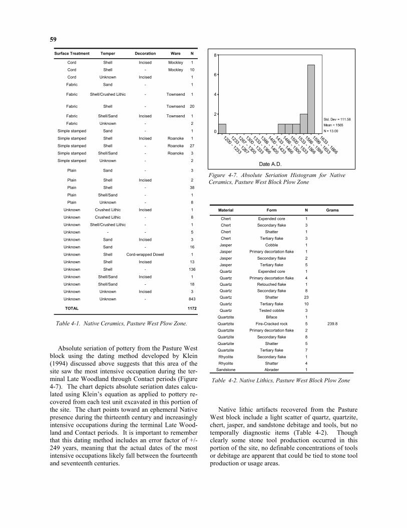
59
Absolute seriation of pottery from the Pasture West block using the dating method developed by Klein (1994) discussed above suggests that this area of the site saw the most intensive occupation during the ter-minal Late Woodland through Contact periods (Figure 4-7). The chart depicts absolute seriation dates calcu-lated using Klein’s equation as applied to pottery re-covered from each test unit excavated in this portion of the site. The chart points toward an ephemeral Native presence during the thirteenth century and increasingly intensive occupations during the terminal Late Wood-land and Contact periods. It is important to remember that this dating method includes an error factor of +/-249 years, meaning that the actual dates of the most intensive occupations likely fall between the fourteenth and seventeenth centuries.
Native lithic artifacts recovered from the Pasture West block include a light scatter of quartz, quartzite, chert, jasper, and sandstone debitage and tools, but no temporally diagnostic items (Table 4-2). Though clearly some stone tool production occurred in this portion of the site, no definable concentrations of tools or debitage are apparent that could be tied to stone tool production or usage areas.
Surface Treatment Temper Decoration Ware N
Cord Shell Incised Mockley 1 Cord Shell - Mockley 10 Cord Unknown Incised 1 Fabric Sand - 1
Fabric Shell/Crushed Lithic - Townsend 1
Fabric Shell - Townsend 20
Fabric Shell/Sand Incised Townsend 1 Fabric Unknown - 2
Simple stamped Sand - 1 Simple stamped Shell Incised Roanoke 1 Simple stamped Shell - Roanoke 27 Simple stamped Shell/Sand - Roanoke 3 Simple stamped Unknown - 2
Plain Sand - 3
Plain Shell Incised 2 Plain Shell - 38 Plain Shell/Sand - 1 Plain Unknown - 8
Unknown Crushed Lithic Incised 1 Unknown Crushed Lithic - 8 Unknown Shell/Crushed Lithic - 1 Unknown - - 5 Unknown Sand Incised 3 Unknown Sand - 16 Unknown Shell Cord-wrapped Dowel 1 Unknown Shell Incised 13 Unknown Shell - 136 Unknown Shell/Sand Incised 1 Unknown Shell/Sand - 18 Unknown Unknown Incised 3 Unknown Unknown - 843
TOTAL 1172
Table 4-1. Native Ceramics, Pasture West Plow Zone.
Date A.D.
1633 - 1666
1599 - 1633
1566 - 1599
1533 - 1566
1500 - 1533
1466 - 1500
1433 - 1466
1400 - 1433
1366 - 1400
1333 - 1366
1300 - 1333
1267 - 1300
1233 - 1267
1200 - 1233
8
6
4
2
0
Std. Dev = 111.58
Mean = 1565
N = 13.00
Figure 4-7. Absolute Seriation Histogram for Native
Ceramics, Pasture West Block Plow Zone
Material Form N Grams
Chert Expended core 1 Chert Secondary flake 3 Chert Shatter 1 Chert Tertiary flake 3 Jasper Cobble 1 Jasper Primary decortation flake 1 Jasper Secondary flake 2 Jasper Tertiary flake 5 Quartz Expended core 1 Quartz Primary decortation flake 4 Quartz Retouched flake 1 Quartz Secondary flake 8 Quartz Shatter 23 Quartz Tertiary flake 10 Quartz Tested cobble 3
Quartzite Biface 1 Quartzite Fire-Cracked rock 5 239.8 Quartzite Primary decortation flake 2 Quartzite Secondary flake 8 Quartzite Shatter 5 Quartzite Tertiary flake 7 Rhyolite Secondary flake 1 Rhyolite Shatter 4
Sandstone Abrader 1
Table 4-2. Native Lithics, Pasture West Block Plow Zone

60
Features
Excavations uncovered 56 features in the Pasture West block, 36 of which were excavated or sampled (Table 4-3). The block contained two linear features running parallel, roughly north-south across the exca-vation block (features 161 and 162). Also present were several burned tap roots in the northeast portion of the block and 35 small circular stains adjacent to features 161 and 162 with the shapes and dimensions of Native postmolds. With the exception of those identified within features 161 and 162, features noted within the excavation block occurred at the plow zone base framed by a 10YR5/6 yellowish brown sandy clay subsoil. As listed in Table 4-3, artifacts occurred in low numbers or were absent from most features. Given the relatively high numbers of eighteenth-century artifacts in the plow zone, the absence of any clearly colonial-era features from early English settle-ment is striking.
Ditch Features
Features 161 and 162 clearly dominate the excava-tion block (Figure 4-8). The features appear to repre-
sent parallel ditches extending both north and south beyond the excavation block. The excavated portions of the features in test units 5 and 17 (feature 161) and test units 4 and 14 (feature 162) revealed a roughly basin-shaped profile with slightly shallower ‘step’ on the east side (Figures 4-9 - 4-12). Their consistent orientations, sizes, and shapes suggest that they were likely constructed in tandem or close in time. With a maximum east-west width in plan of 5.80 feet and a maximum depth of 1.50 feet from the plow zone base, feature 161 is somewhat larger than feature 162. The northern portion of feature 161 arcs slightly to the east. A series of soil horizons were apparent in the feature profiles that included a combination of sands and silts of varying grain sizes and colors, sug-gesting that the ditches filled gradually over time with colluvial wash. Feature 65, a charcoal-rich lens con-taining Native pottery and fire-cracked rock, occurred at the base of feature 161’s stratum I at a depth of 0.40 feet below the top of feature 161 (Figures 4-13 and 4-14). A small portion of feature 65 is visible in the north profile of feature 161.
Figure 4-8. Pasture West Block (facing south) with partially excavated features 162 (left) and 161 (right).

61
Feat. Identified within Excavated Max.
N-S Max. E-W
Max. Depth Artifacts Interpretation
4 Unit 4 X 0.27 0.20 0.30 - Native post mold 17 Unit 3 X 0.44 0.21 0.14 - Native post mold 18 Unit 3 X 0.52 0.42 0.30 Plain shell-tempered sherd Native pit 19 Unit 6 X 0.25 0.30 0.21 - Native post mold 20 Unit 6 X 0.45 0.23 - - Undetermined (no appreciable depth) 21 Unit 6 X 0.80 0.90 1.70 Native sherd Rodent disturbance 22 Unit 5 X 0.75 .85 - - Undetermined 31 Unit 12 X 0.34 0.29 0.34 - Native post mold 61 Unit 14 X 0.39 0.33 0.30 - Native post mold 62 Unit 14 X 0.22 0.18 0.22 - Native post mold 63 Unit 13 X 0.37 0.32 0.29 - Native post mold 64 Unit 13 - 0.30 - - Undetermined
65 Feat 161 X 2.20 1.20 0.40 Plain shell-tempered sherds (14), Roanoke sherd, crushed lithic-tempered Native
sherd, Fire-cracked rock Native hearth 66 Unit 13 X 0.28 0.23 0.21 - Native post mold 95 Unit 19 X 0.22 0.20 - - Possible Native post mold 96 Unit 19 X 0.58 0.40 0.65 iron nail frag Rodent disturbance 97 Unit 20 X 0.28 0.20 - - Possible Native post mold 98 Unit 20 X 0.30 0.23 - - Possible Native post mold
99 Units 4 and 14 X 1.10 5.60 0.45
Roanoke sherds (5), Plain shell-tempered sherds (2), other shell-tempered Native sherds (16), tin-glazed earthenware, imported tobacco pipe bowl frag., brick frags.
(2), window glass frags. (11), wrought iron nail, scrap iron frag. Animal burrow 122 Unit 45 X 0.18 0.23 0.17 - Native post mold 123 Feat 162 X 0.81 0.72 2.35 Fabric-impressed, shell-tempered sherd Burned taproot or large post mold 124 Feat 161 X 0.25 0.30 0.25 - Native post mold 125 Feat 161 X 0.18 0.20 0.34 - Native post mold 126 Feat 161 X 0.15 0.20 0.22 - Native post mold 127 Feat 161 X 0.20 0.20 0.14 - Native post mold 128 Unit 5 X 0.40 0.20 - - Possible Native post mold 129 Unit 5 X 0.30 0.30 - - Possible Native post mold 133 Unit 52 X 0.18 0.18 0.22 - Native post mold 134 Unit 52 X 0.19 0.22 0.13 - Native post mold 135 Unit 52 X 0.28 0.20 0.13 - Native post mold 136 Unit 39 X 0.20 0.25 0.20 - Native post mold 137 Unit 39 X 0.20 0.24 0.15+ - Non-cultural 138 Unit 39 X 0.18 0.23 0.25+ - Non-cultural 139 Unit 39 X 0.20 0.20 0.18 - Native post mold 141 Unit 52 X 0.18 0.19 0.15 - Native post mold 161 various Sampled 25+ 5.80 1.50 Roanoke (4), other Native sherds (2), qtz flake, tobacco pipe frag. Ditch 162 various Sampled 20+ 4.20 1.10 Roanoke pottery (4), Plain shell-tempered (1), Imported tobacco pipe frag., Ditch 163 Unit 51 0.20 0.20 - - Possible Native post mold 164 Unit 5 0.30 0.30 - - Possible Native post mold 165 Unit 19 0.55 - - - - 166 Unit 19 0.25 0.20 - - Possible Native post mold 167 Unit 5 0.20 0.20 - - Possible Native post mold 168 Feat 161 0.70 0.85 - - - 170 Unit 6 0.50 0.45 - - Possible Native post mold 171 Unit 51 0.35 0.25 - - Possible Native post mold 172 Unit 51 0.20 0.20 - - Possible Native post mold 173 Unit 51 1.40 1.85 - - - 174 Unit 50 0.35 0.30 - - Possible Native post mold 175 Unit 50 0.70 0.55 - - - 176 Unit 50 0.30 0.20 - - Possible Native post mold 177 Unit 50 0.25 0.25 - - Possible Native post mold 178 Unit 50 0.25 0.28 - - Possible Native post mold 179 Unit 50 0.30 0.20 - - Possible Native post mold 180 Unit 4 0.95 0.90 - - - 181 Unit 19 - 2.75 - - - 182 Feat 162 X 1.55 1.20 4.90 Plain shell-tempered (2) Burned tap root or post 183 Unit 13 0.60 0.50 - - -
Table 4-3. Pasture West Block Features.

62
Figure 4-9. Feature 161 north profile.
E950N2255
1 ft.0 ft.
TU 17Level LineTU 5N2255E942
Feature161
I - 10YR5/4 yellowish brown silty sand mottled w/10YR4/4 dark yellowish brown clay sand, 10YR3/3 clayey silt and 10YR5/4 yellowish brown sandy loam
II - 10YR4/4 dark yelowish brown clay sand mottled w/10YR5/4 yellowish brown silty sand, 10YR3/3 clayey silt
III - Feature 65: charcoal mottled with 10YR5/6 yellowish brown sandy clay and 7.5YR5/4 brown clayey sand
IV - 10YR4/6 dark yellowish brown sandy silt mottled with 10YR4/4 dark yellowish brown sandy clay silt
V - 7.5YR4/6 strong brown sandy clay mottled with 10YR4/6 dark yellow brown sandy silt
Subsoil: 10YR5/6 yellowish brown sandy clay
Plow Zone: 10YR4/4 dark yellowish brown sandy loam plowzone
Werowocomoco
44GL32
TU 5, 17
Feature 161
North Profile
Figure 4-10. Feature 161 North Profile.

63
V - 10YR5/6 dark yellowish brown sandy clay
IV - 10YR5/4 yellowish brown silty sand with several shallow lenses
III - 10YR4/6 dark yellowish brown sandy loam
II - 10YR4/4 dark yellowish brown sandy loam
I - 10YR4/6 dark yellowish brown sandy loam
Werowocomoco
44GL32
TU 5,17
Feature 161
South Profile
Feature 161
N2250E948
0 ft. 1 ft.
Line LevelN2250E942
Figure 4-11. Feature 161 South Profile.
Feature 162
N2260
E960TU 14
1ft.0ft.
Level LineTU 4
Werowocomoco
44GL32
TU 4,14
Feature 162
North Profile
N2260
E950
Subsoil: 10YR5/6 yellowish brown sandy clay
II - 10YR5/8 yellowish brown clayey sand
I - 10YR4/6 dark yellowish brown sandy loam
Plow Zone: 10YR4/4 dark yellowish brown sandy loam
Figure 4-12. Feature 162 North Profile.

64
Figure 4-13. Feature 65, East profile.
Figure 4-14. Feature 65 Plan and Profile.
Subsoil: 10YR5/4 yellowish brown sandy clay
Feature 65: 10YR4/6 dark yellowish brown sady loam
mottled with 7.5YR5/4 clayey sand
and flecked with charcoal
Feature 161: 10YR3/4 dark yellowish brown sandy loam
Werowocomoco
44GL32
TU 17
Feature 65
Plan View
Feat 65
0ft. 1ft.
East Profile
Fire-cracked rock

65
With the exception of one imported kaolin pipe fragment identified in the transitional deposits located in the top 0.2 feet of the feature, artifacts identified within feature 161 were exclusively Native American. Artifacts included 4 shell-tempered, simple-stamped ceramics (i.e., Roanoke ware) several small Native sherds with unidentifiable surface treatments and tem-pers, and a quartz flake. Feature 65 contained an addi-tional Roanoke simple-stamped sherd, 14 shell-tempered plain ceramics, and a fire-cracked rock. Charcoal from feature 65 returned a radiocarbon date of 490 +/- 40 BP (Beta 186839), which calibrates at
the two sigma range to A.D. 1400 – 1460 (Table 4-4) (Stuiver and van der Plicht 1998). Though somewhat smaller at 4.20 feet across and 1.10 foot in depth, feature 162 was similar to feature 161 in form, contents, and north – south extent. Evi-dence of colluvial deposition was less apparent in fea-ture 162, possibly due to disturbance from an animal burrow, labeled feature 99, which cut into the top of feature 161. Artifacts recovered from feature 162 in-cluded 4 Roanoke simple-stamped sherds (Table 4-5).
Beta Analytic Sample No.
Feature No. / Description
Measured C14 Age (BP)
Conventional C14 Age (BP)
Intercept w/ Calibration Curve
Calibrated Age (2 sigma)
186840 F. 182 (Burned tap root) 540 +/- 40 500 +/- 40 Cal AD 1420 Cal AD 1400 - 1450
186839 F. 65 (Charcoal lens) 510 +/- 40 490 +/- 40 Cal AD 1430 Cal AD 1400 - 1460
Table 4-4. Pasture Block West Radiocarbon Dates.
Feature Context identified within Stratum Level Artifacts Count
161 Unit 17 I a Roanoke sherds 3
161 Unit 17 I b Roanoke sherd 1
161 Unit 5 I Imported tobacco pipe fragment 1
161 Unit 5 II Quartz secondary flake 1
161 Unit 17 III a Unidentified Native sherds 2
65 Feat 161 I Plain shell-tempered sherds 14
65 Feat 161 I Roanoke sherd 1
65 Feat 161 I Crushed lithic tempered Native sherd 1
65 Feat 161 I Fire-cracked rock (quartzite) 1
162 Unit 14 I b Roanoke sherds 2
162 Unit 4 I c Roanoke sherd 1
162 Unit 14 I c Roanoke sherd 1
123 Feat 162 I Sand-tempered, fabric-impressed sherd 1
182 Feat 162 I a Unidentified Native sherd 1
182 Feat 162 I a Fired Clay fragments 2
Table 4-5. Artifacts in Ditch features and Associated Contexts, Pasture Block West.

66
10YR3/2 very dark grayish brown sandy loam with abundant charcoal
10YR6/8 brownish yellow silty sand with
charcoal flecking
10YR5/6 yellowish brown sandy loam mottled with
10YR5/8 yellowish brown clayey sand
Subsoil: 10YR5/6 yellowish brown sandy clay
10YR5/6 yellowish brown sandy loam mottled with
10YR3/2 very dark grayish brown sandy loam with
charcoal flecking
10YR4/4 dark yellowish brown sandy loam mottled
with 10YR5/6 yellowish brown sandy loam
10YR5/6 yellowish brown sandy loam
Werowocomoco
44GL32
TU14
Features 162 and 182
West Profile
Feature 182
N2255
E955 Level Line
0ft. 1ft.
Feature 162
N2260
E955
Figure 4-15. Feature 162 and 182 West Profile.
Our excavations exposed two charcoal-rich anoma-lies, designated features 123 and 182, at the base of feature 162. The larger of the two features, feature 182, consisted primarily of large pieces of burned wood mixed with sandy loam (stratum I) and a second layer of charcoal-flecked silty sand (stratum II) extend-ing almost 5 feet in depth (Figure 4-15). Charcoal from feature 182 returned a radiocarbon date of 500 +/- 40 BP (Beta 186840), which calibrates at the two-sigma range to A.D. 1400 – 1450 (Stuiver and van der Plicht 1998). Artifacts identified within the feature fill included an eroded Native sherd and two fired clay fragments. Feature 123 appeared along the shallow, eastern portion of feature 162 and contained a char-coal-rich sandy loam matrix extending 2.40 feet below the base of feature 162. A single, sand-tempered, fab-ric-impressed sherd appeared at the top of the feature.
Postmold features
Most of the features in the excavation block had diameters in plan of 0.2 – 0.4 feet, depths of 0.2 – 0.3 feet, and basin-shaped profiles. Several of these likely Native postmolds identified in plan were difficult or impossible to detect in profile, as noted in the table with a missing value for feature depth. Postmolds were present along the western edges of features 161 and 162, possibly forming linear patterns, though the size of the stains and the spacing between them does not match other sites that contain clear evidence of palisade lines. Postmold stains were also present within the excavated portion of feature 161, though, once again, the numbers, spacing, and sizes of the stains do not point toward the presence of a palisade line. Additional excavation in this portion of the site should allow us to better understand the spatial organi-zation and function of these postmold patterns.

67
Feature Chronology, Function, and Structure Interpretation of the chronology, structure, and function of features 161 and 162 must necessarily be preliminary. Based on the associated artifacts and ra-diocarbon dates, it appears that the features are not boundary ditches associated with the early eighteenth-century colonial occupation of the site. Boundary ditches are fairly common on colonial sites dating to the seventeenth- and eighteenth-centuries in Tidewater Virginia. Such boundary ditches were typically cre-ated to mark property boundaries and subsequently filled with soils containing artifacts from the later colo-nial era (Horning 1998). Features 161 and 162 con-tained almost exclusively Native artifacts despite the abundance of eighteenth-century refuse in the plow zone. The materials from early historic occupation of the site present in the features – the two imported to-bacco pipe fragments – appear to be intrusive. Moreover, the radiocarbon dates place the ditch construction and use squarely in the precontact era. The slightly earlier date (500 BP +/- 40) came from feature 182 identified at the base of the ditch feature 162. Given its unusual shape, contents, and depth, feature 182 appears to represent the burned taproot of a sizable tree. Nearby feature 123 may also represent a burned taproot. Our rationale in selecting this sample for dating was that the burned root may date a forest-clearing event that occurred immediately prior to the ditch construction. English colonist Henry Spelman’s (1998) account of Powhatan agricultural practices in-cludes a reference to Powhatans who burned and chipped tree stumps in order to clear areas for gardens. If similar practices were behind the burning of the fea-ture 182 taproot, then the radiocarbon date for the fea-ture may correspond with the ditch construction date. An alternate explanation is that the feature repre-sents a large post set in the ditch that eventually burned. This possibility is suggested by illustrations that accompanied Thomas Hariot’s (1972) A Briefe
and True Report of the New Found Land of Virginia (Lorant 1946). Hariot’s publication describes the Al-gonquian communities of the North Carolina coast encountered by the Roanoke colonists during their repeated (and ultimately failed) attempts to colonize the area from 1584 - 1590. The volume was illustrated with detailed engravings depicting Carolina Al-gonguians, their villages, and their daily practices. The engravings are Theodor de Bry’s copies of water-colors painted by John White, the recording artist on the 1585-6 colonization attempt. White’s painting of the village of Secota (Figure 4-16) includes a circular depression with inset posts within which several Seco-tans dance. White’s accompanying annotation de-
scribes, “A ceremony in their prayers with strange ges-tures and songs dancing about posts carved at the topps lyke mins faces” (Lorant 1946:191). A more detailed watercolor labeled “A Religious Dance” (Figure 4-17) depicts seven posts with carved faces set in a shallow circular ditch. The posts appear to be about a foot in diameter, roughly paralleling feature 182’s width in plan.
The slightly later radiocarbon assay (490 BP +/- 40) came from feature 65, a concentration of charcoal and artifacts identified near the base of the feature 161 ditch. The feature was apparently created when the ditch was open and subsequently sealed by feature 161’s fill. Our rationale in selecting a sample from feature 65 for dating was that the context appeared to mark a feature, possibly a hearth, in use while the ditch was open. The proximity of the two dates from differ-ent contexts within separate ditch features supports the inference that the ditches are indeed precontact fea-tures. The overall size and layout of the ditches is, of course, unknown at this point, though there are some indications from their shapes in plan that the ditches may be curvilinear. Again, such a pattern points to-ward Native, as opposed to English colonial, construc-tion. Circular ditches surrounding Native settlements that are in some ways similar to features 161 and 162 have been identified in the Potomac River drainage at the Potomac Creek site (44ST2) (Blanton et al. 1999; Stewart 1992), the Moyaone site (18PR8) (Stephenson
Figure 4-16. Inset from John White’s watercolor of Se-
cota (Lorant 1946:191).

68
et al. 1963), Cumberland site (18CV171) (Williams 1983), and the Winslow (18MO9), and Fisher (18LD4) sites (Slattery and Woodward 1992). The ditches at these sites are associated with a palisade and surround nucleated settlements – elements that are not apparent at the Werowocomoco site. Recent excavations at the Potomac Creek site, a settlement with occupations contemporaneous with the fifteenth-century dates from Werowocomoco, exposed a series of circular palisade trenches, post lines, and pit features, including a main ditch measuring approximately 3.0 feet (0.93 m) across and 0.8 feet (0.24 m) in depth. Blanton and his col-leagues (1999:95) argue convincingly that the ditch and similar features on other sites initially served as a borrow pits for soil banked against the interior pali-sade. Such ditches subsequently served as convenient locations for refuse disposal. Two concentric ditches encircle the Buck site (44CC29) along the Chickahom-iny River, a site excavated in the late 1960s whose materials are currently under study at William and Mary. The ditches enclose a relatively small area measuring roughly 200 by 60 feet containing a light scatter of postmolds and pit features. Although small postmolds were present adjacent to and within the ditch features in the Pasture West block, the limited exposure does not provide any clear evi-dence of palisade lines associated with the ditches. Such palisade lines may, of course, become apparent in future excavations. Artifact density within the ditches was also extremely light, considerably lighter than the refuse pits at the Potomac Creek site and similar settle-ments with nucleated residential areas. The ditches at Werowocomoco appear to represent features some-what different than ditches at some contemporaneous settlements in the Chesapeake. Early documentary accounts of Werowocomoco village may aid in interpreting the features. John Smith made no mention of ditch features or palisade lines in his accounts of Werowocomoco. If a defen-sive palisade was present at Werowocomoco and he was allowed to see it, it is likely that Smith, a soldier by training and temperament, would have mentioned it. The early seventeenth-century Zuñiga map, a map likely drawn by Smith, (Stephensen and McKee 2000:33) may offer important clues about the ditches (Figure 4-18). Researchers studying Jamestown have recently drawn from the detailed sketch of James Fort found on the Zuñiga map to assess their excavation results, finding the sketch an accurate rendering of the
fort’s footprint (1996:17). Additional notation on the map includes the path Smith took during his December 1607 - January 1608 captivity and scattered dots that appear to represent dispersed house locations in some Powhatan villages. As noted earlier in chapter 2, the cartographer added an unusual set of notations at Werowocomoco—dots surrounding a double “D” shaped pattern and three additional dots within the Ds. The significance of this notation is unclear, but its large size clearly conveys its strategic importance alongside Jamestown. Taken together, the map and the ditches identified in the Pasture West block raise the intriguing possibility that Powhatan Indians con-structed large landscape features at the village during the fifteenth century that continued to exist through 1607, finding their way onto a draft of Smith’s Map of
Virginia.
If this interpretation is correct, then the ditch fea-tures were over a century old when Wahunsenacawh rose to power. The ditches may represent prominent landscape features that defined Werowocomoco as a powerful place, perhaps even drawing Wahun-senacawh to establish his residence there. The Zuñiga Map may in fact record substantial landscape modifi-cation at Werowocomoco that was subsequently for-gotten. The evidence at hand suggests these infer-ences, though other interpretive possibilities exist. Additional excavation is necessary before any confi-dent conclusions may be reached about the ditch fea-tures. Such investigations will focus on identifying the size, shape, contents, and chronology of the features.
Figure 4-17. John White’s watercolor entitled “A Religious
Dance” (Lorant 1946:196-7).

69
Figure 4-18. Inset from the Zuñiga Map of Virginia.
The Pasture East block consisted of 12 excavation units centered on the grid coordinate N2300 E1000 (Figure 4-19). These excavations identified one large feature and abundant artifacts associated with an eight-eenth-century domestic area. Also present in lower frequencies were Native ceramics, lithics, and post-molds from an earlier occupation likely associated with the materials in the adjacent Pasture West block. The following discusses plow zone deposits before turning to the features identified in the block.
Stratigraphy and Plow Zone Deposits
Excavation units in this area uncovered the same 10YR4/4 dark yellowish brown sandy loam plow zone (stratum I) underlain by a 10YR5/6 yellowish brown sandy silt (stratum II) identified in the nearby Pasture West block. Plow zone depths were fairly uniform,
ranging from 0.8 to 0.9 feet below surface. Most his-toric ceramics recovered from the plow zone were manufactured during the seventeenth and eighteenth centuries. Native ceramics were predominantly shell-tempered wares from the Late Woodland through Con-tact periods. Tin-glazed earthenware formed the larg-est category of historic pottery in this portion of the site (Figure 4-20), with other historic ceramics sug-gesting a prominent eighteenth-century presence matched in the Pasture West block. Imported pipe bore diameters were concentrated in the middle to late eighteenth century (Figure 4-21). Taken together these historical materials point toward a late seventeenth- through middle eighteenth-century occupation, perhaps immediately preceding Richard Taliaferro’s docu-mented late eighteenth-century residence on the prop-erty.
Pasture East Block

70
F2
F3
F93
F86
F41 F40
F37
F36
F1
F84F25
F85
F82
F33
F32
F1
F1
F75
F71F72
F7
F11
F9F8
F56F54
F58
WEROWOCOMOCO SITE
44GL32
PASTURE EAST BLOCK
PLAN VIEW
Feature Fill: 2.5YR 4/4 olive brown sandy loam
Feature Fill: 10YR 4/4 dark yellowish brown sandy
loam mottled with 10YR 4/6 dark yellowish brown
clayey sand and 7.5YR 4/6 strong brown clayey sand
Subsoil: 10YR 5/6 yellowish brown
sandy clay
TU17 TU8 TU11
TU23 TU18
TU9 TU24 TU12TU22
TU10
TU16 TU15 0 5
ft
GN
N2305
E990
N2310
E1010
N2285
E1000
Figure 4-19. Plan of Pasture East Block.

71
Colonial era artifacts were found in high densities within the Pasture East block, and are consistent with a dispersed trash midden surrounding a residence and/or kitchen. A large feature identified in the western por-tion of the block may in fact represent one of these buildings. The artifact signature was very similar to that seen in the Pasture West block, though higher den-sities were generally found in the east block. Colonoware identified in both pasture excavation blocks may indicate the presence of early colonial pot-tery produced within a Native American community or by enslaved Africans during the eighteenth century. Together with the results of the shovel test survey, the artifacts from the pasture blocks suggest a proximity to the center of a sizable Euro-American farmstead, dat-ing from the late seventeenth through the early nine-teenth centuries. This component may mask important portions of the Native settlement at Werowocomoco, and it is unclear how the colonists may have incorpo-rated elements of the Contact era landscape into their farmstead.
Fewer Native ceramics were recovered from the plow zone of the Pasture East block (n=198) compared with the adjacent Pasture West block (n=1172). With the exception of one sherd with crushed lithic temper, all of the Native pottery was tempered with crushed shell (Table 4-6). Of the sherds with identifiable sur-face treatments (n=41), most (78%) had plain surfaces, while the remainder were fabric-impressed (10%), simple-stamped (7%), or cord-marked (5%). Parallel-ing patterns in the Pasture West block, typological classification of these ceramics indicates a light scatter of Middle Woodland through Contact period ceramics, with greater numbers of Late Woodland through Con-tact period diagnostics. Absolute seriation of the Na-tive pottery from the Pasture East Block suggests dates ranging from the fifteenth through early seventeenth centuries with a strong peak circa AD 1600 (Figure 4-22). Lithic artifacts recovered from the block were fashioned predominantly from quartz and quartzite and included no temporally diagnostic items (Table 4-7).
Date
2000
1950
1900
1850
1800
1750
1700
1650
1600
1550
Tin-glazed
erwald
West-
N Devon
N Midlands
Staffordshire
Engl Stone
Dipped WhiteSalt-glazed
Buckley
Wh Salt-glazed
Pearlware
Creamware
Whiteware
Figure 4-20. Temporal Distribution of Historic Ceramics from Pasture East Block Plow Zone. Each bar
represents one sherd.

72
8/64: 1620 - 1650
7/64: 1650 - 1680
6/64: 1680 - 1720
5/64: 1720 - 1750
4/64: 1750 - 1800
120
100
80
60
40
20
0
100
71
Date A.D.
1633 - 1667
1600 - 1633
1567 - 1600
1533 - 1567
1500 - 1533
1467 - 1500
1433 - 1467
1400 - 1433
5
4
3
2
1
0
Std. Dev = 79.42
Mean = 1588
N = 6.00
Figure 4-21. Imported Pipe Stem Bore Diameters from
Pasture East Block, Measured in 64ths of an Inch.
Figure 4-22. Histogram of Absolute Seriation Results for
Native Ceramics from the Plow Zone, Pasture East Block.
Material Form N Grams Chert Primary decortation flake 5 Chert Secondary flake 4 Chert Tertiary flake 6 Chert Tested cobble 1 Jasper Primary decortation flake 1 Jasper Tertiary flake 3 Quartz Fire-Cracked rock 2 117.5 Quartz Primary decortation flake 4 Quartz Secondary flake 2 Quartz Shatter 25 Quartz Tertiary flake 10 Quartz Tested cobble 4
Quartzite Fire-Cracked rock 2 10.0 Quartzite Primary decortation flake 1 Quartzite Retouched flake 2 Quartzite Secondary flake 10 Quartzite Shatter 3 Quartzite Tertiary flake 4 Rhyolite Primary decortation flake 1 Rhyolite Secondary flake 3 Rhyolite Shatter 3 Slate Secondary flake 1 Slate Tertiary flake 4
Surface Treatment Temper Decorative Technique Ware N
Cord Shell - Mockley 2
Fabric Shell - Townsend 4
Simple stamped Shell Incised Roanoke 1
Simple stamped Shell - Roanoke 2
Plain Shell - 24
Plain Sand - - 1
Plain Unknown - - 7
Unknown Crushed Lithic - - 1
Unknown Sand Incised - 1
Unknown Sand - - 3
Unknown Shell Incised - 1
Unknown Shell - 27
Unknown Shell/Sand - - 1
Unknown Unknown - - 123
Total 198
Table 4-6. Plow Zone Pasture Block East, Native Sherds. Table 4-7. Plow Zone Pasture Block East, Lithic Arti-
facts.

73
Fea. Identified in unit(s)
Exca-vated Fill Max
N-S (ft) Max E-W (ft)
Max Depth (ft) Artifacts Interpretation
1 7-9, 23,24 10YR4/3 sandy loam w/ charcoal flecks 15+ 13+ -
Imported pipe stems, tin-glazed earthenware, coarse red earthenware, hand-wrought nails,
iron, charcoal, brick, shell Large eighteenth century feature
2 8 X 10YR3/4 sandy loam 0.33 0.36 0.15 - Native post mold 3 8 X 10YR3/4 sandy loam 0.38 0.40 0.29 - Native post mold 7 10 X 10YR3/4 sandy loam 0.25 0.26 0.12 - Native post mold 8 10 X 10YR3/4 sandy loam 0.30 0.25 0.10 - Native post mold 9 10 X 10YR3/4 sandy loam 0.37 0.30 0.22 - Native post mold 11 10 X 10YR3/4 sandy loam 0.34 0.48 0.12 - Native post mold 25 12 X 10YR3/4 sandy loam 0.21 0.28 0.10 - Native post mold 32 12 X 10YR4/4 sandy loam 0.32 0.30 0.30 - Historic post mold 33 12 X 10YR3/4 sandy loam 0.72 1.02 0.40 - Historic post hole
36 18 X 10YR3/4 sandy loam underlain by 10YR5/6
sandy loam 0.30 0.20 0.15 -
Native post mold
37 18 X 10YR3/4 sandy loam underlain by 10YR5/6
sandy loam 0.38 0.35 0.21 -
Native post mold
40 18 X 10YR3/4 sandy loam underlain by 10YR5/6
sandy loam 0.38 0.42 0.20 -
Native post mold 41 18 X 10YR3/4 sandy loam 0.19 0.26 0.10 - Native post mold 54 15 X 10YR3/4 sandy loam 0.20 0.22 0.12 - Native post mold
56 16 X 10YR3/3 sandy loam
mottled w/ 10YR5/4 clay w/ heavy charcoal
1.95 2.20 3.90 Wrought nail, unidentified nail, Native sherd, quartzite flake (in top 0.3 ft)
Burned tap root
58 16 X 10YR3/4 sandy loam 0.22 0.32 0.14 - Native post mold 71 22 X 10YR3/4 sandy loam 0.45 0.45 0.30 - Native post mold 72 22 X 10YR3/4 sandy loam 0.64 0.70 0.35 Wrought nail Historic post hole
75 22 X 10YR3/4 sandy loam underlain by 10YR5/6
sandy loam 0.35 0.35 0.30 -
Native post mold 82 24 X 10YR3/4 sandy loam 0.20 0.24 0.25 - Native post mold 84 24 X 10YR3/4 sandy loam 0.25 0.34 0.26 - Native post mold 85 24 X 10YR3/4 sandy loam 0.60 0.54 0.25 - Native post mold 86 11 X 10YR3/4 sandy loam 0.56 0.61 0.52 - Native post mold 93 11 X 10YR3/4 sandy loam 0.29 0.40 0.15 - Native post mold
Table 4-8. Pasture East Block Features.
Features
Excavations uncovered a total of 24 features in the Pasture East block, all but one of which were tested (Table 4-8). Features noted within the excavation block all occurred at the plow zone base framed by 10YR5/6 yellowish brown sandy silt subsoil. Feature 1 appeared in five test units as a 2.5Y4/4 olive brown sandy loam mottled with charcoal and shell fragments. At its surface the feature contained a dense concentration of tin-glazed earthenware, coarse red earthenware, imported pipe stems, hand-wrought nails, and brick fragments. The excavation exposed portions of the feature’s relatively straight eastern edge, indicating that it extends over fifteen feet north-south and over 13 feet east-west. A transitional zone occurred along the eastern edge of the feature consist-ing of lighter 10YR4/4 dark yellowish brown sandy loam mottled with 10YR4/6 dark yellowish brown clayey sand and 7.5YR4/6 strong brown clayey sand. Given its likely chronological placement in the late seventeenth or eighteenth centuries, the feature was not excavated. Feature 1 represents a large pit, possibly a cellar hole, associated with the early historic occupa-tion previously identified by shovel testing in this por-
tion of the site. Feature 56 was roughly circular in plan with a maximal diameter of 2.2 feet, a cylindrical shape in profile, and a depth of almost 4 feet (Figure 4-23).
Figure 4-23. Feature 56 plan.

74
Artifacts, including a hand-wrought nail, an unidenti-fied nail fragment, an eroded Native sherd, and a quartzite flake, were recovered from the top 0.3 feet of the fill. The paucity of historic materials from the fill suggests that the feature dates to the early stages of the English colonial occupation of the site or late in the Native phase of settlement. In general, the Pasture East block included a large feature and deposits associated with a late seventeenth through eighteenth-century residential complex amidst a lighter scatter of Native features and deposits dating to the Late Woodland through Contact periods. As listed in Table 4-8, artifacts occurred in low numbers or were absent from most excavated features. The only Native artifacts recovered from feature context were found in the burned taproot along with two nail fragments. A comparison of the density of historic artifacts per test unit (Figure 4-24) indicates that the Pasture East Block has higher numbers of materials associated with residential space (particularly imported tobacco pipe fragments) and architecture (particularly hand-wrought nails) during the late seventeenth through eighteenth centuries. Combined with the large feature 1, it is clear that this area of the site is close to the core of the early historic-era residence. The presence of early historic-era features and arti-facts of a residential complex, likely the earliest on the site, raises the possibility that the ditch features identi-fied in the nearby Pasture West Block were associated with this complex. Based on the available evidence, though, this association does not appear likely. No historic artifacts were recovered from the ditches with the exception of the upper-most, transitional layer, and the silty fill within the ditches suggests that they were open for some time. Additionally, the available radio-carbon dates provide a consistent, precontact age for the ditch features. As noted above, research on the
earliest colonial settlements in the Chesapeake (e.g., Potter and Waselkov 1994) highlights a trend toward settlement locations that correspond with Native vil-lages. One puzzling aspect of the site has been why the earliest historic-era occupation is located so far (roughly 1000 feet) from Purtan Bay. A possible ex-planation is that the earliest settlers chose to locate their residence in an area of the site previously-cleared of trees and settled by Powhatans and close to natural springs. This settlement strategy may have benefited from the labor of previous Native residents and from their identification of some of the most productive agricultural soils (Potter and Waselkov 1994). An-other possibility, one that cannot yet be evaluated fully with the evidence at hand, is that the earliest colonial settlers intentionally chose to occupy and to reconfig-ure a landscape of symbolic importance to Wahun-senacawh and the Powhatan Indians.
Hand-made brick
Hand-wrought nails
Imp. tob. pipe frags
Free-blown glass
Tin-glz. earthenware
Artifacts per Test Unit
50
40
30
20
10
0
West Block
East Block
Figure 4-24. Comparison of Historic Artifacts in the Pasture
Excavation Blocks.
The Riverfront block consisted of twenty-three ex-cavation units centered roughly on the grid coordinate N1930 E150 (Figures 4-25 and 4-26). The block yielded the highest density of Native American ceram-ics on the site, particularly Townsend ware, and a di-versity of Native material culture suggesting that the area corresponded with the residential core of the Late Woodland / Contact period village. Historic artifacts recovered from the block include predominantly nine-teenth- through twentieth-century materials associated
with a landscaped yard and farmhouse that may date to the arrival of the Caffee family during the early nine-teenth century.
Stratigraphy and Plow Zone Deposits
Excavation units in this area uncovered a 10YR3/4 dark yellowish brown sandy loam plow zone (stratum I) underlain by a 10YR5/6 yellowish brown sandy silt (stratum II). While the topography in this area was generally flat with only a slight slope declining to the
Riverfront Excavation Block
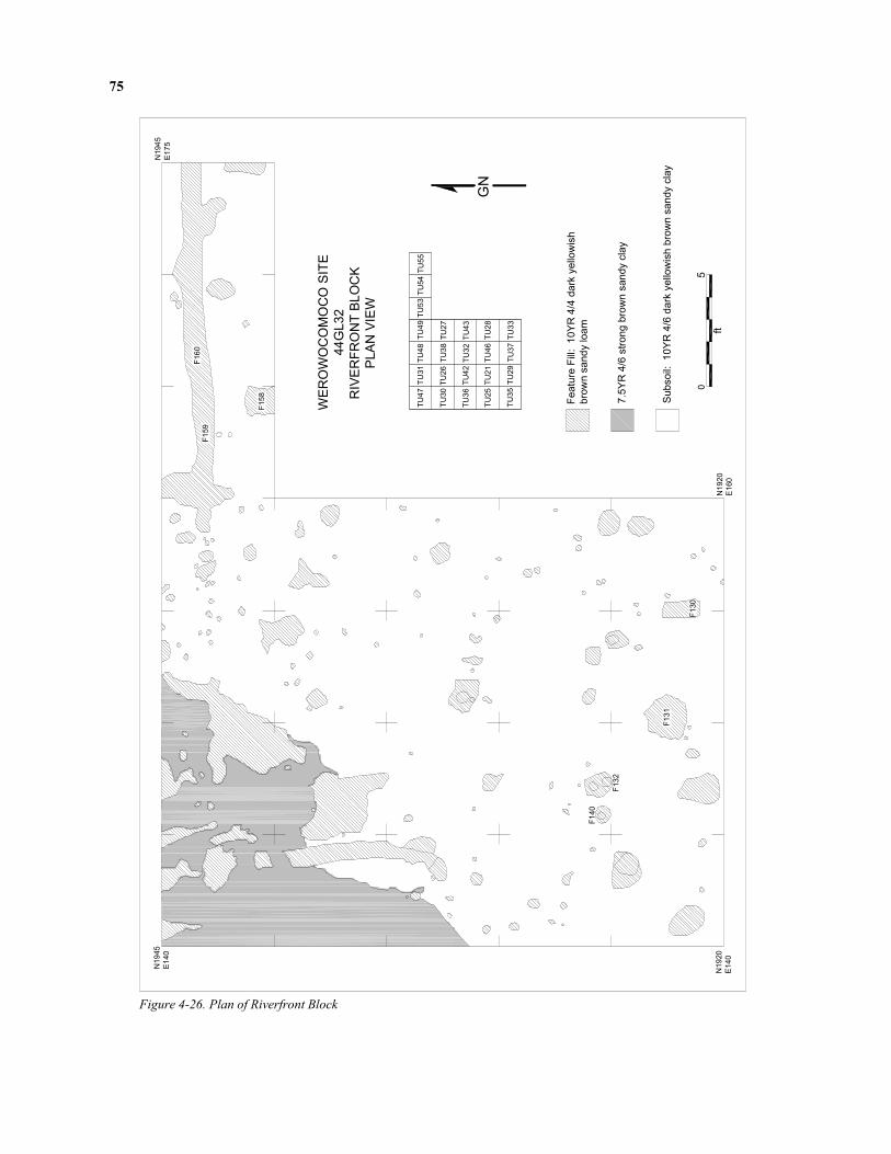
75
F140
F132
F131
F130
F159
F160
WEROWOCOMOCO SITE
44GL32
RIVERFRONT BLOCK
PLAN VIEW
Feature Fill: 10YR 4/4 dark yellowish
brown sandy loam
7.5YR 4/6 strong brown sandy clay
Subsoil: 10YR 4/6 dark yello
wish brown sandy clay
N1945
E140
N1920
E140
N1920
E160
N1945
E175
TU47
TU31TU48
TU49TU53TU54TU55
TU30TU26
TU38
TU27
TU36
TU42TU32
TU43
TU25TU21
TU46
TU28
TU35TU29
TU37TU33
05
ft
GN
F158
Figure 4-26. Plan of Riverfront Block

76
west, the plow zone varied in thickness from 0.30 feet in test unit 55 to 0.80 feet in test unit 47. This varia-tion in depth is likely due to a combination of vertical erosion and nineteenth- through twentieth-century landscaping. Temporally diagnostic materials from the historic era in the plow zone included imported ceramics, iron nails, and hand-made brick. Together with machine-made bottle glass and cut nails, the historic ceramics recovered from the Riverfront block reflect a promi-nent nineteenth- and twentieth-century presence (Figure 4-27). The majority of nineteenth- and twenti-eth-century domestic artifacts such as table glass frag-ments, iron can fragments, and whiteware pottery sherds were located west of grid line E155. Eight-eenth-century ceramics, including white salt-glazed and other English stonewares, creamware, and tin-glazed earthenware, were found evenly distributed in lower frequencies throughout the excavation block. The later materials coincide with evidence of a fence line, defined by a series of postholes running grid north-south through the excavation block. Since the fence line corresponds with trash disposal during the more recent period and does not conform to the distri-bution of the eighteenth-century material, the fence line was probably not built until the nineteenth cen-tury. Construction materials, including shell mortar, window glass, and hand-made brick, follow a similar Figure 4-25. Riverfront Excavation Block
Date
2000
1950
1900
1850
1800
1750
1700
1650
1600
1550
Creamware
Pearlware
Whiteware
Tin-glazed
N Midlands Slipware
English Stoneware
White Salt-glazed
Figure 4-27. Temporal Distribution of Plow Zone Ceramics from Riverfront Block.
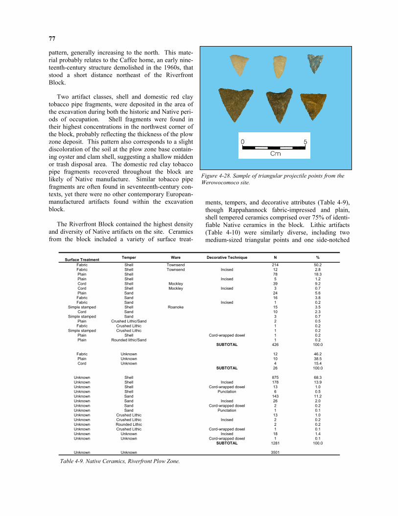
77
pattern, generally increasing to the north. This mate-rial probably relates to the Caffee home, an early nine-teenth-century structure demolished in the 1960s, that stood a short distance northeast of the Riverfront Block.
Two artifact classes, shell and domestic red clay tobacco pipe fragments, were deposited in the area of the excavation during both the historic and Native peri-ods of occupation. Shell fragments were found in their highest concentrations in the northwest corner of the block, probably reflecting the thickness of the plow zone deposit. This pattern also corresponds to a slight discoloration of the soil at the plow zone base contain-ing oyster and clam shell, suggesting a shallow midden or trash disposal area. The domestic red clay tobacco pipe fragments recovered throughout the block are likely of Native manufacture. Similar tobacco pipe fragments are often found in seventeenth-century con-texts, yet there were no other contemporary European-manufactured artifacts found within the excavation block. The Riverfront Block contained the highest density and diversity of Native artifacts on the site. Ceramics from the block included a variety of surface treat-
ments, tempers, and decorative attributes (Table 4-9), though Rappahannock fabric-impressed and plain, shell tempered ceramics comprised over 75% of identi-fiable Native ceramics in the block. Lithic artifacts (Table 4-10) were similarly diverse, including two medium-sized triangular points and one side-notched
Figure 4-28. Sample of triangular projectile points from the
Werowocomoco site.
Table 4-9. Native Ceramics, Riverfront Plow Zone.
Surface Treatment Temper Ware Decorative Technique N % Fabric Shell Townsend 214 50.2 Fabric Shell Townsend Incised 12 2.8 Plain Shell 78 18.3 Plain Shell Incised 5 1.2 Cord Shell Mockley 39 9.2 Cord Shell Mockley Incised 3 0.7 Plain Sand 24 5.6 Fabric Sand 16 3.8 Fabric Sand Incised 1 0.2
Simple stamped Shell Roanoke 15 3.5 Cord Sand 10 2.3
Simple stamped Sand 3 0.7 Plain Crushed Lithic/Sand 2 0.5 Fabric Crushed Lithic 1 0.2
Simple stamped Crushed Lithic 1 0.2 Plain Shell Cord-wrapped dowel 1 0.2 Plain Rounded lithic/Sand 1 0.2 SUBTOTAL 426 100.0
Fabric Unknown 12 46.2 Plain Unknown 10 38.5 Cord Unknown 4 15.4 SUBTOTAL 26 100.0
Unknown Shell 875 68.3 Unknown Shell Incised 178 13.9 Unknown Shell Cord-wrapped dowel 13 1.0 Unknown Shell Punctation 6 0.5 Unknown Sand 143 11.2 Unknown Sand Incised 26 2.0 Unknown Sand Cord-wrapped dowel 2 0.2 Unknown Sand Punctation 1 0.1 Unknown Crushed Lithic 13 1.0 Unknown Crushed Lithic Incised 2 0.2 Unknown Rounded Lithic 2 0.2 Unknown Crushed Lithic Cord-wrapped dowel 1 0.1 Unknown Unknown Incised 18 1.4 Unknown Unknown Cord-wrapped dowel 1 0.1
SUBTOTAL 1281 100.0
Unknown Unknown 3501

78
point. The presence of substantial numbers of fire-cracked rock and the overall diversity of lithic forms and materials support the notion that the Riverfront block is within a longstanding residential zone of the site. Contour maps of ceramic and lithic artifact den-sity across the block indicate that artifact densities
increase markedly on the northern edge of the block across most categories (Figures 4-29 and 4-30). Com-bining this evidence with the shovel test data, it ap-pears likely that the block is adjacent to an area of the site intensively occupied by Native residents.
140 145 150 155 160 165 170
1920
1925
1930
1935
1940
140 145 150 155 160 165 170
1920
1925
1930
1935
1940
140 145 150 155 160 165 170
1920
1925
1930
1935
1940
140 145 150 155 160 165 170
1920
1925
1930
1935
1940
140 145 150 155 160 165 170
1920
1925
1930
1935
1940
140 145 150 155 160 165 170
1920
1925
1930
1935
1940
Figure 4-29 Contour Map of Native Ceramics from the
Riverfront Block. From top: Townsend Fabric-impressed,
Plain Shell-tempered, Mockley Cord-marked.
Figure 4-30. Contour Map of Lithic Artifacts from the
Riverfront Block. From top: Debitage, bifaces, fire-
cracked rock.

79
Absolute seriation of the Native ceramics in the
block produced dates ranging from the fourteenth through early seventeenth centuries A.D., a result con-sistent with the numbers of Townsend ceramics recov-ered from the block (Figures 4-31 and 4-32). The presence of Mockley ceramics as a minority ware (10% of the assemblage) indicates that the Riverfront block also saw earlier, less intensive, Middle Wood-land settlement.
One copper object recovered from the Riverfront plow zone may tie the site to the English colonial presence in the region. The artifact is rectangular and measures roughly one inch square. It appears to be cut from a larger piece of copper and was later folded. Fragments of this size have been found in considerable numbers from early seventeenth-century contexts at Jamestown, and were specifically created for trade with the Powhatans (Kelso et al. 2001). The fragments of cop-per may be one of a number of objects traded during the early encounters between the English and Virginia Indians at Werowocomoco. Other copper objects col-lected by the landowners from the plow zone were found in both the pasture and the fields closer to the water. Several of these may be of early seventeenth-century origin, including several small scraps of sheet copper and an apparent rolled copper bead. (Figure 4-33). Analysis of these materials for their mineral com-position and their place of manufacture is currently underway.
Material Form N Weight (g) Argillite Primary decortation flake 1 Basalt Retouched flake 1
Chalcedony Tertiary flake 1 Chert Primary decortation flake 5 Chert Secondary flake 6 Chert Tertiary flake 17 Chert Shatter 6 Jasper Projectile point:Triangle 1 Jasper Tertiary flake 1 Quartz Tested cobble 2 Quartz Core 1 Quartz Primary decortation flake 41 Quartz Secondary flake 72 Quartz Tertiary flake 88 Quartz Shatter 112 Quartz Retouched flake 2 Quartz Fire-Cracked rock 7 170.3
Quartzite Primary decortation flake 24 Quartzite Secondary flake 171 Quartzite Tertiary flake 181 Quartzite Shatter 47 Quartzite Retouched flake 2 Quartzite Biface 2 Quartzite Projectile point 3 Quartzite Projectile point: Side Notched 1 Quartzite Projectile point: Triangle 2 Quartzite Abrader 1 Quartzite Fire-Cracked rock 28 1761.9 Slate Secondary flake 1
Table 4-10. Native Lithics, Riverfront Plow Zone.
Figure 4-31. Rappahannock Incised ceramics from
the Riverfront Block.
DATE A.D
1600 - 1650
1550 - 1600
1500 - 1550
1450 - 1500
1400 - 1450
1350 - 1400
1300 - 1350
7
6
5
4
3
2
1
0
Std. Dev = 86.11
Mean = 1521
N = 20.00
Figure 4-32. Histogram of Absolute Seriation Results for
Native Ceramics from the Plow Zone, Riverfront Block.
Figure 4-33. Rolled copper bead recovered from plow zone
deposits.

80
Features
Our excavations identified over 100 soil anomalies in the Riverfront block. Since the excavation strategy in this portion of the site prioritized exposure of a broad area of what appears to be the residential core of the Late Woodland / Contact period settlement, only eight features were sampled during the field season (Table 4-11). The excavated features include four that appear to be historic postholes based on their shapes and con-tents. Feature 130, which contained creamware, was rectangular in plan with a flat-based, U-shaped profile. Feature 131 was amorphous in plan with a flat-based profile and tapering sidewalls. Artifacts recovered from the feature include hand-made brick and a pearl-ware sherd, indicating the feature was likely filled after the late 1770s. Feature 132 was a rectangular posthole with two square molds that contained hand-made brick. Feature 158 was rectangular in plan with a U-shaped profile. Artifacts included oyster shell frag-ments and faunal remains. Native artifacts, including two quartzite flakes and a shell-tempered sherd, were also present in the feature. Feature 158, a possible postmold located in test unit 53, was rectangular in plan and measured 1.2 feet by 0.9 feet. Excavation of the north half of the feature exposed a round-based, U-shaped profile extending to a depth of 0.45 feet beneath the base of stratum I. Ar-tifacts recovered from the feature include oyster shell fragments and faunal remains. Native artifacts, includ-ing a quartzite secondary thinning flake and tertiary flake, a shell-tempered ceramic sherd, and an eroded ceramic sherd were also recovered from the feature. Features 159 and 160 are sections of a linear slot trench extending more than 35 feet east-west through several test units (Figure 4-34 and 4-35). Each exca-
vated section represents a 2.5-foot long sample of the trench. The width of the trench varied from 0.55 to 0.70 feet. Excavation revealed a flat-bottomed, U-shaped profile 0.25 feet deep. Artifacts recovered from the features included Rappahannock fabric-impressed pottery, Native lithics, oyster shell, and ani-mal bone fragments. One fragment of hand-made brick was also recovered from the top of feature 159. This was the only historic artifact found in the feature and may be intrusive.
Fea. Test unit(s)
Exca- vated Fill Max
N-S (ft) Max
E-W (ft) Max
Depth (ft) Artifacts Interpretation
130 33, 37 X 10YR4/4 sandy clay loam 1.40 0.80 1.00 Creamware sherd, shell fragment Post-1765
postmold
131 29, 37 X 10YR4/4 sandy clay loam 1.75 2.00 0.65
Pearlware sherd, handmade brick, Native ceramics (3), quartzite secondary flake,
shell fragments (2) Post-1770 postmold
132 21 X 10YR4/6 sandy loam mottled w/ 10YR3/6
sandy loam 1.20 0.80 0.60 Handmade brick, Native ceramics (2),
bone, shell Historic post-hole and postmold
140 21 10YR4/3 sandy loam 0.70 0.70 - Pigs tooth fragments (5) Historic post-mold
158 53 X 10YR4/3 silty loam 1.20 0.90 0.45 Native ceramics (2), quartzite flakes (2), shell (2), bone Postmold
159 31 X 10YR5/6 silty loam 2.00 - 0.10 Native ceramic, handmade brick, shell (4), bone Slot trench
160 54 X 10YR5/6 silty loam 1.80 - 0.28 Townsend fabric impressed sherd, Other Native sherds (2), quartzite flakes (2),
quartz shatter, shell (2), bone Slot trench
160A 54 X 10YR3/4 sandy loam 0.60 0.40 0.23 - Postmold 160B 54 X 10YR3/4 sandy loam 0.35 0.45 0.15 - Postmold
Table 4-11. Riverfront Block Features
10YR4/4 dark yellowish brown sandy loam
Subsoil: 10YR4/6 dark yellowish brown sandy clay
10YR4/4 dark yellowish brown sandy loam mottled with
10YR5/6 yellowish brown sandy loam and 10YR3/3
dark brown sandy loamGN
0ft.
Werowocomoco
44GL32
TU 54
Feature 160 before excavation
N1940 E165
F160
1ft.
Figure 4-34. Feature 160 Prior to Excavation.

81
A series of circular to elliptical soil anomalies ap-peared in an uneven distribution at the base of features 159 and 160. Six possible postmolds were identified at the base of feature 159. The postmolds ranged in size from 0.2 to 0.5 feet in diameter, none of which were sampled. Eight possible postmolds were also located at the base of feature 160. Two sampled postmolds were semicircular in plan with a V- (160A) or U- (160B) shaped profile. Neither contained any artifacts. In addition to these numbered features, two shallow soil anomalies appeared at the plow zone base running north-south and curving to the east near the south wall. These features may represent the remains of a cart path. The deposit contained dark brown (10YR4/3) silty loam mottled with dark yellowish brown (10YR3/4) silty loam and extended 0.3 feet beneath the plow zone base. Shallow cart “ruts” that extended slightly deeper appeared within some portions of this feature. Two additional soil anomalies were noted but not sampled. A 7.5YR4/6 strong brown sandy clay was found at the base of stratum I in most of test unit 30. No artifacts were observed on the surface of this soil concentration. Probing of the soil indicated the deposit extends at least two feet below the base of stratum I, suggesting that it represents a natural soil stratum. A second, more diffuse anomaly consisted of dark yel-lowish brown (10YR4/4 and 5/4) sandy loam mottled with oyster and clam shell inclusions located in por-tions of test units 26, 31, 38, and 48. The highest con-centrations of oyster and clam shell in the excavation
block were found in the vicinity of this soil anomaly, as well as a substantial number of Native ceramics and lithics. This area appears to represent the remains of shell disposal in the vicinity of a former living surface. The evidence from the Riverfront Block will help guide future excavation strategies at the site aimed at identifying Native features dating to the Contact pe-riod. The paucity of Native pit features in an area of the site with such high densities of Native artifacts in the plow zone seems, at first glance, somewhat puz-zling. The Riverfront block contained roughly ten times the density of Townsend sherds compared with other portions of the site and four times the density of lithic artifacts, as discussed below. The presence of Native postmolds indicates that the area contained structures whose outlines are now difficult to detect. As noted above, residential areas of Contact period settlements in the Chesapeake often contain few fea-tures beyond postmolds. The linear trench that extends almost the full length of the northern wall of the excavation block represents a landscape feature intended to separate two areas. While we did recover a small amount of hand-made brick near the top of one of the trench sections, no other historic artifacts were found within the feature fill or the sampled postmolds. If the trench was con-structed by eighteenth- or nineteenth-century occu-pants of the site, it likely performed the same functions as the fence lines described above. Its orientation co-incides with more recent landscape features and may have delineated field from yard or a small garden. If
Subsoil: 10YR4/6 dark yellowish brown sandy clay
Feature 160
West Profile
Level Line
Werowocomoco
44GL32
TU 54
Feature 160
Plan View After Excavation
N1943.8
E167.5
N1943.1
E167.5
160A
Feature 160B
North ProfileLevel Line
Feature 160A
North Profile
0ft.
Level Line
N1943.1
E170
160B GN
N1944
E170
10YR3/4 dark yellowish brown sandy loam
10YR4/4 dark yellowish brown silty sand
10YR3/3 dark brown sandy loam
10YR4/3 brown / dark brown sandy loam
1ft.
Level Line
Feature 160
East Profile
Figure 4-35. Feature 160 After Excavation.

82
Cornfield Excavation Block
the hand-made brick is intrusive, and the trench instead dates to the Native occupation of the site, the feature may have separated domestic living spaces or served a defensive function as a palisade. A significant in-crease in the amount of Native material was recorded during shovel testing immediately north of the trench, suggesting that this may indeed mark a division be-tween two heavily occupied areas of the village. John White’s painting of Secota (Figure 4-16) includes just such a fence line. The historic domestic artifacts recovered from the Riverfront block reflect a typical domestic assemblage from an extended occupation lasting from the late eighteenth through the twenty-first centuries. Differ-ences in the concentrations of these artifacts over the excavation area likely reflect shifting attitudes toward
trash disposal that correspond with changes in the use of space. In the years shortly before the Caffee family built their home near the excavation area, and possibly their first years of residence, they disposed of very little trash in this portion of the site. By mid-century the occupants of the house built a fence demarcating yard space from agricultural fields and began dispos-ing their refuse beyond the fence in an attempt to maintain cleaner areas within the more formalized landscape. This coincides with changes in Victorian sensibilities reflected in a modified form by the rural middle class families of the Middle Atlantic region (e.g., Bushman 1993). The maintenance of these fence lines reflects a long-term commitment to these ideals, and an attempt to sustain borders between the agricul-tural world and the home space.
The smallest excavation block opened during the 2003 season was located approximately 350 feet from the Purtan Bay waterfront within a field planted in corn (Figure 4-36). Excavation of four test units in this area recovered the lowest densities of historic ma-terials on the site but comparable densities of Native materials. The paucity of historic materials in the Cornfield block reflects its distance from residential spaces and other activity areas intensively used during the historic era. No post-contact features were found in this portion of the site, raising the likelihood that Native deposits in the Cornfield block experienced less of an impact from historic occupations than other por-tions of the site.
Stratigraphy
The Cornfield block uncovered stratified deposits that included two stacked plow zones and what appears to be a buried “A” horizon (Figures 4-37 and 4-38). The more recent plow zone of 10YR3/4 sandy loam extended to depths ranging from 0.8 – 1.1 feet below surface, while an older plow zone consisting of 10YR3/4 sandy loam mottled with 10YR5/8 sandy silt with plow scars at its base extended to depths ranging from 1.0 – 1.3 feet below surface. These deposits were combined as stratum I. A third layer of soil (excavated as stratum II) contained a light scatter of Native arti-facts beneath this second plow zone. The interface between stratum I and II undulated to a greater degree than the current surface, suggesting a historic landform with greater topographic variation than at present. Due to the possibility that the Cornfield block con-
tained stratified deposits, test unit 56 was excavated in arbitrary 0.1-foot levels starting at one foot below sur-face. Our goal in using this strategy was to detect de-posits containing solely Native materials associated with a buried cultural horizon. As listed in Table 4-12, stratum I soils (i.e., the Ap horizon or plow zone) con-tained a mix of historic and Native materials. Beneath the stratum I plow scars, stratum II was defined by a change in soil color and texture. Stratum II contained a light scatter of Native pottery and one piece of iron. At the base of stratum IIb the darker soils of stratum II covered all of test unit 41 and the eastern portions of test units 44 and 56 in an arcing pattern that parallels a line of posts in these units. Stratum II may indeed represent a buried A horizon, i.e., organic- and artifact-rich soils of a former living surface that include, in this case, diagnostic artifacts from the Middle Woodland through Contact periods. Another possibility is that these soils represent a sub-surface zone of soil composed of materials and organic matter leached from an A horizon (i.e., a B horizon). Given that the stratum II soils roughly parallel an arc-ing line of postmolds immediately to the east (described below), the deposits may be associated with the western end of a Native domestic structure. The stratum II deposits differ only subtly in color from the overlying plow zone soils and artifact density was low, lending some support to the notion that they represent a B horizon. Future excavation in this portion of the site and additional radiocarbon dates should clarify these issues.
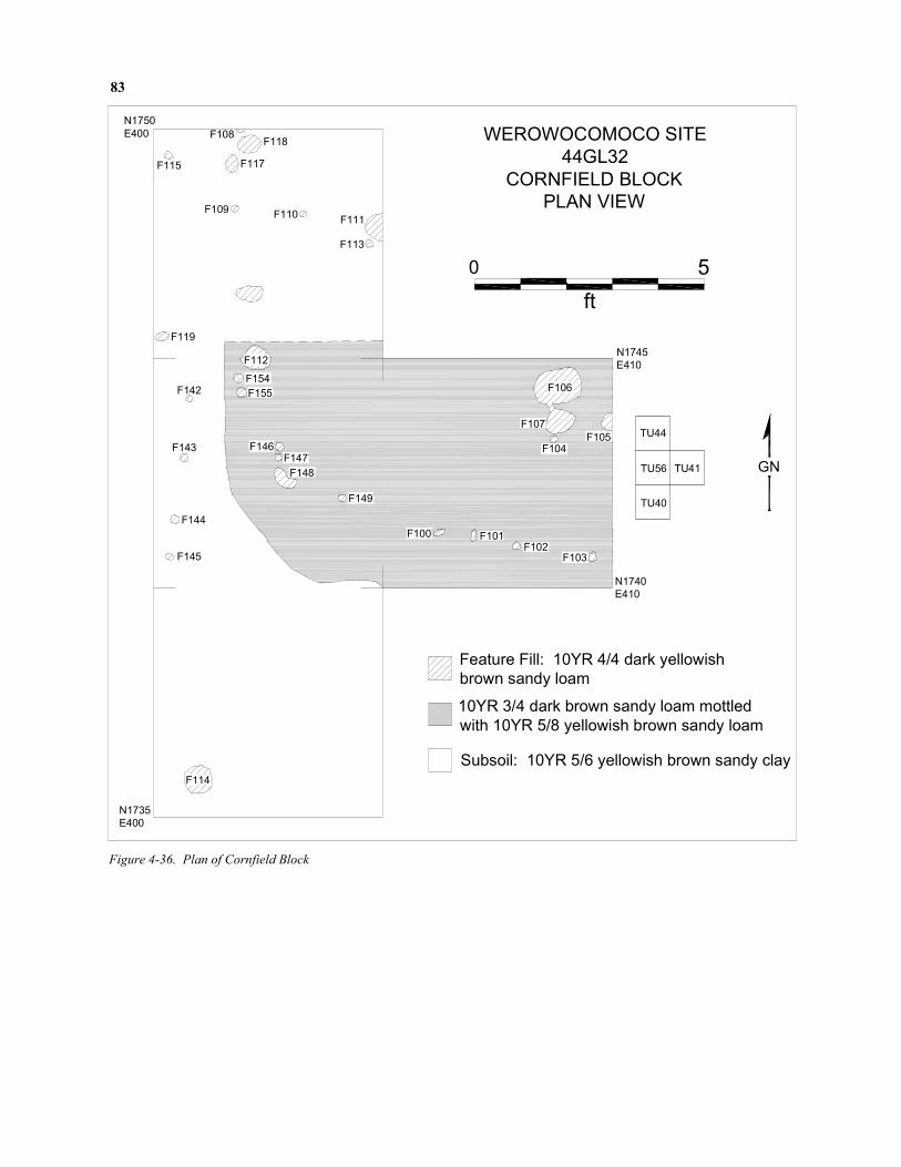
83
F115
F108F118
F117
F109 F110F111
F113
F119
F112
F154
F155F142
F143
F144
F145
F146F147
F148
F149
F100 F101F102
F103
F106
F107
F104F105
F114
WEROWOCOMOCO SITE
44GL32
CORNFIELD BLOCK
PLAN VIEW
N1750
E400
N1735
E400
N1745
E410
N1740
E410
TU44
TU56
TU40
TU41
Feature Fill: 10YR 4/4 dark yellowish
brown sandy loam
10YR 3/4 dark brown sandy loam mottled
with 10YR 5/8 yellowish brown sandy loam
Subsoil: 10YR 5/6 yellowish brown sandy clay
0 5
ft
GN
Figure 4-36. Plan of Cornfield Block

84
Ib
Level Line
Ia
II
TU 41
Werowocomoco44GL32
North Profile
N1745
E405
1ft.0ft.
Possible intact "A" horizon: 10YR3/4 dark yellowish brown
sandy loam (60%) mottled with 10YR5/8 yellow sand (40%)
Subsoil: 10YR5/8 yellow sandy clay
Plow zone: 10YR3/4 dark yellowish brown sandy loam
(95%) mottled with 10YR5/8 yellow sand (5%)
Plow zone: 10YR3/4 dark yellowish brown sandy loam
V
N1745
E410
N1745
E405
Plow zone: 10YR3/4 dark yellowish brown sandy loam
Plow zone, 10YR3/4 dark yellowish brown sandy loam (95%) mottled
with 10YR5/8 yellow sand (5%)
Possible intact "A": 10YR3/4 dark yellowish brown (60%) mottled with
10YR5/8 yellow sand (40%)
10YR5/8 yellow sand (85%) mottled with 10YR3/4 dark yellowish brown
sandy loam (15%)
10YR5/8 yellow sand
Subsoil: 10YR5/8 yellow sandy clay
0ft. 1ft.
III
44GL32Werowocomoco
West Profile
N1740
E405
TU 41
II
V
IV
Ia
Level Line
Ib
Figure 4-37. Test Unit 41 North Profile. Figure 4-38. Test Unit 41 West Profile.
Strat / Lvl
Starting depth (ft)
Ending depth (ft) Soil Feats / anomalies
at base Artifacts Comments
I a 0.0 0.8 10YR3/4 sandy loam -
Brick, coal, glass, nails, domestic and imported pipe stems, Historic ceramics (North Devon, Tin-glazed, English stoneware, Pearlware, Creamware), Fire-
cracked rock, lithics, Roanoke simple-stamped pottery
Plow zone
I b 0.8 1.0 10YR3/4 sandy loam Plow scars Brick, coal, nails, lithics, English stoneware, shell-
tempered Native pottery Plow zone
I c 1.0 1.1 10YR3/4 sandy loam Plow scars Roanoke simple-stamped pottery Base of plow zone
II a 1.1 1.2 10YR3/4 sandy loam mottled w/ 10YR 5/8
sandy silt
No plow scars, amorphous stains w/ charcoal flecks
Shell-tempered Native pottery Possible buried “A” horizon Late Wood-land / Contact?
II b 1.2 1.3 10YR3/4 sandy loam w/ 10YR 5/8 sandy
silt Post molds Shell-tempered Native pottery, iron fragment
Possible buried “A” horizon dating to Late Woodland / Contact
II c 1.3 1.4 - 1.5
10YR3/4 sandy loam mottled w/ 10YR 5/8
sandy silt - Mockley cord-marked pottery
Possible “A” horizon base dating to Middle
Woodland
Table 4-12. Deposits from Test Unit 56.

85
Plow Zone Artifacts
Plow zone materials recovered from the Cornfield block point toward a series of late precontact through twentieth-century activities. Historic ceramics present in the Cornfield block include low numbers of wares produced during the seventeenth through twentieth centuries, with some indications that the area was used more intensively during the eighteenth and early nine-teenth centuries (Figure 4-39). The two measurable pipe stem fragments fell into the 1710 – 1750 range (5/64ths). Native ceramics from the Cornfield plow zone gen-erated absolute seriation dates falling in the fourteenth, sixteenth, and seventeenth centuries A.D. (Figure 4-40). Ceramic wares included Mockley, Townsend, and Roanoke (Table 4-13), extending this occupation range from the Middle Woodland period through Contact. Native lithic artifacts recovered from the block were predominantly quartz and quartzite and included no temporally diagnostic items (Table 4-14).
Features
Twenty-nine soil stains appeared within the Corn-field excavation units, most of which had the dimen-sions and shapes of Native postmolds, i.e., circular plans and shallow, basin- or v-shaped profiles (Table 4-15). The majority of features in the block contained
no artifacts and none included historic materials. Post-molds in test units 41, 56, and 44 formed what may be the arcing line of a Native house pattern, and a second line of posts in test unit 56 was also apparent. Two larger pit features with basin-shaped profiles also oc-curred in the block. Features 106 and 114 both con-tained shell-tempered Native pottery. As noted in Ta-ble 4-15, our excavations exposed other features with dimensions similar to features 106 and 114, though none were associated with any artifacts. In general, excavations in the Cornfield block indi-cate the considerable spatial extent of archaeological deposits associated with Native occupations at the site. The block is located several hundred feet from the Pur-tan Bay riverfront yet it contains domestic architectural features and (possibly) the intact deposits of a living surface predating English colonial settlement. The presence of a line of Native postmolds in an area of the site otherwise containing modest numbers of Native materials suggests that similar domestic features may be present across much of the site. In fact, the pattern is consistent with other sites, such as Paspahegh (44JC308) along the James River (Lucketti et al. 1994), where dispersed village communities of the Late Woodland / Contact era are associated with a light scatter of artifacts.
Whitew
are
Pearlware
Cream
ware
Wh Salt-G
lazed
English Stoneware
N Devon G
ravel
Tin-glazed
Date
2000
1950
1900
1850
1800
1750
1700
1650
1600
1550
Figure 4-39. Temporal Distribution of Historic Ceramics from Corn Field Block
Plow Zone. Each bar represents one sherd.

86
Date A.D.
1600 - 17001500 - 16001400 - 15001300 - 14001200 - 1300
2
1
0
Std. Dev = 162.73
Mean = 1490
N = 3.00
Figure 4-40. Absolute Seriation of Native Ceramics from the Plow Zone, Cornfield Block.
Surface Treatment Temper Decorative
Technique Ware N
Cord Shell - Mockley 5 Cord Shell Incised Mockley 1 Fabric Sand - - 1 Fabric Shell - Townsend 2 Simple stamped Shell - Roanoke 3
Plain Shell - - 4 Plain Sand - - 2
Unknown Unknown - - 164 Unknown Shell - - 41 Unknown Shell Incised - 14 Unknown Sand - - 14 Unknown Sand Incised - 1
Unknown Crushed lithic - - 1
Material Form N Grams
Chert Primary decortation flake 1 Chert Secondary flake 1
Chert Shatter 1
Quartz Primary decortation 4
Quartz Secondary flakes 4
Quartz Tertiary flakes 1
Quartz Shatter 4
Quartzite Biface 1
Quartzite Fire-cracked rock 2 294
Quartzite Secondary flakes 8
Quartzite Tertiary flakes 5
Quartzite Shatter 2 Slate Tertiary flake 1
Table 4-13. Native Ceramics, Cornfield Plow Zone. Table 4-14. Native Lithics, Cornfield Plow Zone.

87
Feat. Identified within unit
(s)
Exca-
vated
Fill Max N-S
Max E-W
Max Depth Artifacts Interpretation
100 41 X 10YR3/4 sandy loam 0.18 0.26 0.1.5 - Native post mold 101 41 X 10YR3/4 sandy loam 0.26 0.17 0.12 Native pottery sherd Native post mold 102 41 X 10YR3/4 sandy loam 0.18 0.16 0.15 - Native post mold 103 41 X 10YR3/4 sandy loam 0.16 0.17 0.13 - Native post mold 104 41 X 10YR3/4 sandy loam 0.16 0.14 0.20 - Native post mold 105 41 X 10YR3/4 sandy loam - 0.42 0.20 - -
106 41 X 10YR3/4 sandy loam w/ 10YR5/8 sandy silt 0.74 1.02 0.46 Native pottery sherd
Native pit 107 41 X 10YR3/4 sandy loam 0.58 0.53 0.80 - - 108 44 X 10YR3/4 sandy loam 0.18 0.20 0.17 - Native post mold 109 44 X 10YR3/4 sandy loam 0.17 0.16 0.20 - Native post mold 110 44 X 10YR3/4 sandy loam 0.17 0.17 0.18 - Native post mold 111 44 X 10YR3/4 sandy loam 0.58 - 0.14 - - 112 44 X 10YR3/4 sandy loam 0.41 0.42 0.21 - - 113 44 X 10YR3/4 sandy loam 0.15 0.15 0.14 - Native post mold
114 40 X 10YR3/4 sandy loam 0.57 0.60 0.25 Shell-tempered (3), sand-tempered (1), and uniden-tified Native pottery (1)
Shallow Native pit
115 44 X 10YR3/4 sandy loam 0.20 0.22 0.20 - Native post mold 117 44 X 10YR3/4 sandy loam 0.38 0.30 0.30 - - 118 44 X 10YR3/4 sandy loam 0.40 0.50 0.20 - - 119 44 X 10YR3/4 sandy loam 0.28 0.20 0.18 - Native post mold 142 56 X 10YR3/4 sandy loam 0.18 0.18 0.20 - Native post mold 143 56 X 10YR3/4 sandy loam 0.20 0.18 0.18 - Native post mold 144 56 X 10YR3/4 sandy loam 0.20 0.19 0.18 - Native post mold 145 56 X 10YR3/4 sandy loam 0.20 0.18 0.18 - Native post mold 146 56 10YR3/4 sandy loam 0.22 0.20 - Native post mold 147 56 10YR3/4 sandy loam 0.20 0.18 - Native post mold 148 56 10YR3/4 sandy loam 0.30 0.62 - Native post mold 149 56 10YR3/4 sandy loam 0.20 0.19 - Native post mold 154 56 10YR3/4 sandy loam 0.21 0.20 - Native post mold 155 56 10YR3/4 sandy loam 0.40 0.22 - Native post mold
Table 4-15. Corn Field Block Features.
Summary
To summarize the results of the 2003 season at Werowocomoco, we excavated four blocks, each of which produced information useful to understanding the Late Woodland / Contact period village. Excava-tions in the pasture blocks identified two large, parallel ditch features containing Native artifacts that produced radiocarbon dates in the fifteenth century AD. The scatter of postmolds identified in this portion of the site did not form any discernible patterns. The large, apparently rectilinear feature in the pasture points to-
ward the earliest historical (i.e., post-contact) presence at the site, an occupation that likely began in the late seventeenth or early eighteenth century. Excavations in the Riverfront block produced the highest density of Native materials and an array of Native postmolds. The Cornfield block identified a possible buried cul-tural horizon containing Middle and Late Woodland diagnostics, several small Native features, and an arc-ing pattern of Native postmolds.

88
Though the Werowocomoco research is still at an early stage, the results of the first field season demon-strate that the site will shed light on a settlement that played an important role in the Contact period. Our research addresses two broad themes: 1) a community-oriented perspective on the development of a Native chiefdom polity from A.D. 1300 - 1609 and, 2) a study of the Chesapeake colonial encounter’s material conse-quences from the vantage of a Native center. Thus far, our field research indicates that the site was a remarka-bly large village circa 1607 containing evidence of substantial landscape modification dating to Contact and the centuries immediately preceding 1607.
Our review of the ethnohistorical and archaeologi-cal context of the site indicates that studies of the Powhatans are now at a critical juncture. A compara-ble body of data from archaeological sites on the James (the Paspahegh site, Jordan’s Point) and the York (Werowocomoco and Kiskiack) is starting to emerge. Studies of Contact-period material culture have allowed researchers to examine the social entan-glements that defined the Contact period. Interpretive frames applied to the culture history of Native societies in the Chesapeake now include perspectives that com-bine a close reading of the archaeological and docu-mentary evidence with social theories on cultural prac-tice, political economy, and cosmology. The descen-dant communities of Virginia Indians have also in-sisted that they be part of the process to recover and represent their history. Opportunities for a new his-torical anthropology of the Chesapeake region abound.
Research goals during the first season of excava-
tions at the Werowocomoco site focused on the related issues of site integrity, chronology, and spatial organi-zation. Our archaeological survey identified a large, complex, and multi-component site. Elements of the survey record parallel models of a dispersed Native settlement dating to the Contact period. The subse-quent excavations indicate that the site contains intact features from the Late Woodland through Contact peri-ods and an array of later deposits from the historic era. Two of the excavation blocks, the Pasture West block and the Cornfield block, yielded features and possibly a buried horizon dating to the Late Woodland through Contact periods. The other two excavation blocks con-tained postmold stains that could date to any number
of periods prior to the English colonial occupation of the site. In terms of integrity and feature preservation, these results compare favorably with other Native sites dating to the terminal Late Woodland through Contact periods in the Coastal Plain, most of which include few features beyond postmolds and burials.
The site’s radiocarbon dates, Native ceramics, and
European trade goods point toward ephemeral Middle Woodland occupations and increasingly intensive set-tlement toward the end of the Late Woodland period. Mockley ceramics, generally dating from A.D. 200 to A.D. 900, comprise a minority component in all of the excavation blocks except the Cornfield. Townsend ceramics, which persist on the Middle Peninsula from A.D. 900 – 1600, occur in particularly high densities along the Purtan Bay riverfront (Figure 5-1). Roanoke simple-stamped ceramics dating to the terminal Late Woodland centuries and the Contact period occur in higher densities in the Pasture West block – the area containing the two ditches. Absolute seriation of plow zone contexts in each of the blocks points toward Late Woodland settlement that increased after A.D. 1400. Copper trade goods recovered from the plow zone combined with the materials from the burial and cache of artifacts described in chapter 3 parallel a Con-tact period component at the site. An important goal in future field seasons will be to identify intact features that may be dated definitively to the Contact period.
Changes in the nature of historic-era occupations
are also apparent in artifact patterns at the site (Figure 5-2). The two pasture blocks, which contained pre-dominantly eighteenth-century materials, included the highest densities of ceramics and pipe fragments. The density of nails and brick increased in the Pasture East block over the Pasture West block, likely correspond-ing to the presence of structures in that area. The den-sities of glass containers and brick peaked in the River-front block corresponding with shifts in material cul-ture during the nineteenth century. These variations seem to indicate a spatial reorganization at the site during the late eighteenth or early nineteenth centuries, when the focus of the farmstead shifted closer to the river. Finally, densities of all categories of historic materials were lowest in the Cornfield block, raising the likelihood of undisturbed Native deposits in this portion of the site.
CHAPTER 5
_________________
CONCLUSION

89
Corn Field
Riverfront
Pasture East Block
Pasture West Block
Artifacts per Test Unit (log scale)
40
30
20
10
54
3
2
1
.5
.4
.3
.2
.1
Mockley
Townsend
Roanoke
Plain shell-tempered
Lithic artifactsHandmade brick
Wrought Nails
Free-blown glass
Imp tobac pipe frags
Dominant ceramic
Artifacts per Test Unit (log scale)
300
200
100
5040
30
20
10
54
3
2
1
Pasture West Block
Pasture East Block
Riverfront
Corn Field
Figure 5-1. Comparison of Native Artifacts by Block. Figure 5-2. Comparison of Historic Artifacts by Block.
Taken together, the temporal and spatial pattern-ing identified during the 2003 season suggests a narra-tive outline of the site’s historical landscapes. The Middle Woodland through Contact period use of space at the site apparently expanded inward from the first floodplain terrace overlooking Purtan Bay, Leigh Creek, and Bland Creek. As suggested by the shovel test survey, Middle Woodland II (A.D. 200 – A.D. 900) settlement at the site focused on this lowest ter-race. The Townsend ceramics concentrated in the Riv-erfront block point toward a greater concentration of residential activities and living spaces on Purtan Bay throughout the Late Woodland period. Based on the absolute seriation results, this use of the riverfront as the residential core of the village peaked during the fifteenth through early seventeenth centuries. The two available radiocarbon dates and the density of Roanoke ceramics recovered from the Pasture West block indi-cate that a roughly contemporaneous expansion of the site occurred 1000 feet to the east in the pasture. Though we have much to learn about the role of the ditch features and this area more generally, the use of space in the pasture differed markedly from the resi-dential core of the village on Purtan Bay. This portion of the site may correspond with an elite or sacred area of the village, one created late in the precontact era and eventually tied to Wahunsenacawh’s residence, as mentioned in John Smith’s account.
As outlined in chapter 3, the burial and artifact
cache located on the second floodplain terrace contrib-ute to the next chapter in the Werowocomoco narra-tive. The cache contained the three categories of mate-rial sought most by Wahunsenacawh and the Powhatans generally: copper ornaments, glass beads, and iron tools. The presence of two ‘King’s Touch”
tokens and almost 4,000 glass beads suggest a high status burial, possibly one with ties to, or a relative of, Wahunsenacawh. The materials accompanying the remains of the 2 – 4 year old child can only be under-stood within the context of Powhatan mortuary ritual, Native symbolic systems, and early seventeenth-century relations that created new social identities and meanings in the negotiated events of culture contact. The presence of these early seventeenth-century pres-tige goods at Werowocomoco prompts questions about who the remains represent and what role he or she played within Powhatan kinship relations and early colonial interaction in the Chesapeake, questions that cannot be answered at this time. The remains were interred in an area of the site overlooking both the ditch features identified in the pasture and the residen-tial village.
This Native cultural landscape clearly evolved
through time with new elements that took cues from existing uses of space. We will need to test a good deal more of the site before we understand this landscape history in any detail. Aspects of the Contact period settlement that have already emerged, though, may parallel the use of space illustrated in the John White watercolor of the North Carolina Algonquian settle-ment of Secota, reproduced below from the DeBry engraving that accompanied Hariot’s (Lorant 1946) Brief and True Report. The images from White (and DeBry) have been used to illustrate so many discus-sions of Native community organizations during the early colonial era that they have become iconic. De-spite this overuse, the illustrations nonetheless provide a useful departure point for thinking about the use of space within Contact period Werowocomoco.

90
The caption that accompanied the image is repro-duced below:
THOSE of their towns which are not fenced in
are usually more beautiful, as can be seen in
this picture of the town of Secota. The houses
are farther apart and have gardens (marked
E), in which they grow tobacco, called by the
natives uppówoc. They also have groves of trees where they hunt deer, and fields where
they sow their corn. In the cornfields they set
up a little hut on a scaffold, where a watch-
man is stationed (F). He makes a continual
noise to keep off birds and beasts which
would otherwise soon devour all the corn.
They sow their corn a certain distance apart
(H) , so that one stalk should not choke the
next. For the leaves are large like great reed
leaves (0).
They also have a large plot (C) where they
meet with neighbors to celebrate solemn
feasts, and a place (D) where they make
merry when the feast is ended. In the round
plot (B) they assemble to pray. The large
building (A) holds the tombs of their kings
and princes. In the garden on the right (I)
they sow pumpkins. There is also a place (K)
where they build a fire at feast time, and just
outside the town is the river (L) from which
they get their water.
These people live happily together without
envy or greed. They hold their feasts at night,
when they make large pres to light them and
to show their joy.
White’s paintings and DeBry’s engravings have
been characterized as Europeanized imagining of the Native world in coastal North Carolina. No doubt this characterization has some validity, as may be seen in the wide, straight avenue running through Secotan. Yet White was also a careful observer whose detailed imagery capture details that would otherwise be lost. Like Secotan, the Werowocomoco site includes a con-centrated residential core located in close proximity to the riverfront. Moving away from the river in the Secotan image, an area of agricultural fields is fol-lowed by round plots for prayer, feasting, and ritual. Opposite the dance circle a structure houses the re-mains of “kings and princes.” Similarly, the interior zone of the Werowocomoco site includes ditch fea-tures opposite an area containing at least one high status burial. Though these possible parallels between an Algonquian community in North Carolina and one in Virginia are suggestive, at this stage in our research they simply provide hypotheses for testing in future investigations at the site.
The earliest English colonial settlement at
Werowocomoco apparent in our excavations, dating to the late seventeenth or early eighteenth century, was superimposed directly on the area of the Native settle-ment defined by the ditches. In fact, the colonial set-tlement in the pasture represents a seemingly odd loca-tion for an English settlement of this period given its distance from the York River. The location may re-flect a conscious effort to incorporate elements of the Powhatan landscape by colonists who were aware of the property’s history. Alternatively, this portion of the site may have appealed to the settlers since it of-fered an open space cleared of trees and closer to fresh water springs. Finally, a reorganization of space within the farmstead moved the focus of settlement closer to the river late during the eighteenth century or early nineteenth century.
This narrative will no doubt be amended and re-
vised as we accumulate additional information from the site. Future research directions critical to this ef-
Figure 5-3. John White painting of “The Town of Secota”
from Lorant (1946:191).

fort include excavations to determine the size, shape, contents, and chronology of the ditch features in the pasture. Testing in the area surrounding the ditches is also critical to understanding the overall spatial context of these landscape features. Further investigation of the riverfront area is needed to evaluate the primary living space of the village during the Late Woodland and Contact periods. Excavation of the Cornfield block should allow us to determine whether the area contains intact deposits and residential architecture, both of which are suggested by the limited testing in this portion of the site.
Perhaps even more essential than these efforts, a richer understanding of the long-term precontact his-tory of the site is also needed. An excavation strategy designed to identify such evidence, including buried deposits that may be present along Purtan Bay, Leigh, and Bland Creeks, is planned for the current field sea-son. By combining such evidence with the results of copper characterization studies, radiocarbon dating, and ethnobotanical analysis (all currently underway), a better understanding of Werowocomoco’s history will emerge.

92
REFERENCES
_________________ Althusser, Louis and Etienne Balibar 1971 Reading Capital. New York: Pantheon Books. Axtell, James 2001 Natives and Newcomers: The Cultural Origins of North America. New York: Oxford University Press. Barbour, Philip L. 1964 The Three Worlds of Captain John Smith. Boston: Houghton Mifflin. 1969 The Jamestown Voyages under the First Charter, 1606-1609: Documents Relating to the Foun-
dation of Jamestown and the History of the Jamestown Colony up to the Departure of Captain
John Smith, last President of the Council in Virginia under the First Charter, Early in October
1609. London: published for the Hakluyt Society by Cambridge U.P. 1970 Pocahontas and Her World; a Chronicle of America's First Settlement in Which Is Related the S
tory of the Indians and the Englishmen, Particularly Captain John Smith, Captain Samuel Ar-
gall, and Master John Rolfe. Boston: Houghton Mifflin. 1986 The Complete Works of Captain John Smith (1580-1631). Chapel Hill: University of North Carolina Press. Binford, Lewis R. 1964 Archaeological and Ethnohistorical Investigations of Cultural Diversity and Progressive
Development among the Aboriginal Cultures of Coastal Virginia and North Carolina. Ph.D. dissertation, University of Michigan. Blanton, Dennis B. 1999 The Potomac Creek Site (44ST2) Revisited. Richmond: Virginia Department of Historic Resources. 1999 A Study of the First People of the Eastern Shore: Archaeological Evaluation of the Thomas
Wharf Site (44NH1), Northampton County, Virginia. Williamsburg, Va.: Center for Ar- chaeological Research, Department of Anthropology, The College of William & Mary. 2000 Drought as a Factor in the Jamestown Colony, 1607 - 1612. Historical Archaeology 34:74-81. Blanton, Dennis B. and Carter C. Hudgins nd Archaeological Evidence for Native Prestige Commodity Devaluation: An Example from the
Chesapeake Associated with the Jamestown Colony. Unpublished manuscript. Blanton, Dennis B., Veronica Deitrick, and Kara Bartels 2001 Brief and True Report of Projectile Points from Jamestown Rediscovery as of December 1998. Journal of the Jamestown Rediscovery Center 1. Boyd, Donna C. and C. Clifford 1992 Late Woodland Mortuary Variability in Virginia. In Middle and Late Woodland Research in Vir
ginia: A Synthesis. T. Reinhart and M.E. Hodges, eds. Pp. 249-276. Richmond: The Dietz Press. Bradley, Richard 2000 An Archaeology of Natural Places. New York: Routledge. Braun, David P. 1983 Pots as Tools. In Archaeological Hammers and Theories. J. Moore and A. Keene, eds. Pp. 107- 134. New York: Academic Press. Braun, David P. and Stephen Plog 1982 Evolution of "Tribal" Social Networks: Theory and Prehistoric North American Evidence. American Antiquity 47:504-525. Brown, Alexander 1890 The Genesis of the United States ; a Narrative of the Movement in England, 1605-1616, Which
Resulted in the Plantation of North America by Englishmen, Disclosing the Contest between
England and Spain for the Possession of the Soil Now Occupied by the United States of Amer-
ica ; Set Forth through a Series of Historical Manuscripts Now First Printed, Together with a
Reissue of Rare Contemporaneous Tracts, Accompanied by Bibliographical Memoranda, Notes,

93
and Brief Biographies. London: W. Heineman. 1969 The First Republic in America; an Account of the Origin of This Nation, Written from the Re-
cords Then (1624) Concealed by the Council, Rather Than from the Histories Then Licensed by
the Crown. New York: Russell & Russell. Brown, Marley R. and Kathleen J. Bragdon 1986 Toward a Resource Protection Process: James City County, York County, City of Poquoson, and
City of Williamsburg. Williamsburg, Va.: Office of Archaeological Excavation, Department of Archaeology, Colonial Williamsburg Foundation. Bushman, Richard 1993 The Refinement of America: Persons, Houses, and Cities. New York: Vintage Books. Casey, Edward S. 1997 The Fate of Place: A Philosophical History. Berkeley: University of California Press. Certeau, Michel de 1984 The Practice of Everyday Life. Berkeley: University of California Press. Chamberlayne, C. G. 1933 The Vestry Book of Petsworth Parish Gloucester County, Virginia, 1677-1793. Richmond: Virginia State Library. Claassen, Cheryl 1998 Shells. Cambridge: Cambridge University Press. Cosgrove, Denis E. 1984 Social Formation and Symbolic Landscape. London: Croom Helm. Cotter, John L. 1994 Archaeological Excavations at Jamestown, Virginia. Special Publication 32. Courtland, Va.: Ar cheological Society of Virginia. Curry, Dennis C. 1999 Feast of the Dead: Aboriginal Ossuaries in Maryland. Crownsville: Maryland Historical Trust Press. D'Altroy, Terence N. and Timothy Earle 1985 Staple Finance, Wealth Finance, and Storage in the Inka Political Economy. Current Anthropol-
ogy 26:187-206. DeBoer, Warren R. 1988 Subterranean Storage and the Organization of Surplus: The View from Eastern North America. Southeastern Archaeology 7:1-20. Deetz, James 1988 American Historical Archaeology: Methods and Results. Science 239:362-367. Dent, Richard J. 1995 Chesapeake Prehistory: Old Traditions, New Directions. New York: Plenum Press. Drennan, Robert D. and Carlos A. Uribe 1987 Chiefdoms in the Americas. Lanham, Md.: University Press of America. Earle, Timothy K. 1978 Chiefdoms in Archaeological and Ethnohistorical Perspectives. Annual Review of Anthropology
16:279-308. 1991 Chiefdoms: Power, Economy, and Ideology. Cambridge: Cambridge University Press. 1997 How Chiefs Come to Power: The Political Economy in Prehistory. Stanford, Calif.: Stanford University Press. Emerson, Thomas E. 1997 Cahokia and the Archaeology of Power. Tuscaloosa: University of Alabama Press. Egloff, Keith T. and Stephen R. Potter 1982 Indian Ceramics from Coastal Plain Virginia. Archaeology of Eastern North America 10:95-117. Faery, Rebecca Blevins 1999 Cartographies of Desire: Captivity, Race, and Sex in the Shaping of an American Nation. Norman: University of Oklahoma Press. Fausz, Frederick J. 1985 Patterns of Anglo-Indian Aggression and Accommodation Along the Mid-Atlantic Coast, 1584 - 1634. In Cultures in Contact: The European Impact on Native Cultural Institutions in Eastern
94
North America, A.D. 1000-1800. W.W. Fitzhugh, ed. Washington, DC: Smithsonian Institution Press. Feest, Christian F. 1978 Virginia Algonguians. In Handbook of North American Indians. W.C. Sturtevant, ed. Pp. 235- 270. Washington, D.C.: Smithsonian Institution Press. 1990 The Powhatan Tribes. New York: Chelsea House Publishers. Ferguson, Alice L. and T. Dale Stewart 1940 An Ossuary near Piscataway Creek with a Report on the Skeletal Remains. American Antiquity
6:4-18. Ferguson, Leland G. 1992 Uncommon Ground: Archaeology and Early African America, 1650-1800. Washington, D.C.: Smithsonian Institution Press. Fitzgerald, William R., Dean H. Knight, and Allison Bain 1995 Untanglers of Matters Temporal and Cultural: Glass Beads and the Early Contact Period Huron Ball Site. Canadian Journal of Archaeology 19:117-138. Friedmann, J. and M. J. Rowlands 1977 The Evolution of Social Systems: Proceedings of a Meeting of the Research Seminar in
Archaeology and Related Subjects Held at the Institute of Archaeology, London University. London: Duckworth. Fritz, Jean 1987 The Double Life of Pocahontas. New York: Puffin Books. Gallivan, Martin D. 1997 Spatial Analysis of John Smith's 1612 Map of Virginia. Journal of Middle Atlantic Archaeology
13:145-160. 2003 James River Chiefdoms: The Rise of Social Inequality in the Chesapeake. Lincoln: University of Nebraska Press. Gallivan, Martin and Michael Klein 2004 Economy, Architecture, and Exchange: Conjuncture and Event in the Chesapeake, AD 1200 - 1607. Journal of Middle Atlantic Archaeology 20:13-20. Gaynor, Jay 1993 'Tools of All Sorts to Worke': A Brief Look at Trade Tools in 17th-Century Virginia. In The Archaeology of 17th-Century Virginia. T.R. Reinhart and D.J. Pogue, eds. Pp. 311-356. Richmond, Va.: Dietz Press. Gleach, Frederic W. 1997 Powhatan's World and Colonial Virginia: A Conflict of Cultures. Lincoln: University of Nebraska Press. Gunn-Allen, Paula 2003 Pocahontas: Medicine Woman, Spy, Entrepreneur, Diplomat. San Francisco: Harper. Hammell, George R. 1983 Trading in Metaphors: The Magic of Beads. In Proceedings of the Glass Bead Conference. C.F.I. Hayes, ed. Rochester, N.Y.: Rochester Museum of Science. Hamor, Ralph 1998 A True Discourse. In Jamestown Narratives: Eyewitness Accounts of the Virginia Colony. E.W. Haile, ed. Pp. 792-840. Champlain, Va.: RoundHouse. Hantman, Jeffrey L. 1990 Between Powhatan and Quirank: Reconstructing Monacan Culture and History in the Context of Jamestown. American Anthropologist 92(3):676-690. Hariot, Thomas, and John White 1972 A Briefe and True Report of the New Found Land of Virginia. New York: Dover Publications. Harpole, Thane, David A. Brown, and Anthony Smith
2003 The Search for Powhatan’s Seat of Power: A Survey and Salvage Excavation of a Portion of Site
44GL32, Gloucester County, Virginia. Gloucester, Va.: DATA Investigations. Henry, Susan 1980 Physical, Spatial, and Temporal Dimensions of Colono Ware in the Chesapeake 1600 - 1800. Volume 23. Columbia: South Carolina Institute of Archaeology and Anthropology, University of

95
South Carolina. Hodges, Mary Ellen. 1993 The Archaeology of Native American Life in Virginia in the Context of European Contact: Review of Past Research. In The Archaeology of 17th-Century Virginia. T. Reinhart and D.J. Pogue, eds. Pp. 1-66. Richmond, Va.: The Dietz Press. Horning, Audrey J. 1998 Ditches of New Town. Williamsburg, Va.: Colonial Williamsburg Foundation. Hudgins, Carter C. 2004 Old World Industries and New World Hope: The Industrial Role of Copper at Jamestown. Jour- nal of the Jamestown Rediscovery Center 2. Jirikowic, Christine A. 1990 The Political Implications of a Cultural Practice: A New Perspective on Ossuary Burial in the Potomac Valley. North American Archaeologist 11:353-74. Kelso, William M., J. Eric Deetz, Seth W. Mallios, and Beverly A. Straube 2001 Jamestown Rediscovery VII. Richmond: The Association for the Preservation of Virginia Antiquities. Kelso, William M. and Beverley A. Straube 1997 1996 Interim Report on the APVA Excavations at Jamestown, Virginia. Richmond: Association for the Preservation of Virginia Antiquities. 2004 Jamestown Rediscovery 1994-2004. Richmond: Association for the Preservation of Virginia Antiquities. Kent, Barry C. 1983 The Susquehanna Bead Sequence. In Proceedings of the 1982 Glass Bead Conference. C.F. Hayes, ed. Pp. 75-81. Rochester, N.Y.: Rochester Museum and Science Division. Kenyon, Ian T. and Thomas Kenyon 1983 Comments on Seventeenth Century Glass Trade Beads. In Proceedings of the 1982 Glass Bead
Conference. C.F. Hayes, ed. Pp. 59-74. Rochester, N.Y.: Rochester Museum and Science Division. Kidd, Kenneth E. and Martha A. Kidd 1970 A Classification System for Glass Beads for the Use of Field Archaeologists. Volume 1. Ottawa: Parks Canada. Klein, Michael 1994 An Absolute Seriation Approach to Ceramic Chronology in the Roanoke, Potomac and James
River Valleys, Virginia and Maryland. Ph.D. dissertation, University of Virginia. Klein, Michael and Thomas Klatka 1991 Late Archaic and Early Woodland Demography and Settlement Patterns. In Late Archaic and
Early Woodland Research in Virginia: A Synthesis. T. Reinhart and M.E. Hodges, eds. Richmond, Va.: The Dietz Press. Kupperman, Karen Ordahl 2000 Indians and English: Facing Off in Early America. Ithaca, N.Y.: Cornell University Press. Lapham, Heather A. 2001 More Than "a Few Blew Beads": The Glass and Stone Beads from Jamestown Rediscovery's 1994-1997 Excavations. Journal of the Jamestown Rediscovery Center 1. 2004 Glass Beads from the Ripley Collection. Manuscript on file at the Department of Anthropology, College of William and Mary, Williamsburg, Va. Lapham, Heather A. and William C. Johnson 2002 Protohistoric Monongahela Trade Relations: Evidence from the Foley Farm Phase Glass Beads. Archaeology of Eastern North America 30:97-120. Lefebvre, Henri 1991 The Production of Space. Cambridge: Blackwell. Lemay, J. A. Leo 1992 Did Pocahontas Save Captain John Smith? Athens: University of Georgia Press. Lewis, Clifford M. and Albert J. Loomie 1953 The Spanish Jesuit Mission in Virginia, 1570-1572. Chapel Hill: Published for the Virginia Historical Society by the University of North Carolina Press.

96
Lorant, Stefan, ed. 1946 The New World: The First Pictures of America. New York: Duell Sloan & Pearce. Lucketti, Nicholas M., Mary Ellen N. Hodges, and Charles T. Hodges, eds. 1994 Paspahegh Archaeology: Data Recovery Investigations of Site 44jc308 at the Governor's Land
at Two Rivers James City County, Virginia. Williamsburg, Va.: James River Institute for Archae- ology, Inc. McCartney, Martha W. and Mary Ellen N. Hodges 1980 National Register of Historic Places Registration Form, Pamunkey Indian Reservation Archaeological District. United States Department of the Interior, National Park Service. MacCord, Howard A. 1969 Camden: A Postcontact Indian Site in Caroline County. Quarterly Bulletin of the Archeological
Society of Virginia 24:1-55. Mallios, Seth W. 1998 In the Hands of "Indian Givers": Exchange and Violence at Ajacan, Roanoke, and Jamestown. Ph.D. dissertation, University of Virginia. Mallios, Seth W. and Shane Emmet 2004 Demand, Supply, and Elasticity in the Copper Trade at Early Jamestown. Journal of the Jamestown Rediscovery Center 2. Mallios, Seth W. and Beverley A. Straube 2000 1999 Interim Report on the APVA Excavations at Jamestown, Virginia. Richmond: Association for the Preservation of Virginia Antiquities. Mason, Polly (compiler) 1965 Records of Colonial Gloucester County. 2 vols. Berryville, Va.: Chesapeake Book Company. Mauss, Marcel 1954 The Gift; Forms and Functions of Exchange in Archaic Societies. Glencoe, Ill.: Free press. McCary, Ben 1981 The Location of Werowocomoco. Quarterly Bulletin of the Archeological Society of Virginia 36:77-93. McLearan, Douglas C. and L. Daniel Mouer 1994 Jordan's Journey III: A Preliminary Report on the 1992-1993 Excavations at Archaeological
Site 44PG307. Richmond: Virginia Commonwealth University Archaeological Research Center. Miller, Christopher L. and George R. Hammell 1986 A New Perspective on Indian-White Culture Contact: Cultural Symbols and Material Trade. Journal of American History 73:311-328. Montague, Col. Ludwell Lee 1972 Powhatan's Chimney, Gloucester County. Discovery 4(3):6-10. Mook, Maurice A. 1943 The Ethnological Significance of Tindall's Map of Virginia, 1608. William and Mary College
Quarterly Historical Magazine 23(4):371-408. Morgan, Tim, et al. 1995 Archaeological Excavations at Jordan's Point: Sites 44PG151, 44PG300, 44PG302, 44PG303,
44PG315, 44PG333. Williamsburg, Va.: The Virginia Company Foundation. Mossiker, Frances 1996 Pocahontas: The Life and the Legend. New York: Da Capo Press. Mouer, L. Daniel, Mary Ellen N. Hodges, Stephen R. Potter, Susan L. Henry Renaud, Ivor Noël Hume, Dennis J. Pogue, Martha W. McCartney, and Thomas E. Davidson 1999 Colonoware Pottery, Chesapeake Pipes and ‘Uncritical Assumptions’. In I Too Am America:
Archaeological Studies of African-American Life. T.A. Singleton, ed. Pp. 83-115. Charlottesville: University Press of Virginia. Mouer, L. Daniel, et al. 1992 Jordan's Journey: A Preliminary Report on Archaeology at Site 44PG302. Richmond: Virginia Commonwealth University Archaeological Research Center. Noël Hume, Ivor 1962 An Indian Ware of the Colonial Period. Quarterly Bulletin of the Archeological Society of Vir-

97
ginia 17:2-14. 1991 A Guide to Artifacts of Colonial America. New York: Vintage Books. 1994 The Virginia Adventure, Roanoke to James Towne: An Archaeological and Historical Odyssey.
New York: Alfred A. Knopf. Pauketat, Timothy R. 1994 The Ascent of Chiefs: Cahokia and Mississippian Politics in Native North America. Tuscaloosa: University of Alabama Press. Percy, George 1998 Observations Gathered out of Discourse. In Jamestown Narratives: Eyewitness Accounts of the
Virginia Colony. E.W. Haile, ed. Pp. 85-100. Champlain, Va.: Roundhouse. Pietak, Lynn 1999 Bead Color Symbolism among Post-Contact Delaware and Munsee Groups. Journal of Middle
Atlantic Archaeology 15:3-20. Potter, Stephen R. 1989 Early English Effects on Virginia Exchange and Tribute Systems in the Seventeenth Century: An Example from the Tidewater Potomac. In Powhatan's Mantle: Indians in the Colonial Southeast. P.H. Wood, G.A. Waselkov, and M.T. Hatley, eds. Pp. 151-172. Lincoln: University of Nebraska Press. 1993 Commoners, Tribute, and Chiefs: The Development of Algonquian Culture in the Potomac Val-
ley. Charlottesville: University Press of Virginia. Potter, Stephen R. and Gregory A. Waselkov 1994 "Whereby We Shall Enjoy Their Cultivated Places". In Historical Archaeology of the
Chespeake. P. Shackel and B.J. Little, eds. Pp. 23-33. Washington, D.C.: Smithsonian Institution Press. Plog, Stephen and Braun David P. 1982 Evolution of "Tribal" Social Networks: Theory and Prehistoric North American Evidence. American Antiquity 47:504-525. Price, David 2003 Love and Hate in Jamestown: John Smith, Pocahontas, and the Heart of a New Nation. New York: Knopf. Rankin-Hill, Lesley 2004 Inventory of Human Remains Recovered from the Werowocomoco Site (44GL32), Gloucester
County, Virginia. Manuscript on file at the Department of Anthropology, College of William and Mary, Williamsburg, Va. Rountree, Helen C. 1989 The Powhatan Indians of Virginia: Their Traditional Culture. Norman: University of Oklahoma Press. 1990 Pocahontas's People: The Powhatan Indians of Virginia through Four Centuries. Norman: University of Oklahoma Press. 1993 Powhatan Foreign Relations, 1500-1722. Charlottesville: University Press of Virginia. Rountree, Helen C. and E. Randolph Turner III 1994 On the Fringe of the Southeast: The Powhatan Paramount Chiefdom in Virginia. In The Forgot
ten Centuries: The Southeastern United States in the Sixteenth and Seventeenth Centuries. C. Hudson and C. Tesser, eds. Pp. 355-72. Athens: University of Georgia Press. 1998 The Evolution of the Powhatan Paramount Chiefdom in Virginia. In Chiefdoms and Chieftaincy
in the Americas. E.M. Redmond, ed. Gainesville: University Press of Florida. 2002 Before and after Jamestown: Virginia's Powhatans and Their Predecessors. Gainesville: University Press of Florida. Rubertone, Patricia E. 2001 Grave Undertakings: An Archaeology of Roger Williams and the Narragansett Indians. Washington, D.C.: Smithsonian Institution Press. Sahlins, Marshall David 1985 Islands of History. Chicago: University of Chicago Press. Sempkowski, Martha L. 1994 Early Historic Exchange between the Seneca and the Susquehannock. In Proceedings of the 1992

98
People to People Conference. C.F. Hayes, ed. Pp. 51-64. Rochester, New York: Rochester Museum and Science Center. Shanks, Michael, and Christopher Tilley 1982 Ideology, Symbolic Power, and Ritual Communication: A Reinterpretation of Neolithic Mortu- ary Practices. In Symbolic and Structural Archaeology. I. Hodder, ed. Pp. 129-154. Cambridge: Cambridge University Press. Silliman, Stephen W. 2005 Culture Contact or Colonialism? Challenges in the Archaeology of Native North America. American Antiquity 70:55-74. Slattery, Richard G., and Douglas R. Woodward 1992 The Montgomery Focus: A Late Woodland Potomac River Culture. Havre de Grace: Archaeo- logical Society of Maryland. Spelman, Henry 1998 Relation of Virginia. In Jamestown Narratives: Eyewitness Accounts of the Virginia Colony. E.W. Haile, ed. Pp. 497-519. Champlain, Virginia: RoundHouse. Smith, John 1986a A True Relation. In The Complete Works of Captain John Smith (1580-1631). P.L. Barbour, ed. Pp. 5-117, Vol. 1. Chapel Hill: University of North Carolina Press. 1986b A Map of Virginia. In The Complete Works of Captain John Smith (1580-1631). P.L. Barbour, ed. p. 119-189, Vol. I. Chapel Hill: University of North Carolina Press. 1986c The Proceedings. In The Complete Works of Captain John Smith (1580-1631). P.L. Barbour, ed. Pp. 191-279, Vol. II. Chapel Hill: University of North Carolina Press. 1986d Generall Historie of Virginia. In The Complete Works of Captain John Smith (1580-1631). P.L. Barbour, ed. Pp. 5-475, Vol. II. Chapel Hill: University of North Carolina Press. 1986e The True Travels, Adventures, and Observations of Captaine John Smith. In The Complete
Works of Captain John Smith (1580-1631). P.L. Barbour, ed. Pp. 123-252, Vol. III. Chapel Hill: University of North Carolina Press. Stahle, David W., Cleaveland, Malcolm K., Blanton, Dennis B., Therrell, Matthew D., and Gay, David A. 1998 The Lost Colony and Jamestown Droughts. Science 280:564-567. Stephenson, Robert. L., Alice L. Ferguson, and Henry G. Ferguson 1963 The Accokeek Creek Site: A Middle Atlantic Seaboard Culture Sequence. Volume 20. Ann Ar- bor: Museum of Anthropology, University of Michigan. Stephenson, Richard W. and Marianne M. McKee 2000 Virginia in Maps: Four Centuries of Settlement, Growth, and Development. Richmond, Va.: Library of Virginia. Steponaitis, Laurie C. 1987 Prehistoric Settlement Patterns in the Lower Patuxent Drainage, Maryland. Ph.D. dissertation, State University of New York at Binghamton. Stewart, T. Dale 1992 Archaeological Exploration of Patawomeke: The Indian Town (44ST2) Ancestral to the One
(44ST1) Visited in 1608 by Captain John Smith. Contributions to Anthropology 56. Washington, D.C.: Smithsonian Institution Press. Strachey, William 1953 The Historie of Travell into Virginia Britania. London: Hakluyt Society. Straube, Beverley A. 2004 Inventory of Metal Objects Recovered from the Werowocomoco Site (44gl32), Gloucester
County, Virginia. Manuscript on file at the Department of Anthropology, College of William and Mary, Williamsburg, Va. Strong, Pauline Turner 1999 Captive Selves, Captivating Others: The Politics and Poetics of Colonial American Captivity
Narratives. Boulder, Colo.: Westview Press. Stuiver, Minze and Johannes van der Plicht 1998 Intcal 98 Radiocarbon Age Calibration. Radiocarbon 40(3):1041-83. Tilton, Robert S. 1994 Pocahontas:The Evolution of an American Narrative. New York: Cambridge University Press.

99
Tolbert, Sarah E. nd A Preliminary Study of Ceramic Style at the Werowocomoco Site. Unpublished Manuscript. Townsend, Camilla 2004 Pocahontas and the Powhatan Dilemma. New York: Hill and Wang. Turner, E. Randolph III 1976 An Archaeological and Ethnohistorical Study of the Evolution of Rank Societies in the Virginia
Coastal Plain. Ph.D. dissertation, Pennsylvania State University. 1986 Difficulties in the Archaeological Identification of Chiefdoms as Seen in the Virginia Coastal Plain During the Late Woodland and Early Historic Periods. In Late Woodland Cultures of the
Middle Atlantic Region. J.F. Custer, ed. Newark: University of Delaware Press. 1992 The Virginia Coastal Plain During the Late Woodland Period. In Middle and Late Woodland
Research in Virginia: a Synthesis. T. Reinhart and M.E. Hodges, eds. Pp. 97-136. Richmond, Va.: The Dietz Press. 1993 Native American Protohistoric Interactions in the Powhatan Core Area. In Powhatan Foreign
Relations:1500-1722. H.C. Rountree, ed. Pp. 76-93. Charlottesville: University of Virginia Press. Turner, E. Randolph III, Martin D. Gallivan, Thane Harpole, David Brown, and Danielle Moretti-Langholtz 2005 National Register of Historic Places Registration Form, Werowocomoco Archaeological Site. United States Department of the Interior, National Park Service. Turner, E. Randolph, III and Anthony F. Opperman 1993 Archaeological Manifestations of the Virginia Company Period: A Summary of Surviving Powhatan and English Settlements in Tidewater Virginia, Circa 1607-1624. In The Archaeology
of 17th-Century Virginia. T. R. Reinhart and D. J. Pogue, eds. Richmond, Va.: The Dietz Press. Turner, Victor W. 1967 The Forest of Symbols; Aspects of Ndembu Ritual. Ithaca, N.Y.: Cornell University Press. Tindall, Robert 1608 The Draught of Virginia. London: The British Library. Tyler, Lyon G. 1901 Werowocomoco. William and Mary College Quarterly 10(1):1-4. Ucko, Peter J. and Robert Layton. 1999 The Archaeology and Anthropology of Landscape: Shaping Your Landscape. New York: Routledge. Underwood, John R., Dennis B. Blanton, W. Jason Cline, David W. Lewes, William H. Moore 2003 Systematic Archaeological Survey of 6,000 Acres, Naval Weapons Station Yorktown, Virginia. Williamsburg, Va.: William and Mary Center for Archaeological Research. Vaughan, Alden T. 1975 American Genesis: Captain John Smith and the Founding of Virginia. Boston: Little Brown. Vollmann, William T. 2001 Argall: A Book of North American Landscapes. New York: Viking. Wall, Robert D. and Heather A. Lapham 2003 Material Culture of the Contact Period in the Upper Potomac Valley: Chronological and Cultural Implications. Archaeology of Eastern North America 31:151-177. Waselkov, Gregory A. 1982 Shellfish Gathering and Shell Midden Archaeology. Ph.D. dissertation, University of North Carolina, Chapel Hill. Ward, H. Trawick 1985 Social Implications of Storage and Disposal Patterns. In Structure and Process in Southeastern
Archaeology. R.S. Dickens and H.T. Ward, eds. Pp. 83-101. Tuscaloosa: University of Alabama Press. Williams, Emily
2005 Analysis of Fibers from the Werowocomoco Site (44GL32). Report on file at the William and Mary Department of Anthropology, Williamsburg, Va.
Williams, M. Christopher 1983 A Preliminary Site Report for the Cumberland Palisaded Village Site, Calvert County, Maryland. Report submitted to the Maryland Historical Trust, Southern Maryland Regional Preservation Center, and American University.

100
Williamson, Margaret Holmes 1992 Pocahontas and Captain John Smith. History and Anthropology 5:365-402. 2003 Powhatan Lords of Life and Death: Command and Consent in Seventeenth-century Virginia. Lincoln: University of Nebraska Press. Wright, Henry T. 1984 Prestate Political Formations. In On the Evolution of Complex Societies: Essays in Honor of
Harry Hoijer. T.K. Earle, ed. Malibu: Undena Publications. Zuñiga, Don Pedro de 1608 Map of Virginia. Valladolid, Spain: Archivo General de Simancas.