Embed Size (px)
Citation preview
1
Developed By: The Water and Biodiversity team, Department of Sustainability and Environment, for the Goulburn Broken Catchment Management Authority. Developed under the guidance of the Biodiversity Action Planning Steering Committee - comprising personnel from the Goulburn Broken Catchment Management Authority, Department of Primary Industries, Department of Sustainability and Environment and Trust for Nature (Vic). Tobi Edmonds 255 Ferguson Road Tatura Victoria 3630 Phone: (03) 5833 5222 Fax: (03) 5833 5299
Acknowledgments:
This project is funded as part of the Goulburn Broken Catchment Management Authority Regional Catchment Strategy in the Upper Goulburn Broken Catchment and is provided with support and funding from the Australian and Victorian Governments, through the Natural Heritage Trust. This project is delivered primarily through partnerships between the Goulburn Broken Catchment Management Authority, Department of Primary Industries, Department of Sustainability and Environment, Trust for Nature and other community bodies. Personnel from these agencies provided generous support and advice during the development of this plan. We also thank numerous landholders, Landcare groups, Local Area Planning Groups and other individuals, who also provided generous support advice, information and assistance wherever possible. Front cover: Heathy Forest: Tobi Edmonds Inset: Grey-crowned Babbler Photo DSE Water and Biodiversity 2006
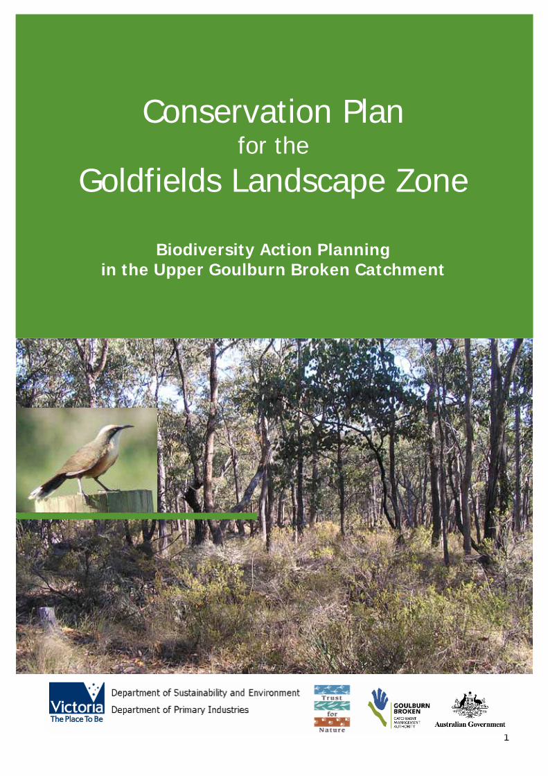
Conservation Plan for the
Goldfields Landscape Zone
Biodiversity Action Planning
in the Upper Goulburn Broken Catchment
2
Published & Printed By: Water and Biodiversity Group Department of Sustainability and Environment Alexandra (Draft January 2006) © Copyright State of Victoria 2005 This publication is copyright. No part may be reproduced by any process except in accordance with the provisions of the Copyright Act 1968. Authorised by: Victorian Government 1 Treasury Place Melbourne, Victoria 3000 Australia ISBN – To be requested Disclaimer This publication may be of assistance to you but the State of Victoria and its employees do not guarantee that the publication is without flaw of any kind or is wholly appropriate for your particular purposes and therefore disclaims all liability for any error, loss or other consequence which may arise from you relying on any information in this publication.
For Further Information: For further information about Biodiversity Action Planning please visit the DPI website at www.dpi.vic.gov.au or the DSE website at www.dse.vic.gov.au or call the Customer Service Centre on 136 186. Or visit the Goulburn Broken Catchment Management Authority website at www.gbcma.vic.gov.au
3
EXECUTIVE SUMMARY The ultimate aim of Biodiversity Action Planning (BAP) is to achieve broad-scale conservation of native biodiversity. BAP identifies priorities for the conservation of native biodiversity, as part of the implementation of the Victorian Biodiversity Strategy 1997. It is not a ‘stand-alone’ project; rather a process for translating objectives set out in Victoria’s Biodiversity Strategy to regional, catchment and local level (Victoria’s Biodiversity Strategy fulfils a statutory requirement under Section 17 of the Flora and Fauna Guarantee Act 1988 and provides the biodiversity action plan for Victoria). To translate objectives from state to regional, catchment and local landscape level, Victoria was first divided on a bioregional basis (bioregions) and then at a landscape level (landscape zones). The methodology used to develop the Landscape Zone plans is according to the ‘Developer’s Manual for Biodiversity Action Planning in the Goulburn Broken Catchment (GBCMA 2004a)’. The Goldfields Landscape Zone plan outlines biodiversity priorities at the bioregional level. This Goldfields Landscape Zone Conservation Plan has been developed at the local (landscape) level and is intended to assist government agencies (primarily extension staff) and the community, to work in partnership towards achieving catchment targets, by setting priority areas for protection and enhancement of native biodiversity. This plan is also intended to enable biodiversity priorities, data and advice to be disseminated to other planning processes, landholders and agencies. The Goldfields Landscape Zone is located within the Goulburn Broken Catchment of Victoria. The Zone, 175,200 hectares in extent, is part of the Highlands Northern Fall and Central Victorian Uplands Bioregions. It is within the Local Government areas of Greater Bendigo, Campaspe, Greater Shepparton City, Strathbogie and Mitchell. Since European settlement much of the vegetation in the zone has been cleared, leaving a fragmented landscape, with many of the remnants that remain, being highly modified. There are 954 priority environmental sites have been identified within the Goldfields Landscape Zone. The priority sites have been determined and ranked (low, medium, high or very high) based on factors such as, size, vegetation quality, Ecological Vegetation Class (EVC) conservation status, threatened species, landscape context and field survey results. These sites contain remnant vegetation and vary greatly in size from a stand of paddock trees, to the Rushworth and Whroo State Forests. Two important components in the Biodiversity Action Planning process, are the focal species approach and the Key Biodiversity Assets approach. The focal species approach uses the habitat requirements of a particular species, or a group of species, to define the attributes that must be present in a landscape, for these species to persist. Six focal species have been identified in the zone: Brush-tailed Phascogale (Phascogale tapoatafa), Brown Treecreeper (Climacteris picumnus), Bush Stone-curlew (Burhinus grallarius), Grey-crowned Babbler (Pomatostomus temporalis), Squirrel Glider (Petaurus norfolcensis) and Tree Goanna (Varanus varanus). The Key Biodiversity Assets approach is a method of grouping biodiversity assets (ie. birds, animals and plants) that use the same type of habitat. Eight Key Biodiversity Assets were identified for the Goldfields Landscape Zone: Grassy Woodlands, Grassy Forests, Herb-rich Foothill Forests, Granitic Hills, Box Ironbark, Riparian Systems, Spring Soaks/Perched Bogs and Riverine Fish communities. The grouping of these assets will assist in targeting actions towards the very high value sites first. Management actions have been developed for the Goldfields Landscape Zone, based on the results of desktop analysis and field surveying. It is intended that government agencies (primarily extension staff) and the community will work together to implement these actions, for the benefit of biodiversity conservation in the Goldfields Landscape Zone and the wider area of the Goulburn Broken Catchment.
4
CONTENTS
EXECUTIVE SUMMARY .................................................................................................................... 3 CONTENTS ..................................................................................................................................... 4 1.0 BACKGROUND ........................................................................................................................... 5
1.1 INTRODUCTION ................................................................................................................ 5 1.2 OBJECTIVES ...................................................................................................................... 5 1.3 CONTEXT FOR THE DEVELOPMENT OF THE GOLDFIELDS CONSERVATION PLAN .................. 6
2.0 THE STUDY AREA ...................................................................................................................... 8 2.1 LANDSCAPE ....................................................................................................................... 8 2.2 VEGETATION ..................................................................................................................... 9 2.2 VEGETATION ................................................................................................................... 10 2.3 SIGNIFICANT FLORA AND FAUNA ..................................................................................... 14
2.3.1 Flora: ............................................................................................................................ 14 2.3.2 Fauna: .......................................................................................................................... 14
3.0 PREPARING A CONSERVATION PLAN ...................................................................................... 15 3.1 METHODOLOGY ............................................................................................................... 15
4.0 IDENTIFYING PRIORITY SITES .............................................................................................. 17 5.0. SUMMARY OF PRIORITY SITE SURVEYING ............................................................................. 18
5.1. VEGETATION QUALITY ASSESSMENTS ............................................................................. 18 5.2 BIRD SURVEYS ................................................................................................................ 18 5.3 CONSERVATION THREATS ............................................................................................... 19
6.0 CONSERVATION ASSETS ......................................................................................................... 21 6.1 FOCAL SPECIES ............................................................................................................... 21 6.2 KEY BIODIVERSITY ASSETS ............................................................................................. 23
7.0 PRIORITY ACTIONS FOR KEY BIODIVERSITY ASSESTS ............................................................. 26 1) KEY BIODIVERSITY ASSET – Grassy Woodlands .................................................................. 27 2) KEY BIODIVERSITY ASSETS – HEATHY FORESTS ................................................................. 29 3) KEY BIODIVERSITY ASSET – WETLANDS ............................................................................. 31 4) KEY BIODIVERSITY ASSET – BOX IRONBARK FORESTS........................................................ 33 5) KEY BIODIVERSITY ASSET – RIPARIAN VEGETATION .......................................................... 35
8.0 FURTHER INFORMATION – PRIORITY SITES ............................................................................ 37 9.0 LANDOWNER ASSISTANCE ...................................................................................................... 38 10.0 MONITORING ....................................................................................................................... 40 11.0 REFERENCES ......................................................................................................................... 43 12.0 ACKNOWLEDGMENTS ............................................................................................................ 45 13.0 APPENDICES ......................................................................................................................... 46 APPENDIX 1 – VICTORIAN BIOREGIONS ........................................................................................ 47 APPENDIX 2 – VICTORIAN LANDSCAPE ZONES .............................................................................. 48 APPENDIX 3 – GOULBURN BROKEN CATCHMENT TARGETS ............................................................ 49 APPENDIX 4 – THREATENED FLORA .............................................................................................. 50 APPENDIX 5 – THREATENED FAUNA .............................................................................................. 51 APPENDIX 5 – THREATENED FAUNA .............................................................................................. 51 APPENDIX 6 – SITE PRIORITISATION METHOD .............................................................................. 52 APPENDIX 7 –VEGETATION QUALITY ANALYSIS (VQA) ASSESSMENT FORM .................................... 53 APPENDIX 8 – LANDSCAPE CONTEXT MODEL ................................................................................. 54 APPENDIX 9 – VEGETATION QUALITY ASSESSMENT RESULTS ........................................................ 55 APPENDIX 10 – PRIORTY SITE INFORMATION ............................................................................... 56 (MAPPING): .................................................................................................................................. 56
5
1.0 BACKGROUND 1.1 INTRODUCTION
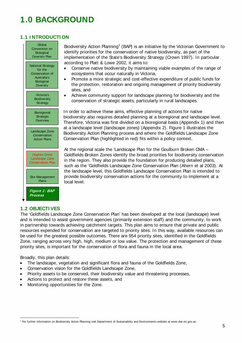
Biodiversity Action Planning1 (BAP) is an initiative by the Victorian Government to identify priorities for the conservation of native biodiversity, as part of the implementation of the State’s Biodiversity Strategy (Crown 1997). In particular according to Platt & Lowe 2002, it aims to: • Conserve native biodiversity by maintaining viable examples of the range of
ecosystems that occur naturally in Victoria, • Promote a more strategic and cost-effective expenditure of public funds for
the protection, restoration and ongoing management of priority biodiversity sites, and
• Achieve community support for landscape planning for biodiversity and the conservation of strategic assets, particularly in rural landscapes.
In order to achieve these aims, effective planning of actions for native biodiversity also requires detailed planning at a bioregional and landscape level. Therefore, Victoria was first divided on a bioregional basis (Appendix 1) and then at a landscape level (landscape zones) (Appendix 2). Figure 1 illustrates the Biodiversity Action Planning process and where the Goldfields Landscape Zone Conservation Plan (highlighted in red) fits within a policy context. At the regional scale the ‘Landscape Plan for the Goulburn Broken CMA – Goldfields Broken Zones identify the broad priorities for biodiversity conservation in the region. They also provide the foundation for producing detailed plans, such as the ‘Goldfields Landscape Zone Conservation Plan (Ahern et al 2003). At the landscape level, this Goldfields Landscape Conservation Plan is intended to provide biodiversity conservation actions for the community to implement at a local level.
1.2 OBJECTIVES The ‘Goldfields Landscape Zone Conservation Plan’ has been developed at the local (landscape) level and is intended to assist government agencies (primarily extension staff) and the community, to work in partnership towards achieving catchment targets. This plan aims to ensure that private and public resources expended for conservation are targeted to priority sites. In this way, available resources can be used for the greatest possible outcomes. There are 954 priority sites, identified in the Goldfields Zone, ranging across very high, high, medium or low value. The protection and management of these priority sites, is important for the conservation of flora and fauna in the local area. Broadly, this plan details: • The landscape, vegetation and significant flora and fauna of the Goldfields Zone, • Conservation vision for the Goldfields Landscape Zone, • Priority assets to be conserved, their biodiversity value and threatening processes, • Actions to protect and restore these assets, and • Monitoring opportunities for the Zone.
1 For further information on Biodiversity Action Planning visit Department of Sustainability and Environments website at www.dse.vic.gov.au
Global Convention on
Biological Diversity Plan
National Strategy for the
Conservation of Australia’s Biological Diversity
Victoria’s Biodiversity
Strategy
Bioregional Strategic Overview
Landscape Zone Conservation Action Plans
Hughes Creek
Landscape Zone Conservation Plan
Site Management
Plans
Figure 1: BAP Process
6
1.3 CONTEXT FOR THE DEVELOPMENT OF THE GOLDFIELDS CONSERVATION PLAN The Goulburn Broken Regional Catchment Strategy (GBRCS) identifies a vision for biodiversity in the catchment. The vision is that “the community will work in partnership with Federal and State Governments and other agencies, to protect and enhance ecological processes and genetic diversity, to secure the future of native species of plants, animals and other organisms in the catchment” (GBCMA 2003a p87). This Landscape Conservation Plan is to assist in achieving this vision, by providing a strategic coordinated approach, for conservation of priority assets. The GBRCS also identifies targets and priorities for the catchment (refer to Appendix 3 for further detail). The following points are intended to provide a summary of the Goulburn Broken Regional Catchment Strategy targets and priorities for biodiversity conservation. For further information please refer to GBCMA 2003a. The Goulburn Broken Catchment Management Strategy identifies the following biodiversity resource condition targets for native vegetation in the catchment: 1. Maintain the extent of all native vegetation types at 1999 levels in keeping with the goal of ‘Net
Gain’ listed in Victoria’s Biodiversity Strategy 1997, 2. Improve the quality of 90% of existing (2003) native vegetation by 10% by 2030, 3. Increase the cover of all endangered and applicable vulnerable Ecological Vegetation Classes to at
least 15% of their pre-European vegetation cover by 2030, 4. Increase 2002 conservation status of 80% threatened flora and 60% threatened fauna by 2030, 5. Maintain the extent of all wetland types at 2003 levels where the extent (area and number) has
declined since European settlement, and 6. Improve the condition of 70% of wetlands by 2030, using 2003 as the benchmark for condition
(GBCMA 2003 p11). Priorities for action to conserve biodiversity in the Goulburn Broken are driven by the conservation significance of the biodiversity asset. Regional investments in biodiversity conservation in the Goulburn Broken Catchment are driven by the following goals (in order of priority): 1. Protecting existing viable remnant habitats and the flora and fauna populations they contain (ie
through reservation, covenants, management agreements, fencing and statutory planning), 2. Enhancing the existing viable habitats that are degraded (management by controlling threats such
as pest plants and animals, grazing, salinity, promotion of natural regeneration and/or revegetation with understorey), and
3. Restoring under-represented biodiversity assets to their former extent by revegetation (to create corridors, buffers, patches of habitat) (GBCMA 2003). It is intended that the actions outlined in this plan will complement the targets of the GBRCS and other policy/strategies pertinent to the state, catchment and region (eg. Victoria’s Native Vegetation Management – A Framework for Action (NRE 2002a): Goulburn Broken Native Vegetation Management Plan (GBCMA 2000): and the Victorian River Health Strategy (NRE 2002b)). This plan is also intended to integrate such policies (eg. targets and legislative requirements) in to the one document, for use by local communities. For example, this plan incorporates aspects of legislation (eg. Action Statements prepared under the Flora and Fauna Guarantee Act 1988), into recommended on-ground actions, for the conservation of threatened species and communities. The Biodiversity Action Planning (BAP) process uses current scientific knowledge to produce an ‘ideal’ landscape for biodiversity conservation. This ‘ideal’ landscape provides for the current levels of species abundance, diversity and interactions. BAP attempts to take a strategic approach to the conservation of threatened and declining species and vegetation types, by looking for opportunities to conserve groups of species in appropriate ecosystems (Platt & Lowe 2002). It is therefore intended that this Goldfields Landscape Zone Conservation Plan will assist government agencies and the community, to work in partnership towards achieving catchment targets and an ‘ideal’ landscape, by setting priority areas for protection and enhancement of native biodiversity.
7
This plan is not intended to be a method of ‘taking over’ land, but rather a resource document, that assists with identifying priority assets and methods of action, to protect or restore valuable assets, through voluntary extension principles. This document may be used by agencies and community groups, for informing existing projects and for strategic planning. However, it must be remembered that this document is by no means ‘comprehensive’, as the BAP process relies on the regular updating of information, to keep it accurate and timely. The plan has therefore been developed as an adaptive plan, to enable management actions and information to be modified, in response to further information (eg monitoring). Therefore this plan will be reviewed when necessary to ensure that it remains a ‘living’ document. It is also intended that extension staff will utilise Geographical Information System (GIS) programs, databases and DSE/DPI staff, to fully identify and understand the BAP process and to provide further information to the community. Consultation and extension with relevant stakeholders, including agencies and community groups, was conducted (and will continue to occur) throughout the development and implementation of this plan. It is envisaged that this plan will be a valuable resource, for identifying priority biodiversity sites and initiating further conservation works in the Zone, and that at a later stage, will lead to further sites and projects being identified by interested individuals and groups.
8
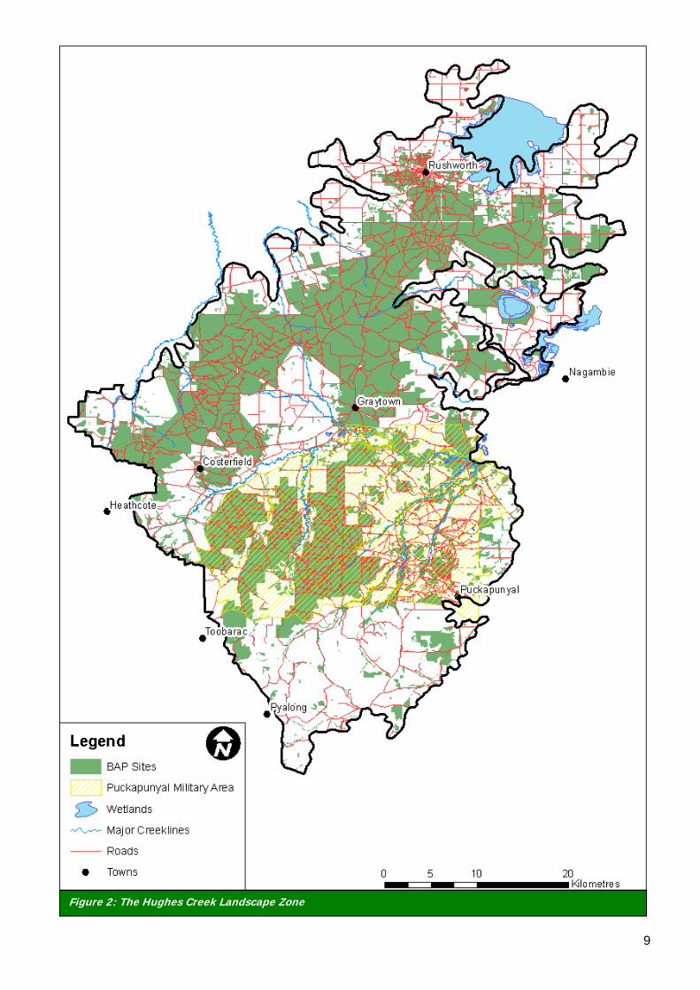
2.0 THE STUDY AREA 2.1 LANDSCAPE The Goldfields Landscape Zone (Figure 2) covers an area of 175, 200 ha within the Goulburn Broken Catchment and represents the whole of the Goldfields Bioregion within the Goulburn Broken Catchment. Goldfields Landscape Zone falls within the Local Government areas of Greater Bendigo, Campaspe, Greater Shepparton City, Strathbogie and Mitchell. The major creeklines in the zone are within the Puckapunyal Military Area, however there are many small creeks and tributaries that occur throughout the zone due to the hilly topography of much of the zone. The north of the zone consists of low undulating hills the relief of which increases as you go further south towards Broadford. Private land covers 52% of the zone and of this 78% has been cleared. This has resulted in not only a loss of habitat but also an inability for the landscape to sustain populations of flora and fauna. For example, many species may not be able to move across open farmland; this prevents breeding between populations, which makes them vulnerable to random events such as disease that can wipe out sub-populations without replacement. Eventually, this results in decline and then extinction of species. Private land use is varied within the Goldfields Landscape Zone with the majority used for stock grazing. Public land occurs in large areas and covers 25% of the zone. Commonwealth land belonging to the Puckapunyal Military area covers 23% of the zone. This network of public and commonwealth land provides good connectivity for species to move throughout the zone.
9
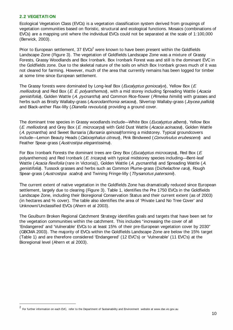
Figure 2: The Hughes Creek Landscape Zone
10
2.2 VEGETATION
Ecological Vegetation Class (EVCs) is a vegetation classification system derived from groupings of vegetation communities based on floristic, structural and ecological functions. Mosaics (combinations of EVCs) are a mapping unit where the individual EVCs could not be separated at the scale of 1:100,000 (Berwick, 2003). Prior to European settlement, 37 EVCs2 were known to have been present within the Goldfields Landscape Zone (Figure 3). The vegetation of Goldfields Landscape Zone was a mixture of Grassy Forests, Grassy Woodlands and Box Ironbark. Box Ironbark Forest was and still is the dominant EVC in the Goldfields zone. Due to the skeletal nature of the soils on which Box Ironbark grows much of it was not cleared for farming. However, much of the area that currently remains has been logged for timber at some time since European settlement. The Grassy forests were dominated by Long-leaf Box (Eucalyptus goniocalyx), Yellow Box (E. melliodora) and Red Box (E. E. polyanthemos), with a mid storey including Spreading Wattle (Acacia genistifolia), Golden Wattle (A. pycnantha) and Common Rice-flower (Pimelea himilis) with grasses and herbs such as Bristly Wallaby-grass (Ausrodanthonia setacea), Silvertop Wallaby-grass (Joycea pallida) and Black-anther Flax-lilly (Dianella revouluta) providing a ground cover.
The dominant tree species in Grassy woodlands include—White Box (Eucalyptus albens), Yellow Box (E. melliodora) and Grey Box (E. microcarpa) with Gold Dust Wattle (Acacia acinacea), Golden Wattle (A. pycnantha) and Sweet Bursaria (Bursaria spinosa)forming a midstorey. Typical groundcovers include—Lemon Beauty Heads (Calocephalus citreus), Pink Bindweed (Convolvulus erubescens) and Feather Spear-grass (Austrostipa elegantissima).
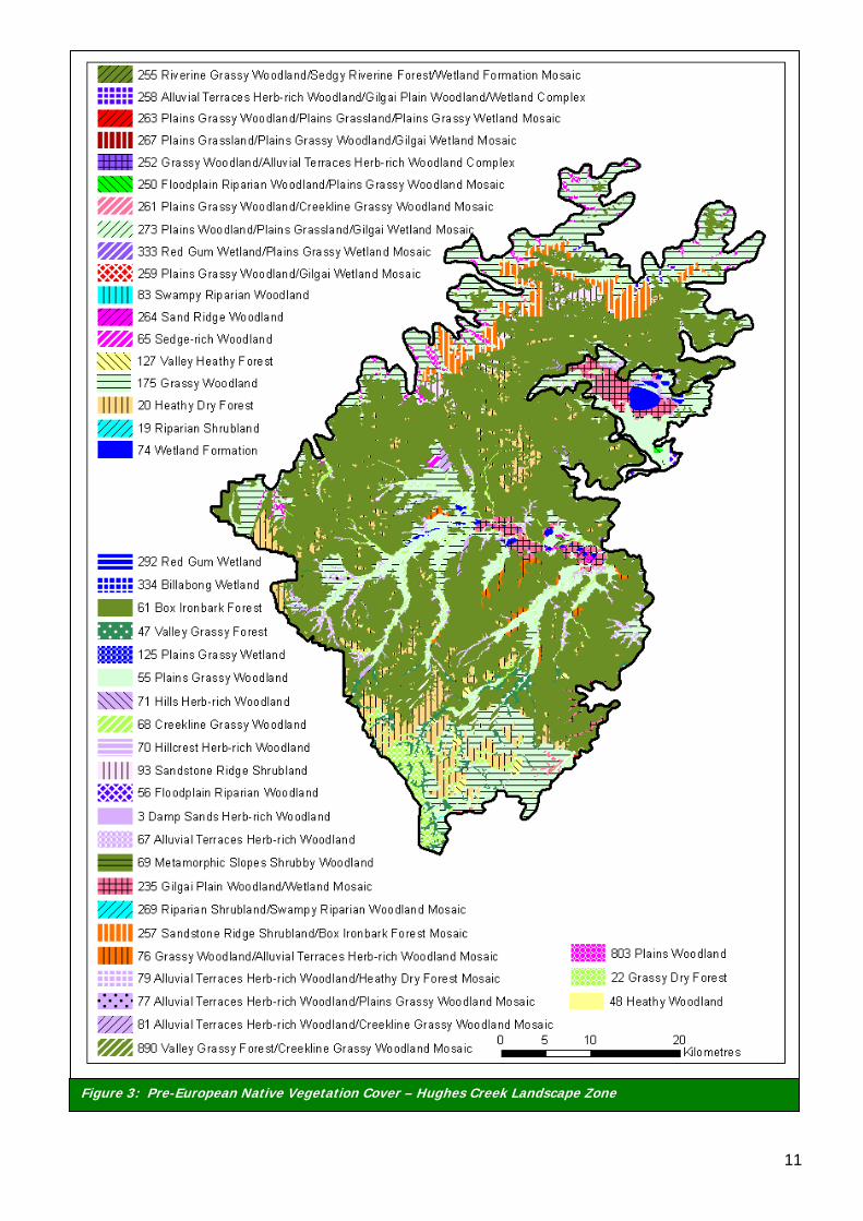
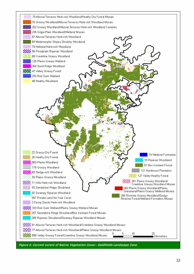
For Box Ironbark Forests the dominant trees are Grey Box (Eucalyptus microcarpa), Red Box (E. polyanthemos) and Red Ironbark (E. tricarpa) with typical midstorey species including—Bent-leaf Wattle (Acacia flexifolia (rare in Victoria)), Golden Wattle (A. pycnantha) and Spreading Wattle (A. genistifolia). Tussock grasses and herbs such as Common Plume-grass (Dichelachne rara), Rough Spear-grass (Austrostipa scabra) and Twining Fringe-lilly (Thysanotus patersonii). The current extent of native vegetation in the Goldfields Zone has dramatically reduced since European settlement, largely due to clearing (Figure 3). Table 1, identifies the Pre 1750 EVCs in the Goldfields Landscape Zone, including their Bioregional Conservation Status and their current extent (as of 2003) (in hectares and % cover). The table also identifies the area of ‘Private Land No Tree Cover’ and Unknown/Unclassified EVCs (Ahern et al 2003). The Goulburn Broken Regional Catchment Strategy identifies goals and targets that have been set for the vegetation communities within the catchment. This includes “increasing the cover of all ‘Endangered’ and ‘Vulnerable’ EVCs to at least 15% of their pre-European vegetation cover by 2030” (GBCMA 2003). The majority of EVCs within the Goldfields Landscape Zone are below the 15% target (Table 1) and are therefore considered ‘Endangered’ (12 EVC’s) or ‘Vulnerable’ (11 EVC’s) at the Bioregional level (Ahern et al 2003).
2 For further information on each EVC, refer to the Department of Sustainability and Environment website at www.dse.vic.gov.au
11
Figure 3: Pre-European Native Vegetation Cover – Hughes Creek Landscape Zone
12
Figure 4: Current extent of Native Vegetation Cover– Goldfields Landscape Zone
13
EVC names have altered since Ahern et al 2003, however area and extent remain the same
* EVC Bioregional Conservation Status refers to the threatened status of the EVC in the bioregion (eg. Murray Fans). Endangered (E) means that ‘less than 10% of the pre-European extent remains, whilst Vulnerable (V) is defined as ‘less than 10-30% pre-European extent remaining (Platt 2002). The EVC Number refers to the unique number attributed to that EVC. Highlighted rows indicate those EVC’s with less than 15% of their original EVC remaining in the Goldfields Creek Landscape Zone
Table 1: Goldfields Zone Ecological Vegetation Classes (pre-1750 and current)
EVC
Gro
up
EVC
Nu
mbe
r
EVC
Bio
regi
onal
C
ons.
Sta
tus*
EVC Name
Pre
17
50
Are
a (h
a)
Cu
rren
t A
rea
(h
a)
% C
urr
ent
Cov
er
15
% p
re-1
75
0
Targ
et
2 48 V Heathy Woodland 26 21 82 4 4 61 D Box Ironbark Forest 96659 53756 56 14499 4 70 D Hillcrest Herb-rich Woodland 5 5 100 1 4 71 D Hills Herb-rich Woodland 8 8 100 1 4 93 LC Sandstone Ridge Shrubland 1265 1209 96 190 4 257 V Sandstone Ridge Shrubland/Box-Ironbark Forest Mosaic 4585 734 16 688 5 76 E Grassy Woodland/Alluvial Terraces Herb-rich Woodland Mosaic 767 27 4 115 5 175 E Grassy Woodland 32023 1260 4 4803 5 252 E Grassy Woodland/Alluvial Terraces Herb-rich Woodland Complex 55 10 18 8 6 20 LC Heathy Dry Forest 8864 4950 56 1330 6 22 D Grassy Dry Forest 3067 365 12 460 6 47 V Valley Grassy Forest 2848 246 9 427 6 69 D Metamorphic Slopes Shrubby Woodland 21 20 95 3 6 127 E Valley Heathy Forest 479 0 0 72 6 890 E Valley Grass Forest/Creekline Grassy Woodland Mosaic 655 27 4 98 8 19 E Riparian Shrubland 13 3 26 2 14 55 E Plains Grassy Woodland 8745 457 5 1312 14 65 E Sedge-rich Woodland 2815 3 0 422 14 235 E Gilgai Plain Woodland/Wetland Mosaic 3782 1017 27 567 14 255 D Riverine Grassy Woodland/Sedgy Riverine Forest/Wetland Formation 67 35 53 10 14 259 E Plains Grassy Woodland/Gilgai Wetland Mosaic 13 0 0 2 14 261 E Plains Grassy Woodland/Creekline Grassy Woodland Mosaic 256 7 3 38 14 263 E Plains Grassy Woodland/Plains Grassland/Plains Grassy Wetland Mosaic 101 1 1 15 14 803 E Plains Woodland 2277 68 3 342 15 56 E Floodplain Riparian Woodland 227 43 19 34 15 68 E Creekline Grassy Woodland 2883 981 34 432 15 250 E Floodplain Riparian Woodland/Plains Grassy Woodland Mosaic 52 0 0 8 16 3 E Damp Sands Herb-rich Woodland 211 17 8 32 16 67 V Alluvial Terraces Herb-rich Woodland 2697 562 21 404 16 77 E Alluvial Terraces Herb-rich Woodland/Plains Grassy Woodland Mosaic 53 0 1 8 16 81 V Alluvial Terraces Herb-rich Woodland/Creekline Grassy Woodland 783 45 6 117 16 258 E Alluvial Terraces Herb-rich Woodland/Gilgai Plain Woodland/Wetland 225 0 0 34 16 264 E Sand Ridge Woodland 136 36 27 20 19 74 E Wetland Formation 896 0 0 134 19 125 E Plains Grassy Wetland 23 31 138 3 19 292 E Red Gum Wetland 306 101 33 46 19 333 E Red Gum Wetland/Plains Grassy Wetland Mosaic 8 1 8 1 99 121 NA Hardwood Plantation 0 13 100 0 99 997 NA Private Land No Tree Cover 0 109009 100 0 Table Information including column A & B from Ahern et al 2003 A B C D Column C derived from (column B divided by column A) multiplied by 100 (for %) Column D derived from (column A divided by 100) multiplied by 15 (*rounded to unit ten)
14
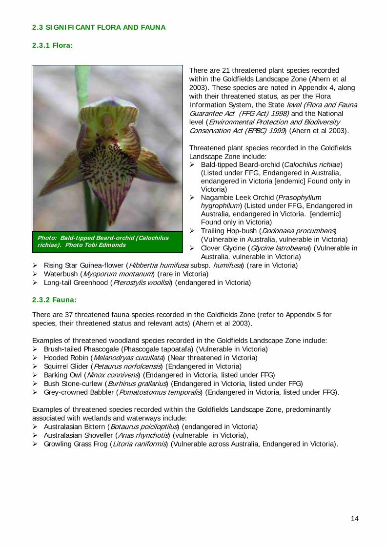
Photo: Bald-tipped Beard-orchid (Calochilus richiae). Photo Tobi Edmonds
2.3 SIGNIFICANT FLORA AND FAUNA 2.3.1 Flora:
There are 21 threatened plant species recorded within the Goldfields Landscape Zone (Ahern et al 2003). These species are noted in Appendix 4, along with their threatened status, as per the Flora Information System, the State level (Flora and Fauna Guarantee Act (FFG Act) 1998) and the National level (Environmental Protection and Biodiversity Conservation Act (EPBC) 1999) (Ahern et al 2003). Threatened plant species recorded in the Goldfields Landscape Zone include:
Bald-tipped Beard-orchid (Calochilus richiae) (Listed under FFG, Endangered in Australia, endangered in Victoria [endemic] Found only in Victoria)
Nagambie Leek Orchid (Prasophyllum hygrophilum) (Listed under FFG, Endangered in Australia, endangered in Victoria. [endemic] Found only in Victoria)
Trailing Hop-bush (Dodonaea procumbens) (Vulnerable in Australia, vulnerable in Victoria)
Clover Glycine (Glycine latrobeana) (Vulnerable in Australia, vulnerable in Victoria)
Rising Star Guinea-flower (Hibbertia humifusa subsp. humifusa) (rare in Victoria) Waterbush (Myoporum montanum) (rare in Victoria) Long-tail Greenhood (Pterostylis woollsii) (endangered in Victoria)
2.3.2 Fauna:
There are 37 threatened fauna species recorded in the Goldfields Zone (refer to Appendix 5 for species, their threatened status and relevant acts) (Ahern et al 2003). Examples of threatened woodland species recorded in the Goldfields Landscape Zone include:
Brush-tailed Phascogale (Phascogale tapoatafa) (Vulnerable in Victoria) Hooded Robin (Melanodryas cucullata) (Near threatened in Victoria) Squirrel Glider (Petaurus norfolcensis) (Endangered in Victoria) Barking Owl (Ninox connivens) (Endangered in Victoria, listed under FFG) Bush Stone-curlew (Burhinus grallarius) (Endangered in Victoria, listed under FFG) Grey-crowned Babbler (Pomatostomus temporalis) (Endangered in Victoria, listed under FFG).
Examples of threatened species recorded within the Goldfields Landscape Zone, predominantly associated with wetlands and waterways include:
Australasian Bittern (Botaurus poiciloptilus) (endangered in Victoria) Australasian Shoveller (Anas rhynchotis) (vulnerable in Victoria), Growling Grass Frog (Litoria raniformis) (Vulnerable across Australia, Endangered in Victoria).
15
3.0 PREPARING A CONSERVATION PLAN
3.1 METHODOLOGY The methodology used to develop this Conservation Plan is based on the ‘Goulburn Broken Biodiversity Action Planning Developer’s Manual’ (GBCMA in prep.). This document provides the background information relating to BAP in the Goulburn Broken Catchment, and is designed to ensure consistency during the development of the plans. The methodology used to prepare this plan contained eight main elements. These were, 1) Identification of conservation features and threatened species, 2) Ground-truthing of potential BAP Sites, 3) Field Surveying of BAP sites, 4) Prioritisation of BAP sites, 5) Generation of focal species List, 6) Generation of Key Biodiversity Asset List, 7) Development of actions for Key Biodiversity Assets, and 8) Landscape Context Analysis. Step 1. Identification of Conservation Features and Threatened Species Features in the landscape that are of potential priority for conservation were identified, as well as flora and fauna species of conservation significance (eg. threatened under State or Commonwealth legislation). This involved desktop analysis of data (eg. literature review; spatial data (eg EVC, trees cover, wetlands, flora and fauna records, aerials); corporate databases (eg. Biosites, Victorian Fauna Display and Flora Information Systems); local knowledge investigations; and the Landscape Context Model (refer to Step 8). From this analysis, a series of sites likely to have conservation values and threatened species, were identified and mapped using GIS (CGDL 2005). Step 2. Ground-Truthing of Potential BAP Sites Involved surveying of the zone from the roadside, to compare desktop analysis data with the on-ground sites in regards to presence, type of vegetation and condition. Step 3. Field Survey BAP Sites Sites were prioritised for survey as per the ‘Goulburn Broken Biodiversity Action Planning Developer’s Manual’ (GBCMA in prep.). This prioritisation method is shown in Appendix 7. One hundred of the sites requiring ground-truthing were field surveyed (on-site or from the nearest public land). This involved: 3.1) Bird surveys were undertaken in accordance with the Birds of Australia – Atlas Search Methods (1–2 hectares, twenty minutes) (Birds Australia 2001). 3.2) Vegetation Quality Assessment (VQA)(DSE 2004) – Site-based habitat and landscape components were assessed against a pre-determined ‘benchmark’ relevant to the vegetation type being assessed (ie. box ironbark, herb-rich foothill forest, grassy woodlands) (Refer to Appendix 7). 3.3) Threat Identification – Whilst undertaking the Vegetation Quality Assessment, a list of threatening processes (ie. pest plants and animals) on the priority sites, were recorded. Step 4. Prioritise BAP Sites The 954 sites were given a ranked value of very high (VH), high (H), medium (M) or low (L), based on a range of factors (conservation status of the EVC, presence of threatened species, size, VQA score). Sites not surveyed, were automatically given a ranked value (as per Appendix 6) to the lesser of the available options (until surveying occurs).
16
Step 5. Generate Focal Species List The focal species approach (Lambeck 1997) uses the habitat requirements of a particular species, or group of species, to define the attributes that must be present in a landscape for these species to persist. For example, if a species that requires the largest remnant size is selected, then fulfilling the needs of that species may result in the conservation of all species, with smaller remnant size requirements. Step 6. Generate Key Biodiversity Asset List The identified environmental features, including flora and fauna species, were categorised into a series of 'nested' environmental assets. For example; similar species or environmental features may be located in ‘nested assets’ such as; creek-lines or ecological vegetation classes. Step 7. Develop Actions for Key Biodiversity Assets This step involved the development of a list of actions aimed at protecting and enhancing the biodiversity values in the Zone, by reducing the identified threats for each key biodiversity asset (as determine in Step 6). Available information (eg. Actions for Biodiversity Conservation (ABC) database) (DSE 2005a) and the Goldfields Landscape Plan (Ahern et al 2003) were also used to compile the actions. Step 8. Landscape Context Analysis To achieve long-term viability of the priority ‘BAP’ sites, they need to be linked and/or increased in size and total tree cover, to form a viable functioning landscape. The Landscape Context Model (LCM) (Ferwerder 2003) uses a model of "known habitat" (based on mapping for tree cover, wetland, and major watercourses) to identify large remnants, key remnant clusters and the key linkages between them. However, because of potential limitations of the input data, areas of conservation significance (particularly grasslands and sparse woodlands) may not be identified. Similarly, areas with minimal conservation significance may be included, because habitat quality data is not included in the model. However, the Landscape Context Model is useful as a background to BAP mapping, as it identifies areas that have the highest (or least) probability of containing additional sites, of conservation interest (as per Step 1). Therefore the model can be used to identify the areas of the landscape, that should be used to link and strengthen a network of conservation sites, and create a sustainable landscape. The model can also be used to further determine the major linkages between BAP sites. The Goldfields Landscape Zone priority sites and Landscape Context overlay are shown in Appendix 8.
17
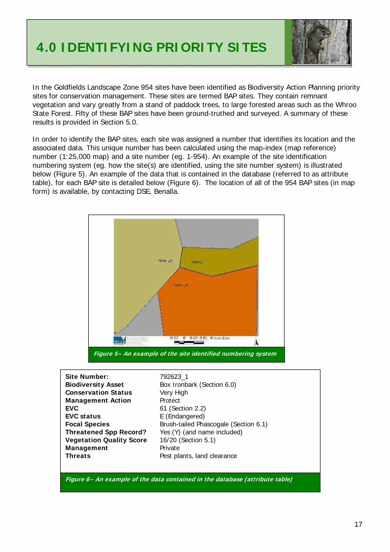
4.0 IDENTIFYING PRIORITY SITES In the Goldfields Landscape Zone 954 sites have been identified as Biodiversity Action Planning priority sites for conservation management. These sites are termed BAP sites. They contain remnant vegetation and vary greatly from a stand of paddock trees, to large forested areas such as the Whroo State Forest. Fifty of these BAP sites have been ground-truthed and surveyed. A summary of these results is provided in Section 5.0. In order to identify the BAP sites, each site was assigned a number that identifies its location and the associated data. This unique number has been calculated using the map-index (map reference) number (1:25,000 map) and a site number (eg. 1-954). An example of the site identification numbering system (eg. how the site(s) are identified, using the site number system) is illustrated below (Figure 5). An example of the data that is contained in the database (referred to as attribute table), for each BAP site is detailed below (Figure 6). The location of all of the 954 BAP sites (in map form) is available, by contacting DSE, Benalla.
Site Number: 792623_1 Biodiversity Asset Box Ironbark (Section 6.0) Conservation Status Very High Management Action Protect EVC 61 (Section 2.2) EVC status E (Endangered) Focal Species Brush-tailed Phascogale (Section 6.1) Threatened Spp Record? Yes (Y) (and name included) Vegetation Quality Score 16/20 (Section 5.1) Management Private Threats Pest plants, land clearance
Figure 6– An example of the data contained in the database (attribute table)
Figure 5– An example of the site identified numbering system
18
5.0. SUMMARY OF PRIORITY SITE SURVEYING 5.1. VEGETATION QUALITY ASSESSMENTS Of the 954 BAP sites that were mapped, 50 were assessed based on habitat features of, 1) Large trees, 2) Canopy cover, 3) Understorey, 4) Weediness, 5) Recruitment, 6) Organic litter, 7) Logs and Landscape Component Scores of, 8) Size, 9) Neighbourhood and 10) Core Area. They were scored out of a maximum score of 20 (intact habitat). An example of the assessment sheet is provided in Appendix 7. Graphical illustration of the results is also provided in Appendix 9. The sites in the Goldfields Landscape Zone scored between 4 and 17. The graphical results (Appendix 9) highlight some of the challenges for biodiversity conservation in the Goldfields Zone. In summary, the assessments identified that: • 23% of sites scored the highest for large trees (more than 7 large trees/ha) • 69% of the sites scored the highest for canopy cover (more than 50% cover) • 36% of sites scored adequate understorey (more than 75% understorey cover and more than two
forms) • 46% of sites scored less than 25% weed cover • 18% sites have adequate regeneration • 8% of sites have adequate organic litter covering the ground (more than 5% cover) • 44% of sites have adequate number of logs (25m/ha) • 26% of sites surveyed were larger than 10 hectares and 20% between 2-10 hectares • 18% of sites had more than 50% vegetation cover in the surrounding landscape (to 1km radius) • 72% of sites were less than 1km from a block of native vegetation greater than 50-hectares. (Note: Sites were scored in relation to the Ecological Vegetation Class Benchmark. Refer to Appendix 7 for further information on surveying). Over the entire zone, the surveys show that there are very few large old trees and not enough organic litter or recruitment. These habitat elements should be targeted within the zone. The VQA scores for each of the sites provide a valuable monitoring system that can be repeated over time. It is also intended that the remaining priority sites will also be assessed over time.
5.2 BIRD SURVEYS As well as completing a vegetation quality assessment of the groundtruthed sites a bird survey was also completed. It is important to note that surveys were restricted in season, timing and duration and the list is not intended to represent the entire population of birds in the Goldfields Zone. Further information on threatened birds in the Goldfields Landscape Zone can also be obtained from the BAP site attribute table.
19
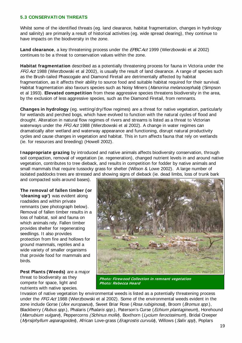
Photo: Firewood Collection in remnant vegetation Photo: Rebecca Heard
5.3 CONSERVATION THREATS Whilst some of the identified threats (eg. land clearance, habitat fragmentation, changes in hydrology and salinity) are primarily a result of historical activities (eg. wide spread clearing), they continue to have impacts on the biodiversity in the zone. Land clearance, a key threatening process under the EPBC Act 1999 (Wierzbowski et al 2002) continues to be a threat to conservation values within the zone. Habitat fragmentation described as a potentially threatening process for fauna in Victoria under the FFG Act 1988 (Wierzbowski et al 2002), is usually the result of land clearance. A range of species such as the Brush-tailed Phascogale and Diamond Firetail are detrimentally affected by habitat fragmentation, as it affects their ability to source food and suitable habitat required for their survival. Habitat fragmentation also favours species such as Noisy Miners (Manorina melanocephala) (Simpson et al 1993). Elevated competition from these aggressive species threatens biodiversity in the area, by the exclusion of less aggressive species, such as the Diamond Firetail, from remnants. Changes in hydrology (eg. wetting/dry/flow regimes) are a threat for native vegetation, particularly for wetlands and perched bogs, which have evolved to function with the natural cycles of flood and drought. Alteration in natural flow regimes of rivers and streams is listed as a threat to Victorian waterways under the FFG Act 1988 (Wierzbowski et al 2002). A change in water regimes can dramatically alter wetland and waterway appearance and functioning, disrupt natural productivity cycles and cause changes in vegetation and habitat. This in turn affects fauna that rely on wetlands (ie. for resources and breeding) (Howell 2002). Inappropriate grazing by introduced and native animals affects biodiversity conservation, through soil compaction, removal of vegetation (ie. regeneration), changed nutrient levels in and around native vegetation, contributes to tree dieback, and results in competition for fodder by native animals and small mammals that require tussocky grass for shelter (Wilson & Lowe 2002). A large number of isolated paddocks trees are stressed and showing signs of dieback (ie. dead limbs, loss of trunk bark and compacted soils around bases). The removal of fallen timber (or ‘cleaning up’) was evident along roadsides and within private remnants (see photograph below). Removal of fallen timber results in a loss of habitat, soil and fauna on which animals rely. Fallen timber provides shelter for regenerating seedlings. It also provides protection from fire and hollows for ground mammals, reptiles and a wide variety of smaller organisms that provide food for mammals and birds. Pest Plants (Weeds) are a major threat to biodiversity as they compete for space, light and nutrients with native species. Invasion of native vegetation by environmental weeds is listed as a potentially threatening process under the FFG Act 1988 (Wierzbowski et al 2002). Some of the environmental weeds evident in the zone include Gorse (Ulex europaeus), Sweet Briar Rose (Rosa rubiginosa), Broom (Bromus spp.), Blackberry (Rubus spp.), Phalaris (Phalaris spp.), Paterson’s Curse (Echium plantagineum), Horehound (Marrubium vulgare), Peppercorns (Schinus molle), Boxthorn (Lycium ferocissimum), Bridal Creeper (Myrsiphyllum asparagoides), African Love-grass (Eragrostis curvula), Willows (Salix spp), Poplars
20
(Poplar spp) and many more. Weeds are especially evident on roadsides, disturbance by machinery and vehicles spread weed seed and agricultural weeds invade remnants. Pest plants invading remnants also results from adjacent land practices (eg. agricultural weeds). Pest Animals are a major threat to the conservation values of the area. Predation of native wildlife by the cat (Felis catus) and Red Fox (Vulpes vulpes) are listed as potentially threatening processes under the FFG Act 1988 (Wierzbowski et al 2002). Species such as the Bush-stone Curlew are preyed upon by these introduced species. Whereas the European rabbit (Oryctolagus cuniculus) and European Hares (Lepus europaeus) compete for habitat, remove native vegetation and disturb soil structure. Native species such as the Eastern Grey Kangaroo (Macropus giganteus) and the Swamp Wallaby (Wallabia bicolour) are currently in large numbers and are in many cases overgrazing within the state forests. Adjacent land use practices. Pasture improvement (such as sowing with Phalaris or application of fertilisers) and herbicide use, cropping, irrigation and plantations, are a threat to remnant vegetation. They can lead to the colonisation of areas by weeds, waterlogging of vegetation, high watertable depths, nutrient run-off and an increase in sediment input to rivers and streams (DPI 2005). Land Development and subdivision. As land becomes subdivided for development, property sizes become smaller leaving less space for native regeneration and increasing the risk of clearing areas of trees and grassland for housing. Increasing the population density can also affect hydrology by increasing the area of hard surfaces and water runoff. However, it should also be noted that small properties can also attract “lifestyle” property owners who may be interested in restoring native vegetation rather than engaging in primary production
21
6.0 CONSERVATION ASSETS 6.1 FOCAL SPECIES Research shows that different species have different types of responses to landscape change. The focal species approach therefore uses the habitat requirements of a particular species or group of species, to define the attributes that must be present in a landscape, for these species to persist. Broadly, the focal species are predicted to be the most sensitive species (in a given landscape) to a threat or ecological process. Such that, their conservation should also conserve other less-sensitive species found in the same vegetation type. Therefore, focal species are a way of defining and guiding targets (eg. patch size and connectivity) for our landscape restoration strategies (Lambeck 1997). Additional benefits of a focal species approach are that it allows for the monitoring of actions (eg. can undertake regular surveys to establish if focal species are becoming more common and using new sites). It also provides the community and organisations implementing on-ground works, with an ‘iconic/focal’ species (if they don’t already have one), which in turn, is envisaged to enhance enthusiasm for implementing works.
The six focal species identified in the Goldfields Zone, and their ecological requirements (thresholds9) are identified below (Table 2). A definition of the ecological terms used include:
Minimum patch size (patch size threshold) – refers to the minimum patch size of vegetation required, for the species to maintain viable populations,
Critical distance between habitat patches (isolation threshold) – refers to the size of the gap between habitats, beyond which, on a daily basis, the animal doesn’t generally cross (GBCMA in prep.),
Dispersal threshold – refers to the distance (km) for which the species has been known to travel (eg. for breeding, migration), but generally does not on a daily basis,
Ecological Vegetation Class (EVC) – the vegetation community that the species prefers, and Other requirements – identifies some other known requirements (not comprehensive) for the
species to survive, or to inhabit an area. It is envisaged that community groups and agencies may target one, or a combination of, the focal species identified (Table 2), for planning and implementation of on-ground works in the Zone. The focal species are only a suggestion of species to focus on-ground works. Other species may also be the focus for on-ground works, given new information and community desire to implement works for another species. Keeping in mind that if we aim to cater for these species, we are also assisting a suite of species and working towards overall vegetation cover targets for the catchment.
9 Thresholds refer to the point at which relatively rapid change occurs (eg loss of species). Therefore, these should be used as a minimum target only.
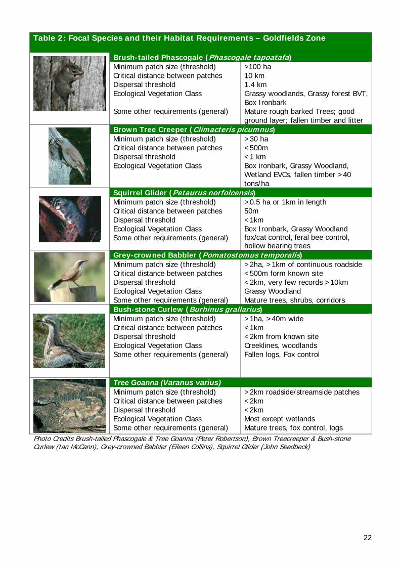
22
Table 2: Focal Species and their Habitat Requirements – Goldfields Zone
Brush-tailed Phascogale (Phascogale tapoatafa) Minimum patch size (threshold) Critical distance between patches Dispersal threshold Ecological Vegetation Class Some other requirements (general)
>100 ha10 km 1.4 km Grassy woodlands, Grassy forest BVT, Box Ironbark Mature rough barked Trees; good ground layer; fallen timber and litter
Brown Tree Creeper (Climacteris picumnus) Minimum patch size (threshold) Critical distance between patches Dispersal threshold Ecological Vegetation Class
>30 ha <500m <1 km Box ironbark, Grassy Woodland, Wetland EVCs, fallen timber >40 tons/ha
Squirrel Glider (Petaurus norfolcensis) Minimum patch size (threshold) Critical distance between patches Dispersal threshold Ecological Vegetation Class Some other requirements (general)
>0.5 ha or 1km in length 50m <1km Box Ironbark, Grassy Woodland fox/cat control, feral bee control, hollow bearing trees
Grey-crowned Babbler (Pomatostomus temporalis) Minimum patch size (threshold) Critical distance between patches Dispersal threshold Ecological Vegetation Class Some other requirements (general)
>2ha, >1km of continuous roadside <500m form known site <2km, very few records >10km Grassy Woodland Mature trees, shrubs, corridors
Bush-stone Curlew (Burhinus grallarius) Minimum patch size (threshold) Critical distance between patches Dispersal threshold Ecological Vegetation Class Some other requirements (general)
>1ha, >40m wide <1km <2km from known site Creeklines, woodlands Fallen logs, Fox control
Tree Goanna (Varanus varius) Minimum patch size (threshold) Critical distance between patches Dispersal threshold Ecological Vegetation Class Some other requirements (general)
>2km roadside/streamside patches <2km <2km Most except wetlands Mature trees, fox control, logs
Photo Credits Brush-tailed Phascogale & Tree Goanna (Peter Robertson), Brown Treecreeper & Bush-stone Curlew (Ian McCann), Grey-crowned Babbler (Eileen Collins), Squirrel Glider (John Seedbeck)
23
6.2 KEY BIODIVERSITY ASSETS Biodiversity Action Planning (BAP) attempts to take a strategic approach toward the conservation of threatened and declining species and vegetation types, by looking for opportunities to conserve groups of species, in appropriate ecosystems. The identification of the appropriate biodiversity assets to focus conservation effort, is the most critical part of the BAP process. The approach of using ‘Key Biodiversity Assets’ has been used, to group together the birds, animals and plants that utilise the same type of habitat. As per the focal species approach, by protecting these assets, we are conserving habitat for a suite of threatened species associated with that habitat. For example, by choosing ‘Grassy Woodlands’ as a key biodiversity asset, it incorporates all of the species that live in, and use Grassy Woodlands, as well as the individual threatened species. Another benefit of this approach is that specific actions can be developed. (Section 7.0) based on the requirements of each asset (eg. to counter threats and improve the status of the asset) Planning and implementation of on-ground works and actions that specifically target each of these assets, can then be undertaken (GBCMA in prep.) Five key biodiversity assets have been identified for the Goldfields Landscape Zone. The 954 BAP sites have been categorised according to the dominant asset type. For further information on each asset, along with threatened species examples, refer to Table 3.
24
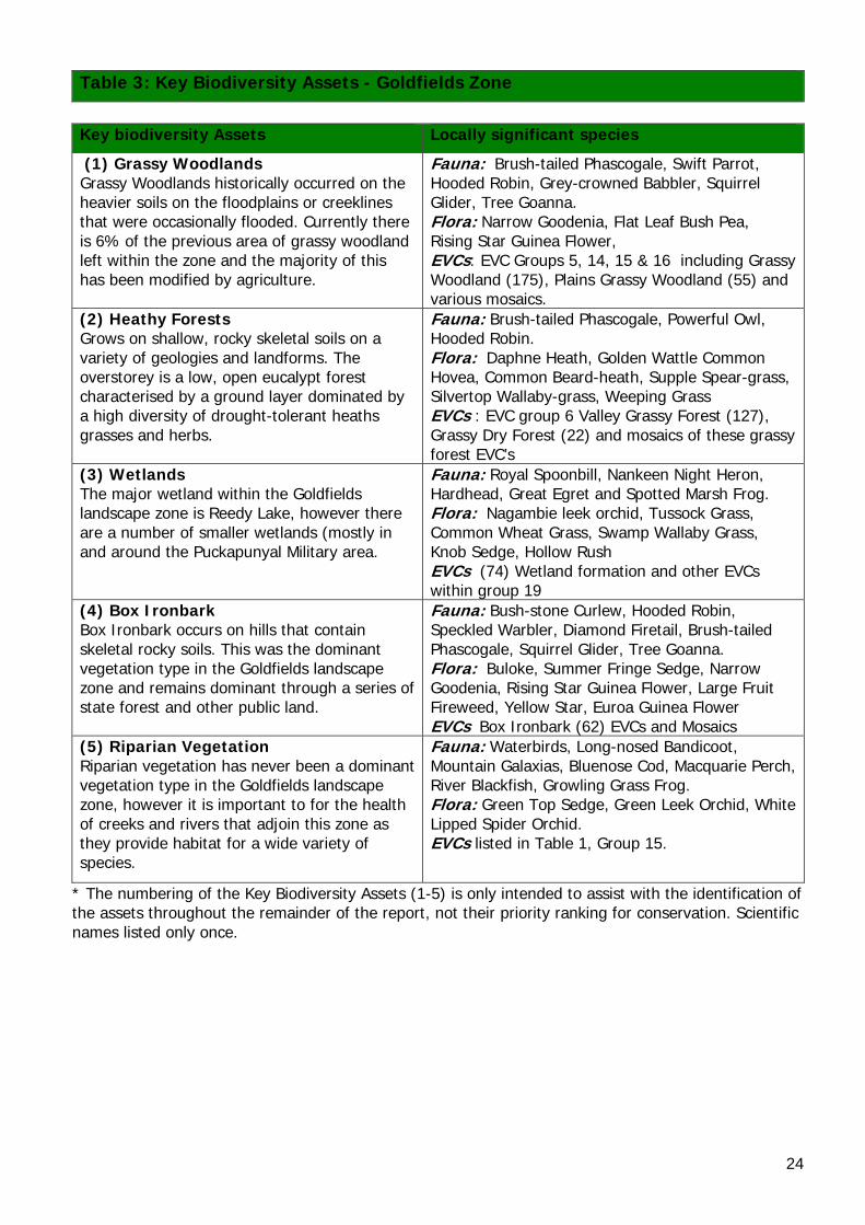
* The numbering of the Key Biodiversity Assets (1-5) is only intended to assist with the identification of the assets throughout the remainder of the report, not their priority ranking for conservation. Scientific names listed only once.
Table 3: Key Biodiversity Assets - Goldfields Zone
Key biodiversity Assets Locally significant species
(1) Grassy Woodlands Grassy Woodlands historically occurred on the heavier soils on the floodplains or creeklines that were occasionally flooded. Currently there is 6% of the previous area of grassy woodland left within the zone and the majority of this has been modified by agriculture.
Fauna: Brush-tailed Phascogale, Swift Parrot, Hooded Robin, Grey-crowned Babbler, Squirrel Glider, Tree Goanna. Flora: Narrow Goodenia, Flat Leaf Bush Pea, Rising Star Guinea Flower, EVCs: EVC Groups 5, 14, 15 & 16 including Grassy Woodland (175), Plains Grassy Woodland (55) and various mosaics.
(2) Heathy Forests Grows on shallow, rocky skeletal soils on a variety of geologies and landforms. The overstorey is a low, open eucalypt forest characterised by a ground layer dominated by a high diversity of drought-tolerant heaths grasses and herbs.
Fauna: Brush-tailed Phascogale, Powerful Owl, Hooded Robin. Flora: Daphne Heath, Golden Wattle Common Hovea, Common Beard-heath, Supple Spear-grass, Silvertop Wallaby-grass, Weeping Grass EVCs : EVC group 6 Valley Grassy Forest (127), Grassy Dry Forest (22) and mosaics of these grassy forest EVC’s
(3) Wetlands The major wetland within the Goldfields landscape zone is Reedy Lake, however there are a number of smaller wetlands (mostly in and around the Puckapunyal Military area.
Fauna: Royal Spoonbill, Nankeen Night Heron, Hardhead, Great Egret and Spotted Marsh Frog. Flora: Nagambie leek orchid, Tussock Grass, Common Wheat Grass, Swamp Wallaby Grass, Knob Sedge, Hollow Rush EVCs (74) Wetland formation and other EVCs within group 19
(4) Box Ironbark Box Ironbark occurs on hills that contain skeletal rocky soils. This was the dominant vegetation type in the Goldfields landscape zone and remains dominant through a series of state forest and other public land.
Fauna: Bush-stone Curlew, Hooded Robin, Speckled Warbler, Diamond Firetail, Brush-tailed Phascogale, Squirrel Glider, Tree Goanna. Flora: Buloke, Summer Fringe Sedge, Narrow Goodenia, Rising Star Guinea Flower, Large Fruit Fireweed, Yellow Star, Euroa Guinea Flower EVCs Box Ironbark (62) EVCs and Mosaics
(5) Riparian Vegetation Riparian vegetation has never been a dominant vegetation type in the Goldfields landscape zone, however it is important to for the health of creeks and rivers that adjoin this zone as they provide habitat for a wide variety of species.
Fauna: Waterbirds, Long-nosed Bandicoot, Mountain Galaxias, Bluenose Cod, Macquarie Perch, River Blackfish, Growling Grass Frog. Flora: Green Top Sedge, Green Leek Orchid, White Lipped Spider Orchid. EVCs listed in Table 1, Group 15.
25
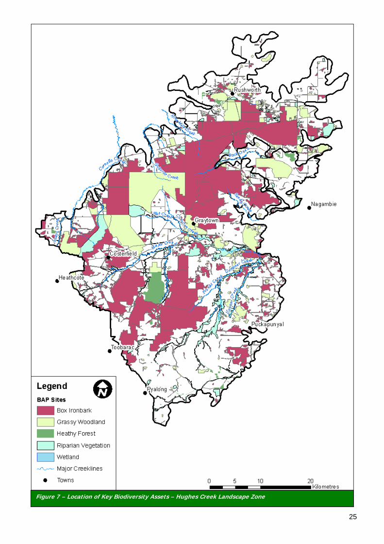
Figure 7 – Location of Key Biodiversity Assets – Hughes Creek Landscape Zone
26
7.0 PRIORITY ACTIONS FOR KEY BIODIVERSITY ASSESTS Priority actions for the Goldfields Landscape Zone have been developed and grouped based on each ‘Key Biodiversity Asset’ (eg. Grassy Woodlands) (refer to Section 6.2). Priority actions for the key biodiversity assets were developed based on the following factors, (1) size/extent (2) condition and (3) landscape processes (eg. habitat connectivity, hydrological regimes). The condition (2) section was also further split in relation to; education/extension; on-ground works; threatened species; and pest plants and animals. For example; an action relating to the condition of a remnant, due to rabbits, can be found under; ‘condition’ – ‘pest plants and animals’. For each of the 5 key biodiversity assets (1-5), the following pages identify: A) An introduction to the asset in the Goldfields Landscape Zone, B) Photographic example of the asset in ‘good condition’ for the zone, and C) Proposed actions for each of the assets in the Zone (broader actions in Ahern et al 2003). It is proposed that the community and agencies in the Goldfields Zone investigate options for implementing these actions in to existing projects/policies. For example, BAP sites in each asset type, should be targeted in order of priority (Very High, High, Medium to Low) in relation to these actions (where applicable). This forms the basis of BAP, where the very high value sites, that require less cost for long-term protection, will provide the highest prospect for conservation (GBCMA in prep.). Note: The Flora and Fauna Guarantee Act 1988 provides for the listing of Victoria’s threatened plant and animal species, ecological communities and potentially threatening processes. Under the Act, an Action Statement must be prepared. Action Statements outline what is required for the species conservation. They are developed based on a rigorous legislative process (Acts of Parliament) and are therefore of high priority. For further information refer to the ‘Actions for Biodiversity Conservation Database’ (ABC) (DSE 2005a).
27
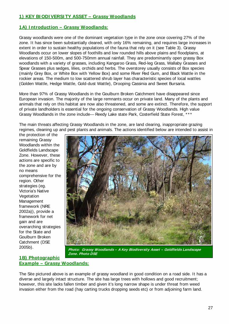
Photo: Grassy Woodlands – A Key Biodiversity Asset – Goldfields Landscape Zone. Photo DSE
1) KEY BIODIVERSITY ASSET – Grassy Woodlands 1A) Introduction – Grassy Woodlands: Grassy woodlands were one of the dominant vegetation type in the zone once covering 27% of the zone. It has since been substantially cleared, with only 16% remaining, and requires large increases in extent in order to sustain healthy populations of the fauna that rely on it (see Table 3). Grassy Woodlands occur on lower slopes of foothills and low rounded hills above plains and floodplains, at elevations of 150-500m, and 500-750mm annual rainfall. They are predominantly open grassy Box woodlands with a variety of grasses, including Kangaroo Grass, Red-leg Grass, Wallaby Grasses and Spear Grasses plus sedges, lilies, orchids and herbs. The overstorey usually consists of Box species (mainly Grey Box, or White Box with Yellow Box) and some River Red Gum, and Black Wattle in the rockier areas. The medium to low scattered shrub layer has characteristic species of local wattles (Golden Wattle, Hedge Wattle, Gold-dust Wattle), Drooping Cassinia and Sweet Bursaria. More than 97% of Grassy Woodlands in the Goulburn Broken Catchment have disappeared since European invasion. The majority of the large remnants occur on private land. Many of the plants and animals that rely on this habitat are now also threatened, and some are extinct. Therefore, the support of private landholders is essential for the ongoing conservation of Grassy Woodlands. High value Grassy Woodlands in the zone include— Reedy Lake state Park, Costerfield State Forest, *** The main threats affecting Grassy Woodlands in the zone, are land clearing, inappropriate grazing regimes, cleaning up and pest plants and animals. The actions identified below are intended to assist in the protection of the remaining Grassy Woodlands within the Goldfields Landscape Zone. However, these actions are specific to the zone and are by no means comprehensive for the region. Other strategies (eg. Victoria’s Native Vegetation Management framework (NRE 2002a)), provide a framework for net gain and are overarching strategies for the State and Goulburn Broken Catchment (DSE 2005b). 1B) Photographic Example – Grassy Woodlands: The Site pictured above is an example of grassy woodland in good condition on a road side. It has a diverse and largely intact structure. The site has large trees with hollows and good recruitment; however, this site lacks fallen timber and given it’s long narrow shape is under threat from weed invasion either from the road (hay carting trucks dropping seeds etc) or from adjoining farm land.
28
1C) Actions – Grassy Woodlands:
Size/Extent: • Create buffers, through revegetation, on freehold land abutting roadside remnants or
reserves to widen the habitat. • Increase connectivity from remnants on private land to remnants and reserves such as
Reedy Lake state Park and Costerfield State Forest. • Protect significant roadsides such as the Northern Highway at Ladypass, Bendigo Murchison
Road (East of Rushworth). • Expand patch size and improve connectivity of isolated or partly disconnected patches Condition: Education/Extension • Encourage landholders to increase the size of existing remnants, to establish new areas of
indigenous species of trees and shrubs, and to retain or establish buffer zones of revegetation or unimproved, uncultivated pasture around woodland.
• Liaise with Parks Victoria, DSE, committees of management and adjacent landholders, regarding the current management of the reserves.
• Encourage protection (fencing) of all remnants and manage grazing practices to benefit the grassy woodland (such as excluding all domestic grazing stock in remnants to allow plants to set seed and regenerate. Manage stock grazing to benefit the native vegetation once plants have set seed).
• Organise community education activities relating to the importance of Grassy Woodlands and associated flora and fauna species, specifically targeting high priority remnants in paddock environments.
• Further promote the benefits of protecting and enhancing remnant patches through extension and voluntary programs, such as Environmental Management Incentives.
• Encourage retention of fallen timber in privately owned sites and making sure that fallen timber is not removed illegally from public land.
On-ground Works • Minimise disturbance at high value sites at high value sites to prevent erosion and minimise
weed invasion. • Ensure clusters or individual specimens of large, hollow-bearing trees and dead standing trees
are retained and protected throughout the zone. • Create hollows or nest boxes to create habitat where it is lacking • Enhance high value sites with shrubs and other species if regeneration has not occurred
following fencing (eg. no existing seed source). • Identify additional native grassland paddocks for protection and restoration, where artefact
grasslands were once grassy forests. Threatened Species • Install nest boxes where hollows are deficient to increase the number of nesting hollows for
animals, such as the Brush-tailed Phascogale and Sugar Gliders. Pest Plant and Animals • Continue ongoing control of foxes and feral cats. • Control regionally listed weeds and environmental weeds from sites • Through the use of exclusion plots and monitoring, identify a healthy macropod population
density and work to maintain this through culling. Landscape Processes (ie. hydrological regime, habitat connectivity): • Encourage adjacent landholders to revegetate adjacent to significant road reserves such as—
Reedy Lake state Park and Costerfield State Forest, Northern Highway at Ladypass, Bendigo Murchison Road (East of Rushworth) in order to widen and buffer them against weed invasion • Identify and prioritise potential sites for habitat expansion and improved connectivity
as identified by the landscape context model and maps provided in this document.
29
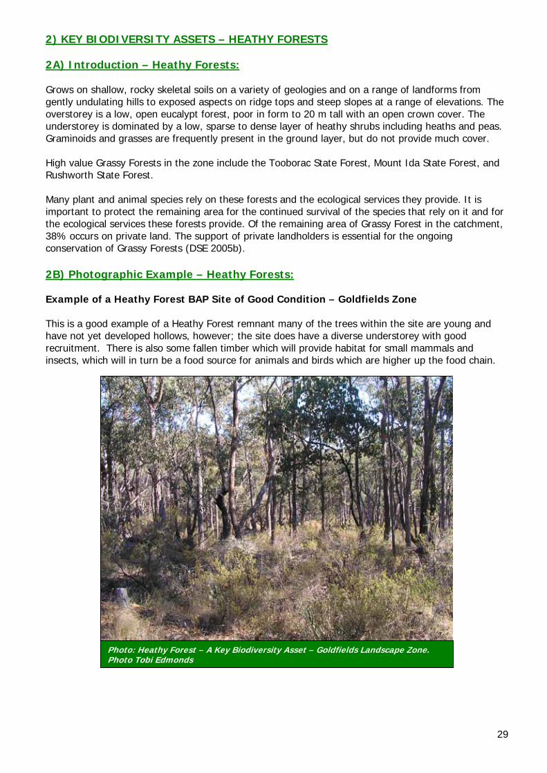
2) KEY BIODIVERSITY ASSETS – HEATHY FORESTS 2A) Introduction – Heathy Forests: Grows on shallow, rocky skeletal soils on a variety of geologies and on a range of landforms from gently undulating hills to exposed aspects on ridge tops and steep slopes at a range of elevations. The overstorey is a low, open eucalypt forest, poor in form to 20 m tall with an open crown cover. The understorey is dominated by a low, sparse to dense layer of heathy shrubs including heaths and peas. Graminoids and grasses are frequently present in the ground layer, but do not provide much cover. High value Grassy Forests in the zone include the Tooborac State Forest, Mount Ida State Forest, and Rushworth State Forest. Many plant and animal species rely on these forests and the ecological services they provide. It is important to protect the remaining area for the continued survival of the species that rely on it and for the ecological services these forests provide. Of the remaining area of Grassy Forest in the catchment, 38% occurs on private land. The support of private landholders is essential for the ongoing conservation of Grassy Forests (DSE 2005b). 2B) Photographic Example – Heathy Forests: Example of a Heathy Forest BAP Site of Good Condition – Goldfields Zone This is a good example of a Heathy Forest remnant many of the trees within the site are young and have not yet developed hollows, however; the site does have a diverse understorey with good recruitment. There is also some fallen timber which will provide habitat for small mammals and insects, which will in turn be a food source for animals and birds which are higher up the food chain.
Photo: Heathy Forest – A Key Biodiversity Asset – Goldfields Landscape Zone. Photo Tobi Edmonds
30
2C) Actions – Heathy Forests: Size/Extent: • Increase the extent of existing remnants, by establishing new areas of indigenous species
of trees and shrubs, and linking them to larger remnants in Tooborac State Forest, Mount Ida State Forest, and Rushworth State Forest.
Condition: Education/Extension • Encourage landholders to increase the size of existing remnants, to establish new areas of
indigenous species of trees and shrubs, and to retain or establish buffer zones of revegetation or unimproved, uncultivated pasture around woodland.
• Liaise with Parks Victoria, DSE, committees of management and adjacent landholders, regarding the current management of the reserves.
• Encourage protection (fencing) of all remnants and manage grazing practices to benefit Grassy Forests (such as exclude all domestic grazing stock in remnants to allow plants to set seed and regenerate. Manage stock grazing to benefit the native vegetation once plants have set seed).
• Organise community education activities relating to the importance of Grassy Forests and associated flora and fauna species, specifically targeting high priority remnants in paddock environments.
• Further promote the benefits of protecting and enhancing remnant patches through extension and voluntary programs, such as Environmental Management Incentives.
• Encourage retention of fallen timber in privately owned Grassy Dry forest Sites and making sure that fallen timber is not removed illegally from public land.
On-ground Works • Minimise disturbance at high value sites at high value sites to prevent erosion and minimise
weed invasion. • Ensure clusters or individual specimens of large, hollow-bearing trees and dead standing trees
are retained and protected throughout the zone. • Enhance high value sites with shrubs and other species if regeneration has not occurred
following fencing (eg. no existing seed source). • Identify additional native grassland paddocks for protection and restoration, where artefact
grasslands were once grassy forests. Threatened Species • Install nest boxes where hollows are deficient to increase the number of nesting hollows for
animals, such as the Brush-tailed Phascogale and Sugar Gliders. Pest Plant and Animals • Continue ongoing control of foxes and feral cats for the protection of threatened species
and focal species such as brush-tailed Phascogales, Sugar Gliders Golden Whistlers and Hooded Robins.
• Control regionally listed weeds and environmental weeds form sites. • Control Drooping Cassinia in areas where it has taken over as a primary coloniser. • Through the use of exclusion plots and monitoring, identify a healthy macropod population
density and work to maintain this through culling. Landscape Processes (ie. hydrological regime, habitat connectivity): • Increase connectivity, by linking remnants on private land to important reserves such as
Tooborac State Forest, Mount Ida State Forest, and Rushworth State Forest. • Enhance linkages between remnant vegetation by use of degraded roadsides.
31
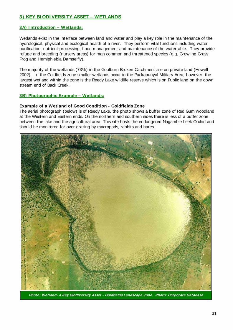
Photo: Wetland- a Key Biodiversity Asset - Goldfields Landscape Zone. Photo: Corporate Database
3) KEY BIODIVERSITY ASSET – WETLANDS 3A) Introduction – Wetlands: Wetlands exist in the interface between land and water and play a key role in the maintenance of the hydrological, physical and ecological health of a river. They perform vital functions including water purification, nutrient processing, flood management and maintenance of the watertable. They provide refuge and breeding (nursery areas) for man common and threatened species (e.g. Growling Grass Frog and Hemiphlebia Damselfly). The majority of the wetlands (73%) in the Goulburn Broken Catchment are on private land (Howell 2002). In the Goldfields zone smaller wetlands occur in the Puckapunyal Military Area; however, the largest wetland within the zone is the Reedy Lake wildlife reserve which is on Public land on the down stream end of Back Creek. 3B) Photographic Example – Wetlands: Example of a Wetland of Good Condition - Goldfields Zone The aerial photograph (below) is of Reedy Lake, the photo shows a buffer zone of Red Gum woodland at the Western and Eastern ends. On the northern and southern sides there is less of a buffer zone between the lake and the agricultural area. This site hosts the endangered Nagambie Leek Orchid and should be monitored for over grazing by macropods, rabbits and hares.
32
3C) Actions – Wetlands: Size/Extent: • Implement a buffer zone around all wetlands on private land (as far out beyond the rim of
the basin as possible) to increase the size of wetlands and provide for their protection. Condition: Education/Extension: • Provide extension to all landholders with wetlands in the Zone, to assist with recognition of
the benefits of wetlands and associated plants and animals on their properties. • Provide opportunities for education of landholders and school children regarding the
benefits of wetlands on farms. • Encourage landholders with wetlands to protect (fence/mange stock) them. • Encourage the grazing of wetlands under management, only when dry, to prevent seed set of
weeds. • Encourage the appropriate use of chemicals and other water contaminants on farms and
within local communities. • Prevent further removal of wetlands, through education (and legislation where required). • Investigate the use of ‘Index of Wetland Condition Assessments’ (DSE 2006) in conjunction
with Vegetation Quality Assessments (still required to allow priority comparisons). On-ground Works: • Protect (via incentives) all identified wetlands in the Zone, commencing with very high value
sites. • Protect existing or implement vegetative cover on inflow paths (eg. revegetate Surface
Water Schemes) to increase water quality. • Support the fencing of sites to exclude grazing, particularly when wet, or prior to being wet,
to allow flowering and seed-set of native plants. • Identify a demonstration site (show casing very high value site) for educational purposes. • Implement recommendations from Robinson and Rowley (1994) Pest Plants and Animals: • Control predators such as foxes and cats to enable water birds to breed and raise young • Control weeds such as blackberry on banks and identify and implement controls on any water
weeds in wetlands such as Arrowhead (Sagittaria brevirostrate). Landscape Processes (ie. hydrological regime, habitat connectivity): • Form clusters of wetlands by giving priority to protecting wetlands that are in close proximity
to one another, or in close proximity to a high value site.
33
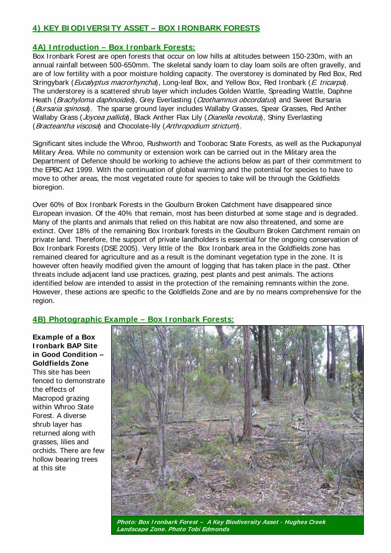
4) KEY BIODIVERSITY ASSET – BOX IRONBARK FORESTS 4A) Introduction – Box Ironbark Forests: Box Ironbark Forest are open forests that occur on low hills at altitudes between 150-230m, with an annual rainfall between 500-650mm. The skeletal sandy loam to clay loam soils are often gravelly, and are of low fertility with a poor moisture holding capacity. The overstorey is dominated by Red Box, Red Stringybark (Eucalyptus macrorhyncha), Long-leaf Box, and Yellow Box, Red Ironbark (E. tricarpa). The understorey is a scattered shrub layer which includes Golden Wattle, Spreading Wattle, Daphne Heath (Brachyloma daphnoides), Grey Everlasting (Ozothamnus obcordatus) and Sweet Bursaria (Bursaria spinosa). The sparse ground layer includes Wallaby Grasses, Spear Grasses, Red Anther Wallaby Grass (Joycea pallida), Black Anther Flax Lily (Dianella revoluta), Shiny Everlasting (Bracteantha viscosa) and Chocolate-lily (Arthropodium strictum). Significant sites include the Whroo, Rushworth and Tooborac State Forests, as well as the Puckapunyal Military Area. While no community or extension work can be carried out in the Military area the Department of Defence should be working to achieve the actions below as part of their commitment to the EPBC Act 1999. With the continuation of global warming and the potential for species to have to move to other areas, the most vegetated route for species to take will be through the Goldfields bioregion. Over 60% of Box Ironbark Forests in the Goulburn Broken Catchment have disappeared since European invasion. Of the 40% that remain, most has been disturbed at some stage and is degraded. Many of the plants and animals that relied on this habitat are now also threatened, and some are extinct. Over 18% of the remaining Box Ironbark forests in the Goulburn Broken Catchment remain on private land. Therefore, the support of private landholders is essential for the ongoing conservation of Box Ironbark Forests (DSE 2005). Very little of the Box Ironbark area in the Goldfields zone has remained cleared for agriculture and as a result is the dominant vegetation type in the zone. It is however often heavily modified given the amount of logging that has taken place in the past. Other threats include adjacent land use practices, grazing, pest plants and pest animals. The actions identified below are intended to assist in the protection of the remaining remnants within the zone. However, these actions are specific to the Goldfields Zone and are by no means comprehensive for the region. 4B) Photographic Example – Box Ironbark Forests: Example of a Box Ironbark BAP Site in Good Condition – Goldfields Zone This site has been fenced to demonstrate the effects of Macropod grazing within Whroo State Forest. A diverse shrub layer has returned along with grasses, lilies and orchids. There are few hollow bearing trees at this site
Photo: Box Ironbark Forest – A Key Biodiversity Asset - Hughes Creek Landscape Zone. Photo Tobi Edmonds
34
4C) Actions – Box Ironbark Forests: Size/Extent: • Encourage landholders to increase the size of existing remnants, to establish new areas of
indigenous species of trees and shrubs, and to retain or establish buffer zones with revegetation or fence out and allow regeneration around Box Ironbark forest.
• Protect significant roadsides such as the Hamilton Road, Mt Camel-Greytown Road, Heathcote-Nagambie Rd, Chapmans Road and the Pyalong-Seymour.
Condition: Extension/Education • Organise community education activities relating to the importance of Box Ironbark
Forests and associated flora and fauna species, specifically targeting high priority remnants in paddock environments.
• Further promote the benefits of protecting and enhancing remnant patches through extension and voluntary programs, such as Environmental Management Incentives and Land for Wildlife.
• Encourage retention of fallen timber in privately owned Box Ironbark Forest sites. On-ground Works • Maintain and improve condition of all identified high value sites by encouraging the
retention of fallen timber and hollow bearing trees, and manage regionally listed weeds. • Exclude all grazing to allow trees, shrubs and native ground cover regenerate. • Restore structural diversity by revegetating degraded remnants with indigenous shrubs and
ground cover, if regeneration has not occurred following fencing (eg. no existing seed source). • Protect clusters or individual specimens of large, hollow-bearing trees are retained and
protected throughout the zone. • Leave any dead standing trees. Install nest boxes where natural hollows are in short supply
to increase the number of nesting hollows for animals such as Brush-tailed Phascogales. • Encourage landowners to plant wood lots so that firewood harvesting is not impacting on
remnants. • Implement recommendations from Robinson and Rowley (1994) Threatened Species • Encourage landowners to carry out searches on their private remnants in wetter years for
threatened flora such as the Bald-tipped Beard-orchid. • Create nesting hollows for Brush-tailed Phascogale and Squirrel Gliders • Protect or plant native understorey species to provide food availability for Grey-crowned
Babblers. Pest Plant and Animals • Minimise disturbance at high value sites to prevent erosion and minimise weed invasion. • Continue ongoing control of foxes and feral cats for the protection of threatened species and
focal species including Brush-tailed Phascogale, Sugar Gliders and Diamond Firetails. • Destroy Noisy Miner populations to make more habitat available for Grey-crowned Babblers. • Control Drooping Cassinia in areas where in dominates in abundances greater than 10 plants
per ha Landscape Processes (ie. hydrological regime, habitat connectivity): • Increase connectivity to important reserves and remnants such as Whroo, Rushworth
and Tooborac State Forests by linking remnants on private land to the state forests via corridors which will allow for the movement of species across their landscape
• Identify and prioritise potential sites for habitat expansion and improved connectivity as identified by the landscape context model and maps provided in this document.
• Protect and expand Box Ironbark areas south of Puckapunyal to assist with the movement of species between the bioregions.
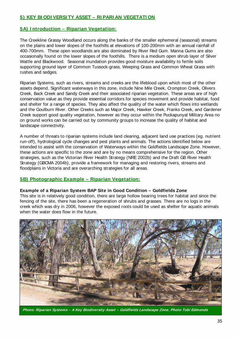
35
Photo: Riparian Systems – A Key Biodiversity Asset – Goldfields Landscape Zone. Photo Tobi Edmonds
5) KEY BIODIVERSITY ASSET – RIPARIAN VEGETATION 5A) Introduction – Riparian Vegetation: The Creekline Grassy Woodland occurs along the banks of the smaller ephemeral (seasonal) streams on the plains and lower slopes of the foothills at elevations of 100-200mm with an annual rainfall of 400-700mm. These open woodlands are also dominated by River Red Gum. Manna Gums are also occasionally found on the lower slopes of the foothills. There is a medium open shrub layer of Silver Wattle and Blackwood. Seasonal inundation provides good moisture availability to fertile soils supporting ground layer of Common Tussock-grass, Weeping Grass and Common Wheat Grass with rushes and sedges. Riparian Systems, such as rivers, streams and creeks are the lifeblood upon which most of the other assets depend. Significant waterways in this zone, include Nine Mile Creek, Crompton Creek, Olivers Creek, Back Creek and Sandy Creek and their associated riparian vegetation. These areas are of high conservation value as they provide essential corridors for species movement and provide habitat, food and shelter for a range of species. They also affect the quality of the water which flows into wetlands and the Goulburn River. Other Creeks such as Major Creek, Hawker Creek, Franks Creek, and Gardener Creek support good quality vegetation, however as they occur within the Puckapunyal Military Area no on ground works can be carried out by community groups to increase the quality of habitat and landscape connectivity. A number of threats to riparian systems include land clearing, adjacent land use practices (eg. nutrient run-off), hydrological cycle changes and pest plants and animals. The actions identified below are intended to assist with the conservation of Waterways within the Goldfields Landscape Zone. However, these actions are specific to the zone and are by no means comprehensive for the region. Other strategies, such as the Victorian River Health Strategy (NRE 2002b) and the Draft GB River Health Strategy (GBCMA 2004b), provide a framework for managing and restoring rivers, streams and floodplains in Victoria and are overarching strategies for all areas. 5B) Photographic Example – Riparian Vegetation: Example of a Riparian System BAP Site in Good Condition – Goldfields Zone This site is in relatively good condition, there are large hollow bearing trees for habitat and since the fencing of the site, there has been a regeneration of shrubs and grasses. There are no logs in the creek which was dry in 2006, however the exposed roots could be used as shelter for aquatic animals when the water does flow in the future.
36
5C) Actions – Riparian Vegetation: Size/Extent: • In consultation with GBCMA and adjacent landholders buffer creeks and rivers, revegetating or
allowing regeneration, using waterway/environmental incentives or covenanting. • Encourage direct seeding to increase cost efficiency and time of creating linkages between
private remnants and waterways. Condition: Education/Extension • Consult with licensees of waterways, to fence the creeklines, through waterway incentives and
encourage the removal of stock, especially during set times to allow regeneration. • Further promote the benefits of protecting and enhancing native vegetation in the in-stream
and riparian environments and linking to private remnants, in extension and voluntary programs, such as Environmental Incentives.
• Encourage the planting of alternative timber supplies, to reduce firewood collection impact on roadsides, remnants and waterways.
• In consultation with Goulburn Broken CMA, develop habitat management plans for streamside on freehold, with particular emphasis upon protecting and expanding habitat nodes (eg Creekline/roadside intersections).
On-ground Works • Establish off stream watering points for all affected sites on waterways, where required. • Negotiate with landholders the fencing (and grazing exclusion) of unused roadsides and
creeklines associated with their properties, and which contain remnants. • Concentrate revegetation and weed control efforts in areas adjacent to streamside reserves. • Encourage retention of fallen timber on all waterways and adjoining remnants. • Manage recreational users of the area to reduce degradation of the area. • Negotiate with landowners to create links from Mount Misery reserve to Nine Mile Creek to
increase species movement across their landscape. Pest Plant and Animals • Continue ongoing control of foxes and feral cats for the protection of threatened species
including Brush-tailed Phascogales and Squirrel Gliders. • Actively weed management to control and prevent infestation, especially Watsonia and
Blackberry. Landscape Processes (i.e. hydrological regime, habitat connectivity): • Increase linkages between Rushworth forest and One Tree Swamp (see Timmering Landscape
Zone Conservation Plan) by protecting and revegetating Nine Mile Creek • Revegetate and link Back Creek to Reedy Lake to allow for the movement of species from
Rushworth State forest to Reedy Lake.
37
8.0 FURTHER INFORMATION – PRIORITY SITES Priority Site Data: Information on the 954 priority BAP sites within the Goldfields has been derived using the Geographical Information System - Arcview 3.3. It is intended that the priority site information and other information detailed in this plan, will allow groups and staff (i.e. extension staff and community groups) to: • Be pro-active in targeting sites • Act as a basis for informed management of the site • Provide a rationale for applying incentives • Provide a tool for landholders and the wider community • Provide a tool to show how a site fits into the wider landscape • Provide a benchmark against which future improvements in management can be monitored How To Use The Data Provided: The data provided is intended for use by a range of organisational, agency and community groups, to assist with biodiversity conservation in the zone. It is particularly targeted towards agency extension officers. For example, it is anticipated that prior to or following a site visit, an extension officer will investigate the data associated with their site, such as: • What is the Ecological Vegetation Class of the site? • How does the site fit in to the wider landscape? • Are there any management agreements or incentives for the site (i.e. covenant, bush tender)? • Are there threatened or significant species recorded at the site or nearby? • What is the priority rating of the site and those near it (i.e. Very high, high, medium or low)? • What is the overarching management recommendation for the site (i.e. protect or restore)? • What are the actions recommended for the site (i.e. pest plant management)? (Negotiations need
to occur to get the best possible outcome for all involved). • What are the options available to the landholders to fulfil these actions (i.e. fencing incentive)? • What are the options for joining the site to public land (i.e. widening roadsides to provide a
corridor/link)? • Using the Landscape Context Map (Appendix 8), determine where possible linkages (revegetation)
may be of the most benefit – think about the landscape, what we could do to help the area. • It is also important to remember that sites with scattered trees are still a vital link in the landscape
and especially in an area where much of the original vegetation has given way to agriculture. Officers need to determine on site, where the best possible linkages could occur, and often this should include scattered vegetation, as although they generally have not been identified as a site in this plan, they form an important element for providing links between the identified sites (especially trees with hollows).
Keeping The Data Current: The data contained in this report is by no means ‘comprehensive’, as this process relies on the regular updating of information, to keep it accurate and timely. Therefore this plan is adaptive, to enable management actions and information to be modified in response to further information, including monitoring actions. The plan will also be reviewed when necessary to ensure that it remains a ‘living’ document. In order for the data and associated maps to remain as up to date and relevant as possible, it is important that site data continue to be added to the database. For example, the Department is not always aware of sightings of flora and fauna by individual landholders or community groups and there are still a number of sites that require Vegetation Quality Assessments and Bird Surveys. Further Information or To Provide Data: For clarification of information or to provide further data, please contact Water and Biodiversity Group, Department of Sustainability and Environment, Benalla on (03) 5761 1611.
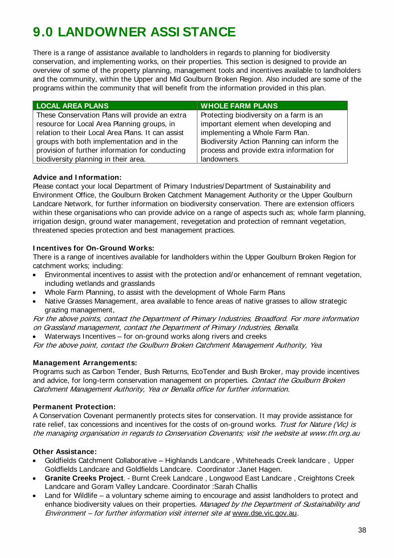
38
9.0 LANDOWNER ASSISTANCE There is a range of assistance available to landholders in regards to planning for biodiversity conservation, and implementing works, on their properties. This section is designed to provide an overview of some of the property planning, management tools and incentives available to landholders and the community, within the Upper and Mid Goulburn Broken Region. Also included are some of the programs within the community that will benefit from the information provided in this plan. LOCAL AREA PLANS WHOLE FARM PLANS These Conservation Plans will provide an extra resource for Local Area Planning groups, in relation to their Local Area Plans. It can assist groups with both implementation and in the provision of further information for conducting biodiversity planning in their area.
Protecting biodiversity on a farm is an important element when developing and implementing a Whole Farm Plan. Biodiversity Action Planning can inform the process and provide extra information for landowners.
Advice and Information: Please contact your local Department of Primary Industries/Department of Sustainability and Environment Office, the Goulburn Broken Catchment Management Authority or the Upper Goulburn Landcare Network, for further information on biodiversity conservation. There are extension officers within these organisations who can provide advice on a range of aspects such as; whole farm planning, irrigation design, ground water management, revegetation and protection of remnant vegetation, threatened species protection and best management practices. Incentives for On-Ground Works: There is a range of incentives available for landholders within the Upper Goulburn Broken Region for catchment works; including: • Environmental incentives to assist with the protection and/or enhancement of remnant vegetation,
including wetlands and grasslands • Whole Farm Planning, to assist with the development of Whole Farm Plans • Native Grasses Management, area available to fence areas of native grasses to allow strategic
grazing management, For the above points, contact the Department of Primary Industries, Broadford. For more information on Grassland management, contact the Department of Primary Industries, Benalla. • Waterways Incentives – for on-ground works along rivers and creeks For the above point, contact the Goulburn Broken Catchment Management Authority, Yea Management Arrangements: Programs such as Carbon Tender, Bush Returns, EcoTender and Bush Broker, may provide incentives and advice, for long-term conservation management on properties. Contact the Goulburn Broken Catchment Management Authority, Yea or Benalla office for further information. Permanent Protection: A Conservation Covenant permanently protects sites for conservation. It may provide assistance for rate relief, tax concessions and incentives for the costs of on-ground works. Trust for Nature (Vic) is the managing organisation in regards to Conservation Covenants; visit the website at www.tfn.org.au Other Assistance: • Goldfields Catchment Collaborative – Highlands Landcare , Whiteheads Creek landcare , Upper
Goldfields Landcare and Goldfields Landcare. Coordinator :Janet Hagen. • Granite Creeks Project. - Burnt Creek Landcare , Longwood East Landcare , Creightons Creek
Landcare and Goram Valley Landcare. Coordinator :Sarah Challis • Land for Wildlife – a voluntary scheme aiming to encourage and assist landholders to protect and
enhance biodiversity values on their properties. Managed by the Department of Sustainability and Environment – for further information visit internet site at www.dse.vic.gov.au.

39
• Local Government (Strathbogie, Mitchell and Murrundindi) – managing authority for native vegetation statutory planning requirements and managing authority for some of the Reserves mentioned in this plan.
40
10.0 MONITORING Monitoring is a fundamental component of all management activities and an important tool, which can be used to enhance the knowledge of biodiversity assets and manage for their on-going protection (Robinson undated). The following table (Table 4) provides a basis for monitoring in Goldfields Landscape Zone. Where possible, this information will feed in to the various Goulburn Broken Catchment monitoring programs. It identifies a general monitoring outline, including actions that may be conducted to determine progress towards achieving catchment biodiversity targets. It identifies the key biodiversity asset, key indicators for monitoring and the suggested frequency/intensity of monitoring. It is important to note that many of the monitoring activities listed below are already taking place, through a variety of mechanisms (eg. collection of data via local/catchment and Statewide databases and processes). Where existing mechanisms are already in place, they will continue to be used. However, there are other monitoring activities that are needed, to provide useful information and allow for accuracy assessment of the Catchments progress, towards meeting the Biodiversity Resource Condition Targets (RCT’s). A wide variety of monitoring actions are listed below. However this does not result in a binding commitment of those organisations (eg. time or funding), to undertake all of the monitoring. Rather, this table is intended to be a source of ideas for agency staff and community groups (eg. community groups may be interested in conducting future surveys). Interested persons can contact the Goulburn Broken Catchment Management Authority, Yea, or the Department of Primary Industries and Department of Sustainability and Environment Offices, Alexandra, to discuss ideas and to ensure a coordinated approach (refer to Section 10.0 for contact information). Whilst Table 4 outlines monitoring actions, evaluation of the BAP process also needs to occur, to evaluate the effectiveness of the BAP process (eg. in engaging people and prioritising works). An evaluation plan is therefore being developed to provide an overarching evaluation process for BAP in the Goulburn Broken Catchment.
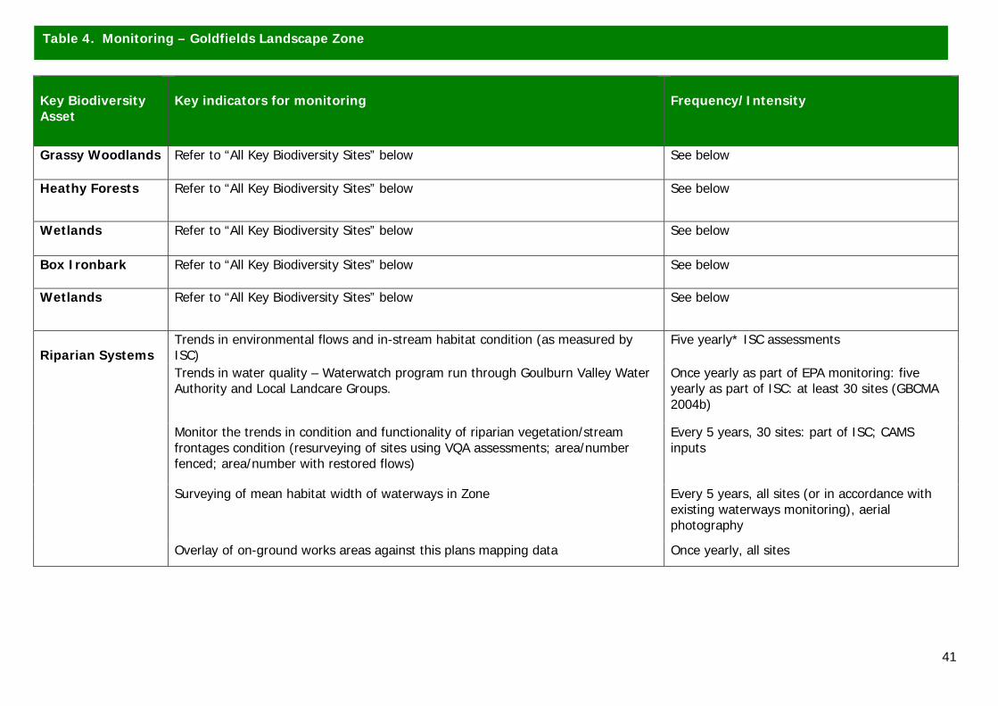
41
Key Biodiversity Asset
Key indicators for monitoring
Frequency/Intensity
Grassy Woodlands Refer to “All Key Biodiversity Sites” below See below
Heathy Forests Refer to “All Key Biodiversity Sites” below See below
Wetlands Refer to “All Key Biodiversity Sites” below See below
Box Ironbark Refer to “All Key Biodiversity Sites” below See below
Wetlands Refer to “All Key Biodiversity Sites” below See below
Riparian Systems
Trends in environmental flows and in-stream habitat condition (as measured by ISC)
Five yearly* ISC assessments
Trends in water quality – Waterwatch program run through Goulburn Valley Water Authority and Local Landcare Groups.
Once yearly as part of EPA monitoring: five yearly as part of ISC: at least 30 sites (GBCMA 2004b)
Monitor the trends in condition and functionality of riparian vegetation/stream frontages condition (resurveying of sites using VQA assessments; area/number fenced; area/number with restored flows)
Every 5 years, 30 sites: part of ISC; CAMS inputs
Surveying of mean habitat width of waterways in Zone Every 5 years, all sites (or in accordance with existing waterways monitoring), aerial photography
Overlay of on-ground works areas against this plans mapping data Once yearly, all sites
Table 4. Monitoring – Goldfields Landscape Zone
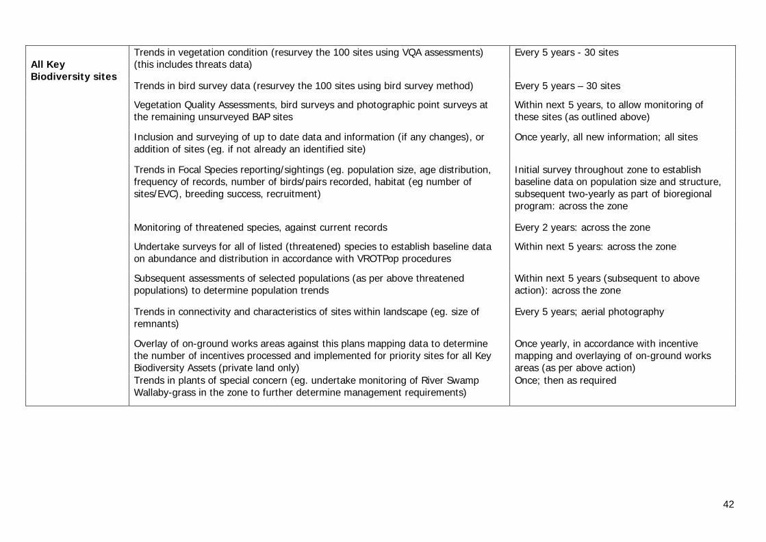
42
All Key Biodiversity sites
Trends in vegetation condition (resurvey the 100 sites using VQA assessments) (this includes threats data)
Every 5 years - 30 sites
Trends in bird survey data (resurvey the 100 sites using bird survey method) Every 5 years – 30 sites
Vegetation Quality Assessments, bird surveys and photographic point surveys at the remaining unsurveyed BAP sites
Within next 5 years, to allow monitoring of these sites (as outlined above)
Inclusion and surveying of up to date data and information (if any changes), or addition of sites (eg. if not already an identified site)
Once yearly, all new information; all sites
Trends in Focal Species reporting/sightings (eg. population size, age distribution, frequency of records, number of birds/pairs recorded, habitat (eg number of sites/EVC), breeding success, recruitment)
Initial survey throughout zone to establish baseline data on population size and structure, subsequent two-yearly as part of bioregional program: across the zone
Monitoring of threatened species, against current records Every 2 years: across the zone
Undertake surveys for all of listed (threatened) species to establish baseline data on abundance and distribution in accordance with VROTPop procedures
Within next 5 years: across the zone
Subsequent assessments of selected populations (as per above threatened populations) to determine population trends
Within next 5 years (subsequent to above action): across the zone
Trends in connectivity and characteristics of sites within landscape (eg. size of remnants)
Every 5 years; aerial photography
Overlay of on-ground works areas against this plans mapping data to determine the number of incentives processed and implemented for priority sites for all Key Biodiversity Assets (private land only)
Once yearly, in accordance with incentive mapping and overlaying of on-ground works areas (as per above action)
Trends in plants of special concern (eg. undertake monitoring of River Swamp Wallaby-grass in the zone to further determine management requirements)
Once; then as required
43
11.0 REFERENCES
Ahern, L.D., Lowe, K.W., Berwick, S., Robinson, D. & Handley, K. (2003). Biodiversity Action Planning: landscape plans for
the Goulburn Broken CMA- Shepparton Irrigation Region – North Zones. Department of Sustainability and Environment,
Victoria.
Berwick, S (2003). Map Unit Descriptions of Lower Goulburn Broken (draft). State of Victoria, Melbourne.
Birds Australia (2001). Bird Surveying Techniques. Available at: http://www.birdsaustralia.org.au.
CGDL (2005). Corporate Geographical Database Library. State of Victoria, Melbourne.
Crown (1997). Victoria’s Biodiversity: Directions in Management. State of Victoria, Melbourne.
DPI (2005). Dairying for Tomorrow: Dairy Sat- The Guide. State of Victoria, Melbourne.
DSE (2003). Barmah Forest Ramsar Site: Strategic Management Plan. State of Victoria, Melbourne.
DSE (2004). Environmental Management in Agriculture: Worksheet Series 1-8. State of Victoria, Melbourne.
DSE (2005a). Actions for Biodiversity Conservation Database (ABC). Department of Sustainability and Environment. State of
Victoria, Melbourne.
DSE (2005b). EVC information sheets. Available at: http://www.gbcma.vic.gov.au/default.asp?ID=157
Ferwerda, F. (2003). Landscape Context Model. State of Victoria, Melbourne.
GBCMA (2003a). Goulburn Broken Regional Catchment Strategy. Goulburn Broken Catchment Management Authority,
Shepparton. Available at: http://www.gbcma.vic.gov.au.
GBCMA (2004a), Developers Manual for Biodiversity Action Planning in the Goulburn Broken Catchment. Goulburn Broken
Catchment Management Authority, Shepparton.
GBCMA (2004b). Goulburn Broken River Health Strategy (draft). Goulburn Broken Catchment Management Authority,
Shepparton. Available at: http://www.gbcma.vic.gov.au.
Howell, M. (2002). Wetland Directions Paper for the Goulburn Broken Catchment. Goulburn Broken Catchment Management
Authority, Shepparton. Available at: http://www.gbcma.vic.gov.au.
Lambeck, R.J. (1997). Landscape planning for biodiversity conservation in agricultural regions. Biodiversity Technical paper
No. 2. Commonwealth of Australia, Canberra.
NRE (2002a). Victoria’s Native Vegetation Management: a Framework for Action. Department of Natural Resources and
Environment, Victoria.
NRE (2002b). Healthy rivers, healthy communities and regional growth: the Victorian River Health Strategy. Department of
Natural Resources and Environment, Victoria.
44
NRE (2002c). Victorian Flora Site Database – May 2002. Department of Natural Resources and Environment, Victoria.
NRE (2002d). Atlas of Victorian Wildlife. March 2002. Department of Natural Resources and Environment, Victoria.
Platt, S.J. & Lowe, K.W. (2002). Biodiversity Action Planning: planning for native biodiversity at multiple scales – catchment,
bioregional, landscape, local. Department of Natural Resources and Environment, State of Victoria, Melbourne.
Robinson, D. (undated). A monitoring, evaluation and reporting strategy for the Longwood Plains Biodiversity Project.
Trust for Nature & Department of Sustainability and Environment, Benalla.
Robinson, J. & Rowley, L. (1994) Drought refuge identification project for the Box Ironbark ecosystem within the Campaspe,
Goulburn and Loddon catchments. Unpublished. report prepared for Department of Conservation & Natural Resources by
Bendigo Field Naturalists Club Inc., Bendigo.
Simpson, K., Day, N. & Trusler, P. (1993). Field Guide to the Birds of Australia (4th ed.). Penguin Books, Ringwood,
Australia.
Wilson, J.A & Lowe, K.W. (2002). Planning for the conservation of native biodiversity within catchments using biophysical
modeling. Department of Natural Resources and Environment, State of Victoria, Melbourne.
Wierzbowski, P., Lowe, K.W., Handley, K, Berwick, S., Robinson, D. & Ahern, L.D. (2002). Biodiversity Action Planning:
Strategic Overview for the Victorian Riverina Bioregion. Department of Natural Resources and Environment, State of
Victoria, Melbourne.
45
12.0 ACKNOWLEDGMENTS This project is funded as part of the Goulburn Broken Catchment Management Authority Regional Catchment Strategy, in the Upper Goulburn Broken Region and is provided with support and funding from the Australian and Victorian Governments. This project is delivered primarily through partnerships between the Goulburn Broken Catchment Management Authority (GBCMA), Department of Primary Industries (DPI), Department of Sustainability and Environment (DSE), Trust for Nature (Vic) (TfN) and other community bodies. Personnel from these agencies provided generous support and advice during the development of this plan. We also thank numerous Landholders, Landcare Groups, Local Area Planning Groups, Agency representatives and individuals, who provided generous support, advice, information and assistance. This included, guidance, technical knowledge, attendance at meetings, plan review, provision of literature and survey data, and property access. Thank-you also to person’s who have provided photographs. Photographer credit (names) are included under each photograph throughout the report. A special acknowledgment to all representatives (current and past) on the Goulburn Broken Biodiversity Action Planning (BAP) Steering Committee. This steering committee was established to oversee the BAP process and is responsible for the coordination of BAP, in the Goulburn Broken Catchment. The committee is comprised of personnel from a range of departmental organisations, including the GBCMA, DPI, DSE and TfN (Vic). Core committee members are detailed below, along with contributors to BAP in the Goulburn Broken (eg. meeting attendance, trial implementation, and plan development). Thank you to person’s whom have attended meetings as invited guest’s (names not listed) and provided valuable comment. BAP Steering Committee Members: GBCMA - Barlow, Tim – Manager, Biodiversity Programs, GBCMA (current)
Brunt, Kate – Biodiversity Projects Coordinator, GBCMA (current) Bell, Kate – (as) Manager, Biodiversity Programs, GBCMA (past)
DPI - Heard, Rebecca – Native Biodiversity Coordinator, DPI (SIR) (current) Stothers, Kate – Nature Conservation Coordinator, DPI (Dryland) (current)
Williams, Lance – Planning Officer, DPI (SIR) (past) Sislov, Alex – Team Leader Environment Program, DPI (SIR) (current)
DSE - Merritt, Bronwyn – Biodiversity Landscape Plan Project Officer (Upper) (past) Smith, Stephen – Senior Flora and Fauna Officer, DSE (Upper) (current)
Edmonds, Tobi – Threatened Flora Projects Officer, DSE (Lower) (current) Wilson, (Dr) Jenny – Biodiversity Projects Officer, DSE (Dryland) (current)
Marshall, Rowhan – BAP Database Manager, DSE (Benalla) (current) Sheahan, Mark – (as) Biodiversity Team Leader, North East, DSE (past)
TFN (Vic) - Robinson, (Dr) Doug – Regional Manager, Goulburn Broken – TfN (Vic) (current) Biodiversity Action Planning Contributors: Mitchell, Peter – Links Officer, DPI (trial implementation) Olive, Cathy – Links Officer, DPI (trial implementation) Berwick, Sue – (as) Flora and Fauna Planner, DSE (past) Mentiplay-Smith, Janice - Links Officer, DPI (current) Howell, Marion – Biodiversity Officer, GBCMA (past)
46
13.0 APPENDICES
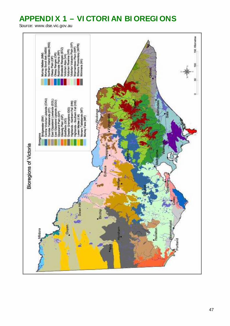
47
APPENDIX 1 – VICTORIAN BIOREGIONS Source: www.dse.vic.gov.au
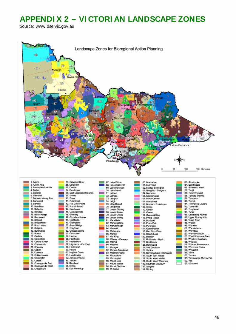
48
APPENDIX 2 – VICTORIAN LANDSCAPE ZONES Source: www.dse.vic.gov.au
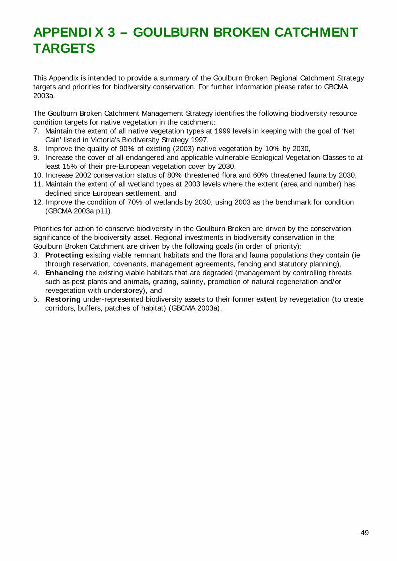
49
APPENDIX 3 – GOULBURN BROKEN CATCHMENT TARGETS This Appendix is intended to provide a summary of the Goulburn Broken Regional Catchment Strategy targets and priorities for biodiversity conservation. For further information please refer to GBCMA 2003a. The Goulburn Broken Catchment Management Strategy identifies the following biodiversity resource condition targets for native vegetation in the catchment: 7. Maintain the extent of all native vegetation types at 1999 levels in keeping with the goal of ‘Net
Gain’ listed in Victoria’s Biodiversity Strategy 1997, 8. Improve the quality of 90% of existing (2003) native vegetation by 10% by 2030, 9. Increase the cover of all endangered and applicable vulnerable Ecological Vegetation Classes to at
least 15% of their pre-European vegetation cover by 2030, 10. Increase 2002 conservation status of 80% threatened flora and 60% threatened fauna by 2030, 11. Maintain the extent of all wetland types at 2003 levels where the extent (area and number) has
declined since European settlement, and 12. Improve the condition of 70% of wetlands by 2030, using 2003 as the benchmark for condition
(GBCMA 2003a p11). Priorities for action to conserve biodiversity in the Goulburn Broken are driven by the conservation significance of the biodiversity asset. Regional investments in biodiversity conservation in the Goulburn Broken Catchment are driven by the following goals (in order of priority): 3. Protecting existing viable remnant habitats and the flora and fauna populations they contain (ie
through reservation, covenants, management agreements, fencing and statutory planning), 4. Enhancing the existing viable habitats that are degraded (management by controlling threats
such as pest plants and animals, grazing, salinity, promotion of natural regeneration and/or revegetation with understorey), and
5. Restoring under-represented biodiversity assets to their former extent by revegetation (to create corridors, buffers, patches of habitat) (GBCMA 2003a).
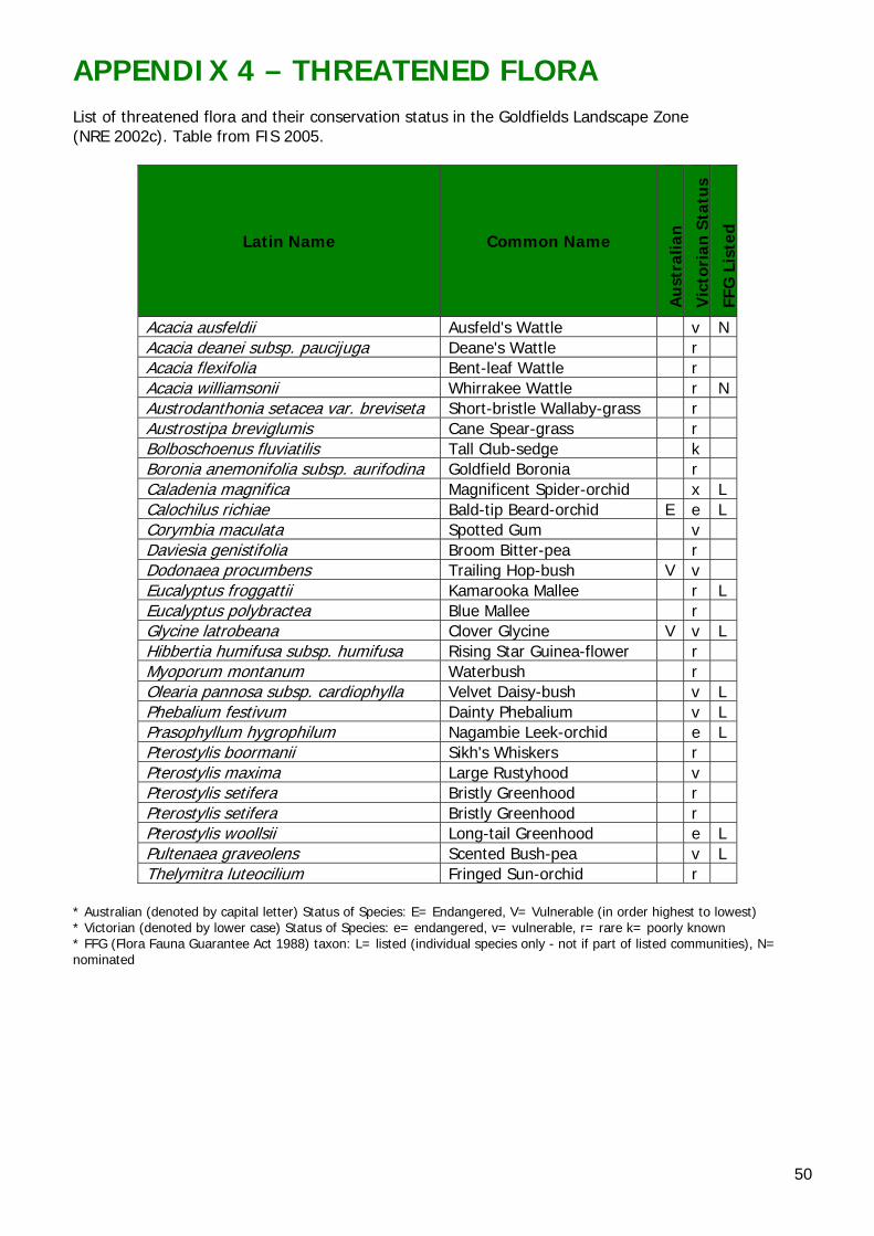
50
APPENDIX 4 – THREATENED FLORA List of threatened flora and their conservation status in the Goldfields Landscape Zone (NRE 2002c). Table from FIS 2005.
Latin Name Common Name
Au
stra
lian
Vic
tori
an S
tatu
s
FFG
Lis
ted
Acacia ausfeldii Ausfeld's Wattle v NAcacia deanei subsp. paucijuga Deane's Wattle r Acacia flexifolia Bent-leaf Wattle r Acacia williamsonii Whirrakee Wattle r NAustrodanthonia setacea var. breviseta Short-bristle Wallaby-grass r Austrostipa breviglumis Cane Spear-grass r Bolboschoenus fluviatilis Tall Club-sedge k Boronia anemonifolia subsp. aurifodina Goldfield Boronia r Caladenia magnifica Magnificent Spider-orchid x L Calochilus richiae Bald-tip Beard-orchid E e L Corymbia maculata Spotted Gum v Daviesia genistifolia Broom Bitter-pea r Dodonaea procumbens Trailing Hop-bush V v Eucalyptus froggattii Kamarooka Mallee r L Eucalyptus polybractea Blue Mallee r Glycine latrobeana Clover Glycine V v L Hibbertia humifusa subsp. humifusa Rising Star Guinea-flower r Myoporum montanum Waterbush r Olearia pannosa subsp. cardiophylla Velvet Daisy-bush v L Phebalium festivum Dainty Phebalium v L Prasophyllum hygrophilum Nagambie Leek-orchid e L Pterostylis boormanii Sikh's Whiskers r Pterostylis maxima Large Rustyhood v Pterostylis setifera Bristly Greenhood r Pterostylis setifera Bristly Greenhood r Pterostylis woollsii Long-tail Greenhood e L Pultenaea graveolens Scented Bush-pea v L Thelymitra luteocilium Fringed Sun-orchid r
* Australian (denoted by capital letter) Status of Species: E= Endangered, V= Vulnerable (in order highest to lowest) * Victorian (denoted by lower case) Status of Species: e= endangered, v= vulnerable, r= rare k= poorly known * FFG (Flora Fauna Guarantee Act 1988) taxon: L= listed (individual species only - not if part of listed communities), N= nominated
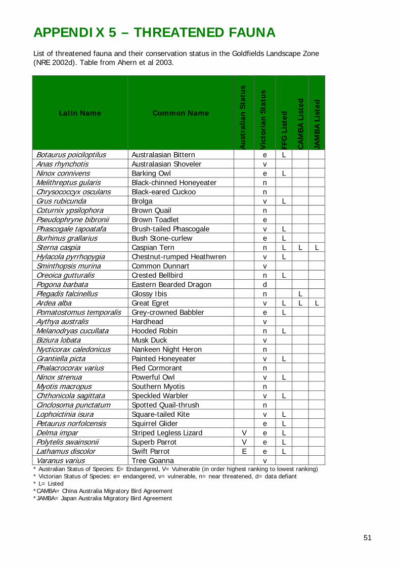
51
APPENDIX 5 – THREATENED FAUNA List of threatened fauna and their conservation status in the Goldfields Landscape Zone (NRE 2002d). Table from Ahern et al 2003.
Latin Name Common Name
Au
stra
lian
Sta
tus
Vic
tori
an S
tatu
s
FFG
Lis
ted
CA
MB
A L
iste
d
JAM
BA
Lis
ted
Botaurus poiciloptilus Australasian Bittern e L Anas rhynchotis Australasian Shoveler v Ninox connivens Barking Owl e L Melithreptus gularis Black-chinned Honeyeater n Chrysococcyx osculans Black-eared Cuckoo n Grus rubicunda Brolga v L Coturnix ypsilophora Brown Quail n Pseudophryne bibronii Brown Toadlet e Phascogale tapoatafa Brush-tailed Phascogale v L Burhinus grallarius Bush Stone-curlew e L Sterna caspia Caspian Tern n L L L Hylacola pyrrhopygia Chestnut-rumped Heathwren v L Sminthopsis murina Common Dunnart v Oreoica gutturalis Crested Bellbird n L Pogona barbata Eastern Bearded Dragon d Plegadis falcinellus Glossy Ibis n L Ardea alba Great Egret v L L L Pomatostomus temporalis Grey-crowned Babbler e L Aythya australis Hardhead v Melanodryas cucullata Hooded Robin n L Biziura lobata Musk Duck v Nycticorax caledonicus Nankeen Night Heron n Grantiella picta Painted Honeyeater v L Phalacrocorax varius Pied Cormorant n Ninox strenua Powerful Owl v L Myotis macropus Southern Myotis n Chthonicola sagittata Speckled Warbler v L Cinclosoma punctatum Spotted Quail-thrush n Lophoictinia isura Square-tailed Kite v L Petaurus norfolcensis Squirrel Glider e L Delma impar Striped Legless Lizard V e L Polytelis swainsonii Superb Parrot V e L Lathamus discolor Swift Parrot E e L Varanus varius Tree Goanna v
* Australian Status of Species: E= Endangered, V= Vulnerable (in order highest ranking to lowest ranking) * Victorian Status of Species: e= endangered, v= vulnerable, n= near threatened, d= data defiant * L= Listed *CAMBA= China Australia Migratory Bird Agreement *JAMBA= Japan Australia Migratory Bird Agreement
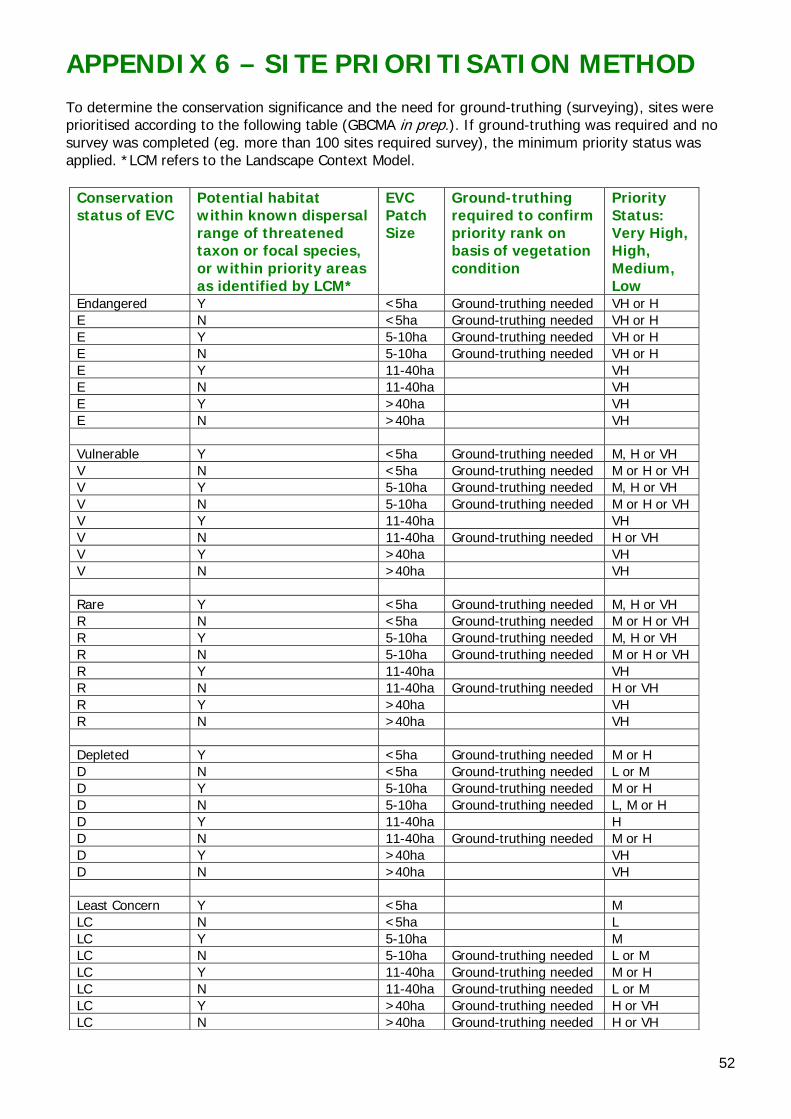
52
APPENDIX 6 – SITE PRIORITISATION METHOD To determine the conservation significance and the need for ground-truthing (surveying), sites were prioritised according to the following table (GBCMA in prep.). If ground-truthing was required and no survey was completed (eg. more than 100 sites required survey), the minimum priority status was applied. *LCM refers to the Landscape Context Model.
Conservation status of EVC
Potential habitat within known dispersal range of threatened taxon or focal species, or within priority areas as identified by LCM*
EVC Patch Size
Ground-truthing required to confirm priority rank on basis of vegetation condition
Priority Status: Very High, High, Medium, Low
Endangered Y <5ha Ground-truthing needed VH or H E N <5ha Ground-truthing needed VH or H E Y 5-10ha Ground-truthing needed VH or H E N 5-10ha Ground-truthing needed VH or H E Y 11-40ha VH E N 11-40ha VH E Y >40ha VH E N >40ha VH Vulnerable Y <5ha Ground-truthing needed M, H or VH V N <5ha Ground-truthing needed M or H or VH V Y 5-10ha Ground-truthing needed M, H or VH V N 5-10ha Ground-truthing needed M or H or VH V Y 11-40ha VH V N 11-40ha Ground-truthing needed H or VH V Y >40ha VH V N >40ha VH Rare Y <5ha Ground-truthing needed M, H or VH R N <5ha Ground-truthing needed M or H or VH R Y 5-10ha Ground-truthing needed M, H or VH R N 5-10ha Ground-truthing needed M or H or VH R Y 11-40ha VH R N 11-40ha Ground-truthing needed H or VH R Y >40ha VH R N >40ha VH Depleted Y <5ha Ground-truthing needed M or H D N <5ha Ground-truthing needed L or M D Y 5-10ha Ground-truthing needed M or H D N 5-10ha Ground-truthing needed L, M or H D Y 11-40ha H D N 11-40ha Ground-truthing needed M or H D Y >40ha VH D N >40ha VH Least Concern Y <5ha M LC N <5ha L LC Y 5-10ha M LC N 5-10ha Ground-truthing needed L or M LC Y 11-40ha Ground-truthing needed M or H LC N 11-40ha Ground-truthing needed L or M LC Y >40ha Ground-truthing needed H or VH LC N >40ha Ground-truthing needed H or VH
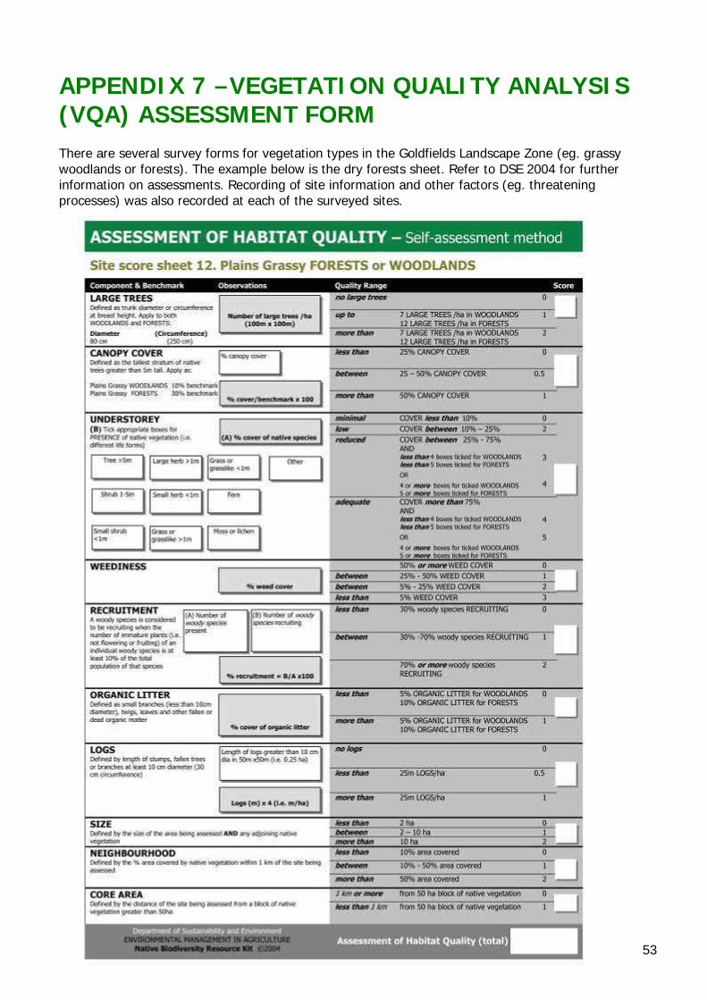
53
APPENDIX 7 –VEGETATION QUALITY ANALYSIS (VQA) ASSESSMENT FORM There are several survey forms for vegetation types in the Goldfields Landscape Zone (eg. grassy woodlands or forests). The example below is the dry forests sheet. Refer to DSE 2004 for further information on assessments. Recording of site information and other factors (eg. threatening processes) was also recorded at each of the surveyed sites.
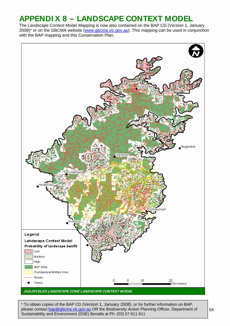
54
APPENDIX 8 – LANDSCAPE CONTEXT MODEL The Landscape Context Model Mapping is now also contained on the BAP CD (Version 1, January 2008)* or on the GBCMA website (www.gbcma.vic.gov.au). This mapping can be used in conjunction with the BAP mapping and this Conservation Plan.
GOLDFIELDS LANDSCAPE ZONE LANDSCAPE CONTEXT MODEL
* To obtain copies of the BAP CD (Version 1, January 2008), or for further information on BAP, please contact [email protected] OR the Biodiversity Action Planning Officer, Department of Sustainability and Environment (DSE) Benalla at Ph: (03) 57 611 611
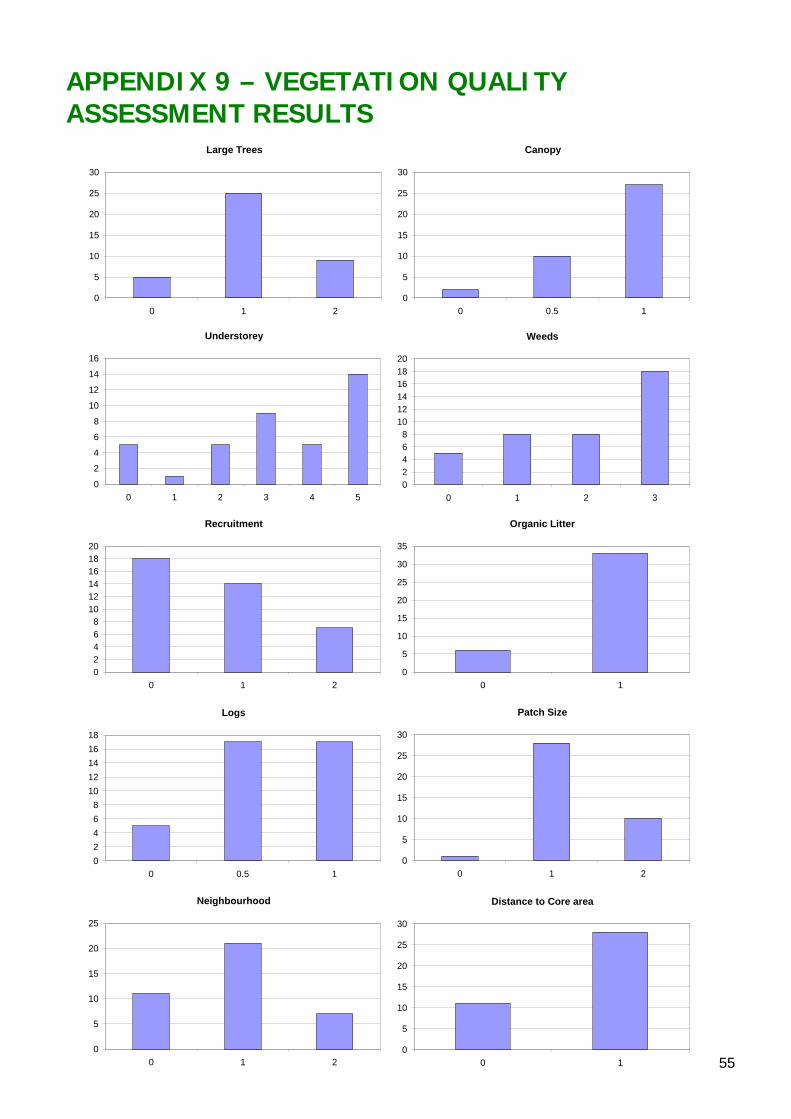
55
Large Trees
0
5
10
15
20
25
30
0 1 2
Canopy
0
5
10
15
20
25
30
0 0.5 1
Understorey
0
2
4
6
8
10
12
14
16
0 1 2 3 4 5
Weeds
02468
101214161820
0 1 2 3
Recruitment
02468
101214161820
0 1 2
Organic Litter
0
5
10
15
20
25
30
35
0 1
Logs
02468
1012141618
0 0.5 1
Patch Size
0
5
10
15
20
25
30
0 1 2
Neighbourhood
0
5
10
15
20
25
0 1 2
Distance to Core area
0
5
10
15
20
25
30
0 1
APPENDIX 9 – VEGETATION QUALITY ASSESSMENT RESULTS
56
APPENDIX 10 – PRIORITY SITE INFORMATION (MAPPING): Mapping and accompanying information for each of the ‘priority BAP sites’ is now contained on the BAP CD (Version 1, January 2008) or on the GBCMA website (www.gbcma.vic.gov.au). This mapping data is designed to be used in conjunction with this Conservation Plan to assist users to obtain further information on priority sites. HOW TO OBTAIN INFORMATION FROM THE BAP CD:
1. Locate the available mapping data by clicking on the ‘BAP Mapping’ hyperlink#. 2. Click on the hyperlink relating to the Zone of interest under the ‘BAP Mapping’ subheading’
(e.g. ‘Barmah’). 3. This will lead to a map identifying priority BAP sites within the chosen Zone. 4. On this map, locate the area/site of interest by clicking on the area. 5. Zoom in or out to the areas/sites of interest, using the North, South, East, West arrows. 6. Click on a BAP site to view the Attribute Table information for that site. 7. Refer to the list of birds surveyed at each site (where available). 8. An explanation of the data provided in the Attribute Table, is provided in the ‘Attribute Table
Definition’ document under the BAP Mapping Subheading 9. For further information to assist with the identification of opportunities to link the BAP sites,
refer to ‘BAP Mapping’, ‘Landscape Context Model Maps’ and choose the relevant Zone name hyperlink(e.g. ‘Barmah’).
10. To access the data via the Geographical Information System (GIS) (where available) select ‘BAP Mapping’,
11. ‘GIS data’ then either ‘BAP GIS layer’ or ‘LCM GIS layer’. # Note: Mapping data for each Landscape Zone can also be located by clicking on the ‘BAP Zones’ hyperlink and choosing the Landscape Zone of interest from the map of the Goulburn Broken Catchment.
To obtain copies of the BAP CD (Version 1, January 2008), or for further information on BAP, please contact [email protected] OR the Biodiversity Action Planning Officer, Department of Sustainability and Environment (DSE) Benalla at Ph: (03) 57 611 611

57

58