Embed Size (px)
Citation preview

The Use of Satellite-Based Technology in Developing Countries
by
Danielle Renee Wood
S.B., Aeronautics and Astronautics Massachusetts Institute of Technology, 2005
Submitted to the Department of Aeronautics and Astronautics and the Engineering Systems Division
In Partial Fulfillment of the Requirements for the Degrees of
Master of Science in Aeronautics and Astronautics
and Master of Science in Technology and Policy
at the
Massachusetts Institute of Technology
September 2008
© 2008 Massachusetts Institute of Technology All rights reserved.
Author__________________________________________________________________
Department of Aeronautics and Astronautics and the Technology and Policy Program, Engineering Systems Division
August 8, 2008
Certified by______________________________________________________________
Annalisa L. Weigel
Assistant Professor of Aeronautics and Astronautics
and Engineering Systems
Thesis Supervisor
Accepted by_____________________________________________________________ Dava J. Newman
Professor of Aeronautics and Astronautics
and Engineering Systems Director, Technology and Policy Program
Accepted by_____________________________________________________________
Prof. David L. Darmofal
Associate Department Head Chair, Committee on Graduate Students
Department of Aeronautics and Astronautics

2

3
The Use of Satellite-Based Technology in Developing Countries
by
Danielle Renee Wood
Submitted to the Department of Aeronautics and Astronautics and the Engineering Systems Division on August 8, 2008,
in Partial Fulfillment of the Requirements for
the Degrees of Master of Science in Aeronautics and Astronautics and Master of Science in Technology and Policy
Abstract
Satellite technology in the areas of remote sensing, communication, and navigation can provide valuable information in a number of areas from business to disaster management to agriculture.
There is great potential for such technology to help solve problems in developing countries. Unfortunately, due to lack of funds, expertise, equipment or awareness, developing countries are not using satellite technology to its full potential. This thesis is motivated by a desire to increase
and improve the use of satellite-based technology in developing countries. Three Research Questions guide the study. Question 1 is, “How does national development level relate to
national space activity?” For this question, national development level is measured by a series of Development Indicators such as Gross Domestic Product. The level of space activity is measured using a Space Participation Metric that is created by the author. Statistical analysis is used to
learn if there is any significant difference in the space activity of countries at different development levels. Research Question 2 asks, “What Mission and Management Architectures
are developing countries using to apply satellite-based technology to national needs?” The data used to answer this question comes from 90 Space Project Case Studies about satellite-enabled activities in Africa. The information from the Case Studies is organized so that trends can be
found in the accomplishments of the projects. Research Question 3 asks, “How does national development level influence the Mission and Management Architectures used by developing
countries in satellite-based technology projects?” This question builds on the data from Research Question 2. Statistical analysis is used to determine if African countries at different development levels perform differently in the Space Project Case Studies. In addition to addressing these three
Research Questions, this study explores the policy context of African countries through a series of interviews. Thirty interviews were held with representatives from African embassies in the
United States. The interview questions explore the institutional structure of the country‟s National Innovation System. To summarize the results, the analysis for Question 1 shows that there is a significant difference in the space activity of countries at different development leve ls.
Question 2 shows that most African space projects involve either one African country or a collaboration with a non-African partner. The third Research Question shows that there is a
significant difference in the level of technical expertise and programmatic leadership shown by African countries at different development levels. This study closes with policy recommendations for developing country policy makers about next steps for using satellite-based
technology.
Thesis Supervisor: Annalisa Weigel
Assistant Professor, Aeronautics and Astronautics and Engineering Systems Division

4

5
Acknowledgements
It has been a great adventure to arrive at this point in my academic career. When I was an
undergraduate at MIT, I was not confidant that I could succeed in graduate school. I must thank Prof Charles Coleman for speaking words of belief and encouragement about my abilities back
then. As I began graduate school, I wanted to do research on this topic, but I did not know how to make it happen. I have been supported and guided by many helpful people. I thank Daniel Irwin of NASA and Ayanna Samuels (Dual SM at MIT, 2005) who showed me how my interests
in international development and aerospace engineering could be combined in a practical way. I also thank Prof David Miller who was my academic and research advisor for parts of my
undergraduate and graduate career at MIT. He consistently encouraged my ideas and plans, even when they inconvenienced him.
I thank Prof Annalisa Weigel who has advised me through this research process. It has
been an honor and joy to work with her. I appreciate the way she encourages me to take initiative with my research.
I am thankful also for my experiences with the NASA Academy internship. It was during this summer program in 2004 that I discovered two things. First, I learned that I definitely wanted to go to graduate school and, second, that I wanted to find a way to research the use of
satellites in developing countries. I am also thankful for the various graduate fellowship programs that have made it
possible for me to pursue this line of research. This includes the NASA Harriett Jenkins Pre-Doctoral Fellowship Program, the Departmental Fellowship from Aeronautics and Astronautics at MIT, the National Science Foundation and the National Defense Science and Engineering
Graduate Fellowship. On a personal note, I thank my husband, Jonathan, for being willing to date me and marry
me even while we lived in two different states so that I could complete my Masters degrees. I also want to thank my parents and brothers for all the ways they have encouraged my interests over the years. Thank you for supporting me when I traveled to Kenya and South Africa to learn
and serve. Thank you for believing that I could pursue all of my interests, from acting to engineering to language to salsa dancing. I am very thankful to God who has guided me through
out this adventure and has placed all of these special people in my life.
Author Biography
Danielle Wood, formerly Danielle Adams, received her Bachelor o f Science degree from MIT in Aeronautics and Astronautics with a Minor in Spanish in 2005. As an undergraduate,
Danielle studied abroad at the Center for Cross-Cultural studies in Spain. She also traveled several times to Kenya to volunteer with homeless children. Since starting her university career Danielle has held several research positions at MIT and NASA centers. After completing her
S.B., Danielle worked as the Operations Manager for the NASA Academy internship program at the Goddard Space Flight Center in Maryland in 2005. Danielle is the recipient of several
federal, graduate fellowships including the NASA Harriett Jenkins Pre-doctoral Fellowship, the National Science Foundation Graduate Research Fellowship, and the National Defense Science and Engineering Graduate Fellowship. Danielle has presented posters and talks at several
conferences including the NASA Institute for Advanced Concepts (2004), and the AIAA Regional Student Conference (2005), the Chapman Conference on Venus Exploration (2006).
Danielle plans to continue her education in the Engineering Systems Division doctoral program. She married Jonathan Wood in 2007.

6

7
Table of Contents
LIST OF FIGURES 10
LIST OF TABLES 11
LIST OF ABBREVIATIONS 13
1 INTRODUCTION 15
1.1 Overview of Thesis 15
1.2 Definitions of Major Terms and Concepts 17 1.2.1 Satellite-Based Technology (SBT) 17 1.2.2 Developing Country 17
1.3 Background and Motivation 18 1.3.1 The Potential of Satellite-Based Technology to Meet Needs in Developing Countries 18
1.3.1.1 Overview of Satellite Remote Sensing 18 1.3.1.2 How Satellite Remote Sensing Can Meet Needs in Developing Countries 21 1.3.1.3 Overview of Satellite Communication 23 1.3.1.4 How Satellite Communication Can Meet Needs in Developing Countries 24 1.3.1.5 Overview of Satellite Navigation 27 1.3.1.6 How Satellite Navigation Can Meet Needs in Developing Countries 28 1.3.1.7 Using Satellite Technologies Together 29 1.3.1.8 Conclusion 29
1.3.2 Historical Overview of Satellite Technology for Developing Countries 30 1.3.2.1 INTELSAT and INMARSAT 30 1.3.2.2 UN COPUOS 30 1.3.2.3 SatelLife 30 1.3.2.4 Surrey Satellite Technology Limited 31 1.3.2.5 SERVIR 31
1.3.3 Developing Country Space Programs 31 1.3.3.1 India 31 1.3.3.2 Brazil 32
1.3.4 Barriers to the Use of Satellite-Based Technology in Developing Countries 32
2 LITERATURE REVIEW 38
2.1 The Role of Technology in Socioeconomic Development 38 2.1.1 The Importance of Technological Capability Building 38 2.1.2 Technology Choice 39 2.1.3 Technology Transfer 40 2.1.4 National Innovation System 40 2.1.5 Absorptive Capacity 41 2.1.6 The Role of Government in Facilitating Technological Capability Build ing 42
2.1.6.1 Points of Agreement on Government Roles 42 2.1.6.2 Point of Contention on Government Roles 43
2.2 Critique of Literature 44

8
2.3 The Use of Satellite Technology in Developing Countries 45
2.4 Critique of Literature 49
3 DATA AND ANALYSIS METHODS 52
3.1 Summary of Research Questions and Methodology 52
3.2 Overview of Data Sources 52 3.2.1 Development Indicators 52 3.2.2 Space Participation Metric 54 3.2.3 Space Project Case Studies 57 3.2.4 Space Program Case Studies 60 3.2.5 Embassy Interviews 61
3.3 Research Questions, Data and Analysis 64 3.3.1 Q1: National Space Activity versus National Development Level 65 3.3.2 Q2: Mission and Management Architectures 68 3.3.3 Q3: Arch itectures versus National Development Level 78 3.3.4 Embassy Interviews 84
3.4 Conclusion 86
4 RESULTS AND DISCUSSION 88
4.1 Q1: National S pace Activity versus National Development Level 88 4.1.1 Summary of Analysis 88 4.1.2 Results and Discussion 88
4.2 Q2: Mission and Management Architectures 92 4.2.1 Summary of Analysis 93 4.2.2 Results and Discussion 93
4.3 Q3: Architectures versus National Development Level 110 4.3.1 Summary of Analysis 111 4.3.2 Results and Discussion 111
4.4 Embassy Interviews 126 4.4.1 Frequency Analysis 126 4.4.2 Statistical Analysis 137
4.5 Summary of Results 139
5 CONCLUSIONS 141
5.1 Q1: National S pace Activity versus National Development Level 141
5.2 Q2: Mission and Management Architectures 142
5.3 Q3: Architectures versus National Development Level 143
6 POLICY RECOMMENDATIONS 145

9
7 SUGGESTIONS FOR FUTURE WORK 150
8 CLOSING REFLECTIONS 154
APPENDIX A: LIST OF SPACE ACTIVITIES USED IN SPM DEFINITION 156
APPENDIX B: LIST OF SPACE PROJECT CASE STUDIES WITH REFERENCES 158
APPENDIX C: MASTER SPACE PROJECT MATRIX WITH PROJECTS 164

10
List of Figures
Figure 1: Overview of Thesis Goals and Methods ___________________________________ 17
Figure 2: Google Maps Homepage in Satellite View _________________________________ 20 Figure 3: NASA Applied Science Division Approach to Using Satellite Data _____________ 20
Figure 4: Map of Africa Showing Countries Included in Embassy Interviews _____________ 64 Figure 5: Master Space Project Matrix ____________________________________________ 75 Figure 6: Master Space Project Matrix with Results _________________________________ 94
Figure 7: Remote Sensing Space Project Matrix ____________________________________ 96 Figure 8: Communication Space Project Matrix ____________________________________ 98
Figure 9: Navigation Space Project Case Studies ___________________________________ 100 Figure 10: Roles and Actors in African Remote Sensing _____________________________ 101 Figure 11: Roles and Actors in African Satellite Communication ______________________ 104
Figure 12: Roles and Actors in African Satellite Navigation __________________________ 105 Figure 13: Mission Architectures versus Initiation Dates, Space Project Case Studies ______ 109
Figure 14: Diagram Depicting Weak and Strong Relationships in African NIS ___________ 135

11
List of Tables
Table 1: List of Activities Used in Space Participation Metric Definition _________________ 55
Table 2: Criteria Used to Select Space Activities for SPM Analysis _____________________ 57 Table 3: Example of Space Project Case Study Data Sheet ____________________________ 59
Table 4: Categories of Countries for the Aggregate SPM Analysis ______________________ 66 Table 5: Hypotheses Tested in SPM Analysis ______________________________________ 67 Table 6: Bins used in SPM Chi-Squared Analysis ___________________________________ 68
Table 7: Chi-Squared Tests Used to Look for Time Trends in Mission Architectures _______ 78 Table 8: Chi-Squared Tests Used to Look for Time Trends in Management Architectures ___ 78
Table 9: Project Technology Ladder______________________________________________ 80 Table 10: Country Technology Ladder ____________________________________________ 81 Table 11: Leadership Ladder ___________________________________________________ 81
Table 12: Finance Ladder ______________________________________________________ 82 Table 13: Expertise Ladder _____________________________________________________ 82
Table 14: Notional Example of Ladder Rankings Assigned to Countries _________________ 82 Table 15: Example of Frequency Summary for Ladder Chi-Squared Tests________________ 83 Table 16: Notional Example of Frequency Analysis for Embassy Chi-Squared Test ________ 84
Table 17: Overview of Embassy Chi-Squared Tests _________________________________ 86 Table 18: Summary of Results from Aggregate SPM vs Development Indicator Chi-Squared
Tests ______________________________________________________________________ 89 Table 19: Summary of Results from Categorized SPM vs. Development Indicator Chi-Squared Tests ______________________________________________________________________ 89
Table 20: Example Results from Chi-Squared Categorized Space Participation Tests _______ 90 Table 21: Example Results from Chi-Squared Aggregate Space Participation Tests ________ 91
Table 22: Results from SPM Chi-Squared Tests with Five Development Indicators ________ 92 Table 23: Trends in Project Purpose for Remote Sensing Case Studies__________________ 106 Table 24: Trends in Project Purpose for Communication Case Studies __________________ 106
Table 25: Trends in Project Purpose for Navigation Case Studies ______________________ 107 Table 26: Results of Mission Architecture Time Trend Tests _________________________ 107
Table 27: Results of Management Architecture Time Trend Tests _____________________ 108 Table 28: Results from Valid Time Trend Chi-Squared Test __________________________ 110 Table 29: Results from 2x2 Chi-Squared Time Trend Tests with 1998 as Cut-Off Year ____ 110
Table 30: Project Technology Ladder with Frequency Analysis Results _________________ 112 Table 31: Results from Project Tech Ladder vs HD Index Chi-Squared, Counting Projects__ 113
Table 32: Ratios of High Tech to Low Tech Projects _______________________________ 114 Table 33: Results from Project Tech Ladder vs HD Index Chi-Squared, Counting Countries 115 Table 34: Results from Project Tech Ladder vs GDP Chi-Squared, Counting Projects______ 115
Table 35: Ratios of High Tech to Low Tech Projects _______________________________ 116 Table 36: Summary of Results from Project Technology Ladder Chi-Squared Tests _______ 116
Table 37: Country Technology Ladder with Frequency Analysis Results ________________ 117 Table 38: Summary of Results from Country Technology Ladder Chi-Squared Tests ______ 118 Table 39: Observed Values from Country Tech Ladder vs HD Index Chi-Squared, Counting
Projects ___________________________________________________________________ 119 Table 40: Ratios of High Tech to Low Tech Projects _______________________________ 119
Table 41: Leadership Ladder with Frequency Analysis Results _______________________ 120

12
Table 42: Summary of Results from Leadership Ladder Chi-Squared Tests ______________ 121 Table 43: Ratios of High Leadership to Low Leadership Projects for Leadership _________ 121
Table 44: Ratios of High Leadership to Low Leadership Projects for Leadership _________ 121 Table 45: Finance Ladder with Frequency Analysis Results __________________________ 122
Table 46: Summary of Results from Finance Ladder Chi-Squared Tests ________________ 123 Table 47: Expertise Ladder with Frequency Analysis Results _________________________ 124 Table 48: Summary of Results from Expertise Chi-Squared Tests _____________________ 125
Table 49: Observed Values from Expertise Ladder vs _______________________________ 125 Table 50: Ratio of High Expertise to Low Expertise Projects _________________________ 126
Table 51: Results of Embassy Frequency Analysis, Questions 1 and 2 __________________ 127 Table 52: Results of Embassy Frequency Analysis, Question 3 _______________________ 129 Table 53: Results of Embassy Frequency Analysis, Question 4 _______________________ 130
Table 54: Results of Embassy Frequency Analysis, Question 5 _______________________ 131 Table 55: Results of Embassy Frequency Analysis, Question 6 _______________________ 132
Table 56: Results of Embassy Frequency Analysis, Question 7 _______________________ 133 Table 57: Results of Embassy Frequency Analysis, Question 8 _______________________ 134 Table 58: Results of Embassy Frequency Analysis, Question 9 _______________________ 135
Table 59: Results of Embassy Frequency Analysis, Question 10 ______________________ 136 Table 60: Results of Embassy Chi-Squared Analysis, _______________________________ 138

13
List of Abbreviations
AEB Agencia Espacial Brasileira (Brazilian Space Agency)
AGRHYMET Agro-Hydro-Meteorological Regional Center (Niger) ARMC African Resource Management Constellation
ASECNA Agence pour la Securite de la Navigation Aerienne en Afrique et a Madagascar (Agency for the Safety of Aerial Navigation in Africa and Madagascar)
COPUOS Committee on the Peaceful Uses of Outer Space EGNOS European Geostationary Navigation Overlay Service
ESA European Space Agency ESL Electronic Systems Laboratory (at Stellenbosch University in South
Africa)
FEWS NET Famine Early Warning System Network GDP Gross Domestic Product
GEO Geostationary Orbit GIS Geographic Information System GLONASS Russia‟s Global Navigation Satellite System
GPS Global Position System (United States) GVF Global VSAT Forum
HD Level Human Development Level HDI Human Development Index IAF International Astronautical Federation
ICT Information and Communication Technology IMSO International Mobile Satellite Organization
INTELSAT International Telecommunications Satellite Consortium IRNSS Indian Regional Navigational Satellite System ISRO Indian Space Research Organisation
ITSO International Telecommunications Satellite Organization ITU International Telecommunications Union
LEO Low Earth Orbit MARA Mapping Malaria Risk in Africa MDG Millennium Development Goals
NASA National Aeronautics and Space Administration NIS National Innovation System
NRC National Research Council OECD Organisation for Economic Co-operation and Development PSA Program on Space Applications (United Nations)
PPP Purchasing Power Parity RASCOM Regional African Satellite Communication Organization
SBT Satellite-Based Technology SPM Space Participation Metric SSTL Surrey Satellite Technology Limited
UN United Nations UNISA University of South Africa

14
UNISPACE United Nations Conference on the Exploration and Peaceful Uses of Outer Space
UNOOSA United Nations Office of Outer Space Affairs US AID United States Agency for International Development
VSAT Very Small Aperture Terminal WTO World Tourism Organization

15
1 Introduction Technology that is enabled by satellites holds great potential to meet significant needs in
developing countries. Specifically, satellite-based remote sensing, communication and navigation capabilities can provide valuable services in the developing world. Unfortunately, the
potential of these technologies is not fully met due to various barriers that prevent developing countries from making use of such technology. These barriers include lack of access to funding,
expertise, infrastructure, equipment and education. The purpose of this research is to understand the mechanisms by which developing countries have overcome such barriers by examining examples of programs, projects and companies involved in bringing satellite-based technology to
developing countries. Ultimately, this research will highlight ways that policy makers in the developing world can increase the benefit that their countries receive from satellite-based
technology.
1.1 Overview of Thesis
The purpose of this study is to examine and improve the ways that satellite-based
technology can meet needs in developing countries. Within this purpose, two broad goals guide the research design. The first goal is to increase our understanding of how satellite technology is
used in developing countries. The second goal is to understand how development level is related to space activity.
The study is a multi-disciplinary analysis that draws from aerospace engineering and
international development. Thus, the audience for this document is mixed. The author‟s goal is to make it understandable to engineers who are unfamiliar with development issues as well as to
those who are experts in development but not familiar with satellite technology. The scope for the study is broad, but it has been narrowed by considering the work of an office that is an expert in this topic, the United Nations Office of Outer Space Affairs (UNOOSA). Based on their
activities, the range of technologies to be studied includes satellite remote sensing, satellite communication and satellite navigation. UNOOSA has identified these technologies as having
specific potential to benefit developing countries. i There has already been a great deal of literature highlighting the potential benefits of satellite technology in developing countries. There is also a clear understanding in the literature
that technical capability building is an essential element of socio-economic development. Finally, ample literature has highlighted the challenges associated with developing countries
gaining space capability and accessing the benefits of space technology. This study makes a unique contribution by using quantitative and qualitative methods to understand the relationship between national development level and the use of space technology in developing countries.
Specifically, this thesis will answer the following research questions. 1) How does national development level relate to national space activity?
2) What Mission and Management Architectures are developing countries using to apply satellite-based technology to national needs?
3) How does national development level influence the Mission and Management
Architectures used by developing countries in satellite-based technology projects? The answers to these research questions do not completely satisfy the two goals, but the
questions allow the study to turn the goals into manageable tasks. Five categories of data are used to answer these questions. The first data category is
information about national space participation. This data measures the extent of space

16
participation for all sovereign states in the world. The second category is pro ject case studies. This data considers the technology and management characteristics of specific projects using
satellite-based technology in Africa. The third category is case studies of national space programs for developing countries. The fourth source of data is a set of in-person interviews
conducted with officials at embassies of African countries in the United States. These interviews help provide context for the technology and education policies of African countries. Each of these first four sets of data was created as part of this research. The fifth data set is borrowed
from international organizations such as the United Nations. This set is made of numerical development indicators such as Gross Domestic Product and the Human Development Index.
These are used to measure national development level for all the countries in the world. Several kinds of data analysis are used in this research. Statistical analysis is used for
Research Questions 1 and 3 to look for significant relationships between development level and
space activity. The space program case studies and interviews are also reviewed qualitatively to look for trends and success stories.
The results of the study show that there is a statistically significant relationship between national development level and space activity. This can be seen when comparing all countries in the world or comparing just African countries. The results also show what level of technical
activity is found in satellite projects in Africa. These conclusions pave the way for policy recommendations to African policymakers and their counterparts in other developing regions.
The figure below summarizes the organization and methodology of this thesis. Notice that the figure is in the shape of a triangle with the pinnacle pointing down. This is done to show that each element of the triangle is more narrowly scoped than the elements above. At the top of the
triangle are the two broad goals that motivate the thesis. These goals are too broad to be fully addressed in a thesis, but they do influence all the steps below them in the figure. Each of the
three research questions contributes to achieving these goals. Research Question 1 addresses both goals. Question 2 contributes to Goal 1; and Question 3 contributes to Goal 2. The Research Questions have different scopes. Question 1 considers space activity for all the sovereign
countries in the world. Questions 2 and 3 consider Architectures for space activity only within Africa. The five data sources are shown in order from most broad to most narrow in scope. The
first two relate to all countries; the last three cover only African countries. The data sources provide a great deal of information that could be analyzed in many ways. In that sense, choosing the analysis methods also requires narrowing the scope.

17
Two Goals1. Increase understanding of Satellite Technology use in developing countries
2. Understand how development level relates to space activity
Three Research Questions1. How does national development level relate to national space activity?
2. What Architectures are developing countries using to apply
satellite-based technology to national needs?
3. How does national development level influence the Architectures used by
developing countries in satellite-based technology projects?
1. Development Indicators
2. Space Participation Metric
3. Space Project Case Studies
4. Embassy Interviews
5. Space Program Case
Three Analysis Methods1. Frequency Analysis
2. Categorization
3. Chi-Squared Tests
Five Data Sources
Figure 1: Overview of Thesis Goals and Methods
1.2 Definitions of Major Terms and Concepts
Several key terms will be used throughout this study. Some of them may cause confusion
for the reader, due to their elusive definitions in literature and in common speech. Thus, these terms are defined in this section.
1.2.1 Satellite-Based Technology (SBT)
The author uses satellite-based technology (SBT) to indicate any technology that is
enabled by satellites. This includes services performed directly by satellites as well as the information obtained using satellites. Thus, if a computer tool is developed based on satellite
data, it can be considered an SBT.
1.2.2 Developing Country
The term “developing country” is used broadly, but there is not a clear method to determine which countries are developing and which are already developed. Of course,
development is not a binary state; it is a spectrum. It is somewhat artificial to assign a specific boundary between countries. Thus, in this project, development is measured along a spectrum
defined by a consistent source. The primary source is the Human Development Index (HDI). We use the Human Development Index as a measure of national development. ii The HDI was developed by the United Nations. It is a composite score based on several objective indicators of

18
development. These indicators fall into diverse categories including economics, education policy, and health. The HDI assigns countries a score between 0 and 1 as a summary of socia l
and economic development. The Index also divides countries into three categories: High, Medium and Low Development. As of the 2004 HDI rankings, High Development Countries
have an HDI score of at least .80. Medium Development Countries are ranked at .5 and above. This leaves Low Development Countries with rankings below .5. Thus, in this analysis, countries are compared in terms of development based on their rankings in the HD Index as well as other
Indicators provided by the Human Development Report. A full explanation of the HD Index and the rankings of all countries according to the Index can be found on the website referenced
above.
1.3 Background and Motivation
Space enthusiasts are often challenged with questions like, “Why should we invest in
space technology when there are starving people all over the world who could use that money?” Such a question reveals an ignorance of the way that satellite-based technology can help to
improve food production for starving people. Satellite remote sensing can be used to better plan and understand food production on a regional or national scale, while the satellite-based Global Positioning System (GPS) enables precision farming techniques to increase crop yield. The
following section explains some of the ways that satellite-based technology can be harnessed to meet needs in developing countries.
1.3.1 The Potential of Satellite-Based Technology to Meet Needs in
Developing Countries
This research emphasizes three specific areas of satellite-based technology that can meet significant needs in developing countries. These are remote sensing, communication and navigation. This section explains each of these technologies and provides examples of the needs
they can serve in developing countries. In order to give context to the needs discussed in this section, we will refer to how they
connect to the United Nation‟s Millennium Development Goals (MDGs). The MDGs are a set of
eight goals that were adopted by the UN General Assembly in the year 2000. Each goal provides a measurable standard to be achieved by the year 2015. Together, the goals provide focus for the
work of the United Nations in developing countries. The following list summarizes the eight goals.
1) Eradicate extreme poverty and hunger.
2) Achieve universal primary education. 3) Promote gender equality and empower women.
4) Reduce child mortality. 5) Improve maternal health. 6) Combat HIV/AIDS, malaria and other diseases.
7) Ensure environmental sustainability. 8) Develop a global partnership for development. iii
1.3.1.1 Overview of Satellite Remote Sensing
One service that satellites provide is earth remo te sensing. The phrase “Remote Sensing”
simply means “the … process of obtaining data or images from a distance.”iv Thus, the concept is broad and can be applied to many types of technology. Here we refer to instruments mounted

19
on satellites that can measure phenomena on earth. The Space Encyclopedia notes that satellite remote sensing is possible because “the satellites‟ instruments analyze light and other radiation
reflected and emitted from surface features. Each feature…has a different signature of reflected or emitted radiation.”v There are two major categories of remote sensing; these are imagery and
scientific measurement. The data from satellite imagery can be used to create geographically referenced maps of locations on earth. The data from scientific measurements can be used to infer much about the state of the atmosphere, land or water.
Remote sensing has been widely used since the beginning of the satellite era. The first weather satellite, Tiros 1, was launched by the United States in 1960. It was the first of a series
of ten successful weather satellite missions between 1960 and 1965. vi Landsat is a later remote sensing satellite series that has proved very beneficial. Since 1972, this program has provided valuable imagery of the land.vii In 1978, the US satellite Seasat became one of the first ocean
observing satellites.viii Today remote sensing technology has advanced to allow imagery at such high resolution that driving and walking maps are based on satellite images. Meanwhile, great
advances in scientific remote sensing measurements allow scientists to observe phenomena ranging from storms to forest fires to pollution.
Both satellite imagery and scientific measurements made by satellites have the potential
to meet needs in developing countries, if the data is converted into useful information. Satellite imagery is often put into a Geographic Information System (GIS) in order to make it more
useful. This allows users to reference the imagery with its geographic location and to add layers of other information based on the same geographic reference. GIS provides a powerful tool for organizing information. It allows a user to observe, analyze and design the way land is used. For
example, the state of Massachusetts provides geographically referenced data that researchers and planners can access for analysis. ix Another example comes from the increasingly popular Google
Maps website. The figurex below shows a snapshot of the Google Maps homepage in satellite view. Here a satellite image of the United States is overlaid with geographic information showing state boundaries and capitals. This is one example of the powerful combination of GIS
and satellite data. Satellite imagery is produced both by government owned satellites as well as by commercial satellite operators.

20
Figure 2: Google Maps Homepage in Satellite View
When satellite remote sensing technology is used to measure environmental phenomena, there are various ways in which that data can be turned into valuable information that can help
policymakers. One way is illustrated below in the figurexi from the NASA Applied Sciences division. It explains the process of taking scientific data from NASA satellites and creating useful information.
Figure 3: NASA Applied Science Division Approach to Using Satellite Data

21
As seen in the figure above, the data from earth observation satellites is fed into scientific
models that describe the Earth System. These models are analyzed using high performance computers and visualization. The models are also validated using data from other sources such as
ground based measurements. With these models, scientists can make predictions and forecasts about natural phenomena. They can format their models into Decision Support Tools. This means that the information will be provided such that it applies directly to the requirements of a
customer that must make a decision. Such a customer may be a policy maker on the local, regional or national level. Ultimately, the satellite data is useful if it can be formatted such that it
efficiently provides relevant information to help manage decisions. There is a wide range of sensors that can be used on satellites to make scientific
measurements. Some examples include NASA‟s Aqua satellite. xii One of its instruments is the
Atmospheric Infrared Sounder or AIRS. It allows analysts to produce very accurate temperature and humidity profiles of the atmosphere. Also, the European Space Agency has the Earth
Resource Satellite-1.xiii One of its seven instruments is the Radar Altimeter. It measures the time it takes for microwaves to travel from the satellite to the ocean and back. With this information it can calculate ocean altitudes. Finally, the Indian space agency – called the Indian Space
Research Organisation – operates the Indian Remote Sensing Satellite System. One of the satellites is called RESOURCESAT-1. It carries three cameras, one of which is called a Linear
Imaging Self Scanner (LISS). This camera can take images in both the visual and infrared spectral bands.xiv Most scientific remote sensing satellites are owned and operated by government organizations, but there are some commercial operators who produce scientific data.
An example is the OrbView-2 satellite of the company GeoEye. It provides imagery of the sea that can be used by fishing vessels to find the best places to fish. xv
1.3.1.2 How Satellite Remote Sensing Can Meet Needs in Developing Countries
Next we consider how the capabilities of sate llite remote sensing are relevant to
developing countries. We discuss three of the pressing needs in developing countries that can be addressed through satellite-based remote sensing. The needs are as follows: urban planning,
disaster management, and food security. Each of these will be discussed in more detail below. This is not an exhaustive list, but it shows the power of the technology. Other areas in which remote sensing can meet needs include the following: managing natural resources, monitoring
pollution, preserving sites of natural or historical importance, preserving endangered species, facilitating water management, and creating land use maps. xvi
1.3.1.2.1 Urban Planning
Urban planning is an urgent need in many developing countries where so called “mega-cities” of over ten million people, such as Manila and Nairobi, are growing quickly due to urbanization.xvii Urbanization is the process of people moving from rural to urban settings, and it
is happening much faster in developing countries than in industrialized o nes.xviii Barney Cohen of the National Research Council notes that in the last century, the number of cities with over
one million people has grown from 16 to 400. He goes on to say that “managing urban growth …has become one of the most important challenges of the 21st century”.xix In many developing countries the rural population is quickly moving into urban centers in search of better jobs

22
opportunities and access to education. These immigrants are often poor and end up living in “informal settlements” or slums rather than finding proper housing.xx
The influx of people taxes the fragile infrastructure of the cities. xxi The growth outpaces the ability of city planners to design solutions that could meet the needs of the new people. The
first need of city planners is accurate and timely information about the rapid changes of a city that is experiencing urbanization.xxii High resolution satellite imagery used with GIS can provide planners with much needed information about the growth of their cities. This can assist them
with such tasks as population estimates, the design of water or sewage systems, crime prevention and the development of alternative housing to replace informal settlements. As an example, the
US Agency for International Development (US AID) sponsored planners in the Philippines who used satellite data from Russia to analyze land use patterns. xxiii Satellite technology can be one tool that helps urban planners to meet the 7th Millennium Development Goal: “Ensure
environmental sustainability.”
1.3.1.2.2 Disaster Management
The second need of developing countries that can be addressed by satellites is disaster
management. Here the term “disaster” is used broadly. It includes what are commonly thought of as natural disasters, such as hurricanes, volcanoes and tsunamis. It also includes long term problems such as famine, drought and disease outbreaks. Developing countries are very
susceptible to harm from disasters. Not only are they located in regions where disasters occur often, but they often have fragile infrastructure and limited resources.xxiv Thus, if medical
supplies or food are destroyed by a tsunami or famine, the result is great want. Satellite-based technology can serve several roles in disaster management. First, satellites
can sometimes provide early warning about disasters through remote sensing. Satellite images of
hurricanes forming over the ocean have become commonplace; this is a form of early warning for disasters. Satellites can also monitor volcanoes, tsunamis and fires to warn of danger. Additionally, there are projects such as MARA (Mapping Malaria Risk in Africa), that use
satellite data to provide early warning of disease outbreaks. In this case, analysts use climate data to predict where malaria-carrying mosquitoes are most likely to flourish.xxv Also, satellite data
can give warning of famine or drought conditions before they become severe. For example, one instrument on Landsat 4 is called the Thematic Mapper. One set of measurements it takes in the infrared shows how much moisture is in plants. A low moisture reading could be an indication of
a failing crop.xxvi Because satellites have a global view and because they can revisit the same location on earth frequently, the warnings they provide about disasters cannot be matched by
other platforms. The second way that satellites can help with disaster management is by providing back up infrastructure during and after a disaster. This includes remote sensing data that guides relief efforts as well as communication services in areas where the regular
infrastructure has been damaged. Satellite communication will be discussed more in a later section. As an example of the remote sensing capabilities, consider the tsunami that devastated
Asia in December of 2005. Satellites were used both to help workers identify the areas that most needed relief and to help scientists understand the dynamics of the tsunami. xxvii
When satellite technology is used for managing disasters such as famine or malaria
outbreaks, it is helping to meet the 1 st and 6th Millennium Development Goals. The first is “Eradicate extreme poverty and hunger.” The 6th is “Combat HIV/AIDS, malaria and other
diseases.”

23
1.3.1.2.3 Food Security
The third example of a need felt in developing countries and served by satellites is food security. According to Smith‟s article called the “Geography and Causes of Food Insecurity in
Developing Countries”, “a person is food secure when he or she has access at all times to enough food for an active, healthy life.”xxviii Smith goes on to point out that the world‟s food supply is
enough to meet the world‟s need, but as of the year 2000 twenty percent of the world was chronically malnourished. This need is concentrated in the developing world. Meanwhile, for children under the age of 5, close to 1 in 3 in developing countries is malnourished. xxix One way
to improve the problem of food insecurity in developing countries is to improve the information available to the agricultural sector. Satellites can be a part of this process.
Three ways that satellite remote sensing can improve food security are as follows: crop evaluation, weather forecast and pest detection. Crop evaluation means using satellite data to understand the health of crops. This could give national or regional policy makers warning if
there is danger of a famine or drought as discussed above in the section on disaster management. Weather forecasting and climate data from satellites can help farmers make the best decisions
about managing their crops as they grow. Finally, satellite data can alert farmers to the risk or presence of pests and diseases. xxx
One example of a satellite project concerned with food security is the Famine Early
Warning System Network (FEWS NET). This program, funded by the US Agency for International Development, works with partners in Africa, Central America, Haiti and
Afghanistan. Their goal is to provide warnings of food security problems in these regions. FEWS NET uses satellite data in several ways. They use infra-red measurements to evaluate the “Normalized Difference Vegetation Index” which shows the “vigor and density of
vegetation.”xxxi Another set of data is used to estimate rainfall. These are examples of how satellite data can indicate the health of food crops. xxxii
Clearly, using satellites in this way helps us reach the 1st MDG: “Eradicate extreme
poverty and hunger.”
1.3.1.3 Overview of Satellite Communication
Satellites provide many services in the area of communication. Fundamentally, they provide a platform to transfer data from one point on the globe to another. This data may be in
the form of a phone call, an internet signal, a television broadcast or a radio broadcast. The key benefit of using satellites for communication is their global reach. By using a set of satellites placed strategically in orbit, one can create a network that can send data anywhere in the world.
Communication satellites have traditionally been flown in Geostationary Orbit (GEO). This means that they orbit the earth directly above the equator at an altitude of about 36,000
kilometers; at this altitude the orbit is at the same rate as the rotation of the earth. Thus the satellite always points to the same location on earth. A satellite in geostationary orbit can see a large portion of the earth. In fact, a network of just three geostationary satellites provides
coverage for the entire inhabited globe. It is clear that geostationary orbits are preferable for communication. Because of this, that orbital altitude is very popular and has grown crowded. An
alternative to a 3-satellite network at GEO is a multi-satellite network at LEO (Low Earth Orbit). Low Earth Orbit refers to any orbit that is within about 250 kilometers of the earth. Because such satellites operate closer to earth, they do not need as much power to send their signal. Thus, they
can be smaller. The trade off, however, is that it requires more complex coordination to send signals via a LEO network. LEO satellites do not stay constantly over the same location on earth.

24
If one satellite is handling a phone call over New York, but it is going to move away from that location, the data must be passed to another satellite.xxxiii
Whenever communication satellites operate in space, there must be a ground facility to send and receive the satellite signal. One type of ground hardware that is very useful in
developing countries is the VSAT or Very Small Aperture Terminal. VSAT systems are stationary satellite earth stations that can be used for various types of data transmissions. The system includes the outdoor satellite dish and an indoor unit that is about the size of a desktop
computer.xxxiv The VSAT system is described as “very small” because the satellite dish for the earth segment is usually between .9 and 1.8 meters. xxxv Because of its small size and simple set
up, the VSAT is easy to use in developing countries.
1.3.1.4 How Satellite Communication Can Meet Needs in Developing Countries
Satellite based communication is helpful in developing countries for several reasons. It provides a communication infrastructure that is faster to deploy and more useful in remote areas
than a ground based infrastructure such as a cellular network or fixed telephone lines. As population density decreases, it becomes cheaper to use satellite-based infrastructure than ground
based infrastructure.xxxvi More generally, satellites play a role in providing phone, internet, and broadcast services in developing countries. The satellite option is most economical for phone communication outside the coverage of cellular networks; this is usually in rural areas. That
being said, many cellular providers are using satellites for international calls.xxxvii Satellite-based internet in developing countries competes with several ground based options including fiber-
optic under sea cables, cellular networks and dial-up on fixed telephone lines. There are pros and cons for each option in terms of availability, bandwidth, delay, and cost. The regulatory environment of each country strongly affects which technology is most affordable. Satellites are
very well suited for broadcast, particularly of radio and television. While a satellite-based radio or television system is likely to be more expensive than conventional systems, the satellite allows for access to programming from around the globe.xxxviii
Communication technology can meet a variety of needs in developing countries. This includes improving access to the following: education, medical care, government services, and
economic efficiency. The need for improvement in each of theses areas will be discussed more in the following section.
1.3.1.4.1 Education
There a strong need to improve education opportunities in the developing world. Rural
schools in developing countries are often understaffed and lack basic resources such as textbooks, desks and boards. There is also concern about the level of teacher qualification.xxxix
Teacher absence is very common in developing countries. Some authors attribute this to the challenging teaching conditions.xl In the face of such problems, satellite-based communication technology can provide improvements to both formal and informal education opportunities. One
option is distance education. If there are not enough qualified teachers in one location, the students can connect with teachers in another location via satellite. This could be as a direct, two
way link or the teacher could broadcast lessons to many classrooms. A second optio n is to use television, radio or the internet to provide opportunities for informal education. Students of all ages could access the material.

25
Consider three examples of satellite technology used for education in developing countries. First is the University of South Africa (UNISA). It is a large university that specializes
in distance learning. They use satellite technology to connect teachers in their central campus with students in their remote hubs.xli Also in South Africa is the Mindset Network. Mindset uses
satellites to offer educational content for use in both formal and informal education at many levels. They also ensure that schools and clinics have the equipment to effectively use their information.xlii Meanwhile Indonesia started using satellites to provide distance education in the
1980s. They saw that only 18% of applicants could be served in national universities; they responded by creating the Indonesian Open University which served 60,000 students via
satellite.xliii As we see from these examples, satellites can help achieve the 2nd Millennium Development Goal: “Achieve universal primary education.”
1.3.1.4.2 Medical Care
Satellite communication technology can improve medical care in developing countries by
enabling telemedicine or transmitting valuable health-related data. The following section discusses the need for both and gives examples of successful projects.
In rural areas of developing countries, it may be difficult or expensive to get access to medical care. For example in India, the medical infrastructure is highly centered in urban settings. Although 75 percent of the population lives far from the major cities, there is a great
shortage of secondary and tertiary medical care providers in the suburban and rural areas. As a consequence, many rural Indians with serious medical concerns cannot receive a diagnosis
without traveling a great distance and incurring a large expense. This situation is a function of the overall infrastructure distribution of the nation. The rural settings do not have the necessary infrastructure to support the medical profession or to maintain a given health professional‟s
salary.xliv Satellites and other information technologies provide a potential method to address this
problem through telemedicine. Telemedicine is “the delivery of health care and the exchange of
health-care information across distances.” Thus, health care providers and patients are connected virtually rather than being in the same place. They may communicate via video conferencing,
email, pictures, or by sending medical data. Doctors provide diagnosis, treatment and counseling. The interaction may be recorded and passed between patient and doctor or it may be real-time. Most telemedicine currently occurs in remote areas in industrialized countries, but there is a
growing effort to use it in developing countries. xlv Even in the urban centers of developing countries, there may be benefit from connecting virtually with international specialists in
particular fields. Martinez et al did a study of three telemedicine case studies in rural settings of Latin
America. They noticed that one category of health care facility, called a health post, was most
often located in small towns with no telephone infrastructure or roads. They concluded that telemedicine does have the potential to improve service in these health posts, but care must be
taken to implement the technology in a manner relevant to the social and economic context. xlvi Another way that communication satellites can improve health care is by facilitating the
collection of health related data. This could include environmental data to explain the spread of a
disease or data recording the provision of health care services. The Onchocerciasis Control Program is an example of communication satellites transferring environmental data for public
health. Onchocerciasis is also known as river blindness. It is a disease spread by flies that can ultimately lead to total blindness. It affected most of sub-Saharan Africa until international

26
efforts to fight the disease began in the 1970s. The control program was very successful in reducing the spread of the disease.xlvii As part of the effort to fight the disease, 150 sensors were
placed in rivers. The data from these sensors guided the process of killing the fly larvae that spread the disease. Communication satellites played a role by transmitting the sensor data to data
collection centers in real time. The company Cell-Life provides an example of how data on medical care provision can
improve health. Cell-Life is a non-profit company in South Africa that develops communication
technology to improve the care of HIV/AIDS. South Africa and other Sub-Saharan nations face a huge AIDS crisis; close to two-thirds of those with the virus are in this region. South Africa has a
national initiative to provide anti-retroviral treatment to those with HIV. The difficulty is that the drugs must be taken regularly and completely to be effective. If the patient takes less than 95% of the required doses, the virus could mutate and develop a resistance to the drug. Patients often
need encouragement to stay on their regimen because of the uncomfortable side effects of the treatment. Because of this issue, medical staff provide accountability for patients by meeting
with them regularly for consultations. The data from these meetings is valuable but cumbersome. Cell-Life has developed technology based on cell phones to collect data about patient adherence to their prescription. In this case, the technology is not satellite-based because a cell-based
solution is more cost effective in the urban settings where Cell-Life works. A satellite-based solution could be appropriate in some settings, however. xlviii
Using satellites to enable telemedicine or improve health care can help advance the 4 th, 5th, and 6th MDGs. Number 4 is “Reduce child mortality; #5 is “Improve maternal health; #6 is “Combat HIV/AIDS, malaria and other diseases.”
1.3.1.4.3 Government Services
Rural communities in developing countries often have poor access to government services. It may be necessary for community members to travel long distances to urban centers in order to complete routine transactions such as obtaining a birth certificate or registering a deed.
As a result, some community members take long, expensive trips and lose opportunities to earn income. Others simply miss out on obtaining the government service. In these same communities
it may be difficult to access up to date information about government news or to effectively express an opinion about government behavior. In recognition of this problem, many have suggested e-government as a method for improving access to government services. The World
Bank‟s Information for Development Program defines e-government as “the use of information and communications technologies (ICT) to transform government by making it more accessible,
effective and accountable.”xlix They go on to describe three phases of e-government, which are “publish, interact and transact.”l Publishing includes making government information available, for example, on the internet. Interacting refers to providing opportunities for citizens to
participate in public decision making and dialog with their government. Transact ing refers to obtaining government services via telecommunications technology. li
Another area of concern in developing countries is the high level of corruption that frequently enters into government transactions. Authors Batabyal and Jick Yoo write about corruption in developing countries. They mention the high frequency of bribes to public officials
and the tendency for people who wait for public goods to give bribes that move them up the queue. lii Because e-government activities increase the transparency of transactions, the
methodology has the potential to reduce corruption. liii

27
Satellite technology can provide the communication infrastructure that will allow rural communities to participate in e-government activities, even if they live outside of the ground-
based communication infrastructure. In this way, it would advance the 8 th Millennium Development Goal. The first sub-goal under #8 is as follows, “Develop further an open trading
and financial system that is rule-based, predictable and non-discriminatory, include[ing] a commitment to good governance, development and poverty reduction – nationally and internationally.” liv
1.3.1.4.4 Economic Efficiency
Developing country markets can be highly inefficient due to imperfect information. This means that information about prices does not travel as it should throughout a market, thus there
is the danger of arbitrage pricing. Arbitrage happens when the same products are sold at different prices in different geographic regions. lv If there is perfect information, lower prices in one region cause increased demand. Meanwhile, decreased demand in the high priced region causes prices
to decrease. Ultimately prices are equal in both regions. When communication technology is used to connect various members of a market, it can reduce the opportunity for arbitrage. This is
beneficial because it means that the most economic welfare will be gained in the market. If farmers or entrepreneurs are in rural areas in developing countries, the cost of information about fair market prices is high. They often rely on people to learn prices, and they run the risk of
being cheated by intermediate buyers. lvi If they can access the internet or telephone via satellite or other technology, they can learn what the market prices are. Examples of this benefit come
from the e-Choupal project in India. It allows Indian farmers to access information on market prices as well as weather and farming practices using rural internet kiosks. lvii The same kind of innovation is used in Kenya. The African Regional Centre for Computing was set up to help
small farmers find correct market prices by internet. lviii This kind of progress also advances MDG #8 as discussed above.
1.3.1.5 Overview of Satellite Navigation
Satellite navigation involves the use of satellites and ground receivers to determine latitude, longitude and altitude. The technology works as follows. Navigation satellites are
equipped with atomic clocks that keep very accurate time. The satellites broadcast their positions and the time to receivers on the ground. If a receiver can capture signals from at least four
satellites, it can calculate its position in two steps. The first step is to find the distance between the receiver and each satellite. This is inferred from the time it takes for the signal to travel from each satellite to the receiver; the receiver knows the rate at which the signal travels and can thus
infer the distance. The second step is to find the point that is the appropriate distance from each satellite. lix
There is one fully operational, global satellite navigation system. It is the US Global Positioning System (GPS); several other systems exist or are planned. The US GPS is a s ystem that includes 27 satellites, a series of ground control facilities and receiver units. The
constellation of satellites is complete as long as 24 are operating. With this capacity, the system can be used anywhere on earth and by spacecraft in low earth orbit. lx In May, 2000 the US
government removed a technology called “Selective Availability” from the GPS system. Previously, the technology had decreased the precision of the GPS signal available for civilian use. Once this feature was removed, the usefulness of commercial GPS navigation systems
greatly increased. lxi

28
Other satellite constellations used or planned for navigation include Russia‟s GLONASS, Europe‟s Galileo, India‟s IRNSS and China‟s Compass. The GLONASS has not always been
maintained as a fully global constellation, but when it is complete it is very comparable to GPS.lxii Europe is in the process of creating the Galileo constellation. The first launch for Galileo
was in 2005. The plan is to have the four satellites required for position determination by 2009. Ultimately, Galileo will have 30 satellites and cover the entire globe. lxiii India plans to deploy its own regional satellite navigation system. The project was approved in 2006 and will ultimately
include 7 satellites. lxiv China is producing the Compass Navigation Satellite system. China launched four navigation satellites between 2000 and 2007. lxv
Navigation satellites have many uses including navigation, position and timing. The navigation application facilitates the operation of cars, planes, ships, and spacecraft. Hikers and pedestrians can also navigate by satellite. The excellent position measurements enable surveying
and mapping as well as precision farming (to be discussed more below). Meanwhile, the signal from the atomic clocks is used by banks, cell phone operators and power grids. lxvi
It should be noted that the standard signals from GPS and GLONASS are not precise enough for some applications. For example, commercial aircraft could not depend solely on GPS information. The signal is not precise enough to completely guide take off and landing. To solve
this problem, there are several augmentation systems that work with GPS to improve the performance of the system. These Augmentations include ground based and satellite-based
systems. lxvii Two examples are the US satellite-based Wide Area Augmentation System (WAAS) and the European Geostationary Navigation Overlay Service (EGNOS). lxviii
1.3.1.6 How Satellite Navigation Can Meet Needs in Developing Countries
Satellite navigation is very relevant to developing countries in various ways. A key benefit of the technology is that the infrastructure is already in place. In fact, there are multiple,
redundant systems currently in operation and more are being planned. A user of satellite navigation only needs to buy a receiver. Receiver technology is steadily becoming more mature and affordable. Thus satellite navigation is becoming a cost effective option for areas such as
aviation and wildlife tracking.
1.3.1.6.1 Aviation
Civil aviation in developing countries can be a valuable source of economic growth. In
some countries, aviation is a primary means for tourists to enter the country and stimulate the economy. lxix Unfortunately, civil aviation in developing countries suffers from safety concerns. The infrastructure that is required to maintain standard air traffic management can be very
expensive. Also expensive are the government operations required to provide adequate safety oversight. Civil aviation safety is not always a high priority in “poor countries, with massive debt
burden, basic health, sanitation, food and education concerns to address,”lxx as explained in a report of the World Tourism Organization. The WTO goes on to recommend that the air traffic management technology based on satellite navigation can be more affordable than traditional
ground based infrastructure. It is particularly useful in remote airports that are used infrequently. lxxi
The European Union recognizes the value of satellite-based aviation navigation in developing countries. They are working in Africa to demonstrate and spread the use of the technology. The European Space Agency partnered with the African agency ASECNA (Agency
for the Safety of Aerial Navigation in Africa). They used the EGNOS augmentation system, as

29
described above, to increase the precision of the position information provided by GPS. To demonstrate the effectiveness for aviation navigation, they did a flight across Africa from
Senegal to Kenya in 2005. Ultimately Europe plans to create an extension of EGNOS to cover the Africa-Indian Ocean region. lxxii
The efforts to use satellite navigation for aviation do not directly match any of the Millennium Development Goals. They do, however, fit the spirit of the goals. Indirectly, they are part of the solution. Improved aviation safety can lead to a better economy and will help with
goals like “Eradicat[ing] extreme poverty and hunger.”lxxiii
1.3.1.6.2 Wildlife Tracking
Wildlife is a valuable natural resource in many developing countries. As is well known,
many species of wildlife are in danger of going extinct due to human activity. Thus, a key challenge in many developing countries is managing this precious and fragile resource. Wildlife management can be facilitated through the use of satellite-based wildlife tracking. GPS receivers
are specially designed to attach to animals without harming them or impeding their movement. For example, the H.A.B.I.T Research company specializes in making small GPS wildlife
tracking technology. lxxiv Researchers in South Africa used GPS to track the nation‟s national bird, the Blue Crane. The small transmitters were only 3 centimeters by 5 centimeters. lxxv The use of satellite technology for wildlife tracking fits into the 7 th Millennium
Development Goal: “Ensure environmental sustainability.”lxxvi
1.3.1.7 Using Satellite Technologies Together
Some satellite applications that can benefit developing countries use more than one satellite technology at the same time. One example is precision farming. This technique uses satellite remote sensing data as well as satellite navigation to manage crops. By mapping a farm
with great precision and monitoring the land carefully, the care of the crops can be improved greatly. This can lead to improved crop yield, which would greatly serve developing countries. A
second example is the care of refugees and displaced persons. On one hand, satellite navigation helps humanitarian workers travel during crises; meanwhile satellite imagery can help clarify where needs are and how to provide resources. A third example is disaster relief. The
above section discussed using remote sensing and communications during disasters. Here we note two international programs that promote this. The International Charter on “Space and
Major Disasters” is an agreement between several space agencies to provide satellite imagery at no cost during a disaster. An analogous agreement called the Tampere Convention on Emergency Telecommunications ensures that communication technology, including satellites,
will be available during disaster relief efforts. It does this by eliminating the regulatory b arriers that would prevent telecommunication technology from being used. lxxvii When satellite
communication and remote sensing are combined during disasters, the impact is much greater.
1.3.1.8 Conclusion
This section provided a technical overview of three key types of satellite technology –
remote sensing, communication and navigation. We discussed various problems that impact developing countries. We went on to show how satellite-based technology has the potential to
address these problems. Also, this section gave examples of specific programs and projects in which satellite technology is used in developing countries. The next section will provide an

30
overview of how satellite technology has been relevant to developing countries since satellites were invented.
1.3.2 Historical Overview of Satellite Technology for Developing Countries
From the early days of the satellite era, technology pioneers recognized the benefits of satellites for developing countries. The following section summarizes some of the initiatives that
have provided satellite technology to developing countries. It begins with activities that started in the 1960s such as INTELSAT and concludes by highlighting more recent projects.
1.3.2.1 INTELSAT and INMARSAT
President Kennedy called for the development of American communication satellite technology that would serve the needs of developing nations and the world. Specifically, he
urged that the system operate even in unprofitable regions and allow membership of any country. In response, Congress passed the Communications Satellite Act in 1962 which led to the creation of INTELSAT (International Telecommunications Satellite Consortium) in 1964. INTELSAT
began as an intergovernmental organization that operated a global communication satellite system. Early Bird was the first communications satellite launched for INTELSAT. lxxviii When
it launched in 1965, Brazil was among the first countries to have communication earth stations to receive her signals. lxxix Later in 2001, INTELSAT became a private company overseen by the member nations through the International Telecommunications Satellite Organization (ITSO).lxxx
Today 148 countries, including many developing countries, are members of the ITSO and use its services. lxxxi
INTELSAT primarily provides satellite communication services for fixed ground systems. In 1979, a similar organization was developed to provide mobile satellite communication, particularly for maritime applications. Thus, INMARSAT was born. lxxxii It
followed a similar path as INTELSAT and later became a company overseen by the International Mobile Satellite Organization. lxxxiii In its first year, developing countries such as Argentina,
Brazil, China, and India joined INMARSAT. Many others joined in later years. lxxxiv
1.3.2.2 UN COPUOS
Since the 1950s, the United Nations has actively pursued what they called the “Peaceful
Uses of Outer Space.”lxxxv They wanted to understand and promote the non-military uses of space technology that would improve people‟s lives. The Committee on the Peaceful Uses of
Outer Space (COPUOS) was established in 1958. The resolution that founded this committee included the desire that space technology would be to the “benefit of States irrespective of the state of their economic or scientific development”. lxxxvi The Office of Outer Space Affairs
implements the work of the Committee. This work includes the Program on Space Applications (PSA). The PSA was started in 1971 to “assist people from developing countries in acquiring the
knowledge, skills and practical experience necessary” to use satellite technology. lxxxvii The PSA‟s activities include spreading awareness and building capacity in regard to satellite technology. They work in the following areas: Space Science, Satellite Navigation, Natural Resource
Management, Satellite Communication, and Disaster Management. lxxxviii
1.3.2.3 SatelLife
SatelLife is an organization concerned with the use of information and communication technology to improve health care in developing countries. The goal of SatelLife is to facilitate

31
access to information for health care workers in resource-starved areas. SatelLife offers this service at no cost. Some of their services include hosting discussion groups, providing
publications, and a tool to retrieve web pages via email. lxxxix SatelLite started its work with satellite technology. The Surrey Satellite Technology Ltd
company in England built two satellites for the company. HealthSat 1 was launched in 1991, and HealthSat 2 followed in 1993. Since the satellites were in low earth orbit, not geostationary, they did not stay constantly over the same location on earth. The technology was a store-and-forward
model. Earth stations collected data such as emails and waited for the satellites to pass before transmitting and receiving information.xc
1.3.2.4 Surrey Satellite Technology Limited
The Surrey Satellite Technology LTD (SSTL) company focuses on the production of small satellites. They grew out of research at the University of Surrey that dates back to the
1970s. The company opened in 1985. Their business model caters to customers that have not worked with space technology before. Through their Know How Transfer/Training program,
they sell satellites along with training on how to implement satellite projects. Surrey has worked with many developing countries including Algeria and Nigeria. xci
1.3.2.5 SERVIR
SERVIR is a project that originated in the NASA Marshall Space Flight Center; it was officially inaugurated in 2005. The goal of the project is to give decision makers in Central
America and Mexico ready access to NASA remote sensing data. xcii It is a partnership between NASA and the 8 countries in Latin America from Mexico to Panama. The main product of the
program is a web-based portal that offers visualizations of data for the Central American environment. The data comes from NASA satellites. The applications covered by SERVIR include disasters, biodiversity, water, weather, climate and energy. NASA implemented the
project first as an experiment at Marshall and then created an operational program headquartered in Panama and led by the Water Center for the Humid Tropics of Latin America and the Caribbean.xciii
1.3.3 Developing Country Space Programs
Several developing country governments have pursued their own national space capabilities for many years. Two of these countries – India and Brazil – are discussed below.
1.3.3.1 India
The Indian space program includes the Indian Space Research Organisation (ISRO) under the Department of Space as well as several other government agencies that make use of
their space capabilities. India has had an indigenous launch capability since 1980. ISRO also focuses on satellite-based remote sensing, disaster monitoring, communication and broadcast.
The space program includes a network of ground-based satellite operations centers, data processing centers, launch sites and research centersxciv.
The story of the Indian space program is a remarkable example of a developing country
that sought out and gained competence near the technological frontier in a new field. The space era began with the launch of the Sputnik satellite in 1957 by the Soviet Union. This led to a
frenzy of activity in several countries that were eager to launch their own satellites. India had only been independent of British rule since 1947; thus it was remarkable that this young

32
democracy also began work to develop a national space program in the 1960s xcv. By 1963, the first sounding rocket was launched from India. In 1967, a satellite telecommunication earth
station was set up to receive NASA satellite data. The Indian Space Research Organization was founded in 1969. Aryabhata, ISRO‟s first Indian satellite was launched in 1975. These
milestonesxcvi demonstrate that India was able to become a space faring nation in a relatively short amount of time, given the long development time associated with space technology.
India‟s work in space technology can be divided into two distinct eras. Between 1962 and
about 1983, most of the projects were experimental or focused on gaining new skills. Starting in the mid-1980s, India had a more established space program and a better skill set. xcvii India has
moved from being a pure importer of space technology to also being an exporter and consultant. India works with a US company to sell its remote sensing imagery on a commercial basis. They also sell space hardware components to the US.xcviii
Vikram Sarabhai is a key figure in the history of the Indian space program. He was a scientist and manager who lead many programs and organizations in India. He served as the first
leader of the Indian space program.xcix
1.3.3.2 Brazil
Brazil stands out among Latin American nations for its strong space capabilities. Part of
the motivation for Brazil to pursue space technology is its geography. It is a large country with many fragile natural resources, such as the rainforest and coastlines. It has many remote regions
with low population density. Brazil has thus pursued capabilities in remote sensing, communication and navigation.c Brazil began building space expertise in 1961 with the founding of the National Institute
of Space Research. This institute fostered scientific research and an understanding of the applications of satellite technology. In 1964, Brazil started a sounding rocket program. Sounding
rockets are research rockets that do not go out of the earth‟s atmosphere. The Brazilian Telecommunications Company, Embratel, manages a number of communication satellites. The first of these was launched in 1985 by Arianespace of Europe. Starting in 1988, Brazil and China
pursued a joint program in remote sensing. This has led to collaboration on four earth resource satellites. In 1990, Brazil started operating the Alcantara Launching Center, which is well
positioned for the launch of geostationary satellites. By 1993, Brazil was ready to launch an indigenously built satellite. Later in 1994, Brazil founded a national space agency that is known as the AEB. These and other institutions make up Brazil‟s national space program. ci Brazil is also
the only developing country that is participating in the International Space Station. cii
1.3.4 Barriers to the Use of Satellite-Based Technology in Developing
Countries
The previous section outlined a plethora of ways that satellite technology is able to meet needs in developing countries. Unfortunately, this section did not tell the whole story. Despite
the ripe potential of this family of technologies, there are several barriers that prevent develop ing countries from making full use of satellites. Some of these barriers are general; others are
specific to the various types of satellite technology. This section explains the barriers that make it difficult for developing countries to develop their own satellite capability or benefit from satellite-based technology (SBT).
In general, it is inherent in the definition of developing countries that they have a lower capacity to use technology than developed countries. With this come several problems that

33
impede the indigenous production of SBTs. Within developing countries there may be a lack of awareness of the benefits of SBTs. Policy makers may not know that satellite technology can
help them reach some of their core goals, such as providing adequate food and education to their population. Satellites are a highly sophisticated technology and there may not be enough
technical expertise available to pursue it. This lack of expertise may come from a poor education system that is not able to train enough skilled technical workers. Developing countries are generally poor and satellite technology is often beyond their budget. Also, designing,
manufacturing and operating satellite technology requires a sound technical infrastructure. This is sometimes lacking in developing countries.ciii
Due to lack of indigenous capability in satellite technology, developing countries often collaborate with other countries to benefit from the technology. These collaborations can be useful, but there are several challenges that limit their effectiveness. These challenges will be
discussed for each of the three technology areas, namely, remote sensing, communication and navigation.
In the area of remote sensing there is the potential for national security constraints, limitations on technology transfer and an increase in cost due to commercialization. The national security constraints refer to the prerogative of the data producers to choose not to share the data
for security reasons. Security precautions may also limit the technology that a country shares with another country. Another limitation on technology transfer is economic considerations. A
country that holds a technology may not have a financial incentive to share it with another country. They may choose instead to only share scientific data or out-dated technology. Finally, note that remote sensing is transitioning from being a government-only activity to being a
government and commercial activity. Commercial remote sensing companies tend to charge more for their imagery and are less likely than governments to aid developing countries. civ
In the area of communication technology the scenario is a bit different. The entities operating satellites are largely multinational commercial entities. The barrier that can impede access to satellite technology is limiting policy on the part of the host developing country. The
government may limit the companies that are allowed to receive licenses in order to protect a national telecommunications provider. This reduces competition and increases prices for the
consumer. Groups like the International Development Research Center and the VSAT Forum have called for more open policies for the use of satellite communication tools. cv,cvi
In the area of navigation the barrier is more of a specter than a current reality. Until the
year 2000, the US government limited the precision of the location information from GPS. The various governments that own the Global Navigation Satellite Systems have the power to limit
the use of these systems at their discretion. Thus, developing countries that depend on the systems of other countries are ultimately powerless to ensure the continuing availability of the resource.cvii
This section has outlined various policy, technology and financial barriers that limit the use of satellite technology in developing countries. This leads to the two main goals of the thesis.
One is to better understand how satellite technology is being used in developing countries. The second is to understand how development level impacts this satellite activity. The first goal will help developing countries find ways around the barriers that limit the use of satellite-enabled
technology by investigating the current state of the field. The case studies in this research provide concrete examples of the results of these barriers as well as examples of how some
groups have mitigated the barriers. In this way, this thesis expands our understanding of the ways developing and industrialized countries are using satellite technology. Beyond this, we explore
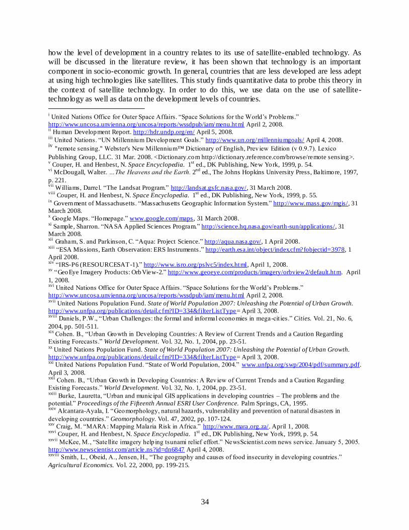
34
how the level of development in a country relates to its use of satellite-enabled technology. As will be discussed in the literature review, it has been shown that technology is an important
component in socio-economic growth. In general, countries that are less developed are less adept at using high technologies like satellites. This study finds quantitative data to probe this theory in
the context of satellite technology. In order to do this, we use data on the use of satellite-technology as well as data on the development levels of countries. i United Nations Office for Outer Space Affairs. “Space Solutions for the World‟s Problems.”
http://www.uncosa.unvienna.org/uncosa/reports/wssdpub/iam/menu.html April 2, 2008. ii Human Development Report. http://hdr.undp.org/en/ April 5, 2008.
iii United Nations. “UN Millennium Development Goals.” http://www.un.org/millenniumgoals/ April 4, 2008.
iv "remote sensing." Webster's New Millennium™ Dictionary of English, Prev iew Edition (v 0.9.7). Lexico
Publishing Group, LLC. 31 Mar. 2008. <Dictionary.com http://dictionary.reference.com/browse/remote sensing>. v Couper, H. and Henbest, N. Space Encyclopedia. 1
st ed., DK Publishing, New York, 1999, p. 54.
vi McDougall, Walter. …The Heavens and the Earth. 2
nd ed., The Johns Hopkins University Press, Baltimore, 1997,
p. 221. vii
Williams, Darrel. “The Landsat Program.” http://landsat.gsfc.nasa.gov/, 31 March 2008. viii
Couper, H. and Henbest, N. Space Encyclopedia. 1st
ed., DK Publishing, New York, 1999, p. 55. ix
Government of Massachusetts. “Massachusetts Geographic Informat ion System.” http://www.mass.gov/mgis/, 31
March 2008. x Google Maps. “Homepage.” www.google.com/maps, 31 March 2008.
xi Sample, Sharron. “NASA Applied Sciences Program.” http://science.hq.nasa.gov/earth-sun/applications/, 31
March 2008. xii
Graham, S. and Parkinson, C. “Aqua: Project Science.” http://aqua.nasa.gov/, 1 April 2008. xiii
“ESA Missions, Earth Observation: ERS Instruments .” http://earth.esa.int/object/index.cfm?fobjectid=3978, 1
April 2008. xiv
“IRS-P6 (RESOURCESAT-1).” http://www.isro.org/pslvc5/index.html, April 1, 2008. xv
“GeoEye Imagery Products: OrbView-2.” http://www.geoeye.com/products/imagery/orbview2/default.htm. April
1, 2008. xvi
United Nations Office for Outer Space Affairs. “Space Solutions for the World‟s Problems.”
http://www.uncosa.unvienna.org/uncosa/reports/wssdpub/iam/menu.html April 2, 2008. xvii
United Nations Population Fund. State of World Population 2007: Unleashing the Potential of Urban Growth.
http://www.unfpa.org/publications/detail.cfm?ID=334&filterListType= April 3, 2008. xviii
Daniels, P.W., “Urban Challenges: the formal and informal economies in mega-cit ies.” Cities. Vol. 21, No. 6,
2004, pp. 501-511. xix
Cohen. B., “Urban Growth in Developing Countries: A Review of Current Trends and a Caution Regarding
Existing Forecasts.” World Development. Vol. 32, No. 1, 2004, pp. 23-51. xx
United Nations Population Fund. State of World Population 2007: Unleashing the Potential of Urban Growth.
http://www.unfpa.org/publications/detail.cfm?ID=334&filterListType= April 3, 2008. xxi
United Nations Population Fund. “State of World Population, 2004.” www.unfpa.org/swp/2004/pdf/summary.pdf.
April 3, 2008. xxii
Cohen. B., “Urban Growth in Developing Countries: A Review of Current Trends and a Caution Regarding
Existing Forecasts.” World Development. Vol. 32, No. 1, 2004, pp. 23-51. xxiii
Burke, Lauretta, “Urban and municipal GIS applications in developing countries – The problems and the
potential.” Proceedings of the Fifteenth Annual ESRI User Conference. Palm Springs, CA, 1995. xxiv
Alcantara-Ayala, I. “Geomorphology, natural hazards, vulnerability and prevention of natural disasters in
developing countries.” Geomorphology. Vol. 47, 2002, pp. 107-124. xxv
Craig, M. “MARA: Mapping Malaria Risk in Africa.” http://www.mara.org.za/. April 1, 2008. xxvi
Couper, H. and Henbest, N. Space Encyclopedia. 1st
ed., DK Publishing, New York, 1999, p. 54. xxvii
McKee, M., “Satellite imagery help ing tsunami relief effort.” NewsScientist.com news service. January 5, 2005.
http://www.newscientist.com/art icle.ns?id=dn6847 April 4, 2008. xxviii
Smith, L., Obeid, A., Jensen, H., “The geography and causes of food insecurity in developing countries.”
Agricultural Economics. Vol. 22, 2000, pp. 199-215.

35
xxix
Smith, L., Obeid, A., Jensen, H., “The geography and causes of food insecurity in developing countries.”
Agricultural Economics. Vol. 22, 2000, pp. 199-215. xxx
United Nations Office for Outer Space Affairs. “Space Solutions for the World‟s Problems.”
http://www.uncosa.unvienna.org/uncosa/reports/wssdpub/iam/menu.html April 2, 2008. xxxi
US AID. “FEW S NET: Maps, Data and Imagery.” http://www.fews.net/pages/imageryhome.aspx?pageID=Ndvi
April 4, 2008. xxxii
US AID. “FEW S NET.” http://www.fews.net/pages/default.aspx?l=en April 4, 2008. xxxiii
Couper, H. and Henbest, N. Space Encyclopedia. 1st
ed., DK Publishing, New York, 1999, p. 55. xxxiv
Khan, M. “VSAT Communication.” http://www.satcoms.org.uk/articles/29.asp April 3, 2008. xxxv
Gilat Satellite Networks. “Glossary of Terms.” http://www.gilat.com/Content.aspx?Page=glossary#V April 3,
2008. xxxvi
Samuels, Ayanna T., “Assessing the Technical, Economic and Policy -centered Feasibility of a Proposed
Satellite Communicat ion System for the Developing World,” SM Thesis, Massachusetts Institute of Technology,
2005. xxxvii Versi, Anver. “Africa‟s Telecoms Revolution.” African Business.
http://findarticles.com/p/articles/mi_qa5327/is_200708/ai_n21294289/print Accessed March 18, 2008. xxxviii
Song, Steve. “Viewpoint: Bandwidth Can Bring African Universities Up to Speed.” International Development
Research Centre. http://www.idrc.ca/en/ev-84498-201-1-DO_TOPIC.html Accessed April 18, 2008. xxxix
Glewwe, P., Kremer, M., “Schools, Teachers, and Education Outcomes in Developing Countries.” Chapter in
Handbook on the Economics of Education http://post.economics.harvard.edu/faculty/kremer/papers_kremer . April
3, 2008. xl
Chaudhury, N., Hammer, J., Kremer, M., Muralidharan, K., and Rogers, F., “Missing in Action: Teacher and
Health Worker Absence in Developing Countries.” Journal of Economic Perspectives. Vol. 20, No. 1, 2006, pp. 91-
116. xli
“New Student hub opened at Unisa‟s Sunnytown Complex.” UNISA Media Release.
http://www.unisa.ac.za/Defau lt.asp?Cmd=ViewNewsItem&NewsID=1166&Cmd=GetNav&NavID=6 April 4, 2008. xlii
Mindset Network. http://www.mindset.co.za/ April 4, 2008. xliii
Johari, Rajab and Shaw, Willard, “Higher Education via Satellite: The Indonesian Distance Education Satellite
System.” International Review of Education. Vol. 32, No. 3, 1986, pp. 325-330. xliv
Bagchi, S. “Telemedicine in Rural India”. Public Library of Science Medicine. Vol 3, No. 3, 2006, p 299. xlv
Craig, J., Patterson, V., “Introduction to the practice of telemedicine.” Journal of Telemedicine and Telecare. Vol.
11, No. 1, 2005, p. 3. xlvi
Martinez, A., Villarroel, V., et al, “Analysis of Information and Communication Needs in Rural Primary Health
Care in Developing Countries.” IEEE Transactions on Information Technology in Biomedicine. Vol. 9, No. 1, 2005,
p. 66-73. xlvii
World Bank Group. “Global Partnership to Eliminate Riverb lindness.” http://www.worldbank.org/afr/gper/ April
5, 2008. xlviii
Anand, Samir and Rivett, Ulrike, “ICT in the management of HIV t reatment: Cell -Life: A South African
Solution.” Convergence. Vol. 6, No. 3, 2005, pp 56-59. xlix
Khalil, M., Lanvin, B., Chaudhry, V., “ The E-Government Handbook for Developing Countries .”
http://www.infodev.org/en/Publication.16.html April 4, 2008. l Khalil, M., Lanvin, B., Chaudhry, V., “The E-Government Handbook for Developing Countries .”
http://www.infodev.org/en/Publication.16.html April 4, 2008. li Khalil, M., Lanvin, B., Chaudhry, V., “ The E-Government Handbook for Developing Countries .”
http://www.infodev.org/en/Publication.16.html April 4, 2008. lii
Batabyal, A., and Jick Yoo, S., “Corruption, Bribery, and Wait Times in the Public A llocation of Good s in
Developing Countries.” Review of Development Economics. Vol. 11, No. 3, 2007, pp. 507-517. liii
Khalil, M., Lanvin, B., Chaudhry, V., “ The E-Government Handbook for Developing Countries .”
http://www.infodev.org/en/Publication.16.html April 4, 2008. liv
United Nations. “UN Millennium Development Goals, #8.” http://www.un.org/millenniumgoals/# April 4, 2008. lv "arbitrage." Dict ionary.com Unabridged (v 1.1). Random House, Inc. 04 Apr. 2008. <Dict ionary.com
http://dictionary.reference.com/browse/arbitrage>. lvi
Brewer, E., Demmer, M., et al, “The case for technology in developing regions.” Computer. Vol. 38, No. 6, 2005,
pp. 25-38.

36
lvii
“e-Choupal.” http://www.echoupal.com/ April 4, 2008. lviii
Opala, Ken. “Kenyan Farmers Discover the Internet.” International Development Research Centre.
http://www.idrc.ca/en/ev-47033-201-1-DO_TOPIC.html Accessed April 18, 2008. lix
Couper, H. and Henbest, N. Space Encyclopedia. 1st
ed., DK Publishing, New York, 1999, p. 50. lx
“The Global Positioning System.” http://www.gps.gov/index.html April 4, 2008. lxi
Office of the Press Secretary, White House. “Statement by the President regading the United States‟ decision to
stop degrading global positioning system accuracy.”
http://www.ngs.noaa.gov/FGCS/info/sans_SA/docs/statement.html April 4, 2008. lxii
Zarraoa, N., Mai, W., et al, “Preliminary evaluation of the Russian GLONASS system as a potential geodetic
tool.” Journal of Geodesy. Vol. 72, 1998, p. 356-363. lxiii
European Space Agency. “What is Galileo?” http://www.esa.int/esaNA/GGGMX650NDC_galileo_0.html April
4, 2008. lxiv
“Indigenous Navigation System.” http://www.sac.gov.in/asac-ongoing-satellite-ins.html April 4, 2008. lxv
Staff Writer, GPS News. “China Puts New Navigation Satellite into Orbit.” GPS Daily.
http://www.gpsdaily.com/reports/China_Puts_New_Navigation_Satellite_Into_Orbit_999.html April 4, 2008. lxvi
“Global Positioning System: Serv ing the World.” http://www.gps.gov/index.html April 4, 2008. lxvii
“Gauthier, L., Michel, P., and Ventura-Traveset, J., “EGNOS: The First Step in Europe‟s Contribution to the
Global Navigation Satellite System.” ESA Bulletin. Vol. 105, 2001, pp. 35-42. lxviii
“GPS Augmentations.” http://www.gps.gov/systems/augmentations/index.html April 4, 2008. lxix
Clarke, John-Paul and Miller, Bruno, “Impact of Aviation Infrastructure on Economies of Developing
Countries.” Proceedings of Aircraft Technology, Integration and Operations. American Institute of Aeronautics and
Astronautics, Los Angeles, 2002. lxx
World Touris m Organizat ion. “Parameters of Aviation Safety.” ICAO Directs General of Civil Aviation
Conference. Montreal, 2006. lxxi
World Touris m Organizat ion. “Parameters of Aviation Safety.” ICAO Directs General of Civil Aviation
Conference. Montreal, 2006. lxxii
European Space Agency. “Success for the first trans -African flight with EGNOS.”
http://www.esa.int/esaNA/SEMOZ00DU8E_index_0.html April 5, 2008. lxxiii
UN Millennium Development Goals. http://www.un.org/millenniumgoals/# April 5, 2008. lxxiv
HABIT Research. http://www.habitresearch.com/ April 5, 2008. lxxv
“GPS Tracking Helps „Crit ically Endangered‟ Blue Crane.”
http://www.zimbio.com/GPS+Technology+Reviews/articles/237/GPS+tracking+helps+Critically+Endangered+Blue
April 5, 2008. lxxvi
UN Millennium Development Goals. http://www.un.org/millenniumgoals/# April 5, 2008. lxxvii
United Nations Office for Outer Space Affairs. “Space Solutions for the World‟s Problems.”
http://www.uncosa.unvienna.org/uncosa/reports/wssdpub/iam/menu.html April 2, 2008. lxxviii
McDougall, Walter. …The Heavens and the Earth. 2nd
ed., The Johns Hopkins University Press, Baltimore,
1997, p. 354-359. lxxix
Whalen, David. “Communications Satellite: Making the Global Village Possible.”
http://www.hq.nasa.gov/office/pao/History/satcomhistory.html. April 3, 2008. lxxx
INTELSAT. www.intelsat.com. April 3, 2008. lxxxi
“International Telecommunications Satellite Organization.” www.itso.int April 3, 2008. lxxxii
Whalen, David. “Communications Satellite: Making the Global Village Possible.”
http://www.hq.nasa.gov/office/pao/History/satcomhistory.html. April 3, 2008. lxxxiii
“What is IMSO?” http://www.imso.org/whatisimso_UK.asp April 3, 2008. lxxxiv
“List of Parties to the Convention on the Internatioanl Mobile Satellite Organization.”
http://www.imso.org/member_states.asp April 3, 2008. lxxxv
UN Office for Outer Space Affairs. http://www.unoosa.org/oosa/en/OOSA/index.html April 5, 2008. lxxxvi
United Nations. “Resolution Adopted by the General Assembly, # 1348.”
http://www.unoosa.org/oosa/en/SpaceLaw/gares/html/gares_13_1348.html April 5, 2008. lxxxvii
United Nations Programme on Space Applications. “History of the Programme.”
http://www.unoosa.org/oosa/en/SAP/history.html April 5, 2008. lxxxviii
“United Nations Programme on Space Applications.” http://www.unoosa.org/oosa/en/sapidx.html April 5,
2008. lxxxix
SatlLife. “What We Do.” http://www.healthnet.org/whatwedo.php April 5, 2008.

37
xc
Mullaney, John. “SatelLife: Pioneering the Path for Electronic Communication and Health Informat ion in the
Developing World.” http://www.isoc.org/inet96/proceedings/a3/a3_2.htm April 5, 2008. xci
“Surrey Satellite Technology Ltd.” http://www.sstl.co.uk/index.php?loc=1 April 5, 2008. xcii
Cook-Anderso, Gretchen and Beasley, Dolores. “NASA Develops Central American Monitoring System.”
http://www.nasa.gov/home/hqnews/2005/feb/HQ_05038_panama.html April 5, 2008. xciii
“Abour SERVIR.” http://servirtest.nsstc.nasa.gov/about.html April 5, 2008. xciv
Sundararajan, V. “Emerging Space Powers – A comparative study of National Policy and Economic
Analysis for Asian Space Programs (Japan, China, India)”. AIAA Space 2006 Conference. San Jose, CA. Sept 2006. xcv
India. CIA World Factbook. https://www.cia.gov/library/publications/the-world-factbook/geos/in.html
Accessed October 29, 2007. xcv i
Milestones. Indian Space Research Organisation. http://www.isro.org/mileston.htm Accessed October 29, 2007. xcv ii
Harvey, B. The Japanese and Indian Space Programs: Two Roads into Space. Praxis Publishing, Chichester, UK. 2000. xcv iii
Baskaran, A. “Competence building in complex systems in the developing countries: the case of
satellite building in India”. Technovation. Vol 21, pp 109-121. 2001. xcix
Harvey, B. The Japanese and Indian Space Programs: Two Roads into Space. Praxis Publishing, Chichester, UK. 2000. c Kiratzi, Thasos. “The Space Sector in Brazil – An Overview.”
http://www.globalsecurity.org/space/world/brazil/index.html April 5, 2008. ci
“IAF Focus on Brazil.” http://www.iafastro.org/index.php?id=57&no_cache=1&tx_iafmshow_pi1[tt_country]=BR
April 6, 2007. cii
“Brazilian International Space Station Program.” http://www.inpe.br/programas/iss/ingles/default.htm April 5,
2008. ciii
Romero, Juan Martin Canales. “Technology, Limitat ions and applications of space technology in developing
countries.” Advances in Space Research. Vol. 34, 2004, pp. 2203-2208. civ
George, Hubert. “Developing Countries and remote sensing: how intergovernmental factors impede progress.”
Space Policy. Vol. 16, 2000, pp. 267-273. cv
“Open and Closed Skies: Satellite Access in Africa.” International Development Research Centre.
http://www.idrc.ca/en/ev-51227-201-1-DO_TOPIC.html Accessed April 18, 2008. cvi
“The VSAT Industry: Regulatory Issues.” The VSAT Forum. http://www.idrc.ca/en/ev-51227-201-1-
DO_TOPIC.html Accessed April 18, 2008. cvii
George, Hubert. “Developing Countries and remote sensing: how intergovernmental factors impede progress.”
Space Policy. Vol. 16, 2000, pp. 267-273.

38
2 Literature Review The following literature review has two major sections. The first section, called “The Role of Technology in Socioeconomic Development,” draws from economic theory to explain how technological capability building is a vital part of national development. This section
provides a theoretical grounding for the emphasis in this thesis on technology in a developing context. The second major section, called “The Use of Satellite Technology in Developing
Countries,” reviews some of the policy literature that articulates the issues and evolution of the field. After each section, a brief critique is offered to highlight the points in the literature that are most relevant to this study. The critiques also explain the unique contributions that this thesis
provides to both bodies of literature.
2.1 The Role of Technology in Socioeconomic Development
The following discussion explores several issues related to the role of technology in the socioeconomic development of less developed countries. The first section explains the motivation for developing countries to build national technological capability. The following
sections explain the various issues that a developing country encounters when seeking to make policy that encourages technical capacity building. First, there is the issue of technology choice;
a country needs to decide how to invest in various levels of technology. Second, if a developing country does not have access to a technology domestically, they can consid er options for technology transfer with other countries. Technology transfer can be very beneficial but there
are many potential pitfalls that can make it ineffective as a vehicle for technological capability building. Third, a government can facilitate technological capability building by encouraging a
strong National System of Innovation. Fourth, a country needs to establish the capacity for technical learning, called absorptive capacity. The fifth section explores the range of roles a
government plays in order to facilitate technological capability building.
2.1.1 The Importance of Technological Capability Building
Technological capability building is a key to national socio-economic development. Robert Solow, Nobel Prize winner in Economics, demonstrates that technology plays a pivotal role in economic development.cviii This is not to say that technology always has positive impacts,
but it has become widely understood that mastery of technology is a key step toward economic development. Cohen defines technology as “a set of specialized knowledge applied to achieving
a practical purpose”.cix Cohen goes on to categorize technology into five main forms, as follows: 1) theoretical and practical understanding of how to do things; 2) objects, good or tools; 3) installed techniques of production or processes; 4) skills and abilities of workers; and 5)
organizational framework and managerial systems. cx In this study, all five forms of technology are relevant. Technological capability building is working intentionally to increase effectiveness
or activity in each of these five areas. Huq summarizes the motivation for developing countries to pursue technical capability, saying, “Competitiveness and long-term growth are achieved through efficient technology management, innovation and technological progress.”cxi He goes on
to say that “the importance of building technological capability in developing countries and the significance of the role the state plays…cannot…be over-emphasized.”cxii With this motivation
in mind, the next sections discuss the challenges of pursuing technological capability building.

39
2.1.2 Technology Choice
Once a developing country chooses to invest in technological capability building, a fundamental question remains. What level of technology should the country pursue? De veloping
countries are, by definition, less advanced in technology than industrialized countries. Should developing countries try to gain skills in the advanced technology used by industrialized
countries? Or should they instead invest in technology that is more “appropriate” to their stage of development?
Author Roy Grieve provides an historical overview of the changes in expert
recommendations on this subject of technology choice. cxiii Grieve explains that in the 1960s and 1970s, development economists recommended that developing countries pursue “appropriate”
technology that was highly labor intensive. A major problem of the time for developing countries was the lack of employment opportunity. Economists thus recommended that developing countries should invest in low-capital, labor intensive techniques wherever possible. This
recommendation extended to large, medium and small scale enterprises. As Grieve summarizes, “The neoclassical appropriate technology strategy thus recommended that developing countries
seek to achieve industrialization and build up their manufacturing capabilities on a different technological basis from that of the already advanced countries.”cxiv The problem with this recommendation was that the low-capital, labor intensive technical option was not always readily
available, even though theory suggested that it would be more beneficial. Thus, this neoclassical dream failed to lead to widespread improvement for developing countries.
In contrast to the neoclassical mantra of labor intensive technology, current development economics encourages developing countries to do their best to implement the same kind of technology that is used in industrialized countries. Indeed, as Grieve explains, “The
recommended objective is to achieve a firm grasp of modern technology, learn from it, and on this basis, seek to develop innovation and technological capabilities.”cxv The examples of several Asian countries, such as South Korea, show that a developing country can accomplish great
economic growth by focusing on learning the technology used in more developed countries. Grieve thus concludes that the goal of developing countries should be “to leapfrog and narrow
the technology gap or „catch up‟ on the „best practice‟ in advanced countries.”cxvi It should be noted, however that there is yet a third option. Starting in the 1970s and
continuing through the turn of the century, another kind of appropriate technology movement
developed in parallel with the recognition of the need for catch up. As Grieve explains, Dr. E. Schumacher is known as the father of the movement due to his seminal work called Small is
Beautiful.cxvii This take on appropriate technology assumes that the efforts of developing countries to use technology will be dualistic. On one hand, developing countries will pursue the modern technology used by industrialized countries, particularly in urban centers. At the same
time, to combat the problems of unemployment and to serve rural areas, countries should find ways to use “intermediate technology”. Intermediate technology is characterized as labor
intensive, suitable for small scale work and accessible to the context. Included in the idea of accessibility is that the technology is achievable given the financial and educational constraints of developing countries. The goal is not to limit innovation, but to use it creatively to find
accessible ways to solve problems. Grieve concludes that this application of appropriate technology is basically successful and helpful but should be used in addition to, not instead o f,
the pursuit of advanced technology.cxviii

40
2.1.3 Technology Transfer
When developing countries do not have access to technology locally, they can seek to gain access to it from another country that has the technology. As discussed above, technology
transfer can be a potential source of leap-frogging, but this is not automatic. According to Cohen, the success of technology transfer depends heavily on the initial technological capability of the
recipient country.cxix Drawing on work by Bhalla, Cohen categorizes the world into three groups, “Technology leaders: the United States, Japan; Technology followers: other OECD countries; Technology borrowers: developing countries”. Cohen finds that there is a cost associated with
technology transfer and that this cost is higher if the countries involved are not in the same group, as defined above.cxx
Technology transfer may occur in a variety of ways, as outlined by Cohen. These include purchasing or licensing agreements, working with foreign experts, the presence of multi-national corporations in a developing country, training of workers in a developed country, creating
institutions to facilitate technology transfer, or creating educational institutions. cxxi Cohen goes on to define a series of steps that a recipient country passes through during technology transfer.
These stages are technology “assessment and selection, acquisition, adaptation, absorption and assimilation, diffusion, and development”. These concepts bring together several of the other sections of this discussion. The assessment and selection stages relate to technology choice
questions. The adaptation, absorption, and assimilation stages related to the sections below on National Innovation Systems and Absorptive Capacity.
Cohen‟s work explained what technology transfer is and how it can happen. Grieve‟s work, above, introduced the concept of leap-frogging, or using technology transfer to jump to a more advanced technology without going through the conventional, historical progression of
learning and invention. But does leap-frogging really work? Gallagher, in her study on the potential for leap-frogging in the Chinese automobile industry, explains both the benefits and complications of leap- frogging through technology transfer. While the idea “captured the
imaginations of innumerable scholars, students, and even some in the private sector,” leap-frogging does not work automatically. Gallagher found that the effectiveness of leap-frogging is
limited by three key areas: “1) un-strategic and inconsistent policies, 2) weak domestic technological capabilities, and 3) an apparent unwillingness of more advanced …firms to transfer …more efficient technologies beyond those simply required by the standards.”cxxii In
other words, even if advanced technology is available, the developing co untry may not benefit from it without specific ingredients. These ingredients will be discussed more in the section on
absorptive capacity and National Innovation Systems below. These topics help address the apparent paradox that a developing country that wants to build technological capability must have technological capability. The sections below explain how a country can put itself in a good
position to build technological capability through strong institutions and research.
2.1.4 National Innovation System
The institutional organization that facilitates technological capability building is the
National Innovation System (NIS). The NIS framework provides a method by which to analyze the set of institutions concerned with science and technology and the interactions between those institutions. We can thus understand the ability of a nation to innovate, or build technological
capability. Such institutions may include universities, firms, research agencies, administrative agencies, financial agencies and consumers. Some of the early studies based on this method were
done in the 1980s by Freemancxxiii, Lundvallcxxiv and Nelsoncxxv.

41
Sharifcxxvi gives an overview of the development of the method. The NIS concept was developed partly in academia and partly in policy. As a result it is not a formal academic model,
and may not necessarily be used to make predictions about the success of an NIS. It can be used, however, to describe systems and give useful policy insight. With regard to applying the
framework, Sharif notes several cautions. The concept is very flexible and can be applied at different levels of analysis (national, regional, sectoral, etc). This does not mean it is always appropriate to apply it at these levels, however. One must consider how national sovereignty,
cultural norms or globalization affect the analysis. Finally, there is disagreement as to whether every country has an NIS. Some contend that certain minimum requirements must be met while
others argue that a system can always be defined, even if it is very poor. Metcalfecxxvii and Ramlogan used the NIS framework to examine innovation in
developing countries. They offer some issues that arise when applying the framework to
developing countries. First, one must be careful with the unit of analysis. When analyzing an activity that appears to be contained in a developing country, one should be aware that it may be
connected to activities in other nations through global value chains or technical cooperation agreements. Because developing countries may have limited technology and expertise, they can be constrained to depend upon resources from other countries. Second, innovation can
sometimes be taken to mean only invention of new technology. In the developing country context, however, innovation may come through imitation or technology transfer.
2.1.5 Absorptive Capacity
The ability to assimilate technology is known in literature as absorptive capacity. The concept of absorptive capacity was defined by three seminal papers written by Cohen and Levinthal in 1989cxxviii, 1990cxxix and 1994cxxx. They argued that a firm‟s ability to use technology
from outside sources is influenced by internal research and development cxxxi. They are viewed as the fathers of the concept, although they were not the first to make such an observation. Lane and Kokacxxxii reviewed the literature on absorptive capacity in 2006 and created a synthesized
definition of the term based on all three seminal papers. From this synthesized definition several key ideas can be gleaned. First, a firm increases its capacity to learn about science a nd
technology by doing research and development (R&D). Second, the overall organization will have better absorptive capacity if individuals are well informed and are also able to effectively communicate with other parts of the organization. Thirdly, there is a time component in
absorptive capacity. It not only matters that firms can see what technology is currently relevant, but they also need to see what may be relevant in the future. Absorptive capacity thus includes a
firm‟s ability to correctly understand the direction of technical change and make plans accordingly that will increase their profit.
This study uses the concept of absorptive capacity in a developing country context. Work
by Lorentzencxxxiii provides a precedent showing that the framework is appropriate when applied to a developing country. This paper uses data from the South African automotive component
supplier industry and evaluates the validity of the absorptive capacity assumptions. Lorentzen divides the 25 firms of the study into four categories, “innovators, followers, mandate executers, cliff hangers”. The overall behavior of these various groups does show consistency with the
absorptive capacity model. The most successful group, the innovators, have high absorptive capacities. These firms invest highly in advanced technical training for their employees and have
knowledge close to or on the technological frontier. At the other end of the spectrum are cliff hangers. These firms produce goods of decent quality but do not have an in-depth technical

42
knowledge of the processes they follow. They rely heavily on their parent multinational corporation for technical direction. Lorentzen‟s work shows that the absorptive capacity concept
can be used appropriately in a developing country context.
2.1.6 The Role of Government in Facilitating Technological Capability
Building
The previous sections have developed the argument that it is vital for developing countries to build technological capability. They should seek to gain competence in the
technologies used by industrialized countries. One way to achieve this is through technology transfer, in all of its various forms. Technology transfer is more likely to be successful if a
country has a strong National Innovation System and absorptive capacity. Given all this, what is the role of government in promoting technological capability building? How can governments build absorptive capacity and strengthen the NIS? What activities should be performed by
governments as opposed to the private sector? There are a number of ways that governments contribute to technological capability
building. Some of them are generally accepted as appropriate and necessary government activities, while some are more controversial. Each of these two categories of technology policy will be discussed below. Please note that this section is focused on what roles governments
should take on. It does not provide complete answers for how governments should best accomplish these roles.
2.1.6.1 Points of Agreement on Government Roles
In his book The Creation of Technological Capability in Developing Countriescxxxiv, J. L.
Enos recommends a three-prong policy approach by which governments can facilitate industrial technological capability building. The points he outlines are generally not contested in literature. The three points are 1) The Nurturing of Skills, 2) The Creation of Organizations, and 3) The
Instilling of Purpose. In the discussion on the Nurturing of Skills, Enos focuses on education policy. The author‟s main recommendations are to ensure universal primary education, to prioritize medium level technical or vocational training, and – at the university level – to put
more emphasis on improving the technical fields than on the humanities. In the section on the Creation of Organizations, Enos recommends the creation of organizations that serve different
purposes. Some provide various levels of technical training, some advance and disseminate technical knowledge and some improve productive efficiency. Together they facilitate the increase of technical capability. Finally, when considering the Instilling of Purpose, Enos points
out that the coordination of activities and the manner in which information flows within an organization are key determinants of the group‟s sense of purpose. In summary, Enos suggests
that governments should be concerned with providing education, creating appropriate organizations within the NIS – such as research institutions – and, ensuring coordination within the NIS.
Singhcxxxv provides insight on the role of government in providing funds for research. He gives an historical overview of the government funding profiles of the industrialized countries
including US, Japan and Europe. According to Singh, in the US the majority of research funding came from the government, not from private entities, in the period after World War II. Since that time, the trend has gradually reversed so that private funding is greater. Japan and Europe had a
consistently lower level of research funding from government than private sources. Despite these trends, however, federal research funding was significant and helpful. Singh makes the point that

43
even as federal research support decreased, federal policies still encourage research. Tactics such as tax concessions, public-private partnerships, and subsidies are growing in importance.
Another area in which governments contribute to technological capability building is by providing sound infrastructure. The United Nations‟ Task Force on Science, Technology and
Innovation prepared a report entitled Innovation: Applying Knowledge in Development. One of the sections of the report outlines the benefits that come when developing country governments invest in infrastructure. On one hand, the infrastructure serves to facilitate the activities of firms
and society in general. On the other hand, the process of creating infrastructure is an opportunity for countries to build technical capability. The report encourages governments to look at
infrastructure projects as learning opportunities for domestic governments and firms. Infrastructure includes energy systems, communication, water, sanitation and even research facilities. The report notes that the lack of adequate infrastructure in developing countries is a
barrier to growth in many countries.cxxxvi Governments also influence technological capability building through trade policy.
Salvatore provides an historical overview of trade policy in developing countries since the 1950s. He shows how initially many developing countries tried to establish a strong industrial base by closing their countries to imports. They sought to manufacture many of the items they had been
importing. They minimized imports through quotas and tariffs. Later in the 1970s and continuing into the 1990s, countries gradually recognized that these import-substitution policies did not lead
to economic growth. Consequently, instead of closing their economies, they began to liberalize their economies to allow more trade. cxxxvii Government policies can encourage access to foreign technology by reducing barriers to trade and creating favorable conditions for foreign
investment. The final element of government policy that is generally agreed upon as an appropriate
role for government in encouraging technological capability building is macroeconomic policy. Bird describes the three facets of macroeconomic policy in his paper “Conducting Macroeconomic Policy in Developing Countries: Piece of Cake or Mission Impossible?”
Macroeconomic policy includes monetary policy, fiscal policy and exchange rate policy. Governments can use these instruments to create an economic environment that is stable enough
to encourage investment in technical learning and innovation. Developing countries face particular challenges in using these instruments, however. Bird recommends “that developing countries need to focus on long-term structural change aimed at reducing their vulnerability to
external shocks and creating an economic environment which allows traditional measures of macroeconomic policy to work better.”cxxxviii
2.1.6.2 Point of Contention on Government Roles
The main of area of contention about the role of government in technology policy is the question of whether the government should purposely try to promote specific sectors within the
economy. Such tactics are often called industrial policy. Returning to Grieve‟s paper, we see that there are experts on both sides of the argument. Some urge that governments should create an
environment that fosters innovation but not intervene directly. Others point to success stories in Asia as proof that government intervention is good. Such intervention can come in the form of building infrastructure to support a specific sector or licensing more foreign technology in a
certain area. Grieve does not try to settle the dispute; he only explains the posture of each side.cxxxix

44
It should be noted here that neither side of the industrial policy argument is suggesting that the government should be a dominant player in the market. Both sides are assuming a
generally free market economy with few state owned enterprises. This is worth mentioning because of the history of developing countries. Between the 1950s and the 1980s, when many
developing countries engaged in limited trade as discussed above, there was also a trend toward strong nationalization and a heavy public presence in the economy. Some developing countries are still in the process of privatizing their major industries, but most started the effort in the
1980s.cxl
2.2 Critique of Literature
The above discussion is included in this study in order to provide a broad background on the relationship between technology and developing countries. The motivation of this work is a desire to understand and improve the use of satellite-based technology in developing countries.
We can now argue that the use of such technology to meet needs in developing countries is appropriate. Not only can it solve problems, it is also part of their process of building
technological capability. We can further argue that it is in the best interest of developing countries to progressively improve their understanding of satellite technology when they use it. From the discussion above, it is clear that more benefit will come to developing countries if they
master and produce satellite technology than if they just benefit from its services. This principle is implicit in the methods and arguments used throughout this study. The same principle is also
voiced in a paper by the United Nations in 1988. cxli Some elements of the literature reviewed above do not apply directly to the study of
satellite-technology in developing countries. The literature argues that technological capability
building can be part of the process that leads to socio-economic development. While this is true, it will not be directly measured in this study. We will not demonstrate with data that b uilding
technological capability in satellite technology directly leads to socio-economic development. Rather, we use data on satellite usage and data on development level and ask if there is any statistical relationship between the two. This is partly to learn whether countries that are less
developed tend to be excluded from the benefits of satellite technology. At the same time, we show whether countries that are more developed tend to benefit more.
It should be noted that much of the reviewed literature focuses on the firm as the central user of technology. This is true in the discussions above on absorptive capacity, on technology transfer and on the role of government. When dealing with satellites, the firm is not always the
central player. Often satellite projects are funded by governments or by partnerships between governments and private entities. Current remote sensing satellites are sponsored by both
governments and companies. The data they produce is bought and sold across public and private boundaries. The current satellite navigation systems are utilities owned by governments and used freely by everyone. Meanwhile, the ground equipment to access navigation satellites has spurred
a major industry. Communication satellites are launched by governments and private entities. The original government communication organizations, like INTELSAT, are now operating
commercially. In short, it is difficult to tie satellite technology to either the government or the commercial sector. In some aspects, satellites are a form of infrastructure that is best provided by government. But satellites can also be capital investments for commercial ventures. No attempt
is made in this thesis to specify whether the use of satellite technology in developing countries should be a government or commercial activity. Instead we gather data about specific projects
and learn about what kind of organizations are involved. There is a focus on government activity

45
in several aspects of our data collection, however. The national Space Participation Metric data and the Space Program Case Studies primarily cover government activities.
As mentioned above, most of the literature on technology as a tool for development assumes the centrality of the firm. Here we identify a gap in the literature that we will help to fill.
There is little discussion of technology transfer involving government entities, yet many of the project case studies found in this study are examples of this. Meanwhile, absorptive capacity is defined for firms, but could potentially be relevant for government programs as well. While we
cannot blindly apply the findings discussed above on technology transfer, absorptive capacity or the role of government, the basic concepts in this segment of the literature review are valuable.
To summarize, this thesis does build on the foundations from the literature presented above. Technological capability building is a key step to development. From the discussion on technology choice, it is clear that developing countries should pursue competence in advanced
technology like satellites. Further, they can gain this competence partly through technology transfer. The transfer process will be more successful if the country has a strong NIS and has
organizations with good absorptive capacity. The role of government in this area includes investing in education, building basic infrastructure, making policies that encourage access to new technology and even investing directly in and operating satellite technology itself.
2.3 The Use of Satellite Technology in Developing Countries
There is a body of literature on the use of satellite technology in developing countries.
Relevant publications include conference proceedings, workshop reports, news reports, agency reports and scholarly articles. This section provides an overview of some of these publication sources and the information they provide. In addition, we explain the gap filled by this research.
One of the main sources is work by the United Nations Office of Outer Space Affairs in partnership with organizations such as the International Astronautical Federation (IAF) and the
European Space Agency. The UN holds a variety of types of workshops relating to satellite technology in developing countries. Some workshops provide training in specific topics suc h as satellite-aided search and rescue. Others give information about the current status of projects in a
particular area. One specific example is the series put on as part of the Programme on Space Applications. The UN has hosted many workshops since 1998 to educate stakeholders about the
benefits of satellite technology for developing countries. Summary reports from these workshops are available online.cxlii
As an example we summarize here the report on the UN/International Academy of
Astronautics Workshop on Small Satellites in the Service of Developing countries held in Valencia Spain in 2006 as part of the International Astronautical Congress. cxliii The workshop
grew out of recommendations made at the Third United Nations Conference on the Exploration and Peaceful Uses of Outer Space (UNISPACE III) in 1999. At UNISPACE III, it was recommended that developing countries should seek to build and operate small satellites as a
way to develop domestic industry for space technology. Small satellites were seen as particularly appropriate to meet needs in developing countries because they are cheaper, faster to build and
less complex than larger satellite missions. The workshop included four presentations from speakers representing the French Space Agency, Surrey Satellite Technology Limited (SSTL), South Africa and Indonesia. The French speaker described an example of a small satellite bus
platform and explained how it could be used in the context of developing countries. The speaker from SSTL described the international collaboration in the Disaster Monitoring Constellation, an
effort that includes several developing countries. The speaker from South Africa talked about

46
progress in the African Resource Management constellation project. Indonesia discussed satellite activities in both their country and Malaysia. As can be seen, such workshops are helpful for
providing examples of satellite projects in developing countries. They do not, however, provide an overview of the technical community or analysis about trends. This thesis adds to the
literature by filling these gaps. In addition to the United Nations Office of Outer Space Affairs, other agencies provide
publications that give insight into the use of satellites in developing countries. The International
Telecommunications Union (ITU), for example, produces reports such as “ICT and Telecommunications in the Least Developed Countries – Mid-Term Review for the Decade
2001-2010.”cxliv ITU reports like this provide a broad overview of trends in communication technology, but do not focus on satellite communications specifically. Also, the publications of the Global VSAT Forum (GVF) provide useful insight into regulatory issues surrounding the use
of satellite technology for communications. The GVF is a professional association of companies involved in the fixed satellite communication industry. Their annual report from 2001 highlights
the progress made in the deregulation of the VSAT industry in Africa, Asia and the Americas.cxlv Many countries have had a monopolistic satellite communication industry; the monopoly was often held by a state owned entity. The GVF lobbies governments to lower barriers to
competition and provide licenses to more VSAT companies. This ultimately leads to lower prices for the consumers.
We turn now to scholarly publications on the topic of satellite technology for use in developing countries. A number of papers have described specific projects or satellite missions. This review focuses not on these types of papers, but on more general papers that have grappled
with the topic at a high level. The papers are discussed in chronological order, where appropriate. In 1983, Bhavsar wrote an article entitled “Earth Survey Satellites and Cooperative
Programmes,” which provided an overview of international cooperation in the first twenty years of satellite remote sensing.cxlvi The author was from the Space Applications Centre of the Indian Space Research Organisation. Overall, the article shows that in the 1960s most collaboration in
remote sensing was bilateral partnership between the United States and other countries. By the 1980s, more countries had developed remote sensing capability and multilateral collaboration
had become more common. A major turning point in this process was the first United Nations Conference on the Exploration and Peaceful Uses of Outer Space in 1968. This meeting “played an important role in creating world wide awareness about the peaceful uses of space.”cxlvii In
1970, the author was part of a team asked by the United Nations to produce a report recommending ways to increase participation of developing countries in satellite remote sensing
collaborations. As part of the project, the author visited Argentina, Brazil, France, Indonesia, Iran, Japan, the United Kingdom, the United States and the Soviet Unio n to learn about their satellite remote sensing programs. With this experience, they recommended that developing
countries may be more likely to join partnerships if they are facilitated by neutral, multilateral organizations such as the UN. They specifically recommended that funding be made available to
support travel, new organizations and projects in developing countries. In a 1988 article, Kingwell wrote about the potential dangers for developing countries if
the current space faring nations started to use Data Relay Satellites to transmit remote sensing
data from satellites to centralized earth stations. cxlviii Kingwell contrasted two scenarios. The first was the status quo. In this case, most remote sensing satellites were in Low Earth Orbit (LEO)
and transmitted their data to earth stations when they passed over them. If a developing country wanted to receive satellite data about its region that was produced by another country‟s satellite,

47
they could buy or request the right to receive the data directly from the satellite. In this way, they did not have to depend on the country that owned the satellite to send the data to them later. The
second scenario that Kingwell feared was as follows. Space faring nations use geosynchronous data relay satellites to send earth remote sensing data from LEO satellites to central data
collection stations in the home country of the satellites. In this second scenario, if a developing country wants to have access to the data, they get it later from the home country. The potential disadvantages of this scenario for developing countries are given. First, they may have less
timely access to the data. Second, they may receive data that is processed in a way that is not relevant to their physical circumstances. Third, it reduces the opportunity for developing
countries to maintain or build skills in processing raw satellite data. The author recommended that if Data Relay Satellites were used, satellite owners should also continue to allow direct downlink of data to earth stations in other countries.
In 1988 Abiodun et al wrote an article in the journal Space Policy called “Development of Indigenous Capability in Remote Sensing.”cxlix Abiodun was the UN Expert on Space
Applications, but wrote in an unofficial capacity. The paper encouraged developing countries to pursue capability in remote sensing, but warned that they too frequently limited themselves to using applications of the technology. Rather, they should seek to understand the technology at a
fundamental level and seek to build indigenous capability. The paper mentioned that many partnerships between developing countries and industrialized countries in remote sensing
provided the opportunity for technology transfer. The warning was that such transfer can not succeed unless the recipient country is prepared to learn about the new technology. The paper suggested that developing countries seek to build research capability and supportive institutions.
Abiodun goes on to describe the activities of the United Nations Programme on Space Applications as a partial solution to address these issues. Part of the work of the PSA included
creating Regional Space Science and Technology Centres to equip developing countries with better skills in the field. With its focus on the need for in-depth technical understanding and research capability, the paper echoed the ideas presented above about building a strong NIS and
increasing absorptive capacity in order to facilitate technology transfer. Another benefit of the paper is that it introduced the United Nations Principles of Remote Sensing. These principles
were developed in 1986 to provide guidance for the legal and political issues surrounding remote sensing. The authors recalled that the Principles encouraged countries with remote sensing capability to share their data openly with the countries they observed. This provides a foundation
for international cooperation in remote sensing. Codding wrote an article in 1989 focused on issues in satellite communications for
developing countries.cl Codding considered the state of INTELSAT as it faced new sources of competition including INMARSAT, under sea cables and regional satellite organizations. Codding presented the concern that INTELSAT could respond to such competition by changing
its pricing to the detriment of developing countries. Codding particularly suggested that developing countries would lack access to domestic satellite communications. As a solution,
Codding recommended that the ITU lead the formation of a global satellite communication system dedicated to domestic satellite communication for developing countries. The system would be called Glodom. Codding discussed the history of RASCOM and used it as a model for
the formation of Glodom. RASCOM is the Regional African Satellite Communication Organization.
Consider the next set of three papers and the trends they reveal. Rao and Bhavan wrote in 1993 and provided an overview of satellite activity in developing countries in communication,

48
education, remote sensing, disaster management and space science. Their main argument was that satellite technology could help developing countries but that most were not involved with
the technology. Rao and Bhavan highlighted the activities of China and India in satellite technology as excellent, but exceptional. They closed with recommendations on how
international assistance could be mobilized to get more developing countries involved with space technology.cli In 1993, Hubert George wrote a much more optimistic article called “Remote Sensing of Earth Resources: Emerging Opportunities for Developing Countries.”clii At this time,
George was seeing changes in the technical and political systems that influenced the use of satellite remote sensing technology in developing countries. Specifically, George mentioned five
trends that could increase access to remote sensing technology for developing countries. First, the technology of remote sensing and the computation that supports it were improving, making it more affordable and easier to use. Second, the global community was paying more attention to
environmental issues, thus prioritizing the need for earth observation data. Third, the cost of satellite missions was decreasing as smaller, less expensive satellites were becoming more
capable. Fourth, more government and commercial entities were producing remote sensing data; this led to more options and potentially better prices for data consumers. Fifth, there was an increase in international efforts to coordinate earth observation data and to include developing
countries. This was evidenced by the activities of specific international organizations. The third paper in this series, written in 2003 by Othman, is called “Small Satellites for the Benefit of
Developing Countries.”cliii Othman repeated some of the optimism of George and emphasized that it was feasible for many developing countries to pursue indigenous capability in satellite technology by investing in small satellites. Othman made the point that this was one of the major
recommendations of the third United Nations Conference on the Exploration and Peaceful Uses of Outer Space in Vienna in 1999, as described above. He provided the example of the successful
development of the SunSat spacecraft in a South African university. In addition, Othman mentioned examples of small satellite projects in Mexico, Peru, Brazil, Argentina and Chile. A brief look at these three articles shows an apparent increase in the participation of developing
countries in satellite remote sensing technology between 1993 and 2003. Several helpful technology and policy changes eased access to the technology.
The paper by Barker, Barnes and Price from 1996 provided some technical insight into the design of communication satellites that is most appropriate for developing countries.cliv Specifically, the authors suggested several design features that could make communication
satellites more affordable while still meeting the needs of developing countries. One example was the operational frequency band. The authors advised the use of the lowest frequency that
would still meet the users‟ needs. A mix of lower and higher frequencies could be used to enhance performance. Also, the authors noted that it was generally advisable to have satellites send their data directly to earth stations rather than linking with other satellites first. Ultimately,
the authors gave practical advice to decision makers in developing countries that want to pursue cost effective satellite technology.
Also noteworthy is a paper by Neumann from 2006.clv It discussed implications from space law on the use of satellite technology for developing countries. Neumann opened by questioning whether developing countries have any right to benefit from satellite
communications based on international law. As part of the background of the paper, Neumann acknowledged the existence of a digital divide between developed and developing nations.
Satellite technology was identified as one appropriate tool to reduce this divide. Neumann then analyzed five specific areas to see what rights were provided by international law for developing

49
countries in this arena. Neumann used international agreements and treaties such as the Outer Space Treaty to draw five conclusions. The conclusions are as follows. First, developing
countries have a right to use the geostationary orbits and communications frequencies assigned to them as part of international negotiations. Second, there is no specific right of developing
countries to receive technology that is transferred from developed countries. Stated another way, developed countries are under no obligation to transfer technology to developing countries. Third, developing countries working with INTELSAT do have a right to ensure continuity of
service. This right was established by contractual agreement when Intelsat was privatized. International law has no bearing on this, however. Fourth, developing countries do have a right
to provide universal telecommunications service to their citizens even if this requires non-competitive practices. Fifth, while international law encourages collaboration between nations, there is no clear right of developing countries to benefit from collaborations with developed
countries. In general, Neumann‟s analysis shows that nothing bars developing countries from using satellite technology; however, nothing in international law guarantees that developing
countries will receive assistance from other nations.
2.4 Critique of Literature
What does this review of literature on the use of satellite technology in developing
countries reveal? What knowledge is already established in the field and what remains to be researched? Several themes stand out and will be expanded upon here. To begin, note that the
satellite community recognized from its early days that there was potential to meet the needs of developing countries with this technology. Conferences held by the United Nations and others gathered and recorded the knowledge of this potential. Also, from the early days of the space era,
there was controversy about how to ensure that all countries would benefit from access to space. The controversy was rooted in concerns about security, intellectual property and political
ideology. Another theme that echoed in several papers was that developing countries needed access to technology from developed countries in order to use satellites. There was also a gradual historical progress toward increasing activity of developing countries with satellite technology.
Whereas older papers complained that only a few developing countries had any space projects, later papers were excited to explain that the technology was becoming more accessible to more
countries. This increase is partly due to the emphasis on small satellites for developing countries. It should be noted here, though, that such “small” satellites can not be used for geosync hronous communication or weather missions. They are very well suited for non-real time remote sensing
missions, however. Consider now the style and methodology of the literature in this field. Most papers are
written based on the experience of the authors, not based on verifiable data. A few papers provide examples case studies, but the number of case studies is very limited. The papers are useful to provide a qualitative understanding of the needs, issues and trends in the field. They are
not, however, rigorous research papers in which questions are answered using quantitative methods. One reason why the papers are so qualitative in nature is that it is difficult to gather
accurate data about the use of technology in developing countries. This thesis, therefore, is making a great contribution to the literature on satellite technology in developing countries. This study brings together copious data about space projects and programs in developing countries.
The data is used in statistical tests to create new information. Note also that the results of this thesis inform about the relationship between development and space activity. This is valuable

50
because it tests, for the first time, the assumptions and theories that undergird many papers about satellite technology in developing countries.
cviii
Solow, R. “Technical Change in the Aggregate Production Function”. Review of Economics and Statistics, Vol.
39, No. 3, pp. 312-320. cix
Cohen, Goel. Technology Transfer: Strategic Management in Developing Countries. Sage Publicat ions. New
Delh i. 2004, p. 66. cx
Cohen, Goel. Technology Transfer: Strategic Management in Developing Countries. Sage Publicat ions. New
Delh i. 2004, p. 35. cxi
Huq, Mozammel. “Build ing technological capability in the context o f globalization: opportunities and challenges
facing developing countries.” International Journal of Technology Management and Sustainable Development. Vol.
3, No. 3, 2004, pp. 155-171. cxii
Huq, Mozammel. “Build ing technological capability in the context o f globalization: opportunities and challenges
facing developing countries.” International Journal of Technology Management and Sustainable Development. Vol.
3, No. 3, 2004, pp. 155-171. cxiii
Grieve, Roy. “Appropriate Technology in a Globalizing World.” International Journal of Technology
Management and Sustainable Development. Vol. 3, No. 3, 2004, pp. 173-187. cxiv
Grieve, Roy. “Appropriate Technology in a Globalizing World.” International Journal of Technology
Management and Sustainable Development. Vol. 3, No. 3, 2004, pp. 173-187. cxv
Grieve, Roy. “Appropriate Technology in a Globalizing World.” International Journal of Technology
Management and Sustainable Development. Vol. 3, No. 3, 2004, pp. 173-187. cxvi
Grieve, Roy. “Appropriate Technology in a Globalizing World.” International Journal of Technology
Management and Sustainable Development. Vol. 3, No. 3, 2004, pp. 173-187. cxvii
Schumacher, E.F. Small is Beautiful: A Study of Economics as if People Mattered. Vintage Books, London,
1973. cxviii
Grieve, Roy. “Appropriate Technology in a Globalizing World.” International Journal of Technology
Management and Sustainable Development. Vol. 3, No. 3, 2004, pp. 173-187. cxix
Cohen, Goel. Technology Transfer: Strategic Management in Developing Countries. Sage Publicat ions. New
Delh i. 2004 p. 139. cxx
Cohen, Goel. Technology Transfer: Strategic Management in Developing Countries. Sage Publicat ions. New
Delh i. 2004 p. 160. cxxi
Cohen, Goel. Technology Transfer: Strategic Management in Developing Countries. Sage Publicat ions. New
Delh i. 2004 p. 113. cxxii
Gallagher, K. “Limits to leapfrogging in energy technologies? Evidence from the Chinese Automobile
Industry”. Energy Policy. Vol 34. 2006, pp. 383-394. cxxiii
Freeman, C. (1995). The national system of innovation in historical perspective. Cambridge Journal of Economics, 19(1),
5–24.
cxxiv Lundvall, B. (1992). National systems of innovation. London: P inter.
cxxv Nelson, R. R. (Ed.). (1993). National innovation systems: A comparative analysis . New York/Oxford: Oxford UniversityPress.
cxxvi Sharif, N. “Emergence and development of the National Innovation Systems Concept”. Research Policy. Vol
35. pp 745-766. 2006. cxxvii
Metcalfe, S. “Innovation Systems and the competitive process in developing countries”. The Quarterly Review
of Economics and Finance. 2007. cxxviii
Cohen, W., & Levinthal, D. 1989. Innovation and learning: The two faces of R&D. Economic Journal, 99: 569–596.
cxxix Cohen, W., & Levinthal, D. 1990. Absorptive capacity: A new perspective on learning and innovation. Administrative
Science Quarterly, 35: 128–152.
cxxx Cohen, W., & Levinthal, D. 1994. Fortune favors the prepared firm. Management Science, 40: 227 –251.
cxxxi Lane, Koka. “The Reification of Absorptive Capacity: A Crit ical Review and Rejuvenation of the Construct”.
Academy of Management Review. Vol 31, No. 4, 833-863. 2006 cxxxii
Lane, Koka. “The Reification of Absorptive Capacity: A Crit ical Review and Rejuvenation of the Construct”.
Academy of Management Review. Vol 31, No. 4, 833-863. 2006 cxxxiii
Lorentzen, J. “The Absorptive Capacities of South African Automotive Component Suppliers”. World
Development. Vol. 33, No. 7, pp. 1153-1182, 2005. cxxxiv
Enos, J., L. The Creation of Technological Capability in Developing Countries”. International Labour
Organisation. Pinter Publishers, London.1991.

51
cxxxv
Singh, Lakhwinder. “Globalization, national innovation systems and response of public policy.” International
Journal of Technology Management and Sustainable Development. Vol. 3, No. 3, 2004, pp. 215-231. cxxxvi
Juma, Calestous and Yee-Cheong, Lee. Innovation: Applying Knowledge in Development. UN Millennium
Project Task Force on Science, Technology and Innovation. Earthscan. Sterling, 2005. cxxxvii
Salvatore, Dominick. “International Trade Policies, Industrialization, and Economic Development.”
International Trade Journal. Vol. 10, No. 1, 1996, pp. 21-47. cxxxviii
Bird, Graham. “Conducting Macroeconomic Po licy in Developing Countries: Piece of cake or Mission
Impossible?” Third World Quarterly. Vol. 22, No. 1, 2001, pp. 37-49. cxxxix
Grieve, Roy. “Appropriate Technology in a Globalizing World.” International Journal of Technology
Management and Sustainable Development. Vol. 3, No. 3, 2004, pp. 173-187. cxl
Al-Obaidan, Abdullah. “Efficiency effect of privatization in the developing countries.” Applied Economics. Vol
34. 2002, pp. 111-117. cxli
Abiodun, Adigun, et al. “Development of indigenous capability in remote sensing.” Space Policy. 1988. cxlii
“Index of Online Reports on the Activities of the United Nations Programme on Space Applications.” UN Office
for Outer Space Affairs. http://www.unoosa.org/oosa/en/SAP/activitiesrep/index.html Accessed April 19, 2008. cxliii
“Report on the Seventh United National/International Academy of Astronautics Workshop on Small Satellites in
the Service of Developing Countries.” United Nations, Committee on the Peaceful Uses of Outer Space. 15 January
2007. http://www.unoosa.org/oosa/en/SAP/activitiesrep/index.html Accessed April 19, 2008. cxliv
“ICT and Telecommunications in Least Developed Countries – Mid-Term Review for the Decade 2001-2010.”
International Telecommunications Union. http://www.itu.int/ITU-D/ldc/publications.html Accessed April 19, 2008. cxlv
“Reports and Accounts 1999-2001.” Global VSAT Forum. http://www.gvf.org/gvf/about/index.cfm Accessed
April 19, 2008. cxlvi
Bhavsar, P.D. “Earth Survey Satellites and Cooperative Programmes.” Advances in Space Research. Vol. 3, No.
7, 1983, pp. 139-147. cxlvii
Bhavsar, P.D. “Earth Survey Satellites and Cooperative Programmes.” Advances in Space Research. Vol. 3, No.
7, 1983, pp. 139-147. cxlviii
Kingwell, Jeff. “Data Relay Satellites and Remote Sensing.” Space Po licy. May 1988, pp. 103-107. cxlix
Abiodun, Adigun Ade, Camacho, Sergio, Oesberg, Rolf -Peter, Zhukov, Vlad imir. “Development of Indigenous
Capability in Remote Sensing.” Space Policy. 1988, pp. 122-130. cl
Codding, George, “The Glodom Alternative.” Space Policy. August 198, pp. 227-236. cli
Rao, U.R., Bhavan, Antariksh. “Space Technology in developing nations: an assessment.” May 1993, pp. 166 -
171. clii George, Hubert. “Remote Sensing of Earth Resources: Emerg ing Opportunities for Developing Countries.”
Space Policy. Vol. 14, 1998, pp. 27-37. cliii
Othman 2003 Othman, Mazlan. “Small Satellites for the Benefit of Developing Countries.” Acta Astronautica.
Vol. 52, 2003, pp. 687-690. cliv
Barker, Keith, Barnes, Carl, Price, Kent. “Space Based Communications Infrastructure for Developing
Countries.” Proceedings of AIAA International Communications Satellite Systems Conference. Washington, D.C.
1996. clv
Neumann, J. “Satellite Telecommunications as a Tool for Bridging the Digital Div ide – Public International Law
Implications.” Proceedings of the 57th
International Astronautical Congress. Valencia, 2006.

52
3 Data and Analysis Methods
The following section provides an overview of the analysis used in this study to answer the three research questions. The first section introduces the research questions and briefly summarizes the methods used to answer them. The next section provides more detail regarding
the data sources used in the analysis. The last section discusses each research question in turn and shows how specific data sets are analyzed to answer them.
3.1 Summary of Research Questions and Methodology
This thesis is built around three research questions that seek the connection between space activity and development level in developing countries. The questions are as follows.
1) How does national development level relate to national space activity? 2) What Mission and Management Architectures are developing countries using to apply
satellite-based technology to national needs? 3) How does national development level influence the Mission and Management Architectures
used by developing countries in satellite-based technology projects?
Statistical analysis with quantitative data is used to answer these questions. Question 1 uses Chi-Squared analysis to measure whether there is a statistically significant difference in
national space activity between countries at different development levels. Question 2 uses a large collection of case studies to understand the trends in accomplishment and implementation for specific space projects in Africa. Question 3 draws on the trends identified in Quest ion 2. It uses
statistical analysis to find whether there is a difference in space project activity between African countries at different development levels.
Note that the three research questions build on each other while providing different levels and scope for analysis. The first question considers space activity very generally, but includes all sovereign nations in the world. The second question zooms in geographically to focus only on
African countries. This allows for a more detailed study of specific space activities. Question 2 is exploratory. The data is observed, categorized and organized in an effort to learn new
information. Question 3 takes the observation a step further. While still considering specific space projects in Africa, it uses statistical analysis to concretize the observations in Question 2. Although the analysis does not completely answer the research questions, together the work
provides strong evidence about the relationship between national development level and space activity. Complementing all of this quantitative data is a set of in person interviews with
representatives of 30 African countries. These conversations provide valuable context for this entire analysis.
3.2 Overview of Data Sources
The next section explains the motivation and collection of the five major data sources in this research.
3.2.1 Development Indicators
As discussed earlier, one of the main goals of this project is to understand how national development level influences the use of satellite-based technology. In order to investigate this quantitatively, a method to quantify development is needed. There is no need for the author to
derive a metric for development because many specialized agencies have created such indices.

53
Examples include the Global Competitiveness Report of the World Economic Forumclvi and the World Bank‟s World Development Indicatorsclvii. While many data sources could be used with
equal benefit, this study relies mainly on the Human Development Report by the United Nations Development Program.clviii The Human Development Report is an annual summary of key
development indicators for nations around the world. It is created based on the philosophy that development is “expanding the choices people have to lead lives that they value.” clix Part of the goal of the report is to consider indicators beyond economic data to measure development.
The Human Development dataset is chosen for several reasons. First, it strives to provide data for every country in the world. This gives a total of 177 countries for this collection.
Second, it provides a multi- faceted approach to measuring development. It provides statistics for many areas of life, from health to education to finances to equality. Third, it makes the statistics for each country available in a convenient format for independent analysis. Fourth, it includes an
aggregate measurement of development called the Human Development Index (HDI). The 2006 version of the Human Development Report is the source used in this study. It was the latest
version available at the time this analysis was initiated. The Human Development report includes a huge set of data with many development
indicators. Six specific indicators were chosen to be used in several stages of this analysis. They
are listed below.
1. Human Development Index 2. Human Development Level 3. Gross Domestic Product (GDP), in billions of 2004 US dollars
4. Gross Domestic Product per Capita, with Purchasing Power Parityclx in 2004 US dollars
5. Public Education Expenditure as a percentage of GDP 6. Internet users (per 1000 people) 7. Cellular Subscribers (per 1000 people)
As discussed above, the Human Development Index is a composite indicator created by
the authors of the Human Development Report. This index is one number – between zero and one – that combines several statistics in the report to describe a country‟s development level. This provides a convenient way to compare the development level of all countries. Specifically,
the HDI considers the average status for four indicators – life expectancy at birth, adult literacy rate, school enrollment ratio, and GDP per capita.clxi
The Human Development Level is derived from the HDI. The Human Development Report divides all countries into 3 groups – High, Medium and Low Development – based on their Human Development Index. The group with the highest indices is considered “highly
developed.” The next group is in “medium development,” while the lowest set of indices are termed “low development.” It is possible for multiple countries to receive the same Human
Development Index score. For the 177 countries ranked in the 2006 Human Development Report, the 63 countries with an HDI of .800 or above are labeled as highly developed. The middle set includes the 83 countries with HDI‟s between .500 and .798. The low development
countries have HDIs from .311 to .492. In this research, countries are compared using both their HD Index (from zero to 1) and their HD Level (from low to high).
Gross Domestic Product, in total and per capita, are included because they are traditional measures of economic development for countries. It is also significant that access to satellite-

54
based technology is expensive. One would therefore expect that national space activity increases with GDP. Note that the GDP per capita value is normalized using Purchasing Power Parity
(PPP) rates of exchange. This means that when the diverse currencies are converted into US dollars, the price differences in the countries are taken into account.clxii
Public Education Expenditure is one of the development indicators included. It is chosen as a proxy measurement for the level of education in the country. The use of satellite-based technology requires a well educated workforce. It is therefore assumed that countries who are
more active with satellite technology may invest more on education. Other indicators of the education level of the workforce or the emphasis on science and technology would be desirable.
The Human Development Report does include a set of indicators meant to reflect “Technology: Diffusion and Creation.” These include records on patents, license fees, as well as research and development expenditure.clxiii Unfortunately, many of these indicators have incomplete records.
There are many gaps in the data, especially among African countries. Because this study focuses so much on Africa, we use the more complete education indicator only.
The final two development indicators pulled from the Human Development Report are Internet Users (per 1000 people) and Cellular Subscribers (per 1000 people). Both of these statistics show the use of relatively new communication technology. They are very relevant
measures, especially because in many developing countries internet access and international cell phone calls are enabled by satellites. More generally, the adoption of these advanced
technologies is a measure of development. Countries that have higher use of satellite technology may also have high usage rates for internet and cell phones.
Each of the indicators listed above shows different aspects of national development. It is
assumed in each case that a higher score in the indicator equates to a higher level of development. Please note that the development indicators outlined here will henceforth be
referenced by abbreviations, as given below.
1. HDI
2. HD Level 3. GDP
4. GDP per Capita 5. Education Expenditure 6. Internet Users
7. Cellular Subscribers
3.2.2 Space Participation Metric
Recall that a major goal of this work is to compare national development level with
national space activity. The previous section shows that there are a variety of sources from which to draw quantitative development indicators for individual countries. The same is not true for
national space activity. There is not a ready source of quantitative data that compares many countries on the basis of their space-related work. It was thus incumbent upon this researcher to create a method to measure national space activity. This has led to the creation of the Space
Participation Metric (SPM). The SPM is a value defined for all sovereign countries in the world. The purpose of the
SPM is to provide a quantitative value that describes how active a given country is in space-related activities. The SPM for each country is assigned based on a simple point system. One

55
point is awarded to each country for every space activity from the SPM List of Space Activities in which it participates. The List of Space Activities includes twenty-one items in four
categories. The categories are designed to distinguish different levels of technical achievement. Thus, Category 1 is the set of activities with the lowest technical level. This category includes
membership in a space related society, hosting a meeting with space themes or participation in regulatory action with regard to space. Meanwhile, Category 4 is the highest technical level. This includes the use and ownership of spacecraft and launching hardware. Categories 2 and 3 fill in
the technical spectrum. Category 2 includes activities that show evidence for space related education, research or capacity building programs. Category 3 is for activities that show
evidence of the use of ground based space hardware, such as communication or satellite tracking equipment. The table below shows the full List of Space Activities considered for the SPM analysis.
They are divided based on their Categories as outlined above. More detail about the specific activities with full nomenclature and references can be found in Appendix A.
Table 1: List of Activi ties Used in S pace Participation Metric Definition
List of Space Activities Used in SPM Definition
Category Definition Space Activities
1
Evidence of membership in
international space related society, hosting of space meeting or space-
related regulatory action
UN COPOUS Members
as of 2004
Group on Earth
Observations Member
Host an International
Astronautical Congress Conference
Member of IMSO
Member of ITSO
Member of ITU
Member of IAF
Member of IAU
Signed Outer Space
Treaty
2
Evidence of space related education,
research, or capacity building programs
Inclusion in UN Directory of Education
for Space Science
National Space Program
(according to Jane’s Space Directory)
Space Institutes or
Organizations (according to Jane’s
Space Directory)
Participate in UN PSA
Report to UNOOSA on nationals space
activities or research

56
3 Evidence of ground based space
hardware
Domestic Communication
Satellite system
International
Communication Satellite Earth Stations
Earth Observation
Facilities and Equipment (Jane’s
Space Directory)
4 Evidence of space hardware or launch
facilities
Launch Facilities (Jane’s Space
Directory)
Launch Vehicle(s)
(Jane’s Space Directory)
Participant in
International Space Station
Appear on UN Launch Registry
Several factors limit the kinds of activities that can be included in the List. First, in order to use the activity, an accurate and exhaustive participation list must be available. This avoids the
danger of giving some countries credit for participation in an activity while neglecting others that participate in the same activity. For example, it would be preferable to give space participation points for each country that has a national space program or national office concerned with space
matters. It is very difficult, however, to say precisely which countries have national space offices of this kind. In this case, points are awarded to countries that are listed in Jane’s Space
Directoryclxiv because it is a reputable publication that aims to include internationally relevant space information. A second criterion for including a space activity is that it must be, in theory at least, available to every country in the world. That is, there must an opportunity for every
country to participate. Some activities on the list may not seem to meet this criterion. For example, not every country in the world was invited to participate in the International Space
Station because not every country has the space expertise necessary to contribute. The author takes the stance that, in theory, any country could have achieved the necessary technical prowess to participate in the ISS. Thus this activity is included. A third criterion is applied when selecting
Space Activities. They must be activities for which credit can be applied at a country level. This does not necessarily imply that every activity is done by a national government, though many
are. This does imply that the context of the activity includes associating participants with their country. For example, there are several activities related to the United Nations. Individuals who participate in UN programs generally represent their country, and the UN tends to record
participation based on countries. To summarize, the three criteria that are applied to the Space Activities are as follows: 1) An exhaustive participation list must be available; 2) The activity
must be theoretically available to every country in the world; and 3) There must be a way to

57
associate participation in the activity with specific countries. These criteria are summarized in the table below.
Table 2: Criteria Used to Select Space Activities for SPM Analysis
# Criteria
1 Activity has an exhaustive participation list
2 Activity is available to every country in the world
3 Activity is associated with participation by specific countries
When classifying specific Space Activities in the various categories, there is some ambiguity. For example, a “capacity building program” may involve the use of ground based
space hardware or it may be something less technically advanced. For cases such as this, the rule is to use the lowest appropriate category. If there is not undisputable evidence that an activity belongs in a high category, it is placed lower.
Two methods of tallying the SPM points to a given country are used in the research. Each country has an Aggregate score and a Categorized score. Both methods are used in order to
ensure that both aspects of the data are considered. The Aggregate score is simply a sum of the points earned by a country, which is equivalent to the number of activities in which that country participates. The benefit of the Aggregate score is that it is a single number that summarizes
space activity. The disadvantage is that this single number masks the technical nature of the activities; it gives equal weight to very different activities. Hence, there is a need for the
Categorized score. The Categorized score counts the number of points each country receives in the various categories from 1 to 4. This allows a brief summary of the technical level of the country‟s experience. It shows at a glance whether the country is largely involved in highly
technical activities. Note that the categories are chosen after the list of activities is found. The categories are
not chosen a priori as a guide for finding activities. The categories emerge as one logical way to divide the activities that meet the inclusion criteria. Part of the intention in using the categories is to address the fact it is overly simple to give the same credit for hosting a meeting as for
launching a rocket. The other side of the argument, however, is that the Aggregate SPM captures the variety of ways that countries can interact with space technology. It gives credit to countries
that may not be able to afford their own space craft, but have an interest in space none the less.
3.2.3 Space Project Case Studies
The Space Participation Metric (SPM) is a very helpful way to turn available information into quantitative data that can allow for statistical analysis. The SPM analysis is limited,
however, by the strict criteria placed on the List of Space Activities. Many interesting examples of space activities can not be included on the List. Also, the SPM makes an effort to consider all
the sovereign countries in the world. The result is a very high level analysis that leaves out a great deal of detail. In order to pursue the two main goals of this thesis at a more detailed scope, the Space
Project Case studies are pursued. As a reminder, the two goals of the thesis are to better understand the satellite-enabled activities in the developing world and to understand how the
level of development of a country relates to its use of satellite technology. The Space Project Case studies form a set of 90 summaries of programs, projects and organizations that utilize satellite-based technology in Africa. This section explains the motivation for the scope of these

58
case studies as well as the methods used for data collection. There are several aspects that limit the scope of Space Project Case Studies, including geography, technology area, project intent
and depth. Each of these will be discussed in turn below. Geographically, the Space Project Case studies include examples from the African
continent. This includes satellites owned by African countries, collaborations between African countries and external partners, as well as organizations that offer a satellite-based service in Africa. Africa is chosen as a focal point for several reasons. First, it includes a large number of
very poorly developed countries. This is supported by the rankings of the Human Development Index. The HD Report has data for 51 out the 53 countries in Africa. Of these 51 countries, 29
are in the “Low Development” category. Only 2 countries from outside of Africa, Yemen and Haiti, are in this low category. Note also that out of the 51 countries in African ranked by the HDI, only 2 are in the “High Development” category. The large percentage of poorly developed
countries in Africa makes it an attractive region from which to learn about satellite technology. Africa is clearly a developing context; it is arguably the least developed continent. Thus, success
stories about technology from Africa are very meaningful to the whole developing world. A second reason to use African case studies is that it includes a great deal of diversity. The African country with the highest Human Development Index is the Republic of Seychelles at an index of
.842. The lowest ranked country is Niger at an HDI of .311. In between is a whole spectrum of development indices. Thus, despite the overall poor performance of the continent, there is
enough diversity to allow for interesting analyses. The third reason for focusing on Africa is the great potential of satellite technology to meet needs in this region. The same reasons expressed in the introduction apply here. Africa suffers from systemic problems of famine, drought, disease
and weak communication links. There is a role for satellite technology in solving each of these problems. Finally, a fourth reason to study case studies in Africa is the wealth of examples of the
use of satellite technology there. The prevalence of satellite technology in Africa may be surprisingly high to some readers. In terms of technology area, the Space Project Case studies are limited according to the
same scope as the overall thesis. Examples are sought in satellite communication, remote sensing and navigation.
Project intent is another factor considered when choosing African Space Project Case Studies. Only projects that involve direct use of satellite technology are included. Some projects are found that involve only awareness building or education about space technology. These are
excluded. Finally, the Case Studies are scoped in terms of depth. For each example project, a
maximum of 19 questions are considered. In most cases, not all 19 questions are applicable, and some queries are ignored. The main goal of the questions is to understand what work was done, who lead it, who funded it, who provided the satellite expertise and how the African participants
were involved. The table below summarizes the questions asked about each Space Project Case Study and provides an example of the responses for one specific case, the Center for Remote
Sensing and GIS at the University of Ghana.

59
Table 3: Example of Space Project Case Study Data Sheet
Factor Factor Value
Project Name Centre for Remote Sensing and GIS at University of Ghana
Project Leader University of Ghana
Other Designation CERGIS
Financing? Some funding for specific projects comes from donor agencies or contracts for service
Country Ghana
Purpose (Remote Sensing/Communication/Nav/Etc)
earth observation/remote sensing
Architecture (single sat/multi-sat/data buy/data proc, etc)
data processing; use satellite data to make useful data products
Instruments/Sensors/Equipment Uses SPOT, LANDSAT and NOAA data
Cost Unknown
Weight Not applicable
Launch Vehicle Not applicable
Initiation Date 1993
Launch Date (targetted or past) Not applicable
Is project in the context of larger national space program?
no
Is project motivation by a desire for national development?
yes
What method does country use to procure technology? (Who built sat and how did country participate?)
local effort with some outside funding for specific projects
Is project part of a series of projects on the same topic or application?
no
Is there already a well established ground segment to the project?
Not applicable
Termination of project on going
Reference
Rochon, et al. "Applicability of Near-Real-Time Satellite Data
Acquisition and Analysis & Distribution of Geoinformation in Support of African Development" www.uneca.org/codi/Documents/WORD/ECA_CODI_IV_Paper_
Rochon.doc. Accessed Feb 27, 2008
Data is collected for the Space Project Case studies from many sources. Examples come
from conference proceedings, news articles, journal articles, and organizational websites. Some

60
entities, such as the European Space Agency or the United Nations, report on their own activities to promote satellite technology in Africa. Most of the case studies are found via the Internet but
care is taken to confirm the credibility of the site. The African Space Project Case Studies provide a rich collection of examples showing
how space technology is usefully applied in a developing context. Within the Case Studies are examples of Africans designing and launching satellites as well as Africans working along side external partners to apply satellite data to their problems. The case studies give much more detail
than the SPM data can provide. This Case Study process is not hampered by a desire to be exhaustive. Of course, this ad hoc data set can not claim to capture all of the space activities in
Africa or even all of the important ones. This thesis does claim, however, that the information in the case studies provides factual examples of space activities. It is expected, also, that the large number of case studies provides a representative account of how satellites are used in Africa. A
full list of the Space Project Case Studies with references can be found in Appendix B.
3.2.4 Space Program Case Studies
The Space Project Case Studies provide many examples of the use of satellite-based
technology in Africa. The activities vary from simply using satellite data to satellite design. Several countries in Africa have formal, government space agencies. The number is small enough that it is very feasible to make case studies for each agency. To be more specific, two
countries – Nigeria and Algeria – have officially named Space Agencies. Meanwhile, South Africa is in the process of creating one, as of the time of this writing. Egypt does not have one
agency for space programs, but they do have two government entities that direct the two facets of their space policy – Remote Sensing and Communication. These two Egyptian agencies are clearly specialized entities that focus on space topics. The space programs of these four countries
are reviewed in short case studies. These case studies pursue the first goal of this thesis, to increase our understanding of the space activities in developing countries. Several measures are used to ensure that no African space agency is left out of this
analysis. Certainly, other countries such as Morocco and Kenya are very involved in space activities. Such countries are considered for inclusion, but they do not have advanced, multi-
faceted space agencies. After reviewing various sources, such as Jane’s Space Directory, the proceedings of the African Leadership Conference on Space Science and Technology for Sustainable Developmentclxv, and various articles about space in Africa clxvi, this set of countries is
chosen. There are 10 questions in the Space Program Case Studies. These questions seek to show
a little about the history of the program as well as its status within the government. The questions are listed below.
1. When did the country start to use satellite technology?
2. Is there an official space program? If so, when did the country officially create a national space program?
3. Is the space program part of a long term policy commitment to space?
4. Is the space effort integrated into other government policy?

61
5. Is the space effort motivated by a desire for national development? What are the main motivations?
6. Where is the country in the four phases of space technology?
a. Phase 1: Buy technology from elsewhere. b. Phase 2: Work with a foreign partner to build technology while training domestic
personnel.
c. Phase 3: Build technology in the country d. Phase 4: Share technology with other countries
7. What is the relationship between government, private industry and academia with respect
to the space program?
8. What educational resources are there in the country to train potential entrants into the
space industry? 9. What is the magnitude of the space program (in terms of # of projects per unit time, # of
employees, etc)?
10. Is the country collaborating with other countries on space projects? If so, what are some examples?
The questions are answered as completely as possible. In some cases it is very hard to find documentation to answer a given question. Note that the concept of the four Phases of
Space Technology is borrowed from a paper that does a case study on Malaysian space activities.clxvii The geographic scope of the Space Program Case Studies is limited to African countries, in parallel with the Space Project Case Studies.
No formal analysis is done with the Space Program Case Studies for this thesis. The information, however, does provide valuable background that helps in interpreting the overall
results of the analysis. The African Space Program Case Studies are referred to in the discussion of the analysis results in Chapter 4.
3.2.5 Embassy Interviews
The fifth and final source of data used in this research is the set of responses from 30
interviews with representatives of African countries at embassies in Washington, DC. The purpose of the interviews is to learn about the policy context of African countries and its influence on the use of technology. The interviews include representatives from only African
countries, consistent with the scope defined in the Space Project Case Studies. The motivation for pursuing these interviews is the difficulty in finding documented information about
technology policy in Africa. The interview questions focus on the structure of government with respect to technology, the relationship between government and academia or industry, and the government‟s use of satellite technology. It should be acknowledged that many of the embassy
officials find the questions quite daunting and do not feel that they are fully competent to answer correctly. The answers thus reflect their best understanding of the situation. This, however, has
its own value. Most of the interviewees are not technical experts. The interviews thus show how an African government official who is not a specialist understands the use of satellite technology

62
in their country. Because satellite technology requires such specialized knowledge, any understanding shown by a novice in the field is all the more noteworthy. On one hand, the
responses regarding factual questions about the structure of the government can generally regarded as true. The responses about the use of satellite technology can be regarded, at worst, as
evidence of the understanding of a technical novice in the community under consideration. At best, they provide accurate information. The interviews are conducted in person, when possible. In a few cases, they are
conducted by phone due to scheduling difficulties. Two countries prefer to send responses by email. The interviews are semi-structured. The same 10 questions are asked to each person, but
conversation beyond the questions varies according to the natural flow of the interaction. The persons interviewed are recommended by the relevant embassies. In almost every case, they are employees of the embassy. In one case, the interviewee is an appropriate person outside the
embassy. In a few cases, more than one person participates in the interview. Most interviews last between 30 minutes and 1 hour. The interviews are performed between August 2007 and April
2008. The interview questions are chosen to probe into the structure of the National Innovation System, as discussed in the literature review. The paradigm of the NIS encourages study of the
relationships between the various actors concerned with science and technology. The first set of questions asks about the government structures for addressing technology issues. The next
section asks about how the government relates to academia and industry. Later questions ask specifically about satellite technology, and the final set asks about the educational system. The interview questions are summarized below.
1. In your country, are there one or more central government bodies that are responsible for
national science and technology issues? If so, what are they?
a. How would you describe the financial resources allotted to these bodies?
2. What is the relationship between the government and other entities such as the
Universities, Industry and National Laboratories?
3. Is there a central government body that is responsible for national space-related issues?
4. Does your country have a national space program?
5. If your government wanted to have a satellite launched into space, how might they obtain
this service?
6. What are some ways that your government uses satellite-based technology to meet
national needs? Some examples could be for improving communication, for monitoring the environment, for providing weather information, etc.
7. On a scale of 1 to 5, how important would you say that satellite-based technology is to your country? (1 means “Not important at all”; 5 means “Extremely important”) Please
explain briefly.

63
8. In your country, are there one or more central government bodies that work on environmental issues (water, air, agriculture, fisheries, forestry, etc) on a national level?
If so, what are they?
a. If so, do these bodies make use of satellite-based technology? In what way?
9. What is the relationship between government, private industry and academia with respect
to science and technology issues?
10. What educational resources are there in the country to train potential entrants into scientific or technical careers? Examples include university degree programs, scholarships, internships, etc
A key strength of the Embassy Study is that the countries represented cover a wide
geographic range of Africa. Countries from each corner and region of the continent are included – from the North, South, East, West and Central areas of Africa. Countries from each of the major European language groups are included – Francophone, Anglophone and
Lusophone. The countries also represent a variety of levels of space activity. Some of the 30 countries, including Nigeria and Algeria, have an official space program or national
satellites. Others have no official space policy. The map below shows the countries that are interviewed. The countries which are interviewed are indicated with circles around their names. Circled countries include Niger and Chad. No circle means the countries are not
interviewed. Grey shading means there is no embassy in the US for that country or territory; this is true for Somalia and the territory of Western Sahara. The island country of Cape
Verde is not shown on this map, but it is also included in the interviews.

64
Figure 4: Map of Africa Showing Countries Included in Embassy Interviews
3.3 Research Questions, Data and Analysis
The two main goals of this thesis are pursued through answering three specific research questions. This section reviews the questions, explains the purpose for including them and shows
how the data sources described above are analyzed to answer these research questions. Together these research questions help increase our understanding of satellite technology use in
developing countries while helping us learn how development level relates to satellite technology use. In addition to the analysis for each research question, this section also explains the analysis done for the Embassy Interview data. The analysis methods for the entire thesis are introduced in
this section. The results are shown and discussed in the next chapter.

65
3.3.1 Q1: National Space Activity versus National Development Level
This section explains the motivation, scope, analysis and methods for the first Research Question.
Motivation and Scope
The first research question is “How does national development level relate to national space activity?” The answer to this question is at the heart of the second goal of this thesis. In order to answer it, data is collected that meets the first goal – learning more about how satellite
technology is used in developing countries. The benefit of pursuing this research question is that it uses quantitative data to test what we suspect to be true from theory or personal experience. It
probes the assumption that more developed countries are more active in space. Policy makers in developing countries can learn what kind of space activity is normally achieved by countries in their development level. They can also see the exceptional developing countries that achieve
more than the norm and learn from them. All sovereign countries are included in this analysis. Summary of Analysis
The data used to address Question 1 is the Space Participation Metric (SPM) and Development Indicator data for all sovereign countries. Chi-squared statistical analysis is used to test for a statistically significant difference in the SPM scores among countries grouped
according to their development scores. The result of the Chi-Squared is the probability that differences among the groups happen by chance. If the probability is very low (in this thesis, a
cut off of 5% is used), the difference is considered meaningful or significant. The SPM scores in Aggregate and Categorized form are compared to the Development Indicators in a series of Chi-Squared tests.
Methods and Assumptions
The Chi-squared statistical test is chosen for several reasons. First, much of the data is in integer form; it is not continuous. This test handles discontinuous well. Second, the Chi-Squared
method allows one to test for differences among groups. This is the right kind of method to answer whether there are differences in the ways different groups of countries behave. There are
several steps in Chi-Squared analysis and the choices made at each step effect the results. This section explains the rational behind the construction of the Chi-Squared tests.
The first step is to divide all the sovereign countries in the world into groups to be
compared based on Space Participation. For the Aggregate SPM, this division is done based on the percentages of countries in various levels. When using the Aggregate SPM (a sum of all
space participation points), about half of the countries earn 5 points or less. Close to one quarter earn between 6 and 10 points, and the remaining quarter earn 10 or more points. Since these percentages created such symmetric groups, there are chosen as the bins or groups for the Chi-
Squared Tests. This is summarized in the table below.

66
Table 4: Categories of Countries for the Aggregate SPM Analys is
Categories of Countries (Aggregate Space Participation Metric)
Category # of SP points
% of Countries
SPM1 >10 24%
SPM2 6-10 24%
SPM3 <=5 53%
Another method for grouping the countries is used with the Categorized SPM data. In this case, the four categories of space activities create natural bins or groups. Thus, once countries are divided according to development level, the number of projects in each category for each country
is counted. This number is used in two ways in the analysis. Chi-Squared tests are performed by adding all the projects done in a particular space category by a particular set of countries. This is
referred to as “Counting Activities.” Another set of Chi-Squared tests is done by adding up how many countries appear at least once within a particular space category and development level. This is referred to as “Counting Countries.”
The second step is to divide all the sovereign countries into groups based on each development indicator. The countries are divided into different development levels, called bins,
in three different ways. The first way is to create four groups that have the same number of countries in them. The countries are ordered based on their value of the development indicator in question, from lowest to highest. Thus, the four groups represent progressively higher levels of
development. The second way is the same but uses three equal groups that have low, medium and high values for that development indicator. The disadvantage of these first two methods is
that there is no guarantee that the lowest and highest groups are different by any particular amount. The benefit is that the test is more likely to be valid because the groups are of similar size. Tests sometimes become invalid when very small groups are compared to very large ones.
In order to respond to the actual data, however, a third method is used to create bins of countries based on development. According to the type of data, the countries are either divided based on the range of the data or on the order of magnitude of the data. For example, when dividing
countries based on the Human Development Index, all the values are of the same order of magnitude and the countries are spread out fairly evenly between the lowest and highest value. In
this situation it is useful to divide the countries at evenly distributed points along the range from the lowest to the highest data point. In some other cases, such as GDP, the values in the data change drastically in order of magnitude. The lowest values are order 10-1 while the largest are
order 103. If the range of data is to be simply divided evenly, most of the countries would end up in the lower group with only a tiny minority in the highest groups. This often leads to an invalid
test. Thus, in a case like this, the data is divided based on the order of magnitude. In addition to using several methods to bin countries based on development level, two methods are used to count countries within the bins. This is done to ensure that the results are
consistent. These two methods specifically apply to the Categorized method for binning the Space Activity points, as mentioned above. The methods ultimately lead to testing two null
hypotheses. The first method is to count each instance when a country has a space activity in a particular category. Thus, if Country A has 3 activities in Category 1, they get credit for each of

67
these 3 activities. The other method is to just count the instances of countries in each category. In this case, County A only gets 1 count for its three activities in Category 1. The first method,
Counting Activities, addresses the following question, “Is there a significant difference in the number of space activities in various categories for countries of different development levels?”
In this case, the null hypothesis is that there is no difference in the number of activities pursued in the various categories for countries at different development levels. The second method, Counting Countries, addresses this question, “Is there a significant difference in the number of
countries in different development levels that appear in the various space activity categories?” In other words, does a particular category see more countries at a particular development level? The
null hypothesis here is that there is no difference in the number of countries from various development levels that appear in a particular space activity category. These two sets of null hypotheses are summarized in the table below.
Table 5: Hypotheses Tested in SPM Analysis
Two Hypotheses Tested within Aggregate SPM Analysis
Method Question Null Hypothesis
Counting
Activities
Is there a significant difference
in the number of space activities in various categories for
countries of different development levels?
There is no difference in the number of activities pursued in the various
categories for countries at different
development levels.
Counting
Countries
Is there a significant difference in the number of countries in
different development levels that appear in the various space
activity categories?
There is no difference in the number of
countries from various development levels that appear in a particular space
activity category
The chart below summarizes the various combinations of binning methods used in the Chi-Squared tests. Each of the Development Indicators, as described above, is used in
comparison with the Aggregate and Categorized SPM scores. Thus the chart below is repeated six times in the analysis; there are seven indicators, but the HD Index and HD Level tests are
combined. The tests using the Aggregate SPM and Counting Countries method are only done with one kind of binning for the Development Indicators. This is sufficient because they agree with the other tests, which are done more extensively with the method of Counting Activities.

68
Table 6: Bins used in SPM Chi-S quared Analysis
Development
Indicator Bins: Four Equal Groups
Three Equal
Groups
Data Range or Order
of Magnitude
Categorized SPM: x x x
Aggregate SPM
(Count Activities): x x x
Aggregate SPM
(Count Countries): x ---- ----
The Chi-Squared test is performed in many ways to ensure that the answer is not just a result of the problem construction. This sensitivity analysis gives more confidence in the results.
3.3.2 Q2: Mission and Management Architectures
This section explains the motivation, scope, analysis and methods for the second Research Question.
Motivation and Scope
The second research question of this thesis is, “What Mission and Management
Architectures are developing countries using to apply satellite-based technology to national needs?” The goal of this question is to explore at a detailed level the satellite-enabled activities in
developing countries. This question is addressed by analyzing data from the 90 African Space Project Case Studies. This part of the research is inductive. The goal is to observe reality, collect data about it and organize that data in a way that will help the reader understand the reality
better. The results of this section of analysis include a categorization of the Space Project Case Studies in several ways that help explain trends in the field.
Note that the scope of this analysis is the same as that of the Space Project Case Studies; it is limited to African examples of the use of sate llite communication, remote sensing and navigation technology. The author does not assume that the trends observed in Africa can be
generally applied to other regions. It is thought, however, that a more detailed study can be made by focusing on a limited geographic region. Some lessons from studying Africa will be
applicable to other regions, especially considering the diversity of development levels within Africa. As discussed in the introduction, the particular technology areas are chosen because they have such strong relevance to developing countries.
The terms “Mission” and “Management” architectures require explanation. The Mission Architecture refers to the type and level of technology used. Satellite-based missions may
include designing and launching a satellite, or operating ground based satellite technology, or using and processing satellite data, for example. The various missions each depend on satellite technology, but they require different levels of involvement with an actual satellite. There a re, of
course, multiple ways that different missions could have been defined. It may have been based on the purpose of the project or the field of satellite technology. In this case, the missions are
defined based on the level of technical activity for a specific reason. It is natural to assume that more developed countries would work on projects of higher technical sophistication. The

69
Architecture categories created in Question 2 lay the foundation for testing this assumption in Question 3. In short, Mission Architecture answers what is accomplished in the project.
The Management Architecture refers the organizations involved in executing the project. If Mission Architecture tells what, Management Architecture tells who. Part of the reason for
defining the Management Architecture is that many of the Space Project Case Studies involve partnerships. Some partnerships are between African organizations or countries. Some are between African entities and external entities. A study of the trends in these partners hips is
revealing. While many African countries do not have the capabilities to execute a complete satellite project on their own, they may be able accomplish it with a partner. Some examples of
Management Architecture include, “One African Country or Organization,” or “An External Partnership with Satellite Expertise from External Partner.” Summary of Analysis
The primary goal of the Mission and Management Architecture categorization is to place all the Space Project Case Studies on a Master Architecture Matrix with “Mission” and
“Management” as the axes. This allows for rapid, visual comprehension of how the projects in the Case Studies compare to each other. It also shows what kinds of projects dominate numerically. In addition to the Master Architecture Matrix that includes all 90 case studies, three
smaller matrices are presented. These specialized matrices separately show the subset of projects that can be classified as remote sensing, communication or navigation.
Three kinds of supporting analysis complement the Architecture Matrices. First, the projects are categorized in terms of their Purpose. Purpose here is defined from the technology user‟s perspective. The second kind of supporting analys is is a graphical depiction of Roles and
Actors in the Space Project Case Studies. This is done separately for each of the three areas of satellite-based technology considered in this thesis (remote sensing, communication and
navigation). The third supporting analysis is an exploratory look at the Time Trends in the Space Project Case Study data. The Time Trend analysis considers what Mission and Management Architectures have been used over time, based only the case studies in this collection.
Methods and Assumptions
Most of the analysis in Question 2 is done by manually reviewing the case studies and
placing them in the appropriate Architecture categories. This simple explanation, however, disguises many layers of decisions and assumptions that are implicit in the organization of the data. This section explains several key choices that direct the classification. The choices include
what Achitecture categories to include, how to distinguish between potentially ambiguous Achitectures, how to order the Achitectures, what color code to use,and the criteria to assign
projects to Achitecture categories. The Mission Architectures are discussed first; the Management analysis follows. The Specialized Matrices showing Remote Sensing, Communication and Navigation Projects follow the same methods as the Master Matrix. The
goals of the Project Purpose and Roles and Actors Analysis are discussed as well. A different kind of analysis is done to understand the potential time trends in the Space
Project Case Study data. This requires statistical tests.
Mission Architectures
This section explains the methods and assumptions used in creating the Mission Architectures.
Choosing the Architectures. For both the Mission and Management analysis, the categories emerge after much data is collected. They are refined continually as more information

70
is found. This means that the categories represent what the data actually show rather than a pre-conceived idea of what it might show. The categories are not a generic representation of what
might be; they show only the examples found in the case studies. The reader may distinguish logical gaps where an intermediate category could have been defined between two existing
categories. This only shows that there are not case studies that apply to the missing category. The categories used in the Mission Architecture analysis show the technical activities
accomplished by the project. This choice flows from the goal of elucidating what satellite
technologies are being used in developing countries. Specifically, the architectures show what satellite-enabled activity is done. The architectures are described based on the type of
technology, not the user‟s purpose for the project. Thus, the architecture “Operate Ground-Based Satellite Technology” is used instead of “Use satellite communication for telemedicine.” The purpose is to show the level of satellite technology.
The list below shows the set of Mission options used in the Master Architecture Matrix.
1. Participate in Regulatory Action Regarding Satellites 2. Use Satellite Data Products or Decision Tools 3. Process Satellite Data and Create Data Products or Decision Tools
4. Operate Ground Technology to Send and/or Receive Satellite Data 5. Lease Satellite Capacity and Distribute Satellite Service
6. Operate the Satellites of Others 7. Lease and Operate a Satellite 8. Buy and Operate a Satellite
9. Design and Build a Satellite 10. Design, Build, Launch and Operate a Satellite
There are several ways that architectures could have been defined based on the available
information. It is possible, for example, to create a category for all the projects that operate a
satellite (6, 7, 8 and 10). This, however, does not show the technical steps that some projects take before operation begins. The system here starts by considering all the aspects of running a
satellite system and then creating architectures that are a subset of these aspects. A complete project includes the design, manufacture, launch, and operation of a satellite. Part of the operation includes using ground equipment to receive data from the satellite as a product and to
send data to a satellite for control or communication. Most projects achieved a subset of this collection of technical activities. Ultimately, categories are created by showing which set of
these are accomplished. Ordering the Architectures. The order of the categories for the mission architectures is
intentional. Part of the goal of the Architecture matrix is to show a spectrum of ways that satellite
technology can be accessed. The Architecture categories are listed above in ascending order. The lowest numbers reflect the lowest level of connection to the technology. The higher the number,
the closer the Mission is to actually operating a spacecraft in space. The philosophy is to include as many activities as possible that are enabled by satellites. Then the activities are ranked according to how close the user is to controlling the space hardware. Overall, there is a
progression from activities involving work on a spacecraft (designing, building, operating a satellite) to activities involving work on ground based technology to activities that only involve
the data received from spacecraft. This order does not attempt to imply that it is always more technically challenging to do a higher category. Instead, the order of the category reflects the

71
level of control the participants have over the actual spacecraft and the data. If they participate in the design of the spacecraft, they have the highest level of control. If they only have access to
data collected by others, they have very little control. Another facet of the order is that the highest level of projects implicitly includes the
lower levels, as appropriate. For example, if a project receives credit for operating a satellite, it is implied that they also receive and process data in a way appropriate to their application. The main exemption to this inclusiveness is perhaps the lowest project architecture, “Participate in
Regulatory Action Regarding Satellites.” It is not assumed that all projects include this activity. Color Coding the Architectures. In addition to ordering the architectures from the least
interaction with a spacecraft to the most, a color code is used in the Matrix to reinforce the hierarchy. The colors provide visual support for the idea that there is a spectrum of technical activities enabled by satellites. The architectures are labeled with the colors of the visible
spectrum, from red to violet. Red is used for the mostly highly ranked architectures; violet is for the lowest. In between, the colors are spread as appropriate following the general pattern of the
rainbow – Red, Orange, Yellow, Green, Blue, Indigo, and Violet. Since there are more Mission Architectures than there are colors, several colors are used more than once. The colors group families of architectures. For example, red is used for projects that involve designing and
building a satellite. Green represents the use of ground-based satellite technology. The idea of a spectrum of Architecture levels from red to violet is used multiple times in this analysis. The
number of Architectures and the transitions between colors is not consistent, however. Each is chosen to fit the given scenario. What is consistent is that red always represents the high end of the spectrum and violet is the low end.
Assigning Projects to the Architecture Categories. Focus now on methods for assigning projects for the Mission Architecture analysis. The key rule here is that architecture categories
are created and projects are assigned in various mission categories according to what is accomplished in the case study. Each case study has implicit boundaries based on the available documentation. These boundaries are used in defining the mission category. This is helpful
because every satellite-based activity ultimately can be traced to someone launching a satellite. Some projects, however, do not include this early step in their context. For example, a project
may involve the installation of satellite-based communication equipment in a university. The entities involved in this particular task may be paying a service provider who ultimately leases time on a satellite. Assume that the documentation on the project is explicitly about the ground
based equipment. This is considered an instance of the use of satellite-based technology. Its Mission Architecture considers only the ground based part of the task. This narrow focus helps to
highlight the part of the activity in which the African entity in question is directly involved. If there is ambiguity as to the accomplishments of a project, it is placed in the lower of the levels. For instance, if it is not clear whether a country processed satellite data themselves or only used
data processed by others, it is assumed that they used data processed by others. To summarize, the Mission Architecture assignments reflect what is accomplished by the entities involved in the
case study as represented by the available documentation.
Management Architectures
This section explains the methods and assumptions used in creating the Management Architectures.
Choosing the Architectures. The goal of the Management Architectures is to show who is directly involved with the project. Below is a list of the Management Architectures.

72
1. External Company or Organization; Provides Satellite Service in Africa
2. External Collaboration; Satellite Expertise from External Partner 3. External Collaboration; Satellite Expertise from Both Sides
4. External Collaboration; Satellite Expertise from African Partner 5. Regional African Collaboration (and possible contractors) 6. Non-regional African Collaboration (and possible contractors)
7. One African Country or Organization (and possible contractors)
The Architecture titles require further explanation. Architecture 1 is “One African Country or Organization.” This means that the primary participants in the project represent an African national government, an African organization within a country, or an African company (that may
or may not be multi-national). Architectures 2 and 3 cover collaborations in which the primary actors are Africans from different countries. Architectures 4, 5, and 6 refer to collaborations in
which at least one partner is from outside of Africa. The word “external” here simply means external to Africa. It is not clarified whether the partner is from a developed or industrialized country. These three architectures (4 to 6) include a note as to where the satellite expertise
originates. It comes either from the non-African partner, from the outside partner and the African partner, or from only the African partner. Note that this refers to the particular expert ise required
to do the project. In other words, choosing Architecture 2 does not imply that the African partner has no satellite expertise. It does imply that the expertise needed to accomplish the task in the Mission Architecture is supplied by the external partner. Architecture 1 refers to cases in which a
non-African entity offers a service using satellites in Africa, but not through a specific partnership. This includes non-African companies that sell satellite-based phone or internet
service in Africa. In this case, it is easy to see that there is no observable partnership with an African entity. Another example is a company that owns satellites that provide communication coverage to Africa. They are affecting Africa, but not through a clearly defined partnership.
There are several possibly ambiguous Architectures in the Management list. The distinction between Architectures 2 and 3 merits discussion. Architectures 2 and 3 both represent
collaborations between African entities. These entities could be governments or private organizations. Regional and non-regional collaborations are distinguished for a reason. Regional implies that several countries that are near each other within Africa are cooperating. Non-
regional means the countries are not in the same part of Africa. Some regional collaboration is pursued because of common language, geography or heritage among countries. One example is
the Case Study Project AGRHYMET. This is a regional scientific center concerned with agriculture, water resource management and meteorology in Western Africa. The countries involved primarily speak French. They face common geographic problems, such as desert
encroachment and drought. In some cases, the same ethnic people groups have been spread among the various countries. Contrast this with the Case Study Project ARMC, the African
Resource Management Constellation. In this case, Nigeria, Algeria, South Africa and Kenya are partnering to create a satellite constellation for Africa. The countries are from three different corners of Africa – west, north, south and east. They have very different environmental concerns
and different language and culture. It is concluded based on cases such as this, that a non-regional collaboration has some key differences in motivation and s tructure from a regional
collaboration. This is why they are kept as separate Architectures. Note, however, that if the goal

73
of a collaboration is to invite all or most African countries, it was considered “regional”. In this case, Africa is the common region.
Consider the inclusion of contractors in Architectures 1 to 3. Architectures 1 through 3 show the main actors as one or more African entities, but include the possibility of the
involvement of contractors. One might argue that, if contractors are involved in an undefined way, the categories do not represent what is done by the African participants. It is true that the specific accomplishments of the African player are not shown in the Matrix. That is done in a
separate analysis that will be discussed in Question 3. The goal of the categories here is to show who is involved in the projects. The categories distinguish between contractual relationships and
partnerships. In Architectures 1 to 3, an African government or organization may hire some entity to do work. The entity may be from Africa or from outside Africa. The key here is that the initiative for the project comes from the African customers; they have control over the project.
This is different from the collaborations described in Architectures 4, 5 and 6. These represent partnerships between African and non-African organizations or governments. The African
partner is not necessarily in control of the project or the source of the initiative for starting the project. There is not a commercial contract governing the project. Both African and external partners invest in the project because they expect mutual benefit from their participation. This
explains the motivation for distinguishing between contractual relationships and collaborations. Ordering the Architectures. The order of the Management Architectures is meant to
reflect the level of challenge, initiative or leadership shown by the African entity. Thus, Architecture 7 is a case where all the initiative and leadership comes from one African country or organization. If a contractor is involved, it is under the leadership of that entity. Architectures 1
to 4 all show involvement and some level of initiative from a non-African partner. Architectures 5 to 7 show the initiative coming from Africa. Thus, the lowest numbers show the least advanced
project effort from Africa. The higher the number, the more management initiative comes from the African player. A specific decision is made to rank a non-regional collaboration higher than a regional
collaboration. Based on the arguments mentioned above, it is concluded that a non-regional collaboration requires more effort than a regional collaboration. It is likely to require more
distance traveled for meetings, more language barriers and more compromise. This is the motivation for ranking the non-regional collaboration as slightly higher than a regional one. It shows more initiative on the part of the African countries.
Color Coding the Architectures. The color codes use in the Management Architectures follow the same structure as the Mission Architecture. Red is for the highest ranked Architecture.
Violet is for the lowest. In this case, the number of colors in the spectrum equals the number of architectures, so there is one color per level. Assigning Projects to the Architecture Categories. Next consider the rules and
assumptions guiding the assignment of projects to particular Architectures. In this case, the project category shows who is directly involved in accomplishing the project. Again, the project
boundaries are drawn from the available documentation and context. In some cases the projects are clearly done on behalf of national governments. In other cases, entities within a particular country act. Still other projects involve the work of regional organizations. The Management
Architecture options do not distinguish between work done by a government and work done by a private entity; this is found in the Roles and Actors analysis. The main information here is
whether the work is done by one African organization, a group of African organizations or collaboration between Africans and non-Africans. The non-African partners are not specified at

74
this point as being from developed or developing countries; the goal is to show whether the resource comes from inside or outside Africa. In the case of collaborations, the Master
Architecture Matrix defines who brings the satellite expertise. In general, collaborating partners could bring money, initiative, expertise, training or equipment. Expertise is specifica lly noted
here to show whether the partnership might be allowing the African entity to achieve something beyond its own expertise.
The Master Space Project Matrix The graphic below shows the Master Space Project Architecture Matrix without the
projects filled in. This visual brings together all the methods described above. The horizontal axis shows the seven Management Architectures. The vertical axis shows the ten Mission Architectures. The top left corner of the matrix holds the highest level projects in both the
Mission and Management Architectures. This corner represents projects with strong interaction with actual space hardware in which the African entities are highly involved. The top right
corner shows projects in which the technical content is high, but the African contribution is smaller. In the bottom left corner, the technical content is low, but the African initiative is high. The bottom right corner is the lowest set of projects. Here the technical mission is less involved
with a spacecraft and only uses satellite data or deals with regulation. In this corner, also, the African partner is in collaboration and may not be contributing much satellite expertise. The
colors are used to indicate moving along the spectrum of Architectures. The leftmost column and top row are red to show higher values on that axis. The rightmost column and the lowest row are violet to indicate the lowest level.

75
Pa
rtic
ipa
te i
n R
eg
ula
tory
Acti
on
Use
Sa
t D
ata
Pro
du
cts
Pro
ce
ss
Sa
t D
ata
; cre
ate
da
ta p
rod
ucts
Op
era
te G
rou
nd
Se
gm
en
t; s
en
d o
r
rece
ive
da
ta
Le
ase
Sa
t C
ap
acit
y a
nd
Dis
trib
ute
Se
rvic
e
Op
era
te O
the
rs’
Sa
tellit
es
Le
ase
an
d O
pe
rate
Sa
tellit
e
Bu
y a
nd
Op
era
te
Sa
tellit
e
De
sig
n,
Bu
ild
Sa
tell
ite
De
sig
n,
Bu
ild
, L
au
nch
,
Op
era
te S
ate
llit
e
Exte
rna
l
Com
pan
y o
r
Org
an
iza
tion
; p
rovid
es s
at
se
rvic
e in
Afr
ica
Exte
rna
l
Co
llab
ora
tio
n;
Sa
t e
xp
ert
ise
fr
om
exte
rna
l
pa
rtn
er
Exte
rna
l
Co
llab
ora
tio
n;
Sa
t e
xp
ert
ise
fr
om
bo
th
sid
es
Ext
ern
al
Co
llab
ora
tio
n;
Sa
t e
xp
ert
ise
fr
om
Afr
ica
n
pa
rtn
er
Regio
nal
Afr
ican
Co
llab
ora
tio
n
+ C
on
tra
cto
rs
Non
-
Regio
nal
Afr
ican
Co
llab
ora
tio
n
+ C
on
tra
cto
rs
One
Afr
ican
Cou
ntr
y+
C
on
tra
cto
rs
Ma
ste
r M
atr
ix
Figure 5: Master Space Project Matrix

76
Specialized Matrices Recall the three specialized matrices focusing on remote sensing, communication and
navigation respectively. Each one is constructed with the same basic rules as outlined abo ve. The difference is that the Mission and Management categories are defined differently based on the
available data. In some cases, the data is more refined; this allows for more specific categories. In all three technology areas, some context-specific categories are used to give the reader more information about the activities.
Project Purpose
The Project Purpose Analysis for the Space Project Case Studies is a straightforward review of what the users in the projects state as the ultimate goal of the activity. The purpose is determined by a manual review of the documentation for each Case Study. Some projects have
more than one stated purpose; in such a case each purpose is counted. Thus, the summary data on project purpose has more than 90 entries. The purposes are organized within the three major
satellite technology areas: Remote Sensing, Communication and Navigation. The final result is a table showing the stated purposes from the Case Studies and the number of projects that mentioned that purpose. Examples of project purposes include facilitating tele-medicine, tele-
education, meteorology, natural resource management and a national census.
Roles and Actors An analysis of the Roles and Actors is done for each of the three satellite areas: remote
sensing, communication and navigation. This analysis complements the information from the
Management Architecture work. The Management Architecture analysis is helpful for understanding what kind of entities are involved in the projects but it does not give a full picture.
The Case Studies provide enough information to understand what kind of organizations offer what kind of services in the three satellite fields. The Roles and Actors analysis shows, at a glance, where African and non-African entities are involved in each area.
The Roles and Actors summary is created as follows. One satellite area, such as remote sensing, is considered. The Roles are chosen by finding, from the case studies, the major steps
required to complete the activities. The Actors are filled in to each step. Next the actors are categorized based on their similarities. For example, in remote sensing, there are several activities in the life cycle of a satellite project. This includes building the satellite, operating the
satellite, processing satellite data, coordinating satellite projects and using satellite data. Within the role of “Satellite Builder”, the Space Project Case Studies reveal several kinds of
organizations that do this. Some are non-African space agencies; some are non-African commercial companies; still others are African entities. In addition to identifying these major groups, the individual examples from the case studies are shown. One more step adds
information to the Roles and Actors analysis. The Roles are ranked by order and color to show closeness to the satellite. This method parallels the ranking and ordering of the Miss ion
Architectures. Thus, Satellite Builders are at the top in red while the Data Users are the bottom in blue.
Space Project Time Trend Analysis As part of the Space Project Case Study data collection, time information is collected
whenever possible. Specifically, the Case Studies look for the initiation of the project, the launch date of the satellite (if applicable), and the termination of the project. In many cases the launch

77
data is not relevant and the termination date is not known or has not arrived. Thus the initiation date is the most consistent data. This data on initiation dates is used to search for time trends.
Projects that do not have a specific initiation date are neglected in several cases. A few projects have launch dates but not initiation dates. In such cases, it is assumed that the initiation for the
project is 5 yeas before the launch date. Note that the data collection process does not specifically look for an historical overview of space projects in Africa. Rather, most projects are either currently happening or were recently
accomplished. Some projects are currently existing organizations that began many decades ago. The data set does not attempt to be historically complete or representative. Because the case
study data set is so large, however, some exploratory time analysis is done to see if any trends can be found.
The methods are as follows. The Mission and Management Architecture assignments
from the Master Space Project Matrix are used to label projects. The labels are simply the numbers associated with each Architecture in the lists above. Thus, Management Architecture
number 1 is “External Company or Organization; Provides Satellite Service in Africa.” Because the Architectures are ranked from lowest to highest, they can be considered in groups for statistical analysis. For example, the first four Management Architectures can logically be
grouped as “low,” while the top three are called “high”. The next step is to see if projects in a particular time period are distributed between low and high Architectures in a way that is
significantly different from other time periods. A Chi-Squared analysis is used to explore this. The Mission and Management trends are considered separately. For the Mission time analysis the following question is asked, “Is there a statistically significant difference in the
breakdown of Mission categories at different time periods?” The null hypothesis is that there is no difference in the number of projects in various Mission categories at different time periods.
The Management analysis asks a parallel question, “Is there a statistically significant difference in the breakdown of Management categories at different time periods?” The null hypothesis is that there is no difference in the number of projects in various Management Architecture
categories at different times. The Chi-Squared Tests are set up with several binning methods to find valid and
appropriate tests. Time can be divided in several ways; six methods are tried here. First, the total range of data is divided into five equal groups. Second, the data is divided based on decades (as in from 1991 to 2000). Third, the projects are sorted by initiation data and divided in three
groups; each group has the same number of projects. Fourth, the projects are sorted by initiation data and divided into four equal groups. Fifth, the time is divided based on historical events of
importance to the field. The last method is to divide the years into two groups and repeat the test many times with different breakpoints in the sets of years. The breakpoint is the year that cuts off the early time period from the late time period. This sixth method shows what set of years can be
used as a breakpoint to calculate a significant difference. The bins for Architectures are also created in several ways. The 12 Mission Architectures are combined into three and four groups
for the Chi-Squared tests. The 7 Management Architectures are considered in 7, 3 and 2 groups. The fifth method mentioned above for binning projects based on time is to divide the
years based on historical events. The historical events used are major conferences related to the
use of satellite technology in development. Specifically, the three United Nations Conferences on the Exploration and Peaceful Uses of Outer Space, called UNISPACE Conferences, as well as
the World Summit on Sustainable Development are used. UNISPACE I was in 1968. UNISPACE II was in 1982. UNISPACE II was in 1999.clxviii The World Summit on Sustainable

78
Development was in 2002.clxix Each of these meetings worked to spread awareness about the benefits of satellite technology for developing countries. It is logical to wonder whether the
Mission or Management Architectures improved after the meetings. The tables below summarize the Chi-Squared tests performed in this Space Project Time
Analysis. The first table is for Mission tests; the second for Management tests. The top row of each table shows the set of binning options used for the time variable. The far left column shows the options for binning the Mission or Management data. An “x” in the matrix shows that the
corresponding combination of bins is used in a Chi-Squared test. The choice of what combinations to do is guided by the results of previous tests. More results will be discussed in
the next section. Here, note only that most of the Chi-Squared tests are not valid. Thus, observations from the Mission tests informed the choice of Management tests.
Table 7: Chi-Squared Tests Used to Look for Time Trends in Mission Architectures
Mission Time
Trend Tests
Range of Time Bin
Decade Bins
Three Equal
Groups
Four Equal
Groups
Historical Events
Two Time Periods
Four Bins x x x x x ****
Three Bins **** x x x x ****
Two Bins **** x **** **** **** x
Table 8: Chi-Squared Tests Used to Look for Time Trends in Management Architectures
Management
Time Trend
Tests
Range of
Time Bin
Decade
Bins
Three
Equal Groups
Four
Equal Groups
Historical
Events
Two Time
Periods
Seven Bins **** **** x x **** ****
Five Bins **** **** x x **** ****
Three Bins **** **** x x **** ****
Two Bins **** **** x x **** ****
3.3.3 Q3: Architectures versus National Development Level
This section explains the motivation, scope, analysis and methods for the third Research
Question. Motivation and Scope
The third research question in this thesis is closely related to Question 2. Question 3 asks, “How does national development level influence the Mission and Management Architectures
used by developing countries in satellite-based technology projects?” The heart of the question is to learn whether the observations found in Question 2 lead to any statistically significant differences for countries of different development levels.
The scope of this analysis is the same as that of Question 2. It uses the data from the 90 Space Project Case Studies. Thus, all the examples are from Africa. They include projects in the
areas of Remote Sensing, Communication and Navigation. The projects under consideration show an active use of satellite technology, not awareness building activities.
The analysis in Question 3 uses a two step mapping to facilitate statistical analysis.
Projects are ranked according to various criteria; those projects are associated with specific countries. The countries thus receive credit for the ranking of the projects. Because of this

79
mapping, some of the 90 Space Project Case Studies are not included in the analysis. A few of them do not have a specific list of African countries or organizations that can be given credit for
their project ranking. Some of them ostensibly serve every country in Africa. In this case, no country is given credit because this credit would not aid in the process of differentiating
countries based on space activity. Twelve projects are thus excluded from the analysis in Question 3.
Summary of Analysis
There are three main steps in the Question 3 analysis. First, the Master Space Project Matrix concept is adapted to allow for more precise project rankings. The result of this step is a
set of five Ladders that rank the Space Project Case Studies according to various rules. The projects are ranked at certain levels in the Ladders. Next, the countries associated with these projects next receive credit for these rankings. Third, the country information is used to do Chi-
Squared tests that parallel the Question 1 analysis. In this case the space activity is based on information from the Space Project Case Studies instead of the Space Participation Metric. The
other difference is that the only countries considered are African countries, instead of all sovereign nations. The analysis is like Question 1 because the space activity data is compared to the Development Indicator data to find trends. The same Development Indicator from Question 1
are used. The ultimate result of this analysis is the answer to the following question, “Is the performance of countries in the Space Project Case Study Data shown by statistical tests to be
different for countries of different development levels?” Methods and Assumptions
There are two major steps in the Question 3 analysis. The first step is creating the
Ladders that rank the projects and mapping those rankings to specific countries in Africa. The second step is performing Chi-Squared statistical tests using the Ladder rankings as a measure of
space activity and the Development Indicators as a measure of national development. The following section explains both of these stages in turn. Creating the Ladders
The results of Question 2 are designed to provide a quick and informative summary of the satellite-enabled activities in Africa. It is organized to most conveniently show what kinds of
projects are accomplished and who is involved. This is primarily shown through the Master Space Project Matrix. It would be ideal to take the exact results of Question 2 and apply them to Question 3. This would mean giving countries credit for the project rankings in the Master Space
Project Matrix and using these rankings in the statistical analysis. This is not practical for several reasons. First, the Master Space Project Matrix purposely leaves some ambiguity as to the source
of expertise, leadership, and financial resources in some categories of projects. For example, if a project includes one African country and a contractor, the Space Project Ma trix does not show how the contractor contributes. Nor is it intended to. Second, the Master Matrix includes some
projects that do not have a clear set of countries to which they map. Third, the rankings on the Master Space Project Matrix can be seen as non-monotonic. For example, if an African country
hires a company to build a satellite for them, they gain the highest rankings in both Mission and Management Architecture. This is because they are working at a level of high control over the spacecraft (Mission) and they are working on their own initiative (Management). Meanwhile, if
an African country partners with a non-African country to build a satellite, they would end up at a lower overall ranking. It can be argued, however, that the experience of build ing a satellite with
another country can involve more technical expertise than hiring a contractor to build one. For

80
the sake of the Question 3 analysis, it is desirable to eliminate this kind of ambiguity. This leads to the definition of five Ladders for ranking the Space Project Case Studies.
Each Ladder is a set of categories or levels that is defined with methods very similar to the ones used in Question 2. They are based on information and examples in the data, not pre-
conceived expectations. Thus they are not collectively exhaustive. It is possible that higher levels on the ladder include or imply lower levels, if this is logical. Each ladder is unique in that it measures one specific aspect of the Space Project Case Studies. As in Question 2, the Ladders
are color coded with red showing the highest ranking and violet showing the lowest. Numbers are also used for ranking, with one being the lowest.
The topics considered in each Ladder are chosen to help answer the question of how Architectures relate to development level. The ladders provide Architectures that are more specific than the Mission and Management Architectures. They are all aspects of a space project
that could be expected to vary with development level. Specifically, two Ladders clarify the Mission Architecture. These Ladders show us what is technically accomplished in each project
and what technical expertise is displayed by the African participants in each project. Three Ladders clarify the Management Architectures. Management includes the source of leadership, expertise and funding. Each of these aspects of Management is considered individually in a
Ladder. The goal is to learn whether each of these project elements shows the same statistical relationship to development level. Once each ladder is defined, projects are manually assigned to
the appropriate level. Project Technology Ladder. The first Ladder is the Project Technology Ladder. The goal of this ranking is to specifically consider what is technically accomplished in the Space Project.
This is generally the same as the Mission Architecture in Question 2. The projects are re-assessed, however. The chart below shows the 9 levels of the Project Technology Ladder. Here
red shows projects that include satellite design. Orange shows pro jects that include satellite operation. Yellow is for projects that include leasing satellite capacity from another operator. Green means operating ground-based satellite equipment. Blue means working with satellite
data. Violet means participating in regulatory action.
Table 9: Project Technology Ladder
Rank Color Level
9 Red Design, Build, Launch, Operate Satellite
8 Red Design and Build Satellites 7 Orange Buy and Operate Satellite
6 Orange Lease and Operate Satellite
5 Orange Operate others' satellites
4 Yellow Lease sat capacity and distribute service 3 Green Operate ground segment to send/receive sat data
2 Blue Process Sat Data and create data products/decision tools
1 Violet Participate in Regulatory Action regarding Satellites
Country Technology Ladder. The second Ladder is the Country Technology Ladder. Its purpose is to rank projects based on what is accomplished by the African entity involved. This is
a departure from anything done in Question 2 analyses. Now the difference between an African country buying a satellite from a contractor and an African country building their own satellite
can be more clearly seen. One key difference from the Master Space Project Matrix is Level 8.

81
This is included to cover projects in which African countries buy satellites from contractors, but also participate in the design as a training exercise. The Ladder is shown below. This Ladder has
one more level than the Project Technology Ladder, but this is completely a result of what appeared in the data.
Table 10: Country Technology Ladder
Rank Color Level
10 Red Design, Build, Operate Satellite
9 Red Design, Build Satellite
8 Red Buy and Operate satellite; Train in sat design
7 Orange Buy/Lease and Operate Satellite 6 Orange Operate others' satellites
5 Yellow Lease sat capacity and distribute service/content
4 Green Operate ground segment to send/receive sat data
3 Blue Process Sat Data and create data products/decision tools 2 Blue Use/Help Define sat data product
1 Violet Participate in Regulatory Action regarding Satellites Leadership Ladder. This is the first of the Ladders that relate to the Management
Architecture analysis. The three Management Ladders represent different aspects of project execution. This ladder ranks projects according to the source of the initiative or coordination for the project. Note, that the source of Leadership does not have be the organization that provides
expertise or financial resources. Those are treated in the ir own ladders. Initiative and coordination can be strictly organizational roles that are accomplished by non-technical entities. In each case study, the key words for Leadership include terms such as “founded”,
“coordinated,” “led,” and “contracted.” The table below shows the Leadership Ladder for the Space Project Case Studies. It has 6
levels that reflect the different examples seen in the Case Study data. This draws from the pattern set by the Management Architectures. The main difference is that collaborations are compared based on the source of initiative instead of the source of expertise.
Table 11: Leadership Ladder
Rank Color Level
6 Red Single African country or organization 5 Orange Non-regional Group of African countries or organizations
4 Green Regional group of African countries or organizations
3 Blue External Collaboration, Initiative from Africa
2 Indigo External Collaboration, Initiative from African and external
partners
1 Violet External collaboration, initiative from external partner
Finance Ladder. This is a second Ladder that clarifies the Management rankings. This one ranks projects based on the source of financial resources. The Ladder is shown below.

82
Table 12: Finance Ladder
Rank Color Level
6 Red Single African country or organization
5 Orange Non-regional Group of African countries or organizations
4 Green Regional group of African countries or organizations
3 Blue External Collaboration, Funding from Africa
2
Indigo External Collaboration, Funding from African and external
partners 1 Violet External collaboration, Funding from external partner
Expertise Ladder. Finally, the Expertise Ladder is the one that most closely resembles the Management Architecture analysis. The projects are re-assessed, however, to make sure that the evidence for knowledge from the African partner is correctly interpreted. The Ladder is below,
without the projects.
Table 13: Expertise Ladder
Rank Color Level
6 Red Single African country or organization
5 Orange Non-regional Group of African countries or organizations 4 Green Regional group of African countries or organizations
3 Blue External Collaboration or contract, Expertise from Africa
2 Indigo External Collaboration or contract, Expertise from African and
external partners
1 Violet External collaboration or contract, Expertise from external partner Assigning Project Points to Countries
Once all the Space Project Case Studies are assigned to appropriate Ladders, the next step is to assign the project rankings to the corresponding countries. This is done separately for each Ladder. One of the queries of the Project Case Study data is the set of African countries involved
in the project. A matrix is created with all the African countries on the horizontal axis and all the Case Study Projects on the vertical axis. If a particular country is involved in a project, the
ranking for that project is placed in the appropriate cell. The table below shows a notional example.
Table 14: Notional Example of Ladder Rankings Assigned to Countries
Ladder 1 Country 1 Country 2 Country 3 Country 4
Project 1 6
Project 2 3 3
From this table we can conclude that Country 2 is involved in Project 1 and it has a
ranking of 6 on Ladder 1. Also, Countries 3 and 4 are involved with Project 2 and receive rankings of 3 on Ladder 1. Note that each Ladder has the same set of countries associated with
particular projects. It is possible, however, for the rankings of a project to vary between Ladders. In this analysis there are 5 Ladders (as defined above), 53 African countries, 78 projects (out of the original 90 Project Case Studies), and rankings defined for each Ladder.
Performing the Chi-Squared Tests

83
Once the African countries receive credit in the various matrices for project rankings, the next step is to perform Chi-Squared tests. Two families of variables are considered. Countries are
described based on the Space Project Rankings and the Development Indicators described above. The Space Project Rankings represent a measure of space activity; the rankings from each
Ladder show a specific aspect of space activity accomplishment (technical, leadership, financial, etc). Note that the Human Development Report from which the Development Indicators are drawn does not have data for two African countries, Somalia and Liberia. These countries are
thus excluded from the Chi-Squared analysis. As in Question 1, a cut off probability of 5% is used to determine if the null hypotheses can be rejected.
The same methodology is used for each of the 5 Ladders to perform Chi-Squared Tests. First, the matrix that assigns country rankings for the projects is used to create a frequency summary for each country. This summary shows how many instances of a particular ranking a
country receives. This is the country data used in the Chi-Squared tests. The table below shows examples from the rankings of several African countries for the Project Technology Ladder.
Algeria is shown to have 2 projects at level 1, 2 projects at level 2, 1 project at level 3 and so on.
Table 15: Example of Frequency Summary for Ladder Chi-S quared Tests
Project Tech Rankings Algeria Angola Benin
1 2 1 2 2 2 0 1 3 1 1 2 4 0 1 0 5 0 0 0 6 0 0 0 7 2 1 1 8 0 0 0 9 4 0 0 10 0 0 0
Separate Chi-Squared tests are done with each of the seven Development Indicators (HDI, HD Level, GDP, GDP per Capita, Education Expenditure, Internet Users, and Cellular
Subscribers). For each Indicator three methods are used to bin the countries based on development data and one method is used to bin the countries based on space data. This analysis is done with methods that parallel the Chi-Squared tests in Research Question 1. The
Architecture Rankings are divided into 2 bins of equal numbers of levels. The bins are created for the Development Indicators by ranking the countries based on the indicator and then dividing
the countries in three ways, as follow: four groups with an equal number o f countries, three groups with an equal number of countries, and groups divided based on the range of data or the order of magnitude. If the range of data is used, the range between the highest development data
point and the lowest is divided into three ranges and countries are binned accordingly. If order of magnitude is used, bins are based on the changing magnitudes of the data. If Chi-Squared tests
performed in this way are invalid because some of the expected values are less than 5, the method is slightly altered to see if larger bins create valid tests. This may mean using 2 instead of three development bins.
For each of these tests, the hypothesis is that countries in different development bins will have significantly different results for their space project rankings. The corresponding null

84
hypothesis is that there is no difference in space project rankings for countries of different development bins. The theory presented in the literature review suggests that more countries with
higher space project rankings should be more developed. If the Chi-Squared tests are shown to be statistically significant and the null hypothesis is rejected, the data must be reviewed to find
whether the difference shows more developed countries to be more advanced in their space project architectures.
3.3.4 Embassy Interviews
This study includes 30 interviews with officials from African embassies. In the section
above on data sources the motivation and methods for data collection in these interview are explained. This section explains the methods used to analyze the interview data.
The first method used to analyze the interview discussions is a frequency analysis. The responses from each interview are recorded by the author by typing notes on a laptop during the interview. This is done in a word processing document. The information is transferred to a
spreadsheet document for processing. Within the spreadsheet, a matrix is formed with responses on the horizontal axis and countries on the vertical axis. A separate matrix is formed for each
question in the interview. For every country, the key ideas from their responses are identified. If the same idea has been expressed by a previous country, that instance of the idea is counted. If it is a new idea, it creates a new column among the responses. Repeating this process for each idea
from each country leads to a count of how many countries mentioned each idea. The countries associated with each response are also recorded. The table below provides a notional example of
the matrix used for this frequency analysis.
Table 16: Notional Example of Frequency Analysis for Embassy Chi-S quared Test
Response 1 Response 2 Response 3 Response 4
Country 1 x x x
Country 2 x x x
This tables shows that Country 1 said Responses 1 to 3. Country 2 also mentioned an idea like Responses 2 and 3. They did not say anything like Response 1. Country 2 added a new
response, #4, that had not been mentioned by Country 1. The results from the frequency analysis can be synthesized in two ways. One perspective is to look for common trends throughout Africa. The countries represent much of the geographic,
cultural and language diversity in Africa, thus, the results can be considered as representative of the continent. For this method, simply use the totals from the frequency analysis that count how
many times each idea is mentioned. The ideas that are mentioned the most can be considered the most conclusive. A second perspective considers how common responses divide the countries. Look for responses that are said by many of the countries but not by all of them. If 15 or 20 out
of 30 countries make a comment, it may be worth looking for how the countries who do say it are different from those who do not. Care must be taken, however, to make sure that if a country
does not say a comment it implies that it is not true for them. Some of the interview questions are framed this way; many are not. For example, all the countries are directly asked if they have a national space program. In this question, a definitive answer is received from each country.
Meanwhile, many countries also talk about the importance of privatization in their economy. This is not directly asked as part of the interview, so it can not be assumed that it is not important
for a country that does not mention it.

85
A few questions divide the countries in a way that facilitates statistical analysis. Chi-Squared analysis is applied here that parallels the tests done in Question 1 and Question 3. These
are cases in which the question is asked to each country, the answer can be considered binary, a large majority of the countries give the same answer, and those that gave a different answer form
a group large enough to compare in statistical tests. Four responses from the interviews fit these criteria. The four ideas are listed below.
1. Government agencies in our country that are concerned with the environment use satellite technology.
2. In my country, the Ministry in charge of science and technology is very large; it has hundreds of employees or more.
3. In my country, financial resources for science and technology are inadequate.
4. The government body in my country that is in charge of communication/information technology/broadcast is the agency that primarily deals with science and technolo gy
issues.
It is not obvious, a priori, whether to compare countries that made these statements based on
space activity or development indicators. Both are done. For the thirty countries in the embassy study, they are grouped based on whether they say each of these responses. Then Chi-Squared
tests are done to see whether the group that said the response is significantly different from the group that did not say it. The Chi-Squared tests compare these two groups in three areas, as follows: the rankings from the Project Technology Ladder, the Human Development Index, and
the Aggregate Space Participation Metric score. Each set of Chi-Squared tests is done in two ways. For the Embassy response versus the
Project Technology Ladder, each variable in the Chi-Squared tests has two bins. The bins for the Ladder are the high and low halves of the rankings. One test is done by counting projects in the Ladder results for each embassy group. The other test is done by counting countries in the
Ladder results. For the Embassy Data versus Human Development there are also two bins for each variable. One test is done that bins the development data based on the range of HD Index
scores. The other puts the HD Index data into two groups with equal numbers of countries. For the Embassy Data versus Space Participation, there are two binning methods. One method creates SPM groups based on the divisions used in Question 1 analysis. One group scores less
than 6; one group scores more than 5. The other method splits the countries into two equal groups that are sorted by SPM. Each method is chosen based on experience with the variables in
Questions 1 and 3 analyses. The table below summarizes the various combinations of Chi-Squared tests. All the tests use 2 bins for each variable. The bin for the embassy data is always two groups: those that made the comment and those that did not. The chart summarizes the
binning methods for the other variables. The chart below is repeated four times – once for each Embassy Response listed above.

86
Table 17: Overview of Embassy Chi-S quared Tests
Project Tech Ladder Human Development Space Participation
Embassy
Data
(yes or
no)
Bins: Low Rankings
(1 to 5) and High
Rankings (6 to 10);
Count
Projects
Bins: Low Rankings
(1 to 5) and High
Rankings (6 to 10);
Count
Countries
Bin based
on the range of
HD Index
data, Low HDI and
High HDI
Bin using 2 groups
with the same # of
countries, Low HDI and High
HDI
Bins: Low SPM (<6)
and High SPM (>5)
Bin: 2 groups with the same # of countries;
Low SPM and High SPM
The Chi-Squared analysis addresses the question, “Is there any difference in the space
and development data for countries that make this comment and countries that do not?” The null hypothesis is that there is no difference in the space or development data for countries that make
the comment and those that do not. Each Chi-Squared test is evaluated for validity and significance. The test is valid if all of the expected values generated in the test are greater than 5. The test for significance is if the probability of achieving the given results is less than 5%.
3.4 Conclusion
This chapter has accomplishes three tasks. First it provides an overview of the analysis
process for this thesis. Second, it provides a detailed discussion of the data sources and the methodology for collecting them. Third, it describes the analysis and shows how it is used to answer each research question. It must be noted that the research questions are not completely
answered by these analyses. The work is limited in geographic scope and the Case Studies may not cover every aspect of the field. The analysis does significantly and convincingly increase our
knowledge of the answers, however. The results from this analysis are presented in the next chapter. clvi
World Economic Forum. “The Global Competitiveness Report.”
http://www.weforum.org/en/initiatives/gcp/Global%20Competit iveness%20Report/index.htm. Accessed June 5,
2008. clvii
The World Bank. “World Development Indicators.”
http://web.worldbank.org/WBSITE/EXTERNAL/DATASTATISTICS/0,,contentMDK:21725423~pagePK:6413315
0~piPK:64133175~theSitePK:239419,00.html. Accessed on June 5, 2008. clviii
UNDP, “Human Development Reports.” http://hdr.undp.org/en/. Accessed on June 5, 2008. clix
“The Human Development Concept.” http://hdr.undp.org/en/humandev/ Accessed June 5, 2008. clx
“Why is GDP per capita (PPP US$) used over GDP per capita (US$) in the HDI?”
http://hdr.undp.org/en/statistics/indices/hdi/question,72,en.html Accessed June 5, 2008. clxi
“What is the human development index (HDI)?” http://hdr.undp.org/en/statistics/indices/hdi/question,68,en.html
Accessed June 5, 2008. clxii
“Why is GDP per capita (PPP US$) used over GDP per capita (US$) in the HDI?”
http://hdr.undp.org/en/statistics/indices/hdi/question,72,en.html Accessed June 5, 2008. clxiii
“Indicators by Tables.” http://hdrstats.undp.org/indicators/indicators_table.cfm Accessed June 5, 2008. clxiv
Clark, Phillip. Jane’s Space Directory. Jane‟s Informat ion Group, Alexandria, VA, 2005/2006. clxv “South African Space Portal.” www.space.gov.za/alc2007/programme/index.php Accessed June 12, 2008. clxvi Campbell, Keith. “Key African countries stepping up their space efforts.”
http://www.engineeringnews.co.za/print_version.php?a_id=125912 Accessed June 12, 2008. clxvii
Peter, Nicolas. “Nanosatellite for Remote Sensing Experiments, the Case of Malaysia.” 55th
International
Astronautical Congress. Vancouver, Canada. 2004

87
clxviii
Report of the Third United Nat ions Conference on the Exploration and Peaceful Uses of Outer Space.
http://www.unoosa.org/oosa/en/unisp-3/index.html Accessed on June 26, 2008. clxix
Home Page for World Summit on Sustainable Development. http://www.un.org/jsummit/ Accessed June 26,
2008.

88
4 Results and Discussion This chapter presents the results of the analysis for each Research Question and for the Embassy Interview Analysis. It also provides a discussion that interprets the quantitative results. Note that the discussion in this chapter is intended to be strictly descriptive and not prescriptive.
The policy prescriptions of the author are presented in a later chapter.
4.1 Q1: National Space Activity versus National Development Level
The results in this section contribute toward an answer to the first Research Question. This section helps in reaching the first and second goals of the thesis: 1) To understand how developing countries are using satellite technology; and, 2) To understand how development
level impacts satellite activity.
4.1.1 Summary of Analysis
The first research question of this thesis is, “How does national development level relate
to national space activity?” As discussed in Chapter 3, statistical analysis is used to answer this question. Chi-Squared tests are performed using Development Indicators and Space Participation data for all the sovereign countries in the world. Two sets of Chi-Squared tests are done. One
uses the Aggregated Space Participation Data. The other uses the Categorized Space Participation Data. Both sets of tests consider all seven Development Indicators (HDI, HD Level,
GDP, GDP per Capita, Education Expenditure, Internet Users, and Cellular Subscribers). The Chi-Squared tests are done with various binning and counting methods to ensure robustness in the results.
4.1.2 Results and Discussion
Overall, the results from the Chi-Squared tests consistently show that there is a statistically significant difference in the number of projects and countries that appear in the various categories of space activities when the countries a re divided based on Development
Indicator. In other words, the statistical tests show that there is a meaningful difference in the space activities of countries at different development levels.
The Chi-Squared tests are not set up to directly confirm the theoretical assertion that countries of higher development level show higher space participation scores. When the data is considered, however, with the knowledge that the groups are significantly different, there is
evidence that the more developed countries have higher Space Participation scores. Over 35 Chi-Squared tests are done using Development Indicators and Space
Participation data. The cut off probability used in this analysis to reject the null hypothesis is 5%. All except two of the tests are considered valid because they have Expected Values of 5 or greater. Only two of the tests are not statistically significant. Both of them use the number of
cellular subscribers as the Development Indicator. The major result remains that the tests show a relationship between development level and space activity.
The tables below summarize the results of the Chi-Squared tests for this research question. On each table, the far left column lists five of the development indicators; the top row shows the binning methods used to divide countries according to these development indicators.
The first table shows the Chi-Squared test results for the Aggregate SPM tests. Recall that Aggregate SPM counts all the activities of a country in any category. The Aggregate tests s how

89
two invalid tests; the rest are valid and significant. The second table shows the results from the Categorized SPM tests. Categorized SPM counts activities within various technical categories.
All the tests are significant except the last two under the Cell Phone Development Indicator. Note that the Cell Phone data is missing for many countries; this makes it harder to see a
significant difference.
Table 18: Summary of Results from Aggregate SPM vs Development Indicator Chi-S quared Tests
Aggregate
SPM Results
Four Equal Bins of Countries
Three Equal Bins of Countries
Range of Data/Order of Magnitude
GDP Valid and Significant Valid and Significant Valid and Significant
GDP per
Capita Valid and Significant Valid and Significant Valid and Significant
Education Exp. Valid and Significant Valid and Significant INVALID
Internet Users Valid and Significant Valid and Significant Valid and Significant
Cellular
Subscribers Valid and Significant Valid and Significant INVALID
Table 19: Summary of Results from Categorized SPM vs. Development Indicator Chi-S quared Tests
Counting Projects Counting Countries
Categorized
SPM Results
Four Equal Bins of Countries
Three Equal Bins of Countries
Range of Data/Order of
Magnitude
Four Equal Bins of Countries
GDP Valid and Significant
Valid and Significant
Valid and Significant
Valid and Significant
GDP per Capita Valid and Significant
Valid and Significant
Valid and Significant
Valid and Significant
Education Exp. Valid and Significant
Valid and Significant
Valid and Significant
Valid and Significant
Internet Users Valid and Significant
Valid and Significant
Valid and Significant
Valid and Significant
Cellular
Subscribers
Valid and Significant
Valid and Significant
Valid not
significant Valid not significant
Consider first the few exceptions to the general trends in the results. Several of the Cellular Subscriber tests are not significant. They may be explained as follows. The test with
four equal development bins that counts countries is not significant. Neither is the test that uses Order of Magnitude to create development bins significant. Note, however, that four other tests done with the cell phone indicator are shown to be very significant. Their results are on the order
of 10-4 – much lower than the .05 cut off. A possible reason why the exceptions occurred is the unusual numbers in those tests. In the Order of Magnitude test the data is in a form that does not
facilitate Chi-Squared. There are four different orders of magnitude in the data but a strong majority of countries are in the middle two. This leaves a small group at the top and bottom of just 3% of the countries. Such a lop-sided grouping is not handled well by Chi-Squared. The test
that counts countries with four equal development bins may be off because the cell phone data is missing for many countries. Instead of testing for the 172 countries for which we have space
data, only 152 countries are included. These occurrences may explain the anomalies. Once satisfied that the results of the Chi-Squared tests provide a consistent message, what can be concluded from the results? The theory in this field expects that countries who show a

90
greater use of technology should be of higher development level. The Chi-Squared tests do not prove this directly, but they do provide the tools to look for evidence. This evidence is discussed
below. The table below shows the set up and results for the Chi-Squared Test that compares
GDP and Categorized Space Participation. This test bins the development data into four groups of equal numbers of countries. Since there is GDP data for 172 countries, each of these four groups has 43 countries. Since the 172 countries are sorted from least to greatest GDP, the four
groups of 43 countries represent different levels of GDP from low to high. The data counted is the number of activities by countries of various development levels in each space category.
Examine the chart below.
Table 20: Example Results from Chi-S quared Categorized S pace Participation Tests
Chi-Squared Test: Four Equal Groups of GDP - Categorized SPM - Count Activities
Observed
Count 1
(Low) Count 2 Count 3
Count 4
(High) Total
GDP4 (Low) 95 14 42 0 151
GDP3 134 36 43 0 213
GDP2 210 67 48 7 332
GDP1 (High) 337 133 79 65 614
Total 776 250 212 72 1310
Expected
Count 1
(Low) Count 2 Count 3
Count 4
(High)
GDP4 (Low) 89.45 28.82 24.44 8.30
GDP3 126.17 40.65 34.47 11.71
GDP2 196.67 63.36 53.73 18.25
GDP1 (High) 363.71 117.18 99.36 33.75
Chi-Squared test result
1.96 x 10⁻¹⁵
The top section of the chart shows the Observed values, those found in the data. The cells
that read Count 1 to Count 4 are heading columns that count the number of activities in each corresponding category. Under “Count 1”, the activities in Category 1 are counted. The cells that read GDP4 to GDP1 label the four levels of GDP for the countries. Each of these GDP groups
has 43 countries. GDP4 includes the lowest set of countries by GDP; GDP1 holds the highest set. The middle section shows the Expected Values. These are the values that the Chi-Squared test predicts will appear if the null hypothesis is correct and there is no difference between the
groups. The bottom number shows the result of the Chi-Squared Test. It means that the probability of the observed data occurring by chance is 1.96 x 10⁻¹⁵. This is a very low
probability! It is much smaller than the cut off of .05. Thus, this test is considered significant. It shows that any difference between the categories chosen is likely to have meaning and not be random chance.
Next, examine these non-random differences in the Observed data. Recall that the Category 1 Space Activities are the lowest level of activity. This category includes items such as
attending a space related meeting. It is expected that every development level, from GDP4 to GDP1, should see the higher scores in Category 1 than in other Categories; and this is what

91
appears. Category 1 has much higher counts than other Categories in each GDP level. The number of counts in Category 1 also increases with GDP level. In fact, this is true in each
Category. As GDP increases from level 4 to level 1, the space scores increase. This is strong evidence that more developed countries show higher space scores. Focus also on Count 4.
Category 4 includes activities with owning and operating space hardware. It is very telling that no projects for GDP4 or GDP3 countries are in this category. That means that the countries with the lowest GDP‟s do not have or operate space hardware, according to the sources in this study.
Meanwhile, the highest GDP level has 65 instances of Category 4 activities. This is strong evidence that higher development is associated with greater space activity.
Consider also the Aggregate SPM versus GDP results for confirmation. They are shown in the chart below.
Table 21: Example Results from Chi-S quared Aggregate S pace Participation Tests
Chi-Squared: Four Equal Groups of GDP – Aggregate SPM – Count Countries
Observed SP1 (10-21) SP2 (6-10) SP3 (0-5) Total
GDP4 (Low) 0 2 41 43
GDP3 0 11 32 43
GDP2 10 21 12 43
GDP1 (High) 36 7 0 43
Total 46 41 85 172
Expected SP1 SP2 SP3
GDP4 (Low) 11.5 10.25 21.25
GDP3 11.5 10.25 21.25
GDP2 11.5 10.25 21.25
GDP1 (High) 11.5 10.25 21.25
Chi-Squared Test Result
1.86 x 10⁻²⁸
In this chart, Space Participation is binned based on a sum of all the points. Each country
earns one point for each of their space activities, and the ir Aggregate SPM score is the total number of points. The Aggregate analysis with GDP tells the same story as the Categorized analysis. In this case, the columns in the Observed data show how many countries from each
GDP level have the specified number of Aggregate SPM points. This analysis should be biased towards the less developed countries because they receive the same credit for Category 1
activities as for higher Categories. Look at the Observed results under SP1. This shows how many countries in each GDP category have greater than 10 Space Participation points or activities. This is the highest Space Participation Category. None of the GDP4 or GDP3 (the low
score GDP countries) achieve this high space score. Focus on the row of GDP4. These low GDP countries only have 2 representatives in the middle space participation level. Forty-one out of
forty-three are in the lowest category. The column of SP3 is also telling. The number of countries in this low space category monotonically decreases as GDP increases. Finally, in the GDP1 category, there are no countries with less than 5 Space Participation Points. The trends in
this data certainly support the idea that countries with higher development levels have higher space participation. This is what is expected based on theory.

92
So far this section has looked closely at the results from the GDP analysis to see if there is evidence of greater space participation for higher GDP countries. Next, compare the results
from GDP to the other Development Indicators to see if the relationship is always of the same strength.
The table below shows the Chi-Squared test results for 5 of the Development Indicators in one instance of the test. The second row shows tests that use the Aggregate SPM bins and the 4 equal groups for the Development Indicator bins. The third row shows the results for the
Categorized SPM bins and 4 equal group development bins. Note that this third row data counts activities not countries. All of the Chi-Squared tests represented here are valid and significant.
Table 22: Results from SPM Chi-S quared Tests with Five Development Indicators
GDP Per Capital
GDP
Education
Expenditure
Internet
Users Cell Subscribers
Aggregate
SPM 1.86 x 10⁻²⁸ 1.30 x 10⁻⁶ 2.90 x 10⁻⁴ 4.75 x 10⁻⁸ 4.17 x 10⁻⁶
Categorized
SPM
(Count
Activities)
1.96 x 10⁻¹⁵ 1.01 x 10⁻⁵ 1.6 x 10⁻⁴ 6.7 x 10⁻⁶ 5.82 x 10⁻⁴
This chart shows decimals that represent small probabilities. Each of them is much less than .05; this is why the tests are considered significant. Focus on the exponent on the 10 in each result. This shows the order of magnitude. In general, if the order of magnitude is very negative,
it implies a stronger affect of the variable. This is read with caution because the accuracy of the software used in the test is not accounted for. The overall trend, however, can be considered.
Look at the row for Aggregate SPM. The probability for GDP is much more negative than any of the other indicators. The same is true for the Categorized SPM row. This is evide nce, though somewhat weak, that space participation may follow GDP more than the other Development
Indicators. Further analysis with other methods, such as regression, could be employed to confirm this suspicion.
Finally, summarize the conclusions from the Question 1 data analysis. The results of the Chi-Squared tests clearly and consistently show that there is a meaningful difference in space activity for countries at different development levels. There is strong evidence in the data that
countries with higher development rankings also have higher space participation scores. The reverse relationship is also suggested. Countries with higher quantity and quality of space
activity are more highly developed. It is possible that GDP is the best Development Indicator to predict space participation among all countries. This could be confirmed by future regression analysis.
4.2 Q2: Mission and Management Architectures
The results in this section contribute toward an answer to the second Research Question.
The analysis for Question 2 is primarily exploratory and inductive. This section helps in reaching the first goal of the thesis: to understand how developing countries are using satellite technology.

93
4.2.1 Summary of Analysis
The second research question is this, “What Mission and Management Architectures are developing countries using to apply satellite-based technology to national needs?” The data used
in this analysis are from the Space Project Case Studies that review satellite-enabled activities in Africa. These activities are in the areas of remote sensing, communication and navigation. The
main steps in this analysis are to define appropriate categorization schemes and organize the projects within them. The results of this analysis are a series of matrices and tables that show trends in space activities of African countries and organizations.
4.2.2 Results and Discussion
There are several layers to the results from Research Question 2. The following section shows the Master Space Project Matrix, the Specialized Space Project Matrices, the Roles and Actors Analysis, Trends in Project Purpose, and Trends in Project Architectures over Time.
Master Space Project Matrix
The first result is the Master Space Project Matrix. It takes all of the 90 Space Project Case Studies and organizes them to show their Mission and Management Architectures. Recall that the Mission Architectures reflect what is technically accomplished in the project. The
Management Architectures show who is directly involved in the project. The Master Space Project Matrix is shown below with the numbers of projects in each category filled in. The full
matrix with project names can be seen in Appendix C. The horizontal axis shows the Management Architectures. The vertical axis shows the Mission Architectures. Note that some of the Architecture names have been shorted to facilitate visual presentation.

94
2P
art
icip
ate
in
Re
gu
lato
ry A
cti
on
(2
)
1U
se S
at
Da
ta P
rod
ucts
(1)
15
93
22
Pro
ce
ss
Sa
t D
ata
;
cre
ate
da
ta p
rod
ucts
(31
)
81
11
2O
pe
rate
Gro
un
d
Se
gm
en
t; s
en
d o
r
rece
ive
da
ta (
22)
15
Le
ase
Sa
t C
ap
acit
y a
nd
Dis
trib
ute
Se
rvic
e (
6)
1O
pe
rate
Oth
ers
’
Sa
tellit
es
(1)
1L
ea
se a
nd
Op
era
te
Sa
tellit
e (
1)
71
16
Bu
y a
nd
Op
era
te
Sa
tellit
e (
15)
2D
esi
gn
, B
uil
d S
ate
llit
e
(2)
18
De
sig
n,
Bu
ild
, L
au
nch
,
Op
era
te S
ate
llit
e (
9)
Ext
ern
al
Com
pan
y
or
Org
.;
pro
vides
sat
serv
ice
in A
fric
a
(8)
Ext
ern
al
Colla
bora
tion
; S
at
exp
ert
ise
from
ext
ern
al
part
ne
r
(23
)
Ext
ern
al
Colla
bora
tion
; S
at
exp
ert
ise
from
both
sid
es
(13
)
Ext
ern
al
Colla
bora
tion
; S
at
exp
ert
ise
from
Afr
ican
part
ne
r
(3)
Regio
nal
Afr
ican
Colla
bora
tion
+
Contr
acto
rs
(4)
Non
-Regio
nal
Afr
ican
Colla
bora
tion
+ C
ontr
acto
rs
(2)
One A
fric
an
Cou
ntr
y +
Contr
acto
rs
(37
)
Ma
ste
r M
atr
ix
-
90
Pro
jec
ts
To
tal
Figure 6: Master Space Project Matrix with Results

95
Consider first observations from the Matrix about the Management Architectures. The
totals for each row and column are shown in parentheses along the top row and far left column. The matrix shows that most projects fall in the red, blue and indigo columns (#1, #5 and #6
counting from left to right). Thirty-seven of the ninety projects involve an African country working on its own or with contractors. The total number of collaborations with external partners is the sum of columns #4 to #6 in green, blue and indigo. This gives a total of thirty-nine out of
ninety. Meanwhile, only six projects in the orange (#2) and yellow (#3) columns involve collaborations between African countries. There is much more collaboration between Africans
and external partners than between African partners. Looking further within the external partnerships shows that in most collaborations, the external partner is bringing satellite expertise. Sometimes the African partner brings it as well, as shown in the blue column (#5). In twenty-
three out of thirty-nine cases, however, the external partner provides all the relevant satellite expertise. This is contrasted with the three projects in the green column (#4) in which the
external partner brings some other resources such as funding or coordination. Now focus on the Mission Architecture trends in the rows of the matrix. The largest rows
are green and blue (#4 and #3 counting from bottom). Thirty-one of the projects involve
processing satellite data and twenty-two involve operating satellite-enabled ground equipment. These Mission Architectures are relatively low in the spectrum. They rank as levels 4 and 3,
while 10 is the highest. Despite this concentration near the bottom, there is an optimistic concentration near the top as well. There are nine projects in the top row – Design, Build, Launch and Operate a Satellite. There are fifteen projects in the third row from the top – Buy and
Operate a Satellite. In this case, seven of the fifteen projects are done by external organizations that provide service in Africa. Thus, the real focus for African activity is in the other e ight
projects involving buying and operating satellites. Six of these are done by single African countries while two are done by African collaborations. In terms of project Mission Architecture, there seems to be heavy activity in either buying and building satellites or just using satellite data
from others. There are fewer examples of middle level Mission architectures such as leasing the satellites of others or leasing capacity on the satellites of others.
Next inspect the matrix as a whole for trends. Think of the matrix as having four quadrants, top- left, top-right, bottom-left and bottom-right. The projects generally fill in all the quadrants except the top-right. The largest numbers can be found in the bottom right quadrant. In
that section there are fifteen projects for processing satellite data that involve external collaborations in which satellite expertise comes from the external partners. Meanwhile, nine
projects process satellite data with satellite expertise from both the African and external partners. Another high scoring cell is eights projects that operate ground based satellite equipment and use external expertise. By contrasting the two quadrants on the right side of the matrix, it is clear that
most external collaborations lead to low Mission Architectures. There are very few data processing projects that involve only African entities. This may be because the partners tend to
supply the data in such projects. Thus, African groups on their own do not have the data resources. The top- left quadrant shows quite a few African projects that pursue high mission architectures. There are more projects involving a single country or organization in this quadrant
than there are inter-African collaborations. The next section discusses the Specialized Space Project Matrices. They will provide
additional insight into the information on the Master Space Project Matrix.

96
Specialized Space Project Matrices
Three matrices are produced based on the same rules and assumptions as the Master
Space Project Matrix. Each one only includes the projects in its specific area of technology specialization. The three areas are remote sensing, communication and navigation. Each of these
subordinate matrices are presented and discussed below. Remote Sensing
A total of fifty- three projects out of the ninety space project case studies can be classified as Remote Sensing. They receive this classification if the final goal of the project is related to
remote sensing, as evidenced in the project documentation. The Matrix of Remote Sensing Projects is shown below with the numbers of projects in each category filled in.
15Use Satellite
Data Products
(6)
1581322
Process
Satellite Data
to Create Data
Products (31)
1
Operate
Ground
Segment to
Send or
Receive Data
(1)
113Operate
Satellites (5)
1Design, Build
Satellites (1)
18
Design, Build,
Launch and
Operate
Satellite (9)
External
Collaboration;
External
Funding and
Expertise
(15)
External
Collaboration;
External
Funding; Sat
expertise from
both sides
(8)
External
Collaboration;
Funding + Sat
expertise from
both sides
(3)
External
Collaboration;
External
Funding;
African
Funding and
Expertise
(3)
Regional
African
Collaboration
+ Contractors
(3)
Non-Regional
African
Collaboration +
Contractors
(2)
One
African
Country +
Contractors
(19)
Remote
Sensing Matrix -
53 Projects
Total
Figure 7: Remote Sensing Space Project Matrix
This matrix has similar but not identical axes as the Master Matrix. The horizontal axis is
still showing the Management Architectures. The vertical axis shows the Mission Architectures. The specific entries in the Architectures are chosen based on the data available in just the remote
sensing case studies. The Mission Architectures that are shown here all appeared in the Master Matrix. The Management Architectures bring added information about the source of funding in collaborative projects. Notice that there are four categories of external collaboration instead of
the three in the Master Matrix. How do the trends in the Remote Sensing Matrix compare to those of the Master Matrix?
First, notice that the overall layout of the projects within the Remote Sensing Matrix is similar. There are few projects in the top right quadrant; far more in all the other quadrants. There are many projects in the lower right quadrant that involve processing satellite data. This shows that

97
the bulk of the projects in that group on the Master Matrix are actually remote sensing projects. There is also a matching large group of projects in the top left quadrant of both the Master and
Remote Sensing Matrices. Thus, most projects in which individual African countries build a satellite are remote sensing projects. A preliminary conclusion may be that African countries
demonstrate a high level of accomplishment in the area of satellite design for remote sensing. This will be clarified and qualified more in future analyses. For now, note that the projects with the highest Mission and Architecture rankings are in remote sensing; they are not in
communication or navigation. There is no Management Architecture for “External Company or Organization that provides services in Africa”. This is not a mode that is observed in Remote
Sensing, only in other satellite areas. Consider specific columns. The most populous columns are the red, indigo and violet or
#1, #6 and #7 as read from left to right. Nineteen of the fifty- three remote sensing projects are
done by one African country who may hire contractors. Fifteen is the next highest column. These projects are done in external partnerships. The funding and execution come from outside, but
some of them include training opportunities for the African partners. In third place is the indigo column with eight projects. These are external partnerships in which the funding is from outside Africa, but both sides contribute satellite expertise. There are only two or three projects in each
of the other columns. There is little collaboration among Africans in remote sensing and little external collaboration in which the Africans bring both funding and expertise.
Consider specific rows. The most populous rows are the first row, “Design, Build, Launch and Operate Satellite” and the second row from the bottom, “Process Satellite Data…” Together these two rows make up forty-one of the fifty-three projects. None of the other rows
even have project numbers in the double digits. Thus, remote sensing projects tend toward two extremes: those providing complete control of the satellite to the African country or those that
provide no control of the satellite to the African country. In the data processing projects, Africans are working with satellite data that is collected by other entities for their own purposes. Focus on the bottom row, “Use Satellite Data Products or Decision Tools.” These types of
projects involve African actors obtaining satellite data that is already somewhat processed and using it. The data may be purchased or it may be freely available. The common way of using it is
to input it into a Geographic Information System and organize it in a way that is relevant to the user. There are no external collaborations in this row. This may imply something important. This work requires less specific knowledge of satellite-based technology. Note the five projects that
intersect “Use satellite data products” and “One African country or organization.” These projects involve both remote sensing and navigation. In the Master Space Project Matrix, they are
categorized based on their performance in the navigation area because they rank higher in navigation than in remote sensing. Focus now on the projects that involve external collaborations. Most of them work on
processing satellite data. Observe the green column (#4 from the left). Here are three satellite data processing projects in which the African partner has the requisite expertise and some
funding. They need a partner to help with funding, but not to supply the expertise. Note that all three of the Case Study Projects in this column are not short term efforts, but well-established centers that provide data processing services and training to other Africans. Here external
funding has lead to a long term benefit and the productive use of African skill. What does this imply about the barriers that prevent African countries from using satellite technology? Is lack of
money or expertise a bigger barrier? The other three columns showing collaborations seem to imply that external expertise is sorely needed. The majority of these projects depend heavily on

98
outside expertise. Many of these projects are short term efforts that are meant to lead to more long term work. A majority of them is sponsored by the European Space Agency (ESA) and rely
on data collected by various ESA satellites. The influence and benefit of outside expertise can not be denied.
Communication The Communication Specialty Matrix has twenty-seven case studies. The Mission
Architectures that describe communication projects vary notably from those of the Remote Sensing Matrix, although they are all found on the Master Matrix. The Management
Architectures are less specific on the Communication Matrix than on the Remote Sensing Matrix, simply because the case studies do not provide as much detail. Note that the column for “External Company or Organization that Provides Services in Africa” is needed for
Communication projects whereas it is not used in the Remote Sensing Cases. The Communication Matrix is shown below.
10Regulatory Action in
Satellite Communication
(1)
52Operate Ground
Segment of Satellite
Comm System (7)
15Lease Satellite Capacity
and Distribute Content
or Service (6)
1Operate Leased Satellite
(1)
714Buy and Operate
Satellite (12)
External
Company or
Organization;
Provides
Services in
Africa
(8)
Collaboration
Between
African and
External
Partners
(6)
Regional
African
Collaboration
+ Contractors
(1)
Non-Regional
African
Collaboration
+ Contractors
(0)
One
African
Country +
Contractors
(12)
Communication
Matrix -
27 Projects Total
Figure 8: Communication S pace Project Matrix
What can be learned from the Communication Matrix? First, note that the range of technology in the Mission axis is limited. The highest level of project in Remote Sensing involves building, designing and operating a satellite. Here, the highest level of project involves
buying and operating a satellite. This is logical because communication satellites are more complex and challenging to design than remote sensing satellites. African countries have chosen
to only buy communication satellites rather than be involved with their design. Second, note the Communication Matrix has an overall distribution of projects that echoes the Master Matrix. A major difference is that the top right corner does not seem so empty. It is dominated by External

99
Companies that operate satellites that service Africa. There is only one column showing external collaborations and only one project that includes African collaboration.
Consider specific columns. The first column from the left has almost half of the projects. There is a healthy range of Mission Architectures in this column, from buying communication
satellites to operating the ground segment. Note that the projects in which an African entity buys a satellite only involve 2 countries, Nigeria and Egypt. Egypt actually accounts for four o f the five projects in the first two cells in this left-most column. There are five projects that involve
leasing satellite capacity and distributing service or content. Most of these projects are implemented by commercial or non-profit organizations. Only one is a quasi-governmental
organization that operates in a commercial manner. No other column has as much diversity of Mission Architecture as the first. It should be noted that the Communication Matrix may not adequately represent realistic
proportions of the kinds of projects that are done in Africa. The examples represent well the kinds of activities that are done, but the numbers may be uninformative. The Space Participation
data and the Embassy interviews evidence a great deal of satellite communication activity in African. The fact that there are fewer Communication projects than Remote Sensing projects should not be taken as evidence that communication is less important or prevalent. The
communication simply activity has a different structure, as will be seen in the Roles and Actors analysis.
Navigation Fourteen of the ninety Space Project Case Studies are on the use of Satellite Navigation
technology. The Mission Architectures used to describe this limited data set are very specific to the activities in this field. It is the only way to show differentiation between the projects. African
use of satellite navigation technology is limited to the architectures that involve operating ground-based technology to receive data. No African country owns navigation satellites. They benefit, like many other countries, from the availability of two global satellites systems that are
owned by the United States and Russia. When they partner with Europe, Africans also benefit from the European satellites that augment the signal from the US system. The Mission
Architectures in this matrix show the sophistication with which the navigation satellite signal is received and processed. See the table below for the full matrix.

100
112
Use Sat Nav
Receiver Only
for Position
Determiniation
(4)
8Use Sat Nav
with GIS (8)
1
Use Sat Nav
with
Augmentation
(1)
1
Manufacture or
Sell Products
that include Sat
Nav Receivers
(1)
External
Company or
Organization;
Provides
Services in
Africa
(1)
External
Collaboration;
External Sat
Nav Expertise
(2)
External
Collaboration
Sat Nav
Expertise
from both
sides
(1)
African
Collaboration
+ Contractors
(0)
One African
Country +
Contractors
(10)
Navigation
Matrix -
14 Projects
Total
Figure 9: Navigation S pace Project Case Studies
The highest Mission level is for companies that create and sell products that can receive
signals from the navigation satellites. No African entities are involved in this, but such products
are sold in African markets. The second Architecture is using navigation satellite signals with Augmentation. This refers specifically to Europe‟s system of satellites that provide corrections to
the signals of the GPS systems of the US. This makes it feasible to use the GPS signals for airplane navigation because it increases the fidelity of the signal. The next architecture is using the data from a navigation satellite signal receiver in a Geographic Information System (GIS).
This means that the location data is collected and stored and transferred to a computer. GIS software is used to put that information data in a format that can be easily integrated with other
information and visualized on maps. The lowest Architecture level involves simply using a navigation satellite signal receiver and finding the location of an individual. This is a very sparse matrix and it does not reflect the overall shape of the previous ones.
Most of the projects involve individual countries using satellite navigation data and GIS. Focus on the box in the first column that has eight projects. Five of these projects are from national
governments recording their use of satellite navigation technology and GPS to facilitate the execution of their national census. The other three projects in that box are from commercial African companies that use satellite navigation data and GIS in construction or contracting work
for clients. The one project in the middle column warrants mention. The project uses a specially
designed, small device that can be attached to a bird for tracking purposes. The device includes a receiver to get position information from navigation satellites. It also uses cellular technology to

101
send that information to the researchers. Only one example of this kind of animal tracking was found, but these methods are likely used often.
This concludes the review of the Mission and Management Architectures that are found in the various Project Architecture Matrices. The next section shows the Roles and Actors of the
Space Project Case Studies. Roles and Actors
The purpose of the Roles and Actors analysis is to add to the understanding provided by the Architecture Matrices. It is yet another way to organize the data from the ninety Space
Project Case Studies. The Management Architectures only show whether African or non-African entities are involved in the projects. The next analysis gives more concrete information about the organizations involved. The term “Actors” simply refers to the entities that are doing the action.
The term “Roles” is based on the highest technical activity of the Actors. Separate analysis is done for each of the three satellite technology areas – remote sensing, communication and
navigation. Remote Sensing
The graphic below shows the various roles seen in the Remote Sensing Space Project Case Studies. The Roles are listed on the far left without boxes. They include Satellite Builders,
Satellite Owners and Operators, Satellite Data Processors, Coordinating Organizations and Data Users. Each colored box gives a category of Actors. Below the category, examples of specific organizations from the case studies are listed. These examples are the Actors.
Non-African Space Agencies
(NASA, ESA, CSA)
African Space Agencies(Nigeria, Algeria)
African National Remote
Sensing Agencies(Egypt’s NARSS, South Africa SAC)
Satellite Owners
& Operators
African Regional RemoteSensing Centers
(RCMRD, OSS, SADC Regional
Remote Sensing Unit, AGRHYMET, ACMAD)
Sat DataProcessors
Satellite Builders
Non-African Companies(SSTL, China Great Wall, Ukraine Yuzhnoe)
African Entities(SunSpace, ESL)
CoordinatingOrgs
African Regional Associations(SADC,CILSS, Nile Basin Init.,
Lake Victoria Fisheries Org)
African Universities(Univ of Ghana)
Multilateral DevelopmentOrganizations
(World Vision, UN, World Bank,
World Conservation Union, WHO, USAID)
African Nat’l Remote Sensing Agencies
(Morocco, Mozambique, Senegal)
Data Users
African Gov’t Agencies(Morocco’s Watershed Authority,
Kenya’s Min of Health,
Burkina Faso’s Water Resources Agency,
Zambia’s Min of Agriculture,
National Meteorological Services)
African Universities(South Africa’s Univ of KwaZulu-Natal,
Egypt’s Drainage Research Institute)
African
Scientific
Networks(Miombo, Mara)
Figure 10: Roles and Actors in African Remote Sensing

102
Coordinating Organizations is the vaguest Role label. This refers to groups that do not necessarily bring satellite expertise, but they do provide leadership in projects that use satellite
technology. They bring together the partners, sometimes provide funding or help to secure it and disseminate information that is produced as a result of the projects. The Roles and Actors
diagram is color coded in a manner similar to the Matrices. The Role that is most involved with the satellite technology is red. The colors continue down the spectrum as the roles move away from direct involvement with the satellite. It can be argued that Data Users are more closely
involved with the technology than Coordinating Organizations. That is true in the technical sense, but in the context of executing the projects, the Coordinating Organizations have more
influence than the data users. Note also that the diagram is designed so that each role can include the roles below it. Thus Satellite Builders are often Satellite Owners and Operators. They also process and use satellite data. Some times they even coordinate projects. With this in mind, it
also makes sense to have Coordinating Organizations above Data Users. They do sometimes use the data as well.
The key insights that can be drawn from this diagram are the locations of African organizations and knowledge of whether they are public or private institutions. Within the Role of Satellite Builders, there are Non-African Space Agencies, Non-African Companies and
African Entities. This means that the builders for satellites in the Space Project Case Studies came from these three sources. The two African entities that have truly demonstrated
independent expertise in building satellites are the Sun Space and Information Systems company and the Electronic Systems Laboratory (ESL) at Stellenbosch University. Both are in South Africa. Sun Space actually is a spin off company from the ESL. It functions as an independent
commercial corporation. The ESL is part of a government university. It is easy to see that there is very limited capacity for building satellites in Africa. A few other countries are pursing the
capability, including Nigeria, Algeria and Egypt. Several case studies show that when they buy remote sensing satellites, they also pay for training in satellite design from the contractor. None of them have independently built a satellite at this time.
Consider now the role of Satellites Owners and Operators. Within Africa, there are two major types of entities that do this. They are the national space agencies and the national remote
sensing agencies of a few countries. Not many African countries have official national space agencies, as is evidenced by the Embassy Data and the Space Program Case Studies. Only Nigeria and Algeria have officially named Space Agencies. The satellite projects of these space
agencies are part of the Space Project Case Studies. Egypt has a clear space policy, led by two distinct entities. One of them is NileSat, which deals with satellite communications. The other is
the National Authority for Remote Sensing (NARSS). Both NileSat and NARSS are reviewed in Space Project Case Studies, and they appear as examples in the cooresponding Roles and Actors Diagram. South Africa is in the process of creating a space agency, but it is not yet established as
of early 2008. A strong South African organization with satellite expertise is the Space Applications Center of the Council for Scientific and Industrial Research. The SAC is also one of
the Space Project Case Studies. This diagram, then, shows most of the strong government organizations in Africa with remote sensing satellite operation expertise. Those with communication expertise are shown in the next diagram.
In the Role of Satellite Data Processors many more examples could be listed. This task is done by many Actors, as shown in the diagram. The category “African Scientific Networks”
refers to non- institutionalized groups that work together on a common problem from disparate geographic locations. Two case studies, Miombo and MARA, show this type of collaboration.

103
The other three categories of Actors generally refer to governmental organizations. The Regional and National Remote Sensing Agencies are supported – at least in part – by African
governments. This is also true for most universities in Africa, according to the Embassy Interviews. Thus, the Satellite Operator and Data Processor Roles are dominated by government.
The Coordinating Organizations are in two forms, African Regional Associations and Multilateral Development Organizations such as the United Nations. In these categories many more examples can be added. The African Regional Associations are government collaborations.
They work closely with the Multilateral Development Organizations. Finally, there are two kinds of Data Users. Both of them are government related – the agencies and the universities.
It is easy to conclude that the Actors in the Remote Sensing area are largely government institutions. The other conclusion is that Africans overall are most active starting at the level of Satellite Data Processors and below. They do not have a strong presence as Satellite Builders,
Owners or Operators yet. Notice also that it is easy to see a linear progression through the Roles in the field of Satellite Remote Sensing. Each Role can neatly encompass the ro les below it, and
each role is the logical step above the roles below it. This makes sense in terms of both technology and project execution. The same linear flow is not present in the Communication Roles and Actors Diagram in the next section.
Communication
This section shows the Roles and Actors for the African Satellite Communication community. In this case, boxes show Roles and the specific Actors that are observed in the Case Studies are shown in parentheses. It is not easy to make a linear progress ion through the roles
from the Satellite Builders to the Data Users. There are many paths through the diagram, as shown by the arrows between boxes. These arrows show how the technical service and the data
flow from the source to the final user. The colors have the same meaning as in other analyses. They are red for the highest level of satellite technology and flow downward through the spectrum toward blue to represent weaker connections to the satellite technology. See the
diagram below.

104
Satellite Launchers(Ariane, Sea Launch, China Gov)
Satellite Builders(Boeing, EADS Astrium, China’s Great Wall, Orbital Sciences, Space Systems/Loral, Lockheed Martin)
Satellite Owners/Operators(Intelsat, Eutelsat, Inmarsat, SES New Skies, NileSat, Thuraya)
Satellite Service Providers(Sentech of South Africa, Kingston Inmedia,
MultiChoice Africa, InterSat)
Multilateral Organizations, NGOs
(United Nations)Small and Medium Enterprises
Multinational
Corporations
(Odebrecht Group)
Internet Service Providers
Individuals
Universities
(African Virtual University, UNISA)
National Telecomm Companies
Content Creators
(Mindset)
Note that some companies and organizations have
changed names since the time of the activity studied.
Figure 11: Roles and Actors in African Satellite Communication
The top level of Roles holds the Satellite Launchers and Builders. Both groups are
mentioned in the Space Project Case Studies; thus, they are shown here as well. None of the Satellite Launchers or Builders in the twenty-seven Communication Case Studies are African. The Launching Companies and Satellite Builders shown in the boxes here are European, Chinese
and American. Of the seven Satellite Owners listed, only one is African. This is the Egyptian agency NileSat, which is mentioned above. Africans do not make a strong appearance in the
Communication market until one moves down in the diagram to the yellow and green levels below Satellite Owners and Operators. Several of the Satellite Service Providers are African – Sentech, MultiChoiceAfrica and InterSat. Sentech operates as a commercial company but it is
owned by the state government of South Africa. MultiChoice Africa and InterSat are commercial companies that operate in many countries in Africa. Organizations such as these lease satellite
capacity and package content to sell to the many groups in the lowest level (blue). They sell directly to individuals, to Small and Medium Enterprises, to Universities and to Multilaterals. Some groups, like Mindset, do both content creation and distribution via satellite. In some cases,
the Service Providers reach the end customers through National Telecommunication Companies that may be government run.
The challenge of diagramming the interactions within the Communication community is that the services can have many different pathways. Consider the example of MultiChoice Africa. They sell satellite television, audio, data and video services to individual homes.
Meanwhile, Afsat is an African company that leases satellite service and sells V-Sat communication services. Their customers are mainly small enterprises, internet service providers
and corporations. The Embassy Interviews and Literature Review revealed that the National Telecommunication Companies and the government ministries that oversee them play an important role in this market. They influence the openness and competitiveness of the market.
The African Virtual University is an interesting Case Study as well. It is a program to send

105
educational material via satellite from all over the world to Africa. The satellite service is actually provided by Intelsat, a Satellite Owner, directly to this User.
The Communication Roles have much more diversity than the Remote Sensing Roles. There is quite a mix of government, quasi-government and commercial organizations involved.
Navigation The Navigation Roles and Actors diagram is simple. There are three levels of non-
African roles, and there is one level at which Africans work. See the diagram be low.
Global Satellite Navigation System Owners
(US)
Sat Nav Augmentation System Owners
(US, Europe)
Manufacturers of Sat Nav Ground Equipment
(Thuraya)
Users of Satellite Navigation Technology
African Census Bureaus(Zambia, Liberia, Namibia,
South Africa, Kenya)
Wildlife Scientists
(South Africa)
Consulting Companies(Gath, WE Consult,
Compuplot )
Development Researchers(Cyber Shepherds)
African Census Bureaus(Zambia, Liberia, Namibia,
South Africa, Kenya)
Wildlife Scientists
(South Africa)
Consulting Companies(Gath, WE Consult,
Compuplot )
Development Researchers(Cyber Shepherds)
Figure 12: Roles and Actors in African Satellite Navigation
The organizations who own the global satellite navigation systems, who own the satellite
augmentation systems and who manufacture satellite navigation ground equipment are all non-Africa. Several groups from the Project Case Studies rely on the services of these external service providers. The groups are African National Census Bureaus, Wildlife Researchers,
African Consulting Companies and Development Researchers. The Census Bureaus are government organizations. The other groups are private.
Purpose
This section summarizes the results of an analysis of Purpose within the Space Project
Case Studies. The Purpose is defined based on the user‟s goal for implementing the technology as explained in the documentation of the Space Project Case Study. The three charts below show
the main purposes mentioned in the three satellite technology areas – remote sensing, communication and navigation. This is not an exhaustive list, because some stated purposes do not fit neatly within a single category. It does show the important trends, however. It is also not
mutually exclusive because some projects list more than one purpose. The first chart shows the results for Remote Sensing.

106
Table 23: Trends in Project Purpose for Remote Sensing Case Studies
Remote Sensing
Water Resource Management 13
Natural Resource Management 7
Agriculture/Food Security 6
Monitoring Desertification 2
Meteorology 2
Wetlands Management 2
Land Cover 1
Pollution Management 1
The largest set of projects is aimed at Water Resource Management. Note, however, that
most of these projects are under the same umbrella program. This is the TIGER program of the European Space Agency. Through TIGER, ESA funds a series of projects on Water Resource
Management in Africa. Many of the TIGER projects are included in the case studies because their information is so readily available in one place. Their prevalence, however, may skew the data. Other common project purposes are natural resource management, food security,
monitoring desertification, meteorology and wetland management. The next chart shows the common purposes for communication Case Study projects.
Internet, distance education, radio and television stand out as common uses of satellite communication systems.
Table 24: Trends in Project Purpose for Communication Case Studies
Communication
Internet 8
Distance Education 8
Radio 6
Television 5
Phone 3
Telemedicine 2
Informal Education 1
Finally, see below for the chart showing the purpose in navigation projects. The use of navigation technology for national census taking is the dominant example. Note that the dominance of this example is partly due to data collection methods, as in the case of the TIGER

107
projects. All the case studies on the use of satellite navigation data for a national census are from an online record of a United Nation‟s conference on Census Cartography and Management in
Africa.clxx Despite the danger of skewing the data, the author chooses to include all of these examples because they provide valuable information.
Table 25: Trends in Project Purpose for Navigation Case Studies
Navigation
National Census 7
Surveying/Construction 3
Personal Navigation 2
Aviation Navigation 1
Wildlife Tracking 1
Time Trends
The analysis on the initiation dates for the Space Project Case Studies is done to see if
anything can be learned from the data available. The results are mostly inconclusive. The method is to divide the Space Project Case Studies into bins based on initiation data and Mission or
Management ranking from the Master Space Project Matrix. The outcome is that most of the Chi-Squared tests are invalid due to small numbers in the Expected Values. These low Expected Values imply that the results of the Chi-Squared test can not be trusted.
The charts below show which combinations of binning methods are valid. The top table is for the Mission tests; the bottom shows the Management tests. The top row of each table
shows the methods used to bin the time data. The far left columns show the methods used to bin the space project data. Blank boxes in the tables mean that no test is done in that combination. If a test turns out to be both Valid and Significant, it shows that there is a meaningful difference in
the type of Architectures used at different time periods.
Table 26: Results of Mission Architecture Time Trend Tests
Mission
Architecture
Time Trend
Tests
Range of Time Bin
Decade Bins
Three Equal
Groups
Four Equal
Groups
Historical Events
Two Time Periods
Four Bins INVALID INVALID INVALID INVALID INVALID ****
Three Bins **** INVALID Valid not
Significant
Valid not
Significant INVALID ****
Two Bins **** INVALID **** **** **** Several Valid
Tests; some
Significant

108
Table 27: Results of Management Architecture Time Trend Tests
Management
Architecture
Time Trend
Tests
Range of
Time Bin
Decade
Bins
Three
Equal Groups
Four
Equal Groups
Historical
Events
Two Time
Periods
Seven Bins **** **** INVALID INVALID **** ****
Five Bins **** **** INVALID INVALID **** ****
Three Bins **** **** INVALID INVALID **** ****
Two Bins **** **** Valid, not
Significant
Valid, not
Significant **** ****
The first issue is the invalidity of so many tests. The suspected reason for this is the
lopsided nature of the data. The Space Project Case Studies are not constructed to be a n historical representation of the evolution of space activity in Africa. Most of the projects in the
Case Studies are currently active or were active within the past decade. The projects that have early initiation dates are mostly well-established organizations that have existed for decades and still exist. Thus, the data set used in these Chi-Squared tests does not represent well the true
picture of how Mission and Management practices changed over time. In order to do a more complete analysis of this type, an intentional literature review is needed to find data about past
projects. The current analysis is done in an exploratory manner to see what can be learned from the data that is available.
The plot below provides a visual explanation of the limited nature of the data. It shows
the Mission Architecture scores or rankings for the Project Case Studies plotted against the initiation date for each project. Note that a set of redundant projects are left out, for visual clarity. These are the TIGER Projects. They are all projects sponsored by the same organization, the
European Space Agency. Most of them have the same Mission Architecture scores and the same initiation dates. Two of these projects are used to represent the whole group in the graph below.

109
Mission Architecture Scores over Time (Only 2 TIGER Projects Shown)
0
2
4
6
8
10
12
14
1950 1960 1970 1980 1990 2000 2010 2020
Project Years
Mis
sio
n A
rch
ite
ctu
re S
co
res
Figure 13: Mission Architectures versus Ini tiation Dates, S pace Project Case Studies
The graph clearly shows that the majority of its projects start after the year 1990. Some of the binning methods lead to invalid tests because they create bins with only three or four
projects. Chi-Squared methods do not handle such unsymmetrical data well. Note that the binning method that is based on historical data uses the years of several major space conferences as breakpoints. The three UNISPACE Conferences occurred in 1968, 1982 and 1999clxxi; the
World Summit for Sustainable Development was in 2002. clxxii Do not use this plot to conclude that most space activity in Africa occurred after 1990.
This data is not at all exhaustive in a historical sense. It is better used to notice how many current projects started decades ago. Consider now the tests that are valid, but not statistically significant. The first of such
tests uses three equally sized bins for the time data and three bins for the Mission Architecture data. The test is valid in the sense that the Chi-Squared result is believable. The table below
shows the observed data from this Chi-Squared test. The italicized numbers show the indices of the Space Project Case Studies in each Time Data bin. The lowest indices, from 1 to 30, show the earliest projects. Projects #60 to #88 are the latest projects. In the first column under Mission,
the three levels represent bins of low, medium and high Mission Architectures. There is no clear trend in the observed numbers. The row of Low Mission Projects decreases then increases. The
row of Medium Mission Projects increases then decreases. The Chi-Squared result shows that the probability of achieving such a result by chance is about 19%. Thus, these values are

110
inconclusive. The null hypothesis that there is no different in Mission Architectures over time can not be rejected. This is also true for the other valid and insignificant tests.
Table 28: Results from Valid Time Trend Chi-S quared Test
Observed
Early
Projects
Middle
Projects
Late
Projects
Mission # 1 to 30 # 31 to 59 # 60 to 88 Total
Low
Mission Projects 12 8 16 36
Med Mission
Projects 7 11 8 26
High Mission Projects 11 10 5 26
Total 30 29 29 88
The most informative tests are the ones that divide the time data and the Mission
Architecture data each into two bins. Here a series of Chi-Squared tests are attempted and each one is valid. The only difference between each test is the year that serves as the cut-off point between early and late projects. The result is that a range of years is found that lead to valid and
significant Chi-Squared tests when used as a cut-off point. The cut-off years that lead to significant tests are from 1996 to 2000. For this data set, there is a statistically significant
difference in projects before 1996 and projects after 1996 in terms of their Mission Architecture. The same is true for the years 1997 to 2000. The observed results from the test using 1998 as the cut-off year are shown below. Early projects are those before 1998; late projects are from 1998
or later.
Table 29: Results from 2x2 Chi-S quared Time Trend Tests with 1998 as Cut-Off Year
Observed Early
Projects Late
Projects Total
Low Tech Projects 20 36 56
High Tech
Projects 21 11 32
Total 41 47 88
This data actually shows that the number of high tech projects is much lower in the later period than in the earlier period. Also, the ratio of high tech to low tech projects decreases. This preliminary result, then, shows an increase in the number of overall projects, but not in the level
of technology over time. The author notes again that this should not be considered conclusive, merely suggestive.
4.3 Q3: Architectures versus National Development Level
The results in this section contribute toward an answer to the third Research Question,
“How does national development level influence the Mission and Management Architectures used by developing countries in satellite-based technology projects?” In this analysis, some of the methods from Question 1 and some of the methods from Question 2 are combined to crown

111
the study. This section helps in reaching the second goal of the thesis: to understand how development level impacts satellite activity.
4.3.1 Summary of Analysis
The analysis has two main stages. In the first stage, the ninety African Space Project Case Studies are categorized and ranked based on the methods of Question 2 analysis. In order to do
meaningful tests that are neither redundant nor vague, the categorization schemes from Question 2 are reworked into 5 Ladders. Each Ladder measures a different aspect of the Space Project Case Study. Projects are ranked on the Ladders. The rankings are applied to the appropriate
African countries that participate in the projects. The second stage is to do statistical analysis about the countries by using the rankings as a measure of space activity and the Development
Indicators as measures of national development.
4.3.2 Results and Discussion
The results for each Ladder analysis are shown below. The overall result is that virtually all of the Chi-Squared Tests show a significant difference in the Ladder rankings of countries on
different development levels. This parallels the results of Question 1. It is further evidence that national development level is a strong determinant of space activity. Note also that almost all the Chi-Squared tests performed in this section are valid and therefore, believable.
Project Technology Ladder
The Project Technology Ladder ranks projects according to the level of the technical accomplishments in the project. Thus, it shows what is achieved, without regard to whether it is achieved by an African entity, a contractor or an external partner. The first result is the
breakdown of projects on the Project Technology Ladder; this is essentially a frequency analysis. The chart below shows the number of projects in each level of the Ladder. Recall that about 12
Space Project Case Studies are excluded from some parts of the Question 3 analysis because of poor applicability to these methods. In this Ladder, seventy-nine out of ninety projects are analyzed.

112
Table 30: Project Technology Ladder with Frequency Analysis Results
Rank Color Level Projects # of Projects
9 Red Design, Build,
Launch, Operate
Satellite
SunSat, Sumbandilasat, NigeriaSat -1, ALSAT-1, NX Nigeria, Alsat -2A, Alsat
- 2B, EgyptSat-1, DMC
9
8 Red Design and Build
Satellites Sunspace, ESL at SU 2
7 Orange Buy and Operate
Satellite
NARSS, Nilesat 102, Nilesat 101, NigeriaSat-2, NigComSat, NileSat,
RASCOM, ARMC, 8
6 Orange Lease and Operate
Satellite Nilesat 103 1
5 Orange Operate others '
satellites SAC 1
4 Yellow Lease sat capacity
and distribute service
Sentech, MultiChoice Africa, Intersat, AFSAT, Mindset
5
3 Green
Operate ground segment to
send/receive sat data
RCMRD, UNISA, Botswana V-Sat, WE Consult, Zambia Census, Liberia
Census, Namibia Census, South Africa Census, Kenya Census, Gath,
Compuplot, Sierra Leone Census,
Ethiopia Census, GPS Crane Track, Uganda Telecentre, NePAD eAfrica,
Senegal Telemed, AVU, River
Blindness, EGNOS, Cyber Shepherds, AIDS Telemed
22
2 Blue
Process Sat Data
and create data products/decision
tools
CENACARTA, CERGIS, AGRHYMET,
Geo-AQUIFER, Centre de Suivi Eco, RECTAS, Miombo, TIGER Ghana,
TIGER GIS River Man, TIGER WADE.
IWAREMA TIGER, Lake Victoria TIGER, FEWSNET, AFRICOVER,
LEWS, GMES, NileRiver, Tiger Morocco, Malaria Risk TIGER, TIGER
ARBRE, TIGER StereoSAat, TIGER SHARE, EPIDEMIO DUE,
GlobWetland DUE, Lake Quality Egypt
TIGER, Coasts Tanzania, Intsormil CRSP
27
1 Violet Participate in
Regulatory Action regarding Sats
Tampere Conv, Space and Major Disasters, Inmarsat, Intelsat
4
Total 79
In the table above, Rank refers to the level on the Ladder. A higher rank means a higher
level of technical achievement. The Levels are defined in a similar manner to the Mission Architectures in this and the next Ladder. The important difference is what is being ranked.

113
The most populous levels of the Ladder are 2 and 3. Most projects involve operating ground technology or processing satellite data. In the next step of this analysis, countries receive
credit for the rankings of their projects. If a country is involved in the project called CENACARTA, for example, it has an instance of a Level 2 project. The Chi-Squared tests do
not sum these rankings. Rather a frequency analysis counts the instances of each ranking. The rankings from all of the Space Project Case Studies are compared to the seven Development Indicators in Chi-Squared tests. The Indicators are Human Development Level,
Human Development Index, GDP, GDP per Capita, Education Expenditures, Internet Users and Cellular Subscribers. The Chi-Squared tests are performed in two different ways. One method
counts the number of projects for countries in various development and space activity levels. The second method counts the number of countries represented in various space activity and development levels. Counting projects means that a country gets credit for every project it has in
a particular level. Counting countries means that the test just checks to see whether a given country appears in a level at all.
In almost every test, the Chi-Squared analysis shows significance when counting the number of projects, but not when counting countries. This implies that there is a significant difference in the number of projects in different rankings associated with countries of different
development levels. More briefly, counting projects shows that development level influences the level of the space activity. Why does counting countries not show the same thing? This is
probably because most countries are involved in at least one project. When countries are counted the numbers do not appear different enough to trigger statistical significance. Consider now an example from the Chi-Squared tests for the Project Technology Ladder
and Human Development Index. The first table shows the values for counting projects; a later table shows the values for counting countries. Both tables show two technology bins, Low and
High. Low is considered a rank from 1 to 5 on the Ladder. High is for ranks from 6 to 9 on the Ladder. There are four bins for HD Index. HDIndex4 is the lowest bin and HDIndex1 is the highest bin.
Table 31: Results from Project Tech Ladder vs HD Index Chi-S quared, Counting Projects
Chi-Squared Test for Project Technology Ladder Rankings vs Human Development Index – Count
Projects
Observed HDIndex4
(Low) HDIndex3 HDIndex2
HDIndex1 (High)
Total
Low Tech 84 93 60 52 289
High Tech 9 17 7 24 57
Total 93 110 67 76 346
Expected HDIndex4
(Low) HDIndex3 HDIndex2
HDIndex1 (High)
Low Tech 77.68 91.88 55.96 63.48
High Tech 15.32 18.12 11.04 12.52
Chi-Squared Result 5.38 x 10⁻⁴ Result is valid
and significant.
This table above shows the number of projects counted for countries in each of the HD Index bins. The number of countries in each HD Index bin is between 11 and 13. The lowest

114
category of countries, HDIndex4, has ninety-three projects. Eighty-four of these ninety-three projects rank as Low Tech on the Ladder. Nine rank as High Tech. The highest set of countries
(HDIndex1) has seventy-six projects. Note that this number is lower than the number of projects for the low group. There are fifty-two Low Tech projects and twenty-four High Tech projects
among these seventy-six. The result of the Chi-Squared test shows that the groups are significantly different. What does the data show about how they are different? There are two ways to look at the data to see how development influences Project
Technology Ranking. One can first ask whether more developed countries do more projects overall than less developed countries. This is possible to determine since the columns represent
approximately equal numbers of countries. In looking at the column totals, it is not strictly true that more developed countries do more projects. The lowest development level of countries shows ninety-three projects; the next shows one hundred and ten projects. Then there is a drop to
sixty-seven and finally seventy six projects. Development level does not seem to increase the number of projects completed. Next ask whether the ratio of high technology to low technology
projects is higher for more developed countries. These ratios are shown in the table below. The countries with the lowest development indices are on the left; the highest are on the right. Now it is clear that, while more developed countries may not do more projects overall, they do more
projects in the High Technology category. The most highly developed countries show a higher ratio of high to low technology projects in this case. This is evidence that higher development
leads to more activity in high tech projects. The raw numbers show the same idea when only the high technology projects are considered. Look back at the Chi-Squared table above and focus just at the high technology row. Notice that the numbers increase from nine to twenty-four high
technology projects. There is a slight dip at HDIndex2, but this is dip is not seen when only three HD Index bins are used.
Table 32: Ratios of High Tech to Low Tech Projects
for Project Technology vs HD Index Bins (Count Projects)
Ratio of High Tech to Low Tech Projects
(Proj Tech vs HD Index - Counting Projects)
HDIndex4 (Low)
HDIndex3 HDIndex2 HDIndex1
(High)
0.107 0.183 0.117 0.462
The previous set of tables show the results when projects are counted. Now look at the
results when countries are counted. These results are not statistically significant, so one can not infer anything from the number patterns. The Chi-Squared result means that there is almost a
50% likelihood of them occurring by chance.

115
Table 33: Results from Project Tech Ladder vs HD Index Chi-S quared, Counting Countries
Chi-Squared Test for Project Technology Ladder Rankings vs Human Development Index – Count
Countries
Observed HDIndex4
(Low) HDIndex3 HDIndex2
HDIndex1 (High)
Total
Low Tech 40 38 30 29 137
High Tech 9 11 7 13 40
Total 49 49 37 42 177
Expected HDIndex4
(Low) HDIndex3 HDIndex2
HDIndex1 (High)
Low Tech 37.93 37.93 28.64 32.51
High Tech 11.07 11.07 8.36 9.49
Chi-Squared Result 0.482 Test is valid and not
significant.
The Chi-Squared tests are also done with Project Technology Ladder rankings versus
Gross Domestic Product (GDP). The table below shows the observed data and results.
Table 34: Results from Project Tech Ladder vs GDP Chi-S quared, Counting Projects
Chi-Squared Test for Project Technology Ladder Rankings vs Gross Domestic Produc t – Count Projects
Observed GDP4 (Low)
GDP3 GDP2 GDP1 (Low)
Total
Low Tech 29 69 112 79 289
High Tech 10 6 9 32 57
Total 39 75 121 111 346
Expected GDP4 (Low)
GDP3 GDP2 GDP1 (Low)
Low Tech 32.58 62.64 101.07 92.71
High Tech 6.42 12.36 19.93 18.29
Chi-
Squared Result
1.06 x 10-05 Test is valid
and significant.
The Chi-Squared test result shows that it is highly improbable that these results happened
by chance. It is statistically significant. Once can say that more developed countries are doing more projects overall, even though the second highest GDP group is slightly higher than the
highest GDP group. The ratio of High Tech to Low Tech projects is shown below. Interestingly, the highest GDP group, #1, does have the highest ratio, but the lowest GDP group is in second

116
place. Overall, the evidence does favor the trend that higher GDP leads to higher technology rankings, but the relationship is not completely consistent.
Table 35: Ratios of High Tech to Low Tech Projects
for Project Technology vs . GDP, Count Projects
Ratio of High Tech to Low Tech
GDP4 (Low)
GDP3 GDP2 GDP1 (Low)
0.34 0.09 0.08 0.41
A total of thirty-seven Chi-Squared tests are performed just for the Project Technology
Ladder, and there are five Ladders with parallel tests. For the sake of brevity, the results of the Project Tech Ladder are summarized in the chart below. The Development Indicators are listed on the far left column; the binning methods for these indicators are listed on the second row. The
HD Level Chi-Squared tests are not shown because their bins are based on the three Human Development Levels defined by the Human Development Report.
Note that similar results are seen with the other development indicators as were seen with Human Development Index and GDP. Counting projects generally leads to statistically significant differences; counting countries generally does not. Each indicator has at least two
significant tests in which projects are counted. All the tests are valid except one. The evidence is clear from this section that development level does influence the level of projects in which
countries participate. There is slightly weaker evidence that higher development level leads to higher technology rankings.
Table 36: Summary of Results from Project Technology Ladder Chi-S quared Tests
Counting Projects Counting Countries
Project
Tech
Ladder
Chi-
Squared
Results
Four Equal Bins of
Countries
Three Equal Bins
of Countries
Range of Data/Order
of Magnitude
Four Equal Bins
of Countries
Three Equal Bins
of Countries
Range of Data/Order of
Magnitude
HD Index Valid and
Significant Valid and Significant
Valid and Significant
Valid, Not
Significant
Valid, Not
Significant
******
GDP Valid and
Significant Valid and Significant
INVALID Valid, Not
Significant
Valid, Not
Significant
******
GDP per
Capita
Valid and Significant
Valid and Significant
Valid and Significant
Valid, Not
Significant
Valid, Not
Significant
Valid, Not
Significant
Education Exp.
Valid and Significant
Valid, Not Significant
Valid and Significant
Valid, Not Significant
Valid, Not Significant
Valid, Not Significant
Internet
Users
Valid, Not
Significant
Valid and Significant
Valid and Significant
Valid, Not
Significant
Valid, Not
Significant
Valid, Not
Significant
Cellular
Subscribers
Valid and Significant
Valid and Significant
Valid and Significant
Valid, Not
Significant
Valid, Not
Significant
Valid, Not
Significant
Country Technology Ladder

117
The analysis for the remaining Ladders is very similar to the first Ladder. The Country Technology Ladder ranks projects and their associated countries according to what the African
entity achieved. This is a specialized form of Mission Architecture rankings, as is the Project Technology Ladder. In this case, the African countries only receive credit for what they are
clearly documented to contribute to the project. The benefit of this distinction is that it shows the technical expertise of the African countries and organizations. The table be low shows the Country Technology Ladder with the projects at each level.
Table 37: Country Technology Ladder with Frequency Analysis Results
Rank Color Level Projects # of Projects
10 Red Design, Build,
Operate Satellite SunSat, Sumbandilasat, Alsat - 2B 3
9 Red Design, Build
Satellite Sunspace; ESL at SU 2
8 Red
Buy and Operate
satellite; Train in sat design
DMC, NigeriaSat -1, ALSAT-1, NX Nigeria, Alsat -2A, EgyptSat-1
6
7 Orange Buy/Lease and
Operate Satellite
NARSS, Nilesat 102, Nilesat 101, NigComSat, NileSat; NigeriaSat-2,
RASCOM, ARMC, Nilesat 103 9
6 Orange Operate others '
satellites SAC 1
5 Yellow
Lease sat capacity
and distribute service/content
Sentech, MultiChoice Africa, Intersat, AFSAT, Mindset
5
4 Green
Operate ground segment to
send/receive sat data
UNISA, Botswana V-Sat, WE Consult, Zambia Census, Liberia Census,
Namibia Census, South Africa Census,
Kenya Census, Gath, Compuplot, Sierra Leone Census, Ethiopia Census, GPS
Crane Track, Uganda Telecentre,
NePAD eAfrica, Senegal Telemed, AVU, EGNOS, Cyber Shepherds, AIDS
Telemed; RCMRD,
22
3 Blue
Process Sat Data and create data
products/decision
tools
CENACARTA, CERGIS, Geo-
AQUIFER, Centre de Suivi Eco, RECTAS, Miombo, IWAREMA TIGER,
Lake Victoria TIGER, FEWSNET, AFRICOVER, AGRHYMET,
11
2 Blue Use/Help Define sat
data product
GMES, NileRiver, Tiger Morocco,
Malaria Risk TIGER, TIGER ARBRE, TIGER StereoSAat, TIGER SHARE, EPIDEMIO DUE, GlobWetland DUE,
Lake Quality Egypt TIGER, Coasts Tanzania, Intsormil CRSP, TIGER
Ghana, TIGER GIS River Man, TIGER
WADE, LEWS,
16
1 Violet
Participate in
Regulatory Action regarding Sats
Tampere Conv, Space and Major Disasters, Inmarsat, Intelsat,
4
Total Projects 79

118
Consider three key differences between the Project and Country Technology Ladders. First, the highest category in each Ladder is different. In the Country Project Ladder, the highest
category is “Design, Build, Operate a Satellite”. In the Project Technology Ladder, the highest category is “Design, Build, Operate and Launch a Satellite.” The difference is that there are
Space Project Case Studies that include all four steps. The African partners are only directly involved in three steps, however. There are no Project Case studies in which Africans launch a satellite. There are three case studies, however, in which Africans design, build and operate a
satellite. The second difference between the Ladders is that the number of categories is different. The Country Technology Ladder needs an additional category to show how some African
countries participated in the projects that work toward data analysis. Look at levels 2 and 3. All of these twenty-seven projects are in one level in the Project Technology Ladder because the project accomplishes satellite data processing. In 16 projects, however, there is no evidence that
the African partner work on satellite data processing. They work as data product users, and they help to define the requirements of the data products being developed. The third difference
between the two Ladders is that there is a category in which the African countries buy a satellite but also receive some training in satellite development. For some of the projects that achieve designing, building and operating a satellite, the Africans are directly involved in each stage, but
they do not achieve it independently. This Ladder shows an accurate picture of the African accomplishments in the Space Project Case Studies.
The same sets of Chi-Squared tests are done using the Country Technology Ladder as were done using the Project Technology Ladder. The same Development Indicators are used to measure national development level. The chart below summarizes the results of the Chi-Squared
tests for this Ladder. There is no major difference from the results in the Project Technology Ladder. Although there are subtle differences in the ways the countries participate in the project,
most countries did not move from the High Tech bin to the Low Tech bin. Thus the statistical results are generally the same.
Table 38: Summary of Results from Country Technology Ladder Chi-S quared Tests
Counting Projects Counting Countries
Country
Tech
Ladder
Chi-
Squared
Results
Four Equal Bins
Three Equal Bins
Range of Data/Order
of Magnitude
Four Equal Bins
Three Equal Bins
Range of Data/Order of
Magnitude
HD Index Valid and
Significant Valid and Significant
Valid and Significant
Valid, Not
Significant
Valid, Not
Significant
Valid, Not
Significant
GDP Valid and
Significant Valid and Significant
INVALID Valid, Not Significant
Valid, Not Significant
INVALID
GDP per
Capita
Valid and Significant
Valid and Significant
Valid and Significant
Valid, Not
Significant
Valid, Not
Significant
Valid, Not
Significant
Education
Exp.
Valid and Significant
Valid, Not
Significant
Valid and Significant
Valid, Not
Significant
Valid, Not
Significant
Valid, Not
Significant
Internet
Users
Valid, Not
Significant
Valid and Significant
Valid and Significant
Valid, Not
Significant
Valid, Not
Significant
Valid, Not
Significant
Cellular
Subscribers
Valid and Significant
Valid and Significant
Valid and Significant
Valid, Not
Significant
Valid, Not
Significant
Valid, Not
Significant

119
The statistical results show that there is a relationship between development level and space activity. Is there evidence that higher development leads to higher levels of technology?
Consider the observed values in the HD Index Chi-Squared test. This test is significant and valid.
Table 39: Observed Values from Country Tech Ladder vs HD Index Chi-S quared, Counting Projects
Chi-Squared Test for Project Country Ladder Rankings vs Human Development Index – Count Projects
Observed HDIndex4
(Low) HDIndex3 HDIndex2
HDIndex1 (High)
Total
Low Tech 79 89 58 51 277
High Tech 9 17 7 25 58
Total 88 106 65 76 335
The HD Index increases from left to right. HDIndex4 is the lowest; HDIndex1 is the highest. The total number of projects does not increase as Development Level increases. The
number of high tech projects does increase, and the number of low tech projects decreases as development increases. This can be said to support the idea that higher development is associated with higher levels of technology. This is supported by the ratio of high to low technology; see
below. The ratio is much higher for the countries in the top level of HD Index. All of this provides evidence that the more developed countries have more technically advanced space
activities.
Table 40: Ratios of High Tech to Low Tech Projects
for Country Technology vs HD Index Chi-S quared (Counting Projects)
Ratio of High Tech to Low Tech Projects
HDIndex4 HDIndex3 HDIndex2 HDIndex1
0.113924 0.191011 0.12069 0.490196
Leadership Ladder
The Leadership Ladder is the first of the three Ladders derived from the Management Architectures. This Ladder ranks projects according to the level of initiative or leadership shown by African entities. The Leadership Ladder is shown below with the projects.

120
Table 41: Leadership Ladder with Frequency Analysis Results
Rank Color Level Projects # of
Projects
6 Red Single African country
or organization
Sunsat, Sunspace, ESL, Sumbandilasat, NigeriaSat-1, NigeriaSat-2, NigComSat,
CENACARTA, Botswana V-sat, ALSAT-1, CERGIS, UNISA, Mindset, AFSAT,
MultiChoice, InterSat, NX Nigeria, ALSAT-2A, ALSAT-2B, EgyptSat-1, NileSat-101, NileSat-
102, NileSat-103, NileSat, NARSS,
Compuplot, Gath, Kenya Census, ZA Census, Ethiopia Census, Sierra Leone Census,
Namibia Census, Liberia Census, Zambia
Census, WE Consult, Sentech,
36
5 Orange Non-regional Group of
African countries or
organizations
MARA 1
4 Green Regional group of
African countries or organizations
ARMC, Geo-Aquifer, RASCOM, AGRHYMET 4
3 Blue External Collaboration,
Initiative from Africa GPS Crane Track, NePAD 2
2 Indigo
External Collaboration,
Initiative from African and external partners
RCMRD, Cyber Shepherds, Uganda Telecentre,
3
1 Violet External collaboration, initiative from external
partner
GMES, Nile River, TIGER Morocco, GIS River Man, Malaria Risk TIGER, TIGER ARBRE,
TIGER StereoSat Africa, TIGER SHARE, TIGER WADE, EPIDEMIO DUE, GlobWetland DUE, TIGER IWAREMA, Lake Quality Egypt
TIGER, Lake Victoria TIGER, FEWSNET, AFRICOVER, DMC, Miombo, LEWS, Coasts Tanzania, Intsormil CRSP, RECTAS, Centre
de Suivi Eco, Senegal Telemed, EGNOS, River Blindness, Space and Major Disasters,
Tampere Converntion, AIDS Telemed,
Intelsat, Inmarsat, African Virtual University, SAC
34
Total 80
The projects are largely seen in the highest and lowest Ladder Levels. Thirty-six projects
involve only one African country or organization. Thirty-four projects happen because of the initiative of a non-African partner.
The Chi-Squared tests for the Leadership Ladder are performed with the same methods as the tests described above. The table below shows the results.

121
Table 42: Summary of Results from Leadership Ladder Chi-S quared Tests
Counting Projects Counting Countries
Leadership
Ladder
Chi-
Squared Results
Four Equal Bins
Three Equal Bins
Range of Data or Order of
Magnitude
Four Equal Bins
Three Equal Bins
Range of Data or Order of Magnitude
HD Index Valid and Significant
Valid and Significant
Valid, Not
Significant
Valid, Not
Significant
Valid, Not
Significant
******
GDP Valid and Significant
Valid, Not
Significant
Valid and Significant
Valid, Not
Significant
Valid, Not
Significant
*****
GDP per
Capita
Valid and Significant
Valid and Significant
Valid and Significant
Valid, Not
Significant
Valid, Not
Significant
*****
Education
Exp.
Valid and Significant
Valid and Significant
Valid and Significant
Valid, Not
Significant
Valid, Not
Significant
Valid, Not
Significant
Internet Users
Valid, Not Significant
Valid, Not Significant
Valid, Not Significant
Valid, Not Significant
Valid, Not Significant
Valid, Not Significant
Cellular
Subscribers Valid, Not
Significant
Valid and Significant
Valid and Significant
Valid, Not
Significant
Valid, Not
Significant
Valid, Not
Significant
The results of the Chi-Squared tests show that all of the Development Indicators show at least two significant results except the Internet Users Indicator. All of the significant tests comes
when counting projects, not countries. Internet Usage is not shown to relate to leadership in satellite activities. Since many other Development Indicators do show a significant relationship, however, the overall result follows the same trend as seen above. The table below shows just the
ratios of High Leadership projects to Low Leadership projects as evidence that higher development countries tend to demonstrate more leadership. This table uses the data from the HD Index test with four equal bins. The results from the GDP per capita test with four equal bins
show similar trends. Note, however, that not all of the sets of ratios are monotonically increasing. Most, though, do show that the highest development level has the highest ratio.
Table 43: Ratios of High Leadership to Low Leadership Projects for Leadership
Ladder vs HD Index Chi-S quared Tests (Counting Projects)
Ratio of High Leadership to Low Leadership
HDIndex4 (Low)
HDIndex3 HDIndex2 HDIndex1
(High)
0.430769 0.459459 0.358491 0.897436
Table 44: Ratios of High Leadership to Low Leadership Projects for Leadership
Ladder vs Per Capita GDP Chi-S quared Tests (Counting Projects)
Ratio of High Leadership to Low Leadership
PCG4
(Low) PCG3 PCG2
PCG1
(High)
0.39 0.40 0.58 0.91
Finance Ladder

122
The Finance Ladder is the second of the Management Architecture Ladders. It ranks projects according to the source of the financial support. A project gains higher ranking if more
support comes from an African source. The Ladder is shown below.
Table 45: Finance Ladder with Frequency Analysis Results
Rank Color Level Projects # of
Projects
6 Red Single African country or
organization
SunSat, SunSpace, ESL at SU, Sumbandilasat, NigeriaSat-1,
NigeriaSat-2, NigComSat,
CENACARTA, Botswana V-Sat, ALSAT-1, UNISA, AFSAT,
MultiChoice Africa, InterSat, NX
Nigeria, ALSAT-2A, ALSAT-2B, EgyptSat-1, NileSat-101, NileSat-
102, NileSat-103, NileSat,
NARSS, Compuplot, Gath, ZA Census, Ethiopia Census, Sierra Leone, Namibia Census, Liberia
Census, Zambia Census, WE Consult, Sentech, SAC
34
5 Orange Non-regional Group of African
countries or organizations ARMC 1
4 Green Regional group of African countries or organizations
Geo-Aquifer, RASCOM, AGRHYMET
3
3 Blue External Collaboration,
Funding from Africa
2 Indigo External Collaboration,
Funding from African and external partners
RCMRD, DMC, MARA, RECTAS, Centre de Suivi Eco, CERGIS, NePad eAfrica, Mindset, Space
and Major Disasters, Uganda Telecentre, Kenya Census,
Intelsat, Inmarsat, AVU
14
1 Violet External collaboration,
Funding from external partner
GMES, TIGER Ghana, Nile River,
TIGER Morocco, GIS River Man, Malaria Risk TIGER, TIGER ARBRE, TIGER StereoSat,
TIGER SHARE, TIGER WADE, EPIDEMIO DUE, Globewetland DUE, TIGER IWAREMA, TIGER
Lake Quality Egypt, TIGER Lake Victoria, FEWSNET,
AFRICOVER, Miombo, LEWS,
Coasts Tanzania, Intsormil CRSP, GPS Crane Track, Senegal
Telemed, EGNOS, River
Blindness, Tampere Conv, AIDS Telemed, Cyber Shepherds
28
Total 80

123
Observe that Finance tends to line up with Leadership. Most projects are still at the extreme ends of the spectrum.
Table 46: Summary of Results from Finance Ladder Chi-S quared Tests
Counting Projects Counting Countries
Finance
Ladder Chi-
Squared
Results
Four Equal Bins
Three Equal Bins
Range of Data/Order
of Magnitude
Four Equal Bins
Three Equal Bins
Range of Data/Order of
Magnitude
HD Index Valid and Significant
Valid and Significant
Valid, Not
Significant
Valid, Not
Significant
Valid, Not
Significant
******
GDP Valid and Significant
Valid, Not
Significant
Valid and Significant
Valid, Not
Significant
Valid, Not
Significant
*****
GDP per Capita
Valid and Significant
Valid and Significant
Valid and Significant
Valid, Not Significant
Valid, Not Significant
Valid, Not Significant
Education
Exp.
Valid and Significant
Valid and Significant
Valid and Significant
Valid, Not
Significant
Valid, Not
Significant
Valid, Not
Significant
Internet
Users
Valid, Not
Significant
Valid, Not
Significant
Valid, Not
Significant
Valid, Not
Significant
Valid, Not
Significant
******
Cellular
Subscribers Valid, Not
Significant
Valid and Significant
Valid and Significant
Valid, Not
Significant
Valid, Not
Significant
Valid, Not
Significant
The Chi-Squared tests for Finance are almost identical to those for Leadership. Financial support seems to be coupled with Leadership in this context.
Expertise Ladder
The Expertise Ladder is the third and final Management Architecture Ladder. It ranks countries according to the source of the expertise. See the Ladder below.

124
Table 47: Expertise Ladder with Frequency Analysis Results
Rank Color Level Projects # of Projects
6 Red Single African
country or
organization
SunSat, SunSpace, ESL at SU, Sumbandilasat, CENACARTA,
NileSat, NARSS, Compuplot, Gath,
ZA Census, Ethiopia Census, Sierra Leone Census, Namibia
Census, Liberia Census, Zambia
Census, WE Consult, Sentech, SAC, Kenya Census
19
5 Orange
Non-regional Group of African
countries or organizations
0
4 Green
Regional group of
African countries or
organizations
Geo-Aquifer, AGRHYMET, MARA, 3
3 Blue
External
Collaboration or contract,
Expertise from
Africa
RECTAS, Centre de Suivi Eco, CERGIS, GPS Crane Track, Cyber
Shepherds 5
2 Indigo
External Collaboration or contract,
Expertise from African and
external
partners
ARMC, RCMRD, NigeriaSat-1,
TIGER Ghana, GIS River Man, TIGER WADE, TIGER IWAREMA,
RCMRD, Lake Victoria TIGER,
FEWSNET, AFRICOVER, ALSAT-1, DMC, Miombo, LEWS, Space
and Mjor Disasters, Tampere Conv,
NX Nigeria, ALSAT-2A, ALSAT-2B, EgyptSat-1, Intelsat, Inmarsat
22
1 Violet
External
collaboration or contract,
Expertise from
external partner
NigeriaSat-2, NigComSat, GMES, NileRiver, TIGER Morocco,
RASCOM, Malaria Risk TIGER, TIGER ARBRE, TIGER StereoSat Africa, TIGER SHARE, EPIDEMIO
DUE, GlobWetland DUE, Lake Quality Egypt TIGER, Coasts
Tanzania, Intsormil CRSP, Senegal
Telemed, EGNOS, NePAD eAfrica, Mindset, River Blindness, AIDS Telemed, Uganda Telecentre,
AFSAT, MuiltiChoice Africa, InterSat, NileSat -101, NileSat-102,
NileSat-103, AVU
29
Total 78

125
This Ladder has a different distribution of projects than the other two Management Ladders. There are more projects away from the extreme ends. The main change is that many
projects are in Level 2, where expertise comes from both African and External Partners. The next table summarizes the results of the statistical tests.
Table 48: Summary of Results from Expertise Chi-S quared Tests
Counting Projects Counting Countries
Expertise Ladder
Chi-
Squared
Results
Four Equal Bins
Three Equal Bins
Range of Data/Order
of Magnitude
Four Equal Bins
Three Equal Bins
Range of Data/Order
of Magnitude
HD Index Valid and Significant
Valid, Not Significant
Valid, Not Significant
INVALID
INVALID
Valid, Not Significant
GDP INVALID Valid, Not
Significant INVALID INVALID
Valid, Not
Significant
*****
GDP per
Capita
Valid and Significant
Valid, Not
Significant
Valid and Significant
INVALID Valid, Not
Significant
*****
Education
Exp.
Valid and Significant
Valid and Significant
Valid and Significant
INVALID Valid, Not
Significant
Valid, Not
Significant
Internet
Users
Valid and Significant
Valid and Significant
Valid, Not
Significant INVALID
Valid, Not
Significant
******
Cellular
Subscribers Valid and Significant
Valid and Significant
Valid and Significant
INVALID Valid, Not Significant
******
This summary of Chi-Squared tests shows the most mixed results. HD Index and GDP
are not shown to have meaningful relationships with expertise. The Development Indicators GDP per capita, Education Expenditure, Internet Users and Cellular Subscribers do seem to have a relationship with expertise as demonstrated in these projects. It is fitting that the only
Development Indicator that is consistently significant is Education Expenditure. Consider these results in more detail in the two tables below.
Table 49: Observed Values from Expertise Ladder vs
Education Expenditure Chi -Squared, Counting Projects
Chi-Squared Test for Project Country Expertise Rankings vs Education Expenditures – Count Projects
Observed EDU4 (Low)
EDU3 EDU2 EDU1 (High)
Total
Exp Low 74 106 73 52 305
Exp High 2 8 11 12 33
Total 76 114 84 64 338
This first table shows that the highest education level has a lower number of projects than the lowest level. The number of low expertise projects decreases from left to right, though this is not monotonic. The number of high expertise projects monotonically increases. This is strong
support that higher education yields the ability to be involved with projects at a higher level of expertise.

126
Table 50: Ratio of High Expertise to Low Expertise Projects
for Expertise Ladder vs Education, Count Projects
Ratio of High African Expertise to Low African Expertise Projects
EDU4 (Low)
EDU3 EDU2 EDU1 (High)
0.03 0.08 0.15 0.23
The ratios of high expertise to low expertise projects clearly increase as Education
Expenditure increases.
4.4 Embassy Interviews
Representatives from 30 African countries are interviewed as part of this study. Recall that the purpose of the Embassy Interviews is to provide background information about the
National Innovation Systems of African countries. There are two sections in the analysis of the information from the Embassy Interviews. The first section, a Frequency Analysis, shows the most commonly stated answers and discusses their import. This shows common trends in African
countries from different parts of the continent. The second section, a Statistical Analysis, uses Chi-Squared tests to find whether there is any significant difference between countries that make
different statements in the interviews. Here, instead of looking for common trends, the analysis shows distinctions between countries.
4.4.1 Frequency Analysis
There are ten questions in the Embassy Interviews. This section shows the responses to
each question in turn. In some cases, information from one question can also be applied to other questions. The responses are kept separately here, however. The presentation is true to the way the speaker gave the information. In each question, the most commonly cited answers are shown.
A cut off is subjectively chosen for each question. In some questions, there is very little agreement; if 3 countries make a comment, this is a high score. In most questions, a response is
mentioned if more than 5 people say it. Note that the comments below must be read with some caution. Most questions in the
interview are open ended. If a particular interviewee does not make a comment, this does not
imply that the comment does not apply to their country. A few questions are directly asked to each country. These are used in the statistical analysis in the next section. In most cases, seeing a
given set of countries make a comment only shows that there are at least that many countries for which it is true. There may be more that did not say it. Given the open-ended nature of the interview, any convergence in the responses is very significant.
Questions 1 and 2
The table below shows the first two interview questions. These two questions are analyzed together because the information in their responses is so overlapping. Question 1 is, “Are there one or more central government bodies that are responsible for national science and
technology policy?” Question 2 is, “What is the relationship between the government and other entities such as universities, industry or national laboratories?” Question 1 has a number of sub-
questions that guide the speaker in their description of the government bodies. The table below shows the most commonly stated remarks; any answer mentioned at least 10 times is shown here.

127
Table 51: Results of Embassy Frequency Analysis, Questions 1 and 2
Question 1: Are there one or more central government bodies that are responsible for national science and technology policy?
Question 2: What is the relationship between the government and other entities such as Universities, Industry or National Laboratories?
Responses to Questions 1 and 2 Frequency
There is a government ministry that promotes science and technology 30
At least some universities are government funded 28
The minister in charge of science/technology is part of the cabinet 27
The minister for science/technology reports to Prime Minister or President 26
There is at least one national university 26
Science/Technology ministries collaborate with entities outside of country 24
Financial Resources for science/technology ministry are inadequate 23
There is a regulatory body for industry 22
There are national laboratories or research institutions 21
The Ministry for Communication deals with science/technology issues 18
Education/Science/Technology has recently been a high priority of the country 18
Ministry in charge of science/technology is very large (hundreds of employees or more)
18
There are some private tertiary schools 15
The ministry in charge of science/technology collaborates with multilaterals 14
The ministry in charge of science/technology was recently created or re-organized 11
University research is funded by the government 11
Most industry is private or government is encouraging privatization 11
The body for science/technology financially supports research 10
These responses are full of interesting information. First consider the information about the government body in charge of science and technology. Note that every single country that is
interviewed states that there is a government ministry whose job it is to promote science and technology. Furthermore, 27 of the 30 countries note that the minister in charge of this ministry
is part of the cabinet. In 26 cases this minister reports directly to the Prime Minister or President. The purpose for asking these questions is to look for evidence that priority is being placed on science and technology in the government. The fact that all 30 countries claim to have a ministry
concerned with science and technology that operates at the highest level of government shows at least some effort toward putting emphasis on the topic. Eighteen of the countries stated directly
that education, science and technology are currently a high priority in their country. This is very optimistic given the many international calls for more emphasis in these areas. A less optimistic observation is that 23 of the countries say that the financial resources allocated to the ministry for
science and technology is inadequate.

128
Some other common remarks about the science/technology ministries are that they collaborate with foreign entities (24 countries); they are relatively large (18 countries); they work
with multilateral organizations such as the United Nations (14); and they give financial support to research (10). What can be concluded from the large size of many of the ministries for science
and technology? This is not clear. The interviewees do not seem to equate size with effectiveness. Consider the result that 18 of the countries say that the Ministry for Communications deals with science and technology issues. This potentially shows the
importance of information and communication technology in Africa. Some of the answers in this section speak directly about the university system. Twenty-
six of the countries state that they have at least one national university. Twenty-eight say that at least some of the universities are government funded. Fifteen mention that there are some private tertiary schools in their country. Eleven countries note that research within the universities is
funded by the government. From these observations several conclusions can be drawn. First, government funding is very important to the universities in these countries, both for existence
and for research. Private universities may not be as common as government schools; although this is subject to further investigation. What do the responses tell about other parts of the National Innovation System, suc h as
research laboratories and industry? The interview prompts directly ask about the existence of national laboratories. Twenty-one countries say that there are national laboratories or research
institutions in their country. Note that six countries answer that most research laboratories are in the universities; they are not independent entities. Four countries say that there are no or few national labs. It seems from this sample that most African countries do have some government-
based research organizations. In a few cases, they are missing or limited. The state of industry in the countries is also addressed in an interesting manner with
Question 2. Twenty-two countries respond that the government relates to industry through a regulatory body, such as a Ministry of Industry. Note that eleven countries say that most industry is private or the government is encouraging privatization. Four countries mentioned that industry
is gradually moving toward privatization. Six countries say that most industry is under the government. In these last three sets of comments there is a common idea. This data reflects the
trend in African countries to move from a more centralized, government run economy toward a more privatized model; and the move is certainly not complete. How do these observations relate to the use of satellite technology in Africa? First,
consider the data regarding the ministries for science and technology in Africa. It is good that there are institutional structures in all the sample countries that are relevant to science and
technology. The Remote Sensing Space Project Case Studies show that many of the users of satellite data are government agencies that fall under the leadership of such ministries. It is also good that collaboration with external governments and multilaterals is common. The Remote
Sensing Roles and Actors analysis shows that African regional collaborations and multilateral agencies often serve as coordinating organizations in satellite projects. Most countries say it is
common for them to collaborate externally. This could lead to more opportunities to benefit from satellite technology. The importance of the communication technologies clearly relates to satellites, which are an example of communication technology. If African countries are placing
great emphasis on communication technology, they are well positioned to increase their benefit from satellites.
Second, the data about universities and national laboratories relates to satellite technology. These research institutions play the role of Data User and Data Processor in the

129
Remote Sensing Roles and Actors analysis. These actors have a key role in achieving benefit from satellite technology.
Third, consider the transitional state of industry in some African countries. Many African countries are working towards a more privatized economy. There is evidence for this in both the
Embassy Interview data and the Literature Review. This trend toward privatization has potential impact on the use of satellite technology. In the field of Remote Sensing, most Actors from the Space Project Case Studies tend to be government related. In the areas of Communication and
Navigation, there is a mix of commercial and government Actors. In all three areas, most Africans are involved by operating ground equipment or processing and using data. There is not
presently an industry in Africa for building satellite hardware. Only one commercial entity does this; it is in South Africa. How will a trend toward privatization affect the opportunities for an African satellite industry? In Remote Sensing, it may not be very pivotal whether the economy
transitions to being more privatized since many of the uses of satellite technology (as referenced in the Purpose Analysis) relate to public works that are appropriate roles for government. In the
area of Communication, an increase in privatization is very important. The Literature Review in this thesis points out that a potential barrier to satellite communication projects is a closed or highly regulated market. Navigation can be affected in various ways by privatization. On one
hand, government is very involved with the issues of using satellite navigation for air traffic management. One the other hand, the commercial airlines are certainly affected by technical
advances. The Case Studies show several examples of purely private companies using satellite navigation.
Question 3 Questions 1 and 2 have the most in-depth set of questions and issues to consider. The
remaining questions have much less scope. As seen in the table below, Question 3 asks, “Is there a central government body that is responsible for national space related issues?” At the heart of this question is a desire to know whether there is an official government space agency in the
country. The question is purposely worded very generally to include possible variations from the space agencies of the western world. The question acknowledges that there may not be a
dedicated office with concern only for space. There may, however, be an office whose role includes handling national space related issues. The table below shows the responses.
Table 52: Results of Embassy Frequency Analysis, Question 3
Question 3: Is there a central government body that is responsible for national space related
issues?
Response to Question 3 Frequency
The ministry for communication licenses satellite providers 20
No or Not sure 11
The Ministry for Infrastructure or Transport 7
The National Aviation Authority 5
The Ministry for Science and Technology 4

130
Twenty countries say that the Ministry of Communication is one office concerned with
space issues because it grants licenses to satellite communication providers. This reflects the idea from Questions 1 and 2 that the Communication Ministry has an important role to play in overall
technology policy. Eleven countries answer with “no” or “not sure”. In some cases, this clearly reflects a discomfort with the question and a desire to not answer incorrectly. Recall that the interviewees are diplomats and thus are very careful in their wording. Other ministries are
mentioned that deal with space issues, including Transport, Infrastructure, Aviation and Science/Technology. It may be that some mention the Aviation Authority because they associate
space with air travel. Another reason may be because the Aviation Authority is concerned with satellite navigation for air travel. This is not specified. Overall, these responses show that, even if there is not a clear space agency in a country, issues related to space are ha ndled somewhere in
the government.
Question 4 The table below shows Interview Question 4, which asks, “Does your country have a national space program?” This is meant to be a straightforward question with a binary response.
It actually generates a variety of responses, as seen in the table below.
Table 53: Results of Embassy Frequency Analysis, Question 4
Question 4: Does your country have a national space program?
Responses to Question 4 Frequency
No/Not aware of one 20
Yes, within Min of Communication 3
Not sure 3
Yes 2
Space Technology is not a priority 2
We are in the process of creating one 1
The majority of the countries (20) say they do not have a space program or agency. A few
say this by carefully stating that they are not aware of such a program. Yet another three countries avoid answering by saying they are not sure. Interestingly, three countries repeat the emphasis from Interview Questions 1 through 3 on the role of the Ministry of Communication.
This ministry is said to house within it the space program or policy. This is quite a claim. The personal interpretation of the researcher is that this simply means the same thing that is stated in
Question 3. The Minister of Communication deals with regulations relating to the use of satellites for communication. Two countries, Nigeria and Algeria, say that they do have a space agency. South Africa is the country that says they are in the process of creating one. Egypt,
which does have a clear commitment to a long term space policy, is not interviewed. These interview results fit the conclusions drawn in the African Space Program Case Studies. Note that
two countries explain why they do not have a space agency by saying that “Space is not a priority.” Several other comments are made by individual countries along the same lines. One country says they can not afford to fund a space program. Another says their country only has
space policy with regard to national security and foreign policy issues. These comments are

131
understandable given the notion of a space program presented by agencies such as NASA or ESA. Part of the goal of this research is to expand the image of what an African space program
means and how it can serve needs.
Question 5 Interview Question 5 asks, “If your government wanted to have a satellite launched into space, how might they obtain this service?” For some countries, this is a purely hypothetical
question. A few countries answer it based on past experience. This few includes Nigeria, Algeria, and South Africa. For several other countries, there is an established answer for their
government. For example, Kenya suspects that its first option is to use the launch site that Italy maintains in its territory. For the rest of the countries, what is presented is really the opinion of the interviewee. It should be taken as such.
Table 54: Results of Embassy Frequency Analysis, Question 5
Question 5: If your government wanted to have a satellite launched into space, how might they obtain this service?
Responses Frequency
Work with Russia 6
Work with China 4
No response/Unsure 4
Work with US 4
Regional collaboration with other African countries 3
Government wants to launch satellite 3
Hire services from else where 4
Question is too hypothetical to answer 3
The box above shows the question, and below it is a table with the responses. As can be expected, most countries answer by saying they would work with another country that has launch
capability. These countries include Russia (6), China (4), and the United States (4). Note that a given interviewee may mention more than one such partner. Another kind of collaboration mentioned is with African partners. This calls to mind the efforts of the Regional African
Satellite Communications Organization (RASCOM). In this case, about forty African countries are working together; they have seen the launch of their first satellite in December 2007. The
launch for RASCOM‟s satellite is done by Arianespace. This is outlined in one of the Space Project Case Studies. Four countries give the more general answer that they would hire the launch services from somewhere. Seven of the thirty countries refuse to answer, either because
they do not know or because they think the question is too hypothetical to answer. Even though some of the answers show the best guess of the interviewee, overall, they agree with other parts
of the data. In the Space Project Case Studies, launch services for African satellites are provided by Chinese, US and European launchers. This can be seen in the Roles and Actors analysis.
Question 6 Question 6 asks, “What are some ways your government uses satellite based technology
to meet national needs?” The question assumes that many of the satellite applications are government activities. The answer takes a slightly broader scope. See the table below.

132
Table 55: Results of Embassy Frequency Analysis, Question 6
Question 6: What are some ways your government uses satellite based technology to meet national needs?
Response Frequency
Communication 23
Weather/Meteorological 22
Environment/Natural Resources 15
Satellite Television 12
Phone 10
Internet (including commercial service) 8
Air Traffic Control 7
Navigation 6
Agriculture/Drought/Food Security 7
Radio 4
The most frequent answer is that satellites are used for communication. Twenty-three out of thirty interviewees mention this. Recall that in the Space Project Case Studies, the number of
Remote Sensing Case Studies outweighs the number of Communication Case Studies with a ration of 53 to 27. The reader is cautioned above to not assume that communication is less important than remote sensing because of these numbers. Results like this are part of the reason
to not underestimate the importance of communication. Weather is also a frequently mentioned satellite application. It may be that communication and weather are the most common-place
satellite applications, both in Africa and around the world. People who are not experts on satellite technology are still aware of how their in these areas. All of the areas mentioned by interviewees in this question also appear in the analysis on
Purpose for the Space Project Case Studies. This agreement is very positive; it shows some level of awareness about satellites among these government officials. It also gives credence to both
sets of data. Question 7
Question 7 is very subjective, but it also is framed in a way that is easily summarized. The question asks, “On a scale of 1 to 5, how important would you say that satellite-based
technology is to your country?” The interviewees are told that 1 means “Not Important at All,” and 5 means “Extremely Important”. The responses are shown in the table below.

133
Table 56: Results of Embassy Frequency Analysis, Question 7
Question 7: On a scale of 1 to 5, how important would you say that satellite-based technology is to your country?
Response Frequency
Only answered “5” 17
Answered “5” and a lower number (1-3) 3
“4” only 3
“3” only 2
“2” only 2
“1” only 0
We believe technology is a major tool for
change and development 8
There is a lot of potential to benefit from satellite tech
8
Satellite technology is a high priority; we are investing heavily in it
7
Sat technology is not being used much 6
Current impact of satellite technology on our country is small
5
In several cases, the interviewee wants to make two different points. They consider that
importance can be measured in more than one way. It can state how much impact the technology is having or how much impact is has the potential to have. In order to accommodate both interpretations, some countries give two answers. As seen in the table, three countries state that
the theoretical importance of the technology is at 5, but they give a lower score between 1 and 3 to represent the actual impact of the technology. Otherwise, seventeen of the countries give a
straightforward answer of 5. To them satellite technology is extremely important. No one says the importance is just at 1. In addition to the numerical scores, some countries add qualitative comments. On the
positive side are comments about how technology is a major tool for development (8); and there is great potential to benefit from satellite technology (8); and the country is investing in satellite
technology as a priority (7). Two other sets of countries say that the technology is actually not being used much (6) and the impact of the technology is small (5). Note that these positive and negative comments sometimes come from the same countries. This set of opinions demonstrates
well the motivation for this thesis; there is great potential for satellite technology to meet national needs in Africa. Unfortunately, the impact is not being fully realized.
Question 8 Question 8 asks, “How do government bodies concerned with the environment use
satellite technology?” This question is designed to be a follow on to Interview Question 6. It asks a slightly more specific question in the same vein. The answers are shown below.

134
Table 57: Results of Embassy Frequency Analysis, Question 8
Question 8: How do government bodies concerned with environment use satellite technology?
Response Frequency
These agencies do use satellite technology 19
These agencies do not seem to use satellite technology 4
These agencies may use satellite technology, I am not sure 3
Satellites are used for Air Traffic Control or Air Navigation 3
They use satellites for remotes sensing 2
Satellites used in mining sector 2
Although this question is specific, the answers are not. Most responses simply indicate the person‟s understanding of whether or not the agencies do use satellite technology. Nineteen
countries mention that the agencies do use satellite technology. Four clearly say that they do not think the agencies use it, and three are not sure. This leaves four countries unaccounted for. The examples most frequently stated for how the agencies use satellite technology include air traffic
management, remote sensing and in the mining sector. This question is somewhat disappointing in its lack of examples. The Space Project Case Studies show that African agencies concerned
with environmental issues frequently use satellite data. Question 9
Question 9 asks, “What is the relationship between the government, industry and academia with respect to science and technology issues?” This question is a follow on to
Questions 1 and 2. The question is also somewhat vague and produced vague responses. The goal of the question is to learn about how money, technology and information flow among these sectors. Some of the most informative comments are shown below.

135
Table 58: Results of Embassy Frequency Analysis, Question 9
Question 9: What is the relationship between the government, industry and academia with respect to science and technology issues?
Response Frequency
Government provides most or some research funding 14
Government and universities collaborate on research 11
University and Industry need better ties 7
Government and Industry need better ties 6
Government and academia are close 6
Universities get some funding from foreign organizations 5
Fourteen countries say that the government provides most or at least some of the research
funding to universities and other agencies that do research. Eleven show that universities and government collaborate on research; this includes cases in which the government sponsors
specific projects. Seven countries say that University and Industry need better ties. Six countries mention that Government and Industry need better ties. The responses seem to show that the triangle made of the government, university and academia has two weak sides and one strong
side. The Government-to-Academia link is strong. The Government-to-Industry link is weak; and the Academia-to-Industry link is weak. The Government, Academia and Industry are key
players in a National Innovation System. These ideas are expressed in the diagram below.
Academia Industry
Gov‟t
Weak!
Weak!
Str
ong!
Academia Industry
Gov‟t
Weak!
Weak!
Str
ong!
Gov‟t
Weak!
Weak!
Str
ong!
Figure 14: Diagram Depicting Weak and Strong Relationships in African NIS
A weak link between Industry and Academia or between Government and Industry does not bode well for the future of satellite technology in Africa. Recall that Sun Space, the only

136
example of a commercial company in Africa that builds satellites, opened as a result of a strong link between Industry and Academia. If Africa wants to advance in its technical abilities, this
triangle must be strengthened on all sides. The weak link between government and industry is interesting given the information in Question 2 about how many African governments are
transitioning from a centralized economy toward more privatization. Does the transitional status cause the weak link? This thesis does not have enough data for a complete answer. Of course, the number of countries that make these comments is small; thus the comment can not be taken as
universal truth.
Question 10 The final Interview Question asks, “What educational resources are there in the country to train potential entrants into technical careers?” The goal of this question is to learn specifically
about the educational system in each country and about the opportunities for technical training. See the table below.
Table 59: Results of Embassy Frequency Analysis, Question 10
Question 10: What educational resources are there in the country to train potential entrants into technical careers?
Response Frequency
There are scholarships from government or government supported education 23
Engineering and Science are available in a national university 22
Government funds at least some universities 14
There are local technical training schools 11
There are national or regional technical training schools 11
Internships are common or required for graduation 9
Twenty-three of the thirty countries say that the government gives scholarships for
education or that education is government supported. Almost as many countries say that engineering and science curriculums are available at a national university. In parallel to Question 2, fourteen countries mention that government funds at least some universities. This supports the
conclusions from Questions 1 and 2 about the importance of government funding in African education. There is also more information about the role of private schools. Only two countries say there are more private than public schools. Only one country says that engineering and
science education are only available in private schools. This appears to suggest that African countries do not depend on private universities for their science and engineering education. Other
literature should be consulted for verification of this. There is also mention of local and regional technical training schools. These refer to
schools that offer degrees that are lower than university degrees. These technical schools train
students to work as technicians, mechanics and other trades in technical fields. The question of

137
internships shows interesting results. Internship here refers to jobs taken by students while they are in university to learn about their field. The prompt for the question includes internships; so,
many countries address them in their answer. Nine countries think of them as common. Four countries think they are not common. One country says internships are a new trend. Overall,
internships do not seem to be a common practice, based on this sample. Conclusion: Frequency Analysis for Embassy Interviews
There is clearly a great deal of data contained in these interviews. It is not within the scope of this thesis to completely analyze and compare all the comments. The main benefit of
this frequency analysis is to give a sense of context for the scientific and technical institutions in Africa. These institutions – the government ministries and agencies, the universities, the laboratories, the private companies – are the partners that can make use of satellite technology.
4.4.2 Statistical Analysis
The Embassy Interview data is also analyzed in a very preliminary way with statistical tests. The goal is to see whether some of the interview responses divide the countries in a
statistically meaningful way when compared to those countries‟ performance in some of the other data sets in this thesis. Specifically, the Embassy data is compared to the Human Development data, the Space Participation data and the Project Technology Ladder data. The
embassy data is chosen because it clearly divides the countries into two groups.
Agencies Using Satellite Technology This data is drawn from Question 8, “How do government bodies concerned with environment use satellite technology?” Nineteen of the countries say that the relevant agencies in
their country do use satellite technology. Call this group of countries #1. The remaining eleven do not say this, and are assumed to imply a negative answer. Call this group of countries #2. Note that each country is directly asked about this issue. Three sets of Chi-Squared tests are done
based on these two groups of countries. All three show at least one valid test. The first test asks whether there is a significant difference between the Human
Development Indices of Group 1 and Group 2 countries. Two methods are used to bin the HDIndex data – based on the range of data for the 30 countries and based on dividing the countries into two equal groups. Only the latter method leads to a valid result. It is not
significant. This means that the null hypothesis – that there is no difference in HDIndex between Group 1 and Group 2 countries – can not be rejected. This test shows no evidence that the HD
Index between Group 1 and Group 2 countries are systematically different. The second test asks whether there is a significant difference in Space Participation for Group 1 and Group 2 countries. For simplicity, the Aggregate SPM data is used; it describes
SPM in one number. The valid test in this case bins the SPM data based on two equally sized groups of countries. This test is also not significant. The null hypothesis – that there is no
difference in SPM for Group 1 and Group 2 countries – can not be rejected. This test shows no difference in SPM data for Group 1 and Group 2 countries. The third Chi-Squared test compares the Group 1 and Groups 2 countries according to
their Project Technology Ladder rankings from the Space Project Case Studies. One test counts projects that the countries participate in; the other test counts countries in the various bins. This
is similar to earlier methods for the Ladder Chi-Squared Tests. Both tests are valid and not

138
significant. No mathematically important difference is found in the rankings of Group 1 and Group 2 countries.
In all three examples, Group 1 and Group 2 prove to not be a meaningful division. This could be because some of the interviewees are mistaken in their answers.
Large Ministry for Science and Technology This data comes from Question 1. Eighteen countries say that their government ministry
in charge of science and technology is large and has hundreds of employees or more. The remaining twelve countries do not call the ministry large. Every country is asked about the size
of this ministry. A parallel set of Chi-Squared tests are done with the same binning methods for the HD Index, SPM and Ladder data. Again, there is at least one valid test for each combination of variables. None of them are significant. This means that the current data set does not show a
meaningful division of countries based on the size of their ministry of science.
Financial Resources are Inadequate This comes from the supporting question within Question 1 that asks each country if the financial resources are adequate for the ministry concerned with science and technology.
Twenty-three countries say that the resources are inadequate. This is probably an indicator of low development. In the same three sets of Chi-Squared tests, only the tests comparing Embassy
Data versus the Technology Ladder data produce valid results. Again, none are significant. This is not surprising since Group 1 and Group 2 are so different in size. Thus the response to this question is not a statistically significant way to divide the countries in this data set.
Body for Communication deals with Science/Technology Issues
This is the one set of tests that produces a valid and significant result, but only one of the six tests with this data is significant. This information comes from Question 1. All the countries are asked if there is a national government body that deals with science and technology issues.
Eighteen say that it is the ministry for communication (or information technology or broadcast). The remaining twelve countries answer in another way that indicates it is not the communication
ministry. The same set of six Chi-Squared tests is performed. For the Project Technology Ladder data, both results are valid and not significant. For the Human Development data, one result is
invalid; one is valid and not significant. For the SPM data, one result is valid and significant; one is invalid. The valid result bins the SPM data into two equally sized groups of countries that are
sorted by SPM. The observed data is shown below.
Table 60: Results of Embassy Chi-S quared Analysis,
Embassy Data versus Space Participation Metric
Observed Emb1
(Comm) Emb2 (Other) Total
High SPM 6 9 15
Low SPM 12 3 15
Total 18 12 30
In the table above, the breakdown of countries in each category is shown. The category “Emb1” refers to the countries that do say that their communication ministry is the main
government body to handle science and technology issues. The label “Emb2” refers to countries

139
that do not say this. The data shows that a greater percentage of the High SPM countries are in the Emb2 category; meanwhile, a greater fraction of the Low SPM countries are in Emb1. This
implies that countries that score higher for space participation are not likely to have the Communication Ministry function as the most important government body for science and
technology issues. This may be explained by looking at some of the countries in the High SPM category. This high SPM group includes countries like South Africa, Nigeria, Algeria and Kenya who all have strong, specialized government agencies for space and other scientific topics. All of
these countries are in the Emb2 category.
4.5 Summary of Results
This section provides a brief summary of the results discussed this chapter. In the analyses for Question 1, Chi-Squared tests are performed to compare Space Participation to seven Development Indicators. The results of the Chi-Squared tests clearly show there is a
meaningful difference in the space activity of countries in different development levels. There is also strong evidence that the more developed countries do more space activity and do more space
activity at higher technical levels. These points can be seen in the number trends, but are not proven with statistics.
The analysis for Question 2 takes the ninety Space Project Case Studies and categorizes
them in several ways. The Master Space Project Matrix organizes the case studies based on their Mission and Management Architectures. This matrix shows that most Space Project Case Studies
involve individual African countries and organizations or involve external collaborations. There is not as much collaboration between African countries. The Roles and Actors study shows what kinds of positions African entities hold in the Space Project Case Studies. For Remote Sensing
projects, African entities are usually Data Processors, Coordinating Organizations or Data Users. They are very rarely satellite builders. There are a few organizations with satellite operation
ability, but this is very limited. In Communication projects, Africans are Service Providers, Content Creators, Internet Service Providers, and System Users. The National Telecommunication companies also play an important role. In Navigation, Africans use the
ground based equipment in a variety of ways and at different levels of sophistication. Some analysis is done to see if there are discernible Time Trends in the Space Project Case Study data.
The question is whether the Mission and Management Architectures have changed over time. Most of the Chi-Squared tests are invalid. The main exception is a series of tests that use two bins for time and two bins for Mission Architecture. These 2-by-2 tests show that the years from
1996 to 2000 each create a meaningful cutoff in this data set. The tests also suggest that the number of projects has increased over time, but the level of technology has not. This result is not
conclusive. The analysis for Question 3 creates five Ladders on which to rank the Space Project Case
Studies. The Ladders compare the projects on the basis of Project Technology, Country
Technology, Leadership, Finance, and Expertise that can be credited to the African countries. Chi-Squared analysis is done to compare the space activity to the seven Development Indicators.
In almost all the Ladder Chi-Squared tests, there is a valid difference for most Development Indicators when counting projects, but not when counting countries. The least consistent Development Indicator is the number of Internet Users. The tests results with Internet Users are
sometimes significant, but not always. There is evidence that higher development leads to more activity at higher levels on the Ladders. It is not always a monotonic relationship, however. It is

140
not clear that higher development leads to doing more projects, but higher development seems to lead to a higher percentage of advanced projects.
In the Embassy Study, thirty representatives from African Embassies are interviewed. The results include the following ideas. There is a science policy infrastructure in most African
country governments. Most representatives say the ministry that makes science policy is not adequately funded. The university systems in Africa are closely tied to government for funding. Government agencies and universities work frequently with external and multilateral
organizations. The lists offered by the embassy personnel of the ways that satellite technology is used agree in content with the Purpose trends from the Space Project Case Studies. Most African
countries do not have a space agency, but many do have an office to handle various space related issues. Most interviewees say that satellite technology is extremely important to their country, although some note that it is not being used to full its potential. There is evidence in the
interviews of transition in many African economies from centralized to more privatized markets. These may be affecting relationships between government and industry as well as between
academia and industry. There is government-funded technical education at various levels in most countries.
Several Chi-Squared tests are done with the Embassy data to see if it produces
meaningful results. Most tests are valid, but not significant. The Embassy responses do not provide meaningful distinction among countries. One exception may be the comment that the
Ministry of Communication is the most important government body for science and technology issues. This does lead to one significant statistical test, but the tests are not consistently significant.
clxx
“2010 World Programme on Population and Housing Censuses: Sub -regional Workshop on Census Cartography
and Management.” http://unstats.un.org/unsd/demographic/meetings/wshops/Zambia_8Oct07/list_of_docs.htm
Accessed June 27, 2008. clxxi
Report of the Third United Nat ions Conference on the Exploration and Peaceful Uses of Outer Space.
http://www.unoosa.org/oosa/en/unisp-3/index.html Accessed on June 26, 2008. clxxii
Home Page for World Summit on Sustainable Development. http://www.un.org/jsummit/ Accessed June 26,
2008.

141
5 Conclusions This chapter shows how the results defined in Chapter 4 answer the three Research Questions of the thesis. Each Research Question is discussed in turn.
5.1 Q1: National Space Activity versus National Development Level
Research Question 1 asks, “How does national development level relate to national space activity?” The specific analyses that address this question are Chi-Squared tests that compare
Space Participation and Development Indicators for all sovereign countries. In short, the Chi-Squared tests show definitively that there is a meaningful difference in space activity for countries at different development levels. The data also includes strong evidence that more
highly developed countries are more active with space technology and have more advanced space projects. The tests that use the Aggregate version of the Space Participation Metric imply
that more developed countries have higher Aggregate scores. This suggests that they do more space-related activities. Recall that the Aggregate score is simply the total number of activities for each country. The tests that use the Categorized version of SPM imply that more developed
countries show greater participation in technically advanced space-related activities. Note that “development level” is measured with multiple Development Indicators. Each
indicator shows the same overall results, though with different levels of significance. This implies that the conclusions are true for development level as defined by this set of indicators. It does not prove that every Development Indicator will show the same results.
The Development Indicators used in this analysis are Human Development Level, Gross Domestic Product, GDP per Capita, Education Expenditure, Internet Users and Cellular
Subscribers. The consistency of the results among the Development Indicators is noteworthy. All of the Development Indicators produce at least one Chi-Squared test that is significant for both Aggregate and Categorized SPM. The only clear exception that is valid and not significant
comes from the tests on Cellular Subscribers, which is a limited data set. The statistics thus show that development level is related to space activity. The numerical patterns in the observed data,
further suggest that space activity increases in quantity and quality with development level. The results from the Categorized SPM analysis show that the four Categories chosen to
divide the twenty-one Space Activities are valid Categories. The Categories are designed to
distinguish the Space Activities into four technical levels of space participation. They range from membership in a space society to operating space hardware. This classification of activities is
shown to create meaningful differences between countries. All of these conclusions confirm the theory discussed in the Literature Review. They
specifically confirm the theory on the importance of technology to national development. This
theory argues that pursuit of technological capability building is a key step to national development. Countries that are active in Categories 3 and 4 are demonstrating technological
capability. This analysis also confirms the motivation for the thesis. It shows that developing countries are not accessing the benefits of satellite-based technology as much as more developed countries. Note that the number patterns in the data support a two-way relationship between
space activity and development. More developed countries are more active in high level space technology. At the same time, more advanced countries in space are more developed.
There are, of course, exceptions to the theories. The trends in the observed data are not completely monotonic. For example, the Categorized SPM versus GDP test shows that more of the lowest GDP countries are in the low Category 1 activities than the high Category 4 activities.

142
This follows the theory. Meanwhile, there are also more of these low GDP countries in Category 3 than 2 activities. This does not follow theory. Note also, that countries like Nigeria and India
have low Human Development Index scores but high Aggregate Space Participation scores. These countries are exceptions to the theory. These examples show that the pursuit of satellite
technology does not by itself guarantee national development. Nor does high development always imply that a country is using satellite technology. Countries like Iceland and Luxembourg are in the highest Human Development Level and the middle Aggregate SPM level. Despite
these exceptions, the trends are statistically sound. This research does show that national development level is related to national space activity.
5.2 Q2: Mission and Management Architectures
Research Question 2 says, “What Mission and Management Architectures are developing countries using to apply satellite-based technology to national needs?” The answer to this
question is complex. It is drawn from the Master Space Project Matrix as well as the Ladders from Question 3.
Consider first the Management Architectures. These Architectures show who is directly involved with executing a project. The Master Space Project Matrix shows trends based on ninety case studies. The three most common scenarios are listed below.
One African Country or Organization (37 projects)
External Collaboration; Satellite Expertise from External Partner (23)
External Collaboration; Satellite Expertise from Both Sides (13) This list of Management Architectures shows that two extremes are common. African
countries do many projects independently; they also do many projects based on partnerships with external experts. There are fewer examples of projects involving partnership between African
countries or organizations. Only six of the Space Project Case Studies show inter-African collaboration.
These trends lead to several conclusions. First, many African countries, companies and
scientific organizations are pursuing satellite-enabled projects without external partners. In some of the 37 examples the African entity contracts some of the work of the project, but the
leadership and financing is African. This large number of projects is encouraging when one considers the commonly cited barriers of using satellite-technology in developing countries. Some of the common barriers are lack of finances and lack of awareness. In these thirty-seven
cases, the African entities are aware of the technology and have the financial resources to pursue the project. This is confirmed by the Leadership and Finance Ladders from the Question 3
analysis. In each Ladder, over thirty projects show Leadership or Finance coming from an African entity. The Expertise Ladder is quite different. It has only nineteen projects in which one African entity gets credit for the all the satellite expertise. This suggests that the biggest barrier
for some countries is not money or awareness, but expertise. Second, consider the two categories of projects that involve an external partnership with
at least some satellite expertise from outside of Africa. Adding up the projects in the second and third most common Architectures shows that thirty-six projects have this scenario. Thus there is a rather bi-modal behavior in African Space Project Case Studies. About thirty-seven happen
with African Management while another thirty-six happen due to external collaboration. There is a balance between independent African action and dependent African effort. This situation
leaves much room for improvement. Analysis for Question 3 shows that many countries are only working in the lower Management Architectures.

143
Consider now the Mission Architectures. These can be considered from two points of view. First, the Master Space Project Matrix shows what Architectures are used in general in
space projects that involve Africa. The three most common technical activities are listed below.
Process satellite data (31 projects)
Operate ground segment of satellite system (22)
Buy and operate a satellite (15)
A different set of activities summarizes what African countries and organizations specifically accomplish in the Space Project Case Studies. The most common cases are listed
below.
Operate ground segment of satellite system (22 projects)
Use or help define satellite data product (16)
Process satellite data to create decision tools (11)
These lists show what is most commonly accomplished in African countries using satellite-based technologies. The data only considers Africa, not the entire developing world. Thus it is not a complete answer to the question, but it is a good start.
The Literature Review for this thesis discusses the issue of Technolo gy Choice for developing countries. Poorly developed countries need to invest in technological capability. As
part of this process, they must decide what level of technology to pursue. The literature on Technology Choice suggests that developing countries should pursue the most advanced technology that is available. The Mission Architectures that are most common for African
countries are not the most advanced options. Most African countries are not pursuing the highest level of space technology. Both lists of Mission Architectures above show that the predominant
activities involve using ground technology enabled by satellites. The nature of satellite technology dictates that different expertise is needed to operate satellite ground equipment than to develop spacecraft. This means that the effort of Africans to use ground equipment or process
satellite data does not automatically help them move toward working with spacecraft directly. Africans must make a conscious choice to gain technological capability in higher level satellite
technology if they want to move up in Mission Architecture.
5.3 Q3: Architectures versus National Development Level
The third Research Question reads, “How does national development level influence the Mission and Management Architectures used by developing countries in satellite-based technology projects” This question is answered based on the Chi-Squared tests using the
rankings of the five Ladders and the Development Indicators. The statistical tests prove that there is a meaningful difference between the Ladder rankings of countries in different development
groups. The data also suggests that the percentage of projects with high Mission and Management Architectures is likely to be higher for more developed countries. This is true even though the overall number of space-related projects may not increase.
For both the Mission and Management Architectures, significant results are seen when the Chi-Squared tests count the total number of projects for each country. There is no significant difference when countries are only counted once per category. The statistical difference does not
just come from which countries are using satellite technology. It comes from how involved various countries are with satellites.
The Mission Architecture Ladders suggest that higher development leads to more advanced technology. Evidence from the number trends shows that more highly developed countries are likely to have a higher fraction of their projects in the high technology category.

144
This trend is not always consistent or monotonic in the data, however. In both the Project and Country Technology Ladders, the number of high technology projects increases and the number
of low technology projects decreases as development increases. Neither relationship is monotonic. There is very little difference between the results of the Project Technology Ladder
and the Country Technology Ladder in their statistical results. Some difference can be seen in the distribution of countries along the Ladder. For example, the Country Technology Ladder has nineteen projects in its top 3 categories; the Project Technology Ladder has only eleven projects
in it top three categories. Many countries do move down in the Country Technology Ladder because the African contribution in the project is lower than the overall project achievement. The
changes are not very well captured in the statistical analysis, however, because most projects do not move from the “High Tech” bin to the “Low Tech” bin in the Chi-Squared test. Most move within the same bin. Thus, the two ladders do have different results, but the differences are small.
The three Management Ladders have slightly more variation in their results, but they all show that the ratios of high to low Architecture projects increase with as development increases.
This suggests that higher development is associated with higher Management Architectures. There are very bi-modal results for the Leadership and Finance Ladders. The projects are piled at the extreme ends of these two Ladders. Most projects are led and financed by either one African
entity or by an external partner. Leadership and financial sponsorship seem to be very closely linked. The statistical tests show significant results for all the Development Indicators except for
Internet Users. In these significant tests, the ratios of high leadership projects to low leadership projects increase with development level, but not monotonically. Meanwhile, the results of the Expertise Ladder rankings show a slightly different picture. There is not longer a bi-modal
distribution of projects at the extreme ends of the ladder; more projects have moved to the middle of the ladder. Only Education Expenditure has consistently significant tests. Education
emerges with a strong relationship to Expertise, as would be expected. These results are consistent with theory in the same way that the results from Research Question 1 are consistent. Theory suggests that higher development should correspond
to greater use of technology. These results are noteworthy, however, because the number of countries under consideration is much smaller than in Question 1. Research Question 1 compares
about one hundred and seventy-five countries. Research Question 3 only compares fifty-three countries and the statistical results are significant. The analysis from Question 3 shows that there is measurable diversity among African countries. The results from Question 2 show that there
may be two groups of African countries, those who manage their own projects and those who tend to collaborate. This suggests that there is untapped potential for African collaboration.

145
6 Policy Recommendations This chapter builds on all the previous chapters and presents a set of policy
recommendations that flows out of the study results. Most of the recommendations address observations of the Mission and Management Architectures in the ninety Space Project Case
Studies. The distribution of the projects on the various Matrices and Ladders suggest ways that possible improvements can be made in how African countries pursue satellite projects. The
recommendations are made primarily to African policy-makers and other stakeholders that participate in satellite projects in Africa. This is because the recommendations respond to data from Africa. It may be useful as well to policy-makers and stakeholders in other developing
contexts. All of the recommendations build on the idea – as outlined in the introduction – that it is
to the benefit of developing countries to increase their use of satellite technology in remote sensing, communication and navigation. The responses to the Embassy Interviews show that African representatives are also aware of the potential for satellite technology to meet needs in
their countries.
Recommendation #1: Take initiative in developing external collaborations in remote
sensing projects.
This recommendation is directed toward African government representatives, particularly in those countries that are frequently involved in low Mission Architecture projects at the
initiative of external partners. The Project Technology Ladder from Question 3 analysis shows that twenty-seven of the ninety Case Studies involve processing satellite data. Many of these same projects appear among the thirty-four Case Studies for which the initiative comes from an
external partner. This recommendation does not discourage collaborations with external partners. The Literature Review clearly shows that one way for developing countries to increase their technological capability is to learn from other countries. The recommendation thus states that
African policy makers should look for opportunities to collaborate and design the collaboration in a way that best meets their short and long term needs. Specifically, they should keep three
goals in mind. First, design the collaboration such that their country receives training or technology transfer that they can use in the future. Second, design the collaboration such that it is feasible for the work to continue after the help from the partner is gone. Third, design the
collaboration such that the work reflects the needs of their country, not just the resources of the partner. If African policymakers initiate the collaboration, they will have a greater opportunity to
define it. Two project case studies, Geo-Aquifer and AFRICOVER show examples of projects that meet these goals. AFRICOVER is initiated by an external partner, but it is done in a beneficial
way. The United Nations Food and Agriculture Organization initiated AFRICOVER, and the United States and Italy financed it. The goal of the project is to create remote sensing data
products for land management. The implementation model is wise because it involves local expertise from the beginning. The work is done by Africans with the help of external experts. At the end, the African partners own the databases created during the project. The Geo-Aquifer
project is lead by Algeria, Tunisia and Libya with the goal of using satellite data for natural resource management. It is follows a project initially lead and funded by the European Space
Agency. The three countries are able to continue the work started in the ESA project.

146
There are challenges to such a recommendation. An African country may not feel able to freely negotiate the terms of a partnership in which they are primarily a recipient. If an
opportunity to benefit from satellite technology does not meet the three goals described above, that does not mean that it should not be taken. The recommendation only suggests that African
policy makers consciously pursue these goals as often as possible. Recommendation #2: Look for opportunities to fund projects based on African expertise .
This recommendation is directed to African policy makers as well as donor organizations
that invest in African technological capability building. The Remote Sensing Architecture Matrix shows that very few projects are done in which an external partner provides only funding and an African partner provides expertise and funding. The Remote Sensing Roles and Actors Diagram
reveals many centers of knowledge in Africa about remote sensing. These include National Remote Sensing Agencies, African Space Agencies, Regional Remote Sensing Centers,
Scientific Networks, and Universities. This recommendation suggests that external partners should seek to underpin these organizations with funding and avoid funding only projects in which the partner provides expertise. The goal of this recommendation is to increase the
opportunities for these African centers of knowledge to use and improve their skills. The examples in the Case Studies of projects that achieve this Management Architecture
are centers for remote sensing. Consider RECTAS, the Centre for Training in Aerospace, which provides training and consulting in remote sensing for countries in western Africa. The center is funded by the UN Economic Commission for Africa. The African countries that participate in
the center also supply funding and handle the operations. The challenges to implementing this recommendation may arise from the unwillingness
of a funder to give money to a project with which they are otherwise uninvolved. Because of this, it may be more palatable to attempt such an Architecture between an African partner and an external partner that have worked together in the past with successful results.
Recommendation #3: Pursue advanced Mission Architectures with African collaborations.
This recommendation is directed towards African policy makers. It responds to the fact
that only two projects on the Master Space Project Matrix involve Africans collaborating on
projects in the upper half of the Mission Architectures. These projects are the African Resource Management Satellite Constellation and RASCOM. This excludes the Disaster Monitoring
Constellation in which Nigeria and Algeria collaborate with England, China and Turkey. The recommendation suggests that African policy makers look for more opportunities to work together on advanced missions. For countries that already own satellites, this could include new
satellite projects. For countries that do not have satellite design or operation experience, this could begin with a mid- level architecture such as leasing time on another country‟s satellite. The
goal here is to find ways that Africans can help each other climb the Mission Architecture ladder. There has been little of this so far. The African Resource Management Satellite (ARMS) Constellation project is an
ambitious example of such effort. It includes Nigeria, Algeria, and South Africa – who have had satellites in space before – as well as Kenya who has not. The goal is to develop four satellites
with the same payload that will work together to observe the entire African continent. This is a

147
project that is not yet complete, thus its success can not be rated. It is an admirable effort, however.
The ARMS project highlights some of the difficulties of such collaboration. The four countries are not in the same region of Africa. They face cultural and language differences. They
also bring different levels of expertise to the project. Part of the challenge is to teach partners while completing work. A project like ARMS is very liable to derailment by political or economic instability. Both of these are common in Africa.
Recommendation #4: Look for opportunities to do mid-level Mission Architecture projects.
This recommendation is for African policy makers. The Master Space Project Matrix shows
that there are few projects that involve Africans leasing satellite time from other satellite owners.
In the communications area, several large companies lease satellite capacity and distribute satellite service. In these cases, the leasing company does not operate the satellites. Meanwhile,
Egypt leases a satellite for national communication. Some data from the Embassy Interviews suggest that it is common for African countries to lease time on communication satellites. There are no examples of satellite leasing in the remote sensing Case Studies. There are similar trends
for some of the other mid- level Mission Architectures such as satellite operation and down linking satellite remote sensing data. This recommendation encourages African policymakers to
consider pursuing projects like these in the middle of the Matrix. This is directed especially to countries that have satellite data processing capability for remote sensing. This could be a feasible next step that can increase both technological capability and the benefit from satellite
data. The Satellite Applications Center (SAC) in South Africa is an example of a facility that
benefits from the capability to operate satellites even when no national satellite is in orbit. The SAC is able to serve other countries with this capability, and they use these skills at home when they launch indigenous satellites.
The challenges with implementing such a recommendation depend on the goal. If a country wants to begin to down link data directly from a satellite, this is very doable. The Regional
Centre for Mapping of Resources for Development in Kenya has the capability to down link data from other countries‟ satellites by agreement. Indeed, as stated in the Literature Review, the United Nations‟ principles governing remote sensing establish that countries with satellites
should support the right of other countries to access and downlink their data. clxxiii Another example of this is the PUMA Case Study Project in which the European Space Agency attempts
to provide every country in Africa with equipment for down linking meteorological satellite data. There may be greater challenges in starting to operate a satellite for the first time. The skills needed for satellite operation are specialized; they are not taught in general education programs.
This may require collaboration with African or external partners in order to gain the expertise. Finally, note that this recommendation can be equally useful to countries that have only worked
at low Mission Architectures as well as countries that already have national satellites. In both cases, it can expand their access to useful data.
Recommendation #5: Look for opportunities to collaborate with external partners on
satellites.

148
This recommendation is directed to African policy makers. The Master Space Project Matrix shows that only one project involves an African partner working with an external partner on a
project to launch and operate satellites. This recommendation encourages Africans to look for opportunities to collaborate with external partners on high mission architecture projects. It can
mean contributing to a satellite constellation, building an instrument for another country‟s satellite, co-sponsoring a satellite with another country or many other scenarios. The only relevant project in this set of Case Studies is Nigeria and Algeria‟s participation in the Disaster
Monitoring Constellation. In this project the Surrey Satellite Technology company invites several countries to contribute satellites to a constellation that can be used for natural resource
management and disaster monitoring. Each country owns its one satellite in the constellation, but agrees to use some of the satellite time for disaster response. Consider also some examples from Latin America. Argentina frequently works with other countries on its satellite projects.clxxiv
Brazil has a series of earth observation satellites jointly developed with China. clxxv This recommendation may seem applicable only to African countries that have their own
satellites, but it does not have to be limited to this set. There are a number of ways that an African country can contribute to a satellite project, from funding to personnel to expertise.
Recommendation #6: Use the Mission Architectures. Try to go up to the next level, even if
it requires collaboration.
This recommendation is for African policy makers and policy makers in other developing
countries. It responds to the results of Research Questions 1 and 3, which show that less
developed countries tend to have lower levels of space participation. In Question 1, less developed countries show lower quantity and technical quality of space activities. In Question 3,
there is evidence that less developed countries are less likely to be involved with high technology projects, even if they do a comparable number of projects. How can poorly developed countries respond to this discouraging data? This recommendation presents a way forward to any
developing country, no matter where it tends to find itself on the Master Space Project Matrix. The Introduction and Literature Review establish that developing countries can benefit from
a greater use of satellite technology. The use of this technology also increases the technological capability of the country. This increase is a step toward national development. Thus, it is argued that investing in satellite technology has a two-fold benefit. First, it helps to address problems in
the environment, in communication and in navigation. Second, when a country learns how to use this advanced technology, they develop skills that can help improve their development level.
The recommendation suggests that no country should complacently remain where they are on the Master Space Project Matrix. If a country tends to do projects at a certain technical level and does not have expertise in higher Mission Architectures, they should consider opportunities to do
more advanced Mission Architectures. This may require moving down in Management Architecture. That is fine as long as the project experience is a learning opportunity. Consider
developing Country A, for example. Perhaps Country A‟s National Remote Sensing Agency has widespread competence in data processing but there is only limited expertise in satellite operation. This agency may consider partnering with a partner to learn about satellite operation.
Such knowledge can ultimately lead to more control over the data and services available to them. There is a compelling counter argument to this recommendation. In the case of Country A as
described above, the leaders may argue that they are meeting all of their current needs by using satellite data from other sources. They may say that the data processing skills they have are

149
adequate for present activities. Country A may not be able to afford to launch its own satellite at the present time and thus may not see any benefit in having satellite operation skills. This kind of
philosophy is very near-sighted. Though Country A does not have current opportunities to operate their own satellite, it is certainly in their long term benefit to gain these advanced skills.
It may be possible for Country A to use these skills in a future partnership. Perhaps if Country A contributes satellite operation effort to a project, they can receive access to more frequent or more relevant data as a result. There is no guarantee that the data sources that Country A
currently relies on will always be available. It is also likely that the needs of Country A will change and require new kinds of data or better quality data. To not prepare for such eventualities
is dangerous as well as near-sighted. Of course, the challenge for policy makers in developing contexts is how to invest in long-term welfare when so many short term crises dominate the resources.
Several comments made by African officials during the Embassy Interviews show that there is an awareness of this tension. They also show that these officials believe in the need to increase
their technical capability and their level of satellite use. These comments confirm the wisdom of the recommendation and disagree with the counter argument. Several examples follow. When asked how important satellite technology is to their country, one interviewee says, “We do not
have many people who have been trained in science and technology. We normally rely on technical expertise from other countries. It would be good to use satellite technology more.” This
comment acknowledges the country‟s current dependence on foreign partners and the need for more training in their local personnel. Another country responds to the same question by saying, “Technology is important and is a major tool for change. We believe in this but we do not have
the tools to use it.” A third country answers the same question this way, “You cannot be developed without good communication; to have good communication is the tool for everything.
But it will be very hard for poor countries to achieve it because of the lack of financing. ” This recommendation suggests a small, practical step to improve such situations. clxxiii
Abiodun, Adigun Ade, Camacho, Sergio, Oesberg, Rolf -Peter, Zhukov, Vlad imir. “Development of Indigenous
Capability in Remote Sensing.” Space Policy. 1988, pp. 122-130.
clxxiv
National Commission for Space Activities. www.conae.ar Accessed June 14, 2008. clxxv INTERNATIONAL ASTRONAUTICAL FEDERATION. “FOCUS ON BRAZIL.”
HTTP://WWW.IAFASTRO.ORG/INDEX.PHP?ID=57&NO_CACHE=1&TX_IAFMSHOW_PI1[TT_COUNTRY]=BR ACCESSED
ON APRIL 6, 2007.

150
7 Suggestions for Future Work This section presents several questions that are raised in this study but are not fully answered. Each question is followed by a brief explanation and follow up issues. These questions are suggested as foundations for future research.
Are African countries taking full advantage of available data sources?
The Master Space Project Matrix shows that none of the Case Studies are projects involving just African partners who process satellite data. It is not clear whether this is representative of the reality in Africa or what might cause such a trend. Does this imply that
African countries that do not have their own satellites are not able to access satellite data without the efforts of a partner? What resources are available that make satellite data freely available
outside of formal partnerships. A future study could investigate these issues. The first step is to find more data to confirm the trend from this study. The second step is to find examples of sources of satellite data that are freely available for general use. Through documentation or
interviews, a study can ascertain who uses this data and what barriers prevent its use.
Why are African countries not collaborating more with external partners on satellites?
The Master Space Project Matrix shows only one project in which African countries mutually collaborate with external partners on a project that involves the design, building and
operating of a satellite. This specifically distinguishes contracting projects from collaborating projects. Future study could investigate why this kind of project is so scarce. What are the
barriers that prevent African countries from collaborating with space faring nations on satellite projects? One method could be to consider the examples in which Latin America n or Asian countries have collaborated with NASA or the European Space Agency. While reviewing these
examples, look for the technical contributions from each side and compare these with Africa‟s capabilities. Also consider the motivations and incentives for such collaborations through documentation and interviews.
Does African have greater expertise in building remote sensing satellites than
communication satellites? What are the causes and impacts of this?
The Master Space Project Matrix, along with the Specialized Matrices in Remote Sensing and Communication, imply that Africans have much stronger expertise in satellite development
for remote sensing than for communication. This thesis does not completely answer why this is true; it only speculates that this is because communication satellites are more complicated to
build. Further study could investigate this trend by focusing on the cases of Nigeria, Algeria, Egypt and South Africa. Through documentation and interviews with personnel in these countries, one could learn about the levels and areas of expertise in their country. Further
analysis could consider the economic implications of this by learning about the stakeholders and motivations in the African satellite communication industry.
Why is there little collaboration in the communication case studies?
This question arises from the Specialized Communication Case Study Matrix. It shows
that there are few projects involving collaboration of any kind. Only seven out of the twenty-seven communication projects involve collaboration. Further study could investigate why this
might be. One could start by understanding the stakeholders and motivations in the African

151
satellite communication industry. One could also consider other geographic areas such as Latin America. Next, explore the examples of collaboration that do appear in Africa. Use
documentation and interviews to understand the motivation in these cases. Consider also the economic and policy pressures that influence these projects.
Is there a need for a stronger commercial remote sensing industry in Africa?
The Remote Sensing Roles and Actors Analysis reveals that most Actors in the African
remote sensing field are government agencies or universities. This begs the question, what might be the role for a commercial segment to the industry? Is there any economic motivation to
encourage commercial activity? What has caused the Actors to form as they are? How does this compare to the US or other commercial remote sensing industries?
What is the status of communication regulation in Africa?
This study finds allusions to the importance of open policy regimes to encourage satellite
communication in Africa. Much more could be studied on this topic. The first step would be to learn about the current policy regulations that influence the use of satellite technology in Africa. An economic analysis could evaluate the need for policy changes.
What are the trends in Space Project Architectures over Time?
This study does a very preliminary analysis of space project Mission and Management Architectures over time. The analysis is based only the data collected in this study, which is not a truly historical overview. In order to do a more complete analysis, one must start with an
historical literature review to find documentation on African space projects from the 1950s through the present. For each example, find the initiation date, the Management Architecture and
the Mission Architecture. One could use the same statistical analysis methods described in this thesis on this larger data set and find more conclusively if there are changes in the Architectures over time.
How do the various Development Indicators compare?
This thesis uses seven Development Indicators as measures of national development level. No effort is made in this study to rigorously compare the indicators and their relative importance in predicting space activity. Several questions could be explored using regression
analysis. First, which of these Development Indicators makes the strongest contribution in explaining the results of the Space Participation Metric analysis? Second, which of these
Development Indicators makes the strongest contribution in explaining the results of the Space Project Case Study analysis? Third, are there other Development Indicators that should be included? This third question may be addressed by considering other studies that use
Development Indicators to predict technology outcomes. A study like this must also consider relationships, such as correlation, between the Development Indicators.
Which comes first – satellite technology or development?
This thesis is written from the point of view that technological capability building is a
stepping stone to national development. The basic belief is that if countries pursue satellite technology, they will ultimately improve their development level to some extent. The results of
Questions 1 and 3 imply that more developed countries are more involved in satellite technology. It is not clear, however, what causes what. Does higher development level make it easier to

152
participate in satellite technology projects? Or does satellite technology help a country improve its development? This is a question that merits further study, perhaps with a system dynamics
model.
What else can be learned from the Embassy Interview Data?
Much data is included in the results from the Embassy Interviews with African officials. The data is analyzed here largely for the purposes of comparing it to the other data sets in the
study. It is not used to its full potential. Several other steps can be taken with this data. First, it can be compared to other documented evidence about African National Innovation Systems.
How do these responses compare to literature on Africa‟s ministries of science and technology or Africa‟s national laboratories and universities? Second, the information can be organized thematically. The analysis done so far organizes the data according to the question to which it
responds. Some information, however, should be looked at according to topic. For example, there is insight into the university system in both Interview Questions 2 and 9. This data should
be combined and summarized. Once these themes are organized, the data can be more readily compared to published literature on the topic.
How is the emphasis on Communication Technology affecting African countries?
The Embassy data shows that 18 of the countries name the ministry in charge of
communication as the most important ministry for science and technology issues. Further study could investigate this trend. Does this imply a real emphasis on communication in these countries? Are other areas of technology suffering or benefitting from this emphasis? How are
government and grass roots efforts in the area interacting? It appears from the statistical analysis that the countries with higher technical capacity in space do not have such an emphasis on the
communication ministry. Are African countries in economic transition? How is this affecting technology adoption?
Some Embassy responses suggest that many African countries are transitioning from a centralized to a more privatized economy. Further research and literature review could confirm
this. It would then be interesting to explore how this transition is affecting technology adoption in general and satellite activity in particular. Satellite technology often requires strong government activity, particular in remote sensing projects. Are countries with more privatized
industry less active in satellite projects? How is this different in the remote sensing, communication and navigation areas?
Is there a weak triangle in African National Innovation Systems?
The Embassy data also suggests that there are weak linkages in the Innovation Systems of
some African countries. Several interviewees talked about the weak connection between industry and government or between industry and academia. Further literature review could confirm such
trends and clarify them. This could also be cross-referenced with the space activity data. What causes these weak linkages? What are possible solutions? How does this phenomenon influence technology adoption?
Are African students being trained for technical careers with internships?
There is a mix of responses as to whether internships are commonly used to train African students for technical careers. It would be valuable to explore this question more deeply and gain

153
more accurate data on the prevalence of internships. This data could be compared to technology adoption data, education data or space activity data to learn if it seems to influence outcomes in
these areas.

154
8 Closing Reflections All the conclusions in the previous chapters are founded on literature, data or analysis included in this study. I take the liberty in this chapter to discuss some personal reflections. These may not be rigorously supported by data, but they were learned or observed during the
process of conducting this study. Overall, I am pleased to report that the level of satellite-related activity in Africa far
exceeds my initial expectations. Once I expanded my definition of satellite activity to include any project that is enabled by a satellite, I found that it is influencing life in Africa in many ways. This is very encouraging. The comments of many African embassy officials confirm that satellite
technology is used frequently. At the same time, my data and their comments confirm that the technology could be used so much more.
The experience of conducting interviews in African embassies deserves some discussion. It was very challenging in several ways. First, I had to convince people at the embassies to meet with me. Some countries simply refused to attempt to answer my questions. When they heard
that I had questions about technology, they said that they did not have anyone competent to answer me. I learned that I had to be careful about how I sold myself. Here my dual competences
in engineering and policy were an advantage. If I sa id that I was doing engineering analysis, some people were more overwhelmed. If I said I was doing a policy study, they were often more likely to help me. Some people at the embassies were very bothered by my methods. They
assumed that if I was doing a technical study about their country, I should not simply talk to a few officials and call that research. I tried to reassure them that their comments would not be my
final source of information and that I only needed high level information about each country. Several embassies suggested that I needed to travel to their country for my research. A few asked me to wait while they contacted the appropriate officials in their home country. This usually led
to no response, but 2 countries did send me information in this way. The second challenge was in communicating with the embassies. I generally contacted them initially by phone. Some embassies have sophisticated phone systems with directories and voicemail boxes. Some phone
lines would ring ceaselessly if no one was there to answer. I observed that these African ex-patriots used technology at a variety of levels. Even though they are in the United States with all
of its resources, many of them are not confidant in using these modern conveniences. Some embassies use e-mail readily. Others asked me to send everything by fax because they did not use e-mail regularly. In some cases, fax was even preferred to postal mail. I found it hard to
know who to talk to in the embassy when I first called. Every embassy has a diffe rent leadership structure. In some cases, the best person is the education or cultural attaché. Ultimately, I was at
the mercy of whoever answered the phone or responded to voicemails. My interaction with the African embassies was very valuable as a way to ground my analysis in the practical realities of African countries.
The main thing I learned in this study is that the barriers that prevent African countries from using satellite technology must be battled simultaneously. The main barriers seem to be
lack of finances, lack of technical expertise and lack of awareness of the potential of the technology. Simply addressing any one of these areas will not solve the problem. Partnerships between developing countries or between less developed and more developed countries seem to
be a powerful tool for combating these barriers. Such partnerships can bring financial help, technical training, technology transfer and increased awareness all at once. The key need seems
to be that partnerships are designed to maximize long term benefit to the developing countries.

155
There are certainly difficult issues to consider when suggesting that developing countries solve their problems by working with other countries. There is the danger that less developed countries
may settle into a rut in which they depend on others for advancement. There is the danger that more developed countries may not find adequate incentives for partnering in a beneficial way.
There is the danger that partnerships will depend too much on the ebb and flow of political regimes. Collaboration is certainly not a panacea. It is, however, a practical way to address the reality that developing countries have very limited resources and extremely large problems.

156
Appendix A: List of Space Activities Used in SPM Definition
List of Space Activities Used in SPM Definition
Space Activities References (Links Accessed on June 19, 2008)
Members as of 2004 of United Nations Committee
on the Peaceful Uses of Outer Space
http://www.unoosa.org/oosa/COPUOS/members.html
Member of Group on Earth Observations
http://earthobservations.org/ag_members.shtml
Hosted an International
Astronautical Congress Conference
http://www.iafastro.com/index.php?id=101
Member of International
Mobile Satellite Organization
http://www.imso.org/member_states.asp
Member of International
Telecommunications Satellite Organization
http://67.228.58.85/dyn4000/itso/tpl1_itso.cfm?location=
&id=3&link_src=HPL&lang=english
Member of International
Telecommunications Union
http://www.itu.int/cgi-bin/htsh/mm/scripts/mm.list?_search=ITUstates&_langua
geid=1
Member of International Astronautical Federation
http://www.iafastro.com/?id=55
Member of International
Astronomical Union http://www.iau.org/administration/membership/national/
Signed Outer Space Treaty http://www.unoosa.org/oosatdb/showTreatySignatures.do
Inclusion in United Nations
Directory of Education Opportunities for Space
Science
http://www.unoosa.org/oosa/SAP/eddir/index.html
National Space Program
(according to Jane’s Space Directory)
Clark, Phillip. Jane’s Space Directory. Jane‟s Information Group,
Alexandria, VA, 2005/2006.
Space Institutes or Organizations (according to
Jane’s Space Directory)
Clark, Phillip. Jane’s Space Directory. Jane‟s Information Group,
Alexandria, VA, 2005/2006.

157
Participate in United
Nations Program on Space Applications
http://www.unoosa.org/oosa/en/SAP/sched/index.html
Report to UNOOSA on nationals space activities or
research
http://www.unoosa.org/oosa/en/docsidx.html
Domestic Communication Satellite system (According
to CIA World Factbook)
https://www.cia.gov/library/publications/the-world-
factbook/fields/2124.html
International Communication Satellite
Earth Stations (According to
CIA World Factbook)
https://www.cia.gov/library/publications/the-world-
factbook/fields/2124.html
Earth Observation Facilities and Equipment (Jane’s
Space Directory)
Clark, Phillip. Jane’s Space Directory. Jane‟s Information Group,
Alexandria, VA, 2005/2006.
Launch Facilities (Jane’s
Space Directory)
Clark, Phillip. Jane’s Space Directory. Jane‟s Information Group,
Alexandria, VA, 2005/2006.
Launch Vehicle(s) (Jane’s Space Directory)
Clark, Phillip. Jane’s Space Directory. Jane‟s Information Group,
Alexandria, VA, 2005/2006.
Participant in International
Space Station
http://www.nasa.gov/mission_pages/station/structure/elements/partners.html
Appear on UN Launch
Registry
http://www.unoosa.org/oosa/en/SORegister/docsstatidx.h
tml

158
Appendix B: List of Space Project Case Studies with
References
List of Space Project Case Studies with Full Names and References
Shorthand
Name Full Name
Reference
(Links Valid as of May 2008)
ACMAD
African Center of
Meteorological Applications for Development
http://ioc.unesco.org/goos/Africa/ACMAD.doc
AFRICOVER
Multipurpose Africover
Database for Environmental Resources
http://www.africover.org/africover_initiative.htm
AFSAT Afsat Communications
Africa Limited http://www.afsat.com/index.html
AGRHYMET Agro-Hydro-Meteorological Regional Center
http://www.agrhymet.ne/eng/centre.htm
AIDS
Telemedicine AIDS Telemedicine
http://www.gvf.org/solutions/studies/index.cfm?fuseactio
n=more&check=121&row=10
ALSAT-1 AlgeriaSat-1
Cooksley, Curiel, et al. "Alsat-1 First Year in Orbit" 54th International Astronautical Congress of the International Astronautical Federation, the International Academy of
Astronautics, and the International Institute of Space Law, 29 September - 3 October 2003, Bremen, Germany
ALSAT-2A AlgeriaSat-2A http://www.engineeringnews.co.za/print_version.php?a_
id=125912
ALSAT-2B AlgeriaSat-2B http://www.engineeringnews.co.za/print_version.php?a_id=125912
AMESD
African Monitoring of the Environment for
Sustainable Development
http://www.eumetsat.int/Home/Main/Media/Press_Relea
ses/032117?l=en
ARMC African Resource Management Satellite
Constellation
http://www.sunspace.co.za/programmes/african_resource_managment.htm
ARTEMIS
Africa Real Time Environmental Monitoring Information
System
http://gcmd.nasa.gov/records/GCMD_CIESIN0122.html
AVU African Virtual University
www.worldbank.org/afr/findings/english/ find223.pdf
Botswana V-Sat
Using Very Small Aperture Terminal
Systems in Botswana
www.btc.bw/News/Articles/JanMarch/BTC%20Pilots%20VSAT%20Services%20Deep%20in%20the%20Serong
a.pdf
CENACARTA National Center for Mapping and Remote Sensing
www.cenacarta.com (with translation by Google.com)

159
CERGIS Centre for Remote Sensing and GIS at
University of Ghana
Rochon, et al. "Applicability of Near-Real-Time Satellite Data Acquisition and Analysis & Distribution of Geoinformation in Support of African Development"
www.uneca.org/codi/Documents/WORD/ECA_CODI_IV_Paper_Rochon.doc. Accessed Feb 27, 2008
Coasts in Tanzania
Tanzania/Kenya spatial information
project
http://www.crc.uri.edu/index.php?projectid=46
Compuplot Compuplot Company www.compuplot.com
CSE Centre de Suivi Ecologique
Planchon, F."Land Degradation in Senegal"
ftp://ftp.fao.org/agl/emailconf/lada/lada2_fatou_planchon.doc Accessed Feb 27, 2007
Cyber Shepherds
Cyber Shepherds http://www.idrc.ca/en/ev-47038-201-1-DO_TOPIC.html
DMC Disaster Monitoring Constellation
Baker, Adam, et al. “NextGen DMC: High Performance
Small Spacecraft Based Observation at an Affordable Cost.” International Astronautical Congress, Valencia, Spain, 2006.
DUE
EPIDEMIO
Earth Observation in
Epidemiology http://dup.esrin.esa.it/projects/summaryp60.asp
DUE
GlobWetland
Development and demonstration of a standardised
information service based on EO technology to support
the implementation of the RAMSAR Convention
http://dup.esrin.esa.it/projects/summaryp61.asp
EGNOS EGNOS in Africa http://www.esa.int/esaNA/SEMOZ00DU8E_index_0.htm
l
EgyptSat-1 MisrSat-1 http://www.engineeringnews.co.za/print_version.php?a_id=125912
ESL at SU
Electronic Systems Laboratory at
Stellenbosch University
http://esl.ee.sun.ac.za/index.php/Main/SatelliteSystems
Ethiopia Census
Ethiopia Census
Presentation on the Ethiopian Approach in Census Cartography.
http://unstats.un.org/unsd/demographic/meetings/wshops/Zambia_8Oct07/list_of_docs.htm Accessed April 24, 2008
Eutelsat Eutelsat SA http://www.eutelsat.com/eutelsat/eutelsat-
communications.html
FEWS NET Famine Early Warning Systems Network
http://www.fews.net/Pages/default.aspx
Gath Gath Management Ltd http://www.gathkenya.com/
Geo-Aquifer Geo-Aquifer http://dup.esrin.esa.it/news/news135.asp
GMES Services
Element
Global Monitoring for
Environment and Security, Services Element
http://www.esa.int/esaLP/SEM2UV2IU7E_LPgmes_0.html
GPS Crane
Track GPS Crane Tracking
http://www.ewt.org.za/news_fullstory.aspx?status=0&ne
wsID=466
Inmarsat Inmarsat oversight by http://www.inmarsat.com/About/?language=EN&textonl

160
International Mobile Satellite Organization
y=False
Intelsat
Intelsat, oversight by ITSO (International
Telecommunications Satellite Organization)
http://www.intelsat.com/about-us/
International Charter
Space and Major Disaster
International Charter,
Space and Major Disasters
http://www.disasterscharter.org/main_e.html
InterSat
Africa
InterSat Africa Limited
http://www.intersatafrica.com/
INTSORMIL CRSP
International Corn and Millet Collaborative Research Support
Program
"Down to Earth: Geographic Information for Sustainable Development in Africa," Report by National Research Council.
http://www.nap.edu/openbook.php?isbn=0309084784
Kenya
Census Kenya Census
Ndubi, Joseph. "Use of GIS in Census Management and Mapping: The Kenyan Experience." United Nations Regional Workshop on Census Cartography and
Management. Lusaka, Zambia. 2007 http://unstats.un.org/unsd/demographic/meetings/wshops/Zambia_8Oct07/list_of_docs.htm
Kingston
Inmedia Kingston Inmedia
http://www.balancingact-
africa.com/news/back/balancing-act_143.html
LEWS Livestock Early Warning system
http://cnrit.tamu.edu/lews/index.html
Liberia
Census Liberia Census
Mwangangi, Isaac, et al. "The 2008 Liberia Population and Housing Census." UN Regional Workshop on
Census Cartography and Management. Lusaka, Zambia. 2007 http://unstats.un.org/unsd/demographic/meetings/wsho
ps/Zambia_8Oct07/list_of_docs.htm Accessed April 24, 2008.
MARA Mapping Malaria in Africa
http://www.mara.org.za/
Mindset Mindset Network http://www.mindset.co.za/corporate/templates/about.ht
m
Miombo Miombo Network
http://www.geog.psu.edu/geclab/miombo/ and "Down to Earth: Geographic Information for Sustainable Development in Africa," Report by National Research
Council. http://www.nap.edu/openbook.php?isbn=0309084784
Multichoice Africa
MultiChoice Africa Limited
http://www.dstvafrica.com/main.aspx?t=9&s=3
Namibia
Census Namibia Census
Mwazi, Ottilie. "Census Mapping with GIS in Namibia" Regional Workshop on Census Cartography and Management., Lusaka, Zambia. 2007
http://unstats.un.org/unsd/demographic/meetings/wshops/Zambia_8Oct07/list_of_docs.htm Accessed April 24, 2008
NARSS
Egypt's National
Authority for Remote Sensing and Space Sciences
http://www.narss.sci.eg/narsspages/home.aspx

161
NEPAD
eAfrica eSchools
NEPAD eAfrica
eSchools Initiative Demo Project
http://www.infodev.org/en/Publication.355.html
NigComSat
Nigeria
Communication Satellite -1
http://news.bbc.co.uk/2/hi/africa/6653067.stm
NigeriaSat-1 NigeriaSat-1 http://www.sstl.co.uk/index.php?loc=5
NigeriaSat-2 NigeriaSat-2 http://www.spacedaily.com/reports/Nigeria_To_Build_S
econd_Space_Satellite_999.html
NileSat The Egyptian Satellite
Company www.nilesat.com.eg
NileSat-101 NileSat-101 http://www.engineeringnews.co.za/print_version.php?a_
id=125912
NileSat-102 NileSat-102 http://www.engineeringnews.co.za/print_version.php?a_id=125912
NileSat-103 NileSat-103 http://www.engineeringnews.co.za/print_version.php?a_id=125912
NX Nigeria NX Nigeria http://www.engineeringnews.co.za/print_version.php?a_
id=125912
PUMA Preparation for Use of MSG in Africa
http://www.eumetsat.int/Home/Main/What_We_Do/Inter
nationalRelations/Africa/SP_1182256661901?l=en
RASCOM
Regional African Satellite
Communications Organization
http://www.rascomstar.com/web/index.html
RCMRD Regional Centre for Mapping of Resources
for Development
http://www.rcmrd.org/
RECTAS Regional Centre for Training in Aerospace Surveys
http://www.rectas.org/RECTAS%20Brief.htm
River
Blindness
Onchocerciasis (River Blindness) Control Programme
http://www.who.int/blindness/partnerships/onchocerciasi
s_OCP/en/ and United Nations Office for Outer Space Affairs. “Space Solutions for the World’s Problems.” http://www.uncosa.unvienna.org/uncosa/reports/wssdpu
b/iam/menu.html April 2, 2008.
SAC
Council for Scientific and Industrial Research’s Satellite
Applications Center
http://www.csir.co.za/SAC/index.html
Satellife AED-SatelLife company
http://www.healthnet.org/whoweare.php
Senegal Telemedicine
Telemedicine in Senegal
http://eu.spaceref.com/news/viewpr.html?pid=5399
Sentech Sentech http://www.sentech.co.za/
SES New Skies
SES New Skies Satellites
http://www.ses-newskies.com/products.htm

162
Sierra Leone
Census Sierra Leone Census
Presentation by Statistics Sierra Leone on the Use of GPS to Design Enumeration Areas: A Convenient Solution for Developing National Sampling Frames.
http://unstats.un.org/unsd/demographic/meetings/wshops/Zambia_8Oct07/list_of_docs.htm Accessed April 24, 2008.
Sumbandilasat
Sumbandilasat http://www.sunspace.co.za/programmes/ZA002.htm
SunSat SunSat http://centaur.sstl.co.uk/SSHP/micro/micro99.html
SunSpace Sun Space and
Information Systems http://www.sunspace.co.za/products/index.htm
Tampere Convention
Tampere Convention
on the Provision of Telecommunication Resources for Disaster
Mitigation and Relief Operations
http://www.reliefweb.int/telecoms/tampere/
Thuraya Thuraya http://www.thuraya.com/content/profile.html
TIGER
ARBRE
Aquifer and River Basin Resource Evaluation
http://www.space.gc.ca/asc/eng/satellites/tiger_project.
asp#arbre
TIGER Ghana
Satellite hydrogeology
for water resource management in Northern Ghana
http://www.space.gc.ca/asc/eng/satellites/tiger_project.asp#ghana
TIGER GIS River Man
Remote Sensing and
GIS Application in Integrated River Basin Management
http://www.space.gc.ca/asc/eng/satellites/tiger_project .asp#limpopo
TIGER
IWAREMA
TIGER IWAREMA
Zambia http://dup.esrin.esa.it/projects/summaryp75.asp
TIGER Lake Quality Egypt
Satellite Monitoring of Lake Water Quality in
Egypt
http://dup.esrin.esa.it/projects/summaryp79.asp
TIGER Lake Victoria
Lake Victoria TIGER project
http://dup.esrin.esa.it/projects/summaryp76.asp
TIGER
Malaria Risk
Development and
demonstration of Earth observation technology for
identifying natural mosquito habitats and predicting malaria risk
in Africa
http://www.space.gc.ca/asc/eng/satellites/tiger_project.
asp#africa
TIGER Morocco
Integrated Decision Aid System for Water Resource
management, Sous-Massa Basin, Morocco
http://www.space.gc.ca/asc/eng/satellites/tiger_project.asp#morocco

163
TIGER Nile
River
TIGER Nile River
Awareness Kit
http://www.space.gc.ca/asc/eng/satellites/tiger_project.
asp#nile
TIGER Share
Operational soil
moisture monitoring service
http://dup.esrin.esa.it/projects/summaryp77.asp
TIGER StereoSat
TIGER StereoSat Africa
http://www.space.gc.ca/asc/eng/satellites/tiger_project.asp#stereosat
TIGER WADE
Water Resources Assessment using SAR in Desert and
Arid Lands in West African Ecosystems
http://dup.esrin.esa.it/projects/summaryp78.asp
Uganda Telecentre
Satellite Communication for
Community Development: Nakaseke Telecentre
http://www.idrc.ca/en/ev-86365-201-1-DO_TOPIC.html
UNISA University of South
Africa
http://www.unisa.ac.za/default.asp?Cmd=ViewContent&
ContentID=20555
WE Consult WE Consulting
Company http://www.we-consult.info/index.html
World Space World Space Satellite Radio
http://www.worldspace.com/whatisit/overview.html
ZA Census Census South Africa
"Basson, Carel. "The Use of Geographical Information Systems, Global Positioning Systems and Automated
Demarcation Technologies in Surveys and Census Mappingn at Statistics South Africa." Proceedings of the Regional Workshop on Census Cartography and
Management, Lusaka. 2007. http://unstats.un.org/unsd/demographic/meetings/wshops/Zambia_8Oct07/list_of_docs.htm Accessed April
2008.
Zambia Census
Zambia Census
Zambia, "Census Mapping: A Case of Zambia." United Nations Regional Workshop on Census Cartography and Management.
http://unstats.un.org/unsd/demographic/meetings/wshops/Zambia_8Oct07/list_of_docs.htm Accessed April 24, 2008.

164
Appendix C: Master Space Project Matrix with Projects The Master Space Project Matrix is shown below with the projects filled in. Because the graphic is so large, it is
divided into two parts. First, the left half of the Matrix is shown; next the right half is shown.
Participate in
Regulatory Action (2)
MARAUse Sat Data Products (1)
Centre de Suivi Eco., ACMAD,
RECTAS
AGRHYMET, Geo-
AQUIFER
CENACARTA, CERGISProcess Sat Data;
create data products
(31)
UNISA, Botswana V-Sat, WE
Consult, Zambia Census, Liberia Census, Namibia Census, South Africa
Census, Kenya Census, Gath, Compuplot, Sierra Leone Census, Ethiopia
Census
Operate Ground Segment; send or
receive data (22)
Sentech, MultiChoise Africa, Intersat, AFSAT, Mindset
Lease Sat Capacity and Distribute
Service (6)
SACOperate Others’
Satellites (1)
Nilesat 103Lease and Operate
Satellite (1)
RASCOMARMC
NigeriaSat-2, NARSS,
Nilesat 102, Nilesat 101, NigComSat, NileSat
Buy and Operate
Satellite (15)
Sunspace, ESL at SUDesign, Build
Satellite (2)
SunSat, Sumbandilasat, NigeriaSat-1, ALSAT-1, NX
Nigeria, Alsat -2A, Alsat - 2B, EgyptSat-1
Design, Build,
Launch, Operate Satellite (9)
External Collaboration;
Sat expertise from African
partner
(3)
Regional African
Collaboration + Contractors
(4)
Non-Regional
African Collaboration + Contractors
(2)
One African Country + Contractors (37)
Master Space
Project Case
Study Matrix –
(Left Side)

165
Tampere Conv,
Space and Major
Disasters
Participate in
Regulatory Action (2)
Use Sat Data
Products (1)
Process Sat Data; create data
products (31)
Operate Ground Segment; send or
receive data (22)
Lease Sat Capacity and Distribute
Service (6)
Operate Others’ Satellites (1)
Lease and Operate Satellite (1)
Buy and Operate Satellite (15)
Design, Build Satellite (2)
Design, Build,
Launch, Operate Satellite (9)
Master Space
Project Case
Study Matrix –
(Right Side)
GMES, NileRiver, Tiger Morocco,
Malaria Risk TIGER, TIGER
ARBRE, TIGER StereoSAat,
TIGER SHARE, EPIDEMIO DUE,
GlobWetland DUE, Lake Quality
Egypt TIGER, Coasts Tanzania,
Intsormil CRSP, ARTEMIS, PUMA,
AMESD
Miombo, TIGER
Ghana, TIGER
GIS River Man,
TIGER WADE,
IWAREMA
TIGER, Lake
Victoria TIGER,
FEWSNET,
AFRICOVER,
LEWS
Uganda Telecentre, NePAD
eAfrica, Senegal Telemed, AVU,
River Blindness, EGNOS, Cyber
Shepherds, AIDS Telemed
GPS Crane
Track
Kingston Inmedia
SatelLife, SES
NEW Skies,
Eutelsat, Inmarsat,
Intelsat, Thuraya,
WorldSpace
DMC
External Company
or Org.; provides
sat service in Africa
(8)
External Collaboration; Sat
expertise from external partner
(23)
External
Collaboration;
Sat expertise
from both sides
(13)