Embed Size (px)
Citation preview
THE USE OF GEOLOGY ON THE WESTERN FRONT.1
By ALFRED H. BROOKS.
INTRODUCTION.
Before the end of the war nearly all active American geologists were engaged in work directly or indirectly connected with military problems. The many fields of activity opened to geologists by the emergency iricluded service with troops, administration of war activities, national economics, relief work, military education, and, above all, applied geology. The success achieved by the American geologist in such strongly contrasting duties bears testimony to his broad interests and wide experience and shows that he did his full part in the great struggle. This record also shows the educational value of geologic training, for it has made clear that such training develops the mentAl power necessary to success in new fields of endeavor. It is also true, as shown by the record, that while the geologj,st has the mental equipment and experience to render valuable service during war in many different capacities, yet his most important duties will be to determine the sources of minerals which the military situation renders especially necessary. This fact is here emphasized because it has been assumed by some that the application of geology to war is limited to the work done on the battlefield. As a matter of fact, the work in economic geology done on this side of tp.e Atlantic contributed more to the successful termination of the war than that of the geologists in France. The Germans, too, recognized this fact, for a large part of the geologists they called into military service were engaged in the investigation of mineral resources. Many geologists in both France and England were engaged in a similar service.
The following is a partial list of publications in which reference is made to the war work of American geologists: ALDEN, W. C., The country around Camp Albert L. Mills
(text on back of topographic map), New York: Map of Camp Mills quadrangle, U. S. Geol. Survey, 1918.
ALDEN, W. C., The country around Camp Upton (text on back of topographic map), New York: Map of Moriches quadrangle (Camp Upton edition), U.S. Geol. Survey, 1918.
BASTIN, E. S., War-time mineral activities in Washington: Econ. Geology, vol. 13, pp. 524--537, 1918.
BATEMAN, A.M., Military and geologic mapping---a plane table: Geol. Soc. America Bull., vol. 30, pp. 405-414, 1919.
-- The geologist in war time-the training of artillery · officers: Econ. Geology, vol. 12, pp. 628-631, 1917.
BERKEY, C. P., Engineering geology during and after the war (abstract): Geol. Soc. America Bull., vol. 30, p. 81, 1919.
BLiss, E. F., Some problems of international readjustments of mineral supplies as indicated in recent foreign literature (abstract): Geol. Soc. America Bull., vol. 30, pp. 101-102, 1919.
BROOKS, A. H., Influence of geography on the conduct of the war (abstract): Educational Congress, Dept. Public Instruction of Pennsylvania, 1919, Proc., pp. 540-547, Harrisburg, 1920.
-- Military mining in France: Eng. and Min. Jour., vol. 109, pp. 606-610, 1920.
--The application of geology to war (abstract): Eng. a.nd Min. Jour., vol. 109, p. 764, 1920; Washington Acad. Sci. Jour., vol. 10, pp. 331-333, 1920.
-. - TheLorraine iron field and the war: Eng. a.nd Min. Jour., vol. 109, pp. 1065-1069, 1920.
BuTTs, CHARLEs, The country in and around Camp Taylor (text on back of topographic map): Map of Camp Taylor and vicinity, Ky., U. S. Geol. Survey, 1918.
CAMPBELL, M. R., The country around Camp Shernlan. · (text on back of topographic map): Map of Camp Sherman quadrangle, Ohio, U.S. Geol. Survey, 1918.
CRoss, WHITMAN, Geology in the World War and after: Geol. Soc. America Bull., vol. 30, pp. 165-188, 1919.
DAvis, W. M., Handbook of northern France, Cambridge, 1918.
DAy, A. L., Annual report of the Director of the Geophysical Laboratory: Carnegie Inst. Washington Yearbook, 1917, pp. 135-137, 1918.
DEWOLF, F. W., The outlook for geology and geography: School Science and Mathematics, vol. 19, pp. 391-397, Chicago, 1919.
GREGORY, H. E. [editor], Milital'ygeologyand topography, New Haven, Conn., 1918.
-- Geology in the Student Army Training Corps (abstract): Geol. Soc. America Bull. vol. 30, pp. 81-82, 1919.
HEWETT, D. F., Manganese ore as a war mineral (abstract): Geol. Soc. America Bull. vol. 30, pp. 97-98, 1919.
t Presented in ab~tract before the Geological Society of America Pee. 31, 1919. 85
86 SHORTER CONTRIBUTIONS TO GENERAL GEOLOGY, 1920.
JoHNSON, D. W., 'Iopography and strategy in war, New York, 1917.
--- Some recent books on military geography: Geog. Review, vol. 9, pp. 60-63, 1920.
LEE, C. H., Water resources in relation to military operations: Military Engineer, vol. 12, pp. 285-289, 1920.
LEITH, C. K., Internationalization of mineral resources (abstract): Geol. Soc. America Bull., vol. 30, pp. 107-
·108, 1919. !;EVERETT, FRANK, The country around Camp Custer
(text on back of topographic map): Map of Camp Custer quadrangle, Mich., U. S. Geol. Survey, 1918.
LoUGHLIN, G. F., Rock products and the war (abstract): Geol. Soc. America Bull., vol. 30, p. 97, 1919.
MATTHES, F. E., The country around Camp Mc(Jlellan (text on back of topographic map): Map of Anniston quadrangle, Ala., Camp McClellan edition, U. S. Geol. Survey, 1918. ·
· -- The country around Camp Gordon (text on back of topographic map): Map of Camp Gordon and vicinity, Georgia, U. S. Geol. Survey, 1918.
MERTIE, J. B., jr., Present status of phototopographic mapping from the air: Eng. News Record, vol. 82, pp. 996-999, 1919.
MoFFIT, F. H., Methods used in aero-phototopographic mapping (review): Eng. Newf! Record, vol. 82, pp. 1000-1.004, 1919.
MooRE, R. C., The environment of Camp Funston, with a chapter on the western theater of war, by Maj. D. W. Johnson: Kansas Geol. Survey Bull. 4, Topeka, 1918.
PAIGE, SIDNEY, United States Geological Survey as a civic institution during war (abstract): G€01. Soc. America Bull., vol. 30, pp. 78-79, 1919.
PoGuE, J. E., Mineral resources in the war and their bearing on preparedness: Sci. Monthly, vol. 4, pp. 120-124, 1917.
-- Military geology: Science, vol. 46, pp. 8-10, 1917. SALISBURY, R. D., and BARROws, H. ·H., The environ
ment of Camp Grant, Ill.: :illinois Geol. Survey Bull. 39, 1918.
SHAW, E. W., Mexican petroleum and the war (abstract): Geol. Soc. America Bull., vol. 30, pp. 109-110, 1919.
SMITH, G. 0., Our mineral reserves, in American problems of reconstruction, edited by E. 1\L Friedman, pp. 59-97, New York, 1918.
--U.S. Geol. Survey Thirty-eighth Ann. Rept., pp. 7-9, 1917.
-- U. S. Geol. Survey Thirty-ninth Ann. Rept., pp. 7-10, 1918.
---U.S. Geol. Survey Fortieth Ann. Rept., pp. 7-10, 1919.
-- The strategy of Ininerals, New York, 1919. ---- EconOinic limits of domestic independence in
minerals (abstract): Geol. Soc. America Bull., vol. 30, pp. 98-100, 1919.
-- Military contributions of civilian engineers, Geol. Soc. America Bull., vol. 30, pp. 389-404, 1919.
SMITH, P. S., The geologist in war times: The United · States Geological Survey's war work: Econ. Geology,
vol. 13, pp. 392-399, 1918. SMITH, W. D., War work by the department of geology at
the University of Oregon (abstract): Geol. Soc. America Bull., vol. 30, p. 83, 1919.
SPURR, J. E., War minerals: Econ. Geology, vol. 13, pp. 500-511, 1918.
-- Commercial control of the mineral resources of the world (abstract): Geol. Soc. America Bull., vol. 30, pp. 108-109, 1919. .
-- The commercial control of the Inineral resources of the world; its political significance: Sci. Monthly, vol. 6, pp. 73-82, 1919.
STEPHENSON, I~. \V., and MISER, H. D., Camp Pike and the adjacent country (text on back of topographic map): Map of Little Rock quadrangle, Ark., Camp Pike edition, U. S. Geol. Survey, 1918.
STONE, R. W., Phosphate rock an economic army (abstract): Geol. Soc. America Bull., vol. 30, p. 104, 1919.
UMP~EBY, J. B., World view of mineral wealth (abstract): Geol. Sec. America Bull., vol. 30, p. 107, 1919.
VAUGHAN, T. W., Geologic surveys and the eradication of malaria: Southern Med. Jour., vol. 11, pp. 569-572, Birmingham, Ala., 1918.
--- Presentation of geologic information for engineer~ ing purposes (abstract): Geol. Soc. America Bull., vot 30, pp. 79-80, 1919.
WRIGHT, F. E., War-time development of the optical industry: Optical Soc. America Jour., vol. 2-3, pp. 1-7, 1919.
Although geologic investigations in areas far behind the front must always be of great importance during war, yet it is now definitely established that the geologist can render an essential service at and near the front. The fact that a knowledge of geology may prove to be the decisive factor in a given military operation was made evident only during the late war and by no means found general acceptance among military leaders.
An exposition of the use of geology during the war should be prefaced by the statement that while the science was definitely recognized in several of the armies, it was by no means developed to its full usefulness, not so much because of the failure to organize geologic staffs or to give support to geologic investigations, as because of the failure to apply the results achieved and to seek the advice of the geologist on problems that clearly lay within his field. Relatively few officers of the high commands of the several armies that employed geologists had any adequate conception of the application of geology to military and engineering problems. So far as geology was thought of at all, it was regarded by many as a purely speculative and abstract rather than as a practical and concrete science. The geologic officers of all the armies had to spend much time and energy in combating such ignorance and prejudice. This made the service particularly hard, for it was

USE OF GEOLOGY ON THE WESTERN FRONT. 87
discouraging to see the cheerlul undertaking of impossible projects, involving the needless expenditure of time and energy and only too often useless sacrifice of lives, which could have been avoided by a little elementary knowledge of geology. These conditions can best be emphasized by citing a few examples.
During the great battle of Verdun a bodv of troops was ordered to intrench itself on the high plateau of the Cc3tes de Meuse. Even a casual examination of the geologic map would have shown that the plateau was underlain by hard limestone with less than a foot of soil. This material could not be excavated with the light tools furnished or even with proper equipment in the time available. As a consequence there was a large and needless loss of life.
In part of the Lorraine sector the front-line dugouts were located by the French without any consideration of the underground-water conditions. As a consequence a large part of the dugouts constructed atgreatlaborwerequickly rendered useless by filling with water. We did the same thing. I recall an attempt at dugout construction at a locality where the responsible officer had been warned that he could not excavate to the depth required to obtain shelter. The location was in an exposed position, and a· number of lives were sacrificed before the project was abandoned because of water.
In the early part of the war, when transportation facilities were crowded to the limit, the British brought road metal from England in ignorance of the fact that a geologist was able to designate readily accessible sources in the theater of operations. A responsible officer in our own service made a requisition for filter sand to be transported across the Atlantic, though the geologists of the American Expeditionary Force had already found localities where such sand could be procured in France.
During 1915 the German troops in the St. Mihiel sector were giving official recognition to the use of the witch-hazel stick in locating sources of underground water. The first duty of the geologist detailed to this, sector was to collect data on the results achieved by this implement, so as to shake the confidence of the authorities in its efficacy. In our Army many large plants, such as hospitals and flying fields, were located without any definite knowledge of the source of needed water. In the .British Army, after the first year, no well drilling was
permitted without the approval of the geologist in charge of water-resource investigations. There was no such rule in the American Expeditionary Force, and many wells were drilled with no adequate knowledge of the underground-water conditions. In many instances it was not until hospitals or other large plants actually had a shortage of water that the geologist was called into consultation.
In the early part of the war neither the British nor Germans recognized the need of geologic knowledge as a preparation for :rp.ilitary mining. The success of the British in gaining control of the underground situation must in large measure be credited to the refinement of the geologic studies and their interpretations made by Lieut. Col. T. Edgeworth David. The attitude of the British is illustrated by a personal experience. Soon after reaching France I was sent to the British front to investigate military mining. When I was presented to Brig. Gen. R. N. Harvey, who commanded the British mining troops, and stated my mission, he said, without knowing my profession: "The first requisite for success in military mining is to secure the services of experienced geologists. I wish I had known that at the start." 2 Although, as will be shown, the French Army probably made a more general. use of geologic maps than any other, yet there was a school of French officers who had no conception of the application of geology to military affairs. One of these, in a confidential and authoritative report on mine warfare, says: ''It may be well in complex cases [that is, underground conditions] to make borings and consult geologists." His attitude is also .indicated by this sentence among his final ·conclusions: ''The discoveries of experts do not count for much. Science has the habit of taking back with one hand what she gives with the other."
A large part of the German secret official manual of military geology 3 is devoted to an attempt to convince army officers of the usefulness of geology in war. During the first two years of the war the German technical publications contained many articles advocat-
2 Gen. Harvey has recently repeated the same thought: "From the military miner's point of view geological advisers must always be indispensable during war" (King, W. B. R., Ueological work on th ewesternfront: Geog. Jour., vol. 54, p. 217, London, 1919).
s Kriegsgeologie, herausgegebenim Aultrage des Chefs des Generalstabs des Feldherres durch den Chef des Kriegsvermessungwesens am 15 Januar 1918, Brussels, 1918. ·
88 SHORTER CONTRIBUTIONS TO GENERAL GEOLOGY, 1920.
ing the use of geologists in the army and pointing out the various applications of the science to war problems. This propaganda was finally stopped by the censor under the plea that military secrets were being published. It is evident; therefore, that Germany, with all her use of applied science, had not then recognized the military utility of geology.
The examples above given will serve to illustrate the difficulties with which the military geologist had to deal on the western front. There were, of course, physical obstacles to
staffs of the different belligerents will be presented. This will be followed by the principal theme of this paper, namely, the application of geology to war as developed on the western front. In this presentation the attempt ·will be to make the subject clear to the reader who is not conversant with geologic science. For this reason some concepts of geology which are well understood by professional geologists will be elucidated.
DEVELOPMENT OF MILITARY GEOLOGY.
observation and record, and, above all, his It is evident that as great military leaders investigations were hampered by the fact that must take into account the physical features when geologic results were demanded at all, within the theater of operations, they have they were demanded at once. Many of the made at least a subconscious use of geologic responsible officers of the several belligerents facts. Most of them have not realized, howhad no idea of the necessity of field studies. ever, that in many regions the use of geologic A geologic officer might be ordered to make a facts will make it possible to predict accurately geologic map overnight, without any prepara- the physical conditions that influence military tion, very much as a draftsman .would be or- operations. Military engineers as a class have dered to make a tracing. The necessity of giv- also ignored geology, to their disadvantage, ing the· geologic office:Fs opportunity to do field though their work brings them into closer conwork and study the terrain was often com- tact with geologic phenomena than that of any pletely ignored. other service.
The American Expeditionary Force, profit- The many references in technical publica-ing by the experience of the Allies, organized tions to the application of geology to engineergeologic work from the start. Although many' ing projects 4 must be counted as a recognition American officers failed to recognize the utility of the use of the science in military art. Yet of geologic knowledge, there were exceptions to direct references to the military value of a this rule. The work could not have been car- knowledge of geology are exceedingly scant in ried out without the strong support given to it prewar publications. This lack is due in part by many of the officers, especially by those of to the fact that only during the present generathe Corps of Engineers. It is worthy of note tion has the science reached a sufficient degree that the plan for employing geologists in the of precision to make its conclusions generally American Expeditionary Force did not origi- applicable to engineering projects. Engineers nate with geologists but with regular (_)fficers as a class, except those in the branch of mining, of the Engineer Corps of the United States have not yet taken cognizance of this evolution Army. The strongest support of the geologic of geology toward greater accuracy. It can work throughout the war came from the same not be expected that military engineers will be source. in advance of those in civil life in a recognition
As a class the persons most difficult to con- of the application of geology. vince of the utility of geology Were those who Maj. Gen. Portlock, soldier and geologist, in civil life had failed to recognize the applica- was one of the first to recognize that a knowl.tion of the science to problems of engineering. edge of geology would be of aid in wa·r. In his As a result of my experience I am convinced discussion, published in 1868,S of various apthat the average American civil engineer is plications of the science, he says: "Geology sadly lacking in elementary knowledge of geol- is now a true science, being -founded on facts ogy as well as in the application of geology to and reduced to the dominion of definite laws, his profession. 4 iues, Heinrich, and Watson, T. L., Engineering geology, New York,
In the following pages the history of the 1914. sorsbie, R. F., Lieut. Col., R. E., Geology for engineers, LondODt
application of ·geology to war will be briefly 19:~ortlock, J. E., MaJ. Gen. R. E., A rudimentary treatise on geology,
traced, and the organization of the geologic sth ed., Landon, 1868.
USE OF GEOLOGY ON THE WESTERN FRONT. 89
and in consequence has become a sure guide to the practical man. * * * The soldier also may find in geology a most valuable guide in tracing his lines both of attack and defense."
Before the war the only very definite application of geology to military problems was that made by the French military geographers. The study of military topography is as old as the art of war, but it had no very definite scienti:fic basis until the gei~.etic relation between land forms and geologic history had been recognized. So long as land forms were regarded as unrelated features, without order of arrangement of form, their influence on military operations could not be presented systematically.
French soldiers have long been leaders in the study of military topography, and with the development of physiographic science they were quick to see its application in their field. This was in part due to their environment, for it has long been the duty of French military leaders, in the interests of national defense, to study the terrain of their own land, which has been the battle ground of Europe since the dawn of history. Here the broader features of relief are clear-cut and of simple pattern. Now here is the genetic relation between topography and drainage, on the one hand, and stratigraphy and structure, on the other, more evident than in northern and eastern France. The many wars of the past afforded innumerable examples of the control of military movements by the highlands, scarps, and watercourses, and these examples have been noted by generations of military geographers. It is therefore not surprising that the French, who have so long m~intained a leadership in the art of war, should have been the first to recognize the use of geology in the field of military topography, but it is remarkable that other nations have failed to give any attention to this subject. A generation before the present war the physiographic features of the Paris Basin and of much of the rest of Europe had been described and their influence on strategy and tactics set forth by French officers. There is a dearth of similar treatises by the military geographers of other nations.
It is not pertinent to this paper to discuss the development of physiographic science, or to search. out its earliest applications to military problems. Suffice it to say on ~ne hand that the geologic interpretation of some land forms
is so evident that it was recognized early in the evolution of geologic science, and on the other that the empirical description of topography has dominated most treatises on geography up to very recent years.
In this connection it is perhaps worthy of record that the geographer Guyot during the Civil War prepared a description of a part of the southern Appalachian region for the use of the military authorities. 6 He was probably the first American geographer to . make use of his science in military problems. His description is very largely empirical and presents for the most part a bewildering mass of detail without orderly arrangement. Here and there are suggestions that Guyot had profited by Lesley's great work, "Manual of coal and its topography" (1856), and had some inkling of the geologic basis of land forms.7 Though physiographic science has been developed chiefly by American students, yet not until the outbreak of the recent war was its military application recognized in this country. This is all the more remarkable, for, as will· be shown, the French have for many years been publishing works on this subject. Maj. Johnson's work 8 has directed attention to a field of research which should prove of fascinating interest to both the American geologist and the professional soldier.
Of the many French treatises on military topography, that of Commandant Marga, published 35 years ago, 9 may be cited as one in which the physiographic control of military operations is clearly set forth. Furthermore, Marga recognized the influence of geology in the matter of controlling troop movements by its determination of the physical character of soil. Of this he says: 10 •
The character of the soil, which is known by the geology, greatly influences the passability of a region, and therefore indicates the difficulties which armies must overcome in their marches. In a .granitic country the roads are good at all seasons, whereas in a region of argillites they are muddy after the rains of autumn or spring and dusty
s Guyot, Arnold, Notes on the geography of the mountain district of western. North Carolina (manuscript), Princeton, N.J., Feb. 22, 1863. CopyinlibmryofU. S. Geol. Survey.
7 Lesley's students gained a clear conception of the need of geologic knowledge as a basis of understanding topographic forms. Among the military papers of one of them, Maj. T. B. Brooks, I find many references to the need of a geologic basis for an understanding of military topography.
s Johnson, D. W., Topogra;phyandstrategyin war, New York, 1917. 9 Marga, A., Commandant du Genie, Geographie militaire, pt. i:
Generalites, La France, 2 vols. and atlas, 4th ed., Paris, 1885; pt. 2, Pri..ncipaux etats de l'Europe, 3 vols. and atlas, Paris, 1885.
10 Op. cit., pt. 1, vol. 1, p. 18.

90 SHOR'I'ER CONTRIBUTIONS TO GENERAL GEOLOGY, 1920.
in summer. * * * Physical geography, also using the of accuracy the control exercised by the science of geology through the data furniE~hed by geologic physiography on the military operations of the and topographic maps, determines the types of terrain late war. which are unfavorable. It determines the position oflines There are other publications by French of defense and the places that should be fortified. officers which treat military geography from
In his discussion of the military geography the standpoint of the physiographer. The two of France, Marga presents briefly the geology above cited clearly indicate that the French
,_ of the region, and points out its influence on the have been the pioneers in this field and for a terrain. The control of military operations. generation have recognized its importance. exercised by the Vosges, Ardennes, and other They long ago present~d complete analyses of highlands and by the outward-facing scarps of the military physiography of France and the Paris Basin, as well as by the watercourses, accurately predicted its control on the camare set forth in detail. In this connection he paigns of the war. Moreover, the interest of says:
11 "Between the Triassic plateau of French officers in physiography has been by no
Langres and Paris there are six concentric means confined entirely to the application of ridges which present more or less serious the science to military problems. Several have obstacles to invasion." The influence of all made notable contributions to geologyY There these physical features on the wars of the past can be no question that interest in and knowland the future are analyzed in considerable edge of geology was more widely disseminated detail. This exhaustive treatise indeed covers among French officers than among those of any the whole field of geographic influences on war, of the other belligerents. including the commercial, political, ethnologic, Though geology has in the past received and industrial factors. little recognition in military textbooks, the
The more purely physiographic phase of the science was by no means ignored in the training military geography of France and of many other of officers. At West Point a brief course in countries of Europe has been elaborately pre- general geology has long been a part of the cursen ted by 0. Barre, commandant du genie, in riculum but apparently was given for the purhis lectures at the Ecole d'application de pose of general culture, with little or no recog-1' artillerie et du genie, FontainebleauP Barre nition of its application to war. French offiis not only a professional soldier but also an cers have also received training in geology, and eminent geologist. Though his treatment of its application, especially ~o military top~!?military topography is physiographic, yet he raphy, has been recognized·m the French milihas laid greatest emphasis on the tectonic his- tary schools. Less is known of ~h~ Germ~ tory and has perhaps presented the geology in officers' training in geology, but 1t 1s certam greater detail than his thesis required. His that some of them were at least required to principal work on this subject, published 20 attend brief lecture courses in the science. years ago, forecasts with a remarkable degree British officers formerly received instruction
n Idem, p. 155. . u Cours de geographie, Croquis geographiques, par le chef de batalllon
du genie o. Barre, Ecole d:application de l'artillerie et du genie, Fon-tainebleau, 1897-1900: ·
Section 1, Introduction a l'etude del'Europe centrale, January, 1897, pp.1-27.
Section 2, France, frontiere du nord frontiere du nord-est, August, 1898, pp. 1-89.
Section 3, France, systeme des Alpes, frontiere du Jura, frontiere des Alpes, November, 1899, pp.1-70. . . . .
section 4, France, frontiere des Pyrenees, frontleres mantlmes, massif centrale, June, 1900, pp. 1-78.
Section 5, Belgique et Hollande, Suisse, Autriche-Hongrie, June, 1897, pp.1-75.
Section 6, Italie du nord, Allemagne, January, 1898, pp. 1-85. Sections 1 and 2 were republished (two pamphlets) under the general
title "La geographie militaire et les nouvelles methodes geographiques," with part of the maps from the atlas, Paris, 1899. The atlas was also issued in six sections, covering the same areas as the text, as follows: Section 1, January, 1897, 5 plates of maps; section 2, August, 189!l, 7 plates of maps and sections; section 3, July, 19CO, 5 plates of ma~sand sections; section 4, July, 1900, 5 plates of maps and section; sectiOn 5, January, 1901, 5 plates of maps and sections; section 6, July, 1898, 5 plates of maps.
in geology both at the Chamberly Staff College and at the Chatha.,m Engineer School, but these courses were abandoned many years ago.14
Between 1886 and 1898 Lieut. Col. Charles Cooper King gave the course in military geology at the staff college. He was an artillery officer, a man of broad culture, and a geologist of some standing. He seems to have been the first professional soldier to recognize the wide application of geology to military problems.
1a Noe, G. de la, Lieut. Col. du Genie, and De Margerie, Emmanuel, Les formes du terrain, Service geograpbique del' Armee, Paris, 1888.
Barre, o., Commandant du Genie, L'arcbitecture du sol de Ia France, Paris, 1903.
Berthaut, Gen., Topologie; etude du terrain, Service geographique de l'Armee.
u King, Capt. w. B. R., Geological work on the western front: Geog. Jour., vol. 54, p. 218, London, 1919.
USE OF GEOLOGY ON THE WESTERN FRONT. 91
In his teaching, which included field· work, he pointed out the influence of geology on military operations.15
The above statements indicate that geology has not been entirely ignored in military education, though the use of the science does not seem to have been widely accepted. Above all, there was before the war an almost complete ignorance among military men of the fact that professional geologists could render valuable service during a campaign. This is all the more surprising because there are many examples in military history where ignorance of geology has been a serious handicap. A few exceptions to the general neglect of . the use of geology by military authorities should be noted.
When Napoleon invaded Egypt in 1798 he included in his expeditionary force a commission of scientists, among. whom were two geologists. This was part of a pla:ll. for a scienti:fic investigation of a little-known region and was in no sense a recognition of the military value of geology. At that time, in fact, no geologic maps had been made and the students of earth science were primarily mineralogists and paleontologists. Some of the elaborate topographic surveys made by the military authorities in different parts of Europe during the Napoleonic regime included the collection of information about the distribution of minerals and other scientific data.16 The plan of having scienti:fic investigations made in connection with military and semimilitary expeditions, originated by Napoleon, has since been widely adopted. Much of the first knowledge of the western part of the United States was gained in this manner.
In 1898 Dr. George F. Becker went to the Philippine Islands to make a reconnaissance of the geology and mineral resources of the islands. He was attached to the Army and was there during the Philippine Insurrection. On occasions he was called upon to give geologic advice bearing on military subjects. Dr. H. H. Hayden accompanied the Younghusband expedition into Tibet as geologist, and geologists have been attached to many other military ~nd semimilitary expeditions. These can not, however, be claimed as indi-
1;; Obituary notice of Lieut. Col. Charles Cooper King: Geol. Soc. London Jour., vol. 54, p. Ixxxvi, 1898.
tG Berthaut, Col., Les ingenieurs de geographie militaires, 1624-1831, vol. 1, pp. 404, 420, 426, 429, 430; vol. 2, pp. 14, 104, 334, 477, 480, Paris, Service geographique del' Armee, 1902.
43595°-21-8
eating recognition of the military value of geology.
During her war with Russia Japan made a geologi<; survey of Chosen, and it is quite possible that some of the results may have been put to immediate military use. The evident purpose of this survey, however, was to determine the resources of Chosen.
Certain geologic maps and studies of parts of Germany and Austria appear to have been made in the past by order of the military authorities with the desire of obtaining information about water supply. In fact, the use of geologists during peace times to determine sources of underground water for military posts and fortifications has been not uncommon. This must be regarded as a civilian rather than a military us~ of geology.
Except in the field of military topography, Col. Cooper King was probably the first professional soldier to recognize the application of geology to war, but apparently little attention was paid to his pioneer work in this field. The subject was entirely ignored until shortly before the outbreak of the World War, when Capt. Kranz, of the corps of fortification engineers of the German Army, called attention to the use of geology in war .17 In his article Kranz, who was himself a trained geologist, briefly sketched the several fields of usefulness of military geology .. He pointed out that while three or four German engineer officers were each year given a few hours a week of instruction in geology at Charlot ten burg Politechnik, this did not meet the situation. He recommended that a few selected officers be trained as professional geologists by a three years' course, including field work at one of the universities. Kranz advocated the recognition of military geology as a special profession. The work of these specialists, he stated, could be supplemented in time of war by calling into the military service other geologists from civil life.
Kranz's recommendations, published a year before the war, attracted little attention among geologists and apparently none at all among the military authorities. Therefore, when the war came German geologists were mobilized with their unit without regard to the possible value of their services in their own profession.
n Kranz, Capt. W. (retired), Militargeologie: Kriegstech. Zeitschr., vol. 16, pp. 464-471, Berlin, 1913.
92 SHORTER CONTRIBUTIONS TO GENERAL GEOLOGY, 1920.
This was at a time when scientists of some other professions were excused from service with troops on the plea that they were more valuable in other fields. At once there arose a great clamor among German geologists for a similar recognition of the utility of their science. The German technical journals and even the daily press contained many articles showing the application of geology in war, and Kranz's article, previously almost ignored, was cited as presenting the views of a trained soldier. Soon controversies arose as to the best military use of geology and its limitations. This continued until public discussion was stopped by the military censor in 1916.
While this battle in printer's ink was raging and at least one German army was using the witch-hazel stick, the British . expeditionary force had quietly acted in May, 1915, by calling into the service Capt. W. B. R. King, of the British Geological Survey, to determine underground-water resources.18 Capt. King, .therefore, so far as known, was the first geologist to receive a military assignment for work in his own profession. During the summer of 1915 a staff of geologists was organized for a part of the German front and appears to have been specially charged with the examination of water resources. Both the British and the German geologic investigations were extended during the following year, and gradually more or less definite geologic organizations were formed, as will be set forth below.
The first recommendations for the employment of geologists by the American Expeditary Force were made in July, 1917, by Brig. Gen. (then Col.) S. A. Cheney, and Col. (then Maj.) Ernest Graves, both of the Engineer Corps. These officers, after a visit to the British front, independently came to the same conclusion. Gen. Cheney had been investigating water-supply equipment and Col. Graves military mining. This report was approved by Brig. Gen. Harry Taylor, chief engineer of the American Expeditionary Force, and orders were issued to Maj. E. C. Eckel and me, which took us to France in August.
French geologists of military age, like those of Germany, were mobilized with their units. No geologic staff was organized in the French .Army during the war, and but little definite
1s King, W. B. R., Geological work on the western front: Geog. Jour., vo!. 54, pp. 201-221, 1919.
recognition was given to the military application of the science. There was, however, probably a larger use of geologic maps among French officers than among those of any other Allied army. The geologic map of France was completed many years ago, and French engineers have long been trained to use it as a source of certain kinds of information. Most of them are sufficiently versed in geology to apply the information contained on the map and in the explanatory text, though the text is expressed in very technical language. It is indeed not uncommon to find French engineers who have sufficient knowledge of paleontology to make their own stratigraphic determinations.
The fact that the French were fighting in their own land, with whose physical features they were thoroughly familiar, made the service of geologists less important to them than to their allies. Nearly every French officer had at least a subconscious knowledge of the local geology in his field-an advantage entirely lacking among the officers of the other armies. In spite of this fact the French made certain blunders because of their ignorance of the geology.
It has been shown that the French have long been the leaders in military physiography, and that more of her officers had been trained in ' geology than those of any other country. It is difficult, therefore, to understand why France made no professional use of geologists during the war. One reason for it lies in the fact that in comparison with other countries France has not to any great extent applied geology to industrial problems. The ideals of her leading geologists have been to advance the science rather than to show its practical utility. Moreover, the French geologic maps, completed many years ago, are not of the same standards of detail and accuracy as those of · more recent date issued by other countries. The lack of refinement in the geologic maps is due to the fact that there are but few good base maps of French territory. Except for areas chiefly along the old German frontier, there were at the beginning ·of the war no good topographic base maps of France. The standard map (scale 1 :80,000) is hachured, and the topography was surveyed before the middle of the last century. Therefore, though the features of culture are admirably shown, the map is of little u8e as a base for detailed
USE OF GEOLOGY ON THE ·wESTERN FRONT. 93
geologic surveys. It should be added that the above criticism of lack of detail in some of the French geologic work does not apply to the investigations in the coal fields.
As a result of the conditions above set forth French engineers and men of affairs have not always realized the practical value of detailed surveys and exhaustive studies. In general, the attitude of the engineer is that the geologist has completed his researches many years ago and presented final results. If additional geologic information or interpretation is needed the engineer and not the geologist must be called upon. In other words, the average engineer knows little of the precision of results attained during the recent development of geologic science. As the military authorities held the same view, it was natural for them to turn to the engineer rather than to the geologist, both for more precise information and for a practical application of the science.
In one field of applied geology, namely, hydrology, the early leadership of French geologists must stand without question. Yet in spite of this the French Army drove thousands of wells without consulting a geologist, so far as can be learned, and certainly without definite recognition of the hydrologists as a class. It should be added, however, that many of. the engineers of the water-supply service of the French Army were close students of geology and hence were entirely competent to make their own geologic examinations. I also found many French engineer officers using the geologic maps in connection with the siting of dugouts.
Though the French Army gave no recognition during the war to the use of professional geologists, it by no means entirely ignored the application of geology to military problems. As already noted, French officers received geologic instruction, 19 including a study of the terrain in the field, before the war. During the war some lectures were given to French officers on the application of geology to military engineering.20
The French were the first to issue a map showing the passability of the country as
19 Lemoine, Paul, Compte-rendu de !'excursion dirigee par M. le Genera.l Jourdy aux environs de Rouen les 8 et 9 avril 1906; Soc. amis sci. nat. Rouen Bull., 1905, pp. 453-466, 1906.
Joly, H. D., Conference de geologie: Rev. genie militaire, vol. 34, pp. 50-78, Paris; 1907.
20 Charra, Capt., Geologie appliquee aux travaux du genie, Groupe des armees du Nord, Co~s du genie, Mar. 29, 1918.
governed by the physical character of the surface formations. During the summer of 1918 plans were formulated by the Service geographique for the preparation of ''tank maps," which were to take cognizance of the physical conditions imposed by the surface materials. A number of the prominent French geologists were also attached to the Service geographique during the war and performed valuable services in preparing descriptions of the physical features of the theater of operations, as well as in summarizing the mineral resources and mining industry of Germany.
I learn through Dr. A. Renier 21 that Gen. · Greindle, chief engineer of the Belgian Army and long secretary of the Geological Society of Belgium, had a very intimate knowledge of the geology of the country where operations were carried on and made full use of it. In September, 1918, Dr. Van Strachen was appointed geologic adviser to th~ engineering commission (conseil de genie) of the Belgian Army.
It appears that geologists were attached to the Austrian Army during the war. This action probably followed the organization of the geologic corps in the German Army. As to the Italian or Russian use of geologists during the war, no facts are at hand.
GEOLOGIC STAFF OF BRITISH EXPEDITIONARY FORCE.
In May, 1915, Capt. W. B. R. King was de~ tailed as geologist to the engineer in chief, British Expeditionary Force, and took over as his principal task the determination of water resources in the areas occupied by the British Army. He was the official adviser on all matters relating to water resources but also had to do with other applications of geology to military affairs. It- also fell to Capt. King to devise the system of surface-water control in the plains of Flanders and in northern France, which had an important use in both offensive and defensive warfare.
In May, 1916, the first use of geologists for mine warfare was made by the British Expe ditionary Force,22 .and Lieut. Col. (then Maj.) T. Edgeworth David was assigned to this duty, first as geologic adviser to the engineers of the armies and later at general headquarters, where
21 Personal letter, Sept. 23, 1919. 22 King, W. B. R., Geological work on the western front: Geog. Jour.,
vol. 54, pp. 201-202, 1919.

94 SHORTER .CONTRIBUTIONS TO ,GENERAL GEOLOG;Y, 1920.
he served on the staff of the inspector of mines. Col. David was assisted throughout the war by Lieut. Loftus Hills, and at different times by other geologists detailed from among the officers of the mining troops. Although the British geologic staff at no time exceeded five officers, this was not so much of a handicap as would appear, for there were among the officers of the mining troops ("tunneling companies") many mining engineers who had been trained as geologists and were well qualified to extenq the observations and deductions of the headquarters staff. Col. David and Capt. King shared the investigations relating to other fields of applied geology. Though for much of the war these two officers were attached to different branches of the chief engineer's staff, they worked in perfect harmony, and the geologic investigations were carried on as a unit.
. Toward the end of the war the obvious mistake of having, in theory at least, two independent staffs was rectified. The two geologic offices were then united under the deputy engineer in chief,23 and Lieut. Col. David became chief geologist.
which allowed one for each ~~rps. These were to be mmnbers of the staffs of the chief engineers of the armies. Provision was also made for two geologic officers for work in the line of communication. This plan also provided that the senior geologic officer at gen~ral headquarters should be designated chief geologist and should have technical supervision of all geologic work in the American Expeditionary Force. This designation carried with it the technical control of the geologic investigations then being made by an officer of the watersupply section. Meanwhile the geologic work done at general headquarters, in part for the Engineers and in part for the intelligence section of the General Staff/4 had so greatly increased in amount that authority was finally obtained in August, 1918, to increase the geologic section to a total of six officers.
Therefore, in midsummer, 1918, a total of 18 geologic officers had been authorized, distributed as follows: Six at general headquarters, five with each of the two armies, and two in the line of communications (designated the service of supplies in the American Expedi-
GEOLOGIC STAFF OF AMERICAN EXPEDITIONARY tionary Force). Though requisition had been FORCE. made on Washington by cable in July, 1918,
for additional geologists, but one arrived before The geologic section of the American Expe- the signing of the armistice. For this reason
ditionary Force was established as a part of and because the armies did not ask for their the office of the chief engineer in September, 1917. It then included two officers and was full quota of geologists the complete authorized not enlarged until April, 1918, when another geologic staffs were never organized. officer was added for temporary duty only. To provide the needed personnel a careful The geologic section was first made a part of. search was made in the American. Expedithe division of front-line engineering, which tionary Force for professional .geologists, ~nd was under Col. G. A. Youngberg. Col. Young- a number ':ere found engaged m other duties. berg's strong support of the geologic work The followmg were ord~~ed to ge~eral hea~throughout the war was the decisive factor in quarters as fast as conditiOns pernntted: MaJ. gaining for it· what recognition it received. Morris F. Lacroix, then instructor in the Army Later the section was transferred to the division Engineer School; Lieut. R. S. Knappen, who of engineering intelligence, which was admin- was serving as topographic officer in a railroad istered by Col. F. B. Wilby, and he too did regiment; Lieut. H. F. Crooks, who was serving much to help the geologic investigations. At as a master engineer in a road regiment; Lieut. a still later date the chief geologist reported Wallace Lee, who commanded a munition directly to the assistant to the chief engineer train in the Field Artillery; and Lieut. Kirk at general headquarters. All the assistants Bryan, who was a private serving as draftsto the chief engineer, including Gens. M. L. man at a corps headquarters. Walker, S. A. Cheney, and Charles Kellar, did At the time of the signing of the armistice everything in their power to advance the geo- there was a total of nine officers engaged, at logic work and to gain recognition for it. least in part, in the geologic work of the
In July, HH8, plans were approved pro-viding for five geologic officers for each army, 24 The cooperation with the intelligence section of the General Staff
was brought about through the influence of Col. K. T. Riggs, Cavalry, one of the first to recognize the application of geology to war. 2s King, W. B. R., op. cit., p. 217.

USE OF GEOLOGY ON THE WESTERN FRONT. 95
American Expeditionary Force, five at general headquarters, two with the First Army, one with the Second Army, and one with the watersupply section.25
The influence of geology on field fortifications was also developed in the engineer training schools of the American Expeditionary Force. This result was due largely to the teaching of the late Capt. John D. Irving, who was in charge of the oourse on mining and dugouts at the Army Engineer School and lectured at the corps schools. A few geologic lectures were also given at army and corps schools by the chief geologist of the American Expeditionary Force.
GEOLOGIC WORK OF GERMAN ARMY.
The beginning and organization of geologic work in the German Army have not yet been fully set forth in any publication now available. As already shown, it is certain that at the outbreak of war the German Army had no geologic staff, nor any definite policy for the use of geologists. The Germans have, however, so long made use of applied geology in connection with engineering works that there can be little doubt that they called
to consultation on engineering before the need of geologic asmore purely military field was
It is also generally be' Prof. Albrecht Penck has long been
an adviser of the German general staff on matters relating to geology and geography. The evidence obtained from technical journals and captured documents makes it possible to outline, in brief, the development of the German military geologic organization.
It appears certain that as late as the spring of 1915 practically no use had been made of geology in the German Army, and that during the following summer the development of
26 The following is a complete roster of officers connected with the geologic work of the American Expeditionary Force during the war: Lieut. Col. Allred H. Brooks, chief geologist at ge:p.eral headquarters; Maj. E. C. Eckel, at general headquarters for about one month and in the water-supply section of the line of communication for about four months; Maj. Morris F. La Croix, at general headquarters and with First Army; Capt.CharlesH.Lee,atgeneralheadquartersandinlineofcommunication; Lieut. R. S. Knappen, at general headquarters and with Second Army; Lieut. T. M. Smithers, at general headquarters for three months; Lieut. Harold F. Crooks, at general headquarters; Lieut. Kirk Brjran, at general headquarters; Lieut. Wallace Lee, at general headquarters, and with First Army; Lieut. A. W. Diston, a few weeks at general headquarters; Lieut. Sidney Powers, arrived in France on day of armistice. Capt. 0. E. Meinzer and Lieut. K. C. Heald were on the way to France at the time of the armistice.
military geology in that army began. At this time Van W erveke, 26 then director of the Alsace-Lorraine Geological Survey, paid a professional visit to the Lorraine front, . with a view of determining underground-water resources. The first geologic work by any one in the army appears to have been done by Prof. Hans Phillipp, of Greifswald. During the summer of 1915 Phillipp, then serving as a pFivate in the Lorraine sector, made some water-supply investigations in the Bois de Pretes region of the Moselle Valley. By November of that year 27 the army staff of this sector had given definite recognition to these investigations, which then occupied four geologists. By February, 1916, this staff had been increased to twenty ge'ologists.
About the time that Phillipp started work, Capt. Kranz opened a geologic office at the University of Lille.28 In August, 1915, Dr. August Leppla, 29 of Berlin, started library and laboratory work on the geology of Belgium at Brussels. This was followed in 1916 by the advent of other geologists at Lille and Brussels, and gradually a military geologic organization was established. This organization, it appears, was not definitely incorporated into the German Army until late in 1917. In the later part of 1916, however, there began to appear in the German military manuals instructions on the use of geologists. For example, instructions 30 on position warfare issued December 15, 1915, include the following paragraph:
In the organization of the ground much labor can be saved by appealing to geologists and other competent persons to choose favorable positions, principally relating to the evacuation of water, the driving of tunnels and galleries, the location of wells, and the collection of the necessary material.
This is in strong contrast to the manuals on similar subjects issued before and early in the war, in which there is no reference to geology.
The geologists of the German Army were a part of the department of military surveys,
26 Van Werveke, Leopold, Anregung zur planmassigen geologischen Untersuchung des besetzten feindlichen Gebiet: Geol. Landesanstalt von Elsass-Lothringen Mitt., vol. 10, pp. 241-255, Strassburg, 1916.
21 Van Werveke, Leopold, Die Ergebnisse der geologischen Forschungen von Elsass-Lothringen in ihre Verwendung zu Kriegswerken: Wiss. Gesell. Strassburg Schriften, No. 28, p. 27, Strassburg, 1916.
28 Information from Prof. Charles Barrois, then detained by the German military authorities at Lille.
29 Information from Dr. A. Renier, then detained at Brussels. so Reglements allemands relatifs: Laguerre de position, p. 7, Paris,
Grand quartier general des armees des Nord et Nord-est, 1917.
96 SHORTER CONTRIBUTIONS TO GENERAL GEOLOGY, 1920.
controlled by an officer (Chef des Kriegsvermes- side. A signboard on the road read "Geologen Stelle No. sungwesens) who was a member of the general 3." There was every appearance of per.manence a.nd
staff. At the headquarters of each army, or comfort. possibly group of armies, in the field there is a Lieut. R. S. Knappen, who visited another survey staff officer (Stabsoffizier der Vermes- one of the geologic offices, found it still more sungwesens) with the rank of major. Under elaborate. It is worthy of note that these .him is a geologist with ·the rank of captain offices were in the St. Mihiel sector and were the {Gruppen Leiter), who has charge·of geologic first places from which we chased the Germans. investigations and surveys. The geologists are In that sector there are known to have been divided into small sections (Geologen Stellen) five of the geologic offices, and they were about and distributed according to the needs of the 20 kilometers apart and all connected by service.31 These sections were commanded by telephone. experienced geologists, some of whom were There is no exact information as to the lieutenants, some noncommissioned officers, number of military geologists in the German .and some privates. There appears to have Army. At the outbreak of the war, it is said,32
.been a special class of privates created, known 176 geologists were mobilized with different :as Kriegsgeologen. The low rank of the Ger- units for active service. It seems quite likely man military geologists is but a reflection of a that before the armistice mDst of these were general policy. In general, officers of equiva- assigned to geologic duties. There are known lent responsibilities were ranked much lower in to have been about 20 in the St. Mihiel sector. the German Army than in the armies of the Prof. Barrois estimates that about 60 geologists Allies. The discrepancy is specially noticeable were working under Capt. Karl Regelman, who -when comparison is made with the American had headquarters at Lille. In addition to this and British armies. In the German technical force about 5 or 6 were stationed at Bru~sels for journals there are numerous references to the much of the war, but these were chiefly older low rank given to military geologists, and com- men, not directly connected with the military plaint is made that in consequence they had not problems. Captured documents and informasu:fficient authority and influence. tion from Prof. Barrois and Dr. have
In addition to the above-mentioned organi- revealed the names of 34 gec)lOgis :zation, which did the field work, there were professionally with the :geologic intelligence sections or information should be noted, however, that .bureaus (Geologische Arbeitstelle or Geolo- geologists were occupied in · gische Beratungstelle), of which there was one mineral resources of Belgium 'northern :at Lille, one at Brussels, and one at Metz. France and not working directly on military These were manned by the older geologists and problems. It is proba'bly safe to assume that did only office work. They furnished the field about 100 geologists of the German Army were geologists with summaries of literature, com- investigating military problems on the western. piled maps, and made determinations of rocks front. and fossils.
During the period of trench warfare, the geologic sections (Geologen Stellen) were provided with comfortable, well-equipped offices, located conveniently to the front line. One of these offices is described by Maj. Lawrence Martin as being :a well-built hut in the woods east of the Cotes de Meuse, well equipped, having stained-glass centers leaded into the -windows, and better drawing tables, shelves, drawers, and filing arrangements than in most offices of American gen-eral headquarters. There was an illuminated paleontological poem on the wall, and outside a concrete rain gage with a 5-inch cast of a fossil (ammonite) em bedded in the
81 Kriegsgeologie, Brussels, 1918.
APPLICATION OF GEOLOGY TO WAR.
OUTLINE.
Geology :finds its principal application to war in forecasting the physical coRditions that will be encountered in the execution of certain military projects, such as the construction of-fortifications, the maneuvering of troops, and the erection of engineering structures, and in determining the sources of water, road metal, and other mineral supplies. The value of geology to the military commander is directly proportionate to the accuracy of the deductions
32 Steinman, Gustav, Geologie und Kriege: Geol. Rundschau, voL 6, pp. 94-95, 1915.
USE OF GEOLOGY ON THE WESTERN FRONT. 97
made by the geologist. This accuracy will evi- may determine whether or not trenches can be dently be controlled by the simplicity or com- made at a certain locality by the use of only plexity of the problem presented and by the the standard infantry equipment. Again, acopportunity afforded for detailed observations. curate deductions . as to the kind of alluvial The nature of the problem will be inherent to the filling of a valley at a locality within the enemy theater of operations; the opportunity for obser- lines may control its passability for infantry, vations will depend on the military situation. artillery, or tanks and thus be the decisive fa<>" It is evident that if the geology is simple and tor in determining the feasibility of a given opportunities are afforded for exhaustive field maneuver. It is evident that the military gestudies, the results will be more accurate than ologist must often come to a decision on probif the geology is complex or the military situa- lems when facts are exceedingly scant. Such · tion prevents extensive field observations. a decision may be little more than a" scientific For example, the underground-water resources guess" and must then be frankly stated as such. available for use in the line of communications Of two men who are familiar with the general on both sides of the western front could be de- conditions in the tl;teater of operations a geoltermined with great precision, owing to the ogist will, however, be better qualified to make relative simplicity of .the stratigraphy and such a guess than one who is untrained in the structure and to the ample opportunities in science. It will be evident that the military the rear areas for detailed examinations. On geologist must be one of broad training and the other hand, the conclusions reached on the experience and preferably one who has applied geology of the areas within the zone of shell his science to engineering problems. fire, where observations are always more or less The use of geology on the western front was limited, were usually less accurate than those greatly favored by two circumstances: (1) The relating to rear areas. Still greater difficulties entire theater of operations was covered by the are encountered in times of rapid advance, official geologic maps of the French and Belgian when the facts must be gathered under extraor- sur--;eys, and (2) the geology of the region was dinary difficulties except in so far as they can relatively simple. Some of these geologic maps be obtained from published maps and reports. were old and not up to the present standards,
The problems of the military geologist are in ·yet all were invaluable to the military geol~ general among the simpler problems of geology, ogists of the belligerents on both sides. The and deal primarily with (1) the physical char- information presented by these maps was supacter of the surface formations, (2) the depth plemented by numerous publications treating to hard rock, (3) the lithology and structure of of the geologic problems arising in the field t.he formations to depths of less than 100 feet, of operations. except in deep-well drilling, (4) the depth of The formations along the western front. the ground-water level, (5) the distribution of between the Vosges Mountains and the English water-bearing beds, including their surface out- Channel consist of little-altered sediments crops, (6) the geologic control of run-off as ranging in age from late Triassic to Quaternary. affecting stream volume, and (7) the distribu- The lithologic units are fairly persistent ovm tion of rock suitable for road metal and of broad areas, and the beds are but little disgravel, sand, and materials for concrete. turbed. This simplicity of stratigraphy and
Though the geologic facts needed would structure favored the definite determination of under ordinary conditions be readily determin- the physical conditions that influence military able, the zone of fighting is of course unfavor- operations. Closely folded and highly induable for field work, and the investigator must rated Triassic for~ations, together with meta~ often perforce be content with very meager ob- morphic Carboniferous rocks and large masses servations or even rely entirely on compiled of intrusives, make up the Vosges Mountains. data. Although the military situation may The geologic complexity of this range did not prevent detailed examinations, the facts and interfere greatly with the solving of the probinterpretations sought for demand a high de- lems presented by warfare, for a detailed gree of refinement, such as is usually necessary knowledge of areal and structural geology was for engineering projects. For example, a dif- here not absolutely essential. Springs occurference of 1 or 2 feet in the depth to qard rock ring along the numerous zones of fracture
98 SHORTER CONTRIBUTIONS TO GENERAL GEOLOGY, 1920.
afforded an ample supply of pure water, and the depth to hard rock could in most places be forecast with a fair degree of accuracy. The geology on the lines of communication was also simple. It is no doubt true that there was a larger use of geology on the wes~ern front than there would have been if the scene of operations had been in a region of greater complexity.
Though the problems of military geology are usually not complex, yet their solution demands the attention of highly trained professional geologists who have had extensive field experience. It will be shown below that in certain fields where the geology is very simple the experienced engineer can often make his own geologic observations and deductions. This procedure, however, as indicated by the experience of the war, is safe only where the professional geologist has determined the general conditions and the necessity of giving consideration to geologic facts has become well established.
All higher staff officers and military engineers should know some geology. It is equally important that the military geologist should have some knowledge of engineering. Unless the geologist has the capacity and experience to make the practical application of his science, he will be unable to render the service demanded. To develop full usefulness in war a geologist should have some military training, especially in military engineering. Kranz's suggestion that military geology be recognized as a distinct profession is not without merit. The basal training should, however, be geologic and not military. It can not be too strongly emphasized that the view held by some that all problems in military geology can be solved by those whq have made geology only a side issue to another profession is entirely erroneous. This is eminently not true, for there is no place for amateurs in war, be it in geology or in any other subject relating to military science.
Therefore, in making a choice of geologists for problems of war, thorough military training must be given due weight, yet it is essential to procure men who have had broad professional education and above all wide field experience. The military geologist must be capable, on one hand, of solving the most detailed geologic problems and, on the other, of reaching trustworthy conclusions on the basis of only inadequate field observations and on a study of literature. In other words, he must be trained
in both detailed and reconnaissance surveys. His success will depend on his ability to grasp and coordinate the salient geologic features of the theater of operations, and to make the practical interpretations of them demanded by the military situation.
In military geology, as in all other branches of applied geology, the geologic map is the first essential. If none is available, one must be prepared. The geologic map once made, with the necessary structural sections and tables of sequence, can be interpreted for the various military uses. A military geologic map can not be too detailed, and the ideal to be sought is the hi~hest scientific accuracy. Lacking such a map or the time to prepare it, the geologist must make reconnaissance and compile maps. The known facts relating to the areal distribution of geologic formations must be shown on the map, and even a greatly generalized map is better than none at all. Should warfare continue to develop on the scale and with the scientific refinement witnessed during the last fi:ve years, geologic maps will in time be considered almost as essential to the offensive and defensive operations as topographic maps are now.
FIELDWOBXS.
INTRODUCTION.
Any engineering project involving excavation must take account of the underground physical conditions, or, in other words, the geology. This is especially true of modem fortifications, which require a large amount of excavation. The experience of the war has shown that protection against modern highpower artillery can not be obtained by surface structures, no matter how strong they are built. Adequate defense against artillery is possible only by the excavation of deep works pr~tected by undisturbed earth or rock. The deeper the excavation the greater the influence of the geology. Therefore, there is no branch of military art to which the application of geology is more definite than in the location and construction of fortifications. This is true of both permanent and field fortifications.
Permanent fortifications are built during peace times, when there is ample time to explore exhaustively the underground physical conditions by test borings and other excavations. The facts thus determined can often
USE OF GEOLOGY ON THE WESTERN FRONT. 99
be correctly interpreted by an experienced engineer who has little geologic knowledge. Nevertheless, there are some localities where the conditions are so complex as to call for greater geologic knowledge than that possessed by the average engineer. The experienced engineer should recognize such conditions and know when to call for professional geologic advice. Capt. Kranz 33 has cited an illuminating example in which the engineer recognized his own limitations. Some works forming a part of a permanent fortification had to be built on marshy ground. . The engineer officer in charge, not being sure that his own interpretation of the test borings was correct, called a geologist into consultation. As a result of the geologic examination modifications of the project were made, and this, as it proved, prevented an important part of the structure from sinking into the mud, as it would have done had the original plan been followed.
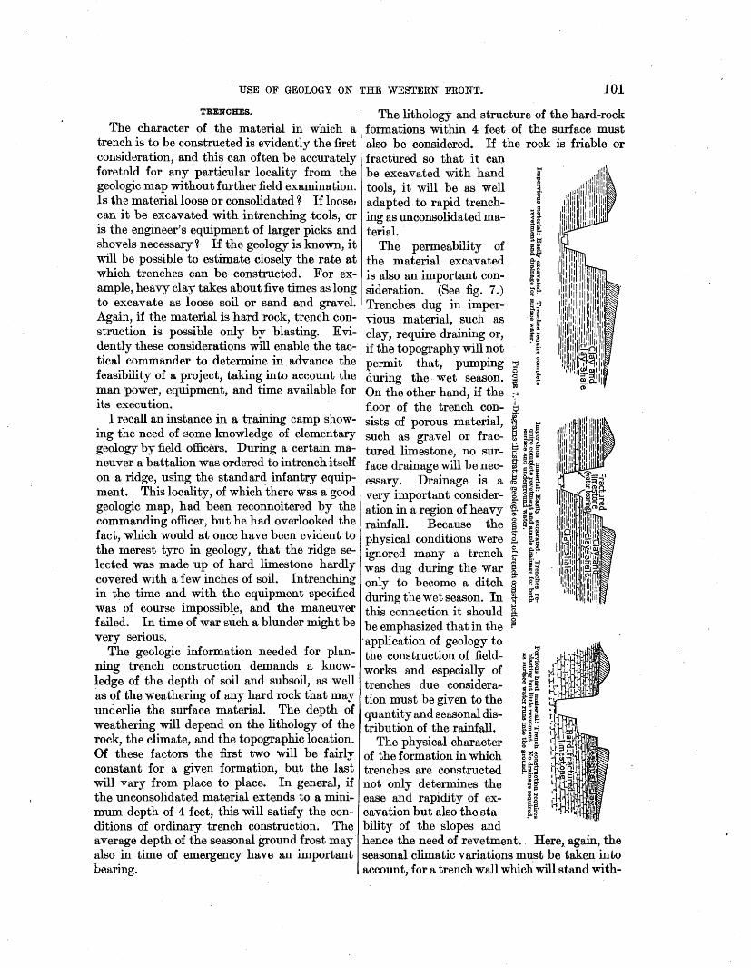
Fieldworks consist of trenches, dugouts, and subways, used in defense, and mines, which may be either defensive or offensive. In siege operations approach trenches or saps are also used in the offensive. Trenches are surface· excavations and range from hastily constructed breastworks, giving only partial cover to a man lying down, to excavations 6 feet or more deep, giving complete protection except against shell and trench-mortar fire. Dugouts range from cave shelters, excavated usually to a depth of not exceeding 30 feet, to shelters constructed at or near the surface. Military mines range from those not having sufficient cover to give protection against shell fire to those which are 100 or even 200 feet below the surface. It is evident that even shallow trench excavation is more or less affected by geologic conditions, such as depth to hard rock and permeability of the soil, while for deeper works geology may absolutely control the feasibility of the project. Under front-line conditions it is seldom possible to use anything but the simplest mechanical equipment, and therefore projects that presented no difficulties in peace may be impracticable in war. Moreover, it is of very great advantage for the military commander to know in advance what physical conditions he will meet in executing any given project for field fortifications.
33 Kranz, Capt. W., Militargeologie: Kriegstechn. Zeitscbr., vol. 16, p. 468, Berlin, 1913.
Field fortifications, in contrast with permanent fortification~, are almost always built in a hurry and often under shell fire. In general such works must be constructed without taking time to make underground tests. Yet in many localities the underground conditions are clearly indicated by the surface formations or can be determined by the correct interpretation of a geologic map. Scientific warfare demands that every possible source of pertinent information be drawn upon in advance of an undertaking. The engineer charged with the construction of field fortifications must make it part of his duty to become acquainted with and make use of the geologic facts. The desired result· may be in part accomplished by training the military engineer in the principles of geology that affe~t his profession; in part by furnishing him with geologic maps and teaching him their use.
"Although field fortifications are usually built in a hurry, the time available and the character of the work required vary greatly according to the military situation. They may consist of only the cover dug hastily by the infantryman with his intrenching tools under front-line conditions, or they may involve the deliberate organization of a defensive position, with the use of engineer troops and their equipment. Under the first condition the application of geology will be limited to the use of such facts as can be gleaned by a hasty reconnaissance or from the geologic map. Such use may prevent the commanding officer from making the blunder, of which there were only too many examples during the late war, of choosing defensive positions where excavation was impracticable, when not forced to do so by the military situation. Furthermore, if the higher commander, who is not at the scene of operations, has information at hand about the local geologic conditions, either from a map or from a military geologist, he will not be likely to issue intrenching orders which are impossible of execution.
The deliberate organization of a defensive position usually allows more time for planning and execution than the rapid intrenchment described above. In such projects the army, corps, or division commander usually gives orders for the defensive position, the site of the works being designated only in a general way. The details of location are left to the engineer officer in charge, who adjusts them so as to take advantage of favorable topographic

100 SHORTER CONTRIBUTIONS TO GENERAL GEOLOGY, 1920. I
conditions within the zone designated by his geologic knowledge before siting his fieldworks orders. In certain regions it is of equal im- is neglecting an important source of informaportance to adjust the fieldworks so as to take·· tion, and this neglect may lead to disaster. It advantage of favorable geologic conditions. is equally true, however, that geology is only Therefore the engineer should have a geologic one of several factors that influence the choice map, and it will save time if he is accompanied of sites for fieldwork~. by a geologic officer who can give .him the de- Once the general s1te of fieldworks ~as been tailed facts about geologic conditions. Atten- selected, a knowledge of geology agam comes tion to the geology is especially important into play in helping to make choice of the " if the fieldworks are to include deep dugouts. detailed locations. Often a slight change of
SITING OF FmLDWORXS.
There has been some controversy as to whether favorable or unfavorable geologic conditions can be regarded at all in the siting of fieldworks. Some hold that this is a purely tactical problem; others that the local geology must be the decisive factor. It is evident that the military situation may demandsome form of- defensive works where the geologic conditions are all adverse, and it is then the duty of the engineer to overcome the obstacles as best he may. Thus fieldworks ha~e been constructed in the water-soaked ground of Flanders, and underground shelters have been hewn out of the solid granite of the Vosges ¥ountains. These operations were possible, however, only under long-stabilized conditions of pos~tion warfare which made it possible to overcome the physical obstacles by equipment that is usually not available at the front. Even in these operations knowledge of the geology was invaluable by indicating in advance the conditions that would be met and therefore the equipment and time necessary for the construction. · .
In many localities the geologic condition~ may practically prohibit the construction of fieldworks. In such localities geology rather than tactics will be the decisive factor. If the bedrock is such that troops can not intrench themselves in a given position with the material and time available, field fortifications can be constructed only by choosing a more favorable site, and in making this choice the tactical commander must be guided by the geology.
To take another example-that of an underground offensive-military mining, as a rule, can be carried on only where it is favored by the geology. Obviously a plan for a mine attack must give heed to the geology, or it may be doomed to failure. Therefore the tactical commander who does not avail himself of
position that will be entirely in accord with their tactical Tequirements will yield more favorable geologic conditions. Thus, a trench may by a slight shift avoid hard rock or danger from flooding, and a dugout that would be difficult to construct at one place may easily be built at another near by.
The experience of the war has shown that although the location of the front line will be controlled by the tactical situation, the works .of the second and third positions may often be so adjusted as to take full advantage of favorable geologic . conditions. Consciously or unconsciously, such adjustments were, made by both sides on the western front, notably in the Lorraine sector. In many places the adjustment was brought about by elimination, the unfavorable localities being successively abandoned after futile attempts to fortify the~. Much of this useless work could have been avoided by taking cognizance of very simple geologic facts. ·
The most essential element in the correct siting of fieldworks is a comprehensive knowledge of topogrt;tphy, Here, too, evidently, a knowledge of the geology is an important factor. Topographic maps can evidently be read much more intelligently if the reader has some acquaintance with the genesis of land forms and hence with their relation to the bedrock structure and lithology as well as to the recent geologic history. This application of geology was but little developed during the war, except by the French.
It can not be expected that all future wars will be fought in regions of which topographic maps are available. In the absence of such maps the geologist can perform important serv~ ice by determining in advance the topographic types that will be found in the field of operations, and he will be able to gain a better conception of the relief than those who are unversed in geologic science.
USE OF GEOLOGY ON THE WESTERN FRONT. 101
TRENCHES.
The character of the material in which a trench is to be constructed is evidently the first consideration, and this can often be accurately foretold for any particular locality from the geologic map without further field examination. Is the material loose or consolidated ~ If loose, can it be excavated with intrenching .tools, or is the engineer's equipment of larger picks and shovels necessary~ If the geology is known, it will be possible to estimate closely the rate at which trenches can be constructed. For example, heavy clay takes about five times as long to excavate as loose soil or sand and gravel. Again, if the material is hard rock, trench construction is possible only by blasting. Evidently these considerations will enable the tactical commander to determine in advance the feasibility of a project, taking into account the man power, equipment, and time available for its execution.
I recall an instance in a training camp showing the need of some knowledge of elementary geology by field officers. During a certain maneuver a battalion was ordered to intrench itself on a ridge, using the standard infantry equipment. This locality, of which 'there was a good geologic map, had been reconnoitered by the commanding officer, but he had overlooked the fact, which would at once have been evident to the merest tyro in geology, that the ridge selected was made up of hard limestone hardly covered with a few inches of soil. Intrenching in the time and with the equipment specified was of course impossibl~, and the maneuver failed. In time of war such a blunder might be very serious.
The geologic information needed for planning trench construction demands a knowledge of the depth of soil and subsoil, as well as of the weathering of any hard rock that may underlie the surface material. The depth of weathering will depend on the lithology of the rock, the climate, and the topographic location. Of these factors the first two will be fairly constant for a given formation, but the last will vary from place to place. In general, if the unconsolidated material extends to a minimum depth of 4 feet, this will satisfy the conditions of ordinary trench construction. The average depth of the sea~onal ground frost may also in time of emergency have an important bearing.
The lithology and structure of the hard-rock formations within 4 feet of the surface must also be considered. If the rock is friable or fractilred so that it can be excavated with hand tools, it will be as well adapted to rapid trenching as unconsolidated material.
The permeability of the material excavated is also an important consideration. (See fig. 7.) Trenches dug in impervious material, such as clay, require draining or, if the topography will not permit that, pumping t ~ during the wet season. ~ :; On the other hand, if the --t
floor of the trench con- ~ sists of porous material, ~ ....
1i ~ ,Q 8 such as gravel or frac- ~ :~.q tured limestone, no sur- ~ £8 g·
.., ~ 8"'
face drainage will be nee- · ~ ~~e l=i' [~$" essary. Drainage is a d'<i ~ ~ ~-
very important consider- i. [i~ ation in a region of heavy ~· ~ ii rainfall. Because the ~ ~i~ physical conditions were g, ¥-~
d h e. ft?-ignore many a trenc .... "' a ~-~ was dug during the war g :: ~
1:!' c~:~
only to become a ditch c:. ~w ~ g-"'
during the wet season. In a ~7 this connection it should a
d h .~ be emphasize that in t e ·application of geology to "tt
the construction of field- ; f~· works and esp_ecially of l:i.~·&i
!1:0"1>" trenches due considera- :~a. tion must be given to the · ~We quantity and seasonal dis- i [! tribution of the rainfall. §J~
O<>~
The physical character ~~~ of the formation in which ) ~§ trenches are constructed ?-j-[ not only determines the .. g· ease and rapidity of ex- ~-~ cavation but also the sta- p.~· bility of the slopes and hence the need of revetment. Here, again, the seasonal climatic variations must be taken into account, for a trench wall which will stand with-
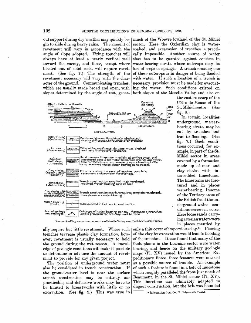
102 SHORTER CONTRIBUTIONS TO GENERAL GEOLOGY, 1920.
out support during dry weather may quickly begin to slide during heavy rains. The amount of revetment will vary in accordance with the angle of slope adopted. Firing trenches will always have at least a nearly vertical wall toward the enemy, and these, except where blasted out of solid rock, will require revetment. (See fig. 7.) The strength of the revetment necessary will vary with the character of the ground. Communicating trenches, which are usually made broad and open, with slopes determined by the angle of rest, gener-
much of the W oevre lowland of the St. Mihiel sector. Here the Oxfordian clay is watersoaked, and excavation of trenches is practically impossible. Another source of water that has to be guarded against consists in water-bearing strata whose outcrops may be loci of seeps or springs. A trench crossing one of these outcrops is in danger of being flooded with water. If such a location of a trench is necessary, provision must be made for evacuating the water. Such conditions existed on both slopes of the Moselle Valley and also on
the eastern scarp of the Cotes de Meuse of the St. Mihiel sector. (See fig. 8.)
.__ ___ J.._ ___ __,_z ___ ___;3'----------'4Kilometers
In certain localities underground waterbearing strata may be cut by trenches and lead to flooding. (See fig. 7.) Such conditions occurred, for example, in part of the St. Mihiel sector in areas covered by a formation made up of marl and clay shales with in-terbedded limestones. The limestones are fractured and in places water bearing. In some of the Tertiary areas of the British front the underground-water conditions were even worse. Here loose sands carrying artesian waters were in places man tied by
EXPLANATION
(Quaternarv). :;.:·:·:'1.::·.,;.::: an !5 an grave s.Usuall.ysaturai:ed excep,t Valleyfillirig ~S d d 1 . ·' ..... , ········ durmg dryseason.Un-favorablefortrenches
(Q Limons E--;,z~Silts withsomef'inesands.Usualfy well drained uaternary) ·- ·-·· and veryfavorablefor·trenches
8 · . ~Hard massive lim.Efst:one overlain atsurtacebysoiland li~~~f6~~ weat_pered zoneyzto.l meterthick. W::
USE OF GEOLOGY ON THE WESTERN FRONT. 103
on the north by a water-bearing fault. To avoid flooding, it was therefore necessary to site the dugouts so as not to cut the fault plane.
The application of these principles can be illustrated by citing some of the geologic features of the Lorraine sector. The Moselle Valley is floored in part by gravel, usually saturated and unfavorable to trenches and also in places subject to inundation by floods. The lowest formation exposed in the valley walls (fig. 8) consists of the Middle Lias clay shales with some thin limest6ne beds. The shales weather deeply to a clay that is easily excavated for trenches, which, however, require more or less complete revetting and provisions for getting rid of surface water. Moreover, some of the limestone lenses carry enough water to interfere with fieldworks. This formation is succeeded by a porous sandstone (Middle Lias) from 20 to 40 feet thick, whose outcrop is usually marked by a small bench on the valley slopes. The top of" this sandstone affords a good position for defensive works, provided they are not excavated deep enough to cut the bottom of the. formation, where there is a strong waterbearing zone. On account of a slight westerly dip of all the formations there is less trouble with water on the west side than on the east side of the Moselle Valley. Above the sandstone is another clay-shale formation (Upper Lias or Toarcian), which affords easy trench construction but calls for full revetment and ample provision for the drainage of surface water. The Toarcian is capped by the heavy fractured limestone of the Bajocian (Jurassic). The outcrop of this limestone is marked by bold bluffs and cliffs that mark the margin of the Moselle plateau (C6tes de Moselle), and its top furnishes an admirable defensive position. At its base, the site of the famous minette iron ore of Lorraine, there is a strong water-bearing zone which must be avoided in fieldworks.
As a rule the soil and weathered material overlying the Bajocian limestone is not deep enough for trenches, and in many places they must be blasted out of the hard rock but require no revetment and are self-draining. Locally the Bajocian limestone is capped by deposits of loam or silt, the so-called Limon of the French geologists. This formation in many places is deep enough for trenches, can be quickly excavated, needs little revetment, and is well
drained and admirably adapted to trench construction. Therefore the distribution of the Limon was a rather important military factor, as it permit- _ 1\)
ted rapid trench 111 0
construction with only infantry equipment in a region which in general was underlain by hard limestone with only a thin covering.
The section described above covers less than a mile in a horizontal di- ~ rection. It serves ; as a good illustra- "' tion o.f the variety ~ of physical condi- ~
~ tions affecting con- p
struction that may ~ be found within a ~ short distance in a 8
~~ region where there ~ are no great differ- ~ ences in the charac- .@ ; ter of the forma- o ;;
t 8'
tions.
DUGOUTS.
"Dugout" is~ used as a general i.. term to designate .-any form of shelter ~ against rifle or shell ~ i fires, having an ~ overhead cover and in part or entirely underground. Dugouts range from a shallow recess .under the parapet of a trench (splinter proof), affording protection only against small missiles, to one excavated to sufficient depth to withstand the shells of the heaviest artillery (fig. 9). If the dugout is entirely underground and undisturbed earth and rock are the sole cover, it is called a "cave shelter." A dugout consisting of
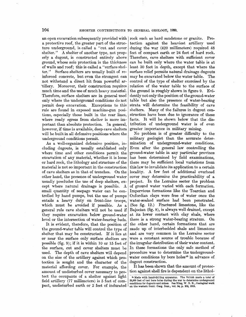
104 SHORTER CONTRIBUTIONS TO GENERAL GEOLOGY, 1920.
an open excavation subsequently provided with a protective roof, the greater part of the structure underground, is called a "cut. and cover shelter." A shelter of another type, not properly a dugout, is constructed entirely above ground, whose sole protection is the thickness of walls and roof; this is called a "surface shelter." Surface shelters are usually built of reinforced concrete, but even the strongest can not withstand a direct hit from powerful ar·tillery. Moreover, their construction requires much time and the use of much heavy material. Therefore, surface shelters are in general used only where the underground conditions do not permit deep excavation. Exceptions to this rule are found in exposed machine-gun positions, especially those built in the rear lines, where ready egress from shelter is more important than absolute protection. In general, however, if time is available, deep cave shelters will be built in all defensive positions where the underground conditions permit.
As a well-organized defensive position, including dugouts, is usually established only where time and other conditions permit the excavation of any material, whe.ther it is loose or hard rock, the lithology and structure of the material is not so important in the construction of cave shelters as in that of trenches. On the other hand, the presence of underground water usually precludes the use of deep shelters, except where natural drainage is possible. A small quantity of seepage water can be controlled by hand pumps, but the use of pumps entails a heavy duty on front-line troops, which must be avoided if possible. As a general rule cave shelters will not be used if they require excavation below ground-water level or the intersection of water-bearing beds.
It is evident, therefore, that the position of the ground-water table will control the type of shelter that may be constructed. If it lies at or near the surface only surface shelters are possible (:fig. 9); if it is within 10 or 15 feet of the surface, cut and cover shelters must be used. The depth of cave shelters will depend on the size of the artillery against which protection is sought and the character of the material affording cover~ For example, the amount of undisturbed cover necessary to protect the occupants of a shelter against light field artillery (77 millimeters) is 5 feet of compact, undisturbed earth or 2 feet of indurated
rock such as hard sandstone or granite. Protection against the heaviest artillery used during the war ( 420 millimeters) required 48 feet of compact earth or 24 feet of hard rock. Therefore, cave shelters with sufficient cover can be built only where the water table is at least 30 feet in depth, except that where the surface relief permits natural drainage dugouts may be excavated below the water table. The control of the type of shelter exercised by the relation of the water table to the surface of the ground is roughly shown in figure 9. Evidently not only the position of the ground-water table but also the presence of water-bearing strata will determine the feasibility of cave shelters. Many of the failures in dugout construction have been due to ignorance of these facts. It will be shown below that the distribution of underground water is of even greater importance in military mining.
No problem is of greater difficulty to the military geologist than the accurate determination of underground-water conditions. Even after the general law controlling the ·ground-water table in any particular province has been determined by field examinations, there may be sufficient local variations from this law to invalidate its application to a certain locality. A few feet of additional overhead cover may determine the practicability of a project. In the Lorraine sector the problem of ground water varied with each formation. Impervious formations like the Toarcian and Oxfordian clays were free of water once the water-soaked surface had been penetrated. (See fig. 12.) Fractured limestone, like the Bajocian (:fig. 8), is always well drained, except at its lower contact with clay shale, where there is a strong water-bearing stratum. On the other hand, certain formations that are made up of interbedded shale and limestone and are very common in the Lorraine sector were a constant source of trouble because of the irregular distribution of their water content. In these formations the only safe method of procedure was to determine the undergroundwater conditions by bore holes35 in advance of dugout construction.
It has been shown that the amount of protection against shell fire is dependent on the lithol-
ao Made with hand-drilling apparatus. The British made a total of 28,000 feet of test bore holes during the war to determine underground conditions for dugouts and mines. See King, W. B. R., Geological work on the western front: Geog. Jour., vol. 54, p. 202, 1919.
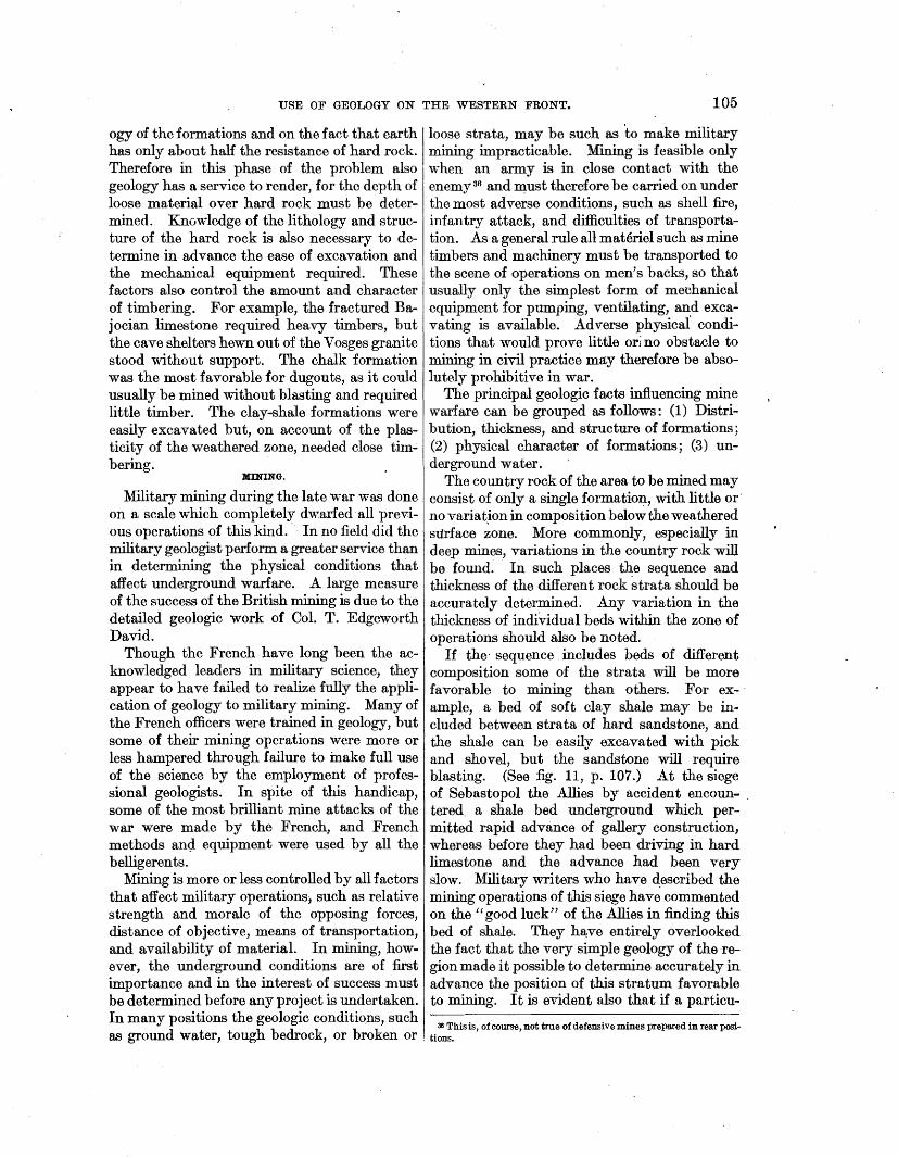
USE OF GEOLOGY ON THE WESTERN FRONT. 105
ogy of the formations and on the fact that earth I loose strata, may be such as to make military has only about half the resistance of hard rock. mining impracticable. Mining is feasible only Therefore in this phase of the problem also ·when an army is in close contact with the geology has a service to render, for the depth of loose material over hard rock must be determined. Knowledge of the.lithology and structure of the hard rock is also necessary to determine in advance the ease of excavation and the mechanical equipment required. These factors also control the amount and character of timbering. For example, the fractured Bajocian limestone required heavy timbers, but the cave shelters hewn out of the Vosges granite stood without support. The chalk formation was the most favorable for dugouts, as it could usually be mined without blasting and required little timber. The clay-shale formations were easily excavated but, on account of the plasticity of the weathered zone, needed close tim~ bering.
MINING.
Military mining during the late war was done on a scale which completely dwarfed· all previous operations of this kind. - In no field did the military geologist perform a greater service than in determining the physical conditions that affect underground warfare. A. large measure of the success of the British mining is due to the detailed geologic work of Col. T. Edgeworth David.
Though the French have long been the acknowledged leaders in military science, they appear to have failed to realize fully the application of geology to military mining. Many of the French officers were trained in geology, but some of their mining operations were more or less hampered through failure to inake full use of the science by the employment of professional geologists. In spite of this handicap, some of the most brilliant mine attacks of the war were made by the French, and French methods an<i equipment were used by all the belligerents.
enemy 36 and ~ust therefore be carried on under the most adverse conditions, such as shell fire, infantry attack, and difficulties of transportation. As a general rule all materiel such as mine timbers and machinery must be transported to the scene of operations on men's backs, so that usually only the simplest form of mechanical equipment for pumping, ventilating, and excavating is available. Adverse physical conditions that would prove little ori no obstacle to mining in civil practice may therefore be absolutely prohibitive in war.
The principal geologic facts influencing mine warfare can be grouped as follows: (1) Distribution, thickness, and structure of formations; (2) physical character of formations; (3) underground water.
The country rock of the area to be mined may consist of only a single formation, with little or· no variat,ion in composition below the weathered surface zone. More commonly, especially in deep mines, variations in the country rock will be found. · In such places the sequence and thickness of the different rock strata should be accurately determined. A.ny variation in the thickness of individual beds within the zone of operations should also be noted.
If the· sequence includes beds of different composition some of the strata will be more favorable to mining than others. For ex- · ample, a bed of soft clay shale may be in .. eluded between strata of hard sandstone, and the shale can be easily excavated with pick and shovel, but the sandstone will require blasting. (See fig. 11, p. 107.) A.t the siege of Sebastopol the Allies by accident encoun- . tered. a shale bed underground which permitted rapid advance of gallery construction, whereas before they had been driving in hard limestone and the advance had been very slow. Military writers who have ~escribed the mining operations of this siege have commented on the ''good luck'' of the Allies in finding this bed of shale. They h~ve entirely overlooked the fact that the very simple geology of the region made it possible to determine accurately in advance the position of this stratum favorable to mining. It is evident also that if a particu-
Mining is more or less controlled by all factors that affect military operations; such as relative strength and morale of the opposing forces, distance of objective, means of transportation, and availability of material. In mining, however, the underground conditions are of first importance and in the interest of success must be determined before any project is undertaken. In many positions the geologic conditions such
d h b dr k b - k' 36 This is, of course, not true of defensive mines prepared in rear posi-
as groun water, toug e oc , or ro en or . tions.
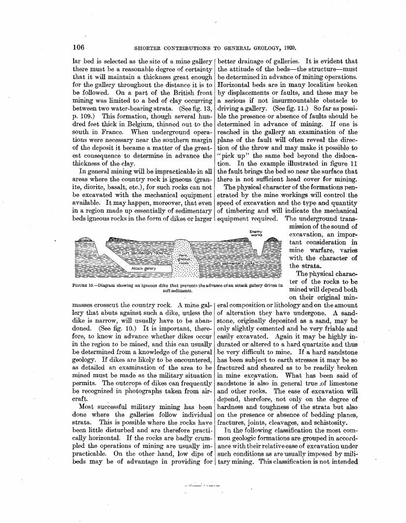
106 SHORTER CONTRIBUTIONS TO GENERAL GEOLOGY, 1920.
lar bed is selected as the site of a mine gallery there must be a reasonable degree of certainty that it will maintain a thickness great enough for the gallery throughout the distance it is to be followed. On a part of the British front mining was limited to a bed of clay occurring between two water-bearing strata. (See fig. 13, p. 109.) This formation, though several hundred feet thick in Belgium, thinned out to the south in France. When underground operations were necessary near the southern margin of the deposit it became a matter of the greatest consequence to determine in advance the thickness of the clay.
In general mining will be impracticable in all areas where the country rock is igneous (granite, diorite, basalt, etc.), for such rocks can not be excavated with the mechanical equipment available. It may happen, moreover, that even in a region made up essentially of sedimentary beds igneous rocks in the form of dikes or larger
better drainage of galleries. It is evident that the attitude of the beds-the structure-must be determined in advance of mining operations. Horizontal beds are in many localities broken by displacemen:ts or faults, and these may be a serious if not insurmountable obstacle to driving a gallery. (See fig. 11.) So far as possible the presence or absence of faults should be determined in advance of mining. If one is reached in the gallery an examination of the plane of the fault will often reveal the direction of the throw and may make it possible to "pick up" the same bed beyond the dislocation. In the example illustrated in figure 11 the fault brings the bed so near the surface that there is not sufficient head cover for mining.
The physical character of the formations penetrated by the mine workings will control the speed of excavation and the type and quantity of timbering and will indicate the mechanical equipment required. The underground trans-
mission of the sound of ~~~~ excavation, an impor-
~=-=="'==:-=~~~~ tant consideration in mine warfare, varies with the character of the strata.
The physical character of the rocks to be
FIGURE 10.-Diagram showing an igneous dike that prevents the advance of an attack gallery driven in soft sediments. mined will depend both
masses crosscut the country rock. A mine gallery that abuts against such a dike, unless the dike is narrow, will usually have to be abandoned. (See fig. 10.) It is important, therefore, to know in advance whether dikes occur in the region to be mined, and this can usually be determined from a knowledge of the general geology. If dikes are likely to be encountered, as detailed an examination of the area to be mined must be made as the military situation permits. The outcrops of dikes can frequently be recognized in photographs taken from aircraft.
Most successful military mining has been done where the galleries follow individual strata. This is possible where the rocks have been little disturbed and are therefore practically horizontal. If the rocks are badly crumpled the operations of mining are usually impracticable. On the other hand, low dips of beds may be of advantage in providing for
on their original mineral composition or lithology and on the amount of alteration they have undergone. A sandstone, originally deposited as a sand, may be only slightly cemented and be very friable and easily excavated. .Again it may be highly indurated or altered to a hard quartzite and thus be very difficult to mine. If a hard sandstone has been subject to earth stresses it may be so fractured and sheared as to be readily broken in mine excavation. What has been said of sandstone is. also in general true _of limestone and other rocks. The ease of excavation will depend, therefore, not only on the degree of hardness and toughness of the strata but also on the presence or absence of bedding planes, fractures, joints, cleavages, and schistosity.
In the following classification the most common geologic formations are grouped in accol'dance with their relative ease of excavation under such conditions as are usually imp0sed by military mining. This classification is not intended
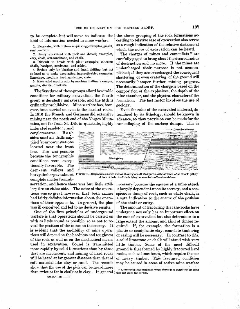
USE OF GEOLOGY ON THE WESTERN FRONT. 107
to be complete but will serve to indicate the kind of information needed in mine warfare.
1. Excavated with little or no picking; examples, gravel, sand, and silt.
2. Easily excavated with pick and shovel; examples, clay, shale, soft sandstone, and chalk.
3. Difficult to break with pick; examples, siliceous chalk, hardpan, sandstone, and schist.
4. Broken only by blasting and hand drilling but not so hard as to make excavation impracticable; examples, limestone, medium hard sandstone, slate.
5. Excavated rapidly only by machine drilling; example, granite, diorite, quartzite.
The first three of these groups afford favorable conditions for military excavation, the fourth group is decidedly unfavorable, and the fifth is ordinarily prohibitive. Mine warfare has, however, been carried on even in the hardest rocks. In 1916 the French and Germans did extensive mining near the north end of the Vosges Mountains, not far from St. Die, in quartzite, highly indurated sandstone, and conglomerates. Both sides used air drills supplied from power stations located near the front line. This was possible because the topographic conditions were exceptionally favorable. The deep-cut valleys and
the above grouping of the rock formations according to relative ease of excavation also serves as a rough indication of the relative distance at which the no)se of excavation can be heard.
The charges of mines and camouflets 87 are carefully gaged to bring about the desired radius of destruction and no more. If the mines are undercharged their purpose is not acccomplished; if they are overcharged the consequent shattering, or even cratering, of the ground will necessarily hamper further mining progress .. The determination of the charge is based on the composition of the explosives, the depth of the mine chamber, and the physical character of the formation. The last factor involves the use of geology.
Even the color of the excavated material, determined by its lithology, should be known in advt;mce, so that provision can be made for the camouflagi~g of the surfac~. dumps. This is
heavytimbergavealmost FIGURE 11.-Dia.gra:mm.atic cross section showing a fault that prevents the advance ·or an attack gallery driven in beds of soft shale lying between beds of hard sandstone.
complete shelter from ob-servation, and hence there was but little artil-:- 1 necessary because the success of a mine attack lery fire on either side. 'l'he noise of the opera- is largely dependent upon its secrecy, and a contiona was so great, however, that both armies spicuous dump of rock, such as white chalk, is had fairly definite information about t~e opera- a sure indication to. the enemy of the position tions of their opponents .. In general, the plan of the shaft or entry. was ill conceived and led to no decisive results. The amount of fracturing that the rocks have
One· of the first principles of underground undergone not only has an important effect on warfare is that operations should be carried on the ease of excavatim{ but also determines to a with as little sound as possible, so as not tore- large extent the amount and kind of timber reveal the position of the mines to the enemy. It quired. If, for example, the formation is a is evident that the audibi1ity of mine opera- plastic or semiplastic clay, complete timbering tions will depend on the hardness and toughness or casing will be necessary. In contrast to this, of the rock as well as on the mechanical means a solid limestone or chalk will stand with very used in excavation. Sound is transmitted little timber. Some of the most difficult more rapidly by solid formations than by those ground is that formed by highly fractured hard that are incoherent, and mining of hard rocks rocks, such as limestones, which require the use will be heard at far greater distance than that of of heavy timber. This fractured condition soft material like clay or sand. The records may be caused in areas of active mine warfare show that the use of the pick ·can be heard more
31 A camouflet is a small mine whose charge is so gaged that its effect than twice as far in chalk as in clay. In general does not reach the sl.lrface.
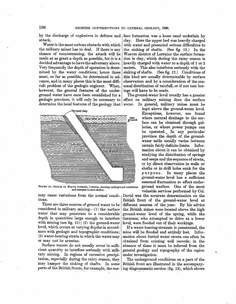
108 SHORTER CONTRIBUTIONS TO GENERAL GEOLOGY, 1920.
by the discharge of explosives in defense and attack.
Water is the most serious obstacle with which the military miner has to deal. If there is any chance of countermining, the attack will be made at as great a depth as possible, for it is a decided advantage to have the adversary above. Very frequently the depth of operation is determined by the water conditions; hence these must, so far as possible, be determined in adyance, and in many places this is the most difficult problem of the geologic engineer. When, however, the general features of the underground water have once been established for a geologic province, it will only be necessary to determine the local features of the geology that
Tamped day
face formation was a loose sand underlain by clay. Here the upper bed was heavily charged with water and presented serious difficulties to the sinking of shafts. (See fig. 13.) In the W oevre district of Lorraine the surface formation is clay, which during the rainy season is heavily charged with water to a depth of 1 or 2 meters. This also interferes seriously with the sinking of shafts. (See fig. 12.) Conditions of this kind are usually determinable by surface observation and by a consideration of the seasonal distribution of rainfall, or if not test borings will have to be made.
The ground-water level usually has a greater effect on military mining than the surface water. In general, military mines must be
kept above the ground-water level. Exceptions, however, are found
:::;:-~-s--~~~~ vt.Lr~~~JI:~::c:.~~~~~=:t~:.g~~nd where natural drainage to the sur-
=-~ ;:~~~~-~~~~~~-~-(- f::i~~~ :h::eta~:rt~:~~~ ~:~ ~ ~ be operated.. In any particular province the depth of the ground-water table usually varies between
~ordi~ '~impervious clay shale= certain fairly definite limits. Infor-- ~~ ~&round mation about it can be obtained by
'\'1::..:: studying the distribution of springs and seeps and the sequence of strata, or by direct observation in wells or shafts or in drill holes sunk for the purpose. In many places the ground-water level has a sufficient seasonal fluctuation to affect under-
FIGURE 12.-Section in Woevre lowlands, Lorraine, showing underground conditions ground warfare. One of the most and entrance to cave shelter. valuable services performed by Col.
may cause variations from the normal conditions.
There are three sources of ground water to be considered in military mining-(1) the surface water that· may penetrate to a considerable depth in quantities large enough to interfere with mining (see fig. 12); (2) the ground-water level, which occurs at varying depths in accordance with geologic and topographic conditions; (3) water-bearing'stratain which the water may or may not be artesian.
Surface waters do not usually occur in sufficient quantity to interfere seriously with military mining. In regions of excessive precipitation, especially during the rainy season, they may hamper the sinking of shafts. In some parts of the B~~ish fronts, for. example, the sur-
David wa~ the accurate determination on the British front of the ground-water level at different seasons of the year. By his advice the British mines were located above the high ground-water level of the spring, while the Germans, who attempted to drive at a lower level, were :flooded out of their workings.
If a water-bearing stratum is penetrated, the mine will be flooded and entirely lost. Information about buried water strata can often be obtained from existing well records; in the absence of these it must be inferred from the general geology and topography of the region under investigation.
The underground conditions on a part of the British front are illustrated in the accompanying diagrammatic section (fig. 13), which shows
I ,.,. .. ,•

USE OF GEOLOGY ON THE WESTERN FRONT. 109
a bed of impervious clay overlain by quicksand and underlain by chalk carrying artesian water. To nteet these conditions shafts were sunk through the quicksand by the use of tubing, and the mine galleries were driven in the clay. If these galleries broke into the sand above, they would be flooded by surface waters. If, on the other hand, they were placed too low in the clay the artesian water of the chalk would break through and flood the mine works from below. A gallery properly placed in this section evidently had a strong tactical position, for it could not be countermined at a lower level. This presents an excellent example of the necessity of close adjusting of the mine works to the geologic conditions.
Though the factors governing military mining are very largely geologic, yet their interpretation in terms of excavation, equipment, etc.,
3. The information gained about the depth of the ground water or of water-bearing strata by the use of geology will determine in advance the type of cave shelter which can be constructed and whether mining is practicable.
4. By the use of goologic facts it will be possible to forecast the kind and quantity of mat6riel necessary to execute any project of fortification. This will include the tools and other mechanical equipment, such as ventilators, boring machines, and pumps, revetting material for trenches, and timbers for dugouts and mines.
5. A knowledge of the geology will make it possible to learn in advance the character of the material to be excavated, and this is one of the factors determining the time needed to complete the project.
are problems of the mining engineer. Therefore, the geologic engineer will be called upon for the geologic facts and deductions, and the mining engineer will apply these data in formulating the plans of un-derground operation. ~~~
The ~eologist not o~y must Attack gallery . = lmperviou~ clay, determme the facts m regard _________ ._. _ __ __ _ -=: dry ground
to hisownsideofthefrontbut ~~~~ must also forecast, so far as =:J.--.--~-~'~, - ' _ ', ~~~· .' ,: Fractured chalk, Possible the conditions which :.&-J;t_:.:L~- ··-:~)s:--=-~Z, -· '· '.!,\;-, · ~~~·artesian water;
' . . - tl· . ~·==r--" ....-r---',....,.--L---r-'-- ..,- --,---,-:- wet ground the enemy will meet if he coun-termines. Evidently mine FIGURE 13.-Diagram showing location of mine gallery in dry ground between two water-
bearing formations. warfare calls for the most de-tailed geologic information. It is to the great credit of the British geologic staff that they procured this information in spite of the fact that all the investigations had to be carried on under front-line conditions. The surface observations were supplemented by a large number of test borings.
GEOLOGIC JU.PS .AKD REPORTS.
The geologic information needed as a guide to the location and construction of fieldworks was furnished by all the armies of the western front in the form of maps, sections, and reports, and to sol,Ile extent by personal inference. In the earlier stages of the work
sll11KARY. the maps were chiefly adaptati()ns of the The use of geologic facts in the siting and existing French and Belgian geologic maps.
construction of fieldworks can be summarized -Later more detailed geologic surveys were as follows: made and the results were shown on color
1. Geology will make it possible to take maps printed for general distribution. The advantage, so far as the tactical situation per- standard scale of the British military geologic mits, of the most favorable physical conditions. maps was 1 : 10,000, and they were printed on
2. A knowledge of the geology will, to a large the new Ordnance Survey base without the extent, prevent the undertaking of projects contours.ss These geologic maps are pre-that are impossible on account of the physical conditions underground.
as The maps examined covered areas in the plains of Flanders, where there is little relief. It is possible that others were issued in which the reliefls shown by contours.

110 SHORTER CONTRIBUTIONS TO GENERAL GEOLOGY, 1920.
sen ted as being a "General classification of ground according to its suitability for dugouts, etc." The information shown by colors is supplemented by overprinted descriptions. The locations of all ·bore holes are indicated, thus giving a measure of the reliability of the information about any particular locality. For the mining work of the British Army geologic maps on a still larger scale were prepared, but these appear to have been issued only in manuscript form. The British also printed geologic cross sections with brief explanatory texts conveying information of the same kind as that shown on the maps.
These graphic data: were supplemented by the British geologists by brief reports in which the geologic sequence was described ana its relations to the construction of fieldworks set forth. These reports were usually iss~ed in mimeographed form and were illustrated by geologic sections. The British geologists, unlike those of the American Army, were frequently called into consultation on the ground, and thus gave much help orally of which there is no record.
The first military geologic maps prepared by the American Expeditionary Force were col·ored by hand on bases without relief arid on :a scale of 1 : 80,000. When the work of issuing ;geologic maps of the entire front was undertaken these were printed on a scale of 1:50,000, ·with a contoured base. They were termed engineering geologic maps and the classification was lithologic. In the legend the lithologic units were described with reference to the construction of fieldworks. Seeps and springs were indicated by red lines. A part of the Montsec map, originally printed in colors with contoured base, is here reproduced (Pl. XV).
The German Army issued some geologic engineering maps on the French hachured base of the 1:80,000 scale, but their standard map was on a scale of 1:25,000, on a contoured base, with the geology indicated in great detail. The map explanations were practical rather than scientific and presented in full detail the features of each geologic formation that could be of military value. It is probable that not very many of these detailed maps were printed during the war, for less than half a dozen were captured.
In addition to these maps the Germans printed many reports dealing with the relation between geology and field fortifications. In
these reports .an evident attempt was made to avoid all geologic nomenclature that would not be comprehensible to the layman. Some, indeed, were clearly intended for the use of men having little or no technical education. In spite of this attempt the German map legends and reports are in general so elaborate and comprehensive as to tend to defeat their own purpose.
All the belligerents followed the practice of issuing preliminary geologic maps and reports before more complete information was available. These would be corrected in later editions. Thus a geologic map might run through several editions within a few months. The exigencies of military operations may evidently demand some information before the field ex .. aminations have been completed. This situation is a difficult one for the average geologist to meet, for his inclination is to wait until he has all his facts before coming to a decision. It is hard for a geologist from civil life, to grasp the important fact that some information is better than none at all.
The geologic engineering mapa of the Ameri• can Expeditionary Force differed from most of those issued by the other armies in the fact that they were extended far within the enemy lines. It was held that information about the physical conditions in enemy territory was of value even if only approximately correct. These maps could of course not have been prepared had the French official maps (1 :80,000) not been available. In drawing the boundaries on a scale larger than the original some use was made of aero-photographs. The base of the heavy cliffforming Bajocian limestone could, for example, be rather accurately delineated from the photographs. The same results could probably have been attained without the photographs if a better contoured base had been available. Another feature that favored the drawing of this contact for part of the Moselle Valley was the fact that the vineyards of this area, which were outlined on the base map, are all on the Bajocian limestone. Spring lines were also a useful guide in determining some of the contacts.
The geologic section of the American Expeditionary Force prepared a number of reports dealing with the geologic control of field fortifications, military mining, mining troops, and related subjects. These reports are listed below. All except one were issued only in
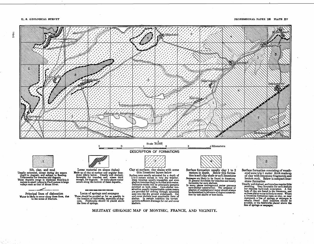
f
U. 8. G EOLOGICAT, SURVEY
-Silt, clay, and mud Usuallf, saturated, except during dry season (A~I to August), and sqbject; to flooding. Unfavorable for trenches and ~ts.
These deposits range in thickness from~io 2 meters m small valley~! to 2'to 8 meters in large valleys such as that Of Meuse River. __ .-::::;_· ---
Principal lines of dislocation. Water is likely to occur along these lines, due
to the zones of fracture.
PROFESSIONAL PAPER 128 PLATE XV
__ 1_
Scale 50,00~ 3 4 Kilometers ~ 0 1 2
~ Loose material on slopes {talus)
Made up of clay at surface and angular limestone debris below. Usually well drained; favorable for trenches and, where thick enough, for dugouts. In many places water occurs along tile bottom of these deposits.
---·----Locus of springs and seepages These should be avoided as far as ~ible in
the location of field works, especially of dugouts. Fieldwork& should be placed above the lines of springs.
DESCRIPTION OF FORMATIONS
/:/'// //////
/ ////:;:/// /~ //////
/ / / / / / tlltt<
Clay at surface; clay shales with some thin limestone layers below
Surface zone usually saturated for a depth of 1 to 2 meters except in very dry weather. Deep trenches usually impossible, and even shallow trenches likely to be tilled with water. Defensive works will be principally parapets revettec;l on both sides. Cave-slielter construction usually impracticable unless means are provided for sinl<ing through satura~ zone into the dry ground underneath. Cut and cover shelters most practicable form of shelter. In certain loo8lities the terrain pel'!llits sufficient drainage for cut and cover Shelters.
~ Surface fonnation usually clay 1 to 2
meters in depth. Below this fonnation is soft clay shale or soft limestone
Seepages are likely to be found in limestone. In general favorable for trenches and locally favorable for cave shelters.
In man)' ~aces underground water prevents cave-shelter construction. The presence or absence of underground water should always be determined in advance of dugout construction by test shafts or· bore holes.
MILITAll.Y GEOLOGIC MAP OF MONTSEC, FRANCE, AND VICINITY.
-Surface fonnation consistin_g of weath· ered zone ~to 1 meter. th1ck madeuR of clay with limestone fragments and broken rock. Below is compact limestone formation
Usually well drained, and trenches require little revettin~. Very favorable for cave shelters but requ~res hard-rock excavation. A few beds of clay are found in the limestone, and at these places water is likely to occur. Where a limestone fonnation·rests on·clay, as near Apremont, a line of sprin~ or seepages ·is usually found. Such localities should be avoided, or the tleldworks placed above tbe line of sprinp or seepages.
USE OF GEOLOGY ON THE WESTERN FRONT. 111
manuscript form and. hence had no wide circulation. Reports were prepared covering the front between the Swiss frontier and_ Meuse River and including a description of the military engineering features and their relation to the geology. A special report on underground water and its relation to fieldworks was also prepared for the use of the engineers. Detailed reports were also made on the geology and topography of the enemy positions in the Lorraine sector and their relation to and control of the enemy fortifications. These reports were prepared for the use of the intelligence section of the General Staff.
Geologic engineering maps prepared by geologic section, American Expeditionary Force.
Quadrangle. Scale.
Commercy ........ 1:80,000 Montsec ......... 1:50,000 Cheminot ........ 1:50,000 St. MihieL. ___ .. 1:50,000 Etain. . . . . . . . . . . . 1: 50, 000 Luneville. __ . ___ .. 1:50,000 Amelecourt ... _ . . 1: 50, 000 Schirmeck .... __ .. 1:50,000 Chateau Thierry. . 1: 50, 000
Notes.
Hand colored; not printed. Printed.
Do. Do. Do.
Hand colored; not printed. Do.
Not completed. Do.
Reports prepared by geologic section, American Expeditionary Force, relating to field fortifications, etc.
Mining troops of British Expeditionary Force. Notes on British mining practice. Notes on British mining schools. Engineer re~onnaissance on French front from Belfort to
St. Mihiel. Geology and topography as affecting military engineering,
Nomeny-St. Mihielsector. Mine-rescue apparatus. Notes on cover for shelters. Underground water and its relation to :fieldworks.
(Printed ip. Engineer Field Notes, No. 27, A. E. F.) Notes on shelters for infantry. Geology and topography as affecting military engineering
of German position, St. Mihiel and Pont-a-Mousson sector.
The German defenses of the Lorraine front.
MANEUVERING.
The influence of swamps and marshes on strategy and tactics is of course well established. On many occasions skillful leaders have defeated an opponent by taking advantage of impassable ground. Present tactics and modern equipment in artillery and tanks have led to a revision of the old classification of passable and impassable ground for troop maneuvers. This revision has been necessary
because of the colossal scale of modern operations, involving not only tremendous .concentrations of men but also enormous unit weight of mobile equipment, such as artillery and tanks. A land surface that would have been no obstacle to maneuvers in fonner wars, with their relatively small numbers of troops and light equipment, might prove almost impassable for the great bodies of men and the heavy equipment demanded by present tactics. There were, of course, plenty of exceptions to the new requirements during the late war, for much fighting was done in swampy lowland and even among rugged snow-clad ranges, where the great concentration of infantry in attack and the use of heavy equipment was impossible. The decisive battles of the war, however, were fought in areas where the passability of the ground was an important element. The question whether a certain hill slope is made up of slippery clay or of hard ground may be the decisive factor in a tactical movement. Again, the success of an operation may hinge on the quick traverse of a certain valley bottom. If the valley floor is silt or clay, it will be soft and muddy during the wet season and difficult to traverse; if it is sand and gravel it will be hard and dry and easy . of passage by troops and equipment. Again, the suGcessful fording of a stream may depend on the physical character of the stream bottom. A knowledge of the geology of the region will make it possible to forecast the physical conditions of the surface, and this will often be of immense service in formu-lating plans for tactical movements. .
The feasibility of a maneuver depends, as shown above, on the physical condition of the soil, as well as on the topography. 89 Complete understanding of the topography of the scene of operations is clearly of first importance to the tactician. It has been emphasized in many publications, 40 notably by the French, that a thorough knowledge of military topography can best be obtained by understanding its relations to the bedrock geology and to the recent geologic history of the region. This subject relates to the training of officers and, though important, need not be further discussed here. The influence of topography on tactical move-
39 There are other conditions, such as distribution of forests, character of roads and railroads, that influence tactical movements, but these need not be considered here. ·
40 This subject is admirably presented in "Military geology and to-pography," edited by H. E. Gregory, pp. 162-252, New Haven, 1918.
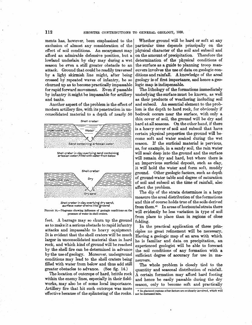
112 SHORTEU CONTRIBUTIONS TO GENERAL GEOLOGY, 1920.
ments has, however, been emphasized to the exclusion of almost any consideration of the effect of soil conditions. An escarpment may afford an admirable defensive position, but a lowland underlain by clay may during a wet season be even a still greater obstacle to an attack. Ground that could be readily traversed by a light skirmish line might, after being crossed by repeated waves of mfantry, be so churned up as to become practically impassable for rapid forward movement. Even if passable by infantry it might be impassable for artillery and tanks.
Another aspect of the problem is the effect of modern artillery fire, with its penetration in uncousolidated material to a depth of nearly 50
Shell crater
Shell crater in clay overlying sand containing artesian water; filled with water from below
Shell crater
r---~ A---===--====-..=:::::: -==-- - ===: ~~-Dry~~
~£il!!N@,@f·1\;fii,i-iMW("r:>~·: .. :·~-t·t;J..;!":,:!\;~;~t Shell crater in clay overlying dry sand; surface water drains into gro~:~nd.
FIGuRE 14.-Diagrams showing influence of geologic conditions on the presence of water in shell craters.
feet. A barrage may so churn up the ground as to make it a serious obstacle to rapid infantry attacks and impassable to heavy equipment. It is evident that the shell craters will be much larger in unconsolidated material than in hard rock, and which kind of ground will be reached by the shell fire can be determined in advance by the use of geology. Moreover, underground conditions may lead to the shell craters being filled with water from below and thus add still greater obstacles to advance. (See fig. 14.)
The location of outcrops of hard, brittle rock within the enemy lines, especially in their fieldworks, may also be of some local importance. Artillery fire that hit such outcrops was more ·effective because of the splintering of the rocks.
Whether ground will be hard or soft at any particular time depends principally on the physical character of the soil and subsoil and on the amount of precipitation. Therefore the determination of the· physical conditions of the surface as a guide to planning troop maneuvers involves the use of data on geologic conditions and rainfall. .A knowledge of the areal geology is of first importance, and hence a geologic map is indispensable.
The lithology of the formations immediately underlying the surface must be known, as well as their products of weathering including soil and subsoil. An essential element to the problem is the depth to hard rock, for obviously if bedrock occurs near the surface, with only a thin cover of soil, the ground will be dry and hard at all seasons. On the other hand, if there is a heavy cover of soil and subsoil that have certain physical properties .the ground will become soft and water soaked during the wet season. If the surficial material is pervious, as, for example, in a sandy soil, the rain water will soak deep into the ground and the surface will remain dry and hard, but where there is an impervious surficial deposit, such as clay, it will hold the water and form soft, muddy ground. Other geologic factors, such as depth of ground-water table and degree of saturation of soil and subsoil at the time of rainfall, also affect the problem.
The dip of the strata determines in a large measure the areal distribution of the formations and this of course holds true of the soils derived from them .. u In areas of horizontal strata there will evidently be less variation in type of soil from place to place than in regions of close folding.
In the practical application of these prin-: ciples no great refinement will be necessary. Having a geologic map of an area with which he is familiar and data on precipitation, an experienced geologist will be able to forecast the soil conditions of any formation with a sufficient degree of accuracy for use in maneuvers.
The whole problem is closely tied to the quantity and seasonal distribution of rainfall. A certain formation ·may afford hard ·footing and hence be easily passable during the dry season, only to become soft and practically
41 In glaciated regions other factors are evidently involved, which will not be discussed here.
USE OF GEOLOGY ON THE WESTERN FRONT. 113
impassable during wet weather. Therefore monthly data on precipitation are absolutely essential, and information about evaporation is desirable. In northern latitudes the seasonal distribution of ground frost may have a bearing on the passability of the terrane at times.
The permanent ground frost of polar and subpolar regions introduces another element. In these regions the soil and subsoil thaw only to a depth of 1 foot to 3 feet during the short summer. This condition produces a swampy character in the ground even on hill slopes, and as a result much of the country is almost impassable for modern armies.
An area in which the character of the soil and the precipitation are such as to form muddy ground during the wet season may be artifici~ly drained. Locally the plain of Flanders has been so drained as to give relatively hard ground, but the great plain of western Russia, with similar natural physical conditions but not drained, is wet and muddy.
In arid and semiarid regions the considerations above set forth are. of less importance, for the terrane, except for talus slopes, is likely to be firm at all seasons. AB the greatest concentrations of the population of the world are in the humid regions, however, these are likely to continue to be the scenes of important wars. Therefore the use of geologic maps in forecasting the physical conditions of the
•surface of the ground deserves attention by tactical leaders. This military use of geology need not be overemphasized, for evidently in many regions it will have little practical application. Moreover, its important effect in military maneuvers will be confined chiefly to the wet season of the year.
Though geologic maps may be only occasionally of service to the tactician, yet he can not afford to ignore any source of iuformation about the physical character of the terrane in the scene of his operations. Advance knowledge that the soil conditions in this or that part of the battlefield will slow down an infantry attack or make the advance of artillery or tanks impossible may give a decisive advantage in a given movement. Some instances from the late war, showing the influence of geology on troop maneuvers, can be cited.
In the Lorraine sector of northeastern France strongly contrasting physical condi-
tions were found between the areas underlain by hard limestones (Jurassic) and sandstones (Triassic) and those underlain by clays and marls (Liassic and Jurassic). The· former afford hard footing at all times; the latter during the wet season were in many places impassable for heavy equipment. such as artillery and tanks or even for quick movements of large "Qodies of infantry. The wet country may be provided with hard roads, but in time of advance the enemy will destroy the roads in whole or in part, so that they are likely to be impassable. Moreover, a general attack is made over a broad front, and the advance of heavy artillery or tanks must be possible without counting on the use of roads.
The Germans had planned their withdrawal from the St. Mihiel salient in October, when the water-soaked clays of the W oevre lowland (Pl. XV) are in their worst state so far as the movement of troops is concerned. (See fig. 12.) Captured documents showed that they had formulated very elaborate plans for the demolition of roads and bridges. Fortunately, our attack. was made in September, both before the physical conditions were at their·worst and before the plans for demolition could be accomplished. Had the attack been deferred until October and the roads been destroyed as planned, a part of the new positions would have been almost impregnable to attack until after the rainy season. Evidently the Germans had taken into account the pltysical conditions of the surface formation and its seasonal. variations.
The physical character of river bottoms and banks may also be an important factor.in carrying out any particular movement. A shallow watercourse bottomed by mud or silt will be impassable for large bodies of infantry, not to mention artillery and tanks. The presence of a bedrock reef on such a stream, affording a hard bottom, will provide a feasible crossing. For example, the streams traversing the W oevre lowlands, underlain by the Oxfordian clay shales, had muddy bottoms that could not be crossed by artillery, tanks, or large bodies of infantry. In places, however, as shown by the geologic maps (Pl. XV), the streams traversed limestone reefs where crossings could be made. Geologic information of this . kind was used in the planning of the St. ¥iJllel attack, principally in choosing routes for tanks.· Again, the

114 SHORTER CONTRIBUTIONS TO GENERAL GEOLOGY, 1920.
gravel-filled valleys of the streams whose sources are in the hard rocks of the Vosges Mountains afford dry, firm footing, but the Meuse and its tributaries, traversing areas of soft limestones and shales, are bottomed with silt and mud and are very difficult to traverse during th~ wet season. The ground underlain by the Cretaceous chalk usually remained hard during all seasons. Many of the Tertiary formations became water soaked during the wet season and furnished a difficult terrain for troop movements. Much the larger part of the success in the use of tanks during the war was attained in the chalk areas, but attempts to take tanks across areas underlain by clay formations, such as the Oxfordian, in the St. Mihiel salient, failed.
The study of the physical conditions affecting troop movements must sometimes take account of the effect of barrage fire. In the Tertiary formations of the British front there were places where an artesian water-bearing sand was capped by impervious clay. As a result of a heavy barrage the ground was pitted with innumerable shell craters filled with water from the underlying strata.42 Advance over such ground was exceedingly difficult for infantry. The designation of the areas where these conditions existed, so that they might not be chosen as scenes of attack, was one of the duties of the British geologists. On the other hand, where an impervious clay overlay a dry sand the effect of shell fire was to drain the surface. Such t-ypes of terrain might be of local importance in affording a series of dry shell craters to organize as defensive positions.
The use of geologic maps· to forecast the physical conditions of the surface was of slow development during the war. In this field the French did the pioneer work. A map of a part of the Reims sector, making a classification of surface deposits according to degree of passability, was issued by the Fifth French Army in July, 1917. It is called a soil map and is on a hachured base on a SGale of 1:80,000. The physical character· of the surface outcrop of each formation in its relation to infantry and artillery movements is described for both the wet and dry seasons. This appears to have been the first and probably was the best of this type of geologic mnps. The French also issued "general information_ maps," on some of which
42 Information from Col. T. Edgeworth David.
the soil was outlined and classified in a crude way according to passability. Toward the end of the war the Service geographique started on a project to make a series of maps for the use of tanks, but none of these were issued.
As has been shown, the British geologists were consulted on questions relating to physical conditions of the surface, especially in regard to the effect of barrage fire. They also prepared some maps, giving a broad classification of their entire front with reference to the use of tanks.
No special maps giving a classification of soils as affecting the maneuvering of troops were issued by the American Expeditionary Force. Information of this kind was, however, given on some of the geologic engineering maps. In these the explanations included a description of the surface conditions of each formation for both the wet and dry season. An example of this type of map, the original of which was in colors, is given in Plate XVL
It also fell to the geologists of the American Expeditionary Force to collect and make available information about river crossings. This had largely to do with the fluctuations of stream volume but also took into account the character of the river bottom. The description of the topography and geo]ogy of the enemy's lines, prepared by the geologists of the American Expeditionary Force, included mention of the areas in which hard or soft footing would be found on the uplands and slopes as well as i:rt the valley bottoms. Just before the armisti~e the Tank Corps of the American Expeditionary Force developed a plan to make use of a geologist in the se]ection of area suitable to the maneuvering of tanks. By that time experience had shown that a proper use of tanks is possible only if heed is given to the physical conditions of the soil.
It appe~ that in the German Army the use of geology in forecasting the conditions to be encountered in an advance was only a late development. Not much space is devoted to this application of the science in the German secret manual of war geology published in January, 1918. Through the courtesy of Dr. A. Renier I saw at Brussels a German map giving information of this type, issued in June, 1918. This was called a military geologic map and is published on a scale of 1:50,000. The legend is of the same general type as those of the
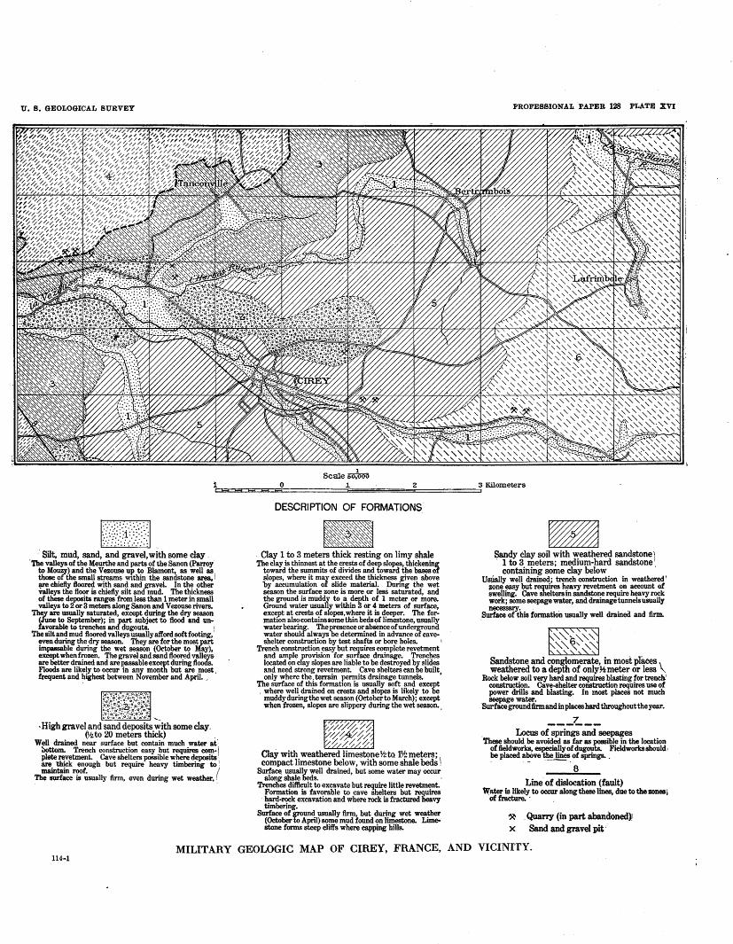
U. B. GEOLOGICAL SURVEY PROFESSIONAL PAPER 128 PLATE XVI
1 Scale so,ooo
1~==EL~~==~o=============1E============32C===========~3Kilornerers
~ · Silt, mud, sand, and gravel, with some clay
'The valleys of the Meurthe and parts of the Sanon (Parroy to Mouzy) and the Vezouse up to Blamont, as well as those of the small streams w1thin the sandstone area, i !p'e chiefly floored with sand and gravel. In the other valleys tlie floor is chiefly silt and mud. The thickness of these deposits ranges from less than 1 meter in small valleys to 2 or 3 meters along Sanon and V ezouse rivers.
They are usually saturated, except during the dry season (June to September); in part subject to flood and unfavorable to trenches and dugouts. I
The silt and mud floored valleys usually afford soft footing, even during the dry season. They are for the most part impassable during the wet season (October to May), except when frozen. The gravel and sand floored ·valleys· are better drained and are passable except during floods. Floods are likely to occur in any month but are most , frequent and highest between November and April. ,
r~}.~f~j~~f~!rt ·High gravel and ~~d ·d·~;;~iis ;;ith some clay.
(~to 20 meters thick) _ Well drained near surface but contain much water at'
oottom. Trench construction easy but requires com-\ plete revetment. Cave shelters possible where deposits ! are thick enough but require heavy timbering to 1
•
maintain roof. . I The surface is usually firm, even during wet weather, ~
DESCRIPTION OF FORMATIONS.
Clay 1 to 3 meters thick resting on limy shale
Th~~~j~~~i~:~~f~t~f :if:iJ!~~~defo~~t~~i=!~l slopes, where it may exceed the thickness given above by accumulation of slide material. During the wet season the surface zone is more or less saturated, and the ground is muddy to a depth of 1 meter or more. Ground water usually within 3 or 4 meters of surface, exce_pt at crests of slopes, where it is deeper. The formatlOn also contains some thin beds of limestone, usually water bearing. The presence or absence of underground water should always be determined in advance of caveshelter construction by test shafts or bore holes. 1
Trench construction easy but requires complete revetment and ample provision for surface drainage. Trenches located on clay slopes are liable to be destroyed by slides and need strong revetment. Cave shelters can be built only where the. terrain permits drainage tunnels. '
The surface of this format10n is usually soft and except . where well drained on crests and slopes is likely to be
muddy during the wet season (October to March); except when frozen, slopes are slippery during the wet season. ,
///(i:/~ '//~-// % /1- %
Clay with weathered limestone Yz to 1¥.! meters; \ compact limestone below, with some shale beds .
Surface_ usually well drained, but some water may occur along shale beds. ·
Trenches difficult to excavate but require little revetment. Formation is favorable to cave Shelters but reguires
· hard-rock excavation and where rock is fractured heavy timbering.
Surface of ground usually firm, but during wet weather (October to April) some mud found on limestone. Limestone forms steep cliffs where capping bills.
-Sandy clay soil with weathered sandstone 1 · 1 to 3 meters; medium-hard sandstone
containing some clay below · UsJially well drained; trench construction in weathered!
zone easy but requires heavy revetment on account of swelling. Cave shelters in sandstone require heavy rock work; some seepage water, and drainage tunnels usually
S~~his formation usually well drained and firm.
"'"6"-"" '"""'~ "' " Sandstone and conglomerate, in most pfaces \
weathered to a depth of onlyY.!meter or less ' Rock below soil very bard and requires blasting for trench'
construction. Cave-shelter construction requires use of power drills and blasting. In most places not much seepage water.
Surfacegroundfirmandinplacesbardthroughouttheyear.
---~--. Locus of springs and seepages These should be avoided as far as possible in. the location
of fieldworks, especially of dugouts. Fieldworks should, be placed a~ve th~. of springs. .
8
Line of dislocation (fault) \Vater is likely to occur along these lines, due to the zones!
of fracture. · .
~ . Quarry (in part abandoned).: x Sand andgravel pit·
MILITARY GEOLOGIC MAP OF CIREY, FRANCE, AND VICINITY. 114-1
USE OF GEOLOGY ON THE WESTERN FRONT. 115
French and American maps already described. Its purpose is evidently to guide the tactical commander in planning a forward movement. While intended primarily to describe the surface formations, it also contains geologic information bearing on :fieldworks. The areas of natural and possibly artificial inundation are indicated. Like all the other German military geologic publications, the map is confusing because of the attempt to show too great a variety of facts on a single base. Dr. Renier told me that a number of other maps of this type had been prepared, but this is the only one captured, so far as I know. In one respect it was different from all other German geologic maps that I have seen, inasmuch as it covered areas held by the Allies and was therefore in part based on compiled data.
The sources of information needed for geologic maneuvering maps will be field o bservations within an army's own lines and compiled data on areas occupied by the enemy. Geologic and soil maps will be the best sources of information. The facts furnished by these maps must be interpreted in terms of firmness and stability of. soil at different seasons of the year. A proper interpretation will be possible only if the geologist has a personal familiarity with the region, and he should also know by observation the effect on the soil of a given type of the passage of large bodies of troops and heavy equipment. He should also know the unjt weight of the heaviest equipment which is used.
River and stream crossings should be marked on the same maps, with a statement of whether bottom is hard or soft and the seasonal fluctuations in depth. Maps of this type should be made on a contoured base and on a scale not larger than 1: 50,000.~3 It is very desirable that the same maps also show distribution of forests, 44 which is important to maneuvers.
WATER RESOURCES.
The supplying of a huge modern army with water is one of the largest tasks that falls to the military engineer. It is difficult enough to develop the water supply needed in rear areas and under stationary conditions of trench war-
43 The standard geologic maps of the U.s. Geological Survey (scales 1:62,500 and 1: 125,000) are well adapted for this purpose if a proper explanatory text is prepared to accompany them.
44 Forests could be shown, as on the French maps, by a black pattern; the geologic information being indicated by overprints in transparent colors.
fare, but the task becomes far more complex and serious in time of advance and mobile warfare. During the recent war both the British and the French estimate of minimum water requirement when troops were massed for advance was about 150,000 gallons a day for every 20 square miles of territory occupied.
The water supply provided for civil consumption in most regions is not sufficient for military needs. Therefore, it is usually not only necessary to make available to the armies the water already developed but also to seek new sources of supply. The determination of possible sources of water in any particular region is largely a geologic problem. Nevertheless, during the early part of the war none of the opposing armies appear to have made any use of professional geologists in this field. Part of the German forces were then using the witch-hazel stick to find water, and the well drilling done by the British was~ largely haphazard and without heed to the geologic facts. 45
The British were the first to recognize the error of such happy-go-lucky methods. By the time the United States entered the war the use of geologists in determining the sources of water was well established in both the British and German armies. The French watersupply service was also making much use of geology in selecting locations for wells but failed to recognize the economy and efficiency of calling on professional geologists to solve geologic problems, rather than having the work done by water-supply engineers, many of whom were at best only partly trained in geology and all of whom must perforce give the greater part of their attention to questions of development and mechanical equipment.
In view of the experience gained by the blunders of our allies there is less excuse for our not having made full use of geologic science in its application to water resources. Though reforms were instituted during the war in these matters, yet in the aggregate many wells were drilled by the American Expeditionary Force without any knowledge of the underground water conditions. It is rather surprising to find experienced engineers who in their own field will not start a project without the most careful investigations and planning, yet who will cheerfully begin drilling for water while
«5 King, w. B. R., Geological work on the western front: creog. Jour., vol. 54, p. 219, 1919.
116 SHORTER CONTRlBUTIONS TO GENERAL GEOLOGY, 1920.
utterly ignorant of its underground occurrence. The explanation of this anomaly lies largely in the fact that engineers have not kept pace with modem advance in applied geology sufficiently to realize that the location of water-bearing strata is almost an exact science. Fortunately the hit or miss method did less harm in this field than it might elsewhere, because underground water-bearing strata are rather widely distributed on the western front. Therefore a policy that would have been disastrous in many other fields in general led here only to a waste of time and. energy.
A determination of the sources of underground wate-r demands a knowledge of the areal, stratigraphic, and structural geology. The French official maps formed admirable guides in this field, and in some places an interpretation of these maps and their accompanying explanatory text sufficed to determine the positions of water-bearing strata. More commonly, however, some local surveys and supplementary investigations were necessary. Most of the well drilling done in the American zone was in the line of communication. At the front we depended largely on water supplies already developed by the French military authorities, and during the advance we made much use of sterilized surface water.
It fell to the geologists in large measure to report on the resources of the surface waters. Where good stream measurements were available 46 or where the conditions permitted field examinations the questions of surface water aupply were passed on by engineers. Even in this field they were not always entirely successful, because many engineers who are expert in water-supply construction failed to realiz~ the necessity of a careful scrutiny of the seasonal variations of rainfall and more especially of the control of run-off by the geology as well as by precipitation. As a result some attempts were made to utilize surface water without adequate knowledge of the quantity of water available during the dry season. When it came to estimating stream volumes within the enemy's lines the task proved to be beyond the engineers and fell to the geologists of the American Expeditionary Force. With this went the determination of the location of springs, depth to underground water, and similar facts, which,
46 There bas been no systematic gaging of streams in northern and northeastern France.
of course, requires a knowledge of structure and stratigraphy.
In the British Expeditionary Force the geologist, Capt. W. B. R. King, acted as adviser to the chief efiooineer on all matters relating to water resources. No well drilling was permitted without his sanction, and he supervised the collection of all data relating to water resources. His duties were distinct from those of the water-supply officers, who took his results and interpreted them from the standpoint of the engineer. The line was therefore clearly drawn between water resources, belonging to the field of the geologist, and water supply, belonging to that of the engineers.
The lack of surface water in part of the area lying in front of the British lines necessitated the drilling of wells during the advance. One of the most valuable services rendered by Capt. King consisted in selecting sites for these wells within the battle area and forecasting the depth to water. In commenting on Capt. King's paper, 47 Brig. Gen. Liddell says:
In this connection it would give you some idea of the problem with which the geologists had to deal when I instance the advance of the Third Army. * * * We had to cross practically a desert area * * * in which there was practically no surface water. We got across this desert area largely owing to our accurate geological knowledge of the ground. * * * To take 300,000 men and 100,000 horses across an area like that is a feat which I think has seldom been equaled. Of course, we depended largely upon borings. During the advance and in the face of the enemy we made 13 bores 250 to 300 feet in depth; in some cases the boring plants were in line with the field guns, and the crews unfortunately in this case were knocked out by shell fire. The bores were most successful, and as a result the Army was well supplied with water.
This statement well illustrates the necessity of having an exhaustive knowledge of the geology of the theater of operations. Had it not been for Capt. King's professional attainments and knowledge of the terrain, which enabled him to predict the underground water conditions, this advance would not have been made in the time allotted to it. It brings further proof of the necessity of having the geologic investigations in the hands of experienced professional geologists. To rely on amateurs in such an emergency would have been the height of folly.
In the French Army both the water-resource and water-supply work was done by the
tt King, W. B. R., op. cit., p. 215.

U. S. GEOLOGICAL SURVEY PROFESSIONAL PAPER 128 PLATE XVII
Alluvium 1 Kimmeridien
A.staf'tes 30·50m.
Oxf"ordien orWoevre I/0-160m.
Bsiocien or Liverdun ·
. Oolitl/6 tnt: 50·70m.
Llas superieur or TOBrcien 90·130 m.
Lias moyen or Liasien 60-100 m.
Lias inf"erleur or S/nemurien
40m.
.lnfrallsss/c .
30-50 m. Limestone~ herd
80-100 m. LimestoneJ hard; blocky
-1::::!:="==±1------- ------------------------Locus or spr/nes 25-40 m. Marls, .sandy_; thin lenses reddish limestone
80·115 m. Marlandclayshafes.
75 -100m. Hqrfs snd clay shs/e.; thin beets of" limestone
r2(;5;;5~l-f_;_-;,;_ ~ ~~~;~ ~t--;;-;_~~~~;;, ~~~ ~:; ;;; = ~L f%;:S '{; :/pn;,;;j;'::U~'ftfs J weak end ver,able i(1 flow ----s&iean"d ciiiys ----------------
GENERALIZED SECTION OF COMMERCY QUADRANGLE, FRANCE, SHOWING SEQUENCE OF GEOLOGIC FORMATIONS AND OCCURRENCE OF WATER.
116-1

USE OF GEOLOGY ON THE WESTERN FRONT. 117
same men. Though it was very evident that greater use of geology would have been beneficial to the French service, yet it must be remembered that many of the French e:r;tgineers had a complete knowledge ·of the underground water resources of the country. Indeed, some of them were highly competent geologists. Nevertheless, the service would have been benefited if professional geologists had been employed to determine the water resources and the engineers had been free to devote their time to the engineering problems.
In the American Expeditionary Force the distinction between the work of the geologist and that of the engineer was recognized but not very sharply defined.· Some of the engineers engaged in water-supply developmen.t gave small heed to geology, and insufficient control was exercised to compel the determination of underground conditions in advance of well drilling. As a consequence during the dry season there was an unnecessary shortage of water at a number of hospitals, aviation fields, and other military establishments. On the other hand, some of the geologists were detailed to water-supply work that clearly belonged to· the domain of the engineers. These matters were being rectified at the end of the war,· when a definite system of responsibility for the different fields was being established.
The function of the military geologists of the German Army in the matter of water resources seems to have been similar to that of the British geologists. They acted as .advisers in all matters relating to water resources but were not responsible for the engineering problems of water development. It appears that they performed some of the duties of sanitation, which in all the other armies were left to the medical corps.
Many of the geologic data and conclusions relating to water resources must necessarily relate to special localities where water developments are under consideration. In the American Expeditionary Force reports of this character were made concise and, so far as possible, shorn of all geologic terminology and speculation. The aim was to put into the hands of the engineer a statement of conclusions, with a brief summary of the facts upon which the conclusions were based. In addition, some reports and sections were prepared for the use
. 43595°-21-10
of those versed in geology. (See Pl. XVII.) The purpose of such a report was to present the geologic facts bearing on the water resources of a particular region, to serve as a guide to those making local examinations. It would have be.en well to have had these reports prepared before the war, as a part of the military preparation. Though there is a vast literature dealing with the underground w~ters of France, it consists for the most part of detailed descriptions of special localities, and but few attempts have been made to summfirize the facts bearing on larger regions, as has been done for many parts of the United States.·
Exceptions to this are the publications· of Dr. Ed. Imbeaux, of Nancy, ingenieur en chef des ponts et chaussees, which give much information about the underground waters of France and especially of Lorraine.48 Information about the run-off of streams of northern and northeastern France is exceedingly scant, as there has been no systematic gaging of the watercourses. Data of this kind were collected from various sources, and in the absence of exact measurements estimates were made on the basis of precipitation and knowledge of the geologic conditions.
The American Expeditionary Force printed some maps showing the facts relating to distribution of water as determined by geology. On these maps were indicated the locations of springs, the areas of possible shallow dug wells, and the areas of deeper underground w&ters and · also the available information about stream volumes. (See fig. 15.) They proved. ~o be of great service to the water-supply engineers, but unfortunately the force available for their preparation was not large enough to permit covering the entire front with these maps. To be complete they should have shown also the depth of the principal underground water horizon by subterrf\nean contours. This would have greatly enhanced the value of the maps but could not be done for lack of sufficient field force to make the necessary local examinations.
It also fell to the geologists to compile reports on the water resources within the enemy lines. These reports were printed as small pamphlets, each accompanied by a map (fig. 16) graphically summarizing the information contained
48 Imbeaux, Ed., and others, Annuaire statistique et descriptif de la distribution d'eau de la France, 2d ed., Paris, 1009. Imbeaux, Ed., Les eaux potables et leur rOle hygienique dans 1e · Departement de Meurthe et Moselle, Paris, 1897.
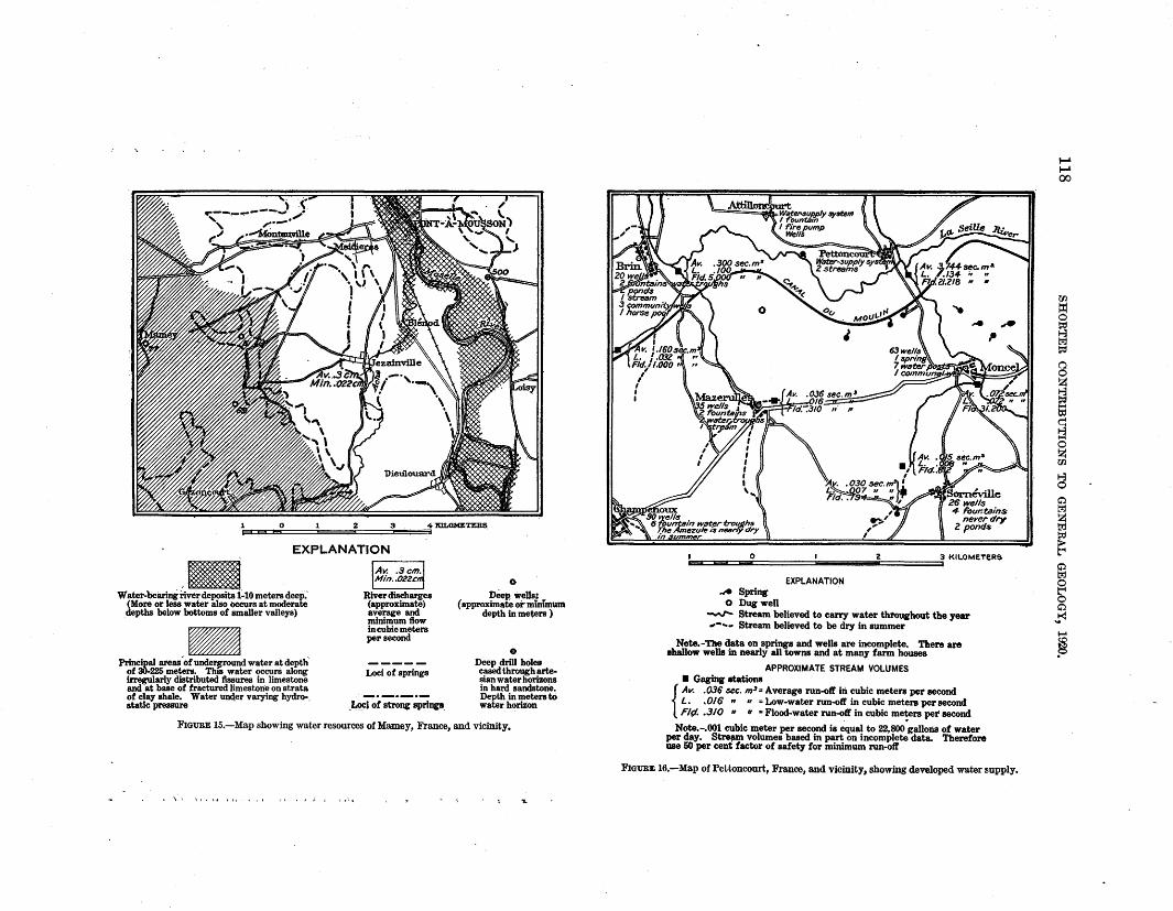
.. 0 1 2 3 4 XILOMETERS.
EXPLANATION
'~ Water-bearing iiver deposits 1-10 meters deep.'
(More or less water &lso oceurs at moderate depths below bottoms of smaller valleys)
_a1 ' Principal areas of undel'Jrround water at depth
ol 30-225 meters. ThiS water occurs along irregularly distributed fissures in limestone and at baSe of fractured limestone on strata of clay shale. Water unc\er varying hydro-. static pressure
River disCharges (approximate) average and minimum flow in cubic meters per second
Loci of springs
"Loci ol strong springs.
0
Deep wells: (approximate or minfmum
depth in meters )
e Deep drill holes cased through artesian water horizons in hard sandstone. Depth in meters to water horiZon
FIGURE 15.-Map showing water resources of Mamey, France, and vicinity.
I. \ \ \ t • I. I It • Jl o I •' I ,.;,
, 0 I 2 3 KII.OMtTER&
.A Spring 0 Dugwell
EXPLANATION
-.r- Stream believed to carry water throughout the year ... -.... Stream believed to be dry in summer
Note.-'nle data on springs and wells are incomplete. Then are ehallow wells in nearly all towns and at many farm houses
APPROXIMATE STREAM VOLUMES • Gaging stations
{
Av .. 036 .sec. m3 =Average run-off iri cubic meters per second L. • 01() " " = Low-water run-off in cubic meters per second Fltl. .310 " " • Flood-water run-off in cubic me~ra per second
Note.-.001 cubic meter per second is equal to 22,800 galloliS of water per day. Strejllll volumes baaed in part on incomplete data. Therefore use 50 per cent factor of safety lor minimum run-off
FIGURE 16.-Map of Pettoncourt, France, and vicinity, showing developed water supply.
......,. 1-' 00
00
~ 0
~ ~
c 0 21 i-3
~ § 0 ~ 00
i-3 0
~ ~ ~ G':l trJ
~ 0 0 ~
j
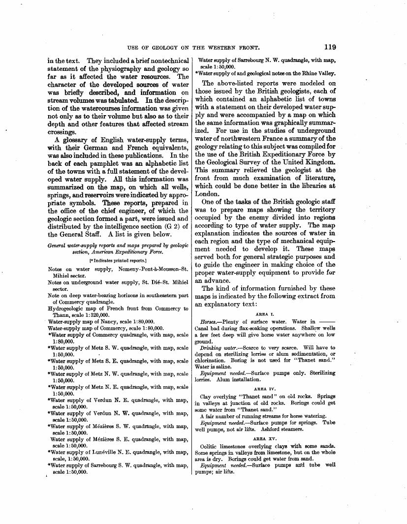
USE OF GEOLOGY ON THE WESTERN FRONT. 119
in the text. They included a brief nontechnical statement of the physiography and geology so far as it affected the water resources.· The character of the developed sources of water was briefly described, and information on stream volumes was tabulated. In the description of the watercourses information was given not only as to their volume but a1so as to their depth and other features that affected stream crossings.
A glossary of English water-supply terms, with their German and French equivalents, was also included in these publications. In the back of each pamphlet was an alphabetic list of the towns with a full statement of the developed water supply. All this iriformation was summarized on the map, on which all wells, springs, and reservoirs were indicated by appropriate symbols. These reports, prepared in the office of the chief engineer, of which the geologic section formed a part, were issued and distributed by the intelligence section (G 2) of the General Staff. A list is given below.
General water-supply reports and maps prepared by geologic section, American Expeditionary Force.
[*Indicates printed reports.]
Notes on water supply, Nomeny-Pont-a-Mousson-St. Mihiel sector.
Notes on underground water supply, St. Die-St. Mihiel sector.
Note on deep water-bearing horizons in southeastern part of Commercy quadrangle.
Hydrogeologic map of French front from Commercy to Thann, scale 1:320,000.
· Water-supply map of Nancy, scale 1:80,000. Water-supply map of Commercy, scale 1:80,000. *Water supply of Commercy quadrangle, with map, scale
1:80,000. *Water supply of Metz S. W. quadrangle, with map, scale
1:50,000. *Water supply of Metz S. E. quadrangle, with map, scale
1:50,000. *Water supply of Metz N. W. quadrangle, with map, scale
1:50,000. *Water supply of Metz N. E. quadrangle, with map, scale
1:50,000. *Water supply of Verdun N. E. quadrangle, with map,
scale 1:50,000. *Water supply of Verdun N. W. quadrangle, with map,
scale 1:50,000. *Water supply of Mezieres S. W. quadmngle, with map,
scale 1:50,000. Water supply of Mezieres S. E. quadrangle, with map, scale 1: 50,000.
*Water supply of Luneville N. E. quadrangle, with map, scale, 1:50,000.
*Water supply of Sarrebourg S. W. quadrangle, with map, scale 1: 50,000.
Water supply of Sarrebourg N. W. quadrangle, with map, scale 1: 50,000.
*Water supply of and geological notes on the Rhine Valley.
The above-listed reports were modeled on those issued by the British geologists, each of which contained an alphabetic list of towns with a statement on their developed water supply and were accompanied by a map on which the same information was graphically summarized. For use in the studies of underground water of northwestern France a summary of the geology relating to this subject was compiled for the use of the British Expeditionary Force by the Geological Survey of the United Kingdom. This summary relieved the geologist at the front from much examination of literature, which could be done better in the libraries at London.
One of the tasks of the British geologic staff was to prepare maps showing the territory occupied by the enemy divided into regions according to type of water supply. The map explanation indicates the sources of water in each region and the type of mechanical equipment needed to develop it. These maps served both for general strategic purposes and to guide the engineer in making choice of the proper water-supply equipment to provide f<!>r an advance.
The kind of information furnished by these maps is indicated by the following extract from an explanatory text:
AREA I.
Horses.-Plenty of surface water. Water in -Canal bad during flax-soaking operations. Shallow wells a few feet deep will give horse water anywhere. on low ground.
Drinking water.-Scarce to very scarce. Will have to depend on sterilizing lorries or alum sedimentation, or chlorination. Boring is not used for "Thanet sand." Water is saline.
Equipment needed.-Surface pumps only. Sterilizing lorries. Alum installation.
AREA IV.
Clay overlying "Thanet sand " on old rocks. Springs in valleys at junction of old rocks. Borings could get some water from "Thanet sand."
A fair number of running streams for horse watering. Equipment needed.-8urface pumps for springs. Tube
well pumps, not air lifts. Ashford steamers.
AREA XV.
Oolitic limestones overlying clays with some sands. Some springs in valleys from limestone, but on the whole area is dry. Borings could get water from sand.
Equipment needed.-8uriace pumps an'd tube well pumps; air lifts.
120 SHORTER CONTRIBUTIONS TO GENERAL GEOLOGY, 1920.
Another type of British water-supply map be learned, the German geologic staff was the of the region held by the enemy was one on official source of an~·information about water which the relative abundance of water in the resources, and the engineers were charged with several regions is indicated, as well. as its the developments. purity. Using as a unit 150,000 gallons a The experience of the war has clearly shown day for each 20 square miles, the colors on the that matters relating to the provision of water map show whether water is ''abundant, for field armies are of two kinds-(1) the determedium, or scarce," also whether it is ''good, mination of water resources, which includes the fair, or bad." These maps were prepared for collection of data in field and office and relates strategical and tactical purposes. chiefly to geology; (2} the furnishing of water
The regional reports 49 of the French General supply, which pertains to the development of Staff include brief statements on water supply water and is solely a matter of engineering. An and some short but very admirable summaries effective organization will clearly differentiate of the geologic and physiographic features, between the two fields. The geologist will
, prepared by Dr. Emmanuel de Martonne and make the necessary field examinations and coinother geologists. The several French armies pilations of data, so as to obtain full informaalso issued maps· showing the distribution of tion as to the sources of water. The results of sources of water developed for military use the geologist's investigation will be furnished in within their own lines. Outside of these there terse summaries to.the engineer. It will be his seem to have been no maps or other publi- duty, with these data before him, to determine cations relating· to water resources issued by the location and plan of water-supply stations the French Army. The engineers of the and the type of mechanical equipment. He Service d'eau had, however, in their files many will also direct the execution of the project. data relating to the hydrology of the army This division of duties and responsibilities besectors. tween the military geologist and the engineer
The Germans issued very elaborate · maps was the plan followed by both the British and showing the water resources of the areas German armies. within their own lines. All their geologic In time of war provision for water must be military maps contained some reference to made (1) to supply camps, cantonments, hoBunderground water. In addition, special maps pitals, railways, shops, etc., in rear and mobiliwere issued on scales of 1:25,000 and 1: 50,000 zation areas, (2) to supply the mobile armies in which contained a great variety of informa- the theater of operations. The task of providtion on water resources and water supply. On ing water for the rear areas will be the simpler these maps the distribution of loci of springs of the two, because usually the information and areas of deep and shallow waters were available about the water resources of the rear indicated by colors. In addition the quantity areas is better and if information is lacking and quality of the water supply of each town local surveys, such as can not be made at the was shown by symbols, and all the military front, are possible. On the -other hand, the supply systems, including reservoirs, pipe largest local d~mands and therefore the largest ljnes, and pumping stations, were indicated. water-supply units will be in the rear areas This information was so complete that the where there are the greatest permanent concencapture of one of these maps made it possible trations of personnel as well as of war industries to select important targets for artillery fire. and means of transportation. In the areas of None of tb,ese maps contained any information mobilization and supply there will be time, about quantities of surface waters. No cap- which is often lacking at the front, to develop tured documents revealed evidence that the underground water, if it is present, by drilling. Germans prepared maps showing water re- Similar conditions prevail along the line of sources of the areas within the Allied lines. communication, but the development of water
In addition to maps the Germans issued some supply becomes more difficult as the front is reports dealing with underground waters and approached. their methods of development. So far as could One of the first steps to be taken in time of
war or when war is threatened is to call into the ""Notice descriptive et statistique, Ministere de la Guerra, Commis-1 • ffi · b f 1 · t t d
;;ion du service geographique de l'Armee. serVIce a su Cient num er o geo og1s s o e-
USE OF GEOLOGY ON 'I:HE WESTERN FRONT. 121
termine the water resources in the mobilization and rear areas, for these resources must be determined before sites are selected for camps, hospitals, depots, etc. Much of this work can be done in times of peace, but supplementary local examinations and surveys will always be necessary.
Knowledge of the water resources of the theater of operations will also be based on information collected during times of peace, but supplementary investigations will always be necessary, including compilations, as well as field examinations, in so far as the military situation permits. This task should receive immediate attention at time of war or when war is threatened. .
The first important task will be the preparation of maps and reports showing the general distribution of water resources in the· entire theater of operations ·and including a general classification of the area in accordance with sources, quantity, and quality of water. The purpose of such maps and reports will be strategic, for water supply is one of the important factors to be considered in the general plan of a campaign. These maps and reports will contain also a statement of the equipment needed to develop the water supply in different parts of the theater of operations. This statement will be prepared by the water-supply officers from the information furnished by the geologist. Its purpose is to serve as a guide in providing the mechanical equipment needed to develop a water supply.
Detailed water-supply maps accompanied by brief descriptive texts are necessary for the use of armies in the field. These maps and reports will present every detail of developed and potential sources of water, including springs, wells, reservoirs, tanks, cisterns, ·stream volumes, lakes, ponds, and available underground water. Information showing the quantities of water available is of the utmost importance, and the quality of the water must also be reported. Seasonal variations of stream flow must likewise be considered. The preparation of such maps and reports is a proper function of the geologic corps, which will, however, cooperate with the water-supply and sanitary officers.
The water-resource maps and reports must be ready before troop movements are begun. As new and more detailed information will be collected during an advance, the reports on
water resources will receive constant revision which will involve new additions and supplements. A necessary extension of this work will include the collection and coordination of information about the water resources of areas within t~e enemy lines. The collection of this information will form a part of the peace-time preparation, but no matter how exhaustively it may be done in advance, the information will always require revision in time of war. The determination, as far as may be, of the water resources within the enemy lines also lies essentially within the field of the geologist. It can not be too strongly emphasized that though the development of a water supply is a function of the water-supply engineer, the available water resources can best be determined by the geologist.
TRANSPORTATION.
Geologic facts and their interpretation clearly deserve recognition in problems of road, railroad, canal, reservoir, and wharf construction. 50
The application of geology in this field relates·tQ depth and physical character of bedrock, stability of slopes, and character of river crossings, as well as to sources of road metal and railroad ballast. In this, as in other branches of geology applied to engineering, profound knowledge of the science is not always needed, and in many problems the experienced engineer will himself be able to determine the necessary facts correctly and make accurate deductions. If properly trained, he will also know when the problem is beyond his experience, so that he should seek the assistance of the professional geologist. So far as I know, little use was made of geologists on engineering problems relating to transportation on the western front. The Germans, however, have so long recognized the need of advance geologic knowledge in building railroa~, canrus, etc., that it is not likely that they ignored this need in time of war. Much space is given to this subject in the German manual of military geology. The average American railroad engineer, however, has not yet learned the use of geology in his own field.
In the British and American armies geologists were called upon for information on the
50 Some applications of geology to engineering are presented in the following publications:
MacDonald, D. F., Some engineering problems of the Panama Canal in their relation to geology and topography: Bur. :Mines Bull. 86, 1915.
Atwood, w. w., Relation of landslides and glacial deposits to reservoir sites in the San Juan Mountains, Colo.: U.s. Geol. Survey Bull. 685,1918.
122 SHORTER CONTRIBUTIONS TO GENERAL GEOLOGY, 1920.
distribution of road metal; the French appear to have relied on their engineers for this service. As the French engineers were operating in their own country, they had far more local knowledge than their allies had. No general reports on the road metals of France have been issued, and under war conditions it was not always possible for the British and American officers to find the individuals who had the local information.
Special road and quarry services were organized in the American Expeditionary Force, and these did not call upon the geologist for much information. Time and effort would undoubtedly have been saved had more use been made of geologic facts in this field. However, when advances were planned it was found that the geologists were the best sources of
· information about the distribution of road metal and railroad ballast within the enemy lines. This information was in part embodied in the geologic engineering maps which have been described and in part presented on special maps. ·The special maps showed the surface distribution of· all hard rocks that might be used for road metal and also the gravel deposits. The location of all quarries and gravel pits was also shown. Eight maps showing the distribution of road metal were prepared by the geologists of the American Expeditionary Force.
Military preparation should include the preparation of general small-scale maps on which the distribution of all rocks that may be used for road ballast is indicated, with a classification of their relative value for this purpose. All quarries and gravel pits should be shown on such maps, with an indication by symbol of their relative importance. Large, well-equipped quarries should be distinguished from those whose product is used only locally. Special large-scale maps showing road metal should be issued for important areas in the theater of operations. These would be prepared after the plan of campaign had been determined.
CONSTRUCTION.
What has been said about the application of geology to the building of roads, railways, and canals applies equally to other forms of engineering construction. In this field the determination of the character of foundation and stability of slopes, as well as sources of
raw materials, involves some use of geologic facts. Here again many of the problems are so simple as not to require the advice of a professional geologist. Yet there is always danger that the engineer who is ignorant of geology will make blunders that could easily have been avoided. Such errors are even more costly in war than in peace. All engineering works constructed during war are built in a hurry, and often the advice of the geologist can save time by forecasting the physical conditions.
The only service to construction rendered by the geologists of the American Expeditionary Force was in locating sources of aggregate for making concrete. . There was during the war a hurried call for the building of a plant near the front to make reinforced-concrete blocks (shell bursters) used for dugout protection. (See fig. 9.) The geologic problem was very simple, for it was evident that the gravels from the hard rocks of the Vosges Mountains were the only possible source of -suitable material. Knowledge of the bedrock geology and of the physiographic history, together with limitations on locations placed by the military situation, narrowed the choice of location to a small area. A brief field examination settled the problem and showed that the situation permitted only two possible locations, and the transportation conditions practically limited the selection to one, and in two days the matter was settled. This was a very good example of the value in an emergency of definite geologic information about the field of operations.
The British geologists performed valuable service in bringing definite proof that the concrete of the German ''pill boxes'' (surface shelters) WftB being made of gravels from the Rhine. It was established by the British Foreign Office that t~gravel was being brought to Belgium by canals through Holland. A protest to the Dutch Government, with this proof as to source of material, ended this military traffic through a neutral country.
MINERAL RESOURCES.
War investigation of mineral resources will fall into three classes-(1) that in the home country to meet military needs; (2) that in the theater of operations for use of the army in the field; (3) that in the country of the
USE OF GEOLOGY ON THE WESTERN FRONT. 123
enemy as a guide in broad strategy or in minor western front. It is most likely that the attacks. The first of these is plainly a civil French engineers made use of geologic maps function and needs no further mention here. in choosing sites. It is known also that in the Investigations of mineral resources within the British service no important locations were theater of operations, such as investigations made without a report by a geologist, at least of road metal, concrete material, and water, on the water supply. In the American Expehave already been referred to and included all ditionary Force the practice of calling on those of this type performed by the Allies. In geologists for information before the estabsome regions military geologists would be called lishment of hospitals, aviation fields, etc., was upon to investigate mineral fuels in the not very general, and as a consequence some theater of operations for use of the field armies. needless blunders were made. The Germans made elaborate investigation of It fell to the geologists of the British and the mineral resources of the occupied territory. German armies to help determine the areas of They paid special attention to deposits of possible artificial inundation. This phase of phosphate, coal, and iron, doing a large warfare formed an important part of defensive amount of drilling and open-cut work. There and offensive operations at certain localities in were probably as many geologists engaged in northwestern France and Belgium. Both these investigations as were employed on American and British geologists ·were called to military problems. This was not specifically locate sources of filter sand. war work, however, for its purpose was to In the German military geologic manual obtain commercial information that could not considerable attention is devoted to the inbe acquired during peace. It was, no doubt, fluence of geology on earth telegraphy and the intention of the German Government to listening-in devices, for it was found that cerevaluate the resources of the conquered terri- tain underground conditions favored the transtory as a guide in delineating its proposed mission of electric currents. The determining expanded frontier after it had won the war. factor appears to be the distribution of water-
The mineral reserves of the enemy and their bearing strata, and the best transmission was distribution are evidently important factors obtained where such a bed was included bein military strategy. Some work on this tween two impervious formations. These conproblem was done by the geologists of the elusions regarding geologic influences on earth American Expeditionary Eorce, and a large electric transmission seem to have been overnumber of French geologists were employed looked by the German Signal Corps. A manduring the war on a similar mission. Under uaP1 dealing. with this subject published as ordinary war conditions work of this kind late as the end of 1917 makes no mention of the would not fall to geologists of the field armies, use of geology in this field. In reference to as it can better be performed at the rear, where this subject it says: "The range of the power access to good libraries is to be had. A more buzzer depends on the· nature of the ground purely tactical problem in which the geologists between the stations. * * * Power-buzzer of the American Expeditionary Force gave communications must not therefore be selected some help is ·the designation of important from the map, but their suitability must be localities of the enemy mineral industry for ascertained by experiment." This statement bombing raids or even shelling. ·is all the more remarkable because when it was
MISCELLANEOUS APPLICATIONS.
There are many other fields in which geologic knowledge can be of service during war. The location of camps, cantonments, hospitals, aviation fields, and munition and engineer dump~ milst evidently take into account drainage and character of soil and subsoil, as well as water supply. The geologic facts relating to these subjects are usually simple but were often ignored by the armies of the
printed many German military geologic maps had already been issued, and on all of these the relative conductivity of each formation was noted in the explanation. It indicates that ~he work of the German military geologist was by no means completely coordinated with that of other branches of the service. It brings additional proof that the application of geology
~~ Manual of position warfare for all armies, part 9, The Signal Service and its employment, paragraph 15, Berlin, issued by the Chief of the General Staff of the Field Army. Dec. 15. 1917.
124 SHORTER CONTRIBUTIONS TO GENERAL GEOLOGY, 1920.
to military problems developed only during this war was so new a field that its full usefulness had by no means been reached when hostilities ceased.
CONCLUSIONS.
The many applications of geology to war have been set forth above. It has been shown that nearly all the great powers recognized the usefulness of the science before the end of the war by organizing geologic staffs. Furthermore, many instances have been cited from the experience of the war where the direct military value of geologic knowledge was proved beyond question. Modern scientific warfare evidently compels an army to seek every possible advantage .by making full use of all sources of information about the physical conditions within the theater of operations. Of two opposing armies the one having the
better knowledge of the terrain will have an advantage and at times a decisive advantage. A complete knowledge of the terrain is, however, possible only by the use of geology.
All this brings proof that geologic knowledge . must be considered a part of the preparation for war. Geologic preparation for war may be classed under three headings:
1. The general principles of geology and their application to war must be made a part of military education.
2. Peace-time preparation should include the collection and coordination of geologic data · relating to all possible theaters of operations.
3. A staff of geologic engineer reserve officers should be organized. This should be made up of experienced professional geologists who should receive the special peace-time training necessary to develop them to their full usefulness when called into active service.