Embed Size (px)
Citation preview


ii
The U.S. Department of Agriculture (USDA) prohibits discrimination in all its programs and
activities on the basis of race, color, national origin, age, disability, and where applicable, sex,
marital status, familial status, parental status, religion, sexual orientation, genetic information,
political beliefs, reprisal, or because all or part of an individual's income is derived from any
public assistance program. (Not all prohibited bases apply to all programs.) Persons with
disabilities who require alternative means for communication of program information (Braille,
large print, audiotape, etc.) should contact USDA's TARGET Center at (202) 720-2600 (voice and
TDD). To file a complaint of discrimination, write to USDA, Director, Office of Civil Rights,
1400 Independence Avenue, S.W., Washington, D.C. 20250-9410, or call (800) 795-3272 (voice)
or (202) 720-6382 (TDD). USDA is an equal opportunity provider and employer.

iii
Table of Contents
Chapter 1 Purpose of and Need for Action ........................................................................ 1
1.1 Background ......................................................................................................................................... 1
1.2 Description of the Allotments ............................................................................................................. 3 1.2.1 Dexter Creek Allotment .............................................................................................................. 4 1.2.2 June Lake Allotment ................................................................................................................... 5 1.2.3 Mono Mills Allotment ................................................................................................................. 5 1.2.4 Mono Sand Flat Allotment .......................................................................................................... 6
1.3 Purpose and Need ............................................................................................................................... 6
1.4 Desired Condition ............................................................................................................................... 7 1.4.1 Desired Condition for Range ....................................................................................................... 8 1.4.2 Desired Condition for Water Quality .......................................................................................... 9 1.4.3 Desired Condition for Hydrologic and Soil Function .................................................................. 9 1.4.4 Desired Condition for Air Quality ..............................................................................................10 1.4.5 Desired Conditions for Wildlife .................................................................................................10
1.5 Forest Plan Direction .........................................................................................................................10 1.5.1 Inyo National Forest Land and Resource Management Plan (1988) ..........................................10 1.5.2 LRMP Amendment #6 – Forest-wide Range Utilization Standards (1995) ...............................10 1.5.3 Sierra Nevada Forest Plan Amendment (2004) ..........................................................................11 1.5.4 Mono Basin National Forest Scenic Area Comprehensive Management Plan (Scenic Area Plan)
(1989) 11
1.6 Public Involvement ............................................................................................................................12 1.6.1 Comment and Scoping Period ....................................................................................................12 1.6.2 Native American Consultation ...................................................................................................12 1.6.3 Issues ..........................................................................................................................................13
Chapter 2 Alternatives ..................................................................................................... 14
2.1 Introduction ........................................................................................................................................14
2.2 Alternative Development Process .....................................................................................................14
2.3 Alternatives Considered But Eliminated From Detailed Study .....................................................14 2.3.1 Sage Grouse Conservation Alternative .......................................................................................14 2.3.2 Resource Conservation Alternative ............................................................................................15 2.3.3 Current Management Alternative ...............................................................................................15
2.4 Alternatives Considered in Detail .....................................................................................................15 2.4.1 Alternative 1 – No Action (No Grazing) ....................................................................................15 2.4.2 Alternative 2 – Proposed Action ................................................................................................16
2.5 Monitoring ..........................................................................................................................................23
Chapter 3 Environmental Consequences ......................................................................... 26
3.1 Introduction ........................................................................................................................................26

iv
3.2 Effects Relative to Range Resources ................................................................................................27 3.2.1 Existing Condition ......................................................................................................................27 3.2.2 Environmental Consequences ....................................................................................................29
3.3 Effects Relevant to Hydrologic Resources, Soil, and Air Quality ..................................................38 3.3.1 Existing Condition ......................................................................................................................38 3.3.2 Environmental Consequences ....................................................................................................46
3.4 Effects Relative to Terrestrial Wildlife ............................................................................................52 3.4.1 Existing Condition ...................................................................... Error! Bookmark not defined. 3.4.2 Environmental Consequences .................................................... Error! Bookmark not defined.
3.5 Effects Relative to Aquatic Wildlife .................................................................................................79 3.5.1 Existing Condition ......................................................................................................................79 3.5.2 Environmental Consequences ....................................................................................................84
3.6 Effects Relative to Plants and Noxious Weeds .................................................................................85 3.6.1 Existing Condition ......................................................................................................................85 3.6.2 Environmental Consequences ....................................................................................................88
3.7 Effects Relative to Cultural Resources .............................................................................................91 3.7.1 Existing Condition ......................................................................................................................91 3.7.2 Environmental Consequences ....................................................................................................95
3.8 Effects Relative to Socio-Economic Factors.....................................................................................97 3.8.1 Existing Condition ......................................................................................................................97 3.8.2 Environmental Consequences ....................................................................................................98
3.9 Effects Relative to Finding of No Significance (FONSI) Elements ..............................................100
Chapter 4 Lists ............................................................................................................... 105
4.1 Agencies and Persons Consulted.....................................................................................................105
4.2 References Cited...............................................................................................................................105
APPENDIX A: Allotment Maps ..............................................................................................................115
APPENDIX B: Amendment #6 Matrices .................................................................................... 121
APPENDIX C: Capability and Suitability ..............................................................................................123
APPENDIX D: Response to Comments ...................................................................................................131
APPENDIX E: Comparison of Alternatives ...........................................................................................148

List of Tables
Table 1. Current Allotment Management. .......................................................................... 2 Table 2. Desired Conditions for Ecosystem Communities within the Project Area. .......... 8 Table 3. Design Criteria for Areas Outside of Key Areas by Vegetation Community
Type. ................................................................................................................................. 17
Table 4. Other Actions to Reduce Utilization and/or Improve Livestock Distribution. ... 19 Table 5. Amendment #6 Standards for Utilization for the Dexter Creek Allotment. ....... 20 Table 6. Amendment #6 Standards for Utilization for the June Lake Allotment. ............ 21 Table 7. Amendment #6 Standards for Utilization for the Mono Mills Allotment. ......... 22 Table 8. Amendment #6 Standards for Utilization for the Mono Sand Flat Allotment.... 23
Table 9. Monitoring Plan. ................................................................................................. 24 Table 10. Cultural Resources Recommended for Monitoring and SRPMs ...................... 25
Table 11. Summary of Existing Conditions. ..................................................................... 28 Table 12. Stream Proper Functioning Condition and Key Area Amendment #6 Watershed
Condition Rating Results for all Allotments. .................................................................... 44 Table 13. Cumulative Watershed Effects Calculations for Watersheds in the Mono Basin
Allotments. ........................................................................................................................ 48 Table 14. Potential Sage-grouse Habitat within the Mono Basin Allotment Group. ....... 56 Table 15. Comparison of Sage-grouse Habitat Utilization Within and Outside Four
Grazing Allotments ........................................................................................................... 57 Table 16. Acres of Potentially Suitable Northern Goshawk Habitat by Allotment. ......... 58
Table 17. Northern Goshawk Protected Activity Centers in the Mono Basin Allotment
Group. ............................................................................................................................... 59 Table 18. Miles of Perennial Stream. ................................................................................ 81
Table 20. Sensitive Species Found or With Potential Habitat in Analysis Area. ............. 86
Table 21. Watch List Plants and Other Rare Species Known from Analysis Area ......... 87 Table 22. Known Weed Species, with Ratings and Inyo NF Proposed Treatment (USDA
FS, 2007). .......................................................................................................................... 88
Table 23. Survey Matrix ................................................................................................... 93 Table 24. Project Acres-- Survey and Cultural Site Summary. ........................................ 94
Table 25. AUMs, Head Months, and Fees. ....................................................................... 99

1
Chapter 1 Purpose of and Need for Action
1.1 Background
There are five grazing allotments in the Mono Basin that vary in size from 8,696 acres to
29,263 acres (Table 1). Of those, four are currently under analysis for this environmental
assessment: Dexter Creek, June Lake, Mono Mills and Mono Sand Flat. The fifth
allotment, Black Canyon, will be analyzed at a later date.
Grazing by sheep and cattle has occurred in the area for over 150 years. According to
Menke et al, grazing in the Eastern Sierra first took on significant proportions after 1870
at the height of the mining boom. Livestock during this period numbered in the hundreds
of thousands. After the creation of the Forest Service in 1905, use became more regulated
and livestock numbers decreased. However, the area was grazed beyond its capacity until
relatively recent times (Menke et al, 1996).
Traditionally, sheep are grazed in the Mono Basin during the summer months and spend
the rest of the year at lower elevations in other parts of California. This practice carries
on today in the ranching families that have long settled here. Cattle may be moved to
lower elevations, but also may spend the winter in the Eastern Sierra, as has been the case
on the Mono Sand Flat Allotment.
Currently, grazing on the allotments is authorized by Term Grazing Permits that specify
the terms and conditions for grazing, including the type and timing of livestock as well as
any management actions necessary to meet desired rangeland conditions. The Dexter
Creek and June Lake Allotments are permitted to the I&M Sheep Company for sheep.
Mono Mills is currently vacant, but has previously been permitted for sheep. The Mono
Sand Flat Allotment is permitted to the Hilton Family Trust for cattle. Table 1
summarizes current management practices for the Mono Basin Allotments.

2
Table 1. Current Allotment Management.
Allotment Acres Capable
Acres (Acres
capable
for
grazing)
Class of
Livestock Permitted
Numbers Last Season of
Use Permitted
Animal
Unit
Months
(AUM’s)
Grazing
System Status Last Year
of Use On
Date Off
Date
Dexter Creek
18,781 17,556 Sheep 1,500 Ewes 6/15 9/15 917
Deferred
Rotation* Active 2010
June Lake
S&G
16,528 12,705 Sheep 1,500 Ewes 7/1 8/31
612
Deferred
Rotation Active 2010
Mono Mills
S&G
29,263 28,143 Sheep 4,000 Ewes 7/1 9/15
3,038
Deferred
Rotation Vacant 2005
Mono Sand
Flat 8,696 8,570 Cattle 26 Cow/Calf
Pairs 12/1 5/31
206
Season-
Long** Permittee has
taken non-
use for the
past four
years for
resource
protection.
2006
*Deferred rotation is defined in Inyo National Forest Land and Resource Management Plan, Amendment #6 as, ―a system in which units are
utilized for only a portion of the growing season.‖
**Season-long systems permit continuous grazing throughout the season of use. The season of use in this case is December through May.
3
1.2 Description of the Allotments
The Mono Basin Allotments covered in this analysis stretch from the northeastern shore of Mono
Lake to the northern slope of the Glass Mountains. They are bounded on the west by U.S.
Highway 395 and on the east by Dexter Canyon. Elevations range from approximately 6,400 to
9,317 feet at Crooked Peak. The allotments are relatively flat compared to other portions of the
Inyo National Forest, although the allotments other than Mono Sand Flat do have some steep
areas. Precipitation ranges from about 12 inches in the Mono Sand Flat Allotment, near 6,500
feet elevation, to about 34 inches in the higher elevations in the southern tip of the Dexter Creek
Allotment (30 year average using PRISM data from 1971-2000).
The project area is generally comprised of typical Eastside Sierra sagebrush/bitterbrush type
communities, including: Indian ricegrass (Oryzopsis hymenoides), needlegrass (Stipa spp.) basin
sagebrush (Artemesia tridentata), rabbitbrush (Chrysothamnus spp.) and bitterbrush (Purshia
spp.) as well as several other woody species such Jeffery pine (Pinus jeffreyi), lodgepole pine
(Pinus contorta), and single leaf pinyon (Pinus monophylla).
The project area also supports dry meadow type vegetation, which includes saltgrass (Distichlis
spp.) and dry land sedges such as Douglas (Carex douglasii) and Ross (Carex rossii). Dry
meadow areas are also important to species such as sage grouse.
There is very little riparian vegetation in these allotments, with a few riparian strips along creeks,
a few meadows and springs in the Dexter Creek allotment, and one meadow within the Mono
Mills Allotment. The spring in the Mono Sand Flat allotment is also surrounded by less than ¼
acre of riparian vegetation.
Desert shrub type communities consist of plants such as Indian ricegrass (Oryzopsis
hymenoides), salt grass (Distichlis spicata), greasewood (Sarcobatus vermiculatus), rabbitbrush
(Chrysothamnus spp.), and spiny hopsage (Grayia spinosa).
Bedrock consists primarily of volcanic rocks including tuff, basalt, and andesitic and rhyolitic
rocks. There is also some granodiorite in the Dexter Creek Allotment. Surficial deposits are also
mainly volcanically derived, including ash and pumice deposits. The Mono Sand Flat Allotment
has unique surface deposits, as much of the allotment is covered in small, partially vegetated
sand dunes.
Most soils are weakly developed and have low productivity, with some areas of moderate
productivity and small pockets of high productivity mainly in meadows (USDA Forest Service,
1995). Because most of the area contains sandy and ashy soils with very high permeability, most
of the area is often dry and the soils have little potential for compaction. Rill erosion also does
not tend to occur in this area due to lack of water concentration. Wind erosion is relatively
important in these often unconsolidated soils, and vegetation may return slowly when disturbed.

4
1.2.1 Dexter Creek Allotment
Dexter Creek Allotment is located approximately five miles southeast of Mono Lake. Its
boundaries are Dry Creek on the west, Dexter Creek on the east, the northern side of the Glass
Mountains on the south, and the Forest boundary (mainly running along Highway 120) on the
north. The legal description is T1S, R28E, Sections 1, 2, 11- 14, 23-26, 35, 36; T1S, R29E,
Sections 1-22, 24- 26, 28- 31; T2S, R28E, Section 1.
The primary forage species are bitterbrush and bunchgrasses such as Indian ricegrass (Oryzopsis
hymenoides), needlegrass (Stipa spp.), and bottlebrush squirreltail (Elymus elymoides).
Dexter Creek is used as a sheep allotment by the I&M Sheep Company. Currently, 1,500 sheep
are authorized to graze from 6/15 to 9/15. Sheep are herded in bands of approximately 1,500
head. The sheep stay with the band and rarely stray as their movement is directed by a herder
who also uses dogs to keep the sheep together. With two exceptions, which are noted below, the
I&M Sheep Company has used the same rotation for the past ten years. The pattern is as follows:
1. On approximately July 2, unload sheep at Sagehen Summit – sheep will graze toward the
valley between the Summit and Baxter Springs, avoiding pockets of freeze-damaged
Bitterbrush.
2. Baxter Corral/Springs – water sheep at road crossing and limit sheep bedding ground to
the north side of creek only. Avoid grazing along streambanks and riparian areas.
3. Draft livestock water from Baxter Springs at road crossing.
4. Lower Dexter Bench – water sheep at road crossing in North Canyon, at end of FS Road
1S15A, and at end of unnumbered road in NE 1/4 Sec. 18. After watering, push sheep to
higher ground away from creek. All other watering will be done via truck except for one
watering site at Dexter Creek.
5. Avoid wet areas and streams on upper Johnny Meadows.
6. Wild Horse Canyon to Crooked Meadows Road – sheep are allowed to water in Dexter
Creek at road crossing in SW ¼ Section 30. Wild Horse Meadow – sheep will bed in
trees between FS Road 1N02 and meadow. Wild Horse Meadow is closed to grazing for
resource protection.
7. Sagehen Peak to Sagehen Meadow – Meadow and downstream riparian/stock pond has
water. Bed sheep uphill away from dry meadow/stock pond. Making a once over pass
along riparian upstream of pond is approved. Avoid grazing onto private property near
edge of meadow and first gabion downstream of meadow ―proper‖.
8. Head towards Gas Pipe Spring and north of Hwy 120 to BLM allotment by September
15.

5
The first exception is that prior to 2004, the sheep started at Baxter Springs (step 2) rather than
Sagehen Summit. The second exception is that Johnny Meadow was rested from 2002 to 2008.
1.2.2 June Lake Allotment
The June Lake Allotment is located approximately two miles south of Mono Lake. Its boundaries
are U.S. Highway 395 on the west, the Forest Boundary on the north, the Mono Craters on the
east, and Wilson Butte on the south. Its legal description is: T1N, R27E, Sections 29-33; T1S,
R27E, Sections 3-10, 15-22, 28-33, T2S. R27E, Sections 4-9.
The primary forage species are bitterbrush and bunchgrasses such as Indian ricegrass (Oryzopsis
hymenoides), needlegrass (Stipa spp.), and bottlebrush squirreltail (Elymus elymoides).
June Lake is run as a sheep allotment by the I&M Sheep Company. Currently, 1,500 sheep are
authorized to graze from 7/1 to 8/31. Sheep are herded in bands of approximately 1,500 head.
The sheep stay with the band and rarely stray as their movement is directed by a herder who also
uses dogs to keep the sheep together. The rotation of sheep through the allotment has been the
same since 1994. The rotation is as follows:
1. Enter Allotment on approximately July 1
2. Upper Aqueduct road (1N11) to poleline .
3. Poleline road to 1N11.
4. 1N11 southeast to 1S35.
5. 1S35 South to 1S40.
6. Devil’s Punch Bowl area.
7. North along Mono Craters to Lousy Fire area.
8. Exit allotment on approximately August 31.
1.2.3 Mono Mills Allotment
Mono Mills Allotment is located between the June Lake and Dexter Creek Allotment. Its
boundaries are the Mono Craters on the west, Highway 120 and the Forest boundary on the
north, Dry Creek on the east, and generally the northern side of the Glass Mountains on the
south. The legal description is: T1N, R27E, Sections 33, 34, 28; T1S, R27E, Sections 1-3, 10-
15, 22-28, 33-36; T2S, R28E, Sections 1-4, 10, 11; T1S, R28E, Sections 3-10, 14-23, 26-35;
T1N, R28E, Sections 3-6, 7.
The Mono Mills Allotment is currently vacant but was used as a sheep allotment prior to 2005.
The earliest use in the Forest Service records is 1941, but the allotment has most likely been

6
grazed by sheep since the late nineteenth century. Prior to 2005, 4,000 sheep were authorized to
graze from 7/1 to 9/15.
The primary forage species are bitterbrush and bunchgrasses such as Indian ricegrass (Oryzopsis
hymenoides), needlegrass (Stipa spp.), and bottlebrush squirreltail (Elymus elymoides).
1.2.4 Mono Sand Flat Allotment
The Mono Sand Flat Allotment is located along the northeastern shore of Mono Lake. The
northern and eastern boundaries are the Forest boundary and the rest of the boundary is along the
shoreline (not including relicted lands). The legal description is T3N, R27E, Sections 22-35;
T3N, R28E, Sections 30-32; T2N, R28E, Sections 5-9, 21, 28, 32, 33.
Mono Sand Flat is used as a cattle allotment by the Hilton Family Trust. The Term Grazing
Permit allows for 26 cattle to use the allotment between December 1 and May 31. However, the
permittee has taken non-use for resource protection since 2006.
The primary forage species are plants such as Indian ricegrass (Oryzopsis hymenoides), salt grass
(Distichlis spicata), greasewood (Sarcobatus vermiculatus), rabbitbrush (Chrysothamnus spp.),
and spiny hopsage (Grayia spinosa).
1.3 Purpose and Need
The purpose and need for the proposed action is to move from existing to desired future
conditions, which are described by certain Inyo National Forest standards and guidelines and
management direction while continuing to provide for livestock grazing under updated allotment
management plans in the Mono Lake Basin.
1. There is a need for continued livestock grazing under updated allotment management plans for
the grazing allotments in the Mono Basin.
Livestock grazing has been identified as an appropriate use of National Forest System
lands which have been found to be capable and suitable for grazing. In the Inyo National
Forest Land and Resource Management Plan (LRMP), the allotments in the Mono Basin
were identified as being capable and suitable for livestock grazing based on an
assessment of forage production, accessibility, slope, and other factors (Management
Areas 1, 5 [pp. 152]).
Where consistent with other multiple use goals and objectives there is Congressional
intent to allow grazing on suitable lands. (Multiple Use Sustained Yield Act of 1960,
Wilderness Act of 1964, Forest and Rangeland Renewable Resources Planning Act of
1974, Federal Land Policy and Management Act of 1976, National Forest Management
Act of 1976)

7
The allotments contain lands identified as suitable for domestic livestock grazing in the
LRMP and continued domestic livestock grazing is consistent with the goals, objectives,
standards, and guidelines of the Forest Plan (LRMP pages III-45, IV-67, IV-84-86, IV-
134-135, and IV-211).
It is Forest Service policy to make forage available to qualified livestock operators from
lands suitable for grazing consistent with land management plans (FSM 2203.1; 36 CFR
222.2 (c)). Current grazing permit holders have expressed interest in continuing use of
the Dexter Creek, June Lake, and Mono Sand Flat Allotments, and in resuming use of the
currently vacant Mono Mills Allotment.
It is Forest Service policy to continue contributions to the economic and social well being
of people by providing opportunities for economic diversity and by promoting stability
for communities that depend on range resources for their livelihood (FSM 2202.1).
2. There is a need for improved range vegetation condition and trend where existing conditions
are not meeting or moving toward desired vegetation condition. The LRMP, Amendment #6, and
the SNFPA provide direction and the desired conditions for range vegetation.
Evaluations in 2008 and 2010 identified portions of allotments in which desired vegetative
conditions were not being met. In the Mono Sand Flat Allotment, poor soil quality and dry
conditions have resulted in a low density of desirable species (shrubs, bunchgrasses and
herbaceous vegetation) that does not meet standards for desired vegetative composition of this
community (LRMP, p.76).
In the Dexter Creek, June Lake and Mono Sand Flat Allotments, portions of the desert shrub and
bitterbrush communities do not meet standards for desired vegetative condition, being
moderately to heavily hedged or browsed without sufficient annual recovery (LRMP, pp.76,
105). There is also a need to ensure sufficient forage for mule deer after livestock grazing season
with total annual browse utilization that maintains bitterbrush condition (LRMP, pp.85, 98-99,
and 117)
Heavily hedged bitterbrush results from overgrazing due to poor livestock distribution.
Distribution can be improved through management direction set forth in annual operating
instructions. There is a need to ensure that grazing allotments are managed according to a
planned management system. (LRMP, p. 84).
1.4 Desired Condition
Desired conditions are the on-the-ground resource conditions that management is working
toward within a defined timeframe. These are the expected results if management goals are fully
achieved. They bring broad-scale desired conditions from the Forest Plan down to project level.
8
The Inyo National Forest Land and Resource Management Plan (LRMP) directs management of
grazing lands and sets standards and guidelines. The LRMP Amendment #6 further defines
standards and guidelines and defines desired conditions for range plant communities. The 2004
Sierra Nevada Forest Plan Amendment (SNFPA) also describes desired conditions for range.
Parts of the area of interest are also managed under the 1989 Comprehensive Management Plan
for the Mono Basin National Forest Scenic Area (Mono Basin Scenic Area Plan).
1.4.1 Desired Condition for Range
The LRMP Amendment #6 directs management by prescribing utilization based on plant species
composition. Desired conditions for each vegetation community (Table 2) are the conditions
identified in the top two tiers or rows of the matrices in Forest Plan Amendment #6, Appendix A
(See also section 1.5.2 and Appendix B of this document). Vegetation communities that fall
within the third tier or below of the matrix do not meet the desired condition.
Conditions are assessed at key areas on the allotments. Using data from a 100 point transect (toe-
point method), the ratio of desired species to the total number of herbaceous hits, in combination
with watershed condition determines utilization standards.
Table 2. Desired Conditions for Ecosystem Communities within the Project Area.
Desired conditions for ecosystem communities within the project area from the top two tiers of
Amendment #6, Appendix A matrices.
Community Type Desired Future Condition
Wet Meadow
At least 51 hits tallied on herbaceous species per 100 point transect with at
least 51 of these hits tallied being desirable species including primarily
sedges. Properly functioning water, soil and vegetation cycles. Mixed
native grass and forb communities provide a mosaic of plants with species
diversity, a variety of vegetative structures and sufficient amounts of litter.
Graminoid communities show vigor. Bare ground less than 5%. Achieve or
maintain satisfactory range condition on all rangeland in this community
type.
Moist Meadow
At least 37 hits tallied on herbaceous species per 100 point transect with at
least 37 of these hits tallied being desirable species such as sedges. Properly
functioning water, soil and vegetation cycles. Diverse mix of riparian
graminoids and forbs present with significant proportions of riparian
species relative to moisture availability. Bare ground less than 5%.
Graminoid communities show vigor. Achieve or maintain satisfactory range
condition on all rangeland in this community type.
Aspen Aspen communities with diverse age structure of 2 or more age classes
including seedlings, young plants, mature plants, decadent plants and
sprouts or suckers in addition to adequate regeneration. Shrublands: Desert Shrub,
Sagebrush/Bunchgrass and
Bitterbrush
At least 30 hits tallied on herbaceous species per 100 point transect with at
least 8 of these hits tallied being desirable species including needlegrass,
ricegrass and squirrel tail grass. Vigorous growth and regeneration of mid-

9
Table 2. Desired Conditions for Ecosystem Communities within the Project Area.
Desired conditions for ecosystem communities within the project area from the top two tiers of
Amendment #6, Appendix A matrices.
Community Type Desired Future Condition
late seral shrub species interspersed with a variety of native grasses and
forbs. Properly functioning water, soil and vegetation cycles. Achieve or
maintain satisfactory range condition on all rangeland in this community
type.
Streams & Riparian areas
Properly functioning water, soil and vegetation cycles; reproducing
riparian plant communities, at least 80% of the potential vegetative
cover along streams; stable, defined channels with appropriate
width/depth ratios for stream type; less than 20% of streambank
actively eroding, balanced erosion/deposition levels. Maintain at least
80% of potential ground cover within 100’ from the edges of all
perennial streams, or to the outer margin of the riparian ecosystem,
where wider than 100 feet. Plant species may include sedges, rushes,
tufted hairgrass, willow, birch, aspen and cottonwood of mixed age
class. In woody systems, riparian shrubs cover of at least 35% to
include a variety of species. Achieve or maintain satisfactory range
condition on all rangeland in this community type.
1.4.2 Desired Condition for Water Quality
Water quality meets the goals of the Clean Water Act and the Safe Drinking Water Act; it is
fishable, swimmable and suitable for drinking after normal treatment. Water quality meets all
state and federal standards.
1.4.3 Desired Condition for Hydrologic and Soil Function
The Sierra Nevada Forest Plan Amendment (SNFPA 2004) requires that Riparian Conservation
Objectives (RCO) are met for all new projects. The RCOs apply to Riparian Conservation Areas
(RCAs), which are the areas within 300 feet of perennial streams, springs, and other special
aquatic features, or 100 feet of intermittent and ephemeral streams. RCOs focus on water quality,
water quantity and aquatic habitat. There is a relatively small area of RCAs within the Mono
Basin Allotments, so the RCOs are not applicable to most of the project area. However, they will
be discussed where applicable (See Existing Conditions under Hydrologic Resources, section
3.5.2).
Amendment #6 of the LRMP contains desired conditions for soil and hydrologic function. The
desired condition is that all areas are fully functional in terms of soil and hydrology.
The desired condition for stream channels is that they are in proper functioning condition (PFC)
as defined by the Proper Functioning Condition protocol (USDI 1998).

10
1.4.4 Desired Condition for Air Quality
Air quality meets all state and federal standards. The only air quality standard that is relevant to cattle
grazing is the PM10 Standard.
1.4.5 Desired Conditions for Wildlife
Wildlife habitat is managed to provide species diversity, to ensure that viable populations of
existing native vertebrates and invertebrates are maintained, and that the habitats of management
emphasis species are maintained or improved.
1.5 Forest Plan Direction
Management direction for the Mono Basin Grazing allotments is described in the Inyo National
Forest LRMP (USDA Forest Service, 1988), as amended by LRMP Amendment 6, Forest-wide
Range Utilization Standards (USDA Forest Service, 1995) and the SNFPA (USDA Forest
Service, 2004).
1.5.1 Inyo National Forest Land and Resource Management Plan (1988)
The Inyo National Forest LRMP establishes Forest Management Direction, including Forest
goals, forest objectives, standards and guidelines, management prescriptions, and management
area direction. The standards and guidelines set the minimal resource conditions for vegetative
diversity and range resources.
1.5.2 LRMP Amendment #6 – Forest-wide Range Utilization Standards (1995)
This document sets utilization standards for the grazing of domestic livestock that would
accelerate the restoration and improvement of degraded range sites, and maintain those sites
currently in good condition. A vegetation condition classification determined by toe-point
transects compares the total number of desired species within a given area to the total number of
herbaceous plants counted. This vegetation composition is applied to the utilization matrices—
along with the watershed evaluation criteria—to determine proper use levels for a key area
(LRMP Amendment 6, 1995). These utilization levels are set as a percentage of weight of a
forage species that is allowed to be utilized by livestock. Standards are determined based on
vegetation types within the project area including: Wet Meadow, Moist Meadow, Dry Meadow,
Desert Shrub, Sagebrush, and Bitterbrush. These are presented in tables that have a different
allowable use standard for early season use (E=pre-boot stage: before seed head is formed) and
late season use (L=after seed maturity).

11
1.5.3 Sierra Nevada Forest Plan Amendment (2004)
The Sierra Nevada Forest Plan Amendment (2004) amends the Land and Resource Management
Plans of the national forests in the Sierra Nevada to address various changed circumstances and
information that was not sufficiently addressed in the original plans. One of these circumstances
was to establish grazing standards to better reflect the wide array of site-specific conditions and
the management opportunities they may provide. Standards include use of noxious weed-free
hay, streambank disturbances (specifics for TES and essential habitats), proper functioning
condition (PFC) assessments, protection of bogs and fens from livestock trampling, placement of
livestock handling facilities, utilization/bare ground, and trend for meadow areas and riparian
browse use.
1.5.4 Mono Basin National Forest Scenic Area Comprehensive Management Plan
(Scenic Area Plan) (1989)
The Mono Basin National Forest Scenic Area (Scenic Area) was established by Section 304 of the
California Wilderness Act (PL 98-425) in 1984. The Scenic Area Plan provides management direction,
including goals, standards and guidelines, and management prescriptions for range and other resources.
Parts of the June Lake, Mono Mills, and Mono Sand Flat Allotments overlap the Scenic Area boundary.
Relevant Management Prescriptions (Each of these zones overlaps parts of the June Lake, Mono Mills,
and Mono Sand Flat Allotments.:
General Use Zone – Allow range improvement activities that are compatible with dispersed recreation
and wildlife objectives. Permit no grazing in developed recreation sites.
There are no developed recreation sites in the areas overlapping the grazing allotments.
Under the Proposed Action, there are no range improvements planned within the General Use
Zone.
Limited Development Zone – Manage grazing use to avoid sensitive areas and emphasized wildlife
habitats. Allow range improvements needed to facilitate effective range management when shifting
grazing to less sensitive areas.
There are no sensitive areas or emphasized wildlife habitats on the sections of the Limited
Development Zone that overlap these allotments.
Under the Proposed Action, there are no range improvements planned within the Limited
Development Zone.
No Development Zone – Phase out grazing from National Forest System lands, consistent with ecological,
geological, cultural, and visual emphasis of this prescription. Prohibit grazing of domestic livestock on
National Forest System relicted lands. Existing range improvements may remain until grazing use is
12
phased out. Improvements used in conjunction with permits to cross National Forest System lands may
remain until no longer needed.
The Scenic Area Plan includes direction to close grazing allotments when permits are waived
back to the government and when there is no qualified purchaser of permitted livestock and/or
base property (p. 34). Consistent with the enabling legislation, ―persons currently holding valid
grazing permits will continue to be able to exercise those permits consistent with other applicable
law‖ (Public Law 98-425, Title III, Sec. 304(c); Scenic Area Plan, p. 32). This applies to the
Mono Sand Flat Allotment.
The section of the Mono Mills Allotment in the No Development Zone is in the Mono Craters and
is not grazed.
No grazing currently takes place on relicted lands, nor would this occur under the Proposed
Action.
1.6 Public Involvement
1.6.1 Comment and Scoping Period
A Proposed Action (October 2010) was mailed to interested parties and a legal notice requesting
comments on the Proposed Action was published in the Inyo Register October 23, 2010. The scoping
period ran concurrently with the comment period. Comments were received from seven
organizations/agencies, including Western Watersheds Projects, Lahontan Regional Water Quality Control
Board, Center for Biological Diversity, California Department of Transportation (CalTrans), City of Los
Angeles Department of Water and Power (LADWP), the Mono Lake Committee (MLC), and the Utu Utu
Gwaitu Paiute Tribe. Each of these comments was received prior to the end of the 30-day comment
period. The comments from CalTrans, LADWP, and the Utu Utu Gwaitu Paiute Tribe did not require a
response. Responses to the other comments can be found in Appendix D.
1.6.2 Native American Consultation
Native American Tribes that claim ancestral home lands within the project area were consulted
pursuant to the American Indian Religious Freedom Act of 1978, Executive Order 13007 (1996),
and under Section 101(d)(6)(B) of the National Historic Preservation Act of 1966 (as amended).
No issues or concerns have been brought forward. This project has been discussed with the
following Tribes via formal letters, phone calls and meetings. Formal consultation for this
project began in April 2010.
Federally Recognized Tribes:
Bridgeport Paiute Indian Colony
Benton Paiute Reservation, Utu Utu Gwaitu Paiute Tribe

13
Bishop Paiute Indian Tribal Council
Big Pine Paiute Tribe of Owens Valley
Not Federally Recognized Tribes or other interested groups:
Mono Lake Kutzadikaa Tribe
California Indian Basketweavers Association
1.6.3 Issues
An issue is a point of debate, dispute, or disagreement regarding anticipated effects of the
proposed action. To develop issues for the proposed project, the ID Team analyzed comments
from the public and separated the issues into two groups: key issues and non-key issues. After
analysis of the comments, it was determined that there were no key issues that resulted in the
development of additional alternatives. The Western Watersheds Project recommended four
additional alternatives, including the No Grazing Alternative, Sage Grouse Conservation
Alternative, Resource Conservation Alternative, and Current Management Alternative. The No
Grazing Alternative is included in the EA as an alternative considered in detail, however there
were no specific actions identified for the Sage Grouse Conservation Alternative and Resource
Conservation Alternative, as described under ―Alternatives Considered, But Eliminated from
Detailed Study‖ (section 2.3). The Current Management Alternative is also discussed under
―Alternatives Considered, But Eliminated from Detailed Study‖(section 2.3).

14
Chapter 2 Alternatives
2.1 Introduction
This section describes the Proposed Action and alternatives to the Proposed Action considered in
this Environmental Assessment. Two alternatives were analyzed in detail: Alternative 1 (no
grazing) and Alternative 2 (Proposed Action). Three alternatives were considered based on
comments received during public scoping, but were eliminated from detailed study, and they
include: Sage Grouse Conservation Alternative, Resource Conservation Alternative, and Current
Management Alternative.
2.2 Alternative Development Process
This chapter describes in detail two alternatives for managing livestock grazing practices:
Alternative 1 (No Grazing) and Alternative 2 (Proposed Action). The Proposed Action was
developed following direction from the District Ranger in consultation with the Forest range and
resource staff.
The Inyo National Forest Land and Resource Management Plan (USDA Forest Service, 1988),
Forest Plan Amendment #6: Forest-wide Range Utilization Standards (USDA Forest Service,
1995), and the Sierra Nevada Forest Plan Amendment (SNFPA) (USDA Forest Service, 2004)
provide direction and the desired conditions for vegetation, riparian, aquatic, hydrology, water
quality, soil, plant, wildlife, and heritage resources. Resource condition assessments in 2008 and
2010, along with grazing history and monitoring data, provided the means to assess the
difference between existing conditions and desired conditions. With this comparison,
management actions were identified and a proposed action was developed. The implementation
of LRMP Amendment 6 for each allotment formed the basis of the proposed action.
2.3 Alternatives Considered But Eliminated From Detailed Study
2.3.1 Sage Grouse Conservation Alternative
This alternative was not analyzed in detail because the proposed action alternative incorporates
measures that conserve sage grouse and their habitat. In addition, no specific actions were
provided in the comments received during public scoping that made this alternative different than
the proposed action alternative. The proposed action alternative includes measures to reduce
potential disturbance to sage grouse during the breeding season and measures to maintain
suitable habitat. For example, the proposed action delays the start of grazing within suitable sage
15
grouse nesting habitat until after July 1 to reduce disturbance during the breeding season and
does not allow livestock use in areas within two miles of active sage-grouse leks. The proposed
action also includes allowable use standards within key areas based on existing vegetation
conditions and by vegetation community type (i.e. wet meadows, upland, and riparian), and
applies grazing management techniques (i.e. rotating use) to keep livestock distributed as evenly
as possible throughout suitable rangelands within pasture or herd areas, as part of maintaining
suitable sage grouse habitat.
2.3.2 Resource Conservation Alternative
This alternative was not analyzed in detail because the proposed action alternative incorporates
measures that conserve sensitive resources. In addition, no specific actions were provided in the
comments received during public scoping that made this alternative different than the proposed
action alternative. The proposed action alternative incorporates specific actions designed to
meet or move toward desired conditions based on watershed and vegetation conditions,
following direction outlined in the LRMP Amendment 6: Forest-wide Range Utilization
Standards (USDA Forest Service 1995). Resource condition assessments in 2008 and 2010,
along with grazing history and monitoring data, provided the means to assess the difference
between existing and desired conditions. The proposed action was developed based on the
comparison between existing condition and desired conditions for watershed, vegetation, aquatic
and terrestrial wildlife, and cultural resources.
2.3.3 Current Management Alternative
Under this alternative, livestock management and use would continue as currently being
implemented on the four allotments. The current management alternative was not analyzed in
detail because it does not fully meet the purpose and need for the project. There is a need for
change from current management, as some specific areas on the allotments are not meeting or
moving toward desired conditions in an acceptable timeframe (section 1.3 and 1.4). The
proposed action alternative incorporates specific actions designed to meet or move toward the
desired condition as related to the disparity between the existing condition and the desired
condition.
2.4 Alternatives Considered in Detail
2.4.1 Alternative 1 – No Action (No Grazing)
Alternative 1 represents the ―No Grazing‖ alternative. Under this alternative, all term grazing
permits would be cancelled. No permits would be issued for the four affected allotments until

16
and unless a subsequent NEPA decision to re-authorize grazing on any or all of the allotments is
made.
2.4.2 Alternative 2 – Proposed Action
The Mono Lake Ranger District of the Inyo National Forest proposes to continue to permit
livestock grazing within the Mono Basin Allotment Group. The Proposed Action is designed to
maintain trends in vegetation and watershed conditions where current conditions are satisfactory
and functioning, or improve trends where conditions are degraded or non-functional relative to
livestock grazing. Collectively, these four allotments cover approximately 73,268 acres of
National Forest System lands and private lands (management of private lands is not covered by
this Proposed Action).
The Proposed Action would:
A. Authorize the continued grazing of livestock on the Mono Basin Allotment Group within
the analysis area through issuance of a permit for each allotment.
B. Implement an adaptive management system to achieve defined desired conditions through
design criteria1, monitoring, and constrained flexibility
2.4.2.1 Design criteria common to all allotments under the Proposed Action
Base on-dates on plant phenology, soil moisture level, annual climate variation, or other
site-specific constraints for each key area. Off-date is dependent on level of forage
utilization.
Distribute livestock as evenly as possible throughout suitable rangelands by managing
rotation of livestock through pastures or herd areas during the specified time periods.
When rested areas on sheep allotments reach desired condition, reintroduce livestock
slowly by rotating the animals through the area quickly (1-2 days) for the first two years
and monitor the area as per Table 9 to ensure that the area is maintained at desired
condition.
Restrict livestock to areas that are, at a minimum, two miles away from any active sage-
grouse leks.
Follow Amendment #6 protocols in Table 3 to set allowable use levels outside of key
areas.
Use the Forest Plan Amendment #6 forage utilization matrices to adjust allowable use
levels based on vegetation composition as measured through methods such as Toe Point
inventories at five-year intervals.
1 Design criteria provide the sideboards to management and define the ―constrained flexibility‖ that
adaptive management provides. Design criteria state what constraints will be applied to management.

17
When crossing streams or riparian areas, cross streams as perpendicular to flow as
possible. Do not herd livestock parallel to the stream for extended distances.
No bedding grounds would be authorized within 500 feet of streams.
Consolidate sheep bedding grounds so that they are no less than ½ mile apart.
Do not repair or replace water tanks on these allotments until evaluated by a heritage
specialist.
Sheep would be actively herded by shepherds who would keep them from entering into
rested areas.
Equipment (trailers, water drafting equipment) and clothing would be cleaned before
arriving on Forest land. Equipment would be considered clean when visual inspection of
tires, tracks, and underbody does not reveal soil, seeds, plant material or other such
debris. Disassembly of equipment components or specialized inspection equipment is not
required.
Table 3. Design Criteria for Areas Outside of Key Areas by Vegetation Community Type.
Vegetation
Community
Type
Design Criteria
Wet Meadow
Grazing management standards prescribed to maintain or move toward
desired condition
Allowable utilization level 45% or less and/or
Stubble height 4-inches or more
Bare ground would not exceed 5% to protect soil
Upland and
Shrublands (including
Bitterbrush
and Sagebrush
Communities)
Grazing management standards prescribed to maintain or move toward
desired condition
Allowable herbaceous utilization level 50% or less
Allowable browse utilization level 45% or less and/or
Residual dry matter average of 300 pounds per acre or more to protect
soil

18
Table 3. Design Criteria for Areas Outside of Key Areas by Vegetation Community Type.
Vegetation
Community
Type
Design Criteria
Riparian
Grazing management standards prescribed to maintain or move toward
desired condition
Allowable herbaceous utilization level 45% or less
Allowable browse utilization level 20% of annual leader growth of
mature riparian shrubs and trees. No more than 20% of seedlings can
be browsed.
Remove livestock from any area of the allotment when browsing
indicates a change in livestock preference from grazing herbaceous
vegetation to browsing woody riparian vegetation.
Streambanks would not exceed 20% disturbance per reach.*
* Earth disturbance is defined as complete removal of vegetation or a percentage of bare ground resulting from
the disturbance (USDA, 1995a)
Adaptive grazing management allows land managers to use monitoring as a tool to achieve
desired conditions. A course of action is chosen with the goal of reaching and maintaining
desired conditions. If monitoring shows that goals continue to go unmet, additional actions may
be taken in order to move towards those goals. These additional actions would be aimed at
reducing grazing pressure on areas not meeting standards and guidelines if the initial actions
prove to be inadequate. Reduction of grazing pressure would be achieved by reducing utilization
or improving livestock distribution. By applying principles of adaptive management, land
managers would be able to determine the best combination of actions required to ensure that
allotments meet desired conditions. These actions would be set forth in each allotment’s Annual
Operating Instructions. Table 4 summarizes possible actions that could be used in an adaptive
management approach.
19
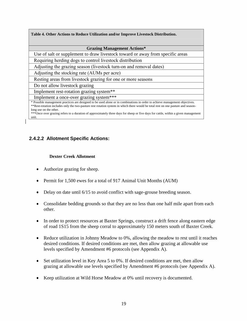
Table 4. Other Actions to Reduce Utilization and/or Improve Livestock Distribution.
Grazing Management Actions*
Use of salt or supplement to draw livestock toward or away from specific areas
Requiring herding dogs to control livestock distribution
Adjusting the grazing season (livestock turn-on and removal dates)
Adjusting the stocking rate (AUMs per acre)
Resting areas from livestock grazing for one or more seasons
Do not allow livestock grazing
Implement rest-rotation grazing system**
Implement a once-over grazing system*** * Possible management practices are designed to be used alone or in combinations in order to achieve management objectives.
**Rest-rotation includes only the two-pasture rest rotation system in which there would be total rest on one pasture and season-
long use on the other. ***Once over grazing refers to a duration of approximately three days for sheep or five days for cattle, within a given management
unit.
2.4.2.2 Allotment Specific Actions:
Dexter Creek Allotment
Authorize grazing for sheep.
Permit for 1,500 ewes for a total of 917 Animal Unit Months (AUM)
Delay on date until 6/15 to avoid conflict with sage-grouse breeding season.
Consolidate bedding grounds so that they are no less than one half mile apart from each
other.
In order to protect resources at Baxter Springs, construct a drift fence along eastern edge
of road 1S15 from the sheep corral to approximately 150 meters south of Baxter Creek.
Reduce utilization in Johnny Meadow to 0%, allowing the meadow to rest until it reaches
desired conditions. If desired conditions are met, then allow grazing at allowable use
levels specified by Amendment #6 protocols (see Appendix A).
Set utilization level in Key Area 5 to 0%. If desired conditions are met, then allow
grazing at allowable use levels specified by Amendment #6 protocols (see Appendix A).
Keep utilization at Wild Horse Meadow at 0% until recovery is documented.

20
Keep utilization at Crooked Meadows at 0% until recovery is documented.
Authorize permittee to use of Roads 01S471 and 01S526, which are closed to the public
under the Inyo National Forest Motor Vehicle Use Map (2010).
Assure that the trough at Baxter Springs is thoroughly drained and dry when domestic
sheep have vacated this portion of the allotment.
Remove bull thistle and mullein from Baxter Spring area by hand. May use shovels to
remove stem base.
Locate all bedding grounds, watering sites and trails outside northern goshawk protected
activity centers.
Table 5. Amendment #6 Standards for Utilization for the Dexter Creek Allotment.
Dexter Creek Utilization
Key
Area
Range Type Amendment #6 Standards**
Early Late
5* Bitterbrush 40% 30%
6 Bitterbrush 50% 40%
7a Bitterbrush
50% 40%
8* Johnny Meadow (Moist)
35% 25%
Exc Bitterbrush 50% 40%
*Because this area does not meet desired conditions and recent utilization has been
lower than Amendment #6 standards, utilization would be set at 0% until recovery
is documented. Recovery is achieved when the area meets desired conditions. **Early = before seed heads are formed on grasses. Late = after seed heads are formed
June Lake Allotment
Authorize grazing for sheep.
Permit for 1,500 ewes for a total of 612 AUM’s.
Delay on date until 7/1 to avoid conflict with sage-grouse breeding season and to avoid
the possibility of interaction between domestic sheep and Sierra Nevada big horn sheep.

21
Consolidate bedding grounds so that they are no less than one half mile apart from each
other.
Set utilization in Key Area 1 to 0% until recovery is documented. If desired conditions
are met, then allow grazing at allowable use levels specified by Amendment #6 protocols
(see Appendix A).
Restrict use of the 2010 Mono Fire area until upward trend according to Amendment #6
standards is documented.
Table 6. Amendment #6 Standards for Utilization for the June Lake Allotment.
June Lake Creek Utilization
Key
Area
Range Type Amendment #6 Standards
Early Late**
1* Bitterbrush 40% 30%
2 Bitterbrush 50% 40%
3 Bitterbrush
50% 40%
*Because this area does not meet desired conditions and recent utilization has been
lower than Amendment #6 standards, utilization would be set at 0% until recovery
is documented. Recovery is achieved when the area meets desired conditions. **Early = before seed heads are formed on grasses. Late = after seed heads are formed
Mono Mills Allotment
Authorize grazing for sheep.
Permit for 4,000 ewes for a total of 3,038 AUM’s from 7/1 to 9/15.
Consolidate bedding grounds so that they are no less than one half mile apart from each
other.
No sheep bedding grounds are authorized in Mono Mills town site.
No sheep bedding grounds are authorized on the pumice sand flats.
Sheep will not be loaded or unloaded at Big Sand Flat.

22
Remove sheep bedding ground/high use area from water pond, water collection site south
of Highway 120 in the Big Sand Flat area.
In order to improve livestock distribution, consider installing a centrally located well and
water tank to provide approximately 4,000 gallons of water per day. Permittees would
use this site to fill water trucks and take the water elsewhere. Livestock would not be
watered in the vicinity of the well. Further analysis of this action would take place once
the location of the proposed well is established.
If a well is installed in potential sage-grouse habitat within the Mono Mills Allotment,
assure that construction does not allow water to pond in the vicinity.
Inspect existing wells on the allotment and repair if possible to help improve livestock
distribution.
Permittee is not authorized to take vehicles off road to access water sources.
Locate all bedding grounds, watering sites and trails outside northern goshawk protected
activity centers.
Table 7. Amendment #6 Standards for Utilization for the Mono Mills Allotment.
Mono Mills Utilization
Key
Area
Range Type Amendment #6 Standards**
Early Late
1 Bitterbrush 50% 40%
2 Bitterbrush 50% 40%
5 Bitterbrush 50% 40%
Mono Sand Flat Allotment
Authorize grazing for cattle.
Permit for 26 cow/calf pairs for a total of 206 AUM’s from 12/1 to 5/30.
Rest allotment until recovery is documented. While being rested, utilization will be set at
5%. Per Amendment #6, ―the 5% allowable use is for incidental use only. The intent is
not to have grazing at this level‖ (USDA Forest Service, 1995).
Permittee is not authorized to take vehicles off road to access water sources.

23
Table 8. Amendment #6 Standards for Utilization for the Mono Sand Flat Allotment.
Mono Sand Flat Utilization
Key
Area
Range Type Amendment #6 Standards**
Early Late
1* Desert Shrub 30% 20%
2* Desert Shrub 30% 20%
*Because this area does not meet desired conditions and recent utilization has been
lower than Amendment #6 standards, utilization would be set at 5% until recovery
is documented. Recovery is achieved when the area meets desired conditions. **Early = before seed heads are formed on grasses. Late = after seed heads are formed
2.5 Monitoring
Monitoring that would occur if the Proposed Action was implemented is specified in the
Monitoring Plan outlined below. This plan includes both implementation and effectiveness
monitoring. Implementation monitoring is used to determine if the grazing activity is
implemented as designed. Effectiveness monitoring is conducted to determine if the
management practices applied have been effective in moving toward or maintaining desired
condition and meeting resource objectives. The monitoring process involves collecting data to
determine, what—if any—adjustments are needed to meet the desired conditions and the
standard and guidelines outlined in LRMP Amendment #6 and SNFPA. Project-specific
monitoring would be conducted at the key areas as described in the Proposed Action. At least 20
percent of the key areas shall be monitored annually.
Key areas on the allotments are chosen because they are representative of the allotment as a
whole. Monitoring of key areas allows one to extrapolate the condition of the rest of the
allotment and to determine the effects of livestock grazing and its management. By monitoring
key areas regularly it is possible to adjust management in order to produce desired conditions.
Weeds
The on-going monitoring of Astragalus monoensis inside and outside the existing exclosure at
Big Sand Flat will continue at a minimum of five-year intervals. An initial assessment of the
amount of reproductive output removed from Lupinus duranii plants at populations on the
allotments will be done and additional monitoring scheduled as needed, depending on the results
of the initial study.

24
Table 9. Monitoring Plan.
Monitoring Item
Method
Frequency
Variability Indicating
Action
Implementation Monitoring (Permit Administration)
Permit Compliance Allotment and Units
Inspections
Ongoing, annual permittee
actual use reports
Non-compliance
Annual Operating
Instructions (AOI)
AOI meetings Annually Non-compliance
Fee Payment Bill for Collection Annually Bill not paid by due date
Livestock numbers Count livestock Random Numbers outside of AOI
authorized for season.
Excess use Allotment inspections Ongoing All excess use
Improvement maintenance Inspections Ongoing Failure to maintain
improvements
Salting Allotment inspections Ongoing Failure to follow AOI
instructions
Range Readiness R5 range readiness
procedure
Pre-season and ongoing as
needed
Range not ready for
grazing
Forage utilization Key Species, Extensive
Browse
20% of key areas Annually Utilization standards
exceeded
Streambank
Stability/Disturbance
MIM, Alteration by
livestock, Stability and
Cover
Ongoing Downward trend
Effectiveness Monitoring
Riparian Ecologic
Condition and Trend
Rooted Frequency,
Greenline MIM, PFC,
Photo Points, BMP
3-5 years Downward trend
Upland Ecological
Condition and Trend
Line Intercept, Toe Point,
Shrub age and form Class,
3-5 years Downward trend

25
Table 10. Cultural Resources Recommended for Monitoring and SRPMs
Allotment Sites Recommended for Annual
Monitoring
Monitor
Count
Resource Protection
Measures
RPM
Count
Dexter Creek
05-04-51-0001 (CA-MNO-1522)
05-04-51-151(CA-MNO-738)
05-04-51-0189 (CA-MNO-822)
05-04-51-1651 (CA-MNO-4744)
05-04-51-1657 (CA-MNO-4740)
5
Avoidance of site area
Drift fence along eastern edge
of road 1S15
Avoidance of site area
3
June Lake S&G
05-04-51-1649 (26-6152)
1
Repair or replacement of water
tanks in this allotment need to
be reviewed by a cultural
resource specialist prior to
approval
1
Mono Mills S&G
05-04-51-0006 (CA-MNO-0116)
05-04-51-0598 (CA-MNO-0534)
05-04-51-0419 (CA-MNO-4622)
05-04-51-0515 (26-5697) 4
No off road access to
creek/spring
Repair or replacement of metal
water tanks in this allotment
need to be reviewed by a
cultural resource specialist prior
to approval
2
Mono Sand Flat 05-04-51-1658 (CA-MNO-4741)
05-04-51-1659 (CA-MNO-4742)
When allotment is used after rest
2
No off road access to
creek/spring
1
Total Annual Monitoring 12
Resource Protection
Measures 7

26
Chapter 3 Environmental Consequences
3.1 Introduction
This section summarizes the physical, biological, social, and economic environments of the
affected project area and the potential changes to those environments due to implementation of
the alternatives. It describes the environmental impacts of the proposal in relation to whether
there may be significant environmental effects as described in 40 CFR 1508.27. Further analysis
and conclusions about the potential effects are available in resource specialist reports and other
supporting documentation located in the project record. These reports contain more detailed
data, methodologies, analyses, conclusions, maps, references, and technical documentation that
the resource specialist relied upon to reach the conclusions in this EA. The following documents
are incorporated by reference and available upon request:
Biological Assessment for Domestic Sheep Grazing Within the Mono Basin Grazing
Allotment Project. Richard Perloff, Wildlife Biologist, Inyo National Forest. January 21,
2011.
Biological Evaluation for Aquatic Species. Lisa Sims, Fish Biologist, Inyo National
Forest. January 14, 2011.
Biological Evaluation Sensitive Plant Species. Sue Weis, Assistant Forest Botanist, Inyo
National Forest. January 21, 2011.
Biological Evaluation—Terrestrial Animals. Richard Perloff, Wildlife Biologist, Inyo
National Forest. January 25, 2011
Cultural Resource Analysis. Crystal West, North Zone Archaeologist, Inyo National
Forest. January 13, 2011.
Hydrology and Soils Input for the Mono Basin Grazing Allotments EA. Erin Lutrick,
Hydrologist, Inyo National Forest. January 21, 2011.
Inyo National Forest Land and Resource Management Plan. 1988.
Inyo National Forest Land and Resource Management Plan Amendment 6, Forestwide
Grazing Utilization Standards. 1995.
Inyo National Forest Land and Resource Management Plan Amendment, Sierra Nevada
Forest Plan Amendment. 2004.

27
Management Indicator Species Report. Richard Perloff, Wildlife Biologist, Inyo National
Forest and Lisa Sims, Fish Biologist, Inyo National Forest. January 25, 2011.
Noxious Weed Assessment. Sue Weis, Assistant Forest Botanist, Inyo National Forest.
January 13, 2011.
Rangeland Resources for the Mono Basin Grazing Allotments. April Barron, North Zone
Rangeland Management Specialist, Inyo National Forest. January 14, 2011.
3.2 Effects Relative to Range Resources
The discussion below is taken from the Range Report for the Mono Basin Grazing Allotments,
which is hereby incorporated by reference (Barron 2011a).
3.2.1 Existing Condition
Sheep and cattle have grazed the entire project area since the late 19th Century. Most of the
rangelands in this proposal have been grazed under permit with the Forest Service since the
creation of the Inyo National Forest in 1907. Permittees operate on the allotments according to
the terms and conditions of their term grazing permits. Specific instructions for management are
relayed yearly in each allotment’s Annual Operating Instructions (AOIs). Range personnel make
compliance checks throughout the grazing season. Permittees who do not comply with the terms
and conditions of their permits may lose their grazing privileges if a pattern of noncompliance
emerges.
Table 11 summarizes existing conditions on the allotments.
.

28
Table 11. Summary of Existing Conditions.
Existing Conditions at Mono Basin Grazing Allotment Key Areas
Allotment Key
Area Range
Type
PFC
Rating
Desired
Plants/
Total
Herbaceous
% in
Form
Classes
3 or 6*
Am. 6
Matrices
Top Two
Tiers
(y/n)**
Amendment #6
Watershed
Condition
Dexter
Creek
5 Bitterbrush NA 32/53 35% n Fully Functional
Dexter
Creek
6 Bitterbrush NA 18/50 No Data y Fully Functional
Dexter
Creek
7a Bitterbrush NA 22/46 7% y
Fully Functional
Dexter
Creek
8 Johnny
Meadow
(Moist)
NA 34/79 NA n
Fully Functional
Dexter
Creek
Exc Bitterbrush NA 20/59 No Data y Fully Functional
June
Lake
1 Bitterbrush NA 43/62 32% n Fully Functional
June
Lake
2 Bitterbrush NA 33/44 0% y Fully Functional
June
Lake
3 Bitterbrush NA 38/51 0% y Fully Functional
Mono
Mills
1 Bitterbrush NA 31/42 0% y Fully Functional
Mono
Mills
2 Bitterbrush NA 22/54 0% y Fully Functional
Mono
Mills
5 Bitterbrush NA 24/51 0% y Fully Functional
Mono
Sand Flat
1 Desert
Shrub
NA 0/38 NA n Fully Functional
Mono
Sand Flat
2 Desert
Shrub
NA 2/21 NA n Not surveyed
*Form class refers to the degree of hedging of bitterbrush. Classes are described with the bitterbrush
matrix in Appendix A.
** One of the factors necessary for an area to be at desired condition is the ratio of desired plants to
herbaceous species must lie in one of the top two tiers of the Amendment #6 matrices.
3.2.1.1 Dexter Creek Allotment
The Dexter Creek Allotment is characterized by a bitterbrush plant community with some
meadows and areas of Jeffrey pine. Three of the five key areas studied were at desired condition.
One was not at desired condition due to severe hedging of bitterbrush and another, at Johnny
Meadow, was not at desired condition due to a low number of desirable species. However, both

29
of these areas were rated fully functional for Amendment #6 watershed condition. In Key Area 5,
species composition also fell into the top two tiers of the Amendment #6 matrices.
3.2.1.2 June Lake Allotment
The June Lake Allotment is also dominated by bitterbrush and sagebrush with native perennial
bunchgrasses. Data collection showed key areas to be at desired condition with the exception of
Key Area 1 which was not at desired condition due to severe hedging of bitterbrush. Species
composition met Inyo National Forest standards and guidelines. Key Area 1 is located in the
vicinity of a bedding ground. Because of this, it may be grazed more than other areas and is
therefore not necessarily representative of the condition of the allotment a whole.
3.2.1.3 Mono Mills Allotment
The Mono Mills Allotment has not been grazed for the past four years. The allotment is
characterized by stands of Jeffrey pine interspersed with open areas of bitterbrush and sagebrush.
The key areas within the allotment are in desired condition.
3.2.1.4 Mono Sand Flat Allotment
The Mono Sand Flat Allotment is a desert shrub plant community. Soils are sandy and prone to
drifting. Some pedestalling is apparent, but this is a natural occurrence in a sand dune
environment (Hydrologist’s note, Amendment #6 Watershed Analysis Field Record 2008). Data
collection revealed a low percentage of desired species and both key areas are in unsatisfactory
condition. Dry conditions for the past several years have contributed to this decline in condition.
Rest and wetter years in the future could bring the allotment back in line with Inyo National
Forest standards and guidelines.
The most common species found were greasewood (Sarcobatus vermiculatus), salt grass
(Distichlis spicata), and rabbitbrush (Chrysothamnus nauseosus). None of these are desired
species under Amendment #6 standards for desert shrub plant communities. Desired species that
were found were Indian ricegrass (Oryzopsis hymenoides) (one hit out of 50 points on a transect)
and spiny hopsage (Grayia spinosa) (one hit out of 50 points on a transect). There is minimal
forage on this allotment and only 26 cow/calf pairs are allowed to graze each season. Cattle
graze the Mono Sand Flat Allotment in conjunction with the adjacent BLM lands.
3.2.2 Environmental Consequences
3.2.2.1 Direct, Indirect and Cumulative Effects of No Grazing (Alternative 1)
Alternative 1 represents the ―No Grazing‖ alternative. Under this alternative, all term grazing
permits would be cancelled. No permits would be issued for the four affected allotments until
and unless a subsequent NEPA decision to re-authorize grazing on any or all of the allotments is
made.
From an ecological perspective, the No Grazing alternative would allow areas at less than
desired conditions to improve at natural rates of recovery. Areas with heavily hedged bitterbrush
should recover in two to three years with complete rest. This is because the degree of hedging is
30
based on the condition of two-year-old wood (BLM, 1996). With no grazing, no hedging would
be apparent after two years has passed.
Crooked Meadow and Wild Horse Meadow, having already been rested for several years, would
take several more years, possibly decades, to return to desired condition (Milchunas,
2006).Without grazing pressure, satisfactory areas would likely be able to maintain desired
conditions. Under the No Grazing alternative, those plants favored by livestock would be more
likely to consistently maintain high vigor, produce greater amounts of seed, and possibly
increase their populations, leading toward maintenance of a more diverse species composition
(Dietz, 2006). This is because the possibility of livestock grazing would be eliminated.
Meadows would likely maintain or gain mixed native grass and forb communities that provide a
mosaic of plants with species diversity, a variety of vegetative structures, and sufficient amounts
of litter. Graminoid communities are expected to show vigor.
Aspen stands would be more likely to have a diverse age structure of two or more age classes,
including seedlings, young plants, mature plants, decadent plants, and sprouts or suckers in
addition to adequate regeneration. Livestock grazing is not the only factor contributing to aspen
decline and cessation of grazing alone would not guarantee recovery.
Shrublands would likely show vigorous growth and regeneration of mid to late seral shrub
species interspersed with a variety of native grasses and forbs. Without grazing, overgrazed
shrubs should recover in two to three years. Bedding grounds would recover more slowly.
Riparian areas would likely have at least 80% ground cover within 100 feet of the edge of the
stream or to the outer margin of the riparian ecosystem where wider than 100 feet. In woody
systems, riparian shrub cover would likely be at least 35% and include a variety of species.
But despite the likelihood of improvement, not all unsatisfactory areas would necessarily return
to their pre-disturbance state if grazing pressure was removed (Friedel 1991, Laycock 1991).
Ending grazing alone should lead to improvement of livestock induced disturbance, but changes
in range condition, especially species composition, can depend on many factors. However, it is
likely that species composition would trend towards desired condition.
Cumulative Effects
The area affected by grazing lies within the boundaries of the Mono Basin Grazing Allotments.
Because the NEPA decision covers ten years, the effects of the No Grazing Alternative would be
seen throughout the next decade. However, the effects of previous overgrazing (i.e. grazing that
took place before 2011, such as the overgrazing that caused the degraded conditions currently
seen at Crooked Meadows) may yet take decades to resolve.

31
Activities other than grazing that affect the condition of the range include recreation,
implementation of the 2009 Travel Management EIS Decision, and fuels reduction projects,
including prescribed fire. Conditions can also be affected by climate and wildfires.
Recreation has a minimal impact on these four allotments. There are a few primitive camp sites,
but these are in areas populated by Jeffrey pines, not in areas where grazing normally occurs.
The most common recreation activity on these allotments is off-highway vehicle (OHVs).
Implementation of the 2009 Motorized Travel Management Record of Decision may reduce the
amount of off highway vehicle use in the allotments as unauthorized routes are closed to public
travel. Approximately 67 miles of road will be closed within the Mono Basin Allotments. There
are no reasonably foreseeable future proposals to decommission the unauthorized routes or
convert them to other uses such as non-motorized trails. However, some revegetation of these
routes is expected as motorized use is discontinued, leading to some minor, localized
improvement in range condition.
Areas where fuels reduction occurs are not generally primary range, as forage is sparse under
tree canopies. Fuels reduction will not negatively impact livestock operations and may improve
the availability of forage. Fire suppression has resulted in trees beginning to dominate what were
formerly sagebrush and bitterbrush shrublands. Fuels reduction reduces competition, allowing
shrubs and bunchgrasses to move back in. This is a positive impact on range conditions.
Prescribed fire will have an effect similar to fuels reduction. In the pre-European era, wildfires
reduced the number of trees, allowing for a more open canopy. Fire would periodically sweep
through these environments and burn the shrublands, encouraging new growth and regeneration.
Prescribed fire can fulfill these functions and help restore the range to a state resembling the pre-
European environment. In the long run, prescribed fires would result in higher quality forage.
Prescribed fire has been used to treat approximately 9,265 acres within the Mono Basin
Allotments.
Climate, along with soils, hydrology, and geography, is one of the factors that ultimately
determine the state of vegetation in a region. Climate change may affect range conditions within
the project area, although the effects of that climate change are not well known. It is predicted
for the region containing the project area that the climate will become warmer, precipitation will
remain about the same, but more of that precipitation will occur as rain instead of snow and there
will be more extreme weather events such as drought and floods (Furniss et al, 2010).
A decrease in the amount of snow would lead to a decrease in snow melt in the spring, leaving
less water for plants and riparian areas. However, although climate change will be a factor in
range condition in the years to come, it is not possible to predict with any certainty what changes
may occur in the next decade or what their significance might be.
Since the year 2000, wildfire has affected 6,350 acres within the Mono Basin Allotments.
Wildfire can have a beneficial effect on range conditions, as it removes excess vegetation and
allows for regeneration and new growth. However, wildfire can also allow invasive species such
as cheat grass (Bromus tectorum) to move in. Wildfires in the project area have not resulted in
heavy weed infestation. The 2010 Mono Fire area does not seem to be threatened by weed
invasion (Weis, 2011b).

32
Determination
There would be no adverse cumulative effects of the No Grazing Alternative when combined
with past, present, and reasonably foreseeable future actions within the project area. Under
Alternative 1, the purpose and need of improved range vegetation condition and trend would be
met, but the purpose and need of continued livestock grazing would not be met.
3.2.2.2 Direct, Indirect, and Cumulative Effects of the Proposed Action
(Alternative 2)
To avoid repetition, the effects described below pertain to all four allotments. Effects specific to
individual allotments are in separate sections below.
The Inyo National Forest Land and Resource Management Plan (LRMP), LRMP Amendment
#6, and Sierra Nevada Forest Plan Amendment (SNFPA) standards and guidelines are designed
to maintain or move rangeland vegetation to desired conditions. The effects are measured in
meadows, shrublands (uplands), aspen stands, and riparian areas. These standards are designed to
provide a measurable utilization standard in combination with trend monitoring, in order to
provide a more consistent tool for long-term adaptive management in perpetuating healthy and
vigorous plant communities throughout the allotments for long term sustainability of the
rangeland resources. Because management has met standards and is meeting or moving toward
desired conditions in most locations under these standards and guidelines, it is reasonable to
assume that this positive trend will continue under similar management including appropriate
changes where needed.
Meadows would likely maintain or gain mixed native grass and forb communities that
provide a mosaic of plants with species diversity, a variety of vegetative structures, and
sufficient amounts of litter. Graminoid communities are expected to show vigor. This
would be achieved by keeping allowable utilization levels to 45% or less with stubble
height of four inches or more and bare ground not exceeding 5%.
Aspen stands would be more likely have a diverse age structure of two or more age
classes, including seedlings, young plants, mature plants, decadent plants, and sprouts or
suckers in addition to adequate regeneration. This would be achieved by maintaining
allowable browse utilization levels at 20% of annual leader growth for mature trees. No
more than 20% of seedlings would be browsed. Livestock would be removed from any
area of the allotment when browsing indicates a change in livestock preference from
grazing herbaceous vegetation to browsing woody riparian vegetation. Livestock grazing
is not the only factor contributing to aspen decline and cessation of grazing alone would
not guarantee recovery.
Shrublands would likely show vigorous growth and regeneration of mid to late seral
shrub species interspersed with a variety of native grasses and forbs. This would be
achieved by keeping allowable herbaceous utilization at 50% or less, allowable browse

33
utilization at 45% or less, and maintaining an average of 300 pounds or more per acre of
residual dry matter. Overgrazed shrubs should recover in two to three years. Because
bedding grounds would be consolidated, many current bedding grounds would no longer
be used and would show a decrease in bare ground and increase in mid to late seral plant
species.
Riparian areas would likely have at least 80% ground cover within 100 feet of the edge of
the stream or to the outer margin of the riparian ecosystem where wider than 100 feet. In
woody systems, riparian shrub cover will be at least 35% and include a variety of species.
This would be achieved by keeping allowable herbaceous utilization to 45% or less and
browse utilization to 20% of annual leader growth of hardwood seedlings. Stream banks
would not exceed 20% disturbance per reach.
Direct effects of grazing can be loss of plant cover and litter, soil disturbance, and streambank
alteration. The proposed action is designed to use Amendment #6 standards to lessen these
impacts. Areas not at desired condition would be rested and would thus be able to improve, while
areas that are at desired condition would be managed to maintain or improve upon their present
state. If monitoring shows that the areas are not moving towards or maintaining desired
conditions, adaptive management measures would be used to alter use on the allotments (Table
4). For example, if conditions seem to indicate a downward trend, the grazing season could be
shortened so that the livestock spend less time grazing in the area.
Continuing to apply Amendment #6 grazing standards would ensure that livestock are distributed
more evenly throughout the allotments because they guard against livestock remaining in one
area for too long. Once the Amendment #6 level of utilization is reached, livestock would be
moved to another location. Pressure would be removed from areas not at desired condition. This
would reduce the amount of hedging and trampling in the affected areas and allow for an
increase in the number of desirable species.
Applying Amendment #6 standards would require working closely with the permittees and
checking utilization regularly during the grazing season, which would allow for annual operating
plans that would also result in a more even distribution of livestock and grazing across an
allotment. Promoting more even use means that previously ungrazed plants would have more of
a chance of being grazed (which would stimulate growth) and that individually, frequently
grazed plants would be grazed fewer times. With more even distribution, range condition can
improve with little or no reduction in livestock numbers (Anderson, 1967; Holechek et al, 2004).
Because areas not at desired condition would be rested under the Proposed Action, recovery in
those areas would proceed in the same manner as under Alternative 1. Overgrazed bitterbrush
would probably take two to three years to return to desired condition. Unsatisfactory meadow
areas, having already been rested for several years, would take several more years, possibly
decades, to return to desired condition (Milchunas, 2006). Satisfactory areas would likely
maintain desired conditions because sheep grazing on the allotments will be moderate and will
take place in the summer. It has been shown that moderate summer grazing by sheep has little
effect on the amount of vegetation or species composition (Harniss and Wright, 1982). If
34
conditions did appear to deteriorate, Amendment #6 allows utilization standards to be reduced
progressively if conditions appear to be declining in order to maintain areas at their desired state.
Improved distribution of livestock would also lead to an increase in overall plant vigor because
overgrazing would be less likely to occur. Ending over-utilization of forage and browse would
allow for the maintenance and/or increase of desirable vegetation (Dietz 2006). Increase in
vegetation allows for more ground cover, reduced erosion, retention of soil water, and
encourages new growth.
On allotments grazed by sheep, livestock movement would be controlled by herding. The
permittees run gregarious breeds of sheep (white-faced and Rambouillet), which rarely stray
from the herd. Also, a herder stays with the sheep throughout their time on the allotment. In this
way, herders would be able to strictly adhere to the Annual Operating Instructions so that
utilization standards would not be exceeded.
Possible Management Actions Employed in Adaptive Grazing Management
Actions described in Table 4 would be taken alone or in combination if the range condition was
not on a static or upward trend. These measures are designed to protect resources.
Many of these measures result in more efficient distribution of livestock, which, as stated above,
can improve range condition. Use of salt or supplement can draw livestock towards or away from
specific areas. Livestock are attracted to salt and supplement blocks. If the blocks are placed
some distance from a problem spot such as an overgrazed riparian area, livestock will go to the
blocks, leading to less use around the riparian area. Herding dogs can be used to control livestock
movement.
Other actions involve resting all or part of an allotment. Resting areas for one or more seasons,
not allowing grazing, and implementing a rest-rotation grazing system all fall under this
category. Resting areas for one or more seasons would have the same effect as the No Grazing
Alternative throughout the period of time the areas are rested. Livestock could then be returned
to the area and other management tools under the Proposed Action would be used to ensure that
the range continues to trend towards desired condition. Not allowing grazing would have the
same effect as the No Grazing Alternative. Under a rest-rotation system, per Amendment #6, the
allotment is broken up into two pastures and each year one pasture would be rested while the
other would be grazed. This could lead to improved forage conditions. A negative effect of the
rest-rotation system is that the pasture being grazed gets increased use. However, the rest-
rotation system could be used in conjunction with fewer numbers of livestock so that
concentration of use will not increase.
35
In the once-over grazing system, livestock graze areas with low to moderate intensity for a short
period of time. This has the benefit of preventing over-grazing and allowing plants more time to
grow without grazing pressure. This could lead to increased plant vigor, less trampling and bare
ground, and healthier riparian areas.
Adjusting the grazing season (livestock turn-on and turn-off dates) can be used to decrease the
number of grazing days or it can be used to come on or off of the allotment at a time more
beneficial to plants and wildlife. For instance, a later turn-on date could allow plants more time
to flower and produce seed.
Adjusting the stocking rate can help to improve range condition. Stocking rate can be an
important factor that governs ―vegetation, animal, and financial outcomes from rangeland
livestock grazing‖ (Holechek et al, 2004).
Dexter Creek
Conditions on the Dexter Creek Allotment meet Inyo National Forest standards and guidelines
except for at Key Area 5 where more than 15% of the bitterbrush is heavily hedged and at
Johnny Meadow where there is not a high enough ratio of desired plant species to plant species
in general. Key Areas 6, 7a, and Exc (this area was formerly an exclosure, but the fencing is no
longer extant) meet standards and guidelines, therefore, continuing current management should
allow for maintenance of desired conditions in these three areas. Conditions in Johnny Meadow
would likely improve relative to current conditions. Conditions in Wild Horse Meadow and
Crooked Meadow, which have been rested for the past several years, would likely continue to
improve their condition. Key Area 5 would likely recover from overhedging of bitterbrush.
Areas with heavily hedged bitterbrush should recover in two to three years with complete rest.
This is because the degree of hedging is based on the condition of two-year-old wood (BLM,
1996). With no grazing, no hedging would be apparent after two years have passed.
June Lake
Conditions on the June Lake Allotment are at desired condition except for at Key Area 1 where
the bitterbrush is overgrazed. Current management is working in Key Areas 2 and 3; therefore,
continuing this management would allow for maintenance of desired conditions in these areas.
Key Area 1 is located near a concentrated use area and so is not really representative of the
allotment as a whole. However, utilization at Key Area 1 would be set at 0% until recovery is
documented (i.e. the area meets desired condition), allowing areas with heavily hedged
bitterbrush to recover in two to three years with complete rest. This is because the degree of
hedging is based on the condition of two-year-old wood (BLM, 1996). With no grazing, no
hedging would be apparent after two years have passed.

36
Mono Mills
Setting utilization at Amendment #6 prescribed levels would allow the allotment to remain at
desired condition.
Adding a water source on the Mono Mills Allotment would allow permittees to distribute
livestock more widely. The slope of the roads and distance to other water sources currently
makes water transport difficult and expensive. This alternative could therefore make ranching
operations more economically feasible on the Mono Mills Allotment.
Mono Sand Flat
Mono Sand Flat Allotment would be rested to allow recovery from the effects of previous
grazing and dry conditions. Without grazing pressure, desired species may be able to come back
into the area. However, if conditions in this desert shrubland system continue to be dry, it may
make recovery a slow and difficult process. Resting the allotment instead of closing it would
allow the permittee to take advantage of the forage that may rebound when wetter conditions
prevail. As only 26 cow/calf pairs are authorized to graze here, only a low amount of grazing
pressure would occur on the recovered allotment.
Recovery would be a slow process and may take decades (Milchunas, 2006). If recovery does
not take place within the ten year time span this NEPA analysis covers, the Forest may, at that
time, decide to continue resting the allotment or take other management actions.
Cumulative Effects
The area affected by grazing lies within the boundaries of the Mono Basin Grazing Allotments.
Because the permits for these allotments allow for ten years of use, the effects would be seen for
10 to 15 years. Because the Proposed Action calls for utilization which will not exceed the
environment’s ability to recover, there should be no damage at the end of the ten year period and
appropriately grazed areas should recover within five years. However, the effects of previous
overgrazing (i.e. grazing that took place before 2011, such as the overgrazing that caused the
degraded conditions currently seen at Crooked Meadows) may yet take decades to resolve.
Activities other than grazing that affect the condition of the range include recreation,
implementation of the 2009 Travel Management EIS Decision, and fuels reduction projects,
including prescribed fire. Conditions can also be affected by climate and wildfires.
Recreation has a minimal impact on these four allotments. There are a few primitive camp sites,
but these are in areas populated by Jeffrey pines, not in areas where grazing normally occurs.
The most common recreation activity on these allotments is off-highway vehicle (OHVs).
Implementation of the 2009 Motorized Travel Management Record of Decision may reduce the
amount of off highway vehicle use in the allotments as unauthorized routes are closed to public
travel. Approximately 67 miles of road will be closed within the Mono Basin Allotments. There

37
are no reasonably foreseeable future proposals to decommission the unauthorized routes or
convert them to other uses such as non-motorized trails. However, some revegetation of these
routes is expected as motorized use is discontinued, leading to some minor, localized
improvement in range condition.
Areas where fuels reduction occurs are not generally primary range, as forage is sparse under
tree canopies. Fuels reduction will not negatively impact livestock operations and may improve
the availability of forage. Fire suppression has resulted in trees beginning to dominate what were
formerly sagebrush and bitterbrush shrublands. Fuels reduction reduces competition, allowing
shrubs and bunchgrasses to move back in. This is a positive impact on range conditions.
Prescribed fire will have an effect similar to logging. In the pre-European era, wildfires reduced
the number of trees, allowing for a more open canopy. Fire would periodically sweep through
these environments and burn the shrublands, encouraging new growth and regeneration.
Prescribed fire can fulfill these functions and help restore the range to a state resembling the pre-
European environment. Prescribed burns maybe cause for temporary cessation of grazing (2-5
years), but in the long run would result in higher quality forage. Prescribed fire has been used to
treat approximately 9,265 acres within the Mono Basin Allotments.
Climate, along with soils, hydrology, and geography, is one of the factors that ultimately
determine the state of vegetation in a region. Climate change may affect range conditions within
the project area, although the effects of that climate change are not well known. It is predicted
for the region containing the project area that the climate will become warmer, precipitation will
remain about the same, but more of that precipitation will occur as rain instead of snow and there
will be more extreme weather events such as drought and floods (Furniss et al, 2010).
A decrease in the amount of snow would lead to a decrease in snow melt in the spring, leaving
less water for plants and riparian areas. However, although climate change will be a factor in
range condition in the years to come, it is not possible to predict with any certainty what changes
may occur in the next decade or what their significance might be. However, the Proposed Action
calls for a program of monitoring which would allow range managers to track changes to range
conditions so that management could be altered accordingly.
Fire suppression over the past century has allowed distribution of vegetation to become
increasingly dense, making the area more susceptible to catastrophic wildfire. Fire can destroy
existing vegetation and allow invasive species such as cheat grass (Bromus tectorum) to move in.
Wildfire is especially detrimental to bitterbrush and big sagebrush, as they are slow to rebound
after catastrophic fires; bitterbrush can take as long as 30 years to fully recover (Nord 1965) and
big sagebrush can take as much as 35 to 100 years (Baker 2006). Wildfire could reduce the
amount of available forage for many years and necessitate resting the allotments. Since the year
2000, wildfire has affected 6,350 acres within the Mono Basin Allotments.
Determination

38
There would be no adverse cumulative effects of the Proposed Action when combined with past,
present, and reasonably foreseeable future actions within the project area. This alternative would
meet the standards and guidelines in the Inyo National Forest LRMP (USDA Forest Service,
1988) as revised by LRMP Amendment #6, Forest-wide Grazing Utilization Guidelines (USDA
Forest Service, 1995) and the Sierra Nevada Forest Plan Amendment (USDA Forest Service,
2004).
Under Alternative 2, the purpose and need of improved range vegetation condition and trend
along with the purpose and need for continued livestock grazing would be met.
3.3 Effects Relevant to Hydrologic Resources, Soil, and Air Quality
The discussion below is summarized from the Hydrology and Soils Input for the Mono Basin
Grazing Allotments EA and is hereby incorporated by reference (Lutrick 2011).
3.3.1 Existing Condition
3.3.1.1 Affected Environment
Air Quality Setting
The only substantial air pollution that could be related to livestock grazing is PM10, or particulate
matter less than 10 microns in size. This can be created when dust is stirred up through livestock
trailing or when livestock are transported to the site in vehicles. Almost the entire analysis area is
classified as non-attainment for PM10 due to dust from the dry shorelines around the lowered
Mono Lake. As stated in the Mono Basin Planning Area PM10 State Implementation Plan, ―It is
clear that the predominant source of PM-10 emissions in the Mono Basin Planning Area is
windblown dust…The Control measure to reduce air pollution from PM-10 emissions specifies a
gradual increase in the water elevation of Mono Lake…the only feasible method to sufficiently
reduce emissions to comply with the federal PM-10 Standard‖. This quote shows livestock
grazing it is not an activity of concern for air pollution control agencies, although effects of the
alternatives will be discussed briefly below.
Hydrologic Setting
The allotments are within two major drainage basins: Mono Lake, and the Owens River. The
allotments are all almost entirely within the Mono Lake Watershed. Only a very small portion
(about 3040 acres combined of a total 73,300 acres of allotments) of the June Lake, Mono Mills,
and Dexter Creek allotments are within the Owens River Watershed. None of the allotment areas
have surface connectivity to the Owens River, or Mono Lake. The few streams infiltrate into
alluvial fans on the valley slope.

39
Only the Dexter Creek Allotment and the very northeastern corner of the Mono Mills Allotment
have any surface streamflow. There is a total of about 9.5 miles of perennial streams in these two
allotments, and none in the others. There is also a spring with standing surface water in the Mono
Sand Flat Allotment, which is fenced and therefore inaccessible to livestock. Mono Mills
Allotment contains at least four springs. The Dexter Creek Allotment also contains a few
intermittent streams and at least 15 springs.
The Forest Service uses watersheds for analysis based on the USGS National Hydrologic Dataset
(NHD) layer. Those watersheds are identified by their Hydrologic Unit Code (HUC), which can
be seen in the project record. The State of California delineates watersheds using ―Calwater‖
watersheds. The project area lies within 25 Calwater watersheds. For a list of those watersheds,
see the project record.
For a description of soils present on the Mono Basin Allotments, see section 1.2.
The Inyo National Forest has established criteria for evaluating soil and watershed condition of
rangelands through the LRMP Amendment #6 (Forest-wide Standards and Guidelines). Soil
desired conditions and standards for riparian areas and uplands are included in Amendment #6,
and are not separated out from hydrologic function. Effects to soil function are components of
the Amendment #6 protocol and data collection for this analysis followed this established
protocol.
Past and current impacts to soil productivity include grazing by livestock and areas of mining,
roads, wildfire, off-road vehicle use, and other recreational uses. Generally, soil is not degraded
in these allotments, but in the few meadows where concentrated livestock grazing has occurred
in the past, there tends to be loss of soil surface layer, compaction, and increases in bare soil.
Hydrology and Soils Focus and Methods
This analysis focuses on key area hydrologic and soil function, stream functional condition and
water quality. These are the three principal water and soil related desired conditions in the Forest
Plan Direction (USDA Forest Service 2004).
Key Area Hydrologic and Soil Function
Amendment #6 to the Inyo National Forest land and Resource Management Plan (LRMP)
establishes a protocol for assessing watershed condition in meadow and upland areas for
vegetation and watershed condition. This method is known as key area hydrologic function
analysis. Amendment #6 methods are used for an entire key area. Many soil and hydrologic
attributes are taken together determine whether an area is hydrologically functional. A
hydrologically functional area can withstand high flows or runoff without eroding, has
streamcourses that remain connected to their floodplain, and have soil capable of absorbing
rainfall or snowmelt. This Amendment #6 protocol was used at 13 key areas along with four
40
other riparian areas in 2008 and 2010. Five of these were in meadow/riparian vegetation types
and 12 in upland vegetation types. Results are shown in Table 11 on page 28.
Stream Functional Condition
In this analysis, stream functional condition was determined using the Proper Functioning
Condition (PFC) protocol (USDI 1998). The PFC protocol was developed by a multi-agency
effort, and is a common rapid assessment method for stream condition. If there was a perennial
stream at the key area, a PFC analysis was completed. An IDT completed PFC analysis at three
sites, although none were key areas. Results are shown in the Existing Condition section in Table
11on page 28.
Water Use
Three of the four allotments are proposed for sheep grazing, and sheep are able to graze in areas
without surface water. Water is often trucked in from nearby locations. Some water is taken from
local springs or streams, while some is taken from nearby municipal water supplies. This
document will, where possible, analyze the amount of water taken and any effects to surface or
groundwater beneficial uses. It will also analyze the installation of a new well to provide
drinking water to sheep on the Mono Mills Allotment.
Water Quality
The Forest Plan requires ―Water quality meets the goals of the Clean Water Act and the Safe
Drinking Water Act; it is fishable, swimmable and suitable for drinking after normal treatment.‖
Forest Service Region 5 has a management agency agreement with the state Water Quality
Control board to apply best management practices to maintain and protect water quality on
National Forest lands (USDA Forest Service 2000).
Methods for assessing water quality include; determining beneficial uses of water in the
assessment watersheds, assessing the risk and occurrence of potential pollutants, and field
assessment of indicators and/or measures of pollutants.
Beneficial Uses and Water Quality Objectives
Beneficial uses are the natural and human uses of surface water and are defined in the State of
California Water Quality Control Board Basin Plans. These beneficial uses must be maintained.
The designated beneficial uses for the analysis area are in the Lahontan Area Basin Plan
(California, LRWQCB, 1995), and are listed and discussed in more detail in the Soil and
Hydrology Report for this project.
Region-wide numeric and narrative water quality objectives (WQOs) are established in the Basin
Plan (LRWQCB, 1995) and include the nutrient WQO’s that apply to the project area. Relevant
WQOs are listed in the Soil and Hydrology Report for this project, as well as in the Basin Plan.
Those relevant to grazing can be summarized into sediment, bacteria and other pathogens, and
nutrients and are briefly described below.

41
Sediment – Field observations of livestock trampling in springs and stream reaches is a strong
indicator that sediment is reaching the stream or spring channel. Cattle and sheep can cause
physical impacts to streambanks that can result in stream sedimentation (Marlow 1985, Siekert
1985).
Bacteria and other pathogens – It is well established in the literature that fecal coliform, giardia,
and other bacteria or pathogens can be introduced into water by cattle and sheep. For a summary
of literature relating to bacterial contamination from grazing in National Forest and similar
environments, see Lutrick (2011b). Most existing water quality research related to grazing
focuses on cattle, not sheep, so there is little research relevant to this project. Fecal coliform,
while not harmful itself, is often used as an indicator of the presence of fecal matter, which can
contain harmful pathogens. The Lahontan Basin Plan has a fecal coliform standard of 20 cfu/100
mL. Presence of livestock in wet areas is used here to estimate presence of bacteria and other
pathogens. No quantitative water quality measurements are known to have been taken within
these allotments.
Field investigation for these biological contaminants includes observing if livestock are present
where waste products can enter water directly from defecation or urination, or indirectly from
observing livestock trailing along, across or near streams. Presence is an indicator that serves as
a surrogate for in-stream bacteria sampling. The threshold for determining if beneficial uses are
maintained is whether or not receptors are adversely affected.
Nutrients – Livestock proximity to water can be used to detect the potential for nutrient
enrichment. Waste products contain nitrogen, a biostimulatory substance, which may affect the
trophic status of waters. Eutrophication can result from nutrient introduction if sufficient
quantities are present. A field indicator is condition of aquatic features such as stream channels
and springs. A degraded condition from livestock indicates that nutrients may be elevated.
Risk Assessment
Water quality parameters with the most likely potential to be affected by the proposed action are
sediment, bacteria and other pathogens and nutrients. Livestock waste products are known to
introduce bacteria and other pathogens into water (Suk 1983, 1986), and can cause increased
nutrient levels. Livestock can also cause physical impacts to streambanks that can result in
stream sedimentation (Marlow 1985, Siekert et al. 1985). Field methods such as observing the
ability of livestock to reach surface water or observing where they were actually seen in or
adjacent to surface water is used here.
The degree to which, if at all, the above parameters affect beneficial uses of water is key to
describing environmental effects of the proposed action. If there is some known or potential
introduction of pollutants by livestock, this analysis determines whether the extent adversely
affects the beneficial uses of the water.

42
3.3.1.2 Existing Condition
In this section, the existing condition of all allotments will be discussed. Because the Dexter
Creek Allotment is the only allotment with surface water or with areas that were not fully
functional for hydrologic and soil function (although not in any key areas), it is the only one that
will be discussed individually. The others will be discussed site-by-site, but all in the same
section.
Air Quality
Almost the entire project area is in non attainment for PM10 due to dust from the dried Mono
Lake shoreline. Soil disturbance from the trampling action of the livestock when soil moisture
levels
are low would result in increased fugitive dust emissions (PM10) in the allotment. In addition,
vehicles used in association with livestock operations on the access roads would also generate
small additional amounts of PM10 emissions. However, the overall effect on air quality would be
slight, local and short-term due to the generally wide distribution of livestock movement patterns
in the allotment and the relatively few sheep in the area. Further, the ―State Implementation Plan
for the Mono Lake PM10 Non-attainment Area‖ (Patten and Ono, 1995) does not identify
grazing or vehicle traffic as a source of concern for PM10, and therefore current grazing is not
considered a measurable impact to air quality.
Key Area Hydrologic and Soil Function
While there is some riparian area within the Dexter Creek Allotment, the other four allotments
have no surface water that is currently accessed by livestock (in other allotments, springs are
fenced off or not in an area that is grazed). Ground cover is naturally sparse in many areas,
although pavement and litter act as groundcover over many of these upland areas. In these dry,
upland areas, soil has little potential for compaction, and with high infiltration rates, most rainfall
and snowmelt infiltrates into the soil with very few incidences of rilling or other overland flow.
Disturbance from current sheep grazing tends to be slightly loosened soils, with some reduced
groundcover and disturbance of surface litter and/or gravel continuity. This could lead to minor
increases in loose soil and ability of any overland flow to move sediment. However, in these
allotments, the relatively low use and once-over aspect of sheep grazing has not led to increased
erosion at the sites visited. The sheep disturb only the surface layer of soil, and vegetation has a
chance to grow back once the sheep have passed over each site. Overall, there is some minor soil
loosening and minor reduction in ground cover in high use areas, but the disturbance is well
within standards for soil and watershed protection. Exceptions are discussed below.
Bedding grounds have the most severe impacts, However, bedding grounds are small, up to
about ½ acre in size. Impacts include highly compacted soil, and alteration of vegetation or
removal of vegetative cover. While the effects to bedding grounds are comparable to the effects
of a road, there are as few as 20 bedding grounds identified in each allotment, and the total area
of disturbed ground is very small compared to the watershed as a whole. None of these bedding

43
grounds are known to be causing erosion or having off-site effects, and therefore are considered
a moderate alteration of soil productivity over a very local area.
Of the fourteen sites analyzed for compliance with Amendment #6, twelve were found to be fully
functional and two were found to be at-risk. The two at-risk sites were both in meadows within
the Dexter Creek Allotment (Crooked Meadow and Wild Horse Meadow) and are not key areas.
Crooked Meadow has historical stream incision that has dried out the meadow, and Wild Horse
Meadow has some hummocks, rills and gullies. Neither has been grazed in recent years. The
specific meadows’ condition will be discussed by allotment below.
As can be seen in Table 11 on page 28, there were few streams analyzed for functional condition
rating. That is because only the Dexter Creek Allotment has substantial surface water, and in the
other allotments, livestock do not graze at the site of surface water. Of the three streams analyzed
in the Dexter Creek Allotment, all were found to be at Proper Functioning Condition (PFC).
Riparian Conservation Objectives (RCOs) are met in most places, deviating only at one known
location (unnamed stream about 1.5 miles south of Baxter Spring). Only two known bedding
grounds are within Riparian Conservation Areas (RCAs). One, near Johnny Meadow, does not
affect any riparian vegetation. The other, south of Baxter Spring, is located within 50 feet of
water. RCO Standard #103 requires that less than 20% of each stream reach be disturbed by
activities such as grazing. At the site south of Baxter Spring, over a short reach, there is greater
than 20% streambank trampling. The proposed action would make changes to bedding ground
locations to address this inconsistency with Forest Plan direction.This affects local stream
morphology and reduces bank cover, increasing the potential for streambank erosion and
instability during high flows. While the banks are currently not eroding excessively, there is
potential with a high flow.
In key areas, hydrologic and soil function analysis was completed using the Amendment #6
protocol. Table 12 below shows the results of Amendment #6 and PFC evaluations completed in
the field in 2008-2010.

44
Table 12. Stream Proper Functioning Condition and Key Area Amendment #6 Watershed Condition
Rating Results for all Allotments.
Allotment Key
Area Range Type PFC Rating Amendment 6
Watershed Condition
Dexter
Creek S&G
5 Bitterbrush NA Fully Functional
6 Bitterbrush NA Fully Functional
7a Bitterbrush NA Fully Functional 8 Johnny Meadow (Moist) NA Fully Functional Exc Bitterbrush NA Fully Functional
Wet Meadow (Baxter Spring) PFC ND
Unnamed spring north of
Sagehen Peak PFC
ND
Crooked Meadow (Wet) PFC At-risk
Wild Horse Meadow (dry/moist) ND At-risk
June Lake
S&G 1 Bitterbrush NA Fully Functional 2 Bitterbrush NA Fully Functional 3 Bitterbrush NA Fully Functional
Mono Mills
S&G
1 Bitterbrush NA Fully Functional 2 Bitterbrush NA Fully Functional 5 Bitterbrush NA Fully Functional
Mono Sand
Flat C&H 1 Desert Shrub NA Fully Functional 2 Desert Shrub NA ND
NA = Not applicable (no stream); ND = No Data; PFC = Proper Functioning Condition
Water Quality
Water quality has not been measured quantitatively within these allotments. As stated above,
only the Dexter Creek Allotment has surface water that is accessed by livestock, and therefore it
is the only allotment that will be discussed further in terms of water quality. The other allotments
have some springs or surface water. However these features are either fenced off (as in the case
of the Mono Sand Flat Allotment), or are in an area where the sheep would not graze (as in the
case of the Mono Mills Allotment). Sheep grazing, which occurs on all of the allotments other
than Mono Sand Flat, is more contained than cattle grazing, with the sheep driven by a shepherd
at all times. Therefore, the areas they graze and over which they travel are controlled. The sheep
stay to a known and defined path, and do not access water where they are not led by the
shepherd.
Because there is no water accessed by livestock in any of the other allotments, there are currently
no potential water quality effects on any allotment other than the Dexter Creek Allotment.
45
Dexter Creek Allotment
Key Area Hydrologic and Soil Function
The Amendment #6 protocol was used to rate seven sites, five of which were found to be fully
functional and two at-risk, as shown in Table 12 Three sites were analyzed for stream functional
condition (PFC), and of those, all were found to be at desired condition.
The two locations found to be at-risk for watershed condition were Crooked Meadow and Wild
Horse Meadow. Both of these meadows have been closed to grazing for resource protection
(Crooked Meadow since 1997 and Wild Horse Meadow since 2003), and therefore the current
condition is not related to historic grazing. The effects are likely due to past grazing. Crooked
Meadow was rated at-risk due to much of the meadow having apparently dried out and converted
to sage after stream incision, reducing soil stability and increasing bare ground. The stream in the
meadow, however, has adequate vegetation for stable banks and is at desired condition.
Wild Horse Meadow was found to be at risk due to minor hummocking, small area of unstable
gullying in the main (dry) stream channel, and minor compaction. The meadow has been closed
to grazing for eight years. The meadow is vulnerable when subjected to high levels of grazing
due to some bank instability.
Water Quality
There are currently four sites where sheep were reported to cross streams or congregate near
surface water (high use sites), all on the Dexter Creek Allotment. These four sites are the sites
where sheep manure likely enters surface water. Only three of these sites were observed to have
recent high use, at the stream crossing downstream from Baxter Spring, at the bedding ground
along the unnamed stream about 1.5 miles south of Baxter Spring, and along Dexter Creek at the
southern edge of the Dexter Creek Allotment. At these sites, sheep manure is deposited adjacent
to and in surface water. Because sheep are moved by their shepherd every day, each of these
sites is only accessed at most a few days a year. While this could cause spikes in nutrients,
pathogens, and bacteria on and immediately after those days, and on days when runoff carries
remaining manure into the streams, the small amount of manure washed into the streams relative
to the streamflow is unlikely to affect beneficial uses. Because manure is only entering the water
at four sites, and only over short durations (one to a few days), water quality is not degraded over
more than a very local area, over a very short term, and does not pose an overall water quality
concern in any watershed. RCO Standard #103 and state water quality standards are therefore
met.

46
3.3.2 Environmental Consequences
3.3.2.1 Direct, Indirect, and Cumulative Effects of No Grazing (Alternative 1)
The No Action alternative, which would result in no grazing on the Mono Basin Allotments,
would have no measurable effect to air quality, and minor, very local positive effects to water
quality, and soil and hydrologic function.
There are no known current air quality effects other than very minor, local increases in dust
during and directly after livestock passage. Therefore, it is assumed that removing all livestock
from these four allotments would only have very minor, local and very short duration effects of
reduced dust input into the air. This would have no effect on the current PM10 violation status of
the Mono Basin because the effects would be too small to be measured. Therefore, there would
be no measurable positive or negative effect to air quality under the No Action alternative.
Hydrologic and soil function would be slightly improved throughout the allotments over time.
Outside of riparian areas, there is currently only minor soil surface disturbance and slightly
increased potential for erosion due to loosening of the soil. This is spread out over the allotments,
and is within Amendment #6 desired condition at all upland locations. At the sheep bedding
grounds, most vegetation is gone and soil is compacted over areas up to ½ acre. Under the No
Action alternative, these bedding grounds would slowly decompact, and within a few years,
would partially revegetate (with some disturbance-adapted species) to reduce any erosion
potential. While the No Action alternative will reduce soil disturbance relative to current
condition, the reduction will be minor and desired conditions will still be met.
At two locations, Crooked Meadow and Wild Horse Meadow, soil and hydrologic conditions are
currently at-risk, and their condition would likely continue to improve slowly relative to current
conditions. Both meadows would be vulnerable were heavy grazing to occur on streambanks,
and with no grazing, they would likely continue their slow recovery. Time for recovery to
desired condition depends on climate, but would likely take decades. Both meadows have some
stream downcutting, and therefore the historic meadow extent may never be reached again.
Because these meadow streams are already at PFC, they already meet RCO Standard #117, but
removing all potential for grazing would further reduce potential for negative changes in bank
stability.
At the one location (watering area 1.5 miles south of Baxter Spring) where it is known that
streambank trampling exceeds 20% over a short (roughly 500 feet) distance, the streambanks
would gradually become vegetated. This would reduce the potential for bank erosion during high
runoff and better meet RCO Standard # 103 and 105.
Under the No Action Alternative there would be no long-term measureable effect to water
quantity relative to current condition.

47
Cumulative Effects
This cumulative effects analysis will focus on cumulative watershed effects using the equivalent
roaded area (ERA) method. While this method has not been well tested for grazing, it is the
standard protocol for determining cumulative watershed effects in Region 5 of the Forest
Service. Cumulative effects will also be estimated for air quality.
The No Action alternative will have no cumulative effects for air quality. Because there will be
no direct or indirect effects large enough to measure, there will also be no cumulative effects.
The Mono Lake Basin will continue to be in non-attainment for PM10 until Mono Lake levels
increase, and removing grazing would make no difference in that condition.
Cumulative Watershed Effects (CWE) were calculated using the area of all known past, present,
and reasonably foreseeable future actions that are known to cause ground disturbance. For this
area, those effects are roads, fuels treatments/timber harvest, urban areas, prescribed and natural
fire, and grazing. For all watersheds, a 14-16% Threshold of Concern was used. An ERA
coefficient of 0.5 was used for high use grazing areas (here, bedding grounds), 0.05 was used for
moderate use areas, and 0.01 was used for low use areas. However, not enough research has been
done to quantify the ERA of sheep grazing in uplands, so these coefficients are a best estimate
based on local conditions and observed effects of grazing. All allotments were mapped showing
high, moderate, low/moderate, and unknown use levels. Further, there is no surface water over
most of the grazing area. Therefore, even if there is soil disturbance and some soil compaction
(here, found only in bedding grounds), there is no potential for it to be transferred down-gradient
in the watershed. For that reason, the ERA method also overestimates cumulative watershed
effects from current grazing. However, it was still used here to present an estimate of potential
cumulative watershed effects.
Table 13 below shows the results of the ERA analysis for the No Action alternative for each
watershed that has at least some portion in the allotments. It shows the results under the current
condition, the No Action Alternative, and the Proposed Action Alternative. None of the
watersheds were calculated to have an Equivalent Roaded Area at or near their Threshold of
Concern under the No Action Alternative. It should be noted that the June Lake and Rush Creek
watersheds are fundamentally altered due to diversions and dams that alter water quantities and
timing of flows. Because the No Action Alternative will not affect any flows in those watersheds
(or any other watershed), there will be no additional cumulative effect from this alternative.
Climate change may affect the hydrologic and soil condition within the project area, although the
effects of potential changes are not well known. It is predicted for the region containing the
project area that the climate will become warmer, precipitation will remain about the same, but
more of that precipitation will occur as rain instead of snow and there will be more extreme
weather events such as drought and floods (Furniss et al, 2010).

48
Table 13. Cumulative Watershed Effects Calculations for Watersheds in the Mono Basin Allotments.
Cumulative Watershed Effects calculations for watersheds in the Mono Basin Allotments, using the Equivalent Roaded
Area (ERA) method. All watersheds have a threshold of concern of 14-16% Currently and under both alternatives, the
watersheds are under the threshold of concern for cumulative watershed effects.
Watershed Name (HUC 6) HUC6 acres Current ERA
No Action
ERA
Proposed Action
ERA (for year
2011)
Cowtrack Spring
35,407 0.8% 0.1% 0.8%
Deep Wells
35,129 2.6% 0.1% 2.6%
Dry Creek
22,976 7.2% 3.9% 7.2%
East Craters Sand Flat
29,480 4.7% 1.5% 4.7%
Alameda Well
43,011 3.5% 0.1% 3.5%
Cottonwood Canyon
30,806 1.2% 0.1% 1.2%
Kirkwood Spring
22,113 2.6% 0.1% 2.6%
June Lake*
15,385 1.5% 0.8% 1.5%
Punch Bowl
14,693 5.3% 1.5% 5.3%
Rush Creek*
30,937 5.7% 1.3% 5.7%
Deadman Creek
27,079 6.1% 2.3% 6.1%
Owens River/Dry Creek
25,840 4.0% 0.4% 4.0%
Owens River/Mclaughlin Creek
26,415 4.9% 0.8% 4.9%
* These watersheds have major hydrologic alterations due to dams and diversions
Climate change is likely to increase the high flows and decrease the low flows in the few stream
within the project area. This could lead to greater erosion potential along the streams due to
flashier flows and reduced riparian vegetation due to more dry years. The No Action Alternative
would not have an additional cumulative effect, because there would be no grazing on any
streambanks.

49
3.3.2.2 Direct, Indirect, and Cumulative Effects of the Proposed Action
(Alternative 2)
The Proposed Action would allow for improved meadow, water quality, and streambank
condition relative to the current condition, but would have slightly greater minor, local negative
impacts than the No Action alternative. These minor impacts would still allow RCOs to be met at
all locations, and would protect beneficial uses to meet state and federal water quality standards.
There are no known current air quality effects other than very minor, local increases in dust
during and directly after livestock passage. Therefore, continuing with grazing on these
allotments would cause existing minor, local dust levels to continue. This would have no effect
on the current PM10 violation status of the Mono Basin because the effects would be too small
to be measured.
The Proposed Action would result in very local and minor improvements in water quality
relative to the current condition. Changes would only occur on the Dexter Creek Allotment.
There would be no change relative to the current condition on the Mono Sand Flat, June Lake, or
Mono Mills Allotments, because livestock currently do not access any surface water on these
allotments. There would still be no access to water in these three allotments under the Proposed
Action Alternative.
On the Dexter Creek Allotment, sheep would continue to access surface water at road crossings
and watering locations for a period of a few hours to a few days a year. There are currently only
four sites that are known to have use near surface water. All bedding grounds would be required
to be at least 500 feet away from surface water under the Proposed Action, and therefore the one
site that is a watering site/bedding ground that currently has trampled banks, will no longer be
accessed by sheep. This would reduce manure and urine input slightly at this location, although
watering still may occur. Currently, there are no known or suspected impacts to beneficial uses at
the four high use sites, only likely a slight increase in nutrients and bacteria on the few days per
year that the sheep are at the water sites, and in the days immediately following that access. This
same impact would continue at these four sites. If monitoring shows that there is some possibility
that beneficial uses are not met, adaptive management will be used to alter the use to meet
beneficial uses. For example, water could be trucked into a location instead of having sheep
drink directly out of a stream if the drinking location becomes over trampled or has more than
minor inputs of manure or sediment into surface water. Water quality would continue to meet all
state and federal standards to meet RCO #1.
Hydrologic and soil function would be slightly improved throughout the allotments over time. At
discrete locations, sheep in bedding grounds (except for the Mono Sand Flat Allotment, which is
a cattle allotment) remove most vegetation and compact soil over areas up to ½ acre. Under the
Proposed Action alternative, some existing bedding grounds would no longer be used, because it
will require that bedding grounds are more than ½ mile apart. At the decommissioned bed
grounds, soil would slowly decompact, and within a few years, would vegetate to reduce any
erosion potential. While the Proposed Action alternative will reduce soil disturbance relative to
50
current condition in upland areas, the change will be very small. Desired conditions for soil and
hydrology in these upland locations will still be met.
At two locations, Crooked Meadow and Wild Horse Meadow, soil and hydrologic conditions are
currently at-risk. Regardless, their condition would likely continue to improve relative to current
conditions because they would not be grazed. Time for recovery to desired condition depends on
climate, but would likely take decades. Both meadows have some stream downcutting, and
therefore the historic meadow extent may never be reached again. Because these meadows
streams are already at PFC, they already meet RCO #117. Removing grazing until vegetation
meets desired condition will allow for more stabilization before grazing resumes.
At the one location (watering area 1.5 miles south of Baxter Spring) where it is known that
streambank trampling exceeds 20% over a short (roughly 500 feet) distance, the sheep would no
longer be allowed to bed down within 500 feet of the stream, and streambanks would gradually
vegetate. The site could still be used for watering, but because the sheep would not remain at the
site overnight or for days at a time, the banks would receive less trampling. This would reduce
the potential for bank erosion during high runoff and better meet RCO Standard # 103.
At Baxter Springs, sheep currently are able to access the North Canyon Creek riparian area.
Installation of a fence for resource protection at this site will prevent sheep from entering the
North Canyon Creek riparian area. This will reduce potential for streambank trampling and will
concentrate use on a road.
The Mono Sand Flat Allotment key areas were found to be in desired condition for soils. Under
the Proposed Action, the allotment will continue to be rested until vegetative recovery is
documented. Therefore, there will likely be more vegetative cover of types that have roots
sufficient to hold some soil in place before it is grazed. Due to this, and to the fact that only 26
cow/calf pairs would be permitted, the Proposed Action will likely not have any detrimental
effect to soil condition other than some local, dispersed surface disturbance. During the period of
time when the allotment would be rested to achieve vegetative recovery, there would be no
detrimental soil or hydrologic effects.
Water quantity would continue to be slightly affected on a local, short-term scale, with the same
effects as the current condition. Sheep currently drink directly out of some streams in the Dexter
Creek Allotment. Additionally, water is taken from two springs to be delivered by truck or piped
to a trough. This use of water would continue. The diversion of water a few days a year at the
Mono Mills spring site, and a small volume of water more continuously in the Dexter Creek
Allotment Spring, are not enough to affect beneficial uses.
A well may be installed in the southern portion of the Mono Mills Allotment to provide water to
fill trucks for sheep watering. Sheep would not water directly at the well. The well could provide
up to 4,000 gallons per day over the grazing season, which is about from July 1 through
September 15. If 4,000 gallons is pumped every day for less than 90 days, the total water
pumped would be less than or equal to one acre-foot per year. The well would be drilled
somewhere adjacent to a road so that the drill rig could access the site. There is no surface water
within the Mono Mills Allotment (other than a small stream segment in the north portion of the

51
allotment), and therefore the well would not have the potential to be in the underflow of any
stream or spring. Because the well would only pump up to 4,000 gallons per day for less than
three months per year, it is very unlikely that it could affect any surface water flow in nearby
streams (the nearest stream is about five miles away).
During drilling, Best Management Practices would need to be implemented to prevent soil
erosion or contamination. To prevent any erosion from excess water that is found during drilling,
the driller must plan for a dispersion system to disperse any of the water, rather than allow it to
flow directly onto the landscape where it may cause gully erosion. While an outpouring of water
is not certain, the driller should be prepared for that eventuality. Any drilling mud should not be
deposited in swales or other areas that might possibly flow during heavy runoff, although there
are not likely any such features in the area. With proper implementation of Best Management
Practices, there is very little likelihood of any soil erosion.
Cumulative Effects
This cumulative effects analysis will focus on cumulative watershed effects using the equivalent
roaded area (ERA) method, as explained under the No Action alternative discussion. Cumulative
effects will also be estimated for air quality.
The Proposed Action alternative will have no cumulative effects for air quality. Because there
will be no direct or indirect effects large enough to measure, there will also be no cumulative
effects. The Mono Lake Basin will continue to be in non-attainment for PM10 until Mono Lake
levels increase, and continuing grazing would make no difference in that condition.
Cumulative Watershed Effects (CWE) were calculated using the area of all known past, present,
and reasonably foreseeable future actions that are known to cause ground disturbance. A
discussion of the methods used is included in the No Action Cumulative Effects discussion.
Table 13 on page 48 shows the results of the ERA analysis for the Proposed Action Alternative
for each watershed that has at least some portion in the allotments. None of the watersheds were
calculated to have an Equivalent Roaded Area at or near their Threshold of Concern under this
alternative. This is not a surprising result, because the current and proposed grazed area would be
almost the same. (While slightly less acreage would be open to grazing under the Proposed
Action, the difference is too small to create a different ERA result). Currently, none of the
watersheds within the project area have any known cumulative watershed effects. Therefore,
under the same grazing acreage, there should be no change.
Climate change may affect the hydrologic and soil condition within the project area, although the
effects of that climate change are not well known. It is predicted for the region containing the
project area that the climate will become warmer, precipitation will remain about the same, but
more of that precipitation will occur as rain instead of snow and there will be more extreme
weather events such as drought and floods (Furniss et al, 2010).

52
Climate change could reduce the amount of vegetative cover due to decreased snowpack,
although this is not known for certain. It is likely to increase the high flows and decrease the low
flows in the few stream within the project area. This could lead to greater erosion potential along
the streams. The Proposed Action Alternative would allow grazing only at a few locations along
streams. These factors could combine to lead to a local cumulative increase in streambank
instability. However, due to the very few locations where grazing would occur along
streambanks, there would likely be no decrease in stream stability along more than a few
hundred feet of stream.
3.4 Effects Relative to Terrestrial Wildlife
This section contains a summary of information presented in the Biological Evaluation,
Biological Assessment and Management Indicator Species Report developed for this project
(Perloff 2011a, Perloff 2011b, Perloff and Sims 2011) which are hereby incorporated by
reference.
3.4.1 Existing Condition
3.4.1.1 Federally Listed Threatened and Endangered Species
The Sierra Nevada distinct population segment (DPS) of California bighorn sheep was
emergency listed on April 20, 1999. At the time of the emergency listing, the population was
thought to total no more than 125 animals. The final rule to list this DPS as endangered was
published on January 3, 2000. Notice of Availability of the Final Recovery Plan for SNBS
(USDI Fish and Wildlife Service 2007) was published in the Federal Register on February 13,
2008. On August 5, 2008 the U.S. Fish and Wildlife Service published the final rule on critical
habitat designation for Sierra Nevada bighorn sheep and a taxonomic name change to Ovis
canadensis sierrae (USDI Fish and Wildlife Service 2008a).
Bighorn sheep select open habitats that allow detection of predators at sufficient distances to
allow adequate lead-time to reach the safety of precipitous terrain. Optimal bighorn sheep
habitat is visually open and contains steep, generally rocky, slopes. Sierra Nevada bighorn sheep
avoid forests and thick brush, but will use open woodland habitats on rocky slopes. Bighorn
sheep in the Sierra Nevada utilize a wide range of elevations, from alpine peaks in excess of
4,000 meters (13,120 feet) to the base of the eastern escarpment as low as 1,450 meters (4,760
feet) (Wehausen 1980). Within this elevational range, there is a wide variety of vegetation
communities, including (from lowest to highest): (1) Great Basin sagebrush-bitterbrush-
bunchgrass scrub; (2) pinyon-juniper woodland and mountain mahogany scrub; (3) mid-
elevation and subalpine forests, woodlands, and meadows; and (4) alpine meadows and other
alpine habitats varying from cliffs to plateaus.

53
On August 5, 2008, the U. S. Fish and Wildlife Service designated approximately 417,577 acres
of critical habitat for this species in Tuolumne, Mono, Fresno, Inyo and Tulare Counties.
Approximately 272,000 acres of designated critical habitat are within the boundaries of the Inyo
National Forest. Critical herd units were also identified, including the Mount Gibbs and Mount
Warren units which comprise the Northern Recovery Unit for this species.
The Mono Basin grazing allotments are located approximately 3 miles east of the Mount Gibbs
herd unit at the closest point (see Figure 1, Biological Assessment). The majority of bighorn
sheep use in this herd unit is centralized around the southeast slope of Mount Gibbs in Bloody
Canyon, however sheep have been detected as far north as Mount Dana and as far south as
Mount Wood. California Department of Fish and Game (CDFG) biologists have fitted a number
of sheep in this herd unit with radio-collars and monitor their movements on a regular basis.
Their data shows that the closest a collared bighorn sheep has approached the June Lake East
Allotment is approximately 5 miles. The Mount Gibbs core use area is located slightly less than
7 miles from the northeast corner of the June Lake East Allotment.
3.5.1.2 Forest Service Sensitive Species and Management Indicator Species
The sagebrush-steppe plant community within the analysis area provides habitat for one Pacific
Southwest Region sensitive species. That species is the sage-grouse (Centrocercus
urophasianus), and several grouse individuals have been detected recently within the June Lake
Allotment. The pure and mixed coniferous forest located at higher elevations in the Glass
Mountains provides suitable habitat for northern goshawks (Accipiter gentilis) and all or portions
of six breeding territories occur within the Mono Mills and Dexter Allotments. No other
sensitive species are known to occur within the analysis area, nor is there suitable habitat present
for any of these other species. Only the sage-grouse and northern goshawk are discussed further
in this document.
Sage Grouse:
The greater sage-grouse is a Forest Service sensitive species and a Management Indicator
Species representing sagebrush habitats. There are now two distinct species of sage-grouse – the
newly recognized Gunnison sage-grouse (Centrocercus minimus) of Colorado and Utah, and the
greater sage-grouse (Centrocercus urophasianus) found in parts of eleven western states,
including California. The sage-grouse is a permanent resident in northeastern California, ranging
from the Oregon border along the east side of the Cascade Range and Sierra Nevada to northern
Inyo County. The species was formerly an abundant resident in northeastern California and
southeast of the Sierra, as far as Big Pine in the Owens Valley. By the 1940's however, numbers
had been greatly reduced and populations fragmented. Because the greater sage-grouse has
experienced significant range and population reductions in many areas of the state, it is
designated as a (third priority) California Species of Special Concern in its nesting and lek
(breeding) grounds.
In January 2002 a petition was filed with FWS requesting that the greater sage- grouse occurring
in the Mono Basin area of Mono County, California, and Lyon County, Nevada, be emergency
listed as an endangered distinct population segment (DPS) under the Endangered Species Act
(Act). There is evidence that this population is genetically distinct from greater sage-grouse
54
elsewhere (Benedict et al. 2003, Oyler-McCance et al. 2005). On December 26, 2002, FWS
published a 90-day finding regarding this petition and concluded that listing was not warranted.
On April 29, 2008 the FWS published a second 90-day finding on the petition to list the sage-
grouse as threatened or endangered (USDI 2008b). It was determined that the petition for listing
presented substantial scientific or commercial information indicating that listing may be
warranted. On March 23, 2010 the FWS published a notice of 12-month petition findings in the
Federal Register. Pertinent finding were that the Bi-State population (previously referred to as
the Mono Basin area population) meets the criteria as a distinct population segment (DPS) of the
greater sage-grouse and warrants listing under the Endangered Species Act but is precluded by
higher priority listing actions.
The Bi-State area population of greater sage-grouse occurs in portions of Carson City, Lyon,
Mineral, Esmeralda, and Douglas Counties in Nevada, and of Alpine, Inyo, and Mono Counties
in California. The State wildlife agencies in Nevada and California have jointly identified six
Bi-State area Population Management Units (PMUs): Pine Nut, Desert Creek-Fales, Mount
Grant, Bodie, South Mono and White Mountains. The current analysis of available information
suggests only Bodie and South Mono PMUs are likely to persist over the next thirty years, and
may also contract in size without increased conservation efforts or implementation of recovery
actions.
The Mono Basin grazing allotments are within both the Bodie and South Mono PMUs. The
majority of the Mono Sand Flat Allotment lies within the Bodie PMU, however, approximately
420 acres are in the South Mono PMU. Approximately ¾ of the June Lake, a small section of
Mono Mills and virtually all of the Dexter Creek allotments are within the South Mono PMU.
The remaining portion of the June Lake and Mono Mills allotments are not within a PMU as they
support stands of coniferous forest and are not suitable habitat for sage-grouse.
Sage-grouse are generally associated with Great Basin shrub-steppe vegetation. California
Wildlife Habitat Relationship (CWHR 2005) habitat types considered to be suitable for sage-
grouse include barren (BAR), bitterbrush (BBR), low sage (LSG), sagebrush (SGB) and wet
meadow (WTM). Summer habitat consists of sagebrush mixed with areas of wet meadows,
riparian or irrigated agricultural fields. As habitat begins to dry up over the summer, grouse
broods move to more mesic wet meadows where succulent grasses and insects are still available.
Sage-grouse form flocks as brood groups break up in early fall. As fall progresses, grouse move
toward their winter ranges. Exact timing of this movement varies depending on the grouse
population, geographic area, overall weather conditions and snow depth. Sagebrush is essential
for survival during the fall, winter and early spring months.
Open areas within sagebrush communities are needed for courtship displays. Fairly open stands
of sagebrush are needed for nesting. The sage-grouse breeds from mid-February to late August,
with the peak strutting period in March and April and the nesting and brooding period from May
through July. In the Long Valley and Parker areas, juvenile grouse have generally vacated the
nest by the beginning of June (personnel communication Overton). Nesting habitat consists of
big sagebrush communities that have 15-38% canopy cover and a grass and forb understory.
Previous studies of the relation between shrub canopy cover and residual grass cover needed for
suitable nesting habitat have determined that nesting sites were selected with a grass-forb

55
understory >18 cm in height and ≥25% shrub cover (mesic areas) and >18cm of height and
≥15% cover in arid sites (Connelly et al. 2000). These studies were conducted in southeastern
Idaho and were believed to be similar to sage-grouse nesting needs in the Mono Basin area.
However, results from a recent study of sage-grouse nesting success and habitat needs within
Mono County, California showed that nest sites were characterized by 42.4% shrub canopy
cover, 10.5 cm residual grass height, and 2.7% residual grass cover (Kolada 2007). The nest
survival estimate was 43.4%, and the percent cover of shrubs other than sagebrush was the
variable most related to nest survival, not residual grass cover or height (Kolada 2007).
Sage-grouse breeding habitats are defined as those where lek attendance, nesting, and early
brood-rearing occur (Connelly et al. 2000, Connelly et al. 2004). These habitats are sagebrush-
dominated rangelands, typically consisting of large, relatively contiguous sagebrush stands, and
are critical for survival of sage-grouse populations (Connelly et al. 2000). Grouse potentially
utilizing the project area would be associated with the following three distinct lek complexes.
The Bodie Hills PMU includes one of the largest lek complexes in the Bi-State Planning Area.
To date, 29 different leks have been mapped within the boundary of the PMU. The Parker lek
complex is located in the extreme northwest portion of the South Mono PMU in the vicinity of
the north June Lake Loop, around Grant Lake and Parker Creek and the southern half of the
Mono Basin. The Granite Mountain lek complex is located south of Mono Lake along the
northern flank of the Glass Mountain range, from Big Sand Flat east to Adobe Valley. To date,
two lek sites, Adobe and Gaspipe, have been identified in the Granite Mountain area. Of these
two leks, only Adobe is currently active.
Sage-grouse are known to utilize portions of the June Lake Allotment. The United States
Geologic Survey (USGS), under contract to the California Department of Fish and Game
(CDFG), implemented an intensive radio-telemetry study from 2001 to 2005 to examine seasonal
habitat use and home ranges. The study also included nest and random sighting locations and
collection of vegetation data. During the period 2003 – 2005 radio-collared grouse associated
with the Parker breeding complex flew from the Parker Meadow area to the north-central portion
of the June Lake Allotment. The vast majority of grouse use within the allotment occurred
within the boundary of the ―Lousy‖ fire; a wildfire which burned in 1985. All detections of
radio-collared birds occurred between November and April. No telemetered birds were detected
in Mono Sand Flat, Mono Mills or Dexter Creek allotments.
Based on existing vegetation data provided by the Pacific Southwest Region’s Remote Sensing
Laboratory, there are approximately 26,722 acres of potential sage-grouse habitat within the four
grazing allotments . The Bodie and Mono/Adobe areas as a whole contain approximately
404,162 acres identified as potential sage-grouse habitat. The portion within the four allotments
represents slightly less than 7 percent of the total available. Table 14 identifies the amount of
potential sage-grouse habitat by allotment within the project area. This includes all polygons
typed as CWHR BAR, BBR, LSG, SGB and WTM, with areas containing pinyon pine or other
conifers excluded. Suitable sage-grouse nesting habitat was then determined using this
vegetation data. All suitable habitat within a two-mile buffer around sage-grouse lek sites was
identified as potential nesting habitat. Suitable habitat outside of this two-mile buffer was
identified as foraging and roosting habitat. Utilizing a two-mile buffer around currently active
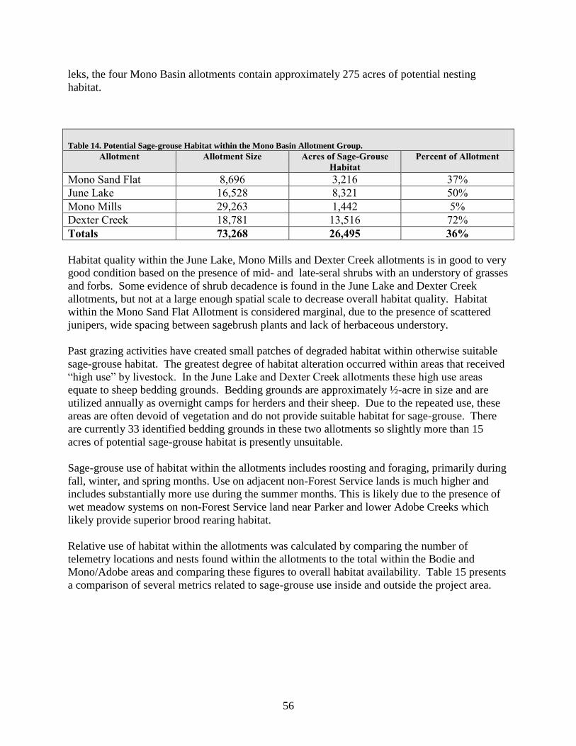
56
leks, the four Mono Basin allotments contain approximately 275 acres of potential nesting
habitat.
Table 14. Potential Sage-grouse Habitat within the Mono Basin Allotment Group.
Allotment Allotment Size Acres of Sage-Grouse
Habitat
Percent of Allotment
Mono Sand Flat 8,696 3,216 37%
June Lake 16,528 8,321 50%
Mono Mills 29,263 1,442 5%
Dexter Creek 18,781 13,516 72%
Totals 73,268 26,495 36%
Habitat quality within the June Lake, Mono Mills and Dexter Creek allotments is in good to very
good condition based on the presence of mid- and late-seral shrubs with an understory of grasses
and forbs. Some evidence of shrub decadence is found in the June Lake and Dexter Creek
allotments, but not at a large enough spatial scale to decrease overall habitat quality. Habitat
within the Mono Sand Flat Allotment is considered marginal, due to the presence of scattered
junipers, wide spacing between sagebrush plants and lack of herbaceous understory.
Past grazing activities have created small patches of degraded habitat within otherwise suitable
sage-grouse habitat. The greatest degree of habitat alteration occurred within areas that received
―high use‖ by livestock. In the June Lake and Dexter Creek allotments these high use areas
equate to sheep bedding grounds. Bedding grounds are approximately ½-acre in size and are
utilized annually as overnight camps for herders and their sheep. Due to the repeated use, these
areas are often devoid of vegetation and do not provide suitable habitat for sage-grouse. There
are currently 33 identified bedding grounds in these two allotments so slightly more than 15
acres of potential sage-grouse habitat is presently unsuitable.
Sage-grouse use of habitat within the allotments includes roosting and foraging, primarily during
fall, winter, and spring months. Use on adjacent non-Forest Service lands is much higher and
includes substantially more use during the summer months. This is likely due to the presence of
wet meadow systems on non-Forest Service land near Parker and lower Adobe Creeks which
likely provide superior brood rearing habitat.
Relative use of habitat within the allotments was calculated by comparing the number of
telemetry locations and nests found within the allotments to the total within the Bodie and
Mono/Adobe areas and comparing these figures to overall habitat availability. Table 15 presents
a comparison of several metrics related to sage-grouse use inside and outside the project area.

57
Table 15. Comparison of Sage-grouse Habitat Utilization Within and Outside Four Grazing
Allotments
Sage-Grouse Metric Count Percent of
Total Acres of suitable habitat within four grazing allotments1 26,722 7%
Acres of suitable habitat outside four grazing allotments
(primarily non-Forest Service land)
404,162 93%
Total suitable habitat in Bodie and Mono/Adobe areas 430,884 100%
Number of telemetry locations within four grazing
allotments2
116 4%
Number of telemetry locations outside four grazing
allotments (primarily non-Forest Service land)
2,554 96%
Total number of telemetry locations in Bodie and
Mono/Adobe areas
2,670 100%
Number of sage-grouse nests found within four grazing
allotments2
0 0%
Number of sage-grouse nests found outside four grazing
allotments (primarily non-Forest Service land)
38 100%
Total number of sage-grouse nests in Bodie and
Mono/Adobe areas
38 100%
Acres of suitable nesting habitat within four grazing
allotments3 275 0.2%
Acres of suitable nesting habitat outside four grazing
allotments (primarily non-Forest Service land) 117,513 99.8%
Total suitable nesting habitat in Bodie and
Mono/Adobe area 117,788 100%
1. Acres of habitat derrived from Pacific Southwest Region Remote Sensing Laboratory existing vegetation data (USDA
Forest Service 2001).
2. Telemetry and nest location data provided by United States Geological Survey (USGS unpublished data).
3. Acres of nesting habitat derrived from existing vegetation data and a two-mile buffer around lek sites (excluding inactive
leks).
Northern Goshawk:
The northern goshawk is found throughout most of North America, with a few isolated
populations in the southeastern and central United States. Within the Sierra Nevada goshawks
breed from 2,460 feet in the ponderosa pine/mixed-conifer vegetation types through 10,000 feet
in the red fir and lodgepole pine vegetation types. On the eastern slope of the Sierra Nevada
goshawks are found in the eastside pine and aspen vegetation types (USDA Forest Service
2001).
Goshawks prey on a variety of species, particularly small mammals and birds in timber areas.
Foraging has been documented to occur in heavy canopied forests with open understories.
Goshawks generally use perches to identify prey while hunting, so they probably do not forage in
expansive treeless areas.
The nesting cycle begins with courtship and nest building during February and March and
concludes in late August to early September when fledglings become independent. Stick nests
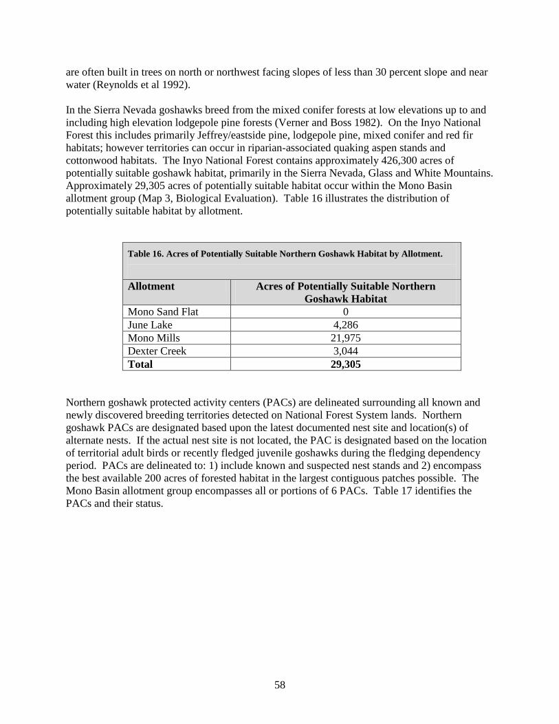
58
are often built in trees on north or northwest facing slopes of less than 30 percent slope and near
water (Reynolds et al 1992).
In the Sierra Nevada goshawks breed from the mixed conifer forests at low elevations up to and
including high elevation lodgepole pine forests (Verner and Boss 1982). On the Inyo National
Forest this includes primarily Jeffrey/eastside pine, lodgepole pine, mixed conifer and red fir
habitats; however territories can occur in riparian-associated quaking aspen stands and
cottonwood habitats. The Inyo National Forest contains approximately 426,300 acres of
potentially suitable goshawk habitat, primarily in the Sierra Nevada, Glass and White Mountains.
Approximately 29,305 acres of potentially suitable habitat occur within the Mono Basin
allotment group (Map 3, Biological Evaluation). Table 16 illustrates the distribution of
potentially suitable habitat by allotment.
Table 16. Acres of Potentially Suitable Northern Goshawk Habitat by Allotment.
Allotment Acres of Potentially Suitable Northern
Goshawk Habitat
Mono Sand Flat 0
June Lake 4,286
Mono Mills 21,975
Dexter Creek 3,044
Total 29,305
Northern goshawk protected activity centers (PACs) are delineated surrounding all known and
newly discovered breeding territories detected on National Forest System lands. Northern
goshawk PACs are designated based upon the latest documented nest site and location(s) of
alternate nests. If the actual nest site is not located, the PAC is designated based on the location
of territorial adult birds or recently fledged juvenile goshawks during the fledging dependency
period. PACs are delineated to: 1) include known and suspected nest stands and 2) encompass
the best available 200 acres of forested habitat in the largest contiguous patches possible. The
Mono Basin allotment group encompasses all or portions of 6 PACs. Table 17 identifies the
PACs and their status.

59
Table 17. Northern Goshawk Protected Activity Centers in the Mono Basin Allotment Group.
PAC Identifier Allotment Acres Within the
Allotment
Last Year With
Confirmed Activity
R05F04D51T10 Mono Mills 58 2006
R05F04D51T04 Mono Mills 201 2004
R05F04D52T06 Mono Mills 156 1998
R05F04D51T11 Mono Mills 200 2009
R05F04D51T06a Dexter Creek 231 1995
R05F04D51T06b Dexter Creek 134 2005
Yellow Warbler:
The yellow warbler (Dendroica petechia) was selected as the MIS for riparian habitat in the
Sierra Nevada. This species is usually found in riparian deciduous habitats in summer
(cottonwoods, willows, alders, and other small trees and shrubs typical of low, open-canopy
riparian woodland) (CDFG 2005). It also breeds in montane shrubbery in open conifer forests.
During migration, it visits woodland, forest, and shrub habitats. Yellow warbler is dependent on
both meadow and non-meadow riparian habitat in the Sierra Nevada (Siegel and DeSante 1999).
Yellow warblers are known to occur in the Mono Basin, but not necessarily in the Mono Basin
allotment group. Yellow warblers have been detected along Rush, Lee Vining, Mill and Wilson
creeks and was the most frequently captured breeding species at all sites and demonstrated fair to
high productivity ratios (Heath et al. 2004).
Riparian habitat was mapped from satellite imagery and subsequently verified through field
surveys. The Mono Basin allotments contain approximately 75 acres of yellow warbler habitat
(MRI). Five acres occur adjacent to Dry Creek in the extreme northeast corner of Mono Mills
allotment. The remainder is adjacent to Dexter Creek and un-named tributaries that feed North
Canyon in the Dexter Creek Allotment. The habitat is generally very narrow; rarely extending
more than 10-15 feet from the edge of the stream channel. Riparian vegetation consists of an
overstory of quaking aspen (Populus tremuloides) with an understory of willow (Salix spp.), wild
rose (Rosa woodsii), grasses and forbs. With the exception of two sites, all yellow warbler
habitat is outside the area grazed by livestock. Much of the habitat is within deeply entrenched
canyons which are inaccessible to livestock. The two sites that overlap with grazed areas include
a 0.6 acre bedding ground and watering area in Township 1S, Range 29E, Section 7; and a 1.2
acre watering area in Township 1S, Range 29E, Section 30.

60
The Inyo NF LRMP (as amended by the Sierra Nevada Forests MIS Amendment (USDA Forest
Service 2007) requires bioregional-scale habitat and distribution population monitoring for the
yellow warbler; hence, the riparian habitat effects analysis for the Mono Basin Grazing
Allotment Project must be informed by both habitat and distribution population monitoring data.
The sections below summarize the habitat and distribution population status and trend data for
the yellow warbler. This information is drawn from the detailed information on habitat and
population trends in the 2010 SNF Bioregional MIS Report (USDA Forest Service 2010a),
which is hereby incorporated by reference.
Habitat Status and Trend
There are currently 38,140 acres of riparian habitat on National Forest System lands in the Sierra
Nevada. Over the last two decades, the trend is stable.
Population Status and Trend
Monitoring of the yellow warbler across the ten National Forests in the Sierra Nevada has been
conducted since 2009 in partnership with PRBO Conservation Science, as part of a monitoring
effort that also includes mountain quail, hairy woodpecker, and fox sparrow (USDA Forest
Service 2010a, http://data.prbo.org/partners/usfs/snmis/). Yellow warblers were detected on
13.7% of 160 riparian point counts in 2009 and 19.4% of 397 riparian point counts in 2010;
additional detections were documented on upland point counts. The average abundance (number
of individuals recorded on riparian passive point count surveys) was 0.166 in 2009 and 0.309 in
2010. In addition, the yellow warblers continue to be monitored and surveyed in the Sierra
Nevada at various sample locations by avian point count, spot mapping, mist-net, and breeding
bird survey protocols. The results of these monitoring efforts are summarized in the 2008
Bioregional Monitoring Report (USDA Forest Service 2008). Current data at the rangewide,
California, and Sierra Nevada scales indicate that the distribution of yellow warbler populations
in the Sierra Nevada is stable.
3.4.1.2 Species of Local Concern
Mule Deer:
Mule deer from the Mono Lake and Casa Diablo deer herds pass through the Mono Basin during
the spring and fall migrations. All of the perennial streams and Warren Bench receive deer use
at these times. Many individuals also stay in the Mono Basin during the summer, primarily
along the North Fork of Lee Vining Creek, and on Warren Bench. Deer from these herds
generally winter in Huntoon Valley and the Benton area, and summer on both sides of the Sierra
Crest. The timing of spring migration is relatively consistent between years.
Suitable mule deer habitat is composed of four distinctly different elements: fawning, foraging,
cover, and winter range. Hiding cover is typically close to the ground and thick enough to
camouflage the outline of a deer, without being so dense as to obscure the approach of potential
predators. Thermal cover is similar and generally thought to be denser, with the additional
61
property of sheltering deer from the elements. Winter range tends to be lower elevation habitats
that meet the requirements for forage, hiding, and thermal cover described above. Habitat
suitability can be rated by the ratio of cover areas to forage areas and their size and spatial
arrangement. Habitat within the June Lake, Mono Mills and Dexter Creek allotments is
primarily forage and cover. Some limited fawning habitat may exist along Dexter Creek, but the
majority is located west of the allotments closer to summer range on Warren Bench.
Deer leave their winter habitat in April and follow receding snow through transition range,
arriving at summer habitat in mid-June to early-July. Fall migrations are less predictable and are
generally precipitated by the first major snowfall. The earliest fall migration occurs is in mid-
October, though deer more typically begin their migration in mid to late-November.
The quality of forage is most important to deer during the spring migration when does are
pregnant and replenishing nutritional stores depleted during the winter. At that time deer seek
out nutritious grasses, forbs and new annual leader growth on bitterbrush.
Deer transition range includes portions of June Lake, Mono Mills and Dexter Creek allotments.
Portions of the Mono Lake herd travel from winter range, through Adobe Valley and then along
the northern escarpment of the Glass Mountains. The remainder of this herd migrates to the
north of Mono Lake, primarily in the Bodie Hills. The southern third of June Lake Allotment
and the southwest corner of the Mono Mills Allotment are identified as a migration corridor for
the Casa Diablo deer herd. Little or no deer use occurs within the Mono Sand Flat Allotment.
Pygmy Rabbit:
The pygmy rabbit (Brachylagus idahoensis) is the smallest North American leporid. Big
sagebrush accounts for the majority of their diet and may comprise up to 99 percent of their diet
in the winter (Green and Flinders 1980a). Sagebrush canopy also is important as cover for
protection from predators (Grinnell et al. 1930). Additionally the pygmy rabbit is 1 of only 2
species of rabbits in North America that digs its own burrows (Orr 1940). Because of the
combination of these needs, pygmy rabbits are dependent on dense sagebrush growing on deep,
friable soils (Weiss and Verts 1984). The specific habitat requirements mean that even a large,
continuous stand of sagebrush may be highly fragmented for pygmy rabbits (Heady 1998).
Sagebrush islands are prominent clusters of sagebrush higher than the surrounding sagebrush.
Studies have noted that pygmy rabbits were more likely to be found in these clusters (Grinnell et
al. 1930, Orr 1940).
The pygmy rabbit was identified as a category 2 candidate for listing under the Endangered
Species Act in 1991. Category 2 candidates were species for which there was information
indicating that a proposal to list it as threatened or endangered may be appropriate, but for which
additional information on biological vulnerability and threat was needed. In April 2003, a
petition was submitted to list the species as threatened or endangered in Oregon, Idaho, Montana,
Wyoming, California, Nevada and Utah. On September 30, 2010 the Fish and Wildlife Service

62
(Service) published a 12-month finding on the petition to list the species. The Service
determined that listing was not warranted at that time.
In California, pygmy rabbits occur in eastern Modoc, Lassen and Mono counties (Orr 1940,
Severaid 1950, Jones 1957). The southern limit of their distribution in California is from the
vicinity of Lake Crowley in southern Mono County (Jones 1957). Their known elevational
range in California extends from approximately 4,800 feet at Goose Lake to 8,373 feet at Bodie.
Notable areas of known occupied pygmy rabbit habitat include the Bodie Creek drainage, the
historic Bodie Racetrack, Murphy Meadows and the Aurora Creek drainage. Pygmy rabbits
have not been detected on the Mono Sand Flat allotment but may be present based on habitat
suitability (USDI Bureau of Land Management 2008). It is unknown whether pygmy rabbits
occur within June Lake, Mono Mills or Dexter Creek allotments, although some marginally
suitable habitat is present.
3.4.2 Environmental Consequences
3.4.2.1 Direct, Indirect and Cumulative Effects of No Grazing (Alternative 1)
Federally Listed Threatened and Endangered Species
Under the No Action Alternative, it was determined that there would be no direct, indirect or
cumulative effects to Sierra Nevada bighorn sheep. No livestock grazing would occur within the
allotments, negating any possibility of contact between domestic and Sierra Nevada bighorn
sheep. No designated critical habitat occurs in the Mono Basin allotments; therefore cessation of
domestic grazing would have no impact within bighorn sheep habitat.
Forest Service Sensitive Species and Management Indicator Species
Sage Grouse:
Under the No Action Alternative there would be no direct impact to sage-grouse individuals or
their habitat. Cessation of grazing would have the indirect effect of allowing for passive
restoration within bedding grounds. Over time, sagebrush plants would become re-established
and allowed to grow freely in the absence of livestock trampling. The speed at which recovery
occurs would be predicated on the availability of either a suitable seed source or existing
seedbed. It is estimated that sagebrush would occupy the sites within 10-15 years. The spatial
coverage of sagebrush habitat would increase by slightly more than 15 acres.
Northern Goshawk:
Under the no action alternative there would be no direct, indirect or cumulative impacts on
northern goshawks or their habitat. Under existing management, no forage competition, direct
disturbance, habitat alteration or impedance of movement is occurring within suitable northern
goshawk habitat. Cessation of grazing would not alter this condition.

63
Yellow Warbler:
Elimination of grazing would have no direct impact on riparian habitat. Under existing
management, slightly less than two acres of riparian habitat are within the area grazed by
livestock. At these two sites aspen recruitment and understory shrub, grass, and forb cover is
reduced relative to un-grazed riparian habitat. Past grazing may have resulted in a reduction of
both deciduous and total canopy cover as a result of inadequate aspen recruitment. Under the No
Action Alternative, grazing would cease at these two sites and understory vegetation would
likely respond rapidly.
Species of Local Concern
Mule Deer:
Under the No Action Alternative there would be no direct impacts to mule deer. Under existing
management, mule deer and livestock do not overlap temporally on the allotments and
disturbance of deer by livestock operations is not occurring. Cessation of grazing would not alter
this condition. In the absence of livestock grazing, additional forage may be available to mule
deer during fall migration; however forage availability is not a limiting factor for mule deer on
the allotments
Pygmy Rabbit:
Under the No Action Alternative there would be no direct impact to pygmy rabbit individuals or
their habitat. Cessation of grazing would have the indirect effect of allowing for passive
restoration within bedding grounds. Over time, sagebrush plants would become re-established
and allowed to grow freely in the absence of livestock trampling. The speed at which recovery
occurs would be predicated on the availability of either a suitable seed source or existing
seedbed. It is estimated that sagebrush would occupy the sites within 10-15 years. The spatial
coverage of sagebrush habitat would increase by slightly more than 15 acres.
3.4.2.2 Direct, Indirect and Cumulative Effects of the Proposed Action (Alternative
2)
3.4.2.3 General
Potential impacts of grazing on wildlife species include competition for forage, direct
disturbance, habitat alteration, and impedance of movement.
Forage competition: Domestic livestock and wildlife species often utilize the same forage
species and can compete directly for available forage within a given area.
Direct disturbance: Direct disturbance can take the form of displacement of wildlife species
either by the livestock themselves or by other activities associated with grazing management
(e.g. presence of humans, operation of equipment, etc.). Another direct impact is the physical
trampling or crushing of individual wildlife organisms, nests or burrows.

64
Habitat alteration: Habitat alteration occurs when specific habitat components are trampled (e.g.
stream banks, springs, subterranean burrows, vegetation) or modified by consumption (e.g.
removal of cover).
Impedance of movement: Structures associated with livestock management (e.g. fences, above-
ground pipelines) can hinder wildlife movement and block migration corridors.
Federally Listed Threatened and Endangered Species
Direct and Indirect Effects
Implementation of the Mono Basin Grazing Allotment Project would not result in any of the
potential impacts listed above as the allotments are all spatially disjunct from occupied Sierra
Nevada bighorn sheep habitat. Factors limiting Sierra Nevada bighorn sheep recovery include
disease, predation, low population numbers and limited distribution, availability of open habitat,
and potential further loss of genetic diversity due to small population sizes and inadequate
migration between them. The Recovery Plan identifies disease transmission from domestic to
bighorn sheep as a major threat to this species and one of the key factors in listing the species.
The greatest risk posed by the proposed action is the potential for direct contact between
domestic and wild sheep that could lead to disease transmission. Contact could occur either
through straying of domestic sheep or as a result of long-distance movement by bighorn sheep.
If contact were to occur and the bighorn subsequently returned to the Mount Gibbs herd unit,
there is a high risk of spreading disease and resulting mortality within the Northern Recovery
Unit.
The possibility of contact between Sierra Nevada bighorn sheep and domestic sheep can be
determined, in part, by quantitatively estimating the relative likelihood of a bighorn sheep
moving into a domestic sheep allotment. This analysis was accomplished for all grazing
allotments in the Eastern Sierra and is documented in A Process for Identifying and Managing
Risk of Contact Between Sierra Nevada Bighorn Sheep and Domestic Sheep (Baumer et al.
2009) (Risk Assessment) and Application of the Document Entitled A Process for Identifying
and Managing Risk of Contact Between Sierra Nevada Bighorn Sheep and Domestic Sheep
(Croft et al. 2010) (Application Document). Briefly, a geographic information system (GIS)
based model was developed that incorporated Sierra Nevada bighorn sheep habitat suitability and
proximity to herd use areas to determine the relative likelihood of Sierra Nevada bighorn sheep
use of any particular location within the modeled area. The model incorporated habitat
suitability, resistance to movement, core bighorn sheep home ranges, and cumulative cost of
travel from a core home range location to any point within 60 kilometers (36 miles). The model
output is expressed as the Inverse Weighted Distance (IWD). IWD values represent the
likelihood of a bighorn sheep using a specific point on the landscape. Values closer to 1 indicate
a high likelihood of use by a Sierra Nevada bighorn sheep while values closer to 0 indicate a low
likelihood.

65
To determine a threshold of acceptable risk, the final GIS product (described above) was
overlain with locations where Sierra Nevada bighorn sheep are known to have occurred. The
IWD value at each known sheep location was calculated. Through this analysis, it was
determined that the values for all the known locations of collared rams ranged from 0.833 to 1.0.
The lowest value (0.833) for a known bighorn sheep location was, therefore, identified as a
threshold value, above which bighorn sheep use is highly likely. If domestic sheep are grazed in
locations that have a high likelihood of Sierra Nevada bighorn sheep use, the potential for
contact between domestic and wild sheep exists and is predicted. Because the goal of the Risk
Assessment is to prevent contact between the two species, values between 0.833 and 1.0 fall into
a category of unacceptable risk. The locations of those areas that have a value between 0.833
and 1.0 and their relationship to the Mono Basin allotments are displayed in Figure 2, Biological
Assessment. Approximately 1,670 acres (10%) of the June Lake Allotment fall within the area
with IWD values between 0.833 and 1.0. Of this, 265 acres are in the central median between
the divided lanes of Highway 395 and are not used by domestic sheep. Similarly, another 134
acres within the zone of overlap are located north of State Route 120 East in an unused portion of
the allotment. The total area of overlap is therefore approximately 1,271 acres or <8% of the
allotment. This area has experienced historic livestock grazing as evidenced by the presence of 3
sheep bedding grounds; however no grazing has occurred since the mid-1990s and none would
occur through implementation of the proposed action. None of the other Mono Basin allotments
are within the range of IWD values that suggest a high risk of contact between domestic and
bighorn sheep. In summary, no domestic sheep grazing is expected to occur in the area with
IWD values between 0.833 and 1.0 under the proposed action.
The Application Document (Croft et al. 2010) identifies several criteria land managers should
consider when evaluating whether an allotment or portion of an allotment identified as having a
high/unacceptable risk of contact may remain open and still ensure the prevention of contact
between domestic and Sierra Nevada bighorn sheep (i.e. allotment specific criteria).
Criteria
1) Allotments or portions of allotments within the predicted area of potential contact (i.e.,
mapped areas of inverse weighted distance values between 0.833 and 1.00) that are separated
from occupied Sierra Nevada bighorn sheep habitat by towns, highly developed recreation areas,
or other human developments that inhibit bighorn sheep movement.
2) Allotments or portions of allotments within the predicted area of potential contact that are
separated from occupied Sierra Nevada bighorn sheep habitat by large contiguous forested areas
that inhibit bighorn sheep movement.
3) Allotments or portions of allotments within the predicted area of potential contact that are
east of the U.S. Highway 395 management boundary recommended in Section II-E of the final
Recovery Plan for Sierra Nevada Bighorn Sheep (USDI Fish and Wildlife Service 2007).
4) Allotments or portions of allotments within the predicted area of potential contact that are
separated from occupied Sierra Nevada bighorn sheep habitat by major bodies of water (e.g.,
Mono Lake, Crowley Lake) that inhibit bighorn sheep movement.

66
The portion of the June Lake Allotment with mapped IWD values between 0.833 and 1.0 is
entirely east of Highway 395 and therefore meets criteria 3. In this area, Highway 395 is a four
lane divided roadway with moderate traffic volume. This stretch of highway is sufficiently wide
and busy to serve as a barrier to eastward movement by a Sierra Nevada bighorn sheep.
Similarly, the highway would also deter westward movement by domestic sheep if they were
separated from the band. There are several other natural and man-made features between the
Mount Gibbs herd unit and the June Lake Allotment that help to minimize the potential for
contact between the two species. The direct line of travel between occupied bighorn habitat and
the allotment is bisected by pure and mixed stands of coniferous forest. Grant Lake extends for 3
miles from north to south and also bisects the most direct line of travel. State Route 158, a two
lane paved road passes along the western boundary of Grant Lake and creates an additional
impediment to potential eastward travel by bighorn sheep.
The analysis in Clifford et al. (2007, 2009) showed a significant reduction in the probability of
Sierra Nevada respiratory disease transmission by not grazing domestic sheep during the rut,
limiting grazing days by domestic sheep, and vigilant domestic sheep grazing management.
Clifford (2009) considered the rut to extend from October through November.
The proposed action for the June Lake East Allotment includes several best management grazing
practices to further minimize contact between domestic and wild sheep. The permitted season of
use would be July 1 to August 31 each year which is a month before the onset of rutting season
for bighorn sheep in the area. The grazing period would be limited to 60 days a year and the
total number of domestic sheep would not exceed 1,500. Each of these are verifiable grazing
practices to reduce the probability of contact between bighorn and domestic sheep (Clifford
2007, Baumer et al 2009). Additional allotment-specific grazing practices are included to
prevent and detect straying of domestic sheep outside the allotment boundary. These include:
1. The permittee shall count all individual sheep upon entering and exiting the allotment.
One hundred percent counts will also be conducted following any type of ―scatter‖ event;
2. The permittee shall use marker sheep at a ratio of at least 1 to 35;
3. The permittee is responsible for assuring all permitted sheep are accounted for at all
times. A daily log of sheep numbers and counts will be maintained by the permittee. The
permittee will conduct daily counts of marker sheep following any significant change in sheep
distribution (e.g. after leaving bed grounds, trailing, or movement to a new feeding area); and
4. If at any time during the grazing season a domestic sheep is unaccounted for, the
permittee will notify the Forest Service immediately and the Escape Management Plan (USDA
Forest Service 2010b) will be implemented.
Cumulative Effects
The cumulative effects analysis area is defined as the following HUC-5 watersheds which
encompass the Mono Basin allotments: Mono Lake North, East Mono Basin, Mono Lake West,
Adobe Valley, and Rush Creek. These five watersheds total approximately 691,300 acres.
Within the cumulative effects boundary, cumulative effects are analyzed on the accumulation of

67
all past, present and reasonably foreseeable future actions or disturbances that would occur
within the next 20 years.
The species was emergency listed in 1999 as endangered by the U. S. Fish and Wildlife Service
because of the dramatic population decline in the late 1990s attributable to predation by
mountain lions, failure of sheep to utilize favorable low elevation winter range habitat because of
the presence of mountain lions, and the threat of large-scale mortality that could occur if
domestic sheep transmitted disease to a bighorn population. The inability of existing regulatory
mechanisms to deal with the issues of lion predation and disease transmission was also noted as a
major reason for the listing of the species.
Domestic sheep grazing has already been eliminated on all or portions of 6 of the 7 Inyo
National Forest allotments located west of Highway 395. The 7th allotment (Sherwin/Deadman)
is partially within the area with IWD values between 0.833 and 1.0; however the areas of overlap
are either not grazed by domestic sheep, or are separated from occupied Sierra Nevada bighorn
sheep habitat by a highly developed area (Town of Mammoth Lakes) and large contiguous
forested areas. Domestic grazing by cattle is expected to have negligible impacts on Sierra
Nevada bighorn sheep or designated critical habitat as wild sheep tend to inhabit areas unsuitable
for cattle use.
The Humboldt-Toiyabe National Forest has temporarily suspended domestic sheep grazing on all
or portions of those allotments within the area with IWD values between 0.833 and 1.0. They
are currently analyzing these allotments under the National Environmental Policy Act (NEPA)
and may permanently vacate the allotments or switch the class of livestock to cattle. A Proposed
Action is expected in 2012 once an analysis of whether the allotments are suitable for cattle
grazing is completed. Similarly, the Bureau of Land Management’s NEPA analysis of Dog
Creek and Green Creek allotments is ―in progress‖.
Mountain lion predation continues to be a risk factor for Sierra Nevada bighorn sheep; however
recent efforts by CDFG to monitor lion movements and remove lions known to prey on bighorn
are helping to mitigate this risk.
There are no other projects or activities identified in occupied bighorn sheep habitat that, in
conjunction with the Proposed Action, are likely to have cumulative negative impacts on Sierra
Nevada bighorn sheep populations.
Determination
The Biological Assessment determined that the implementation of the Mono Basin Grazing
Allotment Project WILL NOT AFFECT Sierra Nevada bighorn sheep or adversely modify
designated critical habitat for this species. This determination was based on the following
factors:
1. No domestic sheep grazing would occur in areas with inverse weighted distance values
mapped between 0.833 to 1.0 which are considered to be areas of unacceptable risk of contact
between domestic and bighorn sheep;

68
2. The grazed portion of the June Lake Allotment is entirely east of Highway 395 which is a
four lane divided highway and serves as a barrier to eastward movement by bighorn sheep and
westward movement by domestic sheep (Step 3, Criteria 3 Application Document);
3. Other natural and man-made barriers exist within the most direct line of travel between
the June Lake Allotment and occupied Sierra Nevada bighorn sheep habitat; and
4. A variety of best management grazing practices are identified in the proposed action,
including removing domestic sheep by the end of August (one month before the rut), limiting
grazing duration to 60 days, and implementing a number of measures to insure vigilant domestic
sheep grazing management.
Forest Service Sensitive Species and Management Indicator Species
Sage-Grouse:
Direct and Indirect Effects
Livestock grazing can have negative or positive impacts on sage-grouse habitat depending on the
timing and intensity of grazing (Crawford et al. 2004). For example, early season light to
moderate grazing can promote forb abundance/availability in both upland and riparian habitats
(Crawford et al. 2004). Heavier levels of utilization decrease herbaceous cover, and may
promote invasion by undesirable species (Crawford et al. 2004). Direct impacts from livestock
grazing can include disturbance during the breeding, nesting, early- and late-brood rearing
seasons. Disturbances may lead to dispersal from the area or abandoning nest sites. Direct
impacts also include inadvertent trampling of sage-grouse and sage-grouse nest sites by
livestock. Although nest destruction by livestock trampling is rare, the presence of livestock can
cause sage-grouse to abandon their nests (Crawford et al. 2004; Call and Maser 1985). Direct
impacts also include those related to vegetation structure. Grazing can remove grass or forb
cover that helps conceal sage-grouse nests from predators (Hockett 2002; Beck and Mitchell
2000).
Indirect impacts to sage-grouse habitat can include changes in composition, density, and
structure of vegetation and removal of brood forage and cover in meadows (Call and Maser
1985; Crawford et al. 2004). Trampling of vegetation by livestock can kill sagebrush,
particularly the smaller plants (Beck and Mitchell 2000). Grazing can also move sagebrush-grass
communities into lower successional stable states dominated by sagebrush with little herbaceous
understory (Beck and Mitchell 2000). The reduction in herbaceous understory can reduce the
understory cover and decrease the suitability of these areas for nesting. The reduction in forbs
during the spring and summer may also limit their availability for sage-grouse broods (Hockett
2002). Localized and concentrated use by livestock can reduce understory grass cover, which
may impact the quality of nesting habitat the following year and may affect nesting if grazed
during the late spring (Beck and Mitchell 2002).

69
Competition for forage is not expected to occur within the allotments. Grouse appear to be using
the allotments primarily during non-summer months when livestock are absent. Greater sage-
grouse are sagebrush obligates and the importance of sagebrush as a source of food and cover
has been well established (Patterson 1952, Braun et al. 1977, Connelly et al. 2000). During
winter, sage-grouse feed almost exclusively on leaves of sagebrush. Livestock grazing does not
substantially alter the density or productivity of sagebrush. Sagebrush is not a preferred browse
species, likely due to the concentrations of monoterpenoids in the foliage. Trampling and
destruction of sagebrush plants can occur in areas of concentrated cattle/sheep occupancy (e.g.
bedding grounds). It is estimated that less than 20 acres of vegetation are currently being
trampled and are unavailable to foraging grouse.
Insects and forbs composed the bulk of the diet of juvenile sage-grouse in Idaho, Montana and
Oregon (Klebenow and Gray 1968, Peterson 1970, Drut et al. 1994). Insects were the greatest
component of the diet for chicks until the second week post-hatch when forbs were consumed in
greater quantities (Klebenow and Gray 1968, Peterson 1970). The majority of suitable forb and
insect foraging areas are found within the meadow systems present in the vicinity of the project
area. The majority of these meadow systems are located on lands not managed by the Forest
Service and are not located within an allotment boundary. A single wet meadow system
(Crooked Meadows) occurs within the Dexter Creek Allotment. Under the proposed action, no
livestock grazing would occur in Crooked Meadows.
Direct disturbance of sage-grouse as a result of the proposed livestock operations is expected to
be minimal and would not occur during the time of year when disturbance would constitute a
negative impact. There are no strutting grounds within the allotments; therefore there would be
no potential for livestock/grouse interactions during the breeding season. The proposed grazing
season in Dexter Creek and June Lake would be delayed until after June 15 and July 1
respectively. By June 1 grouse in Long Valley and Parker Meadows have finished courtship and
nesting and broods are capable of limited flight (Overton, personal communication). There
would be no temporal overlap between grouse nesting and livestock grazing. This would
eliminate the potential for livestock to cause nest abandonment or inadvertent trampling of sage-
grouse nests.
Some disturbance may occur if grouse are using the upland portions of June Lake, Mono Mills
and Dexter Creek allotments during the summer months. Grouse may be flushed during foraging
or loafing and displaced short distances away from the source of disturbance. This disturbance
would be of relatively low intensity and short duration and grouse would be able to re-occupy the
site shortly after the passage of livestock.
The potential exists that grouse and cattle will overlap spatially and temporally in the Mono Sand
Flat Allotment. At present grouse are not known to occupy this allotment; however telemetered
birds were found approximately 1.5 miles north of the allotment during winter months. It is
possible that when grouse numbers increase, the population’s range may expand to include the
Mono Sand Flat area. Under the proposed action, no livestock grazing will occur within this
allotment until desired vegetation and watershed conditions are attained. It is unknown how long
it will take for recovery to occur, but it could be during the 10 year permit period. At some point
both grouse and cattle may be present and some level of disturbance of grouse could occur. The

70
degree of disturbance would likely be minimal due to the low number of cattle (26 cow/calf
pairs) permitted.
Some level of habitat alteration is occurring under current grazing systems and is expected to
continue, to a lesser degree, through implementation of the proposed action. Overall, livestock
grazing appears to mostly affect productivity of sage-grouse populations (Beck and Mitchell
2000). Productivity is decreased when nests are unsuccessful (e.g. predated, abandoned,
trampled) or habitat quality is too poor to provide insects and forbs during the brood rearing
period.
The greatest degree of habitat alteration occurs within areas that receive ―high use‖ by livestock.
In the June Lake and Dexter Creek allotments these high use areas generally equate to sheep
bedding grounds. Bedding grounds are approximately ½-acre in size and are utilized annually as
overnight camps for herders and their sheep. Due to the repeated use, these areas are often
devoid of vegetation and do not provide suitable habitat for sage-grouse. There are currently 33
identified bedding grounds in these two allotments so slightly more than 15 acres of potential
sage-grouse habitat is presently unsuitable. Under the proposed action all or most of these same
bed grounds would continue to experience annual use. There are 3 historic bed grounds in the
Mono Mills Allotment within suitable sage-grouse habitat which would likely be re-opened
under the proposed action. Therefore, under the proposed action a total of approximately 18
acres of potential sage-grouse habitat would be unsuitable for the 10 year life of the grazing
permits.
Braun et al. (1977) indicated that most hens nest within 3.2 km of a lek although other
researchers have described distances ranging from 2.7 to 7.8 kilometers. In this analysis,
important breeding habitat is identified as all suitable habitat within 3.2 kilometers (2 miles) of
an active lek. The Dexter Creek Allotment contains 50 acres of suitable habitat within 3.2
kilometers of the Adobe lek. The June Lake Allotment contains 225 acres of suitable habitat
within 3.2 kilometers of the Parker lek complex. Under the proposed action, no livestock grazing
would occur within this important breeding habitat.
Some nesting may occur at distances greater than 3.2 kilometers from an active lek. If this is
occurring, it is possible that some sage-grouse nest in areas of the June Lake and Dexter Creek
allotments that would be grazed by livestock. Herbaceous cover associated with nest sites may
provide scent, visual and physical barriers to potential predators. Habitat alteration would have
the greatest impact within the allotments if residual grass height was insufficient to protect and
screen nests. Kolada (2007) found that the residual grass height found at sage-grouse nesting
sites within Mono County, California averaged 10.5 cm and residual grass cover averaged 2.7%.
Within the Dexter Creek Allotment, surveys conducted after the 2003 and 2006 grazing seasons
noted residual grass heights averaged 23.6 cm and 17.8 cm, respectively. Therefore the residual
grass height within the project area exceeds that identified by Kolada and is likely providing
suitable cover for nesting habitat.
Sage-grouse movements are not currently being impeded by structures associated with livestock
use of the four allotments. No fences or other potential obstructions are present within June
Lake, Mono Mills or Dexter Creek allotments. Fencing is generally not required for sheep

71
grazing operations as herders in combination with dogs are able to maintain herd cohesiveness
and direct sheep to appropriate locations. Mono Sand Flat contains several boundary fences as
well as an exclosure fence around the primary spring source. These fences are low and generally
do not extend above the adjacent brush canopy. Sage-grouse flight tends to be above canopy
level except during take-off and landing, and the existing fences should not constitute a barrier to
movement or possible source of collision. A short section (0.1 miles) of new fence is proposed
near Baxter Springs. The fence will be fitted with mylar streamers which is a technique known
to make fences more visible to sage-grouse and reduce the potential for collisions.
Cumulative Effects
The Bi-State Conservation Plan identifies a variety of factors other than livestock grazing that
pose potential risks to sage-grouse within the Bodie and South Mono PMUs. These include
pinyon-juniper encroachment, urbanization/changing land use, fences/transmission lines,
recreational activities, predation, sport hunting, poaching, sagebrush habitat condition, and
mining/geothermal/energy development.
Pinyon-juniper encroachment is limited within the project area. Approximately 406 acres of
CWHR type PJN occur within the 4 allotments, primarily along the eastern edge of Dexter Creek
Allotment. It is unknown how rapidly the range of pinyon-juniper is expanding into the
sagebrush community.
Urbanization and changing land use is largely absent within the four allotments. Approximately
430 acres of private land are within the allotments. A 40 acre parcel is present near Sagehen
Meadow. A single family residence was constructed at this site in 2008 which encumbers less
than 1/2-acre. No other subdivision of this property is reasonably foreseeable. The remaining
private land is a single parcel within the Mono Sand Flat Allotment. There is no indication that
this parcel will be developed.
As discussed previously there is a limited amount of fencing present within the Mono Sand Flat
Allotment. Several additional miles of fence are present immediately east of the Dexter Creek
Allotment associated with the Adobe Ranch complex. Direct mortality of sage-grouse due to
fence strikes is a potentially significant population risk. This risk is most often associated with
the low-level flight of birds into leks under poor light conditions. Similar impacts are expected as
sage-grouse access other small habitats of concentrated use, for example night roosts, springs
and meadows. Fences are a yearlong risk, with seasonal peaks occurring in the spring and
summer, as birds concentrate near strutting grounds and late brood habitats. Sage-grouse
mortality resulting from fence strikes has been documented in Long Valley, but not in the Mono
Basin. The fences in Long Valley where collisions occurred have been re-constructed to easily
drop down during the breeding season and documented mortality has decreased substantially.
No transmission or distribution lines are situated within the four allotments. An overhead
transmission line runs roughly parallel to Highway 395 west of the June Lake Allotment. The
distance from the line to sage-grouse habitat in the allotment ranges from 400 feet to over ½-
mile. Poles for above ground utility lines provide perches for avian predators (Ellis 1984, 1987)

72
and may cause sage-grouse to avoid the immediate area where they are placed. Utility lines may
also cause direct mortality if flying sage-grouse strike the wires (Call and Maser 1985). To date,
no utility wire strikes have been documented in the South Mono or Bodie PMUs.
Recreational activities within the allotments are dispersed in nature and consist of fuelwood
gathering, vehicle use of existing dirt roads and isolated un-improved campsites.
Lands within the Mono Basin allotments are mostly un-developed and do not provide areas that
would attract predators or provide a source population of feral cats and dogs. A 40 acre landfill
that services the communities of June Lake and Lee Vining is located less than 1 mile west of
sage-grouse habitat in the June Lake Allotment. The landfill likely attracts ravens and coyotes,
both of which are known to prey on grouse and decrease nesting productivity (Coates and
Delehanty 2010).
Sport hunting is the physical act of removing individual birds from the population during a
regulated season and by regulated methods of take (shotgun, archery, falconry). However,
hunting seasons are only scheduled when specific population criteria are met. Sport hunting of
sage-grouse occurs within the South Mono PMU within a designated hunting zone called the
South Mono/Inyo Hunt Zone. In the Bodie PMU hunting is allowed in the North Mono Hunt
Zone. Quota numbers for the two zones are relatively conservative, with 25 permits issued for
the north zone and 35 for the south zone during the 2010-2011 season (CDFG 2010). The Mono
Basin allotment group lies between the two hunt zones. Any harvest within the allotments would
be illegal. There are no recent accounts of sage-grouse poaching within the South Mono PMU.
Mineral extraction and geothermal development are essentially absent from the Mono Basin
allotments. Several old prospect sites are present in the vicinity of Sagehen Peak, but no current
extraction is on-going. The Forest Service is currently analyzing a proposal to install an
anemometer in the vicinity of Sagehen Peak. The project proponents are attempting to determine
whether the site is properly situated to develop a wind energy facility. The anemometer itself is
not likely to represent a negative impact to sage-grouse as the guy wires would be constructed
with anti-collision devices and all horizontal parts of the tower would contain structures to deter
raptor perching. Although not reasonably foreseeable at this time, construction of a new wind
energy facility could present substantial risk to local sage-grouse populations due to mortality
associated with wind turbines as well as habitat disruption from ancillary facilities such as roads
and transmission lines. Any proposal for construction of a wind energy facility would entail
additional analysis under NEPA, including an analysis of the potential effects on sage-grouse.
West Nile Virus (WNv) has emerged as a potential threat to greater sage-grouse since 2002
(Naugle et al. 2004, USDI Fish and Wildlife Service 2008c, Walker and Naugle 2009). West
Nile virus has been identified as a cause of sage-grouse mortality in the Bodie PMU (Casazza et
al 2005). Greater sage-grouse are considered to have a high susceptibility to WNv, with
resultant high levels of mortality (McLean 2006).
In sagebrush habitats, WNv is primarily regulated by environmental factors, including
temperature, precipitation and distribution of anthropogenic water sources that support the
mosquito vectors (Reisen et al. 2006). Livestock watering facilities have the potential to support
the mosquito vector, especially if the water is allowed to stagnate. Most livestock watering
within the June Lake, Mono Mills and Dexter Creek allotments is not likely to contribute to
potential spread of WNv. Water for sheep is generally transported by truck throughout the

73
allotments and provided to livestock in portable troughs. The troughs are drained after 1-2 days
and moved to a new location in the allotment. This short duration precludes stagnation of water
and does not create suitable mosquito breeding habitat. At Baxter Springs, water is piped to a
permanent trough. The trough location is within potential sage-grouse habitat and could be a
mosquito breeding ground if water is allowed to remain for extended periods of time. The
proposed action includes installation of a centrally located well and water tank in the Mono Mills
Allotment. Water may escape from this facility and pond nearby, creating additional mosquito
breeding habitat. To alleviate the potential spread of WNv from these water sources, the
following measure is incorporated in the Proposed Action:
WLF-1. Assure that the trough at Baxter Springs is thoroughly drained and dry when domestic
sheep vacated this portion of the allotment. If a well is installed in potential sage-grouse habitat
within the Mono Mills Allotment, assure that construction does not allow water to pond in the
vicinity.
The Mono Sand Flat Allotment contains a spring fed pond with relatively slow moving and
ponded water. The pond is a potential location for mosquito breeding; however, surveys
conducted during July and August 2010 failed to detect mosquito larva.
Although not identified in the Bi-State Plan, wildfire may pose the greatest long-term risk to
maintenance of sage-grouse populations. Fire tends to kill mature sagebrush plants. Re-
establishment of sagebrush stands may take up to 15 years or more post-fire. In some portions of
burned areas such as south facing slopes, cheat grass may rapidly expand and dominate such
sites after wildfire. The resulting mono-culture of annual brome is substantially less suitable for
sage-grouse. The presence of cheat grass may lead to an altered fire regime and exacerbate the
occurrence of landscape fires. Contemporary fires (since 2000) have generally been relatively
small or have only consumed small amounts of sagebrush vegetation in the vicinity of the Mono
Basin allotments. During this period, approximately 6,350 acres of shrub-steppe vegetation has
burned. Type conversion or rapid spread of weeds in burned areas is not currently occurring in
the vicinity of the Mono Basin allotments (see Botany section of this document) These burns
have had the beneficial effect of creating a mosaic of patches of early-seral sagebrush-steppe
vegetation which more closely resembles historic levels of seral diversity. The cumulative
impact of wildfire on sage-grouse habitat in the Mono Basin is not a limiting factor for
population viability. The potential for a large, landscape scale wildfire exists, however these
events are stochastic and it is not possible to predict when such an incident may occur.
Determination
Considering the above discussion of effects, it is my determination that implementation of the
Mono Basin Grazing Allotment project may impact individual sage-grouse, but would not result
in a trend towards federal listing or loss of viability within the project area. This determination is
based on the following factors:
1. Livestock will not be authorized to graze until after June 15th, when sage-grouse have
completed the breeding and nesting season in this area;
2. All meadow systems that provide potential brood rearing habitat have a 0% allowable
utilization standard;

74
3. Utilization standards will continue to allow for suitable cover needed during the nesting
season;
4. Reducing allowable utilization to 0% in the Mono Sand Flat Allotment will allow for
gradual restoration of potential sage-grouse habitat; and
5. The impacts of the proposed action were on-going when the sage-grouse was identified
as a priority 3 candidate for listing under the Endangered Species Act and are not likely to
elevate the species to a higher priority.
Northern Goshawk:
Direct and Indirect Effects
Livestock grazing identified in the proposed action may be a source of disturbance during
goshawk breeding and nesting activities. It is unlikely that other impacts associated with
livestock grazing (i.e. forage competition, habitat alteration, impedance of movement and non-
native species) are affecting northern goshawk population or habitat within the Mono Basin
allotment group.
Human disturbance has the potential to cause goshawk to abandon nesting during the nesting and
post fledging period (February 15 through September 15). Goshawks initiate breeding when the
ground is still covered in snow and sometimes nests are located along roads when they are not
yet in use. Additionally, roads and trails provide flight access for goshawk. When the snow
melts, these sites can potentially be areas of conflict as sheep bedding grounds are often located
along roads.
Goshawks display a variety of responses to humans and vehicles. During the nest establishment
period (March – April), repeated perturbations may cause individuals to abandon nest building.
Once the female has begun incubating eggs, she is less likely to display any overt response when
people or vehicles approach the nest. Observations of nests on the Inyo National Forest suggest
that both the male and female adults become more aggressive shortly after juveniles hatch and
will actively defend the nest by ―dive bombing‖ approaching humans. This behavior results in
an energetic cost to the adults and may also detract from their ability to tend to young or forage.
This aggressive behavior declines significantly once juveniles are capable of independent flight
(mid-August) and by the end of August human disturbance in the vicinity of nests does not
appear to negatively affect juvenile survival.
The use of sheep bedding grounds or the trailing or watering of sheep in close proximity to an
active goshawk nest presents a risk to goshawk individuals and productivity. The presence of
humans, sheep and vehicles may elicit territorial or defensive behavior by goshawks and lead to
nest abandonment or reduced ability to protect the nest. These impacts would most likely to
occur if the source of disturbance was very close to an active nest. The protected activity center
is a viable proxy for the area where disturbance would likely be detrimental to goshawks.
Disturbance outside of PACs is unlikely to negatively affect northern goshawks. Under existing
management, there are no sheep bedding grounds or watering sites within PACs. New bedding

75
grounds may be required to adequately distribute sheep throughout the Mono Mills Allotment.
To assure that disturbance of northern goshawks during the breeding season is minimized or
eliminated, the following measure is incorporated in the Proposed Action:
WLF-2. Locate all bedding grounds, watering sites and trails outside northern goshawk protected
activity centers.
Cumulative Effects
The major threats to northern goshawks at the present time involve the effects of vegetation
management (e.g., timber harvest, fuels treatments, etc.) and wildfire on the amount, distribution
and quality of habitat (DeStefano 1998).
The 1988 Inyo National Forest LRMP designated 29,697 acres within the Mono Basin allotment
group as prescription #10 (high-level timber management). Upon publication of the Record of
Decision for the Sierra Nevada Forest Plan Amendment Project (USDA Forest Service 2004) the
area was reclassified as ―general forest‖. Some level of timber harvest has historically occurred
throughout this area. Prior to the early 1990s harvest methods included overstory removal, small
clearcuts, pre-commercial and commercial thins. Beginning in the early 1990s, the Forest
discontinued the cutting of large old trees and began a program of ―old-growth‖ restoration.
Since that time timber harvest has consisted of thinning from below or removing the smallest
diameter trees sequentially until a desired basal area and spacing was reached. Cut trees were
sold as firewood or left on site for the public to collect. Most areas were subsequently treated
with prescribed fire.
Since 1994 approximately 9,265 acres have been treated in this manner. The units were likely
goshawk foraging habitat prior to treatment and continue to provide foraging opportunities as the
dominant overstory trees were retained. Potential goshawk nesting habitat was identified by the
early 1990s and no timber harvest has occurred in those stands since that time.
Wildfire has not played a significant role in modifying northern goshawk habitat in recent
history. Since 2001 four wildfires have affected approximately 525 acres of suitable goshawk
foraging habitat. Fire intensity within these habitat areas was generally low to moderate and they
continue to provide foraging opportunities.
Determination
Considering the above discussion of effects, the Biological Evaluation determined that
implementation of the Mono Basin Grazing Allotment project may impact individual northern
goshawks, but would not result in a trend towards federal listing or loss of viability within the
project area. This determination is based on the following factor:
1. Bedding grounds, watering sites and trailing routes will not be allowed within northern
goshawk Protected Activity Centers (Mitigation WLF-2).
Yellow Warbler:
Direct and Indirect Effects

76
Under this alternative livestock use would continue within approximately 1.2 acres of riparian
habitat. The Proposed Action eliminates sheep bedding grounds within 500 feet of streams.
This would eliminate livestock use of the 0.6 acre bedding ground located in Township 1S,
Range 29E, Section 7. In the absence of grazing, understory vegetation would likely respond
rapidly at this site. The remaining 1.2 acres of riparian habitat would be managed with the
following use standards (USDA Forest Service 1995):
• Allowable herbaceous utilization level 45% or less;
• Allowable browse utilization level 20% of annual leader growth of hardwood seedlings
and advanced regeneration; and
• Streambanks would not exceed 20% disturbance per reach.
These use standards are compatible with maintaining adequate aspen recruitment and there
should be no change in total acres of riparian habitat, deciduous canopy cover, total canopy
cover or CWHR size class.
Cumulative Effects
Livestock grazing and water diversions are the primary historic and on-going activities that
affect yellow warbler habitat across the Sierra Nevada. As described above, grazing is currently
occurring within slightly less than 2 acres of riparian habitat within the Mono Basin allotments.
This represents approximately 2 percent of the total available habitat within the allotments.
There are no water diversions or other perturbations cumulatively impacting riparian habitat in
the analysis area. Sport fishing has been known to affect riparian habitat in some areas of the
Sierra Nevada. Anglers may trample or remove vegetation while attempting to access
waterways. The northern Glass Mountains is a relatively remote area without an established
sport fishery. As such, angling pressure is light to non-existent and not a source of disturbance
within yellow warbler habitat.
Aspen stands are often utilized by dispersed campers. This use may reduce the suitability of
yellow warbler habitat due to trampling of young aspen suckers which may lead to a reduction of
aspen regeneration. Dispersed camping does occur in the Glass Mountains; however no
dispersed campsites were identified in riparian habitat within the Mono Basin allotments.
Determination
Livestock grazing has been occurring since the 1860s within the project area (Fletcher 1982)
and, in conjunction with wildfire and climate, has created the vegetative mosaic present on the
landscape. Under the proposed action, allowable use standards are modified based on the
condition of key areas within the allotments and are designed to provide accelerated restoration
and improvement of degraded range sites to a functional condition and to maintain those sites
currently in a fully functional condition. Under the proposed action livestock use would be
discontinued within 0.6 acres of riparian habitat in Township 1S, Range 29E, Section 7. The
proposed action would allow some level of impact to continue on approximately 1.2 acres out of

77
38,140 acres (0.003%) of riparian habitat on National Forest System lands in the Sierra Nevada.
The degree of impact is anticipated to be minimal, and would not alter the existing trend in the
habitat, nor lead to a change in the distribution of yellow warblers across the Sierra Nevada
bioregion.
Species of Local Concern
Mule Deer:
Direct and Indirect Effects
Implementation of the proposed action would have minimal or no impact on mule deer.
Livestock and mule deer would not overlap temporally as the on dates for livestock are delayed
until after June 15 or later at which time deer have already accessed summer range west of
Highway 395. Similarly, livestock would be removed from the allotments no later than
September 15 each year which is at least one month prior to the earliest onset of fall deer
migration. This would negate the potential for livestock disturbance of deer or disruption of
fawning.
Similarly, competition for forage would be minimized by delaying livestock use until after spring
migration. Deer would have access to all new growth of grasses, forbs and shrubs as well as the
residual from the previous year. Forage availability would not be a limiting factor for deer
during fall migration. The use standards prescribed in Forest Plan Amendment #6 are maximum
limits of use by all species (both domestic livestock and wildlife). Adaptive management would
entail monitoring utilization after fall deer migration. If deer use in the fall results in exceeding
utilization limits, livestock use would be reduced the following year to correct the imbalance.
Cover habitat would not be affected by livestock grazing. Cover habitat on the allotments is
provided by dense stands of conifers which are not impacted by sheep grazing.
Implementation of the proposed action would have no effect on the ability of mule deer to pass
through the allotments. There are currently no fences or other potential barriers in June Lake,
Mono Mills or Dexter Creek allotments A short (0.1 mile) section of fence would be
constructed near Baxter Springs which may cause deer to detour a small distance. Generally,
however, deer are able to jump over or crawl under standard height fences.
2. Cumulative Effects
Past and present effects to deer include historic grazing within deer habitat; loss or creation of
habitat by wildfire; loss of hiding and thermal cover from timber and fuels projects, along with
an increase in forage; urban expansion; and a general increase in noise and sight disturbance
from recreational activities such as hunting, camping and pleasure driving, including all forms of
motor vehicle use. Deer mortality from collisions with vehicles is expected to continue on high-
speed paved routes such as US395. Between 1965 and 2001, deer mortality on a 40 mile stretch
of US395 ranged from 5 – 56 deaths per year (EMA 2003). Bleich et al. (2006) reported that
road-kills accounted for 27 percent of deer mortality investigated during their study.
Wildfire can remove both cover and forage for mule deer. Contemporary fires (since 2000) have
generally been relatively small or have only consumed small amounts of shrub-steppe vegetation
in the vicinity of the Mono Basin allotments. During this period, approximately 6,350 acres of

78
shrub-steppe vegetation has burned. The potential for a large, landscape scale wildfire exists,
however these events are stochastic and it is not possible to predict when such an incident may
occur.
Habitat burned by wildfire does not necessarily become unsuitable for mule deer, but may
change from hiding or thermal cover to foraging habitat. In other cases, when invasive plant
species colonize the site post-fire, habitat quality is reduced. Only when a complete type
conversion (e.g., sagebrush/bitterbrush to cheat grass) occurs would the habitat become
unsuitable. Type conversion or rapid spread of weeds in burned areas is not currently occurring
in the vicinity of the Mono Basin allotments (see Botany section of this document) and burned
areas continue to provide foraging opportunities for mule deer.
Some level of timber harvest has occurred throughout the forested portion of the project area.
Prior to the early 1990s harvest methods included overstory removal, small clearcuts, pre-
commercial and commercial thins. Beginning in the early 1990s, the Forest discontinued the
cutting of large old trees and began a program of ―old-growth‖ restoration. Since that time
timber harvest has consisted of thinning from below or removing the smallest diameter trees
sequentially until a desired basal area and spacing was reached. Cut trees were sold as firewood
or left on site for the public to collect. Most areas were subsequently treated with prescribed fire.
Since 1994 approximately 9,265 acres have been treated in this manner. Historic clearcuts
effectively converted cover to foraging habitat, until such time as reforestation efforts were
successful. Thinning from below reduced the quality of both thermal and hiding cover. Recent
thinning operations (since 1996) included design criteria to retain patches of cover throughout
areas that received high use by mule deer. No additional timber harvest or fuels reduction
projects are reasonably foreseeable within the Mono Basin Allotments.
Pygmy Rabbit:
Direct and Indirect Effects
It is unlikely that issuance of term grazing permits would lead to competition for forage between
livestock and pygmy rabbits. Sagebrush comprises the majority of pygmy rabbit diets and this
plant species is rarely consumed by livestock due to potentially toxic levels of monoterpenoids in
the foliage. Some sagebrush can be destroyed by repeated trampling and this is likely to occur to
a limited degree within sheep bedding grounds. It is estimated that existing and expected
bedding grounds will encumber approximately 18 acres of shrub-steppe vegetation that could
provide forage and habitat for pygmy rabbits.
Livestock grazing could be a source of disturbance, especially in the vicinity of rabbit burrows.
Burrows usually have a number of entrances, are constructed into a north or east facing slope
(Wilde 1978), and are often located at the base of sagebrush patches (Green and Flinders 1980b).
In California, their burrows are generally less than 1m long and up to 1.5 m deep (Orr 1940).
Burrows are an important element of an individual’s home range because they provide protection
from predation and temperature extremes, and are probably used as nesting sites. Disturbance at
burrow sites could cause temporary displacement of individuals, but would likely be a short term
perturbation, with rabbits able to return to their burrows shortly after livestock vacate the area.
79
The potential for burrow collapse as a result of livestock trampling exists but is expected to be
minimal. Of the four allotments, pygmy rabbits are most likely to occur in Mono Sandflat based
on habitat suitability, historic range and proximity to known occupied habitat. Under the
proposed action, livestock grazing would be deferred on Mono Sandflat Allotment until desired
vegetation conditions are attained. During this time there would be no potential for livestock to
damage rabbit burrows. If livestock are eventually permitted on the allotment, the numbers
would be low (26 cow/calf pairs) and the potential for burrow damage would remain minimal.
Livestock grazing on the four allotments is unlikely to have any impact on the ability of pygmy
rabbits to move through suitable habitat.
Cumulative Effects
The main threat to B. idahoensis in Nevada and California is fragmentation due to large fires.
These fires have extirpated populations from entire valleys and without leaving any cover behind
may not allow rabbits to repopulate the area. The spread of non-native plant species in recently
burned areas can exacerbate this threat. Agricultural fields are also a risk factor. Fields are often
placed on the same loamy soils the rabbits prefer, may also create a potentially impassable
barrier, and may increase the habitat suitability for cottontails. Road systems represent a
potential barrier to dispersal. In nighttime road transect surveys in areas with known ratios of
jackrabbits/cottontails/ B. idahoensis, B. idahoensis was consistently significantly
underrepresented. This may be due to their reluctance to cross open areas (Sequin 2004).
Contemporary fires (since 2000) have generally been relatively small or have only consumed
small amounts of shrub-steppe vegetation in the vicinity of the Mono Basin allotments. During
this period, approximately 6,350 acres of shrub-steppe vegetation has burned. These burns have
had the beneficial effect of creating a mosaic of patches of early-seral sagebrush-steppe
vegetation which more closely resembles historic levels of seral diversity. These wildfires have
not been large enough to constitute a barrier that would prevent pygmy rabbit dispersal. The
potential for a large, landscape scale wildfire exists, however these events are stochastic and it is
not possible to predict when such an incident may occur.
Agriculture in the Mono Basin is minimal and restricted to small plots of land on the western
side of Mono Lake. Three high-speed paved roads (US395, SR167, and SR120) occur in the
vicinity of the Mono Basin allotments. State route 167 forms the northern boundary of the Mono
Sandflat Allotment and may act as a barrier for rabbits dispersing from occupied habitat in the
Bodie Hills.
3.5 Effects Relative to Aquatic Wildlife
This section contains a summary of information presented in the Biological Evaluation for
Aquatic Species (Sims, 2011) which is hereby incorporated by reference.
3.5.1 Existing Condition
Aquatic resources within the Mono Allotment group are sparse throughout the area. No running water,
or perennial streams, occurs within the Mono Sand Flat or June Lake allotments. Approximately 9.5
miles of perennial streams occur within the Dexter and Mono Mills allotments and are small in size and

80
flow, and typically terminate in the ground. Although these streams provide an important resource for
wildlife by creating diverse riparian habitats, they do not provide hydrological connectivity to any
major bodies of water, and so are biologically isolated. Desert springs also provide important riparian
habitat, not only providing water to the inhabitants of this ecosystem, but also increasing diversity
within the landscape. No native fish inhabit these streams and due to the lack of robust, dependable
flow, introduced trout have not particularly thrived in these environments. A population of brook trout
occurs within Dexter Creek within the allotment, which is a self sustaining population with relatively
small individuals.
The condition of the meadows relate to the condition of the streams that flow through them. Meadows
that are properly functioning will have minimal soil disturbance along the stream edge, where as
meadows not functioning properly or that are in poor condition will have above average sediment input
and reduction in surface shade due to the suppression of vegetative growth. Four of the five Key Areas
were rated as Proper Functioning Condition, with Johnny Meadow rated at Fair, indicating that
meadows within the allotments are in relatively good condition. Streams within these meadows have
been rated as Proper Functioning Condition, with vigorous riparian vegetation and shade, stable banks
and lack of unstable areas.

81
Above: Location of perennial streams within the Dexter Creek Allotment.
Table 18. Miles of Perennial Stream.
Allotment Name Miles of Perennial
Streams
June Lake Allotment 0
Mono Mills Allotment 0.75
Mono Sand Flat 0
Dexter Creek Allotment 8.75
Total 9.5 miles
A query of GIS information for springs and streams was conducted for the four allotments. A
total of 41 springs were identified throughout the four allotments. The tables below indicate the
results of the query.
Table 19. Number of Springs.
Allotment Name Number of Springs
June Lake Allotment 0
Mono Mills Allotment 3
Mono Sand Flat 1
Dexter Creek Allotment 37
Total Number of Springs 41

82
Above: Location of springs on the Mono Sand Flat Allotment. One spring is located on the
allotment.

83
Map above: Location of springs within the Dexter Creek, Mono Mills and June Lake
allotments. Also included are results from springsnail surveys completed by Hershler, 1989, as
depicted by the bright green dots. No rare species were identified.
A complete aquatic survey was conducted in 1995 by fisheries technicians to catalog aquatic
species throughout Dexter Creek Allotment. Brook trout were identified within Dexter Creek,
along with mountain yellow-legged frogs in Crooked Meadows, which have since been
extirpated. Springs were also surveyed for springsnails, and an unidentified springsnail was
observed in a spring that occurs outside the allotment boundary. No other aquatic species were
identified in the surveys. Macroinvertebrates were not included in the surveys.
Prior to 2000, Crooked Meadows within the Dexter Creek watershed was habitat to a robust
population of mountain yellow-legged frogs. Since that time, the population was extirpated by
the fungal infection, Chytrid. Several surveys have been conducted in the area since that time,
with negative results. Personal communication with Roland Knapp, research biologist, in 2009,
indicated that he has occasionally observed a single adult frog within the meadow, however, no
tadpoles have been observed in the meadow.

84
Left: Overview of riparian area
within the allotment in the upper
watershed of an un-named creek,
just northeast of Wild Horse
Meadow.
Management Indicator Species (MIS) within the analysis area include the Pacific chorus frog
(an indicator of meadow habitat) and the macroinvertebrate populations (an indicator of aquatic
habitat). Macroinvertebrates are aquatic–dwelling insects that live either their entire life or part
of their life in the water, and for the purpose of using these organisms as an MIS, are good
indicators of overall stream health. For the Pacific chorus frog, a total of 91.8 meadow acres are
identified as suitable habitat, all which occur within the Crooked Meadows complex along
Dexter Creek. For macroinvertebrates, a total of 9.5 miles of stream occur within the allotments
that are suitable habitat for these species. The analysis of these MIS is included within the MIS
Report for the Mono Basin Group Grazing Allotment Project, and is incorporated by reference.
3.5.2 Environmental Consequences
Direct and Indirect Effects of the No Action and Proposed Action Alternatives:
There are no aquatic species of special concern (Threatened, Endangered, or Sensitive species)
within the four allotments that would be affected by a grazing decision (see Aquatic Species
Biological Evaluation for the Mono Basin Group Grazing Allotment Project, incorporated by
reference). Therefore, neither the No Action nor the Proposed Action would directly, indirectly,
or cumulatively affect any aquatic species of special concern.
The implementation of this project will not alter the existing trend in the habitat for aquatic
macroinvertebrates across the Sierra Nevada bioregion. The change in flow, sedimentation and

85
shade are too small to be measured in the Mono Basin Group Range Permit Re-issuance analysis
area. As a result, both the No Action and the Proposed Action would have no effect on habitat
for aquatic macroinvertebrates.
Both alternatives would result in no grazing in the Crooked Meadows area, allowing for a
continued upward trend of 91.8 acres in hydrologic function and vegetative cover for this
meadow. Therefore, there would be no direct, indirect or cumulative effects on Pacific chorus
frog habitat with the implementation of either alternative. The maintenance of 91.8 acres of
identified wet meadow in the analysis area will be beneficial to the Pacific chorus frog at the
project scale and at the Bioregional scale.
3.6 Effects Relative to Plants and Noxious Weeds
This section contains a summary of information presented in the Biological Evaluation for
Sensitive Plant Species (Weis 2011a) and the Noxious Weed Risk Assessment (Weis,
2011b).which are hereby incorporated by reference.
3.6.1 Existing Condition
The vegetation of the three southern allotments, Dexter Creek, June Lake, and Mono Mills, has
been well documented by Michael Honer (2001) and is mostly dominated by sagebrush scrub
and Jeffrey pine forests, with other woodlands and forests of pinyon pine, lodgepole pine, and
aspen. Riparian vegetation is present along perennial springfed streams and includes willows,
wild rose, water birch, sedges, and grasses. There are also several meadow systems adjacent to
springs that were used for cattle grazing in the past and show some sign of disturbance (Honer,
2001). Honer identifies the pumice sand flats in these three allotments as a special habitat and
they are also described in the California Natural Diversity DataBase (CNDDB) as a rare natural
community. They are the principal habitat for the two sensitive species Mono milk-vetch and
Mono Lake lupine. Honer describes them as large, nearly shrubless pumice soil ―sand flats‖
surrounded by Jeffrey pine forest and sagebrush.
The Mono Sand Flat Allotment on the northeast shore of Mono Lake consists for the most part of
sparsely vegetated sand dunes with some seasonally flooded swales and a few springs with
riparian vegetation.
The Inyo National Forest has an aspen enhancement project currently in the planning stage,
although surveys of aspen have been ongoing since 2008. There are approximately 60 aspen
stands, totaling about 800 acres, in the analysis area, mostly on the Dexter Creek Allotment, with
a few on the Mono Mills allotment. Ten of the stands have been visited and evaluated as of
2010. Of these, three were deemed to be at low risk, three at moderate risk, and four at high risk
of being lost from above (overtopped by conifers) or not being replaced from below (insufficient
aspen regeneration). Sheep browsing was observed at four of the stands, but was an issue at only
two of them. The enhancement project proposes to treat aspen stands at moderate, high, and
highest levels of risk using a suite of treatments, in order to reduce the risk of loss.
In a Forest-wide search for fens using aerial photos, one meadow, Crooked Meadows, was
identified as possibly having a fen. The meadow was visited in 2007 and sampled at three

86
locations, but no areas meeting the Forest Service Region 5 definition of a fen (>40 cm peat,
year-round saturated soil, fen plants) were found.
Rare and Sensitive Plants
The Biological Evaluation for the Mono Basin Grazing Allotments (Weis 2011a) identified three
sensitive plant species known to occur in the project area (Mono milk-vetch, Bodie Hills rock-
cress, and Mono Lake lupine) and seven sensitive species for which potential habitat exists
within the project area (5 rare moonworts, Williams’ comb-leaf, and Inyo phacelia (Table 20).
Known populations in the allotments have been monitored through field visits and mapping
within the past ten years as well as through limited sampling of three populations of Mono milk-
vetch beginning in 1982. There were inconsistent results among the populations in regard to
number of plants present. At Big Sand Flat in the Mono Mills allotment, there are two plots, one
inside and one outside of a fenced area, and since 1982, there has been a larger reduction in
Mono milk-vetch plants inside the exclosure than outside, although both declined. The effect
does not appear to be associated with current grazing since it is more severe inside the fence than
outside. In another area, Smokey Bear Flat, which is outside of the Mono Basin, the numbers of
plants in two plots have increased over the same period. Information about this species is limited
and the factors affecting population levels are not well understood, but monitoring will continue
as follows:
The on-going monitoring of Astragalus monoensis inside and outside the existing exclosure at
Big Sand Flat would continue at least at five year intervals. An initial assessment of the amount
of reproductive output removed from Lupinus duranii plants at populations on the allotments
would be done and additional monitoring scheduled as needed, depending on the results of the
initial study.
Table 19. Sensitive Species Found or With Potential Habitat in Analysis Area.
Species Common
Name
# Populations Allotment Habitat
Astragalus
monoensis
Mono milk-
vetch
7 Mono Mills
June Lake
Pumice Sand Flat, adjacent
Jeffrey pine/lodgepole
woodland and sagebrush
Boechera
bodiensis
Bodie Hills
rock-cress
1 Dexter Creek Rocky volcanic tuff
Lupinus duranii Mono Lake
lupine
25 Mono Mills,
June Lake,
Dexter Creek
Pumice Sand Flat, adjacent
Jeffrey Pine/lodgepole
woodland and sagebrush
Phacelia
inyoensis
Potential habitat Mono Sand Flat Sagebrush near seasonally
wet areas
Polyctenium
williamsiae
Williams’ comb-
leaf
Potential habitat Mono Sand Flat Edge of seasonally wet areas
Botrychium spp.
(B. crenulatum,
B. ascendens, B.
lunaria, B.
lineare, B.
minganense)
Moonworts Potential habitat All Meadows and spring areas

87
Watch List Plants and Other Rare Species (CNPS, CNDDB)
Table 21 lists other rare plants found in the analysis area, but not included on the Forest Service
Region 5 Sensitive Species list. These species are on List 2 of the California Native Plant
Society (CNPS), which includes plant species that are rare, threatened, or endangered in
California, but more common elsewhere. The ranks within List 2 indicate level of threat within
California, with 0.2 being a moderate threat and 0.3 being low threat. These species are not
disjunct from the larger range of the species and are not considered rare in the rest of their range.
Table 20. Watch List Plants and Other Rare Species Known from Analysis Area
Species Common
Name
#
populations
Allotment List/Status
Camissonia boothii ssp.
boothii
Booth’s evening-
primrose
1 June Lake CNPS 2.3
Camissonia boothii ssp.
intermedia
Booth’s hairy
evening-
primrose
1 June Lake CNPS 2.3
Chaetadelpha wheeleri Wheeler’s dune-
broom
1 Mono Sand Flats Inyo NF Watch List,
CNPS 2.2
Lupinus pusillus var.
intermontanus
Intermontane
lupine
1 Mono Sand Flats CNPS 2.3
Psoralidium lanceolatum Lance-leaved
scurf-pea
1 Mono Sand Flats CNPS 2.3
Tetradymia tetrameres Dune horsebrush 2 Mono Sand Flats CNPS 2.2
Thelypodium integrifolium
ssp. complanatum
Foxtail
thelypodium
1 Mono Sand Flats CNPS 2.2
Weeds
The Noxious Weed Risk Assessment (Weis 2011b) identified six invasive weed species known to
occur within the project area, including cheatgrass, Russian thistle, mullein, bull thistle,
dandelion and tansy mustard (Table 22). The total area mapped within the analysis area is less
than 100 acres, or less than 0.1% of the total area.
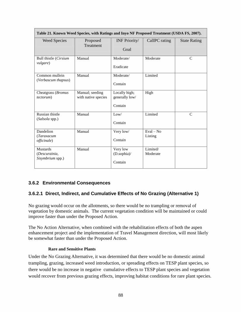
88
Table 21. Known Weed Species, with Ratings and Inyo NF Proposed Treatment (USDA FS, 2007).
Weed Species Proposed
Treatment
INF Priority/
Goal
CalIPC rating State Rating
Bull thistle (Cirsium
vulgare)
Manual Moderate/
Eradicate
Moderate C
Common mullein
(Verbascum thapsus)
Manual Moderate/
Contain
Limited
Cheatgrass (Bromus
tectorum)
Manual; seeding
with native species
Locally high;
generally low/
Contain
High
Russian thistle
(Salsola spp.)
Manual Low/
Contain
Limited C
Dandelion
(Taraxacum
officinale)
Manual Very low/
Contain
Eval – No
Listing
Mustards
(Descurainia,
Sisymbrium spp.)
Manual Very low
(D.sophia)/
Contain
Limited/
Moderate
3.6.2 Environmental Consequences
3.6.2.1 Direct, Indirect, and Cumulative Effects of No Grazing (Alternative 1)
No grazing would occur on the allotments, so there would be no trampling or removal of
vegetation by domestic animals. The current vegetation condition will be maintained or could
improve faster than under the Proposed Action.
The No Action Alternative, when combined with the rehabilitation effects of both the aspen
enhancement project and the implementation of Travel Management direction, will most likely
be somewhat faster than under the Proposed Action.
Rare and Sensitive Plants
Under the No Grazing Alternative, it was determined that there would be no domestic animal
trampling, grazing, increased weed introduction, or spreading effects on TESP plant species, so
there would be no increase in negative cumulative effects to TESP plant species and vegetation
would recover from previous grazing effects, improving habitat conditions for rare plant species.

89
3.6.2.2 Direct, Indirect, and Cumulative Effects of the Proposed Action
(Alternative 2)
The design criteria for grazing management under Amendment 6 of the Inyo LRMP, including
standards for key areas and general vegetation types including aspen, as well as the proposed
criterion prohibiting bedding grounds on pumice sand flats, will maintain or improve current
habitat conditions for Mono Lake lupine and Mono milk-vetch.
Other actions that will affect vegetation in these allotments are the proposed Aspen Enhancement
Project and implementation of the Travel Management decision (2010) which limited OHV use
to authorized roads only. The eventual recovery of routes not authorized in the Travel
Management decision will improve the condition of the sand flat habitat. The cumulative effects
of the Proposed Action and these two other actions will be to enhance the pumice sand flat and
aspen communities in particular and vegetation in general.
Under the Proposed Action, a drift fence would be built at Baxter Spring. Because there are no
known rare or sensitive species in the area, the fence would have no effect on rare and sensitive
plant species.
Rare and Sensitive Plants
The effects of the proposed grazing allotment permits were analyzed by habitat type, including
pumice sand flats, rocky steep habitat, and riparian habitats. The direct effects of grazing include
trampling and grazing of sensitive plants, but the management under Amendment 6, which
includes limits on utilization, residual dry matter, and resting several areas until recovery is
documented, prescribed watering procedures, and the prohibition of bedding grounds on sand
flats will protect sensitive plants and their habitats.
Other uses and factors potentially affecting botanical resources in the area include recreational
activities, implementation of the Travel Management decision (2009), previous fuel reduction
treatments, fire, management of adjacent BLM allotments, and climate change influence on
precipitation and fire intervals. As discussed above, the direct and indirect effects of the
proposed action are limited in scope and intensity and they do not contribute to a significant
cumulative effect when added to the effects of other past, current, and reasonably foreseeable
future activities.
Determination
Based on effectively using Amendment 6 adaptive management of the grazing in the Mono
Basin allotments, continuation of monitoring of Mono milk-vetch and Mono Lake lupine
populations, the design criterion of no bedding grounds at sand flats, and the decision to close
unauthorized routes under the Travel Management project, it was determined that the direct,
indirect, and cumulative effects of the proposed activity may impact individuals but will not lead
to a trend to federal listing for Mono milk-vetch or Mono Lake lupine.
Based on effectively using Amendment 6 adaptive management of the grazing in the Mono

90
Basin allotments, monitoring of the known Bodie Hills rockcress population, and the likelihood
of many undocumented populations, it was determination that the proposed activity may impact
individuals but will not lead to a trend to federal listing for Bodie Hills rockcress.
Based on effectively using Amendment 6 adaptive management of the grazing in the four Mono
Basin allotments, including resting several meadows, the ability of the moonworts to tolerate
some disturbance, and the relatively light use and impact on meadows by sheep it was
determined that the proposed action may impact individuals, but is not likely to cause a trend
toward federal listing or a loss of viability for slender moonwort, scalloped moonwort, common
moonwort, Mingan moonwort, and upswept moonwort.
Based on the fact that the Mono Sand Flat Allotment would be rested until vegetation recovers
enough for grazing and on the proposed management using Amendment #6 standards, it was
determined that the Proposed Action may impact individuals, but is not likely to cause a trend
toward federal listing or a loss of viability for Williams’ combleaf or Inyo phacelia.
Watch List Plants and Other Rare Species (CNPS,CNDDB)
The effects on the species in Table 21 are the same as those discussed for the sensitive species
above. Based on grazing standards and design criteria, the condition of the habitat will be
maintained or improved, and although individual plants may be affected by grazing, no
downward population trends are expected.
Weeds
Several weed species occur near Baxter Spring, where a change in watering strategy to reduce
impacts is proposed. The site will be monitored and bull thistle and mullein removed. The
monitoring will also be used to detect any new weed species that may be introduced, since this
site appears to be susceptible to weed invasion. Under the Proposed Action, a drift fence would
be built at Baxter Spring. Because weeds are present, equipment and clothing should be cleaned
before and after work at the site. With this mitigation in place, the construction of the fence
should have no effect on weed populations.
Other weeds, particularly cheatgrass are scattered throughout the area, mostly along roads, and
are not expected to spread a great deal. The Crater fire in the Mono Mills allotment does not
show signs of weed invasion and in a survey of the Mono fire in 2010, no weeds were found
adjacent to the burned area, so very little spread is expected. New disturbances such as fires or
fuel reduction projects are surveyed for weeds and monitored following the disturbance. Weed
populations adjacent to routes considered in the Travel Management assessment (2009) were
identified and those posing high risk will be eradicated during implementation of that decision.
Other known populations identified for the Weed Treatment EA (2007) will be treated in order of
Inyo NF priority (Table 22) as funding allows. Although climate change effects may favor the
91
spread of invasive plant species, the current management for weed treatment and the grazing
management under Amendment 6 are expected to reduce the risk.
Many of the areas with weed infestations would have changes in livestock management that
reduce the amount of trampling and associated ground disturbance due to resting of the area, a
reduction in livestock numbers, or a shortened season. This should contribute to higher levels of
vegetation cover and litter, and less bare ground and disturbance in those areas, which should
reduce the weed risk. The overall risk of habitat alteration from this project contributing to weed
vulnerability is low.
3.7 Effects Relative to Cultural Resources
Summarized from the Cultural Resource Report for the Mono Basin Grazing Allotment Analysis,
Report # R2008050401307 (West 2011).
The protection of cultural resources has been incorporated into the Proposed Action. The
environmental analysis for the NEPA decision and compliance with section 106 of the National
Historic Preservation Act (NHPA) were accomplished pursuant to the:
Programmatic Agreement among the USDA, Forest Service, and the Advisory Council on
Historic Preservation, Regarding Rangeland Management Activities on National Forest System
Lands (USDA FS 1995) (PA) and the
Memorandum of Understanding among the USDA Forest Service, Pacific Southwest Region,
California State Historic Preservation Officer, and the Nevada State Historic Preservation
Officer regarding Rangeland Management Activities, 1996 (MOU) and the Rangeland Heritage
Resources Management Activities, Inyo National Forest, California and Nevada, 1997 (INF
Supplemental).
These agreements outline timelines and procedures the Forest will employ to meet their
responsibilities under Section 106 of the NHPA and related authorities. The Forest will meet
those requirements by implementing a phased identification and evaluation approach pursuant to
the MOU. Stipulation XII.D. of the MOU, Amendment No.1 extended the term of the MOU for
an additional five years.
3.7.1 Existing Condition
Cultural resources found within the four allotments illustrate a long history of human use of the area.
Prehistoric Native American sites consist of temporary and seasonal resource procurement camps and
sites associated with the collection of piaga, the larvae of the Pandora moth, which was harvested and
stored as a valuable food source within the Jeffrey pine forest.
92
Historic sites within the project area are generally associated with logging and grazing that supported the
Bodie Gold Mine at the end of the 19th and into the early 20
th Century. Basque and Spanish immigrants
herded sheep throughout the Dexter Creek, Mono Mills and June Allotments and left their mark and
stories of their lives on the bark of aspen trees. The Mono Mills Historic Logging District harvested,
milled and transported lumber and firewood to the Mining town of Bodie via the Bodie Railroad.
Remnants of this cultural history are found throughout the project area and were analyzed for the direct
and indirect effects of the proposed action to continue grazing in the area
3.7.1.1 AREA OF POTENTIAL EFFECT (APE)
The area of potential effect for this analysis focused on high use or concentrated grazing areas where
impacts to cultural sites are most likely to occur (MOU Table No. 1). These areas were identified from
high use and sheep bed GIS data collected by Forest Rangeland Specialists. Other grazing use levels will
be analyzed over the next three years and included as addendums to this report. High use areas are
defined in the MOU as ―Areas which receive concentrated use from livestock grazing activities, where
use is intense enough to cause possible degradation of the environment and or heritage resources through
erosion, compaction, or trampling.‖ These areas include but are not limited to seeps, springs, creek
banks, meadows, shade areas, watering troughs, stock drives and bedding areas. All high use areas within
the four allotments were surveyed for cultural resources.
SURVEY STRATEGY AND FIELD METHODS
The inventory strategy for this Environmental Assessment focused on all high use grazing areas.
All high use areas plus a 40 meter buffer were intensively surveyed using 20 meter transects.
Current Sheep Allotments (June Lake, Mono Mills, Dexter Creek)
Cultural sites that were identified within 100 meters of a high use grazing area or sheep bedding
ground were visited and the effects of grazing analyzed and documented. Sheep bed locations
that did not have prior cultural survey were surveyed for cultural resources including a 40 meter
buffer surrounding the disturbed area. Areas of high use with low site sensitivity were
selectively surveyed.
Current Cattle Allotments with areas of High Use and potential conflicts: (Mono Sand
Flat)
All identified high use areas where cultural resources were likely were surveyed for cultural
resources. Areas that had a low probability of cultural resources such as areas that are inundated
with water seasonally were not surveyed.
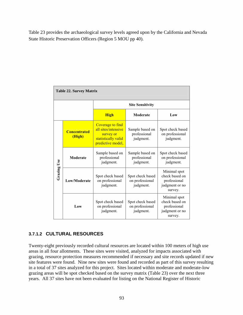
93
Table 23 provides the archaeological survey levels agreed upon by the California and Nevada
State Historic Preservation Officers (Region 5 MOU pp 40).
Table 22. Survey Matrix
Site Sensitivity
High Moderate Low
Gra
zin
g U
se
Concentrated
(High)
Coverage to find
all sites/intensive
survey or
statistically valid
predictive model,
Sample based on
professional
judgment.
Spot check based
on professional
judgment.
Moderate
Sample based on
professional
judgment.
Sample based on
professional
judgment.
Spot check based
on professional
judgment.
Low/Moderate
Spot check based
on professional
judgment.
Spot check based
on professional
judgment.
Minimal spot
check based on
professional
judgment or no
survey.
Low
Spot check based
on professional
judgment.
Spot check based
on professional
judgment.
Minimal spot
check based on
professional
judgment or no
survey.
3.7.1.2 CULTURAL RESOURCES
Twenty-eight previously recorded cultural resources are located within 100 meters of high use
areas in all four allotments. These sites were visited, analyzed for impacts associated with
grazing, resource protection measures recommended if necessary and site records updated if new
site features were found. Nine new sites were found and recorded as part of this survey resulting
in a total of 37 sites analyzed for this project. Sites located within moderate and moderate-low
grazing areas will be spot checked based on the survey matrix (Table 23) over the next three
years. All 37 sites have not been evaluated for listing on the National Register of Historic

94
Places. The MOU allows the Forest Service to assume eligibility of unevaluated sites as long as
their potential significant historic values can be protected either through avoidance or standard
resource protection measures.
Evaluation for the National Register of Historic Places:
According to the Range MOU Section IV, D. 2, significance evaluation is not necessary prior to initiating
range undertakings if the standard resource treatment measures of Appendix C, clause V can be
implemented to ensure that potential values are unaffected in any manner. No cultural resources were
evaluated for this undertaking because all potentially significant historic values could be protected using
Standard Resource Protection Measures.
3.7.1.3 CULTURAL RESOURCE TREATMENT RECOMMENDATIONS
Standard Resource Protection Measures (SRPMs) may include, but are not limited to
maintaining or reconstructing existing range improvements, constructing new range
improvements to reduce or eliminate impacts to cultural resources and removing or re-locating
the high use area to another location devoid of cultural resources (MOU, Appendix C, V).
SRPMs are recommended for seven cultural sites in order to protect their potentially significant
historic values from the effects of continued grazing (Table 10). Protection measures will be
implemented prior to authorization of grazing.
Table 23. Project Acres-- Survey and Cultural Site Summary.
Allotment Project
Acres
APE Acres
High Use
Previously
Surveyed
Acres
High Use
New Survey
Acres High
Use + 40m
buffer
Cultural
Sites in
High Use
Area
Dexter Creek
18,781 497.6 339.3 350.5 14
June Lake S&G
16,528 69.0 56.3 65.6 5
Mono Mills S&G
29,263 57.4 57.4 0 15
Mono Sand Flat 8,696 51.8 0 139.3 3
Total 73, 268 675.8 453 555.4 37

95
3.7.1.4 MONITORING PLAN
Annual site condition monitoring will test effectiveness of protection measures and the
assumptions made during the site analysis when grazing effects were ambiguous. Twelve
cultural resources are recommended for annual site condition monitoring (Table 10).
Monitoring results will be reported to the California State Historic Preservation Office annually
in the Inyo National Forest Heritage Program Annual Report under the Range Activities section
as well as an addendum to this report. If adverse effects are found as a result of continued
grazing use, then standard protection measures will be implemented.
3.7.2 Environmental Consequences
3.7.2.1 Direct, Indirect, and Cumulative Effects of No Grazing (Alternative 1)
If grazing is not permitted in these four allotments, no direct or indirect effects are anticipated.
This Alternative would have No Effect 36 CFR §800.5(b) to cultural resources.
Cumulative Effects
If there are no direct or indirect effects, there can be no cumulative effects (40 CFR §1508.7).
3.7.2.2 Direct, Indirect, and Cumulative Effects of the Proposed Action
(Alternative 2)
The Inyo National Forest proposes to continue to permit livestock grazing by incorporating
adaptive management strategies on the four grazing allotments within the Mono Basin Allotment
Group while meeting Forest Plan direction. Continued grazing will have little effect to the 37
cultural resources identified within high use grazing areas within the four allotments if standard
resource protection measures and monitoring are implemented. The Proposed Action prohibits
grazing within the Mono Mills town site, an eligible and contributing element of this Historic
District. This restriction will protect this valuable cultural resource. The Proposed Action also
prohibits bedding grounds within 500 feet of water which will ultimately protect sensitive
heritage resources located in these areas. The Proposed Action calls for construction of a drift
fence at Baxter Springs. Consultation with the State Historic Preservation Officer’s office will be
needed for concurrence on No Adverse Effect for the construction of the fence. This has not yet
been done. Under the proposed action, bull thistle and mullein would be removed at Baxter
Springs. This action would have no adverse effect (Sierra PA Attachment 4 Stipulations 11.3).
Site condition monitoring will test whether the restrictions in the proposed action are sufficient to
protect cultural resource values. A Cultural Resource Specialist shall be contacted if additional

96
range improvements, surface disturbing projects, and changes in grazing practices (that will
concentrate grazing and could create impacts) are proposed. These will be cleared on a project
by project basis according to Section 106 of the National Historic Preservation Act (36 CFR Part
800). With the above protection measures and monitoring in place, this alternative will have No
Adverse Effect 36 CFR §800.5(b) to cultural resources.
Cumulative Effects
Cultural resources are non-renewable resources that have continually been impacted by past
actions within the four grazing allotments. The majority of cultural sites analyzed for this project
have been affected by at least one of the following actions; dispersed camping, looting, livestock
grazing, the development of livestock related structures, logging, prescribed fires, construction
and maintenance of roads, flooding and fluvial transport of cultural materials and natural
weathering. These disturbances have for the most part been documented in the cultural site
records, however the effects of these disturbances on the historic integrity of the resource has
been largely undocumented and therefore cannot be accurately quantified for analysis. For the
purposes of this analysis, it can be assumed that these previous actions have potentially affected
cultural sites in similar ways to the direct and indirect effects of the present project, discussed in
the Effects Analysis of the Cultural Report (R2008050401307).
Grazing, logging, prescribed fire, and recreation are the primary causes of cultural site
disturbance within the project area. Livestock grazing has occurred in the area for nearly 100
years. Damage to the integrity of cultural sites from cattle and sheep grazing has already
occurred in a majority of these areas. The current analysis found that continued grazing with
specific resource protection measures in place is unlikely to cause more damage to cultural sites.
Road construction, maintenance of roads, and use of roads by the public have also impacted
cultural resources by first being constructed through many of them and second by allowing the
public to easily access cultural sites and cause damage through camping, collecting and looting.
Public recreational use is an ongoing disturbance that is difficult to manage and quantify. Site
condition monitoring and site protection is occurring at various cultural sites in the project area
with this type of use through the Travel Management Environmental Impact Statement (EIS)
Decision (2009).
Logging (historic and more recently) has greatly affected cultural resources within the project
area through ground disturbance and road construction, specifically in the Mono Mills
Allotment. Again most of the damage has already occurred to cultural sites in these areas.
Future logging and thinning projects must comply with historic preservation laws and avoid
adverse effects to cultural sites.
Actions in the reasonably foreseeable future with the potential to affect cultural resources include
the implementation of the Travel Management EIS Decision (2009) in which certain routes
where cultural resources are located are maintained or closed based on this decision. The
prescribed fire program in the Mono Mills Allotment has the potential to affect cultural
resources. Because both of these are federal undertakings the potential effects from these
projects should be avoided through the section 106 process.

97
With resource protection measures and monitoring in place, the proposed action should have no
cumulative effects on the contributing elements of the cultural resources within the grazing
allotments. This alternative would have No Adverse Effect 36 CFR §800.5(b) to the 37 cultural
resources analyzed, if monitoring shows that there are no grazing-related changes in site
condition. For the remaining cultural resources within the allotments, monitoring, new survey
and spot checks based on the survey matrix presented earlier would be used to determine
whether additional resource protection measures should be implemented to protect cultural
resource values. With resource protections measures and monitoring in place, the proposed
action should have no cumulative effects on the contributing elements of the cultural resources
within the grazing allotments.
3.8 Effects Relative to Socio-Economic Factors
This section contains a summary of information presented in the Social and Economic Effects
Analysis for the Mono Basin Grazing Allotments (Barron, 2011b).which is hereby incorporated
by reference.
3.8.1 Existing Condition
Demographic Information
The communities affected by the EA lie in Mono and Inyo Counties in the state of California.
Although California is the most populous state in the nation, these two counties have relatively
small populations. Mono County had 13,698 people in 2010 and Inyo County had 18,201 (State
of California, 2010). These are rural counties on the eastern side of the Sierra Nevada range, far
from California’s population centers on the Pacific Coast. Population density in these counties is
low. In comparison to the overall state population density of 239.1 people per square mile (U.S.
Census, 2010), Mono County has only 4.4 people per square mile and Inyo County has 1.8 (State
of California, 2010).
Geography
Mono County encompasses 3,132 square miles between the eastern Sierra Nevada and the
Nevada state border. Inyo lies to the south of Mono County and comprises 10,140 square miles.
Very little of this land is privately owned. Eighty-five percent of Mono County’s land is owned
by the federal government. The State of California and the City of Los Angeles own 3.6% and
3.2% respectively. Only 7.8% is privately held. In Inyo County, 92% of the land is federal, 2.4%
belongs to the State, and 3.9% belongs to the City of Los Angeles. Only 1.7% is privately held
(Counties of Inyo and Mono Agricultural Commissioner’s Office, 2009). Much of the public
land is leased for uses such as ranching, mining, and geothermal development.
Employment and Income
The industries that employ the most people in Mono County are retail trade, personal services,
and construction. Agriculture, forestry and fisheries fall eighth on the list. In Inyo County, the
primary industries are retail trade, health services, and construction, with agriculture, forestry
and fisheries falling in seventh place (U.S. Census, 2010).

98
Agriculture is a multi-million dollar business in the two counties, with much of that business
coming from livestock production. In 2009, livestock production in Inyo County was valued at
$9,997,350, or 52% of all agricultural income. In Mono County, the value was $19,596,055, or
60% of the value of all agricultural commodities in the county for that year (Counties of Inyo
and Mono Agricultural Commissioner’s Office, 2009).
Social Factors
Most of this area remains rural in nature and has a long tradition of agricultural pursuits.
Historically, many ranchers have made this area their home. Grazing by cattle and sheep has
taken place since the mining boom of the 1870s and ranching has played a significant part in the
social fabric of Mono and Inyo Counties. The land is also valued for a myriad of other uses such
as recreation, mining, and water development. Balancing all of these uses while enhancing the
health and beauty of the landscape can be a challenge.
Grazing in the Mono Basin is well suited to the lifestyle known as transhumance, in which
ranchers move their livestock to different areas at different times of year. In this instance, the
sheep ranchers keep their livestock in Bakersfield, California in the winter, and bring them to the
higher elevations in Mono County in the summer.
The cattle that use the Mono Sand Flat Allotment in the winter remain in the area all year long.
The Hilton Family Trust, which is the permittee for this allotment, has its base property in Mono
County.
3.8.2 Environmental Consequences
3.8.2.1 Direct, Indirect, and Cumulative Effects of No Grazing (Alternative 1)
The cessation of grazing would mean a slight economic loss to the permittees, the local
economy, and the U.S. Forest Service. Currently, the allotments provide 1,735 Animal Unit
Months2(AUMs) (Table 25). This allows for 7, 645 Head Months
3 (HMs) on the Dexter Creek
and June Lake Allotments and 206 HMs on the Mono Sand Flat Allotment. Use of these
allotments garners the Forest Service $2,270 each grazing season, half of which comes back to
the Forest in range betterment funds. Under Alternative 1, the permittees would lose this forage
and the Forest Service would not receive grazing fees for range betterment funds.
This alternative would not meet the LRMP Standards and Guidelines in that it would not provide
grazing tenure to lend stability to the local livestock-raising community and established ranching
operations. The I&M Sheep Company relies on these summer pasture to run their operation. The
3,000 ewes they run on the Dexter Creek and June Lake Allotments constitute over 50% of their
business. Under the No Grazing Alternative, they would be forced to seek alternative pastures
and if those are not found, their operation may become no longer viable. Along with this would
come the loss of seasonal jobs and revenue for the local economy.
2 An Animal Unit Month is the amount of feed or forage required by an animal unit for one month
3 A Head Month is one month’s use and occupancy of range by one weaned or adult animal.

99
The Hilton Family Trust runs only 26 cow/calf pairs on the Mono Sand Flat Allotment as part of
an on/off allotment in conjunction with BLM lands. This number makes up less than 2% of their
total herd and will not have a large impact on their operation.
Table 24. AUMs, Head Months, and Fees.
Alternative AUMs Provided
for Livestock
Industry
Head
Months
Net loss of AUMs Minimal Grazing
Fees
Sheep ($0.27 per head month)
Existing 1,529 (Does not
include the
proposed 3,038
AUMs for Mono
Mills)
7,645 NA $2,064
1-No
Grazing
0 0 1,529 0
2-Proposed
Action
4,567 22,835 0 $6,165
Cattle ($1.35 per head month)
Existing 206 206 NA $278
1-No
Grazing
0 0 206 0
2-Proposed
Action
206 206 0 $278
3.8.2.2 Direct, Indirect, and Cumulative Effects of the Proposed Action
(Alternative 2)
Alternative 2 would have a beneficial impact on the permittees, the U.S. Forest Service, and the
local economy. Under the Proposed Action, the sheep permittees would be provided with 4,567
AUMs each season The Mono Sand Flat Allotment provides 206 AUMs to the permittee;
however, these AUMs would not be available while the allotment is being rested. The permittee
has not used the allotment for the past four years, so this would not require any adjustment on his
part.
100
With the resumption of grazing on the Mono Mills Allotment in addition to continued grazing on
the Dexter Creek and June Lake Allotments, as proposed in Alternative 2, the sheep operations
would pay $6,165 in grazing fees yearly. The Forest would receive half of this money back as
range betterment funds. The local economy would benefit as seasonal jobs would be created and
goods and services would be purchased.
This alternative would meet LRMP Standards and Guidelines because it would provide grazing
tenure to lend stability to the local livestock-raising community and established ranching
operations. Along with economic stability, this alternative would be beneficial to communities
that value traditional uses of the land as part of the rural lifestyle.
Ranching operations may benefit from the new management practices as a result of increased
land performance and vegetation health. Enhanced ecosystem conditions may mean increased
nutritive value of forage which could result in higher weigh gains on livestock, producing lambs
with a higher market value.
3.9 Effects Relative to Finding of No Significance (FONSI) Elements
In 1978, the Council on Environmental Quality published regulations for implementing the
National Environmental Policy Act (NEPA). These regulations (40 CFR Parts 1500-1508)
include a definition of ―significant‖ as used in NEPA. The ten elements of this definition are
critical to reducing paperwork through use of a finding of no significant impact (FONSI) when
an action would not have a significant effect on the human environment, and is therefore exempt
from requirements to prepare an environmental impact statement (EIS). Significance as used in
NEPA requires consideration of the following ten intensity factors in the appropriate context for
that factor.
1. Beneficial and adverse impacts.
Mitigations and management requirements designed to reduce the potential for adverse impacts
were incorporated into the Proposed Action (i.e. standards and guidelines outlined in the Inyo
National Forest LRMP (USDA Forest Service 1988), as amended by Forest Plan Amendment #6,
Forest-wide Range Utilization Standards (USDA Forest Service 1995), Sierra Nevada Forest
Plan Amendment (USDA Forest Service 2004), and the Mono Basin Scenic Area Plan (USDA
Forest Service, 1989). These mitigations and management requirements would minimize or
eliminate the potential for adverse impacts caused by livestock grazing activities.

101
A discussion of potential effects was summarized above from supporting analysis (Barron 2011,
Lutrick 2011, Perloff 2011a, Perloff 2011b, Perloff and Sims 2011, Sims 2011, Weis 2011a, Weis
2011b and West 2011). All analyses prepared in support of this document considered both
beneficial and adverse effects of the proposed action; however, beneficial effects were not used
to offset or compensate for adverse effects in the analyses. None of the potential effects of the
Proposed Action or No Grazing Alternative would be significant, even when considered
separately from the beneficial effects that occur in conjunction with those effects.
2. The degree to which the proposed action affects public health or safety.
None of the alternatives considered would have an effect upon public health and safety.
3. Unique characteristics of the geographic area such as proximity to historic or
cultural resources, parklands, prime farmlands, wetlands, wild and scenic rivers, or
ecologically critical areas.
There are no parklands, prime farmlands, wild and scenic rivers, or ecologically critical areas
within the project area.
The allotments contain meadows, springs, and riparian features that would classify as wetlands.
Based on the environmental analysis completed for hydrology, range, wildlife, and botany, the
Proposed Action would not have a significant adverse effect to riparian values. The resource
protection standards applied in the Proposed Action alternative, including restrictions on bedding
ground location and livestock movement would ensure a lack of significant effects to wetlands.
The protection of cultural resources has been incorporated into the Proposed Action, and would
follow the stipulations in the Programmatic Agreement (PA) among the USDA, Forest Service,
and the Advisory Council on Historic Preservation, Regarding Rangeland Management Activities
on National Forest System Lands (June 26, 1995) and the Memorandum of Understanding
among the USDA Forest Service, Pacific Southwest Region, California State Historic
Preservation Officer, and the Nevada State Historic Preservation Officer regarding Rangeland
Management Activities, 1996 (MOU) and the Rangeland Heritage Resources Management
Activities, Inyo National Forest, California and Nevada, 1997 (INF Supplemental). Details
regarding the field surveys and management recommendations for heritage resources sites and
features are contained in the Effects Analysis Mono Basin Grazing Allotments NEPA (West
2011) and Heritage Resource Report (#R2008-05-04-01307). By following the
recommendations outlined in this report, including the use of the standard procedures outlined in
the PA and MOU, it was determined that there would be no adverse effects to cultural resources
from implementing this project (Ibid).

102
4. The degree to which the effects on the quality of the human environment are likely
to be highly controversial.
The proposed project follows the management direction in the Inyo National Forest Land and
Resource Management Plan (USDA Forest Service 1988), as amended by Forest Plan
Amendment #6, Forestwide Range Utilization Standards (USDA Forest Service 1995), the 2004
Sierra Nevada Forest Plan Amendment (USDA Forest Service 2004), and the 1989 Mono Basin
Scenic Area Plan (USDA Forest Service, 1989). The Proposed Action was developed by
comparing existing conditions with desired conditions. Potential adverse effects have been
minimized or eliminated to the point where there are few effects to draw controversy. Public
involvement efforts did not reveal any significant issues or any other significant controversies
regarding environmental effects of this proposal. Based on comments from the public and the
analysis of effects from the ID Team, there are not significant effects expected to the quality of
the human environment from implementing any of the alternatives, including the Proposed
Action alternative.
5. Degree to which the possible effects on the human environment are highly uncertain
or involve unique or unknown risks.
The proposed project follows the management direction in the Inyo National Forest Land and
Resource Management Plan (USDA Forest Service 1988), as amended by Forest Plan
Amendment 6, Forestwide Range Utilization Standards (USDA Forest Service 1995), the 2004
Sierra Nevada Forest Plan Amendment (USDA Forest Service 2004), and the Mono Basin Scenic
Area Plan (USDA Forest Service, 1989). It implements management requirements designed to
reduce the potential for adverse effects, and has incorporated utilization standards for the grazing
of domestic livestock that would accelerate the restoration and improvement of degraded range
sites and maintain those sites currently in good condition.
Local expertise in implementation of grazing activities minimizes the chance of highly uncertain
effects or effects which involve unique or unknown risks. Livestock grazing has occurred in the
eastern Sierra for more than a century including on the allotments within the Mono Basin
Grazing Allotments analysis area. Many of the grazing practices used decades ago are no longer
used due to a better understanding of range conditions, the needs of livestock, and effects of
grazing on resource values. Rangeland health on the Inyo National Forest has continued to
improve over time. Proposed activities are routine in nature, employing standard practices and
protection measures, and their effects are generally well known.
6. The degree to which the action may establish a precedent for future actions with
significant effects or represents a decision in principle about a future consideration.

103
The Mono Basin Grazing Allotments Analysis represents a site-specific project that does not set
precedence for future decisions with significant effects or present a decision in principle about
future considerations. Any future decisions would require a site-specific analysis to consider all
relevant scientific and site-specific information available at that time. These activities are in
accordance with the best available science to manage grazing activities at this time.
7. Whether this action is related to other actions with individually insignificant but
cumulatively significant impacts.
A cumulative effect is the consequence on the environment that results from the incremental
effect of the action when added to the effects of other past, present, and reasonably foreseeable
future actions, regardless of what agency or person undertakes the other actions and regardless of
land ownership on which the actions occur. A cumulative effects analysis was completed
separately for each resource area. None of the resource specialists found the potential for
significant adverse cumulative effects (Barron 2011, Lutrick 2011, Perloff 2011a, Perloff 2011b,
Perloff and Sims 2011, Sims 2011, Weis 2011a, Weis 2011b and West 2011).
8. The degree to which the action may adversely affect districts, sites, highways,
structures, or objects listed in or eligible for listing in the National Register of Historic
Places or may cause loss or destruction of significant scientific, cultural, or historical
resources.
It was determined that there would be no adverse effect to cultural resources from implementing
this project (West 2011; HRR # R2008-05-04-01307), and the Proposed Action does not
adversely affect districts, sites, highways, structures, or objects listed in or eligible for listing in
the National Register of Historic Places. Protection of heritage resources in the area was
incorporated into the Proposed Action through such measures as restricting livestock movement
and bedding ground location. Based on analysis documented in the Heritage Resource Report,
the Proposed Action would not cause loss or destruction of significant, scientific, cultural, or
historical resources.
9. The degree to which the action may adversely affect an endangered or threatened
species or its habitat that has been determined to be critical under the Endangered Species
Act of 1973.
There is one federally listed threatened or endangered wildlife species known to occur in the
vicinity of the project area. This species is the Sierra Nevada bighorn sheep (endangered).
There is no critical habitat identified within the analysis area. Based on analysis documented in

104
the Biological Assessments, it was determined that this project would not likely adversely affect
individuals or habitat of the Sierra Nevada bighorn sheep (Perloff, 2011b).
No federally listed threatened or endangered plant species have potential habitat (including
critical habitat) or occur within or adjacent to the project area (Weis 2011a).
10. Whether the action threatens a violation of Federal, State, or local law or
requirements imposed for the protection of the environment.
The proposed action would not threaten a violation of Federal, State, or local law, or
requirements imposed for the protection of the environment. The proposed action is consistent
with the National Environmental Policy Act (NEPA), National Forest Management Act
(NFMA), Endangered Species Act (ESA), Clean Water Act, and National Historic Preservation
Act (NHPA). The proposed action is fully consistent with the Inyo National Forest Land and
Resource Management Plan (USDA Forest Service 1988), as amended by LRMP Amendment
#6, Forest-wide Range Utilization Standards (USDA Forest Service 1995), the Sierra Nevada
Forest Plan Amendment (USDA Forest Service, 2004), and the Mono Basin Scenic Area Plan
(USDA Forest Service, 1989).

105
Chapter 4 Lists
4.1 Agencies and Persons Consulted
Joe Echenique, Echenique Livestock
Miguel Iturriria, I&M Sheep Company
Paco Iturriria, I&M Sheep Company
Kathleen Nelson, Botanist, Inyo National Forest
Cory Overton, Wildlife Biologist, US Geological Survey, Western Ecological Research Center
USDI Bureau of Land Management, Bishop Field Office, Bishop, California
USDI Fish and Wildlife Service, Ventura, California
4.1.1.1 Environmental Assessment Preparers
April Barron Rangeland Management Specialist
Erin Lutrick Hydrologist
Richard Perloff Wildlife Biologist
Lisa Sims Fisheries Biologist
Sue Weis Assistant Forest Botanist
Crystal West North Zone Archaeologist
4.2 References Cited
Anderson, E. William. 1967. Grazing Systems as Methods of Managing the Range Resources.
Journal of Range Management. Vol. 20, No. 6 (Nov., 1967), pp. 383-388.
Barron, April. 2011a. Rangeland Resources Report for the Mono Basin Grazing Allotments.
USDA Forest Service. Bishop, CA. 47 pp.
Barron, April. 2011b. Social and Economics Effects Analysis for the Mono Basin Grazing Allotments Environmental Assessment. USDA Forest Service. Bishop, CA. 6 pp.

106
Baumer, A., N. East, J. Echenique, M. Haworth, M. Leinassar, C. Papouchis, T. Stephenson, D.
Weaver, and G. Wilson. 2009. A Process for identifying and managing risk of contact
between Sierra Nevada bighorn sheep and domestic sheep. February 2009. 37pp.
Beck, Jeffrey L. and Dean L. Mitchell. 2000. Influences of livestock grazing on sage-grouse
habitat. Published in Wildlife Society Bulletin 2000, 28. Pages 993-1002.
Benedict N.G., Oyler-McCance S.J., Taylor S.E., Braun C.E., Quinn T.W. 2003 Evaluation of
the eastern (Centrocercus urophasianus urophasianus) and western (Centrocercus
urophasianus phaois) subspecies of sage-grouse using mitochondrial control-region
sequence data. Conservation Genetics, 4, 301–310.
Bleich, V, C., Pierce, B. M., Hones, J. L., Bowyer, R. T. 2006. Variance in survival of young
mule deer in the Sierra Nevada, California. California Fish and Game 92(1):24-38
Braun, C. E., T. Britt, and R.O. Wallestad. 1977. Guidelines for maintenance of sage-grouse
habitats. Wildl. Soc. Bull. 5:99-106.
Call W. Mayo and Chris Maser. 1985. Wildlife Habitats in Managed Rangelands-The Great
Basin of Southeastern Oregon, Sage-Grouse. Pacific Northwest Forest and Range
Experiment Station, U.S. forest Service. General Technical Report PNW-187. 1985. p.
17-21.
CDFG. 2010. Upland game bird hunting regulations. California Fish and Game Commission.
Sacramento, CA.
Casazza, M. L., Overton, C. T., Torregrosa, A. 2005. Ecology of greater sage-grouse in the Bi-
State planning area. Progress Report March 2005. Western Ecological Research Center,
USGS.
CDFG (California Department of Fish and Game). 2005. California Department of Fish and
Game and California Interagency Wildlife Task Group. California Wildlife Habitat
Relationships (CWHR) version 8.1. personal computer program. Sacramento, California.
On-Line version. http://www.dfg.ca.gov/biogeodata/cwhr/cawildlife.asp. (Accessed:
January 3, 2008).
Clifford, Deana L., Brant A. Schumaker, Thomas R. Stephenson, Vernon C. Bleich, Maya
Leonard-Cahn, Ben J. Gonzales, Walter M. Boyce, and Jonna A. K. Mazet. 2007.
Modeling Risks of Disease Transmission from Domestic Sheep to Bighorn Sheep:
Implications for the Persistence and Restoration of an Endangered Endemic Ungulate.
UC Davis Wildlife Health Center Department of Fish and Game Resource Assessment
Program-Final Report. February 9, 2007.
Clifford, Deana L., Brant A. Schumaker, Thomas R. Stephenson, Vernon C. Bleich, Maya
Leonard-Cahn, Ben J. Gonzales, Walter M. Boyce, and Jonna A. K. Mazet. 2009.

107
Assessing disease risk at the wildlife-livestock interface: A study of Sierra Nevada
bighorn sheep. Biological Conservation (142) 2559-2568.
Connelly, J. W., M. A. Schroeder, A. R. Sands, and C. E. Braun. 2000. Guidelines to manage
sage- grouse populations and their habitats. Wildlife Society Bulletin, 28(4):967-985.
Connelly, J. W., S. T. Knick, M. A. Schroeder, and S. J. Stiver. 2004. Conservation assessment
of Greater Sage-Grouse and sagebrush habitats. Western Association of Fish and Wildlife
Agencies, Cheyenne, WY.
Counties of Inyo and Mono Agricultural Commissioner’s Office. 2009. 2009 Crop and Livestock
Report. http://www.inyomonoagriculture.com/Crop%20Reports/CropReport2009.pdf
Croft, B., A. Fesnock, M. Haworth, R. Mazur, L. Murphy, S. Nelson, R. Perloff, and T.
Stephenson. 2010. Application of the document entitled, a process for identifying and
managing risk of contact between Sierra Nevada bighorn sheep and domestic sheep.
12pp.
CWHR 2005. California Department of Fish and Game. California Interagency Wildlife Task
Group. 2005. California Wildlife Habitat Relationships version 8.1 personal computer
program. Sacramento, California.
Crawford, John A., Rick A. Olson, Neil E. West, Jeffrey C. Mosley, Michael A. Schroeder, Tom
D. Whiteson, Richard F. Miller, Michael A. Gregg, and Chad S. Boyd. 2004. Ecology
and management of sage-grouse and sage-grouse habitat. Rangeland Ecology and
Management. Volume 57, Issue 1 (January 2004) pp. 2-19.
Derlet RW, Carlson JR. An Analysis of Human Pathogens Found in Horse/Mule Manure Along
the John Muir Trail in Kings Canyon and Sequoia and Yosemite National Parks.
Wilderness and Environmental Medicine. 2002; 13(2):113-118.
Derlet RW, Carlson JR. Coliform bacteria in Sierra Nevada wilderness lakes and steams: What is
the impact of backpackers, pack animals, and cattle? The Journal of Wilderness and
Environmental Medicine. 2006; 17:15-20.
Derlet RW, Carlson JR, Richards JR. Risk Factors for Coliform Bacteria in Sierra Nevada
Mountain Wilderness Lakes and Streams. International Journal of Wilderness. 2008;
14:28-31.
DeStefano, S. 1998. Determining status of Northern Goshawks in the west: is our conceptual
model correct? J. Raptor Res. 32:342-348.
Dietz, Harland. 2006. Special Report: Grass: The stockman’s crop. How to harvest more of it.
Sunshine Unlimited Inc. Lindsborg, Kansas. 16 pages.
Drut, M.S., W.H. Pyle, and J.A. Crawford. 1994. Technical note: Diets and food selection of
sage- grouse chicks in Oregon. J. Range Manage. 47:90–93.
108
Ellis, K. L. 1984. Behavior of lekking greater sage-grouse in response to a perched golden eagle.
Western Birds 15:37–38.
Ellis, K. L. 1987. Effects of a new transmission line on breeding male greater sage-grouse at a
lek in northwestern Utah [abstract]. Page 15 in J. Roberson, chairman. Fifteenth greater
sage-grouse workshop transactions of the Western States Greater Sage-Grouse
Committee, 28–30 July 1987. Western Association of Fish and Game Agencies, Midway,
Utah, USA.
EMA (Environmental Management Associates). 2003. Analysis of Caltrans deer kill data U.S.
Highway 395, Mono County, California. EMA Report No. 1829-01. March 2003.
Prepared for Mammoth Pacific, L. P.
Fletcher, Thomas C. 1982. The Mono Basin in the nineteenth century: Discovery, settlement,
land use. M.A. thesis, Department of Geography, University of California, Berkeley.
Friedel, M. H. Range Condition Assessment and the Concept of Thresholds: A Viewpoint.
Journal of Range Management. Vol. 44, No 5 (Sep., 1991), pp 422-426.
Furniss, Michael J.; Staab, Brian P.; Hazelhurst, Sherry; Clifton,
Cathrine F.; Roby, Kenneth B.; Ilhadrt, Bonnie L.; Larry, Elizabeth B.;
Todd, Albert H.; Reid, Leslie M.; Hines, Sarah J.; Bennett, Karen A.;
Luce, Charles H.; Edwards, Pamela J. 2010. Water, climate change, and
forests: watershed stewardship for a changing climate. Gen. Tech. Rep.
PNW-GTR-812. Portland, OR: U.S. Department of Agriculture, Forest
Service, Pacific Northwest Research Station. 75 pp.
Green, J. S. and J. T. Flinders. 1980a. Habitat and dietary relationships of the pygmy rabbit.
Journal of Range Management 33:136-142.
Green, J. S. and J. T. Flinders. 1980b. Mammalian Species, Brachylagus idahoensis. The
American Society of Mammalogists 125:1-4.
Grinnell, J., J. Dixon, and J. M. Linsdale. 1930. Pages iii and 553-562 in Vertebrate Natural
History of a Section of Northern California through the Lassen Peak Region. University
of California Publications in Zoology 35:1-594.
Harniss, R.O. and H.A. Wright. Summer Grazing of Sagebrush-Grass Range by Sheep. Journal
of Range Management. Vol 35, No 1, 1982. Pp 13-17.
Heady, L. T. 1998. Home range, habitat, and activity patterns of pygmy rabbits (Brachylagus
idahoensis) in southeast Idaho. M. S. Thesis, Idaho State University, Pocatello. 72 pp.
Heath, S.K., Leah A. Culp, H. River Gates, Quresh S. Latif, and Christopher M. Tonra. 2004.
Riparian Songbird Monitoring in the Eastern Sierra Nevada Results of the 2003 field

109
season and selected 1998-2003 summary results. Point Reyes Bird Observaotry
Conservation Science January 2004 pps 1, 43, and 51.
Hershler, R. 1989. Springsnails (Gastropoda: Hydrobiidae) of Owens and Amargosa River
(Exclusive of Ash Meadows) Drainages, Death Valley System, California-Nevada.
Proceedings of Biological Society of Washington. 102(1), 1989. pp 176-248.
Hershler, R. 1998. A Systematic Review of the Hydrobiid Snails (Gastropoda: Rissooidea) of
the Great Basin, Western United States. Part I. Genus Pyrgulopsis. The Veliger 41(1):
January 6, 1998. pp1-132.
Hockett, Glenn A. 2002. Livestock Impacts on the Herbaceous Components of Sage-Grouse
Habitat: A Review. Intermountain Journal of Sciences. Vol 8, No. 2, 2002. pp. 105-114.
Holechek, J.L., R.D. Pieper, C.H. Herbel. 2004. Range Management: Principles and Practices.
Pearson/Prentice-Hall. Upper Saddle River, NJ.
Honer, M.A. 2001. Vascular Flora of the Glass Mountain Region, Mono County, CA. Aliso
20(2), pp. 75-105, Rancho Santa Ana Botanic Garden, Claremont, CA.
Jones, F. L. 1957. Southern extension of the range of the pigmy rabbit in California. Journal of
Mammalogy 38:274.
Klebenow, D. A. and G. M. Gray. 1968. The food habits of juvenile sage-grouse. J. Range
Manage. 21:80–83.
Kolada, Eric J. 2007. Nest Site Selection and Nest Success of Greater sage-grouse in Mono
County, California- Thesis. University of Nevada, Reno. December, 2007.
McLean, R.G. 2006. West Nile virus in North American birds. Ornithological Monographs 60:
44-64.
Laycock, W. A. Stable States and Thresholds of Range Condition on North American
Rangelands: A Viewpoint. Journal of Range Management. Vol. 44, No 5 (Sep., 1991),
pp. 427-433.
LRWQCB. 1995. Water Quality Control Plan for the Lahontan Region. State of California,
Regional Water Quality Control Board, Lahontan Region. 2006 Section 303(d) List of
Water Quality Limited Segments, Accessed from the Internet on January 7,2008.
Lutrick, Erin. 2011. Hydrology and Soils Input for the Mono Basin Grazing Allotments EA.
USDA Forest Service. Bishop, CA. 22 pp.
Marlow, C.B. and T.M. Pogacnik. 1985. Time of grazing and cattle-inducted damage to
streambanks. Pp. 279-284. In: Johnson, R.R. Riparian ecosystems and their management:
Reconciling conflicting uses. First North American riparian conference. USDA Forest

110
Service. Gen. Tech. Rpt. RM-120. 523 pages. Rocky Mtn. Forest and Range Experiment
Station.
Menke, J. W.; Davis, C.; Beesley, P. 1996. Rangeland Assessment. In: Sierra Nevada Ecosystem
Project: Final Report to Congress. Vol. III: Assessments, Commissioned Reports, and
Background Information. III. Davis, CA: University of California, Davis, Centers for
Water and Wildlands Resources.
Milchunas, Daniel G. 2006. Responses of plant communities to grazing in the southwestern
United States. Gen. Tech. Rep. RMRS-GTR-169. Fort Collins, CO: U.S. Department of
Agriculture, Forest Service, Rocky Mountain Research Station. 126 p.
Naugle, D. E., C. L. Aldridge, B. L. Walker, T. E. Cornish, B. J. Moynahan, M. J. Holloran, K.
Brown, G. D. Johnson, E. T. Schmidtmann, R. T. Mayer, C. Y. Kato, M. R. Matchett, T.
J. Christiansen, W. E. Cook, T. Creekmore, R.D. Falise, E. T. Rinkes and M.S. Boyce.
2004. West Nile virus: pending crisis for greater sage-grouse. Ecology Letters 7:704-713.
Naugle, D.E., C.L. Aldridge, B.L. Walker, K.E. Doherty, M.R. Matchett, J. McIntosh, T.E.
Cornish, and M.S. Boyce. 2005. West Nile virus and sage-grouse: What more have we
learned. Wildlife Society Bulletin 33: 616-623.
Nielsen, Axel E. Trampling the Archaeological Record: An Experimental Study. American
Antiquity. Vol. 56, No. 3 (July, 1991), pp. 483-505.
Orr, R. T. 1940. The Rabbits of California. Occasional Papers of the California Academy of
Sciences 19:1-227.
Osborn, A., S Vetter, R. Hartley, L. Walsh, and J. Brown. 1987 Impacts of Domestic Livestock
Grazing on the Archeological Resources of Capital Reef National Park,Utah. National
Park Service Midwest Archeological Center, Occasional Studies in Anthropology, No.
20, Lincoln, NE.
Overton, Cory. Wildlife Biologist, US Geological Survey, Western Ecological Research Center.
E-mail regarding nesting dates of sage-grouse in Long Valley, CA. Personal
Communication.
Oyler-McCance, S. J., Taylor, S. E., and Quin, T. W. 2005. A multilocus population genetic
survey of the greater sage-grouse across their range. Molecular Ecol. 14: 1293-1310.
Patterson, R.L. 1952. The sage-grouse in Wyoming. Sage Books, Inc., Denver, Colo.
Patton, Christopher and Duane Ono, Walter Pachuki, and Charles Satterfield. 1995. Mono Basin
Planning Area PM10 State Implementation Plan. Great Basin Unified Air Pollution
Control District.

111
Peterson, J.G. 1970. The food habits and summer distribution of juvenile sage-grouse in central
Montana. J. Wildl. Manage. 34:147–155.
Perloff, R. D. 2011a. Biological Evaluation for the Mono Basin Grazing Allotment Project.
USDA Forest Service. Bishop, CA. 44 pp.
Perloff, R. D. 2011b. Biological Assessment for Domestic Sheep Grazing within the Mono
Basin Grazing Allotment Project. USDA Forest Service. Bishop, CA. 27pp.
Perloff, R. D. and L. Sims. 2011. Management Indicator Species Report for the Mono Basin
Grazing Allotment Project. USDA Forest Service. Bishop, CA. 24 pp.
Reisen, W.K., Y. Fang, and V.M. Martinez. 2006. Effects of temperature on the transmission of
West Nile Virus by Culex tarsalis (Diptera: Culicidae). Journal of Medical Entomology
43: 309-317.
Siegel, R.B. and D.F. DeSante. 1999. Version 1.0. The draft avian conservation plan for the
Sierra Nevada Bioregion: conservation priorities and strategies for safeguarding Sierra
bird populations. Institute for Bird Populations report to California Partners in Flight.
Available on-line: http://www.prbo.org/calpif/htmldocs/sierra.html.
Siekert, R.E., Q.D. Skinner, M.A. Smith, J.L Doad, and J.D. Rodgers. 1985. Channel response of
an ephemeral stream in Wyoming to selected grazing treatments. In: Johnson, R.R.
Riparian ecosystems and their management: Reconciling conflicting uses. First North
American riparian conference. USDA Forest Service. Gen. Tech. Rpt. RM-120. 523
pages. Rocky Mtn. Forest and Range Experiment Station.
Sequin, E. 2004. Bureau of Land Management Eagle Lake Field Office pygmy rabbit
(Brachylagus idahoensis) survey May - September 2004. University of Nevada at Reno.
20 pp.
Severaid, J. H. 1950. The pigmy rabbit (Sylvilagus idahoensis) in Mono County, California.
Journal of Mammalogy 31:1-4.
Sims, Lisa. 2011b. Biological Evaluation for Aquatic Species. USDA Forest Service. Bishop,
CA. 5 pp.
State of California, Department of Finance, California County Population Estimates and
Components of Change by Year, July 1, 2000-2010. Sacramento, California,
December 2010. http://www.dof.ca.gov/research/demographic/reports/estimates/e-
2/2000-10/view.php
U.S. Census Bureau. 2010. U.S. Census. http://2010.census.gov/2010census/
USDA Forest Service. 1988. Inyo National Forest Land and Resource Management Plan. Inyo
National Forest, Bishop, California.
112
USDA Forest Service. 1989a. Mono Basin National Forest Scenic Area Comprehensive
Management Plan. Inyo National Forest, Bishop, California.
USDA Forest Service 1989b. Mono Basin National Forest Scenic Area Final Environmental
Impact Statement for the Comprehensive Management Plan. Inyo National Forest,
Bishop, California.
USDA Forest Service. 1995. Inyo National Forest Land and Resource Management Plan,
Amendment #6—Forest-Wide Standards and Guidelines. U.S. Forest Service, Pacific
Southwest Region.
USDA Forest Service. 1995. Soil Survey, Inyo National Forest, West Area. U.S. Department of
Agriculture – Forest Service, Pacific Southwest Region. June 1995.
USDA Forest Service. 1997. Region 5 Rangeland Analysis and Planning Guide. R5-EM-TP-004.
USDA U.S. Forest Service. 2001. Sierra Nevada Forest Plan Amendment. Final Environmental
Impact Statement. Biological Evaluation. Pacific Southwest and Intermountain Regions.
Volume 3: Part 4.4. 276pp.
USDA Forest Service. 2004. Sierra Nevada Forest Plan Amendment. Final Supplemental
Environmental Impact Statement. Record of Decision. Pacific Southwest Region. 72pp.
USDA Forest Service. 2006. Memorandum of Understanding Among the USDA Forest Service,
Pacific Southwest Region, California State Historic Preservation Officer, and the Nevada
State Historic Preservation Officer Regarding Rangeland Management Activities with
appendices. Pacific Southwest Region, Vallejo, California.
USDA Forest Service. 2007a. Record of Decision, Sierra Nevada Forests Management
Indicator Species Amendment. U.S. Forest Service, Pacific Southwest Region.
December, 2007. 18pp.
USDA Forest Service. 2008. Sierra Nevada Forests Bioregional Management Indicator Species
(MIS) Report: Life history and analysis of Management Indicator Species of the 10
Sierra Nevada National Forests: Eldorado, Inyo, Lassen, Modoc, Plumas, Sequoia,
Sierra, Stanislaus, and Tahoe National Forests and the Lake Tahoe Basin Management
Unit. Pacific Southwest Region, Vallejo, California. January 2008.
USDA Forest Service. 2009. Final Environmental Impact Statement. Inyo National Forest
Motorized Travel Management. R5-MB-198, August 2009.
USDA Forest Service. 2010a. Sierra Nevada Forests Bioregional Management Indicator
Species (MIS) Report: Life history and analysis of Management Indicator Species of the
10 Sierra Nevada National Forests: Eldorado, Inyo, Lassen, Modoc, Plumas, Sequoia,

113
Sierra, Stanislaus, and Tahoe National Forests and the Lake Tahoe Basin Management
Unit. Pacific Southwest Region, Vallejo, California. December 2010. 132pp.
USDA Forest Service. 2010b. Sierra Nevada bighorn sheep/domestic sheep grazing escape
management plan/communication protocol. Inyo National Forest, Bishop, CA.
USDI Bureau of Land Management. 1996. Utilization Studies and
Residual Measurements, BLM/RS/ST-96/004+1730.
USDI Bureau of Land Management. 1998. A user guide to assessing proper functioning
condition and the supporting science for lotic areas. TR 1737-15.
UDSI Bureau of Land Management. 2008. Environmental Assessment livestock grazing
authorization. BLM Bishop Field Office. EA Number CA-170-08-18.
USDI, Fish and Wildlife Service. 2007. Recovery Plan for the Sierra Nevada Bighorn Sheep.
Sacramento, California, xiv + 199 pages.
USDI, Fish and Wildlife Service. 2008a. Endangered and Threatened Wildlife and Plants;
Designation of Critical Habitat for the Sierra Nevada Bighorn Sheep (Ovis canadensis
californiana) and Taxonomic Revision. August 5, 2008. In Federal Register Vol. 73 No.
151, 45534-45604.
USDI Fish and Wildlife Service. 2008b. Endangered and Threatened Wildlife and Plants; 90-
day Finding on a Petition to List the Western Sage-Grouse (Centrocercus urophasianus
phalos) as Threatened or Endangered. Vol. 73, No. 83. Tuesday, April 29, 2008. 23170-
23175pp.
USDI Fish and Wildlife Service. 2008c. Greater sage-grouse interim status update. Mountain-
Prairie Region, Wyoming Ecological Services Office. 240pp.
Verner, Jared, and Allen S. Boss. Technical coordinators. 1982. California wildlife and their
habitats: western Sierra Nevada. Gen. Tech. Rep. PSW-37, 439p., illus. Pacific
Southwest Forest and Range Exp. Stn., Forest Serv., U. S. Dep. Agric., Berkeley, Calif.
http://www.fs.fed.us/psw/publications/documents/psw_gtr037/
Walker B. L. and D. E. Naugle. 2009. West Nile virus ecology in sagebrush habitat and impacts
on greater sage-grouse populations. In Ecology and conservation of greater sage-grouse:
a landscape species and it’s habitat. http://sagemap.wr.usgs.gov/monograph.asp
Wehausen, J. D. 1980. Sierra Nevada bighorn sheep: history and population ecology. Ph.D.
Thesis, University of Michigan, Ann Arbor.
Weiss, N. T. and B. J. Verts. 1984. Habitat and distribution of pygmy rabbits (Sylvilagus
idahoensis) in Oregon. Great Basin Naturalist 44:563-571.
114
Weis, Sue. 2011. Biological Evaluation for Sensitive Plant Species. USDA Forest Service. Bishop, CA. 15 pp.
Weis, Sue. 2011b. Noxious Weed Risk Assessment for the Mono Basin Grazing Allotments. USDA Forest Service. Bishop, CA. 2 pp.
West, Crystal. 2011. Cultural Resource Report for the Mono Basin Grazing Analysis. Report R2008050401307. USDA Forest Service. Bishop, CA. 5 pp.
Wilde, D.B. 1978. A population analysis of the pygmy rabbit (Sylvilagus idahoensis) on the
INEL site. Ph. D. Dissertation, Idaho State University, Pocatello. 172 pp.
Overton, Cory. Wildlife Biologist, US Geological Survey, Western Ecological Research Center.
E-mail regarding nesting dates of sage-grouse in Long Valley, CA. Personal
Communication.

115
APPENDIX A: Allotment Maps
Map 1: Project Area
Map 2: Dexter Creek Allotment
Map 3: June Lake Allotment
Map 4: Mono Mills Allotment
Map 5: Mono Sand Flat Allotment
BEDDING GROUNDS SHOWN OUTSIDE ALLOTMENT BOUNDARIES ARE IN
ADJACENT ALLOTMENTS NOT COVERED BY THIS ANALYSIS.

116

117

118

119

120

121
APPENDIX B: Amendment #6 Matrices
Matrices from Inyo National Forest Land and Resource Management Plan,
Amendment #6, Appendix A
CAREX - DOMINATED (WET) MEADOW
Allowable Use (% by weight)
Key Species: Carex spp. (sedges)
Desired Plants Tallieda/ Total Herbacious Utilization Levels under Deferred Rotation
Grazing System
Early Late
68/68+ 50% 40%
51-67/51+ 50% 40%
19-50/19+ 40% 30%
7-34/16-85 30% 20%
0-16/0-45 20% 10%
a. Number of vegetation hits tallied out of 100 total using the toe-point method (FSH 2209.21
Range Analysis Handbook).
----------------------------------------------------------
DESERT SHRUB
Allowable Use (%)b
Key Species: Stipa spp. (needlegrass), Oryzopsis Hymenoides (Indian ricegrass), Grayia spinosa
(spiny hopsage).
Desired Plants Tallied/ Total Herbacious Utilization Levels under Deferred Rotation
Grazing System
Early Late
29 – 41/ >38 40% 30%
8-40/ >30 40% 30%
<32/ >10 30% 20%
<14/ >5 20% 10%
<8/ <11 10% 5%c
b.
Percent use on grasses is by weight. % use on brush is the % of the current year’s growth.
Whichever is utilized first limits the amount of time grazing is allowed.
c. The 5% allowable use is for incidental use only. The intent is not to have grazing at this level.
In the proposed action, 0% is used rather than 5% for clarity’s sake.
---------------------------------------------------------

122
BITTERBRUSH
Allowable Use (%)
Key Species: Purshia spp. (Bitterbrush), Stipa spp. (needlegrass), Oryzopsis hymenoides (Indian
ricegrass), Elymus elymoides (squirreltail).
Desired Plants Tallied/ Total Herbacious Utilization Levels under Deferred Rotation
Grazing System
Early Late
29-41/ >38
<15% Purshia in Form Classes 3 and/or 6d
50% 40%
8-40/ >30
<15% Purshia in Form Classes 3 and/or 6
50% 40%
<32/ >10
>15% Purshia in Form Classes 3 and/or 6
40% 30%
<14/ >5
>15% Purshia in Form Classes 3 and/or 6
30% 20%
<8/ <11
>15% Purshia in Form Classes 3 and/or 6
20% 5%
d.
FSH 2209.21 (Range Handbook) Form Classes for brush.
Class 1 = All bitterbrush available, little or no hedging.
Class 2 = All bitterbrush available, moderately hedged.
Class 3 = All bitterbrush available, heavily hedged.
Class 4 = Bitterbrush largely available, little or no hedging.
Class 5 = Bitterbrush largely available, moderately hedged.
Class 6 = Bitterbrush largely available, heavily hedged.

123
APPENDIX C: Capability and Suitability
Capability and suitability are defined in the Sierra Nevada Forest Plan Amendment (SNFPA)
Appendix K. Capability is the potential of an area of land to produce resources, supply goods and
services, and allow resource uses under an assumed set of management practices and at a given
level of management intensity. Capability depends on current conditions and site conditions such
as climate, slope, landform, soils and geology, as well as the application of management
practices, such as silviculture or protection from fire, insects, and disease. Capability for each of
the allotments was determined primarily through the use of geographic information systems
(GIS) and indicates the potential to support domestic grazing by sheep and cattle. Suitability is
the appropriateness of applying certain resource management practices to a particular area of
land as determined by an analysis of the economic and environmental consequences and
alternative uses foregone. A unit of land may be suitable for a variety of individual or combined
management practices.
Capability criteria include:
Areas with less than 30% slopes for cattle and less than 45% slope for sheep. Frequently,
the degree of slope cannot be used by itself as a clear-cut guide to capability but must be
considered as it interacts with other local factors. Among these are location of water,
length of slope, and kind of livestock and their familiarity with the range. Exceptions may
be made if, through successfully demonstrated historical use, Forest Plan goals and
objectives can be met.
Areas producing more than or having the potential to produce an average of 200 lbs. of
forage per acre per year on an air dry basis over the planning period.
Areas accessible to livestock (without such factors as rock or physical barriers).
Suitability criteria include:
Areas with potential social conflicts such as developed recreation sites and special use
areas.
Administrative sites and research facilities or study sites.
Areas where livestock grazing is impracticable due to economic considerations, either
from an agency or permittee perspective.
Key wildlife habitat areas (threatened, endangered, sensitive and management indicator
species).
Areas with soil erosion hazard ratings of high or very high.

124
Areas where ground cover (vegetation, litter, rock greater than 1/4 inch) is insufficient to
protect soil from erosion. The minimum percentage cover will be 60% unless local data is
available for use in setting more specific ground cover requirements.
Weed infestations where livestock use could impede noxious weed control objectives.
Unique habitats such as bogs, fens, jurisdictional wetlands, or rare plant communities.
Areas where the existing condition or rehabilitation needs preclude grazing for the planning period.
The grazing capacity of the range within an allotment is dependent upon the amount and status of
capable and suitable acres located within the allotment boundary. The ability of grazing capacity
to support a given stocking rate can be inferred from the number of acres meeting specific
capability and suitability criteria described above, standards and guidelines governing forage
utilization, and overall condition of the range resource within the allotment. When livestock
consumption of forage falls within the productive potential of the range and within imposed
limits on forage utilization, stocking rates can be considered appropriate. Capable and suitable
potential and capacity is discussed below for each allotment.
Capability is as follows for each allotment:
Dexter Creek
Only 446 of Dexter Creek’s 18,781 acres are not capable for grazing. This acreage is located in
North Canyon and is not capable due to steep canyon walls. The total capable acreage is 18,335.
Most of the capable acreage on the Dexter Creek Allotment is suitable for grazing. Exceptions
are known Heritage sites where grazing may cause damage to artifacts. Assuming that minimum
site productivity is achieved on all of these acres (this is likely a conservative estimate),
permitted use is within the capacity of the range to support grazing at the current stocking rate.
Range condition information, described below, appears to corroborate this observation because
the majority of key areas4 received satisfactory ratings. Although instances of overgrazing
occurred, they were not common nor do they appear related to range capacity (or lack-thereof).
Rather, excessive browsing observed on the allotment appeared to be associated with a key area
near a sheep bedding ground where concentrated use occurred. Concentrated use at that location
does not reflect average use across the allotment as determined through site visits and monitoring
information.
June Lake
4,373 acres of the June Lake Allotment are not capable for grazing due to steep slopes and lack
of forage production. Most of this acreage (2,949) is in the Mono Craters, an area with steep
4Key areas on the allotments are chosen because they are representative of the allotment as a whole. Monitoring of
key areas allows one to extrapolate the condition of the rest of the allotment and to determine the effects of livestock
grazing and its management. By monitoring key areas regularly it is possible to adjust management in order to
produce desired conditions.

125
slopes and barren sand. The total capable acreage is 12,155. The Mono Fire swept through the
northern most portion of the June Lake Allotment in 2010, burning approximately 1,205 acres
and making this area unsuitable for grazing for the next three to five years. The rest of the
capable acres are suitable for grazing.
Assuming that minimum site productivity is achieved on all of these acres (this is likely a
conservative estimate), permitted use is within the capacity of the range to support grazing at the
current stocking rate. Range condition information, described below, appears to corroborate this
observation because the majority of key areas received satisfactory ratings. Although an instance
of overgrazing occurred, it was not common nor did it appear related to range capacity (or lack-
thereof). Rather, excessive browsing observed on the allotment appeared to be associated with a
key area near a sheep bedding ground where concentrated use occurred. Concentrated use at that
location does not reflect average use across the allotment as determined through site visits and
monitoring information.
Mono Mills
779 acres of the Mono Mills Allotment are not capable for grazing. This acreage is mostly on the
east side of the Mono Craters where there is steep topography and sand flats. The total capable
acreage is 28,484. All of the capable acres in the Mono Mills Allotment are also suitable for
grazing.
Assuming that minimum site productivity is achieved on all of these acres (this is likely a
conservative estimate), permitted use was within the capacity of the range to support grazing at
the previous stocking rate. Range condition information, described below, appears to corroborate
this observation because key areas received satisfactory ratings. There is no evidence that either
short- or long-term damage was inflicted upon the range resource as a result of former stocking
rates.
Mono Sand Flat
126 acres of the Mono Sand Flat Allotment are not capable for grazing due to lack of adequate
forage production. The total capable acreage is 8,570.
Assuming that minimum site productivity is achieved on all of these acres, permitted use was
within the capacity of the range to support grazing at the previous stocking rate. However, range
condition information described below appears to suggest that desirable forage species are in
relatively low abundance at key areas. The short supply of key species indicates that the
productive potential of the site may have declined.
Summary of allotment suitability
Dexter Creek
Most of the capable acreage on the Dexter Creek Allotment is suitable for grazing. Exceptions
are known Heritage sites where grazing may cause damage to artifacts.

126
June Lake
The Mono Fire swept through the northern most portion of the June Lake Allotment in 2010,
making it temporarily unsuitable for grazing. The rest of the capable acres are suitable for
grazing.
Mono Mills
The capable acres of the Mono Mills Allotment are suitable for grazing with the exception of the
sand flats.
Mono Sand Flat
The capable acres of the Mono Sand Flat Allotment are suitable for grazing.

127

128

129

130

131
APPENDIX D: Response to Comments
132
Commenter 1: Western Watershed Project
Comment 1: The NEPA implementing regulations specify that NEPA documents must
analyze a full range of alternatives. Based on the information and analysis presented in the
sections on the Affected Environment (40 C.F.R. § 1502.15) and the Environmental
Consequences (40 C.F.R. §1502.16), the NEPA document should present the environmental
impacts of the proposed action and the alternatives in comparative form, thus sharply
defining the issues and providing a clear basis for choice among options by the decision
maker and the public. The regulations specify that agencies shall:
(a) Rigorously explore and objectively evaluate all reasonable alternatives, and for alternatives
which were eliminated from detailed study, briefly discuss the reasons for their having been
eliminated.
(b) Devote substantial treatment to each alternative considered in detail including the proposed
action so that reviewers may evaluate their comparative merits.
(c) Include reasonable alternatives not within the jurisdiction of the lead agency.
(d) Include the alternative of no action.
(e) Identify the agency's preferred alternative or alternatives, if one or more exists, in the draft
statement and identify such alternative in the final statement unless another law prohibits the
expression of such a preference.
(f) Include appropriate mitigation measures not already included in the proposed action or
alternatives.
In addition to reviewing any proposed grazing action, other reasonable alternatives that
should be reviewed include: (a) Current Management, to establish baseline conditions for
comparison of all other alternatives, and to facilitate review of existing management
strategies so that the benefits and drawbacks of any proposed management changes and
the proposed “adaptive management” can be clearly understood; (b) No Grazing, i.e.
amending the LRMP to permanently close one or more allotments to all further use by
domestic livestock; (c) a Sage Grouse Conservation alternative. The sage grouse
conservation alternative would protect sage grouse breeding, nesting and brood rearing
areas by restricting livestock to areas outside of sage grouse use areas and would ensure
that residual vegetation heights are maximized to reduce nest predation; and, (d) Resource
Conservation alternative. The Resource Conservation alternative would protect all
sensitive wildlife and plant habitat on the allotments to conserve the many sensitive species,
other wildlife, cultural, and scenic resources found on these allotments.
The IDT considered two alternatives in detail: the No Action (No Grazing) Alternative and the
Proposed Action. The two alternatives are discussed in comparative form in Chapter 2 of the EA.
The Current Management, Sage-Grouse, and Resource Conservation Alternatives were also
considered but were eliminated from detailed study. The reasoning behind this decision are
stated in Chapter 2, part 2.3 of the EA. Effects of current management, Alternative 1, and
Alternative 2 are presented in the table in Appendix E.

133
Mitigation measures are included in the description of the Proposed Action.
Comment 2: The National Environmental Policy Act (NEPA) document should present the
environmental impacts of the proposed action and the alternatives in comparative form,
thus sharply defining the issues and providing a clear basis for choice among options by the
decision maker and the public.
According to Forest Service NEPA regulations (36 CFR 220.7(b)(3)(iv)), the EA may discuss
the impacts (direct, indirect, and cumulative) of alternatives in a comparative description or
describe the impacts of each alternative separately.
Effects of the two alternatives and current management are compared in the table in Appendix E.
Comment 3: The Forest must determine the capability and suitability of each of the four
allotments for continued livestock grazing.
The capability and suitability of these allotments to provide livestock grazing is provided in
Appendix C of the EA. Capability was mapped based on a GIS analysis. Use areas mapped for
past planning purposes were reviewed and updated by the IDT to determine suitability.
Comment 4: The Proposed Action document provides a summary of actual use measured
on the allotments over the last 10 years. However, utilization was only provided for a
fraction of those years. It is unclear if allotments/key areas were grazed and not monitored
or were not grazed in those years where no data is provided. The table should be modified
to correct this deficiency and clarify which years the allotments were used.
Data was gathered by monitoring key areas (20% of an allotment’s key areas are monitored each
year if staffing is available) and through various studies that have been conducted over the past
decade. Allotments that are vacant or are in non-use are not monitored for utilization. Where
there is no percentage given, no data exists for that year. Grazing did occur in those years with
no data; however, utilization was not monitored in those years.
The IDT used Amendment #6 data from 2008 and 2010 and not utilization data to complete their
analyses. Because of this, the utilization table (Table 2 in the Proposed Action) was eliminated
from the EA.
Comment 5: The Proposed Action document contains no explanation as to why the number
of sheep to be permitted on June Lake Allotment will increase from 1,300 to 1,500.
The number 1,300 in Table 1 of the Proposed Action document is a typographical error. The
number of sheep currently permitted for June Lake Allotment is 1,500.
Comment 6: The NEPA documents should clearly document all site-specific problems
related to current and prior livestock grazing, what measures the Forest Service has taken

134
to correct these problems, and what measures will be put in place to ensure that similar
problems do not arise again.
Site-specific problems related to livestock grazing and measures to correct these problems are
discussed in Chapter 2, which contains the Proposed Action, and in Chapter 3, which describes
the Proposed Action in relation to each resource area.
Comment 7: The NEPA documents should include estimates of anticipated time to recovery
of all areas that are being rested to comply with LRMP Amendment #6.
Anticipated recovery time is addressed in Section 3.3.2.2, Direct, Indirect, and Cumulative
Effects of the Proposed Action. This section states that ―Overgrazed bitterbrush would probably
take two to three years to return to desired condition. Unsatisfactory meadow areas, having
already been rested for several years, would take several more years, possibly decades, to return
to desired condition (Milchunas, 2006).‖
Comment 8: The Proposed Action document includes a list of “Design Criteria for Areas
outside of Key Areas by Vegetation Community Type.” The only constraints listed in the
table are utilization levels. The Forest already sets utilization standards. So what is the
difference here?
The differences between current management and the Proposed Action are delineated in the table
in Appendix E.
Comment 9: The Proposed Action document provides a list of possible grazing
management actions. However, these management actions are all currently available to the
Forest. So what is the difference between the current management and the adaptive
management that is being proposed?
The differences between current management and the Proposed Action are delineated in the table
in Appendix E.
Comment 10: The NEPA documents should consider the impacts of the proposed adaptive
management options. Temporary or permanent removal of livestock from allotments or
pastures may be essential for resource protection. However, if this does not involve
reduction in stocking rates but simply results in the same number of livestock being moved
into an adjacent pasture or allotment then a full review of the potential impacts of this
redistribution is required.
Effects of the Proposed Action which included these adaptive management options are discussed
in the Rangeland Resources Report for the Mono Basin Grazing Allotments (Barron, 2011a) and
in Section 3.3 of the Mono Basin Grazing Allotments EA.
Comment 11: The Forest must explain the specific resource monitoring that will be
conducted that will allow the Forest “to use monitoring as a tool to achieve desired
conditions.”

135
Monitoring protocol is discussed in Section 2.5 of the Mono Basin Grazing Allotments EA.
Comment 12: The NEPA documents should include a clear comparison of current and
proposed management approaches and monitoring so that the likely effectiveness of the
proposed “adaptive management” can be assessed.
Current and proposed management are discussed in Chapters 2 (Alternatives) and 3
(Environmental Consequences) of the EA. Effects of the different management options are
presented in the Table in Appendix E
Comment 13: The Forest should evaluate the impacts and risks posed to the endangered
Sierra Nevada bighorn sheep population of continuing to authorize domestic sheep grazing
on June Lake and Dexter Creek Allotments, and any reopening of Mono Mills Allotment.
Effects of the Proposed Action on the Sierra Nevada bighorn sheep population is discussed in
detail in Biological Assessment for the Mono Basin Grazing Allotment Project (Perloff, 2011a)
and summarized in Section 3.5 of the Mono Basin Grazing Allotments EA.
Comment 14: The NEPA documents must fully analyze the direct, indirect and cumulative
impacts of each alternative on the Bi-State sage-grouse and its habitat.
Effects of the Proposed Action on the Bi-State sage-grouse population are discussed in the
Biological Evaluation for the Mono Basin Grazing Allotment Project (Perloff, 2011b) and
summarized in Section 3.5 of the Mono Basin Grazing Allotments EA.
Comment 15: The sage-grouse is the Inyo National Forest MIS species for sagebrush. The
environmental reviews should include the capability and suitability determinations that are
required for MIS species. The Forest must show how allotment conditions correlate with
Bi-State sage-grouse population health.
MIS species and their habitat are discussed in detail in Biological Evaluation for the Mono Basin
Grazing Allotment Project (Perloff, 2011a) and the Management Indicator Species Report for the
Mono Basin Grazing Allotment Project (Perloff and Sims, 2011) and summarized in Section 3.5
of the Mono Basin Grazing Allotments EA.
Comment 16: The NEPA documents should provide a detailed site-specific analysis of the
effects of each alternative on the mountain yellow-legged frog (Rana sierra). The Forest
should explain the steps that will be taken to protect this candidate species and its habitat if
any of its habitat is opened to livestock use.
Effects of the Proposed Action on the mountain yellow-legged frog are discussed in the
Biological Evaluation for Aquatic Species (Sims, 2011) and summarized in Section 3.6 of the
Mono Basin Grazing Allotments EA.

136
Comment 17: The NEPA documents must outline the results of surveys that have been
conducted and review and analyze the individual and the cumulative impacts of livestock
grazing in these allotments on pygmy rabbit and the sagebrush habitat they are dependent
on.
Effects of the Proposed Action on the pygmy rabbit and its habitat are discussed in Section 3.5 of
the Mono Basin Grazing Allotments EA (EA pages 60-62, 77-78).
Comment 18: The NEPA documents should review and analyze potential impacts of each
alternative on mule deer, and should review the progress that the Forest Service has made
in reaching the goals laid out in the 1988 Inyo National Forest LRMP.
Effects of the Proposed Action on mule deer are discussed in Section 3.5 of the Mono Basin
Grazing Allotments EA (EA pages 59-62, 75-76).
Comment 19: The NEPA documents should include results of recent surveys and
monitoring of rare and sensitive wildlife and plant species including those species listed in
the table below for the project area.
Species
Boechera bodiensis Bodie Hills rock-cress RPR 1B.3
Camissonia boothii ssp. boothii Booth's evening-primrose RPR 2.3
Camissonia boothii ssp. intermedia Booth's hairy evening-primrose RPR 2.3
Tetradymia tetrameres dune horsebrush RPR 2.2
Thelypodium integrifolium ssp. complanatum foxtail thelypodium RPR 2.2
Lupinus pusillus var. intermontanus intermontane lupine RPR 2.3
Psoralidium lanceolatum lance-leaved scurf-pea RPR 2.3
Thelypodium milleflorum many-flowered thelypodium RPR 2.2
Lupinus duranii Mono Lake lupine RPR 1B.2
Astragalus monoensis Mono milk-vetch RPR 1B.2
Astragalus kentrophyta var. ungulatus spiny milk-vetch RPR 2.2
Astragalus pseudiodanthus Tonopah milk-vetch RPR 1B.2
Chaetadelpha wheeleri Wheeler's dune-broom RPR 2.2
Artemia monica Mono brine shrimp
Sorex lyelli Mount Lyell shrew
Accipiter gentilis northern goshawk
Falco mexicanus prairie falcon
The status of rare and sensitive wildlife and plant species are described in the Biological
Evaluation for the Mono Basin Grazing Allotment Project (Perloff, 2011a), Management
Indicator Species Report for the Mono Basin Grazing Allotment Project (Perloff and Sims,
2011), Biological Evaluation for Aquatic Species (Sims, 2011), and the Biological Evaluation for

137
Sensitive Plant Species (Weis, 2011), and summarized in Sections 3.5, 3.6, and 3.7 of the Mono
Basin Grazing Allotments EA. Thelypodium milleflorum and Astragalus kentrophyta var.
ungulates are not on the FS sensitive species or watch lists and are therefore not included.
Astragalus pseudiodanthus is a watch list plant, but is not known to exist in the project area, so it
is not included.
Comment 20: Many of these species (see table for comment 18) occur together in rare
habitats such as the Big Sand Flat area where the Sierra Nevada Mountain yellow-legged
frog, Mount Lyell shrew, and Mono milk-vetch [occur] in association with the Mono
pumice flat community. The Forest should redraw allotment boundaries to permanently
end grazing in these areas to protect these resources.
These resources are protected under the Proposed Action as no bedding grounds would be
allowed on pumice sand flats. Also, ranchers generally do not graze their sheep on pumice sand
flats due to lack of forage.
Comment 21: The NEPA documents should include an inventory and maps of habitat types
on these allotments including all meadows, springs, stream and riparian areas, soil types,
cryptogamic crusts, rare and unique plant assemblages, timber stands, meadows, and
juniper, sagebrush and bunchgrass communities. The NEPA documents should review and
analyze potential impacts of each alternative on these habitat types including impacts to
water quality.
Each of the specialist reports describe the surveys and inventories that were used in the analysis,
Maps of habitat types are not included because the small maps presented with the EA could not
show the amount of detail required. The Rangeland Management Report (Barron 2011a),
Hydrology and Soils Input specialist report (Lutrick 2011), and Biological Evaluations and
Assessments (Perloff 2011a, Perloff 2011b, Perloff and Sims 2011, Sims 2011, Weis 2011a,
Weis 2011b) each provide information on habitat types and existing condition related to their
respective resource. This information is summarized by resource area in the EA in Chapter 3,
Environmental Consequences.
Comment 22: The NEPA documents should provide data (with maps) and analyses of
changes in vegetation over time including distribution of noxious and invasive species, fire,
any vegetation treatments, and range improvements. Vegetation maps should portray rare
and unique plant assemblages, timber stands, meadows, and juniper, sagebrush and
bunchgrass communities. The vegetation maps should identify areas where sage
understories are dominated by cheatgrass, medusahead, and other weeds, and those areas
where natural communities persist. The NEPA documents should review and analyze
potential impacts of all alternatives on the spread and distribution of these invasive species.
Vegetation communities are described in Chapter 1 (Purpose and Need) and Chapter 3
(Environmental Consequences) of the EA(EA pages 3-6, 28-29, 83-86). Information on
vegetation and noxious weeds is presented in the Biological Evaluation for Sensitive Plant
Species (Weis, 2011a), the Noxious Weed Risk Assessment for the Mono Basin Grazing
Allotments (Weis, 2011b), and the Rangeland Resources Report for the Mono Basin Grazing

138
Allotments (Barron, 2011a), and is summarized in the Mono Basin Grazing Allotments EA(EA
pages 3-6, 28-29, 83-86).
Comment 23: The Forest should conduct a cumulative watershed effects analysis for the
watersheds in the project area and should present this data in the NEPA documents. The
documents should disclose the percent of equivalent roaded acres in the watershed, the
threshold of concern, the natural suitability index, and how the allotment (combined with
both past and anticipated future projects on both private and public land) will impact these
key indices. The documents should also discuss the measures that will be taken to
eliminate or reduce these effects. The documents should describe the condition of the
watersheds in terms of CWE, ownership patterns, land disturbance history, sensitive
habitat, and other issues. In addition, the documents should disclose when, and how many,
surveys have been conducted in these watersheds and whether or not these field surveys
suggested upgrading the risk of cumulative watershed effects in the affected watersheds.
The documents should consider the cumulative impacts of past, present, and future
projects (including those on private land) within these watersheds and discuss ways to
minimize or eliminate these impacts.
The cumulative watershed effects analysis is discussed in detail in the Hydrology and Soils Input
for the Mono Basin Grazing Allotments EA (Lutrick, 2011) and summarized in Chapter 3 of the
Mono Basin Grazing Allotments EA (EA pages 46-48, 51).
Comment 24: The Forest must consider the impacts of the proposed action and each
alternative on water quality.
Effects pertaining to water quality are presented in detail in the Hydrology and Soils Input for the
Mono Basin Grazing Allotments EA (Lutrick, 2011) and summarized in Chapter 3 of the Mono
Basin Grazing Allotments EA.
Comment 25: The NEPA documents should inventory all specially designated areas
including Wilderness Study Areas, Wilderness, and special management areas that overlap
or are adjacent to the allotments. The analysis should explain how each alternative
reviewed in the NEPA documents is compatible with maintaining the characteristics and
values of those areas.
The Mono Basin Scenic Area overlaps with parts of the Mono Basin Allotments. The Proposed
Action is consistent with the legislative direction in the Mono Basin National Forest Scenic Area
Comprehensive Management Plan, which states, ―Persons currently holding valid grazing
permits will continue to be able to exercise those permits consistent with other applicable law‖
(USDA Forest Service, 1989a).
There are no wilderness areas in or adjacent to the Mono Basin Allotments.
139
Comment 26: The NEPA documents should include an inventory of cultural and historic
resources on these allotments. The NEPA documents should review and analyze all
potential impacts on these fragile and irrecoverable resources for each alternative.
Information on cultural resources are described in detail in the Cultural Resource Report for the
Mono Basin Grazing Analysis (West, 2011, Report R2008050401307) and summarized in
Chapter 3 of the EA (EA pages 89-95).
Comment 27: According to the Region 5 website,
The Forest Service strategy for dealing with climate change is based on 20
years of targeted research and a century of science and management
experience. The Forest Service strategy includes helping forests adapt to
changes in climate by restoring the resilience of forest, range and aquatic
ecosystems; managing forests to increase the carbon dioxide they capture
and store; using forest products to reduce and replace fossil fuel energy;
maintaining a research program, and reducing the agency's environmental
footprint.
The NEPA document should explain how each alternative meets this strategy.
In addition, Regulation 36 C.F.R. § 219.20 defines capability as:
The potential of an area of land to produce resources, supply goods and
services, and allow resource uses under an assumed set of management
practices and at a given level of management intensity. Capability depends
upon current conditions and site conditions such as climate, slope, landform,
soils, and geology, as well as the application of management practices, such
as silviculture or protection from fire, insects, and disease.
Since capability depends upon conditions such as climate, the NEPA documents should
consider the impacts of ongoing global climate in making the capability determinations.
Climate change is discussed in the Rangeland Resources Report for the Mono Basin Grazing
Allotments (Barron 2011a), Hydrology and Soils Input for the Mono Basin Grazing Allotments
EA (Lutrick 2011), and Biological Evaluation: Sensitive Plant Species (Weis, 2011a). These
discussions are also in Chapter 3 of the EA (EA pages 30, 36, 46-47, 50, 87).
It is predicted for the region containing the project area that the climate will become warmer,
precipitation will remain about the same, but more of that precipitation will occur as rain instead
of snow and there will be more extreme weather events such as drought and floods (Furniss et al,
2010). However, it is not possible to depend on the accuracy of predictions about the extent of
climactic change over the next ten years, which is the length of the permit.

140
Comment 28: The NEPA documents must fully review the cumulative impacts of livestock,
wild horses, mining and mining exploration, global climate change, off road vehicle use,
energy developments (including geothermal), transmission projects, and other
developments such as the Mammoth Airport on the four allotments’ wildlife, sensitive
plant species, habitats for wildlife and sensitive plants, and cultural resources.
Cumulative effects on resources are summarized in Chapter 3 of the Mono Basin Grazing
Allotments EA (EA pages 29-31, 35-37, 45-47, 49-50, 60-61, 64-65, 68-71, 72-76, 82, 83-87,
92-94, 95-97)., and discussed in detail in the Rangeland Resources Report for the Mono Basin
Grazing Allotments (Barron 2011a), Hydrology and Soils Input for the Mono Basin Grazing
Allotments EA (Lutrick 2011), and Biological Evaluations and Assessments (Perloff 2011a,
Perloff 2011b, Perloff and Sims 2011, Sims 2011, Weis 2011a, Weis 2011b).
Currently, there are no wild horses, mining and mining exploration, energy developments,
transmission projects, or other developments such as the Mammoth Airport on the Mono Basin
Allotments.
Comment 29: The NEPA documents should consider the impacts of the proposed adaptive
management options. Temporary or permanent removal of livestock from allotments or
pastures may be essential for resource protection. However, if this does not involve
reduction in stocking rates but simply results in the same number of livestock being moved
into an adjacent pasture or allotment then a full review of the potential impacts of this
redistribution is required.
The EA (p. 33) states:
Working closely with the permittees and checking utilization regularly during the grazing season
would allow for annual operating plans that would result in a more even distribution of livestock
and grazing across an allotment. Promoting more even use means that previously ungrazed plants
would have more of a chance of being grazed (which would stimulate growth) and that
individually, frequently grazed plants would be grazed fewer times. With more even distribution,
range condition can improve with little or no reduction in livestock numbers (Anderson, 1967;
Holechek et al, 2004).
Improved distribution of livestock would also lead to an increase in overall plant vigor because
overgrazing would be less likely to occur. Ending over-utilization of forage and browse would
allow for the maintenance and/or increase of desirable vegetation (Dietz 2006). Increase in
vegetation allows for more ground cover, reduced erosion, retention of soil water, and
encourages new growth.
Comment 30: The Forest must explain the specific resource monitoring that will be
conducted that will allow the Forest “to use monitoring as a tool to achieve desired
conditions”. The Forest cannot simply describe an ad hoc management system that does not
require extensive resource monitoring and call it “Adaptive Management”.

141
The IDT established a monitoring plan (EA pgs. 23-34) to evaluate if the design criteria are
being implemented as planned (implementation monitoring) and in the longer term, if
management is meeting or moving toward the established desired condition objectives
(effectiveness monitoring). The monitoring plan includes measuring vegetation and watershed
condition through established protocols. The data collected from these established protocols was
used to describe the existing condition, and was the basis for developing the design criteria and
adaptive options by comparing the difference between the desired condition and the existing
condition. The monitoring plan was reviewed by the IDT, and it was determined that the
monitoring prescribed will provide the information needed to determine if adaptive management
changes should be made and to guide the direction that those changes take. Implementation will
be an interdisciplinary effort, and ongoing evaluations and adaptive changes (if needed) will
occur as part of permit administration.
Comment 31: The NEPA documents should include a clear comparison of current and
proposed management approaches and monitoring so that the likely effectiveness of the
proposed “adaptive management” can be assessed. Adaptive management requires explicit
designs that specify problem-framing and problem-solving processes, documentation and
monitoring protocols, roles, relationships, and responsibilities, and assessment and
evaluation processes (Stankey et al., 2005).
The proposed action outlines an adaptive management strategy that builds in the flexibility to
respond to changed conditions or management actions (design criteria) that are not effectively
meeting or moving toward the desired objectives. Through an interdisciplinary process, the IDT
identified desired conditions, design criteria, and adaptive options that would be available to
make adjustments in management if monitoring indicated that adaptive changes are needed. This
adaptive management strategy follows direction outlined in FSH 2209.13, 92.23b and A
Practical Approach to Adaptive Management, With a Specific Focus on Livestock Management
NEPA Based Decisions guidance document (Quimby 2001).
Commenter 2: Mono Lake Committee
Comment 32: The only allotment that is at desired condition is Mono Mills. Dexter Creek
and June Lake Allotments have sections that have not met the desired condition. The
entire Mono Sand Flat Allotment is not at desired condition. The Proposed Action states
that certain areas will be rested until they reach the desired condition, and then grazing
will be allowed again. This language suggests a potential pattern of use, degradation, and
recovery that may be repeated through time. MLC recommends that the Inyo develop a
more sustainable approach to grazing management, one where the desired condition can be
achieved and maintained over the long term, and where appropriate levels of grazing can
be sustained over time without degradation to watershed resources and habitat.
The Proposed Action calls for more even distribution of livestock with set utilization limits.
There are also management options that would be enacted if necessary in order to ensure that
areas in desired condition maintain or improve upon that condition. This is intended to ensure
long-term stability of range condition. The Proposed Action and its effects are discussed further

142
in Chapter 2 (Alternatives) and Chapter 3 (Environmental Consequences) of the Mono Basin
Grazing Allotments EA.
Comment 33: In general, riparian and wet meadow areas should be restricted to grazing
use which the proposed action mostly demonstrates. However, within the Dexter Creek
Allotment area the Inyo should consider requiring water tanks for all livestock watering as
is done within other allotments.
In the Dexter Creek Allotment, areas with surface water accessed by sheep were found to be in
desired condition with a stable trend. There is no downward trend related to grazing; therefore,
current management is appropriate for these areas. Description of conditions in riparian areas can
be found in the Hydrology and Soils Input for the Mono Basin Grazing Allotments EA (Lutrick
2011) and are summarized in the EA, Section 3.4.
Comment 34: Given the current existing condition, the Inyo should be able to demonstrate
that the lands within the Mono Sand Flat Allotment are capable of being managed for
grazing and achieving desired condition over the long term.
Under the Proposed Action, the Mono Sand Flat Allotment will be rested and will not be grazed
until such time that full recovery (return to desired condition) is documented. When and if this
allotment returns to desired condition, reintroduction will be a gradual process (using a shortened
grazing season) in order to gauge landscape response to grazing.
Comment 35: MLC requests greater detail on how management constraints will be
communicated and enforced.
Permittees operate on the allotments according to the terms and conditions of their term grazing
permits which will contain the mitigations set in place by the EA. Specific instructions for
management are relayed yearly in each allotment’s Annual Operating Instructions (AOIs). Range
personnel make compliance checks throughout the grazing season. Permittees who do not
comply with the terms and conditions of their permits may lose their grazing privileges if a
pattern of noncompliance emerges (FSH 2231.62c).
Commenter 3: Center for Biological Diversity
Comment 36: The Proposed Action employs Chapter 90, a new rule governing livestock
grazing that itself has not undergone NEPA review or Endangered Species Act (ESA)
consultation with the U.S. Fish and Wildlife Service. The Center has observed that
applications of Chapter 90 and its reliance on monitoring and adaptive management
evades the Forest Service’s obligation under the NEPA and ESA to take a “hard look” at
reasonably foreseeable levels of authorized livestock grazing and ensure that proposed
actions will not jeopardize the continued existence of threatened or endangered species.
Reasonably foreseeable levels of authorized livestock grazing and its potential effects on
threatened and endangered species is addressed in Chapter 3 of the EA.

143
Rules such as Chapter 90 of the Grazing Permit Administration Handbook (FSH 2209.13 90) are
determined at a higher level of decision making and are not subject to analysis in this EA.
Commenter 4: California Regional Water Quality Control Board, Lahontan
Region
Comment 37: The PA should be supplemented to acknowledge the water quality standards
contained in the Basin Plan, to evaluate the potential for the proposed action to violate
those standards, and to specify management measures for controlling nonpoint source
pollution that are adequate to ensure protection of waters of the State and compliance with
the Basin Plan.
These issues are discussed in Section 3.4 of the EA (EA pages40-41) and in the report Hydrology
and Soils Input for the Mono Basin Grazing Allotments EA (Lutrick 2011).
Comment 38: The Existing Conditions section describes the rotation patterns used on the
allotments but does not adequately describe the existing soils, hydrology, and vegetation
conditions.
The EA has additional information that was not present in the Proposed Action. Soils and
hydrology are discussed in Section 3.4 of the EA and in the report Hydrology and Soils Input for
the Mono Basin Grazing Allotments EA (Lutrick, 2011). Vegetation conditions are discussed in
Sections 3.3 and 3.7 and in the reports Rangeland Resources Report for the Mono Basin Grazing
Allotments (Barron 2011a), Biological Evaluation for Sensitive Plant Species (Weis, 2011a), and
Noxious Weed Risk Assessment for the Mono Basin Grazing Allotments (Weis, 2011b).
Comment 39: Please clearly differentiate between the current management strategies and
conditions and the proposed action.
Current and proposed management are discussed in Chapter 2 Alternatives and Chapter 3
Environmental Consequence. Effects of Alternatives and current management are summarized
and compared in the table in Appendix E.
Comment 40: How are sheep prevented from grazing stream banks and riparian areas?
How are sheep prevented from grazing Wild Horse Meadow?
On allotments grazed by sheep, livestock movement would be controlled by herding. The
permittees run gregarious breeds of sheep (white-faced and Rambouillet), which rarely stray
from the herd. Also, a herder would stay with the sheep throughout their time on the allotment.
In this way, herders would be able to strictly adhere to the Annual Operating Instructions so that
utilization standards would not be exceeded.
Range personnel make compliance checks throughout the grazing season.

144
Comment 41: Table 2 (Table 11 in the EA) key areas do not correspond to key areas
shown on figures. The Figures show fewer key areas than Table 2. The key areas should be
numbered on figures to correspond to numbering in Table 2.
The table shows both key areas and other locations such as points used in studies which are not
key areas. The interdisciplinary team relied on all available data to determine existing conditions.
The IDT used Amendment #6 data from 2008 and 2010 and not utilization data to complete their
analyses. Because of this, the utilization table (Table 2 in the Proposed Action) was eliminated
from the EA.
Comment 42: Regarding Table 2 (Table 11 in the EA): Please supply annual data or
describe why annual monitoring data is not available.
Twenty percent of key areas are monitored annually, and because of that, each allotment does
not get checked every year. Twenty percent is an ideal number, and can be met only when there
is sufficient staffing to do the monitoring. Where there is no percentage given, no data exists for
that year. Allotments that are vacant or are in non-use are not monitored for utilization.
Comment 43: Please describe the terms “PFC” and “good” as they are used in the
document (Table 4 in the EA).
The word ―good‖ is equivalent to ―fully functional.‖ To avoid confusion, the word ―good‖ in the
EA has been changed to ―fully functional.‖
PFC is defined in: Riparian Area Management: A User Guide to Assessing Proper Functioning
Condition and the Supporting Sciences for Lotic Areas, which states: ―Proper functioning
condition (PFC) is a qualitative method for assessing the condition of riparian-wetland areas. The
term PFC is used to describe both the assessment process, and a defined, on the-ground condition
of a riparian-wetland area.
Comment 44: Describe the difference between Desired Condition and PFC.
Desired conditions are the on-the-ground resource conditions that management is working
toward within a defined timeframe. These are the expected results if management goals are fully
achieved. They bring broad-scale desired conditions from the Forest Plan down to project level.
PFC is defined in: Riparian Area Management: A User Guide to Assessing Proper Functioning
Condition and the Supporting Sciences for Lotic Areas, which states: ―Proper functioning
condition (PFC) is a qualitative method for assessing the condition of riparian-wetland areas. The
term PFC is used to describe both the assessment process, and a defined, on the-ground condition
of a riparian-wetland area.

145
Comment 45: Some of the design criteria for wet meadow areas are not set to comply with
the Desired Future Condition nor set to achieve a fully functional condition of the
watershed. For example, the Wet Meadow Design Criteria states, “bare ground would not
exceed 10%.” The Desired Future Condition stated in Table 3 (Table 2 in the EA) is “bare
ground less than 5%.” A 10% level of bare ground would indicated a condition between
“degraded at 10-15%” and “at-risk at 5-10%” according to Forest Plan Amendment 6. The
Design Criteria should be set to achieve fully functional watershed conditions and the
Desired Future Conditions in Table 3.
The Wet Meadow Design Criteria statement, ―bare ground would not exceed 10%,‖ in the PA
has been changed to ―bare ground would not exceed 5% in the EA.
Comment 46: Please provide a monitoring plan based on scientific principles that details, at
a minimum; parameters to be monitored, frequency of monitoring, locations monitored,
and methods used.
Monitoring recommendations are discussed in Section 2.5 of the EA.
Comment 47: How will livestock be prevented from grazing the numerous key areas with
0% utilization standards?
The Allotment Management Plan given to the permittee would contain the allowable use
standards as set forth by the EA. The Annual Operating Instructions also inform the permittee
which parts of the allotment require rest. The permittees would communicate this information to
their herders.
On allotments grazed by sheep, livestock movement would be controlled by herding. The
permittees run gregarious breeds of sheep (white-faced and Rambouillet), which rarely stray
from the herd. Also, a herder would stay with the sheep throughout their time on the allotment.
In this way, herders would be able to strictly adhere to the Annual Operating Instructions so that
utilization standards would not be exceeded. The cattle allotment, Mono Sand Flat, will be
rested.
Range personnel make compliance checks throughout the season.
Comment 48: How long will this management action (reducing utilization) be continued
until additional management actions are employed?
Areas with heavily hedged bitterbrush should recover in two to three years with complete rest.
This is because the degree of hedging is based on the condition of two-year-old wood (BLM,
1996). With no grazing, no hedging would be apparent after two years have passed.
For the Mono Sand Flat Allotment and unsatisfactory meadows, recovery would be a slow
process and may take decades (Milchunas, 2006). If recovery does not take place within the ten-
year time span this NEPA analysis covers, the Forest may, at that time, decide to continue resting
the allotment or take other management actions.

146
Comment 49: Please describe the column heading “% in Form Classes 3 or 6” used in
Table 11.
Form class refers to the degree of hedging of bitterbrush. Classes are described with the
bitterbrush matrix in Appendix A.
Comment 50: Who is responsible for the monitoring of sheep that enter the undisturbed
portion of Baxter Springs, and how is the monitoring reported?
Range personnel make checks on the allotments throughout the grazing season. During these
visits, notes are taken and later placed in the allotment file (2210 file). Range personnel advise
the permittees of the results of these checks.
Comment 51: The Mono Mills figure shows multiple bedding areas south of the allotment
boundary. This figure should be corrected or an explanation provided as to why livestock
are bedding outside the allotment boundary.
The bedding grounds referenced here are in another allotment that is adjacent to the Mono Mills
Allotment (the Sherwin/Deadman Allotment).
Comment 52: The PA does not adequately describe the adaptive management approach.
The proposed action outlines an adaptive management strategy that builds in the flexibility to
respond to changed conditions or management actions (design criteria) that are not effectively
meeting or moving toward the desired objectives. Through an interdisciplinary process, the IDT
identified desired conditions, design criteria, and adaptive options that would be available to
make adjustments in management if monitoring indicated that adaptive changes are needed. This
adaptive management strategy follows direction outlined in FSH 2209.13, 92.23b and A
Practical Approach to Adaptive Management, With a Specific Focus on Livestock Management
NEPA Based Decisions guidance document (Quimby 2001).
The IDT established a monitoring plan (EA pages 23-25) to evaluate if the design criteria are
being implemented as planned (implementation monitoring) and in the longer term, if
management is meeting or moving toward the established desired condition objectives
(effectiveness monitoring). The monitoring plan includes measuring vegetation and watershed
condition through established protocols. The data collected from these established protocols was
used to describe the existing condition, and was the basis for developing the design criteria and
adaptive options by comparing the difference between the desired condition and the existing
condition. The monitoring plan was reviewed by the IDT, and it was determined that the
monitoring prescribed will provide the information needed to determine if adaptive management
changes should be made and to guide the direction that those changes take. Implementation will
be an interdisciplinary effort, and ongoing evaluations and adaptive changes (if needed) will
occur as part of permit administration.

147
References
Milchunas, Daniel G. 2006. Responses of plant communities to grazing in the southwestern
United States. Gen. Tech. Rep. RMRS-GTR-169. Fort Collins, CO: U.S. Department of
Agriculture, Forest Service, Rocky Mountain Research Station. 126 p.
Quimby, Chuck. 2001. A Practical Approach to Adaptive Management, With a Specific Focus
on Livestock Management NEPA Based Decision. USDA Forest Service, Rocky
Mountain Region
USDA Forest Service. 1989a. Mono Basin National Forest Scenic Area Comprehensive
Management Plan. Inyo National Forest, Bishop, California.
USDA Forest Service. 2005. 2209.13 Grazing Permit Administration Handbook, Chapter 90
Rangeland Management Decision Making.
USDI Bureau of Land Management. 1993. Riparian Area Management: Process for Assessing
Proper Functioning Condition. Technical Report. TR 1737-9 1993.
USDI Bureau of Land Management. 1996. Utilization Studies and
Residual Measurements, BLM/RS/ST-96/004+1730.
USDI Bureau of Land Management. 1998. A user guide to assessing proper functioning
condition and the supporting science for lotic areas. TR 1737-15.

148
APPENDIX E: Comparison of Alternatives

149
Comparison of Alternatives
Item to Compare Alternative 1:
No Action (No Grazing)
Current Management Alternative 2:
Proposed Action
Effects to Rangeland
Resources
Improved health and vigor in
vegetation. Upward trend in
unsatisfactory areas, upward
or static trend in areas at
desired condition.
Dexter Creek: Upward trend
at Key Area 5, Johnny
Meadow, Wild Horse
Meadow, and Crooked
Meadows. Upward or static
trend in Key Areas 6, 7a, and
Exc.
June Lake: Upward trend at
Key Area 1. Upward or static
trend at Key Areas 2 and 3.
Mono Mills: Upward or static
trend at all Key Areas.
Mono Sand Flat: Slow
upward trend at both Key
Areas.
Possible static or downward
trend at areas not currently in
desired condition.
Upward trend at Wild Horse and
Crooked Meadows. Possible
static or downward trend at
Johnny Meadow and Key Area
5.
Possible static or downward
trend at Key Area 1.
Upward or static trend at all Key
Areas.
Allotment would not be rested;
the pace of recovery would slow
down.
Improved health and vigor in
vegetation. Upward trend in
unsatisfactory areas, upward or
static trend in areas at desired
condition.
Dexter Creek: Upward trend at
Key Area 5, Johnny Meadow,
Wild Horse Meadow, and
Crooked Meadows. Upward or
static trend in Key Areas 6, 7a,
and Exc.
June Lake: Key Area 1 would be
rested, resulting in an upward
trend. Upward or static trend at
Key Areas 2 and 3.
Mono Mills: Upward or static
trend at all Key Areas. New water
source would be provided.
Mono Sand Flat: Allotment
would continue to be rested for
resource protection resulting in a
slow upward trend.

150
Comparison of Alternatives
Item to Compare Alternative 1:
No Action (No Grazing)
Current Management Alternative 2:
Proposed Action
Effects to Hydrological
Resources
No measurable effect to air
quality, and minor, very local
positive effects to water
quality, and soil and
hydrologic function.
Very minor, local, and very
short duration effects of
reduced dust input into the air.
No positive or negative effect
to air quality
Slight improvement in
hydrologic and soil function
over time. Bedding grounds
would slowly decompact and
vegetate to reduce any erosion
potential.
No measurable effect to air
quality, and minor, very local
negative effects to water quality,
and soil and hydrologic function.
Very minor, local increases in
dust during and directly after
livestock passage
Minor soil surface disturbance
and slightly increased potential
for erosion due to loosening of
the soil. Soil in bedding grounds
would remain compacted and
sheep would continue to remove
vegetation from these areas.
No measurable effect to air
quality, and minor, very local
positive effects to water quality,
and soil and hydrologic function
relative to current condition, but
more negative than the NoAction
alternative
Very minor, local increases in
dust during and directly after
livestock passage
Minor soil surface disturbance
and slightly increased potential
for erosion due to loosening of
the soil. Soil in bedding grounds
would remain compacted and
sheep would continue to remove
vegetation from these areas.
However, there will be fewer
bedding grounds and soil would
decompact and vegetation return
to areas where bedding grounds
have been eliminated.

151
Comparison of Alternatives
Item to Compare Alternative 1:
No Action (No Grazing)
Current Management Alternative 2:
Proposed Action
Results of ERA analysis: See
Table 13.
No effect to water quantity.
No known or suspected
impacts to beneficial uses at
the four high use sites, only
likely a slight decrease over a
few days per year.
Results of ERA analysis: See
Table 13 of EA.
No long-term measureable effect
to water quality relative to
current condition, but a
reduction in flow on the few
days at the few sites where water
is pumped or where sheep drink
directly from streams relative to
the No Action Alternative
No known or suspected impacts
to beneficial uses at the four high
use sites on the Dexter Creek
Allotment, only likely a slight
increase in nutrients and bacteria
on the few days per year that the
sheep are at the water sites, and
in the days immediately
following that access.
Slightly greater minor, local
negative impacts than the No
Action alternative .These minor
impacts would still allow RCOs
to be met at all locations, and
Results of ERA analysis: See
Table 13.
No long-term measureable effect
to water quality relative to current
condition, but a reduction in flow
on the few days at the few sites
where water is pumped or where
sheep drink directly from streams
relative to the No Action
Alternative
No known or suspected impacts
to beneficial uses on the Dexter
Creek Allotment, only likely a
slight increase in nutrients and
bacteria on the few days per year
that the sheep are at the water
sites, and in the days immediately
following that access
Improved meadow, water quality,
and streambank condition relative
to the current condition, but
would have slightly greater
minor, local negative impacts

152
Comparison of Alternatives
Item to Compare Alternative 1:
No Action (No Grazing)
Current Management Alternative 2:
Proposed Action
Hydrologic and soil function
would be slightly improved
throughout the allotments
over time.
would protect beneficial uses to
meet state and federal water
quality standards.
Hydrologic and soil function
would be slightly improved
throughout the allotments over
time, except at four high use
areas near water.
than the No Action alternative.
These minor impacts would still
allow RCOs to be met at all
locations, and would protect
beneficial uses to meet state and
federal water quality standards.
Hydrologic and soil function
would be slightly improved
throughout the allotments over
time.
Very local and minor
improvements in water quality
relative to the current condition.
Changes would only occur on the
Dexter Creek Allotment. There
would be no change relative to
the current condition on the Mono
Sand Flat, June Lake, or Mono
Mills Allotments, because
livestock currently do not access
any surface water on these
allotments. There would still be
no access to water in these three
allotments.
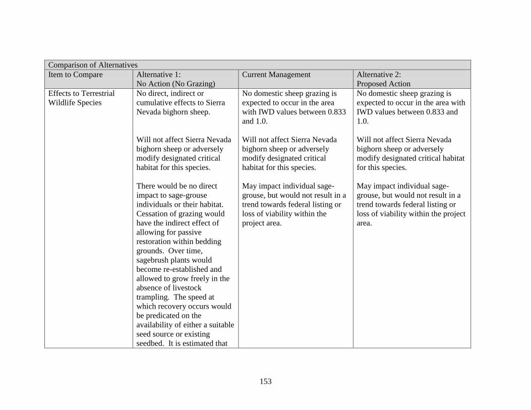
153
Comparison of Alternatives
Item to Compare Alternative 1:
No Action (No Grazing)
Current Management Alternative 2:
Proposed Action
Effects to Terrestrial
Wildlife Species
No direct, indirect or
cumulative effects to Sierra
Nevada bighorn sheep.
Will not affect Sierra Nevada
bighorn sheep or adversely
modify designated critical
habitat for this species.
There would be no direct
impact to sage-grouse
individuals or their habitat.
Cessation of grazing would
have the indirect effect of
allowing for passive
restoration within bedding
grounds. Over time,
sagebrush plants would
become re-established and
allowed to grow freely in the
absence of livestock
trampling. The speed at
which recovery occurs would
be predicated on the
availability of either a suitable
seed source or existing
seedbed. It is estimated that
No domestic sheep grazing is
expected to occur in the area
with IWD values between 0.833
and 1.0.
Will not affect Sierra Nevada
bighorn sheep or adversely
modify designated critical
habitat for this species.
May impact individual sage-
grouse, but would not result in a
trend towards federal listing or
loss of viability within the
project area.
No domestic sheep grazing is
expected to occur in the area with
IWD values between 0.833 and
1.0.
Will not affect Sierra Nevada
bighorn sheep or adversely
modify designated critical habitat
for this species.
May impact individual sage-
grouse, but would not result in a
trend towards federal listing or
loss of viability within the project
area.

154
Comparison of Alternatives
Item to Compare Alternative 1:
No Action (No Grazing)
Current Management Alternative 2:
Proposed Action
sagebrush would occupy the
sites within 10-15 years. The
spatial coverage of sagebrush
habitat would increase by
slightly more than 15 acres.
No direct, indirect or
cumulative impacts on
northern goshawks or their
habitat.
All bedding grounds would be
eliminated.
Elimination of bedding
ground in Township 1S,
Range 29E, Section 7 would
lead to rapid response of
understory vegetation.
Yellow warbler habitat—no
direct impact on riparian
May impact individual northern
goshawks, but would not result
in a trend towards federal listing
or loss of viability within the
project area.
Bedding grounds, watering sites,
and trails are not restricted from
northern goshawk protected
activity centers.
Bedding ground would remain in
Township 1S, Range 29E,
Section 7.
Would not alter the existing
trend in the habitat, nor lead to a
May impact individual northern
goshawks, but would not result in
a trend towards federal listing or
loss of viability within the project
area.
No bedding grounds, watering
sites, or trails would be located in
northern goshawk protected
activity centers.
Elimination of bedding ground in
Township 1S, Range 29E, Section
7 would lead to rapid response of
understory vegetation.
Would not alter the existing trend
in the habitat, nor lead to a

155
Comparison of Alternatives
Item to Compare Alternative 1:
No Action (No Grazing)
Current Management Alternative 2:
Proposed Action
habitat. At two sites aspen
recruitment and understory
shrub, grass, and forb cover is
reduced relative to un-grazed
riparian habitat. Under the No
Action Alternative, grazing
would cease at these two sites
and understory vegetation
would likely respond rapidly.
No effect on the ability of
mule deer to pass through the
allotments.
No direct, indirect or
cumulative impacts on mule
deer or their habitat.
No direct impact to pygmy
rabbit individuals or their
habitat. Cessation of grazing
would have the indirect effect
of allowing for passive
restoration within bedding
grounds.
change in the distribution of
yellow warblers across the Sierra
Nevada bioregion.
No effect on the ability of mule
deer to pass through the
allotments.
Unlikely to have any impact on
the ability of pygmy rabbits to
move through suitable habitat.
change in the distribution of
yellow warblers across the Sierra
Nevada bioregion.
No effect on the ability of mule
deer to pass through the
allotments.
Unlikely to have any impact on
the ability of pygmy rabbits to
move through suitable habitat.
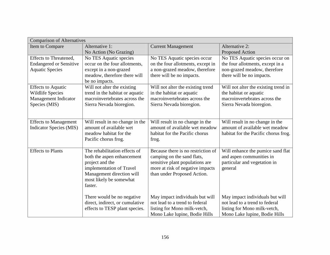
156
Comparison of Alternatives
Item to Compare Alternative 1:
No Action (No Grazing)
Current Management Alternative 2:
Proposed Action
Effects to Threatened,
Endangered or Sensitive
Aquatic Species
No TES Aquatic species
occur on the four allotments,
except in a non-grazed
meadow, therefore there will
be no impacts.
No TES Aquatic species occur
on the four allotments, except in
a non-grazed meadow, therefore
there will be no impacts.
No TES Aquatic species occur on
the four allotments, except in a
non-grazed meadow, therefore
there will be no impacts.
Effects to Aquatic
Wildlife Species
Management Indicator
Species (MIS)
Will not alter the existing
trend in the habitat or aquatic
macroinvertebrates across the
Sierra Nevada bioregion.
Will not alter the existing trend
in the habitat or aquatic
macroinvertebrates across the
Sierra Nevada bioregion.
Will not alter the existing trend in
the habitat or aquatic
macroinvertebrates across the
Sierra Nevada bioregion.
Effects to Management
Indicator Species (MIS)
Will result in no change in the
amount of available wet
meadow habitat for the
Pacific chorus frog.
Will result in no change in the
amount of available wet meadow
habitat for the Pacific chorus
frog.
Will result in no change in the
amount of available wet meadow
habitat for the Pacific chorus frog.
Effects to Plants The rehabilitation effects of
both the aspen enhancement
project and the
implementation of Travel
Management direction will
most likely be somewhat
faster.
There would be no negative
direct, indirect, or cumulative
effects to TESP plant species.
Because there is no restriction of
camping on the sand flats,
sensitive plant populations are
more at risk of negative impacts
than under Proposed Action.
May impact individuals but will
not lead to a trend to federal
listing for Mono milk-vetch,
Mono Lake lupine, Bodie Hills
Will enhance the pumice sand flat
and aspen communities in
particular and vegetation in
general
May impact individuals but will
not lead to a trend to federal
listing for Mono milk-vetch,
Mono Lake lupine, Bodie Hills

157
Comparison of Alternatives
Item to Compare Alternative 1:
No Action (No Grazing)
Current Management Alternative 2:
Proposed Action
There would be no negative
direct, indirect, or cumulative
effects to watch list plants or
other rare species.
Weeds:
Reduced risk of weed spread
and new weed introduction
since there will be fewer
vectors.
rockcress, slender moonwort,
scalloped moonwort, common
moonwort, Mingan moonwort,
upswept moonwort, Williams’
combleaf or Inyo phacelia.
Watch List Plants and Other
Rare Species:
Based on grazing standards and
design criteria, the condition of
the habitat will be maintained or
improved, and although
individual plants may be affected
by grazing, no downward
population trends are expected.
Weeds:
The overall risk of habitat
alteration from this management
contributing to weed
vulnerability is low.
rockcress, slender moonwort,
scalloped moonwort, common
moonwort, Mingan moonwort,
upswept moonwort, Williams’
combleaf or Inyo phacelia.
Watch List Plants and Other Rare
Species:
Based on grazing standards and
design criteria, the condition of
the habitat will be maintained or
improved, and although
individual plants may be affected
by grazing, no downward
population trends are expected.
Weeds:
The overall risk of habitat
alteration from this project
contributing to weed vulnerability
is low.

158
Comparison of Alternatives
Item to Compare Alternative 1:
No Action (No Grazing)
Current Management Alternative 2:
Proposed Action
Effects to Heritage
Resources
No direct or indirect effects
are anticipated. This
Alternative would have no
effect.
Current management would have
a potential to adversely affect
heritage resources because
protection measures and site
condition monitoring would not
be implemented.
Will have no adverse effects to
cultural resources.
With resource protections
measures and monitoring in
place, the proposed action should
have no cumulative effects on the
contributing elements of the
cultural resources within the
grazing allotments.
Economic Effects Would not provide grazing
tenure to lend stability to the
local livestock-raising
community and established
ranching operations.
No AUMs would be
authorized.
Would provide grazing tenure to
lend stability to the local
livestock-raising community and
established ranching operations.
The sheep permittees would be
provided with 1,529 AUMs each
season. The Mono Sand Flat
permittee would have 206
AUMs.
Would provide grazing tenure to
lend stability to the local
livestock-raising community and
established ranching operations.
The sheep permittees would be
provided with 4,567 AUMs each
season due to the resumption of
grazing on the Mono Mills
Allotment. The Mono Sand Flat
Allotment provides 206 AUMs to
the permittee; however, these
AUMs would not be available
while the allotment is being
rested.

159
Comparison of Alternatives
Item to Compare Alternative 1:
No Action (No Grazing)
Current Management Alternative 2:
Proposed Action
Enhanced ecosystem conditions
may mean increased nutritive
value of forage which could result
in higher weigh gains on
livestock, producing lambs with a
higher market value.