Embed Size (px)
Citation preview


Programmatic Environmental Assessment #556 October 2017 Categorical Permissions to Alter U.S. Army Corps of Engineers Projects Pursuant to 33 USC 408
U.S. ARMY CORPS OF ENGINEERS, NEW ORLEANS DISTRICT
Programmatic Environmental
Assessment #556
Categorical Permissions to Alter U.S. Army Corps of Engineers Civil Works Projects
Pursuant to 33 USC 408
U.S. Army Corps of Engineers Mississippi Valley Division
Regional Planning and Environment Division South New Orleans District

Programmatic Environmental Assessment #556 October 2017 Categorical Permissions to Alter U.S. Army Corps of Engineers Projects Pursuant to 33 USC 408
2
Table of Contents 1 Introduction ........................................................................................................... 4
1.1 33 USC Section 408 Authority and Guidance............................................ 5 1.2 Scope of the Programmatic Environmental Assessment ........................... 6
1.2.1 Federal Flood Risk Reduction and Flood Control Projects ............. 8 1.2.2 Federal Navigation Projects .......................................................... 10
2 Purpose and Need .............................................................................................. 10 2.1 USACE Policy Guidance ......................................................................... 10 2.2 Procedures and Limitations ..................................................................... 12
3 Alternatives ......................................................................................................... 14 3.1 Alternative 1 – No Categorical Permissions (No-Action) ......................... 14 3.2 Alternative 2 – Categorical Permission for Pipeline Crossings Including
Horizontal Directional Drills, Open Cuts, Ramp-Overs, and Floodwall Penetrations ............................................................................................ 15
3.3 Alternative 3 - Categorical Permission for Utility Lines Including Fiber Optic, Water, Natural Gas, and Electricity, Both Aerial and Underground, Including Associated Structures and Support Poles ................................ 16
3.4 Alternative 4 - Categorical Permission for Bulk Material Conveyor Systems…………………………………………………………………………17
3.5 Alternative 5 - Categorical Permission for Culverts, Drainage Pipes, and Drainage Ditches ..................................................................................... 17
3.6 Alternative 6 - Categorical Permission for Vehicle and Pedestrian Bridges………………………………………………………………………….17
3.7 Alternative 7 - Categorical Permission for Bank Stabilization and Erosion Control Features ...................................................................................... 18
3.8 Alternative 8 - Categorical Permission for Bulkheads, Docks, Wharfs, Mooring Pilings and Dolphins .................................................................. 19
3.9 Alternative 9 - Categorical Permission for Barge Fleeting Operations in Channels with Existing Barge Fleeting Operations .................................. 20
3.10 Alternative 10 - Categorical Permission for Cattle Guards, Fences, and other Ranching Activities on Easement Lands ........................................ 20
3.11 Alternative 11 - Categorical Permission for Trails, Signage, Lighting, and Other Similar Operational, Recreational, and Decorative Features ......... 20
3.12 Alternative 12 - Categorical Permission for Soil Investigations and Seismic Surveys, Including Borings, Piezometers, and Inclinometers. ................. 21
3.13 Alternative 13 - Levee Ramps and Crossings ......................................... 21 3.14 Alternative 14 - Categorical Permission for Alterations that Meet
Engineering Requirements and Environmental Conditions (Recommended Plan)…………………………………………………………………………….21
3.15 Important Differences between Alternative 1 and All Other Alternatives . 22 4 Affected Environment .......................................................................................... 22

Programmatic Environmental Assessment #556 October 2017 Categorical Permissions to Alter U.S. Army Corps of Engineers Projects Pursuant to 33 USC 408
3
4.1 Air Quality ................................................................................................ 23 4.2 Water Quality ........................................................................................... 24 4.3 Wetlands and Other Waters .................................................................... 25 4.4 Upland Habitats ....................................................................................... 26 4.5 Essential Fish Habitat .............................................................................. 27 4.6 Threatened and Endangered Species ..................................................... 28 4.7 Cultural Resources .................................................................................. 29
5 Environmental Consequences ............................................................................ 30 5.1 Air Quality ................................................................................................ 30 5.2 Water Quality ........................................................................................... 31 5.3 Wetlands and Other Waters .................................................................... 33 5.4 Upland Habitats ....................................................................................... 35 5.5 Essential Fish Habitat .............................................................................. 36 5.6 Threatened and Endangered Species ..................................................... 37 5.7 Cultural Resources .................................................................................. 39 5.8 Summary of Potential Direct and Indirect Impacts ................................... 41
6 Cumulative Impacts ............................................................................................ 43 6.1 Past Actions ............................................................................................ 43 6.2 Present and Future Actions ..................................................................... 44
7 Agency Coordination and Public Comments ....................................................... 45 8 Conclusion .......................................................................................................... 46 9 Preparers ............................................................................................................ 47 APPENDIX A - Navigation, Flood Risk Reduction, and Mississippi River and Tributaries Projects within the New Orleans District APPENDIX B - Engineering Criteria and Requirements for Section 408 Requests APPENDIX C - Threatened and Endangered Species by Parish within the Geographical Boundary of the New Orleans District APPENDIX D - Public Notice of Proposed Programmatic EA APPENDIX E - Section 408 New Orleans District Environmental Compliance APPENDIX F – Public and Agency Comments

4
Programmatic Environmental Assessment #556 October 2017 Categorical Permissions to Alter U.S. Army Corps of Engineers Projects Pursuant to 33 USC 408
1 Introduction The U.S. Army Corps of Engineers (USACE), District (District) has constructed, and continues to construct, numerous civil works projects within its geographical area of responsibility in the southern portion of Louisiana. The District receives numerous requests each year from private interests and local and state agencies for permission to perform activities that would affect or alter these USACE civil works projects. When requests are received, they are evaluated to determine if the proposed alteration would impair the usefulness of the USACE project or be injurious to the public interest. Engineering Circular (EC) 1165-2-216, titled Policy and Procedural Guidance for Processing Requests to Alter US Army Corps of Engineers Civil Works Projects Pursuant to 33 U.S. Code (USC) 408, provides guidance to process such requests. The EC is available at: http://www.publications.usace.army.mil/Portals/76/Publications/EngineerCirculars/EC_1165-2-216.pdf?ver=2016-06-28-100552-103. Because issuance of permission to alter a USACE project is a federal action, it is subject to National Environmental Policy Act (NEPA), 42 U.S.C. §4321, et seq., compliance. To simplify the review process, EC 1165-2-216, Section 6.s states that USACE districts may develop "categorical permissions" to address environmental compliance for proposed alterations that are similar in nature and have similar impacts. A categorical permission is similar to a "categorical exclusion" under NEPA. Categorical permissions are established at the district level and address only requests to alter civil works projects under Section 408, whereas categorical exclusions are established at the agency level with the involvement of the President’s Council on Environmental Quality, and cover agency-wide actions. A categorical exclusion covers a category of actions that does not normally result in individually or cumulatively significant environmental effects and for which therefore neither an environmental assessment (EA) nor an environmental impact statement (EIS) is required. Once the agency has identified categories of activities that do not normally have the potential for individually or cumulatively significant impacts, the agency may establish a categorical exclusion for those activities. Because use of a categorical exclusion obviates the need to prepare an EA or EIS, use of categorical exclusions can reduce paperwork and delay so that more resources are available to assess proposed actions that have the potential to cause significant environmental effects. Under EC 1165-2-216, categorical permissions are used in the same manner as categorical exclusions, and offer the same time and resource-saving benefits to the agency. The District has prepared this environmental assessment to evaluate the environmental impacts of certain categories of requested alterations to determine whether those actions may appropriately be designated as categorical permissions. Designation of a type of proposed action as a categorical permissions would allow expedited NEPA review of the proposed action to validate application of the categorical permission and to identify and specify any special conditions that may apply on a site-specific basis. If validated, this expedited review would result in preparation of a Memorandum for

5
Programmatic Environmental Assessment #556 October 2017 Categorical Permissions to Alter U.S. Army Corps of Engineers Projects Pursuant to 33 USC 408
Record documenting the use of the categorical permission in lieu of preparation of an EA or EIS. If approved, categorical permissions would be applicable to certain categories of requests to alter Federal flood control and flood risk reduction projects and navigation projects within the boundaries of the District. Preparation of this programmatic environmental assessment follows the President’s Council on Environmental Quality (CEQ) guidance for Effective Use of Programmatic National Environmental Policy Act (NEPA) Reviews. It evaluates “a suite of ongoing, proposed, and reasonably foreseeable actions that share a common geography or timing, such as multiple activities within a defined boundary” as described in the CEQ guidance. The purpose of this Programmatic Environmental Assessment is to develop categorical permissions as described in EC 1165-2-216 to cover potential alterations that are similar in nature, have similar impacts, and have impacts that do not individually or cumulatively have any significant effect on the human environment in order to simplify the Section 408 review process. If approved, the respective categorical permissions will be reviewed on a regular basis to ensure that based on on-going experience, those types of activities continue to have only minimal environmental impacts, and that circumstances have not changed that would impact the analyses and conclusions reached in this document. This document provides the necessary information to fully address the potential environmental impacts of implementing categorical permissions for Section 408 as required under the National Environmental Policy Act of 1969, as amended (42 USC 4321 et seq.); CEQ Regulations [40 Code of Federal Regulations (CFR) 1500 – 1508] (CEQ, 1992); and USACE Engineer Regulation (ER) 200-2-2 (33 CFR 230). ER 200-2-2 contains the USACE’s procedures for implementing NEPA. 1.1 33 USC Section 408 Authority and Guidance The authority to grant permission for temporary or permanent alterations to Federally authorized civil works projects is contained in Section 14 of the Rivers and Harbors Act of 1899, codified at 33 U.S. Code § 408, titled Taking possession of, use of, or injury to harbor or river improvements. It states: “It shall not be lawful for any person or persons to take possession of or make use of for any purpose, or build upon, alter, deface, destroy, move, injure, obstruct by fastening vessels thereto or otherwise, or in any manner whatever impair the usefulness of any sea wall, bulkhead, jetty, dike, levee, wharf, pier, or other work built by the United States, or any piece of plant, floating or otherwise, used in the construction of such work under the control of the United States, in whole or in part, for the preservation and improvement of any of its navigable waters or to prevent floods, or as boundary marks, tide gauges, surveying stations, buoys, or other established marks, nor remove for ballast or other purposes any stone or other material composing such works: Provided, That the Secretary of the Army may, on the recommendation of the Chief of Engineers, grant permission for the temporary occupation or use of any of the aforementioned

6
Programmatic Environmental Assessment #556 October 2017 Categorical Permissions to Alter U.S. Army Corps of Engineers Projects Pursuant to 33 USC 408
public works when in his judgment such occupation or use will not be injurious to the public interest: Provided further, That the Secretary may, on the recommendation of the Chief of Engineers, grant permission for the alteration or permanent occupation or use of any of the aforementioned public works when in the judgment of the Secretary such occupation or use will not be injurious to the public interest and will not impair the usefulness of such work.” Specific USACE guidance for implementation of 33 U.S. Code § 408 ("Section 408") is provided by EC 1165-2-216. The expiration date on the EC is July 21, 2016, however the expiration was extended by Headquarters USACE until September 30, 2017. It is expected that the expiration date of the EC will continue to be extended until it is succeeded by new guidance. EC 1165-2-216 defines the use of the terms “alteration” and “alter” as any action by any entity other than USACE that builds upon, alters, improves, moves, occupies, or otherwise affects the usefulness or the structural or ecological integrity of a USACE project. This definition is also being used in this document as well. The entity or individual requesting permission to alter the USACE project, hereafter referred to as the requester, is responsible for acquiring all other needed permissions, authorizations, and permits. This includes any permits needed from the USACE Regulatory Program, specifically Rivers and Harbors Act Section 10 and Clean Water Act Section 404 permits. EC 1165-2-216 contains USACE policy statements concerning environmental compliance for Section 408 permissions. “This EC only applies to alterations proposed within the lands and real property interests identified and acquired for the USACE project and to lands available for USACE projects under the navigation servitude.” Because USACE only has Section 408 jurisdiction over the lands within the USACE project area, generally “[t]he scope of analysis for the NEPA and environmental compliance evaluations for the Section 408 review should be limited to the area of the alteration and those adjacent areas that are directly or indirectly affected by the alteration.” The EC also recognizes that in some circumstances, a larger area should be subject to environmental review. 1.2 Scope of the Programmatic Environmental Assessment The District’s geographical area of responsibility for civil works projects is shown in Figure 1. USACE districts are defined mainly by drainage basins. The District includes the drainage basin of the Mississippi River within Louisiana generally south of the Old River Control Complex near Simmesport, and nearly all of the coastal streams and rivers draining into the Gulf of Mexico within Louisiana, but it does not include the Sabine River Basin or the Pearl River Basin. The Galveston District has responsibility for the Sabine River Basin and the Vicksburg District has responsibility for the Pearl River Basin. The Vicksburg District also has responsibility for the Red and Ouachita River Basins in central and north Louisiana.

7
Programmatic Environmental Assessment #556 October 2017 Categorical Permissions to Alter U.S. Army Corps of Engineers Projects Pursuant to 33 USC 408
Figure 1: The New Orleans District geographical boundary. Per EC 1165-2-216, the scope of the analysis for Section 408 reviews is limited to the lands and real property interests required for USACE projects and those adjacent areas that are directly or indirectly affected by the alteration. If a proposed alteration is part of a larger project that extends beyond the USACE project boundaries, the District staff would determine what portions or features of the larger project USACE has control and responsibility over to warrant inclusion as part of the evaluation, as described in EC 1165-2-216. Requests to alter projects other than Federal flood risk reduction, flood control projects (Mississippi River and Tributaries Project), and Federal navigation projects, and alteration types not considered in this Programmatic Environmental Assessment, will be evaluated for National Environmental Policy Act compliance separately. Either a categorical exclusion as provided under ER 200-2-2, an environmental assessment (EA) with a finding of no significant impact (FONSI), or an environmental impact statement (EIS) with a record of decision (ROD) would be prepared for those requests. The lead paragraph of EC 1165-2-216 states that the EC applies to Federally-authorized projects. There are several large Federal projects within the District that are

8
Programmatic Environmental Assessment #556 October 2017 Categorical Permissions to Alter U.S. Army Corps of Engineers Projects Pursuant to 33 USC 408
Congressionally-authorized for construction, but construction, as part of a Federal project has not commenced. Examples are the East Baton Rouge Parish flood risk reduction project, the Morganza to the Gulf flood risk reduction project, and the West Shore Lake Pontchartrain flood risk reduction project. (Note that some components of these projects have been constructed by non-Federal interests at their own expense.) In some cases, project cost-share agreements have not been executed between the USACE and the non-Federal project sponsors, and in some cases the projects have not received “new start” construction funding from Congress. When USACE has jurisdiction over the project area under another authority (such as the Clean Water Act §404 or Rivers and Harbors Act §10), the District will evaluate proposed actions that would alter these authorized but not-yet-constructed projects in the same manner as proposals to alter constructed projects are evaluated, while considering that real estate acquisition to establish project boundaries has not yet occurred. The establishment of categorical permissions would not change the engineering and real estate reviews conducted for every Section 408 request. The District’s Engineering Division conducts, and would continue to conduct, a thorough evaluation of every Section 408 request to assure that the usefulness of the USACE project(s) is not impaired and that the alteration would not be injurious to the public interest. The USACE Regional Real Estate Division would also continue to evaluate every Section 408 request to assure that the USACE project’s real estate interests are not adversely affected. These two District technical divisions would continue to work with the requesters to modify the requests as needed to assure the Section 408 actions do not adversely affect USACE projects. All Section 408 requests also undergo an agency technical review or ATR, as required by EC 1165-2-216. The District has developed and utilizes an overarching review plan, called a procedural review plan, which established the review procedures to be used for requests that are similar in nature and that have similar impacts. The District’s procedural review plan applies to generally the same categories of requests as this programmatic EA. Individual review plans are developed and used for the types or categories of requests that are not covered under the procedural review plan. 1.2.1 Federal Flood Risk Reduction and Flood Control Projects There are several large-scale flood risk reduction projects within the District. The project providing hurricane storm surge risk reduction to most of Orleans Parish (New Orleans) and the parts of Jefferson and St. Charles Parishes that lie on the east bank of the Mississippi River, is the Lake Pontchartrain and Vicinity project. The West Bank and Vicinity project provides hurricane storm surge risk reduction to parts of Jefferson, St. Charles and Orleans Parishes that lie on the west bank of the Mississippi River. Both of these projects are designed to provide risk reduction from storms with a one percent chance of occurring in any single year, otherwise known as the 100-year level of risk reduction. The New Orleans to Venice project provides hurricane storm surge risk reduction to parts of Plaquemines Parish, generally the higher lands bordering both banks of the Mississippi River. The Larose to Golden Meadow project provides

9
Programmatic Environmental Assessment #556 October 2017 Categorical Permissions to Alter U.S. Army Corps of Engineers Projects Pursuant to 33 USC 408
hurricane storm surge risk reduction to parts of Lafourche Parish, generally the higher lands bordering both banks of Bayou Lafourche. All of these projects consist primarily of earthen levees, along with concrete floodwalls, concrete barriers, navigable floodgates, vehicular floodgates, and pumping stations. The Mississippi River and Tributaries (MR&T) Project’s flood control plan employs a variety of engineering techniques, including an extensive levee system to prevent disastrous overflows on developed alluvial lands; floodways to safely divert excess flows past critical reaches so that the levee system will not be unduly stressed; channel improvements and stabilization features to protect the integrity of flood control measures and to ensure proper alignment and depth of the navigation channel; and tributary basin improvements, to include levees, headwater reservoirs and pumping stations, that maximize the benefits realized on the main stem by expanding flood protection coverage and improving drainage into adjacent areas within the alluvial valley. Major features of the MR&T project lie within the District. The most notable feature is the mainline levees along the banks of Mississippi River. Within the District, the west bank levee is continuous, except for floodwalls, floodgates, and water control structures from the upstream limit of the District near Old River to Venice. On the east bank, the levee runs from Baton Rouge to Bohemia in Plaquemines Parish, with interspersed floodwalls, floodgates, and water control structures. Major project features along the Mississippi River include the Bonnet Carre diversion structure and spillway, the Morganza diversion structure, and the Old River Control Complex, which includes three major water control structures (Low Sill, Auxiliary, and Overbank Structures), and the Old River Lock. The Atchafalaya Basin Flood Control project is also a major feature of the MR&T project. The Atchafalaya Basin Flood Control project consists of levees along both banks of the Atchafalaya River from Old River downstream to approximately Butte La Rose and basin protection levees on the east and west sides of the Atchafalaya Basin Floodway down to the vicinity of Morgan City, and the Levees West of Berwick which provide river flood protection to cities, towns and communities along Bayou Teche and Bayou Sale. In addition to these levees, the project includes many floodgates, several pumping stations, several navigation locks, navigable floodgates, gravity drainage structures, and channel dredging for flood control and navigation. The MR&T project also includes a channel improvement program which prevents migration of the Mississippi and Atchafalaya Rivers. Under this program, dikes, revetment, and dredging are used to stabilize the river channel and its banks. These channel improvement features provide both navigation and flood risk reduction benefits by maintaining an efficient channel alignment, providing the required flood-carrying capacity, and protecting the adjacent levee system. One additional, notable flood risk reduction project is the Comite River Diversion project under construction in East Baton Rouge Parish which, when operational, will divert flood flows from the Comite River to the Mississippi River. Appendix A contains annotated tables of the flood risk reduction and MR&T projects within the District.

10
Programmatic Environmental Assessment #556 October 2017 Categorical Permissions to Alter U.S. Army Corps of Engineers Projects Pursuant to 33 USC 408
1.2.2 Federal Navigation Projects The District likely has the densest concentration of navigation projects in the U.S. The most heavily used and deepest draft channel is the Mississippi River which is currently maintained to provide a 45 feet deep navigation channel from the Gulf of Mexico to Baton Rouge. Dredging is required to maintain the navigation channel from the bar channel in the Gulf of Mexico at the entrance to Southwest Pass, through Southwest Pass to the vicinity of Venice. Dredging is also required at several locations between Baton Rouge and New Orleans, known as crossings, where the deep, natural channel of the river crosses from one side of the river to the other. The Calcasieu River and Pass project in southwest Louisiana provides a 40 feet deep navigation channel from the Gulf of Mexico to the Port of Lake Charles, with side channels and turning basins. The Atchafalaya River and Bayous Chene, Boeuf and Black project provides a 20 feet deep channel from the Gulf of Mexico, through the Atchafalaya River and Bayou Chene, up to the industrial fabrication facilities located along Bayous Boeuf and Black near Morgan City. Other notable coastal waterways that have USACE-maintained navigation channels are Mermentau River, Freshwater Bayou, Houma Navigation Canal, Port Fourchon (Bayou Lafourche), Barataria Bay Waterway, Tiger Pass, and Baptiste Collette Bayou. All of these channels provide for navigation between the Gulf of Mexico and inland, land-based facilities. The primary navigation channel running parallel to the Louisiana coast is the Gulf Intracoastal Waterway or GIWW. The GIWW provides for shallow-draft, inland navigation from Brownsville, Texas to the vicinity of Apalachicola, Florida. Within the District, the main stem of the GIWW runs from the western to the eastern borders of the District. An alternate route runs from the main stem near Morgan City to the Port Allen Lock on the west bank of the Mississippi River near Baton Rouge. The GIWW is heavily used for the transportation of liquid petroleum and petroleum products. This project is unlike nearly all other USACE projects in the District because it does not have a non-Federal project sponsor who is responsible for acquisition of lands, easements, right-of way, and disposal areas. All real estate interests required for the GIWW project are in the name of the Federal Government. Appendix A contains annotated tables of the navigation projects within the District. 2 Purpose and Need 2.1 USACE Policy Guidance. Engineering Circular 1165-2-216, Section 6.s, states
that USACE districts have the ability to develop categorical permissions for compliance with Section 408 to cover potential alterations that are similar in nature and that have similar impacts in order to simplify the National Environmental Policy Act review process. The District proposes to establish categorical permissions for common types of requests that experience has shown to not typically cause any more than minimal environmental impacts. During 2016 and the first eight months of 2017, the District’s environmental compliance staff received 96 requests subject

11
Programmatic Environmental Assessment #556 October 2017 Categorical Permissions to Alter U.S. Army Corps of Engineers Projects Pursuant to 33 USC 408
to Section 408 review. While the majority of these requests have generally fallen into types of actions that are both similar in nature and impacts, as of late 2017 the District has reviewed and prepared individual environmental assessment checklists for 36 separate requests that did not meet the criteria for a categorical exclusion contained under ER-200-2-2. Each of these 36 separate requests resulted in a determination of no significant impact on the human environment made by the USACE, CEMVN District Commander. Appendix E of this EA lists each request along with a description of the type of action and compliance with associated Federal, state and local laws and regulations. Through this programmatic EA, the District proposes to establish categorical permissions for additional types of actions that are common in the District, even though no such requests have been received through the Section 408 program.
Establishing categorical permissions would simplify the review process for the majority of the Section 408 requests that are received and allow the District to expedite environmental reviews while continuing to provide an adequate level of environmental review meeting NEPA requirements. The majority of future requests, based on requests received in 2016 and 2017, are expected to have minimal to minor levels of adverse environmental impacts on the environment within USACE project boundaries and adjacent areas indirectly affected. Expedited reviews would benefit both the Government and requesters by reducing the time and expense related to processing the Section 408 requests, while continuing to fully comply with USACE NEPA implementing regulations and USACE Section 408 policy guidance. Further, it would free up personnel resources to process environmental reviews of the remaining requests which require the preparation of EAs or EISs, within a reasonable amount of time. EC 1165-2-216 contains guidance to District offices concerning the use of existing categorical exclusions under 33 CFR 230.9 for the efficient processing of Section 408 requests. Two categorical exclusions are specifically mentioned. The first, 33 CFR 230.9(b), addresses activities at completed Corps projects which carry out the authorized project purposes. The District has not applied this categorical exclusion for any Section 408 requests, since no requests have been received which support or carry out the authorized project purposes. The second, 33 CFR 230.9(i), addresses real estate grants for rights-of-way which involve only minor disturbances to earth, air, or water. The following activities are specifically mentioned under this categorical exclusion: “Minor access roads, streets, and boat ramps; Minor utility distribution and collection lines, including irrigation; Removal of sand, gravel, rock, and other material from existing borrow areas; and oil and gas seismic and gravity meter survey for exploration purposes.” The EC specifically states “Real estate grants for rights-of-way as referenced in Section 33 CFR 230.9(i) should be broadly interpreted to include grants of rights-of-way by either USACE or the non-Federal sponsor.” This information is provided here to explain why these types of activities are not included as proposed categorical permissions in this EA. As of June 2017, the District has applied this categorical exclusion to five Section 408 requests; one for an earthen levee ramp for vehicle access, one for a fiber optic cable crossing of a levee, one for a multi-use trail

12
Programmatic Environmental Assessment #556 October 2017 Categorical Permissions to Alter U.S. Army Corps of Engineers Projects Pursuant to 33 USC 408
(road) on top of an existing levee and two for utility lines used for drainage. There are currently three additional projects undergoing review that will likely be categorically excluded under ER 200-2-2. The purpose of this document is to develop categorical permissions as described in EC 1165-2-216 to cover potential alterations that are similar in nature and have similar impacts and that do not have the potential for individually or cumulatively significant impacts in order to simplify the Section 408 review process. This aligns with guidance from CEQ concerning development of programmatic NEPA reviews for multiple actions that are similar in nature (CEQ, 2014). Also, a programmatic document allows for a more comprehensive evaluation of potential cumulative impacts that may result from numerous alterations within the District. 2.2 Procedures and Limitations The following general requirements are applicable to all Section 408 requests received by the District:
1. Design and construction specifications must be signed and sealed by a Louisiana-registered professional engineer and, if applicable, a Louisiana-registered geologist.
2. The proposed alteration must not negatively impact typical inspections, operations, and maintenance of the USACE project.
3. The proposed alteration must not impact any flood-fighting operations that may be conducted at the USACE project.
4. The proposed alteration must not result in any increase in operation and maintenance costs to the USACE.
The following engineering and environmental conditions have been developed to assist in determining if proposed alterations would be injurious to the public interest:
1. Proposed alterations must not adversely affect any threatened or endangered species, including their critical habitat, listed or designated under the Endangered Species Act.
2. Proposed alterations must not result in the “take” of migratory birds as defined in the Migratory Bird Treaty Act.
3. Proposed alterations must incorporate best management practices to control storm water runoff or any point source discharges in accordance with any required National Pollutant Discharge Elimination System (NPDES) permits.
4. Proposed alterations must not encourage additional development within the floodplain, or adversely affect floodplain values or the base flood elevation.
5. Proposed alterations must not adversely affect any significant cultural resources and be in compliance with the National Historic Preservation Act (NHPA) Section 106.
6. Proposed alterations must meet other conditions as described in Section 5, Environmental Consequences.
7. Proposed alterations must not cause a public health or safety issue, or a
13
Programmatic Environmental Assessment #556 October 2017 Categorical Permissions to Alter U.S. Army Corps of Engineers Projects Pursuant to 33 USC 408
navigation safety issue. All 408 requests are reviewed for compliance with these requirements. Any alterations that are approved as categorical permissions will continue to be evaluated for compliance with these requirements. Additionally, in order to qualify for use of a categorical permission, the request must meet the following requirements:
1. The activity must not result in more than minor impacts to the environment. 2. The activity must have a small footprint. 3. The activity must not be likely to adversely affect a listed species or designated
critical habitat under the Endangered Species Act. 4. The activity must not have the potential to result in disproportionate adverse
impacts to low income or minority populations. 5. The activity must not adversely affect prime and unique farmlands, state-
designated scenic streams or socioeconomic resources. 6. The activity must have no or only temporary adverse impacts to recreational
resources. 7. The activity must not impinge upon the value (habitat, hydrology, etc.) of any
National Wildlife Refuge, National Forest, areas administered the National Park Service of the U.S. Department of Interior, areas administered by the Louisiana Departments of Natural Resources or Wildlife and Fisheries, or similarly held areas administered by federal, state, or local governmental authority, unless special permission from these agencies is submitted with the application.
Proposed activities not meeting these requirements will be evaluated through the preparation of an Environmental Assessment or Environmental Impact Statement, as appropriate. Generally, the requester is responsible for conducting all necessary environmental and cultural resources studies and analyses, obtaining necessary permits, and providing copies to USACE for review. If the environmental conditions listed above are met and the request would not result in more than minor impacts to the environment, then the proposed alteration would be determined to not be injurious to the public interest, from an environmental perspective, unless there are extraordinary circumstances are involved. Detailed engineering criteria and requirements for some proposed alterations have been developed by the Districts’ Engineering Division to assist in determining if the proposed alteration would impair the usefulness of the USACE project. Requesters are required to comply with these criteria and requirements. These engineering criteria and requirements are provided as Appendix B and are available on the District’s website at: http://www.mvn.usace.army.mil/Portals/56/docs/Section%20408/Section%20408%20Criteria%20for%20website.pdf.

14
Programmatic Environmental Assessment #556 October 2017 Categorical Permissions to Alter U.S. Army Corps of Engineers Projects Pursuant to 33 USC 408
3 Alternatives For this EA, categories or types of requests are the alternatives. Thirteen action alternatives were evaluated in detail, in addition to the no-action alternative. The following general requirements apply to all of the action alternatives: The requester conducts all necessary environmental and cultural resources surveys and provides the information to the District staff. The requester obtains all necessary permits and approvals from other agencies, including State water quality certification and a State coastal use permit, when applicable. The District staff conducts Endangered Species Act Section 7 review and as necessary consultation with the USFWS and/or the National Marine Fisheries Service, conducts Essential Fish Habitat consultation with the National Marine Fisheries Service as necessary, and conducts cultural resources review and National Historic Preservation Act Section 106 coordination with the Louisiana State Historic Preservation Officer (SHPO) and interested Tribes. Once the above environmental compliance is complete and if the request would not result in more than minor impacts to the environment, then absent unusual or extraordinary circumstances, the appropriate categorical permission(s) would be applied to the request and a Memorandum for Record would be prepared to document that determination. 3.1 Alternative 1 – No Categorical Permissions (No-Action) No action is defined as not establishing any categorical permission(s). The District would obtain the NEPA compliance for each request individually by application of a categorical exclusion under ER 200-2-2, preparation of an EA and signing of a FONSI (if appropriate), or preparation of an EIS and signing of a record of decision. All requests to alter USACE projects would be evaluated on a case-by-case basis to assess individual and cumulative environmental impacts. This alternative would not meet the purpose and need of developing categorical permissions to simplify and expedite the Section 408 request environmental review process for activities with individually and cumulatively minor impacts. The District would continue to expend valuable time and resources processing EAs for activities with no potential for significant impacts. The processing of other more complicated 408 requests would continue to be delayed by lack of resources and a backlog of requests. Note that the no-action alternative as described in this EA is not the scenario of the District ceasing to accept Section 408 requests and grant Section 408 permissions for alterations determined to be permissible. The District does not have the discretion to disregard Federal law and USACE implementation policy. Attempting to determine what would happen if no Section 408-type actions were allowed would be a highly speculative endeavor, and doing so could lead the reader to believe it to be a viable

15
Programmatic Environmental Assessment #556 October 2017 Categorical Permissions to Alter U.S. Army Corps of Engineers Projects Pursuant to 33 USC 408
alternative, which it is not. In some limited, specific cases, there would likely be options to redesign proposed actions to avoid interacting with USACE projects, and proponents would take advantage of those options. But, it is unreasonable to believe the USACE could avoid granting Section 408 permissions for more than a short period of time. 3.2 Alternative 2 – Categorical Permission for Pipeline Crossings Including
Horizontal Directional Drills, Open Cuts, Ramp-Overs, and Floodwall Penetrations
This alternative would establish a categorical permission for pipeline crossings of levees, floodwalls, navigation channels, flood risk reduction channels, and dredged material disposal areas. This alternative does not apply to requests for new, long distance pipelines crossing multiple USACE navigation and flood risk reduction projects. The alternative would apply to the large number of requests the District receives for pipelines connecting industrial facilities located along navigation channels to docks and wharves where products are loaded or unloaded from barges and ships. Common requests include new pipelines, additional pipelines using existing pipe racks, and replacement pipelines. Often, the requests include both a pipeline crossing of a levee/floodwall and construction or modification of a dock or wharf along the adjacent navigation channel. Occasionally, a short access road and/or levee ramp may also be proposed to provide access to the pipeline corridor between the levee and the river. Minor access roads are categorically excluded from NEPA evaluation by ER 200-2-2. A large variety of industrial chemicals and petroleum products are transported in these pipelines, although requests for pipelines to carry cooling water, drainage water, and drinking water are also received. Most requests of this type are for pipelines associated with facilities located along major shipping channels, especially the Mississippi River between Baton Rouge and Venice, Louisiana, and along the Calcasieu River and Pass project in southwest Louisiana. There are hundreds of pipeline crossings of the Mississippi River Levees downstream from Baton Rouge. Requests for this type of action along the Mississippi River would typically alter three Federal navigation projects; the Mississippi River Levees, the Mississippi River Channel Stabilization project, and the Mississippi River Ship Channel project. The area of effect considered in the Section 408 review is normally from the landside toe of the Mississippi River levee to the end of any bank stabilization features in the Mississippi River. In some cases, a 408 request also has the potential to affect the maintained navigation channel, in which case the shipping channel also is within the area of effect. A typical Mississippi River levee cross-section with adjacent features is shown in Figure 2. Other requests under this alternative are for horizontal directional drills (HDDs) beneath a USACE project. Several requests have been received to replace a portion of an existing pipeline beneath a navigation channel due to unsafe conditions of the existing pipeline. Conditions requiring a horizontal directional drill may include corrosion of the existing pipeline, exposure of the pipeline due to scour and erosion of the channel, or proactive replacement at the end of pipeline’s service life. Usually, the entrance and

16
Programmatic Environmental Assessment #556 October 2017 Categorical Permissions to Alter U.S. Army Corps of Engineers Projects Pursuant to 33 USC 408
exit points for the directional drills are outside of the USACE project boundary and there is no surface disturbance or expression of the work within the USACE project, although sometimes the HDD drill sites are located on dredged material disposal areas used for a USACE project.
Figure 2. Typical Mississippi River levee and adjacent features. 3.3 Alternative 3 - Categorical Permission for Utility Lines Including Fiber
Optic, Water, Natural Gas, and Electricity, Both Aerial and Underground, Including Associated Structures and Support Poles
This alternative would establish a categorical permission for utility lines including fiber optic, water, natural gas, and electricity, and including associated structures and support poles. Installations may be aerial, on-ground (at grade), or underground. The District receives a large number of requests for installation and replacement of utility lines. Typically, the requests are for crossing of a levee or floodwall, and less commonly, the crossing of a navigation channel. Horizontal directional drilling is the most commonly requested method for the placement of fiber optic, water and natural gas lines. Usually, the entrance and exit points for the directional drills are outside of the USACE project boundary and there is no surface disturbance or expression of the work within the USACE project. Large-diameter water lines, such as those used for municipal water supply, sewage treatment intakes and discharges, industrial equipment cooling typically use the ramp-over method or the bridge-over method for crossing levees. For crossing floodwalls, either the bridge-over or penetration method is typically used. Aerial placement on poles or towers is the most commonly requested method for installing electrical lines. This categorical permission is applicable to electrical lines for residential, commercial, and industrial uses, but is not meant for long distance, high voltage transmission lines affecting multiple USACE projects, or for proposals requiring

17
Programmatic Environmental Assessment #556 October 2017 Categorical Permissions to Alter U.S. Army Corps of Engineers Projects Pursuant to 33 USC 408
new corridors through USACE-owned project lands. 3.4 Alternative 4 - Categorical Permission for Bulk Material Conveyor Systems This alternative would establish a categorical permission for bulk material conveyor systems, including associated support structures. The District has received several requests for bulk product conveyor systems along the Mississippi River. Types of materials that are moved with the conveyors include coal, grain, bauxite (aluminum ore), fertilizer, and various other manufactured products. These systems allow materials to be transferred between ships and barges on a navigation channel and nearby storage facilities or industrial plants. There are normally docks or wharves associated with the conveyor systems. Along the Mississippi River, a levee and paved road typically run parallel to the river bank. In such situations, the conveyor system crosses the levee and road overhead, supported on steel structures, with sufficient clearance provided for vehicles to travel along the crown of the levee for levee maintenance and inspection. The area of review for the Section 408 request is normally from the land-side toe of the levee to the outer edge of the dock, wharf, or associated mooring pilings. 3.5 Alternative 5 - Categorical Permission for Culverts, Drainage Pipes, and
Drainage Ditches This alternative would establish a categorical permission for culverts, drainage pipes, and drainage ditches. The District has processed one such request for this type of activity, which occurred on developed land in a suburban environment associated with USACE flood risk reduction and project. Culverts, drainage pipes, and drainage ditches have the potential to cause the inadvertent loss of wetlands depending on their location and purpose. All requests for the installation of these types of structures would be examined to determine the purpose and potential effects of such structures and if found to have the potential to drain wetlands and cause the loss of those areas, a categorical permission would not be used. The action would be evaluated through either an EA or EIS as appropriate. 3.6 Alternative 6 - Categorical Permission for Vehicle and Pedestrian Bridges This alternative would result in a categorical permission for alterations that include construction, replacement, modification, or removal of vehicle or pedestrian bridges. The District has received two requests for bridge projects. One request is for a new bridge across the Gulf Intracoastal Waterway where no bridge currently exists. The other request is for demolition of an existing, historically-significant bridge and replacement with a new bridge. Neither of these requests would qualify for a categorical permission under this alternative because of extraordinary circumstances associated with them. The first example has a large scope and impacts that require consideration, while the second example has impacts to a significant cultural resource and possible issues with disturbance of existing contaminated soils and sediments. The

18
Programmatic Environmental Assessment #556 October 2017 Categorical Permissions to Alter U.S. Army Corps of Engineers Projects Pursuant to 33 USC 408
requests covered under this alternative include primarily bridge replacements, major bridge maintenance, modifications, and removals with no extraordinary circumstances. The District has not received any such requests, but anticipates receiving such requests because of the large number of bridges crossing USACE navigation and flood risk reduction projects in south Louisiana. 3.7 Alternative 7 - Categorical Permission for Bank Stabilization and Erosion
Control Features This alternative would result in a categorical permission for alterations that include bank stabilization and erosion control features. Typical techniques are vegetative stabilization, bioengineering, sills, rip rap, revetment, gabion baskets, stream barbs, and bulkheads, or combinations of bank stabilization techniques. The surface soils and sediments that make up coastal Louisiana is mostly alluvial sediment carried downstream by the Mississippi and other rivers and reworked since the last Ice Age. This material is generally highly erodible and bank and shoreline erosion is an all too common problem along navigation channels and natural waterways. The most common method for addressing shoreline erosion is armoring bank lines and shorelines with quarry stone. Another common method is placing quarry stone a short distance out from the shoreline to form a dike, often referred to as a foreshore dike. This method is used when geotechnical and other conditions, such as expected wave energy allow, and when avoidance of direct impacts to the shoreline is a priority. In some documented cases, enough suspended sediment has been captured in the stilled water behind such dikes that the shoreline naturally extends itself out to the foreshore dike. Other materials that may be used for shoreline erosion are articulated concrete mattress, poured concrete, broken concrete (rip-rap), and earthen material excavated from nearby areas or hauled from remote locations. Construction is usually accomplished using equipment positioned on barges or other vessels in the waterway. Dredging to provide access for barges and other vessels to construction sites may also be necessary. Commonly-used dredging equipment includes a barge-mounted hydraulic excavator or a crane with a clamshell-type bucket. Typically, the dredged material either is deposited on the shoreline before surfacing material is placed over it or it is deposited adjacent to the access channel, and then is used to fill in the access channel once the shoreline work is completed. To determine if a request for a bank stabilization or erosion control feature is appropriate to consider as a categorical permission, criteria found in the USACE’s Nationwide General Permit (NGP) #13 (Bank Stabilization) will be used. Bank stabilization projects which conform to the criteria found in NGP #13 have been determined, through the USACE Regulatory permitting process, to neither individually nor cumulatively have significant adverse impacts. If the requested action does not comply, or cannot be modified to comply with the criteria in the NGP, the request would not be processed as a categorical permission. NGP #13 contains the following criteria:

19
Programmatic Environmental Assessment #556 October 2017 Categorical Permissions to Alter U.S. Army Corps of Engineers Projects Pursuant to 33 USC 408
(a) No material is placed in excess of the minimum needed for erosion protection; (b) The activity is no more than 500 feet in length along the bank, unless the
district engineer waives this criterion by making a written determination concluding that the discharge will result in no more than minimal adverse environmental effects (an exception is for bulkheads – the district engineer cannot issue a waiver for a bulkhead that is greater than 1,000 feet in length along the bank);
(c) The activity will not exceed an average of one cubic yard per running foot, as measured along the length of the treated bank, below the plane of the ordinary high water mark or the high tide line, unless the district engineer waives this criterion by making a written determination concluding that the discharge will result in no more than minimal adverse environmental effects;
(d) The activity does not involve discharges of dredged or fill material into special aquatic sites, unless the district engineer waives this criterion by making a written determination concluding that the discharge will result in no more than minimal adverse environmental effects;
(e) No material is of a type, or is placed in any location, or in any manner, that will impair surface water flow into or out of any waters of the United States;
(f) No material is placed in a manner that will be eroded by normal or expected high flows (properly anchored native trees and treetops may be used in low energy areas);
(g) Native plants appropriate for current site conditions, including salinity, must be used for bioengineering or vegetative bank stabilization;
(h) The activity is not a stream channelization activity; and (i) The activity must be properly maintained, which may require repairing it
after severe storms or erosion events. This permit authorizes those maintenance and repair activities if they require authorization.
3.8 Alternative 8 - Categorical Permission for Bulkheads, Docks, Wharfs,
Mooring Pilings and Dolphins This alternative would result in a categorical permission for bulkheads, docks, wharves, and mooring pilings and dolphins (piling clusters), or actions that are similar in nature. The District receives numerous Section 408 requests for the types of actions included in this alternative. Requests for new construction and repair, modification, expansion, and removal of existing structures are all common. It is common for these actions to be combined with actions covered under other alternatives, such as pipelines and bulk product conveyors. These types of actions are usually located along the major navigation channels within the District, including the Calcasieu River, Atchafalaya River, Mississippi River, and Gulf Intracoastal Waterway. These actions always include the installation of pilings. Steel, treated wood, and pre-stressed concrete are the materials

20
Programmatic Environmental Assessment #556 October 2017 Categorical Permissions to Alter U.S. Army Corps of Engineers Projects Pursuant to 33 USC 408
typically used for load-bearing pilings. Sheet pilings used for constructing bulkheads are usually constructed of these same materials, or occasionally vinyl or manufactured composite material. Pilings that penetrate the USACE’s underwater revetment in the Mississippi and Atchafalaya Rivers must have stone or rip-rap placed around their base to prevent scour. 3.9 Alternative 9 - Categorical Permission for Barge Fleeting Operations in
Channels with Existing Barge Fleeting Operations This alternative would result in a categorical permission for alterations that include barge fleeting operations in channels with existing barge fleeting operations. Barge fleeting is a common practice along navigation channels, especially near facilities where large numbers of barges are loaded and unloaded, such as grain elevators, refineries, and chemical plants. Barge fleeting is the temporary mooring and storage of barges while awaiting loading, unloading, or transport elsewhere. There are dozens of permitted barge fleeting operations in the Mississippi River within the District, and the District has received several requests for new fleeting operations and expansion or modification of existing operations. Permitted barge fleeting also occurs on other navigation channels within the District, although to a much lesser degree. Depending on the location of the fleeting operation, barges can be tied to pilings, dolphins (piling clusters), mooring buoys anchored to the channel bottom, or anchors embedded in the channel bank. 3.10 Alternative 10 - Categorical Permission for Cattle Guards, Fences, and
other Ranching Activities on Easement Lands This alternative would result in a categorical permission for alterations that include cattle guards and fences, and actions that are similar in nature. Actions that could be considered similar in nature include typical ranching features, including stock pens, corrals, watering troughs, hay barns, etc. These types of activities are not allowed on USACE fee-owned properties within the District, but are allowed on lands where the USACE or the non-Federal project sponsor holds an easement. Cattle guards are allowed on USACE levees but they must be constructed higher than the required levee elevation so as to not to compromise the levee section. The underlying landowner or their lessee is allowed to conduct normal ranching operations as long as those operations do not conflict with the USACE project’s authorized purposes. The District has received a small number of requests that could be covered under this alternative. 3.11 Alternative 11 - Categorical Permission for Trails, Signage, Lighting, and
Other Similar Operational, Recreational, and Decorative Features This alternative would result in a categorical permission for alterations that include trails, signage, lighting, and other similar operational, recreational, and decorative features, or actions that are similar in nature. The District has received a small number of requests that could be covered under this alternative, specifically paved trails on levee crowns
21
Programmatic Environmental Assessment #556 October 2017 Categorical Permissions to Alter U.S. Army Corps of Engineers Projects Pursuant to 33 USC 408
and associated signage. Levee access ramps are often included in requests for trails on levee crowns. 3.12 Alternative 12 - Categorical Permission for Soil Investigations and Seismic
Surveys, Including Borings, Piezometers, and Inclinometers. This alternative would result in a categorical permission for alterations that include geotechnical investigations including geotechnical borings, installation of piezometers and inclinometers, and seismic surveys, or actions that are similar in nature. These types of activities normally have a very small and temporary footprint, although seismic surveys can stretch over long distances. Any permissions granted for such activities would require filling of any holes with earthen material or grout. Construction activities for borings usually involve the use of truck-mounted drill rigs. Any spoil material from these activities would be graded onto nearby lands, used for other project purposes, or disposed of offsite. 3.13 Alternative 13 - Levee Ramps and Crossings This alternative would result in a categorical permission for levee ramps and crossings for pedestrians or vehicles, and access roads or actions that are similar in nature. The District has received several requests for levee ramps, and requests that include levee ramps among other features. Only ramps proposed to be constructed with earthen material, and those that conform to the standard engineering criteria would be considered under this alternative. Earthen ramps that are seldom used are often built with no surfacing other than earth, whereas often-used ramps are usually surfaced with crushed limestone or gravel, or paved with asphalt. Access roads may be included in requests for ramps. Minor access roads are categorically excluded in ER 200-2-2. 3.14 Alternative 14 - Categorical Permission for Alterations that Meet
Engineering Requirements and Environmental Conditions (Recommended Plan)
The recommended plan would result in the establishment of categorical permissions for Alternatives 2 through 13. The use of one of the categorical permissions in any particular case would only be approved when the requested action meets the limitations described above, when the action is not controversial, and when there are no special circumstances suggesting a need for a more detailed NEPA review. Following an evaluation of potential environmental impacts detailed in Section 5, this alternative was identified as the Recommended Plan. The proposed alterations may include one or more of the activities described for these alternatives. This alternative would meet the purpose and need of efficiently processing Section 408 requests because it would provide NEPA compliance for the types of proposed alterations that are frequently requested and typically only result in no more than minor environmental impacts.

22
Programmatic Environmental Assessment #556 October 2017 Categorical Permissions to Alter U.S. Army Corps of Engineers Projects Pursuant to 33 USC 408
3.15 Important Differences between Alternative 1 and All Other Alternatives The differences between the No-Action alternative and Alternatives 2 through 14 are primarily in the level of environmental analysis that will be performed and the level of public notification provided on requests for Section 408 alterations. If categorical permissions are established, it is anticipated that staff effort and the overall duration between receipt of requests and issuance of permissions would be reduced substantially. Considering Section 408 requests processed between January 2016 and the present in MVN that would fit into one or more of the types of actions discussed above, none of those requests required denial or modification due to environmental concerns. Nearly all permissions contain environmental conditions, to minimize adverse environmental impacts. Some requests are modified due to engineering concerns. There would be no change in the level of engineering review with the establishment of categorical permissions. Likewise, there would be no change in the level of review during the District’s Section 10 and Section 404 permitting process. Currently, public notices for all Section 408 requests are posted on the MVN web site. As EC 1105-2-216 states, “For the purposes of Section 408 requests that are expected to have less than a significant effect on the human or natural environment, a public notice soliciting input will serve as the method of advising all interested parties of the proposed alteration….” If categorical permissions are established, the District does not plan to issue public notices for actions that qualify to use a categorical permission. Presently, the public notice is the only means used to notify the public of the 408 request. EC 1105-2-216 states “Generally, Section 408 EAs should not be circulated for public comment.” In compliance with the EC, the District has not circulated Section 408 EAs for public comment, and no change to this practice would occur with the establishment of categorical permissions. However, in the District, the majority of actions contained in Section 408 requests are also subject to Section 10 and Section 404 permitting. So, many actions contained in Section 408 requests will be put on public notice through the District’s Section 10/404 permitting process. 4 Affected Environment This section describes the affected environment in terms of relevant resources for the Federal flood protection project (Mississippi River and Tributaries or MR&T), flood risk reduction projects, and navigation projects within the District. Because of the broad geographical scope covered by this programmatic document, it is not practical to describe the site-specific affected environment for each USACE project. Instead, this section describes the existing conditions at a regional scale with some limited site-specific details. There are several resources that are not expected to occur or be adversely affected within the boundaries of USACE projects, by any of the types of actions under consideration for categorical permissions, including prime and unique farmlands, state
23
Programmatic Environmental Assessment #556 October 2017 Categorical Permissions to Alter U.S. Army Corps of Engineers Projects Pursuant to 33 USC 408
designated scenic streams, and socioeconomic resources. Socioeconomic resources are generally expected to be benefitted by the Section 408 actions requested since most requests are for improvements to commercial, industrial, or governmental infrastructure. Recreational resources and aesthetics are likewise not expected to be adversely affected, or possibly minimally affected temporarily during project construction only. Floodplain values and functions are not expected to be adversely affected by any of the alternatives under consideration. Additionally, this alternative would not be expected to result in a disproportionate share of negative consequences to people with regard to race, color, national origin, or income in accordance with Executive Order 12898, Federal Actions to Address Environmental Justice in Minority Populations and Low-Income Populations. These resources are not addressed further in this programmatic EA. If any of the above mentioned resources are located within the USACE project boundary, or have a possibility of being adversely affected by actions proposed under a Section 408 request, that request would not be processed as a categorical permission. 4.1 Air Quality Federal air quality policies are regulated through the Clean Air Act. In accordance with this act, the U.S. Environmental Protection Agency (USEPA) has established National Ambient Air Quality Standards (NAAQS) for six criteria pollutants considered harmful to public health and the environment. They are carbon monoxide, nitrogen dioxide, ozone, lead, particulates of 10 microns or less in size (PM-10 and PM-2.5), and sulfur dioxide. Ozone is the only parameter not directly emitted into the air but forms in the atmosphere when three atoms of oxygen (03) are combined by a chemical reaction between oxides of nitrogen and volatile organic compounds in the presence of sunlight. Motor vehicle exhaust and industrial emissions, gasoline vapors, and chemical solvents are some of the major sources of nitrogen and volatile organic compounds, also known as ozone precursors. Strong sunlight and hot weather can cause ground-level ozone to form in harmful concentrations in the air. The USEPA is required to designate counties or air basins as in attainment or nonattainment for each criteria pollutant. If an area is in nonattainment, the state must develop an implementation plan to achieve compliance. Once in compliance with NAAQS, the area becomes a maintenance area. The Clean Air Act General Conformity Rule (58 FR 63214, November 30, 1993, Final Rule, Determining Conformity of General Federal Actions to State or Federal Implementation Plans) dictates that a conformity review be performed when a Federal action generates air pollutants in a region that has been designated a non-attainment or maintenance area for one or more NAAQS pollutants. A conformity assessment requires quantifying the direct and indirect emissions of criteria pollutants caused by the Federal action to determine whether the proposed action conforms to Clean Air Act requirements and any State Implementation Plan.

24
Programmatic Environmental Assessment #556 October 2017 Categorical Permissions to Alter U.S. Army Corps of Engineers Projects Pursuant to 33 USC 408
The Final Conformity Rule requires Federal agencies to ensure that Federal actions in designated nonattainment or maintenance areas conform to an approved or promulgated state implementation plan or Federal implementation plan to ensure that a Federal action would not cause a new violation of the NAAQS, contribute to any increase in the frequency or severity of violations of existing NAAQS, or delay the timely attainment of any NAAQS interim or other attainment milestones. If a project would result in a total net increase in pollutant emissions that is less than the applicable de minimis threshold established in 40 CFR 93.153(b), detailed conformity analyses are not required. There are two areas within the District that are designated as nonattainment: the Baton Rouge 5-parish area that includes East Baton Rouge, West Baton Rouge, Iberville, Livingston, and Ascension Parishes was designated as marginal nonattainment of the currently applicable 2008 8-hour ozone standard on July 20, 2012. St. Bernard Parish was designated as nonattainment for sulfur dioxide under the 1-hour standard on October 4, 2013. All other areas in the District are classified as in attainment of air quality standards. 4.2 Water Quality Individual states have jurisdiction for managing water quality within their states. The State of Louisiana’s Department of Environmental Quality (LDEQ) developed the State’s water quality assessment methods and prepares biennial Integrated Reports in order to meet reporting requirements of the Federal Water Pollution Control Act (33 U.S.C. §1313 and 40 CFR Chapter 1 §130.7), commonly known as the Clean Water Act (CWA). Specifically, assessment results for the Integrated Reports satisfy requirements of §303(d) and §305(b) of the CWA. Section 303(d) of the CWA requires states to identify waterbodies that do not meet water quality standards and to develop total maximum daily loads for those pollutants suspected of preventing the waterbodies from meeting those standards. Total maximum daily loads are the maximum amount of a given pollutant that can be discharged into a water body from all natural and anthropogenic sources including both point and non-point source discharges. Section 305(b) of the CWA requires, among other items, a description of all navigable waters in each state and the extent to which these waters provide for the protection and propagation of fish and wildlife and allow for recreational activities in and on the water (33 U.S.C. §1315(b) et seq.), assessments of the state's water pollution control activities toward achieving the CWA goal of having water bodies that support recreational activities and fish and wildlife propagation, estimates of the costs and benefits of implementing the CWA, and descriptions regarding the nature and extent of nonpoint sources of pollution and recommendations for programs to address nonpoint source pollution. Louisiana Water Quality Standards define eight designated uses for surface waters: primary contact recreation, secondary contact recreation, fish and wildlife propagation,

25
Programmatic Environmental Assessment #556 October 2017 Categorical Permissions to Alter U.S. Army Corps of Engineers Projects Pursuant to 33 USC 408
drinking water supply, oyster propagation, agriculture, outstanding natural resource, and limited aquatic life and wildlife use. Designated uses have a specific suite of ambient water quality parameters used to assess their support. Data and information collected from within or immediately downstream of a water body sub-segment is used to evaluate each sub-segment’s designated uses. Where more than one parameter and criterion define a designated use, support for each use is defined by the designated use's poorest performing parameter (most severely impaired). Likewise, where data from more than one sample station were available, the most severely impaired station was used to make the assessment. The State’s surface water quality monitoring program provides baseline data on individual waterbodies to monitor long-term trends in water quality. Information on each waterbody can be found at http://deq.louisiana.gov/page/water-quality-integrated-report-305b303d. Appendix A of the FINAL Louisiana Water Quality Inventory: Integrated Report (305(b)/303(d)) for each biennial reporting year provides information related to water body types, water body sizes, designated water body uses, and IR categories and suspected causes of impairment. According to the 2016 Integrated Report, the percentage of water body sub-segments in Louisiana that were fully supporting their designated uses of primary contact recreation (swimming) was 72%, and the percentage of water body sub-segments supporting secondary contact recreation was 96%. These figures are both up slightly from the previous report in 2014. Of the sub-segments still showing impairment of these uses, nearly 90% are due solely to elevated fecal coliform densities. The percentage of water body sub-segments that supported fish and wildlife propagation use was 31%, which is slightly better than the average use amount between 2000 and 2016. The low fish and wildlife propagation use is due in part to the large number of water quality parameters and information considered in assessing the use. The LDEQ currently analyzes dissolved oxygen, chlorides, sulfates, total dissolved solids, turbidity, non-native aquatic plants, pH, oil/tar/grease, seven different metals, and dozens of organic compounds including pesticides when assessing water quality for designated use. In addition to these monitored parameters, the presence of advisories due to mercury or organic chemicals also results in impairment to this designated use. Low dissolved oxygen is the most frequently cited suspected cause of fish and wildlife propagation impairment. 4.3 Wetlands and Other Waters Wetlands are lands that transition between terrestrial and aquatic systems. Wetlands are characterized by three attributes: hydric soils, vegetation adapted to such soils, and soils that are saturated or inundated with water for long periods during the growing season. Wetlands serve a variety of important functions, including wildlife habitat, fish breeding and foraging habitat, nutrient/sediment trapping, flood control, and recreation. Louisiana’s wetlands and associated water bodies support an abundance of fish and wildlife resources. Important freshwater species targeted by recreational fishermen with

26
Programmatic Environmental Assessment #556 October 2017 Categorical Permissions to Alter U.S. Army Corps of Engineers Projects Pursuant to 33 USC 408
rod and reel are largemouth bass, black and white crappie, bluegill sunfish, redear sunfish, blue catfish, channel catfish, and flathead catfish. The catfish species are also caught with trot lines, limb lines and jug lines. Commercial fishermen harvest blue catfish, channel catfish, flathead catfish, garfish, and three species of buffalo fish primarily with hoop nets, trot lines, and gill nets. Other important fisheries are the commercial and personal-use harvest of crawfish, blue crabs, and white and brown shrimp. The primary area for the harvest of wild crawfish is within the Atchafalaya River Floodway, but some fishing occurs in other river basins and wetlands. Blue crabs and white and brown shrimp are harvested in the coastal estuarine waters, primarily by commercial fishermen, although personal-use harvest of these species is very common in some areas. Wetlands, especially swamps and bottomland hardwood forests, provide habitat for mammals such as gray squirrel, fox squirrel, swamp rabbit, red fox, gray fox, and coyote. Common wetland furbearers include nutria, mink, muskrat, beaver, otter, and raccoon. White-tailed deer is a common species found in the floodplain. Many reptile and amphibian species also occur in wetland habitats. Waterfowl are very common in Louisiana’s wetlands due in part to the state lying in the core of the Mississippi Flyway. Common dabbling duck species include mallard, wood duck, northern shoveler, northern pintail, gadwall, blue-winged teal, green-winged teal, and American widgeon. Wood ducks and mottled ducks are probably the most common nesting species in the area. Common species of diving ducks are ring- necked, lesser scaup, redhead, common golden-eye, and bufflehead. Other waterfowl in the study area include hooded merganser, common merganser, red-breasted merganser, Canada geese, snow geese, and white-fronted geese. Wading birds such as great blue heron, great egret, tri-colored heron, snowy egret, black-crowned and yellow-crowned night heron, and green heron are examples of common wading birds. Neotropical migrants are the largest group of migratory bird species within the study area and include thrushes, warblers, flycatchers, vireos, hummingbirds, swallows, wrens, tanagers, orioles, sparrows, as well as others. Hawks, falcons, eagles, vultures, and owls are also found in floodplain habitats. Bald eagles have become increasingly common within much of the District and breeding occurs in many areas within the District. The District has numerous navigable waterways and a large number of them serve as federally-maintained navigation channels. These waterways are very important to the economy of the area. The larger, deeper channels are used by ocean-going vessels primarily transporting raw materials and products internationally. Barge tows also utilize these deeper channels as well as numerous smaller channels. Some of the smaller channels also service large numbers of commercial fishing vessels, as well as recreational fishermen and boaters. 4.4 Upland Habitats The most common upland habitats found in areas where Section 408 actions are located include non-wetland bottomland hardwood forest, scrub-shrub land, and

27
Programmatic Environmental Assessment #556 October 2017 Categorical Permissions to Alter U.S. Army Corps of Engineers Projects Pursuant to 33 USC 408
developed land. Non-wetland bottomland hardwood typically contains a large variety of dominant and understory trees and shrubs including various oaks, hickories, elms, sweet pecan, black willow, sycamore, rough-leaf dogwood, and box elder. Chinese tallow, an invasive exotic species sometimes colonizes and dominates areas where native bottomland hardwood forest has been removed or disturbed. Native bottomland hardwood forest, even when jurisdictionally non-wetland, provides suitable habitat for a variety of mammals, reptiles, and birds. The suitability of such habitats for particular species is at least partially dependent upon the size of the tract and the level of disturbance from surrounding areas. Scrub-shrub areas occur primarily on disturbed ground and is composed of woody species such as eastern Baccharis, wax myrtle and various young trees typical of bottomland hardwood forest. Also included as upland habitat, although of lesser value for many species, is mowed areas such as levees, levee berms, powerline and pipeline rights-of-ways. These areas provide feeding habitat for some species of birds and mammals. 4.5 Essential Fish Habitat The Magnuson-Stevens Fishery Conservation and Management Act, as amended by the Sustainable Fisheries Act of 1996, established procedures designed to identify, conserve, and enhance essential fish habitat (EFH) for those species regulated under a Federal fisheries management plan. EFH regulations require Federal agencies to prepare assessments to evaluate the effects of proposed actions that may adversely affect EFH and to provide those assessments to the National Marine Fisheries Service for comments and recommendations. Specific categories of essential fish habitat that could occur in areas where Section 408 actions are proposed include estuarine waters and substrates (mud, sand, shell, rock, and associated biological communities), including the sub-tidal vegetation (seagrasses and algae) and inter-tidal vegetation (marshes and mangroves). The Gulf of Mexico Fishery Management Council, through the generic amendment of the Fishery Management Plans for the Gulf of Mexico, lists the following Federally-managed species as commonly occurring in coastal Louisiana: brown shrimp, white shrimp, red drum, gray snapper, Spanish mackerel, and several species of sharks. Brown shrimp, white shrimp and red drum are, by far, the most likely species to occur in areas where Section 408 actions are proposed due to their occurrence in low salinity habitats and along the water/wetland interface. Table 2 lists these common species and their essential fish habitats that could be found in areas of proposed Section 408 actions.
Table 2: Common Managed Species and Their Essential Fish Habitats Species Life Stages Essential Fish Habitat
Brown shrimp Post larvae, Juveniles
Marsh edge, inner marsh, submerged aquatic vegetation, tidal creeks
Subadults Estuarine mud bottoms, marsh edge

28
Programmatic Environmental Assessment #556 October 2017 Categorical Permissions to Alter U.S. Army Corps of Engineers Projects Pursuant to 33 USC 408
White shrimp Post Larvae, Juveniles, Subadults
Marsh edge, inner marsh, marsh ponds, submerged aquatic vegetation, oyster reefs
Red Drum Post larvae, Juveniles
Submerged aquatic vegetation, estuarine mud bottoms, marsh/water interface
Subadults Estuarine mud bottoms, oyster reefs 4.6 Threatened and Endangered Species Within the District there are 21 animal and 2 plant species listed as either threatened or endangered under the Endangered Species Act, plus critical habitat designated for three species. The majority of these species are under the purview of the U.S. Fish and Wildlife Service (USFWS). The USFWS and the National Marine Fisheries Service (NMFS) share responsibility for the Atlantic sturgeon (previously named Gulf sturgeon), with the USFWS having the lead role in freshwater areas and the NMFS having the lead in estuarine and marine areas. The NMFS has the lead role for sea turtles unless the turtles are nesting, in which case the USFWS has the lead role. The NMFS has responsibility for whales, however no habitat suitable for or utilized by whales is expected in areas where USACE projects exist in the District. There have been no instances so far in the District when Endangered Species Act, Section 7 consultation with the NMFS has been required for Section 408 requests. Species under their purview would very rarely occur in areas where Section 408 actions are proposed. A list of threatened and endangered species by parish is provided as Appendix C. Based on Section 408 permissions issued by the District, the species that are most likely to occur in areas of Section 408 actions are pallid sturgeon which occur in the Mississippi and Atchafalaya Rivers, and West Indian manatee, which occur in coastal rivers and estuaries, primarily east of the Mississippi River. In addition to listed species, designated critical habitats for several species occur within the District. Critical habitat has been designated for Atlantic sturgeon (formerly Gulf sturgeon), red knot (a shorebird), piping plover (a shorebird), and dusky gopher frog. The USFWS developed Standard Local Operating Procedures for Endangered Species (SLOPES) to assist the District’s Regulatory Functions Branch in complying with the consultation requirements of Section 7(a)2 of the Endangered Species Act for Section 404 and 10 permitting. The USFWS has also endorsed the use of SLOPES for the District’s Section 408 permission process, and it has been in use for evaluating Section 408 requests since June 2016. SLOPES is specifically designed for small, routine actions, so that limited staff time may be spent on more significant actions. In that respect, SLOPES is appropriate to use in the proposed categorical permission process. SLOPES consists of several dichotomous keys, one of which is the base key and the others are for individual species. The keys lead the user to three possible findings for each species: 1) No Effect, 2) May Affect, But Not Likely to Adversely Affect (with or without conditions), and 3) May Effect, and Likely to Adversely Affect. If a “May Effect”

29
Programmatic Environmental Assessment #556 October 2017 Categorical Permissions to Alter U.S. Army Corps of Engineers Projects Pursuant to 33 USC 408
determination is reached for any species or critical habitat, the District must consult with the USFWS either formally or informally under established Section 7 consultation procedures. 4.7 Cultural Resources The consideration of impacts to historic and cultural resources is mandated under §101(b)(4) of NEPA as implemented by 40 CFR Parts 1501-1508. NEPA calls for the consideration of a broad range of historic and cultural resources, including American Indian Cultural Sites. Compliance with Section 106 of the National Historic Preservation Act (NHPA) is also mandated, but takes a more narrow focus on historic properties, while requiring federal agencies to allow the Advisory Council on Historic Preservation an opportunity to comment. As an additional consideration, it is the policy of the Federal government to consult with Indian Tribal Governments on a Government-to-Government basis as required in Executive Order 13175. Projects involving Federal land, funds, or permitting are subject to compliance with these laws, regulations, and policies. Cultural resources include historic properties, archeological resources, and Native American resources including sacred sites and traditional cultural properties. They are a broad pattern of material and non-material sites or objects that represent contemporary, historic, and pre-historic human life ways or practices. Common cultural resource sites include prehistoric Native American archeological sites, historic archeological sites, shipwrecks, and structures such as bridges and buildings. Historic properties have a narrower meaning and are defined in § 101(a)(1)(A) of NHPA; they include districts, sites (archaeological and religious/cultural), buildings, structures, and objects that are listed in or determined eligible for listing in the National Register of Historic Places (NRHP). Historic properties are identified by qualified agency representatives in consultation with the SHPO, affected Tribes, and other consulting parties. The District contains all or part of 40 parishes (see Figure 1), and thus includes all or part of each of the five terrestrial management units defined by the 1983 Louisiana Comprehensive Archaeological Plan prepared by the Department of Culture Recreation and Tourism. Specifically, the District includes all of Management Units III and V, the majority of Management Unit IV, and small portions of Management Units I and II. This means that the permissions envisioned as part of this Programmatic EA have the potential to span the full range of history and prehistory, and potentially address any of the current relevant research questions posed by the Louisiana Comprehensive Archaeological Plan. Based on USACE’s review of existing documentation, data on known or existing historic sites provided by the Louisiana SHPO and historic maps, it is clear that the majority of archaeological sites are outside the boundaries of the typical types of civil works projects that would be proposed for alteration under this EA; however there still remains potential to affect significant historic properties such as burial areas, prehistoric mound sites, historic plantation sites, submerged watercraft,

30
Programmatic Environmental Assessment #556 October 2017 Categorical Permissions to Alter U.S. Army Corps of Engineers Projects Pursuant to 33 USC 408
and NRHP-listed structures such as navigation locks and spillways. Pursuant to 36 CFR 800.4(b)(2), Phased Identification and Evaluation, and 36 CFR 800.8, Coordination with the NEPA, the District has notified the Louisiana SHPO, affected Tribes, and Consulting parties that USACE intends to develop a Programmatic Agreement to address the “Section 408 Permissions.” The agreement is intended to facilitate the streamlined review of individual requests relative to the civil works structures and the individual cultural resources. 5 Environmental Consequences The impact analyses in this Programmatic EA were developed based on experience in evaluating and processing Section 408 requests, including public and agency comments on public notices and preparation and review of previous NEPA documents. If a proposed request to modify a USACE project within the scope of this document would result in impacts in excess of what is described in this section, a stand- alone EA or EIS would be prepared to evaluate that request. In accordance with the NEPA regulations' goal for clear, concise environmental documents, only significant environmental issues are discussed below. See 40 CFR §§1500.2 and 1500.4. 5.1 Air Quality Alternative 1 – No Categorical Permissions (No-Action): The No-Action alternative would result in no categorical permissions established to provide NEPA compliance for actions that would alter USACE projects. Individual requests would be evaluated on a case-by-case basis for potential impacts to air quality, especially for actions proposed within non-attainment areas, through preparation of an EA or EIS, unless a categorical exclusion as provided by ER 200-2-2 is applicable. With the exception of five parishes within the Baton Rouge metropolitan area, and St. Bernard Parish, all of the projects that are within the scope of this programmatic environmental assessment would be in NAAQS attainment areas. Alternatives 2 through 13: It is expected that actions covered under these alternatives would produce no more than more than minimal air emissions from construction equipment during project construction within NAAQS attainment areas. No analysis of air emissions for requests for actions in attainment areas would be performed. The actions covered under these alternatives are not expected to cause air emissions that exceed de minimus discharge levels within non-attainment areas within the District. These conclusions are based on the numerous Section 408 requests that have been reviewed and covered under previous NEPA documents within the District. This is taking into consideration that, unless the District determines that it has effective control over more of the project, only direct and indirect impacts of those components of the overall action that lie within USACE project boundaries are considered with respect to

31
Programmatic Environmental Assessment #556 October 2017 Categorical Permissions to Alter U.S. Army Corps of Engineers Projects Pursuant to 33 USC 408
air emissions. Typically, emissions of NOx and particulate matter would result from the use of construction equipment such as earthmoving equipment, drill rigs, concrete trucks, and delivery trucks during project construction. If, during evaluation of an individual request for coverage under a categorical permission, there is reason to believe that the proposed action could exceed the established de minimus discharge levels within a non-attainment area, a conformity determination would be conducted and a separate stand-alone NEPA document would be prepared if the calculations indicate the possibility of exceeding de minimus emissions levels. Bulk material conveyor systems (Alternative 4) have the potential to emit dust particles during normal operation. The US EPA NAAQS includes standards for both 10 microgram and 2.5 microgram diameter particulate matter. Currently there are no areas designated non-attainment for these pollutants within the District. However, indirectly, the potential for visible dust from bulk conveyors could be a concern for business owners and residents located near such operations, although bulk conveyors are typically not located or proposed in close proximity to other businesses or residential areas. The District staff will consider existing land uses in proximity to proposed bulk material conveyor systems, and also consider the types of permits the facility owner has acquired and will need to acquire related to air quality. If the request is potentially controversial due to issues related to air quality, a separate NEPA document would be prepared. Alternative 14: Categorical permission for all alterations that meet engineering requirements and environmental conditions (recommended plan). This alternative is a combination of the other action alternatives considered. The previous section addressed the individual impacts of these alternatives. The actions proposed as categorical permissions are not expected to cause any more than minimal or de minimus impacts. Indirectly and cumulatively these alternatives would address a large number of separate, unrelated requests for a variety of project types. Since these projects would be taking place at various times and places spread throughout the District, there would be no potential for the accumulation of air pollutants. Since the minimal to minor air emissions would be spread over time and area, there would be no adverse cumulative impacts. 5.2 Water Quality Alternative 1 – No Categorical Permissions (No-Action): The No-Action alternative would result in no categorical permissions established to provide NEPA compliance for actions that would alter USACE projects. Individual requests would be evaluated on a case-by-case basis for potential environmental impacts to water quality through preparation of an EA or EIS, unless a categorical exclusion as provided by ER 200-2-2 is applicable. Regardless of whether or not categorical permissions are established, the requester would be responsible for obtaining all necessary Clean Water Act permits, including permits to comply with Sections 401, 402, and 404, as applicable. The District would condition any applicable permissions granted with the requirement for the

32
Programmatic Environmental Assessment #556 October 2017 Categorical Permissions to Alter U.S. Army Corps of Engineers Projects Pursuant to 33 USC 408
requester to obtain state water quality certification prior to initiating construction activities. Alternatives 2 through 13: It is expected that actions covered under these alternatives would produce no more than more than minimal, localized impacts to water quality. Impacts of individual actions would typically be in the form of disturbance to water bottoms resulting in suspension of bottom sediments, thereby increasing turbidity levels. This type of impact is usually unavoidable due to the type of construction involved. For Alternatives 6 (bridges), 7 (bank stabilization), 8 (docks and mooring pilings), and 9 (barge fleeting), the installation of pilings and/or the placement of rock on water bottoms would permanently alter small areas of the water bottom at those specific locations. Temporary and sometimes permanent impacts to wetlands may occur under these alternatives. Any and all impacts to wetlands, whether within or outside of the USACE project boundary would be addressed under the USACE Section 404 permitting process, with avoidance, minimization, and compensatory mitigation required as appropriate for each situation. No discharge of hazardous or toxic chemicals or other substances is anticipated from any of these alternatives. The District would condition any applicable permissions granted with the requirement for the requester to obtain state water quality certification prior to initiating construction activities. Alternative 14: Categorical permission for all alterations that meet engineering requirements and environmental conditions (recommended plan). This alternative is a combination of the other action alternatives considered. The previous section addressed the individual impacts of these alternatives. Independently they are not expected to cause any more than minimal impacts. Indirectly and cumulatively these alternatives would address a large number of separate, unrelated requests for a variety of project types. Since these projects would be taking place at various times and places spread throughout the District, there would be no potential for an accumulation or magnification of water pollution or other water quality issues. Since there would be minimal to minor water quality issues, such as temporary turbidity caused by disturbance of water bottoms, would be spread over time and area, there would be no adverse cumulative impacts. These activities would have Clean Water Act Section 401 water quality certifications associated with them, or would be exempt from such regulation, ensuring that they would not result in more than minor, localized, temporary impacts to water quality. Further, these activities would be subject to Louisiana regulations implementing Clean Water Act, Section 402, related to stormwater discharges from construction projects. The requester would be required to obtain coverage under a National Pollutant Discharge Elimination System permit if more than one acre of ground would be disturbed as part of the overall project. The permit would require a stormwater pollution prevention plan be developed to minimize any impacts to water quality. The conditions described in this EA ensure that no more than

33
Programmatic Environmental Assessment #556 October 2017 Categorical Permissions to Alter U.S. Army Corps of Engineers Projects Pursuant to 33 USC 408
minor impacts would occur to water quality. If there was reason to believe that more than minor impacts would occur to water quality during the preparation of any tiered environmental assessment, a separate stand-alone environmental assessment that includes mitigation measures, or an environmental impact statement would be prepared. 5.3 Wetlands and Other Waters Alternative 1 – No Categorical Permission (No-Action): The No-Action alternative would result in no categorical permissions established to provide NEPA compliance for actions that would alter USACE projects. Individual requests would be evaluated on a case-by-case basis for potential impacts to wetlands and other waters through preparation of an EA or EIS, unless a categorical exclusion as provided by ER 200-2-2 is applicable. Regardless of whether or not categorical permissions are established, the requester would be responsible for obtaining all necessary Clean Water Act (CWA) permits, including permits to comply with Section 404, as applicable. As part of the CWA Section 404 permitting process, unavoidable wetland impacts would be evaluated using the Regulatory Functions Branch’s established procedures. Currently Regulatory Functions Branch typically uses the Rapid Assessment Model to determine the level of wetland impacts and the amount of compensatory mitigation required. Section 404 permittees provide compensatory mitigation on USACE-owned properties for wetland impacts that occur on those properties, to the maximum extent practicable. Compensatory mitigation for impacts occurring on lands where easements are held by the USACE, or by the USACE project’s non-federal sponsor, would occur on project lands, or elsewhere, including the purchase of credits from established and approved mitigation banks. Alternatives 2 through 13: These alternatives are not expected to result in significant impacts to wetlands or waters of the U.S. within the property interests of USACE projects due mainly to the anticipated small footprints of these types of activities within the USACE project boundaries. While individual actions may result in minor impacts to water quality during project construction, these impacts are expected to be local and short-term in duration. There would be no change in the Section 404 permitting process for impacts to wetlands if these categorical permissions for Section 408 requests are established. The District’s Section 10/404 permitting process would run concurrent with the 408 permission process, however the Section 408 process would be completed prior to the Section 10/404 process, as stated in EC 1165-2-216. The requester would be responsible for obtaining all necessary Clean Water Act permits, including permits to comply with Section 404, as applicable. Unavoidable wetland impacts would be evaluated using the District, Regulatory Functions Branch’s established procedures. Currently Regulatory Functions Branch typically uses the Rapid Assessment Model to determine the level of wetland impacts and the amount of compensatory mitigation required. Unavoidable impacts to wetlands would be compensated through purchase of

34
Programmatic Environmental Assessment #556 October 2017 Categorical Permissions to Alter U.S. Army Corps of Engineers Projects Pursuant to 33 USC 408
mitigation bank or In Lieu Fee credits or a permittee-responsible project. Some of the Section 408 requests processed by the District affect navigable waters, and navigation channels in particular, especially those requests that fall under Alternatives 8 (bulkheads, docks, etc) and Alternative 9 (barge fleeting). It is possible that a requester may propose an activity that could cause a navigation safety issue. As an example, in 2016 the District received a request for expansion of a barge fleeting operation on the Mississippi River. The U.S. Coast Guard and a pilot organization responded to the public notice, saying the operation has a history of having barges break free from their moorings and should not be allowed to expand their operation. The requester subsequently modified the request to address the navigation interests’ concerns. In the unlikely event that navigation channels could be adversely affected by a Section 408 proposed action, the request would not be processed as a categorical permission, and a separate EA or EIS would be prepared to evaluate the request. During the public /agency review period on the public notice announcing this EA, the USFWS expressed concern that actions proposed under Alternative 5 (culverts, drainage pipes, and drainage ditches), as written in the public notice, could result in the inadvertent loss of wetland areas. The USFWS recommended that conditions to the proposed categorical permission be added to require examination of the purpose of such structures, and if found to be draining wetlands that could result in the loss of those areas, then the categorical permission should not be used. The current description of Alternative 5, as contained in this EA, incorporates USFWS’ recommendation. Alternative 14: Categorical permission for all alterations that meet engineering requirements and environmental conditions (recommended plan). This alternative is a combination of the other action alternatives considered. The previous section addressed the individual impacts of these alternatives. Independently they are not expected to cause any more than minimal impacts to wetlands. Indirectly and cumulatively these alternatives would address a large number of separate, unrelated requests for a variety of project types. Since these projects would be taking place at various times and places spread throughout the District, there would be no potential for an accumulation or magnification of wetland impacts in any one location. Since wetland impacts of the activities addressed under these alternatives would be avoided, minimized, and mitigated where applicable, through the USACE’s Section 404 Regulatory Program, there would be no potential for significant cumulative adverse impacts to wetlands. Likewise, there would be no potential for cumulative impacts to navigable waterways since each request would be individually assessed for navigation compatibility and safety issues, considering the existing condition of the waterway, including previously permitted activities.

35
Programmatic Environmental Assessment #556 October 2017 Categorical Permissions to Alter U.S. Army Corps of Engineers Projects Pursuant to 33 USC 408
5.4 Upland Habitats Alternative 1 – No Categorical Permission (No-Action): The No-Action alternative would result in no categorical permissions established to provide NEPA compliance for actions that would alter USACE projects. Individual requests would be evaluated on a case-by-case basis for potential impacts to upland habitats, through preparation of an EA or EIS, unless a categorical exclusion as provided by ER 200-2-2 is applicable. Alternatives 2 through 13: Activities such as pipeline crossings (Alternative 2) and utility lines (Alternative 3) often affect upland habitats, although impacts are typically small in size and often temporary. In some cases engineering requirements may dictate re-vegetation of disturbed area to minimize erosion. Generally, upland habitats such as mowed land and scrub/shrub have less fish and wildlife habitat value than aquatic habitats and wetlands, although non-wetland bottomland hardwood forest can provide quality wildlife habitat. Impacts to quality forested habitat on USACE-owned property from Section 408 activities would be avoided and minimized as much as practical. However, there is no allowance in the USACE guidance for Section 408 permitting that allows the USACE to require requesters to provide compensatory mitigation for unavoidable adverse impacts to quality upland habitats. If more than minor impacts to upland habitats within a USACE project boundary are identified during the evaluation of a Section 408 request, a separate environmental assessment would be prepared. There may be minor, short-term impacts to terrestrial wildlife as a result of noise and land disturbances during project construction. It is expected that wildlife that normally use the USACE project area would move to other nearby locations during construction. Because USACE project areas have typically been heavily disturbed in the past, they are not known to contain unique habitats for wildlife that are not available in other nearby locations. Alternative 14: Categorical permission for all alterations that meet engineering requirements and environmental conditions (recommended plan). This alternative is a combination of the other action alternatives considered. The previous section addressed the individual impacts of these alternatives. Independently they are not expected to cause any more than minimal impacts to upland habitats. Indirectly and cumulatively these alternatives would address a large number of separate, unrelated requests for a variety of project types. Since these projects would be taking place at various times and places spread throughout the District, there would be no potential for an accumulation or magnification of upland habitat impacts in any one location. There would be no significant cumulative impact to upland habitats due to the small areas disturbed by the Section 408 activities that are under consideration for categorical permissions. Most of the alternatives (Alternatives 7, 8, 9, 10, 11, 12, and 13) would normally have no impact or only temporary impacts to upland habitats.

36
Programmatic Environmental Assessment #556 October 2017 Categorical Permissions to Alter U.S. Army Corps of Engineers Projects Pursuant to 33 USC 408
5.5 Essential Fish Habitat Alternative 1 – No Categorical Permission (No-Action): The No-Action alternative would result in no categorical permissions established to provide NEPA compliance for actions that would alter USACE projects. Individual requests would be evaluated on a case-by-case basis for potential impacts to essential fish habitat, through preparation of an EA or EIS, unless a categorical exclusion as provided by ER 200-2-2 is applicable. Alternatives 2 through 13: These alternatives may result in minor, primarily short-term, construction-related impacts to essential fish habitat related to physical disruption by mechanized equipment and installation, repair, replacement, or removal infrastructure, such as docks and mooring pilings. Only a small percentage of the requests processed by the District affect areas considered to be EFH. The categories of essential fish habitat most likely to be disturbed or impacted are estuarine mud bottom and estuarine water column. Construction activities and resulting bottom disturbance and higher turbidity levels would cause most mobile species to leave the immediate area during project construction. The potential impacts to red drum, brown shrimp, and white shrimp, and other aquatic species would primarily be related to changes in water quality that may occur during project construction, specifically the potential for localized increases in water turbidity. However, the District is located in a region that consists of easily erodible soils and short-term increases in turbidity occur naturally during storm and high water events. Because of this, most of the native fish and other aquatic species within the region are tolerant of short-term increases in turbidity that may result from construction activities. Some non-mobile benthic species and planktonic species, such as brown and white shrimp post larvae could be killed by such operations, but effects would normally be short-term and restricted to a short distance from construction sites. Small areas, generally less than one acre, may be subject to long-term impacts from projects under Alternative 2 (pipeline crossings), Alternative 7 (bank stabilization), and Alternative 8 (bulkheads, docks, etc.) due to conversion of essential fish habitat to other types of essential fish habitat (mud bottom to rock bottom) or conversion to other types of habitat (upland). Alternative 14: Categorical permission for all alterations that meet engineering requirements and environmental conditions (recommended plan): This alternative is a combination of the other action alternatives considered. The previous section addressed the individual impacts of these alternatives. Independently they are not expected to cause any more than minimal impacts to essential fish habitat. Indirectly and cumulatively these alternatives would address a large number of separate, unrelated requests for a variety of project types. Since these projects would be taking place at various times and places spread throughout the District, there would be no potential for an accumulation or magnification of essential fish habitat impacts in any one location. There would be no significant cumulative impact to essential fish habitats due to the very minor areas disturbed by the Section 408 activities that are under consideration for categorical permissions. Most of the alternatives (Alternatives 3, 4, 5, 10, 11, 12, and 13) would normally have no impact or only temporary impacts to

37
Programmatic Environmental Assessment #556 October 2017 Categorical Permissions to Alter U.S. Army Corps of Engineers Projects Pursuant to 33 USC 408
essential fish habitats. 5.6 Threatened and Endangered Species Alternative 1 – No Categorical Permission (No-Action): The No-Action alternative would result in no categorical permissions established to provide NEPA compliance for actions that would alter USACE projects. Individual requests would be evaluated on a case-by-case basis for potential impacts to threatened or endangered species, through preparation of an EA or EIS, unless a categorical exclusion as provided by ER 200-2-2 is applicable. Alternatives 2 through 13: Every Section 408 request will be subjected to Endangered Species Act, Section 7 consultation requirements. For species and critical habitats under the purview of the USFWS, Standard Louisiana Operating Procedures for Endangered Species (SLOPES), described under the Existing Conditions section, would be used. Using SLOPES for activities under these alternatives, possible outcomes are: • Determination of “No Effect” - No further action is required beyond including the
determination in the categorical permission memo and including the completed SLOPES keys in the project file.
• Determination of “May Affect, But Not Likely to Adversely Affect” - No further action is required beyond including the determination in the categorical permission memo and including the completed SLOPES keys in the project file.
• Determination of “May Affect, But Not Likely to Adversely Affect” with Conditions - The SLOPES determination is documented in the categorical permission memo and the completed SLOPES keys are included in the project file. Species-specific conditions provided by the USFWS under SLOPES are included as conditions of the Section 408 permission. The requester is required to comply with the conditions under their Section 408 letter of permission.
• Determination of “May Affect and Likely to Adversely Affect” - The initial action in this case would be for District staff to contact the requester and notify them of the issue. Using SLOPES, District staff would work with the requester to determine if they would be willing to modify their request so that a “May Affect, But Not Likely to Adversely Affect” determination could be made. If the requester modifies their request to bring the proposed action within the scope of a not likely to adversely affect determination, the SLOPES documentation is completed, with appropriate conditions included in the permission letter to assure the action is not likely to adversely affect listed species. If the requester is unwilling or unable to modify their request so that a “May Affect, But Not Likely to Adversely Affect” determination cannot be made, the categorical permission process is terminated since potential adverse effects to listed species or critical habitats is an extraordinary circumstance, making the request unsuitable for categorical permission. The requester is notified that their action may affect a listed species or critical habitat, and that an EA or EIS

38
Programmatic Environmental Assessment #556 October 2017 Categorical Permissions to Alter U.S. Army Corps of Engineers Projects Pursuant to 33 USC 408
will be required, including consultation as required by regulations promulgated by the USFWS and NMFS (50 CFR 402).
None of the Section 408 requests reviewed by the District during 2016 or 2017, until present, resulted in a determination of May Affect and Likely to Adversely Affect. Since most of the Section 408 requests have been for actions in south Louisiana, and several species, including Gulf sturgeon, pallid sturgeon, and West Indian manatee could occur in the areas where these proposed actions would be located, most of the determinations have been May Affect, but Not Likely to Adversely Affect, either with or without conditions included in the Section 408 permission documents to support the determinations. The remainder of the determinations were No Effect. Although unprecedented in the District, listed species or critical habitats under the NMFS’ purview could be located in an area where a Section 408 activity is requested. The species that may occur in Section 408 project areas are Atlantic sturgeon (formerly Gulf sturgeon), loggerhead sea turtles, and Kemp’s ridley sea turtles. Although some species of whales and three other species of sea turtles are listed as occurring in the waters of Louisiana’s coastal parishes, these species are normally found only in open offshore waters and highly unlikely to be affected by Section 408 actions. Nevertheless, impacts to these species would be considered for any Section 408 action proposed in coastal waters. Critical habitat for Atlantic sturgeon occurs in and near Lakes Pontchartrain and Borgne in southeast Louisiana. District staff would determine if each Section 408 request would be located in areas where these species or critical habitat may be affected. In most cases, a “No Effect” determination will likely be appropriate because most Section 408 requests are for actions located in areas where these species and critical habitat do not occur. If listed species or critical habitat under the NMFS’ purview could reasonably occur where a Section 408 action is requested, District staff would make a determination of potential impacts. If a “No Effect” determination is made, the determination is documented and no further action is required. If a “May Affect, But Not Likely to Adversely Affect” determination is made, informal consultation with the NMFS would be required to obtain the NMFS’ concurrence. If the NMFS concurs with the determination, no further action is required beyond including any appropriate conditions in the Section 408 permission letter. If the NMFS does not concur, the categorical permission process is terminated since potential adverse effects to listed species or critical habitats is an extraordinary circumstance, making the request unsuitable for categorical permission. The requester is notified that their action may affect a listed species or critical habitat, and that an EA or EIS will be required, including consultation as required by regulations promulgated by the USFWS and NMFS (50 CFR 402). Alternative 14: Categorical permission for all alterations that meet engineering requirements and environmental conditions (recommended plan): This alternative is a combination of the other action alternatives considered. The previous section addressed the individual impacts of these alternatives. Based on the determinations
39
Programmatic Environmental Assessment #556 October 2017 Categorical Permissions to Alter U.S. Army Corps of Engineers Projects Pursuant to 33 USC 408
made for numerous requests processed by the District, these types of actions are independently not expected to cause adverse impacts to threatened and endangered species or their designated critical habitats. Indirectly and cumulatively these alternatives would address a large number of separate, unrelated requests for a variety of project types. Since these projects would be taking place at various times and places spread throughout the District, there would be no potential for an accumulation or magnification of threatened and endangered species impacts in any one location. As stated previously, all Section 408 requests would undergo an analysis for potential effects to threatened and endangered species and their designated critical habitats, regardless of whether or not the request will be handled as a categorical permission or not. Any request for which a “May Effect and Likely to Adversely Affect” determination is made would not be processed as a categorical permission since such a determination would be considered an extraordinary circumstance. 5.7 Cultural Resources Alternative 1 – No Categorical Permission (No-Action): The No-Action alternative would result in no categorical permissions established to provide NEPA compliance for actions that would alter USACE projects. Individual requests would be evaluated on a case-by-case basis for potential impacts to cultural resources, through preparation of an EA or EIS, unless a categorical exclusion as provided by ER 200-2-2 is applicable. Alternatives 2 through 13: With these alternatives, each request to modify a USACE project within the scope of this document would be evaluated on a case-by-case basis under the terms of the Programmatic Agreement (PA), Programmatic Agreement Among The U.S. Army Corps Of Engineers, District, The Louisiana State Historic Preservation Officer, The Advisory Council For Historic Preservation, and Participating Tribes For Section 408 Permissions, because these actions individually and cumulatively have some potential to adversely affect historic properties. The “Section 106 process” outlined in the proposed district-wide Agreement provides for the use of Programmatic Allowances where the project scope meets certain pre-defined actions. Where the work does not meet these pre-defined actions, the “Section 106 process” in the PA requires the identification of historic properties/cultural resources that may be affected by the proposed action or alternatives within the project’s area of potential effects (APE). Depending upon the specific action’s potential to affect a cultural resource, USACE would coordinate their findings with the Louisiana SHPO and affected Tribes. All requirements of the NHPA Section 106 would be met. It is not expected that these alternatives would typically affect cultural resources because the requests to alter USACE projects would typically be located on lands that have already been heavily impacted as a result of constructing the USACE project. In many cases, cultural resource surveys have already been completed in these locations. At the same time, foreseeable potential effects to historic properties include: damage, alteration or removal of historic engineering features and materials that contribute to the historic significance of individual properties, and damage or removal of intact

40
Programmatic Environmental Assessment #556 October 2017 Categorical Permissions to Alter U.S. Army Corps of Engineers Projects Pursuant to 33 USC 408
archaeological deposits. Indirect effects to surrounding historic properties could potentially result from vibration created through extended construction activity. If a specific request was identified as being likely to affect any cultural resources, then a separate stand-alone environmental assessment that included mitigation measures, or an environmental impact statement would be prepared. If any cultural resources were inadvertently discovered during construction of an approved alteration, work would be stopped and the Louisiana SHPO and affected Tribes would be consulted to determine the NRHP-eligibility and to resolve any potential effects The Requesters must comply with all of the following general NHPA conditions. Specific conditions, if necessary, will be presented with each request.
• Requester must provide a written Scope of Work to USACE for individual requests that includes a description of the proposed work including duration of construction activities, extent of ground disturbance, and proposed actions to monitor and minimize damage to surrounding structures, trees and vegetation.
• Requester will modify the Scope of Work in response to conditions recommended by USACE to avoid adverse effects to historic properties. Applicant will explain to USACE in writing why any such modifications are not feasible and include a description of any other feasible alternatives that may avoid the adverse effect.
• Requester will perform all Treatment Measures identified by USACE through the Section 106 review to offset any adverse effects, as assigned by the USACE.
• Requester will implement an Inadvertent Discovery and Unexpected Effects Clause to account for unanticipated discoveries and unexpected effects. It shall read: If during the course of work, archaeological artifacts (prehistoric or historic) are discovered or unexpected effects to historic properties, including architecture, architectural elements, and/or archaeology, are identified, the applicant shall stop work in the general vicinity of the discovery or unexpected effect and take all reasonable measures to avoid or minimize harm to the finds or affected property. The applicant will ensure that the discovery or unexpected effects are secured and stabilized, as necessary, and access to the area is restricted. The applicant shall inform their Operations Division (OD) contacts at USACE, who will in turn contact Planning Division (PD) staff. The applicant will not proceed with work until USACE PD completes consultation with the Louisiana SHPO, and others, as appropriate.
• Requester will implement a Louisiana Unmarked Human Burial Sites Preservation Act discovery provision, as well. It shall read: If human bone or unmarked grave(s) are present within the project area, compliance with the Louisiana Unmarked Human Burial Sites Preservation Act (R.S. 8:671 et seq.) is required. The applicant shall notify the law enforcement agency of the jurisdiction where the remains are located within twenty-four hours of the discovery. The applicant shall also notify USACE and the Louisiana Division of Archaeology at 225-342-8170 within seventy-two hours of the discovery.

41
Programmatic Environmental Assessment #556 October 2017 Categorical Permissions to Alter U.S. Army Corps of Engineers Projects Pursuant to 33 USC 408
Alternative 14: Categorical permission for all alterations that meet engineering requirements and environmental conditions (recommended plan): This alternative is a combination of the other action alternatives considered. The previous section addressed the potential individual impacts of these alternatives and defines the proposed review program that would be adopted for Alternatives 2 through 14. The review process outlined above and the general conditions defined must be followed if this alternative is selected. Based on the determinations made for numerous requests processed by the District, these types of actions range from not having or affecting historic properties to adversely affecting them. The current “Section 106 review” program and the proposed Programmatic Agreement, account for the variety of potential impacts and graduates both public and agency input in direct response to the types of impacts for each of the alternatives. Indirectly and cumulatively these alternatives (Alternative 14) would address a large number of separate, unrelated requests for a variety of project types. Since these projects would be taking place at various times and places spread throughout the District, there would be little potential for an accumulation or magnification of cultural resource impacts in any one location beyond those impacts assessed for individual actions. Accordingly, there is little potential for Alternative 14 to expand or amplify the individual impacts of the diverse multiple actions. However, following established review procedures set forth in a Programmatic Agreement, and as a matter of practice, USACE will consider the body of prior 408 Permissions in any one location and make a determination if the categorical permission would continue to apply or if a higher level of NEPA analysis is warranted. 5.8 Summary of Potential Direct and Indirect Impacts A summary of potential direct and indirect impacts as a result of actions on USACE projects that would result from each of the alternatives is shown in Table 3.
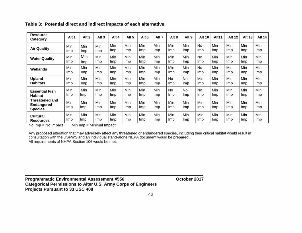
Programmatic Environmental Assessment #556 October 2017 Categorical Permissions to Alter U.S. Army Corps of Engineers Projects Pursuant to 33 USC 408
42
Table 3: Potential direct and indirect impacts of each alternative.
Resource Category Alt 1 Alt 2 Alt 3 Alt 4 Alt 5 Alt 6 Alt 7 Alt 8 Alt 9 Alt 10 Alt11 Alt 12 Alt 13 Alt 14
Air Quality Min Imp
Min Imp
Min Imp
Min Imp
Min Imp
Min Imp
Min Imp
Min Imp
Min Imp
No Imp
Min Imp
Min Imp
Min Imp
Min Imp
Water Quality Min Imp
Min Imp
Min Imp
Min Imp
Min Imp
Min Imp
Min Imp
Min Imp
Min Imp
No Imp
Min Imp
Min Imp
Min Imp
Min Imp
Wetlands Min Imp
Min Imp
Min Imp
Min Imp
Min Imp
Min Imp
Min Imp
Min Imp
Min Imp
No Imp
Min Imp
Min Imp
Min Imp
Min Imp
Upland Habitats
Min Imp
Min Imp
Min Imp
Min Imp
Min Imp
Min Imp
Min Imp
No Imp
No Imp
Min Imp
Min Imp
Min Imp
Min Imp
Min Imp
Essential Fish Habitat
Min Imp
Min Imp
Min Imp
Min Imp
Min Imp
Min Imp
Min Imp
No Imp
No Imp
No Imp
Min Imp
Min Imp
Min Imp
Min Imp
Threatened and Endangered Species
Min Imp
Min Imp
Min Imp
Min Imp
Min Imp
Min Imp
Min Imp
Min Imp
Min Imp
Min Imp
Min Imp
Min Imp
Min Imp
Min Imp
Cultural Resources
Min Imp
Min Imp
Min Imp
Min Imp
Min Imp
Min Imp
Min Imp
Min Imp
Min Imp
Min Imp
Min Imp
Min Imp
Min Imp
Min Imp
No Imp = No Impact Min Imp = Minimal Impact Any proposed alteration that may adversely affect any threatened or endangered species, including their critical habitat would result in consultation with the USFWS and an individual stand-alone NEPA document would be prepared. All requirements of NHPA Section 106 would be met.

Programmatic Environmental Assessment #556 October 2017 Categorical Permissions to Alter U.S. Army Corps of Engineers Projects Pursuant to 33 USC 408
43
6 Cumulative Impacts The Council on Environmental Quality (CEQ) Regulations defines cumulative impact as “the impact on the environment which results from the incremental impact of the action when added to other past, present, and reasonably foreseeable future actions, regardless of what agency (Federal or non-Federal) or person undertakes such other actions. Cumulative impacts can result from individually minor but collectively significant actions taking place over a period of time”. The cumulative impacts addressed in this document consist of the impacts of multiple actions that result in similar effects on the natural resources. 6.1 Past Actions All of the project areas covered by this programmatic environmental assessment have been altered to some degree in the past as a result of constructing a USACE project, or will be altered once the USACE project is constructed. The degree of impact varies widely by USACE project and relationship of the proposed alteration to the USACE project. The District has a high density of Federally-constructed levee systems subject to Section 408. Generally speaking, Federal levees provide important socioeconomic benefits by providing flood damage risk reduction to populated and developed areas. However, levees to address river flooding disconnect river systems from their floodplains which can negatively impact the natural structure and functions of rivers and adjacent backwater and coastal habitats. The levees along the Mississippi River have been cited in a multitude of studies as contributing to coastal wetland loss in Louisiana due to the prevention of overbank flows that would nourish wetlands in a riverine environment with only naturally high banks. Coastal levee systems built to provide risk reduction from tropical weather events also isolate wetlands and other important fish and wildlife habitats from estuarine processes. Those are tradeoffs that were not well known and appreciated when earlier levees systems were built. These levee systems also allowed residential, commercial, agricultural, and industrial development in areas that were previously more vulnerable to flooding, indirectly causing widespread loss of fish and wildlife habitats. Those are unavoidable cumulative and indirect adverse impacts to the environmental from the construction of USACE flood and storm surge risk reduction projects. However, residential, commercial, and industrial use of these lands would be tenuous, at best, with no form of flood or storm surge risk reduction systems in place. The District also has numerous navigation projects that have collectively caused a variety of direct and indirect impacts to the environment. Nearly all coastal rivers from the Calcasieu on the west side to the rivers draining into Lake Pontchartrain on the east side, have been modified in some manner by USACE projects. Note that the Sabine and Pearl Rivers are not mentioned since they are in the Galveston and Vicksburg Districts, respectively. Natural bayous and distributary passes of the Mississippi River have also been dredged and straightened. The Gulf Intracoastal Waterway cuts completely across the District, almost entirely through what was previously coastal
Programmatic Environmental Assessment #556 October 2017 Categorical Permissions to Alter U.S. Army Corps of Engineers Projects Pursuant to 33 USC 408
44
wetlands. These project have collectively brought significant direct adverse impacts to fish and wildlife habitats, although beneficial use of dredged materials partially compensates for adverse impacts. Indirectly, some of these waterways have allowed saltier waters to enter freshwater swamps and marshes killing those habitats and causing significant loss of these coastal wetlands. While USACE navigation, flood control, and flood risk reduction projects have been widely cited as having caused significant adverse impacts within the District, Section 408 requests to alter these projects have not been identified as causing significant impacts. Some Section 408 requests, like utility lines and access roads, simply cross through USACE project lands. Other Section 408 requests seek to build projects to take advantage of USACE navigation projects by siting docks, wharves, bulkheads, etc. next to the maintained waterways. Regardless, all Section 408 projects have increased the human presence in the landscape. 6.2 Present and Future Actions In the wake of Hurricane Katrina in 2005, the USACE began major upgrades to the storm surge risk reduction projects in southeast Louisiana. The efforts at upgrading the project are nearly complete, except for the New Orleans to Venice project in Plaquemines Parish which still has considerable construction underway. Upgrading these flood risk reduction systems has caused significant unavoidable impacts to valuable fish and wildlife habitats requiring mitigation. Compensatory mitigation for impacts to valuable fish and wildlife habitats, including swamps, wetland and non-wetland bottomland hardwood forest, and coastal marshes has occurred and continues to be implemented at mitigation banks, a National wildlife refuge, a National park, and other locations in southeast Louisiana. The Congressional authorizations for the upgrading of the risk reduction systems provided funding for construction, but not major maintenance. Southeast Louisiana rests upon alluvial sediments which tend to compress and sink. Since the recently upgraded levees are expected to lose elevation over time through subsidence, additional levee maintenance events or “lifts” are expected to be required over time. During the course of upgrading the earthen levee system, the USACE determined that resilience needed to be built into the levees in the case of overtopping during a storm. The USACE decided upon an armoring system composed of geotextile material with a grass cover. Once installed, this armoring system would be very expensive to remove and replace for the purpose of a levee lift. The non-Federal sponsor for the projects, who will be responsible for all project maintenance, requested permission to raise the levees before armoring is placed to account for future subsidence. A series of Section 408 requests were submitted and processed to allow the levee “lifts” to occur before the levee armoring was installed. The earthen material used for the levee lifts is being obtained from sources that had been environmentally cleared earlier during the upgrading of the levee systems. Some levee lifts have been completed, some remain underway, and the remainder will be begun soon. The requests for the levee lifts

Programmatic Environmental Assessment #556 October 2017 Categorical Permissions to Alter U.S. Army Corps of Engineers Projects Pursuant to 33 USC 408
45
represents the most significant alterations of USACE projects by Section 408 actions in recent years. None of the levee lifts would have been covered by any of the categorical permissions under consideration in this EA. The District has not processed any notable requests for modifications to navigation projects in recent years. However, the District is currently processing a request for installation of a permanent “barge gate” across Bayou Chene near Morgan City, Louisiana. This proposed action would essentially block the USACE navigation channel officially named Atchafalaya River and Bayous Chene, Boeuf and Black during periods of extreme high water on the Atchafalaya River. The benefit of the project is expected to be decreased flooding of developed lands to the east of the barge gate. This proposed action has been determined to require Headquarters USACE approval due to the impact on the Federal project. 7 Agency Coordination and Public Comments On May 8, 2017 a public notice was issued to announce the District’s intention to prepare a programmatic EA to establish categorical permissions for certain Section 408 actions. The notice was posted on the District’s web site and emailed to state and Federal agencies. A copy of the public notice is provided as Appendix D. The web link to the notice is: http://www.mvn.usace.army.mil/Missions/Section-408/Public-Notices/Article/1176810/permissions-to-alter-us-army-corps-of-engineers-projects-establishment-of-categ/ The public and agency review period was 30 days. Three comments on the public notice were received. The Louisiana SHPO’s office commented they will be participating in the development of the programmatic agreement to handle National Historic Preservation Act compliance and look forward to working with the Corps in the future. The US EPA, Region 6 office stated, since there would be no effect on the separate review and permitting process under the USACE Section 10/404/103 regulatory program, they do not object to the development of categorical permissions to be used in the Section 408 program at the District. The USFWS provided more detailed comments. They are concerned that Alternative 5 (culverts, drainage pipes, and drainage ditches) could result in the inadvertent loss of wetlands, and recommended that conditions be added to the proposed categorical permission to require examination of the purpose of such structures, and if found that wetland areas could be lost, then a categorical permission should not be used. The District agrees with this USFWS recommendation and has included the condition under the description of Alternative 5 in this EA. The USFWS is also concerned that new structures or expansion of existing structures that fall under Alternative 7 (bank stabilization and erosion control features) and Alternative 8 (bulkheads, docks, wharfs, mooring pilings and dolphins) may impact fish

Programmatic Environmental Assessment #556 October 2017 Categorical Permissions to Alter U.S. Army Corps of Engineers Projects Pursuant to 33 USC 408
46
and wildlife habitat depending on the location and size of such structures. The USFWS recommended that the criteria for applicability in Nationwide General Permit 13 (Bank stabilization) and General Permit 128 (Small wharves, boat sheds, bulkhead, and associated dredge and fill activities) be used to determine if the requested activities are suitable for application of a categorical permission. The District agrees that the criteria in Nationwide General Permit 13 are appropriate for evaluating whether a request fitting the description of Alternative 7 is suitable for a categorical permission. In response the USFWS’ comment, the description of Alternative 7 in Section 3.7 of this EA references the criteria in Nationwide Permit 13 as determining factors for the application of categorical permissions. The District does not agree to add the criteria in General Permit 128 (GP 128) as the USFWS recommended. Considering prior requests, the criteria in GP 128 would eliminate all, or nearly all future requests fitting the description of Alternative 8 from consideration as categorical permissions. To illustrate this point, one of the criteria in GP128 restricts its use to actions proposed by private individuals, not companies or other entities, and another restriction limits the size of the affected area to 300 square feet. The District considers these criteria to not be appropriate to the intent or purpose of establishing categorical permissions. This EA and a draft FONSI were posted on the District’s website and distributed via email and US Postal Service mail on September 26, 2017 to interested parties including individuals, organizations, elected officials, and local, state, and Federal agencies for a 30-day review period. The only comments received were from the Louisiana Department of Wildlife and Fisheries. Their letter is included as Appendix F. This EA and associated FONSI were revised in response to the LDWF’s comments by adding their recommended requirement to the lists of requirements on page 13 of this EA and the top of page 3 in the FONSI. 8 Conclusion Following an evaluation of environmental consequences, Alternative 14 has been identified as the Recommended Plan. This alternative best meets the purpose and need for requests to modify USACE projects within the scope of this document. The Recommended Plan would not result in any significant adverse impacts, either directly, indirectly, or cumulatively to the human environment. While minor impacts may occur as a result of some proposed actions, all Section 408 applications will be rigorously evaluated according to the procedures and limitations criteria listed in Chapter 2 of this EA. Section 106 of the NHPA would comply with an executed programmatic agreement for Section 408 categorical permissions.

Programmatic Environmental Assessment #556 October 2017 Categorical Permissions to Alter U.S. Army Corps of Engineers Projects Pursuant to 33 USC 408
47
9 Preparers This document was prepared primarily by Mr. Richard E. Boe, Supervisory Environmental Resources Specialist, and Dr. Jason A. Emery, Archeologist. Both preparers work in the Regional Planning and Environmental Division, South, and physically located at the District, USACE.

APPENDIX A
Navigation, Flood Risk Reduction, and Mississippi River and Tributaries Projects within the New Orleans District

A-1
NEW ORLEANS DISTRICT - RIVER AND HARBOR PROJECTS1
Project Description Parishes
Amite River and Bayou Manchac 7-foot channel from Lake Maurepas to Port Vincent, thence clearing and snagging upstream
St. John the Baptist, Livingston, Ascension and East Baton Rouge
Atchafalaya River and Bayous Chene, Boeuf, and Black
20-foot channel from the Gulf of Mexico to Amelia St. Mary and Terrebonne
Barataria Bay Waterway 12-foot channel from the Gulf of Mexico to Crown Point
Jefferson
Bayou Bonfouca 10-foot channel from Lake Pontchartrain to Slidell St. Tammany
Bayou Dupre 6-foot channel from Violet to Lake Borgne St. Bernard
Bayou Grand Caillou and Bayou Le Carpe 5-foot and 10-foot channels from Houma to Bayou Dulac
Terrebonne
Bayou Lacombe 8-foot channel from Lake Pontchartrain to Slidell St. Tammany
Bayou Lafourche and Port Fourchon 24-foot channel from Gulf of Mexico to Port Fourchon, thence 12-foot, 9-foot, and 6-foot channels upstream to Larose
Lafourche
Bayous La Loutre, St. Malo, and Yscloskey 5-foot and 6-foot channels connecting Yscloskey, Hopedale, Lake Borgne and Chandeleur Sound
St. Bernard
Bayou Segnette Waterway 6-foot channel from Westwego to Barataria Bay Waterway
Jefferson
Bayou Teche 8-foot from the Atchafalaya River to New Iberia, thence a 6-foot channel up to Arnaudville
St. Mary, Iberia and St. Martin
Bayou Teche and Vermilion River 8-foot and 9 foot channels from Vermilion Bay to Lafayette and thence channel improvements to Port Barre
Vermilion, Lafayette, St. Martin, St. Landry
Bayou Terrebonne 6-foot channel from Houma to Bush Canal Terrebonne
Calcasieu River and Pass, including Coon Island, Devil's Elbow, and Salt Water Barrier
40-foot channel from Gulf of Mexico to Lake Charles plus side channels and salt water barrier
Cameron and Calcasieu
Tchefuncte and Bogue Falaya Rivers 10 -foot, thence 8-foot channel from Lake Pontchartrain to Covington
St. Tammany
Freshwater Bayou 12-foot channel from Gulf of Mexico to the Gulf Intracoastal Waterway
Vermilion

A-2
NEW ORLEANS DISTRICT - RIVER AND HARBOR PROJECTS1 (Continued) Project Description Parishes
Gulf Intracoastal Waterway, including Alternate Route and Locks
12-foot channel from eastern to western limits of New Orleans District, plus alternate route from Morgan City to Baton Rouge
Cameron, Vermilion, Iberia, St. Mary, Terrebonne, Lafourche, Jefferson, Plaquemines, Orleans, St. Martin, Iberville, West Baton Rouge
Houma Navigation Canal 18-foot channel from the Gulf of Mexico to Houma Terrebonne
Little Caillou Bayou 5-foot channel from the Robinson Canal to Bayou Terrebonne
Terrebonne
Mermentau River 15-foot channel from Gulf of Mexico to Mile 8. Also structures at Catfish Point and Schooner Bayou and other features.
Cameron, Vermilion
Mississippi River, Baton Rouge to the Gulf of Mexico
55-foot channel authorized from Gulf of Mexico to Baton Rouge. 45-foot channel constructed.
Plaquemines, St. Bernard, Orleans, Jefferson, St. Charles, St. John the Baptist, St. James, Ascension, Iberville, East Baton Rouge, West Baton Rouge
Mississippi River Gulf Outlet 36-foot remaining authorized channel extends from Inner Harbor Navigation Canal to Michoud Canal.
Orleans
Mississippi River Outlets at Venice (Baptiste Collette Bayou and Tiger Pass)
14-foot channels from the Gulf of Mexico to Venice Plaquemines
Michoud Canal 36-foot dead-end channel extending north from the remaining authorized section of the Mississippi River Gulf Outlet
Orleans
Petit Anse, Tigre, and Carlin Bayous 7-foot and 9-foot channels from Vermilion Bay to Delcambre and other locations
Iberia, Vermilion
Tangipahoa River 8-foot channel at the entrance in Lake Pontchartrain and clearing and snagging
Tangipahoa
Waterway from Empire to the Gulf of Mexico 9-foot channel from the Gulf of Mexico to Empire Plaquemines
1This is not a complete list of every authorized river and harbor project. Some projects in the deferred status and inactive status are not
included.

A-3
NEW ORLEANS DISTRICT - FLOOD RISK REDUCTION PROJECTS2
Project Description Parishes
Amite River and Tributaries (Comite River Diversion - Under Construction)
Diversion canal and structures to carry flood flows from the Comite River to the Mississippi River
East Baton Rouge
Grand Isle and Vicinity Various jetties and dunes to provide flood risk reduction on this inhabited barrier island
Jefferson
Lake Pontchartrain and Vicinity System of levees, floodwalls, pump stations and floodgates designed to provide storm surge risk reduction for a 100-year hurricane storm surge event
Parts of Orleans, Jefferson, and St. Charles on the east bank of the Mississippi River and St. Bernard
Larose to Golden Meadow System of levees, floodwalls, pump stations and floodgates designed to provide storm surge risk reduction
Lafourche
Morganza to the Gulf (Authorized - No Federal funding)
System of levees, floodwalls, pump stations and floodgates designed to provide storm surge risk reduction
Terrebonne, Lafourche
New Orleans to Venice System of levees, floodwalls, pump stations and floodgates designed to provide storm surge risk reduction for a 50-year hurricane storm surge event
Plaquemines
Southeast Louisiana (SELA) Internal stormwater drainage improvements Orleans, Jefferson. No projects constructed in St. Tammany
West Bank and Vicinity System of levees, floodwalls, pump stations and floodgates designed to provide storm surge risk reduction for a 100-year hurricane storm surge event
Parts of Orleans, Jefferson, and St. Charles on the west bank of the Mississippi River, and Plaquemines
West Shore Lake Pontchartrain (Authorized - Not Constructed)
System of levees, floodwalls, pump stations and floodgates designed to provide storm surge risk reduction for a 100-year hurricane storm surge event
Parts of St. Charles, St. John the Baptist and St. James on the east bank of the Mississippi River
2This is not a complete list of every authorized flood risk reduction project. Some projects that were constructed but not maintained, and
projects in the deferred status and inactive status are not included.

A-4
NEW ORLEANS DISTRICT- MISSISSIPPI RIVER AND TRIBUTARIES PROJECTS Project Description Parishes
Atchafalaya Basin Flood Control System of floodways, levees, floodwalls, water control structures, channel enlargement, channel training, internal drainage, and flowage easements to convey Mississippi and Red River flood flows to the Gulf of Mexico
St. Mary, St. Martin, Iberia, Iberville, St. Landry, Pointe Coupee, Avoyelles, Concordia
Atchafalaya Basin Floodway System System of environmental protection easements, public access lands, recreation facilities, and water management units within the Atchafalaya Basin Floodway
Primarily Iberville, St. Martin, Iberia
Baton Rouge Harbor (Devil's Swamp) 12-foot deep, 2.5 mile long navigation channel off of the Mississippi River near Scotlandville
East Baton Rouge
Bayou Cocodrie and Tributaries System channel enlargements, a diversion channel and water control structures along Bayous Rapides, Boeuf, and Cocodrie to improve drainage
Rapides, Avoyelles, St. Landry
Bonnet Carre Spillway Control structure and floodway to divert Mississippi River flood flows into Lake Pontchartrain
St. Charles
Mississippi and Louisiana Delta Region (Caernarvon and Davis Pond Freshwater Diversion Projects)
Projects to divert fresh water from the Mississippi River into the Breton and Barataria Basins to reestablish historic salinity levels for the benefit of fish and wildlife resources and estuarine habitats
Plaquemines, St. Bernard (Caernarvon). Jefferson, St. Charles (Davis Pond)
Mississippi River Channel Improvement (Dredging)
9-foot channel upstream from Baton Rouge Within the Mississippi River in East Baton Rouge, West Baton Rouge, Pointe Coupee, West Feliciana
Mississippi River Channel Improvement (Revetments and Foreshore Protection)
Placement of articulated concrete mattress and rock along the river banks to prevent erosion
Along the Mississippi River in Plaquemines, St. Bernard, Orleans, Jefferson, St. Charles, St. John the Baptist, St. James, Ascension, Iberville, East Baton Rouge, West Baton Rouge, Pointe Coupee, West Feliciana

A-5
NEW ORLEANS DISTRICT- MISSISSIPPI RIVER AND TRIBUTARIES PROJECTS (Continued) Project Description Parishes
Mississippi River Levees Levees along the east bank of the river from Baton Rouge to Bohemia and the west bank from north of Old River to Venice
Along the Mississippi River in Plaquemines, St. Bernard, Orleans, Jefferson, St. Charles, St. John the Baptist, St. James, Ascension, Iberville, East Baton Rouge, West Baton Rouge, Pointe Coupee, West Feliciana
Morganza Floodway Control structure and floodway to divert Mississippi River flood flows into the Atchafalaya Basin Floodway
Pointe Coupee
Old River Control Structures and channels to regulate flows between the Mississippi and Atchafalaya Rivers
Concordia

APPENDIX B
Engineering Criteria and Requirements for Section 408 Requests

CONTENTS OF APPENDIX B Sheets 1 to 9 - These nine sheets address surface crossings of both river and
hurricane levees by utilities and pipelines, and penetrations of floodwalls by utilities and pipelines
Sheet 10 - Power Line Service, Crossing Over Levee Sheet 11 - Limits of Permissible Excavation in River, Mississippi River Sheet 12 - Limits of Permissible Stockpile on Riverbanks Sheet 13 - Limits of Permissible River Side Borrow Pits, Mississippi and Atchafalaya
Rivers Sheet 14 - USACE Levee Standards, Concrete Slope Pavement Details, Louisiana Sheet 15 - Repair Procedures Required when Penetrating Revetments with Piles,
Caissons, and/or Pile Clusters Sheet 16 - Permit Requirements for Construction of Utilities (Piers, Dolphins,
Bulkheads, Pilings, Wharves, and Other Structures Adjacent to Authorized Navigation Channels)
Sheet 17 - Permit Requirements for Construction of Utilities across Navigation
Channels Having Less Than 30’ of Depth Sheet 18 - Permit Requirements for Construction of Utilities, Mississippi River Sheet 19 - Permit Requirements for Construction of Utilities Based on May 2010
Criteria (Atchafalaya Basin Main Channel) Sheet 20 - Permit Requirements for Construction of Utilities for May 2010 Criteria
(Calcasieu River) Sheet 21 - Gulf Intracoastal Waterway, Permit Requirements for Constructing
Bulkheads, Structures, Slips, etc., along Algiers Navigation Canal Letter 1 - General Criteria for Pipeline and Utility Line Burial in Waterways within the
New Orleans District, Corps of Engineers (3 page letter with 1 enclosure)


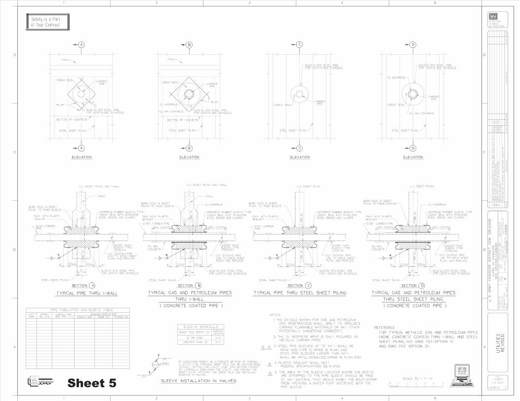


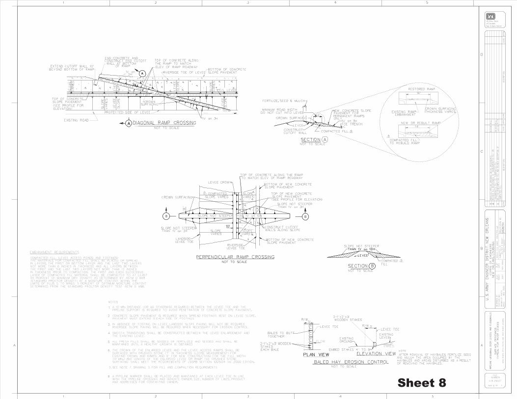
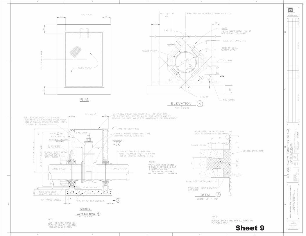


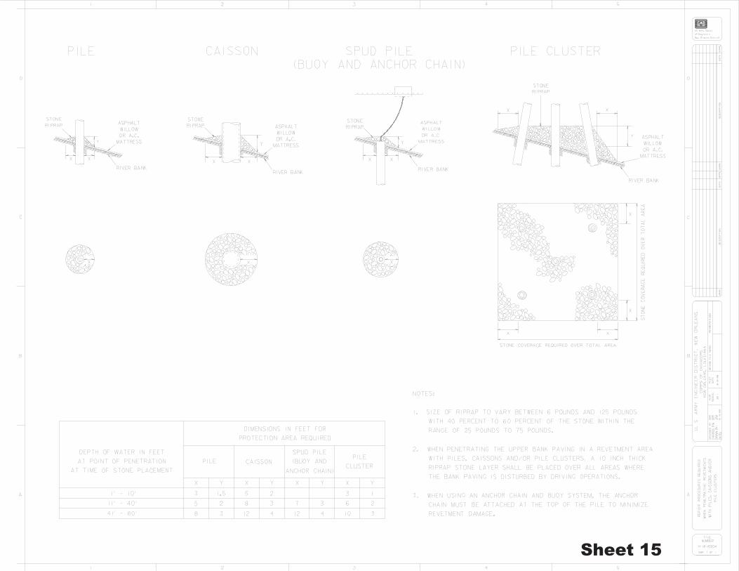


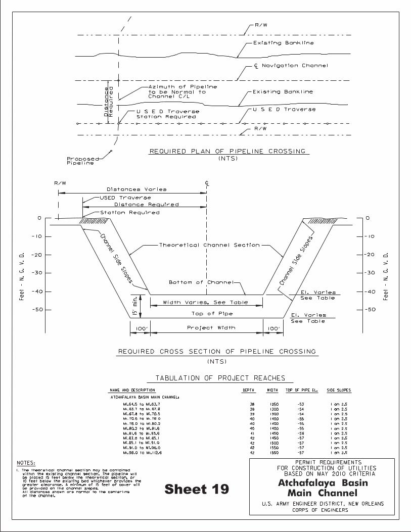


APPENDIX C Threatened and Endangered Species by Parish within
the Geographical Boundary of the New Orleans District

Last updated May 4, 2016 Page 1
ENDANGERED, THREATENED, AND CANDIDATE SPECIES OCCURRING IN PARISHES EITHER PARTIALLY OR COMPLETELY WITHIN THE GEOGRAPHICAL BOUNDARIES
OF THE NEW ORLEANS DISTRICT E=Endangered T=Threatened P=Proposed C=Candidate CH=Critical Habitat*
PARISH†/SPECIES OCCURRENCE GROUP STATUS
ALLEN Chaff-seed, American Known Plant E Woodpecker, Red-cockaded Known Bird E
ASCENSION Manatee, West Indian Seasonal Mammal E Mussel, Alabama Heelsplitter Known Mollusk T Sturgeon, Atlantic Known Fish T Sturgeon, Pallid Known Fish E
AVOYELLES Bat, Northern Long-eared Possible Mammal T Sturgeon, Pallid Known Fish E
BEAUREGARD Chaff-seed, American Known Plant E Woodpecker, Red-cockaded Known Bird E
CALCASIEU Woodpecker, Red-cockaded Known Bird E
CAMERON Manatee, West Indian Seasonal Mammal E Plover, Piping Known Bird T, CH Knot, Red Seasonal Bird T Sturgeon, Atlantic Possible Fish T Turtle, Green Sea Known Reptile T Turtle, Hawksbill Sea Known Reptile E Turtle, Kemp’s Ridley Sea Known Reptile E Turtle, Leatherback Sea Known Reptile E Turtle, Loggerhead Sea Known Reptile T
CONCORDIA Bat, Northern Long-eared Possible Mammal T Mussel, Fat Pocketbook Pearly Known Mollusk E Sturgeon, Pallid Known Fish E Tern, Interior Least Known Bird E
EAST BATON ROUGE Manatee, West Indian Seasonal Mammal E Mussel, Alabama Heelsplitter Known Mollusk T Sturgeon, Atlantic Known Fish T Sturgeon, Pallid Known Fish E
EAST FELICIANA Mussel, Alabama Heelsplitter Known Mollusk T Sturgeon, Atlantic Possible Fish T Sturgeon, Pallid Known Fish E
EVANGELINE Woodpecker, Red-cockaded Known Bird E

Last updated May 4, 2016 Page 2
PARISH†/SPECIES OCCURRENCE GROUP STATUS
IBERIA Manatee, West Indian Seasonal Mammal E Knot, Red Seasonal Bird T Sturgeon, Atlantic Possible Fish T Sturgeon, Pallid Known Fish E Turtle, Green Sea Known Reptile T Turtle, Hawksbill Sea Known Reptile E Turtle, Kemp’s Ridley Sea Known Reptile E Turtle, Leatherback Sea Known Reptile E Turtle, Loggerhead Sea Known Reptile T
IBERVILLE Sturgeon, Atlantic Possible Fish T Sturgeon, Pallid Known Fish E
JEFFERSON Manatee, West Indian Seasonal Mammal E Plover, Piping Known Bird T, CH Knot, Red Seasonal Bird T Sturgeon, Atlantic Known Fish T, CH Sturgeon, Pallid Known Fish E Turtle, Green Sea Known Reptile T Turtle, Hawksbill Sea Known Reptile E Turtle, Kemp’s Ridley Sea Known Reptile E Turtle, Leatherback Sea Known Reptile E Turtle, Loggerhead Sea Known Reptile T
LAFOURCHE Manatee, West Indian Seasonal Mammal E Plover, Piping Known Bird T, CH Knot, Red Seasonal Bird T Sturgeon, Atlantic Possible Fish T Turtle, Green Sea Known Reptile T Turtle, Hawksbill Sea Known Reptile E Turtle, Kemp’s Ridley Sea Known Reptile E Turtle, Leatherback Sea Known Reptile E Turtle, Loggerhead Sea Known Reptile T
LIVINGSTON Manatee, West Indian Seasonal Mammal E Mussel, Alabama Heelsplitter Known Mollusk T Sturgeon, Atlantic Known Fish T Woodpecker, Red-cockaded Known Bird E
NATCHITOCHES Bat, Northern Long-eared Possible Mammal T Snake, Louisiana Pine Known Reptile C Sturgeon, Pallid Possible Fish E Tern, Interior Least Known Bird E Woodpecker, Red-cockaded Known Bird E
ORLEANS Manatee, West Indian Seasonal Mammal E Sturgeon, Atlantic Known Fish T, CH Sturgeon, Pallid Known Fish E

Last updated May 4, 2016 Page 3
PARISH†/SPECIES OCCURRENCE GROUP STATUS
PLAQUEMINES Manatee, West Indian Seasonal Mammal E Plover, Piping Known Bird T, CH Knot, Red Seasonal Bird T Sturgeon, Atlantic Known Fish T Sturgeon, Pallid Known Fish E Turtle, Green Sea Known Reptile T Turtle, Hawksbill Sea Known Reptile E Turtle, Kemp’s Ridley Sea Known Reptile E Turtle, Leatherback Sea Known Reptile E Turtle, Loggerhead Sea Known Reptile T
POINTE COUPEE Sturgeon, Pallid Known Fish E
RAPIDES Bat, Northern Long-eared Possible Mammal T Mussel, Louisiana Pearlshell Known Mollusk T Sturgeon, Pallid Possible Fish E Tern, Interior Least Possible Bird E Woodpecker, Red-cockaded Known Bird E
ST. BERNARD Manatee, West Indian Seasonal Mammal E Plover, Piping Known Bird T, CH Knot, Red Seasonal Bird T Sturgeon, Atlantic Known Fish T, CH Sturgeon, Pallid Known Fish E Turtle, Green Sea Known Reptile T Turtle, Hawksbill Sea Known Reptile E Turtle, Kemp’s Ridley Sea Known Reptile E Turtle, Leatherback Sea Known Reptile E Turtle, Loggerhead Sea Known Reptile T
ST. CHARLES Manatee, West Indian Seasonal Mammal E Sturgeon, Atlantic Known Fish T Sturgeon, Pallid Known Fish E
ST. HELENA Mussel, Alabama Heelsplitter Known Mollusk T Sturgeon, Atlantic Known Fish T
ST. JAMES Manatee, West Indian Seasonal Mammal E Sturgeon, Atlantic Known Fish T Sturgeon, Pallid Known Fish E
ST. JOHN THE BAPTIST Manatee, West Indian Seasonal Mammal E Mussel, Alabama Heelsplitter Possible Mollusk T Sturgeon, Atlantic Known Fish T Sturgeon, Pallid Known Fish E
ST. LANDRY Sturgeon, Pallid Known Fish E

Last updated May 4, 2016 Page 4
PARISH†/SPECIES OCCURRENCE GROUP STATUS
ST. MARTIN Sturgeon, Pallid Known Fish E
ST. MARY Manatee, West Indian Seasonal Mammal E Plover, Piping Known Bird T, CH Knot, Red Seasonal Bird T Sturgeon, Atlantic Possible Fish T Sturgeon, Pallid Known Fish E Turtle, Green Sea Known Reptile T Turtle, Hawksbill Sea Known Reptile E Turtle, Kemp’s Ridley Sea Known Reptile E Turtle, Leatherback Sea Known Reptile E
Turtle, Loggerhead Sea Known Reptile T
ST. TAMMANY Frog, Dusky Gopher Known Amphibian CH
Manatee, West Indian Seasonal Mammal E Mussel, Alabama Heelsplitter Known Mollusk T Quillwort, Louisiana Known Plant E Sturgeon, Atlantic Known Fish T, CH Tortoise, Gopher Known Reptile T Turtle, Ringed Map Known Reptile T Woodpecker, Red-cockaded Known Bird E
TANGIPAHOA Manatee, West Indian Seasonal Mammal E Sturgeon, Atlantic Known Fish T Tortoise, Gopher Known Reptile T Woodpecker, Red-cockaded Known Bird E
TERREBONNE Manatee, West Indian Seasonal Mammal E Plover, Piping Known Bird T, CH Knot, Red Seasonal Bird T Sturgeon, Atlantic Possible Fish T Turtle, Green Sea Known Reptile T Turtle, Hawksbill Sea Known Reptile E Turtle, Kemp’s Ridley Sea Known Reptile E Turtle, Leatherback Sea Known Reptile E Turtle, Loggerhead Sea Known Reptile T
VERMILION Manatee, West Indian Seasonal Mammal E Crane, Whooping Known Bird NEP Plover, Piping Known Bird T, CH Knot, Red Seasonal Bird T Sturgeon, Atlantic Possible Fish T Turtle, Green Sea Known Reptile T Turtle, Hawksbill Sea Known Reptile E Turtle, Kemp’s Ridley Sea Known Reptile E Turtle, Leatherback Sea Known Reptile E Turtle, Loggerhead Sea Known Reptile T
VERNON Snake, Louisiana Pine Known Reptile C Woodpecker, Red-cockaded Known Bird E

Last updated May 4, 2016 Page 5
PARISH†/SPECIES OCCURRENCE GROUP STATUS
WASHINGTON Mussel, Alabama Heelsplitter Known Mollusk T Quillwort, Louisiana Known Plant E Sturgeon, Atlantic Known Fish T, CH Tortoise, Gopher Known Reptile T Turtle, Ringed Map Known Reptile T
WEST BATON ROUGE Sturgeon, Pallid Known Fish E
WEST FELICIANA Sturgeon, Pallid Known Fish E
*Endangered – any species which is in danger of extinction throughout all or a significant portion of its range.
*Threatened – any species which is likely to become an endangered species within the foreseeable futurethroughout all or a significant portion of its range.
*Proposed – any species which is proposed for listing under the Endangered Species Act.
*Candidate – plant and animal taxa considered for possible addition to the List of Endangered and ThreatenedSpecies. These are taxa for which the Service has on file sufficient information on biological vulnerability and threat(s) to support issuance of a proposal to list, but issuance of a proposed rule is currently precluded by higher priority listing actions.
*Critical Habitat – for listed species consists of: (1) the specific areas within the geographical area occupied by thespecies, at the time it is listed in accordance with the provisions of section 4 of the Act, on which are found those physical or biological features (constituent elements) (a) essential to the conservation of the species and (b) which may require special management considerations or protection; and (2) specific areas outside the geographical area occupied by the species at the time it is listed in accordance with the provisions of section 4 of the Act, upon a determination by the Secretary that such areas are essential for the conservation of the species.
*Non-Essential Experimental Population – A reintroduced population believed not to be essential for the survivalof the species, but important for its full recovery and eventual removal from the endangered and threatened list. These populations are treated as "threatened" species except that the ESA's section 7 consultation regulations (requiring consultation with the U.S. Fish and Wildlife Service to reduce adverse impacts from Federal actions) do not apply (except where the species occurs within National Parks or National Wildlife Refuges) and critical habitat cannot be designated.
†If a Parish is not listed here, there are no known occurrences of a threatened, endangered, proposed, or candidate species, or their critical habitat, for that Parish.

Last updated May 4, 2016 Page 6
THREATENED AND ENDANGERED SPECIES IN LOUISIANA AND GENERAL LOCATIONS AND HABITATS
MAMMALS STATUS GENERAL DISTRIBUTION IN LOUISIANA Bat, Northern Long-eared Threatened Bossier, Grant, LaSalle, Ouachita, Rapides,
(Myotis septentrionalis ) Richland, Union, and Winn Parishes; possible in Avoyelles, Bienville, Caddo, Caldwell, Catahoula,Clairborne, Concordia, DeSoto, East Carroll, Franklin, Jackson, Lincoln, Madison, Morehouse,Natchitoches, Red River, Tensas, Webster and West Carroll Parishes
Manatee, West Indian Endangered Lake Pontchartrain & tributaries on Northshore; (Trichechus manatus) rare along Gulf coast
Panther, Florida Endangered1 Entire state (Felis concolor coryi)
Whale, finback Endangered Coastal waters (Balaenoptera physalus)
Whale, humpback Endangered2 Coastal waters (Megaptera novaeangliae)
Whale, right Endangered2 Coastal waters (Eubalaena glacialis)
Whale, sei Endangered2 Coastal waters (Balaenoptera borealis)
Whale, sperm Endangered2 Coastal waters (Physeter catodon)
Wolf, red Endangered1 Cameron & Calcasieu Parishes (Canis rufus)
BIRDS Crane, Whooping Non-Essential Experimental Population White Lake Management
(Grus Americana) area, Vermilion Parish Curlew, Eskimo Endangered1 Entire state
(Numenius borealis)Knot, Red Threatened Coast
(Calidris canutus rufa)Plover, piping Threatened Coast
(Charadrius melodus)Tern, interior least Endangered Mississippi River, north of Baton Rouge;
(Sterna antillarum) Red River, north of Colfax Warbler, Bachman’s Endangered3 Entire state
(Vermivora bachmanii)Woodpecker, ivory-billed Endangered1 Entire state
(Campephilus principalis)Woodpecker, red-cockaded Endangered Entire state (pine forests)
(Picoides borealis)
REPTILES Alligator, American Threatened (S/A)4 Entire state
(Alligator mississippiensis)Snake, Louisiana pine Candidate Bienville, Natchitoches, Sabine, & Vernon Parishes
(Pituophis ruthveni)Tortoise, gopher Threatened Washington, St. Tammany, & Tangipahoa
(Gopherus polyphemus) Parishes Turtle, Kemp’s (Atlantic) ridley sea Endangered5 Coastal waters
(Lepidochelys kempii)Turtle, green sea Threatened5 Coastal waters
(Chelonia mydas)Turtle, hawksbill sea Endangered5 Coastal waters
(Eretmochelys imbricata)Turtle, leatherback sea Endangered5 Coastal waters
(Dermochelys coriacea)Turtle, loggerhead sea Threatened5 Coastal waters

Last updated May 4, 2016
Page 7
(Caretta caretta) Turtle, ringed map (=sawback) Threatened Pearl & Bogue Chitto Rivers
(Graptemys oculifera) FISH Sawfish, Smalltooth Endangered2 Gulf of Mexico: Texas to Florida (Pristis pectinata) Sturgeon, Atlantic Threatened5 Pearl River & Lake Pontchartrain tributaries
(Acipenser oxyrhynchus desotoi) Sturgeon, pallid Endangered Mississippi River & tributaries
(Scaphirhynchus albus) Sturgeon, Shovelnose Threatened (S/A)6 Mississippi River & tributaries (Scaphirhynchus platorynchus) INVERTEBRATES Mussel, Alabama heelsplitter (=inflated) Threatened Amite River, possible in Pearl River
(Potamilus inflatus) Mussel, fat pocketbook pearly Endangered Mississippi River
(Potamilus capax) Mussel, Louisiana pearlshell Threatened Bayous Boeuf, Rapides, & Rigolette drainages
(Margaritifera hembeli) Rapides & Grant Parishes Mussel, pink mucket pearly Endangered Bayou Bartholomew
(Lampsilis abrupta) Mussel, rabbitsfoot Threatened Bayou Bartholomew
(Quadrula cylindrica) PLANTS American chaff-seed Endangered Allen & Beauregard Parishes
(Schwalbea americana) Earth fruit Threatened Caddo, DeSoto, & Winn Parishes; possible in
(Geocarpon minimum) Bienville, Caldwell, Morehouse, & Sabine Parishes Louisiana quillwort Endangered Washington & St. Tammany Parishes
(Isoetes louisianensis) AMPHIBIANS Frog, Dusky Gopher Endangered St. Tammany Parish Critical Habitat (Rana sevosa) 1The Florida panther, red wolf, Eskimo curlew, and ivory-billed woodpecker are presumed to be extinct in the state. 2The National Marine Fisheries Service, St. Petersburg, Florida, has consultation authority for these species. 3There has been no confirmed Bachman’s Warbler U.S. nesting ground sighting since the mid-1960s, however, several sightings of the species have occurred on wintering grounds during the last decade. This species may be extirpated in Louisiana. 4For law enforcement purposes the alligators in Louisiana are classified as “Threatened due to Similarity of Appearance.” They are biologically neither endangered nor threatened. Regulated harvest is permitted under State law. September 21, 1998. 5The U.S. Fish and Wildlife Service and the National Marine Fisheries Service share consultation authority for these species. 6For law enforcement purposes shovelnose sturgeon are classified as “Threatened due to Similarity of Appearance” wherever they coexist with the endangered pallid sturgeon. They are biologically neither endangered nor threatened but this designation extends the ESA take prohibitions to shovelnose sturgeon, shovelnose-pallid sturgeon hybrids and their roe when associated with a commercial fishing activity.
APPENDIX D Public Notice of Proposed Programmatic EA

DEPARTMENT OF THE ARMY CORPS OF ENGINEERS, NEW ORLEANS DISTRICT
7400 LEAKE AVENUE NEW ORLEANS, LOUISIANA 70118
May 9, 2017
Regional Planning and Environmental Division South Environmental Compliance Branch
TO INTERESTED PARTIES
PUBLIC NOTICE PURSUANT TO 33 USC 408 AND THE NATIONAL ENNVIRONMENATAL POLICY ACT
PERMISSIONS TO ALTER US ARMY CORPS OF ENGINEERS PROJECTS CATEGORICAL PERMISSIONS
The US Army Corps of Engineers (USACE), New Orleans District, is responsible for issuing public notices and permissions pursuant to Section 14 of the Rivers and Harbors Act of 1899, codified as 33 USC 408 (Section 408). Section 408 authorizes the Secretary of the Army to grant permission for the alteration or occupation or use of a USACE project if the Secretary determines that the activity will not be injurious to the public interest and will not impair the usefulness of the project. This public notice addresses categorical permissions, which are types of actions that would neither individually nor cumulatively cause more than minor impacts to the environment or the engineering integrity of a USACE project. The New Orleans District is proposing to designate various types of actions as categorical permissions. Once designated, these actions will be given an abbreviated and expedited environmental review for National Environmental Policy Act compliance under the USACE’s Section 408 review procedures as detailed in Engineering Circular (EC) 1165-2-216. Designation of an action as a categorical permission does not alter the engineering or real estate review or the internal agency technical review of a Section 408 request, nor does it affect the separate review and permitting process under the USACE Section 10/404/103 regulatory program. The USACE’s Section 408 compliance review only applies to proposed actions, or the parts of proposed actions, that would occur within the lands and real property interests identified and acquired for USACE projects and to lands available for USACE projects under the navigation servitude. The current procedural guidance requires USACE districts to make diligent efforts to involve the public in the decision-making process for all requests that could alter a USACE project. For the purposes of Section 408 Categorical Permission determinations, this public notice will serve as the method of advising interested parties of the New Orleans District’s proposal to designate certain actions as categorical permissions. The New Orleans District will prepare a programmatic environmental assessment in accordance with the National Environmental Policy Act to address the environmental effects of various types of actions proposed as categorical permissions. The District Commander would then decide if the signing of a finding of no significant
REPLY TO ATTENTION OF

-2-
impact is appropriate to designate specific categorical permissions. Concurrent with the preparation of the environmental assessment, the New Orleans District will assess the actions proposed as categorical permissions for their potential to adversely alter or affect USACE projects from engineering and functional perspective. The following proposed alternatives will be evaluated in the programmatic environmental assessment. These actions are preliminarily expected to have insignificant to minor adverse environmental effects to lands within USACE project boundaries, and they are not expected to cause adverse engineering or operational issues with USACE projects as long as there are constructed according to engineering criteria developed by the New Orleans District. Installation, repair, replacement, modifications or removal of these items would be included. Alternative 1 – No categorical permissions (No-Action)
No action is defined as not designating any categorical permissions, and obtaining the NEPA compliance for each request individually by application of a categorical exclusion under ER 200-2-2, preparation of an EA and signing of a FONSI, or preparation of an EIS and signing of a record of decision. All requests to alter USACE projects would be evaluated on a case-by- case basis to determine if the alteration would impair the usefulness of the USACE project or be injurious to the public interest. This alternative would not meet the purpose and need of developing categorical permissions to simplify the Section 408 review process as described in EC 1165-2-216. Alternative 2 – Categorical permission for pipeline crossings of levees, floodwalls, navigation channels, and dredged material disposal areas, including horizontal directional drills, open cuts, ramp-overs, and floodwall penetrations
This alternative would establish a categorical exclusion for pipeline crossings of levees, floodwalls, and navigation channels, and actions that are similar in nature. This alternative does not apply to requests for new, long distance pipelines crossing multiple USACE navigation and flood risk reduction projects. The alternative would apply to the large number of requests the New Orleans District receives for pipelines connecting industrial facilities located along navigation channels to docks and wharves where products are loaded or unloaded from barges and ships. Common requests include new pipelines, additional pipelines using existing pipe racks, and replacement pipelines. Often, the requests include both a pipeline crossing of a levee/floodwall and a dock or wharf along the adjacent navigation channel. Occasionally, a short access road or levee ramp may also be proposed to provide access to the pipeline corridor between the levee and the river. Minor access roads are categorically excluded in Engineering Regulation (ER) 200-2-2. A large variety of industrial chemicals, are transported in these pipelines, although requests for pipelines to carry cooling water, drainage water, and drinking water are
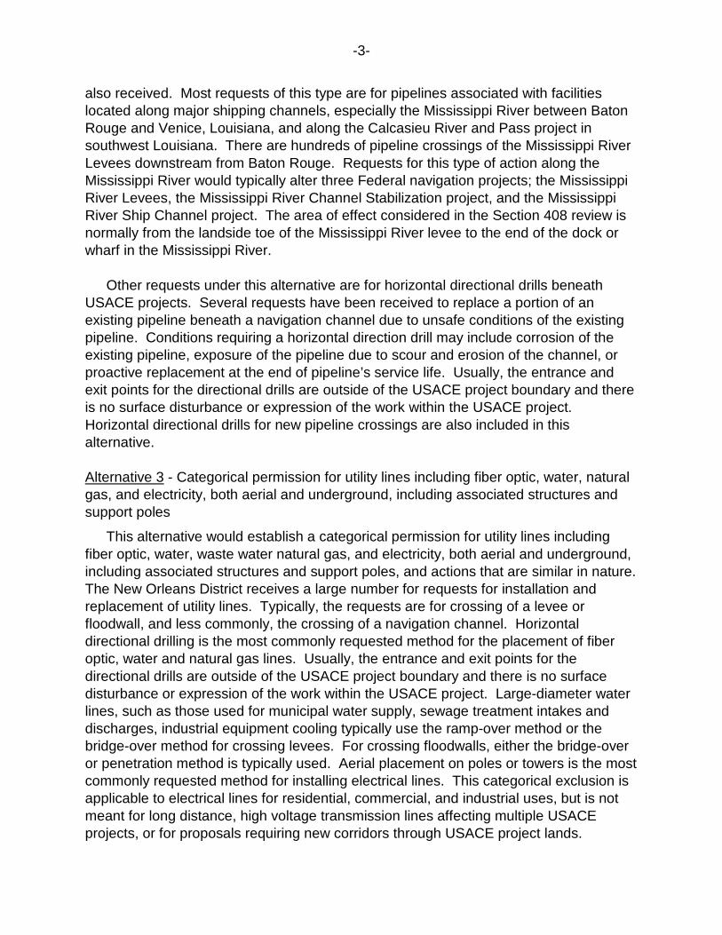
-3-
also received. Most requests of this type are for pipelines associated with facilities located along major shipping channels, especially the Mississippi River between Baton Rouge and Venice, Louisiana, and along the Calcasieu River and Pass project in southwest Louisiana. There are hundreds of pipeline crossings of the Mississippi River Levees downstream from Baton Rouge. Requests for this type of action along the Mississippi River would typically alter three Federal navigation projects; the Mississippi River Levees, the Mississippi River Channel Stabilization project, and the Mississippi River Ship Channel project. The area of effect considered in the Section 408 review is normally from the landside toe of the Mississippi River levee to the end of the dock or wharf in the Mississippi River. Other requests under this alternative are for horizontal directional drills beneath USACE projects. Several requests have been received to replace a portion of an existing pipeline beneath a navigation channel due to unsafe conditions of the existing pipeline. Conditions requiring a horizontal direction drill may include corrosion of the existing pipeline, exposure of the pipeline due to scour and erosion of the channel, or proactive replacement at the end of pipeline’s service life. Usually, the entrance and exit points for the directional drills are outside of the USACE project boundary and there is no surface disturbance or expression of the work within the USACE project. Horizontal directional drills for new pipeline crossings are also included in this alternative. Alternative 3 - Categorical permission for utility lines including fiber optic, water, natural gas, and electricity, both aerial and underground, including associated structures and support poles
This alternative would establish a categorical permission for utility lines including fiber optic, water, waste water natural gas, and electricity, both aerial and underground, including associated structures and support poles, and actions that are similar in nature. The New Orleans District receives a large number for requests for installation and replacement of utility lines. Typically, the requests are for crossing of a levee or floodwall, and less commonly, the crossing of a navigation channel. Horizontal directional drilling is the most commonly requested method for the placement of fiber optic, water and natural gas lines. Usually, the entrance and exit points for the directional drills are outside of the USACE project boundary and there is no surface disturbance or expression of the work within the USACE project. Large-diameter water lines, such as those used for municipal water supply, sewage treatment intakes and discharges, industrial equipment cooling typically use the ramp-over method or the bridge-over method for crossing levees. For crossing floodwalls, either the bridge-over or penetration method is typically used. Aerial placement on poles or towers is the most commonly requested method for installing electrical lines. This categorical exclusion is applicable to electrical lines for residential, commercial, and industrial uses, but is not meant for long distance, high voltage transmission lines affecting multiple USACE projects, or for proposals requiring new corridors through USACE project lands.

-4-
Alternative 4 - Categorical permission for bulk material conveyor systems
This alternative would establish a categorical permission for bulk material conveyor systems, including associated support structures, and actions that are similar in nature. The New Orleans District has received several requests for bulk product conveyor systems along the Mississippi River. Types of materials that are moved with the conveyors include coal, grain, bauxite (aluminum ore), fertilizer, and various other manufactured products. These systems allow materials to be transferred between ships and barges on a navigation channel and nearby storage facilities or industrial plants. There are normally docks or wharves associated with the conveyor systems. Along the Mississippi River, a levee and paved road typically run parallel to the river bank. In such situations, the conveyor system crosses the levee and road overhead, supported on steel structures, with sufficient clearance provided for vehicles to travel along the crown of the levee for levee maintenance and inspection. The area of review for the Section 408 request is normally from the land-side toe of the levee to the outer edge of the dock, wharf, or associated mooring pilings. Alternative 5 - Categorical permission for culverts, drainage pipes, and drainage ditches
This alternative would establish a categorical permission for culverts, drainage pipes, and drainage ditches, and actions that are similar in nature. The New Orleans District has not processed any Section 408 requests for this type of activity, however it is likely that such requests will occur on lands associated with USACE flood risk reduction and navigation projects. Alternative 6 - Categorical permission for vehicle and pedestrian bridges
This alternative would result in a categorical permission for alterations that include construction, replacement, modification, or removal of vehicle or pedestrian bridges, or actions that are similar in nature. The New Orleans District has received two requests for bridge projects. One request is for a new bridge across the Gulf Intracoastal Waterway where no bridge currently exists. The other request is for demolition of an existing, historically-significant bridge and replacement with a new bridge. Neither of these requests would qualify for a categorical permission under this alternative because of extraordinary circumstances associated with them. The first example has a large scope and impacts that require consideration, while the second example has impacts to a significant cultural resource and possible issues with disturbance of existing contaminated soils and sediments. The requests under this alternative that would be covered under this alternative include primarily bridge replacements, bridge maintenance, modifications, and removals with no extraordinary conditions. The New Orleans District has not received any such requests, but anticipates receiving such requests because of the large number of bridges crossing USACE navigation and flood risk reduction projects in south Louisiana.

-5-
Alternative 7 - Categorical permission for bank stabilization and erosion control features
This alternative would result in a categorical permission for alterations that include bank stabilization and erosion control features, or actions that are similar in nature. The surface soils and sediments that make up coastal Louisiana is mostly alluvial sediment carried downstream by the Mississippi and other rivers and reworked since the last Ice Age. This material is generally highly erodible and bank and shoreline erosion is an all too common problem along navigation channels and natural waterways. The most common method for addressing shoreline erosion is armoring bank lines and shorelines with quarry stone. Another common method is placing quarry stone a short distance out from the shoreline to form a dike, often referred to as a foreshore dike. This method is used when geotechnical and other conditions, such as expected wave energy allow, and when avoidance of direct impacts the shoreline is a priority. In some documented cases, enough suspended sediment has been captured in the stilled water behind such dikes that the shoreline naturally extends itself out to the foreshore dike. Other materials that may be used for shoreline erosion is articulated concrete mattress, poured concrete, broken concrete (rip-rap), and earthen material excavated from nearby areas or hauled from remote locations. Dredging to provide access for barges is sometimes necessary. Bulkheads are not included in this alternative since they are primarily designed to allow vessels to moor adjacent to developed land. Alternative 8 - Categorical permission for bulkheads, docks, wharfs, mooring pilings and dolphins
This alternative would result in a categorical permission for bulkheads, docks, wharves, and mooring pilings and dolphins (piling clusters), or actions that are similar in nature. The New Orleans District receives numerous Section 408 requests for the types of actions included in this alternative. Requests for new construction and repair, modification, expansion, and removal of existing structures are all common. It is common for these actions to be combined with actions covered under other alternatives, such as pipelines and bulk product conveyors. These types of actions are usually located along the major navigation channels in New Orleans District, including the Calcasieu River, Atchafalaya River, Mississippi River, and Gulf Intracoastal Waterway. These actions always include the installation of pilings. Steel, treated wood, and pre-stressed concrete are the materials typically used for load-bearing pilings. Sheet pilings used for constructing bulkheads are usually constructed of these same materials, or occasionally vinyl or manufactured composite material. Alternative 9 - Categorical permission for barge fleeting operations in channels with existing barge fleeting operations
This alternative would result in a categorical permission for alterations that include barge fleeting operations in channels with existing barge fleeting operations, or actions that are similar in nature. Barge fleeting is a common practice along navigation channels, especially near facilities where large numbers of barges are loaded and

-6-
unloaded, such as grain elevators, refineries, and chemical plants. Barge fleeting is the temporary mooring and storage of barges while awaiting loading, unloading, or transport elsewhere. There are dozens of permitted barge fleeting operations in the Mississippi River within the New Orleans District, and the District has received several requests for new fleeting operations and expansion or modification of existing operations. Permitted barge fleeting also occurs on other navigation channels within the New Orleans District, although to a much lesser degree. Depending on the location of the fleeting operation, barges can be tied to pilings, dolphins (piling clusters), mooring buoys anchored to the channel bottom, or anchors embedded in the channel bank. The primary concerns expressed about barge fleeting by interested parties in response to Section 408 public notices have been related to navigation safety. The location of barge fleeting and the responsibility of the operators to securely moor their barges have been the main concerns. Any Section 408 requests for barge fleeting that generate substantive navigation safety concerns would not be processed via a categorical permission under this alternative. Safety concerns would be considered an extraordinary circumstance, requiring a more detailed NEPA analysis, and potentially denial of the request. Alternative 10 - Categorical permission for cattle guards and fences
This alternative would result in a categorical permission for alterations that include cattle guards and fences, or actions that are similar in nature. Actions that could be considered similar in nature include typical ranching features, including stock pens, corrals, watering troughs, hay barns, etc. These types of activities are normally not allowed on USACE fee-owned properties, but are allowed on lands where the USACE or the non-Federal project sponsor holds an easement. The underlying landowner or their lessee is allowed to conduct normal ranching operations as long as those operations do not conflict with the USACE project’s authorized purposes. The New Orleans District has received a small number of requests that could be covered under this alternative. Alternative 11 - Categorical permission for trails, signage, lighting, and other similar operational, recreational, and decorative features
This alternative would result in a categorical permission for alterations that include trails, signage, lighting, and other similar operational, recreational, and decorative features, or actions that are similar in nature. The New Orleans District has received a small number of requests that could be covered under this alternative, specifically trails on levee crowns and associated signage. Alternative 12 - Categorical permission for seismic surveys and soil investigations, including borings, piezometers, and inclinometers
This alternative would result in a categorical permission for alterations that include seismic surveys or geotechnical investigations including geotechnical borings, installation of piezometers and inclinometers, or actions that are similar in nature.

-7-
These types of activities normally have a very small and temporary footprint. Any permissions granted for such activities would require filling of any holes with earthen material or grout. Construction activities for borings usually involve the use of truck-mounted drill rigs. Any spoil material from these activities would be graded onto nearby lands, used for other project purposes, or disposed of offsite. Alternative 13 - Levee ramps and crossings
This alternative would result in a categorical permission for levee ramps and crossings for pedestrians or vehicles, and access roads or actions that are similar in nature. The New Orleans District has received several requests for levee ramps, and requests that include levee ramps. Only ramps proposed to be constructed with earthen material, and those that conform to the standard engineering criteria would be considered under this alternative. Structural ramps would require a more detailed environmental review. Ramps that are seldom used are sometimes built with no surfacing other than earth, whereas often-used ramps are usually surfaced with crushed limestone or gravel, or paved with asphalt. Access roads may be included in requests for ramps. Minor access roads are categorically excluded in ER 200-2-2. Alternative 14 - Categorical permission for alterations that meet engineering requirements and environmental conditions This alternative would result in categorical permissions for Alternatives 2 through 13. Categorical permissions would only be applied to requests when it has been determined that the alterations would not impair the usefulness of the USACE project (engineering requirements) or be injurious to the public interest (environmental conditions). Proposed alterations may include one or more of the activities described for these alternatives. This alternative would meet the purpose and need of efficiently processing Section 408 requests in most situations because it would provide NEPA compliance for the types of proposed alterations that are frequently requested and typically only result in no more than minor environmental impacts. Upon completion of the programmatic environmental assessment and finding of no significant impact, and upon completion of engineering reviews, requests for Section 408 permissions to alter USACE projects would be evaluated to determine if they fit under one or more of the categories in the list above. Those that fit into one or more of the categories would be examined to determine if any extraordinary circumstances are present that would disqualify the request from qualifying for a categorical permission. The request would be further examined to determine if any site-specific special conditions may apply to minimize effects on the environment or to the USACE project. Upon inclusion of applicable special conditions, the Section 408 permission would be granted. If the request for Section 408 permission does not fit into one of the categorical permission categories, an environmental assessment would be prepared for proposed actions expected to have less than significant impacts, or an environmental

-8-
impact statement will be prepared for proposed actions expected to cause significant impacts. Please provide comments within 30 days of the date of this notice. Comments and questions may be addressed to Mr. Richard Boe at (504) 862-1505, or by email at [email protected], or by postal mail to Mr. Boe at the address on the letterhead.
Marshall K. Harper Chief, Environmental Planning Branch

From: Rachel Watson on behalf of DCRT Section 106To: Boe, Richard E CIV USARMY CEMVN (US)Subject: [Non-DoD Source] RE: Corps of Engineers Section 408 programDate: Friday, June 9, 2017 2:35:08 PM
Richard,
Thank you for your email. The SHPO will be participating in the development of the programmatic agreement tohandle National Historic Preservation Act compliance. We look forward to working with the Corps in the future.
Sincerely,
Rachel WatsonOffice of Cultural DevelopmentDivision of ArchaeologyP.O. Box 44247Baton Rouge, LA [email protected] 106 submissions: [email protected]

From: Gutierrez, RaulTo: Boe, Richard E CIV USARMY CEMVN (US)Subject: [Non-DoD Source] RE: Corps of Engineers Section 408 programDate: Thursday, June 8, 2017 1:31:26 PM
Mr. Boe,
The Environmental Protection Agency (EPA) has reviewed the Public Notice dated May 9, 2017, concerning theU.S. Army Corps of Engineers Categorical Permissions pursuant to 33 USC 408 and the National EnvironmentalPolicy Act. This public notice addresses categorical permissions, which are types of actions that would neitherindividually nor cumulatively cause more than minor impacts to the environment or the engineering integrity of aUSACE project. The comments that follow are being provided for use in reaching a decision relative to compliancewith the EPA's 404(b)(1) Guidelines for Specification of Disposal Sites for Dredged or Fill Material (40 CFR Part230).
The New Orleans District is proposing to designate various types of actions as categorical permissions. Oncedesignated, these actions will be given an abbreviated and expedited environmental review for NationalEnvironmental Policy Act compliance under the USACE's Section 408 review procedures as detailed in EngineeringCircular (EC) 1165-2-216. Designation of an action as a categorical permission does not affect the separate reviewand permitting process under the USACE Section 10/404/103 regulatory program. Therefore, we do not object to thedevelopment of categorical permissions to be used in the Section 408 program at the New Orleans District of theU.S. Army Corps of Engineers.
Thanks for the opportunity to review and comment on the public notice. We will review and provide additionalcomment on the draft Environmental Assessment once it is available.
Raul Gutierrez, Ph.D.Wetlands Section (6WQ-EM)US EPA Region 6(504) 862-2371
Office:US Army Corps of EngineersNew Orleans DistrictCEMVN-OD-SS7400 Leake AveNew Orleans, Louisiana 70118

United States Department of the Interior
FISH AND WILDLIFE SERVICE
Colonel Michael N. Clancy District Commander U.S. Army Corps of Engineers Post Office Box 60267 New Orleans, Louisiana 70160-0267
Dear Colonel Clancy:
646 Cajundome Blvd. Suite 400
Lafayette, Louisiana 70506 May 22, 2017
Please refer to a May 9, 2017, Public Notice from Mr. Marshal K. Harper, Chief of your
Environmental Planning Branch, regarding proposed categorical permissions for Section 408 (33 USC 408) public notices. Those notices are for permission requests to modify, alter, occupy, or use a U.S. Army Corps of Engineers (Corps) civil works project in the New Orleans District. Categorical permissions would be for only for individual or cumulative permissions that would
not have more than a minor impact to the environment or integrity of a civil works project. We have reviewed the purposed categorical permissions and offer the following comments pursuant to the Endangered Species Act of 1973 ([ESA] as amended) and the Fish and Wildlife Coordination Act (FWCA, 48 Stat. 401 , as amended; 16 U.S.C. 661 et seq.)
The Corps has identified twelve types of actions (referred to as alternatives) that would be evaluated in a programmatic environmental assessment to assess their potential to adversely alter or affect the environment or civil work projects. Within the assessment, a no-action alternative, each individual alternative, and an alternative combining all twelve actions would be analyzed.
If it is determined in the assessment that individually or cumulatively these actions would not have more than a minor impact to the environment or integrity of the civil works project then an abbreviated and expedited review of these type actions would be undertaken by the Corps.
However, this would not alter the engineering, real estate, or internal technical review of the
perm1ss1on.
Of the twelve alternatives proposed, the U.S. Fish and Wildlife Service (Service) only has concerns regarding alternatives, 5 (culverts, drainage pipes, and drainage ditches), 7 (bank
stabilization and erosion control features) and 8 (bulkheads, docks, wharfs, mooring pilings, and dolphins). Regarding Alternative 5, the Service is not concerned with the maintenance and
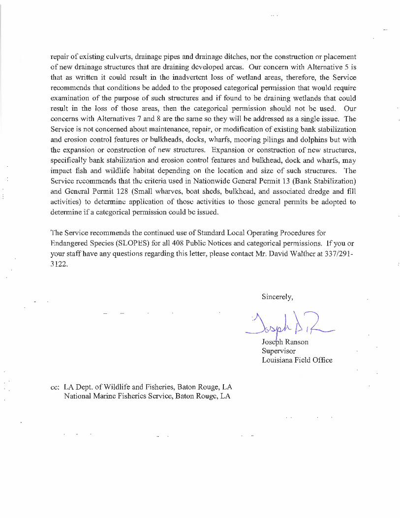
repair of existing culverts, drainage pipes and drainage ditches, nor the construction or placement of new drainage structures that are draining developed areas. Our concern with Alternative 5 is that as written it could result in the inadvertent loss of wetland areas, therefore, the Service
recommends that conditions be added to the proposed categorical permission that would require examination of the purpose of such structures and if found to be draining wetlands that could result in the loss of those areas, then the categorical permission should not be used. Our concerns with Alternatives 7 and 8 are the same so they will be addressed as a single issue. The Service is not concerned about maintenance, repair, or modification of existing bank stabilization and erosion control features or bulkheads, docks, wharfs, mooring pilings and dolphins but with the expansion or construction of new structures. Expansion or construction of new structures, specifically bank stabilization and erosion control features and bulkhead, dock and wharfs, may impact fish and wildlife habitat depending on the location and size of such structures. The Service recommends that the criteria used in Nationwide General Permit 13 (Bank Stabilization) and General Permit 128 (Small wharves, boat sheds, bulkhead, and associated dredge and fill activities) to determine application of those activities to those general permits be adopted to determine if a categorical permission could be issued.
The Service recommends the continued use of Standard Local Operating Procedures for Endangered Species (SLOPES) for all 408 Public Notices and categorical permissions. If you or your staff have any questions regarding this letter, please contact Mr. David Walther at 337/291-
3122.
cc: LA Dept. of Wildlife and Fisheries, Baton Rouge, LA National Marine Fisheries Service, Baton Rouge, LA
Sincerely,
Supervisor Louisiana Field Office
APPENDIX ESECTION 408 NEW ORLEANS DISTRICT
ENVIRONMENTAL COMPLIANCE

Cat Ex File Number ESA Sec 7* MSFCMA CZMA HTRW CWA Sec. 401 CWA Sec. 404(b)(1) CAA NAAQS
Prime and Unique Farmlands
Sec 106 NHPATribal coordination; date
EO 11988, flood plain management
EO 12898, minorities/low-income effect
Other impacts**
N 04-0455NLAA; No Critical Habitat or Adverse Mod.
EFH present; NE NA None presentCert. Required and included (Sec. 404/10)
Pending compliance with Regulatory
In attainment NE No Historic Properties Not needed NE NE
Fisheries; Benthic Communities; Navigation
N 14-0752NLAA; No Critical Habitat or Adverse Mod.
EFH present; NE Permit Issued None presentCert. Required and included (Sec. 404/10)
Pending compliance with Regulatory
In attainment NE No Potential to Cause Effect Yes; 7/21/15 NE NE NA
Abbreviations/Acronyms
N 14-2121NLAA; No Critical Habitat or Adverse Mod.
No EFH Permit Issued None present Cert. IssuedPermit Issued: MVN-2014-02121-CM
In attainment NE No Historic Properties Affected Yes: 7/8/2016 NE NE Wetlands CAA
NAAQSClean Air Act National Ambient Air Quality Standards
N 14-524NLAA; No Critical Habitat or Adverse Mod.
EFH present; NE NA None presentCert. Required and included (Sec. 404/10)
Pending compliance with Regulatory
In attainment NE No Historic Properties Not needed NE NE Wetlands; Benthic
Communities Cert. Certification
N 14-901NLAA; No Critical Habitat or Adverse Mod.
No EFH NA None present Cert. IssuedPending compliance with Regulatory
In attainment NE No Historic Properties Not needed NE NE Wetlands
CZMA Coastal Zone Management Act
N 15-0433NLAA; No Critical Habitat or Adverse Mod.
No EFHPermit Required; Included under Sec. 404/10
None present Cert. IssuedPending compliance with Regulatory
In attainment NE No Historic Properties Yes; 5/8/17 NE NE Wildlife; Wetlands;
Benthic Communities EFH Essential Fish Habitat
N 15-1383NLAA; No Critical Habitat or Adverse Mod.
EFH present; NEPermit Required; Included under Sec. 404/10
None present Cert. IssuedPending compliance with Regulatory
In attainment NE No Historic Properties Not needed NE NE NA
EO Executive Order
N 15-393NLAA; No Critical Habitat or Adverse Mod.
EFH present; NEPermit Required; Included under Sec. 404/10
None presentCert. Required and included (Sec. 404/10)
Pending compliance with Regulatory
In attainment NE No Potential to Cause Effect Not needed NE NE NA
HTRWHazardous, Toxic, and Radioactive Wastes
Y 15-461 NE NA NA NA NA NA NA NA No Potential to Cause Effect Not needed NA NA NA
MSFCMagnuson-Stevens Fishery Conservation and Management Act
N 15-599NLAA; No Critical Habitat or Adverse Mod.
EFH present; NEPermit Required; Included under Sec. 404/10
None presentCert. Required and included (Sec. 404/10)
NA In attainment NE No Potential to Cause Effect Not needed NE NE Benthic Communities
Mod. Modification
N 15-649NLAA; No Critical Habitat or Adverse Mod.
No EFHPermit Required; Included under Sec. 404/10
None presentCert. Required and included (Sec. 404/10)
NA In attainment NE No Potential to Cause Effect Not needed NE NE Wetlands
MMPA Marine Mammal Protection Act
N 15-685NLAA; No Critical Habitat or Adverse Mod.
EFH present; NEPermit Required; Included under Sec. 404/10
None presentCert. Required and included (Sec. 404/10)
Pending compliance with Regulatory
In attainment NE No Potential to Cause Effect Not needed NE NE Benthic Communities
MPRSAMarine Protection Research and Sanctuaries Act
N 15-849Note: FONSI based on FEMA EA
FEMA is project lead federal agency
NA NA NA NA NA NA NA NA NA NA NANE No effect
N 15-857NLAA; No Critical Habitat or Adverse Mod.
No EFHPermit Required; Included under Sec. 404/10
None present NA NA In attainment NE No Potential to Cause Effect Not needed NE NE NA
NA Not applicable
N 15-883 NE No EFH Permit issued None presentCert. Required and included (Sec. 404/10)
Pending compliance with Regulatory
In attainment NE No Potential to Cause Effect Yes; 10/12/16 NE NE
Wildlife; Wetlands; Vehicular Traffic; Recreational NLAA* Not likely to adversely affect
N 16-0096 NE No EFH NA None presentCert. Required and included (Sec. 404/10)
Pending compliance with Regulatory
In attainment NE No Potential to Cause Effect Yes; 7/22/16 NE NE NA
N 16-0135 NE No EFH NA None presentCert. Required and included (Sec. 404/10)
Pending compliance with Regulatory
In attainment NE No Potential to Cause Effect Not needed NE NE NA
N 16-0162 NE No EFH NA None presentCert. Required and included (Sec. 404/10)
Pending compliance with Regulatory
In attainment NE No Potential to Cause Effect Not needed NE NE NA
N 16-167 NE No EFH NA None present NA NA In attainment NE No Potential to Cause Effect Not needed NE NE Unique Uplands
* “NLAA” determinations for projects made pursuant to this key require no further consultation with the Louisiana Ecological Services Office.** See Environmental Compliance Package for details.
Section 408 Requests - Environmental Assessment Checklist Impacts Analysis

Cat Ex File Number ESA Sec 7* MSFCMA CZMA HTRW CWA Sec. 401 CWA Sec. 404(b)(1) CAA NAAQS
Prime and Unique Farmlands
Sec 106 NHPATribal coordination; date
EO 11988, flood plain management
EO 12898, minorities/low-income effect
Other impacts**
Y 16-0221 NE NA NA NA NA NA NA NA No Potential to Cause Effect Not needed NA NA NA
Y 16-0226 NE NA NA NA NA NA NA NA No Potential to Cause Effect Not needed NA NA NA
N 16-0404NLAA; No Critical Habitat or Adverse Mod.
No EFHPermit Required; Included under Sec. 404/10
None presentCert. Required and included (Sec. 404/10)
NA No NE No Potential to Cause Effect Not needed NE NE Benthic Communities
Y 16-0620 NE NA NA NA NA NA NA NANo Adverse Effect to Historic Properties
Not needed NA NA NA
N 16-0710NLAA; No Critical Habitat or Adverse Mod.
EFH present; NEPermit Required; Included under Sec. 404/10
None presentCert. Required and included (Sec. 404/10)
Pending compliance with Regulatory
In attainment NE No Potential to Cause Effect Not needed NE NE Wildlife; Wetlands;
Benthic Communities
N 16-0965 NE NA NA NA NA NA NA NA No Potential to Cause Effect NA NA NA NA
N 16-107NLAA; No Critical Habitat or Adverse Mod.
EFH present; NE Permit Issued None present Cert. IssuedPending compliance with Regulatory
In attainment NENo Adverse Effect to Historic Properties
Yes; 10/25/16 NE NE Wetlands
N 16-147NLAA; No Critical Habitat or Adverse Mod.
No EFH Permit Issued None present Cert. IssuedPending compliance with Regulatory
In attainment NE No Potential to Cause Effect Yes; 4/4/16 NE NE NA
N 16-167 NE No EFH NA None present NAPending compliance with Regulatory
In attainment NE No Potential to Cause Effect Not needed NE NE Unique Uplands
N 16-398 NE No EFH NA None present Cert. IssuedPending compliance with Regulatory
In attainment NE No Potential to Cause Effect Yes; 10/18/16 NE NE NA
Y 16-569NLAA; No Critical Habitat or Adverse Mod.
NA NA NA NA NA NA NA No Potential to Cause Effect Not needed NA NA NA
N 16-734NLAA; No Critical Habitat or Adverse Mod.
EFH present; NEPermit Required; Included under Sec. 404/10
None presentCert. Required and included (Sec. 404/10)
Pending compliance with Regulatory
In attainment NE No Potential to Cause Effect Not needed NE NE Benthic Communities
N 16-738NLAA; No Critical Habitat or Adverse Mod.
EFH present; NEPermit Required; Included under Sec. 404/10
None presentCert. Required and included (Sec. 404/10)
Pending compliance with Regulatory
In attainment NE No Potential to Cause Effect Not needed NE NE Benthic Communities
N o2-3266NLAA; No Critical Habitat or Adverse Mod.
EFH present; NE Permit Issued None present Cert. IssuedPending compliance with Regulatory
In attainment NE No Historic Properties Not needed NE NE
Wildlife; Fisheries; Wetlands; Benthic Communities
Section 408 Requests - Environmental Assessment Checklist Impacts Analysis

Section 408 Categorical Permissions Alternatives (See Programmatic EA 556)Alt 1 No Categorical PermissionsAlt 2 Categorical Permission for Pipeline Crossings Including Horizontal Directional Drills, Open Cuts, Ramp-Overs, and Floodwall PenetrationsAlt 3 Categorical Permission for Utility Lines Including Fiber Optic, Water, Natural Gas, and Electricity, Both Aerial and Underground, Including Associated Structures and Support PolesAlt 4 Categorical Permission for Bulk Material Conveyor SystemsAlt 5 Categorical Permission for Culverts, Drainage Pipes, and Drainage DitchesAlt 6 Categorical Permission for Vehicle and Pedestrian BridgesAlt 7 Categorical Permission for Bank Stabilization and Erosion Control FeaturesAlt 8 Categorical Permission for Bulkheads, Docks, Wharfs, Mooring Pilings and DolphinsAlt 9 Categorical Permission for Barge Fleeting Operations in Channels with Existing Barge Fleeting OperationsAlt 10 Categorical Permission for Cattle Guards, Fences, and other Ranching Activities on Easement LandsAlt 11 Categorical Permission for Trails, Signage, Lighting, and Other Similar Operational, Recreational, and Decorative FeaturesAlt 12 Categorical Permission for Soil Investigations and Seismic Surveys, Including Borings, Piezometers, and InclinometersAlt 13 Categorical Permission for Levee Ramps and Crossings
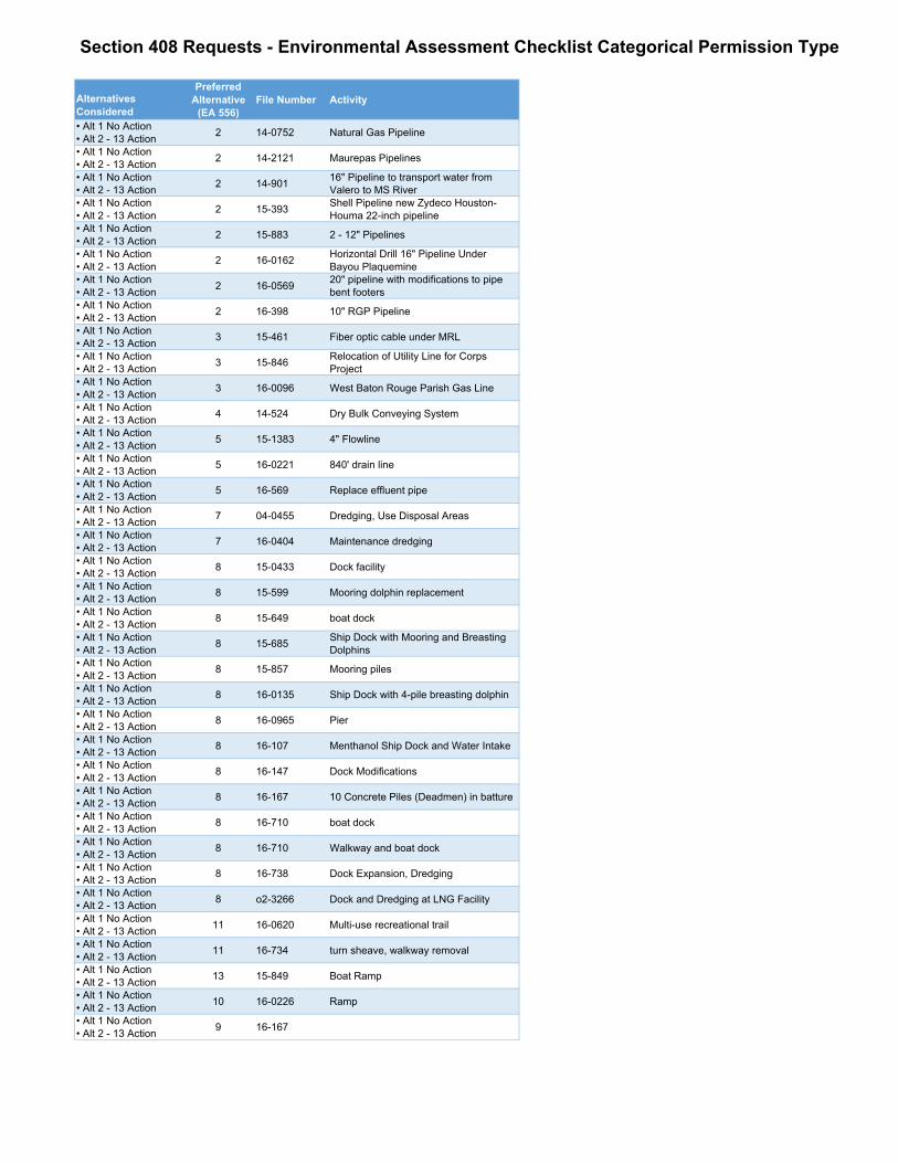
Alternatives Considered
Preferred Alternative
(EA 556)File Number Activity
• Alt 1 No Action• Alt 2 - 13 Action 2 14-0752 Natural Gas Pipeline
• Alt 1 No Action• Alt 2 - 13 Action 2 14-2121 Maurepas Pipelines
• Alt 1 No Action• Alt 2 - 13 Action 2 14-901 16" Pipeline to transport water from
Valero to MS River • Alt 1 No Action• Alt 2 - 13 Action 2 15-393 Shell Pipeline new Zydeco Houston-
Houma 22-inch pipeline• Alt 1 No Action• Alt 2 - 13 Action 2 15-883 2 - 12" Pipelines
• Alt 1 No Action• Alt 2 - 13 Action 2 16-0162 Horizontal Drill 16" Pipeline Under
Bayou Plaquemine• Alt 1 No Action• Alt 2 - 13 Action 2 16-0569 20" pipeline with modifications to pipe
bent footers• Alt 1 No Action• Alt 2 - 13 Action 2 16-398 10" RGP Pipeline
• Alt 1 No Action• Alt 2 - 13 Action 3 15-461 Fiber optic cable under MRL
• Alt 1 No Action• Alt 2 - 13 Action 3 15-846 Relocation of Utility Line for Corps
Project• Alt 1 No Action• Alt 2 - 13 Action 3 16-0096 West Baton Rouge Parish Gas Line
• Alt 1 No Action• Alt 2 - 13 Action 4 14-524 Dry Bulk Conveying System
• Alt 1 No Action• Alt 2 - 13 Action 5 15-1383 4" Flowline
• Alt 1 No Action• Alt 2 - 13 Action 5 16-0221 840' drain line
• Alt 1 No Action• Alt 2 - 13 Action 5 16-569 Replace effluent pipe
• Alt 1 No Action• Alt 2 - 13 Action 7 04-0455 Dredging, Use Disposal Areas
• Alt 1 No Action• Alt 2 - 13 Action 7 16-0404 Maintenance dredging
• Alt 1 No Action• Alt 2 - 13 Action 8 15-0433 Dock facility
• Alt 1 No Action• Alt 2 - 13 Action 8 15-599 Mooring dolphin replacement
• Alt 1 No Action• Alt 2 - 13 Action 8 15-649 boat dock
• Alt 1 No Action• Alt 2 - 13 Action 8 15-685 Ship Dock with Mooring and Breasting
Dolphins• Alt 1 No Action• Alt 2 - 13 Action 8 15-857 Mooring piles
• Alt 1 No Action• Alt 2 - 13 Action 8 16-0135 Ship Dock with 4-pile breasting dolphin
• Alt 1 No Action• Alt 2 - 13 Action 8 16-0965 Pier
• Alt 1 No Action• Alt 2 - 13 Action 8 16-107 Menthanol Ship Dock and Water Intake
• Alt 1 No Action• Alt 2 - 13 Action 8 16-147 Dock Modifications
• Alt 1 No Action• Alt 2 - 13 Action 8 16-167 10 Concrete Piles (Deadmen) in batture
• Alt 1 No Action• Alt 2 - 13 Action 8 16-710 boat dock
• Alt 1 No Action• Alt 2 - 13 Action 8 16-710 Walkway and boat dock
• Alt 1 No Action• Alt 2 - 13 Action 8 16-738 Dock Expansion, Dredging
• Alt 1 No Action• Alt 2 - 13 Action 8 o2-3266 Dock and Dredging at LNG Facility
• Alt 1 No Action• Alt 2 - 13 Action 11 16-0620 Multi-use recreational trail
• Alt 1 No Action• Alt 2 - 13 Action 11 16-734 turn sheave, walkway removal
• Alt 1 No Action• Alt 2 - 13 Action 13 15-849 Boat Ramp
• Alt 1 No Action• Alt 2 - 13 Action 10 16-0226 Ramp
• Alt 1 No Action• Alt 2 - 13 Action 9 16-167
Section 408 Requests - Environmental Assessment Checklist Categorical Permission Type

APPENDIX F
Public and Agency Comments

JOHN BEL EDWARDS ^t^tt flf j t t a JACK MONTOUCET
GOVERNOR DEPARTMENT OF WILDLIFE AND FISHERIES SECRETARY
October 3, 2017
Attn: Marshall K. Harper, ChiefPlanning, Programs, and Project Management DivisionEnvironmental Planning and Compliance BranchUnited States Army Corps of Engineers7400 Leake AvenueNew Orleans, LA 70118
RE: Application Number: PEA #556Applicant: U.S. Army Corps of Engineers-New Orleans DistrictNotice Date: September 26, 2017
Dear Mr. Harper:
The professional staff of the Louisiana Department of Wildlife and Fisheries (LDWF) has reviewed the abovereferenced Public Notice. Based upon this review, the following has been determined:
LDWF has no objection to the proposed establishment of categorical permissions for proposedalterations that are similar in nature and have similar impacts to U.S. Army Corps of Engineers CivilWorks projects pursuant to 33 USC 408. However, we do recommend that the following be added tothe list of requirements for a project to be considered under such categorical permissions:
The activity must not impinge upon the value (habitat, hydrology, etc.) of, any National WildlifeRefuge, National Forest, areas administered by the National Park Service of the U. S. Department ofthe Interior, areas administered by the Louisiana Departments of Natural Resources or Wildlife andFisheries, or other similar publicly held areas administered by federal, state, or local governmentalauthority, unless special permission from these agencies is submitted with the application for thisgeneral permit.
The Louisiana Department of Wildlife and Fisheries submits these recommendations to the U.S. Army Corpsof Engineers in accordance with provisions of the Fish and Wildlife Coordination Act (16 U.S.C. 661 et seq.).Please do not hesitate to contact Habitat Section biologist Chris Davis at 225-765-2642 should you needfurther assistance.
Sincerely.
zc
P.O. BOX 98000 • BATON ROUGE, LOUISIANA 70898-9000 • PHONE (225) 765-2800AN EQUAL OPPORTUNITY EMPLOYER