Embed Size (px)
Citation preview
The Medieval Low Countries, vol. 4 (2017), pp. 91–130
F H G DOI: 10.1484/J.MLC.5.114816
Modelling Monnikerede The Topographical Reconstruction of a
Deserted Medieval Outport near Bruges*
Jan Trachet, Ward Leloup, Kristof Dombrecht, Samuël Delefortrie, Jan Dumolyn, Erik Thoen,
Marc Van Meirvenne, and Wim De Clercq Ghent University / Vrije Universiteit Brussel
Abstract Since the middle of the thirteenth century, the small outport of Monnikerede was part of the portuary system of the later medieval international market of Bruges, which used the Zwin tidal inlet as its gateway to overseas markets. During the sixteenth century, when the political, economic and environmental conditions in the Zwin harbours deteriorated, Monnikerede slowly became depopulated and eventually disappeared from the landscape. In order to analyse the morphology of this deserted harbour, an interdisciplinary research scheme was initiated aimed at integrating historical, cartographic, archaeological, and geophysical data. Through a GIS-based methodology, this integration of complementary sources enabled a topographical reconstruction up to the level of individual parcels and allowed for the discernment of a socio-economic topography. The decline of the city could be visualised through a series of time slices between 1450 and 1850, indicating that Monnikerede’s misfortunes are reflected in the disintegration of the urban fabric. Historical and cartographic data are indispensable in laying the spatio-temporal framework of such reconstructions, whereas the archaeologi-cal data provide a more detailed insight in the intra-parcellar occupation and material culture of a site.
* This research was conducted as a part of the Research Foundation Flanders (FWO)-funded project Medieval Bruges and its outer ports. A landscape-archaeological contribution to the Zwin debate (3G004013). We would like to thank Mr. Strubbe, Mr. Van Wassenhove, Mr. Traen, and Mr. Vandekerkvove, the proprietors and cultivators of the fields in Monnikerede, for their willing cooperation in this research. We would also like to thank Bieke Hillewaert, whose unpublished field- and archival work of this site were a valuable point of departure for this paper.
92
Jan Trachet, Ward Leloup, Kristof Dombrecht et al.
Introduction
In this place, where cows now graze, brisk people once rushed around and the liveliness of commerce and industriousness reigned. Yonder, where the soil is now ripped open by the plough, the wind once gleefully filled the sails and a forest of masts appeared on the secure quay.1
With some literary drama, Hendrik Janssen was the first to attempt to portray the lost medieval harbour of Monnikerede in 1854. Thus, recon-naissance of this deserted town had already started in the middle of the nineteenth century, and Janssen’s description of the deserted site is still valid. Even today, cows graze the south-eastern corner of the former har-bour, while the north-western part of the site is used for crops. Janssen’s survey techniques, on the other hand, are now outdated. He used an eighteenth-century historical map he had found primarily as means of finding his way, and the ‘bumpy terrain’ and occasional protrusions of building materials were mere details in his description of the fields. By contrast, modern survey techniques offer many more opportunities for reviving and reconstructing deserted settlements. The microtopography of a field can be visualised in 3D with a UAV-survey,2 surface artefacts can be accurately registered with GPS, and historical maps can be georectified using a geographic information system (GIS).
At the end of the nineteenth century, archival sources formed the start-ing point for the earliest research into this lost outport of the later medi-eval commercial metropolis of Bruges. Scholars used charters and urban accounts primarily to portray the general socio-economic and political organisation of the small town.3 Through the limited incorporation of historical maps and proto-cadastral documents, researchers managed to reconstruct the pattern of Monnikerede’s streets.4 From the middle
1 The original Dutch text is: ‘Hier, waar nu de koeijen graasden, woelde eens een wakker volk rusteloos dooreen en heerschte de levendigheid van koophandel en vlijt. Ginds spande de wind vrolijk de zeilen en vertoonde zich een mastbosch op de veilige rede, waar nu de grond door de ploeg gescheurd werd’. Hendrik Quirinus Janssen, ‘Monnikereede’, Cadsandria, 1 (1854), 85.
2 i.e., an ‘Unmanned Aerial Vehicle’ or so-called ‘drone’, which is equipped with a camera.
3 Louis Gilliodts-Van Severen, ‘Sources et textes de la coutume de Munikerede’, in Coutumes des petites villes et seigneuries enclavées, III (Brussels: Gobbaerts, 1891), pp. 337–61; August Van Speybrouck, ‘Meunikenreede. Drie vragen en drie antwoorden’, Biekorf, 7 (1896), 39–42, 73–76, 101–08, 132–38.
4 Joseph De Smet, Monnikerede: een verdwenen zeestad van het Zwin (Bruges: Gidsenbond, 1940).
93
Modelling Monnikerede
of the twentieth century onwards, local history societies focused on the historical context of specific toponyms and particular places of interest.5 Economic historians studied the economic promise and financial decline of Monnikerede in a more profound way in the early 1990s.6 The first archaeological research, including an intensive fieldwalking and micro-topographical survey, dates back to the 1980s.7 Although these studies all have merits, they consistently lack one crucial element: the integration of both historical and archaeological data. Moreover, both archaeological survey techniques and methodologies to process written sources have been revolutionized during the last decades, which calls for renewed and integrated research at the site of Monnikerede.
The research project that underlies this paper, namely, Medieval Bruges and its outer ports. A landscape archaeological contribution to the Zwin debate, employs modern techniques and aims at maximal integration of the available historical, archaeological, geophysical, remotely sensed, and cartographic data.8 Whereas previous research never went beyond topographical reconstructions on the level of streets and quarters, recent geophysical soil scans and a micro-topographical UAV-mounted survey uncovered a much more detailed patchwork of zones of habitation and ditches.9 The archaeological field survey revealed historically relevant
5 René De Keyser, ‘De vijf Godskameren te Oostkerke’, Biekorf, 60 (1959), 90–91; René De Keyser, ‘De kapel en de St-Antoniusdijk te Monnikerede’, Rond de Poldertorens, 6 (1964), 22–25.
6 Brigitte Fossion, ‘Bruges et les petites villes du Zwin. A propos des réseaux urbains’, in Le réseau urbain en Belgique dans une perspective historique (1350–1850). Une approche statistique et dynamique. Actes (Brussels: Gemeentekrediet van België, 1992), pp. 327–40; Jean-Pierre Sosson, ‘Les petites villes du Zwin (XIVe–XVe siècles) des espaces urbains inviables’, in Commerce, finances et sociéte (XI e–XVI e siècles). Recueil de travaux d’histoire médiévale offert à M. le Professeur Henri Dubois, ed. by Philippe Contamine, Thierry Dutour, and Bertrand Schnerb (Paris: Presses de l’université de Paris-Sorbonne, 1993), pp. 171–84; Brigitte Fossion, ‘Un exemple de décadence urbaine: La petite ville de Monnikerede (1393–1482)’, Bulletin trimestriel du Crédit Communal de Belgique, 171 (1990), 43–60.
7 Bieke Hillewaert, ‘La petite ville de Monnikerede: Analyse du reliëf et étude microtopographique’, Scholae Archaeologicae, 4 (1986), 5–48.
8 Jan Trachet and others, ‘Medieval Bruges and its outer ports. An interdisciplinary approach to a multi-layered landscape’, RGZM-Tagungen (forthcoming). Project website: www.zwinproject.ugent.be.
9 Jeroen De Reu and others, ‘From low cost UAV survey to high resolution topographic data: Developing our understanding of a Medieval outport of
94
Jan Trachet, Ward Leloup, Kristof Dombrecht et al.
patterns in the medieval artefacts being ploughed to the surface and showed the expansion of the settlement.10 Finally, the study of written sources informed us on the demography and social (in)equality of the town and framed the economic and political evolution of the outport in Bruges’ wider portuary network.11 Comprehensive integration of such diverse datasets, which range from purely spatial and topographic features to socio-economic and political data about the organisation of the city, is not straightforward. However, integration can be attempted through the spatial reconstruction of a unique sequence of sources that contain both temporal and spatial data: proto-cadastral documents, urban accounts, and rent registers.
Indeed, the cadastral information of this medieval harbour is both remarkably diverse and ancient. The so-called ommelopers (land tax reg-isters) of the water boards of Oostkerke and ’s Heer Baselishoek provide site-covering cadastral information well into the fifteenth century, and the rent registers of the church of Oostkerke contain a surprising number of cadastral references as well. Furthermore, the information on real estate from Monnikerede’s urban accounts, though sparse, is very detailed and allows retrogressive analysis back to the end of the fourteenth century. The combination of these spatio-temporal written sources into a GIS that is designed to capture and analyse spatial or geographic data, informs us about the topographical evolution of the port town and allows us to confront the historical data with the archaeological findings.
The objective of this paper is to model the lay-out and morphology of the small town as early as possible, and as detailed as possible. Furthermore, we want to reconstruct the decay of the urban fabric of Monnikerede after the demise of Bruges’ port function to which the small outport was closely related, pinpoint which neighbourhoods were deserted first, and track how the exodus developed. Finally, we aim to discern which harbour-specific, commercial and organisational topographical features were characteristic in this particular town.
Bruges’, Archaeological Prospection, 23 (4) (2016), 335–46; Jan Trachet and others, ‘Reassessing surface artefact scatters. The integration of artefact-accurate fieldwalking with geophysical data at medieval harbour sites near Bruges (Belgium)’, Archaeological Prospection 24 (2), 101 –117.
10 Trachet and others, ‘Reassessing surface artefact scatters’.11 Ward Leloup and others, ‘Monnikerede: The rise and decline of a medieval
outport’, in preparation.
95
Modelling Monnikerede
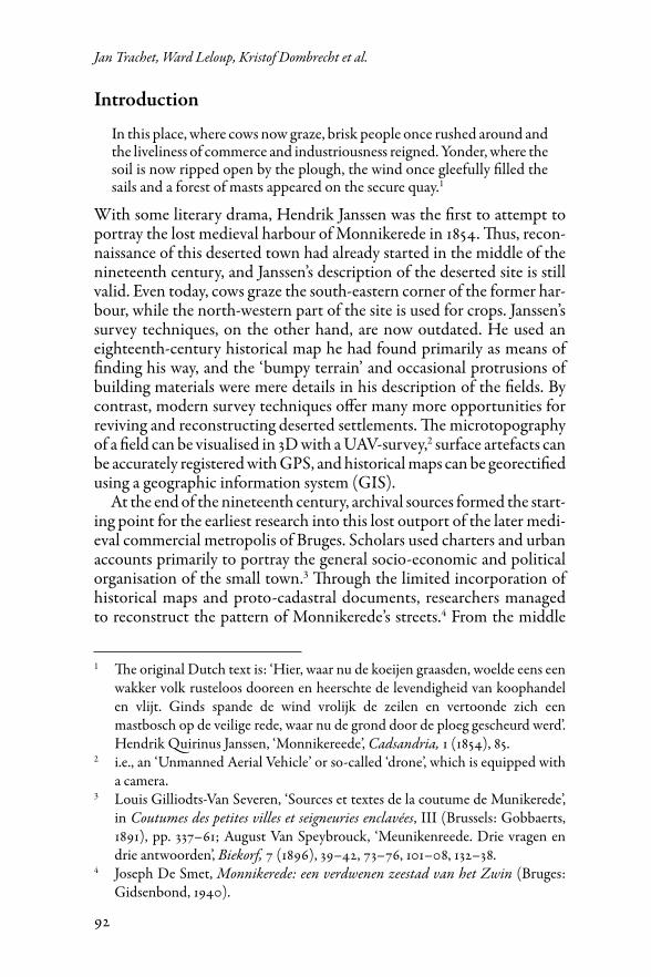
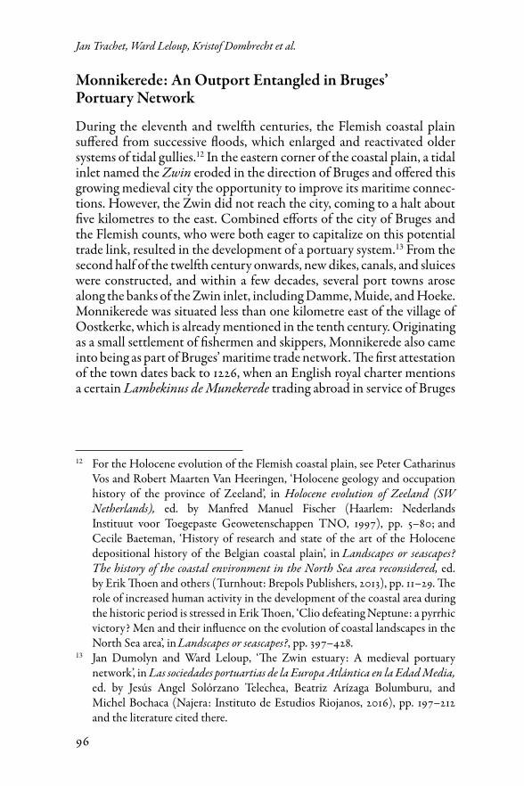
Fig. 1. The site of Monnikerede (below) with indicated research areas, localised within a reconstruction of the medieval Zwin-region (above left) and present-day Belgium (above right). Coordinate system: Belge Lambert 72.
96
Jan Trachet, Ward Leloup, Kristof Dombrecht et al.
Monnikerede: An Outport Entangled in Bruges’ Portuary Network
During the eleventh and twelfth centuries, the Flemish coastal plain suffered from successive floods, which enlarged and reactivated older systems of tidal gullies.12 In the eastern corner of the coastal plain, a tidal inlet named the Zwin eroded in the direction of Bruges and offered this growing medieval city the opportunity to improve its maritime connec-tions. However, the Zwin did not reach the city, coming to a halt about five kilometres to the east. Combined efforts of the city of Bruges and the Flemish counts, who were both eager to capitalize on this potential trade link, resulted in the development of a portuary system.13 From the second half of the twelfth century onwards, new dikes, canals, and sluices were constructed, and within a few decades, several port towns arose along the banks of the Zwin inlet, including Damme, Muide, and Hoeke. Monnikerede was situated less than one kilometre east of the village of Oostkerke, which is already mentioned in the tenth century. Originating as a small settlement of fishermen and skippers, Monnikerede also came into being as part of Bruges’ maritime trade network. The first attestation of the town dates back to 1226, when an English royal charter mentions a certain Lambekinus de Munekerede trading abroad in service of Bruges
12 For the Holocene evolution of the Flemish coastal plain, see Peter Catharinus Vos and Robert Maarten Van Heeringen, ‘Holocene geology and occupation history of the province of Zeeland’, in Holocene evolution of Zeeland (SW Netherlands), ed. by Manfred Manuel Fischer (Haarlem: Nederlands Instituut voor Toegepaste Geowetenschappen TNO, 1997), pp. 5–80; and Cecile Baeteman, ‘History of research and state of the art of the Holocene depositional history of the Belgian coastal plain’, in Landscapes or seascapes? The history of the coastal environment in the North Sea area reconsidered, ed. by Erik Thoen and others (Turnhout: Brepols Publishers, 2013), pp. 11–29. The role of increased human activity in the development of the coastal area during the historic period is stressed in Erik Thoen, ‘Clio defeating Neptune: a pyrrhic victory? Men and their influence on the evolution of coastal landscapes in the North Sea area’, in Landscapes or seascapes?, pp. 397–428.
13 Jan Dumolyn and Ward Leloup, ‘The Zwin estuary: A medieval portuary network’, in Las sociedades portuartias de la Europa Atlántica en la Edad Media, ed. by Jesús Angel Solórzano Telechea, Beatriz Arízaga Bolumburu, and Michel Bochaca (Najera: Instituto de Estudios Riojanos, 2016), pp. 197–212 and the literature cited there.

97
Modelling Monnikerede
merchants.14 Monnikerede’s aldermen were mentioned for the first time in 1266, indicating that the small harbour received urban privileges around the middle of the thirteenth century.15 Unfortunately, very little is known about the spatial and topographical development of Monnikerede’s earli-est phase. Although the toponymy of the town and the existence of an eponymous waterway suggest a connection with the nearby monastery of Ter Doest, the exact relation between these two is still unknown.16
The city of Bruges, which aimed for strict control over its portuary network and connection with the North Sea, kept a tight watch on Monnikerede and the other outports, both economically and judicially. By the end of the thirteenth century, tensions between the increasingly powerful city of Bruges and the Flemish count led to a rebellion, which was met with severe repression.17 One of the comital countermoves was the founding of a new competitive deep-water harbour at the mouth of the Zwin: the city of Sluis. Although the count granted this new har-bour significant autonomy, Bruges’ supremacy over the other outports in the Zwin network only grew stronger. The comital privilege of 1324 illustrated the power structure in the Zwin region. The privilege granted Bruges formal staple rights for all goods entering the county of Flanders through the Zwin, with the exception of goods that entered by way of Damme, Monnikerede and Hoeke. Monnikerede hosted the dried fish trade, and shared the right to weigh trade commodities with Hoeke and Damme.18 Yet while these privileges obviously brought stable economic conditions, they also held economic limitations that were the seeds of its subsequent decline. Not only was the economic activity, which focussed
14 Hansisches Urkundenbuch, ed. by Konstantin Höhlbaum, I (Halle: Verlag der Buchhandlung des Waisenhauses, 1876), p. 63, n° 201.
15 Antoine De Smet, ‘L’origine des ports de Zwin. Damme, Mude, Monikerede, Hoeke et Sluis’, in Etudes d’histoire dédiées a la mémoire de Henri Pirenne par ses anciens élèves (Brussels: Nouvelle sociéte d’éditions, 1937), p. 136; Hansisches Urkundenbuch, I, p. 28, n° 628.
16 So far, De Keyser was the only researcher venturing into the monastic roots of Monnikerede: René De Keyser, ‘De monnik in het stadswapen van Monnikerede’, Rond de Poldertorens, 27 (1985), 23–24. We will return to this question in Leloup and others, ‘The rise and decline’, in preparation.
17 Carlos Wyffels, ‘Nieuwe gegevens betreffende een XIIIde eeuwse democratische stedelijke opstand: De Brugse Moerlemaye (1280–1281)’, Bulletin de la Commission Royale, 132 (1966), 37–142; Thomas Arthur Boogaart, ‘Reflections on the Moerlemaye: Revolt and reform in late medieval Bruges’, Revue Belge de Philologie et d’Histoire, 79 (2001), 1133–58.
18 Dumolyn and Leloup, ‘The Zwin estuary’, pp. 6–8.
98
Jan Trachet, Ward Leloup, Kristof Dombrecht et al.
on local needs and privileged activities, less diversified than in Damme and Sluis, but Monnikerede’s administrative system, port facilities, and population were notably more small-scale and fragile than those of its adjoining major outports.19
With the arrival of the Burgundian dukes in Flanders, the fortunes of Monnikerede started to change. Infringements against the staple privi-lege became ever more frequent, increased ducal taxations weighed on Monnikerede’s finances, and after the town joined Bruges’ uprising against Philip the Good in 1436, Monnikerede was deprived of its privileges. The money the town’s government had to raise to regain these privileges snowballed into debts, increased direct taxation and urban flight, and
19 Ibid. p. 9; A cautious (under)estimation of the number of inhabitants in the first quarter of the fifteenth century arrives at 600 people, spread over a surface of 1186 km². A more detailed and comparative study of these population numbers and population densities in Leloup and others, ‘The rise and decline’, in preparation.
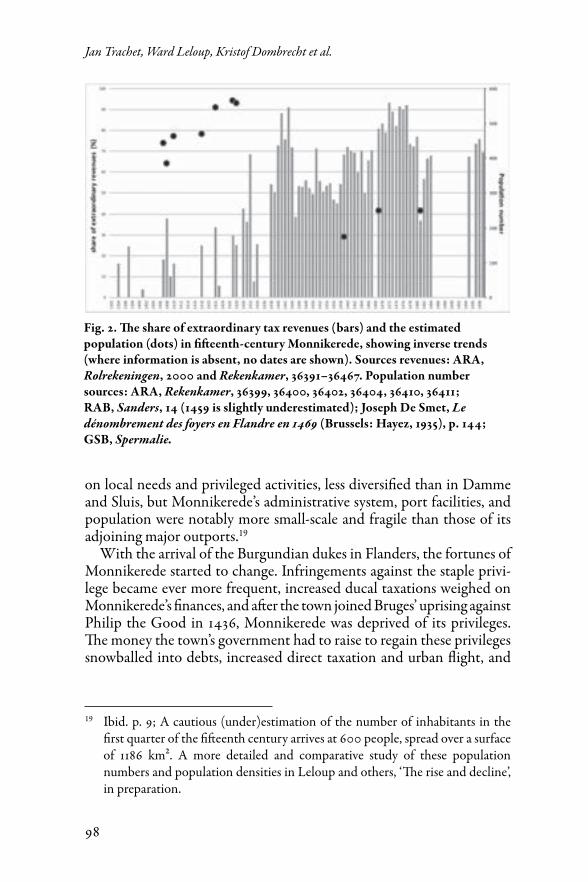
Fig. 2. The share of extraordinary tax revenues (bars) and the estimated population (dots) in fifteenth-century Monnikerede, showing inverse trends (where information is absent, no dates are shown). Sources revenues: ARA, Rolrekeningen, 2000 and Rekenkamer, 36391–36467. Population number sources: ARA, Rekenkamer, 36399, 36400, 36402, 36404, 36410, 36411; RAB, Sanders, 14 (1459 is slightly underestimated); Joseph De Smet, Le dénombrement des foyers en Flandre en 1469 (Brussels: Hayez, 1935), p. 144; GSB, Spermalie.
99
Modelling Monnikerede
further undermined the fragile economy.20 Our research illustrates that Monnikerede’s demographic numbers steeply dropped after the first quarter of the fifteenth century (Fig. 2). The town’s general decline is evidenced by this decrease as well as by the increasing reliance of its finances on extraordinary revenues (e.g., direct taxation, loans or sales of urban property).21 The successive waves of Flemish rebellion against the government of Maximilian of Austria between 1477 and 1492 sealed the fate of Monnikerede as a trading harbour, as the Zwin area became a major battlefield of the revolt causing merchants to stay away.22
Apart from these economic, financial, and political troubles, environ-mental factors also played an important role in the commercial decline of Monnikerede. A tidal inlet is susceptible to silting and sedimentological change, especially when the natural accommodation space is decreased due to embankments.23 Problems with navigability were mentioned as early as 1292 and 1317 and were dealt with by pilotage services from 1400 onwards, and a buoy signalisation system in 1456.24 In an attempt to keep the tidal channel navigable, Bruges began dredging it from the thirteenth century onwards, and explored hydraulic interventions to increase the
20 Dumolyn and Leloup, ‘The Zwin estuary’, pp. 210–11; Jan Dumolyn, De Brugse opstand van 1436–1438 (Heule: UGA, 1997); Jean-Pierre Sosson, ‘Consommation et finances communales. Deux exemples d’asphyxie financière et économique: Hoeke et Mude, petites villes de l’estuaire du Zwin (1394–1500)’, in Proeve ‘t al, ‘t is prysselyck: verbruik in Europese steden (13de-18de eeuw): Liber amicorum Raymond van Uytven, ed. by Walter Prevenier (Antwerp: UFSIA, Departement geschiedenis, 1998), pp. 309–29 (p. 318).
21 Leloup and others, ‘The rise and decline’, in preparation. The upward trend in population numbers during the first quarter of the fifteenth century can possibly be read as a recovering from the pestilence crisis of 1401, which especially ravaged the Flemish coastal areas. Undoubtedly the population numbers of the town were higher still in the preceding centuries.
22 Jelle Haemers, De strijd om het regentschap over Filips de Schone: Opstand, facties en geweld in Brugge, Gent en Ieper (1482–1488) (Ghent: Academia Press, 2015).
23 Thoen, ‘Clio defeating Neptune’.24 Rijksarchief Gent (State Archives in Ghent), Charters Graven van Vlaanderen.
Chronologisch Supplement, 384: petition of the city of Damme to the Count of Flanders (1317); Roger Degryse, ‘Brugge en de organisatie van het loodswezen van het Zwin op het einde van de 15de eeuw’, Handelingen van het Genootschap voor Geschiedenis te Brugge, 112 (1975), 61–130.
100
Jan Trachet, Ward Leloup, Kristof Dombrecht et al.
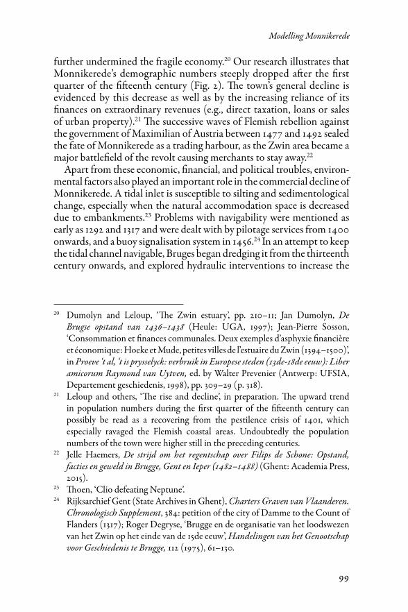
Fig. 3. Jan de Hervy’s painting ‘View of the Zwin area’ (1501) (a), with enlarged details of Damme (b) and Monnikerede (c) (Bruges, Groeningemuseum). The painting depicts the Zwin inlet scouring its way into the direction of Bruges, thereby passing the outports of Sluis, Hoeke, Monnikerede, and Damme. The waterway is sailed by larger boats at the mouth and smaller boats further upstream. Also note the buoy signalisation and mudflats.
tidal flow rate.25 In spite of these ambitious projects, silting continued and further complicated waterborne transit to the inland outports. A final and more drastic attempt to restore the maritime link between Bruges and the North Sea was the construction of an artificial canal: the Verse
25 Dumolyn and Leloup, ‘The Zwin estuary’, p. 211; Marc Ryckaert and André Vandewalle, ‘De strijd voor het behoud van het Zwin’, in Brugge en de zee: van Bryggia tot Zeebrugge, ed. by Valentin Vermeersch (Antwerp: Mercatorfonds, 1982), pp. 53–70.
101
Modelling Monnikerede
Vaart, which partially bypassed the natural Zwin inlet. This waterway, built between 1548 and 1566, dissected the tidal flats of the Zwin inlet and the former harbour area of Monnikerede with a more navigable canal, but probably did not foresee new mooring facilities and thus further disabled the harbour of Monnikerede.
The final blow for Monnikerede was the outbreak of the Eighty Years’ War (1568–1648) that once again turned the Zwin area into a battle-field. The network of smaller outports further disintegrated, compelling Monnikerede’s aldermen to abandon their urban autonomy and offi-cially merge with the city of Damme in 1594.26 The process of oblivion was further procured in 1813, when yet another canal, the Damse Vaart, was dug right through the former centre of Monnikerede, thereby per-manently disfiguring the medieval town- and landscape. Hence, today’s view of the site is fragmented. Northwest and in a small triangle east of the nineteenth-century canal, we find regularly ploughed arable land. Southwest of the canal, the land has presumably never been ploughed and is used as grassland.
Materials and Methods
Cartography
The first iconographical representation of Monnikerede is an early sixteenth-century painting that depicts the entire Zwin area (Fig. 3).27 Although Monnikerede is one of the few inhabited places in the painting without a nametag – perhaps testifying to the fact that it was no longer important – its position in the landscape between Lembeke (SW), Oostkerke (NW), and Hoeke (E) leaves no doubt about its identity. According to the painting, the settlement consisted of several closely spaced houses aligned with the left outer dike of the Zwin inlet. Most of the houses appear to have been constructed in stone and at least one of them is depicted with three storeys.
The 1571 Heraldic Map of the Liberty of Bruges (Brugse Vrije) by Pieter Pourbus also depicts the town.28 Monnikerede is designated ‘Muenikerede’
26 Gilliodts-Van Severen, Coutume de la ville Munikerede, pp. 347–48. The first request to join with the city of Damme was made in 1557.
27 Ann Roberts, ‘The Landscape as a Legal Document: Jan de Hervy’s View of the Zwin’, The Burlington Magazine, 133 (1991), 82–86.
28 Paul Huvenne, Pieter Pourbus: meester-schilder 1524–1584 (s.l.: Gemeentekrediet van België, 1984), pp. 287–91; Het Brugse Vrije in beeld: facsimile-uitgave van de Grote Kaart geschilderd door Pieter Pourbus (1571) en gekopieerd door Pieter
102
Jan Trachet, Ward Leloup, Kristof Dombrecht et al.
and is shown with its coat of arms: a monk standing in front of a boat. Several houses are depicted along the former left dike, and under the coat of arms there are two more.29 On seventeenth-century regional maps, the toponym Monnikerede sporadically appears accompanied by four to seven houses, but then disappears from the macro- and meso-scaled maps.30 The earliest nineteenth-century cadastral maps, such as the commercialized edition by Popp (1854), depict the disrupted land-scape we still perceive today, and contain few references to the medieval townscape.31
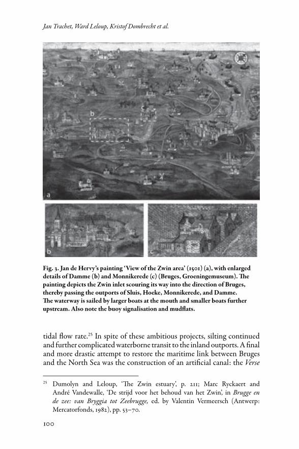
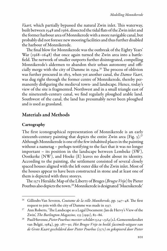
The first preserved detailed micro-scale map dates back to 1695, and shows the former town’s centre (Fig. 4a). Only the western corner appears to be inhabited, and we can discern five houses and a barn. Although the road system to the east is still depicted, it was already unused, as indicated by the tag verdonckerd (‘disappeared’). Most valuable is the mention of both the proprietor and surface area of every single parcel. Moreover, the geographical accuracy of the map permits reliable georectification, hence providing the ideal starting point for the retrogressive analysis.
A second detailed map is related to the construction of the Damse Vaart (1813) and displays how the deserted medieval settlement would be transected by the new canal (Fig. 4b).32 The depiction of the disused road system and parcellation concurs well with the 1695 map, but this map lacks detailed parcel information. The 1813 map permitted reliable georectification, though it exposed a slightly skewed parcellar orientation at the southern edge of the site.
Claeissens (1601), ed. by Bart Van der Herten (Leuven: Universitaire Press, 1998).
29 Cartographic research on these Pourbus maps have demonstrated that with the exception of densely populated cities, the number of houses depicted is probably close to reality. See Dagmar Germonprez, ‘De oudelandse Polder van Cadzand archeologisch onder de loep. Bodemkundig, luchtfotografisch en geofysische prospectie verwerkt in een GIS-applicatie’ (unpublished MA dissertation, Ghent University, 2007).
30 We found three of these maps in the Rijksarchief Brugge (State Archives in Bruges, RAB), Kaarten en plannen, nrs. 747 (1604), 40 (1650), and 29 (1690).
31 Royal Library of Belgium, Kaarten en plannen, 0381: cadastral map of Oostkerke, by Philippe-Christian Popp (1854).
32 The RAB collection Kaarten en plannen contains two maps under n° 997: the abovementioned map of 1695 and one from 1813. Unfortunately, the original of the latter is lost and is only consultable via microfilm.
103
Modelling Monnikerede
Ommelopers
Ommelopers are fiscal land survey documents that offer a geographical or topographical overview of parcels within the dikes in order to collect specific land taxes on behalf of the so-called water boards (wateringhen). These proto-cadastral documents provide detailed information for every parcel, such as the form of the parcel, its proprietor(s), previous proprietor, manner of conveyance, surface, position in relation to the neighbouring parcels and/or infrastructure, land usage, type of habitation, toponyms, significant landscape elements, and amount of ground rents or taxes.33 This is a list of the possible entries in these documents, yet in reality most of the ommelopers will only contain a selection of information.
33 Tim Soens, De spade in de dijk?: Waterbeheer en rurale samenleving in de Vlaamse kustvlakte (1280–1580) (Ghent: Academia Press, 2009), pp. 93–102; Dries Tys, ‘Een middeleeuws landschap als materiële cultuur: De interactie tussen macht en ruimte in het kustgebied en de wording van een laatmiddeleeuws tot vroegmodern landschap. Kamerlingsambacht, 500–1200/1600’ (Unpublished PhD thesis, Vrije Universiteit Brussel, 2003).
Fig. 4. Micro-scaled maps of the already deserted site of Monnikerede in 1695 (left) and 1813 (right) (RAB, Kaarten en Plannen, 997).
104
Jan Trachet, Ward Leloup, Kristof Dombrecht et al.
The oldest preserved register partially describing Monnikerede dates back to 1459.34 Unfortunately, the area of Monnikerede is spread over the territorial jurisdiction of two water boards: the Kerkwatering in the south and the Watering van ’s Heer Baselishoek in the north. As a con-sequence, the south of the town is described in 1459 and 1517, whereas the northern part is described in 1520 and 1550, resulting in a temporal incongruity of the data.35 A final ommeloper or paalboek of the entire town was compiled in 1594.36 The key to successful retrogressive reconstruction was the correspondence of the surface areas mentioned in 1594 with the surface areas depicted on the 1695 map, thus providing the essential link between text and map.
Based on these records, the tracks of the medieval land surveyors could be digitally followed in a GIS-environment (ArcGIS 10.2). The retrogres-sive analysis started with a digital redrawing of the georectified 1695 map, which acted as the base layer for reconstructing the 1594 ommeloper text. The resulting 1594 polygon shape file subsequently served as the base layer for the reconstruction of the 1550 ommeloper text, and so on. The result of these successive operations consists of several layers of contigu-ous reconstructions that form the framework for locating other, more non-contiguous source materials, such as rent registers or urban accounts.
Rent Registers
Similar to the water boards, the parish church of Oostkerke used a system of property- and rent registration in which certain parcels were positioned in relation to neighbouring parcels and infrastructure. As they often contained even more specific topographical information, the registers afforded us the opportunity to improve the topographical patchwork. Three registers have been preserved, with the earliest dating back to 1449, the second to 1481, and the last to 1554.37 Topographic reconstruction of
34 RAB, Sanders, 14: ommeloper of the Kerkwatering of Oostkerke (1459).35 RAB, Verenigde watering van ’s Heer Baselishoek en de Kerkwatering van
Oostkerke, 103: ommeloper of the Kerkwatering (1517) and 105: ommeloper of ’s Heer Baselishoek (1550); Fonds d’Hoop, 91: ommeloper of the watering ’s Heer Baselishoek (1520).
36 RAB, Mestdagh, 958: ommeloper of the jurisdiction of Monnikerede (1594).37 RAB, Brugse Vrije. Registers, 15880: register of goods belonging to the church
of Oostkerke (1449); Grootseminarie Brugge (Bruges Seminary, GSB), Spermalie: register of rents and land belonging to the church of Oostkerke (1481); RAB, Kerkfabriek Oostkerke (Damme), 1: register of rents belonging to the church of Oostkerke (1554).
105
Modelling Monnikerede
these documents was based on the available ommeloper base layers that pro-vided an essential spatial framework. Although the number of described parcels is smaller than in the ommelopers, additional parcel-reconstructions were possible (Table 1). Moreover, the rent registers were not limited by water board boundaries and provide unique spatial information on the area outside the dikes, which in the course of time was reclaimed from the inlet and built upon.
Monnikerede Urban Accounts
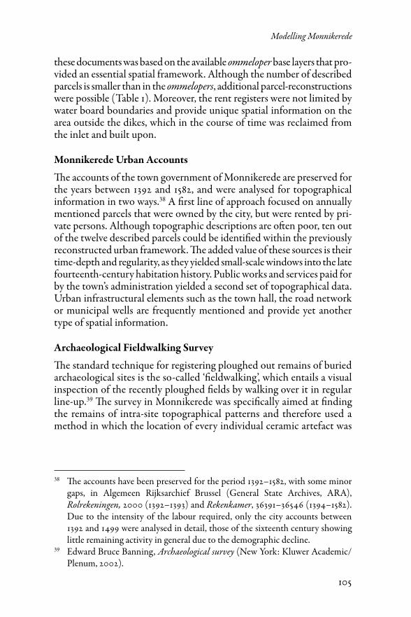
The accounts of the town government of Monnikerede are preserved for the years between 1392 and 1582, and were analysed for topographical information in two ways.38 A first line of approach focused on annually mentioned parcels that were owned by the city, but were rented by pri-vate persons. Although topographic descriptions are often poor, ten out of the twelve described parcels could be identified within the previously reconstructed urban framework. The added value of these sources is their time-depth and regularity, as they yielded small-scale windows into the late fourteenth-century habitation history. Public works and services paid for by the town’s administration yielded a second set of topographical data. Urban infrastructural elements such as the town hall, the road network or municipal wells are frequently mentioned and provide yet another type of spatial information.
Archaeological Fieldwalking Survey
The standard technique for registering ploughed out remains of buried archaeological sites is the so-called ‘fieldwalking’, which entails a visual inspection of the recently ploughed fields by walking over it in regular line-up.39 The survey in Monnikerede was specifically aimed at finding the remains of intra-site topographical patterns and therefore used a method in which the location of every individual ceramic artefact was
38 The accounts have been preserved for the period 1392–1582, with some minor gaps, in Algemeen Rijksarchief Brussel (General State Archives, ARA), Rolrekeningen, 2000 (1392–1393) and Rekenkamer, 36391–36546 (1394–1582). Due to the intensity of the labour required, only the city accounts between 1392 and 1499 were analysed in detail, those of the sixteenth century showing little remaining activity in general due to the demographic decline.
39 Edward Bruce Banning, Archaeological survey (New York: Kluwer Academic/Plenum, 2002).
106
Jan Trachet, Ward Leloup, Kristof Dombrecht et al.
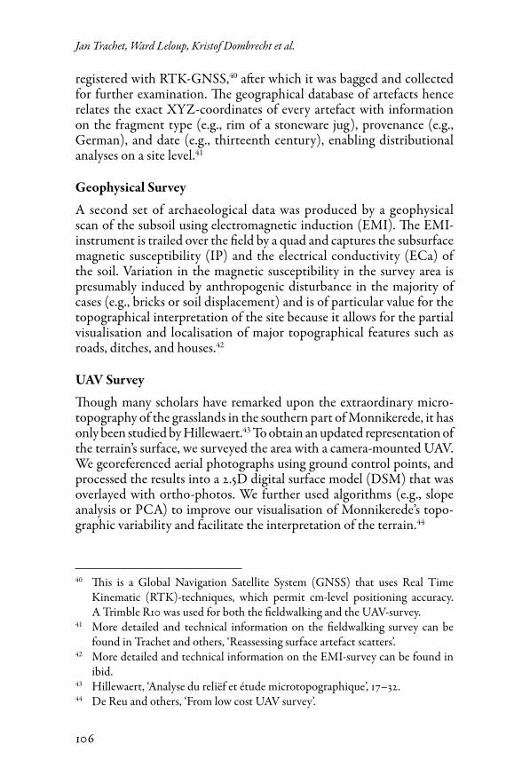
registered with RTK-GNSS,40 after which it was bagged and collected for further examination. The geographical database of artefacts hence relates the exact XYZ-coordinates of every artefact with information on the fragment type (e.g., rim of a stoneware jug), provenance (e.g., German), and date (e.g., thirteenth century), enabling distributional analyses on a site level.41
Geophysical Survey
A second set of archaeological data was produced by a geophysical scan of the subsoil using electromagnetic induction (EMI). The EMI-instrument is trailed over the field by a quad and captures the subsurface magnetic susceptibility (IP) and the electrical conductivity (ECa) of the soil. Variation in the magnetic susceptibility in the survey area is presumably induced by anthropogenic disturbance in the majority of cases (e.g., bricks or soil displacement) and is of particular value for the topographical interpretation of the site because it allows for the partial visualisation and localisation of major topographical features such as roads, ditches, and houses.42
UAV Survey
Though many scholars have remarked upon the extraordinary micro-topography of the grasslands in the southern part of Monnikerede, it has only been studied by Hillewaert.43 To obtain an updated representation of the terrain’s surface, we surveyed the area with a camera-mounted UAV. We georeferenced aerial photographs using ground control points, and processed the results into a 2.5D digital surface model (DSM) that was overlayed with ortho-photos. We further used algorithms (e.g., slope analysis or PCA) to improve our visualisation of Monnikerede’s topo-graphic variability and facilitate the interpretation of the terrain.44
40 This is a Global Navigation Satellite System (GNSS) that uses Real Time Kinematic (RTK)-techniques, which permit cm-level positioning accuracy. A Trimble R10 was used for both the fieldwalking and the UAV-survey.
41 More detailed and technical information on the fieldwalking survey can be found in Trachet and others, ‘Reassessing surface artefact scatters’.
42 More detailed and technical information on the EMI-survey can be found in ibid.
43 Hillewaert, ‘Analyse du reliëf et étude microtopographique’, 17–32.44 De Reu and others, ‘From low cost UAV survey’.
107
Modelling Monnikerede
Reconstruction and Integration of Data
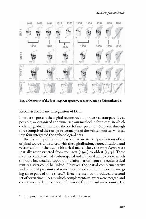
In order to present the digital reconstruction process as transparently as possible, we organized and visualised our method in four steps, in which each step gradually increased the level of interpretation. Steps one through three comprised the retrogressive analysis of the written sources, whereas step four integrated the archaeological data.
The first step produced ten layers that are strict reproductions of the original sources and started with the digitalisation, georectification, and vectorisation of the usable historical maps. Thus, the ommelopers were spatially reconstructed from youngest (1594) to oldest (1459). These reconstructions created a robust spatial and temporal framework to which sporadic but detailed topographic information from the ecclesiastical rent registers could be linked. However, the spatial complementarity and temporal proximity of some layers enabled simplification by merg-ing three pairs of time slices.45 Therefore, step two produced a second set of seven time slices in which complementary layers were merged and complemented by piecemeal information from the urban accounts. The
45 This process is demonstrated below and in Figure 6.
Fig. 5. Overview of the four-step retrogressive reconstruction of Monnikerede.
108
Jan Trachet, Ward Leloup, Kristof Dombrecht et al.
third step encompassed a further grade of interpretation, as undescribed ‘blank’ parcels of a certain time slice were given an occupation value based on the preceding and following time slices. For example, if a parcel was inhabited in 1459 and 1517, but was not described in 1481, it could be assumed that the parcel was continuously inhabited between 1459 and 1517 and could therefore be valued as ‘inhabited’ in the 1480-time slice.
Step four integrated the archaeological data. The separate interpreta-tions of the EMI, UAV, and fieldwalking surveys were superimposed on the retrogressive analysis of historical maps and sources in our search for spatial and temporal congruity. This analysis allowed us to push the spa-tial analysis of the site from the parcel-level to the building-level, which resulted in more detailed time slices.
Results
Parcel Reconstruction Based on Written and Cartographic Sources
Because extensive illustration of every time slice from the four steps is beyond the scope of this article, illustrations are limited to our most essential findings. Figure 5 thus represents the overall four-step meth-odology, whereas Figures 6, 7, and 13 provide more detailed insight into the reconstructions. Table 1 characterises the step 1 source materials and quantifies the interpretative reconstructions of steps 2 through 4.
The retrogressive analysis started with the 1854 cadastral map of Popp (Fig. 5.j1). This map could not be used as a starting point for linking the proto-cadastral descriptions because of the disruptive impact of the Damse Vaart. However, the detailed map of 1695 predates the Damse Vaart and has the appropriate level of accuracy and reference points to make a spa-tial association with the ommeloper of 1594 (Fig. 5.i1). The subsequent retrogressive analyses based on the ommelopers and rent registers are visualised in Figure 5 h1-a1.
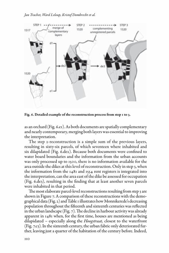
Figure 6 shows how we proceeded from a step-1 reconstruction of the ommelopers, to a merged step-2 reconstruction with additional informa-tion from the urban accounts, to the step-3 interpretation on the level of individual parcels. In detail, the ommeloper from the Kerkwatering dates back to 1517 and covers the area south of the Kerkstraat (‘Church Street’). The ommelopers describe forty parcels, of which twelve were inhabited and three dilapidated (Fig. 6.d1). The ommeloper from ’sHeer Baselishoek was drawn up in 1520 and represents the zone north of this water board’s boundary. Here, five of the twenty-six described parcels were inhabited, three parcels were dilapidated, and one parcel was referred to
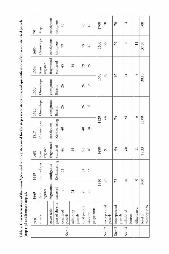
Tabl
e 1. C
hara
cter
isat
ion
of th
e om
mel
oper
s and
rent
regi
ster
s use
d fo
r the
step
1 re
cons
truc
tions
, and
qua
ntifi
catio
n of
the r
econ
stru
cted
par
cels
(s
tep
1–3)
and
hous
es (s
tep
4).
Step
1
year
1449
1459
1481
1517
1520
1550
1554
1695
70so
urce
Ren
t re
gist
erO
mm
elop
erR
ent
regi
ster
Om
mel
oper
Om
mel
oper
Om
mel
oper
Ren
t re
gist
erO
mm
elop
erM
ap
cove
r rat
iofra
gmen
ted
cont
iguo
usfra
gmen
ted
cont
iguo
usco
ntig
uous
cont
iguo
usfra
gmen
ted
cont
iguo
usco
ntig
uous
part
of t
he si
tesc
atte
red
Ker
kwat
erin
gsc
atte
red
Ker
kwat
erin
gBa
selis
Base
lissc
atte
red
com
plet
eco
mpl
ete
desc
ribed
pa
rcel
s 8
5146
4026
2645
7970
adjo
inin
g pa
rcel
s21
4534
tota
l par
cels
2951
9140
2626
7979
70am
ount
pr
oprie
tors
2733
4618
1412
2541
16
1450
1480
1520
1550
1600
1700
Step
2in
corp
orat
ed
parc
els
5791
6685
7970
Step
3in
corp
orat
ed
parc
els
7394
7497
7970
Step
4in
habi
ted
hous
es78
6024
218
4
dila
pida
ted
011
68
11le
vel o
f va
canc
y in
%0.
0018
.33
25.0
038
.10
137.
500.
00
110
Jan Trachet, Ward Leloup, Kristof Dombrecht et al.
as an orchard (Fig. 6.e1). As both documents are spatially complementary and nearly contemporary, merging both layers was essential to improving the interpretation.
The step 2-reconstruction is a simple sum of the previous layers, resulting in sixty-six parcels, of which seventeen where inhabited and six dilapidated (Fig. 6.de2). Because both documents were confined to water board boundaries and the information from the urban accounts was only processed up to 1500, there is no information available for the area outside the dikes at this level of reconstruction. Only in step 3, when the information from the 1481 and 1554 rent registers is integrated into the interpretation, can the area east of the dike be assessed for occupation (Fig. 6.de3), resulting in the finding that at least another seven parcels were inhabited in that period.
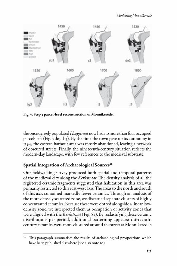
The most elaborate parcel-level reconstructions resulting from step 3 are shown in Figure 7. A comparison of these reconstructions with the demo-graphical data (Fig. 2) and Table 1 illustrates how Monnikerede’s decreasing population throughout the fifteenth and sixteenth centuries was reflected in the urban landscape (Fig. 7). The decline in harbour activity was already apparent in 1481 when, for the first time, houses are mentioned as being dilapidated – especially along the Hoogstraat, closest to the waterfront (Fig. 7.c3). In the sixteenth century, the urban fabric only deteriorated fur-ther, leaving just a quarter of the habitation of the century before. Indeed,
Fig. 6. Detailed example of the reconstruction process from step 1 to 3.
111
Modelling Monnikerede
the once densely populated Hoogstraat now had no more than four occupied parcels left (Fig. 7de3–h3). By the time the town gave up its autonomy in 1594, the eastern harbour area was mostly abandoned, leaving a network of obscured streets. Finally, the nineteenth-century situation reflects the modern-day landscape, with few references to the medieval substrate.
Spatial Integration of Archaeological Sources46
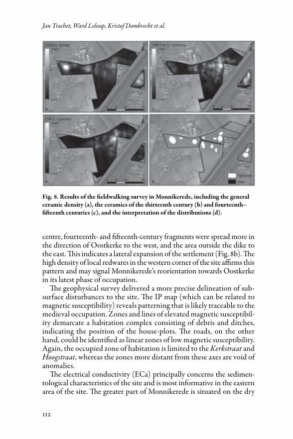
Our fieldwalking survey produced both spatial and temporal patterns of the medieval city along the Kerkstraat. The density analysis of all the registered ceramic fragments suggested that habitation in this area was primarily restricted to this east-west axis. The areas to the north and south of this axis contained markedly fewer ceramics. Through an analysis of the more densely scattered zone, we discerned separate clusters of highly concentrated ceramics. Because these were dotted alongside a linear low-density zone, we interpreted them as occupation or activity zones that were aligned with the Kerkstraat (Fig. 8a). By reclassifying these ceramic distributions per period, additional patterning appears: thirteenth-century ceramics were more clustered around the street at Monnikerede’s
46 This paragraph summarises the results of archaeological prospections which have been published elsewhere (see also note 10).
Fig. 7. Step 3 parcel-level reconstruction of Monnikerede.
112
Jan Trachet, Ward Leloup, Kristof Dombrecht et al.
centre, fourteenth- and fifteenth-century fragments were spread more in the direction of Oostkerke to the west, and the area outside the dike to the east. This indicates a lateral expansion of the settlement (Fig. 8b). The high density of local redwares in the western corner of the site affirms this pattern and may signal Monnikerede’s reorientation towards Oostkerke in its latest phase of occupation.
The geophysical survey delivered a more precise delineation of sub-surface disturbances to the site. The IP map (which can be related to magnetic susceptibility) reveals patterning that is likely traceable to the medieval occupation. Zones and lines of elevated magnetic susceptibil-ity demarcate a habitation complex consisting of debris and ditches, indicating the position of the house-plots. The roads, on the other hand, could be identified as linear zones of low magnetic susceptibility. Again, the occupied zone of habitation is limited to the Kerkstraat and Hoogstraat, whereas the zones more distant from these axes are void of anomalies.
The electrical conductivity (ECa) principally concerns the sedimen-tological characteristics of the site and is most informative in the eastern area of the site. The greater part of Monnikerede is situated on the dry
Fig. 8. Results of the fieldwalking survey in Monnikerede, including the general ceramic density (a), the ceramics of the thirteenth century (b) and fourteenth– fifteenth centuries (c), and the interpretation of the distributions (d).
113
Modelling Monnikerede
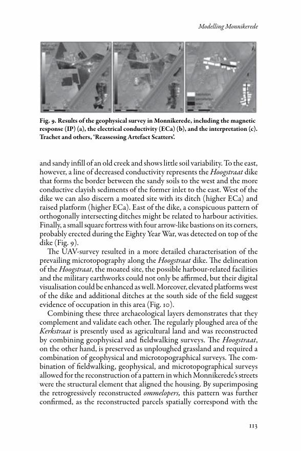
and sandy infill of an old creek and shows little soil variability. To the east, however, a line of decreased conductivity represents the Hoogstraat dike that forms the border between the sandy soils to the west and the more conductive clayish sediments of the former inlet to the east. West of the dike we can also discern a moated site with its ditch (higher ECa) and raised platform (higher ECa). East of the dike, a conspicuous pattern of orthogonally intersecting ditches might be related to harbour activities. Finally, a small square fortress with four arrow-like bastions on its corners, probably erected during the Eighty Year War, was detected on top of the dike (Fig. 9).
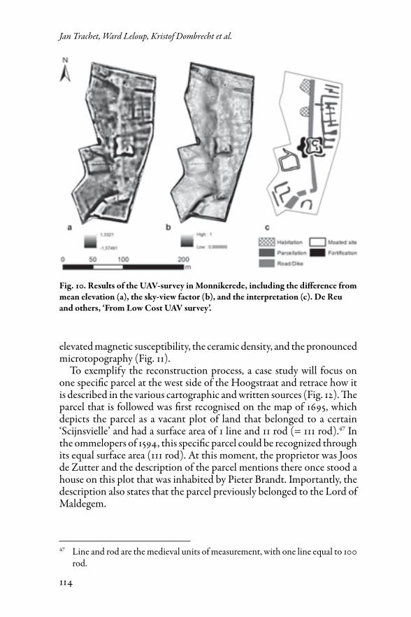
The UAV-survey resulted in a more detailed characterisation of the prevailing microtopography along the Hoogstraat dike. The delineation of the Hoogstraat, the moated site, the possible harbour-related facilities and the military earthworks could not only be affirmed, but their digital visualisation could be enhanced as well. Moreover, elevated platforms west of the dike and additional ditches at the south side of the field suggest evidence of occupation in this area (Fig. 10).
Combining these three archaeological layers demonstrates that they complement and validate each other. The regularly ploughed area of the Kerkstraat is presently used as agricultural land and was reconstructed by combining geophysical and fieldwalking surveys. The Hoogstraat, on the other hand, is preserved as unploughed grassland and required a combination of geophysical and microtopographical surveys. The com-bination of fieldwalking, geophysical, and microtopographical surveys allowed for the reconstruction of a pattern in which Monnikerede’s streets were the structural element that aligned the housing. By superimposing the retrogressively reconstructed ommelopers, this pattern was further confirmed, as the reconstructed parcels spatially correspond with the
Fig. 9. Results of the geophysical survey in Monnikerede, including the magnetic response (IP) (a), the electrical conductivity (ECa) (b), and the interpretation (c). Trachet and others, ‘Reassessing Artefact Scatters’.
114
Jan Trachet, Ward Leloup, Kristof Dombrecht et al.
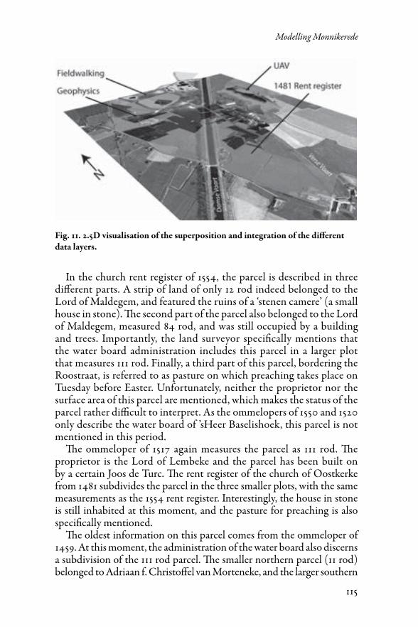
elevated magnetic susceptibility, the ceramic density, and the pronounced microtopography (Fig. 11).
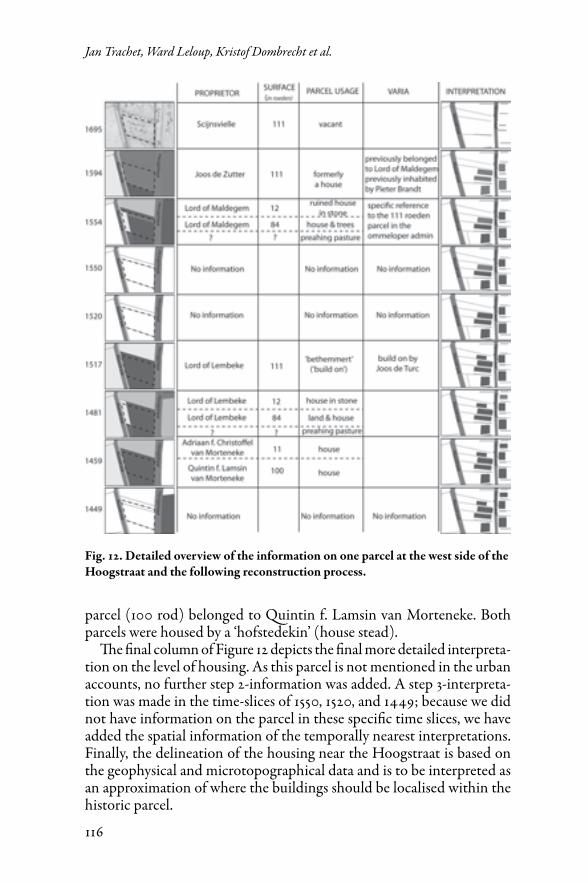
To exemplify the reconstruction process, a case study will focus on one specific parcel at the west side of the Hoogstraat and retrace how it is described in the various cartographic and written sources (Fig. 12). The parcel that is followed was first recognised on the map of 1695, which depicts the parcel as a vacant plot of land that belonged to a certain ‘Scijnsvielle’ and had a surface area of 1 line and 11 rod (= 111 rod).47 In the ommelopers of 1594, this specific parcel could be recognized through its equal surface area (111 rod). At this moment, the proprietor was Joos de Zutter and the description of the parcel mentions there once stood a house on this plot that was inhabited by Pieter Brandt. Importantly, the description also states that the parcel previously belonged to the Lord of Maldegem.
47 Line and rod are the medieval units of measurement, with one line equal to 100 rod.
Fig. 10. Results of the UAV-survey in Monnikerede, including the difference from mean elevation (a), the sky-view factor (b), and the interpretation (c). De Reu and others, ‘From Low Cost UAV survey’.
115
Modelling Monnikerede
In the church rent register of 1554, the parcel is described in three different parts. A strip of land of only 12 rod indeed belonged to the Lord of Maldegem, and featured the ruins of a ‘stenen camere’ (a small house in stone). The second part of the parcel also belonged to the Lord of Maldegem, measured 84 rod, and was still occupied by a building and trees. Importantly, the land surveyor specifically mentions that the water board administration includes this parcel in a larger plot that measures 111 rod. Finally, a third part of this parcel, bordering the Roostraat, is referred to as pasture on which preaching takes place on Tuesday before Easter. Unfortunately, neither the proprietor nor the surface area of this parcel are mentioned, which makes the status of the parcel rather difficult to interpret. As the ommelopers of 1550 and 1520 only describe the water board of ’sHeer Baselishoek, this parcel is not mentioned in this period.
The ommeloper of 1517 again measures the parcel as 111 rod. The proprietor is the Lord of Lembeke and the parcel has been built on by a certain Joos de Turc. The rent register of the church of Oostkerke from 1481 subdivides the parcel in the three smaller plots, with the same measurements as the 1554 rent register. Interestingly, the house in stone is still inhabited at this moment, and the pasture for preaching is also specifically mentioned.
The oldest information on this parcel comes from the ommeloper of 1459. At this moment, the administration of the water board also discerns a subdivision of the 111 rod parcel. The smaller northern parcel (11 rod) belonged to Adriaan f. Christoffel van Morteneke, and the larger southern
Fig. 11. 2.5D visualisation of the superposition and integration of the different data layers.
116
Jan Trachet, Ward Leloup, Kristof Dombrecht et al.
parcel (100 rod) belonged to Quintin f. Lamsin van Morteneke. Both parcels were housed by a ‘hofstedekin’ (house stead).
The final column of Figure 12 depicts the final more detailed interpreta-tion on the level of housing. As this parcel is not mentioned in the urban accounts, no further step 2-information was added. A step 3-interpreta-tion was made in the time-slices of 1550, 1520, and 1449; because we did not have information on the parcel in these specific time slices, we have added the spatial information of the temporally nearest interpretations. Finally, the delineation of the housing near the Hoogstraat is based on the geophysical and microtopographical data and is to be interpreted as an approximation of where the buildings should be localised within the historic parcel.
Fig. 12. Detailed overview of the information on one parcel at the west side of the Hoogstraat and the following reconstruction process.
117
Modelling Monnikerede
From a Topographical Reconstruction…
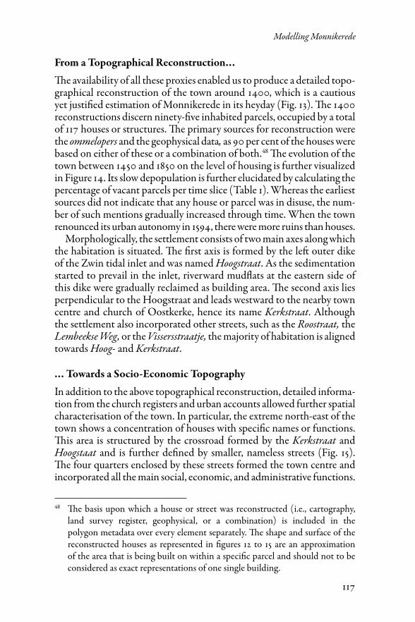
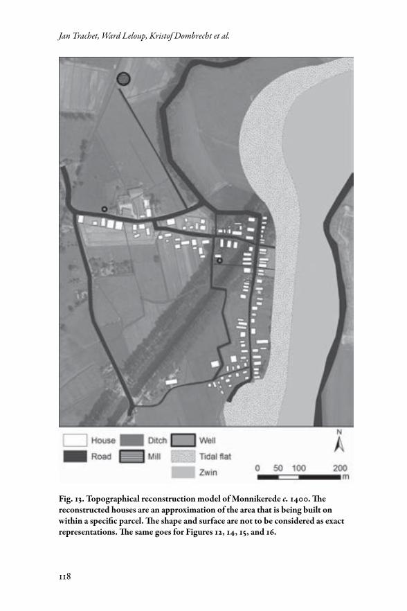
The availability of all these proxies enabled us to produce a detailed topo-graphical reconstruction of the town around 1400, which is a cautious yet justified estimation of Monnikerede in its heyday (Fig. 13). The 1400 reconstructions discern ninety-five inhabited parcels, occupied by a total of 117 houses or structures. The primary sources for reconstruction were the ommelopers and the geophysical data, as 90 per cent of the houses were based on either of these or a combination of both.48 The evolution of the town between 1450 and 1850 on the level of housing is further visualized in Figure 14. Its slow depopulation is further elucidated by calculating the percentage of vacant parcels per time slice (Table 1). Whereas the earliest sources did not indicate that any house or parcel was in disuse, the num-ber of such mentions gradually increased through time. When the town renounced its urban autonomy in 1594, there were more ruins than houses.
Morphologically, the settlement consists of two main axes along which the habitation is situated. The first axis is formed by the left outer dike of the Zwin tidal inlet and was named Hoogstraat. As the sedimentation started to prevail in the inlet, riverward mudflats at the eastern side of this dike were gradually reclaimed as building area. The second axis lies perpendicular to the Hoogstraat and leads westward to the nearby town centre and church of Oostkerke, hence its name Kerkstraat. Although the settlement also incorporated other streets, such as the Roostraat, the Lembeekse Weg, or the Vissersstraatje, the majority of habitation is aligned towards Hoog- and Kerkstraat.
… Towards a Socio-Economic Topography
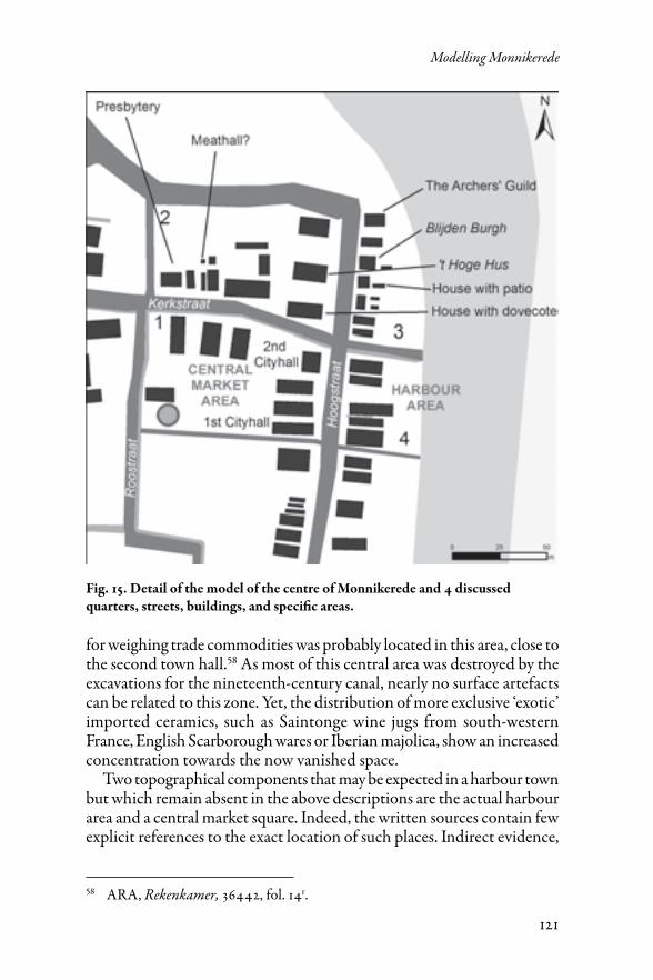
In addition to the above topographical reconstruction, detailed informa-tion from the church registers and urban accounts allowed further spatial characterisation of the town. In particular, the extreme north-east of the town shows a concentration of houses with specific names or functions. This area is structured by the crossroad formed by the Kerkstraat and Hoogstaat and is further defined by smaller, nameless streets (Fig. 15). The four quarters enclosed by these streets formed the town centre and incorporated all the main social, economic, and administrative functions.
48 The basis upon which a house or street was reconstructed (i.e., cartography, land survey register, geophysical, or a combination) is included in the polygon metadata over every element separately. The shape and surface of the reconstructed houses as represented in figures 12 to 15 are an approximation of the area that is being built on within a specific parcel and should not to be considered as exact representations of one single building.
118
Jan Trachet, Ward Leloup, Kristof Dombrecht et al.
Fig. 13. Topographical reconstruction model of Monnikerede c. 1400. The reconstructed houses are an approximation of the area that is being built on within a specific parcel. The shape and surface are not to be considered as exact representations. The same goes for Figures 12, 14, 15, and 16.
119
Modelling Monnikerede
The most important building must have been the town hall, which is most frequently mentioned in the accounts. The original town hall was located in the south of the first quarter but burned down in 1449.49 More than ten years later, in 1461, the urban accounts finally include the purchase and embellishment of a house to serve as the new town hall, a few parcels to the north on the crossroad between the Kerkstraat and the Hoogstraat.50 Just across the Kerkstraat in the second quarter, the 1481
49 In 1462, the account mentions the sale of stones from the town hall twelc tanderen tyden verbernt heeft gheweest (‘which formerly burned down’): ARA, Rekenkamer, 36443, fol. 9r). This probably happened in 1449 since from that year on until 1461, the town’s government annually rented a room from a private burgher for their meetings.
50 In that year, a payment is registered to Vrancke van der Groede van zijnen huse dat burchmeesters ende scepenen tieghen den voorseide Vrancke ghecocht hebben ter voorseide stede van Muenekereede bouf. (‘for his house that the mayors and aldermen bought of him in aid of the city of Monnikerede’: ARA, Rekenkamer, 36442, fol. 7v). That this house was to serve as the new town hall is clear because wine was bought to confirm the agreement als der steden huus ghecocht was (‘when the town hall was purchased’): ARA, Rekenkamer, 36442, fol. 14r). In the following years, several repairs to this new town hall are mentioned in the urban accounts.
Fig. 14. Step 4 reconstruction with the integration of the archaeological survey data.
120
Jan Trachet, Ward Leloup, Kristof Dombrecht et al.
rent register mentions a house with a duvecote (‘dovecote’), which was a status symbol.51 The ommeloper of 1594 describes that same parcel as the allotment where Thooge Hus (‘The High House’) once stood and refers to the area at the north end of the Hoogstraat as Monnikerede-Boven (‘Upper-Monnikerede’).52 In addition, three parcels to the west of this quarter, we find a house described as presbytery, where the parish priest of Oostkerke lived from the middle of the fifteenth century onwards. The upper-class character of this area is further established if we cross the Hoogstraat to the east into the third quarter. In 1481, this area of former tideland was subdivided into at least six separate parcels, of which one was named Blijdenbuerch (‘Jolly Castle’), while another comprised a love (‘vestibule or penthouse’), and a third belonged to Damme’s Sint-Joris Gilde (the archers’ guild).53
Finally, south of the extended Kerkstraat and still east of the Hoogstraat is the fourth quarter, which seems to have had a more harbour-related character. The oldest attestations of habitation on this former tideland date back to 1417. For example, the parcel facing the original town hall across the Hoogstraat was rented by the Prop family between 1417 and 1457. Ecbaerd Prop was a wealthy burgher of Monnikerede and leased beer assizes in 1405 and 1409. His son, Christoffels, was entitled a meester (‘master’) indicating that he had a university education. He leased the assizes on flour and wine on repeated occasions, traded in madder, and held office as an alderman of Monnikerede multiple times.54 The neigh-bouring parcel, facing the second town hall, was rented from 1418 to 1422 by a certain Pauwels den Oosterlinck (‘from the east’), a person about whom we do not have any further information, but whose last name possibly suggests a Hanseatic origin.55 Another tenant of this parcel, Romboud de Wachter, was a notable with connections to the Burgundian court and played an important role in the regaining of the staple of the dried fish after the Bruges Uprising.56 A final attestation of the parcel dates from 1554, and reports that the place was used for drying fishing nets.57 A scale
51 Frederik Buylaert and others, ‘The Van Pottelsberghe-Van Steelant Memorial by Gerard Horenbout: Lordship, piety and mortality in early sixteenth-century Flanders’, Zeitschrift für Kunstgeschichte, 77 (2014), 491–516, esp. 509.
52 RAB, Mestdagh, 958: fol. 4r.53 GSB, Spermalie, fols 5r and 6v.54 e.g., ARA, Rekenkamer, 36403, fol. 3r (1417) and 36419, fols 2r and 4v (1438).55 e.g., ARA, Rekenkamer, 36404, fol. 4r (1418). The term Oosterling was often
used to indicate German or Hanseatic traders.56 e.g., ARA, Rekenkamer, 36431, passim (1450) and 36432, fol. 5v and 9v (1451).57 RAB, Kerkfabriek Oostkerke (Damme), 1, fol. 18r.
121
Modelling Monnikerede
for weighing trade commodities was probably located in this area, close to the second town hall.58 As most of this central area was destroyed by the excavations for the nineteenth-century canal, nearly no surface artefacts can be related to this zone. Yet, the distribution of more exclusive ‘exotic’ imported ceramics, such as Saintonge wine jugs from south-western France, English Scarborough wares or Iberian majolica, show an increased concentration towards the now vanished space.
Two topographical components that may be expected in a harbour town but which remain absent in the above descriptions are the actual harbour area and a central market square. Indeed, the written sources contain few explicit references to the exact location of such places. Indirect evidence,
58 ARA, Rekenkamer, 36442, fol. 14r.
Fig. 15. Detail of the model of the centre of Monnikerede and 4 discussed quarters, streets, buildings, and specific areas.
122
Jan Trachet, Ward Leloup, Kristof Dombrecht et al.
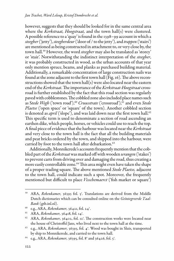
however, suggests that they should be looked for in the same central area where the Kerkstraat, Hoogstraat, and the town hall(s) were clustered. A possible reference to a ‘quay’ is found in the 1398–99 account in which a steegher (‘jetty’), steegherdeur (‘door of / to the jetty’), and trappen (‘stairs’) are mentioned as being constructed in attachment to, or very close by, the town hall.59 However, the word steegher may also be translated as ‘storey’ or ‘stair’. Notwithstanding the indistinct interpretation of the steegher, it was probably constructed in wood, as the urban accounts of that year only mention spruce, beams, and planks as purchased building material. Additionally, a remarkable concentration of large construction nails was found at the zone adjacent to the first town hall (Fig. 16). The above recon-structions showed that the town hall(s) were also located near the eastern end of the Kerkstraat. The importance of the Kerkstraat-Hoogstraat cross-road is further established by the fact that this road section was regularly paved with cobblestones. The cobbled zone also included place names such as Stede Wegh (‘town road’),60 Cruusstrate (‘crossroad’),61 and even Stede Plaetse (‘open space’ or ‘square’ of the town). Another cobbled section is denoted as april (‘slope’), and was laid down near the first town hall.62 This specific term is used to denominate a section of road ascending an earthen dike, which people, horses, or vehicles could use to reach the top. A final piece of evidence that the harbour was located near the Kerkstraat and very close to the town hall is the fact that all the building materials and peat bricks ordered by the town, and shipped into the harbour, were carried by foot to the town hall after debarkation.63
Additionally, Monnikerede’s accounts frequently mention that the cob-bled part of the Kerkstraat was marked off with wooden wrangen (‘stakes’) to prevent carts from driving over and damaging the road, thus creating a more easily controllable zone.64 This area might even have taken the shape of a proper trading square. The above mentioned Stede Plaetse, adjacent to the town hall, could indicate such a spot. Moreover, the frequently mentioned but difficult to place Visschemaerct (‘fish market or square’)
59 ARA, Rekenkamer, 36393 fol. 5r. Translations are derived from the Middle Dutch dictionaries which can be consulted online on the Geïntegreerde Taal-Bank (gtb.inl.nl).
60 e.g., ARA, Rekenkamer, 36421, fol. 24v.61 ARA, Rekenkamer, 36418, fol. 14r.62 ARA, Rekenkamer, 36402, fol. 12r. The construction works were located near
the house of Christoffel Jans, who lived next to the town hall at the time.63 e.g., ARA, Rekenkamer, 36393, fol. 4v. Wood was bought in Sluis, transported
by ship to Monnikerede, and carried to the town hall.64 e.g., ARA, Rekenkamer, 36395, fol. 8v and 36426, fol. 5r.
123
Modelling Monnikerede
could have been located here as well.65 Such a pedestrian zone close by the harbour, the town hall, and the scales could well have been the location of this Visschemaerct. The Vleeschuus (‘Meat Hall’) was probably also located near this square, as the town paid to repave the street between this building and the Cruusstraat.66 Finally, the stede waterscip and drincpit (‘well’) was behind the original town hall and surrounded by pavement too,67 which supports the hypothesis that there was an open and accessible square-like communal place in this area. Taking all of the evidence into consideration, the cobbled zone around the town hall, near the crossing of the Kerkstraat and Hoogstraat, probably served as the vital hub between water and land transport, accommodating mooring, unloading, weighing, storing, and trading of commodities such as dried fish.
The town of Monnikerede was part of the parish of Oostkerke, from which the church was located only a few hundred meters to the west of the town centre. Nevertheless, as we have seen, Monnikerede had a presbytery north of the Kerkstraat, a house where the priest of Oostkerke lived from the middle of the fifteenth century onwards.68 Occasionally, religious cel-ebrations took place in Monnikerede itself too. The urban accounts, for example, mention a chapel from 1466 onwards, which was located on a
65 Although the sources are unclear whether the Visschemaerct should be interpreted as a physical location or merely as an indication of where fish trading was taking place, we assume the former is correct.
66 The meat hall is mentioned for the first time in 1401 (ARA, Rekenkamer, 36393, fol. 2r); for the repaving see ARA, Rekenkamer, 36418, fol. 14r.
67 ARA, Rekenkamer, 36395, fol. 8v.68 De Smet, Verdwenen zeestad, p. 3; De Keyser, ‘De Kapel’.
Fig. 16. Drawings of a selection of the medieval nails found at Monnikerede (right) with red indications of their find locations (left).
124
Jan Trachet, Ward Leloup, Kristof Dombrecht et al.
small parcel across from town halls.69 The church register from 1481 men-tions a pasture west of the Hoogstraat that was used for preaching during the week before Easter (probably by itinerant members of the mendicant orders, as was usual in Flemish towns),70 whereas the accounts of 1484 speak of a mass being celebrated in the town hall.71 Another religious institution concerned the Godskameren (almshouses) and was located on a small parcel at the far western side of the town, near the border with Oostkerke. These buildings housed the poor and needy and were run by the parish poor table of Oostkerke. The buildings consisted of three to five separate houses or rooms and were already mentioned in the first preserved rent register of 1449. As the parcel was owned by an Oostkerke-based institution, it outlived Monnikerede and was occupied off and on until the middle of the nineteenth century.72 Also this zone’s surface ceramics were notably younger than those found in the parcels more to the east.
Discussion
The aim of this article was to integrate archaeological and written sources in order to reconstruct the morphology and the socio-economic topogra-phy of the townscape of the medieval lost harbour site of Monnikerede. Detailed and overarching GIS-integration of a wide variety of sources has proven to be a highly successful methodology at this site. Cartographic and protocadastral sources formed the spatial and temporal framework for this study. The missing link in integrating these sources was found in a detailed micro-scale map that combined visual representation of the plots and numerical addition of the surface. The church rent registers were less site-covering, yet contained more detailed topographical information that allowed for the extension of the framework both spatially and temporally. The entries regarding property within the town accounts only described a small percentage of the parcels, yet their annual regularity and early attestations proved valuable to acquire a systematic view back into the late fourteenth century. The combination of these written sources thus allowed a near complete reconstruction of the port town over seven dif-ferent periods, from 1449 to 1854, to the level of the parcel. In addition,
69 Joseph De Smet, ‘Op en rond het Zwin in de XIVe eeuw’, Rond de Poldertorens, 4 (1960), 29. The chapel was consecrated in 1466 on Saint-Catherine’s Day (ARA, Rekenkamer, 36447, fol. 8v and 10r). On this day in subsequent years, a mass was sung in the chapel (e.g., ARA, Rekenkamer, 36461, fol. 9r).
70 The so-called preekweide (‘preach pasture’) GSB, Spermalie: fols 5r and 6v.71 ARA, Rekenkamer, 36464, fol. 4r.72 De Keyser, ‘De vijf Godskameren’, 90–91.
125
Modelling Monnikerede
the archaeological data were highly complementary as they informed us about the surface artefacts, the surface microtopography, and subsurface anomalies as well. The geophysical and UAV-survey provided intra-parcel information that allowed for the identification of separate building blocks and thus added further detail to the spatial framework. Finally, the fieldwalking survey covered both the spatial and temporal evolution of the site and added insight into its material culture. The final result is a model of the site around 1400 on the level of separate buildings and the topographical evolution it underwent in the following centuries.
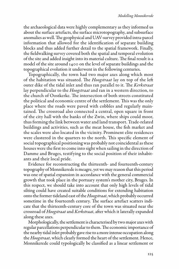
Topographically, the town had two major axes along which most of the habitation was situated. The Hoogstraat lay on top of the left outer dike of the tidal inlet and thus ran parallel to it. The Kerkstraat lay perpendicular to the Hoogstraat and ran in a western direction, to the church of Oostkerke. The intersection of both streets constituted the political and economic centre of the settlement. This was the only place where the roads were paved with cobbles and regularly main-tained. The crossroad also connected a central, open square in front of the city hall with the banks of the Zwin, where ships could moor, thus forming the link between water and land transport. Trade-related buildings and activities, such as the meat house, the fish market and the scales were also located in the vicinity. Prominent elite residences were clustered in the quarters to the north. This specific element of social topographical positioning was probably not coincidental as these houses were the first to come into sight when sailing in the direction of Damme and Bruges, testifying to the social position of their inhabit-ants and their local pride.
Evidence for reconstructing the thirteenth- and fourteenth-century topography of Monnikerede is meagre, yet we may reason that this period was one of spatial expansion in accordance with the general commercial growth that took place in the portuary system’s mother city, Bruges. In this respect, we should take into account that only high levels of tidal silting could have created suitable conditions for extending habitation onto the former tideland east of the Hoogstraat, which probably occurred sometime in the fourteenth century. The surface artefact scatters indi-cate that the thirteenth-century core of the town was situated near the crossroad of Hoogstraat and Kerkstraat, after which it laterally expanded along these axes.
Morphologically, the settlement is characterised by two major axes with regular parcellations perpendicular to them. The economic importance of the nearby tidal inlet probably gave rise to a more intense occupation along the Hoogstraat, which clearly formed the heart of the settlement. Hence, Monnikerede could typologically be classified as a linear settlement or
126
Jan Trachet, Ward Leloup, Kristof Dombrecht et al.
row village, and more precisely, a so-called dijkdorp (‘dike-village’).73 Although the linear form of occupation seems a natural way of occupying the boards of waterways, the linearity of such settlements could also attest to the systematically planned colonisation of a certain area or landscape. Historically, this process of systematic exploitation can be linked to the increasing focus on the coastal area by the Flemish Counts and the Cistercian abbeys in the mid-twelfth century.74
The demographical evolution and high density of habitation that were attested by the socio-economic study of Monnikerede was spatially confirmed by the integration of survey data. Both the ommeloper-land surveys and the geophysical data showed dense habitation, especially near the two main streets and the probable harbour area. The reconstructions show that, once the demographical decline set in, the habitation slowly reoriented westwards to Oostkerke while the centre of Monnikerede was gradually deserted. Finally, the construction of the Damse Vaart in the early nineteenth century destroyed the town’s centre, disconnected the medieval substrate from the modern landscape, and fossilized the already disused street network into an unusable landscape artefact.
It is difficult to establish a relationship between specific events such as tidal silting, economic recession, or warfare to the topographical evolution, yet the different time slices appear to concur with the economic, political, and environmental trends in the downfall of Monnikerede. Associating surface artefacts with the historical parcels is not straightforward, as the interplay between depositional and post-depositional processes could obscure the archaeological record. Nevertheless, detailed registration of the surface artefacts proved that the spatial relation with both the subsoil anomalies and the medieval topography is remarkably well preserved.
However, direct attestations of harbour facilities in Monnikerede are scarce. Only the urban accounts of the year 1398 mention the construction of a steegher. A recently found second attestation of steegher in neighbour-ing deserted harbour of Hoeke is clearly that of a mooring structure, leaving little doubt about the interpretation in Monnikerede. Other references to a place where ships could moor are all indirect. Moreover, this area was heavily affected by the construction of two canals that hampered both the geophysical and the archaeological surveys. As a consequence, a more detailed characterisation of the morphology of the harbour facilities is
73 Following the morphological settlement typology from Marc Antrop, Perspectieven op het landschap: Achtergronden om landschappen te lezen en te begrijpen (Ghent: Academia Press, 2007), pp. 103–05.
74 Adriaan Verhulst, Landschap en landbouw in middeleeuws Vlaanderen (Brussels: Gemeentekrediet van België, 1995), pp. 130–33.
127
Modelling Monnikerede
still lacking. Indeed, the lack of direct evidence pointing to a harbour area made it necessary to take into account more indirect evidence of port activities by simply looking at the urban topography. In his overview of port topographies in Denmark, Jan Bill posited that the specific economic functions of harbours result in a specific topography, not only of water-front morphology, but also of the configuration of streets. His topographic analysis of Danish harbours shows marked similarities with the topog-raphy of Monnikerede. Here too, waterfronts often functioned without large scale mooring installations. In addition, the mainland topography of harbours generally consisted of two main axes: one running parallel to the waterline, while another short street ran perpendicular to it and closely connected a central square with the mooring point. Moreover, this perpendicular street often linked up to the wider road system.75
Another topographic element that was characteristic of tidal harbours can be found in the gradual reclamation of accreted tidal land. Combined historical and archaeological research on the medieval harbour of King’s Lynn, for example, demonstrated that accreted tidal lands in King’s Lynn soon developed from simple wharves to the place where merchants had their dwellings, warehouses, and private quays.76 This gradual extension of the waterfront in the direction of a tidal river is a process that has been frequently observed in harbours in the medieval North Sea area.77
When we consider the harbour of Monnikerede within its place in Bruges’ portuary system, a limited harbour infrastructure does indeed seem plausible. Both economically and politically, Monnikerede and its neighbouring left-bank outports of Hoeke and Mude only played minor roles in the port network, being heavily dependent upon the privileges
75 Jan Bill, ‘Port topography in medieval Denmark’, in Maritime topography and the medieval town. Papers from the 5th international conference on waterfront archaeology in Copenhagen, 14–16 May 1998, ed. by Jan Bill and Birthe Lundetoft Clausen (Copenhagen: The National Museum of Denmark, 1999), pp. 251–61.
76 Helen Clarke, ‘The medieval waterfront of King’s Lynn’, in Waterfront archaeology in Britain and Northern Europe, ed. by Gustav Milne and Brian Hobley (London: Council for British Archaeology, 1981), pp. 132–35.
77 Gustav Milne, ‘Medieval riverfront reclamation in London’, in Waterfront archaeology in Britain and Northern Europe, p. 32; Axel Christophersen, ‘The waterfront and beyond. Commercial activity and the making of townscapes’, in Maritime topography and the medieval town, p. 164; Richard W. Unger, ‘Investment and risk: Ship design and investment in port infrastructure, 1200–1800’, in Richezza del mare, ricchezza dal mare. Secc. XIII–XVIII. Atti della “Trentasettisima di Studi”, 11–15 aprile 2005, ed. by Simonetta Cavaciocchi (Florence: Le Monier, 2006), pp. 317–42 (p. 322).
128
Jan Trachet, Ward Leloup, Kristof Dombrecht et al.
they received from the city of Bruges and the Count of Flanders. Not allowing extensive port infrastructure might have been a way to impede the autonomy of the outports and thus keep them under control. In 1266, for example, Countess Margareta commanded that a navigable waterway near Monnikerede had to be blocked off, as the city of Damme considered the waterway a threat to its own prosperity.78
Indeed, the two major outports of Damme and Sluis were the more privileged towns in the portuary network. Due to its initial advantageous position at the head of the tidal inlet, the harbour of Damme functioned as the primus inter pares among the outports, and had more extensive port infrastructure, including quays and a crane, which were all possessed and maintained by the city of Bruges.79 When silting of the inlet advanced, the most favourable trading location shifted to the mouth of the inlet, where Sluis soon became the only deep-water harbour in the Zwin area. Moreover, Sluis was located the furthest away from Bruges and succeeded in steering a more autonomous course. Their autonomy was aided by the Count of Flanders, who often supported the city as part of his geopolitical struggles with the rebellious city of Bruges. This allowed Sluis to develop an elaborate port infrastructure despite Bruges’ grievances.
From a methodological point of view, the results from this interdis-ciplinary research in Monnikerede surpassed expectations. In particular, we had not anticipated the possibility of integrating town accounts and rent registers into the ommeloper reconstructions. In fact, the underly-ing GIS-database was too basic for the depth of information that could be derived from the urban accounts. Only the final stage of processing revealed the micro-scale potential of the research. Considering the pos-sibility of further interdisciplinary topographical studies in Monnikerede or elsewhere, we believe that more complex relational databases could optimize the integration of written and archaeological sources.
Although such optimisation could have improved the level of detail in our description of Monnikerede, it would not have taken us further back in time. The available sources provide a great deal of information on the fifteenth- and sixteenth-century decline of the harbour, yet Monnikerede’s thirteenth-century expansion and fourteenth-century heyday remain mostly invisible. A second limitation is the characterisation of the water-front. Whereas sources describe the landward topography of the harbour in much detail, they are largely silent about the port infrastructure outside
78 Leopold August Warnkönig, Flandrische Staats- und Rechtsgeschichte bis zum Jahr 1305, II, 2 (Tübingen: Ludw. Friedr. Fues, 1837), p. 16.
79 Marc Dewilde, ‘In de put te Damme’, Archaeologia Mediaevalis, 17 (1994), 52–54.
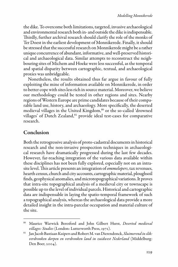
129
Modelling Monnikerede
the dike. To overcome both limitations, targeted, invasive archaeological and environmental research both in- and outside the dike is indispensable. Thirdly, further archival research should clarify the role of the monks of Ter Doest in the earliest development of Monnikerede. Finally, it should be stressed that the successful research on Monnikerede might be a rather unique concurrence of abundant, informative, and well-preserved histori-cal and archaeological data. Similar attempts to reconstruct the neigh-bouring sites of Michem and Hoeke were less successful, as the temporal and spatial disparity between cartographic, textual, and archaeological proxies was unbridgeable.
Nonetheless, the results obtained thus far argue in favour of fully exploiting the mine of information available on Monnikerede, in order to better cope with sites less rich in source material. Moreover, we believe our methodology could be tested in other regions and sites. Nearby regions of Western Europe are prime candidates because of their compa-rable land use, history, and archaeology. More specifically, the deserted medieval villages in the United Kingdom,80 or the so-called ‘drowned villages’ of Dutch Zealand,81 provide ideal test-cases for comparative research.
Conclusion
Both the retrogressive analysis of proto-cadastral documents in historical research and the non-invasive prospection techniques in archaeologi-cal research have dramatically progressed during the last few decades. However, far-reaching integration of the various data available within these disciplines has not been fully explored, especially not on an intra-site level. This article presents an integration of ommelopers, tax revenues, hearth census, church and city accounts, cartographic material, ploughsoil finds, geophysical anomalies, and microtopographical variations. It proves that intra-site topographical analysis of a medieval city or townscape is possible up to the level of individual parcels. Historical and cartographic data are indispensable in laying the spatio-temporal framework of such a topographical analysis, whereas the archaeological data provide a more detailed insight in the intra-parcelar occupation and material culture of the site.
80 Maurice Warwick Beresford and John Gilbert Hurst, Deserted medieval villages: Studies (London: Lutterworth Press, 1972).
81 Jan Jacob Bastiaan Kuipers and Robert M. van Dierendonck, Sluimerend in slik: verdronken dorpen en verdronken land in zuidwest Nederland (Middelburg: Den Boer, 2004).
130
Jan Trachet, Ward Leloup, Kristof Dombrecht et al.
The interdisciplinary research in Monnikerede allowed for the recon-struction of the topography of the late medieval harbour town near its heyday. We linked the particular lay-out of the streets, market, and buildings to their specific harbour-related activities, a methodology that enabled us to establish a social topography. Moreover, the near contiguous sequence of (proto-)cadastral information afforded us the opportunity to topographically reconstruct and visualise the degeneration of the urban fabric, and to relate economic, political, and environmental events to Monnikerede’s decline.