Embed Size (px)
Citation preview
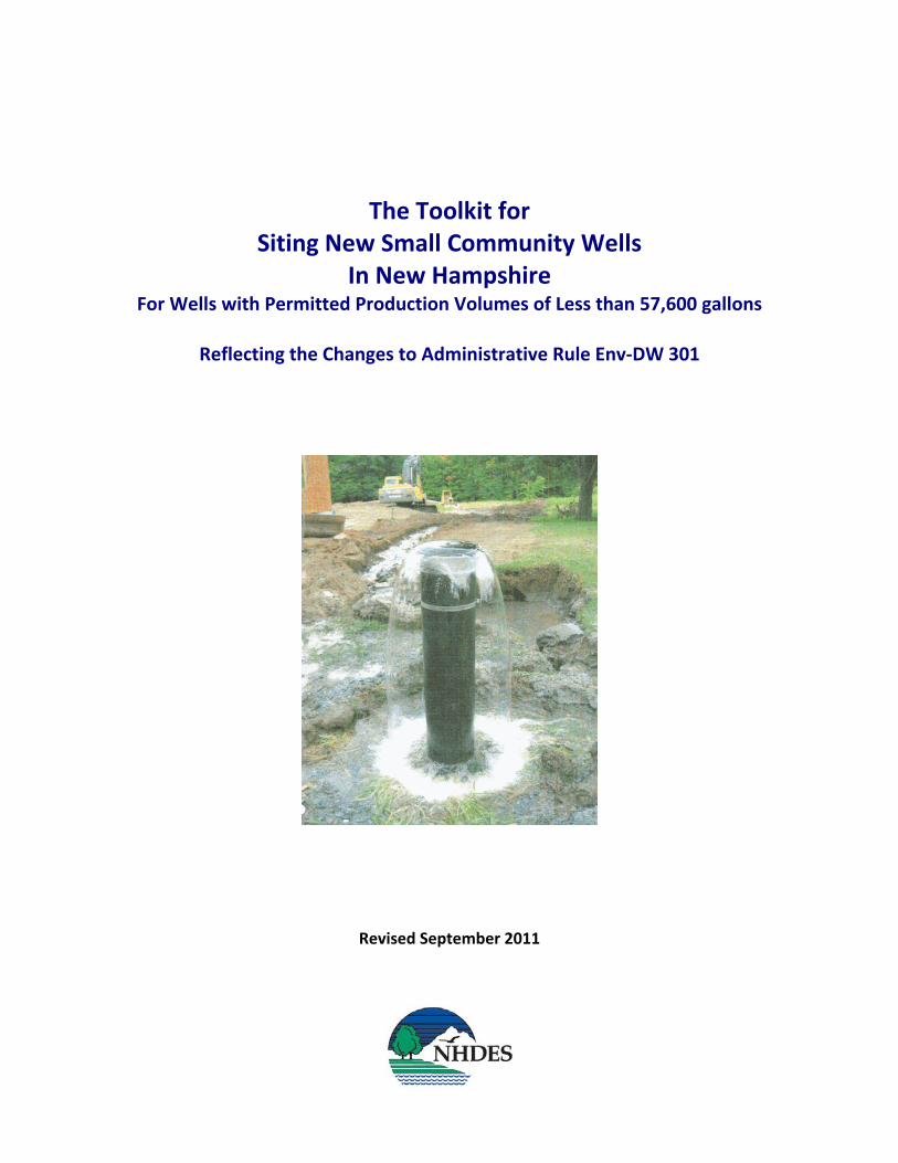
The Toolkit for Siting New Small Community Wells
In New Hampshire For Wells with Permitted Production Volumes of Less than 57,600 gallons
Reflecting the Changes to Administrative Rule Env‐DW 301
Revised September 2011
DES‐WD‐09‐19
The Toolkit for
Siting New Small Community Wells
In New Hampshire
For Wells with Permitted Production Volumes of Less than 57,600 gallons
Reflecting the Changes to Administrative Rule Env‐Dw 301
Revised September 2011
Prepared by
The New Hampshire Department of Environmental Services Water Division, Drinking Water and Groundwater Bureau
29 Hazen Drive; PO Box 95 Concord, NH 03302‐0095
(603) 271‐2947 www.des.nh.gov
Thomas S. Burack, Commissioner
Harry T. Stewart, Director Water Division
Table of Contents
Introduction.............................................................................................................................. 2 Part I: New Community Well Siting Process Chart for Siting Small Community Wells ..................................................................... 2 A. Select a Site and Gather Preliminary Information................................................................ 2 Standard Pumping Test Requirements ..................................................................................... 6 B. Water Conservation Plan...................................................................................................... 6 C. Complete Preliminary Report Activities ............................................................................... 7 D. Obtain Preliminary Report Approval .................................................................................... 8 E. Perform the Constant Rate Pumping Test and Water Quality Sampling.............................. 8 F. Complete Final Report Activities........................................................................................... 8 G. Obtain Final Report Approval ............................................................................................. 10 H. Connecting the New Well to the System and Chemical Monitoring ................................. 10 Part II: Replacement, Regaining Lost Capacity and Special Cases A. Replacement Wells ............................................................................................................. 11 C. Regaining Lost Capacity by Deepening or Hydrofracture................................................... 13 C. Special Cases ....................................................................................................................... 13 Part III: The Tools ................................................................................................................... 15 A. Sample Easement Language ............................................................................................... 16 B. Wellhead Protection Program Educational Mailings.......................................................... 17 C. File Review Guide and Worksheet...................................................................................... 28 D. Windshield Survey Guide and Worksheet.......................................................................... 36 E. Potential Contamination Source List .................................................................................. 41 F. Impact Assessment Guide................................................................................................... 42 G. How to Access the FIRMette tool on the FEMA website ................................................... 47
1
Introduction This document was prepared to assist the applicant in obtaining approval for siting new small community water system wells in New Hampshire, with emphasis on the changes since October 2007 to Administrative Rule Env‐Dw 301, Small Production Wells for Small Community Water Systems. Under these rules, small wells are those with permitted production volumes less than 57,600 gallons. Community water systems are public water systems that serve at least 15 service connections or at least 25 year‐round residents. Also, any development with three or more separate sources where each source serves less than ten households is considered a community water system in New Hampshire as long as the total number of households served by the multiple sources ex‐ceeds ten. [Env‐Ws 372.02(j)] The siting of large production wells (i.e., those permitted to pump 57,600 gallons or more in a 24‐hour period from a single well or multiple hydraulically connected wells) for community wa‐ter systems is subject to Env‐Dw 302, Large Production Wells for Community Water Systems, and Env‐Wq 403, Large Groundwater Withdrawals. If you are siting a large production well for a community water system, contact DES at (603) 271‐8866 for more information. Please note that water conservation plans, pursuant to Env‐Wq 2101, Water Conservation, must be submitted and approved before preliminary well siting approval will be granted. See Part 1. B. Water Conservation Plan for further guidance. ► Be advised that connection of an unapproved source to a community water system consti‐tutes a Class B felony under New Hampshire law.
Part I: New Community Well Siting This section outlines the steps for siting new small community wells. Please refer to the Small Community Well Siting Report Forms for guidance on submitting reports. The toolkit also con‐tains useful information that may help to complete an application. The report forms and other documents mentioned in this guide are online, unless otherwise noted, at www.des.nh.gov and then clicking on “Community Well Sitings” on the “A to Z LIST” located on the upper right‐hand corner under the photos. These documents are also available from the DES Public Information Center, (603) 271‐2975 or [email protected]. The process is outlined on the following page, and is provided in greater detail on the pages fol‐lowing the outline.
2
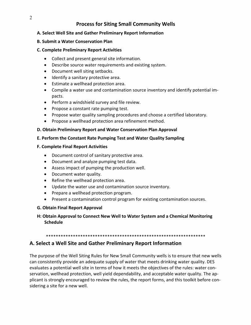
Process for Siting Small Community Wells
A. Select Well Site and Gather Preliminary Report Information
B. Submit a Water Conservation Plan
C. Complete Preliminary Report Activities
Collect and present general site information.
Describe source water requirements and existing system.
Document well siting setbacks.
Identify a sanitary protective area.
Estimate a wellhead protection area.
Compile a water use and contamination source inventory and identify potential im‐pacts.
Perform a windshield survey and file review.
Propose a constant rate pumping test.
Propose water quality sampling procedures and choose a certified laboratory.
Propose a wellhead protection area refinement method.
D. Obtain Preliminary Report and Water Conservation Plan Approval
E. Perform the Constant Rate Pumping Test and Water Quality Sampling
F. Complete Final Report Activities
Document control of sanitary protective area.
Document and analyze pumping test data.
Assess impact of pumping the production well.
Document water quality.
Refine the wellhead protection area.
Update the water use and contamination source inventory.
Prepare a wellhead protection program.
Present a contamination control program for existing contamination sources.
G. Obtain Final Report Approval
H: Obtain Approval to Connect New Well to Water System and a Chemical Monitoring Schedule
*****************************************************************
A. Select a Well Site and Gather Preliminary Report Information The purpose of the Well Siting Rules for New Small Community wells is to ensure that new wells can consistently provide an adequate supply of water that meets drinking water quality. DES evaluates a potential well site in terms of how it meets the objectives of the rules: water con‐servation, wellhead protection, well yield dependability, and acceptable water quality. The ap‐plicant is strongly encouraged to review the rules, the report forms, and this toolkit before con‐sidering a site for a new well.
3
Who can Prepare a New Small Well Siting Application? The application must be prepared by a person who by training and experience is familiar with any of the following and holds the license or certification listed in parentheses: Hydrology or geology of drinking water wells (Licensed Professional Geologist or Engineer). Drinking water system design or maintenance (Licensed Professional Engineer or Certified
Water System Operator). Drinking water well construction or maintenance (Licensed Water Well Contractor or Pump
Installer). 1. Selecting a Small Community Well Site: Consider the "Big Four" The rules cover activities performed after selecting a potential well site. Several factors can render a proposed well site unacceptable. The applicant should complete an assessment to identify any items that may disqualify the well site from final approval. DES’s experience has shown that when a proposed new well location does not meet requirements, usually one or more of the “big four” items below were not carefully considered. DES encourages the appli‐cant to request a site visit during the site selection process. Please note that staff cannot choose the well site for the applicant or approve the site before the receipt of the preliminary report. However, DES personnel can point out difficulties that may affect source approval. FIRST. Control of existing contamination sources Applicants are required to delineate a wellhead protection area (WHPA) [Env‐Dw 301.07], which is the area surrounding a well through which contaminants are likely to move toward and reach the well. The WHPA should not be confused with the sanitary protection area (SPA). Only siting new landfills or salvage yards is prohibited in WHPAs. Existing contamination sources lo‐cated near a proposed well site must be outside the SPA and contamination from these facili‐ties must not reach the well. The rules require that an applicant have adequate knowledge about, and demonstrate control of, existing contamination sources. Known contamination sources are identified and evaluated by the Source Water Hazard Inventory. [See the “Prelimi‐nary Report Form,” Section B, page 1, for instructions.] DES cannot approve a well site with a known contamination source located in the WHPA without the implementation of an accept‐able control program. In most instances such a control program is already in place through the DES Waste Management Division. SECOND. Control and maintenance of the sanitary protective area The sanitary protection area is a circle centered on the well, with a fixed radius dependant upon the volume withdrawn from the well. For a small community well the SPA radius will be 150, 175 or 200 feet, depending on the withdrawal volume (Env‐Dw 301.06). Any activity not directly related to the operation and maintenance of the well and the water system is prohibited in the SPA. Pay careful attention to the present and future activities within the SPA of the proposed well when choosing a site.
The water supplier must legally control the land in the SPA. Legal control is commonly by own‐ership, perpetual easement, condominium covenants, or joint use agreement. Any form of legal control is acceptable provided it gives the water system complete jurisdiction over all activities
4
within the SPA. When water system ownership changes, the legal control must remain with the system. [See Part III Section A for a copy of suggested easement language.] To protect the well from contamination the SPA must be maintained in a natural state. No ter‐rain alteration or tree removal is allowed in the SPA except the minimal amount required for well and water system construction and maintenance. Discharging storm water into retention or detention ponds, drainage swales, storm drains, or similar man‐made structures is not al‐lowed in or across an SPA. Only natural drainage is allowed in the SPA. Please note that the DES Alteration of Terrain Bureau will not issue a permit if the application does not meet all Env‐Dw 301 SPA requirements. Final well site approval will not be granted until all sanitary radius re‐quirements are adequately met. THIRD. Setbacks from surface waters and the 100‐year floodplain To avoid groundwater under the direct influence of surface water, the wellhead and pumping station must be set back from surface water and not be subject to flooding. Wells must be sited at least 50 feet from any surface water, including but not limited to streams, ponds, lakes and wetlands that are inundated for at least 30 consecutive days. Groundwater under the direct in‐fluence of surface water may contain disease‐causing viruses and bacteria, or be more vulner‐able to contamination from point or non‐point releases. Any bedrock well located less than 200 feet from a surface water or any overburden well located less than 100 feet from a surface wa‐ter, must be sampled for microscopic particulate analysis (MPA) during the pumping test. [Refer to A Field Guide For Pumping Test Operators, for complete information on MPA sampling re‐quirements.] The well may not be sited within the 100‐year floodplain. If there is no alternative site outside this floodplain, the elevation of the well must be raised so that the well will not be subject to flooding by a 100‐year flood. FOURTH. Adverse Impacts There can be no unmanageable adverse impacts either to or from the new well. Effects due to pumping the well can include an adverse change in water levels in nearby non‐system wells (public or private), a change in water levels in nearby surface waters, migration of a contami‐nated groundwater plume towards the well, saltwater intrusion into the fresh water aquifer, or groundwater under direct influence of surface water. If any adverse impacts occur, well siting approval will not be given until the impact is adequately addressed and an acceptable man‐agement plan is in place. Carefully consider the surrounding water resources when siting a new well. 2. Wellhead Protection A major objective of the Rules is to incorporate wellhead protection into the siting of new small community wells. Wellhead protection is achieved through education and best management practices. It expands the contamination management area beyond the SPA. Unlike the sanitary protection area, the WHPA is not prohibitive. Wellhead protection incorporates a program that encourages all tenants, homeowners, businesses, or industries to avoid activities that may cause the release of pollutants into the groundwater.
5
The applicant must develop a wellhead protection program for the final report. If there are no uncontrolled known contamination sources in the wellhead protection area, the program con‐sists of informational mailings to everyone in the WHPA. [Examples of sample letters and an educational mailing packet can be found in Part III Section B.] Wellhead protection not only pro‐tects the owner’s investment in the well, but may also reduce chemical sampling requirements once the well is operational. Contact DES at (603) 271‐2862 for information on obtaining waiv‐ers for certain chemical sampling requirements. 3. Water System Requirements Env‐Ws 372, Design Standards for Small Community Water Systems, sets community water sys‐tem source capacity requirements. [See the Preliminary Report Form, Section 2.0 and Work‐sheet A, for directions for calculating source capacity.] If in‐ground irrigation is planned, the ex‐pected daily volume must be added to source capacity calculations. The estimate shall reflect system type, total irrigated area, system design components (# of heads, flow rates, etc), and overall system size. The irrigation system designer/contractor should be able to supply this in‐formation. Contact DES staff at (603) 271‐6685 for assistance. “Source capacity” and “permitted production volume” (PPV) are not necessarily the same. Source capacity refers to the water system needs. PPV is the volume of water extracted from a particular well in a 24‐hour period and is demonstrated during the pumping test. PPV is often the maximum volume a well can safely yield. In addition, the pumping test must demonstrate that all the water system wells pumping together can deliver at least the volume necessary to meet source capacity requirements. Therefore, the total PPVs for all the system wells must add up to at least the source capacity. The total PPVs for the wells may exceed the source capacity, but if the total PPV is less than the source capacity, another well(s) must be installed. 4. Well Yield Dependability Under Env‐Dw 301, well testing must address the question: Is there enough good quality water available to meet the water system’s needs under drought and high use conditions? Many older wells experience reduced yields during drought periods because the original pumping test failed to account for this condition. In addition, excessive, uncontrolled or unaccounted for irri‐gation water use wastes and depletes drinking water supplies. Increased withdrawals from other water users tapping the same aquifer may lower the water table. This could reduce the capacity of existing wells. Water shortages place public health at risk. Therefore, the pumping test was designed to conservatively determine the sustainable production volume. Well site approval will not be granted without documentation of an adequate and dependable well yield. The requirements for a standard pumping test are outlined in the table below. A Field Guide For Pumping Test Operators, contains in‐depth guidance for planning and running a pumping test. The guide includes directions for setting up discharge lines, instrumenting the well(s), trouble‐
shooting the test, determining stabilization, and taking water quality and MPA samples.
6
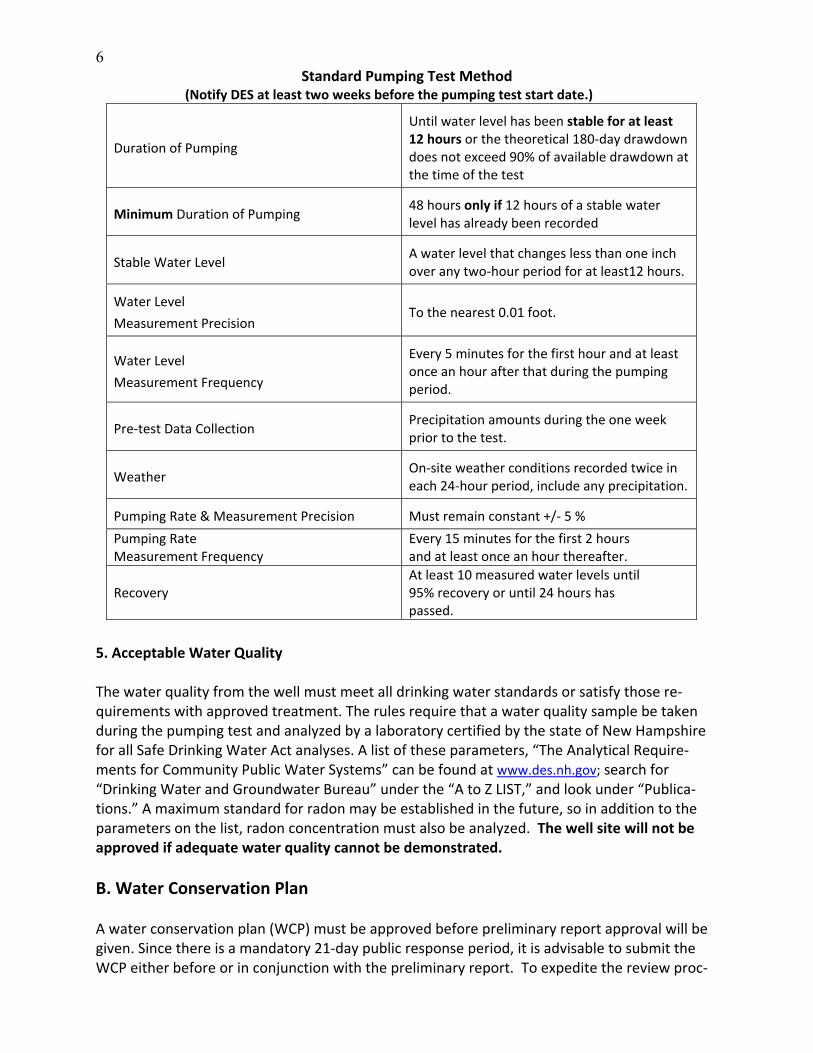
Standard Pumping Test Method (Notify DES at least two weeks before the pumping test start date.)
Duration of Pumping
Until water level has been stable for at least 12 hours or the theoretical 180‐day drawdown does not exceed 90% of available drawdown at the time of the test
Minimum Duration of Pumping
48 hours only if 12 hours of a stable water level has already been recorded
Stable Water Level
A water level that changes less than one inch over any two‐hour period for at least12 hours.
Water Level
Measurement Precision
To the nearest 0.01 foot.
Water Level
Measurement Frequency
Every 5 minutes for the first hour and at least once an hour after that during the pumping period.
Pre‐test Data Collection
Precipitation amounts during the one week prior to the test.
Weather
On‐site weather conditions recorded twice in each 24‐hour period, include any precipitation.
Pumping Rate & Measurement Precision
Must remain constant +/‐ 5 %
Pumping Rate Measurement Frequency
Every 15 minutes for the first 2 hours and at least once an hour thereafter.
Recovery At least 10 measured water levels until 95% recovery or until 24 hours has passed.
5. Acceptable Water Quality The water quality from the well must meet all drinking water standards or satisfy those re‐quirements with approved treatment. The rules require that a water quality sample be taken during the pumping test and analyzed by a laboratory certified by the state of New Hampshire for all Safe Drinking Water Act analyses. A list of these parameters, “The Analytical Require‐ments for Community Public Water Systems” can be found at www.des.nh.gov; search for “Drinking Water and Groundwater Bureau” under the “A to Z LIST,” and look under “Publica‐tions.” A maximum standard for radon may be established in the future, so in addition to the parameters on the list, radon concentration must also be analyzed. The well site will not be approved if adequate water quality cannot be demonstrated.
B. Water Conservation Plan A water conservation plan (WCP) must be approved before preliminary report approval will be given. Since there is a mandatory 21‐day public response period, it is advisable to submit the WCP either before or in conjunction with the preliminary report. To expedite the review proc‐

7
ess, draft the WCP in accordance with the “Water Conservation Plan Guidance Document for Community Water Systems” and refrain from sending copies out for public comment until DES has completed a preliminary review of and commented on the WCP. Submit the WCP directly to the Water Conservation Program, not to the Small Community Well Program. Water conservation rules and the “Water Conservation Plan Guidance Document for Commu‐nity Water Systems“ may be obtained from the DES Public Information Center at (603) 271‐2975 or online at www.des.nh.gov by searching for “Water Conservation” on the “A to Z LIST.” Contact Stacey Herbold at (603) 271‐0659 or at [email protected] for more informa‐tion.
C. Complete Preliminary Report Activities A preliminary report must be completed and approved before conducting a pumping test and preferably before drilling the well(s). In this way, the applicant will avoid spending money on a site that cannot be approved. Contact DES at (603) 271‐2947 for a copy of the report format in MS Word. The applicant is not obligated to use this form, but DES strongly recommends that it be used as a checklist to ensure the report is complete. DES will highlight any missing or incor‐rect information and approval will be withheld until the preliminary report is complete and ac‐curate. A pumping test performed before preliminary approval is granted may be invalid, which then causes a delay in the approval process. Additional Information that Will Help You Complete the Preliminary Report:
Floodplain Elevation and Setbacks Include the current flood hazard boundary map (FHBM), depicting floodplain boundaries and elevations. Be sure to mark the proposed well location on the map. The local municipality should be able to provide a current photocopy of the FHBM. If the town does not have this map or will not allow copying it, you may obtain a "FIRMette," a free printable copy of the section of the FHBM from the FEMA website. [See Section G for steps on accessing the FEMA Flood Map website.] Wetlands Permits. If fill will be used to raise the wellhead and/or pump station above flood elevation, obtain permits through DES Wetlands Bureau. To obtain wetlands permitting infor‐mation call (603) 271‐2147 or email [email protected]. Overburden Wells. Overburden wells require Phase I WHPA delineation. This may mean collect‐ing additional hydrogeologic data during the pumping test. Contact DES staff at (603) 271‐2947 or [email protected] for guidance on Phase I delineation. MPA Sampling. If an MPA is required, contact DES at (603) 271‐2947 for a list of laboratories that perform the analysis and provide the necessary equipment for collecting the samples. Submit the preliminary report to:
Small Community Well Siting Program DES Drinking Water and Groundwater Bureau 29 Hazen Drive; PO Box 95 Concord NH 03302‐0095
8
D. Obtain Preliminary Report Approval If necessary, DES will contact the applicant during the review to discuss the preliminary pro‐posal. The applicant will be notified in writing within 30 days of the receipt of the preliminary report as to whether or not the report is approved. Preliminary report approval expires within four years of the approval date if no final report is received.
E. Install Well, Perform Constant Rate Pumping Test and Water Quality Sampling New community well must be installed in accordance with We 600‐800, New Hampshire Water Well Board rules. These rules include a requirement for grouting the casing of bedrock wells. The constant rate pumping test and water quality sampling proposed in the preliminary report should be performed after receiving written preliminary report approval from DES. Before mak‐ing any changes to the approved testing program, contact DES at (603) 271‐2947. Notify DES at least 10 business days before the start of the pumping test. A staff member will attend the test. A Field Guide For Pumping Test Operators includes a sample pumping test log. Feel free to copy it. The pumping test operator does not have to follow this format but should include all the in‐formation listed in the sample log on the log submitted to DES. Remember to record cumulative meter readings and all recovery data. Submit a copy of the original well log and a copy of the well completion report with the final report. If a data‐logger was used, include all reference elevations, including depth of deployment. Water quality sampling should be done very carefully. Refer to "How to Take Chemical Monitor‐ing Samples" found in the pumping test guide, for the proper methods of sampling all the re‐quired Safe Drinking Water Act (SDWA) parameters. Refer to the “Guidance for Reporting SDWA Analysis,” also found in the pumping test guide, for a listing of all parameters that must be sampled during the pumping test.
F. Complete Final Report Activities A final report must be approved before the well may be connected to the community water system. Contact DES at (603) 271‐2947 for a copy of the report format in MS Word. The appli‐cant does not have to use this form but DES recommends it be used as a checklist. Additional Information for Completing the Final Report 1. Document Control of Sanitary Protective Area
Provide legal documentation of SPA control, such as copies of recorded easements, deeds, con‐dominium covenants, or joint use agreements. Unrecorded copies are unacceptable since they are not legally binding.
9
2. Assess the Sustainable Yield of the Well Document and analyze the pumping test data. [See the “Final Report Form,” Section 3.0, for assistance in reporting and analyzing pumping test data.] Please remember that at least 10 re‐covery water level measurements must be reported. These measurements should have been taken over a 24‐hour period or until 95 percent recovery occurred, whichever is shorter. Assess and document the sustainable yield of the well. The 180‐day theoretical drawdown is a tool in this assessment process. Provide any additional information including all calculations and computer modeling used for the assessment. [See guidance on estimating a 180‐day theo‐retical drawdown in “A Field Guide For Pumping Test Operators.”] 3. Assess the Impacts of Pumping the Production Well Use Section 3.11 of the “Final Report Form” as a guide to document the impacts of pumping the well. If impacts occurred, a management plan must be proposed. Include all pertinent water level measurements and supporting data in the plan. [See the impact guide located in Part III Section F for guidance on assessing impacts to and from the production well.] 4. Document Water Quality Use Section 4.0 of the “Final Report Form” to document water quality, or as a guide for submit‐ting this material. If water derived from the well exhibits natural substances that exceed groundwater standards, the final report must include a brief description of the proposed treat‐ment program for the detected substance. Detections of naturally occurring substances, such as iron or manganese, above allowable drinking water concentrations, require treatment to bring water quality within acceptable lim‐its. Certain naturally occurring substances that pose a health risk to consumers, like arsenic or uranium, require specialized treatment and may require additional water quality analysis to de‐termine the appropriate treatment method. Contact the Drinking Water and Groundwater Bu‐reau at (603) 271‐2513 or [email protected] for direction to the appropriate staff member who can address treatment options and provide treatment system approval. If water derived from a well exhibits contamination from human activities or artificial sources, it will not be approved by DES. Detections of substances that are not naturally occurring indicate an existing contamination source. Until the contamination source is characterized and under control, the well site will not be approved. This applies even if the water can be treated to re‐move the detected compounds. It is not possible to ensure effective treatment until the nature and extent of the contamination is understood. The final report should include a contamination source control program, if necessary. 5. Wellhead Protection Program Use Section 5.0 of the “Final Report Form” to present the Wellhead Protection Program, or as a guide for submitting these materials.

10
If an active, known, contamination source exists in the WHPA, the applicant must perform a complete review of all DES Waste Management Division files relating to the site. Using the in‐formation gleaned from those files, pumping test and water quality data, and geology of the well site, the applicant must propose a contamination control plan. The plan may propose, but not be limited to, frequent water quality sampling and analysis, placement of monitoring wells between the contamination source and the well, alternate well sites, and/or treatment meth‐ods. The plan must demonstrate that the contamination is unlikely to reach the production well, but if it does it can be managed so that water meeting acceptable drinking water stan‐dards will continue to be provided to the water system.
G. Obtain Final Report Approval Submit the final report to:
Small Community Well Siting Program DES Drinking Water and Groundwater Bureau 29 Hazen Drive; PO Box 95 Concord NH 03302‐0095
If necessary, DES will contact the applicant during the review to discuss the final report. The applicant will be notified in writing within 30 days of the receipt of the completed, final report as to whether or not the report has been approved. Final well siting approval expires within four years of the approval date if the well is not connected to a water system.
H. Connect New Well to Community System; Sign Up For Chemical Monitoring Schedule Only after receipt of written well siting approval, may the new well be connected to an existing community system. The connection requirements for new wells on existing systems are as fol‐lows.
At least 12 inches of well casing must remain above ground surface after backfill.
Construction of all public water supply wells must meet We 602, New Well Construction, specifically We 602.06(k).
Each new well must be permanently equipped with a still water tube for future water level measurement.
Each new well must have a dedicated water meter and source sampling tap.
If connection of the new source requires installation of more than 500 feet of waterline, the addition of treatment facilities, or other appurtenances, then plans and specifica‐tions must be submitted to DES. Contact DWGB at (603) 271‐2513 for direction to the appropriate design engineer.
For new wells at existing systems: Once well siting approval is given for a new well at an exist‐ing system, DES will assign an EPA source identification number, but will not list the well as ac‐tive until the system owner notifies DES the well is connected to the system. Failure to notify DES when the source becomes active may result in enforcement action that could include administrative fines. Once DES is notified that the well is active, a chemical monitoring sched‐ule will be issued for the new well.
11
Please note that existing systems must comply with the requirements of Env‐Ws 363, Capacity Assurance for Existing Public Water Systems. New water systems must obtain concept, system design, and business plan approval under Env‐Ws 372, Design Standards for Small Public Drink‐ing Water Systems and Env‐Ws 371, Capacity Assurance for Proposed Public Water Systems, be‐fore new wells may be connected to a water distribution system. Contact Jim Gill at (603) 271‐2949 or [email protected] with any connection or design review questions and Cynthia Klevens at (603) 271‐3108 or [email protected] for capacity assurance questions. For new wells at new systems: An EPA identification number is assigned to the system and source when the both become active. The water system owner must contact DES when the well and water supply system become operational. Failure to notify DES when the well and water system become operational may result in enforcement action that could include administra‐tive fines. Contact Chemical Monitoring at (603) 271‐3907 for further information regarding chemical monitoring. ► Be advised that connection of an unapproved source to a community water system is a viola‐tion of New Hampshire law and constitutes a Class B felony. Please note that an emergency plan, in accordance with New Hampshire Administrative Rule Env‐Ws 360.15, must be filed or updated and submitted to DES in March every six years. This regulation also requires the plan to be reviewed annually by the system and updated as needed. The plan will be a checklist item during each sanitary survey. Contact Johnna McKenna at (603) 271‐7017 or [email protected] for more information or assistance in com‐pleting emergency planning for the water system. Guidance documents and other emergency planning information are available at www.des.nh.gov, and search for “Emergency Planning” on the “A to Z LIST.”
Part II: Replacement Wells, Regaining Lost Capacity, and Special Cases Replacement, Hydrofracture, or Deepening Please note, these well sitings are exempted from Env‐Ws 390, Water Conservation Rules.
A. Replacement Wells Replacement wells may be sited under Env‐Dw 301.26 and Env‐Dw 301.27 if they meet certain criteria. The replacement well must be constructed in the same aquifer as the well it replaces. A gravel well cannot replace a bedrock one. The water system must be able to document the need for a replacement well due to either lost capacity that all conservation and leak detection efforts have failed to remediate or water quality that no longer meets drinking water standards. If water quality issues mandate the construction of a replacement well, the water system must be able to document that treatment is not feasible, cost‐effective, or possible. The replacement well cannot be used to expand the water system by adding new service connections and will not be permitted for a volume greater than was originally approved or demonstrated for the well it replaces.
12
DES encourages the applicant to request a site visit prior to commencing the application process. The applicant must request approval to replace a well by supplying the following information. A letter or the Preliminary Report Form may be used to document these eight items: 1. A description of the project including: The owner’s name, address and phone number. The consultant’s name, address and phone number. The water system name. Federal EPA ID for the well. The water supply requirements for the system established during design approval. Me‐
ter readings, if available, or source capacity calculations will satisfy this requirement.
2. A description of the sanitary protective area that includes all existing activities in the SPA and any proposed efforts to improve conditions in the SPA. (Such as proposing a no‐salt zone on an existing roadway.)
3. Setbacks to surface water, inundated wetlands, and the 100‐year floodplain.
4. A site plan showing the replacement well and the existing well, the SPAs associated with both, and all activities within 500 feet of the replacement well.
5. A description of the current water quality of the existing well, if available.
6. A plan for completing a constant rate pumping test lasting at least 12 hours and collection of water quality samples from the replacement well.
7. Document that there is no contamination in the vicinity of the replacement well that is likely to reach the wellhead due to the change in location. Obtain a GIS map and Inventory from DES to help with this determination.
8. A plan for abandonment of the existing well by a licensed New Hampshire water well con‐tractor. Please note that the existing well must be abandoned per Water Well Board rule We 604 unless a waiver is granted by DES.
Once DES receives and approves the above information, the pumping test and water quality sampling may be performed. DES staff may visit the site during the pumping test; and a ground‐water discharge permit must be obtained. Then, once the pumping test and water quality analysis is complete, the applicant must submit the following items to DES by letter or by using the Final Report Form.
A copy of the well completion report for the replacement well.
A copy of the pumping test log and water quality analysis results.
A map depicting all activities in the sanitary protective area (SPA) and a discussion of how the SPA was improved to meet the requirements of Env‐Dw 301.06.
Within 90 days of replacement well approval the applicant must submit a copy of the well aban‐donment form for the existing well from a licensed water well contractor. The replacement well will be approved for the volume sustained during the pumping test or the yield of the abandoned well, whichever is less.
13
B. Regaining Lost Well Capacity by Hydrofracture or Deepening A system owner may request approval to regain lost capacity of an existing production well if the project is necessary to meet the original source capacity requirements and will not be used to expand the existing system. Common methods of regaining lost capacity include hydrofrac‐ture and deepening. The applicant must supply DES with the following information prior to deepening or hydrofracturing the well; a letter or the Preliminary Report Form may be used to document the following four items. 1. A description of the project, including:
a. The owner’s name, address and phone number b. The consultant’s name, address and phone number c. The water system name d. Federal EPA ID for the well e. The water supply requirements for the system, such as meter readings, if available, or
the source capacity calculations established during design approval.
2. A description of the sanitary protective area that includes all existing activities in the SPA and any proposed efforts to improve conditions in the SPA, e.g., proposing a no‐salt zone on an existing roadway.
3. Setbacks to surface water, inundated wetlands, and the 100‐year floodplain.
4. A plan for completing a constant rate pumping test lasting at least six hours and collection of water quality samples from the well.
Once the above information has been submitted to DES, the applicant must perform the follow‐ing tasks and document the results in a final report. The Final Report Form may be used to document these tasks. 1. Determine sustainable yield by pumping the well for at least 6 hours at a constant rate and
recording water level measurements. Submit the results to DES.
2. Demonstrate that water quality meets current drinking water standards. Purge the well for at least 6 hours prior to collecting the sample. Submit the water quality sampling results to DES.
3. If necessary, treatment will be installed to bring the water withdrawn from the well into compliance with current drinking water standards. Propose a treatment method, if needed.
4. Document that there is no contamination in the vicinity of the well that is likely to reach the wellhead as a result of the increased withdrawal. Obtain a GIS map and Inventory from DES to help with this determination.
C. Special Cases Water Shortage or Source Loss Sometimes a water system runs into trouble and needs to rapidly develop a new water supply. Flooding, drought, and other natural disasters may cause a temporary or permanent water shortage for the water system. Contamination of a source that cannot be treated may cause
14
the source to be unusable. Under these types of circumstances, DES will allow the water sys‐tem to install and utilize a new supply well within a matter of days of the shortage or loss. An expedited approval to use the well can be granted without first applying for new small commu‐nity well approval. If the system wishes to use the well on a permanent basis, standard well siting approval must be obtained within the following months. Failure to do so will result in en‐forcement action by DES. To obtain an Expedited Well Approval the water system must:
Notify the Drinking Water and Groundwater Bureau engineering section at (603) 271‐2513 that an emergency exists. Some documentation will be required, usu‐ally in writing; email is acceptable.
To the greatest extent possible, site the well so that it meets all the SPA and set‐back requirements of Env‐Dw 301.
Provide DES with nitrate and bacteria sampling analyses results that document the well meets drinking water standards for these constituents.
Obtain Expedited Well Approval from DWGB design review/engineering staff.
If the source will be used for more than 60 days, submit all the required applica‐tion materials for new small community well approval.
Demonstration of Source Capacity Sometimes a water system needs to reactivate an unused well due to declining water resources or water quality constraints. The DWGB design review/engineering staff requires that decom‐missioned or unused wells demonstrate source capacity before being reactivated. The require‐ments for this condition are as follows.
1. The water system must be able to demonstrate that, historically, an approval for the source was granted. This may require a file review of the DWGB system files. Contact DES at (603) 271‐0713 to schedule a file review.
2. A standard pumping test and water quality analysis as required by Env‐Dw 301.10. All results of the above must be submitted to DES before the well can be reactivated. If such information is available, the well will be approved for not more than the volume or flow rate demonstrated for the original approval. If the original volume or flow rate data is not available the well can be approved for the volume necessary to meet current water system needs. Final approved volume will be that which was demonstrated during the pumping test. If the inactive well is to be used to expand the water system by adding additional service connections, all of the requirements of Env‐Dw 301 must be met as though it were a new well. A Wellhead Protection Program is not required, but if the water system does not have an active program it is suggested that one be implemented at this time. A source water protection pro‐gram will protect the quality of water used by the water system and could reduce regular water sampling requirements and costs if a chemical monitoring waiver is granted. Contact DES at (603) 271‐7017 for further information.
15
Part III: The Tools
A. Sample Easement Language ................................................................. 16
B. Wellhead Protection Program Informational Mailings ........................ 17
C. File Review Guide and Worksheet........................................................ 28
D. Windshield Survey Guide and Worksheet............................................ 36
E. Potential Contamination Source (PCS) List ........................................... 41
F. Impact Guide ......................................................................................... 42
G. How to Create a FIRMette from the FEMA Website............................ 47
16
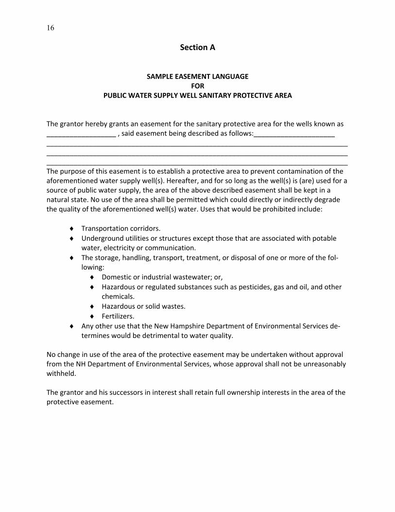
Section A
SAMPLE EASEMENT LANGUAGE FOR
PUBLIC WATER SUPPLY WELL SANITARY PROTECTIVE AREA
The grantor hereby grants an easement for the sanitary protective area for the wells known as __________________ , said easement being described as follows:_____________________ __________________________________________________________________________________________________________________________________________________________________________________________________________________________________________The purpose of this easement is to establish a protective area to prevent contamination of the aforementioned water supply well(s). Hereafter, and for so long as the well(s) is (are) used for a source of public water supply, the area of the above described easement shall be kept in a natural state. No use of the area shall be permitted which could directly or indirectly degrade the quality of the aforementioned well(s) water. Uses that would be prohibited include:
Transportation corridors.
Underground utilities or structures except those that are associated with potable water, electricity or communication.
The storage, handling, transport, treatment, or disposal of one or more of the fol‐lowing:
Domestic or industrial wastewater; or,
Hazardous or regulated substances such as pesticides, gas and oil, and other chemicals.
Hazardous or solid wastes.
Fertilizers.
Any other use that the New Hampshire Department of Environmental Services de‐termines would be detrimental to water quality.
No change in use of the area of the protective easement may be undertaken without approval from the NH Department of Environmental Services, whose approval shall not be unreasonably withheld. The grantor and his successors in interest shall retain full ownership interests in the area of the protective easement.
17
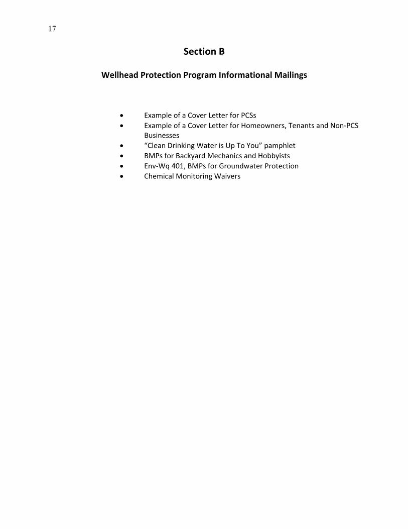
Section B
Wellhead Protection Program Informational Mailings
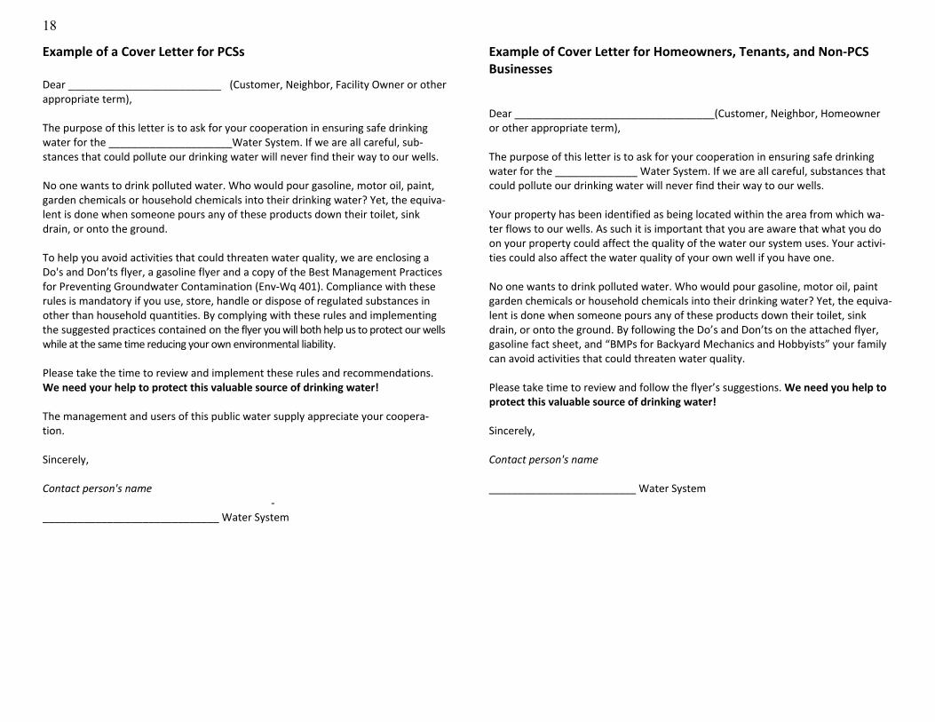
Example of a Cover Letter for PCSs
Example of a Cover Letter for Homeowners, Tenants and Non‐PCS Businesses
“Clean Drinking Water is Up To You” pamphlet
BMPs for Backyard Mechanics and Hobbyists
Env‐Wq 401, BMPs for Groundwater Protection
Chemical Monitoring Waivers
18
Example of a Cover Letter for PCSs Dear __________________________ (Customer, Neighbor, Facility Owner or other appropriate term), The purpose of this letter is to ask for your cooperation in ensuring safe drinking water for the _____________________Water System. If we are all careful, sub‐stances that could pollute our drinking water will never find their way to our wells. No one wants to drink polluted water. Who would pour gasoline, motor oil, paint, garden chemicals or household chemicals into their drinking water? Yet, the equiva‐lent is done when someone pours any of these products down their toilet, sink drain, or onto the ground. To help you avoid activities that could threaten water quality, we are enclosing a Do's and Don’ts flyer, a gasoline flyer and a copy of the Best Management Practices for Preventing Groundwater Contamination (Env‐Wq 401). Compliance with these rules is mandatory if you use, store, handle or dispose of regulated substances in other than household quantities. By complying with these rules and implementing the suggested practices contained on the flyer you will both help us to protect our wells while at the same time reducing your own environmental liability. Please take the time to review and implement these rules and recommendations. We need your help to protect this valuable source of drinking water! The management and users of this public water supply appreciate your coopera‐tion. Sincerely, Contact person's name
‐______________________________ Water System
Example of Cover Letter for Homeowners, Tenants, and Non‐PCS Businesses Dear __________________________________(Customer, Neighbor, Homeowner or other appropriate term), The purpose of this letter is to ask for your cooperation in ensuring safe drinking water for the ______________ Water System. If we are all careful, substances that could pollute our drinking water will never find their way to our wells. Your property has been identified as being located within the area from which wa‐ter flows to our wells. As such it is important that you are aware that what you do on your property could affect the quality of the water our system uses. Your activi‐ties could also affect the water quality of your own well if you have one. No one wants to drink polluted water. Who would pour gasoline, motor oil, paint garden chemicals or household chemicals into their drinking water? Yet, the equiva‐lent is done when someone pours any of these products down their toilet, sink drain, or onto the ground. By following the Do’s and Don’ts on the attached flyer, gasoline fact sheet, and “BMPs for Backyard Mechanics and Hobbyists” your family can avoid activities that could threaten water quality. Please take time to review and follow the flyer’s suggestions. We need you help to protect this valuable source of drinking water! Sincerely, Contact person's name _________________________ Water System

19
Is Gasoline Contaminating Your Drinking Water?
Gasoline is one of the most dangerous products commonly found around the home, yet people often store and use it with little care. Some of the chemicals in gasoline have been found in drinking water with increasing fre‐quency, including benzene, toluene, and ether, which are easily dissolved in water. Even very small gasoline spills can contaminate your drinking water wells or a public water supply.
To Protect Your Drinking Water from Gasoline: If a Spill Occurs:
For any size spill that is not immediately cleaned up, call the DES emergency petroleum spill number at (603) 271‐3644 immediately for instructions. The DES line is answered weekdays from 8 a.m. to 4 p.m. For all other times please call the NH State Police at (603) 271‐3636.
Clean Drinking Water
Is Up to You!
1. Avoid spilling gasoline on the ground, especially near wells • Don’t drain gasoline from lawn mowers, snowblowers, etc. onto the ground. Much of it does not evapo‐rate.
• Don’t burn brush with gasoline.
• Don’t top off your fuel tank.
• Keep refueling and engine work away from water supply wells, if pos‐sible over a concrete floor or similar barrier, and immediately clean up any gas or oil spills.
2. Avoid spilling gasoline in lakes, ponds, and rivers • Keep special gasoline‐absorbing pads on your gas‐powered boat; know how to use them.
• If you own a larger boat, make sure it has no‐spill tank vents.
• Fill portable tanks from outboard boat engines on shore.
• Refuel snowmobiles and ice augers on shore; do not take gasoline stor‐age tanks onto ice‐covered ponds.
3. Store gasoline properly • Use a clearly labeled container made for gasoline, with a spout to avoid spills.
• Keep gasoline containers in a dry, well ventilated shed or detached ga‐rage away from water supply wells.
• Don’t keep metal gasoline cans on a dirt floor for extended periods.
4. Dispose of waste gasoline prop‐erly • Handle old or dirty gasoline as haz‐ardous waste. Bring it to a household hazardous waste collection center in a proper gasoline container.
Where does your drinking water come from?
Your drinking water comes from either groundwa‐ter or surface water. Groundwater is the water that flows through the spaces between soil parti‐cles and through fractures in rock. It comes from rain and snowmelt percolating through the ground.
Surface water comes from rainfall and snowmelt run‐ning over land and from groundwater seepage into lakes and rivers (including reservoirs).
Why should you be concerned?
While some pollutants (such as bacteria, viruses, and phosphorus) can be reduced by passing through soil under certain conditions, groundwa‐ter can be easily contaminated by chemicals and oils. Surface water is also affected by soil and pollutants picked up as water flows over land.
20
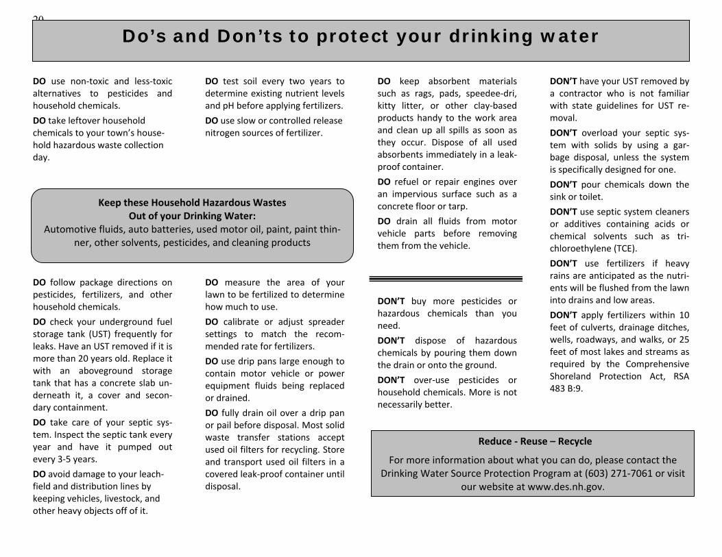
DO use non‐toxic and less‐toxic alternatives to pesticides and household chemicals.
DO take leftover household chemicals to your town’s house‐hold hazardous waste collection day.
DO follow package directions on pesticides, fertilizers, and other household chemicals.
DO check your underground fuel storage tank (UST) frequently for leaks. Have an UST removed if it is more than 20 years old. Replace it with an aboveground storage tank that has a concrete slab un‐derneath it, a cover and secon‐dary containment.
DO take care of your septic sys‐tem. Inspect the septic tank every year and have it pumped out every 3‐5 years.
DO avoid damage to your leach‐field and distribution lines by keeping vehicles, livestock, and other heavy objects off of it.
DO test soil every two years to determine existing nutrient levels and pH before applying fertilizers.
DO use slow or controlled release nitrogen sources of fertilizer.
DO measure the area of your lawn to be fertilized to determine how much to use.
DO calibrate or adjust spreader settings to match the recom‐mended rate for fertilizers.
DO use drip pans large enough to contain motor vehicle or power equipment fluids being replaced or drained.
DO fully drain oil over a drip pan or pail before disposal. Most solid waste transfer stations accept used oil filters for recycling. Store and transport used oil filters in a covered leak‐proof container until disposal.
DO keep absorbent materials such as rags, pads, speedee‐dri, kitty litter, or other clay‐based products handy to the work area and clean up all spills as soon as they occur. Dispose of all used absorbents immediately in a leak‐proof container.
DO refuel or repair engines over an impervious surface such as a concrete floor or tarp.
DO drain all fluids from motor vehicle parts before removing them from the vehicle.
DON’T buy more pesticides or hazardous chemicals than you need.
DON’T dispose of hazardous chemicals by pouring them down the drain or onto the ground.
DON’T over‐use pesticides or household chemicals. More is not necessarily better.
DON’T have your UST removed by a contractor who is not familiar with state guidelines for UST re‐moval.
DON’T overload your septic sys‐tem with solids by using a gar‐bage disposal, unless the system is specifically designed for one.
DON’T pour chemicals down the sink or toilet.
DON’T use septic system cleaners or additives containing acids or chemical solvents such as tri‐chloroethylene (TCE).
DON’T use fertilizers if heavy rains are anticipated as the nutri‐ents will be flushed from the lawn into drains and low areas.
DON’T apply fertilizers within 10 feet of culverts, drainage ditches, wells, roadways, and walks, or 25 feet of most lakes and streams as required by the Comprehensive Shoreland Protection Act, RSA 483 B:9.
Reduce ‐ Reuse – Recycle
For more information about what you can do, please contact the Drinking Water Source Protection Program at (603) 271‐7061 or visit
our website at www.des.nh.gov.
Do’s and Don’ts to protect your drinking water
Keep these Household Hazardous Wastes Out of your Drinking Water:
Automotive fluids, auto batteries, used motor oil, paint, paint thin‐ner, other solvents, pesticides, and cleaning products
21
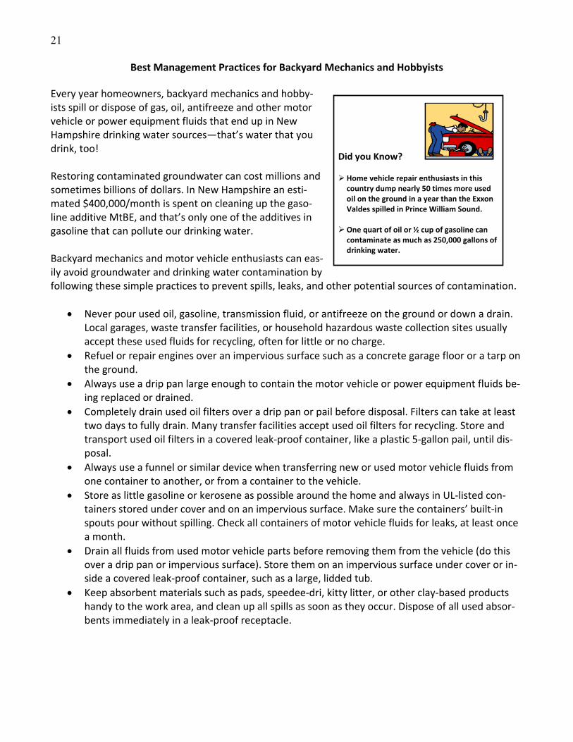
Best Management Practices for Backyard Mechanics and Hobbyists
Every year homeowners, backyard mechanics and hobby‐ists spill or dispose of gas, oil, antifreeze and other motor vehicle or power equipment fluids that end up in New Hampshire drinking water sources—that’s water that you drink, too! Restoring contaminated groundwater can cost millions and sometimes billions of dollars. In New Hampshire an esti‐mated $400,000/month is spent on cleaning up the gaso‐line additive MtBE, and that’s only one of the additives in gasoline that can pollute our drinking water.
Did you Know?
Home vehicle repair enthusiasts in this country dump nearly 50 times more used oil on the ground in a year than the Exxon Valdes spilled in Prince William Sound.
One quart of oil or ½ cup of gasoline can contaminate as much as 250,000 gallons of drinking water.
Backyard mechanics and motor vehicle enthusiasts can eas‐ily avoid groundwater and drinking water contamination by following these simple practices to prevent spills, leaks, and other potential sources of contamination.
Never pour used oil, gasoline, transmission fluid, or antifreeze on the ground or down a drain. Local garages, waste transfer facilities, or household hazardous waste collection sites usually accept these used fluids for recycling, often for little or no charge.
Refuel or repair engines over an impervious surface such as a concrete garage floor or a tarp on the ground.
Always use a drip pan large enough to contain the motor vehicle or power equipment fluids be‐ing replaced or drained.
Completely drain used oil filters over a drip pan or pail before disposal. Filters can take at least two days to fully drain. Many transfer facilities accept used oil filters for recycling. Store and transport used oil filters in a covered leak‐proof container, like a plastic 5‐gallon pail, until dis‐posal.
Always use a funnel or similar device when transferring new or used motor vehicle fluids from one container to another, or from a container to the vehicle.
Store as little gasoline or kerosene as possible around the home and always in UL‐listed con‐tainers stored under cover and on an impervious surface. Make sure the containers’ built‐in spouts pour without spilling. Check all containers of motor vehicle fluids for leaks, at least once a month.
Drain all fluids from used motor vehicle parts before removing them from the vehicle (do this over a drip pan or impervious surface). Store them on an impervious surface under cover or in‐side a covered leak‐proof container, such as a large, lidded tub.
Keep absorbent materials such as pads, speedee‐dri, kitty litter, or other clay‐based products handy to the work area, and clean up all spills as soon as they occur. Dispose of all used absor‐bents immediately in a leak‐proof receptacle.
22
DISCLAIMER: The following Rule is provided for the convenience of interested parties. To ensure that you have the latest rule, please refer to http://des.nh.gov/organization/commissioner/legal/rules/index.htm.
CHAPTER Env‐Wq 400 GROUNDWATER PROTECTION PART Env‐Wq 401 BEST MANAGEMENT PRACTICES FOR GROUNDWATER PROTECTION Statutory Authority: RSA 485‐C:4, VII; RSA 485‐C:11 Env‐Wq 401.01 Purpose. The purpose of these rules is to establish the minimum required management practices to be employed when using, storing, or otherwise handling regulated substances, so that the risk of groundwater contamination is minimized. Env‐Wq 401.02 Applicability. (a) Subject to (b), below, these rules shall apply only to persons who use, store, or otherwise handle any regulated substances in regulated containers. (b) Pursuant to RSA 485‐C:11, I, these rules shall not apply to:
(1) Potential contamination sources listed in RSA 485‐C:7, II(j); or (2) Those regulated substances defined as pesticides under RSA 430:28, XXVI.
(c) These rules also shall not apply to:
(1) Aboveground and underground storage tanks regulated under Env‐Wm 1401, Env‐Wm 1402, or successor rules in subtitle Env‐Or; or (2) On‐premise‐use facilities as defined in RSA 146‐E:2, III.
(d) Potential contamination sources shall be subject to inspections by the department in any area. Env‐Wq 401.03 Definitions. (a) “Department” means the New Hampshire department of environmental services. (b) “Floor drain” means an opening in a floor that is not specifically included in an authorized discharge under one or more of the following regulatory mechanisms:
(1) A NH groundwater discharge permit; (2) A registration required by Env‐Ws 1500 or successor rules in subtitle Env‐Wq; (3) A national pollutant discharge elimination system permit; or (4) A local authorization to discharge to the local wastewater treatment facility.
(c) “Impervious surface” means a surface through which regulated contaminants cannot pass when spilled. The term includes concrete and asphalt unless unsealed cracks or holes are present, but does not include earthen, wooden, or gravel surfaces or other surfaces that could react with or dissolve when in contact with the
23
substances stored on them. (d) “Owner” means the owner of the facility or site on which the potential contamination source is lo‐cated and, if different, the person who is responsible for the day‐to‐day management of the facility or site. (e) “Person” means “person” as defined in RSA 485‐C:2, XI, namely “any individual, partnership, com‐pany, public or private corporation, political subdivision or agency of the state, department, agency or instru‐mentality of the United States, or any other legal entity.” (f) “Potential contamination source” means, as specified in RSA 485‐C:7, I, human activities or opera‐tions upon the land surface that pose a foreseeable risk of introducing regulated substances into the environ‐ment in such quantities as to degrade the natural groundwater quality. Examples of potential contamination sources are listed in RSA 485‐C:7, II. (g) “Regulated container” means any device in which a regulated substance is stored, transported, treated, disposed of, or otherwise handled, with a capacity of greater than or equal to 5 gallons, other than a fuel tank attached to a motor vehicle for the sole purpose of supplying fuel to that motor vehicle for that vehi‐cle’s normal operation. (h) “Regulated substance” means any of the following, with the exclusion of ammonia, sodium hy‐pochlorite, sodium, acetic acid, sulfuric acid, potassium hydroxide, and potassium permanganate:
(1) Oil as defined in RSA 146‐A:2, III; (2) Any substance that contains a regulated contaminant for which an ambient groundwater qual‐ity standard has been established pursuant to RSA 485‐C:6; and (3) Any substance listed in 40 CFR 302, 7‐1‐05 edition.
(i) “Secondary containment” means a structure, such as a berm or dike with an impervious surface, that is adequate to hold any spills or leaks at 110% of the volume of the largest regulated container in the stor‐age area. (j) “Storage area” means a place where a regulated container is kept for a period of 10 or more con‐secutive days. (k) “Work sink” means a sink necessary for the performance of activities that require use of a regulated substance that is not specifically included in an authorized discharge under one or more of the following regula‐tory mechanisms:
(1) A NH groundwater discharge permit; (2) A registration required by Env‐Ws 1500 or successor rules in subtitle Env‐Wq; (3) A national pollution discharge elimination system permit; or (4) A local authorization to discharge to the local wastewater treatment facility.

24
Env‐Wq 401.04 Storage of Regulated Substances. (a) The owner shall store all hazardous wastes in compliance with applicable federal requirements and state requirements as specified in RSA 147‐A and Env‐Wm 100‐1100 or successor rules in subtitle Env‐Hw. (b) The owner shall store all regulated containers on an impervious surface. The owner shall inspect the impervious surface to ensure no cracks or holes exist prior to storage of any regulated containers and annually thereafter during continued use of the storage area. (c) The owner shall secure all storage areas against unauthorized entry by personal surveillance, physi‐cally‐restricted access, or a combination of personal surveillance and physically‐restricted access. (d) The owner shall inspect all storage areas weekly for signs of spills or leakage from regulated con‐tainers. The aisle space between regulated containers that cannot be moved by hand shall be of ample size to allow an inspector to determine the condition of individual regulated containers. (e) Each regulated container shall be clearly and visibly labeled with the chemical and trade name of the material stored within. (f) Each regulated container shall remain closed and sealed at all times except to add or remove regu‐lated substances. Regulated containers equipped with spigots, valves, or pumps shall be considered closed and sealed when the spigots, valves, or pumps are closed or in the “off” position, provided that drip pans are placed and maintained under the spigots, valves, or pumps. (g) Spill control and containment equipment, including, as a minimum, absorbents to pick up spills and leaks, shall be located in the immediate area where regulated substances are transferred, used, or stored. (h) Regulated containers in outdoor storage areas shall:
(1) Have secondary containment; (2) Be kept covered at all times unless the regulated containers are in the process of being trans‐ferred to another location; (3) Have a covering to keep the regulated container and the secondary containment structure free of rain, snow, or ice; and (4) Not be stored within any of the following set‐backs:
a. For surface waters, 50 feet; b. For private wells, 75 feet; c. The protective radius of any public water supply well; or d. For storm drains, 50 feet.
Env‐Wq 401.05 Transferring Regulated Substances. Regulated substances shall be transferred from or to regulated containers only under the following conditions: (a) Funnels and drip pans shall be used; and
25
(b) Fueling or transferring shall be done only over an impervious surface. Env‐Wq 401.06 Floor Drains. Interior floor drains shall discharge only to a holding tank registered in accor‐dance with Env‐Ws 1500 or successor rules in subtitle Env‐Wq. Env‐Wq 401.07 Work Sinks. Work sinks shall discharge only to a holding tank registered in accordance with Env‐Ws 1500 or successor rules in subtitle Env‐Wq. Env‐Wq 401.08 Holding Tanks. Holding tanks that receive discharges from floor drains or work sinks shall be registered and maintained in accordance with Env‐Ws 1500 or successor rules in subtitle Env‐Wq. Env‐Wq 401.09 Release Response Information. (a) The owner shall post release response information in accordance with (b), below, at every storage area. (b) Release response information shall contain the information necessary to contact emergency re‐sponse personnel, including the following:
(1) The name of the individual designated by the owner to be contacted if a spill occurs; (2) The method by which the designated individual can be contacted when there is a release, such as by phone, or in‐person at the main office; (3) The procedure for spill containment; and (4) Emergency phone numbers including 911 and, depending on local protocol:
a. State police; b. Local police and fire department; c. Local hospital; d. Department of environmental services; e. Poison control center; and f. Office of emergency management.
Env‐Wq 401.10 Waivers. (a) The rules contained in this part are intended to apply to a variety of conditions and circumstances. It is recognized that strict compliance with all rules prescribed herein might not fit every conceivable situation. Thus, persons subject to these rules may request a waiver of specific rules in this part in accordance with this section. (b) The person requesting the waiver(s) shall submit the following information in writing to the depart‐ment:
26
(1) A description of the facility or site to which the waiver request relates, including the name, address, and identification number of the facility or site; (2) A reference to the specific section of the rules from which a waiver is being sought; (3) A full explanation of why a waiver is necessary; (4) Whether the waiver is needed for a limited or indefinite period of time; (5) A full explanation with supporting data of the alternative(s), if any, proposed to be imple‐mented or used in lieu of the section’s requirements; and (6) A full explanation of how the proposed alternative(s), if any, would be consistent with the in‐tent of RSA 485‐C and would adequately protect human health and the environment.
(c) The department shall grant a waiver if it determines that the intent of RSA 485‐C will be met and human health and the environment will be protected. In granting the waiver, the department shall impose such conditions, including time limitations, as the department deems necessary to ensure that the activities con‐ducted pursuant to the waiver will be protective of human health and the environment. (d) No waiver shall be granted to any requirement specified in statute unless the statute expressly al‐lows such requirement to be waived. (e) The department shall issue a written response to a request for a waiver within 90 days of receipt of the request. If the department denies the request, the reasons(s) for the denial shall be clearly stated in the written response.
APPENDIX
Rule Section(s) State Statute(s) Implemented
Env‐Wq 401 (see also specific section listed below) RSA 485‐C:1; RSA 485‐C:4, VII; RSA 485‐C:11
Env‐Wq 401.10 RSA 541‐A:22, IV
27
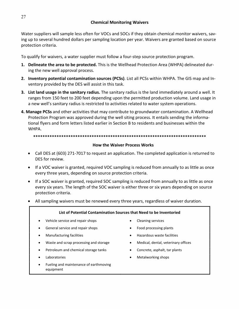
Chemical Monitoring Waivers Water suppliers will sample less often for VOCs and SOCs if they obtain chemical monitor waivers, sav‐ing up to several hundred dollars per sampling location per year. Waivers are granted based on source protection criteria. To qualify for waivers, a water supplier must follow a four‐step source protection program.
1. Delineate the area to be protected. This is the Wellhead Protection Area (WHPA) delineated dur‐ing the new well approval process.
2. Inventory potential contamination sources (PCSs). List all PCSs within WHPA. The GIS map and In‐ventory provided by the DES will assist in this task.
3. List land usage in the sanitary radius. The sanitary radius is the land immediately around a well. It ranges from 150 feet to 200 feet depending upon the permitted production volume. Land usage in a new well’s sanitary radius is restricted to activities related to water system operations.
4. Manage PCSs and other activities that may contribute to groundwater contamination. A Wellhead Protection Program was approved during the well siting process. It entails sending the informa‐tional flyers and form letters listed earlier in Section B to residents and businesses within the WHPA.
**************************************************************************
How the Waiver Process Works
Call DES at (603) 271‐7017 to request an application. The completed application is returned to DES for review.
If a VOC waiver is granted, required VOC sampling is reduced from annually to as little as once every three years, depending on source protection criteria.
If a SOC waiver is granted, required SOC sampling is reduced from annually to as little as once every six years. The length of the SOC waiver is either three or six years depending on source protection criteria.
All sampling waivers must be renewed every three years, regardless of waiver duration.
List of Potential Contamination Sources that Need to be Inventoried
Vehicle service and repair shops Cleaning services
General service and repair shops Food processing plants
Manufacturing facilities Hazardous waste facilities
Waste and scrap processing and storage Medical, dental, veterinary offices
Petroleum and chemical storage tanks Concrete, asphalt, tar plants
Laboratories Metalworking shops
Fueling and maintenance of earthmoving equipment
28
Section C
File Review Guide and Worksheet
Reviewing Files of Contaminated Sites
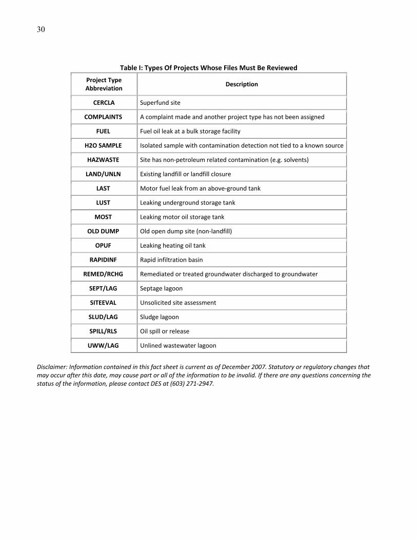
Types of Projects Whose Files Must be Reviewed
Guide to Conducting a File Review
File Review Worksheet
Example of an Inventory
29
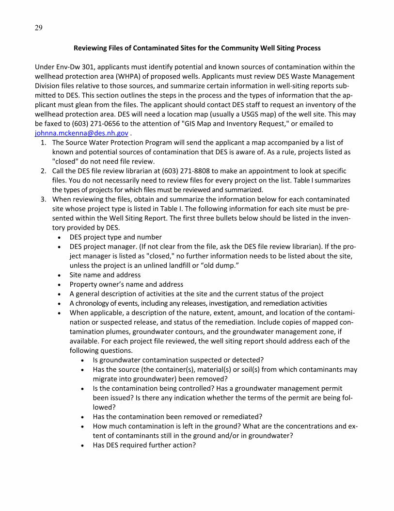
Reviewing Files of Contaminated Sites for the Community Well Siting Process
Under Env‐Dw 301, applicants must identify potential and known sources of contamination within the wellhead protection area (WHPA) of proposed wells. Applicants must review DES Waste Management Division files relative to those sources, and summarize certain information in well‐siting reports sub‐mitted to DES. This section outlines the steps in the process and the types of information that the ap‐plicant must glean from the files. The applicant should contact DES staff to request an inventory of the wellhead protection area. DES will need a location map (usually a USGS map) of the well site. This may be faxed to (603) 271‐0656 to the attention of "GIS Map and Inventory Request," or emailed to [email protected] . 1. The Source Water Protection Program will send the applicant a map accompanied by a list of
known and potential sources of contamination that DES is aware of. As a rule, projects listed as "closed" do not need file review.
2. Call the DES file review librarian at (603) 271‐8808 to make an appointment to look at specific files. You do not necessarily need to review files for every project on the list. Table I summarizes the types of projects for which files must be reviewed and summarized.
3. When reviewing the files, obtain and summarize the information below for each contaminated site whose project type is listed in Table I. The following information for each site must be pre‐sented within the Well Siting Report. The first three bullets below should be listed in the inven‐tory provided by DES. DES project type and number DES project manager. (If not clear from the file, ask the DES file review librarian). If the pro‐
ject manager is listed as "closed," no further information needs to be listed about the site, unless the project is an unlined landfill or “old dump.”
Site name and address Property owner’s name and address A general description of activities at the site and the current status of the project A chronology of events, including any releases, investigation, and remediation activities When applicable, a description of the nature, extent, amount, and location of the contami‐
nation or suspected release, and status of the remediation. Include copies of mapped con‐tamination plumes, groundwater contours, and the groundwater management zone, if available. For each project file reviewed, the well siting report should address each of the following questions.
Is groundwater contamination suspected or detected? Has the source (the container(s), material(s) or soil(s) from which contaminants may
migrate into groundwater) been removed? Is the contamination being controlled? Has a groundwater management permit
been issued? Is there any indication whether the terms of the permit are being fol‐lowed?
Has the contamination been removed or remediated? How much contamination is left in the ground? What are the concentrations and ex‐
tent of contaminants still in the ground and/or in groundwater? Has DES required further action?
30
Table I: Types Of Projects Whose Files Must Be Reviewed
Project Type Abbreviation
Description
CERCLA Superfund site
COMPLAINTS A complaint made and another project type has not been assigned
FUEL Fuel oil leak at a bulk storage facility
H2O SAMPLE Isolated sample with contamination detection not tied to a known source
HAZWASTE Site has non‐petroleum related contamination (e.g. solvents)
LAND/UNLN Existing landfill or landfill closure
LAST Motor fuel leak from an above‐ground tank
LUST Leaking underground storage tank
MOST Leaking motor oil storage tank
OLD DUMP Old open dump site (non‐landfill)
OPUF Leaking heating oil tank
RAPIDINF Rapid infiltration basin
REMED/RCHG Remediated or treated groundwater discharged to groundwater
SEPT/LAG Septage lagoon
SITEEVAL Unsolicited site assessment
SLUD/LAG Sludge lagoon
SPILL/RLS Oil spill or release
UWW/LAG Unlined wastewater lagoon
Disclaimer: Information contained in this fact sheet is current as of December 2007. Statutory or regulatory changes that may occur after this date, may cause part or all of the information to be invalid. If there are any questions concerning the status of the information, please contact DES at (603) 271‐2947.
31
Guide To Conducting a File Review for Siting New Water Supply Sources Step 1. Schedule a File Review Appointment Review the GIS Map and Inventory obtained from DES. Identify the site and town files for review. Any sites listed as 'closed' do not need file review, unless the project was located near the proposed well and groundwater contamination occurred. See the sample GIS map and inventory at the end of this section for an example of the information included in both. Files that must be reviewed are described below. Contact the DES file review librarian at (603) 271‐8808 with the town name(s), site name(s) and site number(s) of the files that you need to review. Provide two weeks advance notice for an appoint‐ment. Please note that some but not all file information is available through OneStop. a. Town files for each town in the 4000‐foot preliminary WHPA. There are two sets of town files and both must be reviewed. The town files contain materials regarding incidents and complaints that aren’t currently DES projects. These items may represent a contaminant release, but initial response activities by DES did not reveal a significant threat to groundwater. Generally these sites are not significant, but the applicant must decide if an item in these files may affect the proposed source and if further evalua‐tion of the incident or complaint is warranted. b. Known contamination sites in the 4000‐foot preliminary WHPA. Known contamination sources are the project types listed in the table on page III‐15, and are noted on the GIS map and inventory. Pro‐vide the file review librarian with the site numbers and names when making an appointment. Step 2. Conduct the File Review
Bring the following material to your file review appointment: •This section of the Toolkit •Your GIS map and inventory •Street maps for the towns in your WHPA •A copy of the attached worksheet for each project file being reviewed •Cash to make copies if needed •Notepaper and pen for taking notes
Arrive at the appointed time. Workspace and seating is limited.
Review Town Files: Review the correspondence and other material in the town files. Review both sets of town files. Identify any correspondence about a property in the preliminary WHPA. Asses the potential threat each may pose to the proposed source.
Review Known Contamination Site Files: Complete the attached worksheet for each contaminated site. The information must be included in the well siting report. The information requested in the attached table is required.
Step 3. Update the Inventory and File Review, if necessary When submitted to DES, the GIS map, inventory and file review information must not be more than 90 days old. The date of the inventory is shown in the map legend. Reminder: This inventory must be ex‐panded, see guidance on conducting a windshield survey in Section D.

32
File Review Worksheet DES Project Type
DES Project Number
DES Project Manager
Site Name and Address
Property Owner’s Name and Address
A description of the nature, extent, amount and location of the contamination or suspected released?
General chronology of events at the site including re‐lease, discovery, investigation and remediation activities.
Answer the following questions:
Is groundwater contamination suspected or detected? What chemicals were detected and in what concentrations?
Has the source of groundwater contamination been removed (such as the storage tank, con‐tainer, waste material or soil)? Describe removal efforts.
Is the groundwater contamination being con‐trolled and how?
Has a groundwater management permit been issued? (If yes, list the permit number)
Is further action being required by DES? (If yes, describe what actions)
Do you anticipate that contamination from this site is a threat to your well source? Describe Why or Why not? Include all sup‐porting documentation.
*Attach extra sheets as needed.
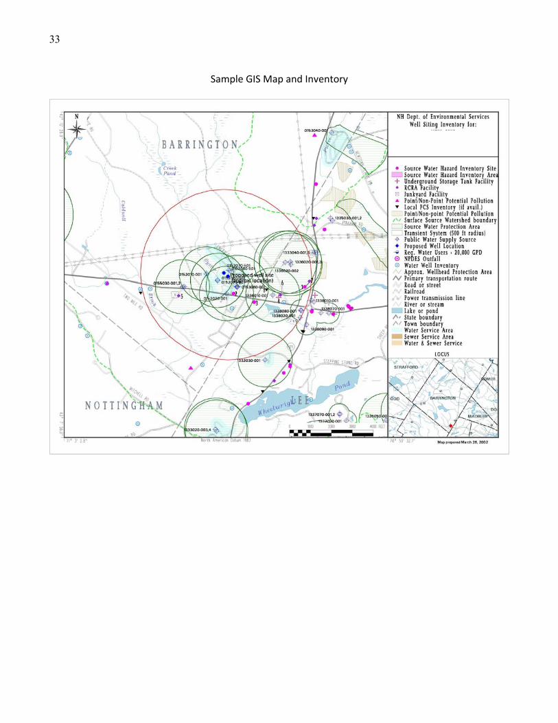
33
Sample GIS Map and Inventory
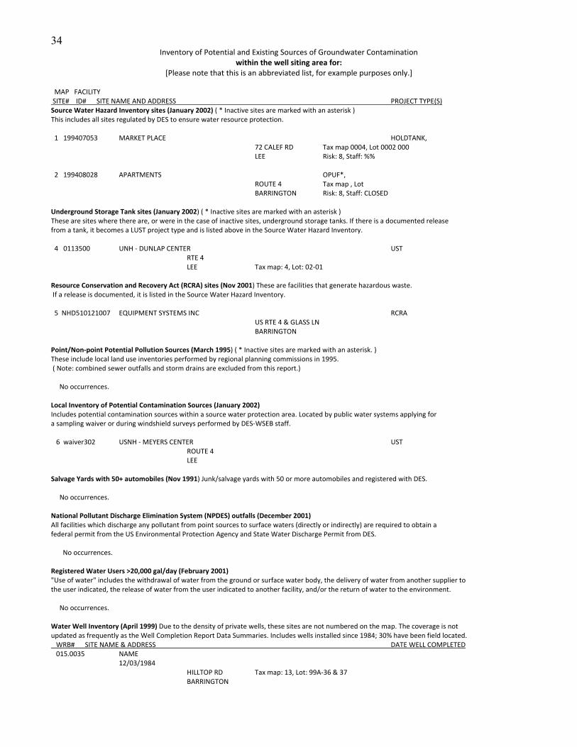
34
Inventory of Potential and Existing Sources of Groundwater Contamination within the well siting area for:
[Please note that this is an abbreviated list, for example purposes only.] MAP FACILITY SITE# ID# SITE NAME AND ADDRESS PROJECT TYPE(S) Source Water Hazard Inventory sites (January 2002) ( * Inactive sites are marked with an asterisk ) This includes all sites regulated by DES to ensure water resource protection. 1 199407053 MARKET PLACE HOLDTANK, 72 CALEF RD Tax map 0004, Lot 0002 000 LEE Risk: 8, Staff: %% 2 199408028 APARTMENTS OPUF*, ROUTE 4 Tax map , Lot BARRINGTON Risk: 8, Staff: CLOSED Underground Storage Tank sites (January 2002) ( * Inactive sites are marked with an asterisk ) These are sites where there are, or were in the case of inactive sites, underground storage tanks. If there is a documented release from a tank, it becomes a LUST project type and is listed above in the Source Water Hazard Inventory. 4 0113500 UNH ‐ DUNLAP CENTER UST RTE 4 LEE Tax map: 4, Lot: 02‐01 Resource Conservation and Recovery Act (RCRA) sites (Nov 2001) These are facilities that generate hazardous waste. If a release is documented, it is listed in the Source Water Hazard Inventory. 5 NHD510121007 EQUIPMENT SYSTEMS INC RCRA US RTE 4 & GLASS LN BARRINGTON Point/Non‐point Potential Pollution Sources (March 1995) ( * Inactive sites are marked with an asterisk. ) These include local land use inventories performed by regional planning commissions in 1995. ( Note: combined sewer outfalls and storm drains are excluded from this report.) No occurrences. Local Inventory of Potential Contamination Sources (January 2002) Includes potential contamination sources within a source water protection area. Located by public water systems applying for a sampling waiver or during windshield surveys performed by DES‐WSEB staff. 6 waiver302 USNH ‐ MEYERS CENTER UST ROUTE 4 LEE Salvage Yards with 50+ automobiles (Nov 1991) Junk/salvage yards with 50 or more automobiles and registered with DES. No occurrences. National Pollutant Discharge Elimination System (NPDES) outfalls (December 2001) All facilities which discharge any pollutant from point sources to surface waters (directly or indirectly) are required to obtain a federal permit from the US Environmental Protection Agency and State Water Discharge Permit from DES. No occurrences. Registered Water Users >20,000 gal/day (February 2001) "Use of water" includes the withdrawal of water from the ground or surface water body, the delivery of water from another supplier to the user indicated, the release of water from the user indicated to another facility, and/or the return of water to the environment. No occurrences. Water Well Inventory (April 1999) Due to the density of private wells, these sites are not numbered on the map. The coverage is not updated as frequently as the Well Completion Report Data Summaries. Includes wells installed since 1984; 30% have been field located. WRB# SITE NAME & ADDRESS DATE WELL COMPLETED 015.0035 NAME 12/03/1984 HILLTOP RD Tax map: 13, Lot: 99A‐36 & 37 BARRINGTON
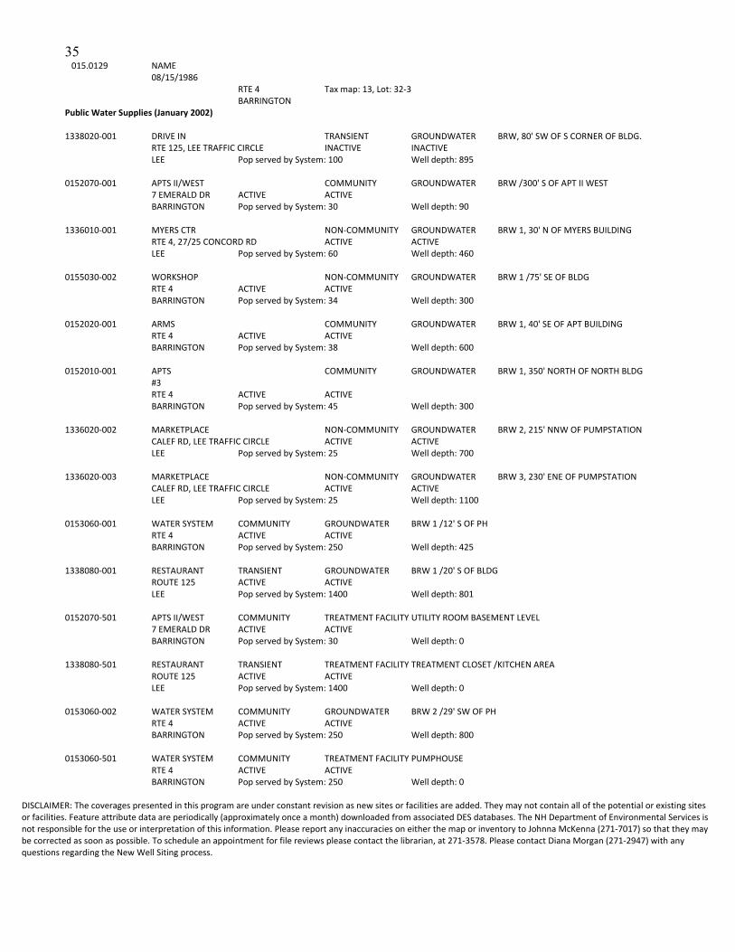
35
015.0129 NAME 08/15/1986 RTE 4 Tax map: 13, Lot: 32‐3 BARRINGTON Public Water Supplies (January 2002) 1338020‐001 DRIVE IN TRANSIENT GROUNDWATER BRW, 80' SW OF S CORNER OF BLDG. RTE 125, LEE TRAFFIC CIRCLE INACTIVE INACTIVE LEE Pop served by System: 100 Well depth: 895 0152070‐001 APTS II/WEST COMMUNITY GROUNDWATER BRW /300' S OF APT II WEST 7 EMERALD DR ACTIVE ACTIVE BARRINGTON Pop served by System: 30 Well depth: 90 1336010‐001 MYERS CTR NON‐COMMUNITY GROUNDWATER BRW 1, 30' N OF MYERS BUILDING RTE 4, 27/25 CONCORD RD ACTIVE ACTIVE LEE Pop served by System: 60 Well depth: 460 0155030‐002 WORKSHOP NON‐COMMUNITY GROUNDWATER BRW 1 /75' SE OF BLDG RTE 4 ACTIVE ACTIVE BARRINGTON Pop served by System: 34 Well depth: 300 0152020‐001 ARMS COMMUNITY GROUNDWATER BRW 1, 40' SE OF APT BUILDING RTE 4 ACTIVE ACTIVE BARRINGTON Pop served by System: 38 Well depth: 600 0152010‐001 APTS COMMUNITY GROUNDWATER BRW 1, 350' NORTH OF NORTH BLDG #3 RTE 4 ACTIVE ACTIVE BARRINGTON Pop served by System: 45 Well depth: 300 1336020‐002 MARKETPLACE NON‐COMMUNITY GROUNDWATER BRW 2, 215' NNW OF PUMPSTATION CALEF RD, LEE TRAFFIC CIRCLE ACTIVE ACTIVE LEE Pop served by System: 25 Well depth: 700 1336020‐003 MARKETPLACE NON‐COMMUNITY GROUNDWATER BRW 3, 230' ENE OF PUMPSTATION CALEF RD, LEE TRAFFIC CIRCLE ACTIVE ACTIVE LEE Pop served by System: 25 Well depth: 1100 0153060‐001 WATER SYSTEM COMMUNITY GROUNDWATER BRW 1 /12' S OF PH RTE 4 ACTIVE ACTIVE BARRINGTON Pop served by System: 250 Well depth: 425 1338080‐001 RESTAURANT TRANSIENT GROUNDWATER BRW 1 /20' S OF BLDG ROUTE 125 ACTIVE ACTIVE LEE Pop served by System: 1400 Well depth: 801 0152070‐501 APTS II/WEST COMMUNITY TREATMENT FACILITY UTILITY ROOM BASEMENT LEVEL 7 EMERALD DR ACTIVE ACTIVE BARRINGTON Pop served by System: 30 Well depth: 0 1338080‐501 RESTAURANT TRANSIENT TREATMENT FACILITY TREATMENT CLOSET /KITCHEN AREA ROUTE 125 ACTIVE ACTIVE LEE Pop served by System: 1400 Well depth: 0 0153060‐002 WATER SYSTEM COMMUNITY GROUNDWATER BRW 2 /29' SW OF PH RTE 4 ACTIVE ACTIVE BARRINGTON Pop served by System: 250 Well depth: 800 0153060‐501 WATER SYSTEM COMMUNITY TREATMENT FACILITY PUMPHOUSE RTE 4 ACTIVE ACTIVE BARRINGTON Pop served by System: 250 Well depth: 0
DISCLAIMER: The coverages presented in this program are under constant revision as new sites or facilities are added. They may not contain all of the potential or existing sites or facilities. Feature attribute data are periodically (approximately once a month) downloaded from associated DES databases. The NH Department of Environmental Services is not responsible for the use or interpretation of this information. Please report any inaccuracies on either the map or inventory to Johnna McKenna (271‐7017) so that they may be corrected as soon as possible. To schedule an appointment for file reviews please contact the librarian, at 271‐3578. Please contact Diana Morgan (271‐2947) with any questions regarding the New Well Siting process.
36
Section D
Windshield Survey Guide and Worksheet
Conducting and Reporting a Windshield Survey
Worksheet for Reporting
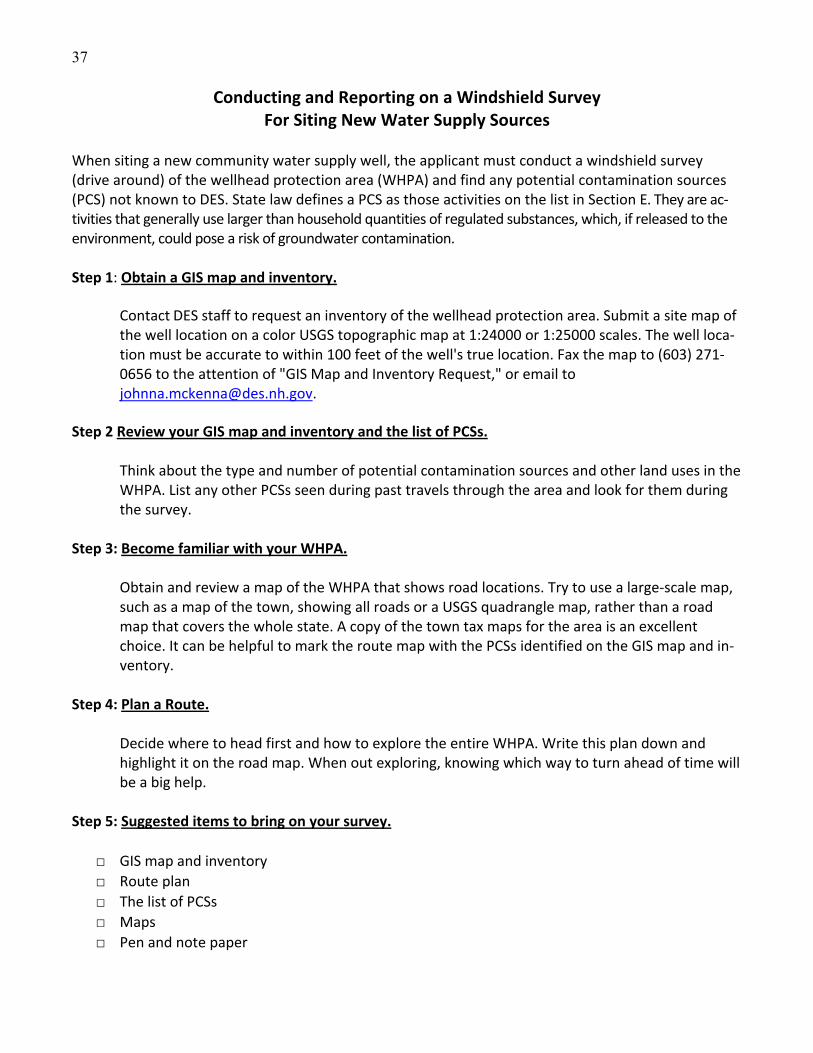
37
Conducting and Reporting on a Windshield Survey For Siting New Water Supply Sources
When siting a new community water supply well, the applicant must conduct a windshield survey (drive around) of the wellhead protection area (WHPA) and find any potential contamination sources (PCS) not known to DES. State law defines a PCS as those activities on the list in Section E. They are ac‐tivities that generally use larger than household quantities of regulated substances, which, if released to the environment, could pose a risk of groundwater contamination. Step 1: Obtain a GIS map and inventory.
Contact DES staff to request an inventory of the wellhead protection area. Submit a site map of the well location on a color USGS topographic map at 1:24000 or 1:25000 scales. The well loca‐tion must be accurate to within 100 feet of the well's true location. Fax the map to (603) 271‐0656 to the attention of "GIS Map and Inventory Request," or email to [email protected].
Step 2 Review your GIS map and inventory and the list of PCSs.
Think about the type and number of potential contamination sources and other land uses in the WHPA. List any other PCSs seen during past travels through the area and look for them during the survey.
Step 3: Become familiar with your WHPA.
Obtain and review a map of the WHPA that shows road locations. Try to use a large‐scale map, such as a map of the town, showing all roads or a USGS quadrangle map, rather than a road map that covers the whole state. A copy of the town tax maps for the area is an excellent choice. It can be helpful to mark the route map with the PCSs identified on the GIS map and in‐ventory.
Step 4: Plan a Route.
Decide where to head first and how to explore the entire WHPA. Write this plan down and highlight it on the road map. When out exploring, knowing which way to turn ahead of time will be a big help.
Step 5: Suggested items to bring on your survey.
□ GIS map and inventory
□ Route plan
□ The list of PCSs
□ Maps
□ Pen and note paper

38
Step 6: Drive and Compare. Drive along all public roadways and compare the land uses observed to those on the PCS list. Stop when one or more of the following is found:
a. A PCS not on the GIS map b. A business on the GIS inventory that has changed in any manner c. A private well within 1,000 feet of the production well that must be monitored during the
pumping test. If one of the above items is found, then:
a. On the GIS map or road map, mark the location of any PCS or private well as accurately as pos‐
sible using nearby intersecting roads or other features. A personal GPS unit, may be used to note the location. However, do not enter private property without the owner's permission.
b. Cross off any business on the GIS inventory that is no longer a PCS. c. Fill in the attached worksheet for reporting on the windshield survey.
It is important to note that PCSs don't always have a sign that says what they are doing. If something might be a PCS, make a note of what type of activity, the location and street address. Don't go up a pri‐vate driveway or into a building during the windshield survey. Obtain the facts on site‐use later, from town offices or the building owner, in step 7. Step 7: Contact Town Offices and Building Owners. Tax, health department, code enforcement, fire department, or planning board records may be of use in identifying a PCS business, confirming a change in site activity, or identifying a spill or other con‐tamination source. Document these contacts on the following worksheet. When contacting a local official,
a. Explain that a new small community water supply well is proposed and request information about land uses in the area. Stress that documenting land use is required by law.
b. Request any owner or address information not discovered during the windshield survey. c. Request information on any land uses that were not obvious during your windshield survey. d. Request information on events or historic uses in the WHPA that may have resulted in a release
of hazardous materials to the environment. The memories of local people can be a great source of this information, sometimes it is the only source.
e. Remember that many town officials in New Hampshire are volunteers and/or offices may only be open part‐time.
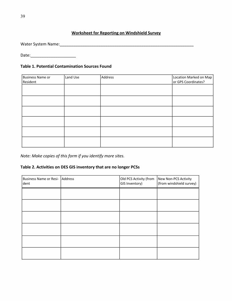
39
Worksheet for Reporting on Windshield Survey Water System Name:___________________________________________________________ Date:____________________ Table 1. Potential Contamination Sources Found Business Name or Resident
Land Use Address Location Marked on Map r GPS Coordinates? o
Note: Make copies of this form if you identify more sites. Table 2. Activities on DES GIS inventory that are no longer PCSs
Business Name or Resi‐dent
Address Old PCS Activity (from GIS Inventory)
New Non‐PCS Activity (from windshield survey)
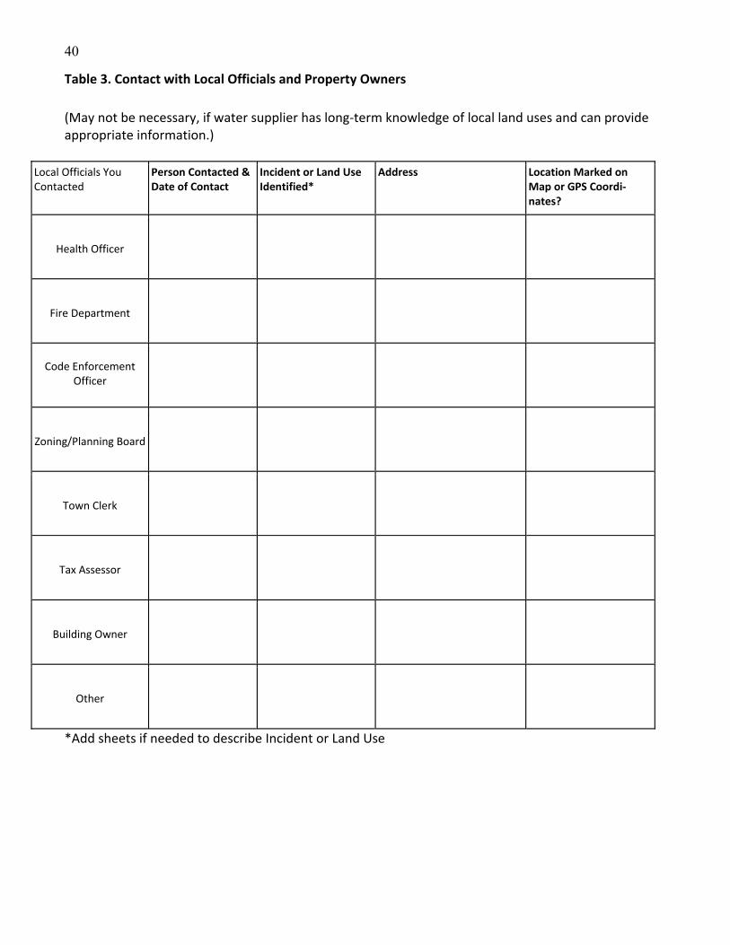
40
Table 3. Contact with Local Officials and Property Owners
(May not be necessary, if water supplier has long‐term knowledge of local land uses and can provide appropriate information.)
Local Officials You Contacted
Person Contacted & Date of Contact
Incident or Land Use Identified*
Address Location Marked on Map or GPS Coordi‐nates?
Health Officer
Fire Department
Code Enforcement Officer
Zoning/Planning Board
Town Clerk
Tax Assessor
Building Owner
Other
*Add sheets if needed to describe Incident or Land Use

41
Section E
Potential Contamination Source List (As listed in RSA 485:C Groundwater Protection Act)
Vehicle service and repair shops* ‐‐ including but not limited to automobile, truck and equipment ser‐vice and repair shops; auto body shops; aircraft refueling, deicing and maintenance areas.
General service and repair shops* ‐‐ including but not limited to furniture stripping, painting and refin‐ishing; photographic processing; printing; appliance and small engine repair; boat repair, service, and refinishing; refrigeration, heating, ventilating and air conditioning shops.
Metalworking shops* ‐‐ including but not limited to machine shops, metal plating, heat‐treating, smelting and jewelry making shops.
Manufacturing facilities* ‐‐ including but not limited to electronic and chemical manufacturing, proc‐essing, and reclamation; paper, leather, plastic, fiberglass, rubber, silicon and glass making; pharma‐ceutical production; pesticide manufacture; and chemical preservation of wood and wood products.
Underground and aboveground storage facilities ‐‐ for oil and hazardous substances, as define in RSA 146‐C.
Waste and scrap processing and storage* ‐‐ including but not limited to junkyards, scrap yards, and auto salvage yards; wastewater treatment plants; dumps, landfills, transfer stations and other solid waste facilities; and wastewater or septage lagoons.
Transportation corridors ‐‐ including but not limited to highways and railroads.
Septic systems ‐‐ large septic systems that require a groundwater discharge permit under RSA 485A:13.
Laboratories and professional offices* ‐‐ including but not limited to medical, dental, and veterinary offices; and research and analytical laboratories.
Use of agricultural chemicals ‐‐ including but not limited to golf courses; feedlots, kennels, piggeries, manure stockpiles; parks; nurseries and sod farms; and the usage of registered pesticides.
Snow dumps, salt storage and use* ‐‐ for winter road and parking lot maintenance.
Stormwater infiltration ponds or leaching catch basins
Cleaning services* ‐‐ including but not limited to dry cleaners, Laundromats; beauty salons; and car washes.
Food processing plants* ‐‐ including but not limited to meat packing and slaughterhouses; dairies; and processed food manufacture.
Fueling and maintenance of excavation and earthmoving equipment*
Concrete, asphalt and tar manufacture*
Cemeteries
Hazardous waste facilities* ‐‐ regulated under the Resource Conservation and Recovery Act, as imple‐mented by RSA 147‐A.III. *Sources subject to inspections for compliance with Env‐Wq 401Best Management Practice for Groundwater Protection.

42
Section F
Guidance for Assessing Impacts To and From
Small Community Water Supply Wells
New Hampshire Administrative Rule Env‐Dw 301, Site Selection of Small Production Wells for Community Water Systems requires the applicant assess impacts during a pumping test. An im‐pact is defined as the effect of pumping the production well at the Permitted Production Vol‐ume on or from the following:
Water levels in public and private wells within 1,000 feet of the production well.
Water levels in nearby surface waters.
Existing groundwater contamination plumes.
Saltwater intrusion into the aquifer
Surface water intrusion into the production well. Impact to Non‐System Wells The most common impact is to water levels in other wells in the vicinity of the production wells. However, if impacts other than these occur, DES will provide remediation guidance. Though the rules only require monitoring of wells within 1000 feet of the production well, serious effects on water levels in wells much farther away have occurred. The applicant or DES may be con‐tacted by irate residents of the area complaining about impacts to their water supplies. A thor‐ough assessment prior to the pumping test can avoid some unwelcome surprises later on. DES may work with the applicant during the assessment process by researching available geo‐logic data such as lineament maps and stratified drift aquifer maps and identifying areas out‐side a 1000‐foot radius that may be influenced by the pumping of the production well. Though monitoring private wells outside the area required by rule may seem onerous or unnecessary to the applicant, it may allay the fears of existing residents. This is especially important where there is strong local opposition to the development. The following outlines some steps the ap‐plicant can take during the assessment process. Assessment
Prior to the pumping test, perform a survey to identify water supply wells that should be monitored during the pumping test. Use the information provided by DES to help define the extent of the area to be surveyed. DES can also supply a GIS map showing the loca‐tions of water distribution lines that will help the applicant identify areas not served by public water supplies. Contact the owners by certified mail and get permission to moni‐tor the wells. It is very important to document refusals as well as those who accept monitoring. See the following cover letter and permission form. The cover letter should be filled in by the applicant/consultant. The well monitoring form gives you permission to monitor the non‐system well and should accompany the cover letter. The form will

43
be filled in by the well owner, with the exception of item number six. The name of the person sampling the well should be inserted here.
Research available data, including the Water Well Program Well Completion Reports, which is available at www.des.nh.gov, under “Water Well Construction Record Query” on the “A to Z LIST,” and town records to determine historic water levels in the area. Talk to local officials such as town planners, health officers and fire department personnel. This can be done as part of your inventory and windshield survey. Does the area have a his‐tory of diminishing water levels? Have there been any disputes over water rights? Pro‐vide a contact list of homeowner names and lot numbers where wells will be monitored, and a cover letter to be sent to well owners asking permission to monitor their well. A sample cover letter can be found at the end of this section.
Monitor the wells identified in your survey. If using an invasive water level measuring device (datalogger), take a bacteria sample from the well prior to instrumenting the well.
DES must address adverse impact complaints received in the course of the well siting approval process and will encourage the applicant to negotiate with the well owner to provide an agree‐able solution to any problems that arise. The following suggested methods, or combination of methods, of addressing impacts due to pumping a production well are acceptable. Other solu‐tions that effectively address the impact may be presented to DES for approval. Suggested Methods for Addressing Impacts to Non‐System Wells
Replacement of the impacted source.
Replacement may include deepening of the impacted source or setting the pump deeper in the well.
Connecting the impacted source to the community water system.
Periodic monitoring of the impacted source.
Periodic monitoring of the pumping volume of the production well.
Reduction in withdrawals from the production well.
Water conservation following Water Efficiency BMPs by the users of the community wa‐ter system that has produced the impact.
The water system owner may appoint a contact person who is prepared to address impact com‐plaints. DES must be notified in writing of all concerns raised by the public and if they are being addressed by the water system’s owner. DES will make the final determination of adverse im‐pacts. Impacts from the pumping of the production well only will be considered under the assessment process. Private well owners who feel they have been impacted by the pumping of the produc‐tion well must be able to demonstrate an impact occurred. Those owners who refused to allow monitoring of their wells during the pumping test will need other documentation to support their claim of an impact, unless an impact to neighboring wells drawing from the same aquifer was noted during the pumping test.
44
Potential impacts to the production well will have been identified during the file re‐view/windshield survey process. As a result, DES may require extra water quality sampling dur‐ing the pumping test to assess possible impacts to the well from PCSs located near the site. Methods for addressing an impact may include treatment and a reduced pumping rate, but usually a well that experiences a water quality impact from a man‐made source cannot be ap‐proved. Impacts to and from surface waters will be assess by the MPA and water level monitoring of the surface water during the pumping test. If the water withdrawn from the production is desig‐nated as having a high risk of being groundwater under direct influence of surface water, then the well may not be approved. However, further sampling may be proposed for the spring, summer and fall of the first year of operation. If the risk factor is medium or low for this addi‐tional testing, new well approval will not be revoked.
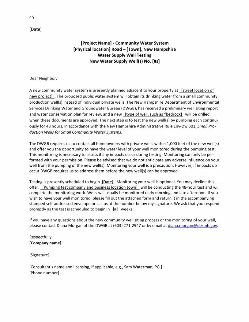
45
[Date]
[Project Name] ‐ Community Water System
[Physical location] Road – [Town], New Hampshire Water Supply Well Testing
New Water Supply Well(s) No. [#s]
Dear Neighbor:
A new community water system is presently planned adjacent to your property at [street location of
new project] . The proposed public water system will obtain its drinking water from a small community
production well(s) instead of individual private wells. The New Hampshire Department of Environmental
Services Drinking Water and Groundwater Bureau (DWGB), has received a preliminary well siting report
and water conservation plan for review, and a new [type of well, such as “bedrock] will be drilled
when these documents are approved. The next step is to test the new well(s) by pumping each continu‐
ously for 48 hours, in accordance with the New Hampshire Administrative Rule Env‐Dw 301, Small Pro‐
duction Wells for Small Community Water Systems.
The DWGB requires us to contact all homeowners with private wells within 1,000 feet of the new well(s) and offer you the opportunity to have the water level of your well monitored during the pumping test. This monitoring is necessary to assess if any impacts occur during testing. Monitoring can only be per‐formed with your permission. Please be advised that we do not anticipate any adverse influence on your well from the pumping of the new well(s). Monitoring your well is a precaution. However, if impacts do occur DWGB requires us to address them before the new well(s) can be approved. Testing is presently scheduled to begin [Date] . Monitoring your well is optional. You may decline this offer. [Pumping test company and business location town] will be conducting the 48‐hour test and will complete the monitoring work. Wells will usually be monitored early morning and late afternoon. If you wish to have your well monitored, please fill out the attached form and return it in the accompanying stamped self‐addressed envelope or call us at the number below my signature. We ask that you respond promptly as the test is scheduled to begin in [#] weeks. If you have any questions about the new community well siting process or the monitoring of your well, please contact Diana Morgan of the DWGB at (603) 271‐2947 or by email at [email protected].
Respectfully,
[Company name]
[Signature]
[Consultant's name and licensing, if applicable, e.g., Sam Waterman, PG.]
[Phone number]
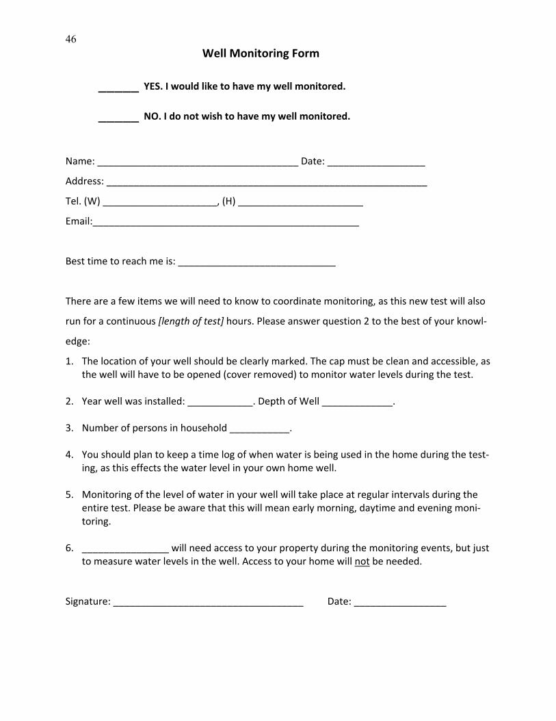
46
Well Monitoring Form
_____ YES. I would like to have my well monitored.
_____ NO. I do not wish to have my well monitored.
Name: _____________________________________ Date: __________________
Address: ___________________________________________________________
Tel. (W) _____________________, (H) _______________________
Email:_________________________________________________
Best time to reach me is: _____________________________
There are a few items we will need to know to coordinate monitoring, as this new test will also
run for a continuous [length of test] hours. Please answer question 2 to the best of your knowl‐
edge:
1. The location of your well should be clearly marked. The cap must be clean and accessible, as the well will have to be opened (cover removed) to monitor water levels during the test.
2. Year well was installed: ____________. Depth of Well _____________.
3. Number of persons in household ___________.
4. You should plan to keep a time log of when water is being used in the home during the test‐ing, as this effects the water level in your own home well.
5. Monitoring of the level of water in your well will take place at regular intervals during the entire test. Please be aware that this will mean early morning, daytime and evening moni‐toring.
6. ________________ will need access to your property during the monitoring events, but just to measure water levels in the well. Access to your home will not be needed.
Signature: ___________________________________ Date: _________________
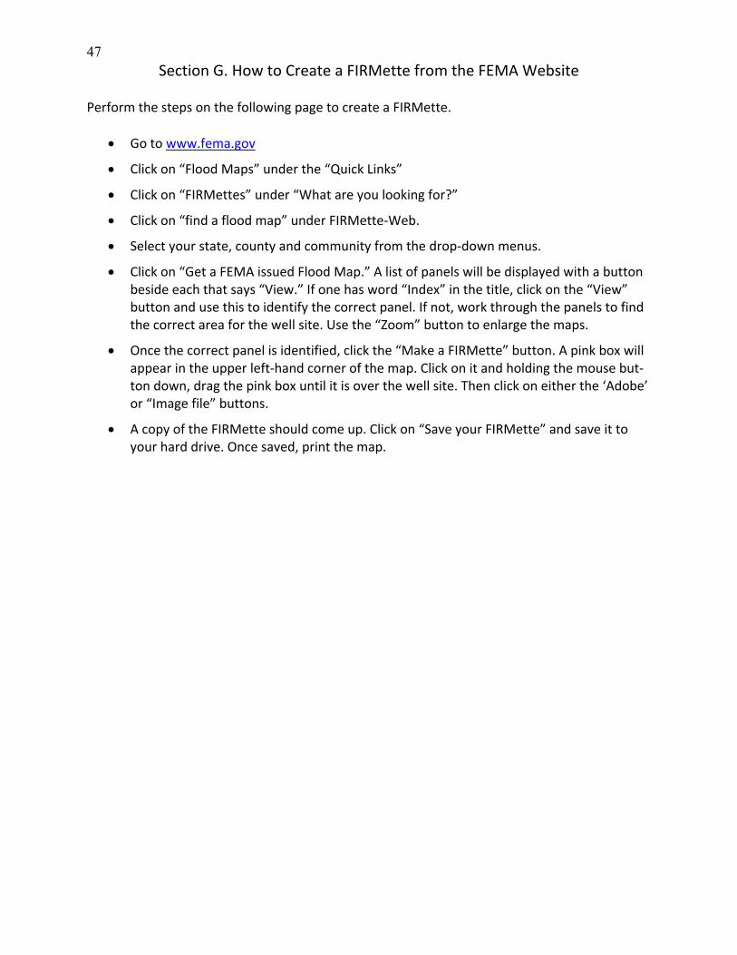
47
Section G. How to Create a FIRMette from the FEMA Website Perform the steps on the following page to create a FIRMette.
Go to www.fema.gov
Click on “Flood Maps” under the “Quick Links”
Click on “FIRMettes” under “What are you looking for?”
Click on “find a flood map” under FIRMette‐Web.
Select your state, county and community from the drop‐down menus.
Click on “Get a FEMA issued Flood Map.” A list of panels will be displayed with a button beside each that says “View.” If one has word “Index” in the title, click on the “View” button and use this to identify the correct panel. If not, work through the panels to find the correct area for the well site. Use the “Zoom” button to enlarge the maps.
Once the correct panel is identified, click the “Make a FIRMette” button. A pink box will appear in the upper left‐hand corner of the map. Click on it and holding the mouse but‐ton down, drag the pink box until it is over the well site. Then click on either the ‘Adobe’ or “Image file” buttons.
A copy of the FIRMette should come up. Click on “Save your FIRMette” and save it to your hard drive. Once saved, print the map.