Embed Size (px)
Citation preview

Annu. Rev. Fluid Mech. 1991.23 : 179 96Copyright © 1991 by Annual Reviews Inc. All rights reserved
THE THEORY OF HURRICANES
Kerry A. Emanuel
Center for Meteorology and Physical Oceanography, MassachusettsInstitute of Technology, Cambridge, Massachusetts 02139
KEY WORDS:tropical cyclones, convection, moist convection, finite-amplitudeinstability
INTRODUCTION
The hurricane remains one of the outstanding enigmas of fluid dynamics.This is so, in part, because the phenomenon is comparatively difficult toobserve and because no laboratory analogue has been discovered. To thisit must be added that hurricanes have received surprisingly little attentionfrom the theoretically inclined fluid dynamicist, perhaps owing to anunderstandable tendency to avoid problems that involve complex thermo-dynamics and lack laboratory analogues. Yet hurricanes involve a richspectrum of fluid-dynamical processes, including rotating, stratified flowdynamics, boundary layers, convection, and air-sea interaction; as such,they provide a wealth of interesting and consequential research problems.This article reviews recent developments in the theory of hurricanes anddelineates the important remaining scientific challenges.
THE MATURE HURRICANE: A NATURAL CARNOTENGINE
About 80 rotating circulations known generically as tropical cyclones formover the tropical oceans each year. Of these, roughly 60% reach an intensity(maximum winds in excess of 32 m s- 1) that qualifies them as hurricanes,a term applied only in the Atlantic and eastern Pacific. (Similar storms inother parts of the world go by different names.) An excellent review of theclimatology and observed characteristics of these storms is provided byAnthes (1982). Here we use the term hurricane in place of the generic termtropical cyclone.
1790066M 189/91/0115-0179502.00
www.annualreviews.org/aronlineAnnual Reviews
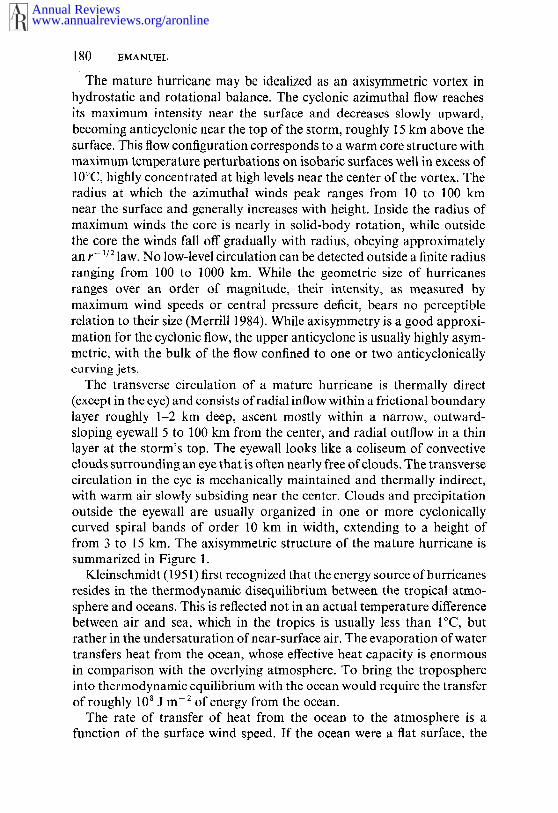
180 EMANUEL
The mature hurricane may be idealized as an axisymmetric vortex inhydrostatic and rotational balance. The cyclonic azimuthal flow reachesits maximum intensity near the surface and decreases slowly upward,becoming anticyclonic near the top of the storm, roughly 15 km above thesurface. This flow configuration corresponds to a warm core structure withmaximum temperature perturbations on isobaric surfaces well in excess of10°C, highly concentrated at high levels near the center of the vortex. Theradius at which the azimuthal winds peak ranges from 10 to 100 kmnear the surface and generally increases with height. Inside the radius ofmaximum winds the core is nearly in solid-body rotation, while outsidethe core the winds fall off gradually with radius, obeying approximatelyan r- 1/2 law. No low-level circulation can be detected outside a finite radiusranging from 100 to 1000 km. While the geometric size of hurricanesranges over an order of magnitude, their intensity, as measured bymaximum wind speeds or central pressure deficit, bears no perceptiblerelation to their size (Merrill 1984). While axisymmetry is a good approxi-mation for the cyclonic flow, the upper anticyclone is usually highly asym-metric, with the bulk of the flow confined to one or two anticyclonicallycurving jets.
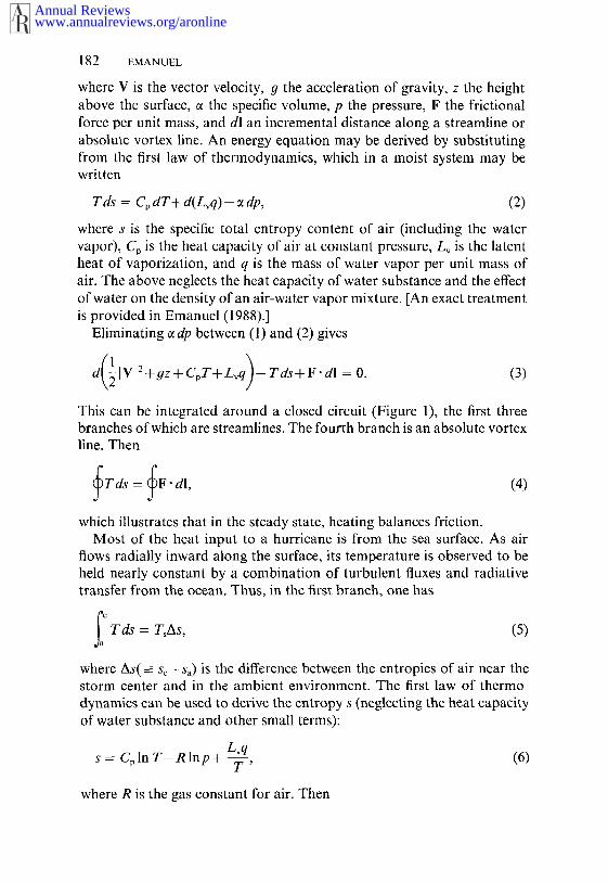
The transverse circulation of a mature hurricane is thermally direct(except in the eye) and consists of radial inflow within a frictional boundarylayer roughly 1-2 km deep, ascent mostly within a narrow, outward-sloping eyewall 5 to 100 km from the center, and radial outflow in a thinlayer at the storm’s top. The eyewall looks like a coliseum of convectiveclouds surrounding an eye that is often nearly free of clouds. The transversecirculation in the eye is mechanically maintained and thermally indirect,with warm air slowly subsiding near the center. Clouds and precipitationoutside the eyewall are usually organized in one or more cyclonicallycurved spiral bands of order 10 km in Width, extending to a height offrom 3 to 15 km. The axisymmetric structure of the mature hurricane issummarized in Figure 1.
Kleinschmidt (1951) first recognized that the energy source of hurricanesresides in the thermodynamic disequilibrium between the tropical atmo-sphere and oceans. This is reflected not in an actual temperature differencebetween air and sea, which in the tropics is usually less than I°C, butrather in the undersaturation of near-surface air. The evaporation of watertransfers heat from the ocean, whose effective heat capacity is enormousin comparison with the overlying atmosphere. To bring the troposphereinto thermodynamic equilibrium with the ocean would require the transferof roughly 108 J m- 2 of energy from the ocean.
The rate of transfer of heat from the ocean to the atmosphere is afunction of the surface wind speed. If the ocean were a flat surface, the
www.annualreviews.org/aronlineAnnual Reviews
THEORY OF HURRICANES 181
(I
~ / /’,;7’", /
ro r
Figure 1 The hurricane Carnot cycle. Air begins spiraling in toward the s~orm center atpoint a, acquiring entropy from the ocean surface at fixed temperature T~. It then ascendsadiab~tiCally from point c, flowing out near the storm top to some large radius, denotedsymbolically by point o. The excess emropy is lost by export or by electromagneticto space betwee~ o and o’ at a much lower temperature To. The cycle is closed by integratingalong an absolute vortex line between o’ and a. The curves c-o and o’-a also representsurfaces of constant absolute angular momentum about the sto~’s axis.
transfer would increase linearly with wind speed, but the increasing rough-ness of the sea surface leads to a somewhat greater dependence on wind.The actual rate of heat transfer is a subject of much controversy andresearch. The dependence of the transfer rate on wind is the principalfeedback mechanism that allows hurricanes to develop. In its essence, thehurricane may be thought of as a wind-induced surface heat exchangeinstability, in which increasing surface winds lead to increased heat transferfrom the sea, which leads to intensification of the storm winds, and so on.
The energy cycle of the mature hurricane has been idealized by theauthor (Emanuel 1986) as a Carnot engine that converts heat energyextracted from the ocean to mechanical energy. In the steady state, thismechanical-energy generation balances frictional dissipation, most ofwhich occurs at the air-sea interface. The idealized Carnot cycle is illus-trated in Figure 1. Carnot’s theorem may be easily derived from Bernoulli’sequation and the first law of thermodynamics. The former states that alongstreamlines or absolute vortex lines in a steady system,
d 7ivi +d(gz)+~zdp+F’dl = O, (1)
www.annualreviews.org/aronlineAnnual Reviews
182 EMANUEL
where V is the vector velocity, 9 the acceleration of gravity, z the heightabove the surface, ~ the specific volume, p the pressure, F the frictionalforce per unit mass, and di an incremental distance along a streamline orabsolute vortex line. An energy equation may be derived by substitutingfrom the first law of thermodynamics, which in a moist system may bewritten
Tds = CpdT+d(Lvq)-~ dp, (2)
where s is the specific total entropy content of air (including the watervapor), o i s t he heat capacity of air a t c onstant pressure, Lv i s t he latentheat of vaporization, and q is the mass of water vapor per unit mass ofair. The above neglects the heat capacity of water substance and the effectof water on the density of an air-water vapor mixture. [An exact treatmentis provided in Emanuel (1988).]
Eliminating ~ dp between (1) and (2) gives
d IVl2+gz+CpT+Lvq --Tds+F.di=O. (3)
This can be integrated around a closed circuit (Figure 1), the first threebranches of which are streamlines. The fourth branch is an absolute vortexline. Then
~Tds-- ~F. dl, (4)
which illustrates that in the steady state, heating balances friction.Most of the heat input to a hurricane is from the sea surface. As air
flows radially inward along the surface, its temperature is observed to beheld nearly constant by a combination of turbulent fluxes and radiativetransfer from the ocean. Thus, in the first branch, one has
~T ds = TsAs, (5)
where As(--- Sc--Sa) is the difference between the entropies of air near thestorm center and in the ambient environment. The first law of thermo-dynamics can be used to derive the entropy s (neglecting the heat capacityof water substance and other small terms):
Lvq(6)s = CplnT--Rlnp-~ T ’
where R is the gas constant for air. Then
www.annualreviews.org/aronlineAnnual Reviews

THEORY OF HURRICANES 183
TsAs = RTs Inpa + Lv(qc-- qa), (7)
where the subscripts c and a refer to quantities evaluated along the surfaceat the storm center and at the starting point, respectively. The saturationof air near the storm center limits the entropy increase to
Lv ,TsAsmax = RT~lnp~ + ~,(q¢ --qa),
Pc .(8)
where q¢* is the saturation mixing ratio at the storm center and is a functionof pc and Ts. From an approximate integration of the Clausius-Clapeyronequation, we have, to an excellent approximation,
3.802mbar [- 17.67Ts -]qc* -- Pc exp L24~.5 ~ TsJ’ (9)
in which Ts is expressed in degrees Celsius.In the second leg of the Carnot cycle, air ascends within deep convective
clouds in the eyewall of the storm and then flows out to large radius. It isimportant to note that when water vapor is properly included in thedescription of the thermodynamic state of the system, this leg is very nearlyreversible and adiabatic, so that ds--0. Some researchers define a dryentropy [without the last term in (6)] and are forced to deal with very largesources of dry entropy in the ascent region, where there is large conversionof latent to sensible heat. The problem with such an approach is that thediabatic source is purely a function of the flow itself and cannot be properlyregarded as external. Attempts to regard the condensation heat source asexternal lead to the oft-repeated statement that hurricanes are driven bycondensation of water vapor, a view rather analogous to that of an engi-neer who proclaims that elevators are driven upward by the downwardacceleration of counterweights. Such a view, though energetically correct,is conceptually awkward; it is far more natural to consider the elevatorand its counterweight as a single system driven by a motor. Here we adopta similar strategy by dealing with the most conserved thermodynamicvariable available, the total specific entropy.
The altitude that the outflow asymptotically approaches is determined bythe requirement that it be neutrally buoyant with respect to the environ-ment. That is, the temperature in the outflow blends smoothly into theambient temperature profile without shocks. The ability of the ambientatmosphere to control the interior structure of the vortex through thisrequirement is consistent with the fact that hurricanes are suberitieal vor-
www.annualreviews.org/aronlineAnnual Reviews
184 EMANUEL
tices (i.e. internal gravity-inertia waves may propagate inward against the
outflow).In the third leg of the Carnot cycle, air descends slowly in the lower
stratosphere, retaining a nearly constant temperature To while losing heatby electromagnetic radiation to space. In this leg, then,
fo’ Tds = - ToAs,
(10)
with As given by (7).Real hurricanes are open systems that continually exchange mass with
their environments. Nonetheless, the Carnot cycle can be closed by inte-grating the Bernoulli equation along a fourth branch that is an absolutevortex line of the system, which is also a surface of constant absoluteangular molnentum about the storm center. Since we are no longer fol-lowing air parcels, the relationship implied by the first law of thermo-dynamics is not strictly valid. It has been shown by Emanuel (1988),however, that there is little thermodynamic contribution from this last leg,owing to the convective neutrality of the ambient atmosphere. Thus adding(7) and (10) gives an expression for the frictional work from
eT, As = ~F- dl, (11)
where e is the thermodynamic efficiency of the Carnot cycle, given by
Ts-ToTs
For typical atmospheric conditions in the tropics, e ~ 1/3.Most of the frictional energy loss in the cycle occurs in the surface
boundary layer and at large radius in the outflow, where the air’s originalangular momentum must ultimately be restored. This latter loss is idealizedas occurring at infinite radius. It may be estimated from conservation ofabsolute angular momentum (M) about the storm center:
1- r2 (12)M = rV+ 2fi ,
where V is the azimuthal velocity, and .f is twice the local vertical com-ponent of the Earth’s angular velocity. From (12), it follows that
V2=_ 1 22
~fr - ~ --fM+ ~f r .(13)
The loss of kinetic energy in the third branch of the cycle is then
www.annualreviews.org/aronlineAnnual Reviews

THEORY OF HURRICANES 185
F’di -~ !i~m~AV = - (Mo-M.) = ~f ra, (14)
assuming that V is zero at the beginning of the cycle.The frictional loss in the boundary layer may be related to the radial
pressure drop by integrating the Bernoulli equation (1) inward along thefirst branch:
F’dl = - ~dp = - RTdlnp = RTslnpa, (15)P~
where we have made use of the ideal gas law, e = RT/p. Thus, the frictionalloss is directly proportional to the logarithm of the pressure deficit.
Substituting (15) and (14) into (11) then
1 2 2eT~As = RT~lnpa + ~f ra,
Po(16)
with an upper bound, for As provided by (8). The last term in (16) reflectsthe energy put into the upper anticyclone; this always detracts from theintensity of the surface cyclone, as reflected in the surface pressure deficit.The stipulation that in (P,/Pc) must be positive leads to a restriction on themagnitude of ra.
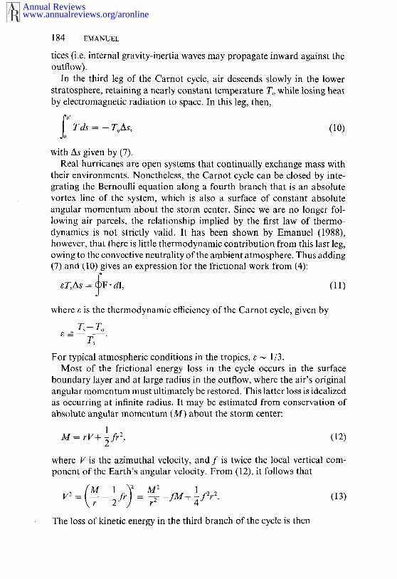
Given r,, p,, qa, Ts, and To, a lower bound on Pc is obtained by using(8) [with (9)] in (16). Unless r~ is unusually large, it has little effect on estimate. Figure 2 shows this lower bound (neglecting ra) as a function Ts and To, using a standard mean surface pressure p, and assuming anambient near-surface relative humidity of 75%. One curiosity of this cal-culation is that there is no solution for sufficiently large T~ or small To. Inthis regime (the hypercane regime) the Carnot cycle becomes unstableowing to a very large heat input from isothermal expansion: the moreintense the storm, the lower the central pressure, giving greater isothermalheat input, which intensifies the storm, and so on.
An estimate of the minimum central pressure po from (16) usingSeptember climatological conditions is shown in Figure 3, together withlocations and central pressures of the most intense hurricanes on record.Clearly, a few hurricanes reach the predicted upper bound on intensity,but the vast majority (not shown in Figure 3) do not.
Two enigmas emerge from Figure 3: Given that the energy potential forhurricanes is large over much of the tropical oceans, why are hurricanesso rare? And even when a hurricane occurs, why do so few reach thetheoretical upper bound on intensity?
www.annualreviews.org/aronlineAnnual Reviews

186 EMANUEL
RH = 75%
40
38
3~"
34.
32"
30’
2.8"
~’6’
24
~00 -15 =30
975
~ Hy percones
-60 -75 -90 -105 -120 -155
folOC)Figure 2 The minimum sustainable central pressure (in millibars) as a function of sea-surface temperature (T~) and mean outflow temperature (~o), assuming an ambient surfacepressure of 1015 mbar and an ambient near-surface relative humidity (RH) of 75%.
HURRICANE GENESIS AS AN EXAMPLE OFFINITE-AMPLITUDE INSTABILITY
Forecasters have known for some time that hurricanes never arise spon-taneously, even if the environmental conditions are considered favorable.Rather, they always emerge from preexisting circulations of presumablyindependent dynamical origin. Yet some of the early theories attemptedto treat tropical cyclogenesis using linear theory.
The Failure of Linear Stability Theory
Early investigations focused exclusively on the dynamics of moist con-vection (see the review by Yanai 1964). These studies suffered the resultthat disturbances of the smallest horizontal scale should develop mostrapidly and so cannot explain the scale of hurricanes. Charney & Eliassen(1964) recognized this defect and proposed a theory called Conditional
www.annualreviews.org/aronlineAnnual Reviews

THEORY OF HURRICANES 187
40
20
EQ
2O
4O
tOOE 120 140 160 t80 t60 140 t20 |00 80 60W
2,,,, ,~,, ~, , , , , , , , , , ,~tOOE t20 t40 160 180 160 140 t20 t00 80 60W
Fi#ure 3 Minimum sustainable central pressure of tropical cyclones (in millibars) underSeptember climatological conditions. The central pressures of some of the most intensetropical cyclones on record are shown by italicized numbers and crosses.
Instability of the Second Kind (CISK) that sought to explain the scale hurricanes by requiring the convection to occur in proportion to theupward motion induced by the frictional boundary layer of a vortex. Here,as in other similar works, dry thermodynamics was used and the heatingwas externalized as much as possible--in this case by making it pro-portional to the frictionally induced vertical velocity and by distributingit in the vertical by an arbitrary function. While not explicitly related tothe concept of convective instability, CISK implicitly requires a reservoirof convective energy to operate. By choosing the right ad hoc parameters,a large-scale amplifying disturbance can be obtained.
While always controversial, CISK has remained popular among a subsetof meteorologists, in part because of the mathematical simplicity of therepresentation of cumulus convection suggested by Charney & Eliassen(1964), but perhaps also because of the enormous appeal of the notion the latter authors that "cumulus clouds and the large scale circulationcooperate, rather than compete." CISK entirely disregards the importanceof enhanced heat fluxes from the sea, emphasized by earlier researcherssuch as Kleinschmidt (1951) and Riehl (1954), and can be shown to energetically on stored potential energy in the tropical atmosphere. This
www.annualreviews.org/aronlineAnnual Reviews

188 EMANUEL
stored energy would be reflected in a thermodynamic stratification of theatmosphere that allows boundary-layer air to become positively buoyantwhen displaced upward a sufficient distance; this is called a state of con-ditional instability. Recent work by Betts (1982) and Xu & Emanuel (1989),however, demonstrates that mean thermodynamic profiles over tropicaloceans are almost precisely constant, as is true of most other forms ofhigh-Rayleigh-number convection, so that there is very little variation offree atmospheric temperature in the absence of boundary-layer entropyvariations. Stored energy occurs occasionally over midlatitude continentsas a result of particular arrangements of topographical features. ThusCISK predicts, in direct contradiction to observation, that nascent hur-ricanes should be common over midlatitude continents during the warmermonths but absent over the oceans.
The weight of evidence suggests that CISK be rejected as a usefulhypothesis and that attempts be undertaken to find a finite-amplitudeinstability based on the thermodynamic interaction of the atmosphere andocean.
Results of Fully Nonlinear Integrations
There have been a number of successful numerical simulations of hurri-canes, dating back to the work of Ooyama (1969). Such modeling hasadvanced to the point where cumulus clouds themselves can be explicitly(albeit crudely) resolved, at least in axisymmetric models. Virtually allnumerical simulations contain representations of the sea-air heat fluxnecessary to maintain hurricanes, but nearly all begin with decidedlyunstable thermal stratification. This creates an ambiguity in interpretingthe initial spin-up of the cyclone, since unstable convection artificiallyconstrained to two dimensions will lcad to upscale energy transfer, asshown originally by Fjortoft (1953). This no doubt occurs in the axisym-metric numerical simulation by Yamasaki (1977), whose integration beginswith highly unstable stratification but whose model allows no surface heatfluxes. The result is a thunderstorm-scale cyclone that reaches maturity in40 hr, considerably less time than is generally observed in nature. At theother extremc, Rotunno & Emanuel (1987) integrate an axisymmetric,nonhydrostatic model that resolves cumulus convection, starting from aninitial state that is neutral to cumulus convection. The evolution of theirsimulated cyclone is portrayed in Figure 4, which shows three experimentsthat differ only in the amplitnde and geometry of the initial vortex. It isevident that amplification occurs only when the initial vortex is sufficientlyintense and concentrated. In this simulation, the amplification may beconsidered to result from a finite-amplitude instability, in accord withnature; the resting atmosphere is metastable. The mature model cyclone
www.annualreviews.org/aronlineAnnual Reviews

THEORY OF HURRICANES 189
5C
20 I’~
i .,~b-<.....-., ..-.,-,...,. - ",o ~"..J \-~ ",,,’,,
I
’ 2’0 ’ 4’0 ’ 6’o ’ d0 ’ 4o’ do’ t4o’ 40’ t~0TIME (hours)
Figure 4 Maximum azimuthal velocity as a function of time (in hours) for three numericalsimulations of hurricanes from Rotunno & Emanuel (1987). The solid curve denotes thecontrol simulation. The dashed curve shows the results of an experiment identical to thecontrol but starting with an amplitude of 2 m s-t. The dash-dot curve denotes a thirdexperiment in which the initial vortex has twice the radial dimensions of the control.
has a structure and amplitude that are quite compatible with observedhurricanes, and the amplitude conforms nearly exactly with the theoreticalprediction based on the Carnot cycle, as discussed previously. Assumingthat the physical reasons for the finite-amplitude nature of the instabilityin the numerical model and in nature are similar, we may inquire aboutthe latter by using the fields produced by the model. As is often the case,however, the output of complex numerical models is as inscrutable asnature herself.
A Minimal Nonlinear ModelOne approach to understanding complex phenomena is to reduce them totheir barest essence in idealized mathematical models. In doing so, onehopes to retain the fundamental physics while discarding embellishments,taking care not to throw away the baby with the bath water. (A worse fateyet is to end up with the wrong baby.)
A minimal hurricane model has been constructed by the author (Eman-uel 1989). (The model may be run on personal computers and is welldocumented. It is available on request.) The flow in the model is taken tobe axisymmetric and in hydrostatic and gradient wind balance, except ina frictional boundary layer. The equations of the model are transformedinto a coordinate system in which one of the coordinates, R, is proportionalto the absolute angular momentum per unit mass about the storm center:
www.annualreviews.org/aronlineAnnual Reviews

190 EMANUEL
1 u 1 2~fR = rV+ ~fr , (17)
where f is considered constant. Since R is conserved in the absenceof friction, this formulation eliminates radial advections, except in thefrictional boundary layer. Moreover, the theory of slantwise convection(e.g. Emanuel 1983) shows that the relevant convectively neutral state one in which air parcels are neutrally buoyant along angular-momentumsurfaces, rather than along vertical surfaces.
The structure of the minimal model is summarized in Figure 5. Thedependent variables are the physical radius r, predicted at the top of themodel and at the top of the boundary layer; the mass streamfunction ~p,predicted at the middle level and diagnosed at the top of the boundarylayer; temperature, represented by a saturation entropy s*, predicted atthe middle level and in the lower layer; and actual entropy s, predicted inthe boundary layer and in the lower layer. (The saturation entropy is theentropy the air would have if it were saturated at the same temperatureand pressure. It is a state variable.)
The essence of the finite-amplitude nature of the hurricane instabilityappears to rely on the existence of a spectrum of different types of wetconvection, represented in the model by only two categories: shallowconvection, which penetrates only to the lower layer; and deep convection,which extends through the depth of the model atmosphere. These twoforms differ in that the former does not precipitate while the latter does.Within deep, precipitating clouds, the latent heat acquired from the sea ismostly converted into sensible heat, while shallow clouds produce no net
~ V’o,rb
Figure 5 Vertical structure of the simple balanced model. The dependent variables arephysical radii r t and rb, saturation entropies s* and Sin*, and actual entropies sb and Sin. Deepclouds occur whenever Sb > S*, while shallow clouds are present when Sb > Sm*. The shallowclouds do not precipitate and thus produce no net heating.
www.annualreviews.org/aronlineAnnual Reviews

THEORY OF HURRICANES 191
heating, since all the condensed water is ultimately reevaporated. Butshallow clouds do stabilize the atmosphere by exchanging the high-entropy, boundary-layer air with low-entropy air from the lower tropo-sphere. The entropy minimum in the lower troposphere above the bound-ary layer, which results from the large subsaturation there, is a normalfeature of the tropical atmosphere and is crucial for understanding thefinite-amplitude nature of tropical cyclogenesis. In the minimal model,shallow clouds occur whenever there is local convective instability in thelower atmosphere (i.e. when s > Sin*, where Sm* is the saturation entropy ofthe lower layer). Deep clouds occur when s > s*.
The fundamental dimensional parameters governing the behavior of themodel are the Coriolis parameter f, the depth H of the troposphere, thedimensionless exchange coefficient CD that appears in the bulk aero-dynamic formulae by which heat and momentum fluxes from the oceanare calculated, and a measure of the sea-air thermodynamic disequilibrium:
~ =- (T~- Tt)(sZ-Sa), (18)
where Ts is the ocean temperature, Tt the ambient temperature of thetropopause, s~’ the saturation entropy of the ocean surface, and sa theentropy of the normal tropical atmosphere near sea level. The quantitys~-sa represents the thermodynamic disequilibrium of the atmosphere-ocean system. When the governing equations are suitably normalized, veryfew nondimensional parameters are needed to describe the system. Themost important of these are those describing the initial vortex and themagnitude of the entropy minimum in the lower troposphere. The scalingfactors for time, length, and velocity are listed in Table 1. Note that all ofthe scales depend on ks, and that these scales are quite different from thoseof baroclinic cyclones.
Table 1 Hurricane scales
Quantity Scalea Typical value
Length Z~/~f- ~ 1000 kmTime C~ ~H)~7 ~/~ 16 hrAzimuthal velocity Z~/2 60 m s- ~Radial velocity ~CD~sf- ~H- ~ 10 m s- ~Vertical velocity CD~ls/2 6 cm s- ~
"Scale parameters: H ~ depth of convecting layer, f ~- twice thelocal vertical component of Earth’s angular velocity, Co-= di-mensionless exchange coefficient for surface fluxes, ;(~ =-thermo-dynamic disequilibrium parameter, defined by Equation (18).
www.annualreviews.org/aronlineAnnual Reviews

192 EMANUEL
Figure 6 shows the evolution of the maximum (dimensionless) wind with(dimensionless) time for four different experiments. The control run beginswith a warm-core vortex of amplitude 0.22, which decays with time initiallybut ultimately amplifies to a quasi-steady intense cyclone. The secondexperiment is identical to the first except that the initial amplitude is0.05. This vortex never amplifies, which demonstrates the finite-amplitudenature of instability in the simple model. The third and fourth experimentsare identical to the first two except that shallow clouds are omitted. Thesesimulations exhibit linear instability in the sense that small perturbationscan amplify. Clearly, the finite-amplitude nature of cyclogenesis in thesimple model depends on the existence of weakly precipitating convection.Why?
The Nature of Moist Convective Adjustment
Consider two extremely different convective processes. In the first, weallow only nonprecipitating convection. Suppose we cool the middle tropo-sphere by, say, adiabatic lifting of the (dry) middle-troposphere air. Thisdestabilizes the column to convection, but since the convection does notprecipitate, its ensemble-average effects do not include heating and theadiabatic cooling is thus unopposed. But the convection does drive thecolumn back toward neutrality by importing low-entropy air into theboundary layer from the middle troposphere (whose entropy is usuallysubstantially less than that of the boundary layer). Hence, nonprecipitatin9convection forces the boundary-layer entropy to follow changes in free-atmosphere temperature. In the second process, we suppose that all ofthe water condensed in clouds falls out as rain. Now, when the middletroposphere is cooled, at least some of the cooling is opposed by the netheat released in precipitating clouds. Precipitatin9 convection drives theatmosphere toward neutrality, in part, by forciny the free-atmosphere
1.0
.8
Vmox.6
.4
Exp.
Exp. F2 .,~
6 8 I0 t2Time
Figure 6 Evolution of maximum dimen-sionless velocity with dimensionless timefor four experiments with the simplifiedmodel. The control run is shown by thesolid line. Expcrimcnt E is identical to thecontrol except that it begins with a smalleramplitude. Experiments F~ and Fz areidentical to the first two experiments exceptthat shallow clouds are omitted.
www.annualreviews.org/aronlineAnnual Reviews
THEORY OF HURRICANES 193
temperature to follow changes in the boundary-layer entropy. Generalizingfrom these two examples, we assert that only a fraction of forced coolingof the middle troposphere will be opposed by convective heating in aconditionally neutral mean atmosphere. This fraction is approximatelyequal to the precipitation efficiency, which is the fraction of condensedwater that falls out of the system.
From this argument we may understand the essence of the finite-ampli-tude nature of tropical cyclogenesis. When a weak vortex is placed incontact with the sea surface, frictional inflow forces upward motion in thefree atmosphere near the vortex core. (Other processes may force upwardmotion in real cyclones.) Since the initial convection will no doubt havea precipitation eff~ciency less than unity, not all of the adiabatic coolingassociated with the ascent of dry (low-entropy), middle-tropospheric airwill be opposed by convective heating, and the central core will cool.Moreover, the boundary-layer entropy near the core will decrease by theaction of downdrafts so as to keep the column neutral to moist convection.Thus, we have no more than the classical spin-down of a balanced, strati-fied vortex on a rigid surface, but with the static stability N2 replaced byan effective stability approximately equal to N2(1-ep), where ep is theprecipitation efficiency.
Opposing this tendency is the anomalous flux of (mostly latent) heatfrom the ocean into the boundary layer, associated with the anomaloussurface winds. Initially, this flux can only partially compensate for thereduction in boundary-layer entropy due to the import of low-entropy airfrom the middle troposphere by the convective downdrafts. The surfacefluxes vary with approximately the first power of the surface wind speed,while the drag (and thus the frictionally induced vertical motion) increasesmore nearly as the square of the wind speed, so that, if anything, the netcooling increases with initial vortex amplitude. But after some time haselapsed, the entropy of the middle troposphere increases owing to theupward flux of high, boundary-layer entropy by low-precipitation-efficiency convection. When the entropy of the middle troposphere becomeslarge enough, the import of low-entropy air into the boundary layer bydowndrafts can no longer compensate for enhanced surface heat fluxes, andthe boundary-layer entropy increases together with the free-atmospherictemperature. The vortex amplifies. This is clearly a nonlinear effect. Exam-ination of the thermodynamic fields of both the simple model and thecomplete model supports this heuristic view. The obvious observationaltest of this idea is to find out whether the saturation of a deep column oftropospheric air is a necessary and sufficient condition for the developmentof tropical cyclones.
www.annualreviews.org/aronlineAnnual Reviews

194 EMANUEL
SUMMARY AND REMAINING PROBLEMS
The mature hurricane is a Carnot engine driven by the thermodynamicdisequilibrium between the tropical oceans and atmosphere. Air spiralingradially inward in the boundary layer is brought closer to thermodynamicequilibrium with the ocean by large wind-induced heat fluxes; it then risesnearly (moist) adiabatically to great altitudes, where the excess heat exported or lost by electromagnetic radiation to space. The mechanicalenergy available from this cycle is a thermodynamic efficiency e, multipliedby the surface temperature and by the difference between the saturationentropy of the ocean surface (at the central pressure of the hurricane) andthe undisturbed boundary-layer entropy. The efficiency is
where TS is the sea-surface temperature, and To is the mean temperatureat which heat is exported by or lost from the storm’s high-level outflow.Its typical magnitude is 1/3.
While the energy source for mature hurricanes has been recognized sinceat least the time of Kleinschmidt (1951), controversy remains about theenergetics and dynamics of hurricane genesis. Observational evidence andforecasting experience favor the idea that hurricanes result from a finite-amplitude instability: Weak disturbances are often observed to decay evenunder favorable environmental conditions, and hurricanes are, after all,rare despite the nearly ubiquitous presence of an energy reservoir (seeFigure 3).
In the early 1960s the theory known as Conditional Instability of theSecond Kind (CISK) was proposed to explain hurricane genesis. In thistheory, the ocean surface serves as a sink for momentum but not asa source of heat; the spin-up relies on convective energy stored in theatmosphere. This theory is suspect for a variety of reasons. First, carefulanalyses of the maritime tropical atmosphere show little stored convectiveenergy, and the few locations (such as central North America in spring)that exhibit large amounts of stored convective energy are not known toproduce incipient cyclones. Also, CISK is a fundamentally linear insta-bility; taken at face value, it predicts that incipient cyclones should beubiquitous features of all convectively unstable atmospheres.
The author (Emanuel 1986) has proposed an alternative theory thatregards tropical cyclogenesis as resulting from finite-amplitude Wind-Induced Surface Heat Exchange (WISHE) instability of the tropical atmo-sphere, relying on a positive feedback between surface heat fluxes and
www.annualreviews.org/aronlineAnnual Reviews
THEORY OF HURRICANES 195
surface wind. WISHE modes are regarded as occurring in ambient atmo-spheres that are neutral to adiabatic displacements of boundary-layerair and hence have no stored convective energy. The reevaporation ofcondensed water in the low-entropy air of the middle troposphere appearsto be the reason for the finite-amplitude nature of the instability: Theresulting downdrafts import low-entropy air into the boundary layer at arate that exceeds the enthalpy flux from the ocean surface. Intensificationoccurs when the entropy of the middle-tropospheric air has been raisedenough to substantially weaken the low-entropy flux into the boundarylayer by downdrafts. While these ideas are consistent with complex numeri-cal simulations, they have yet to be systematically tested in real tropicalcyclones.
Even if the reasons for the finite-amplitude nature of tropical cyclo-genesis are correctly identified, the problem of genesis would remain asone of explaining the initiating disturbance. Observations indicate that avariety of circulations of dynamically independent origin may initiatetropical cyclones. These include easterly waves, which are wavy dis-turbances in the east-to-west flow of air in the tropics, especially overand west of sub-Saharan Africa and in the central Pacific; baroclinicdevelopments in the subtropics; and continental mesoscale thunderstormcomplexes that occasionally drift out over open water. A complete finite-amplitude theory of hurricanes could presumably specify the requiredcharacteristics of the initiating disturbances.
In addition to the problem of genesis, several aspects of hurricanebehavior remain poorly understood. Given that "ignition" has occurredand a hurricane develops, very few reach the upper bounds on intensityimplied by Figure 3. On the other hand, many numerical simulations (e.g.those of Rotunno & Emanuel 1987) consistently intensify storms right tothe upper bound. Why is nature different? One possibility is that mosthurricanes are limited by the cold water that they invariably mix upwardfrom beneath the oceanic seasonal thermocline. Observed sea-surface tem-perature changes are as large as 5°C; only about 2.5°C of cooling is neededto reverse the air-sea thermodynamic disequilibrium. Preliminary studiesshow that the induced cooling may indeed limit the intensity of manyhurricanes, though a comprehensive simulation with a coupled ocean-atmosphere model remains to be performed.
The spiral bands of convective clouds that give hurricanes their charac-teristic appearance in satellite photographs are not well understood. Extanttheories include Ekman-layer instability and inertia-gravity waves prop-agating outward from the eyewall. These theories have not been rigor-ously tested against observations. Some strong hurricanes exhibit con-centric eyewalls that undergo a characteristic evolution in which the
www.annualreviews.org/aronlineAnnual Reviews
196 EMANUEL
eyewalls contract inward, the inner eyewall dissipates, and a new eyewallforms at a larger radius (Willoughby et al 1982). There is no well-accepted
theory of this phenomenon.Finally, the issue of hurricane steering remains the focus of lively
research. Most theories pertain to the drift of barotropic vortices on/~-planes (on which the vertical component of the Earth’s rotation rate varieslinearly with latitude). These theories predict that hurricanes should driftwestward and poleward with respect to the mean wind. They do notaccount for the nonuniformity of the background potential-vorticity gradi-ent in which hurricanes are embedded, nor do they recognize hurricanesas strongly baroclinic vortices with anticyclones in the upper troposphere.It seems likely that accounting for such effects will radically alter ourunderstanding of hurricane motion.
Hurricanes present a large number of fascinating and unresolved prob-lems that have received surprisingly little attention from theorists. As such,they remain a fertile and important subject of research in fluid dynamics.
Literature Cited
Anthes, R. A. 1982. Tropical cyclones: theirevolution, structure and effects. Meteorol.Mono,qr. No. 41. Boston: Am. Meteorol.Soc. 298 pp.
Betts, A. K. 1982. Saturation point analysisof moist convective overturning. J. A tmos.Sci. 39:1484-1505
Charney, J. G., Eliassen, A. 1964. On thegrowth of the hurricane depression. J.Atmos. Sei. 21:68-75
Emanuel, K. A. 1983. The Lagrangian parceldynamics of moist symmetric instability.J. Atmos. Sci. 40:2368 76
Emanuel, K. A. 1986. An air-sea interactiontheory for tropical cyclones. Part I. J.Atmos. Sci. 43:585q504
Emanuel, K. A. 1988. The maximum inten-sity of hurricanes. J. Atrnos. Sci. 45:1143-55
Emanuel, K. A. 1989. The finite-amplitudenature of tropical cyclogenesis. ,L Atmos.Sci. 46:3431-56
Fj~rtoft, R. 1953. On the changes of thespectral distribution of kinetic energy fortwo-dimensional, nondivergent flow. Tellus5:225-30
Kleinschmidt, E. Jr. 1951. Gundlagen einerTheorie des tropischen Zyklonen. Arch.
Meteorol., Geophys. Bioklimatol., Ser. A4:53-72
Merrill, R. T. 1984. A comparison of largeand small tropical cyclones. Mon. WeatherRev. 112:1408-18
Ooyama, K. 1969. Numerical simulation ofthe life cycle of tropical cyclones. J. A trnos.Sci. 26:3-40
Riehl, H. 1954. Tropical Meteorology. NewYork: McGraw-Hill. 392 pp.
Rotunno, R., Emanuel, K. A. 1987. Anair-sea interaction theory for tropicalcyclones. Part II. J. Atmos. Sei. 44: 542-61
Willoughby, H. E., Clos, J. A., Shoreibah,M. G. 1982. Concentric eye walls, second-ary wind maxima and the evolution ofthe hurricane vortex. J. Atmos. Sci. 39:395~411
Xu, K., Emanuel, K. A. 1989. Is the tropicalatmosphere conditionally unstable? Mon.Weather Rev. 117:1471-79
Yamasaki, M. 1977. A preliminary experi-ment of the tropical cyclone without pa-rameterizing the effects of cumulus con-vection. J. Meteorol. Soc. Jpn. 55:11-31
Yanai, M. 1964. Formation of tropical cy-clones. Rev. Geophys. 2:367-414
www.annualreviews.org/aronlineAnnual Reviews

![Evolution of the upper tropospheric outflow in Hurricanes ......and Emanuel [2012],and modeling outflowstudies such as Wang et al. [2014] byusing observations coupled with 6h high-resolution](https://img.pdfslide.us/doc/110x75/6049ce8d92dfbd17fb67ba57/evolution-of-the-upper-tropospheric-outflow-in-hurricanes-and-emanuel-2012and.jpg)