Embed Size (px)
Citation preview
EARTH SURFACE PROCESSES AND LANDFORMS, VOL. 8 , 5 8 9 4 0 3 (1983)
THE TEMPORAL AND SPATIAL DEVELOPMENT OF
NATIONAL NATURE RESERVE, DEVON LANDSLIDES IN THE AXMOUTH-LYME REGIS UNDERCLIFFS
JOHN PIITS*
Department of Building and Civil Engineering, Liverpool Polytechnic. Clarence Street. Liverpool L3 5UG, U. K.
Received 23 June I982 Revised 14 March I983
ABSTRACT
A chronology of landsliding is presented, including suggestions as to a date for initiation. Periods of activity known from historical sources are correlated with known periods of climatic deterioration. The current morphology of the landslide slopes is closely related to the geological succession and structure. These permit the landslides and their development to be differentiated on the basis of whole slope and toe morphology, and much of the whole-slope activity can be related to conditions at the toe. Examples of geomorphological maps, slope categories maps, and cross sections are presented along with a n example of the ‘evolutionary’ maps which may be derived from Ordnance Survey plans and aerial photographs. These generally indicate that weakening of materials by weathering, seepage erosion at the toe, and marine erosion result in frequent mass movement events of a low magnitude. These events ultimately influence the stability of larger slipped blocks behind, which fail less frequently. It is suggested that whole-slope failures in this region have a maximum frequency of once in 120 to 150 years, and that problems of interpretation of historical accounts may mean that it is very much less frequent than this.
KEY WORDS Slope evolution Rotational slip Planar sliding Mudslide Geomorphological mapping Devon
INTRODUCTION
The Axmouth-Lyme Regis Undercliffs occupy an approximately 8.0 km strip of coast in the extreme southeast corner of Devon. The area of the Undercliffs Nature Reserve is almost totally occupied by slope failures (Pitts, 1981a), the localities of the main landslide units being shown in Figure 1. A chronology of landsliding during historical times has been presented for the Bindon slip (Pitts, 1974) and for the Reserve as a whole (Pitts, 1981b). The aim of this paper is to provide details of the geomorphology of the main landslide units and to attempt to explain their evolution.
Once at the foot of the rear scar of the inland cliff, virtually no unslipped ground occurs within the Reserve, apart from where sea cliffs are formed of in situ rocks. An assemblage of maps and sections will be presented to aid the description of the spatial and temporal evolution of landsliding in this geomorphologically dynamic area.
The solid geology of the Reserve comprises Mesozoic rocks ranging from Keuper (Keuper Marl or Mercia Mudstone Group) (Warrington, 1980) to Senonian (Upper Chalk). The Gault, Upper Greensand, and Chalk overstep the progressively older formations of Lower Lias, Rhaetic (or Penarth Group (Warrington, 1980)), and Keuper ages from east to west. The plane of this considerable unconformity dips just east of south at about
* Present address: School of Civil and Structural Engineering; Nanyang Technological Institute; Upper Jurong Road; Singapore 2263.
0197-9337/83/060589-15$01 S O 0 1983 by John Wiley & Sons, Ltd.

590 J. PITTS
Lyrne Bey N
f OAmj footpath
Figure 1. Location map of the Axmouth-Lyme Regis Undercliffs and the sites of landslides referred to in the text. 1. Haven Cliffs, 2. Culverhole Point, 3. Bindon Cliffs, 4. Goat Island, 5 . Dowlands Cliffs, 6. Rousdon Cliffs, 7. Charton Bay,
8. Humble Point, 9. Pinhay Bay, 10. Ware Cliffs
5". The disposition of strata is shown diagrammatically in Figure 2, and the details of the succession are summarized in Table I.
The geometry of the overstep rarely allows a complete succession to be observed. However, a large dip-slip fault with downthrow to the west exposes a succession from the Tea Green Marls (Blue Anchor Formation) to the Middle Chalk with a substantial Rhaetic, Liassic, and Albian succession inbetween. The pre-Cretaceous beds have an easterly dip which averages about 1 1 O , but which varies as a result of local faulting and folding. The area is discontinuously capped by a clay-with-flints deposit, typically about one metre thick.
1 2 3 4 5 6 7 0 9 10 west G 3 east
- x x y t z - x + y c - x d
Figure 2. Schematic section showing the geological succession and structure between Axmouth and Lyme Regis. 1. River Axe, 2. Haven Cliffs, 3. Culverhole Cliffs, 4. Bindon, 5. Dowlands, 6. Rousdon. 7. Charton Bay, 8. Pinhay Bay, 9. Ware Cliffs, 10. Lyme Regis. Succession, as key. x: sea cliffs of in siru rocks; y: slipped, 9, to G; z: slipped C, to G with toe mudslides
KEY G,: E,: D: Gault. C,: B,: A,: F:
Upper Chalk; G,: Middle Chalk; GI: Cenornanian limestone. Phosphatic Upper Greensand; E,: Cherty Upper Greensand; El: Foxmould.
Shales with Beef; C,: Blue Lias. White Liass; 9,: Cotham Beds; 9,: Rhaetavicula contorta Shales; 9,: Rhaetic Bone Bed. Tea Green and Grey marls; A,: Red and Variegated Mark (Keuper). Faults; A: scree; A: colluvium

Tabl
e I.
Geo
logi
cal S
ucce
ssio
n fo
r th
e A
xmou
th-L
yme
Reg
is U
nder
cliff
s (m
odifi
ed a
fter
Mac
fady
en, 1
971)
Terti
ary
to R
ecen
t C
lay
with
flin
ts
(dis
cont
inuo
us) z
one
Seno
nian
co
rtes
tudi
nari
um
plan
us
lata
( =
gra
cilis
). la
biat
us (
= c
uoie
ri)
Turo
nian
Upp
er
{ (T
uron
ian
Cre
tace
ous
Har
d no
dula
r ch
alk
with
ban
ds o
f bl
ack
flint
H
ard
and
soft
nodu
lar
chal
k w
ith
1 flints
Lo
wer
I Ch
alk
[ $::sand I Lo
wer
C
reta
ceou
s
Gau
lt
subg
lobo
sus
Sand
y, o
ccas
iona
lly co
nglo
mer
atic
gl
auco
nitic
, pho
spha
tic l
imes
tone
s Ph
osph
atic
and
che
rty y
ello
wis
h gl
auco
nitic
san
dsto
nes
Gla
ucon
itic
silty
san
ds (
Foxm
ould
)
v a r i
a n s
disp
ar (
= P
ecta
n as
per)
in
jatu
m (
= r
ostr
ata)
{ (C
enom
ania
n
Sine
mur
ian
Jura
ssic
Bas
e of
Jur
assi
c in
new
cor
- re
latio
n
Het
tang
ian
(Upp
er
Lils
tock
For
mat
ion)
Rha
etic
(P
enar
th
Gro
up)
Ll <
Dar
k py
ritife
rous
cal
care
ous s
hale
s w
ith in
terb
edde
d fib
rous
cal
cite
(bee
f). B
lack
Ven
Mar
ls w
ith S
hale
s with
Be
ef a
s th
e lo
wes
t mem
ber
Alte
rnat
ing
calc
areo
us s
hale
s an
d ca
lcar
enite
s w
ith o
c-
% r 5 3 5 2
obtu
sum
se
mic
osta
tun
buck
land
i
angu
lata
pl
anor
bis
Pre-
Plan
orbi
s be
ds.
casi
onal
larg
e am
mon
ite b
earin
g no
dule
s. B
lue
Lias
.
n
Lang
port
Bed
s, W
hite
Lia
s (L
angp
ort m
embe
r) S
un b
ed a
t top
with
man
y U
-sha
ped
burr
ows.
Rub
bly
limes
tone
s at
hig
her
leve
ls, p
orce
lane
ous
limes
tone
s at
low
er l
evel
s. Fo
ssili
fero
us
thro
ugho
ut.
Cot
ham
mar
ble
(Cot
ham
mem
ber)
. Cre
am a
nd b
uff c
olou
red
clay
s, sh
ales
, mud
ston
es a
nd th
in l
imes
tone
s, in
clud
ing
Cot
ham
mar
ble.
Rhae
taoi
cula
con
tort
a be
ds. G
rey
and
blac
k se
leni
tic sh
ales
and
occ
asio
nal t
hin
limes
tone
s.
Bon
e be
d. V
ery
thin
det
rital
lim
esto
ne.
Low
er
(Wes
tbur
y Fo
rmat
ion)
K
eupe
r (M
erci
a M
udst
ones
G
roup
)
Tea G
reen
and
Gre
y M
ark
(Blu
e Anc
hor F
orm
atio
n): g
rey
and
gree
n gy
psife
rous
fissu
red
clay
s, w
ith
som
e ha
rd i
ndur
ated
mud
ston
e ba
nds,
and
term
inat
ed b
y bl
ack,
sel
eniti
c pap
er s
hale
s.
Red
and
var
iega
ted
gyps
ifero
us fi
ssur
ed c
lays
with
har
d gr
ey-g
reen
mud
ston
e ba
nds.
I Tr
iass
ic

592 J. PITTS
THE INITIATION OF LANDSLIDING
The present configuration of the ground in the undercliffs is the product of a series of mass movement events which are believed to have originated during late Pleistocene times. The denuded remains of landslides probably form extensive parts of the offshore region. Recent submarine geophysical work conducted in Lyme Bay (Darton et af., 1981) has revealed many ‘axes’, trending roughly parallel to the coast, which were interpreted as being of a structural origin. In fact, the main structural axes in the pre-Cretaceous strata in this area trend approximately normal to the coast. It is suggested, therefore, that the axes are the eroded remains of multiple rotational slips, repeatedly planed off and oversteepened by a transgressing sea in immediately post- glacial times.
As the toe areas were removed, the landsliding developed a variety of forms determined largely by geological detail. The effects of toe erosion and high water tables continue to have an effect on stability, although the relative stabilization of the rate of sea level rise has led to a decrease in the frequency of occurrence of high magnitude events, especially whole-slope events. Both Jelgersma (1961) and Akeroyd (1972) suggest that the current rate of sea level rise level is in the order of 10.0cm per century, and Akeroyd believes that this rate has been operative for the past 6000 years. Therefore the current slope morphologies may indeed have been established a considerable time ago, following the initial post-glacial period of rapid sea level rise.
An alternative hypothesis has been suggested for the initiation of landsliding by Kellaway et al. (1975) who suggest that landslips may have resulted from glacial oversteepening and dissection by meltwaters. Axmouth is specifically suggested as being a focus of strong glacial/fluvioglacial erosion. The evidence cited for glaciation includes the occurrence of erratic material at Chesil Beach, derived from morainic drift deposited by English Channel ice, or from meltwaters issuing from the Rivers Teign and Otter. Arkell (1949) suggests that much of the material forming Chesil Beach originated as a connection to some lost headland of Cretaceous and Triassic materials seaward of Beer Head and Dowlands Cliff.
Although exotic materials do exist in the Chesil Beach accumulation, Harrison (1848) suggests that its origin was as ships ballast dumped locally before taking on cargo. If glaciation did indeed extend as far south as the English Channel, it is likely that the ice was not particularly erosive. Perhaps though, any meltways could have been a potent force in initially oversteepening the slopes, although a transgressing sea would have had the same effect.
The pre-Cretaceous beds have been eroded approximately along their strike and so the position of any bed may be expected to remain at a constant level. However, there are periclinal folds within the pre-Cretaceous beds, for example at the toe of the Rousdon slip, where there is not only easterly dip of strata, regarded as fairly normal in this area, but also a southerly ‘dip’ down the axis of the fold. It is therefore conceivable that, in the past, such a pattern of folding brought down stratigraphic boundaries which were critical for landsliding within reach of marine erosion.
TEMPORAL DEVELOPMENT OF LANDSLIDE MORPHOLOGY,
A large amount of data has been published on the trends of the post-glacial climate in Europe; some, for example that of Starkel (1966) and Grove (1966, 1972) with respect to landslide activity.
Over the prehistorical time scale, evidence is often inferential. Starkel (1966) suggests a first period of accelerated landslide activity at between 11000 and 9000 years B.P. associated with the waning of permafrost. He adds further phases of activity at approximately 7000 to 5500 years B.P., and 1500 to 500 years B.P. The period 7000 to 5500 years B.P. agrees with the dates of renewed landslide activity cited by Franks and Johnson (1964) who suggest that movements were particularly concentrated in pollen zones VI and VIIa, corresponding to this time period. The climate at the time was warm and wet, and represented the post-glacial climatic optimum. Lamb (1959) points out that during this period rainfall increased markedly and checked the northerly spread of forest in Europe following the retreat of the ice sheets. However, as Terzaghi (1950) indicates, it is the prolonged period of gradual reduction in the strength of soils and rocks, rather than vagaries of the climate which is the direct cause of a landslide. Brunsden and Jones (1976) emphasize the significance of decompositional agencies during periods in between mass movement events.
1 x 10⁴ TO 1 x 10³ TIME SCALES

CHRONOLOGY OF LANDSLIDING 593
THE TEMPORAL DEVELOPMENT OF LANDSLIDE MORPHOLOGY, 1 x lo2 TO 1 x lo-' TIME SCALE
An attempt has been made to correlate landslide events of known date for the Reserve with very short periods of climatic deterioration of a variety of types for which precise dates and some details are available. This consideration of historical rather than essentially prehistorical information may help to clarify the periodicity of primary and reactivated landslide events. This information is shown in Figure 3.
As is usually the case, more recent events are better known, and of the older ones, only those of such a magnitude as to make them newsworthy would be recorded. Of the recent landslide events, those of Humble Point (1961) and Charton Bay (1969) are considered major. Most of the others of the 1960s and 1970s are considerably smaller in magnitude. Toe reactivations, particularly in the form of mudslide surges, occur virtually annually in some parts of the Reserve, and are not included in Figure 3. Events intermediate in both magnitude and frequency are represented mainly by phases of block disruption (Brunsden and Jones, 1976) affecting the lower parts of the undercliff.
Major events which involve either failure of the rearmost cliffs (whole-slope events) or the face of the rearmost slipped block and hence a substantial part of the undercliff, are infrequent. Although there are two types of event here, inadequacy of historical data usually makes it impossible to differentiate between them. Of those shown in Figure 3 only the Bindon slip of 1839 is indisputedly a whole slope event. Over the rather
I600
2000
Humble Point (1689) -
Humble Point (1765)
Dowlands (1790-1800) I
Pinhay (1828) Haven Cliffs (1830) Bindon (1839) Pinhay dr Humble Point (1840) =
I
Pinhay (1886)
Rousdon (1911)
Pinhay (1960-3, 1966) Dowlands (1961) Haven Cliffs to Culverhole Point (1961) Wace (1968, 19691, Charton Bay (1969) R d o n , Haven Cliffs, Pinhay (1976-7)
Figure 3. Correlation of landslide events with periods of climatic deterioration

594 J. PITTS
A
B
.*/.\... - -
I . . . . . . . . . . . . I ( 1 ,
I ' I ' ( ' 1 :
1 ,
C
Figure 4. The approximate positions of slope elements of the Humble Point landslide derived from Ordnance Survey 1 :2500 Plans and aerial photographs. h: high water mark; x: events on aerial photographs of 1962; z: of 1972. Shading denotes steep bare rock slopes. Grid
squares have sides representing lengths of lOOm
Tabl
e 11
. M
agni
tude
s of
slo
pe m
ovem
ent d
urin
g th
e pe
riod
betw
een
the
Ord
nanc
e Su
rvey
2nd
Edi
tion
(Cou
nty
Serie
s) an
d th
e Re
vise
d ‘N
atio
nal G
rid
Editi
on’
Loca
lity
Tim
e B
acks
car
retre
at
Coa
st r
etre
at
Dow
nslo
pe b
lock
m
ovem
ent
E E In
terv
al
(m)
(m)
z W
C
E
Max
. W
C
E
Max
. (m)
Hav
en W
est
1905
-195
8 46
.25
28.8
42
.5
66.2
5 +2
2.5
+25.
0 + 1
2.5
+ 40.
0 22
.5
2 C
liffs
Eas
t 19
05-1
958
15
.0
7.5
5.0
17.5
7.
5 6.
25
15.0
23
.8
0 C
ulve
rhol
e 19
05-1
958
73.7
5 5.
0 2.
5 73
.75
5.0
7.5
5.0
8.75
N
et r
etre
at o
f cre
sts
Bin
don
1904
-195
8 27
.5
12.5
2.
5 27
.5
+ 2.5
+ 1
5.0
+ 10.
0 + 3
0.0
12.5
-17.
5 s 6
Dow
land
s 19
04-1
958
0 5.
0 0
5.0
5.0
12.5
12
.5
27.5
3.
75-5
.0
w R
ousd
on
1904
-195
7 5.
0 2.
5 0
5.0
+ 8.7
5 + 5
.25
4.0
9.75
7.
5 m
ax.
Cha
rton
Bay
1904
-195
9 2.
5 5.
0 5.
0 17
.5
7.5
7.5
10.0
12
.5
2.5-
7.5
t W
hitla
nds
and
E! H
umbl
e Po
int
1904
-1 9
59
2.5
2.5
2.5
7.5
5.0
6.25
6.
25
10.0
2.5
-1 0
.0 $
East
Pinh
ay
1904
-195
8 2.
5 2.
5 2.
5 2.
5 2.
5 5.
0 6.
25
7.5
2.5
War
e C
liffs
19
04-1
958
2.5
2.5
5.0
7.5
11.2
5 25
.0
13.7
5 27
.5
Net
ret
reat
of c
rest
s
z

596 J. PITTS
limited time range covered, the high magnitude events appear to recur between two and five times per century within the Reserve as a whole.
The positions of the sub-Cretaceous unconformity, of the stable ledges of rock within the pre-Cretaceous strata, and of springs are particularly important in explaining the high frequency events in toe areas, and the phases of block disruption in the lower undercliff. The triggering of the highest magnitude events found in the Reserve seem to correlate more directly with climatic events of similar magnitude and frequency.
The factor of safety against sliding of any individual landslide increases substantially above unity following a high magnitude event. Movement and removal of material at the toe then takes place, reducing the toe weighting. This in itself does not appear to develop sufficiently to trigger high magnitude events, since correlation between high magnitude slope and climatic events appears so close. However, the disturbing moment will increase substantially as a result of the relative overloading of the higher portions of the slope, and this in conjunction with a climatic trigger is sufficient to reduce the factor of safety to unity.
The significance of marine erosion was difficult to establish in previous historical surveys (Pitts, 1974, 198 1 b). The mass movement events on the sea cliffs, mainly rockfalls, and clay falls, probably result primarily from gradual deterioration during weathering rather than undermining, Only the cliffs which back the beach for about 1.6 km at the eastern end of the Reserve experience frequent wave attack. The form of the beach here changes from the more usual high, steep, tiered cobble beach, to one of finer material of lower gradient. Access to these cliffs is rarely possible at high tide.
Development of the landslides from 1888 onwards may be plotted from maps and aerial photographs. Full plan coverage at a scale of 1 :2500 exists in three editions (1888-9, 1904-5 and 1957), with one part revised in 1973. Vertical aerial photographs from nine sorties flown between 1946 and 1972 were also available for study. However, only relatively small amounts of detail could be gleaned from these, a problem which has already been discussed (Pitts, 1979a). Four sets of oblique aerial photographs covering the period 1956 to 1977 were also available, and proved useful when unclear or anomalous features appeared on the vertical cover.
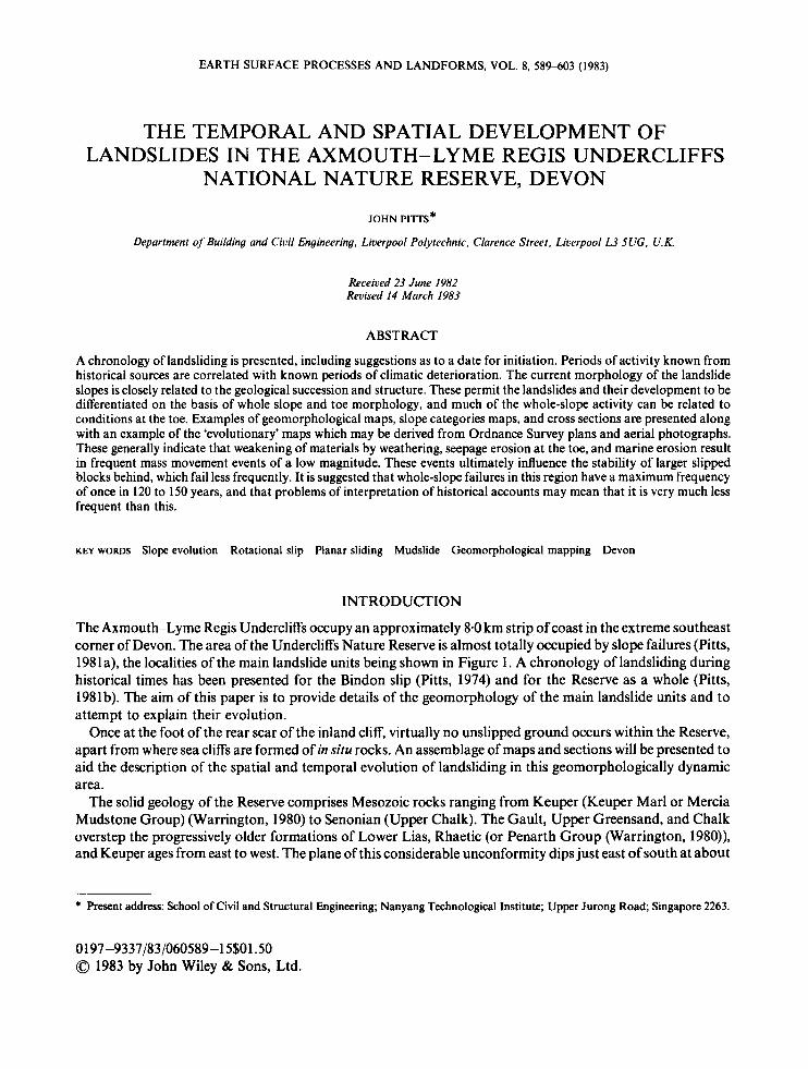
Details obtained from the aerial photographs may be incorporated onto evolutionary maps derived from the Ordnance Survey plans, an example of which is shown in Figure 4. The validity of these maps may be open to question for reasons outlined by Brunsden and Jones (1976). So, although many of the slope units are of considerable magnitude, any values given concerning the movement of large slipped blocks within the undercliff should be considered approximate. Amounts of retreat of the sea cliff and primary backscar are more clearly observable and are probably generally valid. Estimations of rates of degradation and block movement for the main landslide units of the Reserve are summarized in Table 11.
THE SPATIAL DEVELOPMENT O F THE LANDSLIDE MORPHOLOGY
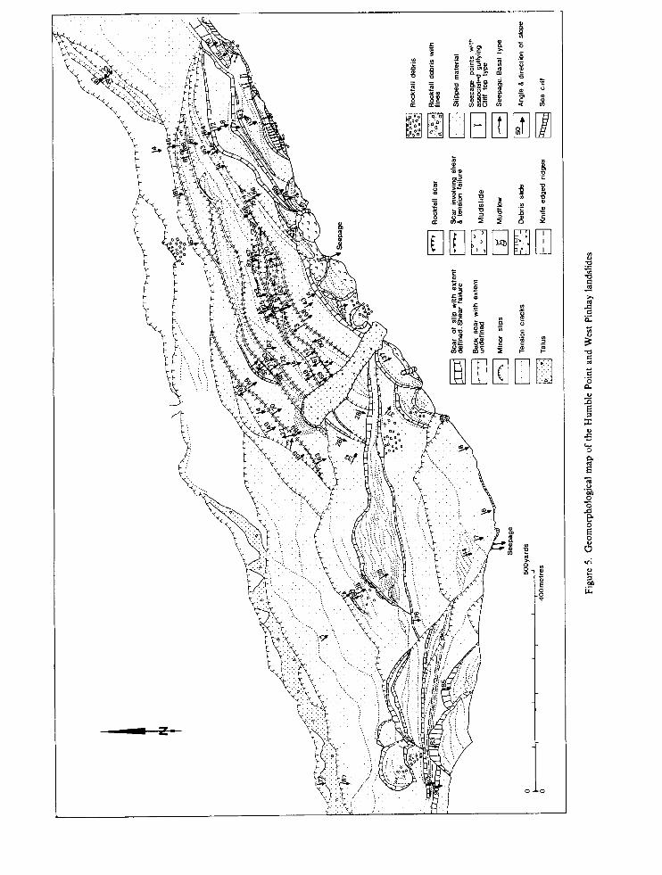
To clarify the patterns of landsliding within the Reserve, a series of geomorphological mapping was carried out, and one map is presented (Figure 5). The main aims of this mapping were to produce a clear picture of the spatial distributions and complexity of the slope forms and processes, and to highlight geological controls on landsliding. The actual process of mapping in this area has been described elsewhere (Pitts, 1979a) and will not be repeated here. An overview of the various geomorphological units present in the Reserve was possible only after the completion of the mapping programme.
The overview is perhaps even more strikingly demonstrated by producing slope categories maps from the more complex geomorphological maps. An example is shown in Figure 6. This map was based on the principles outlined by Waters (1958), with certain modifications. Negative slopes were included as a separate category, these being common in areas where some rotational component to the landslide mechanism exists (Pitts, 1979a). Slope categories maps provide a very succinct cartographic summary of a host of descriptive and interpretive data, such as those on geomorphological maps.
Geological sections of the landslides were surveyed (Figure 7) although in many places, very little of the geological succession showed through the colluvium. However, variations in the composition and the moisture content of the colluvium indicated where and in what ways the succession was changing. The relationships between specific stratigraphic boundaries and the locations of shear planes of landslides is extremely important in this area (Pitts, 1979b).
sa
6p
i~ pa6pa a)iu)(
apiis siiqaa
I

598 J . PlTTS
Figure 6. Slope categories map of the Humble Point and West Pinhay slides
Figure 7. Geological section of the Humble Point landslide. Point x indicates the position of the reef formed by the slip of 1961-see Figure 2 key for stratigraphic detail
The main landslides of the Reserve are of three different types: designated multiple rotational with a low depth to length ( d / l ) ratio (Type A); multiple rotational with high d / l ratios (Type B); and planar block slides of a simple (Type C , ) or complex (Type C , ) form. The major characteristics of the landslides are summarized in Table 111. The morphology of the main undercliffs formed by Types A and B tends to be similar, and is formed in general of broad, substantially intact blocks displaying landward tilt of mainly Cretaceous strata. The chiefdifferences are to be found in the toe areas of the slips, and four main types have been differentiated (Table IV, Figure 8). In Type 2, the sea cliffs are normally of Keuper Marl or Blue Lias. The shear zones in Types 3 and 4 toe areas are usually within the unit of the Lower Lias known as the Shales with Beef, close to the junction with the Blue Lias.
The overall form of the Type A and B slips reflect in great detail local variations within the structure of the pre-Cretaceous beds. The designation of the two Haven Cliffs slips as Type A is a reflection of their small crest to toe length. Structurally they are similar to Type B slips which have a high position for the shear plane, The

Tabl
e 11
1. Su
mm
ary
of t
he la
ndsl
ide
type
s re
pres
ente
d in
the
Axm
outh
-Lym
e R
egis
Und
ercl
iffs
Slip
nam
e W
hole
slo
pe
Toe
cl
assi
ficat
ion
Mai
n m
orph
olog
ical
cha
ract
eris
tics
Posi
tion
of
failu
re z
one
Hav
en C
liffs
Wes
t H
aven
Clif
fs E
ast
Cul
verh
ole
Clif
fs
Bin
don
Dow
land
s R
ousd
on
Cha
rton
Bay
Hig
h U
nder
cliff
C
hart
on B
ay L
ow
Und
ercl
iff
Hum
ble
Poin
trnh
itla
nds
East
Pin
hay
Bay
War
e C
liffs
A A B
c2
A
B B c,
A B
B
2 2 2 1 1 3A a
nd
3B
3B
3B
1 3A
3B
Arc
uate
bac
ksca
r; la
rge,
mai
nly
inta
ct, b
ackt
ilted
blo
cks
Arc
uate
bac
ksca
r; la
rge
mai
nly
inta
ct, b
ackt
ilted
blo
cks.
Arc
uate
bac
ksca
r; su
bdue
d ba
cktil
ted
bloc
ks, h
igh
sea
cliff
. In
tact
, litt
le d
efor
med
or t
ilted
slip
ped
bloc
k. R
ear g
rabe
n w
ith
non-
unifo
rmly
tilt
ed b
lock
s an
d pi
nnac
les.
Off
sho
re t
oe r
eef
(now
ero
ded)
. A
rcua
te b
acks
car;
larg
e m
ainl
y in
tact
bac
ktilt
ed b
lock
s. A
rcua
te b
acks
car.
Rel
ativ
ely
narr
ow
and
long
, lo
w a
ngle
d di
sint
egra
ted
accu
mul
atio
n zo
ne. R
earm
ost b
lock
s mai
nly
inta
ct
and
back
tilte
d.
Arc
uate
bac
ksca
r; m
ainl
y in
tact
, gen
tly b
ackt
ilted
rea
r bl
ocks
.
Stra
ight
bac
ksca
r; hi
ghly
dis
inte
grat
ed, c
rum
pled
acc
umul
atio
n zo
ne w
ith n
on-ti
lted
'wal
l' st
ruct
ures
. B
road
, arc
uate
bac
ksca
r. M
ultip
le b
ackt
ilted
blo
cks.
Off
shor
e to
e re
ef (
now
ero
ded)
. A
rcua
te b
acks
car.
Ver
y br
oad,
fla
t, re
lativ
ely
unbr
oken
rea
r sl
ippe
d bl
ocks
. Bro
ad, h
eavi
ly f
issu
red,
low
ang
led,
wet
low
er
slop
es.
Arc
uate
bac
ksca
r. Lo
ng, b
ackt
ilted
blo
cks
in u
pper
slo
pe, w
ith
disi
nteg
rate
d ac
cum
ulat
ion
zone
bel
ow o
utcr
op o
f un
con-
fo
rmity
.
Gau
lt G
ault
Gau
lt R
haet
ic S
hale
s
?Rha
etic
Sha
les
Shal
es w
ith B
eef
Rha
etic
Sha
les
Rha
etic
Sha
les
Shal
es w
ith B
eef
Shal
es w
ith B
eef

600 J. PITTS
Table IV. Classification of main types of toe morphology and geological structure
Type 1 Type 2 Type 3 Type 4
Slipped blocks forming a Slipped blocks on top of a 3A mudslide or 3B slipped toe at beach level with a sea cliff formed of stable blocks on top of stable shear zone below beach strata. The shear zone is at strata, with a shear zone and sea bed level, or just above the positioned well below the e.g. Bindon, Dowlands and unconformity, e.g. Haven unconformity and relating Humble Point. Cliffs, Culverhole Point. to particular strata on the
crest of a pericline, e.g. Ware, Rousdon.
4A mudslide or 4B slipped blocks on top of stable strata, with a shear zone positioned well below the unconformity and relating to particular strata within beds which are flat lying in strike section, e.g. East Pinhay Bay, Charton Bay.
7 \
7
7
Figure 8. Sections of the main types of landslide toe morphology present in the Reserve. c: cliff of in siiu rocks; s: modern sea level; u: undercliffs; b: modern beach; f: sea bed; x: projection of sub-cretaceous unconformity; p: projection of pericline within pre-Cretaceous
beds; y: projection of strike section of pre-Cretaceous beds
anticline which occurs in the area of Culverhole Cliffs is well reflected in the classification of the Culverhole slip as Type B. The corresponding syncline accounts for the classification of the toe of the Bindon slip as Type 1. The downdip of the beds ensured protection of the Rhaetic Shales from pre-Gault erosion at Culverhole Point, and in the toe area of the Bindon and Dowlands slips.
Similar small scale variations in structure account for the complexity of the toe region of the Rousdon slip. In the western and central portions of the toe area it is of Type 3A, whereas in the east, it is of Type 3B. The main reason for the change is the marked decrease in the thickness of the Shales with Beef which occurred as a result of pre-Gault erosion of the western limb of a periclinal anticline forming the eastern corner of the toe of the Rousdon slip. The Pinhay Bay slip is founded on almost flat lying Blue Lias (Type 4) and the position of the shear plane does not seem to have significantly changed since its inception.

CHRONOLOGY OF LANDSLIDING 60 1
Details of the geological structure have generally determined the form of toes of the landslides and have to a large extent determined the evolution of the landslides of the Reserve. The groundwater regime in turn is largely determined by the disposition of the strata, and the geomorphological mapping confirmed this. The broad, arcuate nature of most of the landslides is clearly visible, and reflects the general competence of the strata (chalk and sandstones) forming the main blocks. Where this pattern exists down to beach level, for example at Dowlands, the geomorphology tends to remain fairly large in scale. However, in the Haven Cliffs area, and in East Pinhay Bay this pattern becomes more complex as the outcrop of argillaceous rocks, and the position of groundwater seepage become transferred to higher positions in the cliffs. At Haven Cliffs, the sub- Cretaceous unconformity outcrops on top of a sea cliff formed of Keuper Marl and juxtaposes beds of relatively high and low permeabilities. The greater array of mappable forms reflects the more active processes of weakening apparent near the unconformity, resulting almost wholly from the effects of seepage. At East Pinhay Bay, the situation is even more complex in that the unconformity lies some way upslope of the edge of the sea cliff. This results in a broad, low-angled zone which lies exactly between the position of the unconformity in the slope and the edge of the sea cliff, and is occupied by highly weakened, comminuted, and rifted debris feeding a mudslide.
The depths of the East Pinhay Bay slip, the Ware Cliffs slip, and the slip in the higher undercliff at Charton Bay have been determined by the position of the topmost unit of the Blue Lias, a thick bed of calcarenite called Table Ledge (Bed 53 of Lang et al, 1923). Above this, in the Shales with Beef, the calcarenites die out, and the development of shear surfaces seems generally uninhibited withir. that dominantly argillaceous formation. Only in the lower undercliff of Charton Bay does a landslip exist which clearly includes the Blue Lias within it. Interestingly, it is of a contrasting mechanism and one which has not necessitated the development of a shear surface through the calcarenites. Clear backtilt of strata exists in some slipped blocks, although wall-like structures composed of Rhaetic calcilutities display no landward tilt of strata. Two additional features of note are the very high degree of disintegration of much of the material in the accumulation zone, and the very high angle of landward tilt which exists in the apparently rotated blocks.
The slip is interpreted as being a simple planar block slide of Type C,. Crumpling within the sliding mass following longitudinal dilatancy during failure, and rear toppling from the back of the sliding mass resulted in the landward tilt of strata. The failure incorporated the otherwise stable Blue Lias because the backscar of the Charton Bay slip of 1969 developed as a large tension crack. The slip forming the upper undercliffs at Charton Bay, produced a line of seepage which fed water into the crown area of the 1969 slip. This, and steady erosion of the sea cliff at the toe, were probably the main destabilizing influences acting on the lower undercliff.
The other major planar failure within the Reserve is at Bindon. This slip acquired most of its present day morphology from the major failure of Christmas Day 1839 (Pitts, 1974). In summary, the Bindon slip comprises a major backscar in Chalk and sandstones of the Upper Greensand, in front of which is a chasm or graben-like structure of which about 750 m remain. Seaward of the chasm is the major slipped block (Goat Island) which covers about six hectares and which moved forward as a complex planar slide. Seaward of Goat Island is a large, much older, non-circular rotational slip which was responsible for the formation of the pre- existing undercliff. At the time of the slip, a reef was thrown up offshore, which represented the terminal portion of the shear zone, and behind the reef was a lagoon. The broad characteristics of the Bindon slip again owe much to the details of structure in the pre-Cretaceous beds, notably the syncline which from just west of Culverhole Point rapidly takes the Rhaetic Shales to below sea level in front of Bindon. There is no evidence from any part of either the Bindon or Dowlands slips for the existence of intervening argillaceous beds, notably the Shales with Beef, which accounts for the great depth of both of these slips.
The rapid erosion of the reef and extended toe of the Bindon slip of 1839 seems to have resulted in a steady forward creep of many of the slope elements of the rotational slip in front of Goat Island at an average rate of 0.3 m/y. This is supported by the advance of high water mark seawards in successive editions of Ordnance Survey plans. The forward creep is also encouraged by loading of the crown of the slope by the products of slumping and toppling failures from the seaward face of Goat Island.
Goat Island itself seems to follow the pattern of steady downslope movement. However, the movement is not uniform, and the relative lack of movement in the eastern part may reflect the stabilizing effects of slope movements in Dowlands Cliff subsequent to 1839.

602 J. PITTS
Certain similarities exist at Humble Point where a syncline at Charton Bay takes the Keuper Marls and Rhaetic Shales down beneath Humble Point. This results in the gradual loss of the double undercliff found in Charton Bay. The slope failure in 1961 at Humble Point had a shear surface within the Rhaetic Shales and produced an offshore reef. The Humble Point slip is of a rotational type and major reactivations of the undercliff here represent one of the more regular features of the Reserve. Humble Point is believed to be the site of a major slip which occurred in 1689 and is known to have experienced a major failure in 1840 as well as in 1961. The recent date of the last Humble Point slip has enabled rather more detail to be assembled of the course of events leading to failure. The change in the profiles of the Humble Point slope just before the last slip (1958) and after the slip (1973) highlights the foreshortening which occurs as a result of toe erosion. The profile in 1958 was 75 m shorter than that in 1973, this difference remaining even after the rapid removal of the toe reef following the slip.
If the 1689 slip did occur at Humble Point, then the progress of events towards major slope failures seem to have been fairly steady for three centuries. The comments of Roberts (1840) that the 1840 slip brought Humble Point into view of Lyme Regis for the first time, may well not be correct. His lifetime may have coincided with the later stages of coastal erosion and destabilization, and when major slips do occur Humble Point may normally be in view, if only for a limited period.
DISCUSSION AND CONCLUSIONS
The geomorphology of the Axmouth-Lyme Regis Undercliffs indicates that rotational mechanisms provide the most important types of primary landslide movement in the Reserve. The Bindon and lower Charton Bay slips are exceptions to this broad pattern. The materials comprising the slips became progressively less competent downslope as a result of fissuring and brecciation during successive movement and degrade into a complex series of smaller size failures. The lower (seaward) half of the undercliff is intermittently active, particularly in the eastern half of the Reserve, this activity being exemplified by block disruption in response to oversteepening of the toe by mudslides and by recession of the sea cliff in particular. The slips of the Reserve are believed to have originated during late Pleistocene times after a gradual deterioration of material strengths and during a general raising of sea level. The present-day morphology of certain landslides may have changed with time as the sub-cretaceous unconformity changed its position relative to sea level during the post-glacial transgression. In other cases, where shear planes exist within pre-Cretaceous strata striking approximately north-south, the morphology may not have changed significantly since initiation.
Current activity on the slopes as judged from evidence from maps, aerial photographs, and field measurement, is following established patterns. The present-day evolution of all the slips depends primarily upon conditions at the toe. Morphology of the toe areas varies considerably, but removal of landslide debris, slipped blocks, or even offshore reefs subsequent to a slope failure, and the gradual recession of sea cliffs upon which landslides have developed, result in critical foreshortening of the profiles. Progressive downslope movement of the large, more competent slipped blocks behind then occurs. The processes at the rear, resulting in the accumulation of scree and crown loading have only a marginal influence on destabilizing the remainder of the slopes. This is borne out by the rarity of whole-slope failures which are not demonstrably preceded by a series of increasingly large failures developing rearwards from the toe. Over the time period for which map, aerial photograph, and field observations allow, there seems little reason to believe that instability following the currently established pattern will not continue.
ACKNOWLEDGEMENTS
I would like to thank the following people for their assistance with the compilation of this paper: Dr. D. Brunsden of the Department of Geography, University of London, King’s College, for supervising the research from which this work was derived, and for critically reading the manuscript; the cartographers of the Departments of Geography of King’s College, London, and the University of Leeds, and N.T.I. Singapore for the preparation of the figures, the Nature Conservancy Council for permission to work in the Axmouth-

CHRONOLOGY OF LANDSLIDING 603
Lyme Regis Reserve; Professor M. J. Kirkby and an unnamed referee who suggested several improvements to the original version of the paper; and Ursula Loke of N.T.I. for typing the revised manuscript.
REFERENCES
Akeroyd, A. V. 1972. ‘Archaeological and historical evidence for subsidence in Southern Britain’, Phil. Trans. Royal Soc. London, A272,
Arkell. W. J. 1949. ’Erratics in Dorset shingle beaches’, Proc. Dorset Nut. Hist. Archaeol. Soc., 72, 125. Brunsden, D., and Jones, D. K. C. 1976. ‘The evolution of landslide slopes in Dorset’, Phil. Trans. Royal SOC. London, A283,605-631. Darton, D. M., Dingwall, R. G., and McCann, D. M. 1981. Geological and Geophysical Inuestigarions in Lyme Bay, Institute of
Franks, J. W., and Johnson, R. H. 1964. ‘Pollen analytical dating of a Derbyshire landslip: The Crown Edge landslides, Charlesworth’,
Grove, J. M. 1966. ‘The Little Ice Age in the Massif of Mont Blanc’, Trans. Inst. Br. Geogr., 40, 129-143. Grove, J. M. 1972. ‘The incidence of landslides, avalanches and floods in Western Norway during the Little Ice Age’, Arcr. Alp. Res., 4,
Harrison, J. R. 1848. ‘Observations on the causes that are in constant operation to alter the outline of the English coast, to affect the entrances of the rivers and harbours, and to form shoals and deeps in the bed of the sea’, Minut. Proc. Instn. Civ. Engrs., 7,327-365.
Jelgersma. S . 1961. ‘Holocene sea level changes in the Netherlands’, Mededel. geol. Srichr, Series C-VI, 6-7. Kellaway, G. A,, Redding, J. H., Redding-Thorne, E. R., and Destombes, J. P. 1975. ‘The Quaternary history of the English Channel’,
Lamb, H. H. 1959. ‘Our changing climate, past and present’, Weather, 14, 299-318. Lang, W. D., Spath, L. F., and Richardson, W. A. 1923. “‘Shales with Beef”, a sequence in the Lower Lias of the Dorset Coast’, Q. J.
Macfadyen, W. A. 1971. Geological Highlights of the West Country, Butterworths, London, 41 4 7 . Pitts, J. 1974. ‘The Bindon landslip of 1839. A survey of historical documents describing this event, its causes and mechanism’, Proc.
Pitts, J. 1979a. ‘Morphological mapping in the Axmouth-Lyme Regis Undercliffs, Devon’, Q. J. eng. Geol. London, 12, 205-217. Pitts, J. 1979b. ‘Discussion’, Q. 1. eng. Geol. London, 12, 277-279. Pitts, J. 1981a. Landslides of the Axmouth-Lyme Regis Undercliffs National Nature Reserve, Deoon, Unpublished Ph.D Thesis, University
Pitts, J. 1981b. ‘A historical survey of the landslips of the Axmouth-Lyme Regis Undercliffs, Devon’. Proc. Dorset Nut. Hist. archaeol.
Roberts, G . 1840. An Account of the Mighry Landslip at Dowlands and Bindon. near Lyme Regis, December 25th 1839, Daniel Dunster,
Starkel. L. 1966. ‘Post-glacial climate and the moulding of European relief ’, Proc. Inr. Symp. World Climate, Royal Meteorological
Terzaghi, K. 1950. ‘Mechanism of landslides’, In Application of Geology ro Engineering Practice, Berkey Volume, Geol. SOC. America,
Warrington. G. 1980. ‘A correlation of Triassic Rocks in the British Isles’, Special Report No. 13, Geol. SOC. London, p. 78. Water, R. S. 1958. ‘Morphological mapping’, Geography, 43, 10-17.
IS 1 -1 69.
Geological Sciences Report 79/10, p. 24.
New Phyrol., 63, 209-216.
I3 1 -1 38.
Phil. Trans. Royal SOC. London. A279, 189-218.
Geol. Soc. London, 79, 47-99.
Dorset nut. Hist. archaeol. Soc.. 95, 18-29.
of London, p. 710.
SOC., 103, 101-106.
Lyrne Regis, p. 28.
Society, London, 15-33.
New York, 82-123.