Embed Size (px)
Citation preview

The Tectonics of North America
A Discussion to Accompany the
Tectonic Map of North America
Scale 1:5,000,000
GEOLOGICAL SURVEY PROFESSIONAL PAPER 628


The Tectonics of North America
A Discussion to Accompany the
Tectonic Map of North America
Scale 1:5,000,000By PHILIP B. KING
GEOLOGICAL SURVEY PROFESSIONAL PAPER 628
UNITED STATES GOVERNMENT PRINTING OFFICE, WASHINGTON : 1969
UNITED STATES DEPARTMENT OF THE INTERIOR
JAMES G. WATT, Secretary
GEOLOGICAL SURVEY
Dallas L. Peck, Director
First printing 1969 Second printing 1970Third printing 1970
Fourth printing 1978Fifth printing 1981
For sale by the Distribution Branch, U.S. Geological Survey, 604 South Pickett Street, Alexandria, VA 22304

CONTENTS
Abstract..._______________________________________Introduction __ ___ __ ____ ___________Tectonic maps defined ___________________________Historical sketch __ ______ _____________Appraisal of existing tectonic maps ________________
Representation of platform areas_________________Representation of foldbelts_____________________
"Tectonic Map of United States"_____ ̂ _ "Tectonic Map of Australia".________________"Tectonic Map of U.S.S.R. and Adjacent Areas,"
and "Tectonic Map of Europe"_________"Tectonic Map of Canada"___________"Tectonic Map of Mexico" and "Tectonic Map
of U.S.S.R."___________________________Representation of subsea areas.______________
"The Tectonic Map of North America".-_____________Compilation of the map_________________________Specifications of the map____________________Platform areas.______________________________
(A) Platform areas within the Precambrian. ___(B) Platform deposits on Precambrian base
ment _________________________________(C) Platform deposits on Paleozoic basement. _(D) Platform deposits on Mesozoic basement. _(E) Volcanic rocks and associated sediments of
North Atlantic province.________________(F) Icecaps________________________________
Foldbelts of Precambrian age_________________Stratigrapbic classification._________________Tectonic classification. ______________________Foldbelts of Canadian Shield_________________Foldbelts of Greenland________________Foldbelts south of Canadian Shield. __________Precambrian of northern South America______
Phanerozoic foldbelts ___________________The tectonic cycle_______________Terminology _________________________
Geosyncline___________.._____________Orogeny______________________Names of orogenies..._____________
Page 1 11278889
911
15171818192121
222427
272930303233363742434344444445
"The Tectonic Map of North America" Continued Pw Phanerozoic foldbelts Continued
Sedimentary units______________ ________ 4CGeosynclinal deposits.... __ 46Eugeosynclinal deposits _ _ 47Miogeosynclinal deposits. _____________ 47Metamorphism of geosynclinal deposits..__ 4PDeposits of successor basins....__________ 4PYounger basinal deposits.__ ______ 50Thick deposits in structurally negative
areas._________________ ____________ 50Volcanic units_______________ _ 50Plutonic units____________ ______ 51
Granitic rocks.______ _ __ 51Mafic plutonic rocks_____ 5?Ultramafic rocks______________________ 5?
Description of foldbelts____________________ 5f(K) Innuitian foldbelt____________ (J) East Greenland foldbelt_________(L) Appalachian foldbelt..______________ 56
Northern Appalachians.__________ 56Southern Appalachians.____________ 5f
(M) Ouachita foldbelt____________ 61 Structural systems related to Ouachita
foldbelt-..._____________. 64(O) Cordilleran foldbelt____________ 64
Northern Cordillera___________ 65Central Cordillera. __ __________ 6rSouthern Cordillera_______.___ 7?
(P) Pacific foldbelt______________ 74Alaska. ____________________ 7ftWashington and Oregon. 7ftCalifornia and Baja California.__... 76
(Q) Antillean foldbelt_____________ 77(N) Andean foldbelt______________ 7f
Subsea areas______________________ 80Fault zones______________________ 81
Glossary.____________________________ 8fReferences cited______________________ 87Index of units on "Tectonic Map of North America"
which are referred to in text_______________ 9f
m

IV CONTENTS
ILLUSTRATIONS
PageFIQTJRE 1. Structural map of Bighorn Mountains uplift, Wyoming and Montana, by N. H. Darton___________________ 2
2. Structural maps of the Jura Mountains, Switzerland, after Albert Heim____________________________ 33. Tectonic map of the Alps, by Rudolf Staub____--_-____- __ _______________________________________ 44. Tectonic sketch map showing the chief belts of folding in the American Cordilleran system, by Hans StillS__ 65. Maps of eastern Tennessee and western North Carolina showing three methods of representing the geology.__ 136. Tectonic map of north-central Nevada showing "structural stages" in an area of complex superposed rocks and
structures.-_____-_--__-_-_-_-------_---------------------_------- _____ __ ___ 147. Map of Gulf Coastal Plain in Texas, Louisiana, and Mississippi showing structure contours on two horizons in the
strata of the platform cover_________________-________-__-_-_____-_--__-___________ ____________ 268. Map of North Atlantic Ocean and adjacent lands showing plateau basalts of North Atlantic province. ______ 289. Map of the Canadian Shield showing provinces that contain Precambrian rocks of different ages.______________ 34
10. Map of North America showing inferred extent of exposed and buried provinces of Precambrian rocks__ 3911. Map of northeastern Greenland showing inferred extent of the late Precambrian Carolinidian foldbelt._______ 5512. Tectonic maps of the two larger areas of exposure of the Ouachita foldbelt_________________________________ 6213. Map of northern Nevada showing extent of Antler orogenic belt of middle Paleozoic time___________________ 7114. Map showing transverse structural features in the southern part of the area of the "Tectonic Map of North
America," and in adjacent regions_______________-_-_---_---_--__-_____________________________ 82
TABLES
Page TABLE 1. Comparison of various classifications of the Precambrian-__.__________________________ ___________ __ 31
2. Classification of orogenies in Canadian Shield_______-_____--_--_-_-___---_-__-__-_- __ ___ 333. Summary of Precambrian rocks and events south of Canadian Shield______________ , ______________._ 40
THE TECTONICS OF NORTH AMERICA A DISCUSSION TO ACCOMPANY THE TECTONICMAP OF NORTH AMERICA, SCALE 1:5,000,000
By PHILIP B. KING
ABSTRACT
The "Tectonic Map of North America," on a scale of 1: 5,000,000, has been compiled by the United States Geologi cal Survey in collaboration with other national geological sur veys, and with the assistance of various individuals. The compilers made use of tectonic maps of some of the countries maps that have been published or are in process of publication. In addition, many other basic maps and reports were consulted.
North America is divided technically into foldbelts of dif ferent ages and platform areas where flat-lying or gently tilted rocks lie upon basements of earlier foldbelts. The two most extensive platform areas are those with Precambrian basement in the central craton, and those with Paleozoic basement in the Atlantic and Gulf Coastal Plains. Configuration of the upper surface of the basement beneath the platforms is shown by contours on a 500-meter interval.
The foldbelts include three of Precambrian age whose principal exposures are in the Canadian Shield, but which also emerge in various outlying areas. The foldbelts of younger ages lie nearer the edges of the continent, and include four that are mainly of Paleozoic age, two that are mainly of Mesozoic age, and two that are mainly of Cenozoic age. Each foldbelt was formed during a geotectonic cycle many geologic periods in length, beginning with a geosynclinal phase, passing through a time of orogeny, and ending with a postorogenic phase.
On the "Tectonic Map of North America" the foldbelts are distinguished by different colors according to age; where several significant times of deformation occurred within them, these are represented by tints of the prevailing colors. The different kinds of rocks which make up the foldbelts are shown by pat terns of these colors.
In the foldbelts, the principal sedimentary rock units on the map are those which formed in the eugeosynclinal and miogeosynclinal areas. In some foldbelts, deposits are preserved which were laid down in successor basins during or shortly after the main orogenies. In the foldbelts of western North America various subdivisions are also shown in the Cenozoic sedimentary rocks and terrestrial volcanic rocks.
Among the plutonic rocks of the foldbelts, granitic rocks are most extensive; they form large to small masses mainly in the eugeosynclinal areas. More mafic and more alkalic vari eties are separately indicated. Ultramafic rocks are important in places, especially near the Pacific Coast and in tine Caribbean region; most of these were emplaced in their present positions by tectonic rather than by magmatic processes.
INTRODUCTION
This discussion is a companion to the "Tectonic Map of North America," which is being published separately by the U.S. Geological Survey. It is intended to aid the
use and understanding of the map, by providing expla nations more lengthy than could be included in th^ legend of the map itself. Such a discussion is the mor> desirable because the map embodies innovations derived- partly from techniques of tectonic mapping that hav been developed during the last few decades by geologists in other countries, and that may not as yet be well known, or be well understood in North America.
TECTONIC MAPS DEFINED
A tectonic map portrays the architecture of the up per part of the earth's crust that is, the features prc - duced by deformation and other earth forces and rep resents this architecture by means of symbols, pattern1" and colors. Such a map differs from the more familir.r areal geologic map, whose primary aim is to represent the surface distribution of rocks of various kinds and ages. Nevertheless, most tectonic maps contain some in dication of the ages and kinds of rocks from which th^ structures were made, and areal geologic maps contain some indication of the structures of the rocks repre sented, so that distinctions between the two kinds of maps are not absolute. Tectonic maps are nearly synony mous with structural maps, just as the subject of teu tonics is nearly synonymous with that of structural geology. Nevertheless, geologists commonly make a vague distinction between structural geology and struc tural maps, which deal primarily with the description, representation, and analysis of structures, mostly on a restricted scale, and tectonics and tectonic maps, which synthesize these data over greater areas, inevitably with a larger amount of interpretation.
Many other kinds of maps are being made whichshow earth features, some of which resemble and someof which differ from tectonic maps as here defined:1. Paleotectonic maps show geologic and tectonic
features as they existed at various times durir^rthe geologic past, rather than the sum of the tevtonics as it exists today. Most of the paleotectonicmaps that nave been made portray in much detailthe sedimentary facies and the thickness of stratain the cratonic areas, but show few of these detailsin the more intensely deformed areas.

THE TECTONICS OF NORTH AMERICA
2. Neotectonic maps are a kind of paleotectonic map in that they represent the tectonic features produced during one part of geologic time, in this case the Quaternary or at most the Quaternary and latest Tertiary. Because of the epeirogenic nature of much of this latest deformation, neotectonic maps emphasize the broad upwarps and downwarps of the crust.
3. Paleogeographic maps show the probable extent of lands and seas as they existed at various times dur ing the geologic past. They thus resemble paleotec tonic maps, but involve a much greater element of interpretation.
4. Paleogeologic maps show the areal geology of a sur face of unconformity that has been covered by a younger body of strata. This buried areal geology has tectonic significance, but it is generally not feasible to represent it on a tectonic map; tectonic maps and paleogeologic maps should supplement rather than duplicate each other.
5. Geophysical maps show the instrumentally deter mined values of gravity, magnetic intensity, or other physical properties of the earth, generally by means of contours. The contours express nu merical values produced by the summation of many earth processes, not all of which are known. The data are not themselves tectonic, although many of them have ultimate tectonic causes. Interpreta tions of these geophysical data are frequently helpful in making tectonic maps.
HISTORICAL SKETCH
Geologists have been making structural and tectonic maps since the early days of the science. Even some of the early structural maps showed folds, faults, and structure contours in much detail, but most of them dealt with rather small areas on large scales. On the other hand, the earlier tectonic maps, covering larger areas such as whole countries, continents, or the world, were on small scales and were primarily intended to por tray the tectonic or the historical-geological predilec tions of their authors. Only in recent decades have tec tonic maps approached the scope and refinement of areal geologic maps.
In the United States, many excellent structural maps appeared during the first part of the century in the folios and professional papers of the U.S. Geological Survey; among these, the structural maps by N. H. Barton of various areas in the Western States are classic (fig. 1). Since 1916, many excellent structural maps of small to large areas have also been published
in the "Bulletin of the American Association of Pe troleum Geologists." A parallel evolution of structural and tectonic maps occurred in Europe, where notable maps have portrayed, for example, the folds and faults of the Jura Mountains (fig. 2), and the superposed nappes and structural layers in the Alps (fig. 3).
FIGURE 1. Structural map of Bighorn Mounts ins uplift, Wyoming and Montana, by N. H. Darton (Darton and Salisbury, 1906, p. 13). Configuration of uplift shown by contours on base of Madison Limestone. Dashed lines show approximate configuration where all sedimentary rocks have been removed by erosion. Heavy lines are faults. Stippled, areas are covered by Tertiary deposits.

HISTORICAL SKETCH
FIGURE 2. Structural maps of the Jura Mountains, Switzerland, showing folds and faults: A. Part of a detailed map. B, Generalized map of the whole area. Copied from Albert Heim (1919, pi. 20 and fig. 103). Longitude is in degrees east of Paris.

THE TECTONICS OF NORTH AMERICA
sS 02 oo£H 0) 0)P a -o
" 4>
£ fc 8«H 4, O
*1 2003 «IM .-£*
,15 05 p!C< 4J G« « *fr 3 PQ
3 4) OQis 8- S
03
-of 0) t>s O^ft > ^ 1 O O t3
C3 GO 03
w M O S
11 = sH -S g 5
i sS o q
W o

HISTORICAL SKETCH
One of the most ambitious of the early tectonic maps was the "Carte tectonique de 1'Eurasie" on a scale of 1:8,000,000, that was compiled and hand colored by fimile Argand. He presented this at the 13th Interna tional Geological Congress in Brussels in 1922 as a com panion of his epoch-making treatise on "Le tectonique de 1'Asie" (Argand, 1924). A colored reproduction of this map on a scale of 1:25,000,000 was published by the 13th Congress in 1928. The state of tectonic knowl edge at the time is suggested, however, by the large blank areas which were left in various parts of the map.
Argand's map had a great seminal influence among geologists, as it created a desire for comparable maps of other areas or continents. Thus, in 1922 the Com mittee in Tectonics was organized in the Division of Geology and Geography of the U.S. National Kesearch Council, and the first report of its chairman, Rollin T. Chamberlin (1923, p. 3), stated: 1
One of the great needs in our field is a series of tectonic maps of the different continents. An important advance in this direc tion has recently been accomplished by Argand, whose magnifi cent structural map of Eurasia was one of the outstanding exhibits at the International Geological Congress at Brussels last summer. Our Committee voted to commence work on a tec tonic map of North America which would bring out the trends of folding, the principal lines of faulting, the axes of doming, and related structural features. Messrs. Willis and Mansfield are to undertake this very important project
Later, the Committee on Tectonics realized that there were still insufficient tectonic data available to represent all of North America, and decided to restrict its objec tive to preparation of a tectonic map of the United States. The task of compiling this map began in 1934 when Chester R. Longwell assumed chairmanship of the committee. Early aspirations of the committee in regard to the map are suggested in Longwell's prospectus (Longwell, 1934, p. 3):
It is suggested that the map represent the following features: trend-lines in folded belts, with axes of individual major folds so far as the scale of the map permits; direction and degree of important overturning of folds; cross folds or important changes in pitch of major fold axes; direction and degree of regional dips; all important faults, with appropriate symbols and figures showing, so far as known, direction and degree of dip, amount of throw and nature of displacement whether normal, reverse or strike-slip; major thrusts (with a special convention or color to designate overthrost masses); belts of en echelon faults; important areas of metamorphic rock, with strike and attitude of cleavage so far as it can be shown; areas of Precambrian rocks related to erogenic zones, as dis cussed recently by Bucher; all major igneous masses; swells and
1 For the subsequent actions of this committee, see the a«""n1 reports of the Division of Geology and Geography of the National Kesearch Council. The history of the committee has also been narrated by Long- well (1944a, p. 1767-1760), from whose account the succeeding para graphs are largely abstracted.
basins in areas of unfolded rocks (possibly by structure con tours) ; salt domes and anticlines; monoclinal folds.
Time relations should be indicated, so far as practicable, by conventional patterns or colors. If conventions are chosen judi ciously, they may be superposed in areas that have experienced repeated diastrophism. It may even be feasible to indicate im portant vertical movements in folded belts, such as the lat? uplift of the Appalachian region. Considerable ingenuity will be required to represent all the complex disturbances in som° western areas, even where adequate information is available. It does not seem practicable to show the geologic ages of indi vidual faults. However, faults that are recognized as 'active' can be distinguished from those supposedly 'dead'; and it may be desirable to indicate that faults in an important group an essentially contemporaneous.
Many of these aspirations were realized on the "Tec tonic Map of the United States" as it finally evolved, but some had to be discarded as infeasible. Nevertheless, representation of most of the items listed has been at tempted on various tectonic maps made subsequently. Final specifications for the "Tectonic Map of the United States'? developed as the work of compilation pro grossed, and were discussed and adopted by members of the committee during periodic meetings. The worJ- of compiling the map was divided among the committee members, each assuming responsibility for one part of the country; in the end, 14 different parts were thus compiled. Compilation of the map was largely com pleted by 1939, but there were inevitable discrepancies between the results of the various compilers so that the results required review and editing} this was done b^ Philip B. King under Longwell's direction. Drafting and printing of the map were delayed by the exigencies of World War II, and it was not published until 1944.
Completion of the "Tectonic Map of the United States" prompted the making of the comparable "Tec- tonic Map of Canada," which was compiled by a com mittee of the Geological Association of Canada under the chairmanship of Duncan R. Derry (Derry, 1950). On this map, many of the same specifications as thos^ for the United States map were followed, but they in cluded some innovations required by the differing tec tonic features of that country.
In Europe, in the meantime, Hans Stilte had been developing his philosophy of geotectonics and his classification of tectonic features in a lengthy series of publications, which were mostly illustrated by tectonic sketches (fig. 4). A desire was felt among many of Stille's European colleagues to represent his and other tectonic concepts in the form of more precise and elabo rate tectonic maps, and in this effort leadership wa^ assumed by the Soviet geologists. A. D. Arkhangelsk:7 (1941) had developed "an historico-morphologioal method, which enables the earth's crust to be tectonic * ally zoned according to the degree of completion of th«

6 THE TECTONICS OF NORTH AMERICA
ATLANTIC
Age of climax of alpinotype deformation
1. jjyuu Neocimmerian (Nevadan)2. JHIMUL Subhercynian (Andean) 9 ' '»' ' Laramide
4. faoeg Late Tertiary .-.-.'. . . Continental shelves
FIGURE 4. Tectonic sketch map showing the chief belts of folding in the American Cordilleran system, by Hans Stille (1936, p. 138).
processes of folding of the geosynclinal regions under going transformation into a platform." - He prepared a "Tectonic scheme of Eurasia" on a scale of about 1:40,- 000,000 that was published in the "Proceedings of the 17th International Geological Congress" (Arkhangel- sky, 1939, pi. 2, p. 304). It remained for N". S. Schatsky
2 Brief summaries of the Soviet work on tectonic maps are given by Spizaharsky and Borovikov (1966) and by Yanshin (1966a), from which most of this and succeeding remarks are taken.
to elaborate these methods and make possible the preparation of tectonic maps on larger scales,
The first map by Schatsky, published in 19£3, covered the Soviet Union and adjacent areas in color on a scale of 1:4,000,000, but in a very generalized manner. This map was preliminary to a more detailed compilation that was made in collaboration with N. A. IMiaevsky, A. A. Bogdaiioff, and M. V. Muratov, with the aid of 41 contributors. The resulting map was published in
APPRAISAL OF EXISTING TECTONIC MAPS
1956, in color on a scale of 1:5,000,000, and represented not only all the Soviet Union, but also those parts of neighboring countries that lay within the area of the map base.
At the 20th International Geological Congress in Mexico in 1956, a Subcommission for the Tectonic Map of the World was organized within the Commission for the Geologic Map of the World. Preliminary to prepa ration of the world map, the subcommission encouraged the compilation of tectonic maps of the various conti nents. One of the first products was the "Tectonic Map of Europe" on a scale of 1:2,500,000 prepared by geolo gists of many European countries, which was issued in 1964 (Schatsky, 1962); its specifications closely fol lowed those of the tectonic map of the Soviet "Union and adjacent areas of 1956, but with elaborations.
Ait the 21st International Geological Congress in Co penhagen in 1960, the U.S. Geological Survey agreed to assume leadership in preparing a tectonic map of North America, in collaboration with other national geological surveys in North America, and with the co operation of various research institutions and interested individuals. To facilitate this collaboration a committee on the map was established, with George V. Cohee as chairman. Philip B. King was designated as chief com piler. Work on the tectonic map was begun by the com piler in June 1961, and was carried to completion in December 1966. The completed map was exhibited at the 23d International Geological Congress in Prague in 1968, and printed copies were available in 1969.
Tectonic maps of many other countries or continents have now been published or are in preparation, com plete listing of which would be tedious here. Also, work by the subcommission is now far advanced on the long- planned "Tectonic Map of the World" (see Bogdanoff and others, 1966).
APPRAISAL OF EXISTING TECTONIC MAPS
The specifications of the tectonic maps previously mentioned, and others not listed, differ from each other in many particulars. These differences reflect evolving and diverse methods of tectonic mapping, as the meth ods have not been stabilized like those used for conven tional areal geologic maps. To some extent these varia tions are useful; little future progress can be made in tectonics if the subject is to be ruled by a single set of dogmas, nor can progress be made in tectonic mapping if the maps are forced to adhere to a single set of speci fications. Some of the variations reflect special condi tions in the different regions, not only as to the kinds of tectonic features to be represented, but also as to the
amount and quality of the information available. Qthr^ variations indicate wide divergences in the objectives of the compilers. To evolve specifications for the "Tec tonic Map of North America," all the varieties of exis*- ing tectonic maps were reviewed, in an effort to find an 3 emulate the better features of each.
The basic components of all tectonic maps are two fold: Those of the first order indicate the nature of the rocks from which the structures are made by means of patterns and colors. Those of the second order repr**- sent the structures themselves (folds, faults, and tl <* like) by means of symbols. On all tectonic maps there is a further subdivision (either stated or implied) of the first-order components between those of the plat form or cratonic areas, where the surface strata are gently tilted or warped, and those of the foldbelt- where the rocks are much deformed and intruded. This subdivision appears on the early tectonic map t y Argand (1928), where Eurasia is subdivided into "pays tabulaires" and <4pays pliss&s" by means of color patterns.
The following examples indicate some of the ways in which first-order components are shown on tectonic maps:
1. Some color patterns are used, mainly in the fold- belts, and the remaining areas, mainly in the platforms, are uncolored. Example, "Tectonic Map of United States," 1944,1962.
2. Color patterns show stratigraphic units that have some rudimentary tectonic significance. Ex amples, "Tectonic Map of Canada," 1950; "Teu tonic Map of Australia," 1960; "Geologic- tectonic Map of Northern Venezuela," 1962.
3. The platform areas are colored with layer tint"; the foldbelts are colored according to a few widespread epochs of climactic orogeny (for example, Caledonian, Variscan), the rocks of the foldbelts being subdivided in turn in+o tectonic units ("structural stages") that formed prior, during, and after the orogenies. Ex amples, "Tectonic Map of U.S.S.R. and Ad jacent Areas," 1956; "Tectonic Map of Europe," 1962; "Tectonic Map of Eurasia," 1966.
4. Colors in the foldbelts represent primarily the ages of folding of the respective units, the^ ages being more minutely subdivided than in (3). Example, "Tectonic Map of Canada," 19f>.
5. Colors in the foldbelts show rock sequences claprn- fied according to "geotectonic cycles" the a^e spans of the "geotectonic cycles" differing frcTi one foldbelt to another. Examples, "Tectoric Map of Mexico," 1961; "Tectonic Map of U.S.S.R.," 1967.
8 THE TECTONICS OF NORTH AMERICA
Representation of second-order structural features, shown by symbols, offers fewer problems in tectonic mapping than representation of first-order components. Most of the features to be represented and the symbols used for them are reasonably standardized, so that they are much the same from one map to another. New or unusual symbols for special structural features, to suit the desires of the compiler are not objectionable or confusing, because these symbols can be identified in the legend.
REPRESENTATION OF PLATFORM AREAS
The objectives in showing platform areas are similar on all tectonic maps, however much they may differ in appearance namely, to express the gentle tilting and warping of the covering strata, the different structural layers of which they are composed, and the configura tion of their basements.
On the two versions of the "Tectonic Map of the United States (Longwell, 1944b; Cohee, 1962), plat form areas are largely left uncolored, except for inliers of Precambrian rocks and for narrow bands of color which indicate the edges of structural layers that are significantly unconformable on the layers beneath (for example, bases of Pennsylvanian, Cretaceous, lower Tertiary, and upper Tertiary). Among other purposes, these colored borders differentiate the platform of the Atlantic and Gulf Coastal Plains from the platform of the central craton. Configuration of the strata is indi cated by brown structure contour lines at a uniform interval of 500 feet, an effort being made to select con toured horizons that can be extended as widely as pos sible ; on the 1944 version of the map 19 horizons were used, on the 1962 version 36. In selecting horizons for contouring on the first version of the map, the highest horizon that would give good results over a wide area was chosen; this was due to the state of knowledge at the time, when configuration of the deeper horizons was largely speculative. This consideration was abandoned in the second version, on which some of the areas were contoured on the top of basement rocks rather than on strata in the cover. On the two maps, portrayal of the platform areas is effective for detailed study, but the general absence of colors detracts from their usefulness as wall maps.
A different method of representing platform areas was introduced on the "Tectonic Map of the U.S.S.R. and Adjacent Areas" (Schatsky and others, 1956), and has been closely followed on many subsequent maps. Contours are drawn on the surface of the basement rocks at 500- or 1,000-m intervals, and the whole area filled in with layer tints that indicate the depth to basement. Basements of Precambrian and Paleozoic ages are
shown on the map referred to, and are distinguished by layer tints of different colors; basements of o*her ages, in other colors, are shown on subsequent maps The con figuration of strata within the sedimentary cover is shown by colored contour lines that are superposed on the basement contours and layer tints. This method of representation produces a very effective wall ir ap, as the configuration of the base of the sedimentary cover is visible at a glance, leaving the configuration of the strata within the cover to be ascertained by more de tailed study.
Besides the features discussed, many recert tectonic maps differentiate "foredeeps" or "marginal homo- clines" at the edges of the platforms by means of special color patterns. Many maps show the "foredeeps" by means of stripes of the same color as the adjacent fold- belt, alternating with stripes in the same color as that of the underlying basement; this is intended to indicate the historical significance of the "foredeep." Neverthe less, "foredeeps" and "marginal homoclines" are actu ally parts of the platform, in which the strata and their basement have been deeply downwarped or steeply tilted against the adjoining foldbelts. The present reviewer questions the need for distinguishing these foatures by separate color patterns. The method might be helpful in regions of scanty information, but where much infor mation is available their nature is evident from the con touring of the basement and the higher strata.
REPRESENTATION OF FOLDBELTS
"TECTONIC TMTAP OF UNITED STATE"*"
On the two versions of the "Tectonic Map of the United States" (Longwell, 1944b; Cohee, 1962) the mio- geosynclinal and other areas of folding and faulting are illustrated mainly by structural symbols in black, without colored overprint, the strength of the deforma tion being suggested by the relative crowding of the symbols. Other tectonic features in the foHbelts are indicated by color patterns: (1) Precambrian rocks; (2) metamorphic rocks, mainly eugeosynclinal (of Paleozoic age in east, of Mesozoic age in west) ; (3) in trusive rocks, the ages being indicated by different colors; (4) sedimentary rocks in postorogenic depres sions (of Triassic age in east, of late Cenozoic age in west) ; (5) terrestrial volcanic rocks in the. western fold- belts, mainly postorogenic and of Cenozoic age.
Ages of deformation in the foldbelts are not indicated on the "Tectonic Map of the United States." The gross ages of the foldbelts in the United States have long been familiar to geologists the Paleozoic deformation in the Appalachian region on the east, and the Mewzoic and Cenozoic deformation in the Cordilleran regain on the
APPRAISAL OF EXISTING TECTONIC MAPS 9
west and to attempt further refinements requires an untangling of many superposed deformations, or of ex trapolation beyond available data (see also Longwell, 19Ma, p. 1772). The gross 'ages of deformation are im plied by the representation of metamorphic and intru sive rocks of Paleozoic age in the east, and of Mesozoic and Cenozoic ages in the west. This method of repre sentation, although satisfactory for showing the tec tonics of a single country, is less well adapted to representation of continents or other large regions, where the ages of deformation in the foldbelts are much more diverse.
"TECTONIC MAP OF AUSTRALIA"
On the "Tectonic Map of Australia" (Geological So ciety of Australia, 1960) the whole continent is shown in color patterns, which represent stratigraphic units. The classification of the units is as follows:Stratified rocks. Sedimentary and volcanic rocks, tbe latter
shown by black overprinted patterns, where present. Cenozoic: Undifferentiated; Tertiary. Mesozoic: Undifferentiated.Paleozoic: Upper (Permian to Upper Carboniferous) ; Mid
dle (Upper Carboniferous to Middle Devonian) ; Lower (Middle Devonian to Cambrian).
Proterozoic: Undifferentiated; Upper (subdivided into upperand lower) ; Lower (subdivided into upper and lower).
Archean: Undifferentiated; gneiss; sediments and meta-sediments.
Intrusive igneous rocks. (Each rock type shown in same color throughout, the ages of the different bodies being indicated by letter symbols: acid (granite and porphyry); alkaline (mainly syenite) ; intermediate to basic (hypabyssal) ; ultra basic.
Each stratified unit is shown by the same color pattern over the entire continent; the units are not themselves tectonic, as their tectonic significance varies from one region to another. However, the tectonic significance of each is indicated in an accompanying table, of which the entries for the lower Paleozoic unit are a sample:
Queensland, folded Tasman geosynclinal zone in east, gently folded sediments in west; New South Wales, Tasman geosyncli nal zone; Victoria, Tasman geosynclinal zone; Tasmania, geo synclinal deposits, moderately to strongly folded; South Aus tralia, folded Adelaide geosyncline, with gently warped strata to northwest; Western Australia, marine and continental de posits, gently folded; Northern Territory, intracratonic basins, gently folded.
The method of representation of the first-order com ponents used on the "Tectonic Map of Australia," while differing from that on the "Tectonic Map of the United States," is equally objective. It is well adapted to a continent where detailed tectonic information is only partly available; thus, the existence of many basins, uplifts, and other features in the poorly known north
western part of the continent is suggested mainly by the distribution of the color patterns, rather than by structural symbols.
"TECTONIC MAP OF TT.S.S.R. AND ADJACENT AREAS," AND "TECTONIC MAP OF EUROPE"
Representation of first-order components in the fold1 - belts on the "Tectonic Map of U.S.S.R. and Adjacert Areas" (Schatsky and others, 1956) has served as a pro totype for many subsequent tectonic maps, and notably for the "Tectonic Map of Europe" (Sohatsky, 1962); the features of these two maps will be considered hero.
On both maps, foldbelts are colored according to th^ age of the assumed climatic orogeny, although the rock^ within the foldbelts themselves may be much older o^ much younger. On the "Tectonic Map of the U.S.S.B., and Adjacent Areas" eight ages (or regions) of folding are distinguished, three in the Precambrian and fiv*. in the Phanerozoic: namely, Archean, Proterozoic, Bai- kalian (Riphean), Caledonian, Hercynian, Mesozoic of Pacific border, Alpine, and Cenozoic of Pacific border. On the map of Europe eight ages (or regions) of fold ing are distinguished, five in the Precambrian and thre^. in the Phanerozoic: namely, Archean, Svecofennian (Karelian), Gothian (Daslandian), Jotnian, Baikalian (Cadomian, Assyntian), Caledonian, Variscan (Her cynian), and Alpine; there are additional categories for Precambrian folding undivided and Paleozoic folding undivided.
Each foldbelt is subdivided in turn into many map units, of which the units on each map for the Variscan or Hercynian regions are given below as samples:
"TECTONIC MAP OF U.S.S.R. AND ADJACENT AREAS"
Regions of Hercynian folding
19. Precambrian of cores of anticlinoria.20. Lower structural stage undivided (China and Taimyr, Cair-
brian; Tien-Shan, Riphean-Ordovician).21. Lower structural stage, lower substage (Kazakhstan, Rip] -
ean-Cambrian; Altai, Cambrian-Ordovician; Ural, Ripl - ean-Cambrian; east slope of Ural, Riphean-Ordovician).
22. Lower structural stage, upper substage (Altai, Ordovician; Kazakhstan, Cambrian3-Ordovician; Ural, Ordovician an-l locally Cambrian).
23. Middle structural stage, lower substage (Tien-Shan an* Kazakhstan, Silurian-Devoniani-a; Ural, Silurian-Devor- ian and locally Ordovician; China, Silurian-Devonian; Altai and Taimyr, Ordovicians-Silurian).
24. Middle structural stage, upper substage (Tien-Shan, Kazakl - stan and Altai, Devonians-Carboniferousi; China, Devo- niani-CarboniferouSi; Taimyr, Devonian-Permian; Ura* Devonians; elsewhere Devonian-rCarboniferouSi).
25. Upper structural stage, interior basins (China, Carbonifer- ousi-Permian; Tien-Shan ana Kazakhstan, Carboniferous" Permian; Ural, Carboniferousi-TriaseiCi).
10 THE TECTONICS OF NORTH AMERICA
26. Upper structural stage, regional depressions ( Ural foreland, OarboniferouSj-Triassici; Kuznets, Carboniferous-Triassic Taimyr foreland, Permian-Triassic; Donetz, Carbonifer ous-Permian).
Intrusive igneous rocks: Ultramafic intrusives, Caledonian granitoids, granitoids undivided, late Hercynian granitoids, and alkalic intrusives.
"TECTONIC MAP OF EUROPE"
Region* of Variacan or Hercynian folding
KV. Reworked massifs of Karelian and older folding (Sudetes,Armorica, Bohemia).
BV. Reworked massifs of Baikalian folding. CV. Reworked massifs of Caledonian folding. VB, etc. Ancient cores reworked by Variscan folding (various
ages indicated by second index letter). Migmatized older Paleozoic and Precambrian of Ural*.
Bugeosynclinal (interior) zones
eV. Undivided.eVl. Lower structural stage (western Europe, Cambrian-Silu
rian ; Great Caucasus, Riphean-Paleozoic i; Ural, Paleo zoic i-Devonian a ) .
eV2. Middle structural stage (western Europe and Or eat Cau casus, Devonian-Carboniferousi; Balkans and Anatolia, Silurian-Carboniferousi; Ural, Devonian»-Carbonif er-OUSl).
Miogeosynclinal (exterior) zones
mV. Undivided (south Ireland and Trans-Caspian region, De vonian-Carboniferous).
mVl. Lower structural stage (western Europe, Cambrian- Devonian; Armorica, Cambrian-Devonian; Morocco, Cambrian-Carboniferous; Or eat Britain, Silurian-De- voniani; Little Caucasus, PaleozoiCi; Ural, Ordovician- Devoniaih; Moravia, Devonian*.*).
mV2. Middle structural stage (western Europe, Devonian; Armorica, Carboniferous i; Little Caucasus and Swient- okrzysky Mountains, Devonian-Carboniferous i; Ural, Devonian ̂ -Carboniferous 2 ; southern France and Mora via, Devonian 2-Carboniferous i; Morocco, Carbonifer-OUSi).
mV2-3. Middle and upper structural stages, undivided (mostly Devonian-Carboniferous t ; Great Britain, Devonian «- Carboniferous.).
All zones
V3. Upper structural stage (western Europe, Carboniferous- Permiani; Balkans, Anatolia, and Bwientokrzysky Mountains, Carboniferous ̂ Permian; Morocco, Qaxfoon- iferoust-Penniani; Caucasus, Paleozoic*; Mangyshlak, Permian j-Triassic).
Ya. Foredeepe.KZ
-Foredeeps covered by Mesozoic and Oenozoic sediments.Ve
Intrusive igneous rocksVarisoan granitoids: (a) Synorogenic, (b) postorogenic.
The type of representation used on these two maps is claimed by its proponents to be "an historical-morpho logical method," in that it shows not only the morpho logical (structural) features, but also how these features and the f oldbelt as a whole developed through geologic
time.8 The climactic orogeny of the f oldbelt is selected as the one during which a previous geosynclinal region was consolidated into a platform a time wh<*Ti forma tion of alpinotype structures gave place to formation of germanotype structures. Each orogenic era (Cale donian, Variscan, Alpine, and so forth) is conceived of in broadest terms. Each orogenic era affected extensive areas along linear belts and had a wide time range; thus, the climactic orogeny in the "regions of Vari^an fold ing" might have occurred several periods earlier or later at one place in the f oldbelt than in another.
Evolution of a f oldbelt is expressed by a sequence of "structural stages" ("etages structuraux"), vhich suc ceed each other in an invariable order, which are ex plained as follows (Schatsky and Bogdamff, 1957, p. 16 1959, p. 8).
The long history of geosynclinal regions is generally charac terized by inherited development. Their cross-sections there fore lack such sharply distinguished structural streres as the basement and blanket of cratons. However, close analysis of the structure and history of development of geosynclinal regions also uncovers a series of clearly defined structural phases; each of these phases, corresponding to a given stage of development of the geosynclinal region, consists of a group of formations that is often separated from those above and below by regional unconformities. Deep-seated (lower) structural phases are usu ally dominated by volcanically derived and sedimentary forma tions (of the spilite-keratophyre type and others), correspond ing to early stages of geosynclinal development. The middle structural phases often contain carbonates, shales and gray- wacke formations, pierced by granitoid intrusions. Upper struc tural phases contain flysch, molasses, coal-bearing basins and other formations.
Thus, the distinction between successive "structural stages" is two-fold; each "stage" is, first of all, a distinc tive body of rocks whose facies is closely related to the tectonic evolution of the foldbelt, and second, each body of rocks is separated from those above and below by regional unconformities.
Use of the term "structural stage" for subdivisions of the sequence in foldbelts creates an unfortunate con fusion with the "stratigraphic stage," which is defined as a time-stratigrrapMc unit next m rank below a series (American Committee on Stratigraphic Nomenclature, 1961, article 31, p. 658-659; see also Gignoux, 1955, p. 12-15), hence a unit which is essentially of th°> same age and scope at all places (for example, Oxford*an, Ceno- manian, Maestrichtian). Study of the excerpts from the legends which are quoted above makes it abundantly clear that "structural stages" are rock-8tratig*«vpJtic and not time-stratigrrapMc units; the range o* a single "stage" may be from Upper Carboniferous to Lower
This and the next paragraph are paraphrased from Schatsky and Bogdanoff (1967) and from several pamphlets that have been prepared by them for the Snboommiwion for the Tectonic Map of the World. See especially Schataky and Bogdanoff (1960) and Bogd-noff (1962).

APPRAISAL OF EXISTING TECTONIC MAPS 11
Triassic in one place, from Permian to Triassic in an other, or from Carboniferous to Permian elsewhere, yet the rocks of the "stage" are presumably of much the same sedimentary facies from one locality to another.
The legend for the "Tectonic Map of the U.S.S.R. and Adjacent Areas" does not seem to provide for longi tudinal subdivisions of foldbelts, even though such sub divisions might have had different histories. This is rectified on the "Tectonic Map of Europe," in which the foldbelts are divided into eugeosynclinal (internal) and miogeosynclinal (external) zones, each with its own sequence of "structural stages" (see excerpt from legend quoted above).
The concept of "structural stages" in the sequence of strata of foldbelts is valid, although it is questionable whether unconformities make significant boundaries be tween them. "Stages" can be recognized in most of the foldbelts of North America, an ideal example being in the Paleozoic rocks of the Ridge and Valley province of the southern Appalachians:4. Coarse clastic deposits, continental or brackish water,
with coal measures; broadly "molasse." (Mainly Pennsylvanian, with Lower Permian locally at top; base varies downward from base of Pennsyl vanian to as low as Upper Devonian).
3. Fine-grained marine elastics, including both typical "flysch" and broad sheets of deposit. (Largely middle Paleozoic; base varies from base of Middle Ordovician to base of Upper Ordovician, or even higher.)
2. Carbonate sequence (largely Cambrian and Lower Ordovician, but with top at variable levels, as in dicated above).
1. Basal clastic sequence; quartzite, arkose, shale, basalconglomerate on Precambrian rocks. (Earliest fos-siliferous Cambrian, but extending downward intounfossiliferous strata classed as Cambrian?).
Sequences of "stages" with very similar lithologiccharacters but with widely variable time ranges, can berecognized in parts of the other foldbelts of NorthAmerica. In some foldbelts are incomplete or repeatedsequences of "stages," and in still others are sequencesof "stages" of very different lithologic character (as inthe California Coast Ranges).
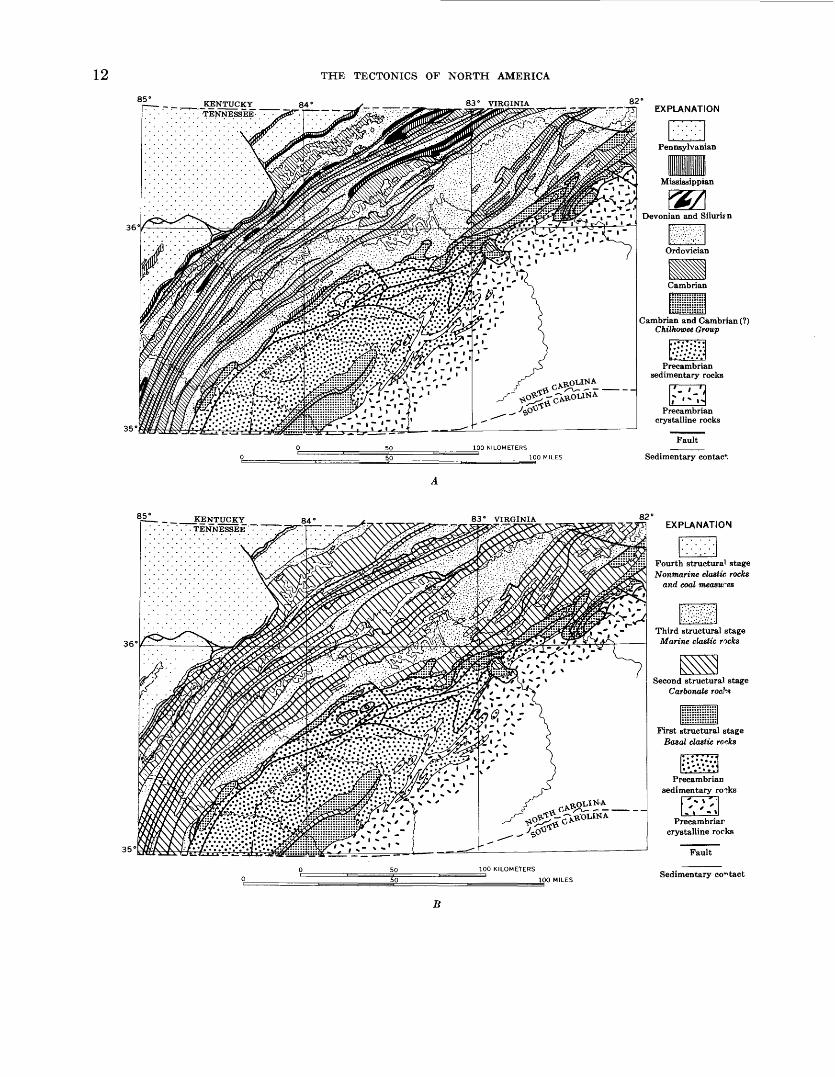
Nevertheless, the present compiler has doubts as to the value of "structural stages" in tectonic mapping. Does representation of the outcrops of the "stages" on a tectonic map give a true picture of the historical de velopment of the foldbelt? Is it possible to represent adequately both the morphology of a foldbelt and its history of development on a single sheet of paper? The "structural stages" in foldbelts characteristically crop out where the rocks are much deformed, hence their out crops may be very narrow. These deformed areas are,
further, the ones where the structural features repre sented by symbols are most crowded, thus adding to th^ complexity of the map pattern (fig. 5). The surfac^ area occupied by a "stage" in a deformed region may have little relation to its relative lithologic or historica I significance; moreover, outcrops of the "stages" may b^ interrupted by later superposed structures, or by over lapping postorogenic deposits (fig. 6). The true signifi cance of any "structural stage" can only be represented on a paleotectonic map which will show its original ex tent beyond its present outcrops, both where the "stage" has been removed by erosion, and where it has been buried beneath younger strata.
A final comment can be made on the method of color ing the foldbelts on the two maps. The colors used ex press the climactic times of orogeny in the foldbelts, dif ferent units of the sequence being shown by tints of th^ prevailing colors, whatever the actual ages of the units. The maps thus vividly emphasize the foldbelts, produc ing an eloquent picture on the wall, but the technique makes detailed study of the foldbelts difficult without constant reference to the legend. Precambrian basement rocks are shown in many different colors, from one fold- belt to another, and postorogenic deposits of the inter nal and external basins are give the same color as th<* climactic orogeny, although they may be many period 0 younger. In some foldbelts the outcrops of the actusJ deformed strata are rather small, as they are nearly buried by extensive postorogenic deposits. Many cf these postorogenic deposits are a platform cover, which is coextensive with the platform cover of surrounding regions. Drawing a boundary between foldbelt color and platform color in postorogenic deposits becomes highly subjective, unless there are abundant subsurface date.
"TECTONIC MAP OF CANADA"
The specifications of the two maps just discussed coir- bine several disparate items the nature of the rock?, the evolution of the rock sequence, and the ages of defor mation. Many later tectonic maps use similar specifica tions, but with significant divergences in the relative emphasis given to the different items.
The "Tectonic Map of Canada" (Stockwell, 1969) thus places primary emphasis on the ages of deformr- tion. On this map, 15 orogenies are differentiated, five in. the Precambrian and 10 in the Phanerozoic, namely: Kenoran (late Archean),Hudsonian (late Aphebianc1" Early Proterozoic), Elsonian (late Paleohelikian c* early Middle Proterozoic), Grenvillian (late Neohelilr- ian or late Middle Proterozoic), East Kootenay (middle Hadrynian or Late Proterozoic), Taconic (early Late Ordovician), Acadian (Middle to Late Devonian), E^- lesmerian (Early Mississippian), Appalachian (Lat"> Mississippian to Early Pennsylvanian), Melvillean
1285°
36°
35°
KENTUCKY TENNESSEE
THE TECTONICS OF NORTH AMERICA
84° v ___ __ 83° VIRGINIA82°
EXPLANATION
Sedimentary contac*.
852 _ _ KENTUCKY _ ___ 84 ' ' '.'.'.TENNESSEE' ' "^ "
36°
35'
83° VIRGINIAEXPLANATION
Sedimentary contact
B

85°JCENTUCKYTENNESSEE
APPRAISAL OF EXISTING TECTONIC MAPS
84° ^_ _____. 83" VIRGINIA
1382°
EXPLANATION
Axis of anticline
Axis of syncline
Precambrian crystalline rocks
35°
100 KILOMETERS
G
FIGURE 5 (left and above). Three maps of eastern Tennessee and western North Carolina showing different methods of representing the geology in a region of strongly deformed rocks. In figures .4. and 7> the representation of time- stratigraphic and rock-stratigraphic units much obscures the representation of structural features, even though their scale is about 3 times that of the ''Tectonic Map of North America." Compiled from geologic maps of Tennessee and North Carolina, .i, Map showing time-stratigraphic units (geologic systems). /?, Map showing rock-stratigraphic units ("structural stages"). C, Structural map, showing folds and faults.
(Late Pennsylvania!!), Tahltaniaii (Early to Middle Triassic), Inklinian (Late Triassic to Early Jurassic), Nassian (Middle Juracsic), Columbian (Late Jurassic to Early Cretaceous), and Laramide (Late Cretaceous to Eocene).
Each orogeny is correlated over the whole country; for example, rocks aft'ected by the Appalachian orogeny are mapped not only in the Appalachians but also in the Arctic Islands. The areas aft'ected by the different orogenies are shown by separate colors, the color of the dominant orogeny being used also for areas reworked from earlier orogenies and for unconformably overly ing deposits. The rocks affected by each orogeny are subdivided in turn according to their lithology and ori gin, their degree of metamorphism, and the. deforma tion to which they have been subjected; some have undergone two or more prior orogenies.
Two examples of the subdivisions of the rocks of the foldbelts which are made on the ''Tectonic Map of Can ada" are quoted below, one for the Precambrian, one for the Phanerozoic:
Hudsonian orogeny (H) ; folding and granitic intrusions dur ing late Aphebian.
Hg, Granitic intrusions emplaced during the Hudsonian,including highly granitized gneisses. Hgd, discordantintrusions.
Hb, Basic intrusions. Hb', mainly gabbro. Ha, mainlyanorthosite.
Hn, Aphebian sedimentary and volcanic gneiss and scl ist.Hug, mixed with granitic material. Hr, granulite andcharnockite.
Hm, Aphebian miogeosynclinal deposits. He, Apliel ianeugeosynclinal deposits.
Heu, Aphebian and (or) Archean slightly metamorphosedeugeosyuclinal deposits. Him, gneissic equivalents.
Hu, Aphebian and (or) Archean sedimentary and volcanicgneisses, commonly mixed with granitic material. Fun,metamorphic rocks in largely unmapped areas, withundivided granitic intrusions.
HKg, Granitic intrusions, emplaced during the Kenoranand re\yorked during the Hudsonian. HKg, intrusionsemplaced during the pre-Kenoran and reworked duringthe Kenoran and Hudsonian.
HKe, Slightly metamorphosed Archean eugeosynclinal de posits, folded during the Kenoran and reworked duringthe Hudsonian.

39
°30
'
EX
PL
AN
AT
ION
Ter
tiar
y v
olca
nics
and
sed
imen
ts
Upp
er M
esoz
oic
volc
anic
s an
d se
dim
ents
NE
VA
DA
N
OR
OG
EN
Y
Low
er M
esoz
oic
shel
f de
posi
ts
Per
mia
n an
d T
rias
sic
volc
anic
s
SO
NO
MA
O
RO
GE
NY
Eug
eosy
ncli
nal
Tra
nsi
tional
M
ioge
osyn
clin
al
Low
er P
aleo
zoic
dep
osit
s
NE
VA
DA
\
39°3
0'
\
20
KIL
OM
ET
ER
S
20
MIL
ES
FIG
URE
6. T
ecto
nic
map
of
nort
h-ce
ntra
l N
evad
a il
lust
rati
ng t
he d
iffi
culty
of
mak
ing
a m
eani
ngfu
l re
pres
enta
tion
of
"s
truct
ura
l st
ages
" on
sm
all-
scal
e te
cton
ic m
aps
in a
n ar
ea o
f co
mpl
ex s
uper
pose
d ro
cks
and
stru
ctur
es.
The
P
aleo
zoic
and
Mes
ozoi
c ro
cks
cons
ist
of t
hree
seq
uenc
es,
each
div
isib
le i
ni:o
"s
truct
ura
l st
ages
." D
urin
g P
aleo
zoic
and
Mes
ozoi
c ti
me
the
sequ
ence
s w
ere
tele
scop
ed b
y lo
w-a
ngle
thru
stin
g;
late
r, t
hei
r ro
cks
wer
e in
vade
d by
plu
tons
, par
tly c
over
ed b
y po
stor
ogen
ic d
epos
its,
and
dis
rupt
ed b
y bl
ock-
faul
ting
, so
th
at
they
ar
e no
w
expo
sed
in
smal
l, di
scon
nect
ed
area
s.
Com
pile
d fr
om
coun
ty g
eolo
gic
map
s of
Nev
ada,
and
fro
m v
ario
us U
.S.
Geo
logi
cal
Sur
vey
publ
icat
ions
.

APPRAISAL OF EXISTING TECTONIC MAPS 15
HKn, Gneissic equivalents, mixed with granitic material.HKr, Granulite and charnockite.
Acadian orogeny (A) ; folding and granitic intrusions mainly during the late Middle to early Late Devonian. A', folding during middle Early Devonian. A", folding possibly during Late Silurian.
Ag, Granitic intrusions.An, Upper Ordovician to Middle Devonian miogeosynclinal
deposits. Am', Cambrian to Middle Devonian. Ae. Silurian to Middle Devonian eugeosynclinal deposits. Ae', Ordo vician to Middle Devonian eugeosynclinal deposits. An', derived gneiss and schist.
A'm, Hadrynian to Early Devonian miogeosynclinal deposits.
A"g, Granitic intrusions. A"b, basic intrusions.A"e, Lower Ordovician to Middle Silurian eugeosynclinal
deposits. A"n, derived gneiss and schist.ATg, Granitic intrusions emplaced during the Taconic and
modified during the Acadian. ATb, basic intrusions em- placed during the Taconic and modified during the Acadian.
ATin, Cambrian to Ordovician miogeosynclinal deposits folded during the Taconic and refolded during the Aca dian. ATM, metamorphic equivalents. ATe, Upper Hadrynian to Middle Ordovician eugeosynclinal deposits, folded during the Taconic and refolded during the Aca dian. ATE, metamorphic equivalents. ATn, derived gneiss and schist
AK"M, Hadrynian or older metamorphosed miogeosynclinal deposits, folded during the middle or late Hadrynian and modified during the Acadian. AK"E, similar metamor phosed eugeosynclinal deposits. AK"n, derived gneiss, schist and migmatite.
AK'g, Granitic intrusions emplaced during the early Hadrynian or before and modified during the Acadian.
AK'M, Metamorphosed early Hadrynian or older miogeo synclinal deposits folded during the early Hadrynian or earlier and refolded during the Acadian. AK'ng, derived gneiss and schist, mixed with granitic material.
AK'e, Earlier Hadrynian or older eugeosynclinal deposits folded during the early Hadrynian or earlier and re folded during the Acadian.
The orogenies listed above are differentiated partly by geologic evidence stratigraphically dated uncon formities, intrusive relations, and the like for which the record is unusually complete in parts of Canada. To a considerable extent, however, they are based on the extensive radiometric dating program of the Geological Survey of Canada, and especially potassium-argon dat ing. Most of the rocks that have been dated are either intrusive or metamorphic.
The five Precambrian orogenies are widely spaced, their climaxes being at about 2,400, 1,700, 1,300, 900, and 700? m.y. (million years) ago, or 700, 400, 400 and 200 ? m.y. apart. The five Paleozoic orogenies lie within a span of 200 m.y. (Middle Ordovician to Late Pennsyl- vanian), and the five Mesozoic orogenies within a span of 155 m.y. (Early Triassic to end of Cretaceous). The figures cited might suggest an acceleration of orogeny through time, but the large number of Phanerozoic
orogenies recognized in Canada would be merely phases of the three or four orogenic eras recognized in Europe and the U.S.S.R., whose climaxes occurred at different times in different places. Very likely the widely spaced Precambrian orogenies recognized in Canada are ac tually groups of orogenies like those in the Phanerozoic, for which the. individual records have become blurred.
The classification of the Precambrian rocks and orog enies in the Canadian Shield on the "Tectonic Map of Canada" is useful and expressive. It blocks out larr^s regions or provinces which have been subjected to oro genic events of widely varying ages, showing within each province the intrusive and supracrustal rocks that formed during, or only a little before, the climactic orogeny, as well as the relics of older rocks affected by earlier orogenies that were reworked by the climactic orogeny. Representation of the Precambrian rocks of the Canadian Shield will be discussed at greater length later (p. 33-36).
The classification of the Phanerozoic rocks and ore 7- enios is less appealing to the present compiler. T^<* large number of orogenies differentiated, and the larre number of rock units mapped in each category obscrre the broader relations. The differentiation gives the im pression, perhaps unintended, of many distinct foJd- belts built against each other, whereas the orogenic units are actually not sharply defined in either time or place; this compiler considers these units to be subdi visions or phases of gross foldbelts that evolved during lengthy tectonic cycles. Moveover, unless unusually com plete age data are available, such a classification in volves a large measure of inference and speculation. A comparable classification would be difficult to make ebe- where in North America, where the available age data are less complete.
"TECTONIC MAP OP MEXICO" AND "TECTONIC MAP OF U.S.S.R."
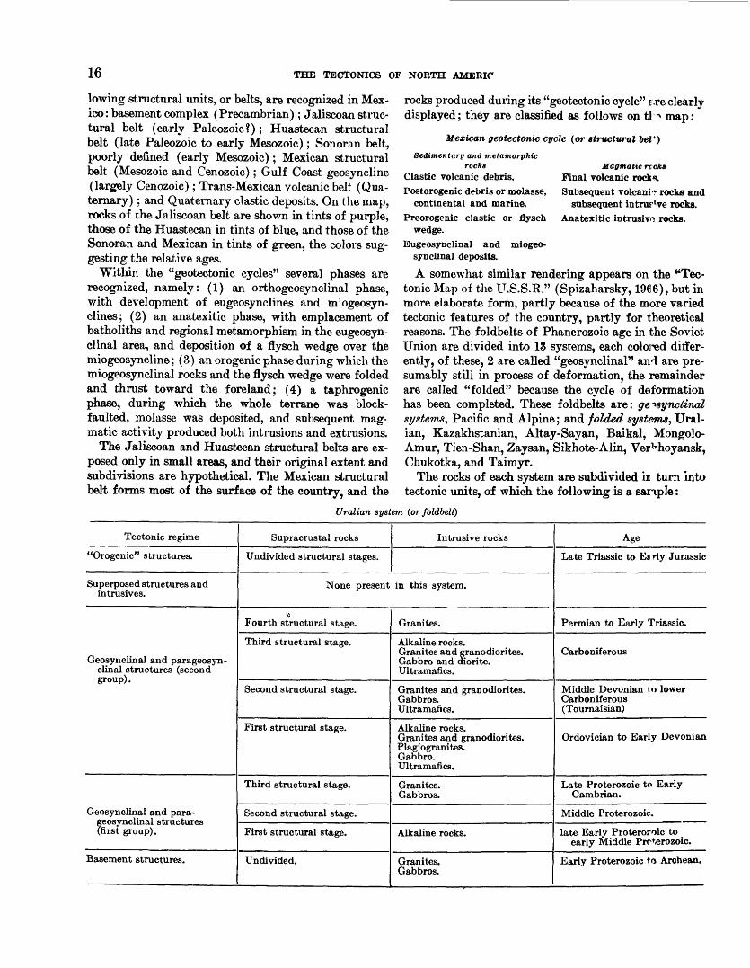
A divergence in another direction from the specifica tions of the "Tectonic Map of the U.S.S.R. and A d- jacent Areas," and the "Tectonic Map of Europe" is illustrated by two maps the "Tectonic Map of Mexico" (de Cserna, 1961) and the "Tectonic Map of the U.S.S.R." (Spizaharsky, 1966). On these maps, em phasis is not on the climactic orogenies in the foldbelts, nor on details of the orogenic episodes, but on the broad tectonic cycles during which the foldbelts were built.
On the "Tectonic Map of Mexico" the country is in terpreted as being composed of "structural belts," erch of which became consolidated during a "geotectonic cycle," the cycle being the interval of time during which an orthogeosynclinal belt became a craton.4 The fol-
4 The theoretical basis for the map is summarized from de Cserna (1960) and from the brief text printed on the map.
16 THE TECTONICS OF NORTH AMERIO
lowing structural units, or belts, are recognized in Mex ico: basement complex (Precambrian); Jaliscoan struc tural belt (early Paleozoic?); Huastecan structural belt (late Paleozoic to early Mesozoic); Sonoran belt, poorly defined (early Mesozoic); Mexican structural belt (Mesozoic and Cenozoic); Gulf Coast geosyncline (largely Cenozoic); Trans-Mexican volcanic belt (Qua ternary) ; and Quaternary clastic deposits. On the map, rocks of the Jaliscoan belt are shown in tints of purple, those of the Huastecan in tints of blue, and those of the Sonoran and Mexican in tints of green, the colors sug gesting the relative ages.
Within the "geotectonic cycles" several phases are recognized, namely: (1) an orthogeosynclinal phase, with development of eugeosynclines and miogeosyn- clines; (2) an anatexitic phase, with emplacement of batholiths and regional metamorphism in the eugeosyn- clinal area, and deposition of a flysch wedge over the miogeosyncline; (3) an erogenic phase during which the miogeosynclinal rocks and the flysch wedge were folded and thrust toward the foreland; (4) a taphrogenic phase, during which the whole terrane was block- faulted, molasse was deposited, and subsequent mag- matic activity produced both intrusions and extrusions.
The Jaliscoan and Huastecan structural belts are ex posed only in small areas, and their original extent and subdivisions are hypothetical. The Mexican structural belt forms most of the surface of the country, and the
rocks produced during its "geotectonic cycle" s.re clearly displayed; they are classified as follows on tl ^ map:
Mexican geotectonic cycle (or structural 6eZ*)
Magmatic recks Final volcanic rock*.Subsequent volcani? rocks and
subsequent intrur've rocks. Anatexitic intrusive rocks.
Sedimentary and metamorphicrocks
Clastic volcanic debris. Postorogenic debris or molasse,
continental and marine. Preorogenic clastic or flysch
wedge. Eugeosynclinal and miogeo
synclinal deposits.
A somewhat similar rendering appears on the "Tec tonic Map of the U.S.S.R." (Spizaharsky, 1966), but in more elaborate form, partly because of the more varied tectonic features of the country, partly for theoretical reasons. The foldbelts of Phanerozoic age in the Soviet Union are divided into 13 systems, each colored differ ently, of these, 2 are called "geosynclinal" and are pre sumably still in process of deformation, the remainder are called "folded" because the cycle of deformation has been completed. These foldbelts are: ge^synclinaZ systems, Pacific and Alpine; and folded systems, Ural- ian, Kazakhstanian, Altay-Sayan, Baikal, Mongolo- Amur, Tien-Shan, Zaysan, Sikhote-Alin, Verkhoyansk, Chukotka, and Taimyr.
The rocks of each system are subdivided ii turn into tectonic units, of which the following is a sample :
Uralian system (or foldbelt)
Tectonic regime
"Orogenic" structures.
Superposed structures and intrusives.
Geosynclinal and parageosyn- clinal structures (second group).
Geosynclinal and para- geosynclinal structures (first group).
Basement structures.
Supracrustal rocks
Undivided structural stages.
Intrusive rocks
None present in this system.
« Fourth structural stage.
Third structural stage.
Second structural stage.
First structural stage.
Third structural stage.
Second structural stage.
First structural stage.
Undivided.
Granites.
Alkaline rocks. Granites and granodiorites. Gabbro and diorite. Ultramafics.
Granites and granodiorites. Gabbros. Ultramafics.
Alkaline rocks. Granites and granodiorites. Plagiogranites. Gabbro. Ultramafics.
Granites. Gabbros.
Alkaline rocks.
Granites. Gabbros.
Age
Late Triassic to Ea rly Jurassic
Permian to Early Triassic.
Carboniferous
Middle Devonian to lower Carboniferous (Tournaisian)
Ordovician to Early Devonian
Late Proterozoic to Early Cambrian.
Middle Proterozoic.
late Early Proteroroic to early Middle Prcterozoic.
Early Proterozoic to Archean.
APPRAISAL OF EXISTING TECTONIC MAPS 17
The theoretical basis for the representation on this map and its legend has been presented at length by Spizaharsky and Borovikov (1966). In brief, the earth's crust is considered to be heterogeneous, and to be divided into gross blocks along abyssal fractures; if so, each block would undergo its own independent history, and universal times of orogeny would be impossible. The tectonic cycle in each folded system began with a geo- synclinal period; the supracrustal rocks that were formed during the period are divisible into a sequence of "structural stages" (rock-stratigraphic units like those on previous Soviet maps), and there is a parallel se quence of intrusive rocks (shown in an adjoining col umn in the legend). Folding was largely completed by the end of the geosynclinal period, but orogenic cli maxes are not mentioned. In the folded systems the geo synclinal period was followed by an "orogenic" and "koilogenic" period, during which the crust was epeiro- genically unwarped and downwarped. These authors use "orogenic" in a geomorphological rather than a tectonic sense that is, for the formation of mountainous topography by uplift, rather than by deformation. In the geosynclinal systems, the "orogenic" and "koilo genic" period has not yet been attained.
According to the map legend, the geosynclinal period (and presumably also the periods of folding) ended in one folded system during the Cambrian, but in others during the Permian, the Triassic, the Early Cretaceous, and the Late Cretaceous; in the geosynclinal systems the geosynclinal period (and period of folding) has not yet ended. Were it not for the theoretical predilec tions of the compilers, the folding in these systems could be assigned, as on the "Tectonic Map of the U.S.S.R. and Adjacent Areas" and the "Tectonic Map of Eu rope," to the broadly defined Baikalian, Variscan, Meso- zoic, and Alpine orogenies.
On the tectonic maps of Mexico and the U.S.S.R. the supracrustal rocks are thus subdivided in a manner like that on some of the tectonic maps hitherto considered, into a sequence of "structural stages" (although these are not so designated on the map of Mexico). Placing the intrusive and (or) magmatic units in a column in the legend adjacent to the supracrustal sequence is a worthy innovation, as it illustrates the parallel evolu tion of the two classes of rocks during the tectonic cy cles in the foldbelts. The resulting legend is fairly simple on the "Tectonic Map of Mexico." On the Tec tonic Map of the U.S.S.R." the great variety of features to be represented produces a legend vastly larger and more complex than on any tectonic map hitherto con sidered. This increases the difficulty of using the map and legend, but it certainly presents a truer picture of the local peculiarities and histories of each foldbelt;
these are obscured by the generalizations made on othei" maps, where tectonic features from widely separated regions are grouped together and correlated.
REPRESENTATION OF SUBSEA AREAS
On most of the tectonic maps just reviewed only the sea-bottom configuration is shown, by topographic cor- tours and bathmetric tints. Even by themselves, subsea topographic contours are more expressive of tectonics than topographic contours on the land, as the structures of the sea bottom have been less modified by erosion?.! and depositional processes. Hence, fault scarps, fault blocks, upwarps, and downwarps are evident merely from their topographic configuration.
Although interpretation of features beneath the sea on tectonic maps cannot, as yet, be made with as much assurance as features on the land, recent oceanographic advances have encouraged proposals for more specify tectonic representation of subsea features. Such repre sentation, especially by Soviet geologists and oceanog-- raphers, has appeared on some of the more recent tee- tonic maps. On the "Tectonic Map of Eurasia" (Yanshin, 1966b) the ocean bottoms are subdivided into first-order units shown by color patterns, as follows:
Structure?, of the Sea and Ocean Floors
Regions of pre-Cenozoic folding; continental platforms [=Cor- tinental shelves] :
1. Regions of epi-Mesozoic and older platforms. Cenozoic folded and geosynclinal regions :
i?. Folded and geosynclinal systems.3. Regions of pre-Neogene folding.4. Deep basins without granitic layer.5. Deep ocean trenches.6. Deep trenches of inland seas.
Regions of oceanic platform [= abyssal plains and ridges] :7. Arched oceanic elevations of the basaltic crust; swell'.8. Marginal swells of oceanic platforms and Philippine
basin.9. Oceanic ridges of block structure.10. Midoceanic ridges, and graben structures of Bay of
Aden and Red Sea.11. Old oceanic plates between zones of elevation (parts
thickly covered by sediments shown by overprinted pattern).
12. Oceanic plates without granitic layer, originating iuPaleozoic and Mesozoic.
Volcanicity:Submarine volcanic ridges and plateaus (shown by over
printed patterns) : a, basaltic; b, mixed composition mostly andesitic.
Besides the first-order units, second-order symbols ar^ used on the map to indicate morphological or tectonic boundaries, faults, folds, flat-topped seamounts, atollr and the like.
Many of the first-order units used on the map am merely morphological or descriptive, such as deep

18 THE TECTONICS OF NORTH AMERICA
oceanic trenches, marginal swells, and mid-ocean ridges; these would probably be nearly as evident from detailed topographic contours alone. Other units imply rock composition, such as granitic or basaltic crust and thick sedimentary cover, and have been verified by geophys ical measurements at least in places. Still others seem more speculative, such as units involving specific times of folding, as these times are not verifiable by present oceanographic methods.
Even more radical proposals for representing subsea tectonics have been made by Soviet geologists. These involve classification of areas by rock composition and ages of folding, placing heavy reliance on particular theories of oceanic origin and evolution.
Today, oceanographic and marine geological investi gations are revealing not only subsea topography to considerable depths, but results are as yet available only in a few places. Accurate portayal of sea-bottom tec tonics in the manner of the more radical proposals mentioned above must await a much wider extension of these investigations.
"THE TECTONIC MAP OF NORTH AMERICA"
COMPILATION OF MAP
Compilation of the "Tectonic Map of North America" was facilitated by the existence of tectonic maps of many of the areas or countries involved some printed and available at the time the compilation began, others in progress at that time and printed subsequently, and others still in manuscript at the time of this writing. The maps in manuscript or in progress during the time of compilation were made available to the compiler through the courtesy of their authors.
A major source of information was the "Tectonic Map of the United States, exclusive of Alaska and Ha waii" (Longwell, 1944b; Cohee, 1962), but configuration of the surface of the basement rocks in this region was taken from the "Basement Map of North America Be tween 24° and 60° N.," compiled by a committee of the American Association of Petroleum Geologists (Flawn, 1967). The tectonics of the State of Alaska is shown on a manuscript map assembled in 1958 by George Gryc and his associates in the U.S. Geological Survey, but for the North American map the data shown there were greatly amplified by information obtained subsequently by these same geologists.
Canada is covered by a published tectonic map (Deny, 1950), but this is superseded by a new tectonic map compiled by the Geological Survey of Canada and a committee of Canadian geologists, under the direction of Clifford H. Stockwell (Stockwell, 1969). The new map, which was made available to the compiler in manu
script, is the chief basis for representing nearl^ half of the land area of North America. The part of this map covering the Canadian Shield was published first (Stockwell, 1965), the whole map in 1969. As will be seen later, the tectonic classification of the Pre^ambrian used on this map was the principal basis for classifica tion of the Precambrian used elsewhere on the North America map. Additional data on western Car ada were obtained from a tectonic map of the western Cordillera, in British Columbia and neighboring areas by William H. White (1966b, fig. 10-1).
All of Greenland is shown on a manuscript tectonic map by Asger Berthelsen prepared for the Geological Survey of Greenland. Eastern and northern Green land are also shown on maps by John Haller of the Danish East Greenland Expeditions. Many of the latter maps have been published in various formr and on various scales (Haller, 1961b; Haller and Kulp, 1962, fig. 3 and pi. 4; Haller, 1968, maps 1-3), but others are still in press. The easternmost part of the U.S.S.R., lying within the area of the North America nap base, is shown on a tectonic map by S. M. Tillmar and his associates of the Siberian Section of the Acr demy of Sciences of the U.S.S.K. (Tillman and others, 1966), which was generously made available by itr authors prior to publication.
Mexico is shown on a tectonic map compiled by Zol- tan de Cserna (1961), which was the chief basis for representing that country on the North America map. In addition, as indicated below, the scheme of classi fication adopted by de Cserna in Mexico greatly aided the present compiler in working out a general tectonic classification for North America. South of Mexico, the next published tectonic maps are of Venezuela (Bucher, 1950; Smith, 1962). The tectonics of the intervening regions of Central America and the Antilles was filled in from geologic maps and miscellaneous data, both published and unpublished. For Central America, ma jor assistance was obtained from Gabriel Dengo of the Organization for Economic Integration of Central America. A tectonic map of Cuba did not become avail able until after completion of the North America map but representation of the country on this map is much the same as on the present map (Puscharovsky and others, 1966).
The subsea topography surrounding North America was assembled from contour charts of the U.S. Navy Hydrographic Office, the U.S. Coast and Geodetic Sur vey, the U.S. Bureau of Commercial Fisheries, and the U.S. Geological Survey, extensively supplemented by publications of the staffs of Scripps Institution of Oceanography, Lament Geological Observatory, and

SPECIFICATIONS OF MAP irWoods Hole Oceanographic Institution. These com pilations were corrected by Henry W. Menard and Robert L. Fisher of Scripps Institution of Ocean ography and by Bruce C. Heezen of Lament Geological Observatory. The subsea topography of the Arctic Ocean and its surroundings was obtained from charts by the Marine Sciences Branch, Canadian Department of Mines, Energy, and Resources, which were furnished in manuscript through the courtesy of M. M. de Leeuw.
Preparation of the North America map was ma terially aided by the opportunity afforded to the com piler to view tectonic features in the field during many excursions, including excursions to such remote areas as Alaska, Newfoundland, southern Mexico, and Guate mala. The compiler also had several mutually helpful conferences with Clifford H. Stockwell and others at the offices of the Geological Survey of Canada, and with Zoltan de Cserna and others at the offices of the In- stituto de Geologfa de Mexico. He* further benefited from attendance at conferences abroad which dealt with tectonic problems. Further, the compiler acknowledges with pleasure his rewarding association with Professor A. A. Bogdanoff of Moscow University, U.S.S.R., a world leader in the subject of tectonic mapping.
Finally, the "Tectonic Map of North America" could not have become a reality without the great and good help of Douglas M. Kinney, geologic map editor of the U.S. Geological Survey, first for his sage counsel and advice during the work of compilation, and second for his assistance in obtaining a printed product that faith fully reproduced the original specifications.
SPECIFICATIONS OF THE MAP
When planning the specifications of the "Tectonic Map of North America," the compiler considered the legends and the philosophical bases of the maps previ ously discussed, and adapted their best features to the new map. Rendering of second-order features on the North America map closely follows that on the "Tec tonic Map of the United States" (Longwell, 1944b; Cohee, 1962), but many innovations are made in the rendering of the first-order features. All the land areas are subdivided into tectonic units, shown by color pat terns, instead of being only partly colored. A practical reason for this change is that, whereas structural and tectonic data are complete enough within the contermi nous United States for many features to be effectively represented by symbols alone, data are less complete elsewhere and many tectonic features in poorly known areas can only be blocked out by color patterns.
Clearly, the units to be shown by color patterns on the "Tectonic Map of North America" must differ from those on conventional areal geologic maps; they must be
tectonic units, rather than stratigraphic units. But what are tectonic units? The preceding review of existing tectonic maps indicates a wide diversity of opinion among makers of tectonic maps as to what a tectonic unit should be a diversity which reflects botl philosophical and practical considerations.
In the judgment of the compiler, the ages of deforma tion of the rocks should not be the major criterion for distinguishing tectonic units. Many contrasting kinds of deformation can occur nearly simultaneously, in differ ent rocks, and in different environments; these rockr and their environments are as significant as the timer when they were deformed. Moreover, although specific ages of deformation can be determined in some local areas, regional ages of deformation are seldom clear- cut. Regional ages of deformation are seemingly clearest in the Precambrian rocks, which are readily divisible, into gross provinces or foldbelts, but this is largely be cause of the great length of Precambrian time and tho incompleteness of the record in these ancient rocks Within the Phanerozoic rocks, many deformational events can be recognized, which not only can be more specifically dated than those in the Precambrian but which are more closely spaced in time. Differentiation of all such events on a tectonic map is of dubious signifi cance, at least on a map of continental scope; the extent of many of the individual events is very local, or can be specifically proved only in local areas. Much more sig nificant is the gross time (that is, the tectonic cycle) during which the structures in each foldbelt were created.
The units shown by color patterns on the "Tectonic Map of North America" should, then, combine several significant tectonic items. Within the deformed regions the gross units should be the f oldbelts, which evolved by continuing deformation during lengthy periods of geo logic time and each of which had its own distinctive history and time span; these foldbelts should be dis tinguished by different colors. Subdivisions of each fold- belt should represent the kinds of rocks involved, which are, to a greater or lesser degree, products of this evolu tion such as eugeosynclinal, miogeosynclinal, and other sedimentary rocks, and various metamorphic, plutonic, and volcanic rocks. These kinds of rocks can be differ entiated by patterns of the prevailing colors. Finally, deformations of specific ages should be indicated only where they imply significant pulses in the evolution of the foldbelt as a whole; they can be shown by various tints of the prevailing color. These concepts correspond closely to the concepts that were the basis for tho "Tectonic Map of Mexico" (de Cserna, 1961), and the present compiler acknowledges his indebtedness to thoso
20 THE TECTONICS OF NORTH AMERICA
concepts in evolving specifications for the "Tectonic Map of North America."
These philosophical considerations are all very well, but they require modification in order to be represented on a map of North America on a 1:5,000,000 scale. Many tectonic items of theoretical significance are difficult or impossible to map at all, and others would require repre sentation on a scale of 1:2,500,000, or even larger. The "structural stages" which adorn many recent tectonic maps are a case in point. The "stage" concept is valid in expressing the evolution of the f oldbelts through time, and "stages" can be recognized in the rock sequences of the f oldbelts of North America; to map them is another matter. Sequences of "stages" are generally best marked in strongly deformed areas, thus, both crowded outcrop patterns and crowded structural symbols would coincide on the map (figs. 5 and 6). The present compiler believes that the structures in such areas are more significant than the rock sequence, hence that representation of the latter must be sacrificed. Nevertheless, as will become apparent later, many of the subdivisions of the f oldbelts used on the "Tectonic Map of North America" are gross "structural stages" in the sense of existing maps, but these are broad enough in scope to be represented clearly on the 1:5,000,000 scale.
A final disclaimer is in order: Tectonic classification will always be much more subjective than stratigraphic classification and will always be greatly influenced by the judgment and predilections of the map compiler. No two compilers will make identical tectonic classifica tions of the rocks of the same area for example, as to what rocks are eugeosynclinal or miogeosynclinal, or as to what rocks are synorogenic or postorogenic. For the "Tectonic Map or North America," the present compiler has appraised the source data and the opinions of geolo gists that relate to each region, but judgment as to the final representation on the map was made by him alone. What he has shown on the map will differ more or less from what would be shown by another compiler, and may be erroneous in places; every feature shown on the map is controversial in some degree. Nevertheless, in making this map a single compiler has viewed North America in all its parts, and has compared the tectonic features of each part with each other part, thus hope fully arriving at a balanced judgment of the relative significance of each.
On the tectonic map, North America and its surround ings are divided into the following tectonically signifi cant major units:Platform areas:
(A) Little deformed Precambrian deposits overlying more deformed earlier Precambrian rocks (Canadian Shield and elsewhere).
(B) Platform deposits on Precambrian basement (cratonic area of central United States, western Crnada, and the Arctic Islands).
(C) Platform deposits on Paleozoic basement (Atlantic and Gulf Coastal Plains).
(D) Platform deposits on Mesozoic basement (Arctic- Coastal Plain of Alaska and northern Onada).
(E) Volcanic rocks and associated sediments of North At lantic province, on Precambrian and younger base ment (Iceland, Greenland, and part of Baffin Island).
(F) Icecaps of Quaternary age, on Precambrian and young er basement (Greenland and parts of Arctic Islands).
Foldbalts of Precambrian age:(G) Kenoran foldbelt (Canadian Shield and elsewhere). (H) Hudsoniaa foldbelt (Canadian Shield and elsewhere). (I) Greenville foldbelt (Canadian Shield and elsowhere).
Foldbelts mainly of Paleozoic age :(J) East Greenland foldbelt (northern east Greenland). (K) Innuitian foldbelt (Arctic Islands and no*th Green
land).(L) Appalachian foldbelt (southeastern North America). (M) Ouachita foldbelt (southern North Americr).
Foldbelts mainly of Mesozoic age :(N) Andean foldbelt (South America, in southeastern cor
ner of map).(O) Cordilleran foldbelt (western North America).
Foldbelts mainly of Cenozoic age:(P) Pacific foldbelt (west coast of North Amer'ca).(Q) Antillean foldbelt (Antilles, southern Central America,
and Caribbean coast of South America). Subsea areas.
On the map and its legend, these tectonic units and their subdivisions are indicated by colors that follow a prismatic scale, according to the ages of tl Q, geotec- tonic cycles during which they were formed brown and red for Precambrian, purple for older Paleozoic, blue for younger Paleozoic, green for Mesozoic, and yel low and orange for Cenozoic. The units and their sub divisions are also indicated by symbols. Prefires of the symbols are the capital letters in the preceding list. These letters are followed by numerals or letters which designate the subdivisions thereof numerals for the sedimentary and metasedimentary subdivisions, Greek letters for the plutonic and volcanic subdivisions.5
However, some of these subdivisions occur in more than one of the foldbelts. For example, "thiclr deposits in structurally negative areas" are characteristic not only of the Cordilleran foldbelt, but also of tt^ adjoin ing Pacific and Antillean foldbelts. Moreover, rocks of various Precambrian foldbelts come to the surface in
8 Nine Greek letters are used in the legend, which are placed in con ventional order (alpha, beta, gamma, delta, and so forth), reading from bottom to top of each column; however, certain letters in the sequence are omitted that would not reproduce clearly on the map (s"ch as zeta, eta, kappa, and nu). The letters are used indiscriminately IT whatever rock type appears in the sequence, so that granite, for example, is designated in one place as alpha, in others as beta, delta, and theta. This usage differs from that on some European maps where all granites are designated as gamma, all basalts as beta, and so forth, regardless of their place in the sequence.

PLATFORM AREAS 21
the foldbelts of later ages. On many of the maps pre viously reviewed, such subdivisions are colored, pat terned, and symbolized in an entirely different manner from one foldbelt to another, and it is difficult to observe their obvious kinships. In order to express such kinship on the "Tectonic Map of North America," the same colors and patterns are used for the subdivisions in all places but they are repeated in the legends of each fold- belt, only their symbols differing from one foldbelt to another.
PLATFORM AREAS
Platform areas are those parts of the continents in which flat-lying or gently tilted deposits, mainly sedi mentary, are underlain at varying depths by a basement of rocks that had been consolidated, not only by earlier deformation, but in part by metamorphism and pluto- nism. This definition, while seemingly clear, is not every where easy to apply. In North America there is much debate among geologists and geophysicists as to which rocks should be called basement and which should not; in compiling the "Tectonic Map of North America" some arbitrary decisions have been made in places. The most extensive platform areas in North America are those with a Precamorian basement in the central craton and those with a Paleozoic basement in the Atlantic and Gulf Coastal Plains. The other platform areas are less extensive or otherwise less typical, but they can more appropriately be placed in this category than in any other.
The tectonic features of the platform areas are most effectively portrayed by means of contours on the up per surfaces of their underlying basements. These sur faces were produced by erosional truncation before the platform deposits were laid over them, but erosion or dinarily had advanced far enough so that any residual topographic features are scarcely apparent in the con tours on a small-scale map. Most of the configuration of the surfaces is therefore the sum of all the deforma tions that were imposed on them after they were trun cated. Contours on the surfaces of the underlying basements are available for all of the central cratonic area, for a large part of the Atlantic and Gulf Coastal Plains, and for the Greenland icecap; these are repre sented on the "Tectonic Map of North America." Foi the remaining platform areas configuration of the un derlying basement is either unknown or is known only in small areas. These platform areas are relatively in consequential and are not contoured.
(A) PLATFOBM ABEAS WITHIN THE PBECAMBBIAN
In parts of the Canadian Shield are areas of flat- lying or gently tilted sedimentary or volcanic rocks oi
Precambrian age, which lie on truncated surfaces of rocks-that were strongly deformed during earlier Pre cambrian orogenies. These orogenies are of diverse agee. and the ages of the deposits that overlie the rocks de formed by them are probably equally diverse; on the map, these deposits are classed as of Early, Middle, and Late Proterozoic ages (Al, A2, and A3).e Most of these flat-lying or gently tilted rocks are now preserved in relatively small areas, but such rocks are very likely the last remnants of what were originally much more ex tensive platform deposits.
One well-known Precambrian platform deposit is the Keweenawan Series of the Lake Superior region a very thick sequence of mafic lavas interbedded with and succeeded by red continental sandstones (A2). The se ries has been downwarped into a broad syncline, faulted, and invaded by thick sheets of gabbro (Aa) but it r unmetamorphosed and is tilted rather than folded, so that its structure contrasts with the underlying Pre cambrian which has undergone thorough erogenic de formation and moderate to strong regional metamor phism (James, 1955). Radiometric dating of the gabbro sheets indicates an age of about 1,100 m.y. (Goldich and others, 1961, p. 96), so that the part of the Keweenawar Series intruded by them is Middle Proterozoic; the- higher parts of the series might extend into the Upper Proterozoic (Stockwell, 1964, p. 12). Other Precam brian continental and volcanic rocks which occur ir. more remote parts of the shield, such as the Athabaska, Dubawnt, and Coppermine River Groups, are even lesr disturbed than the Keweenawan Series, and like it f onr a platform cover over more disturbed earlier Precam brian rocks. Toward the northwest, on the shores of the mainland and in the southern parts of the Arctic Islands, the Precambrian platform deposits include marine car bonates and a few evaporite units (Blackadar and Fraser, 1961, p. 363-368). Many of these groups, liko the Keweenawan Series, have been radiometrically dated as Middle Proterozoic.
Besides the extensive Middle Proterozoic platform deposits there are smaller areas of Precambrian plat form deposits of earlier and later ages. No platform de posits of Archean age remain, if such ever existed. How ever, Lower Proterozoic supracrustal rocks extend in a few places as platform deposits (Al) over the deformed1 Archean, as in the region between Lake Huron anc^ Lake Temiskaming. More commonly, they are eroded back to the edges of their foldbelts, where they form tilted sequences that lie against the deformed Archean (the "marginal homoclines" of Stockwell, 1965; here in cluded in unit H5). The deformed rocks of the Middle
Classification of the Precambrian used on the North America" is discussed on pages 30-32.
"Tectonic Map o*

22 THE TECTONICS OF NORTH AMERICA
Proterozoic Grenville foldbelt are overlain by a few small patches of flat-lying Upper Proterozoic deposits (A3), such as the Double Mer Sandstone near Hamilton Inlet; the Upper Proterozoic attains much greater bulk in parts of North America outside the shield, as will be seen later.
Included with the Upper Proterozoic platform de posits on the "Tectonic Map of North America" are the pre-Upper Cambrian rocks of the Wichita Mountains of Oklahoma. Most of the pre-Upper Cambrian rocks that are exposed are intrusive granites and gabbros, but subsurface data in surrounding areas demonstrate that these are not basement in the usual sense, but are sheets that intrude a thick and extensive terrane of lavas and graywackes (Ham and others, 1964, p. 21-37). Isotopic dating of the intrusives indicates ages of about 500 m.y. suggesting an Early Cambrian rather than a Precam- brian age; the host rocks are of about the same age or slightly older. Regardless of an eventual decision as to the age classification of these pre-Upper Cambrian rocks, they are more closely related tectonically to the later Precambrian (A3) than to the Paleozoic, and are so treated here (see p. 64).
Shown on the "Tectonic Map of North America" by the same color patterns as the Middle and Upper Pro terozoic platform deposits are strata of similar ages in parts of the Appalachian and Cordilleran foldbelts. These strata are properly geosynclinal rather than era- tonic, yet they resemble the platform deposits in that they overlie deformed basements of earlier Precam brian rocks, and were themselves not materially de formed except by the Phanerozoic orogenies. They will be discused more specifically later.
(B) PLATFORM DEPOSITS ON PRECAMBRIAN BASEMENT
In the central craton of North America the exposed Precambrian rocks of the Canadian Shield are sur rounded by areas in which they are covered by varying thicknesses of platform deposits of Paleozoic and younger ages. These platform deposits cover the inte rior lowlands south of the shield in the United States, from whence they extend northwestward through the plains of western Canada into the Arctic Islands and northern Greenland. A broad outlier of similar plat form deposits covers the center of the shield southwest of Hudson Bay. Between the shield and the Appala chian foldbelt on the southeast, the platform deposits make only a discontinuous, narrow strip along the St. Lawrence River.
On the "Tectonic Map of North America" the upper surface of the Precambrian in the central craton is con toured on a 500-m (1,640-ft) interval, and its configura
tion is indicated by layer tints. During the last few decades the top of the basement in the cratoi south of the 60th parallel has been penetrated at numerous places by wells drilled for water, oil, or gas, so thrvt control for contouring is excellent except near the centers of the deeper basins (Flawn, 1967); here, the basement configuration must be extrapolated from the structure of overlying strata. North of the 60th parallel, in Yukon Territory and the District of Mackenzie, very few deep wells have been drilled, but to complete the map, the sparse data from these wells have been used to extend the basement contours hypothetically to tl ?. Arctic Ocean.
The paleogeology of the buried Precambrian surface is of much tectonic interest, as it indicates the extensions of the Precambrian foldbelts away from their surface exposures, in the Canadian Shield and in outlying areas. The paleogeology can be deduced with much confidence in many places by means of well data. For the most part, however, it is not feasible to show the paleog?«logy on the "Tectonic Map of North America," except where exposed boundaries are extended for short distances beneath the cover as dotted lines. The paleog<M>logy of the cratonic area in the United States is indicated on another map, so far as it can be deduced (Bayley and Muehlberger, 1968); data from that map, and from other sources, are summarized in figure 10.
The paleogeologic data show that in most places the Precambrian surface is a true basement of met amorphic and plutonic rocks. Nevertheless, in some areas the Pale- ozic cover is separated from the basement by m oderately deformed younger Precambrian sediments an^ lavas themselves ancient platform deposits like those in the Canadian Shield. Buried extensions of the Ker^eenawan Series and the related Sioux Quartzite occ^r in the states immediately south and southwest of Lake Su perior, and there are areas of rhyolitic lava in Okla homa, north Texas, and adjacent states (Mu^hlberger and others, 1966, p. 6422). At present, it is impracticable to represent the configuration of the lower srrfaces of these Precambrian platform deposits, and the basement contours are perforce carried over their tops.
The basal deposits of the platform cover a TO Paleo zoic, the earliest being mostly Late Cumbrian in age, but the Cambrian is overstepped in many areas by younger strata. As indicated on the various geologic maps of North America, Paleozoic rocks also lie at the surface over extensive parts of the craton, especially toward the southeast, but they are covered r^estward, in the plains east of the Cordillera of the United States and Canada, by thick Mesozoic deposits and thinner Tertiary deposits.

PLATFORM AREAS 23
The structure of the strata in the platform cover is of much tectonic interest and is known in detail, espe cially as a result of drilling for oil, gas, and water. Within each area the sequence of strata form a "layer cake." "Each layer is separated from the other by an unconformity; each layer of geology is completely inde pendent of other layers above and below; there is no clue in the upper layer of either the existence or char acter of the next layer below; and each layer has its own oil and gas geology, completely independent from each of the other layers" (Levorsen, 1943, p. 912). Some of the unconformities between the layers are local; others extend over much or all of the craton, and the strata between them can be integrated into gross "sequences" (Sloss, 1963, p. 95). Four gross sequences have been recognized in the Paleozoic, the 'boundaries between them lying in the lower part of the Ordovician, the middle of the Devonian, and near the base of the Penn- sylvanian; other gross sequences have been distinguished in the Mesozoic and Oenozoic (Sloss, fig. 6, p. 110).
On the tectonic maps of the United States (Long- well, 1944b; Cohee, 1962) and the "Tectonic Map of Canada" (Deny, 1950) the outcropping edges of some of these layers or sequences have been represented on the former, the bases of the Pennsylvanian, the Cre taceous, the lower Tertiary, and the upper Tertiary. Similar usages have been followed on some tectonic maps of other areas or continents. Both the United States and Canadian maps also show structure contours on various strata within the platform cover. Contours on some of these strata can be extended over vast areas, as on the top of the Trenton Limestone (Ordovician) in the eastern United States, and on the top of the Da kota Sandstone (Cretaceous) east of the Cordilleran front from Kansas northward through Alberta. These contours usefully supplement the contours on the sur face of the underlying basement and bring out details of the tectonics of the different layers or sequences in the cover.
Nevertheless, representation of structure within the platform cover has not been attempted on the "Tectonic Map of North America." To represent the extent and nature of the different layers or sequences in the cover would require many superposed lines or patterns, un suitable on a map on this scale; their place is on maps of larger scales, or on a series of maps. Also, the dif ferences between contours on the strata in the cover and those on the basement are of such a low order of magnitude that they are scarcely apparent on a map of small scale with a large contour interval; hence, only confusion would result from superposing them. Such contours would be much more meaningful on maps of larger scales and with smaller contour intervals.
Faults occur at different levels in the platform cover and its basement in the central craton and pose problens of three-dimensional representation. The faults are of three kinds: (1) those which displace units in the baro- ment, but not the overlying strata; (2) those which dis place the basement surface, but which may or may not extend upward to the ground surface; (3) those which displace the surface strata, but which may or may not extend downward to the basement surface. On the "Te < > tonic Map of North America," faults which display units in the buried parts of the basement are mostly not shown; they are more appropriate as components of a paleogeologic map. Faults which displace the surfa^ of the basement but which do not extend to the ground surface are shown by dotted lines (as concealed faults). Faults which displace the surface strata are shown by solid lines; some of these extend downward to the bar <v ment, some do not. Those which do not extend down ward to the basement may be thought of as "floating" above the deeper lying structures that dominate the platform areas on the map.
The central craton as it existed during early Paleo zoic time extended southwestward, well into the Cordil leran region, into what is now the Central and Southern Rocky Mountains, the Colorado Plateau, and parts of the Basin and Range province in Arizona and New Mexico. This part of the early craton has been reacti vated or disrupted during later tectonic events.
In the Southern Rocky Mountains reactivation begrn during later Paleozoic time, but it was extended ov^r much greater areas during the orogenies of Mesozc^c and early Cenozoic time. During each of these times, tJ- * basement was raised into elongate uplifts or geanti clines, between which it was depressed into troughs of varying depth; during the later reactivations the baa^ ment and its cover were folded and faulted, and the weakened crust was penetrated by many intrusives all of these events producing the modern structure of this part of the Rocky Mountains.
This record is reflected in the superincumbent Pha*i- erozoic strata. During the early Paleozoic the region received thin cratonic deposits. During times of reacti vation, as in the later Paleozoic and in the Paleocene ar i Eocene, thick marine or nonmarine deposits, largely elastics, accumulated in troughs or basins between til ^ geanticlines. During pauses in reactivation, as duririr the later Mesozoic, sheets of sediments, some of geosyn- clinal proportions, were spread over the region from the mobile parts of the Cordillera to the west. Thero groups of strata are structural layers, or "stages," eacK of which has its own tectonic features that would d<*- serve representation on large-scale maps. On a small- scale map of the whole continent, however, ft*
24 THE TECTONICS OF NORTH AMERICA
dominant tectonic feature is the configuration of the deformed basement. Consequently, on the "Tectonic Map of North America, 7 ' these areas are colored with the same relief tints as on the remainder of the platform, and contours on the Precambrian basement are extended to the western and southwestern edges of the Colorado Plateau that is, up to the edge of the folds and thrusts of the Cordilleran miogeosyncline.
In that part of the Basin and Range province south and southwest of the Rocky Mountains, the former era- ton was mildly reactivated between late Paleozoic and early Cenozoic time, but it was strongly disrupted by block faulting later during the Cenozoic, producing the present pattern of ranges of older rocks and intervening basins deeply filled by late Tertiary and Quaternary nonmarine deposits (O12). Precambrian rocks form the surface of many of the ranges, especially in Arizona, and their cover rocks occupy correspondingly smaller areas. Configuration of the basement can be indicated by contours only in parts of this disrupted region.
(C) PLATFOBM DEPOSITS ON PALEOZOIC BASEMENT
The Atlantic and Gulf Coastal Plains of southeastern and southern North America are formed of Mesozoic and younger platform deposits that were laid over the deformed Paleozoic and older rocks of the Appalachian and Ouachita foldbelts. The platform deposits thicken and slope seaward from the exposed parts of these fold- belts, the basement descending beneath them. The con tinental shelves which border these coastal plans are their submerged extensions. The Atlantic Coastal Plain is prolonged far southward in the Florida Peninsula, and extends thence, mainly submerged, through the Bahama Islands and up to the front of the Antillean foldbelt in Cuba. The Gulf Coastal Plain projects well into the central United States in the Mississippi Embay- ment, but it narrows southward into Mexico where it is partly interrupted by the outer folds of the Cordillera; it widens again farther south in the Yucatan Peninsula.
From New Jersey to the Llano uplift in central Texas the landward border of the "platform deposits on Paleo zoic basement" is drawn on the tectonic map at the edge of the Cretaceous and (or) Tertiary deposits of the coastal plains, where they overlap on their basement. This border is used for practical reasons; alternatively, there is logic for placing the border farther coastward west of Alabama, at the fronts of the Appalachian and Ouachita foldbelts. Except in the Ouachita Mountains, this front is largely buried from. Alabama to west Texas and is shown as a dotted line (or a concealed fault) on the tectonic map. Westward and southward from cen tral Texas, the edge of the Cretaceous extends far inland from the Gulf Coastal Plain; here, the border of the
platform is arbitrarily placed at the fronts of the Oua chita and Cordilleran foldbelts.
The platform as thus defined has a heterogeneous basement. The most characteristic parts am the de formed rocks of the Appalachian and OuacHta fold- belts of both the external and internal (miogeosyn- clinal and eugeosyiiclinal) zones west of Ala-bama, of the internal zone alone to the northeast (the Piedmont province and its buried extensions). The internal zones are variably metamorphosed and that of the Appala chian foldbelt is invaded by plutonic rocks. Most of the deformed rocks are Paleozoic, but the intemal zone of the Appalachian foldbelt includes probable Pre cambrian that has been reworked by the Paleozoic orogenies.
As the platform is defined, it must perforc0. also in clude less characteristic basement rocks. In the upper part of the Mississippi Embayment and in nor*h-central Texas the Cretaceous and Tertiary deposits spread over the little disturbed Paleozoic rocks of the central craton, so that one layer of platform deposits overstepr another; contours on the Precambrian basement beneath the lower layer are mapped under the upper layer as dotted lines. Well to the southeast of the. Appalachiar foldbelt, in the Smvaiiee basin of northern Florida and southern Georgia, is another area of little disturbed Paleozoic strata, known only from drill data; the basin is- bordered on the north and south by crystalline rocks, but its basal configuration is unknown.
Beneath the platform cover from the Nortl Atlantic States south westward to Texas are also Triassic rocks or at least continental sedimentary rocks and mafic igneous rocks that are lithically identical with the Upper Triassic Newark Group of the inner zone of the Appalachians (L8). Some geologists have proposed that these form a "broad terrane" toward the coast, hence are the initial platform deposits (Spangler and Peterson, 1950, fig. 18, p. 87; McKee and others, 1959, p?. 10), but more plausibly these rocks are preserved in fault troughs like the exposed Newark Group (Durham and Murray, 1967, p. 432). The Eagle Mills Formation, from which a few Triassic plants have been recovered, has Hen pene trated in a trough-like belt that extends acrosr southern Arkansas into Texas (Scott, Hayes, and Fietz, 1961). The Triassic rocks probably predate the platform sequence.
On the "Tectonic Map of North America," configura tion of the Paleozoic basement (C) is indicated, by 500-m contours and by layer tints in a manner similar to that of the Precambrian basement (B), but in a different color. These contours are drawn over the tops of all the heterogeneous rocks just described, whether they are characteristic basement or not. From Alabama eastward

PLATFORM AREAS 25
configuration of the basement is fairly well documented by drill penetrations out to the coast; near the coast, in the Bahama Islands, and on the continental shelves many additional data are afforded by seismic refraction surveys. From Mississippi westward through Texas the basement surface descends more rapidly seaward, so that all drill penetrations are within 150 km (100 miles) of the inner border of the coastal plain. Toward the coast the basement is far beyond reach of the drill, or even of very meaningful results from geophysical sur veys. Nevertheless, hypothetical contours 'on the base ment are shown as far as the coast and down to the 13,000-m contour on the tectonic map; these are derived from the "Basement Map of the United States" (Bayley and Muehlberger, 1968), whose authors compiled them from available geophysical data and by extrapolation from the structures of higher horizons.
The stratigraphy and tectonics of the segment of the coastal plain from Mississippi through Texas has been thoroughly documented by more than half a century of petroleum exploration. Many of the results have been presented on the two versions of the "Tectonic map of the United States" (Longwell, 1944b; Cohee, 1962), including not only faults and salt domes, but structure contours at many levels on the strata of the coastal plain sequence. Contours on the strata within the sequence are omitted from'the "Tectonic Map of North America" because they obscure the regional picture on a 1:5,000,- 000 scale; admittedly, contours on these strata have a firmer factual basis than hypothetical contours on the basement, but contours on any single horizon can be ex tended over only a small part of the whole coastal plain over long belts parallel to the strike where the strata are persistent, over short belts where they are not persistent (fig. 7). On the "Tectonic Map of the United States" of 1962, it was necessary to contour 24 different horizons in this part of the coastal plain to produce reliable results, 15 of which are in the later Tertiary of southern Louisiana alone.
In Mexico, south of this segment of the coastal plain, the Paleozoic basement again lies at relatively shallow depths, but drill penetrations are widely spaced and no regional contour maps on the basement were available to the compiler. Here, the "Tectonic Map of North Amer ica" shows contours on the top of the Lower Cretaceous, copied from the "Tectonic Map of Mexico" (de Cserna, 1961).
The oldest emerging strata of the platform cover are Lower Cretaceous from Mississippi westward, and Upper Cretaceous from Alabama eastward (except for the thin Lower Cretaceous Potomac Group north of the Potomac River). Still older components of the platform cover wedge in downdip beneath the surface Jurassic
from Mississippi westward, Lower Cretaceous from Alabama eastward. Probably the oldest components of the cover are the Werner Formation and Louann Salt, approximately earliest Jurassic, the latter being the source of most of the salt domes that penetrate the higher coastal plain strata from Mississippi westward.
The platform sequence extends upward through the Cretaceous and Tertiary into the Quaternary. In the Atlantic Coastal Plain, regional unconformities cav^e the Eocene to overstep the Cretaceous in places, and the Miocene to overstep both Eocene and Cretaceous in others. The sequence is relatively thin even near the coasts, but seismic refraction surveys indicate thicV- nesses as great as 4,500 m (15,000 ft) toward the edge of the continental shelf (Drake, Ewing, and Sutton, 1959, p. 176-184). The sequence is also thin in the north ern part of the Florida Peninsula, but thickens rapidly toward its southern end to more than 7,000 m (23,000 ft) (Sheridan and others, 1966, p. 1983-1986). From Mississippi westward through Texas the sequence is more nearly complete and vastly thicker, especially ne.<vr the coast. Along the coast of southern Louisiana and eastern Texas, the maximum thickness of sedimerts above the Qligocene is as much as 19,000 m (62,000 ft), the Pliocene as much as 1,800 m (6,000 ft), and the Quaternary as much as 2,400 m (8,000 ft) (Crouch, 1959), but these maxima are not all preserved in a single sequence. The thickness of the older part of the plat form sequence near the coast is unknown but is un doubtedly also great.
The great thickness of sediments near the Louisiana and Texas coast, and the great depths of basement I ?.- neath, implies an extraordinary crustal subsidence. Some geologists attribute this subsidence to isostatic adjustment caused by loading of the crust by the vol uminous sediments brought down by the Mississippi and other rivers, but it may have an ultimate tectoric cause in a postorogenic collapse of the interior of the Ouachita foldbelt in its great arc between Alabama and central Texas. Related to this collapse are the synthetic and antithetic faults in the coastal plain strata (shown on the map), which are concentric to the arc of the foldbelt.
Also shown as an area of "platform deposits on Paleo zoic basement" (C) is a small enclave within the Ccr- dilleran foldbelt in southern Coahuila immediately north of the Parras basin, where Cretaceous strata are more broadly folded and warped than in the surround ing ranges and where the basement lies so near the sur face that it emerges in many places (for example, at Las Delicias; R. E. King and others, 1944, p. 25-3J). Classification of this enclave as a platform rather than as part of the Cordilleran foldbelt must be made with
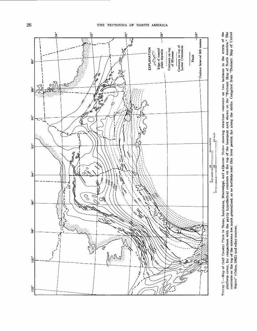
26 THE TECTONICS OF NORTH AMERICA
^ <u ^
-*-1 EH ."S« - 5o -. p
03 rti -
s-( a
a
? 8 «
§r 1CO gj ^
MjS 1§ 5
O O QQ-1 «» *^H
"S a .2u "^ 5 S Jj ^
fl 8"2 ° 9g 05 g t-4 O
'g| |
'i s o S3 . i S
. S ? a .g d>a o .3 .« a -g05 P*i tj
g ^3 4>
9 >? ojhH 53 tC t-< _.§ a|
* _s aFH J3fl«^.2 fl C3
O)
o o S ga|
sli-gO 9 ej O O t!« W S «)IH SH Oi CDS O O Oio ^ t: ia o o o <s w o Q
ti g 5 Sw ^ § 3« "E S w

PLATFORM AREAS 27
reservations; de Cserna (oral commun., 1964) has pointed out to the compiler that other ranges in the eastern part of the Mexican Cordillera have similar features, although perhaps to a lesser degree, so that distinctions are not absolute.
(D) PLATFORM DEPOSITS ON MESOZOIC BASEMENT
Classed as an area of "platform deposits on Mesozoic basement" (D) is the Arctic Coastal Plain a well- marked but somewhat discontinuous ^eomorphic fea ture that extends across northern Alaska, past the mouth of the Mackenzie River in Canada, and along the northwestern edge of the Arctic Islands nearly to Axel Heiberg Island. This coastal plain differs technically from those just discussed, and is more heterogeneous, so that its validity as a true platform is somewhat doubtful.
In northern Alaska the coastal plain lies between the front of the Cordillera (Brooks Range) and the Arctic Ocean, and extends from west of Point Barrow nearly to Yukon Territory, where the Cordillera im pinges on the coast (Gryc, 1959, p. 107-110). Much of it is masked by Quaternary deposits, which lie in part on Upper Cretaceous, in part on marine Tertiary. Un like the strata of the Atlantic and Gulf Coastal Plains, those of this coastal plain slope landward from the coast, and thicken into a foredeep along the front of the Brooks Range; basement is within 720 m (2,500 ft) of the surface near Point Barrow, and stratigraphic evi dence suggests at least the ephemeral existence of a base ment massif offshore beneath the present continental shelf. The structure of the base of the coastal plain deposits in northern Alaska is indicated on the tectonic map by partly hypothetical contours on a basement which may be equivalent to the metamorphosed lower Paleozoic rocks of the core of the Brooks Range.
On the Canadian mainland, in Yukon Territory and the District of Mackenzie, another segment of the Arctic Coastal Plain includes the delta of the Mackenzie River and some areas on either side, all mantled by Quater nary deposits. Here, the underlying bedrock and its basement slope steeply seaward, as attested by a single deep oil test well in the delta which failed to pass through the Lower Cretaceous at a total depth of 3,841 m (12,668 ft) (British-American, Shell, and Imperial Oil Companies, Reindeer D27 well, completed 1966).
In the northwest part of the Arctic Islands the Arctic Coastal Plain is formed by the Beaufort Formation (Craig and Fyles, 1961, p. 406-408) of preglacial Plio cene or earliest Pleistocene age a deposit several hun dred feet thick that was laid down by streams draining northwestward toward the Arctic Ocean. On Banks Island and part of Prince Patrick Island the Beaufort
lies on Paleozoic platform deposits, but farther north east on disturbed Mesozoic strata of the Sverdrup basin (a part of the Innuitian foldbelt).
(E) VOLCANIC BOCKS AND ASSOCIATED SEDIMENTS OF THE NORTH ATLANTIC PROVINCE
The plateau basalts and associated volcanics and sedi ments of the northeastern part of the area of the "Tec tonic Map of North America" are part of an extensive petrographic province variously termed the North J t- lantic, Brito-Arctic, or Thulean province, which in cludes some of the British Isles, the Faeroe Islands, and Spitzbergen, beyond the map area (Wenk, 1961, p. 27f). Within the map area these rocks form Iceland, Jan Mayen Island, parts of the east and west coasts of Greenland, and a small part of the east coast of Bafn Island (fig. 8).
The basalts and associated rocks are not entirely com parable to the platform deposits previously discussed, but they do lie with little deformation on basements with more complex histories. The basalts and associated rocks of Greenland and Baffin Island were spread ov°,r continental crust mainly metamorphic and plutonic rocks of the Hudsonian and earlier Precambrian fold- belts, but northward along the east coast of Greenland upon the diverse rocks of the Paleozoic East Greenland foldbelt. The basalts in Iceland and the other islards may have been erupted on oceanic crust.
Whether the basalts and associated rocks in the widely separated parts of the North Atlantic province were ever originally connected is a question which has impli cations as to the origin of the North Atlantic Ocean whether by continental foundering, continental drift, or some other mechanism but this question is beyond the scope of the present discussion. The occurrence of these rocks near the 70th parallel on both the east and west coasts of Greenland, as well as in Baffin Islard, suggests former connections, even though they are now separated by the Greenland icecap and the waters of Davis Strait. The peculiar configuration of the base of the Greenland icecap near the 70th parallel may have some relation to the volcanic structures. Nevertheless a connection across Greenland beneath the icecap has be°-n questioned, because the sediments and lavas overlap in land from the coasts (Wager, 1947, p. 29; Wenk, 19^1, p. 279).
The basal sediments in Greenland (El) include bcth Lower and Upper Cretaceous on the west coast, and high Upper Cretaceous on the east coast; these are fol lowed by Paleocene sediments with volcanic components that foreshadow the succeeding volcanic episode. Similar basal sediments occur on Baffin Island (Wilson and Clarke, 1965), but are not shown separately on the mrp.
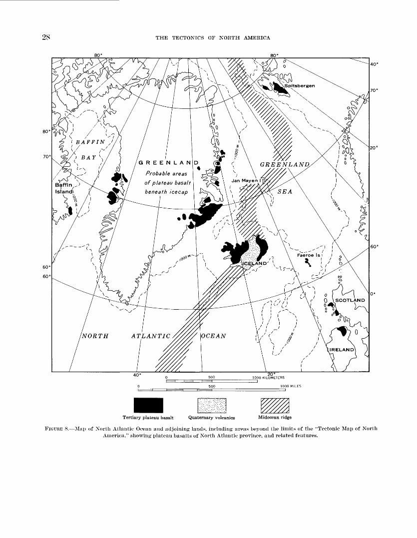
THE TECTONICS OF NORTH AMERICA
Probable areas
of plateau basalt
beneath icecap
Tertiary plateau basalt Quaternary volcanics Midocean ridge
FIGURE 8. Map of Xorth Atlantic Ocean and adjoining lands, including areas beyond the limits of the "Tectonic Map of North America," showing plateau basalts of North Atlantic province, and related features.
PLATFORM ABBAS 29
The overlying plateau basalts (Eft) have a thickness of nearly 8,000 m (26,000 ft) in east Greenland (Wager, 1947, p. 21) and are as thick or thicker in west Green land (Bosenkrantz and others, 1942, p. 55). In east Greenland they are capped by remnants of late Eocene to Miocene marine sediments, a feature indicating that the eruptions were completed during Eocene time. As sociated with the plateau basalts in east Greenland are plutons of various sizes and compositions (Ea), includ ing the famous Skaergaard layered mafic intrusive (Wager and Deer, 1939), as well as alkali syenites and profuse dike swarms. Intrusives are inconsequential in the other areas and are not mapped.
In Iceland, sequences of plateau basalts as thick as 7,000 m (26,000 ft) are exposed, with thin sedimentary intercalations not shown on the map). The oldest radiometric dates are late Tertiary (about 16 m.y.), but plant remains in the sedimentary intercalations indicate various earlier ages back to the Eocene (Askelsson and others, 1960, p. 11-12). The basement on which the ba salts were erupted is not exposed. On the "Tectonic Map of Europe" (Schatsky, 1962) it was assigned to "Precambrian of the marginal part of Laurentia", but this is very implausible. Seismic surveys indicate crustal layers beneath Iceland much like those elsewhere on the Mid-Atlantic Ridge beneath the surface basalts an intermediate layer 16 km thick with a velocity of 6.7 km/sec, and a deep layer 10 km thick with a velocity of 7.4 km/sec. The velocity of the intermediate layer is between that of oceanic and continental crust and may be hydrated oceanic crust (L. C. Pakiser, oral com- mun., November 1967).
Extending across the center of Iceland is a broad belt of Quaternary volcanics (E?) of more varied composi tion than their predecessors, erupted along the trace of the Mid-Atlantic rift zone, and including several vol canoes still in vigorous eruption (Askelsson and others, 1960, p. 21-28, 32-45). Within the belt, special symbols are used on the map to express Quaternary volcanic features: (1) '*mountains of volcanic rubble" ("moberg" or "palagonite mountains"), produced by eruptions un der the Pleistocene icecap, and (2) "fractures", which are either rifts in very young lavas or alined clusters of cinder cones.
<P) ICECAPS
Glaciers, ice fields, and icecaps cover extensive land surfaces in the northern part of the area of the "Tec tonic Map of North America," some being relics of Pleistocene time. Parts of this ice are truly platform deposits (although not composed of conventional sedi mentary rocks) for they conceal, in places to great thick ness, a deformed bedrock or basement whose varied structure and age is largely undetermined. The great
icecap that covers the bedrock in all but the coastal parts of Greenland, and the smaller icecaps in the north eastern part of the Arctic Islands are therefore repre sented as platform deposits on the tectonic map. Most geographic maps overemphasize the ice-covered areas at the expense of the ice-free areas, but while the ice is geographically interesting not all of it is a platform cover in a tectonic sense. On the tectonic map, minor ice patches, valley glaciers, and ice areas with many r<r.k ridges and nunataks are omitted; hence, the rendering of platforms covered by ice differs materially from the ice-covered areas shown on geographic maps.
Geographic maps show many ice fields and glaciers in the northern Cordillera, mostly near the Pacific Cor»«t and north of the 56th parallel, but none of these can be classed as platforms in a tectonic sense. The most likr'y candidate is the great ice field of the St. Elias Moun tains, near the common corners of Alaska, Yukon T^r- ritory, and British Columbia; to consider it a platform area is the more tempting because several major tectonic belts in the bedrock with uncertain mutual relations con verge toward it. Nevertheless, large-scale geograplic maps indicate that the ice field is by no means continu ous and is interspersed throughout with rock ridges, many of which are still unexplored geologically.
On the tectonic map, the configuration of the baw*- ment beneath the Greenland icecap is represented by 500-m contours and by layer tints, in the same man ner as the configuration of the basement in other plat form areas. Data on the configuration of the basement of the other icecaps are not available, but this configura tion is probably of less consequence. The configuration in Greenland is derived from variably spaced geophy^- cal traverses across the ice. Many versions of the results of these traverses have been prepared; the latest is by John Haller of the Danish East Greenland Expeditions who generously made available his manuscript map for use in compiling the tectonic map.
These contours show vividly the extensive area in the center of Greenland where the basement beneath the ice descends below sea level obviously in isostatic response to the load of the icecap. The ice above the basement is as much as 3,410-m (11,150 ft) thick, and its upper surface rises to a maximum altitude of 3,300- m (10,800 ft). Exceptional features of the basement con figuration are the transverse ridges and troughs ne^r the 70th parallel, which may have been shaped by local tectonic causes. The bedrock surface rises toward the coasts, where it emerges in bare plateaus and moun tains a few kilometers to as much as 300 km (160 mi) wide. These attain imposing heights along the east coa<< culminating in the plateau basalts south of Scoreshy Sound at 3,700-m (12,150 ft). The eastern coasNl

30 THE TECTONICS OF NORTH AMERICA
mountains were raised, relative to the bordering sea, by upflexing and upfaulting during Tertiary time (Wager, 1947, p. 51-62); their western flank was depressed be neath the ice during Pleistocene time.
FOLDBELTS OF PRECAMBRIAN AGE
All the Precambrian rocks of North America (with the exception of the platform deposits already dis cussed) are parts of foldbelts that were formed during tectonic cycles embracing various parts of Precambrian time. Special problems are associated with the foldbelts of Precambrian age; hence, they are discussed sepa rately from those of Phanerozoic age.
Precambrian rocks form the surface of vast areas in the northern and northeastern parts of North America, in the Canadian Shield and its extensions into Green land, the Arctic Islands, the Adirondack uplift, the Lake Superior region. Precambrian rocks also form the basement beneath the platform deposits in the surround ing parts of the craton, where they emerge in small inliers on the crests of some of the uplifts, and they ex tend beneath at least the edges of the younger foldbelts where they have been reworked by Phanerozoic orog enies and are brought to the surface in the cores of the ranges.
Because of the large area of Precambrian exposure in the Canadian Shield, this region offers the best op portunity in North America for determining a sequence of Precambrian rocks, the orogenies of Precambrian time, and the foldbelts produced thereby. Great progress in such determinations has been made in recent decades by the Canadian geologists; as a result of accelerated programs of geologic mapping and radiometric dating. The results obtained in the shield can, moreover, be extended with much success into the Precambrian rocks and foldbelts elsewhere in North America, so that these results are used as a basis for the stratigraphic and tectonic classifications on the 'Tectonic Map of North America."
STBATIGBAPHIC CLASSIFICATION
Classification of rocks on a tectonic map is based ulti mately on a stratigraphic classification, but the difficul ties of making a meaningful stratigraphic classification of the Precambrian rocks are well known difficulties resulting from the impossibility until recently of mak ing any reliable correlations of rock sequences beyond local areas. Fossils of value for correlation are virtually lacking in Precambrian rocks, but the methods of radio- metric dating that now exist have proved to be at least a partial substitute. These datings have not only opened the way for correlating Precambrian rocks over exten
sive areas, but have also shown the immense spans of Precambrian time during which these rocks weir formed (James, 1960, p. 104-107).
Radiometric methods of dating are neverthelQes still imperfect; the geochemical and geological limitations have been discussed at length in many publications. Radiometric methods, used in conjunction with geologic methods, can indicate broad correlations, but precise correlations are often elusive. A case in point i* the re lation between the original Huronian Series of Ontario and the Animikie Series of northern Michigan, nearby to the west (James, 1958, p. 33-34). Although trolitian- ally the two have been correlated, and although they obviously lie within the same general age span, there is little evidence that they are actually conteirDorane- ous and much geological evidence that they are not; conversely, if the two are not contemporaneors there is little evidence as to which is the older and which the younger.
Many proposals for a general Precambrian classifica tion have been made during the last century, but the earlier proposals are now obsolete and have only his torical interest; they have been summarized in many publications (see, for example, Holmes, 1963). More to the present purpose are recent proposals, some of which are shown in table 1. Any classification that can be generally accepted must, however, await an international agreement among geologists. Such an international agreement cannot be made until several fundamental questions have been resolved, namely: Are Precambrian rocks and Precambrian time capable of subdivision into named systems and periods comparable to thoro of the Phanerozoic ? Should these subdivisions be basec* on type sequences of rocks in one part of the world or mother? Or should they be defined by means of clusters of radio- metric dates which presumably express the times of orogeny that terminated such sequences? Could the ex isting terminologies of Precambrian rocks be retained and adapted to the radiometric dates that became avail able later, or should a new terminology be croated?
As the "Tectonic Map of Korth America" has been completed before an international agreement on Pre cambrian classification has been reached, an interim classification must be used, but none of the existing clas sifications of the contributing geological surveys in North America are well adapted to this purpose.
The U.S. Geological Survey originally divided the Precambrian (or "Proterozoic Era") into the "j^.rchean" and "AlgonMan" Systems, presumably with time-rock connotations, but in actual practice in Geologi^l Sur vey reports the systems were used empirically for example, "Archean" for dominant plutonic rocks and "Algonkian" for dominant supracrustal rocks. The re-
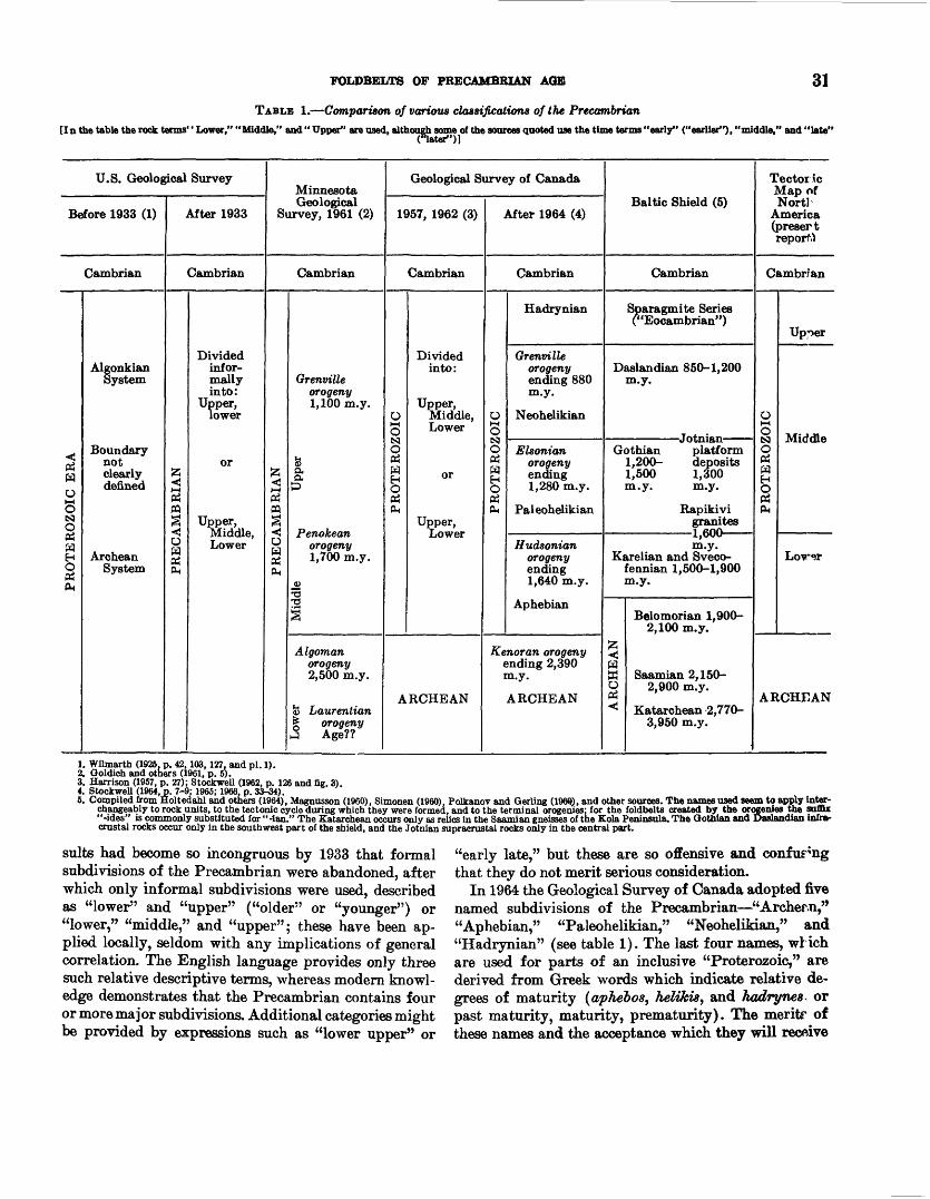
FOLDBELTS OF PRECAMBRIAN AGE 31
TABLE 1. Comparison of various classifications of the Precambrian[In the table the rock terms'' Lower," "Middle," and" Upper" are used, although some of the sources quoted use the time terms "early" ("earlier"), "middle," and "late"
riater")]
U.S. Geological Survey
Before 1933 (1)
Cambrian
PROTEROZOIC ERA
Algonkian System
Boundary not clearly denned
Archean System
After 1933
Cambrian
| PRECAMBRIAN
Divided infor mally into:
Upper, lower
or
Upper, Middle, Lower
Minnesota Geological
Survey, 1961 (2)
Cambrian
PRECAMBRIAN
Grenville orogeny 1,100 m.y.
fca&
Penokean orogeny 1,700 m.y.
_CJ T3-a
3
Algoman orogeny 2,500 m.y.
<5 Laurentian | orogeny 3 Age??
Geological Survey of Canada
1957, 1962 (3)
Cambrian
PROTEROZOIC
Divided into:
Upper, Middle, Lower
or
Upper, Lower
ARCHEAN
After 1964 (4)
Cambrian
PROTEROZOIC
Hadrynian
Grenville orogeny ending 880 m.y.
Neohelikian
Elsonian orogeny ending 1,280 m.y.
Paleohelikian
Hudsonian orogeny ending 1,640 m.y.
Aphebian
Kenoran orogeny ending 2,390 m.y.
ARCHEAN
Baltic Shield (5)
Cambrian
Sparagmite Series ("Eoeambrian")
Daslandian 850-1,200 m.y.
Gothian platform 1,200- deposits 1,500 1,300 m.y. m.y.
Rapikivi granites
1,600 m.y.
Karelian and Sveco- fennian 1,500-1,900 m.y.
Belomorian 1,900- 2,100 m.y.
fc < W W Saamian 2,150- 0 2,900 m.y.PH
< Katarchean 2,770- 3,950 m.y.
Tectoric Map of NortI
America (presert report.)
Cambrian
PROTEROZOIC
Upper
Middle
Lovar
ARCHEAN
1. Wilmarth (1926. p. 42,103,127. and pi. 1).2. Qoldich and others (1961, p. 5).3. Harrison (1957, p. 27); Stocfrwell (1962, p. 126 and fig. 3).4. Stockwell (1964, p. 7-9; 1965; 1966. p. 33-34).5. Compiled from Holtedahl and others (1964), Magnusson (1960), Simonen (I960). Polkanov and Qerling (196(0, and other sources. The names used seem to apply inter
changeably to rock units, to the tectonic cycle during which they were formed, and to the terminal orogenies; for the foldbelts created by the orogenies the suffix "-ides" is commonly substituted for "-ian." The Katarchean occurs only as relics in the Saamian gneisses of the Kola Peninsula. The Gothian and Daslandian infra- crustal rocks occur only in the southwest part of the shield, and the Jotnian supracrustal rocks only in the central part.
suits had become so incongruous by 1933 that formal subdivisions of the Precambrian were abandoned, after which only informal subdivisions were used, described as "lower" and "upper" ("older" or "younger") or "lower," "middle," and "upper"; these have been ap plied locally, seldom with any implications of general correlation. The English language provides only three such relative descriptive terms, whereas modern knowl edge demonstrates that the Precambrian contains four or more major subdivisions. Additional categories might be provided by expressions such as "lower upper" or
"early late," but these are so offensive and confusing that they do not merit serious consideration.
In 1964 the Geological Survey of Canada adopted five named subdivisions of the Precambrian "Areher.n," "Aphebian," "Paleohelikian," "NeoheliMan," and "Hadrynian" (see table 1). The last four names, wlich are used for parts of an inclusive "Proterozoic," are derived from Greek words which indicate relative de grees of maturity (aphebos, heUhis, and hadrynes^ or past maturity, maturity, prematurity). The meritr of these names and the acceptance which they will recftive

32 THE TECTONICS OF NORTH AMERICA
remain to be determined. The novelty of the names militates against comprehending either their meaning or the sequential relations of the units.
On the "Tectonic Map of North America" the interim classification of the Precambrian therefore reverts to the traditional terms "Archean" and "Proterozoic," which have been hallowed by long usage in geological text books and among geologists. The subdivisions thereof can be expressed by descriptive terms, and the Protero zoic is so divided into "Lower," "Middle," and "Upper" ("Early," "Middle," and "Late"); a similar subdivision of the Archean might be possible at a later time, but is not attempted on the map. These traditional terms are open to many objections it is true ambiguities in their earlier definitions and how they were applied, and later questions as to how they could be redefined more pre cisely on the basis of radiometric dates. As suggested by table 1, there seems to be little agreement between North American and European geologists as to the age of the termination of the Archean. This interim classification, whatever its deficiencies, at least makes possible a sub division of the Precambrian into more than the three descriptive categories available in the English language, and provides the subdivisions with names whose ages and sequential relations can be inferred by the geologist who uses the map.
Besides the general time-stratigraphic units just dis cussed, the captions in the legend of the "Tectonic Map of North America" mention the names of a few local Precambrian rock units (the Keewatin, Temiskaming, Huronian, Animikie, Grenville, and Keweenawan Se ries, the Sudbury Norite and Duluth Gabbro). These are included merely for mnemonic purposes and as ex amples ; all are from the southern part of the shield in Canada and the United States, where the Precambrian is familiar to geologists. Their use does not imply that the names can be extended to rocks outside their typical areas, although such extensions have been proposed in the past. Elsewhere in the shield the rock units have properly been given other local names, but those in remote places and those recently proposed are less famil iar to geologists. Many of the names for other rock units, and the probable ages of the units, have been tabulated in publications by Stockwell (1962, fig. 3; 1964, table 3) and by Goldich and others (1961, table 2).
TECTONIC CLASSIFICATION
Tectonic classification of the Precambrian rocks of North America on the basis of radiometric dating and other evidence is clearer than the stratigraphic classifi cation. As more radiometric dates of Precambrian rocks become available, it is increasingly evident that they cluster during periods several hundred million years
long, separated by periods as long or longer with few or no dates (for example, see Gastil, 1960, figs. 1 and 2; Stockwell, 1964, fig. 2). Most of the datings h*ve been made on plutonic and metamorphic rocks, and the clus ters of dates express times of plutonism and metamorph- ism. Inferentially, the clusters also express times of orogeny, of which the plutonism and metamorpHism are partial manifestations. This is confirmed in places by structural unconformities between the rocks tl *.t yield the dates and overlying less deformed rocks. TTie times which yield clusters of radiometric dates are thus com monly interpreted by geologists as erogenic times, and they are so treated on the "Tectonic Map cf North America."
Nevertheless, a qualification is needed. The clusters of dates have definite climaxes, but the whole spread of a cluster may be as great as 400 m.y. or as long as all geologic time since the beginning of the Devonian. Dur ing Devonian and later time, geologists hav?i distin guished many separately named orogenies, the number depending on the predilections of different geologists. Thus, the Precambrian "orogenies" are probably com parable, not so much to the orogenies within the fold- belts of later times, as to the tectonic cycles which created the f oldbelts as a whole; probably the Precam brian "orogenies" themselves consisted of imny such lesser orogenies, now blended together by imperfections of the record.
The nature of the Precambrian orogenies and tectonic cycles has been debated, opinions being colorec1 by con flicting theories as to the origin and evolution of the earth's crust. Many geologists in the past have assumed that crustal behavior during much of Precambrian time differed substantially from that of Phanerozoic time. An ancient fallacy that has caused much mischief is an assumption of the universality of Precambrian oroge nies; remnants of this fallacy persisted even into later times. Bucher (1933, p. 419) thus summarized the thinking of his day:
The best evidence of the diminution in the course cf geologic time of the areas occupied by the orogenic belts ir the pro gressive decrease in the width of the zones of crystalline schists and gneisses produced in successive eras. * * * For Archeozoic time, crystalline schists and gneisses occupy ap parently 100 percent of the folded belts so far as they are accessible to view today. For the Proterozoic, the percentage is still large, but much less than 100 percent. The contrast be tween the Proterozoic and the Paleozoic is still greater. * * *
A modern variant of these views is expressed by Stockwell (1966, p. 34-35):
The orogens of the shield characteristically cover very broad regions quite unlike the mountain chains of later times. An other difference is the long time interval between deposition of sediments and their involvement in orogeny (about 400
POLDBELTS OF PRECAMBRIAN AGE 33
m.y. in two instances), as contrasted with the close time se quence of geosynclinal deposition, sinking, and mountain building in younger rocks. Still another difference is the very extensive overlapping of a younger orogen on an older one and this occurs in regions not likely ever to have been the site of intervening geosynclinal deposition. On the whole, the thesis that the orogenic development of the shield differed from that of the younger rocks seems worth considering and, it may be suggested, resulted from deep crustal or subcrustal movements unrelated to the sinking of geosynclinal belts.
At least some of the alleged contrasts between Pre- cambrian and Phanerozoic orogenies may be more ap parent than real. The depth of denudation of a foldbelt is progressively greater the older the rocks; hence the exposed areas of crystalline rocks are also greater with age. Moreover, the universality of crystalline rocks in the Archean is probably not a product of any single world-wide orogeny, but results from the great length of Archean time during which many orogenies built foldbelts in different places. Also, if the foldbelts men tioned by Stockwell are actually products of gross tectonic cycles rather than single orogenies they are more comparable with those of Phanerozoic time; the Cordilleran foldbelt of western North America which was built during the last 150 m.y. of geologic time com pares favorably in breadth and length to the Pre- cambrian foldbelts, and likewise contains relics of earlier foldbelts that were reworked during the Cor dilleran orogeny. Even allowing for probable changes in the nature and behavior of the earth's crust with time, it is reasonable to assume (as Sederholm did more than half a century ago) that the resemblances between the Precambrian and the Phanerozoic foldbelts are greater than the differences (see Holmes, 1963, p. xxi- xxii).
FOLDBELTS OP CANADIAN SHIELD
In the Canadian Shield, three great clusters of radio- metric dates have been obtained in the Precambrian rocks, whose times probably express major orogenies; these times are so designated on the "Tectonic Map of North America," following previous usage. As ex plained earlier, the so-called orogenies of Precambrian time are more properly gross orogenic times or tectonic cycles in terms of Phanerozoic events, and this will be implicit in the discussion henceforth. The orogenies have been classified as shown in table 2.
These dates, and the orogenies which they express, occur in well-defined areas the "provinces" of Cana dian geologists which are here considered to be the foldbelts produced by the orogenies (fig. 9). The prov inces (or foldbelts) of each age are listed below, in order of increasing age:
Grenville orogenyGrenville province
Hudsonian orogenyChurchill provinceSouthern provinceBear provinceNain province
Kenoran orogenySuperior provinceSlave provinceNain province (minor)
The restriction of orogenic effects during Precam brian time to specific foldbelts (provinces) is illustrated by the passage of deformed supracrustal rocks in the foldbelts into the platform deposits that extend o^er earlier foldbelts, as described under an earlier heading (p. 21-22). Platform deposits of Lower Proterozoic age (Al) thus define Kenoran foldbelts, those of Middle Proterozoic age (A2) Hudsonian foldbelts, and those of Upper Proterozoic age (A3) Grenville foldbe'ts. Such relations are most dramatically expressed during Middle Proterozoic time, when the rocks of the Gr?n- ville foldbelt in the southeastern part of the shield w*»re subjected to deep-seated deformation and accompany ing metamorphism and plutonism, whereas in the gre«t- er part of the shield to the northwest, supracrustal pb.t- form deposits (A2) were being laid down over rocks already consolidated by earlier orogenies the de formed rocks and the platform deposits both yielding nearly contemporaneous radiometric dates.
TABLE 2. Classification of orogenies in Canadian Shield
Rock sequence
Upper Proterozoic (minor iu shield).
Middle Proterozoic.
Lower Proterozoic.
Archean.
Orogenies
Canada '
(I) Grenville orogeny.4
(«)
(II) Hudsoninn orogeny.
(Q) Kenoran orogeny.
Minnesota '
Keweenawan igneous activity.
Penokean orogeny.
Algoman orogeny.
Climax of orogeny '
Rang" of orogeny *
Million years
945
1, 735
2.490
880-1,000
1.640--1.820
2.390-2.600
1 Modified from Slock we ̂ 1 (1964, tables 1 and 2) and other papers.: Modified from Goldich and others (1961, table 2; 1966, table 5).'The climaxes and ranges of the orogenies are inferred from statistical summaries
of recorded radiometric dates in Canada (Stockwell, 1964, p. 2-7); the clitnaier and ranges of the orogenies are based on the abundance of the radiometric dates', the ends being assumed to be the mean minus the standard deviation.
4 Pertinent objections have been raised by Qilluly (1966, p. 104-108) to such terms as" Grenville orogeuic belt" and "Grenville orogeny." Rightly or wrongly ,-the terms are now so firmly entrenched in usage that it is undesirable to substitute some new and unfamiliar nomenclature.
« Stockwell distinguishes an additional Elsonian orogeny between the Hudsonian and Grenville; this is appraised on p. 56.
34
130
THE TECTONICS OF NORTH AMERICA
120° 110° 100° 90° 80° 70° 60° 50° 40°
pPf^X] & V^^\,
50
1000 KILOMETERS
0 1000 MILES
::::::::::::::::^\\^
* * ' " * * ̂ *
Province containing Province containing Province containing Province containing Little deformed Edge of PhanerozoicKenoran foldbelts Hudsonian foldbelts Kenoran and Hudsonian Grenville foldbelt supracrustal strata platform co^er
elements, overprinted mainly middleby Elsonian event Proterozoic
FIGURE IX Map of Canadian Shield showing provinces that contain different assemblages of Precambrian rocks. Modified fromStockwell (19&4, fig. 1).

FOLDBELTS OF PRECAMBRIAN AGE 35
Besides the major orogenies, there are indications of other events of possible erogenic significance during Precambrian time in the Canadian Shield, two of which merit discussion:
Archean time was prolonged, and it is presumed that some or many orogenies occurred before the terminal Kenoran orogeny. One of these, the "Laurentian" orog eny is suggested by geological evidence in the Lake Superior region. As early as 1885, A. C. Lawson recog nized that the Keewatin greenstones of the region were intruded by the so-called "Laurentian" granite (a mis nomer, as the original "Laurentian" is in the Grenville province, and very much younger), and that the eroded surfaces of both were overlain by younger strata, now classed as later Archean (the Knife Lake); he ascribed to this event a major role in Precambrian history. Sub sequent investigations indicate, however, that the younger Kenoran orogeny and the accompanying Algo- man granites are much more prominent in the region, and the "Laurentian" has been relegated to a lesser rank (Goldich and others, 1961, p. 73-74). The age of the "Laurentian" event is still indeterminate, as no radio- metric dates from it have survived; very likely they were overwhelmed by the Kenoran orogeny. Similar (but not necessarily contemporaneous) events may have occurred elsewhere in the Kenoran foldbelts during Archean time, as suggested by the occurrence of granite clasts in many of the sediments. Radiometric data indi cate relics of a 3,550 m.y. event in the gneisses of the Minnesota River valley (Goldich, Lidiak, and others, 1966, p. 5395-5396), but their relation, if any, to the "Laurentian" event is unknown.
The record of pre-Kenoran tectonic events during the Archean is so imperfectly preserved that Stockwell (1965) was unable to map their effects in the Canadian Shield, and these effects are accordingly not indicated on the "Tectonic Map of North America."
Stockwell (1964, p. 2-3) proposed an "Elsonian orog eny" on the basis of a scattering of radiometric dates in the Nain province in the northeastern part of the Labrador Peninsula with a mean age of about 1,370 m.y. The area from which the dates were obtained is a ter- rane of gneisses and embedded granitic plutons, appar ently not differing from the adjoining Hudsonian fold- belt except for the occurrence of bodies of anorthosite and gabbro like those in the Grenville foldbelt to the south (I£); Stockwell suggests that all the anorthosite and gabbro bodies are of Elsonian age, those in the Grenville foldbelt having been reworked during the sub sequent Grenville orogeny. Credence in the existence of an "Elsonian orogeny" is enhanced by the occurrence of radiometric dates within the same age range elsewhere in North America outside the shield.
Nevertheless, the significance of the Elsonian eveit remains dubious. Even in the eastern part of the shield, radiometric dates within this age range are few, and have no prominent peak of abundance like those of the other Precambrian orogenies; radiometric dates within this age range are virtually lacking elsewhere in the shield, except in the Southern province (Michigan and Wisconsin). Besides the anorthosites and gabbros, there are no obvious geological manifestations of an orogeny and the event can hardly have produced a foldbelt in the usual sense. The compiler infers that the Elsonian is a minor event in the Canadian Shield that produced no more than an overprint on rocks already consolidated by the Hudsonian orogeny. On the "Tectonic Map of Nor+h America" the rocks of the Nain province are assign**! to the Hudsonian foldbelt, the overprint of the Eko- nian event being indicated, where appropriate, by a superposed diagonal ruling (H2).
Although the Laurentian, Elsonian, and other prob lematical Precambrian events have only minor signifi cance in North America, they may reflect orogenies of greater significance in other continents. Thus, the Goth- ian deformation in the southwestern part of the Baltic Shield seems to be nearly contemporaneous with the Elsonian event in North America (table 1).
Subdivision of the rocks in the Precambrian fold- belts of the Canadian Shield on the "Tectonic Map of North America" largely follows the classification of Stockwell (1965). Within the Kenoran foldbelts little subdivision can be made, except to separate the supra- crustal sedimentary and volcanic rocks (G2) from the granitic rocks (Gy); the migmatites (Gl) probably represent partial conversions of the former into the latter. More complex classifications are possible in the Hudsonian and Grenville foldbelts, although even here it is necessary to show areas of undifferentiated rocks (HI and II), where the terranes are little mapped or poorly understood. It has been proposd that the closely accordant radiometric dates in each of these foldbeJts indicates not only the ages of their climactic orogenies but also the general age ranges of all the rocks of ea^-h foldbelt (J. T. Wilson, 1950, p. 107-108). Stockwell's more detailed review indicates greater complexities. Each foldbelt includes not only geosynclinal supracrrs- tal rocks that formed during the tectonic cycle that gave rise to the foldbelt, but also plutonic and supracrustal rocks which are relics of earlier cycles reworked by t\e later ones; these reworked earlier rocks are indicated on the tectonic map by superposed diagonal rulings. TT- e Hudsonian foldbelts thus contain reworked relics of the Kenoran foldbelt (H3, Ha); the Grenville foH- belt contains reworked relics of both the Kenoran and Hudsonian foldbelts (12,13, la).
36 THE TECTONICS OF NORTH AMERICA
The famous "Grenville front," or prominent north western border of the Grenville foldbelt, truncates at high angles all the structures of the adjoining Kenoran foldbelt, and there has been much speculation as to its meaning. Certainly throughout its length it marks a significant contrast in style of deformation and meta- morphism, and certainly through parts of its length it is a zone of major faulting and northwestward thrust ing. Its actuality as a structural feature is confirmed by the occurrence through part of its length of a pro nounced linear negative gravity anomaly (Canada Dominion Observatories, 1957). Nevertheless the "front" does not, as has sometimes been assumed, juxta pose a terrane of younger rocks in the Grenville fold- belt on the southeast against terranes of older rocks in the foldbelts to the northwest. Stockwell (1964, p. 18- 21) has been able to trace relics of Archean and Lower Proterozoie rocks involved in the Kenoran and Hud sonian orogenies through the Grenville foldbelt (12, 13), and he proposes that even the Grenville Series (14) of the southern part of the foldbelt (from which the names of the foldbelt and the orogeny are derived) is not younger than the Early Proterozoic, and hence is not simply a geosynclinal precursor of the much later Grenville orogeny.
FOLDBELTS OF GREENLAND
The island of Greenland is obviously a detached northeastern extension of the Canadian Shield, with analogous Precambrian rocks and structures. Incom plete geophysical surveys suggest that the intervening Baffin Bay and Davis Strait are floored by oceanic crust, so that the detachment was more likely by drift than by foundering of shield rocks. Nevertheless, the geometry of the Precambrian rocks and structures does not match convincingly from one coast to another so that the original fit of the two shield areas is still uncertain.
Precambrian shield rocks underlie much of Green land, but they are covered in small part by the plateau basalts and associated rocks (E/J), and in much larger part by the central icecap (F), so that they only emerge near the coasts. Along the east and north coasts, besides, the shield is impinged by the East Greenland and In- nuitian foldbelts (J and K), whose Precambrian com ponents have been reworked by Paleozoic orogenies. Berthelsen and Noe-Nygaard (1965) have made an ex cellent summary of the Precambrian rocks of Greenland. Parts of these rocks are known in much detail, espe cially in the shield area on the west coast as far north as the 73d parallel (Berthelsen, 1961) and in the East Greenland foldbelt between the 70th and 80th parallels (Haller, 1961a, b; Haller and Kulp, 1962); some other
parts are virtually unexplored, especially on the east coast, south of the 68th parallel. Less radiometric dat ing has been done on the Precambrian rocks of Green land, compared with that of the Canadian Shield, but the available results are consistent with those of the shield.
The oldest clearly recognizable foldbelt in Gr-^nland is the Ketilidian, which forms all the west coas* as far north as the 63d parallel. Most of it consists ci deep- seated metamorphic and plutonic rocks (Gl) tlat have undergone long and complex histories. These have been divided into several named complexes of varying com position and metamorphic grade, which are separated in part by strike-slip faults. A few radiometric dates be tween 2,100 and 2,700 m.y. are available which indicate a correlation of the foldbelt with the Kenoran fold- belts of the mainland (fig. 10). Supracrustal rod's (G2) occur in a few places, notably in the Ivigtut ar^ near the 61st parallel, where a sequence of sediments and volcanics as thick as 4,000 m (13,000 ft) is preserved. All the metamorphic and plutonic rocks of the east coast south of the plateau basalts at the 68th parallel are also probably part of the Ketilidian foldbelt (Gl- H3a) but they are little known. Farther north, similar rocks form the autochthone of the East Greenland fold- belt at the head of Scoresby Sound and have yielded maximum radiometric dates of 2,300 m.y.
On the west coast at S0ndre Str0mf jord near the 67th parallel, rocks of the Ketilidian foldbelt are su "-ceeded northward by other metamorphic and plutonic rocks of the Nagssugtoqidian foldbelt (H4), which have yielded radiometric dates of about 1,500 to 1,650 m.y., hence are correlative with the Hudsonian foldbelts of th*. main land. The Nagssugtoqidian foldbelt, like the Ketilidian, is divided into named complexes of varied nature. Su pracrustal rocks (H5), called the Agpatides, are re ported around Umnak Fjord north of Disko Islr.nd, but they have been little studied.
In southernmost west Greenland the Ketilidirn fold- belt has been overprinted by the Sanerutian e^ent, so that all radiometric dates here are 1,600 m.y. or less, hence (like the Nagssugtoqidian) being correlative with the Hudsonian orogeny of the mainland. The area in cludes the extensive Julianehaab Granite (Ha), pctually a heterogeneous complex of various granites with, relics of sedimentary and volcanic suprastrata; although originally formed during the Ketilidian it was immobil ized during the Sanerutian. The area also includes dis cordant bodies of postorogenie granite (H8) which yield Sanerutian dates. On the east coast the Ketilidip n fold- belt is overprinted by the Sanerutian event as fa r north as Angmagssalik at the 66th parallel.
Southernmost west Greenland also contains the still

FOLDBELTS OF PRECAMBRIAN AGE 37
younger Gardar Group continental sandstones and volcanics (A2), block-faulted but otherwise little dis turbed, and contemporaneous alkalic intrusives (Aa). These are platform rocks like the Keweenawan Series of the continental interior, and like them yield radio- metric dates of about 1,000 m.y. They are not compar able to the infracrustal rocks of the Grenville foldbelt which strike out to sea on the opposing coast in Lab rador, even though they yield similar dates, nor are they correlative with the remnants of Upper Proterozoic platform deposits (A3) that overlie the Grenville rocks. as was once proposed (Kranck, 1939, p. 30-32).
The age of the basement rocks of northern and north eastern Greenland is undetermined, but it is probably similar to that of the basement in Baffin and Ellesmere Islands, where a few Hudsonian dates have been ob tained by the Geological Survey of Canada. Between Inglefield Land and Cape York, opposite Ellesmere Island near the 78th parallel, the basement is succeeded by the little disturbed platform deposits of the Thule Group (A2), which are overlain by a few remnants of the Cambrian and Ordovician (B). Although tihe Thule has not been dated, it is interpreted on the tectonic map to be of Middle Proterozoic age, like the comparable Precambrian platform deposits in the northern part of the Canadian Shield.
In northeast Greenland the Thule reappears from under the icecap around the head of Independence Fjord, where it is broadly folded and is overlain uncon- formably by the Upper Proterozoic Hagen Fjord Group (included with B on the map). Eastward in the East Greenland foldbelt, according to Haller (1961a), re lations are even more discordant; the Thule is meta morphosed and plastically deformed (Jl) by the Caro- linidian orogeny, a precursor of the early Paleozoic oro geny that affects the succeeding rocks of the foldbelt (fig. 11). The Carolinidian orogeny has not been closely dated, but Berthelsen and Noe-Nygaard (1965) sug gest its possible correlation with the Grenville orogeny, an interpretation adopted in the legend of the tectonic map. Within the East Greenland foldbelt this Carolin idian basement is followed by a pile of Upper Protero zoic geosynclinal deposits (included in J2) which are discussed on page 54.
FOLDBELTS SOUTH OF THE CANADIAN SHIELD
South of the Canadian Shield in the United States and Mexico, outcrops of the Precambrian are smaller, and are closely to widely separated by the cover of younger strata. In the central craton they emerge in a few of the higher uplifts the Black Hills, the Sioux uplift, the St. Francois Mountains (in the Ozark up
lift), the Arbuckle Mountains, and the Llano uplift. In the Appalachian foldbelt, metamorphic and plutonic rocks form some of the ranges near the central ayis, but the remainder of the Precambrian here consists of younger supracrustal strata. In the northern part of the Oordilleran foldbelt only younger Precambrian supracrustal strata come to the surface, but in the Cen tral and Southern Rocky Mountains metamorphic and plutonic rocks are extensive in the cores of the rang<\s. They reappear in the Basin and Range province w<?st and southwest of the Colorado Plateau, in and near the edge of the Cordilleran miogeosyncline. They form t he surface of large parts of the ranges of the province in Arizona and the desert region of southeastern Cali fornia, whence they extend westward into the Trans verse Ranges to within a few miles of the Pacific Coa st. In most of Mexico, Precambrian metamorphic and pJu- tonic rocks emerge only in small inliers on the crests of higher folds and fault blocks, but there is a larger area of uncertain dimensions in Oaxaca in the far south, as shown by radiometric dates in the metamorphic ttm- plex (Ol). The occurrences in the Transverse Ranfres and in Oaxaca are the only authentic Precambrian in the Pacific border region of North America.
These scattered outcrops of Precambrian metamor phic and plutonic rocks could not have been assembled into any kind of a coherent picture, were it not tH.t similar rocks have been penetrated by many drill holes in the central cratonic area, and were it not tl at many radiometric dates have been obtained, not only from the rocks of the outcrops, but from the rocks of the drill holes. These have made it possible to construct paleogeologic maps of the surface of the buried part of the Precambrian, to connect rocks and structures in the outcrops, and to assign the Precambrian metamorphic and plutonic rocks over large parts of North America to provinces or foldbelts like those in the Canadian Shield.
For practical reasons it is not possible on the "T Tc- tonic Map of North America" to represent the connec tions of these foldbelts where they are buried between the outcrops. For these, the reader should consult pale- ogeological maps, such as the map by Bayley and Muehlberger (1968). The general relations of the P?e- cambrian foldbelts of North America, exposed or buried, are represented in the accompanying text figure (fig. 10). Radiometric datings south of the Canadian Shield are summarized in table 3, based in part on an extensive project of Goldich, Muehlberger, and others (Goldich, Lidiak, and others, 1966; Goldich, Muehl berger, and others, 1966; Muehlberger and others, 19C*>; Lidiak and others, 1966; Muehlberger and others, 196?).
38 THE TECTONICS OF NORTH AMERICA

130
t v:
.1/..-
?.'^
,,*;'
V::;
U/i/
, "^
C-:
-,
/7 >
EX
PLA
NA
TIO
N
Lat
e P
reca
mbr
ian
to e
arly
C
ambr
ian
(abo
ut 5
00 m
y ag
o)
Mai
nly
mid
dle
Pro
tero
zoic
(a
bout
800
-130
0 m
y ag
o)
Out
crop
s of
P
reca
mbr
ian
rock
s
Roe
ks i
nvol
ved
in A
valo
nian
_C
onta
cts
betw
een
Pre
cam
bria
n un
its
even
t (5
50-6
50 m
y ag
o)
Roc
ks i
nvol
ved
in G
renv
ille
or
ogen
y (8
80-1
000
my
ago)
Fro
nts
of P
hane
rozo
ic
fold
belt
s
Roc
ks i
nvol
ved
in H
udso
nian
(128
0-14
60
my
ago)
Roc
ks i
nvol
ved
in H
udso
nian
orog
eny
(164
0-18
60 m
y ag
o)
Roc
ks i
nvol
ved
in K
enor
an
orog
eny
(240
0-26
00 m
y ag
o)
120°
110
FIG
UK
E 10. M
ap o
f N
ort
h A
mer
ica
show
ing
infe
rred
exte
nt
of e
xpos
ed a
nd b
uri
ed
prov
ince
s of
P
reca
mb
rian
ro
cks.
C
ompi
led
from
m
any
sour
ces,
in
clud
ing
Sto
ckw
ell
(196
4,
fig.
1),
an
d
Bay
ley
and
Mue
hlbe
rger
(1
908)
.
CO

40 THE TECTONICS OF NORTH AMERICA
TABLE 3. Summary of Precambrian rocks and events south of Canadian Shield
CanadianShield (Modi
fied fromStockwell,
1964)
PALEOZOIC
600 m.y.
UPPERPROTER-OZOIC
Grenville orogeny
~ 880-1,000m.y.
OH- 1
O(S3OtfW
OtfOH
Elsonianevent
- 1,280-1,460 m.y.
W
Qp i i
Hudsonianorogeny 1,640-1,820m.y.
LOWERPROTER-OZOIC
Kenoranorogeny2,400-2,600m.y.
ARCHEAN
Appalachianfoldbelt
(Rodgers,1967, and
other sources)
Avalonianevent(coastalregion fromNewfoundland southward)Holy roodgranite580 m.y.
Grenville orogeny (in basement of interior Appalachi ans) 800-1,000 m.y.
(No earlierdates re-
- corded) -
-
NortheasternUnited States (Lidiak and
others, 1966)
Metamorphismeast of "Grenville
- front," Ohio - 800-1,000m.y.
St. Francois igneous activity, 1,200-
- 1,350 m.y. -Plutonic com
plex of Iowa,1,3007-1,500?m.y.
-Relics, 1,600- -1,800 m.y.
North-centralUnited States
(Goldich, Lidiakand others,
1966)
Keweenawan igneous
- activity, - 1,000-1,200m.y.
Folding of Sioux Quartz-ite, 1,200m.y.
Apparent ages,1,200-1,400m.y.
Event, 1,490m.y.
Penokean andBlack Hills orogenies 1,600-1,800 m.y.
Algomanorogeny
~ 2,400-2,750m.y.
MinnesotaValley relics 3,550 m.y.
South-centralUnited States (Muehlbergerand others,
1966)
Wichita igneous activity500 m.y.
Llano orogeny - 1,000-1,150 -
m.y.
Panhandle and Spavinaw igneousactivities,1,100-1,300m.y.
Nemaha igneous activity1,350-1,450m.y.
-Granites, -ArbuckleMountains,1,320-1,400m.y.
(No earlierdates recorded)
-
Western United States (Greatly generalizedfrom many sources)
Pikes PeakGranite,
Intrusives Colo-in Apache rado; Group, Southern
- 1,100 m.y. Cali- Dates on fornia
Belt Se- pluton- ries 900- ics, 1,000 1,300 m.y. m.y.
Sherman Granite, Colorado; youngergranites of Arizona,
- 1,300-1,500 in.y.
Mazatzal orogeny, Arizona; final meta-
_ morphism _ in Front Range, Colorado, and prfr-Beltbasement, Montana,1,650-1,750 m.y.
Granites and metamor- _phics, NW. Wyoming,2,400-2,600 m.y.
Relics, NW. Wyoming 3,100 m.y.
Mexico (Fries,196^; Fries
and Riac6n-Orta, 1965)
Eastern Mexico (Tama-ulr>as)710 m.y.
Southern Mexico
- (Oaxaca) - 770-980m.y.
Eastern Mexico
- (Hidalgo) -1,210 m.y.
Nortl -"westernMexico(Soiora) 1,320-1,710m.y.

FOLDBELTS OF PRE CAMBRIAN AGE 41
The oldest radiometric dates outside the Canadian Shield in North America have been obtained from Pre- cambrian rocks in the mountains of northwestern Wyoming and adjacent Montana (Beartooth Moun tains, Bighorn Mountains, Wind River Mountains, and other mountain ranges); they are consistently more than 2,400 m.y. old, with a few relics as great as 3,100 m.y. The dates obtained from the outcrops, and from drill samples in surrounding areas, define a province comparable in age to those produced by the Kenoran orogeny in the Canadian Shield; nevertheless, these provinces are not connected, as younger dates have been found in the intervening area. The rocks of the province are mainly granites and granite gneisses (Gy), but they include the mafic Stillwater Complex of the Beartooth Mountains (Ga), and some schist and iron-formation in central Wyoming and elsewhere (G2). In the Black Hills, where most of the Precambrian is Lower Protero- zoic, 2,500-m.y. dates have been obtained in the small Nemo district, from rocks probably representing an earlier basement.
The remaining Precambrian metamorphic and plu- tonic rocks of the western Cordillera all yield younger radiometric dates. Dominant dates from Montana to Arizona are between 1,500 and 1,800 m.y.; the rocks which yield them are classed on the tectonic map as Hudsonian (H5 or O2; Hy or Oa), but this is a gross generalization of varied rock assemblages, all of which have had complex histories. In the north, the basement rocks below the Belt Series of Montana and comparable supracrustal strata in the Uinta and Wasatch Mountains of Utah have yielded dates within this age range (but relic earlier dates occur in the Little Belt Mountains, Mont.); the Belt Series itself has been dated by a variety of methods as between 1,300 and 900 m.y. old (Obrado- vich and Peterman, 1967), hence is Middle Proterozoic or somewhat younger.
In the south, the basement beneath the Grand Can yon Series and Apache Group, and beneath the Precam- brian supracrustal strata near Caborca, northwestern Sonora, was deformed by the Mazatzal orogeny, dated as 1,650-1,750 m.y. ago (Wasserburg and Lanphere, 1965, p. 755), although it was once ascribed a younger ("El- sonian") age. Actually, two closely spaced events can be discriminated in the orogeny, one 1,650-1,715 m.y. ago, another 1,715-1,750 m.y. ago, the younger dominating toward the south (Silver, 1967). In several different parts of Arizona the rocks deformed and metamorpho sed by the Mazatzal orogeny include sequences of sedi ments and volcanics as thick as 6,000 m (20,000 ft) (Anderson, 1966, p. 6-8). A basal unconformity has been observed beneath one of these sequences (Blacet, 1966), but its regional significance remains to be established.
The supracrustal rocks of this region are probably Middle Proterozoic like the Belt Series in the nor*h; diabase sills in the Apache Group have been dated at 1,100 m.y. (Shride, 1967, p. 76-77).
Special problems attend the Precambrian metamor phic and plutonic rocks of the Southern Rocky Moun tains in Colorado and nearby Wyoming; clearly, tHy have had a complex history. The older paraschists r.nd paragneisses (Idaho Springs Formation and other units) were originally laid down as geosynclinal sfii- ments and volcanics and were afterwards deformed r.nd metamorphosed. Still later, they were plastically folded, and another regional metamorphism was superposed; this event is dated at 1,750 m.y. ago (Pearson and others, 1966; Hedge and others, 1967, p. 554), or at about the time of the Hudsonian orogeny. These rocks, and arso- ciated plutonic rocks, are classed on the tectonic map as Kenoran reworked by Hudsonian orogeny (H3, Ha). Sequences of Lower Proterozoic supracrustal strata (H5) are preserved in places, as in the Medicine low Mountains of southern Wyoming and the Needle Mo'\n- tains of southwestern Colorado, and there are several sets of younger plutonic rocks. Anorthosite (Ift) like that in the eastern part of the Canadian Shield forms the central part of the Laramie Range, Wyo. (New- house and Hagner, 1957); extensive granites such as the Sherman and Silver Plume were emplaced 1,200- 1,300 m.y. ago, and the less extensive Pikes Peak Granite was emplaced 1,000 m.y. ago.
Plutonic activity in the Southern Rocky Mountains thus extended well past the time of the Hudsonian orog eny, into the times of the Elsonian event and the Gr-m- ville orogeny. A similar situation obtains farther south west, in Arizona, where granites emplaced at the c^ose of the Mazatzal orogeny are dated at 1,650 m.y. r.^o, and are followed by later granites dated at 1,375 ruy. ago (Silver, 1966); various stray younger Precambr^an dates reported in Arizona are probably an overprint re lated to these younger granites. The history implied by radiometric dates is also complex in the Transverse Ranges of southern California (Silver and others, If ̂ 3; Silver, 1968); gneisses and plutonics in the San Gabriel Mountains are dated at 1,650-1,700 m.y. ago (hence Mazatzal or Hudsonian); they were followed by a meta morphic event 1,420-1,450 m.y. ago, and later by intru sion of an anorthosite-syenite complex (Oft) 1,220 r^y. ago. The Precambrian rocks were long afterwards in vaded by Permian to Triassic and by later Mesorcoic plutonic rocks.
Radiometric dates intermediate between the Hud sonian and Grenville orogenies have been determined in many of the Precambrian basement rocks penetrated by drilling east of the Cordillera, in the central CK ton
42 THE TECTONICS OF NORTH AMERICA
(Goldich, Lidiak, and others, 1966, p. 5384-5386). Some are merely apparent dates or an overprint, but others pertain to actual plutonic or volcanic events, as shown on table 3. Thus, rhyolitic volcanic rocks were spread widely in Missouri, Oklahoma, and northwestern Texas, and have been dated from place to place as 1,200-1,350 m.y., 1,150-1,300 m.y., 1^100-1,200 m.y., and 500 m.y. ago (Muehlberger and others, 1966, p. 5421-5422); there was also granite emplacement during some of these times. In the compiler's judgement, these events do not justify classing the basement rocks of the southeastern part of the craton as an extension of the proposed El- sonian foldbelt of the shield.7
The youngest Precambrian metamorphic and plutonic rocks south of the Canadian Shield are in the south eastern part of the United States, most of which are broadly correlative with those of the Grenville foldbelt. In the Appalachian foldbelt, rocks yielding dates of about 1,000 m.y. (LI) form the basement of the Paleo zoic miogeosynclinal and eugeosynclinal sequences and, where present, that of the Upper Proterozoic supra- crustal strata (L2) (King, 1969, p. 61-62); they emerge along the axis of the foldbelt in the Long Range of New foundland, the Green Mountains and other uplifts in New England, and in the Blue Ridge as far south as North Carolina. They can be extended westward by drill data to a well-defined boundary (probably a pro longation of the "Grenville front" of the shield) that is traceable southward from Michigan, through Ohio, into Kentucky (Bass, 1960).
Rocks affected by this event are recognizable again in Texas, where the Llano orogeny of the Llano uplift has been dated at 1,000 to 1,150 m.y. (Muehlberger and others, 1966, p. 5422-5423); comparable dates have been obtained from nearby drill samples and from west Texas outcrops (Wasserburg and others, 1962). Ap parently the belt continues southward with much the same trend into eastern Mexico, although details are uncertain because of sparse outcrops (which are labeled O2 on the map, a symbol used elsewhere for rocks af fected by the Hudsonian orogeny). Precambrian in- liers in Tamaulipas have yielded a minimum date of 770 m.y., and those in Hidalgo a date of 1,210 m.y. The metamorphic complex in Oaxaca in the far south has yielded nine or more dates with a scatter between 700 and 1,100 m.y. (Fries and others, 1962, p. 45-52; Fries and Rincon-Orta, 1965, p. 81-87). The Precambrian age of the metamorphic rocks in Oaxaca is further
7 W. R. Muehlberger has contributed a dissenting comment (written commun., April 1968) : "All the events yon cite are on volcanic rocks and their associated shallow granitic intrnsives which are clearly younger than the basement on which they rest or into which they were Intruded. This basement almost everywhere in the region from New Mexico eastward to Ohio has Isotopic ages of 1,350-1,450 m.y. This basement I would include within the Eteonlan of the exposed Canadian Shield. This is the event which we named the Nemaha to distinguish it from the Elsonian inasmuch as there is no clear connection between the two because of the later Grenville events."
attested by the recent discovery of unconformaHy over lying fossiliferous strata of Late Cambrian and younger Paleozoic ages (Pantoja-Alor and Robison, 1967).
There was thus a wide and lengthy belt along much of the southeastern edge of North America that was subjected to metamorphism, plutonism, and prcbably to orogeny about 1,000 m.y. ago, or at a time comparable to the Grenville orogeny and the formation of the Gren ville foldbelt in the southeastern part of the Canadian Shield (fig. 10). This was during a part of Precambrian time when the remainder of North America to tl <». north west had been largely stabilized, and was receiving only supracrustal cratonic or geosynclinal deposits.
Some final Precambrian events deserve notice, al though they are inadequately represented on the "Tec tonic Map of North America" (data regarding them were received too late for inclusion). An Avalonian event (or orogeny) is now well documented in south eastern Newfoundland (Rodgers, 1967, p. 409-410; Poole, 1967, p. 14-17), where the Holyrood Granite (La) intrudes the Harbour Main Volcanics and these are succeeded by as much as 6,000 m (20,000 ft) of Up per Proterozoic strata that are topped by foseiliferous Lower Cambrian; the granite has yielded a radio- metric date of 575 m.y. (McCartney and others, 1966). Comparable very late Precambrian events may have occurred in the basement rocks below the Lover Cam brian in the Maritime Provinces and possibly in south eastern New England (Isachsen, 1964, p. 812-816), al though on the tectonic map these rocks are shown either as Grenville metamorphics (LI) or as Paleozoic plu- tonics (L8). Dates comparable to those of the Holyrood Granite have been obtained from drill samples near the Atlantic Coast in North Carolina (Denison and others, 1967), and perhaps in Florida (fig. 10). Farther northwest in North America, the only significant very late Precambrian to early Paleozoic events were the Wichita igneous activity (A3), referred to earlier (p. 22, 40) and the unconformity between the Belt and Windermere Series and their equivalents (O3 and O4) in the northern part of the Cordilleran fokHMt.
The Avalonian event, although scantily represented in North America, is of interest because it is nearly contemporaneous with the Pan-African or Damaran orogeny, dated at 450-550 m.y. ago, during which many foldbelts throughout Africa were deformed and meta morphosed (Kennedy, 1964; Clifford, 1967). An orog eny of about the same age is also reported in the Pre cambrian rocks of the Atlantic coastal area in Brazil.
PRECAMBRIAN OF NORTHERN SOUTH AJTERICA
Brief mention should be made of the Pre".ambrian of the Guyana Shield in Venezuela and adjacent coun tries of northern South America, whose edge projects
PHANEROZOIC FOLDBELTS 43
into the southeastern corner of the "Tectonic Map of North America." The part of the shield shown in the map consists of metamorphic and plutonic rocks, from which radiometric dates of 2,000-2,500 m.y. have been obtained (McConnell and others, 1964), hence are classed as of Archean age and part of the Kenoran fold- belt on the tectonic map (G2 and Gy). Other dates, both older and younger, have been reported from the crystalline rocks of various parts of the Guyana Shield, outside the area shown on the tectonic map. To the southeast, also outside the area shown on the map, the crystalline rocks are overlain unconformafoly by the nearly undef ormed sandstones of the Roraima Forma tion, once thought to be of Paleozoic or Mesozoic age. However, mafic sills in this formation have yielded radiometric dates of 1,700 m.y. (McConnell and others, 1964), showing that it is likewise Precambrian and is of Lower Proterozoic age. The prolonged stability of the Guyana Shield, as indicated by these data, is noteworthy.
Northwest of the shield, in the Venezuelan Llanos, nearer the front of the Andes, small areas of crystalline rocks (Nl and N/3) project near El Baul, but are prob ably all of Paleozoic rather than of Precambrian age; Cambrian fossils have been found in some of the phyllites, and the intrusive granites have yielded radiometric dates of 270 m.y.
PHANEROZOIC FOLDBELTS
In North America, the foldbelts of Phanerozoic age lie farther away from the center of the continent than the Precambrian shield and its bordering platforms, and nearer the surrounding oceans. The continent is thus almost ideally symmetrical; however, this apparent symmetry may not be a valid generalization, as it is much less perfectly expressed, if at all, in other continents.
The Phanerozoic foldbelts evolved through time from early in the Paleozoic to the present, the evolution of some of them having been completed long ago, of others more recently, whereas in a few the evolution still con tinues. Their sedimentary and tectonic histories become plainer the younger their age, but the histories of all of them are better preserved than those of the Precam brian foldbelts. This makes it possible to classify their components in more detail than those of the Precam brian, but it creates correspondingly greater problems as to how to represent them on the "Tectonic Map of North America."
THE TECTONIC CYCLE
All foldbelts evolved through time, passing through what is here termed a tectonic cycle, consisting of pre- orogenic, orogenic, and postorogenic phases. These cy
cles consolidated originally mobile parts of the crust into cratons, the structures formed during successive phases changing from alpinotype to germanotype in the s^iase of Stille. The orogenic phase was the climax of mobUity in the foldbelt, when the folds, faults, and plutonic structures that were produced exceeded in magnitude and complexity any that were produced before or after.
The rocks that formed in the foldbelts during the tectonic cycles also changed with time. During the errly, or preorogenic phase, the sites of most foldbelts v^ere geosynclines, or tectonically unstable linear trougl s in which sediments and volcanics accumulated, commonly to a greater thickness than in the adjoining cratons. Preorogenic and orogenic phases of the foldbelts over lapped; parts of the geosynclines were being oro^-^ni- cally deformed while other parts were still receiving: de posits. The net effect of the orogenic phase was to reduce the areas of accumulation of supracrustal rocks and to break the earlier broad geosynclinal tracts into irore localized basins, many of which were surrounded by areas of much topographic relief; localized deposition continued into the postorogenic phase, partly in fault- block depressions. In most foldbelts, marine deposition decreased progressively from the orogenic into the post orogenic phase, with a corresponding increase in nonmarine deposition. A still later phase occurs in the Phanerozoic foldbelts that formed earliest; they became so stable that their truncated surfaces were overspread by platform deposits.
During the tectonic cycle the foldbelts also underwent a magmatic evolution. During the preorogenic phase volcanics were erupted in submarine environment^ in parts of the geosynclines; during the orogenic and p ost- orogenic phases the environment of volcanism became progressively more terrestrial; and during the Hter phases in many of the foldbelts the deformed bedrock was nearly or wholly concealed by broad sheets of vol canic products surmounted by chains of volcanic cones. Deep-seated crustal activity, of which the volcanism may be a surface manifestation, reached its climax during the orogenic phase, when various suites of plutonic rocks were emplaced, some in great volume. During the postorogenic phase plutonic rocks v^ere emplaced in lesser volume, but they intruded both the original geosynclinal tracts and the adjacent disrupted parts of the original cratonic areas.
The foregoing paragraphs summarize the tectonic cycles that have been observed in many of the foldbelts* of the world, details of the history and terminology being purposely suppressed so as to give the sumrrary its widest possible application. More elaborate vers: ons of the cycles have been proposed, but these obviously apply only in places; even the present version may be

44 THE TECTONICS OF NORTH AMERICA
too particular. There are no "invariable laws" govern ing the evolution of foldbelts, as has sometimes been claimed; the histories of many of the foldbelts fail to conform, in a few or in many respects, to the classical concepts.
Nevertheless, tectonic cycles of the kind outlined oc curred widely enough hi North America, and are suffi ciently similar from one foldbelt to another to serve as a frame on which to build the classifications adopted on the "Tectonic Map of North America." Although the cycles in each of the foldbelts are thus broadly similar, they and the rocks that formed during the cycles are sufficiently different from one to another to warrant listing them separately in the legend rather than grouping map units together in foldbelts of the same general age, as has been done on some other tectonic maps.
TERMINOLOGY
Many tectonic terms are afflicted with confusing usage, and the terms "geosyncline" and "orogeny" used in the preceding summary are no exception, hence they require further explanation.
GEOSYNCLINE
The term "geosyncline" was first used in slightly dif ferent form by J. D, Dana in 1875, but the concept itself originated with James Hall in 1859. Since then, the term "geosyncline," the concept which it expresses, and the varieties of both, have undergone vast proliferation and mutation, as ably set forth by Glaessner and Teichert (1947). Of particular interest are the terms and concepts proposed by Stille, in several publications (1936b, 1940, and others), which were applied in ex panded form to North America by Kay (1951); some of this terminology, especially the names "eugeosyn- cline" and "miogeosynoline" are discussed hi the follow ing section (p. 47-49).
The compiler regards geosynclines as tectonically un stable linear troughs in which sediments and volcanics accumulated, commonly to a greater thickness than in the adjoining cratonic areas, and the term is so used throughout this account. It is therefore applied to the "orthogeosynclines" of Stille and Kay, and not to the "parageosynclines" of those authors, which are basins of sedimentary accumulation that formed in the cratons under conditions of greater tectonic stability.
Even the tectonically unstable linear troughs that are here considered to be "geosynclines" have a wide variety of characters and forms, some of which are mutually contradictory because they apply to different kinds or to different parts of geosynclines. Thus, a more precise definition of them would not only be difficult, but mis leading and unduly restrictive. Some years ago the com
piler (King, 1959, p. 56-57), rather than undertake a precise definition, listed ten "geosynclinal attributes," which were intended to encompass these variations.
In the preceding section (p. 43), it was stated that the preorogenic phase of the tectonic cycle in a foldbelt was also commonly a geosynclinal phase, and tH inevi tability of a geosynclinal phase as a prelude to orogeny has been proclaimed by many geologists, beginning with James Hall in his first statement of the concept. Accord ing to de Sitter (1956, p. 351), geosynclines ar^ "those accumulations of sediments of great thieknes^ which have beien severely folded." Other geologists 1 <vve at- temped to set a critical limit to the thickness of sedi ments that could accumulate before the inevitable orogeny began for example, about 12,000 m (40,000 ft) (Knopf, 1960, p. 132-133).
No such inevitability was intended by the compiler, in his outline of the geosynclinal concept presorted above, and it appears to be unlikely; again, there are no "inevitable laws" governing the evolution of foldbelts. In the northern Cordillera the Middle and Upper Proterozoic Belt and Windermere Series accumulated to a thickness that far exceeds the figure cited, yet they remained virtually undeformed until the orogenies of Mesozoic time. The Mesozoic and Cenozqic sedimentary accumulation along the Gulf Coast likewise far exceeds this figure, yet the region remains one of very low mo bility. Where accumulation of geosynclinal sediments did closely precede the orogeny in a foldbelt, neither the formation of the geosyncline nor the succeeding orogeny were a result of the sedimentary loading itself; instead, the creation of a trough capable of receiving a thick accumulation of sediments was an early phas^ of the mobility of the foldbelt.
OROGENY
Kegarding the meaning of the term "orogeny," it is instructive to quote the views of several earlier geolo gists (see Dennis, 1967, p. 112-113, for summary of early literature). According to Gilbert (1890, p. 340), who was one of the earliest to use "orogeny" in a technical sense:
The displacements of the earth's crust which produce moun tain ridges are called orogenic. For the broader displacements causing continents and plateaus, ocean beds and continental basins, our language affords no term of equal corvenience. Having occasion to contrast the phenomena of the narrower geographic waves with those of the broader swells, I shall take the liberty to apply to the broader movements the adjective epeirogenic * * *. The process of mountain formation is orog eny, the process of continent formation is epeirogeny, and the two collectively are diastrophism. It may be that orogenic and epeirogenic forces and processes are one, but so lonp at least as both are unknown it is convenient to consider them separately.
PHANEROZOIC FOLDBELTS 45
Soon after, the concept of "orogeny" and "epeirog- eny" became encrusted with further connotations. According to Upham (1894, p. 385) :
Gilbert has recently supplied to our science the terms epeirog- eny and epeirogenic, to designate the broad movements of uplift and subsidence which affect the whole or large parts of conti nents and the oceanic basins. Previously the terms orogeny and orogenic had come into use, denoting the process of formation of mountain ranges by folds, faults, upthrusts and overthrusts, affecting comparatively narrow belts and lifting them in great ridges, while epeirogenic movements of the earth's crust produce and maintain the continental plateaus and the broad depressions which are covered by the sea.
These early statements illustrate a fundamental dichotomy that has plagued the term "orogeny" to this day between the processes which produced the rock structures within the mountain chains and the processes which produced the mountainous landscapes. It was not fully realized until later that most of the present moun tainous landscapes were not caused directly by the proc esses that formed the rock structures, but were caused instead by the differential erosion of broadly uplifted masses of deformed rocks. Stille ( 1936a, p. 850-851) has well expressed the resulting dilemma:
As a matter of fact, orogeny in the tectonic sense generally fails as an explanation for the existence of the topographically great mountains of the earth, such as the Alps of Europe or the Cordilleras of North America. These mountains exist or still exist as a result of post-orogenic en bloc movements, for the most part still going on, and, belonging to the category of epeirogenic processes. Thus arises the terminologic contradic tion, that the mountains as we see them today owe their origin not to what is called orogeny, but to an entirely different type of movement that is to be strongly contrasted with the orogenic process. Orogeny and topographic mountains are indirectly con nected in the sense that the orogenic units, at least in the begin ning, coincide with the units of epeirogenic movement. Thus the Alps are a unit not only morphologically but also in relation to orogenic history.
Stille's remarks reflect the conception of the term "orogeny" prevalent among geologists today, and in particular among the makers of tectonic maps. The fu tility of attempting to revert to Gilbert's sparse and uninformative definition is amply illustrated by the re sults which modern geologists have obtained when they applied his concept (Gilluly, 1966, p, 98). In this ac count, and on the legend of the "Tectonic Map of North America," "orogeny" is therefore used for the processes by which the rock structures within the mountain chains or foldbelts are created.
NAMES OF OROGENIES
The orogenic times in the foldbelts that is, the times of formation of the rock structures have been individually named, but here again there has been con fusion of usage whether these names should be applied to rather brief episodes, of deformation, or to times of
prolonged orogenic activity that group together m?ny -episodes of shorter duration, or whether orogeny has been so nearly continuous through time in the foldbelts that specific names are unjustified.
According to common European usage (expresred, for example, on the "Tectonic Map of Europe," Scrat- sky, 1962), Phanerozoic time in that continent vas marked by four orogenic times, or "eras" the Assy rian (Baikalian), Caledonian, Variscan (Hercynian), and Alpine, which are, respectively, of late PrecsMn- brian to earliest Paleozoic, of early Paleozoic, of late Paleozoic, and of Mesozoic and Cenozoic ages. As a result of more detailed analyses, Stille (see for example, Stille, 1936b, p. 851-854; Knopf, 1948, p. 652-657) has distinguished 40 orogenies during Phanerozoic time, most of them being classed .as phases of the broader orogenic times. While most of Stille's orogenies were based on European field examples, he supposed that each was world-wide in its effects.
In North America, various major orogenies have b°.en commonly recognized for example, the Taconian, A ca- dian, Appalachian (more properly Allegheny), Neva- dan, and Laramide, which are, respectively, of early Paleozoic, of middle Paleozoic, of late Paleozoic, of middle Mesozoic, and of late Mesozoic to early Tertiary ages. However, opinions have varied as to their mean ing whether they represent broad orogenic times like those in Europe, or specific episodes of short duration. Based on the latter concept, European geologists have regarded the North American orogenies as phases of their own orogenic eras. On the same basis, North American geologists have added other named orogeries not of the same age as the five mentioned, or named orogenies of the same age which occur far from the type areas of those mentioned; a formidable list of named orogenies could be assembled from the North American literature. Other North American geologists regard orogeny in the foldbelts as nearly continuous through large parts of Phanerozoic time, although prob ably episodic at any single locality (Gilluly, 1965, p. 21).
The compiler (1955b, p. 737-738) regards specific times of orogeny as episodes within the orogenic phases of the tectonic cycles which created the foldbelts. He doubts the correctness of the proposition that orog eny has been nearly continuous through the life of the foldbelts; instead, orogeny that produced actual rock structures (rather than ephemeral mountainous topog raphy) was concentrated in a succession of episodes during each orogenic phase. Individual episodes were certainly not world-wide, and may not have been exten sive even within the limits of a single foldbelt; names for such episodes are appropriate only for local p fir-

46 THE TECTONICS OF NORTH AMERICA
poses. Of broader interest are the orogenic times which are natural groupings of these episodes. The compiler believes that many of the traditional names for North American orogenies (like the Taconian and others, previously mentioned) apply most appropriately to such orogenic times, and has so used them on the legend for the tectonic map; they are thus comparable in scope, but not in age span, to the orogenic times in Europe (the Caledonian and others, previously mentioned, p. 45). Although such orogenic times, real or fancied, are no more than gross generalizations of many complex events, the names used for them are useful for express ing the general geological ages of the tectonic features.
SEDIMENTARY UNITS
GEO8YNCLXNAX, DEPOSITS
The older sedimentary units of the Phanerozoic fold- belts formed during the preorogenic phase of the tec tonic cycle in geosynclines or troughs of accumulation that were much more extensive than those of the suc ceeding phases; various geosynclinal units are thus represented on the "Tectonic Map of North America." Nevertheless, the deposits and the troughs in which they formed are complex features; it is thus misleading to speak of a single Appalachian geosyncline or a single Cordilleran geosyncline. The nature of the deposits in one part of a geosynclinal trough varied with time, dif ferent segments of a single trough had contrasting his tories, and quite different troughs developed through time in different parts of the longer foldbelts. Because of the small scale of the tectonic map, not all these com plexities can be represented in the units that have been adopted.
In most of the foldbelts, a longitudinal subdivision can be made on the map between contrasting suites of de posits in the eugeosynclines and miogeosynclines. These terms, proposed by Stille" (1940), are now widely used for the features in question in Europe, North America, and elsewhere. They supplant the same author's earlier terms "pliomagmatic" and "miomagmatic" geosynclines (1936b), and correspond broadly to the terms "inter- nides" and "externides" of some other authors internal and external referring in this case to the parts of the foldbelts nearer to their central axes or farther away from them, rather than nearer to or farther away from the bordering cratons. (For a useful discussion of terms, see Knopf, 1960, p. 127-129; Kay, 1967).
As conceived by Stille", the pliomagmatic or eugeo synclines were marked by strong volcanism during the early phases and by synorogenic plutonism during the later phases. Miomagmatic or miogeosynclines were more peripheral, with lesser magmatism and mobility, and were commonly little deformed until the orogeny
in the adjoining eugeosynclines were nearly completed. The differences in magmatism and mobility have pro duced contrasting deposits those of the eugeosynclines being principally submarine volcanics, cherts, slates, and gray wackes; those of the miogeosynclines being princi pally carbonate rocks, quartzites, and shales.
Use of the terms "eugeosyncline" and "mio^eosyn- cline" for these features creates the largely unwarranted implication that they were, in fact, separate geosyn clinal troughs. This impression is enhanced by the fact that through lengthy segments of the foldbelts the two sets of deposits are separated by structural boundaries In many parts of the Appalachian foldbelt the two lie on opposite sides of a welt of basement rocks (tH Long Range in Newfoundland, the Green Mountains and others in New England, the Blue Ridge farther south). In other places one set of deposits lies agains*., or is carried over the other set along major low-range thrusts (for example, the Taconic thrust in New York State, the Roberts thrust in Nevada), both sets consisting of se quences of nearly identical age span, but with radically different facies. In a few other places, however, transi tional deposits can be traced from one into the other through the complex structures that were superposed on them later, relations which suggest that in general the two kinds of "geosynclines" were actually different parts of a single trough.
Many geologists have attempted to use the lithologic features mentioned as absolute criteria for distinguish ing eugeosynclinal from miogeosynclinal deposits. In some areas the two kinds of deposits can be separated clearly by the lithologic criteria alone; nevertheless, the distinctions are blurred elsewhere, or deposits of the two kinds occur in different parts of the same sequence. Triimpy (1960, p. 899) describes the problems of nomen clature in the central and western Alps:
Distinction between eugeosynclines and miogeosynclines * * * may be controversial. Volcanism cannot be used as the only criterion; the Triassic of the Dolomite Mountains is a good ex ample of miogeosynclinal deposition with volcanic mate Hal, the Bundnerschief er of the Pratigau exemplifies eugeosynclinal sedi mentation without volcanism. Should Flysch formations be classed as miogeosynclinal or eugeosynclinal? They develop over mio- and eugeosynclines alike; they have no volcanic materials, but conditions of relief and of contemporaneous mobility ap proach those of true eugeosynclines.
Clearly, the lithologic criteria are simply manifesta tions of the respective tectonic environments. Thus, dis tinctions between eugeosynclines and miogeosynclines, and between their respective deposits, must be r^ade in broadest terms, after considering the gross history and pattern of the particular foldbelt.
These considerations were used in classifying the eugeosynclinal and miogeosynclinal deposits on the

PHANEROZOIC FOLDBELTS 47
"Tectonic Map of North America"; hence, the classi fications made rely heavily on the judgment of the compiler, not only as to the history and nature of the different sequences, hut as to what extent these require generalization in order to he shown on a map of this scale. Even so, a few sequences seem not to be clearly assignable to either category, and are labeled simply as "geosynclinal deposits." Where differentiation is made on the map, the two kinds of deposits are shown in different shades of color, the stronger shades being used for the eugeosynclinal deposits.
During the orogenic phases the eugeosynclinal and miogeosynclinal rocks were subjected to contrasting styles of deformation, resulting from their differing environments and rock compositions; these are reflected by /the different kinds of symbols that are needed to represent their structures on the tectonic map. The eugeosynclinal rocks were deformed in a deep-seated environment to the accompaniment of much meta- morphism and plutonism, and generally as a mass be cause their monotonous sequences contain few units of contrasting competence. The miogeosynclinal rocks were deformed in shallower environments, where their stratified units of contrasting competence were de formed disharmonically. The deformation was accom plished mainly by lateral thrust from the internal or eugeosynclinal parts of the foldbelts, assisted in places by gravitational forces. Deformation terminated rather abruptly along a structural front, where the thick mio geosynclinal sequences gave place to the thinner se quences in the craton or foreland.
It has thus come about that large parts of the eugeo synclinal rocks were plastically folded, with little or no breakage and few contemporaneous faults; most of their breakage was along high-angle faults that were superposed later. On the tectonic map the pattern of the folding in the eugeosynclinal areas is indicated by trend lines, although their culminations into broader anticlinoria and synclinoria are indicated by axial sym bols. The miogeosynclinal rocks, by contrast, were de formed piecemeal, according to the competence of their stratified units. They were thrown into long, nearly parallel anticlines and synclines, commonly asymmetri cal away from the internal part of the foldbelt, and were broken by low-angle to high-angle faults that were thrust in the same direction, all the structures at a given stratigraphic level being based on a surface of decolle- ment in one of the incompetent strata. On the tectonic map the structures of the miogeosynclinal areas are thus represented by variously crowded folds and thrust faults, the anticlines being shown by spindle symbols whose width and spacing expresses the intensity of the deformation.
EUGEOSYNCLINAL DEPOSITS
Eugeosynclinal deposits occupy large areas in both the Appalachian and Cordilleran foldbelts ( L3, L4, L5; O6, O7), and they also occur in the Innuitian, Pa cific, and Antillean foldbelts (Kl, PI, P2, Q2, Q4a). In the Ouachita foldbelt the early Paleozoic (pre-Missis- sippian) deposits have many eugeosynclinal characters, but these are overlain by a thick body of late Paleozoic flysch; because of the small outcrop areas of each, they are not divided on the map (M). The East Greenland foldbelt seemingly lacks eugeosynclinal depositr at least within the present limits of exposure.
As already implied, deformation began in the eugeo synclinal areas during the geosynclinal phase itself, and a succession of pulses led up to the orogenic cli max. Some of these pulses are sufficiently prominent to warrant indication on the tectonic map. In the northern part of the Appalachian foldbelt the Cambrian and Ordovician eugeosynclinal deposits that were deformed by the Taconian orogeny (L3) are separated fronr the Silurian and Devonian eugeosynclinal deposits that were deformed by the succeeding Acadian orojyeny (L4). In the Cordilleran foldbelt a separation is made between older eugeosynclinal rocks that were deformed by several Paleozoic orogenies (O6) and the younger eugeosynclinal rocks that were deformed only by the middle Mesozoic (Nevadan) orogeny (O7). However, in parts of the eugeosynclinal areas regional rr°ita- morphism has been so great that the stratigraphic rec ord is lost; here, the only indication of multiple oro genic pulses is afforded by a scatter of radiometric d^.tes, and the rocks and areas affected by these pulses cannot be separately mapped.
MIOGEOSYNCLINAL DEPOSITS
The miogeosynclinal areas are those parts of the geo- synclines nearest the cratons. The deposits of the mio geosynclinal and cratonic areas are much alike, except that the sequences in the former are thicker and more complete. In many places, the boundaries between the two sequences were sufficiently fixed through time as to suggest that a hinge line of structural origin had been established there early in the tectonic cycle, and persisted later. Thus, the edges of the miogeosynclinal areas in many parts of the Appalachian and Cordilhran foldbelts are marked by a wedging out of the Lower and Middle Cambrian deposits, so that Upper Om- brian or even younger deposits were the first laid down on the adjacent craton; moreover the position of this wedge-out corresponds closely to that, of the wedging out or thinning of many of the succeeding units. Ne^er- theless, the boundaries between the miogeosynclinal and cratonic areas fluctuated somewhat with time, r*ak- ing it difficult to draw a firm line between them or the
48 THE TECTONICS OF NORTH AMERICA
tectonic map. On the map, the contact is arbitrarily shown in most places at the outer limit of strongly folded and faulted rocks, on the assumption that this change in style of deformation was caused by a change from a thick to a thin column of sediments. Boundaries drawn on such structural criteria do not necessarily correspond to boundaries indicated by stratigraphic criteria; very likely some miogeosynclinal rocks that escaped deformation are shown as cratonic on the map, and some cratonic rocks that were deformed are showp as miogeosynclinal.
The sequences in the miogeosynclinal areas are gen erally conformable. Most gaps in the record are along surfaces of disconformity; in only a few places are there angular discordances produced by significant deforma tion prior to the final orogeny. Nevertheless, miogeosyn clinal deposition was much influenced by orogenic events that were taking place in the adjoining eugeosyn- clinal areas. In many miogeosynclines, initial quartzose elastics are followed by thick masses of carbonate rocks, indicative of general crustal quiescence. These are suc ceeded, however, by wedges of clastic rocks that taper away from the eugeosyncline, across the miogeosyncline and onto the craton, the first elastics being fine-grained and marine, the latter coarse-grained, largely conti nental, and partly coal bearing. The fine-grained elastics are probably related to the beginnings of orogeny in the eugeosynelinal area, the coarse-grained elastics to the orogenic climax or to postorogenic phases.
The successive units in the miogeosynclinal sequences are "structural stages" in the sense of European geolo gists, the upper clastic units corresponding to their "flysch" and "molasse." It has even been claimed that "flysch" and "molasse" are invariable sedimentary prod ucts of orogenies, hence that where they are absent there could have been no orogeny. However, the meanings of "flysch" and "molasse" in this broad sense are so am biguous that in the present account the deposits which have been so called are mostly referred to in other terms. It would seem desirable to restrict "flysch" and "mo lasse" as far as possible to their original meanings.
Where first used in the Alps of central Europe, "flysch" and "molasse" apply to distinctive rock-strati- graphic units that are related to the tectonic evolution of tiie area. The original "flysch" is a sequence of dis tinctively interlay ered sandstones, mudstones, and marls that seemingly accumulated in relatively narrow, deep, rapidly subsiding troughs. Nearly identical deposits oc cur elsewhere in the world (including the Appalachian and Ouachita foldbelts of North America), but large parts of the fine-grained clastic wedges of the miogeo synclinal sequences have few of the characteristics of "flysch." The original "molasse" is a less distinctive
younger sequence of marine and brackish water sand stones, with some layers of gravelly or boulder^ con glomerate ("nagelfluh"). Elsewhere, "molasse" ha" been used indiscriminately for almost any kind of pc^toro- genic deposit, such as shallow-water marine sandstones and limestones, coal measures, red beds, or the terres trial gravel filling of intennontane basins thus deriv ing the term of any specific meaning.8
Many of the miogeosynclinal areas in North Anerica have sequences of the sort described, although their age spans vary widely from one foldbelt to another. In the Appalachian foldbelt miogeosynclinal deposition (L6) began in the Cambrian or even earlier; carbonate de posits were succeeded by fine-grained elastics as early as the Middle Ordovician in some places and f s late as the Silurian and Devonian in others. In the Eocky Mountains of Canada and in parts of the Great Basin of the United States, miogeosynclinal depositior (O9) began as early as in the Appalachians, but carbonate deposits were not succeeded by fine-grained elastic^ until Triassic tune or later. In eastern Mexico the span of miogeosynclinal deposition (O9) was entirely in the Mesozoic; the carbonate deposits are Jurassic and Lower Cretaceous, and the fine-grained elastics are Upper Cretaceous.
Not all the miogeosynclinal deposits in North America have so ideal a sequence of units. In some, carbonate de posits and clastic wedges are repeated, in others clastic wedges overlie cratonic deposits with the first Hlf of the geosynclinal sequence unrepresented, in still others the lithologies of all the subdivisions differ from any of those described. In the Great Basin of eastern ITevada, for example, Cambrian to Devonian carbonates r.re fol lowed by a middle Paleozoic clastic wedge derive! from the Antler orogenic belt to the west, which is top-ied in turn by upper Paleozoic carbonates.
Comment has already been made (p. 11,20) on the dif ficulty of mapping "structural stages" or other rock units in strongly deformed areas, and this applies with special force to the miogeosynclinal belts. On the "Tec tonic Map of Mexico" (de Cserna, 1961) on a wale of 1:2,500,000, units of miogeosynclinal deposits lil ° those in the ideal sequence described above are separately mapped, but this is much, less feasible of the "T^tonic Map of North America" on half the scale, either for Mexico or elsewhere (figs. 5 and 6). These difl^ulties are multiplied in the more complex sequences th^t have been cited. Consequently, on the "Tectonic Map of North America" the miogeosynclinal deposits in each foldbelt are shown as single units, thus grossly ^neral-
Some European geologists have attempted to provide for these alleged varieties of "molasse" by using the word in a plural form, bat this has ridiculous connotations when transferred to American English. Thus, "intennontane basins filled with molasses" would mem, to filled with th< "' ' ----- or pancakes 1

DEPOSITS OF SUCCESSOR BASINS 49
izing their many details of composition and age; how ever, some explanation of these details is given in the captions of the legend.
METAMOBPHISM OF GEOSYNCLINAL DEPOSITS
In many of the Phanerozoic f oldbelts of North Amer ica the geosynclinal rocks have been metamorphosed to varying degrees, especially in the eugeosynclinal areas; the rocks that are strongly metamorphosed are dis tinguished on the tectonic map by an overprinted pat tern in red from those that are weakly metamorphosed or umnetamorphosed. In places, the strongly metamor phosed rocks pass along the strike into little meta morphosed rocks. Metamorphism thus increases southwestward in the eugeosynclinal rocks of the Appalachian foldbelt, and a boundary is indicated in northern New England that is determined by the garnet isograd; this is not a stratigraphic boundary, because units of equivalent ages extend across it from the little metamorphosed into the strongly metamorphosed rocks. Outside of New England, regional data on the meta- morphic grades of the geosynclinal rocks are so incom plete that portrayal of the strongly metamorphosed rocks has had to be done on a relative basis, and is probably inconsistent from one area and from one foldbelt to another.
The regional extent of metamorphic rocks of different grades in North America is now being studied by geolo gists of the U.S. Geological Survey and Geological Survey of Canada, as part of a project for the "Map of the Metamorphic Rocks of the World," so that great improvements in representation of metamorphic rocks on tectonic maps can be anticipated at a later time.
In parts of the Cordilleran foldbelt additional units are distinguished as metamorphic complexes (Ol). In the northern Cordillera of Canada and Alaska they generally occur in the median part of the foldbelt. In the far south they form much of the Sierra Madre del Sur along the Pacific coast of Mexico and extend eastward into Guatemala and Honduras. Earlier geologists inter preted these complexes as an Archean protaxis sepa rating geosynclinal deposits on the two sides, but the ages of both the original rocks and their metamorphism have since been variously interpreted. Stratigraphic evidence indicates that some of the complexes are older than less metamorphosed Mesozoic or Paleozoic rocks, hence probably include Precambrian, yet they have yielded many radiometric ages as young as 150 m.y. or less, indicating a long-persistent plutonic and meta morphic activity, a late uplift and unroofing, or both. Whatever the ages of the original rocks in the meta morphic complexes, and their subsequent histories, they probably were formed by prolonged burial at great depths in the crust.
Metamorphic complexes are also indicated on the map in the Antillean foldbelt (Ql), especially in the islands of Cuba, Jamaica, and Hispaniola. These complexes are older than the oldest dated units of the Mesozoic st~ati- fied sequence, but they very likely include frly Mesozoic eugeosynclinal deposits.
DEPOSITS OF SUCCESSOR BASINS
In the internal parts of many of the Phanerozoic fold- belts the eugeosynclinal deposits are succeeded by de posits that were laid down in more restricted basins, during the orogenic phase and the early part of the postorogenic phase; they generally overlie rocks that were much deformed by the first strong orogenies of the foldbelt. The extent and preservation of such deposits vary greatly from one foldbelt to another and from one segment to another. Originally, they were probably laid down widely in most of the f oldbelts, but they have rmce been lost in many places by deep and prolonged erofion.
For the areas in which these deposits accumulated the term "successor basins" is used here and on the legend of the "Tectonic Map of North America." Some of them, notably the area of late Paleozoic deposits in the Mari time Provinces of southeastern Canada, were crlled "epieugeosynclines" by Kay (1951, p. 5$-57), but this term seems overly complex, and elsewhere Kay has used it for features somewhat different from those here dis cussed. The "successor basins" of Alaska have been called "geosynclines" (Gates and Gryc, 1963, p. 269- 272), but they are much less extensive and much more interrupted by nondepositional areas than the true geosynclines that preceded them.
In the Appalachian foldbelt the deposits of successor basins are late Paleozoic (chiefly Mississippian and Pennsylvanian) (L7), and are extensively preserved in the Canadian Maritime Provinces. Smaller outliers occur in Newfoundland and New England but they are un known farther southwest. They were laid down rfter the climactic middle Paleozoic (Apadian) orogeny, but they were in part much deformed by later orogenies (L7a). Triassic deposits (L8) extend for much of the length of the foldbelt; they are postorogenic and were tilted and blocks-faulted rather than folded. In the Cor dilleran foldbelt successor basins form nearly half of the interior of Alaska; they are large but more separated in Yukon Territory and British Columbia. Their de posits are late Mesozoic (latest Jurassic and Cretaceous) (O10), and although much deformed are younger than the climactic middle Mesozoic orogenies. In the wertern United States such deposits are preserved in the interior of the foldbelt only in patches too small to map, but extensive contemporaneous deposits occur to the east and west and are differently classified. In southern
60 THE TECTONICS OF NORTH AMERICA
Mexico the early Tertiary "red conglomerates" have tectonic affinities to the late Mesozoic deposits of suc cessor basins farther north, but they are mapped with the younger basinal deposits (Oil). The Innuitian f oldbelt of the Arctic Islands is partly covered by upper Paleozoic, Mesozoic, and Tertiary deposits of the exten sive Sverdrup basin (K3), and small basins of Devonian deposits occur in the East Greenland f oldbelt (J3).
The deposits in the successor basins in many places attain thicknesses of 4,500-9,000 m (15,000-30,000 ft), but mostly represent localized, rapid sedimentation. All of them include fine to coarse debris derived from previ ously deformed older rocks of the surrounding high lands, and some of them include granite clasts from nearby plutons that were emplaced only a little earlier. Marine deposits are more restricted or intermittent than earlier, and brackish water or continental deposits are correspondingly more extensive. Some areas, such as the New Brunswick basin of the Appalachians and the Sverdrup basin of the Arctic, contain evaporite beds that have been deformed into domes and other diapir structures. Most of the sequence in the successor basins in Alaska is poorly sorted graywacke, with much vol canic debris and a few thin to thick interbedded lavas. The marine sequence is longest and least interrupted in the Sverdrup basin, but its deposits have many re semblances to those of a coastal plain; the basin was probably open on the northwest toward the Arctic Ocean (Tozer,1961,p.400).
YOUNGER BASINAL DEPOSITS
Several classes of younger sedimentary rocks are shown in some of the f oldbelts on the "Tectonic Map of North America." Basinal deposits of Tertiary age, mainly marine and in part very thick, characterize the Pacific and Antillean f oldbelts (P4, Q4). Most of them were moderately to strongly deformed by orogenies dur ing the Cenozoic. The well-known Tertiary sequence of the California Coast Ranges presents a record of shift ing basins and uplifts, and of many local episodes of deformation that culminated during a few times of more general orogeny, the last one in the Pleistocene. The records in some of the other sequences, especially in the Antilles, are equally complex. On large-scale maps it would be desirable to divide these sequences into "structural stages," according to their variations in lithologic facies and their times of deformation, but on the small scale of the "Tectonic Map of North Amer ica" few subdivisions are possible.
Eugeosynclinal deposits that are distinctly different in nature and origin from the other early Tertiary de posits form areas large enough to map separately along the south coast of Alaska, in the Coast Ranges of Oregon
and Washington (P2), and in parts of the Greater An tilles (Q4a), In the Greater Antilles, where orogeny was largely completed during the early part of tH Ter tiary, postorogenic deposits (Q5) are showr in a separate category.
THICK DEPOSITS IK STRUCTURALLY NEGATIVE ABTA8
Another class of younger sedimentary rocks includes the terrestrial deposits of Pliocene and Pleistocene age (O12) which attain great thicknesses in areas of late down warping and downfaulting in the Cordillera n fold- belt. The class does not include river alluvium, terrace deposits, or glacial drift, which cover the bedrodh thinly in parts of the f oldbelt; such deposits have no tec tonic significance and are not shown on the map.
In the Basin and Range province of western United States and northern Mexico the older rocks of the fold- belt and the adjacent craton were disrupted by block- faulting during the latter part of Cenozoic tine, and the basins between the ranges were filled with erosional debris. These deposits interrupt the continuity of the earlier structures in the adjacent ranges, and t\e bed rock beneath them is generally unknown and unmap- pable. Representation of the deposits on the map serves further to indicate the pattern of the very late ("neo- tectonic") deformation that was superposed on previous Cordilleran structures.
In central Alaska, much broader plains ar? inter spersed between the mountain ranges, one of the largest being Yukon Flats on the upper course of the Yukon River. These are thinly to thickly mantled by Pleisto cene and perhaps older Cenozoic deposits. The plains are partly of erosional origin, as indicated by bedrock hills that project through the cover here and tl °;re, but to some extent they are products of late erustal down- warping, hence deserve representation as tectonic features.
Other thick late Cenozoic deposits are showr on the map by the same pattern in the Pacific, Antillean, and Andean f oldbelts (P5, Q6, N5). Some of these were laid down in intermontane basins like those in the Cor dillera, others accumulated on narrow coastal plains. Parts of the deposits are terrestrial and reseml le those in Cordillera, but they include marine units, especially near the coasts. In Central America and sor^e other places the deposits include large volumes of pumice de rived from surrounding volcanic areas, anc? in the coastal areas of the Antilles they include uplifl vl lime stone reefs and banks.
VOLCANIC UNITS
Volcanic rocks form large and complex suites in all the foldbelts. During the early phases of the tectonic

GRANITIC BOCKS 51
cycle thin to thick masses of submarine volcanics were erupted in the eugeosynclinal areas. Their presence here is implicit hi the definition of eugeosynclines and they are not separated from the other eugeosynclinal depos its on the tectonic map, except for those of early Terti ary age in Oregon and Washington (P2a), which are areally extensive. Volcanic rocks that formed during the late phases of the tectonic cycle are mostly not pre served in the older Phanerozoic foldbelts, if they ever existed there, but they are areally extensive in the younger ones. During these late phases, terrestrial vol canic rocks were spread widely in the Cordilleran, Pa cific, and Antillean foldbelts, over rocks that had been deformed during the climactic orogenies. Most of the volcanism in these foldbelts occurred during Tertiary time; it began during the Cretaceous in places and has continued through the Quaternary in others.
The later terrestrial volcanic rocks pose various prac tical problems of representation on the "Tectonic Map of North America." On the one hand, they are merely an inconvenient cover which interrupts the continuity of the older dominant structures of the foldbelts, and in the more extensive volcanic fields masks them entirely. In these more extensive volcanic fields, as in the north western conterminous United States and in western Mexico, they must be shown if only to indicate that the underlying rocks and structures are unknown. On the other hand, many small volcanic patches have been omitted. Between these extremes are numerous areas about which arbitrary decisions regarding representa tion have been made, as in medium-sized volcanic fields, and in the innumerable small remnants of once exten sive fields that are now broken up by faulting, folding, and erosion.
These later terrestrial volcanic rocks also pose many problems of tectonic interpretation and subdivision. Certainly all of them have tectonic significance, but this significance is not always known or understood. A tectonic significance is most apparent for plateau basalts that were products of fissure eruptions, for ignimbrites (ash-flow tuffs) that were spread widely as clouds of incandescent glass, and for andesites that were built into eruptive mountain ranges and chains of volcanic cones, mainly near the continental borders. A tectonic signifi cance is less obvious for the heterogeneous volcanic se quences that are extensive in many parts of the continent and are unclassifiable at present. Even when the theo retical significance of one of the classes of volcanic rocks is known, only fragmentary information on its areal extent is usually available.
However, the extent of the plateau basalts is well known in the Cordilleran foldbelt of Oregon, Wash ington, and British Columbia (P?), as well as in Green
land, Iceland, and Baffin Island (Ejff). The last three occurrences are here classed with the platform deposits and have been described under an earlier heading (p. 27-29). Aside from the plateau basalts, lack of data pre cludes differentiating the volcanic rocks as to kini or origin. Lack of differentiation is partly compensated by the use of symbols on the map to represent volcanic cones, calderas, and other volcanic structures.
The principal separation among the volcanics that is made on the Tectonic Map of North America is be tween the extensive areas that are mainly of Ternary age (O/t, P8, Q8) and the more restricted ones that are mainly of Quaternary age (O*-, Pe, Qe). The latter seem ingly deserve differentiation on the map because they in dicate volcanic activity along lines of very late crustal rupture. Eocks of Quaternary age form the volc^mc fields of the Snake Eiver Plain in Idaho and of the Transverse Belt of southern Mexico, both of which ex tend across the earlier Cordilleran structures. T^ey also form volcanic chains parallel to the prevailing structure in the Cascade Range of Oregon and Washing ton, along the Pacific coast of Central America from Guatemala to Costa Rica, and in the island chains of the Aleutians and Lesser Antilles. As previously noted (p. 29), another belt of Quaternary volcanics extends across the center of Iceland (E?).
PLUTONIC UNITS
Embedded in the geosynclinal deposits of the Phaner ozoic foldbelts are various kinds of plutonic rocks es pecially in the internal or eugeosynclinal zones that vere deformed in deep-seated environments. They were em- placed by various combinations of magmatic, metoso- matic, and tectonic activity as an integral part of the tectonic cycles that produced the foldbelts.
GBAKITIC ROCKS
Granites and related felsic plutonic rocks occur in large volume in the internal zones of all the foldbelts, and are extensively exposed in most of them. They ex hibit the widest variety of form, structure, and relation to the country rocks in which they lie from migma- titic permeations, through discrete but still concordant bodies, to massive, thoroughly discordant bodies. Hie compiler regards all these as parts of a granite senes in the sense of Read (1957, p. 374-375), or parts of a single evolutionary sequence resulting from progres sive mobilization of crustal material during the pre- orogenic, orogenic, and postorogenic phases of the tectonic cycle. However, the subject of the granitic rocks has many more ramifications and problems then can be covered in this brief outline of the concept, and r^ost of these are beyond the scope of this account. Moreover,
52 THE TECTONICS OF NORTH AMERICA
some geologists have challenged the concept itself in many particulars (for example, Gilluly, 1963, p. 164- 167; 1965, p. 2&-2S; Hamilton and Meyers, 1967, p. 17-23). On the "Tectonic Map of North America" it has not been possible to distinguish the different struc tural varieties of the granite series, partly because of the scale of the map, partly because of lack of adequate regional data.
Granitic rocks are extensively exposed in the internal zones of the Appalachian foldbelt (L8, Le), and to a smaller extent in the East Greenland, Innuitian, and Antillean foldbelts (Jo, Ka, Q£); none are exposed in the Ouachita foldbelt, whose internal zone is concealed, but there is some suggestion of their existence from sub surface data. By far the most extensive exposures (and probably also the greatest volume) of granitic rocks occur in the internal zone of the Cordilleran foldbelt throughout its length from Alaska to Central America (O ,O(9).
Most of the granitic rocks were emplaced during or shortly after the main orogenies of the foldbelts, but radiometric dating and some stratigraphic evidence in dicates that the time of emplacement was more pro longed than previously supposed. In the Appalachian foldbelt the main emplacement was during the Devo nian (L8), but some granitic bodies are as old as Ordo- vician and others as young as Carboniferous; the White Mountain alkalic rocks in northern New England are early Mesozoic (Le), and the small hypabyssal intrusives of the Monteregian Hills in southern Quebec are Cre taceous (L0). In the Cordilleran foldbelt some granitic bodies in Alaska, Canada, and Mexico are of proved Paleozoic age, but the greater part is Mesozoic. The Mesozoic batholiths in the Cordillera have been shown by detailed study to be internally complex in both com position and age, and to consist of many discrete plutons that were emplaced over a long period. The rocks of the Sierra Nevada batholith in California vary from west to east from quartz diorite to granite and from Middle Jurassic to middle Cretaceous, but also include some late Triassic plutons on the east (Kistler and others, 1965). The Coast batholith of British Columbia has similarly been found to be a complex of plutons ranging from mafic to felsic and from early Mesozoic to Tertiary in age, with many included shreds and ghosts of the orig inal country rocks (Roddick, 1966).
It is questionable whether representation of details of the age and composition of the granitic rocks would serve a useful purpose on the "Tectonic Map of North America," even were complete data available. These are facts of historical geology which are more appropriate on areal geologic maps, or on tectonic maps of larger scale. On the tectonic map, the granitic rocks shown
separately from the rest are those of markedly differ ent age, such as those of early Mesozoic age in ncHhern New England (Le), and those of Paleozoic age in the Cordillera (O«).
However, in the Cordilleran, Pacific, and Antillean foldbelts intrusive and plutonic rocks of Tertiary age are separately shown (OA, P£, Qy). They have a wide range of structures, composition, and age, but are gen erally of such small dimensions that a more detailed representation is not possible on the map. Many of them are plugs, laccoliths, and other hypabyssal bodies, but a few are deep-seated plutons that approach the dimen sions of those of Mesozoic time. Most of the larger bodies were emplaced in the early part of Tertiary time, hence have been referred to as "Laramide," but a few of them in northern Washington, southern Pritish Columbia, and elsewhere are as young as middle Tertiary.
The Tertiary intrusives of the Cordilleran foldbelt extend well to the east of the plutonic bodies of Meso zoic time, across the miogeosynclinal area, and into the reactivated parts of the craton beyond. Large granitic plutons of early Teritiary age occur, for example, in some of the uplifts of the Southern Rocky Mountains, where they have risen to their present position through the Precambrian basement. Plutons of this kind have had no apparent direct relation to any generation of magma in the eugeosynclinal area. Stille has arcribed them to "allochthonous synorogenic plutonism fed by lateral migration of sialic magma" (Knopf, 1960, p. 131), but this seems inherently unlikely. They ar^ more likely autochthonous, and were derived from deep levels of a crust that had been weakened and broken by many erogenic events.
MAFIC PLUTONIC BOCKS
Many of the granitic rocks of the foldbelts have more mafic phases, and there are occasional discrete plutons of gabbro, diorite, and other rocks which are either contemporaries of the dominant granitic plutons or of slightly earlier ages. On the tectonic map most of these are not separated from the granitic rocks, but a few in the Appalachian and Cordilleran foldbelts occupy suf ficiently large areas to warrant separate representation(Ly,0«).
UX.TRAMAFIC BOCKS
A very different class of plutonic rocks from any of the others comprise the ultramafics peridotites, du- nites, and others, now widely serpentinized. They form small but numerous bodies in the Appalachian foldbelt (L£) and much larger masses in the Cordilleran, Pa cific, and Antillean foldbelts (Oy, Pa, Qa). The ultra- mafic bodies in the Appalachians are small pods and

DESCRIPTION OF FOLDBBLTS 53
lenses that form clusters and chains in the metamorphic bedrock of the internal zones. Many of the large bodies in California and Cuba are thick, gently dipping sheets at the bases of thrust plates. Most of those in Guatemala and some in California are nearly vertical tabular bod ies lying between high-angle transcurrent faults.
Most geologists have ascribed a significant role to the ultramafic rocks in the tectonic processes, but opin ions as to what this role might be have fluctuated from year to year and from geologist to geologist. A for merly appealing interpretation was that they were in truded into the geosynclinal rocks near the central axis of the foldbelt during the first downwarping of the tectogene beneath it (Hess, 1939, p. 270-271), but this interpretation has lost plausibility along with the tecto gene hypothesis itself. Many Mediterranean geologists are convinced that ultramafic rocks were extruded as magma on the sea floor of the eugeosynclines during their early phases, but no North American examples of such magmatic extrusions have been proved. It now seems clear that few, if any, of the ultramafic rocks in the North American foldbelts arrived as magma in the positions which they now occupy, rather that they were emplaced tectonically as cold, nearly solid bodies, their movement being facilitated by slippage along their serpentinized parts. Such bodies may originally have been intruded as magma into rocks at lower levels of the crust, or they may be wedges or slabs of the underlying mantle itself, carried tectonically high above their place of origin (Hess, 1966, p. 5-6).
DESCRIPTION OF FOLDBELTS
The tectonic features of the different foldbelts of Phanerozoic age in North America are reviewed below, in clockwise order around the continent, and in general from oldest to youngest. The descriptions deal solely with surface and near-surface rocks and structures of the kinds which can be shown appropriately on a tec tonic map, and emphasis is given to the means of so representing them. The surface and near-surface rocks and structures of the foldbelts involve many other facts and problems which are not treated, and for which there is a voluminous literature. Further, no mention is made of the structure of the deeper crustal layers and their attendant geophysical problems, even though these would contribute greatly to a full understanding of the tectonics of the foldbelts; the place for these subjects is on other maps and in other publications.
(K) INNUITIAN FOLDBELT
The Innuitian foldbelt extends across the northern part of the Arctic Islands of Canada, and into Peary Land of northern Greenland (Thorsteinsson and To-
zer, 1961, p. 346-349). Its eastern and western ends plunge beneath the Arctic Ocean, and its western end (in Prince Patrick Island) is also overlapped by Meso- zoic and Tertiary strata. How much farther westvard it continues is uncertain; it may be related to the e^rly Paleozoic structures of the core of the Brooks Rs^.nge in northern Alaska.
The Innuitian foldbelt developed from the Frank- linian geosyncline (Thorsteinsson and Tozer, 1961). In the Arctic Islands, a miogeosynclinal belt borders the Canadian Shield and its platform cover, forming the Parry Islands (Melville and Bathurst Islands) and ex tending most of the length of Ellesmere Island. It con tains a sequence as much as 6,000 m (20,000 ft) thick of Ordovician to Upper Devonian strata, mainly car bonates, but with minor elastics and evaporites (I"2). In the Parry Islands these are thrown into long sym metrical east-west folds beautifully displayed on aerial photographs, the deformation being later than the Devonian and earlier than unconformably overlying Middle Pennsylvanian rocks (K3a).
The continuity of the miogeosynclinal structures is interrupted in Cornwallis and nearby islands, where the older miogeosynclinal strata (K2a) were folded between Silurian and Middle Devonian time, mainly along north-south axes that were probably draped over an extension of the Boothia uplift, which project? to ward the area from the Canadian Shield (Kerr and Christie, 1965, p. 919).
A eugeosynclinal belt extends across northern Elles mere Island and into the northern tip of Axel HeiHrg Island. Its boundary with the miogeosynclinal beH is displayed only in eastern Ellesmere Island, where car bonates give place northwestward to graptolite shales and other elastics; elsewhere the boundary is concealed by the younger strata of the Sverdrup basin (see be low). The eugeosynclinal rocks are as thick or thicker than the miogeosynclinal rocks, and in northern Elles mere Island they are graywackes, shales, volcanics, with minor amounts of carbonates, all variably nr^ta- morphosed (Kl and Kla); they have yielded a few Ordovician and Silurian fossils. Schists and gneisses at the base may extend the sequence downward into the Proterozoic. The time of deformation of the eu<*eo- synclinal rocks is uncertain; the deformation was earlier than the overlying Pennsylvanian, and it may 1 "we produced the elastics which occur in the Middle and Upper Devonian of the miogeosynclinal sequence. T>ere are a few embedded granitic plutons (Ka), probably of Paleozoic age.
Less is known about the extension of the foldbelt into Peary Land, as it has been crossed by only a few ground traverses. Its rocks are elastics, with some car-
54 THE TECTONICS OF NORTH AMERICA
bonates and possible volcanics, that become increasingly metamorphosed northward; all are shown as eugeosyn- clinal (Kl) on the tectonic map, but with doubt. Open folds at the edge of the craton are succeeded northward by more complex structures, including low-angle thrusts that are strangely directed northward, away from the craton. Some southward-directed thrusts occur in the western segment, which are thought to result from superposed Tertiary deformation (Haller and Kulp, 1962, p. 33). The time of deformation in Peary Land is uncertain, except that it is older than the overlying Middle Pennsylvanian. Long after the deformation, the foldbelt was split by longitudinal faults which raised the northern part as a horst.
In the northwestern Arctic Islands the core of the Innuitian foldbelt is concealed by upper Paleozoic, Mesozoic, and lower Tertiary (Paleocene or Eocene) strata in the extensive Sverdrup basin (K3a,-b-c) one of the "successor basins" discussed above. These strata attain a thickness of 9,000 m (30,000 ft) in the eastern part of the basin, without any interruption by structural unconformities. The Pennsylvanian and Permian part of the sequence includes carbonates and evaporites, but the much thicker Mesozoic strata are mainly sandstones and shales. Sedimentation during Mesozoic time may have resembled that during Ceno- zoic time along the Gulf Coast, vast amounts of detritus being delivered by streams draining the continental in terior streams which were prograded toward the bordering sea, in this case the Arctic Ocean (Tozer, 1961, p. 400; Tozer and Thorsteinsson, 1964, p. 216- 218). To complete the analogy, the evaporites in the lower part of the sequence have risen through the higher strata as domes and diapirs like those on the Gulf Coast (Thorsteinsson and Tozer, 1961, p. 355-356). The strata of the Sverdrup basin are little deformed in its western part, but are sharply folded and thrust in the eastern part, in Axel Heiberg and Ellesmere Islands; this de formation is a late feature, as it involves Tertiary beds at the top of the sequence. Many of the folds in this part of the basin trend north-south, and are perhaps on a posthumous extension of the older structures of the Boothia Uplift and Cornwallis Island.
Between Ellesmere Island and Greenland the Innui tian foldbelt is interrupted by the Kennedy and Kobe- son Channels whose straight-sided shores suggest a rift, probably produced by left-lateral faulting. The amount of lateral shift, if any, is difficult to prove, as the fold- belt crosses the channels at an oblique angle; neverthe less, the front of the foldbelt in Greenland is 225 km (140 miles) northeast of the front in Ellesmere Island.
(J) EAST GREENLAND FOLDBELT
The East Greenland foldbelt nearly converge with the Innuitian foldbelt at the northeastern corner of Greenland, and the two probably meet at an acut> angle off the coast. From there the East Greenland foldbelt extends southward to Scoresby Sound at the 70th paral lel, where it plunges under the Tertiary plateau basalts (E0); it does not reappear farther south, and p^^esum- ably is cut off at the edge of the continental she1 ^ The exposed part of the foldbelt is 1,400 km (750 miles) long and as much as 300 km (160 miles) wide. TH com plex rocks and structures were deciphered by tl ^ staff of the Danish East Greenland Expeditions, under the direction of Lauge Koch, and have been ably S^mma- rized and interpreted by Haller in several publications (Haller, 1961a, b; Haller and Kulp, 1962, p. 31-61; Haller, 1968).
The East Greenland foldbelt, like the Innuitian fold- belt, is mainly an early Paleozoic feature, and both have been called "Caledonian" in a broad sense (Haller and Kulp, 1962, p. 68-73); however, details of their character and history differ. The main bulk of its geo- synclinal accumulation is a mass of Upper Prot^rozoic sediments as much as 16,000 m (50,000 ft) thick (the Eleanore Bay and Tillite Groups in the sou*h, the Hagen Fjord Group in the north), which are followed nearly conformably by much thinner Paleozoic strata, mainly Cambrian and Ordovician, but topped by Silu rian in the north. On the tectonic map, the whole geo- synclinal assemblage is shown as a single uni* (J2). In the legend the accumulation is simply referred to as "geosynclinal," but all of it is broadly of miogeo- synclinal type; no deposits of truly eugeosyncliral type occur within the width of exposure of the foldbelt. The geosynclinal strata overlie a crystalline basement (Jl), which emerges widely between the 76th and 80tl paral lels and forms smaller inliers to the south. In the north, this is composed of Middle Proterozoic rocks deformed by the Carolinidian (Grenville?) orogeny (fiv. H); farther south, it is earlier Precambrian.
Both the'geosynclinal rocks and their crystalline base ment were strongly deformed; the Silurian is involved in the north, hence the orogeny was Caledoniar in the classical sense. During deformation, the suprrcrustal strata were thrust westward over the Greenland Shield and its platform cover. Thrusting is prominently dis played in Kronprins Christian Land north of the 80th parallel, where westward movement was as much as 40 km (24 miles). Farther south, the frontal thrusts are largely concealed by the icecap, but they emerge for short distances, as in Dronning Louise Land (76th to 77th parallels) and in Gaaseland west of Scoresby Sound (70th parallel). Except along its western edge,
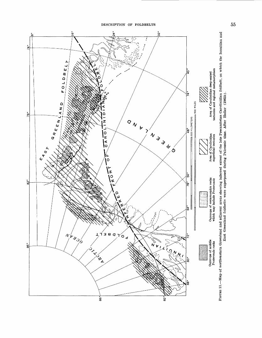
DESCRIPTION OF FOLDBELTS 55
56 THE TECTONICS OF NORTH AMERICA
most of the f oldbelt between the 70th and 76th parallels exposes deeper levels than farther north, and displays a highly mobile infrastructure (J2a), in which the Up per Proterozoic geosynclinal strata and their underly ing basement have been migmatized and have flowed plastically into domes, recumbent folds, and mushroom- shaped bodies all magnificently displayed on the steep walls of the fjords. It is surprising that such complex, deep-seated infrastructures should occur so near the foreland of the f oldbelt.
Between the 72d and 74th parallels the Caledonian folded structures are overlain by Middle and Upper Devonian clastic deposits (J3), mostly red and conti nental and as much as 7,000 m (23,000 ft) thick; they have been called "molasse" and were deposited in "suc cessor basins" as defined in this report. These strata were involved in a second orogeny at about the same time as the main deformation of the Innuitian foldbelt to the west; the orogeny has been called "young Caledonian," but it is contemporaneous with the Acadian orogeny farther south in North America. The surrounding pre- Devonian rocks, already thoroughly deformed by the Caledonian orogeny, were refolded and in part remo- bilized, along axes transverse to the earlier ones. On the tectonic map these younger superposed structures are shown as thin lines that extend across the earlier folds. Both the Devonian and the surrounding older rocks are invaded by late erogenic or postorogenic granite plutons (Ja), which have yielded radiometric dates of 395 m.y.
Overlying all the earlier rocks and structures, espe cially near the coast, is a sequence of postorogenic Pennsylvanian, Permian, and Mesozoic formations (J4), capped in places by outliers of the Tertiary plateau basalts. The postorogenic formations have been little deformed, except by tilting and blockfaulting.
(L) APPALACHIAN FOLDBELT
The Appalachian foldbelt, which also formed mainly during Paleozoic time, is exposed for 3,700 km (2,000 miles) along the southeastern side of North America, from Newfoundland to Alabama. In the Canadian Maritime Provinces it is exposed to a width of 650 km (400 miles) and in Tennessee and North Carolina to a width of 400 km (250 miles); however, large parts of its original extent are now concealed by younger de posits, or submerged beneath the sea. Because of such concealment, it is nearly bisected near New York City. Northeastward, the Appalachian foldbelt runs out to sea along the coast of Newfoundland with no dimuni- tion in strength of deformation, and must surely con tinue to the edge of the continental shelf 100 km (60 miles) beyond. Its nearest counterparts in this direction are the Caledonian and Variscan f oldbelts of the British
Isles on the opposite shore of the Atlantic Ocean, from which it is separated by a wide expanse of oceanic crust. Southwestward, it plunges beneath the Mesozoic and Tertiary strata of the Gulf Coastal Plain in Alabama, again with no dimunition in strength of deformation. In the Atlantic Coastal Plain the southeastern part of the internal zone of the foldbelt is similarly covered t y these younger strata.
The Appalachian foldbelt is notably more repilar in plan than most of the others in North America, with fewer differences in structure from one part to another, and with fewer interruptions by superposed younger structures. Its longitudinal subdivisions maintain their identity for long distances. It pursues a sinuous course, and is divided transversely into a succession of salients and recesses, each salient being about 650 km (400 miles) long.
Nevertheless, as mentioned above, the expos?d part of the foldbelt is nearly bisected at about mid -length near New York City; there are various contrasts be tween the two halves, some real, and some merely ap parent. Geographically, the term "Appalachian Moun tains" is thus commonly used only for the southern half, the highlands to the north being given other names. There is also a traditional belief that the northern half of the foldbelt is primarily an early Paleozoic feature and the southern half primarily a late Paleozoic fea ture. This has given rise to a concept, common in the European literature, of a "Variscan foldbelt" crossing westward over a "Caledonian foldbelt" near th°< place of bisection. The fallacy of this concept is now demon strated by the nearly identical radiometric dates in the internal zones of both halves of the foldbelt (see p. 61). It has also been proposed (Drake and Wood war!, 1963) that a fundamental zone of transcurrcnt faulting crosses the foldbelt near the place of bisection, extending inland from the line of Kelvin Seamounts in the Atlantic Ocean basin to the southeast. While there are j?30physi- cal indications of faulting along this trend in the ocean basin, neither geological nor geophysical data provide convincing evidence for through-going faults in the continent either at the surface or at depth even though structural belts on the south are bent westward from corresponding belts on the north.
Whether superficial or fundamental, there are suffi cient .differences between the northern and southern halves of the Appalachian foldbelt to warrant separate treatment in the remainder of this account.
NORTHERN APPALACHIANS
In the northern Appalachians the front of the fold- belt nearly impinges on the Precambrian rocl-? of the Canadian Shield (or its outlier in the Adirondack up-
NORTHERN APPALACHIANS 57
lift), with only a narrow foreland of Palezoic platform deposits (B) between. In southern Quebec the front of the foldbelt is the major low-angle thrust fault of Lo- gan's Line, but frontal thrusts are discontinuous south ward, and if present to the northeast are beneath the St. Lawrence Estuary.
Precambrian basement rocks (LI, La) emerge in the higher uplifts within the foldbelt itself, where they have been reworked by the Paleozoic orogenies. They are ex posed in a chain of uplifts a short distance southeast of the front of the foldbelt, in the Long Range of New foundland, the Green Mountains and others of New England, and the Hudson River Highlands of New York State. They are exposed again in another chain of uplifts well to the southeast, in the Avalon Peninsula of Newfoundland, Cape Breton Island, southern New Brunswick, and perhaps in southeastern New England (although not there separated on the map from the Paleozoic plutonics, L8). The basement rocks to the northwest are extensions of the Grenville foldbelt and yield characteristic radiometric dates of about 1,000 m.y. Those to the southeast were all seemingly involved in the younger Avalonian event, and in Newfoundland at least yield radiometric dates of 600-550 m.y. The sig nificance of the Avalonian rocks in the history of the northern Appalachians remains to be appraised, but in Newfoundland they may form the southeastern border of the Paleozoic foldbelt (Williams, 1964, p. 1155-1156; Poole, 1967, p. 19). In Newfoundland, the Holy rood Granite of the Avalonian basement is overlapped by fossiliferous Lower Cambrian, but in nearby areas a se quence of Upper Proterozoic strata (L2) as much as 12,000 m (40,000 ft) thick intervenes (Weeks, 1957, p. 145-147).
Miogeosynclinal deposits of Cambrian and Ordovi- cian age (L6) are well displayed in western Newfound land and from Vermont southward into Pennsylvania, but are absent, at least at the surface, through the cen tral segment in Quebec. Although no more than 2,500 m (8,000 ft) thick, their sequence is thicker and more com plete than that in the adjacent foreland; they are topped by younger Ordovician shales that are part of a clastic wedge which extends westward into the foreland, re lated to the late Ordovician Taconian orogeny. This orogeny is further expressed south of the Adirondack uplift by an angular unconformity between the Ordo vician and the Silurian. Above the Silurian in the fore land to the west, from the Catskill Mountains south ward, is a much thicker Devonian clastic wedge, coarse and continental toward the top, which reflects the Late Devonian Acadian orogeny within the foldbelt. Mio geosynclinal deposits of the same age as those on the northwest also occur on the southeastern side of the fold-
belt in Newfoundland, where they are preserved in snail patches on top of the Avalonian basement and the Up r»er Proterozoic strata, but both facies and faunas are more closely related to those in Europe than to those in the northwestern part of the Appalachian foldbelt.
Eugeosynclinal deposits of Cambrian to Devonian age form a large part of the remainder of the northern Ap palachians. On the tectonic map they are divided in*o a Cambrian and Ordovician part (L3) and a Silurian and Devonian part (L4). They are further divided into an unmetamorphosed or weakly metamorphosed part wlich dominates to the northeast, and a strongly metamor phosed part (L3a, L4a) which dominates to the south west, the boundary being placed at the garnet isograd.
Throughout the central segment in Quebec, Cambrian and Ordovician eugeosynclinal rocks extend to the front of the foldbelt, next to the shield and its narrow border of platform deposits. In the Taconic Mountains of Few York State and in western Newfoundland, where C"m- brian and Ordovician miogeosynclinal rocks form the front d-f the foldbelt, they are overlain with thrust con tact by broad sheets of eugeosynclinal rocks of the same ages that were emplaced during early phases of the Ta conian orogeny, probably by gravity sliding from the internal zone (Zen, 1967; Rodgers and Neale, 19*3). Eugeosynclinal rocks of Cambrian to Devonian age form the central and greater part of Newfoundland, and are bordered not only on the northwest but on the southeast by Precambrian massifs with a thin miofyeo- synclinal cover (see above); (Williams, 1964). On the mainland of Nova Scotia, the eugeosynclinal rocks ex tend to the Atlantic coast, but probably formed in an other depositional trough southeast of the belt of J.va- lonian basement (Poole, 1967, p. 18-19).
The eugeosynclinal sequences are generally thicker than the miogeosynclinal. In Vermont, they are dramati cally so, the Cambrian and Ordovician changing f~om 2,500 m (8,000 ft) of miogeosynclinal deposits wee4 of the Green Mountain uplift to 9,000-15,000 m (30,000- 50,000 ft) of eugeosynclinal deposits east of it, where they are followed by 4,500-6,000 m (15,000-20,000 ft) of Silurian and Devonian (Cady, 1960, p. 541-544). Elsewhere thicknesses are variable; there may have Hen zones of uplift or volcanic chains along the siter of some of the present anticlinoria, although these are dif ficult to unravel because of subsequent def ormatior.
Parts of the Cambrian and Ordovician eugeosyncFnal rocks were deformed during the Taconian orogeny be fore the succeeding strata were laid over them. Taconian folding seems to have been greatest along the northwest ern border in Quebec, parts of which were not greatly deformed afterwards. These folded rocks are overlap r»ed from the southeast by Silurian and Devonian shelf de-
58 THE TECTONICS OF NORTH AMERICA
posits (shown as miogeosynclinal, L6 on the map) which pass within a short distance into a thick eugeosynclinal sequence; here, the eugeosyncline had a two-phase his tory. A two-phase history is also evident in Newfound land, where the Silurian, although containing volcanic components like the Ordovician, includes shallow-water arkoses, red ,beds, and conglomerates that contain clasts derived from the older rocks. Elsewhere in the eugeo synclinal part of the foldbelt, Taconian deformation is less obvious, and if present has been much obscured by later deformation; unconformities occur in places, and in New Hampshire the Silurian overlaps Ordovician plutons, but in places the sequence appears to be con formable from Ordovician into Silurian.
The greatest orogeny in the northern Appalachians was the Acadian, whose climax was during later De vonian time (Poole, 1967, p. 33-37). (There is no con vincing evidence of a Caledonian orogeny in the classical sense, between the Silurian and Devonian.) From Maine northeastward, deeper downfolds preserve late Early Devonian continental plant-bearing beds lying con formably at the top of the eugeosynclinal sequence beds which foreshadow the climactic orogeny. Deposits that succeed the orogeny are mostly Carboniferous, although in places they include the latest Devonian.
In Quebec and New England, Silurian and Devonian eugeosynclinal rocks are preserved in two deeply de pressed synclinoria, separated by a median belt of anticlinoria that exposes the older Paleozoic the Connecticut Valley-Gaspe synclinorium on the north west and the Merrimack synclinorium on the southeast (not labeled on the map). South westward, the syncli noria become tightly compressed and the grade of metamorphism increases; in Connecticut schists and gneisses of the synclinoria and the intervening anti clinoria have been plastically folded into nappes of Pennine type. A third synclinorium forms most of the peninsula of Nova Scotia, southeast of the Precambrian massifs of Cape Breton Island and southern New Bruns wick, but most of its rocks are Cambrian and Ordovician and the overlying Silurian and Devonian are minor.
Carboniferous deposits (with latest Devonian at the base in places, and some Permian at the top) (L7) accumulated in successor basins in many parts of the northern Appalachians, but most extensively in the Maritime Provinces. The largest, or New Brunswick basin, occupies more than half of that province, as well as Prince Edward Island and a large part of the floor of the Gulf of St. Lawrence. Farther southeast the basins are separated by massifs of Precambrian and older Paleozoic rocks, some of which stood as highlands during Carboniferous time. The first deposits of the
basins (Mississippian) are partly marine, but the younger (Pennsylvanian) are largely continental, with workable coal measures. Degree of deformation varies. In the New Brunswick basin most of the surface rocks are nearly flat-lying, but there and elsewhere the se quence contains structural unconformities, ard the degree of deformation increases downward; the rocks of some of the smaller basins are more folded, as shown by a separate symbol on the map (L7a). Configuration of the surface of the underlying basement that wns con solidated by the Acadian orogeny is indicated on the map by 500-m contours.
Carboniferous deposits occupy smaller successor basins in western Newfoundland and southeastern New England, and while they overlie much deformed earlier rocks they are themselves more deformed than most of their counterparts in the Maritime Provinces. In the Narragansett basin of Rhode Island coal beds have been converted to graphite, and the southern end of th? basin is intruded by late Paleozoic granite (Le).
Upper Triassic rocks of the Newark Group (L8) form a downfaulted strip in the Connecticut Valley of New England, and another in the Bay of Fundy whose south eastern edge projects onto the shore of Nova Scotia; the latter strip extends southwestward into the Gulf of Maine, where its extent has been determined I y geo physical means (the edge being shown by a dotted line on the map). The Triassic rocks are wholly postongenic, unaltered, and merely tilted and block faulted; they are red beds and arkoses, with interbedded mafic lavas and related intrusives.
The Devonian and earlier eugeosynclinal rocl*?1 were little broken during the Acadian deformation, bnt they and the succeeding Carboniferous and Triassic rocks are traversed by many high-angle faults, most of which are grossly parallel to the grain of the foldbelt, These include the so-called Cabot fault of J. T. Wilson (1962), who proposed that this was a through-going fracture with left-lateral displacement, formed during Carbon iferous time, that extended from Newfoundland through the Maritime Provinces into southeastern New England. It is true that there is an unusual con".entra- tion of high-angle faults of about this age in the places mentioned, but they form a zone as much as 100 km (60 miles) wide. None of the faults in the zone clearly persist for its whole length; some have proved left- lateral displacement, others right-lateral, whereas still others have only proved dip-slip displacemert. The Triassic normal faults of the Bay of Fundy seem to be reactivations within the zone. The Triassic fault? of the Connecticut Valley are a separate system farthe^ west;

SOUTHERN APPALACHIANS 59
they include the Ammonoosuc normal fault of New Hampshire, once thought to be a west-dipping thrust.
Ultramafic rocks (L/3) form pods and lenses in the Cambrian and Ordovician eugeosynclinal rocks on both the mainland and Newfoundland. In Newfoundland they lie in two belts, symmetrically placed on each side of a presumed central axis, but on the mainland they are concentrated in a belt on the northwest that extends, with interruptions, from Gaspe to southern New Eng land. All of them are probably of Late Ordovician age; the thrust sheets of western Newfoundland that were emplaced as gravity slides during the Taconian orogeny contain ultramafic bodies that are rootless like the strata enclosing them.
Granitic rocks occupy parts of the site of the eugeo synclinal area, forming dispersed plutons to the north east, but more extensive and more crowded plutons to the southwest. Both stratigraphic relations and radio- metric dates indicate that they were emplaced during a prolonged period, from early Paleozoic into Mesozoic time. The earliest granitic rocks are pre-Silurian and probably mainly Late Ordovician. Early plutons have been identified in New Hampshire and Maine and others probably exist, but their known extent is too small to warrant separation from the younger Paleozoic granitic rocks on the map. The main assemblage of granitic rocks (L8) is of middle Paleozoic age, and yields radiometric dates of 350-400 m.y.; they are broadly contemporane ous with the Acadian orogeny, ranging from synoro- genic to early postorogenic. A representative suite forms the New Hampshire Plutonic Series, but other series occur both in that state and elsewhere. Mafic plutonic rocks (Ly), in part related to the dominant granitic rocks, form a few areas large enough to indicate separately on the tectonic map.
Younger granitic rocks are wholly postorogenic and are generally more alkalic than the earlier ones (Lc). They are exemplified by the White Mountain Plutonic Series of New Hampshire, which includes a spectacular array of ring dikes, some of which enclose remnants of supracrustal volcanics. The White Moutain Series is early Mesozoic, with radiometric dates of about 185 m.y., but the alkalic rocks farther south in New Eng land are late Paleozoic. The oldest precede the Carbonif erous deposits of the successor basins, but these de posits are themselves invaded by nonalkalic granite at the south end of the Narragansett basin.
The youngest intrusives of all, the Monteregian (L0), form a chain of stocks that extends eastward from Montreal (for which they are named) in the platform area into the outer edge of the foldbelt. They yield radiometric dates of about 110 m.y. and are of Cretaceous age.
SOUTHERN APPALACHIANS
South of its bisection near New York City, the Ap palachian foldbelt is continuous on the surface to Alabama. Throughout this distance it borders the Paleozoic platform deposits of the craton to the ncrth- west with a well-defined topographic and structural front, along which steep folds and prominent thrusts end abruptly, giving place to more open structure in the platform rocks beyond. On the tectonic map, this is shown as the edge of the miogeosynclinal deposits (L6), although stratigraphic data indicate that this edge is actually a broader, less well-defined zone.
Throughout the length of the southern Appalachians the miogeosynclinal rocks form a belt 65-130 km (40-80 miles) wide, expressed topographically by the Valley and Ridge province. The miogeosynclina] se quence, about 9,000 m (30,000 ft) thick, extends from Lower Cambrian to Pennsylvania!!, the upper half (be ginning as low as the Middle Ordovician in pla?«s) being largely clastic deposits derived from the southeast. Parts of the elastics (notably the Ordovician Martins- burg Formation) are typcial flysch laid down in deep longitudinal troughs (McBride, 1962, p. 87-88), but other parts are more varied and form wedges that trper across the miogeosyncline into the craton. Notable among the wedges is the great mass of Middle and Upper Devonian elastics in the northeastern half of the southern Appalachians, which are as much as 3,00^ m (10,000 ft) thick at the apex, but which taper not only northwestward toward the craton, but southwestward along the trend of the foldbelt. Clastic deposits nearly as thick occur on the Middle and Upper OrdovHan farther southwest, and in the Pennsylvanian of Ala bama in the far southwest. Large parts of the elastics are marine, but they become continental higher up, especially in the Pennsylvanian.
The clastic deposits were derived from the erosion of uplifted and probably deformed parts of the interio^ of the foldbelt, and their maxima of different ages in dif ferent places suggest orogenic climaxes in adjacent seg ments of the internal zone; the Ordovician and De vonian maxima may be related to orogenies correlative with the Taconian and Acadian of the northern Ap palachians. However, a large part of the thick Penrsyl- vanian elastics in the far southwest was probably related to orogeny in the impinging Ouachita foldbelt, now buried beneath the Gulf Coastal Plain to the south.
There are few breaks of any structural consequence within the miogeosynclinal sequence itself, and no strata lie unconformably above, hence the times of its defor mation are inferential. The Pennsylvanian is preserved in places in the deeper downfolds in the miogeosyncl^al
60 THE TECTONICS OF NORTH AMERICA
belt, and the lowest Permian is conformable above the Pennsylvanian in the mildly folded part of the adjacent foreland, so that much of the deformation was late in Paleozoic time. This has been called the "Appalachian orogeny" (or "Appalachian Revolution"), but it is hardly Appalachian hi a broad sense, and the more specific term "Allegheny orogeny" is more appropriate.
The structures of the miogeosynclinal belt the classi cal "Appalachian structure" of American geology in cludes long, parallel folds generally asymmetrical toward the northwest, which are broken by low- to high- angle faults that are thrust in the same direction (fig. 5(7). Some of the thrust faults persist for great distances; the Saltville fault extends from Virginia to Alabama, and others are nearly as lengthy. Much of the structure is disharmonic so that the folds and faults overlie surfaces of decollement in various incompetent units low in the sequence; the underlying strata and the basement beneath are probably little deformed, or de formed in a different manner (Rodgers, 1953).
At the surface, the northeastern half of the miogeo synclinal belt contrasts with the southwestern, as the first is dominated by folds and the second by thrust faults the faults so crowded in places that no interven ing folds are preserved. Structures at depth are more alike in the two halves, surfaces of decollement being equally prominent in each. Wells drilled on the Nittany arch, the great culmination of miogeosynclinal folds hi central Pennsylvania, passed through two or more thrusts within 1,500-3,000 m (5,000-10,000 ft) of the surface, and some of them ended in strata higher in the sequence than those in which they started.
Surfaces of decollement also extend out from the foldbelt into the adjoining platform deposits, and have determined much of the structure in this part of the craton or foreland. Near the common corners of Vir ginia, Kentucky, and Tennessee the Pine Mountain fault has moved a block of Carboniferous strata 200 km (124 miles) long and 40 km (25 miles) wide at the edge of the foreland for about 7 km (4 miles) northwestward along an incompetent shaly layer (Rich, 1934; and many later references). Less prominent but even more pervasive decollement surfaces of the same kind are now known from subsurface and outcrop data in the foreland of Pennsylvania, West Virginia, and Tennes see (Gwinn, 1964; Wilson and Stearns, 1958).
In Alabama, the miogeosynclinal rocks are separated from the crystalline rocks of the internal zone by the Talladega belt, a thrust slice about 200 km (125 miles) long made up of Paleozoic strata of a different facies, largely slaty below with f ossilif erous Devonian cherts in the middle and plant-bearing Carboniferous above.
This sequence is more like that in the Ouachita foldbelt (M) than any elsewhere in the Appalachians, and it is so represented on the tectonic map.
Through the remainder of the length of the miogeo- synclinal belt northeast of Alabama, it is bordered on the southeast by the Blue Ridge uplift, which brings to the surface rocks beneath the Paleozoic miogeosyn clinal deposits. The basement of the uplift is crystalline rocks that are outliers of the Grenville foldbelt (Ll). Separating the basement from the Paleozoic are gener ally Upper Proterozoic supracrustal rocks (L2), mafic lavas to the northeast, nonvolcanic elastics to the south west; the latter (Ocoee Series) are as thick or thicker than the adjoining Paleozoic miogeosynclinal sequence. The Upper Proterozoic rocks were little deforced be fore the orogenies of Paleozoic time.
At the boundary between the miogeosynclinal belt and the Blue Ridge uplift the structural style changes; the basement of the Blue Ridge is deformed ith its cover and regional metamorphism is apparent. Toward the northeast the uplift is overfolded against the mio geosynclinal belt, but thrust faults develop southwest- ward along the border, carrying the basement and other rocks of the uplift northwestward over the mic*yeosyn- clinal rocks. In the Tennessee-North Carolina segment, much of the Blue Ridge uplift is allochthonous, as win dows of the thrusts emerge as much as 65 km (40 miles) behind their leading edges. Southwest of Virginia the Precambrian basement rocks of the Blue Ridg«> uplift and their supracrustal cover are juxtaposed agfinst the contrasting metamorphic and plutonic rocks of the Piedmont province to the southeast along the remark ably straight, narrow Brevard zone. Its principal structure is a high-angle fault, along which there are clear indications of a large component of righMateral strike-slip displacement including a nearly he Hizontal linear fabric, and inclusions of exotic rocks in the zone, far from any obvious sources (Reed and Bryant, 1964, p. 1192).
Besides the interpretation of the Brevard zor** as one of strike-slip displacement, others are possible which are not necessarily incompatible. The compiler Hs com pared the zone (and some similar ones in the same re gion) with the root zone of the nappes on tl i south flank of the Alps (King, 1950, p. 653), and has termed it a "dejective zone," thus implying a structure more fundamental than the mere surficial syncline peculated by earlier geologists (King, 1955a, p. 356). This inter pretation has been further exploited by Burcl fiel and Lavingston (1967) who point out that the alloclthonous Blue Ridge rocks northwest of it, like the nr.ppes of the Alps, have no large, obvious source area; hence that this source area must have been pulled down and oblit-
SOUTHERN APPALACHIANS 61
erated along the root zone. Credence is lent to this sug gestion by the fraying out and disappearance of the Brevard zone to the northeast, at about the place where the Blue Ridge rocks cease to be allochthonous, and be come part of an autochthonous uplift.
In the Piedmont province the southeastern, eugeo- synclinal part of the foldbelt are supracrustal rocks younger than the Grenville basement, but their se quences and ages are enigmatic because of metamor- phism, interruption by plutons, and a general absence of fossils. On the tectonic map they are indicated as un divided eugeosynclinal deposits, weakly to strongly metamorphosed (L5, L5a). In the Piedmont, the Gren ville basement itself (LI) only comes to the surface in a cluster of mantled gneiss domes near Baltimore, Md.
So far as now known, the lower part of the sequence dominates in the northwestern part of the Piedmont province. It consists of very thick, nonvolcanic, clastic units, such as the Glenarm Series of Maryland and the Lynchburg Formation of Virginia; these much resem ble the Ocoee Series of the southwestern part of the Blue Ridge uplift, and like it may be of Upper Protero- zoic age (Hopson, 1964, p. 203-207). Higher units, many with large volcanic components, are infolded in the northwestern part of the Piedmont but dominate its southeastern part, especially in the Carolina Slate Belt; they contain a few Cambrian and Ordovician fos sils at one place or another, and have yielded Ordovi cian radiometric dates elsewhere; whether other Paleozoic ages are represented is undetermined.
Most of the supracrustal rocks of the Piedmont prov ince are regionally metamorphosed (L5a), and a meta- morphic climax is attained (at least in North and South Carolina) in a sillimanite-almandine zone northwest of the slate belt (Overstreet and Bell, 1965, p. 54-57); this zone may have been the central axis of the foldbelt during some of the Paleozoic orogenies. Rocks of the Carolina Slate Belt itself are only weakly metamor phosed (Li5) except near plutons, and similar weakly metamorphosed rocks may form a large part of the basement beneath the Atlantic Coastal Plain.
The supracrustal rocks of the Piedmont province have been disrupted by large volumes of plutonic rocks. Gabbros and diorites (I/y) occur in Maryland and North Carolina, and are seemingly of early Paleozoic or latest Precambrian age. A more extensive younger array of granitic plutonic rocks (LS) includes foliated concord ant varieties, and more massive cross-cutting bodies.
Radiometric dates on plutonic and metamorphic rocks in the Piedmont province cluster near 450-500 m.y., 350 m.y., and 250 m.y., the first being more abundant to the northwest, the last to the southeast; they express times of plutonism, metamorphism, and presumably also
of orogeny that extended through a long span of the Paleozoic (Hadley, 1964). These times invite compari son with the known events in the northern Appalachians (the Taconian, Acadian, and later Paleozoic orogenies), but the extent of the rocks involved in each is too vaguely known to make it possible to represent it on the tectonic map. Various considerations, including the record of clastic wedges in the miogeosynclinal belt, suggest that the earlier radiometric dates express a greater erogenic event than the later dates.
Extending through the Piedmont province from Pennsylvania to North Carolina are faulted strips and patches of the Upper Triassic postorogenic rocks of the Newark Group (L8), nearly identical in lithology and structure to the rocks of the same group in the north ern Appalachians. They lie unconformably on the crys+al- line rocks of the Piedmont province, and in Penn<*yl- vania overlap the edge of the miogeosynclinal belt. As shown on the tectonic map, mafic dikes related to the intrusives in the Newark Group extend long distances into the surrounding older rocks and have a systematic regional pattern (King, 1961). As already indicated (p. 24), faulted strips of Triassic rocks in the internal zones of the Appalachian and Ouachita foldbelts con tinue beneath the coastal plain cover at least as far southwest as southern Arkansas.
(M) OUACHITA FOLDBELT
The Ouachita foldbelt is, in many respects, a western continuation of the Appalachian foldbelt; nevertheless, its rock sequence and structure differ significantly, hence it evolved during a different tectonic cycle. The fold- belt extends more than 1,600 km (1,000 miles) across the southern United States, from near the last exposure of the Appalachians in Alabama to western Texas, wl ^re it passes into Mexico. However, it is only exposed for 510 km (275 miles) of this distance in a large r.rea in the Ouachita Mountains (Miser, 1929; and many later papers), and in the Marathon region and even smaller areas in western Texas (King, 1937). Through the remainder of its length it is covered by deposits of the Gulf Coastal Plain (C), but its position is indicated with varying degrees of precision by drill dat% (Flr.wn and others, 1961).
Because of the small extent of the exposed parts of the Ouachita foldbelt, its rocks are shown as a single unit (M) on the "Tectonic Map of North America" (fig. 12). The same symbol is used for inliers of deformed Paleo zoic rocks in the eastern Cordillera of Mexico that w^re classed as parts of the Huastecan structural belt on the "Tectonic Map of Mexico" (de Cserna, 1961). In the Gulf Coastal Plain the front of the concealed part of the foldbelt is shown as a dotted line (or buried fault).
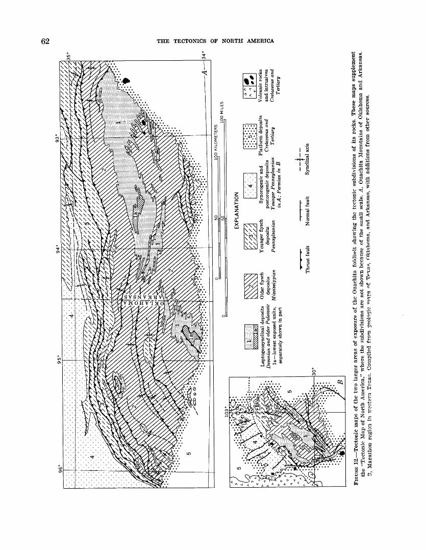
O5 to
103
Lep
toge
osyn
clin
al d
epos
its
Old
er f
lysc
h D
evon
ian
and
olde
r P
aleo
zoic
de
posi
ts
la l
ow
est
exp
osed
uni
ts,
Mis
siss
ippia
n
separ
atel
y s
how
n in
par
t
EX
PL
AN
AT
ION
You
nger
fly
sch
Syn
orog
enic
and
P
latf
orm
dep
osit
sde
posi
ts
post
orog
enic
dep
osit
s C
reta
ceou
s an
d P
enns
ylva
nian
Yo
unge
r P
enns
ylva
nian
T
erti
ary
in A
; P
erm
ian
in B
Vol
cani
c ro
cks
and
intr
usiv
esC
reta
ceou
s an
dT
erti
ary
Thru
st f
ault
Nor
mal
fau
lt
__
i__
Syn
clin
al a
xis
30
°
FIG
URE
12
. T
ecto
nic
map
s of
the
tw
o la
rger
are
as o
f ex
posu
re o
f th
e O
uach
ita
folc
lbel
t sh
owin
g th
e te
cton
ic s
ubdi
visi
ons
of i
ts r
ocks
. T
hese
map
s su
pple
men
t th
e "T
ecto
nic
Map
of
Nor
th A
mer
ica,
" w
here
the
sub
divi
sion
s ar
e no
t sh
own
beca
use
of t
he s
mal
l sc
ale.
A,
Oua
chit
a M
ount
ains
of
Okl
ahom
a an
d A
rkan
sas.
B
Mar
atho
n re
gion
in
wes
tern
Tex
as.
Com
pile
d fr
om g
eolo
gic
map
s of
T*»
xa«,
Okl
ahom
a, a
nd A
rkan
sas,
wit
h ad
diti
ons
from
oth
er s
ourc
es.
OUACHTTA FOLDBELT 63
The course of the Ouachita f oldbelt, like that of the Appalachian f oldbelt, is marked by salients and recesses, but of even greater amplitude. The Ouachita Mountains are at the apex of one salient, the Marathon region at another; a deep recess lies between the Ouachita and Appalachian foldbelts in Mississippi and Alabama, and another adjoins the Llano uplift in central Texas. Throughout its course, the foldbelt lies against the cen tral craton, whose Paleozoic rocks have a different char acter and structure, commonly with thrust contact; in part it is bordered by deep basins containing upper Paleozoic synorogenic clastic deposits the Black War rior basin of Alabama and Mississippi, the Arkoma basin of Arkansas and Oklahoma, and the Val Verde basin of western Texas.
The relation of the Ouachita foldbelt to the Appala chian foldbelt is incompletely determined. Trends of the two structures converge nearly at right angles, and drill data show that the frontal structures curve sharply from one trend to the other, but the manner of junction of the internal zones is unknown. The Ouachita foldbelt also meets the rocks and structures of the Wichita sys tem nearly at right angles in southern Oklahoma; the junction is complexly faulted, but the Ouachita rocks are thrust over the Wichita rocks. In western Texas the Ouachita foldbelt again meets at right angles the younger Cordilleran foldbelt, which largely overwhelms it in Mexico.
The Paleozoic rock sequences of the exposed parts of the Ouachita foldbelt in the Ouachita Mountains and Marathon region are remarkably alike, especially con sidering their wide geographic separation and the very different nature of the contemporaneous rocks exposed in intervening and adjoining areas. The lowest exposed strata in both are high in the Cambrian. The remainder of the lower Paleozoic is dominantly slaty and cherty and is topped by a middle Paleozoic white chert or novaculite. These strata have many, but not all, of the characters of eugeosynclinal deposits. Their thickness is modest, generally no more than 900 m (3,000 ft), and they were probably laid down in a starved basin comparable to the leptogeosynclines of the Alps (Trumpy, 1960, p. 865-866). The only exception is the Silurian Blaylock Sandstone of the Ouachita Moun tains, which wedges out rapidly northward and may be related to an early pulse of orogeny in the interior of the foldbelt.
Higher Paleozoic strata in both areas of exposure are dramatically different a great mass of flysch that marks the orogenic phase in the foldbelt (Cline, 1960; Goldstein and Hendricks, 1962; McBride, 1966). With in the Ouachita Mountains the middle and upper Mis- sissippian part (Stanley and Jackfork Formations) is
5,200 m (17,000 ft) or more thick, but both here jvnd in the Marathon region this part wedges out alirost entirely at the front of the foldbelt. The early Pennsyl- vanian part (Atoka Formation) is 6,000 m (19,000 ft) thick at the front of the Ouachita Mountains, and wedges out almost entirely near the Ozark uplift in the craton to the north. In west Texas a similarly great but younger flysch sequence occurs along the front, mainly in the Val Verde basin, and includes earliest Permian. Successive pulses of orogeny in the Ouachita foldHlt are thus suggested, progressing outward from the in ternal zones and westward along its trend Mississip- pian and early Pennsylvanian pulses in both areas, a late Pennsylvanian pulse in the western area. Related to the younger pulses are structural unconformitier in the higher Paleozoic foreland strata.
As a result of these orogenies, the exposed rocks of the Ouachita foldbelt were deformed in much the sr.me manner as the rocks of the miogeosynclinal belt of the southern Appalachians, into asymmetrical folds over turned toward the north, with many low-angle to high-angle thrust faults. Thrusts are especially nu merous and crowded in the western half of the Oua chita Mountains, near the impingement of the foldbelt on the Wichita system. The eastern half was formerly believed to be rather simply folded, even though the deepest parts of the structure and those parts fartHst south were known to be conspicuously metamorphosed; it is now known that frontal thrusts extend across all this part to the Mississippi Embayment, and that the structures behind the front include major recumbent folds or nappes (Viele, 1966).
In the buried parts of the foldbelt, drill holes h<we penetrated deformed older and younger Paleozoic rocks that are recognizably like the formations in the exposed areas, but these formations, in both the out crops and the buried areas, are only in the frontal zo^es. In Texas, drill holes have penetrated an internal zone of highly sheared, medium-grade metamorphic rock? of undetermined age (Flawn, in Flawn and others, 1961, p. 79-81); these nowhere come to the surface, except in a tiny outcrop immediately south of the Rio Grande in Coahuila, Mexico. Granitic and other plutonic recks were penetrated in a few of the drill holes, but no large plutons have been found so far. East of Texas, the internal zones have not been reached by the drill, and are extensively blanketed by postorogenic deposits. Triassic redbeds (Eagle Mills Formation) occupy a long belt in Arkansas immediately south of the C ria- chita Mountains. South of them a single well in north eastern Louisiana (Union Producing Co., No. T-A Tensas Delta) penetrated undeformed Pennsylvar ian strata, which perhaps were deposited in a successor

64 THE TECTONICS OF NORTH AMERICA
basin, like basins in the Canadian Maritime Provinces, after the major orogeny in the interior of this part of the foldbelt had been completed.
8TBTJCTUBAL SYSTEMS BELATED TO THE OTJA.CHITA FOLDBELT
Before leaving the Ouachita foldbelt, discussion is desirable of other structural systems to which it is related in one way or another systems which have been mentioned only incidentally hitherto.
Structures of Paleozic age in the Wichita system ex tend west-northwest from their impingement with the Ouachita foldbelt for about 650 km (400 miles) across southwestern Oklahoma into the Texas Panhandle; they are vaguely connected thence northwestward through lesser structures with those of Paleozoic age in the Southern Rocky Mountains. Only a small part of the Wichita system projects to the surface, to form the Arbuckle and Wichita Mountains; the remainder is concealed by late Paleozoic postorogenic deposits, in cluding extensive Permian redbeds to the west. On the "Tectonic Map of North America" the system is repre sented by its faults (mostly buried) and by contours on the surface of the Precambrian; its rocks are mapped as platform deposits on a Precambrian basement.
In the Wichita system the lower part of the Paleo zoic sequence, through the Mississippian, is 3,700 m (12,000 ft) thick and mainly carbonate rocks; it much resembles that in the southern Appalachian miogeosyn- cline, except that it lacks most of the Cambrian com ponents. The lower Paleozoic strata thin north, south, and west across the craton, where they lie on crystalline rocks consolidated during Middle Proterozoic orogenies. Within the system itself the Paleozoic strata lie on another body of rocks (Ham and others, 1964, p. 149- 160). Where exposed in the Wichita Mountains these are primarily plutonic gabbros, granites, and rhyolites (shown as A3 on the tectonic map) but a few outcrops and extensive drill data demonstrate that the plutonic rocks are floored intrusives in the upper part of a supra- crustal sequence 6,000 m (20,000 ft) thick, largely gray- wackes and volcanics. Radiometric datings on both the plutonics and volcanics yield surprisingly young ages of 500 m.y., thus placing them and at least part of the supracrustal sequence in the Cambrian rather than in the late Precambrian.
All these rocks and their basement were deformed during several stages of Pennsylvanian time, or broadly at the time of the orogenies in the nearby Ouachita fold- belt. Blocks of basement and supracrustal rocks were raised along high-angle faults, in part with lateral dis placement, producing the massifs of the present Wiohita and Arbuckle Mountains, and others still con cealed. Their erosional debris was shed into deeply sub siding adjoining or intervening troughs notably the
Anadarko basin on the north flank of the Wichita Moun tains where another 4,500 m (15,000 ft) of later Paleozoic sediments accumulated, parts of which were severely folded and faulted during the final st^qres °f the deformation.
Details of the deformation of the Wichita system, the related sedimentation, and the interaction of both with the growing Ouachita foldbelt have been dc'vsribed at length in other publications. Here, it is sufficient to observe that the history of the Wichita system has been germanotype, rather than alpinotype like the Ouachita foldbelt, yet that this history was characterized by a much greater mobility than in most of the cratonic areas of North America.
The Huastecan structural belt of eastern Mexico (de Cserna, 1960, p. 598-601; 1961) is virtually a continua tion of the Ouachita foldbelt, but it is represented at the surface by only a few inliers of deformed Prleozoic rocks that emerge in the higher folds of the easte rn part of the Cordilleran foldbelt (Flawn, in Flawn and others, 1961, p. 90-103), so that its structural pattern is largely conjectural. It is commonly assumed that the Huastecan belt (that is, the Ouachita foldbelt) extends southward along the trend of the present Cordillera, but tl is is by no means assured. Some of the most significant Paleo zoic inliers occur near Las Delicias in southwestern Coahuila, 480 km (300 miles) south of the Marathon region, where a thick sequence of marine Permian with volcanic components has been steply folded along north- northeast axes and intruded by early Mesozoic granite (R. E. King and others, 1944, p. 25-27), suggesting that orogenic movements in the Ouachita foldbelt persisted later in Paleozoic time here than they did farther northeast.
At Las Delicias and elsewhere in western Coahuila, the Mesozoic cover is thinner than in adjacent parts of the Cordillera, over a largely buried massif termed the "Coahuila peninsula," around which the Coriilleran folds are strongly deflected on the south, part of this massif is shown as platform area (C) on the tectonic map (see p. 25-27). This buried massif probably is a consolidated part of the internal zones of the Ouachita foldbelt.
(0) CORDILLEBAN FOLDBELT
The Cordilleran foldbelt extends for 8,000 km 5,500 miles) along the western side of North America, from Alaska to northern Central America, with a vidth of 650-1,600 km (400-1,00 miles). The foldbelt is sigmoid in plan, trending westward in the extreme north, me- ridionally in the main part, then eastward in the ex treme south. Westward from Alaska it is separated by only a short stretch of shallow water from comparable f oldbelts in Asia. Southeast of Guatemala and Honduras in Central America the rocks and structures differ from
NORTHERN CORDILLERA 65
those to the north, and are described later as a part of the Antillean foldbelt (Q).
On its eastern side the Cordilleran foldbelt is bordered through most of its length by the central craton of North America, but in Alaska it fronts northward on the Arctic Coastal Plain, and in Mexico it fronts east ward on the Gulf Coastal Plain. On its inner side the Cordilleran foldbelt and the related Pacific foldbelt (P) are bordered for their entire length by the Pacific Ocean, without coastal plains and with only narrow continental shelves. In the northwest, the Pacific Coast is closely adjoined by the Aleutian Trench and in the south by the Middle America Trench, both with depths greater than 6,000 m (20,000 ft). In the more lengthy intervening area the ocean bottom next to the coast lacks trenches and lies at depths of 3,000-4,000 m (10,000-15,000 ft).
In the Cordilleran foldbelt, the climactic orogenies took place during Mesozoic time, but it had a long ante cedent history of sedimentation and deformation. It arose from several geosynclines, some of which took form early in Paleozoic time, as in the Appalachian foldbelt, others as late as Mesozoic time. Early def orma- tional features have been largely overwhelmed by the later ones, so that their patterns are seldom clear; some were probably precursors of the later structures, others seem to have been quite discordant. The postorogenic history of the foldbelt was much more eventful and complex than that in the Appalachians, with orogenic and epeirogenic events extending through most of the Cenozoic. In many places the imprint of these later events is so great as to disrupt or obscure the more fun damental Mesozoic structures.
These later events are also largely responsible for the present system of Cordilleran Mountains. Through most of the length of the Cordillera these events have produced two major mountain chains, one near the Pa cific Coast on the west, the other fronting the continen tal interior on the east, with lower plateaus and less continuous ranges between. These are only indirectly related to the original Cordilleran foldbelt, and in much of the western United States the eastern mountain chain (Central and Southern Rocky Mountains) is actually a reactivated part of the original craton (see p. 23-24).
As might be expected from the great length of the Cordilleran foldbelt, its geology, tectonics, and history differ from one part to another, which makes generaliza tion difficult, both on the tectonic map and in the present text; this is reflected by the large number of units into which the foldbelt is divided on the map legend, some of which occur only in one part or another. Nevertheless, a certain degree of unity is evident for long distances in the foldbelt, with rather abrupt contrasts in tectonic
style across narrow transverse zones, so that the fold- belt is segmented (King, 1966, p. 2-3). How funda mental this segmentation may be is problematical, br t it is a convenient basis for the ensuing descriptions, wl^re the foldbelt is treated in terms of a northern Cordillera (Alaska and Canada), a central Cordillera (western United States), and a southern Cordillera (Mexico and Central America).
NORTHERN CORDILLERA
The Cordilleran foldbelt trends northwestward in Canada with a nearly constant width of about 800 km (500 miles). A little east of the Alaska-Yukon boundary the belt is constricted by a deep recess along its north eastern side. In Alaska the belt turns westward, widen ing and branching, one branch extending out to sea southwestward to form the Aleutian island arc. Despite the constriction and some tectonic differences on its t wo sides, the cross section of the foldbelt in both Canrda and Alaska is much the same, and longitudinal strips- of like rocks and structures extend through the whole seg ment, including a belt of miogeosynclinal rocks on the northeast and a belt of eugeosynclinal rocks on the southwest. In addition, a belt of younger rocks snd structures fringing the Gulf of Alaska is distinguisl <*! as a part of the Pacific foldbelt (P) and described under a later heading. The segment extends a short distance southward across the 49th parallel into Washington, Idaho, and Montana, where it terminates against over lapping volcanic rocks and the transverse faults of the Lewis and Clark zone.
Easternmost Siberia, opposite Alaska, contains fold- belts that are the obvious extensions of the Cordilleran and Pacific foldbelts of North America into the corti- nent of Asia. Indeed, the rocks and structures of the two continents are separated only by the very shallow nor+h- ern part of the Bering Sea on the south and the Chukchi Sea on the north, underlain by continental crust. It is evident from published maps (notably Tilman and others, 1966) that rocks, structures, and orogenic tines occur in Siberia which are analogous to those in Alas!-a; nevertheless, their positions and trends do not clos^y match. There has been much speculation as to precise connections by Soviet and American geologists (among the latter, Ostenso, 1968; Michael Churkin, Jr., unpub. data), but more precise comparisons are desir able. Further information will no doubt become avail able as a result of oceanographic investigations now in progress on the sea-bottom geology of the intervening areas.
Between the 46th and 60th parallels the outer, or mio geosynclinal, part of the northern Cordillera forms the Rocky Mountains, a bundle of parallel ranges with little
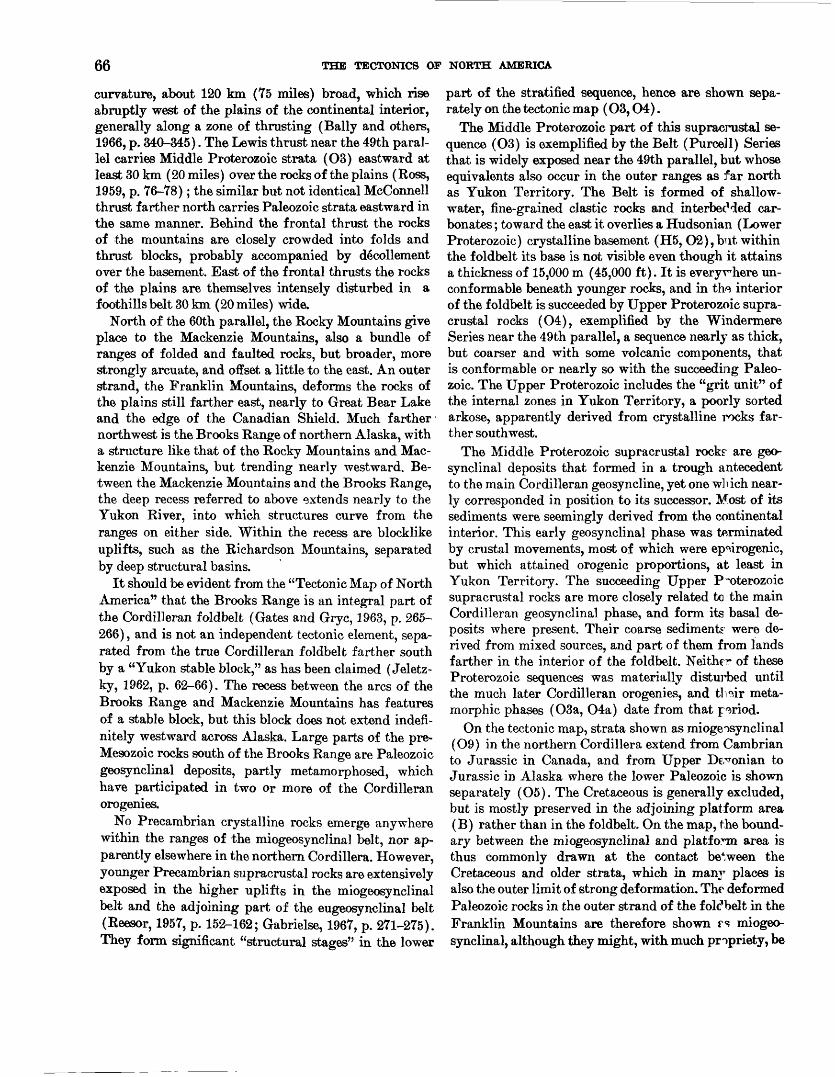
66 THE TECTONICS OF NORTH AMERICA
curvature, about 120 km (75 miles) broad, which rise abruptly west of the plains of the continental interior, generally along a zone of thrusting (Bally and others, 1966, p. 340-345). The Lewis thrust near the 49th paral lel carries Middle Proterozoic strata (O3) eastward at least 30 km (20 miles) over the rocks of the plains (Ross, 1959, p. 76-78); the similar but not identical McConnell thrust farther north carries Paleozoic strata eastward in the same manner. Behind the frontal thrust the rocks of the mountains are closely crowded into folds and thrust blocks, probably accompanied by decollement over the basement. East of the frontal thrusts the rocks of the plains are themselves intensely disturbed in a foothills belt 30 km (20 miles) wide.
North of the 60th parallel, the Rocky Mountains give place to the Mackenzie Mountains, also a bundle of ranges of folded and faulted rocks, but broader, more strongly arcuate, and offset a little to the east. An outer strand, the Franklin Mountains, deforms the rocks of the plains still farther east, nearly to Great Bear Lake and the edge of the Canadian Shield. Much farther northwest is the Brooks Range of northern Alaska, with a structure like that of the Rocky Mountains and Mac kenzie Mountains, but trending nearly westward. Be tween the Mackenzie Mountains and the Brooks Range, the deep recess referred to above extends nearly to the Yukon River, into which structures curve from the ranges on either side. Within the recess are blocklike uplifts, such as the Richardson Mountains, separated by deep structural basins.
It should be evident from the "Tectonic Map of North America" that the Brooks Range is an integral part of the Cordilleran foldbelt (Gates and Gryc, 1963, p. 265- 266), and is not an independent tectonic element, sepa rated from the true Cordilleran foldbelt farther south by a "Yukon stable block," as has been claimed (Jeletz- ky, 1962, p. 62-66). The recess between the arcs of the Brooks Range and Mackenzie Mountains has features of a stable block, but this block does not extend indefi nitely westward across Alaska. Large parts of the pre- Mesozoic rocks south of the Brooks Range are Paleozoic geosynclinal deposits, partly metamorphosed, which have participated in two or more of the Cordilleran orogenies.
No Precambrian crystalline rocks emerge anywhere within the ranges of the miogeosynclinal belt, nor ap parently elsewhere in the northern Cordillera. However, younger Precambrian supracrustal rocks are extensively exposed in the higher uplifts in the miogeosynclinal belt and the adjoining part of the eugeosynclinal belt (Reesor, 1957, p. 152-162; Gabrielse, 1967, p. 271-275). They form significant "structural stages" in the lower
part of the stratified sequence, hence are shown sepa rately on the tectonic map (O3,04).
The Middle Proterozoic part of this supracrustal se quence (O3) is exemplified by the Belt (Purcell) Series that is widely exposed near the 49th parallel, but whose equivalents also occur in the outer ranges as far north as Yukon Territory. The Belt is formed of shallow- water, fine-grained clastic rocks and interbecMed car bonates; toward the east it overlies a Hudsonian (Lower Proterozoic) crystalline basement (H5, O2), but within the foldbelt its base is not visible even though it attains a thickness of 15,000 m (45,000 ft). It is everywhere un- conformable beneath younger rocks, and in the interior of the foldbelt is succeeded by Upper Proterozoic supra crustal rocks (O4), exemplified by the Windermere Series near the 49th parallel, a sequence nearly as thick, but coarser and with some volcanic components, that is conformable or nearly so with the succeeding Paleo zoic. The Upper Proterozoic includes the "grit unit" of the internal zones in Yukon Territory, a poorly sorted arkose, apparently derived from crystalline rocks far ther southwest.
The Middle Proterozoic supracrustal rock? are geo synclinal deposits that formed in a trough antecedent to the main Cordilleran geosyncline, yet one which near ly corresponded in position to its successor. Most of its sediments were seemingly derived from the continental interior. This early geosynclinal phase was terminated by crustal movements, most of which were ep^irogenic, but which attained erogenic proportions, at least in Yukon Territory. The succeeding Upper P-oterozoic supracrustal rocks are more closely related to the main Cordilleran geosynclinal phase, and form its basal de posits where present. Their coarse sediments were de rived from mixed sources, and part of them from lands farther in the interior of the foldbelt. Neithe^ of these Proterozoic sequences was materially disturbed until the much later Cordilleran orogenies, and t]i?ir meta- morphic phases (O3a, O4a) date from that period.
On the tectonic map, strata shown as iniogeosynclinal (O9) in the northern Cordillera extend from Cambrian to Jurassic in Canada, and from Upper Devonian to Jurassic in Alaska where the lower Paleozoic is shown separately (O5). The Cretaceous is generally excluded, but is mostly preserved in the adjoining platform area (B) rather than in the foldbelt. On the map, the bound ary between the miogeosynclinal and platform area is thus commonly drawn at the contact between the Cretaceous and older strata, which in manr places is also the outer limit of strong deformation. The deformed Paleozoic rocks in the outer strand of the foldbelt in the Franklin Mountains are therefore shown FS miogeo synclinal, although they might, with much propriety, be

NORTHERN CORDILLERA 67
considered as deformed platform cover. Also shown as miogeosynclinal are the pre-Cretaceous rocks in the recess between the Mackenzie Mountains and the Brooks Range, although not all of their complex sequence is truly geosynclinal (Jeletzky, 1962, p. 62-66). In places, miogeosynclinal rocks contrast greatly with adjacent eugeosynclinal rocks of the same ages (O6, O7), mostly where they are juxtaposed along faults. Elsewhere, the boundary is indefinite, different parts of the sequence partaking of one f acies or the other, so that the contact is arbitrarily drawn.
In general, the Paleozoic miogeosynclinal rocks are dominantly carbonates,, and the Mesozoic dominantly clastic wedge deposits, but the sequence varies greatly from one part of the belt to another (Bally and others, 1966, p. 361-369; Gabrielse, 1967, p. 275-283; Brosge and others, 1962). Unconformities occur, especially in the upper part of the Devonian, but they were mostly produced by epeirogenic rather than erogenic move ments, and angular discordances are local. The array of unconformities and the epeirogenic movements which they express is especially complex in the recess between the Mackenzie Mountains and the Brooks Range (Je letzky, 1962, p. 62-71). However, true orogenic deforma tion seems to have occurred in the core of the eastern Brooks Range, where rocks below the Upper Devonian have been much metamorphosed (O5a); granites in the vicinity have been dated radiometrically between 370 and 220 m.y., hence are middle to late Paleozoic (Oe). A possible relation between these deformed rocks and the Innuitian foldbelt to the northeast has already been suggested (p. 53).
Most of the Mesozoic clastic wedge deposits of the miogeosynclinal sequence are related to orogenic activ ity in the eugeosynclinal part of the foldbelt, rather than in the miogeosynclinal area itself. Nearly all the deformation in the miogeosynclinal part of the foldbelt was late in the Cretaceous or still later, hence is Lara- mide in the broad sense; in the southern part of the segment Paleocene strata are deformed equally with the Cretaceous in the foothill belt east of the Rocky Mountains. In the Brooks Range, however, Laramide deformation was preceded by an Early Cretaceous (Aptian) time of orogeny and thrusting.
Much of the remainder of the northern Cordillera in both Canada and Alaska was a eugeosyncline during large parts of Paleozoic and Mesozoic time. Its supra- crustal rocks and deformational events were as varied as those in other eugeosynclines, and at least the younger of these are well documented in many places. Volcanic rocks are common, especially in certain parts of the sequence for example, from Devonian into Mississip- pian and from Permian into Triassic in some areas
but thick limestone bodies also accur, although they are mostly of local extent. Coarser clastic rocks, including conglomerate, attest the uplift and probable deforma tion of adjacent areas.
On the "Tectonic Map of North America," the eug'°x>- synclinal rocks that were involved only in the Meso zoic orogenies, and which are primarily of Mesozoic age (O7) are separated from an earlier part, primarily of Paleozoic age (O6) which was involved in one or more previous orogenies and reworked later. Besides these, a still older unit of early Paleozoic age (O5) is showr in Alaska a unit which was involved in middle Paleozoic or earlier orogenies, and not all of whose rocks are of eugeosynclinal character.
Rocks of the last-named category (O5) are extensive in the interior of Alaska, where they include phyllites and schists (O5a) that underlie little metamorphosed rocks of known Mesozoic age. On the flank of the Brooks Range the metarnorphic rocks are traceable northward into unmetamorphosed formations beneath Upr»er Devonian conglomerates; elsewhere, their ages are known only from fossils in scattered limestone units. Clearly, these rocks have been involved in one or more orogenies during Paleozoic time, and perhaps early in that time. In the Seward Peninsula the metamorpMc and partly fossiliferous rocks were folded along north- south axes during the Paleozoic, and were refolded along east-west axes during the Mesozoic or later (D. M. Hopkins, oral commun., 1966).
Southeast of Alaska older Paleozoic rocks are ex posed only along the northeastern and southwestern edges of the eugeosynclinal area; those on the northeast are gradational into the miogeosynclinal deposits, those on the southwest (in the islands of the Alaska Panhan dle) are more truly eugeosynclinal (Brew and others, 1966, p. 157-166). In the northeastern belt, where th^se rocks are not separated from the younger Paleozoic, significant orogeny near the close of the Devonian has been recorded in the Cassiar area and elsewhere (Wheeler, 1966, p. 34). Plutonic rocks of early Paleo zoic age (Oc) occur in the southwestern area.
Later Paleozoic and early Mesozoic eugeosynclinal deposits (O6, O7) extend the length of the northern Cordillera, and many sequences attain thicknesses of more than 7,600 m (25,000 ft). Proportions of the dif ferent components volcanics, chert, argillite, grr»y- wacke, and limestone vary greatly from one place and from one part of the sequence to another, but the Me^o- zoic generally contains coarser elastics than the Pal?.o- zoic. Deposition was widely interrupted during early Triassic time, mostly by epeirogenic movements, hut locally by moderate deformation (White, 1966a, p. 187).
Mesozoic time was one of nearly continuous orogeny
68 THE TECTONICS OF NORTH AMERICA
from place to place in the eugeosynclinal area, and it is difficult to make any meaningful generalizations as to erogenic climaxes; the statement on the legend of the tectonic map that the eugeosynclinal deposits were de formed mainly during a middle Mesozoic (Nevadan) orogeny is a gross oversimplification (Misch, 1966, p. 119). In many areas all the Mesozoic, and even part of the Tertiary, is steeply folded. Nevertheless, a signifi cant part of the deformation had been accomplished well before the terminal Mesozoic (Laramide) orogeny in the miogeosynclinal belt to the northeast. The younger Mesozoic and the Tertiary rocks (OlO, Oil), even where steeply folded, did not participate in many of the deformations that affected the older rocks; they are less metamorphosed and plutonized, and they con tain larger volumes of terrestrial deposits and of coarse immature elastics.
During Mesozoic time granitic rocks were emplaced in the eugeosynclinal area on a vast scale (O0). The great Coast batholith of western Canada is nearly con tinuous for 1,800 km (1,100 miles), from the 49th past the 60th parallel, and is 80-200 km (50-120 miles) wide, but' it is inhomogeneous internally and of several ages (Roddick, 1966, p. 76-79). Other sizeable but less con tinuous batholiths occur in Alaska to the northwest and in Canada to the east, especially in a belt along the northeastern side of the eugeosynclinal area (Cassiar Mountains southward to Monashee Mountains). Geo logic relations and radiometric datings both indicate a prolonged time of emplacement from 250 m.y. to less than 70 m.y., or through all of Mesozoic and into Terti ary time. By far the most extensive granitic emplace ment, especially in the Coast batholith, occurred during Cretaceous. The batholiths of early Tertiary age are late phases of the Mesozoic plutonism, but a few near the 49th parallel are as young as middle Tertiary (OA). Radiometric dating suggests pulses of granitic emplace ment during the Mesozoic at intervals of 30 m.y., but while the pulses lie within the general period of orog eny, they have little obvious relation to the known times of deformation in the supracrustal rocks (Ga- brielse and Reesor, 1964, p. 127-128).
Parts of the eugeosynclinal rocks have been strongly metamorphosed, mainly in areas near granitic plutons, which were also areas of long-persistent heating and recrystallization. Metamorphic rocks thus lie within and around the Coast batholith, as well as in the plu- tonic belt along the northeastern side of the eugeosyn clinal area, where they are more continuous than the granitic rocks themselves. Many of the metamorphic rocks in these belts can be identified as equivalent to less altered Proterozoic, Paleozoic, and Mesozoic forma tions, and have been so mapped (O3a, O4a, O6a, O7a).
Other metamorphic rocks have been transformed by recrystallization and plastic flowage to such an extent that most indications of their original nature r.nd rela tions have been lost, and they are therefore mapped as metamorphic complexes (Ol). The complexes include the Birch Creek Schist of interior Alaska, the equiva lent Yukon Group of Yukon Territory, the Shuswap complex of southern British Columbia, and various intervening bodies all in the northeastern plutonic and metamorphic belt.
Earlier geologists interpreted the metamorphic com plexes as an Archean protaxis that separated younger geosynclines on the two sides, but subsequent investi gations reveal a much more eventful history, involv ing heating and recrystallization in place, penetrative flowage, and superposed deformations through pro longed periods of time. Most radiometric dates in the complexes are surprisingly young 150 m.y. or less but those record only the latest thermal events and sub sequent cooling, after burial at great depths in the crust. Parts of the complexes may be highly altered phases of Paleozoic or even Mesozoic supracrustal rocks, but other parts may once have been Proterozoic supracrustal rocks or an even earlier basement, now remobilized.
During Late Jurassic and through most of the Cre taceous time, the deformed eugeosynclinal rocVs of the northern Cordillera were partly covered by deposits of successor basins (OlO), which were themselves vari ably deformed later. The deposits are coarse elastics and interbedded volcanics, partly marine, partly con tinental, most of the clasts having been derived from surrounding uplifted areas; the deposits also include fragments from granite plutons that had Hen em- placed only a little earlier (Grantz and otheT-s, 1963, p. B58-B59). The successor basins are most extensive in Alaska (Gates and Gryc, 1963, p. 269-272), but the Bowser basin in central British Columbia is 200 by 320 km (120 by 200 miles) across (Souther and Armstrong, 1966, p. 178-180). Smaller basins of continental Ter tiary deposits (Oil) occur here and there in the interior of the northern Cordillera.
Parts of the eugeosynclinal rocks are broken 17 faults, some of which originated during the geopynclinal period itself, but extensive low-angle thrusts h*.ve been described only in the northern Cascade Range of Wash ington (Misch, 1966, p. 120-136). Of greater interest are the very lengthy longitudinal faults, which are commonly expressed as topographic trenches o^* valleys on the land and as fiords between the offshore islands. The fault zone of the Rocky Mountain Trend and its continuation into the Tintina Trench extends with a few offsets from south of the 49th parallel across Can-

CENTRAL CORDILLERA 69
ada into Alaska, and the Denali fault zone extends through the high mountains of southern Alaska into the southeastern panhandle. The straight, or gently curved courses of these and other fault zones, the inter change of apparent upthrown and downthrown sides along their courses, and the frequent absolute differ ences between rocks on the opposite sides all suggest major strike-slip displacements; strike-slip displace ments have been proved in a few segments, but the ac tual displacement in much longer segments remains enigmatic. The Fairweather fault near the coast of Alaska is active today and has given rise to major earthquakes, but most of the remainder have long been dormant.
CENTRAL CORDILLERA
The Cordilleran Mountains occupy most of the United States west of the 104th Meridan, but the cen tral segment of the Cordilleran foldbelt (O), as here defined, forms only part of them. The foldbelt is lim ited northward by the Lewis and Clark transverse zone near the 46th parallel, and southward by another trans verse zone near the 34th parallel the Transverse Ranges and the Texas Lineament of southern Cali- lyrnia and Arizona. The eastern part of the moun tain system (Central and Southern Rocky Moun tains and Colorado Plateau) is classed as a reactivated craton (B), and the western part (Cascade Range and Coast Ranges) is placed in the Pacific foldbelt (P). As here defined, the Cordilleran foldbelt is 1,100 km (700 miles) wide near the 42nd parallel, but it is much nar rower to the north and south.
Even within the central segment of the foldbelt as thus restricted, the fundamental Mesozoic and older orogenic structures are greatly obscured by younger rocks and structures, so that their gross pattern is by no means as evident on the tectonic map as it is in the northern Cordillera. Superposed on the Mesozonic and older structures are Cenozoic volcanic fields and a sys tem of block faults which trend in other directions, and on the tectonic map these varied features play against each other in counterpoint. In the northern part of the segment, the continuity of the Mesozonic and older structures is interrupted entirely by a transverse belt of volcanic rocks that extends from the Snake River Plain of Idaho into the Absaroka Mountains of Wyoming.
The eastern, or miogeosynclinal part of the foldbelt is poorly defined north of the transverse volcanic belt, in Idaho and Montana, where it is closely crowded be tween cratonic and internal elements. It widens farther south in the Great Basin, where it extends westward 400 km (250 miles) from the edge of the Colorado Plateau in Utah into central Nevada. In eastern Cali
fornia it extends as far west as the front of the Sierra Nevada, but in the Mojave Desert to the south its con tinuity is lost in the confused ranges of the southern transverse zone.
In western Wyoming and southeastern Idaho the frontal part of the miogeosynclinal belt consists of close ly crowded folds and thrust slices, very much like those in the Canadian Rocky Mountains (Armstrong and Oriel, 1965). Southward in Utah, the frontal part is de flected into the eastern edge of the Great Basin, aromd the western end of the Uinta Mountains axis. The ranges of the eastern Great Basin contain low-angle thrust faults of great lateral displacement, many of which su perpose strata near the base of the Paleozoic over Meso zoic strata; the thrusts can be correlated from one range to the next, through Utah into southern Nevada, in such a manner as to indicate that they are continuous fea tures (Longwell, 1960; Crittenden, 1961; Armstrong, 1968, pi. 1). Behind the frontal belt in western Utah and eastern Nevada, the thrusts within the ranges difl'er; higher parts of the miogeosynclinal sequence have moved over the lower parts, and the whole has moved over a major decollement near the base of the Paleozoic (Misch, 1960). Correlation from one range to the next indicates that the decollement is a continuous feoture like the frontal thrusts to the east. It is tempting to infer that the decollement is the root zone of the frcutal thrusts, although there is some evidence that the former originated somewhat before the latter (Arm strong, 1968, p. 444). Frontal thrusts and decolle ment are exposed across nearly the whole width of the miogeosynclinal belt in this latitude, and if they are parts of the same feature there was an eastward trans port of very broad sheets of miogeosynclinal strata over their basement although for distances by no means as great as the observed breadth of exposure.
The crystalline basement (O2), probably part of the Hudsonian foldbelt, emerges near the eastern edg«. of the miogeosynclinal area in Utah, but it extends ae far west as Death Valley in southeastern California. It is succeeded in places by Middle Proterozoic strata (O3), comparable to the Belt Series farther north and the Grand Canyon Series farther east, and more widely by Upper Proterozoic strata. The latter attain imprersive thicknesses in the south (Noonday, Johnnie, Wyman, and other units), and like the Upper Proterozoic of the northern Cordillera are nearly conformable with the Paleozoic above; in this segment of the Cordillera their areal extent is not great enough to separate them from, the higher miogeosynclinal strata on the tectonic map.
The miogeosynclinal sequence of the central Cordil lera (O9) is largely Paleozoic, but includes remnants of lower Mesozoic (Triassic and Jurassic) at the top, as
70 THE TECTONICS OF NORTH AMERICA
well as some infolded Cretaceous along the eastern edge. Farther back in the foldbelt, as at Eureka, Nev., the Cre taceous is postorogenic and continental, and was laid down in successor basins whose present remnants are too small to map. Throughout the Great Basin, the volume of the Paleozoic carbonate rocks is impressive. To the south, near Las Vegas, Nev., 5,500 m (18,000 ft) of dominantly carbonate rocks, extend from Cambrian to Permian. Farther north, near Eureka, Nev., carbon ate rocks from Cambrian to Devonian alone are 4,500 m (15,000 ft) thick, but in this latitude they are succeeded by a Mississippian clastic wedge that expands westward toward the middle Paleozoic Antler orogenic belt in the eugeosynclinal area (Nolan and others, 1956); the thin ner, higher Paleozoic, again contains carbonate strata. Further complications develop in the eastern part of the miogeosynclinal area in the same latitude, where the upper Paleozoic thickens to 9,000 m (30,000 ft) in the Oquirrh basin nearly 10 times its value in nearby areas in an exceptional area of extreme but transitory subsidence. On the other hand, in Idaho and Montana, ephemeral positive areas have caused large gaps in the Paleozoic sequence, and the Lower Cambrian is missing at the base.
The eugeosynclinal belt of the central Cordillera ex tends westward from the miogeosynclinal belt to the Pacific f oldbelt (P) near the coast, which had a differ ent tectonic history. In California the boundary with the Pacific foldbelt is along the western edge of the Sierra Nevada and Klamath Mountains, which in the latter area is a zone of east-dipping thrusts (Irwin, 1966, p. 33-36; Davis, 1968). In Oregon and Washing ton the boundary curves eastward in the Columbia arc (not labeled on the map), as shown by deflection of both structural trends and the quartz diorite petrographic boundary (Moore, 1959, p. 199). Whether the Columbia arc was indigenous, or whether it was created by oro- clinal bending during the Cenozoic (Hamilton and Myers, 1966), is beyond the scope of this discussion.
As in the northern Cordillera, the eugeosynclinal supracrustal rocks of the central Cordillera are divided on the map into a unit of Triassic and Jurassic age (O7) deformed only during the Mesozoic orogenies, and a unit of Paleozoic age (O6) that was deformed during several earlier orogenies.
In Nevada, the eastern part of the eugeosynclinal belt is dominated by a lower to middle Paleozoic (Ordovi- cian to Devonian) sequence of cherts and volcanics as much as 15,000 m (50,000 ft) thick that was deformed during the Antler orogeny of middle Paleozoic (Early Mississippian) time (Roberts and others, 1958, p. 2816- 2821). The orogenic belt can be traced through the later structures that are superposed on it for a distance of
800 km (500 miles); its principal manifestation is an eastward transport along the low-angle Roberts thrust 9 of the eugeosynclinal sequence over a miogeosynclinal sequence of the same age (fig. 6 and 13). Windows and klippen of the thrust occur from one range to tl ^ next across a breadth of 95 km (60 miles), which is the. mini mum distance of transport. The known manifestation of the Antler orogenic belt involved only shallow parts of the crust, but its deep-seated origin is sugges+ed by its influence on subsequent tectonic history. The o**ogen- ic belt was the site of lesser disturbances durirg suc ceeding Paleozoic time, and the upper Paleozoic and lower Mesozoic eugeosynclinal deposits were laic1 down only farther west (Silberling and Roberts, 1962, p. 7- 25). The lower Mesozoic eugeosynclinal rocks (O7) pass eastward into near-shore shelf deposits toward the site of the orogenic belt.
Elsewhere in the western part of the Cordilleran fold- belt eugeosynclinal conditions were long persistent. Volcanic rocks as old as Silurian and Devonian have been identified in parts of the Klamath Mountains and the Sierra Nevada, and volcanic rocks are prominent in the remaining Paleozoic and the older Mesozoic, but the Klamath Mountains sequence contains several prominent Paleozoic carbonate formations (Irwin, 1966, p. 23; Clark and others, 1962). The Triassic and Jurassic con tain great volumes of andesitic basaltic submarine lavas and pyroclastics (Dickinson, 1962). Partial sequences of eugeosynclinal rocks in various areas are 9,000 m (30,000 ft) or more thick; however, the total of the whole eugeosynclinal column is undetermined. Struc tural unconformities at various levels indicate pulses of orogeny from one place to another at various timos dur ing the Paleozoic and early Mesozoic, but their extent and magnitude is not as clearly defined as it is in the Antler orogenic belt.
The climactic middle Mesozoic orogeny in the Sierra Nevada has been dated as late in the Jurassic, and1 is the classic Nevadan orogeny; the climax may havo been earlier or later in other parts of the eugeosynclinal belt (Gilluly, 1963, p. 146-150). Deformation was progres sively younger eastward across the foldbelt, and in the miogeosynclinal area there is no clear separation be tween a middle Mesozoic orogeny and a terminal Meso zoic orogeny; most of the events were at intermediate times. At Eureka, Nev., deformed miogeosynclinal rocks are overlain by remnants of Lower Cretaceous successor basin deposits, but at the eastern edge in the same latitude the coarse synorogenic deposits are Upper
Termed the "Roberts Mountains thrust" In many publications, but the shorter form proposed by Gilluly (1963, p. 141-142) to preferred by the compiler.
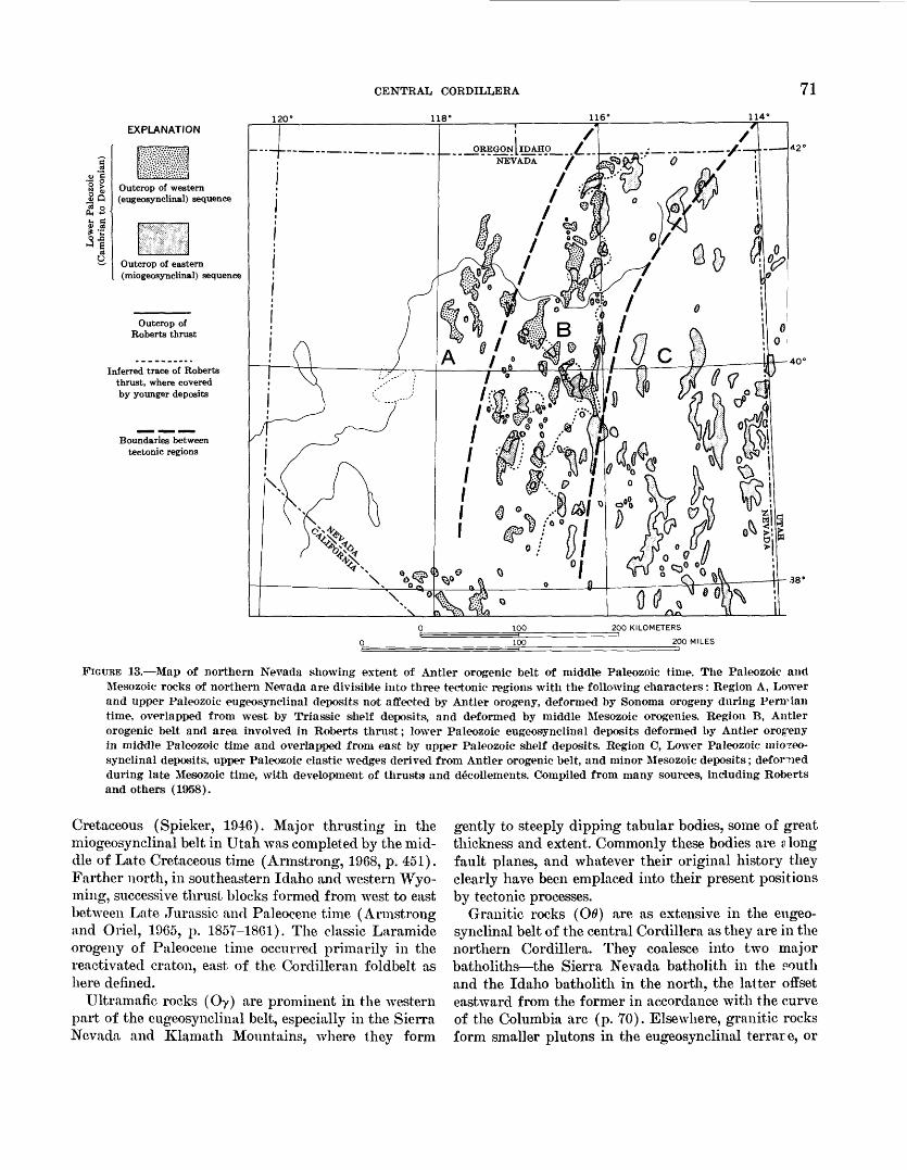
EXPLANATION120
CENTRAL CORDILLERA
118°
71116° 114°
3 § fc
Outcrop of eastern (miogeosynclinal) sequence
Outcrop of Roberts thrust
Inferred trace of Roberts thrust, where covered by younger deposits
Boundaries between tectonic regions
OREGON [lDAHO__ _ £_ _ _"" NEVADA" '/
-38°
200 KILOMETERS
200 MILES
FIGURE 13. Map of northern Nevada showing extent of Antler orogenic belt of middle Paleozoic time. The Paleozoic and Mesozoic rocks of northern Nevada are divisible into three tectonic regions with the following characters: Region A, Lower and upper Paleozoic eugeosynclinal deposits not affected by Antler orogeny, deformed by Sonoma orogeny during Peririan time, overlapped from west by Triassic shelf deposits, and deformed by middle Mesozoic orogenies. Region B, Antler orogenic belt and area involved in Roberts thrust; lower Paleozoic eugeosynclinal deposits deformed by Antler orogeny in middle Paleozoic time and overlapped from east by upper Paleozoic shelf deposits. Region C, Lower Paleozoic miOTeo- synclinal deposits, upper Paleozoic clastic wedges derived from Antler orogenic belt, and minor Mesozoic deposits; deforned during late Mesozoic time, with development of thrusts and decollements. Compiled from many sources, including Roberts and others (1958).
Cretaceous (Spieker, 1946). Major thrusting in the miogeosynclinal belt in Utah was completed by the mid dle of Late Cretaceous time (Armstrong, 1968, p. 451). Farther north, in southeastern Idaho and western Wyo ming, successive thrust blocks formed from west to east between Late Jurassic and Paleocene time (Armstrong and Oriel, 1965, p. 1857-1861). The classic Laramide orogeny of Paleocene time occurred primarily in the reactivated craton, east of the Cordilleran foldbelt as here defined.
Ultramafic rocks (Oy) are prominent in the western part of the eugeosynclinal belt, especially in the Sierra Nevada and Klamath Mountains, where they form
gently to steeply dipping tabular bodies, some of great thickness and extent. Commonly these bodies are ? long fault planes, and whatever their original history they clearly have been emplaced into their present positions by tectonic processes.
Granitic rocks (O0) are as extensive in the eugeo synclinal belt of the central Cordillera as they are in the northern Cordillera. They coalesce into two major batholiths the Sierra Nevada batholith in the routh and the Idaho batholith in the north, the latter offset eastward from the former in accordance with the curve of the Columbia arc (p. 70). Elsewhere, granitic rocks form smaller plutons in the eugeosynclinal terrare, or
72 THE TECTONICS OF NORTH AMERICA
inliers in areas of younger rocks. Both of the larger batholiths are composite, being composed of many dis crete plutons, and in the Idaho batholith including mig- matized host rocks. The granitic rocks become more silicic eastward, changing from quartz diorite to quartz monzonite and granodiorite (Moore, 1959, p. 205-206). With some exceptions, they are also younger from to west to east; all are Mesozoic, but they yield radiometric dates between 180 and 80 m.y., or from late Triassic through the Cretaceous (Kistler and others, 1965, p. 162-164). Most of those west of the Sierra Nevada bath olith are Jurassic or older, whereas most of the dated plutons in the Sierra Nevada and Idaho batholiths are of Cretaceous age. The Boulder batholith near the front of the foldbelt east of the Idaho batholith invades Late Cretaceous rocks. In the Great Basin Mesozoic plutons are mingled with smaller Tertiary intrusives (OA); the latter extend thence across the miogeosynclinal belt and into the reactivated craton east of it. The age range of the Mesozoic granitic rocks broadly coincides with the time of erogenic deformation of the eugeosynclinal rocks, but those of Cretaceous age are later than the erogenic climax; the Sierra Nevada batholith breaks into and shoulders aside eugeosynclinal rocks that had already been steeply upended and regionally metamorphosed.
During Cenozoic time, wide areas of the deformed geosynclinal rocks were covered by terrestrial volcanic rocks (Oft, Oir). The cover is largely intact through Oregon into southern Idaho, but farther south it is dismembered by block faulting and erosion. Volcanic history was prolonged; the older Tertiary volcanics are much deformed and mineralized, the more extensive middle Tertiary volcanics are block faulted, the Quater nary volcanics are merely tilted in the transverse Snake River downwarp. The varied compositions and origins of the volcanic rocks cannot readily be indicated on the tectonic map, and are therefore not differentiated in the generalized units adopted. Basaltic and andesitic vol canics are prominent to the north and west, but silicic volcanics cover large parts of the southern Great Basin, and include widely spread sheets of ignimbrite; where known, the calderas from which they were erupted are shown by smbols on the map.
During Cenozoic time also, large parts of the central Cordillera were disrupted by block faulting, caused by crustal distention. Block faulting has occurred in other foldbelts of the world late in the tectonic cycle, but its magnitude here is without parallel. Block faulting and volcanism partly coincide in time, but the faulting con tinued later; major faulting occurred during the early Pleistocene, and minor faulting continues today in places. In the Great Basin, the previously deformed ter-
rane was split longitudinally into broad to narrow blocks, whose displacement produced the present topog raphy of disconnected ranges and intervening basins; larger, longer fault blocks along the edge of tho Colo rado Plateau to the east and the Sierra Nevada to the west are more coherent manifestations of the same struc ture. The block faulting is a mountain-creating process, hence one of the few deformationa] events in the Cordil lera to which the term "orogeny" can be applied in the narrow sense of Gilbert; in the broader sense of the term the block faulting is more properly postorogenic.
The faults at the edges of the mountain blocks are shown by normal fault symbols on the tectonic map, so far as they are known. Some of the known faults can be observed directly, the existence of others is proved by the even baselines of the mountains and the steep escarp ments behind them. Other mountains may also have been fault blocks, but they were uplifted so long ago that the fault scarps have been destroyed by erosion, and the positions of the faults themselves are lost. The down- faulted blocks, or basins between the ranges, have been filled by debris eroded from the upfaulted areas, shown on the map as "thick deposits in structurally negative areas" (O12). Coarse fanglomerates were deposited near the edges of the basins and fine sands and silts near the centers, the whole accumulation of deposits attain ing thicknesses of 3,000 m (10,000 ft) or more. On the tectonic map the distribution of these debris-filled basins suggests the pattern of latest deformation in tl v<^ cen tral Cordillera, even where faulting is not apparent.
SOUTHERN CORDILLERA
The southern Cordillera is separated from tH cen tral Cordillera by the so-called Texas Lineament (Albritton and Smith, 1957; King, 1965, p. 118), a trans verse zone that extends east-southeast from the Trans verse Ranges of coastal California, south of the Colorado Plateau and a little north of the United States-Mexican boundary, into western Texas. The zone is a strip oi country as much as 160 km (100 miles) wide that sepa rates two parts of the Cordillera with different topog raphies, geologic histories, and styles of deformation. South of the zone the Cordilleran foidbelt exterds 800 km (500 miles) farther east than on the north side, and for long distances its deformed rocks closely adjoin little deformed rocks in the Colorado Plateau and the block mountains of New Mexico, which are reactivated or disrupted parts of the former craton. These contrasts have not been produced by transverse faulting, a nd the Texas Lineament is not a through-going fault zone, as has sometimes been assumed. It is true that the Trans verse Ranges on the west contain eastward-trending high-angle faults, some with left-lateral displacement,

SOUTHERN CORDILLERA 73
but there are few faults parallel to the zone farther east, although it contains many faults trending in other di rections (as elsewhere in the Cordillera).
The southern Cordillera includes all of Mexico except the Gulf Coastal Plain on the east, an area of platform deposits (C), and the parts of Baja California on the west which belong to the Pacific foldbelt (P). From southeastern Mexico it extends eastward into northern Central America, where it forms much of Guatemala, Belize, and Honduras. Except in the extreme south (see p. 74), most of the surface of the southern Cordillera is formed of Mesozoic and Cenozoic rocks, and older rocks emerge only as small inliers in the higher folds and fault blocks, so that the pre-Mesozoic structural pattern is largely undetermined or speculative. Very likely the Mesozoic and Cenozoic rocks and structures are superposed on a very different set of Paleozoic and older geosynclines and foldbelts, along with their fore lands and backlands.
In the far northwest, in the Altar district of Sonora, are incomplete exposures of a geosynclinal sequence, very much like that in the Great Basin of the central Cordillera (O9), consisting of carbonate rocks that in clude Lower Cambrian and the higher Paleozoic sys tems, topped by Triassic and Jurassic marine shales; beneath are Upper Proterozoic supracrustal rocks like those in the Great Basin (O4), which rest on a crystal line (Hudsonian) basement (O2) (Cooper and Arel- lano, 1946; Damon and others, 1962). The relations of this geosynclinal sequence to rocks of surrounding areas in Mexico is unknown, and it is separated from its analogue in the Great Basin to the northwest by 650 km (400 miles), in which no trace of it is preserved.
Farther east, the front of the foldbelt of the southern Cordillera overwhelms the Ouachita foldbelt (M), whose characteristic rocks and structures are exposed in the Marathon dome and some other areas in western Texas. In northeastern Mexico the Coahuila peninsula notably distorts the Cordilleran folds, and is a massif that was evidently consolidated during the Ouachita orogeny. Inliers of Paleozoic and Precambrian rocks occur, both near the Coahuila peninsula and farther south along the Sierra Madre Oriental, but are too frag' mentary to afford much of an idea of the true pre-Meso zoic structural patterns. The continuation of the Oua chita foldbelt (or Huastecan belt) within the southern Cordillera remains speculative. Some geologists (for example de Cserna, 1960, p. 598-601) have proposed that the late Paleozoic foldbelt follows the younger Cordil leran structures southeastward through Mexico into Central America.
Much of the southern Cordillera is a Mesozoic and younger feature. Its miogeosynclinal belt includes the
present Sierra Madre Oriental, the Mesa Central on the west, part of the Sierra Madre del Sur on the south, and its extension into Central America. The miogeosynclinal rocks are dominantly later Mesozoic (mapped as O9, like the more heterogeneous miogeosynclinal deposits in Sonora). Jurassic and Lower Cretaceous carbonate rocks form most of the ranges, and are succeeded by Upper Cretaceous marine clastic wedge deposits. P«v- neath the carbonates are earlier Jurassic and Triarsic red elastics, which include evaporites in some places r.nd volcanics in others. In the interior ranges of central md southern Mexico the deformed Mesozoic miogeosyncli nal rocks are overlain by thick accumulations of synoro- genic and postorogenic coarse continental deposits of Eocene and younger age, the so-called red conglonr^r- ates (O10) (Fries, 1960, p. 91-101). In other ranges, fronting the Gulf Coastal Plain, marine lower Tertiary deposits, including Oligocene and even younger a#es, are folded with the earlier rocks. Deformation of the miogeosynclinal belt of the southern Cordillera was thus primarily Late Cretaceous and early Tertiary, or broadly contemporaneous with the Laramide orogeny of the central Cordillera.
Deformation of the miogeosynclinal rocks produ?-ed a fine display of folds (Alvarez, 1949, p. 1330-13? 3), some long and closely crowded, others shorter and dis continuous; these are accompanied by few low-an^le thrusts. The closely crowded folds formed over a decol- lement in the weak layers of the lower part of the Mesozoic sequence, especially where evaporites are inter- bedded ; the more open folds involve the basement, wHch emerges in the cores of the uplifts. South of the 22d parallel the deformed miogeosynclinal rocks front the little disturbed rocks of the Gulf Coastal Plain ir an abrupt mountain face, but farther north domical uplifts stand in front (shown by structure contours in the coastal plain rocks on the tectonic map) the Sienr. de Tamaulipas, the Sierra de San Carlos, the Sierranias del Burro, and the Marathon dome in Texas. The rrain bundle of folds is strongly deflected westward near the 25th parallel around the south end of the Coahuila pen insula, producing a prominent salient near Monterrey, Nuevo Leon. A lesser branch of the foldbelt, with or>en folds, extends northwest from Monterrey to the Big Bend of the Rio Grande (Weidie and Murray, 1967, p. 689). South of the 20th parallel the frontal folds b^.nd eastward from Chipas into Guatamala and Belize, vdth a south-projecting recess in midcourse.
The Mesozoic miogeosynclinal rocks of the Mesa Cen tral in Mexico pass westward beneath little deformed Tertiary volcanics (Oft), including extensive sheets of ignimbrite, which form the broad dissected plateau0 of the Sierra Madre Occidental. Relations between the prer
74 THE TECTONICS OF NORTH AMERICA
volcanic external and internal zones of the foldbelt are thus largely concealed, and eugeosynclinal rocks are poorly known on the mainland. Metamorphic rocks of uncertain age (mapped as O6a) are exposed west of the volcanic plateau in Sinaloa. The prevolcanic rocks on the south coast of Mexico west of the 102d meridian (mapped as Ol and O9) are now known to include Meso- zoic eugeosynclinal slates and volcanics and embedded ultramafic rocks (Zoltan de Cserna, written commun., 1968). The main occurrence of eugeosynclinal rocks is in Baja California, where they and their granitic plu- tons (O7, O7a, O0) form the backbone of the northern half of the peninsula and its southern tip. In the north they are submarine lavas, pyroclastics, and volcanic sediments, steeply upended and partly metamorphosed; they are known to include strata of Jurassic and Lower Cretaceous (Aptian) age, and may include older com ponents (Allison, 1964, p. 12-15). Both the eugeosyn clinal rocks and the plutons are overlain by nearly undeformed latest Cretaceous (Campanian) sediments (OlO), indicating that the erogenic climax in the south ern Cordillera was later than the classic Nevadan orog eny of analogous parts of the central Cordillera.
In the Sierra Madre del Sur of southern Mexico, and eastward into northern Central America, pre-Mesozoic rocks and structures are more widely exposed than else where in the southern Cordillera. A sequence of Penn- sylvanian and Permian carbonate rocks and their basal elastics extends from Chiapas across Guatemala into Belize; it was deformed by variable but undetermined amounts before the Mesozoic miogeosynclinal deposits were laid over it, hence is shown on the tectonic map as a lower "structural stage" (older miogeosynclinal de posits, O8). A much greater part of the pre-Mesozoic of this region is a metamorphic complex (Ol), varying from paraschist with interbedded marble and amphibo- lite to highly migmatized gneisses (McBirney, 1963, p. 187-197; de Cserna, 1965, p. 15-19). It contains em bedded granitic plutons that have yielded radiometric dates from 300-90 m.y., or from middle Paleozoic to late Mesozoic age (Oe, O0), thus indicating (as in the meta morphic complexes of the northern Cordillera) pro longed heating and plutonic activity. The complex itself is probably of heterogeneous ages. Much of it in Oaxaca is Precambrian, as it has yielded radiometric dates be tween 700-1,100 m.y. and is overlain unconformably by Cambrian strata (Fries and others, 1962, p. 45-52; Fries and Rincon-Orta, 1965, p. 81-87; Pantoja-Alor and Robison, 1967). In Guatemala and Belize the complex is unconformable below the upper Paleozoic strata, but may include earlier Paleozoic (Dixon, 1956, p. 13-17), whereas in southern Guatemala and Honduras it may
include equivalents of the upper Paleozoic itself (Williams and others, 1964, p. 2-5).
The topographic Sierra Madre del Sur of southern Mexico trends east-southeast parallel with the Pacific Coast and the Middle America Trench immediately off shore, but the structures of both its miogeosyi^.linal Mesozoic rocks and its metamorphic complex extend southeastward across it to the coast, where they are remarkably truncated. In Guatemala and Belize the structures are alined more toward the east, ard are traversed by a bundle of closely spaced high-angle faults with the same trend. The high-angle faults extend east ward into the faults that bound the Cayman Trench on the floor of the Caribbean Sea; their westward extension toward the Pacific is concealed. They enclose slices of diverse and contrasting rocks Paleozoic, Mesozoic, and Tertiary sediments, metamorphic complex, granitic rocks, and ultramafic rocks (the latter possibly up^hrust mantle material). To the compiler, this set of faults has every indication of being a zone of major strike-slip dis placement, yet little tangible field evidence for such displacement has been reported (Walper, 1960, p. 1312- 1313; McBirney, 1963, p. 212-213).
Immediately north of the Sierra Madre del Sur the transverse Mexican volcanic belt (On ) extends from the Pacific to the Gulf of Mexico, and contains a dozen lofty volcanic cones (including Pico de Orizaba or Citlal tepetl, 5,698 m or 18,696 ft) and a host of lesser cones and craters, some still vigorously active. It originated late in Cenozoic time and no doubt follows a deep-seated line of weakness, but it is accompanied by little surface rupture and it does not perceptibly deflect the structures of the miogeosynclinal rocks that plunge beneath it. from either side.
(F) PACIFIC FOLDBELT
Cenozoic erogenic activity is especially pronounced in that part of the Cordilleran Mountain System ne^.r the Pacific Coast, and on the tectonic map it is appropriate to separate this part from the main Cordilleran foldbelt (O) as a rather vaguely defined Pacific foldbelt (P). A similar distinction has been made in the Asiatic ectuiva- lent of the North American Cordillera, where Soviet geologists separate a "region of Cenozoic foHing" (sometimes called "Kamchatkan") from a "region of Mesozoic folding" farther inland. The Pacific foMbelt is characterized by late erogenic, volcanic, and seismic activity, by Cenozoic rocks and structures, and by a base ment of eugeosynclinal rocks that are younger than those of the main Cordillera. The Pacific foldbelt was a late accretion to the edge of the North American conti nent, and part or all of it may have formed on what was originally oceanic crust.
WASHINGTON AND OREGON 75
On the "Tectonic Map of North America" the Pacific foldbelt is shown as including the Aleutian Islands, the coastal mountains of southern Alaska, the Coast Ranges of Washington, Oregon, and California, part of the volcanic province of Washington and Oregon, and part of Baja California. Its boundary with the Cordilleran foldbelt is well defined in places, but indefinite in others, where it has been necessary to overlap the units distinc tive of the two foldbelts. Thus, granitic rocks of the Cordilleran foldbelt (O0) are shown in the California Coast Ranges, and plateau basalt of the Pacific foldbelt (Py) is shown in the interior of British Columbia.
ALASKA
The characteristic rocks and structures of the internal part of the Cordilleran foldbelt extend westward across southern Alaska, south of the Alaska Range and into the Alaska Peninsula Mesozoic eugeosynclinal rocks (O7) with their embedded granitic plutons (O0), and younger Mesozoic and Tertiary successor basin deposits (OlO, Oil). Between them and the coast, in the Chugach Mountains, Kenai Peninsula, and Kodiak Island, are younger eugeosynclinal deposits a vast sequence of steeply upended and partly metamorphosed gray- wackes, containing granitic debris from the middle Mesozoic plutons farther inland, but themselves in truded by small plutons of Tertiary age (P/3) (Miller, 1959, p. 20-21). Sparse fossils indicate that the greater part of this sequence is of Cretaceous age (PI), but it is overlain near Prince William Sound by similar deposits of Paleocene age (P2). The same sequence extends southwestward beneath the continental shelf off the Alaska Peninsula, where it reappears in the Shumagin Islands (Burk, 1965, p. 63-71). The base of the Cre taceous eugeosynclinal deposits is undetermined, and they may have been laid down off the edge of the orig inal Cordilleran foldbelt, at oceanic depths at the foot of the continental slope. Overlying the eugeosynclinal deposits in their eastern segment is 7,600 m (25,000 ft) of younger Tertiary shallow water marine deposits (P4).
Northwest of the Cretaceous-Pa leocene eugeosyncli nal belt is the younger Aleutian volcanic arc (Coats, 1962), which extends 960 km (600 miles) through the Alaska Peninsula, ending northeastward at Mount Spurr in the Alaska Range. West of the peninsula, the arc runs out to sea for another 1,600 km (1,000 miles) through the Aleutian Islands; the islands surmount a submarine ridge between the deep Aleutian Trench on the south and the shallower Bering Sea on the north; the ridge continues westward through the Kommandorsky Islands to the coast of Kamchatka. The basement of the Alaska Peninsula is formed of Mesozoic and older rocks
of the Cordilleran foldbelt, and is succeeded by Tertiary volcanics and volcanic-derived sediments (PS, P4), which are surmounted by young andesitic volcanic cor0® (Pe), some still vigorously active (Burk, 1965, p. 119- 122). Very little of the pre-Tertiary basement (PI) emerges in the Aleutian Islands, and they are mostly formed of Tertiary and younger volcanics, the young andesitic cones lying on the northern side of the arc, away from the Aleutian Trench.
WASHINGTON AND OREGON
The northwestern States of Oregon and Washington differ both in geology and tectonic style from nearby parts of the Cordilleran region, for here Cenozoic vol canic rocks and structures dominate the scene nearly to the exclusion of all others (Waters, 1955, p. V04-71S; Snavely and Wagner, 1963) lava plateaus, volcanic cones, and eruptive ranges that were produced by up building, and folded or block-faulted ranges that were produced by deformation of the volcanic materials. Cen ozoic volcanic rocks, and the sediments associated with them, extend along the Pacific Coast for 480 km ("% miles) and extend inland for as much as 650 km (4-00 miles). Within the volcanic areas pre-Cenozoic rocks emerge only as occasional inliers, although they form most of its periphery.
The pre-Cenozoic rocks of the Inliers and of the pe riphery of the volcanic area belong to the eugeosynclinal part of the Cordilleran foldbelt, whose structures are recessed eastward in the Columbia arc (see p. 70); the crust within the recess probably differs from that of the Cordilleran foldbelt, and may have been oceanic during its early history. On the site of the present Co^-st Ranges within the recess, eugeosynclinal deposits (P2) were laid down during Eocene time, and are interbedded with large volumes of submarine pillow basalt (P£a). During Miocene time the eastern part of the recess v^as covered by great floods of plateau basalt of the Columbia River Group (Py), and at about the same time andesitic lavas and pyroclastics (PS) accumulated along the site of the Cascade Range to the west. Building of the Cas cade Range continued into late Tertiary and Quater nary time, when a chain of volcanoes (Pe) grew along its north-south axis. During Tertiary time, small mafic to silicic plutons (P/?) were intruded in the volcanic rocks of the Cascade Range.
The structure of the volcanic area was produced by a combination of volcanic construction and of moderate deformation during Cenozoic time. The Coast Ranges on the west are an anticlinorium, openly folded except in the steeply upthrust Olympic Mountains at the north end. Between them and the Cascade Range to the east is a belt of downwarping expressed as a chain of
76 THE TECTONICS OF NORTH AMERICA
lowlands extending from Puget Sound southward to the Willamette Valley, whose deeper parts are thickly covered by late Tertiary and Quaternary deposits (P5). The plateau basalts within the recess of the Columbia arc form a broad structural basin, little deformed in places, but in others crossed by anticlinal folds.
CALIFORNIA AND BAJA CALIFORNIA
The Coast Ranges of California extend south-south eastward along the Pacific Coast for 925 km (575 miles) from Cape Mendocino past San Francisco Bay to Point Conception, and are separated by the Great Valley from the Cordilleran foldbelt in the Sierra Nevada to the east. South of Los Angeles, the Peninsular Ranges extend south-southeastward into Baja California. In the intervening area are the eastward-trending Trans verse Ranges. Cenozoic strata (P4), largely of marine origin, are thick and extensive in the Coast Ranges south of San Francisco Bay, as well as in parts of the Transverse Ranges and adjacent basins, and have un dergone several periods of erogenic deformation.
In the coastal belt of California great thicknesses of clastic rocks accumulated from latest Jurassic through Cretaceous time, or mainly after the climax of the Ne- vadan orogeny in the Cordilleran foldbelt. To the east these rocks are fossiliferous shelf deposits (P3), but to the west they are a. contemporaneous sequence of poorly fossiliferous eugeosynclinal deposits (Pi) the graywackes, shales, cherts, and pillow basalts of the Franciscan Formation and its kindred (Bailey and others, 1964). The Jurassic and Cretaceous shelf depos its are thrust to the west over the Franciscan deposits, and no transitional phases between them are known (Page, 1966, p. 268-272). The Franciscan deposits were probably laid down at oceanic depths at the foot of the continental slope, in a manner similar to the Cretaceous and Paleocene eugeosynclinal deposits along the south coast of Alaska.
Rocks similar to the Franciscan Formation probably extend southward along the continental shelf west of the Peninsular Ranges as far as southern Baja Cali fornia, as they emerge in many of the offshore islands and coastal promontories of the peninsula, such as Cata- lina Island in the north and Sebastian Vizcaino Penin sula farther south (Allison, 1964, p. 14-15). Here, in contrast to farther north, they appear to be of about the same age as the eugeosynclinal rocks of the Cordil leran foldbelt to the east (O7), rather than younger as in California. Their sedimentary facies is decidedly different, and they contain no granitic plutons.
In other parts of the coastal mountains of California a basement of crystalline rocks emerges, not only in the Peninsular and Transverse Ranges, but also in a long
strip of the Coast Ranges that extends northward past San Francisco Bay. The basement of the Transverse Ranges includes Precambrian plutonic rocks ancf Paleo zoic metamorphic rocks (Oa, O/?, O6a). In the Coast Ranges to the north are extensive granitic rocks (O0) and metamorphic rocks of probable early Paleozoic age (O6a); the granitic rocks have yielded radiometric dates of 80-90 m.y., hence are Cretaceous and are as young or younger than the Franciscan Formation, but they and the metamorphic rocks are everywhere faulted against the Franciscan, so that the original relations between them are unknown.
The Cenozoic strata of the Coast Ranges and Trans verse Ranges have been described in many publications (Reed and Hollister, 1936, p. 1559-1596; Taliaferro, 1943, p. 135-149; Page, 1966, p. 263-268). On the tec tonic map they are shown as a single unit (P4), al though their record is so complex that they could be divided into a number of "structural stages" or a map of larger scale. Deposits of Miocene and earlier ages are extensive and mainly marine, but most cf them grade eastward into continental equivalents. Pliocene marine deposits occur in more restricted coastal areas, such as the Los Angeles and Ventura basins, and in the southern part of the Great Valley. Marine Pliocene strata attain thickness of 4,500 m (15,000 ft) in some of the coastal areas, and nonmarine Pliocene in the interior basins is even thicker. In the coastal areas the marine Pliocene is succeeded conformably by thick lower Pleis tocene marine and brackish water deposits, which are strongly unconformable beneath upper Pleistocene marine terrace deposits and alluvium.
The Cenozoic sequence of the Coast Ranges and Transverse Ranges records an eventful tectonic history, with times of deformation indicated at so many levels and with such varying magnitude from place to place that they are difficult to generalize into any erogenic climaxes. Nevertheless, a group of deformations during middle and late Miocene time appears to have been im portant, to have deformed the earlier Cenozoic strata widely, and to have restricted the areas of subsequent sedimentation. A final climax of deformation occurred during Quaternary time, mainly during the gap be tween the lower and upper Pleistocene deposits (Stille, 1936, p. 867-868; Bailey, 1943, p. 1562-1564).
The sequence of Tertiary marine deposits along the western side of Baja California is nearly as complete as in California (Allison, 1964, p. 16-19), but neitHr they nor the late Cretaceous deposits beneath them hr.ve been as much deformed as farther north. In the southern half of the peninsula the upper Tertiary marir^ depo sits pass eastward into a thick mass of terrestrial vol- canics, pyroclastics, and volcanic sediments (Comondu
CALIFORNIA AND BAJA CALIFORNIA 77
Formation, P8) a mass which is broken off on the east by escarpments that face the Gulf of California.
The structure of the Coast Kanges, Tranverse Ranges, and northern ( Peninsular Ranges is confused by a multitude of faults. The widespread westward thrusting of Jurassic and Cretaceous shelf deposits over the Franciscan Formation has already been mentioned. Much more prominent and generally younger are the high-angle faults, many of which are of great length and have dominant components of strike-slip displace ment (Crowell, 1962). The high-angle faults cross the grain of the ranges at an acute angle, mostly in a north westward direction, but with a conspicuous east-trend ing set in the Tran§verse Ranges. Strike-slip displace ment on the northwest-trending set is dominantly right lateral and on the east-trending set dominantly left lateral. The most lengthy high-angle fault is the San Andreas, which crosses all the coastal ranges from northern California to the United States-Mexican bor der with a nearly straight southeastward course, except for an eastward deflection in the Transverse Ranges.
Nearly every aspect of the high-angle faults of the coastal ranges has been diversely interpreted the time of their inception, the magnitude and kind of their movements, and their role in the geologic history of the region (Hill and Dibblee, 1953; Oakeshott, 1966; Dibblee, 1966). The San Andreas fault has been vari ously estimated to have originated in early Cenozoic time or before and to have been displaced laterally as much as 560 km (350 miles), or to have originated dur ing the Quaternary and to have been displaced less than 2 km (1 mile). In view of the marked contrasts between the rocks on the opposite sides of the San Andreas and most of the other high-angle faults, larger rather than smaller displacements seem likely; such movements probably account for the anomalous juxtaposition of the Franciscan basement against the crystalline basement in the Coast Ranges.
Along the San Andreas fault and many of the others are overwhelming indications of marked displacement during Quaternary time, and of continuing activity to day. Modern activity is attested by the clustering of earthquake epicenters along the faults and by ground breakage along the faults at the times of earthquakes. Fault movements during the last few thousand years are indicated by characteristic landforms along the fault traces fault trenches or rifts, pressure ridges, and sag ponds. Even more striking is the distortion of modern topography along the faults by offset of ridges and stream channels; stream channels crossing the San Andreas fault have been offset right laterally 100-1,500 m (325^,500 ft). The record of displacement along the San Andreas and other high-angle faults indicates that
movements were progressive, so that each topographic feature and each bedrock formation is more offset the greater its age.
The peninsula of Baja California, with eugeosyn- clinal rocks and granitic plutons in its basement, is .a long sliver of continental crust, separated from the Mexican mainland by the deep water of the Gulf of California. The northern half of the gulf is thickly fille.d with sediments, but the southern half is floored by oceanic crust; the gulf is evidently a rift, across which the peninsula drifted northwestward from the continent during Cenozoic time (Rusnak and others, 1964, pp. 68-74). The faults which were formed during the drifting do not, however, extend directly down the gulf, and are not direct extensions of the high-angle faults of California. The latter trend southeastward into Mexico, each dying out on the Sonoran mainland. They are succeeded farther south by other faults, plainly indicated by the bathymetry of the gulf floc^, which also trend southeastward, with an en echelon pattern. The northwestward drift of Baja California and the strike-slip displacement of the high-angle faults of California are not independent phenomena, but are parts of a single grand movement of the western coastal urea of North America (Hamilton, 1961).
(Q) ANTILLEAN FOLDBELT
Another region of pronounced Cenozoic erogenic activity, here called the Antillean foldbelt (Q), lies be tween North and South America in the lands and islands surrounding the Caribbean Sea. On the tectonic m?.p the foldbelt is shown as including the islands of the Greater and Lesser Antilles, and the mainland are^s of coastal Venezuela and southern Central America. Southern Central America is included for convenience, but with equal propriety it could be classed as a southern prolongation of the Pacific foldbelt.
The Antillean foldbelt differs from those of NorMi and South America, as it is an oceanic rather than a continental feature. Much of it is far from any larjre continental areas, and most of the emerged parts ri^e steeply from oceanic depths, making it one of the mcst rugged mountain systems of the Americas. The Puerto Rico Trench is 8,000 m (26,000 ft) deep 130 km (80 miles) north of the coast of Puerto Rico; the Caymr.n Trench is 7,000 m (23,000 ft) deep 40 km (25 miles) south of the coast of Cuba, and the Sierra Maestra ris^s another 2,000 m (6,500 ft) behind the coast. Peaks in the central cordilleras of Hispaniola and Costa Ri?.a project above 3,000 m (10,000 ft), but the other lard areas in the foldbelt are lower. As shown by the bathym etry on the tectonic map, the Caribbean sea floor is itself diversified by basins and trenches, with ridges ard swells between, many of which do not project above

78 THE TECTONICS OF NORTH AMERICA
sea level, and whose structure is largely conjectural. The land areas thus constitute only a fragment of the tectonics of the whole foldbelt, the remainder of which must be deduced from data obtained during oceano- graphic surveys.
Because of the fragmentary evidence, the origin and the tectonic history of the Antillean foldbelt are less certain than those of any of the foldbelts so far con sidered, and have been diversely interpreted. Many of the early hypotheses required extensive continental areas in the Caribbean region, which have now van ished by foundering or other causes. It is true that the crust of the Caribbean sea floor is somewhat thicker and less dense than normal oceanic crust, but it is by no means continental (Donnelly, 1964, p. 683-684); it was probably produced by hydration of normal oceanic crust, rather than by "oceanization" of continental crust. The tectogene hypothesis, which was at one time applied to the Antillean foldbelt (Hess, 1938) is discred ited by newer geophysical data; as originally proposed, it involved downbuckling of a thicker and more sialic crust than is now known to exist.
Perhaps the Caribbean Sea was produced by the drift ing apart of the North and South American continents, but most of the proposed reconstructions of drifting in the region involve implausible shifting, and even com plete rotation of bits of continental crust to produce the present pattern of lands and islands. Other, more plausible reconstructions of the Caribbean by the drift hypothesis might be possible, but they are still in the formative stage. Hess writes (1966, p. 5), "It can be stated without question that the Caribbean existed dur ing the whole of the Tertiary more or less with its pres ent outlines, but how long before that was there a Carib bean?" Present evidence seems to indicate that, what ever may have been the origin and early nature of the Caribbean, the present lands and islands of the Antil lean foldbelt were built up during Mesozoic and Ceno- zoic time on an original oceanic crust, by the addition of magmas from the mantle, followed by a complex tec tonic evolution into the modern foldbelt (Dengo, 1962, p. 156-157; Donnelly, 1964, p. 689-695; Bowin, 1966, p. 15-17).
This tectonic evolution is most nearly completed in the large, massive islands of the Greater Antilles on the north and in the coastal area of Venezuela and Trinidad on the south, both of which underwent erogenic defor mation during late Mesozoic and early Cenozoic time, and have now attained relative stability. It is less com plete in Central America on the west, which is bordered on the Pacific side by a chain of active volcanoes and by the Middle America Trench (Dengo, 1967). Even less mature are the small islands of the Lesser Antilles on the
east, which are mainly volcanic and rise individually out of deep water, with a trench extending at least part of the way around their Atlantic side.
Another item must be added to complete the tectonic picture the great fault zones on each side of tH Carib bean Sea, extending through Venezuela and rrinidad on the south and the Greater Antilles on the ncrth. The Cordillera de la Costa in Venezuela and the North Eange in Trinidad are a line of narrow ridges a long the sea, composed of metamorphosed Mesozoic roclrs (Q2a) unlike the unmetamorphosed Mesozoic rocks south of them. They have reached their present position Vj right- lateral displacement along a fault zone on the south side of the ridges (Rod, 1956, p. 474-476).
On the northern side of the Caribbean Sea the Cay man Trench extends diagonally through the Greater Antilles between Cuba and Jamaica, with steep inf acing scarps on each side (Meyerhoff, 1962, p. 1-3). Farther east, and not in direct alinement, the Anegada Passage forms another, smaller trench between the Greater and Lesser Antilles. Both these features are certainly fault bounded, and at least some left-lateral displacement has occurred along them (or displacements opposite to those in Venezuela and Trinidad), but there are complica tions. The Cayman Trench is floored by an oceanic crust, much thinner than that beneath the islands and sub marine rises on either side, suggesting that th? trench is a rift, perhaps comparable to the rift in the Gulf of California, mentioned above (Ewing and others, 1960, p. 4095-4096). Whatever the nature of the fault move ments north and south of the Caribbean Sea, they de tached the more mature parts of the foldbelt from the unstable parts between, where tectonic evolution is still in progress.
No pre-Mesozoic tectonic units have been proved in the Antillean foldbelt, and their existence is doubtful in most of it. The last exposure of the pre-Mesozoic is in northern Central America where its metr.morphic complex (Ol) plunges southward beneath Tertiary vol- canics (Q8) near the Honduras-Nicaragua border, and it is cut off eastward by the Caribbean coast. Farther south in Central America the basement is th? Nicoya Complex (Q2), resembling the Franciscan of the Pa cific foldbelt, and like it probably no older than Meso zoic (Dengo, 1962, p. 138-142). The pre-Mesozoic meta- morphic complex seems to extend east of the coast be neath the Nicaraguan Rise and Cayman Ridge, but whether it emerges again in the Greater Antilles is un determined. The basement of the Greater Antilles is also termed a metamorphic complex (Ql), but this is known only to be older than Late Jurassic. Most of if", is prob ably older Mesozoic eugeosynclinal material, although
CALIFORNIA AND BAJA CALIFORNIA
pre-Mesozoic components have been proposed in Cuba (Khudoley, 1967, p. 672-674; Hatten, 1967, p. 780-782).
Mesozoic eugeosynclinal deposits (Q2), with large volumes of volcanics and volcanic-derived sediments, oc cur in all areas of the Antillean foldbelt. In southern Central America they are overlain by nonvolcanic Up per Cretaceous deposits (Q3), but in the Greater Antil les the eugeosynclinal sequence extends in most places to the top of the Mesozoic, and in southeastern Cuba into the Eocene (Q4a). In the Cordillera de la Costa of Venezuela, where all the eugeosynclinal rocks are region ally metamorphtosed (Q2a), the largely nonvolcanic Ca racas Group is bordered on the south by the structurally separated but probably older volcanics of the Villa de Cura Group. Mesozoic miogeosynclinal deposits, includ ing thick carbonates, border the eugeosynclinal rocks on the north in Cuba (Q4), and on the south in Venezuela (N3), and are continuous with the platform deposits of the Bahama Islands and the Venezuelan interior. Suc ceeding older Tertiary deposits (Q4) are varied, largely clastic in many areas, but including volcanic components in southern Central America and thick carbonate units in parts of the Greater Antilles.
A significant Middle Cretaceous orogeny occurred in Cuba, but throughout much of the foldbelt the main orogenies occurred from Late Cretaceous through Eo cene time. They were accompanied by emplacement of granitic plutons (Q/?) of middle Cretaceous to Eocene age, largely more mafic than those of the other f oldbelts (diorites and quartz diorites). In Cuba the eugeosyn clinal rocks were carried northward over the miogeo synclinal rocks in great thrust sheets or nappes of Al pine type (Hatten, 1967, p. 785-788), many of which have tabular masses of ultramafic rocks (Qa) along their soles.
In the more mature parts of the foldbelt, deformation was largely completed by Eocene or Oligocene time, so that the later Tertiary is postorogenic and little de formed (Q5). Deformation continued later in Hispani- ola, and there was significant Miocene orogeny in Costa Kica, accompanied by emplacement of small granitic plutons in the central Cordillera (Qy) (Dengo, 1962, p. 143-147).
Young volcanic rocks are lacking in the more mature parts of the foldbelt, but they are important in the less stable intervening parts. Large areas in southern Cen tral America are covered by late Tertiary lavas and pyroclastics, probably derived from fissure eruptions (Q8). On these, on the Pacific side, younger volcanics (Q«) have been built, surmounted by a chain of vol canic cones that extends from the eastern border of Mexico to Costa Kica (Williams, 1952,1960). An arcuate chain of volcanic cones also forms most of the islands
of the Lesser Antilles to the east, but in the northern half of the arc the cones are bordered on the Atlantic side by half a dozen lower islands with a foundation of older Tertiary volcanics and diorite plutons, capped l^y later Tertiary limestones and other sediments (Q4).
(N) ANDEAN FOLDBELT
Many features like those in the North American Cc iw- dillera are repeated in the South American Cordillera, or Andean foldbelt (N). Most of the Andean foldbelt is outside the area of the "Tectonic Map of North Amc * - ica," but its northern prongs extend into it, in Colombia and Venezuela. The tectonic features of the Andean foldbelt are shown on the map down to the 6th parallel, mainly to provide a southern frame for the Caribbean Sea and its Antillean foldbelt (Q). The structures rep resented are copied from compiled maps, such as the "Geologic-Tectonic Map of Northern Venezueb" (Smith, 1962), and publications on the foldbelt have been studied only sufficiently to establish usable map units (see, for example, Jacobs and others, 196^; Mencher, 1963). The tectonics of the foldbelt and its map units will be shown more authoritatively on the "Tectonic Map of South America," which is now in preparation by geologists of the South American countries.
In Colombia, the Andes Mountains split northward into a Cordillera Occidental, a Cordillera Central, and a Cordillera Oriental. The first two plunge northward beneath the lowlands of the Rio Magdalena and its tributaries, but the third extends northeastward into Venezuela, bifurcating in turn into the Sierra de Perija and the Cordillera de Merida, which enclose the Mar*- caibo Basin. The Sierra Nevada de Santa Marta along the Caribbean coast in Colombia is an independent massif. The various cordilleras and sierras are composed of Mesozoic and older rocks, and the lowlands between them are underlain by Cenozoic rocks.
Pre-Mesozoic rocks, largely metamorphosed (Fl, Na), form much of the Cordillera Central and Sierra Nevada de Santa Marta, and emerge in smaller inliers in the Cordillera Oriental and Cordillera de Merida. Th^.y include fossiliferous rocks of various Paleozoic agos, and probably also Precambrian rocks; the pre-Mesozc^c basement of the Cordillera Oriental includes reworked parts of the edge of the Precambrian Guyana Shield. Orogenies at various times during the Paleozoic are suggested in places by unconformities or gaps in tV sequence, but they are too imperfectly known to gi^e much of an idea of the resulting structures. Embedded in the metamorphic rocks are granitic plutons (N/P), primarily Mesozoic but possibly including Paleozo; <*.. Kecent radiometric determinations in Colombia shew
80 THE TECTONICS OF NORTH AMERICA
that they are dominantly Mesozoic, the large pluton in the Sierra Nevada de Santa Marta is dated at 160-170 m.y. (Jurassic) and the large pluton near Medellin in the Cordillera Central is dated at 70 m.y. (Late Cretaceous).
Tectonic history becomes plainer in the Mesozoic. The Cordillera Occidental and the lower ranges along the Pacific coast are formed of Mesozoic eugeosynclinal de posits (N2) submarine lavas and associated sediments that are largely of Cretaceous age, but which may also include Jurassic. The Cordillera Oriental and its exten sions into Venezuela is formed of Mesozoic miogeosyn- clinal deposits (N3), including thick sequences of Cretaceous carbonates. Beneath them, however, are continental red elastics (Giron Group), which are largely of Jurassic age.
The Andean Cordilleras were deformed and shaped into much their present outlines by several orogenies between Late Cretaceous and Eocene time. The miogeo- synclinal rocks of the Cordillera Oriental and Sierra de Perija were thrown into closely crowded, east-di rected folds and thrust slices, but the cordilleras of metamorphic and plutonic rocks were raised mainly as block uplifts bordered by high-angle faults, some with strike-slip displacement. The Bocono fault, which ex tends the length of the Cordillera de Merida, has a large component of right-lateral displacement, and may be still active (Rod, 1956, p. 463-468).
Basinal deposits of Eocene and younger Tertiary ages (N4), partly marine and partly continental, and both synorogenic and postorogenic, fill the depressions between the cordilleras, and have been extensively ex plored for petroleum. In deeper depressions along the Magdalena River in Colombia, and in the Maracaibo Basin in Venezuela, these deposits are covered in turn by late Tertiary and Quaternary deposits (N5). The configuration of the pre-Tertiary basement beneath the Maracaibo Basin is shown on the map by 500-m con tour lines.
SUBSEA AREAS
On the "Tectonic Map of North America" the terrain beneath the seas and oceans surrounding North America is represented by 500-m (1,640-ft) topographic con tours, with the first 200-m (656-ft) contour added, and by bathymetric tints for each 1,000-m (3,280-ft) in terval. The many sources from which the contours have been compiled were summarized earlier (p. 18-19). In addition, a special symbol is used to represent promi nent faults or fracture zones on the ocean floor, whose existence is indicated by topographic scarps, and in part by geophysical evidence. The treatment of the sub- sea areas adopted on the North America map corre
sponds to that on most tectonic maps previously published.
The topography of the sea bottom is clearly more expressive of tectonics than the topography on the land, because the original structural surfaces have bien much less modified by subsequent erosion and deposition. Hence, fault scarps, fault blocks, upwarps, and down- warps are evident merely from their surface configura tion. Moreover, the internal structure of the topographic features on the sea bottom cannot, as yet, be deciphered with as much assurance as on the land. The features are not available for field inspection, but must lv> probed indirectly by various kinds of oeeanographic surveys. These surveys are still incomplete in the areas sur rounding North America, and some of the methods of survey are still being perfected.
On the North America map, as on many others, the subsea areas are not classified into tectonic units like those on the land. However, subsea tectonic units are shown on some of the newer tectonic maps, such as the "Tectonic Map of Eurasia" (Yanshin, 1966) discussed earlier (p. 17-18). Many of the tectonic units shown on such maps are merely morphological or descriptive, and correspond to the physiographic provinces which have been mapped on the sea bottoms around North America (for example, Hcozen and others, 1959, p. 20), and include such features as continental slopes, continental rises, and abyssal plains. Most of these provinces are evident in the subsea topography itself. Other tectonic units shown on such maps indicate the surface or sub surface composition of the sea bottom, such as areas of oceanic crust or continental crust, and areas with thick sedimentary cover. Many data on the composition of the sea bottom have been obtained around North America, but no maps have been published of large arear which show instriunentally verified compositions. Other tectonic units on such newer maps ar^ of more questionable value, as these imply ages of th° units or ages of the deformation, which cannot be verified by existing oceanographic methods, and whicl imply a choice between several possible theories of oceanic tectonics.
Some of the existing survey methods offer more pos sibilities than others for refining the tectonic classifica tion of the subsea areas. Continuous seismic reflection profiling provides information on the structure of re flecting surfaces more than 1,000 m (3,300 ft) below the bottom surface, revealing features that can be inter preted as flat-lying, tilted, or folded sedimen tary beds, as well as faults and unconformities. Many profiles have now been made on the continental shelves and slopes around North America for example, off th«, Atlantic Coast of the United States (Uchupi and Emery, 1967).
FAULT ZONES 81
These surveys will aid materially in an eventual tec tonic mapping of the shelves and slopes around the con tinent, areas which are shown without symbols on the present map.
Magnetic surveys also have tectonic implications. A total intensity magnetic survey has been made of a large area off the Pacific Coast of the United States (Vacquier and others, 1961; Raff and Mason, 1961) which, al though incomplete, has revealed a remarkable pattern of narrow, parallel belts of positive and negative anomalies, offset along the subsea fracture zones. Similar parallel belts of magnetic anomalies have been found on each flank of the Mid-Atlantic and other mid-ocean ridges (Vine and Matthews, 1963), and it has been pro posed that all these anomaly belts are products of sea floor spreading (Wilson, 1965a; Vine and Wilson, 1965). Parallel anomaly belts, apparently of a different kind, are known on the continental shelf and slope off the Atlantic Coast (Drake and others, 1963), but the west ern Atlantic Ocean basin between Bermuda and the continental slope is reported to be magnetically fea tureless (E. R. King and others, 1961; Heirtzler and Hayes, 1967). Magnetic surveys, when more complete, will have an important influence on the tectonic map ping of the subsea areas around North America.
FAULT ZONES
Further discussion is desirable on the only subsea structural features specifically shown on the tectonic map the faults or fracture zones. The most notable of these are off the Pacific Coast of North America; the zones have been described and interpreted by Menard and others in various publications (for summary, see Menard, 1964, p. 41-53). From north to south, those shown on the map are the Mendocino, Pioneer (minor), Murray, Molokai (incompletely represented by the Shirley Trough), Clarion, and Clipperton. Still other fracture zones extend westward from the coast of South America, beyond the map area (fig. 14).
The fault zones on the Pacific Ocean floor are re markably evenly spaced, about 1,000 km (600 miles) apart, and trend nearly westward from the coast along great circle courses for distances of many thousands of kilometers. All of them are expressed topographically by escarpments or lines of ridges and troughs, and at least some of them form the borders of ocean bottoms of different depths; thus, the ocean bottom south of the Mendocino zone is at least 1,000 m (3,300 ft) lower than north of it. The areas between the zones also differ in tectonic behavior, as shown on the map by the nearly featureless surface between the Mendocino and Murray zones, contrasted with the abundant seamounts north and south of them. Seismic surveys show that these ex
press differences in crustal thickness in the areas between the zones. The age of the faulting is undetermined. In view of the fact that few ages older than Cretaceous have been verified in the oceanic areas, they cannot be very ancient, yet no earthquake epicenters occur along them except near their intersections with other features.
Despite the strong expression of the faults on the Pacific Ocean floor and their close approach to the coast of North America, remarkably little indication of them can be discovered on the land. The only zone di rectly traceable to the land is the Mendocino, which offsets the edge of the continental shelf right laterally about 80 km (50 miles), but even it is not identifiable in the surface rocks farther inland. It has been proposed on geological or geophysical evidence that the rone ex tends long distances eastward across North Amer; ",a (Gilliland, 1962; Fuller, 1964); however, the proposals are as yet unconvincing. The Murray zone disappears near the foot of the continental slope, perhaps bener.th a sedimentary cover. It may be related to the faults w;th left-lateral displacement in the Transverse Ranges of southern California; these, in turn, are at the western end of the Texas Lineament, which is not a fault zone. The Clarion zone disappears far west of the coast, bit is alined with the Trans-Mexican volcanic belt, which again is not a fault zone. The Clipperton zone disap pears far west of the coast, but is alined with miror transverse structures in Costa Rica, and these in turn with the lengthy faults on the north coast of South America. A broken, zig-zag connection between the Clipperton zone and the transverse faults of Guate mala can also be imagined through the northeast-tren d- ing Tehuantepec fracture zone. The vagueness of all these relations strengthens the belief that the faults of the Pacific Ocean floor are structures in the ocearic crust, and that if they extend eastward into the North American continent, it is beneath the upper crust, whose surface has been affected indirectly at most.
Where the Mendocino fracture zone leaves the corst it is expressed by a northward-facing scarp, but 120 km (75 miles) farther west the topography reverses to a southward-facing scarp as much as 3,000 m (10,000 ft) high, which continues to the termination of the zone, showing that displacements on the zone have been com plex. This complexity is more strikingly demonstrated by matching magnetic anomalies across it. The anoira- lies indicate that west of the coast there has been an r,s- tonishing left-lateral offset of 1,170 km (785 miles), as compared with an 80 km (50 miles) right-lateral offret of the continental shelf along the same zone. Similar'y, matching the anomalies across the Murray zone in dicates as much as 640 km (395 miles) of right-lateral offset at sea, decreasing eastward, whereas the faults in
00 to
40
e
30
10
Fau
lts
and
frac
ture
zon
esN
onfa
ulte
d tr
ansv
erse
zo
nes
on t
he l
and
Oce
anic
tre
nche
sO
cean
ic r
idge
s an
d ri
ses
Seam
ount
s
FIGU
KE 1
4.
Map
sho
win
g tr
ansv
erse
str
uctu
ral
feat
ures
on
the
land
s an
d be
neat
h th
e se
as i
n th
e so
uthe
rn p
art
of t
he a
rea
of t
he "
Tec
toni
c M
ap o
f N
orth
A
mer
ica,
" an
d in
adj
acen
t re
gion
s. C
ompi
led
from
"T
ecto
nic
Map
of
Nor
th A
mer
ica,
" an
d fr
om p
ubli
cati
ons
of H
. W
. M
enar
d, B
. C.
Hee
zen,
and
oth
ers.

GLOSSARY
the Transverse Ranges on the land are offset left laterally.
These paradoxes seemed inexplicable until J. T. Wil son (1966) proposed the concept of "transform faults," along which lateral displacement has occurred in op posing senses on the two sides of a zone of oceanic spreading. The zone of spreading in this case is the East Pacific Rise, which is supposed to extend north ward from the ocean beneath the continent in the Gulf of California and to emerge again in the ocean floor north of the Mendocino fracture zone. The oceanic spreading along the East Pacific Rise, and the accom panying transform faulting, if these exist, had a major influence on the creation of the younger tectonic features of the Cordilleran and the Pacific f oldbelts of the North American continent.
The existence of lengthy fracture zones on the Pacific Ocean floor has implications on the origin of the fault zones on the north and south sides of the Caribbean Sea (p. 78), especially since east-west fracture zones, also transform faults, are now known to cross the Mid- Atlantic Ridge between the equator and lat 15° N. (Heezen and Tharp, 1%1). The faults in the Carib bean Sea may therefore not be local features produced by a movement pattern in the Antillean foldbelt alone, but may be parts of a circumglobal fracture system in the oceanic crust (fig. 14).
Aside from the subsea faults in the Caribbean Sea, only one other is shown on the tectonic map on the eastern side of North America. This is supposed to fol low the arc of the Kelvin Seamounts ("Bermuda-New England seamount arc" of Northrop and others, 1962) onto the continental shelf and slope near the 40th paral lel. The existence of the fault on the shelf and slope is suggested by a 145-km (94-miles) right-lateral distor tion or actual offset of sedimentary basins and belts of magnetic anomalies that have been determined by oceanographic surveys (Drake and Woodward, 1963, p. 53-55). A landward prolongation of the fault across the Appalachian foldbelt has been proposed on seem ingly tenuous evidence, although there is admittedly a discontinuity at about this latitude between the northern and southern Appalachians, so that the structures of the former lie eastward of those of the latter (p. 56).
GLOSSARY
This glossary defines the tectonic terms used in the text, not all of which are familiar to the non-specialized reader. The initial sentences under many of the items are abstracted from the "International Tectonic Dic tionary" (Dennis, 1967). Succeeding sentences are ex planations or qualifications by the compiler. Some of the terms are discussed at greater length at appropriate
places in the text. French equivalents of some of tH terms are included to facilitate comparison with tH legend of the "Tectonic Map of Europe" (Schatsky, 1962). For brevity, sources and authorships of the terms are seldom included; for literature references and for history of usage the reader should consult the "Interna tional Tectonic Dictionary."
Allochthone. A mass of rocks which has been mowi by tectonic forces from its original site of origin, as in a thrust sheet or nappe. Opposite, autochthone.
Alpinotype tectonics. The tectonics of alpine moun tain belts, which are produced from orthogeosyncline^. Characterized in the internal parts by deep-seated pla^- tic folding and plutonism, and in the external parts 17 lateral thrusting, which has produced nappes, thru^ sheets, and closely crowded folds.
Antithetic structures. Structures produced by minor movements that oppose the prevailing larger movements in the area; for example, faults which are downthrown in a sense opposite to the general uplifting or arching. Opposite, synthetic structures.
Autochthone. A mass of rocks which, though vari ably deformed, has remained at its original site of origin, where it is still rooted to its basement. Opposite, allochthone.
Basement rocks. Rocks beneath the platform are^s and the f oldbelts that were consolidated during earlier deformations, which are overlain by a less deformed younger structural layer or cover. Ideally, basement rocks are metamorphic and plutonic, and contra^ strongly with their cover, but parts of the basement are composed of intermediate rock types so that distinctions are blurred in places. In the central part of the conti nent the basement rocks are Precambrian, but they are of younger ages elsewhere. French, socle. (See p. 21.)
Batholith. Traditionally used for large, subjacent and discordant plutonic bodies, supposedly floorless in contrast to other intrusive bodies; most batholiths are formed of granitic rocks but presumably could be of other compositions. In the western Cordillera of tJ ^ United States and Canada the term is used specifically for regionally extensive aggregates of granitic rocks, complex internally, and consisting of many individual plutons of varied compositions and ages; the "Tectonic Map of North America" and the present text defer to tl -> latter usage. Examples, Sierra Nevada batholith, Idaho batholith, Coast batholith. (See p. 51-52.)
Block faulting. The breakup of a previous more homogeneous terrane into blocks as a result of faultily that is mainly normal or tensional. The resulting struc ture is an array of uplifted mountains (preserving the;r block forms in the early stages), separated by down- faulted depressions. Block-faulting is primarily a pos4--

THE TECTONICS OF NORTH AMERICA
orogenic feature and disturbs terranes with varied prior histories, ranging from those which have undergone little earlier deformation to those of thoroughly de formed rocks. Example, the Basin and Range province of the southwestern United States, (See p. 24,72.)
Craton. A part of the earth's crust which has at tained stability, and which has been little defonried for a prolonged period. As originally defined, the cratons included parts of both the continents and the ocean bot toms, but the proposed examples of the latter are un proved or dubious. In the present text the term, is used only in the continental areas, where it includes both shields and platforms.
Decollement. Detachment of rocks along a strati- graphic surface, resulting in independent styles of de formation in the rocks above and below. The term is merely descriptive, and the detachment could have been produced by any one of a number of tectonic forces, in cluding lateral thrusting and gravity sliding.
Diapir. A fold or dome which contains a core of more mobile rock that has pierced and intruded the overlying less mobile rock. Ordinarily the more mobile rock has a lower density than its cover, but it may be of many kinds, including salt (as in salt domes), other evapo- rites,orclay.
Disharmonic folding. Folding in which there are notable differences in kinds of structures between ad jacent rock bodies, resulting from bedding-plane slip along sedimentary layers. This type of deformation is characteristic of stratified sequences and is, in fact, de manded by the geometry of their folds. In extreme form, bedding-plane slip produces decollement, and the two structures are commonly associated.
Disrupted areas. Used specifically in the text for previously stabilized or cratonic areas that have been broken up by block-faulting and related processes. Ex ample, the part of the Basin and Range province in southern Arizona and New Mexico. (See p. 24,72.)
Epeirogeny. Broad uplift and subsidence of the crust, primarily by vertical movements, which has af fected large parts of the continents. Epeirogeny occurs both in the cratons and in foldbelts during the final stages of their tectonic cycles. It has produced the pres ent mountainous topography in many of the foldbelts, and thus would be "orogeny" as some geologists have defined the term (but not the present compiler). Even as here defined, epeirogenic and orogenie structures grade into each other in detail, although most of them differ distinctly from each other. Counterpart, orogeny. (See p. 44-45.)
Epieugeosyncline. A sedimentary trough or basin on the site of a former eugeosyncline. Nearly synonymous
with successor basin, the term preferred in tb* present text.
Eugeosyncline. The internal part of a geosyncline (orthogeosyncline), away from the craton, character ized by strong volcanism during its early phases and by synorogenic plutonism during its later phases. Deposits of eugeosynclines include submarine volcanics, cherts, slates, and graywackes. Counterpart, miogeosyncline. (See p. 46-47.)
Event. A noncommittal term used for any incident of probable tectonic significance that is suggested by geological, radiometric, or other evidence, whose full implications are unknown. Used especially for minor clusters of radiometric dates whose relations to geologic structures or processes have not been precise1 y deter mined.
Extemides. The external or outer part of a foldbelt, nearest the craton or foreland, commonly the site of a miogeosyncline during its early phases and sul'jected to marginal deformation later. Opposite, internides. The terms externides and internides express relative po sitions of units within the foldbelts, and not their re lation to adjacent parts of the continents. Ir. relation to the central craton of North America, the extftrnides of the Phanerozoic foldbelts would be internal, and the internides external. (See p. 46).
Flysch. A sequence of distinctively interlayered sandstones, mudstones, and marls believed to have ac cumulated in relatively narrow, deep, rapidly subsiding troughs. The term originated in the European Alps, but nearly identical deposits occur in many other foldbelts of the world. Flysch is commonly interpreted as a syn orogenic deposit, and hence the term has been used im properly by many geologists for any clastic sediment that was laid down during the time of the orogeny. (See p. 48).
Foldbelt. A linear belt that has been subjected to folding and other deformation during the orogenie phase of a tectonic cycle. Each foldbelt evolved during a time span different from that of any of the others, and details of their histories differ, although they can be grouped broadly according to generalized world wide times of orogeny. Individual foldbelts and the tectonic cycles which created them, are used as funda mental units on the "Tectonic Map of North America." Synonyms, mobile belt, orogenic belt, and (less prop erly) mountain belt. French, region de ptissement.
Foredeep. The part of the foreland or craton next to a foldbelt that was deeply downfolded and thhkly filled with sediments during the climactic orogeny.
Foreland. A stable area marginal to a foMbelt, to ward which its rocks were thrust or overf olded. The area
GLOSSARY 85
is commonly continental, and is a craton or platform area.
G&rmanotype tectonics. Tectonics of the cratons and the stabilized foldbelts, derived from the structures in Germany north of the Alps. The milder phases of this type of tectonics are epeirogenic, but it also includes broad folds dominated by vertical uplift and high-angle faults, block-faulted terranes, and sedimentary basins deformed within a frame of surrounding massifs.
Infrastructure. Structure produced at a deep crustal level, in a plutonic environment, under conditions of elevated temperature and pressure,, which is character ized by plastic folding and by granitic and other mig- matitic and magmatic rocks. This environment occurs in the internal parts of most of the foldbelts, but the term is used especially where the infrastructure is clearly con trasted with a less disturbed or altered higher layer, or suprastructure.
Intemides. The internal part of a foldbelt, farthest away from the craton, commonly the site of a eugeosyn- cline during its early phases, and subjected later to plastic folding and plutonism. Opposite, extemides.
KoUogenic. A term, used by Spizaharsky and Bor- ovikov (1966) for broad downwarping or subsidence of the crust, of a sort that would be classed as a negative epeirogenic movement in the present text.
Leptogeosyncline. A part of a geosyncline (ortho- geosyncline) in which the water was of great depth, but which received only small thicknesses of sediments over prolonged periods; a form of starved sedimentary basin.
Massif. A massive topographic and structural fea ture in a f oldbelt, commonly formed of rocks more rigid than those of its surroundings. These rocks may be pro truding bodies of basement rocks, rocks consolidated during early deformations in the foldbelt, or younger plutonic bodies.
Miogeosyncline. The external part of a geosyncline, where there was little or no magmatic activity during its depositional phase, and which was little deformed ex cept during the closing phases of the orogeny. Deposits of miogeosynclines include carbonate rocks, quartzites, and shales; these are identical with those laid down on the cratons, but they were laid down to a much greater thickness and in a more complete sequence. Counterpart, eugeosyncline. (See p. 47-49.)
Miomagmatic geosyncline. A term proposed by Stille in 1936, but superseded by his later term miogeo- syncline. (Seep.46.)
Molasse. A term used in the European Alps for a Tertiary sequence of marine and brackish water sand stones, with some layers of gravelly to bouldery con glomerate. As the molasse was laid down after the climax of the Alpine orogeny the term has been used
widely throughout the world for any kind of postorv genic deposit. Because of the great variety of alleged molasse deposits the term is not considered useful out side its original area in the present text. (See p. 48).
Neotectonics. The youngest tectonics of the earth, which was produced during the later part of the Tc?- tiary, during the Quaternary, as well as the tectonics in process of formation at the present time.
Oroclinal structure. An arcuate structure supposed to have been formed by bending of the crust in a hori zontal direction, or by "deformation in plan". Some geologists propose that deformation of this kind pro duced many or most of the arcuate patterns of the foldbelts.
Orogenie phase. The median part of the tectoric cycle in a foldbelt, characterized by the climax of crustal mobility and erogenic activity, and by the formation of alpinotype structures. The erogenic phase is commonly shorter than the preorogenic and postorogenic phaees which precede and follow it, and may be less than a geologic period in length, although it is usually pro longed by a succession of erogenic pulsations. RocH formed during the erogenic phase are term**! synorogenic.
Orogeny. The processes which create the rock stn^?^ tures within the mountain chains or foldbelts. The wo^d orogeny actually means "the formation of mountains," which implies not only the formation of the rock struc tures in the mountains but also of the mountainous lard- scapes. When the term first began to be used a century ago, these were supposed to be parts of the same process and the distinction between them was only recogniz^xi later. Most geologists today use the term orogeny as he^ defined, and consider the formation of the mountainous landscapes to be a postorogenic or epeirogenic process. (See p. 44-45.)
Orthogeosyncline. A major linear sedimentary trough lying outside the craton, generally divisible into eugeosynclinal and miogeosynclinal parts. The term is synonymous with geosyncline as originally defined and as used here; it was proposed in order to distinguish it from sedimentary troughs and basins in the crate ns which were called parageosynclines^ but these are rot accepted as geosynclines in the present text.
Overprint. The superposition of a younger evmt on a dominant earlier event, as indicated by a mil or scatter of young radiometric dates in a terrane doim- nated by earlier dates. Where valid, the younger dates can sometimes be ascribed to renewed orogeny or to re curring plutonic activity, but the reasons for many of them are obscure.
Paleogeographic map. A map which purports to show the extent and outlines of lands, seas, and otl <**
86 THE TECTONICS OF NORTH AMERICA
geographic features at a given time in the geologic past. (See p. 2.)
Paleogeologic map. A map which shows the areal geology of the surface beneath an unconformity, which has been covered by younger strata. (See p. 2.)
Paleotectonic map. A map which represents the tectonic features as they existed at a given time in the geologic past. (See p. 1.)
Parageosyncline. A sedimentary trough or basin in the craton. Although different varieties of parageosyn- clines have been recognized and separately named, none of them are considered to be true geosynclines in the present text. Counterpart, orthogeosynoline.
Pennine-type structure. Structure like that in the Pennine Alps of central Europe, characterized by plas tic deformation of the crystalline basement and its cover, and by the formation of large recumbent folds or nappes.
Platform. That part of a continent which is covered by flat-lying or gently tilted strata, mainly sedimentary, which are underlain at varying depths by basement rocks that were consolidated during earlier deforma tions. A part of the craton of the continent. French, plateforme. (See p. 21).
Pliomagmatic geosyncline. A term proposed by Stille in 1936, but superceded by his later term eugeosyn- cline. (See p. 46.)
Pluton. Originally proposed as a noncommittal term for a body of intrusive igneous rock of any shape or size, hence including batholiths and many other varie ties. However, in the western Cordillera of the United States and Canada the term is commonly used for the individual, relatively restricted bodies of particular composition and age which are components of the larger aggregates, or batholiths.
Plutonism. Processes which take place at depth in the earth's crust under conditions of elevated tempera ture and pressure, which produce plutonic rocks that is, metamorphic, migmatitic, and magmatic rocks. In the present text the term plutonic rocks is used specifi cally for the migmatitic and magmatic varieties, espe cially the granitic types. Plutonic processes are promi nent in the internal parts of foldbelts, and the plutonic environment can be termed infracrustal.
Postorogenic phase. The final phase of the tectonic cycle in a foldbelt, following the climatic orogeny. In some foldbelts the postorogenic rocks and structures are minor and do not obscure the erogenic structures, in others they nearly overwhelm them; in all foldbelts, the postorogenic events have produced the present mountainous landscapes. Postorogenic structures are germanotype and epeirogenic. Postorogenic sediments
are varied; by common European usage they are called molasse^ but this term has little utility. Postorogenic plutonic bodies include discordant granitic plutons and a wide variety of hypabyssal intrusives. In mary of the foldbelts, terrestrial volcanic rocks were spread widely over the deformed terrane during this phase.
Preorogenic phase. The initial phase of the tectonic cycle of a foldbelt, prior to the climactic orogeny. The phase is the time of formation of geosynclines, most of which are clearly divisible into eugeosynclinal (inter nal) and miogeosynclinal (external) parts, the first characterized by abundant submarine volcanism, the second by little magnatism and by carbonate-cuartzite sedimentation. The plutonic rocks of the preorogenic phase include ultramafic bodies and rare early granitic plutons.
Protaxis. An antique term for the central rxis of a mountain chain, supposedly consisting of the oldest rocks and structures., (See p. 49.)
Pulsation. A minor time of deformation which is one part or phase of a more prolonged e^xxih of orogeny.
Reactivated areas. Used specifically in the present text for the parts of a previously stabilized craton that have been involved in one or more renewed deforma tions. Example, Southern Rocky Mountains. (See p. 23-24.)
Reworked structures. Structures that were formed during an earlier time of deformation or orogeny, which have been involved in later deformation that has re folded or otherwise modified them.
Shield. A large area of exposed basement rocks in a craton, commonly surrounded by sediment-covered plat forms; the term is virtually restricted to expored areas of Precambrian basement rocks. French, boucli°r.
Structural stage. A rock-stratigraphic unit or layer in a foldbelt, characterized throughout by a common facies related to the tectonic evolution of the foldbelt. As originally conceived, successive structural stages are supposed to be separated by unconformities, but this is dubious. Rocks of a single stage may vary consider ably in age span from place to place, hence a structural stage is not a stratigraphic stage, or time-stratigraphic unit. French, etage structuraux. (See p. 10-11.)
Successor basin. A sedimentary basin of relatively restricted extent in the internal part of a foldbelt, formed during the erogenic phase or early part of the postorogenic phase. Its deposits overlie geosynclinal rocks that were deformed by the climatic oro,?enies of the foldbelt, but they themselves have been var ably de formed during the later phases of the orogeny. Includes epieugeosynclines. (See p. 49-60.)
REFERENCES CITED
Supracrustal rocks. Sedimentary and volcanic rocks of the suprastmcture in a foldbelt, which have been subject only to near-surface deformational processes, and not to deep burial, plutonism, or metamorphism.
Suprastrueture. The upper structural layer in a foldbelt, subjected to relatively near-surface deforma tional processes, in contrast to an underlying and dif ferently deformed infrastructure.
Synorogenic rocks. Rocks formed during the erogenic phase of the tectonic cycle of a foldbelt. Syn orogenic sediments are preserved mainly in the external parts of the foldbelt; they include flysch as strictly denned, as well as broad sheets of deposit spread far from their erogenic sources. Synorogenic plutonic rocks include concordant granites which have disrupted or replaced the rocks of the internal parts of the foldbelt.
Synthetic structures. Structures produced by minor movements that are in harmony with the major move ments of the area; for example, faults which are down- thrown in the same sense as the general uplifting OT arching. Opposite, antithetic structures.
Tectonic cycle. The interval of time during which an original mobile area has evolved into a stabilized fold- belt, passing through preorogenic, orogenic, and post- orogenic phases, each characterized by distinctive struc tures and by distinctive suites of sedimentary, volcanic, and plutonic rocks. Called a geotectonic cycle by some geologists. (See p. 43-44.)
Tectonic map. A map which portrays the archi tecture of the upper part of the earth's crust, or the features produced by deformation and other earth forces, and represents them by means of symbols, pat terns, and colors. (See p. 1-2.)
Transform, fault. A term applied to a class of faults on the ocean floor; no valid equivalents have been demonstrated on the continents. They are transverse to mid-ocean ridges (and rises), which are commonly off set geographically across them (see fig. 14). The axes of the ridges are inferred to be loci of the addition of new crustal material, which results in spreading of the ocean floor and of strike-slip displacement of the transform faults on the two flanks. However, the geographic off sets of the ridges themselves are only indirectly related to such displacements. As a result of spreading of the ocean floor from the ridge the strike-slip displacement on the faults is in opposite senses on the two flanks. The displacements can be inferred in places from offsets of sea-bottom topography, but they can be demonstrated even more conclusively by offsets of narrow parallel belts of magnetic anomaly. At each end, the transform faults lose displacement and die out on the ocean floor at variable distances from the ridge axes.
REFERENCES CITED
Albritton, C. C., Jr., and Smith, J. F., Jr., 1957, The Texas linea ment, in v. 2 of Relaciones entre la tectonic y la sedimenta tion : Internat Geol. Cong., 20th, Mexico City 1956, sec. 5, p. 501-518.
Allison, E. C., 1964, Geology of areas bordering Gulf of Califor nia, in VanAndel, T. H., and Shor, G. G., Jr., eds., Marine geology of the Gulf of California A symposium: Am. Assoc. Petroleum Geologists Mem. 3, p. 3-29.
Alvarez, Manuel, Jr., 1949, Tectonics of Mexico: Am. Assoc. Petroleum Geologists Bull., v. 33, no. 8, p. 1319-1335.
American Committee on Stratigraphic Nomenclature, 1961, Co-'e of stratigraphic nomenclature: Am. Assoc. Petrolerm Geologists Bull., v. 45, no. 5, p. 645-665.
Anderson, C. A., 1966, Areal geology of the southwest, in Titley, S. B., and Hicks, C. L., Geology of the porphyry copper deposits, southwestern North America: Tucson, Ariz., Un'v. Arizona Press, p. 3-16.
Argand Emile, 1924, La Tectonique de 1'Asie: Internat Geol. Cong., 13th, Brussels 1922, Comptes rendus, p. 171-372.
1928, Carte tectonique de 1'Eurasie: Internat Geol. Cocg., 13th, Brussels 1922, scale 1:25,000,000.
Arkhangelsk!, A. D., 1939, Structure geologique et hisforre geologique de 1'U.S.S.B.: Internat Geol. Cong., 17th, Mos cow 1937, Repts., v. 2, p. 285-304.
1941, Geological structure and geological history of the U.S.S.B.: Moscow-Leningrad, State Sci.-Tech. Press Pe troleum and Solid Fuel Lit, 376 p. [in Russian].
Armstrong, F. C., and Oriel, S. S., 1965, Tectonic development of Idaho-Wyoming thrust belt: Am. Assoc. Petroleum Ge^l- ogists Bull., v. 49, no. 11, p. 1847-1866.
Armstrong, B. L., 1968, Sevier orogenic belt in Nevada and Utah: Geol. Soc. America Bull., v. 79, no. 4, p. 429-458.
Askelsson, J., Bodvarsson, G., Einarsson, T., Kjartansson, G., and Thorarinsson, S., 1960, On the geology and geophysics of Iceland: Internat. Geol. Cong., 21st, Copenhagen 19?0, Guide to Excursion A2, 74 p.
Bailey, E. H., Irwin, W. P., and Jones, D. L., 1964, Franciscan and related rocks, and their significance in the geology of western California : California Div. Mines and Geology BrU. 183,177 p.
Bailey, T. L., 1943, Late Pleistocene Coast Range orogenesis in southern California: Geol. Soc. America Bull., v. 54, no. 10, p. 1549-1567.
Bally, A. W., Gordy, P. L., and Stewart, G. A., 1966, Structure, seismic data, and orogenic evolution of southern Canadian Rocky Mountains: Canadian Petroleum Geology Bull., v. 14, no. 3, p. 337-381.
Bass, N. M., 1960, Grenville boundary in Ohio: Jour. Geology, v. 68, no. 6, p. 673-677.
Bayley, R. W., and Muehlberger, W. R., 1968, Map of basement rocks of the United States: U.S. Geol. Survey, scfle 1:2,500,000.
Berthelsen, Asger, 1961, On the chronology of the Precambrian of western Greenland, in Raasch, G. O., ed., Geology of the Arctic, V. 1: Toronto, Ontario, Univ. Toronto Press, p. 329-338.
Berthelsen, Asger, and Noe-Nygaard, Arne, 1965, The P-e- cambrian of Greenland, in Rankama, Kalervo, ed., The P e- cambrian, Y. 2: New York, Interscience Publishers, p. 113- 262.
THE TECTONICS OF NORTH AMERICA
Blacet, P. M., 1966, Unconformity between gneissic granodiorite and overlying Yavapai Series (older Precambrian), cen tral Arizona, in Geological Survey research 1966: U.S. GeoL Survey Prof. Paper 550-B, p. B1-B5.
Blackadar, B. G., and Fraser, J. A., 1961, Precambrian geology of Arctic Canada a summary account, in Raasch, G. O., ed., Geology of the Arctic, V. 1: Toronto, Ontario, Univ. Toronto Press, p. 361-379.
Bogdanoff, A. A., 1962, On the term "structural stage": Internat. Geol. Gong., Commission for Geological Map of the World, Subcommission for Tectonic Map of the World, 22 p., Moscow.
Bogdanoff, A. A., and others, 1966, On the preparation of the first international tectonic map of the world, in Scientific communications read to the Commission for the Geological Map of the World: Internat GeoL Gong., 22d, India 1964, p. 135-139.
Bowin, C. O., 1966, Geology of central Dominican Republic, in Hess, H. H., ed., Caribbean geological investigations: Geol. Soc. America Mem. 98, p. 11-84.
Brew, D. A., Loney, R. A., and Muffler, L. J. P., 1966, Tectonic history of southeastern Alaska, in A symposium on tectonic history and mineral deposits of the western Cordillera in British Columbia and neighboring parts of the United States: Canadian Inst. Mining and Metallurgy Spec. V. 8, p. 149-170.
Brosg<§, W. P., Dutro, J. T., Jr., Mangus, M. D., and Reiser, H. N., 1962, Palezoic sequence in eastern Brooks Range, Alaska: Am. Assoc. Petroleum Geologists BulL, v. 46, no. 12, p. 2174-2198.
Bucher, W. H., 1933, The deformation of the earth's crust; and inductive approach to the problems of diastrophism: Prince- ton, N. J., Princeton Univ. Press, 518 p.
compiler, 1950, Geologic-tectonic map of the United States of Venezuela (except the Territory of Amazonas and part of the State of Bolivar) (scale 1:1,000,000) : Servicio Teenico de Mineria y Geologia [and others], and Geol. Soc. America, scale 1:1,000,000.
Burchfiel, B. C., and Livingston, J. L., 1967, Brevard zone com pared to Alpine root zones: Am. Jour. Sci., v. 265, no. 4, p. 241-256.
Burk, C. A., 1965, Geology of the Alaska Peninsula island arc and continental margin: Geol. Soc. America Mem. 99, pt. 1,250 p.
Cady, W. M., 1960, Stratigraphic and geotectonic relationships in northern Vermont and southern Quebec: Geol. Soc. America Bull., v. 71, no. 5, p. 531-576.
Canada Dominion Observatories, 1957, Gravity anomaly map of Canada (to end of 1956): Canada Dominion Observatories, Ottawa, scale 1:6,336,000.
Chamberlin, B. T., chm., 1923, Committee on tectonics, First annual report, April 18,1923: NatL Research Council, Div. GeoL and Geog., 26 p., Washington, D.C.
Clark, L. D., Imlay, R, W., McMath, V. E., and Silberling, N. J., 1962, Angular unconformity between Mesozoic and Paleo zoic rocks in the northern Sierra Nevada, California, in Geological Survey research 1962: U.S. Geol. Survey Prof. Paper 450-B, p. B15-B19.
Clifford, T. N., 1967, The Damaran episode in the Upper Pro- terozoic-Lower Paleozoic structural history of southern Africa: GeoL Soc. America Spec. Paper 92,100 p.
Cline, L. M., 1960, Stratigraphy of the Late Paleozoic rocks of the Onachita Mountains, Oklahoma: Oklahoma GeoL Survey BulL 85, 113 p.
Coats, B. R., 1962, Magma type and crustal structure in the Aleutian arc, in Macdonald, G. A., and Kuno, Hisashi, eds., The crust of the Pacific Basin: Am. Geophys. Ur*on Mon. 6, p. 92-109.
Cohee, G. V., chm., 1962, Tectonic map of the United States, exclusive of Alaska and Hawaii, by the United States Geo logical Survey and the American Association of Petroleum Geologists: U.S. GeoL Survey, scale 1:2,500,000.
Collet, L. W., 1927, The structure of the Alps: London, Edward Arnold and Co., 289 p.
Cooper, G. A., and Arellano, A, R. V., 1946, Stratigraphy near Caborca, northwest Sonora, Mexico: Am. Assoc. Petroleum Geologists Bull., v. 30, no. 4, p. 606-611.
Crouch, R. W., 3959, Inspissation of post-Oligoceno sed'meats in southern Louisiana: Geol. Soc. America BulL, v. 70, no. 10, p. 1283-1292.
Craig, B. G., and Fyles, J. G., 1961, Pleistocene geology of Arctic Canada, in Baasch, G. O., ed., Geology of the Arctic, V. 1: Toronto, Ontario, Univ. Toronto Press, p. 403-420
Crittenden, M. D., Jr., 1961, Magnitude of thrust fault'ng limits in northern Utah, in Geological Survey research: U.S. Geol. Survey Prof. Paper 424-D, p. D128-D131.
Crowell, J. C., 1962, Displacement along the San Andr<vas fault, California: Geol. Soc. America Spec. Paper 71, 61 p.
Cseroa, Zoltan de, 1960, Orogenesis in time and space in Mexico: Geol. Rundschau, v. 50, p. 595-605.
1961, Tectonic map of Mexico: GeoL Soc. Amer'ca, scale 1:2,500,000.
1965, Reconocimientp geologico em la Sierra Fadre delSur de Mexico, entre Chilpancingo y Acapulco, Estado de Guerrero: Mexico Univ. Nac. Bol. 62, 77 p.
Damon, P. E., Livingston, D. E., Mauger, R. L., Gilrti, B. J., and Pantoja Alor, Jerjes, 1962, Edad del Pr^eambrico "anterior" y otras rocas del zocalo de la region de Oaborca- Altar de la parte noroccidental del Estado de IT -mora, in Fries, Carl, Jr., ed., Estudios geocronologicos de TC^BS Mexi- canas: Mexico Univ. Nac. Institute de Geologic Bol. 64, p. 11-44.
Darton, N. H., and Salisbury, R. D., 1906, Descripttor of Cloud Peak and Fort McKinney quadrangles, Wyoming: U.S. GeoL Survey GeoL Atlas, Folio 142, 16 p.
Davis, G. A., 1968, Westward thrust faulting in the south-central Klamath Mountains, California: GeoL Soc. America BulL, v. 79, no. 7, p. 911-934.
Dengo, Gabriel, 1962, Tectonic-igneous sequence in O^«ta Rica, in Petrologic studies: Geol. Soc. America, Buddington vol ume, p. 133-162.
1967, Geological structure of Central Americr: Studies in Tropical Oceanography No. 5, Internatl. Conf. o^ Tropical Oceanography, Miami Univ., p. 56-73.
Denison, R. E., Raveling, H. P., and Rouse, J. T., 196T, Age and description of subsurface basement rocks, Pamlico and Al- bemarle Sound areas, North Carolina: Am. Aafoc. Petro leum Geologists Bull., v. 51, no. 2, p. 268-272.
Dennis, John, compiler and ed., 1967, International tectonic dictionary English terminology: Am T Assoc. Petroleum Geologists Mem. 7, 196 p.
Deny, D. B., chm., 1950, Tectonic Map of Canada: GwL Assoc. Canada with the support of the GeoL Soc. America, scale 1:3,801,600.
Dibblee, T. W., Jr., 1966, Evidence for cumulative off-^t on the San Andreas fault in central and northern California, in Bailey, E. EL, ed., Geology of northern California: Cali fornia Div. Minee and Geology BulL 190, p. 375-8°*,
REFERENCES CITED
Dickinson, W. R., 1962, Petrogenetic significance of geosynclinal andesitic volcanism along the Pacific margin of North America: Geol. Soc. America Bull., v. 73, no. 10, p. 1241-1256.
Dixon, C. G., 1956, Geology of southern British Honduras, with notes on adjacent areas: Belize, British Honduras, Govern ment Printer, 85 p.
Donelly, T. W., 1964, Evolution of eastern Greater Antillean island arc: Am. Assoc. Petroleum Geologists Bull., v. 48, no. 5, p. 680-696.
Drake, C. L., Heirtzler, J., and Hirshman, J., 1963, Magnetic anomalies off eastern North America: Jour. Geophysical Research, v. 68, no. 18, p. 5259-5275.
Drake, C. L., and Woodward, H. P., 1963, Appalachian curva ture, wrench faulting, and offshore structures: New York Acad. Sci. Trans., ser. 2, v. 26, no. 1, p. 48-63.
Drake, C. L., Ewing, W. M., and Sutton, G. H., 1959, Continental margins and geosynclines the east coast of North America north of Cape Hatteras, in Ahrens, L. H., and others, eds., Physics and chemistry of the earth, v. 3: New York, Perga- mon Press, p. 110-198.
Durham, C. O., Jr., and Murray, G. E., 1967, Tectonism of At lantic and Gulf Coastal province: Am. Jour. ScL, v. 265, no. 5, p. 428-441.
Ewing, J. I., Antoine, J. W., and Ewing, W. M., 1960, Geophysical measurements in the western Caribbean Sea and in the Gulf of Mexico: Jour. Geophys. Research, v. 65, no. 12, p. 4087- 4126.
Flawn, P. T., chm., 1967, Basement map of North America, be tween latitudes 24° and 60° N., by the American Association of Petroleum Geologists and United States Geological Sur vey : U.S. Geol. Survey, scale 1:5,000,000.
Flawn, P. T., Goldstein, August, Jr., King, P. B., and Weaver, O. E., 1961, The Ouachita system: Texas Univ. Pub. 6120, 410 p.
Fries, Carl, Jr., 1960, Geologia del Estado Morelos y de partes adyacentes de Mexico y Guerrero, region central meridional de Mexico: Mexico Univ. Nac. Inst Geologia Bol. 60,236 p.
ed., 1962, Estudlos geocronologicos de rocas Mexicanas: Mexico Univ. Nac. Inst. Geologia Bol. 64,151 p.
Fries, Carl, Jr., and Rincon-Orta, Cesar, 1965, Nuevas apor- taciones geocronologicas y technicas empleadas en el lab- oratorio de geocronometria, in Contribuciones del labora- torio de geocronometria: Mexico Univ. Nac. Autonoma Inst Geologia Bol. 73, pt 2, p. 57-133.
Fries, Carl, Jr., Schmitter, Eduardo, Damon, P. E., and Liv- ingston, D. E., 1962, Rocas Precambricas de edad grenvil- liana de la parte central de Oaxaca en el sur de Mexico, in Fries, Carl, Jr., ed., Estudlos geocronologicos de rocas mex- icanas: Mexico Univ. Nac. Inst Geologia Bol. 64, p. 45-53.
Fuller, M. D., 1964, Expression of the E. W. fractures in mag netic surveys in parts of the U.S.A.: Geophysics, v. 29, no. 4, p. 602-622.
Gabrielse, Hubert, 1967, Tectonic evolution of the northern Canadian Cordillera: Canadian Jour. Earth Sci., v. 4, no. 2, p. 271-208.
Gabrielse, Hubert, and Reesor, J. E., 1964, Geochronology of Plutonic rocks in two areas of the Canadian Cordillera, in Geochronology in Canada: Royal Soc. Canada Spec. Pub. 8, p. 96-138.
Gastil, Gordon, 1960, The distribution of mineral dates in time and space: Am. Jour. Sci., y. 258, no. 1, p. 1-35.
Gates, G. O., and Gryc, George, 1963, Structure and tectonic his tory of Alaska, in Childs, O. E., and Beebe, B. W., eds., Backbone of the America* tectonic history from pole to
pole; a symposium: Am. Assoc. Petroleum Geologists2, p. 264-277.
Geological Society of Australia, Tectonic Map Committee, 1900,Tectonic map of Australia: Australia Bur. Mineral F>sources, Geology and Geophysics, scale 1:2,534,400.
Gignoux, Maurice, 1955, Stratigraphic geology: San Francisco,Calif., W. H. Freeman and Co., 682 p.
Gilbert, G. K., 1890, Lake Bonneville: U.S. Geol. Survey Men.1,438 p.
Gilliland, W. N., 1962, Possible continental continuation of t^QMendocino fracture zone: Science, v. 137, no. 3531, p. 68r -686.
Gilluly, James, 1963, The tectonic evolution of the westernUnited States: Geol. Soc. London Quart Jour., no. 474, pt.2, p. 133-174.
1965, Volcanism, tectonism, and plutonism in the western United States: Geol. Soc. America Spec. Paper 80,69 p.
1966, Orogeny and geochronology: Am. Jour. Sci., v. 204,no. 2, p. 97-111.
Glaessner, M. F., and Teichert, Curt, 1947, Geosynclines; a fundamental concept in geology: Am. Jour. Sci., v. 245, ro. 8, p. 465-482; no. 9, p. 571-591.
Goldich, S. S., Lidiak, E. G., Hedge, C. E., and Walthall, F. G., 1966, Geochronology of the midcontinent region, UnifMl States, 2. Northern area: Jour. Geophys. Research, v. 71, no. 22, p. 5389-5408.
Goldich, S. S., Muehlberger, W. R., Lidiak, E. G., and Hedge, C. E., 1966, Geochronology of the midcontinent region, United States, 1. Scope, methods, and principles: Jour. Geophrs. Research, v. 71, no. 22, p. 5375-5388.
Goldich, S. S., Nier, A. O., Baardsgaard, Halfdan, Hoffman, J. H., and Krueger, H. W., 1961, The Precambrian geology and geochronology of Minnesota: Minnesota Geol. Survey, Bull. 41,193 p.
Goldstein, August, Jr., and Hendrieks, T. A., 1962, Late Miss's- sippian and Pennsylvanian sediments of Ouachita facie*, Oklahoma, Texas, and Arkansas, in Branson, C. C., ed., Pennsylvanian System in the United States A symposium: Tulsa, Okla., Am. Assoc. Petroleum Geologists, p. 385-430.
Grantz, Arthur, Thomas, Herman, Stern, T. W., and Sheffey, N. B., 1963, Potassium-argon and lead-alpha ages for straH- graphically bracketed plutonic rocks in the Talkeetna Moun tains, Alaska, in Geological Survey research 1963: U.S. Geol. Survey Prof. Paper 475-B, p. B56-B59.
Gryc, George, 1959, Northern Alaska, in Miller, D. J., Payr**, T. G., and Gryc, George, Geology of possible petroleum provinces in Alaska: U.S. GeoL Survey Bull. 1094, p. 88-112,
Gwinn, V. E., 1964, Thin-skinned tectonics in the Plateau and northeastern Valley and Ridge provinces of the Central Appalachians: Geol. Soc. America Bull., v. 75, no. 9, p. 863-900.
Hadley, J. B., 1964, Correlation of isotopic ages, crustal heatit «r, and sedimentation in the Appalachian region, in Lowry, V. D., ed., Tectonics of the southern Appalachians: Virginia Polytechnic Inst Dept. GeoL Sci. Mem. 1, p. 33-45.
Haller, John, 1961 a, The Carolinides an orogenie belt of late Precambrian age in northeast Greenland, in Raasch, G. O., ed., geology of the Arctic, v. 1: Toronto, Ontario, Toronto Univ. Press, p. 155-159.
1961b, Account of the Caledonian orogeny in Greenlair4, in Raasch, G. O., ed., Geology of the Arctic, v. 1: Toronto, Ontario, Toronto Univ. Press, p. 170-187.

90 THE TECTONICS OF NORTH AMERICA
, 1968, Tectonic map of East Greenland (1:500,000); anaccount of tectonism, plutonism, and volcanism in EastGreenland: Medd. om Gr0nland, v. 171, no. 5, p. 1-260.
Haller, John, and Kulp, J. L., 1962, Absolute age determinationsin East Greenland: Medd. om Gr0nland, v. 171, no. 1, 77 p.
Ham, W. E., Denison, R. E., and Merritt, C. A., 1964, Basementrocks and structural evolution of southern Oklahoma:Oklahoma Geol. Survey Bull. 93, 302 p.
Hamilton, Warren, 1961, Origin of the Gulf of California:GeoL Soc. America Bull., v. 72, no. 9, p. 1307-1318.
Hamilton, Warren, and Myers, W. B., 1966, Genozoic tectonics ofthe western United States: Rev.. Geophysics, v. 4, no. 4, p.509-549.
1967, The nature of batholiths: U.S. GeoL Survey Prof.Paper 554-C, p. C1-C30.
Harrisen, J. M., 1957, The Canadian Shield mainland, chap. 2 ofStockwell, C. H., ed., Geology and economic minerals ofCanada [4th ed.]: Canada Geol. Survey Econ. Geology Ser.1, p. 19-122.
Hatten, O. W., 1967, Principal features of Cuban geology discussion: Am. Assoc. Petroleum Geologists Bull., v. 51,no. 5, p. 780-789.
Hedge, C. E., Peterman, Z. E., and Braddock, W. A., 1967, Ageof the major Precambrian regional metamorphism in thenorthern Front Range, Colorado: Geol. Soc. America Bull.,v. 78, no. 4, p. 551-558.
Heezen, B. C., Tharp, Marie, and Ewing, Maurice, 1959, TheNorth Atlantic text to accompany the physiographic dia gram of the North Atlantic. The floors of the oceans, 1:Geol. Soc. America Spec. Paper 65, 122 p.
Heezen, B. C., and Tharp, Marie, 1961, Physiographic diagramof the South Atlantic Ocean, the Caribbean Sea, the ScotiaArc, and the eastern margin of the South Pacific Ocean:GeoL Soc. America, 2 sheets.
Helm, Albert, 1919-1922, Geologic der Schweiz: Leipzig, Chr.Herm. Tanchnltz, 2 voL, 1018 p.
Heirtzler, J. R., and Hayes, D. E., 1967, Magnetic boundaries inthe North Atlantic Ocean: Science, v. 157, July 14, p.185-187.
Hess, H. H., 1938, Gravity anomalies and island-arc structurewith particular reference to the West Indies: Am. Philos.Soc. Proc., v. 79, no. 1, p. 71-96.
1989, Island axes, gravity anomalies, and serpentine in trusions ; a contribution to the ophiolite problem: Internat. Geol. Cong., 17th, U.S.S.R. 1937, Rept, v. 2, p. 263-283.
1966, Caribbean Research Project, 1965, and bathymetric chart, in Hess, H. H., ed., Caribbean geological investiga tions : GeoL Soc. America Mem. 98, p. 1-10.
Hill, M. L., and Dibblee, T. W., Jr., 1953, San Andreas, Oarlock, and Big Pine faults, California; a study of the character, history, and tectonic significance of their displacements: GeoL Soc. America Bull., v. 64, no. 4, p. 443-458.
Holmes, Arthur, 1963, Introduction, in Rankama, Kalervo, ed., The Precambrian, V. 1: New York, Interscience Publishers, p. xi-xxiv.
HoltedahL Olaf, Kratz, K., Magnusson, N. H., and Simonen, A,, 1964, The Baltic Shield, in Bogdanoff, A. A., Mnratov, M. V., and Schatsky, N. S., eds., Tectonics of Europe; ex planatory note to the International Tectonic Map of Europe: Internat. GeoL Cong., Comm. for GeoL Map of World, Moscow, Nauka-Nedra Publishing Houses, p. 30-47.
Hopson, C. A., 1964, The crystalline rocks of Howard and Mont gomery Counties, in The geology of Howard and Montgomery Counties: Maryland GeoL Survey, p. 27-216.
Irwin, W. P., 1966, Geology of the Klamath Mountains province, in Bailey, E. H., ed., Geology of northern Califorrla: Cali fornia Div. Mines and Geol. Bull. 190, p. 19-38.
Isachsen, Y. W., 1964, Extent and configuration of the Pre cambrian in northeastern United States: New Yo~k Acad. Sci. Trans., ser. 2, v. 26, no. 7, p. 812-829.
Jacobs, Cyril, Burgl, Hans, and Conley, D. L., 1963, Backbone of Colombia, in Childs, O. E., and Beebe, B. W., eds., Backbone of the Americas; tectonic history from pole to pole; a symposium: Am. Assoc. Petroleum Geologists M«m. 2, p. 62-72.
James, H. L., 1955, Zones of regional metamorphism in the Pre cambrian of northern Michigan: GeoL Soc. Amer^a Bull., v. 66, no. 12, pt. 1, p. 1455-1488.
1958, Stratigraphy of pre-Keweenawan rocks id parts of northern Michigan: U.S. GeoL Survey Prof. Papir 314-<3, p. 27-44.
1960, Problems of stratigraphy and correlation' of Precambrian rocks with particular reference to the LakeSuperior region: Am. Jour. Sci., v. 258-A (Bradley volume),p. 104-114.
Jeletzky, J. A., 1962, Pre-Cretaceous Richardson ITountainstrough; its place in the tectonic framework of Arctic Canadaand its bearing on some geosynclinal concepts: Boyal Soc.Canada Trans., 3rd ser., v. 56, sec. 3, pt. 1, p. 55-8 V
Kay, Marshall, 1951, North American geosyndines: GeoL Soc.America Mem. 48,143 p.
1967, On geosynclinal nomenclature: GeoL Ma^., v. 104, no. 4, p. 311-316.
Kennedy, W. Q., 1964, The structural differentiation of Africa in the Pan-African (500 m.y.) tectonic episode: Lfleds Bug. Univ. Research Inst. African GeoL, 8th Ann. Rrot. 1962- 1963, p. 48-49.
Kerr, J. W., and Christie, R. L., 1965, Tectonic history <r* Boothia uplift and Cornwallis fold belt, Arctic Canada: Am. Assoc. Petroleum Geologists Bull., v. 49, no. 7, p. 905-926.
Khudoley, K. M., 1967, Principal features of Cuban geology: Am. Assoc. Petroleum Geologists BulL, v. 51, no. 5, p. 668- 677.
King, E. R., Zietz, Isidore, and Dempsey, W. J., 1961, The sig nificance of a group of aeromagnetic profiles off tl "? eastern coast of North America, in Geological Survey research 1961: U.S. Geol. Survey Prof. Paper 424-D, p. D299-D303
King, P. B., 1937, Geology of the Marathon region, Texas: U.S. Qeol. Survey Prof. Paper 187,148 p.
1950, Tectonic framework of southeastern UnttM States: Am. Assoc. Petroleum Geologists Bull., v. 34, no. 4, p. 635- 671.
I955a, Geologic section across the southern Appalachians; an outline of the geology in the segment in Tennessee, North Carolina, and South Carolina, in Russell, R. J., ed., Guides to southeastern geology: GeoL Soc. America, 1966 Annual Meeting, p. 332-373.
1955b, Orogeny and epeiorogeny through time, in Polder- vaart, Arie, ed., The crust of the earth: GeoL Soc. America Spec. Paper 62, p. 723-740.
1959, The evolution of North America: Princoton, N J., Princeton Univ. Press, 190 p.
1961, Systematic pattern of Triassic dikes in the Appa lachian region, in Geological Survey research 1961: U.S. GeoL Survey Prof. Paper 424-B, p. B93-B95.
REFERENCES CITED 91
1965, Geology of the Sierra Diablo region, Texas, with Special determinative studies of Permian fossils, by L. G. Henbest and others, U.S. Geol. Survey Prof. Paper 480, 185 p. 1966, The North American Cordillera, in A symposium on tectonic history and mineral deposits of the western Cor dillera in British Columbia and neighboring parts of the United States: Canadian Inst. Mining and Metallurgy Spec. V. 8, p. 1-25. compiler, 1968, Tectonic map of North America: U.S. Geol. Survey Map.
1969, The Precambrian of the United States of America:southeastern United States, in Rankama, Kalervo, ed., The Precambrian, v. 4, p. 1-71.
King, B. E., Dunbar, C. O., Cloud, P. E., Jr., and Miller, A. K., 1944, Geologyand paleontology of the Permian area north west of Las Delicias, southwestern Coahuila, Mexico: Geol. Soc. America Spec. Paper 52,172 p.
Kistler, B. W., Bateman, P. C., and Brannock, W. W., 1965, Isotopic ages of minerals from granitic rocks of the central Sierra Nevada and Inyo Mountains, California: Geol. Soc. America Bull., v. 76, no. 2, p. 155-164.
Knopf, Adolph, 1948, The geosynclinal theory: Geol. Soc. America BulL, v. 59, no. 7, p. 649-669.
1960, Analysis of some recent geosynclinal theory: Am.Jour. ScL, v. 258-A (Bradley volume), p. 126-136.
Kranck, E. H., 1939, Bedrock geology of the seaboard region ofNewfoundland Labrador: Newfoundland Geol. Survey Bull.19,44 p.
Levorsen, A. I., 1943, Discovery thinking [petroleum]: Am.Assoc. Petroleum Geologists Bull., v. 27, no. 7, p. 887-928.
Lidiak, E. G., Marvin, B. F., Thomas, H. H., and Bass, M. N.,1966, Eastern area, 4. Geochronology of the midcontinentregion, United States: Jour. Geophys. Besearch, v. 71, no.22, p. 5427-5438.
Longwell, C. B., 1934, Proposed tectonic map of the UnitedStates: Science, v. 80, no. 2080, p. 427-428.
1944a, Tectonic map of the United States: Am. Assoc. Petroleum Geologists Bull., v. 28, no. 12, p. 1767-1774.
chm., 1944b, Tectonic map of the United States, preparedunder the direction of the Committee on Tectonics, National Besearch Council: Am. Assoc. Petroleum Geologists, scale 1:2,500,000. 1960, Possible explanation of diverse structural patternsin southern Nevada: Am. Jour. Sci., v. 258-A (Bradley Volume), p. 192-203.
Magnusson, N. H., 1960, The stratigraphy of the pre-Oambrian of Sweden outside the Caledonian mountains: Internat. Geol. Gong., 21st, Copenhagen 1960, Proc., pt 9, p. 133-140.
McBirney, A. B., 1963, Geology of a part of the central Guate malan Cordillera: California Univ. Pubs. Geol. Sci., v. 38, no. 4, p. 177-242.
McBride, E. F., 1962, Flysch and associated beds of the Martins- burg Formation (Ordovician), central Appalachians: Jour. Sed. Petrology, v. 32, no. 1, p. 39-91.
1966, Sedimentary petrology and history of the Haymond Formation (Pennsylvanian), Marathon Basin, Texas: Texas Univ. Bur. Econ. Geology Bept. Inv. 57,101 p.
McOartney, W. D., Poole, W. H., Wanless, B. K., Williams, H., and Loveridge, W. D., 1966, Bb/Sr age and geological setting of the Holyrood granite, southeast Newfoundland: Canadian Jour. Earth ScL, v. 3, no. 7, p. 947-067.
McConnell, B. B., Williams, E., Cannon, B. T., and Snelling, N. J., 1964, A new interpretation of the geology of British Guiana: Nature, v. 204, no. 4954, p. 115-118.
McKee, E. D., Oriel, S. S., Ketner, K. B., Maclachlan, M. F,, Goldsmith, J. W., Maclachlan, J. C., and Mudge, M. R, 195^, Paleotectonic maps of the Triassic System: U.S. Geol. Su~- vey Misc. Geol. Inv. Map 1-300, 33 p.
Menard, H. W., 1964, Marine geology of the Pacific: New Yor]v, McGraw-Hill Book Co., Inc., 271 p.
Mancher, My, 1963, Tectonic history of Venezuela, in Childs, O. E., and Beebe, B. W., eds., Backbone of the Americas; teu tonic history from pole to pole; a symposium: Am. Asso". Petroleum Geologists Mem. 2 p. 73-87.
Meyerhoff, A. A., 1962, Bartlett fault system; age and offset, in Transactions of Third Caribbean Geological Conference, Kingston, Jamaica: Jamaica Geol. Survey Pub. 95, p. 1-7.
Miller, D. J., 1959, Southern Alaska, in Miller, D. J., Payn?, T. G., and Gryc, George, Geology of possible petroleum pro^- inces in Alaska: U.S. Geol. Survey Bull. 1094, p. 8-53.
Misch, Peter, 1960, Regional structural reconnaissance in cen tral-northeast Nevada and some adjacent areas; obse~- vations and interpretations, in Guidebook, Geology of east-central Nevada: Intermountain Assoc. Petroleum Ge ologists, llth Ann. Field Conf., 1960, p. 17-42.
1966, Tectonic evolution of the Northern Cascades of Washington State; a west-Cordilleran case history, <» A symposium on tectonic history and mineral deposits of tl > western Cordillera in British Columbia and neighborir«? parts of the United States: Canadian Inst. Mining and Metallurgy Spec. V. 8, p. 101-148.
Miser, H. D., 1929, Structure of the Ouachita Mountains of Oklahoma and Arkansas: Oklahoma Geol. Survey Bull. 5<\ 30 p.
Moore, J. G., 1959, The quartz diorite boundary line in the west ern United States: Jour. Geology, v. 67, no. 3, p. 189-210.
Muehlberger, W. B., Hedge, C. E., Denison, B. E., and Marvin, B.F., 1966, Southern area, 3. Geochronology of the midcon tinent region, United States: Jour. Geophys. Besearch, v. 71, no. 22, p. 5409-5426.
Muehlberger, W. B., Denison, R E., and Lidiak, E. G., 1967, Basement rocks in continental interior of United Stater: Am. Assoc. Petroleum Geologists Bull., v. 51, no. 12, p. 2351-2380.
Newhouse, W. H., and Hagner, A. F., 1957, Geologic map of ti <* anorthosite areas, southern part of the Laramie Bang?, Wyoming: U.S. Geol. Survey Mineral Inv. Field Studios Map MF-119, scale 1: 63,360.
Nolan, T. B., Merriam, C. W., and Williams, J. S., 1956, T1-; stratigraphic section in the vicinity of Eureka, Nevade : U.S. Geol. Survey Prof. Paper 276, 77 p.
Northrop, John, Frosh, R A., and Frassetto, B., 1962, Bermud''- New England seamount arc: Geol. Soc. America Bull., v. 73, no. 5, p. 587-593.
Oakeshott, G. B., 1966, San Andreas fault in the California Coast Banges province, in Bailey, E. H., ed., Geology of northern California: California Dlv. Mines and GeolofT Bull, 190, p. 357-373.
Obradovich, J. D., and Petennan, Z. E., 1967, Geochronology of the Belt Series, Montana [abs.], in Geochronology of Pr> cambrian stratified rocks: Geochronology Comm., I.U.G.S',- Canada Geol. Survey-Alberta Univ. Dept Geology, Conf., Edmonton, Alberta, 1967, p. 75-76.
92 THE TECTONICS OF NORTH AMERICA
Ostenso, N. A., 1968, A gravity survey of the Chukchi Sea re gion, and its bearing on westward extension of structures in northern Alaska: GeoL Soc. America Bull., v. 79, no. 2, p. 241-251
Overstreet, W. C., and Bell, Henry, 3rd, 1965, The crystal line rocks of South Carolina: U.S. GeoL Survey Bull. 1183, 126 p.
Page, B. MM 1966, Geology of the Coast Ranges of California, i» Bailey, E. H., ed., Geology of northern California: Cali fornia Div. Mines and Geology Bull. 190, p. 255-276.
Pantoja-Alor, Jerjes, and Robison, R. A., 1967, Paleozoic sedi mentary rocks in Oaxaca, Mexico: Science, v. 157, no. 3792, p. 1033-1036.
Pearson, R. C., Hedge, C. E., Thooias, H. H., and Stern, T. W., 1966, Geochronology of the St Kevin Granite and neighbor ing Precambrian rocks, northern Sawatch Range, Colorado: GeoL Soc. America Bull., v. 77, no. 10, p. 1109-1120.
Polkanov, A, A,, and Gerling, B. K., 1960, The Precambrian geo- chronology of the Baltic Shield: Internat GeoL Gong., 21st, Copenhagen 1960 Proe., pt. 9, p. 183-191.
Poole, W. H., 1967, Tectonic evolution of the Appalachian region of Canada, in Geology of the Atlantic region: GeoL Assoc. Canada Spec. Paper 4, p. 9-51.
Puscharovsky, Y. M., Knipper, A. L., and Puig-Rita, M., 1966, Mapa tectonico de Cuba: Comision Nacional de la Acad. Ciences de Cuba, and Inst. of Geology, Acad. Sci. U.R.S.R., scale 1:1,250,000.
Raff, A. D., and Mason, R. G., Magnetic survey off the west coast of North America, 40° N. latitude to 52° N. latitude: GeoL Soc, America BulL, v. 72, no. 8, p. 1267-1270.
Read, H. H., 1957, The granite controversy: New York, Inter- science Publishers, Inc., 431. p.
Reed, J. C., Jr., and Bryant, Bruce, 1964, Evidence for strike- slip faulting along the Brevard zone in North Carolina: GeoL Soc. America BulL, v. 75, no. 12, p. 1177-1196.
Reed, R. D., and Hollister, J. S., 1936, Structural evolution of southern California: Am. Assoc. Petroleum Geologists Bull., v. 20, no. 12, p. 1529-1704.
Reeeor, J. B., 1957, The Proterozoic of the Cordillera in south eastern British Columbia and southwestern Alberta, in Gill, J. B., ed., The Proterozoic in Canada: Royal Soc. Canada Spec. Pub. 2, p. 150-177.
Rich., J. L., 1934, Mechanics of low-angle overthrust faulting as illustrated by Cumberland thrust block, Virginia, Kentucky, and Tennessee: Am. Assoc. Petroleum Geologists Bull., v. 18, no. 12, p. 1584-1596.
Roberts, R. J., Hotz, P. B., Gilluly, James, and Ferguson, H. G., 1958, Paleozoic rocks of north-central Nevada: Am. Assoc. Petroleum Geologists BulL, v. 42, no. 12, p. 2813-2857.
Rod, Emlle, 1956, Strike-slip faults of northern Venezuela: Am. Assoc. Petroleum Geologists Bull., v. 40, no. 3, p. 457-476.
Roddick, J. A., 1966, Coast crystalline belt of British Columbia, im, A symposium on the tectonic history and mineral deposits of the western Cordillera and neighboring parts of the United States: Canadian Inst Mining and Metallurgy Spec. V. 8, p. 73-82.
Rodgers, John, 1953, The folds and faults of the Appalachian Valley and Ridge province, in McGrain, P., ed., South eastern Mineral Symposium 1950: Kentucky GeoL Survey, ser. 9, Spec. Pub. 1, p. 150-165.
1967, Chronology of tectonic movements in the Appalach ian region of eastern North America: Am, Jour. Set, v. 265, no. 3, p. 408-427.
Rodgers, John, and Neale, B. R. W., 1965, Possible "Taconic" klippen in western Newfoundland: Am. Jour. Sit, v. 261, no. 8, p. 713-730.
Rosenkrantz, Alfred, Noe-Nygaard, Arne, Gry, Helg^v Munck, Sole, and Loursen, Dan, 1942, A geological reconnaissance of the southern part of the Svartenhuk Peninsula, west Greenland: Medd. om Gr0nland, v. 135, no. 3, 72 p
Ross, C. P., 1959, Geology of Glacier National Par> and the Flathead region, northwestern Montana: U.S. Ge*»l, Survey Prof. Paper 296,125 p.
Rusnak, G. A., Fisher, R. L., and Shepard, F. P., 19^*, Bathy metry and faults of Gulf of California, in VanAn^el, T. H., and Shor, G. G., Jr., eds., Marine geology of tl * Gulf of Oalif ornia A symposium: Am. Assoc. Petroleum Geologists Mem. 3, p. 59-75.
Schatsky, N. S., ed., 1953, Tectonic map of the U.S.S.R., for universities and institutes: Acad. Sci. U.S.S.R.* GeoL Inst., and Directorship of Geodesy and Cartography, scale 1:4,000,000.
president, 1962, Carte tectonique Internationale de 1'Burope: Comm. GeoL Map of World, Subcommission for Tectonic Map of World, Internat GeoL Cong., Moscow, Scale 1: 2,500,000. [1964].
Schatsky, N. S., Beliaevesky, N. A., Bogdanoff, A. A,, and Mura- tov., M. V., 1956, Tectonic map of the U.S.S.R., an-i adjacent areas: Acad. Sci. U.S.S.R., Ministry of Geology and Mineral Conservation, Ministry of Higher Education, scale 1:5,000,000.
Schatsky, N. S. and Bogdanoff, A. A., 1957, Explanatory note on the tectonic map of the U.S.S.R. and adjoining countries: Moscow, State Sci. and Tech. Publishing Honse, 78, p. [English translation in Am. GeoL Inst Internat Geology Rev. 1959, v. 1, p.1-49]
1960, International tectonic smap of Europe: Comm, Geol. Map of World, Subcommission for Tectonic map of World, Internat. Geol. Cong. 21st, Copenhagen 1960, 59 p.
Scott, K. R., Hayes, W. B., and Fietz, R. P., 1961, GeoTogy of the Eagle Mills Formation: Gulf Coast Assoc. GeoL Soc. Trans., v. 11, p. 1-14.
Sheridan, R. E., Drake, C. L., Nafe, J. E., and Hennion, J., 1966, Seismic-refraction study of continental marrin east of Florida: Am. Assoc. Petroleum Geologists BulL, v. 50, no. 9, p. 1972-1991.
Shride, A. F., 1967, Younger Precambrian geology in southern Arizona : U.S. Geol. Survey Prof. Paper 566,89 p.
Silberling, N. J., and Roberts, R. J., 1962, Pre-Tertizrry stratig raphy and structure of northwestern Nevada: GeoL Soc. America Spec. Paper 72,58 p.
Silver, L. T., 1966, U-Pb isotope relations and their historical implications in Precambrian zircons from BaTdad, Ari zona [abs.] tjeol. Soc. America, Rocky Mountain Sec., 19th Ann. Mtg., Las Vegas, Nev., Program 1966, p. 52.
7 1967, Apparent age relations in the older Precambrian stratigraphy of Arizona [abs.], in Geochronolofry of Pre cambrian stratified rocks: Geochronology Comm., I.U.G.S. Canada Geol. Survey-Alberta Univ. Dept Geology, Oonf., Edmonton, Alberta, 1967, p. 93.
1968, Pre-Cretaceous basement rocks and thHr bearing on large-scale displacements in the San Andreaf fault sys tem, in Dickinson, W. R., and Grantz, Arthur, eds., Pro ceedings of conference on geologic problems of Sr n Andreas fault system: Stanford Univ. PubL GeoL Sci., v. 11, p. 279-280.

REFERENCES CITED
Silver, L. T. McKinney, O. R., Deutsch, S., and Bolinger, J., 1963, Precambrian age determinations in the western San Gabriel Mountains, California: Jour. Geology, v. 71, no. 2, p. 196-214.
Simonen, Ahti, 1960, Pre-Cambrian stratigraphy of Finland: Internat. Geol. Oong., 21st., Copenhagen, 1960, Proc., pt 9, p. 141-153.
Sitter, L. TJ., de, 1956, Structural geology: New York, McGraw Hill Book Co., Inc., 552 p.
Sloss, L. L., 1963, Sequences in the cratonic interior of North America: GeoL Soc. America BulL, v. 74, no. 2, p. 93-114.
Smith, F. D., Jr., ed., 1962, Mapa Geoldgico-Tectonico del Norte de Venezuela: Congreso Yenezolano de Petroleo [Caracas], 1st, scale 1:1,000,000.
Snavely, P. D., Jr., and Wagner, H. O., 1963, Tertiary geologic history of western Oregon and Washington: Washington Div. Mines and Geology Kept. Inv. 22,25 p.
Souther, J. G., and Armstrong, J. E., 1966, North-Central belt of the Cordillera in British Columbia, in A symposium on tectonic history and mineral deposits of the western Cor dillera in British Columbia and neighboring parts of the United States: Canadian Inst Mining and Metallurgy Spec. V. 8, p. 171-184.
Spangler, W. B., and Peterson, J. J., 1950, Geology of Atlantic coastal plain in New Jersey, Delaware, Maryland and Vir ginia : Am. Assoc. Petroleum Geologists Bull., v. 34, no. 1, p. 1-99.
Spieker, E. M., 1946, Late Mesozolc and early Cenozoic history of central Utah: U. S. GeoL Survey Prof. Paper 205, p. 117- 161.
Spizaharsky, T. N., ed., 1966, Tectonic Map of the U.S.S.R.: State GeoL Comm. U.S.S.R., All-union Geol. Research Comm. (VSEGEI), scale 1:2,600,000.
Spizaharsky, T. N., and Borovikov, L. I., 1966, Tectonic map of the Soviet Union on a scale of 1:2,500,000, in Scientific communications read to the Commission for the Geological Map of the World: Internat GeoL Cong., 22d, India 1964, p. 111-120.
Stille, Bans, 1936a, The Present tectonic state of the earth: Am. Assoc. Petroleum Geologists BulL, v. 20, no. 7, p. 849-880.
1936b, Die Entwicklung des Amerikanischen Kordilleren- systems in Zeit und Raum: Sitzungsberichteu Preussischen Akad. Wissenschaften, Phys. Math. KL, no. 15, p. 134-155.
1940, Einf uhrung in den Bau Amerikas: Berlin, Gebruder Borntraeger, 717 p.
Stockwell, C. H., 1962, Second report on structural provinces, orogenies, and time-classification of rocks of the Canadian Precambrian Shield, in Age determinations and geological studies: Canada Geol. Survey Paper 62-17, p. 123-133.
1964, Fourth report on structural provinces, orogenies, and time-classification of rocks of the Canadian Precambrian Shield, in Age determinations and geological studies Pt 2, Geological studies: Canada GeoL Survey Paper 64-17, p. 1-21,26-29.
1966, Notes on the tectonic map of the Canadian Shield,in Scientific communications read to the Commission for the Geological Map of the World: Internat GeoL Cong., 22d, India 1964, p. 33-40.
chm., 1969, Tectonic Map of Canada, prepared by Tec tonic Map of Canada Committee (scale 1: 5,000,000): GeoL Survey of Canada Map.
Stockwell, C. H., chm., and others, 1965, Tectonic map of the Canadian Shield: Canada GeoL Survey, Tectonic Map of Canada Comm. Map. 4-1965, scale 1:5,000,000.
Taliaferro, N. L., 1943, Geologic history and structure of tve central Coast Ranges of California: California Div. Mtnog BuU. 118, p. 119-163.
Thorsteinsson, R., and Tozer, E. T., 1961, Structural history of the Canadian Arctic Archipelago since Precambrian tin <*, in Raasch, G. O., ed., Geology of the Arctic, v. 1: Toronto, Ontario, Univ. Toronto Press, p. 339-360.
Tilman, S. M., Bely, V. F., Nikolaersky, A. A., and Shilo, N. A., 1966, Tectonic map of northeastern U.S.S.R.: Siberian S«c. Acad. Sci., scale 1: 2,500,000.
Tozer, E. T., 1961, Summary account of Mesozoic and Tertiary stratigraphy, Canadian Arctic Archipelago, in Raasch, G. O., ed., Geology of the Arctic, v. 1: Toronto, Ontario Univ. Toronto Press, p. 381-402.
Tozer, E. T., and Thorsteinsson, R., 1964, Western Queen Eliza beth Islands, Arctic Archipelago: Canada Geol. Survey Mem. 332, 242 p.
Triimpy, Rudolph, 1960, Paleotectonic evolution of the central and western Alps: GeoL Soc. America BulL, v. 71, no. 6, p. 843-908.
Uchupi, Elazar, and Emery, K. O., 1967, Structure of continen tal margin of Atlantic coast of United States: Am. Asfl'vc. Petroleum Geologists BuU., v. 51, no. 2, p. 223-234.
Upham, Warren, 1894, Wavelike progress of epeirogenic uplift: Jour. Geology, v. 2, p. 383-395.
Vacquier, Victor, Raff, A. D., and Warren, R. E., 1961, Horizon tal displacements in the floor of the northeastern Pacific Ocean: Geol. Soc. America BulL, v. 72, no. 8, p. 1251-12F8.
Viele, G. W., 1966, The regional structure of the Ouach'ta Mountains of Arkansas, a hypothesis, i» Field conference on flysch facies and structure of the Ouachita Mountain: Kansas GeoL Soc. Guidebook, 29th, p. 245-278.
Vine, F. J., and Matthews, D. H., 1963, Magnetic anomal'^s over oceanic ridges: Nature, v. 199, no. 4897, p. 947-949.
Vine, F. J., and Wilson, J. T., 1965, Magnetic anomalies over a young oceanic ridge off Vancouver Island: Science, v. 150, no. 3695, p. 485-489.
Wager, L. R., 1947, Geological investigations in Bast Greemlard; Pt. 4, The stratigraphy and tectonics of Knud Raamusso-ns Land and the Kangerdlugssuaq region: Medd. om Grj^n- land, v. 134, no. 5, 64 p.
Wager, L. R., and Deer, W. A., 1939, Geological investigations in East Greenland; Pt 3, The petrology of the Skaergar rd intrusion, Kangerdlugssuaq, East Greenland: Medd. om Gr0nland, v. 105, no. 4, 352 p.
Walper, J. L., 1960, Geology of Coban-Purulha area, Alta Vena- paz, Guatemala: Am. Assoc. Petroleum Geologists Bull., v. 44, no. 8, p. 1273-1315.
Wasserburg, G. J., and Lamphere, M. A., 1965, Age determina tions in the Precambrian of Arizona and Nevada: GeoL S'xx America Bull., v. 76, no. 7, p. 735-758.
Wasserburg, G. J., Wetherill, G. W., Silver, L. T., and Flavn, P. T., 1962, A study of the ages of the Precambrian of Texas: Jour. Geophys. Research, v. 67, no. 10, p. 40^1- 4047.
Waters, A. C., 1955, Volcanic rocks and the tectonic cycle, in Poldervaart, Arie, ed., Crust of the earth a symposium: GeoL Soc. America Spec. Paper 62, p. 703-722.
Weeks, L. J., 1957, The Proterozoic of eastern Canada Appela- chia, in Gill, J. E., ed., The Proterozoic in Canada: Ro^al Soc. Canada Spec. Pub. 2, p. 141-149.
Weidie, A. E., and Murray, G. E., 1967, Geology of Parras baMn and adjacent areas of northeastern Mexico*: Am. ASB*>C. Petroleum Geologists BulL, v. 51, no. 5, p. 678-685.
THE TECTONICS OF NORTH AMERICA
Went, Bdnard, 1961, Tertiary of Greenland, in Raascn, G. O., ed., Geology of the Arctic, V. 1: Toronto, Ontario, Univ. Toronto Press, p. 278-284
Wheeler, J. O., 1966, Eastern Tectonic belt of western Cordil lera in British Columbia, in A symposium on tectonic his tory and mineral deposits of the western Cordillera in Brit ish Columbia and neighboring parts of the United States: Canadian Inst Mining and Metallurgy Spec. V. 8, p. 27-45.
White, W. H., 1966a, Summary of tectonic history, In A symposium on tectonic history and mineral deposits of the western Cordillera in British Columbia and neighboring parts of the United States: Canadian Inst Mining and Met allurgy Spec. V. 8, p. 185-189.
1966b, Tectonic map of the western Cordillera British Columbia and neighboring parts of the United States, in A symposium on the tectonic history and mineral deposits of the western Cordillera in British Columbia and neigh boring parts of the United States: Canadian Inst Mining and Metallurgy Spec. V. 8, fig. 10-1, scale 1:2,534,400.
Williams, Harold, 1964, The Appalachians in northeastern Newfoundland A two-sided symmetrical system: Am. Jour. SeL, v. 262, no. 10, p. 1137-1158.
Williams, Howel, 1952, Volcanic history of the Meseta Central Occidental, Costa Rica: California Univ. Pubs. Geol. Sci., v. 29, no. 4, p. 145-180.
1960, Volcanic History of the Guatemalan highlands: California Univ. Pubs. Geol. ScL, v. 38, no. 1, p. 1-86.
Williams, Howel, McBirney, A. R., and Dengo, Gabriel, 1964 Geologic reconnaissance of southeastern Guatemala: Cali fornia Univ. Pubs. Geo. ScL, v. 50,62 p.
Wilmarth, M. G., 1925, The geologic time classifleat'on of the United States Geological Survey compared with otv^r classi fications, accompanied by the original definitions of era, period, and epoch terms : U.S. GeoL Survey Bull. 769, 188 p.
Wilson, C. W., Jr., and Stearns, R. G., 1958, Structure of the Cumberland Plateau, Tennessee: GeoL Soc. America BulL, v. 69, no. 10, p. 1283-1296.
Wilson, J. T., 1950, Recent applications of geophysicrl methods to the study of the Canadian Shield : Am. GeopI "& Union Trans., v. 31, no. 1, p. 101-114.
1962, Cabot fault an Appalachian equivalent of the San Andreas and Great Glen faults and some implications for continental displacement: Nature, v. 195, n«v 4837, p. 135-138.
1965a, A new class of faults and their bearing oncontinental drift: Nature, v. 207, no. 4995, p.
1965b, Transform faults, oceanic ridges, and magneticanomalies southwest of Vancouver Island: Science, v. 150,no. 3695, p. 482-485.
Wilson, J. T., and Clarke, D. B., 1965, Geological expedition toCapes Dyer and Searle, Baffin Island, Canada: Nature,v. 205, p. 349-350.
Yanshin, A. L., 1966a, Tectonic map of Eurasia, <r Scientificcommunications read to the Commission for the GeologicalMap of the World: Internat Geol. Gong., 22d, India 1964,p. 103-109.
ed., 1966b, Tectonic Map of Eurasia: Acad. ScL U.S.S.R.Geol. Inst. (glavnoe Upravlenic geogezy i Kartografy, Mini-stertva Geology U.S.S.R.), Moscow, scale 1: S.C^.OOO.
Zen, E-an, 1967, Time and space relationships of tV Taconicallochthon and autochthon: Geol. Soc. America f*nec. Paper97. 107 p.

iNDEX OF UNITS ON "TECTONIC MAP OF NORTH AMERICA" WHICH ARE REFERRED TO IN TEXT
PageA1-. ___.__.______ 21, 23 Ao._ _.___________ 21, 27 A2._ ______.___ 21, 33, 37 A3._ .____ 21, 22, 33, 37, 42, 64 B... _____ 22,24,37,57,66,69 C______________ 24, 61, 64, 73 D________________-_..__ 27El__._______________ 27 Ea___-______.______ 29 E/S___._______.__ 29, 36, 51, 54 E7...................._..___ 29, 51F_______________.___ 29, 36Gl________________._ 35, 36 G2______________ 35, 36, 41, 43Ga.___-___._...._. -_._. 41Gy__ ___________ 35, 41, 43 HI______.__________ 35 H2_________..__.__. 35 H3__.-_-________- __...... 35, 41H3a______..______ _. 36H4_____....._.__....... 36H5_. ________. 21, 36, 41, 66 Ha________________ 35, 36, 41H-y___.....____......__-.__ 41H«__________________ 36 II___.___.....__.......__ 3512______________...... 35, 3613__________________ 35, 36 14__....____._...._.. 36la___-- _...-.__ ._- 35I-/S_____________ .. ___ 35, 41 Jl_______________.___ 37, 54 J2_______________. __ . 37, 54 J2a_________________ 56 J3______________.___ 50, 56 J4_____.__.__.___._ 56 Ja__________________.. 52, 56 Kl_____..__......_.... 47, 53, 54Kla_____________-___ 53 K2_____________.___ 53 K2«. __...._.....__ 53
PageK3a.______________ 50, 53, 54 K3b__________________ 50, 54 K3c..._______________ 50, 54 Ka_________________ 52, 53 LI__ .___________ 42, 57, 60, 61 L2________________ 42, 57, 60 L3________________ .. 47, 57 L3a_________________ 57 L4________________ __ 47-57 L4a_________________ 57 L5____________ _____ 47-61 L5a_________________. 61 L6_____________ 48, 57, 58, 59 L7_______.________- 49, 58L7a_________________. 49, 58 L8______________ 24, 49, 58, 61 La__________________ ___ 42, 57 L/S__________________ . 52, 59 Ly,... .___________ .. 52, 59, 61L«____________ 42, 52, 57, 59, 61 L«__________________ 52, 58, 59 LO........................... 52, 59M____________ __ 47, 60, 61, 73 Nl__________________. 43, 79 N2______..._______... 80 N3_________________ 79, 80 N4_____________._..__. 80 N5__ . _____ . ____ _ __ .. 50, 80 Na_______...__.__... 79 N/S_ _ __ .____________ _ 43, 79 Ol____________ 37, 49, 68, 74, 78 O2__ . _____ ___ 41, 42, 66, 69, 73 O3________________ 42, 66, 69 O3a______.________ ._ 66, 68 O4________________ 42, 66, 73 O4a_________________ 66, 68 O5__________________ 66, 67 O5a__.......___._.____- 67O6_________.____-__--_- 47, 67, 70O6a_____________._. 68, 74, 76 O7___. _____ 47, 67, 70, 74, 75, 76
O7a________________ 68 74 O8_______________..... 74O9____________ 48, 66, 69, 73, 74 O10________._ 49, 68, 73, 74, 75 Oil________________. 50, 68, 75O12________________ 24, 50, 72 Oa___________ ____ . _ 41, 76 O/S__________________ 41, 76 Oy.......................... 52, 71O«_____......._.________ 52O«_________________ 52, 67, 74OO............... 52, 68, 71, 74, 75 76OX__ . _____________ 52, 68 72 Qn........................ 51, 72. 73Ow__.___..__________ 51, 72, 74PI________________ 47, 75 76P2___.___,___._._______ 47, 75P2a__.____...._____ 51, 50 75P3_________________. 76P4______________________ 50, 75 76P5___________________ 50, 76 Pa______.__________. 52P/S___________________ 52, 75 Py.......................... 51 75P*________________ 51,75 77 Pe______________ . ____ 51, 75 Ql___________________ 49, 78 Q2._.._._.__. ______. 47, 78, 79Q2a_________________ 79 Q3____________________ 79Q4__________________ 50, 79 Q4a_..._.____...__........ 47, 50, 79Q5____ ____....__..... 79Q6_._._.-.___..._..__.... 50Qa__ ________________ 52, 79 Q/S_______.._..._____.. 52, 79 Q-K . - _--__. 52, 79 Q$-__.._ ___..._.... 51,78, 79Q«_______ . _______ __ 51, 79
95
&U.S. GOVERNMENT PRINTING OFFICE: 1981 341-614/263 1223