Embed Size (px)
Citation preview
Professional Land Surveyors of Oregon
The Surveyor’s Role in Conflict Resolution 2016 PLSO Conference – Measure of Tomorrow
Presented By:
John B. Stahl, PLS, CFedS
Cornerstone Land Consulting, Inc., P.C.
www.CPLSinc.com
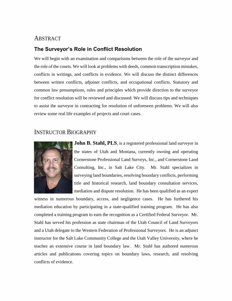
ABSTRACT
The Surveyor’s Role in Conflict Resolution
We will begin with an examination and comparisons between the role of the surveyor and
the role of the courts. We will look at problems with deeds, common transcription mistakes,
conflicts in writings, and conflicts in evidence. We will discuss the distinct differences
between written conflicts, adjoiner conflicts, and occupational conflicts. Statutory and
common law presumptions, rules and principles which provide direction to the surveyor
for conflict resolution will be reviewed and discussed. We will discuss tips and techniques
to assist the surveyor in contracting for resolution of unforeseen problems. We will also
review some real life examples of projects and court cases.
INSTRUCTOR BIOGRAPHY
John B. Stahl, PLS, is a registered professional land surveyor in
the states of Utah and Montana, currently owning and operating
Cornerstone Professional Land Surveys, Inc., and Cornerstone Land
Consulting, Inc., in Salt Lake City. Mr. Stahl specializes in
surveying land boundaries, resolving boundary conflicts, performing
title and historical research, land boundary consultation services,
mediation and dispute resolution. He has been qualified as an expert
witness in numerous boundary, access, and negligence cases. He has furthered his
mediation education by participating in a state-qualified training program. He has also
completed a training program to earn the recognition as a Certified Federal Surveyor. Mr.
Stahl has served his profession as state chairman of the Utah Council of Land Surveyors
and a Utah delegate to the Western Federation of Professional Surveyors. He is an adjunct
instructor for the Salt Lake Community College and the Utah Valley University, where he
teaches an extensive course in land boundary law. Mr. Stahl has authored numerous
articles and publications covering topics on boundary laws, research, and resolving
conflicts of evidence.
TABLE OF CONTENTS
The Surveyor’s Role in Conflict Resolution ....................................................................... 1
Understanding the Judicial Process ................................................................................ 6
The Nature of Real Property Boundaries ........................................................................ 8
How are boundaries created? ...................................................................................... 9
How are boundaries established? .............................................................................. 13
The Nature of Real Property Conflicts ......................................................................... 15
Title Conflicts ........................................................................................................... 16
Deed Conflicts .......................................................................................................... 17
Location Conflicts ..................................................................................................... 19
Resolution of Conflicting Evidence .................................................................................. 21
Practical Construction ................................................................................................... 22
Rules of Construction ................................................................................................... 24
Priority of Evidence Rule ............................................................................................. 26
Resolving Simultaneous Conveyances ......................................................................... 28
Resolving Sequential Conveyances .............................................................................. 30
Deficiencies (Shortages or Overlaps) ....................................................................... 32
Excesses (Overages or Gaps) .................................................................................... 34
Contracting for Conflict Resolution.................................................................................. 37
Resolution Through Mediation ..................................................................................... 40
Resolution Through Arbitration .................................................................................... 42
Resolution Through Litigation ...................................................................................... 47
Documenting the Final Resolution ................................................................................... 50
Conclusion ........................................................................................................................ 53
WORKS CITED
Black, H. C. (1990). Black's Law Dictionary. St. Paul, Minn: West Publishing Company.
Bouvier, J. (1843). A Law Dictionary Adapted to the Constitution and Laws of the United States of
America. Philadelphia: T & JW Johnson, Law Booksellers .
Bouvier, J., & Rawle, F. (1914). Bouvier’s Law Dictionary and Concise Encyclopedia, 3rd
Revision (8th ed.). St. Paul, Minn: West Publishing Company.
Burrill, A. M. (1870). Law Dictionary and Glossary, 2nd Ed. New York: Baker, Voorhis & Co.
Coke, S. E. (1832). The First Part of the Institutes of the Laws of England, or a Commentary on
Littleton.

NOTES:
________________________________________________________________
________________________________________________________________
________________________________________________________________
________________________________________________________________
________________________________________________________________
________________________________________________________________
________________________________________________________________
________________________________________________________________
________________________________________________________________
________________________________________________________________
________________________________________________________________
________________________________________________________________
________________________________________________________________
________________________________________________________________
________________________________________________________________
________________________________________________________________
________________________________________________________________
________________________________________________________________
________________________________________________________________
________________________________________________________________
________________________________________________________________
________________________________________________________________
________________________________________________________________
________________________________________________________________
________________________________________________________________
________________________________________________________________
________________________________________________________________
________________________________________________________________
©2016 Cornerstone Land Consulting, Inc. Page 1
THE SURVEYOR’S ROLE IN CONFLICT RESOLUTION
By John B. Stahl, PLS, CFedS
The overwhelmingly vast majority of surveys in most regions is executed by surveyors without
the slightest hint of any ambiguity, conflict, or dispute arising. The percentage of surveys where
conflicts are discovered ranges in direct proportion to the survival of monuments called for in the
title record, the availability of original survey records, and the legislated methods for perpetuating
the evidence disclosed by subsequent survey records. Stable monuments produce stable land
boundaries; land boundaries that are known, recognized and perpetuated by the landowners. When
the evidence fades with time or is destroyed by development, uncertainty and disputes follow.
This presentation is not intended to address the procedures used for establishing, recovering, or
retracing existing boundary locations where clear evidence can be found. Land surveyors are keen
at deciphering the title records and recognizing the footsteps of prior surveyors. There seems to
be a disconnection, however, between the commonly recognized duty of the surveyor when
retracing recoverable boundaries and their duty when the evidence has been lost, destroyed or
faded beyond recognition. Surveyors, as with those of most any profession, routinely fall short of
their potential when confronted by difficult situations. This presentation is designed to address
those occasional surveys, those minority of surveys, where the surveyor faces difficult choices –
choices which often result in increased liability and the likelihood of disturbing settled possessions.
This presentation will offer the surveyor alternative solutions to those commonly promoted and
practiced. Alternative solutions which will provide the surveyor with the tools necessary to resolve
conflicts at the time they are discovered rather than to merely document their existence with the
expectation that someone else will resolve them. The surveyor possesses many of the skills,
knowledge and expertise necessary to assist in the resolution process; skills which too often go
unused for lack of experience. The surveyor is often the first discoverer of a potential ambiguity,
conflict or dispute. Their response in light of their discovery often sets the stage for the success
or failure of potential resolution. The surveyor’s role in conflict resolution is vital.
©2016 Cornerstone Land Consulting, Inc. Page 2
In all cases, the surveyor is bound by the laws, rules and regulations which govern both his
profession and the fundamental rights of the property owners sharing the common
boundary. The surveyor must be aware of these laws and he must faithfully execute them
during the course of the survey. When the surveyor fails, the failure has a direct impact
upon the rights of the landowners, their subsequent purchasers, and many others whose
reliance upon the survey will have foreseeable result.
The vast majority of surveys are concluded without incident. The surveyor’s findings are
accepted by the landowners who rely upon the positions as established. Occasionally, the
survey results are questioned. Differences with prior survey results, ambiguities raised by
non-conforming prior occupation, or possibly the differing opinion of the landowner will
cause doubt to be cast upon the survey. Occasionally the surveyor himself will discover
conflicts in the record or ambiguities in the meanings of terms recited. The surveyor’s
ability to research and recover the evidence necessary to resolve the ambiguities and
conflicts is indispensable to their proper resolution.
When confronted by discrepancies, the surveyor must step back and reflect upon the
evidence and possibly gather additional evidence. Each additional piece of evidence will
cause the determination of facts to be altered. Alteration of the facts will require the
possible application of differing legal principles. The application of differing legal
principles will yield different conclusions as to the ultimate location of the boundary.
Resolution of the discrepancies is absolutely vital to assure the proper conclusion. Without
proper determination of the facts, there can be no proper conclusion.
As early as 1827, the role of the surveyor, when retracing doubtful or unsettled lines
between landowners, was well defined. The “Regulations by which Surveys will be
Governed in the Location of Vacant Lands,” transcribed from a handwritten copy from the
Center for American History, at the University of Texas, Austin, and filed with the General
Land Office revealed instructions defining the role of the surveyor when confronted by
boundary conflicts. The surveyor’s interaction with the landowners provided an important
method for resolving boundary conflicts. The surveyor alone could do nothing; but when

©2016 Cornerstone Land Consulting, Inc. Page 3
assisting the landowners, the surveyor could provide a vital role in boundary conflict
resolution.
Article 15th. It will be the duty of the surveyor before commencing any survey to see that
adjoining proprietors are notified in order to promote the general harmony of the
neighborhood.
Article 16th. Where a difficulty arises concerning the right of location of a particular
place, it will be the duty of the surveyor to use all reasonable means in his power to
induce the parties to settle their differences in an amicable manner.
… but, if the dispute is about a particular line and an amicable adjustment cannot take
place, it will be the duty of the surveyor to desist from any attempt to survey until the
dispute is settled. Any surveyor who shall continue the process of the (above) and, survey
and return lands in dispute without notifying the commissioner and run disputed lines
without the agreement of the parties interested, shall lay himself liable to the heaviest
responsibility.
The surveyor’s opinion is not binding upon the landowners. If either of the landowners
affected suspect or doubt the surveyor’s findings, he may act as a mediator by assisting the
landowners in settling the discrepancies and achieving an acceptable result. The
landowners may seek additional opinions from other surveyors. If the landowners hire a
second surveyor to confirm the findings, the first surveyor must be willing to provide the
subsequent surveyor with the evidence relied upon in reaching his decision. The surveyor
should assist the landowners in the form of a fact finder reporting the evidence recovered
to those who are asked to evaluate his findings.
The surveyor should maintain an open dialogue with the reviewer to ensure that any
evidence recovered before or during the review is shared between the surveyors. The goal
of the surveyors should be to resolve the discrepancies using any method or procedure
available so that the conclusion reached is a unanimous one. Differing opinions between
surveyors must be resolved between the surveyors. If the problem causing the differing
opinions is not resolvable and the ambiguity results in equally acceptable but differing
results, the surveyors should design alternate solutions that the landowners can utilize to
repair the ambiguity. The landowners are the only ones with the authority to resolve the
discrepancies. Given the proper solutions, most landowners will readily resolve the
conflict.
©2016 Cornerstone Land Consulting, Inc. Page 4
Occasionally, the landowners challenge the surveyor’s findings in a court of law. The land
surveyor serves a somewhat differing role when presenting his findings to the court. Few
professions are afforded the latitude that the surveyor enjoys. The surveyor often performs
two separate functions in court. One function is as a fact witness whose responsibility is
to present the evidence that the surveyor utilized in reaching his decision. As a fact witness,
only evidence directly perceived by the surveyor is presented. No opinions are expressed.
The surveyor performs his role as the “fact finder” and simply presents the evidence
leading to the facts concluded. The second function the surveyor may be asked to perform
is the role of the expert witness. As an expert, the surveyor is relied upon by the court to
assist the trier of fact in interpreting the evidence presented and understanding the legal
principles and their proper application to the fact situation. The expert witness is afforded
the ability to express his opinion as to the ultimate issue before the court; that is the
surveyor’s opinion where the boundary is located.
In January, 1881, a group of surveyors met for the second annual gathering of the Michigan
Society of Surveyors and Engineers to discuss the matters which concerned their
profession. An invited speaker to the event was Thomas M. Cooley, Chief Justice of the
Supreme Court of Michigan. Justice Cooley shared with the group his insights which have
proven timeless in their wisdom. The transcript of his presentation, entitled The Judicial
Function of Surveyors has been published and republished in surveying textbooks since
that time. The article can currently be found in the Appendix of the most recent edition of
Evidence and Procedures for Boundary Location, sixth edition, published in 2010. Chief
Justice Cooley pointed out the importance for the land surveyor to follow the rules of the
court when determining land boundary locations. He stated that:
“When a man has had a training in one of the exact sciences, where every problem within
its purview is supposed to be susceptible of accurate solution, he is likely to be not a little
impatient when he is told that, under some circumstances, he must recognize
inaccuracies, and govern his action by facts which lead him away from the results which
theoretically he ought to reach. Observation warrants us in saying that this remark may
frequently be made of surveyors.”
©2016 Cornerstone Land Consulting, Inc. Page 5
This dichotomous position that the surveyor is confronted with has caused much
consternation and dialogue among the profession. In the surveyor’s haste to complete the
survey, he often will choose the solution which yields the most certainty while requiring
the recovery of the least amount of evidence. The solution is likely to result in the
monumentation of the record boundary position in spite of any direct evidence contrary
with the occupational improvements or prior surveys.
The surveyor’s impatience is precisely the root of the difficulty. The surveyor, when faced
with conflicting evidence, must step back, re-evaluate the evidence, perhaps begin a
lengthy quest for additional evidence, and be willing to allow the necessary passage of time
for all things to be adequately considered. The conflict, once adequately assessed, must be
communicated with the landowners adjoining the boundary under consideration. They
must be given the information concerning the source of the problem, the impact of the
problem, and the possible remedies available to resolve the problem.
Most landowners, once thoroughly informed, will negotiate a settlement to remedy the
situation. The input of the surveyor during the negotiation phase can be crucial to the
outcome of their decision. The surveyor can suggest the appropriate remedies that are
available to meet the needs and desires of the landowners. The surveyor must be familiar
with the state and local regulations which may bear weight on the possible solutions to
ensure the chosen remedy will not cause additional problems.
The landowners, acting alone, have little knowledge of real property laws, rules and
regulations upon which to base their agreement. The surveyor, with the aid of the attorney
or title agent when necessary, can provide information to the owners and can encourage
their cooperation with the goal of achieving an well-informed remedy to their common
problem. Unfortunately, surveyors have been discouraged, not by others, but from some
within the ranks of the profession, from fulfilling their role and relegating any resolution
to the courts though litigation. The owners are frequently never given opportunity to
resolve the conflict through their own agreement.
©2016 Cornerstone Land Consulting, Inc. Page 6
UNDERSTANDING THE JUDICIAL PROCESS
Most of us, when we consider what we know as the “judicial process,” flash back what
we’ve seen on television. We perceive images of the criminal trial argued before the judge
in robe and attendant jury awaiting their decision of “guilty” or “not guilty,” or the
arguments and objections made over evidence being presented and testimony being heard.
What connection, if any, does this court-room drama have with the duties and
responsibilities of the land surveyor? Certainly the surveyor’s technical abilities to utilize
the surveying equipment are skills which aren’t governed by the court. Or, are they?
Consider the court rule:
Rule 702. Testimony by Experts
If scientific, technical, or other specialized knowledge will assist the trier of fact
to understand the evidence or to determine a fact in issue, a witness qualified as an
expert by knowledge, skill, experience, training, or education, may testify thereto
in the form of an opinion or otherwise, if (1) the testimony is based upon sufficient
facts or data, (2) the testimony is the product of reliable principles and methods,
and (3) the witness has applied the principles and methods reliably to the facts of
the case.
The surveyor’s opinion, according to the rules of evidence which govern the courts, must
be based upon sufficient facts or data, reliable principles and methods, and the reliable
application of the principles and methods. When this rule is applied to land boundary
determination, the surveyor’s techniques, methods, and equipment must be capable of
proven reliability.
It is important for the land surveyor to know, understand, and apply the rules of law which
govern his decisions with regard to boundaries. The surveyor’s attention is primarily
focused upon the statutory and common law principles which govern their final opinion,
however, the rules of law which govern the courts also include procedural rules as well as
©2016 Cornerstone Land Consulting, Inc. Page 7
evidentiary rules. The Uniform Rules of Evidence, adopted by at least 42 states, govern the
gathering and evaluation of evidence which the surveyor and the court will review to derive
the facts of the case. The Uniform Rules of Civil Procedure governs the disclosure of the
evidence and opinions reached to all parties of the case. Rule 26 of the Uniform Rules of
Civil Procedure defines the contents of the expert report required to disclose the evidence,
analysis and opinions expressed by the surveyor in reaching their conclusions.
Rule 26(2) Disclosure of Expert Testimony.
(A) In General. In addition to the disclosures required by Rule 26(a)(1), a party must
disclose to the other parties the identity of any witness it may use at trial to present
evidence under Federal Rule of Evidence 702, 703, or 705.
(B) Written Report. Unless otherwise stipulated or ordered by the court, this disclosure
must be accompanied by a written report — prepared and signed by the witness — if the
witness is one retained or specially employed to provide expert testimony in the case or
one whose duties as the party's employee regularly involve giving expert testimony. The
report must contain:
(i) a complete statement of all opinions the witness will express and the basis and reasons
for them;
(ii) the data or other information considered by the witness in forming them;
(iii) any exhibits that will be used to summarize or support them;
(iv) the witness's qualifications, including a list of all publications authored in the
previous 10 years;
v) a list of all other cases in which, during the previous 4 years, the witness testified as
an expert at trial or by deposition; and
(vi) a statement of the compensation to be paid for the study and testimony in the case.
Common rules governing the evidence gathered by the surveyor including the method used
for questioning a witness are outlined in the Rules of Civil Procedure. The surveyor must
keep in mind the Rules of Evidence and the Rules of Civil Procedure which govern the
courts and juries, and should allow them to direct his research, investigation, and analysis
of the evidence as well as his final decision-making process used to derive his ultimate
opinions. The rules of law found in statute, common law, local regulation, or judicial code
©2016 Cornerstone Land Consulting, Inc. Page 8
will direct and guide every step of the surveyor. An intimate knowledge of the rules which
govern is vital to reaching the determined goal.
THE NATURE OF REAL PROPERTY BOUNDARIES
To understand the nature of real property boundaries, it is necessary to first understand the
processes by which boundaries are created and their locations established. This is a two-
step process which is often not given specific notice. The two-step process is first, one of
creation, and second, one of establishment. The boundary must first be created, and then
its location can be established on the ground.
Boundaries are often thought of as legal entities being defined by their mathematical
properties of direction and length. The boundary is frequently thought of as some invisible
line of infinitesimally small width and precisely defined endpoints possessing equally
infinite dimension. This definition of such a line is mathematical in its origin, being purely
conceptual in nature. This representation of a boundary is entirely false.
According to the many legal journals written over the centuries, a boundary is a physical
entity marked by physical objects, called monuments, whether natural or artificial. The
monument itself is a physical manifestation or representation which embodies the authority
of the landowners (the title holders) together with their intent to create the boundary. The
law then requires the conveyance of the property (the act which creates the boundary) be
fully executed in writing. It is presumed that the grantor who originally created the
boundary also had determined the boundary location by memorializing its position with
physical objects, or monuments.
“Boundary – Every separation, natural or artificial, which marks the confines or line of
division of two contiguous estates. (Bouvier & Rawle, 1914, p. 384)
“Boundary – A line or object indicating the limit or furthest extent of a tract of land or territory.
A separating or dividing line between countries, states, districts of territory, or tracts of
land; consisting sometimes wholly of one or more natural objects, as a river, a chain of
lakes, etc.; sometimes artificial erections, as a stone wall, fence, and the like; sometimes
©2016 Cornerstone Land Consulting, Inc. Page 9
of imaginary line drawn from one principal terminus to another, and indicated along its
course by prominent natural or artificial objects standing or erected upon it at intervals;
and sometimes of all these in combination.” (Burrill, 1870, p. 221)
The term, metes and bounds, is derived from Roman law from the word meta, referring to
“the goal of a Roman race course; a mark or object about which the chariots turned, and
where the course ended” (Burrill, 1870, p. 196), and from the word bunda, referring to “a
limit, or enclosing line of lands. In the common phrase ‘metes and bounds,’ metes properly
signify the angles, corners or turning points, and bounds the lines between; though
practically little or no distinction is made between them.” (Burrill, 1870, p. 221).
HOW ARE BOUNDARIES CREATED?
The first step in the life of any boundary line requires that it be created. The boundary can
only be created through the division of an existing estate into two or more parts. The
creation of a boundary must, therefore, involve the intentional division of the estate by
someone having authority, with reliance upon a limit or extent which is made definite and
certain in the form of a written contract describing the intended location of the boundary.
The act of creating the boundary through a conveyance of some right or title from one party
(the grantor) to another (the grantee) is the result of a contractual agreement in which both
parties have negotiated and assented to the terms. The expressed words of the parties’
agreement are considered paramount to construing the meaning intended.
In order to create the boundary, there must be a conveyance of a right or title which causes
a separation in the estate of the grantor. Without two contiguous estates, there can be no
boundary. The boundary line will be discovered at the edges or furthest extent of the two
contiguous estates. The boundary may define the limits of contiguous ownership interests,
or may define the limit of the possessory rights of one party over the lands of another, as
in an access easement. Boundaries can also limit the extent of a regulatory interest as in a
flood zone designation, wetland delineation, or building setback.
Understanding the nature of the estate being defined is necessary when determining the
boundaries of the estate. The estate is made up of all rights, title and interests associated
©2016 Cornerstone Land Consulting, Inc. Page 10
with or appurtenant to the property. Following are the definitions of the terms commonly
associated with real property which must be clearly understood.
Title - The formal right of ownership of property. Title is the means whereby the
owner of lands has the just possession of his property. The union of all the elements
which constitute ownership. Full independent and fee ownership. The right to or
ownership in land; also, the evidence of such ownership. Such ownership may be held
individually, jointly, in common, or in cooperate or partnership form. One who holds
vested rights in property is said to have title whether he holds them for his own benefit
or the benefit of another. (Black, 1990, p. 1485)
Right - A power, privilege, or immunity guaranteed under a constitution, statutes or
decisional laws, or claimed as a result of long usage; an interest or title in an object of
property; a just and legal claim to hold, use, or enjoy it, or to convey or donate it, as he
may please. (Black, 1990, p. 1324)
Interest - The most general term that can be employed to denote a right, claim, title,
or legal share in something. In its application to real estate or things real, it is frequently
used in connection with the terms “estate, “right,” and “title.” More particularly it
means a right to have the advantage accruing from anything; any right in the nature of
property, but less than title. (Black, 1990, p. 812)
The term title is frequently used to denote not only the ownership of the property but the
associated rights and interests which are, in fact, different and particular components of the
title. The term “title” should be used to specifically relate to ownership. A title to land
was defined by Lord Coke to be “the means whereby the owner of lands hath the just
possession of his property” (Coke, 1832, p. 245). Bouvier explained that “complete title”
is comprised of three parts: 1) mere possession or actual occupation of the estate, without
any apparent right, 2) the right of possession, which may reside in one man, while the actual
possession is not in himself; he may have an apparent right of possession which may be
defeated, or an actual right of possession which will stand any test, and 3) the right of
property without either possession or the right of possession. Bouvier described the unity
of the three parts as “perfect title” (Bouvier, 1843, p. 567).
The rights of the title holder include such things as access, occupation, surface, subsurface,
subjacent, timber, mineral, development, etc. Real property interests reflect those
particular outside interests which impose restrictions upon the title holder’s rights.
Interests may be imposed by governing bodies such as zoning and development
©2016 Cornerstone Land Consulting, Inc. Page 11
requirements, statutory interventions such as wetland or shoreline restrictions, or
homeowner and neighborhood associations which include particular covenants, conditions
and restrictions. Interests are often interposed through contractual obligations such as
those made with lending institutions or lien holders.
Statute of Frauds
The statute of frauds, enacted by the English Parliament in 1677 (29 Chas. II, c. 3) has
required that all conveyances affecting rights, title or interests in real property are to be
documented in writing. Here in America, as early as 1627, the New England colonists
required all transfers of property to not only be made in writing, but to also be duly recorded
in the public records. The written record minimizes confusion in the conveyance of title
by providing a resource for refreshing faded memories and overcoming misrepresentations
and acts of fraud common in the ancient days of fiefdom. The recording process works as
a secondary assurance through statutory encouragement of recording the conveyance
document in the public records. Proper recording of the document assures constructive
notice to any subsequent purchaser and supplies protection to the bona fide purchaser.
ORS 41.580 Statute of frauds. (1) In the following cases the agreement is void unless it,
or some note or memorandum thereof, expressing the consideration, is in writing and
subscribed by the party to be charged, or by the lawfully authorized agent of the party;
evidence, therefore, of the agreement shall not be received other than the writing, or
secondary evidence of its contents in the cases prescribed by law:
(e) An agreement for the leasing for a longer period than one year, or for the sale of
real property, or of any interest therein.
(f) An agreement concerning real property made by an agent of the party sought to be
charged unless the authority of the agent is in writing.
The Statute of Frauds exists in the legislative statutes of all 50 states and Canada in one
form or another. The purpose of the Statute of Frauds is to encourage the formation of
written contracts affecting real property and to memorialize agreements between parties.
The statutes encompass a wide variety of contracts including the transfer of landownership.
The requirement for a written conveyance ensures the ability to prove the intent to transfer
title and is further enhanced by the ability to record the conveyance in the public records.
The act of a conveyance which creates the boundary, does not establish its location.
©2016 Cornerstone Land Consulting, Inc. Page 12
The written instrument serves a foundational role in the title conveyance process. Without
the written instrument, there can be no separation of an estate and no creation of a
boundary. The theory of “unwritten title” or “unwritten conveyances,” often promoted in
surveying treatises, is a modern fallacy. A search for the terms in case law across the nation
reveals that the theories have no basis in law.
Intent
The intent of the grantor is paramount to determining the boundary line location. If there
is no intent to create a boundary, then no boundary can be created. The intent of the grantor,
as with any conveyance of property, can only be one of two possibilities. Either the owner
intends to convey property to an existing boundary, or they intend to divide their estate and
create a new boundary; the owner thereby retaining ownership of a remaining portion of
their land and creating a boundary dividing the two ownerships.
It is insufficient for the owner to simply intend on creating the boundary line without the
necessary action taken to actually convey the property lying on the opposite side of the
intended boundary to a second party (the grantee). Without the conveyance to a separate
owner, there can be no separation of ownership. Without a separation of ownership, there
can be no boundary created.
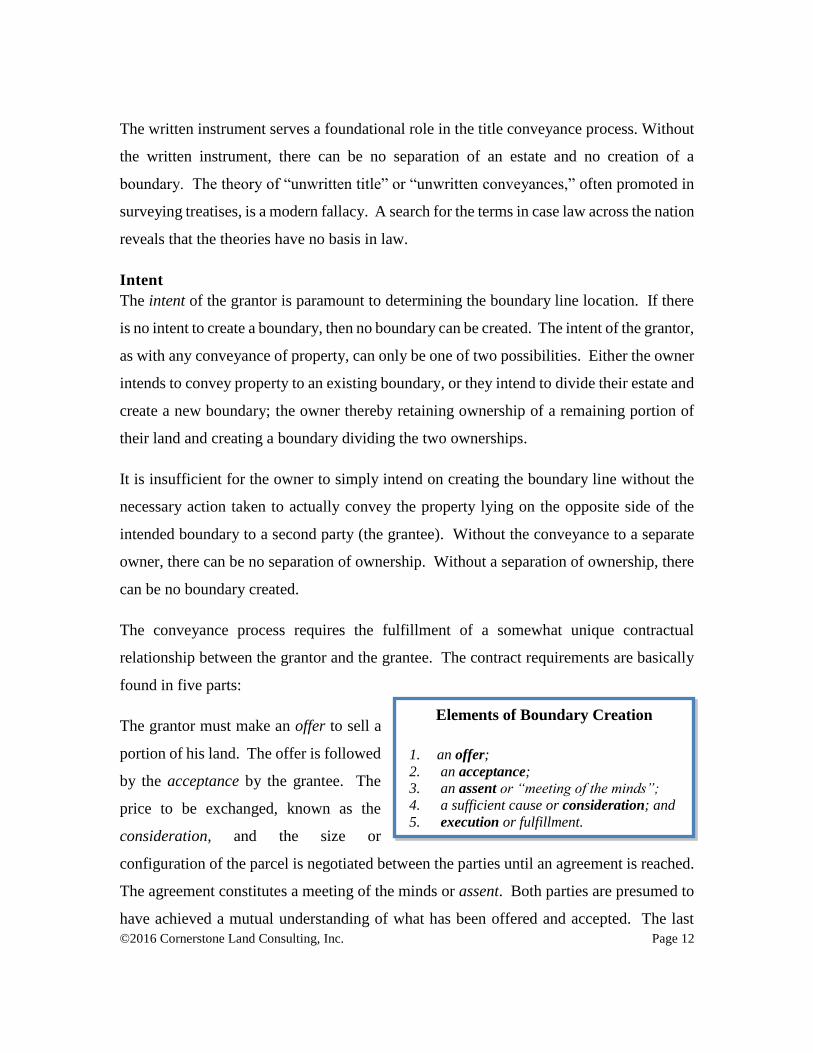
The conveyance process requires the fulfillment of a somewhat unique contractual
relationship between the grantor and the grantee. The contract requirements are basically
found in five parts:
The grantor must make an offer to sell a
portion of his land. The offer is followed
by the acceptance by the grantee. The
price to be exchanged, known as the
consideration, and the size or
configuration of the parcel is negotiated between the parties until an agreement is reached.
The agreement constitutes a meeting of the minds or assent. Both parties are presumed to
have achieved a mutual understanding of what has been offered and accepted. The last
Elements of Boundary Creation
1. an offer;
2. an acceptance;
3. an assent or “meeting of the minds”;
4. a sufficient cause or consideration; and
5. execution or fulfillment.
©2016 Cornerstone Land Consulting, Inc. Page 13
necessary step in the creation of the boundary line is the actual conveyance between the
parties witnessed by the delivery of the deed from the grantor to the grantee, termed
execution. Some states require recording of the conveyance instrument as necessary proof
of delivery.
Once all four contractual requirements are fulfilled, the property conveyance has happened
and the boundary line has been created (at least in theory). It is certain that there are two
separate parcels with a common line of division between them, i.e. the property line or
boundary. Depending upon the actions taken by the grantor and the grantee prior to the
conveyance, the boundary line may or may not have been physically run out on the ground
and monumented by a survey. Fulfillment of the four contractual requirements is all that
is necessary for the boundary line to be created. The parties may or may not have taken
any action or made any representation and reliance to yet establish the exact location of the
boundary on the ground.
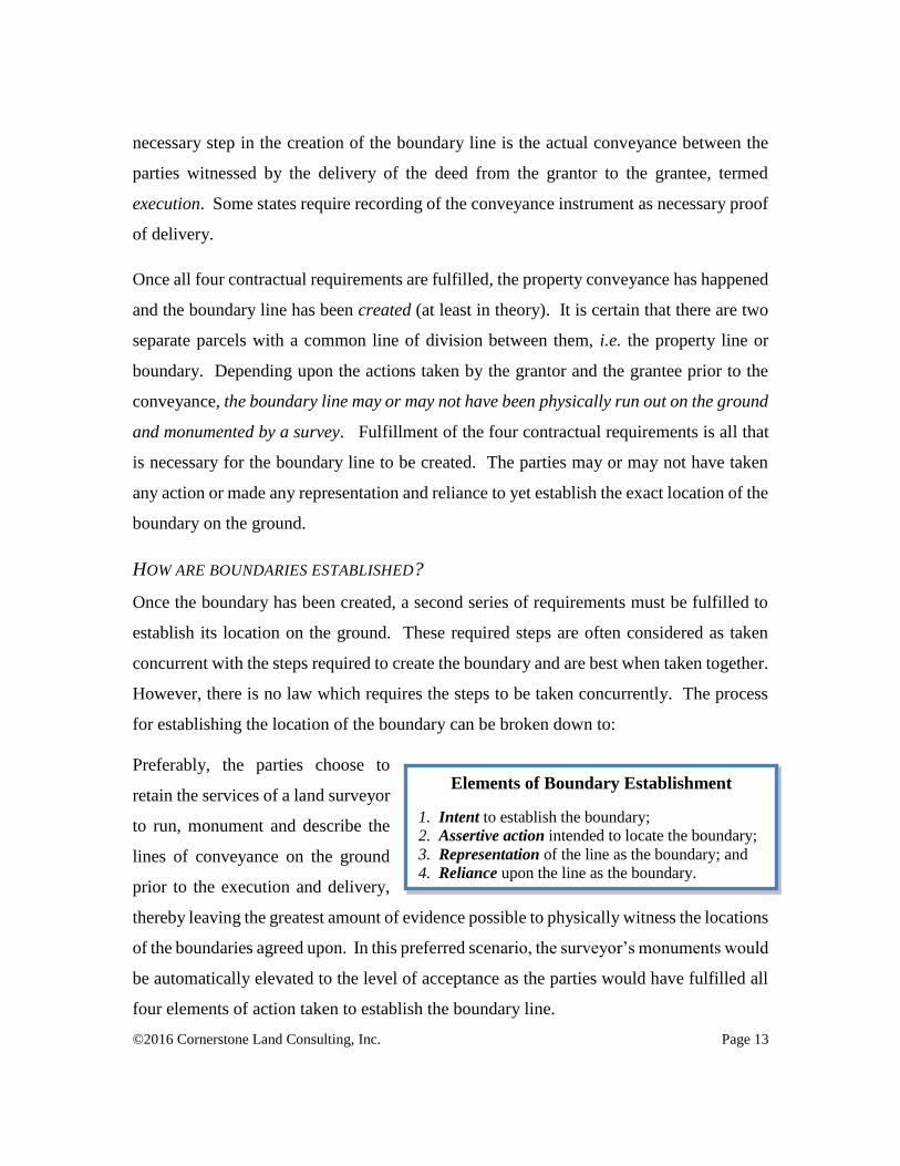
HOW ARE BOUNDARIES ESTABLISHED?
Once the boundary has been created, a second series of requirements must be fulfilled to
establish its location on the ground. These required steps are often considered as taken
concurrent with the steps required to create the boundary and are best when taken together.
However, there is no law which requires the steps to be taken concurrently. The process
for establishing the location of the boundary can be broken down to:
Preferably, the parties choose to
retain the services of a land surveyor
to run, monument and describe the
lines of conveyance on the ground
prior to the execution and delivery,
thereby leaving the greatest amount of evidence possible to physically witness the locations
of the boundaries agreed upon. In this preferred scenario, the surveyor’s monuments would
be automatically elevated to the level of acceptance as the parties would have fulfilled all
four elements of action taken to establish the boundary line.
Elements of Boundary Establishment
1. Intent to establish the boundary;
2. Assertive action intended to locate the boundary;
3. Representation of the line as the boundary; and
4. Reliance upon the line as the boundary.
©2016 Cornerstone Land Consulting, Inc. Page 14
The creation of the boundary concurrent with the parties intent to establish the location of
the boundary, their actions taken to survey the boundary and monument its position on the
ground, their representations that the monuments mark the boundary, and their reliance
witnessed by the subsequent execution of the conveyance document which creates the
boundary would fulfill all elements for both the creation and establishment of the boundary.
All four of the basic contract requirements to create the boundary are fulfilled and all four
of the elements necessary to establish the line’s location are fulfilled as well. This is why
the original survey process is always the best way to create and establish boundaries; both
functions happen in one instance of time. This is also why the mantra, “original
monuments control,” is so often proclaimed by the surveying profession.
When the parties choose to short circuit the original survey and conveyance process
(usually in an effort to save money and/or time), no survey is run and no monuments are
placed on the ground establishing the boundary location prior to its creation. Evidence of
the location of the boundary line is described in the conveyance document based upon some
mutually conceived notion of the boundary line placement. Because there is no physical
manifestation of the boundary line made on the ground, the parties arrive at a conceptual
or theoretical idea of how the boundary location is to be determined, but have not made
any attempt to determine where the boundary location is. The process for subsequent
determination is incorporated into the description of the property which contains the
instructions necessary for a subsequent and anticipated surveyor to establish the boundary
lines on the ground.
Intent
When such a scenario is contemplated by the grantor and grantee, it is logical to deduce
that they fully intend to delay establishment of the boundary location until some future
time. Occasionally, the parties will stipulate in their agreement for a subsequent survey to
be undertaken by one or both parties at a mutually agreed-upon time and joint payment
provision, i.e. the called-for survey. Certainly, it is not logical to consider that the boundary
line would simply remain indeterminable without subsequent court action or reformation
of the original agreement. The parties have made an agreement which contains all of the
©2016 Cornerstone Land Consulting, Inc. Page 15
necessary ingredients to make the subsequent boundary line determination by fulfilling the
four establishment provisions at some later date.
The establishment theories are found quoted throughout the history of common law in cases
across the nation. The question put before the courts in every action regarding the location
of a boundary is the same. “Where is the boundary?” This question is always answered
in the same ways and in reliance upon the same principles of law in every instance.
Evidence is gathered and presented for the purpose of determining the facts of the case,
then the rule of law is applied to the facts and the determination of the boundary is made.
Determination of the boundary is, therefore, a mixture of fact and law.
The rules of law are the same. The court will look for evidence of the intention to create
the boundary and the evidence resulting from the physical action taken by the owners to
establish its location on the ground. The boundary location will be determined upon the
fulfillment of the legal and contractual requirements. Has the boundary been established
by a written contract, by an oral contract, or by an implied contract revealed by their actions
over a long period of time? Has the boundary been established by a representation made
by one party and passive or active reliance by the other incurring substantial costs which
now estops one of the owners from declaring the truth? Has the boundary been established
by the assent of the landowners, acting in good faith, and evidence of their mutual
satisfaction? Has the boundary become established by some bona-fide right established in
reliance upon a local corner of common report? These laws, applied by the courts to
determine boundary locations in every case, have no effect upon title or ownership of the
property. These laws only deal with the location of the boundaries as established on the
ground by the landowners.
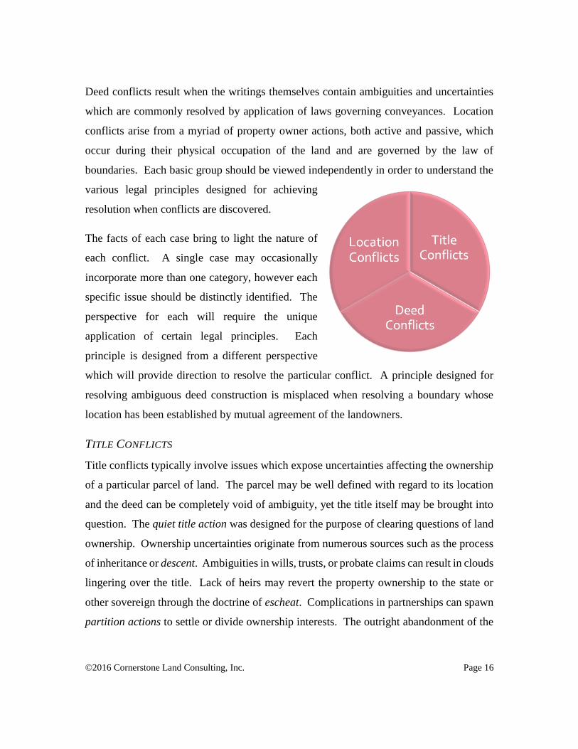
THE NATURE OF REAL PROPERTY CONFLICTS
Real property conflicts can be categorized into three basic groups: 1) Title conflicts, 2)
Deed conflicts, and 3) Location conflicts. Each of these areas of conflict have individual
bodies of law which are designed to address and resolve conflicts when they arise. Title
conflicts involve issues of property ownership based upon laws governing title to property.
©2016 Cornerstone Land Consulting, Inc. Page 16
Deed conflicts result when the writings themselves contain ambiguities and uncertainties
which are commonly resolved by application of laws governing conveyances. Location
conflicts arise from a myriad of property owner actions, both active and passive, which
occur during their physical occupation of the land and are governed by the law of
boundaries. Each basic group should be viewed independently in order to understand the
various legal principles designed for achieving
resolution when conflicts are discovered.
The facts of each case bring to light the nature of
each conflict. A single case may occasionally
incorporate more than one category, however each
specific issue should be distinctly identified. The
perspective for each will require the unique
application of certain legal principles. Each
principle is designed from a different perspective
which will provide direction to resolve the particular conflict. A principle designed for
resolving ambiguous deed construction is misplaced when resolving a boundary whose
location has been established by mutual agreement of the landowners.
TITLE CONFLICTS
Title conflicts typically involve issues which expose uncertainties affecting the ownership
of a particular parcel of land. The parcel may be well defined with regard to its location
and the deed can be completely void of ambiguity, yet the title itself may be brought into
question. The quiet title action was designed for the purpose of clearing questions of land
ownership. Ownership uncertainties originate from numerous sources such as the process
of inheritance or descent. Ambiguities in wills, trusts, or probate claims can result in clouds
lingering over the title. Lack of heirs may revert the property ownership to the state or
other sovereign through the doctrine of escheat. Complications in partnerships can spawn
partition actions to settle or divide ownership interests. The outright abandonment of the
©2016 Cornerstone Land Consulting, Inc. Page 17
property, a common occurrence during the westward settlement, resulted in adverse
possession claims affecting ownership of entire parcels.
Title conflict resolution is typically not within the scope of the land surveyor’s duty. While
the surveyor may become proficient in title matters and may develop a particular level of
expertise on the subject, such determinations are ancillary being not necessary for the
determination of boundary locations. The surveyor must, however, have a fundamental
understanding of title matters in order to properly recognize and depict the type of estate,
particularly the extent of title holdings relative to easement rights. The surveyor may also
develop a particular expertise regarding the research of title records.
“Before further discussing the trial court's rulings with respect to the surveys we pause
to state an established rule. It is that surveys merely establish boundary lines. They do
not determine title to land involved. The subject of title is no concern of the surveyor.”
Swarz v. Ramala, 63 Kan. 633, 66 P. 649; Wagner v. Thompson, 163 Kan. 662, 186 P.2d
278, 1901
Determinations of title matters will affect the final depiction of a boundary based upon the
surveyor’s understanding of the nature of the conveyance. The depiction of an ownership
boundary (title) is distinctively different from that of a right of use for a utility installation
or access road (right). The surveyor must be aware of the distinctive differences between
title, rights, and interests in land to assure proper depiction on the final survey.
DEED CONFLICTS
It is generally supposed that a proper description of a parcel or tract of land is sufficient
only when the terms of the deed precisely enumerate the boundaries. Such supposition is
not a requirement imposed by the courts. The purpose of the description is to merely
provide a unique identification of the subject matter parcel. The description must be
capable of isolating the subject property apart from any other parcel. The goal of the
description is to iterate what is being conveyed; if you want to know where the boundaries
are, get it surveyed. When the description is successful in accomplishing that goal, it is
deemed sufficient.

©2016 Cornerstone Land Consulting, Inc. Page 18
Furthermore, it is the established rule that the courts will be liberal in construing
descriptions of premises conveyed by deed and that a description of land is sufficiently
definite and certain if it is possible for a surveyor to ascertain from the description,
"aided by extrinsic evidence," what property was intended to be conveyed. Sequin et al
v. Maloney-Chambers,198 Or 272, 281, 253 P2d 252 (1953).
Thus, as stated in Bogard v. Barhan, 52 Or 121, 96 P 673 (1908), the test is:
"Can a surveyor, with a deed or other instrument before him, with or without the aid of
extrinsic evidence, locate the land and establish the boundaries?"
See also Hamilton et al v. Rudeen et al, 112 Or 268, 272, 224 P 92 (1924).” O'Hara v.
Brace, 258 Or. 416, 482 P.2d 726 (Or. 03/24/1971)
Many terms used in a description become antiquated and their meanings change over time.
Other terms may seem to be in direct conflict with each other. It is important to view each
description in light of the circumstances which surround its creation. Understanding the
historical terminologies, techniques, procedures, and reasoning used to create the
description are essential to understanding its meaning. Through proper analysis and
application of established rules, the meaning and intent of the document can be properly
construed. The rules provide a reasoned process which gives precedence to that which is
most certain in the description (a locative call) over that which is least certain (an
informative call).
“The court also found applicable well-established rules of priority of references; rules
for harmonizing calls in deeds or surveys; and the requirement that the court consider
all the evidence. Applying these rules to the evidence, the court determined that the White
survey controlled, that it more accurately set forth the boundary, and that it set forth the
true boundary. The court found significant Mr. White's conclusion that the white oak
referenced in both deeds was the corner boundary of the tracts and Mr. White located
the tree. "This monument is a natural or fixed object which is a locative call, served to
fix the boundaries. It is not unreasonable in determining this boundary dispute that this
white oak is the fixed object which, when applied, harmonizes the Ezell and Duncan
deeds." Ezell v. Duncan, No. M2003-00081-COA-R3-CV (Tenn.App. 12/15/2004)
One must keep in mind that the purpose for the rules of construction is to construe the
intent of the scrivener. It is not possible for the words of the description to identify all
evidence necessary for the determination of its boundaries. The description is but one piece
of the evidence which the surveyor must discover before a proper determination can be
made. The actions of the landowners before, during and after the conveyance as well as
©2016 Cornerstone Land Consulting, Inc. Page 19
their testimony concerning the boundaries provide the surveyor with extrinsic evidence
which must be considered. The surveyor’s skill in gathering and interpreting the extrinsic
evidence used to construe the intent of the scrivener is critical.
“It is not necessary, and it is not humanly possible, for the symbols of description, which
we call words, to describe in every detail the objects designated by the symbols. The
notion that a description is a complete enumeration is an instinctive fallacy which must
be got rid of before interpretation can be properly attempted. … Wigmore’s compendium
on “Evidence”, 2nd. Edition, Vol. 5 § 247”
The surveyor must keep an open mind when running the lines of the description on the
ground. Extrinsic evidence discovered during the course of the survey must be considered
and evaluated. The ambiguities that arise during the course of the survey may be
considered as latent ambiguities which exist within the framework of the deed. Such
ambiguities may signal a re-visitation of the deed terms to determine if the evidence
recovered is locative or informative in nature.
LOCATION CONFLICTS
The conveyance of a portion of a parcel of land by a landowner is presumed to follow a set
pattern of events. The conveyance requires the entering of a contractual agreement
between the buyer and the seller. This agreement is somewhat unique in comparison with
the typical formation of an agreement. The contractual agreement contains certain
necessary elements. It is essential to the existence of a contract that there be an offer, an
acceptance, an assent or “meeting of the minds, a sufficient cause or consideration, and
execution or fulfillment.
The typical agreement is a two-party document which requires the signature of both parties
forming a mutual covenant. The instrument of conveyance for a land transaction, however,
contains the signature of only one party, the grantor. The reason that the grantor’s signature
is the only one required is that the grantor is in complete control of the transaction. It is
the grantor who determines the price of the sale and it is the grantor who determines the
placement of the boundaries of the parcel being sold. The grantee does have the ability to
negotiate the sale price or to negotiate the size of the parcel being purchased; it is the
©2016 Cornerstone Land Consulting, Inc. Page 20
grantor, however, who has the ultimate control over the final conditions of the property
transfer. It is for this reason that the terms of the conveyance document are interpreted
against the grantor.
The grantor and the grantee are presumed to have entered into the final agreement with full
knowledge of the location of the boundaries of the parcel. They have, in the normal
contractual sense, entered into a “meeting of the minds” and the agreement is formed. The
conveyance document is prepared which identifies the parcel of land being conveyed, the
consideration is exchanged, and the document is executed and delivered.
In an ideal world, the monuments placed on the ground prior to the conveyance will be
fully described in the conveyance document whle perfect measurements will depict their
locations. The monuments will be easily recognized and well known to the adjoining
owners, will be consistently relied upon by them, and will remain undisturbed for eternity.
Unfortunately, none of us exists in this ideal world. The landowners don’t always have a
survey performed when the boundary is first contemplated. The surveys are not done with
perfection and never will be. The descriptions do not always reflect complete descriptions
of every monument intended to mark the boundaries and the landowners are unaware of
the monuments which become obscured or destroyed.
As ambiguities, uncertainties, or doubt arises regarding the location of a boundary, the duty
to ascertain its location falls upon the adjoining owners. They may or may not call in the
surveyor to assist them in recovering the obscured monuments. They may choose to
resolve the location according to their own satisfaction. They may even rely upon
monuments which were placed in error or may make improper assumptions when resolving
the location. The conflicts which result are as varied as the reasons used to create them.
Fortunately, the law does not prevent the landowners from resolving the uncertainties and
require them to forever live in doubt. The law provides remedies which are designed to
resolve the location of the boundary by allowing the owners to establish its location with
confidence. These legal remedies, when recognized and applied, are designed to stabilize
©2016 Cornerstone Land Consulting, Inc. Page 21
boundary locations and prevent their disturbance by constant revision. However, in order
for these remedies to work, they must be applied by the persons charged with their
application: the surveyors. The surveyor must be vigilant, when conducting the survey, to
be aware of the indications that the boundary location has been established. Monuments
uncalled-for in the conveyance documents, physical evidence of improvements which
appear to reflect the boundary location, testimonial evidence of current beliefs or evidence
of historic occupation of the land might provide the surveyor with evidence that the
boundary location has been established prior to the surveyor’s visitation.
RESOLUTION OF CONFLICTING EVIDENCE
The surveyor’s duty changes dramatically whether they are locating a boundary for the first
time or whether they are locating a boundary which has been established before their
visitation. When laying out a boundary for the first time, the surveyor is tasked with simply
following the instructions of the grantor. Whether those instructions are followed before
or after the conveyance is of little consequence. The instructions must be followed. When
locating a boundary which has already been located, the surveyor’s task is entirely
different. The surveyor must gather the evidence necessary to determine the location of
the boundary as established by the evidence.
“These fundamental survey principles provide that the parties' intent is paramount to all
other considerations when interpreting surveys and conveyances.” Olson v. Jude, 73
P.3d 809 (MT 2003)
When physical evidence of a boundary location is recovered by the surveyor, it is doubtful
that the evidence recovered will be in complete harmony with the written record.
Discrepancies or conflicts in the evidence are routinely addressed by surveyors, often
becoming a second nature requiring little forethought. While application of the legal
principles designed to resolve conflicts in evidence may seem routine to the surveyor, the
landowners and the courts are not nearly as adept to the process. The surveyor must be
aware of the fundamental rules established by the courts for the resolution of conflicts and

©2016 Cornerstone Land Consulting, Inc. Page 22
must apply them accordingly. The better the surveyor can understand and explain those
rules, the more certain their application of the rules will be accepted.
PRACTICAL CONSTRUCTION
The courts presume that, in the process of negotiation and assent, the parties have had
opportunity to enter into a complete understanding of specifically what is being exchanged.
They have taken the opportunity to identify the proposed boundaries on the ground by the
placing of monuments, a description of the proposed boundaries is prepared and placed in
the conveyance document, consideration is exchanged, the document is executed, and the
transaction completed. Both parties are presumed to be fully aware of the location of the
boundaries of the parcel on the ground. It is also presumed that any subsequent occupation
is made in good faith in accordance with the mutual agreement. This presumption may be
overcome by evidence to the contrary, however, absent such evidence the presumption will
prevail.
Upon completion of the title transfer, the grantee may proceed to enter into possession of
the parcel and to erect improvements. These improvements are located with reference to
the boundaries established and made known to both parties prior to the transaction. Fence
lines are erected along the monumented boundaries and buildings are constructed with
reference to the boundaries and local set back ordinances. The actions of the parties
involved from the time of the initial assent to the period of occupation are expected to be
made in accordance with the agreement and form the trail of evidence which the retracing
surveyor may recover and consider. Such actions are found to result in a practical
construction of the intent of the parties upon the ground.
“In ascertaining and giving effect to the intent of the parties to a deed, courts are not
confined to a strict and literal construction of the language used when to do so would
frustrate the intent of the parties, but the surrounding circumstances may be considered
if they indicate the construction placed upon the words by the parties, or their practical
construction of the instrument. (Henry v. Metz, 382 Ill. 297.)” David v. Schiltz, 114 NE
2d 691 - Ill: Supreme Court 1953
The monuments are often destroyed during the construction of the occupational
improvements. Many landowners, intending to perpetuate the monument, will replace the
©2016 Cornerstone Land Consulting, Inc. Page 23
monument with fence corner posts in the same position. In such a case, the fence line or
post coupled with the testimony of the installer will be conclusive evidence of the position
of the intended boundary location. Unfortunately, the retracing surveyor is typically not
privy to such direct evidence after the property has undergone one or two conveyances and
the original landowners or the fence constructor are no longer available.
The loss of direct evidence does not change the fact that the improvements were
constructed in accordance with the original monuments. The simple fact remains but is
more difficult to prove. Such is commonplace when retracing old boundaries. Time fades
all evidence but the fading or loss of evidence does not result in the fading or loss of title
or its boundaries. The boundary still remains as legally defined on the day of its creation;
it just becomes more difficult to prove.
The retracing surveyor must look for additional evidence which may corroborate the
position of the improvements. Such corroborative evidence may be found in the harmony
of the improvements with those placed on other boundaries compared to the configuration
of the boundaries identified on the original conveyance document. The proximity of the
age of the improvements compared with the date of the original conveyance may also
provide sufficient evidence to substantiate the original boundary location. The retracing
surveyor often will look to historical records such as aerial photos, testimony of prior
landowners, building permits, or site plans which may reveal the location of improvements
relative to the boundaries.
When the preponderance of the evidence recovered suggests that the improvements were
erected with reliance upon the original survey monuments which best express the original
intent of the parties, the original boundaries may be reestablished in accordance with the
evidence. The boundary location is not one based upon any form of occupational boundary
or subsequent agreement, but is based upon the recovery of best available evidence
remaining of the original intent. The boundary recovery is a process of retracement of the
survey techniques and subsequent reliance upon them which establishes the original
boundary as intended by the initial parties.

©2016 Cornerstone Land Consulting, Inc. Page 24
Some key elements to look for when recognizing evidence of practical construction are:
(1) Age of the improvements in proximity with the date of the original
conveyance;
(2) geometry of the original parcel relative to the improvements along
successive boundaries;
(3) harmony of improvements along successive boundaries of adjoining
parcels;
(4) lateral displacement of improvements along successive boundaries of
the subject or adjoining parcels; and
(5) rotational displacement of improvements along successive boundaries
of subject or adjoining parcels.
RULES OF CONSTRUCTION
The courts have set forth numerous presumptive rules which form a basis for resolving
ambiguities found within deeds. These rules are part of the rules commonly referred to as
rules of construction. The ambiguities found in deeds may be classified in two separate
categories; latent ambiguities and patent ambiguities.
Latent ambiguity. A latent ambiguity is a defect which does not appear on the face of
the language used. The language is usually clear and intelligible, suggesting a single
meaning; however, the introduction of extrinsic evidence reveals a possibility of multiple
interpretations or meanings.
Patent ambiguity. A patent ambiguity is apparent or obvious on the face of the
instrument or inherent in the uncertainty of the language used such that its effect is to
convey no definite meaning.
One of the requirements of a deed is that the description be sufficient to convey a single,
identifiable parcel of land. The ultimate test of the description is whether it can be located
on the ground by a land surveyor. An ambiguity in a deed description is commonly
resolved by the surveyor by applying the appropriate rules of construction as established
by the courts. Applying rules of construction, however, does not constitute reformation of
a deed. The description in the deed is followed.

©2016 Cornerstone Land Consulting, Inc. Page 25
ORS 93.310 Rules for construing description of real property. The following are the
rules for construing the descriptive part of a conveyance of real property, when the
construction is doubtful, and there are no other sufficient circumstances to determine it:
(1) Where there are certain definite and ascertained particulars in the description, the
addition of others, which are indefinite, unknown or false, does not frustrate the
conveyance, but it is to be construed by such particulars, if they constitute a sufficient
description to ascertain its application.
(2) When permanent and visible or ascertained boundaries or monuments are
inconsistent with the measurement, either of lines, angles or surfaces, the boundaries or
monuments are paramount.
(3) Between different measurements which are inconsistent with each other, that of angles
is paramount to that of surfaces, and that of lines paramount to both.
(4) When a road or stream of water not navigable is the boundary, the rights of the
grantor to the middle of the road, or the thread of the stream, are included in the
conveyance, except where the road or bed of the stream is held under another title.
(5) When tidewater is the boundary, the rights of the grantor to low watermark are
included in the conveyance, and also the right of this state between high and low
watermark.
(6) When the description refers to a map, and that reference is inconsistent with other
particulars, it controls them, if it appears that the parties acted with reference to the map;
otherwise the map is subordinate to other definite and ascertained particulars.
Application of the rules of construction does not mean that a rigid or dogmatic approach
should be taken to attribute all evidence to the four corners of the deed. The deed language
must be viewed in light of the circumstances surrounding the preparation and the
knowledge of the parties at the time of the writing. When latent or patent ambiguities arise,
extrinsic evidence must be relied upon to assist in the construction. When convincing
evidence is recovered showing a mutual mistake by the parties in drafting the document,
such extrinsic evidence might be sufficient to justify reformation of the conveyance
document language.
“The purpose of reformation based on mutual mistake is to make an erroneous
instrument, or instruments, correctly express the real agreement between the parties.
Manning Lumber Co. v. Voget, 188 Or 486, 500, 216 P2d 674 (1950).
"Where [the] written instrument is merely intended to record a prior, definite, and
specific oral understanding of the parties, but, because of a mutual mistake, that
instrument fails to set out the prior agreement correctly in some material respect, a court
of equity will ordinarily reform it." Id.
©2016 Cornerstone Land Consulting, Inc. Page 26
The trial court found that the parties intended the garage be conveyed with Lot 6--instead
of Lot 5--and that the boundary description contained in the sale contract was not
consistent with that intention. That finding, if upheld, would justify reformation of the
contracts to include the disputed land. See Linenberger et ux. v. Schick, 193 Or 14, 16,
236 P2d 925 (1951) (mutual mistake concerning location of garage justified reformation
to eliminate encroachment); see also Zink et ux v. Davis et ux, 203 Or 49, 277 P2d 1007
(1954).” Edwards v. Saleen-Degrange, 161 Or.App. 156, 984 P.2d 854 (Or.App.
06/16/1999)
It is important for the surveyor to keep in mind that their survey should not be undertaken
in such a way as to introduce language into a conveyance which isn’t included or to neglect
language that is included. Such actions might constitute the unwarranted reformation of
the language contained in the instrument. The surveyor must remember that extrinsic
evidence can only be used to provide clarification when an ambiguity arises; the same
extrinsic evidence cannot be used to modify or contradict the clearly expressed terms of
the conveyance.
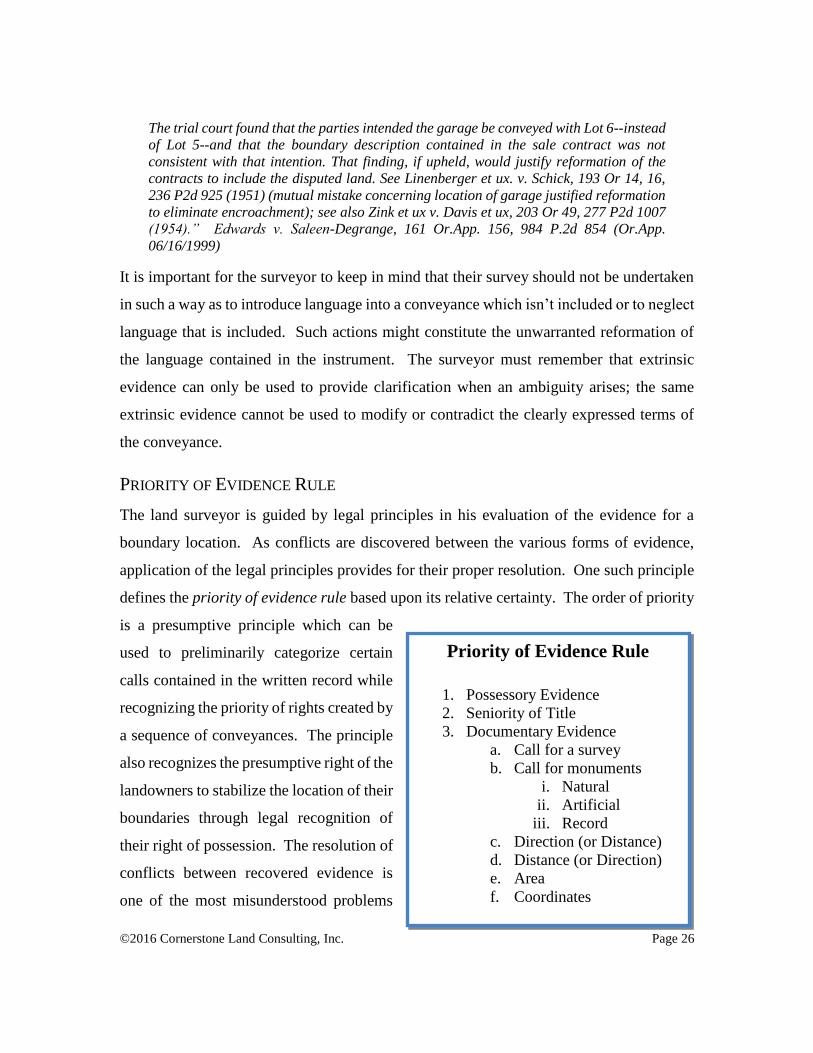
PRIORITY OF EVIDENCE RULE
The land surveyor is guided by legal principles in his evaluation of the evidence for a
boundary location. As conflicts are discovered between the various forms of evidence,
application of the legal principles provides for their proper resolution. One such principle
defines the priority of evidence rule based upon its relative certainty. The order of priority
is a presumptive principle which can be
used to preliminarily categorize certain
calls contained in the written record while
recognizing the priority of rights created by
a sequence of conveyances. The principle
also recognizes the presumptive right of the
landowners to stabilize the location of their
boundaries through legal recognition of
their right of possession. The resolution of
conflicts between recovered evidence is
one of the most misunderstood problems
Priority of Evidence Rule
1. Possessory Evidence
2. Seniority of Title
3. Documentary Evidence
a. Call for a survey
b. Call for monuments
i. Natural
ii. Artificial
iii. Record
c. Direction (or Distance)
d. Distance (or Direction)
e. Area
f. Coordinates

©2016 Cornerstone Land Consulting, Inc. Page 27
for both surveyors and lawyers. Conflicting terms contained within the deed or other
written conveyances occur frequently. Conflicting measurements occur even more
frequently. Clearly written and unambiguous expressed language of the written
conveyance occasionally is found to conflict with other writings or with prior survey
monuments or with occupation of the land. Understanding the legal principles at play is
crucial to the proper analysis and resolution of any boundary location.
The Oregon court recently addressed the considerations of priority of conflicting evidence
relating to deed construction. In the 2004 case of Dennison v. Hodge, 100 P.3d 1144, 196
Or.App. 248 (Or.App. 11/24/2004), the Court of Appeals answered a fundamental question
whether a 1921 deed conveyed to the bank of a river following its meanders. The deed
described the property conveyed as:
"That part of Lot 5, Sec. 28. T 13 S., R. 11 W. W. M. from a point of beginning on the
centre [sic] line of the Alsea highway ot [sic] Sta 83+85, thence S 5105 W. 60' along
the centre [sic] line of the road; thence S 3855' E. 54.5' to a cedar Post on the bank of
the Alsea River; thence along the bank of the Alsea River S 3539' W 108.9_ to a cedar
post; thence N 3855' W 165.5_to a cedar post; thence N 5105' E 160.0_to a cedar post;
thence S 3855' E 82.0' to the point of beginning..."
One party argued that the terms of the deed described the boundary as “along the bank of
the Alsea River,” therefore meaning that the accreted land following the meanders of the
river were included. The other party argued that the description ran from a specific
monument (the cedar post) to another specific monument (another cedar post) calling for a
specific direction and distance; therefore it did not convey the accreted land. The court
concluded:
“... that defendant's argument is defeated by the provisions of ORS 93.310.* Subsection
(2) of that statute provides that "[w]hen permanent and visible or ascertained boundaries
or monuments are inconsistent with the measurement, either of lines, angles or surfaces,
the boundaries or monuments are paramount." (Emphasis added.) If the bank of the Alsea
River constitutes a monument as contemplated by the statute, then the call to the river in
the deed in this case would control over the angle and distance calls. In other words, that
construction of the deed would cause the boundary to run from the first cedar post on the
bank of the river along the bank of the river to the second cedar post, which is necessarily
also on the bank of the river. For purposes of this construction, the posts are artificial
monuments that determine the corners of the property, while the bank functions as a
natural monument along which the property line proceeds from the first cedar post to the
©2016 Cornerstone Land Consulting, Inc. Page 28
second cedar post. The precise distance along the bank is itself undetermined because it
will follow the changing sinuosities of the river. However, the specific angle and distance
tell the reader where to find the second cedar post to ascertain the next corner of the
described area. Thus, under that construction the boundary is the bank or the edge of the
river between the two posts.”
The courts have long recognized an order or hierarchy of evidence used in the interpretation
of land boundaries. The hierarchy is based primarily upon the variation in the level of
certainty that exists with each form of evidence. When terms contained within a deed are
found to conflict, the surveyor must analyze the terms in their order of certainty. However,
if the results obtained by strictly adhering to the priority of evidence rule are clearly
contrary to the overall intent of the deed, the clearly stated contrary intent of the deed will
control.
RESOLVING SIMULTANEOUS CONVEYANCES
The division of a parcel of land into several parcels may occur under two distinct bodies
of law. The parcel may be divided sequentially resulting from a series of conveyances, or
they may be divided simultaneously. A simultaneous division occurs typically by
recording a subdivision plat which depicts a division of a single parcel into several tracts
which might include streets, alleys, blocks, and individual lots. Each of these tracts is
considered to be simultaneously created by the act of filing the plat. Because all of the
tracts are created under a single act, they are considered to be equal in time and
circumstance and, therefore, equal in right. Other examples of protracted and
simultaneously created boundaries are found in wills, court decrees, and much of the fabric
of the Public Land Survey System. Aliquot or “fractional part of the whole” descriptions
such as half or quarter are considered simultaneous creations as one cannot create half of a
parcel without simultaneously creating both halves. The same can be said with any aliquot
division.
Often in such circumstances, monuments may be placed by the surveyor at each
intervening block corner or section corner, leaving the individual lots or interior
subdivisions defined by a protraction diagram of the lot or fractional boundaries.
Protracted lines are depicted on the plat without the benefit of having been located on the
©2016 Cornerstone Land Consulting, Inc. Page 29
ground by survey and monuments. Any differences discovered between the dimensions of
a given block as depicted on the plat and those found between the monuments on the ground
are generally distributed equally amongst the lots, each being given its proportionate share
of any excess or deficiency.
The principle of law designed to resolve discrepancies is referred to as the rule of
apportionment. The apportionment rule is widespread and typically well established in
most jurisdictions with a few exceptions, some regions of upper New York being an
example. The apportionment rule, while being widely accepted, is nonetheless limited in
its application.
As a general rule, if it is discovered that a tract contains more or less land than the area
assigned to it in the original plan, any excess or deficiency should be apportioned among
all of the subdivided tracts or lots in proportion to their areas. W. Robilard & L. Bouman,
Law of Surveying and Boundaries § 12.01 (5th ed.1987); 11 C.J.S. Boundaries § 124
(1938); 12 Am.Jur.2d Boundaries § 63 (1964); Annot., Rights as Between Grantees in
Severalty of Lots or Parts of the Same Tract, Where Actual Measurements Vary From
Those Given in the Deeds or Indicated on the Map or Plat, 97 A.L.R. 1227 (1935);
accord, Hansen v. Lindstrom, 168 Wash. 130, 140-41, 11 P.2d 232 (1932). As with any
rule, however, this general rule is subject to [62 Wn.App. 580] exceptions. One such
exception, which the trial court relied on here, is the "rule of possession". [2] Under the
"rule of possession", an apportionment of an excess or deficiency of land will not be made
when to do so would disturb long established occupational lines or would otherwise be
impractical or inequitable. Pompano Beach v. Beatty, 177 So.2d 261, 263
(Fla.App.1965); Allen v. Mount Morris, 32 Mich.App. 633, 189 N.W.2d 120, 121-22
(1971); Alston v. Clinton, 73 N.M. 341, 388 P.2d 64, 68 (1963); Van Deven v. Harvey, 9
Wis.2d 124, 100 N.W.2d 587, 590-91 (1960). In this situation, the location of the
boundary line in dispute is determined by apportioning the excess or deficiency between
the parties actually involved in the boundary dispute, Alston, 388 P.2d at 68; Van Deven,
100 N.W.2d at 591-92; or by resort to basic common law doctrines for determining
boundaries, namely, adverse possession, parol agreement, estoppel in pais, location by
a common grantor, and/or mutual recognition and acquiescence. Van Deven, 100 N.W.2d
at 591; Washington State Bar Ass'n, Real Property Deskbook § 63.5 (2d ed.1986).
[2] Another exception that could have been applied in this case is the "remnant rule".
The remnant rule applies when the subdivider declares the dimensions of each lot except
the last and thus leaves an irregular, undimensioned space. In this situation, all excess
or deficiency in land is assigned to the undimensioned lot, on the theory that this was the
intent of the grantor or platter. E.g., Robilard & Bouman, supra at § 12.20; 12 Am.Jur.2d,
supra at 601; 11 C.J.S., supra at 738-39; 97 A.L.R., supra at 1232-33. Here, every lot in
Block A of the plat at issue has an assigned width except the southernmost lot, lot 36.
Under the remnant rule, lot 36 would receive all excess property and no apportionment
among the remaining 35 lots would be necessary.
©2016 Cornerstone Land Consulting, Inc. Page 30
Reitz v. Knight, 814 P.2d 1212, 62 Wn.App. 575 (Wash.App. Div. 1 1991)
The apportionment rule is only applied to parcels having equal rights and which have never
been established on the ground by survey or subsequent occupation. A vestige of the
apportionment rule was inapplicably argued in Oregon during the appeal of a 1978 case
regarding the location of a boundary between parcels not contained in a subdivision:
“As against this testimony, defendants Kmetics' expert … testified that his surveyed
boundary line conformed more closely to the boundaries of nearby tracts. Defendants
argue as a "principle of surveying that prior deeds and prior surveys control subsequent
deeds and surveys" and where there is a discrepancy in deeds and surveys resulting in a
shortage to one parcel, "the later surveys must absorb any deficiency." Defendants cite
Adams v. Wilson, 137 Ala 632, 34 So 831 (1902); Robeson v. Howell, 23 La Ann 601
(1871), and 97 ALR 1227, 1231 for this rule. These cases refer to prior surveys, not deeds,
in a particular plot or subdivision where title to the lots becomes vested in different
persons. No Oregon cases are cited in support of this proposed rule, and we have found
none.” Bean v. Kmetic, 282 Or. 739, 580 P.2d 1022 (Or. 06/27/1978)
The rule only applies to simultaneously created parcels having equal rights in the excess or
deficiency and is applied between the nearest established boundary in each direction. The
result is to distribute the excess or deficiency proportionately between each of the
successive parcels holding equal right to the whole. The apportionment rule is only applied
to parcels having equal rights and which have never been established on the ground by
survey or subsequent occupation. The apportionment rule cannot be used to overcome the
location of a boundary which has been previously established by another method. The rule
is applied in a limited sense in that it is considered a “rule of last resort” applied only when
no other method has been previously applied.
RESOLVING SEQUENTIAL CONVEYANCES
Boundaries created by a series of sequential conveyances fall under a different well
recognized rule which requires that the conveyance document which created the boundary
be construed against the grantor who retained ownership of the remaining portion of the
parent parcel. Because the resulting parcels were subject to the ownership interest of the
grantor at the time of each conveyance, a succession of priority is created, each parcel
having seniority of right over the subsequent parcel described. When the surveyor is

©2016 Cornerstone Land Consulting, Inc. Page 31
confronted by a conflict in the written title which gives the appearance of either an overlap
or a gap with the adjoining parcel, the surveyor is obligated to research the record title to
ascertain which of the parcels was created first or whether the parcels were created in
simultaneous fashion. The conveyance of the senior parcel created the original boundary;
any subsequent conveyance of the adjoining property will result in a junior parcel. The
description of the boundary in the junior deed merely reflects the scrivener’s interpretation
of the location of the existing senior parcel boundary. If the senior boundary is improperly
determined, the resulting junior parcel description will give the appearance of creating an
overlap or a gap with the senior parcel. In reality, the discrepancy merely amounts to an
incorrect dimension reported in the junior (remainder) parcel description.
A boundary, by definition, marks the confines or line of division of two contiguous
properties. How, then, can any two adjoining properties overlap or gap? Our use of the
words, “overlap” and “gap” to describe the apparent conflict caused by a shortage or excess
from the record dimensions of a parcel has tainted the way we view the problem. Legally,
it is impossible for two parcels divided by separate ownerships to “overlap” one another.
Likewise, it is also legally impossible for a “gap” to occur. There can only be one boundary
between two adjoining properties; therefore, there cannot be an overlap or gap in the “title.”
What is commonly viewed as a “title” problem, is in fact not a title problem at all. It is
simply a conflict in evidence of two adjoining property descriptions.
The appearance of a gap or overlap represents the discovery of a conflict in evidence, not
a boundary conflict. The resolution of the gap or overlap through the appropriate
application of a legal principle presents the resolution of the conflicting evidence. The
surveyor is expected to arrive at a conclusion to the boundary location and to monument
their decision on the ground. The boundary location is determined by application of the
surveyor’s skill, knowledge and expertise at resolving conflicting title elements contained
within the described boundaries according to legal principles. The principles are
specifically designed to resolve the conflicting evidence by providing rules meant to
©2016 Cornerstone Land Consulting, Inc. Page 32
prioritize the evidence in such a way as to give more credence to one piece of evidence
over another.
The boundary defining the farthest extent of the contiguous estates found by the surveyor
may not reflect the dimensions found in the written title. The location of the boundary
reflected by the title dimensions and the location as established by means of agreement or
possession should be clearly indicated on the survey by making reference to the record and
measured dimensions. The conflicting evidence identified by the survey may be resolved
and the record title modified to reflect the differences if necessary. This process will
involve the contiguous owners’ input and agreement which, when reduced to writing and
recorded, will resolve the discrepancies discovered. The survey may then be completed
reflecting the agreement. The resolution would not be found in a correction of the title
documents as the problem is not a title problem. It is merely an evidentiary conflict.
Differences between the dimensions reflected in the record title and the location of the
boundary as measured upon the ground can originate from a variety of causes. The cause
may be found in a dimension from an earlier survey or from an estimation of distance
between fixed monuments. The cause may be found in a platted block subsequently
divided into individual lots. Errors in the early surveys are often discovered by later
surveys which employ more modern equipment and survey techniques. The nature of the
differences in measurement and the process by which the property was divided often will
determine the method used for reporting and distributing the measurement differences.
Rules of law governing simultaneous and sequentially conveyed property were developed
to provide specific direction to the surveyor to resolve such evidentiary conflicts.
DEFICIENCIES (SHORTAGES OR OVERLAPS)
Overlaps in title are technical and legal impossibilities that are often misunderstood. What
is “described” in a deed may appear to overlap with an adjoining property, however, what
is “conveyed” by the deed is limited to only that portion the grantor has title to. The
conveyance of title is limited by the senior right which created the boundary. Any shortage
discovered in the amount of land available from the parent tract may result in the

©2016 Cornerstone Land Consulting, Inc. Page 33
appearance of an overlap. The parcel with senior rights will prevail over the junior parcel
provided the boundary has not been established by some other actions of the landowners.
Title to the “overlapping” portion is vested in the senior parcel and cannot be encumbered
by a subsequent sale of the remaining junior parcel. The junior parcel may have the
appearance of title, however, an appearance cannot affect the prior ownership rights of the
senior abutter. The only conflict is in the dimensions of the junior parcel.
Surveyors frequently discover latent ambiguities when applying the dimensions contained
in a property description to the ground. The survey process will recover the locations of
the existing boundaries of the parent property which discloses a difference between the
dimension of record and that measured by the surveyor using more modern techniques.
The manner by which the surveyor documents and distributes this discrepancy in the
measurement evidence might vary with each jurisdiction. Some jurisdictions require
recordation of the survey in the title record making it subject to statutory constructive
notice provisions. Other jurisdictions require filing of the survey in a public repository
separate from the title records where the evidence of boundary locations is maintained
separate from the constructive notice of the title record. A few jurisdictions fail to maintain
any public repository for survey evidence, making the perpetuation of boundary locations
over time an extremely difficult task.
The simple remedy for reporting a shortage or excess discovered between two contiguous
parcels, where the survey is placed in a public repository, is to represent the record and
measured dimensions on the face of the survey and to document the surveyor’s
methodology for distributing the excess or deficiency in accordance with the appropriate
legal precedent. Where the surveys are not deposited for public record, little remedy exists
except to attempt a modification of the title record. This may be accomplished, under
certain circumstances, by execution of a correction deed or landowner affidavits to remedy
the record.
A commonly seen, and typically improper, remedy is attempted by executing a Quit Claim
Deed which describes the senior parcel or the parcel to which an apparent claim of

©2016 Cornerstone Land Consulting, Inc. Page 34
ownership is to be released. The description contained in the Quit Claim Deed should
encompass the existing record description of the adjoining (typically senior) parcel.
Release of any interest in the overlapping portion by the title holder of the junior parcel
will remove the apparent cloud upon the title. This method has advantages over other
methods where the overlapping “strip” of land is described and conveyed from one party
to the other. “Strip” descriptions are frowned upon as they often result in violation of
subdivision regulations, when no parcel (strip) actually exists. The more appropriate
resolution should be maintained in the survey record and not incorporated into the title
record.
EXCESSES (OVERAGES OR GAPS)
Gaps in title with an adjoiner are similarly a technical impossibility. To “adjoin” means
to be connected or contiguous, which by logic makes a gap impossible. The more proper
term “adjacent” means lying near to but not necessarily touching. Every boundary marks
the division of two contiguous estates. Therefore, having a gap between two contiguous
estates is not possible. When two parcels do not join or are not contiguous, a third parcel
owned by a third party separates them. The parcel may not be shown on a map or
recognized by the assessor for taxation purposes, but if the property exists, it exists. No
agreement between the adjacent properties will affect the intervening third party interest.
Likewise, if the property does not exist, the two properties are adjoining and there is no
gap between them. An overage or excess found in the dimensions of a parent parcel, from
which the current properties share a common root of title, may result in the appearance of
a “gap” between the parcels.
The descriptions of properties frequently contain inaccuracies that, if taken literally, result
in the appearance of slight gaps or strips of property along the exterior lines of the original
tract. The Supreme Court of West Virginia has addressed this common problem on
numerous occasions. They have repeatedly stated:
“It has been held frequently by this court that there is a presumption of law against a
grantor retaining a long, narrow strip of land next to one of his outside lines, when the
description of the land granted approximates the description under which he holds.

©2016 Cornerstone Land Consulting, Inc. Page 35
“Generally, in the absence of facts or circumstances explanatory, it will not be presumed
that a party granting land intends to retain a long, narrow strip next to one of his lines;
but if the courses and distances approximate closely to a line or corner of the tract owned
by the grantor — especially if the description in the deed corresponds, exactly or
substantially, with the description in the title papers under which the land is held — it
will be presumed that the lines mentioned are intended to reach the corners and run with
the lines of the tract ...”” United Fuel Gas Co. v. Townsend, Supreme Court of Appeals
of W. Virginia, 1927, 139 S.E. 856, quoting Western Co. v. Peytona Co., 8 W. Va. 406,418
The long, narrow strip referred to in United Fuel was approximately 50 feet wide on one
end and 132 feet wide on the other and contained approximately 4 ½ acres of land.
Consider an example of a landowner who holds title to a parcel of land (the parent tract)
described as containing 1000 feet of frontage. The landowner is approached by an
individual desiring to purchase the west 500 feet of the parcel. They decide to forgo the
expense of a survey. The landowner subsequently is approached by a second individual
desiring to purchase the remainder of the original parcel. The landowner is clearly aware
that he originally purchased 1000 feet, sold the west 500 feet and, therefore must have 500
feet remaining. The deed is drawn up describing the remaining east 500 foot parcel and
the sale is consummated. A surveyor is requested to perform a division of the east parcel
and proceeds to retrace the boundaries of the parent tract. Of course he will find that the
dimension of the original parent tract to be either long or short of the original 1000 feet
presumed by the original landowner.
It is readily apparent that the
landowners intended to create a
boundary with the first senior
conveyance. The senior deed will
describe for the first time the
location of the boundary agreed
upon by the original conveyance.
The subsequent conveyance of the
adjacent (junior) parcel can have
but only two possible intents. The
©2016 Cornerstone Land Consulting, Inc. Page 36
first intent would be to follow the existing line of record created by the senior deed; the
second would be to create a new boundary and retain ownership of a third parcel of land
separating the first and second parcels.
“The other evidence, as found by the trial court, favors the defendants' position. It
appears that the original owners of the subdivision owned the entire western half of the
western half of section 2. Thus, for plaintiffs' theory of the boundary to be correct, the
original owners must have intended to retain a 20-foot by 1,320-foot strip of land along
the southern edge of the subdivision. There is nothing in the record to show that they did
or why they would wish to do so.
Since there is no indication that the original owners intended to stop the subdivision short
of the section line, and since we have adopted a policy against construing conveyances
so as to create "strips of land the title to which would otherwise remain in abeyance for
long periods of time," Hurd v. Byrnes, 264 Or 591, 598, 506 P2d 686 (1973), it follows
that the subdivision should be construed as extending to the south section line.” Nelson
v. Vandemarr, 281 Or. 65, 573 P.2d 1232 (Or. 01/24/1978)
The intentional creation of a third parcel should be reflected in the deed records by the
subsequent sale of the third parcel, or by delineation of the strip in the assessor’s records
as a separate parcel. Lacking evidence that either condition is found in the record, it must
be presumed that the intent of the second conveyance was to follow the existing line of
record. Such an interpretation is consistent with the presumptions stated in the above cited
ruling.
These rules of law are designed with the purpose of resolving discrepancies caused by
conflicting evidence. Each piece of evidence must be investigated and analyzed with
regard given to its source while keeping in mind the intent of the parties. When the
surveyor on the ground fails to recognize and apply these rules of law, the conflicting
evidence becomes dogmatically applied resulting in monuments falsely indicating the
location of the boundary. When the surveyor properly applies these rules, the conflicting
evidence is resolved and the boundary is properly monumented.
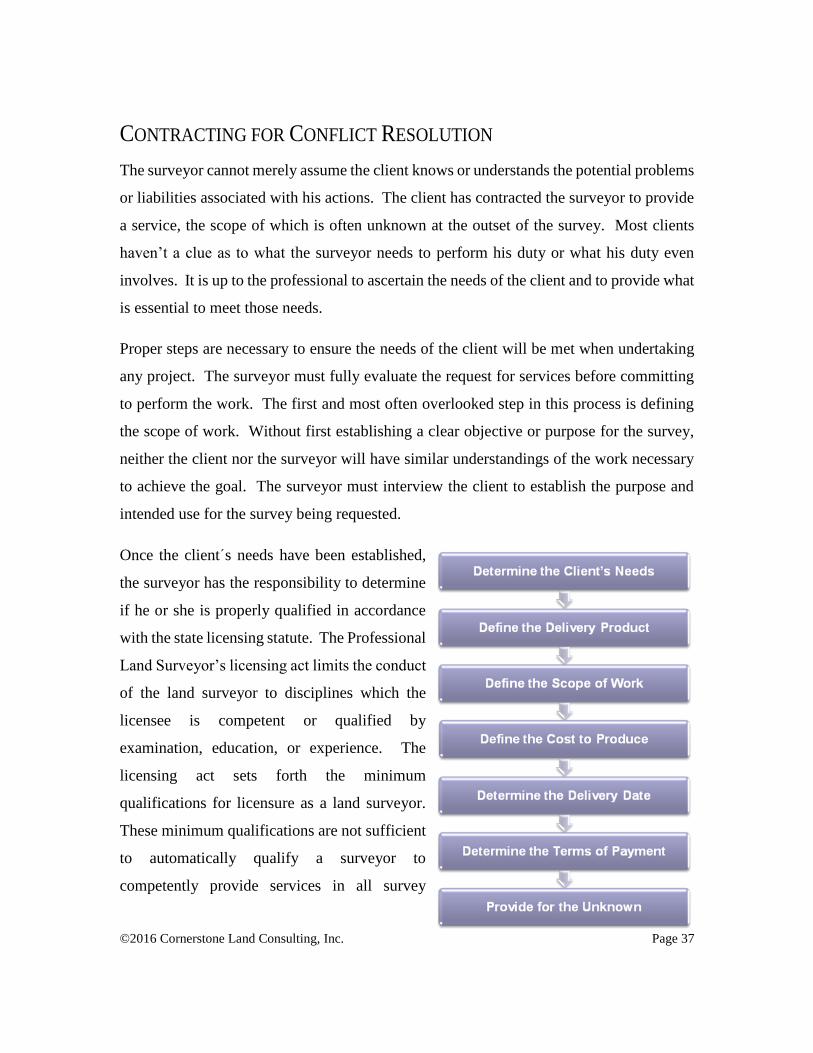
©2016 Cornerstone Land Consulting, Inc. Page 37
CONTRACTING FOR CONFLICT RESOLUTION
The surveyor cannot merely assume the client knows or understands the potential problems
or liabilities associated with his actions. The client has contracted the surveyor to provide
a service, the scope of which is often unknown at the outset of the survey. Most clients
haven’t a clue as to what the surveyor needs to perform his duty or what his duty even
involves. It is up to the professional to ascertain the needs of the client and to provide what
is essential to meet those needs.
Proper steps are necessary to ensure the needs of the client will be met when undertaking
any project. The surveyor must fully evaluate the request for services before committing
to perform the work. The first and most often overlooked step in this process is defining
the scope of work. Without first establishing a clear objective or purpose for the survey,
neither the client nor the surveyor will have similar understandings of the work necessary
to achieve the goal. The surveyor must interview the client to establish the purpose and
intended use for the survey being requested.
Once the clients needs have been established,
the surveyor has the responsibility to determine
if he or she is properly qualified in accordance
with the state licensing statute. The Professional
Land Surveyor’s licensing act limits the conduct
of the land surveyor to disciplines which the
licensee is competent or qualified by
examination, education, or experience. The
licensing act sets forth the minimum
qualifications for licensure as a land surveyor.
These minimum qualifications are not sufficient
to automatically qualify a surveyor to
competently provide services in all survey
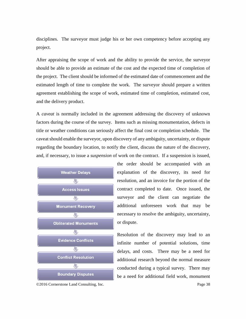
©2016 Cornerstone Land Consulting, Inc. Page 38
disciplines. The surveyor must judge his or her own competency before accepting any
project.
After appraising the scope of work and the ability to provide the service, the surveyor
should be able to provide an estimate of the cost and the expected time of completion of
the project. The client should be informed of the estimated date of commencement and the
estimated length of time to complete the work. The surveyor should prepare a written
agreement establishing the scope of work, estimated time of completion, estimated cost,
and the delivery product.
A caveat is normally included in the agreement addressing the discovery of unknown
factors during the course of the survey. Items such as missing monumentation, defects in
title or weather conditions can seriously affect the final cost or completion schedule. The
caveat should enable the surveyor, upon discovery of any ambiguity, uncertainty, or dispute
regarding the boundary location, to notify the client, discuss the nature of the discovery,
and, if necessary, to issue a suspension of work on the contract. If a suspension is issued,
the order should be accompanied with an
explanation of the discovery, its need for
resolution, and an invoice for the portion of the
contract completed to date. Once issued, the
surveyor and the client can negotiate the
additional unforeseen work that may be
necessary to resolve the ambiguity, uncertainty,
or dispute.
Resolution of the discovery may lead to an
infinite number of potential solutions, time
delays, and costs. There may be a need for
additional research beyond the normal measure
conducted during a typical survey. There may
be a need for additional field work, monument
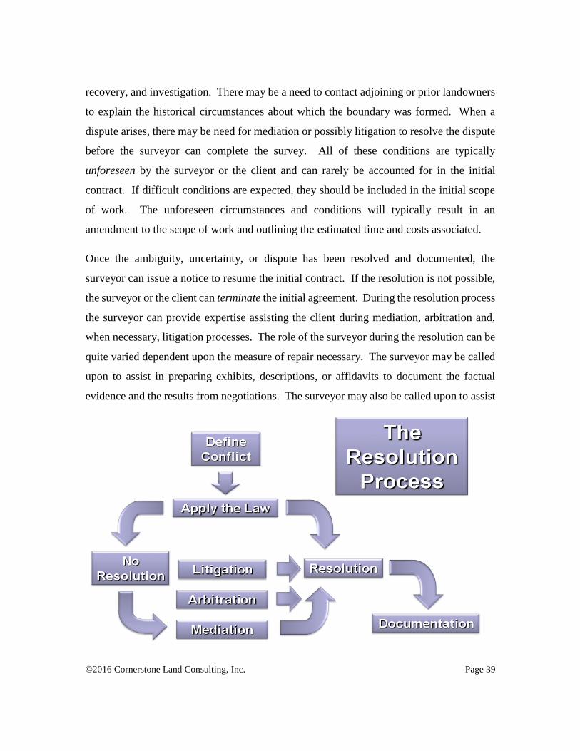
©2016 Cornerstone Land Consulting, Inc. Page 39
recovery, and investigation. There may be a need to contact adjoining or prior landowners
to explain the historical circumstances about which the boundary was formed. When a
dispute arises, there may be need for mediation or possibly litigation to resolve the dispute
before the surveyor can complete the survey. All of these conditions are typically
unforeseen by the surveyor or the client and can rarely be accounted for in the initial
contract. If difficult conditions are expected, they should be included in the initial scope
of work. The unforeseen circumstances and conditions will typically result in an
amendment to the scope of work and outlining the estimated time and costs associated.
Once the ambiguity, uncertainty, or dispute has been resolved and documented, the
surveyor can issue a notice to resume the initial contract. If the resolution is not possible,
the surveyor or the client can terminate the initial agreement. During the resolution process
the surveyor can provide expertise assisting the client during mediation, arbitration and,
when necessary, litigation processes. The role of the surveyor during the resolution can be
quite varied dependent upon the measure of repair necessary. The surveyor may be called
upon to assist in preparing exhibits, descriptions, or affidavits to document the factual
evidence and the results from negotiations. The surveyor may also be called upon to assist
©2016 Cornerstone Land Consulting, Inc. Page 40
in the mediation or litigation process as a consultant or an expert witness. As such, the role
of the surveyor can dynamically change throughout their engagement.
RESOLUTION THROUGH MEDIATION
Mediation is a conflict resolution process in which a neutral person facilitates
communication, the development of understanding, and the generation of options for
creative dispute resolution. Unlike a judge or jury, the mediator does not decide the
outcome of a dispute. A mediator’s role is to help participants to surface issues, to create
a safe space to discuss issues, and to foster agreement as participants seek options that
could move them forward toward workable solutions. Mediation is a useful process when
the goal of preserving the neighbor-to-neighbor relationship is as important as resolving
the substantive problems. Unlike litigation or arbitration, mediation allows the participants
in the dispute to remain in control of the process and to contribute to the outcome.
Surveyors have been encouraged throughout the centuries to involve themselves in the
resolution process. They received encouragement from Thomas M. Cooley, Justice of the
Michigan Supreme court during a presentation to the Michigan Society of Surveyors and
Engineers at their annual conference in January, 1881. Justice Cooley summarized the role
of the surveyor by saying:
“It is always possible, when corners are extinct, that the surveyor may usefully act as a
mediator between parties and assist in preventing legal controversies by settling doubtful
lines. Unless he is made for this purpose an arbitrator by legal submission, the parties,
of course, even if they consent to follow his judgement, cannot, on the basis of mere
consent, be compelled to do so; but if he brings about an agreement, and they carry it
into effect by actually conforming their occupation to his lines, the action will conclude
them. Of course, it is desirable that all such agreements be reduced to writing, but this
is not absolutely indispensable if they are carried into effect without.”
Further advice was given by author, Ray Hamilton Skelton in his book entitled, The Legal
Elements of Boundaries and Adjacent Properties,§ 305 (1st ed.), published in 1930.
"When it is definitely proved that the fence or wall marking the given line is not in
harmony with the lines of other improvements which check with their own deed calls, and
that at most it merely represents a line established at some time by adjoining owners, the
matter is primarily one of law, hinging upon the question of establishment. The
©2016 Cornerstone Land Consulting, Inc. Page 41
[surveyor] should then make a situation survey to show that the lines of the original
survey contradict the line in question, and, where possible, explain the discrepancy. In
all cases the extent of the conflict should be indicated, but no recommendation as to which
line is the boundary should be made, and comments should be confined to the statement
of facts. To prepare such a plat intelligently the [surveyor] must have a knowledge of the
legal principles of establishment.
Furthermore, the [surveyor] is often the first to find the conflict between an established
line and its corresponding deed line. Where boundaries are unsettled such discoveries
are likely to start a dispute, for the first impulse of the party encroached upon is to defend
the land laid down by his deed calls. It is much easier to prevent a fight than to stop one,
and for a party to defer action than to back down from an untenable position. Therefore,
if the [surveyor] can explain the principles of establishment and illustrate them by an
abstract application, the militant party may be persuaded to seek legal advice rather than
to depend upon rough tactics. When this is accomplished the matter may often be
adjusted peacefully, and when they elect to abide by the established line, the position of
the new line may be made a matter of record so that the conflict with the deed line is
explained and thus overcome.”
When conflicts arise between the record locations and the occupation lines, the surveyor’s
role will change from that of evidence recovery and boundary determination to that of a
mediator providing assistance to the landowners for documenting their establishment of
the boundary. Through facilitated dialogue, the participants are able to identify what is
important to them and what they need to reach a solution. Mediation is voluntary and relies
on the good faith participation of the people involved in the process. One of the
fundamental tenets of mediation is confidentiality. In order to encourage honest and open
communication among participants, all conversations associated with the mediation
process remain confidential. As a process, mediation of boundary conflict resolution
requires the use of a skilled, knowledgeable mediator, a task for which the land surveyor
is well suited. With sufficient training and practice, anyone can serve as a mediator
provided they have no stake in the outcome of the dispute.
There are many barriers that can affect the resolution of disputes. These barriers include:
time constraints, inadequate access to information, poor communication structures,
conflicting desires of the landowners, high value of property at stake, emotionally charged
situations, and fatigue. For many land surveyors, there is little training or skill development
in negotiation, listening, communication, or conflict resolution. With limited training and
©2016 Cornerstone Land Consulting, Inc. Page 42
a little priority placed on the importance of developing mediation skills, the surveyor can
fulfill an important role. Few mentors or role models exist for modeling effective skills
and techniques. Many surveyors have a tendency to avoid addressing conflict directly. It
is little wonder that boundary conflict resolution has been avoided by many in the land
surveying profession. The goal for successful mediation requires that the land surveyor
overcome these barriers and engage themselves in resolving the issues.
Many of these limitations, however, can be overcome by adequate training. Each state has
established a program of mediation training through private organizations or through the
courts or the state attorney’s bar association. Mediation has fast become a preferred form
of settlement of conflicts between neighbors over the litigation process. The state
legislators have enacted laws which encourage, and often require, that attempts to resolve
conflicts through the mediation process be attempted before any civil suit can be brought
before the court magistrate. The surveyor can provide an vitally essential role in the
mediation of conflicts by bringing their experience, knowledge and expertise to the
mediation table. The parties, with the guidance of the surveyor, are more likely to enter
into an informed decision which is more likely to fulfill their current and future needs.
RESOLUTION THROUGH ARBITRATION
When all efforts of the landowners to arrive at a mutual agreement regarding the location
of their common boundary have been exhausted, the landowners may reach an impasse.
Only three choices remain; walk away and leave the problem unresolved, arbitrate a
resolution, or litigate a resolution. Prior to the choice to litigate, the parties have the mutual
authority to resolve their boundary. They share a common problem. Their failure to
resolve the problem amicably is not doomed to eternity. One or the other parties may
choose to arbitrate.
Abraham Lincoln was a skilled trial lawyer who viewed litigation as a “last resort.” He is
quoted as writing:

©2016 Cornerstone Land Consulting, Inc. Page 43
“Discourage litigation. Persuade your neighbors to compromise whenever you can.
Point out to them how the nominal winner is often a real loser – in fees, expenses and
waste of time.” Abraham Lincoln’s Notes for a Law Lecture, July 1, 1850.
The step to arbitrate is one which essentially passes the mantel of authority from the
landowner to an arbitrator or a panel of arbitrators. The arbitrator may be chosen by the
landowners either from an informal or formal setting. When we commonly think of
litigation, we equate it with the court system involving attorneys appointed to represent the
owners, a judge appointed as the arbitrator, lack of control over the outcome, and lots of
time and money expended in the process. This is not necessarily the landowners’ only
recourse. They may choose to informally arbitrate the boundary.
The landowners may choose a solution as simple as appointing the surveyor as the
arbitrator. They agree to share the cost of a survey and, “whatever the surveyor decides,
that will be our line.” In this type of action, the surveyor is appointed as the sole arbitrator.
He will perform the survey as typical, he will gather all physical evidence, the written
evidence, and the oral testimony of the landowners (they need their day in court), and make
a professional determination regarding the boundary location in accordance with the rules
of law just as he is expected to do in any other survey. The difference being that (and this
really isn’t any difference) the landowners may choose to appeal his decision even though
they’ve initially agreed to be bound by the arbitrator’s decision.
Some states provide a method for resolution of boundary disputes through a panel of
arbitrators. Rather than rely upon the decision of a single surveyor, the parties may choose
to each select a surveyor, then have the two surveyors jointly select a third surveyor. The
three surveyors can form an arbitration panel, each bringing to the table the evidence
gathered. The panel will review the evidence, perform an analysis and will determine the
facts at hand. They will then discuss the principles involved which determine the boundary
and will derive their opinion. As chosen arbitrators, their opinion is agreed in advance to
be upheld by the owners. If either owner disagrees with the panel opinion, they will have
a right of appeal, however the panel opinion will carry a presumption of correctness which
must be overcome on the appeal.

©2016 Cornerstone Land Consulting, Inc. Page 44
Oregon, as well as several other states, provides by statute an opportunity for disputing
parties to commission, through the civil court, a panel of surveyors to jointly conduct a
survey with the intent to resolve the location of a boundary line. The purpose of such a
statute is not to grant overriding authority to the surveyors to adjudicate the location of the
boundary, but is to provide a consortium of surveyors who, working together to gather and
review the evidence, is more likely to derive a proper conclusion regarding the boundary
location.
O.R.S. Chapter 105 – Property Rights
ACTION TO ESTABLISH BOUNDARY
105.705 Right to bring action; filing of judgment. (1) When any dispute or controversy
exists between owners of adjacent or contiguous lands in this state, concerning the
boundary lines thereof, or the location of the line dividing such lands, any party to the
dispute or controversy may bring an action in the circuit court in the county where all or
part of the lands are situated, for the purpose of having the controversy or dispute
determined, and the boundary line or dividing line ascertained and marked by proper
monuments upon the ground where such line is ascertained.
(2) Upon final determination of the dispute by the court, the clerk of the court shall file
one copy of the judgment in the office of the county surveyor, one copy in the office of the
county assessor and one copy in the office of the county officer who keeps the records of
deeds for recording in the county deed records. [Amended by 1965 c.24 §1; 1979 c.284
§97]
105.710 Pleadings. The complaint in a boundary suit is sufficient if it appears therefrom
that the plaintiff and defendant are owners of adjacent lands, some part of which is in the
county in which the suit is brought and that there is a controversy or dispute between the
parties concerning their boundary or dividing line. It shall not be necessary to set forth
the nature of the dispute or controversy except that the plaintiff shall describe the
boundary or dividing line as the plaintiff claims it to be. The defendant in the answer
shall set forth the nature of the claim of the defendant with reference to the location of
the line in controversy.
105.715 Mode of proceeding. The mode of proceeding in a boundary action is analogous
to that of an action not triable by right to a jury. At the time of entering the judgment
fixing the true location of the disputed boundary or dividing line the court shall appoint
three disinterested commissioners, one of whom shall be a registered professional land
surveyor, and shall direct the commissioners to go upon the land of the parties and
establish and mark out upon the grounds, by proper monuments, the boundary or dividing
line as ascertained and determined by the court in its judgment. The monuments shall be
established by or under the direct supervision of the registered professional land
surveyor who shall file a record of survey, complying with ORS 209.250, with the county
surveyor. [Amended by 1979 c.284 §98; 1991 c.150 §1]
©2016 Cornerstone Land Consulting, Inc. Page 45
Upon completion of the survey, a report of findings is given to the court for final
adjudication. The process is similar to those which provide for the selection of a special
master when topics of technical issues are being tried by the court. Because the judge and
jury don’t have the benefit of the expert’s knowledge, training, or skills in a certain subject,
they must rely upon the expertise of trained professionals such as the surveyor. The duty
of the expert is to assist the trier of fact (i.e. the judge and/or jury) to understand the
evidence, its proper analysis, and the facts determined from the evidence. In the case of
boundary locations, the surveyors are then required to apply the appropriate rule of law
which aligns with the fact situation as the case presents and to determine the location of
the boundary line.
“We therefore find that the decree of the trial court should be modified to show that the
land acquired by plaintiffs by adverse possession includes only the driveway running up
to the east side of plaintiffs' barn. The case is remanded to the trial court for entry of a
decree in accordance with this opinion and to establish the description of the "true
location of the disputed boundary * * * upon the land of the parties and establish and
mark out upon the grounds, by proper marks and monuments, the boundary" as provided
in ORS 105.715, 105.720 and 105.725.” Nelson v. Vandemarr, 281 Or. 65, 573 P.2d
1232 (Or. 01/24/1978)
The parties affected by the boundary line determined by the expert, special master, or
commission are given opportunity to review, challenge, or accept the findings as reported
to the court prior to its final adjudication. For this reason, the findings report is not
considered as having any binding or authoritative standing. The report expresses the
opinions of the surveyors regarding the evidence, factual determinations and resulting
boundary location. Those opinions are subject to review and challenge by the parties and
the court. The court will take the report under advisement along with any issues brought
up under challenge and will make its determination regarding the ultimate issue before the
court.
The statute is designed such that, when disputing parties cannot agree to have their
boundary jointly surveyed, they may petition the court to assign a commission of surveyors
to locate the line in question. Once the survey is completed and the final adjudication by
the court is made, the parties will be bound by the adjudicated line. The charge given the
©2016 Cornerstone Land Consulting, Inc. Page 46
surveyors is no different than their normally assigned task which is to locate the line in
accordance with the rules of law using the best evidence which can be recovered. The
surveyors cannot be used under the statute to establish new corners or boundaries (Burns
v. Kimber (1912),176 Ill. App. 515). They are charged only with locating existing
boundaries as have been created and established by prior action. As such, the surveyors
are responsible for retracing existing boundaries as formerly established.
“The defendants offered in evidence the record of the proceedings of the county court
establishing the old county road No. 562. This record included the field notes of the
survey by the county surveyor when the road was laid out by the Board of County
Viewers. The county court ordered the supervisor of the road district to open up the
proposed road according to law.
The decree of the trial court fixed the boundary between the lands of the plaintiff and the
defendants on the line of the old county road as surveyed by the county surveyor and
described in his field notes. In the absence of evidence to the contrary, we must presume
that the old county road No. 562 was located on the ground as ordered by the county
court in accordance with the survey thereof. The law presumes that official duty has been
regularly performed. ORS 41.360(15).[citations omitted)
…It should be borne in mind that the report of the commissions who establish the
boundary and mark it out upon the ground is subject to review by the court. If exceptions
are filed to the report, the parties may be heard and the court 'may confirm, modify or
set aside the report as is just.' ORS 105.725.
The decree of the lower court assessed to the plaintiff the cost of the survey as well as all
other costs incident to the suit. We agree that the costs of the suit should be assessed
against plaintiff. However, the expense of surveying the boundary and marking it on the
ground should be charged equally to the plaintiff and defendants, both of whom will be
benefited thereby. Newton v. McKeel, supra.” Jensen v. Westenskow, 225 Or. 189, 357
P.2d 383 (Or. 12/07/1960)
The statutes also require that notification be provided to all owners affected by the
permanent survey as their boundaries will ultimately be established by judicial action
thereby binding the parties to the boundaries as determined by the survey. The parties are
typically given an appeal period during which they may file any objections to the locations
of their boundaries.
The judicial process surveys have a unique quality among surveys as the adjudication
directly following the survey process lends permanency to the adjudicated boundaries. The
boundary locations become fixed in position while the costs of the adjudication are borne

©2016 Cornerstone Land Consulting, Inc. Page 47
by the parties who initiated the action. Judicial surveys provide an opportunity for repair
of multiple boundaries which may comprise entire neighborhoods or subdivisions whose
boundaries are in turmoil from the lack of monumentation or the over-prevalence of
conflicting evidence. The effect of the judicial process is to establish the positions of the
existing boundaries, not to adjudicate matters of title.
RESOLUTION THROUGH LITIGATION
The landowners may also choose to go the formal route by hiring the attorneys and yielding
their authority to the judge. They will proceed through a formal process governed strictly
by the law (the same law which governs the actions of the surveyor). Once a judgment is
obtained, the owners again have the right to appeal the decision of the court. If they choose
to appeal the judge’s decision, they can afford the opportunity to receive the opinion of
three to five judges whether their case is heard by an appellate court or the supreme court
of their state.
The role of the surveyor during the litigation process can change dramatically during the
litigation process, often requiring the surveyor to play multiple roles. Prior to filing of the
complaint, the surveyor can function as the surveyor or as a consultant to the parties during
any mediation process. Once the complaint is filed, however, the rules of the game change
considerably. The nature of the dispute is brought before the judiciary and the judicial
rules of evidence and procedure now control. The better the surveyor understands the
judicial process, the more opportunity they will have to assist the landowners to achieve
proper resolution.
“Discourage litigation. Persuade your neighbors
to compromise whenever you can. Point out to
them how the nominal winner is often a real loser
– in fees, expenses and waste of time.” Abraham
Lincoln’s Notes for a Law Lecture, July 1, 1850.
©2016 Cornerstone Land Consulting, Inc. Page 48
The most important difference for the surveyor, which is contrary to their standard of
practice, is the communication process. The surveyor’s typical approach to conflict
resolution requires open communication with any other surveyor performing work on the
same boundary. During the litigation process, however, the direct line of communication
is severed and all communications must be channeled through the attorneys. If the surveyor
wishes to discuss their findings with the opposing party’s surveyor, he must initiate the
contact through the client’s attorney who seeks permission from the opposing party’s
attorney who seeks permission of the opposing party. Meeting times, dates and places are
established along with a list of parties who will be present (should they decide to be present)
and the surveyors will meet under controlled conditions. This process may seem
contradictory to the surveyors’ standard practice, but they must remember they’re not
playing by surveyor rules, they are under court rules. Ex parte (one side only)
communication is frowned upon.
Once litigation is ensued, the discovery of evidence is made through the proper channels
and in accordance with negotiated schedules. The parties will agree to a process for
exchanging documents through formal interrogatories or requests for production. The
surveyor, as a consultant, may be able to provide assistance in formulating the requests for
specific documentation the surveyor will need, as an expert, to properly review the case.
There will typically be an opportunity for obtaining specific testimony of lay witnesses by
deposition or by affidavit to preserve their testimony or to make advanced discovery of the
nature of the testimony. Deposition testimony may provide critical insight to the surveyor,
as an expert witness, to consider in the formulation of their opinions. The surveyor may
again act as a consultant, providing assistance to the attorneys formulating the questions
and understanding the importance of the responses received during the deposition. The
surveyor can bring a level of expertise regarding proper interview of landowners regarding
matters of their boundaries. Their training and experience in gathering and analyzing
evidence can provide an invaluable service to the attorney.
©2016 Cornerstone Land Consulting, Inc. Page 49
Once the discovery period has run its course, a separate period is generally recognized
wherein the surveyors, as expert witnesses, are given opportunity to formulate their
opinions upon the evidence gathered during the initial discovery. The expert’s opinions,
according to the rules adopted in most jurisdictions, are required to be made in writing and
in the form of a report which contains the surveyor’s opinions and all evidence relied upon
as a basis for that opinion. These expert reports are quite extensive and must meet the strict
requirements of the judicial code.
During the trial process, the surveyor can again provide expertise in several roles. The
surveyor, as consultant, may provide assistance directly to the attorney by helping them to
prepare for the witness interrogations. Making certain that the correct questions are asked
is the only way to ensure that the proper evidence is brought before the court. Evidence
not presented is evidence that will not be considered. The surveyor may also assist the
attorney in understanding the responses given by the owners and understanding the purpose
behind a line of questions made by the opposing side. Remember, the attorneys are not
surveyors. Their expertise lies in understanding the trial process, not understanding how
boundaries are determined. That’s the job of the surveyor.
The surveyor will also be relied upon in the courtroom to provide testimony, in the form
of opinions, as an expert witness. Boundary cases will often succeed or fail on the
testimony of the expert. The better the surveyor can explain the process relied upon by the
surveyor to determine a boundary location, the more easily the judge or jury (if there is a
jury) can understand the process they are being asked to employ. The rules, laws and
procedures for determining a boundary are the same for the judge, jury, and surveyor. The
more easily the surveyor’s testimony is understood, the more easily the testimony will be
relied upon.
Once the trial has concluded and the judgment passed, the role of the surveyor is not done.
The final judgment requires documentation. The surveyor may be called upon to provide
descriptions, sketches, or surveys which will accompany the judgment and provide the final
documentation of the boundary on paper and upon the ground. The principle goal in any
©2016 Cornerstone Land Consulting, Inc. Page 50
boundary dispute should be to result in a boundary which is known by the landowners, is
physically marked on the ground with certainty, and documented in the survey records, the
title records, and the court records. Each record should provide cross-reference to the other
to ensure easy discovery by future landowners. The surveyor’s assistance in providing
these records is critical to a stable outcome.
At some point in the litigation process, the landowners will reach a point of mutual
exhaustion, either in desire, time or dollars, and will turn away from the process, return to
their homes, and either live with the results of the decision handed to them or choose to
amicably adjust their boundary line to a location which is mutually agreed upon by both
owners. The authority to mutually decide the location of their common boundary remains
intact. They have the power to decide the fate of their boundary before they choose to
litigate and they have that same power after the litigation is complete. Their power lies in
their ability to arrive at a mutual agreement.
If one or the other parties refuses or is unable to reach a mutual agreement, having
exhausted their remedy through the judicial process, their only choice is to live with the
judgment. If one of them refuses to acknowledge the judgment of the court, that’s where
the strong arm of the law can enter. The police powers are associated with the judgment.
The sheriff, policeman, or constable can be called upon to enforce the judgment. The police
power of enforcement is not available to enforce a civil agreement or arbitrated settlement.
The dunamis represented by the officer’s side-arm is typically sufficient to enforce the
judgment.
DOCUMENTING THE FINAL RESOLUTION
The variety of solutions derived from the mediation, settlement, agreement or judicial
processes yield an equally varied possibility of documentary solutions. The final form of
the settlement is controlled not only by the settlement itself but by state and local statutory
processes. These processes vary greatly by state, region, or locality and must be intimately
understood by the land surveyor. The land surveyor will serve a major role by providing
©2016 Cornerstone Land Consulting, Inc. Page 51
the necessary documentation for the review, acceptance, and approval of the landowner
settlement agreement by the local reviewing agency. Certain documents may be necessary
for the local agency and others may be required for the public records repository.
Most agreements will result in some form of correction or amending document being filed
in the public records. There will be some, however, that will require no alteration as the
parties have agreed to relocate the occupational improvements to harmonize with the
existing record boundary. All of the agreements should, at a minimum, include a land
survey map graphically depicting the location of the boundaries relative to existing lines
of occupation. Monuments should be set along the agreed-upon boundaries with the full
expectation of the parties to the agreement. The survey map should also document all
monuments found which were relied upon during the course of the survey and a narrative
or survey report should be provided to document the deed records, owner testimony and
survey history relied upon to achieve the surveyor’s ultimate opinion regarding the
boundary location as resolved by the parties.
Additional documentation beyond the survey map may also be required. If the title to the
land is affected, the title record may require reparation. Existing title documents may need
to be reformed, exchanges of title may be required, or the filing of the final judgment,
owners’ affidavits, or similar documentation may be required to perpetuate the evidence of
the resolution. Too often, the resolution is filed by the attorney with the clerk of court and
no evidence of the dispute or its ultimate resolution is found in the title record. This can
present a serious problem when subsequent purchasers come on the scene relying upon the
existing title records to pass title, being unaware of the court record. The problem which
was resolved at great effort and expense may be reopened and another dispute started over
the same problem previously resolved. Only after additional expenses are again incurred
will the prior resolution hopefully come to light.
The choice of various methods of documentation will be governed by local ordinances,
state statutes and other factors such as the ability of the surveyor to file their survey in a
public repository. State filing laws for surveys provide a crucial step forward toward
©2016 Cornerstone Land Consulting, Inc. Page 52
perpetuating evidence as to the location of boundaries and the auxiliary evidence which
may disclose the result of an owner agreement or a final judgment resolving the boundary
location. Survey records can be a vital addition to the title record by providing graphic
depictions and written descriptions of the evidence which is used to define the location of
the boundary on the ground.
A surveyor’s narrative included on the map can provide an excellent medium for
documenting the oral, physical, and written evidence utilized by the surveyor in reaching
a determination of the boundaries. The narrative also provides an opportunity to reference
any settlement agreements or judgments affecting the boundary locations shown on the
face of the survey.
Although the survey can provide a means of documenting the evidence, the survey records
commonly do not provide the constructive notice that recording a document in the title
records affords. It is the constructive notice of the title record that binds subsequent
purchasers to the resolution. Once made a matter of public record, all bona fide purchasers
of the land are expected to make the purchase with full knowledge of the contents of the
title record. For this reason, resolutions are best documented when found in the title record.
While there is no law requiring that the boundary established by an agreement between
adjoining owners be recorded (oral agreements are acceptable), they should be encouraged
to enter their agreement in writing and record it as a matter of the title record. Their
agreement may be in the form of a written agreement or may be in the form of an owners’
affidavit, whichever is allowed by rules governing document recording.
If the owners so choose, the second best alternative may be to document the evidence of
their agreement on the face of the survey either by landowner signature or, even less
binding, by the surveyor’s notation within the narrative. Of course, the landowners may,
even when given the opportunity, choose to make no effort to document their agreement.
Their failure to document it will not invalidate their agreement and it may be up to the
surveyor to document the evidence of their agreement in the narrative. The bottom line is
that any effort toward documentation is better than no effort at all.
©2016 Cornerstone Land Consulting, Inc. Page 53
CONCLUSION
Over a century has now passed since Chief Justice Cooley penned his treatise on the
Judicial Function of the Land Surveyor. Technology has since overtaken the surveying
industry and the pace of development has quickened the destruction of evidence of past
boundaries. Yet, his words still ring true to today’s land surveyor:
“A generation has passed away since [the lands] were converted into cultivated
farms, and few if any of the original corner and quarter stakes now remain ... If
now the disputing parties call in a surveyor, it is not likely that any one summoned
would doubt or question that his duty was to find, if possible, the place of the
original stakes which determined the boundary line between the proprietors.
However erroneous may have been the original survey, the monuments that were
set must nevertheless govern.”
As the evidence continues to fade, it rests on the surveyor to recover its remains, to bolster
it with new evidence, and to perpetuate the boundaries for future generations to recover.
While the technology increases the speed and precision by which the surveyor can secure
the position of the boundary, the recovery of the evidence necessary to prove the
boundary’s position becomes more time consuming and difficult.
The difficulty of evidence recovery and analysis has led many surveyors to give up, resort
to staking the “deed line,” and passing the resulting problems on to the client. The client
is handed a map, an invoice, and the advice, “better call an attorney.” The map is
overridden with disclaimer statements in an attempt to shield the surveyor from the fallout
of damages caused by the inadequate survey. Surveyors have attempted to re-define the
profession by reducing it to a technical process of mathematics and measurement. They
have replaced accuracy with precision and enter a battle where the closest pin to the true
measurement wins. The result is a property corner resembling a pincushion of possible
corner positions with no decisive action made to console the landowner.
©2016 Cornerstone Land Consulting, Inc. Page 54
Somewhere along the passing century, the land surveyor has been allured by the shimmer
of technology and has forgotten their true quest. The certainty of the mathematics and the
speed at which a measurement can be obtained tends to reduce boundary surveying to a
technical process. The professional expertise of the surveyor has been mournfully
sacrificed.
It is time for the surveyor to re-discover the root of his profession – to seek after the
evidence that seems so elusive, to study the laws which govern his actions, and to perform
his duty regarding the recovery of the true boundary. The surveyor must take time to gather
all of the evidence available and recognize the importance of the actions of the landowners
and their attempts at resolving their boundaries. The surveyor must assist the landowners
in mediating land disputes which arise. There is only one profession in these great United
States which is empowered with the skills, knowledge, and expertise to identify and locate
land boundaries. There is no other profession upon which the duty falls.
Finally, as Chief Justice Cooley also said:
“I have thus indicated a few of the questions with which surveyors may now and
then have occasion to deal, and to which they should bring good sense and sound
judgement. Surveyors are not and cannot be judicial officers, but in a great many
cases they act in a quasi-judicial capacity with the acquiescence of parties
concerned; and it is important for them to know by what rules they are to be guided
in the discharge of their judicial functions. What I have said cannot contribute
much to their enlightenment, but I trust will not be wholly without value.”
I can only trust that the discussions prompted by this presentation may also be of equal
value and will foster the advancement of our profession.