Embed Size (px)
Citation preview

The
SUBDIVISION REGULATIONS of the
Nashville-Davidson County Metropolitan
Planning Commission Adopted March 9, 2006
Last Amended January 9, 2014

MISSION STATEMENT The Planning Commission guides growth and development as Nashville and Davidson County evolve into a more socially, economically and environmentally sustainable community, with a commitment to preservation of important assets, efficient use of public infrastructure, distinctive and diverse neighborhood character, free and open civic life, and choices in housing and transportation.
The Planning Department does not discriminate on the basis of race, color, national origin, gender, gender identity, sexual orientation, age, religion, creed or disability in admission to, access to, or operations of its programs, services, or activities. Discrimination against any person in recruitment, examination, appointment, training, promotion, retention, discipline or any other employment practices because of non-merit factors shall be prohibited. For ADA inquiries, contact Josie Bass, ADA Compliance Coordinator, at (615)862-7150 or e-mail her at [email protected]. For Title VI inquiries contact Human Relations at (615)880-3370. For all employment-related inquiries, contact Human Resources at 862-6640.

METROPOLITAN PLANNING COMMISSION COMMISSIONERS
Mr. James McLean, Chairman Mr. Stewart Clifton, Vice-Chairman
Mr. Greg Adkins Mr. Derrick Dalton
Mr. Hunter Gee Mr. Jeff Haynes Mr. Phil Ponder
Ms. Andrée LeQuire, Mayor's Designee Council Member Walter Hunt
PLANNING DEPARTMENT Doug Sloan, Executive Director Bob Leeman, Deputy Director
The Subdivision Regulations Adopted - March 9, 2006
Amended- January 28, 2010 Amended – May 26, 2011 Amended – June 13, 2013
Amended – December 12, 2013 Amended – January 9, 2014
Metropolitan Planning Commission 800 Second Avenue South
Nashville, TN 37201 Telephone: 615-862-7190
Fax: 615-862-7209 www.nashville.gov/mpc

Blank pages have been included at the end of chapters, where needed, to facilitate double sided printing of this document. Illustration Credits: Figures 4-1, 4-2, and 4-3 have been adapted from illustrations from Randall Arendt’s “Growing Greener: Putting Conservation into Local Codes” (November 1997) and “Crossroads, Hamlet, Village, Town: Design Characteristics of Traditional Neighborhoods, Old and New” (April 2004).

Introduction.
INTRODUCTION Introduction These Subdivision Regulations are about expanding choices for development that better reflect the patterns of development in Nashville and Davidson County. As Nashville continues to grow and develop, the choice is not whether growth will occur, but how well it will occur. Nashville and Davidson County together are a large, complex area with varying patterns of development ranging from very urban to very rural. The goal is to offer opportunities to preserve the best examples of those patterns, while providing tools to create complementary patterns of development to enhance existing places and preserve the significant resources that are important to us all. The first major step in the development process is to divide a parcel of land into lots, streets, and open spaces. How land is divided defines the pattern of a community, which in turn shapes its character. While the Zoning Code controls land use, the Subdivision Regulations control the pattern of development. Dividing land also defines traffic circulation patterns and access, dedicates rights-of way, and reserves tracts of land to protect environmental resources (floodplains, wetlands, forested areas). The Subdivision Regulations guide development of land consistent with the established policies of the Metro Nashville Government and ensure that new neighborhoods and developments are properly designed and that new subdivisions are integrated into the community. Applying the Community Transect To conceptualize the diversity of development patterns in Nashville/Davidson County, the Metro Planning Department uses a tool called the Community Transect. The Community Transect provides a continuum of development patterns ranging from the most natural and rural areas to the most intense urban areas including Downtown. There are seven transect categories: 1. T1- Natural. Publicly and privately owned, generally undisturbed land often with
environmentally sensitive features, that are intended to be permanently maintained as open space.
2. T2- Rural. Sparsely developed land with agricultural and low density residential uses, complemented by low intensity commercial uses.
3. T3- Suburban. Primarily lower density, single-family residential uses, with some higher density mixed-housing developments and commercial uses, the suburban category is the bridge between rural and urban transect areas and should incorporate open space and natural features into site design while beginning to make buildings more prominent.
4. T4- Urban. Medium to higher density housing with a mixture of housing types with compatibly scaled commercial and civic uses located in centers or commercial corridors; served by highly-connected street systems with sidewalks, bikeways and facilities for mass transit.
5. T5- Centers. Intense areas where residents can live, work and recreate, Centers serve multiple neighborhoods and communities.
6. T6- Downtown. Downtown has the highest intensity and mixture of uses including commercial, office, residential, civic and open space uses, serving the entire County and the Region as the center of commerce, governance and the arts.

Introduction.
7. D- Districts. A range of generally single use areas including medical centers, universities, industrial parks, office parks, and impact areas including airports, quarries, etc., which in some cases are designed to blend into the surrounding neighborhood or center and in other cases should be designed to limit impact on surrounding areas.
Past Subdivision Regulations have contained a uniform set of standards that were applied Metro-wide without regard to the diverse environmental and developed character of Davidson County. The regulations tended to result in conventional suburban patterns. As there are many development patterns across Davidson County, it is useful to have alternative development standards to implement varied development patterns in a variety of physical contexts. In addition to the suburban patterns, these Subdivision Regulations provide for rural and urban patterns of development through a Conservation Subdivision and a Walkable Subdivision, respectively. An applicant may continue to develop a subdivision using the conventional suburban subdivision method or may opt to use the rural or urban regulations in specific locations. Transect Category
Subdivision Standards
T1 Natural No specific regulations apply to these lands. They are intended to remain permanently preserved open space, so subdivision for development is not desired.
T2 Rural Conservation Subdivision Regulations provide for significant preservation of resources (natural, historical, cultural), views, and the rural character of an area. This type of subdivision is generally limited to those areas designated as Rural.
T3 Suburban Conventional suburban subdivision regulations. There may be opportunities within this category to apply the Walkable Subdivision regulations.
T4 Urban
Walkable Subdivisions allow for the restoration and continuation of urban patterns of development as well as for the introduction of urban patterns in additional areas. T5 Centers
T6 Downtown D Districts There are no specific regulations for these as the character of districts
vary greatly from inner-city universities, to the airport, to industrial lands. The pattern of the specific district will determine which regulations will be most appropriate.
How to Use These Regulations As noted above, an applicant may develop conventional suburban subdivisions. The requirements of Chapter 3. General Requirements for Improvements, Reservations, and Design will need to be met for these types of subdivisions. Applicants may, however, opt to develop alternative subdivisions that are more rural or urban in nature. The requirements of Chapter 4. Conservation Subdivisions must be met for a rural subdivision and the requirements of Chapter 5. Walkable Subdivisions must be met for a more urban pattern of development. Where there are no alternative standards included in Chapter 4. or Chapter 5., the regulations of Chapter 3 apply to these subdivisions.

Table of Contents. vii
TABLE OF CONTENTS INTRODUCTION CHAPTER 1. GENERAL PROVISIONS 1-1 Title 1-2 Authority
1-2.1 Authority 1-2.2 Planning Commission has Met State Law 1-2.3 Enforcing Officer
1-3 Purpose 1-3.1 Purpose 1-3.2 Provision of Options 1-3.3 How to Use these Regulations
1-4 Declaration of Development Preference 1-4.1 Declaration of Development Preference
1-5 Jurisdiction 1-5.1 Jurisdiction
1-6 Interpretation 1-6.1 Interpretation
1-7 Severability 1-7.1 Severability
1-8 Saving Provision 1-8.1 Saving Provision
1-9 Effective Date of the Regulations 1-9.1 Effective Date of the Regulations 1-9.2 Subdivisions Submitted or Approved Prior to the Effective Date
1-10 Amendments 1-10.1 Enactment 1-10.2 Codification and Distribution
1-11 Variances 1-11.1 General 1-11.2 Procedures 1-11.3 Conditions 1-11.4 Additional Findings
1-12 Vacation of Streets, Easements, or Other Public Facilities 1-12.1 Planning Commission Approval 1-12.2 Vacations After Sale of Lots
CHAPTER 2. PROCEDURES FOR PLAT APPROVAL 2-1 General Procedures
2-1.1 Review Procedures 2-1.2 Classification of Subdivisions 2-1.3 Official Submission Date 2-1.4 Coordination of Zone Change Application with Subdivision
Application 2-1.5 Reserve Parcels
2-2 Concept Plan 2-2.1 Purpose of the Concept Plan 2-2.2 Concept Plan Pre-application Conference 2-2.3 Application Procedure and Requirements
Table of Contents. viii
2-2.4 Approval Procedures 2-2.5 Process for Planning Commission Hearing 2-2.6 Revisions to Approved Concept Plans 2-2.7 Reapplication of a Disapproved Concept Plan
2-3 Final Site Plan 2-3.1 Purpose of the Final Site Plan 2-3.2 Application Procedure and Requirements 2-3.3 Staff Review 2-3.4 Decision on Final Site Plan 2-3.5 Expiration of Final Site Plan 2-3.6 New Information
2-4 Final Subdivision Plat 2-4.1 Purpose of the Final Plat 2-4.2 Application Procedure and Requirements 2-4.3 Partitioning Large Tracts into Not More than Two Lots 2-4.4 Requirements for Improvements 2-4.5 Staff Review 2-4.6 Decision on Final Subdivision Plat 2-4.7 Expiration of Final Subdivision Plat 2-4.8 Vested Rights 2-4.9 Reapplication of a Disapproved Final Plat
2-5 Recording of Plat 2-5.1 Recording of Plat
2-6 Phasing Major Subdivision Plats 2-6.1 Phasing Major Subdivision Plats
2-7 Resubdivision of Land 2-7.1 Procedure for Subdivision Where Future Resubdivision is
Foreseen 2-8 Miscellaneous Platting Situations
2-8.1 Converting Parcels to Building Sites 2-8.2 Combine Two or More Lots 2-8.3 Shifting Lot Lines 2-8.4 Dedication of Right-of-way, Public Use Lands, or Easements 2-8.5 Existing Structures
CHAPTER 3. GENERAL REQUIREMENTS FOR IMPROVEMENTS, RESERVATIONS, AND DESIGN 3-1 General Requirements
3-1.1 General Requirements 3-1.2 Conformance to Applicable Rules and Regulations 3-1.3 Subdivision and Street Names
3-2 Monument Requirements 3-2.1 Monument Requirements 3-2.2 Control Monuments 3-2.3 Internal Monuments and Lot Pins
3-3 Suitability of the Land 3-4.1 Suitability of the Land 3-4.2 Critical Lots 3-4.3 New Critical Lots 3-4.4 Prior to Concept Plan Approval 3-4.5 Critical Lot Plan Required

Table of Contents. ix
3-4.6 Grade Changing 3-4.7 Grade Changing Devices
3-4 Lot Requirements 3-4.1 Lot Arrangement 3-4.2 Lot Dimensions 3-4.3 Double Frontage Lots 3-4.4 Arterial or Collector Streets 3.4.5 Lot Drainage 3-4.6 Relationship to Watercourses
3-5 Infill Subdivisions 3-5.1 Infill Subdivisions 3-5.2 Criteria for Determining Compatibility for policy areas designated
in the General Plan as Neighborhood Maintenance, Residential Low, Residential Low Medium and Residential Medium policies, except where a Special Policy exists
3-5.3 Criteria for Determining Compatibility for policy areas designated in the General Plan as Neighborhood Evolving, Neighborhood General and/or Special Policies except within Designated Historic Districts.
3-5.4 Criteria for Determining Compatibility for Designated Historic Districts
3-5.5 Infill Subdivision Frontage 3-5.6 Reasonable Conditions
3-6 Blocks 3-6.1 Block Widths 3-6.2 Block Lengths 3.6.3 Considerations for Block Length, Width, and Shape 3-6.4 Easements Through Blocks
3-7 Improvements 3-7.1 Authorization to Construct Improvements 3-7.2 Construction of Improvements
3-8 Requirements for Sidewalks and Related Pedestrian and Bicycle Facilities 3-8.1 Requirements for Sidewalks on New Subdivision Streets 3-8.2 Requirements for Sidewalks on Existing Streets Fronting the
Property Subdivided 3-8.3 Requirements for New Street Pedestrian and Bicycle Access
Easements and Facilities 3-8.4 Sidewalk Dimensions 3-8.5 Sidewalk Encroachments/Obstructions 3-8.6 Sidewalk Tree Preservation
3-9 Requirements for Streets 3-9.1 General Requirements 3-9.2 Street Design Standards 3-9.3 Additional Regulations for Private Street 3-9.4 Street Construction and Related Requirements
3-10 Requirements for Dedication, Reservations, or Improvements 3-10.1 Application 3-10.2 Undeveloped Property 3-10.3 Developed Property 3-10.4 Required Improvements or Dedications

Table of Contents. x
3-10.5 Relationship to Scenic Routes 3-10.6 Conservation Easements for Greenways 3-10.7 Park Dedications
3-11 Inspections During Construction 3-11.1 Inspections During Construction 3-11.2 Pre-construction Conference Required 3-11.3 Outline for Construction Process 3-11.4 Inspection Schedule
3-12 Street Name, Regulatory and Warning Signs for Public Streets 3-12.1 Signage Requirements 3-12.2 Street Name Signs 3-12.3 Regulatory and Warning Signs
3-13 Street Names, Regulatory and Warning Signs for Private Streets 3-13.1 Installation Requirements 3-13.2 Notes 3-13.3 Planned Unit Development
3-14 Drainage and Storm Sewers 3-14.1 General Requirements 3-14.2 Storm Water Facilities 3-14.3 Dedication of Drainage Easements
3-15 Public Water Facilities 3-15.1 Installation of Water Facilities 3-15.2 Compliance
3-16 Sewerage Facilities 3-16.1 General Requirements 3-16.2 Mandatory Connection to Public Sewer System or Provision for
Future Connection 3-16.3 Specifications
3-17 Underground Utilities 3-17.1 Underground Utilities
3-18 Referral to Public Body 3-18.1 Referral to Public Body
CHAPTER 4. CONSERVATION SUBDIVISIONS 4-1 Purpose
4-1.1 Purpose 4-2 Applicability
4-1.1 Applicability 4-1.2 Additional Applicable Land Use Policy Categories 4-1.3 Zoning Code Requirements
4-3 Minimum Area of Subdivision 4-3.1 Minimum Area 4-3.2 Waiver of the Minimum Area Requirements
4-4 Approval Procedures 4-4.1 Required Pre-Application Conference 4-4.2 Planning Commission Review 4-4.3 Quality of the Conservation Lands 4-4.4 Specific Limitations and Requirements 4-4.5 Additional Requirements and Review for the Concept Plan 4-4.6 Additional Requirements and Review for the Final Site Plan 4-4.7 Additional Requirements and Review for the Final Subdivision Plat

Table of Contents. xi
4-5 Lot Yield 4-5.1 Lot Yield
4-6 Lot Requirements 4-6.1 Lot Dimensions 4-6.2 Lot Frontage 4-6.3 Lot Frontage on an Open Space 4-6.4 Multiple Lots on a Common Access Easement
4-7 Conservation Lands 4-7.1 Conservation Lands 4-7.2 Primary Conservation Areas 4-7.3 Secondary Conservation Areas 4-7.4 Additional Lands Set Aside
4-8 Lot Arrangement 4-8.1 Four Step Design Process for Conservation Subdivisions 4-8.2 Step 1: Delineation of Conservation Lands 4-8.3 Step 2: Location of Building Areas 4-8.4 Step 3: Alignment of Streets and Trails 4-8.5 Step 4: Drawing in the Lot Lines
4-9 Requirements for Design and Improvement 4-9.1 Standards for Conservation Subdivisions 4-9.2 Relationship to Scenic Routes 4-9.3 Street design in Conservation Subdivisions 4-9.4 Requirements for Alleys 4-9.5 Supporting Agricultural Uses 4-9.6 Connecting Open Spaces and Access to Open Space 4-9.7 Clearly Delineated Conservation Lands 4-9.8 Areas of Common Sewage Disposal for Individual Sewage
Disposal Systems 4-10 Homeowners’ Association
4-10.1 Homeowners’ Association Required 4-10.2 Bylaws 4-10.3 Required Information
4-11 Ownership of Conservation Lands 4-11.1 Ownership Alternatives 4-11.2 Homeowners’ Association 4-11.3 Legal Instrument for Permanent Protection 4-11.4 Alternative to Conservation Easement
4-12 Conservation Easement Holder 4-12.1 Conservation Easement Holder Alternatives 4-12.2 Conservation Easement Holder in Place
4-13 Maintenance of Conservation Lands 4-11.1 Conservation Lands Management Plan 4-11.2 Maintenance of Natural Features 4-11.3 Tax Assessment of Conservation Lands
CHAPTER 5. WALKABLE SUBDIVISIONS 5- 1 Purpose
5-1.1 Purpose 5-1.2 Design
5-2 Applicability 5-2.1 Applicability

Table of Contents. xii
5-2.2 Standards for Walkable Subdivisions 5-2.3 Alternative Standards
5-3 Lot Requirements 5-3.1 Frontage 5-3.2 Cottage Subdivision 5-3.3 Subdivisions for Attached Housing 5-3.4 Residential Lots Fronting on an Arterial or Collector 5-3.5 Non-Residential and Mixed-Use Lots Fronting on an Arterial or
Collector 5-4 Requirements for Alleys
5-4.1 Requirements for Alleys 5-5 Blocks
5-5.1 Block Widths 5-5.2 Block Lengths 5-5.3 Block Perimeters 5-5.4 Easements Through Long Blocks
5-6 Minimum Sidewalk Width 5-6 Minimum Sidewalk Width
5-7 Requirements for Streets and Pedestrian Access 5-7.1 Purpose 5-7.2 Street Pattern 5-7.3 Street Design Standards 5-7.4 Through Streets and Pedestrian Access 5-7.5 Extension of Temporary Public Dead-end Streets and Pedestrian
Access 5-7.6 Future extension of Proposed Temporary Dead-end Streets and
Pedestrian Access 5-7.7 Pedestrian Access Easements 5-7.8 New Pedestrian Access Easements 5-7.9 Loop Streets 5-7.10 Cul-de-sacs 5-7.11 Requirements for Cul-de-sacs 5-7.12 Sidewalks Not Required
5-8 Additional Requirements for Streets and Pedestrian Access in Non-Residential and Mixed-Use Subdivisions
5-8.1 Pedestrian Access Required 5-8.2 Requirements for Internal Vehicular Circulation 5-8.3 Pedestrian Access 5-9 Variances from Access Standards 5-9.1 Variances 5-9.2 Circumstances for Variances 5-10 Unified Plat of Subdivision 5-10.1 Unified Plat of Subdivision 5-11 Open Space
5-8.1 Open Space Required. 5-8.2 Types of Open Space
CHAPTER 6. ASSURANCE FOR COMPLETION AND MAINTENANCE OF IMPROVEMENTS 6-1 Improvements and Performance Bond
6-1.1 Performance Bond

Table of Contents. xiii
6-1.2 Composition of Performance Bond 6-1.3 Temporary Improvements 6-1.4 Costs of Improvements 6-1.5 Governmental Agencies 6-1.6 Failure to Complete Improvements
6-2 Inspection of Improvements 6-2.1 Inspection of Improvements
6-3 Release, Reduction, or Extension of Performance Bond 6-3.1 Certificate of Satisfactory Completion 6-3.2 Reduction of Performance Bond 6-3.3 Extension of Performance Bonds 6-3.4 Release of Bonds in Conservation Subdivisions 6-3.5 Refer to Planning Commission
6-4 Maintenance of Improvements 6-4.1 Maintenance of Improvements
6-5 Expiration of Bond 6-5.1 Expiration of Bond
6-6 Certification of Private Street Completion 6-6.1 Certification of Private Street Completion
6-7 Disposition of Liquidated Securities 6-7.1 Disposition of Liquidated Securities
CHAPTER 7. DEFINITIONS 7-1 Usage
7-1.1 Usage 7-1.2 Meaning of Terms
7-2 Words and Terms Defined 7-2.1 Words and Terms Defined
CHAPTER 8. ADOPTION OF REGULATIONS AND AMENDMENTS 8-1 Original Enactment
8-1.1 Original Enactment 8-1.2 Public Hearing 8-1.3 Public Hearing Notice 8-1.4 Signatures
8-2 Notice of Public Hearing for Amendments to the Subdivision Regulations 8-2.1 Notice of Public Hearing for Amendments to the Subdivision
Regulations 8-3 Codification of Amendments
8-3.1 Codification of Amendments Appendix A. Plat Certificates Appendix B. Critical Lots – Plans and Procedures Appendix C. Outline for Construction List of Figures Figure 3-1: Sidewalk Dimensions Figure 3-2: Sidewalk Encroachments/Obstructions Figure 3-3: Alternatives to Cul-de-Sacs Figure 4-1: Lot Frontage on an Open Space*
Table of Contents. xiv
Figure 4-2: Four-Step Design Process for Conservation Subdivisions* Figure 4-3: Relationship to Scenic Routes* Figure 4-4: Alternatives to Cul-de-Sacs Figure 5-1: Cottage Subdivisions Figure 5-2: Residential Lots Fronting on an Arterial or a Collector Figure 5-3: Alternatives to Cul-de-Sacs Figure 5-4: Pedestrian Access Figure 5-5: Sidewalks not Required Figure 5-6: Internal Vehicular Circulation Figure 7-1: Pedestrian Benefit Zones *Adapted from illustrations from Randall Arendt’s “Growing Greener: Putting Conservation into Local Codes” (November 1997) and “Crossroads, Hamlet, Village, Town: Design Characteristics of Traditional Neighborhoods, Old and New” (April 2004).

Chapter 1. General Provisions 1
CHAPTER 1. GENERAL PROVISIONS 1-1 Title 1. Title. These provisions shall hereafter be known and cited as the "Subdivision
Regulations of the Metropolitan Government of Nashville and Davidson County." 1-2 Authority 1. Authority. These rules and regulations are adopted pursuant to Chapters 35 and
45 of the Public Acts of 1935 and as subsequently amended and being Section 13-3-401 et seq. and Section 13-4-301 et seq., Tennessee Code Annotated, and in accordance with Article 11, Chapter 5, of the Charter of the Metropolitan Government of Nashville and Davidson County (Metro).
2. Planning Commission has Met State Law. In the adoption of these Subdivision
Regulations, the Planning Commission acts in pursuance to the authority and powers granted by Sections 13-3-401 through 13-4-309, as amended, Tennessee Code Annotated. Having adopted a Major Street Plan for the jurisdiction, and filed a certified copy of the plan with the Register of Deeds, as required by Sections 13-3-402 and 13-4-302, Tennessee Code Annotated, and having held a public hearing on these regulations, as indicated in Section 6-1 of these regulations, and as required by Sections 13-3-403 and 13-4-303, Tennessee Code Annotated, the Planning Commission has fulfilled the requirements set forth in State law as prerequisites to the adoption of these regulations.
3. Enforcing Officer. It shall be the duty of the Executive Director of the
Metropolitan Planning Commission (Planning Commission) or his/her designated appointee to enforce these regulations and to bring to the attention of the Metropolitan Attorney any violations or lack of compliance herewith.
1-3 Purpose 1. Purpose. These regulations are intended to "provide for the harmonious
development of the municipality and its environs, for the coordination of streets within subdivisions with other existing or planned streets or with the plan of the municipality or of the region in which the municipality is located, for adequate open spaces for traffic, recreation, light and air, and for a distribution of population and traffic which will tend to create conditions favorable to health, safety, convenience and prosperity." (Section 13-4-303, Tennessee Code Annotated)
2. Provision of Options. The subdivision regulations provide options for
development that reflect the diversity of the development throughout Davidson County. In recognizing that there are many development patterns across Metro, it is further recognized that regulations are needed to support and enable these varied development patterns to occur.
3. How to Use these Regulations. An applicant may continue to develop
conventional suburban subdivisions using the requirements of Chapter 3. General Requirements for Improvements, Reservations, and Design. An applicant may opt to develop alternative subdivisions that are more rural or urban in nature. The regulations of Chapter 3 apply to these subdivisions as well. In

Chapter 1. General Provisions 2
addition, the requirements of Chapter 4. Conservation Subdivisions must be met for a rural subdivision and the requirements of Chapter 5. Walkable Subdivisions must be met for a more urban pattern of development.
1-4 Declaration of Development Preference 1. Declaration of Development Preference. At the time a Concept Plan is filed with
the Executive Director, as provided in Section 2-3, the applicant shall declare whether the plan shall be reviewed under the requirements of Chapter 3 of these regulations alone or in combination with Chapters 4 or 5 of these regulations. When opting to use Chapters 4 or 5, only the regulations and standards of Chapter 3 and the selected chapter shall be applied. The regulations and standards of the chapter not selected by the applicant shall not be applied. In case of conflict between Chapter 3 and the selected chapter, the regulation or standard of the selected chapter shall apply. A declaration of development preference is not required for a partition.
1-5 Jurisdiction 1. Jurisdiction. These rules and regulations governing the subdivision of land shall
apply to the division of lands, declared under Section 1-4, within the area of jurisdiction of Metro outside the incorporated boundaries of Belle Meade, Berry Hill, Forest Hills, Goodlettsville, Oak Hill, and Ridgetop.
1-6 Interpretation 1. Interpretation. These regulations are intended to promote the health, safety, and
welfare of the persons within this jurisdiction, and toward that purpose, these regulations may be liberally construed.
1-7 Severability 1. Severability. If any part or provision of these regulations or application thereof to
any person or circumstance is adjudged invalid by any court of competent jurisdiction, such judgment shall be confined in its operation to the part, provision, or application directly involved in the controversy in which such judgment shall have been rendered and shall not affect or impair the validity of the remainder of these regulations or the application thereof to other persons or circumstances, and for such purpose, the provisions or any portion of the provisions in these regulations are considered severable. The Planning Commission hereby declares that it would have enacted the remainder of these regulations even without any such part, provision, or application.
1-8 Saving Provision 1. Saving Provision. These regulations shall not be construed as abating any
action now pending under or by virtue of previous Subdivision Regulations, or as discontinuing, abating, modifying, or altering any penalty accruing or about to accrue, or as affecting the liability of any person, or as waiving any right of Metro under any section or provision existing at the time of adoption of these regulations, or as vacating or annulling any rights obtained by any person by lawful action of Metro, except as expressly shall be provided otherwise in these regulations.
1-9. Effective Date of the Regulations

Chapter 1. General Provisions 3
1. Effective Date of the Regulations. The effective date of the Subdivision Regulations as amended shall be March 9, 2006. Any concept plan submitted after April 27, 2006, shall comply with these Subdivision Regulations.
2. Subdivisions Submitted or Approved Prior to the Effective Date. Any subdivision
submitted as a complete application or approved in preliminary or final form, but not yet expired, prior to the effective date may, at the discretion of the applicant, continue under the subdivision regulations adopted March 21, 1991, as amended, but no extensions shall be granted for these subdivisions.
1-10. Amendments 1. Enactment. Before the adoption of any amendment to these regulations, a public
hearing thereon shall be held by the Planning Commission. Notice of the time and place of the public hearing shall be given by publication in a newspaper of general circulation in the jurisdiction. (Section 13-3-403C, Tennessee Code Annotated)
2. Codification and Distribution. Subsequent to the adoption of any amendment to
these regulations, such amendment shall be incorporated into the text of these regulations in the following manner: a. In Chapter 8 of these regulations, each adopted amendment shall be
numbered consecutively and include a brief explanation of the amendment and the effective date.
b. The amendment number and effective date of the amendment shall be included at the end of the amended section as follows: Amendment # ____, month/day/year.
c. Any necessary corrections to the Table of Contents, cross references and/or numbering of sections of these regulations required as a result of an amendment to these regulations, but not specifically called out at the time of the adoption of the amendment, may be made at any time and shall not require formal action by the Planning Commission.
1-11 Variances 1. General. If the Planning Commission finds that extraordinary hardships or
practical difficulties may result from strict compliance with these regulations, a variance from these regulations may be granted, provided that such variance shall not have the effect of nullifying the intent and purpose of these regulations. The Planning Commission shall make findings based upon the evidence presented to it in each specific case that: a. The granting of the variance shall not be detrimental to the public safety,
health, or welfare or injurious to other property or improvements in the neighborhood in which the property is located.
b. The conditions upon which the request for a variance is based are unique to the property for which the variance is sought and are not applicable generally to other property.
c. Because of the particular physical surroundings, shape, or topographical conditions of the specific property involved, a particular hardship to the owner would result, as distinguished from a mere inconvenience, if the strict letter of these regulations were carried out.

Chapter 1. General Provisions 4
d. The variance shall not in any manner vary from the provisions of the adopted General Plan, including its constituent elements, the Major Street Plan, or the Zoning Code for Metropolitan Nashville and Davidson County (Zoning Code).
2. Procedures. A petition for any such variance shall be submitted in writing by the
applicant along with the initial filing of the concept plan. The petition shall state fully the grounds for the application and all of the facts upon which the petitioner is relying.
3. Conditions. In approving variances, the Planning Commission may impose such
conditions as in its judgment, shall secure substantially the objectives, standards, and requirements of these regulations.
4. Additional Findings. Certain Sections of the regulations may require additional
findings to be made by the Planning Commission in order to permit variances. 1-12 Vacation of Streets, Easements, or Other Public Facilities 1. Planning Commission Approval. Prior to acceptance of any public facility by
Metro, any plat or any part of any plat may be vacated by the owner of the premises at any time before the sale of any lot described therein, by a written instrument, submitted to the Planning Commission to which a copy of such plat shall be attached, or an revised plat declaring the plat or part of the plat to be vacated. The Planning Commission shall follow the same procedure for approval of such instrument as required for approval of plats. Such an instrument shall be approved by the Planning Commission, executed and duly recorded thereby voiding that portion of the recorded plat and divesting all public rights in the streets, alleys, and public grounds and all dedications laid out or described in such plat.
2. Vacations After Sale of Lots. When any lot, lots, or phase has been sold, the
public facility(s) may be vacated in the manner herein provided only if all the owners of lots or phases in such plat join in the execution of such writing.

Chapter 2. Procedures for Plat Approvals 5
CHAPTER 2. PROCEDURES FOR PLAT APPROVAL 2-1. General Procedures 1. Review Procedures. Before any land is subdivided, the owner of the property
proposed to be subdivided, or an authorized agent, shall, upon payment of applicable fees as determined by the Planning Commission, apply for and secure approval of the proposed subdivision in accordance with the following procedures: a. Discussion at a recommended pre-application conference of the subdivision
requirements and procedures for the proposed project, and possible issues related to the development of the property.
b. Submittal of the concept plan prepared in accordance with Section 2-2 for Planning Commission review and the securing of required approvals from other public agencies and any affected utility districts and companies.
c. Submittal of final site plan as described in Section 2-3. d. Submittal of the final subdivision plat, prepared in accordance with Section 2-
4, to the Executive Director for review and approval by the Development Review Committee in preparation for recording with the Register of Deeds.
2. Classification of Subdivisions. The Executive Director shall determine whether
the application is a major subdivision, a minor subdivision, or a land partition. final site plan a. Major Subdivision.
1. A major subdivision is division of land into two or more lots that include any of the following: a. A new or extended public street or street right-of-way, but not
including future street alignments illustrated in a plan of resubdivision as required by Section 2-7.1.
b. Improvement(s) within an existing street right-of-way, other than repair or construction of sidewalk(s) or other pedestrian connections required by these regulations, fire hydrants or other types of minor improvements necessary to serve the lots being created.
c. The dedication of a right-of-way or easement for construction of a new public road or public utility.
d. Dedications, reservations, improvements, or environmental conditions that, in the opinion of the Executive Director with advice from reviewing agencies, require construction documents to be reviewed prior to final plat approval in order to insure the public health, safety, and welfare.
2. A concept plan is required for a major subdivision. b. Minor Subdivision.
1. A minor subdivision is a division of land where the conditions for major subdivision review, as set out in Section 2-1.2.a.1. are not present. Notwithstanding the provisions of Section 2-1.2.a, the Executive Director may allow a subdivision of not more than four lots to be processed as a minor subdivision where an extension to an existing public street is required or an existing substandard street is required to be brought up to Public Works Department standards or the dedication of a right-of-way or easement for construction of infrastructure improvements is required provided that construction plans are approved prior to the subdivision being placed on a Planning Commission agenda.

Chapter 2. Procedures for Plat Approvals 6
2. A minor subdivision may begin with a final subdivision plat. A concept plan is not required, however, an applicant may opt to submit a concept plan prior to submitting a final subdivision plat.
c. Partition. 1. A division of land into no more than two (2) lots, fronting on an existing
standard street and no new streets are proposed, other than repair or construction of sidewalk(s) or other pedestrian connections required by these regulations.
2. Neither a concept plan nor final site plan shall be required when the proposed plan of subdivision for the property is deemed to be a partition. Partitions that require a variance or exception from these regulations shall be deemed to be a minor subdivision.
3. Official Submission Date. For the purpose of these regulations, the date the
concept plan, final site plan or final subdivision plat appeared on the Planning Commission Agenda, shall constitute the official submittal date of the plat at which the statutory period required in Sections 13-4-301 et seq., Tennessee Code Annotated, for formal approval or disapproval of the plat shall commence.
4. Coordination of Zone Change Application with Subdivision Application. It is the
intent of these regulations that the review of a subdivision concept plan may be carried out simultaneously with the review of a zone change application made under the Zoning Code. In addition to the application required for the requested zone change, an application for subdivision may be submitted for a coordinated review. a. General Requirement. Whenever a zone change is requested and
development would require the subdivision of a tract, vacant or improved, into two or more lots or the consolidation of lots, the subdivision application may be considered simultaneously with the zone change application.
b. Procedure to be Followed: 1. Concept Plan Approval Required. The application for concept plan
approval shall be made on the forms required for a concept plan available from the Executive Director and shall include all information required of a concept plan as described in the Submittal Checklist available from the Executive Director. The Executive Director shall then coordinate and send the concept plan and zone change application submittals to the Planning Commission for concurrent review. The Planning Commission shall also, when applicable under the provisions of the Zoning Code, make such reviews of use, density, and bulk standards as are required under the zoning regulation.
2. Resubmission of Concept Plan if Major Revisions Required. After completing its review of the zone change application and the concept plan, and approving, approving with conditions, or disapproving the concept plan, the Planning Commission shall forward its recommendations on the zone change application, including reviews of such use, density and bulk standards as it was required to make under the Zoning Code, to the Metropolitan Council to approve, approve with conditions, or disapprove the zone change application. If the Metropolitan Council approved zoning requires major revisions to the concept plan as described in Section 2-2.5.b, the applicant shall resubmit the concept plan for Planning Commission approval. A rezoning and approved concept

Chapter 2. Procedures for Plat Approvals 7
plan for a subdivision entitle the developer to make application for final site plan approval, and subsequently, for approval of a major subdivision or for final plat approval of a minor subdivision.
c. Relation to Specific Plan Districts (SP), Planned Unit Development (PUD), Institutional Overlay (IO) and Urban Design Overlay (UDO). In submitting any SP, PUD, IO, or UDO final subdivision plat for approval, the prior action of the Commission approving the final site plan for an SP, PUD, IO or UDO shall be sufficient to serve as the concept plan and subdivision final site plan approval.
5. Reserve Parcels. Small parcels not conforming in size or shape with all regulations shall not be platted. All land within a tract proposed for subdivision shall be incorporated in lots, lands held in common, or public rights-of-way.
2-2 Concept Plan 1. Purpose of the Concept Plan. The purpose of the concept plan is to provide a
Master Plan of Subdivision to show street, lot, and open space layouts, public dedications, and reservations, if any, and proposed environmental changes for Planning Commission approval prior to the preparation of engineered construction drawings for the subdivision.
2. Concept Plan Pre-Application Conference. Before preparing the concept plan for a subdivision, it is strongly recommended that the applicant schedule a concept plan pre-application conference with Planning Commission staff.
3. Application Procedure and Requirements. A request to subdivide the land shall
be made by the owner of the land, or an authorized representative, by filing an application for approval of a concept plan with the Planning Commission. a. Application Requirements. The application shall:
1. Be made on forms available from the Executive Director and shall be accompanied by a fee as determined by the Planning Commission.
2. Be accompanied by the concept plan and include all information described on the Submittal Checklist available from the Executive Director.
3. For major and minor subdivisions, be presented to the Executive Director in accordance with the adopted, published review schedule.
b. Complete Applications Forwarded. No application shall be accepted or forwarded to the Development Review Committee until all requirements of Section 2-2.3(a) are satisfied.
4. Approval Procedures.
a. Staff Review and Determination of Subdivision Category. The Executive Director shall initiate a review of the concept plan and any exhibits submitted in conformance with these regulations and shall determine whether the concept plan constitutes a major or minor subdivision as described under Section 2-1.2.
b. Development Review Committee. A review shall be performed by the Development Review Committee. Representatives of the State, or Boards or Commissions may be included in the review as appropriate. The review shall be conducted in accordance with the published review schedule. The findings of the review process shall be presented to the Planning Commission.

Chapter 2. Procedures for Plat Approvals 8
c. Published Review Schedule. The published review schedule shall designate a meeting schedule for the Development Review Committee, a deadline for agency comments on concept plan completeness and compliance, a timeline for reporting results to the applicant and a deadline for applicant revisions to be resubmitted to the Planning Department. The revised concept plan shall be reviewed by the Development Review Committee. Once a concept plan is in compliance with all applicable regulations it shall be presented to the Planning Commission for consideration.
d. Additional Procedures for Minor Subdivisions. 1. If the Executive Director determines under Section 2-1.2 that the concept
plan constitutes a minor subdivision, the Executive Director may place the matter on the next available regular meeting agenda of the Development Review Committee.
2. After the application is reviewed and deemed to be in compliance with all applicable regulations, it shall be placed on the next available regular meeting agenda of the Planning Commission for formal approval, conditional approval or disapproval of the concept plan following a public hearing.
3. Subsequent to an approval or conditional approval by the Planning Commission in Section 2-2.4(b), the applicant may proceed directly to the filing of an application for approval of a final subdivision plat as provided in these regulations.
5. Process for Planning Commission Hearing
a. Notice of Hearing. Notice of hearing shall be given to all property owners within 300 feet of the applicant property. Properties owned by the applicant/owner shall not be included in the distance measurement for public notice.
b. Planning Commission Review and Decision. After the Planning Commission has reviewed the concept plan, supplemental data, and the results of the administrative reviews, the applicant shall be advised of any required changes or additions. The Planning Commission shall approve, conditionally approve, or disapprove the concept plan within 60 days after the date of the regular meeting of the Planning Commission at which the application was first placed on the Planning Commission Agenda. A deferral of concept plan consideration requested by the applicant shall be deemed to be a waiver of the 60-day requirement.
c. Failure of the Planning Commission to Act. The failure of the Planning Commission to act upon a concept plan within the prescribed time shall be deemed approval of the plan. In such event, a Notice to Proceed shall be issued by the Secretary of the Planning Commission, upon demand, and the applicant may proceed to apply for final site plan approval in the manner prescribed by Section 2-3. If no final site plan is required, the applicant may proceed to final subdivision plat approval in the manner prescribed in Section 2-4. The applicant is cautioned that such default approvals shall not exempt a subdivision from compliance with the Zoning Code and other Metro Code provisions.
d. Planning Commission Action. After the Planning Commission approves, conditionally approves, or disapproves the concept plan, a letter containing the resolution of the Planning Commission shall be sent to the developer or owner with the date of approval, conditional approval, or disapproval. If a

Chapter 2. Procedures for Plat Approvals 9
concept plan is disapproved, the Planning Commission shall state specific reasons for disapproval that shall be entered into the minutes of the meeting.
e. Requirement to Submit Revised Plans. Any application that receives conditional approval from the Planning Commission shall be followed with revised plans prior to Final Site Plan or Final Plat submission.
f. Effective Period of Concept Plan Approval. The approval of a concept plan shall be effective for four years from the date of Planning Commission Approval to the recording of the final plat or a phase of the plat as described in Section 2-2.4.g. Prior to the expiration of the concept plan approval, such plan approval may be extended for additional terms, with each term not to exceed one year, upon request and if the Planning Commission deems such extension appropriate and the plan meets all requirements of the Zoning Code and Subdivision Regulations in place on the date the extension is requested (except if a variance was granted at the time of approval). 1. All grading shall cease with the expiration of the concept plan approval,
and a stop work order shall be issued by the appropriate agency unless a request for an extension has been received prior to the expiration date.
g. Concept Plan Non-Expiring. A subdivision shall not be subject to concept plan expiration when both of these conditions are met: 1. The subdivision has been divided into two or more phases for final
platting purposes, in compliance with Section 2-6. 2. At least one phase or a portion of a phase has a final plat recorded with
the Register of Deeds and has all public improvements secured. h. Reapproval for Expired Concept Plans. Should concept plan approval expire
for any reason, any submittal for Planning Commission reapproval may be, at the discretion of the Planning Commission, subject to current Zoning Code and Subdivision Regulations in effect at the time reapproval is sought.
6. Revisions to Approved Concept Plans. The applicant shall submit proposed
revisions to the approved concept plan to the Executive Director. The Executive Director shall initiate a review of the proposed revisions to be performed by the Development Review Committee. For all revisions determined to be major revisions, Planning Commission approval shall be required. a. Minor Revisions. If the Executive Director, on the advice of the Development
Review Committee, deems the revision(s) to be minor, the Executive Director is authorized to approve the revisions to the concept plan. Minor revisions are insignificant shifts in street and open space locations, minor changes to lot size, minor changes to unit size and distribution of intensity not inconsistent with a final PUD, SP or other Overlay approval and its associated concept plan, if applicable; minor shifts in lot lines; and other changes which do not alter the general layout and intensity of the approved concept plan or have a significant impact on proposed or existing infrastructure. Minor revisions approved by the Executive Director do not extend the approval date of the concept plan.
b. Major Revisions. All other revisions, including revisions that are determined by the Executive Director, on the advice of the Development Review Committee, to constitute a public interest, shall be deemed to be major revisions. At the request of the applicant, any revised concept plan shall be forwarded to the Planning Commission for decision, including reversal of the decision of the Executive Director. The Executive Director may, at his or her discretion or on the advice of the Development Review Committee, direct any

Chapter 2. Procedures for Plat Approvals 10
revised concept plan to the Planning Commission. For all revisions determined to be major revisions, Planning Commission approval shall be required. The Planning Commission shall approve, conditionally approve, or disapprove the proposed major revision to the concept plan. Procedures for considering a major revision to a concept plan shall be the same as required for an initial application for concept plan approval. The date of the Planning Commission approval for a major revision shall be the new approval date of the concept plan.
c. Failure of the Planning Commission to Act. Failure of the Planning Commission to act in the prescribed time shall be deemed approval. The procedures contained in Section 2-2.4(c) shall be followed.
7. Reapplication of a Disapproved Concept Plan. A reapplication for the same or
substantially same, as determined by the Executive Director, concept plan previously disapproved by the Planning Commission shall not be accepted for a period of one year following Planning Commission’s last action.
2-3 Final Site Plan 1. Purpose of the Final Site Plan. The purpose of the final site plan is to permit a
coordinated review of the various plan documents, construction plans and grading plans related to the subdivision. These include, but are not limited to, roadway and sidewalk construction plans, stormwater drainage construction plans, water and sewer construction plans, utility plans, and landscaping plans. This is to ensure proper placement of infrastructure, utility lines and boxes and to allow for mitigation measures such as screening walls and landscaping to ensure that the final site plan conforms to the approved concept plan and conditions.
2. Application Procedure and Requirements. The applicant shall file with the
Executive Director a final site plan application prior to the expiration of the concept plan. A final site plan may be filed with a revision to a concept plan. The failure of the applicant to satisfy the requirements of this Section with full and correct information shall be cause for disapproval of a final site plan. a. Application Requirements. The application shall:
1. Be made on forms available from the Executive Director and shall be accompanied by a fee as determined by the Planning Commission.
2. Be accompanied by the final site plan and include all information described on the Submittal Checklist available from the Executive Director.
3. Be accompanied by one copy of any required construction plans. The applicant shall be responsible for providing construction plans to all applicable agencies.
b. Complete Applications Forwarded. No application shall be forwarded to the Development Review Committee until all requirements of Section 2-3.2.(a) are satisfied.
3. Staff Review. The Executive Director shall initiate an administrative review of the
final site plan by the Development Review Committee. Representatives of the State, or Boards or Commissions may be included in the review as appropriate. The review shall be conducted in accordance with the published review schedule. The purpose of the review shall be to verify that the required information has been submitted, all applicable regulations and standards have

Chapter 2. Procedures for Plat Approvals 11
been met, and it complies with the approved concept plan. It shall be the responsibility of the applicant to ensure the accuracy, completeness, and construction feasibility of the final site plan.
4. Decision on Final Site Plan. Upon completion of a review (see Section 2-3.3),
the applicable approval procedure below shall be followed. a. Minor Revisions. If the Executive Director, with the advice of the
Development Review Committee, deems that the final site plan shows no revisions or minor revisions to the concept plan as described in Section 2-2.6(a), and meets all the regulatory requirements, the Executive Director is authorized to approve the final site plan on behalf of the Planning Commission. The Executive Director may direct a final site plan to the Planning Commission according to the procedures of Section 2-3.3.b. At the request of the applicant, a final site plan shall be forwarded to the Planning Commission for decision, including reversal of the decision of the Executive Director.
b. Major Revisions. All other revisions shall be deemed to be major revisions as described in Section 2-2.6(b). If the final site plan contains major revisions to the approved concept plan, a revised concept plan along with the final site plan shall be submitted to the Planning Commission for approval by the applicant in accordance with the published review schedule. The procedures contained in Section 2-2.5.b for major revisions to the approved concept plan shall be followed for any major revisions to the final site plan.
c. Failure of the Planning Commission to Act. Failure of the Planning Commission to act upon a final site plan submitted to them under Section 2-3.2 within 60 days after the official submission date (Section 2-1.3) shall be deemed approval of the plan, and in such event, a certificate of approval entitling the applicant to proceed shall be issued, upon demand, by the Chairman and Secretary of the Planning Commission. Caution should be exercised in that such default approval shall not exempt the subdivision from compliance with the Zoning Code and other Metro Code provisions.
5. Expiration of Final Site Plan. Approval of a final site plan shall expire if the
approval of the concept plan has expired under Section 2-2.5(f). 6. New Information. When new information related to the natural characteristics of
the land is discovered during construction, the project engineer shall promptly advise the appropriate Metro agency of details of the found conditions, the impacts, and the modifications to the infrastructure which may be needed. Such found conditions may include, but are not limited to, the presence of sinkholes or other environmentally sensitive or geologic hazard areas. If the modifications to the final site plan are determined to be major, as described in Section 2-3.3(b) and the final site plan no longer complies with the concept plan, Planning Commission approval shall be required for a revision to the concept plan to comply with the revised final site plan based on the new information.
2-4 Final Subdivision Plat 1. Purpose of the Final Plat. The purpose of the final plat is to show the
plan/configuration of the subdivision, which, if approved, may be submitted to the Register of Deeds for recording.

Chapter 2. Procedures for Plat Approvals 12
2. Application Procedure and Requirements. The applicant shall file with the Executive Director an application for approval of a final subdivision plat. The final subdivision plat application shall: a. Contain such information as described in the Submittal Checklist adopted by
the Planning Commission. b. Be made on application forms available from the Executive Director shall be
accompanied by a fee as determined by the Planning Commission. c. Include the entire subdivision, or section thereof, for which final approval is
sought. d. Be a reproducible plat the size, material, and inking of which shall be as
specified by the Register of Deeds. When more than one sheet is required, an index sheet of the same size shall be filed showing the entire subdivision with the sheets numbered in sequence. Any shading placed on the plat face to add clarity shall not cover any words or figures.
e. Except for minor adjustments for field conditions, comply with the approved concept plan and final site plan in street locations and the number of lots shall not vary more than five percent.
f. Be presented to the Executive Director at least six weeks prior to the regular meeting of the Commission at which the plat is to be considered.
g. Be accompanied, if the final plat contains open space, recreational facilities, or any portion of the site in common ownership, regardless of the method of ownership, by the following documentation for approval by the Planning Commission and recording with the final plat: 1. Plans for improvement and maintenance of the open space or facilities
located thereon. 2. Articles of incorporation and bylaws of the homeowners’ association or
other legal entity charged with improving or maintaining the open space or facilities, where open space or facilities are to be deeded to a homeowners’ association or similar organization acting on behalf of the joint owners of said property, and declaration of covenants and restrictions pertaining to each and every property within the subdivision.
3. Partitioning Large Tracts into Not More than Two Lots.
a. Two lots greater than five acres. When partitioning a tract into two parcels where each parcel will be greater than five acres, no action by the Planning Commission is required if no public street or public utility extensions.
b. Two lots of less than five acres each. When partitioning a tract into two lots of less than five acres each, the procedure outlined in Sections 2-4.2 shall apply.
c. One lot less than five acres and one lot greater than five acres. When partitioning a tract into one lot less than five acres and one parcel greater, the procedure outlined in Section 2-4.2 shall be followed except the plat drawing shall not require a detailed survey description of the parcel greater than five acres.
4. Requirements for Improvements. The Planning Commission may require that all
improvements be installed and dedicated prior to the signing of the final subdivision plat by the Secretary of the Planning Commission. If the Planning Commission does not require that all public improvements be installed and dedicated prior to signing of the final subdivision plat, adequate performance bonds must be approved. The amount of any bond shall be established by the

Chapter 2. Procedures for Plat Approvals 13
Executive Director based upon the recommendations of the applicable department or agency. The Executive Director shall require the applicant to indicate on the plat all streets and public improvements to be dedicated or reserved; and any other special requirements deemed necessary by the Executive Director in order for the subdivision plat to conform to the Major Street Plan, the General Plan, and the most recent, detailed plan for the area adopted by the Planning Commission.
5. Staff Review. The Executive Director shall initiate a review of the final
subdivision plat and any exhibits submitted in conformance with these regulations.
a. Staff Review. The review shall be performed by the Executive Director or the Executive Director may send it to the Development Review Committee. Representatives of the State, or Boards or Commissions may be included in the review as appropriate. The review shall be conducted in accordance with the published review schedule.
b. Complete Application. No application shall be considered for review or forwarded to the Development Review Committee until all requirements of Section 2-4.1 are satisfied.
6. Decision on Final Subdivision Plat. Upon completion of the staff review, the
applicable approval procedure below shall be followed. a. Minor Revisions. If the Executive Director deems that the final subdivision
plat shows no revisions or minor revisions to the concept and final site plans as described in Sections 2-2.6.a and 2-3.4.a, and meets all the regulatory requirements, the Executive Director is authorized to approve the final plat of subdivision on behalf of the Planning Commission. The Executive Director may direct a final plat of subdivision to the Planning Commission according to the procedures of Section 2-4.4.b. At the request of the applicant, a final plat of subdivision shall be forwarded to the Planning Commission for decision, including reversal of the decision of the Executive Director.
b. Major Revisions. All other revisions shall be deemed to be major revisions as described in Sections 2-2.6.b and 2-3.4.b. If the final subdivision plat contains major revisions to the approved final site plan, a revised concept plan along with the final site plan shall be submitted to the Planning Commission for approval by the applicant in accordance with the published review schedule. The procedures contained in Sections 2-2.6.b for major revisions to approved concept plan shall be followed for any major revisions at the time of final plat of subdivision.
c. Approval of Final Plats. Planning Commission approval shall be required for any final plat that did not require concept plan or Specific Plan District (SP), Planned Unit Development (PUD), Institutional Overlay (IO) and Urban Design Overlay (UDO) final site plan approval provided that, if the plat of subdivision divides the tract into no more than two (2) lots, then the final plat may be approved by the Secretary of the Planning Commission.
d. Notice of Hearing. For all final plats required to be approved by the Planning Commission, notice of hearing shall be given to all property owners within 300 feet of the applicant property. Properties owned by the applicant/owner shall not be included in the distance measurement for public notice.
e. Failure of the Planning Commission to Act. Failure of the Planning Commission to act upon a final subdivision plat under Section 2-4.4 within

Chapter 2. Procedures for Plat Approvals 14
60 days after the official submission date (Section 2-1.3) shall be deemed approval of the plat, and in such event, a certificate of approval entitling the applicant to proceed shall be issued, upon demand, by the Chairman and Secretary of the Planning Commission. Caution should be exercised in that such default approval shall not exempt the subdivision from compliance with the Metro Code requirements.
7. Expiration of Final Subdivision Plat. An approved Final Subdivision Plat shall
expire if it is not recorded with the Register of Deeds within one year after the date of approval by the Planning Commission or Executive Director. Application for re-approval of an expired plat shall not be subject to the requirements of Section 2-4.7. Final plat approvals granted by the Planning Commission may be extended 30 days by the Executive Director if an application for a performance bond has been filed at least three weeks prior to the expiration of the final plat.
8. Vested Rights. No vested rights shall accrue to any plat by reason of concept
plan, final site plan, or final plat approval until the actual signing of the final plat by the Secretary of the Planning Commission and the recording of that plat with the Register of Deeds.
9. Reapplication of a Disapproved Final Plat. A reapplication for the same or
substantially same, as determined by the Executive Director, final plat previously disapproved by the planning commission shall not be accepted for a period of one year following planning commission’s last action.
2-5 Recording of Plat 1. Recording of the Plat. When all conditions of approval have been met including
all required certifications and signatures and the posting of any required performance bonds or the installation and acceptance of required public infrastructure improvements, the Secretary shall sign the plat on behalf of the Planning Commission. The applicant shall deliver to the Secretary a reproducible copy and a digital copy of the signed plat for recording with the Register of Deeds. The applicant shall reproduce the number of copies of the signed plat required for distribution to other Metro departments and Planning Commission record files. The applicant shall be responsible for any recording and reproduction fees. (See Appendix A for certificate detail.)
2-6 Phasing Major Subdivision Plats 1. Phasing Major Subdivision Plats. The Planning Commission may permit a
subdivision that has been given concept plan approval to be divided into two or more phases for final site plan and final platting purposes and may impose such conditions upon the filing of each phase, as it may deem necessary, to assure the orderly development of the subdivision. Each phase shall be bonded independently of the other phases, unless expressly stated otherwise.
2-7 Resubdivision of Land 1. Procedure for Subdivision Where Future Resubdivision is Foreseen. Whenever
a parcel of land is subdivided, and the subdivision plat shows one or more lots containing more than one acre of land or double the minimum required area for the zoning district in which the lot is located, and the Planning Commission has reason to believe that such lots shall be resubdivided into smaller building sites,

Chapter 2. Procedures for Plat Approvals 15
the Planning Commission shall require that the subdivision and development of such parcel of land allow for the future opening of streets by restricting building locations. A plan of resubdivision shall be depicted on the concept plan drawing unless the applicant can demonstrate that the need for such future street connection is unnecessary. The Planning Commission shall require that future dedications providing for the opening and extension of such streets be so indicated on the plat.
2-8 Miscellaneous Platting Situations 1. Converting Parcels to Building Sites. A land parcel created by deed or land
parcel identified as a reserve parcel on a plat may be converted to a building site within the limits set forth by the Zoning Code and these regulations as follows: a. A deed parcel may be converted to a building site by the procedure described
in Section 2-4.. b. Reserve parcels may be converted to building sites by submittal of a plat
drawing as described in Section 2-4.2.. c. Removal of the reserve status shall require Planning Commission approval
except when the parcel is in reserve pending an action by a public utility to provide service availability as noted on the face of the approved subdivision plat that created the reserve parcel and meets the current standards of all reviewing agencies.
d. When determining whether to remove the reserve status, the Planning Commission shall consider the following: 1. That the parcel fits into the character of the area and is consistent with
the general plan. 2. That all minimum standards of the zoning code are met. 3. That the parcel has street frontage or meets the requirements of Section
3-4.2.b or meets the requirements of Sections 3-4.2.b, 3-4.2.c, 4-6.3 or 5-3.1.
4. That the current standards of all reviewing agencies are met. 2. Combine Two or More Lots. Any number of lots may be combined into an equal
or lesser number of lots by submittal of a plat drawing as described in Section 2-4.2 for a plat with no more than two lots or Section 2-4 for plats with more than two lots. The drawing shall show the original lot lines as dash lines and proposed lot lines as solid lines. Combining lots may be approved by the Executive Director. Any lots resulting from such recombination shall meet all applicable regulations.
3. Shifting Lot Lines. Shifting of lot lines is subject to the same procedures as
described in Section 2-4.2 Shifting of lot lines within a Planned Unit Development shall require submittal of a document showing approval by the homeowners' association.
4. Dedication of Right-of-way, Public Use Lands, or Easements. The dedication of
land or use of land for public purposes may be accomplished by one of the following methods, both of which require Planning Commission approval: a. Dedication by Plat. A reproducible plat shall be prepared depicting the area
to be dedicated by lines and survey description. The location of surrounding property lines, roads and public utilities shall be shown for reference. The placing of monuments and the location of such shall be shown on the plat.

Chapter 2. Procedures for Plat Approvals 16
Signatory data shall also be included in the same manner as for a final plat. If the dedication is for a road right-of-way that, by the location of the dedication area, would divide a tract into two parcels, the plan shall be created as a final subdivision plat in conformance with Section 2-4.
b. Dedication by Written Document (Deed or Instrument). A written document in a form acceptable to the Metropolitan Department of Law may be used for dedications in lieu of a plat. The document shall contain the following minimum information: 1. Statement of purpose for the dedication 2. A narrative survey description of the area to be dedicated 3. Conditions, if any imposed by Grantor 4. The document shall contain the same signatory data as required for a
final subdivision plat. 5. Existing Structures. Any existing structure(s) that would become non-conforming
shall be demolished prior to the recording of final plat, or the building shall be identified as non-conforming on the plat and the following note shall be added to the plat: a. No building permits shall be issued for structures that do not comply with all
requirements of the Zoning Code, except for permits for routine maintenance of the existing structure.

Chapter 3. Requirements for Improvements, Reservations, and Design 17
CHAPTER 3. REQUIREMENTS FOR IMPROVEMENTS, RESERVATIONS, AND DESIGN 3-1 General Requirements 1. General Requirements. Unless otherwise specified in these regulations, all
subdivisions shall comply with the requirements of Chapter 3. An applicant may opt to develop alternative subdivisions that are more rural or urban in nature. The requirements of Chapter 4. Conservation Subdivisions may be used to develop a rural subdivision and the requirements of Chapter 5. Walkable Subdivisions may be used for a more urban pattern of development. For any regulation not included in Chapters 4 or 5, the regulations of Chapter 3 shall apply.
2. Conformance to Applicable Rules and Regulations. In addition to the
requirements established herein, divisions of land shall comply with all applicable laws, ordinances, resolutions, rules, policies or regulations, including, but not limited to the following: a. All applicable provisions of Tennessee law, regulations, or policy. b. The Zoning Code, Building and Housing Codes, and all other applicable
Metro laws. c. The adopted General Plan, including its constituent elements, and the Major
Street Plan. d. The rules of the Metropolitan Health Department and the Tennessee
Department of Health and Environment. e. The rules of the Tennessee Department of Transportation if the subdivision or
any lot contained therein abuts or encompasses a state highway or proposed state route.
f. The standards and regulations adopted by all other boards, commissions, and agencies of the county, where applicable.
3. Subdivision and Street Names. The proposed name of the subdivision or streets
within the subdivision shall not duplicate or too closely approximate phonetically, the name of any other subdivision or street in Metro. Proposed streets connecting, or which may eventually connect, to an existing street shall continue the existing street name, including streets that connect at an arterial or collector street.
3-2 Monument Requirements 1. Monument Requirements. Permanent monuments, of non-degradable material,
shall be placed in all subdivisions when new streets are to be constructed. a. All monuments shall be placed on property corners or referenced to property
lines or road alignments. b. Certification (see Appendix A) for placement of monuments, by a registered
surveyor, shall be required. c. Monuments shall not be required where a subdivision occurs only along
existing streets. 2. Control Monuments. One permanent control monument, both vertical and
horizontal, shall be placed within each subdivision where roads are to be constructed. Control monuments shall be located within dedicated right-of-way
Chapter 3. Requirements for Improvements, Reservations, and Design 18
near the entrance to the subdivision and, if possible, in a non-fill area or be affixed to a natural rock outcrop and shall comply with the following: a. Horizontal coordinates and vertical elevations shall be shown on the final
subdivision plat and shall be correlated to the Tennessee State Plane Coordinate System using North American Datum 1983 and North American Vertical Datum 1929.
b. Reference notes (field ties) defining magnetic bearings and distances to the nearest established street line or official benchmark shall be accurately described on the final subdivision plat.
c. A description shall be included on the final subdivision plat using words and/or symbols to make it easy to locate at the site.
d. Azimuth information provided to either a second monument or a substitute such as an antenna, church spire or other natural object of which disturbance is unlikely shall be included on the final subdivision plat.
3. Internal Monuments and Lot Pins. One monument, for each four lots or fraction
thereof in the subdivision, shall be placed within sight from one to another. a. The monuments shall be placed within dedicated rights-of-way, when
possible, and shall be located in non-fill areas or affixed to natural rock outcrops.
b. In all subdivisions, lot corners and lot line breaks shall be staked with non-degradable pins.
3-3 Suitability of the Land 1. Suitability of the Land. Land which the Planning Commission finds to be
unsuitable for subdivision or development due to flooding as shown on FEMA maps or identified in local studies confirmed by the Stormwater Division of Metro Water Services (Stormwater Division), steep slopes as shown on Metro’s topographical maps, rock formations, problem soils, sinkholes, other adverse earth formations or topography, utility easements, or other features which may be harmful to the safety, health, and general welfare of inhabitants of the land and surrounding areas shall not be subdivided or developed unless adequate methods to solve the problems created by the unsuitable land conditions are formulated by the developer and approved by the Planning Commission. Land containing a designated Cedar Glade environment shall not be subdivided without demonstrated compliance with Section 17.28.060 of the Zoning Code. Additional technical evaluation, plans, and analysis of a proposed subdivision by a professional engineer specializing in geotechnical, soils, hydrology, and/or structures may be required.
2. Critical Lots. When a proposed lot contains natural or manmade features that
affect the feasibility of construction, it shall be designated a critical lot during the concept plan, final site plan and final plat review process. a. A lot shall be designated critical when the lot is created on a natural slope of
20 percent or greater or when it contains natural floodplain. b. A lot may be designated critical on the basis of any other lot feature(s) that
affects the feasibility of construction as listed in Section 3-3.1. c. Lots on steep slopes shall be subject to the hillside development standards of
Section 17.28.030 of the Zoning Code. d. Lots in floodplains shall be subject to the floodplain/floodway development
standards of Section 17.28.040 of the Zoning Code.

Chapter 3. Requirements for Improvements, Reservations, and Design 19
e. Lots with problem soils shall be subject to the development requirements of Section 17.28.050 of the Zoning Code.
f. A star symbol shall be used to identify critical lots on the face of the concept plan, final site plan, and final plat.
3. New Critical Lots. Any lot that will be created as a result of the grading process that meets the definition of a critical lot, shall also be identified as such on the final plat, and shall be subject to the applicable development standards of Sections 17.28.030 and 17.28.040 of the Zoning Code.
4. Prior to Concept Plan Approval. Prior to approval of a Concept Plan for a
subdivision that includes lots designated as critical, the applicant shall provide the Executive Director with a preliminary grading study and a description of the measures to be taken: a. To protect the natural features of the critical lots. b. To minimize changes in grade, cleared area, and volume of cut or fill, and to
control adverse impacts on the critical lots during and following the period of site disturbance.
c. To align streets to minimize disturbance of slopes. d. To identify easements along property lines to meet future drainage needs.
5. Critical Lot Plan Required. Prior to application for a building permit on a lot
designated as critical, a plan shall be submitted to the Executive Director for approval as described in Appendix B. The Executive Director may direct a critical lot plan to the Planning Commission for decision.
6. Grade Changing. If grade changing is required in any subdivision, contour
grading techniques shall be used, where practicable, to provide a natural-appearing transition between grades. The angle of any graded slope shall be gradually transitioned to the angle of the natural terrain. Slopes of 33 percent or less may contain turf but, wherever practicable, vegetation other than turf that increases the natural appearance shall be used. All vegetated embankments shall have a check swale at the top. No reinforced embankment shall exceed 66 percent.
7. Grade Changing Devices. Where development of the land requires grade-
changing devices such as retaining walls, they shall be designated on the preliminary grading study and a description, including illustrations, of each device shall be included. For interlocking walls, vines and groundcover to provide a more natural finish to coarse walls is encouraged. Grade changing devices shall: a. Avoid obstructing driveway connections between building lots for non-
residential development. b. Avoid creating precipitous grade changes, including through the use of
retaining walls, that could result in safety hazard(s) to occupants of the development or to the general public.
c. Generally limit the height retaining walls in or abutting residential development. Excessive grade changes shall be managed with terraces formed by a series of low retaining walls or by a combination of contoured slopes and low retaining wall(s).
3-4 Lot Requirements

Chapter 3. Requirements for Improvements, Reservations, and Design 20
1. Lot Arrangement. The lot arrangement shall be such that there shall be no foreseeable difficulties, for reasons of topography, flood hazards, or other conditions in providing a building site and yard area. Lots proposed for creation on steep slopes, or with limited acceptable soil for private sewage disposal system (if applicable), shall be designated on the face of the plat as critical lots in accordance with the provisions of Section 3-3.2 - 3-3.5.
2. Lot Dimensions. Lot area shall comply with the minimum standards of the
Zoning Code. a. Lot Lines. Residential side lot lines shall be at right angles to street lines (or
radial to curving street lines) unless a variation from this rule will give a better street or lot plan.
b. Frontage for Attached and Detached Single-Family Lots. Each lot shall have frontage onto a public street or, where permitted, onto a private street, or onto a common open space. Lots that front onto a common open space shall have a pedestrian connection from the front of each residential unit to the sidewalk and shall have vehicular access from an abutting public or private alley, or a shared driveway easement. 1. Vehicular access for dwelling units fronting onto a common open space
set back no more than 150 feet from a street. a. The right-of-way of the alley shall be a minimum width of 23 feet and
shall be in blocks of no greater than 400 feet in length. b. Alleys shall be approved by the Public Works Department. c. Alleys shall extend from street to street.
2. Vehicular access for all lots fronting onto a common open space where the distance from the dwelling unit to the street may be greater than 150 feet: a. The vehicular access shall serve as a fire lane as well as providing
access to dwelling units and shall be in blocks of no greater than 400 feet in length.
b. A public alley shall be approved by the Public Works Department. c. Alleys shall extend from street to street.
c. Frontage for all Other Lots. Each lot shall have frontage onto a public street or, where approved by the Planning Commission, on to a private street, or be accessed from the street via an access easement across an adjacent lot where a joint access provides better access management.
d. Flag Lots. Residential flag lots shall not be permitted. The Planning Commission may grant an exception if all of the following conditions are met: 1. There is limited area for access on a street due to severe topography,
floodplain or other unique site conditions. 2. The proposed lots fit into the character of the area and are consistent
with the general plan. 3. All minimum standards of the Zoning Code are met. 4. No more than three lots are proposed. 5. The primary lot adjacent to the street must be compatible with the
General Plan, as outlined in Section 3-5. The residential unit on the primary lot adjacent to the street shall face the street.
6. The flag lot private drive and/or access easement shall connect to a public street.
7. The flag lot private drive and/or access easement shall be at least ten feet wide for its entire length.

Chapter 3. Requirements for Improvements, Reservations, and Design 21
e. Corner Lots. Dimensions of corner lots shall be large enough to allow for street intersection radii and for erection of buildings, as stipulated by the requirements of the Zoning Code.
f. Additional Yard Area. Residential lots, including double frontage and corner lots, shall be platted so that the depth of any yard abutting an arterial or collector street, limited access highway or railroad can conform to any additional yard requirements established by the zone district requirements. 1. In residential areas, a setback of at least 25 feet in depth in addition to the
setback required by the Zoning Code shall be required adjacent to a railroad right-of-way or limited access highway. Alternatively, this additional 25 feet may be designated as common open space.
2. In commercial or industrial areas, the nearest street extending parallel or approximately parallel to a railroad right-of-way shall, wherever practicable, be at a sufficient distance therefrom to ensure suitable depth for commercial or industrial sites.
3. Double Frontage Lots. Creation of attached and detached single-family lots with
double frontage shall be prohibited. Exceptions may be granted by the Planning Commission where necessary to provide access to residential development from other than arterial or collector streets, or to overcome specific disadvantages of topography and orientation.
4. Arterial or Collector Streets. In order to minimize curb cuts when property is divided
along an existing street, the Planning Commission may require that lots not derive access from arterial or collector streets. a. Access for Attached and Detached Single Family Lots. Where driveway access
for attached and detached single family lots is permitted from arterial or collector streets, lots shall be served by combined driveways (usually one driveway entrance shared by two lots), or by a private access drive serving more than two lots (if necessary shared maintenance arrangements shall be incorporated into the subdivision deeds) in order to limit driveway entrances and potential traffic hazards. A note shall be added to the plat that the platted joint access easement(s) shall be the only locations where access shall be permitted.
b. Access for All Other Land Uses. Where driveway access is permitted for all subdivisions not addressed in 3-4.4.a access from arterial or collector streets, the Planning Commission may limit the number of access points. A note shall be added to the plat that the platted access point(s) shall be the only locations where access shall be permitted.
c. Preferred Approach to for Attached and Detached Single-Family Lots Subdivisions Fronting on an Arterial or Collector. When property is subdivided along an arterial or collector street, dwelling units shall be oriented to the arterial or collector street with vehicular access via a rear or side alley. Where no rear or side alley exists, access shall be from a shared frontage road or driveway easement to minimize curb cuts on the arterial or collector. There shall be a separation area between the arterial or collector and the edge of the frontage road or shared driveway easement. The plat shall include a note requiring dwelling units to be oriented towards the arterial or collector street.
5. Lot Drainage. Lots shall be arranged in a manner to permit coordination of lot
drainage with the general storm drainage system for the area, including subsurface drainage.

Chapter 3. Requirements for Improvements, Reservations, and Design 22
a. Drainage systems shall be designed to avoid concentration of flow from each lot onto adjacent lots.
b. The applicant shall insure that all artesian ground waters of a permanent or temporary nature discovered during the subdivision planning, development and construction process shall be intercepted and carried away to primary drainage conduits by swale ditches or in underground pipes on property line easements. Regardless of the location of property lines, intercept shall be allowed at the point of artesian surfacing. The applicant shall be obligated to perform this work upon evidence of any artesian water discovered during the planning, development, and construction phase of the subdivision.
c. Any sinkhole or any natural channel serving as a means of moving ground water into the subterranean system shall be identified on the final plat and shall be protected as approved by the Stormwater Division and the Tennessee Department of Environment and Conservation. All sinkholes in residential subdivisions shall be platted as open space.
6. Relationship to Watercourses. Except as noted in Section 3-10.6, Conservation
Easements for Greenways, if a tract being subdivided contains a water body, or portion thereof, lot lines shall be so drawn as to distribute the entire ownership of the water body among the fees of adjacent lots. a. The Planning Commission may approve an alternative plan whereby the
ownership of and responsibility for safe maintenance of the water body is so placed that it shall not become a public responsibility.
b. No more than ten percent of the minimum area of a lot required under the Zoning Code may be satisfied by land that is under water.
c. Where a watercourse separates a buildable area of a lot from the street by which it has access, provisions shall be made for installation of a culvert or other drainage device of a design approved by the Stormwater Division, and no building permit shall be issued for a structure on such lot until the installation is completed and approved by the Stormwater Division.
3-5 Infill Subdivisions 1. Infill Subdivisions. In areas previously subdivided and predominantly developed,
residential lots resulting from a proposed subdivision within the R and RS zoning districts on an existing street shall be compatible with the General Plan as outlined in Sections 3-5.2 through 3-5.6.
2. Criteria for Determining Compatibility for policy areas designated in the General Plan as Neighborhood Maintenance, Residential Low, Residential Low Medium and Residential Medium policies, except where a Special Policy and/or a Designated Historic District exists. The following criteria shall be met to determine compatibility of proposed infill lots to surrounding parcels. For the purposes of this section, “surrounding parcels” is defined as the five R or RS parcels oriented to the same block face on either side of the parcel proposed for subdivision, or to the end of the same blockface, whichever is less. Parcels may be excluded if used for a non-residential purpose, including but not limited to a school, park or church. Where surrounding parcels do not exist, the Planning Commission may grant an exception to the compatibility criteria by considering a larger area to evaluate general compatibility. An exception to the compatibility criteria may be granted by the Planning Commission for a SP, UDO, PUD or cluster lot subdivision by approval of the rezoning or concept plan.

Chapter 3. Requirements for Improvements, Reservations, and Design 23
a. All minimum standards of the zoning code are met. b. Each lot has street frontage or meets the requirements of Section 3-4.2.b for
fronting onto an open space or meets the requirements of Sections 4-6.3 or 5-3.1 fronting onto an open space.
c. The resulting density of lots does not exceed the prescribed densities of the policies for the area. To calculate density, the lot(s) proposed to be subdivided and the surrounding parcels shall be used. For a corner lot, both block faces shall be used.
d. The proposed lots are consistent with the community character of surrounding parcels as determined below:
1. Lot frontage is either equal to or greater than 70% of the average frontage of surrounding parcels or equal to or greater than the surrounding lot with the least amount of frontage, whichever is greater. For a corner lot, only the block face to which the proposed lots are to be oriented shall be used; and
2. Lot size is either equal to or greater than 70% of the lot size of the average size of surrounding parcels or equal to or larger than smallest surrounding lot, whichever is greater. For a corner lot, only the block face to which the proposed lots are to be oriented shall be used; and
3. Where the minimum required street setback is less than the average of the street setback of the two parcels abutting either side of the lot proposed to be subdivided, a minimum building setback line shall be included on the proposed lots at the average setback. When one of the abutting parcels is vacant, the next developed parcel shall be used. For a corner lot, both block faces shall be used; and
4. Orientation of proposed lots shall be consistent with the surrounding parcels. For a corner lot, both block faces shall be evaluated.
e. The current standards of all reviewing agencies are met. f. If the proposed subdivision meets subsections a, b, c and e of this section but
fails to meet subsection d, the Planning Commission, following a public hearing in accordance with the Planning Commission Rules and Procedures, may consider whether the subdivision can provide for the harmonious development of the community by otherwise meeting the provisions of TCA 13-4-303(a). In considering whether the proposed subdivision meets this threshold, the Commission shall specifically consider the development pattern of the area, any unique geographic, topographic and environmental factors, and other relevant information. The Commission may place reasonable conditions, as outlined in Section 3-5.6, necessary to ensure that the development of the subdivision addresses any particular issues present in an infill subdivision and necessary to achieve the objectives as stated in TCA 13-4-303(a).
3. Criteria for Determining Compatibility for policy areas designated in the General Plan as Neighborhood Evolving, Neighborhood General and/or Special Policies, except within Designated Historic Districts: a. All minimum standards of the zoning code are met. b. Each lot has street frontage or meets the requirements of Section 3-4.2.b for
fronting onto an open space or meets the requirements of Sections 4-6.3 or 5-3.1 fronting onto an open space.
c. The current standards of all reviewing agencies are met. d. The proposed lots comply with any applicable special policy.

Chapter 3. Requirements for Improvements, Reservations, and Design 24
4. Criteria for Determining Compatibility for Designated Historic Districts. a. As defined in Chapter 7, Designated Historic Districts shall include all Historic
Overlay Districts adopted in accordance with Chapter 17 of the Metropolitan Zoning Code and any National Historic Register districts officially listed on the National Register of Historic Places as designated by the National Park Service.
b. All minimum standards of the zoning code are met. c. The proposed lots are consistent with the design character of the district. To
assist the Commission with this determination, the Metropolitan Historical Commission or its designee shall provide a recommendation for the consideration of the Commission as to whether or not the proposed subdivision is consistent with the historical development pattern of the district and compatible with the character of the district in terms of lot size, lot frontage and lot orientation.
d. The current standards of all reviewing agencies are met. 5. Infill Subdivision Frontage. Infill lots shall have rear or side access via an existing
improved alley. For infill lots with a street frontage of less than 50 feet in width and where no improved alley exists, these lots shall be accessed via a shared drive. For infill lots less than 35 feet in width at the terminus of a permanent dead-end street where no improved alley exists, a shared drive shall be required. Where there is an odd number of lots, one lot may have its own access. The Planning Commission may grant an exception if existing conditions prevent alley access or shared drive access.
6. Reasonable Conditions. The Commission may place reasonable conditions necessary to ensure that the development of the infill subdivision addresses any particular issues present and may be necessary to achieve the objectives as stated in TCA 13-4-303(a). Such conditions may include, but are not limited to, setback or build-to designation, identification of a specific building envelope location, building and garage orientation access and easement locations and maximum building height.
3-6 Blocks 1. Block Widths. Blocks shall have sufficient width to provide for two tiers of lots of
appropriate depths. Exceptions to this prescribed block width may be granted by the Planning Commission in blocks adjacent to major streets, railroads, waterways, or for non-residential double frontage lots along collector or arterial streets.
2. Block Lengths. Block Lengths in residential areas shall not exceed 1,200 feet nor be
less than 200 feet or four lot widths whichever is greater, except as the Planning Commission deems necessary to secure efficient use of land or desired features of the street pattern. Wherever practicable, blocks along arterial streets shall not be less than 1,000 feet in length and blocks along collector streets should not be less than 1,000 feet in length.
3. Considerations for Block Length, Width, and Shape. The lengths, widths, and
shapes of blocks shall be determined with due regard to: a. Zoning requirements as to lot sizes; b. Needs for convenient access, circulation, control, and safety of vehicular and
pedestrian traffic; and c. Limitations and opportunities of topography.

Chapter 3. Requirements for Improvements, Reservations, and Design 25
4. Easements Through Blocks. The Planning Commission may require the dedication
of an easement through blocks to accommodate utilities, drainage facilities, or pedestrian traffic.
3-7 Improvements 1. Authorization to Construct Improvements. The approval of the concept plan and the
final site plan by the Planning Commission and the approval by the applicable departments or agencies of construction plans shall be authorization to proceed with construction of improvements within a subdivision.
2. Construction of Improvements. Construction shall be completed to the approved construction plans, construction specifications, and construction inspection requirements of the applicable department and agencies. Inspections during the construction process shall meet the requirements of Section 3-11. If construction has not started within a phase within two years within approval of construction plans, construction plans shall be resubmitted to the applicable departments or agencies for re-approval.
3-8 Requirements for Sidewalks and Related Pedestrian and Bicycle Facilities 1. Requirements for Sidewalks on New Subdivision Streets. Sidewalks shall be located
within the right-of-way on both sides of new public and private streets, including new extensions of existing streets. All sidewalks and pedestrian ways constructed upon public rights-of-way shall be in accordance with the adopted construction standards of the Public Works Department. Sidewalks shall not be required: a. On new subdivision streets in industrial zoning districts. b. On new streets in residential subdivisions where the base zoning district requires
a minimum lot area of at least 20,000 square feet and the area of each lot to be platted remains 20,000 square feet or greater.
c. Along the dead-end street(s) of an infill development, as defined in Section 7-2, where interior lots are accessed from permanently dead-ended street(s) of no more than 750 feet in length.
d. Where development complies with an Urban Design Overlay, or other district governed by urban design standards, that sets out special design intentions that exclude sidewalk on a street at the neighborhood edge, if approved by the respective decision-making body, either the Metropolitan Council or the Planning Commission.
2. Requirements for Sidewalks on Existing Streets Abutting the Property Subdivided.
a. Applicability. 1. Sidewalks are required on all existing streets abutting proposed subdivisions
in the following locations: a. within the Urban Services District, b. within the General Services District where the Sidewalk Priority Index
(SPI) score is 20 or greater, as established in the Strategic Plan for Sidewalks and Bikeways,
c. wherever the adopted community plan recommends sidewalks along specific street(s) abutting the proposed subdivision, and/or
d. wherever the adopted community plan recommends sidewalks within a general area that includes the proposed subdivision.

Chapter 3. Requirements for Improvements, Reservations, and Design 26
2. Applications Exempted from Sidewalk Requirements. Sidewalks shall not be required on applications to combine two or more lots pursuant to Section 2-9.2 or on applications for shifting lots lines pursuant to Section 2-9.3.
3. The requirements and procedures of the Zoning Ordinance shall apply for construction of sidewalks along existing streets in association with non-residential or multi-family developments. The requirements and procedures of the Subdivision Regulations apply for all other development conditions.
b. Construction of sidewalks required where there is an existing sidewalk network. New sidewalks shall comply with the adopted standards of Metro and shall be consistent with existing sidewalk conditions along the block face. Where existing conditions do not meet an adopted standard, a design compatible with existing conditions may be considered and approved by the Planning Commission, upon the advice of the appropriate Metro agencies. Sidewalk construction is required in the following locations: 1. Existing sidewalk repair or replacement. Sidewalks on street(s) abutting
the property, that do not comply with a standard of the Public Works Department and are not consistent with existing sidewalk development on the block face, shall be repaired or replaced as part of a new development.
2. New sidewalk to extend the existing network. New sidewalk shall be constructed on all streets abutting the property wherever installation would extend an existing sidewalk across a public right-of-way.
3. Existing sidewalk present on the same block face. New sidewalk shall be constructed on all streets abutting the property wherever sidewalk(s) already exists on any block face that includes the proposed subdivision.
c. Alternatives to sidewalk construction. 1. Contribution to the Pedestrian Network. When the conditions of Section 3-
8.2.b do not apply and the development is required under Section 3-8.2.a, the developer remains responsible for sidewalk(s) along street(s) abutting the property frontage being subdivided. However, the developer may either construct a sidewalk in accordance with Section 3-8.2.b, or make a financial contribution to the pedestrian network, as defined in Chapter 7-2, or an equal length of sidewalk may be constructed within the same Pedestrian Benefit Zone, as defined in Chapter 7-2, in a location to be determined in consultation with the Public Works Department. Prior to the recording of a final plat for the applicable phase(s) of any subdivision, the applicant shall pay all in-lieu fees with a cashier’s check.
2. Alternative Pedestrian Trail. When an alternative pedestrian trail or greenway trail meeting Metro Greenways’ design standards is proposed to be constructed by the developer, and the trail substantially serves the same purpose as a sidewalk along an existing street required by this Section, then the applicant may construct the trail as a substitute for that sidewalk section.
d. Sidewalks in Infill Subdivisions. When sidewalks are required by Section 3-8.2.a-c on an infill subdivision on a corner lot, sidewalks shall be required on all streets abutting the property frontage. The Planning Commission may only require the sidewalk on the side of the property abutting the street as an alternative to the frontage when that location is a more appropriate contribution to the sidewalk network.
3. Requirements for Non-Street Pedestrian and Bicycle Access Easements and
Facilities.
Chapter 3. Requirements for Improvements, Reservations, and Design 27
a. Applicability. To improve non-vehicular connectivity and facilitate access from streets to pedestrian or bicycle destinations, non-street pedestrian and bicycle access easements and facilities shall be required in proposed subdivisions in the following locations:
1. Any location specifically recommended in the adopted Strategic Plan for Sidewalks and Bikeways,
2. Any location recommended in an adopted community plan, 3. Any location where the SPI score is 20 or greater, and/or 4. Any location that would reduce walking or biking distance by at least 50
percent over other available pedestrian/bicycle connections and the reduced distance is greater than 400 feet.
b Implementation and Maintenance. 1. Non-street pedestrian and bicycle facilities shall be built in accordance
with the adopted standards of Metro and shall be included within right-of-way or dedicated public access easements.
2. Assurance for the completion of facilities required in this section shall be in accordance with the provision in Chapter 6 of these regulations.
3. For any facilities not within the right-of-way, a Homeowners’ Association or Property Owners’ Association shall be established to maintain the facilities.
4. Sidewalk Dimensions. The minimum width of public sidewalks shall be five feet in
residential districts and the minimum width of public sidewalks shall be consistent with the Public Works Department in all other districts, including mixed-use districts. Where concrete curbs are required or constructed, grass or landscaped areas or strips with a minimum width of four feet shall separate all sidewalks from the adjacent street, except within ten feet of a street intersection. (see figure 3-1)

Chapter 3. Requirements for Improvements, Reservations, and Design 28
Figure 3-1: Sidewalk Dimensions
5. Sidewalk Encroachments/Obstructions. Encroachments including, but not limited to utility poles, fire hydrants, parking meters, mailboxes, sign standards, and street furniture shall not be located within the concrete portion of the sidewalk area, unless determined to be compliant by the Public Works Department. However, tree grates, utility grates, and manholes may be permitted within a sidewalk provided five feet of unobstructed clearance is provided on one side, unless less clearance is determined to be compliant by the Public Works Department. (see figure 3-2)
Figure 3-2: Sidewalk Encroachments/Obstructions

Chapter 3. Requirements for Improvements, Reservations, and Design 29
6. Sidewalk Tree Preservation. When specimen quality trees or other natural features
exist, that are desired to be preserved or protected, in the path of a sidewalk, the sidewalk may be located so as to preserve those features. Under such conditions, the sidewalk may be located within a pedestrian easement outside of the dedicated public right-of-way. Exceptions to allow a non-contiguous pedestrian easement may be considered by the Planning Commission, after obtaining a recommendation from the appropriate Metro agencies.
3-9 Requirements for Streets 1. General Requirements. All plans for street improvements require the approval of the
Public Works Department. 2. Street Design Standards.
a. Sight Distance. Sight distance along streets and at intersections shall be not less than the minimum horizontal and vertical distances as specified in the AASHTO Manual, current edition, for the class of street under consideration.
b. Grades and Cross-slopes. Maximum grades shall be approved by the Public Works Department.
c. Vertical Design. Vertical design shall be in accordance with the current edition of the AASHTO Manual. The vertical design speed of a street shall be equal to or greater than the horizontal design speed of that street. The maximum grades shall not exceed those included in the Public Works Department’s Standard Specification and Details. The developer shall show on the plans the "K" value and the design speed of each vertical curve, and the design speed of each horizontal curve.
d. Steeper Grades Permitted. Steeper grades than those specified in Section 3-9.2.c may be permitted for a Minor Local Street and for a Residential Local Street when such is necessary to lessen environmental impacts resulting from designs to meet lesser grades, provided all other design criteria are satisfied. Minimum grades on all roads shall be one percent.
e. Right-of-Way and Pavement Width. Minimum street right-of-way width and pavement width shall be a minimum of 46 feet or otherwise approved by the Planning Commission. 1. Whenever possible, four moving lanes should be avoided in residential areas
except for required arterial or collector streets. Four lanes may be warranted for short distances at entrances to larger developments.
2. One-way streets may be permitted and, in some cases, may be desirable for loop streets or where there is a need to separate the directional lanes to preserve natural features or to avoid excessive grading for street construction on slopes.
f. Non-Curb Street Design Permitted. When it is found to be in the public's interest, a non-curb street design cross section in accordance with Public Works Department’s Subdivision Construction Specification may be permitted in low-density residential zoning.
g. Horizontal Radius of Curved Streets. The minimum centerline radius of curved segments shall be in accordance with the AASHTO Manual, current edition. In cases where design speeds are less than 30 mph, the tangents connecting the curves shall not exceed the length of the centerline radius. Generally, subdivision streets shall not be superelevated.

Chapter 3. Requirements for Improvements, Reservations, and Design 30
h. Tangents between Reverse Curves. The minimum length of tangents between reverse curves for non-superelevated streets shall be in accordance with the Public Works Department’s Standard Specification and Details.
i. Turnarounds. The type of turnaround required shall be determined by the Planning Commission as advised by the Public Works Department. 1. Turnarounds shall be designed to accommodate emergency and service
vehicles as well as passenger cars. Exceptions to the turnaround requirements may be made for short streets, up to 150 feet long, where emergency and service vehicles are able to back out with relative ease.
2. The maximum lengths of dead end streets with turnarounds shall be 750 feet. 3. All circular turnarounds of 50 feet or greater radius on permanent dead-end
streets shall be hollow-core turnarounds. 4. The design of turnarounds shall be approved by the Public Works
Department. j. Intersection Design Standards for Minor Local, Local, and Collector Streets.
1. Intersecting streets shall meet at a 90-degree angle wherever possible. Where natural or manmade obstacles prevent a standard intersection, intersecting streets may have a centerline angle of not less than 75 degrees.
2. The centerline-to-centerline distance between offset T-type intersections shall be at least 200 feet along local streets and 300 feet when such T-type intersections occur along a collector street.
3. The minimum radius of corner lines (returns) connecting lines of intersecting streets shall be approved by the Public Works Department.
4. Where a street approach to an intersection is curved, there shall be a 100-foot minimum curve tangent as measured from the ultimate edge of pavement. For the purposes of this requirement, the ultimate edge of pavement is that point to which the pavement will extend when the street is built to its full dimension conforming to the standards for its assigned classification on the Major Street Plan and Collector Plan.
5. At street intersections, a vertical slope not greater than three percent for 50 feet or greater shall be provided on all stopped streets except on minor local streets an approach slope of 35 feet or greater at a maximum four percent grade may be permitted as measured from the ultimate edge of pavement as defined by the Major Street Plan or Collector Plan.
k. Number of Intersecting Streets. Not more than two streets shall intersect in any one location unless otherwise specifically approved by the Planning Commission.
3. Additional Regulations for Private Streets. Private streets may be included in any
subdivision in conformity to these standards so long as the subdivision is included within a PUD, a UDO, a SP, or is within eligible areas of the Natural Conservation or Rural land use policy or in Conservation, or T2 Rural Neighborhood Maintenance community character policy areas with lots five acres or greater (as defined in Section 7-2). a. The private street (or road) shall be identified on the face of the plat as an
easement for lot access and as a public utility easement. b. Within PUDs, UDOs, and SPs, private streets shall conform to the Public Works
Department’s Standard Specification and Designs: 1. All hardware such as catch basins, inlets, etc., and all drainage structures
shall meet the requirements of Volume 1 of the Stormwater Management Manual.

Chapter 3. Requirements for Improvements, Reservations, and Design 31
2. Up to eight side-by-side parking spaces may be allowed to back directly into the travelway of a loop or permanent dead-end street provided that: a. Such parking is located a minimum of 25 feet from any other parking
spaces backing into the travelway. b. The sight distance along the travelway is adequate for the design speed
of the street. c. All other parking shall be provided with adequate off-street maneuvering
to allow forward entry to the street. 3. All vehicular access to the private street shall be shown on the final site plan
and final subdivision plat. 4. A bond may be posted in lieu of completion of the required improvements in
accordance with the provisions of Chapter 6. 5. The Master Deed, or declaration of covenants for the PUD, shall comply with
Section 17.40.120.E of the Zoning Code. The Master Deed, or declaration of covenants, shall contain, in its description of the common element(s), a specific designation of the private street as the responsibility of the Owner's Association and not of Metro. The Master Deed, or declaration of covenants, shall also provide for a sufficient level of funding to offset the reasonable and foreseeable costs of maintaining the private street.
6. The Master Deed(s), or declaration of covenants for a UDO or SP shall contain, in its description of the common element(s), a specific designation of the private street as the responsibility of an Owner's Association and not of Metro. The Master Deed(s), or declaration of covenants, shall also provide for a sufficient level of funding to offset the reasonable and foreseeable costs of maintaining the private street(s) in the UDO or SP.
c. Private streets in subdivisions within eligible areas of the Natural Conservation and Rural land use policy areas or in Conservation, or T2 Rural Neighborhood Maintenance community character policy areas (as defined in Section 7-2) shall conform to the following: 1. No more than ten lots may be served by a private street or network of private
streets. 2. All drainage improvements required under the Stormwater Management
Ordinance shall be completed and certified to be in compliance with the approved drainage plan before the Planning Commission will approve the final plat of the proposed subdivision. The Planning Commission may permit a performance bond to be posted in lieu of completion for final plat approval.
3. When an existing parcel is being subdivided to create two lots, the permanent easement for access to and egress from the new building site shall have a minimum width of 12 feet.
4. All private streets serving two to ten lots shall have an all-weather surface not less than the width specified by the Public Works Department.
5. If a public water supply is available, the Planning Commission may require fire hydrants to be placed to serve the development as prescribed by Metro ordinances or applicable utility district requirements.
6. The Planning Commission shall require proof that a joint maintenance agreement mutually enforceable and running with the land has been entered into and recorded for the lots served by the private street, prior to final approval of the final plat. The joint maintenance agreement shall provide that each owner is jointly and severally liable for the maintenance of the private street and that each owner can enforce contributions to offset the cost of that maintenance, based proportionately on the units served by the private street.

Chapter 3. Requirements for Improvements, Reservations, and Design 32
The joint maintenance agreement shall also provide that if any owner must pursue legal action to enforce its provisions, he shall be allowed to recover reasonable attorney's fees and associated costs.
d. Private drives shall be approved by the Planning Commission. 4. Street Construction and Related Requirements:
a. Grading and Improvement Plan. Street plans shall conform to the standards required by this Section and shall be approved as to design and specification by Public Works Department.
b. Improvements in Floodable Areas. The finished elevation of proposed streets shall be a minimum of one foot above the 100-year flood elevation. Location of such streets shall conform to the requirements of the Stormwater Management Regulations as administered by the Stormwater Division.
c. Reserve Lots, Parcels, or Common Open Space. The creation of reserve lots, parcels, or common open space adjacent to a proposed street in such a manner as to deny access from adjacent property to such street shall not be permitted.
d. Arrangement of Streets: 1. All streets shall be properly integrated with the existing and proposed system
of streets and dedicated rights-of-way as established in the General Plan, including its constituent elements, and the Major Street Plan and the Collector Street Plan.
2. All streets shall be properly related to special traffic generators, such as industries, business districts, schools, churches, and shopping centers; to population densities; and to the pattern of existing and proposed land uses.
3. Minor local streets shall be laid out to conform as much as possible to the topography, to provide for the efficient dispersal of internal traffic while discouraging high volumes of through traffic, and to permit efficient drainage and accommodate utility systems.
4. The use of an interconnected street system shall be used to broadly disperse internal traffic and provide maximum alternatives for access to property for both public and private movement.
5. The use of curvilinear streets shall be encouraged where conformance with existing topography shall minimize the volume of cut and fill.
6. Street designs such as loop streets or closes shown in Figure 3-3, are preferred to the use of a cul-de-sac design. Cul-de-sacs shall be permitted where topographic features or configuration of property boundaries prevent street connections. These alternatives shall support the turning movements of emergency and service vehicles.
Figure 3-3: Alternatives to Cul-de-sacs.

Chapter 3. Requirements for Improvements, Reservations, and Design 33
7. Proposed streets shall be extended to the boundary lines of the tract to be
subdivided, unless prevented by topography or other physical conditions or unless, in the opinion of the Planning Commission, such extension is not necessary or desirable for the coordination of the layout of the subdivision with the layout, either in existence or proposed, of adjacent tracts. Where streets are extended to property lines, temporary turnarounds shall be installed, unless the street segment is less than 150 feet in length. In all cases, drainage and utility easements shall be extended to property boundaries.
8. In business and industrial developments, the streets and other access routes shall be planned in connection with the grouping of buildings, location of rail facilities, and the provision of alleys, truck loading, and maneuvering areas, and location of walks and parking areas to minimize conflict of movement between the various types of traffic, including pedestrian traffic.
e. Dead-end Streets. 1. Dead-end Streets (Temporary). The arrangement of streets shall provide for
the continuation of streets between adjacent properties for convenient movement of traffic, effective fire protection, and/or efficient provision of utilities. If the adjacent property is undeveloped and the street must be a dead-end street temporarily, the right-of-way shall be extended to the property line. A temporary turnaround, approved by the Public Works Department, shall be provided on all temporary dead-end streets exceeding 150 feet in length, with a notation on the subdivision plat that land outside the normal street right-of-way shall revert to abutting property owners whenever the street is continued. The reconstruction of the temporary turnaround into the normal right-of-way shall be the responsibility of the attaching developer (see Section 3-9.4.d.7). Temporary turn-arounds shall have a minimum slope of one percent as measured from the center. Additionally, a sign shall be placed, in accordance with the requirements of Section 3-12.1, at the terminus of the temporary cul-de-sac that reads as follows: "Temporary Dead-End Street, Street to be extended by the authority of the Metro Government of Nashville and Davidson County.”
2. Dead-end Streets (Permanent). Where a road does not extend beyond the boundary of the subdivision and continuation is not required by the Planning Commission for access to adjoining property, the terminus shall normally not be nearer to such boundary than 20 feet. However, the Planning Commission may require the dedication of an easement extending to the property line to accommodate drainage facilities, pedestrian traffic, or utilities. A turn-around shall be provided at the end of a permanent dead-end street also referred to as a cul-de-sac, in accordance with these regulations. For greater convenience to traffic and more effective police and fire protection, permanent dead-end streets shall be limited in length in accordance with these regulations.
f. Alleys. Alleys may be required where appropriate in all commercial and industrial districts. Alleys are appropriate in residential districts to improve lot access, reduce the number and frequency of driveways entering public or private streets, or reduce the need for topographic disturbance.
g. Construction Standards. The construction plans of all streets shall be approved by the Public Works Department.

Chapter 3. Requirements for Improvements, Reservations, and Design 34
h. Railroads and Intersection Proximity. The intersection of streets shall, to the extent practical, be at least 175 feet from the point where either street crosses a railroad track. The measurement shall be made from the midpoint of the intersection to the midpoint of the street's intersection with the nearest track.
3-10 Requirements for Dedication, Reservations, or Improvements 1. Application. Where a proposed subdivision adjoins or encompasses either a
Greenway Corridor shown on the Countywide Greenways Plan or Countywide Parks Master Plan, a substandard street, or a route depicted upon the Major Street Plan or Collector Plan to be opened, widened, or realigned, or generates a need for increased recreational opportunities, then requirements of Section 3-10 shall apply.
2. Undeveloped Property.
a. Substandard Streets. Substandard streets encompassed by or adjacent to the proposed subdivision shall be improved by the developer. Construction plans shall be approved by the Public Works Department for that street portion located within the boundaries of the subdivision or the abutting street.
b. Infill Development on Non-Standard Street(s). Infill development, located on streets within the urban zoning overlay district that are predominantly developed, provide access to primarily residential uses, and are established with a non-standard right-of-way and/or pavement width, generally shall not be required to provide right-of-way or pavement width in excess of the existing street dimensions.
c. Planned Routing. When applicable, the layout of a street(s) within a subdivision shall conform to the routing depicted upon the Major Street Plan or Collector Plan. The amount of right-of-way for the type of street required shall be dedicated up to a maximum of 60 feet in width. Where any street so depicted requires a right-of-way greater than 60 feet then the developer shall show on the face of the plat an additional area "reserved for future right-of-way" and any required yard area shall be measured from the reservation line.
3. Developed Property. When property containing existing structures is being divided
simply to place each structure on a separate lot and the future right-of-way will fall within the existing structure footprint, then the applicant shall be required to note on the face of the plat any additional area necessary for compliance with the Major Street Plan "reserved for future right-of-way.” The plat shall also contain a note stating, "When any existing structure is demolished, the setback requirements for any new structure shall be measured from the reservation line."
4. Required Improvements or Dedications. In addition to the above requirements, a
traffic impact study may be required in accordance with the Traffic Impact Study Guidelines. Any required on- or off-site street improvements shall be made by the developer upon property that the developer controls and/or upon public property.
5. Relationship to Scenic Routes. A subdivision fronting or encompassing a street
designated on the Major Street Plan as a scenic arterial shall be platted in accordance the requirements of Section 17.24.070 of the Zoning Code and with the following: a. Right-of-way shall be platted as noted in Section 3-10.2.c and the lot area
located within 75 feet of the centerline of the existing right-of-way shall be designated on the face of the plat as a "Scenic Easement."

Chapter 3. Requirements for Improvements, Reservations, and Design 35
b. A building setback line shall be located on the face of the plat. The line shall be established by measuring the applicable zone district required yard from the scenic landscape easement line.
c. A note shall be placed on the face of the plat that states, "except as authorized by approved construction plans, no grading, cutting of trees, or disturbance of natural features shall be performed within this easement except driveway crossings which shall be located to provide minimal disturbance.” The note shall be referenced by arrow or number to the scenic easement location.
6. Conservation Easements for Greenways. Publicly accessible Greenway
conservation easements shall be required in subdivisions along blue line streams identified in Community Plans and/or contiguous to greenways as indicated in the General Plan, including the Metropolitan Parks and Greenways Master Plan. a. The location and size of the easement shall be recommended by the
Metropolitan Greenways Commission. 1. In areas where the primary function of the greenway is as an urban or
neighborhood transportation connector and the waterway is not a regulated floodway, the greenway conservation easement shall include the streambed plus a corridor at least 25 feet in width, measured from top of bank, outward.
2. In areas where the greenway is intended to protect the natural environment of and public access to the major waterways in Davidson County, and serve the multifunctional roles of recreation, transportation, and habitat protection, the greenway conservation easement shall include the floodway plus a corridor at least 75 feet in width, measured from the outer edge of the floodway. In cases where the maximum cross-slope of the land included in the easement is greater than 15 percent, the greenway conservation easement width shall be extended to include an area at least 25 feet in width where a cross-slope of 15 percent or less exists, to enable an ADA accessible trail acceptable to the Greenways Commission Director to be constructed.
3. In cases, such as those where the entire site has steep slopes, and the Planning Commission determines that this proves a hardship to the property owner, alternative routes may be considered.
b. Signs indicating the presence of a future public greenway shall be located every 100 feet along the property at the edge of the greenway conservation easement prior to issuance of the first building permit. Signs shall be posted with the text facing inward on the building lot(s). The developer shall be responsible for the maintenance of all signs until all lots within the subdivision have been sold to the ultimate home purchaser.
c. Paths, when constructed, shall be built to meet the specifications of the Metropolitan Greenways Commission and the Metropolitan Greenways Design Standards for Nashville and Davidson County.
7. Park Dedications. If the proposed subdivision generates a need for additional
recreational opportunities, the applicant may be required to offer a dedication of land for park purposes.
3-11 Inspections During Construction 1. Inspections During Construction. All infrastructure construction is to be completed as
described in the approved construction plans, construction specifications, and construction inspection requirements of the applicable departments and agencies. It

Chapter 3. Requirements for Improvements, Reservations, and Design 36
shall be the applicant’s responsibility to contact the departments and agencies for requirements.
2. Pre-construction Conference Required. A pre-construction conference will be held,
with the appropriate agency, prior to the start of construction on each project. At the pre-construction conference, the contractor and owner shall sign documentation acknowledging construction and inspection requirements.
3. Outline for Construction Process. Construction shall follow the general outline
contained in Appendix C. 4. Inspection Schedule. The contractor shall give 24 hours notification to the applicable
departments or agencies prior to beginning work on each phase of construction as listed in Section 3-11.3. All completed work shall be inspected and approved. Failure to obtain the required inspections and approvals may require work to be removed, certifications and testing by a licensed geotechnical engineering firm to be provided or any future acceptance by the applicable department or agency to be jeopardized.
3-12 Street Name, Regulatory and Warning Signs for Public Streets 1. Signage Requirements. All signage shall conform to the requirements of the Public
Works Department’s standards. Temporary signs may be installed and maintained in lieu of permanent signs until curbs are installed and backfilled. Such signs shall meet the same standards for mounting height, size, and legibility as permanent signs but may be mounted on temporary structures. The installation of temporary street name signs, including the signs required by Section 3-9.4.e.1 for temporary dead-end streets and Section 3-10.6.b for greenway easement signs, in accordance with these standards shall be verified by written developer/contractor certification to the Public Works Department before authorization for building permits may be granted.
2. Street Name Signs
a. Installation Requirements. The developer shall purchase and install appropriate signs. Written confirmation of this placement shall be required from the Public Works Department prior to the recording of a final plat.
b. Bond. The developer may post a performance bond in lieu of the improvements prior to the recording of the final plat. Street sign bonds may be a part of the original bond covering streets, drainage, water, sewer, etc.
c. Notes. All subdivision plats that require street name signs, temporary dead-end street signs as described in Section 3-9.4.e.1, and/or greenway easement signs as described in Section 3-10.6.b shall require a note stating: "No building permit may be issued on any lot until street name signs, temporary dead-end street signs, or greenway easement signs are installed and verified by the Public Works Department on all streets on which the lot depends for access."
d. Planned Unit Developments. Within Planned Unit Developments that require street name signs, but do not require the recording of a final plat, the signing requirements shall be specified in the conditions of approval.
3. Regulatory and Warning Signs
a. Installation Requirements. The developer shall purchase and install appropriate signs. Written confirmation of this placement shall be required from the Public Works Department prior to the recording of a final plat.

Chapter 3. Requirements for Improvements, Reservations, and Design 37
b. Bond. The developer may post a performance bond in lieu of the improvements prior to the recording of the final plat. Street sign bonds may be a part of the original bond covering streets, drainage, water, sewer, etc.
c. Notes. No special note shall be required on the subdivision plat. 3-13 Street Names, Regulatory and Warning Signs for Private Streets 1. Installation Requirements. The developer shall purchase and install signs as
approved by the Public Works Department. Written confirmation of this placement shall be required by developer or contractor certification prior to the recording of a final plat.
2. Notes. All subdivision plats that require street name signs, temporary dead-end
street signs as described in Section 3-9.4.e.1, and/or greenway easement signs as described in Section 3-10.6.b shall require a note stating: "No building permit may be issued on any lot until street name signs, temporary dead-end street signs, or greenway easement signs are installed and verified by developer/contractor certification on all streets on which the lot depends for access."
3. Planned Unit Development. In the case of developments that require the recording
of a final plat, the requirements shall be specified in the conditions of Planned Unit Development approval.
3-14 Drainage and Storm Sewers 1. General Requirements. The storm water system within a subdivision shall be
designed in accordance with the requirements of the Metropolitan Stormwater Management Regulations. All ditch channelization, culvert, storm drain, or catch basin construction shall be governed by Volume 1 of the Stormwater Management Manual. The Stormwater Management Manual is adopted herewith by reference and made a part of these regulations.
2. Storm Water Facilities. Drainage facilities shall be located in the road right-of-way,
where feasible, or in perpetual unobstructed easements. a. Culvert or Bridges. Cross-drain culverts of 36-inch diameter or less shall be
extended 100 feet minimum on either side of a street. Headwall style shall be as directed by the Stormwater Division. 1. Concrete headwalls shall be constructed at both ends of cross drains or
driveway culverts and approved by the Stormwater Division. Masonry headwalls shall not be permitted; however, masonry veneer may be applied to headwalls on driveway culverts.
2. Bridges and box culverts shall be constructed to the same width as the roadway where such is to be placed plus five feet on either side of the roadway upon which sidewalks shall be placed.
b. Accommodation of Upstream Drainage Areas. A culvert or other drainage facility shall in each case be large enough to accommodate potential run-off from its entire upstream drainage area, whether inside or outside the subdivision. The subdivision engineer shall determine the necessary size of the facility. The developer shall be responsible for upsizing cross-drains under existing streets due to relocation of existing drainage channels or increased run-off resulting from the subdivision.
c. Effect on Downstream Drainage Areas. The effect of each subdivision on existing downstream drainage facilities outside the area of the subdivision shall

Chapter 3. Requirements for Improvements, Reservations, and Design 38
be determined. Where it is anticipated that the additional run-off incident to the development of the subdivision will overload existing downstream drainage facilities provisions should be made for improvement of such drainage facilities or inclusion of detention or retention facilities within the proposed development as determined by the Stormwater Division. Generally, the developer's responsibility for downstream improvements shall not extend beyond the second downstream structure.
3. Dedication of Drainage Easements
a. General Requirements. Where a subdivision is traversed by a drainageway, channel, or stream either natural or manmade, there shall be provided a storm water easement or drainage right-of-way conforming substantially to the lines of such watercourse and of such width and construction as shall be adequate for the purpose. Consideration shall also be given to incorporation of sewer easements parallel to or overlaying drainage easements as both generally follow the same course.
b. Drainage Easements. 1. Where topography or other conditions are such as to make impractical the
inclusion of drainage facilities within a road right-of-way, perpetual unobstructed easements at least 20 feet in width for such facilities shall be provided across property outside the road right-of-way but within satisfactory access from a road. Easements shall be indicated on the concept plan, the final site plan, and the final subdivision plat. Drainage easements shall be carried from roads to natural watercourses or to other drainage facilities.
2. When a new drainage system is to be constructed which will transport water across adjacent private land outside the subdivision, appropriate drainage easement(s) shall be secured and indicated on the plat by notes referencing the easement recording.
3. The applicant shall dedicate, when required by the Planning Commission either in fee or by drainage or conservation easement, the land on both sides of existing watercourses to a distance to be determined by the Stormwater Division, but not less than ten feet each side.
3-15 Public Water Facilities 1. Installation of Water Facilities. Where a public water main is within reasonable
access of the subdivision, the applicant shall install water facilities, including fire hydrants, subject to the construction and materials specifications of the Metropolitan Department of Water Services, or applicable Utility District. The location of fire hydrants shall be as specified in applicable Metro ordinances and other Metro Code. Fire flow requirements shall be as specified by the Fire Marshal. The applicant shall determine the availability of sufficient fire fighting water prior to submittal of the final site plan. Plans shall be approved by Metropolitan Department of Water Services, the Utility District, or Fire Marshal where applicable.
2. Compliance. All water systems shall comply with the general instructions and
detailed specifications for construction of water projects of the Metropolitan Department of Water Services, or applicable utility district, which are herewith adopted by reference. All water systems constructed within Metro shall comply with all applicable regulations of the State of Tennessee.
3-16 Sewerage Facilities

Chapter 3. Requirements for Improvements, Reservations, and Design 39
1. General Requirements. The applicant shall design and install sanitary sewer facilities in accordance with the rules, regulations, detail specifications, and standards, where applicable, of the Metropolitan Health Department, the State Department of Health and Environment and the Metropolitan Department of Water Services or applicable utility district. Plans shall be approved by the above agencies where applicable.
2. Mandatory Connection to Public Sewer System or Provision for Future Connection.
Where land lies within Metro, and such land is not within eligible areas of the Natural Conservation or Rural land use policy or in Conservation, or T2 Rural Neighborhood Maintenance community character policy areas (as defined in Section 7-2), no subdivision of land shall be made unless each and every lot is provided with a connection to a public sanitary sewer system. Residential acreage tract developments consisting of lots having an area of one acre or more, exclusive of public ways, may be permitted without the provision of public sanitary sewers, if such is not reasonably accessible, provided such development occurs only along existing public streets with no provision of additional streets providing frontage or access to any lot being developed, and further provided that an alternate method of sewage disposal is approved by the Metropolitan Health Department. Commercial and industrial development sites along existing publicly maintained streets, with no provision of additional streets providing frontage or access of any site being developed may be permitted without the provision of public sanitary sewers, if not reasonably accessible, provided that the plan of subdivision indicates the proposed use of the sites being developed and that an alternate method of sewage disposal for such use is approved by the Metropolitan Health Department.
3. Specifications. The construction specifications of the State of Tennessee,
Metropolitan Department of Water Services, and the Utility Districts serving various portions of Davidson County for sewer system construction are herewith adopted by reference.
3-17 Underground Utilities 1. Underground Utilities. Utilities in residential subdivisions shall be located
underground whenever a new public or private street is included on the plat, or where an existing public or private stub street, is to be extended, as provided in Section 17.28.103 of the Zoning Code. Where a subdivision proposes public or private alleys, utilities may be above or below ground within the alley. An applicant may request an exemption pursuant to Section 17.28.103.E of the Zoning Code from the underground utility requirement for all or a portion of a residential subdivision. If such a request is denied by the planning commission, the applicant has the right to appeal such denial to the Board of Zoning Appeals, as set forth in the Zoning Code.
3-18 Referral to Public Body 1. Referral to Public Body. The Planning Commission shall refer any plat proposing
public facilities such as school sites, parks, etc., to the public body concerned with acquisition or maintenance of such facilities for its consideration and report and shall allow the public body or agency 21 days for reply. The Planning Commission may propose alternate areas for such facilities.

Chapter 3. Requirements for Improvements, Reservations, and Design 40

Chapter 4. Conservation Subdivisions 1
CHAPTER 4. CONSERVATION SUBDIVISIONS Note: This chapter partially relies on Zoning text amendments not yet adopted. As a placeholder Zoning Code sections are referred to as “Section 17.12.xx”. Once the text amendments are adopted, the xx will be replaced and this note deleted. 4-1 Purpose 1. Purpose. Conservation Subdivisions enable a development that groups units on the
more buildable portion of a tract, while preserving at least 50 percent of the tract including natural drainage systems, open space, and environmentally and culturally sensitive areas. The purpose of Conservation Subdivisions is to: a. Provide for the preservation of open space as a watershed protection measure. b. Permit flexibility of design in order to promote environmentally sensitive and
efficient use of the land c. Preserve in perpetuity:
1. Unique or sensitive natural resources such as groundwater, floodplains and floodways, wetlands, streams, steep slopes, woodlands and wildlife corridors and habitat.
2. Scenic views. 3. Historic and archaeological sites.
d. Permit grouping of houses and structures on less environmentally sensitive soils that will reduce the amount of infrastructure, including paved surfaces and utility easements, necessary for residential development.
e. Minimize land disturbance and removal of vegetation during construction resulting in reduced erosion and sedimentation.
f. Promote interconnected greenways and wildlife and other natural corridors through the community.
4-2 Applicability 1. Applicability. Conservation Subdivisions shall be permitted in areas designated as
Rural or Natural Conservation land use policy category or in Conservation, or T2 Rural Neighborhood Maintenance community character policy areas in a Community Plan.
2. Additional Applicable Land Use Policy Categories. The Planning Commission may
permit Conservation Subdivisions in other land use policy categories. 3. Zoning Code Requirements. Conservation Subdivisions are subject to the
requirements of Section 17.12.xx Lot Options for Conservation Subdivisions of the Zoning Code.
4-3 Minimum Area of Subdivision 1. Minimum Area. The minimum area of the subdivision shall be no less than ten times
the minimum lot area for the base-zoning district as established by Table 17.12.020.A of the Zoning Code.
2. Waiver of the Minimum Area Requirement. The Planning Commission may consider
a smaller area than required in Section 4-3.1 if the applicant can demonstrate one of the following: a. The proposed Conservation Lands provide a connection between unconnected,
existing areas of open space or other protected areas and shall not result in providing only narrow or isolated fragments of Conservation Lands.

Chapter 4. Conservation Subdivisions 2
b. The Conservation Subdivision would ensure a unique natural, cultural or historical area will be protected.
4-4 Approval Procedures 1. Required Pre-Application Conference. Approval of Conservation Subdivisions shall
follow the Procedures for Plat Approval set out in Chapter 2 of these regulations. For Conservation Subdivisions, the pre-application conference in Section 2-3.1 shall be required.
2. Planning Commission Review. The Planning Commission shall review a proposed
Conservation Subdivision and shall make a determination that the proposal: a. Conforms to and is consistent with the purpose of the Conservation Subdivision
as described in the Section 4-1. b. Conforms to and is consistent with the principles and objectives of the General
Plan. c. Provides sufficient protection for the lands designated as Conservation Lands.
3. Quality of the Conservation Lands. The Planning Commission shall make a
determination that the quality of the lands designated as Conservation Lands merit the use of Chapter 5 to develop the subdivision.
4. Specific Limitations and Requirements. The Planning Commission may impose
specific limitations and requirements, including any not addressed by these regulations, so as to ensure that the proposed development, including, but not limited to design of the proposed structures and locations of the building lots, respects the unique character of the resources to be conserved as Conservation Lands, the abutting land uses, and the larger community in which the property is located.
5. Additional Requirements and Review for the Concept Plan. In addition to standard
subdivision review, review of the concept plan for a Conservation Subdivision shall include: a. Survey and marking of the boundaries of the areas to be included as
Conservation Lands as described in Sections 4-7.1 - 4-7.3 as well as all phasing boundaries.
b. Location of all areas proposed for grading and other land disturbance with respect to notable features of natural, historical, or cultural significance identified by the applicant as part of the existing conditions submission.
c. Proposal for minimization and mitigation of development impacts on resources to be conserved.
d. Impact of proposed development on the identified cultural and natural resources. e. Suitability of the proposed areas to provide additions to the existing open space
network and greenway systems and to provide terminal vistas, parks, green spaces and other open spaces.
f. Proposal for conservation easements and dedications. g. If applicable, proposal for preservation of farmland. h. Delineation of alternative lot size standards to be employed. i. Preliminary Conservation Ownership and Management Plan outlining the entities
proposed to be responsible for maintaining various elements of the property and describing proposed management objectives and techniques.
6. Additional Requirements and Review for the Final Site Plan. In addition to the final
site plan requirements listed in Chapter 2, a description of the measures to be taken

Chapter 4. Conservation Subdivisions 3
to minimize and control adverse impacts on the Conservation Lands during and following the period of site disturbance and construction shall be required.
7. Additional Requirements and Review for the Final Subdivision Plat. In addition to the
final plat requirements listed in Chapter 2, a Final Conservation Ownership and Management Plan, detailing the precise boundaries and exact acreage of all proposed Conservation Lands and the entities to be responsible for maintaining various elements of the property and describing proposed management objectives and techniques shall be required. Conservation Lands shall be shown as open space on the Final Plat.
4-5 Lot Yield 1. Lot Yield. To determine the maximum density of the Conservation Subdivision,
divide the percent of the gross land area by the minimum lot area of the actual zone district as described in Section 17.12.xx of the Zoning Code.
4-6 Lot Requirements 1. Lot Dimensions. The lot dimensions shall be as described in Section 17.12.xx of the
Zoning Code. 2. Lot Frontage. Each lot shall have frontage on a street or onto a common open
space. The street frontage on the common open space shall be of sufficient width to allow direct pedestrian access from each lot to the street. Lots fronting onto a common open space shall have convenient vehicular access to a street or to a permanent easement via an alley or shared driveway. All alleys in Conservation Subdivisions are subject to the requirements of Section 4-9.4.
3. Lot Frontage on an Open Space. The Planning Commission may consider a
Conservation Subdivision with lots fronting onto an open space with vehicular access from an alley, as illustrated in Figure 4-1. All such alleys shall meet the requirements of the Public Works Department and the Fire Marshal. All alleys in Conservation Subdivisions are subject to the requirements of Section 4-9.4.
Figure 4-1: Lot Frontage on an Open Space
4. Multiple Lots on a Common Access Easement. Multiple lots may share a common
access easement when doing so is the only way to develop permitted densities
Chapter 4. Conservation Subdivisions 4
without disturbing the conservation lands described in Sections 4-7.2 and 4-7.3. Each of the following restrictions shall apply: a. Up to ten lots may share a common access easement. b. The lots shall be designed to ensure the health, safety, and welfare of future
residents of the development in terms of access by service and emergency vehicles, pedestrian safety, and compliance with other applicable Sections of the zoning code.
c. For common access easements longer than 150 feet that terminate in a dead-end, a vehicle turnaround shall be provided.
4-7 Conservation Lands 1. Conservation Lands. Conservation Lands are the undisturbed areas of at least 50
percent of the tract to be set aside. Conservation lands are made up of Primary and Secondary Conservation areas. All lands identified as Primary Conservation areas shall be Conservation Lands. If the Primary Conservation area makes up less than 50 percent of the tract, the balance of the required Conservation Lands shall be made up of Secondary Conservation Areas.
2. Primary Conservation Areas. The following shall be considered Primary
Conservation areas and shall be included as Conservation Lands, unless the applicant demonstrates that this provision would be counter to the purposes of a Conservation Subdivision: a. The 100-year floodplain. b. All perennial and intermittent streams and associated floodways with a 75-foot
corridor measured from the outer edge of the floodway. c. Contiguous slopes over 20 percent. d. Wetlands. e. Known habitat for rare, threatened, or endangered species. f. Cedar Glade Communities. g. Archaeological sites, cemeteries and burial grounds.
3. Secondary Conservation Areas. Secondary Conservation areas shall be prioritized
on the tract in terms of their highest to least suitability for inclusion in the Conservation Lands. The following shall be considered Secondary Conservation areas and shall be included in the Conservation Lands to meet at least minimum area percentage requirements for conservation lands: a. Existing healthy, native forests of a least one-acre contiguous area. b. Prime farmland soils and land in agricultural use. c. Designated historic and specimen trees. d. Other significant natural features and scenic viewsheds. e. Existing and planned trails that connect the tract to neighboring areas. f. Contiguous slopes between 15 and 20 percent. g. Significant historical and cultural sites.
4. Additional Lands Set Aside. Land that is dedicated for use for a sanitary sewer
disposal, whether for a public system or an individual sewage disposal system or other sewage disposal system approved by Metro Water Services, or land that is dedicated for conventional stormwater management devices, that require a disturbance to the land, shall be set aside for such purposes and not included as Conservation Lands.
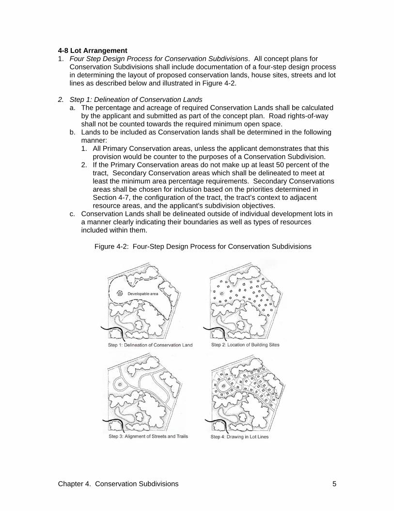
Chapter 4. Conservation Subdivisions 5
4-8 Lot Arrangement 1. Four Step Design Process for Conservation Subdivisions. All concept plans for
Conservation Subdivisions shall include documentation of a four-step design process in determining the layout of proposed conservation lands, house sites, streets and lot lines as described below and illustrated in Figure 4-2.
2. Step 1: Delineation of Conservation Lands
a. The percentage and acreage of required Conservation Lands shall be calculated by the applicant and submitted as part of the concept plan. Road rights-of-way shall not be counted towards the required minimum open space.
b. Lands to be included as Conservation lands shall be determined in the following manner: 1. All Primary Conservation areas, unless the applicant demonstrates that this
provision would be counter to the purposes of a Conservation Subdivision. 2. If the Primary Conservation areas do not make up at least 50 percent of the
tract, Secondary Conservation areas which shall be delineated to meet at least the minimum area percentage requirements. Secondary Conservations areas shall be chosen for inclusion based on the priorities determined in Section 4-7, the configuration of the tract, the tract’s context to adjacent resource areas, and the applicant's subdivision objectives.
c. Conservation Lands shall be delineated outside of individual development lots in a manner clearly indicating their boundaries as well as types of resources included within them.
Figure 4-2: Four-Step Design Process for Conservation Subdivisions

Chapter 4. Conservation Subdivisions 6
3. Step 2: Location of Building Areas. Potential building areas shall be tentatively located using the map delineating Conservation Lands, supplemented by existing conditions data required for concept plan approval. Building areas should generally be located not closer than 100 feet from Primary Conservation areas and 50 feet from Secondary Conservation areas, taking into consideration the potential negative impacts of residential development on such areas as well as the potential positive benefits of such locations to provide attractive views and visual settings for residences. Locating building areas on ridges, hilltops, along peripheral public roads or in other visually prominent areas should be minimized.
4. Step 3: Alignment of Streets and Trails. After designating the building areas, a street
plan shall be designed to provide vehicular access to each building area, complying with the standards in these Subdivision Regulations and bearing a logical relationship to the topography of the property. Impacts of the street plan on proposed Conservation Lands shall be minimized, particularly with respect to crossing environmentally sensitive areas such as wetlands, streams, and slopes exceeding 15 percent. Street connections shall minimize the number of cul-de-sacs and facilitate access to and from building areas in different parts of the property and adjoining properties.
5. Step 4: Drawing in the Lot Lines. Upon completion of the preceding three steps, lot
lines shall be drawn as required to delineate the boundaries of individual residential lots, using Section 17.12.xx of the Zoning Code to determine minimum lot sizes.
4-9 Requirements for Design and Improvement 1. Standards for Conservation Subdivisions. In addition to the requirements contained
in the General Requirements for all subdivisions, the following standards shall apply to Conservation Subdivisions.
2. Relationship to Scenic Routes. A Conservation Subdivision fronting or
encompassing a street designated on the Major Street Plan as a scenic arterial shall be subject to the following standards (See figure 4-3 for an example): a. Right-of-way shall be platted as noted in Section 3-10.5. b. Wherever practicable, lots shall not back onto the scenic easement. c. Access to the lots may be via a frontage road, shared driveways, rear alley
access, or similar means to allow lots to front onto the scenic easement.

Chapter 4. Conservation Subdivisions 7
Figure 4-3: Relationship to Scenic Routes
3. Street Design in Conservation Subdivisions.
a. The street network shall form a connected pattern. b. The street pattern shall be designed to respect and follow existing terrain as
much as possible to minimize earthmoving and disturbance of the existing topography.
c. Streets may take the form of a two way street, a pair of one-way streets on either side of a landscaped median or a one way loop street around a small neighborhood green.
d. Streets may be designed using the appropriate street types contained in the Contextual Street Classification as defined in Section 7-2.
e. Driveway crossings on streets built without curb and gutters shall meet the standards for driveway crossings contained in Volume 1 of the Stormwater Management Manual.
f. Street connections shall be provided to existing or proposed through-streets or collectors adjacent to the subdivision, wherever practicable.
g. Cul-de-sacs are generally prohibited and shall be permitted only where all other street design alternatives, such as loop streets or closes shown in Figure 4-4, are not feasible and one of the following two conditions exists: 1. Where natural features such as wetlands or steep slopes exist or other
primary or secondary conservation areas that are not desirable to remove. 2. Where connection to an existing or planned street is blocked by an existing
permanent structure, an existing or planned interstate, or a protected open space area.
Figure 4-4: Alternatives to Cul-de-sacs.
h. The street network shall be designed to:

Chapter 4. Conservation Subdivisions 8
1. Preserve existing tree lines, hedgerows, and watercourses. 2. Minimize alteration of natural, cultural, or historic features. 3. Promote pedestrian movement. 4. Secure the view to prominent natural vistas. 5. Minimize crossing of Primary Conservation Areas.
4. Requirements for Alleys. Alleys shall be strongly encouraged where practicable to
reduce the need for curb cuts. The following standards shall apply to alleys in conservation subdivisions: a. Alleys, wherever practicable, shall connect with streets at their ends and dead-
end alleys shall be avoided. b. Turnarounds shall be provided if a dead-end alley is longer than 150 feet. c. Alleys may contain turns and intersections with other alleys provided that service
vehicles can be accommodated. d. Alleys shall serve as a utility corridor and wherever practicable, utilities shall be
located to the rear of buildings. e. The right-of-way of the alley shall be a minimum width of 20 feet. f. Public alleys shall be approved by the Public Works Department. g. For all lots where the distance from the dwelling unit to the street via the alley
may be greater than 150 feet, the alley shall serve as a fire lane as well as providing vehicular access to dwelling units.
5. Supporting Agricultural Uses. The design of the Conservation Subdivision shall:
a. Support continuing or proposed new agricultural uses on the tract and adjacent tracts by configuring lots in a manner that maximizes the usable area remaining for such agricultural uses
b. Include appropriate separations between agricultural uses and residential structures to allow for the continued agricultural use.
c. Minimize impacts to prime farmland soils and large tracts of land in agricultural use
d. Avoid interference with normal agricultural practices 6. Connecting Open Spaces and Access to Open Space. When locating open space
the applicant shall: a. Connect proposed open space to any neighboring areas of open space or
protected areas whenever possible. b. Develop a pathway system connecting open space areas accessible to
neighborhood residents and connecting these areas to neighborhood streets and to planned or developed trails on adjacent tracts.
c. Ensure the portion of open space designed to provide plant and animal habitat be kept as intact as possible and trails shall be designed to avoid fragmenting these areas.
d. Every effort shall be made to ensure that Conservation Lands are contiguous and narrow or isolated fragments of Conservation Lands shall be avoided.
7. Clearly Delineated Conservation Lands. There shall be a clear delineation through
signage or other means between the individual development lots and Conservation Lands and the maintenance of the delineation shall be included in the Conservation Lands Management Plan required in Section 4-13.
Chapter 4. Conservation Subdivisions 9
8. Areas of Common Sewage Disposal for Individual Sewage Disposal Systems. The location of all operating parts of the individual sewage disposal systems or other sewage disposal system approved by Metro Water Services, situated in lands held in common and any easements shall be shown on the final subdivision plat.
4-10 Homeowners Association 1. Homeowners’ Association Required. A homeowners’ association shall be
established and membership in the association shall be mandatory for all purchasers of homes in the development and their successors.
2. Bylaws. The homeowners’ association bylaws, guaranteeing continuing
maintenance of the open space and other common facilities, and the declaration of covenants, conditions, and restrictions of the homeowners association shall be submitted for approval to the Executive Director as part of the information required for the final site plan.
3. Required Information. The homeowners’ association bylaws or the declaration of
covenants, conditions and restrictions of the homeowners association shall contain the following information: a. The legal description of the common land including any working agricultural uses
as appropriate. b. A description of common facilities. c. The restrictions placed upon the use and enjoyment of the lands or facilities. d. Persons or entities entitled to enforce the restrictions. e. A mechanism to assess and enforce the common expenses for the land or
facilities including upkeep and maintenance expenses, real estate taxes, and insurance premiums.
f. A mechanism for resolving disputes among the owners or association members. g. The conditions and timing of the transfer of ownership and control of land and
facilities to the association. h. Any other matter the developer deems appropriate.
4-11 Ownership of Conservation Lands 1. Ownership Alternatives. Metro, an individual, a group of individuals, a nonprofit
organization, a homeowners’ association, a public body, or a combination of these entities may hold fee simple title to the Conservation Land. Any use of the Conservation Lands shall be in conformance with the Conservation Lands Management Plan.
2. Homeowners’ Association. Any land dedicated to a sewage disposal system, if the
subdivision is served by an individual sewage disposal system, or other sewage disposal system approved by Metro Water Services, or for a conventional stormwater management device that requires a disturbance to the land shall be owned by the homeowners’ association and shall be considered lands held in common but not considered Conservation Lands.
3. Legal Instrument for Permanent Protection. All Conservation Lands shall be
provided permanent protection through a conservation easement granted to a third party (party other than owner of fee simple). Use of the Conservation Lands shall be in conformance with the Conservation Lands Management Plan.

Chapter 4. Conservation Subdivisions 10
4. Alternative to Conservation Easement. The Planning Commission may consider an alternative permanent protection measure that would provide equal or greater protection to the Conservation Lands as a conservation easement. Use of the Conservation Lands shall be in conformance with the Conservation Lands Management Plan.
4-12 Conservation Easement Holder 1. Conservation Easement Holder Alternatives. The Conservation Easement on the
Conservation Land shall be held by one of the following: a. A Nonprofit Organization. A nonprofit organization devoted to conservation and
preservation may be designated as the holder of the Conservation Easement for the Conservation Land. The organization shall be acceptable to the Executive Director. The focus of the conservation and preservation activities of the nonprofit shall include one or more of the following: 1. Historic sites. 2. Archeological sites. 3. Agricultural uses. 4. Natural and hazard areas including:
a. Perennial and intermittent streams and associated floodways. b. Floodplains. c. Steeply sloped land. d. Wetlands. e. Known habitat for rare, threatened, or endangered species. f. Cedar Glade Communities. g. Forested or meadowlands. h. Significant natural features and scenic viewsheds.
b. Public Agency. A Public Agency involved in Conservation and Preservation may be designated as the holder of the Conservation Easement for the Conservation Land.
2. Conservation Easement Holder in Place. Conservation easement holder, or
alternative as provided in Section 4-11.4 shall be in place before building permits are issued.
4-13 Maintenance of Conservation Lands 1. Conservation Lands Management Plan. In addition to the requirements of Section 2-
5.1.g.2, a Conservation Lands Management Plan, approved by the Planning Commission shall be required that: a. Allocates responsibility and guidelines for the maintenance and operation of the
Conservation Lands, lands held in common and any facilities, including provision for ongoing maintenance and for long-term capital improvements.
b. Estimates the cost and staffing requirements needed for maintenance, operation, and insurance and outlines the means by which such funding shall be obtained or provided.
c. Provides that any changes to the management plan be approved by the Planning Commission.
d. Provides for enforcement of the management plan. 2. Maintenance of Natural Features. Natural features shall be maintained in their
natural condition. The cost and responsibility of maintaining Conservation Lands and any facilities located thereon shall be borne by the property owner(s) as described in

Chapter 4. Conservation Subdivisions 11
Section 4-11. Any planting materials used shall follow the Urban Forestry “Recommended and Prohibited Tree and Shrub List” and the Parks Department “Landscaping with Native Plants” (Middle TN). Any modifications to the natural features shall be designed to ensure that the purpose of the Conservation Subdivision continuous to be met. Permitted modifications include:
a. Reforestation. b. Woodland management. c. Pasture or cropland management. d. Buffer area landscaping. e. Stream bank protection. f. Wetlands management. g. Trails management.
3. Tax Assessment of Conservation Lands. Once a legal instrument for permanent
protection has been placed upon the Conservation Lands, the tax assessor shall be notified of the reduction in development rights in order to initiate reassessment of the conservation lands to reflect the more limited use.

Chapter 4. Conservation Subdivisions 12
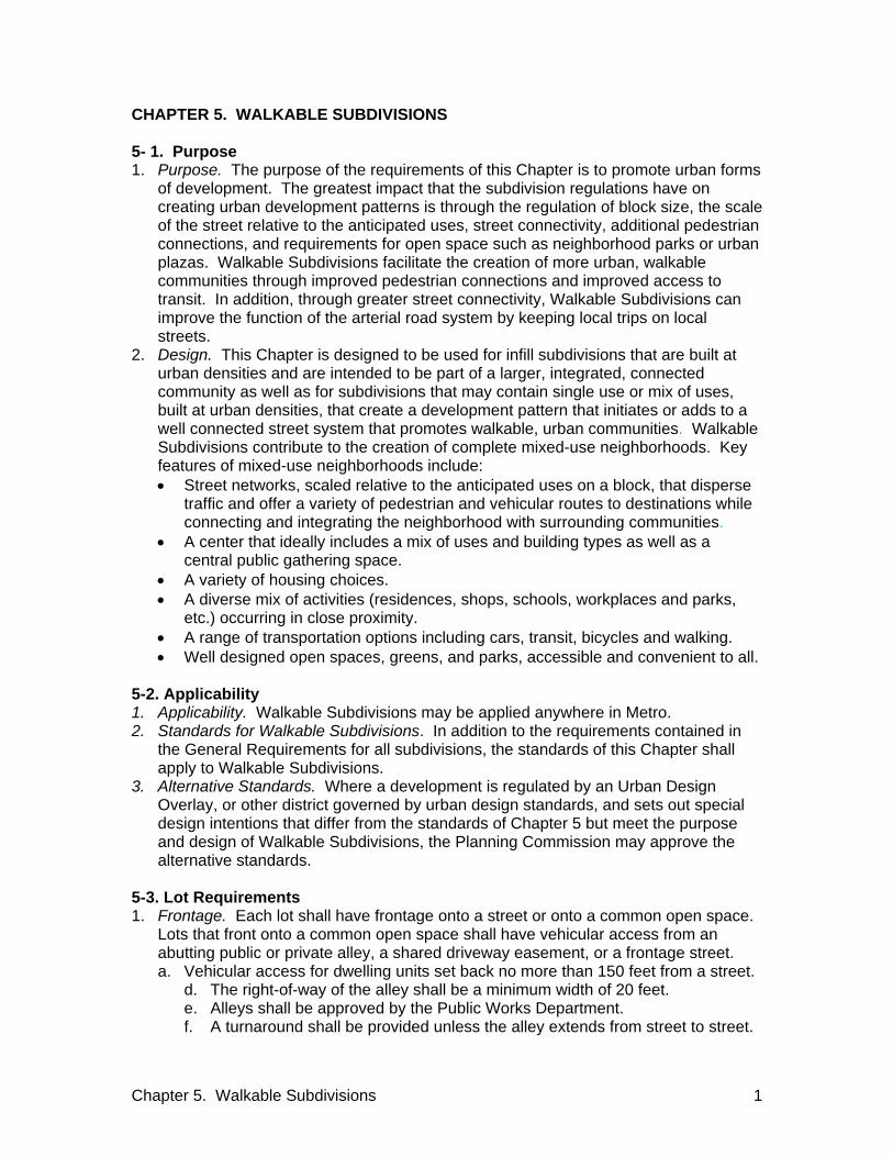
Chapter 5. Walkable Subdivisions 1
CHAPTER 5. WALKABLE SUBDIVISIONS 5- 1. Purpose 1. Purpose. The purpose of the requirements of this Chapter is to promote urban forms
of development. The greatest impact that the subdivision regulations have on creating urban development patterns is through the regulation of block size, the scale of the street relative to the anticipated uses, street connectivity, additional pedestrian connections, and requirements for open space such as neighborhood parks or urban plazas. Walkable Subdivisions facilitate the creation of more urban, walkable communities through improved pedestrian connections and improved access to transit. In addition, through greater street connectivity, Walkable Subdivisions can improve the function of the arterial road system by keeping local trips on local streets.
2. Design. This Chapter is designed to be used for infill subdivisions that are built at urban densities and are intended to be part of a larger, integrated, connected community as well as for subdivisions that may contain single use or mix of uses, built at urban densities, that create a development pattern that initiates or adds to a well connected street system that promotes walkable, urban communities. Walkable Subdivisions contribute to the creation of complete mixed-use neighborhoods. Key features of mixed-use neighborhoods include: Street networks, scaled relative to the anticipated uses on a block, that disperse
traffic and offer a variety of pedestrian and vehicular routes to destinations while connecting and integrating the neighborhood with surrounding communities.
A center that ideally includes a mix of uses and building types as well as a central public gathering space.
A variety of housing choices. A diverse mix of activities (residences, shops, schools, workplaces and parks,
etc.) occurring in close proximity. A range of transportation options including cars, transit, bicycles and walking. Well designed open spaces, greens, and parks, accessible and convenient to all.
5-2. Applicability 1. Applicability. Walkable Subdivisions may be applied anywhere in Metro. 2. Standards for Walkable Subdivisions. In addition to the requirements contained in
the General Requirements for all subdivisions, the standards of this Chapter shall apply to Walkable Subdivisions.
3. Alternative Standards. Where a development is regulated by an Urban Design Overlay, or other district governed by urban design standards, and sets out special design intentions that differ from the standards of Chapter 5 but meet the purpose and design of Walkable Subdivisions, the Planning Commission may approve the alternative standards.
5-3. Lot Requirements 1. Frontage. Each lot shall have frontage onto a street or onto a common open space.
Lots that front onto a common open space shall have vehicular access from an abutting public or private alley, a shared driveway easement, or a frontage street. a. Vehicular access for dwelling units set back no more than 150 feet from a street.
d. The right-of-way of the alley shall be a minimum width of 20 feet. e. Alleys shall be approved by the Public Works Department. f. A turnaround shall be provided unless the alley extends from street to street.
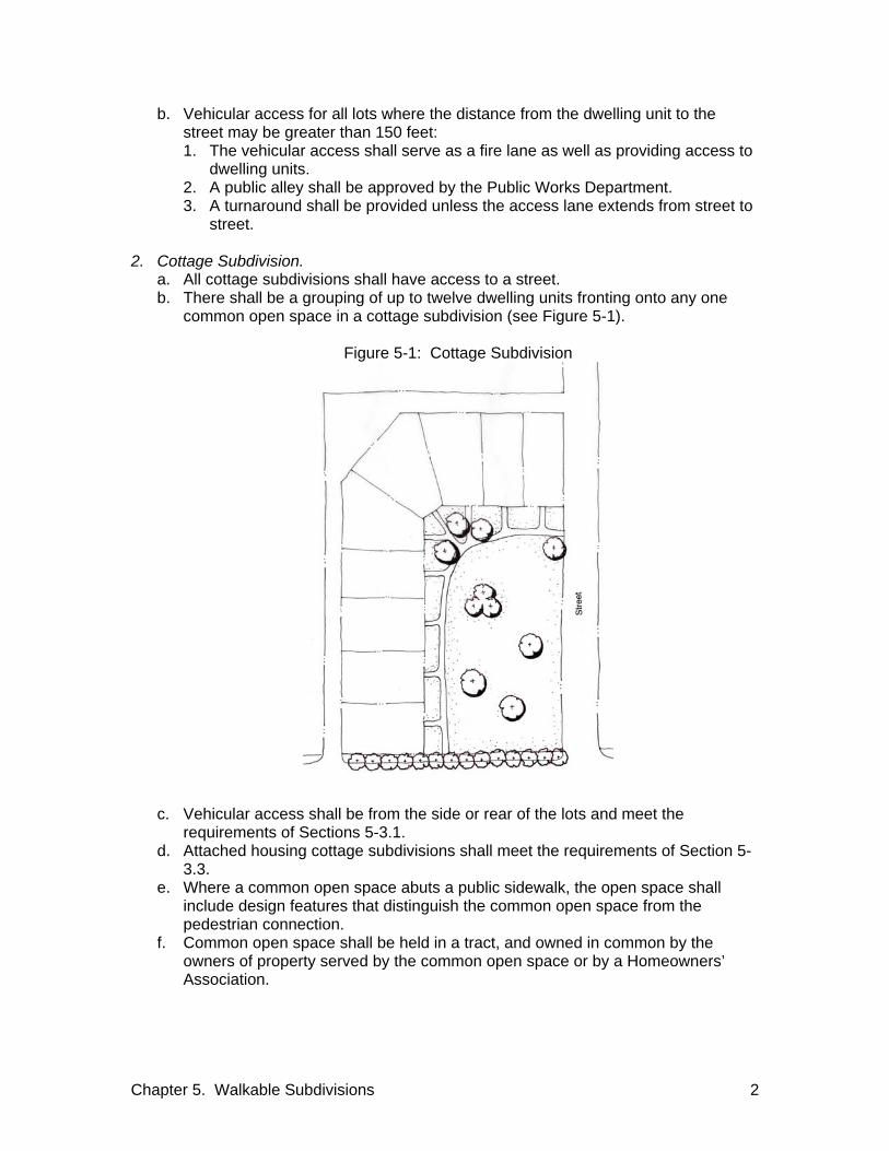
Chapter 5. Walkable Subdivisions 2
b. Vehicular access for all lots where the distance from the dwelling unit to the street may be greater than 150 feet: 1. The vehicular access shall serve as a fire lane as well as providing access to
dwelling units. 2. A public alley shall be approved by the Public Works Department. 3. A turnaround shall be provided unless the access lane extends from street to
street. 2. Cottage Subdivision.
a. All cottage subdivisions shall have access to a street. b. There shall be a grouping of up to twelve dwelling units fronting onto any one
common open space in a cottage subdivision (see Figure 5-1).
Figure 5-1: Cottage Subdivision
c. Vehicular access shall be from the side or rear of the lots and meet the requirements of Sections 5-3.1.
d. Attached housing cottage subdivisions shall meet the requirements of Section 5-3.3.
e. Where a common open space abuts a public sidewalk, the open space shall include design features that distinguish the common open space from the pedestrian connection.
f. Common open space shall be held in a tract, and owned in common by the owners of property served by the common open space or by a Homeowners’ Association.

Chapter 5. Walkable Subdivisions 3
3. Subdivisions for Attached Housing. a. Attached Housing Subdivisions may be developed in zones that permit multi-
family residential uses. b. Purpose of the subdivision for attached housing is to provide opportunities for
individual home and lot ownership in the multi-family zoning districts by allowing subdivision of land for attached housing development.
c. The lot dimensions shall be as described in Table17.12.020.B.1 of the Zoning Code.
d. Attached housing fronting onto common open space shall meet the requirements of Section 5-3.2.
e. The lot width restrictions of Section 3-4.2.f shall not apply to attached single-family housing in Walkable subdivisions.
4. Residential Lots Fronting on an Arterial or Collector. The creation of residential lots
with double frontage shall be avoided wherever practicable. The preferred approach for subdividing residential property along an arterial or collector is as follows: a. Dwelling units face the arterial or collector wherever practicable. b. Vehicular access via a shared frontage street, driveway easement, or rear alley
to minimize curb cuts on arterial as shown in Figure 5-2.
Figure 5-2: Residential Lots Fronting on an Arterial or Collector
c. Access to the shared frontage street, driveway easement, or rear alley from a
local street. d. A commonly held separation area between the arterial or collector and the edge
of the frontage street or shared driveway easement or, between the arterial or collector and the front of the lots if access is via a rear alley.
e. The separation area includes design features that distinguish it from the public sidewalk.
f. The commonly held separation area be held in a tract, and owned in common by the owners of the abutting properties or by a Homeowners’ Association.
g. The commonly held separation area may not be needed for large lot subdivisions providing an edge condition for a Walkable Subdivision.

Chapter 5. Walkable Subdivisions 4
5. Non-Residential and Mixed-use Lots Fronting on an Arterial or Collector. The number of access points on arterial and collector streets from a non-residential or mixed-use development shall be minimized, wherever possible, through the use of driveways common to more than one development, and interior circulation design and connecting parking lots.
5-4 Requirements for Alleys 1. Requirements for Alleys. Alleys shall be strongly encouraged, where practicable, to
reduce the need for curb cuts, increase amount of on street parking, and reduce conflicts between cars and pedestrians. The following standards shall apply to alleys in Walkable Subdivisions: a. Alleys, wherever practicable, shall connect with streets at their ends and dead-
end alleys should be minimized. b. Alleys may contain turns and intersections with other alleys provided that service
vehicles can be accommodated. c. For attached housing fronting onto an arterial or collector, rear access shall be
provided, wherever practicable. d. If the tract abuts an existing alley, vehicle access shall be from the alley,
wherever practicable. e. Alleys shall serve as a utility corridor and, wherever practicable, utilities shall be
located to the rear of buildings. f. Where an alley provides the only vehicle access to a building that is more than
150 feet from a street, the alley shall serve as a fire lane. 5-5. Blocks 1. Block Widths. Blocks widths in Walkable Subdivisions shall meet the requirements
of Section 3-6.1. 2. Block Lengths. Block Lengths in Walkable Subdivisions shall meet the following
requirements: a. Block lengths shall not exceed 600 feet except when built or natural constraints
preclude such spacings. b. Block lengths shall not be less than 200 feet or four lot widths, whichever is
greater, except as the Planning Commission deems necessary to secure efficient use of land or desired features of the street pattern.
c. Wherever practicable, pedestrian connections shall be provided every 300 feet. 3. Block Perimeters. Block perimeter shall not exceed 2,000 feet. 4. Easements Through Long Blocks. The Planning Commission shall require the
dedication of an easement through long blocks to accommodate pedestrian connections and may require the dedication of an easement through long blocks to accommodate utilities or drainage facilities.
5-6. Minimum Sidewalks Widths 1. Minimum Sidewalk Width. The width of the sidewalk in non-residential and mixed-
use subdivisions that are primarily non-residential shall be a minimum of 12 feet. This requirement may be waived for infill development on streets predominantly developed with sidewalks less than 12 feet.

Chapter 5. Walkable Subdivisions 5
5-7. Requirements for Streets and Pedestrian Access 1. Purpose. Contextual Street Classifications, as defined in Section 7-2, are designed
to ensure complete streets in Walkable Subdivisions. The purpose of such streets standards and the pedestrian access standards for Walkable Subdivisions is to: a. Support the creation of a highly connected transportation system in order to
provide choices for drivers, bicyclists, and pedestrians. b. Promote walking, transit and bicycling and safely integrate the pedestrian and
auto environment. c. Connect neighborhoods to each other and to local destinations such as schools,
parks, and shopping centers. d. Provide a seamless transition from one area to the next. e. Reduce vehicle miles of travel and travel times. f. Reduce emergency response times. g. Increase the effectiveness of municipal service delivery. h. Free up arterial capacity to better serve regional long-distance travel needs.
2. Street Pattern. Streets shall be designed in an interconnecting pattern of streets,
sidewalks, and alleys. 3. Street Design Standards. Within the Contextual Street Classifications, all functional
public street cross-sections and roadway improvements shall be approved by the Public Works Department. In determining the most safe and appropriate cross-section, the Public Works Department shall work to ensure that the purpose of the Walkable Subdivision is met and that the key features, as described in Section 5-1.2, pertaining to streets are addressed.
4. Through Streets and Pedestrian Access. The following street and pedestrian access
standards shall be required in Walkable Subdivisions, wherever practicable: a. Through streets shall generally be provided no more than 600 feet apart and
pedestrian access shall generally be provided no more than 300 feet apart. Through street and pedestrian access shall generally be at least 200 feet apart.
b. Where the street pattern in the area immediately surrounding the tract meets the spacing of Section 5-7.4.a, the existing street pattern shall be extended into the tract.
c. New streets shall align with existing streets on adjoining properties unless topography, requirements of traffic circulation, or other considerations make direct connectivity unfeasible. The applicant shall demonstrate that no practicable alternatives exist to providing the street connections.
d. Where streets cannot connect, a pedestrian access shall be provided, where practicable.
e. To ensure connectivity but to discourage through traffic, T-intersections and other devices that dissuade through traffic shall be used where appropriate.
5. Extension of Existing Temporary Dead-end Streets and Pedestrian Access. Existing
temporary dead-end streets and pedestrian accessways adjacent to the tract shall be extended into the tract, wherever practicable.
6. Future Extension of Proposed Temporary Dead-end Streets and Pedestrian Access.
Where the Walkable Subdivision tract is adjacent to tracts that may be subdivided in the future, temporary dead-end streets, and pedestrian accessways shall be

Chapter 5. Walkable Subdivisions 6
extended to the boundary lines of the tract to provide future access to the adjacent tracts. Signage as described in Section 3-9.4.e shall be provided.
7. Pedestrian Access Easements. The following approval criteria and standards apply
to pedestrian accessways: a. The width of the pedestrian access easements shall be sufficient to
accommodate expected users and provide a safe environment b. Pedestrian accessways shall take the most direct route practicable. c. Wherever possible, pedestrian accesses shall be designed so that the pedestrian
can see the ending of the access from the entrance point. d. Pedestrian accessways that connect or are intended to eventually connect two
through streets, shall be designated as public access easements on the final subdivision plat.
e. Pedestrian accessways that connect or are intended to eventually connect to a public school, park, or library, shall be designated as public access easements on the final subdivision plat.
8. New Pedestrian Access Easements. In any zoning district, a new pedestrian access
easement to an existing or planned transit stop, a school, a shopping center, a neighborhood park or other likely pedestrian destination shall be provided as a component of the subdivision, if the addition of the accessway would reduce walking or bicycling distance by at least 50 percent over other available pedestrian connections, and the reduced walking or bicycling distance is greater than 400 feet.
9. Loop Streets. Loop streets shall be given preference over cul-de-sacs. Standards
for loop streets include: a. Connections to other streets at both termini shall be required. b. To facilitate connections to adjacent future development sites, when one
terminus of the loop street does not connect to an existing street, the end shall be stubbed.
c. Loop streets ending in temporary dead-end streets shall require signage as described in Section 3-9.4.e.1.
10. Cul-de-sacs. Cul-de-sacs are generally prohibited and shall be permitted only where
all other street design alternatives, such as loop streets or closes shown in Figure 5-3, are not feasible and one of the following two conditions exists: a. Where natural features such as wetlands or steep slopes exist. b. Where connection to an existing or planned street is blocked by an existing
permanent structure, an existing or planned freeway, or a protected open space area.
Figure 5-3: Alternatives to Cul-de-sacs

Chapter 5. Walkable Subdivisions 7
11. Requirements for Cul-de-sacs. Cul-de-sacs shall meet the following requirements: a. The length of the cul-de-sac shall not exceed 250 feet. b. Cul-de-sacs shall include pedestrian connections to abutting streets wherever
practicable as shown in Figure 5-4.
Figure 5-4: Pedestrian Access
12. Sidewalks Not Required. Sidewalks shall not be required on the planted side of an
eyebrow, close, or cul-de-sac terminus as shown in Figure 5-5.
Figure 5-5: Sidewalks not Required
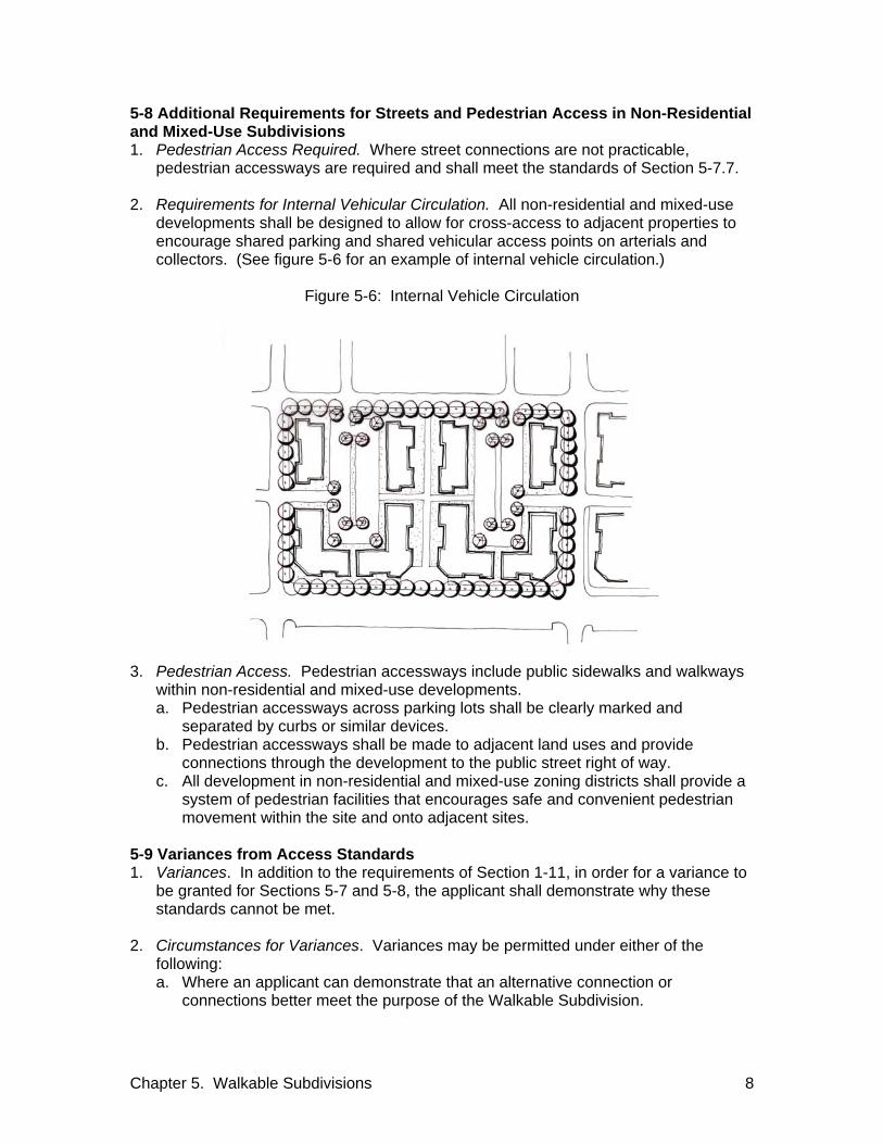
Chapter 5. Walkable Subdivisions 8
5-8 Additional Requirements for Streets and Pedestrian Access in Non-Residential and Mixed-Use Subdivisions 1. Pedestrian Access Required. Where street connections are not practicable,
pedestrian accessways are required and shall meet the standards of Section 5-7.7. 2. Requirements for Internal Vehicular Circulation. All non-residential and mixed-use
developments shall be designed to allow for cross-access to adjacent properties to encourage shared parking and shared vehicular access points on arterials and collectors. (See figure 5-6 for an example of internal vehicle circulation.)
Figure 5-6: Internal Vehicle Circulation
3. Pedestrian Access. Pedestrian accessways include public sidewalks and walkways
within non-residential and mixed-use developments. a. Pedestrian accessways across parking lots shall be clearly marked and
separated by curbs or similar devices. b. Pedestrian accessways shall be made to adjacent land uses and provide
connections through the development to the public street right of way. c. All development in non-residential and mixed-use zoning districts shall provide a
system of pedestrian facilities that encourages safe and convenient pedestrian movement within the site and onto adjacent sites.
5-9 Variances from Access Standards 1. Variances. In addition to the requirements of Section 1-11, in order for a variance to
be granted for Sections 5-7 and 5-8, the applicant shall demonstrate why these standards cannot be met.
2. Circumstances for Variances. Variances may be permitted under either of the
following: a. Where an applicant can demonstrate that an alternative connection or
connections better meet the purpose of the Walkable Subdivision.

Chapter 5. Walkable Subdivisions 9
b. Where no practicable alternatives exist to provide access and/or connections and one of the following conditions exist: 1. Access and connection standards would violate provisions of leases,
easements, covenants, or restrictions in place at the time of adoption of these regulations.
2. Natural constraints, existing buildings or other development adjacent to lands physically preclude a connection now or in the future, considering the potential for redevelopment.
5-10 Unified Plat of Subdivision 1. Unified Plat of Subdivision. Applicants seeking design flexibility in certain areas may
use a unified plat of subdivision as set forth in Section 17.40.170.C of the Zoning Code. The plat shall show all properties to be considered as one unified piece of property. All properties to be included in the unified plat of subdivision shall be within the boundary of the unified plat of subdivision as defined in the Zoning Code. A unified plat of subdivision shall be submitted for review and approval, and may be recorded separately from a final plat, or combined with a final plat. The “Purpose” note on the plat shall clearly state the plat is to be considered a unified plat of subdivision, and the words “Unified Plat of Subdivision” shall be clearly shown above the subdivision name.
5-11. Open Space 1. Open Space Required. In addition to the requirements of Section 3-10.7, in
subdivisions of five acres or greater, applicants are required to include open space in the subdivision as described in Section 5-11.2.
2. Types of Open Space. Open spaces appropriate for a Walkable subdivisions include
plazas, squares, greens, small parks for passive or active recreational uses and linear open space that incorporates natural elements such as a creek or a significant stand of trees. The planted area of an eyebrow, close or cul-de-sac turnaround may be counted towards the open space requirement.

Chapter 5. Walkable Subdivisions 10
Chapter 6. Assurance for Completion and Maintenance Improvements 1
CHAPTER 6. ASSURANCE FOR COMPLETION AND MAINTENANCE OF IMPROVEMENTS 6-1 Improvements and Performance Bond 1. Performance Bond. The applicant shall complete and dedicate all public
improvements prior to the final subdivision plat approval. The Executive Director may provide that, in lieu of the completion of such work previous to the final approval of a plat:, a. the applicant may post a bond in an amount stipulated by the Executive Director
as sufficient to secure the satisfactory construction, installation, and dedication of the required improvements. Such performance bond shall comply with all statutory requirements and shall be satisfactory to the Metropolitan Attorney as to form, sufficiency, and manner of execution as set forth in these regulations. And /or
b. an assessment or other method may be established whereby the municipality is put in assured position to do the work and make the installations at the cost of the owners of the property within the subdivision. Such assessment or other method shall comply with all statutory requirements and shall be satisfactory to the Metropolitan Attorney as to form, sufficiency, and manner of execution as set forth in these regulations.
2. Composition of Performance Bond. For the purpose of these regulations,
performance bond shall mean two documents: a Performance Agreement and an accompanying security document.
a. The Performance Agreement. The Performance Agreement shall stipulate the work to be performed by general categories and the estimated value or cost of each category. The Performance Agreement shall also stipulate a completion date for all of the work to be performed. The Performance Agreement shall only be entered into by owner of the property.
b. The Security Document. The security document may be in a form as follows and shall express the value in a total amount equaling the sum of all work categories: 1. Surety Bond. Issued by an insurance company licensed in the State of
Tennessee and shall be non-expiring. 2. Irrevocable Letter of Credit. Issued by or confirmed by a financial institution
located in Davidson County, Tennessee, or an adjoining county. Any such letter of credit shall contain an auto-renewal clause.
3. Cashiers or Certified Check. Issued by a financial institution located in Davidson County, Tennessee and shall be non-expiring.
c. The Surety Bond and Letter of Credit options (Sections 6-1.2.b.1 and 6-1.2.b.2) shall not be available to an applicant whose past performance has resulted in breached or expired bonds.
d. An entity whose past performance has resulted in non-payment of a bond may be excluded from providing a surety bond for an applicant for a period of one year from the date of breach.
3. Temporary Improvements. When applicable, the applicant shall build and pay for all
costs of temporary improvements required by the Planning Commission, and shall maintain such for the period specified by the Planning Commission. Prior to construction of any temporary facility or improvement, bond shall be posted which shall insure that the temporary facilities shall be properly constructed, maintained, and removed.

Chapter 6. Assurance for Completion and Maintenance Improvements 2
4. Costs of Improvements. All required improvements shall be made by the applicant at
the applicant’s expense or cost sharing. Any provisions for reimbursement by the county, or any utility district shall be by separate agreement with the applicable Metro Department or other governmental entity.
5. Governmental Agencies. Governmental agencies to which these bonds and contract
provisions apply may file, in lieu of said contract or bond, a letter from an agent authorized to act in their behalf agreeing to comply with the provisions of this chapter.
6. Failure to Complete Improvements. In those cases in which a performance bond has
been posted and required improvements have not been installed within the terms of such performance bond agreement, the Executive Director may declare the bond to be in default and require that all the improvements be installed regardless of the extent of the building development at the time the bond is declared to be in default. The funds of the bond shall be used to complete the improvements.
6-2 Inspection of Improvements 1. Inspection of Improvements. If the Executive Director finds that any of the required
improvements have not been constructed in accordance with the applicable Metro Department's construction standards and specifications, the applicant shall be responsible for completing the improvements to the required standards. Whenever the cost of improvements is covered by a performance bond, the applicant and the bonding company or financial institution shall be liable severally and jointly for completing said improvements according to specifications.
6-3 Release, Reduction, or Extension of Performance Bond 1. Certificate of Satisfactory Completion. The Executive Director shall not release nor
reduce a performance bond until all applicable Metro Departments or Agencies provide written confirmation that all required improvements have been satisfactorily completed and all associated and/or surplus construction materials are removed from the site. There shall be no reduction or release of a bond if there are any outstanding administrative penalties or violations related to the bonded site.
2. Reduction of Performance Bond. A performance bond may be reduced upon
demonstration of satisfactory completion of public improvements, that includes installation of the asphalt surface binder course, and then only to the ratio that the installed improvement bears to the total public improvements for the subdivision. In no event shall a performance bond be reduced below ten percent or $5,000.00, whichever is greater of the original principal amount unless the agency indicates a lower amount is sufficient to complete the infrastructure. No more than three reductions shall be considered by the Executive Director. The initial bond reduction shall be considered only after the asphalt surface binder is applied to the entire subdivision phase as platted.
3. Extension of Performance Bonds. The Executive Director, upon proof of extenuating
circumstances by the applicant and acknowledged and agreed to by the Executive Director, may extend the completion date set forth in such bond and may require an increase in the bonded amount to cover increases in costs.
Chapter 6. Assurance for Completion and Maintenance Improvements 3
4. Release of Bonds in Conservation Subdivisions. In addition to requirements of Sections 6-3.1, 6.3.2 and 6.3.3, no bond shall be released for improvements in a Conservation Subdivision until the applicant demonstrates that the impacts associated with the improvements have been mitigated and that all conditions related to the improvements have been satisfactorily fulfilled.
5. Refer to Planning Commission. The Executive Director may refer decisions to
release, reduce, or extend a bond to the Planning Commission. 6-4 Maintenance of Improvements 1. Maintenance of Improvements. The applicant shall be required to maintain all
improvements including all lot improvements, until acceptance of such public improvements by the appropriate department.
6-5 Expiration of Bond 1. Expiration of Bond. Should the bond lapse or expire for any reason prior to
completion of all required improvements no additional building permits shall be issued and the Executive Director shall, through the Metropolitan Department of Law, take any or all appropriate legal action necessary to assure completion of improvements. The bond may be declared in default and the security shall be held by Metro. Only after completion of all improvements or posting of a new bond, shall building permits again be issued.
6-6 Certification of Private Street Completion 1. Certification of Private Street Completion. Prior to release of the bond for private
streets, the Developer's and Contractor's Certificate for Private Streets (see Appendix A) shall be filed. It shall be accompanied by a certification from a geotechnical engineer that all construction phase items as listed in Section 3-11.3 have been inspected and approved for compliance with the specifications and requirements of the applicable departments and agencies and the approved construction plan and final subdivision plat.
6-7 Disposition of Liquidated Securities 1. Disposition of Liquidated Securities. Funds derived from liquidation of securities, as
a result of performance agreement default, shall be used by the applicable Metro Department or utility district to complete the required work. Project administration fees may be charged by the departments or utility district against liquidated funds to offset actual personnel or equipment costs utilized in the accomplishment of required work. Any surplus funds shall be returned to the security provider after all charges and expenses are paid and required work is accepted.

Chapter 6. Assurance for Completion and Maintenance Improvements 4

Chapter 7. Definitions 1
CHAPTER 7. DEFINITIONS 7-1 Usage 1. Usage. For the purpose of these regulations, certain numbers, abbreviations, terms,
and words used herein shall be used, interpreted, and defined as set forth in this chapter.
2. Meaning of Terms. Unless the context clearly indicates to the contrary, the following
shall apply: a. Words used in the present tense include the future tense. b. Words used in the plural number include the singular. c. The word "herein" means "in these regulations." d. The word "regulations" means "these regulations." e. A "person" includes a corporation, a partnership, and an unincorporated
association of persons, such as a club. f. "Shall" is always mandatory. g. “May” shall be interpreted to be assigned to the Metropolitan Planning
Commission, except where otherwise noted. h. A "building" or "structure" includes any part thereof. i. "Used" or "occupied," as applies to any land or building, shall be construed to
include the word "intended, arranged, or designed to be used or occupied." j. The word “days” means “calendar days.”
7-2 Words and Terms Defined Abutting. Lots that are touching or sharing a common point or line but does not include lots that are across a public way from each other. Access. The place, means, or way by which pedestrians, bicyclists, and/or vehicles have safe, adequate, and usable ingress and egress to a property or use. A private access is an access not in public ownership or control by means of deed, dedication, or easement. Adjacent. Lots that are touching or sharing a common point or line including lots that are across a public way from each other. Alley. A low volume lane intended to provide access to the rear or side of lots or buildings and not intended for the purpose of through vehicular traffic. Applicant. The owner or optionee of land proposed to be subdivided or his/her authorized representative, also referred to as subdivider or subdivider agent. See “Subdivider and Subdivider Agent” Arterial Street. See “street, arterial.” Attached and Detached Single-Family Lot. See “Lot, Attached and Detached Single-Family.” Block. A tract of land bounded by streets or by a combination of streets and public lands, cemeteries, railroad rights-of-way, shorelines of waterways or any other barrier to the continuity of development.

Chapter 7. Definitions 2
Block Face. A single boundary of a block described in the definition of a block. A block face is opposing when it is across a public street. Bond, Performance. An agreement and security to assure construction of roads, water and sewer systems or other public facilities in a form specified by Chapter 6 of these regulations. (See public improvements.) Building. Any structure built for the support, shelter, or enclosure of persons, animals, chattels, or movable property of any kind. The term includes any permanent structure including mobile homes. Capital Improvements Program. A schedule of all future projects, listed in order of construction priority, together with cost estimates and the anticipated means of financing each project. All major projects requiring the expenditure of public funds, over and above the annual local government operating expenses, for the purchase, construction, or replacement of the physical assets for the community are included. Collector Street. See “street, collector.” Common Open Space. Any portion of a condominium site or a subdivision that is held in joint ownership by property owners or a homeowners’ association and is intended for the use or enjoyment of the occupants. Common Open Space can include property that is left in a natural state and has primarily scenic value. Land to accommodate required subdivision infrastructure, including green infrastructure such as planting strips, street medians/islands, and conventional stormwater management devices, is excluded from common open space calculations. Conventional stormwater management devices are those designed to hold water for an extended period of time and require disturbance of the land in order to meet detention requirements. (See “lands held in common”) Community Character. The image of a community or area defined by such factors as its built environment, natural features and open space elements, types of housing, infrastructure, and the type and quality of public facilities and services. It is the intent of Neighborhood Maintenance areas to preserve the general character of the neighborhood as characterized by its development pattern, building form, land use and associated public realm. These areas will experience some change over time but efforts should be made to retain the existing character. It is the intent of Neighborhood Evolving and Neighborhood General areas to create new neighborhoods that are generally compatible with the rural, suburban or urban neighborhoods' characteristics in terms of building form, land use and associated public realm, but with opportunities for increased housing choice and improved pedestrian, bicycle and vehicular connectivity. Community Transect. A system for categorizing, understanding and guiding the various development patterns of a region, from the most natural and rural to the most urban. The Transect is an ordering system, which calls for all elements of the natural and built environment to be consistent with the character of the Transect Category that they are within. The Community Transect system was initially described in detail in the “Land Use Policy Application” as adopted, May 27, 2004 and subsequently amended. This classification system was also refined and included in the Community Character Manual, August 14,

Chapter 7. Definitions 3
2009. The Nashville/Davidson County Transect consists of seven categories of natural and built environments. 8. T1- Natural. Publicly and privately owned, generally undisturbed land often with
environmentally sensitive features that is intended to be permanently maintained as open space.
9. T2- Rural. Sparsely developed land with agricultural and low density residential uses, complemented by low intensity commercial uses.
10. T3- Suburban. Primarily lower density, single-family residential uses, with some higher density mixed-housing developments and commercial uses, the suburban category is the bridge between rural and urban transect areas and should incorporate open space and natural features into site design while beginning to make buildings more prominent.
11. T4- Urban. Medium to higher density housing with a mixture of housing types with compatibly-scaled commercial and civic uses located in centers or commercial corridors; served by highly-connected street systems with sidewalks, bikeways and facilities for mass transit.
12. T5- Centers. Intense, mixed-use areas where residents can live, work and recreate, Centers serve multiple neighborhoods and communities. These areas are envisioned to redevelop as complete communities with a mixture of housing convenient to commercial, employment and recreational land uses. These areas should be served by multiple modes of transportation.
13. T6- Downtown. Downtown has the highest intensity and mixture of uses including commercial, office, residential, civic and open space uses, serving the entire County and the Region as the center of commerce, governance and the arts.
14. D- Districts. A range of generally single use areas including medical centers, universities, industrial parks, office parks, and impact areas including airports, quarries, etc., which in some cases are designed to blend into the surrounding neighborhood or center and in other cases should be designed to limit impact on surrounding areas.
Complete Application. The completed form or forms and all accompanying documents, maps, exhibits and fees required of an applicant, including all information required by the Submittal Checklist available from the Executive Director. Concept Plan. A plan drawn to scale that shows street, lot, and open space layouts, public dedications, and reservations, if any, and proposed environmental changes to the tract. It includes topographical information, existing site conditions, analysis, and off-site conditions of a minimum of 300 feet beyond the property boundaries. Concept Plan Pre-Application Conference. A meeting to discuss, at the earliest stages, subdivision requirements and procedures, and possible issues related to the development of a property. It is intended that this meeting will help alleviate possible conflicts over subdivision requirements by early recognition of existing conditions, necessary facilities and other requirements, which the developer can then consider in preparing the formal subdivision proposal. Condominium. Joint domain (joint ownership) also horizontal property regime.

Chapter 7. Definitions 4
Conservation Community Character Policy, Eligible Areas. See, Eligible Areas, Natural Conservation and Rural Land Use Policies, and Conservation and T2 Rural Neighborhood Maintenance Community Character Policies. Conservation Easement. The grant of a property right or interest from the property owner to a unit of government or nonprofit conservation organization stipulating that the described land shall remain in it its natural, scenic, open or wooded state, precluding future or additional development. The land may contain historic structures and archaeological sites. Conservation Land. The portion of undeveloped land within a conservation subdivision that has been designated, dedicated, reserved or restricted in perpetuity from further development and is set aside under a conservation easement. Conservation Lands are divided into Primary and Secondary Conservation areas. Land to accommodate required subdivision infrastructure, including green infrastructure such as planting strips, street medians/islands, drainage fields for individual sewage disposal systems, and conventional stormwater management devices, is excluded from Conservation Land calculations. Conventional stormwater management devices are those designed to hold water for an extended period of time and require disturbance of the land in order to meet detention requirements. Conservation Subdivision. A residential development where at least 50 percent or more of the land area is designated as undivided, permanent open space or farmland, thereby permanently protecting agriculturally, environmentally, culturally or historically significant areas within the tract. The subdivision is characterized by compact lots, common open space, and the preservation maintenance of natural, historical, and cultural resources. Conservation Subdivisions are an alternative approach to the conventional lot-by-lot division of land in rural areas that spreads development evenly throughout a parcel with little regard to impacts on the natural and cultural features of the area. Construction Plan. The maps or drawings showing the specific location and design of improvements to be installed in a subdivision or development. Contextual Street Classifications. See Street, Contextual Classifications. Conventional Subdivision. A lot-by-lot division of land that spreads development evenly throughout a parcel, minimum lot size determined by underlying zoning. Cottage Subdivision. A small lot single-family residential or attached subdivision of dwelling units arranged on at least two sides of a common open space with frontage onto a street of sufficient width to allow direct pedestrian access to the street. Vehicular access is via an abutting alley. A primary pedestrian entrance to each of the dwelling units is located on the common open space with frontage onto a street. County. Metropolitan Nashville and Davidson County, Tennessee. County Council (Metro Council). The chief legislative body for The Metropolitan Government of Nashville and Davidson County. Close Street. See Street, Close.

Chapter 7. Definitions 5
Critical Lots. Lots designated as critical during the concept plan review process, or final plat review process if no concept plan is required, based on soil conditions, degree of slope, flooding, or other lot features that could affect the feasibility of construction. Cul-de-sac Street. See Street, Permanent Dead End. Deed Restriction. A restriction on the use of a property set forth in the deed. Designated Historic Districts. Designated Historic Districts shall include all Historic Overlay Districts adopted in accordance with Chapter 17 of the Metropolitan Zoning Code and any National Historic Register districts officially listed on the National Register of Historic Places as designated by the National Park Service. Detached Single-Family Lots. See “Lot, Attached and Detached Single-Family.” Developer. The owner of land proposed to be subdivided or his authorized representative. Development Review Committee. A committee established to review all development applications. The Committee is made up of staff from the Planning, Public Works, Stormwater Division, Water Services, Code Enforcement, Fire Marshal, Parks and Greenways, Health, NES and other agencies as appropriate, with representatives of the State, or Boards and Commissions maybe included in the review as appropriate. Drawings. The documents that show the characteristics and scope of a subdivision in map form. Drive. A way or place in private ownership that is used for vehicular travel by the owner and those having express or implied permission from the owner, but not by other persons and is not eligible to become a public right-of-way in the future pursuant to Section 13.10 of the Metro Code. Easement. Authorization by a property owner creating the right for the use by another, for a specified purpose, of any designated part of his property. Eligible Areas, Natural Conservation and Rural Land Use Policies, and Conservation and T2 Rural Neighborhood Maintenance Community Character Policies. Areas of the county that are eligible for subdivision on private streets because the property to be subdivided lies within a Natural Conservation or Rural land use policy area or in Conservation, or some T2 Rural Neighborhood Maintenance community character policy areas (designated by the General Plan), is proposed for the creation of lots of five acres or greater, has a predominance of steep topography or floodplain precluding development of lots on less than five acres. Engineer. See "Registered Engineer." Executive Director. The Executive Director of the Metropolitan Planning Commission or such person as designated by the Executive Director responsible for enforcing the provisions of these regulations. (See Secretary of the Planning Commission.) External Subdivision Boundary. All points along the periphery of a subdivision.

Chapter 7. Definitions 6
Final Site Plan. The final site plan provides construction details for roadways and sidewalks, stormwater facilities, water and sewer lines, utilities and other infrastructure as well as landscaping plans. This provides for a coordinated review of the various plan documents, construction plans and grading plans related to the subdivision and ensures proper placement of infrastructure, utility lines and boxes and allows for mitigation measures such as screening walls and landscaping to ensure that the final site plan conforms to the approved concept plan and conditions. Final Subdivision Plat. The final map or drawing and accompanying materials, described in these regulations, on which the subdivider's plan of the subdivision is presented to the Planning Commission and which, if approved, may be submitted to the Register of Deeds for recording. Financial Contribution to the Pedestrian Network. A contribution to Metro as an Alternative to Sidewalk Installation. Where permitted by Section 3-8.2.c.1, the developer may make a financial contribution to Metro in lieu of construction. The value of said contribution shall be the average linear foot sidewalk project cost, determined on an annual basis by the Public Works Department review of sidewalk projects contracted for or constructed by Metro. Any such payments received by Metro shall be assigned and designated for implementation of the Strategic Plan for Sidewalk Capital Improvements, as amended from time to time. The fee in lieu of sidewalk construction shall be used to accommodate pedestrian needs within the pedestrian benefit zone in which the development property is located. The applicant’s payment shall be allocated within 24 months of receipt of the payment; otherwise, said payment shall be refunded to the subdivision applicant. Floodplain. A land area adjoining a river, stream, watercourse, bay, or lake that is likely to be flooded. The floodplain is composed of the regulated floodway and the floodway fringe, as further defined in Volume 1, Regulations, of the Metropolitan Government Stormwater Management Manual. Flood Prone Area - Those lands located in an area that will be inundated by a one hundred-year flood. Floodway. The stream channel and adjacent over bank area required to carry and safely discharge the one hundred-year flood without increasing flood levels more than one foot above natural flood levels (i.e., the area of moving or flowing water). Frontage. That side of a lot abutting on a street and ordinarily regarded as the front of the lot, but it shall not be considered as the ordinary side of a corner lot. Frontage Street. See “Street, Frontage.” Frontage Zone. The space running parallel to and between the street right of way (or boundary of other public/common space) and the front building façade, extending along the width of a building lot. General Plan. The general final site plan for Metropolitan Nashville and Davidson County, Tennessee meeting the intent of Sections 13-3-301, 13-3-302, and 13-4-102, Tennessee Code Annotated, including any subordinate documents.

Chapter 7. Definitions 7
Grade. The slope of a road, other public facility, or terrain generally specified in percentage terms. Greenway. A public linear park, alternative transportation route, or open space conservation area approved by the Metropolitan Greenways Commission that provides passive recreational opportunities, pedestrian and/or bicycle paths, and/or the conservation of open spaces or natural areas, as indicated in a greenway plan adopted by the Greenway Commission. Greenway Conservation Easement. An easement required for land identified as a greenway, as indicated in the General Plan, including the Metropolitan Parks and Greenways Master Plan, and along blue line streams identified in Community Plans, including a streambed plus a corridor width based on the natural conditions of the land abutting the stream. Highway, Limited Access. A freeway or expressway providing a traffic-way for through traffic, in respect to which owners or occupants of abutting property or lands and other persons have no legal right of access to or from the traffic-way, except at such points and in such manner as may be determined by the public authority having jurisdiction over such traffic-way. Hollow Core Turnaround. The turnaround area of a permanent dead-end street (also referred to as a cul-de-sac) that includes an interior landscaped island in the center of the turnaround. Homeowners’ Association. An incorporated community association responsible for the maintenance and management of commonly owned properties or facilities. Improvements. See "Lot Improvement" or "Public Improvement." Individual Sewage Disposal System. A septic tank and disposal field, seepage tile sewage disposal system, or any other sewage treatment device other than a public treatment system, that serves an individual lot. Infill Development. Refers to proposed development within previously subdivided or predominantly developed areas. Infill Subdivision. See “Subdivision, Infill.” Internal Subdivision Boundary. All points within a subdivision such as lot corners, street lines, etc., which do not constitute external boundaries. Lands Held in Common. Lands held in common are all lands held by a homeowners’ association or equivalent and includes: lands designated as Common Open Space (see “Common Open Space”); Conservation Lands owned by the Homeowners’ association (see “Conservation Lands”); land used for the provision of infrastructure common to all subdivisions such as private roads, sidewalks on private roads, planting strips, stormwater facilities, planted portion of hollow-core turnarounds, closes and eyebrows; and land used for drainage fields for individual sewage disposal systems.

Chapter 7. Definitions 8
Land Surveyor. See "Registered Land Surveyor." Land Use Policy. Community Character Policy categories contained in the “Community Character Manuel” as adopted August 14, 2008, and Land Use Policy categories contained in the “Land Use Policy Application” as adopted, May 27, 2004 and subsequently amended, which are applied to property during the Community Planning process to provide specific guidance on the future growth, development and preservation of land. Landscape Buffer. A required yard located at the perimeter of the lot containing landscaping, berms, walls, or fences that shield use of adjacent properties from those uses occurring on the subject property. Level of Service (LOS). A standard comparing a roadways traffic load to the roadways capacity. The Level of Service range, from LOS A (free flow) to LOS F (forced flow). The factors affecting LOS are numerous but include the lane widths, number of lanes, parking, bus stops, percentage of trucks, types of traffic controls, etc. LOS is determined using the procedures described in the Highway Capacity Manual (HCM) published by the Transportation Research Board (TRB). Local Street. See “Street, Local.” Loop Street. See “Street, Loop.” Lot. A tract, plot, or portion of a subdivision or parcel of land intended as a unit for the purpose, whether immediate or future, for transfer of ownership or for creation of a building site. Lot, Attached and Detached Single-Family. A lot for one or two-family dwelling units or three or more attached dwelling units where each unit is on its own lot. Lot, Corner. A lot situated at the intersection of two streets the longest dimension of which is to be considered the side. Lot, Double Frontage. A lot other than a corner lot that has frontage on two or more streets that do not intersect at a point abutting the property. Lot, Flag. A lot so shaped and designed that it contains two distinct parts:
1. The flag, which is the primary, building site; and 50% of the property boundary is adjacent to the rear property line of adjacent lots); and
2. The pole, which connects the flag to the street; provides the only street frontage for the lot; and has a minimum lot width of 15 (fifteen) feet and a maximum width of 40 (forty) feet at the street and has a continuous minimum width of 15 (fifteen) feet along the side property line of adjacent lots.
Lot, Through. See “Lot, Double Frontage.” Lot Improvement. Any building, structure, work of art, or other object or improvement constituting a physical betterment of real property, or any part of such betterment.

Chapter 7. Definitions 9
Major Street. See “Street, Major.” Major and Collector Street Plan(MCSP). The MCSP is a comprehensive plan and implementation tool for guiding public and private investment on the major streets that make up the backbone of Nashville’s transportation system. It is a part of, and implements, the transportation component of the General Plan. The MCSP is adopted by the Planning Commission, pursuant to Sections 13-3-402 and 13-4-302, Tennessee Code Annotated, showing, among other things, "the general location, character, and extent of public ways... (and) the removal, relocation, extension, widening, narrowing, vacating, abandonment or change of use of existing public ways..." Major Subdivision. See “Subdivision, Major.” Metro. The Metropolitan Government of Nashville and Davidson County. Metropolitan Attorney. The attorney holding the position of attorney for the county or such licensed attorney designated by the Metropolitan Attorney to furnish legal assistance for the administration of these regulations. Minor Street. See “Street, Minor.” Minor Subdivision. See “Subdivision, Minor.” Natural Conservation Land Use Policy, Eligible Areas. See, Eligible Areas, Natural Conservation and Rural Land Use Policies, and Conservation and T2 Rural Neighborhood Maintenance Community Character Policies. Neighborhood Street Plan. See “Street, Neighborhood Plan.” Off-Site (Also Off-Site Improvements). Any premises not located within the area of the property to be subdivided, whether or not in the same ownership of the applicant for subdivision approval. Open Space. Open space includes, but is not limited to, parks, plazas, courtyards, playing fields, trails, greenways, and golf course. Open space may be public or privately held and may be used for active or passive recreation. Owner. Any person, group of persons, firm or firms, corporation or corporations, or any other legal entity having legal title to or sufficient proprietary interest in the real property, including contracts to purchase. Owner's Registered Engineer or Registered Land Surveyor. The person, firm, or corporation named to perform design or survey services for the owner. (See Registered Engineer and Registered Land Surveyor) Parcel. A single piece of land separately owned, either publicly or privately, and may be converted into a building site. Pedestrian Access. Pedestrian accesses are access ways that provide direct and continuous pedestrian passage through blocks. They are designed to provide continuous pedestrian routes by connecting a public street to another public street or a

Chapter 7. Definitions 10
residential area, neighborhood activity center, an industrial or commercial center, a transit facility, a park, a school, open space, or a trail facility. Pedestrian Benefit Zone. Each of eleven zones in which fees in-lieu of sidewalk construction may be collected, and where such fees shall be spent for the safety and convenience of pedestrians utilizing the sidewalk or pedestrian network within that zone. Each zone represents, to the extent practicable, an area where pedestrian circulation can take place without traversing major barriers to movement such as interstate freeways and major federal highways that are, by definition, unsafe or unsuitable for pedestrian crossing. Pedestrian Benefit Zones are described as follows: Zone 1-A Bounded by I-40 and I-265 on the southeast; Cumberland River on
north/northwest; county line on west. (West, edge) Zone 1-B Bounded by Cumberland River and I-265 on the south; I-24 on the east and
north; county line on the west. (Northwest, edge) Zone 1-C Bounded by I-24 on the west; I-65 on the southeast and east; county line on
the north. (North, edge) Zone 2-A Bounded by I-65 on the northwest; I-24 on the west; Cumberland River on
the south and east; county line on the northeast. (Northeast, edge) Zone 2-B Bounded by Cumberland River on the north/northwest; I-40 on the
south/southwest; county line on the east. (East, edge) Zone 3 Bounded by the downtown loop (Downtown) Zone 4-A Bounded by I-65 on the east/northeast; I-440 on the south and southwest; I-
40 on the north and northeast. (Southwest, inner) Zone 4-B Bounded by I-65 on the east; I-440 on the north/northeast; I-40 on the
northwest; county line on the south. (Southwest, edge) Zone 5-A Bounded by I-440 on the south; I-24 on the northeast and east; I-40 on the
north/northwest; and I-65 on the west. (South, inner) Zone 5-B Bounded by I-24 on the east/northeast; I-65 on the west; I-440 on the north;
and county line on the south. (South, edge) Zone 5-C Bounded by I-40 on the north; I-24 on the west and southwest; county line
on the east. (Southeast, edge) Figure 7-1: Pedestrian Benefit Zones

Chapter 7. Definitions 11
Performance Bond. See "Bond." Permanent Dead-End Street. See “Street, Permanent Dead-End. Planned Unit Development (PUD). An overlay zone district created by approval of the Metropolitan Council for the purpose of permitting a specific development or land uses. Planning Commission. The Metropolitan Nashville and Davidson County Planning Commission created in accordance with Title 13 of the Tennessee Code Annotated and the Charter of Metropolitan Nashville and Davidson County, Tennessee. Preliminary Plat. Term formerly used under the previous Subdivision regulations to mean drawing or drawings, described in these regulations, indicating the proposed manner of layout of the subdivision. Now referred to as the Concept Plan. Primary Conservation Areas. Primary Conservation areas include the 100 year floodplain, all perennial and intermittent streams and associated floodways with a 75-foot corridor measured from the outer edge of the floodway, contiguous slopes over 20 percent, wetlands, known habitat for rare, threatened, or endangered species, cedar glade communities, archaeological sites, cemeteries and burial grounds. Private Street. See “Street, Private.” Public Improvement. Any drainage ditch, roadway, parkway, sidewalk, pedestrian way, tree, lawn, off-street parking area, lot improvement, or other facility for which the county may ultimately assume the responsibility for maintenance and operation or which may affect an improvement for which county responsibility is established.

Chapter 7. Definitions 12
Public Works Department. The Department of Public Works for Metropolitan Nashville and Davidson County. Ratio of Street Enclosure. A ratio used to spatially define the space of the street (or passageway) and associated frontage zones. The ratio of street enclosure compares the average building height along a block to the horizontal separation between the building facades that spatially define the street. When defining the space of streets classified as Urban Overlay Streets, a ratio of one increment of height to six increments of width (1:6) is the maximum, with a ratio of 1:3 being typical, a ratio of 1:2 being desirable in dense urban settings, and a ratio of 1:1 being appropriate for urban pedestrian passages. In the absence of spatial definition by building facades, regularly spaced street trees can provide the vertical element of the ratio. Register of Deeds. The Metropolitan Davidson County Register of Deeds. Registered Engineer. An engineer certified and registered by the State Board of Architectural and Engineer Examiners pursuant to Section 62-202, Tennessee Code Annotated, to practice in Tennessee. Registered Land Surveyor. A land surveyor certified and registered by the State Board of Land Survey Examiners pursuant to Section 62-1803, Tennessee Code Annotated, to practice in Tennessee. Registered Landscape Architect. Landscape architect certified and licensed by the State Board of Landscape Architects pursuant to Section 62-203, Tennessee Code Annotated, to practice in Tennessee. Resubdivision. A change of any approved or recorded subdivision plat if such change affects any street layout on such map, or any area reserved thereon for public use, or any lot line, or if it affects any map or plan legally recorded prior to the adoption of any regulations controlling subdivisions. Right-of-Way. A strip of land occupied or intended to be occupied by public facilities such as streets, crosswalks, railroads, electric transmission lines, oil or gas pipelines, water mains, sanitary or storm sewer lines, or for another special use. The usage of the term "right-of-way," for land platting purposes, shall mean that every right-of-way hereafter established and shown on a final plat is to be separate and distinct from the lots or parcels adjoining such right-of-way and not included within the dimensions or area of such lots or parcels. Rural Land Use Policy, Eligible Areas. See, Eligible Areas, Natural Conservation and Rural Land Use Policies, and Conservation and T2 Rural Neighborhood Maintenance Community Character Policies. Sanitary Sewer. Domestic wastewater collected from dwelling units, commercial, industrial and institutions within Metro and conveyed through gravity or pumped pipe network to a publicly owned treatment works. Sanitary sewers are not designed to convey stormwater or groundwater. Secondary Conservation Areas. Secondary Conservation areas include existing healthy, native forests of a least one-acre contiguous area, prime farmland soils and
Chapter 7. Definitions 13
land in agricultural use, designated historic and specimen trees, other significant natural features and scenic viewsheds, existing and planned trails that connect the tract to neighboring areas, contiguous slopes between 15 and 20 percent and significant historical and cultural sites. Secretary of Planning Commission. The Executive Director of the Metropolitan Planning Commission (also see Executive Director). Separation. A required area of undeveloped land, which may be left in a natural state or landscaped, at the perimeter of the subdivision designed to separate new conservation subdivisions from existing conventional subdivisions or to separate dwelling units from an abutting arterial or collector street or to separate existing agricultural uses from dwelling units in conservation subdivisions. Sidewalk. That portion of a street between the curb lines, or the lateral lines of a roadway, and the adjacent property lines, intended for use by pedestrians. Sinkhole. A sinkhole is a depression that occurs naturally in a karst area with no surface outflow of water and shall be identified by the first closed contour on 2-foot contour interval map or as designated by TDEC. Specific Plan (SP) District. An alternative zoning process that may permit any land uses, mixture of land uses, and alternative design standards, as may be required to address the unique characteristics of an individual property through a site-specific plan. In return, a SP district requires the site specific plan to be designed such that, at a minimum, the location, integration and arrangement of land uses, buildings, structures, utilities, access, transit, parking, and streets collectively avoid monotony, promote variety, and yield a context sensitive development. Specifications. Written descriptions of a technical nature of materials, equipment, construction systems, standards, and workmanship. Specimen Quality Trees. Trees that are generally considered to be prototypical of that particular species, accurately representing the typical line, form, texture, and color. Generally, larger than 12 inches in caliper. Start of Construction. The first use of permanent construction materials on a site, such as the pouring of slabs or footings or any work beyond the state of excavation. Arterial Street. Any street designated either present or future in accordance with the Major Street Plan designation as an arterial street. Street, Arterial. Any United States or state numbered route, controlled-access highway, or other major radial or circumferential street or highway designated by the Major and Collector Street Plan as an Arterial-Boulevard or Arterial-Parkway. Street, Collector. A street designated by the Major and Collector Street Plan as a Collector-Avenue. Street, Contextual Classifications. Contextual street classifications are labeled and described below according to the context each supports. They are intended for use with the development standards of Chapters 4 and 5. Contextual street classifications

Chapter 7. Definitions 14
address right-of-way and frontage zones, taken together, and include elements of the street architecture that occupy space between building facades on opposing sides of a street. The classifications for streets define the array of elements that make streets “complete”, in that they support the needs of drivers, cyclists, and pedestrians to access adjacent land uses, to circulate safely and comfortably, and to enjoy the predominant public realm of the city – the space of its streets. Each contextual street is correlated to the functional classification(s) it overlays. The definition for each street below sets out a typical way in which a cross-section can be assembled. Variations to the cross-section are permitted to the extent that they support the intended context and meet the needs of the various users.
Collector-Avenue Collector-Avenues (CA) are relatively low speed, low- to medium-volume streets that provide circulation within and between neighborhoods. Collector-Avenues usually serve short trips and are intended for collecting trips from local streets and distributing them to the Arterial-Boulevard network. Collector-Avenues privilege access (the ability to get in and out of surrounding land uses such as businesses or residences on the street) over mobility (the ability to move people on bikes, sidewalks and in vehicles and transit through the area). They are present in both residential and mixed-use areas. For more detailed information regarding the development of Collector-Avenues, refer to the Major and Collector Street Plan. Arterial-Boulevard. Arterial Boulevards are medium- to high speed, high-volume streets that serve longer trips within and between different communities within the city, with access provided by driveways, alleys or frontage roads. While the public may generally think of a boulevard as having a median, in Nashville, Arterial Boulevards range from three-lane, one-way streets Downtown (two travel lanes, one parking lane) to five-lane suburban streets (four travel lanes and one center turn-lane/ raised median). They are designated Arterial Boulevards because of the function they serve to balance access and mobility equally. The balance of moving people through the area while providing access to an area results in a different design for the Arterial Boulevard than that of the Collector-Avenue. For more detailed information regarding the development of Arterial Boulevards, refer to the Major and Collector Street Plan.
Lane. A road of low capacity and low speed serving conservation subdivisions built at low gross densities in rural environments or providing access to low density land uses on the neighborhood edge of Walkable Subdivisions. Lanes may intersect to form a widely spaced organic grid, but should follow the terrain to minimize land disturbance. Lanes provide circulation within rural areas by connecting conservation subdivisions to one another and serve primarily vehicular travel. From centerline to edge, the Lane’s architecture includes a vehicular travel lane, a grassed shoulder, ditch drainage, and may provide for bicycle travel in a bike lane, wide outside lane, or on a multi-use side path that simultaneously serves pedestrians and cyclists. Side plantings are naturalistic rather than formal and take the place of buildings to create an acceptable ratio of street enclosure. Buildings are well set back from the street. Driveways, if present, can be spaced no closer than an average of 100 feet. A Lane is compatible with streets functionally classified as Locals and Minor Locals. The Lane designation is dropped when the street exits the rural area or neighborhood edge and enters a conventional suburban or urban area.
Chapter 7. Definitions 15
Main Street. A destination street, usually found in a Traditional Neighborhood Development, with moderate vehicular capacity at low speeds, designed to balance pedestrian comfort and vehicular throughput. It provides access to civic, social, and commercial activities that are densely arranged to frame an active pedestrian realm. A Main Street is appropriate where buildings tightly frame the street, storefronts and display windows front directly on a sidewalk, land uses are vertically mixed, and ground level uses are generators and attractors of pedestrian activity. From centerline to edge, the Main Street’s architecture includes vehicular travel lane(s) that provide for bicycle travel in mixed traffic, parking lanes, standing curb and gutter, pedestrian-scaled lighting, sidewalk of minimum 12 foot width, with street trees planted in tree wells. Because storefronts occupy much of the ground floor frontage, street trees are located with two objectives in mind: to provide shade for pedestrians and to provide storefront visibility from slow-moving vehicles. The maximum desirable ratio of street enclosure of 1:4; the maximum allowable ratio of street enclosure 1:6. A Main Street is compatible with a street functionally classified as a local street, where it passes through the urban context described herein. The Main Street character is dropped upon exiting the mixed commercial area.
Arterial-Parkway Arterial Parkways are typically at-grade, limited access roadways which provide mobility for cross-town trips while also acting as linear green spaces with landscaping along them. They serve both residential and mixed-use areas. In prioritizing mobility over access, parkways have a different design that accommodates higher traffic speeds and keeps pedestrians and cyclists further away from vehicles to increase safety and prevent injury. For more detailed information regarding the development of Arterial-Parkway, refer to the Major and Collector Street Plan.
Residential Street. A local urban street of low speed and capacity serving primarily mixed residential and civic uses at moderate intensities. Residential streets form the primary street network in compact, walkable neighborhoods. They intersect to form short blocks, provide internal circulation within a neighborhood and to nearby neighborhood services, and reduce demand on the arterial network for short convenience trips. Residential streets provide a balance of short-distance services for all modes of transportation. From centerline to edge, the Residential Street’s architecture includes a vehicular travel lane, provision for bicycle travel in mixed traffic or in a wide outside lane, on-street parking, standing curb and gutter, planting strip, pedestrian-scaled lighting, and sidewalks and street trees at a maximum of 40 feet on center. Continuous on-street parking on both sides of the street is generally appropriate. The maximum allowable ratio of street enclosure is 1:6. A Residential Street is compatible with a street functionally classified as Collector, Local, or Minor Local. The Residential Street designation is dropped when the street exits the compact, walkable neighborhood.
Rural Road. A rural or suburban road of moderate speed and capacity serving residential and small civic uses at low gross development densities. From centerline to edge, the Rural Road’s architecture includes vehicular travel lanes, grassed shoulder, swales drained by percolation, and may provide for bicycle travel in a bike lane, wide outside lane, or on a multi-use side path that can serve both pedestrians and cyclists. Roadside vegetation will vary depending upon the natural condition of roadside land. There is no specified ratio of street enclosure. Buildings are well set back from the street. Driveways, if present, can be spaced no closer than an
Chapter 7. Definitions 16
average of 100 feet. A Rural Road is compatible with streets functionally classified as Locals, Collectors, or Arterials. The Rural Road designation is dropped when the street exits the rural or low-density suburban area, and enters a higher density suburban or urban area.
Street, Close. A “U” shaped loop street having two open ends, each end generally connecting with the same street. Property fronts on the outside of the “U” but the interior of the “U” is a natural or landscaped open space. The close street is used as an alternative to cul-de-sacs in areas where it is difficult to provide a through street. Street, Cul-de-Sac. See “Street, Permanent Dead-end.” Street Design (Standard Specifications and Details). The standards for engineering design and construction of roads, highways, streets, alleys, and related structures within a public street right of way or in an easement created to grant public use of a street. Street, Eyebrow. An informal open space created along a street that preserves an existing natural feature that is in the path of the street. Street, Frontage. A minor street giving access to lots usually running parallel to an arterial street. Street, Local. A street whose principal function is providing access to individual properties. Street, Loop. A local service street that originates from and returns to the same street. Street, Minor Local. A dead-end or loop street providing service to no more than 50 single-family residential lots or 65 multifamily units. Street, Major. A street that is classified as a Collector-Avenue, Arterial-Boulevard or Arterial-Parkway according to these regulations or by the Major and Collector Street Plan. See "street, arterial," "street, collector," and "Major and Collector Street Plan." Street Plan, Neighborhood. The pattern and hierarchy of streets that provide structure to a compact, walkable neighborhood. The organic network, curvilinear network, orthogonal grid, and diagonal network are types of neighborhood street plans that provide good connectivity, multiple routes, and efficient low-speed vehicular movement. Street, Permanent Dead-End. A street or a portion of a street with only one vehicular-traffic outlet. Also referred to as a cul-de-sac street. (See also Hollow Core Turnaround). Street, Private. A way or place in private ownership and used for vehicular travel by the owner and those having express or implied permission from the owner, but not by other persons. A private street is not maintained by Metro. Street Right-of-Way Width. The distance between property lines measured at right angles to the centerline of the road.

Chapter 7. Definitions 17
Street, Temporary Dead-End. A local or collector, closed-end street that is only acceptable as a temporary street condition. Temporary dead-end streets are similar to cul-de-sacs except that they provide a temporary turnaround circle at their closed end. Temporary Dead-end streets are designed to provide for future connections. Street Trees. Species and varieties of trees identified by the Urban Forester and acceptable to the Public Works Department and utility providers for installation in a planting strip or sidewalk tree well within a street right-of-way. Street trees are a street architecture element and are provided to enhance the pedestrian experience and to enclose the space of the street. Structure. Anything constructed above or below ground. Subdivider. Any person who having an interest in land, causes it, directly or indirectly, to be divided, also referred to as applicant. See “Applicant.” Subdivider Agent. Any person who represents or acts for or on behalf of a subdivider or developer in selling, leasing, or developing or offering to sell, lease, or develop any interest, lot, parcel, unit, site, or plot in a subdivision, except an attorney-at-law whose representation of another person consists solely of rendering legal service. Subdivision. Any land, vacant or improved, which is divided or proposed to be divided into two (2) or more lots, parcels, sites, units, plots, or interests of less than five (5) acres in size for the purpose, whether immediate or future, of offer, sale, lease, or development, either on the installment plan or upon any and all other plans, terms, and conditions, including resubdivision, provided, however, that the term "subdivision" does not include land partitioned by owners among themselves either in court or by deeds. (The term "subdivision" includes the process of subdivision or division land, whether by deed, description, map, plat, or other recorded instrument.) Subdivision, Infill. Refers to proposed development within previously subdivided or predominantly developed areas where new lot(s) are created. Consolidation plats and plats for the purposes of shifting lot lines are not infill subdivisions. Subdivision, Major. All subdivisions that are not classified as minor or as partitions. Subdivision, Minor. A division of land into three (3) or more lots fronting on an existing publicly maintained street not requiring improvements other than repair or construction of sidewalk(s) or other pedestrian connections or other types of minor improvements necessary to serve the lots being created. Subdivision, Partition. For the purpose of these regulations, a partition is a subdivision creating not more than two (2) lots fronting on an existing publicly maintained street Substandard Street. Substandard meaning of less pavement, right-of-way width, construction technique, or otherwise non-conforming with current Standard Specifications and Details as is required by these regulations for the applicable class of street.
Chapter 7. Definitions 18
Substantial Completion. Where the stage of constructions of public facilities has progressed to the point of rendering the facility usable for the intended purpose. Project or construction activity is complete except for cleanup, minor landscaping, etc. T2 Rural Neighborhood Maintenance Community Character Policy, Eligible Areas. See, Eligible Areas, Natural Conservation and Rural Land Use Policies, and Conservation and T2 Rural Neighborhood Maintenance Community Character Policies. Temporary Improvement. Any improvement built and maintained by a subdivider during construction not intended to be a permanent structure or facility. Tract. A specified stretch of land to be subdivided. Unified Plat of Subdivision. A property plat(s) approved by the planning commission and recorded by the Register of Deeds which either creates new lots or rerecords existing lots for the purpose of achieving a coordinated and inter-related form of development and/or manner of operation, utilizing the plat to identify and establish by appropriate notes and legal cross references those development or operational opportunities and/or limitations as authorized by the Zoning Code for Metropolitan Nashville and Davidson County and assigned to the subject lots by the owner(s) of the property. Urban Design Overlay District (UDO). An overlay district that allows for the application and implementation of special design standards with the intent of achieving a sense of place by fostering a scale and form of development that emphasizes sensitivity to the pedestrian environment, minimizes intrusion of the automobile into the urban setting, and provides for the sensitive placement of open spaces. Walkable Subdivision. Walkable Subdivisions contribute to neighborhoods that are pedestrian oriented, that provide an opportunity for a variety of housing types, where residences, shops, workplaces and civic building are within close proximity of each other, where there is a network of interconnected streets and blocks and the open space is incorporated. A Traditional Neighborhood Subdivision may be infill subdivisions that are built at urban densities and are intended to be part of a larger, integrated, connected community as well as a subdivision that may contain single or mixed uses, built at urban densities, that create a development pattern that initiates or adds to a well connected street system that promotes walkable, urban communities. Water Body. A standing pool of water such as a lake or pond either natural or manmade with or without a defined inlet or outlet. Water Course. A natural or manmade channel for the movement of water. Yard. The area of any lot where building is restricted by the Zoning Code, including front and side yards which shall remain unobstructed by buildings, and rear yard which shall remain unobstructed by the principal building. Zoning Code. The Zoning Code for Metropolitan Nashville and Davidson County

Chapter 8. Adoption of Regulations and Amendments 1
CHAPTER 8. ADOPTION OF REGULATIONS AND AMENDMENTS 8-1 Original Enactment 1. Original Enactment. In order that land shall be subdivided in accordance with the
objectives and standards set forth in these regulations, these Subdivision Regulations are hereby adopted this 9th day of the month of March, 2006 and shall be in full force and effect April 27, 2006.
2. Public Hearing. Pursuant to Sections 13-303 and 13-603, Tennessee Code
Annotated, a public hearing was held on these regulations on March 9, 2006 at 4:00 PM at Howard Building Auditorium in Nashville, Tennessee.
3. Public Hearing Notice. Notice of the Public Hearing was given by publication in the
Nashville Tennessean and the Nashville City Paper on February 7, 2006. 4. Signatures. Original signatures are on file at the Metro Planning Department.
________________________ Chairman
____________________ Date
ATTEST:
________________________ Secretary
____________________ Date
8-2 Notice of Public Hearing for Amendments to the Subdivision Regulations 1. Notice of Public Hearing for Amendments to the Subdivision Regulations. Prior to
the consideration of amendments to the regulations or new regulations, the Planning Commission shall set a date for a public hearing. The public hearing shall be advertised in the body of one newspaper of general circulation at least 30 days prior to the date of the public hearing. (Sections 13-3-403 and 13-4-303, Tennessee Code Annotated)
8-3 Codification of Amendments
2010 1. Section 3-7.3 deleted
Date amendment approved: January 28, 2010 Date Minutes adopted: February 25, 2010
2011 2. Section 1-5 amended 3. Section 2-1.2 amended 4. Section 2-1.2.a.3 deleted

Chapter 8. Adoption of Regulations and Amendments 2
5. Section 2-1.2.a.3 new 6. Section 2-1.2.b amended 7. Section 2-1.2. c amended 8. Section 2-1.3 amended 9. Section 2-1.4.c amended 10. Section 2-2-1.a 3 and 4 new 11. Section 2-2.2.a amended 12. Section 2-3.1 new 13. Section 2-3.1 renumbered to 2-3.2 14. Section 2-3.2 renumbered to 2-3.3 15. Section 2-3.2.a 3 renumbered to 2-3.3.a.3 and amended 16. Section 2-3.2.a.4 deleted 17. Section 2-3.3 renumbered to 2-3.4 18. Section 2-3.4 renumbered to 2-3.5 19. Section 2-3.4.f renumbered to 2-3.5.f and amended 20. Section 2-3.5.g new 21. Section 2-3.4.g renumbered to 2-3.5.h 22. Section 2-3.5 renumbered to 2-3.6 23. Section 2-3.5.a renumbered to 2-3.6.a and amended 24. Section 2-3.5.b renumbered to 2-3.6.b and amended 25. Section 2-3.7 new 26. Section 2-4. 1 new 27. Section 2-4.1 renumbered to 2-4.2 and amended 28. Section 2-4.2 renumbered to 2-4.3 29. Section 2-4.3 renumbered to 2-4.4 30. Section 2-4.4 renumbered to 2-4.5 and amended 31. Section 2-4.4a-c deleted 32. Section 2-4.5 renumbered 2-4.6 33. Section 2-5.1 new 34. Section 2-5.1 renumbered to 2-5.2 35. Section 2-5.1.d renumbered to 2-5.2.d and amended 36. Section 2-5.2 renumbered to 2-5.3 37. Section 2-5.3 renumbered to 2-5.4 38. Section 2-5.4 renumbered to 2-5.5 39. Section 2-5.5.c. new 40. Section 2-5.4.c renumbered to 2-5.5.d 41. Section 2-5.5 renumbered to 2-5.6 and amended 42. Section 2-5.6 renumbered to 2-5.7 43. Section 2-5.8 new 44. Section 2-6.1 amended 45. Section 2-9.1.b amended 46. Section 2-9.1.c amended 47. Section 2-9.1.d new 48. Section 2-9.2 amended 49. Section 2-9.3 amended 50. Section 2-9.5 new 51. Section 3-1.1 amended 52. Section 3-3.1 amended 53. Section 3-4.2.b amended 54. Section 3-4.2.c new 55. Section 3-4.2.c renumbered to 3-4.2.d and amended
Chapter 8. Adoption of Regulations and Amendments 3
56. Section 3-4.2.d renumbered to 3-4.2.e 57. Section 3-4.2.e renumbered to 3-4.2.f 58. Section 3-4.2.f deleted 59. Section 3-4.3 amended 60. Section 3-4.4 amended 61. Section 3-5 deleted and replaced with new section 62. Section 3-5 new 63. Section 3-8.1 amended 64. Section 3-8.2 deleted and replaced with new section 65. Section 3-8.2 new 66. Section 3-8.3 deleted and replaced with new section 67. Section 3-8.3 new 68. Section 3-8.4 amended 69. Section 3-8.7 deleted 70. Section 3-9.2.e amended 71. Section 3-9.2.i amended 72. Section 3-9.3 amended 73. Section 3-9.3.c amended 74. Section 3-9.4.c amended 75. Section 3-16.2 amended 76. Section 3-18.1 amended 77. Section 4-2.1 amended 78. Section 5-3.2.b amended 79. Section 6-1.1 amended 80. Section 6-1.2.b.2 amended 81. Section 6-1.2.b.4 deleted 82. Section 6-1.2..d amended 83. Section 6-1.5 amended 84. Section 6-3.2 amended 85. Section 7-2 amended 86. Section 8-2.1 amended
Date amendments approved: May 26, 2011 Date Minutes adopted:
2013 87. Section 6-1 amended
Date amendments approved: June 13, 2013 Date Minutes adopted: June 27, 2013
88. Section 2-3.5.b amended 89. Section 2-4.4.c amended 90. Section 2-5.5.d amended
Date amendments approved: December 12, 2013 Date Minutes adopted: January 9, 2014
91. Section 2-1 amended 92. Section 2-2.1 deleted 93. Section 2-2.2 renumbered to Section 2-4.3

Chapter 8. Adoption of Regulations and Amendments 4
94. Section 2-3 renumbered to Section 2-2 and amended 95. Section 2-4 renumbered to Section 2-3 and amended 96. Section 2-5 renumbered to Section 2-4 and amended 97. Section 2-6 renumbered to Section 2-5 98. Section 2-7 renumbered to Section 2-6 and amended 99. Section 2-8 renumbered to Section 2-7 100. Section 2-9 renumbered to Section 2-8 and amended 101. Section 3-3.2 amended 102. Section 3-4.2 amended 103. Section 3-4.3 amended 104. Section 3-5 amended 105. Section 3-6.1 amended 106. Section 3-7.1 amended 107. Section 3-9.3 amended 108. Section 3-14.3 amended 109. Section 3-15.1 amended 110. Section 4-4.6 amended 111. Section 4-10.2 amended 112. Section 7-2 amended
Date amendments approved: January 9, 2014 Date Minutes adopted:

Appendix A. Plat Certificates 1
APPENDICES
NOTE: The Appendices contained herein are provided for informational purposes, being adopted under separate authority by the Metropolitan Planning Commission from the preceding Subdivision Regulations, and are subject to change as conditions warrant. APPENDIX A. PLAT CERTIFICATES Notations and certifications in the forms reproduced in this section shall appear upon the final plat, as applicable.
A. 1. CERTIFICATE OF OWNERSHIP AND DEDICATION
I (we) hereby certify that I am (we are) the owner(s) of the property shown and described hereon as evidenced in book number ________, page ______, County Register's Office of Davidson County, Tennessee, and that I (we) hereby adopt this plan of subdivision with my (our) free consent, and that this plat constitutes offers of irrevocable dedication for all public roads, utilities, and other facilities shown hereon as required by the Subdivision Regulations of the Planning Commission of Metropolitan Nashville, Davidson County. ________________, 19___ _______________________________________ (Date) Owner __________________________________________________________________ Title (if action for partnership or corporation)
A. 2.
SURVEYOR'S CERTIFICATE I hereby certify that to the best of my knowledge and belief the hereon shown subdivision plat represents a Class "__" survey having an unadjusted ratio of precision of 1: and is true and correct. Approved monuments have been placed as indicated. All side lot lines are at right angles or radial to a street unless otherwise noted. By: _________________________________ Date: ______________________ Tenn. Registered Surveyor No. ______________________________________

Appendix A. Plat Certificates 2
A. 3.
Owner's Certificate I (we) hereby certify that I am (we are) the owner(s) of the property shown hereon as evidenced in Book ______, Page ______, Register's Office of Davidson County, Tennessee, and adopt the plan of subdivision of the property as shown hereon and dedicate all public ways and easements as noted. No lot or lots as shown hereon shall again be subdivided, resubdivided, altered or changed so as to produce less area than hereby established until otherwise approved by the Metropolitan Planning Commission and under no condition shall such lot or lots be made to produce less area than prescribed by the restrictive covenants as of record in Book ______, Page ______, R.O.D.C., Tennessee, running with the title to the property. Name: ____________________________________ Date: ________________
A. 4. COMMISSION APPROVAL
APPROVAL BY THE METROPOLITAN PLANNING COMMISSION OF NASHVILLE AND DAVIDSON, COUNTY, TENNESSEE. BY: __________________________________________ DATE: ________________________________________
A. 5. RECORD
RECORDED ____________________________________ IN BOOK ______________, PAGE __________________, OF THE REGISTERS OFFICE OF DAVIDSON COUNTY, TENNESSEE.
A.6.
Notation of Health Restrictions-Any modifications or limitations which may be imposed by the State or County Public Health Department shall be clearly indicated on the plat.

Appendix A. Plat Certificates 3
A. 7. Supercession Notes-If the plat submittal proposes to change lots created by a prior platting then the plat shall contain a note stating "The recording of this plat voids and vacates and supersedes the recording of [Name] _________________________ subdivision of record in plat Book Number __________________, Page _________, R.O.D.C.
A. 8. Other notes-The owner may place notes or lines on the plat relating to private improvements or restrictions, however, such shall be identified by any disclaimer note stating "this ______________________________ is for private purposes only, and is not a requirement of the Metropolitan Planning Commission."
A. 9. CERTIFICATE AND APPROVAL FORMS Developer's and Contractor's Certificate
(for Private Streets) We hereby certify that we are the Developer(s) of the property subdivided under the Final Plat approved by the Metropolitan Planning Commission on _______________, 19____, as evidenced in Book _____, Page _____, R.O.D.C., Tennessee, and the Contractor(s) for the private street(s) therein and we certify that the street(s) has (have) been constructed in conformity with the Final Plat. Developer(s): Company Name: _________________________________________________________ By: _______________________________ Date: ________________________ Contractor(s): Company Name: _________________________________________________________ By: _______________________________ Date: ________________________

Appendix A. Plat Certificates 4

Appendix B. Critical Lots- Plans and Procedures 1
Appendix B. Critical Lots – Plans and Procedures 1. Designation of Critical Lots. Lots are designated critical during the concept plan
review process based on soil conditions, degree of slope, flooding, or other lot features, and to address concerns related to the feasibility of construction as described in Sections 3-3.2 and 3-3.3.
2. Zoning Code Requirements. All critical lots shall meet the applicable requirements of
the Zoning Code, including but not limited to Sections 17.28.030, 17.28.040, and 17.28.050.
3. Critical Lot Plan Required. Prior to application for a building permit on a lot
designated as "critical," a plan shall be submitted to the Executive Director for approval. The plan shall provide a survey of existing conditions, details of the proposed development, and address any concerns in relation to the feasibility of construction on the lot as follows: a. Critical lot plans shall be drawn at a scale of 1"=20'-0". b. The critical lot plan shall show existing conditions, to a point 10 feet outside the
lot boundaries, including: 1. contour lines at 2-foot intervals. 2. the location and elevation of the curb or edge of pavement fronting the lot and
the elevation of the driveway at the house. 3. lot dimensions, easements, setbacks, etc. which are shown on the recorded
plat or a note designating setbacks to be determined by the zoning and/or any easements if not shown on the plat.
4. existing tree masses and locations of existing trees of 8" caliper or greater, including any to be removed.
5. ground elevation at the base of the trees. 6. notations of significant features such as streams, springs, rock outcrops, and
sinkholes; and, if applicable, the floodplain as shown on the final plat. c. The critical lot plan shall also include the exact proposed building footprint and
garage and first floor elevations; location of other proposed lot improvements; proposed contour lines (including driveways) at 2-foot intervals; top and bottom elevations of retaining walls and materials of wall construction; specified and illustrated methods of stabilization of slopes greater than 33% grade including silt fencing and other temporary measures; limits of grading; existing trees to be preserved and methods of preservation; and methods of managing stormwater runoff by keeping the water on the lot.
d. For lots in a floodplain, the plan shall show the minimum finished floor elevations. e. It is emphasized that a typical house design may not be suitable for a critical lot
and a house designed specifically for the lot may be necessary. f. The Executive Director may request additional technical evaluation and analysis
of a proposed critical lot by a professional engineer specializing in geotechnical, soils, hydrology, and/or structures.
3. Critical Lot Plan Review. Three copies of the critical lot plan shall be submitted to
the Executive Director to initiate a staff review. The critical lot plan shall include the name and phone number of the person responsible for the preparation of the plan and the number for a contact person. Within 14 days of the submittal date, the staff

Appendix B. Critical Lots- Plans and Procedures 2
member responsible for the review shall notify the applicant of the approval or disapproval of the plan or the plan changes necessary to gain approval.
4. Basis for Critical Lot Plan Approval. Critical lot plan approval shall be based on the
care taken to minimize the lot area subject to grading, the cut/fill required to prepare the lot for construction, and the effectiveness of the plan to preserve the natural features of the lot and stormwater flow management details.
5. General Guides for the Critical Lot Plan. The following are typical review items, but
not all inclusive: a. Driveways crossing sidewalks in compliance with the Public Works Department
accessibility standards. b. The diversion of runoff away from foundations. c. Grading near lot boundaries that does not undercut trees on adjacent lots or
direct stormwater flow to adjacent lots and structures. d. Grading at the minimum necessary to allow for building construction. e. Avoidance of excessive foundation and retaining wall heights. f. Details of any retaining walls. g. Details of tree preservation. h. All information described on the Critical Lot Checklist available from the
Executive Director. 6. Issuance of Building Permits. No building permit shall be issued at any time prior to
approval of the critical lot plan.

Appendix C. Outline for Construction Process 1
Appendix C: Outline for Construction Process Outline for Construction Process. Construction shall follow the general outline below.
a. Installation of erosion control measures as required by the grading permit. b. Clearing, grubbing, and rough grading of the tract. c. Installation of water and sewer. d. Installation of drainage, underground electrical, telephone, gas, cable TV, and
other utilities. e. Grading and compaction of the subgrade to the required 95 percent of standard
proctor. Proof rolling of the subgrade shall be done in the presence of a Public Works Department inspector and approved prior to installation of any stone base. The design engineer shall certify that the subgrade is at the elevations described in the approved construction plans.
f. Installation of the first lift of stone base. The stone base gradation and compaction density shall be certified by an independent geotechnical engineer on each lift of stone base material.
g. Installation of the curb and gutter. h. Installation of the second lift of stone base. i. Installation of prime coat. j. Installation of the asphalt binder. k. Installation of all required traffic control devices. l. Construction of sidewalk. m. Installation of tack coat. n. Installation of final asphalt wearing surface.