Embed Size (px)
Citation preview

"
THE STATUS BULL TROUT IN THE JARBIDGE DRAINAGE, IDAHO
Challenge Cost Share project ID013-435206-25-9Z
Charles D. Regional Biologist
and Fred
Regional
.Idaho Department Fish and
1992
Prepared for the Boise District
Bureau of Land Managment
,'
ABSTRACT
In an effort to gather information on bull trout Salvelinus confluentus on the Jarbidge River system within Idaho, habitat and fish communities were assessed at sites on the river and its tributaries. Fish sampling was by either electrofishing or snorkel observations to assess population densities and age structures. Streambed composition, water column habitat, and stream width were evaluated for habitat. Fish sampling resulted in no bull trout, although a self sustaining population of wild redband/rainbow trout Oncorhynchus mykiss spp, whitefish Prosopium williamsoni, four cyprinid, one cottid, and one catastomid species were found. Habitat and water temperature assessments indicate that bull trout may be limited by excessive water temperatures which were intensified by the recent drought conditions. Bull trout were last observed in Idaho by Department personnel in and one incidental observation was reported during 1992. Research in Nevada sampled trout in 1992.
1

"
INTRODUCTION
The only native char in Idaho and Nevada is the bull trout Salvelinus confluentus. Bull trout were historically found in anadromous waters of Idaho but construction of dams, water diversions and habitat degradation have eliminated or severelyreduced known populations. Due to the reduction in populationsizes and the lack of knowledge of bull trout biology, they are currently listed as a species of Special Concern by the State of Idaho and as a C2 species by the federal government. Populationsin drainages in southern Idaho have been especially impacted both due to man's impacts and to an ongoing drought. Anglers reported last catching bull trout in the Rock and Salmon Falls creek drainages in the early 1960's but continue to catch an occasional bull trout in the Jarbidge River. In 1991, only one of approximately 100 fish caught in several days of angling in the Jarbidge River below the East and West forks was a bull trout (Charles Corsi, Idaho Fish and Game, 1991, pers. comm.). There currently exists a known fluvial population of bull trout in the upper reaches of Jarbidge River tributaries within Nevada upstream of Idaho (Johnson 1990; Gene Weller, Nevada Department of Wildlife, 1992, Pers. comm.). These fish inhabit waters of the middle and upper drainages of the East and West Forks Jarbidge River. It is speculated that they are a combination of nonmigratory resident and migratory populations which reside downstream in larger reaches of the Jarbidge River.
Due to concerns for the status of bull trout in the Jarbidge River system, the Idaho Department of Fish and Game and u.S. Bureau of Land Management conducted a cooperative study of the drainage with the following objectives:
1) Determine the current distribution of bull trout in the Jarbidge drainage in Idaho.
2) Collect biological data from the bull trout population to help determine popUlation status and to provide additional biological information on the species.
3) Determine habitat usage by bull trout in the Jarbidge River.
In addition to collecting information on bull trout, information on redband/rainbow trout oncorhynchus mykiss (rainbow trout) and other fish species in the drainage was obtained.
2
In 1992, management of the fishery in the Jarbidge River system within Idaho has shifted from a general six fish limit to a wild trout fishery with a two fish daily bag limit. Idaho last stocked rainbow trout in the drainage in 1989. The state of Nevada is still currently stocking catchable rainbow trout in the West Fork. These two tributaries are reported to be popular destinations for Nevada and California anglers with rainbow trout and bull trout comprising 94.7% and 3.5% of the creel respectively in the 1970's and 1980's in Nevada (Johnson 1990).
STUDY AREA
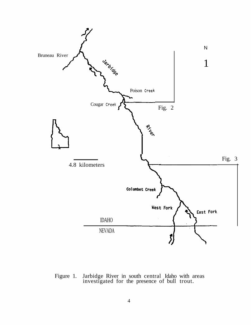
The Jarbidge River watershed is approximately 80 km long and encompasses 1,720 sq km in area. Most of the water for the entire stream system arises in the Jarbidge Mountains of northern Nevada and flows northwestward to its confluence with the Bruneau River in southern Idaho. The East Fork of the Jarbidge is approximately 36 km in length and the West Fork is approximately32 km long. The mainstem downstream of the East and West forks confluence flows northwesterly approximately 45 km to the Bruneau River (Figure 1). streams in the headwaters approach 3,200 m in elevation. At the Idaho-Nevada border, the elevation of the West Fork is 1,628 m, East Fork 1,622 m. By the time the Jarbidge River joins the Bruneau River it has dropped to 1,128 m.
Within Idaho, the Jarbidge River and main tributaries flow through narrow steep sided desert canyons up to 300 m deep. Channel gradient consists mostly of series of shallow run/riffles separated by steeper cascades through boulders and pools. streambed gradient is moderate with the greatest on the West Fork with an average drop of 15.7 m/km. Gradient in the East Fork is 12.0 m/km and in the main Jarbidge River, 8.8 m/km. Vegetation above and along the canyon walls is predominately sagebrush,
.bunch grasses and cheatgrass. Vegetation adjacent to the water consists of alders, willows, sedges, junipers, cottonwoods, wild roses, poison ivy and numerous other brush and grass speciesindicative of undisturbed desert riparian zones in the region.
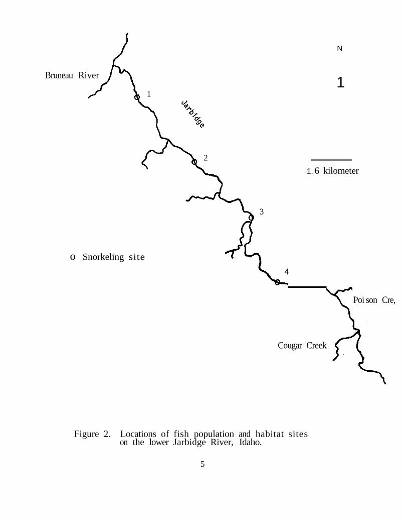
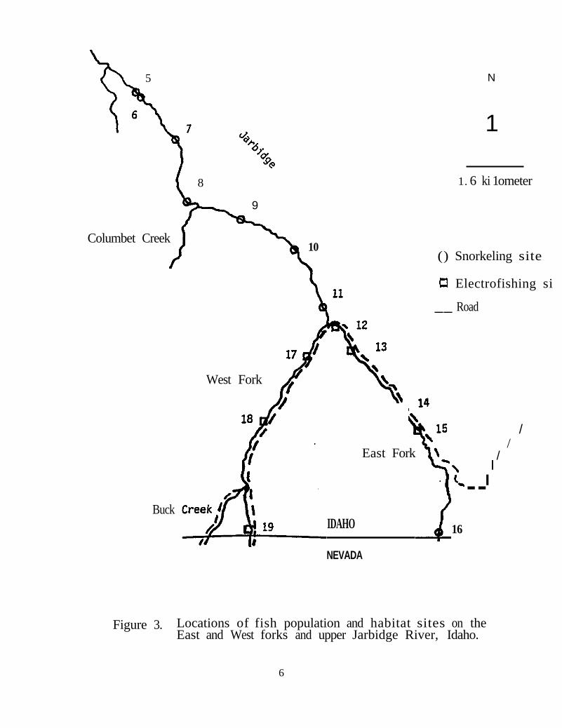
A total of 19 sites were surveyed for fish and habitat assessments on the Jarbidge River and the East and West fork tributaries (Figures 2 and 3). Five sites were on the East Fork, three on the West Fork and 11 on the mainstem. Site selection along the road on the two forks was based on an attempt to gather data on all habitat types throughout the length of the stream
3
N
Bruneau River
1
Poison
Cougar Fig. 2
Fig. 3 4.8 kilometers
IDAHO
NEVADA
Figure 1. Jarbidge River in south central Idaho with areas investigated for the presence of bull trout.
4
N
Bruneau River 1
1
2
1. 6 kilometer
3
o Snorkeling site
4
Poi son Cre,
Cougar Creek
Figure 2. Locations of fish population and habitat sites on the lower Jarbidge River, Idaho.
5
5 N
1
8 1. 6 ki 1ometer
9
Columbet Creek 10
() Snorkeling site
Electrofishing si
__ Road
West Fork
/ /
East Fork /I
--I
Buck IDAHO 16
NEVADA
Figure 3. Locations of fish population and habitat sites on the East and West forks and upper Jarbidge River, Idaho.
6
section within Idaho. Additionally Buck Creek was checked and found to only have a few intermittent shallow pools in July, so no formal analysis was conducted. site selection on the mainstem was based on river mile (nautical miles) markers identified on U.S.G.S. topographic maps. Sites in the upper third of the Jarbidge River (river mile 20 - 25) were located at each mile marker with the exception of an additional site located at river mile 20.1. The site located at river mile 20.1 was added because of the presence of numerous deep pools which we felt may support bull trout. Every other mile (odd numbers) was selected in the lower third of the river. Due to the steepness of the terrain and absence of roads surrounding the mainstem Jarbidge River downstream of the confluence of the two forks, the reach between river miles 7 and 20 was not surveyed. Sites varied in length ranging from 78 to 138 m with riffle structures providing the upper and lower boundaries.
Along the road, fish were sampled at four sites on the East Fork and three sites on the West Fork by electrofishing with a Smith-Root Model 15-A backpack shocker. Rainbow trout populations were estimated using the Seber and LeCren (1967) twostep removal method. Due to gear inefficiency on other species, they were only identified and enumerated during each pass. Total length was measured on all trout and mountain whitefish Prosopium williamsoni. Scale samples were taken from gamefish for age and growth analyses. Length at annulus formation was back-calculated using the Fraser-Lee method with an a-value of 32. Additional samples of fish were collected by angling between sites on the East Fork and main Jarbidge River.
For sites without road access, game fish were identified, measured and enumerated by visual observation while snorkeling. This was done with two snorkelers moving upstream side-by-side, through the entire site. Lengths of individual fish were categorized into 10 cm increments by visually comparing them to a clear plastic ruler marked in 10 cm increments which was attached to a one meter long handle. The snorkelers were in constant communication with each other to avoid counting twice. Some boulder-pool stream reaches which we felt could potentially support bull trout but did not fall within the boundaries of a designated sample site were also snorkeled. These included approximately 0.5 km of stream below the state line on the East Fork, approximately 0.5 km of the Jarbidge River above Columbet Creek and 0.3 km of river above site 2.
7
Habitat was assessed at each site utilizing Idaho Fish and Game standardized stream survey procedures which are based on methods described by Platts et al. (1983) and Rosgen (1985). These procedures require determining stream widths at each transect. Depth, bottom substrate composition and water column fish habitat variables at three points along each transect were also recorded. The lowermost transect was located at the downstream boundary of the site with all other transects 20 m apart to the uppermost boundary. Total site length was measured.
Flow measurements were taken on each of the two forks near their confluence. Water temperature was measured during the early morning near sunrise and during the afternoon on most survey days.
RESULTS
No bull trout were sampled or observed at any site on the mainstem or either of the forks of the Jarbidge River during 1992. Fish sampled or observed in stUdy sites included wild rainbow trout, hatchery rainbow trout, mountain Whitefish, bridgelip sucker Catostomus columbianus, redside shiner Richardsonius balteatus, longnose dace Rhinichthys cataractae, speckled dace B. osculus, and mottled SCUlpin Cottus bairdi. There were also numerous northern squawfish Ptychocheilus oregonensis observed in deep pools of the mainstem Jarbidge River within one km of the Bruneau River. All other nongame species were observed throughout the survey area. In addition to fish species, the native crayfish Pacifastacus gambeli was observed in Buck Creek and in the mainstem Jarbidge River. A fresh water mussel, probably Gonidea angulata was also observed in the lower Jarbidge River.
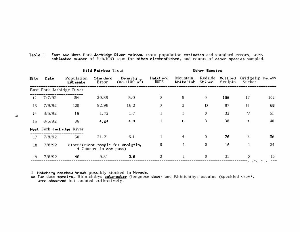
Wild rainbow trout densities estimated in six of the seven electrofish sites (East and West forks) ranged from 1.7 to 16.2
sq. m 1). Due to excessive water depth, electrofishing gear at 18 was too inefficient to sample fish. A single snorkeler observed rainbow trout, mountain whitefish, redside shiner, dace and suckers but no bull trout at this site.
Densities of wild rainbow trout in snorkel transects ranged from a to 8.3 fish/lOa sq m (Table 2). site 1 located at river mile 1 was a long wide shallow run (maximum depth 23 em) with no holding water for game fish. Wild rainbow trout (up to 380 mm) were caught by rod and reel below this site near the mouth.
8
---------------------------------------------------------------------------------------------------------------------------------------
------------------------
1. Fork trout population and standard errors, of fish/IOO sq.m for and counts of sampled.
Trout
Population Mountain Redside 8ridgelip Error (no. /100 R8TlE Sculpin Sucker
East Fork Jarbidge River
12 7/7/92 20.89 5.0 0 8 0 17 102
13 7/9/92 120 92.98 16.2 0 2 D 87 11
8/5/92 1. 72 1.7 1 3 0 32 51
15 8/5/92 36 1 3 38 40
Fork River
17 7/8/92 50 21. 21 6.1 1 0 3
18 7/8/92 for 0 1 0 1 24 Counted in pass)
19 7/8/92 9.81 2 2 0 31 0 15 -----------------------------------------------------------------------------------------------------,_.-._-_._--
lE possibly stocked in dace Bbinichtbys (longnose and Rhinichthys osculus (speckled
but counted collectively.

2. wild rainbow trout (WRB) and mountain whitefish (MWF) numbers and densities observed while snorkeling East Fork and mainstem Jarbidge River sites in 1992.
site no. Date of No. WRB Density WRB No. MWF Density MWF survey Observed (no./100 m2) Observed (no ./100 m2)
1 9/3/92 0 0.0 2 0.2
2 9/3/92 26 2.4 8 0.8
3 9/2/92 22 2.8 8 1.0
4 9/2/92 55 5.3 12 1.2
5 8/11/92 32 2.6 11 0.9
6 8/11/92 61 8.3 21 2.9
7 8/11/92 42 4.2 17 1.7
8 8/11/92 14 1.1 21 1.6
9 8/12/92 11 1.2 9 1.0
10 8/12/92 40 4.4 54 5.9
11 8/12/92 35 3.4 41 4.0
16 10/27/92 24 3.3 1 0.1
10

Hatchery rainbow trout were observed occasionally (sites 4, 5, 6, 14, 15, 17 and 19) in the Jarbidge River from the Nevada state line on the West Fork to river mile 7. When observed in pools, the larger (230-270 mm) hatchery rainbow were generally in the dominant feeding position. Densities of mountain whitefish ranged from 0.2 to 5.9 fish/100 sq m. Numerous reaches with large boulder-pool complexes which did not fall within sampling sites were encountered. snorkeling some of these complexes did not result in finding bull trout or apparent differences in other fish species densities.
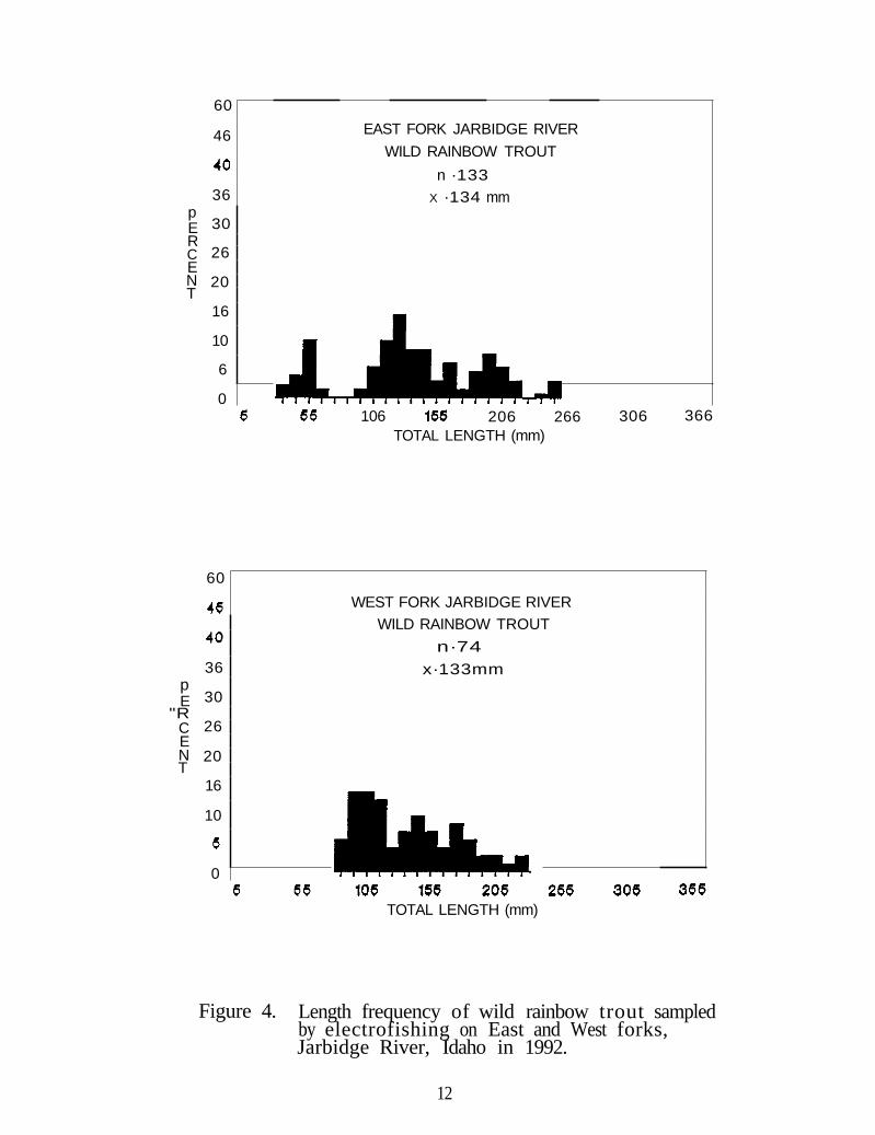
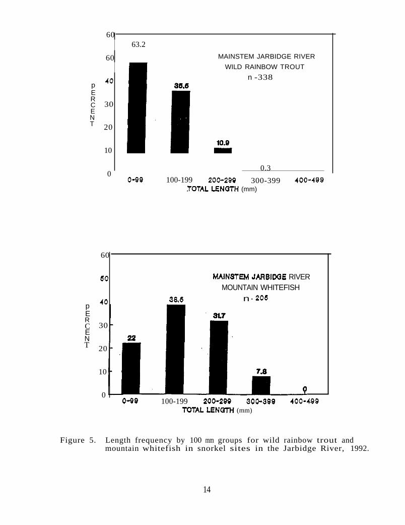
Length of wild rainbow trout sampled by electrofishing on the East and West forks ranged from 30 to 255 mm with mean lengths of 134 mm on the East Fork and 133 mm on the West Fork (Figure 4, Appendix B). Mean back-calculated lengths at annulus formation were 213 mm on the East Fork and 180 mm on the West Fork at three years of age (Table 3). Snorkeling the mainstem found that 53 of the wild rainbow trout and 22 of the mountain whitefish observed were less than 100 mm (Figure 5). Less than one percent of the rainbow trout observed were greater than 300 mm.
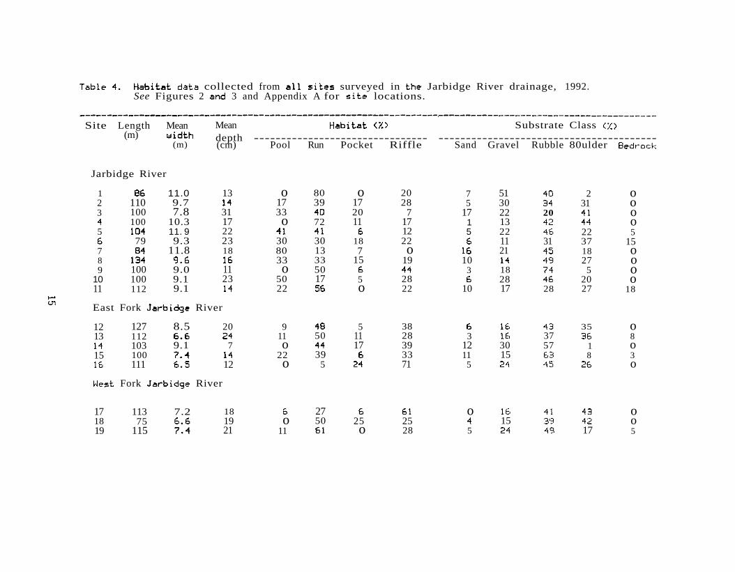
Results of the habitat assessment indicate a low percentage of the substrate composed of silt or sand· at all sites (Table 4). In all but four of the sites the substrate was dominated by gravel or rubble. In those four exceptions, the highest percentage of silt or sand at anyone site was 17 percent. Water column fish habitat is extremely variable with pools, runs, pocket water, and riffles, with no backwater habitat sampled within any of the sites. The entire stream upstream of river mile 2 is confined in a narrow canyon with most of the fish habitat provided by large rocky structures and small pools. Due to the confinement of the canyon, most large woody debris provided by the sparse number of trees in the riparian zone probably washes downstream out of the system except for a few log jams. Although riparian vegetation was in good condition, it provided only a limited amount of cover for fish in 1992. As a result of the drought, low river flows exposed large portions of the stream channel. There is evidence that water levels rise several vertical meters up the canyon walls during high flows. Total flow of the East Fork 100 m upstream of its confluence with the West Fork measured 14.91 cfs on July 7, 1992 and total flow of the West 100 m upstream of its confluence measured 10.77 cfs. Recommended minimum flows for rafting the Jarbidge River are 1,000 cfs.
11
60
46
p E R C E N T
36
30
26
20
16
10
6
0
EAST FORK JARBIDGE RIVER
WILD RAINBOW TROUT
n ·133 X ·134 mm
60
p E
"R C E N T
36
30
26
20
16
10
0
106 206 266 306 366 TOTAL LENGTH (mm)
WEST FORK JARBIDGE RIVER WILD RAINBOW TROUT
n·74
x·133mm
TOTAL LENGTH (mm)
Figure 4. Length frequency of wild rainbow trout sampledby electrofishing on East and West forks, Jarbidge River, Idaho in 1992.
12

Table 3. Back-calculated length-at-age (standard deviation) for wild rainbow trout collected from East Fork and West Fork Jarbidge River, 1992.
East Fork
Year class
No. of fish
Mean 1
length at annulus (mm) 2 3
1991
1990
1989
16
8
6
79 (9.06)
87 (14.50)
94 (11.95)
138 (21. 02)
151 (28.17)
213 (1.6.03)
Weighted average length 84 143 213
West Fork
Year class
No. of fish
Mean 1
length at annulus 2 3
(mm)
1991
1990
1989
2
7
5
74 (1. 54)
82 (13.34)
84 (11.53)
121 (22.80) 139
(18.04) 180
(21.48)
Weighted average length 82 129 180
13
60 63.2
MAINSTEM JARBIDGE RIVER 60 WILD RAINBOW TROUT
n -338 p E R C 30 E N T 20
10
0.3 0
100-199 300-399 (mm)
60
RIVER MOUNTAIN WHITEFISH
n· p E R C 30 E N T 20
10
0 100-199
(mm)
Figure 5. Length frequency by 100 mm groups for wild rainbow trout and mountain whitefish in snorkel sites in the Jarbidge River, 1992.
14
------------------------------------------------------------------~---------------------------------------
collected from surveyed in Jarbidge River drainage, 1992. See Figures 2 3 and Appendix A for locations.
Site Length Mean Mean Substrate Class (m) depth -------------------------------- ---------------------------------------
(m) (cm) Pool Run Pocket Riffle Sand Gravel Rubble 80ulder
Jarbidge River
1 11.0 13 o 80 o 20 7 51 2 o 2 110 9.7 17 39 17 28 5 30 31 o 3 100 7.8 31 33 20 7 17 22 20 o
100 10.3 17 o 72 11 17 1 13 o 5 11. 9 22 12 5 22 22 5
79 9.3 23 30 30 18 22 11 31 37 15 7 11.8 18 80 13 7 o 21 18 o 8 33 33 15 19 10 27 o 9 100 9.0 11 o 50 3 18 5 o
10 100 9.1 23 50 17 5 28 28 20 o 11 112 9.1 22 o 22 10 17 28 27 18
East Fork River
12 127 8.5 20 9 5 38 35 o 13 112 11 50 11 28 3 37 8
103 9.1 7 o 17 39 12 30 57 1 o 15 100 22 39 33 11 15 8 3
111 12 o 5 71 5 o
Fork River
17 113 7.2 18 27 o o 18 75 19 o 50 25 25 15 o 19 115 21 11 o 28 5 17 5
Water temperature fluctuations were observed to range from 15 degrees (C) at 10:30 a.m. to 26 degrees at 5:30 p.m. on August12, 1992. The morning temperature was taken at site 8 (rivermile 22) and the afternoon temperature taken at site 11 (river mile 25). During the August 11-12, 1992 sampling trip numerous trout were observed to be in stress, with a few dying, when water temperatures had reached 25 degrees.
DISCUSSION
The absence of bull trout in any sample within Idaho in 1992 can only be speculated on. The most plausible explanation for their absence is excessive water temperatures and low flows. If bull trout do not tolerate water temperatures much beyond 16 or 17 degrees (C) (Russ Thurow, USFS, Boise, Pers. corom.) then summer water temperatures during low drought flows are excessive in all reaches of the Jarbidge River up to at least the Nevada state line. there is a population of bull trout which resides within Idaho in the Jarbidge system, they probably move upstream to cooler areas before water temperatures reach lethal levels. One bull trout was reported to be observed moving upstream in the East Fork below Murphy Hot Springs in early summer, 1992 (Mark Vincent, USBLH, Pers. Comm.). However snorkeling two likely holding waters in October still did not find any bull trout in Idaho this year. Pratt (1985) reports numerous spawning adfluvial bull trout from Lake Pend Oreille, upstream of seasonally sections of streams. She speculates that these fish moved upstream into the system early in the year when flows were high. This would be a possible survival strategy of Jarbidge River bull trout. With the drought and low water conditions which have prevailed since 1986, stream conditions have not been conducive to supporting even rainbow trout during the midsummer months in the mainstem, as observations of stressed fish indicate. Johnson (1990) makes this emphasis with water temperature monitoring he did on the middle reaches of the West Fork within Nevada.
Despite prevailing low water conditions on all reaches studied, the streambed remained watered and habitat remained diverse with numerous pools, riffles, and runs. Gravel and rubble in all reaches observed appeared to be in excellent condition with little silt or sand. With the exception of some stream encroachment from the road along the East and West forks and at Murphy Hot spring," there is little evidence of man caused degradation to the Jarbidge River habitat in Idaho. Grazing bylivestock has been curtailed in the main canyon and past grazed
16
areas observed are recovering. Although not investigated, numerous old mines in the upper drainage could influence water quality.
Currently there is some potential impact by man on bull trout in both Idaho and Nevada by sport fishing. However, most of the Idaho fishing occurs from Columbet creek up to the state line with most of the pressure being on the East Fork below Murphy Hot springs. Pressure below Columbet Creek is expected to be quite minimal due to the difficult access. Currently with the two trout limit and winter and spring closure, harvest of bull trout is expected to be quite low in Idaho and may have only a marginal impact on the population. However if ongoing studies in Nevada determine that the entire population is extremely distressed due to drought or other impacts and in need maximum protection, elimination of all harvest should be considered by both states.
17

LITERATURE CITED
Johnson, G.L. 1990. Bull trout species management plan. state of Nevada, Department of Wildlife, Statewide Fisheries Program, Federal Aid project No. F-20-26, Job No. 207.4.
Platts, W.S., W.F. Megahan, and G.W. Minshall. 1983. Methods for evaluating stream, riparian, and biotic conditions. USDA Forest Service, Intermountain Forest and Range Experiment Station. General Technical Report INT-138.
Pratt, K.I. 1985. Pend Oreille trout and char life history study. Idaho Department of Fish and Game.
Rosgen, D.L. 1985. A stream classification system. Presented in: Riparian Ecosystems and their Management: Reconciling Conflicting uses. First North American Riparian Conference. USDA Forest Service, Rocky Mountain Forest and Range Experiment station. General Technical Report RM-120.
Seber, G.A.F. and E.D. LeCren. 1967. Estimating population parameters from catches large relative to the population. Journal of Animal Ecology 36:631-643.
18
---------------------------------------------------
------------------------
------------------------
------------------------
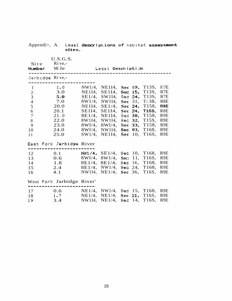
Appendi>, A. i pt. sites.
U.S.G.S. Si t·e Ri ve,-
Mi le Desct- i i .:In
Ri ve,
1 NW1/4, NE1I4, Sec T13S, F:7E 2 3.0 NE1I4, SE1I4, T13S, R7E 3 5.0 SE1/4, SW1I4, T13S, R7E 4 7.0 8W1/4, NW1I4, Sec 31, T 1. 38, R8E 5 20.0 NE1I4, SE1/4, Sec T158, R8E 6 20.1 SE1I4, SE1I4, Sec T15S, R8E 7 21. 0 8E1/4, NE1I4, 30, T158, R9E 8 22.0 8W1I4, NW1I4, 32, T15S, R9E 9 23.0 8Wl/4, 8Wl/4, Sec 33, T158, R9E
10 24.0 8Wl/4, NW1I4, 03, T168, R9E 11 25.0 SW1/4, NE1I4, Sec 10, T16S, R9E
River
12 0.1 SE1/4, 10, T168, R9E 13 0.6 8Wl/4, 8W1/4, Sec: 11, T16S, R9E 14 1.8 8E1/4, 8E1/4, 14., T168, R9E 15 2.4 8E1/4, NW1/4, 24, T168, R9E 16 4.1 NW1I4, NE1/4, Sec 36, T16S, R9E
West Jarbidge River'
17 0.6 NE1/4, NW1/4, 15, T168, R9E 18 NE1/4, NE1/4, Sec T16S, R9E
3.4 NW1I4, NE1/4, 14, T16S, R9E
19

·
Appendix B. Length frequency of game fish sampled'by electrofishing in the East and West forks Jarbidge River, Idaho, 1992.
Total East Fork River West Fork Riverlength Ra1nbow trout ounta1n Ra1noow trout
<nun> Hatchery whitefish w11d Hatchery whitefish
20 30 3 40 5 I 50 13 60 Z 10 I 80 I 90 Z 10
100 1 10 IIo 13 9 120 19 3 130 II 5 140 II 1 ISO 4 5 160 8 3 I 1/0 2 2 6 180 6 4 190 10 2 200 1 2 I 210 4 I 220 2 2 230 I 6 2 2 240 4 1 2 250 I I 3 260 270 1 2 280 1 290 1 300 310 320 1 I 330 340 350 360 310 380 390 400
Total 133 2 19 74 3 7 Mean 134 248 232 133 245 243
20