Embed Size (px)
Citation preview

Page 1 of 32 Oklahoma Geographic Information Council – 10/30/2017
The State of Oklahoma Geographic Information NG911 and Addressing
Standard Oklahoma GI Council / Office of Geographic Information
Oklahoma Geographic Information Council Adopted: September 5, 2014
Draft Submitted for Public Review: May 2, 2014 – September 4, 2014
Oklahoma Geographic Information Council Adopted: DRAFT Draft Submitted for Public Review: DRAFT
Oklahoma 9-1-1 Management Authority Adopted: DRAFT
Draft Submitted for Public Review: DRAFT
Version 2.0
Page 2 of 32 Oklahoma Geographic Information Council – 10/30/2017
Oklahoma Address Standards
Article I. Introduction ..................................................................................................................................... 3 Article II. Background ..................................................................................................................................... 3
Section 2.01 History ...................................................................................................................................... 3 Section 2.02 Legislative Duties ..................................................................................................................... 4 Section 2.03 Need for a Standard ................................................................................................................... 4 Section 2.04 Workgroup Formation ............................................................................................................... 5 Section 2.05 Address Data Formats ............................................................................................................... 5 Section 2.06 Essential Address Elements- USPS Publication 28 ..................................................................... 5 Section 2.07 Enhanced 911 (E911) vs Next Generation 911 (NG911) NENA Mapping Requirements ............ 6 Section 2.08 Definition of the Standard ......................................................................................................... 7 Section 2.09 Applicability and Intended Uses of the Standard ........................................................................ 7 Section 2.10 Spatial Components .................................................................................................................. 7 Section 2.11 Attributes .................................................................................................................................. 7 Section 2.12 Data Field Requirements and Types ........................................................................................... 8 Section 2.13 Standard Addressing Practices ................................................................................................... 8 Section 2.14 Geocoding .............................................................................................................................. 10 Section 2.15 Data Quality ............................................................................................................................ 11 Section 2.16 Positional Accuracy Standards ................................................................................................. 11 Section 2.17 Spatial Reference .................................................................................................................... 11 Section 2.18 Content Accuracy .................................................................................................................... 12 Section 2.19 Data Stewardship .................................................................................................................... 12 Section 2.20 Metadata ................................................................................................................................. 12
Article III. Required Point, Line, & Polygon Schema ..................................................................................... 12 Section 3.01 Address Point – Point .............................................................................................................. 12 Section 3.02 Road Centerline - Line ............................................................................................................ 13 Section 3.03 Public Service Answer Point(PSAP) Boundary – Polygon........................................................ 15 Section 3.04 Emergency Service Zone(ESZ) Boundary – Polygon ............................................................... 15 Section 3.05 Emergency Service Boundary – Polygons (Fire, Law, EMS) .................................................... 16 Section 3.06 Authoritative Boundary – Polygon .......................................................................................... 17 Section 3.07 Other Recommended Layers Polygon ...................................................................................... 18 Section 3.08 Reference Domains ................................................................................................................. 18
Article IV. Citations of Existing Standards, Sources, and Reference Material .............................................. 27 Section 4.01 Existing Neighbor State Standards ........................................................................................... 27 Section 4.02 Existing Professional Standards Documentation & Legislation ................................................. 28 Section 4.03 Workgroup Acknowledgements ............................................................................................... 29 Section 4.04 Maintenance of the Standard ................................................................................................... 29 Section 4.05 Technical Glossary .................................................................................................................. 29
Page 3 of 32 Oklahoma Geographic Information Council – 10/30/2017
Article I. Introduction
This document shall serve as the primary reference document for Next Generation 911 (NG911) Geographic Information System (GIS) Components and Address Standards in the State of Oklahoma regarding GIS based addressing. The standard set forth is to be maintained, utilized, and distributed under the authority of the Oklahoma 9-1-1 Management Authority, the Oklahoma Geographic Information Council and the Oklahoma Office of Geographic Information. This standard is mandatory for NG911 purposes in the State of Oklahoma. The following guidelines should be incorporated into all addressing applications, both geospatial and tabular, to ensure interdisciplinary compatibility.
Article II. Background
Section 2.01 History The Oklahoma Geographic Information Council (further known as GI Council) has continually adapted to the technological advancements within the GIS profession to provide the State of Oklahoma the best possible collective GIS resource since its inception in 1994. The current GI Council of 19 members and the Office of Geographic Information (OGI) represent a professionally diverse cross section of the existing GIS community in Oklahoma and operate under the following legislative authority. The Oklahoma 9-1-1 Management Authority (further known as 911 Authority) was created on November 1st, 2016 and developed a technical subcommittee that would oversee the deployment of NG911 in the State. A partnership was formed between the 911 Authority and the GI Council with the goal of developing a Statewide GIS standard that will meet or exceed National Emergency Number Association (NENA) requirement for NG911 (NENA i3 standard). Below are the legislative initiatives that support the overall goal of the GI Council and 911 Authority partnership:
• 1994 SB 722 Created the State GIS Council of 11 members under the Conservation Commission serving as the Chair
• 1995 HB 1964 Added 3 members to the State GIS Council • 2001 Amendment adding 1 member to the State GIS Council • 2003 Interim Study H2003-105 considered a State-wide Coordinator, adding more members to the
State GIS Council, & the authority to set policies / standards. • 2004 HB 2457 Changed the name of the State GIS Council to the State GI Council, added 4 new
members, created the Office of Geographic Information (OGI) and corresponding positions in the OGI, along with specifying duties for the OGI and the GI Council NG911 Standard Update - Oklahoma 9-1-1- Management Authority History
• 2016 *HB 3126 Created the Oklahoma 9-1-1- Management Authority and the position of State 9-1-1- Coordinator. Wireless 911 Bill passed to change funding and require the NENA Location Services Standard for all 911 centers to follow.

Page 4 of 32 Oklahoma Geographic Information Council – 10/30/2017
Section 2.02 Legislative Duties As set forth in 2004 Regular Session of the Oklahoma State Legislature by §82-1501-205.1 and §82-1501-205.3 HB 2457 includes the following duties for the GI Council and the Office of Geographic Information. The GI Council developed this address standard under the following legislation. Below are the specific excerpts from existing State Statute.
• §82-1501-205.1 A. The duties of the Council shall include overseeing the Office of Geographic Information concerning
the following: 1. Development, adoption, and recommendation of standards and procedures that may be applied to
geographic information and Geographic Information Systems to promote consistency of data elements;
• §82-1501-205.3
(A) There is hereby established an Office of Geographic Information in the Oklahoma Conservation Commission. (D) The Office shall: 6. Develop, maintain, update, and interpret Geographic Information System standards under the direction of the Council and working with state and local agencies; NG911 Standard Update- Oklahoma 9-1-1 Management Authority Legislative Duties
• *§63-2864 The powers and duties of the Oklahoma 9-1-1 Management Authority created in Section 3 of this act shall be to: (4) Direct the Oklahoma Tax Commission to escrow all or any portion of funds collected pursuant to the Oklahoma 9-1-1 Management Authority Act attributable to a public agency, if the public agency fails to: (b) meet standards of the National Emergency Number Association (NENA) limited to call-taking and caller-location technology or comply with an improvement plan to meet such standards as directed by the Authority,
Section 2.03 Need for a Standard Addresses today are the primary reference commonly accepted as the indexing system used to represent specific geospatial locations in an easily searchable tabular format. The increasing integration of geospatial information into every aspect of daily operations has led to the need for a statewide address standard. Throughout Oklahoma there are many authorities that assign addresses within their respective jurisdiction. The development of addressing systems throughout the state without an existing a single point reference document has led to a diversity of datasets. In accomplishing the required tasks of the assigning agencies multiple methods have been employed to accommodate the unique functionality or overcome existing limitations. While many of the limitations that once constrained the development of addresses are no longer applicable today, there are several that are still very much a consideration for the assigning agency. The development of Oklahoma’s address standard ensures the fundamental minimum requirements needed to accurately depict an address are met within any current accepted system today while preparing for future development. The development and integration of NG911 relies primarily on GIS data to accurately determine the location of the caller in order to route the call to the proper Public Safety Answering Point (PSAP). All GIS data that is utilized in NG911 applications must adhere to the requirements as set forth in this standard.
Page 5 of 32 Oklahoma Geographic Information Council – 10/30/2017
Section 2.04 Workgroup Formation
(a) Initial Workgroup -In response to the increasing need for address standardization the GI Council formed the Address Standard Workgroup on April 1, 2011 to research, develop, and submit an address standard for adoption by the GI Council. The primary focus of this group was to research what address standards were being utilized in Oklahoma currently and develop a simple custom set of fundamental address standards that adhered to current industry standards. A fundamental provision from the start of the workgroup was to consider existing formats that currently are operational. While an address assigning jurisdiction may add certain elements to their data the focus of this workgroup was to isolate on the commonalities across the jurisdictions that are required for addressing. After this assessment a fundamental schema and associated documentation was to be built that could either be utilized to create a new address dataset, incorporate an existing, or enhance an older dataset with added functionality.
(b) NG911 Standard Workgroup – The additional requirement beyond the scope of the initial State of Oklahoma Geographic Information Address Standards constituted a need to form another workgroup between the GIS and 911 professionals. In an effort to meet the overall goal and enhance the end product the 911 Authority and the GI Council worked together through a joint GIS Technical Workgroup. This workgroup updated the existing State of Oklahoma Geographic Information Address Standards (Version 1.0 - September 5, 2014) to meet and exceed the required NENA standard for NG911.
Section 2.05 Address Data Formats Addresses generally exist in one of three formats
(a) A single address field or possibly set of fields in a tabular database
(b) A specific address associated with a point feature
(c) An address range associated with a linear feature such as a street or railroad centerline. (This format generalizes the address along the length of the linear feature. It is generally more forgiving but not as precise due to numerous theoretical addresses that may not exist)
Section 2.06 Essential Address Elements- USPS Publication 28 An address is comprised of several different attribute components, all of which are required to accurately define a specific address. When an address is matched against a Master Address File (MAF) it must be parsed (divided) into the individual components separated by a single space between the components. The minimum components required to accurately define the geospatial portion of an address with relation to this address standard are: USPS Publication 28 Data Element OK Address Standard Field Name Example Value Street Number Address 101 Predirectional PreDir N Street Name Street Main Street Suffix StreetType ST Postdirectional SufDir NE Secondary Unit Indicator BldgUnit APT Secondary Number BldgName 3 City City Guthrie State State OK Zipcode Zipcode 73044
Mailing Standards of the United States Postal Service Publication 28 - Postal Addressing Standards
Page 6 of 32 Oklahoma Geographic Information Council – 10/30/2017
While not all of the elements are required to be filled out for an address to be valid all of the placeholders need to be present in the attribute table to accurately represent the accepted United States Postal Service Standards. The Postal Service uses the following parsing logic to enter address information into their appropriate fields. When parsing an address into the individual components, start from the right-most element of the address and work toward the left. Then it places each element in the appropriate field until all address components are isolated. This process facilitates matching files and produces the correct format for standardized output as well as isolating the mismatches to the closest possible fit before failing.
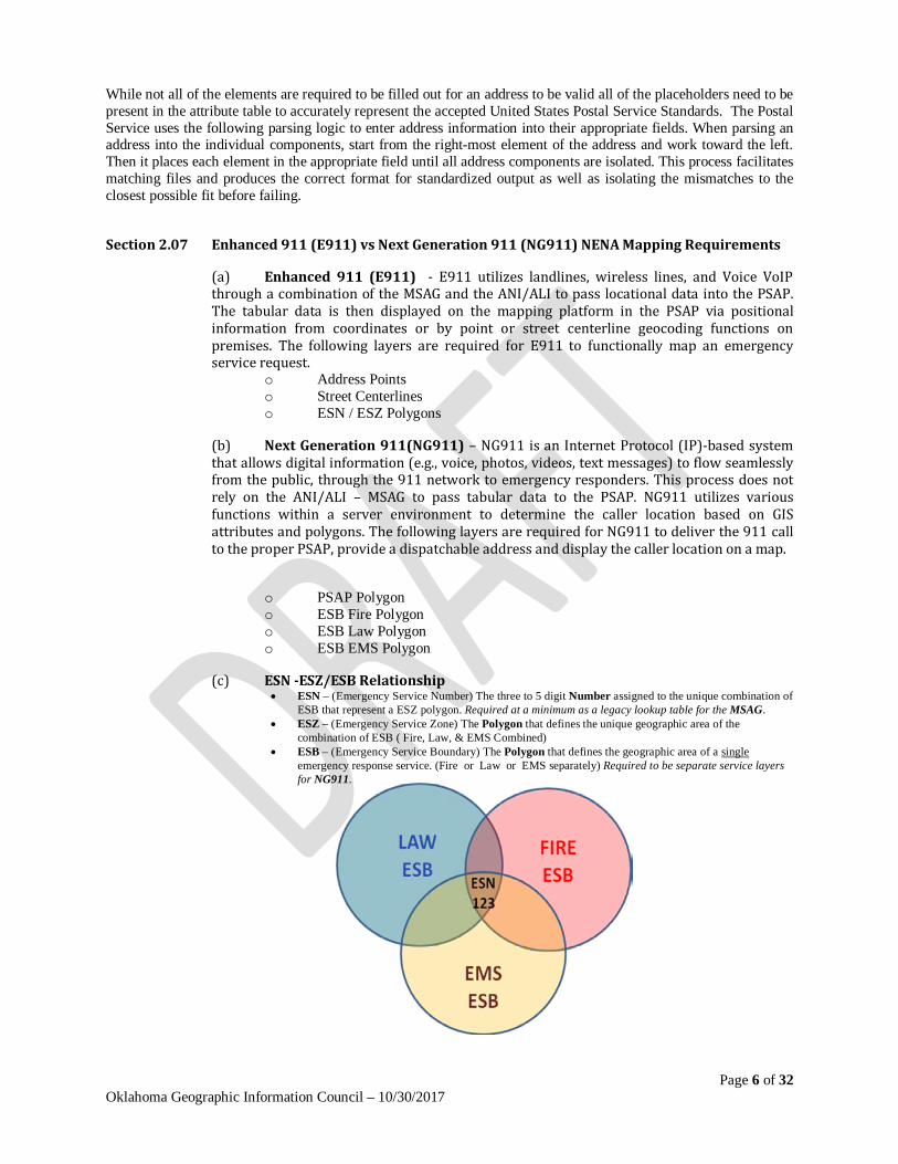
Section 2.07 Enhanced 911 (E911) vs Next Generation 911 (NG911) NENA Mapping Requirements
(a) Enhanced 911 (E911) - E911 utilizes landlines, wireless lines, and Voice VoIP through a combination of the MSAG and the ANI/ALI to pass locational data into the PSAP. The tabular data is then displayed on the mapping platform in the PSAP via positional information from coordinates or by point or street centerline geocoding functions on premises. The following layers are required for E911 to functionally map an emergency service request.
o Address Points o Street Centerlines o ESN / ESZ Polygons
(b) Next Generation 911(NG911) – NG911 is an Internet Protocol (IP)-based system that allows digital information (e.g., voice, photos, videos, text messages) to flow seamlessly from the public, through the 911 network to emergency responders. This process does not rely on the ANI/ALI – MSAG to pass tabular data to the PSAP. NG911 utilizes various functions within a server environment to determine the caller location based on GIS attributes and polygons. The following layers are required for NG911 to deliver the 911 call to the proper PSAP, provide a dispatchable address and display the caller location on a map.
o PSAP Polygon o ESB Fire Polygon o ESB Law Polygon o ESB EMS Polygon
(c) ESN -ESZ/ESB Relationship • ESN – (Emergency Service Number) The three to 5 digit Number assigned to the unique combination of
ESB that represent a ESZ polygon. Required at a minimum as a legacy lookup table for the MSAG. • ESZ – (Emergency Service Zone) The Polygon that defines the unique geographic area of the
combination of ESB ( Fire, Law, & EMS Combined) • ESB – (Emergency Service Boundary) The Polygon that defines the geographic area of a single
emergency response service. (Fire or Law or EMS separately) Required to be separate service layers for NG911.
Page 7 of 32 Oklahoma Geographic Information Council – 10/30/2017
Section 2.08 Definition of the Standard The following address standard defines the intended applications and usages associated with NG911 and the address standard along with the detailed components required for accurately representing caller location technology and addresses in a GIS. NG911 data as defined by this standard must meet or exceed the minimum standards outlined within this standard to be considered compliant with regards to Oklahoma NG911.
Section 2.09 Applicability and Intended Uses of the Standard The intended use of this document is to provide emergency services with a mandatory standard for the implementation and maintenance of a NG911 system. The standard also provides a simple basic address schema for anyone working with addresses in the State of Oklahoma. The associated documentation standardizes the basic structure of the tabular and attribute data required for geocoding using points, lines, and polygons. It is intended to be used by both the public and private sector.
Section 2.10 Spatial Components For the purpose of this standard the spatial feature types referenced are points, lines, and polygons.
(a) Points may be used to represent the center of building footprints, access locations such as driveway, building entrances, or parcel centroids. The address point identifies a single address or at the very least the primary address of a location. (ie.. an apartment complexes main address) The individual point may not completely reflect the address of a parcel or structure considering some buildings or parcels have more than one address. In such a case it is generally advisable to place a single point per valid address to ensure a one to one match in geocoding.
(b) Lines are generally used for street centerlines in this standard but can represent any linear feature where addressing is based on a distance along the line. This address format requires address ranges along the linear feature providing an even / odd address parity instead of individual numbers. It is critical that topology and line directionality are strictly adhered to regarding lines to ensure a functional geocoding.
(c) Polygons represent areas and will be used to delineate areas of a PSAP, Emergency Service Zone (ESZ), Emergency Service Boundary (ESB), and Authoritative Boundary. NG911 will rely on these layers to determine the caller location and services for a particular area as well as maintain an accurate data stewardship to report errors and corrections.
Section 2.11 Attributes Attributes are the tabular datasets represented by rows and columns of information associated with a geographic spatial feature. The following list represents the types of information that can be stored in attribute tables.
(a) Required attributes are the essential fields of data that are, at a minimum, required for correct geocoding and accurate address placement.
(b) Associated attributes pertain to the tabular and related data tied to an address. Examples of this could include a business name, incident number, structure type, etc. Many times associated data is stored in alias tables.
(c) Alias tables may also be associated with any type of attribute data to provide extra information or increase the accuracy of geocoding operations.
Page 8 of 32 Oklahoma Geographic Information Council – 10/30/2017
Section 2.12 Data Field Requirements and Types
(a) Data Field Requirement attributes are tagged as Mandatory (M), Conditional (C), Optional (O) or Transportation (T). Transportation fields have been included for use in other public safety applications.
• Mandatory implies the data field must be populated ( Ie… The field “County” will ALWAYS have a value such as “GARVIN”) • Conditional implies that IF an attribute value exists for a given feature, it MUST be populated. If no value exists for a given feature, the data field is left blank unless other guidance is given. ( Ie… The Street Prefix Type “PreType” MAY have a value such as “N” in 100 N MAIN) • Optional implies the data field must be present but may or may not be populated • Transportation denotes fields that are only essential to Transportation and Routing functionality, the data fields must be present but may or may not be populated. (Ie… The Street Speed Limit “SpeedLimit” MAY have a value such as “25” if so then 25 will be included in the data field. Default speed limit WILL be set at “21” unless the limit is known).
(b) Data Field Types
• ALPHANUMERIC – Any combination of letters, numbers, & characters.
• DATETIME- Specifically a Date/Time format
• NUMERIC - Consisting of whole numbers only ( No Decimals)
• DECIMAL - Consisting of whole numbers including decimals
Section 2.13 Standard Addressing Practices In order to provide for data consistency and interoperability this is the NG911 standard within the State of Oklahoma.
(a) Unique Identification Code (Mandatory) - A unique identifier is required for all databases, whether they are associated attributes or geospatial data sets. This unique identifier shall be used to link address attributes and indexes with other information. The unique identifier is defined in the NENA standard as the ESB NENA Globally unique ID (NGUID). Solely this unique ID will enable tracking the address data element back to the owner. The unique ID shall be configured in the following format:
(LayerName)_(Local911UniqueID)@(Source).(Steward).(ok.us)
Example: [email protected]
(b) Street Types -Each street name should have a street type that is used consistently, or have a street type that is based on a logical pattern. The exception to this rule is where street type is needed to distinguish between two streets in the same area with the same name (e.g., Sunset Dr and Sunset Ct). The recommended standard for establishing the street type values is set forth in the Mailing Standards of the United States Postal Service Publication 28 - Postal Addressing Standards -Appendix C1.
Page 9 of 32 Oklahoma Geographic Information Council – 10/30/2017
(c) Abbreviations – Geographic directional and street types shall always be abbreviated, but street names should never be abbreviated. Unless there are strong reasons for doing otherwise, it is recommended that the Mailing Standards of the United States Postal Service Publication 28 - Postal Addressing Standards -Appendix B & C1 be used.
(d) Street Naming - A standard method of assigning numeric and character street names shall be developed and adopted for the whole jurisdiction. The primary objective is to establish a grid within each jurisdiction regardless of the detailed pattern of the individual grid.
(e) Avoiding Obvious Conflicts – For the sake of accuracy and clarity avoid obvious conflicting names and numbers.
Names with directions: (i.e. South Ridge) Names that include street types: (i.e. Sunset Place Drive) Names that sound alike: (i.e. Roe and Row) Easily misleading names: (i.e. Main Dr and Main St) Multiple word names without hyphens : (i.e. Hickory Wood View Manor)
(f) Non-Grid Street Names - Street names that are not in the street name grid should always be unique to the overall jurisdiction.
(g) Vanity Street Names - Vanity street names and addresses that related to a particular business, developer or property owner and should never be used in place of the primary street address. They may, however, be used as a supplemental address in compliance with the Mailing Standards of the United States Postal Service Publication 28 - Postal Addressing Standards
(h) Location of Street Name Break Points - Street name breaks should occur at an intersection whenever possible, and preferably at an intersection with a major cross street. Where it is not possible to make the break at an intersection, the break should occur at a point on the curve where the street orientation changes from primarily north-south to east-west, or vice-versa. Street name signs should be used at every street name break to clarify the change.
(i) Odd/Even Numbering (Address Parity) – Parity shall remain consistent within the system adopted by the local jurisdiction. Address ranges are sets of numbers, usually comprised of four (4) distinct values, representing a range of addresses along the sides of the centerline of the road by addresses at either end of a street centerline segment. Two values of the range represent the lowest addresses, and the other two represent the highest. The values are further distinguished as being on either the left or the right side of the segment. In topological terms, the low values are associated with the FROM node of the segment, while the high values are associated with the TO node. Likewise, left and right are determined by the direction of the segment, as defined by the FROM and TO nodes. Topology is critical when a set of addressed centerlines is being developed. Implementation of the address parity (i.e., odd vs. even) is usually determined by the addressing software
(j) Sequential Direction - Address ranges shall increase as you travel in the direction adopted by the jurisdiction. The direction of each line segment shall follow the sequence direction of the address ranges. Typically this is accomplished by controlling from-node and to-node topology. One-way streets are NOT an exception to this rule. Curvilinear streets may violate this standard for short stretches provided that they are in compliance with respect to the general direction of the full street segment. Where compliance with this standard is difficult or impossible, it may warrant considering a change in the street name at the point where it changes direction.
Page 10 of 32 Oklahoma Geographic Information Council – 10/30/2017
(k) Consistency with Distance-Based Address Grid – Depending on the preference of the jurisdiction there must be a defined standard interval based grid system. Whether it is hundred blocks as in a city, a potential 1000 addresses per mile, (a possible address every 5.28 feet), or another variation the jurisdictions accepted standards should be adhered to as close as possible. In rural areas addresses can be assigned based on the distance from the nearest section line. This standard is particularly useful in areas that are largely undeveloped (and thus don’t have many cross streets) or in areas that have existing streets that are not in the standard street name grid. This standard should generally be considered to be less important, however, than staying consistent with the address designations of cross streets.
(l) Logical Address Consistency – Addresses located across the street from each other shall be assigned so that they are nearly equal. Where there are more addresses on one side of the street, addresses assigned to the other side will be more widely spaced so that addressing consistency is maintained for addresses across from one another.
(m) Alias Tables – The usage of associated alias tables will greatly increase the accuracy of the automated geocoding. It allows the system to handle various spellings or misspellings (aliases). A series of alias tables create alternate spelling options for common discrepancies regarding addresses. Whenever an address is being processed by the system it needs to go through a process of standardization. A crucial part of this standardization is to look up each address component in the alias tables and replace alias values with the standard equivalents. Constructing such alias tables requires considerable judgment to avoid distortions and are typically built up over time as unmatchable addresses are reviewed. While some alias table information is fairly common many customizations are specific to a particular jurisdiction and cannot be universally adopted.
Ie… A single street with multiple legal names within a single jurisdiction: 14th Ave NE State HWY 199 Sam Noble Pkwy
(n) Address Number Assignment - Each jurisdiction shall adopt a standard method of assigning address numbers. A jurisdiction may elect to have address numbers increase from north to south and from east to west. The jurisdiction may also choose to assign odd address numbers on the south and east sides of the street and even numbers on the north and west sides of the street. Regardless of the method selected, it must remain consistent throughout the jurisdiction and should be coordinated with as many contiguous jurisdictions as possible.
(o) Address Sequential Direction - Addresses shall always be assigned so that they are in numeric sequence and shall increase as you travel in the direction adopted by the jurisdiction
Section 2.14 Geocoding Geocoding is the process of finding associated geographic coordinates (often expressed as latitude and longitude) from other geographic data, such as street addresses, or ZIP codes (postal codes). This process can be accomplished through various methods. For the purpose of this standard the following three methods are preferred.
(a) Point based geocoding provides for the most accurate one to one geocoding option. It utilizes a preset number of essential fields to parse an address and accurately correlate the parsed address to the tabular data associated with a specific geographic point representing an address. While this method is highly accurate it is generally not very tolerant of address discrepancies or errors unless alias tables are utilized. It is generally the preferred first method of geocoding and provides real addresses with absolute accuracy.
(b) Linear based geocoding provides the most widely accepted and error tolerant geocoding option. It allows for any number of addresses within a preset range based on
Page 11 of 32 Oklahoma Geographic Information Council – 10/30/2017
either a single high and low number or an even and odd high and low number parity along a linear feature. A geographic position is calculated along a line based on the measured distance and address interval. This method can be extremely accurate depending on the data ranges. While this method is very tolerant of address discrepancies and errors it can produce theoretical addresses where real addresses do not exist. It is generally preferred for complete coverage of a jurisdiction and provides relative accuracy of an address.
Ie… Linear Theoretical & Actual Address Ranges: Theoretical Address Range: 701-799; 700-798 Actual address range 701-725; 700-724
(c) Composite Geocoding is a dual stage geocoding option where generally a more accurate (generally point based) geocoding option is initially utilized to find a location. If a suitable match is not found the address is passed to the second (generally linear based) geocoding option for an attempted match based on more forgiving parameters. This dual pass geocoding provides very good absolute accuracy while retaining complete coverage of relative accuracy throughout a jurisdiction.
Section 2.15 Data Quality Data quality is the relationship of the contents of the digital database to the reality that we are representing. NG911 requires an extremely high level of data accuracy, quality, and consistency in order to operate correctly. Failure to maintain the necessary quality of NG911 data poses a serious risk of loss of life.
Section 2.16 Positional Accuracy Standards
The geospatial accuracy of an address location should be pursued to achieve the highest feasible positional accuracy possible. While the required accuracy of the data may vary greatly between agencies there must be a minimum accuracy standard to allow for correct demarcation of a single address. Considering many rural address point locations are derived from 1 meter resolution NAIP Orthophotography or various GPS collection devices the following minimum standards should be attainable in most addressing applications. The minimum positional accuracy standards need to meet the following standard as set forth in the FGDC Geospatial Positioning Accuracy Standards Part 3, Appendix3-D (FDGC-STD-007.3-1998)
• Class 1 Horizontal 1:12,000 (10 feet RMSE) See also NENA GIS Data Collection and Maintenance Standards (NENA 02-014)
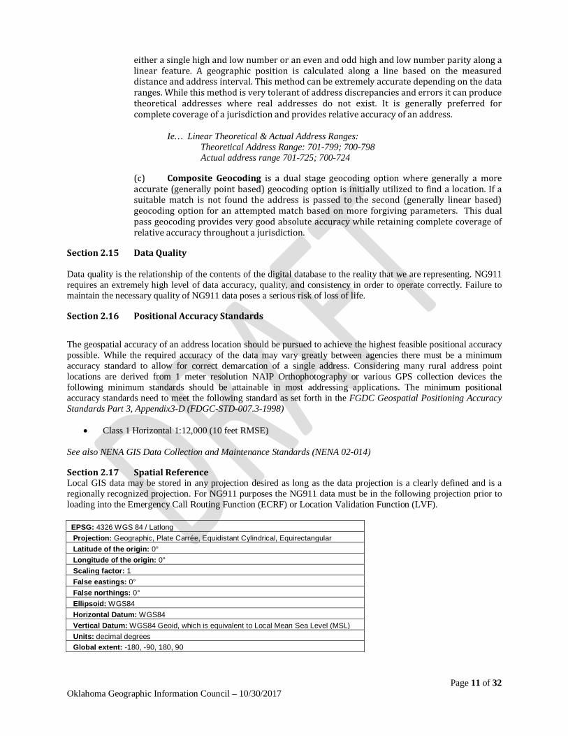
Section 2.17 Spatial Reference Local GIS data may be stored in any projection desired as long as the data projection is a clearly defined and is a regionally recognized projection. For NG911 purposes the NG911 data must be in the following projection prior to loading into the Emergency Call Routing Function (ECRF) or Location Validation Function (LVF).
EPSG: 4326 WGS 84 / Latlong Projection: Geographic, Plate Carrée, Equidistant Cylindrical, Equirectangular Latitude of the origin: 0° Longitude of the origin: 0° Scaling factor: 1 False eastings: 0° False northings: 0° Ellipsoid: WGS84 Horizontal Datum: WGS84 Vertical Datum: WGS84 Geoid, which is equivalent to Local Mean Sea Level (MSL) Units: decimal degrees Global extent: -180, -90, 180, 90
Page 12 of 32 Oklahoma Geographic Information Council – 10/30/2017
Section 2.18 Content Accuracy Content accuracy is measured based on the overall functional correctness of the data to accurately represent reality. This accuracy can be measured by the following aspects.
(a) The individual components of the data must be complete (filled in where appropriate) and contain the correct information.
(b) The data must be correct for the location in question. Routing to someplace is important but locating that someplace is critical.
(c) The data must be correct sequentially in terms of its relationship with the overall addressing schema.
(d) The data must be both current and valid with regard to content in order to function correctly.
Section 2.19 Data Stewardship The agency that is responsible for the data within their respective jurisdiction is the ultimate authority regarding the data and maintains the final authority over the development and maintenance of the information. A clear reference must be maintained in the metadata and tabular data to the authoritative jurisdiction regarding the development and maintenance of any dataset. (See section 2.13.a of this standard)
Section 2.20 Metadata Metadata shall be maintained for all address data sets. The metadata shall meet the standards as set forth in the FGDC Content Standards for Geospatial Metadata (FGDC-STD-001-1998) and shall be made available through accepted publishing methods.
Article III. Required Point, Line, & Polygon Schema
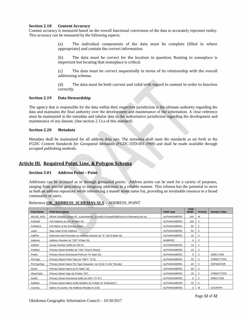
Section 3.01 Address Point – Point Addresses can be accessed as or through geospatial points. Address points can be used for a variety of purposes, ranging from precise geocoding to assigning addresses in a reliable manner. This schema has the potential to serve as both an address repository while referencing a master street name list, providing an invaluable resource to a broad community of users.
Reference OK_ADDRESS_SCHEMAS.XLS – ADDRESS_POINT
Field Name Field Description Field Type Field
Width Priority Domain Table
NGUID_ADD NENA Globally Unique ID : (LayerName)_(Local911UniqueID)@(Source).(Steward).(ok.us) ALPHANUMERIC 100 M
FullAddr Full Address (ie.101 W Main St) ALPHANUMERIC 100 C
FullName Full Name of the Primary Street ALPHANUMERIC 50 C
Label Map Label of the Address ALPHANUMERIC 50 C
AddPre Extension that Precedes an Address Number (ie "A" 100 N Main St) ALPHANUMERIC 15 C
Address Address Number (ie "100" N Main St) NUMERIC 6 C
AddSuf House Number Suffix (ie 100 A) ALPHANUMERIC 15 C
PreMod Primary Street Modifier (ie "Old" Church Street) ALPHANUMERIC 15 C
PreDir Primary Street Directional Prefix (ie "N" Main St) ALPHANUMERIC 9 C DIRECTION
PreType Primary Street Prefix Type (ie "HWY" 70 E) ALPHANUMERIC 25 C STREETTYPE
PreTypeSep Primary Street Name Pre Type Separator (ie Circle "in the" Woods) ALPHANUMERIC 20 C SEPARATOR
Street Primary Street Name (ie N "Main" St) ALPHANUMERIC 60 C
StreetType Primary Street Type (ie N Main "St") ALPHANUMERIC 25 C STREETTYPE
SufDir Primary Street Directional Suffix (ie HWY 70 "E") ALPHANUMERIC 9 C DIRECTION
SufMod Primary Street Name Suffix Modifier (ie N Main St "Extension") ALPHANUMERIC 25 C
Country Name of Country the Address Resides In (US) ALPHANUMERIC 2 M COUNTRY
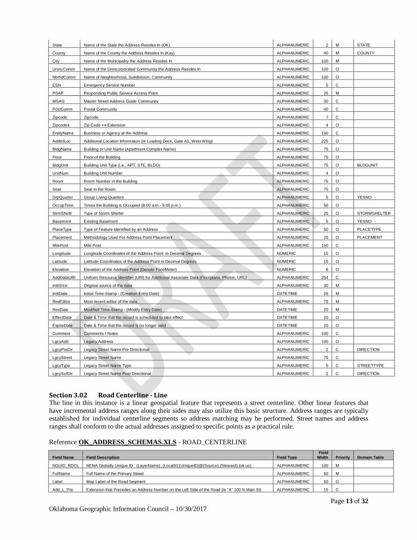
Page 13 of 32 Oklahoma Geographic Information Council – 10/30/2017
State Name of the State the Address Resides In (OK) ALPHANUMERIC 2 M STATE
County Name of the County the Address Resides In (Kay) ALPHANUMERIC 40 M COUNTY
City Name of the Municipality the Address Resides In ALPHANUMERIC 100 M
UnincComm Name of the Unincorporated Community the Address Resides In ALPHANUMERIC 100 O
NbrhdComm Name of Neighborhood, Subdivision, Community ALPHANUMERIC 100 O
ESN Emergency Service Number ALPHANUMERIC 5 C
PSAP Responding Public Service Access Point ALPHANUMERIC 25 M
MSAG Master Street Address Guide Community ALPHANUMERIC 30 C
PostComm Postal Community ALPHANUMERIC 40 C
Zipcode Zipcode ALPHANUMERIC 7 C
Zipcode4 Zip Code +4 Extension ALPHANUMERIC 4 O
EntityName Business or Agency at the Address ALPHANUMERIC 150 C
AddtnlLoc Additional Location Information (ie Loading Dock, Gate A1, West Wing) ALPHANUMERIC 225 O
BldgName Building or Unit Name (Apartment Complex Name) ALPHANUMERIC 75 O
Floor Floor of the Building ALPHANUMERIC 75 O
BldgUnit Building Unit Type (i.e., APT, STE, BLDG) ALPHANUMERIC 75 O BLDGUNIT
UnitNum Building Unit Number ALPHANUMERIC 4 O
Room Room Number in the Building ALPHANUMERIC 75 O
Seat Seat in the Room ALPHANUMERIC 75 O
GrpQuarter Group Living Quarters ALPHANUMERIC 5 O YESNO
OccupTime Times the Building is Occupied (8:00 a.m.- 5:00 p.m.) ALPHANUMERIC 50 O
StrmSheltr Type of Storm Shelter ALPHANUMERIC 25 O STORMSHELTER
Basement Existing Basement ALPHANUMERIC 5 O YESNO
PlaceType Type of Feature Identified by an Address ALPHANUMERIC 50 O PLACETYPE
Placement Methodology Used For Address Point Placement ALPHANUMERIC 25 O PLACEMENT
MilePost Mile Post ALPHANUMERIC 150 C
Longitude Longitude Coordinates of the Address Point in Decimal Degrees NUMERIC 15 O
Latitude Latitude Coordinates of the Address Point in Decimal Degrees NUMERIC 15 O
Elevation Elevation of the Address Point (Denote Foot/Meter) NUMERIC 6 O
AddDataURI Uniform Resource Identifier (URI) for Additional Associate Data (Floorplans, Photos, URL) ALPHANUMERIC 254 C
InitiSrce Original source of the data ALPHANUMERIC 30 M
InitiDate Initial Time-Stamp - (Creation Entry Date) DATETIME 26 M
RevEditor Most recent editor of the data ALPHANUMERIC 75 M
RevDate Modified Time-Stamp - (Modify Entry Date) DATETIME 20 M
EffectDate Date & Time that the record is scheduled to take effect DATETIME 20 O
ExpireDate Date & Time that the record is no longer valid DATETIME 20 O
Comment Comments / Notes ALPHANUMERIC 100 C
LgcyAdd Legacy Address ALPHANUMERIC 100 O
LgcyPreDir Legacy Street Name Pre Directional ALPHANUMERIC 2 C DIRECTION
LgcyStreet Legacy Street Name ALPHANUMERIC 75 C
LgcyType Legacy Street Name Type ALPHANUMERIC 5 C STREETTYPE
LgcySufDir Legacy Street Name Post Directional ALPHANUMERIC 2 C DIRECTION
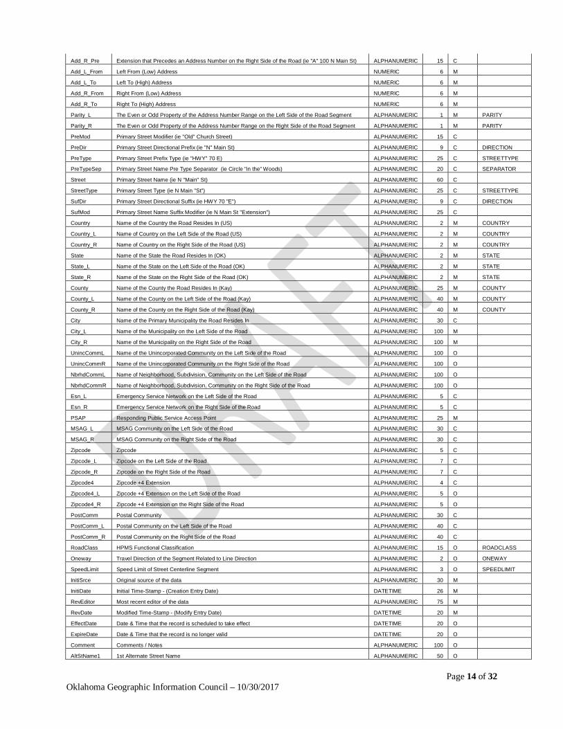
Section 3.02 Road Centerline - Line The line in this instance is a linear geospatial feature that represents a street centerline. Other linear features that have incremental address ranges along their sides may also utilize this basic structure. Address ranges are typically established for individual centerline segments so address matching may be performed. Street names and address ranges shall conform to the actual addresses assigned to specific points as a practical rule. Reference OK_ADDRESS_SCHEMAS.XLS - ROAD_CENTERLINE
Field Name Field Description Field Type Field
Width Priority Domain Table
NGUID_RDCL NENA Globally Unique ID : (LayerName)_(Local911UniqueID)@(Source).(Steward).(ok.us) ALPHANUMERIC 100 M
FullName Full Name of the Primary Street ALPHANUMERIC 50 M
Label Map Label of the Road Segment ALPHANUMERIC 50 O
Add_L_Pre Extension that Precedes an Address Number on the Left Side of the Road (ie "A" 100 N Main St) ALPHANUMERIC 15 C
Page 14 of 32 Oklahoma Geographic Information Council – 10/30/2017
Add_R_Pre Extension that Precedes an Address Number on the Right Side of the Road (ie "A" 100 N Main St) ALPHANUMERIC 15 C
Add_L_From Left From (Low) Address NUMERIC 6 M
Add_L_To Left To (High) Address NUMERIC 6 M
Add_R_From Right From (Low) Address NUMERIC 6 M
Add_R_To Right To (High) Address NUMERIC 6 M
Parity_L The Even or Odd Property of the Address Number Range on the Left Side of the Road Segment ALPHANUMERIC 1 M PARITY
Parity_R The Even or Odd Property of the Address Number Range on the Right Side of the Road Segment ALPHANUMERIC 1 M PARITY
PreMod Primary Street Modifier (ie "Old" Church Street) ALPHANUMERIC 15 C
PreDir Primary Street Directional Prefix (ie "N" Main St) ALPHANUMERIC 9 C DIRECTION
PreType Primary Street Prefix Type (ie "HWY" 70 E) ALPHANUMERIC 25 C STREETTYPE
PreTypeSep Primary Street Name Pre Type Separator (ie Circle "in the" Woods) ALPHANUMERIC 20 C SEPARATOR
Street Primary Street Name (ie N "Main" St) ALPHANUMERIC 60 C
StreetType Primary Street Type (ie N Main "St") ALPHANUMERIC 25 C STREETTYPE
SufDir Primary Street Directional Suffix (ie HWY 70 "E") ALPHANUMERIC 9 C DIRECTION
SufMod Primary Street Name Suffix Modifier (ie N Main St "Extension") ALPHANUMERIC 25 C
Country Name of the Country the Road Resides In (US) ALPHANUMERIC 2 M COUNTRY
Country_L Name of Country on the Left Side of the Road (US) ALPHANUMERIC 2 M COUNTRY
Country_R Name of Country on the Right Side of the Road (US) ALPHANUMERIC 2 M COUNTRY
State Name of the State the Road Resides In (OK) ALPHANUMERIC 2 M STATE
State_L Name of the State on the Left Side of the Road (OK) ALPHANUMERIC 2 M STATE
State_R Name of the State on the Right Side of the Road (OK) ALPHANUMERIC 2 M STATE
County Name of the County the Road Resides In (Kay) ALPHANUMERIC 25 M COUNTY
County_L Name of the County on the Left Side of the Road (Kay) ALPHANUMERIC 40 M COUNTY
County_R Name of the County on the Right Side of the Road (Kay) ALPHANUMERIC 40 M COUNTY
City Name of the Primary Municipality the Road Resides In ALPHANUMERIC 30 C
City_L Name of the Municipality on the Left Side of the Road ALPHANUMERIC 100 M
City_R Name of the Municipality on the Right Side of the Road ALPHANUMERIC 100 M
UnincCommL Name of the Unincorporated Community on the Left Side of the Road ALPHANUMERIC 100 O
UnincCommR Name of the Unincorporated Community on the Right Side of the Road ALPHANUMERIC 100 O
NbrhdCommL Name of Neighborhood, Subdivision, Community on the Left Side of the Road ALPHANUMERIC 100 O
NbrhdCommR Name of Neighborhood, Subdivision, Community on the Right Side of the Road ALPHANUMERIC 100 O
Esn_L Emergency Service Network on the Left Side of the Road ALPHANUMERIC 5 C
Esn_R Emergency Service Network on the Right Side of the Road ALPHANUMERIC 5 C
PSAP Responding Public Service Access Point ALPHANUMERIC 25 M
MSAG_L MSAG Community on the Left Side of the Road ALPHANUMERIC 30 C
MSAG_R MSAG Community on the Right Side of the Road ALPHANUMERIC 30 C
Zipcode Zipcode ALPHANUMERIC 5 C
Zipcode_L Zipcode on the Left Side of the Road ALPHANUMERIC 7 C
Zipcode_R Zipcode on the Right Side of the Road ALPHANUMERIC 7 C
Zipcode4 Zipcode +4 Extension ALPHANUMERIC 4 C
Zipcode4_L Zipcode +4 Extension on the Left Side of the Road ALPHANUMERIC 5 O
Zipcode4_R Zipcode +4 Extension on the Right Side of the Road ALPHANUMERIC 5 O
PostComm Postal Community ALPHANUMERIC 30 C
PostComm_L Postal Community on the Left Side of the Road ALPHANUMERIC 40 C
PostComm_R Postal Community on the Right Side of the Road ALPHANUMERIC 40 C
RoadClass HPMS Functional Classification ALPHANUMERIC 15 O ROADCLASS
Oneway Travel Direction of the Segment Related to Line Direction ALPHANUMERIC 2 O ONEWAY
SpeedLimit Speed Limit of Street Centerline Segment ALPHANUMERIC 3 O SPEEDLIMIT
InitiSrce Original source of the data ALPHANUMERIC 30 M
InitiDate Initial Time-Stamp - (Creation Entry Date) DATETIME 26 M
RevEditor Most recent editor of the data ALPHANUMERIC 75 M
RevDate Modified Time-Stamp - (Modify Entry Date) DATETIME 20 M
EffectDate Date & Time that the record is scheduled to take effect DATETIME 20 O
ExpireDate Date & Time that the record is no longer valid DATETIME 20 O
Comment Comments / Notes ALPHANUMERIC 100 O
AltStName1 1st Alternate Street Name ALPHANUMERIC 50 O
Page 15 of 32 Oklahoma Geographic Information Council – 10/30/2017
AltStName2 2nd Alternate Street Name ALPHANUMERIC 50 O
AltStName3 3rd Alternate Street Name ALPHANUMERIC 50 O
LgcyPreDir Legacy Street Name Pre Directional ALPHANUMERIC 2 C DIRECTION
LgcyStreet Legacy Street Name ALPHANUMERIC 75 C
LgcyType Legacy Street Name Type ALPHANUMERIC 5 C STREETTYPE
LgcySufDir Legacy Street Name Post Directional ALPHANUMERIC 2 C DIRECTION
FromLevel Level from Overpass / Underpass ALPHANUMERIC 10 T LEVEL
ToLevel Level to Overpass / Underpass ALPHANUMERIC 10 T LEVEL
BoundLane Direction of the Lane of Traffic if Dedicated Direction ALPHANUMERIC 15 T DIRECTION
RoadLength Length of Street Segment ALPHANUMERIC 15 T
DriveTime Drivetime of the Street Segment ALPHANUMERIC 15 T
DeadEnd Dead End Street Segment ALPHANUMERIC 10 T YESNO
Surface Paving Surface of the Street ALPHANUMERIC 10 T
Lanes Number of Lanes Represented by the Street Segment ALPHANUMERIC 5 T NUMBER
Toll Requires Toll to Access ALPHANUMERIC 10 T YESNO
LtdAccess Limited Access to the General Public ALPHANUMERIC 10 T YESNO
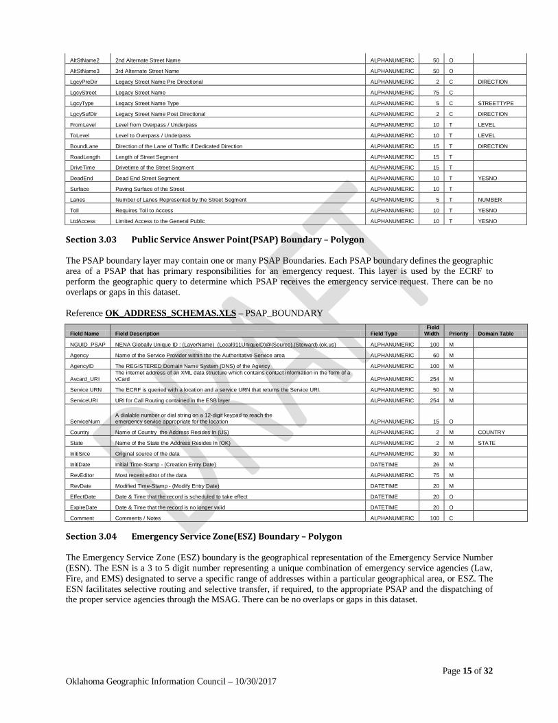
Section 3.03 Public Service Answer Point(PSAP) Boundary – Polygon The PSAP boundary layer may contain one or many PSAP Boundaries. Each PSAP boundary defines the geographic area of a PSAP that has primary responsibilities for an emergency request. This layer is used by the ECRF to perform the geographic query to determine which PSAP receives the emergency service request. There can be no overlaps or gaps in this dataset. Reference OK_ADDRESS_SCHEMAS.XLS – PSAP_BOUNDARY
Field Name Field Description Field Type Field
Width Priority Domain Table
NGUID_PSAP NENA Globally Unique ID : (LayerName)_(Local911UniqueID)@(Source).(Steward).(ok.us) ALPHANUMERIC 100 M
Agency Name of the Service Provider within the the Authoritative Service area ALPHANUMERIC 60 M
AgencyID The REGISTERED Domain Name System (DNS) of the Agency ALPHANUMERIC 100 M
Avcard_URI The internet address of an XML data structure which contains contact information in the form of a vCard ALPHANUMERIC 254 M
Service URN The ECRF is queried with a location and a service URN that returns the Service URI. ALPHANUMERIC 50 M
ServiceURI URI for Call Routing contained in the ESB layer ALPHANUMERIC 254 M
ServiceNum A dialable number or dial string on a 12-digit keypad to reach the emergency service appropriate for the location ALPHANUMERIC 15 O
Country Name of Country the Address Resides In (US) ALPHANUMERIC 2 M COUNTRY
State Name of the State the Address Resides In (OK) ALPHANUMERIC 2 M STATE
InitiSrce Original source of the data ALPHANUMERIC 30 M
InitiDate Initial Time-Stamp - (Creation Entry Date) DATETIME 26 M
RevEditor Most recent editor of the data ALPHANUMERIC 75 M
RevDate Modified Time-Stamp - (Modify Entry Date) DATETIME 20 M
EffectDate Date & Time that the record is scheduled to take effect DATETIME 20 O
ExpireDate Date & Time that the record is no longer valid DATETIME 20 O
Comment Comments / Notes ALPHANUMERIC 100 C
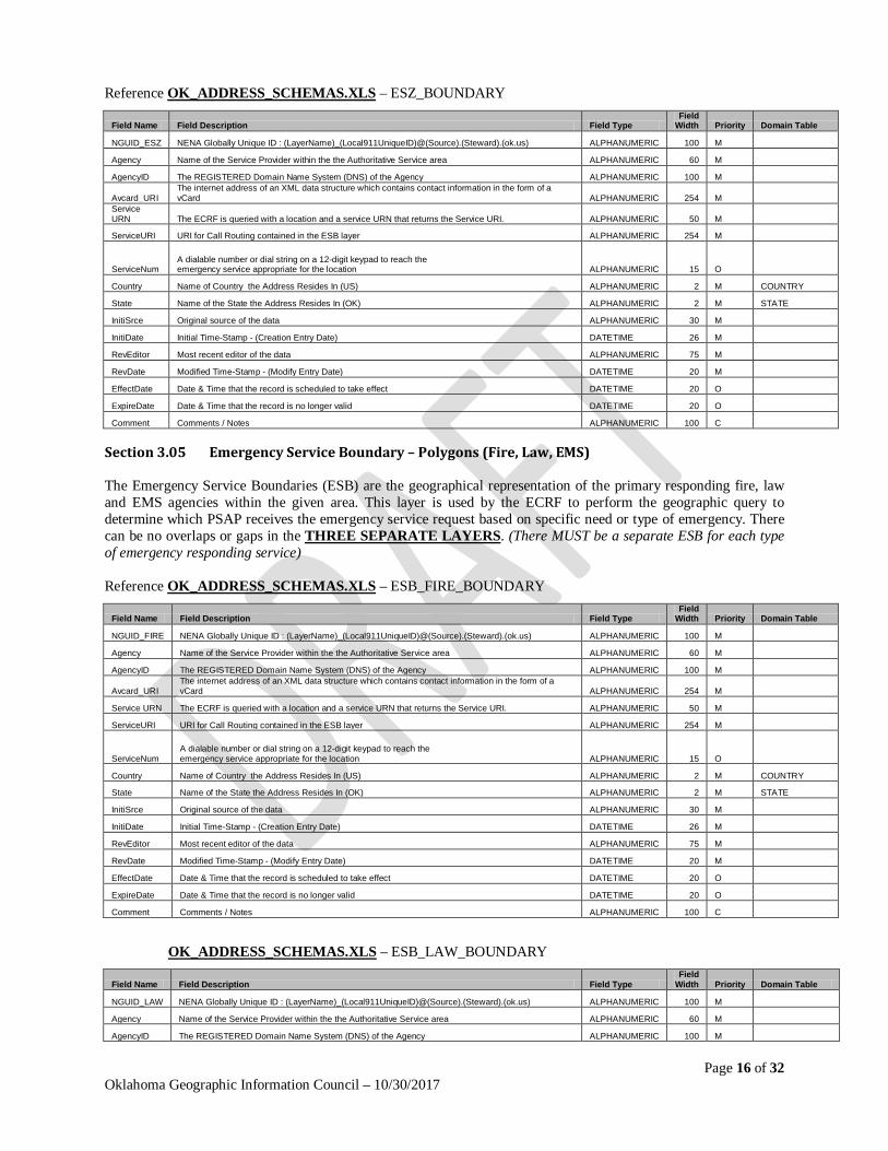
Section 3.04 Emergency Service Zone(ESZ) Boundary – Polygon The Emergency Service Zone (ESZ) boundary is the geographical representation of the Emergency Service Number (ESN). The ESN is a 3 to 5 digit number representing a unique combination of emergency service agencies (Law, Fire, and EMS) designated to serve a specific range of addresses within a particular geographical area, or ESZ. The ESN facilitates selective routing and selective transfer, if required, to the appropriate PSAP and the dispatching of the proper service agencies through the MSAG. There can be no overlaps or gaps in this dataset.
Page 16 of 32 Oklahoma Geographic Information Council – 10/30/2017
Reference OK_ADDRESS_SCHEMAS.XLS – ESZ_BOUNDARY
Field Name Field Description Field Type Field
Width Priority Domain Table
NGUID_ESZ NENA Globally Unique ID : (LayerName)_(Local911UniqueID)@(Source).(Steward).(ok.us) ALPHANUMERIC 100 M
Agency Name of the Service Provider within the the Authoritative Service area ALPHANUMERIC 60 M
AgencyID The REGISTERED Domain Name System (DNS) of the Agency ALPHANUMERIC 100 M
Avcard_URI The internet address of an XML data structure which contains contact information in the form of a vCard ALPHANUMERIC 254 M
Service URN The ECRF is queried with a location and a service URN that returns the Service URI. ALPHANUMERIC 50 M
ServiceURI URI for Call Routing contained in the ESB layer ALPHANUMERIC 254 M
ServiceNum A dialable number or dial string on a 12-digit keypad to reach the emergency service appropriate for the location ALPHANUMERIC 15 O
Country Name of Country the Address Resides In (US) ALPHANUMERIC 2 M COUNTRY
State Name of the State the Address Resides In (OK) ALPHANUMERIC 2 M STATE
InitiSrce Original source of the data ALPHANUMERIC 30 M
InitiDate Initial Time-Stamp - (Creation Entry Date) DATETIME 26 M
RevEditor Most recent editor of the data ALPHANUMERIC 75 M
RevDate Modified Time-Stamp - (Modify Entry Date) DATETIME 20 M
EffectDate Date & Time that the record is scheduled to take effect DATETIME 20 O
ExpireDate Date & Time that the record is no longer valid DATETIME 20 O
Comment Comments / Notes ALPHANUMERIC 100 C
Section 3.05 Emergency Service Boundary – Polygons (Fire, Law, EMS) The Emergency Service Boundaries (ESB) are the geographical representation of the primary responding fire, law and EMS agencies within the given area. This layer is used by the ECRF to perform the geographic query to determine which PSAP receives the emergency service request based on specific need or type of emergency. There can be no overlaps or gaps in the THREE SEPARATE LAYERS. (There MUST be a separate ESB for each type of emergency responding service) Reference OK_ADDRESS_SCHEMAS.XLS – ESB_FIRE_BOUNDARY
Field Name Field Description Field Type Field
Width Priority Domain Table
NGUID_FIRE NENA Globally Unique ID : (LayerName)_(Local911UniqueID)@(Source).(Steward).(ok.us) ALPHANUMERIC 100 M
Agency Name of the Service Provider within the the Authoritative Service area ALPHANUMERIC 60 M
AgencyID The REGISTERED Domain Name System (DNS) of the Agency ALPHANUMERIC 100 M
Avcard_URI The internet address of an XML data structure which contains contact information in the form of a vCard ALPHANUMERIC 254 M
Service URN The ECRF is queried with a location and a service URN that returns the Service URI. ALPHANUMERIC 50 M
ServiceURI URI for Call Routing contained in the ESB layer ALPHANUMERIC 254 M
ServiceNum A dialable number or dial string on a 12-digit keypad to reach the emergency service appropriate for the location ALPHANUMERIC 15 O
Country Name of Country the Address Resides In (US) ALPHANUMERIC 2 M COUNTRY
State Name of the State the Address Resides In (OK) ALPHANUMERIC 2 M STATE
InitiSrce Original source of the data ALPHANUMERIC 30 M
InitiDate Initial Time-Stamp - (Creation Entry Date) DATETIME 26 M
RevEditor Most recent editor of the data ALPHANUMERIC 75 M
RevDate Modified Time-Stamp - (Modify Entry Date) DATETIME 20 M
EffectDate Date & Time that the record is scheduled to take effect DATETIME 20 O
ExpireDate Date & Time that the record is no longer valid DATETIME 20 O
Comment Comments / Notes ALPHANUMERIC 100 C
OK_ADDRESS_SCHEMAS.XLS – ESB_LAW_BOUNDARY
Field Name Field Description Field Type Field
Width Priority Domain Table
NGUID_LAW NENA Globally Unique ID : (LayerName)_(Local911UniqueID)@(Source).(Steward).(ok.us) ALPHANUMERIC 100 M
Agency Name of the Service Provider within the the Authoritative Service area ALPHANUMERIC 60 M
AgencyID The REGISTERED Domain Name System (DNS) of the Agency ALPHANUMERIC 100 M
Page 17 of 32 Oklahoma Geographic Information Council – 10/30/2017
Avcard_URI The internet address of an XML data structure which contains contact information in the form of a vCard ALPHANUMERIC 254 M
Service URN The ECRF is queried with a location and a service URN that returns the Service URI. ALPHANUMERIC 50 M
ServiceURI URI for Call Routing contained in the ESB layer ALPHANUMERIC 254 M
ServiceNum A dialable number or dial string on a 12-digit keypad to reach the emergency service appropriate for the location ALPHANUMERIC 15 O
Country Name of Country the Address Resides In (US) ALPHANUMERIC 2 M COUNTRY
State Name of the State the Address Resides In (OK) ALPHANUMERIC 2 M STATE
InitiSrce Original source of the data ALPHANUMERIC 30 M
InitiDate Initial Time-Stamp - (Creation Entry Date) DATETIME 26 M
RevEditor Most recent editor of the data ALPHANUMERIC 75 M
RevDate Modified Time-Stamp - (Modify Entry Date) DATETIME 20 M
EffectDate Date & Time that the record is scheduled to take effect DATETIME 20 O
ExpireDate Date & Time that the record is no longer valid DATETIME 20 O
Comment Comments / Notes ALPHANUMERIC 100 C
OK_ADDRESS_SCHEMAS.XLS – ESB_EMS_BOUNDARY
Field Name Field Description Field Type Field
Width Priority Domain Table
NGUID_EMS NENA Globally Unique ID : (LayerName)_(Local911UniqueID)@(Source).(Steward).(ok.us) ALPHANUMERIC 100 M
Agency Name of the Service Provider within the the Authoritative Service area ALPHANUMERIC 60 M
AgencyID The REGISTERED Domain Name System (DNS) of the Agency ALPHANUMERIC 100 M
Avcard_URI The internet address of an XML data structure which contains contact information in the form of a vCard ALPHANUMERIC 254 M
Service URN The ECRF is queried with a location and a service URN that returns the Service URI. ALPHANUMERIC 50 M
ServiceURI URI for Call Routing contained in the ESB layer ALPHANUMERIC 254 M
ServiceNum A dialable number or dial string on a 12-digit keypad to reach the emergency service appropriate for the location ALPHANUMERIC 15 O
Country Name of Country the Address Resides In (US) ALPHANUMERIC 2 M COUNTRY
State Name of the State the Address Resides In (OK) ALPHANUMERIC 2 M STATE
InitiSrce Original source of the data ALPHANUMERIC 30 M
InitiDate Initial Time-Stamp - (Creation Entry Date) DATETIME 26 M
RevEditor Most recent editor of the data ALPHANUMERIC 75 M
RevDate Modified Time-Stamp - (Modify Entry Date) DATETIME 20 M
EffectDate Date & Time that the record is scheduled to take effect DATETIME 20 O
ExpireDate Date & Time that the record is no longer valid DATETIME 20 O
Comment Comments / Notes ALPHANUMERIC 100 C
Section 3.06 Authoritative Boundary – Polygon The authoritative boundary is the geographical representation of the data stewards who have the jurisdictional authority to maintain data within their boundary. This generally corresponds to a city or county. There can be no overlaps in this dataset. Reference OK_ADDRESS_SCHEMAS.XLS – AUTHORITATIVE_BOUNDARY
Field Name Field Description Field Type Field
Width Priority Domain Table
NGUID_ATH NENA Globally Unique ID : (LayerName)_(Local911UniqueID)@(Source).(Steward).(ok.us) ALPHANUMERIC 100 M
Agency Name of the Service Provider within the the Authoritative Service area ALPHANUMERIC 60 M
AgencyID The REGISTERED Domain Name System (DNS) of the Agency ALPHANUMERIC 100 M
Avcard_URI The internet address of an XML data structure which contains contact information in the form of a vCard ALPHANUMERIC 254 M
Service URN The ECRF is queried with a location and a service URN that returns the Service URI. ALPHANUMERIC 50 M
ServiceURI URI for Call Routing contained in the ESB layer ALPHANUMERIC 254 M
ServiceNum A dialable number or dial string on a 12-digit keypad to reach the emergency service appropriate for the location ALPHANUMERIC 15 O
Country Name of Country the Address Resides In (US) ALPHANUMERIC 2 M COUNTRY
State Name of the State the Address Resides In (OK) ALPHANUMERIC 2 M STATE
InitiSrce Original source of the data ALPHANUMERIC 30 M
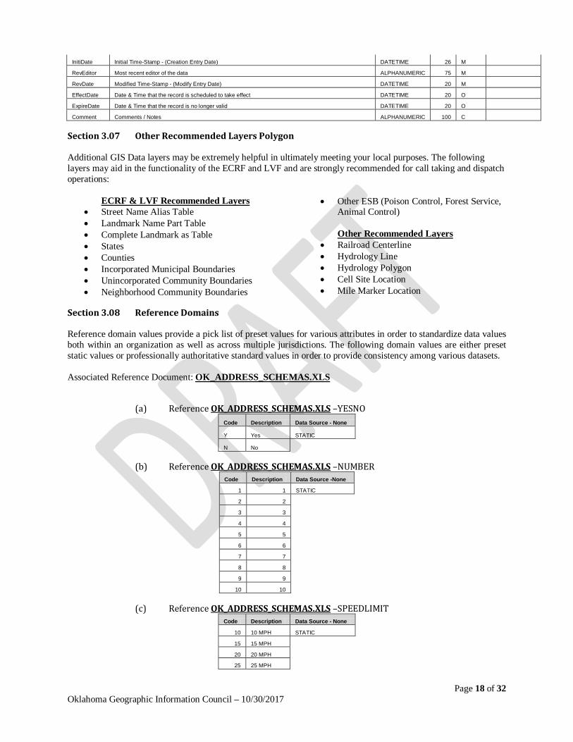
Page 18 of 32 Oklahoma Geographic Information Council – 10/30/2017
InitiDate Initial Time-Stamp - (Creation Entry Date) DATETIME 26 M
RevEditor Most recent editor of the data ALPHANUMERIC 75 M
RevDate Modified Time-Stamp - (Modify Entry Date) DATETIME 20 M
EffectDate Date & Time that the record is scheduled to take effect DATETIME 20 O
ExpireDate Date & Time that the record is no longer valid DATETIME 20 O
Comment Comments / Notes ALPHANUMERIC 100 C
Section 3.07 Other Recommended Layers Polygon Additional GIS Data layers may be extremely helpful in ultimately meeting your local purposes. The following layers may aid in the functionality of the ECRF and LVF and are strongly recommended for call taking and dispatch operations:
ECRF & LVF Recommended Layers • Street Name Alias Table • Landmark Name Part Table • Complete Landmark as Table • States • Counties • Incorporated Municipal Boundaries • Unincorporated Community Boundaries • Neighborhood Community Boundaries
• Other ESB (Poison Control, Forest Service, Animal Control) Other Recommended Layers
• Railroad Centerline • Hydrology Line • Hydrology Polygon • Cell Site Location • Mile Marker Location
Section 3.08 Reference Domains Reference domain values provide a pick list of preset values for various attributes in order to standardize data values both within an organization as well as across multiple jurisdictions. The following domain values are either preset static values or professionally authoritative standard values in order to provide consistency among various datasets. Associated Reference Document: OK_ADDRESS_SCHEMAS.XLS
(a) Reference OK_ADDRESS_SCHEMAS.XLS –YESNO Code Description Data Source - None
Y Yes STATIC
N No
(b) Reference OK_ADDRESS_SCHEMAS.XLS –NUMBER Code Description Data Source -None
1 1 STATIC
2 2
3 3
4 4
5 5
6 6
7 7
8 8
9 9
10 10
(c) Reference OK_ADDRESS_SCHEMAS.XLS –SPEEDLIMIT Code Description Data Source - None
10 10 MPH STATIC
15 15 MPH
20 20 MPH
25 25 MPH
Page 19 of 32 Oklahoma Geographic Information Council – 10/30/2017
30 30 MPH
35 35 MPH
40 40 MPH
45 45 MPH
50 50 MPH
55 55 MPH
60 60 MPH
65 65 MPH
70 70 MPH
75 75 MPH
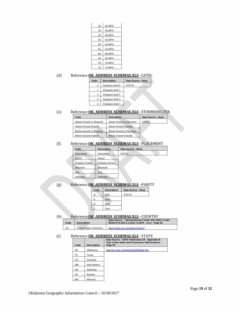
(d) Reference OK_ADDRESS_SCHEMAS.XLS –LEVEL Code Description Data Source - None
0 Overpass level 0 STATIC
1 Overpass level 1
2 Overpass level 2
3 Overpass level 3
4 Overpass level 4
(e) Reference OK_ADDRESS_SCHEMAS.XLS –STORMSHELTER Code Description Data Source - None
Above Ground in Structure Above Ground in Structure STATIC
Above Ground Outside Above Ground Outside
Below Ground in Structure Below Ground in Structure
Below Ground Outside Below Ground Outside
(f) Reference OK_ADDRESS_SCHEMAS.XLS –PLACEMENT Code Description Data Source - None
Geocoding Geocoding STATIC
Parcel Parcel
Property Access Property Access
Structure Structure
Site Site
Unknown Unknown
(g) Reference OK_ADDRESS_SCHEMAS.XLS –PARITY Code Description Data Source - None
O Odd STATIC
E Even
B Both
Z Zero
(h) Reference OK_ADDRESS_SCHEMAS.XLS –COUNTRY Code Description
Data Source - represented by 2 letter ISO 3166-1 Code -NENA-STA-004.1.1-2014_CLDXF - 3.2.2 - Page 26
US United States of America https://www.iso.org/obp/ui/#search
(i) Reference OK_ADDRESS_SCHEMAS.XLS –STATE
Code Description
Data Source - USPS Publication 28 - Appendix B - Two–Letter State and Possession Abbreviations - Page 55
OK Oklahoma http://pe.usps.com/text/pub28/28apb.htm
TX Texas
CO Colorado
NM New Mexico
AR Arkansas
KS Kansas
MO Missouri
Page 20 of 32 Oklahoma Geographic Information Council – 10/30/2017
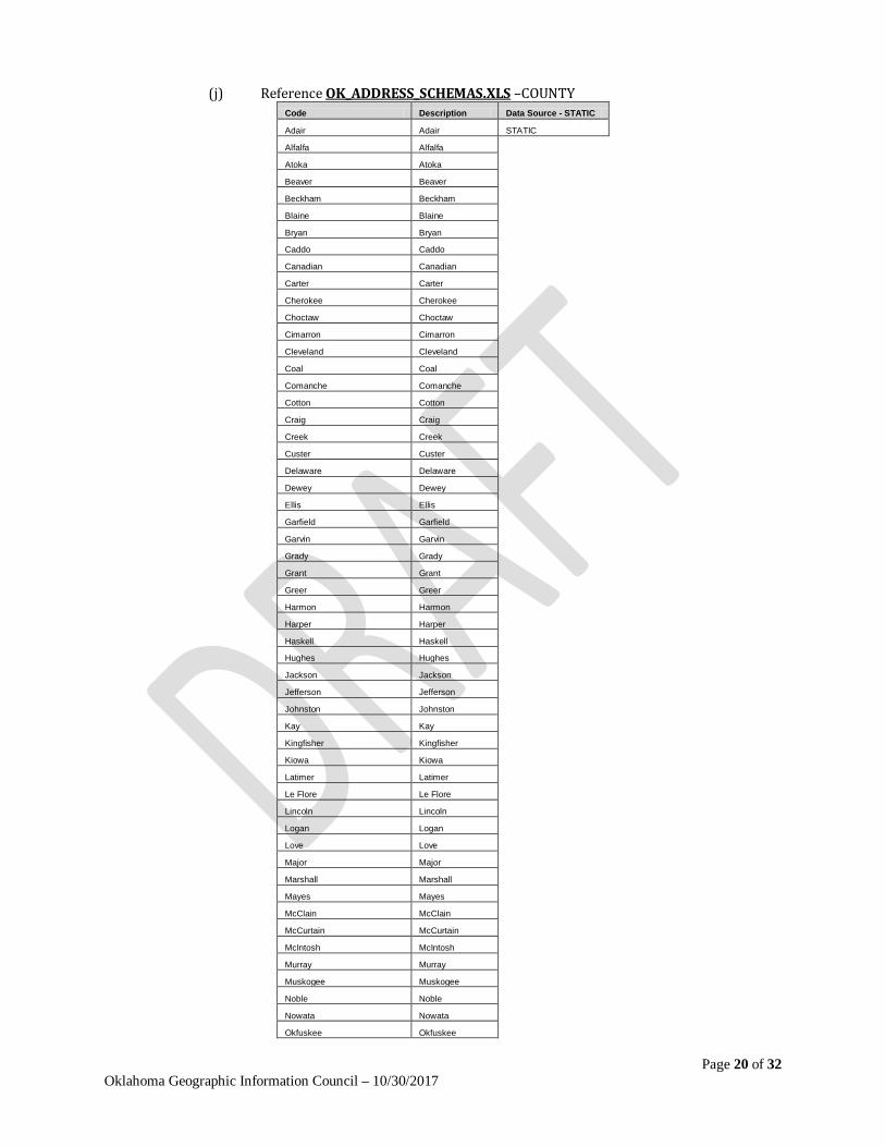
(j) Reference OK_ADDRESS_SCHEMAS.XLS –COUNTY Code Description Data Source - STATIC
Adair Adair STATIC
Alfalfa Alfalfa
Atoka Atoka
Beaver Beaver
Beckham Beckham
Blaine Blaine
Bryan Bryan
Caddo Caddo
Canadian Canadian
Carter Carter
Cherokee Cherokee
Choctaw Choctaw
Cimarron Cimarron
Cleveland Cleveland
Coal Coal
Comanche Comanche
Cotton Cotton
Craig Craig
Creek Creek
Custer Custer
Delaware Delaware
Dewey Dewey
Ellis Ellis
Garfield Garfield
Garvin Garvin
Grady Grady
Grant Grant
Greer Greer
Harmon Harmon
Harper Harper
Haskell Haskell
Hughes Hughes
Jackson Jackson
Jefferson Jefferson
Johnston Johnston
Kay Kay
Kingfisher Kingfisher
Kiowa Kiowa
Latimer Latimer
Le Flore Le Flore
Lincoln Lincoln
Logan Logan
Love Love
Major Major
Marshall Marshall
Mayes Mayes
McClain McClain
McCurtain McCurtain
McIntosh McIntosh
Murray Murray
Muskogee Muskogee
Noble Noble
Nowata Nowata
Okfuskee Okfuskee
Page 21 of 32 Oklahoma Geographic Information Council – 10/30/2017
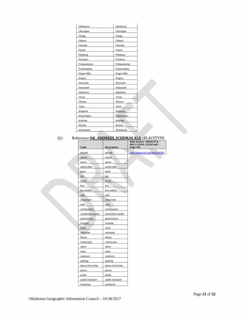
Oklahoma Oklahoma
Okmulgee Okmulgee
Osage Osage
Ottawa Ottawa
Pawnee Pawnee
Payne Payne
Pittsburg Pittsburg
Pontotoc Pontotoc
Pottawatomie Pottawatomie
Pushmataha Pushmataha
Roger Mills Roger Mills
Rogers Rogers
Seminole Seminole
Sequoyah Sequoyah
Stephens Stephens
Texas Texas
Tillman Tillman
Tulsa Tulsa
Wagoner Wagoner
Washington Washington
Washita Washita
Woods Woods
Woodward Woodward
(k) Reference OK_ADDRESS_SCHEMAS.XLS –PLACETYPE
Code Description
Data Source - NENA-STA-004.1.1-2014_CLDXF.pdf - Page 104
aircraft aircraft https://tools.ietf.org/html/rfc4589
airport airport
arena arena
automobile automobile
bank bank
bar bar
bicyle bicyle
bus bus
bus-station bus-station
cafe cafe
classroom classroom
club club
construction construction
convention-center convention-center
government government
hospital hospital
hotel hotel
industrial industrial
library library
motorcycle motorcycle
office office
other other
outdoors outdoors
parking parking
place-of-worship place-of-worship
prison prison
public public
public-transport public-transport
residence residence
Page 22 of 32 Oklahoma Geographic Information Council – 10/30/2017
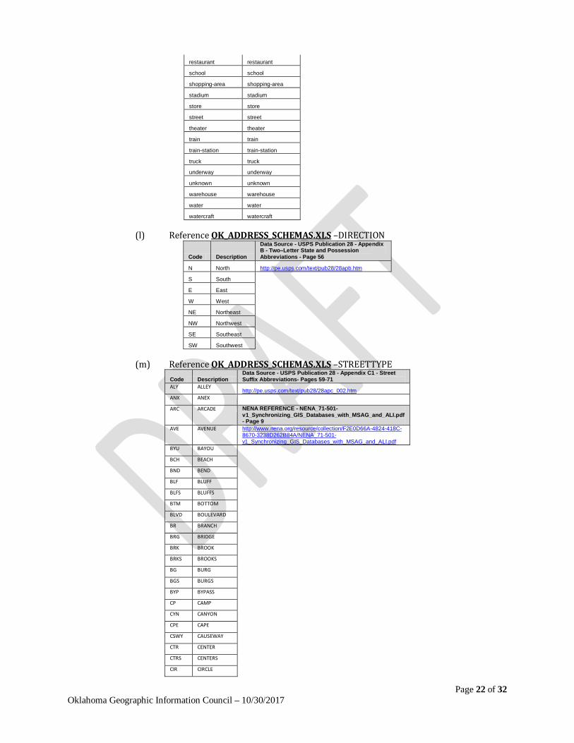
restaurant restaurant
school school
shopping-area shopping-area
stadium stadium
store store
street street
theater theater
train train
train-station train-station
truck truck
underway underway
unknown unknown
warehouse warehouse
water water
watercraft watercraft
(l) Reference OK_ADDRESS_SCHEMAS.XLS –DIRECTION
Code Description
Data Source - USPS Publication 28 - Appendix B - Two–Letter State and Possession Abbreviations - Page 56
N North http://pe.usps.com/text/pub28/28apb.htm
S South
E East
W West
NE Northeast
NW Northwest
SE Southeast
SW Southwest
(m) Reference OK_ADDRESS_SCHEMAS.XLS –STREETTYPE Code Description
Data Source - USPS Publication 28 - Appendix C1 - Street Suffix Abbreviations- Pages 59-71
ALY ALLEY http://pe.usps.com/text/pub28/28apc_002.htm
ANX ANEX
ARC ARCADE NENA REFERENCE - NENA_71-501-v1_Synchronizing_GIS_Databases_with_MSAG_and_ALI.pdf - Page 9
AVE AVENUE http://www.nena.org/resource/collection/F2E0D66A-4824-418C-8670-3238D262B84A/NENA_71-501-v1_Synchronizing_GIS_Databases_with_MSAG_and_ALI.pdf
BYU BAYOU
BCH BEACH
BND BEND
BLF BLUFF
BLFS BLUFFS
BTM BOTTOM
BLVD BOULEVARD
BR BRANCH
BRG BRIDGE
BRK BROOK
BRKS BROOKS
BG BURG
BGS BURGS
BYP BYPASS
CP CAMP
CYN CANYON
CPE CAPE
CSWY CAUSEWAY
CTR CENTER
CTRS CENTERS
CIR CIRCLE

Page 23 of 32 Oklahoma Geographic Information Council – 10/30/2017
CIRS CIRCLES
CLF CLIFF
CLFS CLIFFS
CLB CLUB
CMN COMMON
CMNS COMMONS
COR CORNER
CORS CORNERS
CRSE COURSE
CT COURT
CTS COURTS
CV COVE
CVS COVES
CRK CREEK
CRES CRESCENT
CRST CREST
XING CROSSING
XRD CROSSROAD
XRDS CROSSROADS
CURV CURVE
DL DALE
DM DAM
DV DIVIDE
DR DRIVE
DRS DRIVES
EST ESTATE
ESTS ESTATES
EXPY EXPRESSWAY
EXT EXTENSION
EXTS EXTENSIONS
FALL FALL
FLS FALLS
FRY FERRY
FLD FIELD
FLDS FIELDS
FLT FLAT
FLTS FLATS
FRD FORD
FRDS FORDS
FRST FOREST
FRG FORGE
FRGS FORGES
FRK FORK
FRKS FORKS
FT FORT
FWY FREEWAY
GDN GARDEN
GDNS GARDENS
GTWY GATEWAY
GLN GLEN
GLNS GLENS
GRN GREEN
GRNS GREENS
GRV GROVE
GRVS GROVES
HBR HARBOR

Page 24 of 32 Oklahoma Geographic Information Council – 10/30/2017
HBRS HARBORS
HVN HAVEN
HTS HEIGHTS
HWY HIGHWAY
HL HILL
HLS HILLS
HOLW HOLLOW
INLT INLET
IS ISLAND
ISS ISLANDS
ISLE ISLE
JCT JUNCTION
JCTS JUNCTIONS
KY KEY
KYS KEYS
KNL KNOLL
KNLS KNOLLS
LK LAKE
LKS LAKES
LAND LAND
LNDG LANDING
LN LANE
LGT LIGHT
LGTS LIGHTS
LF LOAF
LCK LOCK
LCKS LOCKS
LDG LODGE
LOOP LOOP
MALL MALL
MNR MANOR
MNRS MANORS
MDW MEADOW
MDWS MEADOWS
MEWS MEWS
ML MILL
MLS MILLS
MSN MISSION
MTWY MOTORWAY
MT MOUNT
MTN MOUNTAIN
MTNS MOUNTAINS
NCK NECK
ORCH ORCHARD
OVAL OVAL
OPAS OVERPASS
PARK PARK
PARK PARKS
PKWY PARKWAY
PKWY PARKWAYS
PASS PASS
PSGE PASSAGE
PATH PATH
PIKE PIKE
PNE PINE
PNES PINES

Page 25 of 32 Oklahoma Geographic Information Council – 10/30/2017
PL PLACE
PLN PLAIN
PLNS PLAINS
PLZ PLAZA
PT POINT
PTS POINTS
PRT PORT
PRTS PORTS
PR PRAIRIE
RADL RADIAL
RAMP RAMP
RNCH RANCH
RPD RAPID
RPDS RAPIDS
RST REST
RDG RIDGE
RDGS RIDGES
RIV RIVER
RD ROAD
RDS ROADS
RTE ROUTE
ROW ROW
RUE RUE
RUN RUN
SHL SHOAL
SHLS SHOALS
SHR SHORE
SHRS SHORES
SKWY SKYWAY
SPG SPRING
SPGS SPRINGS
SPUR SPUR
SPUR SPURS
SQ SQUARE
SQS SQUARES
STA STATION
STRA STRAVENUE
STRM STREAM
ST STREET
STS STREETS
SMT SUMMIT
TER TERRACE
TRWY THROUGHWAY
TRCE TRACE
TRAK TRACK
TRFY TRAFFICWAY
TRL TRAIL
TRLR TRAILER
TUNL TUNNEL
TPKE TURNPIKE
UPAS UNDERPASS
UN UNION
UNS UNIONS
VLY VALLEY
VLYS VALLEYS
VIA VIADUCT
Page 26 of 32 Oklahoma Geographic Information Council – 10/30/2017
VW VIEW
VWS VIEWS
VLG VILLAGE
VLGS VILLAGES
VL VILLE
VIS VISTA
WALK WALK
WALK WALKS
WALL WALL
WAY WAY
WAYS WAYS
WL WELL
WLS WELLS
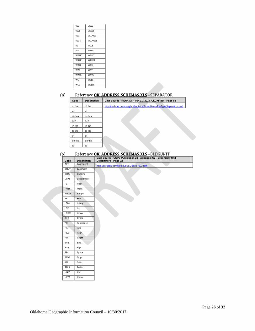
(n) Reference OK_ADDRESS_SCHEMAS.XLS –SEPARATOR Code Description Data Source - NENA-STA-004.1.1-2014_CLDXF.pdf - Page 83
of the of the http://technet.nena.org/nrs/registry/StreetNamePreTypeSeparators.xml
at at
de las de las
des des
in the in the
to the to the
of of
on the on the
to to
(o) Reference OK_ADDRESS_SCHEMAS.XLS –BLDGUNIT Code Description
Data Source - USPS Publication 28 - Appendix C2 - Secondary Unit Designators - Page 72
APT Apartment http://pe.usps.com/text/pub28/28apc_003.htm
BSMT Basement
BLDG Building
DEPT Department
FL Floor
FRNT Front
HNGR Hanger
KEY Key
LBBY Lobby
LOT Lot
LOWR Lower
OFC Office
PH Penthouse
PIER Pier
REAR Rear
RM Room
SIDE Side
SLIP Slip
SPC Space
STOP Stop
STE Suite
TRLR Trailer
UNIT Unit
UPPR Upper
Page 27 of 32 Oklahoma Geographic Information Council – 10/30/2017
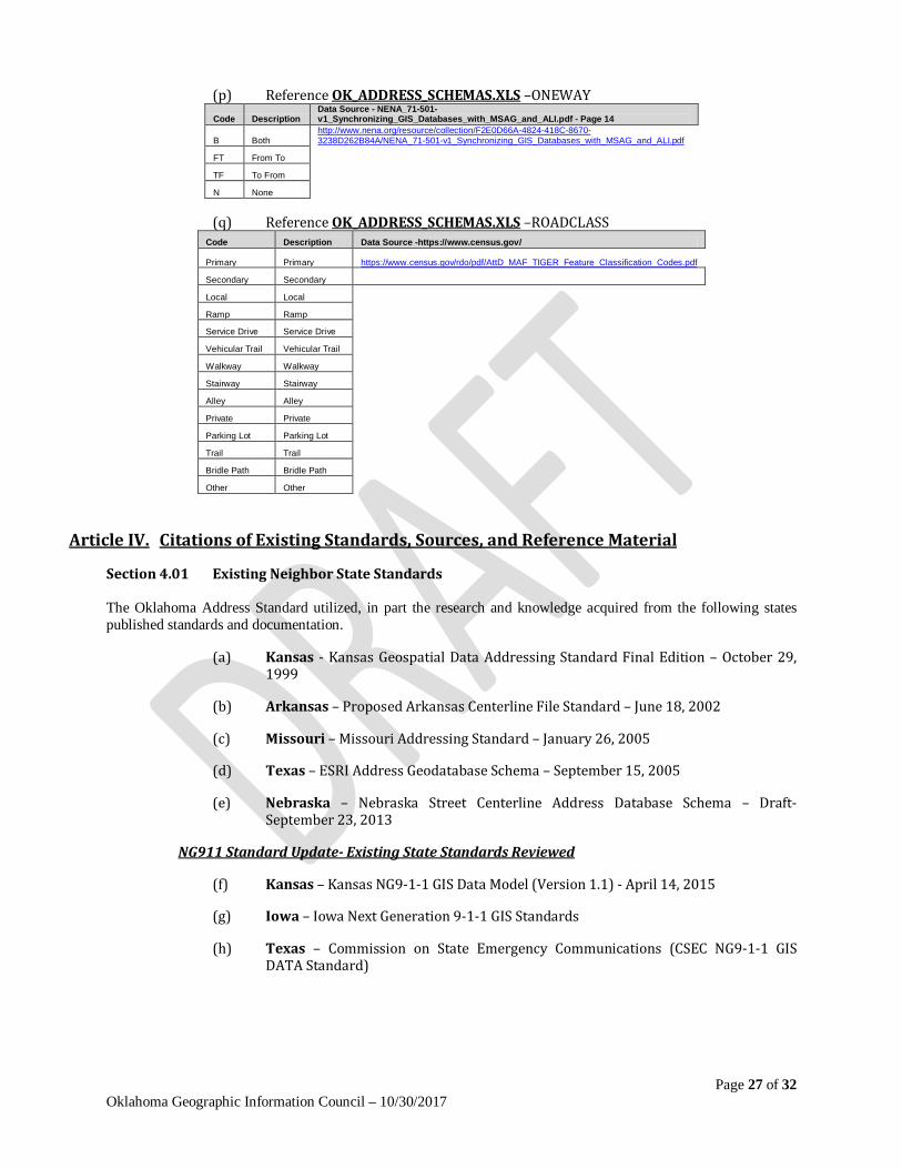
(p) Reference OK_ADDRESS_SCHEMAS.XLS –ONEWAY Code Description
Data Source - NENA_71-501-v1_Synchronizing_GIS_Databases_with_MSAG_and_ALI.pdf - Page 14
B Both http://www.nena.org/resource/collection/F2E0D66A-4824-418C-8670-3238D262B84A/NENA_71-501-v1_Synchronizing_GIS_Databases_with_MSAG_and_ALI.pdf
FT From To
TF To From
N None
(q) Reference OK_ADDRESS_SCHEMAS.XLS –ROADCLASS Code Description Data Source -https://www.census.gov/
Primary Primary https://www.census.gov/rdo/pdf/AttD_MAF_TIGER_Feature_Classification_Codes.pdf
Secondary Secondary
Local Local
Ramp Ramp
Service Drive Service Drive
Vehicular Trail Vehicular Trail
Walkway Walkway
Stairway Stairway
Alley Alley
Private Private
Parking Lot Parking Lot
Trail Trail
Bridle Path Bridle Path
Other Other
Article IV. Citations of Existing Standards, Sources, and Reference Material
Section 4.01 Existing Neighbor State Standards The Oklahoma Address Standard utilized, in part the research and knowledge acquired from the following states published standards and documentation.
(a) Kansas - Kansas Geospatial Data Addressing Standard Final Edition – October 29, 1999
(b) Arkansas – Proposed Arkansas Centerline File Standard – June 18, 2002
(c) Missouri – Missouri Addressing Standard – January 26, 2005
(d) Texas – ESRI Address Geodatabase Schema – September 15, 2005
(e) Nebraska – Nebraska Street Centerline Address Database Schema – Draft- September 23, 2013
NG911 Standard Update- Existing State Standards Reviewed
(f) Kansas – Kansas NG9-1-1 GIS Data Model (Version 1.1) - April 14, 2015
(g) Iowa – Iowa Next Generation 9-1-1 GIS Standards
(h) Texas – Commission on State Emergency Communications (CSEC NG9-1-1 GIS DATA Standard)
Page 28 of 32 Oklahoma Geographic Information Council – 10/30/2017
Section 4.02 Existing Professional Standards Documentation & Legislation The Oklahoma Address Standard directly referenced various pertaining portions of the following documents to ensure industry standards are adhered to.
(a) Federal Geographic Data Committee (FGDC) • FDGC Standards Page • FGDC Content Standard for Geospatial Metadata –(FGDC-STD-001-1998) • FGDC Standards Reference Model – (March 1996) • Postal Addressing Profile of the Federal Geographic Data Committee United States Thoroughfare, Landmark, and Postal Address Standard (December 16, 2010 FGDC Standards WG meeting) • FGDC Endorsed Address Standard – (FGDC-STD-016-2011) • Geospatial Positioning Accuracy Standards Part 3: National Standard for Spatial Data Accuracy (FGDC-STD-007.3-1998)
(b) National Emergency Number Association (NENA) • NENA Standards Page • NENA Standard Data Formats For 9-1-1 Data Exchange & GIS Mapping –
(NENA-02-010) • NENA Information Documentation for Synchronizing GIS Databases with MSAG
& ALI – (NENA-71-501) • GIS Data Collection and Maintenance – (NENA-02-014) • NENA Next Generation 9-1-1 (NG9-1-1) United States Civic Location Data
Exchange Format (CLDXF) Standard (NENA-STA-004) • Recommended Standard For Street Thoroughfare Abbreviations - Arkansas
reference – (NENA-02-002)
(c) United States Postal Service (USPS) • Mailing Standards of the United States Postal Service Publication 28 - Postal
Addressing Standards
(d) American Society for Photogrammetry and Remote Sensing (ASPRS) • ASPRS Accuracy Standards for Digital Geospatial Data – (Draft March 2014) • ASPRS Accuracy Standards for Large-Scale Maps(1990_jul_1068-1070)
(e) State of Oklahoma Legislative Actions • Oklahoma Senate. 1994 Regular Session, S 722 • Oklahoma House of Representatives. 1995 Regular Session, HB 1964 • Oklahoma House of Representatives. Interim Study H2003-105 • Oklahoma House of Representatives. 2004 Regular Session, HB 2457 • Oklahoma House of Representatives. 2016 Regular Session, HB 3126
Page 29 of 32 Oklahoma Geographic Information Council – 10/30/2017
Section 4.03 Workgroup Acknowledgements Oklahoma’s GIS Community contributed directly to the development of the address standard. This standard was developed under the authority and guidance of the GI Council, the Oklahoma Office of Geographic Information, and the volunteered efforts of the following individuals who participated on the Address Standards Workgroup as listed below along with the input from the Oklahoma GIS Community.
• Mike Sharp OGI • Shellie Willoughby OGI • Troy Frazier Oklahoma Tax Commission • Kathy Hines Center for Spatial Analysis • Sohail Hasanjee OneOK • Craig Moody ODOT • John Sharp ACOG • Wade Patterson Garfield County Assessor • Brenda Fennel Choctaw Nation • Joel Foster ACOG • Charles Brady III City of Ardmore
NG911 Standard Update – GIS Technical Workgroup
• Lance Terry Oklahoma 9-1-1 Coordinator Management Authority • Kristal Kuhn Oklahoma 9-1-1 Coordinator Management Authority • Mike Sharp OGI • Shellie Willoughby OGI • Jeremy Planteen ODOT • Jana Harris SWODA • Mike Davis ACOG • Kurt Bickle INCOG • Andrew Sears INCOG • Shelly Stahlbusch Carter County E911 • James Allen Carter County E911 • Russell Anderson City of Norman • Charles Brady III City of Ardmore
Section 4.04 Maintenance of the Standard This standard will be maintained through a partnership between the 911 Authority and the GI Council. The partnership will ensure that this address standard is relevant and applicable to the industry.
Section 4.05 Technical Glossary
(a) Accuracy
Absolute - A measure of the location of features on a map compared to their true position on the face of the earth.
Relative - A measure of the accuracy of individual features on a map when compared to other features on the same map.
(b) Address
Actual or Real - The simple, everyday element that designates a specific, situs location, such as a house number or an office suite.
Range - Numbers associated with segments of a digital street centerline file that represent the actual high and low addresses at either end of each segment.
Page 30 of 32 Oklahoma Geographic Information Council – 10/30/2017
Theoretical - A location that can be interpolated along a street centerline file through geocoding software.
Vanity - A special address that is inconsistent with or an exception to the standard addressing schema.
(c) Address matching – See Geocoding.
(d) ALI – (Automatic Location Identification) The automatic display at the PSAP of the caller’s telephone number, the address/location of the telephone, and supplementary emergency services information of the location from which a call originates.
(e) ANI – (Automatic Number Identification) The 10-digit Telephone Number associated with a device originating a 9-1-1 call.
(f) Attribute - the properties and characteristics of entities.
(g) CAD – (Computer Aided Dispatch) Information about features or elements contained in GIS data is usually stored in a related table.
(h) CLDFX - (Civic Location Data Exchange Format) A set of data elements that describe detailed street address information.
(i) E911 – (Enhanced 911) A telephone system which includes network switching, database, and Public Safety Answering Point premise elements capable of providing Automatic Location Identification (ALI) data, selective routing, selective transfer, fixed transfer, and a call back number. The term also includes any enhanced 9-1-1 service so designated by the Federal Communications Commission in its Report and Order in WC Docket Nos. 04-36 and 05-196, or any successor proceeding.
(j) ECRF - (Emergency Call Routing Function) A functional element in an ESInet which is a Location-to-Service Translation (LoST) protocol server where location information (either civic address or geo-coordinates) and a Service Uniform Resource Name (URN) serve as input to a mapping function that returns a Uniform Resource Identifier (URI) used to route an emergency call toward the appropriate PSAP for the caller’s location or towards a responder agency.
(k) EMS -(Emergency Medical Service) Fire, hospital, poison control, etc., response centers.
(l) Entity - A data entity is any object about which an organization chooses to collect data.
(m) ESB – (Emergency Service Boundary) The Polygon that defines the geographic area of a single emergency response service. (Fire or Law or EMS separately) Required to be separate service layers for NG911.
(n) ESInet - (Emergency Services Internet protocol network) An ESInet is a managed IP network that is used for emergency services communications, and which can be shared by all public safety agencies. It provides the IP transport infrastructure upon which independent application platforms and core functional processes can be deployed, including, but not restricted to, those necessary for providing NG9-1-1 services. ESInets may be constructed from a mix of dedicated and shared facilities. ESInets may be interconnected at local, regional, state, federal, national, and international levels to form an IPbased inter-network (network of networks).
(o) ESN – (Emergency Service Number) The three to 5 digit Number assigned to the
Page 31 of 32 Oklahoma Geographic Information Council – 10/30/2017
unique combination of ESB that represent a ESZ polygon. Required at a minimum as a legacy lookup table for the MSAG.
(p) ESZ – (Emergency Service Zone) The Polygon that defines the unique geographic area of the combination of ESB (Fire, Law, & EMS Combined)
(q) Geocoding -A mechanism for building a database relationship between addresses and geospatial features. When an address is matched to the geospatial features, geographic coordinates are assigned to the address resulting in a single geographic point for a specific address.
(r) Geospatial feature - A point, line or polygon stored within geospatial software.
(s) Geospatial software - Mapping software with analytical capabilities.
(t) Line -A linear feature built of straight line segments made up of two or more coordinates.
(u) LVF – (Location Validation Function) A functional element in a Next Generation 9-1- 1 Core Services (NGCS) that is a Location-to-Service Translation (LoST) protocol server where civic location information is validated against the authoritative GIS database information. A civic address is considered valid if it can be located within the database uniquely, is suitable to provide an accurate route for an emergency call, and adequate and specific enough to direct responders to the right location.
(v) MCS – (MSAG Conversion Service) A web service providing conversion between PIDF-LO and MSAG data.
(w) MSAG – (Master Street Address Guide) A database of street names and house number ranges within their associated communities defining Emergency Service Zones (ESZs) and their associated Emergency Service Numbers (ESNs) to enable proper routing of 9-1-1 calls.
(x) NENA - The National Emergency Number Association is a not-forprofit corporation established in 1982 to further the goal of “One Nation-One Number.” NENA is a networking source and promotes research, planning, and training. NENA strives to educate, set standards, and provide certification programs, legislative representation, and technical assistance for implementing and managing 9-1-1 systems.
(y) NG911 - (Next Generation 9-1-1) NG9-1-1 is an Internet Protocol (IP) based system comprised of managed Emergency Services IP networks (ESInets), functional elements (applications), and databases that replicate traditional E9-1-1 features and functions and provides additional capabilities. NG9-1-1 is designed to provide access to emergency services from all connected communications sources, and provide multimedia data capabilities for Public Safety Answering Points (PSAPs) and other emergency service organizations.
www.nena.org/resource/resmgr/ng9-1- 1_project/whatisng911.pdf
(z) NGUID -(NENA Globally Unique ID) NENA Globally Unique IDs must exist for each feature within the GIS data layer such that the ID is unique within a set of aggregated data for each layer.
(aa) Parity -A characteristic of a set of addresses or address ranges in which the numbers are either odd or even.
(bb) PIDF-LO - Provides a flexible and versatile means to represent location information
Page 32 of 32 Oklahoma Geographic Information Council – 10/30/2017
in a Session Initiation Protocol (SIP) header using an XML schema.
(cc) Point - A geospatial feature that is stored as a single XY coordinate.
(dd) PSAP - (Public Safety Answering Point) An entity responsible for receiving 9-1-1 calls and processing those calls according to a specific operational policy.
(ee) SI – (Spatial Interface) A standardized interface between the GIS and the functional elements that consume GIS data, such as the ECRF and the LVF.
(ff) Street Centerline – A linear representation of a street that contains the associated attributes required for geocoding. A street centerline can represent a single lane or multiple lanes depending on the required functionality.
(gg) URI - (Uniform Resource Identifier) A predictable formatting of text used to identify a resource on a network (usually the Internet) OR A string of characters that must follow prescribed syntaxes such as URL, URN. Note: Version 1.1 of the XML namespaces recommendation uses IRIs (Internationalized Resource Identifiers) instead of URIs. However, because version 1.1 is not yet a full recommendation [February 2003] and because the IRI RFC is not yet complete, this document continues to refer to URIs instead of IRIs.
(hh) URN – (Uniform Resource Name) Uniform Resource Identifiers (URIs) that use the URN scheme, and are intended to serve as persistent, location independent resource names.
(ii) VoIP – (Voice Over Internet Protocol) A technology that allows you to make voice calls using a broadband Internet connection instead of a regular (or analog) phone line.