Embed Size (px)
Citation preview

The State of Agricultural Land Use Planning
in Northern British Columbia
An Assessment of Local Legislative Frameworks
Dr. David J. Connell Associate Professor
University of Northern British Columbia Phone: (250) 960-5835
Email: [email protected]
May, 2015

Agricultural Land Use Planning in Northern BC GENERAL ASSESSMENT
ii
Executive Summary
In this report we present the results of a study of agricultural land use planning in northern British Columbia. The study involved an assessment of the breadth and quality of legislative frameworks that guide agricultural land use planning, including policies, legislation, and governance. The study area covered five Regional Districts with a case study site in each area:
Regional District Sub-area for case study site Regional District of Kitimat-Stikine (RDKS) Greater Terrace Area Regional District of Bulkley-Nechako (RDBN) Smithers-Telkwa Rural Area Peace River Regional District (PRRD) South Peace Area Regional District of Fraser-Fort George (RDFFG) Robson Valley-Canoe Downstream Area Cariboo Regional District (CRD) 150 Mile House Area
We assessed the strength of the legislative frameworks for agricultural land use planning and farmland protection using four principles as criteria: maximise stability, integrate public priorities across jurisdictions, minimise uncertainty, and accommodate flexibility. The study also involved an assessment of the political context within which agricultural land use planning takes place and decisions are made. This part of the assessment included documentation and analysis of three policy regimes: farmland preservation, global competitiveness, and food sovereignty. A policy regime refers to the combination of issues, ideas, interests, actors, and institutions that are involved in formulating policy and for governing once policies are devised.
The aim of the study is to contribute to three areas of knowledge. The case study lends insight to the state of agricultural land use planning in each of the Regional Districts. It contributes to an understanding of the state of agricultural land use planning in northern BC. Finally, the case study is part of a broader national project to identify principles and beneficial practices that represent land use planning solutions that protect farmland.
Overall, we found that the state of agricultural land use planning and farmland protection is of moderate strength, but with significant differences among and within the Regional Districts. The local legislative framework for the CRD: 150 Mile House Area is the strongest among the case study sites, followed by the RDBN: Smithers-Telkwa Rural Area and PRRD: South Peace Fringe Area. The RDKS: Greater Terrace Area shows as the weakest of the case studies assessed; however, the local legislative framework is expected to be strengthened as an outcome of implementing the recommendations presented in the agricultural plan, which is underway. Principles of Land Use Planning
Regional District Maximise stability
Integrate across
jurisdictions Minimise
uncertainty Accommodate
flexibility RDKS: Greater Terrace Area *** * ** ** RDBN: Smithers-Telkwa Rural Area **** **** *** ** PRRD: South Peace Fringe Area **** *** ** **** RDFFG: Robson-Canoe Downstream ** ** *** **** CRD: 150 Mile House Area **** **** *** *** * = Very weak; ***** = Very strong

Agricultural Land Use Planning in Northern BC GENERAL ASSESSMENT
iii
Overall, we found that maximising the stability of the local legislative frameworks is an area of moderate strength among Regional Districts in northern BC. A key element of stability is a clear statement of purpose regarding farmland protection among the primary goals and objectives within each enforceable document. Official Community Plans (OCPs), as enforceable legislation, are the foundation of stability for local frameworks. The OCP is supported by the zoning bylaws, which provide regulations for designated agricultural land uses, thereby contributing to the stability of the framework. Statements in the RDKS OCP are among the strongest, expressing a vision to make “full use of its agricultural potential” and to protect arable land to ensure food security. When we looked at statements that are most directly relevant to protecting agricultural land, only the PRRD OCP includes a statement about protecting farmland under goals, objectives, and policies. Four of the OCPs include protecting farmland as a goal, of which the RDKS, PRRD, and CRD statements are the strongest with direct statements to protect agricultural land. Four of the OCPs include objectives to protect agricultural land. The CRD objectives are among the strongest, with a clear commitment “To protect agricultural land for agricultural purposes” and a separate objective “To support the ALC in protecting agricultural land and agricultural opportunities in the plan area.”
Integrating policies and priorities across jurisdictions is a foundation for building cohesion across provincial, regional, and local governments. In order to successfully integrate policies across jurisdictions there must be sufficient details about the legislative context that guides and constrains local government plans and strategies. Overall, we found that local legislative frameworks were strong to weak when it comes to integrating provincial legislation. The CRD and RDBN had the highest levels of integration. The PRRD is very effective as well, and would be stronger if their draft agricultural plan is adopted by the Regional Board. One concern about the local frameworks is that most of the references to provincial legislation are in aspirational, rather than enforceable, documents.
The presence of uncertainty, typically introduced via ambiguous language, exceptions or gaps, is a critical measure of the weakness of an agricultural land use planning framework. Thus, in addition to maximising the stability of a legislative framework through enforceable policies, people want to know they can rely on these rules and regulations to be applied consistently under different circumstances. A common area of concern among the local legislative frameworks in northern BC is that they include statements about either a desire for or willingness to accommodate more non-farm development on agricultural lands. Such statements are often made in the context of anticipated growth of residential development. At the same time, many OCPs include policies that establish explicit conditions under which non-farm uses or subdivision of agricultural land may be permitted. Such conditions uphold the importance of maintaining agricultural lands and activities, as well as the policies of the ALC Act, while impacts on agricultural lands must be minimised. This use of such policies is an effective means to recognise possible exceptions while minimising uncertainty. Overall, the local legislative frameworks are strong to weak regarding minimising uncertainty. The PRRD is in a unique situation regarding the Delegation Agreement between the Agricultural Land Commission and the Oil and Gas Commission, under which some oil and gas activity is a permitted non-farm use. The Agreement adds to the level of uncertainty within the local legislative framework.
Creating an effective legislative framework is an act of balance, without being too stable so that it cannot be changed when needed or too strict so that it cannot be applied in a range of circumstances. Thus, flexibility is necessary in order to moderate the restrictive effects of

Agricultural Land Use Planning in Northern BC GENERAL ASSESSMENT
iv
maximising stability and minimising uncertainty. One means to accommodate flexibility is typically done through governance mechanisms. Governance for agriculture land use planning is more diverse than other areas of the province. The governing bodies include ALC panels, delegation agreements, Advisory Planning Commissions (APCs), Agricultural Advisory Committees (AACs), and a standing committee of a regional board. Flexibility can also be accommodated within the legislative frameworks. Overall, the local legislative frameworks are strong to moderate regarding accommodating flexibility.
In addition to assessing the strength of the local legislative frameworks, we also assessed how issues, ideas, and interests associated with the three policy regimes influence local agricultural land use planning processes and decisions. The two policy regimes of farmland preservation and global competitiveness have influenced agricultural land use policy and legislation for over forty years. Food sovereignty, and its associated concerns with food security and demand for local food, is a nascent policy regime that is influencing agricultural land use planning. To complete the assessment of the presence and importance of the policy regimes we examined the documents that comprise the legislative framework. We found that all three policy regimes are present in the legislative frameworks of northern BC. Farmland preservation appears to be the most influential of the three policy regimes, with food sovereignty only slightly less influential. Global competitiveness is the least influential. Overall Influence of Policy Regimes
Regional District Global
Competitiveness Farmland
Preservation Food
Sovereignty RDKS: Greater Terrace Area RDBN: Smithers-Telkwa Rural Area PRRD: South Peace Fringe Area RDFFG: Robson-Canoe Downstream CRD: 150 Mile House Area Low Medium High As the project unfolded, several issues emerged as common concerns across the study area. These were small-lot agriculture/fragmentation of farmland, alienation of farmland/foreign ownership, and pressure from natural resource developments. The combined issue of small-lot agriculture and fragmentation of the land base centres on what appears to be a growing awareness of food sovereignty. Much of this interest in small-lot agriculture is associated with new farmers and their need for affordable land that is reasonably close to population centres. What makes the demand for small-lot agriculture particularly important is that there is often little room within farmland protection legislative frameworks to accommodate smaller lots. The main reason is that sub-dividing into smaller lots is in direct conflict with the over-riding goal to not fragment the land base. The primary land use planning tool for preventing fragmentation is large minimum lot sizes. Thus, small lots and farmland protection are often in direct opposition.
Whether the tension is noted explicitly or not, the OCPs in the case study sites include a range of land use policies that tend to avoid fragmentation. For example, as stated in the 150 Mile House Area OCP (5.3.17), “The Regional District encourages strategies that will see large agricultural land holdings retained and operated as single agricultural operations rather than broken

Agricultural Land Use Planning in Northern BC GENERAL ASSESSMENT
v
up as individual land tenures with multiple ownership” (p. 40). This policy reflects the general approach to avoid parcelisation of the land base. Other agricultural land policies that help to avoid parcelisation include encouraging consolidation, protecting contiguous areas, and retaining large holdings. Setting large minimum parcel sizes provide the foundation for such policies. Overall, although the tension between a desire for small agricultural lots and for mitigating fragmentation exists within northern BC, this matter is not significant across the region as a whole. Each Regional District addresses the issue through different means.
Although foreign ownership of land is not mentioned as an agricultural land use planning issue in any of the Regional Districts’ legislative documents, parts of the region have experienced corporations purchasing productive farmland and planting trees for carbon credits. Some work is being done to assess the extent of planting or its impacts on agricultural potential. Although the tree planting practice is somewhat isolated presently, its expansion poses a threat to the agricultural land base. As well, some large parcels of agricultural land have been alienated by building large estates on the property and then either not farming the land or farming only to meet the minimum levels needed for tax assessments and farm status.
Agricultural land use planning is most often associated with urban development. In northern BC, pressures also come from natural resource developments, such as forestry, oil and gas, and mining. The prevalence of ranching in northern BC means that the sector relies heavily on access to Crown land, which means that the interface between forestry and agriculture presents a set of challenges and some opportunities. We found that the integration of agricultural land use planning and natural resource developments appeared primarily in three contexts: OCPs, agricultural plans, and LRMPs. OCPs usually include a short, general statement that deals directly with multiple uses of the non-urban land base, which usually coincides with Crown lands. Some OCPs also include policies to co-operate and communicate with provincial ministries and agencies for planning, disposition, and management of Crown lands in order to minimise conflicts between agricultural and other land uses. Several policies refer to managing water resources. There are few references to provincial legislation for Crown lands but provincial ministries are named. LRMPs play a role to integrate agricultural land uses with natural resource developments on Crown land. However, among the legislative frameworks analysed, the integration of agricultural land use planning and natural resource developments is an area of agricultural land use planning that is significantly under-developed. Planning for agriculture and farmland protection has improved substantially over the past eight years. The mountain pine beetle epidemic appears to be an important catalyst for putting more emphasis on opportunities for agriculture as part of a strategy in increase the level of economic diversification. In the Peace Region, agriculture always had a higher profile. The most significant contributions were the economic development plans developed for the agricultural sector by the Cariboo-Chilcotin Beetle Action Coalition (CCBAC, 2007) and the Omineca Beetle Action Coalition (OBAC, 2009). A number of agricultural land use planning efforts soon followed. Today, based on our assessment, the strength of agricultural land use planning for farmland protection is moderate, with some important strengths and areas of weakness. The outlook is positive. Agricultural land use planning is an on-going concern of public interest in northern BC. At the time of preparing this report, several initiatives were at different stages of development. It is anticipated that the completion of these efforts will lead to stronger legislative frameworks for farmland protection.

Agricultural Land Use Planning in Northern BC GENERAL ASSESSMENT
vi
Table of contents Executive Summary ................................................................................................................................ ii Abbreviations ........................................................................................................................................ vii About the project .................................................................................................................................. viii
Principles for guiding agricultural land use planning ........................................................................... ix Maximise stability ........................................................................................................................... x Minimise uncertainty ...................................................................................................................... x Integrate across jurisdictions ........................................................................................................... x Accommodate flexibility ................................................................................................................. x
Strength of BC’s provincial legislative framework .............................................................................. xi Political context and policy regimes ................................................................................................. xiii
Global competitiveness ................................................................................................................ xiii Food sovereignty .......................................................................................................................... xiv Farmland preservation ................................................................................................................... xv
Introduction ............................................................................................................................................. 1 Purpose and scope of case study .......................................................................................................... 1
Methods .......................................................................................................................................... 1 Overview of study area ........................................................................................................................ 2 Agricultural profile.............................................................................................................................. 2
Results .................................................................................................................................................... 7 State of agricultural land use planning ................................................................................................. 7 Legislative framework ......................................................................................................................... 8
Official Community Plans and Zoning .......................................................................................... 10 Content analysis of documents .......................................................................................................... 15 Current Issues ................................................................................................................................... 17
Small-lot agriculture/fragmentation of farmland ............................................................................ 17 Alienation of farmland/foreign ownership ..................................................................................... 19 Natural resource developments ...................................................................................................... 19
Policy regimes................................................................................................................................... 22 Discussion ............................................................................................................................................. 26
Regional District of Kitimat-Stikine: Greater Terrace Area ............................................................... 26 Regional District of Bulkley-Nechako: Smithers-Telkwa Rural Area ................................................ 27 Peace River Regional District: South Peace Fringe Area ................................................................... 28 Regional District of Fraser-Fort George: Robson Valley-Canoe Downstream ................................... 29 Cariboo Regional District: 150 Mile House Area .............................................................................. 29 Assessment of Principles ................................................................................................................... 30
Maximise stability ......................................................................................................................... 30 Integrate across jurisdictions ......................................................................................................... 31 Minimise uncertainty .................................................................................................................... 32 Accommodate flexibility ............................................................................................................... 33
Conclusion ............................................................................................................................................ 35 References............................................................................................................................................. 36 Glossary ................................................................................................................................................ 37 Acknowledgements ............................................................................................................................... 38 Appendix: Criteria for Evaluating Content of Legislative Framework ................................................... 39 Appendix: Criteria for determining level of influence of policy regimes ................................................ 41

Agricultural Land Use Planning in Northern BC GENERAL ASSESSMENT
vii
Abbreviations AAC Agricultural Advisory Committee AIA Agriculture Impact Assessment APC Advisory Planning Commission ALC Agricultural Land Commission ALCA Agricultural Land Commission Act ALR Agricultural Land Reserve DPA Development Permit Area LGA Local Government Act LRMP Land and Resource Management Plan NFU Non-farm Use OBAC Omineca Beetle Action Coalition OCP Official Community Plan RDFFG Regional District of Fraser-Fort George RVCD Robson Valley-Canoe Downstream RVCU Robson Valley-Canoe Upstream SLUP Strategic Land Use Plan SRMP Sustainable Resource Management Plan

Agricultural Land Use Planning in Northern BC GENERAL ASSESSMENT
viii
About the project The provincial project is a one-year study to identify principles and beneficial practices that represent land use planning solutions that protect farmland in northern British Columbia. We have three objectives related to this purpose:
1. To undertake case studies to fill strategic gaps in our understanding of how agricultural land use planning policies and processes at a local level protect farmland while also integrating public priorities across jurisdictions.
2. To analyse three inter-related policy regimes within Canada’s agri-food system: the long-standing policy regimes of global competitiveness and farmland preservation; and the nascent regime of food sovereignty. The aim is to understand how these three policy regimes influence agricultural land use planning at local, provincial, and national levels of policy. A policy regime and its changes refer to the combination of issues, ideas, interests, actors and institutions that are involved.
3. To mobilise knowledge gained from the research by hosting workshops across northern British Columbia.
This project represents an extension of a national project to identify principles and beneficial practices that promote integrated land use planning solutions that protect farmland across Canada. The relation between agriculture, food, and social priorities is connected to the society we want and the place of food and farmers within it. Historically, the decline in the economic and social role of agriculture has accompanied a significant loss and degradation of the agricultural land base. This trend appears to be reversing. The growth of the local food movement, as evident by the increasing number of farmers markets and citizen-based initiatives like community gardens and local food councils, has been the forerunner of recent calls at the national level for a Canada-wide food policy. Although drastic policy changes are not likely to happen immediately at the national level, changes are already occurring at local and regional levels, with all of Canada’s major metropolitan regions having launched food plans and policy councils (Vancouver, Calgary, Toronto, Ottawa and Montreal). These changes suggest that the place of agriculture and food within Canadian society has shifted to be much more aligned with public priorities.
Sorting out relations between agriculture, food, and society falls, in part, within the domain of land use planning, because every act of producing and consuming food has impacts on the land base. Yet, in spite of forty years of farmland protection policies, the agricultural land base still faces growing pressures from urban development and the pursuit of other economic priorities, with few indications that this trend will be significantly curtailed.
Unlike the urban centres of BC where the greatest pressures on farmland are from urban development, some pressure on agricultural lands in northern BC comes from the development of natural resources, such as forestry and oil and gas. The Site C dam is another source of pressure. Likewise, most of the studies to examine the effectiveness of farmland protection policies have focussed on the pressures from urban development. Recognising that the results of these studies are not fully transferable to northern BC, this project aims to assess the state of agricultural land use planning in this area of the province. We anticipate that the greatest potential benefit of the research is to make a positive contribution to the development of agricultural land use plans, planning processes, and policies

Agricultural Land Use Planning in Northern BC GENERAL ASSESSMENT
ix
in northern BC to protect farmland and promote farming as the highest and best use of these lands. Our assessment will be of benefit to land use decision makers, planning practitioners, to non-government organisations, industry groups, farmer organisations, farmers, and the general public.
For more information about the project, please visit the project website or contact Dr. David J. Connell, University of Northern British Columbia. Phone: (250) 960 5835 Email: [email protected] Website: http://blogs.unbc.ca/agplanning/
Principles for guiding agricultural land use planning An agricultural land use planning legislative framework provides the context and constraints for what local governments must and can do to protect its agricultural lands. An effective framework of policies, legislation, and governance structures presents an opportunity for local governments, which can then choose how much it wants to take advantage of this opportunity. Within this context it is helpful to be able to assess the quality of an agricultural land use planning framework and understand how well it works and why. For this purpose we have identified the following four principles, which are described below:
Maximise stability Minimise uncertainty Integrate across jurisdictions Accommodate flexibility The concepts of stability and uncertainty must be understood with a view of the world as
unpredictable and essentially unknowable. This contrasts with a rationale view of the world as something that we can understand fully – if only we had all of the right data and the ability to process the information. This worldview of an open future presents challenges because planning, by its very function, is focussed on making a desirable future a visible part of today’s land use decision-making processes (Connell, 2009). The aim of planning is not to predict the future or claim to be all-knowing but to envision a desirable future with the information available. The functions of planning are to maximise what we can know about the future and to minimise what we do not know, thereby establishing a domain of understanding within which to make the best possible land use decisions in the present. This leads to the first two principles of agricultural land use planning.
Agricultural Land Use Planning in Northern BC GENERAL ASSESSMENT
x
Maximise stability Something that is stable is difficult to topple; it stands strong and cannot be easily moved. Likewise, a stable legislative framework for protecting farmland is one that is not easily changed at the whim of shifting political interests; it is well-entrenched in acts of legislation, policy, and governance structures that are based on clear, concise language, and can hold up to court challenge. It is something that people can count on to secure the land base for agriculture and to know what the rules are. In this sense, a measure of stability is a measure of the thing itself – the legislative framework – as it is written in its present form. Thus, stability is a critical measure of the strength of an agricultural land use planning framework. Minimise uncertainty In addition to maximising the stability of a legislative framework through clear rules and regulations we must also consider how the framework will be implemented and applied to land use decisions. People want to know they can rely on these rules and regulations to be applied consistently and to know how it will be applied under different circumstances. In this sense, people want not only a stable land base for agriculture but also a legislative framework that provides some certainty about how it will be used to make agricultural land use decisions. However, what we do not know is boundless so we must accept that we cannot eliminate uncertainty. What governments can do is to minimise uncertainty by eliminating loop-holes, ambiguous language, and open-ended conditions. Perhaps more importantly, uncertainty can be minimised through consistent interpretations and applications of the legislative framework. In this sense, a measure of uncertainty is a future-oriented measure of expectations about how the legislative framework will be applied to land use decisions. Thus, the presence of uncertainty is a critical measure of the weakness of an agricultural land use planning framework. Integrate across jurisdictions Integrating policies and priorities across jurisdictions is a foundation for building cohesion across provincial, regional, and local governments. This principle of integration can be viewed as a “policy thread” that weaves together traditional areas of responsibility (Smith, 1998). One can also think of integration as a formal “linkage” between policies that provides consistency among them. Such formal linkages can come in the form of a provincial policy that requires a lower-level policy “to be consistent with” provincial statements. The aim of such vertical mechanisms is to ensure that lower-level policies are set within the context of broader public priorities. The same principle of integration applies horizontally, too, so that plans and strategies are co-ordinated and consistent across local governments. In order to successfully integrate policies across jurisdictions there must be sufficient details about the legislative context that guides and constrains local government plans and strategies. Accommodate flexibility Creating an effective legislative framework is an act of balance without being too stable so that it cannot be changed when needed or too strict so that it cannot be applied in a range of

Agricultural Land Use Planning in Northern BC GENERAL ASSESSMENT
xi
circumstances. Thus, flexibility is necessary in order to moderate the restrictive effects of maximising stability and minimising uncertainty. The principle is to enable decision-makers to accommodate a controlled level of flexibility without compromising the primary functions of the legislative framework to provide stability and reduce uncertainty. The means to accommodate flexibility is typically done through governance mechanisms, such as quasi-judicial provincial commissions, advisory committees, and application processes.
Strength of BC’s provincial legislative framework British Columbia’s legislative framework is very strong. The act of legislation to establish a land reserve of all farmland and a quasi-judicial tribunal provides the highest level of stability. As Barry Smith (1998) stated, "A stable ALR is the cornerstone of planning for agriculture; heightening certainty for persons engaged in farm businesses and support industries." Important elements within the legislation include a clear mandate for the ALC that is focussed specifically on protecting farmland. This primary focus has withstood the test of time over forty years in spite of changing governments. The additional legislation to protect farm practices extends this stability to areas of land use conflict. The strong language in the legislation that local government plans must be consistent with the ALC Act provides a necessary link in order to extend the provincial legislation into the domain of local land use planning and decisions. There are, however, several factors within the farmland protection framework that undermine stability and contribute to uncertainty. The most influential tool that has been used by provincial governments to introduce new elements to the legislative framework has been the Ministry of Agriculture’s annual service plan for the Agricultural Land Commission. Annual Service Plans have been used to introduce new factors (e.g., community need and regional responsiveness) that compromised the ALC mandate to protect farmland as a matter of provincial interest. As Gary Runka stated, “Somehow, during the mid-1990s, uncertainty of purpose and direction crept in to both the administration and the perception of BC’s agricultural land preservation program” (Runka 2006:5). At other times the service plans have also been used to re-inforce the legislated mandate.
The use of regional panels within the ALC has been a source of uncertainty within the legislative framework. Until 2014 the use of the ALC panels, as per the ALC Act, was at the discretion of the ALC Chair. Over the years the level of influence of regional panels in ALC decisions has shifted. In the 2002 annual service plan, the concepts of “regional representation” and “community need” were formally inserted into the ALC practices. In the following years the influence of the regional panels was strengthened. And, as noted in the 2007 service plan, the number of applications to the ALC for land use changes “increased significantly.” Effectively, the greater level of influence of regional and local interests compromised the mandate of the ALC, thereby changing expectations and introducing a greater level of uncertainty about how the ALC Act would be applied. In 2010, the ALC Chair made changes to return to a more centralised decision-making process that re-focusses on protecting the agricultural land base as a mandate of provincial interest. However, in May, 2014, the ALC Act was amended through Bill 24, which was passed on May 29, 2014. These changes were preceded by statements by BC’s Premier in the summer of 2013 that the ALC Act would be reviewed and subject to change. There were three main changes to the ALC Act:
The ALR was divided into two zones

Agricultural Land Use Planning in Northern BC GENERAL ASSESSMENT
xii
- The criteria for agricultural land use decisions in Zone 1 were not changed - The criteria for agricultural land use decisions in Zone 2 were changed and
introduced additional factors that the ALC must consider when making decisions (e.g., social, economic, cultural, and heritage values)
The regional panels were now required, as opposed to being at the discretion of the ALC Chair
The level of direct political involvement was increased through the power to appoint members to the ALC (in some cases without consultation with the ALC)
The most significant changes affect Zone 2 for which the mandate of the ALC to protect farmland has changed. This change has undermined the stability of the legislative framework and introduced uncertainty about how the new criteria will be applied has also increased. A weakness of BC’s agricultural land use planning concerns foreign or out-of-province ownership of land. Presently, BC has no restrictions on foreign ownership of agricultural land, regardless of whether it is in the ALR or not. Foreign ownership of agricultural land increases the possibility that farmland will be alienated. The provincial legislative framework in BC, like most farmland protection policies, is focussed on planning for agricultural land use in the face of urban development and private land. Correspondingly, both the legislation and the supporting materials are directed at integrating provincial policies and legislation with urban land use planning tools of local governments, such as Official Community Plans (OCPs), implementing bylaws (e.g., zoning regulations), and Regional Growth Strategies. In contrast, planning for agriculture in the face of natural resource developments, usually but not exclusively on Crown land, is largely undeveloped. Regional Growth Strategies are valuable planning tools that can help address natural resource developments, urban development, and farmland protection; however the absence of legal strategic land use planning constrains the development of agricultural land use planning at the regional scale. Although the provincial legislative framework in BC is strong overall, there are two practices associated with how the framework is used that compromise this strength. First, the decision-making process has been driven by applications to change land uses. The ALC Act provides a mechanism for land owners, including governments, to apply to the ALC to exclude or include land in the ALR, to approve subdivisions, and to permit non-farm uses. As recognised in a review of the ALC in 2010, these applications have dominated the activities of the ALC with the direct consequence that the ALC had limited time and resources to dedicate to working with local governments to strengthen land use policies in order to protect farmland. Second, although there is no specific policy that treats each local government differently, the practice of working with local governments to develop land use plans is based on the principle of flexibility. That is, the ALC recognises that the geography of the province is very diverse and that local government plans can – and should (Smith, 1998) – be developed to accommodate this diversity. However, this practice of flexible planning leads to significant differences among local government plans with regard to the level of commitment to protecting farmland, with some plans being inconsistent with the mandate of the ALC Act to protect all farmland. Finally, the ALC recently expressed a strong interest to dedicate more resources to encourage farming and its viability. These complementary activities to protecting the land base were present when the land reserve was first established in 1973. However, the programs were

Agricultural Land Use Planning in Northern BC GENERAL ASSESSMENT
xiii
eliminated soon thereafter. Such programs serve indirectly to protect the agricultural land base by increasing the demand for the land itself as productive farmland. Political context and policy regimes To understand how political contexts and multiple public priorities influence agricultural land use planning in Canada, and to what extent it has already had an impact, we will examine the interaction of three current policy regimes: global competitiveness, farmland preservation, and food sovereignty. A policy regime and its changes refer to the combination of issues, ideas, interests, actors and institutions that are involved. Actors of agricultural policy regimes include a wide range of interests represented by citizens, all levels of government, local organisations, professional organisations representing producers, farmers and ranchers themselves, unions, industry trade associations and environmental groups, among others. In Canada, the two policy regimes of global competitiveness and farmland preservation have influenced policies for several decades. The recent emergence of food sovereignty as a policy regime reflects growing public concerns about the security and safety of Canada’s domestic food supply, and may have significant implications for Canada’s global competitiveness and the conservation and use of agricultural land. In this section we described each of these three policy regimes. A description of the criteria we used to determine the level of influence of each policy regime is provided in the appendix. Global competitiveness A policy regime of global competitiveness has strengthened over the past forty years at both the national and provincial levels, usually in the context of pressures on industry viability in the face of freer trade. An interest in global competitiveness often requires policies and strategies to successfully integrate into the global economy. A recent report on competitiveness by the House of Commons Standing Committee on Agriculture and Agri-Food focussed on access to new markets, barriers to trade, food safety and product labelling, and market concentration within sectors. Input to this report was provided by national and regional commodity trade associations, meat and other food processors, transportation associations, and policy institutes, among others. Scholars in this field, such as Grace Skogstad, have noted that, although the membership of the agri-food policy community in Canada is strong individually, the community is nationally fragmented and organisationally divided, as national policies do not always serve all members or geographic regions equally. For example, export-oriented policies may promote the export of raw food products at the risk of higher prices for domestic food processors. Such policies also have regional differences, where policies may benefit one region (food processing in central Canada) to the disadvantage of food producers in another region (food producers in the prairies). Notwithstanding these internal challenges, the competitiveness policy regime continues to strengthen, as evident in the Growing Forward 2 (GF2) policy framework announced on September 14, 2012.
Key ideas from GF2: - Competitiveness and Market Growth: The sector needs to continually increase
productivity, to reduce costs and to respond to consumer demands, such as for high-

Agricultural Land Use Planning in Northern BC GENERAL ASSESSMENT
xiv
value products with specific attributes. Competitiveness also means increasing our share of domestic and international markets.
- The key drivers are: o Innovation: The sector adopts and implements new technologies and innovations,
creating and using knowledge to develop new products, technologies and business management practices that drive down costs, increase productivity and respond to consumer demands.
o Institutional and Physical Infrastructure: Effective rules, regulations, standards, organizations, and physical infrastructure allow firms to operate and markets to function efficiently for a profitable sector and the well-being of Canadians.
- Competing on cost: One factor in assessing the competitiveness of Canadian agriculture and agri-food sector is how cost-efficient Canadian agricultural producers, manufacturers and exporters are in relation to competitor suppliers. This is influenced by a number of factors, including natural resource availability and use, input prices, labour availability and cost, and scale of operation.
- Innovation is critical for improved cost competitiveness. Innovation can lead to improved productivity and reduced costs. However, despite significant agricultural research, the sector could be more effective in applying knowledge and innovating along the supply chain.
- Focus on the role of innovation for productivity growth and the ongoing efforts to access emerging growth markets.
- Continual innovation and adaptation has contributed to increased yields and the creation of new products and production methods
- Increased trade, globalization of supply chains, and more exacting consumer demands have increased the importance of rules, regulations, and other market infrastructure
- Additional industry capacity and infrastructure investments, such as information and communication technologies, will be required to enable producers, processors, buyers, and government agencies to adjust effectively to new food safety regulations and buyer assurance standards.
- Bilateral and multilateral trade agreements and trade promotion efforts are essential. Food sovereignty For our purposes, food sovereignty is a broad term that focusses on the right of citizens to have greater control over its food supply. The term encompasses food security and food safety. Food security is concerned about the availability, accessibility, and affordability of food. While the control of food supplies were among the earliest drivers of nation-building and human settlements, food sovereignty, as defined by the International Planning Committee for Food Sovereignty, is about the right of peoples to define, protect and regulate domestic agricultural production and land policies that promote safe, healthy and ecologically sustainable food production that is culturally appropriate. Within Canada, the growth of the local food movement, as evident by the increasing number of farmers markets and citizen-based initiatives like community gardens and local food councils, has been the forerunner of recent calls for citizens having greater control over national agri-food policies. The National Farmers Union, Canadian Federation of Agriculture, and Food Secure Canada are some of the national actors

Agricultural Land Use Planning in Northern BC GENERAL ASSESSMENT
xv
calling for changes. Adopting agri-food policies that promote greater food sovereignty could easily reach into people’s daily lives, with economic, social and environmental implications, both positive and negative. Such policy will be regarded quite differently depending on a person’s values and priorities, and where agriculture fits among them. Farmland preservation Different terms are used in this policy regime including farmland conservation, farmland preservation, and farmland protection. For our project we will use farmland protection and farmland preservation in two specific ways:
Farmland protection: a narrower term that we will use to refer specifically to land use planning policies that aim to protect farmland so that it is available for farm uses; we will use farmland protection in relation to the contents of a legislative framework.
Farmland preservation: is a broader term that concerns all aspects of policies related to farmland including policies that not only protect farmland but are also concerned with soil and landscape conservation, etc.; can be synonymously with farmland conservation; we will refer to all that is related to farmland preservation as a policy regime.
As a policy regime, preserving farmland first garnered serious public attention in Canada in the early 1970s with most provincial and local jurisdictions having some form of legislation or guidelines in place by the end of the 1970s. The historical development of farmland policies in Canada were accompanied by a wide range of economic, environmental, and social issues that were associated with and re-inforced tensions among different land uses, such as residential, commercial, industrial, and natural resource development.
Correspondingly, motivations for preserving farmland are influenced by factors such as food production, market value for land, environmental issues, amenity of rural landscapes, agrarian ideals and land use conflicts on the urban fringe. In spite of efforts over the past forty years, Canada has experienced a continual loss of prime farmland across the country. The issue is especially acute in Ontario, which contains the country’s largest supply of prime agricultural lands, but concerns for the preservation of farmland exist across the country, albeit to varying degrees. But is also acute in other jurisdictions due to a much more limited and declining agricultural land base, such as in British Columbia and Quebec.
Concern about the loss and fragmentation (parcelisation) of farmland continues to be an issue in the face of continued urban sprawl and alienation of farmland (i.e., farmland that is not being farmed or no longer suitable for farming). These issues often lead to further problems, such as conflicts or tension with residential, recreational, infrastructure, and industrial land uses. Loss of farmland is often associated with concerns about the supply of local food and, increasingly, it is concerned with “land grabbing” through foreign or out-of-province ownership of land.

Agricultural Land Use Planning in Northern BC GENERAL ASSESSMENT
1
Introduction Purpose and scope of case study In this report we present the results of a study of agricultural land use planning and farmland protection policies in northern British Columbia (BC). The study area covers a large portion of the province in geographic terms, but is not part of the primary economic areas of agricultural production, which include the southern interior and southwest. This study contributes to three areas of knowledge. The study is part of a national project to identify principles and beneficial practices that represent land use planning solutions that protect farmland. For our purposes, the study contributes to an understanding of the state of agricultural land use planning in northern BC, where farmland protection faces particular pressures from natural resource developments, rather than from the pressures of urban development that is prevalent in other parts of the province. Finally, the study lends insight to the state of agricultural land use planning in each of five Regional Districts in northern BC.
The overall assessment of agricultural land use planning in northern BC draws from the results of the five assessments completed in each Regional District. The individual studies involved an assessment of the breadth and quality of the legislative framework that governs agricultural land use planning, including the documentation of policies, legislation, and governance structures and a detailed analysis of the contents of these documents. The studies in each Regional District also involved an assessment of the political context within which agricultural land use planning processes are completed and decisions are made. Our assessment of the political context included documentation and analysis of three policy regimes: farmland preservation, global competitiveness, and food sovereignty. Methods Legislative framework: The methods used to complete the assessment in each Regional District involved several activities: Document agricultural land use planning legislative framework:
The legislative framework consists of policies, legislation (and by-laws), and governance structures related to agricultural land use planning at local, regional (or upper-tier), and provincial levels of government. The policies and legislation were identified as enforceable, aspirational, or enabling. Refer to the appendix for definitions of these and other terms.
Content analysis of legislative framework documents: After identifying the relevant documents the next step was to analyse the level of detail of each document’s contents. The aim of the content analysis is to assess the breadth and quality of the legislative framework.

Agricultural Land Use Planning in Northern BC GENERAL ASSESSMENT
2
Political context: Policy regimes
We analysed the contents of documents with regard for the presence and importance of policy regimes. The documents included those identified in the legislative framework. The aim is to assess the extent to which agricultural land use planning accommodates the three policy regimes, influences land use decisions, and encompasses a comprehensive view of food systems planning, activities, and issues.
Overview of study area The study area covers most of northern BC, including five Regional Districts, or parts thereof. Within each Regional District we selected a sub-area as a case study site, for which we completed a content analysis of the local legislative framework and policy regimes. The Regional Districts and case study sites are listed in Table 1 and shown in Figure 1. Table 1. Study area: Regional Districts and case study sites Regional District Sub-area for case study site Regional District of Kitimat-Stikine (RDKS) Greater Terrace Area Regional District of Bulkley-Nechako (RDBN) Smithers-Telkwa Rural Area Peace River Regional District (PRRD) South Peace Area Regional District of Fraser-Fort George (RDFFG) Robson Valley-Canoe Downstream Area Cariboo Regional District (CRD) 150 Mile House Area The region has a diverse economic base, although, given its large geographic area and dispersed settlements, some areas are more dependent on single industries than others. Overall, the major economic sectors include forestry, mining, manufacturing, education, transportation, tourism, and public services. There is also fishing on the west coast and significant oil and gas activity in the northeast. The forestry sector has experienced a significant decline in recent years and faces significant challenges related to the expected reductions in the timber supply caused by the mountain pine beetle infestation, which devastated much of the region’s lodgepole pine forests.
Agricultural profile Agriculture is primarily ranching and forage throughout the central areas, with grains grown in the northeast. The number of farms and farm operators is summarised in Table 2. According to the Census of Agriculture, between 2001 and 2011, the number of farms across northern BC declined from 4,688 to 4,480, which is an 11.3% drop. There was a corresponding decline of 11.8% in the number of farm operators.

Agricultural Land Use Planning in Northern BC GENERAL ASSESSMENT
3
Figure 1. Map of Study Area: Northern British Columbia
Source: Adapted from http://upload.wikimedia.org/wikipedia/en/e/ec/Regional_District_in_British_Columbia.jpg
Agricultural Land Use Planning in Northern BC GENERAL ASSESSMENT
4
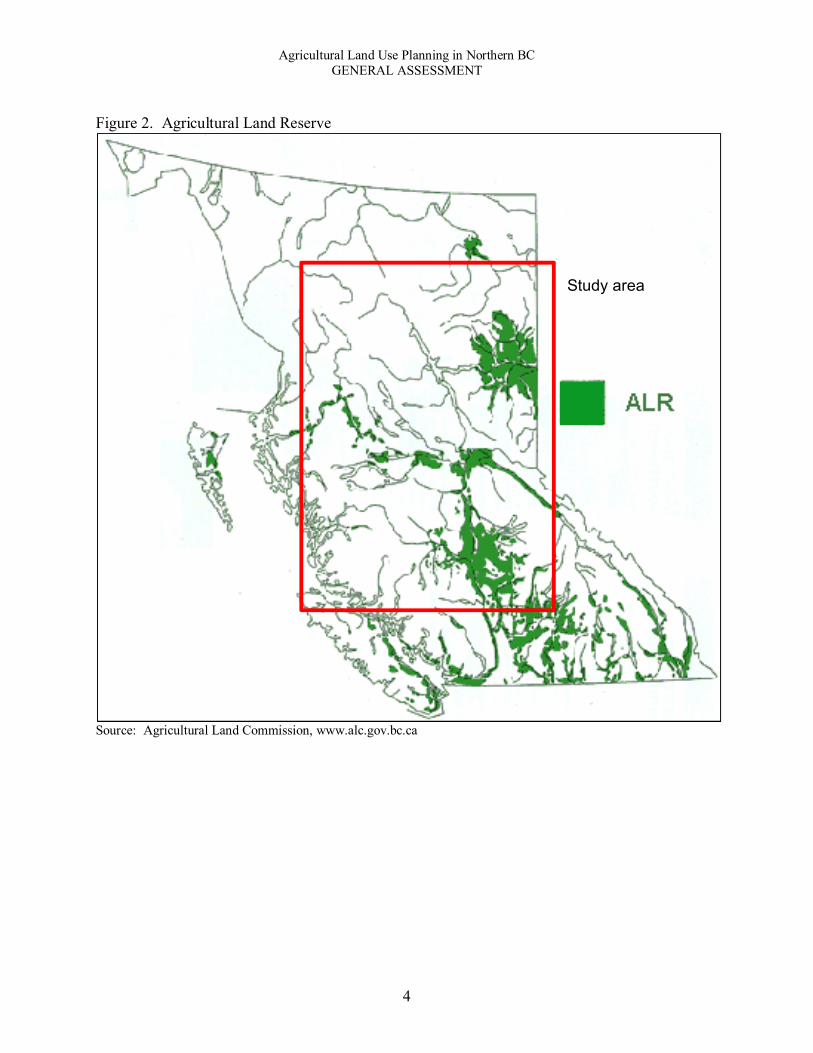
Figure 2. Agricultural Land Reserve
Source: Agricultural Land Commission, www.alc.gov.bc.ca
Study area

Agricultural Land Use Planning in Northern BC GENERAL ASSESSMENT
5
Table 2. Farms and Farm Operators, Regional Districts, 2001-2011 Farms Farm Operators Regional District 2001 2006 2011 2001 2006 2011 Kitimat-Stikine 152 134 106 220 190 155 Bulkley-Nechako 945 866 840 1,495 1,390 1,300 Peace River 1,774 1,699 1,532 2,585 2,505 2,285 Fraser-Fort George 629 621 558 960 935 830 Cariboo 1,188 1,160 1,123 1,855 1,840 1,705
Total 4,688 4,480 4,159 7,115 6,860 6,275 Source: Census of Agriculture 2001, 2006, 2011
The extent of Agricultural Land Reserve (ALR) lands in the study area is shown in Figure 2. The area of these lands varies significantly by Regional District. As shown in Table 3, the PRRD has both the largest land area and the highest percentage of its land base in the ALR, including most of the lands with the highest agricultural capability in the north. The RDKS has the smallest ALR land area and proportion of its land base in the ALR. Most of this land is located in or adjacent to the City of Terrace. A brief profile of agriculture in each Regional District follows.
Table 3. ALR as Percentage of Total Land Area (ha), Regional Districts
Regional District Land area (ha) ALR area (ha) ALR as a %
of total land area Kitimat-Stikine 10,262,000 66,470 1% Bulkley-Nechako 7,782,120 353,360 5% Peace River 11,933,660 1,477,920 12% Fraser-Fort George 5,199,860 378,950 7% Cariboo 8,252,480 924,280 11% Northern BC 43,430,120 3,200,980 7% Source: Smith (1998). Note: there have been some small changes to the amount of ALR. Regional District of Kitimat-Stikine: According to Gagné and Kerby (2013), farming activities include fruit trees, large gardens, greenhouses (most commonly used for tomatoes, cucumbers, and grapes), large fields suitable for grazing, and livestock, such as cattle, pigs, and horses. Between 2006 and 2011, the number of farms and area of farmland both declined. The number of farms declined from 184 to 106, a 42% drop. The area of farmland declined 38%, from 12,763 ha to 7,918 ha. The highest capability soils (Class 2 and 3 soils) are found in the alluvial floodplains of the Skeena River. However, flooding, erosion, and drainage problems are significant barriers to agriculture in the area due, in part, from the higher levels of precipitation. Regional District of Bulkley-Nechako: Agricultural activities within the RDBN are related to dairy, livestock, and forage production. The Regional District has 840 reported farms and 1,300 operators (Census of Agriculture, 2011). The sector is highly dependent on access to Crown lands and water.

Agricultural Land Use Planning in Northern BC GENERAL ASSESSMENT
6
Peace River Region: The agricultural capability of the Peace River Region is quite high, and the soil quality yields wheat, canola (rapeseed), oats, barley, rye, hay, oilseed, and alfalfa. Livestock, beef and cattle, and other equine production are also prevalent, as well as bee keeping and honey production. There are 526 farms within the region, with a total farmed area of 222,443 hectares (Census of Agriculture, 2011). Regional District of Fraser-Fort George: Agriculture in the region is characterised by the beef cattle industry and supporting forage production, with some opportunities for other food production. The arable farmland of the area is located mostly along river valleys. There are 558 farms with 830 farm operators in the region (Census of Agriculture, 2011). Cariboo Regional District: Agriculture in the Cariboo region is characterised by a large beef cattle industry and forage production. Small areas that benefit from microclimates are capable of more diverse horticulture and field crops. The sector is highly dependent on access to Crown lands and water. There are 1,705 farm operators (Census of Agriculture, 2011). The differences among the regions are reflected in differences in the number of applications made to the ALC for subdivision and non-farm uses. The results are shown for the years 2006 to 2014 in Table 4 (excluding RDFFG, given its Delegation Agreement). The highest number of ALC applications was made in the PRRD and the lowest was made in the RDKS, which corresponds with the area of ALR land in each region. However, when we take the differences in land base into account (bottom row of table), the highest number of applications per hectare of ALR land is in the RDKS. The Cariboo has the lowest number of applications per hectare of ALR land. Table 4. Number of ALC Applications by Year, Regional District
Year
RDKS (inc.
Terrace) RDBN PRRD CRD 2014 3 10 30 2013 4 5 52 11 2012 4 17 63 17 2011 7 17 60 18 2010 6 21 54 25 2009 1 23 55 26 2008 5 12 84 38 2007 5 79 29 2006 2 65 23
Total 37 105 542 187 ALR (ha)* 66,470 353,360 1,477,920 924,280
Applications/ 100,000 ha/yr 6.185 4.245 4.075 2.529
Excluding the Regional District of Fraser-Fort George, due to differences under the Delegation Agreement * Smith (1998)

Agricultural Land Use Planning in Northern BC GENERAL ASSESSMENT
7
Results In this section, we present the results for the study of northern BC. We begin with our assessment of the state of agricultural land use planning, assess the legislative framework, and present the results of our content analysis. For the latter, we present the results of the content analyses of the policies and legislation in the five Regional Districts, followed by the results of our assessment of the influence of the three policy regimes (farmland preservation, food sovereignty, and global competitiveness). State of agricultural land use planning The effort dedicated to agricultural planning has improved significantly over the past ten years in northern BC. The mountain pine beetle epidemic appears to be an important catalyst for shifting attention beyond the forestry, mining, and oil and gas sectors to put a greater emphasis on opportunities for agriculture as part of a strategy in increase the level of economic diversification. In the Peace Region, agriculture always had a higher profile. The most significant contributions were the economic development plans developed for the agricultural sector by the Cariboo-Chilcotin Beetle Action Coalition (CCBAC, 2007) and the Omineca Beetle Action Coalition (OBAC, 2009). These documents represented a comprehensive effort to support the development of the sector in central interior BC. A number of agricultural land use planning efforts soon followed. The Regional Districts of Bulkley-Nechako and Kitimat-Stikine have completed agricultural land use inventories and detailed agricultural plans. The Cariboo Regional District also developed an Agricultural Policy and recently completed an agricultural land use inventory. The Peace Region is in the late stages of an agricultural planning process and the Regional District of Fraser-Fort George is in the early stages of planning to support the sector. A summary of agricultural planning efforts is presented in Table 5. Table 5. Existing agricultural strategies, plans, and policies
Regional District Agric. Economic
Devel. Plan Agric. Land Use
Inventory Agric. Plan Agric. Policy Kitimat-Stikine Bulkley-Nechako Peace River In progress Fraser-Fort George Under consideration Cariboo
One way to prevent these efforts from sitting on shelves is to ensure that agricultural plans are not only received by local government councils and boards but are also integrated into formal land use planning policies. Such plans can be named in an enforceable policy (e.g., OCP or zoning

Agricultural Land Use Planning in Northern BC GENERAL ASSESSMENT
8
bylaw), lead to changes in policies, or be adopted as a sub-area plan1. The status of the agricultural plans and policies in each region is shown in Table 6. The Agricultural Policy developed in the CRD has been named in and led to revisions of OCPs. The Agricultural Plan developed in the RDBN in named in and led to changes in recently completed OCPs. In addition, the plans and policies that are under development in other regions may also lead to future changes.
Table 6. Status of local agricultural plan/policy
Aspirational Enforceable
Regional District In
progress Received by
Council Named in
plan Led to revisions
of plan Adopted as
sub-area plan Kitimat-Stikine
Bulkley-Nechako
Peace River
Fraser-Fort George
Cariboo
Legislative framework The legislative framework consists of policies, regulations, and governance structures related to agricultural land use planning at local, regional, and provincial levels of government. Policy documents were identified as enforceable, aspirational, or enabling (refer to the appended glossary for definitions of these and other terms). Table 7 displays the three tiers of agricultural land use planning policies and legislation. At the provincial level, the framework includes the provincial legislative documents pertinent to agricultural land use planning, such as the Local Government Act, the Farm Practices Protection Act, and Agricultural Land Commission Act, the Land Title Act, as well as the Water Act.
Governance for agriculture land use planning is more diverse than other areas of the province. The governing bodies include ALC panels, delegation agreements, Advisory Planning Commissions (APCs), Agricultural Advisory Committees (AACs), and a standing committee of a regional board. In RDFFG, the Regional Board has delegated authority for non-farm use and subdivision for ALR lands. In this capacity, the RDFFG has a significant level of authority over agricultural land use decisions. In its delegated capacity, the RDFFG assumes the role of the Commission (and North Panel) in receiving and considering application. The Act does not provide the ability for a delegated authority to include or exclude land from the Agricultural Land Reserve. The Peace Region is also covered by a delegation agreement, this one is between the ALC and the Oil and Gas Commission. APCs are used in Electoral Areas, but are not strictly agricultural governance bodies, in contrast to an AAC. The Peace River Region is the only area with an AAC.
1 Adopting an agricultural plan as a sub-area plan, often referred to as an Agricultural Area Plan, is appropriate only under certain conditions, which are not prevalent in northern BC.

Agricultural Land Use Planning in Northern BC GENERAL ASSESSMENT
9
Table 7. Legislative Framework, Regional Districts and Case Study Sites Study site Policy Legislation Governance RDKS: Greater Terrace Area
Kalum LRMP (2002) Greater Terrace Area Agriculture
Plan Report (2013) Greater Terrace Agricultural Plan
(2013) Our Strategy for Sustainability,
Terrace 2050 (2009)
Terrace OCP (2011) Greater Terrace Zoning (2011) Lakelse Lake Zoning (2008) Thornhill Zoning (2012) City of Terrace Zoning (1995)
ALC North Panel Advisory Planning Commissions
(Lakelse Lake, Thornhill)
RDBN: Smithers-Telkwa Rural Area
RDBN Agriculture Plan (2012) Bulkley LRMP (1998) Bulkley Valley SRMP (2006) Omineca Agricultural Sector
Strategy (2009)
Smithers Telkwa Rural OCP (2014) RDBN Zoning Bylaw Agricultural Development Areas
ALC North Panel Advisory Planning Commission
PRRD: South Peace Fringe Area
PRRD Regional Agricultural Plan (Draft, Apr/2014)
Dawson Creek LRMP (1999) South Peace Comprehensive
Development Plan (2007)
South Peace Fringe Area OCP (2012)
PRRD Zoning Bylaw
PRRD Agricultural Advisory Committee
Oil and Gas Commission (via Delegation Agreement)
RDFFG: Robson-Canoe Downstream
Robson Valley LRMP (1999) Robson Valley SRMP (1999) OBAC Agriculture Sector Strategy
(2009) Robson-Canoe Valleys Economic
Opportunities Plan (2010)
RVCD Official Community Plan (2002)
RDFFG Zoning Bylaw Agricultural Development Areas
Agricultural Land Use Standing Committee
RDFFG (via Delegation Agreement)
CRD: 150 Mile House Area
CRD Agricultural Policy (2014; adopted in principle)
CCBAC Agriculture Sector Strategy (2007)
Williams Lake SRMP (2005)
150 Mile House Area OCP (2012) Williams Lake Fringe and 150
Mile House Area Zoning Bylaw
ALC Interior Panel Advisory Planning Commission
Acts (provincial laws), bylaws (local government laws, e.g., official municipal plan) [italicised] Enforceable policy, regulations pursuant to acts [bold] Aspirational policy at all levels [plain text]

Agricultural Land Use Planning in Northern BC GENERAL ASSESSMENT
10
Official Community Plans and Zoning In this section, we look more closely at the OCPs in the case study sites with the primary aims to assess the level of detail related to agricultural land and its uses and the level of commitment to protecting farmland. A starting point is to assess the relative importance of agriculture as reflected in statements of vision and goals in the OCPs. The presence of agriculture in vision and goal statements indicates that agriculture is important for the area. At the same time, we can gain insight to the relative importance of agriculture by examining the strength of the language used and the context in which the statement appears.
As shown in Table 12, four of the five OCPs have goals that indicate that agriculture and the preservation of farmland are important to the area. The statements in the RDKS OCP are among the strongest, expressing a vision to make “full use of its agricultural potential” and to protect arable land to ensure food security. The PRRD statements are also strong, expressing a clear commitment to supporting agricultural as an important sector of the economy, recognising that agricultural lands are a “precious commodity,” and to protect the agricultural land base. The RDBN also expresses a strong, clear commitment. The RDFFG OCP does not include a section on vision or goals for the plan. Table 12. Vision and Goal Statements Related to Agriculture in Official Community Plans Regional District Vision and Goal Statements RDKS: Greater Terrace Area Vision: Terrace will prosper from its surrounding natural abundance through
access to outdoor recreation, sustainable resource based industry and full use of its agricultural potential.
Goal: Abundant re-localised food system: The City has the ability to play a key role in developing and supporting our local food systems and overall community food production capacity. Protecting our existing arable land will ensure the food security of residents today and into the future.
RDBN: Smithers-Telkwa Rural Area
Vision for Agriculture: Maintaining the viability of the area’s agricultural sector is critically important to the character and economy of the area. The residents of Electoral Area A support the goals and recommendations of the RDBN Agriculture Plan. The importance of the role of the Agricultural Land Reserve in preserving land for agricultural use is recognized. The consumption of local agriculture products is encouraged through promotion and support of local vendors. The intrusion of residential development into agricultural areas is recognized as a potential problem that will be guarded against.
Goal: The Plan strives to protect and preserve farm land and soil having agricultural capability, and encourage and support the appropriate utilization of that land for agricultural purposes.
PRRD: South Peace Fringe Area
Economic Goal: To support and encourage agriculture industry in the SPFA through preservation of the agricultural land base and restriction on uses that are not compatible with agricultural activities.
Agriculture Goal: To support Agriculture as a primary industry within the SPFA and recognize it is a major component of the lifestyle and rural character of the SPFA and is a major contributor to the local economy. Primary agricultural lands are a precious commodity and are needed for food security.
RDFFG: Robson-Canoe Downstream
None
CRD: 150 Mile House Area Goal: To develop a sustainable economy that promotes best management practices for the agriculture, forestry, tourism and recreation sectors.

Agricultural Land Use Planning in Northern BC GENERAL ASSESSMENT
11
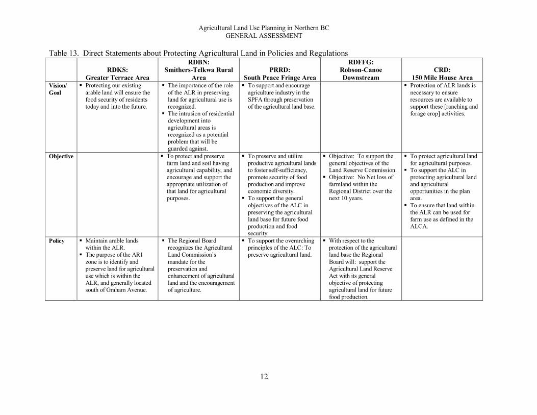
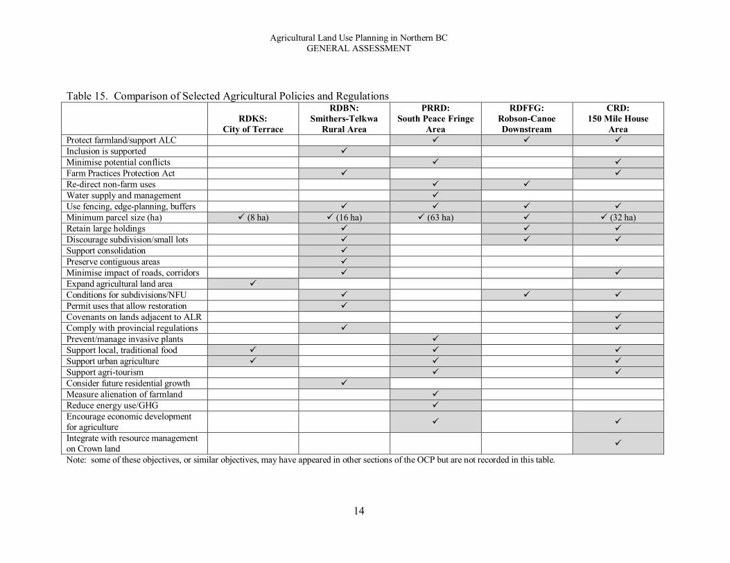
In addition to the importance of agriculture within the OCPs, we also identified the statements that are most directly relevant to protecting agricultural land. These statements are listed in Table 13 under the headings of goals, objectives, and policy, which can appear in any part of the OCP, not only as part of the goals and objectives of the plan itself. The results show that there are important differences among the OCPs. Only the PRRD and RDBN OCPs include a statement about protecting farmland under goals, objectives, and policies. Four of the OCPs include protecting farmland as a goal, of which the RDKS and CRD statements are the strongest with direct statements to protect agricultural land. The RDBN goal introduces uncertainty by leaving “agricultural potential” open to interpretation. Four of the OCPs include objectives to protect agricultural land. The CRD objectives are the strongest, with a clear commitment “To protect agricultural land for agricultural purposes” and a separate objective “To support the ALC in protecting agricultural land and agricultural opportunities in the plan area.” Three of the OCPs have policy statements that include a commitment to protect agricultural lands. Of the five OCPs, the RDFFG expresses the weakest commitment to protecting farmland. Each OCP includes a section on agricultural objectives. Here, too, we can see differences among the regions, especially with regard to the different levels of detail (Table 14). The CRD includes eight separate statements, as compared with the RDFFG, which includes one paragraph that includes three points. Generally, a more detailed set of objectives should provide better direction for future decisions regarding agricultural land uses. We also compared the agricultural land policies of each OCP. The results are displayed in Table 15. Here again we can see significant differences regarding the level of detail, with RDKS and RDFFG having the least amount of detail. The CRD, PRRD, and RDBN have the most detailed policies. Also interesting, there is not a high level of common elements across all OCPs. It is not clear what the implications are for guiding agricultural land use decisions. Finally, we looked at the designations for agricultural land in each OCP, as listed in Table 16. These statements, although not as important as statements of goals, objectives, and policies, serve to reflect the relative importance of agricultural land for the area. The RDKS and RDBN statements include references to protecting these designated lands. The PRRD statement integrates a reference to the Farm Practices Protection (Right to Farm) Act, which helps to strengthen the designation. Among the statements, though, we do not see many similarities. There is no statement included in the RDFFG OCP.
Agricultural Land Use Planning in Northern BC GENERAL ASSESSMENT
12
Table 13. Direct Statements about Protecting Agricultural Land in Policies and Regulations
RDKS:
Greater Terrace Area
RDBN: Smithers-Telkwa Rural
Area PRRD:
South Peace Fringe Area
RDFFG: Robson-Canoe Downstream
CRD: 150 Mile House Area
Vision/ Goal
Protecting our existing arable land will ensure the food security of residents today and into the future.
The importance of the role of the ALR in preserving land for agricultural use is recognized.
The intrusion of residential development into agricultural areas is recognized as a potential problem that will be guarded against.
To support and encourage agriculture industry in the SPFA through preservation of the agricultural land base.
Protection of ALR lands is necessary to ensure resources are available to support these [ranching and forage crop] activities.
Objective To protect and preserve farm land and soil having agricultural capability, and encourage and support the appropriate utilization of that land for agricultural purposes.
To preserve and utilize productive agricultural lands to foster self-sufficiency, promote security of food production and improve economic diversity.
To support the general objectives of the ALC in preserving the agricultural land base for future food production and food security.
Objective: To support the general objectives of the Land Reserve Commission.
Objective: No Net loss of farmland within the Regional District over the next 10 years.
To protect agricultural land for agricultural purposes.
To support the ALC in protecting agricultural land and agricultural opportunities in the plan area.
To ensure that land within the ALR can be used for farm use as defined in the ALCA.
Policy Maintain arable lands within the ALR.
The purpose of the AR1 zone is to identify and preserve land for agricultural use which is within the ALR, and generally located south of Graham Avenue.
The Regional Board recognizes the Agricultural Land Commission’s mandate for the preservation and enhancement of agricultural land and the encouragement of agriculture.
To support the overarching principles of the ALC: To preserve agricultural land.
With respect to the protection of the agricultural land base the Regional Board will: support the Agricultural Land Reserve Act with its general objective of protecting agricultural land for future food production.

Agricultural Land Use Planning in Northern BC GENERAL ASSESSMENT
13
Table 14. Agricultural Objectives in Official Community Plans
RDKS: Greater Terrace Area
RDBN: Smithers-Telkwa Rural
Area PRRD:
South Peace Fringe Area RDFFG:
Robson-Canoe Downstream CRD:
150 Mile House Area Promote land use choices that
support community food security goals.
Increase the overall percentage of food grown and consumed locally.
Embrace food production as an important part of our past, present and future.
Promote and support community agricultural activities.
1) To protect and preserve farm land and soil having agricultural capability.
2) To encourage the expansion and full utilization of land for agricultural purposes.
3) To support the objectives of the ALC.
4) To encourage a diversity of agricultural uses and opportunities.
a) To preserve and utilize productive agricultural lands to foster self-sufficiency, promote security of food production and improve economic diversity.
b) To encourage and support all citizens in the SPFA to have the opportunity, knowledge and resources to produce, acquire, eat, enjoy and celebrate affordable and nutritious local food.
c) To support the AAC in promoting agricultural sustainability and preservation.
d) To promote secure access to water for agriculture, acknowledging and supporting the coexistence of agriculture areas and watershed management areas and their interrelationship in terms of sustainability and water protection.
e) To support the protection of the agricultural land base with emphasis on the preservation of the highest productive land, having a CLI soil rating of Class 1, 2, 3 4 and Class 5(C).
To support the general objectives of the ALC, namely to preserve agricultural land. It is the general objective of the Board to encourage the establishment and maintenance of farms and the use of land within the ALR compatible with agricultural purposes and to guide other forms of development so as to minimize negative impacts on agricultural uses.
1. To protect agricultural land for agricultural purposes.
2. To support the ALC in protecting agricultural land and agricultural opportunities in the plan area.
3. To recognize and support strategies that protect and enhance the area’s rural lifestyle.
4. To designate areas of existing and future sand and gravel extraction.
5. To protect agricultural land by maintaining larger parcels suitable for agricultural production.
6. To prevent rural residential and other non-farm development from adversely affecting agricultural activities.
7. To minimize land use conflicts between sand and gravel extraction operations and neighbouring properties.
8. To work with the relevant government agencies to support sustainable resource management.
Agricultural Land Use Planning in Northern BC GENERAL ASSESSMENT
14
Table 15. Comparison of Selected Agricultural Policies and Regulations
RDKS: City of Terrace
RDBN: Smithers-Telkwa
Rural Area
PRRD: South Peace Fringe
Area
RDFFG: Robson-Canoe Downstream
CRD: 150 Mile House
Area Protect farmland/support ALC Inclusion is supported Minimise potential conflicts Farm Practices Protection Act Re-direct non-farm uses Water supply and management Use fencing, edge-planning, buffers Minimum parcel size (ha) (8 ha) (16 ha) (63 ha) (32 ha) Retain large holdings Discourage subdivision/small lots Support consolidation Preserve contiguous areas Minimise impact of roads, corridors Expand agricultural land area Conditions for subdivisions/NFU Permit uses that allow restoration Covenants on lands adjacent to ALR Comply with provincial regulations Prevent/manage invasive plants Support local, traditional food Support urban agriculture Support agri-tourism Consider future residential growth Measure alienation of farmland Reduce energy use/GHG Encourage economic development for agriculture
Integrate with resource management on Crown land
Note: some of these objectives, or similar objectives, may have appeared in other sections of the OCP but are not recorded in this table.

Agricultural Land Use Planning in Northern BC GENERAL ASSESSMENT
15
Table 16. Agricultural Land Use Designations in Official Community Plans Regional District Statement of Land Use Designation RDKS: Greater Terrace Area The Agricultural designation is intended to preserve our community’s
best quality arable lands for food production. Lands suitable for commercially viable farming activities and smaller scale food production will be maintained to ensure local food security can be achieved. Quality arable lands and lands within the Provincial Agriculture Land Reserve (ALR) are located within this land use designation.
RDBN: Smithers-Telkwa Rural Area The Agriculture (AG) designation applies to those areas that are most suitable to agricultural activities. It is the intent of this designation to preserve these lands for the purposes of farming and other related activities. In general the Agriculture (AG) designation follows the boundaries of the Agricultural Land Reserve (ALR).
PRRD: South Peace Fringe Area The vast majority of the plan area has low density population development with broad scale agricultural and resource extraction activities. This land base is valued for its high food production capability and the protection granted pursuant to the Farm Practices Protection (Right-to-Farm) Act.
RDFFG: Robson-Canoe Downstream The Agriculture/Resource designation applies to the majority of lands within the Plan Area including both privately owned and Crown lands utilized for primary resource extraction, agriculture, non-development or are relatively remote as shown on the Plan's maps. Any land within the Plan area that is not specifically designated otherwise on the maps is hereby designated Agriculture/Resource (Ag/Res).
CRD: 150 Mile House Area [no statement included under ‘land use designation’] Content analysis of documents After documenting the legislative framework for each Regional District we assessed the contents of the legislative and policy documents, with a focus on each of the case study sub-areas. Our aim was to assess the breadth and quality of the local legislative framework. For each of the case studies, we first looked at the breadth of the legislative documents, which include OCPs and zoning bylaws primarily. As a measure of breadth we assessed five components: provincial legislative context; background information; statements of vision, goals, and objectives; regulations; and maps. For this we used a three-point (check mark) scale indicating different levels of detail from minimal () to moderate () to high (). The criteria we used are included in Appendix: Criteria for Evaluating Content of Legislative Framework. Using the same technique, we then looked at policy documents, which include agricultural plans and strategies primarily, as well as Land and Resource Management Plans (LRMPs). In this report, we present summary findings for each Regional District; the more detailed results are presented in the reports for each case study. Local government legislation documents As shown in Table 8, the breadth of coverage among the local legislative documents is moderate, and mostly consistent, among all of the Regional Districts. The PRRD has a bit more breadth than the others, which is also reflected in the extent of the integration of the provincial legislation

Agricultural Land Use Planning in Northern BC GENERAL ASSESSMENT
16
(Table 9). Overall, there is a moderate level of integration among all of the local legislative documents. Table 8. Contents of local legislative documents
Legislative Context Background
Vision, Goals,
Objectives
Regulations (enforceable policies,
procedures) Maps Kitimat-Stikine
Bulkley-Nechako
Peace River
Fraser-Fort George
Cariboo
Table 9. Integration of provincial legislation in local legislative documents
Legislative context (legislation and policies) Land use planning tools Gov. ALC Act
Right to Farm LGA Land
Water Act
Range Act
Farm Bylaw
Cov-enant ADA DPA AAC
Kitimat-Stikine
Bulkley-Nechako
Peace River
Fraser-Fort George
Cariboo
Local government policy documents The policy documents we assessed in each Regional District varied (see Table 7, above) and, in some cases, were at different stages of development. For our analysis, we made the following assumptions:
RDKS: An agricultural plan, along with supporting documents, was completed in 2013; the Regional District is reviewing the plan and considering implementing bylaws. We analysed the agricultural plan as an aspirational policy.
PRRD: The Regional District is in the late stages of finalising an agricultural plan; we analysed the plan as if it was completed.
CRD: The CRD Board adopted an Agricultural Policy in principle; we analysed this document as an enforceable policy.
As discussed later in the report, the completion of the planning processes will likely lead to improved local legislative frameworks. Generally, the policy documents are more comprehensive in nature and much longer, thereby covering more of everything. Correspondingly, the policy documents have more breadth and integration of provincial legislation, as shown in Tables 10 and 11. The CRD, PRRD, and

Agricultural Land Use Planning in Northern BC GENERAL ASSESSMENT
17
RDBN stand above the others. In contrast, the RDKS agricultural plan is a very comprehensive document that has a stronger focus on food security and includes less detail about provincial land use policies. In this way, the various policy documents also have different aims and applications. Table 10. Contents of local policy documents
Legislative Context Background
Vision, Goals,
Objectives
Regulations (enforceable policies,
procedures) Maps Kitimat-Stikine
Bulkley-Nechako
Peace River
Fraser-Fort George
Cariboo
Table 11. Integration of provincial legislation in local policy documents
Legislative context (legislation and policies) Land use planning tools Gov. ALC Act
Right to Farm LGA Land
Water Act
Range Act
Farm Bylaw
Cov-enant ADA DPA AAC
Kitimat-Stikine
Bulkley-Nechako
Peace River
Fraser-Fort George
Cariboo
Current Issues When reviewing the contents of the documents, we also explored three issues that have come up in the project that are current issues: small-lot agriculture/fragmentation of farmland; alienation of farmland/foreign ownership; and natural resource developments. Small-lot agriculture/fragmentation of farmland The combined issue of small-lot agriculture and fragmentation of the land base centres on what appears to be a growing awareness of food sovereignty. Much of this interest in small-lot agriculture is associated with new farmers and their need for affordable land that is reasonably close to population centres. What makes the demand for small-lot agriculture particularly important is that there is often little room within farmland protection legislative frameworks to accommodate smaller lots. The main reason is that sub-dividing into smaller lots is in direct conflict with the over-riding goal to not fragment the land base. The primary land use planning tool for preventing fragmentation is large minimum lot sizes. Thus, small lots and farmland protection are often in direct opposition.

Agricultural Land Use Planning in Northern BC GENERAL ASSESSMENT
18
Whether the tension is noted explicitly or not, the OCPs in the case study sites include a range of land use policies that tend to avoid fragmentation, as listed in Table 26. For example, as stated in the 150 Mile House Area OCP (5.3.17), “The Regional District encourages strategies that will see large agricultural land holdings retained and operated as single agricultural operations rather than broken up as individual land tenures with multiple ownership” (p. 40). This policy reflects the general approach to avoid parcelisation of the land base. Other agricultural land policies that help to avoid parcelisation include encouraging consolidation, protecting contiguous areas, and retaining large holdings. Setting large minimum parcel sizes provide the foundation for such policies. Table 26. Comparison of Selected Agricultural Policies and Regulations RDKS RDBN PRRD RDFFG CRD Minimum parcel size (ha) (8 ha) (16 ha) (63 ha) (32 ha) Retain large holdings Discourage subdivision/small lots Support consolidation Preserve contiguous areas Conditions for subdivisions/NFU
In addition to specific policies, the tension between the desire for small-lots for agriculture and a need to avoid fragmentation appears in different contexts and is addressed in different ways. In the RDBN, the tension is evident in the regional agricultural plan. The plan includes a sub-section specifically for a discussion of issues regarding lot size. As stated, “Maintaining appropriately large parcel sizes and keeping smaller parcel residential development and other uses away from farming areas is an important factor in preserving the integrity of agricultural lands, and minimizing conflict between agriculture and non- agricultural uses” (pp. 72-3). The RDBN concludes, “There is no mechanism for the Regional District to ensure the long-term agriculture use of such properties and prevent their conversion to strictly residential use” (p. 73). In the context of discussing the impacts of subdivision, it is noted in the plan that “the RDBN Board, and the ALC must continue to diligently guard against the fragmentation of agricultural lands, and the further encroachment of residential development into agricultural areas” (p. 75, emphasis added). At the same time, the plan also indicates areas where steps have been taken to recognise and accommodate smaller lot sizes. The RDFFG has a unique way of addressing parcel sizes for the Dunster area, which is designated as a Special Management Area. The area has explicit policies for minimising subdivision, preventing concentration of residential developments, and consolidating multiple holdings into larger parcels as a net benefit to agriculture. All of these policies are barriers for creating small lots, although some smaller lots (1.6 ha and 0.8 ha) may be allowed where land area is limited. This tension between large minimum lot sizes and a desire for small lots exists in the Greater Terrace Area in the RDKS. Among the ALC applications, all of the refusals were justified by not supporting fragmentation into small parcel sizes. On some of the applications, reasons cited for refusals pointed to compliance on minimum parcel sizes for agricultural zoning. Yet, small-lot agriculture is mentioned in the City of Terrace OCP and sustainability strategy,

Agricultural Land Use Planning in Northern BC GENERAL ASSESSMENT
19
and is a centerpiece of the GTA agricultural plan. Specific recommendations are to have sub-areas within the GTA identified for special agricultural zones and to examine which types and densities of farming should be permitted within non-agricultural and non-rural use designations. The issue of small lots is also related to managing the interface between rural and urban areas. This perspective is evident in the CRD Agricultural Policy and the OCPs. The Quesnel Fringe Area OCP emphasises the importance of smaller lots in providing a buffer. The Small Farm land use designation (5.3.6) plays a specific role in this regard. “The ‘Small Farms’ designation on Schedule B provides for land in the ALR, with current lots ranging from 4 ha to 12 ha with limited agricultural potential, that serve as a buffer between Agricultural and Resource designated lands and Rural Residential designated lands” (p. 52).
Overall, although the tension between a desire for small agricultural lots and for mitigating fragmentation exists within northern BC, this matter is not significant across the region as a whole.
Alienation of farmland/foreign ownership
Alienation of farmland has been identified as an issue in three ways: tree planting on agricultural land for carbon credits (often by foreign-owned companies); conversion of large parcels for estate lots; foreign-purchased land not in production.
Although foreign ownership of land is not mentioned as an agricultural land use planning issue in any of the Regional Districts’ legislative documents, parts of the region have experienced corporations purchasing productive farmland and planting trees for carbon credits. The RDBN refers explicitly to this issue in its agricultural plan as a threat related to alienation (or sterilization) of farmland because this practice has the effect of removing productive agricultural lands and contributing to parcelisation. It is known that this practice is also occurring in the RDFFG and CRD. According to news reports (e.g., Hume, 2015), tens of thousands of hectares of agricultural land have been planted with trees in the Cariboo region. Based on preliminary discussions, neither professional planners, agrologists in the region, nor the ALC are aware of the extent of planting or its impacts on agricultural potential. Although this practice is somewhat isolated presently, its expansion into other areas poses a significant threat to the land base.
In the RDFFG, newspapers have also reported the purchase of agricultural land by foreign owners in the Dunster area, although the future use of these lands is uncertain. As well, some large parcels of agricultural land have been alienated by building large estates on the property and then either not farming the land or farming only to meet the minimum levels needed for tax assessments and farm status.
The prevalence of rural residential estates was an issue associated with the alienation of quarter sections in the area in the early 2000s and appears again as a main issue to be addressed by the Draft Regional Agricultural Plan.
Natural resource developments Agricultural land use planning is most often associated with urban development. In northern BC, pressures also come from natural resource developments, such as forestry, oil and gas, and mining. The expected increase in industrial activities and forecasted water issues arising from climate change both suggest a greater need for integrated land use planning.

Agricultural Land Use Planning in Northern BC GENERAL ASSESSMENT
20
The PRRD, more than other parts of northern BC, is under significant pressure from natural resource developments on two sides. On the urban side, the municipalities of Dawson Creek and Pouce Coupe want to maximise the advantages of growth associated with natural resource developments, primarily oil and gas, which means expanding onto adjacent ALR lands. At the same time, there is significant – and increasing – pressure for oil and gas development in rural areas. Much of the South Peace Fringe Area OCP and Draft Regional Agricultural Plan are directed as managing these competing uses of the land base. There is not only a direct conflict over land use, but also significant impacts on other resources such as on the supply and security of local water resources. The stability of the local legislative framework is a key element for the area to be able to manage these dual pressures, however the uncertainty of permitted non-farm uses presents a significant challenge.
Typically, OCPs include a general statement that deals directly with multiple uses of the non-urban land base, which usually coincides with Crown lands. For example, the OCPs in the RDFFG include a Resource Management Objective, which states:
To recognize the importance of the region’s forest, agricultural and mineral resource base and to support an integrated approach to their management, such as is progressing under LRMP, PAS and similar resource planning exercises, including non-extraction uses such as wildlife management, watershed and scenic protection, lakeshore conservation and other special environmental considerations for the maximum long term benefit of the region’s residents.
The RDFFG OCPs also include a Crown Land Objective that recognises and complements the efforts of the Province such that specific developments are consistent with RDFFG policies. The prevalence of ranching in northern BC means that the sector relies heavily on access to Crown land, which means that the interface between forestry and agriculture presents a set of challenges and some opportunities. In RDBN, the Smithers-Telkwa Rural Area legislative framework includes a specific focus on the interface between agricultural lands and forestry. Several sources of pressure and concerns are identified and a solution for a better balance is sought. Similarly, the Omineca Beetle Action Coalition agricultural strategy acknowledges a need to address these pressures in the following statement: “Maximizing compatibility between agricultural expansion and forest or other uses is a recognized and important objective for resource management planning” (p. 28). This point is then emphasised in the following statement: “Without secured tenure arrangements for grazing, ranchers, for example, may be reluctant to undertake fencing investments and other infrastructure investments on their farm properties” (p. 28). The concerns about the interface between agriculture and forestry are also highlighted in the RDBN agricultural plan. The plan notes that ranching in the region is heavily dependent on access to Crown land. Significant issues related to the use of motorised vehicles in and through range land are noted. Other issues include damage caused to fence lines and other agricultural infrastructure by logging contractors and the loss of agricultural land by the planting or replanting of trees. In this context, the plan states, “The Ministry of Forests, Lands and Natural Resource Operations has an opportunity to support range users by consulting with them when forestry activities are planned and executed within range lands” (p. 63).
The situation is similar in the CRD where legislative framework includes general statements about the need to manage natural resources. While it is recognised that the

Agricultural Land Use Planning in Northern BC GENERAL ASSESSMENT
21
management of resources is more of a provincial responsibility, the OCPs also recognise the role of the CRD to provide supportive OCP policies. The OCPs also include policies to co-operate and communicate with provincial ministries and agencies for planning, disposition, and management of Crown lands in order to minimise conflicts between agricultural and other land uses. Several policies refer to managing water resources. There are few references to provincial legislation for Crown lands but provincial ministries are named. Land and Resource Management Plans play a role to integrate agricultural land uses with natural resource developments on Crown land. LRMPs are non-enforceable landscape-level plans that are designed to support forest management and also to establish protected areas. Some legal objectives that deal with specific management objectives, such as old-growth management areas, have been established as an outcome of these planning processes. As will be discussed below, legal objectives to establish Agricultural Development Areas (ADAs) is another outcome of the LRMP processes. Sustainable Resource Management Plans (SRMPs) have been established for sub-areas within LRMPs and have more detailed objectives.
In the RDFFG, the Robson Valley LRMP has the most influence over land use planning for Crown lands. The LRMP includes a good level of detail of relevant provincial legislation and also cites the need to integrate with OCPs. It also includes a stated objective for agriculture: “Maintain or enhance opportunities for use of Crown Land, vegetation, and water resources for agriculture, fisheries and food production.” The LRMP lists five strategies to achieve this objective, which includes farmland protection:
Support the purpose and intent of the Agricultural Land Reserve (ALR) Preserve and maintain the quality of soil within the ALR through appropriate
legislation Support the Robson Valley Crown Land Plan and its designated Agricultural
Development Areas Allow Crown lands with suitable agricultural potential to be alienated for agricultural
uses via the Crown Agricultural Lease policy Improve mechanisms for identifying Crown land areas adjacent to private agricultural
operations that are of interest for future alienation for agricultural uses By these measures, the Robson Valley LRMP serves agricultural uses of Crown Land by integrating them with other natural resource developments. But this LRMP deals more directly with agricultural land uses than most LRMPs. For example, within the CRD, the Horsefly SRMP, approved in 2005, is an enforceable document that is relevant to agricultural lands in the area, in that this strategic land use plan falls under the legal objectives of the Cariboo-Chilcotin Land Use Plan. The Horsefly SRMP has some targets specific for grazing in the 150 Mile House Area. The SRMP does not identify any issues or opportunities related to agriculture in the area. As noted above, some Agricultural Development Areas (ADAs) have been established in northern BC. These ADAs recognise the agricultural potential and farm use of specified Crown lands. ADAs are located in the RDBN and RDFFG. The ADAs are not well integrated with any local enforceable policies and regulations, although they are mentioned in the OBAC agricultural strategy With regard to ADAs, the document emphasises the opportunity available for these lands: “Agriculture Development Areas (ADAs) can also be a potential tool for creating

Agricultural Land Use Planning in Northern BC GENERAL ASSESSMENT
22
certainty. ADAs are crown lands where there is recognized agricultural capability that are suitable for future development” (p. 28). Overall, the integration of agricultural land use planning and natural resource developments appeared primarily in three contexts: OCPs, agricultural plans, and LRMPs. However, among the legislative frameworks analysed, this is an area of agricultural land use planning that is significantly under-developed. Policy regimes The aim of our analysis was to assess how issues, ideas, interests/actors and institutions associated with the three policy regimes influence local agricultural planning processes. The two policy regimes of farmland preservation and global competitiveness have influenced agricultural land use policy and legislation for over forty years. Food sovereignty, and its associated concerns with food security and demand for local food, is a nascent policy regime that is influencing agricultural land use planning. To complete the assessment of the presence and importance of the policy regimes we examined the documents that comprise the legislative framework. Presence and importance were measured as a function of both the level of influence of words, concepts, and statements that appear in the documents and of the placement of these words, concepts, and statements within each document. The criteria for measuring the policy regime statements are presented in Appendix: Criteria for determining level of influence of policy regimes. All three policy regimes are present in the legislative frameworks of northern BC. Table 17 includes a sample of policy statements that illustrate the diversity of interests and ideas. As indicated in Tables 18, 19, and 20, farmland preservation appears to be the most influential of the three policy regimes, with food sovereignty only slightly less influential. Global competitiveness is the least influential. The influence of the policy regimes in each Regional District is shown in Tables 21 through 25. In these tables we can more easily see the level of each policy regime within each Regional District. The results for the RDBN indicate that all three policy regimes are not only present but also that all three regimes have a significant influence on the legislative context that guides decisions for agricultural land uses. By contrast, the results for the RDFFG suggest a relatively low level of interest by the policy regimes. The CRD is most influenced by the one policy regime of farmland preservation.

Agricultural Land Use Planning in Northern BC GENERAL ASSESSMENT
23
Table 17. Sample of Policy Regime Statements
Regional District Global
Competitiveness Farmland
Preservation Food
Sovereignty RDKS: Greater Terrace Area
There are a number of pressures facing global agriculture that suggest that food prices are likely to substantially increase in the foreseeable future.
Protecting our existing arable land will ensure the food security of residents today and into the future.
To the degree that we can produce and secure our food locally, we reduce our reliance on outside food systems…and ultimately allows us to become more self-sufficient.
RDBN: Smithers-Telkwa Rural Area
Food production and distribution has become globalized and increasingly dominated by large retail chain stores
Residential development into agricultural areas is recognized as a potential problem
New model emphasizes locally-produced healthy food products and the importance of food security for the region.
PRRD: South Peace Fringe Area
Some additional marketing opportunities may occur for the cattle sector should discussions related to more foreign trade agreements materialize
Discourage unnecessary expansion of urban areas into ALR lands
Reduce reliance on other regions of the world as a source of food
RDFFG: Robson-Canoe Downstream
Farmers have competed with primary producers from across North America and the world.
This Plan outlines policies and general guidelines that discourage and restrict the fragmentation of agricultural land in the plan area
A reasonable economic return for farmers is the cornerstone to attract new entrants and ensure long-term sustainability
CRD: 150 Mile House Area
The primary macro-variables influencing the sector include globalization of markets
Focus on edge planning to protect the agriculture interface.
Support local food security through local agricultural uses and food processing and by encouraging community gardens and farmers markets to create more food independent communities
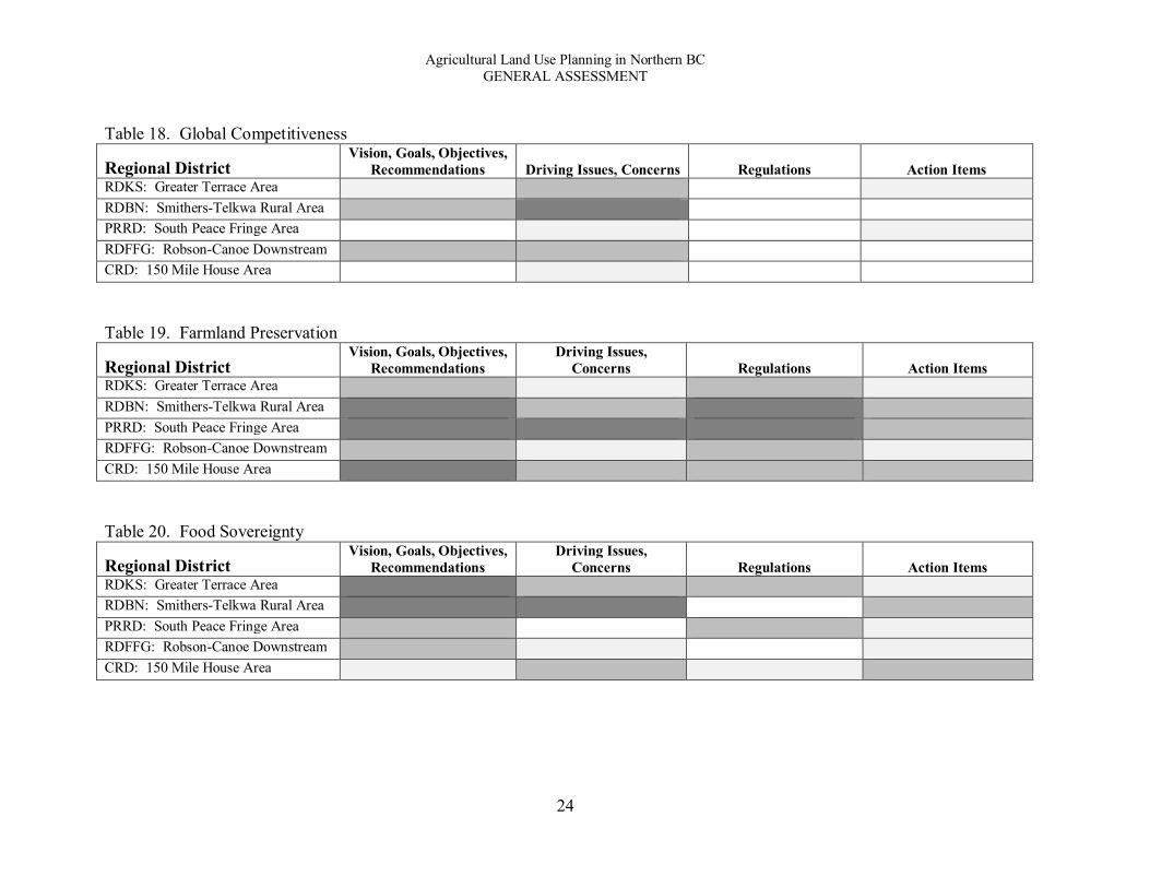
Agricultural Land Use Planning in Northern BC GENERAL ASSESSMENT
24
Table 18. Global Competitiveness
Regional District Vision, Goals, Objectives,
Recommendations Driving Issues, Concerns Regulations Action Items RDKS: Greater Terrace Area RDBN: Smithers-Telkwa Rural Area PRRD: South Peace Fringe Area RDFFG: Robson-Canoe Downstream CRD: 150 Mile House Area Table 19. Farmland Preservation
Regional District Vision, Goals, Objectives,
Recommendations Driving Issues,
Concerns Regulations Action Items RDKS: Greater Terrace Area RDBN: Smithers-Telkwa Rural Area PRRD: South Peace Fringe Area RDFFG: Robson-Canoe Downstream CRD: 150 Mile House Area Table 20. Food Sovereignty
Regional District Vision, Goals, Objectives,
Recommendations Driving Issues,
Concerns Regulations Action Items RDKS: Greater Terrace Area RDBN: Smithers-Telkwa Rural Area PRRD: South Peace Fringe Area RDFFG: Robson-Canoe Downstream CRD: 150 Mile House Area
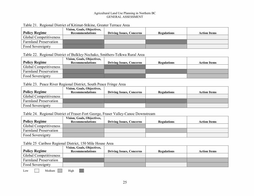
Agricultural Land Use Planning in Northern BC GENERAL ASSESSMENT
25
Table 21. Regional District of Kitimat-Stikine, Greater Terrace Area
Policy Regime Vision, Goals, Objectives,
Recommendations Driving Issues, Concerns Regulations Action Items Global Competitiveness Farmland Preservation Food Sovereignty Table 22. Regional District of Bulkley-Nechako, Smithers-Telkwa Rural Area
Policy Regime Vision, Goals, Objectives,
Recommendations Driving Issues, Concerns Regulations Action Items Global Competitiveness Farmland Preservation Food Sovereignty Table 23. Peace River Regional District, South Peace Fringe Area
Policy Regime Vision, Goals, Objectives,
Recommendations Driving Issues, Concerns Regulations Action Items Global Competitiveness Farmland Preservation Food Sovereignty Table 24. Regional District of Fraser-Fort George, Fraser Valley-Canoe Downstream
Policy Regime Vision, Goals, Objectives,
Recommendations Driving Issues, Concerns Regulations Action Items Global Competitiveness Farmland Preservation Food Sovereignty Table 25 Cariboo Regional District, 150 Mile House Area
Policy Regime Vision, Goals, Objectives,
Recommendations Driving Issues, Concerns Regulations Action Items Global Competitiveness Farmland Preservation Food Sovereignty
Low Medium High

Agricultural Land Use Planning in Northern BC GENERAL ASSESSMENT
26
Discussion Our overall aim for the project is to identify principles and beneficial practices that represent land use planning solutions that protect farmland. As a step toward this final aim we identified four principles that guided our analysis: maximise stability, integrate across jurisdictions, minimise uncertainty, and accommodate flexibility. In this section we discuss the strength of the legislative frameworks for each Regional District in northern BC, while drawing upon the details of the case study sites selected in each Regional District. Regional District of Kitimat-Stikine: Greater Terrace Area The local legislative framework for the GTA has a strong focus on food and agriculture with a stated interest in protecting farmland. With regard for maximising stability for protecting farmland, the City of Terrace Official Community Plan (OCP), as an enforceable piece of legislation, contributes the most. However, other than including statements reflecting the basic requirements mandated under the Local Government Act, the OCP does not have a well-developed framework of policies and regulations to support agricultural land use planning or farmland protection.
Looking ahead, the on-going effort to develop and adopt an agricultural area plan (AAP) is a very significant step forward that will help to strengthen the local legislative framework for agricultural land use planning. The recently completed reports (Gagné and Kerby, 2013; Kerby, 2013a; Ministry of Agriculture, 2013) represent a comprehensive effort to document and assess the state of agriculture and the land base in the GTA. The agricultural plan completed by Gagné and Kerby (2013) includes a detailed set of 90 recommendations for strengthening agriculture in the GTA. Specific opportunities to strengthen policies and regulations for agricultural land use planning are detailed by Kerby (2013b). Presently, however, the agricultural plan is aspirational (non-enforceable); it has been accepted but not adopted by the local governments.
The integration of legislation for the GTA with provincial agricultural land use planning legislation was moderately weak. The ALCA was cited most often and almost all of the documents cited the LGA. None of the legislative documents cited the Farm Practices Protection (Right to Farm) Act or other policies relevant to agricultural land use planning.
With regard for accommodating flexibility, there is no dedicated governance structure in the GTA for agricultural planning specifically. The RDKS has two Advisory Planning Commissions that cover parts of the agricultural land base. The GTA agricultural plan recommended that an Agricultural Advisory Committee be established. Presently, the primary governance structure for accommodating flexibility is the North Regional Panel of the Agricultural Land Commission, a quasi-judicial tribunal that is responsible for most agricultural land use decisions.
With regard for the three policy regimes, it appears that food sovereignty is the most influential, as it is most frequently mentioned in the recent reports. Farmland preservation is also an important influence in the GTA; however, the rationale for protecting farmland is to improve food self-sufficiency and food security. Thereby, in a strict interpretation of the statements, food sovereignty is presented as a greater priority relative to farmland preservation. Global competitiveness also influences policy development; it is recognized as a driving force that

Agricultural Land Use Planning in Northern BC GENERAL ASSESSMENT
27
creates a need greater food self-sufficiency and an opportunity to build the capacity of the local food production system.
Overall, the absence of well-developed local policies within the current legislative framework means that local priorities for farmland protection are not well integrated with provincial policies. Consequently, the local governments must rely on, and to some extent, defer to, the provincial legislation and regulations, thereby putting local agricultural land use decisions in the hands of the provincial ALC. By adopting the recommendations of the agricultural planning reports, the GTA would strengthen its policies to increase protection for the area’s farmland and to integrate the local emerging interests in food sovereignty with the provincial legislative framework for agricultural land use planning. Regional District of Bulkley-Nechako: Smithers-Telkwa Rural Area The local legislative framework for the STRA is strong, which is well suited for the needs of the area. The local framework has a strong focus on agriculture with stated interests in protecting farmland and minimising fragmentation of the land base. With regard for maximising stability for protecting farmland, the recently amended (in 2014) Smithers Telkwa Rural OCP, as an enforceable piece of legislation, contributes the most to stability. The OCP is supported by the regulations of a region-wide zoning and a comprehensive region-wide agricultural plan. The agricultural plan led to changes in and is named by the OCP. Together, the OCP and agricultural plan have clear, detailed language about protecting farmland, which contributes significantly to the strength of the overall framework. They also minimise uncertainty about how the policies and regulations will be applied. The local legislative framework is also supported by a detailed agricultural land use inventory that can inform land use decisions.
The integration of legislation for the STRA with provincial agricultural land use planning legislation is comprehensive. The OCP includes clear statements about the role and importance of the ALC and ALR. A section of the agricultural plan provides a comprehensive review of relevant provincial policies, including the ALC, ALR, the Farm Practices Protection (Right to Farm) Act, as well as the Range Act and Forest and Range Practices Act. Collectively, these documents represent an effective integration of provincial interests in farmland protection within the local legislative framework, thereby strengthening the local priorities for farmland protection.
The primary local governance structure is the Advisory Planning Commission (APC) for Electoral Area A. Among other duties, the APC reviews applications to the ALC. In this capacity, the APC is able to accommodate flexibility within the decision-making process for agricultural land use planning. Recommendations from the APC go to the Board of the RDBN, which then forwards its recommendation to the ALC North Panel. The Regional District stated that having an APC for each Electoral Area allows for decisions that are more responsive to local public priorities compared to having a region-wide Agricultural Advisory Committee.
With regard for the three policy regimes, the legislation and policy documents of the STRA cover all three. Farmland preservation garners the most attention, appearing in the four documents assessed and in each of the four content areas. Global competitiveness is the least present of the three regimes, yet still recognised as a significant driving force for the agricultural sector in the region.
Agricultural Land Use Planning in Northern BC GENERAL ASSESSMENT
28
Overall, the presence of well-developed local policies and regulations supported by a comprehensive agricultural plan means that local priorities for farmland protection are clearly articulated and well integrated with provincial policies. Peace River Regional District: South Peace Fringe Area The South Peace Fringe Area has a moderately strong legislative framework, which is an achievement under the circumstances of the region. The presence of oil and gas developments places significant pressures on the agricultural land base, thus increasing the need for a strong legislative framework. The Delegation Agreement appears to be an effective mechanism to ensure that competing interests are addressed within the regional context, but this does expose the agricultural land base to the over-riding interests in oil and gas development, thereby lessening the stability of the provincial legislative framework while also introducing some elements of uncertainty. Within this context, a greater interest in protecting farmland is evident in recent revisions to comprehensive land use plans and could be further strengthened with the completion of the agricultural plan by the Regional District.
The South Peace Fringe Area OCP contributes substantially to this stability. Agriculture is identified clearly as a public priority and the goals, objectives, and policies include clear language and commitment to preserving the area’s farmland. The OCP is supported by a comprehensive Draft Regional Agricultural Plan that is guided by a vision statement to support agriculture and protect agricultural land. Currently, the absence of an enforceable agricultural plan, e.g., one that is named in the OCP as a guiding document, limits the stability of the overall framework. However, this situation could improve as a positive outcome of the on-going regional planning initiative.
Integrating policies and priorities across jurisdictions is a strong aspect of the local framework. Together, both the OCP and the Draft Regional Agricultural Plan effectively integrate provincial legislation within the local framework. The Draft Plan is particularly effective in this regard, and would be more effective if the plan was adopted, in some form, by the PRRD Board. However, with regard for minimising uncertainty, the local legislative framework for the South Peace Fringe Area is weak, with much of this weakness associated with the non-farm oil and gas activities permitted under the OGC Delegation Agreement. The uncertainty of permitted non-farm uses is also increased due to expressed political support for greater “flexibility.”
The PRRD is the only Regional District in northern BC that has an Agricultural Advisory Committee. The AAC is engaged in agricultural land use planning, but it has not been the practice for the committee to review all applications to the ALC. The Draft Regional Agricultural Plan includes a recommendation to change this practice so that the AAC reviews all applications. The OGC Delegation Agreement is also designed to accommodate flexibility. It provides a comprehensive set of regulations that define permitted oil and gas uses on agricultural land as well as conditions and procedures for when the ALC must be involved in application processes.
With regard for the three policy regimes, farmland preservation is most frequently mentioned within the local legislative framework. This indicates that within the case study, protecting farmland from industrial and developmental pressures is a factor influencing land use

Agricultural Land Use Planning in Northern BC GENERAL ASSESSMENT
29
planning processes. Within the recently updated OCP, it appears that farmland preservation has become more influential. The notion of food sovereignty appears to be new as it is mentioned only within more recently revised documents, thus suggesting a shift in public priorities for agriculture and food industry in the South Peace area. Global competitiveness appears to have less influence, even though the sector is well connected in the global marketplace for grains. Regional District of Fraser-Fort George: Robson Valley-Canoe Downstream The legislative framework for protecting farmland within the RDFFG as a whole is of moderate strength. This assessment reflects the RDFFG’s stated interest in protecting good agricultural land alongside a general support for accommodating non-farm uses and subdivision. The RDFFG’s policy to support the general objectives of the ALC to protect farmland is not as strong as a direct statement to protect farmland. This moderate language takes away from the strengths of the local framework, which include a high level of intra-plan consistency among agricultural land use policies and an ability to accommodate flexibility without introducing unnecessary levels of uncertainty. This is evident in the Rural Community and Special Management Area designations. However, the strengths of the framework are weakened by a low level of integration of provincial legislation to protect farmland within the local legislative framework. Of the three policy regimes, farmland preservation is the most prevalent among RDFFG policies, which focusses on the general need to preserve agricultural land from fragmentation and to mitigate impacts on agricultural lands. The other two policy regimes, although present, do not appear to have significant influence over agricultural land use planning in the region. Cariboo Regional District: 150 Mile House Area The local legislative framework for agricultural land use planning in the CRD as a whole is moderate, with policies in different geographic areas ranging from weak to somewhat strong in relation to farmland protection. The framework for the 150 Mile House Area is among the strongest in the Regional District, and northern BC. The land use policies include statements about supporting the ALC and its efforts to protect farmland, along with some direct statements about protecting farmland. The integration of legislation for the CRD with provincial agricultural land use planning legislation covers the basics, with most references to the ALC Act, the ALR, and the Farm Practices Protection (Right to Farm) Act. More could be done to effectively integrate provincial interests in farmland protection within the local legislative framework, which would thereby strengthen the local priorities for farmland protection.
The range of commitments to farmland protection among plans and policies reflects different planning contexts across the region. The policies covering the fringe areas of Quesnel and Williams Lake focus on protecting the rural character of the areas in conjunction with managing the interface between rural and urban development. In this context, protecting farmland does not appear to be the primary aim but a means to other goals. The focus on protecting farmland is greater in the 150 Mile House and South Cariboo areas. Although the different policies help to accommodate local needs, the varying levels of interest in protecting farmland do contribute to uncertainty about the local government’s commitment to protecting agricultural land.

Agricultural Land Use Planning in Northern BC GENERAL ASSESSMENT
30
The primary local governance structure in the CRD is the Advisory Planning Commission (APC), which exists for each Electoral Area. Among other duties, the APC advises the CRD Board on matters related to land use. Although there is no specific reference to applications to the ALC in the mandate of the APC, at least one member of each APC should have experience with the agricultural sector. In this capacity, the APC is able to accommodate flexibility within the decision-making process for agricultural land use planning.
With regard for the three policy regimes, the legislation and policy documents of the CRD cover all three. Among the legislative documents, farmland preservation is highly influential for the South Cariboo and 150 Mile House Official Community Plans (OCPs), and also strongly represented in the CRD Agricultural Policy. The CCBAC agricultural strategy is the only document that refers to global competitiveness. Food sovereignty, in relation to supporting local food production, is a standard item in the newer OCPs. Assessment of Principles Our assessment of the four principles is summarised in Table 27. As evident through most of the results discussed in this report, there are significant differences among the Regional Districts. Based on our assessment using the four principles, the local legislative framework for the CRD: 150 Mile House Area is the strongest among the case study sites, followed by the RDBN: Smithers-Telkwa Rural Area. Both sites have a stable set of policies and regulations that guide agricultural land use decisions and express a commitment to protecting farmland. This stability is enhanced by a high level of integration between the local and provincial legislation. The RDKS: Greater Terrace Area shows as the weakest of the case studies assessed; however, the local legislative framework is expected to be strengthened as an outcome of implementing the recommendations presented in the agricultural plan, which is underway. Table 27. Principles of Land Use Planning
Regional District Maximise stability
Integrate across
jurisdictions Minimise
uncertainty Accommodate
flexibility RDKS: Greater Terrace Area *** * ** ** RDBN: Smithers-Telkwa Rural Area **** **** *** ** PRRD: South Peace Fringe Area **** *** ** **** RDFFG: Robson-Canoe Downstream ** ** *** **** CRD: 150 Mile House Area **** **** *** *** * = Very weak; ***** = Very strong Maximise stability Above all, a legislative framework must be stable in order to be effective. In this sense, stability is the cornerstone of a strong foundation for guiding agricultural land use decisions. A stable legislative framework for protecting farmland is one that is not easily changed at the whim of

Agricultural Land Use Planning in Northern BC GENERAL ASSESSMENT
31
shifting political interests; it is well-entrenched in acts of legislation, policy, and governance structures that are based on clear, concise language, and can hold up to court challenge. A key element of stability is a clear statement of purpose regarding farmland protection among the primary goals and objectives within each enforceable document. Thus, stability is a critical measure of the strength of an agricultural land use planning framework.
The OCPs, as enforceable legislation, are the foundation of stability for the local framework. Typically, OCPs include vision or goal statements, agricultural objectives, and specific policies for agricultural lands. The OCP is supported by the zoning bylaws, which provide regulations for designated agricultural land uses, thereby contributing to the stability of the framework. In our analysis, three of the five local legislative frameworks were very stable, one was moderate, and one was somewhat weak. Four of the five OCPs have goals that indicate that agriculture and the preservation of farmland are important to the area. The statements in the RDKS OCP are among the strongest, expressing a vision to make “full use of its agricultural potential” and to protect arable land to ensure food security. The strengths of the RDBN OCP is enhanced substantially because it names the regional agricultural plan, which is a comprehensive document, and has a detailed agricultural land use inventory. When we looked at statements that are most directly relevant to protecting agricultural land, the PRRD and RDBN OCPs include a statement about protecting farmland under goals, objectives, and policies. Four of the OCPs include protecting farmland as a goal, of which the RDKS and CRD statements are the strongest with direct statements to protect agricultural land. Four of the OCPs include objectives to protect agricultural land. The CRD objectives are the strongest, with a clear commitment “To protect agricultural land for agricultural purposes” and a separate objective “To support the ALC in protecting agricultural land and agricultural opportunities in the plan area.” Overall, we found that maximising the stability of the local legislative frameworks is an area of moderate strength in northern BC.
Integrate across jurisdictions Integrating policies and priorities across jurisdictions is a foundation for building cohesion across provincial, regional, and local governments. One can also think of integration as a formal “linkage” that provides consistency among them. In order to successfully integrate policies across jurisdictions there must be sufficient details about the legislative context that guides and constrains local government plans and strategies. The ALC Act, with the corresponding responsibilities of the ALC and the presence of the ALR, is most recognised in the local legislative frameworks. This stronger element of integration is offset by the absence, either in whole or in part, of other relevant pieces of legislation. For example, the Farm Practices Protection (Right to Farm) Act is cited in some frameworks, but not used effectively to protect the rights of farmers or to develop tools to manage potential farm/non-farm conflicts. The primary purpose and scope of this Act is to support the rights of farmers to farm and to protect them from nuisance complaints. The CRD’s Agricultural Policy stands out in this regard, as the right to farm is also supported by options for development permit areas and farm bylaws. The Smithers-Telkwa Rural Area legislative framework is worth pointing out for its strong integration of provincial policy. The OCP refers to the importance of the goals and

Agricultural Land Use Planning in Northern BC GENERAL ASSESSMENT
32
recommendations of the regional agricultural plan, thereby integrating the local interests of the STRA with the regional priorities. Furthermore, the RDBN agricultural plan, which is named in the OCP, provides a very comprehensive account of relevant provincial policies. Together, the OCP and agricultural plan are effectively embedded within the context of the provincial priority to protect agricultural lands. The PRRD is also very effective in this regard. In contrast, we found that the GTA legislative framework is minimal, relying almost exclusively on limited references to the ALC Act and ALR. There is very little integration of other relevant pieces of legislation.
Overall, we found that local legislative frameworks were strong to weak when it comes to integrating provincial legislation. This lack of effective integration is one of the weaker aspects among local frameworks in northern BC. One concern about the local frameworks is that most of the references to provincial legislation is in aspirational, rather than enforceable, documents. Minimise uncertainty The presence of uncertainty, typically introduced via ambiguous language, exceptions or gaps, is a critical measure of the weakness of an agricultural land use planning framework. Thus, in addition to maximising the stability of a legislative framework through enforceable policies, people want to know they can rely on these rules and regulations to be applied consistently under different circumstances. A common area of concern among the local legislative frameworks in northern BC is that they include statements about either a desire for or willingness to accommodate more non-farm development on agricultural lands. Such statements are often made in the context of anticipated growth of residential development. In the CRD, for example, there are a few elements within the framework that contribute to uncertainty. One element is the expressed interest in using agricultural lands, including ALR lands, for non-farm uses, such as recreation and tourism. This position is supported by the identification of the ALR as a possible constraint to addressing future growth and of long-term grazing tenures as barriers to development. The presence of these statements is re-inforced by the absence of clear statements of interest in protecting agricultural land in the Williams Lake and Quesnel Fringe Area plans. This absence is notable on its own but is heightened by the contrast with explicit statements to protect agricultural land in the other OCPs. Similarly, in the RDKS, a statement in the City of Terrace OCP about re-evaluating ALR lands “with marginal soil classification and no history of agricultural activity” may be reasonable, but introduces uncertainty about these areas of farmland and about the precision of the criteria for making such evaluations. The RDFFG’s support for non-farm uses in some parts of the region (e.g., the fringe areas of Prince George, McBride, and Valemount) does contribute to uncertainty about the Board’s commitment to protecting its agricultural land base, especially when each policy statement is taken in isolation. A common element of the legislative frameworks is to include conditions under which non-farm uses or subdivision of agricultural land may be permitted. Such conditions uphold the importance of maintaining agricultural lands and activities, as well as the policies of the ALC Act, while impacts on agricultural lands must be minimised. This use of such policies is an effective means to recognise possible exceptions while minimising uncertainty. For example, the Smithers-Telkwa Rural Area OCP states, “Home site severances may be supported provided they meet the requirements established by the ALC, and there is no significant negative impact on agriculture

Agricultural Land Use Planning in Northern BC GENERAL ASSESSMENT
33
associated with the proposed subdivision.” Similarly, section 3.1.2.(6) states, “Non-farm use of agricultural land shall be avoided. Applications for exclusions, subdivisions, and non-farm uses within the Agricultural Land Reserve may only be considered under the following circumstances.” These examples illustrate how uncertainty about what may or may not be permitted is anticipated and addressed directly, thereby minimising uncertainty. Overall, the local legislative frameworks are strong to somewhat weak regarding minimising uncertainty. For the PRRD, given the significant oil and gas activity and the OGC Delegation Agreement, dealing with the uncertainty of permitted non-farm oil and gas activities will be an on-going concern. Accommodate flexibility Creating an effective legislative framework is an act of balance, without being too stable so that it cannot be changed when needed or too strict so that it cannot be applied in a range of circumstances. Thus, flexibility is necessary in order to moderate the restrictive effects of maximising stability and minimising uncertainty.
One means to accommodate flexibility is typically done through governance mechanisms. Governance for agriculture land use planning is more diverse than other areas of the province. The governing bodies include ALC panels, delegation agreements, Advisory Planning Commissions (APCs), Agricultural Advisory Committees (AACs), and a standing committee of a regional board.
The PRRD is the only area in northern BC with an AAC. Its AAC was established approximately ten years ago, and they meet once every two months. The Committee is engaged in land use planning consultations and recommendations on behalf of the agricultural sector of the PRRD. Presently, not all ALC applications are referred to the AAC by the PRRD Board. Referrals mainly include controversial cases regarding non-farm uses, exclusions, and subdivisions where the Board requires further information on the cause and effects that the project will have, and to determine whether or not these problems can be mitigated.
There are also two delegation agreements in northern BC. In RDFFG, the Regional Board has delegated authority for non-farm use and subdivision for ALR lands. In this capacity, the RDFFG has a significant level of authority over agricultural land use decisions. The Agricultural Land Use Standing Committee, which is comprised of all members of the Board, functions as an AAC. In this context, the ALUSC, which serves the whole region, is able to consider agricultural land use decisions in a broader context and accommodate the needs of particular areas. The Peace Region is also covered by a delegation agreement, this one is between the ALC and the Oil and Gas Commission. The Agreement is accompanied by a comprehensive set of regulations that define permitted oil and gas uses on agricultural land as well as conditions and procedures for when the ALC must be involved in application processes.
Flexibility can also be accommodated within the legislative frameworks. For example, the Williams Lake Fringe Area OCP states that the Regional Board "may support an application for exclusion from the ALR or an application for subdivision within the ALR” but applications for exclusion must demonstrate to the satisfaction of the ALC that “there are no negative impacts on agriculture.” Such statements accommodate flexibility without unduly compromising the stability of the framework or contributing unnecessarily to uncertainty. Of particular note, the matter of ALR lands in the Fox Mountain area presents an interesting example of accommodating flexibility.

Agricultural Land Use Planning in Northern BC GENERAL ASSESSMENT
34
The Williams Lake Fringe Area OCP clearly states that the ALC did not support the use of these ALR lands for residential development, but also includes statements that set out parameters under which such applications may be considered. This element of the OCP, although contributing to uncertainty, is also an explicit effort to accommodate flexibility. The structure of the OCPs in the RDFFG provides an example of how to accommodate flexibility within a framework. In this regard, the high level of consistency among policies among the OCPs is complemented by sections that set forth areas that require specific development and servicing policies. These sections include Rural Communities and Special Management Areas. In these sections of the OCPs, the specific needs and interests of defined areas are clearly stated and supported by policy statements that are designed to accommodate differences. The recognition of Dunster as a rural “agricultural community” that should retain larger lots and lower residential densities is an example of how flexibility is accommodated for one unique situation within the region. The different policies for the different fringe areas are also examples of flexibility. Effectively, the high level of internal consistency across OCPs is complemented by a high level of flexibility within OCPs. This may be an effective approach for land use planning across a large geographic area. However, this high level of flexibility takes place in the absence of a clear commitment to protecting farmland, which undermines the benefits of accommodating flexibility and can weaken the overall framework.
Overall, the local legislative frameworks are strong to moderate regarding accommodating flexibility.

Agricultural Land Use Planning in Northern BC GENERAL ASSESSMENT
35
Conclusion The primary aim of this study is to assess the overall state of agricultural land use planning and farmland protection in northern BC. We found that the local legislative frameworks in the five Regional Districts that we studied were of moderate strength overall and that many of the Regional Districts provided high levels of stability within their legislative frameworks. They also effectively integrated priorities across jurisdictions and accommodated flexibility. Overall, the legislative frameworks were not as effective when it came to minimising uncertainty, which can undermine the stronger elements of the framework. Importantly, as discussed throughout this report, there are significant differences when one gets to the details of how each Regional District designs its goals, objectives, and policies for agricultural land. This is evident by looking only at the statements with OCPs that are most directly relevant to protecting farmland.
In addition to assessing the strength of the local legislative frameworks, we also assessed how the political context influences local agricultural land use planning processes and decisions. This part of the assessment included documentation and analysis of the three policy regimes of farmland preservation, global competitiveness, and food sovereignty. We found that all three policy regimes are present in the legislative frameworks of northern BC. Farmland preservation appears to be the most influential of the three policy regimes, with food sovereignty only slightly less influential. Global competitiveness is the least influential. We also identified three current issues related to agricultural land use planning in northern BC. The combined issue of small-lot agriculture and fragmentation of the land base is particularly important because sub-dividing agricultural land into smaller lots is in direct conflict with the over-riding goal to not fragment the land base. Although this matter is important, it is not significant across the region as a whole and each Regional District addresses the issue through different means. A second issue is planting trees on productive agricultural lands for carbon credits. Although this practice is somewhat isolated presently, its expansion into other areas poses a significant threat to the land base. Most critically, this practice is very difficult to track and no one is certain the extent of affects lands. A third current issue is an increasing need to integrate agricultural land use planning with natural resource developments, such as forestry, oil and gas, and water management. The prevalence of ranching in northern BC means that the sector relies heavily on access to Crown land, which means that the interface between forestry and agriculture presents a set of challenges and some opportunities. Presently, agricultural land use planning in the face of pressures from natural resource developments is largely under-developed. All three of these issues present challenges for the agricultural sector, professional planners, and agrologists. The ability to respond to these challenges, however, is limited by resources and the capacity to deal with a multitude of issues simultaneously. Frankly, planning for agriculture is not usually a political priority for local governments in northern BC, and less of a priority when those issues are on Crown lands, and especially when most attention is given to forestry, mining, and oil and gas, including pipelines and liquid natural gas projects.

Agricultural Land Use Planning in Northern BC GENERAL ASSESSMENT
36
References Agricultural Land Commission [ALC] (2013). Report on Delegated Decisions by the Regional District of Fraser-Fort George Under Section 26 of the Agricultural Land Commission Act. Burnaby, BC: Agricultural Land Commission. Bryson, J. (2004). “What to do When Stakeholders Matter: Stakeholder Identification and Analysis Techniques.” Policy Management Review 6(1): 21-53. Connell, D. J. (2009). Planning and Its Orientation to the Future. International Planning Studies, 14(1), 85-98. Gagné, L. and N. Kerby (2013). Greater Terrace Agricultural Area Plan Report. Terrace, BC: City of Terrace and the Regional District of Kitimat-Stikine. Hume, Mark 2015. “B.C. farmland lost to tree planting for carbon credits is a frightening loss.” The Globe and Mail, April 12, 2015. On-line: http://www.theglobeandmail.com/news/british-columbia/bc-ndp-alarmed-over-farmland-lost-to-tree-planting-for-carbon-credits/article23893267/ Runka, G. (2006). “BC’s Agricultural Land Reserve – Its Historical Roots.” Seminar presented at Planning for Food, World Planners Congress, Vancouver, BC, June 21, 2006. Smith, B. (1998). Planning for Agriculture. Victoria, BC: Agricultural Planning Commission.

Agricultural Land Use Planning in Northern BC GENERAL ASSESSMENT
37
Glossary Policy:
A formal statement of intent; principles, rules, or guidelines that are designed to determine or influence major decisions or actions and all activities that fall within the domain of the policy.
Enforceable policy:
Policy with clear statements of intent to enforce (often with penalty for failing to follow the policy)
Aspirational policy:
Policy without clear statements of intent to enforce (often with penalty for failing to follow the policy); a broad statement about desired outcomes, objectives, or activities
Enabling policy:
Policy with clear statements of intent to implement a policy (e.g., provide resources)
Policy regime:
A policy regime and its changes refer to the combination of issues, ideas, interests, actors and institutions that are involved.
Legislation: A law (or Order in Council) enacted by a legislature or governing body; can have many purposes: to regulate, to authorize, to proscribe, to provide (funds), to sanction, to grant, to declare or to restrict. By-law (bylaw):
Local laws established by municipalities as regulated by the provincial government. Note: for our purposes, a by-law is considered part of legislation.
Regulation (pursuant to Act):
Is a form of legislation (law) designed with the intent to regulate; a rule or law designed to control or govern conduct; creates, limits, constrains a right, creates or limits a duty, or allocates a responsibility.
Governance:
Methods, systems, or processes of governing; the act of implementing policy and legislation. For our purposes we are concerned with groups (e.g., commissions, advisory committees) that have the authority to apply, review, or enforce policy and legislation specific to agricultural land use planning.
Agricultural Land Use Planning in Northern BC GENERAL ASSESSMENT
38
Acknowledgements Funding for the provincial project is provided by the Northern Agriculture Research Initiative, a program of the Omineca Beetle Action Coalition and the Cariboo-Chilcotin Beetle Action Coalition, and by the Real Estate Foundation of British Columbia Partnering Fund. The national project is funded by an Insight Grant from the Social Sciences and Humanities Research Council.
The author wishes to thank the professional land use planners and agrologists throughout the regions for their insights and support. Lou-Anne Daoust Filiatrault and Katelan Eistetter made significant contributions to the project as a whole, with Katelan leading the work done in the Peace region. Thank you also to Breanne Tennant and Marli Bodhi for their early work on the project.

Agricultural Land Use Planning in Northern BC GENERAL ASSESSMENT
39
Appendix: Criteria for Evaluating Content of Legislative Framework Legislation documents
Legislative Context (Provincial) Background Vision, Goals, Objectives Local policies Maps
0 None None None None None
Brief statements that include at least one reference to the main provincial legislation or policy related to agricultural land use planning. Little too context provided other than perhaps a statement that acknowledges the local governments duty to uphold these acts and policies.
Very brief description of agriculture background. This may include a minimal section or statistics on historical context, background and issues, and demographics on agriculture/farming.
Includes a vision, goal, or objective for agriculture but with minimal explanation or rationale.
One or two brief statements about agricultural land use policies, perhaps with little context.
Provides at least one (1) general land use map(s) with agricultural land use shown.
Expanded statements that reference more than one of the main provincial legislation and policies and provides added context to the above. Multiple statements that outline how provincial legislation and policies “fit” in the local context.
Includes multiple sections dedicated to information and statistics about agricultural background. May also reference an agricultural plan or report.
Includes a vision, goal, and objective for agriculture with a statement of explanation and some action items.
Several statements (three to five) about agricultural land use policy presented within local context. May also reference an agricultural plan.
Provides at least one (1) general land use map(s) showing agricultural land uses and at least one (1) agriculture specific map showing designated agricultural land.
Comprehensive that outlines how provincial legislation and policies “fit” in the local context.. May include diagrams to help establish thread of consistency among different levels of government.
Comprehensive account of agricultural background . May also reference an agricultural plan or report.
Includes a detailed section on vision, goals, and objectives for agriculture that outlines a rationale and action items. May also document relations with other land uses and local priorities.
Detailed section of agricultural land use policy statements (more than five) or agricultural sub-area plan adopted as by-law. May also reference an agricultural plan.
Provides two (2) or more agricultural land use maps including a map showing designated agricultural land. May also include Other maps to illuCRDte specific issues or policies (future areas of study, development permit areas, current land tenure).

Agricultural Land Use Planning in Northern BC GENERAL ASSESSMENT
40
Policy documents
Legislative Context (Provincial) Background Vision, Goals, Objectives Local Policies Maps
Same as above Same as above Same as above Different Same as above
0 None None None None None
Brief statements that include at least one reference to the main provincial legislation or policy related to agricultural land use planning. Little to no context provided other than perhaps a statement that acknowledges the local governments duty to uphold these acts and policies.
Very brief description of agriculture background. This may include a minimal section or statistics on historical context, background and issues, and demographics on agriculture/farming.
Includes a vision, goal, or objective for agriculture but with minimal explanation or rationale.
Several statements (three to five) about agricultural land use policy presented within local context.
Provides at least one (1) general land use map(s) with agricultural land use shown.
Expanded statements that references more than one of the main and policies and provides added context to the above. Multiple statements that outline how provincial legislation and policies “fit” in the local context.
Includes multiple sections dedicated to information and statistics about agricultural background. May also reference an agricultural plan or report.
Includes a goof presentation of vision, goal, and objective for agriculture with a statement of explanation, a few recommendation items, and some action items.
Comprehensive section of agricultural land use policy statements (more than five).
Provides at least one (1) general land use map(s) showing agricultural land uses and at least one (1) agriculture specific map showing designated agricultural land.
Comprehensive that outlines how provincial legislation and policies “fit” in the local context.. May include diagrams to help establish thread of consistency among different levels of government.
Comprehensive account of agricultural background. May also reference an agricultural plan or report.
Includes a detailed section on vision, goals, and objectives for agriculture with an extensive and detailed list of recommendations and/or action items.
Comprehensive agricultural plan. May also refer to background report.
Provides two (2) or more agricultural land use maps including a map showing designated agricultural land. May also include Other maps to illuCRDte specific issues or policies (future areas of study, development permit areas, current land tenure).

Agricultural Land Use Planning in Northern BC GENERAL ASSESSMENT
41
Appendix: Criteria for determining level of influence of policy regimes
Placement (significance) within Document
Aims, Goals, Objectives
Mission, Vision, Mandate, Purpose Driving issues, concerns Action items
Leve
l of i
nflu
ence
High influence
A clear, explicit statement as part of a short list (three to
five) of items in an enforceable policy or
regulation
A clear, explicit statement at the highest level of an enforceable policy or
regulation
Medium influence A clear, explicit statement as part of a short list (three to
five) of items in an aspirational policy
A clear, explicit statement at the highest level of an
aspirational policy
A clear, explicit statement as part of a short list (three to
five) items in a policy
A clear, explicit statement as part of a short list (three to five) of items in a policy
Low influence A clear, explicit statement as part of a long list of items in
an aspirational policy
A clear, explicit statement as part of a long list of items in
an aspirational policy
A clear, explicit statement as part of a long list of items in a
policy


![Thurston County Agricultural Land Pocket Gopher Evaluation · [THURSTON COUNTY AGRICULTURAL LAND POCKET GOPHER EVALUATION] March 30, 2014 3 Thurston County Agricultural Land Pocket](https://img.pdfslide.us/doc/110x75/5b00b2377f8b9a256b90627a/thurston-county-agricultural-land-pocket-gopher-evaluation-thurston-county-agricultural.jpg)


![[Challenge:Future] Agricultural land deficiency](https://img.pdfslide.us/doc/110x75/54c4b3984a795915788b456c/challengefuture-agricultural-land-deficiency.jpg)
