Embed Size (px)
Citation preview

Icarus144, 210–242 (2000)
doi:10.1006/icar.1999.6290, available online at http://www.idealibrary.com on
The State and Future of Mars Polar Science and Exploration
Stephen M. Clifford,1 David Crisp,2 David A. Fisher,3 Ken E. Herkenhoff,4 Suzanne E. Smrekar,2 Peter C. Thomas,5 DavidD. Wynn-Williams,6 Richard W. Zurek,2 Jeffrey R. Barnes,7 Bruce G. Bills,8 Erik W. Blake,9 Wendy M. Calvin,4 Jonathan
M. Cameron,2 Michael H. Carr,10 Philip R. Christensen,11 Benton C. Clark,12 Gary D. Clow,13 James A. Cutts,2 DortheDahl-Jensen,14 William B. Durham,15 Fraser P. Fanale,16 Jack D. Farmer,11 Francois Forget,17 Kumiko Gotto-
Azuma,18 Rejean Grard,19 Robert M. Haberle,20 William Harrison,21 Ralph Harvey,22 Alan D. Howard,23
Andy P. Ingersoll,24 Philip B. James,25 Jeffrey S. Kargel,4 Hugh H. Kieffer,4 Janus Larsen,14 KennethLepper,26 Michael C. Malin,27 Daniel J. McCleese,2 Bruce Murray,24 John F. Nye,28 David A. Paige,29
Stephen R. Platt,30 Jeff J. Plaut,2 Niels Reeh,31 James W. Rice,32 Jr.,21 David E. Smith,8 CarolR. Stoker,20 Kenneth L. Tanaka,4 Ellen Mosley-Thompson,33 Thorsteinn Thorsteinsson,34
Stephen E. Wood,35 Aaron Zent,20 Maria T. Zuber,36 and H. Jay Zwally8
1Lunar and Planetary Institute, 3600 Bay Area Boulevard, Houston, Texas 77058;2Jet Propulsion Laboratory, Pasadena, California 91109;3Terrain ScienceDivision, Geological Survey of Canada, Ottawa, Ontario K1A 0E8, Canada;4U.S. Geological Survey, Flagstaff, Arizona 86001;5Department of Astronomy,
Cornell University, Ithaca, New York 14853;6British Antarctic Survey, Natural Environmental Research Council, Cambridge CB3 0ET, United Kingdom;7College of Oceanic and Atmospheric Sciences, Oregon State University, Oregon 97331;8Geodynamics Branch, NASA Goddard Space Flight Center, Greenbelt,
Maryland 20771;9Icefield Instruments Inc., Whitehorse, Yukon Canada, Y1A 5H4, Canada;10U.S. Geological Survey, Menlo Park, California 94025;11Department of Geology, Arizona State University, Tempe, Arizona 85287;12Lockheed Martin Astronautics, Denver, Colorado 8020;13U.S. Geological
Survey, Denver Federal Center, Denver, Colorado 80225;14Geofysisk Afdeling, Niels Bohr Institut for Astronomi, Fysik og Geofysik, DK-2100 KøbenhavnOE, Denmark;15Lawrence Livermore National Laboratory, University of California—Berkeley, Livermore, California 94550;16Hawaii Institute of
Geophysics and Planetology, Honolulu, Hawaii 96822;17Laboratoire de Meteorologie Dynamique du C.N.R.S., Universite de Paris 6, F-75252 ParisCedex 05, France;18Nagaoka Institute of Snow and Ice Studies NIED, 187-16 Suyoshi Nagaoka Niigata, Japan;19European Space Agency/ESTEC,NL-2200 AG Noordwijk, The Netherlands;20Space Sciences Division, NASA Ames Research Center, Moffett Field, California 94035;21Geophysical
Institute, University of Alaska—Fairbanks, 903 Koyukuk Drive, Fairbanks, Alaska 99775;22Department of Geological Sciences, Case WesternReserve University, Cleveland, Ohio 44106;23Department of Environmental Science, University of Virginia, Charlottesville, Virginia 22903;24Division of Geological and Planetary Sciences, California Institute of Technology, Pasadena, California 91125;25Department of Physics
and Astronomy, University of Toledo, Toledo, Ohio 43606;26Environmental Sciences Program, Department of Physics, Oklahoma StateUniversity, Stillwater, Oklahoma 74078;27Malin Space Science Systems, Inc., San Diego, California 92191;28Department of Physics,H. H. Wills Physics Laboratory, University of Bristol, Bristol BS8 1TL, United Kingdom;29Department of Earth and Space Sciences,
University of California at Los Angles, Los Angles, California 90095;30Snow and Ice Research Group, University of Nebraska—Lincoln, Lincoln, Nebraska 68583;31Danish Center for Remote Sensing, Technical University of Denmark, DK-2800 Lyngby,Denmark;32Lunar and Planetary Laboratory, University of Arizona, Tucson, Arizona 85721;33Byrd Polar Research Center,Ohio State University, Columbus, Ohio 43210;34Alfred Wegener Institut fur Polar- und Meeresforschung, Columbusstrasse,
D-27568 Bremerhaven, Germany;35Department of Atmospheric Sciences, University of Washington, Seattle,Washington 98195;36Department of Earth, Atmospheric and Planetary Sciences, Massachusetts
Institute of Technology, Cambridge, Massachusetts 02139E-mail: [email protected]
Received July 20, 1999; revised October 25, 1999
As the planet’s principal cold traps, the martian polar regionshave accumulated extensive mantles of ice and dust that cover in-dividual areas of∼106 km2 and total as much as 3–4 km thick. Fromthe scarcity of superposed craters on their surface, these layered de-posits are thought to be comparatively young—preserving a recordof the seasonal and climatic cycling of atmospheric CO2, H2O, anddust over the past ∼105–108 years. For this reason, the martianpolar deposits may serve as a Rosetta Stone for understanding thegeologic and climatic history of the planet—documenting varia-tions in insolation (due to quasiperiodic oscillations in the planet’sobliquity and orbital elements), volatile mass balance, atmosphericcomposition, dust storm activity, volcanic eruptions, large impacts,
catastrophic floods, solar luminosity, supernovae, and perhaps evena record of microbial life. Beyond their scientific value, the polarregions may soon prove important for another reason—providing avaluable and accessible reservoir of water to support the long-termhuman exploration of Mars. In this paper we assess the current stateof Mars polar research, identify the key questions that motivate theexploration of the polar regions, discuss the extent to which currentmissions will address these questions, and speculate about what ad-ditional capabilities and investigations may be required to addressthe issues that remain outstanding. c© 2000 Academic Press
Key Words: Mars, surface; Mars, atmosphere; Mars, climate; ices;exobiology.
210
0019-1035/00 $35.00Copyright c© 2000 by Academic PressAll rights of reproduction in any form reserved.

P
r
ev
raa
eo
,s
nn
rae
fre
;n
ofo
tcd.e
n
n
wy
thatsi-
0).
lo-t anvedun-assf at-e ex-
ndnet’she
ediol-onstruc-olarpro-Whatinay
ableandrent
byaars,
ntevo-the
cussssed.
opicr capslings in
THE STATE AND FUTURE OF MARS
1. INTRODUCTION
Thirty-five years of investigations by robotic spacecraft haprovided substantial evidence that the atmosphere and suof Mars have undergone a lengthy and complex evolution. Tconclusion is supported by the geologic diversity of the plansurface, which has been extensively modified by impact,canic, tectonic, and eolian processes. But perhaps the gresurprise has been the role of water.
Although a combination of low atmospheric pressure and sfreezing temperatures preclude the existence of liquid watethe surface of Mars today, the presence of valley networksthe degraded state of the planet’s oldest terrains suggests thclimate may have been considerably different in the p(Masurskyet al.1977, Pollacket al.1987, Carr 1999). Evidencof more recent fluvial activity is found along the peripherythe planet’s northern plains, where huge scoured channelsof kilometers wide and hundreds of kilometers long, are inciup to a kilometer deep into the martian surface (Bakeret al.1992). The abrupt emergence of these channels from regiocollapsed and disrupted terrain and the enormous dimensiothe braided and streamlined forms found within their beds testo an origin by catastrophic floods, apparently fed by the asian discharge of subpermafrost groundwater (Carr 1979, B1982, Scottet al. 1991). The recent identification of putativshorelines in the northern plains suggests that the waterthese events may have contributed to one or more ice-covlakes or seas that may have collectively covered as muchthird of the planet (Lucchittaet al. 1986; Parkeret al. 1989,1993; Scottet al.1991, 1995; Headet al.1998; Chapman 1994Costard and Kargel 1995). These, and other lines of evidesuggest that Mars is water-rich and may store the equivaof a global ocean of water∼0.5–1 km deep as ground ice angroundwater within its crust (Carr 1987).
Over time, the thermodynamic instability of water and icelow latitudes has led to the progressive redistribution of H2Ofrom surface and near-surface reservoirs to the planet’s dnant cold traps at the poles (Farmer and Doms 1979, Clifand Hillel 1983, Fanaleet al.1986, Zentet al.1986, Mellon andJakosky 1993). Contributing to the growth of these polar manof ice has been a significant component of entrained dust, senged from across the planet by frequent local and globalstorms (Murrayet al.1972, Soderblomet al.1973, Cutts 1973)The precipitation of dust and H2O at the poles is thought to baided by the condensation of atmospheric CO2 during the forma-tion of the seasonal polar caps in the hemispheric fall and wi(Pollacket al.1979). In this same way, ash from volcanic erutions, fallout from large impacts, evaporites from sublimilakes and seas, and perhaps even samples of microbial lifehave been brought to the poles and precipitated from themosphere, to be embedded and preserved within the gromantles of frozen sediment. The observation of extensive la
ing within these deposits, combined with estimates of their ainferred from the number of superposed craters, suggestsOLAR SCIENCE AND EXPLORATION 211
vefacehist’sol-atest
ub-onndt the
ast
ftensed
s ofs of
tifyte-ker
omred
as a
ce,lentd
at
mi-rd
lesav-ust
terp-gmayat-inger-
they may preserve a stratigraphic record of climate changeranges from months to millions of years, modulated by quaperiodic changes in the planet’s orbit and obliquity (Murrayet al.1972, Cutts 1973, Toonet al. 1980, Howardet al. 1982, Cuttset al.1981, Cutts and Lewis 1982, Herkenhoff and Plaut 200
As identified by the participants in theFirst InternationalConference on Mars Polar Science and Exploration(Cliffordet al.2000), the principal goal of Mars polar science and expration is to determine whether this complex evolution has lefinterpretable record of climatic and geologic history preserwithin the stratigraphy of the polar sediments. If so, thenraveling its expression from the intertwined variations in mbalance that have created the deposits will require a variety omospheric, surface, and subsurface observations, innovativploration tools, and the development of a reliablein situmethodof dating the polar ice. Most importantly, in order to understathe origin of past changes we need to understand the placurrent climate, with specific regard to the circulation of tatmosphere and seasonal cycles of CO2, H2O, and dust.
Scientific investigations of the polar regions can be dividinto four general areas of research: geology, climate, glacogy and hydrology, and the search for life. Among the questithese efforts seek to address are: What is the composition, sture, and chronology expressed in the stratigraphy of the pdeposits? What is their mass and energy budget, and whatcesses control them on seasonal and longer timescales?is their dynamical history? And, finally, are there places withthe polar regions where liquid water is or was present that mhave provided habitats for past or present life?
Early efforts to address these questions led to consideradvances in our knowledge of the martian polar terrainshelped identify many key questions to be addressed by curand future investigations (e.g., as summarized by Thomaset al.(1992) and Kieffer and Zent (1992)). Ongoing observationstheMars Global Surveyor (MGS)spacecraft have resulted innumber of new and exciting findings. Over the next several yethe additional data anticipated from theMars Polar Lander,Deep Space-2microprobes,Mars Surveyor 2001 Orbiter, andMars Expressspacecraft will contribute to a further advancemein our understanding of the physical properties and seasonallution of the polar layered deposits. In this paper we assesscurrent state of Mars polar science and exploration and dissome of the fundamental questions that remain to be addre
2. THE MARTIAN POLAR REGIONS
2.1. Composition and Geology
Long before the first spacecraft were sent to Mars, telescobservations had revealed that the planet possesses polathat undergo large seasonal variations in size. Thermal modeby Leighton and Murray (1966) demonstrated that the change
gethatpolar insolation due to the planet’s 25◦ obliquity were sufficientto cause winter temperatures cold enough for CO2 to precipitate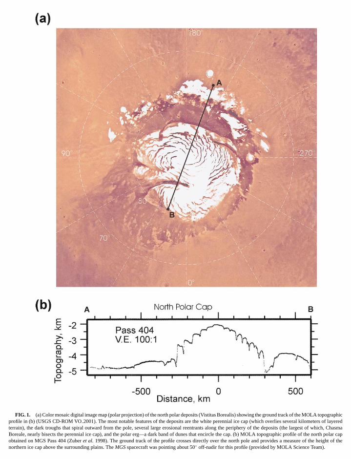
graphif layered
FIG. 1. (a) Color mosaic digital image map (polar projection) of the north polar deposits (Vistitas Borealis) showing the ground track of the MOLA topocprofile in (b) (USGS CD-ROM VO2001). The most notable features of the deposits are the white perennial ice cap (which overlies several kilometers oterrain), the dark troughs that spiral outward from the pole, several large erosional reentrants along the periphery of the deposits (the largest of which, Chasma
Boreale, nearly bisects the perennial ice cap), and the polar erg—a dark band of dunes that encircle the cap. (b) MOLA topographic profile of the north polar capobtained on MGS Pass 404 (Zuberet al. 1998). The ground track of the profile crosses directly over the north pole and provides a measure of the height of thenorthern ice cap above the surrounding plains. TheMGSspacecraft was pointing about 50◦ off-nadir for this profile (provided by MOLA Science Team).
k of thend inounterpart.
ost
ern
FIG. 1—Continued (c) Color mosaic digital image map (polar projection) of the south polar deposits (Planum Australe) showing the ground tracVikingstereo-image derived topographic profile in (d) (USGS CD-ROM VO2006). While the south perennial ice cap is significantly smaller than the one fouthe north (∼400 km vs 1100 km diameter), the underlying (and mostly defrosted) layered terrain occupies an area nearly twice as large as its northern cAlthough not clearly visible in this mosaic, the south polar deposits share several geomorphic similarities with those in the north—the most notableexceptionbeing the dominance of equatorward-facing scarps over troughs within the deposits’ interior. (d)Vikingstereo image-derived topographic profile that crosses almdirectly over the south pole (Schenk and Moore 2000). A rheologic study of the south polar cap, based on this profile, indicates that the∼3-km height of theperennial ice above the surrounding plain is inconsistent with a predominantly CO2 composition, implying that the dominant volatile component of the southcap is water ice (Nyeet al.2000). Subsequent higher resolution profiles obtained by MOLA (Smithet al.1999) have revealed a similar strucutre.

D
einrdta
ael
us
m
st
ebT
r8reeatie
ma
do
cr
pec
c
o
m
boutnewolethe
ding00).orth. Inin isxial
ons93;itiond byand0).s thatandlar
sid-ray).nitsctly
d bysim-uchporalt-dayartssent, theyeron-
s areyers
tly
-i-its
-
o behi-re-er-
214 CLIFFOR
from the atmosphere. As a result, as much as one-quartthe atmosphere condenses out at the winter pole, producseasonal deposit∼1 m thick that covers the latitudes polewaof ∼50◦. By late spring, the increase in insolation causesseasonal cap to sublime away, revealing a considerably smresidual cap that survives the hemispheric summer (Jameset al.2000).
While thermal and spectroscopic observations madeMariner 7 confirmed that the composition of the seasonal cwas CO2 (Neugebaueret al.1971), the composition of the smallperennial caps (Fig. 1) remained uncertain until the arrivatheVikingmission in 1976. TheViking OrbiterInfrared ThermalMapper (IRTM) measured summertime brightness temperatas high as 205 K over the north perennial cap, well in excesthe 148 K sublimation temperature of CO2 (Kieffer et al.1976).Concurrent atmospheric water vapor measurements confirthat the polar atmosphere was saturated with respect to aface reservoir of H2O (Farmeret al.1976). These observationdemonstrated conclusively that the composition of the volacomponent of the perennial cap was water ice.
However, the high polar temperatures recorded byVikingcould not be explained by the presence of ice alone. IndIRTM measurements indicated a polar albedo of 0.45—welllow the value of 0.7 that characterizes clean terrestrial snow.low albedo has been attributed to the deposition and entrainmof atmospheric dust, based on both the “reddish” spectral chateristics of the polar ice (Kieffer 1979, Thomas and Weitz 19and high-resolution images of the scarps visible within the penial cap. These images have revealed the presence of numhorizontal layers whose stratigraphic variations in thicknessalbedo are thought to reflect climatic variations in the quanand relative abundance of dust and water ice deposited on th(Murray et al. 1972, Cutts 1973, Howardet al. 1982, Thomaset al.1992), However, the density, and therefore the bulk coposition of the polar deposits, has proven difficult to constr(Malin 1986, Zuberet al.1998).
With the identification of H2O in the north, it was expectethat the composition of the south perennial cap would also prto be water ice. Yet, throughout the following southern summViking IRTM observations failed to reveal south polar surfatemperatures in excess of 148 K (Kieffer 1979). Atmosphewater vapor levels were also substantially lower than thoseviously recorded in the north (Jakosky and Farmer 1982). Thobservations indicate that the south perennial cap remainedered with CO2 throughout the martian year. Whatever the reson for the year-round survival of CO2, the low temperaturesrecorded over the southern cap mean that it should act as atrap for atmospheric H2O and therefore be at least partially composed of water ice (Jakosky and Farmer 1982).
The polar terrains are among the youngest surfaces to be fon Mars. In the north, their extreme youth is supported byVikinghigh-resolution images that fail to reveal any craters with dia
eters>300 m within the∼106 km2 covered by the deposits(Cuttset al.1976, Herkenhoffet al.1997). This observation ar-ET AL.
r ofg a
heller
bypsrof
resof
edsur-
ile
ed,e-hisentac-9)n-rousndtycap
-in
veer,eicre-seov-
a-
old-
und
-
gues for an age of the exposed surface that is less than a105 years—a result that may reflect either the deposition ofmaterial or the continuous reworking of older material at the p(Toonet al.1980, Herkenhoff and Plaut 2000). In the south,identification of∼15 craters with diameters>800 m (Plautet al.1988) indicates a surface age of 7–15 million years, depenon the recent martian cratering flux (Herkenhoff and Plaut 20These results imply a difference in surface age between the nand south polar layered terrains of 2 orders of magnitudeparticular, the surface age of the south polar layered terragreater (on average) than the timescales of martian orbit/avariations that are thought to produce global climate variati(∼105–106 years; Ward 1979, 1992; Lasker and Robutel 19Touma and Wisdom 1993). The recent resurfacing (deposor erosion) rates for the polar layered deposits that are impliethe observed crater densities are 60–120 m/Ma in the southat least 1165 m/Ma in the north (Herkenhoff and Plaut 200These results are at odds with the concept that the processeform the layers are hemispherically symmetric to first order,suggest that the∼6-km elevation difference between the poregions has had a major difference on polar deposition.
The two geologic units common to both poles are: (i) the reual polar ice cap and (ii) the polar layered deposits (Muret al. 1972, Soderblomet al. 1973, Tanaka and Scott 1987The polar ice caps are simply the high-albedo surficial ice uthat survive the summer at both poles and appear to lie direupon the layered deposits. The two units are distinguishetheir temperatures and albedos, but the residual caps mayply be the most recent layer in the process of forming. Inasmas the layers almost certainly represent geographic and temvariations in the mass balance of ice and dust, the presenresidual caps are most likely comparable to only specific pof the layered deposits. Given the uncertainty in how the premass balance varies over the caps (Kieffer and Zent 1992)residual ice caps could correlate with particular “halves” of lapairs, conformable transitions between layers, or with uncformities between sets of layers. The polar layered depositcharacterized by numerous, laterally extensive, horizontal lathat have apparent individual thicknesses ranging from∼300 mdown to the resolution limits of the available imagery (curren∼1.5 m/pixel, e.g., Fig. 2) (Blasiuset al.1982, Herkenhoff andMurray 1990, Thomaset al. 1992, M. C. Malin, remarks presented at theFirst International Conference on Mars Polar Scence and Exploration, 1998). In the north, the layered deposoverlie the moderately cratered (∼2–3 Ga) plains, while in thesouth, they blanket the ancient (∼4 Ga) heavily cratered highlands.
As discussed previously, the layered deposits appear tcomposed of a mixture of water ice and dust in stratigrapcally variable proportions. However, variations in surfacelief appear to contribute to the observed layering as well. Tracing is visible in bothMariner 9 andViking Orbiter images
(Murrayet al.1972, Blasiuset al.1982, Herkenhoff and Murray1990), as well as in topographic profiles of layered exposures
the lar
THE STATE AND FUTURE OF MARS POLAR SCIENCE AND EXPLORATION 215
FIG. 2. Layered stratigraphy of the north polar deposits. (a) Photomosaic inset of north polar cap at upper right corner shows the relative location ofger
Viking Orbiter image (560B60) of the polar deposit’s equatorward-facing outer (terminal) scarp. TheViking image provides the geologic context and indicatesthe location of (b), a Mars Orbiter Camera image (SPO-2-461/03) which shows that the fine-scale layering in the polar scarp extends down to limit of resolutionee
d
rrs
s
idhteo
skelu
thatrom
thewirldi-ng,ace1
ofous
nts.
r to
sur-arpsthe
on
(NASA/JPL/MSSS).
obtained by the Mars Orbiter Laser Altimeter (MOLA(Zuberet al. 1998). In addition, recent high-resolution imagobtained by the Mars Orbiter Camera (MOC) reveal that, whthe layers are exposed along scarps, they often form ri(M. C. Malin, remarks presented at theFirst International Con-ference on Mars Polar Science and Exploration, 1998). Similarlayering is also observed in ice sheets on Earth, where it onates from stratigraphic variations in ice crystal size (Pate1981).
In the north, the residual polar ice cap and layered depositcoextensive and occupy much of the region poleward of 80◦N.Together, they compose the remnant ice cap, which has a deter of roughly 1100 km. Surrounding the cap is a dark bandunes called the polar erg. The dunes are typically 10–50 mand spaced 1–2 km apart. The thermal inertia of the dune maappears to be too low for sand, suggesting that it may be cposed of smaller particles that have been aggregated by elestatic forces, or some other cementing agent, into larger asblages capable of transport by the circumpolar winds (Herhoff and Vasavada 1999). Because the thermophysical propof the polar dunes are so different from those of dunes atlatitudes, they appear to have been formed by a process uniq
the pole. This conclusion is supported by the geologic relatioships observed between the dunes and erosional scarps f)sre
ges
igi-on
are
am-ofighrialm-
ctro-em-en-rtiesowe to
within the polar layered deposits, evidence which indicatesat least some of the material in the polar erg was derived fthese deposits (Thomas 1982, Thomas and Weitz 1989).
As seen in Fig. 1a, the most distinctive characteristic ofnorthern cap is the dark pattern of curvilinear troughs that soutward in a counterclockwise direction from the pole. Invidual troughs are typically several hundred kilometers lo5–15 km wide, and reach depths of 0.1–1 km; while the surfslopes, exhibited by their bordering scarps, may range from◦–15◦ (Blasiuset al. 1982, Zuberet al. 1998). Within a singletrough, individual layers can often be traced for hundredskilometers—a finding that suggests the layers are continuover a large expanse of the cap.
Also visible in Fig. 1a are several major erosional reentraThe largest of these, Chasma Boreale (85◦N, 0◦W), nearly bi-sects the cap—extending from deep within the cap’s interioits outer edge over a distance of∼500 km. Along its floor, whichlies as much as 1–2 km below the surface elevation of therounding cap, dunes propagate from the Chasma’s interior scuntil they merge with the circumpolar debris that composespolar erg.
Early estimates of the height of the deposits, based
n-oundMariner 9radio occultation data, suggested they reached a max-imum of∼4–6 km above the surrounding plains (Dzurisin and
D
saou
sr
.i
nhaae
nbaeto
os
ieees
s
ts
f
el
m
tlswbnsff
the
renthighread
sur-wn
ationne-
ofolv-
ofThisof
d bysion,ole-ughs
t thecm) ind in
ghlyflecttheitionow,uldereh aseemsbe
cedighiallyern
po-tione de-olianl ofed iners to
216 CLIFFOR
Blasius 1975). However, more recent and accurate meaments made by the MGS MOLA have revealed that the mmum height of the north polar cap is only 3 km, and that it psesses a complicated, multidomed surface topography (Zet al. 1998). Topographic profiles across the northern cap gerally show a sharp 1-km increase in elevation between therounding terrain and edge of the layered deposits. Large aon top of the permanent northern ice cap are extremely smowith regional slopes over many tens of kilometers of order 0◦
and with some areas being so smooth that the submeter precof the instrument on scales of kilometers shows no roughor slope. The MOLA data also show that the bright outliers tsurround the pole are elevated areas, whose local relief vfrom tens of meters to well over 1 km. The large areal extentsignificant elevation of these deposits argue against them btransient features and support the idea that they are remof a previous, more spatially extensive northern ice cap (Zuet al.1998, Fishbaugh and Head 1999a). This conclusion issupported by the preservation of interior deposits within sevcircumpolar craters, including one that exhibits layering onsame 10-m scale observed in the current polar layered dep(Garvinet al.2000).
The northern deposits rest on a very flat plain whose smoness and low relief has been variously attributed to extenresurfacing by volcanism (Tanaka and Scott 1987, Smithet al.1999), an ancient sea bed (Parkeret al.1989, 1993; Scottet al.1991, 1995), or the thinly mantled frozen remnant of an ancocean (Clifford and Parker 1999). Based on the conservativsumption that the polar deposits have no root beneath the levthe surrounding terrain, the volume of the north polar depois estimated to be 1.2 (±0.2)× 106 km3 (Zuber et al. 1998);however, more realistically, isostatic compensation could rein a root of up to 1 km in depth (Johnsonet al. 2000; see alsoSection 2.4), increasing the estimated volume of the deposias much as a third.
In the south, the small residual ice cap (∼400 km diameter) iscentered at 87◦S, 45◦W, a∼200-km offset from the location othe true pole, a relationship whose origin is not currently undstood. The residual cap is superimposed on an extensive reof defrosted layered deposits (∼1500 km in diameter) whosareal coverage is almost twice that occupied by the equivaunit in the north. As in the north, the southern deposits appto be composed of a mixture of ice and dust.Mariner 9 radiooccultation data suggested that these deposits reached amum thickness of 1–2 km (Dzurisin and Blasius 1975).Vikingstereo measurements (Schenk and Moore 2000) and recenquired MOLA data (Smithet al.1999) confirm that the thicknesof the defrosted layered deposits does indeed average bet1 and 2 km (Fig. 1d). However, within the area occupiedthe residual ice cap, the deposits reach a maximum thickof ∼3 km above the surrounding terrain. While the thicknesof the north and south polar deposits appear similar, the di
ences in their age, areal extent, and mass distribution about trespective poles is substantial, and may well be related toET AL.
ure-xi-s-ber
en-ur-easoth,2sionessatriesnding
antserlsoralhesits
th-ive
ntas-l ofits
ult
by
er-gion
entear
axi-
y ac-
eenyesseser-
∼6-km higher elevation of the south polar highlands overnorthern plains (Smithet al.1999).
The north and south polar deposits also differ in their appathermal inertia and surface roughness. The comparativelyinertia of the northern deposits is consistent with the widespexposure of water ice at the surface (Paigeet al. 1994); whilethe lower inertia of the southern deposits is indicative of aface covered by a mantle of fine-grained material of unknothickness (Paige and Keegan 1994, Vasavadaet al.2000). Onepossible explanation for this difference is that, over the∼100×greater exposure age of the southern deposits, the sublimof ice from the surface has resulted in the formation of a figrained lag deposit. In contrast, the higher thermal inertiathe northern deposits indicates a younger, more rapidly eving surface—where deposition, erosion, or a combinationboth has maintained a fresh exposure of ice-rich material.last possibility is consistent with models of the evolutionthe polar troughs, where the higher insolation experiencethe equatorward-facing scarps has led to preferential erowhile deposition is believed to have been dominant on the pward faces and the elevated flats between neighboring tro(Howardet al.1982; Howard 2000; Fisher 1993, 2000).
Interestingly, Earth-based radar observations show thamartian south polar residual ice cap is highly reflective at 3.5wavelength, with many scattering centers (cracks or voidsthe upper 10 m. These scattering centers are likely distributea very low loss medium (Butler 1994, Muhlemanet al. 1995),perhaps indicative of nearly pure water or CO2 ice. Similar radardata show that the north polar layered deposits are not hireflective and probably not cracked. These findings may redifferences in the near-surface vertical density profiles ofnorth and south caps. If the caps have grown by the deposof material with the physical characteristics of terrestrial snthen its densification in response to Mars’ low gravity shobe slow, creating the equivalent of a terrestrial firn layer (whthe density of the deposits is less than that of ice) as mucseveral hundred meters deep. However, this expectation sat odds with the radar data in the south. This conflict mayresolved by recent work that suggests that thermally induvapor diffusion, combined with low accumulation rates and hsummer temperatures, may rapidly metamorphose an initsnow-like deposit into solid ice at the surface of the cap (Arthet al.2000).
While the low thermal inertia and greater age of the southlar deposits imply a reasonably stable surface, high-resoluimages have revealed that, in some areas, the surface of thposits is grooved—suggesting they have undergone recent eerosion (Cutts 1973). However, at other locations, the buriasecondary craters indicates that deposition has also occurrthe recent past (Howardet al.1982, Herkenhoff 2000). Thus, thgeologic history of the layered deposits at both poles appeahave been complex.
heirtheSimilar to its northern counterpart, one of the most notablefeatures of the southern cap is a pattern of comparatively dark
P
ahae
ou
lstet
slentoc
thCtml a
rotd
srtwb
rerme
efuer
onns-th
iso
eara
latio
otherat-olartestlue-
uc-um.
m-to
n an-
in-sed
ria-ionlly
ioniesh theic,d
eralityolarundte ofcantpal
thetheayuch
aturesoserntsent
dded
its,rialt low
ericele-
THE STATE AND FUTURE OF MARS
equatorward-facing scarps that spiral clockwise and outwfrom the pole. But whereas, in the north, virtually all of tdefrosted scarps are actually the sunward-facing walls of nesymmetric troughs (Zuberet al.1998), in the south, most are truscarps—unopposed by a corresponding poleward-facing trwall (Dzurisin and Blasius 1975, Smithet al. 1999, Schenkand Moore 2000). There are also several major erosionaentrants within the defrosted layered deposits. The largethese, Chasma Australe (88◦S, 270◦W), has roughly the samgeneral scale and shape as Chasma Boreale in the north, bua more radial, or longitudinal, orientation.
2.2. Seasonal and Climatic Evolution
While many details are uncertain, a general consensus haveloped regarding the constructional processes responsibthe origin of the polar layered deposits. An essential elemethis model is the belief that atmospheric dust, raised by land global dust storms, acts as nucleation centers for H2O icecondensation. As either hemisphere enters the fall season,suspended particles receive an additional coating of frozen2that makes them heavy enough to precipitate from the asphere, thus contributing to the growth of both the seasonapermanent caps (Cutts 1973, Pollacket al.1979).
Observational support for this depositional model came fViking Lander 2(48◦N, 225.6◦W) which returned images tharevealed the sudden appearance of a reddish-tinted “snow”ing the northern fall (Joneset al. 1979, Wall 1981, Guinneset al.1982). This thin snow cover persisted throughout the noern winter and became patchy by early spring. However, itnot until many weeks after surface temperatures had risen athe CO2 frost point that all the condensate finally disappealeaving behind a thin veneer of dust. This observation confithe existence of an H2O ice component within the seasonal dposit.
The ultimate fate of the dust and H2O that precipitates from thatmosphere during the formation of the seasonal cap is ation of the latitude at which final deposition occurs. At the vhighest and coldest latitudes, where H2O ice is in equilibriumwith the water vapor in the atmosphere, the ice-rich depositilayer persists throughout the year, thus adding to the perecap. However, at those latitudes where diurnal temperatureabove the frost point, any surface H2O sublimes away. What remains is a thin (micrometers thick) seasonal mantle of dustextends from the periphery of the polar caps down to∼40◦ lati-tude. In some regions there is evidence that local winds epically remove and redistribute this eolian deposit (Arvidset al.1983), while in other regions it may accumulate from yto year, forming a blanket of debris that covers the local ter(Soderblomet al.1973).
If this precipitation model is correct, then the large-scaleering exposed in the polar troughs suggests that the deposi
and erosional balance at the poles has been modulated by podic variations in insolation due to changes in the martian obliOLAR SCIENCE AND EXPLORATION 217
rderly
gh
re-of
with
de-forofal
eseOo-nd
m
ur-
h-asoved,s
-
nc-y
alnialrise
at
od-nrin
y-nal
uity and orbital elements (Murrayet al.1972, Toonet al.1980,Cuttset al.1981; Cutts and Lewis 1982). The presence of blarge- and fine-scale layering suggests that mechanisms oping on many different timescales are required to explain the pstratigraphy. Of these, the martian obliquity exerts the greainfluence. The obliquity oscillates about its current mean vawith a period of 1.2× 10⁵ years. The amplitude of this oscillation also varies and is modulated with a period of 1.3× 10⁶ years(Ward 1992). At low obliquity, both seasonal temperature fltuations and mean annual polar temperatures are at a minimThis situation is reversed at times of high obliquity, when sumers of continuous illumination alternate with dark winters,produce both extreme seasonal variations and higher meanual temperatures at the poles.
Other astronomical variables affecting polar insolationclude the 5.1× 10⁴ year precessional cycle and two superpoperiods of change in orbital eccentricity, a 9.5× 10⁴ year cyclewith a peak-to-peak amplitude of 0.04, and a 2× 10⁶ year cyclewith an amplitude of 0.1 (Murrayet al.1973, Ward 1979, Toonet al. 1980). However, while the precessional cycle and vations in orbital eccentricity affect the peak value and duratof summer polar insolation, only changes in obliquity actuaalter the mean annual insolation at a given latitude.
Despite this knowledge, our ability to calculate the insolathistory of Mars is limited by two effects. First, recent studhave demonstrated that, due to a gravitational resonance witorbit of Venus, the evolution of the martian obliquity is chaotvarying from∼0◦ to 60◦ (Touma and Wisdom 1993, Laskar anRobutel 1993). This behavior places an upper limit of sevmillion years on how far back (or forward) the present obliqucan be reliably extrapolated. Second, the total mass of the pcaps, and any asymmetry in the distribution of that mass arothe pole (e.g., as evident in the south), can influence the raprecession and induce polar wander. Thus, there is a signifipotential for climate feedback on polar insolation—the princidriver of climate change (Bills 1999).
Astronomically driven temperature variations can affectevolution of the polar terrains in several ways. For example,cold polar temperatures that characterize low obliquities mresult in the equatorward advance of the polar terrains by as mas several degrees. By the same token, the warmer temperassociated with high obliquities should shift these borders clto the poles (Toonet al. 1980). This suggests that the currepolar boundaries are only a surface manifestation of the preinsolation balance; therefore, at depth, they may be interbeover considerable distances (Squyres 1979).
In addition to modulating the areal extent of the polar deposclimatic variations can also influence the quantity of matethat is deposited and retained by the caps. For example, aobliquity, when the poles are at their coldest, large CO2 ice capsshould persist throughout the year. In that event, atmosphpressure may fall to the point where dust can no longer be
eri-q-vated from the planet’s surface (Toonet al. 1980, Fanaleet al.1982). This cessation of dust storm activity could drastically
D
ee
or
dtt
m
—eah
oo
ao
v
oK
rehr
d
sn
tor8me
au
edsust
e toare
ofcur-hich, theortu-pletegly,toan in
emi-tionbalthis
andonaln the
diese
s hasons,baligherngly
sivi-lsthe
sualb-
ons,COplex
dur-
thinrhiled toopec-
thisof
218 CLIFFOR
reduce or eliminate H2O deposition at the poles. So too, at timof high obliquity, sublimation due to high polar surface tempatures may substantially reduce or eliminate the H2O compo-nent of the annual depositional layer (Toonet al. 1980, Fanaleet al.1982). Therefore, significant polar accumulation maycur only under climatic conditions similar to those we obseat present.
There is, however, a notable exception to this scenario ifparticles are not the principle agents for bringing water topoles. At low obliquity, the resulting colder temperatures atpoles will result in the formation of perennial CO2 ice caps.However, since it is unlikely that both poles will have the saannual energy budget, the CO2 will eventually migrate to themost efficient cold trap. Thus, over time, one pole will win outforming a single permanent CO2 ice cap that will also act as thdominant cold trap for atmospheric water vapor. In this weven at times of low obliquity, water vapor arising from tdiffusive instability of ground ice at low latitudes, or releasedthe atmosphere by volcanism, impacts, and catastrophic flmight accumulate at the poles in significant quantities (Tet al.1980).
Which pole retains a permanent CO2 cap depends on its hebalance. To first order the key difference between the two pis topography—through its effect on the CO2 frost point temper-ature and the winter heat balance (since the total insolation aable in the summer seasons to sublimate CO2 is the same at bothpoles, for a given obliquity; Toonet al. 1980). The north poleis∼6.5 km lower than the south pole (Smithet al.1999). Thiselevation difference yields a 5.8-K difference in the surface cdensation temperature of CO2 (149 K in the north versus 143.2in the south). It also results in a 14.8% higher CO2 condensationrate in the north versus the south, assuming a transparent asphere (Forget and Pollack 1996). Thus, on this basis, the npole is the favored pole for a permanent CO2 ice cap since itradiates at a higher surface temperature and should therefocumulate more CO2 ice during winter than the south cap. In tpresent epoch, this effect is partially offset by the 20% shoduration of the northern winter—a relationship that changes wtime due to the planet’s 5.1× 10⁴ year precessional cycle anhigh (0.0934) orbital eccentricity (Ward 1979, Toonet al.1980).However, this fact alone does not explain the present-dayation where the south pole is the one that retains a permacovering of CO2 ice.
The survival of the southern CO2 cover has been attributeda spring albedo approximately 33% higher than observed duthe equivalent season in the north (Paige and Ingersoll 19Paige and Kieffer (1986) suggest that this hemispheric asymtry is the result of the greater insolation received during southspring, which occurs near perihelion. They argue that the rheating of dust grains entrained in the seasonal deposit cathem to sink into the frost, increasing the albedo sufficientlypreserve CO2 throughout the southern summer. Kiefferet al.
(2000) have proposed an alternative mechanism wherebyrapid sublimation of the seasonal CO2 cap in the early springET AL.
sr-
c-ve
usthehe
e
y,etoodson
tles
ail-
n-
tmo-orth
ac-eterith
itu-ent
ing5).e-rn
pidses
to
produces a wind whose upward velocity component excethe Stokes–Cunningham settling velocity of atmospheric dgrains. In this way, as the sublimation rate increases duthe higher spring insolation, progressively larger dust grainslofted and transported off the seasonal cap.
Another potential contributing factor to the higher albedothe south polar ice cap is that the atmospheric dust load isrently the greatest when the north seasonal cap is forming, woccurs near the perihelion peak in dust storm activity. Thusnorth cap is expected to be darker than the south cap. Unfnately, observations of the seasonal cap albedos are not comenough to determine if this is actually the case. Interestinmodels of the seasonal variation in CO2 surface pressure seemrequire seasonal cap albedos that are brighter in the north ththe south, or at the very least no different between the two hspheres. A key question of considerable importance in relato the formation of the polar layered terrains is whether glodust storms occur in northern summer during epochs whenis within the perihelion season—resulting in the transportincorporation of large amounts of dust into the southern seasand residual caps. Or is there instead an asymmetry betweetwo hemispheres in this regard? Circulation modeling stu(Haberleet al.1993, Barneset al.1993, 1996) suggest that thlarge difference in topography between the two hemispherea very large effect on the circulations in the different seasand it is possible that this might limit the occurrence of glodust storms during northern summer—except, perhaps, at hobliquities, when a denser atmosphere would tend to stroenhance dust storm activity (Kieffer and Zent 1992).
A similar statement can be made regarding the cap emisties. In order to match theViking Landerpressure data, modeneed to suppress the emissivity of the north cap relative tosouth cap. A reduced emissivity could be due to the unuproperties of pure CO2 ice crystals on the surface, or to the oserved presence of CO2 ice clouds in the atmosphere (Bellet al.1996, Hansen 1999, Kiefferet al.2000).
Laboratory studies, as well as TES and MOC observatisuggest that the thermophysical and radiative properties of2
are contributing to a seasonal polar cap behavior more comthan previously imagined (Hansen 1999, Kiefferet al. 2000,Jameset al.2000). As the seasonal south polar cap recededing the first southern spring observed by theMars Global Sur-veyor, a prominent and variegated dark region developed withe cap (∼75◦–85◦S, 150◦–310◦W) that had an albedo similato that of bare martian soil but a surface temperature that, wseveral degrees warmer than the surrounding cap, remainecold to be ice-free. TES observations revealed a weak stral emission depression near the 25-µm “transparency” bandof CO2 indicating an average scattering length in solid CO2 ofcentimeters or more.
These unusual characteristics led the TES team to dubarea the “Cryptic” region and prompted a reexamination
thethe Viking IRTM data for any evidence of a previous occur-rence. This analysis demonstrated that the Cryptic region is a
P
tt
tet
srdt
audet
. Ohaauianf-n
va
in
aetht
s
n
dtua
tydhrs
hereordtheofeast
ustthed. Inelt-
ming
rousthe
ltingdi-the
thec).de-
-3).
ermositsan-,
turetheress-al
le, aofets),socht is., up
in99)le insmringels
h the
ssed8ph-sivetrial92).
THE STATE AND FUTURE OF MARS
repeatable phenomenon, occurring at roughly the same timelocation every year. Further investigations have shown thanorth seasonal cap displays similar Cryptic-like characterisin some regions in the spring.
TES and laboratory data suggest that the low albedo andperatures associated with the Cryptic region may result fromdevelopment of solid CO2 ice (vs the snow or frost generally asociated with seasonal cap). However, it is unclear whethelow albedo of the Cryptic material results from dust dispersevery coarse-grained CO2 or whether the CO2 is so transparenthat it reveals the dark soil that lies underneath.
Observations of the north polar winter cap have also revesporadic “cold spots” similar to those observed in the soby the Viking IRTM (Kieffer 1979, Hansen 1999, Weiss anIngersoll 2000). Occasional “super-cold” spots have been swith 25-µm brightness temperatures as low as 115 K (specemissivities∼0.1); yet, brightness temperatures at 18µm ap-pear consistent with expected kinetic surface temperaturespossible explanation for these observations is that atmospCO2 becomes locally depleted near the surface, dramaticlowering its condensation temperature (Kieffer 1979, WeissIngersoll 2000). Alternatively, TES spectral observations sgest that these cold spots are largely caused by the radproperties of unusually fine-grained CO2, whose deep emissiodepression at 25µm could well explain the less-than-unity efective emissivity required by modeling studies of the seasopolar caps to match the observed annual surface pressuretion (Hansen 1999).
Although the TES observations are providing importantsights, the processes controlling the current CO2 cycle (i.e., thealbedo and emissivity of the caps, the coupling to the dustwater cycles, and the role of atmospheric heat transport) aryet well understood. Clearly, if we are to understand howmartian climate system responds to changes in orbit parameit is imperative that we understand the processes controllingpresent system. In this sense, the key to the past lies in the pre
2.3. Geothermal and Hydrologic Evolution
The martian cryosphere has been defined as that regiothe crust where the temperature remains continuously belowfreezing point of water (Fanale 1976, Rossbacher and Ju1981, Kuzmin 1983). Assuming a solute-free freezing poin273 K, this condition is satisfied at the surface at every latitbelow the diurnal skin depth. At depth, the location of the bof the cryosphere is determined by the latitudinal variationmean annual surface temperature, the thermal conductivithe crust, and the value of the geothermal heat flux. Basereasonable estimates of the globally averaged values of tproperties, the present thickness of frozen ground on Mathought to vary from∼2.5–5.0 km at the equator to∼6.5–13 kmat the poles (Clifford 1993).
Because crustal water will diffuse from regions of higheto lower temperature in response to the geothermally induc
OLAR SCIENCE AND EXPLORATION 219
andtheics
m-he-thein
ledth
enral
neericllyndg-tive
alria-
-
ndnote
ers,theent.
ofthesonofdeseofofoneseis
gradient in vapor pressure, the pore space within the cryospacts as a cold-trap for any water present in the crust (Cliff1993). In light of this behavior, and the 0.5–1 km estimate ofplanet’s inventory of water (Carr 1986), it is likely that muchthe pore volume of the cryosphere is saturated with ice—at lnear the poles (Fig. 3a).
Given the conditions above, the preferential deposition of dand H2O at the polar surface will result in a situation whereequilibrium depth to the melting isotherm has been exceederesponse to this added layer of insulation the position of the ming isotherm will rise within the crust until thermal equilibriuis reestablished. By this process, any ice within the intervenpore space will melt and drain to saturate the lowermost poregions of the crust (Fig. 3b). Should deposition continue,deposits may ultimately reach the required thickness for meto occur at their actual base (Clifford 1987). Under such contions, the deposits may reach a state of equilibrium—wheredeposition of any additional ice at the surface is offset bymelting of an equivalent layer at the base of the cap (Fig. 3
Under present conditions, it is estimated that the polarposits would have to be∼6.5–13 km thick for melting to occur at their actual base (i.e., Fig 3c; see also Clifford 199This suggests that the current position of the melting isothlies at least several kilometers beneath the base of the dep(Fig. 3b)—its exact location being dependent on the meannual surface temperature (∼155 K), local geothermal heat fluxthermal conductivity of the deposits, and melting temperaof the polar ice (which may be depressed below 273 K byeffect of pressure and the presence of freezing-point deping salts). Should glacial sliding occur, the resulting frictionheat could substantially reduce this thickness. For exampsliding velocity of 10 m yr−1, driven by a basal shear stress100 kPa (a value typical of terrestrial glaciers and ice sheproduces sufficient heat (∼30 mW m−2) to halve the thicknesof polar ice required for basal melting during the present ep(Clifford 1987). Given the higher geothermal heat flux thathought to have characterized the planet’s early history (e.gto 5–6 times greater 4 Ga ago; Schubertet al.1992), the condi-tions for basal melting were almost certainly more favorablethe past. Indeed, Clifford (1993) and Clifford and Parker (19have argued that this process may have played a critical rothe climatic cycling of water on Mars—providing a mechaniwhereby groundwater that was discharged to the surface duthe development of the valley networks and outflow channmay have been reintroduced into the subsurface to replenisglobal aquifer from which it was originally withdrawn.
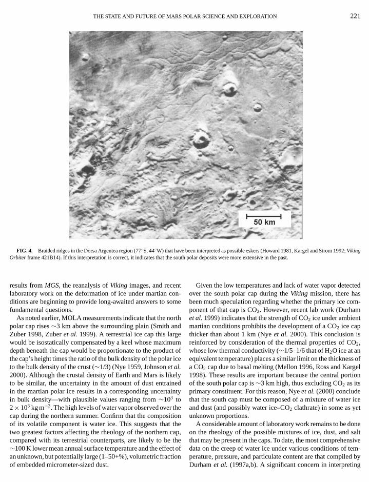
Possible evidence of past basal melting has been discuby several investigators. For example, in Dorsa Argentea (7◦S,40◦W, Fig. 4)—a region that lies just beyond the outer periery of the south polar layered deposits—there is an extennetwork of sinuous and braided ridges that resemble terreseskers (Howard 1981, Kargel and Strom 1992, Metzger 19
redEskers result from the deposition of fluvial sediments in sub-glacial rivers and streams that are associated with glaciers and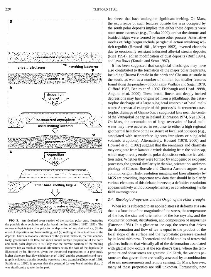
D
inh)
nntiit
ars,d byweres andativee-els
osits4),
havents,le inures979,b,
sed-elt-
atas-ter).elt-
ionale.g.,acialndata
ap,bla-enicmor-for aby
rifytion
hs
rateature
theiesrivestheertedtrialted
tem-us pa-ation
220 CLIFFOR
FIG. 3. An idealized cross section of the martian polar crust illustratthe possible time evolution of polar basal melting (Clifford 1987, 1993). Tsequence depicts (a) a time prior to the deposition of any dust and ice, (bonset of deposition and basal melting, and (c) melting at the actual base odeposits. Given reasonable estimates of the present thickness, thermal cotivity, geothermal heat flow, and mean annual surface temperature of theand south polar deposits, it is likely that the current position of the melisotherm lies as much as several kilometers below the base of the deposillustrated by b). However, given the theoretical expectation of a previouhigher planetary heat flow (Schubertet al.1992) and the geomorphic and topographic evidence that the deposits were once more extensive (Zuberet al.1998,
Smith et al. 1999), it appears that the potential for true basal melting (i.e.,was significantly greater in the past.ET AL.
gethe
f theduc-
orthngs (assly-
ice sheets that have undergone significant melting. On Mthe occurrence of such features outside the area occupiethe south polar deposits implies that either these depositsonce more extensive (e.g., Tanaka 2000), or that the sinuoubraided ridges were formed by some other process. Alternmodes of ridge origin include periglacial action involving icrich regolith (Howard 1981, Metzger 1992), inverted channdue to erosionally resistant indurated alluvial stream dep(Rice 1994), eolian modification of dust deposits (Ruff 199and lava flows (Tanaka and Scott 1987).
It has been suggested that subglacial discharges mayalso contributed to the formation of the major polar reentraincluding Chasma Boreale in the north and Chasma Austrathe south, as well as a number of similar, but smaller featfound along the periphery of both caps (Wallace and Sagan 1Clifford 1987, Benitoet al. 1997, Fishbaugh and Head 1999Anguita et al. 2000). These broad, linear, and deeply incidepressions may have originated from a j¨okulhlaup, the catastrophic discharge of a large subglacial reservoir of basal mwater. A terrestrial example of this process is the recurrent ctrophic drainage of Grimsv¨otn, a subglacial lake near the cenof the Vatnajokul ice cap in Iceland (Bj¨ornsson 1974, Nye 1976On Mars, the accumulation of large reservoirs of basal mwater may have occurred in response to either a high reggeothermal heat flow or the existence of localized hot spots (associated with near-surface igneous intrusions or subglvolcanic eruptions). Alternatively, Howard (1978, 2000) aHowardet al. (1982) suggest that the reentrants and chasmmay originate from katabatic winds draining from the polar cwhich may directly erode the polar deposits or enhance ice ation rates. Whether they were formed by endogenic or exogprocesses, the general similarity in the size, orientation, andphology of Chasma Boreale and Chasma Australe arguescommon origin. High-resolution imaging and laser altimetryMGSare providing important new data that should help clavarious elements of this debate; however, a definitive resoluappears unlikely without complementary or corroboratingin situfield investigations.
2.4. Rheologic Properties and the Origin of the Polar Troug
When ice is subjected to an applied stress it deforms at athat is a function of the magnitude of the stress, the temperof the ice, the size and orientation of the ice crystals, andvolumetric content, distribution, and composition of impurit(Paterson 1981). In a glacier or ice cap, the stress that dthe deformation and flow of ice is equal to the product oflocal slope of its surface and the hydrostatic pressure exby its local thickness. Theoretical and field studies of terresglaciers indicate that virtually all of the deformation associawith glacial flow occurs at the ice sheet’s base, where theperature and shear stress are greatest. On Earth, the variorameters that govern flow are readily assessed by a combin
c)of in situmeasurements and remote sensing. On Mars, however,many of these properties are still unknown. Fortunately, new
THE STATE AND FUTURE OF MARS POLAR SCIENCE AND EXPLORATION 221
FIG. 4. Braided ridges in the Dorsa Argentea region (77◦S, 44◦W) that have been interpreted as possible eskers (Howard 1981, Kargel and Strom 1992;Vikings
too
one
c
eni
thtt
tc
ted
om-
O
s ofgelrtion
r icet
onesaltnsiveem-
Orbiter frame 421B14). If this interpretation is correct, it indicates that the
results fromMGS, the reanalysis ofViking images, and recenlaboratory work on the deformation of ice under martian cditions are beginning to provide long-awaited answers to sfundamental questions.
As noted earlier, MOLA measurements indicate that the npolar cap rises∼3 km above the surrounding plain (Smith aZuber 1998, Zuberet al. 1999). A terrestrial ice cap this largwould be isostatically compensated by a keel whose maximdepth beneath the cap would be proportionate to the produthe cap’s height times the ratio of the bulk density of the polarto the bulk density of the crust (∼1/3) (Nye 1959, Johnsonet al.2000). Although the crustal density of Earth and Mars is likto be similar, the uncertainty in the amount of dust entraiin the martian polar ice results in a corresponding uncertain bulk density—with plausible values ranging from∼103 to2× 103 kg m−3. The high levels of water vapor observed overcap during the northern summer. Confirm that the composiof its volatile component is water ice. This suggests thattwo greatest factors affecting the rheology of the northern ccompared with its terrestrial counterparts, are likely to be∼100 K lower mean annual surface temperature and the effe
an unknown, but potentially large (1–50+%), volumetric fractioof embedded micrometer-sized dust.outh polar deposits were more extensive in the past.
n-me
rthd
umt of
ice
lyednty
eionheap,het of
Given the low temperatures and lack of water vapor detecover the south polar cap during theViking mission, there hasbeen much speculation regarding whether the primary ice cponent of that cap is CO2. However, recent lab work (Durhamet al.1999) indicates that the strength of CO2 ice under ambientmartian conditions prohibits the development of a CO2 ice capthicker than about 1 km (Nyeet al. 2000). This conclusion isreinforced by consideration of the thermal properties of C2,whose low thermal conductivity (∼1/5–1/6 that of H2O ice at anequivalent temperature) places a similar limit on the thicknesa CO2 cap due to basal melting (Mellon 1996, Ross and Kar1998). These results are important because the central poof the south polar cap is∼3 km high, thus excluding CO2 as itsprimary constituent. For this reason, Nyeet al.(2000) concludethat the south cap must be composed of a mixture of wateand dust (and possibly water ice–CO2 clathrate) in some as yeunknown proportions.
A considerable amount of laboratory work remains to be don the rheology of the possible mixtures of ice, dust, andthat may be present in the caps. To date, the most comprehedata on the creep of water ice under various conditions of t
nperature, pressure, and particulate content are that compiled byDurhamet al. (1997a,b). A significant concern in interpreting
D
tyt
oo
f
a
g
eli
ieoft
(
a
a
pv;gim
dlbe
art
t
rate,ingy in-tedgles.y theiceing
g re-therna-
g abla-thethe
h arearpseree.
s, andn of
thesionun-caps
astr cap
dshipsts ae ford thehibitthisre soso,lmostidedturepththisoutable
un-eredflowlart inior.
222 CLIFFOR
the results of such analyses is their validity when extrapolatethe very low strain rates appropriate to Mars. Even in terresglacial studies, where ice deformation rates are substantiallhanced by the∼100 K higher mean annual temperatures,difference between the strain rates that can realistically bevestigated in the lab and those that actually occur in the fieldsignificant problem. This problem is orders of magnitude macute on Mars, where estimated accumulation rates on theof ∼10−4 m yr−1 and surface temperatures as low as∼140–155 K yield horizontal strain rates of as small as∼10−8 yr−1.
Temperature and mass balance are two of the most sigcant factors affecting flow. Given a present mean annual surtemperature of 155 K and a geothermal gradient of 15◦/km, thetemperature at the base of the north polar cap likely falls betw200 and 215 K. This bed temperature, combined with the cobserved range of surface slopes, is sufficient to support flowlocities of as much as a few centimeters per year (Fisher 20Of course, if the long-term temperature environment chanso too will the potential for flow.
Small terrestrial glaciers have a natural mass-balance aving interval of 1–10 years. However, for large ice sheets,Antarctica and Greenland, it can be centuries to millennia. Ding the colder part of this interval the ice caps and glacaccumulate and their flow velocities are at a minimum; cversely, during the hot ablation period their velocities are oat a maximum. The mass-balance interval most relevant tomartian ice caps is the obliquity cycle (∼1.25× 10⁵ yr), whereice accumulates during the cold part of the cycle and ablatespossibly flows) during the warm part. Because the martian obuity varies chaotically (Touma and Wisdom 1993, LaskarRobutel 1993), the potential exists for substantial changes inface temperature. However, these changes are attenuated rwith depth, yielding temperature fluctuations of only∼5–10%at a depth of 3–4 km. Due to the sensitive temperature dedence of the flow law, even such small changes could haconsiderable impact on the rheologic evolution of the capsthough, given the time required for the thermal wave to propathrough the deposits, the basal response of the caps to clchange could lag 30–70 Kyrs behind the conditions experienat the surface (Larsen and Dahl-Jensen 2000).
Most large terrestrial ice caps are generally characterizea broad central region of accumulation and a relatively smalripheral ablation area—having profiles that are well describy a “power 3 flow law” (Paterson 1981). In such instancvariations in the surface relief of the cap can be directly relato both its mass-balance history and basal topography. Hever, thin cold-based ice caps often deviate from this idealhave surface slopes determined by their mass balance palone. On Mars, the polar caps exhibit a complex accumulaand ablation regime that consists of a small inner zone of paccumulation and an outward-spiraling pattern of alternalow-albedo ablation and high-albedo accumulation zones.
Howard (1978, 2000) and Howardet al. (1982) suggest thatthe spiral pattern of troughs in the north and scarps in the so
ET AL.
d torialen-
hein-
is arerder
nifi-ace
eenp’sve-
00).es,
rag-keur-rsn-enthe
andliq-ndsur-pidly
en-e aal-ateate
ced
bype-eds,
tedow-nd
ofileionureing
originate near the edge of the polar deposits and then migby the preferential sublimation of ice from their sunward-facscarps, toward the pole. This loss of ice may be influenced bteractions with off-pole katabatic winds whose flow is deflecby Coriolis forces and crosses the troughs at nearly right anDust liberated by this process may then be scavenged bwinds and redistributed over the planet, while the sublimedmay simply be recycled by cold-trapping on the poleward facslopes and flats that separate the troughs.
Fisher (1993, 2000) has dubbed the spatially overlappinlationship of accumulation and ablation that occurs withinpolar deposits as “accublation” and has proposed an altetive model for the origin of the troughs and scarps involvincombination of accumulation, ablation, and flow. The accution model (Fisher 1993, 2000) proposes that ice flows fromwhite frosted regions, which are accumulating ice, towarddarker equatorward-facing scarps along the troughs, whiclosing mass. This results in the migration of the ablation scon the surface of the moving ice until they reach a location whtheir migration velocity is equal to the flow velocity of the icThe model suggests that the spiral pattern of troughs, scarpreentrant valleys results from the nonsymmetric distributiothe ice flow centers and associated velocity fields aroundpole. Because of its strong model dependence, this concluis extremely tentative—as illustrated by such fundamentalcertainties as the thermal and mass-balance histories of theand the numerical value of the exponent in the flow law.
But the case for significant flow appears to suffer from at leone inconsistency. When the surface slopes of the north polaare averaged over distances that are∼10× the cap’s estimatelocal thickness (a standard scaling and averaging relationused in terrestrial glaciology, e.g., Paterson 1981) it suggeyield stress in the range of 50–200 kPa, a value appropriatwater ice. In contrast, the slopes of the scarps that bounpolar troughs are as much as 10 times greater, yet they exno obvious evidence of closure by flow. One explanation formay be that the surface temperatures within the troughs acold that the near-surface ice is simply too stiff to deform. Ifthen it suggests that the shape of the troughs is maintained asolely by ablation processes. While the elevation data provby MOLA have clearly defined the three-dimensional strucof the troughs, as well as the variation in their relative deas a function of their geographic position within the cap,information alone cannot resolve the question of flow withan accurate knowledge of the long-term and spatially variablation and deposition rates within the cap.
The question of flow also has important ramifications forderstanding the continuity and age of the polar cap’s laystratigraphy. For example, according to the accublationmodel, the material visible in the upper layers of the poscarps was precipitated locally, while the material presenthe lower layers was originally precipitated in the cap’s inter
uthThis model predicts that the combination of local deposition,trough topography, and the radial flow of the cap will result in

P
a
oo
oo
ndb
eigmrchalae
o
eiar
g
4
a8
sossso
ino
ti
des,v-
andn oring
aveum-ice,olar
senan
ima-cialowear
on.. C.
enald byichero-
ap-heryhancal
ief,eathentlycateshoff
allel
m theidgesh istain
thatonsf the
re-ainser-tial
THE STATE AND FUTURE OF MARS
discontinuities between the locally derived younger layersthe interior-derived older layers, an observation that shouldmost notable on the outermost scarps. For this reason, one wexpect the old, lower layers to be more regular and traceablelong distances than the younger, upper layers.
Angular unconformities, indicative of a complex historyerosion and deposition, have been recognized in the north playered deposits (Cuttset al. 1976, 1979; Howardet al. 1982)but not yet in the south, whereViking Orbiter image resolutionis poorer. High-resolution MOC images of both polar regioare allowing such structural relations to be studied in moretail, raising the possibility that angular unconformities maydiscovered in the south polar layered deposits as well.
Waves in the polar strata are another expected consequof the accublation flow model (Fisher 2000). Such waves ornate because the particle paths under accumulation zonesdownward, while in ablation zones they move upward. Thesulting wavelength depends on the ratio of the ablation-induscarp velocity to the ice velocity of the deforming cap—thigher the ratio, the shorter the wavelength. On the other ha completely stagnant ice cap should result in horizontalers with little or no deformation; thus, they should be tracable over long distances no matter what their depth in the pstratigraphy.
2.5. The Geologic Evidence for and against Glacial Flow
Various lines of evidence suggest that ice may have playmore extensive role in the geomorphic evolution of the martsurface in the past, including at the poles (Tanaka 2000, Gaet al. 2000). Products of volcano–ice interactions appear towidespread, especially at mid-latitudes (Allen 1979, Hodand Moore 1979, Rossbacher and Judson 1981, Mouginis-M1985, Squyreset al. 1987, Christiansen 1989, Chapman 199Garvinet al.2000). Other terrains appear to have been formedice-assisted mass wasting, ablation, and other types of periglactivity (Carr and Schaber 1977, Howard 1981, Lucchitta 19Squyres and Carr 1986, Costard and Kargel 1995). Althoughinterpretation of specific features is often debated, there is astantial consensus that periglacial processes (involving regcreep, rock fracturing by freeze-thaw, and related proceshave been important in the geomorphic development of theface. More controversial are proposals that true glacial proce(involving thick, self-deforming ice sheets) were widespreadMars (Lucchitta 1982, Battistini 1987, Tricart 1988, Bakeret al.1991, Kargel and Strom 1992, Kargelet al. 1995). This is es-pecially true of paleoclimatic interpretations of possible glacfeatures, estimates of the volume of ice that may have beevolved, and speculation regarding the ultimate fate of that nmissing H2O.
Many types of martian landforms have been attributedglaciation. If these interpretations are correct, then some of thfeatures imply either a former climate capable of surface mel
(Kargel and Strom 1992) or bed conditions capable of meltin(Howard 1981, Clifford 1987, Kargelet al. 1995). Circumpo-OLAR SCIENCE AND EXPLORATION 223
ndbeuldver
flar
se-e
ncei-ovee-edend,y--
lar
d an
vinbeesark,
bycial1,theub-lithes)ur-sesn
alin-w-
toeseng
lar glacial ice sheets may have once extended to mid-latituaround both poles (Bakeret al. 1991, Kargel and Strom 1992Kargelet al. 1995). In the northern plains, the geomorphic eidence for glaciation may be attributable to the freezingeventual grounding of ice associated with an ancient oceatransient lakes and seas produced by outflow channel-formfloods (Kargelet al.1995, Clifford and Parker 1999).
The geologic evidence that the polar layered deposits hundergone significant glacial flow remains ambiguous. Assing that the layered deposits are more than a few percentsome flow must occur. The broadscale domal shape of the pcap can be explained either by glacial flow (Buddet al. 1986,Clifford 1987, Kargel 1998, Fisher 2000, Greve 2000, Larand Dahl-Jensen 2000) or by ablation (Ivanov and Muhlem2000). Layers exposed in troughs appear, to a first approxtion, to be nearly horizontal and undeformed. However, gladeformation occurs primarily at the base of glaciers and by flthat is primarily parallel to the bed; therefore, appreciable shof horizontal layers can occur without obvious layer distortiMOC images suggest local waviness in some exposures (MMalin, remarks presented at theFirst International Conferenceon Mars Polar Science and Exploration, 1998). These could bdue to flow deformation, a wavy topography on the erosioscarp exposing the layers (e.g., yardang-like forms erodekatabatic winds), or waviness in the original surface on whthe layers were deposited (e.g., caused by the nonuniformsion of the surface at high obliquity).
The presence of the polar troughs, and particularly theirparent penetration to the underlying basement near the peripof the cap, indicates that glacial flow is of lesser importance tablation in creating the details of polar cap topography. Loflow might still occur as a result of the trough topographic reland near the center of the cap, flow may occur in the ice benthe troughs (Fisher 2000). However, the presence of apparundeformed craters on the south polar layered deposits indithat any recent glacial flow there has been minimal (Herken2000).
In the longitude range of 300◦–360◦W, at the edge of thenorth polar layered deposits, faint ridges are found that parthe base of the deposits’ terminal scarp (Fig. 5, Howardet al.1982). These ridges are present at distances up to 20 km fropresent scarp base. The simplest explanation for these low ris that they mark former positions of the terminal scarp, whicnow inferred to be undergoing ablational retreat. It is uncerwhether these ridges are terminal or recessional morainesrequired glacial flow for emplacement, or are just accumulatiof eolian debris that have formed episodically at the base oretreating scarp.
Unfortunately, in the absence of field evidence, the interptation of many purported glacial features is likely to remambiguous. One possible way to detect flow by remote obvation would be via penetrating radar images of any poten
gdeformation of the internal layers of the polar ice. Such an inves-tigation is currently planned as part of theMars Expressmission
e
224 CLIFFORD ET AL.
FIG. 5. Ridges that parallel the base of the equatorward-facing north polar terminal scarp (Viking Orbiter image 566B61). The ridges may simply be th
erosional remnant of the former position of the scarp, debris that has accumulated at the scarp’s base, or morraines formed by the flow or slip of the polar depositsr tion
o
t
n
b
ua
ice
LHe-on
rate-. Inwithn of
bi-tileon-Thete ofce ofd for
ined
at their base (Howardet al.1982). The features in this image are located∼10◦ fuof theViking Orbiterframe highlighted in the inset to Fig. 2a.
in 2003. Other potential investigations are discussed by Cliffet al. (2000).
2.6. The Prospects for Life
Since 19th-century astronomers first reported telescopicservations of “canali” and albedo variations suggestive ofseasonal growth of vegetation, the search for life has been amary driver of Mars research. Although the first reconnaissaof Mars by spacecraft during the 1960’s failed to reveal any edence of alien artifacts or desert oases, interest in the possiof life was rekindled in 1971 withMariner9’s surprising discov-ery of the valley networks and outflow channels. These featprovide clear evidence of the considerable role that liquid whas played in the evolution of the martian surface.
Indeed, by the time theViking Landersset down in 1976, in-terest in the possibility of indigenous life had grown to the powhere much of theLanders’ payload was dedicated to the searfor organic material and evidence of metabolism. Although th
experiments returned some unexpected results, no unambiguevidence of life was found (Kleinet al. 1992). The recent de-ther clockwise along the periphery of the north polar deposits from the loca
rd
ob-hepri-ce
vi-ility
rester
nthse
bate over potential evidence of life in the SNC meteorite A84001 (McKayet al. 1996, Treiman 1999), combined with rcent discoveries about the adaptability and diversity of lifeEarth (Stevens and McKinley 1996, Onstottet al.1998, Cowan1999), has stimulated efforts to identify both better search stgies and more definitive indicators of past and present lifethis section we summarize several aspects of this work,particular emphasis on the potential survival and preservatiolife at the martian poles.
2.6.1. Environmental requirements and potential polar hatats. Although present surface conditions on Mars are hosto life as we know it, there is substantial evidence that envirmental conditions were considerably different in the past.presence of the valley networks and the highly degraded stathe planet’s most ancient terrains have been cited as evidenan early warmer and wetter climate that may have persisteas long as a billion years (Masurskyet al. 1977, Pollacket al.1987, Carr 1999). In addition, theoretical arguments, comb
ouswith the identification of a variety of geomorphic evidence, haveled some to suggest that during this same period much of the
P
rth
iv
e
llmd
t
l
e
9m
ui
yo
ec
te
iovnu
h,
obliq-
ded, thecialy assub-
ei-anyintoed as.
s atf dis-stal
er-k ofthedlyon-the
turec-ain
ac-nt
x re-icetemlow
atsur-
rost95;a-um-undha-
asrentedUVBsid--
d aho-
THE STATE AND FUTURE OF MARS
planet’s surface may have been covered by large standing boof water and ice (Clifford and Parker 1999). Whether the eaclimate was warm or cold, the presence of abundant watethe surface has profound implications for the developmenlife. Indeed, given the intense impact and volcanic activity tcharacterized the planet at this time, the development of lolived hydrothermal systems was likely widespread—duplicatmany of the important conditions that are thought to have girise to life on Earth (Farmer 1996).
If life did establish itself at this time, then its long-term suvival was contingent on its ability to adapt to the subsequchanges in the planet’s physical environment, particularly arelates to the availability of liquid water (McKayet al. 1992).On Earth, access to liquid water is an essential condition forIts presence is required for the hydration of vital biomolecusuch as DNA and proteins, for the function of lipoprotein mebranes, and to support the dynamic ionic exchange requiremetabolism (Horowitz 1979). However, on Mars, present contions of temperature and pressure preclude the stable exisof liquid water at the surface (although the transient meltingice may occur within the top centimeter of the equatorial regofor several hours on the warmest days). Extremely low watertivities at the surface of Mars present a formidable obstacllife (Horowitz 1979, Klein 1992). In addition, because the thCO2 atmosphere lacks oxygen, there is no ozone layer to prothe surface from ultraviolet radiation (Kuhn and Atreya 197Thus, the martian surface experiences a UV flux several tithat normally regarded as lethal for terrestrial organisms.
For the above reasons, the search for extant life on Marsfocused on the identification of potential habitats where liqwater is continuously or episodically persistent, that provprotection from the Sun’s UV, and where some energy sourcavailable to support metabolism. Given the recent discoverlife in deep aquifers on Earth, one of the more promising psibilities for Mars is that, during the planet’s early transitiona colder climate, life may have adapted to a subterraneantence where warmer temperatures and the potential presengroundwater has enabled it to persist to the present day (Boet al. 1992). The existence of a warm, subsurface aqueousvironment is supported by the inferred age and origin ofmartian outflow channels and by the mineralogical evidenchydrous deposition and alteration within the 1.3-byr-old SNmeteorites (McSween and Harvey 1998, Warren 1998).
At the poles, the presence of groundwater at depth, partlarly under the putative artesian conditions expected in the n(Clifford and Parker 1999), would satisfy all three of the enronmental requirements for life identified above. The occurreof liquid water at the surface is more problematic, but cotransiently occur in response to local artesian discharges, bmelting due to local geothermal “hot spots” (or, earlier in tplanet’s history, due to the generally higher global heat flux)to the melting of surface ice in response to the local enrichm
of potent freezing-point depressing salts and/or the greatersolation experienced at high obliquity. With regard to the lattOLAR SCIENCE AND EXPLORATION 225
diesrlyonofatng-ngen
r-nt
s it
ife.es-for
di-enceofithac-to
intect).es
hasiddee isofs-
toxis-e of
stonen-heofC
cu-rthi-celdasaleorent
Pathare and Paige (1998) have demonstrated that as theuity increases beyond 35◦, surface temperatures>273 K canoccur over progressively larger portions of the cap for extenperiods during the spring and summer. On the other handdischarge of basal meltwater would tend to occur along glamargins during episodes of rapid glacial retreat, or possiblcatastrophic discharges from more interior locations due toglacial volcanic eruptions or intense geothermal heating. Inther event, the flow of water to the surface could well entrainexisting organisms (or their byproducts) and deliver theman environment where they would be captured and preservthe discharges froze on the surface, creating deposits of ice
The survival and persistence of liquid water environmentthe martian poles is likely to be enhanced by the presence osolved salts. On Earth, groundwater that is in contact with crurocks for millions of years tends to evolve into a highly minalized brine (Ingebritsen and Sanford 1998). Given the lacrainfall and the isolation of martian groundwater beneathsurface for billions of years, its composition has undoubteexperienced a similar geochemical evolution. Hypersaline cditions can depress the freezing point, thereby extendingenvelope for liquid water and the lower end of the temperarange for the survival and growth of microbial life. In Antartica, viable microbes are found in hypersaline lakes that remunfrozen at temperatures as low as 245 K (Kerryet al. 1977).Don Juan Pond (Wright Dry Valley) is saturated with CaCl2 andfreezes at 222 K (Marion 1997) but does not support viable bteria at this temperature. In the Dry Valley soil profile, lateheat buffering and phase change effects in a mineral matrisult in liquid water detectable below 203 K (Anderson and T1989). However, it is most unlikely that the membrane sysof microbes, as we know them, could be functional at suchtemperatures (Cowan 1999).
Terrestrial microbes have been shown to retain viabilitysubzero temperatures by exploiting thin films of brine on thefaces of particles in permafrost soils (Gilichinskyet al. 1993).Microorganisms have been revived from Siberian permafestimated to be more than 3.0 Ma (Gilichinsky 1994, 19Zvyagintsevet al. 1985, 1990). However, the long term vibility of microorganisms in ice has been questioned on a nber of grounds, including the effects of prolonged backgroradiation which, in the absence of active DNA repair mecnisms, would rapidly destroy the genome (see Kennedyet al.1994).
Hypersalinity reaches its limits in evaporite crusts suchsalterns which support a rich diversity of viable microbes (Oet al. 1995). Not only can cells metabolize in concentrabrine pockets, but the salt can also screen out dangerousradiation (Clark 1998), promote longevity, and preserve reual biomolecules (Grantet al. 1998). Cyanobacteria (oxygenproducing photosynthetic bacteria) have demonstrateremarkable capacity for shade-adaptation, with an ability to p
in-er,tosynthesize at very low irradiances. This capacity also enablescyanobacteria to avoid concomitant UVC and UVB damage
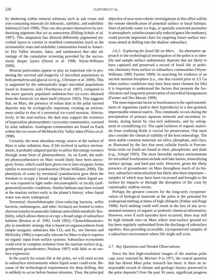
D
s
m
r
c
ri
s
on
mh
w
isu
lf
fdet.
eB
betats.lies
ane),is-
en-ly toebi-nn-anGa
life)fos-res
b-ed,thece-
ap-ri-
ustThelays,m-
haleentsngkelyhis-t—
o theby
ser-forige
cu-n.stillice
rfacees of
larnn in-
226 CLIFFOR
by sheltering within mineral substrata such as salt crustsiron-containing minerals (in lithosolic, sublithic, and endolithhabitats) (Clark 1998). They can also protect themselves bythesizing pigments that act as sunscreens (Ehling-Schulzet al.1997). This adaptation has allowed differently pigmentedcrobial layers to coexist in stratified communities (such asstromatolitic mats and endolithic communities found in Antatic Dry Valley streams, lakes, and sandstones) that takevantage of the cumulative screening provided by the sucsively deeper layers (Doranet al. 1998, Wynn-Williams2000).
Mineral particulates appear to play an important role in pmoting the survival and longevity of microbial populationsboth permafrost and glacial ice (e.g., Christneret al.2000). Thisis supported by the substantially larger microbial populatiofound in Antarctic soils (Vorobyovaet al. 1997), compared tothe more sparsely populated sediment-free ice-cores obtafrom the Antarctic ice sheet itself (Abyzov 1993). This suggethat, on Mars, the presence of eolian dust in the polar layedeposits may be ecologically important, creating an envirment similar to that of a terrestrial ice-cored moraine. Altertively, in the near-surface, the dust may support the existeof hypersaline photosynthetic cryoconite communities, warmby solar radiation. Analogous communities are found on Eawithin the ice covers of McMurdo Dry Valley lakes (Priscuet al.1998).
Certainly, the most abundant energy source at the surfacMars is solar radiation; thus, if life evolved in surface enviroments, it probably adapted quickly to utilize this energy resouthrough some form of photosynthesis. As on Earth, the eaest photosynthesizers on Mars would likely have been anogenic forms, which could have given rise to later oxygenic forsimilar to terrestrial cyanobacteria (Wynn-Williams 2000). Tphotolysis of water by terrestrial cyanobacteria gave themfreedom to occupy a broad range of habitats where liquidter was exposed to light under microaerophilic or locally (segenerated) aerobic conditions. Similar habitats may have exat the martian surface early in the planet’s history, when liqwater was more widespread.
Terrestrial chemolithotrophs (iron-reducing bacteria, subacteria, methanogens, and other Archaea) are limited to reelectron transfer in anaerobic habitats and exhibit metabolic flibility, which allows them to occupy a broad range of subsurfahabitats (Bostonet al. 1992, Gold 1992). Chemolithoautotrophy (a metabolic strategy that is based on organosynthesissimple inorganic substrates like CO2 and H2; see Stevens anMcKinley 1996) is especially relevant for Mars in that it requirno organic input from surface systems. Subsurface ecosyscould exist in complete isolation from the martian surface (egeothermal groundwaters; Nealson 1997) with little or no sface expression.
In the search for extant life at the poles, we will need accto subsurface environments where liquid water could exist.
cause of the technological requirements for deep drilling, tis unlikely to occur before human missions. Thus, the principET AL.
andicyn-
i-thec-ad-es-
o-n
ns
inedts
redn-a-nceedrth
e ofn-rcerli-xy-s
ethea-
lf-tedid
urdoxex-ce-rom
semsg.,ur-
sse-
objective of near-term robotic investigations in this effort willthe remote identification of potential surface or basal habiSites of periodic water ice fogs, or spatially restricted anomain atmospheric volatiles (especially reduced gases like methcould provide important clues for targeting future surface msions aimed at drilling into the shallow subsurface.
2.6.2. Exploring for fossil life on Mars. An alternative ap-proach to the exobiological investigation of the poles is to idtify and sample surface sedimentary deposits that are likehave captured and preserved a record of fossil life or protic chemistry from surface or subsurface communities (WyWilliams 1999, Farmer 1999). In searching for evidence ofancient martian biosphere (i.e., one that existed prior to 3.5when surface conditions may have been more clement forit is important to understand the factors that promote thesilization and long-term preservation of microbial biosignatu(Farmer and Des Marais 1999).
The most important factor in fossilization is the rapid entomment of organisms (and/or their byproducts) in a fine-grainimpermeable mineral matrix. This commonly occurs duringprecipitation of primary aqueous minerals and secondaryments, during burial by clay-rich sediments, and by entrment in crystallizing ice. The rapid isolation of organic mateals from oxidizing fluids is crucial for preservation. One malso consider the chemical stability of the host mineralogy.most stable common materials are silica, phosphate, and cas illustrated by the fact that most cellular fossils in Precabrian rocks on Earth are found in chert, phosphorite, and s(e.g., Schopf 1993). The most favorable surface environmfor microbial fossilization include arid lake basins, mineralizisurface springs, and hard pan soils. However, given the lipresence of groundwater on Mars throughout much of itstory, subsurface mineralization has likely also been importansamples of which may have been excavated and brought tsurface by impacts or through the disruption of the crustcatastrophic outflow events.
Perhaps the greatest concern for the long-term cryoprevation of biological materials at the poles is the potentialwidespread melting at times of high obliquity (Pathar and Pa1998). Such melting could well result in the loss of any acmulated inventory of organic or prebiotic chemical informatioHowever, even if such episodes have occurred, there maybe high latitude sites on Mars where near-surface groundhas been regularly replenished from the discharge of subsuaquifers, thus providing accessible, cryospreserved sampla subsurface environment where life might still exist.
2.7. Key Questions and Needed Observations
Since the first high-resolution images of the martian pocaps were returned byMariner 9 in 1971, the central questiothat has driven Mars polar research has been: is there a
hisalterpretable record of climate and geologic history preserved inthe polar deposits? Over the past 30 years, significant progress

P
no
c
et
cn
e
ko,
sonalry?iq-itats
ithy arepace-ea-
houtigra-nd-
olesute
havee in
THE STATE AND FUTURE OF MARS
has been made in understanding the nature and evolutiothe polar terrains. This is especially true of the recent disceries and insights provided by the investigations of theMarsGlobal Surveyorspacecraft. However, despite these advanmany fundamental properties of the polar deposits are stillknown, and many critical issues remain unaddressed. To datmost thorough review of key questions and needed observaregarding the polar regions is that compiled by the participain the First International Conference on Mars Polar Scienand Exploration(Clifford et al.2000), which is summarized iTable I.
Although the extensive interrelationships that exist betwquestions about the origin and nature of the martian polarposits complicates efforts at strict categorization, the fourquestions identified in Table I effectively summarize the mfundamental uncertainties in our understanding of the poles
(I) What is the composition, structure, and chronology expressedin the sales?
ing life.
this application (Lepper and McKeever 2000), a topic that will
tratigraphy of the polar deposits? (II) What is their massTABLE IKey Questions and Needed Observationsa
The principal goal of Mars polar research is to determine whether there is an interpretable record of climatic and geologichistory that has been preserved in the polar deposits.
I. What is the composition, structure and chronology expressed in the stratigraphy of the polar deposits?A. Externally accessible/measurable properties.
1. Age of exposed layers as a function of stratigraphic position.2. Thickness, extent, and continuity of layers.3. Composition, structure, and ice- and dust-grain characteristics of layers.4. Present surface strain rate.
B. Internal properties.1. Basal topography.2. Internal structure.3. Geothermal heat flux.4. Thermal conductivity and temperature profile.5. Density and porosity.6. Gas permeability.
II. What are the mass and energy budgets of the polar deposits, and what processes control them on seasonal and longer timescA. Current radiation budget (incident, reflected, transmitted, and emitted), including the variation of
radiation balance with season and the effects of dust and ice clouds in the atmosphere.B. Current mass balance (mechanisms, rates, and spatial distribution) of CO2, H2O, and dust.C. Effects of high and low obliquity.D. Cause of the north/south asymmetry in the seasonal evolution and physical characteristics of the polar deposits.E. Processes and role ofin situmodification (e.g., grain densification and geochemical alteration).F. Evidence for or against a feedback between climate and polar insolation.
III. What is the dynamical history of the polar deposits?A. Geomorphic or geophysical evidence of prior variations in vertical and areal extent.B. Evidence of flow (either past or present) and its current role in controlling the shape of polar caps.C. Origin of polar troughs and major reentrants.
IV. Are there places within the polar regions where liquid water is or was present and that mayhave provided habitats for past or present life?A. Evidence of past or present basal melting or basal lakes.B. Identification of peripheral ice deposits associated with local discharges of subpolar or subpermafrost groundwater.C. Existence of microscale near-surface environments (e.g., endolithic, stromatolitic, or ice-rich permafrost) capable of sustainD. Evidence of episodic surface melting associated with high obliquity.E. Presence of molecular biomarkers or microfossils in polar layered deposits.
be discussed in greater detail in Section 4.
a As identified by the participants in theFirst International Confer
OLAR SCIENCE AND EXPLORATION 227
ofv-
es,un-, theionsntse
ende-eyst
i.e.,
and energy budget and what processes control them on seaand longer timescales? (III) What is their dynamical histo(IV) Are there environments within the polar regions where luid water is (or was) present which could have provided habfor life?
Because questions (I) and (II) are directly associated wmeasurable physical, thermal, and radiative properties, thethe ones most readily addressed by present and upcoming scraft missions. The most notable exception to such readily msurable properties is the determination of absolute age. Witan accurate chronology of the development of the polar stratphy, the potential for any significant advance in our understaing of the geologic and climatic record preserved at the pis severely limited. While the problem of determining absolages has long appeared intractable, terrestrial researchersrecently identified at least one technique that offers promis
ence on Mars Polar Science and Exploration(Clifford et al.2000).

TA
BL
EII
Spac
ecra
ftM
issi
ons
wit
ha
Sign
ifica
ntM
ars
Pol
arSc
ienc
eC
apab
ility
Key
ques
tion
/obs
erva
tion
addr
esse
dfr
omTa
ble
I
pace
craf
tM
issi
onde
scrip
tion
Rel
evan
tins
trum
ents
Spe
cific
atio
ns/c
apab
ilitie
sA
ntic
ipat
edob
serv
atio
nsI
IIIII
IV
lob
al
eyo
r(M
GS
)N
ear-
pola
ror
bite
r,al
titud
e∼3
78km
.M
issi
ondu
ra-
tion:
Sep
t.19
97–2
001,
ex-
tens
ion
likel
ydu
eto
loss
ofM
CO
.
Mar
sO
rbite
rC
amer
a(M
OC
)N
arro
w-a
ngle
visi
ble
(one
pass
band
)ca
mer
a:1.
4m
/pix
elsp
atia
lre
solu
-tio
n.W
ide-
angl
evi
sibl
e(t
wo-
colo
r)ca
mer
a:14
0◦fie
lds
ofvi
ewth
atex
-te
ndof
fbo
thlim
bs;
reso
lutio
nat
nadi
ris−2
50m
/pix
el(M
alin
et
al.
1992
).
Hig
hre
solu
tion
ofa
smal
lfr
actio
nof
the
plan
et,d
aily
glob
altw
o-co
lor
map
s.
A1,
A2
B,C
A,B
,CB
,D
Mar
sO
rbite
rLa
ser
Alti
met
er(M
OLA
)1.
064-µ
mw
avel
engt
h,na
dir
poin
ted
lase
ral
timet
erth
atha
sa
160-
msu
rfac
esp
otsi
zean
d10
-Hz
sam
-pl
ing
rate
that
yiel
dsel
evat
ion
mea
-su
rem
ents
(alo
ngtr
ack)
at30
0-m
inte
rval
s.R
angi
ngpr
ecis
ion
varie
sfr
om∼3
8cm
to∼1
0m
(for
sur-
face
slop
esof
0◦to
30◦ )
.A
bso-
lute
accu
racy
,with
resp
ectt
oM
ars’
cent
er-o
f-m
ass,
iscu
rren
tly∼10
m.
Ave
rage
surf
ace
roug
hnes
sca
nbe
dedu
ced
from
the
brea
dth
ofth
ere
-tu
rned
puls
e(Z
ubere
ta
l.19
92).
Sur
face
elev
atio
n,sl
opes
,and
roug
hnes
s,w
ith16
0-m
spot
mea
sure
dev
ery
300
mal
ong
trac
k
A2,
B1
B,C
A,C
The
rmal
Em
issi
onS
pect
rom
eter
(TE
S)
IRM
iche
lson
Inte
rfer
omet
erob
serv
essu
rfac
eem
issi
onfr
om6–
50µm
at5
or10
(sel
ecta
ble)
wav
enum
ber
spec
tral
reso
lutio
n;tw
ow
ideb
and
spec
tral
chan
nels
toob
serv
ere
-fle
cted
sunl
ight
and
IRem
issi
on(4
.5–1
00µ
m).
Inst
anta
neou
ssp
a-tia
lre
solu
tion
is∼3
km;
how
ever
,da
taca
nbe
acqu
ired
cont
inuo
usly
in9-
kmw
ide
strip
sal
ong
trac
k.A
djoi
ning
strip
sfr
ompr
evio
usor
-bi
tsca
nth
enbe
com
bine
dto
pro-
duce
imag
esof
surf
ace
emis
sivi
ty(C
hris
tens
ene
ta
l.19
92).
Min
eral
ogic
,the
rmal
,and
ra-
diat
ive
prop
ertie
sof
sur-
face
;atm
osph
eric
tem
pera
-tu
repr
ofile
s;an
dco
mpo
si-
tion
ofcl
ouds
.
A3,
B3
A,B
,D,
E,F
AB
S
Ma
rsG
Su
rv

Rad
ioS
cien
ce(R
S)
Sci
ence
obse
rvat
ions
are
base
don
at-
mos
pher
icre
frac
tion
of3.
6-an
d4.
2-cm
wav
elen
gth
radi
olin
ksus
edfo
rsp
acec
raft
tele
com
mun
icat
ions
and
trac
king
.Obs
erva
tions
are
mad
ew
hen
spac
ecra
ftpa
sses
behi
ndan
dre
appe
ars
over
limb
ofpl
anet
(Tyl
ere
ta
l.19
92).
Will
prov
ide
surf
ace
pres
sure
and
very
high
vert
ical
re-
solu
tion
(∼10
0m
)pr
ofile
sof
atm
osph
eric
dens
ityan
dte
mpe
ratu
re(0
–65
km),
part
icul
arly
atpo
les.
Pre
ci-
sion
trac
king
ofsp
acec
raft
will
perm
itde
rivat
ion
ofhi
gh-d
egre
esp
heric
alha
r-m
onic
mod
els
ofpl
anet
’sgr
avity
field
.
B
Clim
ate
iter
(MC
O)
Nea
r-po
lar
orbi
ter,
altit
ude
∼405
km.
Lost
Sep
t.19
99.
Unc
lear
ifor
whe
nin
stru
men
tsw
illbe
re-
flow
n.
Pre
ssur
eM
odul
ator
Infr
ared
Rad
iom
eter
(PM
IRR
)
Wid
eban
dso
lar
chan
nel
with
cali-
brat
ion
targ
et;
two-
axis
scan
mir-
ror
yiel
dsbi
-dire
ctio
nalr
eflec
tanc
e;co
oled
dete
ctor
sdi
scrim
inat
ebe
-tw
een
CO 2
and
H 2O
fros
ts;I
Rem
is-
sion
mod
eled
base
don
8IR
chan
nels
(McC
lees
eet
al.
1992
).
Ret
rieve
sve
rtic
alpr
ofile
sof
atm
osph
eric
tem
pera
ture
,du
st,c
onde
nsat
e,an
dw
ater
vapo
r,ap
prox
.ev
ery
1.5◦
latit
ude,
with
5km
limb
vert
ical
reso
lutio
n,ov
eral
lal
titud
es0–
70km
,10
kmve
rt.
reso
lutio
nin
nadi
rvi
ews.
A3
A,B
,D,
F
Mar
sC
olor
Imag
er(M
AR
CI)
Med
ium
-ang
leU
V-V
ISca
mer
aw
ithei
ght
spec
tral
band
sra
ngin
gfr
om0.
42to
1.0µ
m;
40m
spat
ial
res-
olut
ion.
Wid
ean
gle
UV
-VIS
cam
-er
aw
ithse
ven
band
ssp
anni
ng0.
28–
0.77µ
m;
300
msp
atia
lre
solu
tion
(Mal
ine
ta
l.19
99).
Mon
itorin
gof
loca
lto
glob
alsc
ale
met
eoro
logi
cpr
o-ce
sses
and
phen
omen
a.R
e-gi
onal
and
loca
lstu
dies
ofpo
lar
proc
esse
san
dla
nd-
form
s.C
ompi
sitio
nalm
aps
ofiro
n-be
arin
gm
iner
als.
A1
&3
BB
Po
lar
La
nd
er
L)
Land
sD
ec.
3,19
99,
inla
teso
uthe
rnsp
ring.
Sol
ar-
pow
ered
,w
ithpr
ojec
ted
90so
lsof
surf
ace
oper
-at
ions
durin
gpo
lar
sum
-m
er.
Prim
ary
land
ing
site
loca
ted
at76◦
S,1
95◦ W
onon
the
equa
torm
ost
exte
n-si
onof
the
sout
hpo
larl
ay-
ered
terr
ain.
Sur
face
Ste
reo
Imag
er(S
SI)
Clo
neof
Pat
hfind
erIM
P(S
mithe
ta
l.19
97);
ster
eoim
ager
with
mul
ti-sp
ectr
alca
pabi
lity.
Pro
vide
ster
eopa
nara
ma
ofla
ndin
gsi
te,d
eter
min
esk
ybr
ight
ness
,de
tect
atm
o-sp
heric
dust
and
ice
clou
ds.
B
Rob
otic
Arm
with
Cam
era
(RA
&R
AC
)A
rmca
ndi
gto
am
axim
umde
pth
of0.
5m
and
deliv
ersa
mpl
esto
TE
GA
.A
rm-m
ount
edca
mer
aca
nim
age
upcl
ose
(0.2
mm
/pix
el)
inco
lor
usin
gth
ree
colo
red
lam
ps(r
ed,g
reen
,and
blue
),or
toin
finity
inbl
ack
and
whi
te.
Imag
eso
ilpa
rtic
les,
side
-w
all
oftr
ench
,ne
arby
ob-
ject
s,an
dsu
rrou
ndin
gte
r-ra
in;
surf
ace
tem
pera
ture
san
dth
erm
alin
ertia
.
A2,
A3,
B3
B,C
,DC
Ma
rs Orb
Ma
rs (MP

TA
BL
EII
—C
onti
nued
Key
ques
tion
/obs
erva
tion
addr
esse
dfr
omTa
ble
I
acec
raft
Mis
sion
desc
riptio
nR
elev
anti
nstr
umen
tsS
peci
ficat
ions
/cap
abili
ties
Ant
icip
ated
obse
rvat
ions
III
IIIIV
ar
La
nd
er
Land
sD
ec.
3,19
99,
inla
teso
uthe
rnsp
ring.
Sol
ar-
pow
ered
,w
ithpr
ojec
ted
90so
lsof
surf
ace
oper
-at
ions
durin
gpo
lar
sum
-m
er.
Prim
ary
land
ing
site
loca
ted
at76◦
S,1
95◦ W
onon
the
equa
torm
ost
exte
n-si
onof
the
sout
hpo
larl
ay-
ered
terr
ain.
Met
eoro
lgy
Pac
kage
(ME
T)
and
Sur
face
The
rmal
Pro
be(S
TP
)
Sur
face
ther
mal
prob
eto
mea
sure
soil
tem
pera
ture
and
ther
mal
in-
ertia
.M
ET
pack
age
cons
ists
offiv
em
ast-
mou
nted
thin
-wire
ther
-m
ocou
ples
and
one
plat
inum
resi
s-ta
nce
ther
mom
eter
for
mea
rsur
ing
atm
osph
eric
ete
mpe
ratu
res
atfiv
elle
ves
betw
een
surf
ace
and
2.4
m.
Hot
wire
anem
omet
ers
for
mea
-su
ring
horiz
onta
lw
ind
spee
ds10
–20
cmab
ove
surf
ace
and
win
dve
loci
ties
ata
heig
htof
2.4
m.
Mic
rom
achi
ned
capa
citiv
ean
eroi
dba
rom
eter
sfo
rm
easu
ring
atm
o-sp
heric
pres
sure
s.T
unab
leD
iode
Lase
r(T
DL)
spec
trom
eter
sfo
rmea
-su
ring
wat
erva
por
abun
danc
ean
dre
lativ
eab
unda
nce
ofca
rbon
and
oxyg
enis
otop
esin
atm
osph
eric
H2O
vapo
ran
dC
O 2.
Thi
ssu
iteof
inst
rum
ents
will
mak
eth
efir
stin
situ
ob-
serv
atio
nsof
tem
pera
ture
s,pr
essu
res,
win
dve
loci
ties,
and
hum
iditi
esin
the
mar
-tia
npo
lar
regi
ons.
Thi
sin
form
atio
nw
illpr
ovid
eva
luab
lene
wco
nstr
aint
son
the
heat
,mas
s,an
dm
omen
-tu
mtr
ansp
ort
into
and
out
ofth
epo
lar
regi
ons
durin
gth
ela
nded
mis
sion
.
B
The
rmal
Evo
lved
Gas
Ana
lyze
r(T
EG
A)
Exp
erim
ent
incl
udes
eigh
tsa
mpl
eov
ens,
eigh
tre
fere
nce
oven
s,an
da
TD
Lsp
ectr
omet
er.
Sam
ples
re-
trie
ved
byro
botic
arm
are
depo
site
din
sing
le-u
sesa
mpl
eov
en.D
iffer
en-
tial
inen
ergy
use
betw
een
sam
ple
and
empt
yre
fere
nce
oven
sca
nbe
used
toin
fer
pres
ence
ofw
ater
ice
and
min
eral
sco
ntai
ning
adso
rbed
orch
emic
ally
boun
dH 2O
and
CO 2
(Boy
nton
et
al.
2000
).
Det
ect
and
quan
tify
amou
ntof
CO
2an
dH 2
Opr
esen
tas
ice,
adso
rbed
vola
tiles
,and
chem
ical
com
pone
nts
ofso
il;al
sopo
sses
ses
limite
dis
otop
icca
pabi
lity.
Sam
-pl
esw
illbe
retr
ieve
dfr
omdi
ffere
ntde
pths
inpo
larr
e-go
lith
byro
botic
arm
(max
.de
pth∼
0.5
m).
A3
Mar
sD
esce
ntIm
ager
(MA
RD
I)B
lack
and
whi
te1.
25m
rad/
pixe
lres
o-lu
tion,
wid
e-an
gle
desc
ent
cam
era
(http
://m
ars.
jpl.n
asa.
gov/
msp
98/
mss
s/m
ardi
.htm
l).
Firs
tM
AR
DI
imag
ew
illbe
take
nfr
oman
altit
ute
of∼7
kman
dw
illco
nti-
nuin
gun
tilla
ndin
g.W
illal
low
land
ing
site
tobe
loca
ted
inor
bita
lim
ages
,an
dw
illpl
ace
land
erpa
no-
ram
icla
ndsc
aape
tobe
plac
edin
regi
onal
cont
ext.
Sp
Ma
rsP
ol
(MP
L)
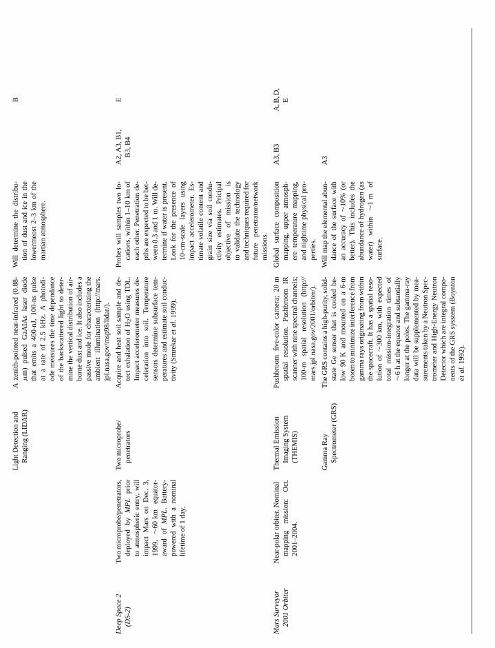
Ligh
tDet
ectio
nan
dR
angi
ng(L
IDA
R)
Aze
nith
-poi
nted
near
-infr
ared
(0.8
8-µ
m)
puls
edG
aAIA
sla
ser
diod
eth
atem
itsa
400-
nJ,
100-
nspu
lse
ata
rate
of2.
5kH
z.A
phot
odi-
ode
mea
sure
sth
etim
ede
pend
ance
ofth
eba
cksc
atte
red
light
tode
ter-
min
eth
eve
rtic
aldi
strib
utio
nof
air-
born
edu
stan
dic
e.It
also
incl
udes
apa
ssiv
em
ode
for
char
acte
rizin
gth
eam
bien
till
umin
atio
n(h
ttp://
mar
s.jp
l.nas
a.go
v/m
sp98
/lida
r/).
Will
dete
rmin
eth
edi
strib
u-tio
nof
dust
and
ice
inth
elo
wer
meo
st2–
3km
ofth
em
artia
nat
mos
pher
e.
B
Sp
ace
2-2
)Tw
om
icro
prob
e/pe
netr
ator
s,de
ploy
edby
MP
Lpr
ior
toat
mos
pher
icen
try,
will
impa
ctM
ars
onD
ec.
3,19
99,∼6
0km
equa
tor-
awar
dof
MP
L.B
atte
ry-
pow
ered
with
ano
min
allif
etim
eof
1da
y.
Two
mic
ropr
obe/
pene
trat
ors
Acq
uire
and
heat
soil
sam
ple
and
de-
tect
exha
latio
nof
H 2O
usin
gT
DL.
Impa
ctac
cele
rom
eter
mea
sure
sde
-ce
lera
tion
into
soil.
Tem
pera
ture
sens
ors
dete
rmin
esu
bsur
face
tem
-pe
ratu
res
and
estim
ate
soil
cond
uc-
tivity
(Sm
reka
ret
al.
1999
).
Pro
bes
will
sam
ples
two
lo-
catio
ns,w
ithin
1–10
kmof
each
othe
r.P
enet
ratio
nde
-pt
hsar
eex
pect
edto
bebe
t-w
een
0.3
and
1m
.Will
de-
term
ine
ifw
ater
ispr
esen
t.Lo
okfo
rth
epr
esen
ceof
10-c
m-s
cale
laye
rsus
ing
impa
ctac
cele
rom
eter
.E
s-tim
ate
vola
tile
cont
ent
and
grai
nsi
zevi
aso
ilco
ndu-
ctiv
ityes
timat
es.
Pric
ipal
obje
ctiv
eof
mis
sion
isto
valid
ate
the
tech
nolo
gyan
dte
chni
ques
requ
ired
for
futu
repe
netr
ator
/net
wor
km
issi
ons.
A2,
A3,
B1,
B3,
B4
E
Su
rvey
or
1O
rbite
rN
ear-
pola
ror
bite
r.N
omin
alm
appi
ngm
issi
on:
Oct
.20
01–2
004.
The
rmal
Em
issi
onIm
agin
gS
yste
m(T
HE
MIS
)
Pus
hbro
omfiv
e-co
lor
cam
era;
20m
spat
ial
reso
lutio
n.P
ushb
room
IRsc
anne
rwith
nine
spec
tral
chan
nels
;10
0-m
spat
ial
reso
lutio
n(h
ttp://
mar
s.jp
l.nas
a.go
v/20
01/o
rbite
r/).
Glo
bal
surf
ace
com
posi
tion
map
ping
,up
per
atm
osph
-er
ete
mpe
ratu
rem
appi
ng,
and
nigh
time
phys
ical
pro-
pert
ies.
A3,
B3
A,B
,D,
E
Gam
ma
Ray
Spe
ctro
met
er(G
RS
)T
heG
RS
cont
ains
ahi
gh-p
urity
,sol
id-
stat
eG
ese
nsor
that
isco
oled
be-
low
90K
and
mou
nted
ona
6-m
boom
tom
inim
ize
inte
rfer
ence
from
gam
ma
rays
orig
inat
ing
from
with
inth
esp
acec
raft.
Itha
sa
spat
ialr
eso-
lutio
nof∼3
00km
,w
ithex
pect
edto
tal
mis
sion
-inte
grat
ion
times
of∼6
hat
the
equa
tora
ndsu
btan
tially
long
erat
the
pole
s.T
hega
mm
a-ra
yda
taw
illbe
supp
lem
ente
dby
mea
-su
rem
ents
take
nby
aN
eutr
onS
pec-
trom
eter
and
Hig
h-E
nerg
yN
eutr
onD
etec
tor
whi
char
ein
tegr
alco
mpo
-ne
nts
ofth
eG
RS
syss
tem
(Boy
nton
et
al.
1992
).
Will
map
the
elem
enta
labu
n-da
nce
ofth
esu
rfac
ew
ithan
accu
racy
of∼1
0%(o
rbe
tter)
.T
his
incl
udes
the
abun
danc
eof
hydr
ogen
(as
wat
er)
with
in∼1
mof
surf
ace.
A3
De
ep
(DS
Ma
rs 20
0

TA
BL
EII
—C
onti
nued
Key
ques
tion
/obs
erva
tion
addr
esse
dfr
omTa
ble
I
Spa
cecr
aft
Mis
sion
desc
riptio
nR
elev
anti
nstr
umen
tsS
peci
ficat
ions
/cap
abili
ties
Ant
icip
ated
obse
rvat
ions
III
IIIIV
Exp
ress
iter
Ent
ers
Mar
sor
bit
Dec
.20
03an
dw
illre
mai
nop
erat
i-on
alth
roug
h20
07.H
ighl
yel
liptic
alne
ar-p
olar
orbi
tw
illva
ryin
altit
ude
from
250
to11
,000
km.
Mar
sA
dvan
ced
Rad
arfo
rS
ubsu
rfac
ean
dIo
nosp
heric
Sou
ndin
g(M
AR
SIS
)
Mul
tifre
quen
cy,
cohe
rent
puls
e,sy
n-th
etic
aper
ture
rada
rso
unde
r/al
ti-m
eter
.Va
riabl
efr
eque
ncy
sele
c-tio
nal
low
sch
arac
teriz
atio
nof
subs
urfa
cem
ater
ial
prop
ertie
san
dfle
xibi
lity
inda
y–ni
ght
oper
atio
ns.
Sec
onda
ry,
rece
ive-
only
ante
nna
and
data
chan
nelt
om
inim
ize
the
ef-
fect
sof
surf
ace
“clu
tter”
onsu
bsur
-fa
cefe
atur
ede
tect
ion.
Ech
opr
ofile
sof
subs
urfa
ceob
tain
edto
dept
hsof
∼3–5
kmw
itha
vert
ical
(dep
th)r
es-
olut
ion
of∼5
0–10
0m
(Pla
ut19
99).
Prim
ary
obje
ctiv
eis
tom
apth
edi
strib
utio
nof
wat
er,
both
liqui
dan
dso
lid,
inth
epo
lar
caps
and
uppe
rcr
ust.
Sec
onda
ryob
ject
ives
incl
ude
subs
urfa
cege
o-lo
gic
prob
ing
for
stra
tigra
-ph
ican
dst
ruct
ural
cont
-ac
ts,c
hara
cter
izat
ion
ofth
esu
rfac
eto
pogr
aphy
,rou
gh-
ness
and
refle
ctiv
ity,
and
iono
sphe
ricso
undi
ng.M
aypr
ovid
eda
taon
dept
han
dch
arac
ter
ofth
e“b
ed”
ofth
epo
lar
laye
red
depo
sits
.
A2,
A3,
B1
A
Oth
erin
stru
men
tsof
pote
ntia
lpol
ar/c
limat
ein
tere
st
Ene
rget
ice
Neu
tral
Ato
ms
Ana
lyze
r(A
SP
ER
A),
Hig
h-R
esol
utio
nS
tere
oC
olor
Imag
er(H
RS
C),
IRM
ap-
ping
Spe
ctro
met
er(O
ME
GA
),R
adio
Sci
ence
Exp
erim
ent
(RS
E),
Atm
osph
eric
For
ier
Spe
ctro
met
er(P
FS
),U
VA
tmos
pher
icS
pect
rom
-et
er(S
PIC
AM
)(h
ttp://
sci.e
sa.in
t/m
issi
ons/
mar
sexp
ress
/).
Hig
h-re
solu
tion
imag
ing
and
min
eral
ogic
map
ping
ofpo
lar
caps
.G
loba
lat
mo-
sphe
ricci
rcul
atio
n,hi
gh-
reso
lutio
nco
mpo
stio
nal
map
ping
ofat
mos
pher
icco
mpo
sitio
n,an
dm
easu
re-
men
tsof
surf
ace–
atm
osp-
here
and
atm
osph
ere–
sola
rw
ind
inte
ract
ions
.
A3,
B3
A,B
,D,
EA
,B,C
B
Ma
rs Orb
est
s
gni
a
sar
n
nh
ur
ale
p
fhvye
rh
osth thesites:/.
sivearsin-
dual
reion;thee andales;ricints
the
hasim-the
n of
berof
tion
lentaller
oste ofphyonusithce
rties
nceEarthld,) to
ture,
THE STATE AND FUTURE OF MARS
In the section that follows, we review the potential for currand future spacecraft missions to address the key questionneeded observations identified in Table I. We then followdiscussion with a brief assessment of the scientific issuesare likely to remain outstanding, and what scientific and tenological challenges must be addressed before we can rethem.
3. MARS POLAR EXPLORATION: CURRENTAND FUTURE MISSIONS
Since it entered Mars orbit in 1997,Mars Global Surveyorhas returned a wealth of new information about the topophy, geomorphology, and thermal characteristics of the plasurface and atmosphere, making some of its most surprand important findings at the poles. If all goes as plannedDecember of 1999, MGS will be joined by two other spacecrthe Mars Polar Lander(MPL) and the twin New MillenniumProject’sDeep Space-2(DS-2) microprobes, which are the firspacecraft ever tasked with actually landing on a polar surf
Between now and 2005, Mars will be visited by a numbeother spacecraft that will include orbiters, landers, rovers,at least two attempts at sample return. Although the primaryjective of the orbiters is to conduct a general survey of the eplanet, their near-polar trajectories make them ideal platfofrom which to conduct observations of the polar atmospheresurface—an opportunity for which many of their instrumehave been specifically targeted and optimized. Similarly, wthe 2001 and later lander missions are directed at low latitutheir investigations will provide valuable insights into the natand history of the global environment, enabling more accuinterpretations of the geologic and climatic record preservethe poles.
Table II lists the mission durations, relevant instruments,anticipated polar observations of those spacecraft currentoperation, under construction, or in development that posssignificant capability for conducting Mars polar research. Asfrom the direct investigations conducted by theMPL andDS-2spacecraft, perhaps the most anticipated mission for Marsscience is the European Space Agency’s (ESA’s)Mars ExpressOrbiter that will be launched in 2003. Among that spacecraextensive complement of instruments is a radar sounder, welectromagnetic investigations of the subsurface may proa first look at the internal structure and basal topographthe polar layered deposits. These capabilities are discussgreater detail below.
Observations by the fleet of spacecraft described abovedramatically impact our present understanding of the polagions, providing many new insights regarding the physical cacteristics, properties, and processes that have influencedevolution. In this section we give a brief overview of these msions, the measurements they are expected to acquire, an
relevance of these observations to addressing the key quesand needed observations summarized in Table I. AdditionaPOLAR SCIENCE AND EXPLORATION 233
ntand
hatthatch-olve
ra-et’ssing, inft:
tce.of
andob-tirermsandtsile
des,reated at
ndy inss a
ide
olar
t’soseideofd in
willre-ar-theiris-d the
formation, including late-breaking-news and links to the mrecent data returned by these missions, is available througMars Surveyor Program and European Space Agency webhttp://mars.jpl.nasa.gov/ and http://sci.esa.int/marsexpress
3.1. Mars Global Surveyor (Sept. 1997–2001)
The MGS mission is the most ambitious and comprehenorbital reconnaissance of Mars yet planned by NASA’s MSurveyor Program. Its principal polar science objectivesclude characterization of the shape and volume of the resiice caps and polar layered deposits (Zuberet al. 1998, Smithet al.1999, Johnsonet al.2000); an investigation of the natuand stratigraphy of polar landforms at meter-scale resolutquantification of the polar radiative balance (which controlsseasonal polar caps on short time scales and the existencextent of the permanent ice caps on much longer time scKieffer et al.2000); and characterization of martian atmosphetransport and boundary conditions to provide better constraon modeling the past and present climate.
These investigations are being carried out by four offive instruments carried aboardMGS, which include the MOC,whose two wide-angle imagers have 140◦ fields of view thatextend off of both limbs and whose narrow-angle cameraa surface resolution of 1.5 m/pixel (an order of magnitudeprovement over the highest resolution images returned byViking Orbiters, Malin et al. 1992); the MOLA, which has a160-m spot size and a ranging precision that varies from∼38cm up to∼10 m, depending on surface slope (Zuberet al.1992);and the TES, which has a spectral range of 6–45µm, a spectralresolution of 5 or 10 wavenumbers, and a spatial resolutio∼3 km (Christensenet al.1992).
Although bandwidth limitations have restricted the numof meter-scale images returned by MOC (i.e., less than 1%the planet’s surface is expected to be imaged at this resoluby the mission’s end), the polar orbit ofMGShas resulted inbetter spatial coverage of the poles than of any other equivaarea on the planet. In contrast to MOC, the substantially smdata volumes generated by MOLA and TES have allowed almcontinuous operation. This capability resulted in the releasthe first high-resolution maps of polar and global topograwithin just a few months of the start of the primary missi(Smithet al.1999). It has also allowed TES to acquire numero9-km wide strips of data along track that can be combined wadjoining strips (obtained during previous orbits), to produimages of the compositional, thermal, and radiative propeof the surface.
MGSalso includes two other investigations: a Radio Scie(RS) experiment that uses the spacecraft’s transmissions toto improve our present knowledge of the martian gravity fietopography, and atmosphere, and a Magnetometer (MAGcharacterize the martian magnetic fields, ionospheric strucand the interaction of Mars with the solar wind. All of theMGS
tionsl in-
instruments are based on the designs of nearly identical instru-ments that were flown on theMars Observerspacecraft, which
9
s
a
sr
d
md
io
t
lna
oe0
e
ive-
eseuthgy,iles
h-dalons
inedro-ess,the
sits.anthe
m.all
mp-ichillon
isayentesthetion
onsat-
ofrchndas
mar-s as
istsricarsceing
to
234 CLIFFOR
was lost upon its arrival at Mars in 1993. These instrumentsdescribed in substantially more detail elsewhere (e.g., Chapand Albee 1992; and Albeeet al.1998).
3.2. Mars Climate Orbiter (Lost Sept. 1999)
The loss of theMars Climate Orbiteron September 23, 199was a major setback for both surface and atmospheric stuof the poles. The key polar science objective ofMCO was todevelop an improved understanding of the thermal and phyprocesses controlling the present seasonal cycles of H2O, CO2,and dust, particularly as it relates to the exchange of water vbetween the polar caps, atmosphere, and subsurface, and thof dust deposited on and eroded from the caps.
MCO carried two instruments: the dual-camera Mars CoImager (MARCI) and an atmospheric sounder, the PresModulator IR Radiometer (PMIRR). MARCI’s seven-colofilter wide-angle camera (with a resolution similar to MOCWA camera) and eight-filter medium-angle camera (with a 40resolution at nadir) was to provide information on the spatialtribution, character, and movement of atmospheric cloudshazes at high latitudes, as well as extensive surface coveof the polar regions during the hemispheric spring and sum(Malin et al.1999). PMIRR (a copy of the atmospheric sounpreviously lost withMars Observer) was to observe the atmosphere above the planet’s trailing limb, providing informaton the vertical profiles of temperature, dust, condensate,water vapor (McCleeseet al.1992). PMIRR was also designeto observe the growth and retreat of the seasonal polar ccharacterizing changes in the reflectivity and emissivity ofpolar ice using a two-axis scan mirror that would have enabmeasurements of reflected sunlight at a variety of emissionincidence angles (substantially extending the bidirectionaflectance coverage of TES). At the time this is written, it isyet known whether MARCI or PMIRR will be recovered as pof a future mission.
3.3. DS-2 Microprobes and Mars Polar Lander (Dec. 3, 199Duration: DS-2∼1 day; MPL∼90 days)
On December 3, 1999, theMPL and DS-2 spacecraft willarrive at Mars to conduct the firstin situ investigations of theplanet’s south polar region. Shortly before atmospheric entheMPL will release the twinDS-2penetrator/microprobes thawill impact the surface at a velocity of∼200 m/s, embeddingthemselves as much as a meter beneath the surface of thedeposits, and up to several kilometers apart. The microprwill be followed by theMPL, a larger and more traditional landthat will use parachutes and retrorockets to set down about 6closer to the pole. The landing site, which is at 76◦S, 195◦W,lies on a gently rolling plain located just inside the periphof the south polar layered deposits and approximately 800away from the pole.
While reliance on battery power will limit the subsurface investigations of theDS-2microprobes to just a single day, th
D ET AL.
areman
dies
ical
pore fate
lorure-’s-mis-andrage
erer-nanddaps,heledandre-otrt
9,
try,t
polarbesrkm
rykm
solar-poweredMPL has an expected lifetime of∼3 months (al-though there is a small possibility that the spacecraft may survthe south polar winter in hibernation, to be revived the following spring). Over the duration of their respective missions, thspacecraft will conduct investigations to characterize the sopolar surface environment, including its meteorology, geoloand especially the physical properties and behavior of volatin the seasonal evolution of the atmosphere and polar cap.
TheDS-2microprobes were developed to validate the tecnology and techniques required to build and deploy the noelements of future seismic and meteorology network missi(Smrekaret al.1999). Although limited by both their small sizeand limited power, theDS-2microprobes will conduct four sci-ence investigations. During the probes’ descent, data obtafrom two onboard accelerometers will be used to derive a pfile of atmospheric density, as well as characterize the hardndepth of penetration, and possible presence of layering (ontens of centimeters scale) within the near-surface polar depoUpon impact, the penetrators will separate into two parts:aftbody that remains at the surface and communicates withMGS, and a forebody that plunges to a depth of up to 1Once the forebody comes to rest, a drill will extract a smsample of deposit material, heat it above 0◦C, and look for thepresence of water vapor using a tunable diode laser. Two teerature sensors in the forebody will also monitor the rate at whthe probe cools. The thermal conductivity of the deposits wthen be estimated by comparing the observed cooling rateMars with previously calibrated models of probe cooldown.
As noted above, a principal science objective of theMarsPolar Landeris the characterization of the local geology. Thinvestigation will actually begin after the aeroshell falls awas theMPL descends to the surface. Throughout that descthe Mars Descent Imager (MARDI) will take a series of imagto provide the regional context necessary to both interpretlandscape viewed from the surface and to aid in the identificaof the landing site’s exact location in orbital imagery.
Once on the surface, theMPL will immediately begin topursue its other science objectives, which include observatiof the quantity and behavior of subsurface, surface, andmospheric H2O; determination of the isotopic abundanceH2O and CO2 in the atmosphere and subsurface; the seafor fine-scale layering within the near surface deposits; adetermination of the abundances of volatile minerals, suchhydrates and carbonates, that may have formed in ancienttian seas and have since been blown into the polar regionpart of the dust raised by local and global dust storms.
Assisting in these investigations is a payload that consof a laser sounder (LIDAR) system for ranging atmosphehazes and an integrated instrument suite called MVACS (MVolatiles and Climate Surveyor). MVACS includes a SurfaStereo Imager (SSI) that will take panoramas of the landsite in 12 spectral channels and in stereo and will be used
-eboth study the local geology and derive atmospheric levels ofdust and water, as well as detection of clouds and hazes. The
P
nb
-rrlvoxin
nnIStrr
spnrR
ibt
pifa
ml a
roos
Ag
uh
aiog
0
g
ayons/sivehileser-mostthat
face
per-rnalthe
y ca-rialay–the
nd a
apor-sur-cts,d re-
icaldis-
sitsin-ithill
erg,imen-erestf thebye toones,
icelo-siblyourigh-
he
ctedind or-
THE STATE AND FUTURE OF MARS
Meteorological Package (MET) will measure atmospheric wipressure, temperature, and humidity near the surface. A roarm (and arm-mounted camera) will be used to investigatesurface, trench into it (Kossackiet al. 2000), image the sidewalls of the trench (with a resolution sufficient to resolve minegrains or annual layers as small as a few tens of micrometesize), and acquire samples for analysis by the Thermal EvoGas Analyzer (TEGA). The TEGA will heat soil samples prvided by the robotic arm to detect the presence of carbon dioand water as ices, absorbed phases, and chemically boundmineral component of the local polar deposits.
3.4. Mars Surveyor 2001 Orbiter and Lander(Oct. 2001–July 2004)
Another orbiter and lander pair will be sent to Mars durithe 2001 launch opportunity. The orbiter will include two istruments: the Thermal Emission Imaging System (THEMand Gamma Ray Spectrometer (GRS). The THEMIS insment will image the polar surface both visually and in sevethermal infrared wavelength bands, with a correspondingtial resolution of 20 and 40 m. This will provide a significaimprovement in detail over the compositional, thermal, anddiative investigations conducted by TES. Meanwhile, the G(which will also include a Neutron Spectrometer and possa High Energy Neutron Detector) will carry out an elemensurvey of the planet’s near-surface (top 0.5 m or so), mapthe distribution of hydrogen as a means of locating near-surwater (Boyntonet al.1992).
Although targeted for an equatorial location, the2001 Landerincludes two instrument suites that will provide the first coprehensive characterization of the dust that is raised by locaglobal dust storms and ultimately deposited and entrained inpolar ice. The Athena Precursor Experiment (APEX) will pvide information on the thermal properties, chemical comption, and iron mineralogy of the dust (Squyreset al.1999), whilethe Mars Environmental Compatibility Assessment (MECpayload will provide data on dust particle size, morpholocomposition, and electrostatic properties (Marshallet al.1999).Together, this information will provide valuable insights abothe optical properties of the dust suspended in the atmospits potential effectiveness as condensation nuclei for H2O andCO2, the concentration and composition of soluble salts it mintroduce into the polar ice, its effect on the rheologic, thermand optical properties of the ice, and the potential complicatit may pose for future geophysical and deep drilling investitions of the polar layered deposits.
3.5. Mars Express Orbiter (Nominal Mission, Dec. 2003–20
The European Space Agency (ESA) is currently plannin
launch both an orbiter and lander to Mars in 2003. Althougthe lander (Beagle 2) will pursue investigations unrelated to theOLAR SCIENCE AND EXPLORATION 235
ds,oticthe
als ined-ide
the
g-)
u-ala-
ta-Slyalngce
-nd
the-i-
)y,
tere,
ayl,nsa-
6)
to
poles, theMars Express Orbiterpayload contains a broad arrof sophisticated instruments (Table II; http://sci.esa.int/missimarsexpress/) that will provide one of the most comprehensurveys of Mars (and the polar regions) yet attempted. Wseveral of these instruments will provide important new obvations of the polar atmosphere and surface, perhaps theeagerly anticipated are the electromagnetic investigationswill be conducted by the Mars Advanced Radar for Subsurand Ionospheric Sounding (MARSIS).
MARSIS is a multifrequency, coherent pulse, synthetic ature radar sounder/altimeter that will investigate the intestructure (and potentially detect the basal topography) ofpolar layered deposits (Plaut 1999). The variable frequencpability permits a fuller characterization of subsurface mateproperties and increases the flexibility of the instrument in dnight operations. The sounder will acquire echo profiles ofsubsurface at a lateral spacing of approximately 5 km avertical (depth) resolution of 50–100-m.
The primary objective of the MARSIS experiment is to mthe distribution of water, both liquid and solid, in the upper ptions of the martian crust. Secondary objectives include subface geologic probing for stratigraphic and structural contacharacterization of the surface topography, roughness anflectivity, and ionospheric sounding.
Data from MARSIS could potentially address several critissues in Mars polar research (Plaut 1999). For example,continuities in dielectric properties within the layered depomay provide evidence of major shifts in climate, periods oftense volcanic activity, or internal deformation associated wglacial flow. The properties of other high-latitude terrains walso be studied, including the thickness of the north polarand possible subsurface stratigraphic contacts among sedtary, volcanic, and ice deposits. But perhaps of greatest intis the potential for investigating the depth and character opolar layered deposits’ “bed.” If attenuation of the signalthe layered materials is not too great, it may be possiblmap the base of the deposit and detect basal melting zshould they exist. The detection of either shallow (<5 km)aquifers or “pockets” of basal meltwater beneath the polarwould be a dramatic result, with potential implications forcal ecosystems, as well as the planet’s regional, and posglobal, hydrology. Such a discovery would revolutionizeideas on the current state of water on Mars and provide hpriority targets for follow-up exobiologic investigations of tpoles.
4. OUTSTANDING ISSUES AND NEEDED CAPABILITIES
By the conclusion of theMars Expressmission, all currentlyplanned investigations of the martian polar regions, condufrom orbit or the surface, will be complete. Although NASA,cooperation with the European Space Agency, plans to sen
hbiter and lander pairs to Mars during the 2003 and 2005 launchopportunities, the lander component of these missions will be
D
r
lo
xwu
a
diia
n
pad
dpteuamiv
a,
eipetthu
o
hai
th
udiesd or-tion
rfaceicsbyad-
ievetheof
theeednd
ratedat-ain-ova
lied;itiesvablyre-plesnal-sso-w-entlyoten-0).heatind inppedl todateth atyagesetmalls ofwillun-
ord
ndin
tri-for
236 CLIFFOR
dedicated to the acquisition and return of surface samples fsites at low latitudes, while the goals and instrument suitesany) of the orbiters are currently undefined. Because of thelead times required for mission planning, and because the pregions will remain a high priority objective of future Mars eploration and research, it is an appropriate time to assesswe expect to learn from current missions and what key issare likely to remain outstanding.
Consideration of the instrument capabilities discussed inprevious section (and listed in Table II) suggests that significprogress will be made in characterizing the surficial compotional, thermophysical, and radiative properties of the polarposits. In addition, perhaps as much as 10% of the polar regwill have been imaged at meter-scale resolution, with essentcomplete coverage (in many colors) at a minimum resolutionseveral tens of meters. These images will provide unprecedeviews of surface morphology and stratigraphy, and will yieimportant clues as to the nature, origin, and evolution of thelar terrains. Data from MOLA and MARSIS should provideimproved estimate of the thickness and volume of the polarposits and, to a lesser degree, of the amount of water that mastored as ice within them. On a larger scale, the synthesis ofobtained from a variety of instruments will yield global maof the distribution and temporal variation of atmospheric wavapor, dust, clouds, and surface frosts, while other instrummay provide low-resolution maps of the distribution of subsface H2O (as regolith adsorbate, near-surface ground ice,perhaps even groundwater) to depths of up to several kiloters. When combined with wind directions and speeds derfrom cloud track observations, this information should givea much improved understanding of atmospheric transporthow water is exchanged between the regolith, atmospherepolar caps.
Yet, despite these many advances, in a very literal senswill have only just begun to scratch the surface in our exploratand understanding of the martian polar regions. For examwhile we will have amassed a large volume of data on theternal properties of the polar deposits, their internal proper(such as gaseous permeability, porosity, density, rheology,mal conductivity, temperature profile, and geothermal heat flwill continue to remain a mystery. That ignorance may well etend to even more fundamental properties, such as the depinternal structure and basal topography. Indeed, althoughradar sounding experiment onMars Expressis an importantfirst step, the inherent difficulty of discriminating between tdielectric properties of ice, embedded dust, and a polar bment of unknown lithology introduces sufficient uncertaintythe interpretation of the radar data that a combination of ogeophysical techniques and/orin situ drilling may be requiredfor its validation.
Likewise, our ability to understand the influence of past cmates on atmospheric circulation, the seasonal cycles of C2,
H2O, and dust, and the polar mass balance will remain costrained by the lack of data necessary to fully and accuratET AL.
om(ifng
olar-hates
thent
si-e-
onsllyofted
ldo-ne-
y beataserntsr-nde-
edusndand
weonle,x-
ieser-x)
x-sits’the
ese-ner
li-O
characterize the present martian climate. On Earth, such stare aided by a dense global network of surface, airborne, anbital sensors that provide both ground truth and a high-resoluspatial and temporal record of the changes that occur in suboundary conditions, fluxes, physical properties, and dynamof the atmosphere. Although the investigations conductedMars spacecraft over the next several years will measurablyvance our knowledge of the present climate system, to achany further progress will require a substantial increase inresolution, frequency, geographic distribution, and durationlocal and global monitoring.
The single greatest obstacle to unlocking and interpretinggeologic and climatic record preserved at the poles is the nfor absolute dating (i.e., I.A.1 in Table I; see also Cutts aLewis 1982, Thomaset al.1992, Cliffordet al.2000). Until re-cently, the most promising method for establishing an accuchronology of the polar stratigraphy appeared to be isotopicing techniques based on the identification of horizons conting either10Be (with recent peaks produced by local supernevents 35 and 60 ka BP; Beeret al. 1992) or volcanic ash (towhich standard argon-dating techniques could then be appDicken 1995). Either approach requires analytical capabiland resources that greatly exceed those that might conceibe employedin situ by robotic spacecraft, necessitating themote acquisition, preservation, and return of drill core sam(tens to hundreds of meters in length) back to Earth for aysis. The magnitude of the cost and logistical problems aciated with such an effort make it impractical to pursue. Hoever, another approach, called luminescence dating, has recbeen proposed that appears to have some promise in its ptial application to Mars (Lepper and McKeever 1998, 200The technique is based on the fact that, in the absence ofand sunlight, natural ionizing radiation will free electronsthe crystal lattice of mineral sediments that become trappedefects. Heating or exposure to light then releases the traelectrons, producing an amount of light that is proportionathe sediment burial time. This technique has been used toterrestrial sediments ranging in age from 1 to 150 ka BP, wisingle measurement error of∼15%. Depending on the intensiof the natural radiation background on Mars, this maximumlimit could potentially be extended even further. A major asof luminescence dating is that the required hardware is senough that it can fit within the mass and volume constrainta DS-2-sized penetrator. Whether this particular techniqueultimately prove viable for use in Mars exploration remainsclear, but the ability to sample and datein situ is a necessaryprerequisite for deconvolving the complex stratigraphic recpreserved at the poles.
Finally, while high-resolution images, radar sounding, aother forms of orbital reconnaissance are of obvious utilitythe remote investigation of landforms or in mapping the disbution of various physical properties, there are other tasks
n-elywhich they are ill-suited. For example, while a suspect glacialmoraine or jokulhlaup deposit may be identified from orbit, such

P
nf
csEo
s
na
,unt
dhs
rr
i
w
ep
io
e
i
sli
im
ea
ik
pablelo-rop-the
plo-is theatig-bud-ongerarewaslife?
ssastlyf them-alf
craftthedingrvoirrm
ep-re.
rres-
,dit bytitutes and87.
ack
rnes, itssciencetithin
yor
arc-
THE STATE AND FUTURE OF MARS
an identification will remain ambiguous without corroboratievidence obtained in the field. There is no better example oneed forin situ investigations than the search for evidencepast or present life. Clearly, the identification of microfossilsactive endolithic communities is not a task that can be condufrom orbit, nor can it be pursued by a traditional lander, invegating a single site, with any reasonable chance of success.when the targeted environment is highly localized, practical csiderations of landing precision and the density and visibilitypotential finds are likely to require long-duration surface invegations conducted by robotic spacecraft that possess signifimobility, sample retrieval, and analytical capabilities. Alterntively, where the density or spatial coverage of potential fiis greater, the deployment of a large number of less cap(and less expensive) spacecraft might satisfy the need. Wthe development of such spacecraft may prove challengingdifficult to conceive of an exploration strategy that could scessfully address the search for life, or any field investigatiosimilar complexity, without these capabilities. Depending onspecific polar science objective, there are a wide variety ofploration platforms and technologies that might be employesuch investigations—the greatest technical constraints on ware mass, mobility, communications, and power. These issuediscussed in greater detail by Cliffordet al. (2000).
While there are presently no plans for a return to the polagions following theMPL andDS-2missions, opportunities fomore ambitiousin situ investigations of the poles will almoscertainly arise in the second half of this decade. These misswill benefit from the wealth of data returned byMPL andDS-2,as well as a number of orbiter-based investigations. Theyalso benefit from a variety of innovative technologies, nowdevelopment, that will significantly enhance our ability to coduct extended investigations of the martian polar environmFrom a scientific perspective, this second phase of polar exration will mark the transition from the broad characterizatof the physical and thermal environment to the developmencomprehensive strategies to investigate the specific processwhich the polar deposits have evolved.
5. SUMMARY
By analogy with the major ice sheets of Earth, the martpolar deposits are believed to preserve a record of geologicclimatic history that extends back at least∼105–108 years. Theirlayered stratigraphy is thought to document variations in inlation (due to quasiperiodic oscillations in the planet’s obuity and orbital elements), volatile mass balance, atmosphcomposition, dust storm activity, volcanic eruptions, largepacts (Lorenz 2000), catastrophic floods, solar luminosity,pernovae, and perhaps even the abundance of microbial lif
Because this potential storehouse of knowledge is unequanywhere else on the planet, the martian polar regions are l
to remain a high priority objective of current and future explration. But to successfully access and interpret this record wOLAR SCIENCE AND EXPLORATION 237
gtheofortedti-venn-ofti-canta-dsblehileit isc-of
heex-inichare
re-
tons
illinn-nt.lo-n
t ofs by
anand
o-q-eric
-su-.ledely
require the development of spacecraft and instruments caof monitoring and sampling the polar environment at multiplecations for extended periods of time, assessing its internal perties, and, most importantly, dating its stratigraphy throughready application ofin situ techniques.
Through such investigations, Mars polar science and exration seeks to address four fundamental questions: Whatcomposition, structure and chronology expressed in the strraphy of the polar deposits? What is their mass and energyget, and what processes control them on seasonal and ltimescales? What is their dynamical history? And, finally,there places within the polar regions where liquid water is orpresent that may have provided habitats for past or present
Over the next several years, ongoing investigations byMarsGlobal Surveyor, and a fleet of other spacecraft, will addremany key elements of these questions and, in doing so, venhance our understanding of the nature and evolution opoles. This knowledge will lay the foundation for the more abitious investigations that are likely to follow in the second hof this decade. Ultimately, the efforts of these robotic spacewill be supplemented by the arrival of humans—brought topoles because of both the promise they hold for understanthe evolution of the planet and because of the valuable reseof accessible water they will provide to support the long-teexploration of Mars. In this way, the martian polar regions rresent not only the key to the planet’s past, but also its futu
ACKNOWLEDGMENTS
This summary benefited from the input of the more than one-hundred tetrial and planetary scientists who participated in theFirst International Confer-ence on Mars Polar Science and Exploration, which was held at Camp AllenTexas, October 18–22, 1998. It also benefited from a helpful review and eJames Bell. Work performed at the Jet Propulsion Laboratory, California Insof Technology, was carried out under contract with the National AeronauticSpace Administration. This is Lunar and-Planetary Institute Contribution 9
Note added in proof. Mars polar science was dealt yet another major setbwith the loss of theMars Polar Lander(MPL) andDeep Space-2(DS-2) missionsin December. Although theMars Global Surveyorspacecraft continues to retua wealth of new data about the nature and seasonal evolution of the polrecent discoveries have reemphasized the importance of addressing thequestions that originally motivated theMPL andDS-2missions. It is hoped thathis lost opportunity will be recovered in an ambitious return to the poles wthe next decade.
REFERENCES
Abyzov, S. S. 1993. Microorganisms in the Antarctic ice. InAntarctic Microbi-ology(E. I. Friedmann, Ed.), pp. 265–295. Wiley–Liss, New York.
Albee, A. L., F. D. Palluconi, and R. E. Arvidson 1998. Mars Global SurveMission: Overview and status.Science279, 1671–1672.
Allen, C. C. 1979. Volcano–ice interactions on Mars.J. Geophys. Res.84, 8048–8059.
Anderson, D. M., and A. R. Tice 1989. Unfrozen water contents of six Ant
o-ill
tic soil materials. InCold Regions Engineering Proceedings: Fifth Interna-tional Conference of the American Society of Civil Engineers, pp. 353–366.American Scociety of Civil Engineers, New York.

D
o
t
8
2
e
a
9ir
vei
h
lol
uo
e,e
ednC
orth
ry:y,
rom
.
sue.
ke in
. C.mansion.
, K.cteria
ter
ial
ding
he, and
ars.
for.
olar
tian
sky
olardust
dic
238 CLIFFOR
Anguita, F., R. Bab´ın, G. Benito, D. G´omez, A. Collado, and J. W. Rice 2000Chasma Australe, Mars: Structural framework for a catastrophic outflowgin. Icarus144, 302–312.
Arthern, R. J., D. P. Winebrenner, and E. D. Waddington 2000. Densificaof water ice deposits on the residual north polar cap of Mars.Icarus 144,367–381.
Arvidson, R. E., E. A. Guinness, H. J. Moore, J. Tillman, and S. D. Wall 19Three Mars years: Viking Lander 1 imaging observations.Science22, 463–468.
Baker, V. R. 1982.The Channels of Mars. Univ. of Texas Press, Austin.
Baker, V. R., M. H. Carr, V. C. Gulick, C. R. Williams, and M. S. Marley 199Channels and valley networks. InMars (H. H. Kieffer, B. M. Jakosky, C. W.Snyder, and M. S. Matthews, Eds.), pp. 493–522. Univ. of Arizona PrTucson.
Baker, V. R., R. G. Strom, V. C. Gulick, J. S. Kargel, G. Komatsu, and V. S. K1991. Ancient oceans, ice sheets, and the hydrological cycle on Mars.Nature352, 589–594.
Barnes, J. R., R. M. Haberle, J. B. Pollack, H. Lee, and J. Schaeffer 1Mars atmospheric dynamics as simulated by the NASA/Ames general clation model. 3. Winter quasi-stationary eddies.J. Geophys. Res.101, 12,753–12,776.
Barnes, J. R., J. B. Pollack, R. M. Haberle, R. W. Zurek, C. B. LeoH. Lee, and J. Schaeffer 1993. Mars atmospheric dynamics as simulatthe NASA/Ames general circulation model. 2. Transient baroclinic eddJ. Geophys. Res.98, 3125–3148.
Battistini, R. 1987. Indices morphologiques d’anciens glaciers dans lesbasses latitudes de Mars: Leur relation avec l’hydrolithosph`ere. Inter-nord18, 399–411.
Beer, J., S. J. Johnsen, G. Bonani., R. C. Finkel, C. C. Langway, H. OescB. Stauffer. M. Suter, and W. Wolfi 1992.10Be peaks as time markers in polaice cores. InThe Last Deglaciation: Absolute and Radiocarbon Chronogies (E. Bard and W. S. Broecker, Eds.), pp. 141–153. Springer-VerNew York.
Bell, J. F., W. M. Calvin, M. E. Ockert-Bell, D. Crisp, J. B. Pollack, anJ. Spencer 1996. Detection and monitoring of H2O and CO2 ice clouds onMars.J. Geophys. Res.101, 9227–9237.
Benito, G., F. Mediavilla, M. Fernandez, A. Morquez, J. Martinez, and F. Ang1997. Chasma Boreale, Mars: A sapping and outflow channel with a tectthermal origin.Icarus129, 528–538.
Bills, B. G. 1999. Obliquity-oblateness feedback on Mars.J. Geophys. Res.104,30,773–30,797.
Bjornsson, H. 1974. Explanation of j¨okulhlaups from Grimsv¨otn, Vatnajokull,Iceland.Jokull 24, 1–26.
Blasius, K. R., J. A. Cutts, and A. D. Howard 1982. Topography and stratigraof martian polar layered deposits.Icarus50, 140–160.
Boston, P. J., M. V. Ivanov, and C. P. McKay 1992. On the possibilitychemosynethetic ecosystems in subsurface habitats on Mars.Icarus95, 300–308.
Boynton, W. V., J. I. Trombka, W. C. Feldman, J. R. Arnold, P. A. J. EnglA. E. Metzger, R. C. Reedy, S. W. Squyres, H. Wanke, S. H. BaileyBruckner, J. L. Calla, D. M. Drake, P. Duke, L. G. Evans, E. L. HainF. C. McCloskey, H. Mills, C. Shinidhara, and R. Starr 1992. Science apcation of the Mars Observer Gamma Ray Spectrometer.J. Geophys. Res.97,7681–7698.
Boynton, W. V., S. H. Bailey, D. K. Hamara, M. S. Williams, R. C. BodM. R. Fitzgibbon, W. J. Ko, M. G. Ward, K. R. Sridhar, J. A. BlancharR. D. Lorenz, R. D. May, D. A. Paige, A. V. Pathare, D. A. Kring, L. A. LeshiD. W. Ming, A. P. Zent, D. C. Golden, H. V. Lauer, Jr., and R.
Quinn 2000. The thermal and evolved-gas analyzer: Part of the Mvolatile and climate surveyor integrated payload.J. Geophys. Res., inpress.ET AL.
.ri-
ion
3.
.
ss,
le
96.cu-
y,d byes.
des
ger,r-
ag,
d
itano-
phy
of
rt,J.s,
pli-
,,,.
Budd, W. F., D. Jenssen, J. H. I. Leach, I. N. Smith, and U. Radok 1986. The npolar ice cap of Mars as a steady-state system.Polarforschung56, 46–63.
Butler, B. J. 1994.The Radar Reflectivity of the Surfaces of Mars and MercuPlanetological Implications, Ph.D. thesis. California Institute of TechnologPasadena, CA.
Carr, M. H. 1979. Formation of martian flood features by release of water fconfined aquifers.J. Geophys. Res.84, 2995–3007.
Carr, M. H. 1986. Mars: A water-rich planet?Icarus56, 187–216.
Carr, M. H. 1987. Water on Mars.Nature326, 30–35.
Carr, M. H. 1999. Retention of an atmosphere on early Mars.J. Geophys. Res104, 21,897–21,909.
Carr, M. H., and J. G. Schaber 1977. Martian permafrost features.J. Geophys.Res.82, 4039–4054.
Chapman, C. R., and A. L. Albee (Eds.) 1992. Mars Observer Special IsJ. Geophys. Res.97.
Chapman, M. G. 1994. Evidence, age, and thickness of a frozen paleolaUtopia Planitia, Mars.Icarus109, 393–406.
Christiansen, E. H. 1989. Lahars in the Elysium region of Mars.Geology17,203–206.
Christensen, P. R., D. L. Anderson, S. C. Chase, R. N. Clark, H. H. Kieffer, MMalin, J. C. Pearl, J. Carpenter, N. Bandiera, F. G. Brown, and S. Silver1992. Thermal emission spectrometer experiment: Mars Observer MisJ. Geophys. Res.97, 7719–7734.
Christner, B. C., E. Mosley-Thompson, L. G. Thompson, V. ZagorodnovSandman, and J. N. Reeve 2000. Recovery and identification of viable baimmured in glacial ice.Icarus144, 479–485.
Clark, B. C. 1998. Surviving the limits to life at the surface of Mars.J. Geophys.Res.103, 28,545–28,556.
Clifford, S. M. 1987. Polar basal melting on Mars.J. Geophys. Res.92, 9135–9152.
Clifford, S. M. 1993. A model for the hydrologic and climatic behavior of waon Mars.J. Geophys. Res.98, 10,973–11,016.
Clifford, S. M., and D. Hillel 1983. The stability of ground ice in the equatorregion of Mars.J. Geophys. Res.88, 2456–2474.
Clifford, S. M., and T. J. Parker 1999. Hydraulic and thermal arguments regarthe existence and fate of a primordial martian ocean.Lunar Planet. Sci. Conf.30th, Abstract 1619. [CD-ROM]
Clifford, S. M., D. A. Fisher, and J. W. Rice, Jr. 2000. Introduction to tMars Polar Science Special Issue; Exploration platforms, technologiespotential future missions.Icarus144, 205–209.
Costard, F. M., and J. S. Kargel 1995. Outwash plains and thermokarst on MIcarus114, 93–112.
Cowan, D. A. 1999. Life in extreme thermal environments: Implicationsexobiology. InThe Search for Life on Mars(J. Hiscox, Ed.), pp. 37–48British Interplanetary Society, London.
Cutts, J. A. 1973. Nature and origin of layered deposits on the martian pregions.J. Geophys. Res.78, 4231–4249.
Cutts, J. A., and B. H. Lewis 1982. Models of climate cycles recorded in marpolar layered deposits.Icarus50, 216–244.
Cutts, J. A., K. R. Blasius, G. A. Briggs, M. H. Carr, R. Greeley, and H. Masur1976. North polar region of Mars: Imaging results from Viking 2.Science194,1329–1337.
Cutts, J. A., K. R. Blasius, and W. J. Roberts 1979. Evolution of martian plandscapes: Interplay of long-term variations in perennial ice cover andstorm intensity.J. Geophys. Res.84, 2975–2993.
Cutts, J. A., J. B. Pollack, A. D. Howard, and O. B. Toon 1981. Quasi-perioclimatic changes on Mars and Earth.Eos. Trans. Am. Geophys. Union62,
ars755–759.
Dicken, A. P. 1995.Radiogenic Isotope Geology.Cambridge Univ. Press,Cambridge, UK.
P
r.
ic
a
b.
o
iss
m
s
d
w
u
rs
ifer
c
g
, Mhn
p
o
ce
r
NM
.
er-
he
ges
. R.sim-cir-
capsnts.
rt,ests
umap
nd
tes of
red
sur-
ons
,
les.
gion
ures
ips
.
a-ter.
aviorthe
THE STATE AND FUTURE OF MARS
Doran, P. T., R. A. Wharton, D. J. Des Marais, and C. P. McKay 1998. Antapalaeolake sediments and the search for extinct life on Mars.J. Geophys. Res103, 28,481–28,493.
Durham, W. B., S. H. Kirby, and L. A. Stern 1997a. Creep of waterat planetary conditions: A compilation.J. Geophys. Res.102, 16,293–16,302.
Durham, W. B., S. H. Kirby, and L. A. Stern 1997b. Correction to “Creep of wices at planetary conditions: A compilation.”J. Geophys. Res.102, 28,725.
Durham, W. B., S. H. Kirby, and L. A. Stern 1999. The rheology of solid cardioxide: New measurements.Lunar Planet. Sci. Conf. 30th, Abstract 2017[CD-ROM]
Dzurisin, D., and K. R. Blasius 1975. Topography of the polar layered depof Mars.J. Geophys. Res.80, 3286–3306.
Ehling-Schulz, M., W. Bilger, and S. Scherer 1997. UV-B-induced synthesphotoprotective pigments and extracellular polysaccharides in the terrecyanobacteriumNostoc commune. J. Bacteriol.179, 1940–1945.
Fanale, F. P. 1976. Martian volatiles: Their degassing history and geochefate.Icarus28, 179–202.
Fanale, F. P., J. R. Salvail, W. B. Banerdt, and R. S. Saunders 1982. Marregolith–atmosphere–cap system and climate change.Icaurs50, 381–407.
Fanale, F. P., J. R. Salvail, A. P. Zent, and S. E. Postawko 1986. Globalbution and migration of subsurface ice on Mars.Icarus67, 1–18.
Farmer, C. B., and P. E. Doms 1979. Global and seasonal variations ofvapor on Mars and the implications for permafrost.J. Geophys. Res.84,2881–2888.
Farmer, C. B., D. W. Davies, and D. D. LaPorte 1976. Mars: Northern smer ice cap—Water vapor observations from Viking 2.Science194, 1339–1340.
Farmer, J. D. 1996. Hydrothermal processes on Mars: An assessment of pevidence. InEvolution of Hydrothermal Systems on Earth (and Mar(G. Bock and J. Goode, Eds.), pp. 273–299. Wiley, New York.
Farmer, J. D. 1999. Implementing a strategy to explore for ancient martian lInThe Search for Life on Mars(J. Hiscox, Ed.), pp. 58–62. British InterplanetaSociety, London.
Farmer, J. D., and D. J. Des Marais 1999. Exploring for a record of anmartian life.J. Geophys. Res.104, 26,977–26,995.
Fishbaugh, K., and J. W. Head III 1999a. North polar region of Mars: Topophy of cirumpolar deposits from MOLA data.Lunar Planet. Sci. Conf. 30th,Abstract 1401. [CD-ROM]
Fishbaugh, K., and J. W. Head III 1999b. The geometry of Chasma Borealeusing Mars Orbiter Laser Altimeter (MOLA) data: A test of the catastropoutflow hypothesis of formation. InThe Fifth-International Conference oMars.Lunar and Planetary Institute, No. 6817. [CD-ROM].
Fisher, D. A. 1993. If martian ice caps flow: Ablation mechanisms and apance.Icarus105, 501–511.
Fisher, D. A. 2000. Internal layers in an “accublation” ice cap: A test for flIcarus144, 289–294.
Forget, F., and J. B. Pollack 1996. Thermal infrared observations of thedensing martian polar caps: CO2 ice temperatures and radiative budgJ. Geophys. Res.101, 16,865–16,879.
Friedmann, E. I., and R. Ocampo-Friedmann 1995. A primitive cyanobacteas pioneer microorganism for terraforming Mars.Adv. Space Res.15, 243–246.
Garvin, J. B., S. E. H. Sakimoto, J. J. Frawley, and C. Schnetzler 2000.polar region craterforms on Mars: Geometric characteristics from theOrbiter Laser Altimeter.Icarus144, 329–352.
Gilichinsky, D. A. 1994.Viable Microorganisms in Permafrost.Russian Acad
Sci., Pushchino Instit. Soil Sci. Photosyn., Pushchino.Gilichinsky, D. A. 1995. Permafrost microbiology.Permafrost Periglacial Pro-cesses6, 281–291.
OLAR SCIENCE AND EXPLORATION 239
ctic
es
ter
on
sits
oftrial
ical
: The
istri-
ater
m-
esent?)
.y
ient
ra-
arsic
ear-
w.
on-t.
ium
orthars
Gilichinsky, D. A., V. S. Soina, and M. A. Petrova 1993. Cryoprotective propties of water in the Earth cryolithosphere and its role in exobiology.OriginsLife Evol. Biosphere23, 65–75.
Gold, T. 1992. The deep, hot biosphere.Proc. Nati. Acad. Sci.89, 6045–6049.
Grant, W. D., R. T. Gemmell, and T. J. McGenity 1998. Halobacteria: Tevidence for longevity.Extremophiles2, 279–287.
Greve, R. 2000. Waxing and waning of the perennial north polar H2O ice capof Mars over obliquity cycles.Icarus144, 419–431.
Guinness, E. A., C. E. Leff, and R. E. Arvidson 1982. Two Mars years of chanseen at the Viking landing sites.J. Geophys. Res.87, 10,051–10,058.
Haberle, R. M., J. B. Pollack, J. R. Barnes, R. W. Zurek, C. B. Leovy, JMurphy, J. Schaeffer, and H. Lee 1993. Mars atmospheric dynamics asulated by the NASA/Ames general circulation model I. The zonal meanculation.J. Geophys. Res.98, 3093–3123.
Hansen, G. B. 1999. Control of the radiative behavior of the martian polarby surface CO2 ice: Evidence from the Mars Global Surveyor measuremeJ. Geophys. Res.104, 16,471–16,486.
Head, J. W., III, M. Kreslavsky, H. Hiesinger, M. Ivanov, S. Pratt, N. SeibeD. E. Smith, and M. T. Zuber 1998. Oceans in the past history of Mars: Tfor their presence using Mars Orbiter Laser Altimeter (MOLA) data.Geophys.Res. Lett.25, 4401–4404.
Herkenhoff, K. E. 2000. Geologic Map of the MTM-85000 Quadrangle, PlanAustrale Region of Mars. U.S. Geological Survey Misc. Inv. Series MI-2686, in press.
Herkenhoff, K. E., and B. C. Murray 1990. High-resolution topography aalbedo of the south polar layered deposits on Mars.J. Geophys. Res.95,14,511–14,529.
Herkenhoff, K. E., and J. J. Plaut 2000. Surface ages and resurfacing rathe polar layered deposits on Mars.Icarus144, 243–253.
Herkenhoff, K. E., and A. R. Vasavada 1999. Dark material in the polar layedeposits and dunes on Mars.J. Geophys. Res.104, 16,487–16,500.
Herkenhoff, K. E., J. J. Plaut, and S. A. Nowicki 1997. Surface age and refacing rate of the north polar layered terrain on Mars.Lunar Planet. Sci.28,551.
Hodges, C. A., and H. J. Moore 1979. The subglacial birth of Olympus Mand its aureoles.J. Geophys. Res.84, 8061–8074.
Horowitz, N. H. 1979. Biological water requirements. InStrategies of MicrobialLife in Extreme Environments(M. Shilo, Ed.), pp. 15–27. Verlag ChemieNew York.
Howard, A. D. 1978. Origin of the stepped topography of the martian poIcarus84, 581–599.
Howard, A. D. 1981. Etched plains and braided ridges of the south polar reof Mars: Features produced by basal melting of ground ice?Repts. Planet.Geol. Prog. NASA TM 84211, 286–288.
Howard, A. D. 2000. The role of Eolian processes in forming surface featof the martian polar layered deposits.Icarus144, 267–288.
Howard, A. D., J. A. Cutts, and K. R. Blasius 1982. Stratigraphic relationshwithin martian polar cap deposits.Icarus50, 161–215.
Ingebritsen, S. E., and W. E. Sanford 1998.Groundwater in Geologic ProcessesCambidge Univ. Press, Cambridge, UK.
Ivanov, A. B., and D. O. Muhleman 2000. The role of sublimation for the formtion of the northern ice cap: Results from the Mars Orbiter Laser AltimeIcarus144, 436–448.
Jakosky, B. M., and C. B. Farmer 1982. The seasonal and global behof water vapor in the Mars atmosphere: Complete global results ofViking atmospheric water detector experiment.J. Geophys. Res.87, 2999–3019.
James, P. B., B. A. Cantor, M. C. Malin, K. Edgett, M. H. Carr, G. E. Danielson,A. P. Ingersoll, M. E. Davies, W. K. Hartmann, A. S. McEwen, L. A.Soderblom, P. C. Thomas, and J. Veverka 2000. The 1997 Spring Regression

aa
.
sr
h
c
os
e
a
o
ul
u
l
h
t
t
rn
umi-
act
res.
de-c.
ons
.olff
ate
A..
an
cht,9.der.
77.ing
. A.sing.
ek,rchite
he
245.
odel
s.
mal
pli-
itia.
iga-
ndof
240 CLIFFOR
of the martian south polar cap: Mars Orbital Camera observations.Icarus144,410–418.
Johnson, C. L., S. C. Solomon, J. W. Head III, R. J. Phillips, D. E. Smith,M. T. Zuber 2000. Lithospheric loading by the northern polar cap of MIcarus144, 313–328.
Jones, K. L., R. E. Arvidson, E. A. Guiness, S. L. Bragg, S. D. Wall, CCarlston, and D. G. Pidek 1979. One Mars year: Viking Lander imagobservations.Science204, 799–806.
Kargel, J. 1998. Posssible composition and dynamics of martian polar capcontrols on ice cap behavior. InFirst International Conference on Mars PolaScience and Exploration, LPI Contribution No. 953, pp. 22–23. Lunar anPlanetary Institute, Houston.
Kargel, J. S., and R. G. Strom 1992. Ancient glaciation on Mars.Geology20,3–7.
Kargel, J. S., V. R. Baker, J. E. Beg´et, J. F. Lockwood, T. L. P´ewe, J. S. Shaw, andR. G. Strom 1995. Evidence of continental glaciation in the martian nortplains.J. Geophys. Res.100, 5351–5368.
Kennedy, M. J., S. L. Reader, and L. M. Swierczynski 1994. Preservation reof micro-organisms: Evidence of the tenacity of life.Microbiology140, 2513–2529.
Kerry, K. R., D. R. Grace, R. Williams, and H. R. Burton 1977. Studies on ssaline lakes of the Vestfold Hills. InAdaptations within Antarctic EcosystemProceedings of the 3rd SCAR Symposium on Antarctic Biology(G. A. Llano,Ed.), pp. 839–858. Gulf Publishing, Houston.
Kieffer, H. H. 1979. Mars south polar spring and summer temperatures: A rual CO2 frost.J. Geophys. Res.84, 8263–8288.
Kieffer, H. H., and A. P. Zent 1992. Quasi-periodic climate change on MIn Mars (H. H. Kieffer, B. M. Jakosky, C. W. Snyder, and M. S. MatthewEds.), pp. 1180–1220. Univ. of Arizona Press, Tucson.
Kieffer, H. H., S. C. Chase, Jr., T. Z. Martin, E. D. Miner, and F. D. Palluc1976. Martian north pole summer temperatures: Dirty water ice.Science194,1341–1344.
Kieffer, H. H., T. N. Titus, K. F. Mullins, and P. R. Christiansen 2000. Mars sopolar spring and summer behavior observed by TES; seasonal cap evocontrolled by grain size.J. Geophys. Res., in press.
Klein, H. P. 1992. The Viking biology experiments: Epilogue and prologOrigins Life Evol. Biosphere21, 255–261.
Klien, H. P., N. H. Horowitz, and K. Biemann 1992. The search for extanton Mars. InMars (H. H. Kieffer, B. M. Jakosky, C. W. Snyder, and M. SMatthews, Eds.), pp. 1221–1233. Univ. of Arizona Press, Tucson.
Kossacki, K. J., W. J. Markiewicz, and H. U. Keller 2000. Small scale trencthe martian soil: Conditions for condensation of atmospheric volatiles.Icarus144, 463–478.
Kuhn, W. R., and S. K. Atreya 1979. Solar radiation incident on the marsurface.J. Molec. Evol.14, 57–64.
Kuzmin, R. O. 1983.Cryolithosphere of Mars.Izd-vo “Nauka” [Izdatel’stvoNauka], Moscow.
Larsen, J., and D. Dahl-Jensen 2000. Interior temperatures of the northerncap on Mars.Icarus144, 456–462.
Laskar, J., and P. Robutel 1993. The chaotic obliquity of the planets.Nature361,608–612.
Leighton, R. B., and B. C. Murray 1966. Behavior of carbon dioxide and ovolatiles on Mars.Science153, 136–144.
Lepper, K., and S. W. S McKeever 1998. Luminescence dating: A tool for maeolian geochronology. InFirst International Conference on Polar Science aExploration, LPI Contribution 953, pp. 24–25. Lunar and Planetary InstituHouston.
Lepper, K., and S. W. S. McKeever 2000. Characterization of fundamental l
nescence properties of the Mars soil simulant JSC Mars-1 and their relevto absolute dating of martian Eolian sediments.Icarus144, 295–301.D ET AL.
ndrs.
E.ing
and
d
ern
ords
me:
sid-
rs.s,
ni
thution
e.
ife.
in
ian
polar
her
tiandte,
Lorenz, R. D. 2000. Microtektites on Mars: Volume and texture of distal impejecta deposits.Icarus144, 353–366.
Lucchitta, B. K. 1981. Mars and Earth: Comparison of cold-climate featuIcarus45, 264–303.
Lucchitta, B. K. 1982. Ice sculpture in the martian outflow channels.J. Geophys.Res.87, 9951–9973.
Lucchitta, B. K., H. M. Ferguson, and C. A. Summers 1986. Sedimentaryposits in the northern lowland plains, Mars.J. Geophys. Res. Suppl. ProLunar Planet. Sci. Conf. 17th, 91, E166–E174.
Malin, M. C. 1986. Density of martian north polar layered deposits: Implicatifor composition.Geophys. Res. Lett.13, 444–447.
Malin, M. C. 1998. Early MGS MOC results. Presentation at theFirst Interna-tional Conference on Mars Polar Science and Exploration.
Malin, M. C., J. F. Bell III, W. M. Calvin, M. A. Caplinger, R. T. Clancy, R. MHaberle, P. B. James, S. W. Lee, M. A. Ravine, P. Thomas, and M. J. W1999. The Mars Color Imager (MARCI) investigation on the Mars ClimOrbiter mission.Lunar Planet. Sci. Conf. 30th, Abstract 1437. [CD-ROM]
Malin, M. C., G. E. Danielson, A. P. Ingersoll, H. Masursky, J. Veverka, M.Ravine, and T. A. Soulanille 1992. Mars Observer Camera.J. Geophys. Res97, 7699–7718.
Marion, G. M. 1997. A theoretical evaluation of mineral stability in Don JuPond, Wright Valley, Victoria Land.Antarctic Sci.9, 92–99.
Marshall, J. M., Anderson, M. Buehler, M. Frant, S. Fuerstenau, M. HeU. Keller, W. Markiewicz, T. Meloy, T. Pike, W. Schubert, and P. Smith 199The MECA payload as a dust analysis laboratory on the MSP 2001 LanLunar Planet. Sci. Conf. 30th, Abstract 1163.
Masursky, H., J. M. Boyce, A. L. Dial, G. G. Schaber, and M. E. Strobell 19Classification and time of formation of martian channels based on Vikdata.J. Geophys. Res.82, 4016–4038.
McCleese, D. J., R. D. Haskins, J. T. Schofield, R. W. Zurek, C. B. Leovy, DPaige, and F. W. Taylor 1992. Atmosphere and climate studies of Mars uthe Mars Observer Pressure Modulator Infrared Radiometer.J. Geophys. Res97, 7735–7757.
McKay, D. S., E. K. Gibson, Jr., K. L. Thomas-Keprta, H. Vali, C. S. RomanS. J. Clemett, X. D. F. Chillier, C. R. Maechling, and R. N. Zare 1996. Seafor past life on Mars: Possible relic biogenic activity in martian meteroALH84001.Science273, 924–930.
McKay, C. P., R. L. Mancinelli, C. R. Stoker, and R. A. Wharton, Jr. 1992. Tpossibility of life on Mars during a water-rich past. InMars (H. H. Kieffer,B. M. Jakosky, C. W. Snyder, and M. S. Matthews, Eds.), pp. 1234–1Univ. of Arizona Press, Tucson.
McSween, H. Y., and R. P. Harvey 1998. Brine evaporation: An alternative mfor the formation of carbonates in Allan Hills 84001.Meteorit. Planet. Sci.32, p. A103.
Mellon, M. T. 1996. Limits on the CO2 content of the martian polar depositIcarus124, 268–279.
Mellon, M. T., and B. M. Jakosky 1993. Geographic variations in the therand diffusive stability of ground ice on Mars.J. Geophys. Res.98, 3345–3364.
Metzger, S. M. 1992. The eskers of New York state: Formation process imcations and esker-like features on the planet Mars.Proc. Lunar Planet. Sci.Conf. 23rd, 901–902. [Abstract]
Mouginis-Mark, P. J. 1985. Volcano-ground ice interactions in Elysium PlanIcarus64, 265–284.
Muhleman, D. O., A. W. Grossman, and B. J. Butler 1995. Radar investtion of Mars, Mercury, and Titan.Ann. Rev. Earth Planet. Sci.23, 337–374.
Murray, B. C., L. A. Soderblom, J. A. Cutts, R. P. Sharp, D. J. Milton, aR. B. Leighton 1972. Geological framework of the south polar regionMars.Icarus17, 328–345.
anceMurray, B. C., W. R. Ward, and S. C. Yeung 1973. Periodic insolation variationson Mars.Science180, 638–640.

P
inr
ty
.oin
alig
o
po
nu
mo
e
l
ilo
d
t
9p
c
9
p
i
ear
egion
nce
992.
ona
ew
an-Map
and
ars
. B.ill,wn,ryion.
er,en,
om,ent.
J.ey
er
polar
tion
es
,
X).ple
e,
ano-
tems
THE STATE AND FUTURE OF MARS
Nealson, K. H. 1997. The limits of life on Earth and searching for life on MaJ. Geophys. Res.102, 23,675–23,686.
Neugebauer, G., G. Munch, H. Kieffer, S. C. Chase, Jr., and E. M1971. Mariner 1969 infrared radiometer results: Temperatures and theproperties of the martian surface.Astron. J.76, 719–728.
Nye, J. F. 1959. The motion of ice sheets and glaciers.J. Glaciol3, 493–507.
Nye, J. F. 1976. Water flow in glaciers: J¨okulhlaups, tunnels and veins.J. Glaciol.17, 181–207.
Nye, J. F., W. B. Durham, P. M. Schenk, and J. M. Moore 2000. The instabilia south polar cap on Mars composed of carbon dioxide.Icarus144, 449–455.
Onstott, T. C., T. J. Phelps, F. S. Colwell, D. Ringelberg, D. C. White and DBoone 1998. Observations pertaining to the origin and ecology of micrganisms recovered from the deep subsurface of Taylorsville Basin, VirgGeomicrobiol. J.15, 353–385.
Oren, A., M. Kuhl, and U. Karsten 1995. An endoevaporitic microbial mwithin a gypsum crust: Zonation of phototrophs, photopigments, andpenetration.Marine Ecol. Progr. Ser.128, 151–159.
Paige, D. A., and A. P. Ingersoll 1985. Annual heat balance of martian pcaps: Viking observations.Science228, 1160–1168.
Paige, D. A., and K. D. Keegan 1994. Thermal and albedo mapping of theregions of Mars using Viking thermal mapper observations: 2. South pregion.J. Geophys. Res.99, 25,993–26,031.
Paige, D. A., and H. H. Kieffer 1986. Non-linear frost albedo feedbackMars: Observations and models. InWorkshop on the Evolution of the MartiaAtmosphere, LPI Tech Rept. 86-07, pp. 33–34. Lunar and Planetary InstitHouston.
Paige, D. A., J. E. Bachman, and K. D. Keegan 1994. Thermal and albedoping of the polar regions of Mars using Viking thermal mapper observati1. North polar region.J. Geophys. Res.99, 25,959–25,991.
Parker, T. J., D. S. Gorsline, R. S. Saunders, D. C. Pieri and D. M Schneeb1993. Coastal geomorphology of the martian northern plains,J. Geophys.Res.98, 11,061–11,078.
Parker, T. J., R. S. Saunders, and D. M. Schneeberger 1989. Transitionaphology in West Deutronilus Mensae, Mars: Implications for modificationthe lowland/upland boundary.Icarus82, 111–145.
Paterson, W. S. B. 1981.The Physics of Glaciers.Pergamon, New York.
Pathare, A. V., and D. A., Paige 1998. Recent liquid water in the polar regof Mars. InFirst International Conference on Mars Polar Science and Expration, LPI Contribution 953, p. 31. Lunar and Planetary Institute, Houst
Plaut, J. J. 1999. Probing the crust of Mars with orbital sounding raThe MARSIS Experiment on Mars Express.Lunar Planet. Sci. Conf. 30th,Abstract 1136. [CD-ROM]
Plaut, J. J., R. Kahn, E. A. Guinness, and R. E. Arvidson 1988. Accumulaof sedimentary debris in the south polar region of Mars and implicationsclimate history.Icarus76, 357–377.
Pollack, J. B., D. Colburn, F. M. Flasar, R. Kahn, C. Carlston, and D. Pidek 1Properties and effects of dust particles suspended in the martian atmosJ. Geophys. Res.84, 2929–2945.
Pollack, J. B., J. F. Kasting, S. M. Richardson, and K. Poliakoff 1987. Thefor a wet, warm climate on early Mars.Icarus71, 203–224.
Priscu, J. C., C. H. Fritsen, E. E. Adams, S. J., Giovanni, H. W. Paerl, CMcKay, P. T. Doran, D. A. Gordon, B. D. Lanoil, and J. L. Pinckney 19Perennial Antarctic lake ice: An oasis for life in a polar desert.Science280,2095–2098.
Rice, J. W., Jr. 1994. Analogs and interpretations for the martian thumbterrain and sinuous ridges.Proc. Lunar Planet. Sci. Conf. 25th, 1127–1128.
Ross, R. G., and J. S. Kargel, 1998, Thermal conductivity of Solar Systemwith special reference to martian polar caps. InSolar System Ices(B. Schmitt,C. de Bergh, and M. Festou, Eds.), pp. 32–36. Kluwer Academic, Dordre
Rossbacher, L. A., and S. Judson 1981. Ground ice on Mars: Inventory, dibution, and resulting landforms.Icarus45, 39–59.
OLAR SCIENCE AND EXPLORATION 241
rs.
ermal
of
R.or-ia.
tht
lar
olarlar
on
te,
ap-ns:
rger
mor-of
onso-n.
ar:
ionfor
79.here.
ase
. P.8.
rint
ces,
cht.
Ruff, S. W. 1994. Comparison of Mars sinuous ridges with terrestrial lindunes: Observations from the field.Proc. Lunar Planet. Sci. Conf. 25th, 1171–1172.
Schenk, P. M., and J. M. Moore 2000. Stereo topography of the south polar rof Mars: Volatile inventory and Mars polar lander landing site.J. Geophys.Res., in press.
Schopf, J. W. 1993. Microfossils of the early Archean Apex chert: New evideof the antiquity of life.Science260, 640–646.
Schubert, G., S. C. Solomon, D. L. Turcotte, M. J. Drake, and N. H. Sleep 1Origin and thermal evolution of Mars. InMars (H. H. Kieffer, B. M. Jakosky,C. W. Snyder, and M. S. Matthews, Eds.), pp. 147–183. Univ. of ArizPress, Tucson.
Scott, D. H., M. G. Chapman, J. W. Rice, Jr., and J. M. Dohm 1992. Nevidence of lacustrine basins on Mars: Amazonis and Utopia Planitiae.Proc.Lunar Planet. Sci. Conf. 22nd, 53–62.
Scott, D. H., J. M. Dohm, and J. W. Rice, Jr. 1995. Map showing chnels and possible paleolake basins. U.S. Geol. Surv. Misc. Inv. SeriesI-2461.
Scott, D. H., J. W. Rice, Jr., and J. M. Dohm 1991. Martian lacustrine basinsreassessment of fluvial history: Exobiologic implications.Origin Life Evol.Biosphere21, 189–198.
Smith, D. E., and M. T. Zuber 1998. An overview of observations of Mnorth polar region from the Mars Global Surveyor Laser Altimeter. InFirstInternational Conference on Polar Science and Exploration, LPI Contribution953, pp. 35–36. Lunar and Planetary Institute, Houston.
Smith, D. E., M. T. Zuber, S. C. Solomon, R. J. Phillips, J. W. Head, JGarvin, W. B. Banerdt, H. V. Frey, D. O. Muhleman, G. H. PettengG. A. Neumann, F. G. Lemoine, J. B. Abshire, O. Aharonson, C. D. BroS. A. Hauck, A. B. Ivanov, P. J. McGovern, H. J. Zwally, and T. C. Duxbu1999. The global topography of Mars and implications for surface evolutScience284, 1495–1503.
Smith, P. H., M. G. Tomasko, D. Britt, D. G. Crowe, R. Reid, H. U. KellN. Thomas, F. Glien, P. Rueffer, R. Sullivan, R. Greeley, J. M. KnudsM. B. Madsen, H. P. Gunnlaugsson, S. F. Hviid, W. Goetz, L. A. SoderblL. Gaddis, and R. Kirk 1997. The imager for Mars Pathfinder experimJ. Geophys. Res.102, 4003–4025.
Smrekar, S., D. Catling, R. Lorenz, J. Magalh˜aes, J. Moersch, P. Morgan,Murphy, B. Murray, M. Presley-Holloway, A. Yen, A. Zent, and D. Blan1999. Deep Space 2: The Mars Microprobe Mission.J. Geophys. Res.104,27,013–27,030.
Soderblom, L. A., M. C. Malin, J. A. Cutts, and B. C. Murray 1973. Marin9 observations of the surface of Mars in the north polar region.J. Geophys.Res.78, 4197–4210.
Squyres, S. W. 1979. The evolution of dust deposits in the martian northregion.Icarus40, 244–261.
Squyres, S. W., and M. H. Carr 1986. Geomorphic evidence for the distribuof ground ice on Mars.Science231, 249–252.
Squyres, S. W., R. Arvidson, J. F. Bell III, M. Carr, P. Christensen, D. DMarais, C. d’Uston, T. Economou, S. Gorevan,G. Klingelh¨ofer, L. Haskin,K. Herkenhoff, A. Knoll. J. M. Knudsen, A. L. Lane, V. Linkin, M. MalinH. McSween, R. Morris, R. Rieder, M. Sims, L. Soderblom, H. W¨anke, andT. Wdowiak 1999. The Mars 2001 Athena Precursor Experiment (APEIn Workshop on Mars 2001: Integrated Science in Preparation for SamReturn and Human Exploration, pp. 86–88. Lunar and Planetary InstitutHouston.
Squyres, S. W., D. E. Wilhelms, and A. C. Moosman 1987. Large-scale volcground ice interactions on Mars.Icarus70, 385–408.
Stevens, T. O., and J. P. McKinley 1996. Lithoautotrophic microbial ecosysin deep basalt aquifers.Science270, 450–454.
stri-Tanaka, K. L. 2000. Dust and ice deposition in the martian geologic record.Icarus144, 254–266.
d
h
e
o
efa.
A9
s
h
r
ood-
ions:
ry
netic
ution
the
.
. B.Al-
O.ead,H.C.ars
.mesoils.
v-
242 CLIFFOR
Tanaka, K. L., and D. H. Scott, 1987. Geologic map of the polar regions of MU.S. Geological Survey Misc. Inv. Map I-1802-C, scale 1:15,000,000.
Thomas, P. 1982. Present wind activity on Mars: Relation to large latitudinzoned sediment deposits,J. Geophys. Res.87, 9999–10,008.
Thomas, P. C., and C. Weitz 1989. Dune sand materials and polar layered deon Mars.Icarus81, 185–215.
Thomas, P., S. Squyres, K. Herkenhoff, B. Murray, and A. Howard 1992. Pdeposits on Mars. InMars (H. H. Kieffer, B. M. Jakasky, C. W. Snyder, anM. S. Mathews, Eds.), pp. 767–795. Univ. of Arizona Press, Tucson.
Toon, O. B., J. B. Pollack, W. Ward, J. A. Burns, and K. Bilski 1980. Tastronomical theory of climatic change on Mars.Icarus44, 552–607.
Touma, J., and J. Wisdom 1993. The chaotic obliquity of Mars.Science259,1294–1297.
Treiman, A. H. 1999. The status of martian life in meteorite ALH84001.EOSTrans. Am. Geophys. Union80, 205.
Tricart, J. L. F. 1988. Environmental change of planet Mars demsonstratlandforms.Z. Geomorph.32, 385–407.
Tyler, G. L., G. Balmino, D. P. Hinson, W. L. Sjogren, D. E. Smith, R. WS. W. Asmar, M. J. Connally, C. L. Hamilton, and R. A. Simpson 1992. Rascience investigations with Mars Observer.J. Geophys. Res.97, 7759–7779.
Vasavada, A. R., J. P. Williams, D. A. Paige, K. E. Herkenhoff, N. T. BridgR. Greeley, B. C. Murray, D. S. Bass, and K. S. McBride 2000. Surproperties of Mars’ polar layered deposits and polar landing sites.J. GeophysRes., in press.
Vorobyova, E., V. Soina, M. Gorlenko, N. Minkovskaya, N. Zalinova,Mamukelashvili, D. Gilichinsky, E. Rivkina, and T. Vishnivatskaya 19The deep cold biosphere: Facts and hypothesis.FEMS Microbiol. Rev.20,277–290.
Wall, S. D 1981. Analysis of condensates formed at the Viking 2 LanderThe first winter.Icarus47, 173–183.
Wallace, D., and C. Sagan 1979. Evaporation of ice in planetary atmospIce-covered rivers on Mars.Icarus39, 385–400.
Ward, W. R. 1979. Present obliquity oscillations of Mars: Fourth-order accuin orbital e and I.J. Geophys. Res.84, 237–241.
Ward, W. R. 1992. Long-term orbital and spin dynamics of Mars. InMars(H. H.Kieffer, B. M. Jakosky, C. W. Snyder, and M. S. Matthews, Eds.), pp. 298–3Univ. of Arizona Press, Tuscon.
D ET AL.
ars.
ally
posits
olar
e
d by
o,dio
s,ce
.7.
ite:
eres:
acy
Warren, P. H. 1998. Petrologic evidence for low-temperature, possible flevaporitic origin of carbonates in the Allan Hills 84001 meteorite.MeteoritPlanet. Sci.32, A162.
Weiss, B. P., and A. P. Ingersoll 2000. Cold spots in the martian polar regEvidence of carbon dioxide depletion?Icarus, 144, 432–435.
Wynn-Williams, D. D. 1999. Antarctica as a model for ancient Mars. InTheSearch for Life on Mars(J. A. Hiscox, Ed.), pp. 49–57. British InterplanetaSociety, London.
Wynn-Williams, D. D. 2000. Cyanobacteria in deserts—Life at the limit? InTheEcology of Cyanobacteria: Their Diversity in Time and Space(B. A. Whittonand M. Potts, Eds.), pp. 341–366. Kluwer Academic, Dordrecht.
Zent, A. P., and F. P. Fanale 1986. Possible Mars brines: Equilibrium and kiconsiderations.J. Geophys. Res.91, Proc. Lunar Planet. Sci. Conf. 16th,D439–D445.
Zent, A. P., F. P. Fanale, J. R. Salvail, and S. E. Postawko 1986. Distriband state of H2O in the high-latitude shallow subsurface of Mars.Icarus67,19–36.
Zuber, M. T., L. Lim, and J. Zwally 1999. The role of viscous deformation inmorphology of the martian north polar cap. InFirst International Conferenceon Mars Polar Science and Exploration, LPI Contribution No. 953, pp. 45–46Lunar and Planetary Institute, Houston.
Zuber, M. T., D. E. Smith, S. C. Solomon, D. O. Muhleman, J. W. Head, JGarvin, J. B. Abshire, and J. L. Bufton 1992. The Mars Observer Lasertimeter investigation.J. Geophys. Res.97, 7781–7798.
Zuber, M. T., D. E. Smith, S. C. Solomon, J. B. Abshire, R. S. Afzal,Aharonson, K. Fishbaugh, P. G. Ford, H. V. Frey, J. B. Garvin, J. W. HA. B. Ivanov, C. L. Johnson, D. O. Muhleman, G. A. Neumann, G.Pettengill, R. J. Phillips, X. Sun, H. J. Zwally, W. B. Banerdt, and T.Duxbury 1998. Observations of the north polar region of Mars from the MOrbiter Laser Altimeter.Science282, 2053–2060.
Zvyagintsev, D. G., D. A. Gilichinskii, S. A. Blagodatskii, E. A. Vorob’eva, G. MKhlebnikova, A. A. Arkhangelov, and N. N. Kudryavtseva 1985. Survival tiof microorganisms in permanently frozen sedimentary rocks and buriedMikrobiologiya54, 155–161.
Zvyagintsev, D. G., D. A. Gilichinskii, G. M. Khlebnikova, D. G. Fedoro
20.Davydov, and N. N. Kudryavtseva 1990. Comparative characteristics of mi-crobial cenoses from permafrost rocks of different age and genesis.Mikrobi-ologiya59, 491–498.