Embed Size (px)
Citation preview
1179
ISSN 1064-2293, Eurasian Soil Science, 2009, Vol. 42, No. 10, pp. 1179–1189. © Pleiades Publishing, Ltd., 2009.Original Russian Text © N.P. Chizhikova, I.V. Kovda, A.V. Borisov, N.I. Shishlina, 2009, published in Pochvovedenie, 2009, No. 10, pp. 1266–1277.
INTRODUCTION
The considerable progress in the study of theHolocene history of soil formation and the environ-ment is mainly related to extensive and comprehensiveinvestigations of paleosols buried under kurgans. Theseunique objects were once excluded from soil formationand preserved intact by the overlying ground. Theirstudy makes it possible to reconstruct the stages of thesoil evolution and the climatic dynamics in large areasand within a considerable time span [2, 3, 5–8, 12, 17,26, 30].
Traditional paleosol and paleogeographic recon-structions are based on the following soil characteris-tics: the contents and distribution patterns of the humus,soluble salts, carbonates, and gypsum; the microbiotastatus; and others. It should be noted that these charac-teristics are subjected to diagenetic changes, and theoverlying deposits may affect them in the upper layersof buried paleosols.
In this context, clay minerals in buried and modernsoils should be studied as a component of the soil mem-ory, which permits us to reconstruct specific features ofsome soil-forming processes. The clay mineralogy hasnot been used for soil paleoreconstructions. The onlyexception is the study of kurgans in Ukraine performedin the 1970s–1980s [15, 16]. Despite the conservatismof the mineralogical composition, the clay material ischemically active and has a high capacity for reactions[29]. Contrary to many other soil characteristics, which
may be wiped out upon soil evolution, the changes inthe clay minerals are preserved in the soil profile for along time. Thus, clay minerals may be a valuable objectin paleosol and pedoarchaeological investigations; theirstudy may help us to reveal regularities that cannot bediagnosed by more labile soil characteristics.
The transformation of clay material in soils ismainly related to the biological factor and the soil solu-tion, so clay minerals under kurgans are almost com-pletely preserved and are not subjected to diageneticchanges in contrast to other soil properties. The specificfeatures of clay minerals in buried soils were formedprior to their burial, and the differences between theburied paleosols and the background surface soils arerelated to the transformation of the clay material in thebackground soils after the construction of the kurgans.
The solonetzic process is one of the main soil-form-ing processes in the steppe zone, where ancient kurgansare widespread. The process includes the peptization ofclay and colloids; the high solubility of humic sub-stances; an alkaline reaction; alkaline hydrolysis; andthe migration of clay, colloids, and humic substances inthe soil profile [35]. The physicochemical features ofthe solonetzic process are well studied and described inpublished materials. The mineralogy of solonetzic soilcomplexes is not comprehensively studied, though thetypical distribution patterns of the clay minerals in theprofile of solonetzic soils are known [21–23, 31–36].They were generalized in [29]: down the soil profile,
SOIL MINERALOGY AND MICROMORPHOLOGY
The Solonetzic Process in Surface Soils and Buried Paleosols and Its Reflection in the Mineralogical Soil Memory
N. P. Chizhikova
a
, I. V. Kovda
b
, A. V. Borisov
c
, and N. I. Shishlina
d
a
Dokuchaev Soil Science Institute, per. Pyzhevskii 7, Moscow, 119017 Russia
b
Institute of Geography, Russian Academy of Sciences, per. Staromonetnyi 29, Moscow, 119017 Russia
c
Institute of Physicochemical and Biological Problems of Soil Science, Russian Academy of Sciences,Pushchino, Moscow oblast, 142290 Russia
d
State Historical Museum, Krasnaya Ploshchad’ 1/2, Moscow, 109012 Russia
Received December 16, 2008
Abstract
—The development of the solonetzic process in paleosols buried under kurgans and in the modern sur-face soils has been studied on the basis of the analysis of the clay (<1
µ
m) fraction. The revealed changes in thetextural differentiation of the soils and the mineralogical composition of the clay fraction during 4500 years areassessed from the viewpoint of the “memory” of the solid-phase soil components. The mineralogical charac-teristics show that the solonetzic process in the modern background soil is more developed. The mineralogicalapproach allows us to reveal the long-term changes in the soil status; it is less useful for studying the effect ofshort-term bioclimatic fluctuations. In the latter case, more labile soil characteristics should be used. The min-eralogical method, combined with other methods, becomes more informative upon the study of soil chronose-quences. Our studies have shown that the data on the clay minerals in the buried paleosols may contain specificinformation useful for paleoreconstructions that is not provided by other methods.
DOI:
10.1134/S1064229309100135
1180
EURASIAN SOIL SCIENCE
Vol. 42
No. 10
2009
CHIZHIKOVA et al.
the portion of micaceous minerals decreases, and theportion of labile silicates increases due to the formationof illite in the upper horizons [31, 33] and due to theremoval of montmorillonite minerals from the upperhorizons and their accumulation in the solonetzic hori-zon [14, 36]. Some scientists pointed to the accumula-tion of poorly crystallized roentgen-amorphous com-pounds [32]. Kornblyum suggested that these com-pounds could be referred to as allophanoids. Heexplained their origin by the destruction of Mg-contain-ing minerals of the chlorite and montmorillonite groups[21]. The superdispersed state of labile silicates of themontmorillonite group under the impact of their wash-ing with slightly saline solutions with soda was identi-fied [36].
The aim of our investigation of paleosols buriedunder steppe kurgans and the background surface soilswas to assess the degree of preservation of the solo-netzic features and the development of solonetzic pro-cesses on the basis of data on the mineral soil compo-nents. We compared the distribution patterns of the clay
minerals in a paleosol buried about 4500 years ago andin the surface background soil; thus, the direction of thechanges in the clay material was estimated. We alsotried to use the parameters of the clay profiles of thestudied solonetzic soils for the paleoenvironmentalinterpretation.
OBJECTS AND METHODS
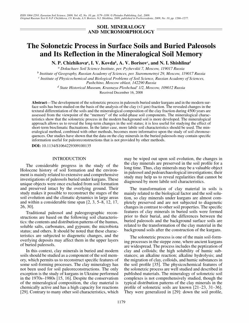
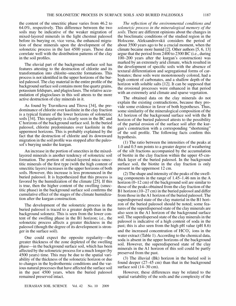
The field study was performed in the desert-steppezone with light chestnut soils on the western slope ofthe Sal–Manych Ridge (a part of the Ergeni Upland,Fig. 1). The parent materials are represented by salineloess-like calcareous loams with a considerable sandcontent in some areas. The complexity of the soil coverpattern is slightly pronounced. The groundwater depthis more than 10 m. Wormwood–grassy associationswith projective cover of about 50% predominate in theplant cover. The area is used for pasturing. The climateis moderately continental with the mean annual temper-ature being 8
°ë
, the mean annual precipitation being
1
Kurgan
1
Kurgan
2
Kurgan
3
Kurgan
4
Kurgan
5
Kurgan
6
Kurgan
7
Kurgan
8
Kurgan
9
Kurgan
10
0
The interval between the unbroken contour lines is 5 m
45°
45° 50° 55°40°
45°
50°
55°45° 50° 55°40°
50°
55°
Volga R.
Don R.
Elista
Volgograd
40°–40°
N
234
50 m
Fig. 1.
Location of the studied objects. Designations: (
1
) power lines, (
2
) earth roads, (
3
) kurgans, and (
4
) pit of the background soil.
EURASIAN SOIL SCIENCE
Vol. 42
No. 10
2009
THE SOLONETZIC PROCESS IN SURFACE SOILS AND BURIED PALEOSOLS 1181
300–350 mm, and the precipitation-to-potential evapo-ration ratio being about 0.5. The snow cover depth aver-ages 10 cm, and the depth of the soil freezing is 70–100 cm.
We studied the paleosols buried under kurgan 5 ofthe Peschanyi-V burial site and the background surfacesoils. The studied kurgan was formed over a burial siteof the Early Catacomb culture in the area occupied bysolonetzes. The radiocarbon dating of bone tissuesfrom the major grave under the kurgan was performed(GrA
2581
±
73
cal yr B.C.).At present, the height of the kurgan exceeds 1 m,
which prevents the penetration of moisture and rootsinto the buried paleosol and ensures its good preserva-tion. The kurgan is composed of material from thehumus horizon and, partly, from the BCk horizon of theburied soil. The soil of the kurgan effervesces from thesurface. The buried paleosol was studied under the cen-tral part of the kurgan, where its height reached 112 cm.The background surface soil was studied at a distanceof 50 m from the kurgan in an area with similar soil-landscape conditions.
The morphogenetic analysis of the buried paleosoland the background surface soil was performed in thefield. The contents of humus, carbonates, and gypsumand the composition of the water extracts were deter-mined by routine methods. The composition of theadsorbed bases was determined according to the Shol-lenberger method [4]. The particle-size distributionanalysis was done by the pipette method with pyro-phosphate pretreatment [1]. The studied soils werediagnosed according to the classification systems of1977 and 2004 [18, 19]. In this paper, the names andindices of the soil horizons are given according to thesystem of 1977.
The clay fraction was extracted via the elutriationtechnique. The X-ray diffractometry of oriented slideswas performed using an XZG-4A universal diffracto-meter (Carl Zeiss Jena, Germany). The minerals werediagnosed using standard tests [9, 10, 24, 28, 29]. TheBiskaye methods [36, 37] were used for the semiquan-titative assessment of the contents of the main groups ofclay minerals and for the separate determination of thekaolinite and chlorite.
RESULTS AND DISCUSSION
Soil morphology.
The buried paleosol was identifiedas a chestnut solonetzic soil (according to the classifi-cation system of 2004), or as a light chestnut solonetzicand solonchakous soil (according to the classificationsystem of 1977).
A1, 0–10 cm. Gray homogenous compact light loamwith a fine crumb structure in the upper part and a loosethin platy structure in the lower part; single diageneticconcentrations of gypsum and soluble salts; gradualboundary.
B1, 10–27 cm. Brown compact medium loam;coarse crumb–blocky structure in the upper part and
crumb–prismatic structure in the lower part; slighteffervescence from a depth of 15 cm; strong efferves-cence from a depth of 18 cm; single organic–clay filmson ped faces; iron–manganic and carbonate concentra-tions are absent; gradual smooth boundary.
B2k, 27–45 cm. Yellow-brown compact mediumloam; coarse angular blocky structure; strong efferves-cence; calcareous films on the walls of fissures and onped faces; gradual smooth boundary.
BCk, 45–90 cm. Whitish brown-yellow compactmedium loam; strongly effervescent, with abundantcalcareous nodules (white eyes); upon drying, dis-persed calcite grains are clearly seen on pit walls.
Cz, 90–105 cm. Brownish yellow slightly compactsandy light loam with a loose coarse blocky structure;abundant veins of soluble salts; abrupt slightly wavyboundary.
Cz,y 105–200 cm. Similar to the above-lying hori-zon, but richer in sand; abundant gypsum concentra-tions in the form of crystal aggregations in the upperpart of the horizon; down the soil profile, the amount ofgypsum concentrations decreases.
Background surface soil: light solonetz (2004), or amedium-deep solonchakous solonetz (1977).
A1, 0–12 cm. Whitish gray light moderately compactlight loam; thin platy–fine crumb structure; abrupt smoothboundary (in some places, with small fingering).
B1, 12–30 cm. Reddish brown medium loam; pris-matic structure (the vertical size of the prisms is about3–6 cm, and the horizontal size of the prisms is about1–3 cm); abundant clay–humus films on ped faces; fewvery small iron–manganic concentrations; gradualsmooth boundary.
B2k, 30–43 cm. Brown compact medium loam;clear effervescence; weakly pronounced prismaticstructure with organomineral films on ped faces in theupper part and a blocky–prismatic structure withoutfilms in the lower part; upon the soil drying, dispersedcalcite crystals (carbonate impregnations) are seen onthe walls; clear smooth boundary.
BCk, 43–95 cm. Yellow-brown compact mediumloam with coarse blocky structure; two subhorizons canbe distinguished with respect to the character of the car-bonate pedofeatures: in the upper part, dispersed calcitegrains and diffuse calcite concentrations are seen; in thelower part, abundant calcareous nodules (white eyes)are present; clear smooth boundary.
C, 95–125 cm. Brownish yellow compact mediumloam; coarse blocky structure; the salt content is low,veins of soluble salts are absent; the transition ismarked by the appearance of concentrations of gypsumand soluble salts; abrupt slightly wavy boundary.
Cz,y, 125–200 cm. Similar to the above-lying hori-zon with a somewhat coarse texture and abundant veinsof soluble salts and aggregations of gypsum crystals.
Thus, though the two profiles have generally similarmorphologies, the difference between them is seen in
1182
EURASIAN SOIL SCIENCE
Vol. 42
No. 10
2009
CHIZHIKOVA et al.
the degree of morphological manifestation of solo-netzic process. The buried paleosol is characterized byits poorly pronounced solonetzic features in the form ofsome eluviation features in the upper horizon and thedestruction of the prismatic structure in the upper partof the illuvial horizon; the organomineral films on pedfaces in the illuvial horizon are weakly pronounced.This may be related to the degradation of the solonetzicfeatures during the 4500 yrs after the soil’s burying orto the initially weak development of these features inthe buried soil.
The modern surface soil is characterized by a better-pronounced prismatic structure with vertically elon-gated peds (though the typical columnar structure is notformed), abundant humus–clay films in the illuvialhorizon, a thin platy structure in the lower part of the A1horizon, and a fingering boundary between the A1 andBk horizons. All these features point to the more activesolonetzic process in the modern soil. This may berelated to the longer development of the solonetzic pro-cess and to its higher intensity due to some humidiza-tion of the climate after the kurgan’s construction.
Chemical properties.
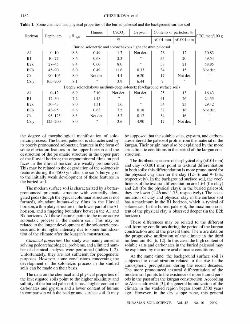
Our study was mainly aimed atsolving pedoarchaeological problems, and a limited num-ber of chemical analyses were performed (Tables 1, 2).Unfortunately, they are not sufficient for pedogeneticpurposes. However, some conclusions concerning thedevelopment of the solonetzic process in the studiedsoils can be made on their basis.
The data on the chemical and physical properties ofthe investigated soils point to the higher alkalinity andsalinity of the buried paleosol; it has a higher content ofcarbonates and gypsum and a lower content of humusin comparison with the background surface soil. It may
be supposed that the soluble salts, gypsum, and carbon-ates entered the paleosol profile from the material of thekurgan. Their origin may also be explained by the morearid climatic conditions in the period of the kurgan con-struction.
The distribution patterns of the physical clay (<0.01 mm)and clay (<0.001 mm) point to textural differentiationin both soils; this differentiation is more pronounced forthe physical clay than for the clay (12–16 and 9–13%,respectively). In the background surface soil, the coef-ficients of the textural differentiation are 1.64 (for clay)and 2.0 (for the physical clay); in the buried paleosol,they are lower (1.46 and 1.75, respectively). The accu-mulation of clay and physical clay in the surface soilhas a maximum in the B1 horizon, which is typical ofsolonetzes. In the buried paleosol, the maximum con-tent of the physical clay is observed deeper (in the B2khorizon).
These differences may be related to the differentsoil-forming conditions during the period of the kurganconstruction and at the present time. There are data onthe progressive aridization of the climate in the thirdmillennium BC [6, 12]. In this case, the high content ofsoluble salts and carbonates in the buried paleosol maybe explained by the more arid climatic conditions.
At the same time, the background surface soil issubjected to desalinization related to the rise in theatmospheric precipitation during the recent decades.The more pronounced textural differentiation of themodern soil points to the existence of more humid peri-ods in the past after the kurgan construction. Accordingto Aleksandrovskii [3], the general humidization of theclimate in the studied region began about 3500 yearsago. However, in the dry steppe zone, this general
Table 1.
Some chemical and physical properties of the buried paleosol and the background surface soil
Horizon Depth, cmHumus CaCO
3
Gypsum Contents of particles, %CEC, meq/100 g
% <0.01 mm <0.001 mm
Buried solonetzic and solonchakous light chestnut paleosol
A1 0–10 8.6 0.49 1.7 Not det. 26 12 30.83
B1 10–27 8.6 0.68 2.3
"
35 20 49.54
B2k 27–45 8.4 0.60 8.0
"
38 21 58.85
BCk 45–90 8.0 0.49 11.6 0.33 34 15 Not det.
Cz 90–105 8.0 Not det. 4.4 6.20 17 Not det.
"
Cz,y 105–200 8.1
"
3.9 6.44 7
" "
Deeply solonchakous medium-deep solonetz (background surface soil)
A1 0–12 6.9 2.10 Not det. Not det. 25 13 16.43
B1 12–30 7.2 1.45
" "
41 26 24.35
B2k 30–43 8.0 1.31 1.6
"
34 23 29.42
BCk 43–95 8.6 0.63 7.5 0.18 32 16 Not det.
Cz 95–125 8.3 Not det. 5.2 0.12 34 16
"
Cz,y 125–200 8.0
"
3.6 4.90 17 Not det.
"
pHH2O
EURASIAN SOIL SCIENCE
Vol. 42
No. 10
2009
THE SOLONETZIC PROCESS IN SURFACE SOILS AND BURIED PALEOSOLS 1183
humidization is poorly pronounced, and the soil evolu-tion pattern reflects shorter stages of the relative moist-ening and drying of the climate [12]. Thus, if we rejectthe hypothesis that the difference between the two stud-ied soils is related to the spatial differentiation of thesoil cover rather than to the temporal changes in the soilformation, we may suppose that the higher intensity ofthe textural differentiation in the background surfacesoil results from the cumulative effect of periodicallyrepeating humidization periods.
Mineralogical composition of the clay minerals.
The mineralogical composition of the clay fractionsseparated from the buried paleosol is generally similarto that in the background surface soil. The followingminerals are identified: smectite, mica and hydromica,magnesium–iron chlorite, and imperfect kaolinite.Some horizons contain quartz, potassium feldspars, andplagioclases.
The swelling smectitic phase is represented by vari-ous mixed-layered minerals: mica–smectite with a highcontent of smectitic layers, mica–smectite with a lowcontent of smectitic layers, and chlorite–smectite.These formations are unevenly distributed in the soilprofiles.
The ratio between the intensities of the
d
001
and
d
003
peaks to the intensity of the
d
002
peak attests to the pre-dominance of trioctahedral mica–hydromica of the biotitictype. The presence of micas identified by the sharp peaksat 1.0 nm should be especially noted. Similar peaks areproduced by hydromica, but their
d
001
= 1.01 nm peak ismore asymmetric towards the range of smaller angles.
The studied minerals, as well as magnesium–ironchlorite, kaolinite, and fine-dispersed quartz, are iden-
tified in almost all the samples from the studied soils,but the ratios between them and their particular crystal-lographic characteristics are different in the differentsoil horizons.
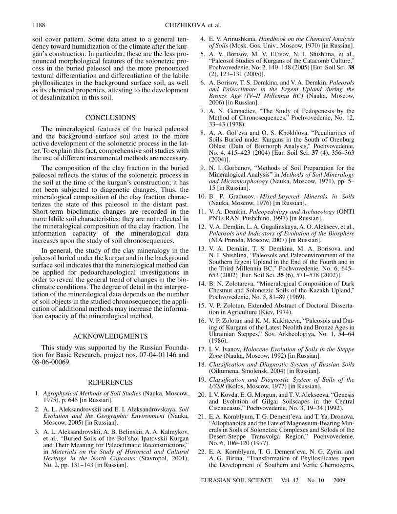
The distribution pattern and composition of the clayfraction.
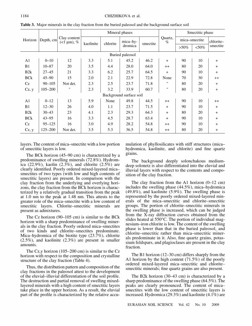
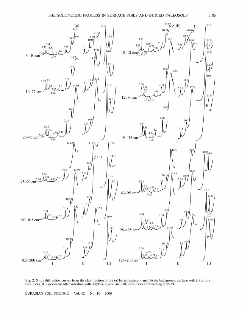
In the buried solonetzic light chestnut paleo-sol, the clay fraction in the A1 horizon (0–10 cm) iscomposed of minerals with stiff crystalline structures:mica–hydromica (45%) and chlorite and kaolinite(8.4% in total) (Table 3, Fig. 2). The swelling phase ismainly represented by the poorly ordered mixed-lay-ered mica–smectite with a high content of smectiticlayers.
The B1 horizon (10–27 cm) is the horizon of theilluvial accumulation of clay. However, the composi-tion of the clay fraction and the proportion between thedifferent clay minerals in it attest to the destructionand/or removal of the smectitic phase from this hori-zon. Note that the morphological features of the solo-netzic process in the upper part of this horizon are weaklypronounced. The clay fraction consists of mica–hydrom-ica, chlorite, and kaolinite. The
d
001
= 1.58 nm peak on thediffraction curve from the initial preparation points tothe beginning of the transition of mixed-layered miner-als into the superdispersed state. Similar processeswere studied in the salt-affected soils of the BarabaLowland [36] and in the soils of the North Caucasusregion [20, 27]. They are usually related to saliniza-tion–desalinization phenomena, particularly in thepresence of soda [32].
In the lower part of the illuvial horizon (B2k, 27–45 cm),the swelling phase predominates and includes mixed-layered mica–smectite with a high portion of smectitic
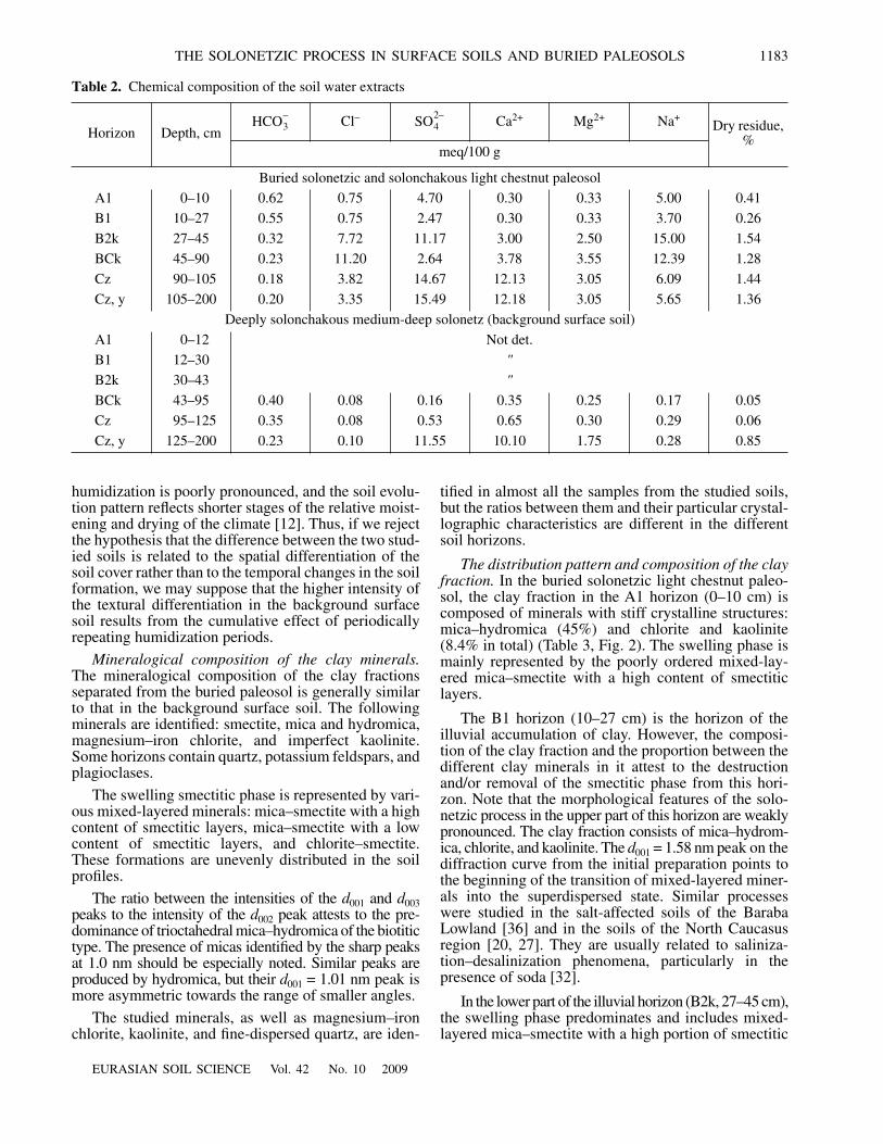
Table 2.
Chemical composition of the soil water extracts
Horizon Depth, cmCl
–
Ca
2+
Mg
2+
Na
+
Dry residue, %
meq/100 g
Buried solonetzic and solonchakous light chestnut paleosol
A1 0–10 0.62 0.75 4.70 0.30 0.33 5.00 0.41
B1 10–27 0.55 0.75 2.47 0.30 0.33 3.70 0.26
B2k 27–45 0.32 7.72 11.17 3.00 2.50 15.00 1.54
BCk 45–90 0.23 11.20 2.64 3.78 3.55 12.39 1.28
Cz 90–105 0.18 3.82 14.67 12.13 3.05 6.09 1.44
Cz, y 105–200 0.20 3.35 15.49 12.18 3.05 5.65 1.36
Deeply solonchakous medium-deep solonetz (background surface soil)
A1 0–12 Not det.
B1 12–30
"
B2k 30–43
"
BCk 43–95 0.40 0.08 0.16 0.35 0.25 0.17 0.05
Cz 95–125 0.35 0.08 0.53 0.65 0.30 0.29 0.06
Cz, y 125–200 0.23 0.10 11.55 10.10 1.75 0.28 0.85
HCO3– SO4
2–
1184
EURASIAN SOIL SCIENCE
Vol. 42
No. 10
2009
CHIZHIKOVA et al.
Table 3.
Major minerals in the clay fraction from the buried paleosol and the background surface soil
Horizon Depth, cm Clay content (<1
µ
m), %
Mineral phasesQuartz,
%
Smectitic phase
kaolinite chlorite mica–hy-dromica smectite
mica–smectite chlorite–smectite
>50% <50%
Buried paleosol
A1 0–10 12 3.3 5.1 45.2 46.2 + 90 10 +
B1 10–87 20 3.5 4.4 28.0 64.0 ++ 80 20 +
B2k 27–45 21 3.3 6.2 25.7 64.5 + 90 10 +
BCk 45–90 15 2.0 2.1 22.9 72.8
None
70 30 ++
Cz 90–105
Not det.
2.3 2.5 23.7 71.8
"
80 20 +
Cz, y 105–200
"
2.3 3.2 33.9 60.7
"
80 20 +
Background surface soil
A1 0–12 13 5.9
None
49.8 44.5 ++ 90 10 ++
B1 12–30 26 4.0 1.1 23.7 71.5 + 90 10 +
B2k 30–43 23 4.1 2.3 29.3 64.3 + 80 20 +
BCk 43–95 16 3.3 4.5 28.7 63.4 + 90 10 +
Cz 95–125 16 3.0 4.9 28.2 54.8 ++ 90 10 +
Cz, y 125–200
Not det.
3.5 5.3 36.5 54.8 ++ 80 20 +
layers. The content of mica–smectite with a low portionof smectitic layers is low.
The BCk horizon (45–90 cm) is characterized by apredominance of swelling minerals (72.8%). Hydrom-ica (22.9%), kaolin (2.3%), and chlorite (2.5%) areclearly identified. Poorly ordered mixed-layered mica–smectites of two types (with low and high contents ofsmectitic layers) are present. In comparison with theclay fraction from the underlying and overlying hori-zons, the clay fraction from the BCk horizon is charac-terized by a relatively gradual transition from the peakat 1.0 nm to the peak at 1.48 nm. This attests to thegreater role of the mica–smectite with a low content ofsmectitic layers. Chlorite–smectitic minerals arepresent as admixtures.
The Cz horizon (90–105 cm) is similar to the BCkhorizon with a sharp predominance of swelling miner-als in the clay fraction. Poorly ordered mica–smectitesof two kinds and chlorite–smectites predominate.Mica–hydromica of the biotite type (23.7%), chlorite(2.5%), and kaolinite (2.3%) are present in smalleramounts.
The Cz,y horizon (105–200 cm) is similar to the Czhorizon with respect to the composition and crystallinestructure of the clay fraction (Table 4).
Thus, the distribution pattern and composition of theclay fractions in the paleosol attest to the developmentof the eluvial–illuvial differentiation of the soil profile.The destruction and partial removal of swelling mixed-layered minerals with a high content of smectitic layerstake place in the upper horizon. As a result, the eluvialpart of the profile is characterized by the relative accu-
mulation of phyllosilicates with stiff structures (mica–hydromica, kaolinite, and chlorite) and fine quartzgrains.
The background deeply solonchakous medium-deep solonetz is also differentiated into the eluvial andilluvial layers with respect to the contents and compo-sition of the clay fraction.
The clay fraction from the A1 horizon (0–12 cm)includes the swelling phase (44.5%), mica–hydromica(49.8%), and kaolinite (5.9%). The swelling phase isrepresented by the poorly ordered mixed-layered min-erals of the mica–smectitic and chlorite–smectiticgroups. The portion of chlorite–smectitic minerals inthe swelling phase is increased, which can be judgedfrom the X-ray diffraction curves obtained from theslides heated at
550°ë
. The portion of individual mag-nesium–iron chlorite is low. The content of the swellingphase is lower than that in the buried paleosol, andchlorite–smectitic rather than mica–smectitic miner-als predominate in it. Also, fine quartz grains, potas-sium feldspars, and plagioclases are present in the clayfraction.
The B1 horizon (12–30 cm) differs sharply from theA1 horizon by the high content (71.5%) of the poorlyordered mixed-layered mica–smectitic and chlorite–smectitic minerals; fine quartz grains are also present.
The B2k horizon (30–43 cm) is characterized by asharp predominance of the swelling phase (64.5%). Thepeaks are clearly pronounced. The content of mica–smectites with the low content of smectitic layers isincreased. Hydromica (29.3%) and kaolinite (4.1%) are
EURASIAN SOIL SCIENCE
Vol. 42
No. 10
2009
THE SOLONETZIC PROCESS IN SURFACE SOILS AND BURIED PALEOSOLS 1185
(a)
3.21
3.353.54
3.37
4.26
4.76 5.0
7.18
10.2
14.5
7.1
10.0
14.2
–1.3
3.53
3.574.78
4.26
5.0
10.2
14.5
10.0
10.0
14.1
14.1
14.1
10.0
10.0
14.0
14.0
10.0
10.0
14.0
10.0
10.0
10.0
10.0
10.1
17.0
14.0
7.183.33
3.343.56
4.78
4.26
5.0
10.0
10.2
7.18
14.62
7.0
7.1814.98
3.03
3.03
3.343.56
4.74 5.0
0–10 Òm
10–27 Òm
27–45 Òm
45–90 Òm
90–105 Òm
105–200 Òm
0–12 Òm
12–30 Òm
30–43 Òm
43–95 Òm
95–125 Òm
125–200 Òm
5.0
5.04.74
4.74
7.18
7.18
7.18
7.183.34
3.33
3.56
3.56
7.114.68
17.8
17.514.52
10.28
17.2
17.5
10.28
14.0
10.0
10.0
10.014.0
14.0
17.0
18.0
18.0
10.0
10.2
10.27.18
7.18
10.1
7.0
7.1
3.34
3.34
3.34
3.53
3.53
3.533.57
3.57
4.24
4.745.0
5.0
5.0
10.18
10.2
10.14
7.18
7.18
7.2
4.74
4.26
4.26
4.745.0
7.18
10.0
14.5
14.98
3.563.34
3.343.573.53 5.0
7.18
10.0
10.0
10.0
14.0
10.0
14.0
7.18
5.04.743.21
3.34
3.573.53
4.26
10.21
14.68
–19.0
10.0
10.0
7.18 17.2
14.014.7
14.58
7.18
4.744.23
17.5
14.68
4.744.26
I II III I II III
12.013.3
(b)
Fig. 2.
X-ray diffraction curves from the clay fraction of the (a) buried paleosol and (b) the background surface soil: (I) air-dryspecimens, (II) specimens after solvation with ethylene glycol, and (III) specimens after heating at 550
°
C.
1186
EURASIAN SOIL SCIENCE
Vol. 42
No. 10
2009
CHIZHIKOVA et al.
present, and the portion of chlorite increases up to2.3%.
The BCk horizon (43–95 cm) is generally similar tothe B2k horizon with respect to the composition of theclay fraction. However, the content of the swellingphase represented by the poorly ordered mica–smec-tites with a high portion of smectitic layers is increased,whereas the content of mica–smectites with a low por-tion of smectitic layers is low. Among the mica–hydro-mica minerals (28.7%), the portion of mica diagnosedby a sharp peak at 1.0 nm increases. Chlorite–smectite,kaolinite, fine quartz grains, potassium feldspar, andplagioclases are also present in the clay fraction.
The Cz horizon (95–125 cm) is characterized by thesimilar composition of the clay with a somewhatincreased content of the swelling phase and chlorite;Quartz, potassium feldspar, and plagioclases arepresent.
The clay fraction from the Cz,y horizon (125–200 cm)is similar to that from the BCk and Cz horizons, thoughthe intensities of the characteristic peaks of the miner-als are considerably lower.
These data on the mineralogical composition of theclay fractions from the buried paleosol and the back-ground surface soil allow us to suppose that both soilprofiles are developed from the same parent material, inwhich the swelling phase represented by mixed-layeredminerals of the mica–smectitic and chlorite–smectitictypes predominates. The amounts of mica–hydromicaof the biotitic type, magnesium–iron chlorite, andimperfect kaolinite are smaller.
The solonetzic process as reflected in the propertiesof the clay fraction.
Both soil profiles are characterized
by the pronounced eluvial–illuvial differentiation of theclay fraction and the minerals composing it. The A1horizons of both soils are depleted of the clay fraction,and the clay fraction in them is depleted of the swellingphase due to the disappearance of mica–smectitic min-erals. The content of individual chlorite is also low.These features (the decrease in the content of mica–smectite and chlorite and the increase in the content ofmica–hydromica and kaolinite against the backgroundof the generally poor crystalline structure of the clayminerals) are typical of the clay fraction in the upperhorizons of solonetzes [33, 34]. At the same time, theclay fraction in this horizon is relatively rich in finequartz grains, which may be explained by the destruc-tion of clay minerals and their removal from the hori-zon. The illuvial horizons have an increased content ofthe clay fraction and an increased content of the swell-ing phase (mica–smectitic minerals with a high contentof smectitic layers) in the clay fraction. The eluvial–illuvial differentiation of the clay is well pronouncedboth in the buried light chestnut solonetzic soil and thebackground solonetz (the differentiation coefficients ofthe smectitic phase in the profiles of these soils are 1.58and 1.6, respectively). The composition of the clayfraction and the proportion between the different min-erals in it in the illuvial (B) horizons of both soilsbecome relatively close to those in the parent materials(C horizons), which has been noted as a typical featureof solonetzic soil complexes [34].
The background surface solonetz is characterized bythe sharper differentiation of the smectitic phase in theprofile (from 44.5% in the clay fraction from the A1horizon to 71.5% in the clay fraction from the B1 hori-zon). In the buried light chestnut solonetzic paleosol,
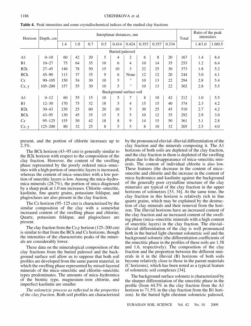
Table 4. Peak intensities and some crystallochemical indices of the studied clay fractions
Horizon Depth, cmInterplanar distances, nm
Total
Ratio of the peak intensities
1.4 1.0 0.7 0.5 0.414 0.424 0.353 0.357 0.334 1.4/1.0 1.0/0.5
Buried paleosol
A1 0–10 60 42 20 5 4 2 6 8 20 167 1.4 8.4
B1 10–27 75 64 35 10 6 4 10 14 35 253 1.2 6.4
B2k 27–45 140 78 50 15 10 3 22 25 30 373 1.8 5.2
BCk 45–90 113 37 35 9 6 None 12 12 20 244 3.0 4.1
Cz 90–105 150 54 30 10 5 " 10 13 22 294 2.8 5.4
Cz, y 105–200 157 55 30 10 5 " 10 13 22 302 2.8 5.5
Background surface soil
A1 0–12 60 55 15 10 5 7 8 10 42 212 1.0 5.5
B1 12–30 170 75 32 18 5 4 15 15 40 374 2.3 4.2
B2k 30–43 230 25 60 20 10 5 30 25 45 510 2.7 4.2
BCk 43–95 130 45 35 15 5 5 10 12 35 292 2.9 3.0
Cz 95–125 155 50 42 18 8 9 14 15 50 361 3.1 2.8
Cz, y 125–200 80 32 25 8 5 5 8 10 32 205 2.5 4.0
EURASIAN SOIL SCIENCE Vol. 42 No. 10 2009
THE SOLONETZIC PROCESS IN SURFACE SOILS AND BURIED PALEOSOLS 1187
the content of the smectitic phase varies from 46.2 to64.0%, respectively. This difference between the twosoils may be indicative of the weaker migration ofmixed-layered minerals in the light chestnut paleosolbefore its burying or, vice versa, the enhanced migra-tion of these minerals upon the development of thesolonetzic process in the last 4500 years. These datacorrelate well with the distribution patterns of the clayin the soil profiles.
The eluvial part of the background surface soil hasfeatures attesting to the destruction of chlorite and itstransformation into chlorite–smectite formations. Thisprocess is not identified in the upper horizons of the bur-ied paleosol. The clay material in the entire profile of thebackground surface soil contains more fine quartz grains,potassium feldspars, and plagioclases. The relative accu-mulation of plagioclases in this soil attests to the moreactive destruction of clay minerals in it.
As found by Travnikova and Titova [34], the pre-dominance of chlorite over kaolinite in the clay fractionis a typical feature of the lower horizons of solonetzicsoils [34]. This regularity is clearly seen in the BC andC horizons of the background surface soil. In the buriedpaleosol, chlorite predominates over kaolinite in theuppermost horizons. This is probably explained by thefact that the destruction of chlorite and its downwardmigration in the soil profile was stopped after the paleo-sol’s burying under the kurgan.
An increase in the portion of smectites in the mixed-layered minerals is another tendency of solonetzic soilformation. The portion of mixed-layered mica–smec-titic minerals of the first type (with the high content ofsmectitic layers) increases in the upper horizons of bothsoils. However, this increase is less pronounced in theburied paleosol. It is hypothesized that this process isfavored by the humidization of the climate [25]. If thisis true, then the higher content of the swelling (smec-titic phase) in the background surface soil confirms thecumulative effect of the stages of the climate humidiza-tion after the kurgan construction.
The development of the solonetzic process in theburied paleosol is traced to a greater depth than in thebackground solonetz. This is seen from the lower con-tent of the swelling phase in the B1 horizon; i.e., thesolonetzic process affects a greater thickness in thepaleosol (though the degree of its development is stron-ger in the surface soil).
One could expect the opposite regularity—thegreater thickness of the zone depleted of the swellingphase—in the background surface soil, which has beenaffected by the solonetzic process for a much longer (by4500 years) time. This may be due to the spatial vari-ability of the thickness of the solonetzic horizon or dueto changes in the hydrothermic conditions and the var-ious natural processes that have affected the surface soilin the past 4500 years, when the buried paleosolremained preserved intact.
The reflection of the environmental conditions andsolonetzic process in the mineralogical memory of thesoils. There are different opinions about the changes inthe bioclimatic conditions of the studied region in theHolocene. Aleksandrovskii considers the period ofabout 3500 years ago to be a crucial moment, when theclimate became more humid [2]. Other authors [5, 6, 13]argue that the period from 2400 to 2300 BC (i.e., during100–200 years after the kurgan’s construction) wasmarked by an extremely arid climate, which resulted inthe development of specific soils with the absence oftextural differentiation and segregational forms of car-bonates; these soils were monotonously colored, had ahigh content of carbonates, and a shallow depth of thehorizon with soluble salts [12]. It can be supposed thatthe erosional processes were enhanced in that periodwith an extremely arid climate and sparse vegetation.
The obtained data on the clay minerals do notexplain the existing contradictions, because they pro-vide some evidence in favor of both hypotheses. Thus,some similarity of the mineralogical composition of theA1 horizon of the background surface soil with the Bhorizon of the buried paleosol attests to the possibilityof the partial erosion of the surface soil after the kur-gan’s construction with a corresponding “shortening”of the soil profile. The following facts confirm thishypothesis.
(1) The ratio between the intensities of the peaks at1.0 and 0.5 nm points to a greater degree of weatheringof the silt fractions accompanied by the accumulationof biotite in the clay fraction within the upper 45-cm-thick layer of the buried paleosol. In the backgroundsurface soil, the biotite in the clay fraction is onlypresent in the uppermost 12 cm.
(2) The shape and intensity of the peaks of the swell-ing components in the range of 1.45–1.46 nm in the Ahorizon (0–12 cm) of the background soil are similar tothose of the peaks obtained from the clay fraction of theB1 horizon (10–27 cm) in the buried paleosol and differfrom those in the A1 horizon of the buried paleosol. Thesuperdispersed state of the clay material in the B1 hori-zon of the buried paleosol should be noted; some fea-tures of the superdispersed state of the clay minerals arealso seen in the A1 horizon of the background surfacesoil. The superdispersed state of the clay minerals in thepaleosol is indicative of a high content of soda in thepast; this is also seen from the high pH value (pH 8.6)and the increased concentration of çë ions in thewater extract (Table 1). According to the chemical data,soda is absent in the upper horizons of the backgroundsoil. However, the superedispersed state of the clayminerals in the A1 horizon of this soil could be partlypreserved from the past.
(3) The illuvial (Bk) horizon in the buried soil isfound deeper (27–45 cm) than that in the backgroundsurface soil (14–30 cm).
However, these differences may be related to thespatial variability of the soils and the complexity of the
O3–
1188
EURASIAN SOIL SCIENCE Vol. 42 No. 10 2009
CHIZHIKOVA et al.
soil cover pattern. Some data attest to a general ten-dency toward humidization of the climate after the kur-gan’s construction. In particular, these are the less pro-nounced morphological features of the solonetzic pro-cess in the buried paleosol and the more pronouncedtextural differentiation and differentiation of the labilephyllosilicates in the background surface soil, as wellas its chemical properties, attesting to the developmentof desalinization in this soil.
CONCLUSIONS
The mineralogical features of the buried paleosoland the background surface soil attest to the moreactive development of the solonetzic process in the lat-ter. To explain this fact, comprehensive soil studies withthe use of different instrumental methods are necessary.
The composition of the clay fraction in the buriedpaleosol reflects the status of the solonetzic process inthe soil at the time of the kurgan’s construction; it hasnot been subjected to diagenetic changes. Thus, themineralogical composition of the clay fraction charac-terizes the state of this paleosol in the distant past.Short-term bioclimatic changes are recorded in themore labile soil characteristics; they are not reflected inthe mineralogical composition of the clay fraction. Theinformation capacity of the mineralogical dataincreases upon the study of soil chronosequences.
In general, the study of the clay mineralogy in thepaleosol buried under the kurgan and in the backgroundsurface soil indicates that the mineralogical method canbe applied for pedoarchaeological investigations inorder to reveal the general trend of changes in the bio-climatic conditions. The degree of detail in the interpre-tation of the mineralogical data depends on the numberof soil objects in the studied chronosequence; the appli-cation of additional methods may increase the informa-tion capacity of the mineralogical method.
ACKNOWLEDGMENTS
This study was supported by the Russian Founda-tion for Basic Research, project nos. 07-04-01146 and08-06-00069.
REFERENCES
1. Agrophysical Methods of Soil Studies (Nauka, Moscow,1975), p. 645 [in Russian].
2. A. L. Aleksandrovskii and E. I. Aleksandrovskaya, SoilEvolution and the Geographic Environment (Nauka,Moscow, 2005) [in Russian].
3. A. L. Aleksandrovskii, A. B. Belinskii, A. A. Kalmykov,et al., “Buried Soils of the Bol’shoi Ipatovskii Kurganand Their Meaning for Paleoclimatic Reconstructions,”in Materials on the Study of Historical and CulturalHeritage in the North Caucasus (Stavropol, 2001),No. 2, pp. 131–143 [in Russian].
4. E. V. Arinushkina, Handbook on the Chemical Analysisof Soils (Mosk. Gos. Univ., Moscow, 1970) [in Russian].
5. A. V. Borisov, M. V. El’tsov, N. I. Shishlina, et al.,“Paleosol Studies of Kurgans of the Catacomb Culture,”Pochvovedenie, No. 2, 140–148 (2005) [Eur. Soil Sci. 38(2), 123–131 (2005)].
6. A. Borisov, T. S. Demkina, and V. A. Demkin, Paleosolsand Paleoclimate in the Ergeni Upland during theBronze Age (IV–II Millennia BC) (Nauka, Moscow,2006) [in Russian].
7. A. N. Gennadiev, “The Study of Pedogenesis by theMethod of Chronosequences,” Pochvovedenie, No. 12,33–43 (1978).
8. A. A. Gol’eva and O. S. Khokhlova, “Peculiarities ofSoils Buried under Kurgans in the South of OrenburgOblast (Data of Biomorph Analysis,” Pochvovedenie,No. 4, 415–423 (2004) [Eur. Soil Sci. 37 (4), 356–363(2004)].
9. N. I. Gorbunov, “Methods of Soil Preparation for theMineralogical Analysis” in Methods of Soil Mineralogyand Micromorphology (Nauka, Moscow, 1971), pp. 5–15 [in Russian].
10. B. P. Gradusov, Mixed-Layered Minerals in Soils(Nauka, Moscow, 1976) [in Russian].
11. V. A. Demkin, Paleopedology and Archaeology (ONTIPNTs RAN, Pushchino, 1997) [in Russian].
12. V. A. Demkin, L. A. Gugalinskaya, A. O. Alekseev, et al.,Paleosols and Indicators of Evolution of the Biosphere(NIA Priroda, Moscow, 2007) [in Russian].
13. V. A. Demkin, T. S. Demkina, M. A. Borisova, andN. I. Shishlina, “Paleosols and Paleoenvironment of theSouthern Ergeni Upland in the End of the Fourth and inthe Third Millennia BC,” Pochvovedenie, No. 6, 645–653 (2002) [Eur. Soil Sci. 35 (6), 571–578 (2002)].
14. B. N. Zolotareva, “Mineralogical Composition of DarkChestnut and Solonetzic Soils of the Kazakh Upland,”Pochvovedenie, No. 5, 81–89 (1969).
15. V. P. Zolotun, Extended Abstract of Doctoral Disserta-tion in Agriculture (Kiev, 1974).
16. V. P. Zolotun and K. M. Kukhteeva, “Paleosols and Dat-ing of Kurgans of the Latest Neolith and Bronze Ages inUkrainian Steppes,” Sov. Arkheologiya, No. 1, 54–64(1986).
17. I. V. Ivanov, Holocene Evolution of Soils in the SteppeZone (Nauka, Moscow, 1992) [in Russian].
18. Classification and Diagnostic System of Russian Soils(Oikumena, Smolensk, 2004) [in Russian].
19. Classification and Diagnostic System of Soils of theUSSR (Kolos, Moscow, 1977) [in Russian].
20. I. V. Kovda, E. G. Morgun, and T. V. Alekseeva, “Genesisand Evolution of Gilgai Soilscapes in the CentralCiscaucasus,” Pochvovedenie, No. 3, 19–34 (1992).
21. E. A. Kornblyum, T. G. Dement’eva, and T. Ya. Dronova,“Allophanoids and the Fate of Magnesium-Bearing Min-erals in Soils of Solonetzic Complexes and Solods of theDesert-Steppe Transvolga Region,” Pochvovedenie,No. 6, 106–120 (1977).
22. E. A. Kornblyum, T. G. Dement’eva, N. G. Zyrin, andA. G. Birina, “Transformation of Phyllosilicates uponthe Development of Southern and Vertic Chernozems,
EURASIAN SOIL SCIENCE Vol. 42 No. 10 2009
THE SOLONETZIC PROCESS IN SURFACE SOILS AND BURIED PALEOSOLS 1189
Solonetzes, and Solodic Soils,” Pochvovedenie, No. 1,107–114 (1972).
23. E. A. Kornblyum, T. G. Dement’eva, N. G. Zyrin, andA. G. Birina, “Some Characteristics Features of theTranslocation and Transformation of Phyllosilicatesupon the Development of Southern and Vertic Cher-nozems, Solonetzes, and Solodic Soils,” Pochvovedenie,No. 5, 107–120 (1972).
24. I. Kostov, Mineralogiya (Spetsialna chast) (Mineralogy:Special Issue), (Nauka i Iskusstvo, Sofia, 1957. Trans-lated under the title Mineralogiya, Moscow: Mir, 1971.
25. S. A. Manukov, “Changes in the Composition of Phyllo-silicates in Loess Deposits upon Their ContinuousMoistening,” in Methods for Studying Geological Engi-neering Features of Clay Sediments in the Ciscaucasusin Relation to the Assessment of Slumps and SurfaceSubsidence (Nauka, Moscow, 1967), pp. 175–184 [inRussian].
26. L. S. Pesochina, Extended Abstract of Candidate’s Dis-sertation in Biology (Moscow, 2004).
27. R. T. Popova, T. Ya. Dronova, V. V. Morozov, et al., “TheRole of Clay Minerals and Nonsilicate Iron Compoundsin the Development of Some Vertic Soils,” Pochvovede-nie, No. 11, 125–135 (1992).
28. G. Brown (Ed.), The X-Ray Identification and CrystalStructures of Clay Minerals, (Mineralogical Soc., Lon-don, 1961).
29. T. A. Sokolova, T. Ya. Dronova, and I. I. Tolpeshta, ClayMinerals in Soils (Grif i K, Tula, 2005), 336 pp. [in Rus-sian].
30. Ya. G. Ryskov and V. A. Demkin, The Holocene Devel-opment of Soils and Environment of Southern Steppes in
the Southern Ural Region (ONTI PNTs RAN, Push-chino, 1997) [in Russian].
31. L. S. Travnikova, “Mineralogical Composition of theFraction <1 µm in Some Solonetzes from the Cher-nozemic and Chestnut Soil Zones,” Byull. Pochv. Inst.im. V.V. Dokuchaeva, issue 11 (1968).
32. L. S. Travnikova, “About the Geography and Genesis ofClay Matter in Solonetzic Soils,” in Abstracts of Papersto the V Delegate Congress of the All-Union Soil ScienceSociety (Minsk, 1977), Vol. 1, pp. 156–157 [in Russian].
33. L. S. Travnikova, “About the Composition and Structureof Major Components of Clay Matter in Sodic Solo-netzes,” Dokl. Akad. Nauk SSSR 226 (6), 1425–1428(1976).
34. L. S. Travnikova and N. A. Titova, “Composition andDistribution of Clay Minerals in Particle-Size Fractions<5 µm of Soils of Solonetzic Complexes in the KalmykSteppe,” Pochvovedenie, No. 4, 74–86 (1978).
35. N. B. Khitrov, Genesis, Diagnostics, Properties, andFunctioning of Swelling Clayey Soils in the CentralCiscaucasus (Moscow, 2003) [in Russian].
36. N. P. Chizhikova, B. P. Gradusov, and L. S. Travnikova,“Mineralogical Composition of Clay Matter in Soils,” inStructure, Functioning, and Evolution of Biogeocenosesin the Baraba Lowland (Nauka, Novosibirsk, 1974),Vol. 1, pp. 159–183 [in Russian].
37. P. E. Biskaye, “Distinction between Kaolinite and Chlo-rite in Recent Sediments by X-Ray Diffraction,” Am.Mineral. 49 (9–10).
38. P. E. Biskaye, “Mineralogy and Sedimentation of RecentDeep-Sea Clay in the Atlantic Ocean and Adjacent Seasand Oceans,” Geol. Soc. Am. Bull. 76, 803–832 (1965).