Embed Size (px)
Citation preview
www.DiscoveryPacks.com
We started www.caves.com and www.cavediggers.com simply as a way for people to share caving information about their projects. Originally, it was meant for sharing information about what was going on in Rader’s Valley, West Virginia, which was mostly digging related. Mark designed a website for our project and then began to get really creative with it by making flash videos with music and including lots of pic-tures. Being on the web, it was naturally picked up by search spiders and linked into the search lists of the major engines. Then Mark began to get a bunch of e-mails from people telling him how much they en-joyed the site; obviously cavers were surfing the web in greater numbers than we had originally thought. So he added more and more information. Pictures, articles, and links were added daily and, all the while, visitors continued asking for more. During this time, people began sending us articles to publish on the website. In fact, we had so many we didn’t know what to do with them all! Back then, we had submissions
Caves.Com, The Magazine...
Editor Contact Info
Mark Passerby [email protected]
Aaron Bird
Rachel Bosch [email protected]
Mailing Address: P.O. Box 80693
Lansing, MI 48908
The fine print... We welcome photo, article, and letters submissions. We will consider all for publication.
Advertising is accepted for this magazine and costs vary de-pending on size of ad and placement. Please email editor for information. This magazine is published quarterly beginning in late Feb-ruary of each year. Articles should be submitted one month prior to publishing. Subscriptions are $20 per year. Mail check to: Mark Passerby, P.O. Box 80693, Lansing, MI 48908 Make check payable to: Mark Passerby.
Want to know more? Send e-mail to [email protected] Letter to the editor? [email protected]
Announcing cave happenings? [email protected]
on digging techniques mostly. We were really focusing on digging to get into caves in West Virginia. Others, with their own projects, picked up on our enthusiasm to share info, and so began a world-wide “electronic conference” on digging tech-niques and tools that continues to this day. All of this was fuel for Mark, because dig-ging is his thing. In Greenbrier County, WV, his digs have lead to miles and miles of cave. His current passion for breaking into the “Big One” in Rader’s Valley is in-fectious, as evidenced by the number of people who have worked there tirelessly so many times over the years. Our occasional successes have been enough to keep us go-ing strong. Add to it Mark’s enthusiasm and the wind (which is gale-force in every hole!), and we’re usually not short on opti-mism. Suffice it to say, caving in the Val-ley is all about attitude! At some point in this wild electronic (and now paper) cave-media ride, we noticed that the general caving submissions –and requests for info– greatly outnumbered the
3rd Edition September – November
2
13
16
digging submissions. We realized there were cavers other than diggers out there! Just kidding... ;-) but we really did recognize that people were hungry for more than just dig-ging, which was quite a brain fart for thickheaded people like me and Mark. Actually I think it may have been Rachel and Brenda who pushed us to be “more inclusive,” since they are our voices of reason. Once we got it under our skin that we were going to do more than digging related arti-cles, and checked with CaveDiggers subscribers, the proverbial cave gate was thrown wide and we began contacting people who had great stories to tell about caving in gen-eral… and we found some right away who were willing to share their stories. In this, the Third Edition, we’ve included an interview with a cave diving photogra-pher named Steve Auer, an article about the famous Army Corps dam fighter Don Rim-bach, and a report from a recently opened, explored, and mapped cave in Alabama. However, we can’t stray too far from our roots, so we do still have digging articles in this Edition. In fact, we have a doozy. Several years ago, a group of cavers from West Virginia Uni-versity and South-Western Pennsylvania all found themselves working together at Lau-rel Caverns, a large commercial cave near Uniontown, Pennsylvania. They had the nor-mal jobs of leading tours and taking people on wild cave trips in the lower part of the cave, but they also found they were encouraged to look for more passage… using any means necessary. The included article, by Jeff Bray, is the story of what they did to find new cave and how they went about it. You’re going to be surprised! In August many of us attended DigCon 2002, held in Greenbrier County, WV, and we included a report of the activities that went on, as well as attached the program from the weekend as an appendix. In addition, there is a report on the Carroll Cave Dig break-through. Finally, there’s an article about finding new caves (or digsites) using the tem-perature variations near entrances. Overall, we think we’re publishing some great arti-cles and believe this Edition will have something for everyone. We hope you enjoy read-ing it as much as we enjoyed putting it together. In the next Edition, we plan to focus on vertical caving including gear, techniques, ver-tical caves, rigging philosophies, and anything else we can find or you send us related to vertical caving. In the Edition to follow that one, which will be the first for next year, we’ll focus on surveying and mapping. If you have a story to tell or a technique you want to share concerning vertical caving or surveying/mapping, then send it us and we’ll try to get it in. As always, send us feedback about how you think we’re doing! Aaron Bird September, 2002 WWW.CAVES.COM
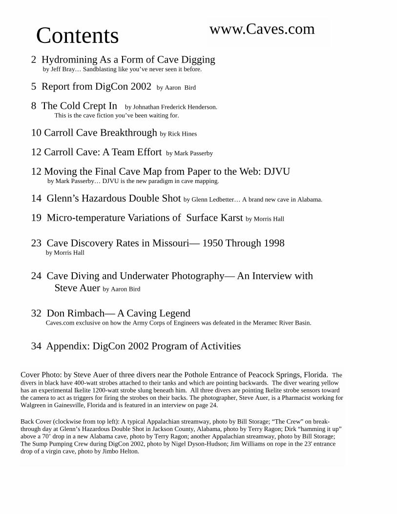
Contents www.Caves.com
2 Hydromining As a Form of Cave Digging by Jeff Bray… Sandblasting like you’ve never seen it before.
5 Report from DigCon 2002 by Aaron Bird
8 The Cold Crept In by Johnathan Frederick Henderson. This is the cave fiction you’ve been waiting for.
10 Carroll Cave Breakthrough by Rick Hines
12 Carroll Cave: A Team Effort by Mark Passerby
12 Moving the Final Cave Map from Paper to the Web: DJVU by Mark Passerby… DJVU is the new paradigm in cave mapping.
14 Glenn’s Hazardous Double Shot by Glenn Ledbetter… A brand new cave in Alabama.
19 Micro-temperature Variations of Surface Karst by Morris Hall
23 Cave Discovery Rates in Missouri— 1950 Through 1998 by Morris Hall
24 Cave Diving and Underwater Photography— An Interview with
Steve Auer by Aaron Bird
32 Don Rimbach— A Caving Legend Caves.com exclusive on how the Army Corps of Engineers was defeated in the Meramec River Basin.
34 Appendix: DigCon 2002 Program of Activities
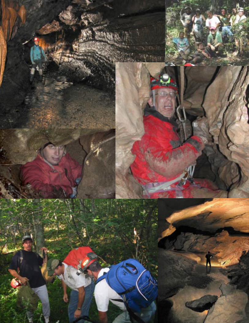
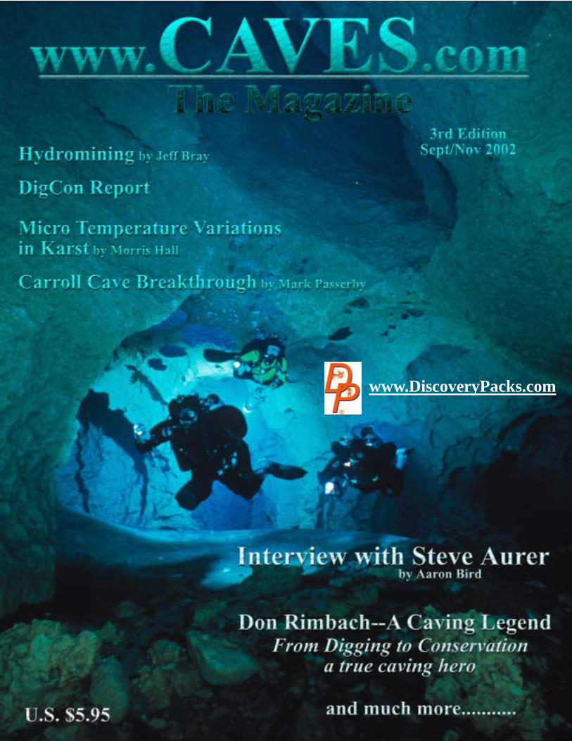
Cover Photo: by Steve Auer of three divers near the Pothole Entrance of Peacock Springs, Florida. The divers in black have 400-watt strobes attached to their tanks and which are pointing backwards. The diver wearing yellow has an experimental Ikelite 1200-watt strobe slung beneath him. All three divers are pointing Ikelite strobe sensors toward the camera to act as triggers for firing the strobes on their backs. The photographer, Steve Auer, is a Pharmacist working for Walgreen in Gainesville, Florida and is featured in an interview on page 24. Back Cover (clockwise from top left): A typical Appalachian streamway, photo by Bill Storage; “The Crew” on break-through day at Glenn’s Hazardous Double Shot in Jackson County, Alabama, photo by Terry Ragon; Dirk “hamming it up” above a 70’ drop in a new Alabama cave, photo by Terry Ragon; another Appalachian streamway, photo by Bill Storage; The Sump Pumping Crew during DigCon 2002, photo by Nigel Dyson-Hudson; Jim Williams on rope in the 23' entrance drop of a virgin cave, photo by Jimbo Helton.
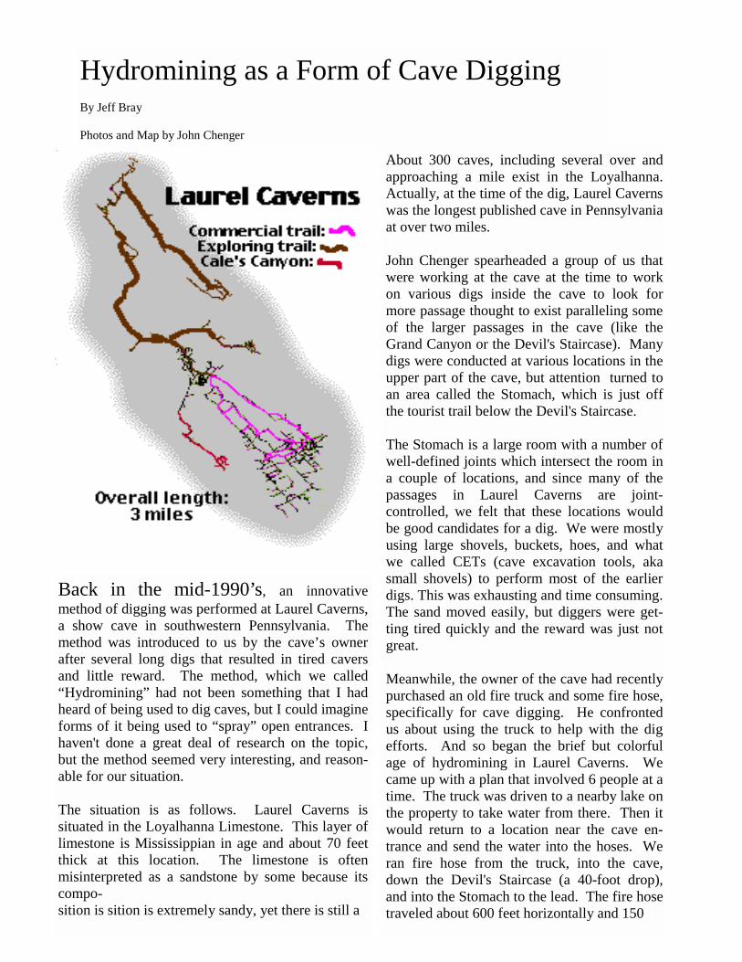
Back in the mid-1990’s, an innovative method of digging was performed at Laurel Caverns, a show cave in southwestern Pennsylvania. The method was introduced to us by the cave’s owner after several long digs that resulted in tired cavers and little reward. The method, which we called “Hydromining” had not been something that I had heard of being used to dig caves, but I could imagine forms of it being used to “spray” open entrances. I haven't done a great deal of research on the topic, but the method seemed very interesting, and reason-able for our situation. The situation is as follows. Laurel Caverns is situated in the Loyalhanna Limestone. This layer of limestone is Mississippian in age and about 70 feet thick at this location. The limestone is often misinterpreted as a sandstone by some because its compo- sition is sition is extremely sandy, yet there is still a
Hydromining as a Form of Cave Digging By Jeff Bray Photos and Map by John Chenger
About 300 caves, including several over and approaching a mile exist in the Loyalhanna. Actually, at the time of the dig, Laurel Caverns was the longest published cave in Pennsylvania at over two miles. John Chenger spearheaded a group of us that were working at the cave at the time to work on various digs inside the cave to look for more passage thought to exist paralleling some of the larger passages in the cave (like the Grand Canyon or the Devil's Staircase). Many digs were conducted at various locations in the upper part of the cave, but attention turned to an area called the Stomach, which is just off the tourist trail below the Devil's Staircase. The Stomach is a large room with a number of well-defined joints which intersect the room in a couple of locations, and since many of the passages in Laurel Caverns are joint-controlled, we felt that these locations would be good candidates for a dig. We were mostly using large shovels, buckets, hoes, and what we called CETs (cave excavation tools, aka small shovels) to perform most of the earlier digs. This was exhausting and time consuming. The sand moved easily, but diggers were get-ting tired quickly and the reward was just not great. Meanwhile, the owner of the cave had recently purchased an old fire truck and some fire hose, specifically for cave digging. He confronted us about using the truck to help with the dig efforts. And so began the brief but colorful age of hydromining in Laurel Caverns. We came up with a plan that involved 6 people at a time. The truck was driven to a nearby lake on the property to take water from there. Then it would return to a location near the cave en-trance and send the water into the hoses. We ran fire hose from the truck, into the cave, down the Devil's Staircase (a 40-foot drop), and into the Stomach to the lead. The fire hose traveled about 600 feet horizontally and 150
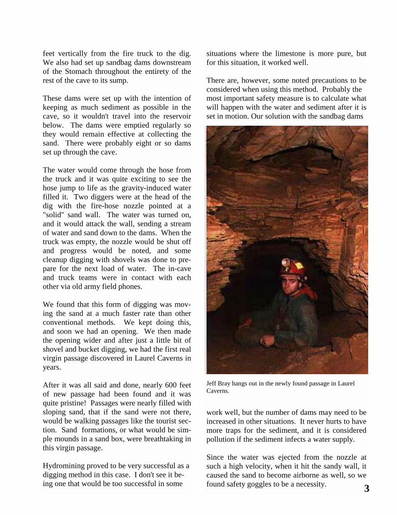
feet vertically from the fire truck to the dig. We also had set up sandbag dams downstream of the Stomach throughout the entirety of the rest of the cave to its sump. These dams were set up with the intention of keeping as much sediment as possible in the cave, so it wouldn't travel into the reservoir below. The dams were emptied regularly so they would remain effective at collecting the sand. There were probably eight or so dams set up through the cave. The water would come through the hose from the truck and it was quite exciting to see the hose jump to life as the gravity-induced water filled it. Two diggers were at the head of the dig with the fire-hose nozzle pointed at a "solid" sand wall. The water was turned on, and it would attack the wall, sending a stream of water and sand down to the dams. When the truck was empty, the nozzle would be shut off and progress would be noted, and some cleanup digging with shovels was done to pre-pare for the next load of water. The in-cave and truck teams were in contact with each other via old army field phones. We found that this form of digging was mov-ing the sand at a much faster rate than other conventional methods. We kept doing this, and soon we had an opening. We then made the opening wider and after just a little bit of shovel and bucket digging, we had the first real virgin passage discovered in Laurel Caverns in years. After it was all said and done, nearly 600 feet of new passage had been found and it was quite pristine! Passages were nearly filled with sloping sand, that if the sand were not there, would be walking passages like the tourist sec-tion. Sand formations, or what would be sim-ple mounds in a sand box, were breathtaking in this virgin passage. Hydromining proved to be very successful as a digging method in this case. I don't see it be-ing one that would be too successful in some
situations where the limestone is more pure, but for this situation, it worked well. There are, however, some noted precautions to be considered when using this method. Probably the most important safety measure is to calculate what will happen with the water and sediment after it is set in motion. Our solution with the sandbag dams
work well, but the number of dams may need to be increased in other situations. It never hurts to have more traps for the sediment, and it is considered pollution if the sediment infects a water supply. Since the water was ejected from the nozzle at such a high velocity, when it hit the sandy wall, it caused the sand to become airborne as well, so we found safety goggles to be a necessity. 3
Jeff Bray hangs out in the newly found passage in Laurel Caverns.
A good feel for the strength of the water is also help-ful to the hosers, although this becomes more com-fortable with practice. Hosers would also want to be sensitive to historical graffiti if it exists at the dig site, as well as formations, bats, and other cave life. With all this in mind, as well as some common sense, hydromining can be useful in finding new passage. If you would like to see another article on this ven-ture, click onto your favorite web-browser and go to: http://www.batmanagement.com/Projects/Cale/laurel1.html
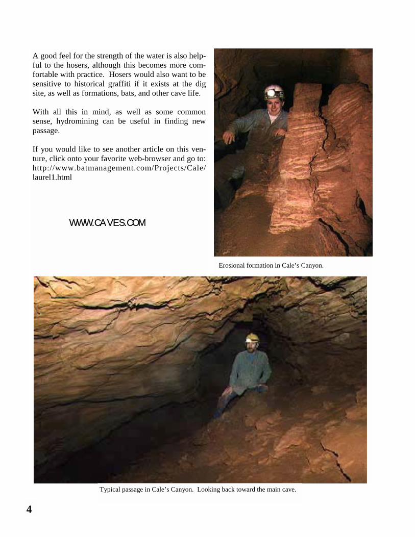
Typical passage in Cale’s Canyon. Looking back toward the main cave.
Erosional formation in Cale’s Canyon.
WWW.CAVES.COM
4
DigCon was held August 1-4 at the West Vir-ginia Association for Cave Studies fieldhouse in Renick, WV. In all, seventeen hardcore dig-gers participated in a variety of activities dur-ing the long, hot weekend that included sharing techniques, demonstrating equipment, and of course digging. Attendees came from as far away as New York, Connecticut, and Michi-gan. On Friday of DigCon, six diggers went to Zi-gafoose Blowhole to continue chaining back the two very large and menacing boulders chocked together above the first climbdown and also to check a lead near the entrance. The chaining operation involved placing 3/8” bolts into the rocks, attaching Petzl hangers and screwlinks, and then connecting them to the wall with chain. Four strands of chain in a zig-zag pattern are now in place to hold the lower boulder if it be-gins to move. Together with the stout locust post beneath the rock, the boulders should be securely supported in the event they shift. Further into the cave, a couple of Northeastern Diggers showed their determination by remov-ing two stubborn rocks to push a lead. Unfor-tunately the lead did not go, but at least now it can be written off the list. Then a tour was made of a recent passage expansion effort and the diggers headed for the entrance. After the Zigafoose work, the group exited into the heat and began to work on a sinkhole dig about 300’ North of the Zigafoose entrance. Several hours were spent pulling out coffee can sized hunks of sandstone with the occasional coffee table hunk being blown in half with a dedicated digger’s Hilti kit. Eventually the heat and hunger got to the dig-gers before the sinkhole revealed cave passage, so the group left to “dig” up some food. Eve-
DigCon 2002 By Aaron Bird Photos by Nigel Dyson-Hudson ning activities followed and consisted of sitting
around with beer and munchies making plans for the next day’s Sump Pumping Project and Dig Tour.
On Saturday morning, the group split with one half going on the Dig Tour and the other half going to the Sump Pumping Project. The Dig Tour con-sisted of stops at fourteen different caves that had been dug open. Included in this list are several notables such as Borehole, Maxwelton, Scott Hol-low, and Zigafoose. See Appendix: DigCon 2002 Program on page 34 for more details. The sump pumping project had gotten off to a gung-ho start the previous evening with consump-tion of a sizeable quantity of good beer. (Rader’s Valley cavers drink Guinness.) Those who had not decided which activity to engage in were quickly convinced that booming passage lay just on the other side of a “small, and easily pumped out sump” and that they should join the sump pumpers for a shot at seeing major Rader’s Valley borehole. Unfortunately this was not to be and the Rader’s Valley crew’s ability at breaking into the “big one” was again overshadowed by their enthusiasm for finding it. Though they have found some signifi-cant caves and passages in Rader’s Valley, their ability to convince diggers/cavers to join them
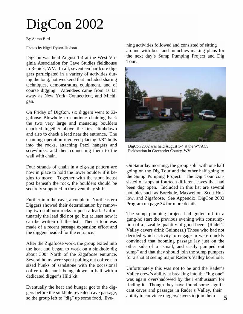
DigCon 2002 was held August 1-4 at the WVACS Fieldstation in Greenbrier County, WV.
5
seems to currently be a better skill than finding the master drain through the valley. Actually, this skill did pay off because with so many energetic diggers, they man-aged to accomplish a dig in the Vlad Way that eventually lead to breezy, going cave… but that’s another story. On Saturday morning, the group split with one half going on the Dig Tour and the other half going to the Sump Pumping Project. The Dig Tour consisted of stops at fourteen different caves that had been dug open. Included in this list are sev-eral notables such as Borehole, Max-welton, Scott Hollow, and Ziga-foose. See Appendix.
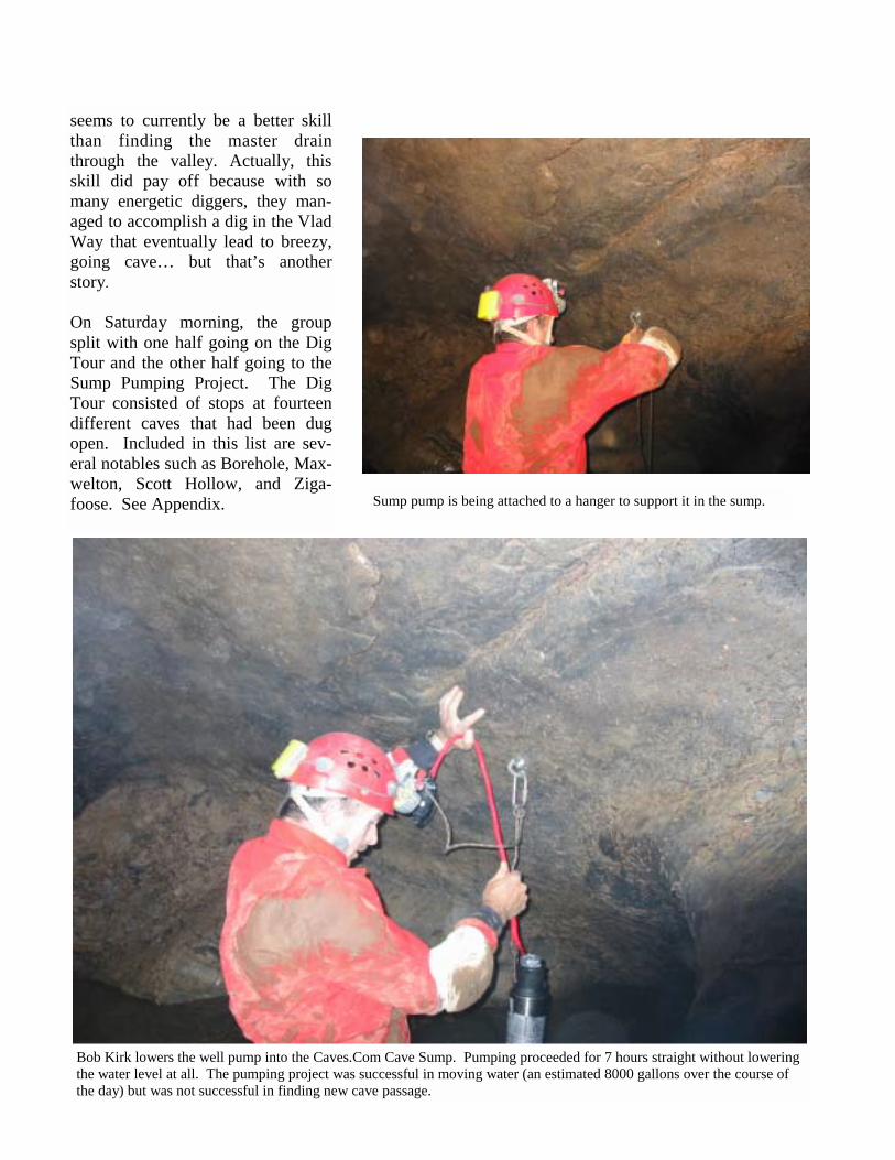
Bob Kirk lowers the well pump into the Caves.Com Cave Sump. Pumping proceeded for 7 hours straight without lowering the water level at all. The pumping project was successful in moving water (an estimated 8000 gallons over the course of the day) but was not successful in finding new cave passage.
Sump pump is being attached to a hanger to support it in the sump.
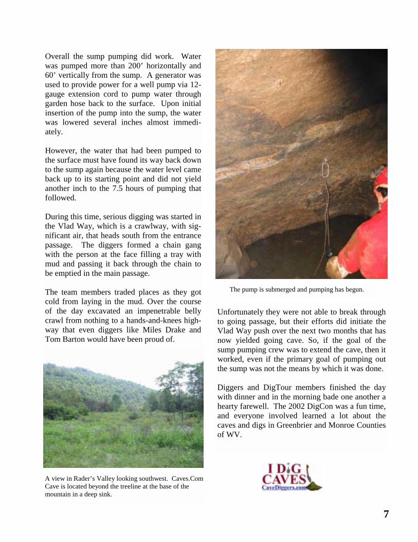
Overall the sump pumping did work. Water was pumped more than 200’ horizontally and 60’ vertically from the sump. A generator was used to provide power for a well pump via 12-gauge extension cord to pump water through garden hose back to the surface. Upon initial insertion of the pump into the sump, the water was lowered several inches almost immedi-ately. However, the water that had been pumped to the surface must have found its way back down to the sump again because the water level came back up to its starting point and did not yield another inch to the 7.5 hours of pumping that followed. During this time, serious digging was started in the Vlad Way, which is a crawlway, with sig-nificant air, that heads south from the entrance passage. The diggers formed a chain gang with the person at the face filling a tray with mud and passing it back through the chain to be emptied in the main passage. The team members traded places as they got cold from laying in the mud. Over the course of the day excavated an impenetrable belly crawl from nothing to a hands-and-knees high-way that even diggers like Miles Drake and Tom Barton would have been proud of.
Unfortunately they were not able to break through to going passage, but their efforts did initiate the Vlad Way push over the next two months that has now yielded going cave. So, if the goal of the sump pumping crew was to extend the cave, then it worked, even if the primary goal of pumping out the sump was not the means by which it was done. Diggers and DigTour members finished the day with dinner and in the morning bade one another a hearty farewell. The 2002 DigCon was a fun time, and everyone involved learned a lot about the caves and digs in Greenbrier and Monroe Counties of WV.
7
The pump is submerged and pumping has begun.
A view in Rader’s Valley looking southwest. Caves.Com Cave is located beyond the treeline at the base of the mountain in a deep sink.
The cold crept in. Slowly and methodically. Like an icycle hanging from the roof over the porch in winter, growing with every drip. The sharp point of coldness lengthened with each drip of water as pain gave way to numb. Brooke thought her leg was broken. It had been the fall. She only wanted to leave, to walk out. To get back to the car parked twenty feet from the entrance. She wanted to feel the warm air of the outside. When she met Casey Arbogast, it was love immediate. Five, maybe six beers, music, and the pulse of life of the State Fair. He exhibited Limousine cattle. The French beast of burden. But his cows were beef cows. Fat and juicy and bored. Casey saw her petite body glaring at his stench while he shoveled shit from the cattles’ pen. When he looked up and saw Brooke Artest and her awkward mouth, doe eyes, long straight hair, busty chest, and strong-angled shoulders, he wanted to fly. Their eyes met and the Limousine huffed. No words were exchanged; none were needed. ************** The day had started out fine. Brooke had taken Ca-sey to breakfast at Patty’s Melt in Stephensville. They both ate egg whites scrambled and got strange looks from the waitress, but they didn’t care. Three weeks of love, romance, four-wheeler rides around the Arbogast farm, and several passionate visits to Casey’s moss-floored forest on the ridge—he called it his “thinking spot,” but she knew it for what it was—were enough to separate them from the hum-drum of reality. It was the middle of September and outside it was foggy and humid at 7:43 in the morning. They were going to Fester Creek Hole to go caving. Casey knew caves. He knew all about them; his dad’s best friend took him caving when he was five on Casey’s family farm.
He went into cave entrances located in the walls of huge and crumbling sinkholes filled with the rotting carcasses of sheep and cattle; these were his first experiences underground. There were caves all over his farm, so it was natural that he explore them as he grew. His tolerance for darkness, for cold wetness, and for tight spaces intensified with the years as he pushed the caves and his abilities farther and farther. Today they were visiting one that Casey knew inside and out. He figured it would be best to introduce Brooke to an “easy” cave. It was ver-tical, but it was straightforward with a single passage from the entrance to the underground lake at the bottom of the cave. The passage was broken only by the two vertical sections not far from the entrance. Brooke had shown deft skill with a rappelling rack and ascenders at Rocky Point, where they practiced going up and the down the rope, so he didn’t worry, besides she was tough. He had watched in awe at the way she handled that steer that had gotten itself caught in the loading ramp. Yep, she was tough. Fester Creek was a simple cave. One short squeeze in, then a small pit. Anchor to a large Maple, and rappel in after the squeeze. Sim-ple. This would be Brooke’s first trip to Fester. Entering the cave, they felt the briskness of the cool cave air. “Chilly. I hope I wore enough clothes,” she thought as she slowly descended. Then at the bottom, she waited for Casey. Moving through the narrow passage, the two wound beneath the Earth. Each stepped lightly and articulated each move carefully. Underground, they spoke little, saving their words for problem solving as they negotiated the cave. Occasionally, the sound of plastic
The Cold Crept In Cave Fiction by Johnathan Frederick Henderson
8
scraping the walls or ceiling broke the black silence. The sheer darkness and solitude were a perfect respite from everything. Casey mounted a boulder and spun webbing around to set the second drop. His metal cara-biners rattled. He clipped the rope in and dropped it down the shaft. Brooke nimbly wrapped rope through the short rack, both feet firm. She crept over. On rope and then down. Casey followed and again they paced. No real destination, just going. Just caving. ************** On her side, cramped and unmoving she lay. Her foot was twisted, but rammed between two sharp rocks that pinched her toes. All she felt was cold. She felt betrayed. Three quarters of a mile in and no one with her. It was the cold she feared. The cold and the stillness. When she tried moving, neck pain stopped her head short. Instinct told her to relax and breathe. ************** The passage tightened and their world got smaller. Neither feared the breakdown. The passage just ended. Casey turned and moved to the left and found the climbdown to the next level. He encouraged Brooke to climb down to him. She began to move toward him but slipped. Her helmet smashed the ceiling and her body pivoted to the floor. The wrenching move of her twisting body and staid foot happened in-stantaneously. Lightning bolts of pain shot through her head. She screamed. Casey climbed back up. Calmly he looked at her, felt her leg, and looked at her again. He shoved off his backpack and grabbed the kit with his space blanket. He whispered some-thing, moved away. His light was in her face. He shouted something. He kissed her. He was
moving his lips. He blinked. He was pale. Brooke turned her gazed slightly, stopped, frowned and look at him. Casey smiled. She looked at the ceil-ing, saw the mark in the mud where her helmet had hit; she looked for him again, but he was gone. **************
It was only dark around her view. The grey and speckled ceiling was overhead, two or three feet away, but she could not tell. She was breathing. She moved and it hurt. “I will come back,” he had said. ************** Casey scrambled up and over the boulders. He breathed hard and fast and sure. He climbed and ascended. The rope was dry and his hands hurt. He moved too fast. He wanted to be there with her. And he climbed harder. The world was outside, but his life was behind him. Was she still alive? He fumbled for the keys, as always stashed under the right front tire. He groped for them. The near-est phone was not near. He drove with blinkers on and fast. His car zipped around mountain turns on gravel roads to the blacktop. The two-lane road was open. No traffic. Sixty miles per hour. Sev-enty. Now, the gas station. The pay phone. He knew the number. He had called it the night before. He had told Jim that he and Brooke would be going to Fester Hole today. He didn’t expect to have to be calling back so soon. Jim Abbott answered…
9 WWW.CAVES.COM
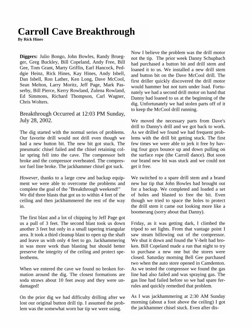
Diggers: Julio Bongo, John Bowles, Randy Brueg-ger, Greg Buckley, Bill Copeland, Andy Free, Bill Gee, Tom Grant, Marty Griffin, Earl Hancock, Ped-dgie Heinz, Rick Hines, Kay Hines, Andy Isbell, Dan Isbell, Ron Lather, Ken Long, Dave McCool, Sean Melton, Larry Moritz, Jeff Page, Mark Pas-serby, Bill Pierce, Kerry Rowland, Zulena Rowland, Ed Simmons, Richard Thompson, Carl Wagner, Chris Wolters. Breakthrough Occurred at 12:03 PM Sunday, July 28, 2002. The dig started with the normal series of problems. Our favorite drill would not drill even though we had a new button bit. The new bit got stuck. The pneumatic chisel failed and the chisel retaining col-lar spring fell into the cave. The compressor belt broke and the compressor overheated. The compres-sor fuel line broke. The jackhammer chisel got suck. However, thanks to a large crew and backup equip-ment we were able to overcome the problems and complete the goal of the "Breakthrough weekend!" We did three blasts that got us to within 4 feet of the ceiling and then jackhammered the rest of the way in. The first blast and a lot of chipping by Jeff Page got us a pull of 3 feet. The second blast took us down another 3 feet but only in a small tapering triangular area. It took a third cleanup blast to open up the shaft and leave us with only 4 feet to go. Jackhammering in was more work than blasting but should better preserve the integrity of the ceiling and protect spe-leothems. When we entered the cave we found no broken for-mation around the dig. The closest formations are soda straws about 10 feet away and they were un-damaged! On the prior dig we had difficulty drilling after we lost our original button drill tip. I assumed the prob-lem was the somewhat worn bar tip we were using.
Now I believe the problem was the drill motor not the tip. The prior week Danny Schupbach had purchased a button bit and drill stem and loaned it to us. We installed a new drill stem and button bit on the Dave McCool drill. The first driller quickly discovered the drill motor would hammer but not turn under load. Fortu-nately we had a second drill motor on hand that Danny had loaned to us at the beginning of the dig. Unfortunately we had stolen parts off of it to keep the McCool drill running. We moved the necessary parts from Dave's drill to Danny's drill and we got back to work. As we drilled we found we had frequent prob-lems with the drill bit getting stuck. The first few times we were able to jerk it free by hav-ing four guys bounce up and down pulling on the surface rope (the Carroll dance). But soon our brand new bit was stuck and we could not get it free. We switched to a spare drill stem and a brand new bar tip that John Bowles had brought out for a backup. We completed and loaded a set of holes and blasted to free the bit. Even though we tried to space the holes to protect the drill stem it came out looking more like a boomerang (sorry about that Danny). Friday, as it was getting dark, I climbed the tripod to set lights. From that vantage point I saw steam billowing out of the compressor. We shut it down and found the V-belt had bro-ken. Bill Copeland made a run that night to try to purchase a new one but the stores were closed. Saturday morning Bell Gee purchased two when the auto store opened in Camdenton. As we tested the compressor we found the gas line had also failed and was spraying gas. The gas line had failed before so we had spare fer-rules and quickly remedied that problem. As I was jackhammering at 2:30 AM Sunday morning (about a foot above the ceiling) I got the jackhammer chisel stuck. Even after dis-
Carroll Cave Breakthrough By Rick Hines
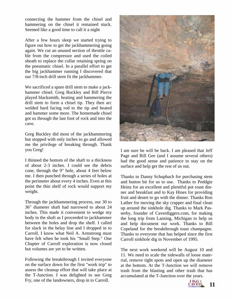
connecting the hammer from the chisel and hammering on the chisel it remained stuck. Seemed like a good time to call it a night After a few hours sleep we started trying to figure out how to get the jackhammering going again. We cut an unused section of throttle ca-ble from the compressor and used the coiled sheath to replace the collar retaining spring on the pneumatic chisel. In a parallel effort to get the big jackhammer running I discovered that our 7/8-inch drill stem fit the jackhammer. We sacrificed a spare drill stem to make a jack-hammer chisel. Greg Buckley and Bill Pierce played blacksmith, heating and hammering the drill stem to form a chisel tip. They then arc welded hard facing rod to the tip and heated and hammer some more. The homemade chisel got us through the last foot of rock and into the cave. Greg Buckley did most of the jackhammering but stopped with only inches to go and allowed me the privilege of breaking through. Thank you Greg! I thinned the bottom of the shaft to a thickness of about 2-3 inches. I could see the debris cone, through the 9" hole, about 4 feet below me. I then punched through a series of holes at the perimeter about every 4 inches. Even at this point the thin shelf of rock would support my weight. Through the jackhammering process, our 30 to 36" diameter shaft had narrowed to about 24 inches. This made it convenient to wedge my body in the shaft as I proceeded to jackhammer between the holes and drop the shelf. I called for slack in the belay line and I dropped in to Carroll. I know what Neil A. Armstrong must have felt when he took his "Small Step." One Chapter of Carroll exploration is now closed but volumes are yet to be written. Following the breakthrough I invited everyone on the surface down for the first "work trip" to assess the cleanup effort that will take place at the T-Junction. I was delighted to see Greg Fry, one of the landowners, drop in to Carroll.
I am sure he will be back. I am pleased that Jeff Page and Bill Gee (and I assume several others) had the good sense and patience to stay on the surface and help get the rest of us out. Thanks to Danny Schupbach for purchasing stem and button bit for us to use. Thanks to Peddgie Heinz for an excellent and plentiful pot roast din-ner and breakfast and to Kay Hines for providing fruit and desert to go with the dinner. Thanks Ron Lather for moving the sky crapper and final clean up around the sinkhole dig. Thanks to Mark Pas-serby, founder of Caverdiggers.com, for making the long trip from Lansing, Michigan to help us and help document our work. Thanks to Bill Copeland for the breakthrough toast champagne. Thanks to everyone that has helped since the first Carroll sinkhole dig in November of 1995. The next work weekend will be August 10 and 11. We need to scale the sidewalls of loose mate-rial, remove tight spots and open up the diameter at the bottom. At the T-Junction we will remove trash from the blasting and other trash that has accumulated at the T-Junction over the years.
11
12
On the weekend of the breakthrough in Carroll Cave I had decided to make the trip down and help out in anyway possible, as well as take video of the actual dig in process. I have uploaded some of that video to http://www.caves.com in the Video Section for all to see. Rick Hines has done a super job of documenting the entire event from start to finish most of which can be reviewed at http://www.carrollcave.org. My personal observations were more on the people involved and the variety of personalities all working together to make such a massive undertaking possible. For example, Greg Buckley would go down the hole, jackhammer for hours, and then turn around and go at it again, seeming almost tireless the entire time. Another is Dave McCool whose expertise in explo-sives contributed a great deal to the success of each set. Dozens of people came and went during the 3 days I was there, all seeming to have their perfect place in the overall picture of the project. A great deal of this exceptional organization can be attributed to the unshaking energy of Rick Hines. His, and the group’s, adherence to a set pattern care-fully spelled out on a safety checklist explains why during the entire dig there were no major injuries. There is much more cave to be found in Carroll Cave and as history unfolds, the new entrance will show how the digging effort made the difference in finding what remains. There is a drastic difference between the spring’s flow and the cave’s water flow which indicates much is going on in Carroll Cave and there should be lots more passage still to be found.
Moving the Final Cave Map from Paper to the Web By Mark Passerby Software that is needed to move large maps from paper to the web, range from web design to imaging types. For those already using cer-tain software you can substitute what you use for the choices I have below. 1) Web Design-- For those with less experi-ence in imaging software as well as for sea-soned veterans, consider Net Objects Fusion www.netobjects.com Version 7 is super, and literally within hours you can be publishing on the web. 2) File Sharing-- www.kazaa.com This is not just a music sharing system but also a software sharing. Once installed simply click on the software selection and put in anything you like. With millions of users there is very little you won't find. 3) Adobe Photoshop 7--- www.adobe.com for editing/resizing photos and images. 4) DJVU--This product is a must! To give you an idea of just how much DJVU varies, con-sider the example of a PDF file.
WWW.CAVES.COM
Carroll Cave: A Team Effort By Mark Passerby
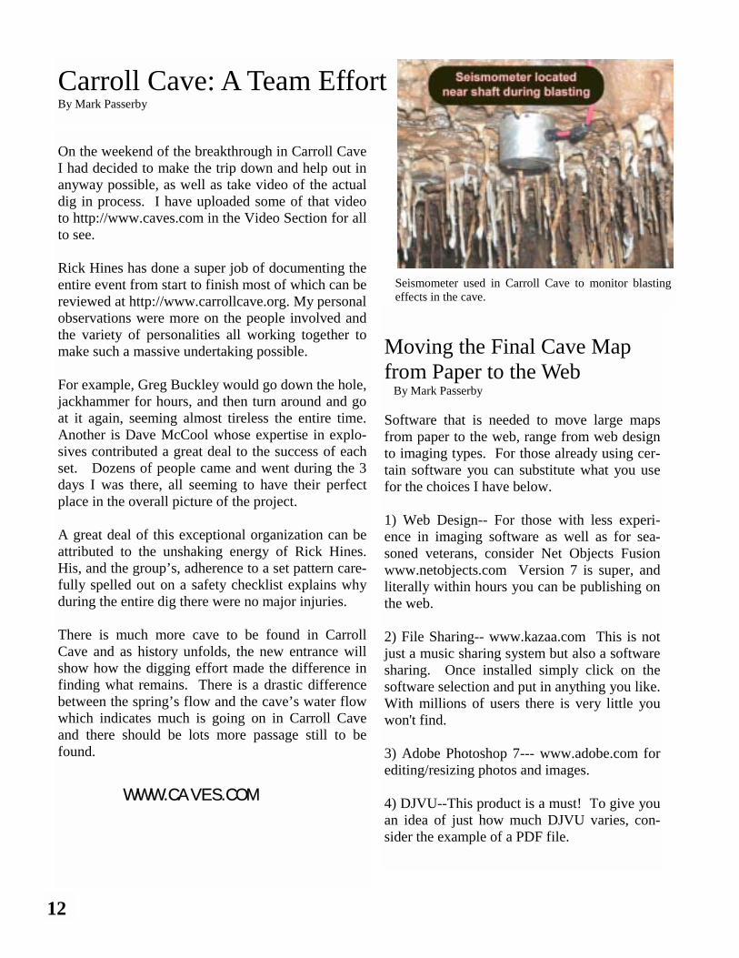
Seismometer used in Carroll Cave to monitor blasting effects in the cave.
Caves.com Yahoo Discussion Groups Caves.com maintains several groups hosted by Yahoo. The website addresses and interest areas are listed below. Everyone is welcome to join and participate. Cave Digging— http://groups.yahoo.com/group/cavediggers/ Vertical Caving— http://groups.yahoo.com/group/cavescomverticalcaving/ Surveying—– http://groups.yahoo.com/group/cavescomcavesurveying/ Cave Rescue— http://groups.yahoo.com/group/cavescomcaverescue/ Geology/Hydrology— http://groups.yahoo.com/group/cavescomcavegeohydro/ Biology— http://groups.yahoo.com/group/cavescomcavebiology/ Cave Diving— http://groups.yahoo.com/group/cavescomcavediving/ Bat Conservation— http://groups.yahoo.com/group/cavescombatconservation/
A single page in a 50-page catalog that has been scanned and converted to PDF format is as large as all 50 pages scanned and put in the DJVU format. This software is the key to putting huge zoom-able map files online for those in your project to see without losing quality and with a file size that is realistic. Even the file size you up-load is not actually what loads when a user ini-tially comes to the page. Instead it is a patented unique system for display of huge files that works by only showing you a sample of the entire file. You can’t see the file all at once anyway, so this software just shows what you’re looking at whether it be a closeup or a lower resolution. I have followed this software since its early development and it is perfect for large cave map files. To purchase the converter program go to www.djvu.com (I think you now have to call them to order) or contact me and I may be able to hook you up with an earlier Non-Commercial. version). To view DJVU you have to have the DJVU Browser Plugin www.djvu.com/download/ then to view a small map online go to: www.cavediggers.com/druidmap.djvu NOTE: Hyperlinks as well can be added to connect dozens of pages to the image and
create a complete project around one map and its various links embedded within it. 5) Video to Flash--- see http://www.wildform.com I just purchased the Flix Pro which allows me to publish .avi that I build in Adobe Premiere to the web in Flash that 98% of people on web can see. The Pro version also allows you to build your own custom viewer and .exe files so that it can be burned onto a CD etc. So a hyperlink on the en-trance to the cave could quite easily now pull up a flash video of the entrance with a bit of narration of the cave. Pretty cool, huh? 6) Building Flash presentation for your site and project----Many use Macromedia Flash but for those not wanting to spend alot of time learning and not alot of money I highly recommend http://www.swishzone.com. Swish is perfect for learning "flash" quick. Basically this is the process: draw a map, scan it in, and save it as a large image file. Next, using DJVU put links on the map, connect to pages with descriptions, videos, photos and any other relevant content. Finally, place it on a server and password protect if necessary to share with your group. This method is much more attractive than a paper map because its cheaper (after software purchases) and easier to view the map. Also, there will always be a backup, so there won’t be anymore lost maps.
WWW.CAVES.COM 13
14
Glenn’s Hazardous Double Shot By Glenn Ledbetter
Over the last few years, finding new caves in the TAG region has been tough. Though there have been several great discoveries, many of them have come from known caves. You have to walk many miles and look under every stone, sink and ravine you come to in order to find new cave. This article is my personal account of the discovery and exploration of a new, very decorated cave that came about from a lot of hard work and determina-tion on the part of a good, strong group of TAG cavers. TAG is not yet pushed to the bitter end. On April 27th (2002) Jeff, Wendy, and I made a short trip to check a small hole I had found a couple months back. When I found the hole, the weather was cold and steam was rising about head high from a small 3-foot diameter opening. I returned later and dropped the short pit and could hear a stream run-ning below. I followed the sound to a too tight verti-cal crack. Later, Jeff and I were looking for a dig project so we returned to look at it again. The water was still there and the crack was still too tight. Before leaving we tossed a few rocks and a few made it down about 20 feet or so farther. We had planned to come back with a big hammer and try to get in. That’s when Hazard came in: I had met
Evon Thompson in the filter. Photo by Glenn Ledbetter
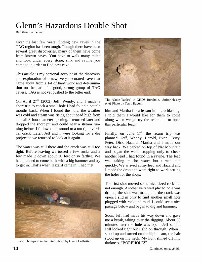
The “Coke Tables” in GHDS Borehole. Softdrink any-one? Photo by Terry Ragon.
him and Martha for a lesson in micro blasting. I told them I would like for them to come along when we go try the technique to open this particular lead. Finally, on June 17th the return trip was planned. Jeff, Wendy, Harold, Evon, Terry, Peter, Dirk, Hazard, Martha and I made our way back. We parked on top of Nat Mountain and began the walk, stopping only to check another lead I had found in a ravine. The lead was taking mucho water but turned dud quickly. We arrived at my lead and Hazard and I made the drop and went right to work setting the holes for the shots. The first shot moved some nice sized rock but not enough. Another very well placed hole was drilled, the shot was made, and the crack was open. I slid in only to find another small hole plugged with rock and mud. I could see a nice passage below and began to dig and hammer. Soon, Jeff had made his way down and gave me a break, taking over the digging. About 30 minutes later the hole was open. Jeff said it still looked tight but I slid on through. When I stood up and turned on the high beam, the hair stood up on my neck. My light shined off into darkness. “BOREHOLE!”
Continued on page 16.
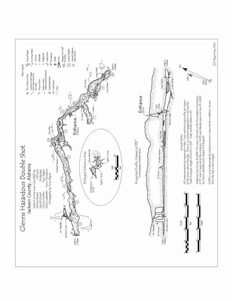
As I began to yell, Jeff came on through and started shooting video in a passage that was 15 feet wide by 15 feet high. Soon Pup was down to confirm borehole, and in a blink every one who had gear was on their way! First, we took off down stream trying to keep a leash on Hazard who was leading the way in very pretty virgin booty. The borehole went maybe 400’ or so to a breakdown end. We followed some side passages that looped back into the main cave. Then Jeff, Harold, Hazard and I took off up stream in a mostly walking passage. We came to a low belly crawl, Hazard was talking about it being a fil-ter for him so I crawled through about 20 feet to more very pretty walking passage. We convinced him to come on through and took off again. When we came to another hands and knees crawl, we turned back and headed for the entrance. Jeff came up with a name for the new cave, Glenn’s Hazardous Double Shot. The name comes for the lead being one of mine, Hazard teaching me to micro blast, and it taking 2 shots to open. I never had a cave named after me so you know I like it. Mapping was started on July 29th. Terry, Peter, Evon, Harold and I made the first survey trip. Our goal was to map from the entrance down, then go upstream. We made 25 stations for a to-tal of 711 feet and a depth of 66 feet. The last two hundred feet was all virgin and we were mapping as we went. The end of the upstream came with two 30’ domes. One of which Pup and Harold climbed up to check. They both deter-mined this could be the way but would be tough going up. We checked a few crawls including one that took a great chunk of Evon's hair out before turning her back, and another with lots of air-flow, which may be a dig in the future.
Tourist trip. On August 5th, Jeff, Wendy, and I made a tourist trip to the end of the survey. Wendy had never been in the cave and was surprised with how nice it really was. Once we got to the end of the upstream passage we be-gan to check around to look for a way on. Jeff found a small hole and used a rock to dig it open enough to see going darkness on the other side. That’s when I went back to check the low water crawl that stopped Evon the previous trip. After some digging I was in to a standing pas-sage looking up into a 50-foot dome room. I slid up through a 6-foot climb to the room that was 50 feet long by 12 feet wide and 50 feet high. Then I tried to make a voice connection
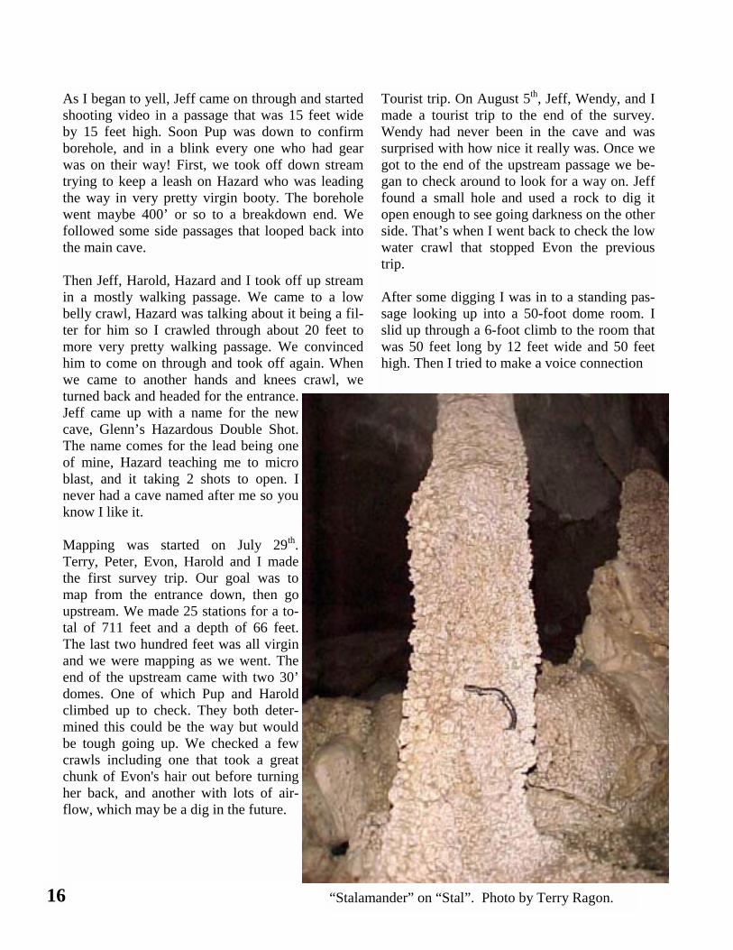
16 “Stalamander” on “Stal”. Photo by Terry Ragon.
but never did. Before leaving this area I poked around looking for a way on. There was a 35-foot waterfall with airflow galore but no way up. Second survey trip. On August 13th, Terry, Chrissy and I made a return trip to mop up some of the upstream loop passages and to survey through the Hair Bawl Crawl. We mapped up a low water crawl pushed by Jeff and Wendy the previous weekend. We also took a look at a small hole that Jeff had found and dug on for a while. The darkness was still there along with the sound of another dome. This area of the cave, the known upper extent, has several domes one with a good amount of water and air coming down. This is the water that runs throughout the cave and a short dome climb here could push the cave farther up. Overall we set 11 stations for a total of 186 feet. This brought the cave to a length of 897 feet, and we
had not even started down the borehole yet. August 27th found myself, Jeff, and Wendy trying to get into a high lead in the borehole passage. We took a ladder used for hunting into the cave in 3 sections. Once in we assembled it, we stood it up to the passage, and Jeff and I held it while Wendy made her way up very slowly. She then took off down virgin passage about 4 feet tall that went about 100 feet or so. While the passage did not go where we hoped, it was great and another very decorated part of the cave. I set a bolt and left a rope rigged for the survey into the area. Then we tried to find a suitable place to set the ladder for the other upper lead, however, we decided to wait on the survey crew to push the other passage. Also on August 27th we finished the survey by set-ting 19 stations for 474 feet and a new depth of 87 feet. Terry, Chrissy, Wendy, Jeff and I mopped up the survey while pup, Dirk, Evon and Harold
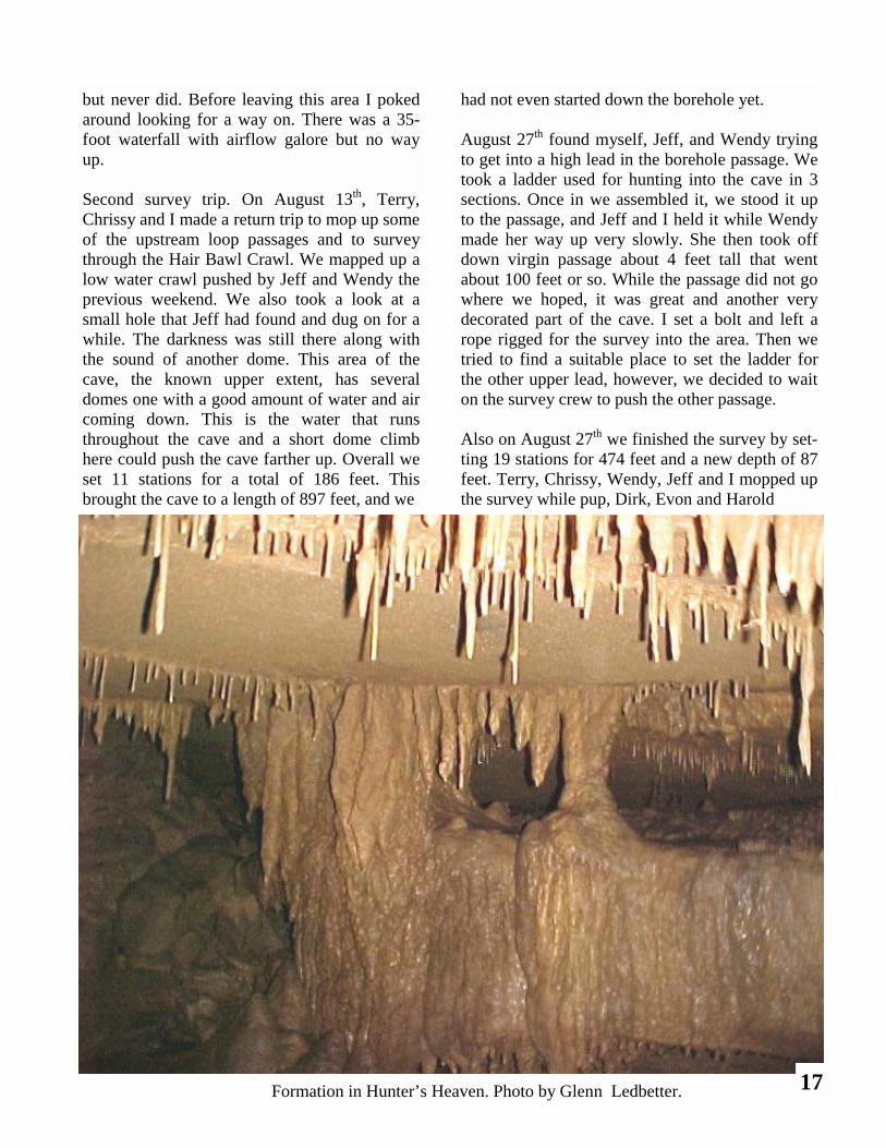
Formation in Hunter’s Heaven. Photo by Glenn Ledbetter. 17
WWW.CAVES.COM
toured the cave. Pup and crew headed to the back of the cave to see the Hair Bawl Crawl and the water fall lead there. The water was still flowing good de-spite the drought conditions in Jackson County. The survey ended with a grand total of 1371 feet of very decorated cave. Most of the cave is walking and two leads remain for a later time, one 15-foot water-fall with walking passage above and a low wet stream dig that had a nice echo. I’d like to say thanks to every one involved with the discovery, micro blasting, and mapping of this fine cave. Thanks Terry Ragon, Chrissy Frotten, Peter Michaud, Hazard Bryant, Martha Hendrix, Dirk Si-ron, Evon Thompson, Harold Calvert, Jeff Lynn and Wendy Bowen for all your help and patience. I really enjoyed caving and learning to survey with you all and we will do it again. See you all at the bit-ter end!
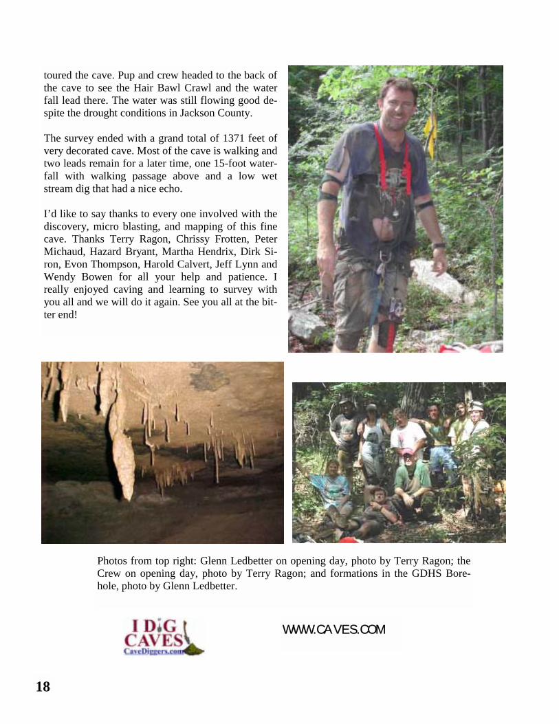
Photos from top right: Glenn Ledbetter on opening day, photo by Terry Ragon; the Crew on opening day, photo by Terry Ragon; and formations in the GDHS Bore-hole, photo by Glenn Ledbetter.
18
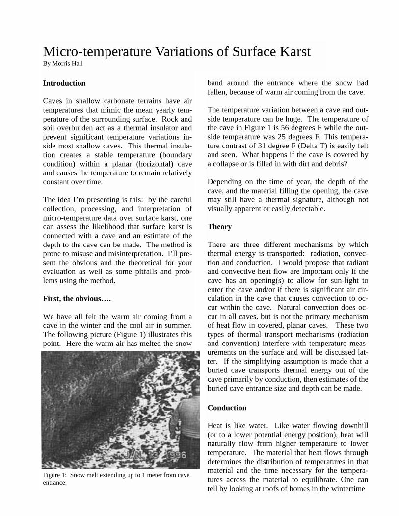
Introduction Caves in shallow carbonate terrains have air temperatures that mimic the mean yearly tem-perature of the surrounding surface. Rock and soil overburden act as a thermal insulator and prevent significant temperature variations in-side most shallow caves. This thermal insula-tion creates a stable temperature (boundary condition) within a planar (horizontal) cave and causes the temperature to remain relatively constant over time. The idea I’m presenting is this: by the careful collection, processing, and interpretation of micro-temperature data over surface karst, one can assess the likelihood that surface karst is connected with a cave and an estimate of the depth to the cave can be made. The method is prone to misuse and misinterpretation. I’ll pre-sent the obvious and the theoretical for your evaluation as well as some pitfalls and prob-lems using the method. First, the obvious…. We have all felt the warm air coming from a cave in the winter and the cool air in summer. The following picture (Figure 1) illustrates this point. Here the warm air has melted the snow
Micro-temperature Variations of Surface Karst By Morris Hall
band around the entrance where the snow had fallen, because of warm air coming from the cave. The temperature variation between a cave and out-side temperature can be huge. The temperature of the cave in Figure 1 is 56 degrees F while the out-side temperature was 25 degrees F. This tempera-ture contrast of 31 degree F (Delta T) is easily felt and seen. What happens if the cave is covered by a collapse or is filled in with dirt and debris? Depending on the time of year, the depth of the cave, and the material filling the opening, the cave may still have a thermal signature, although not visually apparent or easily detectable. Theory There are three different mechanisms by which thermal energy is transported: radiation, convec-tion and conduction. I would propose that radiant and convective heat flow are important only if the cave has an opening(s) to allow for sun-light to enter the cave and/or if there is significant air cir-culation in the cave that causes convection to oc-cur within the cave. Natural convection does oc-cur in all caves, but is not the primary mechanism of heat flow in covered, planar caves. These two types of thermal transport mechanisms (radiation and convention) interfere with temperature meas-urements on the surface and will be discussed lat-ter. If the simplifying assumption is made that a buried cave transports thermal energy out of the cave primarily by conduction, then estimates of the buried cave entrance size and depth can be made. Conduction Heat is like water. Like water flowing downhill (or to a lower potential energy position), heat will naturally flow from higher temperature to lower temperature. The material that heat flows through determines the distribution of temperatures in that material and the time necessary for the tempera-tures across the material to equilibrate. One can tell by looking at roofs of homes in the wintertime
Figure 1: Snow melt extending up to 1 meter from cave entrance.
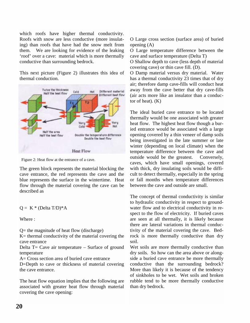
which roofs have higher thermal conductivity. Roofs with snow are less conductive (more insulat-ing) than roofs that have had the snow melt from them. We are looking for evidence of the leaking ‘roof’ over a cave: material which is more thermally conductive than surrounding bedrock. This next picture (Figure 2) illustrates this idea of thermal conduction.
The green block represents the material blocking the cave entrance, the red represents the cave and the blue represents the surface in the wintertime. Heat flow through the material covering the cave can be described as Q = K * (Delta T/D)*A Where : Q= the magnitude of heat flow (discharge) K= thermal conductivity of the material covering the cave entrance Delta T= Cave air temperature – Surface of ground temperature A= Cross section area of buried cave entrance D=Depth to cave or thickness of material covering the cave entrance. The heat flow equation implies that the following are associated with greater heat flow through material covering the cave opening:
Figure 2: Heat flow at the entrance of a cave.
O Large cross section (surface area) of buried opening (A) O Large temperature difference between the cave and surface temperature (Delta T) O Shallow depth to cave (less depth of material covering cave) or thin cave fill. (D). O Damp material versus dry material. Water has a thermal conductivity 23 times that of dry air; therefore damp cave-fills will conduct heat away from the cave better that dry cave-fills (air acts more like an insulator than a conduc-tor of heat). (K) The ideal buried cave entrance to be located thermally would be one associated with greater heat flow. The highest heat flow though a bur-ied entrance would be associated with a large opening covered by a thin veneer of damp soils being investigated in the late summer or late winter (depending on local climate) when the temperature difference between the cave and outside would be the greatest. Conversely, caves, which have small openings, covered with thick, dry insulating soils would be diffi-cult to detect thermally, especially in the spring or fall months when temperature differences between the cave and outside are small. The concept of thermal conductivity is similar to hydraulic conductivity in respect to ground-water flow and to electrical conductivity in re-spect to the flow of electricity. If buried caves are seen at all thermally, it is likely because there are lateral variations in thermal conduc-tivity of the material covering the cave. Bed-rock is more thermally conductive than dry soil. Wet soils are more thermally conductive than dry soils. So how can the area above or along-side a buried cave entrance be more thermally conductive than the surrounding bedrock? More than likely it is because of the tendency of sinkholes to be wet. Wet soils and broken rubble tend to be more thermally conductive than dry bedrock.
20
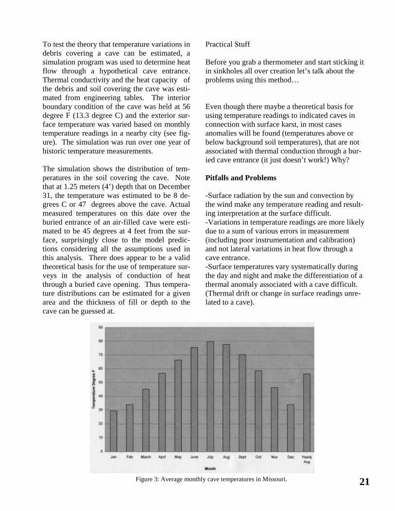
To test the theory that temperature variations in debris covering a cave can be estimated, a simulation program was used to determine heat flow through a hypothetical cave entrance. Thermal conductivity and the heat capacity of the debris and soil covering the cave was esti-mated from engineering tables. The interior boundary condition of the cave was held at 56 degree F (13.3 degree C) and the exterior sur-face temperature was varied based on monthly temperature readings in a nearby city (see fig-ure). The simulation was run over one year of historic temperature measurements. The simulation shows the distribution of tem-peratures in the soil covering the cave. Note that at 1.25 meters (4’) depth that on December 31, the temperature was estimated to be 8 de-grees C or 47 degrees above the cave. Actual measured temperatures on this date over the buried entrance of an air-filled cave were esti-mated to be 45 degrees at 4 feet from the sur-face, surprisingly close to the model predic-tions considering all the assumptions used in this analysis. There does appear to be a valid theoretical basis for the use of temperature sur-veys in the analysis of conduction of heat through a buried cave opening. Thus tempera-ture distributions can be estimated for a given area and the thickness of fill or depth to the cave can be guessed at.
Practical Stuff Before you grab a thermometer and start sticking it in sinkholes all over creation let’s talk about the problems using this method… Even though there maybe a theoretical basis for using temperature readings to indicated caves in connection with surface karst, in most cases anomalies will be found (temperatures above or below background soil temperatures), that are not associated with thermal conduction through a bur-ied cave entrance (it just doesn’t work!) Why? Pitfalls and Problems -Surface radiation by the sun and convection by the wind make any temperature reading and result-ing interpretation at the surface difficult. -Variations in temperature readings are more likely due to a sum of various errors in measurement (including poor instrumentation and calibration) and not lateral variations in heat flow through a cave entrance. -Surface temperatures vary systematically during the day and night and make the differentiation of a thermal anomaly associated with a cave difficult. (Thermal drift or change in surface readings unre-lated to a cave).
21 Figure 3: Average monthly cave temperatures in Missouri.
-Since small changes in temperatures may be signifi-cant, sensitive instrumentation is required. -In most areas, only the shallowest of buried caves have a prayer of being found thermally. In the area of Missouri I have tried this method, it appears that some caves can be located down to a maximum depth of between 12 and 25 feet. -If the material covering the cave entrance has the same or similar thermal properties as the surround-ing bedrock, the cave will be invisible thermally. -The greatest heartache is this: a valid thermal anomaly may be detectable over a cave, yet the joint, sinkhole, etc. is too small to be entered. The surface karst may be in thermal connection with a cave, but not a human sized connection. In other words, tem-perature surveys may help in picking or prioritizing the spot to dig, but there is never a guarantee that the cave you find is bigger than a breadbox. As in most geophysical methods, the successful use of thermal surveys is greatly enhanced by the inte-gration of other data sources such as climatic, topog-raphic, remote sensing, aerial photos, hydrogeologic (both surface and subsurface) and existing cave tem-perature data. Nothing can surpass local experience and knowledge. Thermal surveys may not work at all in your area if your caves are vertical, with small, buried entrances. There are definitely problems with recording and interpretation of surface thermal data and this method of investigation has received some criticism. One PhD I mentioned this idea to said that different temperatures in sinkholes are nothing more than variations in differences in sunlight and wind condi-tions around the sinkhole. For this reason I make my surveys on cloudy, windless days. The other point is that he had looked at thermal video of a cave and saw no measurable difference in air temperature, but did see thermal variations in the groundwater coming from a cave entrance. He does raise an im-portant issue: water and air temperatures in a cave are often similar, but not always identical…meaning
a thermal anomaly may exist in the air of a cave but not the water in the same cave and visa versa. The other point he says is that in his experience, he has not seen thermal anoma-lies associated with cave entrances or buried caves. Here is a great frustration of using the method…what works in August probably won’t work in May. There can be such changes in surface temperature conditions that what works one day won’t work even on the next, or even the same day at a different time. Thermal anomalies are highly dependant on the tem-perature contrast between the cave and outside surface temperature. I contend that micro-temperature surveys should be tried and evalu-ated for their predictive capability for locating caves. With proper initial selection of the candidate for surveying, selecting an appropriate time and date to survey, use proper instrumentation, careful repeatable surveys, recording of base temperature readings to account for thermal drift, the integration of all available relevant data, and knowledge and experience in an area (including good old common sense), tempera-ture surveys can be a valuable tool in the pri-oritization and placement of your next dig. This method can work, but is as much an art as a science in picking out valid thermal anoma-lies associated with covered cave entrances. Next time we will talk about instrumentation, field procedures, interpretation and the honest to goodness discovery of a cave using this technique.
WWW.CAVES.COM
22
Cave Discovery Rates in Missouri –1950 through 1998 By Morris Hall
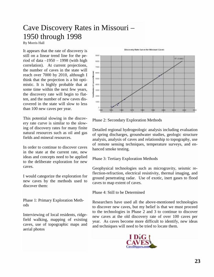
It appears that the rate of discovery is still on a linear trend line for the pe-riod of data –1950 – 1998 (with high correlation). At current projections, the number of caves in the state will reach over 7000 by 2010, although I think that the projection is a bit opti-mistic. It is highly probable that at some time within the next few years, the discovery rate will begin to flat-ten, and the number of new caves dis-covered in the state will slow to less than 100 new caves per year. This potential slowing in the discov-ery rate curve is similar to the slow-ing of discovery rates for many finite natural resources such as oil and gas fields and mineral resources. In order to continue to discover caves in the state at the current rate, new ideas and concepts need to be applied to the deliberate exploration for new caves. I would categorize the exploration for new caves by the methods used to discover them: Phase 1: Primary Exploration Meth-ods Interviewing of local residents, ridge-field walking, mapping of existing caves, use of topographic maps and aerial photos
Phase 2: Secondary Exploration Methods Detailed regional hydrogeologic analysis including evaluation of spring discharges, groundwater studies, geologic structure analysis, analysis of caves and relationship to topography, use of remote sensing techniques, temperature surveys, and en-hanced smoke testing. Phase 3: Tertiary Exploration Methods Geophysical technologies such as microgravity, seismic re-flection-refraction, electrical resistivity, thermal imaging, and ground penetrating radar. Use of exotic, inert gases to flood caves to map extent of caves. Phase 4: Still to be Determined Researchers have used all the above-mentioned technologies to discover new caves, but my belief is that we must proceed to the technologies in Phase 2 and 3 to continue to discover new caves at the old discovery rate of over 100 caves per year. As caves become more difficult to identify, new ideas and techniques will need to be tried to locate them.
23
Cave Diving and Underwater Photography —An Interview with Steve Auer Interviewer: Aaron Bird All photos by Steve Auer
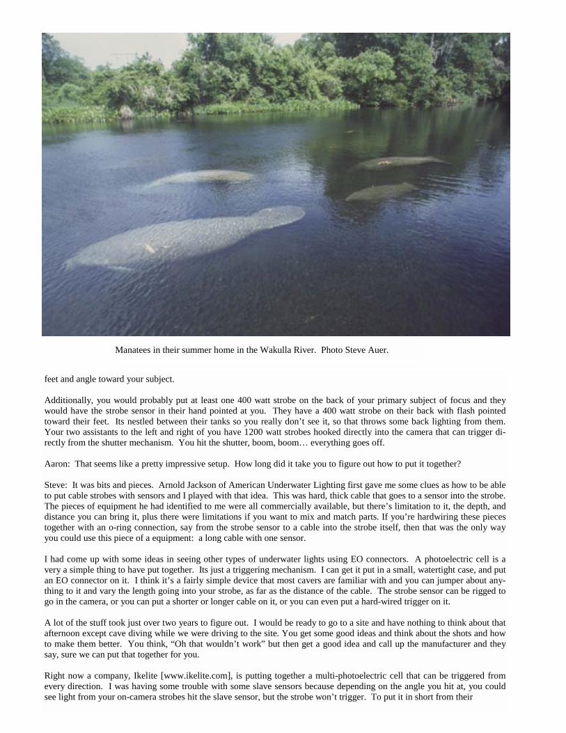
Aaron: Steve, thank you for joining me this evening to discuss cave diving, underwater photography, and the manatees of Florida’s Springs. To get started, how about telling us about the manatees? Steve: One of the first times that I got to swim with the Manatees in the Wakulla River, located just south of Tallahassee, Florida, there was a huge cow in the herd, it was bigger than any cow I had seen before, and was quite larger than any manatee I had see before and I was curious as to whether it was pregnant or not. I didn’t know… I’m no manatee expert or anything. Shortly thereafter I got a call from my good friend Gretchen Evans, who runs the canoe livery located right on the Wakulla River, that there was a baby manatee spotted in the river; brand new, one foot long, black as coal, and swimming with its mother. I didn’t get a chance to get back in the water that year with the animals, and it wasn’t until a year later that I returned to film the manatees as they returned from their wintering grounds, I figure somewhere down around Crystal River. I compared some photos with those from the year before and actually identified this huge calf that was swimming with a mother, a cow, and by matching up the scar patterns from the year before and now, it was quite evident that this was the manatee that was born. It was pretty neat. Aaron: Wow. That is a pretty neat experience. Steve: Yeah. It was, and from what I gather, this was one of the first documentations of a live birth in the Wakulla River. Aaron: How did you find yourself getting into photographing manatees? Steve: I wanted to buy my first camera back in college in the late ‘80s, but couldn’t afford one. I had this feeling, from seeing all the press about manatees, that they were eventually going to be extinct and the only place you would ever be able to see them would be in a zoo. I just had this desire to get in the water and get my own photos to be able to pass onto future generations. I graduated from Pharmacy School at the University of Cincinnati where I grew up, moved to Florida, and finally got my first camera and started to get in the water and start filming. Aaron: And did that lead to cave diving? Steve: I’ve been a certified open water diver since 1983, and after I moved to the Keys, I started doing a little bit more advanced and technical diving. In the late ‘90s, with Billy Deans, and group down there, I got to do some neat wrecks. I finally got my first camera and started doing underwater photos when I knew was going to be getting married, leave the Keys, move God knows where, and all my friends were telling me, “Your diving is done… you’re getting married, that’s it” I was like, “O.K., I’ve got to do it now. I’ve got to spend this money. I’ve got to buy this camera.” So in 1996 I bought my first underwater camera, started playing around on the reefs, and got photos of some of the deeper wrecks. Then in August of ’97, we left the Keys, moved to Tallahassee, Florida, and I found that I had a lot of free time in my first ten months after relocating to Tallahassee; and the Crystal River was only two hours away and I finally got my chance to get in the water with the manatees. It was a blast! I’m kinda disappointed with the spectacle, circus-like atmosphere that you find in the Crystal River area and the way the people go after and pursue the manatees to the point of near harassment. From a canoeing experience on the Wakulla River I found a place where you could go and actually see the manatees. I became friends with a lady named Gretchen Evans who ran a canoe livery and she gave me all her notes and information as she followed the animals and herds with reports from people at her canoe livery. She finally hooked me up with a boat and I went out and started film-ing the Wakulla River. Aaron: Now you’ve been interested in photography for quite a while now, and started taking photographs of manatees, and then springs after? How about caves?
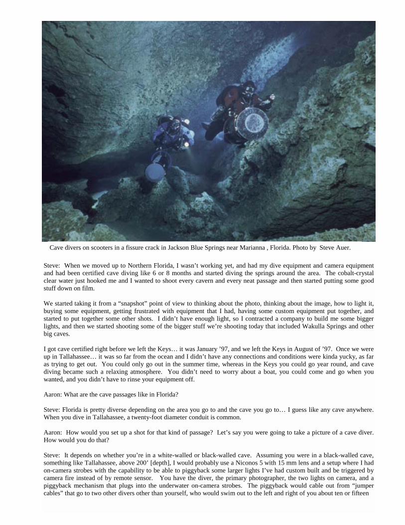
Steve: When we moved up to Northern Florida, I wasn’t working yet, and had my dive equipment and camera equipment and had been certified cave diving like 6 or 8 months and started diving the springs around the area. The cobalt-crystal clear water just hooked me and I wanted to shoot every cavern and every neat passage and then started putting some good stuff down on film. We started taking it from a “snapshot” point of view to thinking about the photo, thinking about the image, how to light it, buying some equipment, getting frustrated with equipment that I had, having some custom equipment put together, and started to put together some other shots. I didn’t have enough light, so I contracted a company to build me some bigger lights, and then we started shooting some of the bigger stuff we’re shooting today that included Wakulla Springs and other big caves. I got cave certified right before we left the Keys… it was January ’97, and we left the Keys in August of ’97. Once we were up in Tallahassee… it was so far from the ocean and I didn’t have any connections and conditions were kinda yucky, as far as trying to get out. You could only go out in the summer time, whereas in the Keys you could go year round, and cave diving became such a relaxing atmosphere. You didn’t need to worry about a boat, you could come and go when you wanted, and you didn’t have to rinse your equipment off. Aaron: What are the cave passages like in Florida? Steve: Florida is pretty diverse depending on the area you go to and the cave you go to… I guess like any cave anywhere. When you dive in Tallahassee, a twenty-foot diameter conduit is common. Aaron: How would you set up a shot for that kind of passage? Let’s say you were going to take a picture of a cave diver. How would you do that? Steve: It depends on whether you’re in a white-walled or black-walled cave. Assuming you were in a black-walled cave, something like Tallahassee, above 200’ [depth], I would probably use a Niconos 5 with 15 mm lens and a setup where I had on-camera strobes with the capability to be able to piggyback some larger lights I’ve had custom built and be triggered by camera fire instead of by remote sensor. You have the diver, the primary photographer, the two lights on camera, and a piggyback mechanism that plugs into the underwater on-camera strobes. The piggyback would cable out from “jumper cables” that go to two other divers other than yourself, who would swim out to the left and right of you about ten or fifteen
Cave divers on scooters in a fissure crack in Jackson Blue Springs near Marianna , Florida. Photo by Steve Auer.
feet and angle toward your subject. Additionally, you would probably put at least one 400 watt strobe on the back of your primary subject of focus and they would have the strobe sensor in their hand pointed at you. They have a 400 watt strobe on their back with flash pointed toward their feet. Its nestled between their tanks so you really don’t see it, so that throws some back lighting from them. Your two assistants to the left and right of you have 1200 watt strobes hooked directly into the camera that can trigger di-rectly from the shutter mechanism. You hit the shutter, boom, boom… everything goes off. Aaron: That seems like a pretty impressive setup. How long did it take you to figure out how to put it together? Steve: It was bits and pieces. Arnold Jackson of American Underwater Lighting first gave me some clues as how to be able to put cable strobes with sensors and I played with that idea. This was hard, thick cable that goes to a sensor into the strobe. The pieces of equipment he had identified to me were all commercially available, but there’s limitation to it, the depth, and distance you can bring it, plus there were limitations if you want to mix and match parts. If you’re hardwiring these pieces together with an o-ring connection, say from the strobe sensor to a cable into the strobe itself, then that was the only way you could use this piece of a equipment: a long cable with one sensor. I had come up with some ideas in seeing other types of underwater lights using EO connectors. A photoelectric cell is a very a simple thing to have put together. Its just a triggering mechanism. I can get it put in a small, watertight case, and put an EO connector on it. I think it’s a fairly simple device that most cavers are familiar with and you can jumper about any-thing to it and vary the length going into your strobe, as far as the distance of the cable. The strobe sensor can be rigged to go in the camera, or you can put a shorter or longer cable on it, or you can even put a hard-wired trigger on it. A lot of the stuff took just over two years to figure out. I would be ready to go to a site and have nothing to think about that afternoon except cave diving while we were driving to the site. You get some good ideas and think about the shots and how to make them better. You think, “Oh that wouldn’t work” but then get a good idea and call up the manufacturer and they say, sure we can put that together for you. Right now a company, Ikelite [www.ikelite.com], is putting together a multi-photoelectric cell that can be triggered from every direction. I was having some trouble with some slave sensors because depending on the angle you hit at, you could see light from your on-camera strobes hit the slave sensor, but the strobe won’t trigger. To put it in short from their
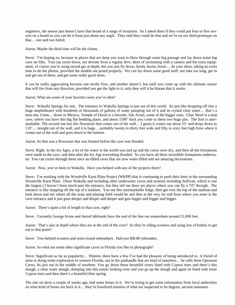
Manatees in their summer home in the Wakulla River. Photo Steve Auer.
engineers, the sensor just doesn’t have that broad of a range of reception. So I asked them if they could put four or five sen-sors on a board so you can hit it from just about any angle. They said they could do that and we’re on our third prototype on that… one and two failed. Aaron: Maybe the third time will be the charm. Steve: I’m hoping so, because in places that are deep you want to blow through some big passage and lay down some big cave on film. You can swim down, not deviate from a regular dive, short of swimming with a camera and the extra equip-ment, of course you’re using mixed gas at depth, but you just fly down, boom, boom, boom… do your shots, taking no extra time to do the photos, provided the models are posed properly. We can lay down some good stuff, not take too long, get in and get out of there, and get some really good shots. It can be really aggravating because one strobe fires, and another doesn’t, but until you come up with the ultimate sensor that will fire from any direction, provided you get the light to it, only then will it be blatant that it works. Aaron: What are some of your favorite caves you’ve shot? Steve: Wakulla Springs for one. The entrance to Wakulla Springs is just out of this world. Its just like dropping off into a huge amphitheatre with hundreds of thousands of gallons of water pumping out of it and its crystal clear water… that’s a neat one. Umm… down in Mexico, Temple of Doom is a favorite, Sak Actun, some of the bigger ones. Chac Mool is a neat cave, where you have this big flat bedding plane, and about 1500’ back you come to these two huge pits. The first is unre-markable. The second one has this flowstone that comes out of the wall… I guess it comes out about 55’ and drops down to 110’… straight out of the wall, and it is huge… probably twenty to thirty feet wide and fifty to sixty feet high from where it comes out of the wall and goes down to the bottom. Aaron: So that was a flowstone that was formed before the cave was flooded. Steve: Right. In the Ice Ages, a lot of the water in the world was tied up and the caves were dry, and then all the formations were made in the cave, and then after the Ice Age everything flooded. So you have all these incredible formations underwa-ter. You can cruise through these once air-filled caves that are now water-filled and see amazing decorations. Aaron: Now, you’ve been in Wakulla. Have you helped with any of the projects there? Steve: I’m working with the Woodville Karst Plain Project (WKPP) that is continuing to push their lines in the surrounding Woodville Karst Plain. [Near Wakulla and including other underwater caves and systems including Sullivan, which is one the largest.] I haven’t been much past the entrance, but they tell me there are places where you can fly a 747 through. The entrance is like stepping off the top of a stadium. You see this unremarkable ledge, then get over the top of the stadium and look down and see where all the seats and playing field would be and then at the very far end from where you enter is the cave entrance and it just goes deeper and deeper and deeper and gets bigger and bigger and bigger. Aaron: There’s quite a bit of length to that cave, right? Steve: Currently George Irvine and Jarrod Jablonski have the end of the line out somewhere around 21,000 feet. Aaron: That’s also at depth where they are at the end of the cave? So they’re riding scooters and using lots of bottles to get out to that point? Steve: Tow-behind scooters and semi-closed rebreathers. Halcyon RB-80 rebreather. Aaron: So what are some other significant caves in Florida you like to photograph? Steve: Significant as far as popularity… Hmmm, there have a few I’ve had the pleasure of being introduced to. A friend of mine is doing some exploration in western Florida, out in the panhandle that are kind of nameless… he calls them Opossum Caves. Its just out in the middle of nowhere. You go down these beautiful rivers lined with Cyprus trees and there’s this slough, a clear water slough, dumping into this tannic looking river and you go up the slough and again its lined with more Cyprus trees and then there’s a beautiful blue spring. The one we dove a couple of weeks ago, had some bones in it. We’re trying to get some information from local authorities on what kind of bones are back in it… they’re fossilized remains of what are suspected to be dugons, ancient manatees.
That’s still on the checking out phase. The cave is small and gnarly, kind of pretty, small and up and down and lots of fossil-ized remains. That whole area of the state has some really beautiful caves. One of my favorite in that section, by name is Jackson Blue. It has real beautiful brownish/tannish colored walls and lots of fossils… lots of Sea Biscuits and Sand Dollars. Aaron: Do you ever find live animals in caves? Steve: Blind crayfish. Also anyplace that has a high nitrate level you’ll see these little pointy things you see down by the ocean. I don’t what the name of those is. Nothing far back in. You might see some eels. If you come up on a catfish any-where, its like “O.K. There’s another opening somewhere.” Aaron: How many diveable springs are there in Florida? Steve: I couldn’t even begin to give you a number on that. Hundreds. And still a lot left to be explored. Before I left Tal-lahassee, we were working on a cave, but I threw the towel in on the project. There wasn’t anything else to find. Everywhere we went it just pinched off. The passages all had a real silty floor, dark and crumbly walls, and there was no real noticeable flow. We found a deep section to it, and everywhere we could go just pinched off and ended. Some friends of mine from the WKPP went 1000’ back to the Anal Extraction. Its just small, nasty, muddy clay on the floor and you have to just putt-putt your way through and they were just seeing where the thing went and you get back about 400’ in the Anal Extraction and dropped down through a hole and the walls and floor just dis-appeared. You go back there and drop through and you can’t see any-thing. The first guys in put the line, of course, and its just straight down. You drop through at about 125’ and you hit the debris cone at about 230’ and you look around and you can’t see anything. Its clear water. Your light just doesn’t hit any-thing. It’s a bit of a swim to get back there. Logistics of get-ting gear back there… staging bottles and whatnot, on open circuit, its ends up being pretty limited. Everything went black, and we just haven’t been back. There was cave we found about ¼ mile from there back in May of ‘97 that we’re pretty sure it connects to. That was an-other one that was just this little sinkhole in the side of the road. We get geared up, jumped in, got a reel tied on, swam down pushing leaves and limbs and junk out of the way and I thought we hit a [black] gerthite wall and I’m looking at it and as the debris behind me kinda caught up with me, I saw it just kinda oozing and slipping over the edge. It wasn’t a wall, it was an abyss and the next stop was like 190’ on debris cone. Our first night in there, we got in, tied off, and went down to about 120 and circumscribed the room with line and surveying as we’re diving and doing the math… it was like 160’ across. The next dive we went back on gas, Trimix, dropped down,
tied into the bottle drop we designated and continued down to the debris cone at 190’, went off the debris cone at 255’ and its just going borehole tunnel at like 255’. Some friends of ours have since gone back and connected it to a cave across the highway. We’re on the north side of the highway. They connected it to a cave on the south side of the highway that’s suspected to connect to a bunch of sinks south of that one. Aaron: So it’s a significant system? Steve: Oh yeah. Very significant. Very old looking. All the structure inside is very worn. It has no flow. Being that close to the coast it is tidal and its just very tannic, so you have to catch it at the right time when there’s enough groundwater to sustain what flow there is to keep it clear. Aaron: Earlier, you mentioned a gerthite wall. What is gerthite? Steve: It’s a black substance. You’ll have sections of white wall and there’s a section of black mineral. I don’t know what the chemical composition of it is. Aaron: You had said you had mistaken an actual pas-sage for gerthite. Is this easy to do? Is it so black that it looks like passage or passage looks like gerthite?
Manatees in the Wakulla River. Photo Steve Auer.
Steve: It was just my first perception not knowing any better and we jump in a hole and it was like, somebody had to have been in this sink before, its right by the highway, come on… and as a popular a destination as Tallahassee was years ago, somebody had to have ex-plored this, right? Who am I? I can’t find anything. I can’t even find myself in the dark. I jump in this hole we’re swimming around and its like that’s just a gerthite wall, so that’s why nobody ex-plored. My light was just absorbed by the depth, this was way before HID, so I had a regular halogen light and I was sitting there looking at it and taking in all the observations I can and then as the silt just kinda crept in behind and underneath me and just dropped down through that one slit, I was like O.K. this isn’t a gerthite wall this is going passage. Aaron: You mentioned lights. Lets talk about lights a bit. What’s your primary? Steve: Extreme Exposure Pro HID 18. It will burn for up to 8 hours. HID is High Intensity Discharge. Its one of the new lights, doesn’t produce much heat, so you can actually fire it on land. Uses very little current. The mechanics of it I can’t exactly explain, but they take voltage from the battery, they ramp it up, they run the electricity through a gas medium and you get a high intensity beam that is about 5000 Kelvin [color tempera-ture] as opposed to about 2000 Kelvin with a halogen bulb. The halogen bulb is more or less just a dead short on the battery. A 50 watt halogen bulb on the same size battery would give you about three hours of burn time. The HIDs are nice. They’re blue, very sharp, very pene-trating, and with the higher intensity HIDs you can do still photography with them. You can actually get a rea-sonably decent image because it gives you the same color temperature as the sunlight. As opposed to a Halo-gen which just gives you a yellow tinge. Aaron: How many total lights do you take with you? Steve: Three. You’ve got standard cave diving rules. Two backup lights, which you keep clipped off on your chest harness, and of course the large primary. Aaron: Have you had any experiences in caves where you learned a whole lot in a short amount of time? Steve: I’ve been pretty conservative. In so far as right depth, right gas. Back before we knew better we all had an experience with that. We were diving a sink in Her-nandez County called the Eagle’s Nest and diving deep on air, which is stupid. It will kill you. It is not good for you. It whacks you out of your mind.
We were about 200 to 220 feet on air and it just… I knew better… we didn’t proceed any further because the cave went down to 240 or 250 from there, and we just kind of thumbed and went back to a depth where we weren’t so narced. Two far back? Umm. Again, along the same lines… inex-perience. We were back about a mile in a cave, myself and a buddy. One of the scooters failed. We didn’t have a backup. We got out with plenty of gas, but we had a nasty little re-striction to negotiate on the way back. So, we weren’t just swimming or towing through huge borehole. It was a nice pretty cave, and we ascended, went through a constriction and it was small cave from there on out. Lots of flow behind us. Basic rules of cave diving: dive the right mix, don’t go too deep, always have plenty of lights, and have contingencies, where contingencies are like if you plan on going back with a scooter, plan on coming out with a scooter, and if you bring one scooter – like you have three lights – you better have a tow scooter. If one scooter fails, it is a mechanical piece of equipment, you have a failure, its like oh well, big deal, we have to thumb the dive. Park your dead scooter, clip it off, pull out your good scooter, hit the trigger and get on out of there. Aaron: When I was a lot younger, I read about a lot of cave diving deaths in Florida. Has the education worked? Are the numbers decreasing? Steve: As far as deaths… Aaron: Yes. As in inexperienced people taking regular scuba down in caves. Steve: The education has helped out quite a bit, but I think what we’re seeing now is all the people are educated, and the dumb rednecks know to not go in the caves. For everyone else, if you’re open water certified, stay the heck out of them, because the education is out there to tell you that you will die and this is how you will die and it will not be pleasant. A lot of folks that are trained, who might be a weekend war-rior or step up to the plate and be a little more brave than they should be, are taking the gear and knowledge that they have and getting way the heck out there and winding up dead. Aaron: So there are still people dying in underwater caves in Florida? Steve: Sure. Aaron: I heard a statistic, maybe it was ten years ago, or more, that… I think it was 1 in 10 cave divers in Florida were going to die from that sport. Are the numbers still that high?
29
Steve: No. I know a lot of people in the sport and few have perished. Aaron: Is cave diving a very popular sport? Steve: Its hard to say. We get a lot of folks from Georgia area. There’s a lot of active cave divers in central Florida, and quite a few in south Florida. As a whole, and I don’t know where the heck this number came from, but on the whole, I’m told there’s like 1000 active cave divers in the world. Makes me scratch my head every time I have to send off a piece of equip-ment for repair. I’m like, so how many pennies per cave diver am I spending to repair this piece of equipment? Only a few people are ever going to look at it, but I do it for me… Aaron: Is it an expensive sport? Steve: Not so much. It’s a heck of a lot cheaper than boat div-ing, and I think more relaxing. If its one of these pay sites you go to, you can come and go as you please. You can get out of the water when you want or when gas supplies and rule of thirds mandate. An airfill isn’t more than ten or fifteen dollars if you’re going to fill it with some kind of nitrox and the charge on your light. Gasoline to get there. Lunch. Its not that bad. Aaron: Sounds like it’s not that much more than air caving… once you get the initial investment. Steve: Yeah. The initial investment is a real bite in the behind. $1000 for a set of doubles. $2000 for a drysuit. $800 to $1200 light. $150 on backup lights. Then if you’re getting out there, you have stage bottles, stage rigging for secondary regulators for your stage bottles, scooters, backup scooters. And if you’re taking it even further, DPVs (Diver Propulsion Vehicles), and if you’re a basic cave diver and you want to document this for when you’re an old man and been bent a hundred times, then I’ll get a high res video camera, put that in an underwater hous-ing… spend a couple grand on lights… oh its fun. Aaron: Now… you guys always leave lines in underwater caves, right? Steve: Unless you’re the original explorer, where you put in a primary line, we usually follow existing lines. My exploration has been pretty limited, but that’s because my focus is photog-raphy. Aaron: In the caves that are heavily traveled are there lines rigged permanently? Steve: Even the cave we’re exploring and caves off the beaten trail, there are permanent lines in them. The ones that are more of the tourist caves have the heavy braided goldline. It looks kind of like parachute cord, but I couldn’t tell you what gauge it is. The stuff we lay in caves is the #22 braided nylon. When you’re doing exploration, you sit at home watching T.V. and you knot it every ten feet. Someone sits across the room with
a spool, and as you pull it off the spool, they knot it every ten feet, so there are knots ten feet apart. They put a knot in it you reel it in. They put a knot in it you reel it in. Then load your reels and go exploring the next day. Lay the line, and then as you’re laying it, survey it. Then come out and put together your stick map. Aaron: If its O.K., I would like to go back to cave div-ing photography. Do you have any interesting stories about shot setups? Steve: There’s a cave in Mexico, called Temple of Doom, with a huge stalactite, is that the one that hangs from the ceiling? Aaron: Yep, stalactites hang from the ceiling. Steve: This huge stalactite, the first time we went in and shot it, I’m swimming behind my models and my mod-els were following exactly the plan they’re supposed to and they’re right at the halocline, and then they totally blitz the halocline, the salt and freshwater layer, and they’re swimming ahead of me and absolutely ruined the shot. Its so aggravating, but I can’t yell at them because they followed the plan, they executed it brilliantly. As they swam through, they swam at the halocline at the depth I wanted them to in order to get the shot and to put the lights to fall around the cave, but it just disturbed the halocline so bad that I couldn’t maneuver myself any-where to be able to get clear water to be able to shoot through. We approached this huge stalactite the second time, I stayed just above the halocline off to the right, and had them swim to the far left of the line at a little deeper and come up, and its kind of neat, you look at the shot you can see where their air… their exhaust pushed the salt-water through a column in the fresh water as it came up. You have to look really close on the slide in the image, but you can see where the streaks mix… but we nailed it. Aaron: Well… the shots I’ve seen on your website are simply phenomenal. Steve: Thank you. In one of the shots I was real stoked about, there’s three divers in the photo. One of them was a guy I had never met before, had never dove with before, and I was just like, “I’m going to give this guy a $5000 piece of equipment of mine to swim through a water filled cave?” It was insured, but if it shorts out and the kills the man, well that’s… we’ll just chalk it up to a field test. Anyway, you give a stranger piece of equipment, tell him how to use it, I’m just like I’ll wait and see what happens. The guy did exactly what he was supposed to… we shot two rolls in Peacock Springs. His first name was Steve but I can’t remember his last name. He was from England. This guy did exactly what I told him to every single shot. Out of the 76 shots, the 1200 misfired once, so I got 75 out of 76 shots.

In the neatest shot, we were coming to this section where the cave takes a turn and there’s an exit called Pothole. It’s real small. If you’re a student or just bopping along, you’ll miss the exit most of the time, but at the surface looking down its like three feet wide and ten feet long… just a little punch in the top of the cave. The angle I took out to make the shot was one where it’s kind of looking up, which is the only photo I’ve done where you can see it this way. So I’ve got my two divers with 400s swimming towards me, I’ve got the foreground lit, and my two divers lighting intermediary. Then there’s this gentleman in the background with my 1200 and I told him if you get in a situation you can clip the 1200 off on you like a stage bottle and if you get to somewhere where you see me turn around and I’m ready to hit the trigger, and that light is any closer than 20’ from something, then that light is going to burn a laser hole through the rock and its going to look awful. Just turn it 90 degrees. He did it and it gave an appearance like the light was going around a corner. I was like, “Yes!” I was really happy with it. It was a fun day. Aaron: Well this has been a great interview. I think I’ve personally learned an awful lot about diving and photography. Any final comments? Steve: The itty bitty details about the sport you have to get from the experts in the field. I’m com-fortable with what I do. What I do is fairly limited.
The equipment and techniques I use are the do-it-right concept, and I just try to keep everything in the best condition I can. So the dive can be safe and enjoyable and of course safe for my buddy if he needs to fall back on it. But its an itch that I try to fill… or made and try to fill. Aaron: Your pictures make it seem like we’re almost there. Steve: Thank you. Eventually I’ll quit and get old and move on; I hope it doesn’t happen anytime soon. Its something that I want to be able to pass onto someone else and show them. “What kind of an idiot goes in a water-filled hole in the ground?” “Well let me show you what we see.” Its like, “That’s down there?” and you’re like, “It goes and goes and goes..” and when that one ends you go in the one across the street and when that one ends you go in the one down the road, and when that one ends you go in the one in the next county, and when that one ends you go in the ones in Mexico, and Mexico is just like… [where its happening.] In so far as the manatees, I owe a lot to my friend Gretchen Ev-ans. She turned 78 in June. She ran the canoe livery and took all this information about the manatees and reported it to the Depart-ment of Environmental Protection so they could get some data on the movement and how many they saw and I gave her duplicates of everything I had for the scar pattern data…. it was a real neat relationship.
31
When not cave diving or taking pictures, Steve spends time with his family and works as a Pharmacist at Wal-green in Gainesville, FL. Check out his website at www.aquatography.com. Below: A manatee calf suckles from the mother’s teat in the Crystal River.
On manatees, the nipples are located in the “flipper pit.” Photo by Steve Auer.
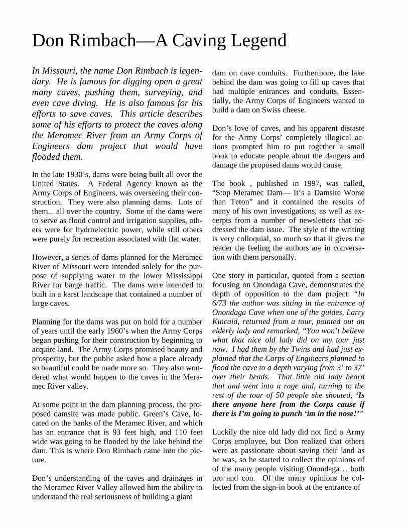
Don Rimbach—A Caving Legend
In Missouri, the name Don Rimbach is legen-dary. He is famous for digging open a great many caves, pushing them, surveying, and even cave diving. He is also famous for his efforts to save caves. This article describes some of his efforts to protect the caves along the Meramec River from an Army Corps of Engineers dam project that would have flooded them. In the late 1930’s, dams were being built all over the United States. A Federal Agency known as the Army Corps of Engineers, was overseeing their con-struction. They were also planning dams. Lots of them... all over the country. Some of the dams were to serve as flood control and irrigation supplies, oth-ers were for hydroelectric power, while still others were purely for recreation associated with flat water. However, a series of dams planned for the Meramec River of Missouri were intended solely for the pur-pose of supplying water to the lower Mississippi River for barge traffic. The dams were intended to built in a karst landscape that contained a number of large caves. Planning for the dams was put on hold for a number of years until the early 1960’s when the Army Corps began pushing for their construction by beginning to acquire land. The Army Corps promised beauty and prosperity, but the public asked how a place already so beautiful could be made more so. They also won-dered what would happen to the caves in the Mera-mec River valley. At some point in the dam planning process, the pro-posed damsite was made public. Green’s Cave, lo-cated on the banks of the Meramec River, and which has an entrance that is 93 feet high, and 110 feet wide was going to be flooded by the lake behind the dam. This is where Don Rimbach came into the pic-ture. Don’s understanding of the caves and drainages in the Meramec River Valley allowed him the ability to understand the real seriousness of building a giant
dam on cave conduits. Furthermore, the lake behind the dam was going to fill up caves that had multiple entrances and conduits. Essen-tially, the Army Corps of Engineers wanted to build a dam on Swiss cheese. Don’s love of caves, and his apparent distaste for the Army Corps’ completely illogical ac-tions prompted him to put together a small book to educate people about the dangers and damage the proposed dams would cause. The book , published in 1997, was called, “Stop Meramec Dam— It’s a Damsite Worse than Teton” and it contained the results of many of his own investigations, as well as ex-cerpts from a number of newsletters that ad-dressed the dam issue. The style of the writing is very colloquial, so much so that it gives the reader the feeling the authors are in conversa-tion with them personally. One story in particular, quoted from a section focusing on Onondaga Cave, demonstrates the depth of opposition to the dam project: “In 6/73 the author was sitting in the entrance of Onondaga Cave when one of the guides, Larry Kincaid, returned from a tour, pointed out an elderly lady and remarked, “You won’t believe what that nice old lady did on my tour just now. I had them by the Twins and had just ex-plained that the Corps of Engineers planned to flood the cave to a depth varying from 3’ to 37’ over their heads. That little old lady heard that and went into a rage and, turning to the rest of the tour of 50 people she shouted, ‘Is there anyone here from the Corps cause if there is I’m going to punch ‘im in the nose!’” Luckily the nice old lady did not find a Army Corps employee, but Don realized that others were as passionate about saving their land as he was, so he started to collect the opinions of of the many people visiting Onondaga… both pro and con. Of the many opinions he col-lected from the sign-in book at the entrance of
WWW.CAVES.COM
the cave, 99% were against the dam, if it was going to flood the cave. The Army Corps attempted to make claims in their “Summary Report” that the lake would not greatly affect the cave and that only “approximately 1/3 to 1/2 of the lower levels of this cave will be innundated.” Don conducted some measurements and found that if this were to be true, then the impact on the cave would indeed be minimal because there was already an old Grist Mill Dam that ponded the cave stream 2’ to 3’ deep along the tourist trail. However, Don reports this flooding to be dif-ferent from the Army Corps’ “Comprehensive Basin Study”, which claimed that “60% of the tourist trails would be underwater at flood pool.” Subsequently Don and the owner of the cave did further investigation and found that an additional report agreed with the latter and that indeed most of the cave would be flooded. Don sums up the innundation of the cave with the following synopsis: “All that would remain of Onondaga at flood pool would be 2 large air pockets in the central chamber. One would extend from the cactus room to a point just short of the twins. The other from the daniel boone room (half flooded) to the iron door af-ter which a 100’ section of completely flooded passage would prevent access from the rear entrance of the cave.” Now that it was clear the cave was going to be flooded, the owner requested that the Army Corps conduct a study to determine if a dike at the entrance of the cave could keep out the wa-ter. Don quoted the owner as saying, “After all, they are the world’s largest engineering organization.” The Army Corps heard the owner’s request and even toured the cave, but never conducted a feasibility study and never even gave the owner a report on the issue. Instead, a sub-poena by the United States Attorney’s Office revealed the Army Corps had no intention of protecting the cave in any way: “It is recom-mended that no partial or total protective measures be considered for Onondaga
Cave unless overwhelming economic pressures dictate otherwise.” At this point in the book, Don has demonstrated two deceptions by the Army Corps, which he calls the “Frauds.” However, there was a third, which was even more insidious than the first two. Throughout negotiation with the owner of Onon-daga Cave, the Army Corps promised him he would retain ownership of 90% of the cave. With hope for status quo as his motivator and his faith in the Army Corps’ judgment as the “...world’s larg-est engineering organization,” he continued to hold onto the belief he would be able to keep his livelihood and continue operating the second old-est commercial cave in America. This turned out to be a misconception as well. In the early 1970’s, as the Meramec Dam issue was becoming a major issue for much of the United States, Don Rimbach was approached by a disgruntled employee of the Army Corps who wanted to share information concerning property acquisition associated with lake. The employee informed Don of a law stating that the Army Corps had to own all of the land that would be inundated by the lake. This meant the tourist trail in Onondaga Lake, by law, had to be Army Corps property. Thus it also meant that the owner would not be able to maintain his livelihood and that the cave would have the Army Corps as its owner. This was the straw that broke the camel’s back. The owner of Onondaga Cave filed a lawsuit in Federal Court against the Army Corps of Engi-neers to force an injunction against the dam. He received the support of a community and a na-tion. No one would support the Army Corps’ plans for the dam: a public referendum showed the people were completely against the dam by a huge majority. Then Senator Tom Eagleton wrote a bill for deauthorization of the dam and President Ronald Reagan quietly signed it into law in 1981. The Meramec Basin Dam building efforts were officially over. Don Rimbach and the thousands of opponents of this travesty had fought for ten years and finally emerged victorious.
33 WWW.CAVES.COM
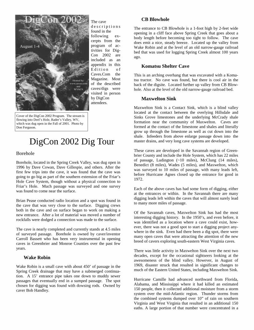
CB Blowhole The entrance to CB Blowhole is a 1-foot high by 2-feet wide opening in a cliff face above Spring Creek that goes about a body length before becoming too tight to follow. The cave does emit a nice, steady breeze. Located up the valley from Wake Robin and at the level of an old narrow-gauge railroad bed that was used for logging Spring Creek almost 100 years ago.
Komatsu Shelter Cave This is an arching overhang that was excavated with a Koma-tsu tractor. No cave was found, but there is cool air in the back of the digsite. Located further up valley from CB Blow-hole. Also at the level of the old narrow-gauge railroad bed.
Maxwelton Sink Maxwelton Sink is a Contact Sink, which is a blind valley located at the contact between the overlying Hillsdale and Sinks Grove limestones and the underlying McCrady shale formation near the community of Maxwelton. Caves are formed at the contact of the limestone and shales and literally grow up through the limestone as well as cut down into the shale. Infeeders from above enlarge passage down into the master drains, and very long cave systems are developed.
These caves are developed in the Savannah region of Green-brier County and include the Hole System, which has 22 miles of passage, Ludington (~10 miles), McClung (14 miles), Benedict (8 miles), Wades (5 miles), and Maxwelton, which was surveyed to 10 miles of passage, with many leads left, before Hurricane Agnes closed up the entrance for good in 1972. Each of the above caves has had some form of digging, either at the entrances or within. In the Savannah there are many digging leads left within the caves that will almost surely lead to many more miles of passage.
Of the Savannah caves, Maxwelton Sink has had the most interesting digging history. In the 1950’s, and even before, it was identified as a location where a cave could exist, how-ever, there was not a good spot to start a digging project any-where in the sink. Even had there been a dig spot, there were many open caves that were attracting the attention of the new breed of cavers exploring south-eastern West Virginia caves.
There was little activity in Maxwelton Sink over the next two decades, except for the occasional sightseers looking at the awesomeness of the blind valley. However, in August of 1969, disaster struck that resulted in significant changes to much of the Eastern United States, including Maxwelton Sink.
Hurricane Camille had advanced northward from Florida, Alabama, and Mississippi where it had killed an estimated 150 people, then it collected additional moisture from a storm system over the mid-Atlantic region. Thunder storms from the combined systems dumped over 10” of rain on southern Virginia and West Virginia that resulted in an additional 150 eaths. A large portion of that number were concentrated in a
DigCon 2002 Dig Tour Borehole Borehole, located in the Spring Creek Valley, was dug open in 1996 by Dave Cowan, Dave Gillespie, and others. After the first few trips into the cave, it was found that the cave was going to go big as part of the southern extension of the Friar’s Hole Cave System, though without a physical connection to Friar’s Hole. Much passage was surveyed and one survey was found to come near the surface.
Brian Pease conducted radio location and a spot was found in the cave that was very close to the surface. Digging crews both in the cave and on surface began to work on making a new entrance. After a lot of material was moved a number of rockfalls were dodged a connection was made to the surface.
The cave is nearly completed and currently stands at 4.5 miles of surveyed passage. Borehole is owned by caver/inventor Carroll Bassett who has been very instrumental in opening caves in Greenbrier and Monroe Counties over the past few years.
Wake Robin Wake Robin is a small cave with about 450’ of passage in the Spring Creek drainage that may have a submerged continua-tion. A 15’ entrance pipe takes one down to muddy sewer passages that eventually end in a sumped passage. The spot chosen for digging was found with dowsing rods. Owned by caver Bob Handley.
Cover of the DigCon 2002 Program. The stream is flowing into Deel’s Hole, Rader’s Valley, WV, which was dug open in the Fall of 2001. Photo by Don Ferguson.
The cave d e s c r i p t i o n s found in the following ex-cerpts from the program of ac-tivities for Dig-Con 2002 are included as an appendix in this E d i t i o n o f Caves.Com the Magazine. Most of the described caves/digs were visited in person by DigCon attendees.
June of 1972, however, brought another disaster to the Eastern U.S. This time, it was Hurricane Agnes. Her storms did over 3 billion dollars worth of damage and killed approximately 120 people. The entrance to Maxwelton was also one of the casualties of Hurricane Agnes. When cavers arrived in the sink when the water went back down, they found little evi-dence there had ever been an entrance.
Pete Williams and Chuck Hempel had become accustomed to redigging the entrance over the past two years from the effects of small storms, but when they began to redig the entrance this time, they couldn’t find any trace of the culvert pipe. It had taken a category 5 hurricane to initially weaken the plug enough for them to open a passageway into Maxwelton. Now they had a plug resulting from a category 4 hurricane to fight against. Not surprisingly their resolve was shaken.
Not long after the entrance was sealed shut by the hurricane, the other entrance was sealed shut by the asphalt of a parking lot. The Maxwelton project was over.
Several people have tried to dig in the sinkhole since then, but none have had success. In the past six months, however, Jeff Bray has brought microgravity analysis to West Virginia and used it to find anomalies which may be cave passages of the Maxwelton system… but only by digging will we know for sure.
Soil Pipe Slump In the summer of 2002, this entrance was a slot canyon with 20’ high dirt walls that lead into a short passage of walking height with dirt walls and ceiling. From here the passage con-tinued as a miserable, low, and narrow crawlway for 150’ with no airflow. Maybe an entrance someday? Not likely. Located about ¾ of a mile south of the Maxwelton Sink.
Track-Hoe Dig Heavy equipment usage no cave passage yet. Near Maxwel-ton Sink.
Micro-Gravity Well Casing Very recently, i.e. last week (late July, 2002), this well was dug where micro-gravity measurements indicated the location of cave passage. A 102’ shaft, 6” in diameter was dug into a passage approximately 20’ high. A video camera was low-ered down the shaft and a stream passage was seen. In addi-tion to the passage at 102’, a passage was also found at 30’, but was estimated at only 2’ high or less. Located near Max-welton Sink.
Hurricane Ridge (Peddler’s) This sink, near Pickaway, was first known as Peddler’s Blow-hole by early Monroe County cave mappers. Several groups of people over the years attempted to poke at the rocks, but no group became focused on the project until 1996 when a group of people, mostly from WVU Student Grotto began working on the rock pile. They used a come-along to pull out large
small region of western Virginia near Covington.
Death, disaster, and 1.4 billion dollars in damage were the devastating result of Camille’s passing. In the midst of untold tragedy, there was one other result: a small hole in the back of Maxwelton Sink blowing big air.
Pete Williams visited the sink soon after the waters receded. Apparently the water draining from the vast lake that had formed in the sinkhole had created enough force to wash open a passageway that was at least large enough for air and water to flow through. Pete began digging in the hole and others including Randy Flora, Chuck Hempel, Peter Surrey, Ann Harmon, and many WVACS members joined in the dig pro-ject as well.
There were as many as a dozen dig trips to the blowing hole over the next few months, which was referred to as “Cow-Shit Pit” for its nasty character. Initially a hole was excavated down 18 feet to a bedding-plane crawlway full of large rocks that had flaked off the ceiling. At this point the airflow had been concentrated into an all-out wind, so the motivation was high to continue through the blockage.
Being the late 1960’s, dynamite was still in favor and was used to blast through the breakdown flakes into a cobble-filled crawlway beyond. A trench was then excavated into the cob-ble and the dig progressed forward for almost 300’ where the cave passage finally opened to a stoopway. This passage soon lead to a junction room where the cave went big. Three subway tunnels exited from the room, one of them be-ing an up-and-down stream passage, but the other two lead directly to almost 4 miles of walking passage. Surveying con-tinued through the spring and into the summer.
The NSS Convention was held in Blacksburg during the sum-mer of the 1970, and the explorers and mappers had a lot to show for their efforts in Maxwelton Sink. They presented the Convention goers with a slide show that resulted in many ooo’s and aaah’s from the size of the passages and also inter-est in visiting the cave; the first sport trips to Cow Shit Pit left for the cave the next morning.
Surveying continued through 1970 and 1971, with the mileage adding up quickly and new discoveries being made almost every trip. During this time, at least two large rainstorms flooded the entrance, both of which caused significant damage to the digging works. In an effort stabilize the entrance, a culvert pipe was installed in the vertical section of the dig. The culvert worked well for the next few survey trips as ex-cited mappers pushed the cave closer and closer to the double-digit mileage mark.
The year 1972 arrived with the anticipation of surveying what was thought to be one of the largest caves in West Virginia. Survey continued through the spring when the surveyed length of the cave did indeed reach 10 miles. A new entrance had been found in a trash-filled sink, and though difficult, it did provide access to the cave. It seemed that the survey of a large West Virginia contact cave was well underway with nothing to stop it.
following Sunday were all that were needed to finally get in.
Aaron Bird got the pleasure of knocking off the final rock, using bull pins incidentally, and squeezing through to find that the cave did continue beyond the rock choke.
A number of survey trips have mapped the cave to 1000’ in length and over 200’ in depth. The last trip into the cave re-sulted in pushing a microblasted crack into a large room and finding going stream passage both upstream and down.
Zigafoose Blowhole Zigafoose Blowhole, located in Rader’s Valley, has long en-ticed cavers with its wind, which has been considered by many to be among the strongest breezes anywhere rivaling even Wind Cave in South Dakota. Over the years many cavers came to the crack to be cooled by the strong breeze in the summer and watch leaves get sucked in during winter. A few even poked at the small crack, however it wasn’t until the late 1980’s that it was successfully penetrated. The rest of this transcript is taken from an article by Mark Passerby in the 1st Edition of CaveDiggers.com the Magazine.
“…at some point in the process, I visited Zigafoose Blowhole. I was told by everyone that the air was massive, the entrance tight, and the possibility for a dig horrible.
My first visit was with Herman Hertz who, being a bit smaller than me, tried to squeeze in. It was not to be and he got very stuck in an entrance that was blowing air at probably 25 mph. I literally could not pull him out and being stuck at a 30-degree angle [head down] in the cold air, he quickly became con-cerned, as did I.
We contemplated going for help but opted to bull his boots off and I got in a position braced against the headwall and pulled as hard as possible. He began to break free but with considerable scraping.
About ten minutes passed and after some very tense moments, he finished backing out. It was very evi-dent that the entrance would need to be comfortable before I could bring a digging crew in to start a pro-ject.
A few weeks later I was back with a stick of Tovex to do a little comfort fix on the entrance. As my feet were held, I found a perfect ledge to pack a charge and after setting everything in place, blasted the con-striction to a large opening. Everyone could now get in, however I still didn’t know if there would be any-thing worth digging inside the cave.
I crawled in and was met with a nice little room with a large mess of breakdown just to the right. The area that I felt represented the best place to dig was largely under the breakdown pile so digging would be somewhat riskier than normal.
rocks and basic rock tossing to remove the small ones.
On the first day working at the site, two bats flew out of the hole they were working toward, so they began to get really motivated about digging. Stream diversion was necessary so they could dig in reasonable working conditions so several holes were successfully dug to allow the water to sink before the actual digsite.
The dig lasted every weekend for three months beginning around Thanksgiving of 1996 and continuing until the end of February 1997 when a breakthrough was achieved.
Over the next few years, about 2 miles of cave were surveyed and some mop up is still being done. Total length of the cave currently stands at 2.4 miles.
Scott Hollow The Scott Hollow valley was long thought to contain a cave. Mike Dore walked the sinkholes of the area in the early 1980’s and found a spot where his dowsing rods indicated a void or water below. Mike then used a backhoe and a bull-dozer to open a hole down into cave. Actually two parallel passages were found that headed right down the dip to a junc-tion room where an infeeding stream came in. The passage went upstream a ways but downstream it appeared to end in an impenetrable crack. At this point Mike and his companions thought they had found a nice little cave. They were still eager to explore, so they began climbing around and eventually found a way over the apparent end of the downstream passage to an overlying way on.
After negotiating the upper level passage, they climbed back down to find the stream again and followed it less than 100 feet into the master drain, which is now called Mystic River and is 50 to 80 wide and up to 100 feet high.
Scott Hollow currently has around 30 miles of surveyed pas-sage… and its still going.
Deel’s Hole This sinkhole in Deel’s Hollow has enticed many people over the years. In the 1970’s Dave Goldman worked in it looking for a way in, but wasn’t successful. The sink remained a tar-get on the map for many people, but it wasn’t worked again until Mark Passerby and Bob Kirk began a dig project there in the late 1990’s. They dug on an entrance for many trips and tried following the air, but eventually got down to a level where it became more and more difficult to dig and subse-quently became less interested in the hopes for finding cave. Curiosity got the better of Mark in 2001 and he recruited oth-ers to come and work on the dig. Several more dig trips were taken there, but again the hole was stubborn. However, one weekend in November of 2001 saw the introduction of micro-blasting to the Rader’s Valley area, as well as some very dedi-cated diggers including Carroll Bassett, Jaime Alvarez, and John Kerr. A Saturday of effort with microblasting and the
we decided to dig at the back area of the valley/sink in what was only a very small hole with a bit of air.
Our theory was that the water going in the entrance up front was bound to flow down the dip and back along the strike so digging at the back area would intersect passage just as it went into solid rock. Wow! Looking at it now, we couldn’t have been any-more on target! In fact, digging where the water en-ters would have proved futile [Ed. Note: We removed so much material from the hole, that it was impossi-ble for the passage to escape us.]
…we finally reached a depth and had a hole cleaned out to a point where we were ready to begin move-ment into the joint and into the hillside.
Much of the debris at this point could be placed in areas at the bottom tha were clear and out of the way, so movement was quickened and progress was somewhat easier.
The joint at this point was really shaping up quite nicely and we now were between two solid walls with a solid roof. Still we felt we need to progress a bit further back into the hill before dropping down.
Aaron, who has spent the most time at the front of the dig, continued to dig and fill buckets at a feverish pace. He finally stopped at a silt pile. Josh DeHaven and I at this point decide to give it a shot. This was Josh’s first cave digging experience and probably one he won’t forget too soon.
After looking at where we were in the dig, I decided that the time had come to go down a bit more. Quickly we hit a back solid wall… a real good sign that the passage we were after was to our left and back along the strike.
We began digging a bit down and to the left and within five minutes were peering into blackness with monster air plowing us in the face. Looking back at the dig, it is clear that the water for the most part sinks in the front of the sink and rapidly descends down along the strike until it intersects the joint, then taking the joint to it’s end, the water pushes a silt and debris pile against the back wall before making the turn back along the strike and into open cave under the hillside…” Mark’s discussion continues, but to sum it up, the passage zigs and zags its way down about 30 vertical feet and 150 in length to a sump. One of the projects for DigCon is pumping out the sump… we’ll see if there’s more cave for us to find if the water can be pumped out.
Now that the entrance was enlarged, and the spot to the dig evident, it was time to find people who be interested in working in there. By luck I managed to convince 8 to 10 WVACS members on a project weekend to come start the dig.
It was an impressive crew and a huge amount of dirt was moved rather quickly with no need to blast. Pete Waller and I continued to the dig from that point for a bit to a point where a major rock slid into the hole and a major piece of breakdown above us resettled a bit. It was somewhat ominous and made us recon-sider getting under the pile.
Some time later, Pat Dolin got involved digging on it with me and we continued to work down. Mike Dore and Jim Tompkins were invited on a trip and pro-vided the necessary bravery for making the final hit on a few rocks that would end up dropping the bot-tom out.
It was late one evening and a few rocks had been removed when all of a sudden –and unexpectedly—we were looking into cave! Mike, Jim, Pat, and I were there that night and slipped down through the new hole. Immediately we were in solid passage [10’ high, 2-4’ wide] and took off down it.
The end was not far however, but in the floor was a tight pit that dropped a considerable distance…”
Since then Zigafoose has been pushed to a depth of approxi-mately 200’ and about a mile of passage has been seen with many more leads left, though the current surveyed length is only 350’ with a depth of 65’. There are several projects cur-rently ongoing in the cave including passage enlargement, boulder chaining, and rigging.
Caves.com (Taken from an article by Mark Passerby in the Second Edi-tion of CaveDiggers.com the Magazine)
“The Caves.com Cave has the distinction of being the most labor intensive of all the digs I have ever engaged upon. It required hundreds of man hours and tons of material was removed. Ending with a huge hole lined with solid clean walls, the dig now appears quite elegant and is certainly looked on with pride by all of those who participated in making the eventual breakthrough on July 6, 2002.
Initially we began by doing a dye trace of the water entering the front area to see which of the two springs the cave drained to. The results were some-what unexpected and the travel time far less than we had anticipated, so we geared up to begin a dig pro-ject.
The first decision was whether to dig where the water was entering, which appeared to be the most obvious route to take, however after a bit of back and forth,