Embed Size (px)
Citation preview
THE SILURIAN SUCCESSION OF THE OSLO REGION
David Worsley, Nils Aarhus, Michael G. Bassett,
Michael P.A. Howe, Atle Mørk & Snorre Olaussen

- 1 -
T H E SI LU RIAN SUCC ESSION OF T H E OS LO R EGION
David Worsley, Nils Aarhus, Michael G. Bassett,
Michael P. A. Howe, Atle MØrk & Snorre Olaussen
David Worsley
Nils Aarhus
Michael G. Bas sett
Michael P. A. Howe
Atle MØrk
Snorre Olaussen
Paleontologisk museum, Sars gate 1, Oslo 5
I KU, Postboks 1883, 7001 Trondheim
National Museum of Wales, Cardiff CF1 3N P, U K
109 Gartree Rd, Oadby, Leicester L E2 2FF, U K
l KU, Postboks 1883, 7001 Trondheim
Geologisk Laboratorium, Statoil, Postboks 300,
4001 Stavanger
Cover figure taken from Kiær (1908 ) of Silurian exposures in
Ringerike from 11 Kongens Utsikt11•
May 1982
- 2 -
A BST RACT
The marine Silurian succession of the Oslo Region is up to 650 m
thick and displays a great variety of mixed clastic and carbonate
lithofacies. We propose the replacement of the ex i sting numerically
based stratigraphical scheme for the succession by a series of formal
lithostratigraphical units. The entire succession comprises two groups
and eleven formations, all of which are defined and described herein.
Our studies of the age relationships and depositional environments of
these units permit a revised synthesis of the palaeogeographical
evolution of the Oslo Region during the Llandovery and Wenlock. We
also briefly review recent work on the Ludlow red bed deposits of the
Ringerike Group.
30/A/2/mas
1. INT RO D U CT ION
- 3 -
The marine Lower Palaeozoic succession of the Oslo Region is
approximately 1,250 m thick and is overlain by an almost equally thick
red bed sequence of late Silurian age. This sedimentary suite is
exposed within a NN E -SSW trending graben ( Fig. 1) which appears to
have developed mainly in the Carboniferous and Permian ( Ramberg &
Spjeldnæs 1978, Olaussen 1981). Regional facies mosaics and thickness
variations in the Lower Palaeozoic succession reflect the foreland
character of the Oslo Region between the developing Caledonide
orogenic zone (Nicholson 1979) and the cratonic development seen
further east on the Baltic Shield. These features prompted Størmer
(1967) to suggest that Lower Palaeozoic sediments were deposited in
an intracratonic syneclise which corresponded generally to the
younger Permocarboniferous graben structure. Maximum subsidence
occurred in the late Silurian and Størmer tentatively associated this
syneclise with other basins of similar age along the southwestern and
southern margins of the Baltic Shield (e. g. in Scania and Poland). An
alternative, but not entirely conflicting, hypothesis by Ramberg
(1976) rather suggests the development of an off -set series of
fault -bounded · basins a lang the margins of the shield area. Both
authors clearly supposed that the margins of the Oslo Region•s Lower
Palaeozoic basih structure were generally coincident with those of the
later Permian graben.
Lower Palaeozoic sequences are patchily exposed throughout the
region between and beneath Permian intrusive and extrusive
complexes. l nterpretation of the original geographical relationships of
present exposures is complicated both by Permian faulting and
metamorphism and by earlier Caledonian deformation which had
marked ly different effects throughout the region. Exposures in
southern districts show gentle dips, but WSW - EN E striking folds
increase in intensity northwards to MjØsa where Lower Palaeozoic
rocks are exposed in highly deformed parautochthonous sequences
lying immediately south of major southeastwards directed thrust planes
( Nicholson 1979, Nystuen 1981). The appreciable crustal shortening
produced by Caledonian deformation must be barne in mind when
assessing the lateral facies variations observed in present exposures.
l n spite of these complications, well preserved exposures are both
30/A/3/mas
- 4 -
widespread and often exceptionally fossiliferous. These features make
the region an excellent area for detailed stratigraphical studies and
many contributions through the last 150 years have produced
progressively more refined correlations of the Lower Palaeozoic
succession (see review by Henningsmoen 1960).
Although Cambrian and Ordovician sequences are relatively well
understood, Silurian rocks have hitherto been poorly dated and their
facies mosaics have often been misinterpreted because of erroneous
intraregional correlations. This is particularly unfortunate as these
deposits• developmental patterns clearly reflect important tectonic
events in the neighbouring Caledonides and miscorrelations of the
Oslo Region•s Silurian succession have inevitably produced incorrect
models for the penultimate development of the southern Norwegian
sector of the Caledonian orogen. This situation has developed,
ironically enough, within the present century as a result of the
monumental work of Kiær (1908) which described in detail the marine
Silurian succession of the Oslo Region ; this work was impressive, not
least because of its advanced interpretations of regional facies
patterns and its impact was such that it has since been accepted as
the definitive work on this part of the Lower Palaeozoic sequence.
Much scientific activity has consequently been directed to Cambrian
and Ordovician units and only isolated aspects of the palaeontology
and geology of the Silurian succession have been described in the
ensuing 70 years. Key reviews of the Silurian sequence in parts or
all of the region . are those of Henningsmoen (1960), Seilacher &
Meischner (1964), Whitaker (1966, 1977), and BjØrlykke (1974). These
and most other contributions (see our comprehensive bibliography)
implicitly accepted the original stratigraphical scheme of Kiær (1908),
although the results of some studies either questioned or altered some
of Kiær•s correlations (e.g. Henningsmoen 1954, Heintz 1969).
However a reconnaissance survey by Bassett & Rickards (1971)
demonstrated the diachronous nature of many of Kiær•s units and
clearly indicated the need for a revision of Kiær•s stratigraphical
scheme throughout the entire Oslo Region.
A study of the regional stratigraphy and depositional environments of
the Silurian succession was therefore initiated in 1976, both as a part
of project 11 Paleostrat11 at the Paleontologisk museum, University of
30/A/4/mas
- 5 -
Oslo (grant no. D. 40. 38-6 from NAVF, the Norwegian Council for
Science and the Humanities) and as a Norwegian contribution to the
l GCP project 1 Ecostratigraphy 1• Several research students and foreign
workers have contributed to this study and biostratigraphical,
palaeoecological and sedimentological surveys of most districts and
stratigraphical units of the Oslo Region•s marine Silurian succession
are new in progress or have been completed recently. Much of the
basis for this paper consists of resulting unpublished information
(partly collated in theses) collected both by the present authors and
by other colleagues. The latters• information is acknowledged
wherever appropriate, but we especially note here the contributions
of R. J. Aldridge, B. G. Baarli and N. -M. Hanken. Work in progress
makes it necessary to propose herein a lithostratigraphical framework
for the entire sequence which accords with modern stratigraphical
standards. We al se present summa ri es of aur biostratigraphical and
sedimentological interpretations in order to give a broad review of the
chronological and palaeogeographical relationships of aur major
lithostratigraphical units. l n order to present a camp lete review of
present knowledge of the Silurian development of the Oslo Region, we
also give a brief summary of lithostratigraphical and sedimentological
studies ·carried out in recent years on the late Silurian nonmarine red
bed sequence (see especially Whitaker 1965, Turner 1974 a, b, c and
Turner & Whitaker 1976).
2 . ST RAT I G RA P HY
Present Stratigraphical Scheme
The numerical classification of the Lower Palaeozoic succession of the
Oslo Region is based on a sequence of units first proposed by Kjerulf
(1857). Kjerulf divided the marine deposits of the Oslo district into
11 Etagen 11 1 to 8; this terminology was further developed, modified and
elaborated by subsequent workers. However, units were aften defined
us ing a mixture of bie- and lithostratigraphical criteria, and this is
clearly seen in Kiær•s (1908) proposals for the Silurian sequence.
30/A/5/mas
- 6 -
Kiær redefined and refined Kjerulf's nomenclature and used this
numerical system as his primary form for the division and correlation
of the sequence in the various districts of the region. He divided
marine Silurian rocks into " Etagen" 6 to 9; although he did not study
the overlying red beds, he assigned them to " Etage" 10 ( Kiær op. cit.
Profiltafel 1) which he defined as " Devonian sandstone and conglo
merate 11. Kiær further subdivided his major units using an
alphabetical subnotation (e.g. Sa, 6b ) and further subdivisions were
based on the Greek alphabet (e. g. 6bf3) with numerical subscripts
(e.g. 6bf31). He aften complemented this procedure with descriptive
names for each subunit in order to highlight characteristic fossils
(e.g. Sb, Ringerike: " Die Zone mit Rhynchonella Weaveri"). Many such
units are in fact lithologically based, and Kjærs 6b in Ringerike is a
sandstone dominated unit between two more shaly sequences. Kiær
also defined units on a mixed litho - and biostratigraphical basis (" Die
Zonen 8a -b oder der Monograptusschiefer 11) or on ly on lithological
character (1'8d: Die Zone mit dem MalmØkalk").
Kiær (1920 ) subsequently adopted a different approach to the strati
graphical subdivision of the Silurian succession in a paper describing
algae from the Ringerike district. He there introduced a classification
based on "groups" (e. g. the Stricklandia and Pentamerus group!? in
his Lower Silurian "series") and he also introduced same
subdivisions "zones" without us ing numerical designation·s.
However, these zones were also based on both litho- and bio
stratigraphical criteria (e.g. "the zone with the finely nodular
Rhynchonella nucula limestone"). He promised a more comprehensive
presentation of these new divisions, but other research and admini
strative duties prevented this work. Subsequent papers on the
Silurian stratigraphy of the region followed Kiær's original numerically
and alphabetically based subdivisions with their descriptive names.
However, groups proposed by Kiær (1920) were redefined as "series"
( Holtedahl 1953, Strand & StØrmer 1955, Henningsmoen 1960). Strand
& StØrmer also introduced a lithostratigraphically based terminology
for the northern districts of the region, based on information which
was published subsequently by Skjeseth (1963). The resultant
stratigraphical scheme for the Silurian rocks of the Oslo Region
included subdivisions grouped into the Stricklandia (" Etage" 6)
Pentamerus (7) and Lower (8) and Upper Spiriferid (9) "series".
30/A/6/mas
- 7 -
Although recognizing the dual base for the definition of these units,
Henningsmoen (1955) suggested that they could be assigned chrono
stratigraphical relevance, and this practice has been followed by most
workers until recently.
11 Etagen 11 6 and 7 were originally correlated by Kiær (1908) with the
British Lower and Upper Llandovery, 11 Etage11 8 with the Wenlock and
11 Etage11 9 with the Ludlow. Subsequent stud i es of vertebrate and
other fauna l elements (e. g. Henningsmoen 1954, Heintz 1969, Bas sett
& Rickards 1971, Bockelie 1973 and Turner & Turner 1974) would
rather suggest that the entire marine sequence should be assigned to
the Llandovery and Wenlock, the transition to the overlying red beds
occurring close to the Wenlock Ludlow boundary. Continual
revisions of the biostratigraphical zonation of Llandovery and Wenlock
sequences elsewhere have produced a detailed framework which new
enables relatively precise correlations to be made throughout the Oslo
Region between different sedimentary facies. Of especial note are
works on graptolites (Bjerreskov 1975, Rickards 1976), conodonts
(Aidridge 1979), and brachiopod phyletic lineages (Williams 1951,
Ziegler 1966, Rubel 1977, Johnsen 1979 and MØrk 1981). Important
biostratigraphical syntheses have also been presented by Ziegler,
Cocks & Mc Kerrow (1968), Cocks (1971) and Cocks, Holland, Rickards
& Strachan (1971). Comparisons of aur data with these works have
shown that most of the (both major and mi nor) currently accepted
units are diachronous when traced through the Oslo Region.
We have considered several possible revisions of the present scheme:
in view of the long -established u se of the numerical 11 Etage11 system
we could, for example, retain these units, either by redefinition and
adjustment of their boundaries or by recognition and tabulation of
their informal and diachronous nature. However, we consider that
such procedures would merely exacerbate ex i sting confusion;
furthermore, this numerical notation masks the facies variations
observed throughout the region. We believe that an entirely new
approach to the stratigraphical problems of the Oslo Region•s Silurian
sequence is warranted and therefore propose here formal and
mappable lithostratigraphical units throughout the region and
designate stratotypes for each unit. These units are of formational
rank and are intended to replace the previously accepted four
30/A/7/mas
- 8 -
11series11 of the Silurian succession. We foresee an interim period,
especially prior to forthcoming detailed descriptions, where Kiær•s
miner subdivisions (e. g. 6bf3) may still have to be used within our
formational framework: these should then be used only as local and
informal descriptive terms and have no intraregional correlative
significance.
In most districts the maps of Kiær (1908) provide an adequate basis
for tracing our formational boundaries and so we do not present new
geological maps showing the areal distribution of our formations
throughout the region. Although we here redefine and reorganize
Kiær•s units into our new formations in each area, our formational
boundaries always fellow (within any reasonable mappable scale) unit
boundaries displayed on Kiær•s maps. We therefore define in each
case the equivalence of our formations to Kiær•s numerical units in
each district. An exception is the northern districts where Silurian
exposures were on ly briefly described and not mapped by Kiær. l n
these districts we accept the proposals and summary map of Skjeseth
(1963) and subsequent detailed mapping carried out by M. P. A. H.
validates our approach.
Geographical nomenclature
StØrmer (1953) divided the Oslo Region into eleven districts in his
description of Ordovician stratigraphy and his terminology has been
generally accepted in subsequent publications. Silurian outcrops are
common in seven of these districts and we mainly adhere to Størmer•s
district boundaries. However, Størmer•s 110slo-Asker11 district is here
divided into the Oslo and Asker (i. e. Asker and Bærum) districts
with boundaries defined by the respective local government areas
(Fig. 1) . For ease of reference we call størmer•s district 3 the Skien
district and his district 10 the Hamar district. We use the terms
central (Oslo and Asker), western ( Holmestrand, Modum, Eiker and
Ringerike), southern (Skien) and northern ( Hadeland, Toten, Hamar
and Ringsaker) districts in a purely geographical sen se with no
implicit facies connotations. This is explicitly stated here since Kiær
discussed palaeogeographical relationships in terms of 11eastern 11,
11western11 and 11mixed 11 facies developments; our work indicates the
inadequacy of such a simple palaeogeographical zonation.
30/A/8/mas
- 9 -
Place names used for aur new formations are taken from those printed
on the 1:50,000 maps of the Norwegian Ordinance Survey (NGO), or
on local economic or tourist maps where the former do not display the
relevant name. Grid references are also taken from the NGO maps.
The most important localities referred to in the text for the definition
and description of aur units are shown in Figs. 2 and 3.
New lithostratigraphical units
We here propose and describe eight new formations in the marine
sequence stud i ed; we al se redefine and describe three units
previously proposed by Skjeseth (1963) in the northern districts of
the region. To complement the lithostratigraphical scheme previously
established for the overlying red beds (see p. 44) we also propose
the establishment of the Bærum and Hole groups to embrace the entire
complex of marine facies described below. The formational scheme
proposed is presented in Figs. 4 and 5, which show both regional
correlations and facies and thickness variations observed throughout
the region. l n Fig. 4 we also compare aur units with Kiær's (1908)
stratigraphical scheme in each district. l ndividual lithostratigraphical
units are defined and described below. We also introduce member
subdivisions in the type areas of same of the formations, but stress
that the Jack of formal proposals of members in many of aur
formational units largely reflects the present state of research.
Future refinements will result in the definition of additional members
to characterize the total facies mosaic present. Our synthesis is based
on an examination of all districts within the region, but we should
note that more detailed studies are required in the Skien district and
in the Wenlock succession of Holmestrand. C loser inspection of small
and aften highly metamorphosed exposures in the Eiker and Lier
districts should also give extra data to augment the depositional
models we present here.
Brief and generalized environmental interpretations are presented for
each formation. The use of benthic faunas in the environmental
analysis of Silurian sequences was pioneered by Ziegler (1965) and
Ziegler et al. (1968) who defined five brachiopod dominated
"communities" with distributions which apparently parallelled the
Llandovery coastlines of central England and Wales. Each was named
30/A/9/mas
- 10 -
after a typically occurring genus:
Lingula, Eocoelia, Pentamerus,
11communities11• Successors of these
(from proximal to distal) the
Stricklandia and
Llandovery fauna!
Clorinda
assemblages
have subsequently been defined in the Wenlock and Ludlow of Britain
(Calef & Hancock 1974, Hurst 1976 and Watkins 1979). A major point
of debate has been the direct palaeobathymetrical significance of such
recurring benthic assemblages. Same authors (e. g. Mc Kerrow 1979)
assert a direct relationship between 11community11 development and
water depth, but detail ed sedimentological stud i es suggest that
varying fauna! mosaics may be expected in different depositional
regimes. Works by Anderson (1971, 1974) and Bridges (1976) suggest
that the fivefofd division originally proposed by Ziegler (1965)
reflects the linear barred coastline developed in the Welsh
Borderlands during the Upper Llandovery, the Lingula and Eocoelia
11communities11 inhabiting tidal and lagoonal environments behind
pentamerid colonized banks and shoals; the Stricklandia and Clorinda
11communities11 were then developed in progressively lower energy
shoreface and offshore shelf en vi ronments. l n other situations, e. g.
on a shelf influenced by a prograding deltaic coastline, a different
benthic fauna mosaic may be expected. l n each case, ecological
structure and fauna! distribution will reflect all limiting factors af
fecting a particular habitat. These factors, together with ecological
interplay between individual species (and not only the single limiting
factor of depth), will determine the structure of the resultant benthic
faunas. Another serious weakness of the 11community11 concept which
is commonly used for Silurian benthic faunas is that the 11 communities11
described by many workers are larger units than those which most
modern ecologists would term a community and Boucot (1975) proposed
the term 11 Benthic Assemblage11 which we consider useful to group the
various communities (sensu strictu) which are found in a spectrum of
proximal to distal marine situations from intertidal ( B. A. 1) to
dominantly pelagic ( B. A. 6) environments. We will here adhere to
Boucot•s scheme prior to the completion of more detailed palaeoeco
logical analyses which we hope will enable the definition of
recognizable palaeocommunities in the sense of Kauffmann & Scott
(1976).
The dating of each formation is only briefly discussed here using key
faunal elements. Appreciable refinements of aur correlations will result
30/A/10/mas
- 11 -
from biostratigraphical studies based on more detailed systematic
sampling within each unit and district. In aur comparisons with other
areas within the Anglo -Baltic province we have found it natural to
correlate aur units with the standard stratigraphical scheme for the
British Silurian sequence (Fig. 4, see Cocks, Holland, Rickards &
Strachan 1971). Stages for the Wenlock Series which we use here
were first proposed by Bassett, Cocks, Holland, Rickards & Warren
(1975) and these have new been formally accepted as international
standards (Martinsson et al. 1981). The status of the Llandovery
stages proposed by Cocks, Toghill & Ziegler (1970) has not yet been
formalised internationally but we find it useful to correlate aur units
with these local British divisions of the Llandovery Series.
T H E BÆ R U M G RO U P
The group•s name is based on the municipality of Bærum. The group
comprises the mixed clastic and carbonate marine sequences found
throughout the Oslo Region which are here assigned to the Solvik,
Sælabonn, Rytteråker, Vik, Ek, Bruflat and Skinnerbukta formations;
all of these units are defined and described below.
The base of the Bærum Group throughout the region is everywhere
coincident with earlier definitions of the lowermost occurrence of
11 Etage11 6. In the Oslo, Asker and Holmestrand districts this
corresponds to the base of aur Solvik Formation; the boundary
stratotype for the base of the Bærum Group is therefore that defined
for the Solvik Formation on Hovedøya, Oslo district (p. 12) where it
is conformable with the underlying rocks. l n other districts the
group•s base corresponds to the base of aur Sælabonn Formation. The
base of the group in these latter districts is locally disconformable;
this is most easily seen in the northernmost districts where basal
units infill and overlie karstic surfaces in the Caradoc to ? early
Ashgill MjØsa Limestone.
30/ A/11 /mas
- 12 -
The composite thickness of the group is approx. 400 m in the Bærum
area (Fig. 5). The group is thickest (600 -650 m) in the northern
districts of the Oslo Region but its tap has not yet been definitely
identified there. In all other districts the tap of the group coincides
with the boundary between 11 Etage11 8b and Se as defined by Kiær
(1908). As discussed later (p. 35), under aur description of the
overlying Hole Group, this junction is sharp ly defined in the
Ringerike and Skien districts, but is gradational in Oslo and Asker.
The group appears to range in age from the early Llandovery to the
mid -Sheinwoodian (riccartonensis or low rigidus Biozone). The group's
tap is diachronous, becoming younger from the Ringerike and Skien
districts towards Asker and Oslo.
T H E SOLV I K FO RMAT ION
Definition
The name of the formation is taken from Solvik (NM981378), a bay on
the west coast of Mal møya, 5 km south of Oslo city centre (Fig.
2a). The formation corresponds essentially to 11 Etage11 6 of Kiær
(1908) in the Oslo, Asker and Holmestrand districts. The Solvik *
Formation is characterized by dominant shales with very thin to thin
siltstone and limestone intercalations. All quantitative terms for
describing bedding used herein fellow the scheme of lngram (1954).
Variation in these components (Fig. 6) suggests a twofold division
into the Myren and Padda members in the formation•s type area on the
MalmØya group of islands in the Oslo district. A complete type section
cannot be designated and the stratotype for the base of the Solvik
Formation is defined on the south coast of Hovedøya (NM975412).
Reference sections through the lower and upper parts of the
formation are well exposed in two faulted but relatively continuous
profiles on the east (NM988380) and west (NM981377) coasts of
Malmøya respectively; the tap of the formation is seen in the latter
section at Sol vik.
* All references to bed thicknesses used herein fellow the
scheme proposed by lngram (1954).
30/ A/12/mas
- 13 -
The formation is thought to be approximately 190 m thick in its type
area, but faulting makes an exact determination impossible.
The lower boundary is defined by the sharp contact between
underlying calcareous sandstones of the Langøyene Sandstone
Formation (Brenchley and Newall 1975, equivalent to Sb of Kiær 1897
and 1902) and the dark grey silty shales with miner siltstones of the
Solvik Formation. A SO cm thick nodular li.mestone occurs locally as a
basal developmenf of the overlying unit (Fig. 7). The base of the
lowermost Myren Member is, by definition, coincident with the base of
the Solvik Formation. The Myren Member is approximately 1SO m thick
and includes Sa and Sb of Kiær (1908) in the type area of the Solvik
Formation. The name of the member is derived from a locality on the
east coast of Malmøya (NM988380) which shows the most complete
development of the lower parts of this unit. Detailed correlations of
several partial sections both here and on the west coast of the island
suggest a minimum thickness of 120 m for Kiær's Sa (in contrast to
his suggested thickness of 50 to SO m) and a total minimum thickness
of approximately 1SO m for the whole Myren Member. The member
consists of shales with miner laminae and very thin interbeds of
siltstone. Siltstones are most common in Sa� and 6ba where they
comprise 30 % of the succession (Fig. S). Body fossils are genera li y
rare in the lower parts of the member, but in situ brachiopod
associations dominated by Leangella scissa and Protatrypa
malmoeyensis characterize 6ba: and 6bf3 respectively (Worsley 1971).
The Padda Member corresponds in general to Se of Kiær (1908) in the
Mal mØya area. lts name is deri ved from a small is land north west of
Malmøya ( NM992390) where the upper parts of the unit are well
exposed, but its base is defined in a complete 30 m thick type section
on the west coast of Malmøya (NM981377). Although shales also
dominate this member, thin interbeds and lenses of both calcareous
siltstone and limestone occur together with calcareous nodules. The
base of the Padda Member is defined at the sharp introduction of
these ca1careous interbeds above the highly shaly upper parts of the
Myren Member. Characteristic fauna l elements of the Padda Member
are both in situ and reworked populations of Stricklandia lens ;
bryozans, corals and stromatoporoids are also relatively common.
30/ A/13/mas
- 14 -
The upper boundary of the Solvik Formation is gradational over about
2 m, but it is easily mappable in the type area. The dominantly shaly
Padda Member grades rapidly into the thinly interbedded limestones
and shales (in approximately equal proportions) of the overlying
Rytteråker Formation (Fig. S); the junction is taken at the first
appearance of finely 11nodular11 limestone horizons assigned to the
Rytteråker Formation. Bedding pl ane exposures show that most of
these 11nodules1 1 are carbonate infills of endichnial burrows in the
shales.
Other occurrences
The Solvik formation is also seen in many exposures in the Asker and
Holmestrand districts and its total thickness appears to be relatively
constant.
The siltstones of the Myren Member thin and decrease in abundance
westwards from the type area to Asker where beds which can be
assigned to this unit interfinger with a more calcareous shale
development throughout Sa and Sb of Kiær (1908). Mar is and
limestones in Kiær•s Se at Spirodden ( NM840338) contain both
Stricklandia lens, abundant tabulate corals and stromatoporoids; these
beds should be assigned to a new, as yet undefined unit with member
status ( B. G. Baarli pers. comm. ). The significance of benthic algae
in this unit at Spirodden was commented upon by Lauritzen & Worsley
(1974) and MØrk & Worsley (1980). Kiær (1908) defined Scf3 in Asker
as a 10 m thick shaly sequence which he assumed to be directly
overlain by the limestones of 11 Etage11 7. However, a series of new
road cuttings not available to Kiær show a SO m thick sequence of
shales and siltstones which Iie between Kiær•s 11Sca11 and the overlying
Rytteråker Formation. A detailed study of the entire Solvik Formation
in the Asker district now in progress will result in the definition of
several new members in this area ( B. G. Baarli pers. comm. ).
Only the uppermost 25 m of the Solvik Formation are exposed in the
Holmestrand district on the island of BjØrkØya (NL7S498S) and these
were re -examined by MØrk (1977). Both this exposure and cores from
test boreholes through the entire lower Silurian succession in the
subsurface of the neighbouring island of Langøya demonstrate a facies
30/ A/14/mas
- 15 -
development which we assign to the Sol vik Formation. Exposures
through the uppermost parts of the Solvik Formation on BjØrkØya
show similar shales and siltstones to those seen in the upper parts of
the formation in Asker.
Depositional environments
The shale-dominated sequence of the Solvik Formation reflects the
rapid early Silurian transgression of the Oslo, Asker and Holmestrand
districts and the establishment of sublittoral depositional environments
in these areas. Siltstones of the Myren Member in the type area were
storm generated and deposited in quiet muddy environments below
normal wave base. Exposures through equivalent lower parts of the
Solvik Formation in the Asker district show notably fewer siltstone
intercalations than the type area and calcareous interbeds are more
common. The transition to the shale and limestone facies of the Padda
Member is abrupt in the type area. Both sedimentary structures and
fauna indicate the establishment here of shallower environments with
intermittent periods of both current and wave reworking of the sea
floer. The storm generated siltstones seen 11in 6c�11 in Asker and
Holmestrand are thought to be time equivalents of the Padda Member.
In contrast to the depositional regime of the lower parts of the
formation, the Asker and Holmestrand districts were now in a more
proximal situation than the type area. Fauna l associations seen
throughout the Solvik Formation in all three districts correspond
generally to Benthic Assemblages 5 and 4 of Boucot (1975).
Rare graptolites and abundant brachiopods form the basis for aur
dating (Fig. 4). The nodular horizon which defines the base of the
formation contains a sparse shelly fauna with Hirnantian aspects
( Cocks in press). This· passes up fnto shales with very sparse and
non-diagnostic faunas, but we have found Climacograptus
transgrediens 11 m above the base of the formation on Ormøya (Fig.
2a). This graptolite ranges from the ?upper persculptus to lower
acuminatus Biozones elsewhere and the base of the Solvik Formation is
therefore immediately below the Ordovician/ Silurian boundary as
taken at the base of the persculptus Biozone. Occurrence of sub-
30/ A/15/mas

- 1S -
species of Stricklandia lens in the Asker district in-dicate that the top
of the formation here approximates to the ldwian/Fronian transition
(B.G. Baarli pers. comm.).
T H E SÆLA BONN FO RMAT ION
Definition
The Sælabonn Formation is best demonstrated in the Ringerike district
(Fig. 2b) in a series of small coastal exposures around Sælabonn, a
small bay in the northern part of Tyrifjorden. This formation
corresponds in general to 11 Etage11 S of Kiær (1908) in the Ringerike,
Skien, Hadeland, Toten, Hamar and Ringsaker districts. Our
definition incorporates the HelgØya Quartzite of Skjeseth (19S3) as a
local member in the two latter districts. The formation is
approximately 110 m thick in the Sælabonn area, where it is characte
rized by varying proportions of sandstone, siltstone and shale.
Sandstones dominate the middle part of the unit and lithological
variation was apparently the main reason for Kiær•s (1908) tripartite
subdivision (Sa, Sb, and Se). Formal proposals for subdivision into
three members approximately equivalent to Kiær•s units will probably
result from work in progress in the Ringerike area. ( E. Themsen
pers. comm. ) .
The entire Sælabonn formation is not exposed in any one section in
the type area; the basal stratotype for the formation is defined on
Store Svartøya (NMS78585) where the lower 11 m of the formation also
are exposed (Fig. 8). A reference section through the midd le of the
unit is exposed around Sandvika (NMS9SSOS) and its upper parts are
well displayed in the basal stratotype for the overlying Rytteråker
Formation at Limovnstangen (p. 19). The base of the Sælabonn
Formation is defined on Store Svartøya at the sharp contact between
crinoidal biosparites of Sb (with a karstic upper surface) and the
silty shales with minor thin limestones and siltstones of the lower part
of the Sælabonn Formation (Fig. 8). This 20 m thick development
30/ A/1S/mas
- 17 -
coarsens up into medium to thickly bedded sandstones with miner
siltstones and shales (6b of Kiær 1908, 50 m thick). These further
fine up into thin to medium interbeds of siltstone and shale with
increasing limestone intercalations towards the junction with the
overlying Rytteråker Formation.
Other occurrences
Exposures elsewhere in the Ringerike and Skien districts indicate a
similar tripartite development to that of the type area. The base is
exposed at several localities in the southern parts of the Skien
di stri et (e. g. Skrapekleiv N L381523) where silty shales of the
formation overlie a thin (0. 5 - 1 m) very coarse sandstone which has
an erosive contact with small biohermal structures and biosparites of
uppermost Sb ( Rønning 1979). Exposures north of Skien at JØnnevall
in Gjerpendalen (NL 321708) show an erosive contact with Sb, but the
base of the formation there consists of sandstones which grade up
into the silty shales assigned to Ga by Kiær (1908).
In Hadeland, Owen (1978) defined the SkØyen Sandstone Formation as
a sandstone and shale unit with a gradational base (to his KalvsjØ
Formation, Sa of earlier workers) and tap (to aur Rytteråker
Formation). This unit is 120 m thick and correlates with 11 Etagen11 Sb
and 6 of earlier workers. Because of poor exposure Kiær (1908) and
Major (1946) were unable to define the boundary between Sb and 6 in
Hadeland, and Owen's approach is eminently justifiable. Although
present exposures do not display the precise contact between these
units, sections examined by us suggest an important change in
sedimentological development in tl:le middle of Owen's Skøyen Sand
stone and the upper 60 m of his unit show a tripartite development
similar to that of the Sælabonn Formation in the adjacent Ringerike
district. Pending further detailed analysis we suggest as an interim
measure that Owen's SkØyen Sandstone be regarded as an informal
unit, the upper part of which is clearly correlative with the Sælabonn
Formation at Ringerike.
Further north, in the Toten, Hamar and Ringsaker districts, the
Sælabonn Formation is represented in toto by the thin HelgØya
Quartzite Member which rests on eroded surfaces of the MjØsa
30/ A/17 /mas
- 18 -
Limestone. Sandstone infills of the karstic topography marking the top
of this limestone are seen at several localities in Toten. The Hel gØya
Quartzite•s original type section at Eksberget (PN087355) on Helgøya
(Skjeseth 1963) is poorly exposed and ·a hypostratotype is here
defined in a disused quarry at Vestby near GjØvik (NN921379). The
member is 9 m thick here (Fig. 10). The lower 5 m con sist of medium
to thickly bedded sandstones with thin shaly partings; these grade
up into thinly interbedded sandstones and shales with limestone inter
calations uppermost marking the transition into the overlying
Rytteråker Formation. Other exposures further north in
Brumunddalen ( PN076586) and on HelgØya indicate an essentially
similar 1 but thicker development (15 to 30 m).
Depositional en vi ronments
Basal sandstones and shales in the Ringerike and Skien districts
reflect the earl y Silurian transgression of these areas. Sandstones in
the middle of the formation represent a subsequent progradational
episode and deposition in coastal environments. The upper parts of
the .unit in both areas suggest renewed transgression 1 with a gradual
transition from clastic to carbonate dominated sedimentation.
Exposures in Hadeland suggest an essentially similar depositional
history to that of the type area. The thin sandsten es of the Helgøy a
Quartzite Member in the Toten 1 Hamar and Ringsaker districts reflect
the transgression of an area which had been emergent throughout the
late Ordovician. This development appears to correlate with the upper
part of the Sælabonn formation in its type area. In all districts the
transition to the overlying Rytteråker Formation suggests a complex
and irregularly diachronous cut-off of coarse clastic supply as a
result of continuous regional transgression. The faunas of the
formation are reminiscent of Benthic Assemblages 1 to 3 of Boucot
(1975).
A general Rhuddanian to ldwian age is suggested in the type area by
brachiopods ( E. Themsen pers. comm.) and conodonts ( R. J. Aldridge
pers. comm. ). The occurrence of Borealis borealis around the junction
with the overlying Rytteråker Formation indicates a middle ldwian age
30/ A/18/mas
- 19 -
for the uppermost beds of the Sælabonn Formation in its type area
(MØrk 1981). However, the base of the formation has not yet been
definitively dated.
T H E RYTT E RA K E R FO RMATION
Definition
The name of this formation is derived from Rytteråker Farm
(NM699594) on the west coast of Tyrifjorden in the Ringerike district.
The formation•s character is well demonstrated in this type area,
especially in coastal exposures around Limovnstangen, a peninsula 1
km south of Rytteråker Farm.
The Rytteråker Formation is essentially an equivalent of 11 Etage11 7a
and 7b of Kiær (1908) throughout the Oslo Region. Our formational
proposal replaces the term 11 Pentamerus Limestone11 which has been
widely used subsequent to Kiær•s work. Whereas many workers (e. g.
Henningsmoen 1960) have applied the name 11 Pentamerus Limestone11 in
a sen se which conforms to our Rytteråker Formation, Kiær used the
terms 11 Borealis and 11 Pentamerus11 Limestones11 to those restricted
parts of our Rytteråker and overlying Vik formations which contain
abundant pentamerids. This varying u sage and the inherent
nomenclatural confusion of bio- and lithostratigraphical properties
prompt our rejection of the name 11 Pentamerus Limestone11• The
informal 11 Engen Limestone11 proposed by Owen (1978) in the Hadeland
district is here assigned to the Rytteråker Formation. Limestones
assigned to the formation are approximately 50 m thick in the type
area; Kiær•s tripartite division (7a, 7ba, 7bØ) was based both on
faunal composition and on varying proportions of limestone and
calcareous shale within the unit. A single complete type section is not
seen, but the basal stratotype is defined on the northern ti p of
Limovnstangen (NM691591) and reference sections through the midd le
and upper parts of the formation are exposed along both coasts of
30/A/19/mas
- 20 -
this peninsula. The tap is seen in the basal stratotype of the
overlying Vik Formation on the northern limb of a small syncline
whose axis defines the northern coast of Limovn_stangen ( NM695596).
The basal stratotype shows a gradational development: interbedded
thin to medium siltstones and shales here assigned to the Sælabonn
Formation show increasingly common intercalations of limestone beds
upwards. The base of the Rytteråker Formation is defined at the
quantitative dominance of limestone contra siltstone intercalations
(Fig. 11). Our formational base is therefore 5. 5 m higher in the
section than the junction between 6c and 7a defined by Kiær (1908)
and corresponds to Kiær•s bed XIV ( Kiær 1908: Profiltafel 11). Lime
stones with pentamerids become increasingly abundant through the
basal 10 m of the formation and grade upwards into thickly bedded
biosparites in the middle 25 m of the unit (7ba: of Kiær 1908). These
beds are composed of finely comminuted pentamerid and crinoid
debris; small bioherms are found at the tap of this sequence
throughout the Ringerike district ( Kiær 1908, Hanken, Olaussen &
Worsley 1979). The uppermost 17 m of the formation (7b� of Kiær
1908) consist of planar limestone beds and well-bedded calcareous
nodules with interbedded shales; the shale content increases towards
the contact with the overlying Vik Formation.
Other occurrences
Although the character and content of the carbonates in the
Rytteråker Formation vary from district to district, the unit can be
traced throughout the Oslo Region. The formation thins marked ly to
the N E of the type area (Fig. 5); thickening to the E S E and S
results in maximum observed thicknesses of 65 m in the Oslo and
Asker districts and 80 m in the Skien district.
Exposures in the Hadeland district show a gradational base from the
Sælabonn Formation, interbedded limestones and shales pass ing up
into a thickly bedded pentamerid biosparite unit. This is erosively
overlain by interbedded limestones and shales with both bioclastic and
general carbonate content decreasing upwards to the contact with the
Ek Formation (see p. 24). The Rytteråker Formation thins
progressively northwards through the Toten, Hamar and Ringsaker
30/ A/20/mas
- 21 -
districts. Northernmost exposures at Torsæter Bridge in
Brumunddalen ( PN076586) show a 15 m thick sequence of interbedded
thin limestone beds, nodular horizons and shales.
The Rytteråker Formation shows somewhat similar developments in the
Asker, Oslo, Holmestrand and Skien districts. The base is gradational
in all cases, either from the more sandy Sælabonn or more shaly
Solvik formations. Thin, fine-gra i ned limestones and shales occur in
equal proportions in the lower parts of the unit in all these areas.
Limes tone beds thicken and coarsen upwards and shale con tent
decreases into the middle and upper parts of the unit. The transition
to the overlying Vik Formation is marked by the renewed development
of interbedded limestones and shales.
Depositional environments
The Rytteråker Formation represents the establishment of relatively
shallow carbonate depositional environments throughout the Oslo
Region at a time when earlier source areas for coarse clastic material
were submerged. The pentamerid biosparite units seen in Hadeland
and Ringerike represent high-energy shoals, with crests which may
have been intermittently emergent (e. g. in Hadeland). Biohermal
development on the upper surfaces of the shoals in Ringerike was
probably initiated subsequent to a relative rise in sea-level which
resulted in stabilization of these shoals1 high ly mobile substrates.
Other districts show somewhat more distal marine carbonate
sequences. However, in all these other districts a general
shallowing-upwards trend throughout the lower and middle parts of
the formation is indicated by an increase of better sorted and thick
bedded biosparites at the expense of shale and fine -grained
limestones. Abundant pentamerids, corals and stromatoporoids
together with benthic algae in all districts indicate that the formation
was not deposited in water of any great depth. The fauna is typical
of Benthic Assemblage 3 of Boucot (1975).
The occurrence of the pentamerids Borealis and Pentamerus suggests
a somewhat diachronous base for the Rytteråker Formation, rang ing
30/ A/21 /mas
- 22 -
from the middle to late ldwian in the Ringerike and Hadeland districts
to the late ldwian or early Fronian in the central and southern dis
tricts of the Oslo region (MØrk 1981). The transition to the Vik and
Ek formations is dated by graptolite and brachiopod faunas in these
overlying units (p. 25 and 27).
T H E V I K FO RMAT ION
Definition
The development of this formation is best demonstrated in widespread
but discontinuous exposures throughout the Ringerike district. The
most easily accessible sections are seen in roadside cuttings
immediately east of Vik (NM715609), prompting aur use of this
formational name. The formation is generally synonymous with " Etage"
7c of Kiær (1908) in the Ringerike, Oslo, Holmestrand and Skieri
districts and with Kiær•s 7b� and 7c in Asker. The Vik Formation is
approximately 80 m thick in its type area and shows a tripartite *
development with varying proportions of both red and greenish grey
shales, marls and limestones. This tripartite development was the
basis of Kiær•s (1908) subdivision into 7ca:., 7c� and 7cy and the
members proposed by Aarhus (1978) generally correspond to Kiær•s
subdivisions. We here modify the provisional nomenclature of Aarhus
and propose the establishment of the Storøysundet, Garntangen and
Abborvika members (in ascending order) in the Vik Formation in its
type area. A single type section for the formation cannot be design
ated but a basal stratotype is defined in a coastal section NW of
Rytteråker Farm (NM695596). This section is marked by the gradation
from thinly interbedded limestones and greenish grey shales of the
underlying Rytteråker Formation into predominantly red shales. The
base of the Vik Formation is defined at the transition from limestone
to shale dominance 4 m below the lowermost occurrence of red shales.
* 11 Red" units, referred to both here and subsequently, show
colours var.ying from pale to dark reddish brown, 10 R5/4 to
10 R3/4 of the Standard Rock Color Chart. Greenish grey beds
correspond to 5GY6/1 of the same chart.
- 23 -
The base of the Storøysundet Member is, by definition, coincident
with the base of the Vik Formation. The basal stratotype displays
12. 5 m of the member, but a total thickness of approximately 20 m in
the type area of the Vik Formation is suggested by other coastal
exposures around Storøysundet ( NM6958). The red shales of the
Storøysundet Member contain miner bioclastic limestone lenses, small
calcareous nodules and occasional greenish grey shale interbeds. A
diverse but sparse fauna includes articulated crinoid stems,
brachiopods, stromatoporoids and tabulate corals.
The middle 13 m of the Garntangen Member are exposed in the E68
road section near Garntangen (NM720609) on the coast of
Steinsfjorden. The member is also well exposed on the west coast of
Sto røya ( NM690576 to NM694582) where its basal stratotype is defined.
lts base is taken at the marked increase in limestone interbeds 3 m
above the uppermost red shales of the underlying unit. The
Garntangen Member is approximately 25 m thick and consists of thinly
bedded limestones and calcareous nodules with miner greenish grey
marls. Fresh exposures in the road section near Garntangen display
19 bentonitic horizons which vary from a few mm to 12 cm thick
(Fig. 12, see also Hagemann 1966). This part of the Vik Formation
has a more rich and diverse fauna than the adjacent members and
both corals and stromatoporoids are abundant; brachiopods (especially
Pentameroides sp. and Costistricklandia lirata) are also common in
certain beds.
The upper Abborvika Member consists of greenish grey to red shales
with interbedded finely nodular limestones. A sparse fauna of
crinoids, cephalopods and brachiopods is seen. The member is
estimated to be 35 m thick in its stratotype on Purkøya (NM688571);
the base is defined by the transition from the abundant limestones cf
the underlying unit into greyish green calcareous shales with sparse
evenly bedded and calcareous nodular horizons. These beds pass up
into red shales with irregular very finely nodular horizons about 18 m
above the base of the member. The upper 3 m of the member consist
of greenish grey shales; these are sharply overlain by siltstones of
the Bruflat Formation and the junction is well exposed on Purkøya
(Fig. 12).
30/ A/23/mas
- 24 -
Other occurrences
Although exposures in the Holmestrand district show a similar
tripartite development to that of the type area, the middle unit in
Holmestrand (well exposed on Killingholmen, NL753995) consists of
thickly bedded biosparites with corals, stromatoporoids and coquinas
of Pentameroides sp. This unit was assigned to 7cf3 or the 11 Upper
Pentamerus Limestone11 by Kiær (1908 ) . In the Skien district a 10 m
thick shale sequence ( Kiær•s 7ca.) passes up into nodular limestones
and greenish grey marls; these are directly overlain by shales which
we assign to the Skinnerbu kta Formation (8a/b of Kiær 1908 ) .
Exposures
irregularly
with finely
assigned to the Vik Formation on Malmøya consist of
varying proportions of greenish grey shales and marls
nodular limestones. A notable feature is the widespread
occurrence of exceptionally well preserved articulated crinoid stems
up to several metres long . Occasional thin intraformational con
glomerate horizons are also found on MalmØya; these contain eroded
and redeposited corals and calcareous nodules, reflecting the early
diagenetic formation of these nodules. Occasional easily weathered
interlaminae may represent bentonitic horizons. Exposures in the
Asker district have still not been examined in detail, but we
provisionally include both 7bf3 and 7c of Kiær in the Vik Formation in
this district. We further note that sections seen here appear
transitional between the Ringerike and Malmøya developments .
The Vik Formation thins southwards from 80 m in the type area to
45 m in the Skien district. Red colouration of shales in the formation
is developed only in the Ringerike and Asker districts. However, the
apparent absence of both red colouration and bentonites in the
Holmestrand and Skien districts may result from Permian contact
metamorphism of the exposures in these areas.
Depositional environments
Sediments and faunas of the Vik Formation suggest somewhat deeper
depositional environments than those of the underlying Rytteråker
Formation with greater (although still fine-grained) clastic influx.
Shales near the base and top of the formation in the Ringerike,
30/ A/24/mas
- 25 -
Holmestrand and Skien districts contain faunas characteristic of
Benthic Assemblages 4 and 5 of Boucot (1975). The presence of
abundant corals and stromatoporoids (and associated benthic algae)
typical of Benthic Assemblage 3 suggests the development of shallow
marl banks in the Garntangen Member in the type area. A comparable
unit in Holmestrand comprises a bioclastic shoal rich in pentamerid
and coral debris. Several interpretations have been presented by
previous workers to explain the local red colouration of the Vik
Formation•s shales. These will be discussed further below (p. 52).
Our correlation of the unit is based both upon occurrences of the
brachiopods Pentameroides and Costistricklandia and on conodonts
(A idridge pers. comm. ). These brachiopods suggest that the
Garntangen Member may be equivalent to low c5 of the British
sequence and the conodonts suggest a slightly older (C 4) age for the
base of the Vik Formation. A marked ly diachronous tap is suggested,
ranging from mid c5 equivalent in Ringerike to late c6 on MalmØya
( Fig. 4).
T H E E K FO RMAT ION
Definition
This formation•s name was proposed by Skjeseth (1963) ; its name is
derived from Eksberget ( PN087355) on the island of HelgØya in the
Hamar district. The Ek Formation is approximately 95 m thick in this
type area; exposures assigned herein to the Ek Formation are
dominated by greenish grey to dark grey (aften graptolitiferous)
shales. We con sider the Ek Formation to camp rise all units ass i gned
by Kiær (1908) to 1 1 Etage 11 7c in the Hadeland, Toten, Hamar and
Ringsaker districts and we retain Skjeseth 1s (1963) concept of the
formation. Exposu res in the Hadeland district show a transitional
development to the Vik Formation of Ringerike but are more like the
30/ A/25/mas
- 26 -
development of the Ek Formation in its type area; we therefore
incorporate the informal 11Askilsrud shale11 of Owen (1978) from
Hadeland within our Ek Formation.
Poor exposure and complex tectonics make a satisfactory definition of
the formation difficult. The type section proposed by Skjeseth (1963)
along the 11new road11 ( Kiær 1908: fig. 100) at Eksberget is now
overgrown, but no better exposures are known at present. The base
of 7c at Eksberget was described by Kiær at the transition from red
nodular limestones and shales (here assigned to the Rytteråker
Formation) to greenish grey marly shales with darker grey
graptoliferous horizons. Kiær noted approximately 95 m of such
shales, the lower 65 m with numerous graptolite horizons and the
upper 30 m with a sparse shelly fauna. The nature of the top of the
Ek Formation is poorly understood on Helgøya. The boundary with the
overlying Bruflat Formation is best seen in this latter unit•s basal
stratotype in the Toten district.
Other occurrences
Several small exposures are seen in the Ringsaker district around
Torsæter Bridge in Brumunddalen (PN077584 to PN077589)
approximately 20 km north of Eksberget. Exposures there are highly
tectonised and dark grey graptoliferous shales with bentonites appear
to have been secondarily reddened, probably during Permian times.
Small exposures of dark grey graptoliferous shales are also seen in
railway cuttings in the Toten district around Bruflat (NM875238 and
NM877257).
The base of the unit was exposed in 1977 in a temporary exposure in
a trench at Stor-Kyset (NM907297), 2. 5 km east of Reinsvoll in
Toteh. The top of the Rytteråker Formation was marked there by a
55 cm thick red nodular limestone; this was overlain by a 20 cm thick
bentonite, followed by greenish grey shales and bentonites with some
graptolite horizons. Exposures in Hadeland (railway cuttings at
Netberg, NM842851 and Gunnstad, NM787844) indicate a similar
thickness to that seen in the type area and a basal hypostratotype is
defined at the former (Fig. 13). The base of the formation there is
marked. by red shales (7c of Kiær) overlying grey nodular
30/ A/26/mas
- 27 -
limestones of the Rytteråker Formation. The , lower part of the Ek
Formation consists of alternating greenish grey and reddish shales
with occasional bentonitic horizons1 sparse shelly fossils and
occasional thin black graptoliferous horizons. The remainder of the
formation consists of greenish grey and red shales with finely nodular
limestone horizons.
Depositional environments
The shales of the northern districts were deposited in deep water
environments distal to the prograding sandy deposits of the overlying
Bruflat Formation. This foredeep passed laterally southwards into
shallower shelf environments with the mixed carbonate and mud facies
of the Vik Formation. The Hadeland exposures reflect this transition 1
but are on balance more akin to the Ek Formation.
Well preserved graptolites indicate a maximus Biozone age for the base
of the Ek Formation in its hypostratotype in Hadeland. A good
turriculatus Biozone fauna is seen 5 m above the base of the
formation. Two poorer faunas 3 and 315 m above the base sug gest a
probable correlation with the maximus Biozone. A basal crenulata
Biozone age is suggested by graptolites from the tap of the unit in
Hadeland; sparse shelly faunas support this conclusion 1 indicating an
equivalence to the c5;c6 transition. The base appears to be
progressively younger and the tap progressively older northwards
(Fig. 4) through the Toten and Hamar districts.
B RUFLAT FO RMATION
Definition
We here adopt1 define in detail and extend the use of the formational
unit proposed by Strand & Størmer (1955) and Skjeseth (1963) for the
30/ A/27 /mas
- 28 -
Toten, Hamar and Ringsaker districts, with its name deri ved from
Bruflat (NN877256) in the Toten district. Kiær (1922) introduced the
term 11Mariendal Series11 for rocks which we assign to this unit in the
Ringsaker district; however, that term has never been widely u sed,
whereas the Bruflat Formation is new general ly accepted. The informal
term 'Marienberg Beds ' was used by Ramberg and Spjeldnæs (1978)
for units which we assign to the Bruflat Formation. We here
geographically extend Skjeseth's (1963) formational concept to include
units assigned to 8a and 8b by Kiær (1908) in the Ringerike and
Hadeland districts.
Because of incomplete exposure and complex tectonics, a single type
section cannot be designated. The type area around Bruflat shows a
tightly folded and faulted series of anticlines and synclines where
various parts of the unit are exposed. Best exposures are seen in
several road and railway cuttings between Eina (NN875229) and
Reinsvoll (NN884283). The base of the formation is defined in the
southern end of a railway cutting (NN875238), 800 m north of Eina
Railway Station. A composite section has not yet been satisfactorily
established in the type area, but a thickness in the order of
400-550 m is suggested (Fig. 14). The formation is characterized by
varying proportions of sandstones, siltstones and silty shales. The
lower part of the formation in the type area consists of medium to
thickly bedded very fine calcareous sandstones and silty shales, the
base of the formation being defined by the first occurrence of
sandsten es. Man y of the sandstones have eros i ve bases, and show
planar lamination passing up into rippled tops. The upper 200 m of
the formation consist of irregular and intergrading alternations of fine
calcareous sandstones, siltstones and bioclastic limestones, aften in
thick beds with only thin shaly partings. Relatively diverse shelly
faunas occur sporadically. At the top of the formation there is a
gradational contact with red shales here assigned to the Reinsvoll
Formation in an exposure on the western margin of the type area,
(see p. 31).
Other occurrences
Several exposures in Brumunddalen show only a poorly fossiliferous
shaly development of the formation (river bank and road cuttings
30/ A/28/mas
- 29 -
near Torsæter Bridge (PN0757-PN0758)). At Bjørgeberget (PN0555)
reddened shales uppermost in the Bruflat Formation yield a fauna with
Cyrtia exporrecta ( Kiær 1922). l n Hadeland· approximately 125 m of
the formation are exposed; neither the tap of this unit nor an y
younger units are preserved in this district. However, comparison
with the adjacent Ringerike district indicates that the Hadeland
exposures represent most of the formation•s original development in
this district (railway cuttings at Gulla, NM7882).
Numerous partial sections in Ringerike demonstrate an attenuated de
velopment of the Bruflat Formation in this district. A composite
reference section can be studied on the islands of PurkØya and
Storøya. The base is seen on the NW coast of Pur køya ( NM688571),
the middle parts in good but discontinuous exposures on Storøya
(NM691571 to NM690574) and the tap is exposed at Vintergututangen,
the northernmost point of Storøya (NM710586). A total thickness of
approximately 115 m is indicated. The base is taken at the first thick
siltstones which sharply overlie the greenish grey shales and nodular
marls uppermost in the Vik Formation. The lower part of the Bruflat
Formation (Sa of Kiær, approximately 70 m thick) consists of a
rhythmic sequence of shales (with shelly faunas) and more silty
intervals; siltstones become more common upwards and 8b of Kiær
(approximately 45 m thick) consists of medium-bedded siltstones and
sandstones with bioclastic limestones and miner thin shales. We have
not seen the desiccation cracks reported by Størmer (1942) in the
upperm0st beds, but the tap of the unit is marked by an erosive
contact with the limestones of the overlying Braksøya Formation.
Depositional environments
The formation shows a coarsening upwards sequence in the type area,
reflecting a large scale coastal progradation into and over the
graptolitic shale environments of the Ek Formation. Distal storm
generated sandstones in the lower parts of the Bruflat Formation are
overlain by sediments typical of wave dominated clastic shelf
environments with faunas assignable to Benthic Assemblage 4 of
Boucot ( 1975) .
30/ A/29/mas
- 30 -
l n the Ringerike district the formation shows a similar coarsening
(and shallowing) upwards trend to that seen in the type area.
Stormgenerated siltstones in the lower part of the unit (8a) were
deposited below normal wave base in quiet muddy environments with
faunas typical of Benthic Assemblage 5. The uppermost part of the
formation (8b) shows abundant evidence of wave reworking1 with
faunas which can be assigned to Benthic Assemblage 4. The
uppermost beds still contain these marine faunas and the erosive
contact with the overlying BraksØya Formation is noteworthy. Clasts
of the underlying Bruflat Formation•s sandstones found immediately
above this contact may suggest emergence prior to renewed marine
deposition in the carbonate dominated environments of the Braksøya
Formation.
Skjeseth (1963) tentatively correlated his Bruflat Sandstone of the
northernmost districts with 1 1Etagen11 8 and 9 of more southerly areas
and subsequent workers (e. g. størmer 19671 BjØrlykke 1974)
generally assumed a Wenlock age for the formation although BjØrlykke
noted that 11the age of the Bruflat Sandstone is not very well
defined11• Exposures both in the Ringerike and northern districts
contain graptolite1 conodont, brachiopod and coral taxa which are all
characteristic of the uppermost Telychian ( c6 or crenulata Zone). No
diagnostic Wenlock faunal elements have yet been found1 but we
cannot yet rule out the possibility that the formation may extend into
the basal centrifugus Biozone of the Wenlock.
Bassett & Rickards (1971) first presented revised datings of the
formation in the Ringerike district; however 1 their results were
somewhat confusing as the apparent occurrence of cyrtograptids in
beds assigned to 8a near Vik suggested a Wenlock age for this
locality in contrast to the Llandovery faunas of nearby exposures at
the same stratigraphical level. It is now clear that the cyrtograptids
did not originate from this locality, and graptolites found in 8a and
8b at Ringerike (Monograptus vomerina vomerina and M. parapriodon)
suggest correlation with the crenulata Zone ( Rickards 1976). Aldridge
(1974) described an amorphognathoides assemblage of conodonts from
8b in Ringerike; this conodont assemblage ranges into the early
30/ A/30/mas
- 31 -
Wenlock, but the associated occurrence of the brachiopods
Costistricklandia lirata lirata, Cyphomenoidea wisgoriensis,
Protomegastrophia walmstedtii and of the rugose coral
Palaeocyclus porpita suggest a Telychian age.
Both conodont and brachiopod shelly faunas now found in the upper
parts of the Bruflat Formation in its type area contain the same key
elements as listed above, thus suggesting a close correlation with
Ringerike (Fig. 4). The reddened 11 Cyrtia shales11 found by Kiær
(1922) on BjØrgeberget in the Ringsaker district lack distinctive
faunas. No typical Llandovery fauna l elements occur, however, and
these beds (probably the youngest parts of the Bruflat Formation
preserved in the Oslo Region) may extend into the early Wenlock.
THE REINSVOLL FO RMATION
Definition
This unit has not been described previously and has only been
identified with certainty in the Reinsvoll area of the Toten district.
The Reinsvoll Formation is not assigned to any of the groups
des.cribed herein at this stage, but is provisionally described here in
view of its potential regional significance. The Reinsvoll Formation
consists of poorly exposed red shales of unknown total thickness. lts
basal stratotype is exposed on a farm track between Highway 4 and
Berget, on the eastern bank of the Hunselv river in Toten
(NN876269). The lower 21 m of the Hunselv section consist of
calcareous sandstones with bioclastic interbeds and shaly partings;
these beds are assigned to the Bruflat Formation and the upper 10 m
of this sequence are reddened. These are overlain by approximately
15 m of monotonous red shales which we here assign to the Reinsvoll
Formation, but the nature of the contact with the underlying beds is
obscure. Similar red shales have also been seen in trenches dug for a
new housing development immediately south of Reinsvoll (NN886279).
Loose blocks are also present in drift above a nearby road-cutting.
30/ A/31 /mas
- 32 -
No definite equivalents of the Reinsvoll Formation have yet been
found in Hadeland. In the Hamar and Ringsaker districts the Bruflat
Formation is unconformably overlain by rhomb-porphyry Javas and by
the Brumunddal Sandstone (Kiær 1922, Rosendahl 1929) of probable
Permo-Triassic age. The junction, seen at several places on
BjØrgeberget ( PN05555) is poorly exposed, and the presence of the
Reinsvoll Formation there can neither be confirmed nor rejected.
Depositional environments and age of the Reinsvoll formation are
uncertain. Although the formation is certainly younger than the
underlying Bruflat Formation, no identifiable fossils have yet been
found.
THE S KINNERB UKTA FORMATION
Definition
This formation•s name is derived from Skinnerbukta, a bay on the NW
coast of MalmØya in the Oslo district. The Skinnerbukta Formation
corresponds to 11Etagen11 Sa and 8b of Kiær (1908) in the Oslo, Asker,
Modum, Holmestrand and Skien districts. In spite of same tectonic
disturbance a reasonably complete type section can be defined in
cliffs on the east coast of Skinnerbukta (NM894381). The unit is
approximately 80 m thick in its type section and consists of dark grey
graptoliferous shales.
The base is defined immediately above a sequence of shales with both
nodular and continuous limestone interbeds. The nodules are larger
and the limestone beds thicker than those usually seen in the Vik
Formation, but these beds are here ass i gned to that formation. The
overlying dark grey shales of the Skinnerbukta Formation contain
occasional very thin marly horizons, which are sometimes slightly
bioturbated. The total calcareous content of the formation increases
upwards and its upper parts consist of somewhat paler calcareous
shales. These uppermost beds al sa show an increasing abundance of
30/ A/32/mas
- 33 -
limestone interbeds and the gradational tap of the unit is defined by
the base of the overlying Malmøya Formation (see below). Graptolites
and hyolithids dominate the fauna of the formation in the type
section; same rare shelly elements have been found, including
scattered lingulids, gastropods, crinoids and individuals of
Eoplectodonta transversalis.
Other occurrences
The formation is also exposed at several localities in the Asker,
Holmestrand and Skien districts. Exposures at Bærum in the Asker
di stri et (Øverland, NM876449, Jong 846404 and Gjettum NM850022)
suggest a thickness of 90 m; shales there contain both graptolites and
low diversity benthic faunas. Exposures on Kommersøya (NL750990)
and at Sande (NM740013) in the Holmestrand district are metamor
phosed, but a more diverse benthic fauna with several taxa of both
brachiopods and trilobites are seen, while graptolites are rare.
Exposures in the Skien di stri et (e. g. around Kapitel berget, N L
367628) mark the continuation of this sedimentological and ecological
gradient; limestones are more common, and form distinct horizons
(aften bioclastic lenses) in the upper part of the unit. Benthic faunas
here show a moderate diversity and approach an ecological structure
similar to that seen in the upper parts of the Bruflat Formation of
Ringerike. However, the absence of coarse clastic material leads to
the assignment of this sequence to the Skinnerbukta, rather than to
the Bruflat Formation.
Depositional environments
In its type area, the Skinnerbukta Formation was deposited in low
energy, usually anaerobic environments. The occasional presence of
bioturbation and of (highly restricted) benthic elements . suggests
periodic flushing of a generally anoxic mud bottom. Several of these
elements may represent either epiplan ktic taxa drifted into the area
attached to floating algae or possible giant spat. The only clearly
benthic element is Eoplectodonta transversalis: the few individuals
found are small and apparently stunted, suggesting restricted bottom
conditions adverse to shelly colonisation. Bioturbation and benthic
diversity increase upwards in the formation in the type area,
30/ A/33/mas
- 34 -
suggesting a genera l ly sha l lowing trend. Benthic fauna l diversity a lso
progressive ly increases from Oslo, through Asker and Ho lmestrand, to
Skien; and faunas found in Skien may be ass i gned to Benthic
Assemblages 5 to 4 of Boucot (1975).
The faunal evidence suggests a marked regiona l diachroneity of the
Skinnerbukta Formation•s lower and upper boundaries, which become
older from Ma lmøya to Skien. Grapto lite faunas in the type section
suggest that the base of the formation there is approximate ly
corre lative with the L landovery l Wenlock boundary, a lthough the
basal 10 m (Sa of Kiær 1908) may possib ly be assigned to the latest
L landovery crenulata Biozone.
Revision of the corre lation of Bassett & Rickards (1971) suggests that
e lements typical of the Wenlock centrifugus, murchisoni and
riccartonensis grapto lite Biozones are found upwards through the
formation and its upper parts may extend into the rigidus Biozone.
8oth the base and tap of the Skinnerbukta Formation become
progressively older southwards, and benthic faunas near the tap of
the formation in the Skien district contain e lements which, as noted
under aur discussion of the Bruflat Formation, are typica l of the
uppermost L landovery (e. g. Costistrick landia lirata l irata,
Palaeocyc lus porpita and l sorthis mckenzii).
Comparison with Ringerike suggests that the Skinnerbukta Formation
in its type area is latera l ly equiva lent to the (combined) uppermost
parts of the Bruflat Formation, the entire Braksøya Formation and the
lowermost parts of the Steinsfjorden Formation of the latter district.
This complex facies mosaic wi l l be further discussed be low.
30/ A/34/mas
- 35 -
THE HOLE GROUP
The group1s name is based on the municipality of Hole in the
Ringerike di stri et and comprises the carbonate-dominated sequences
found in the upper parts of the marine Si lurian succession in the
centra l, western and southern districts of the Oslo Region. These
sequences are assigned to our new Braksøya, Ma lmøya and
Steinsfjorden formations. Representatives of the group are not
preserved in the northern districts of the region.
The base of the group is genera l ly coincident with the base of
11Etage11 Be of Kiær (1908). In the Ringerike, Modum and Skien
districts this corresponds to the base of our Braksøya Formation and
the boundary stratotype for the base of the Ho le Group is that
defined be low for the Braksøya Formation on Braksøya in the
Ringerike district. The junction with the under lying Bærum Group is
sharply defined there. In other districts (Os lo, Asker and
Holmestrand) the group1s base corresponds to the base of our
Mal møya Formation, with a gradational lower junction. The composite
thickness of the group is 275 m · and 240 m respective ly in the
Ringerike and Asker districts, thinning southwards to 120 m and
170 m in the Ho lmestrand and Skien districts. The group1s top is not
preserved in the Os lo district, but its upper boundary to the
Ringerike Group in other districts corresponds to the gradationa l
junction between 11 Etagen11 9 and 10 of Kiær (1908).
The Hole Group is corre lated with most of the Sheinwoodian and
Homerian. lts base is diachronous, younging from Skien and
Ringerike to the Oslo district and its top is p laced somewhat be low
the Homerian/Gorstian boundary in the Ringerike district. Severa l
workers have suggested a large-scale regional diachronism for the
junction between the Ho le Group and the overlying Ringerike Group
(e. g. Spje ldnæs 1967, BjØrlykke 1974 and Ramberg & Spje ldnæs 1978).
We sti l l lack adequate biostratigraphic documentation of such a
re lationship (see p. 40).
30/ A/35/mas
- 36 -
THE BRAKSØYA FORMATION
Definition
The formation is best demonstrated on the west coast of Braksøya
(NM727610) in the Ringerike district, where a complete type section
can be designated (Fig. 15); the formation is 27 m thick there, and
consists of a complex carbonate development with miner marls and
shales. The Braksøya Formation corresponds to 11Etagen11 8c and 8d of
Kiær (1908) in the Ringerike, Modum and Skien districts. We
provisionally subdivide the formation into two informal members,
pending the results of work in progress by S. O. and N. M. Hanken.
The base of the Braksøya Formation in its type section is defined
immediately above the clearly-defined eroded top surface of the
Bruflat Formation. Small sandstone and shale clasts are seen in the
basal limestone development of the Braksøya Formation. The lower
biohermal member is 17 m thick and is characterized by thinly bedded
marls with massive biomicrite and biolithite structures (up to 7 m high
and 15 m wide) which we interpret as small patch reefs (Fig. 16, c. f.
Kiær, 1908, fig. 19c). These contain algae, bryozoans, tabulate
corals, stromatoporoids and other problematical organisms both as
framework and binding elements in the reefs1 structure (Hanken,
Olaussen & Worsley 1979). The patch reefs pass both laterally and
vertically into marls of variable thickness which contain a varied
brachiopod fauna, and occasional horizons show large,
current-oriented, rugose corals (Whitaker 1965). Scattered sulphate
pseudomorphs after celestite or gypsum are also seen in the marly
sequence. The upper part of this member consists of a 3.5 m thick,
black, bituminous shale with in situ tabulate corals and
stromatoporoids; individual colonies o�r 1 m3 in size are present.
The upper, well-bedded member is 10 m thick in the formation•s type
section and consists of thickly bedded limestones with marly partings
and occasional desiccation cracks. Thinly (al gal?) laminated limestones
with fenestral fabrics and pseudomorphs after evaporite nodules, coral
biostromes and oncolitic biosparites also occur. The top of the
BraksØya Formation is taken below the first appearance of thinly
interbedded limestones and shales here assigned to the overlying
Steinsfjorden Formation.
30/ A/36/mas
- 37 -
Other occurrences
The complex and varied development of the Braksøya Formation is well
demonstrated in several exposures elsewhere in the Ringerike district
( GeitØya NM6956, Sto røya NM7057 and SØnsterud NM7251). Wherever it
is exposed, the contact with the underlying Bruflat Formation is
erosive. As might be expected, the patch reef and marl components of
the lower member of the formation show variable local developments,
and in same exposures this member consists of only ane of these com
ponents.
Exposures in the Modum and Skien districts are provisionally
included in the BraksØya Formation. A lower biohermal member is well
developed in both districts (especially at Kapitelberget, NL 367628 in
Skien). However, the upper part of the formation in both districts
contains interbedded limestones and shales similar to those assigned to
the Malmøya Formation in the Holmestrand and central districts and
unlike those of the upper member at Ringerike.
Depositional environments
All exposures assigned to the Braksøya Formation indicate the
establishment of marginal marine carbonate depositional environments
following a short (and biostratigraphically indefinable) period of
eros ion (and ?emergence) near the Llandovery /Wenlock boundary. The
fauna and flora of the patch reefs indicate shallow1 clear water,
marine en vi ronments; however, both the restricted character of the
flora and fauna and the occurrence of evaporites in marl sequences at
Ringerike suggest periodical hypersaline conditions. Desiccation
cracks and evaporitic pseudomorphs seen in the upper parts of the
formation in the type area also indicate intra/supratidal depositional
environments. Such features have not been observed in the Modum
and Skien districts and this suggests deposition in more distal marine
environments. Faun as are campa rable to those ass i gned to Benthic
Assemblages 2 and 3 by Boucot (1975).
30/ A/37 /mas
- 38 -
Brachiopods, corals and ostracodes seen in the type section of the
Braksøya Formation contain no diagnostic Llandovery elements, and
the base of the overlying Steinsfjorden Formation contains brachiopods
(including Eocoelia angelini) with a Sheinwoodian (riccartonensis
Biozone) age. Faunal elements therefore suggest a low Sheinwoodian
(pre-riccartonensis Biozone) age similar to that of the Upper Visby
Beds of Gotland ( Bassett & Cocks 1974). The occurrence of
Eocoelia angelini in the upper part of the Braksøya Formation in the
Skien district suggests a somewhat later transition here to beds
assigned to the Steinsfjorden Formation. Thus, the Braksøya
Formation in its type area is considered to be a time equivalent of the
Skinnerbukta Formation in the Holmestrand and central districts. The
development in Skien overlies beds assigned to the Skinnerbukta
Formation; the tap of the Braksøya Formation in this di stri et is
approximately correlative with the junction between the Skinnerbukta
and Mal møya formations of the Holmestrand and central districts (Fig.
5).
THE MALMØY A FORMA Tl ON
Kjerulf (1857) introduced the term 11Malmøya Limestone and Shale11 (his
Etage 8) for exposures on MalmØya in the Oslo district. Kiær (1908)
assigned the lower (more shaly) part of Kjerulf's unit to 11Etage11 8c
and the upper massive limestones to 11Etage11 8d; he applied the term
11MalmØkalk11 both to the latter limestones and to units which he
assigned to 8d in the Bærum, Holmestrand and Skien districts. Kiær•s
practice was also followed by Strand & StØrmer (1955) in · their
definition of the 11MalmØya Limestone". Our redefinition and use of the
Malmøya Formation is based on Kjerulf's (1857) original designation;
both Kiær•s (1908) term 11MalmØkalk11 and subsequent application of
this term only to the upper part of Kjerulf1s unit are therefore
rejected. Our use of the MalmØya Formation corresponds to 11 Etagen"
Be and 8d of Kiær (1908) in the Oslo, Asker, Eiker and Holmestrand
districts.
30/ A/38/mas
- 39 -
Only the lower and middle parts of the Malmøya Farmation are exposed
on MalmØya and these represent the youngest Silurian strata
preserved in the Oslo district. The basal stratotype defined on
Mal mØya ( NM985382) is therefore supplemented with a hypostratotype
from Gjettum in the Asker district (NM875449). The formation is
approximately 35 m thick at Gjettum (Fig. 17), and both its base
(Malmøya) and tap (Gjettum) are gradational. The base is defined on
Malmøya at the first development of continuous limestone beds above
the graptoliferous shales with slightly marly horizons of the
underlying Skinnerbukta Formation. The lower part of the formation
(8c of Kiær) shows varying proportions of continuous, nodular and
lenticular limestone horizons, all with interbedded shales. These grade
up into thickly to massively bedded biosparitic limestones and the
faunal diversity increases with increasing limestone content. The
lower and middle parts of the formation at Gjettum show a similar
development to beds preserved on Malmøya; the massive limestones
seen in both areas grade upwards in the Gjettum section into coral
and stromatoporoid biostromes and biosparrudites high in the
formation. These show a gradational contact with the thinly
interbedded micritic limestones and shales (with a more restricted
fauna) which we assign to the overlying Steinsfjorden Formation.
Other occurrences
The MalmØya Formation is also exposed on Kommersøya (NL7499) and
at Sande (NM738015) in the Holmestrand district; its base there is
obscure and the junction with the underlying Skinnerbukta Formation
may be faulted. As in the type area, the unit shows a grading up
from interbedded limestones and shales into thickly bedded limestones
with car al biostromes and biosparrudites.
Depositional environments
Thinly-bedded limestones in the lower parts of the formation are
interpreted as storm-generated units deposited distally to carbonate
shoals represented by the overlying thickly bedded biosparites and
coral biostromes. The entire sequence reflects progressively
shallowing depositional environments in the Holmestrand and central
districts with the progradation of these carbonate shoals over the
30/ A/39/mas
- 40 -
basinal shales of the underlying Skinnerbukta Formation. High energy
environments on the shoals are suggested by the reworked corals of
the biostromes; however, all the units assigned to the formation were
deposited in subtidal environments and no evidence of emergence is
seen. The fauna is reminiscent of Benthic Assemblages 4 to 3 of
Boucot (1975).
The base of the Malmøya Formation on Malmøya is younger than the
riccartonensis (possibly early rigidus) Biozone upper graptolitic
shales of the underlying Skinnerbukta Formation. Faunal elements
within the MalmØya Formation have a general, but nondiagnostic
Wenlock aspect; conodonts found in Kiær•s 8d may however make more
detail ed correlations possible ( R. J. Aldridge pers. comm. ). The
brachiopod Eocoelia angelini occurs in the lower parts of the formation
(Se) at Gjettum and on Kommersøya. This brachiopod suggests a
correlation with the mid-Sheinwoodian riccartonensis Biozone ( Bassett
& Rickards 1971, Bassett & Cocks 1974, Bassett 1979). Available
evidence therefore suggests a diachronous base for the Malmøya
Formation, ranging from the riccartonensis Biozone in Holmestrand
and Asker to the rigidus Biozone on MalmØya. Basal units in
Holmestrand and Asker (Kiær•s 8c) are considered to be time
equivalents of the upper parts of the Braksøya Formation of Skien
(Kiær•s 8d) and the basal unit of the Steinsfjorden Formation in
Ringerike (Kiær•s 9a). The basal units of the Malmøya Formation on
Malmøya are somewhat younger and are correlated with Kiær•s 8d in
Holmestrand and Asker, 9a in Skien and 9b in Ringerike. The age of
the transition between the Malmøya and Steinsfjorden formations in the
Asker and Holmestrand districts is still uncertain.
30/ A/ 40/mas
- 41 -
THE STEINSFJOR DEN FORMATION
Definition
This formation is best demonstrated on the coast and islands of
Steinsfjorden in the Ringerike district. A single type section cannot
be designated, but the type area comprises numerous overlapping
coastal exposures in the northwestern part of Steinsfjorden together
with the adjacent islands of Herøya, Småøyene and BraksØya. The
basal stratotype is defined at Loretangen ( NM728637) and re
presentative sections through the formation are seen northwards along
the coast to Brattstad (NM3668) and on Herøya ( NM7363). The up per
gradational contact to the overlying clastic red bed deposits of the
Ringerike Group is well exposed at Ranberget (NM725604). The
Steinsfjorden Formation is approximately 260 m thick in the type area
(Fig. 18) and contains irregularly varying proportions of grey-green
shales and marls, red dolomitic shales, dolomites and limestones.
Variation in these components forms the basis of a subdivision into
three members proposed by Olaussen (1978). The formation
corresponds to 11Etage11 9 of Kiær (1908) throughout the Oslo Region,
and we here assign outcrops preserved in the Ringerike, Asker,
Eiker, Modum, Holmestrand and Skien districts to this unit.
The base of the Steinsfjorden Formation at Loretangen is defined at
the first occurrence of thinly interbedded limestones and shales which
overlie the thickly bedded limestones of the Braksøya Formation.
Olaussen (1978) assigned the basal 200 m of the Steinsfjorden
Formation to the SjØrvoll Member (9a-d and lower 9e of Kiær 1908).
This member consists of variably interbedded dolomitic limestones and
limestones with red and greenish grey shales and marls. Mudflake
conglomerates, desiccation cracks and algal laminated dolomitic
limestones are common; the fauna shows a low diversity, with a high
proportion of euryhaline elements and aften high individual
abundance. A noteworthy eurypterid fauna (Størmer 1934, 1938)
occurs together with algae (Hoeg & Kiær 1926) in beds assigned to 9d
by Kiær (1908).
The overlying Brattstad Member (upper 9e and 9f of Kiær 1908) is
30 m thick and consists of medium to thickly bedded limestones in its
30/A/41/mas
- 42 -
lower and upper parts, with interbedded marls and dolomitic
limestones in the midd le of the member (Fig. 19). The limestones
contain a relatively rich and varied fauna; 1 to 3 m thick massive
favositid and oncolitic biostromes (the 11 Favosites11 Limestone of Kiær
1908) are characteristic of the uppermost beds of the member. The
basal stratotype of the member is defined in a coastal exposure at
Brattstad (NM745670) at the first occurrence of massive lumpy bedded
limestones which Iie above marls with desiccation cracks assigned to
the SjØrvoll Member.
The overlying greenish-grey marls with thin limestone beds and
nodular horizons assigned to the Ranberget Member (30 m, 9g of Kiær
1908) display mudflake conglomerates, desiccation cracks and
ripplemarks. The fauna is restricted to bryozoans and ostracodes,
with significant horizons containing agnathans and eurypterids. The
base of the member is defined in the E68 road section between Vik
and Sundvollen at the first appearance of marls over the massive
lumpy bedded limestones of the Brattstad Member. A 40 cm thick
bentonite occurs 2 m above the base of the member (JØrgensen 1964).
The upper boundary is gradational, with interbedded limestones and
greenish grey shales passing up into red mudstones and sandstones
of the Ringerike Group. The junction is defined arbitrarily at the
overall change in colour from greenish grey to red sediments; this
transition is accompanied by the disappearance of the few remaining
in situ marine fauna l elements.
Other occurrences
Units assigned to the Steinsfjorden Formation in other districts show
a thinner development than that of the type area (Asker 200 m,
Holmestrand 115 m, Skien 140 m). The lower parts and the upper
transition to the Ringerike Group are everywhere broadly similar to
the type area. However, the midd le parts of the unit in these other
areas are dominated by limestones (which are quarried in the Skien
and Holmestrand districts) with more normal stenohaline faunas. 8oth
patch reefs and biostromes are found in these middle parts of the
formation in Holmestrand, while biostromes also occur in the Asker,
Modum and Skien districts. The biostromal 11 Favosites Limestone11 of
Kiær (1908) can be found in all these districts in the upper part of
the formation.
30/ A/ 42/mas
- 43 -
Depositional environments
l n its type area the formation contains mixed carbonate and mud
lithofacies associations mostly deposited in supratidal, intertidal and
restricted subtidal environments. Rhythmic lithological variations seen
within the unit represent small-scale transgressive and regressive
events; the transgressive periods are marked by the deposition of
thin biostromal banks. The presence of early diagenetic dolomite and
celestite suggests arid conditions in the type area (Olaussen 1978 &
1981b). The lower and upper parts of the formation in other districts
were deposited in similar peritidal environments, but the unit's middle
parts suggest more apen subtidal environments which permitted the
development of biostromes and patch reefs with a highly diverse flora
and fauna on marginal areas of the inner shelf. The favositid
bioherms and biostromes seen in the upper part of the formation in all
districts mark a farger scale transgressive episode, which for a short
time resulted in normal marine conditions throughout the Oslo Region,
prior to a regional regression which culminated in the deposition of
the overlying red beds of the Ringerike Group.
The units which we assign to the Steinsfjorden Formation were
originally correlated with the Ludlow. However, stud i es of agnathans
(Heintz 1969), ostracodes (Martinsson 1969) and thelodonts (Gross
1967, Turner & Turner 1974) suggest that the transition from marine
to red bed deposition at the tap of the Steinsfjorden Formation
approximates to the Wenlock/Ludlow boundary, thus placing the entire
formation within the Wenlock. The age of the base of the
Steinsfjorden Formation was first clarified by Bassett & Rickards
(1971) using the occurrence of the brachiopod Eocoelia angel in i. We
have already noted the mid-Sheinwoodian age of this brachiopod: its
occurrence in the lower parts of the Steinsfjorden Formation in
Ringerike and in varying parts of underlying units in other districts
suggests that the base of the Steinsfjorden Formation becomes
younger progressively from Ringerike through Holmestrand and Skien
to the Asker di stri et (Fig. 5). We therefore con sider the lower parts
of the Steinsfjorden Formation in its type area to be time equivalents
of the entire Malmøya Formation of the Asker district and of the
30/A/43/mas
- 44 -
upper parts of the MalmØya and Braksøya formations in the
Holmestrand and Skien districts respectively.
The ostracode and thelodont faunas described from the upper beds
(9g) of the Steinsfjorden Formation in Ringerike (Gross 1967,
Martinsson 1969, Turner & Turner 1974) suggest a correlation with
the Halla Beds of Gotland (Gross 1968). Recent work on Gotland
( Bassett et al. in prep. ) suggests that the Halla Formation Iies within
the nassa Biozone. The youngest marine faunas of the Steinsfjorden
Formation may therefore have a slightly earlier age than that
suggested near to the Wenlock/Ludlow boundary by among others
Turner & Turner (1974: 190). We have as yet little fauna! evidence to
date the upper parts of the Steinsfjorden Formation in other districts.
The youngest faunas found at Holmestrand (9d) have a Sheinwoodian
character, and faunas elsewhere have a general Wenlock aspect. We
have therefore no biostratigraphic data to test the sedimentological
models of Spjeldnæs (1966) and BjØrlykke (1974) which suggest a
regionally diachronous contact with the overlying Ringerike Group,
becoming younger from Ringerike towards the ESE and S; work now
in progress on thelodonts from the Asker district (S. Turner pers.
comm. ) may resolve this question.
THE RINGERIKE GRO UP
We will here summarize the development of the nonmarine red beds
which overlie the Steinsfjorden Formation in the Ringerike, Asker,
Holmestrand, Eiker and Skien districts. In all these districts the red
beds assigned to the Ringerike group have a conformable and
gradational contact with the Steinsfjorden Formation. The Ringerike
Group is uncomformably overlain by sediments (the Asker Group of
Dons & Gyory 1967, Henningsmoen 1978), or lavas generally thought
to be of Permian age, although fusulines found recently in the Asker
Group have a late Carboniferous aspect (Olaussen 1981a).
30/A/44/mas
- 45 -
Kiær (1908) assigned the red beds of Ringerike to 11Etage11 1 0 and
suggested a Devonian age. There is a 11 Downtonian11 fauna of
agnathans, crustaceans and eurypterids in the lower parts of this red
bed sequence (Kiær 191 1, Kiær 1924, Hanken & StØrmer 1975).
Agnathans have also been described from similar red beds on Jeløya
on the eastern side of outer Oslofjord in the Holmestrand district
(Kiær 1931 , Heintz 1974). The entire red bed development was for
man y years ass i gned to 11 Etage11 or stage 1 O in most works (e. g. see
review of Henningsmoen 1960), but later workers have assigned the
sequence either to the 11 Ringerike Formation11 (Spjeldnæs 1966), the
11Ringerike Sandstone Series11 (Whitaker 1 966) or to the 11Ringerike
Sandstone11 ( Heintz 1969). Stud i es of various aspects of this red bed
development have been presented by Whitaker (1964, 1 965, 1966,
1980), Turner (1974a, b, c) and Turner & Whitaker (1976). These
stud i es have been chiefly directed towards the Ringerike district,
although Turner (1974a) and Turner & Whitaker (1976) also presented
information on the Asker and Holmestrand districts.
Turner (1974a) proposed the Ringerike Group to embrace all red bed
uhits earlier assigned to 11Etage11 10 in the original sense of Kiær
(1 908). The group comprises a 1, 250 m thick sequence of red
siltstones and sandstones in its type area in the Ringerike district.
Turner (1974a) also defined the Sundvollen (lower 500 m) and
Stubdal, (sic, upper 750 m) formations within the Ringerike Group in
its type area. The type section of the Sundvollen Formation on the
western slepes of Kroksund (NM7259) consists mostly of red siltstones
and sandstones, interpreted by Turner as deposited in estuarine and
coastal alluvial plain environments. The Stubdal Formation•s type
section in Stuvdal (NM 7766) is dominated by sandstones (with intra
formational conglomerates), reflecting deposition by braided stream
systems prograding over the more fine-grained deposits of the
underlying formation. 8oth palaeocurrent indicators and the petrology
of sandstones in both formations suggest drainage systems with
sources to the N and NW of the present Ringerike district in the
developing Caledonides (Turner & Whitaker 1976). The maximum
preserved thickness of the Stubdal Formation is seen at Stuvdal;
when traced southwards the preserved thickness of the formation
decreases rapidly because of increasing pre-Permocarboniferous
erosion.
30/ A/ 45/mas
- 46 -
Units assigned by Turner (1974a) to the Ringerike Group in the
Asker district at Kolsås show a broadly similar stratigraphy to that of
the type area, although the total thickness of the group is only 500
m. The Sundvollen Formation is 100 m thick and consists of siltstones
and mudstones with mi nor sandstones. The Stubdal Formation consists
of finergrained sandstones than those seen in its type area, although
the mineralogical content is similar both in Ringerike and Asker.
The Holmestrand Formation of Turner (1974a) is exposed on both the
east (on Jeløya) and west (around Holmestrand) coasts of outer
Oslofjord in the Holmestrand district. Turner defined the type section
of the formation between Engenes and Smørstein (NL723999) in the
Holmestrand area, and assigned all pre-Permocarboniferous red bed
units in the area to this formation. An approximately 600 m thick
sequence is dominated by medium-grained sandstones with
extraformational conglomerate clasts, a development which Turner &
Whitaker (1976) contrasted with the red beds seen in the Ringerike
district. They suggested deposition of the Holmestrand Formation•s
sandstones by braided streams draining westwards, both clast
composition and sandstone mineralogy suggesting the erosion of
Pre-Cambrian basement complexes to the east of the Oslo graben.
This interpretation contrasts with the results of other workers ( F.
Andreasen pers. comm. ) which suggest deposition of the Holmestrand
Formation on coastal floodplains with palaeocurrent directions from the
NW. A further complication is that recent studies of the junction
between the Ringerike and Asker groups (Espejord 1979, Olaussen
1981a) suggest that some of the red beds previously assigned to the
Ringerike Group in the Holmestrand district may be of
Permocarboniferous age. We note here that late Carboniferous
fusulines have been found recently at Jeløya in a limestone clast from
beds earlier assigned to the upper part of the Holmestrand Formation
(Olaussen 1981a) so that more detailed work is clearly necessary.
Studies of the metamorphosed exposures of a 300 m thick sequence
generally assigned to the Ringerike Group in the Eiker and Skien
districts are also needed before reliable palaeogeographical
interpretations can be presented.
Early descriptions of the agnathan and arthropod faunas in beds
ass i gned to the basal parts of the Ringerike Group in its type area
30/ A/ 46/mas
- 47 -
followed Kiær•s (1911) assumption of a Downtonian age. Later works
(Heintz 1969: 25, Turner & Turner: 1974:190) suggested an early
Ludlow age for the same units. However, as the youngest marine
faunas found in the Steinsfjorden Formation are now considered to
indicate a nassa Biozone age, these lowermost red beds could be of
Wenlock age. Turner (1974a: 111) considered the Holmestrand
Formation of the Holmestrand district to be age equivalent to the
Stubdal Formation of Ringerike. We have no data on the age of the
marine to red bed transition in Holmestrand. A fossiliferous horizon
found in the lower parts of the Holmestrand Formation at smørstein
by G. Henningsmoen contains a plectambonitacean brachiopod and a
single poorly preserved chitinozoan with 11a general Ludlow aspect11
(5. Laufeld pers. comm. ). Agnathans found on Jeløya (NL953923)
suggest an early Downtonian age (Heintz 1974), but these finds are
from the up per parts of the Holmestrand Formation. The combined
evidence, albeit sparse, does not suggest any substantial diachroneity
between the Ringerike and Holmestrand districts and we provisionally
consider the Holmestrand Formation to be a lateral equivalent of the
Sundvollen Formation of Ringerike (Fig. 5).
3. SYNTHES IS
Our correlations and environmental interpretations of the proposed
formational units permit a synthesis of the palaeogeographical
evolution of the Oslo Region in the Silurian. This review discusses
earlier work in the context of aur results and presents general models
which will be tested and refined in the course of studies now in pro
gress. At this stage we present general nonpalinspastic lithofacies
distribution maps rather than attempt detailed palaeogeographical
interpretations on the basis of insufficient data. The varylng degrees
of deformation seen in the different districts (Nystuen 1981) should
be barne in mind when these facies distributions are evaluated, as
appreciable N-S crustal shortening in the central and northern
districts of the region has produced the apparently arcuate lithofacies
beits seen today, (see e. g. StØrmer 1967). Our maps (Fig. 20) reflect
lithofacies distributions at the six stage boundaries between the
Rhuddanian and Gorstian.
30/ A/47 /mas
- 48 -
Pre-Silurian development
Most of the Cambrian and Ordovician sediments of the Oslo Region
were deposited in relatively stable and tranquil shelf environments
with little coarse clastic supply and relatively low rates of
sedimentation (see BjØrlykke 1974a, Fig. 13). A series of NNE-SSW
trending facies beits were developed in the Caradoc (Størmer 1967:
Fig. 16); shallow marine carbonates with reefs in northern and
southern districts passed eastwards into more distal muddy
environments. This situation changed radically during the Ashgill,
when a regional regression resulted in subaerial exposure of the
Ringsaker, Hamar and Toten districts. This regress ion was
accompanied first by the migration of reefoid facies from Hamar
through Hadeland to Ringerike, with a subsequent development of
clastic dominated sequences in all districts still submerged. This
development was earlier interpreted as an epeirogenetic response to
the Horg orogenic phase within the southern Scandinavian sector of
the developing Caledonides (Størmer 1967). However, it may rather
reflect glacioeustatic sea level changes resulting from the development
of the Gondwanaland ice-cap (see review in Brenchley & Newall 1980).
The eros ion of land areas in Toten, Hamar and Ringsaker, in the late
Ashgill produced significant karstic features in the top of the Caradoc
Mjøsa Limestone. The uppermost parts of the shallow-marine clastic
and carbonate sequences in the Ringerike and Skien districts also
display erosional and karst features which suggest intermittent
non-deposition and subaerial exposure (Hanken 1974 and 1979,
Rønningen 1979). The central districts show a complex of N E-SW
trending sandy and oolitic shoals ( Brenchley, Newall & Stanistreet
1979, Brenchley & Newall 1980). The local development of channel
structures (with conglomerate and breccia infills) cutting into these
shoals was interpreted as indicating contemporary falding in the Oslo
and Asker districts by Kiær (1902) and Spjeldnæs (1957). Later
workers (e. g. Lervik 1970, Brenchley & Newall 1975) have found little
evidence for falding, and the channel development may reflect both
the eustatic fall in sea-level and local adjustments along block margins
in the underlying basement. The conglomeratic infills of many
channels were probably formed by the erosion of intermittently
(?tidally) exposed beach-rock on shoal crests. However, large blocks
30/ A/48/mas
- 49 -
of sandy limestone seen loca l ly (e. g . in channe ls on HovedØya in the
Os lo district), may rather ref lect mi nor loca l tectonic up lift and some
what more prolonged subaerial erosion of these shoa ls. Loca l thickness
variations and synsedimentary deformation structures in this sequence
may also indicate sma l l scale movements in the Ashgi l l .
Ear l ier workers have often advocated the presence of a 11Te lemark
Land11 as a more or less permanent feature a long the western margins
of the Os lo Region throughout the Lower Palaeozoic. BjØr lykke
(1974b) envisaged this area as consisting of a positive arch with sand
shoa ls separating the Os lo Region's syneclise from the geosync lina l
deve lopment to the west . Brenchley et a l. (1977) further suggested
that these shoa ls prograded eastwards in the course of the Ashgi l l
regression. However, facies patterns in the Ashgi l l and Rhuddanian
successions of the easternmost Os lo district may a lso ref lect the
presence of simi lar shoa ls over positive areas to the east of the
margins of the syneclise, with the Ashgi l l regression producing
progradation over both the western and eastern margins of the
depositiona l basin.
The ear ly Si lurian transgression of the Os lo region
The sha les and miner thin si ltstones of the Solvik Formation direct ly
overlie the contrasting sandstones and oo lites of the Ashgi l l
Langøyene Formation in the Oslo and Asker districts ( Brenchley &
Newal l 1975). No basa l conglomerates have been found - indeed, the
sha les of the So lvik Formation loca l ly drape over the margins and
infi l l the centra l parts of channe ls deve loped (but not completely
fi l led) during the deposition of the under lying unit . The rap id and
large-scale nature of the transgression producing these basa l sha les
is suggested by the grapto lites and re lative ly distal quiet-water
benthic faunas immediately over the formationa l contact; this
transgression may be re lated to the me lting of the Gondwanaland
ice-cap at this time ( Brenchley & Newa l l 1980). Grapto lites suggest
that this transgression occurred at some time within the ear ly
Rhuddanian (either perscu lptus or acuminatus Biozones).
Ear lier accounts have suggested a gradua l continuous transgression of
the Os lo Region throughout the ear l y Si l urian (e . g. Spje ldnæs 1957,
30/A/49/mas
- 50 -
BjØrlykke 1974) so that the basal deposits of our Sælabonn Formation
in Ringerike would correlate with the upper parts of the Solvik
Formation of Oslo and Asker . Present evidence ( Fig. 4) suggests that
the early Rhuddanian transgression rapidly established marine
depositional environments in all but the northernmost districts of the
region, with coastal deposits of the Sælabonn Formation in western
and southern districts passing eastwards into the distal environments
of the shale -dominated Solvik Formation. A better understanding of
the biostratigraphy of late Ordovician and early Silurian units in the
Ringerike and Hadeland districts is necessary before the early
Silurian transgression of the Oslo Region can be full y interpreted .
Rhuddanian and early ldwian
Most districts of the Oslo Region were inundated during the early
Rhuddanian, producing a regional! y coherent facies mosaic with
marginal marine deposits of the Sælabonn Formation grading into the
more distal shales of the Solvik Formation . The development of the
Sælabonn Formation in the western and southern districts suggests
that the transgression of these areas was followed by renewed coastal
progradation in the late Rhuddanian, producing the massive
sandstones seen in the midd le of the formation . A renewed trans
gressive phase in the mid - ldwian is suggested by the fining -upwards
sequence seen above these sandstones in the Ringerike and Skien
districts; this transgression resulted in in submergence of the
northern districts and the deposition of the HelgØya Quartzite Member
on karstic surfaces of the MjØsa Limestone.
The shale-dominated Solvik Formation in the Oslo and Asker districts
shows several noteworthy features. The lower parts of the Myren
Member display relatively thick and frequent siltstone interbeds in
their easternmost localities on Malmøya . Equivalent sequences in Asker
contain thinner and less common siltstones with more frequent marly
interbeds; both sediments and fauna suggest more distal, but
probably shallower, depositional environments in Asker . In both
Malmøya and Asker initial rapid transgression was followed by a
gradual shallowing until the mid -ldwian when a reverse geograp hical
pattern of deposition then developed . Storm -generated siltstones
deposited in low energy mud environments are found in Asker but a
30/ A/50/mas
- 51 -
more marly development on Malmøya contains faunas and sedimentary
structures indicating shallower and (at least intermittently)
wave -reworked bottom conditions . The transition to these up per
developments of the Solvik Formation is relatively sharp in both
areas; the apparently synchronous abrupt shallowing on MalmØya and
deepening in Asker may have been caused by local block movements.
The total facies mosaic seen over all of the Oslo Region supports this
conclusion as this transition apparently coincides with the mid - ldwian
transgression of the northern districts . The Asker development can
be understood within this mosaic, but the Malmøya sequence can only
be explained by a contemporaneous slight uplift of the eastern parts
of the depositional basin which produced more distal but shallower
environments there. Exposures on BjØrkØya ( Holmestrand) of the
upper parts of the Sol vik Formation are similar to Asker, although
sedimentary structures and faunas suggest somewhat more proximal
environments in Holmestrand .
Late ldwian and Fronian
The late ldwian development of the region shows the diachronous
development of carbonate -dominated environments reflecting the
gradual submergence of western and northern source areas.
Ringerike, Hadeland and Skien retained their marginal marine
character, with thinly interbedded bioclastic limestones and shales
rapidly grading up into thick and massive bioclastic limestones. These
were deposited on shallow shoals with mobile substrates repeatedly
reworked by wave and tida l activity. Holmestrand, Asker and Oslo
first became the site of carbonate dominated deposition around the
ldwian/ Fronian transition . Although the massive bank developments
observed further west are not seen in these more distal areas, a
general coarsening and shallowing upwards trand marks the early
Fronian development in these districts .
Small patch reefs found on the top of the bioclastic shoals in
Ringerike indicate a stabilization of these mobile bodies in the
mid - Fronian . Reef structures show several developmental stages from
stabilization to diversification phases, but their growth was probably
terminated by renewed rapid deepening and increasing influx of clay.
Similar trends are seen in both central and southern districts .
30/A/51/mas
- 52 -
The nodular limestone development seen in the northernmost districts
suggests distal depositional environments throughout the Rytteråker
Formation; the of elevation of the northern districts in the late
Ordovician and earl y Silurian was now ended 1 presaging the more
marked subsidence of those areas in the earl y Telychian .
Telychian
The gradational tap of the carbonate-dominated Rytteråker Formation
is best dated in the northern districts 1 where overlying shales
contain turriculatus Biozone graptolite faunas . The age evidence is
more circumstantial in other areas1 but the development of the
uppermost Rytteråker Formation and the basal parts of both the Vik
and Ek formations in all districts indicate both deepening depositional
environments and increasing clastic supply around the Fronian/
Telychian transition . A new sedimentational pattern now emerged:
marked subsidence of the northern districts produced graptolitic shale
environments which shallowed southwards into marl and shale facies1
with both faunas and sedimentary structures suggesting more
moderate depths of deposition .
Bentonites are found in both the Ek and Vik Formations; these have
previously been suggested as a means of precise correlation between
various districts ( Hagemann 1966) . However 1 both aur graptolite and
other faunal evidence suggests that the bentonites rather represent a
prolonged period of intermittent volcanic activity throughout the
turriculatus and crispus zones . The local red colouration of the Vik
Formation•s shales has earlier been interpreted as a result of
deposition in continental environments ( Hagemann 1966)1 an
interpretation which cannot be supported by aur faunal and sediment
ological data . Whitaker (19651 1977) interpreted these marine deposits
as the weathering products of lateritic earths resulting from basaltic
eruptions in the Caledonides . Bentonites do occur with red shales in
the Ek Formation 1 but there are many other examples of marine red
shales with no evidence of contemporaneous volcanism (and
vice -�) . Whatever the primary source of the red shales1 it is
more interesting to consider the factors which have produced the
preservation of primary red colouration . Franke & Paul (1980) note
that marine red shales always contain > 2% Fe2031 and consider that
30/ A/52/mas
- 53 -
the reduction of primarily -deposited ferric iron complexes was
prevented by the generally oligotrophic nature of such shales'
depositional environments . These conclusions fit well with the
occurrence of red shales in the Vik Formation: the red units contain
sparse faunas while intercalated fossiliferous and calcareous units are
grey -green, possibly suggesting diagenetic reduction of prima ry red
muds . Both the Vik Formation's red shales and similar Lower
Palaeozoic units elsewhere have earl i er been ascribed to 'deep shelf,
bas in and ocean floer' depositional sites (Ziegler & McKerrow 1975),
while Silurian red shales in the Baltic area are found with Clorinda
community representatives in outer shelf environments ( Bassett in
press . ). Although red shales in the Oslo Region are associated with
somewhat shallower bottom conditions than those suggested by Ziegler
& McKerrow, known occurrences � found in areas marginal to the
contemporaneous graptolitic basin facies development of the northern
districts .
The transition from the Ek and Vik formations to overlying units is
diachronous and Malmøya in the Oslo district is the only locality
where the tap of either of these units approximates to the
Llandovery/Wenlock boundary . In Ringerike and northern districts we
date the transition to the Bruflat Formation as lower C6 or base
crenulata Biozone. Contrary to previous assumptions we now know
that the Bruflat Formation is almost entirely of Llandovery age, with
only the uppermost beds possibly extending into the Wenlock in the
Ringsaker district. This suggests very high rates of sedimentati.on for
the Bruflat Formation in the late Telychian especially in the
northern districts and prompts a closer examination of the
formation's depositional environments. BjØrlykke ( 1974: 27) suggested a
probable "delta slepe environment with deposition of distal turbidites"
and later ( BjØrlykke op. cit . : 31) he envisaged the unit as
representing "a true deltaic facies " reflecting 11 • • • • • the initiation of
a period of delta sedimentation, which gradually filled up the shallow
sea with clastic sediments " . Although the lower parts of the formation
in the type area in Toten do show features which may be compatible
with BjØrlykke's model, its upper parts suggest rather that an initial
rapid progradation with high sedimentational rates was followed by
stabilization and the establishment of a wave dominated clastic shelf
environment and extensive reworking of sediments and faunas in the
30/ A/53/mas
- 54 -
uppermost Telychian. Initial progradation rapidly filled the foredeep
established during the Fronian in the northern districts but t his was
followed by a change in depositional regime, and neither delta tap nor
coastal environments are suggested by the uppermost development of
the formation in the northern districts.
The Bruflat Formation in the Ringerike district shows a somewhat
similar (although thinner) coarsening and s hallowing -upwards
sequence to that seen in the type area. Siltstones and shales
deposited below storm range wave base grade up into wave -reworked
sandstones and siltstones with miner shales. The faunas also suggest
a shallowing -upwards trend, but the most proximal fauna l associations
seen are only typical of Benthic Assemblage 4 of Boucot 1975. Neither
sediments nor faunas suggest any appreciably more distal development
in Ringerike than that of the northern districts. Thus the Bruflat
sandstone reflects a major easterly to southeasterly directed pro
gradation of a coastline lying west of both Ringerike and the northern
districts. This progradation infilled the northerly basinal areas and
depositional equilibrium was rapidly established with the development
of a wave reworked platform in both areas. The subsequent
development of the northern districts is conjectural in the absence of
proven younger Silurian deposits. The break in deposition marking
the tap of the Bruflat Formation in Ringerike suggests a short period
of emergence around the Llandovery/Wenlock boundary prior to the
establishment of marginal marine carbonate environments in the Lower
Wenlock.
The development of the Vik Formation in Holmestrand and Skien is
essentially similar to that of Ringerike. The junction with the
overlying Skinnerbukta Formation (penecontemporaneous with the
Vik/ Bruflat Formation boundary in Ringerike) is also marked by a
deepening trend in these other districts. However, although faunas in
Skien suggest a subsequent shallowing in the uppermost Telychian,
the coarse clastic supply was negligible, and the sequence there
consists of s hales with miner calcareous siltstones and marls. A
similar break in deposition to that seen in Ringerike occurs near to
the Llandovery l Wenlock boundary in Skien. This part of the
succession is both contact metamorphosed and poorly exposed in
Holmestrand . In the Oslo and Asker districts deposition of nodular
30/ A/54/mas
- 55 -
limestones and marls assigned to the Vik Formation continued
throughout most of the Telychian, with no signs of shallowing or
break in deposition in. the uppermost Llandovery. l n contrast, the
Llandovery l Wenlock boundary there is marked by continued
deepening, and deposition of the graptolitic shales of the
Skinnerbukta Formation.
l n summary, the Telychian was marked by subsidence throughout the
depositional bas in, with the subsidence being most marked in the
northern districts in the earl y to mid-Telychian. l n these districts
and in Ringerike we see a subsequent shallowing trend, with a major
clastic progradation which terminated in the late Telychian. The
Holmestrand and Skien districts were not at any time near to any
significant clastic source areas, suggesting relatively greater uplift of
the northwestern bas in margins closer to the developing Caledonides.
The more gradual but continued deepening seen in the Oslo and
Asker districts suggests that the total facies patterns reflect ongoing
regional transgression coupled with local and differential tectonic
movements along lineaments marking the western margins of the bas in.
These were responsible both for the northerly Bruflat development
and for the short period of uplift seen near the Llandovery /Wenlock
boundary in Ringerike and Skien. However, the continuing trans
gression produced first a cut -off in clastic supply and subsequently
the development of carbonate environments along the western margins
of the basin in the early Wenlock.
Sheinwoodian and Homerian
Earlier interpretations of early Wenlock facies relationships through
the region have been influenced by the assumption of a Wenlock age
for the Bruflat Formation. Størmer (1967) therefore envisaged a
11period of unrest 11 then. Subsequent authors (e. g. BjØrlykke 1974,
Ramberg & Spjeldnæs 1978) considered the Bruflat Formation as
representing the initiation of a continuing southwards deltaic
progradation which culminated in the deposition of 1 10ld Red type 11
sediments of the Ringerike Group . As we have noted previously, the
Bruflat Formation represents a clastic influx which started and
finished in the late Llandovery; there is no evidence that this
depositional episode is the same as that which resulted in deposition
30/ A/55/mas
- 56 -
of the Ringerike Group in the late Wenlock. Although Wenlock
sequences are not preserved in northern districts, exposures in the
rest of the region suggest the development of NW-SE trending
carbonate facies beits with little clastic supply.
Marginal marine environments with reefs developed in the Ringerike
and Skien districts, after a short and as yet undefined period of
emergence in the earl y Sheinwoodian. This reef zone passes through
more distal marly sequences in Holmestrand into basinal shales in
Asker and Oslo; faunas in the latter districts suggest gradual
deepening from restricted benthic environments in Asker to more
pelagic conditions on Malmøya. The reefs of Ringerike are overlain by
sediments with a restricted lagoonal nature, suggesting a regressive
episode in the mid-Sheinwoodian, which produced the basinwards
migration of reefs and banks to a belt passing through Holmestrand.
These structures protected an extensive hinterland with the restricted
shallow subtidal to supratidal facies sequences now preserved in
Ringerike, while the Asker and Oslo districts continued to be the
sites of more apen marine depositional conditions. Small reef
structures developed in the Holmestrand and Skien districts in the
late Sheinwoodian and earl y Homerian. l n Holmestrand a common
feature is the occurrence of small patch reef cores in highly
fossiliferous biostromes; these suggest the repeated wave destruction
of incipient reef developments and fully developed reef structures
only occur in "9d 11 following a marked transgressive episode in the
mid- Homerian. Contrary to previous suggestions the Wenlock is not
marked by any ongoing regressive trend: following regression in the
mid-Sheinwoodian the area remained stable until the mid - Homerian
when the short-lived transgressive development noted above produced
the marine biostromes of the 11 Favosites Limestone 11 which occur inter
bedded with lagoonal deposits in Ringerike. The available evidence
suggests that this sharp transgressive pulse was followed in the late
Homerian by large-scale coastal progradation and the deposition of
terrestrial red-beds in Ringerike. This transition was probable
diachronous, with red-bed deposition commencing somewhat later in
the Asker district. We have as yet no evidence of the age of the
transition to red bed deposition further south in the region. The
Holmestrand area apparently emerged as a result of progradation from
the eastern margin of the depositional basin (Turner & Whitaker
30/ A/56/mas
- 57 -
1976) . Fish occurrences on Jeløya, used previously to support a
gradual southerly progradation, occur in the upper parts of the red
bed sequence and their Downtonian age gives only an upper limit to
the age of the transition from marine to continental deposition in this
area.
The Wenlock development of the Oslo Region was therefore not marked
by continuous regress ion and red-bed progradation. Depositional
environments were characterised by low clastic supply and the
establishment of stable carbonate platform environments subject to
mi nor transgressive and regressive p u l ses. This pattern terminated in
the late Homerian as a result of renewed large-scale regression and
progradation. McKerrow (1979) has suggested a eustatic drap in sea
level in several areas east of the lapetus Ocean in the late Wenlock; a
subsequent transgressive episode in the early Ludlow is not seen in
the Oslo Region because of local uplift in this segment of the
Caledonides so that the entire depositional basin became the site of
terrestrial sedimentation.
A CKNOWLE DGEMENTS
We would like to express aur deep appreciation to Professor G.
Henningsmoen and to the late Professor L. StØrmer for introducing us
to the stratigraphy of the Oslo Region and for their inspiration to
begin this work. Gunnar Henningsmoen has also given invaluable
information and comments at all stages of the study. Many other
colleagues have also supplied us with information and discussed
various aspects of aur proposals, and we would especially than k R. J.
Aldridge, B. G. Baarli, J. F. Bockelie, O. L. Bruton, K. BjØrlykke,
N.-M. Hanken, A. W. Owen, N. Spjeldnæs and E. Themsen. Dr.
L. R. M. Cocks critically read the penultimate draught of the pa per,
and we are very grateful for his technical and scientific comments.
Last but not least, aur heartfelt thanks to Liza Kravik and Mette A .
Sagmo for inexhaustible patience with the preparation of innumerable
draughts of text and fig u res in the presence of toa man y cooks . . .
30/ A/57/mas
- 58 -
RE FE RENCES
N . B . : This reference list contains both works mentioned in the text
and other papers on various aspects of the Silurian succesion of the
Oslo Region .
AAR HUS, N . , 1978: Bergarter og tabulate koraller øverst i Llandovery på Ringerike . Unpublished Cand . real . thesis, University of Oslo, 146 pp .
A LD RIDGE, R . J. , 1974: An amorphognathoides zone conodont fauna from the Silurian of the Ringerike area, south Norway. Norsk geol . Tidsskr. 54, 295-303 .
A LD RIDGE, R . J . , 1975: The stratigraphic distribution of conodonts in the British Silurian. Jl Geol . Soc . 131, 607 -618 .
A LD RIDGE, R . J . , DO RNING, K . J . , HI L L, P . J . , RIC HA RDSO N, J . B. & SIVETE R, D . J. , 1979: Microfossil distribution in the Silurian of Britain and lreland, pp . 433-438 . In Harris, Holland & Leake (eds) . The Caledonides of the British Isles reviewed. Geol . Soc . Land . Spee. Publ. 8.
ANDE RSON, E . J . , 1971: Environmental models for Paleozoic communities. Lethaia 4, 287-302.
AND E RSON, E . J. , 1974: Community patterns . 3 . 1 -3 . 1 1 in 11 Principles of benthic community analysis11, Sedimenta I V, Comparative Sedimentology laboratory, Miami .
BASSETT, M . G . , 1979: Brachiopods . p . 185 -206 in V . Jaanusson, S . , Laufeld & R . Skog lund (eds): Lower Wenlock fauna! and floral dynamics -Vattenfallet Section, Gotland. S GU Ser C . nr 762.
BASSETT, M. G . , C HE RNS, L., LA RSSON, K . & MA RTINSSON, A. : (in press. ): Key points for correlation in the Silurian of Gotland . Palaeontology .
BASSETT, M. G. & COCKS, L . R . M. , 1974: A review of Silurian brachiopods from Gotland - Foss i Is and strata �' 56 pp.
BASSETT, M . G . , COCKS, L. R . M. , HO L LAND, C . H . , RICKA RDS, R . B & WA R REN, P . T ., 1975: The type Wenlock Series . Report Inst . Geol . Sei . Land . 75/13, 19 pp .
BASS ETT, M. G. & RICKA RDS, R . B. , 1971: Notes on Silurian stratigraphy and correlation in the Oslo district. Norsk .9!21. Tidsskr . 51, 247-260 .
BJE R RESKOV, M ., 1975: Llandoverian and Wenlockian graptolites from Bornholm . Fossils and Strata §., 93 pp .
BJØ R LYKKE, K . , 1974a: Depositional history and geochemical composition of Lower Palaeozoic epicontinental sediments from the Oslo region . Norges .9!21. unders . 305, 81 pp .
30/ A/58/mas
- 59 -
BJØ R LYKKE, K., 1974b: Geochemical and mineralogical influence of Ordovician is land a res on epicontinental clastic sedimentation. A study of Lower Palaeozoic sedimentation in the Oslo Region, Norway. Sedimentology 21, 25 1 -272.
BOCKE LIE, F. J. , 1973: The presence of Prunocystites (Cystoidea) in Stage 9e of Ringerike, Norway. Norsk� Tidsskr. 53, 317 -322.
BOUCOT, A. J., 1975: Evolution and extinction rate controls. Developments in Palaeontology and Stratigraphy 1. 422 pp., Elsevier Publishing Co. , Amsterdam.
BOUCOT, A. J. & JO HNSON, J. G. , 1967: Silurian and Upper Ordovician atrypids of the genera Plectatrypa and Spirigerina. Norsk � Tidsskr. 47, 79- 102.
BOUCOT, A. J., JO HNSON, J. G . . & STATO N, R.D. , 1964: On same atrypoid, retzioid and athyridoid brach i o poda. J. Paleont. 38, 805 -822.
B REN C H LEY, P. J. & NEWA L L, G., 1975: The stratigraphy of the Upper Ordovician Stage 5 in the Oslo -Asker district, Norway. Norsk � Tidsskr. 55, 243-277.
B REN C H LEY, P. J. & NEWA L L, G. , 1977: The significance of contorted bedding in upper Ordovician sediments of the Oslo Region, Norway. J. sedim. Petro l. 47. 819-833.
B R EN C H L EY, P. J. & N EWA L L, G., 1980: A facies analysis of Upper Ordovician regressive sequences in the Oslo Region, Norway - a record of glacio-eustatic changes. Palaeogeogr. Palaeoclimatol. Palaeoecol. 31, 1-3S..
B REN C H LEY, P. J. , NEWA L L, G. & STANIST REET, l . G. , 1979: A storm surge origin for sandstone beds in an epicontinental platform sequence, Ordovician, Norway. Sediment. Geol. 22, 185 -217.
B RIDGES, P. H., 1976: Lower Silurian transgressive barrier islands, south west Wales. Sedimentology 23, 347-362.
B ROAD HU RST, F. M., 1966: Growth forms of stromatoporoids in the Silurian of southern Norway. Norsk� Tidsskr. 46, 401-404.
B ROAD HU RST, F. M. , 1968: Large scale ripples in Silurian limestones. Lethaia, .J._, 28-38.
CA LE F, C. E. & HANCOCK, N. J. , 1974: Wenlock and Ludlow marine communities in Wales and the Welsh Borderland. Palaeontology 17, 779-810.
COCKS, L. R. M., 1971: Facies relationships in the European Lower Silurian. Mem. Bur. Rech. geol. mi nier 73, Colloque Ordovicien-Silurien, Brest, SE:!ptembre 1971, 223-227.
COCKS, L. R. M. , HO L LAND, C. H., RICKA RDS, R. B. & ST RAC HAN, 1., 1971: A correlation of Silurian rocks of the British l sies. Jl geol. Soc. Land 127 l 1 03 - 1 36 .
COCKS, L. R. M., TOGHI L L, P. & ZIEG LE R, A. M. , 1970: Stage names within the Llandovery Series. Geo l. Mag 107, 79-87.
30/ A/59/mas
- 60 -
DONS, J. A. & GJO RY, E., 1967: Perm i an sediments, lav as and faults in the Kolsås area W of Oslo. Norsk geol. Tidsskr . 47, 57 -77.
F RANKE, W . & PAU L, J . , 1980: Pelagic redbeds in the Devonian of Germany - deposition and diagenesis. Sediment. Geo l. 25, 231 -256.
G ROSS, W. , 1967: Uber Thelodonter - Schuppen. Palaeontographica 127a, 1- 167.
G ROSS, W., 1968: Die Agnathan - Fauna der silurischen Halla Schichten Gotlands. Geo l. For Stockholm Forhand l . 90 369-400.
HAG EMANN, F., 1957: On the petrography of the Silurian shales from Hadeland, Norway. Norsk � Tidsskr. 37, 229-246.
HAG EMANN, F., 1966: Silurian bentonites in the Oslo region. Norges � unders. 242, 44-6 1.
HANK EN, N - M. , 1974: En undersØkelse av Sb sedimentene på Ullerntangen, Ringerike. Unpublished Cand . real . thesis, University of Oslo. 131 pp.
HANK EN, N -M., 1979: Sandstone pseudomorphs of aragonite fossils in an Ordovician vadose zone. Sedimentology 26, 135 - 142.
HANK EN, N-M., O LAUSS EN, S . & WO RS L EY, D. , 1979: Silurian bioherms in the Oslo Region (Norway) . Reefs Newsletter 5, 33-35.
HANK EN, N-M. & STØRM E R, L. , 1975: The trail of a large Silurian eurypterid. Fossil & Strata 1, 255-270.
H EINTZ, A., 1939: Cephalaspida from the Downtonian Skr. Norske Vitensk . -A kad. i Oslo l Mat. -Naturv. Kl. (1939). pp.
of Norway. no 5, 119
H EINTZ, A., 1967: A new tremataspidid from Ringerike, South Norway . J. Linnean Soc. (Zool) 47, 55-68.
H EINTZ, A., 1969: New Agnaths from the Ringerike Sandstone. Skr. Norske Vidensk. -Akad. i Oslo.!.· Mat. -Naturv. B· �serie .!:!2...:.. 26, 28pp.
H EINTZ, A., 1974: Additional remarks about Hemicyclaspis from Jeløya, southern Norway. Norsk� Tidsskr. 54, 375-384.
H ENNINGSMO EN, G . , 1954: Silurian ostracodes from the Oslo Region, Norway 1. Beyrichiacea. With a revision of the Beyrichiidae. Norsk � Tidsskr. 34, 15-71.
H ENNINGSMO EN, G. , 1955: Om navn på stratigrafiske enheter. Norges geol. unders. 191, 5-17.
H ENNINGSMO EN, G. , 1960: Cambro-Silurian deposits of the Oslo region. pp. 130-150. In 11Geology of Norway11, ed. O . Holtedahl, Norges � unders. 208.
HENNIN GSMO EN, G . , 1978: Sedimentary rocks associated with the Oslo Region Lavas . pp 17-24 in J. A. Dons & B . T . Larsen (eds). 11The Oslo paleorift, a Review and guide to excursions11• Norges geol. unders . 337, 199 pp.
30/ A/60/mas
- 61 -
HØ E G, & K lÆR, J. , 1926: A new plant-bearing horizon in the marine Ludlow of Ringerike. Skr. Vidensk. Se lsk. Kristiania Mat. -Naturv. Kl . l 1926 (1): 12 pp.
HO LTEDA H L, O. , 1916: The strophomenids of the Kristiania Region. Skr. Vidensk. Se lsk. Kristiania, l Mat. Naturv. Kl. ( 1915) 12, 117 pp.
HO LTEDA H L, O. , 1953: Norges geologi. Norges� unders. 164, 118 pp.
HU RST, J. M. 1975: Wenlock carbonate level bottom brachiopod-dominated communities from Wales and the Welsh Borderland. Palaeogeogr. Palaeoc limat. Pa laeoeco l. 17, 227-255.
l NGRAM, R . L. , 1954: Terminology for the thickness of stratification and parting units in sedimentary rocks: Geo l. Sec. Amer. Bu ll 65, 937-938.
JOHNSON, M. E. , 1979: Evo lutionary brachiopod lineages from the L landovery Series of eastern Iowa. Palaeonto logy 22, 549-567.
JØRG ENSEN, P., 1964: Mineralogical composition of two Si lurian bentonite beds from Sundvol len, southern Norway; Norsk � Tidsskr. 44 227-234. __ ,
KAU F FMANN, E. G. A. & SCOTT, R. W., 1976: Basic concepts of community ecology and paleoeco logy: 1-28 in R. G. Scott & WEST (ed. ) 11 Structure and c lassification of Paleocommunities11• Dowden, Hutchinson & Ross Inc. Pa.
K lÆR, J., 1897: Faunistische Uebersicht der Etage 5 des norwegischen Silursystems. Skr. Videnskab. Selsk. Kristiania l Mat. -Naturv. ..!S.!.:.., �' 76pp.
--
K lÆR, J. , 1902: Etage 5 i Asker (Eng lish Summary). Norges� unders . 34, 11 1pp.
K lÆR, J. , 1908: Das Obersilur im Kristianiagebiete. Eine stratigraphisch -faunistische Untersuchung. Skr. Vidensk. Se lsk. Kristiania l Mat . -Naturv. K l. 1906 11, 596pp.
--
K lÆR, J., 191 1: A new Downtonian fauna in the Sandstone Series of the Kristiania area. A preliminary report. Skr. Vidensk. Selsk. Skr. Kristiania, l Mat-Naturv. Kl. ( 191 1), 22 pp.
K lÆR, J., 1920: Oversikt over kalkalgefloraene i Norges oruovicium og silur. Norsk � Tidsskr. §., 113- 140.
K lÆR, J., 1922: Siluren i Brumunddalen og Veldre. Norsk � Tidsskr. §., 21 1-216.
K lÆR, J., 1924: The Downtonian fauna of Norway l . Anaspida, with a geological introduction. Skr. Vidensk. Selsk. Kristiania Mat. -Naturv . ..!S.!.:.._§., 13 9 p p .
K lÆR, J., 1931: Hemicyclaspis murchisoni faunaen i den downtoniske sandsten på Jeløen i Oslofjorden. Norsk geol . Tidsskr. 12, 419-433.
KJ ERU L F, T . , 1857: Ueber die Geo logie des Sudlichen Norwegens. � � Naturvid. �' 193-333.
30/A/6 1/mas
- 62 -
LAU F E LD, S . , B ERGSTRØM, J . & WARR EN, P.T. , 1975: The boundary between the Si lurian Cyrtograptus and Co lonus sha les in Skåne, southern Sweden. Geo l. For. Forh. 97, 207 -222.
LAURITZ EN, Ø. and WORS L EY, D . , 1974: A lgae as depth indicators in the Si lurian of the Os lo region. Lethaia ?_, 157 - 161 .
L ERVIK, A . , 1970: En stratigrafisk undersøke lse av etasje 5 Bærum. Unpub lished Cand rea l thesis, University of Os lo.
MAJOR, H. , 1945: A Si lurian 11pipe-rock11 at Hade land. Norsk geo l. Tidsskr. 25, 225-229.
·MAJOR, H. , 1946: Noen profi ler fra e ldste Si l ur Os lofe ltets nord lige de ler . Norsk.� Tidsskr. 26, 59- 142.
MARTINSSON, A . , 1969: Corre lation of Si lurian ostracode faunas in Norway. Lud low Res. Group Bu l l . 16, 27 -28.
MARTINSSON, A ., BASS ETT, M. G . & HO L LAND, C . H. , 1981: Ratification of Standard Chronostratigraphica l Divisions and Strato - types for the Si lurian System . Episodes 1981, g, 36 .
McK ERROW, W . S. , 1979: Ordovician and Si lurian changes in sea fevei. Jf Geo l. Soc . Lend. 136, 137 - 145.
MORI, K. , 1978: Stromatoporoids from the Si lurian of the Os lo Region. Norsk geo l . Tidsskr. 58, 121 - 144.
MØRK, A. , 1977: En stratigrafisk, sedimento logisk og pa leoøko logisk undersøke lse av undersi luriske sedimenter (6c -7a,b) i Os lofe ltet, med
MØRK, A., 1981: A reappraisa l of the Lower Si lurian brachiopods Borea lis and Pentamerus . Pa laeonto logy 24, 537 -553 .
MØRK, A . & WORS L EY, D., 1980: The environmenta l significance of a lgae in the midd le L landovery succession of the centra l Os lo Region . Lethaia 13, 339-346.
NIC HO LSON, R., 1979: Ca ledonian corre lations: Britain and Scandinavia . 3 - 18 in A . L . Harris, C. H. Ho l land & B. E. Leake (eds) . The Ca ledonides of the British Is les reviewed . Geo l . Soc . spee. pub l. 8, Scottish Academic Press, Edinburgh.
NYSTU EN, J. P. , 1981: The Late Precambrian "sparagmites of Southern Norway: a major Ca ledonian a l lochthon - The Osen - RØa nappe comp lex . Am. Jour . Sei. 281, 69-94.
O PI K, A. , 1933: Ober em1ge P lectambonitiden aus Acta et Comm . Univ . tartuensis, Ser . A. 24 (7), 79 pp.
O LAUSS EN, S . , 1978: fe ltets yngste marine Bærum og Ringerike. Os lo 275 pp .
30/ A/62/mas
Norwegen.
of
- 63 -
O LAUSS EN, S. , 1981a: Marine incursion in Up per Palaeozoic sedimentary rocks of the Oslo Region, southern Norway. Geo l. Mag. 118, 281 -288.
O LAUSS EN, S. , 1981b: Formation of celestite in the Wenlock, Oslo Region, Norway - evidence for evaporitic depositional environments. Jour. Sed. Petrol. 5 1, 37 -46.
OW EN, A. W., 1978: The Ordovician and Silurian stratigraphy of central Hadeland, South Norway. Norges � unders. 338, 1 - 23.
P E E L, J. S. & YOC H E LSON, E. L. , 1976: Two new gastropod genera from the Lower Silurian of the Oslo Region, Norway. Norsk geol. Tidsskr. 65, 15-28.
RAM B ERG, l. B. , 1976: Grav i ty interpretation of the Oslo gra ben and associated igneous rocks. Norges � unders. 325, 194pp.
RAM B ERG, I. B. and S PJ E LDNÆS, N. , 1978: The tectonic history of the Oslo Region. pp. 167 - 194. In I. B. Ramberg and E. R. Neumann (eds. ), Tectonics and Geophysics of Continental Rifts. Rei del Publishing Co. , Dordrecht.
RICKARDS, R. B. , 1976: The sequence of Silurian graptolite zones in the British Isles. Geol. Jour. 1.1, 153 - 188.
RITC HI E, A. , 1964: New light on the morphology of the Norwegian Anaspida. Norske Skr. Vidensk. - Akad. l. Mat. Naturv. Kl. Ny ser (14), 35 pp.
RØNNING, K. J. , 1979: Stratigraphy and sedimentology of the Upper Ordovician Stage 5b sediments of the Skien - Langesund district, Oslo Region, Norway. Cand. real. thesis. Univ. i Bergen, 229 pp.
ROS EN DA H L, H. , 1929: Brumunddalens porfyr-sandsteinlagrekke. Norsk � Tidsskr. 10, 367 -438.
RU B E L, M. , 1977: Evolution of the genus Stricklandia ( Pentamerida, Brach. ) in the Llandovery of Estonia, pp 193 -212. In Kaljo, D. (ed. ): Facies and fauna of the Baltic Silurian. Academy of Sei., Estonian S . S. R. , Institute Geol. , Tallinn, 286 pp.
ST. JOS EPH, J. K. S. , 1938: The Pentameracea of the Oslo Region, being a description of the Kiær collection of pentamerids. Norsk geol. Tidsskr. 17, 225-336.
S EI LA C H ER, A. & M EISCHN ER, D. , 1964: Fazies -Analyse im Palaozoikum des Oslo- Gebietes. Geol. Rsch. 54, 596 -619.
S C H E F F EN, W. , 1933: Die Zooantharia Rugosa des Silurs auf Ringerike im Oslo - Gebiet. Skr. Norske Vidensk. A kad l . Mat. Naturv. Kl. (1932) no 5, 64 pp.
SKJ ES ET H, S. , 1963: Contributions to the geology of the Mjøsa District and the classical sparagmite area in Southern Norway. Norges � unders. 220, 126pp.
S P J E LDNÆS, N. , 1957: The Silurian/Ordovician border in the Oslo district. Norsk� Tidsskr. 37, 355 -371.
30/ A/63/mas
- 64 -
S PJ E LDNÆS, N . , 1966: Silurian tidal sediments from the base of the Ringerike Formation, Oslo region, Norway . Norges � Tidsskr . 46, 497 -509 .
STASINSKA, A ., 1967: Tabulata from Norway, Sweden and from the erratic boulders of Pol and, Palaeontologica Polen i ca 18, 128 p p, 38 pl .
STØRM ER, L . , 1934: Merostomata from the Downtonian sandstone of Ringerike, Norway . Skr . Norske Vidensk . A kad . Oslo l Mat . Naturv . kl (1933), no 10 125 __ , pp .
STØRM ER, L. , 1934: Eurypterid remains from the Ludlow zone 9d of Ringerike . Norsk geol. Tidskr. 14, 119-126.
STØRM ER, L,. 1935: Dictyocaris Salter, a large crustacean from the Upper Silurian and Downtonian . Norsk geol . Tidsskr . 15, 265 -298.
STØRM ER, L . , 1938: Eurypterus fischeri in Ludlow beds (9d) at Ringerike . Norsk geol . Tidsskr . 18, 69-70.
STØRM ER, L. , 1942: TØrkesprekker i siluren på Ringerike . Norsk � Tidsskr . 21, 290.
STØRM ER, L . , 1953: The Middle Ordovician of the Oslo Region, Norway 1 . lntroduction to stratigraphy. Norsk � Tidsskr . 31, 37 -141 .
STØRM ER, L. , 1967: Same aspects of the Caledonian geosyncline and foreland west of the Baltic shield. Q.:.::!.! Geol . Sec . Land . 123, 183 - 214 .
STRAND, T. & STØRM ER, L. , 1955: Lexigue stratigraphigue international vol. 1, Fase. 2a Norvege - Norge - Norway . 101 p p . Paris .
TURN ER, P . , 1974a: Lithostratigraphy and facies analysis of the Ringerike Group of the Oslo region . Norges � unders . 314, 101 -131.
TURN ER, P . 1974b: Marine calcarenites from the Ringerike Group (Stage 10) of southern Norway. Norsk geol . Tidsskr . 54, 1 - 12 .
TURN ER, P . , 1974c: Origin of red beds in the Ringerike group (Silurian) of Norway . Sedim . Geol . 12, 215-235.
TURN ER, P . and TURN ER, S. , 1974: Thelodonts from the upper Silurian of Ringerike, Norway. Norsk geol . Tidsskr . 54, 183 - 192.
TURN ER, P . & WHITAK ER, J . H . MeD . , 1976: Petrology and provenance of late Silurian fluviatile sandstones from the Ringerike Group of Norway . Sediment. Geol . 16, 45-68.
WATKINS, R. , 1979: Benthic community organization in the Ludlow Series of the Welsh Borderland. Bull . Br . Mus . nat . Hist . ( Geol . ) 31, 175 -280 .
WH IT AK ER, J . H . MeD . , 1964: Mud -crack diapirism in the Ringerike sandstone of southern Norway. Norsk geol . Tidsskr . 44, 19-30 .
WHITAK ER, J . H . McD . , 1965: Primary sedimentary structures from the Silurian and Lower Devon i an of the Oslo region, Norway . Nature 207, 709 -711 .
30/ A/64/mas
- 65 -
WHITAK ER, J . H . McD . , 1966: The Silurian and Lower Devonian geology of Ringerike, Norway . Unpublished Ph . D . thesis . Leicester University, 2 vals .
W HITAK ER, J . H. McD ., 1974: 11 Gutter casts 1 1, a new name for scour -and -fill structures with examples from the Llandoverian of Ringerike and Malmøya, southern Norway . Norsk� Tidsskr . 53, 403 - 417 .
WHITAK ER, J . H . McD . , 1977: A guide to the Geology around Steinsfjorden, Ringerike. 56pp . Universitetsforlaget, Oslo .
WHITAK ER, J. H. MeD . , 1980: A new trace fossil from the Ringerike Group, southern Norway . Proc . Geol . Assoc. 91, 85-89 .
WHITTARD, W . F . , 1939: The Silurian lllaenids of the Oslo Region . Norsk geol . Tidsskr . 19, 275-296 .
Wl L LI AMS, A. , 1951: Llandovery brachiopods from Wales with special reference to the Llandovery district . Q. Jl geol . Sec . Lend . 107, 85 - 136 .
WI LSON, J. L. , 1975: Carbonate facies in Geologic History . 471pp, SpringerVerlag, Berlin .
WORS L EY, D ., 1969: Lower Llandovery brachiopod faunas and associated sediments from Mal møya and adjacent is lands, Oslo Region, Norway . Unpublished Ph . D . thesis, University of Manchester, 219 pp.
WOR S L EY, D ., 1971: Faunal anticipation in the lower Llandovery of the Oslo Region, Norway. Norsk� Tidsskr . 51, 161 - 169.
WORS L EY, D. & BROAD HURST, F . M . , 1975: An environmental study of Silurian atrypid communities from southern Norway . Lethaia !!, 271 -286.
WRIG HT, A. D . , 1960: The species Streptis monilifera (M'Coy) Norsk geol . Tidsskr . 40, 259-277 .
Z l E G L ER, A . M. , 1965: Silurian marine communities and their environmental significance. Nature 207, 270-272.
Z l E G L ER, A . M., 1966: The Silurian brachiopod Eocoelia hemisphaerica (J. de C. Sowerby) and related spee i es. Palaeontology �' 523 -52 4 .
ZI E G L ER, A . M. , COCKS, L.R . M. , & BAM BA C H, R . K. , 1968: The composition and structure of Lower Silurian marine communities. Lethaia .J., 1 -27 .
ZI EG L ER, A. M. , COCKS, L .R. M . & McK ERROW, W. S . , 1968: The Llandovery transgression of the Welsh Borderland. Palaeontology l.l, 736 -782.
ZI E G L ER, A . M. & McK ERROW, W . S . , 1975: Silurian marine red beds. Am . .::!..:_ Sei. 275, 31 -56 .
30/ A/65/mas
FIGUR ES
Fig . 1
Fig. 2 a, b
Fig. 3 a, b
Fig. 4
Fig. 5
Fig . 6
Fig. 7 a, b
Fig. 8
Fig. 9
Fig . 10
30/ A/66/mas
- 66 -
Si lurian outcrops of the Os lo Region showing the
districts referred to herein (modified from Størmer,
1953) . Progressive ly pa ler shadings ref lect decreasing
deformation southwards.
Maps showing key locations of exposures in the Os lo
and Ringerike districts.
Maps showing key locations of exposures in the
Holmestrand and northern districts .
A regional corre lation of the formationa l units proposed
here; comparisons with the previous numerica l ly -based
units are presented for each district.
A fence diagram displaying thickness variations of the
marine Silurian succession throughout the Oslo Region.
A schematic log through the Solvik Formation on
Malmøya (Os lo district) showing lithological variation
and member boundaries .
The basal stratotype of the Sol vik Formation on
HovedØya (Oslo district) and the formation•s tap on
Malmøya (photos) .
A schematic section of the boundary stratotype for the
base of the Sæl a bonn Formation, Store Svartøya,
Ringerike.
Symbols used in the stratigraphic sections presented
herein .
Hypostratotype through the He lgøya Quartzite Member
of the Sælabonn Formation at Vestby (Toten district) .
Fig . 1 1
Fig . 1 2
Fig. 1 3
Fig. 14
Fig . 15
Fig. 16
Fig. 17
Fig . 18
Fig. 19
Fig. 201 a-f
Fig. 21
30/ A/67 /mas
- 67 -
A general section through the composite stratotypes of
the Rytteråker and Vik formations in Ringerike .
a) Vik Formation1 bentonites at Vik (Ringerike) .
Photo.
b) Junction between the Vik and Bruflat formations
in Ringerike . Photo .
Hypostratotype for the base of the Ek Formation in
Hadeland.
Schematic section through the Bruflat Formation at
Bruflat (Toten) .
The type section of the BraksØya formation1 Ringerike.
Biohermal developments in the Braksøya Formation at
Braksøya1 Ringerike (photo).
Hypostratotype of the Malmøya Formation at Gjettum
(Asker district).
A composite section through the Steinsfjorden
Formation 1 Ringerike.
The B rattstad Member (ph o to) in its type section 1
Ringerike.
11Time-slice11 maps showing lithofacies distributions1
near stage boundaries within the Llandovery and
Wenlock.
Symbols used in Fig. 20 .

- 68 -
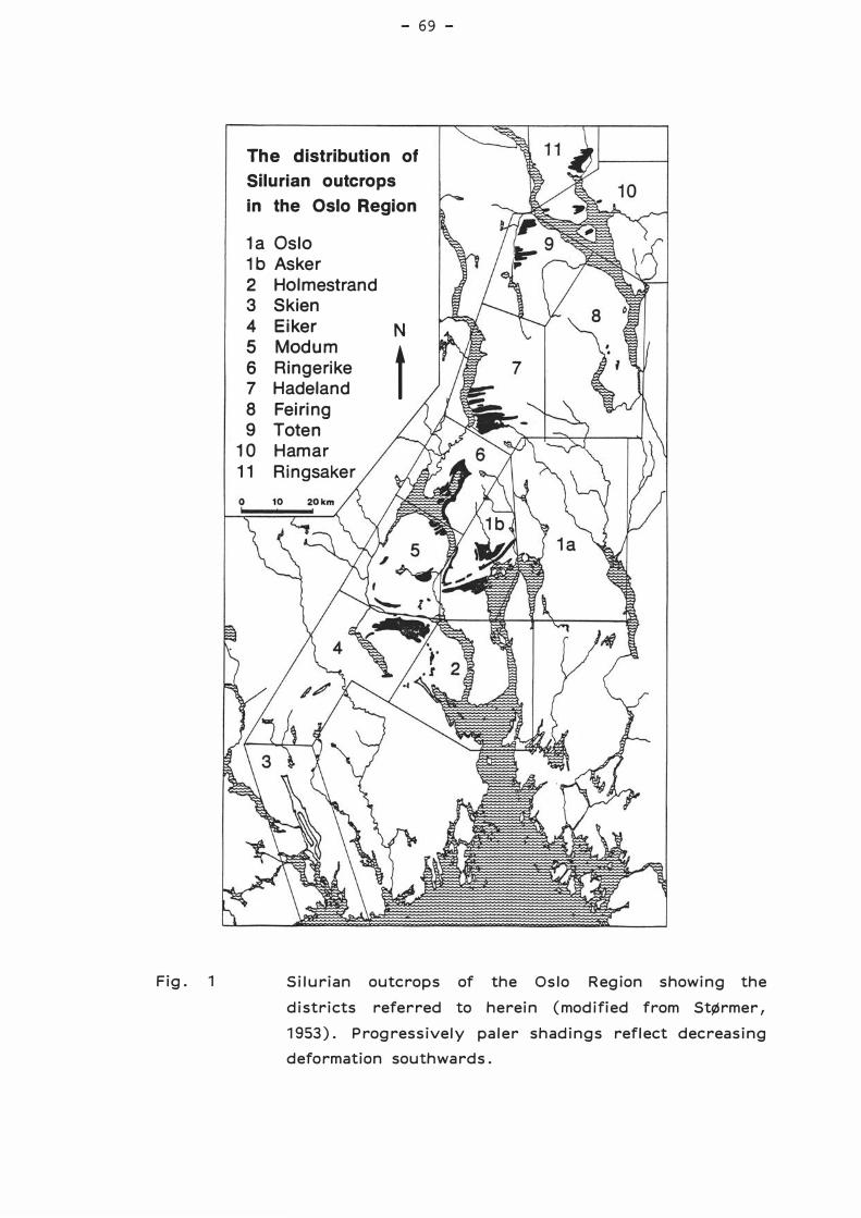
Fig . 1
- 69 -
The distribution of Silurian outcrops in the Oslo Region
1a Oslo 1b Asker 2 Holmestrand 3 Skien 4 Eiker N 5 Modum t 6 Ringerike 7 Hadeland 8 Feiring 9 Toten
10 Hamar 11 Ringsaker
Silurian outcrops of the Oslo Region showing the
districts referred to herein (modified from StØrmer,
1953) . Progressively paler shadings reflect decreasing
deformation southwards .
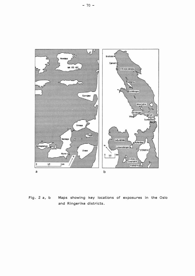
a
Fig. 2 a, b
- 70 -
b
Maps showing key locations of exposures in the Oslo
and Ringerike districts.
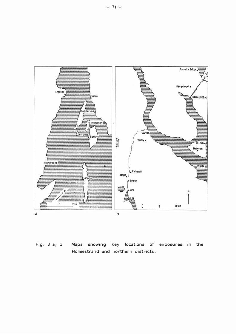
a
Fig . 3 a, b
- 71 -
Bjørgeberget •
N
r o 10 km
b
Maps showing key locations of exposures in the
Holmestrand and northern districts.
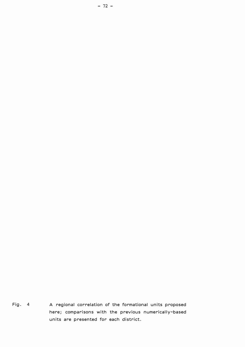
Fig . 4
- 72 -
A regional correlation of the formational units proposed
here; comparisons with the previous numerically -based
units are presented for each district .
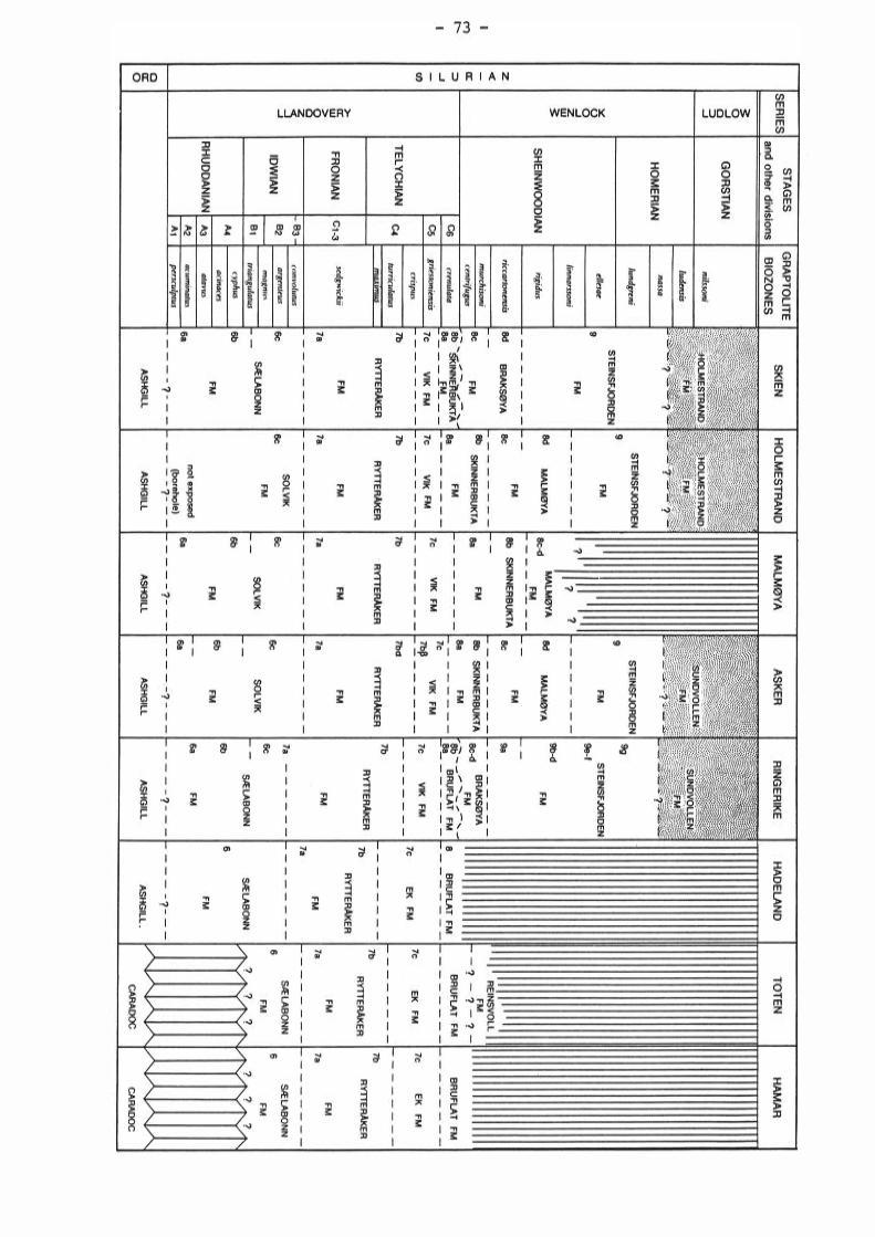
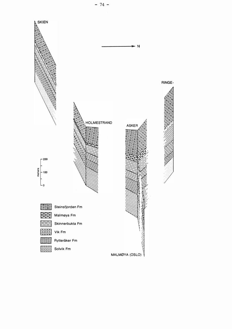
a Steinsfjorden Fm
� MalmøyaFm
� Skinnerbukta Fm
æ VikFm
� Rytteråker Fm
�==�=::=3 Solvik Fm
- 74 -
--------N
RINGE-
MALMØYA (OSLO)
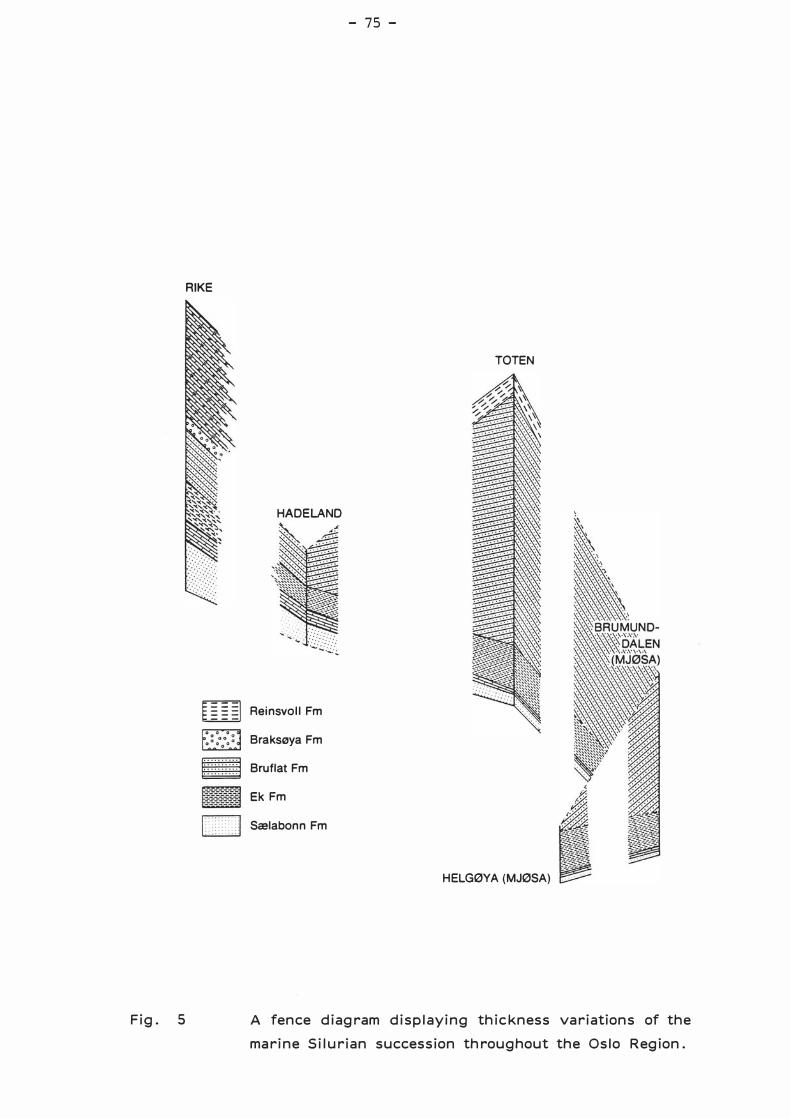
Fig . 5
RIKE
HADELAND
[]]]] Reinsvoll Fm
Braksøya Fm
� BruflatFm
�������� Ek Fm
l > J Sælabonn Fm
- 75 -
TOTEN
HELGØYA (MJØSA)
A fence diagram displaying thickness variations of the
marine Silurian succession throughout the Oslo Region .

50 70
o/o lithology
Fig. 6
90 1
- 76 -
----'----r
2 4 6 10 20 40 o 10 20
cm bed thickness
,____ __ ..__ __ ...___,
beds/m silt- & limestone
frequency
CC N
A schematic log through the Solvik Formation on
Malmøya (Oslo district) showing lithological variation
and member boundaries.
-E -en en Q) c:
..:.:: CJ
..r::: -
;:: c: :::J

F i g . 7 a, b
- 77 -
a
b
T h e b a s a l stratoty pe of th e So l v i k Formation on
H ovedØya (Os l o d i st r i ct ) and the fo rmation•s tap o n
M a l mØya ( p hotos ) .
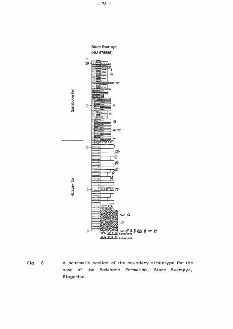
Fig. 8
Æ c c _g i 15 en
.o Il)
2 Q) �
-w •
5
- 78 -
Store Svartøya
(NM 678585)
A schematic section of the boundary stratotype for the
base of the Sæl a bonn Formation 1 Store Svartøya 1
Ringerike.
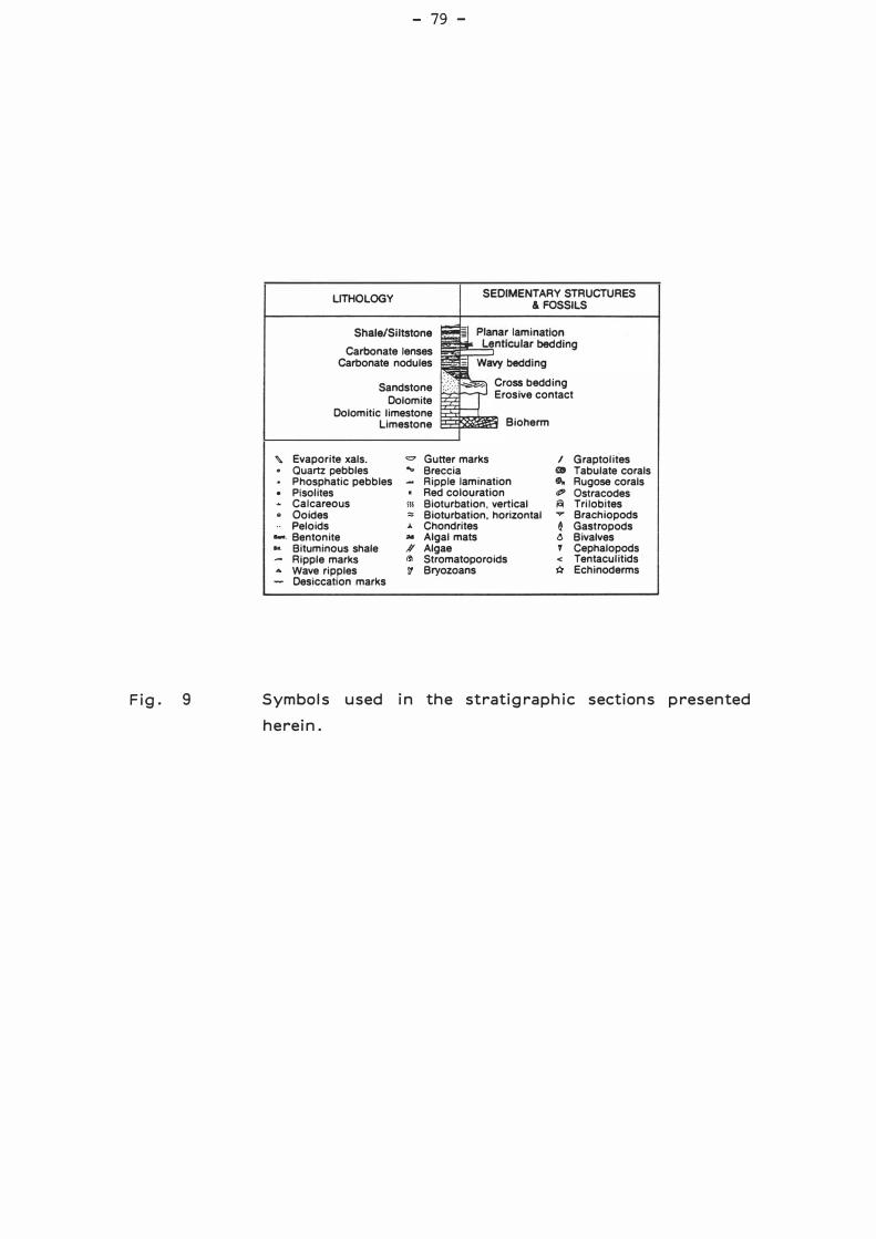
Fig . 9
"' .
. �
.
.. -· ..
...
- 79 -
LITHOLOGY SEOIMENTARY STRUCTURES & FOSSILS
Shale/Siltstone
Carbonate lenses Carbonate nodules
Sandstone Dolomite
Dolomitic limestone Limestone
Cross bedding Erosive contact
Bioherm
Evaporite xals. = Gutter marks l Quartz pebbles ... Breccia a Phosphatic pebbles Aipple lamination .. Pisolites • Red colouration Ø' Calcareous SIS Bioturbation. vertical 161 Ooides ::: Bioturbation, horizontal ..,..
Graptolites Tabulate corals Rugose corals Ostracodes Trilobites Brachiopods
Peloids J. Chondrites e Gastropods Bentonite ill Algal mats t> Bivalves Bituminous shale A' Algae ' Cephalopods Ripple marks 1!1 Stromatoporoids < Tentaculitids Wave ripples 'i! Bryozoans Q Echinoderms Desiccation marks
Symbols used in the stratigraphic sections presented
herein .
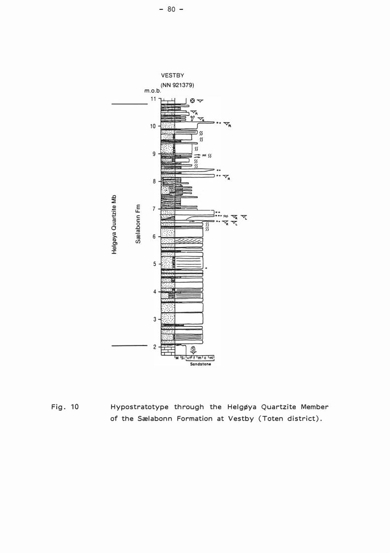
Fig. 1 O
.c :2 $ E ';::j u. t:: c: ca c: :l o
o .c ca ca æ >-
!Sl (/) Cl Qj :I:
- 80 -
VESTBY
(NN 921379) m.o.b.
11
10
9
8
7
6
5
3
··�
··vR
···�� � ··��
Hypostratotype through the HelgØya Quartzite Member
of the Sælabonn Formation at Vestby (Toten di stri et) .
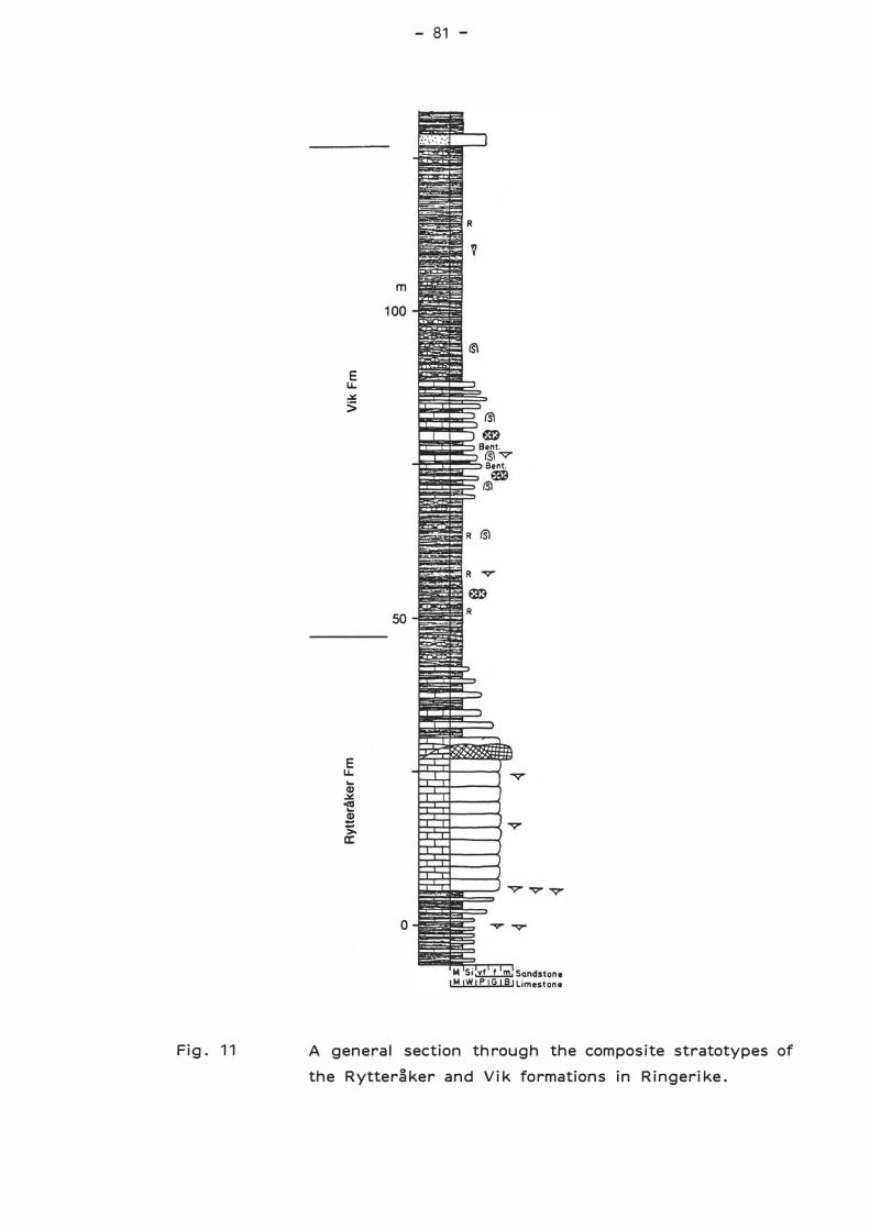
Fig. 11
E u. � >
E u.
... Q) � -e .æ >. a:
- 81 -
m
100
50
o
A general section through the composite stratotypes of
the Rytteråker and Vik formations in Ringerike.
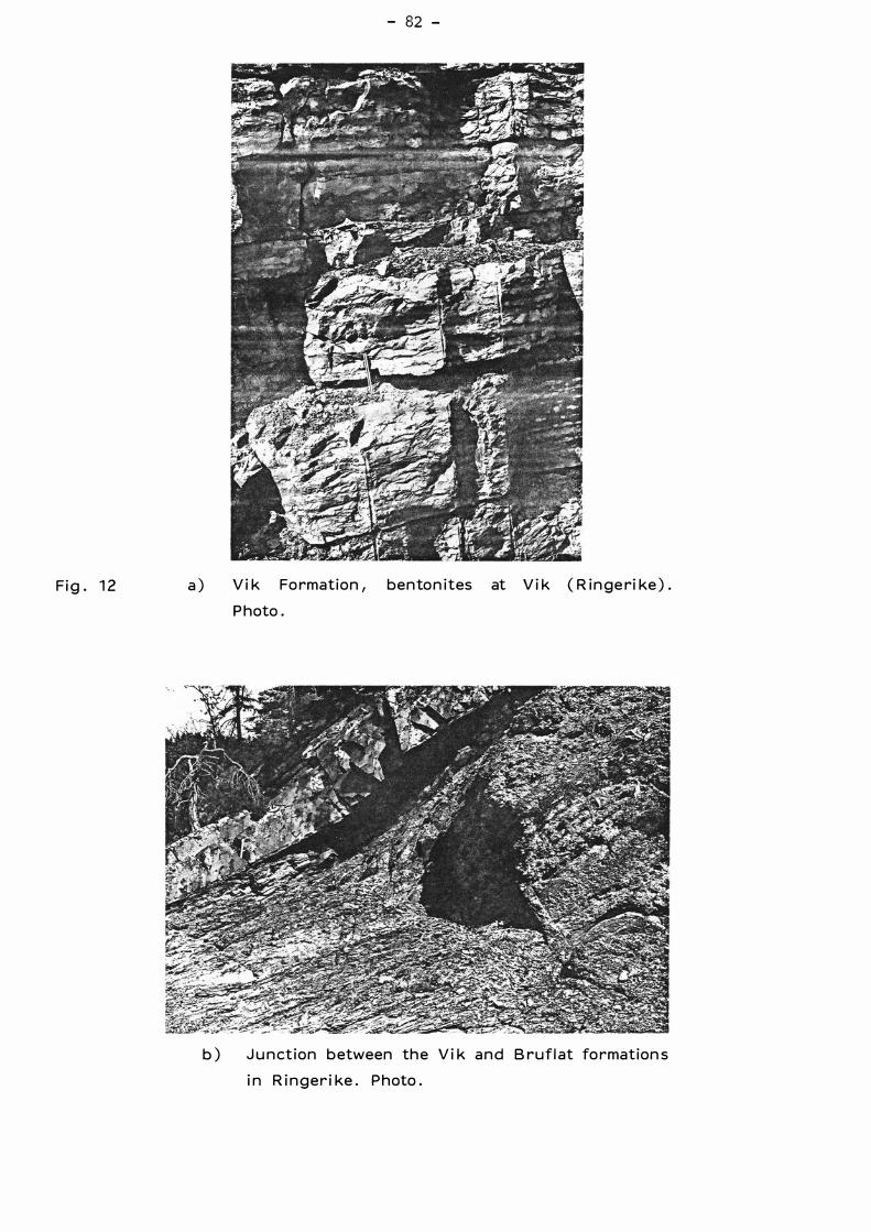
F i g . 12 a )
- 82 -
Vi k Formation, bento n ites at Vi k ( R i n geri ke ) .
Photo .
b ) Ju n ction b etween th e Vi k a n d Bru f l at fo rmation s
i n Ri n ge r i ke . Photo .
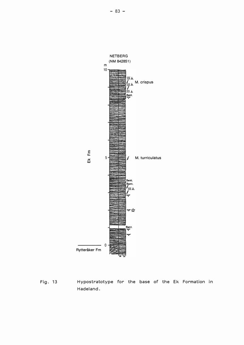
Fig . 13
E LL � w
Rytteråker Fm
m 10
5
o
- 83 -
NETBE RG
(NM 842851)
M. turriculatus
Hypostratotype for the base of the E k Formation in
Hadeland.
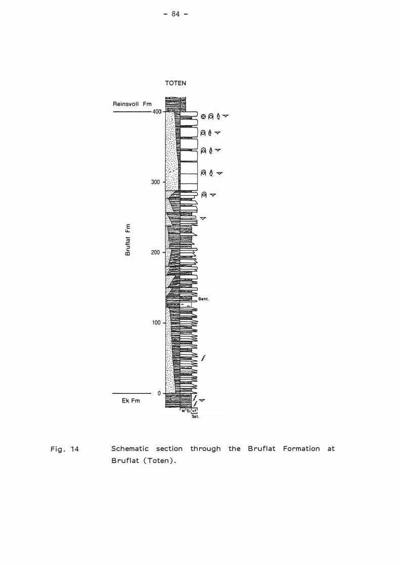
Fig. 14
Reinsvoll Fm ----- 400
E u..
� 'S
300
as 2oo
100
o Ek Fm
- 84 -
TOTEN
Sst.
Schematic section through the Bruflat Formation at
Bruflat (Toten) .
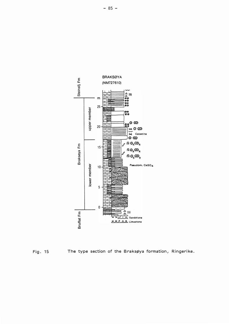
Fig. 15
E u.
� c: 'j (J)
E u. ca >-IS! Ul ..:.:: ca .... ID
E u. (å ;;::: � .... ID
.... Q)
.c E Q) E .... Q) a. a. �
.... Q)
.c E Q) E .... Q) 3: .2
- 85 -
BRAKSØYA
(NM727610)
m
25
sæ 20
._,..
;iot Celestite sø
15
10 Pseudom. ca,so4
5
The type section of the Braksøya formation, Ringerike.
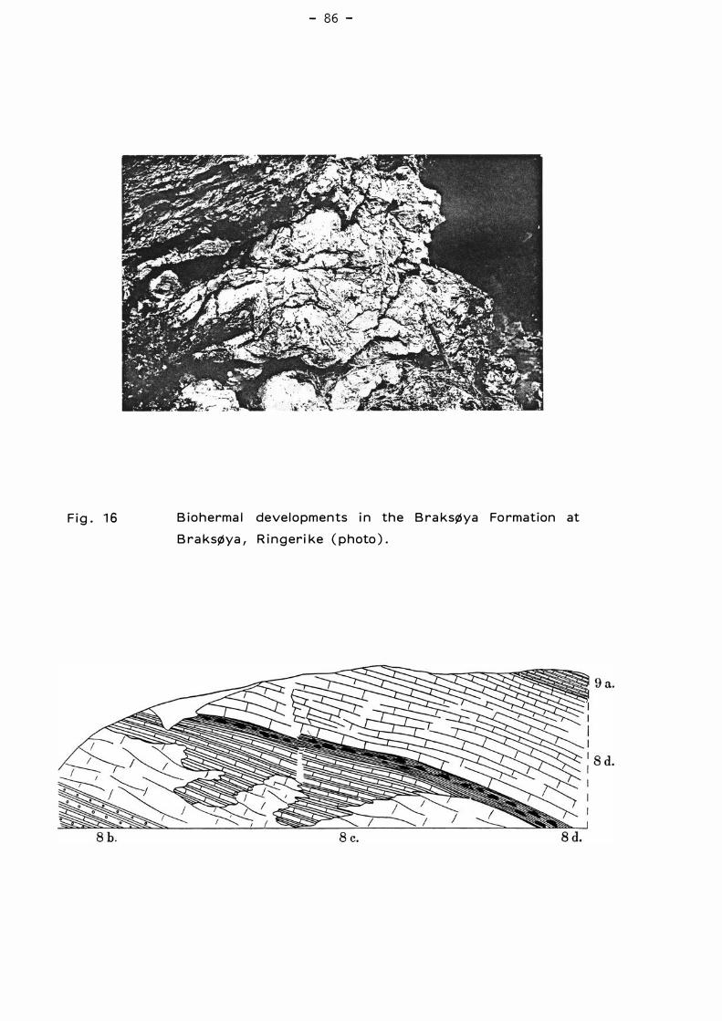
F i g. 16
- 86 -
B io h erma l deve l o pm e n ts i n th e Bra k søya Formation at
Bra k søya, Ri n g eri ke ( p h oto ) .
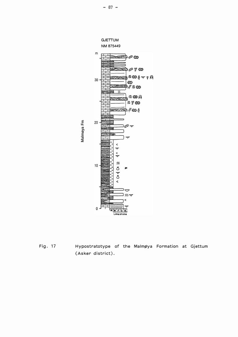
Fig. 17
- 87 -
GJETIUM
NM 875449
Hypostratotype of the Malmøya Formation at Gjettum
(Asker district).
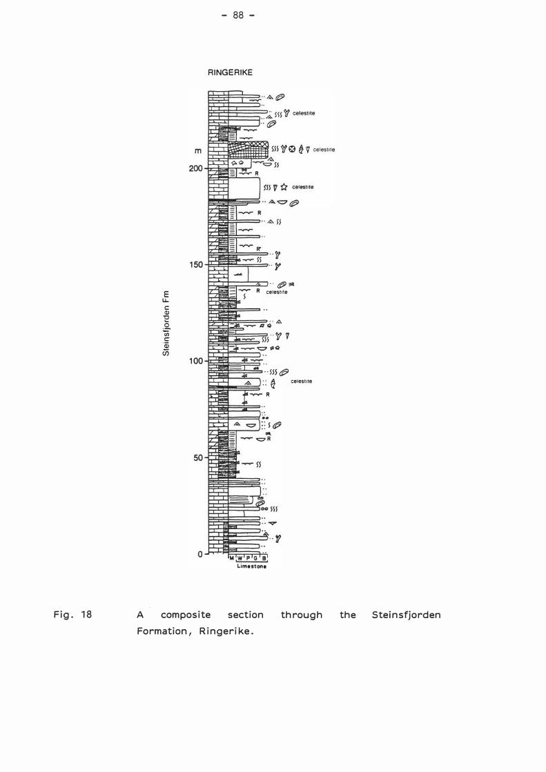
- 88 -
RINGERIKE
··� 150 p
"Ø'flli E ce1est1te
I.L. c: Ql
"C .... ··� . Q. (ij "'/f'? t::' 'Qj u;
100 "lHØ .. � celest1te . .
Fig . 18 A composite section through the Steinsfjorden
Formation, Ringerike.
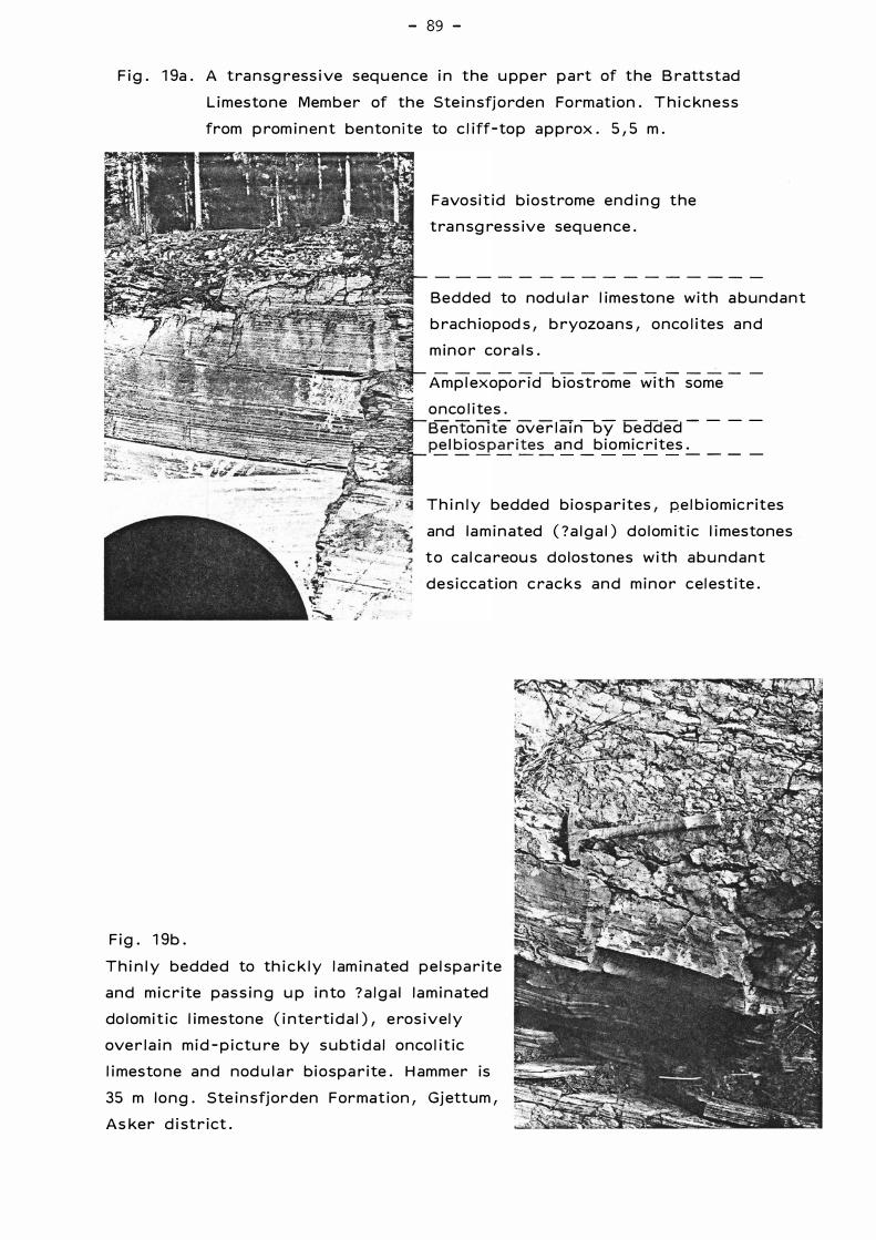
- 89 -
F i g . 1 9a . A tra n sg ress i ve seq u en ce i n the u p p e r p a rt of the B rattstad
L i mesto n e Mem b e r of th e Ste i n sfj o rd e n Fo rmation . T h i c kn e s s
from p rom i n en t bento n i te to c l iff-to p a p p rox . 5 1 5 m .
F i g . 1 9b .
Favo s i t i d b i o strome e n d i n g t h e
tra n sg re s s ive seq u e n ce .
B e d d ed to nod u l a r l i m esto n e with a b u n d a n t
b rach iopod s 1 b ryozoa n s 1 o n co l i tes a n d
m i n o r co ra l s .
A m p l exopo r i d b iostrome with some
o n co l i te s . B e n ton ite ove r l a i n-hy bedded -
- - -
p e l b i o s p a r ite� a n d_ b i o m i c r ites .:....._ _ _ _
T h i n l y bedded b i o s p a rites 1 p e l b i o m i c rites
and l a m i n ated ( ? a l g a l ) d o l om it i c l i mesto n e s
t o ca l ca reou s d o l osto n e s w i th a b u n d a n t
d e s i ccatioh c ra c k s a n d m i n e r ce l estite .
T h i n l y bedded to th i c k l y l am i n ated p e l s p a r ite
a n d m i c r ite pa s s i n g u p i n to ? a l g a l l a m i n ated
do l om i t i c l i m esto n e ( i n te rti d a l ) 1 e ros i ve l y
ove r l a i n m i d - p i ctu re b y s u bti d a l o n co l it ic
l i mesto n e a n d n od u l a r b i o s p a r ite . H am m e r is
35 m l o n g . Ste i n sfj o r d e n Format ion 1 Gj ettum 1
A s ke r d i st r i ct .
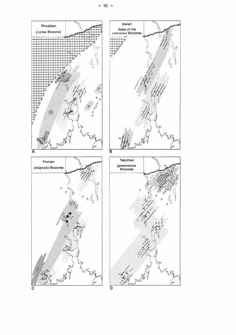
A
R h uddian
(cyphus Biozone)
Fron ian
(sedgwickii Biozone)
?
� \ \ . .
"·
- 90 -
? J .}\\\{ f.
.. ' ·'1{" J? J ?
ldwian
(base of the convolutus B iozone)
"·
Telych ian
(griestoniensis Biozone)
f---- -----11!
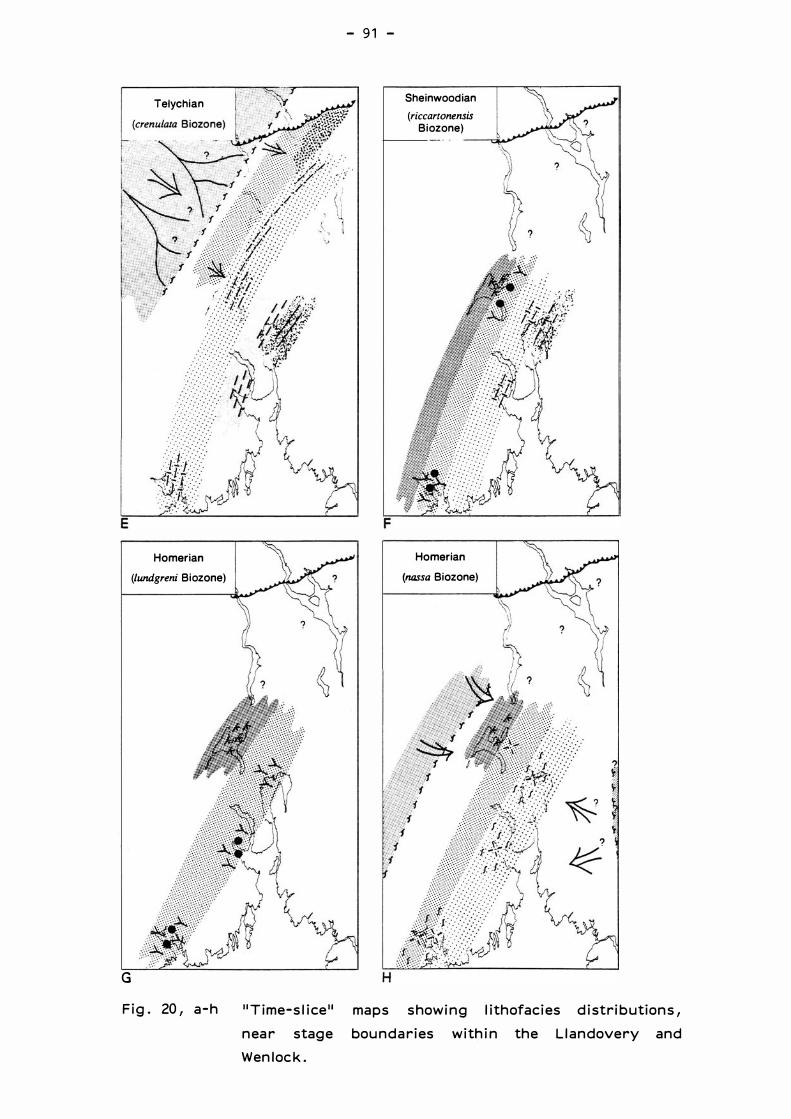
G
Telychian
. . . . : . .
. . . . .
Ho merian
(lundgreni Biozone)
Fig . 20, a-h
- 91 -
Sheinwood ian
(riccartonensis Biozone)
Ho merian
(nassa Biozone)
1 1Time-slice 11 maps showing lithofacies distributions,
near stage boundaries within the Llandovery and
Wenlock .

-92
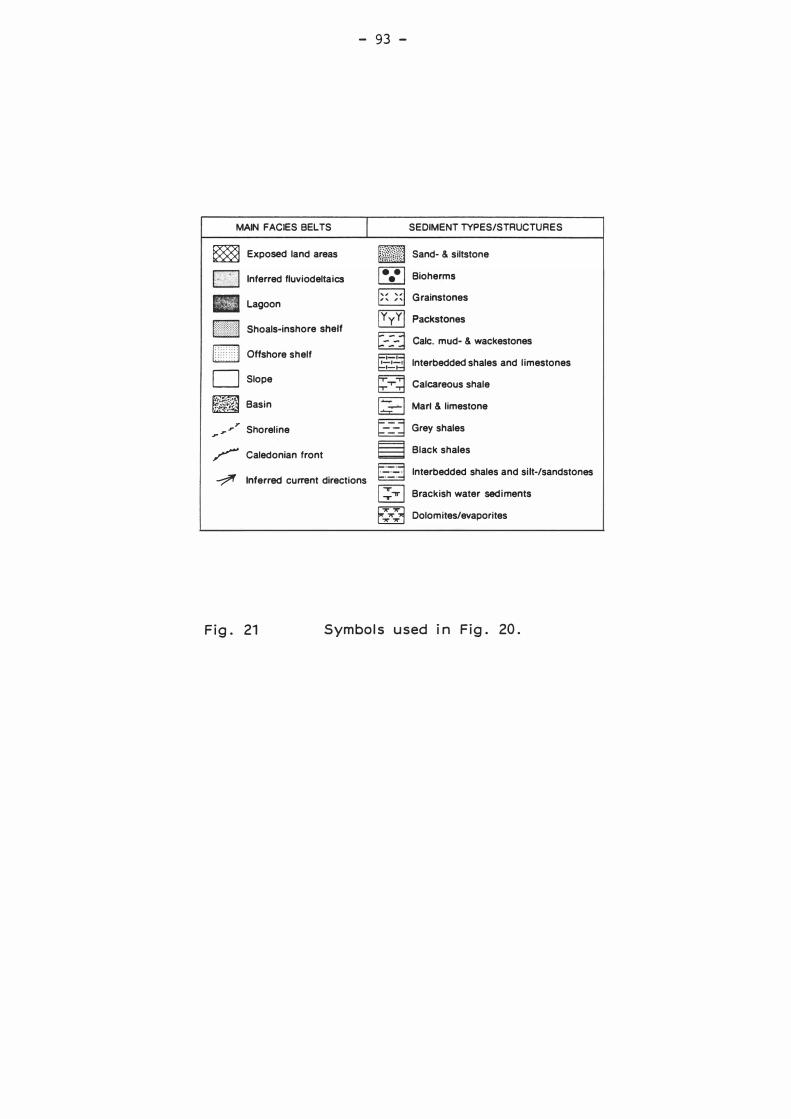
- 93 -
MAIN FACIES BELTS
� Exposed land areas
j;;;i,i3rl lnferred fluviodeltaics
Bl Lagoon
[ j Shoals-inshore shelf
LITIJ Offshore shelf
O Slope
� Basin
... ,. ,.'
Shoreline
� Caledonian front
l
---;?' lnferred current directions
SEDIMENT TYPES/STRUCTURES
�f.@:1i&J Sand- & siltstone
j• •
• 1 Bioherms
� � Grainstones
Packstones
Gale. mud- & wackestones
lnterbedded shales and l imestones
Calcareous shale
Mari & limestone
Grey shales
Black shales
lnterbedded shales and si lt-/sandstones
l ::; ..". , Brackish water sediments
� Dolomites/evaporites
Fig. 21 Symbols used in Fig. 20 .