Embed Size (px)
Citation preview
IJOG
291
Indonesian Journal on Geoscience Vol. 7 No. 3 December 2020: 291-303
How to cite this article: Titu-Eki, A. and Hall, R., 2020. The Significance of the Banda Sea: Tectonic Deformation Review in Eastern
Sulawesi. Indo nesian Journal on Geoscience, 7 (3), p.291-303. DOI: 10.17014/ijog.7.3.291-303
INDONESIAN JOURNAL ON GEOSCIENCEGeological Agency
Ministry of Energy and Mineral Resources
Journal homepage: hp://ijog.geologi.esdm.go.idISSN 2355-9314, e-ISSN 2355-9306
Indexed by: SCOPUS (Q3)
The Significance of the Banda Sea: Tectonic Deformation Review in Eastern Sulawesi
Adept Titu-Eki1,2 and Robert Hall1
1SE Asia Research Group, Department of Earth Science, Royal Holloway University of London, Egham, Surrey TW20 0EX, United Kingdom
2Department of Mining Engineering, University of Nusa Cendana, Jln. Adisucipto, Penfui, Kupang - West Timor, Nusa Tenggara Timur 85228, Indonesia
Corresponding author: [email protected] received: April, 10, 2019; revised: December, 19, 2019;
approved: April, 13, 2020; available online: November, 5, 2020
Abstract - The geology of eastern Sulawesi is widely known for its complexity due to multiple deformation stages.The geology on land has been studied excessively, but little assessment has been made on the offshore geology, thus the geological evolution of the area remains a subject of controversy. A thorough observation of high multibeam ba-thymetry dataset offshore and SRTM dataset onshore provides an understanding on the geological features relating to the tectonic deformation. Exquisite morphological features include carbonate buildups and gravitational collapse dominating the shelf areas whereas distinct form of ridges and seamount exists in the offshore. Structural features in this area including the major Tolo Thrust and South Sula Fault varied structural lineations on land with several polygonal extensional faulting and accretionary wedge on the west of the North Banda Sea. The existence of these features may indicate that the area was majorly deformed during Neogene, specifically relating to the opening of the Banda Sea due to the subduction rollback of Banda.
Keywords: tectonic deformation, Sulawesi, Banda Sea, multibeam, SRTM, subduction rollback
© IJOG - 2020. All right reserved
Introduction
Background Eastern Sulawesi is situated near the converg-
ing margins of Eurasia, Australia, and Pacific Plates, and has an intriguing geological complex-ity with inadequate understanding of the structural styles relating to the formation and interaction of small plates and subduction zones. The significant development of Sulawesi started in the Neogene period. The Australian continental margin had drifted northwards after the Gondwana breakup
and collided with the Eurasian Plate in the Late Oligocene - Early Miocene (Hall, 2002 and 2012). This collision has often been interpreted as an arc-continent collision, resulting in the complexity of Sulawesi. During this period, an Australian prom-ontory termed the Sula Spur (now fragmented), collided with Sulawesi which resulted in struc-tures viable for hydrocarbon trapping (Davies, 1990; Hasanusi et al., 2004) and had immensely deformed Sulawesi and its surroundings.
The collision of the Sula Spur with Sulawesi was initially thought to have occurred by move-
IJOG
Indonesian Journal on Geoscience, Vol. 7 No. 3 December 2020: 291-303
292
ments along major left-lateral strike-slip faults (Klompe, 1954; Audley-Charles, 1974; Hamil-ton, 1979). Stratigraphic similarities have been used to link the Banggai-Sula block with the Misool Island (Audley-Charles, 1974), sug-gesting that the Banggai-Sula microcontinent was sliced from the Bird Head region in Papua (Hamilton, 1979), and moved westward ±2,500 km from its origin place in Central Papua (Ger-rard et al., 1988). This assumption was recently disapproved as new studies confirm the absence of such fault in eastern Sulawesi, yet indicated major extension caused by subduction rollback forming the Banda Arc in Early Miocene (Spak-man and Hall, 2010; Rudyawan and Hall, 2012; Hall and Sevastjanova, 2012; Hall 2012). This extension had also led to the formation of the North Banda Sea, in Middle to Late Miocene (Hinschberger et al., 2000).
The Batui Thrust of the East Arm marks the Early Miocene collision zone which was assumed to extend from the northern East Arm (Poh Head), creating a fold and thrust belt along the coast towards the southern East Arm (Sukamto, 1990; Hasanusi et al., 2004; Hasanusi et al., 2015). Recent studies have shown the absence of the continuity of the Batui Thrust in the northern
East Arm, and that the faults in this area are actually right-lateral strike-slip faults (known as the Balantak Fault) that extends towards the northern Sula platform offshore (Ferdian et al., 2010; Watkinson et al., 2011).
Apart from the previous dominant geological observations on land, geophysical and remote sensing studies offshore and onshore both proved value in contributing to the knowledge of the area. However, since most parts of eastern Sulawesi are still underexplored, there are still uncertainties concerning its development. This study produces interpretations of high quality multibeam bathymetry offshore and SRTM data onshore to provide new insights on the devel-opment of this highly complex area, namely to evaluate the evolution of eastern Sulawesi by identifying major tectonic events through remote sensing observations. The studied area encompasses the east and SE Arm of Sulawesi, Banggai-Sula islands, parts of Buru, and the North Banda Sea (Figure 1).
Geological SettingsIndonesia is situated in the meeting point of
four tectonically active plates. The convergence of Eurasia, India-Australia, and Pacific plates
Figure 1. Location of the approximate studied area (red box) with bathymetry contours.
o110 E o115 E o120 E o125 E o130 E o135 E
o 5 N
o 0o
5 S
o10
S Bathymetry
5000 m
1000 m
BORNEO
Celebes Sea
North Arm
East Arm
Molucca Sea
Halmahera
BuruSeram
Banggai-Sula
North Banda Sea
Southwest Arm
Southeast ArmSouth Banda Sea
Weber Basin
Bird’s Head
SULAWESI
Flores
Timor
JAVA
Java Sea
South China Sea
Pacific Ocean
Indian Ocean
0 120 240 480km
N

IJOG
The Significance of the Banda Sea: Tectonic Deformation Review in Eastern Sulawesi (A. Titu-Eki and R. Hall)
293
are the main cause of such intense seismicity and volcanism occurring in the area. It develops numerous subduction zones of the microplates and generates the major strike-slip Sorong Fault in eastern Indonesia (Hall 2009). Hall (2002) claimed these plate boundaries shifted rapidly during Cenozoic which dates most of the major tectonic events in history.
Indonesia is formed by fragments of the Gond-wana supercontinent which rifted towards the Eurasian subduction margin where the Cenozoic collision of this margin is the key event for the present day geology. The major plate convergence had resulted in many important extension periods which form new basins and subsidence assumedly driven subduction. It is also the main reason for Indonesia to be dominated by Cenozoic-age rock. These events vastly occur in eastern Indonesia where arc-ophiolitic crust and young ocean basins are dominant, whilst western Indonesia is mostly underlain by continental crust (Hall, 2009).
The Cenozoic collision has often been inter-preted as an arc-continent collision, resulting in
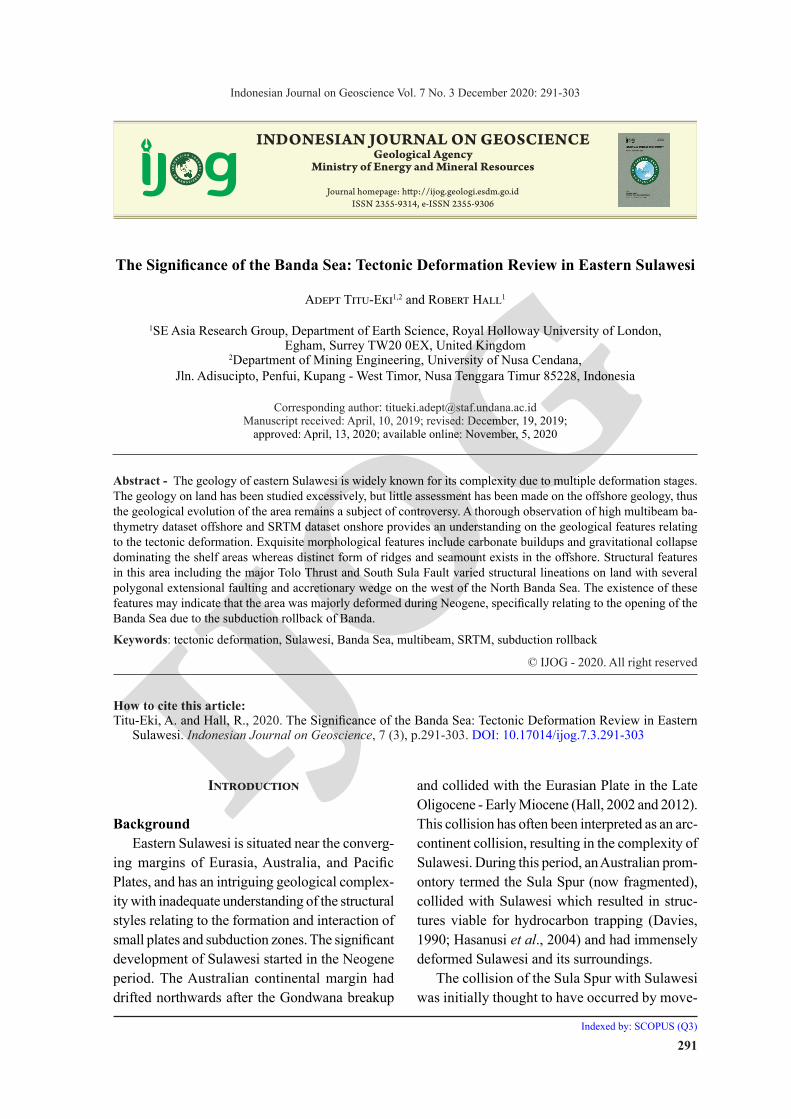
the complexity of Sulawesi. It has resulted in the distribution of various rocks on the island seen today (Figure 2). The East and Southeast Sulawesi Arms contain continental terrain deriving from the northern margin of Australia, together with the ophiolitic complex which originated from the mid-oceanic ridge in the Pacific Plate (Mar-tosuwito, 2012). The East Arm is dominated by ultramafic and subsidiary basic rocks which are known as the Eastern Sulawesi Ophiolite Belt (ESOB) (Simandjuntak, 1986). The major mass trace of ophiolites extends from the East Arm to the SE Arm and terminates at the Lawanopo Fault Zone. This fault has been inactive since the end of Pleistocene (Natawidjaja and Daryono, 2015).
The structural trend of East Sulawesi Arm is oriented E-W to NE-SW where most of the rock contact lies dominantly on faults, like igneous rocks thrusting over the Eocene and Middle Mio-cene carbonates (Sukamto, 1990). The western East Arm structural lineaments changes to a NW-SE trend (Rudyawan and Hall, 2012), displaying metamorphic core complex in the area with a
Figure 2. Simplified geological map of Sulawesi showing the distribution of Neogene and Quaternary rocks (from Nugraha, 2016).
N
0 100 200
km
Sedimentary and volcanic rocks
Basement rocks
Holocene alluviumSulawesi Sea
Maluku Sea
Banda Sea
Mak
assa
r S
trai
t
Quaternary-Neogene limestoneQuaternary-Neogene clastic sedimentsQuaternary-Neogene volcanics
Neogene igneous intrusivesNeogene metamorphicsPre-Neogene rocks
o118 E
o120 E
o122 E
o124 E
o126 E
o2 N
o0
o2 S
o6 S
IJOG
Indonesian Journal on Geoscience, Vol. 7 No. 3 December 2020: 291-303
294
northward transition in topographic style which recently known to be marked by two detachment faults (Spencer, 2011). The Southeast Arm experi-enced many deformations after the collision to the Australian margin, where one of them is shown by the development of the Matano Fault. This fault is situated in northern Southeast Arm and extends ap-proximately 170 km towards the W-NW (Ahmad, 1977). The Matano Fault is a left-lateral strike-slip fault and is previously assumed to show genetic relation with the Sorong Fault deriving from Bird Head Papua (Ahmad, 1977; Hamilton, 1979). The fault is assumed to have initiated at the late stage of the subduction melange which occurred in Middle Miocene (Ahmad, 1977). The offshore also encountered post-collisional deformation like the development of canyon morphology in eastern SE Arm, showing graben and anticlinal structures in the subsurface (Viktor et al., 2017)
The Banggai-Sula Block is known as part of the Sula Spur (Klompe, 1954) that was transported westward from Papua New Guinea by either the Sorong Fault (Audley-Charles, 1974; Hamilton, 1979) or by the Mesozoic-Miocene seafloor spreading (Pigram and Panggabean, 1984). A re-cent study discovered the absence of the extended Sorong Fault at the north and south of Sula (Ferd-ian et al., 2010; Watkinson et al., 2011; Rudyawan and Hall, 2012). The fault observed in the southern Banggai-Sula Block (South Sula Fault) has been identified as a normal fault which may recently have reactivated into a sinistral strike-slip motion (Hinschberger et al., 2003). Barely any Cenozoic rocks are exposed in the Sula Islands whereas the Banggai Islands are dominated by Pliocene Peleng Formation (Rudyawan and Hall, 2012). The Late Miocene sediments are mostly associated with reefal build-ups which are present within the limestone and carbonate platform of offshore East Arm (Davies, 1990).
Buru is part of the nonvolcanic Banda Outer Arc which contains geological similarities with Timor, Seram, and parts of Buton, but distinct its geological features with Sulawesi. Although Buton lies at the southern East Arm, its geologi-cal aspects are more related to Buru, rather than
the South East Arm (Katili, 1978; Fortuin; et al., 1990 Milsom, 2000). This similarity suggests that both islands derived from the same continental margin and that Buru considerably rotated east-ward away from the east Sulawesi orogeny to its current position (Milsom, 2000). The narrow and similar margin between eastern Mangoli Island (Sula) with the northern Buru Sea could suggest that both islands were separated during the spreading of the North Banda Sea (Rudyawan and Hall, 2012), which is consistent with the Buru Basin formation dominated by extensional faults trending E-W (Patria and Hall, 2017).
The North Banda Sea is considered as a trapped oceanic crust shown by the magnetic anomalies in the Banda Sea (Katili, 1978; Bowin et al., 1980; Lapoullie et al., 1985; Lee and Mc-Cabe, 1986), whilst Silver et al. (1985) states that North Banda Sea may have originated from the Pacific Plate. New magnetic and bathymet-ric studies record the opening of the Banda Sea around 12.5-7.15 Ma in a NW-SW direction with a 3 cm/year spreading rate during the extension of the Sula Spur (Hinschberger et al., 2000; Hall, 2012), which also led to the development of Tolo Thrust and accretionary prism in eastern South-east Arm (Rehault et al., 1991).
Dataset and Methodology
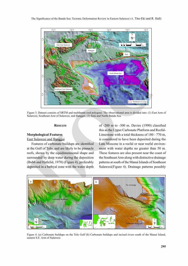
High resolution (15 m) multibeam data ac-quired by GeoData Ventures Pte Ltd were used in this study showing exceptional topographic features of the seabed (bathymetry) with structural lineaments and morphological features. Regional scale Shuttle Radar Topography Mission (SRTM) of 90 m resolution comprising merged gravity im-agery and multibeam bathymetry was acquired by TGS and was used to observe structural lineaments featured onshore and offshore. The multibeam and SRTM dataset was studied using ArcGIS which will distinguish structural trends of the area. The area of observation is divided into: (1) East Su-lawesi (East and Southeast Arms) - Banggai Island and (2) Sula Islands - Banda Sea (Figure 3).
IJOG
The Significance of the Banda Sea: Tectonic Deformation Review in Eastern Sulawesi (A. Titu-Eki and R. Hall)
295
Figure 3. Dataset consists of SRTM and multibeam (red polygon). The observational area is divided into: (1) East Arm of Sulawesi, Southeast Arm of Sulawesi, and Banggai, (2) Sula and North Banda Sea.
Results
Morphological FeaturesEast Sulawesi and Banggai
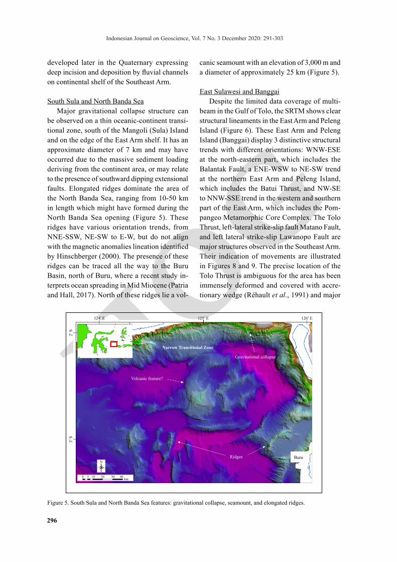
Features of carbonate buildups are identified at the Gulf of Tolo, and are likely to be pinnacle reefs, shown by the equidimensional shape and surrounded by deep water during the deposition (Bubb and Hatlelid, 1978) (Figure 4), preferably deposited in a bathyal zone with the water depth
of -200 m to -300 m. Davies (1990) classified this as the Upper Carbonate Platform and Reefal-Limestone with a total thickness of 180 - 770 m, is considered to have been deposited during the Late Miocene in a reefal or near reefal environ-ment with water depths no greater than 50 m. These features are also present near the coast of the Southeast Arm along with distinctive drainage patterns at south of the Manui Islands of Southeast Sulawesi(Figure 4). Drainage patterns possibly
Figure 4. (a) Carbonate buildups on the Tolo Gulf (b) Carbonate buildups and incised rivers south of the Manui Island, eastern S.E. Arm of Sulawesi.
East Arm Sulawesi
Banggai
o121 E o122 E o123 E o124 E
Sula
o125 E o126 E
o 1 S
o 2 S
Southeast Arm Sulawesi
o3
So
4 S
North Banda Sea
Multibeam Coverage
0 15 30 60 90 120km
N
Carbonate Buildups
a
0 5 10 20km
N
bNo coverage
Carbonate Buildups
Incised channels
Carbonate Buildups
0 3 6 12km
N
IJOG
Indonesian Journal on Geoscience, Vol. 7 No. 3 December 2020: 291-303
296
developed later in the Quaternary expressing deep incision and deposition by fluvial channels on continental shelf of the Southeast Arm.
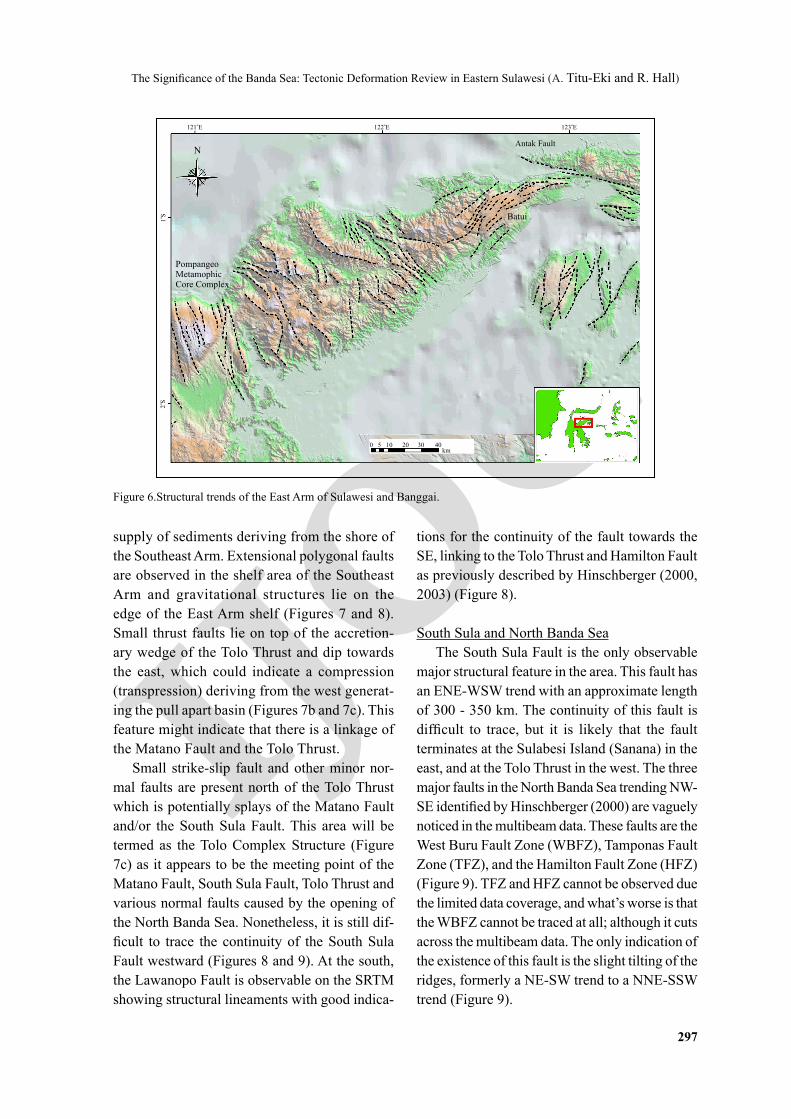
South Sula and North Banda SeaMajor gravitational collapse structure can
be observed on a thin oceanic-continent transi-tional zone, south of the Mangoli (Sula) Island and on the edge of the East Arm shelf. It has an approximate diameter of 7 km and may have occurred due to the massive sediment loading deriving from the continent area, or may relate to the presence of southward dipping extensional faults. Elongated ridges dominate the area of the North Banda Sea, ranging from 10-50 km in length which might have formed during the North Banda Sea opening (Figure 5). These ridges have various orientation trends, from NNE-SSW, NE-SW to E-W, but do not align with the magnetic anomalies lineation identified by Hinschberger (2000). The presence of these ridges can be traced all the way to the Buru Basin, north of Buru, where a recent study in-terprets ocean spreading in Mid Miocene (Patria and Hall, 2017). North of these ridges lie a vol-
canic seamount with an elevation of 3,000 m and a diameter of approximately 25 km (Figure 5).
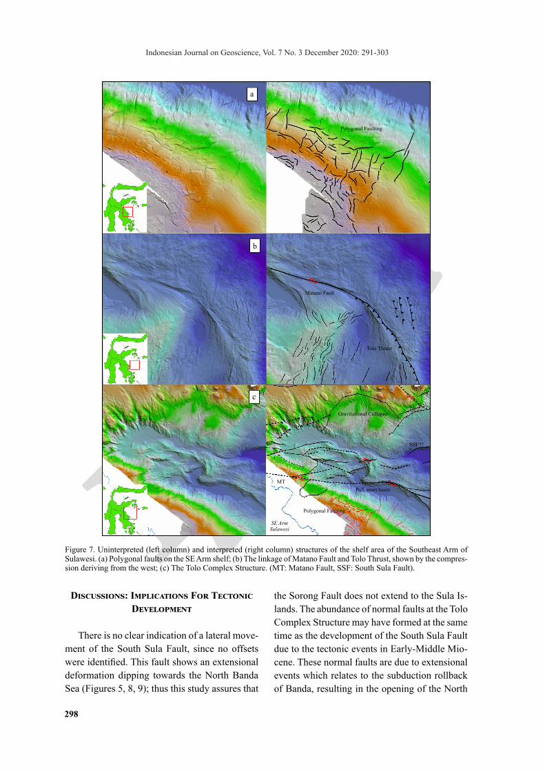
East Sulawesi and BanggaiDespite the limited data coverage of multi-
beam in the Gulf of Tolo, the SRTM shows clear structural lineaments in the East Arm and Peleng Island (Figure 6). These East Arm and Peleng Island (Banggai) display 3 distinctive structural trends with different orientations: WNW-ESE at the north-eastern part, which includes the Balantak Fault, a ENE-WSW to NE-SW trend at the northern East Arm and Peleng Island, which includes the Batui Thrust, and NW-SE to NNW-SSE trend in the western and southern part of the East Arm, which includes the Pom-pangeo Metamorphic Core Complex. The Tolo Thrust, left-lateral strike-slip fault Matano Fault, and left lateral strike-slip Lawanopo Fault are major structures observed in the Southeast Arm. Their indication of movements are illustrated in Figures 8 and 9. The precise location of the Tolo Thrust is ambiguous for the area has been immensely deformed and covered with accre-tionary wedge (Réhault et al., 1991) and major
Figure 5. South Sula and North Banda Sea features: gravitational collapse, seamount, and elongated ridges.
N
Volcanic feature?
Narrow Transitional Zone
Gravitational collapse
Ridges Buru
o125 E o126 E
0 5 10 20 30 40km
o3
S
o124 E
o 2 S
IJOG
The Significance of the Banda Sea: Tectonic Deformation Review in Eastern Sulawesi (A. Titu-Eki and R. Hall)
297
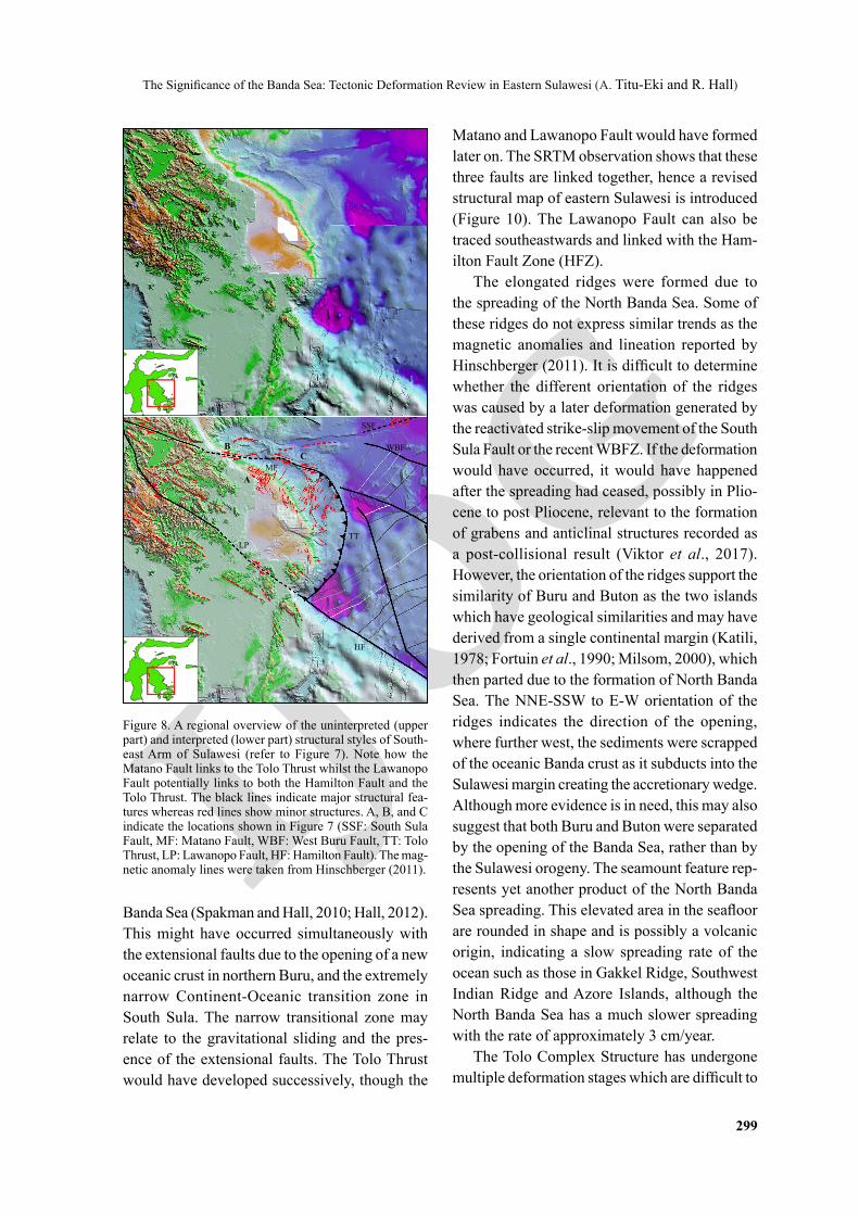
supply of sediments deriving from the shore of the Southeast Arm. Extensional polygonal faults are observed in the shelf area of the Southeast Arm and gravitational structures lie on the edge of the East Arm shelf (Figures 7 and 8). Small thrust faults lie on top of the accretion-ary wedge of the Tolo Thrust and dip towards the east, which could indicate a compression (transpression) deriving from the west generat-ing the pull apart basin (Figures 7b and 7c). This feature might indicate that there is a linkage of the Matano Fault and the Tolo Thrust.
Small strike-slip fault and other minor nor-mal faults are present north of the Tolo Thrust which is potentially splays of the Matano Fault and/or the South Sula Fault. This area will be termed as the Tolo Complex Structure (Figure 7c) as it appears to be the meeting point of the Matano Fault, South Sula Fault, Tolo Thrust and various normal faults caused by the opening of the North Banda Sea. Nonetheless, it is still dif-ficult to trace the continuity of the South Sula Fault westward (Figures 8 and 9). At the south, the Lawanopo Fault is observable on the SRTM showing structural lineaments with good indica-
tions for the continuity of the fault towards the SE, linking to the Tolo Thrust and Hamilton Fault as previously described by Hinschberger (2000, 2003) (Figure 8).
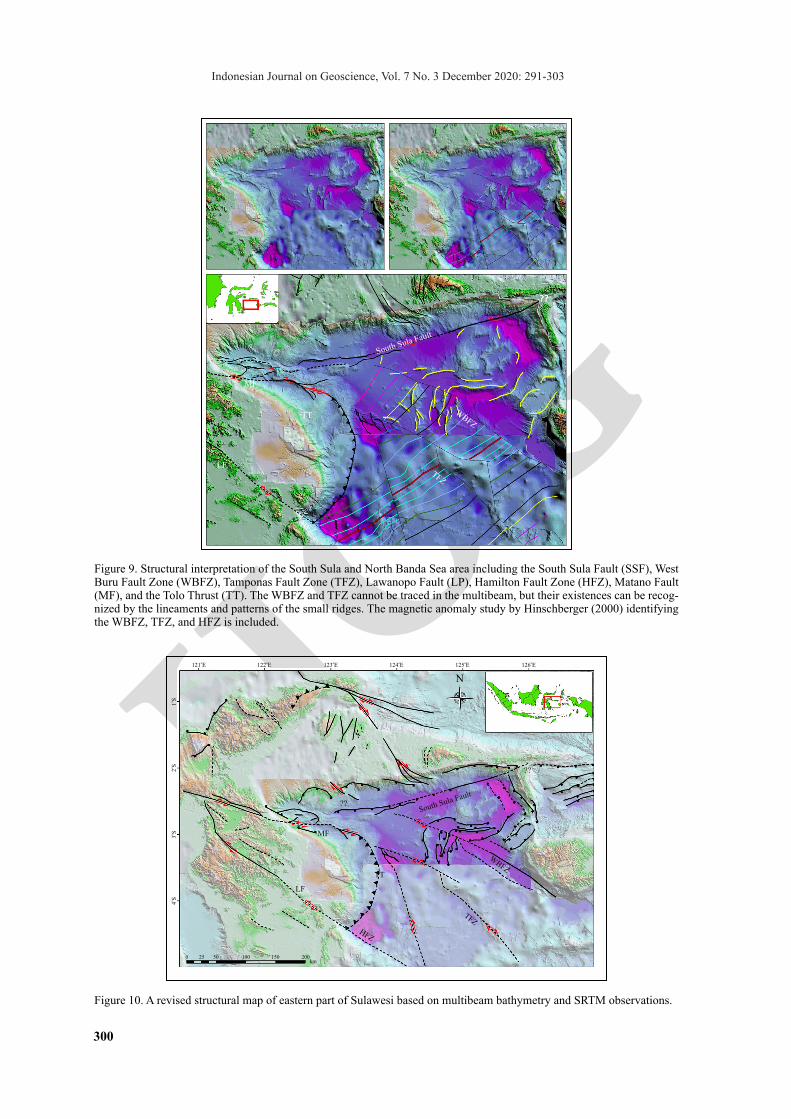
South Sula and North Banda SeaThe South Sula Fault is the only observable
major structural feature in the area. This fault has an ENE-WSW trend with an approximate length of 300 - 350 km. The continuity of this fault is difficult to trace, but it is likely that the fault terminates at the Sulabesi Island (Sanana) in the east, and at the Tolo Thrust in the west. The three major faults in the North Banda Sea trending NW-SE identified by Hinschberger (2000) are vaguely noticed in the multibeam data. These faults are the West Buru Fault Zone (WBFZ), Tamponas Fault Zone (TFZ), and the Hamilton Fault Zone (HFZ) (Figure 9). TFZ and HFZ cannot be observed due the limited data coverage, and what’s worse is that the WBFZ cannot be traced at all; although it cuts across the multibeam data. The only indication of the existence of this fault is the slight tilting of the ridges, formerly a NE-SW trend to a NNE-SSW trend (Figure 9).
Figure 6.Structural trends of the East Arm of Sulawesi and Banggai.
Antak Fault
Batui
Pompangeo Metamophic Core Complex
o 1S
o2
S
o121 E
o122 E
o123 E
N
0 5 10 20 30 40km
IJOG
Indonesian Journal on Geoscience, Vol. 7 No. 3 December 2020: 291-303
298
Polygonal Faulting
Matano Fault
Tolo Thrust
Gravitational Collapse
SSF??
Pull-apart basin
MT
Polygonal Faulting
SE Arm Sulawesi
a
b
c
Figure 7. Uninterpreted (left column) and interpreted (right column) structures of the shelf area of the Southeast Arm of Sulawesi. (a) Polygonal faults on the SE Arm shelf; (b) The linkage of Matano Fault and Tolo Thrust, shown by the compres-sion deriving from the west; (c) The Tolo Complex Structure. (MT: Matano Fault, SSF: South Sula Fault).
Discussions: Implications For Tectonic Development
There is no clear indication of a lateral move-ment of the South Sula Fault, since no offsets were identified. This fault shows an extensional deformation dipping towards the North Banda Sea (Figures 5, 8, 9); thus this study assures that
the Sorong Fault does not extend to the Sula Is-lands. The abundance of normal faults at the Tolo Complex Structure may have formed at the same time as the development of the South Sula Fault due to the tectonic events in Early-Middle Mio-cene. These normal faults are due to extensional events which relates to the subduction rollback of Banda, resulting in the opening of the North
IJOG
The Significance of the Banda Sea: Tectonic Deformation Review in Eastern Sulawesi (A. Titu-Eki and R. Hall)
299
A
BC
LP
MF
HF
SSF
WBF
TT
Figure 8. A regional overview of the uninterpreted (upper part) and interpreted (lower part) structural styles of South-east Arm of Sulawesi (refer to Figure 7). Note how the Matano Fault links to the Tolo Thrust whilst the Lawanopo Fault potentially links to both the Hamilton Fault and the Tolo Thrust. The black lines indicate major structural fea-tures whereas red lines show minor structures. A, B, and C indicate the locations shown in Figure 7 (SSF: South Sula Fault, MF: Matano Fault, WBF: West Buru Fault, TT: Tolo Thrust, LP: Lawanopo Fault, HF: Hamilton Fault). The mag-netic anomaly lines were taken from Hinschberger (2011).
Banda Sea (Spakman and Hall, 2010; Hall, 2012). This might have occurred simultaneously with the extensional faults due to the opening of a new oceanic crust in northern Buru, and the extremely narrow Continent-Oceanic transition zone in South Sula. The narrow transitional zone may relate to the gravitational sliding and the pres-ence of the extensional faults. The Tolo Thrust would have developed successively, though the
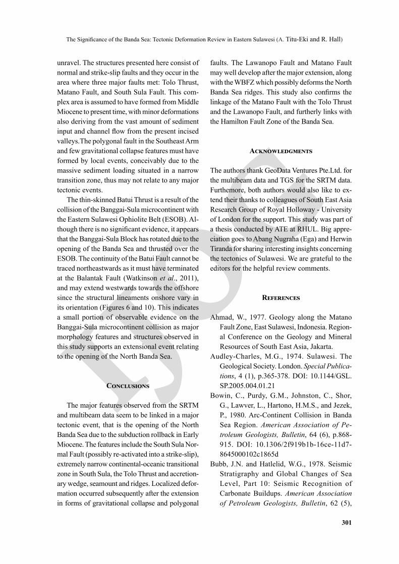
Matano and Lawanopo Fault would have formed later on. The SRTM observation shows that these three faults are linked together, hence a revised structural map of eastern Sulawesi is introduced (Figure 10). The Lawanopo Fault can also be traced southeastwards and linked with the Ham-ilton Fault Zone (HFZ).
The elongated ridges were formed due to the spreading of the North Banda Sea. Some of these ridges do not express similar trends as the magnetic anomalies and lineation reported by Hinschberger (2011). It is difficult to determine whether the different orientation of the ridges was caused by a later deformation generated by the reactivated strike-slip movement of the South Sula Fault or the recent WBFZ. If the deformation would have occurred, it would have happened after the spreading had ceased, possibly in Plio-cene to post Pliocene, relevant to the formation of grabens and anticlinal structures recorded as a post-collisional result (Viktor et al., 2017). However, the orientation of the ridges support the similarity of Buru and Buton as the two islands which have geological similarities and may have derived from a single continental margin (Katili, 1978; Fortuin et al., 1990; Milsom, 2000), which then parted due to the formation of North Banda Sea. The NNE-SSW to E-W orientation of the ridges indicates the direction of the opening, where further west, the sediments were scrapped of the oceanic Banda crust as it subducts into the Sulawesi margin creating the accretionary wedge. Although more evidence is in need, this may also suggest that both Buru and Buton were separated by the opening of the Banda Sea, rather than by the Sulawesi orogeny. The seamount feature rep-resents yet another product of the North Banda Sea spreading. This elevated area in the seafloor are rounded in shape and is possibly a volcanic origin, indicating a slow spreading rate of the ocean such as those in Gakkel Ridge, Southwest Indian Ridge and Azore Islands, although the North Banda Sea has a much slower spreading with the rate of approximately 3 cm/year.
The Tolo Complex Structure has undergone multiple deformation stages which are difficult to
IJOG
Indonesian Journal on Geoscience, Vol. 7 No. 3 December 2020: 291-303
300
Figure 9. Structural interpretation of the South Sula and North Banda Sea area including the South Sula Fault (SSF), West Buru Fault Zone (WBFZ), Tamponas Fault Zone (TFZ), Lawanopo Fault (LP), Hamilton Fault Zone (HFZ), Matano Fault (MF), and the Tolo Thrust (TT). The WBFZ and TFZ cannot be traced in the multibeam, but their existences can be recog-nized by the lineaments and patterns of the small ridges. The magnetic anomaly study by Hinschberger (2000) identifying the WBFZ, TFZ, and HFZ is included.
Figure 10. A revised structural map of eastern part of Sulawesi based on multibeam bathymetry and SRTM observations.
MF
??
TT
South Sula Fault
WBFZ
TFZ
HFZ
LF
MF
??
TT
South Sula Fault
WBFZ
TFZ
HFZ
LF
o121 E
o4
S
0 25 50 100 150 200km
o3
S
o
2S
o 1S
o122 E
o123 E
o124 E
o125 E
N
o126 E
MF
??
??
TT
South Sula Fault
WBFZ
TFZ
HFZ
LF
IJOG
The Significance of the Banda Sea: Tectonic Deformation Review in Eastern Sulawesi (A. Titu-Eki and R. Hall)
301
unravel. The structures presented here consist of normal and strike-slip faults and they occur in the area where three major faults met: Tolo Thrust, Matano Fault, and South Sula Fault. This com-plex area is assumed to have formed from Middle Miocene to present time, with minor deformations also deriving from the vast amount of sediment input and channel flow from the present incised valleys.The polygonal fault in the Southeast Arm and few gravitational collapse features must have formed by local events, conceivably due to the massive sediment loading situated in a narrow transition zone, thus may not relate to any major tectonic events.
The thin-skinned Batui Thrust is a result of the collision of the Banggai-Sula microcontinent with the Eastern Sulawesi Ophiolite Belt (ESOB). Al-though there is no significant evidence, it appears that the Banggai-Sula Block has rotated due to the opening of the Banda Sea and thrusted over the ESOB. The continuity of the Batui Fault cannot be traced northeastwards as it must have terminated at the Balantak Fault (Watkinson et al., 2011), and may extend westwards towards the offshore since the structural lineaments onshore vary in its orientation (Figures 6 and 10). This indicates a small portion of observable evidence on the Banggai-Sula microcontinent collision as major morphology features and structures observed in this study supports an extensional event relating to the opening of the North Banda Sea.
Conclusions
The major features observed from the SRTM and multibeam data seem to be linked in a major tectonic event, that is the opening of the North Banda Sea due to the subduction rollback in Early Miocene. The features include the South Sula Nor-mal Fault (possibly re-activated into a strike-slip), extremely narrow continental-oceanic transitional zone in South Sula, the Tolo Thrust and accretion-ary wedge, seamount and ridges. Localized defor-mation occurred subsequently after the extension in forms of gravitational collapse and polygonal
faults. The Lawanopo Fault and Matano Fault may well develop after the major extension, along with the WBFZ which possibly deforms the North Banda Sea ridges. This study also confirms the linkage of the Matano Fault with the Tolo Thrust and the Lawanopo Fault, and furtherly links with the Hamilton Fault Zone of the Banda Sea.
Acknowledgments
The authors thank GeoData Ventures Pte.Ltd. for the multibeam data and TGS for the SRTM data. Furthemore, both authors would also like to ex-tend their thanks to colleagues of South East Asia Research Group of Royal Holloway - University of London for the support. This study was part of a thesis conducted by ATE at RHUL. Big appre-ciation goes to Abang Nugraha (Ega) and Herwin Tiranda for sharing interesting insights concerning the tectonics of Sulawesi. We are grateful to the editors for the helpful review comments.
References
Ahmad, W., 1977. Geology along the Matano Fault Zone, East Sulawesi, Indonesia. Region-al Conference on the Geology and Mineral Resources of South East Asia, Jakarta.
Audley-Charles, M.G., 1974. Sulawesi. The Geological Society. London. Special Publica-tions, 4 (1), p.365-378. DOI: 10.1144/GSL.SP.2005.004.01.21
Bowin, C., Purdy, G.M., Johnston, C., Shor, G., Lawver, L., Hartono, H.M.S., and Jezek, P., 1980. Arc-Continent Collision in Banda Sea Region. American Association of Pe-troleum Geologists, Bulletin, 64 (6), p.868-915. DOI: 10.1306/2f919b1b-16ce-11d7-8645000102c1865d
Bubb, J.N. and Hatlelid, W.G., 1978. Seismic Stratigraphy and Global Changes of Sea Level, Part 10: Seismic Recognition of Carbonate Buildups. American Association of Petroleum Geologists, Bulletin, 62 (5),
IJOG
Indonesian Journal on Geoscience, Vol. 7 No. 3 December 2020: 291-303
302
p.772-791. DOI: 10.1306/c1ea4e4b-16c9-11d7-8645000102c1865d
Davies, I.C., 1990. Geological and Exploration Review of the Tomori PSC. Eastern Indonesia.Indonesian Petroleum Association, 19 (1), p.41-67.
Ferdian, F., Hall, R., and Watkinson, I., 2010. A Structural re-Evaluation of the North Banggai-Sula Area, Eastern Indonesia. Proceedings, Indonesian Petroleum As-sociation. IPA10-G-009. DOI: 10.29118/ipa.2303.10.g.009
Fortuin, A.R., De Smet, M.E.M., Hadiwasas-tra, S., Van Marle, L.J., Troelstra, S.R., and Tjokrosapoetro, S., 1990. Late Cenozoic Sedimentary and Tectonic History of South Buton, Indonesia. Journal of Southeast Asian Earth Sciences, 4 (2), p.107-124. DOI: 10.1016/0743-9547(90)90010-B
Garrard, R., Supandjono, J.,and Surono., 1988. The Geology of the Banggai-Sula Microcon-tinent, Eastern Indonesia. Proceedings, Indo-nesian Petroleum Association, IPA 88-11.01. DOI: 10.29118/ipa.653.23.52
Hall, R., 2002. Cenozoic Geological and Plate Tectonic Evolution of SE Asia and the SW Pacific: Computer-Based Reconstructions, Model and Animations. Journal of Asian Earth Sciences, 20, p.353-431. DOI: 10.1016/S1367-9120(01)00069-4
Hall, R., 2009. Indonesian Geology. Encyclope-dia of Islands. Univ. California Press, Berke-ley, California, p.454-460.
Hall, R., 2012. Late Jurassic-Cenozoic Recon-structions of the Indonesian Region and the Indian Ocean. Tectonophysics, 570, p.1-41. DOI: 10.1016/j.tecto.2012.04.021
Hall, R. and Sevastjanova, I., 2012. Austra-lian Crust in Indonesia. Australian Journal of Earth Sciences, 59, p.827-844. DOI: 10.1080/08120099.2012.692335
Hamilton, W.B., 1979. Tectonics of the Indone-sian Region. US. Govt. Print. Off, 345pp.
Hasanusi, D., Abimanyu, R., Artono, E., and Baasir, A., 2004. Prominent Senoro Gas Field Discovery in Central Sulawesi, Indonesia.
Proceedings, Deep Water And Frontier Ex-ploration In Asia and Australia Symposium. p.1-21. DOI: 10.29118/ipa.1770.177.197
Hasanusi, D., Wijaya, R.,and Sumarianto, J., 2015.Tiaka-Tiara Fault Bend Fold Structures and Its Implication to Control Hydrocarbon Entrapment within Fracture Carbonate Reser-voir in the Eastern Arm of Sulawesi, Indone-sia. International Conference and Exhibition. 2015. Melbourne, Australia. Aapg/Seg.
Hinschberger, F., Malod, J.A., Réhault, J.P., Dy-ment, J., Honthaas, C., Villeneuve, M., and Burhanuddin, S., 2000. Origine Et Evolution Du Bassin Nord-Banda (Indonesie): Apport-Des Donnees Magnetiques. Comptes Rendus de l'Académie des Sciences-Series IIA. Earth and Planetary Science, 331 (7), p.507-514. DOI: 10.1016/S1251-8050(00)01438-5
Hinschberger, F., Malod, J.A., Réhault, J.P., and Burhanuddin, S., 2003. Contribution of Ba-thymetry and Geomorphology to the Geody-namics of the East Indonesian Seas. Bulletin de la Société Géologique de France, 174 (6), p.545-560. DOI: 10.2113/174.6.545
Katili, J.A., 1978. Past and Present Geotectonic Position of Sulawesi, Indonesia. Tectonophys-ics, 45 (4), p.289-322. DOI: 10.1016/0040-1951(78)90166-X
Klompe, T.H., 1954.The Structural Importance of the Sula Spur (Indonesia). Indonesian Journal of Natural Sciences, 110. p.21-40.
Lapouille, A., Haryono, H., Larue, M., Pramu-mijoyo, S., and Lardy, M., 1985. Age and Origin of the Sea-Floor of the Banda Sea (Eastern Indonesia). Oceanologica Acta, 8 (4), p.379-389.
Lee, C.S. and Mc Cabe, R., 1986. The Banda-Celebes-Sulu Basin: A Trapped Piece Of Cretaceous-Eocene Oceanic Crust? Nature, 322 (6074), p.51. DOI: 10.1038/322051a0
Martosuwito, S., 2012. Tectonostratigraphy of the Eastern Part of Sulawesi, Indonesia, in relation to the terrane origins. Jurnal Geologi dan Sumber Daya Mineral, 22. p.199-207.
Milsom, J., 2000. Stratigraphic Constrait on Su-ture Models for Eastern Indonesia. Journal of
IJOG
The Significance of the Banda Sea: Tectonic Deformation Review in Eastern Sulawesi (A. Titu-Eki and R. Hall)
303
Asian Earth Sciences, 18 (6), p.761-779. DOI: 10.1016/S1367-9120(00)00035-3
Natawidjaja, D.H. and Daryono, M.R., 2015. The Lawanopo Fault, Central Sulawesi, East Indonesia. AIP Conference Proceedings. AIP Publishing, 030001. DOI: 10.1063/1.4915009
Nugraha, A.M.S., 2016. Late cenozoic history of Sulawesi, Indonesia: the Celebes Molasse. Thesis (PhD) - University of London, 2016.
Patria, A. and Hall, R., 2017. The Origin and Significance of the Seram Trough, Indonesia. Proceedings, Indonesian Petroleum Asso-ciation, Forty-first Annual Convention and Exhibition. IPA 17-19-G.
Pigram, C.J. and Panggabean, H., 1984. Rifting of the Northern Margin of the Australian Continent and the Origin of Some Microcon-tinents in Eastern Indonesia. Tectonophysics, 107 (3-4), p.331-353. DOI: 10.1016/0040-1951(84)90257-9
Réhault, J.P., Malod, J.A., Larue, M., Burhanud-dinn, S., and Sarmili, L., 1991. A new sketch of the central North Banda Sea, Eastern Indo-nesia. Journal of Southeast Asian Earth Sci-ences, 6 (3-4), p.329-334. DOI: 10.1016/0743-9547(91)90078-C
Rudyawan, A. and Hall, R., 2012. Structural Re-assessment of the South Banggai-Sula Area: No Sorong Fault Zone. Proceedings, Indo-nesian Petroleum Association. 36th Annual Convention. IPA12-G-030. DOI: 10.29118/ipa.0.12.g.030
Silver, E.A., Gill, J.B., Schwartz, D., Pra-setyo, H., and Duncan, R.A., 1985. Evidence for a Submerged and Displaced Continen-tal Borderland, North Banda Sea, Indo-nesia. Geology, 13 (10), p.687-691. DOI:
10.1130/0091-7613(1985)13<687:EFASAD> -2.0.CO;2
Simandjuntak, T., 1986. Sedimentology and Tec-tonics of the Collision Complex in the East Arm Sulawesi, Indonesia. Unpublished. Ph.D Thesis. p.374. Royal Holloway and Bedford New College. Univ. London.
Spakman, W. and Hall, R., 2010. Surface Defor-mation and Slab-Mantle Interaction during Banda Arc Subduction Rollback. Nature Geo-science, 3, p.562-566. DOI: 10.1038/ngeo917
Spencer, J.E., 2011. Gently Dipping Normal Faults Identified With Space Shuttle Radar Topogra-phy Data in Central Sulawesi, Indonesia, and Some Implications for Fault Mechanics. Earth and Planetary Science Letters, 308, p.267-276. DOI: 10.1016/j.epsl.2011.06.028
Sukamto, R., 1990. Peta Geologi Lembar Ujung Pandang, Sulawesi Selatan, Skala 1: 1000.000. Pusat Penelitian dan Pengembang-an Geologi, Bandung.
Victor, K.M.R., Ilahude, D., Hermansyah, G., Wijaya, P.H., Nainggolan, T.B., Usman, E., Sarmili, L., Kurnio, H., Widiatmoko, H.C., Rachmat, B., and Dewi, K.T., 2017. Seismic Stratigraphy Detection and Evaluation: The Implications in Exploring for Hydrocarbon Structural Traps in Morowali Waters and Gulf Of Kendari, Central Sulawesi, Indo-nesia. Proceedings, Indonesian Petroleum Association.IPA 17-475-SG. DOI: 10.29118/ipa.50.17.475.sg
Watkinson, I.M., Hall, R., and Ferdian, F., 2011.Tectonic re-Interpretation of the Banggai-Sula-Molucca Sea Margin, Indonesia. Geo-logical Society. London. Special Publications, 355, p.203-224. DOI: 10.1144/SP355.10