Embed Size (px)
Citation preview
1 of 28
22 September 2016 | Issue 20
For ‘live’ Kingfisher updates of offshore activities, visit www.fishsafe.eu and follow @KingfisherInfo on Twitter
Produced by The Kingfisher Information Service of Seafish, in conjunction FLTC Services Ltd and with support from The Scottish Government. Any queries please contact Kingfisher Information Services, Sea Fish Industry Authority, Humber Seafood Institute, Origin Way, Europarc, Grimsby, DN37 9TZ
email: [email protected] website: www.kingfishercharts.org tel: +44 (0)1472 252307 fax: +44 (0)1472 268792
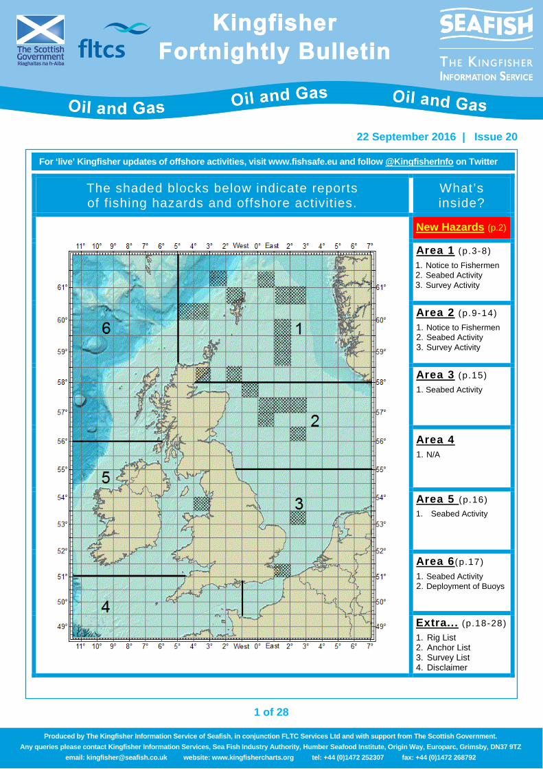
The shaded blocks below indicate reports of fishing hazards and offshore activities.
What’s inside?
New Hazards (p.2)
Area 1 (p .3-8) 1. Notice to Fishermen 2. Seabed Activity 3. Survey Activity
Area 2 (p .9-14) 1. Notice to Fishermen 2. Seabed Activity 3. Survey Activity
Area 3 (p .15) 1. Seabed Activity
Area 4 1. N/A
Area 5 (p.16) 1. Seabed Activity
Area 6 (p.17) 1. Seabed Activity 2. Deployment of Buoys
Extra... (p.18-28) 1. Rig List 2. Anchor List 3. Survey List
4. Disclaimer
2 of 28
For ‘live’ Kingfisher updates of offshore activities, visit www.fishsafe.eu and follow @KingfisherInfo onTwitter
22 September 2016 | Issue 20
Produced by The Kingfisher Information Service of Seafish, in conjunction FLTC Services Ltd and with support from The Scottish Government. Any queries please contact Kingfisher Information Services, Sea Fish Industry Authority, Humber Seafood Institute, Origin Way, Europarc, Grimsby, DN37 9TZ
email: [email protected] website: www.kingfishercharts.org tel: +44 (0)1472 252307 fax: +44 (0)1472 268792
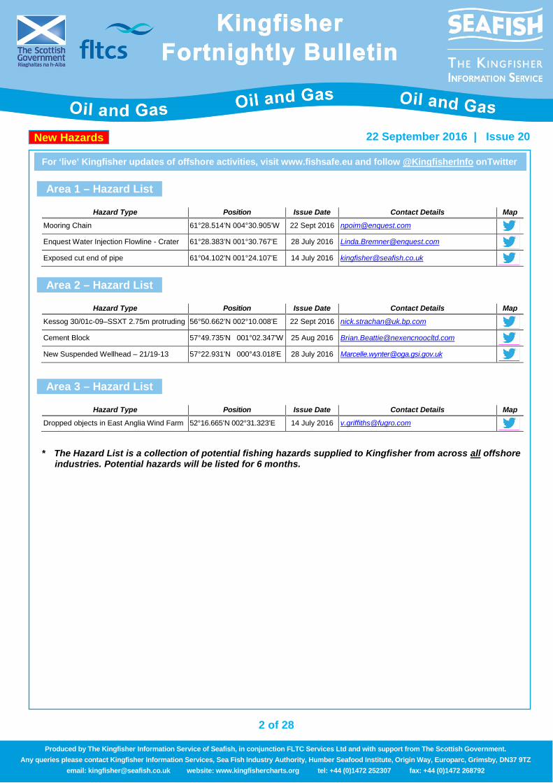
Area 1 – Hazard List
Area 2 – Hazard List
Area 3 – Hazard List
* The Hazard List is a collection of potential fishing hazards supplied to Kingfisher from across all offshore
industries. Potential hazards will be listed for 6 months.
Hazard Type Position Issue Date Contact Details Map
Mooring Chain 61°28.514’N 004°30.905’W 22 Sept 2016 [email protected] Enquest Water Injection Flowline - Crater 61°28.383’N 001°30.767’E 28 July 2016 [email protected] Exposed cut end of pipe 61°04.102’N 001°24.107’E 14 July 2016 [email protected]
Hazard Type Position Issue Date Contact Details Map
Kessog 30/01c-09–SSXT 2.75m protruding 56°50.662’N 002°10.008’E 22 Sept 2016 [email protected] Cement Block 57°49.735'N 001°02.347'W 25 Aug 2016 [email protected] New Suspended Wellhead – 21/19-13 57°22.931'N 000°43.018'E 28 July 2016 [email protected]
Hazard Type Position Issue Date Contact Details Map
Dropped objects in East Anglia Wind Farm 52°16.665’N 002°31.323’E 14 July 2016 [email protected]
New Hazards
3 of 28
For ‘live’ Kingfisher updates of offshore activities, visit www.fishsafe.eu and follow @KingfisherInfo onTwitter
22 September 2016 | Issue 20
Produced by The Kingfisher Information Service of Seafish, in conjunction FLTC Services Ltd and with support from The Scottish Government. Any queries please contact Kingfisher Information Services, Sea Fish Industry Authority, Humber Seafood Institute, Origin Way, Europarc, Grimsby, DN37 9TZ
email: [email protected] website: www.kingfishercharts.org tel: +44 (0)1472 252307 fax: +44 (0)1472 268792
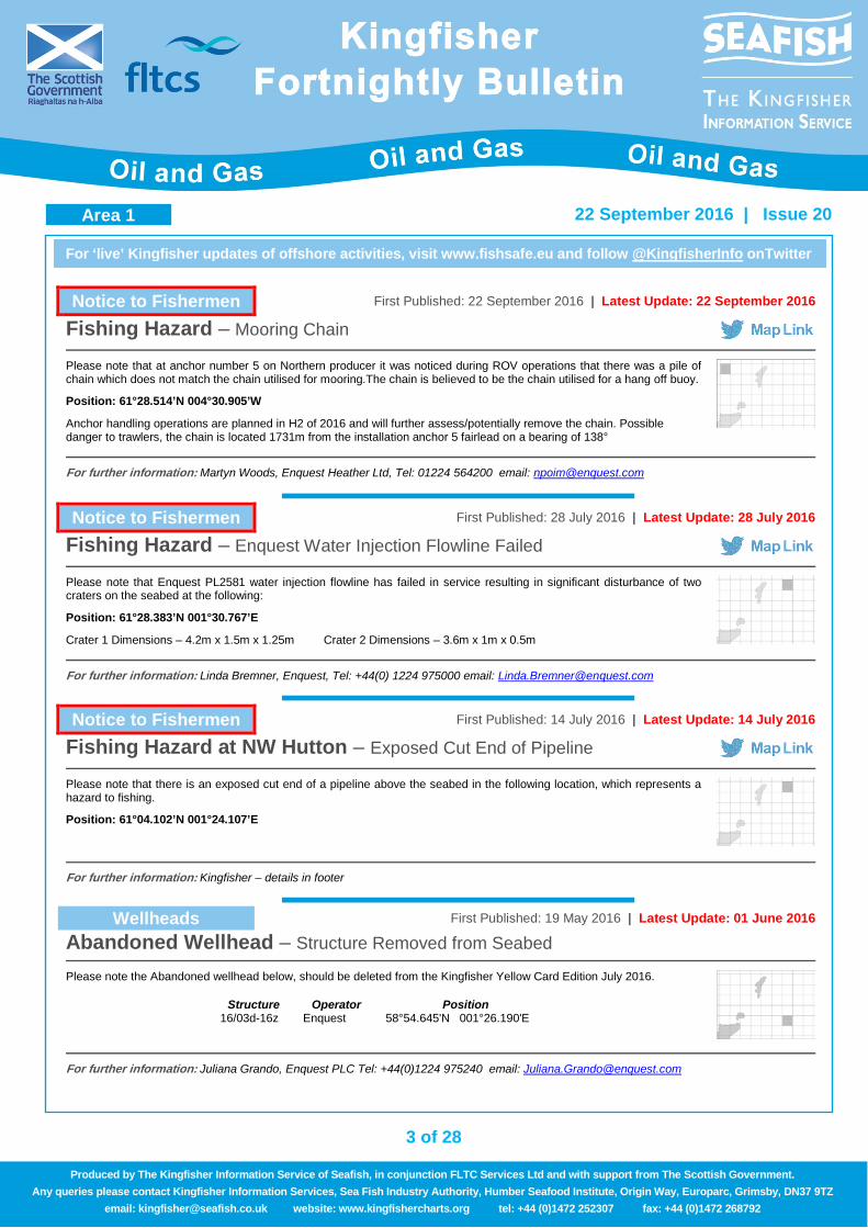
Notice to Fishermen First Published: 22 September 2016 | Latest Update: 22 September 2016
Fishing Hazard – Mooring Chain
Please note that at anchor number 5 on Northern producer it was noticed during ROV operations that there was a pile of chain which does not match the chain utilised for mooring.The chain is believed to be the chain utilised for a hang off buoy.
Position: 61°28.514’N 004°30.905’W
Anchor handling operations are planned in H2 of 2016 and will further assess/potentially remove the chain. Possible danger to trawlers, the chain is located 1731m from the installation anchor 5 fairlead on a bearing of 138°
For further information: Martyn Woods, Enquest Heather Ltd, Tel: 01224 564200 email: [email protected]
Notice to Fishermen First Published: 28 July 2016 | Latest Update: 28 July 2016
Fishing Hazard – Enquest Water Injection Flowline Failed
Please note that Enquest PL2581 water injection flowline has failed in service resulting in significant disturbance of two craters on the seabed at the following:
Position: 61°28.383’N 001°30.767’E
Crater 1 Dimensions – 4.2m x 1.5m x 1.25m Crater 2 Dimensions – 3.6m x 1m x 0.5m
For further information: Linda Bremner, Enquest, Tel: +44(0) 1224 975000 email: [email protected]
Notice to Fishermen First Published: 14 July 2016 | Latest Update: 14 July 2016
Fishing Hazard at NW Hutton – Exposed Cut End of Pipeline
Please note that there is an exposed cut end of a pipeline above the seabed in the following location, which represents a hazard to fishing.
Position: 61°04.102’N 001°24.107’E
For further information: Kingfisher – details in footer
Wellheads First Published: 19 May 2016 | Latest Update: 01 June 2016
Abandoned Wellhead – Structure Removed from Seabed
Please note the Abandoned wellhead below, should be deleted from the Kingfisher Yellow Card Edition July 2016.
Structure Operator Position 16/03d-16z Enquest 58°54.645'N 001°26.190'E
For further information: Juliana Grando, Enquest PLC Tel: +44(0)1224 975240 email: [email protected]
Area 1
4 of 28
For ‘live’ Kingfisher updates of offshore activities, visit www.fishsafe.eu and follow @KingfisherInfo onTwitter
22 September 2016 | Issue 20
Produced by The Kingfisher Information Service of Seafish, in conjunction FLTC Services Ltd and with support from The Scottish Government. Any queries please contact Kingfisher Information Services, Sea Fish Industry Authority, Humber Seafood Institute, Origin Way, Europarc, Grimsby, DN37 9TZ
email: [email protected] website: www.kingfishercharts.org tel: +44 (0)1472 252307 fax: +44 (0)1472 268792
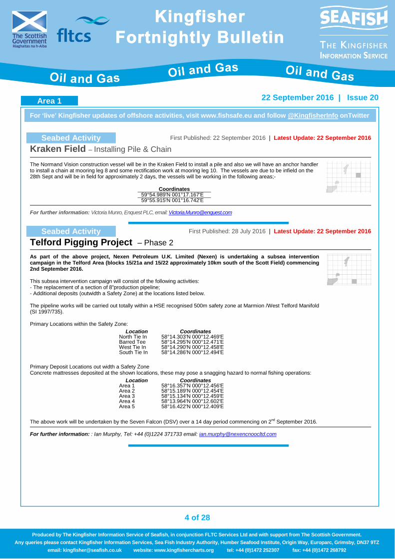
Seabed Activity First Published: 22 September 2016 | Latest Update: 22 September 2016
Kraken Field – Installing Pile & Chain
The Normand Vision construction vessel will be in the Kraken Field to install a pile and also we will have an anchor handler to install a chain at mooring leg 8 and some rectification work at mooring leg 10. The vessels are due to be infield on the 28th Sept and will be in field for approximately 2 days, the vessels will be working in the following areas;-
Coordinates 59°54.989'N 001°17.167'E 59°55.915'N 001°16.742'E
For further information: Victoria Munro, Enquest PLC, email: [email protected]
Seabed Activity First Published: 28 July 2016 | Latest Update: 22 September 2016
Telford Pigging Project – Phase 2
As part of the above project, Nexen Petroleum U.K. Limited (Nexen) is undertaking a subsea intervention campaign in the Telford Area (blocks 15/21a and 15/22 approximately 10km south of the Scott Field) commencing 2nd September 2016. This subsea intervention campaign will consist of the following activities: - The replacement of a section of 8”production pipeline; - Additional deposits (outwidth a Safety Zone) at the locations listed below. The pipeline works will be carried out totally within a HSE recognised 500m safety zone at Marmion /West Telford Manifold (SI 1997/735). Primary Locations within the Safety Zone: Primary Deposit Locations out width a Safety Zone Concrete mattresses deposited at the shown locations, these may pose a snagging hazard to normal fishing operations: The above work will be undertaken by the Seven Falcon (DSV) over a 14 day period commencing on 2nd September 2016.
Location Coordinates North Tie In 58°14.303'N 000°12.469'E Barred Tee 58°14.295'N 000°12.471'E West Tie In 58°14.290'N 000°12.458'E South Tie In 58°14.286'N 000°12.494'E
Location Coordinates Area 1 58°16.357'N 000°12.456'E Area 2 58°15.189'N 000°12.454'E Area 3 58°15.134'N 000°12.459'E Area 4 58°13.964'N 000°12.602'E Area 5 58°16.422'N 000°12.409'E
For further information: : Ian Murphy, Tel: +44 (0)1224 371733 email: [email protected]
Area 1
5 of 28
For ‘live’ Kingfisher updates of offshore activities, visit www.fishsafe.eu and follow @KingfisherInfo onTwitter
22 September 2016 | Issue 20
Produced by The Kingfisher Information Service of Seafish, in conjunction FLTC Services Ltd and with support from The Scottish Government. Any queries please contact Kingfisher Information Services, Sea Fish Industry Authority, Humber Seafood Institute, Origin Way, Europarc, Grimsby, DN37 9TZ
email: [email protected] website: www.kingfishercharts.org tel: +44 (0)1472 252307 fax: +44 (0)1472 268792
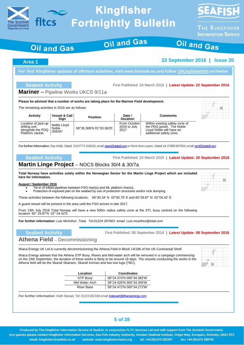
Seabed Activity First Published: 24 March 2016 | Latest Update: 22 September 2016
Mariner – Pipeline Works UKCS 9/11a
Please be advised that a number of works are taking place for the Mariner Field development.
The remaining activities in 2016 are as follows:
Activity Vessel & Call Sign Position Date /
Duration Comments
Location of jack-up drilling unit alongside the PDQ Platform Jacket.
Noble Lloyd Noble D5EM7
59°35.308'N 01°03.363'E From October 2016 to July 2017
Within existing safety zone of the PDQ jacket. The Noble Lloyd Noble will have an additional safety zone.
For further information: Ray Wells, Statoil, Tel:07771 918018, email: [email protected] or Remi Arne Larsen, Statoil, tel: 07889 807954, email: [email protected]
Seabed Activity First Published: 24 March 2016 | Latest Update: 20 September 2016
Martin Linge Project – NOCS Blocks 30/4 & 30/7a
Total Norway have activities solely within the Norwegian Sector for the Martin Linge Project which are included here for information. August / September 2016
• Tie-in of infield pipelines between FSO riser(s) and ML platform riser(s). • Protection of exposed part on the seabed by use of protection structures and/or rock dumping.
These activities between the following locations: 60°30.34’ N 02°00.79’ E and 60°29.87’ N 02°04.42’ E. A guard vessel will be present in the area until the FSO arrives in late 2017. From 15th July 2016 Total Norway will have a new 500m radius safety zone at the STL buoy centred on the following location: 60° 29.87’N 02° 04.42’E
For further information: Luis McArthur, Total, Tel:01224 297903 email: [email protected]
Seabed Activity First Published: 08 September 2016 | Latest Update: 08 September 2016
Athena Field – Decommissioning
Ithaca Energy UK Ltd is currently decommissioning the Athena Field in Block 14/18b of the UK Continental Shelf.
Ithaca Energy advises that the Athena STP Buoy, Risers and Mid-water arch will be removed in a campaign commencing on the 24th September, the duration of these works is likely to be around 18 days. The vessels conducting the works in the Athena field will be the Skandi Skansen, Skandi Iceman and two tow tugs (TBC).
Location Coordinates STP Buoy 58°24.374'N 000°34.382'W
Mid Water Arch 58°24.426'N 000°34.345'W Riser Base 58°24.472'N 000°34.272'W
For further information: Keith Stewart, Tel: 01224 652184 email: [email protected]
Area 1 Area 1
6 of 28
For ‘live’ Kingfisher updates of offshore activities, visit www.fishsafe.eu and follow @KingfisherInfo onTwitter
22 September 2016 | Issue 20
Produced by The Kingfisher Information Service of Seafish, in conjunction FLTC Services Ltd and with support from The Scottish Government. Any queries please contact Kingfisher Information Services, Sea Fish Industry Authority, Humber Seafood Institute, Origin Way, Europarc, Grimsby, DN37 9TZ
email: [email protected] website: www.kingfishercharts.org tel: +44 (0)1472 252307 fax: +44 (0)1472 268792
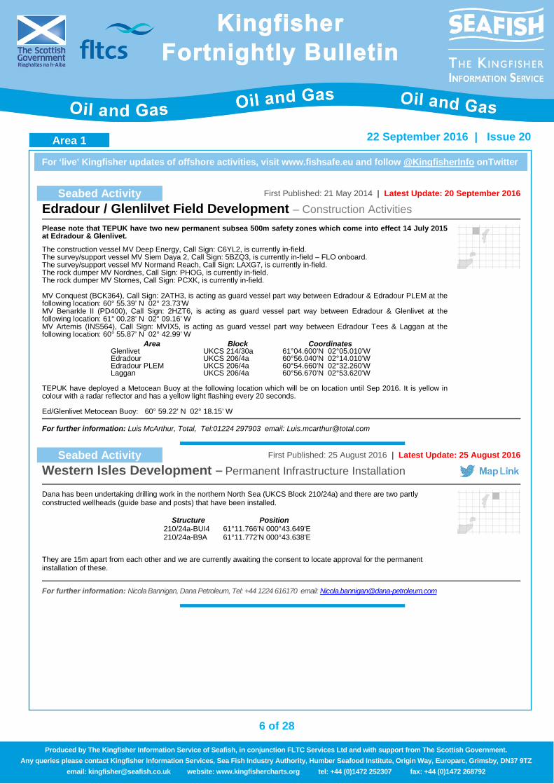
Seabed Activity First Published: 21 May 2014 | Latest Update: 20 September 2016
Edradour / Glenlilvet Field Development – Construction Activities
Please note that TEPUK have two new permanent subsea 500m safety zones which come into effect 14 July 2015 at Edradour & Glenlivet.
The construction vessel MV Deep Energy, Call Sign: C6YL2, is currently in-field. The survey/support vessel MV Siem Daya 2, Call Sign: 5BZQ3, is currently in-field – FLO onboard. The survey/support vessel MV Normand Reach, Call Sign: LAXG7, is currently in-field. The rock dumper MV Nordnes, Call Sign: PHOG, is currently in-field. The rock dumper MV Stornes, Call Sign: PCXK, is currently in-field. MV Conquest (BCK364), Call Sign: 2ATH3, is acting as guard vessel part way between Edradour & Edradour PLEM at the following location: 60° 55.39’ N 02° 23.73’W MV Benarkle II (PD400), Call Sign: 2HZT6, is acting as guard vessel part way between Edradour & Glenlivet at the following location: 61° 00.28’ N 02° 09.16’ W MV Artemis (INS564), Call Sign: MVIX5, is acting as guard vessel part way between Edradour Tees & Laggan at the following location: 60° 55.87’ N 02° 42.99’ W TEPUK have deployed a Metocean Buoy at the following location which will be on location until Sep 2016. It is yellow in colour with a radar reflector and has a yellow light flashing every 20 seconds. Ed/Glenlivet Metocean Buoy: 60° 59.22’ N 02° 18.15’ W
Area Block Coordinates Glenlivet UKCS 214/30a 61°04.600’N 02°05.010’W Edradour UKCS 206/4a 60°56.040’N 02°14.010’W Edradour PLEM UKCS 206/4a 60°54.660’N 02°32.260’W Laggan UKCS 206/4a 60°56.670’N 02°53.620’W
For further information: Luis McArthur, Total, Tel:01224 297903 email: [email protected]
Seabed Activity First Published: 25 August 2016 | Latest Update: 25 August 2016
Western Isles Development – Permanent Infrastructure Installation
Dana has been undertaking drilling work in the northern North Sea (UKCS Block 210/24a) and there are two partly constructed wellheads (guide base and posts) that have been installed.
They are 15m apart from each other and we are currently awaiting the consent to locate approval for the permanent installation of these.
Structure Position 210/24a-BUI4 61°11.766'N 000°43.649'E 210/24a-B9A 61°11.772'N 000°43.638'E
For further information: Nicola Bannigan, Dana Petroleum, Tel: +44 1224 616170 email: [email protected]
Area 1
7 of 28
For ‘live’ Kingfisher updates of offshore activities, visit www.fishsafe.eu and follow @KingfisherInfo onTwitter
22 September 2016 | Issue 20
Produced by The Kingfisher Information Service of Seafish, in conjunction FLTC Services Ltd and with support from The Scottish Government. Any queries please contact Kingfisher Information Services, Sea Fish Industry Authority, Humber Seafood Institute, Origin Way, Europarc, Grimsby, DN37 9TZ
email: [email protected] website: www.kingfishercharts.org tel: +44 (0)1472 252307 fax: +44 (0)1472 268792
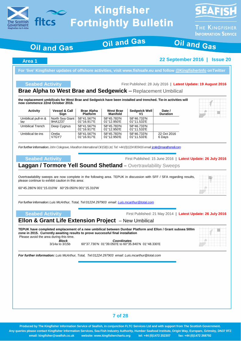
Seabed Activity First Published: 28 July 2016 | Latest Update: 19 August 2016
Brae Alpha to West Brae and Sedgewick – Replacement Umbilical
the replacement umbilicals for West Brae and Sedgwick have been installed and trenched. Tie-in activities will now commence 22nd October 2016.
Activity Vessel & Call Sign
Brae Alpha Platform
West Brae Manifold
Sedgwick Well V1
Date / Duration
Umbilical pull-in & lay
North Sea Giant 9HA1237
58°41.567'N 01°16.917'E
58°45.783'N 01°12.950'E
58°46.733'N 01°11.533'E
Umbilical Trench Deep Cygnus
58°41.567'N 01°16.917'E
58°45.783'N 01°12.950'E
58°46.733'N 01°11.533'E
Umbilical tie-ins Orelia V7GY7
58°41.567'N 01°16.917'E
58°45.783'N 01°12.950'E
58°46.733'N 01°11.533'E
22 Oct 2016 6 Days
For further information: John Colegrave, Marathon International Oil (GB) Ltd, Tel: +44 (0)1224 803416 email: [email protected]
Seabed Activity First Published: 15 June 2016 | Latest Update: 26 July 2016
Laggan / Tormore Yell Sound Shetland – Overtrawlability Sweeps
Overtrawlability sweeps are now complete in the following area. TEPUK in discussion with SFF / SFA regarding results, please continue to exhibit caution in this area: 60°45.280'N 001°15.010'W 60°29.050'N 001°15.310'W
For further information: Luis McArthur, Total, Tel:01224 297903 email: [email protected]
Seabed Activity First Published: 21 May 2014 | Latest Update: 26 July 2016
Ellon & Grant Life Extension Project – New Umbilical
TEPUK have completed emplacement of a new umbilical between Dunbar Platform and Ellon / Grant subsea 500m zone in 2015. Currently awaiting results to prove successful final installation Please avoid the area during this time.
Block Coordinates 3/14a to 3/15b 60°37.730’N 01°39.050’E to 60°35.840’N 01°48.330’E
For further information: Luis McArthur, Total, Tel:01224 297903 email: [email protected]
Area 1 Area 1
8 of 28
For ‘live’ Kingfisher updates of offshore activities, visit www.fishsafe.eu and follow @KingfisherInfo onTwitter
22 September 2016 | Issue 20
Produced by The Kingfisher Information Service of Seafish, in conjunction FLTC Services Ltd and with support from The Scottish Government. Any queries please contact Kingfisher Information Services, Sea Fish Industry Authority, Humber Seafood Institute, Origin Way, Europarc, Grimsby, DN37 9TZ
email: [email protected] website: www.kingfishercharts.org tel: +44 (0)1472 252307 fax: +44 (0)1472 268792
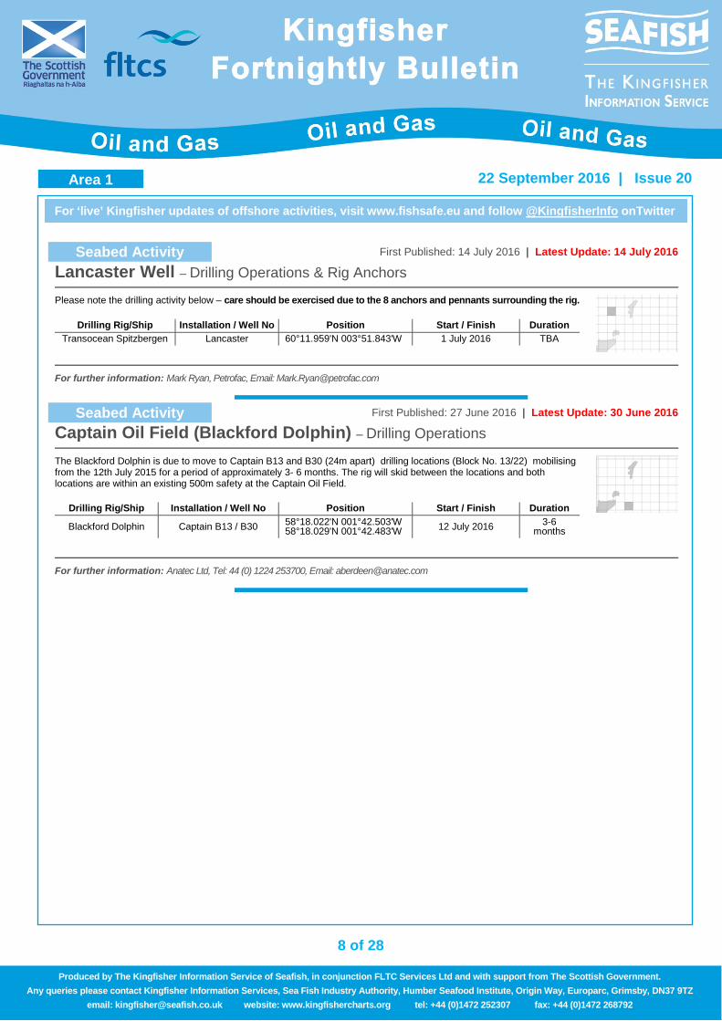
Seabed Activity First Published: 14 July 2016 | Latest Update: 14 July 2016
Lancaster Well – Drilling Operations & Rig Anchors
Please note the drilling activity below – care should be exercised due to the 8 anchors and pennants surrounding the rig.
Drilling Rig/Ship Installation / Well No Position Start / Finish Duration Transocean Spitzbergen Lancaster 60°11.959'N 003°51.843'W 1 July 2016 TBA
For further information: Mark Ryan, Petrofac, Email: [email protected]
Seabed Activity First Published: 27 June 2016 | Latest Update: 30 June 2016
Captain Oil Field (Blackford Dolphin) – Drilling Operations
The Blackford Dolphin is due to move to Captain B13 and B30 (24m apart) drilling locations (Block No. 13/22) mobilising from the 12th July 2015 for a period of approximately 3- 6 months. The rig will skid between the locations and both locations are within an existing 500m safety at the Captain Oil Field.
Drilling Rig/Ship Installation / Well No Position Start / Finish Duration
Blackford Dolphin Captain B13 / B30 58°18.022'N 001°42.503'W 58°18.029'N 001°42.483'W 12 July 2016 3-6
months
For further information: Anatec Ltd, Tel: 44 (0) 1224 253700, Email: [email protected]
Area 1
9 of 28
For ‘live’ Kingfisher updates of offshore activities, visit www.fishsafe.eu and follow @KingfisherInfo onTwitter
22 September 2016 | Issue 20
Produced by The Kingfisher Information Service of Seafish, in conjunction FLTC Services Ltd and with support from The Scottish Government. Any queries please contact Kingfisher Information Services, Sea Fish Industry Authority, Humber Seafood Institute, Origin Way, Europarc, Grimsby, DN37 9TZ
email: [email protected] website: www.kingfishercharts.org tel: +44 (0)1472 252307 fax: +44 (0)1472 268792
Notice to Fishermen First Published: 22 September 2016 | Latest Update: 22 September 2016
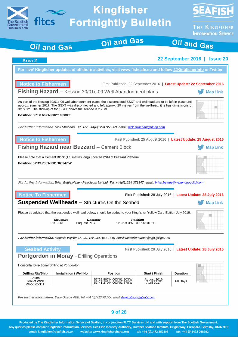
Fishing Hazard – Kessog 30/01c-09 Well Abandonment plans
As part of the Kessog 30/01c-09 well abandonment plans, the disconnected SSXT and wellhead are to be left in place until approx. summer 2017. The SSXT was disconnected and left approx. 20 metres from the wellhead, it is has dimensions of 3m x 3m. The stick-up of the SSXT above the seabed is 2.75m.
Position: 56°50.662’N 002°10.008’E
For further information: Nick Strachan, BP, Tel: +44(0)1224 955089 email: [email protected]
Notice to Fishermen First Published: 25 August 2016 | Latest Update: 25 August 2016
Fishing Hazard near Buzzard – Cement Block
Please note that a Cement Block (1.5 metres long) Located 2NM of Buzzard Platform
Position: 57°49.735’N 001°02.347’W
For further information: Brian Bettie,Nexen Petroleum UK Ltd, Tel: +44(0)1224 371347 email: [email protected]
Notice To Fishermen First Published: 28 July 2016 | Latest Update: 28 July 2016
Suspended Wellheads – Structures On the Seabed
Please be advised that the suspended wellhead below, should be added to your Kingfisher Yellow Card Edition July 2016.
Structure Operator Position 21/19-13 Enquest PLC 57°22.931'N 000°43.018'E
For further information: Marcelle Wynter, DECC, Tel: 0300 067 1616 email: [email protected] .uk
Seabed Activity First Published: 28 July 2016 | Latest Update: 28 July 2016
Portgordon in Moray – Drilling Operations
Horizontal Directional Drilling at Portgordon
Drilling Rig/Ship Installation / Well No Position Start / Finish Duration Shuna
Teal of Wick Woodstock 1
57°39.807'N 003°01.903'W 57°41.270'N 003°01.878'W
August 2016 April 2017 60 Days
For further information: Dave Gibson, ABB, Tel: +44 (0)7713 985550 email: [email protected]
Area 2
10 of 28
For ‘live’ Kingfisher updates of offshore activities, visit www.fishsafe.eu and follow @KingfisherInfo onTwitter
22 September 2016 | Issue 20
Produced by The Kingfisher Information Service of Seafish, in conjunction FLTC Services Ltd and with support from The Scottish Government. Any queries please contact Kingfisher Information Services, Sea Fish Industry Authority, Humber Seafood Institute, Origin Way, Europarc, Grimsby, DN37 9TZ
email: [email protected] website: www.kingfishercharts.org tel: +44 (0)1472 252307 fax: +44 (0)1472 268792
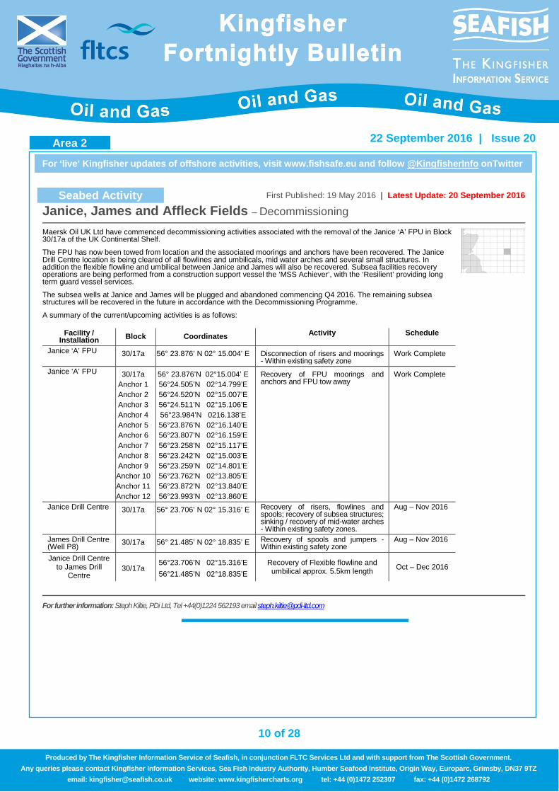
Seabed Activity First Published: 19 May 2016 | Latest Update: 20 September 2016
Janice, James and Affleck Fields – Decommissioning
Maersk Oil UK Ltd have commenced decommissioning activities associated with the removal of the Janice ‘A’ FPU in Block 30/17a of the UK Continental Shelf.
The FPU has now been towed from location and the associated moorings and anchors have been recovered. The Janice Drill Centre location is being cleared of all flowlines and umbilicals, mid water arches and several small structures. In addition the flexible flowline and umbilical between Janice and James will also be recovered. Subsea facilities recovery operations are being performed from a construction support vessel the ‘MSS Achiever’, with the ‘Resilient’ providing long term guard vessel services.
The subsea wells at Janice and James will be plugged and abandoned commencing Q4 2016. The remaining subsea structures will be recovered in the future in accordance with the Decommissioning Programme.
A summary of the current/upcoming activities is as follows:
Facility / Installation Block Coordinates Activity Schedule
Janice ‘A’ FPU 30/17a 56° 23.876’ N 02° 15.004’ E Disconnection of risers and moorings - Within existing safety zone
Work Complete
Janice ‘A’ FPU 30/17a Anchor 1 Anchor 2 Anchor 3 Anchor 4 Anchor 5 Anchor 6 Anchor 7 Anchor 8 Anchor 9 Anchor 10 Anchor 11 Anchor 12
56° 23.876’N 02°15.004’ E 56°24.505’N 02°14.799’E 56°24.520’N 02°15.007’E 56°24.511’N 02°15.106’E 56°23.984’N 0216.138’E 56°23.876’N 02°16.140’E 56°23.807’N 02°16.159’E 56°23.258’N 02°15.117’E 56°23.242’N 02°15.003’E 56°23.259’N 02°14.801’E 56°23.762’N 02°13.805’E 56°23.872’N 02°13.840’E 56°23.993’N 02°13.860’E
Recovery of FPU moorings and anchors and FPU tow away
Work Complete
Janice Drill Centre 30/17a 56° 23.706’ N 02° 15.316’ E Recovery of risers, flowlines and spools; recovery of subsea structures; sinking / recovery of mid-water arches - Within existing safety zones.
Aug – Nov 2016
James Drill Centre (Well P8) 30/17a 56° 21.485’ N 02° 18.835’ E Recovery of spools and jumpers -
Within existing safety zone Aug – Nov 2016
Janice Drill Centre to James Drill
Centre 30/17a
56°23.706’N 02°15.316’E 56°21.485’N 02°18.835’E
Recovery of Flexible flowline and umbilical approx. 5.5km length Oct – Dec 2016
For further information: Steph Kiltie, PDi Ltd, Tel +44(0)1224 562193 email [email protected]
Area 2
11 of 28
For ‘live’ Kingfisher updates of offshore activities, visit www.fishsafe.eu and follow @KingfisherInfo onTwitter
22 September 2016 | Issue 20
Produced by The Kingfisher Information Service of Seafish, in conjunction FLTC Services Ltd and with support from The Scottish Government. Any queries please contact Kingfisher Information Services, Sea Fish Industry Authority, Humber Seafood Institute, Origin Way, Europarc, Grimsby, DN37 9TZ
email: [email protected] website: www.kingfishercharts.org tel: +44 (0)1472 252307 fax: +44 (0)1472 268792
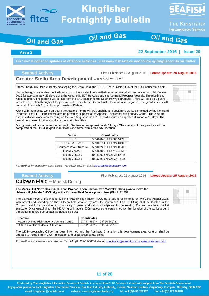
Seabed Activity First Published: 12 August 2016 | Latest Update: 24 August 2016
Greater Stella Area Development – Arrival of FPV
Ithaca Energy UK Ltd is currently developing the Stella Field and FPF-1 FPV in Block 30/6A of the UK Continental Shelf.
Ithaca Energy advises that the Stella oil export pipeline shall be installed during a campaign commencing on 19th August 2016 for approximately 33 days using the Apache II, EDT Hercules and the Normand Progress Vessels. The pipeline is 43km in length. The pipeline will be laid from the SAL location to the Southern Wye structure. There will also be 3 guard vessels on location throughout the pipelay route, namely the Ocean Trust, Shalanna and Elegance. The guard vessels will be infield from 19th August for approximately 33 days.
Along with the pipelay work on-board the Apache II there will be trenching and backfilling works completed by the Normand Progress. The EDT Hercules will also be providing support to the Apache II and conducting survey works. There will be riser installation works commencing on the 24th August at the FPF-1 location with an expected duration of 16 days. The vessel being used for these works is the North Sea Giant.
Diving works will also commence on the 8th September for approximately 34 days. The majority of the operations will be completed at the FPF-1 (Export Riser Base) and some work at the SAL location.
Vessel Coordinates FPF-1 56°46.846'N 002°06.542'E
Stella SAL Base 56°30.194'N 002°24.049'E Southern Wye Structure 56°30.228'N 002°24.054'E
Guard Vessel 1 56°46.000'N 002°12.425'E Guard Vessel 2 56°41.613'N 002°23.587'E Guard Vessel 3 56°33.979'N 002°24.761'E
For further information: Keith Stewart Tel: 01224 652184 Email: [email protected]
Seabed Activity First Published: 25 August 2016 | Latest Update: 25 August 2016
Culzean Field – Maersk Drilling
The Maersk Oil North Sea Ltd. Culzean Project in conjunction with Maersk Drilling plan to move the “Maersk Highlander” HDJU rig to the Culzean Field Development Area (Block 22/25A) The planned move of the Maersk Drilling “Maersk Highlander” HDJU rig is due to commence on w/c 22nd August 2016, with arrival and spudding on the Culzean field location by w/c 5th September. This HDJU rig shall be located in the Culzean field for a period of approximately 5 years and will spud adjacent to the existing Culzean Wellhead Jacket structure. Once established, the HDJU rig will have a 500m safety zone established for the duration of the works around the platform centre coordinates as detailed below:
Location Coordinates Maersk Drilling Highlander HDJU Rig Centre 57˚ 11.565' N 01˚ 54.645’ E Culzean Wellhead Jacket Structure 57˚ 11.547' N 01˚ 54.679’ E
The UK Hydrographic Office has been informed and the Admiralty Charts for this development area location shall be updated to include the HDJU Rig location and established safety zone.
For further information: Max Ferran, Tel: +44 (0) 1224 242858, Email: [email protected] www.maerskoil.com
Area 2 Area 2
12 of 28
For ‘live’ Kingfisher updates of offshore activities, visit www.fishsafe.eu and follow @KingfisherInfo onTwitter
22 September 2016 | Issue 20
Produced by The Kingfisher Information Service of Seafish, in conjunction FLTC Services Ltd and with support from The Scottish Government. Any queries please contact Kingfisher Information Services, Sea Fish Industry Authority, Humber Seafood Institute, Origin Way, Europarc, Grimsby, DN37 9TZ
email: [email protected] website: www.kingfishercharts.org tel: +44 (0)1472 252307 fax: +44 (0)1472 268792
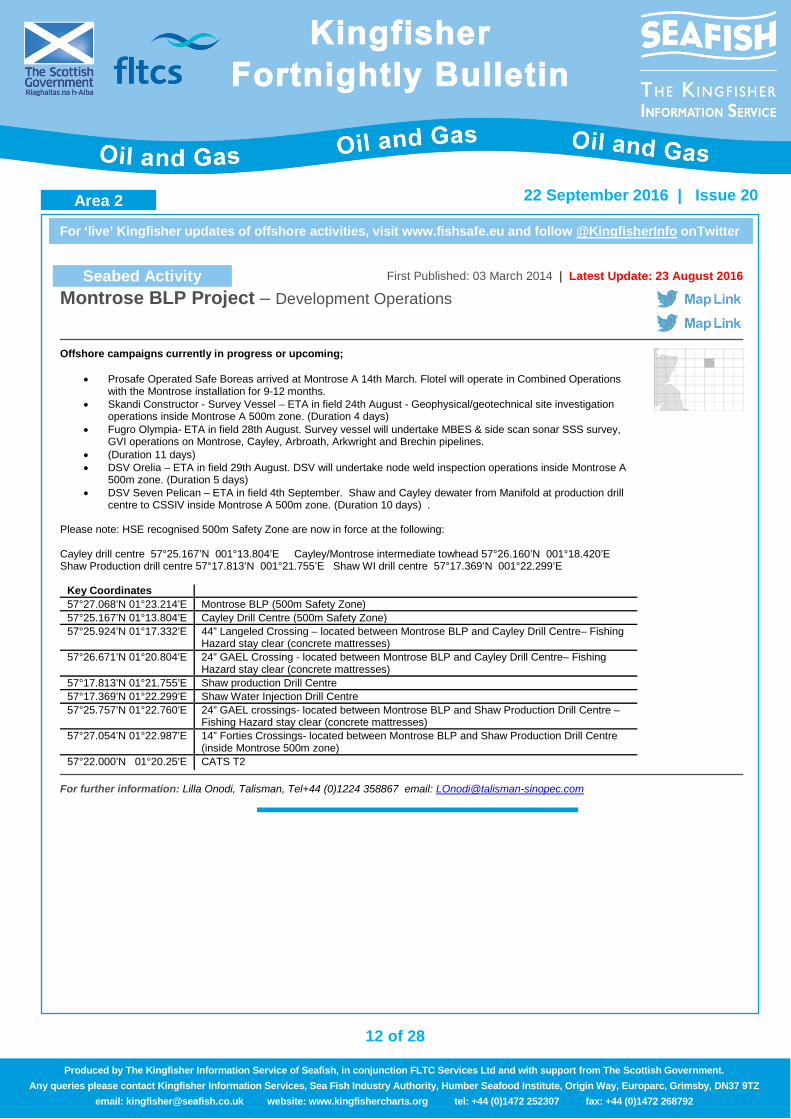
Seabed Activity First Published: 03 March 2014 | Latest Update: 23 August 2016
Montrose BLP Project – Development Operations
Offshore campaigns currently in progress or upcoming;
• Prosafe Operated Safe Boreas arrived at Montrose A 14th March. Flotel will operate in Combined Operations with the Montrose installation for 9-12 months.
• Skandi Constructor - Survey Vessel – ETA in field 24th August - Geophysical/geotechnical site investigation operations inside Montrose A 500m zone. (Duration 4 days)
• Fugro Olympia- ETA in field 28th August. Survey vessel will undertake MBES & side scan sonar SSS survey, GVI operations on Montrose, Cayley, Arbroath, Arkwright and Brechin pipelines.
• (Duration 11 days) • DSV Orelia – ETA in field 29th August. DSV will undertake node weld inspection operations inside Montrose A
500m zone. (Duration 5 days) • DSV Seven Pelican – ETA in field 4th September. Shaw and Cayley dewater from Manifold at production drill
centre to CSSIV inside Montrose A 500m zone. (Duration 10 days) .
Please note: HSE recognised 500m Safety Zone are now in force at the following:
Cayley drill centre 57°25.167’N 001°13.804’E Cayley/Montrose intermediate towhead 57°26.160’N 001°18.420’E Shaw Production drill centre 57°17.813’N 001°21.755’E Shaw WI drill centre 57°17.369’N 001°22.299’E
Key Coordinates 57°27.068’N 01°23.214’E Montrose BLP (500m Safety Zone) 57°25.167’N 01°13.804’E Cayley Drill Centre (500m Safety Zone) 57°25.924’N 01°17.332’E 44” Langeled Crossing – located between Montrose BLP and Cayley Drill Centre– Fishing
Hazard stay clear (concrete mattresses) 57°26.671’N 01°20.804’E 24” GAEL Crossing - located between Montrose BLP and Cayley Drill Centre– Fishing
Hazard stay clear (concrete mattresses) 57°17.813’N 01°21.755’E Shaw production Drill Centre 57°17.369’N 01°22.299’E Shaw Water Injection Drill Centre 57°25.757’N 01°22.760’E 24” GAEL crossings- located between Montrose BLP and Shaw Production Drill Centre –
Fishing Hazard stay clear (concrete mattresses) 57°27.054’N 01°22.987’E 14” Forties Crossings- located between Montrose BLP and Shaw Production Drill Centre
(inside Montrose 500m zone) 57°22.000’N 01°20.25’E CATS T2
For further information: Lilla Onodi, Talisman, Tel+44 (0)1224 358867 email: [email protected]
Area 2
13 of 28
For ‘live’ Kingfisher updates of offshore activities, visit www.fishsafe.eu and follow @KingfisherInfo onTwitter
22 September 2016 | Issue 20
Produced by The Kingfisher Information Service of Seafish, in conjunction FLTC Services Ltd and with support from The Scottish Government. Any queries please contact Kingfisher Information Services, Sea Fish Industry Authority, Humber Seafood Institute, Origin Way, Europarc, Grimsby, DN37 9TZ
email: [email protected] website: www.kingfishercharts.org tel: +44 (0)1472 252307 fax: +44 (0)1472 268792
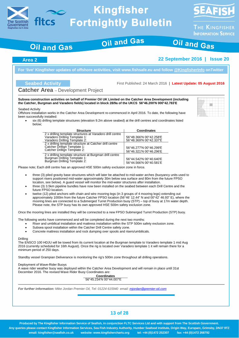
Seabed Activity First Published: 24 March 2016 | Latest Update: 05 August 2016
Catcher Area – Development Project
Subsea construction activities on behalf of Premier Oil UK Limited on the Catcher Area Development (including the Catcher, Burgman and Varadero fields) located in block 28/9a of the UKCS 56°46.200'N 000°42.783'E
Seabed Activity Offshore installation works in the Catcher Area Development re-commenced in April 2016. To date, the following have been successfully installed:
• six (6) drilling template structures (elevation 9.2m above seabed) at the drill centres and coordinates listed below;
Please note; Each drill centre has an approved HSE 500m safety exclusion zone in force.
• three (3) piled gravity base structures which will later be attached to mid-water arches (buoyancy units used to support risers positioned mid-water approximately 30m below sea surface and 80m from the future FPSO location, see below). A guard vessel will monitor the mid-water structures after installation.
• three (3) 3.5km pipeline bundles have now been installed on the seabed between each Drill Centre and the future FPSO location.
• twelve (12) piled anchors with chain and wire mooring legs (in 3 groups of 4 mooring legs) extending out approximately 1000m from the future Catcher FPSO location (56°46’ 12.44” N and 00°42’ 46.93” E), where the mooring lines are connected to a Submerged Turret Production buoy (STP) – top of buoy at 17m water depth. Please note, the STP buoy has its own approved HSE 500m safety exclusion zone.
Once the mooring lines are installed they will be connected to a new FPSO Submerged Turret Production (STP) buoy. The following works have commenced and will be completed during the next two months:
• Riser and umbilical installation and mattress installation within the STP 500m safety exclusion zone. • Subsea spool installation within the Catcher Drill Centre safety zone. • Concrete mattress installation and rock dumping over spools and risers/umbilicals.
Drilling The ENSCO 100 HDJU will be towed from its current location at the Burgman template to Varadero template 1 mid Aug 2016 (currently scheduled for 16th August). Once the rig is located over Varadero template 1 it will remain there for a minimum period of 250 days. Standby vessel Grampian Deliverance is monitoring the rig’s 500m zone throughout all drilling operations. Deployment of Wave-Rider Buoys A wave rider weather buoy was deployed within the Catcher Area Development and will remain in place until 31st December 2016. The revised Wave Rider Buoy Coordinates are:
Structure Coordinates 2 x drilling template structures at Varadero drill centre Varadero Drilling Template 1: Varadero Drilling Template 2:
56°48.366'N 00°42.258'E 56°48.369'N 00°42.337'E
2 x drilling template structure at Catcher drill centre Catcher Drillign Template 1: Catcher Drillign Template 2:
56°46.277'N 00°46.299'E 56°46.321'N 00°46.296'E
2 x drilling template structure at Burgman drill centre Burgman Drilling Template 1: Burgman Drilling Template 2:
56°44.542'N 00°40.640'E 56°44.566'N 00°40.581'E
Coordinates 56°45.234'N 00°44.007'E
For further information: Mike Jordan Premier Oil, Tel: 01224 615940 email: [email protected]
Area 2
14 of 28
For ‘live’ Kingfisher updates of offshore activities, visit www.fishsafe.eu and follow @KingfisherInfo onTwitter
22 September 2016 | Issue 20
Produced by The Kingfisher Information Service of Seafish, in conjunction FLTC Services Ltd and with support from The Scottish Government. Any queries please contact Kingfisher Information Services, Sea Fish Industry Authority, Humber Seafood Institute, Origin Way, Europarc, Grimsby, DN37 9TZ
email: [email protected] website: www.kingfishercharts.org tel: +44 (0)1472 252307 fax: +44 (0)1472 268792
Seabed Activity First Published: 19 May 2016 | Latest Update: 26 July 2016
Ettrick & Blackbird Decommissioning Project – Phase 1
Nexen Petroleum U.K. Limited (Nexen) is decommissioning the Ettrick and Blackbird Fields located in Block 20/2a of the UKCS Central North Sea.
The decommissioning work will be conducted in phases and is centred on an FPSO, Aoka Mizu, which is stationed at Ettrick and will be departing the Field in Phase 1 of the project. The removal of the subsea facilities will follow during subsequent phases. On departure of the FPSO, the associated riser buoy and moorings will remain on location mid-water at a depth 25m below the surface. Planned departure of the Aoka Mizu is 31st July 2016. A guard vessel will be on station until removal of the buoy. The pipeline works will be carried out totally within a HSE recognised 500m safety zone. Details of which are as follows: Ettrick FPSO Centre (SI 2016/309). Location Coordinates
Riser Buoy (Submerged at 25m once FPSO departs) 57°54.568'N 000°35.520'W
For further information: : Ian Murphy, Tel: +44 (0)1224 371733 email: [email protected]
Seabed Activity First Published: 14 July 2016 | Latest Update: 14 July 2016
ETAP Area – New 35km Umbilical (to be trenched)
Please note a new 35km 109mm OD umbilical has been laid between the ETAP CPF platform 500m safety zone 57°17.434'N 001°39.774'E) and the Machar Drill Centre 500m safety zone (57°04.790'N 002°04.857'E). The new umbilical is to be trenched along its entire length, apart for approximately 350m where it crosses the existing Scoter pipeline & umbilical which will be protected with a rock berm. These trenching and rock berm installation activities will be undertaken over the next 6 weeks by the Fugro Saltire and Rockpiper vessels respectively.
For further information: Jonny McKane, BP, Direct: +44 (0)1224 835642, Mobile: +44 (0)7768 045157
Area 2
15 of 28
For ‘live’ Kingfisher updates of offshore activities, visit www.fishsafe.eu and follow @KingfisherInfo onTwitter
22 September 2016 | Issue 20
Produced by The Kingfisher Information Service of Seafish, in conjunction FLTC Services Ltd and with support from The Scottish Government. Any queries please contact Kingfisher Information Services, Sea Fish Industry Authority, Humber Seafood Institute, Origin Way, Europarc, Grimsby, DN37 9TZ
email: [email protected] website: www.kingfishercharts.org tel: +44 (0)1472 252307 fax: +44 (0)1472 268792
Seabed Activity First Published: 20 June 2016 | Latest Update: 31 August 2016
Perenco Thames Field – Decommissioning Operations
Perenco UK Ltd will be performing decommissioning operations at the Thames Field in the Southern North Sea. The Thames Field is located two nautical miles west of the Deep Water Route (DWR) via the DR1 light buoy. The works are taking place in the 500m zone at the Thames platform and will likely to commence from Friday 2nd September 2016. It will be undertaken by a heavy lifting vessel (HLV) operating alongside the existing Thames platform, which has a statutory 500m safety zone. The HLV will be anchored inside the 500m safety zone during the operation, with the anchor lines extending outside the 500m safety zone. A barge will be at the Thames Field for offloading of the decommissioned structures and transportation back to port. The barge will be assisted by two tugs to manoeuvre into position alongside the HLV when required. Details of the Thames Decommissioning Operation are presented below: Location Name: Thames UK Licence Block: 49/28A Platform Co-ordinates: 53º 04.98’ N 002º 32.74' E Start Date: 20th June 2016 End Date: 30th September 2016 HLV Name: Rambiz or Taklift 4 ERRV: On-Site Safety Zone: 500 metre radius
For further information: Anatec Limited, Tel: +44 1224 253700, Email: [email protected]
Seabed Activity First Published: 25 August 2016 | Latest Update: 25 August 2016
Bacton to Hewitt – Pipeline Spans
New pipeline spans discovered on ENI’s Bacton to Hewett pipeline (Approx. 8.5nm offshore). Please exercise caution.
Span Position Length / Height Span 1 52°59.466'N 001°34.373'E to 52°59.445'N 001°34.327'E 65 m x 1.7 m Span 2 52°59.618'N 001°34.695'E to 52°59.606'N 001°34.664'E 23 m x 0.7 m
For further information: Kingfisher – See details in footer
Seabed Activity First Published: 11 August 2016 | Latest Update: 11 August 2016
NE Kellet Gut Goodwin Sands – Diving Operations
Diving operations are due to take place over the wreck of the Rooswijk between the 5th September 2016 and the 14th September 2016. The operation is being undertaken on behalf of Historic England and Rijksdienst Voor het Cultureel Erfgoed.
The dive support vessel Coastal Guardian will, subject to weather, maintain station on a two point mooring for the duration of the operation. Passing traffic is requested to give a wide berth.
Position Start / Finish Duration 51°16.443'N 001°34.537'E 05/09/16 9 Days
For further information: Mark James at MSDS Marine - Tel:07917 703176 email: [email protected]
Area 3
16 of 28
For ‘live’ Kingfisher updates of offshore activities, visit www.fishsafe.eu and follow @KingfisherInfo onTwitter
22 September 2016 | Issue 20
Produced by The Kingfisher Information Service of Seafish, in conjunction FLTC Services Ltd and with support from The Scottish Government. Any queries please contact Kingfisher Information Services, Sea Fish Industry Authority, Humber Seafood Institute, Origin Way, Europarc, Grimsby, DN37 9TZ
email: [email protected] website: www.kingfishercharts.org tel: +44 (0)1472 252307 fax: +44 (0)1472 268792
Seabed Activity First Published: 28 July 2016 | Latest Update: 28 July 2016
Liverpool Bay – Drilling Operations
Petrofac drilling operations
Drilling Rig/Ship Installation / Well No Position Start / Finish Duration Irish Sea Pioneer Lennox 110/15L 53°37.881'N 003°10.595'W 28/07/16 60 Days
For further information: Dave Smith, Petrofac, Tel: +44 1224 247141 email: [email protected]
Seabed Activity First Published: 28 July 2016 | Latest Update: 28 July 2016
Morecambe Field – Millom West Fabric Maintenance Campaign
The Seajacks Hydra jack up accommodation barge will be located alongside the Millom West Platform (linked via bridge access) for Fabric Maintenance works on the platform which are due to be completed by end September, when the Hydra will depart the field. The barge will be located on site via 4 legs on the sea bed.
Location Rig/Ship Installation / Well No Position Start / Finish Duration Millom West Millom 113/26a 54°01.621'N 003°51.605'W 01/08/16 45 Days
Seajacks Jack-Up 53°57.670'N 003°40.296'W 01/08/16 45 Days
For further information: Shona Jones, Centrica Exploration & Production, Tel: +44(0)7557 619262 email: [email protected]
Area 5
17 of 28
For ‘live’ Kingfisher updates of offshore activities, visit www.fishsafe.eu and follow @KingfisherInfo onTwitter
22 September 2016 | Issue 20
Produced by The Kingfisher Information Service of Seafish, in conjunction FLTC Services Ltd and with support from The Scottish Government. Any queries please contact Kingfisher Information Services, Sea Fish Industry Authority, Humber Seafood Institute, Origin Way, Europarc, Grimsby, DN37 9TZ
email: [email protected] website: www.kingfishercharts.org tel: +44 (0)1472 252307 fax: +44 (0)1472 268792
Seabed Activity First Published: 25 August 2016 | Latest Update: 25 August 2016
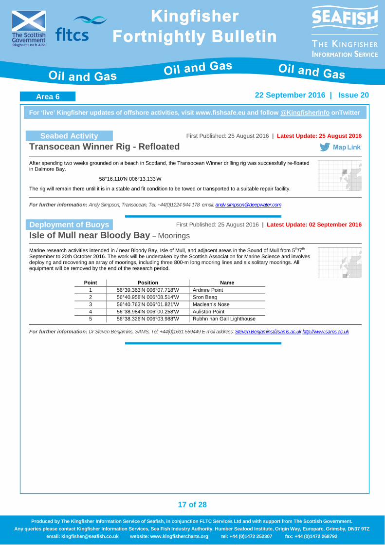
Transocean Winner Rig - Refloated
After spending two weeks grounded on a beach in Scotland, the Transocean Winner drilling rig was successfully re-floated in Dalmore Bay.
58°16.110'N 006°13.133'W
The rig will remain there until it is in a stable and fit condition to be towed or transported to a suitable repair facility.
For further information: Andy Simpson, Transocean, Tel: +44(0)1224 944 178 email: [email protected]
Deployment of Buoys First Published: 25 August 2016 | Latest Update: 02 September 2016
Isle of Mull near Bloody Bay – Moorings
Marine research activities intended in / near Bloody Bay, Isle of Mull, and adjacent areas in the Sound of Mull from 5th/7th September to 20th October 2016. The work will be undertaken by the Scottish Association for Marine Science and involves deploying and recovering an array of moorings, including three 800-m long mooring lines and six solitary moorings. All equipment will be removed by the end of the research period.
Point Position Name
1 56°39.363'N 006°07.718'W Ardmre Point 2 56°40.958'N 006°08.514'W Sron Beag 3 56°40.763'N 006°01.821'W Maclean’s Nose 4 56°38.984'N 006°00.258'W Auliston Point 5 56°38.326'N 006°03.988'W Rubhn nan Gall Lighthouse
For further information: Dr Steven Benjamins, SAMS, Tel: +44(0)1631 559449 E-mail address: [email protected] http://www.sams.ac.uk
Area 6
18 of 28
For ‘live’ Kingfisher updates of offshore activities, visit www.fishsafe.eu and follow @KingfisherInfo onTwitter
22 September 2016 | Issue 20
Produced by The Kingfisher Information Service of Seafish, in conjunction FLTC Services Ltd and with support from The Scottish Government. Any queries please contact Kingfisher Information Services, Sea Fish Industry Authority, Humber Seafood Institute, Origin Way, Europarc, Grimsby, DN37 9TZ
email: [email protected] website: www.kingfishercharts.org tel: +44 (0)1472 252307 fax: +44 (0)1472 268792
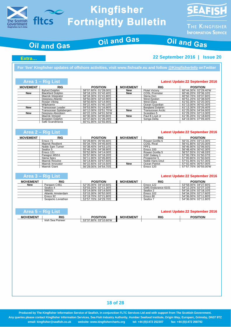
Area 1 – Rig List Latest Update:22 September 2016
MOVEMENT RIG POSITION MOVEMENT RIG POSITION Byford Dolphin 58°07.60’N 01°28.00’E New Flotel Victory 60°44.30’N 02°29.40’W
New Blackford Dolphin 58°18.10’N 01°42.40’E New COSL Promoter 60°46.20’N 03°36.10’E Maersk Integrator 58°34.30’N 01°41.80’E Stena Don 60°50.70’N 03°37.60’E Deepsea Atlantic 58°50.00’N 02°32.90’E West Epsilon 60°51.20’N 02°38.50’E Rowan Viking 58°50.60’N 02°14.90’E West Elara 61°02.30’N 02°20.30’E Wilphoenix 59°22.40’N 01°40.10’E Ocean Guardian 61°13.00’N 00°42.30’E
New Transocean Leader 59°53.90’N 01°16.90’E Borgland Dolphin 61°13.30’N 03°26.40’E Transocean Spitsbergen 60°12.00’N 03°51.70’W New Transocean Arctic 61°25.00’N 04°04.00’E
New Deepsea Aberdeen 60°22.10’N 04°01.50’W Scarabeo 5 61°29.20’N 02°13.30’E Maersk Intrepid 60°30.30’N 02°00.80’E New Paul B Loyd Jr 61°35.20’N 01°18.60’E Borgsten Dolphin 60°37.66’N 01°39.29’E Songa Delta 64°19.00’N 07°09.40’E Safe Scandinavia 60°41.90’N 02°55.90’E
Area 2 – Rig List Latest Update:22 September 2016
MOVEMENT RIG POSITION MOVEMENT RIG POSITION Ensco 71 55°28.80’N 05°06.60’E Rowan Gorilla 6 56°31.20’N 03°13.30’E Maersk Resilient 55°34.70’N 04°45.60’E COSL Rival 56°41.80’N 02°20.30’E Noble Sam Turner 55°38.40’N 04°53.10’E FPF1 56°46.90’N 02°06.50’E Seafox 5 55°46.10’N 04°38.90’E Ensco 100 56°48.40’N 00°42.30’E Ensco 121 55°52.90’N 04°14.00’E Rowan Gorilla 5 56°57.55’N 01°48.33’E Paragon MSS1 55°57.90’N 02°18.20’E GSF Galaxy 1 57°00.79’N 01°50.37’E Stena Spey 56°11.90’N 02°45.80’E Prospector 5 57°00.80’N 01°50.50’E Maersk Resolve 56°14.80’N 03°57.60’E Noble Hans Deul 57°01.90’N 01°57.30’E Maersk Innovator 56°22.60’N 03°15.50’E New Ocean Patriot 57°02.40’N 00°57.00’E Maersk Giant 56°29.00’N 04°54.70’E Ensco 120 57°57.70’N 00°55.00’W
Area 3 – Rig List Latest Update:22 September 2016
MOVEMENT RIG POSITION MOVEMENT RIG POSITION New Paragon C461 52°35.00’N 04°10.60’E Ensco 122 53°58.00’N 04°27.60’E
Seafox 4 53°03.20’N 02°11.30’E GMS Endurance 6101 54°12.20’N 02°27.10’E 590021 53°14.00’N 03°14.50’E Seafox 2 54°34.10’N 02°18.10’E Atlantic Amsterdam 53°15.30’N 00°52.00’E Ensco 102 54°34.20’N 02°17.60’E Ensco 92 53°19.70’N 02°21.80’E Ensco 80 54°36.00’N 02°11.80’E Seajacks Leviathan 53°57.70’N 04°29.70’E Seafox 7 54°36.00’N 02°11.80’E
Area 5 – Rig List Latest Update:22 September 2016
MOVEMENT RIG POSITION MOVEMENT RIG POSITION Irish Sea Pioneer 53°37.80’N 03°10.60’W
Extra…
19 of 28
For ‘live’ Kingfisher updates of offshore activities, visit www.fishsafe.eu and follow @KingfisherInfo onTwitter
22 September 2016 | Issue 20
Produced by The Kingfisher Information Service of Seafish, in conjunction FLTC Services Ltd and with support from The Scottish Government. Any queries please contact Kingfisher Information Services, Sea Fish Industry Authority, Humber Seafood Institute, Origin Way, Europarc, Grimsby, DN37 9TZ
email: [email protected] website: www.kingfishercharts.org tel: +44 (0)1472 252307 fax: +44 (0)1472 268792
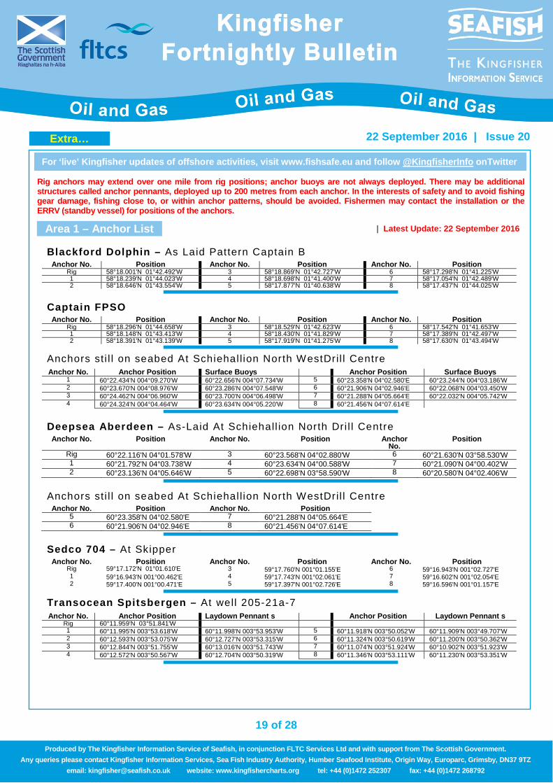
Rig anchors may extend over one mile from rig positions; anchor buoys are not always deployed. There may be additional structures called anchor pennants, deployed up to 200 metres from each anchor. In the interests of safety and to avoid fishing gear damage, fishing close to, or within anchor patterns, should be avoided. Fishermen may contact the installation or the ERRV (standby vessel) for positions of the anchors.
Area 1 – Anchor List | Latest Update: 22 September 2016
Blackford Dolphin – As Laid Pattern Captain B
Anchor No. Position Anchor No. Position Anchor No. Position Rig 58°18.001'N 01°42.492'W 3 58°18.869'N 01°42.727'W 6 58°17.298'N 01°41.225'W 1 58°18.239'N 01°44.023'W 4 58°18.698'N 01°41.400'W 7 58°17.054'N 01°42.489'W 2 58°18.646'N 01°43.554'W 5 58°17.877'N 01°40.638'W 8 58°17.437'N 01°44.025'W
Captain FPSO
Anchor No. Position Anchor No. Position Anchor No. Position Rig 58°18.296'N 01°44.658'W 3 58°18.529'N 01°42.623'W 6 58°17.542'N 01°41.653'W 1 58°18.148'N 01°43.413'W 4 58°18.430'N 01°41.829'W 7 58°17.389'N 01°42.497'W 2 58°18.391'N 01°43.139'W 5 58°17.919'N 01°41.275'W 8 58°17.630'N 01°43.494'W
Anchors st i l l on seabed At Schiehal l ion North WestDril l Centre Anchor No. Anchor Position Surface Buoys Anchor Position Surface Buoys
1 60°22.434'N 004°09.270'W 60°22.656'N 004°07.734'W 5 60°23.358'N 04°02.580'E 60°23.244'N 004°03.186'W 2 60°23.670'N 004°08.976'W 60°23.286'N 004°07.548'W 6 60°21.906'N 04°02.946'E 60°22.068'N 004°03.450'W 3 60°24.462'N 004°06.960'W 60°23.700'N 004°06.498'W 7 60°21.288'N 04°05.664'E 60°22.032'N 004°05.742'W 4 60°24.324'N 004°04.464'W 60°23.634'N 004°05.220'W 8 60°21.456'N 04°07.614'E
Deepsea Aberdeen – As-Laid At Schiehall ion North Dri l l Centre
Anchor No. Position Anchor No. Position Anchor No.
Position
Rig 60°22.116'N 04°01.578'W 3 60°23.568'N 04°02.880'W 6 60°21.630'N 03°58.530'W 1 60°21.792'N 04°03.738'W 4 60°23.634'N 04°00.588'W 7 60°21.090'N 04°00.402'W 2 60°23.136'N 04°05.646'W 5 60°22.698'N 03°58.590'W 8 60°20.580'N 04°02.406'W
Anchors st i l l on seabed At Schiehal l ion North WestDril l Centre
Anchor No. Position Anchor No. Position 5 60°23.358'N 04°02.580'E 7 60°21.288'N 04°05.664'E 6 60°21.906'N 04°02.946'E 8 60°21.456'N 04°07.614'E
Sedco 704 – At Skipper
Anchor No. Position Anchor No. Position Anchor No. Position Rig 59°17.172'N 01°01.610'E 3 59°17.760'N 001°01.155'E 6 59°16.943'N 001°02.727'E 1 59°16.943'N 001°00.462'E 4 59°17.743'N 001°02.061'E 7 59°16.602'N 001°02.054'E 2 59°17.400'N 001°00.471'E 5 59°17.397'N 001°02.726'E 8 59°16.596'N 001°01.157'E
Transocean Spitsbergen – At well 205-21a-7
Anchor No. Anchor Position Laydown Pennant s Anchor Position Laydown Pennant s
Rig 60°11.959'N 03°51.841'W 1 60°11.995'N 003°53.618'W 60°11.998'N 003°53.953'W 5 60°11.918'N 003°50.052'W 60°11.909'N 003°49.707'W 2 60°12.593'N 003°53.075'W 60°12.727'N 003°53.315'W 6 60°11.324'N 003°50.619'W 60°11.200'N 003°50.362'W 3 60°12.844'N 003°51.755'W 60°13.016'N 003°51.743'W 7 60°11.074'N 003°51.924'W 60°10.902'N 003°51.923'W 4 60°12.572'N 003°50.567'W 60°12.704'N 003°50.319'W 8 60°11.346'N 003°53.111'W 60°11.230'N 003°53.351'W
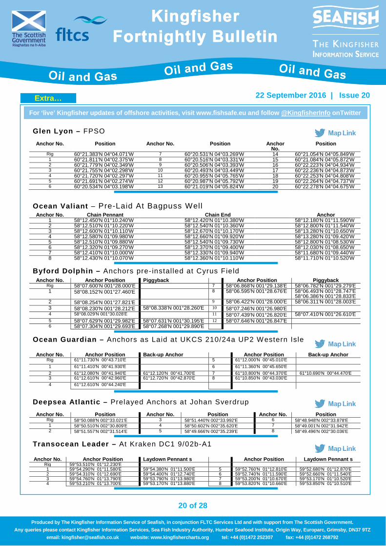
Extra…
20 of 28
For ‘live’ Kingfisher updates of offshore activities, visit www.fishsafe.eu and follow @KingfisherInfo onTwitter
22 September 2016 | Issue 20
Produced by The Kingfisher Information Service of Seafish, in conjunction FLTC Services Ltd and with support from The Scottish Government. Any queries please contact Kingfisher Information Services, Sea Fish Industry Authority, Humber Seafood Institute, Origin Way, Europarc, Grimsby, DN37 9TZ
email: [email protected] website: www.kingfishercharts.org tel: +44 (0)1472 252307 fax: +44 (0)1472 268792
Glen Lyon – FPSO
Anchor No. Position Anchor No. Position Anchor No.
Position
Rig 60°21.383'N 04°04.071'W 7 60°20.531'N 04°03.269'W 14 60°21.054'N 04°05.849'W 1 60°21.811'N 04°02.375'W 8 60°20.516'N 04°03.331'W 15 60°21.084'N 04°05.872'W 2 60°21.779'N 04°02.349'W 9 60°20.506'N 04°03.393'W 16 60°22.223'N 04°04.934'W 3 60°21.755'N 04°02.298'W 10 60°20.493'N 04°03.449'W 17 60°22.236'N 04°04.873'W 4 60°21.720'N 04°02.297'W 11 60°20.955'N 04°05.765'W 18 60°22.253'N 04°04.808'W 5 60°21.691'N 04°02.274'W 12 60°20.987'N 04°05.792'W 19 60°22.264'N 04°04.737'W 6 60°20.534'N 04°03.198'W 13 60°21.019'N 04°05.824'W 20 60°22.278'N 04°04.675'W
Ocean Valiant – Pre-Laid At Bagpuss Well
Anchor No. Chain Pennant Chain End Anchor 1 58°12.450'N 01°10.240'W 58°12.420'N 01°10.380'W 58°12.180'N 01°11.590'W 2 58°12.510'N 01°10.220'W 58°12.540'N 01°10.360'W 58°12.800'N 01°11.540'W 3 58°12.600'N 01°10.110'W 58°12.670'N 01°10.170'W 58°13.280'N 01°10.650'W 4 58°12.580'N 01°09.980'W 58°12.660'N 01°09.920'W 58°13.280'N 01°09.420'W 5 58°12.510'N 01°09.880'W 58°12.540'N 01°09.730'W 58°12.800'N 01°08.530'W 6 58°12.320'N 01°09.270'W 58°12.370'N 01°09.400'W 58°12.030'N 01°08.650'W 7 58°12.410'N 01°10.000'W 58°12.330'N 01°09.940'W 58°11.680'N 01°09.440'W 8 58°12.430'N 01°10.070'W 58°12.360'N 01°10.110'W 58°11.710'N 01°10.520'W
Byford Dolphin – Anchors pre- instal led at Cyrus Field
Anchor No. Anchor Position Piggyback Anchor Position Piggyback
Rig 58°07.600’N 001°28.000’E 7 58°06.868'N 001°29.138'E 58°06.782'N 001°29.279'E 1 58°08.152'N 001°27.460'E 8 58°06.595'N 001°28.676'E 58°06.493'N 001°28.747'E
58°06.386'N 001°28.833'E 2 58°08.254'N 001°27.821'E 9 58°06.422'N 001°28.000'E 58°06.311'N 001°28.003'E 3 58°08.230'N 001°28.212'E 58°08.338'N 001°28.260'E 10 58°07.246'N 001°26.980'E 4 58°08.029'N 001°30.028'E 11 58°07.439'N 001°26.820'E 58°07.410'N 001°26.610'E 5 58°07.629'N 001°29.982'E 58°07.631'N 001°30.195'E 12 58°07.646'N 001°26.847'E 6 58°07.304'N 001°29.693'E 58°07.268'N 001°29.890'E
Ocean Guardian – Anchors as Laid at UKCS 210/24a UP2 Western Isle
Anchor No. Anchor Position Back-up Anchor Anchor Position Back-up Anchor
Rig 61°11.730'N 00°43.710'E 5 61°12.000'N 00°45.010'E 1 61°11.410'N 00°41.930'E 6 61°11.360'N 00°45.650'E 2 61°12.080'N 00°41.940'E 61°12.120'N 00°41.700'E 7 61°10.800'N 00°44.370'E 61°10.690'N 00°44.470'E 3 61°12.610'N 00°42.960'E 61°12.720'N 00°42.870'E 8 61°10.850'N 00°43.030'E 4 61°12.610'N 00°44.240'E
Deepsea Atlantic – Prelayed Anchors at Johan Sverdrup
Anchor No. Position Anchor No. Position Anchor No. Position Rig 58°50.088'N 002°33.021'E 3 58°51.440'N 002°33.992'E 6 58°48.948'N 002°33.878'E 1 58°50.510'N 002°30.809'E 4 58°50.602'N 002°35.620'E 7 58°49.001'N 002°31.942'E 2 58°51.557'N 002°31.514'E 5 58°49.666'N 002°35.239'E 8 58°49.496'N 002°30.036'E
Transocean Leader – At Kraken DC1 9/02b-A1
Anchor No. Anchor Position Laydown Pennant s Anchor Position Laydown Pennant s
Rig 59°53.510'N 01°12.230'E 1 59°54.290'N 01°11.580'E 59°54.380'N 01°11.500'E 5 59°52.760'N 01°12.810'E 59°52.680'N 01°12.870'E 2 59°54.310'N 01°12.690'E 59°54.400'N 01°12.740'E 6 59°52.740'N 01°11.590'E 59°52.660'N 01°11.540'E 3 59°54.760'N 01°13.790'E 59°53.790'N 01°13.980'E 7 59°53.200'N 01°10.670'E 59°53.170'N 01°10.520'E 4 59°53.210'N 01°13.700'E 59°53.170'N 01°13.880'E 8 59°53.820'N 01°10.660'E 59°53.850'N 01°10.510'E
Extra…
21 of 28
For ‘live’ Kingfisher updates of offshore activities, visit www.fishsafe.eu and follow @KingfisherInfo onTwitter
22 September 2016 | Issue 20
Produced by The Kingfisher Information Service of Seafish, in conjunction FLTC Services Ltd and with support from The Scottish Government. Any queries please contact Kingfisher Information Services, Sea Fish Industry Authority, Humber Seafood Institute, Origin Way, Europarc, Grimsby, DN37 9TZ
email: [email protected] website: www.kingfishercharts.org tel: +44 (0)1472 252307 fax: +44 (0)1472 268792
Paragon MSS1 – Telford H2 Well
Anchor No. Anchor Position Laydown Pennant s Anchor Position Laydown Pennant s
Well 58°12.320'N 00°16.720'E 7 58°11.760'N 00°17.300'E 58°11.700'N 00°17.380'E 1 58°12.850'N 00°16.160'E 58°12.930'N 00°16.050'E 8 58°11.690'N 00°16.720'E 58°11.610'N 00°16.720'E 2 58°12.940'N 00°16.720'E 58°12.950'N 00°16.580'E 9 58°11.770'N 00°16.150'E 58°11.700'N 00°16.090'E 3 58°12.840'N 00°17.270'E 58°12.900'N 00°17.130'E 10 58°12.020'N 00°15.690'E 58°11.980'N 00°15.570'E 4 58°12.610'N 00°17.720'E 58°12.680'N 00°17.660'E 11 58°12.320'N 00°15.500'E 58°12.320'N 00°15.370'E 5 58°12.320'N 00°17.860'E 58°12.320'N 00°18.000'E 12 58°12.620'N 00°15.670'E 58°12.660'N 00°15.550'E 6 58°12.020'N 00°17.760'E 58°11.990'N 00°17.880'E
Borgsten Dolphin – Dunbar Plat form 3/14a Borgsten Dolphin due to leave for offhire in Cromarty Firth Port anchorage #4 on 1st October. No change yet but there will be next time.
Anchor No. Position Anchor No. Position Anchor No. Position Rig 60°37.660‘N 01°39.290‘E 5 60°37.820‘N 01°37.750‘E 10 60°37.390‘N 01°40.390‘E 1 60°36.930‘N 01°38.730‘E 6 60°37.930‘N 01°37.820‘E 11 60°37.290‘N 01°40.320‘E 2 60°37.000‘N 01°38.510‘E 7 60°38.350‘N 01°39.510‘E 12 60°37.190‘N 01°40.180‘E 3 60°37.060‘N 01°38.300‘E 8 60°38.300‘N 01°39.750‘E 4 60°37.700‘N 01°37.700‘E 9 60°38.250‘N 01°39.980‘E
Area 2 – Anchor List First Published: 10 March 2016 | Latest Update: 22 September 2016
West Phoenix – At Invergordon Anchorage West Phoenix at Offshore Invergordon Anchorage, Moray Firth with anchors deployed. Offhire from TEPUK, but TEPUK want to publish final position. The DP3 semi-submersible Rig West Phoenix is currently at an offshore Invergordon anchorage, Moray Firth
Anchor No. Position Anchor No. Position Anchor No.
Position
Rig 57°42.560'N 03°52.550'W 3 57°43.710'N 03°53.420'W 6 57°42.190'N 03°50.840'W 1 57°42.140'N 03°54.500'W 4 57°43.720'N 03°51.690'W 7 57°41.650'N 03°51.870'W 2 57°43.150'N 03°54.140'W 5 57°43.000'N 03°50.520'W 8 57°41.640'N 03°53.250'W
Stena Spey – As-Laid At Alma
Anchor No. Position Anchor No. Position Anchor No.
Position
Rig 56°11.890'N 002°45.750'E 3 56°12.260'N 002°46.930'E 6 56°11.060'N 002°44.930'E 1 56°11.530'N 002°45.330'E 4 56°11.680'N 002°46.990'E 7 56°11.640'N 002°43.820'E 2 56°12.660'N 002°46.250'E 5 56°11.170'N 002°46.270'E 8 56°12.260'N 002°43.840'E
Catcher FPSO – Construction vessels Skandi Skansen and Skandi Neptune working around and extending out approximately 1000m from the future Catcher FPSO
Anchor No. Position Anchor No. Position Anchor No. Position STP Buoy @ Future FPSO
56°46.207'N 000°42.782'E
1 56°46.573'N 000°42.093'E 5 56°46.457'N 000°43.780'E 9 56°45.713'N 000°42.755'E 2 56°46.602'N 000°42.136'E 6 56°46.423'N 000°43.804'E 10 56°45.719'N 000°42.687'E 3 56°46.630'N 000°42.182'E 7 56°46.387'N 000°43.824'E 11 56°45.728'N 000°42.620'E 4 56°46.655'N 000°42.233'E 8 56°46.350'N 000°43.840'E 12 56°45.739'N 000°42.555'E
Extra…
22 of 28
For ‘live’ Kingfisher updates of offshore activities, visit www.fishsafe.eu and follow @KingfisherInfo onTwitter
22 September 2016 | Issue 20
Produced by The Kingfisher Information Service of Seafish, in conjunction FLTC Services Ltd and with support from The Scottish Government. Any queries please contact Kingfisher Information Services, Sea Fish Industry Authority, Humber Seafood Institute, Origin Way, Europarc, Grimsby, DN37 9TZ
email: [email protected] website: www.kingfishercharts.org tel: +44 (0)1472 252307 fax: +44 (0)1472 268792
COSL Rival – Proposed Mooring at Judy30/7a COSL Rival located adjacent to the East face of the Judy Platform from 19th April for approx 6 months. Moorings are fitted with polyester inserts and subsea buoyancy and represent a significant snagging hazard to fishing vessel activity in the vicinity. Moorings have a circa 2km radius about the location
Anchor No. Position Anchor No. Position Anchor No. Position Alongside 56°41.791'N 002°20.319'E 4 56°42.870'N 002°19.365'E 9 56°42.406'N 002°21.890'E Standoff 56°41.807'N 002°20.355'E 5 56°42.897'N 002°19.526'E 10 56°41.361'N 002°21.830'E
1 56°40.927'N 002°19.690'E 6 56°42.945'N 002°20.077'E 11 56°41.193'N 002°21.599'E 2 56°41.102'N 002°19.457'E 7 56°42.757'N 002°21.099'E 12 56°41.061'N 002°21.267'E 3 56°41.250'N 002°19.161'E 8 56°42.583'N 002°21.519'E
Ocean Patriot – As Laid at Pierce A12 Well
Anchor No. Position Anchor No. Position Anchor No. Position Rig 57°10.081’N 002°15.560’E 5 57°09.323'N 002°16.412'E # 7 Pennant End 57°09.638'N 002°14.153'E 1 57°10.622'N 002°14.944'E # 5 Pennant End 57°09.263'N 002°16.466'E 8 57°10.298'N 002°14.428'E 2 57°10.691'N 002°15.793'E 6 57°09.382'N 002°15.260'E # 8 ROV Survey 57°10.362'N 002°14.457'E 3 57°10.369'N 002°16.396'E # 6 Pennant End 57°09.316'N 002°15.228'E 4 57°09.971'N 002°16.677'E 7 57°09.671'N 002°14.261'E
Safe Caledonia Flotel – At ETAP
Anchor No. Position Anchor No. Position Anchor No. Position Rig 57°17.576’N 001°39.588’E 4 57°17.170'N 001°37.220'E 8 57°17.884'N 001°41.775'E 1 57°16.250'N 001°39.942'E 5 57°18.740'N 001°38.764'E 9 57°16.292'N 001°40.303'E 2 57°16.236'N 001°39.646'E 6 57°18.806'N 001°39.416'E 10 57°17.412'N 001°37.130'E 3 57°17.012'N 001°37.388'E 7 57°18.179'N 001°41.507'E
Area 1 – Survey List Company & Vessels Towed Cable
Length / Depth Area Covered & Quad Blocks Duration
Gardline Geosurvey Limited Ocean Reliance
J8B2707
59°35.849'N 001°39.467'E 59°35.932'N 001°47.967'E 59°31.623'N 001°48.121'E 59°31.540'N 001°39.638'E
9 23/09/2016 - 30/04/2017
For 4 Days
Fugro Survey Ocean Reliance
60°39.901'N 003°05.873'W 60°39.902'N 002°55.993'W 60°35.215'N 002°56.002'W 60°35.214'N 003°05.859'W
205; 206 18/09/2015 - 31/10/2016
For 1 Day
PGS Geophysical ASA Ramforn Titan
C6AL9 1300m
3m
59°05.934'N 000°47.106'E 59°23.403'N 000°45.914'E 59°24.209'N 001°46.717'E 59°17.366'N 001°42.602'E 59°06.629'N 001°39.751'E
8 9 15/09/2016 - 30/11/2016
For 90 Days
Fugro Survey AS MV Fugro Galaxy
C6YY4 1300m
3m
59°30.922'N 001°01.155'E 59°38.673'N 001°01.014'E 59°38.734'N 001°15.827'E 59°30.983'N 001°15.915'E
9 06/09/2016 - 31/10/2016
For 10 Days
Fugro Survey Fugro Galaxy
1300m 3m
59°30.957'N 001°01.255'E 59°38.707'N 001°01.115'E 59°31.017'N 001°15.927'E 59°04.998'N 001°16.015'E
9 Late Sept For 7 - 10 Days
Gardline Geosurvey Sea Explorer
C6NG6 1200m
3m
60°19.722'N 003°32.747'W 60°15.941'N 003°25.016'W 60°12.104'N 003°32.620'W 60°15.878'N 003°40.350'W
205 01/08/2015 - 31/10/2016
For 7 Days
Fugro Survey Fugro Galaxy (TBC)
58°59.113'N 001°17.868'E 59°02.883'N 001°17.682'E 59°02.963'N 001°24.007'E 58°59.193'N 001°24.182'E
9; 16 August /Sept For 10 Days
StatoilUK Limited Nordnes - PHOG
59°35.532'N 001°02.880'E 59°35.626'N 001°03.378'E 59°35.374'N 001°03.564'E 59°35.279'N 001°03.067'E
9 27/07/2015 - 31/10/2016
For 2 Days
Extra…
23 of 28
For ‘live’ Kingfisher updates of offshore activities, visit www.fishsafe.eu and follow @KingfisherInfo onTwitter
22 September 2016 | Issue 20
Produced by The Kingfisher Information Service of Seafish, in conjunction FLTC Services Ltd and with support from The Scottish Government. Any queries please contact Kingfisher Information Services, Sea Fish Industry Authority, Humber Seafood Institute, Origin Way, Europarc, Grimsby, DN37 9TZ
email: [email protected] website: www.kingfishercharts.org tel: +44 (0)1472 252307 fax: +44 (0)1472 268792
PGS Geophysical ASA Nordic Explorer
C6TU3 Thor Assister
OZ2061
59°10.986'N 001°37.080'W 58°29.444'N 002°28.293'W 58°36.058'N 002°54.933'W 58°44.849'N 002°47.665'W 58°57.351'N 002°31.868'W 59°22.240'N 002°12.186'W 59°28.108'N 002°13.267'W 59°27.275'N 002°29.060'W 59°53.790'N 002°30.822'W 59°51.742'N 001°33.902'W 59°49.494'N 001°17.396'W 59°54.397'N 001°08.573'W 60°02.022'N 000°55.813'W 60°12.213'N 000°50.007'W 60°18.211'N 000°45.880'W 60°24.164'N 000°39.235'W
60°28.377'N 000°44.972'W 60°30.955'N 000°45.419'W 60°36.041'N 000°42.139'W 60°53.483'N 000°39.830'W 60°54.331'N 000°59.477'W 61°28.940'N 000°54.016'W 61°28.334'N 000°05.690'W 59°37.709'N 000°06.373'W 59°37.325'N 000°45.254'W 59°11.109'N 001°15.133'W 59°10.986'N 001°37.080'W
209; 1; 5; 6; 7; 12; 13
21/07/2015 - 30/11/2016
For 90 Days
EGS International Ltd ILV Granuaile
EIPT Coastworker
MHIU8
Section A 57°28.380’N 005°52.250’W 57°28.380’N 005°52.420’W 57°28.434’N 005°52.827’W 57°28.541’N 005°53.305’W 57°28.597’N 005°53.384’W 57°29.898’N 005°54.102’W 57°30.998’N 005°54.728’W 57°31.942’N 005°54.624’W 57°33.392’N 005°54.132’W 57°34.878’N 005°53.722’W 57°38.157’N 005°52.976’W 57°39.089’N 005°53.228’W 57°41.542’N 005°54.907’W 57°43.127’N 005°56.455’W 57°45.726’N 005°59.883’W 57°47.028’N 006°02.835’W 57°51.001’N 006°08.872’W 57°52.629’N 006°11.877’W 57°54.967’N 006°14.057’W 57°56.571’N 006°14.474’W 57°59.325’N 006°13.658’W 58°01.811’N 006°11.771’W 58°04.424’N 006°09.689’W 58°06.203’N 006°06.520’W 58°07.431’N 006°03.270’W 58°07.849’N 006°02.589’W 58°13.453’N 005°53.446’W 58°20.579’N 005°50.296’W 58°28.022’N 005°51.168’W 58°35.825’N 005°52.002’W
Section B 58°35.825’N 005°52.002’W 58°43.872’N 006°07.869’W 58°44.430’N 006°09.912’W 58°44.602’N 006°11.025’W 58°44.969’N 006°12.741’W 58°45.144’N 006°13.558’W 58°45.421’N 006°14.540’W 58°45.605’N 006°15.700’W 58°48.352’N 006°27.821’W 58°49.286’N 006°32.153’W 58°51.397’N 006°39.448’W 58°51.397’N 006°39.444’W 58°53.556’N 006°40.881’W 58°55.511’N 006°40.645’W 58°56.244’N 006°37.338’W 58°56.244’N 006°19.152’W 58°56.244’N 005°56.242’W
Section C 58°35.825’N 005°52.002’W 58°40.188’N 005°49.156’W 58°44.858’N 005°42.307’W 58°47.190’N 005°37.819’W 58°48.660’N 005°33.804’W 58°50.130’N 005°26.955’W 58°51.477’N 005°12.311’W 58°52.333’N 004°56.723’W
08/08/2016 - 15/10/2016
05/08/2016 Gardline Geosurvey
Sea Explorer C6NG6
1200m 3m
60°19.722'N 003°32.747'W 60°15.941'N 003°25.016'W 60°12.104'N 003°32.620'W 60°15.878'N 003°40.350'W
205
01/08/2016 Fugro Survey Fugro Galaxy (TBC)
58°59.113'N 001°17.868'E 59°02.883'N 001°17.682'E 59°02.963'N 001°24.007'E 58°59.193'N 001°24.182'E
9; 16
Subsea 7 Acergy Viking
JWLL
60°18.834'N 000°01.121'E 60°25.606'N 000°02.114'E 60°32.377'N 000°03.113'E 60°39.015'N 000°05.757'E 60°44.935'N 000°12.423'E 60°44.512'N 000°12.870'E 60°38.554'N 000°06.356'E 60°31.896'N 000°03.918'E 60°25.124'N 000°02.916'E 60°18.353'N 000°01.921'E 60°12.063'N 000°00.135'E 60°12.010'N 000°00.992'E 60°49.780'N 000°21.151'E 60°49.552'N 000°21.885'E 61°13.053'N 000°44.978'E 61°13.035'N 000°41.108'E 61°12.999'N 000°44.979'E
61°12.981'N 000°41.109'E 61°11.261'N 000°43.144'E 61°12.978'N 000°44.808'E 61°11.238'N 000°43.245'E 61°12.955'N 000°44.909'E 61°15.461'N 000°49.508'E 61°15.065'N 000°49.867'E 61°14.667'N 000°48.204'E 61°14.151'N 000°46.810'E 61°13.498'N 000°45.803'E 61°13.236'N 000°45.537'E 61°13.192'N 000°49.455'E 61°12.761'N 000°49.434'E 61°12.818'N 000°44.316'E 61°13.702'N 000°45.016'E 61°14.461'N 000°46.190'E 61°15.038'N 000°47.748'E
17/05/2016 - 31/12/2016
For 7 Days
25/07/2016 Gardline Geosurvey
Sea Explorer C6NG6
1200m 3m
60°06.386'N 004°16.323'W 60°10.265'N 004°08.827'W 60°06.518'N 004°01.064'W 60°02.647'N 004°08.562'W
204
Extra…
24 of 28
For ‘live’ Kingfisher updates of offshore activities, visit www.fishsafe.eu and follow @KingfisherInfo onTwitter
22 September 2016 | Issue 20
Produced by The Kingfisher Information Service of Seafish, in conjunction FLTC Services Ltd and with support from The Scottish Government. Any queries please contact Kingfisher Information Services, Sea Fish Industry Authority, Humber Seafood Institute, Origin Way, Europarc, Grimsby, DN37 9TZ
email: [email protected] website: www.kingfishercharts.org tel: +44 (0)1472 252307 fax: +44 (0)1472 268792
21/07/2016 Gardline Geosurvey
Sea Explorer C6NG6
75m 2m
60°13.539'N 003°58.008'W 60°12.241'N 003°48.060'W 60°04.739'N 003°52.016'W 60°06.032'N 004°01.931'W
205; 204
15/07/2016 PGS Geophysical
ASA Nordic Explorer
C6TU3 8500m / 50m
58°25.696'N 000°32.006'E 58°22.945'N 002°50.791'W 59°22.197'N 002°10.395'W 59°29.882'N 001°31.716'W 60°02.022'N 000°55.813'W 60°24.164'N 000°39.235'W 60°53.483'N 000°39.830'W 61°08.933'N 001°25.780'W 61°24.160'N 001°23.862'W
61°24.548'N 000°34.618'E 61°08.141'N 001°10.139'E 60°07.637'N 001°45.008'E 59°25.302'N 001°26.550'E 59°07.291'N 001°32.858'E 58°54.302'N 001°29.198'E 58°41.918'N 000°50.793'E 58°25.696'N 000°32.006'E
08/07/2016 Gardline Geosurvey
Limited Ocean Reliance
J8B2707
1300m 3m 58°19.370'N 000°43.452'E 15
27/06/2016 TOTAL E&P UK Ltd
Siem Daya 2 5BZQ3
Route Survey:
60°56.671'N 002°53.622'W 60°04.604'N 002°05.421'W
214/30, 206/4
22/06/2016 Fugro Survey Ltd Fugro Searcher
3EUY6 Along TEPUK existing pipelines
01/06/2016 Fugro Survey Ltd Fugro Searcher
3EUY6
60°03.714'N 001°58.026'E 60°04.259'N 001°59.083'E 60°03.696'N 002°00.244'E 60°03.151'N 001°59.186'E
3; 4
Area 2 – Survey List Company & Vessels Towed Cable
Length / Depth Area Covered & Quad Blocks Duration
Fugro Survey AS Fugro Galaxy
C6YY4 1300m
3m
57°55.791'N 000°15.364'E 58°02.165'N 000°04.441'E 57°56.344'N 000°07.333'E 57°49.988'N 000°03.401'E
20; 14; 21 01/10/2016 - 31/10/2016
For 10 Days
Gardline Surveys Ltd MV Kommandor
PBQW 57°57.594'N 000°53.660'E
58°17.350'N 000°12.349'E 21; 15 25/09/2016 - 09/10/2016
For 5 Days
Gardline Geosurvey Ltd Kommandor - PBQW 56°26.072'N 002°42.548'E
56°32.809'N 002°33.954'E 30 05/09/2016 - 04/12/2016
For 7 Days
GeoXYZ Skandi Constructor
C6ZH8
57°19.441'N 001°18.141'E 57°15.131'N 001°18.339'E 57°15.234'N 001°26.291'E 57°19.544'N 001°26.109'E
22 05/09/2016 - 04/12/2016
For 7 Days
PGS Geophysical ASA Ramform Vanguard
C6TU8 8500m 25m
57°11.162'N 002°19.139'E 56°40.298'N 002°34.415'E 56°35.327'N 002°17.911'E 56°37.323'N 002°09.528'E 56°27.094'N 001°35.365'E 56°30.079'N 001°26.197'E 56°54.815'N 001°23.439'E
22; 23; 29; 30 15/08/2016 - 30/09/2016
For 90 Days
PGS Exploration (UK) Limited Ramform Vanguard
C6TU8 8100m 25m
56°57.651'N 002°25.826'E 56°56.431'N 002°21.764'E 56°55.478'N 002°16.359'E 56°55.690'N 002°10.799'E 56°57.300'N 002°05.095'E 56°59.400'N 002°01.823'E 57°09.978'N 001°50.294'E 57°13.540'N 001°48.234'E 57°16.841'N 001°49.068'E 57°19.417'N 001°51.855'E 57°21.156'N 001°55.804'E 57°25.988'N 002°11.800'E
22; 23; 30 01/08/2016 - 30/11/2016
For 50 Days
Fugro Survey Ltd Fugro Meridian
C6QR4
57°49.693'N 001°47.589'E 57°49.739'N 001°52.639'E 57°46.999'N 001°47.679'E 57°47.045'N 001°52.723'E
22 30/07/2016 - 01/10/2016
For 10 Days
Extra…
25 of 28
For ‘live’ Kingfisher updates of offshore activities, visit www.fishsafe.eu and follow @KingfisherInfo onTwitter
22 September 2016 | Issue 20
Produced by The Kingfisher Information Service of Seafish, in conjunction FLTC Services Ltd and with support from The Scottish Government. Any queries please contact Kingfisher Information Services, Sea Fish Industry Authority, Humber Seafood Institute, Origin Way, Europarc, Grimsby, DN37 9TZ
email: [email protected] website: www.kingfishercharts.org tel: +44 (0)1472 252307 fax: +44 (0)1472 268792
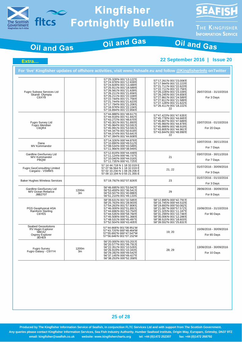
Fugro Subsea Services Ltd Skandi Olympia
C6XY8
57°25.328'N 001°13.122'E 57°24.978'N 001°12.839'E 57°24.828'N 001°13.489'E 57°25.911'N 001°18.589'E 57°26.561'N 001°21.639'E 57°26.211'N 001°21.656'E 57°26.211'N 001°22.339'E 57°22.744'N 001°21.756'E 57°21.744'N 001°21.623'E 57°17.794'N 001°21.206'E 57°16.978'N 001°22.156'E 57°16.894'N 001°22.856'E
57°17.261'N 001°23.006'E 57°17.944'N 001°22.223'E 57°21.711'N 001°22.623'E 57°22.711'N 001°22.756'E 57°26.228'N 001°23.339'E 57°26.245'N 001°24.656'E 57°27.861'N 001°24.589'E 57°27.811'N 001°21.589'E 57°27.128'N 001°21.622'E 57°26.411'N 001°18.222'E
22
26/07/2016 - 31/10/2016
For 3 Days
Fugro Survey Ltd Fugro Meridian
C6QR4
57°44.888'N 001°48.617'E 57°44.918'N 001°51.842'E 57°43.272'N 001°48.670'E 57°43.301'N 001°51.893'E 57°45.964'N 001°53.591'E 57°45.991'N 001°53.591'E 57°44.347'N 001°50.618'E 57°44.374'N 001°53.641'E 57°47.394'N 001°44.608'E
57°47.423'N 001°47.635'E 57°45.778'N 001°44.665'E 57°45.807'N 001°47.689'E 57°45.960'N 001°44.878'E 57°45.999'N 001°48.919'E 57°43.805'N 001°44.961'E 57°43.844'N 001°48.990'E
22
15/07/2016 - 01/10/2016
For 20 Days
Dana MV Kommandor
57°14.326'N 000°44.876'E 57°10.890'N 000°49.512'E 57°08.534'N 000°43.589'E 57°11.966'N 000°38.949'E
10/07/2016 - 30/11/2016
For 7 Days
Gardline GeoSurvey Ltd M/V Kommandor
PBQW
57°12.819'N 000°44.448'E 57°11.124'N 000°46.737'E 57°10.040'N 000°44.016'E 57°11.735'N 000°41.725'E
21 03/07/2016 - 30/11/2016
For 7 Days
Fugro GeoConsulting Limited Cargano - VSMW5
57 14 44.718 N 1 18 32.019 E 57 07 56.564 N 1 18 32.019 E 57 02 10.230 N 1 08 28.206 E 57 09 13.194 N 0 55 21.355 E
21; 22 01/07/2016 - 30/09/2016
For 3 Days
Baker Hughes Wireless Services 57°19.792'N 002°07.826'E 23 01/07/2016 - 01/10/2016
For 3 Days
Gardline GeoSurvey Ltd M/V Ocean Reliance
J8B2707 1200m
3m
56°46.695'N 001°53.942'E 56°53.459'N 001°36.541'E 56°53.507'N 001°40.886'E 56°51.210'N 001°49.133'E
29 28/06/2016 - 30/09/2016
For 8 Days
PGS Geophysical ASA Ramform Sterling
C6YE5
58°39.631'N 001°32.585'E 58°25.763'N 001°28.903'E 57°54.263'N 001°57.806'E 57°46.009'N 002°01.891'E 57°44.696'N 001°53.754'E 57°44.535'N 000°58.760'E 57°45.508'N 000°51.366'E 57°48.531'N 000°45.497'E 57°52.504'N 000°43.405'E
58°12.895'N 000°42.791'E 58°16.745'N 000°44.510'E 58°19.893'N 000°50.062'E 58°21.087'N 000°57.572'E 58°21.325'N 001°11.187'E 58°31.299'N 001°10.746'E 58°35.006'N 001°12.286'E 58°38.515'N 001°18.603'E 58°39.552'N 001°25.831'E
15/06/2016 - 31/10/2016
For 90 Days
Seabed Geosolutions RV Hugin Explorer
5BEA2 Osprey Explorer
3EHE9
57°44.668'N 001°08.951'W 57°43.720'N 000°48.464'W 57°55.692'N 000°47.547'W 57°56.646'N 001°07.152'W
19; 20 15/06/2016 - 30/09/2016
For 65 Days
Fugro Survey Fugro Galaxy - C6YY4
1200m 3m
56°20.000'N 001°03.201'E 56°20.577'N 001°06.791'E 56°22.351'N 001°10.526'E 56°26.919'N 001°10.343'E 56°29.282'N 000°49.542'E 56°37.145'N 000°49.427'E 56°38.253'N 000°52.358'E
28; 29 13/06/2016 - 30/09/2016
For 10 Days
Extra…
26 of 28
For ‘live’ Kingfisher updates of offshore activities, visit www.fishsafe.eu and follow @KingfisherInfo onTwitter
22 September 2016 | Issue 20
Produced by The Kingfisher Information Service of Seafish, in conjunction FLTC Services Ltd and with support from The Scottish Government. Any queries please contact Kingfisher Information Services, Sea Fish Industry Authority, Humber Seafood Institute, Origin Way, Europarc, Grimsby, DN37 9TZ
email: [email protected] website: www.kingfishercharts.org tel: +44 (0)1472 252307 fax: +44 (0)1472 268792
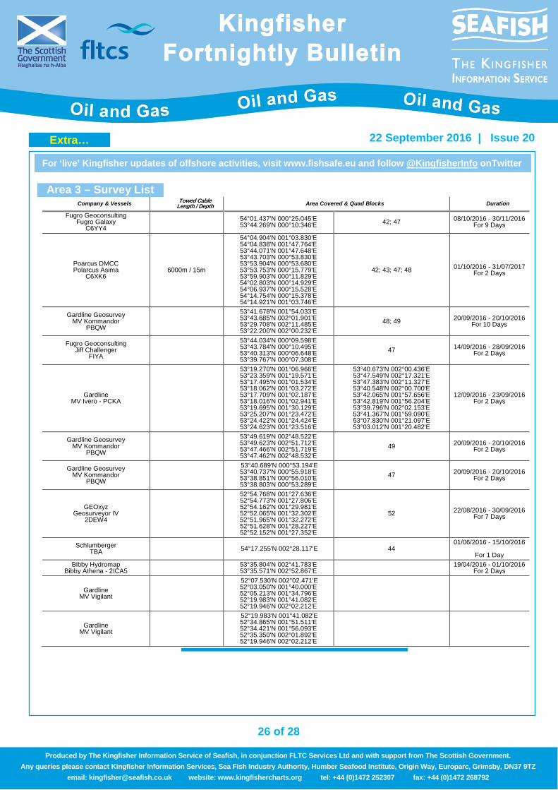
Area 3 – Survey List Company & Vessels Towed Cable
Length / Depth Area Covered & Quad Blocks Duration
Fugro Geoconsulting Fugro Galaxy
C6YY4 54°01.437'N 000°25.045'E
53°44.269'N 000°10.346'E 42; 47 08/10/2016 - 30/11/2016 For 9 Days
Poarcus DMCC Polarcus Asima
C6XK6 6000m / 15m
54°04.904'N 001°03.830'E 54°04.838'N 001°47.764'E 53°44.071'N 001°47.648'E 53°43.703'N 000°53.830'E 53°53.904'N 000°53.680'E 53°53.753'N 000°15.779'E 53°59.903'N 000°11.829'E 54°02.803'N 000°14.929'E 54°06.937'N 000°15.528'E 54°14.754'N 000°15.378'E 54°14.921'N 001°03.746'E
42; 43; 47; 48 01/10/2016 - 31/07/2017 For 2 Days
Gardline Geosurvey MV Kommandor
PBQW
53°41.678'N 001°54.033'E 53°43.685'N 002°01.901'E 53°29.708'N 002°11.485'E 53°22.200'N 002°00.232'E
48; 49 20/09/2016 - 20/10/2016 For 10 Days
Fugro Geoconsulting Jiff Challenger
FIYA
53°44.034'N 000°09.598'E 53°43.784'N 000°10.495'E 53°40.313'N 000°06.648'E 53°39.767'N 000°07.308'E
47 14/09/2016 - 28/09/2016 For 2 Days
Gardline MV Ivero - PCKA
53°19.270'N 001°06.966'E 53°23.359'N 001°19.571'E 53°17.495'N 001°01.534'E 53°18.062'N 001°03.272'E 53°17.709'N 001°02.187'E 53°18.016'N 001°02.941'E 53°19.695'N 001°30.129'E 53°25.207'N 001°23.472'E 53°24.422'N 001°24.424'E 53°24.623'N 001°23.516'E
53°40.673'N 002°00.436'E 53°47.549'N 002°17.321'E 53°47.383'N 002°11.327'E 53°40.548'N 002°00.700'E 53°42.065'N 001°57.656'E 53°42.819'N 001°56.204'E 53°39.796'N 002°02.153'E 53°41.367'N 001°59.090'E 53°07.830'N 001°21.097'E 53°03.012'N 001°20.482'E
12/09/2016 - 23/09/2016 For 2 Days
Gardline Geosurvey MV Kommandor
PBQW
53°49.619'N 002°48.522'E 53°49.623'N 002°51.712'E 53°47.466'N 002°51.719'E 53°47.462'N 002°48.532'E
49 20/09/2016 - 20/10/2016 For 2 Days
Gardline Geosurvey MV Kommandor
PBQW
53°40.689'N 000°53.194'E 53°40.737'N 000°55.918'E 53°38.851'N 000°56.010'E 53°38.803'N 000°53.289'E
47 20/09/2016 - 20/10/2016 For 2 Days
GEOxyz Geosurveyor IV
2DEW4
52°54.768'N 001°27.636'E 52°54.773'N 001°27.806'E 52°54.162'N 001°29.981'E 52°52.065'N 001°32.302'E 52°51.965'N 001°32.272'E 52°51.628'N 001°28.227'E 52°52.152'N 001°27.352'E
52 22/08/2016 - 30/09/2016 For 7 Days
Schlumberger TBA 54°17.255'N 002°28.117'E 44
01/06/2016 - 15/10/2016
For 1 Day Bibby Hydromap
Bibby Athena - 2ICA5 53°35.804'N 002°41.783'E 53°35.571'N 002°52.867'E 19/04/2016 - 01/10/2016
For 2 Days
Gardline MV Vigilant
52°07.530'N 002°02.471'E 52°03.050'N 001°40.000'E 52°05.213'N 001°34.796'E 52°19.983'N 001°41.082'E 52°19.946'N 002°02.212'E
Gardline MV Vigilant
52°19.983'N 001°41.082'E 52°34.865'N 001°51.511'E 52°34.421'N 001°56.093'E 52°35.350'N 002°01.892'E 52°19.946'N 002°02.212'E
Extra…
27 of 28
For ‘live’ Kingfisher updates of offshore activities, visit www.fishsafe.eu and follow @KingfisherInfo onTwitter
22 September 2016 | Issue 20
Produced by The Kingfisher Information Service of Seafish, in conjunction FLTC Services Ltd and with support from The Scottish Government. Any queries please contact Kingfisher Information Services, Sea Fish Industry Authority, Humber Seafood Institute, Origin Way, Europarc, Grimsby, DN37 9TZ
email: [email protected] website: www.kingfishercharts.org tel: +44 (0)1472 252307 fax: +44 (0)1472 268792
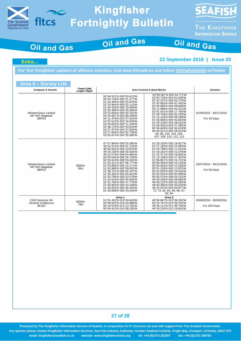
Area 4 – Survey List
Company & Vessels Towed Cable Length / Depth Area Covered & Quad Blocks Duration
WesternGeco Limited MV WG Magellan
5BPK2
50°46.521'N 005°09.613'W 50°54.734'N 005°21.377'W 51°23.465'N 005°32.878'W 51°23.964'N 005°52.113'W 51°44.429'N 006°19.058'W 52°25.496'N 005°45.560'W 53°22.694'N 005°30.252'W 54°15.687'N 003°58.268'W 54°11.478'N 003°27.524'W 54°02.513'N 003°18.029'W 53°43.822'N 003°11.240'W 53°48.175'N 003°43.918'W 53°27.473'N 004°37.826'W 53°17.694'N 004°52.738'W 53°05.874'N 004°35.066'W
53°00.567'N 004°34.771'W 52°50.729'N 004°53.595'W 52°42.207'N 004°53.279'W 52°42.663'N 004°41.443'W 52°30.980'N 004°09.668'W 52°11.988'N 004°43.412'W 52°01.541'N 005°17.783'W 51°49.709'N 005°30.255'W 51°24.218'N 005°09.268'W 51°28.065'N 004°40.844'W 51°29.228'N 004°28.022'W 51°06.450'N 004°27.483'W 50°49.849'N 004°49.619'W 50°46.521'N 005°09.613'W
94; 95; 102; 103; 104; 107; 108; 110; 112; 113
01/09/2016 - 30/11/2016
For 35 Days
WesternGeco Limited MV WG Magellan
5BPK2 8500m 30m
47°57.866'N 009°30.380'W 48°24.314'N 009°51.115'W 48°55.542'N 009°23.870'W 49°20.235'N 008°30.930'W 49°22.076'N 008°04.960'W 50°05.040'N 008°26.728'W 50°33.619'N 008°03.452'W 51°03.311'N 007°06.777'W 51°53.850'N 006°15.171'W 51°42.988'N 005°59.932'W 51°38.791'N 006°00.167'W 51°35.361'N 005°55.610'W 51°33.799'N 005°53.578'W 51°32.619'N 005°50.400'W 51°31.784'N 005°47.778'W 51°30.853'N 005°43.248'W 51°30.823'N 005°36.463'W 51°30.698'N 005°33.626'W
51°29.328'N 005°18.827'W 51°27.180'N 005°15.995'W 51°25.788'N 005°11.914'W 51°19.261'N 005°12.078'W 51°15.371'N 005°18.802'W 51°13.136'N 005°17.915'W 51°06.857'N 005°16.721'W 50°59.059'N 005°15.216'W 50°55.064'N 005°10.256'W 50°51.228'N 005°13.876'W 50°41.830'N 005°19.934'W 50°25.554'N 005°40.999'W 50°04.074'N 006°54.515'W 49°28.435'N 006°38.680'W 49°45.122'N 005°03.265'W 49°50.366'N 004°33.620'W 49°22.970'N 004°09.977'W 72; 73; 82; 83; 85; 86; 87;
93; 94
15/07/2016 - 30/11/2016
For 90 Days
CGG Services SA Oceanic Endeavour
3EJQ7 8000m TBA
Area 1 51°01.452'N 013°49.634'W 50°39.942'N 013°04.988'W 50°19.019'N 013°23.792'W 50°40.410'N 014°08.255'W
Area 2 49°58.667'N 013°38.292'W 50°15.767'N 012°06.202'W 49°35.111'N 011°48.764'W 49°18.234'N 013°19.603'W
20/06/2016 - 30/09/2016
For 100 Days
Extra…
28 of 28
For ‘live’ Kingfisher updates of offshore activities, visit www.fishsafe.eu and follow @KingfisherInfo onTwitter
22 September 2016 | Issue 20
Produced by The Kingfisher Information Service of Seafish, in conjunction FLTC Services Ltd and with support from The Scottish Government. Any queries please contact Kingfisher Information Services, Sea Fish Industry Authority, Humber Seafood Institute, Origin Way, Europarc, Grimsby, DN37 9TZ
email: [email protected] website: www.kingfishercharts.org tel: +44 (0)1472 252307 fax: +44 (0)1472 268792
Disclaimer and Limitation of Liability Whilst reasonable steps have been taken to ensure its accuracy, the data contained in this Bulletin (“Bulletin Data”) is not verified. Except to the extent required by law, the Seafish Industry Authority and FLTC Services Limited shall have no liability to You, meaning any person, firm, partnership, corporate body or any other legal person receiving or otherwise using, or benefitting from the use of, Bulletin Data for any damage or losses (including consequential losses) caused by any error or omission in the Bulletin Data. Notwithstanding the foregoing exclusion of liability, in the event that we are found liable to You, then our entire liability in such event, whether in contract, delict (including negligence) or otherwise, shall not exceed £10,000. The Admiralty Notices to Mariners should also be consulted.