Embed Size (px)
Citation preview
pag. 1G. ScaleraPaper submitted to Annals of Geophysics
The Sea Level Enigmatic Rising
New Perspectives from an Expanding Globe
Giancarlo Scalera
INGV – Istituto Nazionale di Geofisica e Vulcanologia, Via di Vigna Murata 605 – 00143Roma, Italy ([email protected])
Abstract. In the expanding Earth framework it is possible to find additional phenomenathat could contribute in a proper way to the water balance and general tectonic eustatisminvolved in the sea lever rising. Recent compilations seems to leave unexplained up to 12cm/century of sea rising, and possible solutions invoking a polar ice shells melting near tothe upper limit of the error bars reveal in confict with the consequent expected decreasingof the Earth angular velocity. It is shown that taking into account possible effects of anexpanding Earth, the problem can be initiated towards an appropriate solution, at least asregards the just orders of magnitude. Major effects on sea-level could come from ongoingrelaxation of curvature variations that are peculiar for an expanding globe.
Key words. Sea level rising – Expanding Earth – Lithospheric curvature variations –Tectonic eustatism – Global water balance
1. Introduction
Because a substantial expansion of theglobe must have consequences on the evo-lution of the oceanic basins and their con-tents, it is obvious to scrutinize if the re-sults of recent researches about sea levelrise and their unsolved problems can be ex-plained in the expanding Earth framework.
The expanding Earth is a conceptionthat should be considered the next step to-ward the true mobilism and a more com-plete evolutionistic view of Earth’s geo-logic processes – eventually to be an in-terpretative key also in planetology. Whileplate tectonics conserves an hidden her-itage of old fixist and contractionist ideas– especially in its orogenetic compres-sional corollary – that does not conflictwith previous Anglophon Academic tra-diction (Brouwer, 1981; Scalera, 2012a),instead, expanding Earth is providing newarmonic explanations for a number of phe-
nomena that were thinked to be splittedin two separated processes, like the moun-tain ranges and the mid-oceanic ridges, thesecular Polar Motion (PM) and the TruePolar Wander (TPW), and so on (Besse& Courtillot, 1991, 2002; Scalera, 2003,2006, 2012a, 2013).
What become important in this con-ception is the emissive activity of theplanet, which shows in volcanic erup-tions (Scalera, 2013), rising of megadykes(Ollier, 2003, 2012; Scalera, 2012d), reser-voirs of methane gas (Katz et al., 2008;Scalera, 2012b; among others) etc., be-sides an isostatic mechanism of mountainbuilding, without a large scale subduction(undreds of km of underthrust) but allow-ing for the overthrusting or underthrustingof few tens of km, often observed on thefield (Scalera, 2010, 2012d).
In this context of more radical evolu-tion of the planet, even the change of thesurface of the ocean floor (increasing, at
2 SCALERA: Sea Level Rising and Expanding Earth
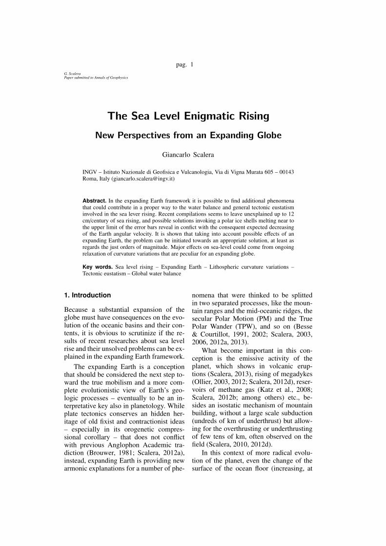
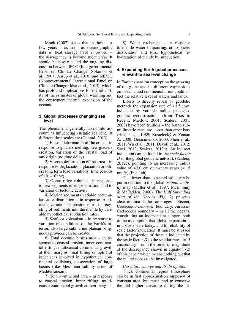
Fig. 1. – a) Values of the scale factor D – namelythe size of the geodetic network – at different years,with respect to the ITRF-2008 (data published in theIERS Technical Notes and Annual Reports). – b)The values of the radius variations annual rate ∆R/y,averaged on the time lapses from the indicated yearto 2008. With the exception of the probably spuriousvalues of 1988 and 1989, the series seems to indicatea value ≈0.15 cm/y. This means a total expansion of≈3.0 cm on 20 years. It is worthy to note that thisrate is in the order of magnitude of the discrepancyshown in equation (2) of this paper.
least from the beginning of the Mesozoic),the change in their water content, andchanges – both regional and global – in theshape of the Earth, should be considered inanalyzing the data of sea level.
2. Problems in sea level rise
It is a long time that the variation ofthe sea level has attracted the interest ofgeoscience community (e.g., Fairbridge,1961; Carey, 1981; Pugh, 1987; Hallam,1992; Aaron et al. 2010; Lambeck etal., 2010; among many others), but re-cent discussions about the rising of thesea level (Church, 2001, 2006; Munk,2002; Douglas & Peltier, 2002; Cazenave& Nerem, 2004; Miller & Douglas, 2004)have put in evidence the existence of aprobable discrepancy between the esti-
mated and measured sea level secular riseafter the end of the last little ice age earlyin the 19th century. Global sea level rise(GSLR) and its causes are then subjects ofan intense controversy called the attribu-tion problem (Miller & Douglas, 2004).
The total sea level rise ζT (t) (referredto the crust, which in turn can move ver-tically) is splitted in two parts, the firstlinked to variation of the amount of massof ocean water and the second to varia-tion of ocean volume (without variation ofmass):
ζT (t) = ζe(t) + ζs(t). (1)
The first term ζe(t) is called eustatic and isgenerally credited to be linked to:
i) – growth or melting of glaciers.
ii) – deposition of new snow cover onglaciers or creation of new glaciers.
iii) – creation or growing, and deple-tion or exhaustion of any kind of non-marine underground water reservoir andaquifer.
The second term ζs(t) is called stericand ascribed to the thermal expansion ofthe sea water.
Recent estimates of the global sea levelrise point to values of 1.5–2.0 mm/y, arate that should be distributed on the firstand second term of equation (1). The es-timates for possible maximum values ofthe two terms coming from glaciers melt-ing and thermal expansion of the salineoceanic water – as consequence of green-house effect – are both many times infe-rior to the needed (Munk, 2002; Miller &Douglas, 2004). The needed supplemen-tal heat storage in the oceans should be1024J per century, while an estimate ofonly 2.0·1023J per century is the maximumvalue allowed by data and theory, and thedifference between the measured (21 cm)and the maximum contribution eustatic (6cm) and steric (3 cm; due essentially togreenhouse) for the last century is
ζmeasured(2000) − ζe − ζgreenhouse =
= 21 − 6 − 3 = 12 cm. (2)
SCALERA: Sea Level Rising and Expanding Earth 3
Munk (2002) states that in these lastfew years – as soon as oceanographicdata in heat storage have improved –the discrepancy is become more crear. Itshould be also recalled the ongoing dis-cussion between IPCC (IntergovernmentalPanel on Climate Change; Solomon etal., 2007; Aarup et al., 2010) and NIPCC(Nongovernmental International Panel onClimate Change; Idso et al., 2013), whichhas profound implications for the reliabil-ity of the estimates of global warming andthe consequent thermal expansion of theoceans.
3. Global processes changing sealevel
The phenomena generally taken into ac-count as influencing eustatic sea level atdifferent time scales are (Conrad, 2013):
1) Elastic deformation of the crust – inresponse to glaciers melting, new glacierscreation, variation of the crustal load ofany origin (no time delay).
2) Viscous deformation of the crust – inresponse to deglaciation, glaciation or oth-ers long term load variations (time periodsof 103–105 yr).
3) Ocean ridge volume – in responseto new segments of ridges creation, and tovariation of tectonic activity.
4) Marine sediments variable accumu-lation or distruction – in response to cli-matic variation of erosion rates, or recy-cling of sediments into the mantle by vari-able hypothetical subduction rates.
5) Seafloor volcanism – in response tovariation of conditions of the Earth’s in-terior, also large submarine plateau or ig-neous provices can be created.
6) Total oceanic basins area – in re-sponse to coastal erosion, inner continen-tal rifting, multicausal continental growthat their margins, final filling or uplift ofinner seas involved in hypothetical con-tinental collisions, disseccation of largebasins (like Messinian salinity crisis ofMediterranean).
7) Total continental area – in responseto coastal erosion, inner rifting, multi-causal continental growth at their margins.
8) Water exchange – in responseto mantle water outpouring, atmosphericdissociation and loss, hypothetical re-hydratation of mantle by subduction.
4. Expanding Earth gobal processesrelevant to sea level change
In Earth expansion conception the growingof the globe and its different expressionson oceanic and continental areas could af-fect the relative level of waters and lands.
Efforts to directly reveal by geodeticmethods the expansion rate of ≈1.5 cm/yindicated by variable radius paleogeo-graphic reconstructions (from Trias toRecent; Maxlow, 2001; Scalera, 2001,2003) have been fruitless – the found sub-millimetric rates are lesser than error bars(Heki et al., 1989; Kostelecky & ZemanA. 2000; Gerasimenko, 2003, Shen et al.,2011; Wu et al., 2011; Devoti et al., 2012;Sarti, 2012; Scalera, 2012c). An indirectindication can be found in the scale factorD of the global geodetic network (Scalera,2012c), pointing to an increasing radiusvalue of ≈3.0 cm on twenty years (≈1.5mm/y) (Fig. 1ab).
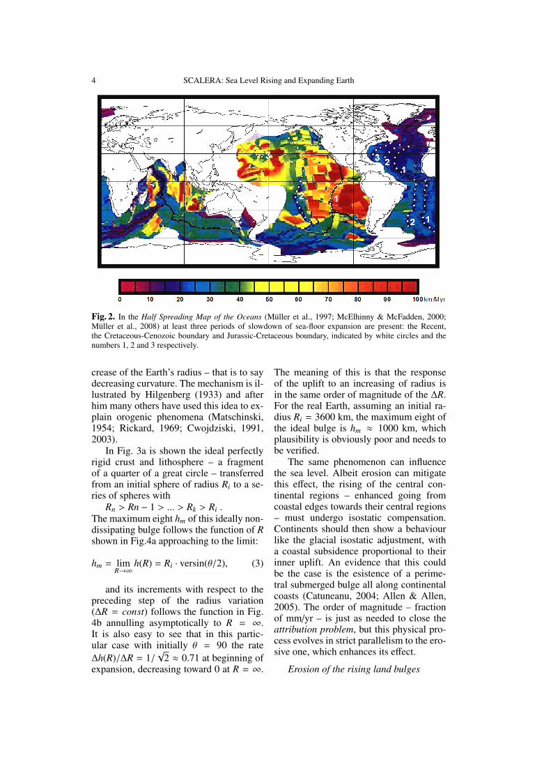
This lower than expected value can beput in relation to the global tectonic activ-ity map (Muller et al., 1997; McElhinny& McFadden, 2000). The Half SpreadingMap of the Oceans (Fig. 2) presentsclear minima at the same ages – Recent,Cretaceous-Cenozoic boundary, Jurassic-Cretaceous boundary – in all the oceans,constituting an independent support bothto the assumption that global expansion isin a stasis state today, and to reliability ofscale factor indication. It must be stressedthat the projection of the rate indicated bythe scale factor D to the secular rate – ≈15cm/century – is in the order of magnitudeof the discrepancy shown in equation (2)of this paper; which means nothing but thatthe matter needs to be investigated.
Curvature change and its dissipationThick continental region lithosphere
can be in first approximation supposed ofconstant area, but must tend to conservethe old higher curvature during the in-
4 SCALERA: Sea Level Rising and Expanding Earth
Fig. 2. In the Half Spreading Map of the Oceans (Muller et al., 1997; McElhinny & McFadden, 2000;Muller et al., 2008) at least three periods of slowdown of sea-floor expansion are present: the Recent,the Cretaceous-Cenozoic boundary and Jurassic-Cretaceous boundary, indicated by white circles and thenumbers 1, 2 and 3 respectively.
crease of the Earth’s radius – that is to saydecreasing curvature. The mechanism is il-lustrated by Hilgenberg (1933) and afterhim many others have used this idea to ex-plain orogenic phenomena (Matschinski,1954; Rickard, 1969; Cwojdziski, 1991,2003).
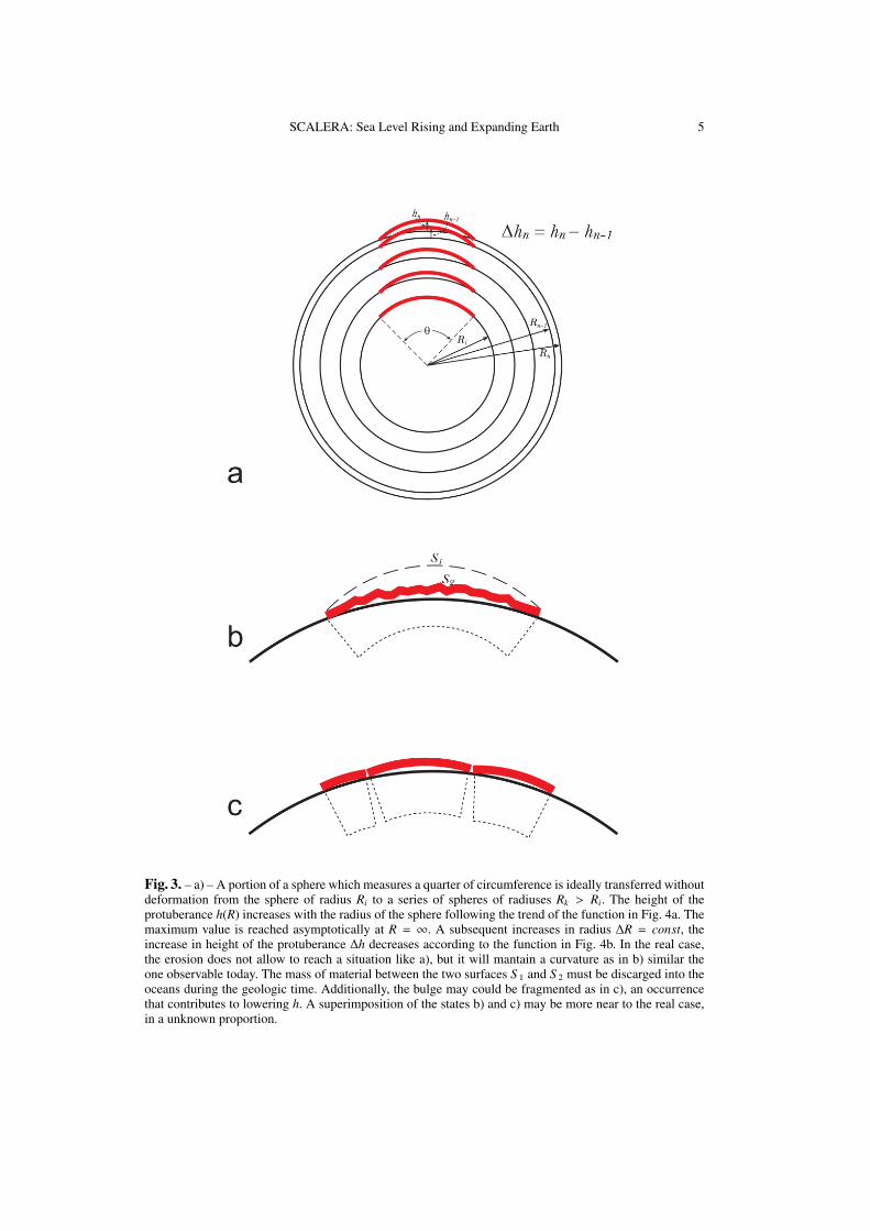
In Fig. 3a is shown the ideal perfectlyrigid crust and lithosphere – a fragmentof a quarter of a great circle – transferredfrom an initial sphere of radius Ri to a se-ries of spheres with
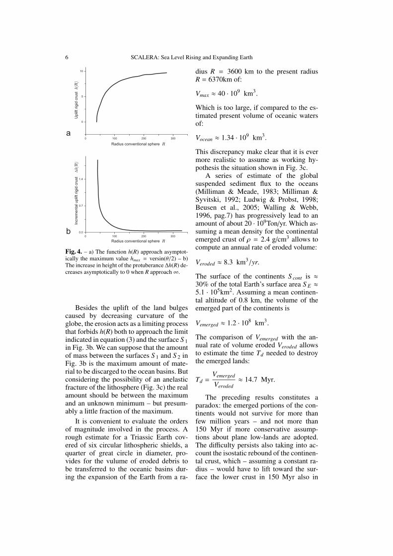
Rn > Rn − 1 > ... > Rk > Ri .The maximum eight hm of this ideally non-dissipating bulge follows the function of Rshown in Fig.4a approaching to the limit:
hm = limR→∞
h(R) = Ri · versin(θ/2), (3)
and its increments with respect to thepreceding step of the radius variation(∆R = const) follows the function in Fig.4b annulling asymptotically to R = ∞.It is also easy to see that in this partic-ular case with initially θ = 90 the rate∆h(R)/∆R = 1/
√2 ≈ 0.71 at beginning of
expansion, decreasing toward 0 at R = ∞.
The meaning of this is that the responseof the uplift to an increasing of radius isin the same order of magnitude of the ∆R.For the real Earth, assuming an initial ra-dius Ri = 3600 km, the maximum eight ofthe ideal bulge is hm ≈ 1000 km, whichplausibility is obviously poor and needs tobe verified.
The same phenomenon can influencethe sea level. Albeit erosion can mitigatethis effect, the rising of the central con-tinental regions – enhanced going fromcoastal edges towards their central regions– must undergo isostatic compensation.Continents should then show a behaviourlike the glacial isostatic adjustment, witha coastal subsidence proportional to theirinner uplift. An evidence that this couldbe the case is the esistence of a perime-tral submerged bulge all along continentalcoasts (Catuneanu, 2004; Allen & Allen,2005). The order of magnitude – fractionof mm/yr – is just as needed to close theattribution problem, but this physical pro-cess evolves in strict parallelism to the ero-sive one, which enhances its effect.
Erosion of the rising land bulges
SCALERA: Sea Level Rising and Expanding Earth 5
Fig. 3. – a) – A portion of a sphere which measures a quarter of circumference is ideally transferred withoutdeformation from the sphere of radius Ri to a series of spheres of radiuses Rk > Ri. The height of theprotuberance h(R) increases with the radius of the sphere following the trend of the function in Fig. 4a. Themaximum value is reached asymptotically at R = ∞. A subsequent increases in radius ∆R = const, theincrease in height of the protuberance ∆h decreases according to the function in Fig. 4b. In the real case,the erosion does not allow to reach a situation like a), but it will mantain a curvature as in b) similar theone observable today. The mass of material between the two surfaces S 1 and S 2 must be discarged into theoceans during the geologic time. Additionally, the bulge may could be fragmented as in c), an occurrencethat contributes to lowering h. A superimposition of the states b) and c) may be more near to the real case,in a unknown proportion.
6 SCALERA: Sea Level Rising and Expanding Earth
0 100 200 300
0
5
10
Uplif
t rigid
cru
st
h(R
)
Radius conventional sphere R
0 100 200 300
0.0
0.7
1.4
Incre
me
nta
l up
lift rig
id c
rust Dh(R)
Radius conventional sphere R
a
b
Fig. 4. – a) The function h(R) approach asymptot-ically the maximum value hmax = versin(θ/2) – b)The increase in height of the protuberance ∆h(R) de-creases asymptotically to 0 when R approach∞.
Besides the uplift of the land bulgescaused by decreasing curvature of theglobe, the erosion acts as a limiting processthat forbids h(R) both to approach the limitindicated in equation (3) and the surface S 1in Fig. 3b. We can suppose that the amountof mass between the surfaces S 1 and S 2 inFig. 3b is the maximum amount of mate-rial to be discarged to the ocean basins. Butconsidering the possibility of an anelasticfracture of the lithosphere (Fig. 3c) the realamount should be between the maximumand an unknown minimum – but presum-ably a little fraction of the maximum.
It is convenient to evaluate the ordersof magnitude involved in the process. Arough estimate for a Triassic Earth cov-ered of six circular lithospheric shields, aquarter of great circle in diameter, pro-vides for the vulume of eroded debris tobe transferred to the oceanic basins dur-ing the expansion of the Earth from a ra-
dius R = 3600 km to the present radiusR = 6370km of:
Vmax ≈ 40 · 109 km3.
Which is too large, if compared to the es-timated present volume of oceanic watersof:
Vocean ≈ 1.34 · 109 km3.
This discrepancy make clear that it is evermore realistic to assume as working hy-pothesis the situation shown in Fig. 3c.
A series of estimate of the globalsuspended sediment flux to the oceans(Milliman & Meade, 1983; Milliman &Syvitski, 1992; Ludwig & Probst, 1998;Beusen et al., 2005; Walling & Webb,1996, pag.7) has progressively lead to anamount of about 20 · 109Ton/yr. Which as-suming a mean density for the continentalemerged crust of ρ = 2.4 g/cm3 allows tocompute an annual rate of eroded volume:
Veroded ≈ 8.3 km3/yr.
The surface of the continents S cont is ≈30% of the total Earth’s surface area S E ≈5.1 · 105km2. Assuming a mean continen-tal altitude of 0.8 km, the volume of theemerged part of the continents is
Vemerged ≈ 1.2 · 108 km3.
The comparison of Vemerged with the an-nual rate of volume eroded Veroded allowsto estimate the time Td needed to destroythe emerged lands:
Td =Vemerged
Veroded≈ 14.7 Myr.
The preceding results constitutes aparadox: the emerged portions of the con-tinents would not survive for more thanfew million years – and not more than150 Myr if more conservative assump-tions about plane low-lands are adopted.The difficulty persists also taking into ac-count the isostatic rebound of the continen-tal crust, which – assuming a constant ra-dius – would have to lift toward the sur-face the lower crust in 150 Myr also in
SCALERA: Sea Level Rising and Expanding Earth 7
all the coastal regions, that is a fact un-acknowledged by geology. This problemcan be successful overcomed by assum-ing a process of continental steady emer-sion, enhanced toward their interior re-gions, caused by curvature variations –schematically shown in Fig. 3b and Fig. 3c– as effectively acting with continuity dur-ing the geologic time. This solution allowsfor an emersion of deep materials in theshields regions and forbids the same upris-ing along the coasts.
It is also interesting to evaluate howmuch volume of sediments V250 is dis-charged to oceans – if the actual rate ofglobal erosion is supposed constant – in250 Myr, namely the lapse of time of dou-bling of the Earth’s radius:
V250 = Veroded × 250Myr ≈ 2.1 · 109 km3,
which, reasonably, is
V250 ≈ 120 · Vmax , and h250 ≈ 1
20 · hm ,
providing a rough evaluation of the real an-nual bulging hannual due to curvature de-creasing.
hannual ≈h250
250 Myr≈
≈ 0.2 mm/yr = 2.0 cm/century,
again in the needed order of magnitude tobe useful to close equation (2).
The expanding global ocean basinAdopting the expanding Earth frame-
work, the surface of the oceans mustbe considered not as a constant but asa variable. Their total surface has in-creased starting from Triassic, from a smallamount to the actual one. Several clueshave been found (Dickins et al., 1992) thatalso the depth of the oceans has increasedfrom few hundreds of meters – essentiallyas shallow epicontinental seas – to their ac-tual mean depth of 4000 m – but deeperthan 10000 m in the trench zones.
This expansion, beside the assumptionof a rough constancy of the waters volume,has led many expansionists (e.g. Egyed,1956) to consider that a regression of the
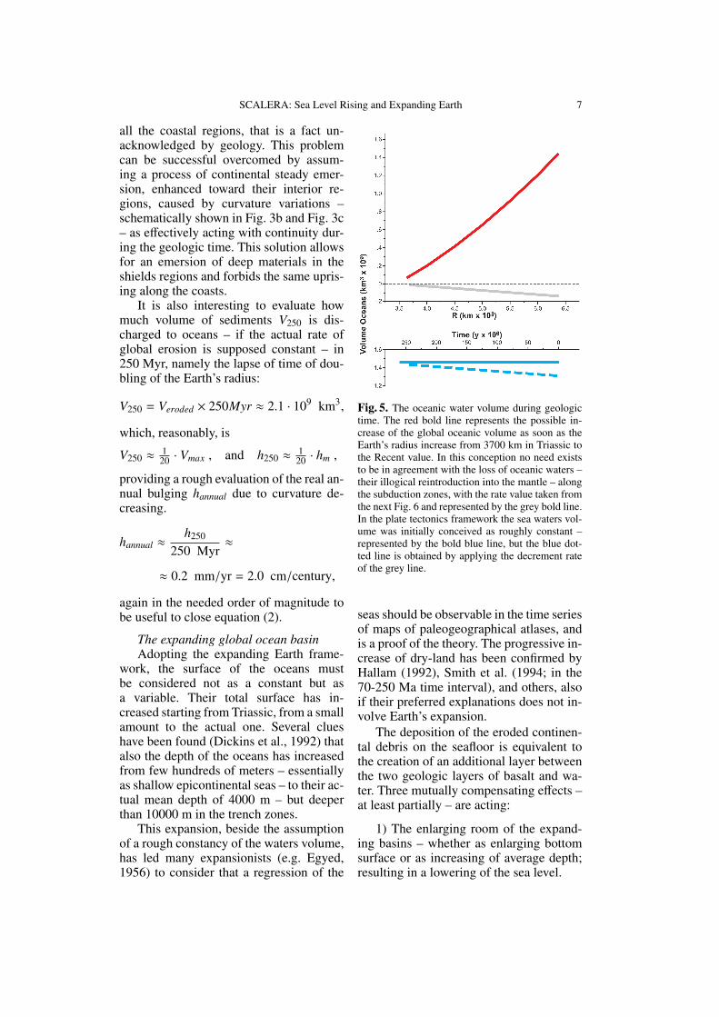
Fig. 5. The oceanic water volume during geologictime. The red bold line represents the possible in-crease of the global oceanic volume as soon as theEarth’s radius increase from 3700 km in Triassic tothe Recent value. In this conception no need existsto be in agreement with the loss of oceanic waters –their illogical reintroduction into the mantle – alongthe subduction zones, with the rate value taken fromthe next Fig. 6 and represented by the grey bold line.In the plate tectonics framework the sea waters vol-ume was initially conceived as roughly constant –represented by the bold blue line, but the blue dot-ted line is obtained by applying the decrement rateof the grey line.
seas should be observable in the time seriesof maps of paleogeographical atlases, andis a proof of the theory. The progressive in-crease of dry-land has been confirmed byHallam (1992), Smith et al. (1994; in the70-250 Ma time interval), and others, alsoif their preferred explanations does not in-volve Earth’s expansion.
The deposition of the eroded continen-tal debris on the seafloor is equivalent tothe creation of an additional layer betweenthe two geologic layers of basalt and wa-ter. Three mutually compensating effects –at least partially – are acting:
1) The enlarging room of the expand-ing basins – whether as enlarging bottomsurface or as increasing of average depth;resulting in a lowering of the sea level.
8 SCALERA: Sea Level Rising and Expanding Earth
2) The filling of this expanding roomby continental sediment flux; resulting in arising of the sea level.
3) The subsidence of the sea floor dueto the isostatic readjustment in response tothe increased sedimentary load; resultingin a lowering of the sea level.
For roughly evaluate the effect on sealevel of process 1), an arbitrary assump-tion can be a linear increase of the Earth’sradius in the time lapse Triassic-Recent– about 250 Myr. A second arbitrary as-sumption is that in first approximation thesurface area of the continents is a constant.The third assumption is the costance of theerosion products that are transported intothe oceans.
The function of the increasing oceansvolume from Triassic to Recent is
Voce(R) = (S sphere(R) − S con) × hoce(R).
In first approximation, assuming the meandepth of the oceans hoce = const = 4 km,
Voce = (4πR2 − S con) × 4.0 km,
which function is shown in Fig. 5.The function is nearly linear and indi-
cate an annual rate of volume increase of
∆Voce ≈ 5.6 km3/y, (4)
without an average change of the sea level.
5. Not closed water cycle: mantlewater content
A further main philosophical differencebetween plate tectonics and expandingEarth is about the not closed water cycle.Both conceptions agree that the global wa-ter cycle is not closed, but in a substantialdifferent sense.
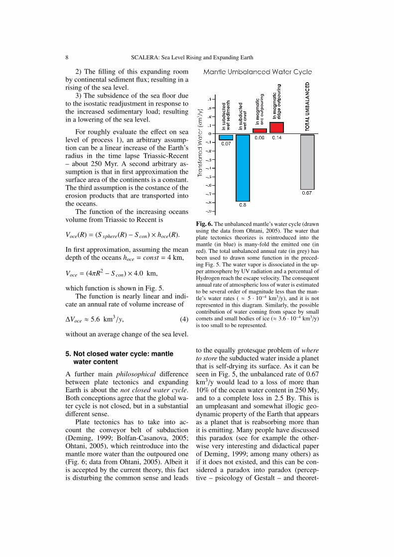
Plate tectonics has to take into ac-count the conveyor belt of subduction(Deming, 1999; Bolfan-Casanova, 2005;Ohtani, 2005), which reintroduce into themantle more water than the outpoured one(Fig. 6; data from Ohtani, 2005). Albeit itis accepted by the current theory, this factis disturbing the common sense and leads
Fig. 6. The unbalanced mantle’s water cycle (drawnusing the data from Ohtani, 2005). The water thatplate tectonics theorizes is reintroduced into themantle (in blue) is many-fold the emitted one (inred). The total unbalanced annual rate (in grey) hasbeen used to drawn some function in the preced-ing Fig. 5. The water vapor is dissociated in the up-per atmosphere by UV radiation and a percentual ofHydrogen reach the escape velocity. The consequentannual rate of atmospheric loss of water is estimatedto be several order of magnitude less than the man-tle’s water rates ( ≈ 5 · 10−4 km3/y), and it is notrepresented in this diagram. Similarly, the possiblecontribution of water coming from space by smallcomets and small bodies of ice (≈ 3.6 · 10−4 km3/y)is too small to be represented.
to the equally grotesque problem of whereto store the subducted water inside a planetthat is self-drying its surface. As it can beseen in Fig. 5, the unbalanced rate of 0.67km3/y would lead to a loss of more than10% of the ocean water content in 250 My,and to a complete loss in 2.5 By. This isan umpleasant and somewhat illogic geo-dynamic property of the Earth that appearsas a planet that is reabsorbing more thanit is emitting. Many people have discussedthis paradox (see for example the other-wise very interesting and didactical paperof Deming, 1999; among many others) asif it does not existed, and this can be con-sidered a paradox into paradox (percep-tive – psicology of Gestalt – and theoret-

SCALERA: Sea Level Rising and Expanding Earth 9
ical). The positive aspect of these inves-tigations (Bolfan-Casanova, 2005; Ohtani,2005; Hirschmann, 2006; Hirschmann &Kohlstedt, 2012) is that – reversing theglove – there can be better understoodthe storage regions from where the watersare uplifted towards the surface (Wyllie,1971).
As that concerns the relevance of thisunbalanced loss of water on the problemsof the sea level variations, the prevailingof reintroduction of water into the man-tle (Ohtani, 2005) upon the outpouring ofwater at arcs and midoceanic ridges caneventually deflect the bold blue line of Fig.5, and applying the decrement rate of thegrey line, the blue dotted line is obtained.The ocean volume should had decreased of≈ 0.17 × 10⁹ km3 in 250 My, like to say atotal decrease of sea level of ≈ 0.48 km,which is a negligible secular lowering of≈ 0.02 cm/century in equation (2).
In the expanding Earth concep-tion without subduction (Vogel, 1984;Cwojdziski, 2003; Maxlow, 2001; amongothers) or without large scale subduction(Scalera, 2010), a relevant reintroductionof water into the mantle is not allowed.The annual rate of water volume increase– ∆Voce ≈ 5.6 km3/y (equation (4)) – ismore than 25 times the estimated annualrate of water outpouring in magmatism ofarcs and ridges (Fig. 6). Consequently twonot mutually excluding processes can beenvisaged:
i) A greater rate of outpouring must behypothesized. The ocean bottoms are stilltoday largely unexplored and the possibil-ity exists of a very large number of unde-tected spot-like or diffused sources of juve-nile water. This hypothesis is strengthen bythe interpretation of the thrench-arc zonesas regions of uplift of deep mantle materi-als, possibly hydrated, releasing water in amiriad of ocean bottom sources. Also theland sources of juvenile water should bereassessed in their real percent of content.
ii) A greater rate of tectonic activ-ity in the geologic time lapses indi-cated in the Half Spreading Map of theOceans (Muller et al., 1997; McElhinny &
McFadden, 2000), where at least two pe-riods of enhanced sea-floor expansion arepresent intercalated between the minimaof Recent, Cretaceous-Cenozoic boundaryand Jurassic-Cretaceous boundary (Fig. 2).A strongly enhanced emission of juvenilewater should be expected in this more tec-tonically active periods.
The enlarging room of the oceanicbasins should have evolved in average syn-chrony with the water mantle outpouring –or coming from other sources – (red linein Fig. 5), a synchrony process that maybe has been favoured by the isostatic ad-justment of the ocean bottom depth (moreemission leading to more high sea leveland consequent isostatic depression of sea-bottom – the deep oceans has been cre-ated by the waters). We cannot admit thatthis synchrony is perfect along the geo-logic time axis, but it can be supposed thatsome phase shift may occur. For examplebeside a stasis of global expansion and tec-tonic activity (Fig. 2) two different hypoth-esis about the water mantle emission canbe formulated: i) a parallel stasis of thisemission, ii) a more or less intense prolon-gation of the emission. An upper limit canbe then evaluated for the sea level changefrom equation (4), assuming a steady fill-ing water flux of 5.6 km3/y in a situa-tion of constant oceanic basins surface of360.7 × 106 km2:
∆hoce ≈ 0.15 cm/century,
an the order of magnitude lesser than thevalues that can be taken into account toclose equation (2). This means that the av-erage water supply indicated by (4) is notsufficient to sustain a non-negligible por-tion of recent sea-level rise. Only hypothe-sizing a link between a stasis of the globalexpansion and an intensified orogenic ac-tivity (see the proposed orogenic modelin: Scalera, 2007a, 2010, 2012d) an higherflow of juvenile mantle’s water can be sus-pected. However, a two order of magni-tude higher mantle water outpouring in or-der to get values relevant for equation (2)is hardly conceivable.
10 SCALERA: Sea Level Rising and Expanding Earth
6. Not closed water cycle:atmosphere water content
A subject never completely defined is thestudy of the rates of arrive, formation andloss of chemical species in the upper at-mosphere. Water can be transported in thisregion from below or from the externalspace.
The comets have been suggested asan important supply of water to ourplanet (Frank et al., 1986; Lebedinets& Kurbanmuradov, 1992; Deming, 1999;among others). Time by time, this sup-ply would be episodic, somewhat catas-trophic (Shields, 1988), accompained bysudden ingressions and slow regressions ofthe seas, or more continuous, powered byfrequent fall of cosmic ice meteors (Berczi& Lukacs, 2001).
It has been evaluated that 103 tons tomore than 104 tons – at least an order ofmagnitude of uncertainty (!) – of meteoricmaterial falls on the Earth each day andthat a substantial portion of it or a com-parable additional amount could be consti-tuted by icy bodies, which are more dif-ficult to detect because they, with few ec-ceptions, completely vaporize. If arbitrar-ily the upper value 104 tons/day is assumedfor the icy bodies, it can be derived a valueof 0.000365 km3/y, a small percentage ofthe mantle water supplies represented (redbars) in Fig. 6, that however must be con-sidered a value possibly subject to futureincreasing re-evaluation.
For what concerns the possible loss ofwater to outer space, remember that the to-tal content of water in the Earth’s atmo-sphere is estimated to be only 0.001 % ofthe total water content of the hydrosphere.This amount is several order of magnitudegreater than the amounts shown in Fig.6. Then, an incorrect deduction would bethat the loss for photodissociation and hy-drogen escape out of the atmosphere musttherefore be a very small and negligiblepercentage, because atmosphere is conti-nously replenished by water vapour fromoceans (97.3 %), glaciers (2.1 %), lands(0.6 %), and biologic organisms (0.00004%) (Lenz, 2013). In addition, some plan-
ets have lost their atmosphere in depen-dence of their particular condition of pres-sure and temperature. We only can hopethat the percentage is small. Indeed, recentestimate points to a water loss of 5 · 1011
grams lost each year by photodissociation(Brinkmann, 1969; Hunten & Donahue,1976; Hunten et al., 1989; Lenz, 2013),which is about 6.5 · 10−4 km3/y, an amountseveral order of magnitude smaller than theamounts shown in Fig. 6, and which shouldbe considered an upper limit because oxi-gen can recombine with hydrogen of dif-ferent origin to build new water molecules.
It is possible to conclude that, with thepresent level of knowledge, we have not tocare of the possible water supply from ex-ternal space or loss of water by photodisso-ciation. At least today, sea level is affectedby these phenomena in a negligible man-ner, independently of any global tectonicstheory.
7. Different rotational effects
The consequences of the melting of the ofpolar ice sheets and of other glaciers hasbeen considered by Munk (2002) in hisconcluding remarks:
The rotational evidence, although con-voluted, appears to rule out a largeeustatic contribution from melting onAntarctica and Greenland, assumingthat the measured J2 is representative ofthe 20th century. However, an enhancedcontribution from glacial melting andother midlatitude sources is NOT ruledout by the rotational evidence.
Albeit this is not the paper in which totry resolving in full details these discrep-ancies, it must be stressed that the effectsof the combined global expansion and iso-static relaxation of the persistent curvaturebulges could be very different in compari-son to those caused by the melting of theice caps. The ice melting produces a trans-ferring of water from high latitudes to-wards intermediate and low latitudes. Theflow of eroded materials from continentsand the isostatic variations of the level oflands and ocean bottoms could lead to still
SCALERA: Sea Level Rising and Expanding Earth 11
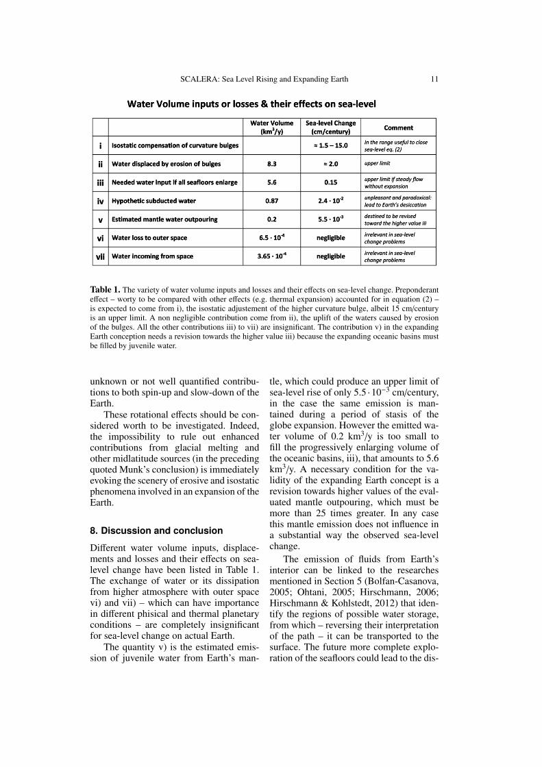
Table 1. The variety of water volume inputs and losses and their effects on sea-level change. Preponderanteffect – worty to be compared with other effects (e.g. thermal expansion) accounted for in equation (2) –is expected to come from i), the isostatic adjustement of the higher curvature bulge, albeit 15 cm/centuryis an upper limit. A non negligible contribution come from ii), the uplift of the waters caused by erosionof the bulges. All the other contributions iii) to vii) are insignificant. The contribution v) in the expandingEarth conception needs a revision towards the higher value iii) because the expanding oceanic basins mustbe filled by juvenile water.
unknown or not well quantified contribu-tions to both spin-up and slow-down of theEarth.
These rotational effects should be con-sidered worth to be investigated. Indeed,the impossibility to rule out enhancedcontributions from glacial melting andother midlatitude sources (in the precedingquoted Munk’s conclusion) is immediatelyevoking the scenery of erosive and isostaticphenomena involved in an expansion of theEarth.
8. Discussion and conclusion
Different water volume inputs, displace-ments and losses and their effects on sea-level change have been listed in Table 1.The exchange of water or its dissipationfrom higher atmosphere with outer spacevi) and vii) – which can have importancein different phisical and thermal planetaryconditions – are completely insignificantfor sea-level change on actual Earth.
The quantity v) is the estimated emis-sion of juvenile water from Earth’s man-
tle, which could produce an upper limit ofsea-level rise of only 5.5 ·10−3 cm/century,in the case the same emission is man-tained during a period of stasis of theglobe expansion. However the emitted wa-ter volume of 0.2 km3/y is too small tofill the progressively enlarging volume ofthe oceanic basins, iii), that amounts to 5.6km3/y. A necessary condition for the va-lidity of the expanding Earth concept is arevision towards higher values of the eval-uated mantle outpouring, which must bemore than 25 times greater. In any casethis mantle emission does not influence ina substantial way the observed sea-levelchange.
The emission of fluids from Earth’sinterior can be linked to the researchesmentioned in Section 5 (Bolfan-Casanova,2005; Ohtani, 2005; Hirschmann, 2006;Hirschmann & Kohlstedt, 2012) that iden-tify the regions of possible water storage,from which – reversing their interpretationof the path – it can be transported to thesurface. The future more complete explo-ration of the seafloors could lead to the dis-
12 SCALERA: Sea Level Rising and Expanding Earth
covery of a larger set of localized or dif-fused sources of juvenile mantle’s water, ora reassessment of the juvenile water con-tent of the exiting sources.
Major effects on sea-level could comeonly from i) and ii) (Table 1), which arelinked to ongoing curvature variations. Thevalue i) of 15 cm/century is obviously anupper limit, but also a fraction of it, be-sides the value ii) coming from the ero-sive discarge to oceans of the bulges, cancontribute to remove the difficoulties high-lighted by Munk (2002), Douglas & Peltier(2002), Miller & Douglas (2004).
The possibility to proof – at least as fit-ting order of magnitude – that in the ex-panding Earth framework it is possible tofind additional phenomena that could con-tribute in a proper way to the water balanceinvolved in the sea lever rising, should beconsidered a further support to the conceptof global emmitting Earth, which is a con-cept that underlies the more general one ofthe expanding Earth.
This paper has no pretense to provide adetailed quantitative account of the effectscaused by the curvature change on sea-level. Its aim are limited to scrutinize theinvolved magnitude orders and to comparethem with the already recognized physi-cal processes – like thermal expansion –that are cause of sea-level change. The ex-istence of unaccounted global geophysicalprocesses linked to an expanding Earth canproduce discrepancies in main-stream the-ories of sea level rise, and, as a matter offacts, this is the situation of the presentday comparison between theory and obser-vations. These discrepancies will presum-ably found a way toward their solution ifnew research lines will start that take intoaccount the global isostatic and emissivephenomena of an expanding planet.
Acknowledgements. Albeit I do not know him per-sonally, I am greatly indebted to Walter Munk forhaving instilled in me the belief (a meme that hasacted on my mind long after reading of his work in2002) that the unsolved problems of the change ofthe sea level would be discussed taking additionallyinto account an expansion of the globe.
ReferencesAarup, T., Church J.A., Wilson W.S., Woodworth
P.L. (2010). Sea-level Rise and Variability –A Summary for Policy Makers, UNESCO/IOC,Paris, 12 p.
Allen, P.A., and Allen, J.R. (2005). Basin Analysis:Principles and Applications, 2nd ed., BlackwellPublishing, 549 pp.
Berczi, Sz., Lukacs, B. (2001). Existence, sur-vival and recognition of icy meteorites onantarctica with respect to palaeotemperatures,Acta Climatologica et Chorologica, UniversitatisSzegediensis, Vol. 34-35, 51-68.
Besse, J., and Courtillot, V. (1991). Revised andsynthetic Apparent Polar Wander Paths of theAfrican, Eurasian, North American and IndianPlates, and True Polar Wander since 200 Ma,Jour. Geophys. Res., 96, 4029-4050.
Besse, J., and Courtillot, V. (2002). Apparent andtrue polar wander and the geometry of thegeomagnetic field over the last 200 Myr, J.Geophys. Res., 107 (B11), 2300, doi:10.1029/2000JB000050.
Beusen, A.H.W., Dekkers, A.L.M., Bouwman,A.F., Ludwig, W., Harrison, J. (2005).Estimation of global river transport of sed-iments and associated particulate C, N, and P,Global Biogeochemical Cycles, 19, GB4S05,doi:10.1029/2005GB002453, 1-17.
Bolfan-Casanova, N. (2005). Water in the Earth’smantle. Mineralogical Magazine, 69 (3), 229-257.
Brinkmann, R.T. (1969). Dissociation of watervapour and evolution of oxygen in the terrestrialatmosphere, Journal of Geophysical Research,74 (23), 5355-5368.
Brouwer, A. (1981). From Eduard Suess to AlfredWegener, Geologische Rundschau, 70 (1), 33-39.
Carey, S.W. (1981). Causes of sea-level oscillations,in: Frakes, L.A. (ed.): Victoria’s coasts and con-tinental shelf, Proceedings of the Royal Societyof Victoria, 92 (1), 13-17.
Cazenave, A., Nerem R.S. (2004). Present-day sea level change: Observations andcauses, Reviews of Geophysics, 42, RG3001,doi:10.1029/2003RG000139, 20 pp.
Catuneanu, O. (2004). Retroarc foreland systems –evolution through time, Geological Society ofAfrica Presidential Review No. 7, Journal ofAfrican Earth Sciences, 38 (3), 225-242.
Church, J., Gregory, J.M., Huybrechts, P., Kuhn, M.,Lambeck, K., Nhuan, M.T., Qin, D., Woodworth,P.L. (2001). Changes in sea level, in: J.T.Houghton et al. (eds.) Climate Change 2001:The Scientific Basis. Contribution of WorkingGroup I to the Third Assessment Report ofthe Intergovernmental Panel on Climate Change,Cambridge Univ. Press, New York, 639-693.
Church, J.A., and N.J. White (2006). A 20thcentury acceleration in global sea-level
SCALERA: Sea Level Rising and Expanding Earth 13
rise, Geophys. Res. Lett., 33, L01602,doi:10.1029/2005GL024826.
Conrad, C.P. (2013). The solid Earth’s influence onsea level, GSA Bulletin, 125 (7/8), 1027-1052.
Cwojdziski, S. (1991). Zmniejszanie krzywiznypowierzchni ekspanduj¸ acej Ziemi jedn¸ a zmoyzliwych przyczyn tektogenezy (Decreasingof the expanding Earth surface curvature a possi-ble causes of tectogenesis), Acta Univ. Wratisl.,1375, 327-356.
Cwojdziski, S. (2003). The tectonic structure of thecontinental lithosphere considered in the lightof the expanding Earth theory – A proposalof a new interpretation of deep seismic data,Polish Geological Institute Special Papers n◦9,Warszawa, 80 pp.
Deming, D. (1999). On the possible influenceof extraterrestrial volatiles on Earth’s climateand the origin of the oceans, Palaeogeography,Palaeoclimatology, Palaeoecology, 146 (1), 33-51.
Devoti, R., Esposito, A., Pietrantonio, G., Pisani,A.R., Riguzzi, F. (2012). GPS Positioning andVelocity Field in the Apennines SubductionZone, in: Scalera G., Boschi E., CwojdziskiS. (eds.) The Earth Expansion Evidence –A Challenge for Geology, Geophysics andAstronomy, Roma: Aracne editrice. 367-375.
Dickins, J.M., Choi, D.R., Yeates, A.N. (1992).Past distribution of oceans and continents, in:Chatterjee, V.S. and Hotton, N. III (eds.):New Concepts in Global Tectonics. Texas TechUniversity Press, Lubbock, 193-199.
Douglas, B.C., Peltier, W.R. (2002). The Puzzle ofGlobal Sea-Level Rise, Physics Today, 55 (3),March, 35-40.
Egyed, L. (1956) The change in Earth’s dimen-sions determined from palaeogeographical data,Geofisica pura e applicata, 33, 42-48.
Fairbridges, R.W. (1961). Eustatic changes in sealevel, Physics and Chemistry of the Earth, 4, 99-185.
Frank, L.A., Sigwarth, J.B., Craven, J.D. (1986). Onthe influx of small comets into the Earth’s up-per atmosphere - II: Interpretation, GeophysicalResearch Letters, 13 (5), 307-310.
Gerasimenko, M.D. (1993). The problem of thechange of the Earth dimension in the lightof space geodesy data, in: G. Scalera andK.-H. Jacob (eds.) Why Expanding Earth?– A book in Honour of Ott ChristophHilgenberg. Proceedings of the 3rd LautenthalerMontanistisches Colloquium, Mining IndustryMuseum, Lautenthal (Germany) May 26, 2001(INGV Publication, Rome), 395-405.
Hallam, A. (1992). Phanerozoic sea-level changes,Columbia University Press, New York, 266 pp.
Heki K., Takahashi Y., Kondo T. (1989). The base-line length changes of circumpacific VLBI net-works and their bearing on global tectonics.
IEEE Transactions on Instrument And Measur.,38 (2), 680-683.
Hilgenberg O.C. (1933). Vom wachsenden Erdball.Giessman & Bartsch GmbH. Berlin. 56 pp.
Hirschmann, M.M. (2006). Water, Melting, and theDeep Earth H2O Cycle, Annual Review of Earthand Planetary Science, 34, 629-653.
Hirschmann, M.M., Kohlstedt, D. (2012). Water inEarth’s mantle, Physics Today, March, vol. 63(3), 40-45.
Hunten, D.M., Donahue, T.M. (1976). Hydrogenloss from terrestrial planets, Annual Rev. EarthPlanet. Sci., 4 (1), 265-292.
Hunten, D.M., Donahue, T.M., Walker, J.C.G.,Kasting, J.F. (1989). Escape of atmospheresand loss of water, in: Atreya, S.K., Pollack,J.B., Matthews, M.S. (eds.) Origin and evolutionof planetary and satellites atmospheres. Univ.Arizona Press, Tucson, 386-422.
Idso, C.D., Carter, R.M., Singer, S.F. (eds.) (2013).Climate Change Reconsidered II: PhysicalScience – 2013 Report of the NongovernmentalInternational Panel on Climate Change (NIPCC)– Summary for Policymakers, The EarthlandInstitute, Chicago, 22 pp.
Katz, B.J., Mancini, E.A., Kitchka, A.A. (2008).A review and technical summary of the AAPGHedberg Research Conference on Origin ofpetroleum – Biogenic and/or abiogenic and itssignificance in hydrocarbon exploration and pro-duction, The AAPG Bulletin, 92 (5), 549-556.
Kostelecky, J., Zeman, A. (2000). Hypothesis of theEarth’s body expansion and global plate motionsfrom the point of view of contemporary geodeticreference frames, Acta Geol. Geoph. Hung., 35(4), 415-424.
Lebedinets, V.N., Kurbanmuradov, O. (1992). Therole of cometary and meteoritic matter in thegenesis of noctilucent clouds, (in Russian),Astronomicheskii Vestnik, 26, Jan.-Feb., 83-92.
Lambeck, K., Woodroffe, C.D., Antonioli, F.,Anzidei, M., Gehrels, W.R., Laborel, J., Wright,A.J. (2010). Paleoenvironmental records, geo-physical modelling and reconstruction of sealevel trends and variability on centennial andlonger time scales, in: Church, J.A., Woodworth,P.L., Aarup, T. and Wilson, W.S. (eds.)Understanding sea-level rise and variability.Wiley-Blackwell, London, 61-121.
Lenz, G. (2013). The physics of water on Earth.Web site: ’H2O - The Mystery, Art, and Scienceof Water’, A Sweet Briar College LearningResource.
Ludwig, W., Probst, J.-L. (1998). River sedimentdischarge to the oceans: Present-day control andglobal budgets, American J. of Sciences, 298(April), 265-295.
Matschinski, M. (1954). Sulla origine delle mon-tagne (The origin of mountains), (in Italian),Rendiconti Accad. Naz. dei Lincei, Sc. fis. mat.e nat., Vol. XVI, 54-62.
14 SCALERA: Sea Level Rising and Expanding Earth
Maxlow, J. (2001). Quantification of an Archaeanto Recent Earth Expansion Process UsingGlobal Geological and Geophysical Data Sets,Unpublished PhD thesis, Curtin University ofTechnology, Perth, Western Australia, 438 pp.
McElhinny, M.W., McFadden, P.L. (2000).Paleomagnetism, continents and oceans,Academic Press, New York, 380 pp.
Miller, L., Douglas, B.C. (2004). Mass and vol-ume contributions to twentieth-century globalsea level rise, Nature, 428, 25 March, 406-409.
Milliman, J.D., Meade, R.H. (1983). World-widedelivery of river sediment to the oceans, J. Geol.,91, 1-21.
Milliman, J.D., Syvitski, J.P.M. (1992).Geomorphic/tectonic control of sedimentdischarge to the ocean: the importance of smallmountainous rivers, J. Geol., 100, 325-344.
Muller, R.D., Roest, W.R., Royer, J.Y., Gahagan,L.M., Sclater, J.G. (1997). Digital isochrons ofthe world’s ocean floor, Jour. Geophys. Res.,102, 3211-3214.
Muller, R.D., Sdrolias, M., Gaina, C., Roest,W.R. (2008). Age, spreading rates, and spread-ing asymmetry of the world’s ocean crust,Geochem. Geophys. Geosyst., v. 9, Q04006,doi:10.1029/2007GC001743.
Munk, M. (2002). Twentieth century sea level: Anenigma, PNAS, 99 (10), May 14, 6550-6555.
Ohtani, E. (2005). Water in the Mantle, Elements, 1,25-30.
Ollier, C.D. (2003). The origin of mountains on anexpanding Earth, and other hypotheses, in: G.Scalera and K.-H. Jacob (eds.) Why ExpandingEarth? – A book in Honour of Ott ChristophHilgenberg. Proceedings of the 3rd LautenthalerMontanistisches Colloquium, Mining IndustryMuseum, Lautenthal (Germany) May 26, 2001(INGV Publication, Rome), 129-160.
Ollier, C.D. (2012). Dykes, crustal extension andglobal tectonics, in: Scalera G., Boschi E.,Cwojdziski S. (eds.) The Earth ExpansionEvidence – A Challenge for Geology,Geophysics and Astronomy, Aracne editrice,Roma, 297-304.
Peucker-Ehrenbrink, B., Schmitz, B. (2001).Accretion of Extraterrestrial Matter ThroughoutEarth’s History, Kluwer Academic & Plenum,New York, 471 pp.
Pugh, D.T. (1987). Tides, Surges and Mean Sea-Level, John Wiley & Sons Ltd., 472 pp.
Rickard, M.J. (1969). Relief of curvature on expan-sion – A possible mechanism of geosynclinalformation and orogenesis, Tectonophysics, 8 (2),129-144.
Sarti, P. (2012). The Consistency Between Localand Space Geodetic Observations – Accuracyof the Global Terrestrial Reference Frame, in:Scalera G., Boschi E., Cwojdziski S. (eds.) TheEarth Expansion Evidence – A Challenge for
Geology, Geophysics and Astronomy, Aracneeditrice, Roma, 377-388.
Scalera, G. (2001). The Global paleogeographi-cal reconstruction of the Triassic in the Earth’sdilatation framework and the paleoposition ofIndia, Annali di Geofisica, 44 (1), 13-32.
Scalera, G. (2003). The expanding Earth: asound idea for the new millennium, in: G.Scalera and K.-H. Jacob (eds.): Why ExpandingEarth? A book in Honour of Ott ChristophHilgenberg. Proceedings of the 3rd LautenthalerMontanistisches Colloquium, Mining IndustryMuseum, Lautenthal (Germany) May 26, 2001(INGV Publication, Rome), 181-232.
Scalera, G. (2006). TPW and Polar Motion as due toan asymmetrical Earth expansion, in: Lavecchia,G. and G. Scalera (eds.) Frontiers in EarthSciences: New Ideas and Interpretations. Annalsof Geophysics, Supplement to Vol. 49 (1), 483-500.
Scalera, G., 2007. A new model of orogenic evolu-tion. Rend. Soc. Geol. It., Nuova Serie, 5 , 214-218.
Scalera, G. (2010). Earthquakes, phase changes,fold belts: from Apennines to a global perspec-tive, GeoActa, Spec. Publ. n.3, ’Geology of theAdriatic area’, 25-43.
Scalera, G. (2012a). Is plate tectonics a Tychoniancompromise? Z. geol. Wiss., 40 (1), 19-34.
Scalera, G. (2012b). Biogenic/AbiogenicHydrocarbons Origin – Possible Role ofTectonically Active Belts, in: Scalera G.,Boschi E., Cwojdziski S. (eds.) The EarthExpansion Evidence – A Challenge for Geology,Geophysics and Astronomy, Aracne editrice,Roma, 463-475.
Scalera G. (2012c). Geodetic problems of an ex-panding globe – simple critical arguments, in:Scalera G., Boschi E., Cwojdziski S. (eds.) TheEarth Expansion Evidence – A Challenge forGeology, Geophysics and Astronomy, Aracneeditrice, Roma, 389-394.
Scalera, G. (2012d). Distensional Mediterraneanand world orogens – Their possible bearingto mega-dykes active rising, in: Scalera G.,Boschi E., Cwojdziski S. (eds.) The EarthExpansion Evidence – A Challenge for Geology,Geophysics and Astronomy, Aracne editrice,Roma, 115-160.
Scalera, G. (2013). The vague volcano-seismicclock of the South American Pacific margin,Advances in Geosciences, 35, 89-103.
Shen, W.-B., Sun, R., Chen, W., Zhang, Z., Li, J.,Han, J., Ding, H. (2011). The expanding Earthat present: evidence from temporal gravity fieldand space-geodetic data, Annals of Geophysics,54 (4), doi: 10.4401/ag-4951.
Shields, O. (1988). Post-Triassic Earth expansionperhaps caused by a cometary impact in Tibet,J. Geol. Soc. India, 32 (6), 506-512.
SCALERA: Sea Level Rising and Expanding Earth 15
Smith, A.G., Smith, D.G., Funnel, B.M. (1994).Atlas of Mesozoic and Cenozoic coastlines,Cambridge University Press, Cambridge, 99 pp.
Solomon, S., Qin, D., Manning, M. (eds.) (2007).Climate Change 2007: The Physical ScienceBasis – Contribution of Working Group Ito the Fourth Assessment Report of theIntergovernmental Panel on Climate Change(IPCC), Cambridge University Press, CambridgeU.K., 996 pp.
Vogel, K. (1984). Beitrage zur Frage der Expansionder Erde auf der Grundlage von Globenmodellen(Contributions to the Question of EarthExpansion Based on Globe-Models), Zeitschriftfur Geologische Wissenschaften. 12 (5):563-573; translated to English in: Scalera G.,Boschi E., Cwojdziski S. (eds.) The EarthExpansion Evidence – A Challenge for Geology,Geophysics and Astronomy. Roma: Aracneeditrice. 161-170.
Walling, D.E., Webb, B.W. (1996). Erosionand Sediment Yield: Global and RegionalPerspectives, Proceedings of the internationalsymposium held at Exeter, UK, 15-19 July 1996.IAHS Publication n. 236, 3-19.
Wyllie, P.J. (1971). Role of water in magma gener-ation and initiation of diapiric uprise in the man-tle, J. Geophys. Res., 76 (5), 1328-1338.
Wu X., Collilieux X., Altamimi Z., VermeersenB.L.A., Gross R.S., Fukumori I. (2011).Accuracy of the International TerrestrialReference Frame origin and Earth expan-sion. Geophys. Res. Lett., 38, L13304,doi:10.1029/2011GL047450.