Embed Size (px)
Citation preview

THE SCROLL
Newsletter of the Manning River Canoe and Bushwalking Club
Web:- manningcanoebushwalk.wordpress.com email:- [email protected]
P.O. Box 511, TAREE 2430 ISSUE: July 2014
Rainbow Over Treachery Headland – Geoff Songberg
PHOTOS- Please forward some of your favourite photos of places you have been to be used as a Feature Pic. Stuart
Next General Meeting: 6:00pm 2 October 2014, Geoff Songberg’s home - Wingham
President: Greg Stewart
Treasurer: Dennis Mitchell 6552 3338
Secretary: Mick O’Brien 6551 2531 [email protected]
Editor/ Publicity: Stuart Ireland 6552 6574 [email protected]
Minutes from Annual General Meeting 3 /7/2014
Meeting opened at 6:00pm. Attendance: Greg Stewart, Geoff Martin, Mick O’Brien, Stuart Ireland, Jenny Ireland, Mick Doyle, Chris Dennis, Geoff Songberg Apologies: Graeme Enright, Louise Enright, Chris Stewart, Dennis Mitchell, Wendy Campbell, Murray Bourke, Previous Minutes: Read and accepted. Election of Office Bearers: All re-elected unopposed. General Meeting Business: * Activities calendar complied for the next 3 months. * Treasurer’s report accepted. * Fees to be retained at $5 * Meetings to be held at private homes as Mick’s business will not be available in the future.

2
TRIP REPORTS (Quite a few cancellations because of weather this time around.)
OLD LANGLEY VALE RAIL LINE NEAR LANSDOWNE
Sunday 23 March. Jenny, Stuart, Glenda, Annelie, Chris, Geoff Both Chris and I had been along the old forest railway, or what remains of it, before. We both recalled a quite pleasant walk with not too much scrub bashing and a few mountain creek diversions. The gentle climb along the bed of the old railway up to the back of Vincent’s lookout, as we recalled, wasn’t too difficult.
It started out as we remembered, heading along the old rail bed, down through the first creek crossing, no bridges remain, and along the other side of the valley. One horizontal log remained on one of the narrower creek crossings but for the
most part we had to scramble down one side and up the other. For while the old track was still reasonably clear but as we progressed further up the hill the scrub became thicker. You could see where other parties had pushed through with the occasional cut or broken vegetation. We were not half way before the scrub became real thick and without a machete we resorted to the old wooden stick bash the bush down method of getting through. Stuart and I took turns at the front clearing the path for the others. Morning tea was enjoyed at one of the last creek crossings which had water. Afterward the track crossed the creek
again and then stayed on the side of the valley getting higher off the creek. Memory played tricks and it took us longer to find the only rail line still remaining on a curving embankment high above the creek. Now we could truly “walk the line”. Sitting on the track also provided a sunny rest stop and a leech, tick check.
Finally the lantana became too thick and not being able to push through we lost the line. Chris thought we had come further up the line than on the previous occasion as she recalled dropping off into the creek more often and sooner. With a wall of lantana all around us there was no choice but to back track a little and find a way down into the creek. This was the way as we soon picked up the trail indicators left by some other intrepid rail explorer who also was beaten back by the lantana. Walking up the creek bed was certainly easier than bashing lantana. The last bridge crossing was found which left us with one bank scramble and the last bit of track cutting out onto the forest drive just short of the Vincent’s Lookout road.
3
We were by now running a bit late so lunch turned out to be on the side of the road in the dappled shade of the trees. After lunch a walk up the road to the lookout for a quick look and then down the ridge towards the cars. Unfortunately memory let us down again and we took one wrong turn which was only sorted out by being faced with a wall of thick vegetation and no track down into the valley. We did find a trail back up onto the ridge where the correct trail showed itself. From then it was a fast decent down the motor bike trail back to the first rail creek crossing and the cars. Still, despite the thickening vegetation and poor memory for all the turns, the trip was still a good one, though Chris has other recollections. The scrubby, leechy, tick-biting walk. I
wonder what gave her that idea? Perhaps it was the numerous leech and tick bites. Still it is a good walk but needs a bit of clearing to form it into a great walk. Geoff
MARIA RIVER PADDLE
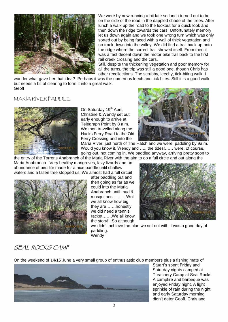
On Saturday 19th April, Christine & Wendy set out early enough to arrive at Telegraph Point by 8 a.m. We then travelled along the Hacks Ferry Road to the Old Ferry Crossing and into the Maria River, just north of The Hatch and we were paddling by 9a.m. Would you know it, Wendy and ….. the tides!…… were, of course, going out, not coming in. We paddled anyway, arriving pretty soon to
the entry of the Torrens Anabranch of the Maria River with the aim to do a full circle and out along the Maria Anabranch. Very healthy mangroves, lazy lizards and an abundance of bird life made for a nice paddle until shallow waters and a fallen tree stopped us. We almost had a full circuit
after paddling out and then going as far as we could into the Maria Anabranch until mud & mosquitoes ………Well we all know how big they are…….honestly we did need a tennis racket…….We all know the story!! So although we didn’t achieve the plan we set out with it was a good day of paddling. Wendy
SEAL ROCKS CAMP On the weekend of 14/15 June a very small group of enthusiastic club members plus a fishing mate of
Stuart’s spent Friday and Saturday nights camped at Treachery Camp at Seal Rocks. A campfire and barbeque was enjoyed Friday night. A light sprinkle of rain during the night and early Saturday morning didn’t deter Geoff, Chris and

4
Jenny setting out in their spray jackets on a pleasant 4 hour walk, while Stuart and George went fishing. Leaving the camp ground we set off on the Woody Pear Walk through bushland, up over a ridge and on to the bitumen road that led us down to Number One Beach. From here
we could see the lighthouse in the distance. We walked along Number One Beach to the council camping area then followed the road up the hill to the shop. Luckily we stopped for coffee, as we avoided a light rain scud. We continued on down the road past Boat Beach. As we started to climb the road to the lighthouse parking area we had good views looking back along all the little beaches to Sandbar Beach and Celito Headland. We then continued along the
road through bushland, mainly dominated by banksia until we came to two steep gorges cutting the cliff. There was a very spectacular view as we watched the waves surging back and forth through a sea cave. We continued on to the lookout in front of the lighthouse keepers’ cottages from where we had good views
of the big and little Seal Rocks. We came down a track and steps through the sand dunes onto Lighthouse Beach and walked back towards Treachery Headland. Just as we were about to leave the beach a light shower of rain caught us, but didn’t last long. We followed the walking track up through the bush onto the road into the campground. After a break for lunch Stuart and George were heading out onto Treachery Headland for a fish so
the rest of us did the circuit walk around the headland and out to the point. We had panoramic views up to the lighthouse and down to Broughton Island, Hawks Nest and Port Stephens. After watching George land a fish we made our way back and followed a track and steps down onto Treachery Beach. The sky out to sea was looking very black so we headed up one of the many tracks through the sandhills back to camp. As we stopped and looked back out to sea the sun shining from the west cast a golden glow over the land and rewarded us with a double rainbow which Geoff captured on his camera. Back at the campground we organised a fire, shared the one fish for entree and had a pleasant evening as the clouds blew away and the sky filled with stars. Sunday morning we awoke to sunshine and blue skies, but a strong cold wind. George left for home and the four of us walked over the sandhills down onto Treachery Beach and headed for Yagon Camp. We spotted plenty of whales. Mostly out to sea but three were only 200 metres off shore. The ones out to sea were putting on a fine performance, breaching and thrashing their tails and flukes. We walked to the end of the beach expecting to find a track up onto the headland, but no luck. So we walked halfway back along the beach and up an old 4WD track onto the dirt road. We stopped for a snack and then followed the road through the bush to Yagon Camp which is in the Myall Lakes National Park. We walked a
short distance through the sandhills to a platform which gave us good views to the south. We returned along the road to Treachery Camp for a late lunch. The weather was clouding over, wind getting stronger and temperature dropping so everyone was happy to pack up and head back home. Although Stuart did stop for one last fish off the island at Number One Beach, but no luck. Despite the unsettled weather, we
5
enjoyed the weekend walking and camping in one of the most scenic coastal spots in the Manning/Great Lakes area. Jenny
ITEMS FOR SALE
2 man Macpac macrolite tent. It weighs 2 kilos and has had very little use. Sells for $500 new and we
want $280
1 pair of front and 2 pair of rear Deuter high quality panniers in good condition for $150.
Phone Marilyn and Gary Ferris. 0428 452 157 or 65599750. NOTICES
It is imperative that participants in events contact the organiser before attending an advertised club event. The organisers then know how many people are attending and who to contact in case of cancellations, change of venue or dates etc.
When car pooling please consider the cost to the owner of the vehicle in fuel, wear and tear. The club has a personal locator beacon (PLB) in case of emergencies while in remote areas which is available through Mick O’Brien. You will need to sign it in and out. For non-remote areas mobile phone 000 emergency calls should be used. There is also now a GPS to help you navigate. Don’t forget there is a kayak and a Canadian also available for use by club members. Jackets and paddles come with the boats Note: Buoyancy vests are compulsory on the all canoe trips and must be worn at all times while on the water. Helmets must also be worn on white kayaks water trips.
Quick Calendar 3/7/2014
Grading of Walks (Bushwalking NSW)
Each walk is graded into one of six grades based on the degree of difficulty of that particular walk.
Grade 1 Easy
Opportunity for large number of walkers, including those with reduced walking ability to walk on well marked and even tracks. Tracks are man-made and may have a few steps. Should not be steep. Suitable for beginners. Distance should not exceed about 10km.
Grade 2 Easy-Medium
Easy walk, mostly on tracks of low gradient. Opportunity to walk easily in natural environments on well marked tracks. Tracks should not be steep. Distance should not exceed about 15km.
Grade 3 Medium
Medium walk with some hilly sections and/or rougher terrain. Opportunity to walk on defined and distinct tracks with some steep sections requiring a moderate level of fitness. Suitable for fit beginners. Distance should not exceed about 20km.
Grade 4 Medium-Hard
Steeper, rougher terrain and may have off-track sections (no more than one quarter of the walk) or a longer distance track walk. Opportunity to explore and discover relatively undisturbed natural environments mostly along defined and distinct tracks. Tracks can be steep. There may be short sections of rock scrambling involved. Leaders should have map reading abilities and/or ability to use a compass. Distance depending on circumstances. Not suitable for most beginners.

6
Grade 5 Hard
Off-track or difficult terrain. Opportunity for walkers with advanced outdoor knowledge and skills to find their own way along often indistinct tracks or off track in remote locations. May include steep sections of unmodified surfaces. There may be rock scrambling, creek walking and crossing involved. Distance should not exceed 30km, but may be short and difficult. Not suitable for beginners.
Grade 6 Very Hard
Strenuous off-track walk or very long distance. Opportunity for highly experienced walkers to explore remote and challenging natural areas without reliance on managed tracks. Terrain may be steep, uneven and no track. There may be rock scrambling, creek walking and crossing involved. Distance covered is unlimited, but may be short and difficult. Only for experienced walkers and not suitable for beginners.
Note: You must phone the contact person to let them know you are coming as things may change at short notice.
July 2014 Date Activity Details Contact
Thurs 3 July
Meeting The AGM will be held at Bushcamper Canvas starting at 6:oopm
Mick O 6551 2531 0400 475 835
Sat 5
Sun 6
Sat 12
Sun 13
Sat 19
Sun 20
Thurs 24 Fri 25
Pack walk Grade: 5
A two day pack walk along fire trails to the base of Mt Paterson to a fixed camp and then a harder climb to re-locate/visit the plane wreck of VH MJA which crashed in 1976. The walk is off track and covers some steep terrain.
Mick O 6551 2531 0400 475 835
Sat 26 Sun 27
Car camp Allyn River Forest. The starting point for Thursday’s walk. A chance to stay over for the weekend or join for a social weekend.
Mick O 6551 2531 0400 475 835
August 2014 Date Activity Details Contact
Sat 2
Sun 3
Sat 9
Sun 10 Walk Grade: 3
A split walk involving two locations. The first part of the day is a walk to and along the old Wooton Tramway near Wooton and in the afternoon a walk up Alum Mountain at Buladelah. Easy walks with good views.
Mick D 0408 885245
Sat 16
Sun 17
Sat 23
Sun 24 Paddle A local paddle from Croki to Harrington or elsewhere depending on conditions. This will be a flat water paddle.
Chris D Ph 6557 0052 0427 569 050
Sat 30
Sun 31
Sept 2014 Date Activity Details Contact
Thurs 4 Meeting A General Meeting at Geoff Songberg’s home in Wingham starting at 6:00pm.
Geoff S 6557 0052 0427 569 050

7
Sat 6
Sun 7 Walk Grade: 4
A favourite walk up Mt Goonook. Excellent views looking down into Killabarkh. There is some off track terrain and some scrambling over rocks.
Geoff S 6557 0052 0427 569 050
Sat 13
Sun 14
Sat 20 Sun 21
Bike Ride A two day bike ride starting at Bombah Point in the Myall Lakes Nat Park. The plan is to ride to Tea Gardens and catch the ferry across Port Stephens to Nelsons Bay and stay the night there and return the following day to Bombah Point.
Geoff M 0408 862 292
Sat 27
Sun 28 Pack walk Grade: 4
A planned 5 day pack-walk in the Budawangs National Park through some remote and rugged terrain.
Janusz 6555 9365
Oct 2014
Date Activity Details Contact
Sat 4
Sun 5
Sat 11
Sun 12 Walk Grade: 3
An easy day walk in Yarratt Forest walking through to the Lansdowne River.
Stuart/ Jenny 042765526575 65526574
Sat 18
Sun 19 Pack-walk Grade: 4
5 day Yuragir coastal pack-walk. This pack-walk begins with a half day then four full days followed by a half day finish on the following Saturday. Meet: Woolgoolga for car shuffle
Mick O 6551 2531 0400 475 835
Sat 25
Sun 26
FUTURE ACTIVITIES TO BE AWARE OF.
Date Activity Details Contact Nov 3 Day
Paddle A paddle from Tea Gardens to Neranie with camping along the way. Gear will need to be carried onboard for the trip.
Geoff M 0408 862 292
Nov 15-16
Paddle / walk
A weekend at Stuarts Point with some paddling and walking and camping in a fixed car camp.
Geoff M 0408 862 292
Winter 2015
Pack walk Grade: 4
12 day car supported walk along the Larapinta trail in the NT. Have a look at the web site. larapintatrail.com.au
Geoff / Chris 6557 0052 0427 569 050
When car pooling please consider the cost to the owner of the vehicle in fuel, wear and tear. NOTE: Buoyancy jackets are now compulsory to be worn at all time when paddling. Maritime regulation require them to be worn when more than 50 metres from shore.