Embed Size (px)
Citation preview
The ScaleMaster Typology: Literature Foundation
Robert E. Roth, Michael Stryker, and Cynthia A. Brewer [email protected] | [email protected] | [email protected]

THE SCALEMASTER MULTI-SCALE MAPPING OPERATOR TYPOLOGY *The ScaleMaster project is a collaboration among Jessica Acosta, Cindy Brewer, Robert Roth, Douglas Schoch, and Michael Stryker from Penn State University, Barbara Buttenfield from the University of Colorado, Carolyn Fish from Michigan State University, and Charlie Frye from ESRI. * The ScaleMaster project is funded by ESRI, Inc. through Professional Services Agreements 2003B6345, 2003B6346, 2003B6347, and 2006B2964. *All materials related to the ScaleMaster project can be accessed at www.scalemaster.org.
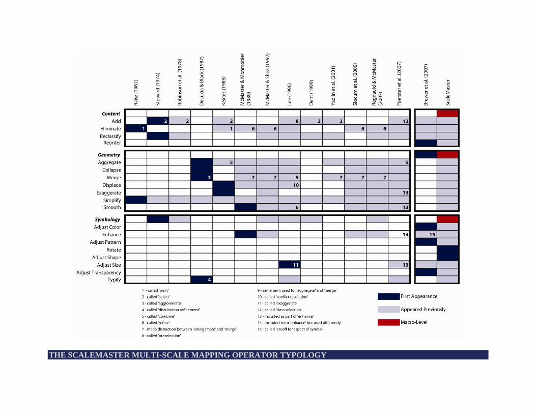
THE SCALEMASTER MULTI-SCALE MAPPING OPERATOR TYPOLOGY

CONTENT
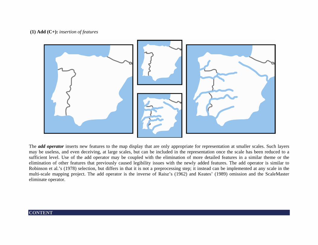
(1) Add (C+): insertion of features
The add operator inserts new features to the map display that are only appropriate for representation at smaller scales. Such layers may be useless, and even deceiving, at large scales, but can be included in the representation once the scale has been reduced to a sufficient level. Use of the add operator may be coupled with the elimination of more detailed features in a similar theme or the elimination of other features that previously caused legibility issues with the newly added features. The add operator is similar to Robinson et al.’s (1978) selection, but differs in that it is not a preprocessing step; it instead can be implemented at any scale in the multi-scale mapping project. The add operator is the inverse of Raisz’s (1962) and Keates’ (1989) omission and the ScaleMaster eliminate operator. CONTENT
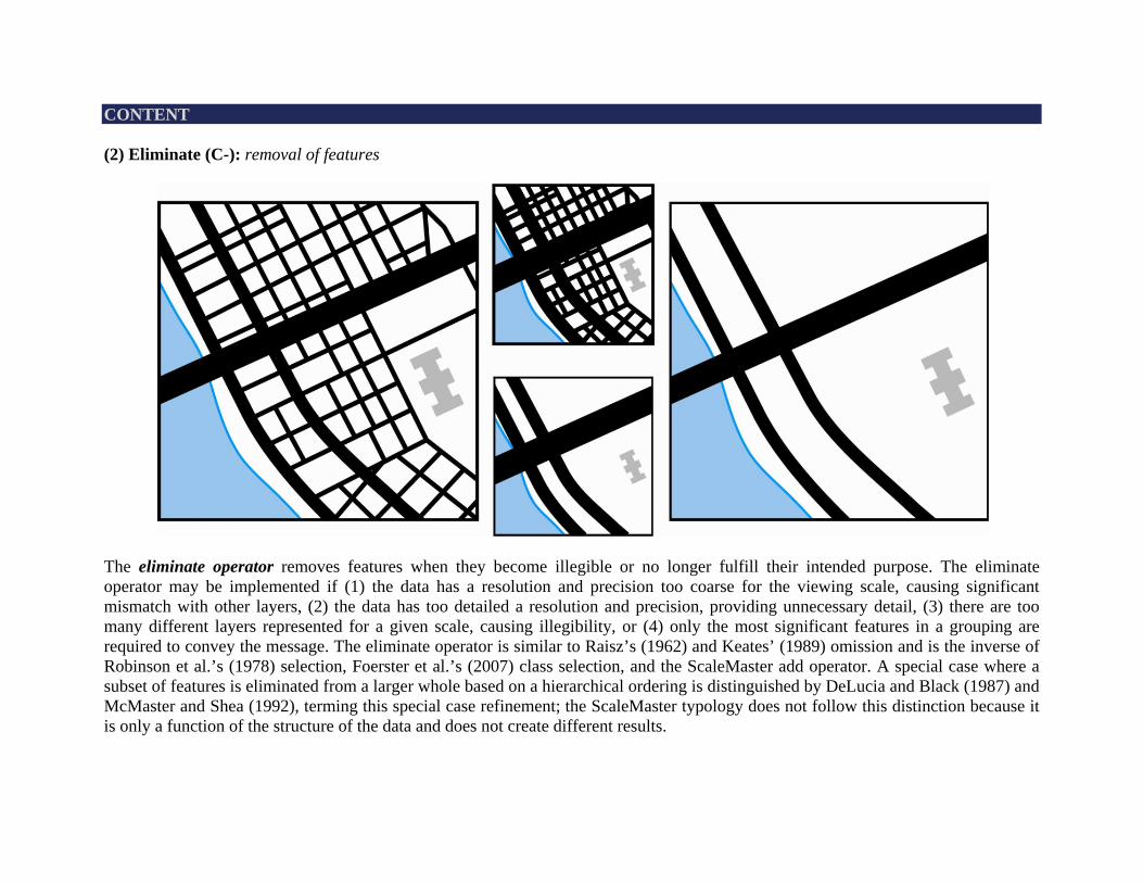
CONTENT (2) Eliminate (C-): removal of features
The eliminate operator removes features when they become illegible or no longer fulfill their intended purpose. The eliminate operator may be implemented if (1) the data has a resolution and precision too coarse for the viewing scale, causing significant mismatch with other layers, (2) the data has too detailed a resolution and precision, providing unnecessary detail, (3) there are too many different layers represented for a given scale, causing illegibility, or (4) only the most significant features in a grouping are required to convey the message. The eliminate operator is similar to Raisz’s (1962) and Keates’ (1989) omission and is the inverse of Robinson et al.’s (1978) selection, Foerster et al.’s (2007) class selection, and the ScaleMaster add operator. A special case where a subset of features is eliminated from a larger whole based on a hierarchical ordering is distinguished by DeLucia and Black (1987) and McMaster and Shea (1992), terming this special case refinement; the ScaleMaster typology does not follow this distinction because it is only a function of the structure of the data and does not create different results.
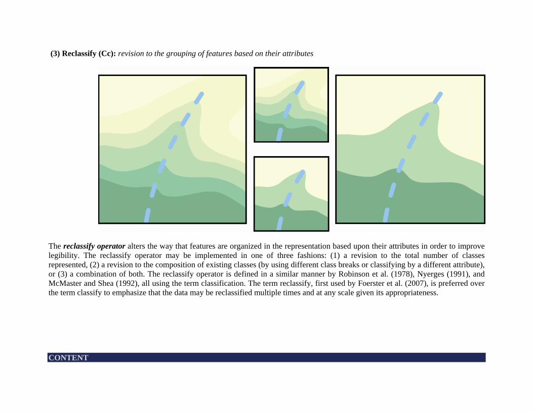
(3) Reclassify (Cc): revision to the grouping of features based on their attributes
The reclassify operator alters the way that features are organized in the representation based upon their attributes in order to improve legibility. The reclassify operator may be implemented in one of three fashions: (1) a revision to the total number of classes represented, (2) a revision to the composition of existing classes (by using different class breaks or classifying by a different attribute), or (3) a combination of both. The reclassify operator is defined in a similar manner by Robinson et al. (1978), Nyerges (1991), and McMaster and Shea (1992), all using the term classification. The term reclassify, first used by Foerster et al. (2007), is preferred over the term classify to emphasize that the data may be reclassified multiple times and at any scale given its appropriateness. CONTENT
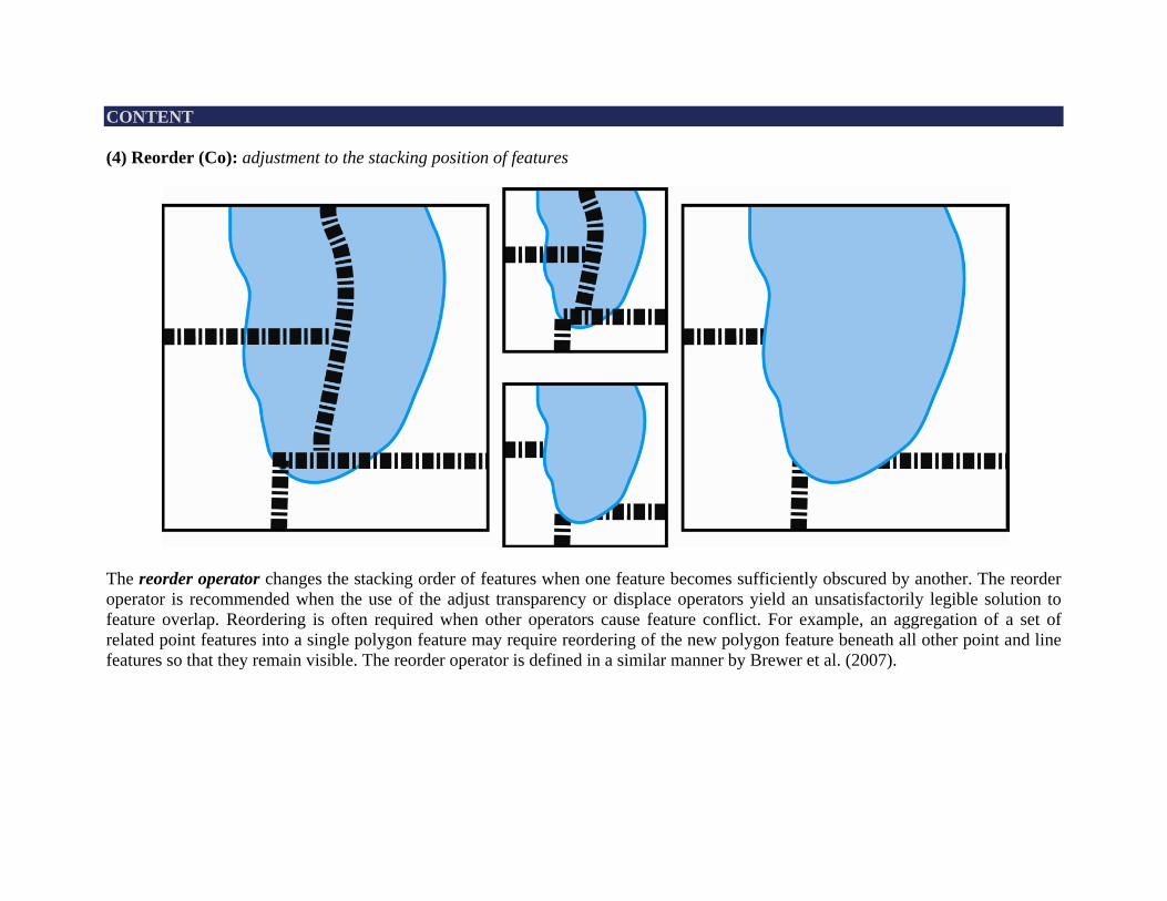
CONTENT (4) Reorder (Co): adjustment to the stacking position of features
The reorder operator changes the stacking order of features when one feature becomes sufficiently obscured by another. The reorder operator is recommended when the use of the adjust transparency or displace operators yield an unsatisfactorily legible solution to feature overlap. Reordering is often required when other operators cause feature conflict. For example, an aggregation of a set of related point features into a single polygon feature may require reordering of the new polygon feature beneath all other point and line features so that they remain visible. The reorder operator is defined in a similar manner by Brewer et al. (2007).
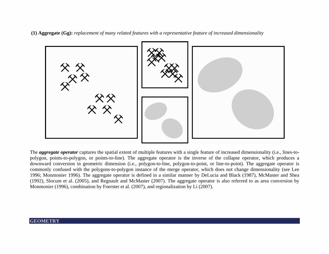
(1) Aggregate (Gg): replacement of many related features with a representative feature of increased dimensionality
The aggregate operator captures the spatial extent of multiple features with a single feature of increased dimensionality (i.e., lines-to-polygon, points-to-polygon, or points-to-line). The aggregate operator is the inverse of the collapse operator, which produces a downward conversion in geometric dimension (i.e., polygon-to-line, polygon-to-point, or line-to-point). The aggregate operator is commonly confused with the polygons-to-polygon instance of the merge operator, which does not change dimensionality (see Lee 1996; Monmonier 1996). The aggregate operator is defined in a similar manner by DeLucia and Black (1987), McMaster and Shea (1992), Slocum et al. (2005), and Regnault and McMaster (2007). The aggregate operator is also referred to as area conversion by Monmonier (1996), combination by Foerster et al. (2007), and regionalization by Li (2007). GEOMETRY
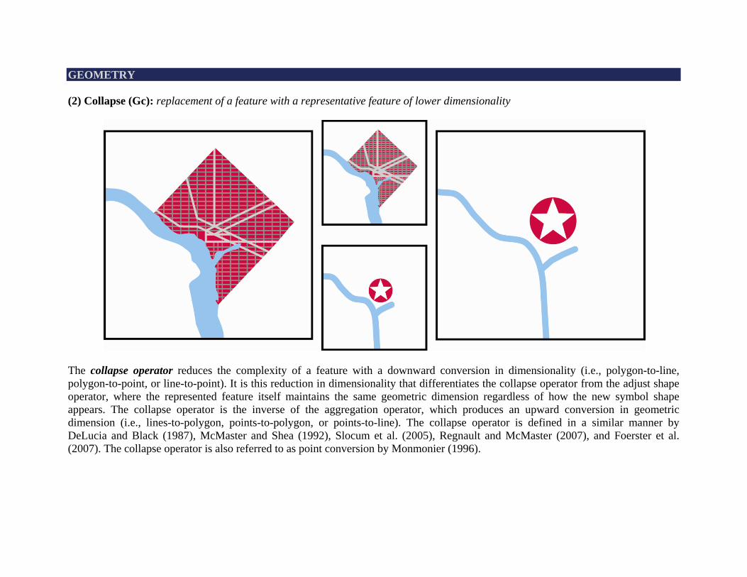
GEOMETRY (2) Collapse (Gc): replacement of a feature with a representative feature of lower dimensionality
The collapse operator reduces the complexity of a feature with a downward conversion in dimensionality (i.e., polygon-to-line, polygon-to-point, or line-to-point). It is this reduction in dimensionality that differentiates the collapse operator from the adjust shape operator, where the represented feature itself maintains the same geometric dimension regardless of how the new symbol shape appears. The collapse operator is the inverse of the aggregation operator, which produces an upward conversion in geometric dimension (i.e., lines-to-polygon, points-to-polygon, or points-to-line). The collapse operator is defined in a similar manner by DeLucia and Black (1987), McMaster and Shea (1992), Slocum et al. (2005), Regnault and McMaster (2007), and Foerster et al. (2007). The collapse operator is also referred to as point conversion by Monmonier (1996).
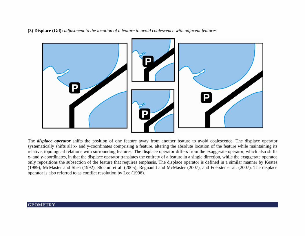
(3) Displace (Gd): adjustment to the location of a feature to avoid coalescence with adjacent features
The displace operator shifts the position of one feature away from another feature to avoid coalescence. The displace operator systematically shifts all x- and y-coordinates comprising a feature, altering the absolute location of the feature while maintaining its relative, topological relations with surrounding features. The displace operator differs from the exaggerate operator, which also shifts x- and y-coordinates, in that the displace operator translates the entirety of a feature in a single direction, while the exaggerate operator only repositions the subsection of the feature that requires emphasis. The displace operator is defined in a similar manner by Keates (1989), McMaster and Shea (1992), Slocum et al. (2005), Regnauld and McMaster (2007), and Foerster et al. (2007). The displace operator is also referred to as conflict resolution by Lee (1996). GEOMETRY
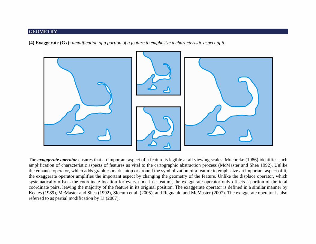
GEOMETRY (4) Exaggerate (Gx): amplification of a portion of a feature to emphasize a characteristic aspect of it
The exaggerate operator ensures that an important aspect of a feature is legible at all viewing scales. Muehrcke (1986) identifies such amplification of characteristic aspects of features as vital to the cartographic abstraction process (McMaster and Shea 1992). Unlike the enhance operator, which adds graphics marks atop or around the symbolization of a feature to emphasize an important aspect of it, the exaggerate operator amplifies the important aspect by changing the geometry of the feature. Unlike the displace operator, which systematically offsets the coordinate location for every node in a feature, the exaggerate operator only offsets a portion of the total coordinate pairs, leaving the majority of the feature in its original position. The exaggerate operator is defined in a similar manner by Keates (1989), McMaster and Shea (1992), Slocum et al. (2005), and Regnauld and McMaster (2007). The exaggerate operator is also referred to as partial modification by Li (2007).
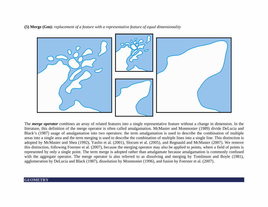
(5) Merge (Gm): replacement of a feature with a representative feature of equal dimensionality
The merge operator combines an array of related features into a single representative feature without a change in dimension. In the literature, this definition of the merge operator is often called amalgamation. McMaster and Monmonier (1989) divide DeLucia and Black’s (1987) usage of amalgamation into two operators: the term amalgamation is used to describe the combination of multiple areas into a single area and the term merging is used to describe the combination of multiple lines into a single line. This distinction is adopted by McMaster and Shea (1992), Yaolin et al. (2001), Slocum et al. (2005), and Regnauld and McMaster (2007). We remove this distinction, following Foerster et al. (2007), because the merging operator may also be applied to points, where a field of points is represented by only a single point. The term merge is adopted rather than amalgamate because amalgamation is commonly confused with the aggregate operator. The merge operator is also referred to as dissolving and merging by Tomlinson and Boyle (1981), agglomeration by DeLucia and Black (1987), dissolution by Monmonier (1996), and fusion by Foerster et al. (2007). GEOMETRY
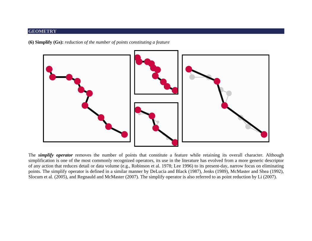
GEOMETRY (6) Simplify (Gs): reduction of the number of points constituting a feature
The simplify operator removes the number of points that constitute a feature while retaining its overall character. Although simplification is one of the most commonly recognized operators, its use in the literature has evolved from a more generic descriptor of any action that reduces detail or data volume (e.g., Robinson et al. 1978; Lee 1996) to its present-day, narrow focus on eliminating points. The simplify operator is defined in a similar manner by DeLucia and Black (1987), Jenks (1989), McMaster and Shea (1992), Slocum et al. (2005), and Regnauld and McMaster (2007). The simplify operator is also referred to as point reduction by Li (2007).
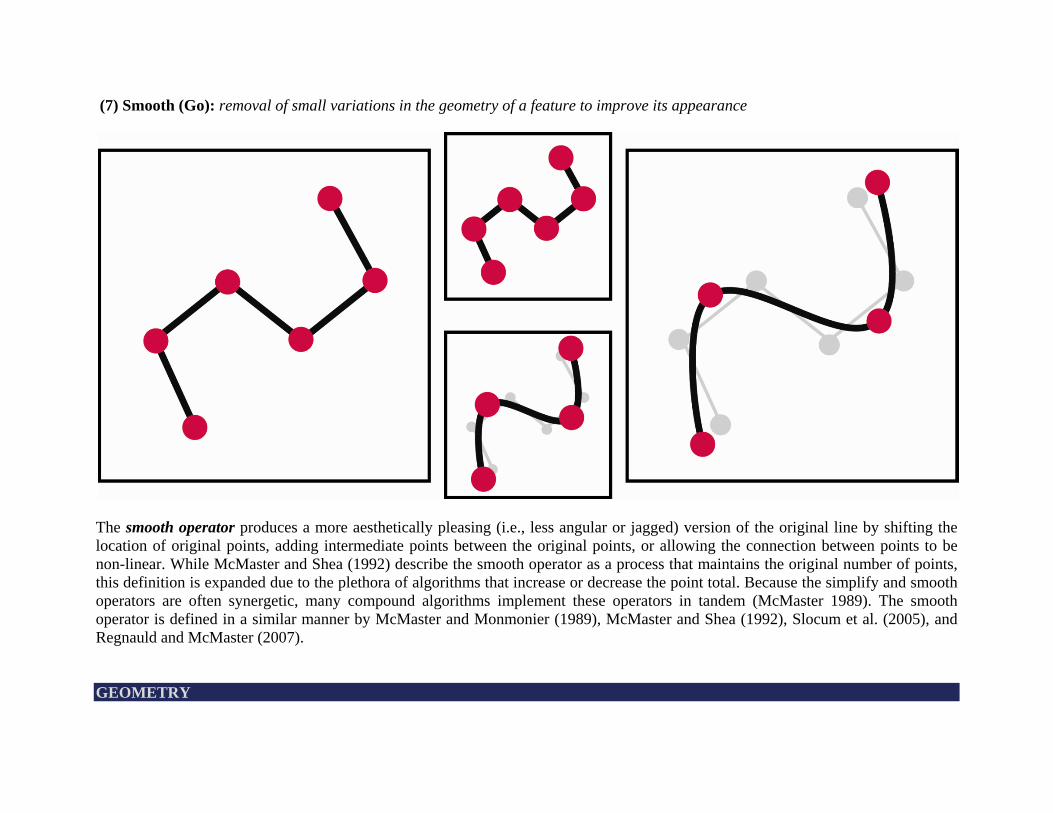
(7) Smooth (Go): removal of small variations in the geometry of a feature to improve its appearance
The smooth operator produces a more aesthetically pleasing (i.e., less angular or jagged) version of the original line by shifting the location of original points, adding intermediate points between the original points, or allowing the connection between points to be non-linear. While McMaster and Shea (1992) describe the smooth operator as a process that maintains the original number of points, this definition is expanded due to the plethora of algorithms that increase or decrease the point total. Because the simplify and smooth operators are often synergetic, many compound algorithms implement these operators in tandem (McMaster 1989). The smooth operator is defined in a similar manner by McMaster and Monmonier (1989), McMaster and Shea (1992), Slocum et al. (2005), and Regnauld and McMaster (2007). GEOMETRY
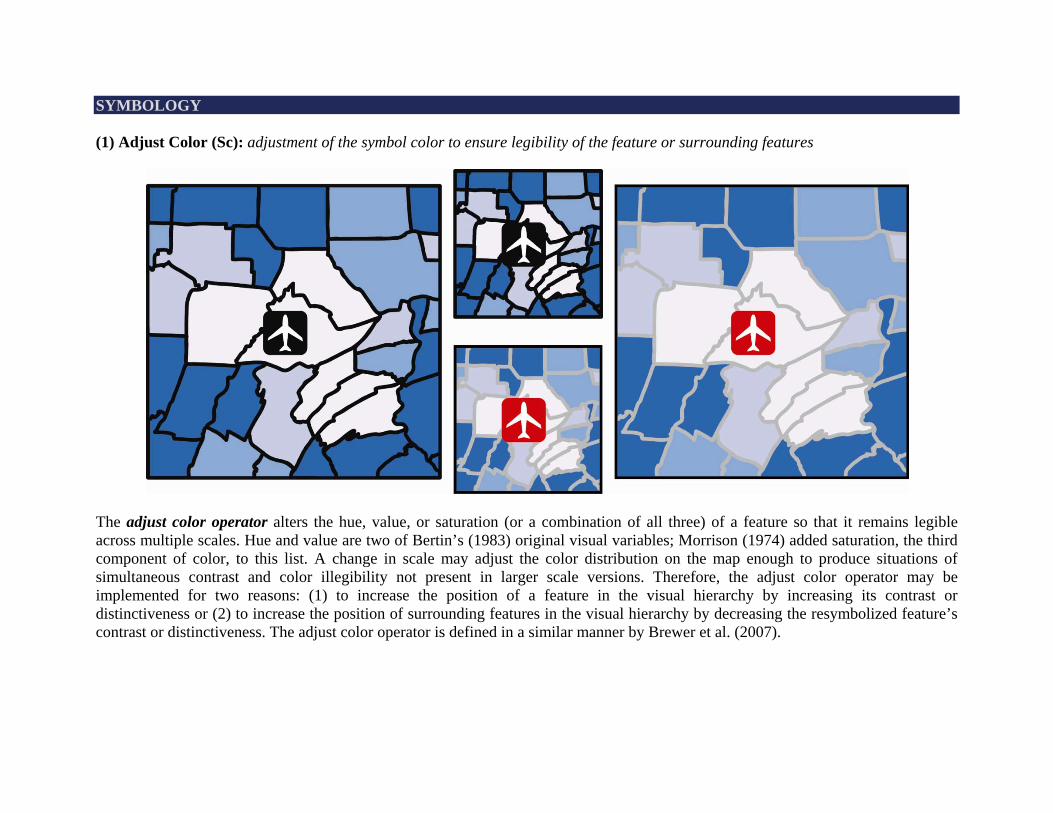
SYMBOLOGY (1) Adjust Color (Sc): adjustment of the symbol color to ensure legibility of the feature or surrounding features
The adjust color operator alters the hue, value, or saturation (or a combination of all three) of a feature so that it remains legible across multiple scales. Hue and value are two of Bertin’s (1983) original visual variables; Morrison (1974) added saturation, the third component of color, to this list. A change in scale may adjust the color distribution on the map enough to produce situations of simultaneous contrast and color illegibility not present in larger scale versions. Therefore, the adjust color operator may be implemented for two reasons: (1) to increase the position of a feature in the visual hierarchy by increasing its contrast or distinctiveness or (2) to increase the position of surrounding features in the visual hierarchy by decreasing the resymbolized feature’s contrast or distinctiveness. The adjust color operator is defined in a similar manner by Brewer et al. (2007).
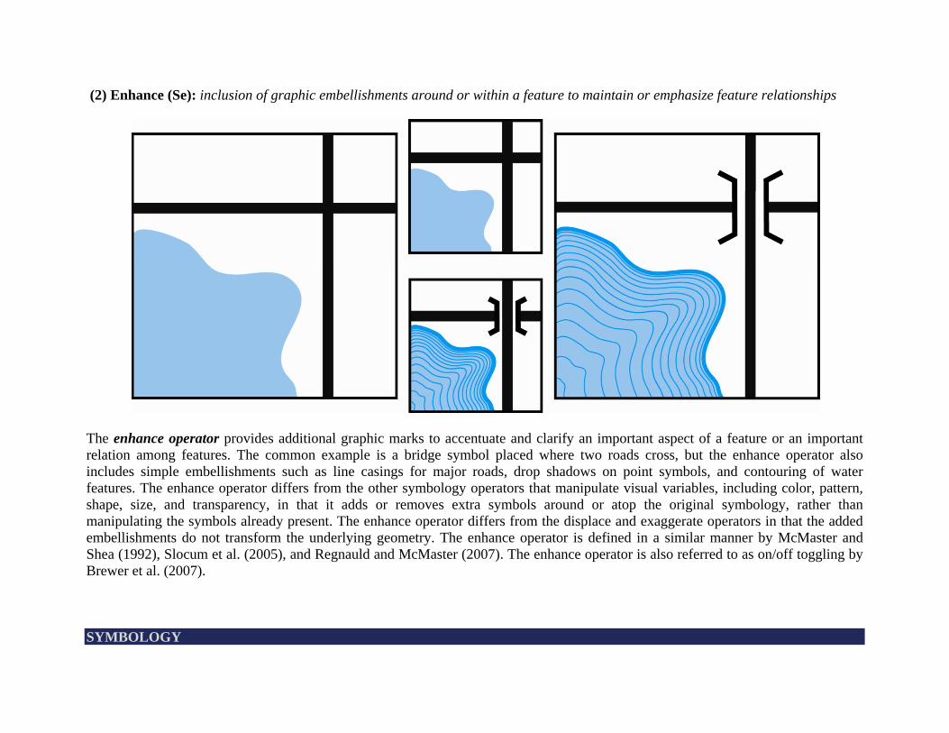
(2) Enhance (Se): inclusion of graphic embellishments around or within a feature to maintain or emphasize feature relationships
The enhance operator provides additional graphic marks to accentuate and clarify an important aspect of a feature or an important relation among features. The common example is a bridge symbol placed where two roads cross, but the enhance operator also includes simple embellishments such as line casings for major roads, drop shadows on point symbols, and contouring of water features. The enhance operator differs from the other symbology operators that manipulate visual variables, including color, pattern, shape, size, and transparency, in that it adds or removes extra symbols around or atop the original symbology, rather than manipulating the symbols already present. The enhance operator differs from the displace and exaggerate operators in that the added embellishments do not transform the underlying geometry. The enhance operator is defined in a similar manner by McMaster and Shea (1992), Slocum et al. (2005), and Regnauld and McMaster (2007). The enhance operator is also referred to as on/off toggling by Brewer et al. (2007). SYMBOLOGY
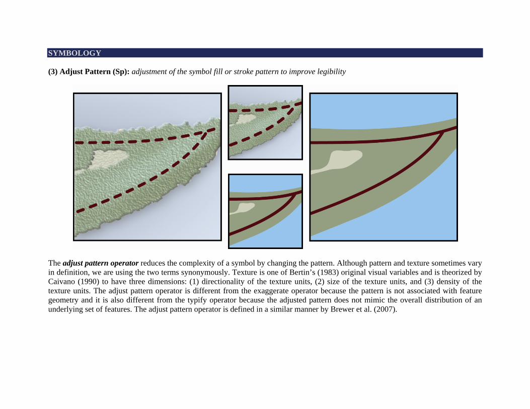
SYMBOLOGY (3) Adjust Pattern (Sp): adjustment of the symbol fill or stroke pattern to improve legibility
The adjust pattern operator reduces the complexity of a symbol by changing the pattern. Although pattern and texture sometimes vary in definition, we are using the two terms synonymously. Texture is one of Bertin’s (1983) original visual variables and is theorized by Caivano (1990) to have three dimensions: (1) directionality of the texture units, (2) size of the texture units, and (3) density of the texture units. The adjust pattern operator is different from the exaggerate operator because the pattern is not associated with feature geometry and it is also different from the typify operator because the adjusted pattern does not mimic the overall distribution of an underlying set of features. The adjust pattern operator is defined in a similar manner by Brewer et al. (2007).
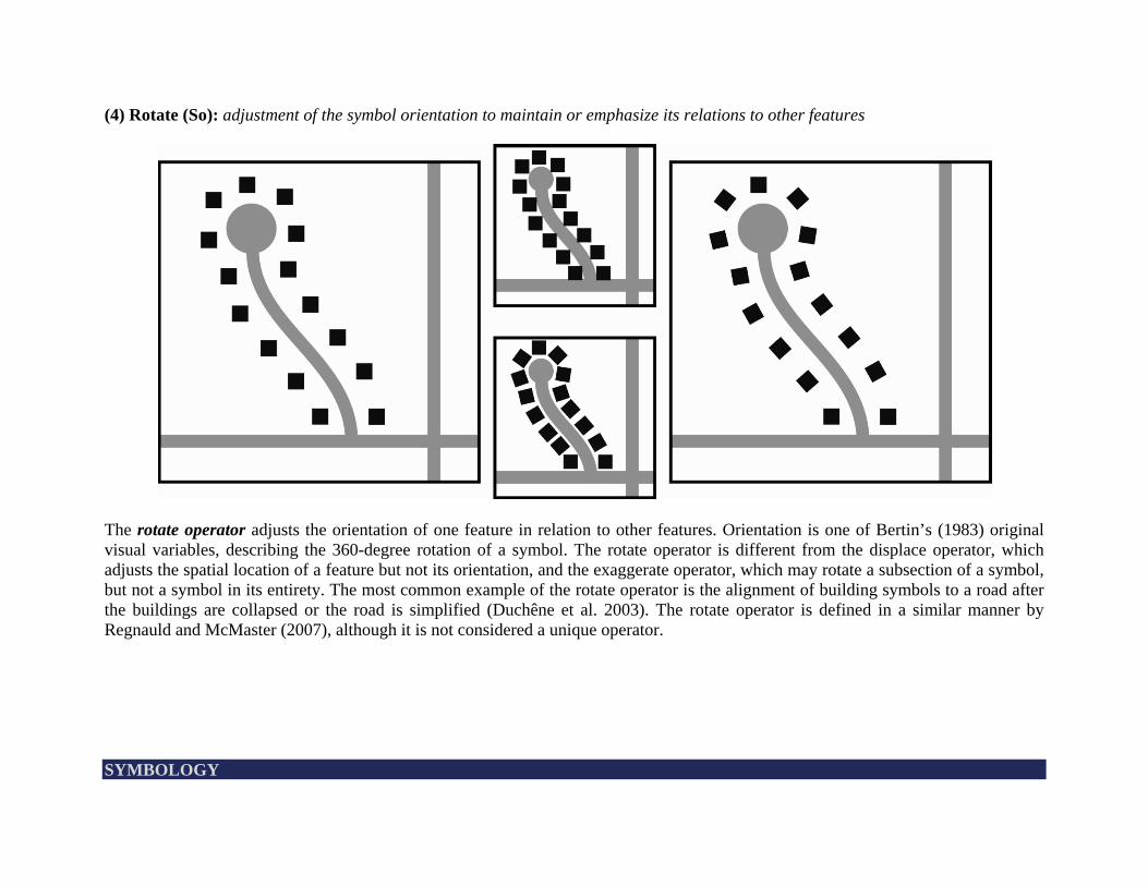
(4) Rotate (So): adjustment of the symbol orientation to maintain or emphasize its relations to other features
The rotate operator adjusts the orientation of one feature in relation to other features. Orientation is one of Bertin’s (1983) original visual variables, describing the 360-degree rotation of a symbol. The rotate operator is different from the displace operator, which adjusts the spatial location of a feature but not its orientation, and the exaggerate operator, which may rotate a subsection of a symbol, but not a symbol in its entirety. The most common example of the rotate operator is the alignment of building symbols to a road after the buildings are collapsed or the road is simplified (Duchêne et al. 2003). The rotate operator is defined in a similar manner by Regnauld and McMaster (2007), although it is not considered a unique operator. SYMBOLOGY
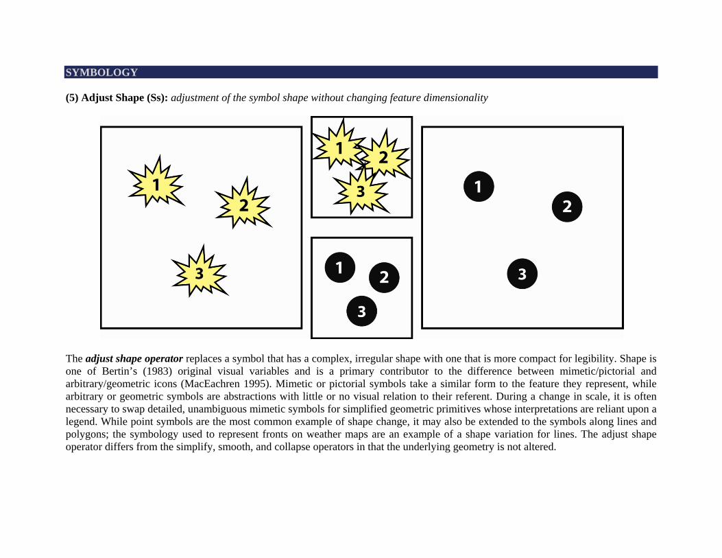
SYMBOLOGY (5) Adjust Shape (Ss): adjustment of the symbol shape without changing feature dimensionality
The adjust shape operator replaces a symbol that has a complex, irregular shape with one that is more compact for legibility. Shape is one of Bertin’s (1983) original visual variables and is a primary contributor to the difference between mimetic/pictorial and arbitrary/geometric icons (MacEachren 1995). Mimetic or pictorial symbols take a similar form to the feature they represent, while arbitrary or geometric symbols are abstractions with little or no visual relation to their referent. During a change in scale, it is often necessary to swap detailed, unambiguous mimetic symbols for simplified geometric primitives whose interpretations are reliant upon a legend. While point symbols are the most common example of shape change, it may also be extended to the symbols along lines and polygons; the symbology used to represent fronts on weather maps are an example of a shape variation for lines. The adjust shape operator differs from the simplify, smooth, and collapse operators in that the underlying geometry is not altered.
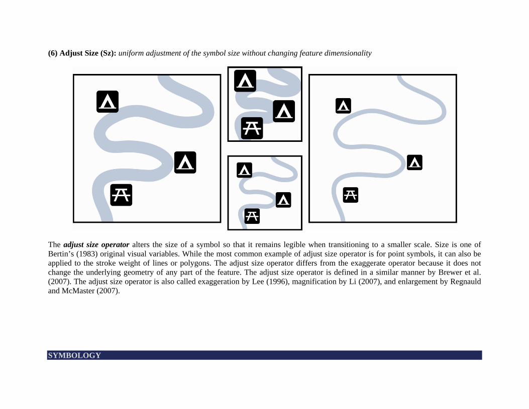
(6) Adjust Size (Sz): uniform adjustment of the symbol size without changing feature dimensionality
The adjust size operator alters the size of a symbol so that it remains legible when transitioning to a smaller scale. Size is one of Bertin’s (1983) original visual variables. While the most common example of adjust size operator is for point symbols, it can also be applied to the stroke weight of lines or polygons. The adjust size operator differs from the exaggerate operator because it does not change the underlying geometry of any part of the feature. The adjust size operator is defined in a similar manner by Brewer et al. (2007). The adjust size operator is also called exaggeration by Lee (1996), magnification by Li (2007), and enlargement by Regnauld and McMaster (2007). SYMBOLOGY
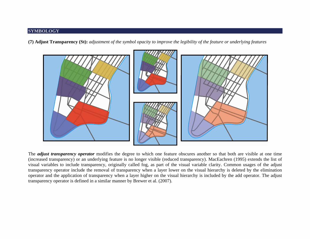
SYMBOLOGY (7) Adjust Transparency (St): adjustment of the symbol opacity to improve the legibility of the feature or underlying features
The adjust transparency operator modifies the degree to which one feature obscures another so that both are visible at one time (increased transparency) or an underlying feature is no longer visible (reduced transparency). MacEachren (1995) extends the list of visual variables to include transparency, originally called fog, as part of the visual variable clarity. Common usages of the adjust transparency operator include the removal of transparency when a layer lower on the visual hierarchy is deleted by the elimination operator and the application of transparency when a layer higher on the visual hierarchy is included by the add operator. The adjust transparency operator is defined in a similar manner by Brewer et al. (2007).
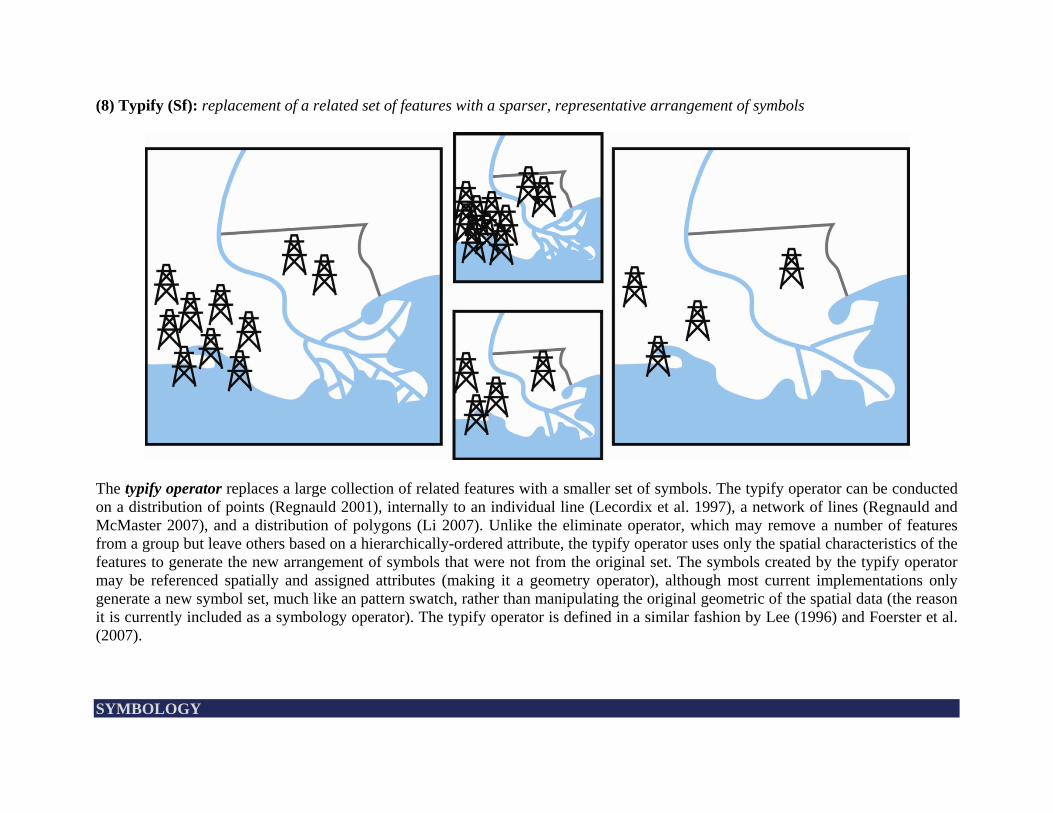
(8) Typify (Sf): replacement of a related set of features with a sparser, representative arrangement of symbols
The typify operator replaces a large collection of related features with a smaller set of symbols. The typify operator can be conducted on a distribution of points (Regnauld 2001), internally to an individual line (Lecordix et al. 1997), a network of lines (Regnauld and McMaster 2007), and a distribution of polygons (Li 2007). Unlike the eliminate operator, which may remove a number of features from a group but leave others based on a hierarchically-ordered attribute, the typify operator uses only the spatial characteristics of the features to generate the new arrangement of symbols that were not from the original set. The symbols created by the typify operator may be referenced spatially and assigned attributes (making it a geometry operator), although most current implementations only generate a new symbol set, much like an pattern swatch, rather than manipulating the original geometric of the spatial data (the reason it is currently included as a symbology operator). The typify operator is defined in a similar fashion by Lee (1996) and Foerster et al. (2007). SYMBOLOGY
REFERENCES Bertin, J. 1983. Semiology of Graphics: Diagrams, Networks, Maps. Madison, WI: University of Wisconsin Press. (originally
printed in French in 1967) Caivano, JL. 1990. Visual texture as a semiotic system. Semiotica 80(3-4): 239-252. Duchêne, C, S Bard, X Barillot, A Ruas, J Trévisan, and F Holzapfel. 2003. Quantitative and Qualitative Description of Building
Orientation. In: Fifth Workshop on Progress in Automated Map Generalisation. Paris, France: 28-30 April. DeLucia, AA, and RT Black. 1987. Comprehensive approach to automatic feature generalization. In: Proceedings of the 13th
International Cartographic Conference. Morelia, Mexico: 12-21 October. Foerster, T, J Stoter, and B Köbben. 2007. Towards a Formal Classification of Generalization Operators. In: Proceedings of the 23th
International Cartographic Conference. Moscow, Russia: 3-10 August. Jenks, G. 1989. Geographic Logic in Line Generalization. Cartographica 26(1): 27-42. Keates, J. 1989. Cartographic Design and Production. Harlow, UK: Longman Scientific. Lecordix, F, C Plazanet, and J-P Lagrange. A Platform for Research in Generalization: Application to Caricature. GeoInformatica
1(2): 161-182. Lee, D. 1996. Automation of Map Generalization: The Cutting-Edge Technology. ESRI White Paper Series. Redlands, CA: ESRI. Li, Z. 2007. Algorithmic Foundation of Multi-Scale Spatial Representation. Boca Raton, FL: CRC Press. MacEachren, AM. 1995. How Maps Work: Representation, Visualization, and Design. New York, NY: Guilford Press. McMaster, RB. 1989. The integration of simplification and smoothing routines in line generalization. Cartographica 26(1): 101-
121.
McMaster, RB, and KS Shea. 1992. Generalization in Digital Cartography. Washington, DC: Association of American Geographers Press.
Monmonier, M. 1996. How to Lie with Maps. Chicago, IL: University of Chicago Press. Morrison, JL. 1974. A theoretical framework for cartographic generalization with the emphasis on the process of symbolization.
International Yearbook of Cartography 14: 115-127. Muehrcke, PC. 1986. Map Use: Reading, Analysis, and Interpretation. Madison, WI: JP Publications. Nyerges, TL. 1991. Representing Geographical Meaning. In: BP Buttenfield and RB McMaster (eds) Map Generalization:Making
Rules for Knowledge Representation. Harlow, UK: Longman Group. Raisz, E. 1962. Principles of Cartography. New York: McGraw-Hill. Regnauld, N. 2001. Contextual Building Typification in Automated Map Generalization. Algorithmica 30(2): 312-333. Regnauld, N, and RB McMaster. 2007. A Synoptic View of Generalisation Operators. In: WA Mackaness, A Ruas, and LT
Sarjakowski (eds) Generalisation of Geographic Information: Cartographic Modelling and Applications. Oxford, UK: Elsevier. Robinson, A, R Sale, and J Morrison. 1978. Elements of Cartography. New York, NY: John Wiley & Sons. Slocum, TA, RB McMaster, FC Kessler, and HH Howard. 2005. Thematic Cartography and Geographic Visualization. Upper
Saddle River, NJ: Pearson Prentice Hall. Tomlinson, RF, and AR Boyle. 1981. The State Of Development of Systems for Handling Natural Resources Inventory Data.
Cartographica 18(4): 65-95. Yaolin, L, M Molenaar, and AD Tinghua. 2001. Frameworks for Generalization Constraints and Operations Based on Object-
Oriented Data Structures in Database Generalization. In: Proceedings of the 20th International Cartographic Conference. Beijing, China: 6-10 August.
REFERENCES