Embed Size (px)
Citation preview
The Salient Features of Site Location in the
Andaman Islands, Indian Ocean
ZARINE COOPER
THE LOCATION OF ARCHAEOLOGICAL SITES provides information on how people organized themselves in a particular environment, in relation to resources that were considered vital throughout a seasonal cycle, and in relation to group structure and territorial boundaries. This paper focuses on the economic and socioreligious criteria that determine the location of encampments in the Andaman Islands.
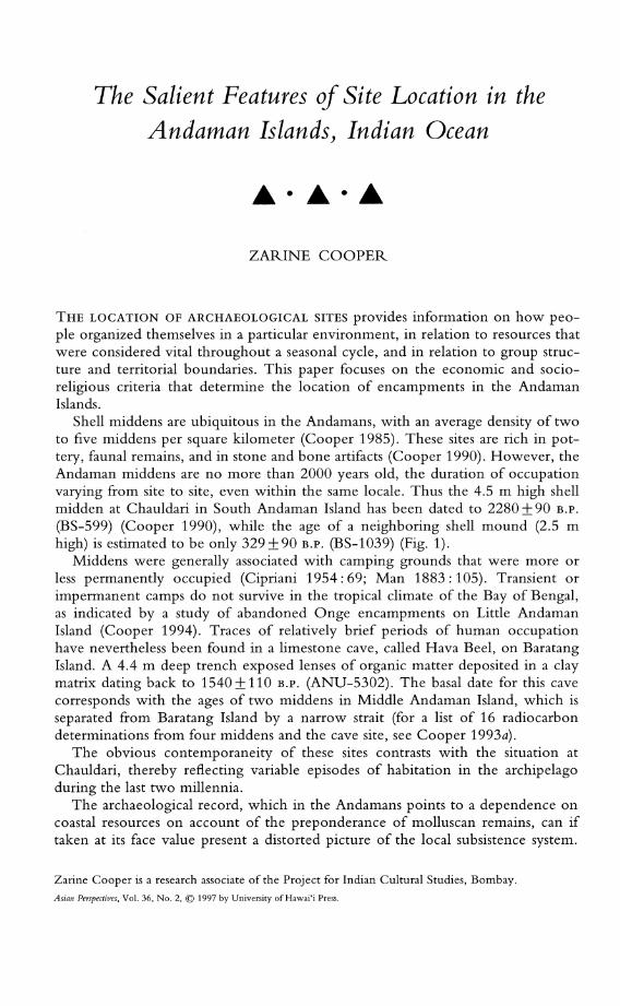
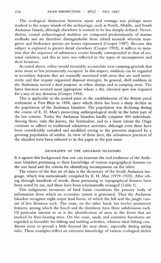
Shell middens are ubiquitous in the Andamans, with an average density of two to five middens per square kilometer (Cooper 1985). These sites are rich in pottery, faunal remains, and in stone and bone artifacts (Cooper 1990). However, the Andaman middens are no more than 2000 years old, the duration of occupation varying from site to site, even within the same locale. Thus the 4.5 m high shell midden at Chauldari in South Andaman Island has been dated to 2280±90 B.P.
(BS-599) (Cooper 1990), while the age of a neighboring shell mound (2.5 m high) is estimated to be only 329±90 B.P. (BS-l039) (Fig. 1).
Middens were generally associated with camping grounds that were more or less permanently occupied (Cipriani 1954: 69; Man 1883: 105). Transient or impermanent camps do not survive in the tropical climate of the Bay of Bengal, as indicated by a study of abandoned Onge encampments on Little Andaman Island (Cooper 1994). Traces of relatively brief periods of human occupation have nevertheless been found in a limestone cave, called Hava Beel, on Baratang Island. A 4.4 m deep trench exposed lenses of organic matter deposited in a clay matrix dating back to 1540 ± 110 B.P. (ANU-5302). The basal date for this cave corresponds with the ages of two middens in Middle Andaman Island, which is separated from Baratang Island by a narrow strait (for a list of 16 radiocarbon determinations from four middens and the cave site, see Cooper 1993a).
The obvious contemporaneity of these sites contrasts with the situation at Chauldari, thereby reflecting variable episodes of habitation in the archipelago during the last two millennia.
The archaeological record, which in the Andamans points to a dependence on coastal resources on account of the preponderance of molluscan remains, can if taken at its face value present a distorted picture of the local subsistence system.
Zarine Cooper is a research associate of the Project for Indian Cultural Studies, Bombay.
Asian Perspectives, Vol. 36, No.2, © 1997 by University of Hawai'i Press.
Bay of Bengal
J'--------.-y
12'-------1
South Andaman I
Duncan Passage
Coco Channa'
Landfall I q.1f
Andaman I
Ritchi .. Archipelago
Q lInl, A"d.moo
r.n Degr •• Channe'
94'
Andaman Sea
I
OBarron I
Cave
Q 16 32 48Km k_====-====*'====~'
Fig. 1. Map showing the important archaeological sites in the Andaman Islands.
222 ASIAN PERSPECTIVES . 36(2) . FALL 1997
A caution to this effect has already been sounded in an earlier paper (Cooper 1990), which uses ethnographic data and population distribution patterns to demonstrate that terrestrial fauna and flora might have played a greater role in the local diet. In support of this hypothesis, the location of shell middens is examined in relation to how they are perceived by the Andaman Islanders, as evident in their oral traditions. The latter, in addition to highlighting the role of terrestrial resources in the subsistence system, distinguishes the criteria that determine site location, in this case middens, and those by which they are identified.
THE LOCATION OF MIDDENS IN THE ANDAMANS
The middens are generally located on rocky platforms just behind or within the mangrove belt that borders the innumerable creeks and sheltered bays. The average basal area of these sites is 240 sq m, and the mean height is 1.5 m.
It is important to remember that the majority of the middens, regardless of whether they are situated inland or along the coast, occur within 1 km of freshwater springs or streams. Undoubtedly, these water sources determined the locales of semipermanent encampments, as witnessed by clusters of sites around perennial springs.
Interestingly, there appears to be no correlation between the dimensions of sites and their respective distances from sources of freshwater, although there is a 0.50 coefficient of correlation between the attributes of height and area, as demonstrated by simple regression analysis. It is highly doubtful whether these dimensional attributes have been intentionally structured, rather they may be related to a combination of site formation processes that include the utilization of some of these mounds as camping platforms after they had reached a suitable height (Cooper 1994: 240).
Shelter from the wind was also an important factor in determining the location of community huts and temporary villages (Man 1882:283; Radcliffe-Brown 1922:412).
I have not attempted site catchment analysis as it "disregards the importance of non-subsistence factors in site location" such as "shelter, topography and water supply" (Clarke 1978: 128). Instead, as advocated by Clarke (1978: 128), "site location should be analyzed in terms of mixed strategy models."
RESOURCE EXPLOITATION
As indicated above, the locational analysis carried out so far has yielded useful information on the topographical correlates of sites, their dimensions, and the importance of the proximity of sources of water that are so vital for long-term occupation. However, one's perspective of site location is considerably widened in the light of ethnographic records on resource availability and utilization, and with reference to relevant oral traditions.
Cross-cutting the division of groups based on linguistic differences was an ecological distinction between coast-dwellers (aryoto) and interior groups (eremtaga) (Man 1883:102; Radcliffe-Brown 1922:26). This distinction was primarily based on the coastal groups' use of marine resources, some of which are subject to less seasonal variation than terrestrial resources. Moreover, the semipermanent village
COOPER • SITE LOCATION IN THE ANDAMAN ISLANDS 223
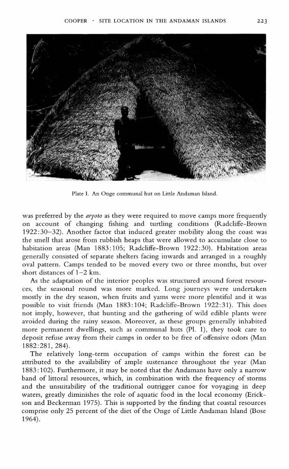
Plate I. An Onge communal hut on Little Andaman Island.
was preferred by the aryoto as they were required to move camps more frequently on account of changing fishing and turtling conditions (Radcliffe-Brown 1922: 30-32). Another factor that induced greater mobility along the coast was the smell that arose from rubbish heaps that were allowed to accumulate close to habitation areas (Man 1883: 105; Radcliffe-Brown 1922: 30). Habitation areas generally consisted of separate shelters facing inwards and arranged in a roughly oval pattern. Camps tended to be moved every two or three months, but over short distances of 1-2 km.
As the adaptation of the interior peoples was structured around forest resources, the seasonal round was more marked. Long journeys were undertaken mostly in the dry season, when fruits and yams were more plentiful and it was possible to visit friends (Man 1883:104; Radcliffe-Brown 1922:31). This does not imply, however, that hunting and the gathering of wild edible plants were avoided during the rainy season. Moreover, as these groups generally inhabited more permanent dwellings, such as communal huts (PI. 1), they took care to deposit refuse away from their camps in order to be free of offensive odors (Man 1882:281,284).
The relatively long-term occupation of camps within the forest can be attributed to the availability of ample sustenance throughout the year (Man 1883: 102). Furthermore, it may be noted that the Andamans have only a narrow band of littoral resources, which, in combination with the frequency of storms and the unsuitability of the traditional outrigger canoe for voyaging in deep waters, greatly diminishes the role of aquatic food in the local economy (Erickson and Beckerman 1975). This is supported by the finding that coastal resources comprise only 25 percent of the diet of the Onge of Little Andaman Island (Bose 1964).
224 ASIAN PERSPECTIVES . 36(2) . FALL 1997
The ecological distinction between aryoto and eremtaga was perhaps more marked in the major islands of the archipelago, such as North, Middle, and South Andaman Islands, although elsewhere it seemed to be less sharply defined. N evertheless, coastal archaeological middens are composed predominantly of marine mollusks and are therefore distinguishable from inland mounds wherein mangrove and freshwater species are better represented (Cooper 1987). Because this subject is explored in greater detail elsewhere (Cooper 1992), it suffices to mention that the sequence of subsistence events broadly corresponded to that of seasonal variation, and this in turn was reflected in the types of encampments and their locations.
As noted above, refuse would invariably accumulate near camping grounds that were more or less permanently occupied. In this respect, middens can be regarded as secondary deposits that are normally associated with areas that are used intensively and that require organized disposal strategies. In general, shell middens in the Andamans served a dual purpose: as refuse dumps and as camping areas. The latter function seemed most appropriate where a dry, elevated spot was required for a stay of any duration (Cooper 1994).
This is applicable to the period prior to the establishment of the British penal settlement at Port Blair in 1858, since which there has been a sharp decline in the population of the Andaman Islanders. The population was declining during the course of E. H. Man's pioneering anthropological study in the latter part of the last century. Today the Andaman Islanders hardly comprise 400 individuals. Among these, only the Jarawa, the Sentinalese, and to a lesser extent the Onge continue to adhere to traditional subsistence activities, although even these have been considerably curtailed and modified owing to the pressures imposed by a growing population of settlers. In view of these facts, the subsistence practices of the islanders have been referred to in this paper in the past tense.
GEOGRAPHY OF THE ANDAMAN ISLANDERS
It is against this background that one can examine the oral traditions of the Andaman Islanders pertaining to their knowledge of various topographical features on the one hand and the criteria for identifying encampments on the other.
The source of the first set of data is the dictionary of the South Andaman language, which was meticulously compiled by E. H. Man (1919-1923). After sifting through hundreds of words, those pertaining to topographical features have been noted by me, and these have been schematically arranged (Table 1).
This indigenous inventory of land forms constitutes the primary body of information from which an economic system is generated. Thus the Andaman Islanders recognize eight major land forms, of which the hill and the jungle consist of five divisions each. The coast, on the other hand, has twelve prominent features, among which the beach and the foreshore have three subdivisions each. Of particular interest to us is the identification of areas in the forest that are marked by fruit-bearing trees. On the coast, sandy and extensive foreshores are regarded as favorable for fishing and turtling activities, whereas ideal fishing conditions seem to prevail a little beyond the near shore, especially during spring tides. These examples reflect an extensive knowledge of various ecological niches
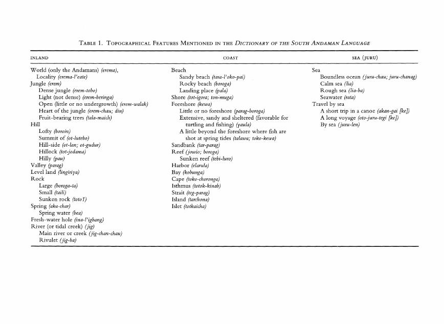
TABLE 1. TOPOGRAPHICAL FEATURES MENTIONED IN THE DICTIONARY OF THE SOUTH ANDAMAN LANGUAGE
INLAND
World (only the Andamans) (erema), Locality (erema-I'eate)
Jungle (erem) Dense jungle (erem-tobo) Light (not dense) (erem-beringa) Open (little or no undergrowth) (erem-walak) Heart of the jungle (erem-chau; din) Fruit-bearing trees (tala-maich)
Hill Lofty (boroin) Summit of (ot-Iutebo) Hill-side (ot-Ian; ot-gudur) Hillock (tot-jodama) Hilly (pau)
Valley (parag) Levelland (lingiriya) Rock
Large (boroga-ta) Small (taili) Sunken rock (tot01)
Spring (aka-char) Spring water (bea)
Fresh-water hole (ina-I'igbang) River (or tidal creek) (jig)
Main river or creek (jig-chan-chau) Rivulet (jig-ba)
COAST
Beach Sandy beach (tara-/' oko-pai) Rocky beach (boroga) Landing place (pala)
Shore (tot-igora; tonCmuga) Foreshore (kewa)
Little or no foreshore (parag-boroga) Extensive, sandy and sheltered (favorable for
turtling and fishing) (yaula) A little beyond the foreshore where fish are
shot at spring tides (talawa; toko-kewa) Sandbank (tar-parag) Reef (jowio; boraga)
Sunken reef (tebi-Iuro) Harbor (elarula) Bay (kobunga) Cape (toko-choronga) Isthmus (totok-kinab) Strait (teg-parag) Island (tarchona) Islet (totkaicha)
SEA (JURU)
Sea Boundless ocean (juru-chau; juru-chanag) Calm sea (Ii a) Rough sea (lia-ba) Seawater (rata)
Travel by sea A short trip in a canoe (akan-gai [ke J) A long voyage (oto-juru-tegi [ke J) By sea (juru-Ien)
226 ASIAN PERSPECTIVES • 36(2) • FALL 1997
as well as the diverse subsistence strategies that are employed for their efficient exploitation.
The significance attached to a particular topographical feature, therefore, often depends upon the resources it has to offer and the means of procuring them. This in turn is immediately useful in helping the archaeologist and/or ethnographer in formulating models regarding the nature and function of a site. These can be tested against the archaeological record, which, with regard to long-term occupation, has already indicated that the proximity to perennial sources of water is the most important determinant of site location. As a rule, camps are situated on an elevation, whether it is a hillock or an exposed patch of rock. As pointed out earlier, shelter from the wind was also taken into consideration when selecting a camp site. On the other hand, stifling living conditions were avoided, as for example at Tombebuea in Little Andaman Island, where it was observed that a communal hut had been shifted from its former position and rebuilt closer to the sea, for recent tectonic movements in that part of the island had resulted in the uplifting of the coast, thereby obstructing the sea breezes (Cipriani 1954: 73).
Thus an archaeological survey in the Andamans can predictably lead to one or more shell mounds in the vicinity of freshwater springs or streams, and if these overlook favorable fishing and hunting spots, the contents of the mounds may partially reflect the types of resources that are locally available, although this is not always so. For instance, on Swamp Island, which is only 1.5 km long and about 0.5 km wide, and which lies off the southeast tip of North Andaman Island, Cooper found a bewildering assortment of middens. One of these is composed almost entirely of flat oysters; these are, at present, common off the west coast of Middle and North Andaman Islands, but may have been more widespread in the past. Two other mounds consist of a mixture of the genus Anadara and of flat oysters, while shells of the Anadara are predominant in the fourth midden. The freshwater spring in the north of the island undoubtedly marked a major camping place. Unfortunately, it has not yet been possible to date these sites in order to determine the differences in their ages, if any.
This, however, was possible at Chauldari. At this locale, the tall, 2000-year-old mound yielded, in the earlier phase of occupation, molluscan species belonging to rocky shores and estuaries, whereas at a later stage the mud flats in the littoral and sublittoral zones were increasingly exploited. The species of bivalves included Marcia recens, Anadara granosa, and Scapharca (Cunearca) congrua (Cooper 1990). The chemical and mineral analysis of soil from this site, as also the X-ray diffraction studies of shells, revealed a period of abandonment spanning several centuries. The fact that different habitats were exploited during the accumulation of faunal refuse at the site reflects changes in dietary preferences and/or in the environment. In this regard, it may be mentioned that the lower layers of the Chauldari midden, i.e., below 2.1 m, contained a higher number of the bones of Sus scrofa (Pig) than the upper deposits. In contrast, the neighboring shell mound, which is only 300 years old, is largely composed of flat oysters.
These data suggest that osteological remains do not necessarily represent the marine or land animals that in the distant past distinguished certain places. Moreover, the availability of different species, terrestrial or otherwise, is bound to have varied in the course of time, as did their ecological niches. Thus the Andaman shell middens are a skewed reflection of the topographical features that marked
COOPER . SITE LOCATION IN THE ANDAMAN ISLANDS 227
ancient camping spots and of the resources that they once offered. Needless to add, plant remains are hard to find, although lumps of resin belonging to the tree of the genus Dipterocarp were recovered from the excavations at Hava Beel cave. The resin was apparently used for burning torches in the dark interior of the cave, much as the Onge and the other surviving groups of Andaman Islanders do today (Cooper 1993a).
Of great commercial value these days are the shells of the genus Trochus and Tridacna, which are currently abundant off the west coast of Middle Andaman Island, and possibly on North Andaman Island. It was therefore not surprising to find a 2.3 m high midden rich in Tridacna shells in the southeast corner of Interview Island (see Fig. 1). But what came as a surprise was that a hunting camp had been established on top of the heap by the Karens, who are Burmese fishermen and farmers. They were brought to the Andamans as laborers in 1924 and have since settled at Webi in Middle Andaman Island. The Karen camp on Interview Island demonstrated how a midden could serve as a convenient platform, in addition to affording certain advantages for hunting wild pig (Cooper 1987). I was also informed by an elderly Karen that forty years ago he had seen an encampment of about fifty Islanders, presumably Jarawa, on the opposite shore, i.e., of North Andaman Island. Although nothing remains of the camp, the fact that it was a favored haunt is marked by a large midden. At present, the Jarawa have settled farther down the west coast of Middle Andaman Island.
ENCAMPMENTS
Encampments can be distinguished in terms of the duration of occupation for which they are intended. Thus, baraij signifies long-term occupation and is also associated with a communal hut (Man 1919:74; Radcliffe-Brown 1922:32). Chang, on the other hand, denotes a temporary village (Man 1921: 146), while an ancient encampment or shell midden is called bud-I' artam (Man 1919: 78). The latter encapsulates the temporal dimensions of the lives of the Andaman Islanders in that it provides a direct link with the past, what with the dead being buried in communal huts and their bones subsequently being incorporated in discarded material. A midden is, therefore, a repository of the remains of ancestors. In addition, it symbolizes the achievements of hunting expeditions in the past when, prior to the introduction of dogs by the British colonizers and the Andaman Islanders use of dogs in tracking down pigs, hunting required much skill, the success of which was reflected in accumulations of faunal remains (Cooper 1993b).
The temporal dimension of encampments is further reflected in the five types of shelters that are known to have been constructed by the Andaman Islanders in accordance with the duration of stay at a particular camp, the number of people occupying it, and the principal activities that were meant to be carried out there (Man 1883: 105-106).
PLACE NAMES
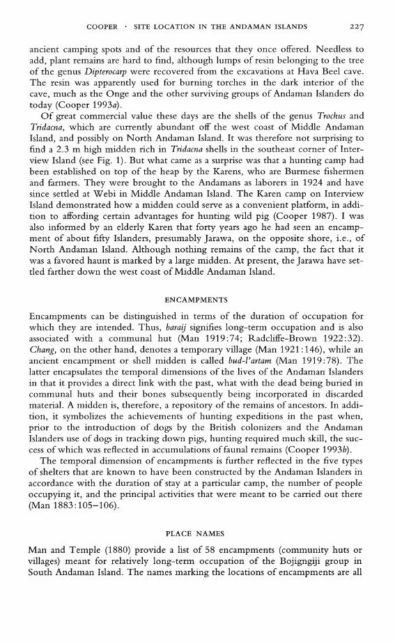
Man and Temple (1880) provide a list of 58 encampments (community huts or villages) meant for relatively long-term occupation of the Bojigngiji group in South Andaman Island. The names marking the locations of encampments are all
228
25
20
15
10
5
o Trees and
Plants
ASIAN PERSPECTIVES . 36(2) . FALL 1997
Useful Plants
Sea Spring Ocher Topo- Socio- Direction graphical cultural features features
Fig. 2. Attributes of encampment place names from the Andaman Islands.
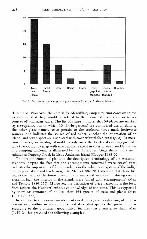
descriptive. Moreover, the criteria for identifying camp sites runs contrary to the expectation that they would be related to the nature of occupation or to resources of utilitarian value. The list of camps indicates that 39 places are marked by trees/plants, out of which 15 (38.46 percent) are considered useful. Among the other place names, seven pertain to the seashore, three mark freshwater sources, one indicates the source of red ocher, another the orientation of an island, and seven spots are associated with sociocultural features (Fig. 2) . As mentioned earlier, archaeological middens only mark the locales of camping grounds. The two do not overlap with one another except in cases where a midden serves as a camping platform, as illustrated by the abandoned Onge shelter on a small midden at Dugong Creek in Little Andaman Island (Cooper 1985: 32).
The preponderance of plants in the descriptive terminology of the Andaman Islanders, despite the fact that the encampments concerned were coastal sites, indicates the importance of forest products in the subsistence system of the indigenous population and lends weight to Man's (1882:281) assertion that those living in the heart of the forest were more numerous than those inhabiting coastal areas. In fact, the interior of the islands were "filled with encampments" (Man and Temple 1880:256). Moreover, the derivation of place names from the local flora reflects the islanders' exhaustive knowledge of the same. This is supported by their acquaintance of no less than 164 species of trees and plants (Man 1883 :426-433).
In addition to the encampments mentioned above, the neighboring islands, or certain areas within an island, are named after plant species that grow there or according to the prominent geographical features that characterize them. Man (1919: 24) has provided the following examples:
COOPER . SITE LOCATION IN THE ANDAMAN ISLANDS 229
1. Coast and interior of Middle Andaman: leaf of the Licuala peltata (kaup-tongda), which is abundant there. 2. Central portion of the east coast of Middle Andaman: kol flower (el-akakoda). 3. Baratang Island: named after the bara tree; the full name means "locality of our type of speech." 4. Ritchie's Archipelago: the land across the sea (el-arljuru). 5. The coasts of South Andaman, Rutland Island, Labyrinth Islands, southwest corner of Middle Andaman: the land of spring water (el-aka-beada). 6. Little Andaman Island: the Semecarpus (Patang) tree, which flourishes there, and the casuarina trees (wilmatara) trees on the sand.
Seven of the 58 encampments referred to above are associated with sociocultural features. Three of these are related to spiritual or superstitious beliefs or objects, such as a burial platform, the turtle nets of the departed spirits (northwestern coast of Rutland Island), and the abode of Puluga, or Biliku, a mythical being associated with the northeast monsoon (Man 1883:99). The other four camps are connected with shellfish, turtle eggs, a shipwreck, and a defeat after a severe fight.
Prominent among the places associated with mythical events is W ot-a-emi, which is not listed by Man and Temple (1880), as it is not situated in South Andaman Island but lies on the northeastern tip of Baratang Island. According to legend, it is here that the first islanders arrived (Radcliffe-Brown 1909: 261-262). However, the shell midden located at this spot is not particularly old, its age (1530 ± 70 B.P.) indicating its contemporaneity with other archaeological sites in the area (Cooper 1993a).
THE TERRITORY AND THE CAMP
On a different level, a midden serves to mark the territory of a group, which in the Andamans constitutes the dominant social unit possessing hunting rights over a recognized area (Radcliffe-Brown 1922:26, 29). These rights are reinforced through the knowledge of a midden as an ancient encampment (Radcliffe-Brown 1922:29-30). There are no marked boundaries between the areas of various groups, for territorial limits conform to natural boundaries, as defined by hills, creeks, and belts of dense forest (Man 1883: 113). However, a local group is often denoted by a reference to the district that it occupied or to one of its chief camping places (Radcliffe-Brown 1922: 28). The creation of some of these landforms is attributed to Puluga (Man 1883: 99).
The mythical associations of territorial boundaries defined by physical features and those of certain camping places constitute a binding element-one demarcating a territory, the other marking it-that ultimately defines the mythical boundaries of the islanders' universe. In this regard, the practice of burying the dead within semipermanent encampments assumes special significance, in that the link with the ancestors and in turn with the mythical realm is established.
THE ENCAMPMENT IN PERSPECTIVE
The data outlined above are divided into two principal categories, the first of these comprising local knowledge of the geography of the Andamans. This con-
230 ASIAN PERSPECTIVES . 36(2) . FALL 1997
stitutes a data bank that is uniformly available throughout the archipelago and on which the pattern of subsistence is based. The second category concerns the semipermanent encampment, the ecological factors determining its location, the temporal dimension of settlements, the names by which they are identified, and the relationship between the major camp(s) of a group and the area within which its social and economic roles are enacted.
What emerges from this is that the criteria for selecting a suitable spot for longterm occupation is quite different from those for identifying or naming it. The latter set of criteria illuminate those aspects of the subsistence system and socioreligious sphere that are not reflected in the archaeological record, as they are, by their very nature, invisible, inconspicuous, and nontangible. Furthermore, the nomenclature, although largely derived from local plant lore, is in essence personalized and subjective in that the flora and fauna that it represents, apart from their economic value, reflect a community's preference and experiences, both fearful and pleasant. This, together with the spiritual connotations of ancient encampment, establishes and enhances the sense of association and belonging to a place, in addition to strengthening social bonds and reinforcing a group's land-owning and hunting rights. In effect, the principal camping sites of a group form the centers, as it were, from which direct control is exercised over a given area, thereby rendering it a "landscape" that "is constituted as an enduring record of-and testimony to-the lives and works of past generations who have dwelt within it, and in so doing, have left something of themselves" (Ingold 1993: 152).
From the archaeological point of view, the proximity of sites to freshwater streams or pools constitutes a fundamental criterion for the location of encampments, one that is not reflected in the etymology of place names, but which is nevertheless mentioned in ethnographic reports (Man 1882: 283; RadcliffeBrown 1922: 412). On the other hand, the study of site locations can indicate one of the prime factors that influence the location of a site, especially one that is connected with long-term occupation.
What is also apparent is the feedback relationship between environmental features and modes of subsistence on the one hand, and vital resources and the location of encampments on the other. In fact, all these elements seem interdependent, although the situation is rendered more complex with the use of sociocultural phenomena in distinguishing camp locations.
ACKNOWLEDGMENTS
I would like to thank Michael W. Graves for his insightful comments on this paper.
REFERENCES
BOSE, S. 1964 Economy of the Onge of Little Andaman. Man in India 44:289-310.
CIPRIANI, L. 1954 A survey of Little Andaman during 1954. Bulletin of the Department of Anthropology
3(2): 66-94. 1966 The Andaman Islanders. London: Weidenfeld and Nicolson.
CLARKE, D. L. 1978 Analytical Archaeology, 2nd ed. London: Methuen and Co., Ltd.
COOPER • SITE LOCATION IN THE ANDAMAN ISLANDS 231
COOPER, Z. 1985
1987
1990
1992
1993a
1993b 1994
Archaeological explorations in the Andaman Islands. Bulletin of the Indo-Pacific Prehistory Association 6:27-39. A Report on Archaeological Investigations in the Andaman Islands from 1984 to 1986. Submitted to the Homi Bhabha Fellowships Council, Bombay. Archaeological evidence for resource exploitation in the Andaman Islands. Man and Environment 15(1) :73-81. The relevance of the forager/collector model to island communities in the Bay of Bengal. Man and Environment 17(2):111-122. The origins of the Andaman Islanders: Local myth and archaeological evidence. Antiquity 67:394-399. Perceptions of time in the Andaman Islands. World Archaeology 25(2):262-267. Abandoned Onge encampments and their relevance in understanding the archaeological record in the Andaman Islands, in Living Traditions: Studies in the Ethnoarchaeology of South Asia: 235-263, ed. B. Allchin. New Delhi: Oxford and IBH Publishing Co. Pvt. Ltd.
ERICKSON, P., AND S. BECKERMAN 1975 Population Determinants in the Andaman Islands. Mankind 10(2): 105-107.
INGOLD, T. 1993 The temporality of the landscape. World Archaeology 25(2): 152-174.
MAN,E. H. 1882 On Andamanese and Nicobarese objects. Journal of the Anthropological Institute of Great
Britain and Ireland 11 :268-294. 1883 On the aboriginal inhabitants of the Adaman Islands. Journal of the Anthropological Institute
of Great Britain and Ireland 12:69-175, 327-434. 1919- Dictionary of the South Andaman language. The Indian Antiquary 48: 1-84, 49: 85-136, 1923 50:137-164,51:165-188,52:189-203.
MAN, E. H., AND R. C. TEMPLE 1880 Note on two maps of the Andaman Islands. The Journal of the Royal Geographical Society
50:255-259.
RADCLIFFE-BROWN, A. R. 1909 The religion of the Andaman Islanders. Folklore 20(3):257-271. 1922 The Andaman Islanders. Cambridge: Cambridge University Press.
ABSTRACT
The results of archaeological surveys in the Andamans have been combined with information gleaned from local oral traditions in order to correlate the ecological determinants of site location with the criteria for marking and identifying encampments. The implications of the distinction between the two sets of criteria are examined. KEYWORDS: Andaman Islands, South Asia place names, settlement patterns.