Embed Size (px)
Citation preview

THE ROUGH FESCUE DOMINATED COMMUNITYTYPES IN THE FOOTHILLS OF
NORTH-CENTRALALBERTA
ALBERTA SUSTAINABLE RESOURCE DEVELOPMENT

ii
THE ROUGH FESCUE DOMINATED COMMUNITY TYPES INTHE FOOTHILLS OF NORTH-CENTRAL ALBERTA
Prepared by
Willoughby, M.G.
Edmonton Sustainable Resource Development2001 Public Lands Division

iii
Pub. No.: T/017ISBN: 0-7785-1997-X
For copies of this report contact:
Michael Willoughby9920 108 Str.th
Edmonton, AB.T5K 2M4(780)[email protected]

iv
Table of contents
Introduction 1
Methods 1
Results 4
Species composition 4
Ya Ha Tinda, Harrison flats 10
Discussion 11
Plant community ecology 12
Bog birch/Rough fescue Bearberry 12Rough fescue /Hairy wildrye 12Rough fescue/Tufted hairgrass 14
Summary 14
Literature cited 17
List of Figures
Figure 1. Rough fescue dominated zones in Alberta 3
Figure 2. Ordination of undisturbed rough fescue dominated plots in Zone III 5
Figure 3. Cluster analysis of undisturbed rough fescue plots in Zone III. 5
Figure 4. Biplot ordination of selected plant species and environmental variables for all undisturbed rough fescue dominated transects in Zone III. 6
Figure 5. Ordination of Ya Ha Tinda and Harrison flats transects with thesummarized undisturbed rough fescue dominated community types in

v
Zone III. 10
List of Tables
Table 1. Canopy cover of selected species in each of the three rough fescue dominated community types in Zone III. 8
Table 2. Site characteristics of the three undisturbed rough fescue dominatedcommunity types in Zone III. 9
List of Photos
Photo 1. The lack of fire has allowed bog birch cover to increase on both the grazed and ungrazed transects at the Elk Creek rangeland reference areafrom 1968 to 2000. 13
Photo 2. In over 30 years of protection from grazing and fire there has beenlittle shrub expansiion at the Harold Creek rangeland reference area. Howevershrub expansion has continued on the moister sites in the background. 15

vi
ABSTRACT
The fescue grasslands of Alberta are an important grazing resource for both wildlife anddomestic livestock. These grasslands are also found in some of the most ecological diverseareas of the province. Looman (1982) described three zones of rough fescue in Alberta,characterized by a different species. In the Northern rough fescue zone, north of 51 N latitudeo
in the foothills of North-central Alberta three undisturbed rough fescue dominated types havebeen described. These include the Rough fescue-Hairy wildrye dominated community which isfound on dry, well-drained sites. On moister sites with deep snow accumulation bog birch willinvade to form the Bog birch/Rough fescue/Bearberry dominated community type. In contrast,on moist, rich sites tufted hairgrass co-dominates with rough fescue to form the Rough fescue-Tufted hairgrass dominated community type. This paper will describe and examine thesuccessional relationships of these community types in the presence and absence ofdisturbance.

Looman (1969) and Hill (1995) felt that the third rough fescue zone was dominated by1
Northern rough fescue, but there appears to be extensive overlap between this species and Foothillsrough fescue, particularly in the southern part of the zone west of Rocky Mtn. House and Sundre.
1
INTRODUCTION
Looman (1982) and Hill (1995) recognized three zones of rough fescue in Alberta (Figure 1)each characterized by a different species (Pavlick and Looman 1984). The largest zone (I) includedthe Foothills and Central Parkland (Strong and Thompson 1995) of east-central Alberta and isdominated by Plains Rough fescue (Festuca hallii). The second zone (II) is dominated by FoothillsRough fescue (F. campestris) and includes the Foothills fescue, Montane and Subalpine subregions ofsouthwestern Alberta and the Cypress Hills. The third zone (III) is dominated by Northern roughfescue (F. altaica) and extends north of 50 N latitude along the foothills and mountains ofo
north-central Alberta and includes the Upper Foothills, Subalpine and Montane subregions. Classification of the Rough fescue dominated communities have been made by Willoughby et al.
(2001) for the Foothills rough fescue zone, but only a limited classification is available for the Northernrough fescue zone. Particularly, it is not clear how the rough fescue grasslands are related between the1
Upper Foothills, Montane and Subalpine subregions. The rough fescue grasslands of North-Central Alberta are important locally for grazing by
livestock and wildlife. Morgantini and Russell (1983) found that rough fescue made up over 69% of theelk winter diet in the Ya Ha Tinda area. These grasslands are also important in maintaining the localbiodiversity. Despite the importance of these grasslands there is little understanding of their ecology. Willoughby (2001) and Willoughby (1999) have identified a Rough fescue-Hairy wildrye, Roughfescue-Tufted Hairgrass and Bog birch/Rough fescue/Bearberry dominated communities in the UpperFoothills and Subalpine subregions within this zone, but no attempt has been made at examining therelationship between these community types across the various subregions. In this paper the data fromthe rough fescue dominated communities north of 51 N latitude located within the Upper Foothills,o
Subalpine and Montane subregions were combined in order to determine the similarity and successionalrelationships of these types.
METHODS
All of the data from the Rough fescue dominated communities identified by Willoughby (2001),Willoughby (1999) and Willoughby et al. (2001) in the Upper Foothills, Subalpine and Montanesubregions of Alberta were classified using both cluster analysis (SAS) and ordination (PC-ORD). Thedata included plots done near the Ya Ha Tinda ranch, Harrison flats, Forty Mile Flats (UpperClearwater Forest Land Use Zone), Ribbon Flats, Panther Corners and Wilson Creek range

2
allotment. These data also included rangeland reference area data from, McCue Creek, Yara Creek,Harold Creek, Upper James River, Seven mile burn, Elk Creek and Eagles Nest Cabin (WillmoreWilderness Park) (Weerstra and Willoughby 1998). The reference area data included grazed andungrazed transects with over 30 years of data from a number of the sites. The initial classification wascomplicated by the fact that a number of the transects represented grazing and fire disclimax communitytypes. In order to gain a better understanding of the ecology of these sites in the absence ofdisturbance only the undisturbed transects were reordinated and classified. This left 64 transects whichincluded the inside ungrazed transects from 1981 to 2000 at the Upper James (UJR) and McCueCreek (MC) reference areas, from 1991 to 2000 at the Harold Creek (HC) reference area, from 1998to 2000 at Eagles Nest cabin (EN) and Wilson Creek allotment (WCT01). The inside and outsidetransects from 1979 to 1985 at Yara Creek (YC), from 1991 to 2000 at Elk Creek (EC) and theunburned transects at Seven Mile Burn (SMB). Data from Ribbon Creek Flats (RF) prior to brushclearing (MacCallum and Yakimchuk 1992), Panther Corners (PANT)(AGRA 1998) and Forty MileFlats (FM) were also included in the analysis.
Both the Ya Ha Tinda (YE,YW) and Harrison flats (H) areas of the province have extensiveareas of rough fescue grassland that support large herds of elk. In an effort to determine how thesedisturbed grasslands were ecologically related to the other undisturbed rough fescue dominatedcommunity types the Ya Ha Tinda and Harrison transects were reordinated with the summarizedspecies lists of the undisturbed Rough fescue-Hairy wildrye (HWR), Bog birch/Roughfescue/Bearberry (BEGL) and Rough fescue-Tufted hairgrass (TUFT) community types.

3
Figure 1. Rough fescue dominated zones in Alberta. Adapted from Looman (1982)
Ordination (DECORANA)(Gauch 1982) and cluster analysis (SAS) multivariant techniquescombine the sites based on the similarity of species composition. The groupings from cluster analysiswere overlain on the site ordination. Soil moisture, nutrients, drainage, elevation and slope data werecollected in the procedure outlined in the Ecological Land Survey Site Description Manual (1994). These data were correlated with the ordination axes using PC-ORD in an effort to determine whichenvironmental variables accounted for the most variation in the species-stand table. These data werepresented in a species-environment biplot.
Rangeland reference area sites were selected from within range allotments on areas thatrepresented primary range. Originally sites thought to be in poor range condition were selected . Thesesites were usually represented by open grasslands on south-facing slopes, benchlands and terraces. The reference sites were not located near salt or within 100-ft. (30-m) of a fence. The preferreddistance from a water source was greater than 1000-ft. (300-m) but less than 1-mi. (1.6-km). Eachreference site consisted of a fenced exclosure and a 100-ft (33-m) transect inside and outside theexclosure. The outside transect was situated 25-ft (8-m) or greater from the edge of the exclosure. At3-in. (7-cm) intervals, the basal frequency of the plant species were recorded using Parker's loop(Parker 1954). In 1981, the canopy cover of the plant species was also recorded (at 6-ft. (1.8-m)intervals) using a 20x50 cm Daubenmire frame. Presently, the transects are being recorded every three

4
years. All the basal frequency data prior to 1981 was converted to canopy cover using regressionanalysis.
Transect data from non-rangeland reference area sites were collected in order to developmanagement plans for the various range allotments. These data were collected using the methodologyoutlined by Dale et al. (2001).
RESULTS
Species composition
The ordination and cluster analysis of the undisturbed rough fescue dominated communities inzone 3 is outlined in Figures 2 and 3. The first two axes in the ordination accounted for 49% and 16%of the variation in the species stand table, respectively (Figure 2). There is a distinct grouping of thetransects done at Yara Creek (YC), McCue Creek (MC), Upper James River (UJR), majority of thePanther Corner transects and Forty Mile flats. These transects are dominated by rough fescue, hairywildrye and slender wheatgrass and represent the Rough fescue-Hairy wildrye community type. Thetransects located at Harold Creek (HC), Eagles Nest (EN) and Wilson Creek (WCT) were alldominated by rough fescue and tufted hairgrass and they grouped together to form the the Roughfescue-Tufted hairgrass dominated community type.
The final grouping was all of the transects that were dominated by bog birch, rough fescue andbearberry. These included the Seven Mile Burn, Ribbon Flats, Elk Creek and a number of transectslocated within Panther Corners. Both the cluster analysis (Figure 3) and ordination (Figure 2) indicatedthat the Rough fescue-Tufted hairgrass and Rough fescue-Hairy wildrye dominated community typeswere much more similar than the transects dominated by rough fescue, bearberry and bog birch. Indeed, cluster analysis indicated that the Rough fescue-Tufted hairgrass transects grouped togetherwithin the larger Rough fescue/Hairy wildrye dominated group (Figure 3).

Bog birch dominated plots
Rough fescue-Hairy wildrye dominated
Rough fescue-Tufted hairgrass dominated
Rough fescue-Hairy wildrye dominated
5
Figure 2. Ordination of undisturbed Rough fescue dominated plots in Zone III.
Figure 3. Cluster analysis of undisturbed Rough fescue plots in Zone III.

ACONDEL
AGOSGLA
AGROTRA
ANEMMUL
ANTELAN
ANTEPAR
ARCTUVA
ARTEFRI
ARTELUD
ASTEALP
ASTECIL
BETUGLA
CALAMON
CAREATR
CAREAUR
CAREMAC
CAREOBT
CAREPRE
CAREXER
CETRNIV
CREPRUNDANTCAL
DANTPAR
DELPGLA
DESCCES
DODECON
ELYMINN
EPILANG
FESTSCA
FRAGVIR
GAILARI
GEUMTRI
HEDYSUL
HELIHOO
JUNCBAL
KOBRMYO
KOELMAC
LINULEW
LUZUMUL
MERTPAN
MOSSSPP
MYOSALP
OXYTMON
OXYTSER
POLYVIV
POTEFRUROSAACI
RUBUARC
RUMEACE
SALIBEB
SALIMYR
SALISPPSMILSTE
THALVEN
VACCCAE
MOIST
NUTRDRAIN
ELEVSLOPE
Axis 1
Axi
s 2
6
The species-environment biplot is outlined in Figure 4. Species characteristics of the Bogbirch/Rough fescue/Bearberry community, bog birch (betugla), bearberry (arctuva), oatgrass (dantcal,dantpar), willow (salimyr, salispp, salibeb), scapose hawk’s beard (creprun), blueberry (vacccae),alpine bistort (polyviv), valeriana (valesit), graceful sedge (carepre) were found on the right side of axisone and were situated around the ordinates of higher moisture and higher (poorer) drainage.
In contrast species characteristic of the Rough fescue-Hairy wildrye community, shrubbycinquefoil (potefru), rose (rosaaci), fringed and prairie sage (artefri,artelud), white scaled sedge(carexer), browned eyed susan (gailari), locoweed (oxytmon, oxytser), junegrass (koelmac), cut leavedanemone (anemmul) and bog sedge (kobrmyo) were found on the left side of axis 1 and
Figure 4. Biplot ordination of selected plant species and environmental variables for all undisturbedrough fescue dominated transects in zone III.
bottom of axis 2 and tended to have lower moisture, nutrients and were more rapidly drained. Many ofthese plots were also found at higher elevations and were located on steep south facing slopes. Speciescharacteristic of the Rough fescue-Tufted hairgrass community, tufted hairgrass

7
(descces), monkshood (acondel), veiny meadow rue (thalven), thick-spiked and long-bracted sedges(caremac, careatr), tall lungwort (mertpan), dock (rumeace), arctic rush (juncbal) were found at the topof axis 2. These species were correlated with higher moisture and were found on somewhat richersites. Species that were common to all three types tended to be found in the middle of the ordinationrough fescue (festsca), hairy wildrye (elyminn), slenderwheatgrass (agrotra), old man’s whiskers (geumtri), strawberry (fragvir), mountain dandelion (agosgla),blunt sedge (careobt), flax (linulew), shooting star (dodecon) and fireweed (epilang).
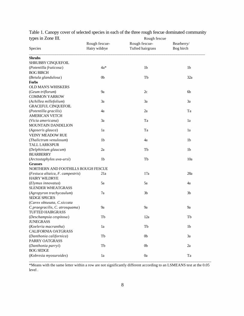
Table 1 outlines the differences in species composition between the various community types.All three community types were dominated by rough fescue which was not significantly differentbetween the types. The Rough fescue-Hairy wildrye community type had a significantly higher cover ofshrubby cinquefoil and slender wheatgrass than the Rough fescue-Tufted hairgrass or Roughfescue/Bearberry/Bog birch community types. In contrast, the Rough fescue-Tufted hairgrass had asignificantly higher cover of tufted hairgrass than the other community types and the Roughfescue/Bearberry/Bog birch community had the highest cover of bog birch, bearberry and oatgrassspecies (Parry and California) (Table 1).
Table 2 outlines the physical characteristics of each plant community type. The soils of eachcommunity type are very similar ranging from Orthic Eutric and Melanic Brunisols on the Roughfescue-Hairy wildrye and Bog birch/Rough fescue/Bearberry communities to Cumulic and OrthicRegosols on the Rough fescue-Tufted hairgrass community. All of the communities have fluvial andlacustrine parent materials and their textures range from loamy at the surface to Clay loams and SiltyClay Loams at depth. The pH ranges from 5-8 and the depth of the Ah horizon averages from 3-10cm for all community types. The Rough fescue-Tufted hairgrass or Bog birch/Rough fescue/Bearberry community is slightly moister ranging from mesic to subhygric, than the Rough fescue-Hairy wildryecommunity type which has a submesic to mesic moisture regime. The Rough fescue-Tufted hairgrasscommunity also has slightly poorer drainage and higher nutrients than the other community types withgleying at depth at one site.
8
Table 1. Canopy cover of selected species in each of the three rough fescue dominated communitytypes in Zone III. Rough fescue
Rough fescue- Rough fescue- Bearberry/Species Hairy wildrye Tufted hairgrass Bog birch____________________________________________________________________________________ShrubsSHRUBBY CINQUEFOIL(Potentilla fruticosa) 4a* 1b 1bBOG BIRCH(Betula glandulosa ) 0b Tb 32aForbsOLD MAN'S WHISKERS(Geum triflorum) 9a 2c 6bCOMMON YARROW(Achillea millefolium) 3a 3a 3aGRACEFUL CINQUEFOIL(Potentilla gracilis) 4a 2a TaAMERICAN VETCH(Vicia americana) 3a Ta 1aMOUNTAIN DANDELION(Agoseris glauca) 1a Ta 1aVEINY MEADOW RUE(Thalictrum venulosum) 1b 4a 1bTALL LARKSPUR(Delphinium glaucum) 2a Tb 1bBEARBERRY(Arctostaphylos uva-ursi) 1b Tb 10aGrassesNORTHERN AND FOOTHILLS ROUGH FESCUE(Festuca altaica, F. campestris) 21a 17a 28aHAIRY WILDRYE(Elymus innovatus) 5a 5a 4aSLENDER WHEATGRASS(Agropyron trachycaulum) 7a 3b 3bSEDGE SPECIES(Carex obtusata, C.siccata C.praegracilis, C. atrosquama) 9a 9a 9aTUFTED HAIRGRASS(Deschampsia cespitosa) Tb 12a TbJUNEGRASS(Koeleria macrantha) 1a Tb 1bCALIFORNIA OATGRASS(Danthonia californica) Tb 0b 3aPARRY OATGRASS(Danthonia parryi) Tb 0b 2aBOG SEDGE(Kobresia myosuroides) 1a 0a Ta_______________________________________________________________________________________*Means with the same letter within a row are not significantly different according to an LSMEANS test at the 0.05level .

9
Table 2. Site characteristics of the three undisturbed rough fescue dominated community types in ZoneIII.
Rough fescue/Rough fescue Rough fescue Bearberry/
Site characteristics -Hairy wildrye -Tufted hairgrass Bog birch__________________________________________________________________________Soil (subgroup) O. Melanic Cumulic Regosol O.Eutric5
Brunisol Orthic Regosol Brunisol1 5 10
O.EutricBrunisol7
O. HumicRegosol2
Parent material Fluvial, Fluvial, Lacustrine, over Colluvial apron, Glacial Fluvial glacial tillGlacial fluvial
Surface Texture L L L
Effective texture CL, SiL, SiCL, SiC CL, SiCL CL, SiL, SiC
pH 5-8 5-6.5 5-8
Ah thickness (average) 2-27(10) 2-4(3) 2-5(4)
Humus form Mor, Mull Mor Mull, Mor
Depth to Gleying None None, 60cm None
Moisture Submesic, Mesic, Mesic,Mesic Subhygric Subhygric
Nutrient Mesotrophic, Mesotrophic, MesotrophicPermesotrophic Permesotrophic
Drainage Well Moderately well, WellWell
Elevation (m) 1470-2150 1370-1737 1300-1981 Aspect Level, South North, East,South Level, SouthSlope (%) 0-22(9) 2-3(2) 1-2(1)
Number of Soil Pits 10 2 4___________________________________________________________________________1 Indicates percentage of soil pits with this soil subgroup (ie 1=10%)

BEGL
H183
H187H195
H383
H387
H395
HWR
TUFT
YE01
YE02
YE03YE05
YE06
YE07
YE09
YW01
YW03
Axis 1
Axi
s 2
10
Ya Ha Tinda, Harrison Flats
The ordination of the Ya Ha Tinda (YE, YW) and Harrison flats (H) transects with thesummarized undisturbed rough fescue community types is outlined in Figure 5.
Figure 5. Ordination of Ya Ha Tinda and Harrison flats transects with the summarizedundisturbed rough fescue dominated community types in Zone III
The first two axes accounted for 51% and 11% of the variation in the species-stand table respectively. The ordination indicates that the Ya Ha Tinda and Harrison flat grasslands have a closer affinity with theRough fescue-Hairy wildrye (HWR) community than either the Rough fescue-Tufted hairgrass (TUFT)

11
or Bog birch/Rough fescue/Bearberry (BEGL) dominated community types. There is a distinct grouping of the Ya Ha Tinda plots into two community types. The first type
was described on grasslands east of Scalp Creek (YE). These transects were dominated by shrubbycinquefoil, rough fescue or sedge, junegrass, fringed brome, old man’s whiskers and early yellowlocoweed and represent the Rough fescue-Sedge-Junegrass community type (Willoughby et al. 2001). This community type was the most extensive grassland community described in the Ya Ha Tinda area. The other community type was described west of Scalp Creek near the Ya Ha Tinda ranch buildings. The transects (YW) in this community were dominated by shrubby cinquefoil, sedge, junegrass,Kentucky bluegrass, showy locoweed and cut leaved anemone. These transects represented a Sedge-Junegrass community type.
In contrast the Harrison flats transects were the most similar to the summarized Rough fescue-Hairy wildrye (HWR) community and were dominated by shrubby cinquefoil, rough fescue, sedge,junegrass, old man’s whiskers and early yellow locoweed. The dominant species on the Harrisontransects are very similar to the dominant species at the Ya Ha Tinda, but the cover of rough fescueaveraged 35% at Harrison flats in comparison to only 10% at the Ya Ha Tinda (Appendix 1).
DISCUSSION
The rough fescue dominated grasslands follow the creeks and river valleys throughout thefoothills of the Rocky Mountains north of Calgary to Willmore Wilderness park near Grande Cache. The topography of the area consists of both mountains and foothills. Closed-canopy coniferous forestdominates the area with potential climax species on modal sites being white and black spruce withlodgepole pine as an early successional species (Strong 1992). The valley bottoms have predominantwillow and bog birch cover with pockets of open grassland. The south facing slopes are also coveredby grassland.
The rough fescue dominated grasslands are generally found on mesic to subhygric, well drainedsites within these valley bottoms and on lower slope positions of south facing slopes. On moister andricher sites tufted hairgrass and graceful sedge often replaces rough fescue as the dominate species inthe community. On steep dry south facing slopes hairy wildrye, junegrass, sedge species and fringedsage tend to dominate (Willoughby 2001).
Soil moisture and nutrients appear to account for most of the variation within the ordination ofthe undisturbed rough fescue dominated community types. Moisture is a major limiting factor limitingthe distribution of plants (Krebs 1978). In this study it appears there was a definite species response toa moisture and nutrient regime gradient. Species characteristic of moist, medium rich sites included bogbirch, willow, graceful sedge, and alpine bistort. These species were indicative of the Bog birch/Roughfescue/Bearberry community type. Species characteristic of moist, rich sites included tufted hairgrass,long-bracted sedge, monkshood, tall lungwort and dock. These species were characteristic of theRough fescue-Tufted hairgrass community type. In contrast species characteristic of dry, well drained,medium to rich sites included bog sedge, fringed sage, shrubby cinquefoil and locoweeds. Thesespecies were characteristic of the Rough fescue-Hairy wildrye community type.
12
Plant community ecology
Bog birch/Rough fescue/Bearberry
de Groot (1998) found that bog birch tended to prefer moist, acidic, nutrient poor organic soilswhich were well drained. Anderson (1975) also found that bog birch is very sensitive to extremely coldwinter temperatures, but can survive temperatures to as low as -27 C if sufficient snowfall occurs. Theo
presence of bog birch on these rough fescue dominated grasslands may indicate sites which havedeeper snow accumulations, which insulate bog birch from the extreme winter conditions. The deepersnow accumulations would also increase soil moisture in the spring further favouring bog birch growth. The surface of this community is well drained and dries out quickly in the summer favouring the growthof rough fescue, junegrass, bearberry, Parry oatgrass and California oatgrass plant species.
Repeated fire (every few years) reduces bog birch canopy cover and above ground biomass,but has only a minimal effect on bog birch mortality (de Groot 1998, Bork et al. 1996). Bork et al. also found that burning bog birch three times in 9 years controlled shrub growth and increased forageproduction by over 40% compared to the unburned control. The increase in bog birch cover in theabsence of fire is evident from the pictures taken at the Elk Creek rangeland reference area from 1968to 2000 (Photo 1).
Rough fescue-Hairy wildrye
The Rough fescue-Hairy wildrye dominated community is found on submesic to mesic, welldrained sites. This community can also be found on south facing slopes in lower slope positions wheresome moisture accumulates (Willoughby 2000). In the absence of grazing and fire it appears thiscommunity type will eventually succeed to conifer forest (Willoughby 2000), but the time frame forcomplete tree invasion appears to be greater than 60 years. Willoughby also found that increasedgrazing pressure by domestic livestock leads to a decline in rough fescue and other native species andallows species like Kentucky bluegrass and dandelion to dominate the site to form a Kentuckybluegrass-Sedge dominated community type.
Initial analysis of the Ya Ha Tinda ranch and Harrison flats rough fescue dominated grasslandsindicated that these grasslands were very different from the other undisturbed rough fescue dominatedtypes. Work by Looman (1969), found that these grasslands supported a large elk herd during thewinter when they remained snow free. It would appear that this heavy dormant season grazing hasaltered the community structure so that these grasslands do not resemble the other undisturbed orgrazed Rough fescue-Hairy wildrye community types. Bailey et al. (1988) found that heavy dormantseason grazing lowered plains rough fescue cover and allowed species like junegrass, sedge, slenderwheatgrass, fringed sage and pussytoes to increase in the Aspen parkland. They also found that forageproduction was significantly lower under

13
1968
2000
Photo 1: The lack of fire has allowed bog birch cover to increase on both the grazed andungrazed transects at the Elk Creek rangeland reference area from 1968 to 2000.

14
heavy dormant season grazing compared to the ungrazed control. They concluded that heavy dormantseason grazing was having the same impact on the community as a light June grazing treatment. Itwould appear that the heavy grazing by wildlife during the winter is having a similar affect on themajority of the Ya Ha Tinda grasslands.
The other Ya Ha Tinda grassland community type (Sedge-Junegrass) that was described byWilloughby et al. (2001) was found in an area where the Ya Ha Tinda ranch feeds hay to horsesduring the winter. The horses also graze this area early in the spring. This grazing pressure has allowedKentucky bluegrass to invade onto this community type and it would appear that this community type issucceeding to a community that is similar to a number of the grazed transects of the rangeland referenceareas to the east of the ranch in the Red Deer river valley (Willoughby 2000).
It would appear that the grasslands of the Ya Ha Tinda represent grazing disclimax communitytypes. If protected from grazing these grasslands would likely succeed to a community type that issimilar to the undisturbed Rough fescue-Hairy wildrye dominated type.
Rough fescue-Tufted hairgrass
The Rough fescue-Tufted hairgrass community is found on moderately well drained, subhygric,rich sites. This community type appears to represent the transition between the drier Rough fescue-Hairy wildrye community and the moister and richer Tufted hairgrass-Sedge dominated communitytype (Willoughby 2001). Willoughby (1998) found a 25% increase in shrub cover in only 25 years onthe Tufted hairgrass-Sedge community type, but this community type is rarely shrub covered. Photostaken at the Harold Creek rangeland reference area in 1963 and again in 2000 show little shrubexpansion in over 30 years of no disturbance (Photo 2). Lane et al. (2001), have found that there hasonly been an 18% increase in shrub cover on this community type in Willmore Wilderness Park in over40 years. Presently it is not clear why shrub expansion is slower in this community type.
Continued grazing pressure causes rough fescue to decline and initially tufted hairgrass andsedge increase in cover. However, continued grazing pressure causes a further decline in all nativespecies and the site will become dominated by Kentucky bluegrass, dandelion and clover species(Willoughby 2001). In Willmore where there is little seed source for Kentucky bluegrass and theseheavily grazed Rough fescue-Tufted hairgrass types are often dominated by alpine timothy, slenderwheatgrass, sedge and tufted hairgrass. Many of the sites have also been invaded by tall buttercup.
SUMMARY
The fescue grasslands of Alberta represent some of the most ecologically diverse areas of theprovince. Historically, the desired plant community of these grasslands was one that maximized beefproduction, which has led to a decline in condition of many of these grassland communities. In recentyears there has been a movement towards more sustainable use of our natural resources. The scopeof sustainability has shifted from being defined by economic assessement to include broadersustainability of ecological functions and patterns (Lee and

15
1963
1994
Photo 2: In over 30 years of protection from grazing and fire there has been little shrubexpansion at the Harold Creek rangeland reference area. However, shrub expansion has continued onthe moister sites in the background

16
Hanus 1998). Today society desires the conservation of native plant communities. In North-centralAlberta these rough fescue dominated grasslands are important locally for both wildlife and domesticlivestock. They also contribute to the local biodiversity of the area. Despite their importance there isonly limited understanding of their ecology. This paper describes and presents a classification of therough fescue dominated community types of the foothills of North-central Alberta. This classificationrecognizes three rough fescue dominated community types and outlines the successional relationships ofeach type. Hopefully, this classification can be used to ensure the conservation of these nativegrasslands.

17
LITERATURE CITED
AGRA. 1998. Panther Corners, Upper Red Deer Range Inventory. Alberta Environment.Corporate Management Service. Calgary. AB. 71pp.
Anderson, J.H. 1975. A palynological study of late Holocene vegetation and climate in theHealy Lake area of Alaska. Arctic, 2(1), 62-69.
Bailey, A.W., M.G. Willoughby, and B.D. Irving. 1988. Effect of grazing on forage and beefproduction from Rough fescue rangeland in Central Alberta. Farming for the Future. AlbertaAgriculture. Edmonton. Project no. 87-0099. 62pp.
Bork, E, D. Smith and M. Willoughby. 1996. Prescribed burning of Bog birch. Rangelands. 18:4-7.
Dale, E., M.G. Willoughby, M.A. Alexander, C.T. Lane, C. Rowand and A.Bogen. RangeSurvey Manual. Public Lands Division. Sustainable Resource Development. Edmonton. AB.
de Groot, W.J. 1998. Fire Ecology of Betula glandulosa Michx. Phd thesis. Dept. of ForestScience. University of Alberta. Edmonton. AB. 203pp.
Ecological Land Site Description Manual. 1994. Resource Information Branch. LandInformation Services Division. Forestry, Lands and Wildlife. Edmonton. AB.
Gauch, H.G. 1982. Multivariant analysis in community ecology. Cambridge, University Press.Cambridge. 298pp.
Hill, M.J., W.D. Willms, D.J. Major and J.R. King. 1995. Modelling the Biogeography ofRough fescue in Alberta. Proc. Fifth International Rangeland Congress. Salt Lake City, Utah. pp 234-235.
Krebs, C.J. 1978. Ecology: The Experimental Analysis of Distribution and Abundance. 2 nd
Edition. Harper and Row Publishers. New York. 678pp.
Lane, C.T., M.G. Willoughby, J.Gould, L.Allen and R. Belland. 2001. Rangeland Ecology andRare Plant Monitoring in Willmore Wilderness Park. Foothills Model Forest. Progress Report. Hinton,Alta. 65pp.
Lee, P. and S. Hanus. 1998. Criteria and Indicators for Monitoring Biodiversity in Alberta’sForests: Part 1 Review of Legislation, Policies, External Agreements and Programs. AlbertaEnvironmental Protection. Pub. No. T/422.

18
Looman, J. 1982. Grasslands of Western North America: Fescue Grasslands. In GrasslandEcology and Classification Symposium. June 1982, Kamloops B.C.. Edited by A.C. Nicholson, A.McLean and T.E. Baker. British Columbia Ministry of Forests. 353pp.
Looman, J. 1969. The fescue grasslands of Western Canada. Vegetatio. 19:128-145.
MacCallum, B. and R. Yakimchuk. 1992. Evaluation of the effects of mechanical clearing on aBog birch/Rough fescue community in the Subalpine ecoregion of Alberta. Rocky Mountain ElkFoundation-Canada. Alberta Fish and Wildlife Division. Edmonton. AB. 50pp.
Morgantini, L.E. and W.B. Russell. 1983. An assessement of three elk winter ranges in theRocky Mountains Region. Alberta Fish and Wildlife Division. Edmonton. AB. 265pp.
Parker, K.W. 1954. A method for measuring trend in range condition on national forest ranges.U.S. Forest Service. Washington, D.C. 26pp.
Pavlick, L.E. and J. Looman. 1984. Taxonomy and nomenclature of rough fescues, Festucaaltaica, F. campestris (F. scabrella var. major), and F.hallii in Canada and the adjacent part of theUnited States. Can. J. Bot. 62:1739-1749.
Strong, W.L. 1992. Ecoregion and ecodistricts of Alberta. Vol. I. Alberta Forestry, Lands andWildlife, Land Information Services Division, Resource Information Branch, Edmonton. AB. Pub. No.T/244. 77pp.
Weerstra, B.G. and M.G. Willoughby. 1998. Rangeland Reference Areas. AlbertaEnvironment. Land and Forest Service. Edmonton, AB. 178pp.
Willoughby, M.G. 1998. Rangeland Reference Areas: Seven mile creek, range condition andtrend from 1964-1997. Alberta Environment. Land and Forest Service. T/403. 19pp.
Willoughby, M.G. 1999. Range plant community types and carrying capacity for the Subalpineand Alpine subregions of Alberta. Alberta Environment. Land and Forest Service. Pub. No. T/438.163pp.
Willoughby, M.G. 2000. Rangeland Reference Areas: Species composition changes in thepresence and absence of grazing and fire on the Rough fescue-Hairy wildrye community type in theUpper Foothills subregion Alberta. Alberta Environment. Land and Forest Service. Pub. No. T/572.53pp.
Willoughby, M.G. 2001. Range plant community types and carrying capacity for the UpperFoothills subregion of Alberta. Alberta Environment. Land and Forest Service. 4th approximation. Pub.

19
No. T/003. 119pp.
Willoughby, M.G. M.A. Alexander and K.M. Sundquist. 2001. Range plant community typesand carrying capacity for the Montane subregion of Alberta. Alberta Environment. Land and ForestService. 4th approximation. Pub. No. T/589. 193pp.