Embed Size (px)
Citation preview

The Roles of the Greater Farallones National Marine Sanctuary
Advisory Council and the Working Group
The Overflight Working Group was formed by Greater Farallones National Marine Sanctuary Advisory
Council in their effort to assist the Greater Farallones National Marine Sanctuary (the Sanctuary) with
addressing several years of public requests to review the location and dimensions (shape and size) of NOAA
regulated overflight zones in certain areas of San Mateo, Marin and Sonoma Counties that are managed by the
Sanctuary. The role of the Working Group is to be advisory to the Greater Farallones Sanctuary Advisory
Council (SAC). The Working Group does not directly advise the Sanctuary, NOAA, Department of Commerce,
or any other federal rulemaking agency. More information about the Working Group and its process is set forth
in these Recommendations.
The SAC will consider the Overflight Working Group recommendations at its regular public meeting on
February 1, 2017, and the SAC will determine the final suite of recommendations that will go directly to the
Sanctuary Superintendent for consideration. The recommendations may suggest either regulatory or non-
regulatory actions or both. The Superintendent will review and consider the final SAC recommendations and
report back to the SAC regarding any possible actions at a later date.
Both the Working Group recommendations and the SAC decisions are preliminary to any regulatory
process. If any final recommendations by the SAC include proposed regulatory changes, and the Sanctuary
Superintendent decides to move forward with those changes, then it will require an official federal rulemaking
notice and process that includes environmental review as required by law. During that process, if it goes
forward, there would be ample opportunity for public review and comment.
Public Comments to the Sanctuary Advisory Council on February 1
The SAC is giving members of the public the opportunity to submit comments on these
Recommendations to the Greater Farallones Sanctuary Advisory Council for their consideration at the February
1, 2017 meeting:
Written Comments
If you wish to provide written comments, please email them to [email protected]. All written
comments must be received by January 26th at 5:00 PM in order for them to be provided to the Sanctuary
Advisory Council briefing book.
Spoken Comments
During the February 1, 2017 Sanctuary Advisory Council meeting, there will be 30 minutes allocated for
public comments specific to the Overflight Working Group Recommendations. The time allowed for each
commenter will be three minutes or less, but likely less dependent on the number of people wishing to
comment. Commenters will need to sign in prior to the comment period, and names will be called in the order
they are received. The Sanctuary Advisory Council is looking for unique comments. Repeating the same
comment from previous speakers is discouraged. Multiple people wishing to make similar comments are
encourage to appoint a spokesperson for their collective comments. Since it is quite possible that speaking time
will be limited for all commenters, you are urged to submit a written comment if you have extensive unique
comments.
The Agenda with the times and location of the February 1 SAC meeting in Pt. Reyes Station and a link
to this document will be posted at http://farallones.noaa.gov/manage/sac_meetings.html. The Agenda times
may be updated.

George Clyde, Chair
Greater Farallones National Marine Sanctuary Advisory Council
Working Group on NOAA Regulated Overflight Zones
January 19, 2017
To the Members of the Sanctuary Advisory Council
Attn: John L. Largier, Chair
Dear Members of the Sanctuary Advisory Council,
With this letter I am pleased to transmit to you the Recommendations of the Working
Group on NOAA regulated low-overflight zones.
As a body, the Working Group was not able to reach the sort of agreement that is typical
of a working group, where there is a broad consensus for the recommendations. The group
included three pilots, four marine scientists, a representative of the Monterey Bay SAC, and
myself. While the group unanimously believes that the birds and marine mammals along our
coast and in estuaries are subject to potential disturbance from low-flying aircraft (including
drones) and came to agreement on a number of recommendations, in the end, the pilots and the
other members remained divided in some important ways regarding how the wildlife can and
should be protected.
From the very start of the discussions in late 2015, the pilots advocated for pilot
education and outreach instead of the regulatory approach used by the four west coast sanctuaries
– establishing NOAA regulated overflight zones (NROZs) where pilots flying below 1,000 feet
are subject to citation. The pilots’ position is that NOAA should not be attempting to regulate
airspace, as that is under the exclusive jurisdiction of the FAA. They also believe that the
NROZs can pose serious safety issues for pilots in the area. They believe that pilot education
and outreach, coupled with existing FAA regulations regarding minimum flying elevations, is the
preferred approach.
The other members of the WG agree on the importance of pilot education and outreach.
However, they also believe in NOAA’s right to establish and enforce its NROZ regulations,
accepting the FAA’s stated position that it does not view NOAA’s low-overflight rules as an
airspace regulation nor as an infringement on the FAA’s stated authority.1 Following the
precautionary principle, they believe that the NROZs are an important tool – both in protecting
the wildlife through regulatory enforcement and as an effective way to motivate and educate
pilots about the locations of vulnerable wildlife and the minimum elevations necessary to protect
them from potential disturbance. It is the non-pilot view that outreach and education alone is not
as effective as a combination of outreach, education and enforceable regulated low-over-flight
zones within the Sanctuary.
1 77 Fed. Reg.at p. 3921, fn 1 ( January 26, 2012)
In spite of over 60 hours of meetings and teleconferences, the engagement of a
professional facilitator and circulation of ten drafts for comment, this fundamental division
continued though the final teleconference this week. As a result, the WG members were
individually polled for their views on the various proposals that the WG developed, and the
results of that polling are included in the Recommendations. The pilots also intend to provide a
written statement with their views, which will be distributed to the SAC when published and will
be posted at http://farallones.noaa.gov/manage/sac_meetings.html.
Nevertheless, the WG members worked very well together in developing mutual
understandings as to the relevant issues, and they achieved significant agreements on some
matters. The pilot input helped forge a non-regulatory approach to protecting Devil’s Slide Rock
and to determine the dimensions and locations of the proposed new and extended NROZs. Their
input also resulted in the recommendation that the horizontal dimensions of the existing and
future NROZ should be reduced substantially for reasons of compliance and pilot safety.
The attached Recommendations reflect positive and constructive input from the marine
biologists and pilots, in spite of the pilots’ overall objections to the NROZs. The
Recommendations are well considered. Most are supported by virtually all the marine scientists
and SAC representatives on the WG and, in some cases, by some or all of the pilots. They will
be valuable not only to our Sanctuary, but also to other Sanctuaries and managers of other
protected areas with low-overflight issues.
On that basis, the attached Recommendations are ripe for consideration by the SAC at its
February 1 meeting. My personal view, as a member of the WG (and not as its Chair), is that the
SAC should consider and approve all of the Recommendations, and that they should be
forwarded to the Sanctuary Superintendent for action.
Lastly, thank you for appointing me as Chair of the Working Group. It has been a
challenging but satisfying assignment during which we all have learned a great deal and
hopefully have aided the Sanctuary in its mission of protecting habitat and wildlife in our local
waters.
Sincerely,
CC: Chair, Monterey Bay National Marine Sanctuary Advisory Council

Greater Farallones National Marine Sanctuary Advisory Council
Working Group on NOAA Regulated Overflight Zones
Recommendations to Sanctuary Advisory Council
January 19, 2017

Greater Farallones National Marine Sanctuary Advisory Council
Overflight Working Group
Working Group Members2
George Clyde, Chair Sanctuary Advisory Council Member, GFNMS
Gerry McChesney Marine Scientist, U.S. Fish and Wildlife Service
Jaime Jahncke, Ph.D. Marine Scientist, Point Blue Conservation Science
Sarah Allen, Ph.D. Marine Scientist, National Park Service
Tenaya Norris Marine Scientist, The Marine Mammal Center
Brian Branscomb Private and Commercial Pilot
John duGan Commercial Helicopter Pilot, Bay Aerial Helicopter Tours
Andy Wilson Pilot and Representative of California Pilots Association
Barton Selby Monterey Bay National Marine Sanctuary Advisory Council Liaison
Working Group Staff Providing Technical, Logistical and Facilitator Support
Marina Piscolish Senior Mediator/Facilitator, Center for Collaborative Policy
Sage Tezak NOAA
Karen Reyna NOAA
Matt Pickett NOAA
Thanks to Scott Kathey for his contributions, and to Kate Bimrose and Jenn
Gamurot for their administrative assistance.
Credits for photographs on cover page:
Low-flying aircraft, Courtesy of San Francisco Seaplane Tours
Common Murre with fish, Photo by Derek Lee, Point Blue Conservation Science
Harbor seals, Photo by Jason Thompson
Common Murre on the water, Photo by Sophie Webb
2 Further information regarding the Working Group members is included in the Sanctuary Overflight Working
Group Reference Materials. An electronic copy of these Recommendations will be linked with the February 1,
2017, Sanctuary Advisory Council meeting materials at http://farallones.noaa.gov/manage/sac_meetings.html.

1
TABLE OF CONTENTS
Introduction ................................................................................................................................2
Background .................................................................................................................................4
Recommendations .......................................................................................................................6
Section 1: General Recommendations ......................................................................................6
GR-1: Single Purpose for NOAA Regulated Overflight Zones .............................................6
GR-2: Minimum Altitude .....................................................................................................6
GR-3: Horizontal Dimensions of Coastal NROZs ................................................................8
GR-4: Suggested Improvements to FAA Aeronautical Charts ..............................................9
GR-5: Implications for Other Sanctuary NROZs ................................................................ 12
GR-6: NROZs Next to the Point Reyes National Seashore ................................................ 14
GR-7: Class E Airspace Issues ........................................................................................... 14
GR-8: Class B Airspace Issues ........................................................................................... 16
GR-9: Disturbance of Wildlife by Unmanned Aerial Vehicles (Drones) Outside of the
NROZs .............................................................................................................................. 16
GR-10: Pilot Outreach and Education Recommendations ................................................... 18
Section 2: Recommendations for Specific NROZ Sites ......................................................... 24
ACRONYMS
AGL Above Ground Level
AIM Aeronautical Information Manual
AOPA Aircraft Owners and Pilots Association
CFR Code of Federal Regulations
FAA Federal Aviation Administration
FAR Federal Aviation Regulations
GFNMS Greater Farallones National Marine Sanctuary
GGNRA Golden Gate National Recreation Area
GPS Global Positioning Systems
NOAA National Oceanic and Atmospheric
Administration
NPS National Park Service
NROZ NOAA Regulated Overflight Zones
PRNS Point Reyes National Seashore
SAC Sanctuary Advisory Council
UAV Unmanned Aerial Vehicles
VFR Visual Flight Rules

2
Introduction
The Greater Farallones National Marine Sanctuary Advisory Council (the SAC) formed
the Overflight Working Group to consider and to make recommendations regarding the locations
and dimensions of areas where the elevation of motorized aircraft should be regulated to
minimize potential disturbance to birds and marine mammals. The areas to be considered were
within Greater Farallones National Marine Sanctuary (Greater Farallones Sanctuary or the
Sanctuary) and in the Devil’s Slide area of Monterey Bay National Marine Sanctuary (Monterey
Bay Sanctuary), which is managed by Greater Farallones Sanctuary.
The motivation for this inquiry came from the Farallones Sanctuary staff to follow up on
numerous comments received during regulatory proceedings over several years, most recently in
connection with the revisions to the low-overflight regulations of West Coast sanctuaries in 2012
and the Greater Farallones Sanctuary expansion in 2015. In the course of those proceedings and
earlier, both Greater Farallones and Monterey Bay Sanctuaries have already established some
NOAA Regulated Overflight Zones (NROZs) where flights of motorized aircraft below 1,000
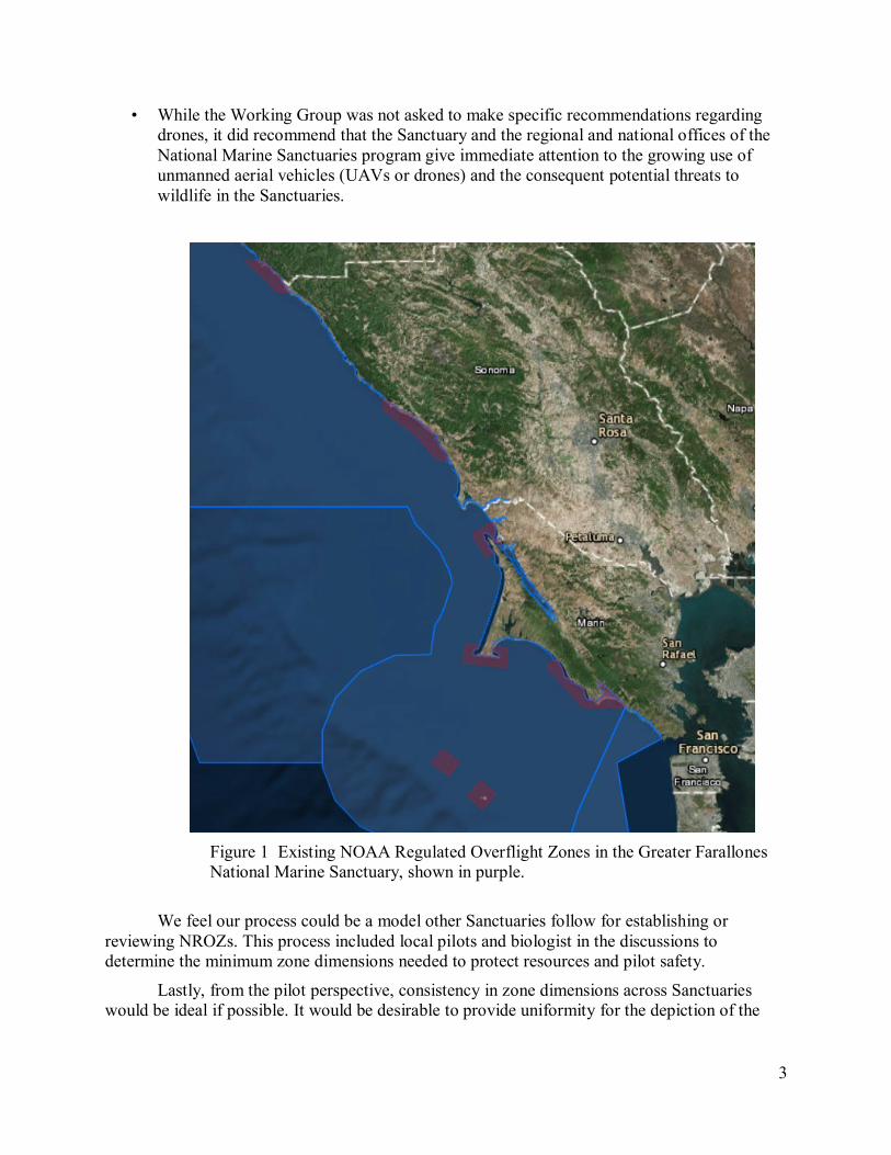
feet that disturb birds or marine mammals violate sanctuary regulations. The existing Greater
Farallones Sanctuary NROZs are shown in purple in Figure 1.
One recommendation of the Working Group was substantial reductions in the horizontal
dimensions of the NROZs to the minimum dimensions needed to adequately protect birds and
marine mammals breeding and resting along the coastline. By reducing the horizontal
dimensions of the NROZs, pilots may be more likely to comply with the regulation, and, more
importantly, improve pilot and passenger safety. Presently many NROZs in the Sanctuary
extend approximately one-and-one-half miles offshore of sensitive coastal wildlife areas. The
working group concluded that approximately 1,000 feet would be sufficient in most cases, and
that a uniform horizontal dimension for all NROZs that adjoin the coast based on that premise
would be more effective than the current horizontal dimensions, which substantially exceed that.
Based on input from the pilots and other sources, the Working Group made a number of
recommendations on how to improve the depiction of NROZs and other sensitive areas in the
Sanctuary on the Federal Aviation Administration (FAA) aeronautical charts and other materials.
The Working Group’s Recommendations also include:
• Acknowledgement of the pilot’s ultimate authority for the safety of the aircraft under
FAA regulations;
• A limited exception to the low-overflight regulations to take into consideration
unanticipated weather;
• The long-term permitting of qualified commercial operators to conduct low overflights
under specified conditions to ensure that wildlife would not be disturbed (similar to the
Farallones Sanctuary permits for shark tour companies), and to improve expedited
permitting in some cases where urgency is required;
• Recommendations as to improving protection of wildlife along the coast of the Pt. Reyes
National Seashore (PRNS), where the Sanctuary’s boundaries do not include the one-
quarter mile from the coastline, and therefore the NROZs do not adequately protect
wildlife from low overflights on the coastline or outlying rocks. In addition, coordinate
with the air tour management plans of the National Park Service (NPS) for PRNS;
• Specific recommendations regarding improved pilot education and outreach, including
recommending staff for this responsibility; and
3
• While the Working Group was not asked to make specific recommendations regarding
drones, it did recommend that the Sanctuary and the regional and national offices of the
National Marine Sanctuaries program give immediate attention to the growing use of
unmanned aerial vehicles (UAVs or drones) and the consequent potential threats to
wildlife in the Sanctuaries.
Figure 1 Existing NOAA Regulated Overflight Zones in the Greater Farallones
National Marine Sanctuary, shown in purple.
We feel our process could be a model other Sanctuaries follow for establishing or
reviewing NROZs. This process included local pilots and biologist in the discussions to
determine the minimum zone dimensions needed to protect resources and pilot safety.
Lastly, from the pilot perspective, consistency in zone dimensions across Sanctuaries
would be ideal if possible. It would be desirable to provide uniformity for the depiction of the
4
Sanctuary NROZs on the FAA charts and other FAA documents for the entire West Coast. It is
acknowledged that different conditions at other sanctuaries might justify a different approach.
For the specific sites that were considered, except for Devil’s Slide Rock, the
recommendations are to add new or extended NROZs where flights under 1,000 feet would be
subject to the Sanctuary regulations:
Sonoma Coast between the two existing NROZs, which includes the coast of The Sea
Ranch, Stewarts Point and Salt Point,
Bodega Head and Bodega Rock,
Along the Marin Coast from the existing NROZ at Tomales Point southward to and
including McClures Beach and Elephant Rock,
Along the Marin Coast and from the existing NROZ at Pt. Reyes along the Drakes Bay
coast to the existing NROZ that covers Double Point and the Bolinas coast, and
The remainder of Tomales Bay, south of the existing NROZ that extends from the mouth
to Tom’s Point.
Regarding the Devil’s Slide area, the Working Group recommended that the Sanctuary
ask the FAA to add a special notice on its aeronautical charts requesting pilots fly at least 1,000
feet over this sensitive area, and that the effectiveness of this notice along with other pilot
outreach and education, be monitored.
Background
In response to comments received on various Greater Farallones Sanctuary planning
documents over the years, the Greater Farallones Sanctuary Advisory Committee (SAC)
commissioned the formation of a volunteer working group to examine potential additions and
other changes to the Sanctuary’s NOAA Overflight Regulation Zones (NROZs). A member of
the SAC was appointed as Chair, who worked with Sanctuary staff to form the Working Group.
In forming the Working Group, the Chair sought a small group who could commit to
meeting attendance and substantial work between meetings. The ten-member group consisted of
four marine scientists familiar with the areas and disturbance of birds and marine mammals, four
local pilots (including a commercial helicopter pilot and a representative from the leading
advocacy organization for the aviation community in California, the California Pilots
Association), a representative from the Monterey Bay Sanctuary Advisory Council, and the
Chair. One pilot dropped out mid-way through the process, but the remainder of the Working
Group members undertook their responsibilities diligently over a period of 13 months, resulting
in these recommendations.
This was the first time in the history of the Office of National Marine Sanctuaries that
pilots and members of the aviation community have been actively engaged in crafting low-
overflight regulations. Previously, pilot participation was primarily accomplished by providing
comments in scoping sessions and during the environmental and regulatory process.
Local pilots were interviewed and invited for positions on the Working Group. The pilots
selected to participate have various FAA pilot certificates and ratings, including private,
commercial, rotor wing, Air Transport Pilot and flight instructor. All are local and extremely
familiar with the Northern California coastline, FAA Airspace, the FAA’s Federal Aviation

5
Regulations (FARs) and local airports, including Half Moon Bay Airport. The pilots and other
members of the Working Group made site visits to areas under consideration, and many complex
issues were discussed in depth. This well-informed Working Group participated in many give-
and-take discussions, informed each other, and produced creative and constructive results, many
of which were beyond what was contemplated at the start.
The process was further informed by written comments from stakeholders selected by the
Working Group as being knowledgeable with wildlife and aviation considerations at the various
sites and in the region, and a facilitator was engaged to advance the process.
The Working Group considered options for protecting important seabird and marine
mammal breeding and resting areas along the coast and important waterbird and marine mammal
foraging areas in coastal estuaries (not off-shore foraging areas away from the coast). While the
Working Group has made a number of very specific recommendations, the group conveyed an
underlying theme. The key to protecting wildlife from potential disturbance by low-flying
aircraft is ultimately pilot outreach and education, which can include education through
providing textual and graphical information on the FAA sectional aeronautical charts.
After numerous meetings, conference calls and site visits, the pilots believe that outreach
and education is the most effective way to protect marine mammals and birds. There are several
recommendations for pilot education and outreach that were formulated through a pilot education
and outreach subcommittee (see Recommendation GR-10). Indeed, some pilots believe that low-
overflight regulations are not necessary and could even be counterproductive, as they may be
viewed by pilots as an inappropriate effort by the National Oceanic and Atmospheric
Administration (NOAA) to regulate airspace that should be under the exclusive jurisdiction of
the FAA. Additionally, having the threat of a violation, citation or penalties where aviation
safety is concerned may also be inappropriate. (Separately, the pilots’ are providing a statement
to the SAC expressing their views and concerns, which will be posted here when delivered:
http://farallones.noaa.gov/manage/sac_meetings.html.)
However, subject to those qualifications for some members, it was also the consensus of
the Working Group that a clear and accurate notation of the NROZs and the NOAA regulations
on the FAA aeronautical charts was itself an extremely effective educational tool, particularly
when combined with a thorough pilot outreach program. Showing the NROZs as marked zones
on the FAA charts with an explanatory text box is probably the best way of reaching, informing
and reminding both local and visiting pilots of the need to protect wildlife from potential
disturbance by low overflights. Consequently, a key component of the Working Group’s
recommendations is in Recommendation GR-10, which focuses on pilot outreach and education
throughout the region, and in the recommendations for pilot outreach and education for the
specific sites.
While the Working Group agreed that low-flying aircraft can disturb wildlife, the
members noted that there are other human disturbances of wildlife, often more significant than
low-flying aircraft. Nevertheless, it was agreed that reducing potential disturbance of wildlife by
low-flying aircraft is beneficial, and that education, outreach and well-considered regulations
noted prominently on the FAA aeronautical charts are appropriate.
Many of the materials and presentations considered by the Working Group are at this
link: Sanctuary Overflight Working Group Reference Materials.

6
Recommendations
The Working Group has made a suite of recommendations that fall into two categories: general
and site specific. All general recommendations are prefaced with “GR” followed by a number.
Some general recommendations have multiple sub-recommendations.
Section 1: General Recommendations
The following recommendations are listed by topic. In every case there was a vote, the
results are shown by member with a “0” to “6” ranking, with “6” being the most favorable and
“0” being the most unfavorable. Sarah Allen was unable to attend the final teleconference and
gave Tenaya Norris her proxy, who voted on her behalf.
GR-1: Single Purpose for NOAA Regulated Overflight Zones
The Sanctuary’s regulations establish “Special Wildlife Protection Zones.” These serve
several purposes, with provisions that apply to transiting cargo vessels and approaching white
sharks, in addition to disturbance of wildlife by low-flying aircraft.
The Working Group has focused solely on low overflights that might disturb birds and
marine mammals and has made recommendations regarding the locations and dimensions of the
NROZs to protect these resources. The Working Group did not consider other roles that the
Special Wildlife Protection Zones may play, or disturbance of wildlife from sources other than
motorized aircraft within the Sanctuary.
Because of possible confusion arising out of the existence of various protected areas for
various purposes, the Working Group recommends that the Sanctuary revise its regulations to
designate NROZs with the single purpose of preventing disturbance from low overflights, and
not for the purpose of regulating other activities within the same zones as is done now in the
“Special Wildlife Protection Zones.”
GR-2: Minimum Altitude
SAC Members Marine Scientists Pilots
George
Clyde- GF
Barton
Selby - MB
Gerry
McChesney
Jaime
Jahncke
Tenaya
Norris
Sarah
Allen
John
duGan
Brian
Branscomb
Andy
Wilson
6 6 3 3 4 4 1 1 1
The minimum altitude of 1,000 feet in the existing and proposed NROZs was discussed
at length, with pilots advocating 500 feet above ground level (AGL) for consistency with the
FARs, which require that pilots remain 500 feet above open water or uncongested areas and
1,000 feet above congested areas (14 CFR §91.119). The areas where low overflight zones are
being proposed are uncongested. For consistency with FARs, the pilots advocated using the
same altitudes that pilots are already familiar with and trained to fly over open water or
uncongested areas – 500 feet AGL. Also, based reports regarding restoration and monitoring of
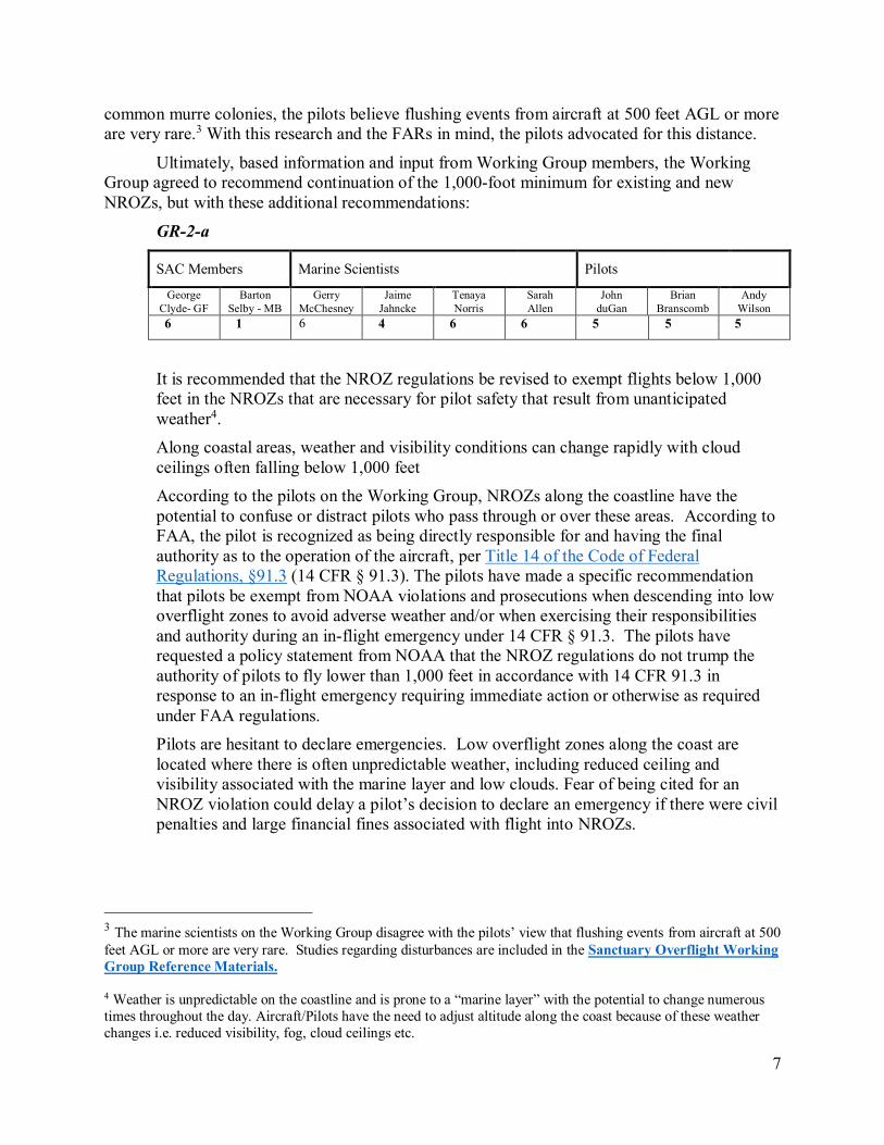
7
common murre colonies, the pilots believe flushing events from aircraft at 500 feet AGL or more
are very rare.3 With this research and the FARs in mind, the pilots advocated for this distance.
Ultimately, based information and input from Working Group members, the Working
Group agreed to recommend continuation of the 1,000-foot minimum for existing and new
NROZs, but with these additional recommendations:
GR-2-a
SAC Members Marine Scientists Pilots
George
Clyde- GF
Barton
Selby - MB
Gerry
McChesney
Jaime
Jahncke
Tenaya
Norris
Sarah
Allen
John
duGan
Brian
Branscomb
Andy
Wilson
6 1 6 4 6 6 5 5 5
It is recommended that the NROZ regulations be revised to exempt flights below 1,000
feet in the NROZs that are necessary for pilot safety that result from unanticipated
weather4.
Along coastal areas, weather and visibility conditions can change rapidly with cloud
ceilings often falling below 1,000 feet
According to the pilots on the Working Group, NROZs along the coastline have the
potential to confuse or distract pilots who pass through or over these areas. According to
FAA, the pilot is recognized as being directly responsible for and having the final
authority as to the operation of the aircraft, per Title 14 of the Code of Federal
Regulations, §91.3 (14 CFR § 91.3). The pilots have made a specific recommendation
that pilots be exempt from NOAA violations and prosecutions when descending into low
overflight zones to avoid adverse weather and/or when exercising their responsibilities
and authority during an in-flight emergency under 14 CFR § 91.3. The pilots have
requested a policy statement from NOAA that the NROZ regulations do not trump the
authority of pilots to fly lower than 1,000 feet in accordance with 14 CFR 91.3 in
response to an in-flight emergency requiring immediate action or otherwise as required
under FAA regulations.
Pilots are hesitant to declare emergencies. Low overflight zones along the coast are
located where there is often unpredictable weather, including reduced ceiling and
visibility associated with the marine layer and low clouds. Fear of being cited for an
NROZ violation could delay a pilot’s decision to declare an emergency if there were civil
penalties and large financial fines associated with flight into NROZs.
3 The marine scientists on the Working Group disagree with the pilots’ view that flushing events from aircraft at 500
feet AGL or more are very rare. Studies regarding disturbances are included in the Sanctuary Overflight Working
Group Reference Materials.
4 Weather is unpredictable on the coastline and is prone to a “marine layer” with the potential to change numerous
times throughout the day. Aircraft/Pilots have the need to adjust altitude along the coast because of these weather
changes i.e. reduced visibility, fog, cloud ceilings etc.
8
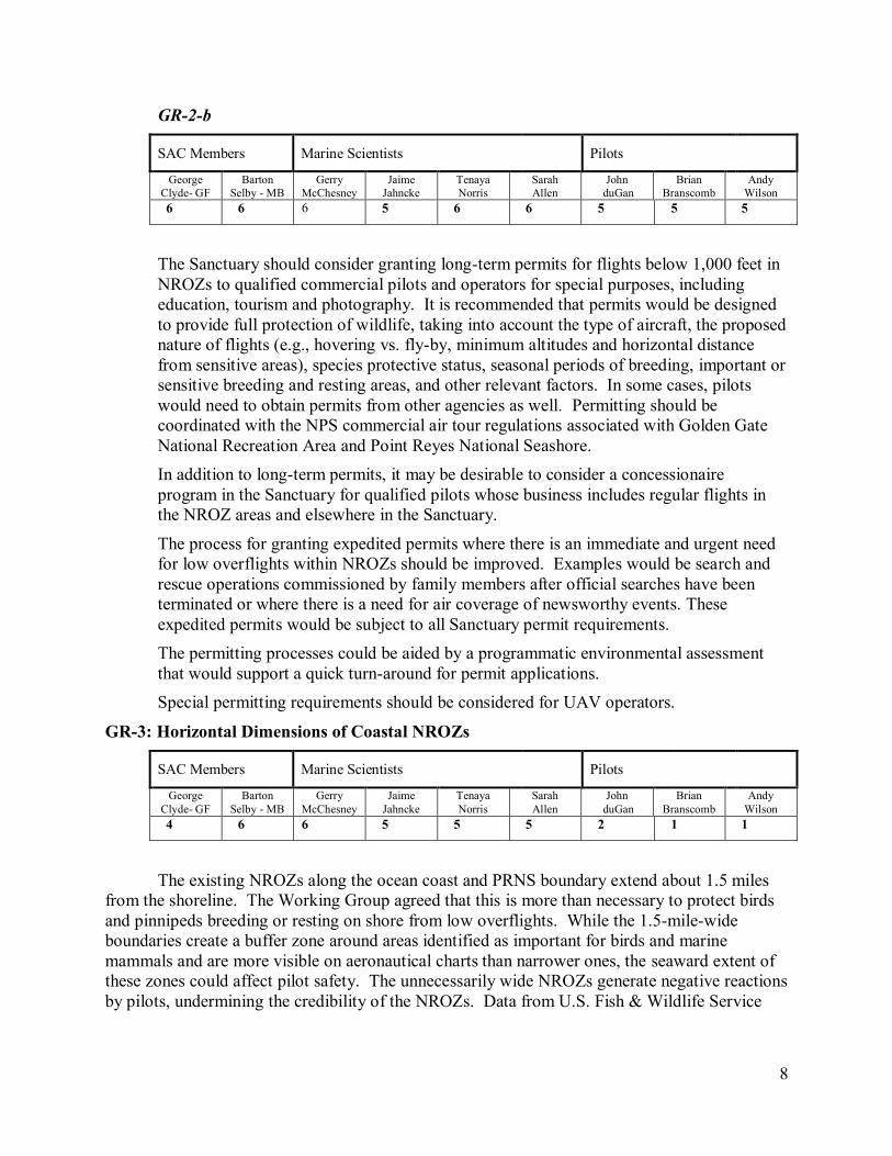
GR-2-b
SAC Members Marine Scientists Pilots
George
Clyde- GF
Barton
Selby - MB
Gerry
McChesney
Jaime
Jahncke
Tenaya
Norris
Sarah
Allen
John
duGan
Brian
Branscomb
Andy
Wilson
6 6 6 5 6 6 5 5 5
The Sanctuary should consider granting long-term permits for flights below 1,000 feet in
NROZs to qualified commercial pilots and operators for special purposes, including
education, tourism and photography. It is recommended that permits would be designed
to provide full protection of wildlife, taking into account the type of aircraft, the proposed
nature of flights (e.g., hovering vs. fly-by, minimum altitudes and horizontal distance
from sensitive areas), species protective status, seasonal periods of breeding, important or
sensitive breeding and resting areas, and other relevant factors. In some cases, pilots
would need to obtain permits from other agencies as well. Permitting should be
coordinated with the NPS commercial air tour regulations associated with Golden Gate
National Recreation Area and Point Reyes National Seashore.
In addition to long-term permits, it may be desirable to consider a concessionaire
program in the Sanctuary for qualified pilots whose business includes regular flights in
the NROZ areas and elsewhere in the Sanctuary.
The process for granting expedited permits where there is an immediate and urgent need
for low overflights within NROZs should be improved. Examples would be search and
rescue operations commissioned by family members after official searches have been
terminated or where there is a need for air coverage of newsworthy events. These
expedited permits would be subject to all Sanctuary permit requirements.
The permitting processes could be aided by a programmatic environmental assessment
that would support a quick turn-around for permit applications.
Special permitting requirements should be considered for UAV operators.
GR-3: Horizontal Dimensions of Coastal NROZs
SAC Members Marine Scientists Pilots
George
Clyde- GF
Barton
Selby - MB
Gerry
McChesney
Jaime
Jahncke
Tenaya
Norris
Sarah
Allen
John
duGan
Brian
Branscomb
Andy
Wilson
4 6 6 5 5 5 2 1 1
The existing NROZs along the ocean coast and PRNS boundary extend about 1.5 miles
from the shoreline. The Working Group agreed that this is more than necessary to protect birds
and pinnipeds breeding or resting on shore from low overflights. While the 1.5-mile-wide
boundaries create a buffer zone around areas identified as important for birds and marine
mammals and are more visible on aeronautical charts than narrower ones, the seaward extent of
these zones could affect pilot safety. The unnecessarily wide NROZs generate negative reactions
by pilots, undermining the credibility of the NROZs. Data from U.S. Fish & Wildlife Service

9
seabird monitoring at Devil’s Slide shows that nearly all aircraft disturbances to seabirds occur
from aircraft below 1,000 ft. altitude and within 1,000 ft. horizontal of the nesting colony.
The goal should be protection of the resources, simplicity to comply and enforce,
effectiveness as an outreach tool and consistency with the precautionary principle. Accordingly,
the Working Group recommended that existing and new NROZs that adjoin the ocean coast
extend approximately 1,000 feet seaward from the most seaward points of the coast, as well as
offshore rocks and islands.
The Working Group considered two methods of drawing the outer NROZ boundaries:
Literally following the 1,000-ft guideline minimizes the distance from shore in the
event of emergency, where the aircraft’s ability to glide to shore may be critical.
Also, the pilot’s ability to gauge the glide distance to safety becomes more difficult
further from shore without specialized instruments.
Using a measure of one-half mile from the coast would adequately protect seabirds
and marine mammals along the coast and would be simple to communicate. But, the
half-mile boundary would extend slightly further off shore in many areas, so it could
also impact pilot safety as compared to literally following the 1,000-foot line.
Ultimately, the Working Group agreed to recommend literally following the 1,000-ft line.5
The actual boundaries may be smoothed and straightened to be consistent with NOAA
policies favoring straight lines for protection zones. To meet pilot safety concerns it is
recommended that there be as many GPS points as practicable, keeping the glide distance and
safety of aircraft in mind.
GR-4: Suggested Improvements to FAA Aeronautical Charts
SAC Members Marine Scientists Pilots
George
Clyde- GF
Barton
Selby - MB
Gerry
McChesney
Jaime
Jahncke
Tenaya
Norris
Sarah
Allen
John
duGan
Brian
Branscomb
Andy
Wilson
6 6 6 5 5 5 2 1 1
The Working Group recommends that the Sanctuary and NOAA ask the FAA to consider
making some changes with respect to the designation of the Sanctuary and the NROZs on its
aeronautical charts. The Working Group recommended minimizing complexity on the FAA
aeronautical charts pertaining to NROZs, as it may cause pilot confusion and may make it more
difficult for new and student pilots, as well as experienced pilots unfamiliar with the area, to find
necessary information on the chart. This is especially true in the complex airspace such as San
Francisco Bay Area.
Below is an excerpt from the current chart as an example:
5 See special consideration for NROZs along the Pt. Reyes National Seashore Boundary, Recommendation GR-6,
below.
10
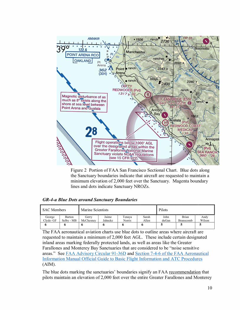
Figure 2 Portion of FAA San Francisco Sectional Chart. Blue dots along
the Sanctuary boundaries indicate that aircraft are requested to maintain a
minimum elevation of 2,000 feet over the Sanctuary. Magenta boundary
lines and dots indicate Sanctuary NROZs.
GR-4-a Blue Dots around Sanctuary Boundaries
SAC Members Marine Scientists Pilots
George
Clyde- GF
Barton
Selby - MB
Gerry
McChesney
Jaime
Jahncke
Tenaya
Norris
Sarah
Allen
John
duGan
Brian
Branscomb
Andy
Wilson
6 6 6 6 6 6 5 5 5
The FAA aeronautical aviation charts use blue dots to outline areas where aircraft are
requested to maintain a minimum of 2,000 feet AGL. These include certain designated
inland areas marking federally protected lands, as well as areas like the Greater
Farallones and Monterey Bay Sanctuaries that are considered to be “noise sensitive
areas.” See FAA Advisory Circular 91-36D and Section 7-4-6 of the FAA Aeronautical
Information Manual Official Guide to Basic Flight Information and ATC Procedures
(AIM).
The blue dots marking the sanctuaries’ boundaries signify an FAA recommendation that
pilots maintain an elevation of 2,000 feet over the entire Greater Farallones and Monterey

11
Bay Sanctuaries. This recommendation is frequently ignored. Furthermore, the blue dot
designations showing sanctuary boundaries are confusing and effectively diminish the
impact of the 1,000-foot minimum altitudes in the NROZs. The Working Group
recommends that the Sanctuary ask the FAA to delete the blue dots designating the
sanctuaries’ boundaries.
GR-4-b Improved Marking of NROZs
SAC Members Marine Scientists Pilots
George
Clyde- GF
Barton
Selby - MB
Gerry
McChesney
Jaime
Jahncke
Tenaya
Norris
Sarah
Allen
John
duGan
Brian
Branscomb
Andy
Wilson
6 6 6 5 6 6 5 5 5
Currently, the boundaries of the Sanctuary NROZs are indicated by a set of magenta
colored dots and solid lines. Pilots expressed confusion over the meaning of the dots. In
addition, if the horizontal width of coastal NROZs is reduced to approximately 1,000
feet, the dots will be less visible on the FAA aeronautical charts. To put this in
perspective, the diameter of the magenta dots inside the boundaries of NROZs on the
chart above represent approximately 1,000 feet. While the narrower NROZs will still be
visible, the magenta dots will be confusing. The Working Group recommends
eliminating the magenta dots and that the charts should show all NROZ boundaries
simply with solid magenta colored lines.
GR-4-c: Improved Legend Explaining NROZs
Even with narrower areas, the NROZs will easily be noticed by pilots because of the text
box that points to the NROZs, as shown in the above chart example. However, the
Working Group recommends improving the text currently used, but was unable to agree
on a specific recommendation:

12
Two recommendations that received mixed support were these:
SAC Members Marine Scientists Pilots
George
Clyde- GF
Barton
Selby - MB
Gerry
McChesney
Jaime
Jahncke
Tenaya
Norris
Sarah
Allen
John
duGan
Brian
Branscomb
Andy
Wilson
6 0 3 3 3 3
1. Recommend to the FAA to revise the text box in the following respects:
• Show a reference to the NOAA website, http://sanctuaries.noaa.gov/flight, rather
than the CFR citation.
• State the purpose of the regulation: protecting wildlife.
• Clarify that it is not an FAA flight rule.
SAC Members Marine Scientists Pilots
George
Clyde- GF
Barton
Selby - MB
Gerry
McChesney
Jaime
Jahncke
Tenaya
Norris
Sarah
Allen
John
duGan
Brian
Branscomb
Andy
Wilson
6 0 6 3 3 3
2. Recommend to the FAA that this text be used in the box:
Flight operations below 1000’ AGL in this
NOAA Regulated National Marine Sanctuary
Designated Area may violate NOAA wildlife
protection regulations – not a flight rule violation
Also, there was a favorable discussion of recommending to the FAA use of the Canadian
symbol below indicating areas where wildlife may be disturbed . This would be for the
NROZ text boxes and elsewhere in areas where there should be an advisory (like Devil’s
Slide Rock). The meaning of the symbol would be put in the chart legend and the Airman’s
Information Manual.
GR-5: Implications for Other Sanctuary NROZs
SAC Members Marine Scientists Pilots
George
Clyde- GF
Barton
Selby - MB
Gerry
McChesney
Jaime
Jahncke
Tenaya
Norris
Sarah
Allen
John
duGan
Brian
Branscomb
Andy
Wilson
6 6 1 5 1 1 3 3 3
13
To help pilots recognize and understand the NORZs in the Sanctuary and other
sanctuaries, it would be desirable for the NROZs to follow the same principles and FAA chart
designations in all sanctuaries. Accordingly, the Working Group recommends that the SAC
recommend that the Olympic Coast, Monterey Bay and Channel Islands National Marine
Sanctuaries consider revising their regulations to the extent possible to conform to these
recommendations. Secondly, the Working Group recommends that NOAA ask the FAA to
revise its charts to reflect a uniform approach to displaying the NROZs of these sanctuaries.
This recommendation should be made to each sanctuary, to the West Coast Regional Office of
the National Marine Sanctuaries, and to the Headquarters of the Office of the National Marine
Sanctuaries.

14
GR-6: NROZs Next to Point Reyes National Seashore
In Marin County the Sanctuary boundaries adjacent to PRNS begin at the boundary of the
Seashore, which follows the PRNS boundaries that extends one-quarter mile (1320 feet) from the
coast. Below is an example of the PRNS coast, with an existing NROZ in purple approximately
one-quarter mile offshore of the vulnerable coastline:
Figure 3 The purple area is an existing NROZ at Pt. Reyes. It is about one-
quarter mile (1320 ft.) off-shore from the coast and therefore does not cover
wildlife on the immediate coast and rocks.
Because of these circumstances, the extra level of protection and pilot education that the
NOAA overflight regulations provide in the NROZs elsewhere in the Sanctuary do not cover the
PRNS coast and nearby coastal rocks, leaving a quarter-mile gap. The Sanctuary regulations do
not extend into this area because it is beyond the Sanctuary boundaries.
The NPS does not have regulations specifically addressing low overflights within the
PRNS boundaries. The NPS has regulations banning aircraft (including UAVs) from taking off
from or landing on parklands, but they do not specifically provide overflight protection from
aircraft that land or take off outside of park boundaries. While there is protection from
disturbance of wildlife by low-flying aircraft through the laws and regulations of the NPS, US
Fish and Wildlife Service and National Marine Fisheries Service, the additional enforcement
provisions of the NROZs are not available in the one-quarter mile along the coast.
In light of these circumstances, the Working Group recommends:

15
GR-6-a
SAC Members Marine Scientists Pilots
George
Clyde- GF
Barton
Selby - MB
Gerry
McChesney
Jaime
Jahncke
Tenaya
Norris
Sarah
Allen
John
duGan
Brian
Branscomb
Andy
Wilson
6 5 5 5 6 6 2 0 0
All existing and new NROZs along the PRNS ocean coast should extend from the
Sanctuary/PRNS boundary out 1,000 feet seaward from the boundary (rather than
approximately one-and-one-half miles, as they do now). This would provide as much
protection as possible given the Sanctuary/PRNS boundary, and the 1,000-ft. NROZs on
the FAA charts are also an educational tool for pilots.
GR-6-b
SAC Members Marine Scientists Pilots
George
Clyde- GF
Barton
Selby - MB
Gerry
McChesney
Jaime
Jahncke
Tenaya
Norris
Sarah
Allen
John
duGan
Brian
Branscomb
Andy
Wilson
6 5 1 3 4 4 0 0 0
To provide better protection for coastal wildlife within one-quarter mile off the PRNS,
the Sanctuary should:
Consult with PRNS and the NPS to expand the Sanctuary’s boundaries to cover
the one-quarter mile strip along the coast along the PRNS. Wildlife is not
protected from low-flying aircraft by NROZs in these areas. Therefore, an
expansion of Sanctuary boundaries, in consultation with the NPS, may be
desirable for both the Sanctuary and PRNS.
There is precedent for Sanctuary boundaries overlapping NPS parkland elsewhere
along the coast, including a portion of the NROZ covering Bolinas Lagoon, which
is within the Golden Gate National Recreation Area (GGNRA), and the southern
portion of the NROZ along Stinson Beach, where the GGNRA boundaries extend
one-quarter mile off-shore, but the Sanctuary boundaries follow the coast.
However, many of the PRNS coastal areas that would be overlapped are
Wilderness Areas that were created prior to the establishment of the Sanctuary.
The NPS does not favor overlapping jurisdictions for Wilderness Areas under its
management, so obtaining joint agency agreements to the Sanctuary’s expansion
in these areas would likely be challenging. Another issue could be NPS concerns
that low-overflight permits issued by the Sanctuary could undermine existing NPS
protections, so that would need to be addressed.
Encourage PRNS and the NPS, in consultation with the FAA, to adopt regulations
similar to the Sanctuary’s NROZ Sanctuary to cover these special circumstances –
where the NPS boundaries adjoin National Marine Sanctuary NROZ boundaries.
This would be a special case that would not be precedent for other NPS lands.
Explore other ways in which the Sanctuary, the NPS and the FAA may provide
16
additional protection from low overflights and pilot education in the one-quarter-
mile strip.
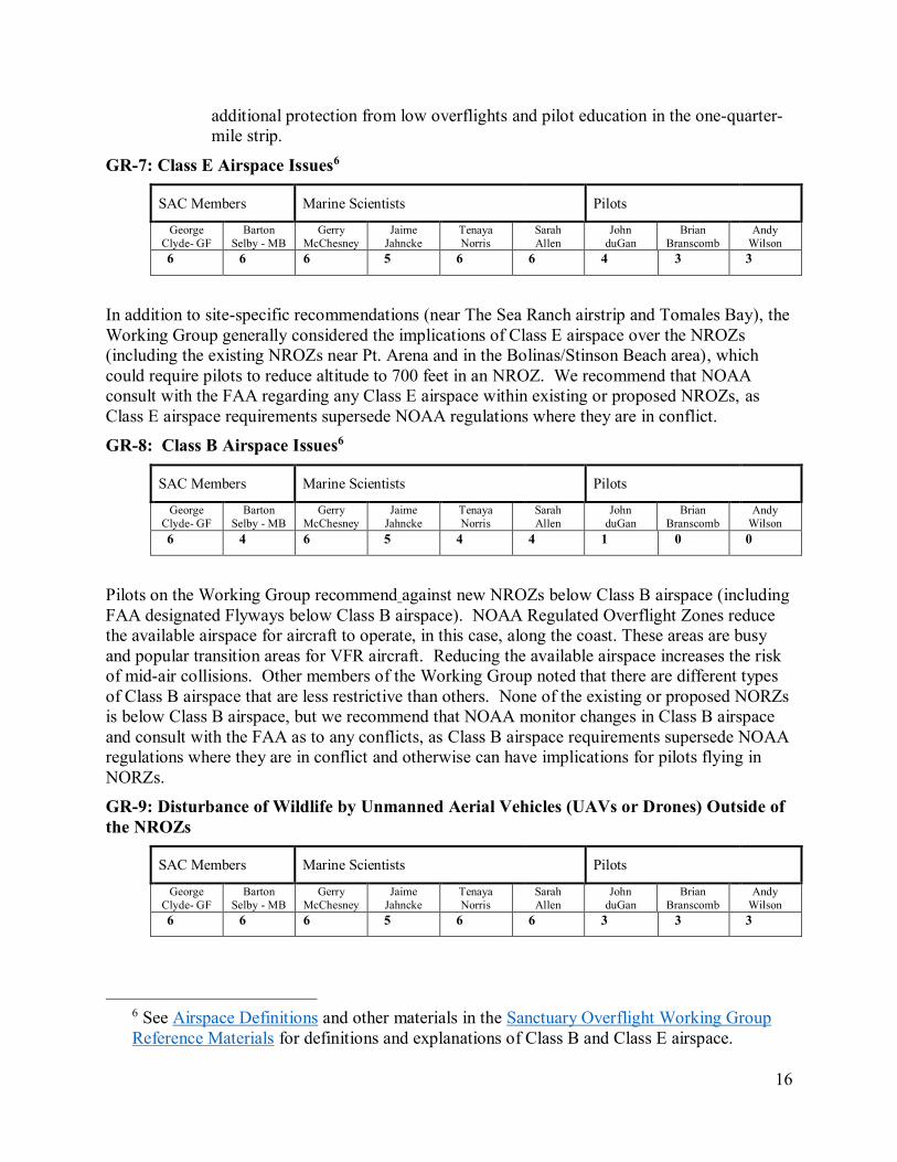
GR-7: Class E Airspace Issues6
SAC Members Marine Scientists Pilots
George
Clyde- GF
Barton
Selby - MB
Gerry
McChesney
Jaime
Jahncke
Tenaya
Norris
Sarah
Allen
John
duGan
Brian
Branscomb
Andy
Wilson
6 6 6 5 6 6 4 3 3
In addition to site-specific recommendations (near The Sea Ranch airstrip and Tomales Bay), the
Working Group generally considered the implications of Class E airspace over the NROZs
(including the existing NROZs near Pt. Arena and in the Bolinas/Stinson Beach area), which
could require pilots to reduce altitude to 700 feet in an NROZ. We recommend that NOAA
consult with the FAA regarding any Class E airspace within existing or proposed NROZs, as
Class E airspace requirements supersede NOAA regulations where they are in conflict.
GR-8: Class B Airspace Issues6
SAC Members Marine Scientists Pilots
George
Clyde- GF
Barton
Selby - MB
Gerry
McChesney
Jaime
Jahncke
Tenaya
Norris
Sarah
Allen
John
duGan
Brian
Branscomb
Andy
Wilson
6 4 6 5 4 4 1 0 0
Pilots on the Working Group recommend against new NROZs below Class B airspace (including
FAA designated Flyways below Class B airspace). NOAA Regulated Overflight Zones reduce
the available airspace for aircraft to operate, in this case, along the coast. These areas are busy
and popular transition areas for VFR aircraft. Reducing the available airspace increases the risk
of mid-air collisions. Other members of the Working Group noted that there are different types
of Class B airspace that are less restrictive than others. None of the existing or proposed NORZs
is below Class B airspace, but we recommend that NOAA monitor changes in Class B airspace
and consult with the FAA as to any conflicts, as Class B airspace requirements supersede NOAA
regulations where they are in conflict and otherwise can have implications for pilots flying in
NORZs.
GR-9: Disturbance of Wildlife by Unmanned Aerial Vehicles (UAVs or Drones) Outside of
the NROZs
SAC Members Marine Scientists Pilots
George
Clyde- GF
Barton
Selby - MB
Gerry
McChesney
Jaime
Jahncke
Tenaya
Norris
Sarah
Allen
John
duGan
Brian
Branscomb
Andy
Wilson
6 6 6 5 6 6 3 3 3
6 See Airspace Definitions and other materials in the Sanctuary Overflight Working Group
Reference Materials for definitions and explanations of Class B and Class E airspace.
17
From the very start and throughout the process, the Working Group members expressed
concerns regarding the potential for disturbance of birds and marine mammals in the sanctuaries
by unmanned aerial vehicles (UAVs or Drones). While UAVs provide an excellent way for the
public to view and photograph sanctuary resources, the sanctuaries need to give special attention
to the disturbances to wildlife that they can cause.
Launched from shore or from boats, UAVs have easy access to sensitive areas. Their
ability to hover increases the likelihood that a bird or marine mammal could view them as
predators, and their wide-angle focal lengths encourage close flight.
Although the Working Group was not given a charge to make recommendations on this
issue and was not constituted with representatives of UAV users and the UAV industry to be able
fairly to consider the matter, the Working Group desired to make some recommendations on this
subject, and the SAC authorized this at its August 2016 meeting. One of our members prepared
a statement of the concerns. Barton Selby’s Comments on Drones and Related Matters
(11/20/16)
As a preliminary matter, it was a working assumption of the Working Group that the
current NROZ regulations applied to flights of UAVs along with other motorized aircraft. They
are included as “motorized aircraft” under the language prohibiting “disturbing marine mammals
or seabirds by flying motorized aircraft at less than 1,000 feet over the waters...”. 15 CFR
§922.82(a)(11). This is reflected in the National Marine Sanctuary FAQs webpage on the
overflight regulations, http://sanctuaries.noaa.gov/flight/faqs.html, (11/11/16):
Question: Are model aircraft and Unmanned Aircraft System (drone) operations
restricted within sanctuary overflight regulation zones?
Answer: Yes. Model aircraft and Unmanned Aircraft Systems (drones) that are propelled
by motors qualify as motorized aircraft under regulations of the sanctuaries, and therefore
must adhere to sanctuary overflight restrictions. As with traditional aircraft, they could
operate above the sanctuaries' minimum altitude limits, provided Federal Aviation
Administration (FAA) regulations allow them to fly at such altitudes. Current FAA rules
impose altitude limitations on model aircraft and other Unmanned Aircraft Systems.
However, because this may not be obvious to some, the Working Group recommends that
the sanctuaries’ regulations be clarified so there is no doubt of their coverage of UAVs in the
NROZs. This would help ensure compliance by recreational and commercial UAV pilots and
assure that researchers and others involved in non-recreational UAV use within the sanctuaries
would obtain permits for their activities, if appropriate.
Additionally, the exploding use of private UAVs in other parts of the sanctuaries presents
a significant issue. These include recreational UAV users and commercial and recreational
photographers, news reporters, fishing boats, tour boats for observation of whales and other
wildlife, and monitoring of wildlife by individuals and organizations. A good summary of the
threat is at http://montereybay.noaa.gov/resourcepro/resmanissues/aircraft.html.
The threats are not only to wildlife along the coast and in estuaries. Based on data from
the Applied California Current Ecosystem Studies Project (ACCESS), there are significant and
predictable concentrations of wildlife, including birds feeding with whales, within the
sanctuaries well off-shore. See Presentation by Jaime Jahncke, “Off-shore areas where marine

18
wildlife may be subject to disturbance” (2016). These may also be subject to disturbance by
UAVs launched from recreational and commercial boats (as well as other low-flying aircraft).
Under the circumstances, the Working Group strongly recommends that the sanctuaries
and the National Marine Sanctuaries regional and national offices give special and early attention
to this growing threat to sanctuary resources. These include the NROZs as well as areas within
the sanctuaries that are not protected by NROZs. The Working Group recommends a dedicated
program to gather information and research UAV’s and their present and projected impacts on
sanctuary resources.
An aggressive program of outreach and education should be considered as a primary
action (including signage at beaches, parks and other places where UAVs are launched along the
coast and estuaries, as well as marinas and boat launches that serve boats that may carry UAVs).
It should be recognized that UAV operators may lack knowledge or concern regarding their
impact on wildlife, generally and in particular locations where they operate, and outreach and
education should be tailored accordingly.
As a last resort, new regulations covering UAVs for areas outside of the NROZs may also
be indicated. These could include restrictions on launching UAVs within the Sanctuary,
following the approach of the NPS in National Parks and managers of many other protected
areas.
GR-10: Pilot Outreach and Education Recommendations
SAC Members Marine Scientists Pilots
George
Clyde- GF
Barton
Selby - MB
Gerry
McChesney
Jaime
Jahncke
Tenaya
Norris
Sarah
Allen
John
duGan
Brian
Branscomb
Andy
Wilson
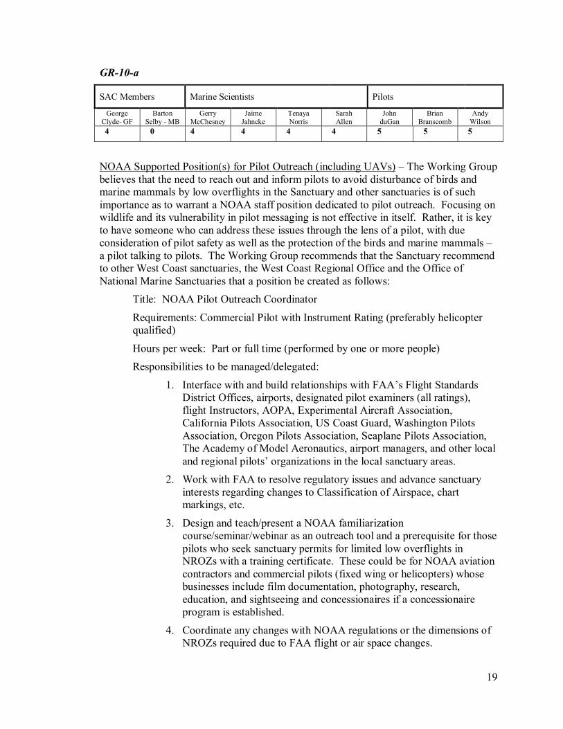
6 2 2 3 3 3 5 5 5
The Working Group showed a strong consensus that the most important activity to
protect birds and marine mammals from potential disturbance by low-flying aircraft is pilot
outreach and education. Education and outreach is far more important than regulations and
enforcement. Indeed, much of the discussion regarding new and revised regulations and
improved notations on FAA charts was driven by this conviction.
The advantage of an effective outreach program is that it will educate pilots about the
issues and the regulation interaction between the governing agencies. It will also reach more
people than an enforcement program. Outreach has the potential to protect all U.S. coastlines
and a very large number of marine mammals and seabirds, not only the ones inside the NROZs.
Additionally, an outreach and education program, rather than restrictions, would benefit
birds and mammals in other areas of the nation as awareness among the aviation community is
increased. The Seabird Protection Network, an existing but small NOAA outreach program,
could be an effective avenue for educating the pilot community if provided additional staff and
resources.
The Working Group made these specific recommendations regarding pilot outreach and
education.
19
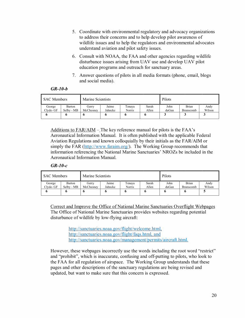
GR-10-a
SAC Members Marine Scientists Pilots
George
Clyde- GF
Barton
Selby - MB
Gerry
McChesney
Jaime
Jahncke
Tenaya
Norris
Sarah
Allen
John
duGan
Brian
Branscomb
Andy
Wilson
4 0 4 4 4 4 5 5 5
NOAA Supported Position(s) for Pilot Outreach (including UAVs) – The Working Group
believes that the need to reach out and inform pilots to avoid disturbance of birds and
marine mammals by low overflights in the Sanctuary and other sanctuaries is of such
importance as to warrant a NOAA staff position dedicated to pilot outreach. Focusing on
wildlife and its vulnerability in pilot messaging is not effective in itself. Rather, it is key
to have someone who can address these issues through the lens of a pilot, with due
consideration of pilot safety as well as the protection of the birds and marine mammals –
a pilot talking to pilots. The Working Group recommends that the Sanctuary recommend
to other West Coast sanctuaries, the West Coast Regional Office and the Office of
National Marine Sanctuaries that a position be created as follows:
Title: NOAA Pilot Outreach Coordinator
Requirements: Commercial Pilot with Instrument Rating (preferably helicopter
qualified)
Hours per week: Part or full time (performed by one or more people)
Responsibilities to be managed/delegated:
1. Interface with and build relationships with FAA’s Flight Standards
District Offices, airports, designated pilot examiners (all ratings),
flight Instructors, AOPA, Experimental Aircraft Association,
California Pilots Association, US Coast Guard, Washington Pilots
Association, Oregon Pilots Association, Seaplane Pilots Association,
The Academy of Model Aeronautics, airport managers, and other local
and regional pilots’ organizations in the local sanctuary areas.
2. Work with FAA to resolve regulatory issues and advance sanctuary
interests regarding changes to Classification of Airspace, chart
markings, etc.
3. Design and teach/present a NOAA familiarization
course/seminar/webinar as an outreach tool and a prerequisite for those
pilots who seek sanctuary permits for limited low overflights in
NROZs with a training certificate. These could be for NOAA aviation
contractors and commercial pilots (fixed wing or helicopters) whose
businesses include film documentation, photography, research,
education, and sightseeing and concessionaires if a concessionaire
program is established.
4. Coordinate any changes with NOAA regulations or the dimensions of
NROZs required due to FAA flight or air space changes.
20
5. Coordinate with environmental regulatory and advocacy organizations
to address their concerns and to help develop pilot awareness of
wildlife issues and to help the regulators and environmental advocates
understand aviation and pilot safety issues.
6. Consult with NOAA, the FAA and other agencies regarding wildlife
disturbance issues arising from UAV use and develop UAV pilot
education programs and outreach for sanctuary areas.
7. Answer questions of pilots in all media formats (phone, email, blogs
and social media).
GR-10-b
SAC Members Marine Scientists Pilots
George
Clyde- GF
Barton
Selby - MB
Gerry
McChesney
Jaime
Jahncke
Tenaya
Norris
Sarah
Allen
John
duGan
Brian
Branscomb
Andy
Wilson
6 6 6 6 6 6 3 3 3
Additions to FAR/AIM – The key reference manual for pilots is the FAA’s
Aeronautical Information Manual. It is often published with the applicable Federal
Aviation Regulations and known colloquially by their initials as the FAR/AIM or
simply the FAR (http://www.faraim.org/). The Working Group recommends that
information referencing the National Marine Sanctuaries’ NROZs be included in the
Aeronautical Information Manual.
GR-10-c
SAC Members Marine Scientists Pilots
George
Clyde- GF
Barton
Selby - MB
Gerry
McChesney
Jaime
Jahncke
Tenaya
Norris
Sarah
Allen
John
duGan
Brian
Branscomb
Andy
Wilson
6 6 6 6 6 6 6 6 5
Correct and Improve the Office of National Marine Sanctuaries Overflight Webpages
The Office of National Marine Sanctuaries provides websites regarding potential
disturbance of wildlife by low-flying aircraft:
http://sanctuaries.noaa.gov/flight/welcome.html,
http://sanctuaries.noaa.gov/flight/faqs.html, and
http://sanctuaries.noaa.gov/management/permits/aircraft.html.
However, these webpages incorrectly use the words including the root word “restrict”
and “prohibit”, which is inaccurate, confusing and off-putting to pilots, who look to
the FAA for all regulation of airspace. The Working Group understands that these
pages and other descriptions of the sanctuary regulations are being revised and
updated, but want to make sure that this concern is expressed.

21
GR-10-d
SAC Members Marine Scientists Pilots
George
Clyde- GF
Barton
Selby - MB
Gerry
McChesney
Jaime
Jahncke
Tenaya
Norris
Sarah
Allen
John
duGan
Brian
Branscomb
Andy
Wilson
6 3 6 5 5 5 4 4 5
The internet and websites provide many educational opportunities. For example:
1. Provide a direct link from the sanctuaries’ websites to improved NOAA
information for pilots, rather than indirectly through the Seabird Protection
Network or the Office of National Marine Sanctuaries websites (although
those could be cross linked). An example of a direct link from a sanctuary
webpage is the Olympic Coast National Marine Sanctuary webpage.
2. Educational programs to which flight instructors can send new pilots, which
would provide a certificate of some sort for people who take the course. This
could be qualification requirement for long-term sanctuary permits.
3. Create a blog or other interactive website to keep pilots involved with these
issues. Possibly costs could be covered or offset by offereing vendors
advertising space for the aviation community or grants from wildlife
protection groups.
4. With some airports there are site specific websites that are included in pre-
flight planning, that could include information about the NROZs and potential
wildlife disturbance as well as a link to the NOAA regulations. E.g.,
http://www.wsdot.wa.gov/aviation/AllStateAirports/CopalisBeach_CopalisSta
te.htm. Including information in pre-flight planning materials is an excellent
way to reach experienced pilots and pilots from out of the area.
5. Add information regarding the NROZ in “Additional Remarks” section of the
FAA Chart Supplement/Airport Directory, the AOPA Airport Directory,
www.airnav.com and similar pilot information sources for airports where
sanctuaries are typical destinations from that airport (in addition to those
identified in the site specific recommendations above).
GR-10-e
SAC Members Marine Scientists Pilots
George
Clyde- GF
Barton
Selby - MB
Gerry
McChesney
Jaime
Jahncke
Tenaya
Norris
Sarah
Allen
John
duGan
Brian
Branscomb
Andy
Wilson
6 3 6 5 5 5 4 4 5
Contribute information about the need for wildlife protection from low overflights to
existing websites that pilots already utilize:
1. FAA websites, including those open to advertising which could also publish
messages and links regarding NOAA Regulated Overflight Zones as pro bono
advertising.

22
2. Newsletters and blogs of pilot associations, including Airport Advocate of
California Pilots Association.
3. Commercial websites serving pilots and the aviation community, such as
AOPA.
4. Military and US Coast Guard websites may provide opportunities for pilot
education regarding wildlife protection and the sanctuary regulations.
GR-10-f
SAC Members Marine Scientists Pilots
George
Clyde- GF
Barton
Selby - MB
Gerry
McChesney
Jaime
Jahncke
Tenaya
Norris
Sarah
Allen
John
duGan
Brian
Branscomb
Andy
Wilson
6 5 6 5 5 5 6 6 6
Target flight schools, FAA certification programs, flight instructors, and pilot
education programs: pilot examiners, Flight Standards District Offices and airport
managers. Contacts should be developed at a personal level, establishing personal
relationships with key individuals that lead the organization/community.
1. Military and US Coast Guard flight schools, where thousands of pilots are
trained each year (including replacement air groups that fly up and down the
coast)
2. FAA Safety Team program (FAAST), https://www.faasafety.gov/.
3. Preparation of training syllabus on avoiding wildlife disturbance in coastal
areas, including the sanctuaries. This would be made available as a syllabus
for the several on-line providers of courses for pilots, certifications and flight
instructors. This training could also be required as a condition for permits that
the sanctuary would consider for commercial pilots.
4. Provide written materials for backing up the on-line information with on-the-
ground education.
GR-10-g
SAC Members Marine Scientists Pilots
George
Clyde- GF
Barton
Selby - MB
Gerry
McChesney
Jaime
Jahncke
Tenaya
Norris
Sarah
Allen
John
duGan
Brian
Branscomb
Andy
Wilson
6 4 6 6 5 5 6 6 6
Improve written materials and the program of written outreach to pilots, with pilot
input as to the text. An example of a good poster is at printable flyer of the
Overflight Poster.
23
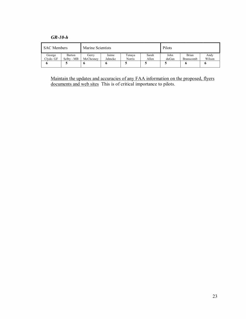
GR-10-h
SAC Members Marine Scientists Pilots
George
Clyde- GF
Barton
Selby - MB
Gerry
McChesney
Jaime
Jahncke
Tenaya
Norris
Sarah
Allen
John
duGan
Brian
Branscomb
Andy
Wilson
6 5 6 6 5 5 5 6 6
Maintain the updates and accuracies of any FAA information on the proposed, flyers
documents and web sites This is of critical importance to pilots.
24
Section 2: Recommendations for Specific NROZs (See the map that follows this table)
Except as indicated in Areas 2i (Devil’s Slide Rock) and 2j (Tomales Bay), all of the pilots voted against these proposals and all other
members voted for them.
Area (NROZ) Wildlife to be
Protected
Recommendation Reasons for this
Recommendation
Special
Considerations and
Member Comments
Education and
Outreach
2a. Existing
Sonoma County NROZs
alongside Gualala to the
north and Jenner to the
South
These areas host
most of the largest
and most diverse
seabird breeding
colonies on the
Sonoma County
coast, including
Fish Rocks,
Gualala Point
Island, Russian
Gulch, Russian River Rocks,
Arched Rock and
Gull Rock.
Relatively new
and expanding
colonies of
Common Murres
occur at Fish
Rocks, Gualala
Point Island, and
Gull Rock. Other species nesting in
relatively large
numbers include
Brandt's
Cormorant,
pelagic cormorant,
pigeon guillemot,
and western gull.
Fort Ross Reef is
the most important
haul-out on the
Reduce the seaward horizontal dimension of
these two NROZs from approximately 1.5 miles
to approximately 1000 feet from the most
seaward points of the coast and from offshore
rocks and islands.
See above discussion of
horizontal dimensions of
NROZs.
For the Steller sea lion
colony (which
includes pups) near
Fort Ross, the 1,000
ft. horizontal
separation may not be
adequate for hovering
helicopters at 1,000 ft.
elevation. – S. Allen
For Boonville, Anchor
Bay, Lofty Redwoods,
Ocean Ridge, Redwood
Coast Medical, Sea
Ranch and other nearby
airports, add information
regarding the NROZ in
“Additional Remarks”
section of the FAA
Chart
Supplement/Airport Directory, the AOPA
Airport Directory and
similar pilot information
sources.
For local coastal access
points such as public
beaches, parks,
campgrounds, harbors
and vessel launching
sites, provide signage
that advises boaters and other coastal users of
NOAA regulations
regarding UAV usage in
NROZs. See general
recommendations in
Section 4 regarding
UAVs.
25
Area (NROZ) Wildlife to be
Protected
Recommendation Reasons for this
Recommendation
Special
Considerations and
Member Comments
Education and
Outreach
Sonoma Coast for
rare Steller sea
lions; fairly large
numbers of
California sea lions also haul out
there as well as
Northwest Cape
Rocks. Several
important harbor
seal pupping and
haul-out areas
occur along here,
including the large
Russian River
mouth site. A
small Steller sea lion rookery and
California sea lion
haul out occurs
within the area.
2b. Area between
the two existing Sonoma
County NROZ’s,
approximately 20 miles
of coastline including
The Sea Ranch, Stewarts
Point and Salt Point
State Park. This NROZ joins two existing
NROZs.
This area has haul-
out areas and
rookeries for
harbor seals along
a string of haul-out
sites on offshore
rocks and pocket
beaches. Hundreds of
seabirds also
frequent the area,
including several
small colonies of
Pelagic
Cormorants and
Pigeon
Guillemots.
Add a new NROZ between the two existing
zones, along the Sanctuary coastal boundary and
extending approximately 1000 feet seaward
from the most seaward points of the coast and
from offshore rocks and islands.
While wildlife in this
area is not as
concentrated as in
existing NROZs, there
are ample marine
mammals and birds to
warrant protection from
low overflights in this area, and having a single
NROZ for this entire
coastal area is more
informative to pilots and
easier for pilot
education and outreach,
compliance and
enforcement.
Wildlife in this remote
area may be less
accustomed to human
NOAA, in
consultation with local
airport authorities,
pilots and the FAA,
should address the
aviation safety
concerns, including
Class E Airspace, if any, that the extended
overflight zone near
The Sea Ranch would
have on aircraft taking
off from or landing at
the airstrip at The Sea
Ranch.
Notification to Sea
Ranch property owners
of new NROZ.
Signage at The Sea
Ranch airstrip, at Sea
Ranch Community
Center and at the
Boonville, Anchor Bay, Lofty Redwoods and
Ocean Ridge airports.
For Sea Ranch,
Boonville, Anchor Bay,
Lofty Redwoods, Ocean
Ridge, and other nearby
airports, add information
regarding the NROZs in
“Additional Remarks”
section of the FAA

26
Area (NROZ) Wildlife to be
Protected
Recommendation Reasons for this
Recommendation
Special
Considerations and
Member Comments
Education and
Outreach
disturbances and
therefore more
vulnerable to
disturbance from low
overflights.
Chart
Supplement/Airport
Directory, the AOPA
Airport Directory and
similar pilot information sources.
For local coastal access
points such as public
beaches, parks,
campgrounds, harbors
and vessel launching
sites, provide signage
that advises boaters and
other coastal users of
NOAA regulations
regarding UAV usage in
NROZs. See general recommendations in
Section 4 regarding
UAVs.
2c. Bodega Head
and Bodega Rock
Along the coast of
Bodega Head,
there are four
species of seals
and sea lions that
haul-out, and there
is a small harbor
seal rookery at
Bodega Head. Bodega Rock
hosts a major
Brandt's
Cormorant colony
and a major
California sea lion
haul-out that is
also utilized by
small numbers of
Steller sea lions,
Add new NROZ along the Sanctuary coastal
boundary from Mussel Point south to Doran
Beach including Bodega Rock. This NROZ
extends seaward from the Sanctuary coastal
boundary approximately 1000 feet from the
coast or any more seaward rocks, including
Bodega Rock. The southern boundary of this
NROZ should be a line from the southern extent
of this NROZ (1000 feet south of Bodega Rock) to the Sanctuary boundary at Doran Beach so as
to avoid a gap between Bodega Rock and the
rest of the NROZ.
Important area for both
bird nesting and marine
mammal haul outs.
There is a history of air
tours over the area to
view the “hole” from the
planned nuclear power
plant.
NOAA, in
consultation with the
U.S. Coast Guard,
should address any
aviation safety or
other issues that the
new overflight zone at
Bodega Head and
Bodega Rock would have for helicopters or
UAVs landing at or
taking off from Coast
Guard Station Bodega
Bay.
For Doran Beach,
Bodega Harbor, Spud
Point Marina, and local
public beaches, harbors
and vessel launching
sites, provide signage
that advises boaters of
UAV usage in NROZs.
See general comments in Section 4 regarding
UAVs.

27
Area (NROZ) Wildlife to be
Protected
Recommendation Reasons for this
Recommendation
Special
Considerations and
Member Comments
Education and
Outreach
elephant seals and
harbors seals.
2d. Existing NROZ
at Tomales Point and
Bird Rock, along the
Sanctuary/PRNS boundary.
There are three
species of seals
and sea lions that
haul-out, and there are several large
harbor seal
rookeries that
extend from Bird
Rock south to
Elephant Rock
south of McClures
Beach. These are
mainly Harbor
seals, but also
California Sea
Lions haul out on Bird Rock and
some Elephant
seals on the
adjacent beaches.
Numerous species
of seabirds nest on
Bird Rock
including a large
Brandt’s
Cormorant colony
and rare Ashy Storm-petrels.
Brown Pelicans,
Brandt’s
Cormorants, and
other seabirds
utilize the rock as
a roost outside the
breeding season.
Numerous species
of seabirds nest on
Bird Rock
Beginning at Tomales Point and extending
southward, reduce the seaward horizontal
dimension of this NROZ from approximately
1.5 miles to approximately 1,000 feet from the Sanctuary Boundary.
Important area for both
bird nesting and marine
mammal haul outs and
harbor seal rookery.
For Dillon Beach,
Lawson’s Landing,
Miller Park, and other
local public beaches, harbors and vessel
launching sites, provide
signage that advises
boaters of UAV usage in
NROZs. See general
comments in Section 4
regarding UAVs.
28
Area (NROZ) Wildlife to be
Protected
Recommendation Reasons for this
Recommendation
Special
Considerations and
Member Comments
Education and
Outreach
including rare
Ashy Storm-
petrels.
2e. Extended
NROZ to cover
McClures Beach and Rock and Elephant Rock
along the
Sanctuary/PRNS
boundary
There are three
species of seals
and sea lions that haul-out, and there
is are several large
harbor seal
rookeries that
extend from Bird
Rock south to
Elephant Rock.
Elephant seals also
haul out on the
beaches.
Extend existing NROZ at Tomales Point/Bird
Rock southward along the Sanctuary boundary
to include McClures Beach and Elephant Rock with a horizontal dimension of approximately
1,000 feet from the Sanctuary boundary.
Important area for both
bird nesting and marine
mammal haul outs and rookeries
There are no unique
airspace issues here that
need to be addressed.
No special use needs
shown on charts.
These are cliffs, 400-
500 feet; can pilots get
to the shoreline given proposed overflight
restrictions in this
area? - Pilot comment
2f. Existing NROZ
at Pt. Reyes along Sanctuary/PRNS
boundary
There are four
species of seals and sea lions that
haul-out, and
breed at Pt Reyes.
Numerous species
of seabirds nest
there in large
numbers,
including rare
Ashy Storm-
petrels.
Reduce the seaward horizontal dimension of this
NROZ from approximately 1.5 miles to approximately 1,000 feet from the Sanctuary
boundary.
Highly significant
colonies of marine mammals and nesting
and roosting seabirds.
Gray whales with
calves travel very close to shore at Point
Reyes Headland as
they migrate north. -
SA
2g. Existing NROZ
covering Double Point
and south to Bolinas mostly along the
Sanctuary/PRNS
boundary
There are three
species of seals
and sea lions that haul-out, and there
is a large harbor
seal rookery on
Stormy Stack and
in cove at Double
Point. Sea Lions
haul out on Stormy
Stack and
Reduce the seaward horizontal dimension of this
NROZ along the PRNS boundary from
approximately 1.5 miles to approximately 1,000 feet from the Sanctuary/NPS boundary. For
coastal areas south of PRNS (off of Bolinas and
Stinson Beach), reduce the seaward horizontal
dimension from approximately 1.5 miles to
approximately 1000 feet from the most seaward
points of the coast and from offshore rocks and
islands. No changes in the NROZ covering
Highly significant
colonies of marine
mammals (one of largest harbor seal colonies in
state) and nesting and
roosting seabirds.
29
Area (NROZ) Wildlife to be
Protected
Recommendation Reasons for this
Recommendation
Special
Considerations and
Member Comments
Education and
Outreach
Elephant seals on
the beaches.
Numerous species
of seabirds nest on
Stormy stack including rare
Ashy Storm-
petrels.
Bolinas Lagoon are recommended.
2h. New NROZ(s)
between the two existing
NROZ’s identified
above, commencing at
the southeast end of the
Pt. Reyes NROZ and
following the coast of
Drakes Bay along the
Sanctuary/PRNS
boundary alongside Drakes Beach, the
mouths of Drakes Estero
and Limantour Estero,
Limantour Beach, Point
Resistance and Millers
Point Rocks, to the north
end of the existing
Double Point - Bolinas
NROZ
Along the
northwest and
west of this NROZ
there is a large
elephant seal
rookery and haul-
out area as well as
a California sea
lion haul-out area.
There are significant harbor
seal rookeries and
haul-out areas at
the northwest end
of beach, in
Drakes Estero (one
of largest in state),
and also at Drakes
Beach, and at
Limantour Beach.
At Pt. Resistance there is a
significant
Common Murre
colony. Drakes
Bay itself is an
important foraging
area for seabirds
and other
waterbirds.
Drakes Bay is a
Extend and connect the two existing NROZs
along Pt. Resistance, Millers Point Rocks and
the entire coast of Drakes Bay along the
Sanctuary boundary with a horizontal dimension
into Drakes Bay of approximately 1,000 feet
from the Sanctuary boundary.
Effectively protects the
various wildlife areas
along the Drakes Bay
shore including Pt.
Resistance and Millers
Point Rocks. While
foraging birds are
present in the bay itself
during some seasons,
restricting low overflights there seems
unnecessary as the
NROZ along the coast
and the topography
effectively should
discourage low
overflights over the
entire bay.
Gray whales with
calves travel and rest
very close to shore at
Drakes Bay as they
migrate north. -SA

30
Area (NROZ) Wildlife to be
Protected
Recommendation Reasons for this
Recommendation
Special
Considerations and
Member Comments
Education and
Outreach
foraging and
migratory pathway
for gray whales
and humpback
whales.
2i. Devil’s Slide Area
(Everyone voted a “6”
for this except for Bart
Selby, who voted “5”,
and Sarah Allen and
Tenaya Norris, who
were not present at the
time this was
considered)
There are significant
breeding colonies
of Common
Murre, Brandt's
Cormorant,
Pelagic
Cormorant, Pigeon
Guillemot, and
other species on
Devil’s Slide Rock
(“Egg Rock”) and
along the mainland cliffs in this area.
At this time the Working Group is not recommending a new regulatory zone at this
site.
The Working Group recommends the following
actions be implemented concurrently:
1) Request the FAA to change chart markings
to make pilots aware of Devil’s Slide Rock
and risks to resources:
Create marking on the chart that
combines two approaches currently in
use over the Lawrence Livermore
Laboratory and Alameda Air Station. Use a Magenta Circle and insert a text
box that explains that it is a “sensitive
nesting area” and “request 1000 Ft.
AGL.”
A mock-up of this warning on the FAA
charts is linked here.
If NOAA would like support to address
this with FAA, US Fish & Wildlife
Service and others can be asked to write
letter of support or even attend meeting,
if thought to be helpful.
2) Immediately engage with FAA’s current
process to re-consider Class B Airspace to
better support this need. i.e., ask FAA to move the current Class B airspace away
The Devil’s Slide Rock Sub-Group’s Meeting
Goal was to develop
draft recommendations
for review by the WG
re: Devil’s Slide Rock
that advance the
precautionary principle
without creating
excessive constraints on
pilots, risking pilot
safety.
The Sub-Group had these Grounding
Assumptions:
• There are
resources to protect on
Devil’s Slide Rock
• There are
airspace issues
regarding nearby Class
B airspace that
complicate the issue of
regulating this area for overflight.
The nearby cliffs, the
proximity of Half Moon
Bay Airport and the
known low-ceiling fog
conditions also were
factors considered.
Has anyone thought about putting a system
up to take a picture of
low flights? Using
infrared or something
to note when
something is in the
zone and can take a
picture. This
technology can be
pieced together. This
could be useful for
educating about or correcting low
overflight and
monitoring
effectiveness of the
efforts. NOAA
currently does some of
this work related to
aircraft monitoring
during sensitive
seasons for the
birds/mammals. – B. Selby
Continue active education and apparently
successful pilot outreach
for this site by the
Seabird Protection
Network and others.
Sensitive Nesting Area. Pilots are
requested to avoid flight below 1000 Ft.
AGL in this area. See Supplement.
31
Area (NROZ) Wildlife to be
Protected
Recommendation Reasons for this
Recommendation
Special
Considerations and
Member Comments
Education and
Outreach
from Devil’s Slide to provide more room to
allow pilots more easily to maneuver
around Devil’s Slide Rock to better protect
birds
3) Gather Data
Gather data on whether this approach
worked. Commit to a time to revisit
this.

32
2j. Tomales
Bay
Tomales Bay is
probably the most
important estuary
between San
Francisco and
Humboldt Bays for
wintering waterfowl, especially Black
Brant (a species of
goose), diving ducks
such as surf scoters,
greater scaup, and
bufflehead, and other
ducks such as
northern shovelers
and American
wigeon. A large
double-crested
cormorant colony and harbor seal
rookery occurs on
Hog Island. It is also
an important area for
nesting and foraging
Osprey and bald
eagles recently
began nesting and
foraging there as
well.
Large harbor seal rookeries occur in
Tomales Bay.
Harbor seals give
birth on sand bars
near the mouth of the
estuary and at Hog
Island. It is an
important foraging
area for California
sea lions and harbor
seals, particularly during the winter
salmon and Pacific
The Working Group was unable to agree on a
Recommendation for Tomales Bay, the mouth of
which is included in an existing NROZ.
Below are two proposals considered, the first
favored by the pilots as their first choice and the
second favored by all the other members of the
Working Group.
Note - Each option includes a significant Pilot
Education and Outreach effort, much like that
discussed in the Devil’s Slide study area.
A. No extension of the existing 1,000’
NROZ, but ask FAA to mark the Tomales Bay area
south of the existing NROZ with magenta coloring,
a text box similar Devil’s Slide Rock and possibly
a graphic symbol of a bird (see Recommendation
GR-4-c).
B. Extend the existing 1000-ft. minimum
elevation NROZ south to cover the remainder of
Tomales Bay up to the Sanctuary boundaries.
Recommend that the NOAA consult with
FAA to address any issues that might arise
because of the Class E airspace (as
described in GR-7 above) in the southern
part of the Bay.
Consider whether there should be an
exclusion from this minimum altitude for seaplanes or amphibious aircraft unless
From Sub-Group Notes (before
WG consideration:
Reasons for this
Recommendation
• Wildlife to be protected
exist throughout the entire Bay.
However, it is recognized that the greatest concentration of
breeding species, including
cormorants and seals are in the
northern part of the Bay, from
the mouth of the Bay to south of
Hog Island;
• It is recognized that any
recommendation advanced
should protect species, protect
pilot safety and where possible,
advance uniformity in the
dimensions of the protective zones to improve pilot
compliance without risking
safety. The more uniform and
universal
restrictions/regulations, across
zones, the better. However, this
shared view is complicated by
the unique features of various
study areas and cannot always
be upheld when negotiating
options for protecting areas. • Relevant FAA
regulations that relate to Option
B are captured below: FARs > Part 91 > Section 119 -
Minimum safe altitudes: General
section 91.117 | section 91.121
Except when necessary for takeoff or
landing, no person may operate an
aircraft below the following altitudes:
(a) Anywhere. An altitude allowing, if a
power unit fails, an emergency landing
without undue hazard to persons or
property on the surface.
(b) Over congested areas. Over any
congested area of a city, town, or
settlement, or over any open air
Comments provided
to Tomales Bay Sub-
Group
George
Clyde
Bart Selby
See the member comments from the
straw poll, linked
here.
For local public
beaches, shore-side
viewing areas, tourist
destinations,
campgrounds, parks
harbors and vessel
launching sites, provide signage that advises of
NOAA regulations
regarding UAV usage in
NROZs in Tomales Bay.
See general
recommendations in
Section 4 regarding
UAVs.
33
herring spawn.
Steller sea lions
rarely occur in the
bay, also.
they are transiting the airspace with no
intention to land (as proposed by Aaron
Singer of SF Seaplanes in his Stakeholder
Comment). This exclusion from the
NROZ regulations could be seasonal to
avoid disturbance and flushing of the
large numbers of wintering birds. The Working Group decided it did not have
enough information on this subject to
make a recommendation, although were
strong views pro and con.
assembly of persons, an altitude of 1,000
feet above the highest obstacle within a
horizontal radius of 2,000 feet of the
aircraft.
(c) Over other than congested areas. An
altitude of 500 feet above the surface,
except over open water or sparsely
populated areas. In those cases, the
aircraft may not be operated closer than
500 feet to any person, vessel, vehicle, or
structure.
(d) Helicopters. Helicopters may be
operated at less than the minimums
prescribed in paragraph (b) or (c) of this
section if the operation is conducted
without hazard to persons or property on
the surface. In addition, each person
operating a helicopter shall comply with
any routes or altitudes specifically
prescribed for helicopters by the
Administrator.
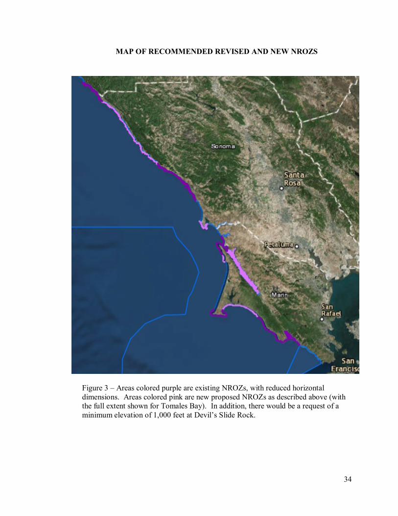
34
MAP OF RECOMMENDED REVISED AND NEW NROZS
Figure 3 – Areas colored purple are existing NROZs, with reduced horizontal
dimensions. Areas colored pink are new proposed NROZs as described above (with
the full extent shown for Tomales Bay). In addition, there would be a request of a
minimum elevation of 1,000 feet at Devil’s Slide Rock.