Embed Size (px)
Citation preview
Proceedings World Geothermal Congress 2010 Bali, Indonesia, 25-29 April 2010
1
The Role of Sumatera Fault Structures in Appearance of Geothermal Features
at Cubadak Area, West Sumatera, Indonesia
Dudi Hermawan and Yuanno Rezky
Center for Geological Resources, Geological Agency. Jl. Soekarno-Hatta No. 444 Bandung 40254, Indonesia
[email protected], [email protected]
Keywords: geothermal features, hotspring, fault structure, depression zone.
ABSTRACT
The Cubadak geothermal area is located in the great Sumatra fault zone. It is important to understand characteristics of this fault zone in connection with the geothermal area.
Geothermal features of Cubadak consist of hotsprings situated at Cubadak and Sawah Mudik with temperatures between 37.10C – 74.80C. The appearance of Cubadak hotspring is controlled by the Cubadak northwest-southeast trending fault. The Sawah Mudik hot spring is controlled by the Botung southwest-northeast trending fault. These structures truncate reservoir rocks underground and enable trapped hydrothermal fluids to flow to the surface along the fractures.
The structures in the Cubadak geothermal area are part of the Sumatera fault zone that spreads along Sumatera Island from Semangko Gulf at the south to Aceh at the north. The fault is still active, the subduction zone along west coast of Sumatera Island is a result of stress caused by the convergence of the Indian-Australian plate and the Eurasian plate. As result of the motion of this structural system, the depression (graben) in several locations occurs especially in en-echelon truncation, is the result of extensional forces in this fault system. Cubadak geothermal area is developed at a depression zone which has a northwest-southeast trending fault structure boundary. This structural zone is facilitating the appearance of geothermal features at Cubadak area and has contributed to the formation of this geothermal system.
1. INTRODUCTION
The Great Sumatera Fault has an important role on most geothermal systems along Sumatera. The fault system is a consequence of the Indian-Australian plate subducting under the Eurasian plate, over which there is a subduction zone along the West Coast of Sumatera Island.
Cubadak geothermal area are recognized by the existence of surface manifestations such as hotsprings. The geothermal area is located at a depression zone which is developed by fault structures, which are part of Great Sumatera Fault.
The objective of this paper is to discuss the connection between Great Sumatera fault and the appearance of geothermal feaures at Cubadak area.
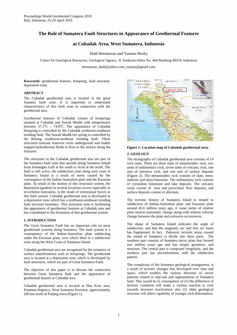
Cubadak geothermal area is located at Dua Koto area, Pasaman Regency, West Sumatera Province, approximately 200 km north of Padang town (Figure 1).
CUBADAK AREA
Figure 1: Location map of Cubadak geothermal area.
2. GEOLOGY
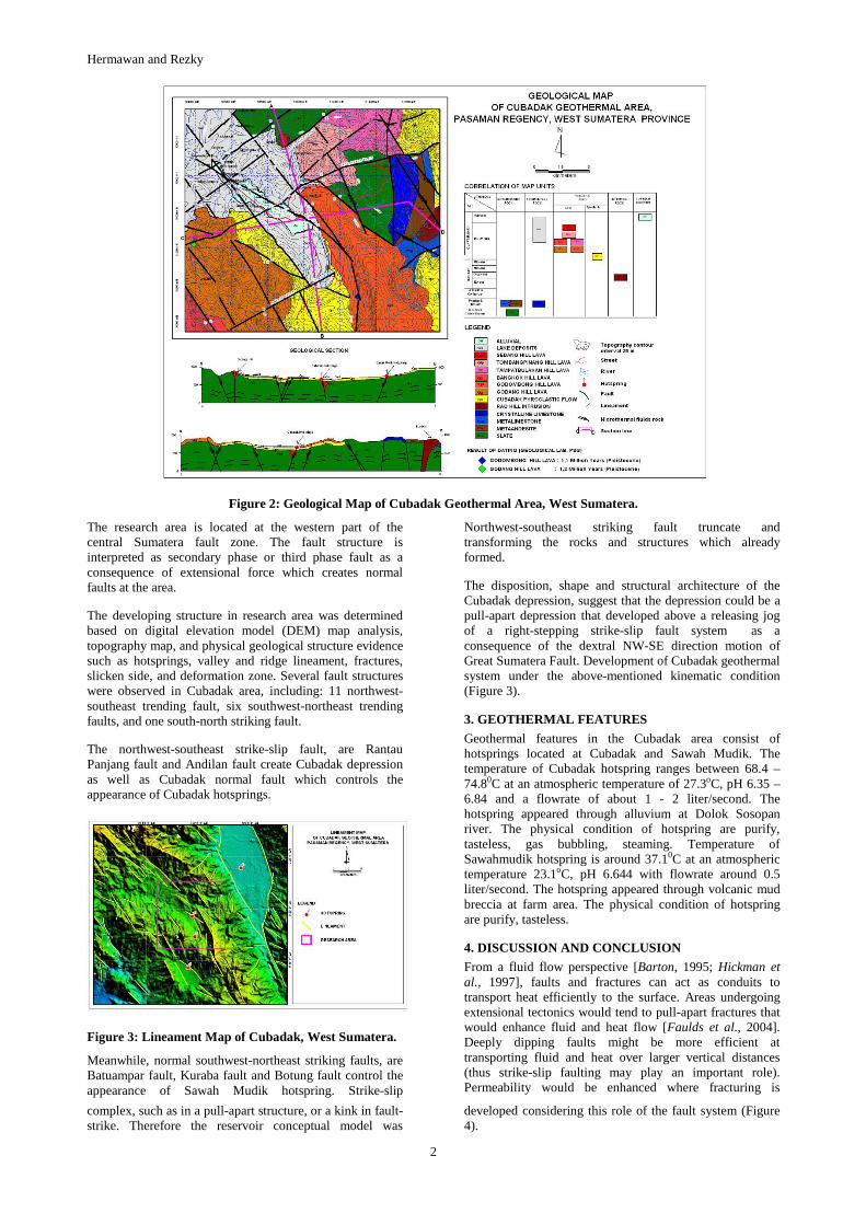
The stratigraphy of Cubadak geothermal area consists of 14 rock units. There are three units of metamorphic rock, two units of sedimentary rock, seven units of volcanic rock, one unit of intrusive rock, and one unit of surface deposits (Figure 2). The metamorphic rock consists of slate, meta-andesite and meta-limestone. The sedimentary rock consists of crystalline limestone and lake deposits. The volcanic rocks consist of lava and pyroclastic flow deposits, and surface deposits consist of alluvium.
The tectonic history of Sumatera Island is related to subduction of Indian-Australian plate and Eurasian plate around 45.6 million years ago, it cause series of relative plate motion systematic change along with relative velocity change between the plate and extrusive occurrences.
The shape of Sumatera Island indicates the angle of subduction, and that the magmatic arc and fore arc basin has fragmented. In fact, Paleozoic tectonic stress caused the island of Sumatera to divide into three parts. The southern part consists of Sumatera micro plate that formed two million years ago and has simple geometry, and structure. The central part is composed irregularly, and the northern part has unconformities with the subduction pattern.
The complexity of the Sumatera geological arrangement, is a result of tectonic changes that developed over time and space, which enables the various direction of vector patterns related to slip-rate and segmentation of Sumatera fault. This would be in consequence of (1) the difference of tectonic condition will make a various reaction to rock towards structure reactivation, also (2) older geological structure will affect capability of younger rock deformation.
Hermawan and Rezky
2
Figure 2: Geological Map of Cubadak Geothermal Area, West Sumatera.
The research area is located at the western part of the central Sumatera fault zone. The fault structure is interpreted as secondary phase or third phase fault as a consequence of extensional force which creates normal faults at the area.
The developing structure in research area was determined based on digital elevation model (DEM) map analysis, topography map, and physical geological structure evidence such as hotsprings, valley and ridge lineament, fractures, slicken side, and deformation zone. Several fault structures were observed in Cubadak area, including: 11 northwest-southeast trending fault, six southwest-northeast trending faults, and one south-north striking fault.
The northwest-southeast strike-slip fault, are Rantau Panjang fault and Andilan fault create Cubadak depression as well as Cubadak normal fault which controls the appearance of Cubadak hotsprings.
Figure 3: Lineament Map of Cubadak, West Sumatera.
Meanwhile, normal southwest-northeast striking faults, are Batuampar fault, Kuraba fault and Botung fault control the appearance of Sawah Mudik hotspring. Strike-slip
Northwest-southeast striking fault truncate and transforming the rocks and structures which already formed.
The disposition, shape and structural architecture of the Cubadak depression, suggest that the depression could be a pull-apart depression that developed above a releasing jog of a right-stepping strike-slip fault system as a consequence of the dextral NW-SE direction motion of Great Sumatera Fault. Development of Cubadak geothermal system under the above-mentioned kinematic condition (Figure 3).
3. GEOTHERMAL FEATURES
Geothermal features in the Cubadak area consist of hotsprings located at Cubadak and Sawah Mudik. The temperature of Cubadak hotspring ranges between 68.4 – 74.80C at an atmospheric temperature of 27.3oC, pH 6.35 – 6.84 and a flowrate of about 1 - 2 liter/second. The hotspring appeared through alluvium at Dolok Sosopan river. The physical condition of hotspring are purify, tasteless, gas bubbling, steaming. Temperature of Sawahmudik hotspring is around 37.10C at an atmospheric temperature 23.1oC, pH 6.644 with flowrate around 0.5 liter/second. The hotspring appeared through volcanic mud breccia at farm area. The physical condition of hotspring are purify, tasteless.
4. DISCUSSION AND CONCLUSION
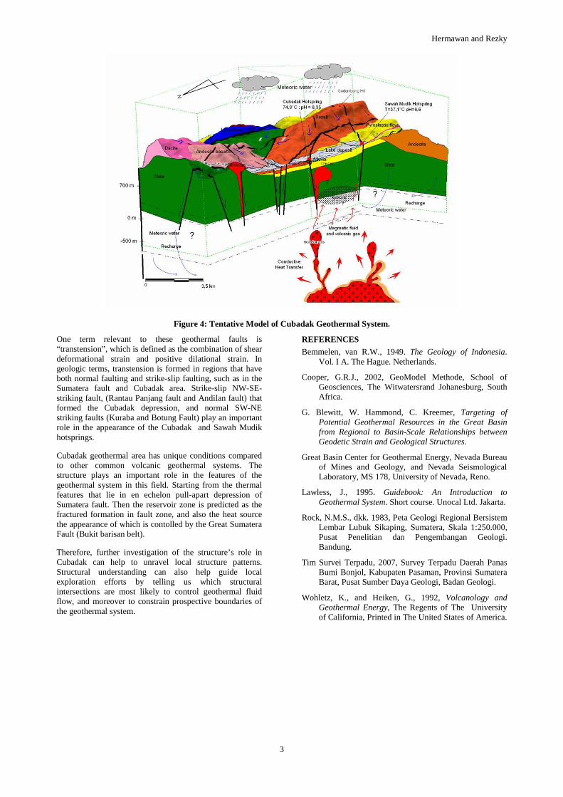
From a fluid flow perspective [Barton, 1995; Hickman et al., 1997], faults and fractures can act as conduits to transport heat efficiently to the surface. Areas undergoing extensional tectonics would tend to pull-apart fractures that would enhance fluid and heat flow [Faulds et al., 2004]. Deeply dipping faults might be more efficient at transporting fluid and heat over larger vertical distances (thus strike-slip faulting may play an important role). Permeability would be enhanced where fracturing is
complex, such as in a pull-apart structure, or a kink in fault-strike. Therefore the reservoir conceptual model was
developed considering this role of the fault system (Figure 4).
Hermawan and Rezky
3
Figure 4: Tentative Model of Cubadak Geothermal System.
One term relevant to these geothermal faults is “transtension”, which is defined as the combination of shear deformational strain and positive dilational strain. In geologic terms, transtension is formed in regions that have both normal faulting and strike-slip faulting, such as in the Sumatera fault and Cubadak area. Strike-slip NW-SE-striking fault, (Rantau Panjang fault and Andilan fault) that formed the Cubadak depression, and normal SW-NE striking faults (Kuraba and Botung Fault) play an important role in the appearance of the Cubadak and Sawah Mudik hotsprings.
Cubadak geothermal area has unique conditions compared to other common volcanic geothermal systems. The structure plays an important role in the features of the geothermal system in this field. Starting from the thermal features that lie in en echelon pull-apart depression of Sumatera fault. Then the reservoir zone is predicted as the fractured formation in fault zone, and also the heat source the appearance of which is contolled by the Great Sumatera Fault (Bukit barisan belt).
Therefore, further investigation of the structure’s role in Cubadak can help to unravel local structure patterns. Structural understanding can also help guide local exploration efforts by telling us which structural intersections are most likely to control geothermal fluid flow, and moreover to constrain prospective boundaries of the geothermal system.
REFERENCES
Bemmelen, van R.W., 1949. The Geology of Indonesia. Vol. I A. The Hague. Netherlands.
Cooper, G.R.J., 2002, GeoModel Methode, School of Geosciences, The Witwatersrand Johanesburg, South Africa.
G. Blewitt, W. Hammond, C. Kreemer, Targeting of Potential Geothermal Resources in the Great Basin from Regional to Basin-Scale Relationships between Geodetic Strain and Geological Structures.
Great Basin Center for Geothermal Energy, Nevada Bureau of Mines and Geology, and Nevada Seismological Laboratory, MS 178, University of Nevada, Reno.
Lawless, J., 1995. Guidebook: An Introduction to Geothermal System. Short course. Unocal Ltd. Jakarta.
Rock, N.M.S., dkk. 1983, Peta Geologi Regional Bersistem Lembar Lubuk Sikaping, Sumatera, Skala 1:250.000, Pusat Penelitian dan Pengembangan Geologi. Bandung.
Tim Survei Terpadu, 2007, Survey Terpadu Daerah Panas Bumi Bonjol, Kabupaten Pasaman, Provinsi Sumatera Barat, Pusat Sumber Daya Geologi, Badan Geologi.
Wohletz, K., and Heiken, G., 1992, Volcanology and Geothermal Energy, The Regents of The University of California, Printed in The United States of America.