Embed Size (px)
Citation preview
The role of peat decomposition in patterned mires: a case study fromthe central Swiss Alps
Význam dekompozice rašeliny na povrchově strukturovaných rašeliništích: případová studie ze švýcarských Alp
Brigitta A m m a n n1, Herbert E. W r i g h t2, Vania S t e f a n o v a2,Jacqueline F. N. v a n L e e u w e n1, Willem O. v a n d e r K n a a p1,Daniele C o l o m b a r o l i1 & Willy T i n n e r1
D e d i c a t e d t o K a m i l R y b n í č e k a n d E l i š k a R y b n í č k o v á o n t h e o c c a s i o n o f t h e i r8 0 t h b i r t h d a y s
1University of Bern, Switzerland, Institute of Plant Sciences and Oeschger Centre for ClimateChange Research, email: [email protected], [email protected],[email protected], [email protected], [email protected]; 2University of Minnesota, Limnological Research Center, 310 Pillsbury DriveSE, Minneapolis, MN 55455, USA, email: [email protected], [email protected]
Ammann B., Wright H. E., Stefanova V., van Leeuwen J. F. N., van der Knaap W. O., ColombaroliD. & Tinner W. (2013): The role of peat decomposition in patterned mires: a case study from thecentral Swiss Alps. – Preslia 85: 317–332.
A number of hydrological, botanical, macro- and micro-climatological processes are involved in theformation of patterned peatlands. La Grande Tsa at 2336 m a.s.l. is probably the highest bog in thecentral Swiss Alps and is unique in its pattern. In two of five pools there is in the contact zonebetween the basal peat and the overlying gyttja an unconformity in the depth-age models based onradiocarbon dates. Palynostratigraphies of cores from a ridge and a pool confirm the occurrence ofan unconformity in the contact zone. We conclude that deepening of the pools results from decom-position of peat. The fact that the dated unconformities in the two pools and the unconformity in theridge-core all fall within the Bronze Age suggest they were caused by events external to the bog. Wehypothesize that early transhumance resulted in anthropogenic lowering of the timberline, whichresulted in a reduction in the leaf-area index and evapotranspiration, and in higher water levels andthus pool formation.
K e y w o r d s: deepening of pools, mires, patterned peatlands, peat decomposition, pool formation
Introduction
Peatlands occur where drainage is impeded and where plant growth is vigorous enough foraccumulation to exceed decomposition. There may be hummocks on the surface ofpeatlands, which are the result of a local presence of trees or shrubs that provide woodybiomass that decomposes less readily than graminoids and mosses. Between the hum-mocks are low spots in which water can accumulate and inhibit growth of vascular plants.The patterns formed by hummocks and hollows may become linear if a gentle slope exists,and the long axes of the hollows are invariably parallel to the contours of the slope. Theintricate, winding pattern of pools in string fens (aapamoors) of boreal Finland is anextreme example, but the domal form of raised bogs provides a sufficient slope for thedevelopment of an arcuate pattern of pools (e.g. Kermi bogs of Fennoscandia; Cajander
Preslia 85: 317–332, 2013 317
1913, Sjörs 1961, 1983, Eurola 1962, Tolonen 1967, Ruuhijärvi 1983). Both types can beeither concentric on flat ground or eccentric on slopes.
Any distinctive pattern in the landscape begs for an explanation. Research on the poolson patterned peatlands has a long tradition and various hydrological and/or biologicalmechanisms have been proposed. A historic perspective as far back as the 17th century isoffered by Gorham (1953) and more recently by Tallis (1983), Sjörs (1998) and Glaser(1998). Eppinga et al. (2010) present data and models on a larger spatial scale fora hypothesis that there is a gradient in the availability of nutrients along a climatic gradientfrom Scotland to Siberia.
On bogs we may distinguish between the more or less shallow “hollows”, which can befilled with peat of Sphagnum cuspidatum and may seasonally dry out, and “pools”, whichhave open water all year round. Hollows in Estonia have been stable for over 3000 years(Karofeld (1998a). Pools described by Moore (1977), which have been stable for at least5000 years, were partly filled with various forms of peat and gyttja, not by cyclic replace-ment but by expansion and contraction of the pools. A mechanism for the transition fromhollow to pool involving hydrological changes and differential peat growth is presented byBelyea & Clymo (1998). Studies on the fens of southeastern Labrador and the raised bogof Hammarmossen in central Sweden (Foster et al. 1983, 1988, Foster & Wright 1990) ledto the following scenario: (i) When enough peat accumulates on a gently sloping substratefor the formation of irregularities on the surface, perhaps localized around trees or shrubs,water collects in the low lying areas during snow-melt to form small pools. (ii) Whena pool fills to the low spot on the down-slope rim, it will drain into the next-lower pool. Butwhen the lowest part of the rim is on a contour, it will drain laterally, producing a long lin-ear pool parallel to the contour. (iii) Plant growth in the pool is inhibited, whereas on therelatively dry adjacent ridges shrubs and even trees increase the height of the ridge and thepool becomes deeper. (iv) Dissolved oxygen in the water has two sources: it gets stirredinto the water from the atmosphere by wind and is enhanced by the products of algal pho-tosynthesis. Increased oxygen in the bottom water results in decomposition of the peat onthe floor of the pool and the adjacent ridge may be locally undermined. The pool thusbecomes deeper and wider. Masses of decomposed peat may rise to the surface as a resultof the accumulated methane and carbon dioxide. (v) With a larger water surface anddeeper water, algal growth results in accumulation of detrital gyttja, thus burying thedecomposed peat. Algal growth (and gyttja formation) may thus pull the system in oppo-site directions: the additional oxygen may enhance peat decomposition, but by sealing offthe peat the gyttja may protect the peat from oxidation. The depth of the pools may have anadditional effect: as long as the pools are not very deep they do not contain a thermoclineand therefore atmospheric oxygen may reach the bottom of the pool. With increase indepth a thermocline may be established and less oxygen will reach the bottom. (vi) Thepool may ultimately fill up with gyttja, the surface of which then can support the growth ofmosses and sedges.
In the oriented pools investigated on a fen in south-eastern Labrador, the sequence ter-minated with step (iv), and the peat on the floor of the pool was completely removed to themineral substratum, with only pieces of refractory wood remaining (Foster et al. 1983).The arcuate pools on the flanks of the symmetrical raised bog Hammarmossen in centralSweden are well developed and the entire sequence is represented. Radiocarbon dating ofthe basal peat showed that the bog there grew from the center outwards (Foster & Wright
318 Preslia 85: 317–332, 2013
1990). The early stages of development from hollows to linear pools can be witnessed nearthe modern bog margin, and the full sequence is present in the older and deeper poolstoward the center. In the latter area paired radiocarbon dates from the top of the decom-posed peat and the base of the overlying gyttja at four different sites indicate hiatuses ofbetween 430 and 1430 years, which represent the amount of peat removed by decomposi-tion before burial by gyttja (Foster & Wright 1990).
In the present study we test the above hypothesis using the miniature bog of La GrandeTsa in the Swiss Alps (2336 m a.s.l.), which has five parallel linear pools with orientation(Figs 1 and 2) that may fit the model so well represented in boreal forests. Patterned miresare rare in the Alps. Ullmann & Stehlik (1972) provide an early description of the raisedbog Rotmoos near Weichselboden at a lower altitude (700 m a.s.l.) in the calcareous east-ern Alps of Upper Styria (Austria), which has a special local climate in a deep valley,where the sun never reaches the bog during winter. At this site there are eccentric arcuatehollows comparable to those at Hammarmossen in central Sweden (Foster & Wright1990) but no pools as at La Grande Tsa. Usually hollows only contain water during high-water periods (e.g. after snow melt), whereas pools are full of water throughout the year(Belyea & Clymo 1998). On a bog both hollows and pools can coexist, as at Hammar-mossen and Nittenmossen (Foster & Wright 1990).
Of the many questions there are about the formation of pools on bogs (Sjörs 1961,1983, 1998, Boatman & Tomlinson 1973, 1977, Boatman 1977, Glaser 1998, Karofeld1998a, b) we concentrate on the mechanisms responsible for the deepening of alreadyexisting pools.
Materials and methods
The site La Grande Tsa
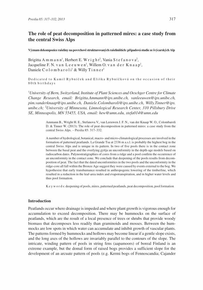
The plateau of La Grande Tsa (46°09'18.74''N, 7°21'52.20''E, 2336 m a.s.l.) is situated inthe Val d’Hérémence, a southern tributary valley of the Rhône Valley in the central SwissAlps, about 8 km south of the city of Sion (French, in German Sitten, Fig. 1). Twopalynological sites near La Grande Tsa are Mont Carré (Welten 1982) and Gouillé Rion(Tinner et al. 1996, Tinner & Kaltenrieder 2005). In addition, macrofossils including char-coal were analysed contiguously at Gouillé Rion, and upland soil surveys were used forbiosequence reconstructions (Tinner et al. 1996, Tinner & Kaltenrieder 2005). The bed-rock consists mainly of schists belonging to the Penninic nappe of the Grand-St-Bernard.
There is no local weather station but the annual mean temperature can be estimated tobe about 1 °C and the annual precipitation to at least 1100 mm. For the nearby hydroelec-tric power station Grande Dixence annual means of 1.4 °C and 920 mm are cited (Roh &Rey 1989). The climate is subcontinental.
Roh & Rey (1989) provide a phytosociological description of the vegetation in the areaand a map of the bog, which we use in a simplified form (Fig. 2). La Grande Tsa is men-tioned as the highest well-developed bog in the Swiss Alps; its patterning is unique for thiscountry and probably the entire Alps (in German: Terrassenhochmoor). In addition, thebog and its surroundings harbour several plant species that are rare in the Central Alps (i.e.Carex limosa, C. paupercula, Sedum villosum). For this reason the site is now a naturereserve and fenced. The history of the vegetation during the Holocene is known for two
Ammann et al.: Peat decomposition in patterned mires 319
320 Preslia 85: 317–332, 2013
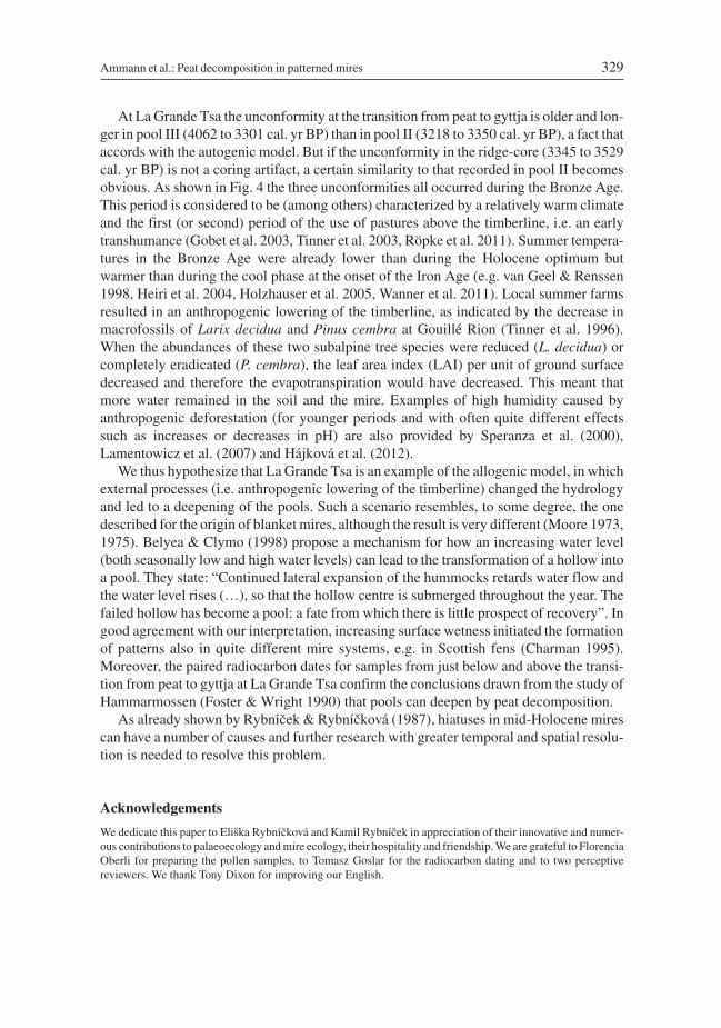
Fig. 1. – (A) Google map of the Alpine arch showing the location of Sitten/Sion in the upper Rhône Valley(Valais). (B) Google map showing the Val d’Hérémence joining the Rhône valley near Sion, and the three neigh-bouring sites sampled. (C) The three neighbouring sites: Gouillé Rion is a lake at 2343 m a.s.l. (Tinner et al. 1996,Tinner and Kaltenrieder 2005); La Grande Tsa is a patterned peatland with distinct pools at 2336 m a.s.l. (thispaper) and Mont Carré is a mire without patterns at 2290 m a.s.l. (Welten 1982).
nearby sites: (i) The palynological sequence for Mont Carré (2299 m a.s.l., Welten 1982)covers the period from the Younger Dryas to the onset of the Roman period but the rate ofaccumulation and sampling resolution are low for the period relevant to La Grande Tsa.(ii) The pollen and macrofossil records from Gouillé Rion (2343 m a.s.l., Tinner et al.1996) cover the period from the Bølling to the present and were used to reconstruct thelong-term timberline dynamics. Today all three sites are above the timberline but belowthe tree line (~2350 m a.s.l. in the 1990s, today ~2400 m a.s.l.). Plant macrofossils showthat the site was forested already 200 years after the onset of the Holocene. Larix deciduaand Betula pendula forests remained open (with e.g. heliophilous Juniperus nana andDryas octopetala) till ~9500 cal. yr BP. Between 9500 and 3600 cal. yr BP dense forests ofLarix decidua, Betula pendula and Pinus cembra occurred around these sites (Tinner et al.1996, Kaltenrieder et al. 2005, Tinner & Kaltenrieder 2005). These forests were damagedby man during the Bronze Age, mostly by the use of fire to gain summer pastures(Colombaroli et al. 2010). Dynamic vegetation models (FORCLIM) show that the loca-tion of these sites was highly sensitive to climate-induced oscillations in the timberline asrecorded in the pollen and macrofossil records (Heiri et al. 2006). Dynamic landscapesimulations (LANDCLIM) suggest a paramount long-term role of soils in determining thecomposition and dynamics of the vegetation around the three sites (Henne et al. 2011).
Methods of coring, sampling, dating and pollen analysis
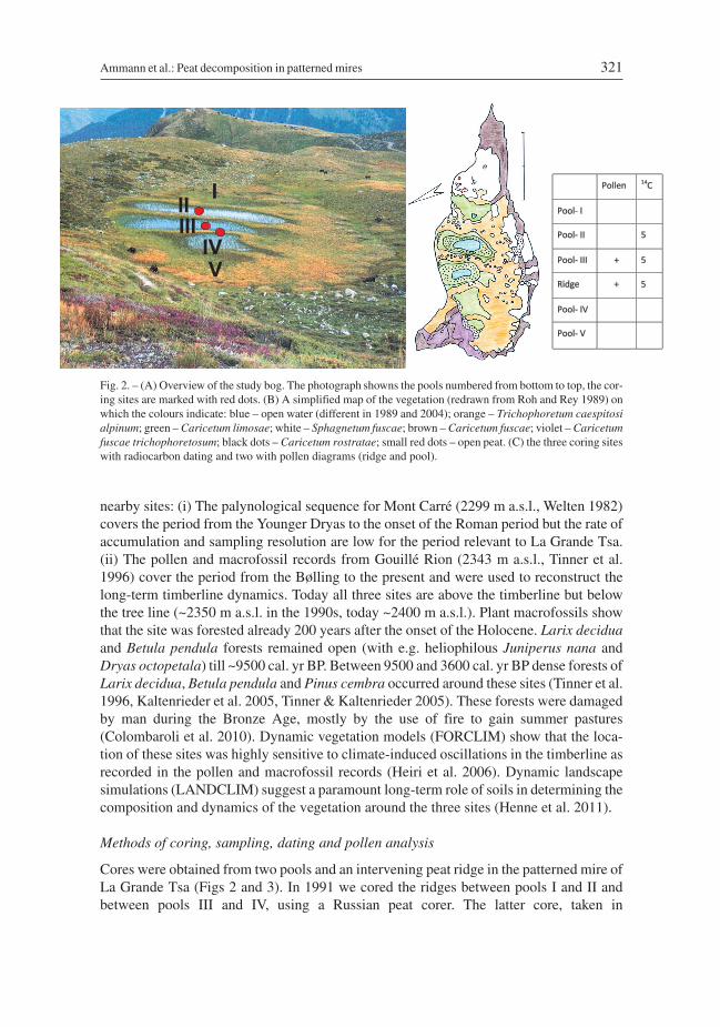
Cores were obtained from two pools and an intervening peat ridge in the patterned mire ofLa Grande Tsa (Figs 2 and 3). In 1991 we cored the ridges between pools I and II andbetween pools III and IV, using a Russian peat corer. The latter core, taken in
Ammann et al.: Peat decomposition in patterned mires 321
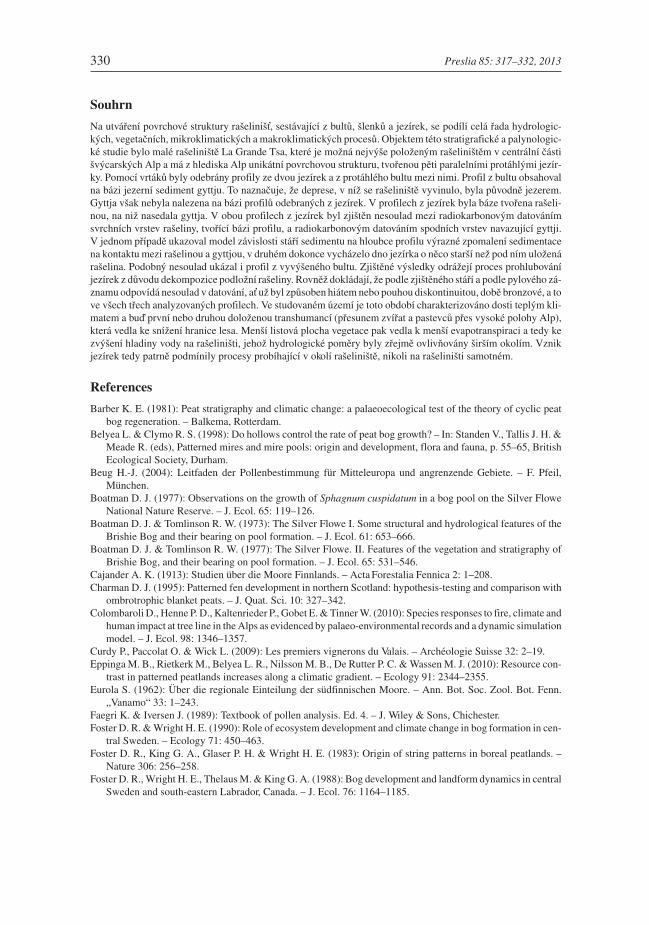
Fig. 2. – (A) Overview of the study bog. The photograph showns the pools numbered from bottom to top, the cor-ing sites are marked with red dots. (B) A simplified map of the vegetation (redrawn from Roh and Rey 1989) onwhich the colours indicate: blue – open water (different in 1989 and 2004); orange – Trichophoretum caespitosialpinum; green – Caricetum limosae; white – Sphagnetum fuscae; brown – Caricetum fuscae; violet – Caricetumfuscae trichophoretosum; black dots – Caricetum rostratae; small red dots – open peat. (C) the three coring siteswith radiocarbon dating and two with pollen diagrams (ridge and pool).
Trichophorum alpinum stands, was nearly complete and was therefore chosen as the mas-ter core for dating and pollen analysis (now labelled ridge-core). In 1993 we re-coredpools I, II (not analysed) and III using a square-rod piston sampler (Wright 1967). In 2004we revisited pool II with a square-rod piston sampler for dating the unconformity.
Lithostratigraphy
The sediments in the cores were described and categorized based on visual features fol-lowing Troels-Smith (1955).
Radiocarbon dating
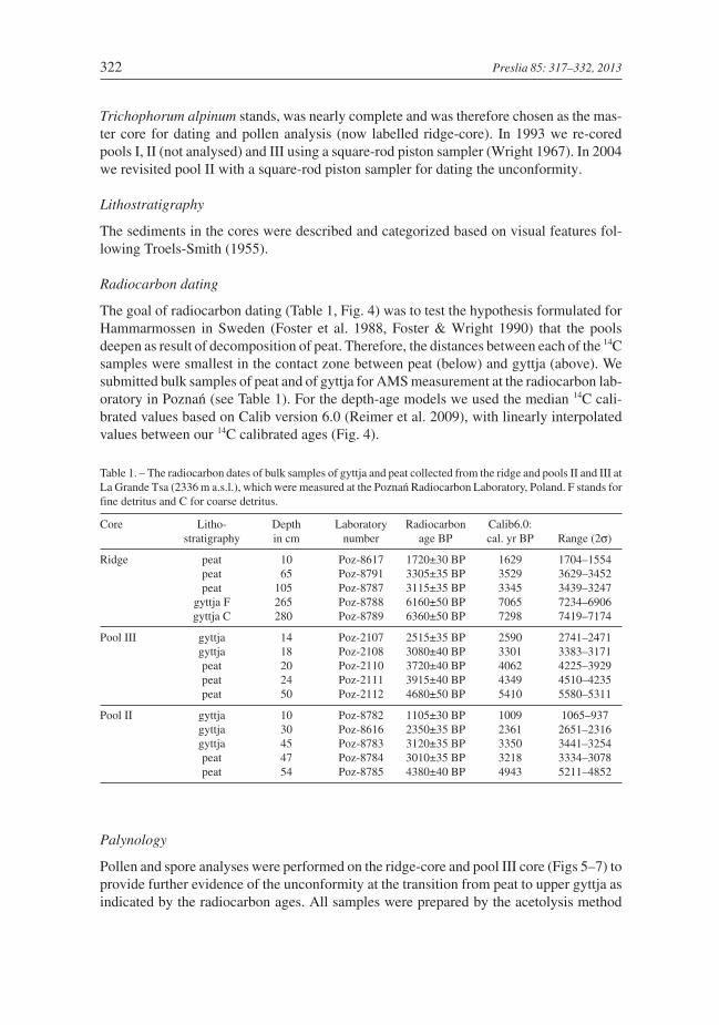
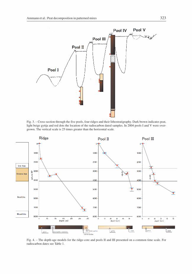
The goal of radiocarbon dating (Table 1, Fig. 4) was to test the hypothesis formulated forHammarmossen in Sweden (Foster et al. 1988, Foster & Wright 1990) that the poolsdeepen as result of decomposition of peat. Therefore, the distances between each of the 14Csamples were smallest in the contact zone between peat (below) and gyttja (above). Wesubmitted bulk samples of peat and of gyttja for AMS measurement at the radiocarbon lab-oratory in Poznań (see Table 1). For the depth-age models we used the median 14C cali-brated values based on Calib version 6.0 (Reimer et al. 2009), with linearly interpolatedvalues between our 14C calibrated ages (Fig. 4).
Table 1. – The radiocarbon dates of bulk samples of gyttja and peat collected from the ridge and pools II and III atLa Grande Tsa (2336 m a.s.l.), which were measured at the Poznań Radiocarbon Laboratory, Poland. F stands forfine detritus and C for coarse detritus.
Core Litho-stratigraphy
Depthin cm
Laboratorynumber
Radiocarbonage BP
Calib6.0:cal. yr BP Range (2σ)
Ridge peat 10 Poz-8617 1720±30 BP 1629 1704–1554peat 65 Poz-8791 3305±35 BP 3529 3629–3452peat 105 Poz-8787 3115±35 BP 3345 3439–3247
gyttja F 265 Poz-8788 6160±50 BP 7065 7234–6906gyttja C 280 Poz-8789 6360±50 BP 7298 7419–7174
Pool III gyttja 14 Poz-2107 2515±35 BP 2590 2741–2471gyttja 18 Poz-2108 3080±40 BP 3301 3383–3171peat 20 Poz-2110 3720±40 BP 4062 4225–3929peat 24 Poz-2111 3915±40 BP 4349 4510–4235peat 50 Poz-2112 4680±50 BP 5410 5580–5311
Pool II gyttja 10 Poz-8782 1105±30 BP 1009 1065–937gyttja 30 Poz-8616 2350±35 BP 2361 2651–2316gyttja 45 Poz-8783 3120±35 BP 3350 3441–3254peat 47 Poz-8784 3010±35 BP 3218 3334–3078peat 54 Poz-8785 4380±40 BP 4943 5211–4852
Palynology
Pollen and spore analyses were performed on the ridge-core and pool III core (Figs 5–7) toprovide further evidence of the unconformity at the transition from peat to upper gyttja asindicated by the radiocarbon ages. All samples were prepared by the acetolysis method
322 Preslia 85: 317–332, 2013
Ammann et al.: Peat decomposition in patterned mires 323
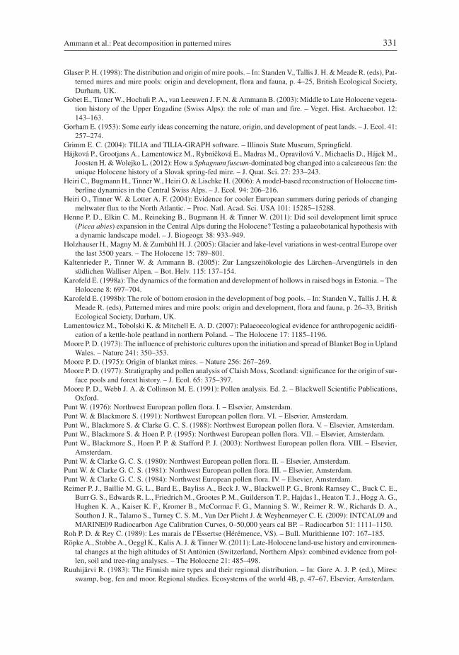
Fig. 3. – Cross-section through the five pools, four ridges and their lithostratigraphy. Dark brown indicates peat,light beige gyttja and red dots the location of the radiocarbon dated samples. In 2004 pools I and V were over-grown. The vertical scale is 25 times greater than the horizontal scale.
Fig. 4. – The depth-age models for the ridge-core and pools II and III presented on a common time scale. Forradiocarbon dates see Table 1.
324 Preslia 85: 317–332, 2013
Fig.
5.–
Polle
ndi
agra
mfo
rth
eri
dge-
core
(sel
ecte
dta
xaon
ly,d
epth
-lin
ear)
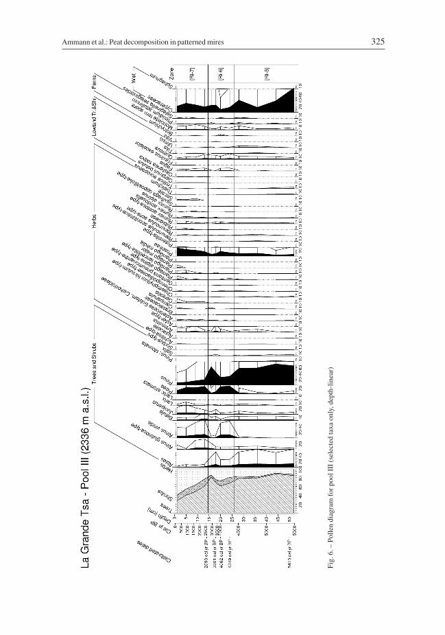
Ammann et al.: Peat decomposition in patterned mires 325
Fig.
6.–
Polle
ndi
agra
mfo
rpo
olII
I(s
elec
ted
taxa
only
,dep
th-l
inea
r)
326 Preslia 85: 317–332, 2013
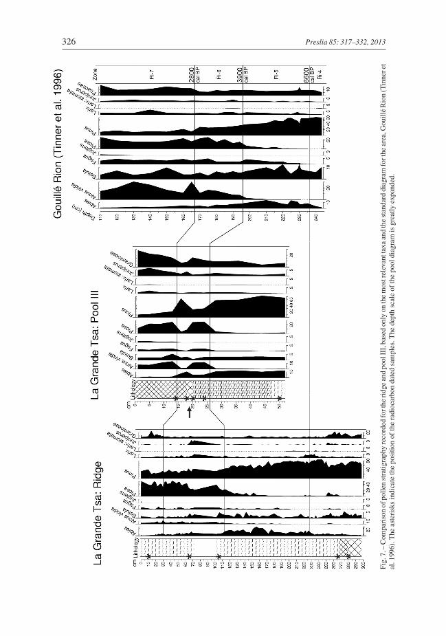
Fig.
7.–
Com
pari
son
ofpo
llen
stra
tigra
phy
reco
rded
fort
heri
dge
and
pool
III,
base
don
lyon
the
mos
trel
evan
ttax
aan
dth
est
anda
rddi
agra
mfo
rthe
area
,Gou
illé
Rio
n(T
inne
ret
al.1
996)
.The
aste
risk
sin
dica
teth
epo
sitio
nof
the
radi
ocar
bon
date
dsa
mpl
es.T
hede
pth
scal
eof
the
pool
diag
ram
isgr
eatly
expa
nded
.
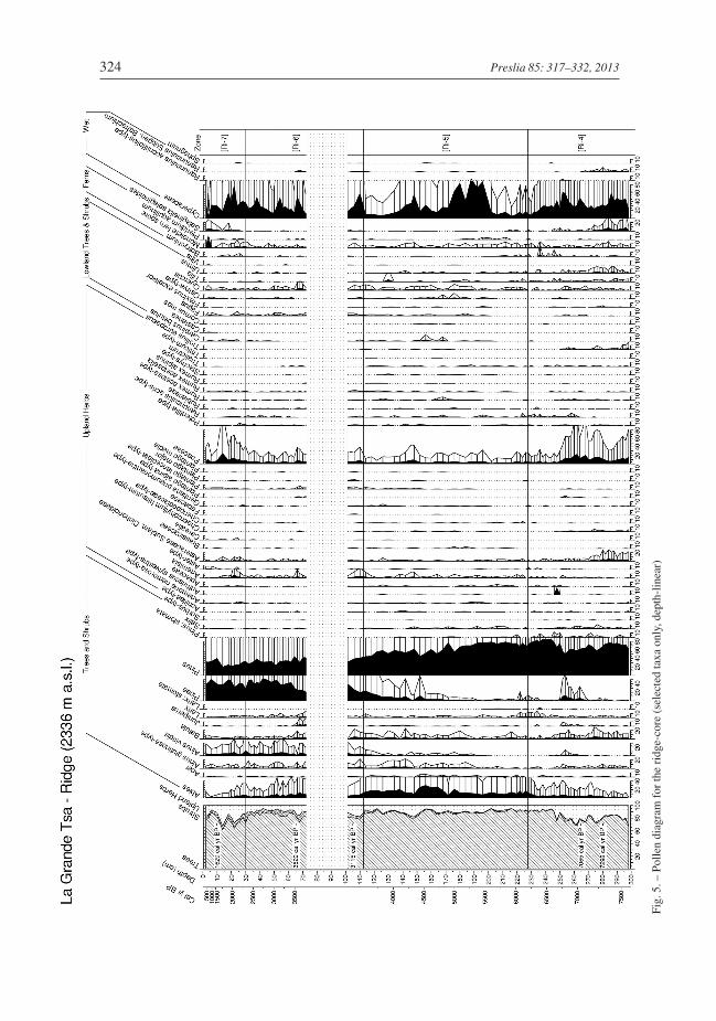
(Faegri & Iversen 1989). Pollen percentages are based on the pollen sum (100%) of AP(arboreal pollen, including trees and shrubs) and NAP (non-arboreal pollen). Spores ofBryophyta and Pteridophyta and pollen grains of Cyperaceae and aquatic plants areexcluded from the pollen sum. At least 500 terrestrial pollen grains were identified to thelowest possible taxonomic level using the keys of Punt (1976), Punt & Clarke (1980, 1981,1984), Punt et al. (1988, 1995, 2003), Punt & Blackmore (1991), Moore et al. (1991) andBeug (2004). For calculating the percentages and printing the results, Tilia and TGView1.5.11 programs (Grimm 2004) were used. Pollen-zone boundaries shown by continuouslines are based on a comparison with the regional pollen zones recorded at Gouillé Rion(Tinner et al. 1996).
Results
Lithostratigraphy
The ridge core contains gyttja at the base of the core, showing that the depression in whichthe peat developed was originally a lake. This basal gyttja was not reached in the poolcores. The pool cores consist of peat below and a second (younger) layer of gyttja above(see Figs 3, 5–7).
Radiocarbon dates and depth-age models
After calibration of the radiocarbon dates (Table 1) we developed three depth-age models(Fig. 4). The neutral term “unconformity” includes both hiatuses and a discontinuity.
Palynostratigraphy
The pollen records in the ridge-core, the pool III core and their combination (Figs 5–7) canbe used to reconstruct the dynamics of the patterned mire on the basis of individualbiostratigraphies. In addition, the record in the ridge core can be compared with thatreported for the nearby lake of Gouillé Rion by Tinner et al. (1996). For comparison weadded the local pollen-assemblage zones of this regional standard to the pollen diagramsof La Grande Tsa (Ri-4 to Ri-7). The ridge-core starts around 7300 cal. yr BP, i.e. duringthe second half of the Atlantic period or zone Ri-4 of Gouillé Rion. Larix was locally pres-ent (stomata only found at Gouillé Rion, but abundant macrofossils) as well as Pinuscembra (stomata of Pinus sp. at both sites, abundant macrofossils at Gouillé Rion).Among the pollen Abies is relatively important, but occasional needle finds (Tinner et al.1996, Kaltenrieder et al. 2005) indicate that the local presence of Abies at these high alti-tudes was rather rare. In both diagrams the first slight increases in Picea and Alnus viridisoccur in zone Ri-5. In zone Ri-6 there is a distinct increase in these two taxa and Juniperus(J. nana in the macrofossils) and a decline in Abies. This decline in Abies is also recordedin the uppermost samples from the site at Mont Carré (Welten 1982).
The first appearance of the grazing indicator Plantago alpina in zone Ri-5 most proba-bly documents the onset of alpine summer farming in the Gouillé Rion area, whichoccurred at latest during the Bronze Age (Tinner et al. 1996, Kaltenrieder et al. 2005).
Pollen grains of Cerealia-type and Vitis were certainly blown up from the valley. This is inaccordance with the pre-Roman records of Vitis (since the 8th century BC) in archaeological,
Ammann et al.: Peat decomposition in patterned mires 327
archaeobotanical and palynological from the main valley of the Valais (Curdy et al. 2009).It is in this pollen zone Ri-6 (~3900 to 2800 cal. yr BP) that the unconformities occur in allthree depth-age models (Fig. 4). Zone Ri-6 corresponds largely to the Bronze Age(4200–2800 cal. yr BP), when the forest around the patterned mire was destroyed by firesof human origin (Colombaroli et al. 2010). The transition from zones Ri-6 to Ri-7 coin-cides approximately with the transition from the Late Bronze Age to Early Iron Age (i.e.800 BC). During zone Ri-7 (ca 2800–1625 cal. yr BP) Cerealia-type pollen forms a nearlycontinuous curve and the first grains of Juglans occur (indicating the Roman occupationof the Valais).
The core from pool III indicates that the hiatus in the peat record occurs in zone Ri-6,i.e. after the decrease in Abies and Pinus and increase in Alnus viridis and Picea.
Discussion
In both pools there is an unconformity in the radiocarbon dates for below and above thecontact between the peat (upper) and gyttja in the depth-age models, indicating a slightreversal in pool II and distinct slow-down (below 0.3 mm yr–1) in the estimated rate ofaccumulation in pool III (Fig. 4). The unconformity in pool III is somewhat older than thatin pool II. This is in accordance with the situation at Hammarmossen, where the oldest andlongest gaps in the depth-age models are near the top of the domed bog, although the dif-ference in age at La Grande Tsa is small and we have paired peat-gyttja ages for only twopools, compared to eight pools at Hammarmossen (Foster & Wright (1990). Nevertheless,we infer that at La Grande Tsa the pools also deepened because of peat decomposition, asindicated by the unconformities in the depth-age models (Fig. 4).
At least another three questions remain unanswered: (i) If the algae take up old carbonfrom the decomposing peat, may we get radiocarbon ages for the gyttja just above the peatthat are too old? If so, the age of the upper sample in the pair of dates (measured on bulkgyttja) would be too old, and therefore the hiatus may be even longer than indicated by thedates. (ii) The unconformity in radiocarbon dates in the ridge-core brackets the gap in thecore that we consider to be a coring artifact, namely incomplete recovery. But could it be thatthis has a common cause with the unconformities in the pool cores? (iii) This leads to themain question: is the peat decomposition caused by local autogenous processes in the bog orby allochthonous processes such as climate, fire, or land use? Or is it a combination of both?In questions (ii) and (iii) the hydrology of the mire plays a central role. Currently we have nohydrological measurements for La Grande Tsa, for which it would be interesting to know theseasonal difference in hydrology between periods of snow melt and mid-summer.
Foster & Wright (1990) discuss three models of pool formation. According to the neu-tral model, pools are initiated when the bog begins to form and therefore extend from thesurface down to the minerogenic soil. This model obviously does not apply to La GrandeTsa. According to the autogenic model, pool formation is controlled by the local bog mor-phology and hydrology, with progressively younger pools from the centre of the dometowards the margin, as is well illustrated by the situation at Hammarmossen (Foster &Wright 1990). According to the allogenic model, however, pool formation occurs simulta-neously across the bog in response to an external cause such as a climatic change (e.g.Bolton Fell Moss; Barber 1981).
328 Preslia 85: 317–332, 2013
At La Grande Tsa the unconformity at the transition from peat to gyttja is older and lon-ger in pool III (4062 to 3301 cal. yr BP) than in pool II (3218 to 3350 cal. yr BP), a fact thataccords with the autogenic model. But if the unconformity in the ridge-core (3345 to 3529cal. yr BP) is not a coring artifact, a certain similarity to that recorded in pool II becomesobvious. As shown in Fig. 4 the three unconformities all occurred during the Bronze Age.This period is considered to be (among others) characterized by a relatively warm climateand the first (or second) period of the use of pastures above the timberline, i.e. an earlytranshumance (Gobet et al. 2003, Tinner et al. 2003, Röpke et al. 2011). Summer tempera-tures in the Bronze Age were already lower than during the Holocene optimum butwarmer than during the cool phase at the onset of the Iron Age (e.g. van Geel & Renssen1998, Heiri et al. 2004, Holzhauser et al. 2005, Wanner et al. 2011). Local summer farmsresulted in an anthropogenic lowering of the timberline, as indicated by the decrease inmacrofossils of Larix decidua and Pinus cembra at Gouillé Rion (Tinner et al. 1996).When the abundances of these two subalpine tree species were reduced (L. decidua) orcompletely eradicated (P. cembra), the leaf area index (LAI) per unit of ground surfacedecreased and therefore the evapotranspiration would have decreased. This meant thatmore water remained in the soil and the mire. Examples of high humidity caused byanthropogenic deforestation (for younger periods and with often quite different effectssuch as increases or decreases in pH) are also provided by Speranza et al. (2000),Lamentowicz et al. (2007) and Hájková et al. (2012).
We thus hypothesize that La Grande Tsa is an example of the allogenic model, in whichexternal processes (i.e. anthropogenic lowering of the timberline) changed the hydrologyand led to a deepening of the pools. Such a scenario resembles, to some degree, the onedescribed for the origin of blanket mires, although the result is very different (Moore 1973,1975). Belyea & Clymo (1998) propose a mechanism for how an increasing water level(both seasonally low and high water levels) can lead to the transformation of a hollow intoa pool. They state: “Continued lateral expansion of the hummocks retards water flow andthe water level rises (…), so that the hollow centre is submerged throughout the year. Thefailed hollow has become a pool: a fate from which there is little prospect of recovery”. Ingood agreement with our interpretation, increasing surface wetness initiated the formationof patterns also in quite different mire systems, e.g. in Scottish fens (Charman 1995).Moreover, the paired radiocarbon dates for samples from just below and above the transi-tion from peat to gyttja at La Grande Tsa confirm the conclusions drawn from the study ofHammarmossen (Foster & Wright 1990) that pools can deepen by peat decomposition.
As already shown by Rybníček & Rybníčková (1987), hiatuses in mid-Holocene mirescan have a number of causes and further research with greater temporal and spatial resolu-tion is needed to resolve this problem.
Acknowledgements
We dedicate this paper to Eliška Rybníčková and Kamil Rybníček in appreciation of their innovative and numer-ous contributions to palaeoecology and mire ecology, their hospitality and friendship. We are grateful to FlorenciaOberli for preparing the pollen samples, to Tomasz Goslar for the radiocarbon dating and to two perceptivereviewers. We thank Tony Dixon for improving our English.
Ammann et al.: Peat decomposition in patterned mires 329
Souhrn
Na utváření povrchové struktury rašelinišť, sestávající z bultů, šlenků a jezírek, se podílí celá řada hydrologic-kých, vegetačních, mikroklimatických a makroklimatických procesů. Objektem této stratigrafické a palynologic-ké studie bylo malé rašeliniště La Grande Tsa, které je možná nejvýše položeným rašeliništěm v centrální částišvýcarských Alp a má z hlediska Alp unikátní povrchovou strukturu, tvořenou pěti paralelními protáhlými jezír-ky. Pomocí vrtáků byly odebrány profily ze dvou jezírek a z protáhlého bultu mezi nimi. Profil z bultu obsahovalna bázi jezerní sediment gyttju. To naznačuje, že deprese, v níž se rašeliniště vyvinulo, byla původně jezerem.Gyttja však nebyla nalezena na bázi profilů odebraných z jezírek. V profilech z jezírek byla báze tvořena rašeli-nou, na niž nasedala gyttja. V obou profilech z jezírek byl zjištěn nesoulad mezi radiokarbonovým datovánímsvrchních vrstev rašeliny, tvořící bázi profilu, a radiokarbonovým datováním spodních vrstev navazující gyttji.V jednom případě ukazoval model závislosti stáří sedimentu na hloubce profilu výrazné zpomalení sedimentacena kontaktu mezi rašelinou a gyttjou, v druhém dokonce vycházelo dno jezírka o něco starší než pod ním uloženárašelina. Podobný nesoulad ukázal i profil z vyvýšeného bultu. Zjištěné výsledky odrážejí proces prohlubováníjezírek z důvodu dekompozice podložní rašeliny. Rovněž dokládají, že podle zjištěného stáří a podle pylového zá-znamu odpovídá nesoulad v datování, ať už byl způsoben hiátem nebo pouhou diskontinuitou, době bronzové, a tove všech třech analyzovaných profilech. Ve studovaném území je toto období charakterizováno dosti teplým kli-matem a buď první nebo druhou doloženou transhumancí (přesunem zvířat a pastevců přes vysoké polohy Alp),která vedla ke snížení hranice lesa. Menší listová plocha vegetace pak vedla k menší evapotranspiraci a tedy kezvýšení hladiny vody na rašeliništi, jehož hydrologické poměry byly zřejmě ovlivňovány širším okolím. Vznikjezírek tedy patrně podmínily procesy probíhající v okolí rašeliniště, nikoli na rašeliništi samotném.
References
Barber K. E. (1981): Peat stratigraphy and climatic change: a palaeoecological test of the theory of cyclic peatbog regeneration. – Balkema, Rotterdam.
Belyea L. & Clymo R. S. (1998): Do hollows control the rate of peat bog growth? – In: Standen V., Tallis J. H. &Meade R. (eds), Patterned mires and mire pools: origin and development, flora and fauna, p. 55–65, BritishEcological Society, Durham.
Beug H.-J. (2004): Leitfaden der Pollenbestimmung für Mitteleuropa und angrenzende Gebiete. – F. Pfeil,München.
Boatman D. J. (1977): Observations on the growth of Sphagnum cuspidatum in a bog pool on the Silver FloweNational Nature Reserve. – J. Ecol. 65: 119–126.
Boatman D. J. & Tomlinson R. W. (1973): The Silver Flowe I. Some structural and hydrological features of theBrishie Bog and their bearing on pool formation. – J. Ecol. 61: 653–666.
Boatman D. J. & Tomlinson R. W. (1977): The Silver Flowe. II. Features of the vegetation and stratigraphy ofBrishie Bog, and their bearing on pool formation. – J. Ecol. 65: 531–546.
Cajander A. K. (1913): Studien über die Moore Finnlands. – Acta Forestalia Fennica 2: 1–208.Charman D. J. (1995): Patterned fen development in northern Scotland: hypothesis-testing and comparison with
ombrotrophic blanket peats. – J. Quat. Sci. 10: 327–342.Colombaroli D., Henne P. D., Kaltenrieder P., Gobet E. & Tinner W. (2010): Species responses to fire, climate and
human impact at tree line in the Alps as evidenced by palaeo-environmental records and a dynamic simulationmodel. – J. Ecol. 98: 1346–1357.
Curdy P., Paccolat O. & Wick L. (2009): Les premiers vignerons du Valais. – Archéologie Suisse 32: 2–19.Eppinga M. B., Rietkerk M., Belyea L. R., Nilsson M. B., De Rutter P. C. & Wassen M. J. (2010): Resource con-
trast in patterned peatlands increases along a climatic gradient. – Ecology 91: 2344–2355.Eurola S. (1962): Über die regionale Einteilung der südfinnischen Moore. – Ann. Bot. Soc. Zool. Bot. Fenn.
„Vanamo“ 33: 1–243.Faegri K. & Iversen J. (1989): Textbook of pollen analysis. Ed. 4. – J. Wiley & Sons, Chichester.Foster D. R. & Wright H. E. (1990): Role of ecosystem development and climate change in bog formation in cen-
tral Sweden. – Ecology 71: 450–463.Foster D. R., King G. A., Glaser P. H. & Wright H. E. (1983): Origin of string patterns in boreal peatlands. –
Nature 306: 256–258.Foster D. R., Wright H. E., Thelaus M. & King G. A. (1988): Bog development and landform dynamics in central
Sweden and south-eastern Labrador, Canada. – J. Ecol. 76: 1164–1185.
330 Preslia 85: 317–332, 2013
Glaser P. H. (1998): The distribution and origin of mire pools. – In: Standen V., Tallis J. H. & Meade R. (eds), Pat-terned mires and mire pools: origin and development, flora and fauna, p. 4–25, British Ecological Society,Durham, UK.
Gobet E., Tinner W., Hochuli P. A., van Leeuwen J. F. N. & Ammann B. (2003): Middle to Late Holocene vegeta-tion history of the Upper Engadine (Swiss Alps): the role of man and fire. – Veget. Hist. Archaeobot. 12:143–163.
Gorham E. (1953): Some early ideas concerning the nature, origin, and development of peat lands. – J. Ecol. 41:257–274.
Grimm E. C. (2004): TILIA and TILIA-GRAPH software. – Illinois State Museum, Springfield.Hájková P., Grootjans A., Lamentowicz M., Rybníčková E., Madras M., Opravilová V., Michaelis D., Hájek M.,
Joosten H. & Wolejko L. (2012): How a Sphagnum fuscum-dominated bog changed into a calcareous fen: theunique Holocene history of a Slovak spring-fed mire. – J. Quat. Sci. 27: 233–243.
Heiri C., Bugmann H., Tinner W., Heiri O. & Lischke H. (2006): A model-based reconstruction of Holocene tim-berline dynamics in the Central Swiss Alps. – J. Ecol. 94: 206–216.
Heiri O., Tinner W. & Lotter A. F. (2004): Evidence for cooler European summers during periods of changingmeltwater flux to the North Atlantic. – Proc. Natl. Acad. Sci. USA 101: 15285–15288.
Henne P. D., Elkin C. M., Reineking B., Bugmann H. & Tinner W. (2011): Did soil development limit spruce(Picea abies) expansion in the Central Alps during the Holocene? Testing a palaeobotanical hypothesis witha dynamic landscape model. – J. Biogeogr. 38: 933–949.
Holzhauser H., Magny M. & Zumbühl H. J. (2005): Glacier and lake-level variations in west-central Europe overthe last 3500 years. – The Holocene 15: 789–801.
Kaltenrieder P., Tinner W. & Ammann B. (2005): Zur Langszeitökologie des Lärchen–Arvengürtels in densüdlichen Walliser Alpen. – Bot. Helv. 115: 137–154.
Karofeld E. (1998a): The dynamics of the formation and development of hollows in raised bogs in Estonia. – TheHolocene 8: 697–704.
Karofeld E. (1998b): The role of bottom erosion in the development of bog pools. – In: Standen V., Tallis J. H. &Meade R. (eds), Patterned mires and mire pools: origin and development, flora and fauna, p. 26–33, BritishEcological Society, Durham, UK.
Lamentowicz M., Tobolski K. & Mitchell E. A. D. (2007): Palaeoecological evidence for anthropogenic acidifi-cation of a kettle-hole peatland in northern Poland. – The Holocene 17: 1185–1196.
Moore P. D. (1973): The influence of prehistoric cultures upon the initiation and spread of Blanket Bog in UplandWales. – Nature 241: 350–353.
Moore P. D. (1975): Origin of blanket mires. – Nature 256: 267–269.Moore P. D. (1977): Stratigraphy and pollen analysis of Claish Moss, Scotland: significance for the origin of sur-
face pools and forest history. – J. Ecol. 65: 375–397.Moore P. D., Webb J. A. & Collinson M. E. (1991): Pollen analysis. Ed. 2. – Blackwell Scientific Publications,
Oxford.Punt W. (1976): Northwest European pollen flora. I. – Elsevier, Amsterdam.Punt W. & Blackmore S. (1991): Northwest European pollen flora. VI. – Elsevier, Amsterdam.Punt W., Blackmore S. & Clarke G. C. S. (1988): Northwest European pollen flora. V. – Elsevier, Amsterdam.Punt W., Blackmore S. & Hoen P. P. (1995): Northwest European pollen flora. VII. – Elsevier, Amsterdam.Punt W., Blackmore S., Hoen P. P. & Stafford P. J. (2003): Northwest European pollen flora. VIII. – Elsevier,
Amsterdam.Punt W. & Clarke G. C. S. (1980): Northwest European pollen flora. II. – Elsevier, Amsterdam.Punt W. & Clarke G. C. S. (1981): Northwest European pollen flora. III. – Elsevier, Amsterdam.Punt W. & Clarke G. C. S. (1984): Northwest European pollen flora. IV. – Elsevier, Amsterdam.Reimer P. J., Baillie M. G. L., Bard E., Bayliss A., Beck J. W., Blackwell P. G., Bronk Ramsey C., Buck C. E.,
Burr G. S., Edwards R. L., Friedrich M., Grootes P. M., Guilderson T. P., Hajdas I., Heaton T. J., Hogg A. G.,Hughen K. A., Kaiser K. F., Kromer B., McCormac F. G., Manning S. W., Reimer R. W., Richards D. A.,Southon J. R., Talamo S., Turney C. S. M., Van Der Plicht J. & Weyhenmeyer C. E. (2009): INTCAL09 andMARINE09 Radiocarbon Age Calibration Curves, 0–50,000 years cal BP. – Radiocarbon 51: 1111–1150.
Roh P. D. & Rey C. (1989): Les marais de l’Essertse (Hérémence, VS). – Bull. Murithienne 107: 167–185.Röpke A., Stobbe A., Oeggl K., Kalis A. J. & Tinner W. (2011): Late-Holocene land-use history and environmen-
tal changes at the high altitudes of St Antönien (Switzerland, Northern Alps): combined evidence from pol-len, soil and tree-ring analyses. – The Holocene 21: 485–498.
Ruuhijärvi R. (1983): The Finnish mire types and their regional distribution. – In: Gore A. J. P. (ed.), Mires:swamp, bog, fen and moor. Regional studies. Ecosystems of the world 4B, p. 47–67, Elsevier, Amsterdam.
Ammann et al.: Peat decomposition in patterned mires 331
Rybníček K. & Rybníčková E. (1987): Palaeobotanical evidence of Middle Holocene stratigraphic hiatuses inCzechoslovakia and their explanation. – Folia Geobot. Phytotax. 22: 313–327.
Sjörs H. (1961): Surface patterns in boreal peatland. – Endeavour 20: 217–224.Sjörs H. (1983): Mires of Sweden. – In: Gore A. J. P. (ed.), Mires: swamp, bog, fen and moor. Regional studies, p.
69–94, Elsevier, Amsterdam.Sjörs H. (1998): Bog-pools and flark-pools: similarities and differences. – In: Standen V., Tallis J. H. & Meade R.
(eds), Patterned mires and mire pools: origin and development, flora and fauna, p. 34–36, British EcologicalSociety, Durham.
Speranza A., Hanke J., van Geel B. & Fanta J. (2000): Late-Holocene human impact and peat development in theČerná Hora bog, Krkonoše Mountains, Czech Republic. – The Holocene 10: 575–585.
Tallis J. H. (1983): Changes in wetland communities. – In: Gore A. J. P. (ed.), Mires: swamp, bog, fen and moor.General studies, p. 311–347, Elsevier, Amsterdam.
Tinner W. & Kaltenrieder P. (2005): Rapid responses of high-mountain vegetation to early Holocene environmen-tal changes in the Swiss Alps. – J. Ecol. 93: 936–947.
Tinner W., Ammann B. & Germann P. (1996): Timberline fluctuations recorded for 12,500 years by soil profiles,pollen, and plant macrofossils in the Central Swiss Alps. – Arct. Alp. Res. 28: 131–147.
Tinner W., Lotter A. F., Ammann B., Conedera M., Hubschmid P. & van Leeuwen J. F. N. (2003): Climaticchange and contemporaneous land-use phases north and south of the Alps 2300 BC to 800 AD. – Quat. Sci.Rev. 22: 1447–1460.
Tolonen K. (1967): Über die Entwicklung der Moore im finnischen Nordkarelien. – Ann. Bot. Fenn. 4: 219–416.Troels-Smith J. (1955): Characterization of unconsolidated sediments. – Geological Survey of Danmark 3:
39–71.Ullmann H. & Stehlik A. (1972): A moss of nordic type in the Alps. – In: Proc. 4th International Peat Congress,
Otaniemi, Finland, Vol. 1. Survey, classification, study and conservation of peatlands, p. 75–88, FinnishNational Peat Committee, Helsinki.
Van Geel B. & Renssen H. (1998): Abrupt climate change around 2,650 BP in north-west Europe: evidence forclimatic teleconnections and a tentative explanation. – In: Issar A. S. & Brown N. (eds), Water, environmentand society in times of climatic change, p. 21–41, Kluwer, Dordrecht.
Wanner H., Solomina O., Grosjean M., Ritz S. P. & Jetel M. (2011): Structure and origin of Holocene coldevents. – Quat. Sci. Rev. 30: 3109–3123.
Welten M. (1982): Vegetationsgeschichtliche Untersuchungen in den westlichen Schweizer Alpen:Bern–Wallis. – Denkschriften der Schweizerischen Naturforschenden Gesellschaft 95: 1–104.
Wright H. E. (1967): A square-rod piston sampler for lake sediments. – J. Sed. Petrol. 37: 975–976.
Received 3 March 2013Revision received 10 June 2013
Accepted 12 June 2013
332 Preslia 85: 317–332, 2013