Embed Size (px)
Citation preview
The removal of feral cats from San Nicolas Island, California to Protect
Native and Endemic Species: 2009 Annual Report
Chad C. Hanson, David J. Will, Jake E. Bonham, and Bradford S. Keitt
Island Conservation
100 Shaffer Road, Santa Cruz, CA 95060
USA
Annual Report – Final
October 2010
Suggested Citation:
Hanson, C.C., Will, D.J., Bonham, J.E., and B. S. Keitt. 2010. The removal of feral cats from San Nicolas Island, California to Protect Native and Endemic Species: 2009 Annual Report. Unpublished report, Island Conservation, Santa Cruz, CA. 19 pp.
1
The removal of feral cats from San Nicolas Island, California to Protect Native and
Endemic Species: 2009 Annual Report
EXECUTIVE SUMMARY
Island Conservation, funded by the Montrose Settlements Restoration Program, began
conducting a seabird restoration project on San Nicolas Island in 2009. The restoration project
called for the removal of feral cats in an effort to counter their negative impacts on marine birds
and other native wildlife. In coordination with the U.S. Navy, the U.S. Fish and Wildlife
Service, the Institute for Wildlife Studies and The Humane Society of the United States, Island
Conservation (IC) removed fifty-seven cats from San Nicolas Island between June 25, 2009 and
December 31, 2009. Fifty-two animals were transferred to The Humane Society of the United
States, where they are housed and cared for in an outdoor facility in Ramona, California. Several
removal methods, including the use of modified padded leg-hold live traps, and hunting were
used to successfully implement the project within a short window of opportunity. The presence
of the endemic San Nicolas Island fox, rugged topography, restricted access to parts of the island
due to security closures and numerous archaeological sites, marine mammal presence on the
beaches, and sea- and shorebird nesting and roosting all complicated removal efforts. The
presence of the abundant endemic island fox (>600 individuals (Garcelon and Hudgens 2008)),
which is similar in size to feral cats, provided complex challenges due to the potential for injuries
associated with unintentional trapping of foxes. IC field staff altered traps and deployed a remote
monitoring system to reduce the risk of injury to island foxes. In total, there were 958 fox
captures and an injury rate of less than 10%, which was lower than the project partners
anticipated. The majority of these injuries were minor and required little intervention. Starting in
December 2009, IC field staff deployed camera traps across the island to detect any remaining
feral cats. The cameras captured several photos of what appears to be the same feral cat,
indicating that at least one individual feral cat remains on San Nicolas Island.
2
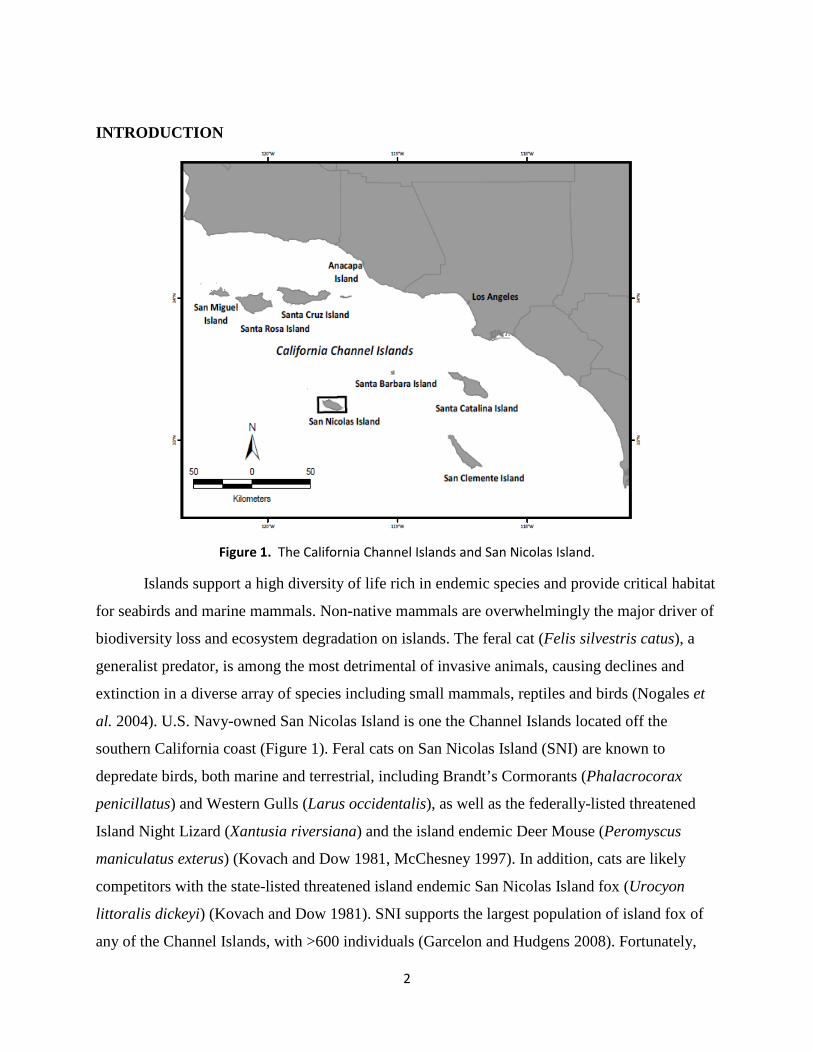
INTRODUCTION
Figure 1. The California Channel Islands and San Nicolas Island.
Islands support a high diversity of life rich in endemic species and provide critical habitat
for seabirds and marine mammals. Non-native mammals are overwhelmingly the major driver of
biodiversity loss and ecosystem degradation on islands. The feral cat (Felis silvestris catus), a
generalist predator, is among the most detrimental of invasive animals, causing declines and
extinction in a diverse array of species including small mammals, reptiles and birds (Nogales et
al. 2004). U.S. Navy-owned San Nicolas Island is one the Channel Islands located off the
southern California coast (Figure 1). Feral cats on San Nicolas Island (SNI) are known to
depredate birds, both marine and terrestrial, including Brandt’s Cormorants (Phalacrocorax
penicillatus) and Western Gulls (Larus occidentalis), as well as the federally-listed threatened
Island Night Lizard (Xantusia riversiana) and the island endemic Deer Mouse (Peromyscus
maniculatus exterus) (Kovach and Dow 1981, McChesney 1997). In addition, cats are likely
competitors with the state-listed threatened island endemic San Nicolas Island fox (Urocyon
littoralis dickeyi) (Kovach and Dow 1981). SNI supports the largest population of island fox of
any of the Channel Islands, with >600 individuals (Garcelon and Hudgens 2008). Fortunately,
3
safe techniques to remove feral cats from islands have been developed, making the removal of
feral cats from islands possible (Campbell et al. 2010). The removal of introduced species, such
as cats, has become a widely accepted method for restoring island ecosystems. The goal of the
project outlined here is to restore seabird populations and ecosystem function on SNI by
removing feral cats. The SNI restoration project is currently ongoing and this report presents
activities through 2009.
The preferred alternative for removing feral cats from SNI was identified in the Final
Environmental Assessment (EA; USFWS 2009) and included an adaptive management approach
using live trapping and hunting. The most common techniques used for removing cats from
islands are trapping, hunting, and toxic bait (Campbell et al. 2010). Cage traps are ineffective at
capturing all feral cats in a population (Bester et al. 2002, Domm and Messersmith 1990,
Twyford et al. 2000), and were demonstrated to be inefficient at capturing feral cats on SNI
(Garcelon 2009). Several alternatives were analyzed and dismissed in the Final EA, including the
use of toxins, immunocontraceptives, and Trap-Neuter-Return (TNR). Currently, no toxin is
registered in the U.S. for use on cats, thus this was not an option for SNI. Plus, the presence of
the island fox prevented the use of toxins due to the risk of poisoning. Immunocontraceptive
agents that have been successfully used in other species have been ineffective when trialed on
cats, and searches for other agents have not revealed any effective agents to date (Levy et al.
2005). TNR campaigns are ineffective at reducing cat populations to zero and have never been
successful in removing an insular feral cat population (Campbell et al. 2010, Longcore et al.
2009). Further, the U.S. Navy has a policy prohibiting TNR programs on Navy lands. Once
completed, SNI will be the fifth largest island (14,562 acres) to be cleared of feral cats to date,
and the largest cat removal project to be completed without toxic baiting (Campbell et al. 2010).
METHODS
Island Preparation
Facilities
In close coordination with the U.S. Navy, IC identified suitable facilities outside of the
main town (Nictown) on SNI that could serve as both a workshop and living space. Starting in
May 2009 (Figure 2), IC field staff renovated and cleaned Building 187 and the associated
4
mobile home. This location was selected because it was one of the few unused buildings left on
the island with the necessary infrastructure, was centrally located, and would not be affected by
security closures associated with missile testing operations. Building 187 served as a workshop
for vehicles, project preparation and office space. IC field staff used the mobile home behind
Building 187 primarily as sleeping quarters, which was able to support up to ten IC field staff.
Critical infrastructure, including phone and internet, were installed in the office to facilitate
project planning and communication.
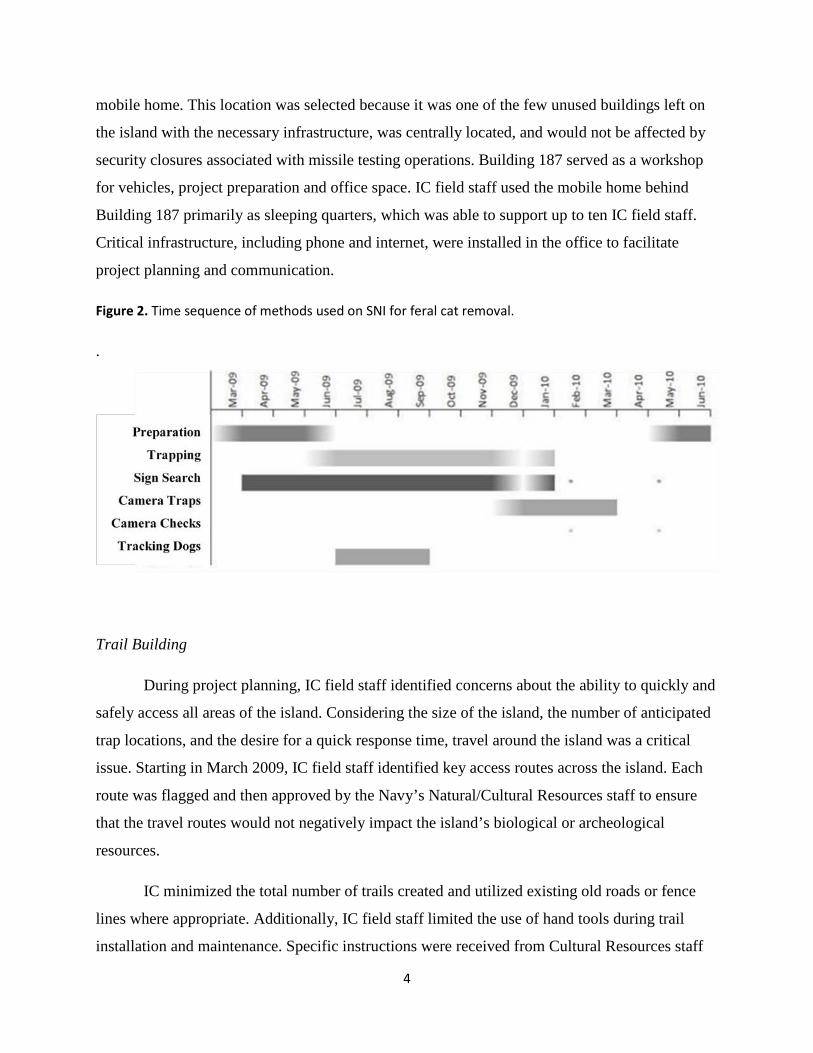
Figure 2. Time sequence of methods used on SNI for feral cat removal.
.
Trail Building
During project planning, IC field staff identified concerns about the ability to quickly and
safely access all areas of the island. Considering the size of the island, the number of anticipated
trap locations, and the desire for a quick response time, travel around the island was a critical
issue. Starting in March 2009, IC field staff identified key access routes across the island. Each
route was flagged and then approved by the Navy’s Natural/Cultural Resources staff to ensure
that the travel routes would not negatively impact the island’s biological or archeological
resources.
IC minimized the total number of trails created and utilized existing old roads or fence
lines where appropriate. Additionally, IC field staff limited the use of hand tools during trail
installation and maintenance. Specific instructions were received from Cultural Resources staff
5
about where tools could be used and the appropriate procedures to follow in the event that
archeological items were unearthed. As described in the Final Environmental Assessment, IC
followed the established erosion mitigation measures. Chain link fences were anchored on steep,
soft banks to prevent vehicles from destroying trails and temporary culverts were placed in large
drainages in anticipation of the rainy season. Both Navy Natural/Cultural Resources staff had the
opportunity to travel on the temporary trails after they were finished. IC field staff provided
periodic updates about their condition over the course of the project.
Vehicles
IC field staff utilized two trucks, three motorcycles, and three Utility Terrain Vehicles
(UTV’s) to access the island. Per Navy regulation, all IC field staff completed an off-road
motorcycle safety course, an ATV safety course and held a valid motorcycle license. The trucks
and UTVs were the primary modes of transportation to and from trap locations, with the
motorcycles as a supplement for quick response. At the onset of the rainy season, motorcycle use
was suspended for safety reasons and the UTVs were the only vehicles used to access dirt roads
and trails. All vehicles were regularly pressure washed to avoid the spread of weedy plant
species,
Radio Repeaters
In coordination with the U.S. Navy, IC field staff used their FCC licensed radio
frequencies to communicate on island. Radio repeaters, antennas, and solar panels were placed at
approved locations similar to other repeaters on island.
Trapping
Preparation
Starting in June 2009, IC field staff members searched the island for cat sign, focusing in
particular on fresh cat tracks and scat. Key cat travel areas were identified and marked on GPS
units and with orange flagging for future trap placement. Traps were placed during the last week
of June and the first traps were opened on June 25, 2009. This timeframe coincided with the end
of the island fox breeding season
6
Oneida Victor #1 Soft Catch padded jaw traps were used for trapping. These traps were
specifically modified to reduce the risk of leg injury to the island fox by adding additional
swivels, shortening the anchor chain, and adding a more flexible shock absorbing spring. Bullet
point super stakes (Schmitt Enterprises, New Ulm, MN) were used exclusively as trap anchors.
Anchors were used to secure traps away from green vegetation that could bind swivels and were
driven to a depth that allowed the lower swivel to remain just above ground level. Traps for SNI
were prepared by de-greasing and painting them with natural tone spray paint. Care was taken to
prevent paint from coating the padding on the trap jaws. This method of rust prevention was
chosen over more common commercial dyes due to the ease and speed of preparation.
Military Closures
SNI is an active military installation and operations conducted on island often restrict
access to large areas of terrain. These closures provided a challenge in operating an island-wide
trap line as they restricted ability to access traps and to release animals in a timely manner. The
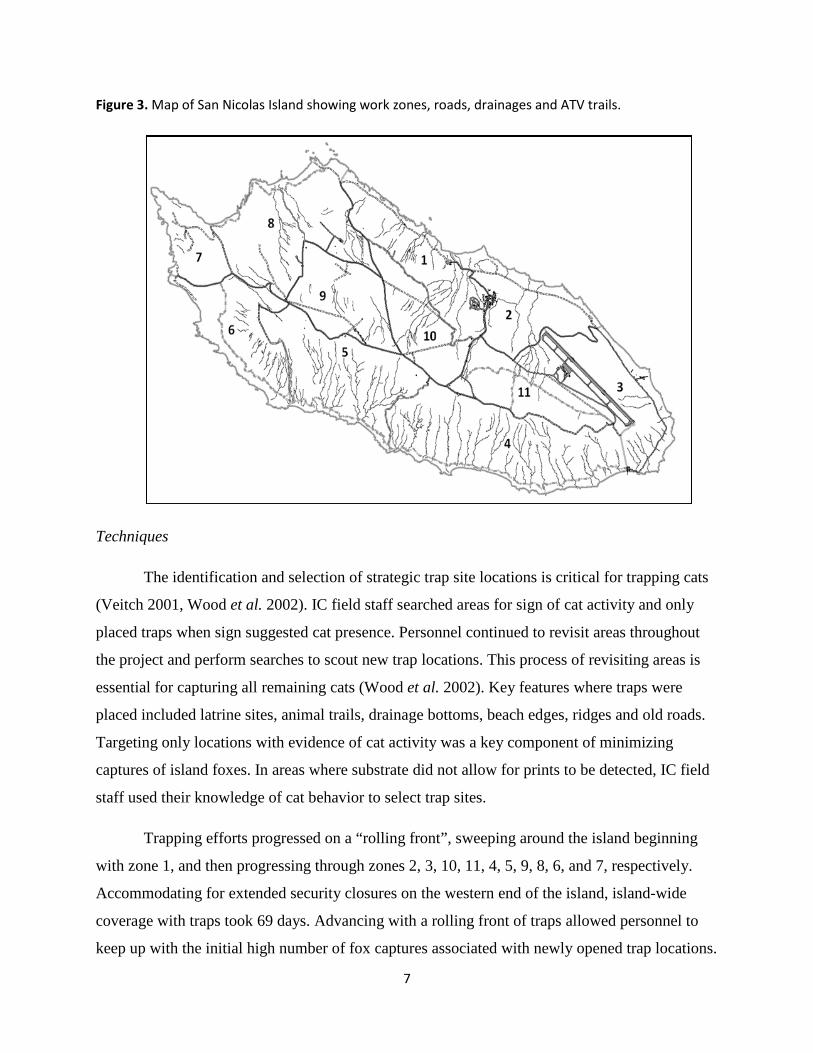
island was divided into 11 zones based on geographic features, roads and access points before
any traps were set (Figure 3). The formation of zones facilitated clear communication by
personnel and allowed IC field staff efforts to be directed and managed more effectively. When
closures occurred, all traps within the affected area were de-activated to prevent captures and
reopened once the operation was complete. Operational closures due to the Navy’s range
activities varied in length from a single day to several weeks. Areas involved typically covered
three or more zones.
7
Figure 3. Map of San Nicolas Island showing work zones, roads, drainages and ATV trails.
Techniques
The identification and selection of strategic trap site locations is critical for trapping cats
(Veitch 2001, Wood et al. 2002). IC field staff searched areas for sign of cat activity and only
placed traps when sign suggested cat presence. Personnel continued to revisit areas throughout
the project and perform searches to scout new trap locations. This process of revisiting areas is
essential for capturing all remaining cats (Wood et al. 2002). Key features where traps were
placed included latrine sites, animal trails, drainage bottoms, beach edges, ridges and old roads.
Targeting only locations with evidence of cat activity was a key component of minimizing
captures of island foxes. In areas where substrate did not allow for prints to be detected, IC field
staff used their knowledge of cat behavior to select trap sites.
Trapping efforts progressed on a “rolling front”, sweeping around the island beginning
with zone 1, and then progressing through zones 2, 3, 10, 11, 4, 5, 9, 8, 6, and 7, respectively.
Accommodating for extended security closures on the western end of the island, island-wide
coverage with traps took 69 days. Advancing with a rolling front of traps allowed personnel to
keep up with the initial high number of fox captures associated with newly opened trap locations.
8
After fox captures decreased to a level manageable by staff in an area (foxes largely learned to
avoid traps), trapping progressed into a new zone. Advancing in structured waves proved
advantageous as it facilitated an adaptive management approach.
Wood (2002) described a successful trap set for targeting cats. On SNI, all sets were built
in accordance with this description and made as ‘walk-through’ sets utilizing narrow ‘pinches’
on existing animal trails. When cats were thought to be avoiding the standard set type, ‘cubby
sets’ were used as an alternative. Cubby sets were constructed of local materials, utilizing terrain
features that facilitated limiting the animal to a single entrance (Algar and Burrows 2004, Veitch
2001, Wood et al. 2002). All sets were constructed in the same manner with a similar appearance
regardless of placement (walk-through or cubby) to facilitate identification of trap sets by
previously captured island foxes and to lower capture and recapture rates.
Pongo (cat urine, feces, glycerine) and catnip (Nepeta cataria) oil were combined and
used as a lure on all trap locations. The majority of cats were captured in traps utilizing this lure.
Feces was removed after ~5 weeks of trapping in each zone, and the amount of catnip was
reduced progressively after this time to counteract any avoidance that may have been occurring
by individual cats. Although most cats are attracted to catnip, some are not (Clapperton et al.
1994). By the fourth month of trapping, all trap sites were scented with lure consisting of only
cat urine and glycerin. Scent at the trap sites was refreshed after any capture or every 10 days in
conjunction with scheduled site checks. Anal gland secretion was collected from several cats as
an alternative olfactory lure. This was only used on one occasion when a cat was thought to be
avoiding the standard set type and scent combination. In addition to olfactory lures, Felid
Attracting Phonics (FAPs), a digital audio lure mimicking cat vocalizations, were utilized in
conjunction with the ‘cubby’ set type (Algar and Burrows 2004).
Corrosion Issues
After six weeks of deployment, trap operation began to be affected by corrosion. The
paint used on traps was prone to scratching, chipping, and flaking from normal handling and was
further damaged during capture events. The exposed bare metal quickly oxidized and corrosion
began to interfere with trap operation. Commercially available speed dip (Formula One Instant
Trap Kote, Snare One, Port Republic, NJ) and logwood trap dye and wax were tried as
9
alternatives to painting and produced a more durable alternative. However, the problem persisted
where traps were deployed in moist saline soils. To solve this problem, traps were routinely
checked for excessive corrosion and replaced with refurbished traps when necessary.
After five weeks of deployment, anchor assemblies began to show signs of corrosion and
on several occasions the cable sheared in half. The combination of incompatible metals
(galvanized steel aircraft cable and aluminum ferrules), coupled with the moist marine
environment, provided ideal conditions for galvanic corrosion. This phenomenon was not
apparent in past trapping efforts due to their short duration and/or dissimilar substrate conditions.
In searching for a solution, IC field staff discovered commercial fur trappers often use copper
ferrules in combination with stainless steel aircraft cable when operating in salt marshes (N.
Sterling pers. comm. 2009). All sets on SNI were modified to use these components and to date,
the copper and stainless materials show no signs of corrosion or deterioration after being
deployed for >6 months.
Live Removal
Trapped cats were removed from traps by live capture and transferred to an on-island
holding facility operated by the Institute for Wildlife Studies (IWS). Each cat was sexed, aged,
vaccinated, inspected for injury, provided a health check-up, and tagged with a passive integrated
transponder (PIT) by IWS staff. IWS personnel also collected DNA samples from each animal
and noted its reproductive status. In conjunction with The Humane Society of the United States
(The HSUS), all cats captured in traps were transported to a permanent holding sanctuary on
mainland California, where they will remain for the duration of their lives in a fully enclosed
facility.
All island foxes removed from traps were processed on site by the IC field staff. Staff
were trained in fox handling techniques to ensure safe removal and processing, including the
identification of potential injuries. PIT tags were administered to all untagged foxes. Animals
with suspected injuries including fractures, dislocations, major cuts or body temperature related
conditions were transferred to an on-island fox medical clinic staffed by IWS personnel. All
other animals were released on-site.
10
Foxes trapped during the day were susceptible to hyperthermia (overheating). Elevated
fox core temperatures occur as quickly as 20 minutes post-capture, so the trap monitoring system
and good radio communication was critical to minimizing exposure. IC field staff immediately
treated hyperthermic foxes in the field, employing several methods for cooling by evaporation,
while rapidly transferring foxes to on-site IWS staff. Hypothermia (low body temperature) was
of concern in cold, rainy conditions. Protocols were established for rain events in order to reduce
potential exposure of any trapped foxes. This included closing traps in difficult to access areas
when rain was forecasted and having staff available to respond to the remaining traps 24 hours a
day. Additionally, IC field staff routinely carried instant heat packs and dry towels to begin
treatment of hypothermic animals in the field before transferring them to IWS staff.
Trap Monitoring System
A telemetry-based trap monitoring system was developed to remotely check trap status,
decrease staff time spent checking traps, and decrease response time to captured animals. The
foundation for this system was developed by the Institute for Wildlife Studies as part of the
island fox monitoring program on SNI. The monitoring system was composed of transmitter
units connected to traps, an island-wide repeater system, a GIS database with field PDA data
collection, and a user interface hosted on a local internet network. When activated, each
transmitter sent a trap-specific ID code every four hours indicating it was operational. When
sprung, a modified ID code was transmitted immediately and then every 30 minutes until the trap
transmitter was reset. Repeaters relayed trap status data both to a dedicated PC, where a set of
scripts filtered the raw data to find capture events, and simultaneously to the internet. A web-
based software user interface was designed to combine capture events with location information
from a GIS database, allowing IC field staff to quickly identify which traps were sprung and plan
the most effective route between all sprung traps. This system was a powerful adaptive
management tool that increased staff efficiency and minimized effects on non-target species
(Will et al. 2010).
Data Collection System
To maximize the efficiency of data collection, IC field staff were equipped with handheld
ruggedized field computers with GPS (Archer PDA, Juniper Systems, Logan, UT) running a
11
customized version of ESRI’s ArcPad 7.1.1 (ESRI, Redlands, CA). Units captured information
about trap checks, trap sets, trap deactivations, captures, location of cat sign, and an activity
tracklog for each IC staff member. Customized drop-down menus standardized data entry
options by requiring field staff to choose from preset options. The database and ArcPad interface
took the place of paper forms and streamlined the process of gathering information in the field
and post-processing at the end of each day. All traps placed on island were managed using this
system. Each time IC field staff visited a trap site they recorded information about its status and
any actions taken. By capturing information about trap checks and trap resets, IC field staff used
the database to create a regular maintenance schedule that included a visual inspection of each
trap every five days. At the end of each field day, data from the Archers was checked in and
synchronized with the database. Once all of that day’s data had been incorporated an updated
version of the geodatabase was uploaded to each Archer, ready for the next day in the field (Will
et al. 2010).
Spotlight Hunting
Although spotlight hunting was an option in the Final Environmental Assessment, in an
attempt to exhaust all non-lethal means of removal, spotlight hunting was not utilized as a
removal method from June 2009-December 2009.
Detection Dogs
Specialized feline detection dogs were utilized during the cat removal campaign on SNI
for three months. Dogs were used as a tool to determine trap sites by indicating the location of
scent trails, and to track cats that were avoiding traps. Quarantine measures developed in
conjunction with the San Nicolas Island Fox Working Group were designed to minimize the risk
of potential introduction of disease or parasites that could impact the island fox. Because the goal
of the project was to trap as many of the cats as possible and remove them live from the island,
hunting with tracking dogs was used only in areas that had already been trapped for a period of
time. Dogs were not as effective at detecting cat sign on SNI as IC had anticipated. IC field staff
identified several reasons for this. Dogs were provided aversion training for foxes using training
collars and thus foxes, which they encountered frequently, were likely seen by the dogs as
negative reinforcement for their efforts, making them less eager to work. Additionally, the
12
extended quarantine period (7 weeks) where the dogs could not work, and the low numbers of
cats in the areas they were worked, meant there were few opportunities to positively reinforce
their effort. After three months, dogs were removed from SNI in October of 2009 and will no
longer be used for this project.
Sign Search
Signs such as prints, scat, latrines, scratch posts and predated seabird carcasses were used
during the course of the project to detect the presence of cats. Sign searching by IC field staff
occurred both in structured transects across zones, as well as in spot treatments informed by GIS
data queries. IC field staff logged cat sign locations into the Archer handheld computers allowing
for the island-wide mapping of cat signs. Probable home range areas for cats on SNI were
identified based on home range estimates from a detailed study of cat home ranges on Santa
Catalina Island by Guttilla (2007) and cat sign density from SNI. Staff activity and sign search
efforts were heavily influenced by these spatial analyses. In addition, personnel track logs were
routinely monitored by managers to direct search activity to areas that had been overlooked.
After an initial sweep of the island, IC field staff found that sign search efficiency was
negatively affected by substrate and weather conditions. As cat densities on island dropped, it
became harder for staff to positively identify cat tracks and find fresh scat. The biggest factors
affecting sign search were the large number of fox tracks and poor tracking substrate. On the
west end of the island, where there are a high number of foxes and large areas covered by sand
dunes, discerning cat from fox tracks was particularly difficult. These issues caused IC field staff
search fatigue when searching areas with high fox activity levels and they were less accurate in
assessing the absence of cats in a particular area.
Camera Traps
Infra-red remote cameras set along key travel routes provide images of cats and foxes
using that route. IC field staff chose digital cameras to facilitate field downloads and save costs
in developing images. Three brands of cameras were purchased and trialed. Units compared were
Cryptic Cams (custom models, Critter Cam, Tasmania), Cuddeback Capture IR trail camera
(Non Typical, Green Bay, WI), and Reconyx Professional Series PC85 (Reconyx, Holmen, WI).
Most trialed cameras did not function or perform as advertised. Requirements included a rugged
13
dependable build, weather-proof case, quick trigger, wide field of view, and a battery life and
memory enabling them to function in the field for months. Reconyx PC85 cameras were chosen
as the best option; with a lithium ion battery conversion kit and high capacity memory card so
that camera traps could function without maintenance for a maximum of 6 months. Twenty-six
cameras have been distributed over the island since December 2009, focusing on areas with high
cat captures and sites where significant animal traffic occurs. Photos of detected cat(s) will assist
managers in confirming when that animal is removed by matching the image with the animal
once captured.
RESULTS AND DISCUSSION
Between June 25, 2009, and December 31, 2009, 21,290 trap nights occurred with up to
236 active trap sets being open at any one time. During this time, 53 feral cats were known to be
removed from the island, of which 52 (51 trapped, 1 opportunistically captured by hand) were
transferred to The HSUS and 1 was lethally removed on-island by gunshot. Three of the trapped
cats were pregnant females that subsequently gave birth to a total of 10 kittens while being held
on-island. An additional 4 cats may have been lethally removed by encounters with dogs,
although there is no direct evidence to confirm this. Captures of the island fox totaled 957 during
this same timeframe. IC brought a total of 89 foxes (<10% of total) to the IWS clinic, of which
73 foxes had treatable project-related injuries ranging from minor (abrasion, laceration) to major
(shock, fracture). Of the remaining 16 foxes, 11 were determined not to have any injuries and
were shortly released and 5 were considered “mitigation” cases. There were a total of four
known fox fatalities, three of which were due to exposure and one from an encounter with a
tracking dog. Garcelon (2010) provides additional information regarding island fox injuries and
treatment. Monitoring of the fox population by IWS during follow-up box trapping efforts
indicate no detectable change in the fox population (Garcelon 2010).
The trap monitoring system was instrumental to the project. This system enabled a team
of six staff to maintain daily checks of approximately 250 traps and have a response time to
captures of < 60 minutes during daylight hours and an average of 5 hours during the night. This
quick response time reduced the amount of time an animal was susceptible to exposure.
Although the system worked as expected the majority of the time, there were two occasions
during which the trap transmitters failed and foxes were in the trap for an extended period of
14
time. After these failure events, more frequent checks and cleaning of the trap site monitoring
equipment were implemented.
The last feral cat capture occurred on November 17, 2009. Following that date, no cat
sign was detected until camera traps were deployed in December 2009. On December 14, 2009 a
Navy personnel reported a visual sighting of a feral cat. On December 26, 2009, a camera trap
captured a photo of a feral cat confirming that at least one feral cat remains on San Nicolas.
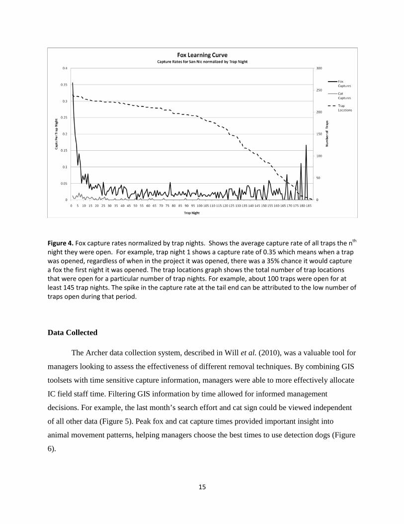
As initially demonstrated in a trial study conducted in 2006, foxes can become trap-
averse due to visual and olfactory cues at the trap site (Figure 4). After 5 to 10 days open, a trap
would have a dramatically lower chance of capturing a fox. On average, foxes were caught 2 ± 1
times (N=958), with one individual being caught seven times. It is unclear if foxes were
conditioned to avoid specific site locations within their home area, or to avoid standardized sets
in general.
Cats were captured in trap sets utilizing olfactory lures. Although auditory attractants
(FAPs) were deployed, no captures were attributed to their use. Because of the minimal number
of deployments (<5) the effectiveness of auditory attractants cannot be adequately determined
from this trial.
15
Figure 4. Fox capture rates normalized by trap nights. Shows the average capture rate of all traps the nth night they were open. For example, trap night 1 shows a capture rate of 0.35 which means when a trap was opened, regardless of when in the project it was opened, there was a 35% chance it would capture a fox the first night it was opened. The trap locations graph shows the total number of trap locations that were open for a particular number of trap nights. For example, about 100 traps were open for at least 145 trap nights. The spike in the capture rate at the tail end can be attributed to the low number of traps open during that period.
Data Collected
The Archer data collection system, described in Will et al. (2010), was a valuable tool for
managers looking to assess the effectiveness of different removal techniques. By combining GIS
toolsets with time sensitive capture information, managers were able to more effectively allocate
IC field staff time. Filtering GIS information by time allowed for informed management
decisions. For example, the last month’s search effort and cat sign could be viewed independent
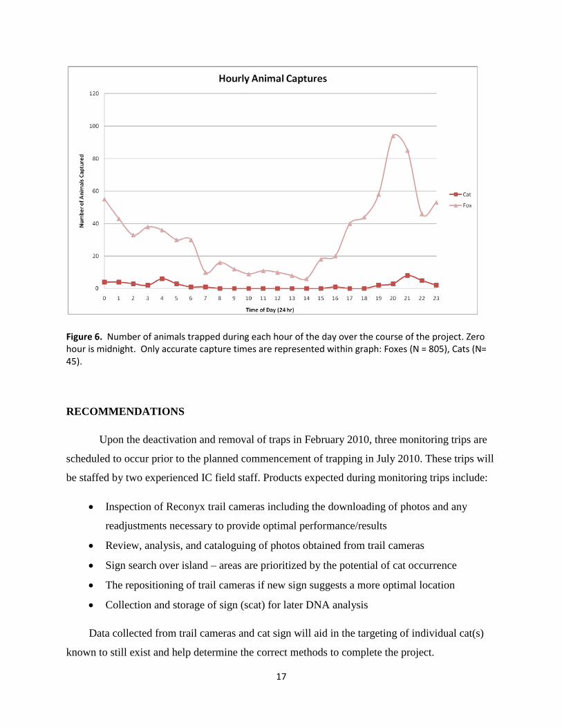
of all other data (Figure 5). Peak fox and cat capture times provided important insight into
animal movement patterns, helping managers choose the best times to use detection dogs (Figure
6).

16
Figure 5. Data collection using the field PDAs allowed for instant access to maps from information collected in the field. (A) Map shows cat sign that was observed by IC field staff over the course of the project broken down into different categories. (B) The island was broken into 30 m square grids. Anytime a GPS track from staff activity intersected a square it was removed from the map. The resulting map shows areas that were uncovered by IC field staff, shown in the darker grey; these are predominately extremely steep ravines or areas without vegetation.
17
Figure 6. Number of animals trapped during each hour of the day over the course of the project. Zero hour is midnight. Only accurate capture times are represented within graph: Foxes (N = 805), Cats (N= 45).
RECOMMENDATIONS
Upon the deactivation and removal of traps in February 2010, three monitoring trips are
scheduled to occur prior to the planned commencement of trapping in July 2010. These trips will
be staffed by two experienced IC field staff. Products expected during monitoring trips include:
• Inspection of Reconyx trail cameras including the downloading of photos and any
readjustments necessary to provide optimal performance/results
• Review, analysis, and cataloguing of photos obtained from trail cameras
• Sign search over island – areas are prioritized by the potential of cat occurrence
• The repositioning of trail cameras if new sign suggests a more optimal location
• Collection and storage of sign (scat) for later DNA analysis
Data collected from trail cameras and cat sign will aid in the targeting of individual cat(s)
known to still exist and help determine the correct methods to complete the project.

18
The remaining cat(s) on island are suspected to avoid current trap sets. Areas with
suspected/known cat presence will receive additional trap sets. Where applicable, these sets will
be designed and set with alterations to the “standard” trap set to increase the chance of capture.
Alterations will include: semi-blind sets, different or no lure used, and adjustments to the organic
material placed around a trap. Additionally, cubby sets in conjunction with auditory attractants
(FAP’s) may be deployed to diversify trap sets as needed.
The use of trail cameras will continue throughout the remainder of the project and into the
confirmation phase. The detection of new sign, including cats captured on cameras, will be
responded to by trapping or with spotlight hunting until that individual is removed. The profile of
each cat photographed, based on color, markings, and size, will be recorded and referenced to
help determine the probability that any future animals removed match that profile. Genetic
analysis may be used to profile individual remnant cats. DNA from cats captured can be
compared with the scat and/or hair samples collected previously in the field. IC is currently
identifying a genetics lab with which to work and help design sample collection and storage
procedures.
Confirmation of Removal
IC field staff anticipates removing the last cats from the island in 2010; the confirmation of
the absence of cats will continue into 2012. IC plans to leave trail cameras on island and revisit
them over time to assist in absence confirmation. Various camera locations will have scent
stations incorporated into the set with the intention of attracting any remaining cats thereby
improving the probability of detecting a cat. Track pads, both natural and created, will be GPS
marked and revisited. Due to the difficulty of confidently distinguishing cat tracks from fox
tracks, track pads will aid in the placement of camera traps, which can provide positive
identification. Only clearly identifiable cat tracks will be considered as a detected cat.
IC has contracted Landcare Research to develop a detection probability model to
determine the probability of eradication, as has been done for other eradication projects (Ramsey
et al. 2009). This model will be used to direct the type and amount of effort required to confirm
removal of feral cats from SNI. Monitoring trips will be conducted post-2010 and to the level of
effort described within the environmental assessment; monitoring trips will occur at 6, 12, and 24
19
months after the primary removal. Additional efforts towards confirmation will be assessed in
relation to the outcomes of the detection probability model. Methods used in post-2010
monitoring trips will be determined in consultation with the lead and cooperating agencies,
Montrose Trustee Council, and other relevant stakeholders.
ACKNOWLEDGEMENTS
This campaign would not have been possible without the efforts of IWS staff. Bill Wood
and Jeff Davis provided advice throughout the project and its development. Grace Smith, Annie
Little, and David Garcelon provided continual support and feedback throughout this project and
helped IC overcome numerous hurdles. This project was funded by the Montrose Settlements
Restoration Program and supported by the U.S. Navy and the U.S. Fish and Wildlife Service.
This report draws heavily from Hanson et al. 2010 and Will et al. 2010 both published in the
2010 Vertebrate Conference Proceedings.
REFERENCES
Algar, D.A., and N.D. Burrows. 2004. Feral cat control research: Western Shield review –
February 2003. Conservation Science Western Australia 5, 131-163.
Bester, M.N., J.P. Bloomer, R.J. van Aarde, B.H. Erasmus, P.J.J. van Rensburg, J.D. Skinner,
P.G. Howell, and T.W. Naude. 2002. A review of the successful eradication of feral cats from
sub-Antarctic Marion Island, Southern Indian Ocean. South African Journal of Wildlife
Research 32, 65-73.
Campbell, K. J., G. Harper, C. C. Hanson, D. Algar, B. S. Keitt, and S. Robinson. 2010. An
updated review of feral cat eradications on islands. Turning the Tide II. ISSG, Gland,
Switzerland. In review.
Clapperton, B.K., Eason, C.T., Weston, R.J., Woolhouse, A.D., Morgan, D.R., 1994.
Development and testing of attractants for feral cats, Felis catus L. Wildlife Research 21, 389-
399.
Domm, S., and J. Messersmith. 1990. Feral cat eradication on a barrier reef island, Australia.
Atoll Research Bulletin 338, 1-4.
20
Garcelon, D.K. 2009. Report on testing of methods to remove feral cats from padded leg-hold
traps, San Nicolas Island, California. Unpublished report prepared by the Institute for Wildlife
Studies, Arcata, CA. 6pp.
Garcelon, D.K. and B.R. Hudgens. 2008. Island fox monitoring and demography on San
Nicolas Island 2007. Unpublished report prepared by the Institute for Wildlife Studies,
Arcata, CA. 28pp.
Guttilla, D.A. 2007. Effects of sterilization on movement, home range behavior and habitat use
of feral cats on Santa Catalina Island, California. M.S. thesis. Department of Biological
Science. California State Univer., Fullerton.
Hanson, C. C., K. J. Campbell, J. E. Bonham, and B. S. Keitt. 2010. The removal of feral cats
from San Nicolas Island: Methodology. Proc. Vertebr. Pest Conf. 24
Kovach, S.D., and R.J. Dow. 1981. Ecology of the feral cat on San Nicolas Island. 1980. Pacific
Missile Test Center, Point Mugu, California. pp. 27.
Levy, J.K., M. Mansour, P.C. Crawford, B. Pohajdak, and R.G. Brown. 2005. Survey of zona
pellucida antigens for immunocontraception of cats. Theriogenology 63, 1334-1341.
Longcore, T., C. Rich, and L.M. Sullivan. 2009. Critical assessment of claims regarding
management of feral cats by Trap-Neuter-Return. Conservation Biology 23, 887-894.
McChesney, G.J. 1997. Breeding biology of the Brandt’s Cormorant on San Nicolas Island,
California. M.S. thesis, California State Univ., Sacramento.
Nogales, M., A. Martin, B.R. Tershy, C.J. Donlan, D. Veitch, N. Puerta, B. Wood, and J. Alonso.
2004. A review of feral cat eradication on islands. Conservation Biology 18, 310-319.
Ramsey, D.S.L., Parkes, J., Morrison, S., 2009. Quantifying eradication success: The removal of
feral pigs from Santa Cruz Island, California. Conservation Biology 23, 449-459.
Twyford, K.L., P.G. Humphrey, R.P. Nunn, and L. Willoughby. 2000. Eradication of feral cats
(Felis catus) from Gabo Island, south-east Victoria. Ecological Management and Restoration
1, 42-49.
21
USFWS. 2009. Final Environmental Assessment for the Restoration of San Nicolas Island’s
Seabirds and Protection of other Native Fauna by Removing Feral Cats. U.S. Fish and
Wildlife Service, Carlsbad, CA. 105 pp.
Veitch, C.R., 2001. The eradication of feral cats (Felis catus) from Little Barrier Island, New
Zealand. New Zealand Journal of Zoology 28, 1-12.
Will, D. Hanson, C. Campbell, K. Garcelon, D. Keitt, B. 2010. A trap monitoring system to
enhance efficiency of feral cat eradication and minimize adverse effects on non-target
endemic species on San Nicolas Island. Proc. Vertebr. Pest Conf. 24
Wood, B., B.R. Tershy, M.A. Hermosillo, C.J. Donlan, J.A. Sanchez, B.S. Keitt, D.A. Croll,
G.R. Howald, and N. Biavaschi. 2002. Removing cats from islands in northwest Mexico.
Turning the tide: the eradication of invasive species. C.R. Veitch and M.N. Clout (Editors).
pp. 374-380. IUCN SSC Invasive Species Specialist Group. IUCN, Gland, Switzerland.