Embed Size (px)
Citation preview
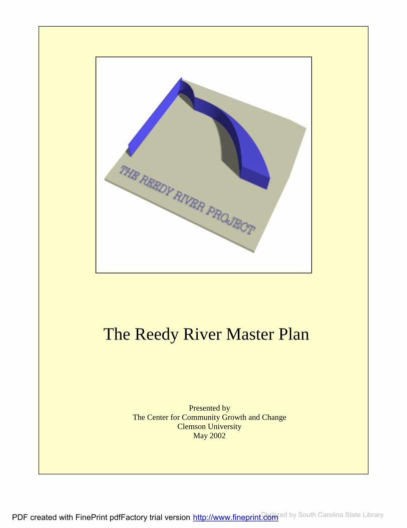
The Reedy River Master Plan
Presented by The Center for Community Growth and Change
Clemson University May 2002
PDF created with FinePrint pdfFactory trial version http://www.fineprint.comDigitized http://www.fineprint.comDigitized http://www.fineprint.com by South Carolina State Library
Funded by: The City of Greenville Greenville County Clemson University’s College of Architecture, Arts and Humanities
Research Conducted by:
The Center for Community Growth and Change The College of Architecture, Arts and Humanities Clemson University Dean Janice Schach, FASLA
Director:
Dr. Barry Nocks, AICP
Designers:
Dr. Umit Yilmaz Georgia Harrison, ASCA Harry Harritos, AIA
Associate Planner:
Lucy Noth
PDF created with FinePrint pdfFactory trial version http://www.fineprint.comDigitized http://www.fineprint.comDigitized http://www.fineprint.com by South Carolina State Library
ACKNOWLEDGEMENTS
Many people and organizations contributed to this project. Elected officials and staff of the City and County of Greenville were instrumental in initiating and guiding this effort.These include: The Steering Committee that met regularly to review the Clemson team’s
progress- Phyllis Henderson, chair; Joe Dill, Mark Kingsbury, Bob Taylor, Xanthene Norrisand, Garry Coulter, Chandra Dillard, Lillian Flemming, Michelle Shain, Fred Carpenter (replaced by Diane Smock), and Mayor Knox White, ex officio.
Staff members of City and County governments- Charles (Randy) Oliver, City Manager; Nancy Whitworth and Julie Franklin of the Economic and Community Development Department, City of Greenville; Steve Stewart, County Administrator and Jimmy Forbes, Director of the PlanningCommission, Greenville County.
Numerous other staff members of City and County Governments provided invaluable assistance.
Numerous faculty, students and staff members at Clemson University contributed to this effort: Clemson University faculty that took leadership roles in the process-
Designers Umit Yilmaz, Harry Harritos and Georgia Harrison; PlanningProfessors Grant Cunningham and Jeff Parkey; and Lucy Noth, Associate Plannerand Center Coordinator
Dean Janice Schach, FASLA Graduate Assistants who performed invaluable assistance in completing the
project- Patricia McPherson, Sam Gannon and Dana Zaffuto
Clemson University students in various City Planning, Architecture and Landscape Studios
Other Clemson University staff in public information and other departments.
The completion of this project would not have been possible without the generoussupport of many interested residents of Greenville. Various professionals and volunteers gave generously of their time and expertise to assist the Clemson project team with advice and assistance. Stakeholders made themselves available to us and shared their perspectives willingly. Media representatives worked to become informed about the project and provided fair and constructive coverage. Perhaps most important, manyresidents took time out of their busy lives to participate in the process and share their views and concerns. I hope that the concepts presented in this master plan will be developed to contribute to an improved quality of life for Greenville.
Dr. Barry Nocks, AICP Director
PDF created with FinePrint pdfFactory trial version http://www.fineprint.comDigitized http://www.fineprint.comDigitized http://www.fineprint.com by South Carolina State Library
TABLE OF CONTENTS
EXECUTIVE SUMMARY
THE REEDY RIVER MASTER PLAN REPORT
THE RIVER CORRIDOR DEFINED................................................................................ 2 BACKGROUND STUDIES AND EXISTING PLANS .................................................. 11 MASTER PLAN PROCESS AND MAP ......................................................................... 24 STEP ONE: PUBLIC MEETINGS AND INTERVIEWS .............................................. 26 STEP TWO: TRAIL NETWORK DESIGN.................................................................... 34 STEP THREE: CREATION OF THE MAPS…………………………………………...40 STEP FOUR: KEY DEVELOPMENT SITE DESIGNS ................................................. 48 STEP FIVE: IMPLEMENTATION ................................................................................ 61 LAND USE AND ZONING............................................................................................. 61 LAND USE AND ZONING RECOMMENDATIONS ................................................... 62 STRATEGIES TO ACQUIRE LAND ............................................................................. 63 LAND ACQUISITION RECOMMENDATIONS........................................................... 64 ENVIRONMENTAL ISSUES RECOMMENDATIONS................................................ 65 IMPLEMENTATION PHASING RECOMMENDATIONS........................................... 66 PUBLIC / PRIVATE PARTNERSHIPS .......................................................................... 72 NEXT STEPS FOR GREENVILLE................................................................................. 73 RECOMMENDATIONS FOR NEXT STEPS................................................................. 73
LIST OF FIGURES
FIGURE 1: THE MASTER PLAN MAP AS SEEN ON PAGE 38, MAP 12................... 3 FIGURE 2: A RIVER AND ITS FLOODPLAINS ........................................................... 3 FIGURE 3-14: NEIGHBORHOODS ................................................................................ 4 FIGURE 15: GRAPHIC REPRESENTATION OF A WATERSHED............................. 6 FIGURE 16: THE WATERSHEDS OF THE REEDY RIVER CORRIDOR .................. 6 FIGURE 17: THE SECTORS OF THE STUDY AREA................................................. 16 FIGURE 18: MAP FOR FIRST PUBLIC MEETINGS .................................................. 40 FIGURE 19: MAP FOR SECOND PUBLIC MEETINGS ............................................. 40
PDF created with FinePrint pdfFactory trial version http://www.fineprint.comDigitized http://www.fineprint.comDigitized http://www.fineprint.com by South Carolina State Library
FIGURE 20: MAYBERRY PARK SITE DESIGN......................................................... 52 FIGURE 21: MAYBERRY PARK SITE DESIGN WITH THE FLOODPLAINS........ 53 FIGURE 22: LAKE CONESTEE AREA SITE DESIGN............................................... 56 FIGURE 23: LAKE CONESTEE AREA SITE DESIGN WITH FLOODPLAINS ....... 57 FIGURE 24: N. GREENVILLE YMCA SITE DESIGN ................................................ 59 FIGURE 25: N. GREENVILLE YMCA SITE DESIGN WITH FLOODPLAINS ........ 60
LIST OF MAPS MAP 1: HYDROGRAPHY ............................................................................................... 7 MAP 2: TRAVELERS REST HYDROGRAPHY ............................................................. 8 MAP 3: MAYBERRY PARK HYDROGRAPHY............................................................. 9 MAP 4: LAKE CONESTEE HYDROGRAPHY............................................................. 10 MAP 5: CURRENT LAND USE .................................................................................... 18 MAP 6: TRAVELERS REST CURRENT LAND USE................................................... 19 MAP 7: MAYBERRY PARK CURRENT LAND USE ................................................. 20 MAP 8: LAKE CONESTEE CURRENT LAND USE ................................................... 21 MAP 9: PUBLIC AND SEMI-PUBLIC LANDS ............................................................ 37 MAP 10: TRAIL EASEMENTS OWNERSHIP .............................................................. 38 MAP 11: PUBLIC PROPERTIES AND EASEMENTS................................................. 39 MAP 12: THE MASTER PLAN MAP............................................................................ 44 MAP 13: MASTER PLAN SECTION ONE ................................................................... 45 MAP 14: MASTER PLAN MAP SECTION TWO ........................................................ 46 MAP 15: MASTER PLAN SECTION THREE .............................................................. 47 MAP 16: IMPLEMENTATION PHASING.................................................................... 71
LIST OF TABLES
TABLE 1: EXISTING PLANS ....................................................................................... 11 TABLE 2: INTERVIEWS ............................................................................................... 29 TABLE 3: IMPLEMENTATION PHASING ................................................................. 67
PDF created with FinePrint pdfFactory trial version http://www.fineprint.comDigitized http://www.fineprint.comDigitized http://www.fineprint.com by South Carolina State Library

LIST OF APPENDICES
APPENDIX ONE: EXISTING PLANS
APPENDIX TWO: PUBLIC MEETINGS
APPENDIX THREE: TRAIL DESIGN GUIDELINE RECOMMENDATIONS
APPENDIX FOUR: RIVERFRONT CASE STUDIES
PDF created with FinePrint pdfFactory trial version http://www.fineprint.comDigitized http://www.fineprint.comDigitized http://www.fineprint.com by South Carolina State Library

PDF created with FinePrint pdfFactory trial version http://www.fineprint.comDigitized http://www.fineprint.comDigitized http://www.fineprint.com by South Carolina State Library

EXECUTIVE SUMMARY
Clemson University’s Center for Community Growth and Changedeveloped the Reedy River Master Plan Project under the joint sponsorship of the City and County of Greenville. The project emphasized public input and participation to develop a master plan that will serve as a framework for development within a sixteen-mile stretch of the Reedy River, spanningfrom the river’s headwaters in TravelersRest to Lake Conestee. The river’s character is extremely diversethroughout this corridor, traversing both urban and rural areas. The Reedy River continues to flow an additional 57 miles downstream through Laurens and Greenwood Counties, ending at LakeGreenwood.
The Reedy River has been an integral element in Greenville’s history, playinga central role in the textile industry ofGreenville until the 1980s. Yet, for manyyears the river has been abused and neglected.
Over the past decade the Reedy River Corridor has received growing attention from a number of public and private entities. These have included city andcounty governments, non-profit environmental groups, for-profit corporations, and a variety ofindividuals. As a result of the recognizedpotential of the river corridor, growth in the area, and the general desire to continue improving and protectingGreenville’s quality of life, a Master plan for the Reedy RiverCorridor was developed.
The proposed master plan provides guidance to both public and private sectors, defining areas for various typesof land uses (i.e., open space, activerecreation, commercial, residential, etc.) surrounding land uses, infrastructure, river and land characteristics, and natural resource considerations. The master plan includes proposals for park improvements and a corridor-wide trail system. Using the master plan, specific proposals can be sought or developed forparticular sites in the river corridor. These proposals may be defined by uses and design guidelines developed in the master plan.
The Objectives of the Reedy River Master Plan
The plan is based on several coreconcepts. These include: Recognize the diversity of the
corridor; Create overarching vision; Provide a feasible, long-term
plan; Create a foundation for future
redevelopment and activitiesaround the river; and
Balance use, redevelopment and water quality issues.
The proposed master plan has three components: An integrated set of trails or
pathways to, around and alongthe Reedy River;
EXECUTIVE SUMMARY
PDF created with FinePrint pdfFactory trial version http://www.fineprint.comDigitized http://www.fineprint.comDigitized http://www.fineprint.com by South Carolina State Library

Reedy River Master Plan
Reedy River Master Plan Report 2
Sites for recreation and/oreconomic development near the river; and
Land use recommendations.
In addition, water quality issues are noted, reflecting the strong public concern with flooding, water quality and storm water runoff.
Summary of Public Input
For planning purposes, the corridor was divided into five sectors. These are noted in Figure 17 on page 15. Sectors include: Northern area (headwaters to Sulphur Springs Road), Textile Crescent (Sulphur Springs to Academy),Downtown (Academy throughCleveland Park), Greenville Tech (south of Cleveland Park to I-85), and Conestee (I-85 to Conestee Mill).
Between July 9 and 17, 2001, five meetings were held along the 16-mile Reedy River corridor. These sessions were attended by between 50 and 200 people each, with a total of about 500 people participating in these sessions.They were asked what they liked anddisliked as well as what they did and did not want to see in the river corridor. Public comments were similar amongthe five meetings. The most commonlyexpressed views included:
•Greenville cares about the Reedy River corridor. •Greenville cares about its quality
of life, seeking additional open space and recreational opportunities, while promoting economic development in selected areas. •Access to the Reedy River is critical toward the future development of the corridor. •The quality of the Reedy River must be improved and protected, paying specialattention to runoff and flooding issues.
Following the public meetings in July,another set of meetings took place in September, in which participants identified specific areas for river access.Another set of public meetings took place in December, where preliminaryplans were presented and discussed. Inaddition, public comments were receivedby e-mail, phone and web site. The Reedy River Project staff also reviewed more than two dozen plans and interviewed over 100 stakeholders to getinput on related issues.
An important source of ongoingguidance during the process was a steering committee made up of members of city and county councils, chaired byCounty Council member PhyllisHenderson.
Pathways System
The Master Plan Map (Figure 1) showsa variety of routes both to and around the river. In most cases the pathways not along the river are proposed in public easements held by utilities or alongroads. Specific improvements in rights
PDF created with FinePrint pdfFactory trial version http://www.fineprint.comDigitized http://www.fineprint.comDigitized http://www.fineprint.com by South Carolina State Library

Reedy River Master Plan
Reedy River Master Plan Report 3
#
Eque stri an P ark
#
O ld TR H igh
I- 85
I-3 8 5
GEER
-
RIDG E
B LUE RI D G
E
PO INS ET T
RO E FORD
OL D WHI T E HORSE
A
LIL Y
L AU RE N S
R D
CEDA
R LANE
FO R K SH OA L S
IN TERSTATE 85
AU G
UST A
KEE L
ER M
ILL
FOW L
ER
BRAM LETT
PER IME T ER
S PLEAS ANT BU
RG DR
MC
EL H ANE Y
DU NCA N
ASH MORE BRIDGE
6TH
AU G
U S TA S T
D
S
PE
R RY
TAR
MA
I NMA
ULDIN
M AU LD
IN R
D
FOOT HILLS
GIBSON
PAR
KINS
MILL
R
D
SET
T LEM E
NT
FRAN
KLIN
C ONESTEE
PELHAM RD
N MA
IN
S
T
AG N EW
LEDBETTER
CRANE
8TH
ARCH
COX
CLEVELAND ST
PARKER
JAMISON
WATSON
HAY
WO
OD
RD
MAR
ION
BRUC E
WEST
WH IT E
HOR
SE
LINDSEY LAKE
7TH
RUTHERFORD RD
E
T IND
AL
MONT
I S
RID
GE
RD
BATSON
WINN
RIVER BEND
E NORT H
ST
FAIR
FORE
ST
W
Y
HUNTS BRIDGE
CIRCLE
F UR M
AN
KERNS
HODG
ENS
BE R
EA
MO
N TAG
UE
ED GEMONT
WOO
DSID
E
PEACE
VE RD
AE
BL V
D
DA
I RY
D
R
KRIE
GER
WAD E
HA M P
T ON BL V D
RUTLEDGE LAKE
HAMP TON
N PLEASANTBURG DR
E FARIS
RD
DU
VAL L
D
R
HUNT
WILL IAM S
LO WNDES HILL RD
CLE
MS O
N
M EADORS
MCD
A NI E
L
A
V
EUNIC
E
W FARIS RD
RO SE
BOY D
CHA R
LES
RO E
SU M
TE R
TUC SON
PENDLETON ST
CHU
RCH
VIEWMO NT
HA
LT O
N
RD
L ILA
WATK INS
AL ICE
4TH
HIGHLAWN
PL A
NO
BAIL
E Y
FAI R
C RE S T
F IEL D
DUNCAN CHAPEL
AUGUSTA RD
US HWY 27 6
LADY
CHURCHI LL
GRO
VE
RD
E WASHINGTON ST
RO GERS
MO RGAN
S CH
URCH
ST
T HI RD
ENG EL
FARRS B RIDGE
DO GW
OOD
NT RETREAT
MA NLEY
VAN
CE
STATE PAR K
E PARKINS MILL RD
YMCA
VIL LA RD
HAMMETT
RUBY
MU R P
H Y
ACC E S S
U NKN O
WN
F OREST VIL LE
SE
CON D
V ALL E Y O AK
1S TS P
RUC E
SHAW
AIRPOR T RD
PINE
F ORES
T
MIL
L S
AV
WEM
BLEY
RD
B
PERRY AV
CHI
C K S P
RIN G
S
RD
BERK
LEY
PENARTH
5 TH
HUFF
CA S TL E
PALMETTO
ALM A
END
LOVE
JONES
KIRK
BURN S
GRID
LEY
US
HW
Y 2
5
2 ND
TO LAR
HEND ER SON
PI NE
NEW M CELHANEY
C
OAK
BOWE
RS
W W
ASH
ING TO
N ST
B RI D WEL L
F ER N
LEAF
O LD PA RKER
GRE
E N V
ALLEY
I NA
S ACADEM Y ST
OLD RO E FORD
KINGS
TAM PA
N ORA
CRESCEN T AV
N CHU R C
H ST
VI N E
RA S
O R
LO O P
O LD B
L EA
CHER
Y
ORD E
RS
NEW PERRY
WA
SHI NG
TO
N
MORR IS
WARWICK
WHITE HORSE RD EXT
OLD B UN CO MBE
RI CHM
OND
MA YO
ROCK QU AR RY
HAMP TO N AV
SU LPHU R SPRIN GS
HIL
LTO
P
G UE SS
BUD
HENDERSO N R
D
ROCKY SLOPE RD
FAIRFIELD
BE N
N ETT
S
T
WO ODS LAKE RD
OLD EASLEY
EASLEY BRIDGE
CLU
B FOR E
S T
BU NCO MBE S T
LEE
LUR
AY
POE
ROS S
PENDLETO N
VIN SON
ODOM
THO MAS
N IX
BIRNIE ST
SA LE M
SCHO
OL
10TH
SUM
MIT
D
R
KEI TH
D R
ZE
LM A
FO
XH
A L L
KAY
CLE
V ELA ND
EX T S
T
GRE
EN
AV
VERNER
FRO
NTA G
E
TUL ANE
WOODL ARK ST
CENTER
LOR RA
I NE
F I NLE Y
CH
UK A R
STRA TFOR D
NEW CIRCL E
3RD
9TH
BYRD B L VD
HEARD
PARIS VIEW
FI F
TH
HALE
ALBAI N
OR
CH ID
DUNBAR ST
LAUR
E L
LAKE
WOOD
DON
D
R
EL IZ
A BE
TH
P I TTM A
N
CLAR
K
JO
N ES
AV
MCCRARY
HAVEN
VI ST A
RI D
G EWAY
CLAR
ENDO
N
DY ER
HI CKS
POTOM AC AV
ASHL
EY
SA CO
EASTVIEW
SCA LY BA RK
GAN TT
SMYT
HE
MIN
US
DAV
IS
MC NE E SE
PLAN
T
E STONE A V
M AE
TRINITY
WOODL AND
WY
ECHO LS
CA R VER
TWIN LAKE RD
WILLIS
CON
YERS
CL UB
S UNRISE VAL LEY
CHATHAM
PINE GROVE
BUR
GES
S
MONTAN A
FOX CREEK
MEYE
RS DR
DAL LAS
DA
R L I NGT
O N
M CMAKI N
RAC
INE
WO
OD
LAKESIDE
MA C K
BUIST AV
LYN
CHBU
RG
F LET
C HE R
A LA M
O
MELVI N
WACO
THERESA
DAV ID
SON
KENS
IN GTON
LONG FOREST
FAIR
M ONT
ABELIA
WI L C
U N
GE
NT
R Y
COU
R TLA
N D
MA L OY
ABNEY
ASHLEY AV
WO R
T H
FURM
AN H
ALL
COLO NIAL
LOOM
AVER I LL
TO
WNE
S
ST
WENWOO D RD
OLD
AN
DE RS O N
SW
E ETGU M
CRO FT ST
TRAM MELL
SIXTH
TALL EY
AND R
EW
S
LA W N
VI E W
BUT LER
RHET T S
T
ME L
V IL L
E
AV
R AW
O O D
ALL E
N
ARLINGTON AV
WAT K
IN S BRI D G
E
BU
T L ER
SP
RIN
GS
RD
R ANC
H
JAS P
E R
E PARK A VALLEY
SPEED
VI CTO
R
LEN ORE
M ARTI N
UNI VER SITY RIDG E
MCBETH
RIC
E
ST
DEERIN G
OLD
AU G
USTA
RD
PL
EASA
NTBU
RG
OLD A UGU STA
P EA R
CLUB
DR
H ULL
PAR
K
N AC
A DEMY
S
T
DO
R SEY
MC DOW ELL
TR EMONT
LA
URA
SCA
R LE T
T
S
T
PI M
LI CO
R
D
GOWER ST
L AM AR
BLA
CKBERR
Y VAL
LEY
I ND
UST
RI A
L DR
PATTON
L AKE
LANGFORD
AN
DE
RSO
N
S
T
ELF
W EARLE ST
ALTA V ISTA
CO
RNEL
IA
ACKL EY
RD
B ARCL A Y
BELVEDER E
PARADE
BYR
DLAN
D
D R
SMIT H
ADDIS
ALT A
MONT
D O RC HE STE R
KI NGSBU RY
PRO
S PE R I TY AV
BRA D L
E Y B
LVD
COBB
ASSE MBLY
LANGSTON
SIRR
INE
FENW ICK L IN D
A
CAMDEN
HOLM
ES DR
SAAD
WOO
DLA N
D
20TH
COL LINS
FO XWORTH
D UK EL A ND
GRANDVIEW
MO
ODY
CENTU
RY
D
R
11 TH
RIVERSIDE DR
N ORWOOD
PAT
BARK
TRAN SIT DR
PINEF IELD
NEWLAND
WAC
C AMA
W
AV
ELI
PINE
CRE
EK
P ELZ
ER
PETTIGRU
ST
PINC KN EY ST
W STONE AV
FARMINGT ON
LA J UAN
J AMES
LITTLE TEXAS
MO N
AV IE W
S MA I
N
ST
C REST
HATCH
WHIT E O AK D R
NEWPORT
REG
ENT
SOUTHWOOD
BEAC ON
MA U D IE
BEAT
TIE
NOR
THCL
IFF
WILLARD ST
SH ERM A
N
G UESS ST
RODNEY
F RO
ST
BRANDT
COVIN GTON
E MCBEE AV
MCD
A DE
CHILDR ESS
ED
GEF IE
L D
BRANTFO RD
ATHENS
BEL AIR E
MAR LBO
RO
REN FR
EW
ESTA
TE
LYDIA
FAI R FA X
MOR A
GHANA
STO
N EHA
VEN
DR
DECA
TUR
B AT ES VIE W D R
OL D FO
RK S HOA LS
PINCK NE Y
RIDGEWO OD
CONEST EE LAKE
W IL HEL M W INTER
DONALD SON
LOU ISE
LO NG HILL ST
WEDGEW OOD
DR
OVERBROOK
RD
PARIS M OUNT AIN
JORDAN
KEEN E
BO ON E
HON O
U R
BRYA NT
MT VISTA AV
R AINBO W
ALV I
N
SULLIV AN
EL DO RADO
CLEAR VIEW
RU T
HERF
ORD
ST
LIN DE N
TA WBA
MIL
L
OSC A
R ST
BERE A M
ID DL E
SCH
OO L
DU
NB
A R
WEB
STER
R
D
WA
RDV
I EW
YO RK
PARKINS L AKE RD
MA S O
N
ARNOLD
DUPO NT DR
E TAL LUL AH DR
WO ODMO NT
E BROAD ST
ABE
RDE EN
DR
CATHEY
ELKH
O R N
YOUNG
DEL
TA
DEVONSHIRE
PLEASANT R IDGE AV
TRACTION ST
WI LD R O
S E
OVERTO N
LAKEHURST ST
TUBB
S M
OUNT
AIN
DUN LA
P
ACC
ES S R
AMP
GOO
D
A ZALEA CT
OL D
PL AZ A
DELAW ARE
W IL MA
COOL BROOK
MIL L
CR E
EK
GAL
AX
CROSBY
W MOUNT AINVIEW AV
HOYT
BER EA FO RE ST
LOW NDES AV
MA Y
B ERR
Y ST
POR
T SMO
UT
H
ARLENE
RANDALL ST
TINDAL AV
CURETON
WORLEY RD
E MA IN S
T
ST U
RT
E VA N
T
SPARTANBURG ST
FOREST
RAVENEL
EDW A
R DS
ELD ER ST
AS
H FO RD A
V
R OU
N D HI
L L
TAT E
HIA
L EAH
R
D
MC
ALIST
ER
R D
BUFF
ISBELL L A
S HUD
SON
ST
BRANCH
CA
MM E
R
A
V
J ENKINS ST
MO
NAG
HAN
QU
AI L
LELAND
BRO OK
DALE
AV
HIL L
S IDE
CALH
O UN
CURETON ST
LEGRAND BLVD
GAY
HOGAN
PI NE
MEAD
OW
MOOR
EMO NT
MA
P LE
COLU MBIA
MEL
ODY
O TIS ST
MAR BL
E
BENNE TT
V EST
MOH
AWK
D
R
P IN E LA K E
PAT R
OL C
LUB
BER E
A H EI GHT S
FO
WLE
RV
ILL E
Z ARL
INE
SPANCO
AGNES
W ATTS AV
SO UTH D R
H ALSE Y
GA RD
ENIA
SADDL EBACK
EL PASO
A SB U
R Y A V
SABLE
RI DG
E C RE S T
DR
D ILL
O N
SUNS
HI NE
CAVALIER DR
LAKE CIRCLE
COL EMA
N
ATTU
BROOKSIDE CIR
SIDNEY
FAIR WOOD
REEV ES
MO
RRIS
ON
UNN A
M ED A LLE
Y
KONN
AROC
K
COOPER
WORKM AN
LIONS CLU B O
A K HI LL
AL
PI NE
WY
H ICKO RY
LI L A C
CONL EY
KATI E
O RCH AR D
PA RK D R
W BR
OA
D ST
HEL LENE
DUNDEE
BRO O
KFOR ES
T
COA N
NICKAL US
HIWA SS EE
CR
E STV
I EW
C
HI S
OL M
T
RL
FORTNER E E ARLE ST
RO
E CE N
T ER
TRAI LS END
S M ILAX
RI CHA
RDS
CAP E
RS ST
SELMA
CLARK ST
ELM
ST
A IKEN
MCA R THUR
HIL L
S IDE
DR
PIC K ETT
NEELY
WE BB R D
E NO RTH EXT ST
W OODVAL E AV
BOX
WO O
D
LA
TO
MAS S
E E
AV
DUKE
GL
ENR
OS
E
VIO
LA
ST
EM IL E
NASHUA
WILKINS ST
COL LINS CREEK RD
DERWOOD
LARKSPUR
N LE
ACH
S
T
WENDFIELD
DELLWOO D DR
21ST
MI STLE TO E
W P
RE NT
I SS
AV
GARRETT
GRAYSON
NIC HOLAS
ANDERS
JO R DA N E BEN
EZER
NEUBERT
UNN A
ME D S TR
E ET
ETHELR IDGE
MARIE
RIDGELAND DR
FARIS
S T F
RANC
IS
GREE
N
SPRING
RI V
E R
SULLIVA N ST
GL A SS
PUEBLO
ALICE FARR
M CIVER ST
CAM E
L BAC K
HOWE S T
HONE
YSUC
K LE
EI S
ENHO
WE R D
R
SY C
AMO
RE
D R
NEW
B ERRY
W OODS CROSSING RD
BEL
MON
T
A
V
B RO C
KMAN
ALBERTA
QUE
EN
S T
LANNEAU DR
EB
E NEZ ER
CH
URC
H
BLUE M OU NTAIN
NOTR
E DAM
E
HEL
LAM
S
MUL BERRY
ST
BADGER
LES
TER
DI B Y
HA
R DWI CK
GILFILL IN G RD
GAL LIVAN ST
TOW ER DR
COURT N EY
LUL
L WAT E
R R
D
WO
OD
BR IAR
BEATT IE PL
DR A Y
TO N
ORANGE ST
COLLINSON
HAVENW OO D
AVO N
LLOYD
ST
VIN
TA
GE
AV
CALL
AHA N
J ON
Q UIL
BELK
VARDRY ST
NANC Y
CO PE
CO NE
STE
E
A
V
LA K E
V IE W
MON
ROE
ROCK CREEK
DR
ELLEN D
ALE
WI L
D TURK EY
LYNWO OD
S AN T
UCK
RED BUD
CAM ILLE AV
MALO
N E
TAZ
EW
EL L
SPR IN GS I DE
GRE
ENA CR
E
RD
ALA DD
I N
GILREATH
DR U
ID
ST
O LD AI R P
O RT
R D
KI RK SEY
ANSEL ST
REB
ECCA
ST
L OCUST
CODY
PAR
K PL
ACE
B LAC K WO O
D
WA
L NU
T
S
T
SC
R UG G
S
Com
m erc
ia l
BLAK
E
BABBS HOLLO W RD
LAN
DWO OD
AV
WELB O
R N ST
MC
PH ERS
O N L A
SHELBURNE RD
GIBBS ST
HAT HAW
AY
THUNDER
PROSPERITY
VIR GI NIA
NICHO L ST
MON TGOMERY
E LROD
WALDROP
DO NN
YBR
OO K
BULL DOG
E C AMPERDOWN WY
CAROLINA AV
RO CHESTER
DYKESON
BENSO N
S TA R
S C A
LHO U
N
ST
W MCBEE AV
WILL
I AM
SBU R
G
MO
NT
FOR D
PETT EE
MI LF
ORD
PRINCET ON
AV
CH ANDL ER
OTIS
PACIFIC AV
SKYV IEW DR
CO
L GA
T E
W CI R
CL E
A V
BOL ING
WELDO N
E M ONTCL AIR AV
CORR INE DR
ARLINGTON
OLD P AR IS M OU N
TA IN
LI GO N
NEWKIRK
MERRILAT
CUM
BER LA
ND
AV
FARGO
MCD
ONAL
D
ST
ST O
NE LA
KE
D
R
ROOSEVELT
SAPON EE
HENRY
T OLEDO
BRAG G
BA TES
WALCO TT
CHO I C
E HI LL
OREGON
ST
AD
E LE
PHILL IP S
HIGH
BAYN
E
WOO
DSI D E
A
V
SOU TH CREEK
METTS
FR ED
ERI CK
ST
ED GEWOO D
BOR DEN
CHAUCER
TER R
AC E
SANDY
PROVO
CLI FF S ID E
VILLAGE
MC C AL L S T
C A R M E
L ST
VICKSBURG
THO MS PO N
RO
CKW
OO
D
DR
DO
R R
GLEN N RD
STALL S
T
HUDSON
A LA MEDA ST
DA
UGH
TRY
HAMMONS
F AI R
LAW
N
LI T TL E CREE K
MI S
SIO
N S
T
BEAVER
M ISTY GATE
CO
TH
RAN
CHERRY DAL E
EDE
N
CATAWBA
RO
BIN H O
OD
RD
GRAY
OD
ESS A
IRENE
GO L DSMI TH
BUENA VIST
A AV
HAVIL
AND
AV
WI
LSHI
R E
DR
H AWKINS
TOD DS
BLYTHE DR
PAC
E
RIV
ER
ST
PHI LL IP
S L A
WES
T FIELD
ST
RUTL
EDGE
PLU M
PER R IN
ST
WIN
TERBER RY CT
E NDEL
ST
MORN INGSIDE
B ROO
K SID E
ST O
NO
DR
BU T
L ER
A
V
PI N SLE Y
PLA N
T D R
EXT
QU EE
N S BU R
Y
WO
ODW
A RD
PRAN CER AV
LA
K ECR
E ST
DR
BAKER
PE C
O S
HI LL
Y S T
KE OW
EE
AV
G LADY S DR
S L E
A CH
S
T
MALL ARD
WO O
D MEDE
RO
CKI NG H
A M R
D
MC
COY
BEECHWOO D AV
OCONEE
CAIN ST
OAK
V IEW
D
R
W HILLCR EST DR
ST
FR A
N CI S
DR
CHESTNUT
CA R
TER
ST
SAVANNA H
T OY ST
WILDERNESS LA
DOGWOO D
LA
BIR
CHW
OO
D
CE D
AR
CR
EEK
VER NER SPRINGS
W PARK AV
FISHER DR
BROUGHTON DR
PA RR IS
HAYNIE ST
STEWART S
T
DILL
RO UND PO
N D RD
SU N
S ET DR
TRAFALGER
OLD C ED A R L A NE
SHA RON
BAGW ELL
CHI CKASAW
DEO YLEY AV
HA R
RI N
GT ON
A V
OLD ST AND IN G
S P RIN GS
SEM IN
O LE D R
SCOTT
PIPER LA
CREOL E
GA LLO N
BAL DWIN
PI N EY W OO D S
CLOVER
E AUGUSTA PL
DOE ST
FERN WOO D L A
CRESCENT RIDGE D R
HOL
LYRID
GE
BRIARCLI F F DR
PIN
E FO
RES T
DR
CAL DER
SW
ANS
GA TE
PL
FO RTUN E
W INDFIEL D RD
WES
TVIE
W
A V
S TR A
DLE Y
K ELL
Y
BLAIR
ST
CLE VE
L AN
D PA R
K DR
SY LV
A N WY
BLE
CKLE
Y
AV
E RSK IN E S T
UN
EEDA
PENDLETON RD
F
ORE
S T
L A
C HELSEA
PEARL AV
CR
OSBY
C IR
NUGGET
MAL
L ARD
S
T
WE
L LI N
GT O
N A V
RE D
STO
N E
RI D
GEO V
ER
EAT ON
WHITSITT ST
SUFFOL K
FONTAINE RD
BROOKWOO D DR
ALEXANDER
CO N
WE LL
GLE NN S
T
VELM A
COL FAX
BLEASE
ME AD O
W S
T
RIVERW
O OD
LU TH ER ST
S HEMW OOD LA
TRAYNHAM
MIDL AND ST
GROUSE R IDGE
WI LLIA
M S S T
LOBL OLLY
E
XPO S
I TI O
N
DR
MA NL Y S T
C A NVA SB A
CK
LIPSCOM
BE
GAN DY ST
SCOTCH
MAHO N
OGDEN
WHI
TIN
ALT AC
RE S T
VER
DU N
WHIT
E OA
K
R
D
DO UT HI T ST
ROB B
IE
GARRA UX ST
D AV I D S T
N A
V OND
ALE
DR
SEWANE E AV
FAI RB A
NKS
WH
YT EM
A N
MA RC
HBAN
KS
SEVE N
T H
L ACONI A
G RI FFI N D R
QU AI L R
U N
RO
BINS
ON
ST
B OYC E AV
PERR IN
PA TTE R
SON
LO TUS CT
TI M
R OD
WY
MC
GA
RI T
Y
W A NTR IM D R
HAY
NES
WOR
TH
SIZEMORE
L AV I NIA A V
MC
G O WE
N S
BRE
N DA N
W
Y
MAPL E CREE K
CL EV
E I RVI NE
AV
E C I RCL
E AV
BON NIE W
O OD
C AM B
RIDG
E
DEL
ORES
CA G
LE S T
BECK AV
FLEMING ST
E FIFTH ST
DOUGLAS DR
HENR IETTA S T
BROCKMAN HI LL
DINW
I DDLE
WRI G L
E Y
LINCO LN C HAPEL
C HA S
TAIN
FE RN C RE S T
WEBB CR EE K
CONCO RD
BRIGGS
AV
EDISTO ST
FR
ONTU
S
S T
LOC KWOOD AV
KIR
K WOO D
LA
HIG H
L AND
DR
CHA PM
AN
QU AI L H
I LL D
R
WAL
L AC E
HAW
KINS
CRE
EK
CI TY VIEW
D ERA ST
BRUNSON S
T
HINDMA N DR
SI RRI NE DR
THOMPSON
F RANK
ST
BAR TO N
S M
EMM I
N GER
ST
CL AY
NI CHOL TO WN RD
ARB OR
TR O
T TE R
S
T
INE VIEW
MERRY DALE
MAC
O S T
L AND'S END
KNO LLWO OD
LA
KILBURN
OAK FOREST
POW ER
DI XI E
AV
LOWELL
S TAD
I UM
VI E
W D
R
DAM ERO N AV
VERM O N
T
LYNCREST
CANTERBURY
MIC
H AUX
D
R
VA N
N OY
S T
CHER
RY LA
UREL
CAS TE
LL
BR
OOK S
I DE AV
ROW
LEY
S
T
W INDMONT RD
BIRNIE EXT ST
JAC
Q U L I NE
PROF S
PL
RIC
HLAN
D
W
Y
VON H OLLE N
MONTR OSE D R
E A
N TRI M
DR
B URDE T
TE ST
SPRINGER ST
TUN GSTEN
PON
DERO
S A
R
D
ESSEX CT
V OCA
TION
AL
PI NE CR ES T
CHES
TERF
IELD
TIMB
ER
BILTMORE DR
T H
I RD
ST
IN DIG
O
FLORIDA
SUM
N ER
S
T
DRAP
ER
F ARIS C
I R
HOLL IS
SI MMO
N S A V
BOND L A
PRESCOTT
ST
CA LVERT
LAK
E FO
REST
DR
LA NCA S TER
MYRON
FLOR ENCE
RIC
H ARD
S ON
ST
E ELF ORD ST
SANFORD
H
OPE
ST
ATW
OOD
ST
THRUSTON ST
M ILTON
MCKAY ST
COL
UMN
S
T
PA R
K WOO
D
D R
WI LL I E MAE
BOYCE SPRING S AV
ARBU
TUS
TR
L
WEST BR OOK
GREENLAN D D R
EVE
LYN
A
V
PAR
I S V I
EW
D
R
AMHERS T
AV
PRIM ROSE LA
ART HUR A
V
C H A RL B UR Y S T
OAKLAN D DR
NA N
DIN A
GATLING AV
W TA L LUL A H
D R
FLE E
T WO
OD
CORTEZ
HA W
THO
R NE LA
MARCHANT
HI LLS IDE C
IR
MAYFAIR LA
SE V
IER
S
T
CR AI GWOOD R D
E CO FFEE ST
SA NDRA
HO LMES
SAG
AMOR
E
L
A
OA K
DALE
ST ERL I NG
AMBER DR
LAR AMIE
POPLAR
WOODLAN
D WAY C
IR
INT
E RUR
BAN
LAFA
Y ETTE
MO SS
P OI N T
S TILLW
OOD
D R
BLAN
CHE
STRA
THAM
MER
EDIT
H
LA
DEERPAT H
LAYTO N
W ATERS AV
FARRS
ELMORE ST
GAY
LORD
JI M
M Y DO
OLITT
L E
DR
KEL L
ETT PA
RK D
R
HOR
TON
BEC
KER
S
T
BEN ST
BOGG
S
LONGVIEW TER
EBA U
G H A
V
COV
ENTR
Y
L
A
AL
STO
N
RAYFO RD L A
QUE
STOV
ER
DR
SYL VAN DR
KEN
DA L
GRE
E N D
R
FACULTY R
O W
STA RB
U RST
B RUN
SWI
C K
DE
ERF I EL
D
F AI R
LA NE CI R
B R OAD U S AV
RE NR IC K
DR
SHA LL
OWFO
RD
RD
GREENE
O NE A L S T
HOLI DAY
MCDANIEL CT
OAK CREST
CT
WEBSTER ST
HAPPY A V
CROSS RIDGE
STARSDALE
MA
CO T
E R
HAL L ST
PRO VENCE AV
STRA
WBE
RRY
SPR
ING
DALE
DR
M CGE E S T
BRO
O M FI E
L D
LANGDO N
WAR R E
N CT
CRA NBROOK
SINGL ET ON
INEE D
A
TASSEL
TR
LI BE R
TY L A
LA T IM
ER
GLENMORE
W A
UGU
STA
P
L
NO RTHWOOD AV
GRAC
ELAN
D
MC K
I NL E
Y
WE
ST D
R
GURL EY AV
LA
MP
OS
T
D
R
LAUREL CREEK LA
REEDY
W ILM ONT L
A
AL GONQUIN TRL
E VE
R GR E
EN
RO SE AV
BURN
S CR
OSS
WO
OD V
ALL
EY
BOSW ELL
B RO
CK
SWAN S
O N CT
MT VERE DR
E PRENTISS A V
CONWAY DR
WH
I TEH
ALL
ST
HO LLIE
BU S H
B EV
ERL Y
L A
KINGS C T
MIDDLETON
ALTA
MON
T TER
RACE
BO L
T
ST
STENHOUSE DR
WH
EA T
S TON
E
COTTINGHAM
MIM
S
AV
RHON D A
KILGORE
E HIL L CREST DR
LOIS AV
CRYSTAL A
V
WES
C
EARNHARDT
GATE S ST
R AMS EUR C T
CE L
AND
ST
E ASTL
AN D
R
R
IDG
EWAY
AV
KENWO OD LA
A ST
E LANN EAU D R
AL
MENA
DALE
D
R
I VY ST
B AYO
U
PONCE D E L EON DR
HU
MMI NG B
I RD R
D G
L IN
DSA
Y
A
V
WAI
T E
S T
AFT
ON
AV
B REN T
WO O
D
JAC KSO N
LORA
REACH ST
WIN
NERS
BOWEN
KEL L ETT
DR
P RI N CE A V
RID
GEW
AY
DR
FAIRBROOK
LYN
N ST
CR OSS POI NTE
CLA
YTON
CO NG R E SS
HYDE ST
O LD W
O O DRU F
F RD
WAR E ST
WI NTHROP AV
ARCADI A DR
PEARCE
AV
CENTURY CIR
BLACKSTONE
B ETTY SPENCER DR
TAWBW
DUCH
ESS
YELLOW STO NE
WIBERG
MI
L ER
LA
LIN
T ON
S
T
DAHLG LEN AV
ROC
HE
STE R
S T
C H RIS T OP H ER
RI D
G ESI D E
N LA
U REN S
S
T
FRIA
RT
UCK
RD
LE N
OX
A
V
HAYGOOD
F AL L S S T
MA N
NIN G
S
T
MCA
DOO
A
V B
RID
WELL
A
V
HER
B ERT
MARKET PL
ACE
DR
RO
OSEV
ELT
AV
ING
LESBY
R D
CROSS RIDGE
AN D
ERS O
N
UN ITED WY
L OW
HI LL
ST
FO
URT H
BIG
BY
S
T
N HU
DSO N
S
T
IDLEWO OD D R
N PARK DR
W OO DFIN AV
FO RE
S T ST
BRI
A R
S
T
B ATE
S LIN
E
WOODBIN
E
RD
CO Q
UI N
A
PINEBROOK
CHA
NEY
S
T
MELTON
J ASMINE
MT
ZIO N
S
T
C LO V ER D AL E LA
UND
ERW
OO D
AV
GR AN D A V
MO
CKIN
GB
I RD
HI L
L
IO LA ST
WI NN S T
CARROLL L A
BARKSDALE RD
AV I
ATIO
N
LA
SHARON DR
P OIN TE C IR
MO SHER
GOR DON
AUG USTA TER
INVERNE SS
EXETE R
A UG U S
TA C
T
L INCO
LN S
T
CRI GL ER S T
MARSHALL AV
CE N
T ERF IE L
D
CLAUSSEN AV
B ST
WHI
TMIR E
A IRP
ARK C T
SIT KA A V
GR AV E S
D R MAL
LOR
Y
ST
NEAL ST
OELAN D DR
CHRIST IN E
MEL
CAR
AIRPOR T EXT RD
RAN D WO O D
POINSETT AV
R AM
SEY C
T
COOPER
ST
KEL L
EY
CT
ROB IN SO N
WH
I TN
E R
ST
CEN
T ER
S
T
MT EUS
TI S S T
MIL
L S
LA V I STA
C T
BOGG S ST
FER GU SON D R
KIM ST
KE AT A V
KING ST
SK
YL AN
D DR
BRAVES AV
CAS
EY
ST
AU S TIN S T
AZALEA HIL L DR
HUN TC R
EST
FE A
THER
STON
E
C OV EY
HIL L
CT
RETR IEVER LA
CRAIG WOOD CT
JUD
Y
ST
MAR
TIN
ST
HILL
WAVERL Y
CT
SC H OO L STR E ET
RA
Y BU R
N
WA
C CA
MAW
CI R
POINTER LA
ANCHOR AGE DR
MC NEIL CT
HORSE SHOE
L A NE
AV
B UR E A
HEI G
HTS
LO RD F AI R F AX
SKYLAND
ROUND KNOB
WHIT L E
E CT
WIUKA AV
DU CK
E RT
WA TS ON A V
FA I R
F OR
EST
PAR KINS G LEN CT
VIVIAN ST
SIM
M ONS
C
T
BOYKINS
COM
MU
N ITY
F AYE TH
E L
H EN
RYDAL
E ST
P O
S T OAK
RD
CA T LIN CIR
HARCOURT DR
I- 85
DUN
CAN
ST
SCOTTIE
NEVE
R LAND
ME R
R I TT
ALVINS
AL
PITTLER DR
GRO
CE
ST
ROXBURY
MCCL
URE
BEVERLY DR
CL EVEL AND CT
BAYBERRY
N M
E MMI
N GE R
S T
DIP
LOMA
D
R
MA PL E C
RE S T
U NI V
E R SI T
Y S T
TRAFALAGER
TASHA
DR
A LLE TA AV
RICHAR D
ST
-
2ND
CO
X
HEN
DERS
ON
UNKNOWN
I -3 85
VI RGI NI A
UNK N
OWN
ALL EY
INTERSTATE 85
AL LE Y
ACCE SS RAMP
BR
IARCL
I FF
DR
CO LO NIAL
WE
ST
POINSE TT
-
BUTLER
DUK E
UNK NOWN
MAR T
I N
-
AIKE
N
OLD
WH
ITE H
O RSE
-
EBEN
EZ E
R CHU
RCH
RAINB OW
ACC
E SS R
AMP
DUNCAN
LOOP
-
-
DUN CAN
J ON ES
-
HAWKIN
S
A LLE Y
INTERSTATE 85
-
-
HEN
DE
RS ON
-
BLUE RIDG E-
ACCESS RAMP
-
POPLAR
-
UNKNOW
N
-
1ST
UN
NAME
D ALL
E Y
U NKN
O WN
OLD AU GUST A
-
BROO
KS
UNK NOWN
INT E
RST A
TE 8
5
-
AL
L E Y
UNK
NO WN
RIDG
E
BEA C
ON
ACCESS RAM P
C
RIDGEH AW
K INS
-
A LLE
Y
UNNAM ED STREET
FAIRMO
NT
-
HAM
M ET T
DUNCA N C HA P EL
ACC E
SS RAM P
-
MA PL E
UNKNOWN
GALAX
-
8TH
U NKNOWN
-
-
WHIT
E HO RS
E
-
MO N A
VI E W
WATSON
UNKNO WN
COLU
M BIA
-
-
-
ALLEY
-
A LLE
Y
-
-
UN
NAM E
D A L
LEY
3 RD
7 TH
-
A LLE
Y
CH U
R CH
-
U NKN O W
N
-
-
1 ST
-
ALLEY
-
INA
AL LEY
AC
CESS
U NK N
OWN
-
-
-
-
UN NA M
ED AL LE Y
MAU
LDI N
-
-
RENF REW
UN NA M ED S TR E
ET
HU
NT
WIL L
IAM
S
ALICE
BOWEN
UNK
NOW
N
-
2ND
SMI T
H
MCGARITY
4 TH
-
-
SCH OOL
PAR K E
R
4TH
-
DRA PE R
WIL L IS
UNKNOW N
MA I
N
-
OLD BUN COMBE
B
HAYNESW OR TH
-
DUNCAN
-
UNKN OWN
-
LOW
N DES HI LL
RD
-
POINS
ETT
P INE C RE
E K
E NORTH ST
-
5TH
OLD BUN COMBE
CIRCL E
UNNAM ED AL LEY
-
QUEE
NSBU
RY
OL D STANDING SPRINGS
LAU R E L
-
WOODMONT
7TH
-
SE TTLEM ENT
UNKN OWN
-
-
PARK
ALL E
Y
KING
SBUR
Y
UNN
AMED
AL LE
Y
-
-
H ENR
Y
-
-
NORA
FA I RM
ONT
-
-
-
ALLE
Y
-
SPRI
NG
U NK N
OWN
4T H
-
TAYL
OR
CO OPER
-
-
KEE
L ER M
I LL
G RID
L EY
EDWARDS
AL LEY
MAR I
ON
W EST
CHU R
C H
S UMT
ER
F AIR
MONT
6TH
ALLEY
WASHINGTON
FU R
MAN
-
6TH
BIS
HOP
-
-
-
B
A LLE
YYM
CA
UNKNOW N
-
PARKE R
-
-
WEST
ACCES S RAM P A CC ES S
RA M P
ACCESS RA MP
CROS BY
4TH
LO VE
UNKNOWN
ACC
E SS
RAMP
-
PATTON
-
UNK NOW
N
-
-
-
HU NTS B RIDGE
4 TH
P IN E L AK E
-
-
FRON TAG E
2 ND
1 ST
AC CESS RAM P
A LL E
Y
5 TH
-
-
-
9TH
MON T
A GUE
ALLE
Y
UNN A
M E D A
LL EY
3 RD
U NKNOWN
UNNAMED ALLEY
-
DUNC
AN
KENSIN GTON
-
-
UNKNOW N
A LLE
Y
-
RI VERW OO D
SMY T
HE
SE C
ON
D
AUGUSTA
D
LE DB E TTE R
M AULD IN
-
UNKNOWN
-
F INL
EY
UN NA
M E D S TR E
E T
MO
NT A
GU
E
BATSON
-
-
-
OLD PAR
KE R
ACCESS RAMP
-
-
BEREA
ALLEY
CLEM
SON
UNKN OWN
H IL L TO P
ACCESS RAMP
S MYT
H E
ACC
E SS R
AMP
-
UNKNOWN
3 RD
6 T H
-
AL
LEY
FRONTAGE RD
-
KR
IEG
ER
A LST O
N
-
A VO N
UNKNOW N
STANDING SPRINGS
U NNA M
ED ST R EE T
HODGENS
SIX
TH
OLD FORK SHO AL S
8T H
ALLE
Y
AC CE
S S RAM
P
WH I
T E H
OR S
E
END
DU
NC
A N
A LLE
Y
-
SI XTH
5TH
ACCESS R AMP
US H
WY
2 5
-
D UN
CAN
C HA
P EL
UNKNOW N
-
K EI TH D R
PINE
C REEK
-
-
WATK
INS
-
R OE
-
MAR
ION
-
CH A
R LES
M A IN
MAIN
AL L E
Y
INTE R
S T ATE
85
UN NA
M ED A L LE
Y
CIRCLE
-
-
U N KNO W
N
THOMPSO N
I-85
ALLEY
UN
K NO
WN
RIDGESIDE
U NK N O
W N
3R D
GANT T
-
-
UNNAM ED ALLEY
-
UN N
AM
ED AL L
EY
-
-
FAI R MON T
-
-
4T
H
PAR K
CIRCL E
UNKN OWN
-
-
-
C IRC
L E
1ST
-
CED AR
LA N
E
OL D
BUNC
OM
BE
BATS
ON
PATTON
ACCESS RAMP
#
YMC A
#Furm a n
#
B erea Middl e S cho ol
N M
AIN
ST
PENDLETON ST
E WASHINGTON ST
S CH
U RCH
S T
PERRY AV
W W
A SH ING TON ST
S ACADE MY ST
N C H U R C H
S T
WAS HIN G T ON
HAM
PTO
N AV
BE N
NET
T
BUN
COM
BE ST
B IR NI E S T
GR
EEN
A
V
DUNBAR ST
E STONE AV
WOOD LAN D
W
Y
TO
WNE
S
ST
CROFT ST
RHETT ST
ARLINGTON AV
E PARK AV
UNIVERSITY RIDGE
N A
CA
DE M
Y
S
T
R ST
AN
DER
SON
S
T
W EARLE ST
PE T TIGR U
S T
PIN
C KNEY
ST
W STONE AV
S M
AIN
ST
GU ES S
E MCBEE AV
CKN
EY
OVE RB R OOK
RU T
HERF
O
OS C A R S T
D U P O
E B ROAD ST LAKEHURS
T ST
M A YB E RR Y S T
TINDAL AV
S H U
DSO N
ST
J ENKINS ST
MOH
AWK
DR
WATTS AV
A SBURY AV
W BR O AD S T
E EARLE ST
TR A IL S E
BO
XWOO
D
L A
VIO L A
ST
WILKINS ST
N L
EA
CH
ST
RIDGELA ND DR
SULLIVAN ST
MCIVER ST
H O WE ST
BEL
MON
T
AV
MUL BER R Y
ST
S T
BEA TTIE PL
LLO
Y D
S T
VA R D R Y ST
ANSEL ST
WEL BO
RN ST
GIBBS ST
NICHOL ST
E CAMPERDOWN WY
S C A
LHOU
N
ST
W MCBEE AV
MC CAL L ST
HA V I L
RIV
E R
ST
W
E ST F
I EL D
ST
BU T
LER
A
V
H IL L Y ST
TOY ST
WILD ER NESS L
DOGWOOD LA
W PARK AV
HAYNIE ST
DI LL
FER NWOOD
NE F
ORE
S T
DR
K EL L
Y
CL EVELA
ND PARK D
R
PEARL AV
MAL
LAR D
S
T
WHITSITT ST
C ONWEL
L
M E AD OW S T
WILLIAM
S ST
MANLY ST
THIT
ST
GA R RA U X ST
V I D S T RO
BINS
ON
BOYCE AV
LAVI N IA A V
CL E VE IRV IN
E AV
C A G LE S T
HENRIETTA ST
BR IG
G S
AV
FR A NK
ST
S M
E MM
ING
E R
ST
TRO
TTER
ST
KNOLL WOOD LA
VAN
NOY
ST
RO
WLE
Y
ST
RIC
HLAN
D
WY
SPRINGER ST
BILTMOR
E D
RIC
HAR D
SON
ST
E E LFO R D ST
HO P E
S
T
ATW
OO D
S T
T H R US T O N S T
MCKAY ST
CO L
UMN
S
T
PAR
K
BOYCE S
E COFFEE ST
WOOD LAN D W
AY C
IR
LAFA Y E TTE
ELMORE ST
HOR
TON
BE
CKE R
ST
BEN ST
E B A U G H A
BROADUS
AV
O NEA L S T
WEBS TER ST
H A L L
MCGEE ST
ROSE AV
WH
BO
LT
S
T
I VY ST
BAYO
U
HYDE ST
WAR E S T
N LA
URE
NS
ST
FA LLS ST
RO
OSEV
ELT
A
V
A ND ERSO
N
N H
UDS
ON
ST
WOODFIN AV
FO REST ST
BR
IAR
ST
B AT E
SLI N
E
MT
ZIO N
S T
WIN
N S T
CARROLL LA
LINCO
LN ST
M A R S HA L L A V
C L A U SS E N AV
NEAL ST
P OI NS E TT A V
WH IT
NER
ST
CEN
TER
ST
M T EU STI S
LA V IS T A
BOGGS ST
KE AT AV
K I N G ST
CA
SEY
S
T
A US T IN S T
JUD
Y
S
T
MAR
T IN
S
T
WA TSO
N AV
VIVIAN ST
H AR C O U R T D R
DU
NCA
N
ST
ALVI N S
AL
N M
E MM
I NG
E R
ST
U N I VE R S IT Y ST
A L L E T A
RI C HA R D
ST
M A R TI N
UN N
A MED
AL L
E Y
E N ORTH ST
ACCESS RAMP
U N N A M ED S T R E ET
A N E
C E NTER F OR C OM MU NITY GR OWTH A ND C HA NGE
M a p c om pi l at i o n by th e C e n te r fo r C om m un i ty G row t h a nd Ch a ng e , D e pa r tm e nt o f P la n ni ng a nd L a n ds c a pe A rc h ite c tur e, C le m s on U ni v e rs i ty , A ny r es p on s ib il i ty o r li a bi l it y f r om the us e o f th i s m a p is e x pre ss l y d i s c la i m e d .
City of Greenville, South Carolina
Reedy River Master Plan Map
Downtown Area
0 2 4 Miles
Railroad
Existing Land UseReedy RiverStreamsFloodplain
Waterbodies
Public and Sem-Public PropertiesExisting Parks
Commercial, Residentail and Mixed Use
AmtrackMill Redevelopment
Retail, Office & ResidentialRetail & OfficeRetail & ResidentialOffice
Community Recreation RedevelopmentProposed Land Use and Trail System
Trail and Transportation NetworkPotentially Off Street PathsOff Street PathsOn Street PathsTram
Semi-Public ParksRecreation Area and Trails around the North Greenville YMCAThe Lake Cones tee Env ir onem ntal, Recreational and Educat ional Center
Public Parks
Other Public Openspaces
Mayberry Park (The W. Greenville Floodplain Area)
Sport Fields
Legend
Floodway
of way can be developed over time.Additional easements in the utilitycorridors may be obtained by workingwith local landowners.
Proposed pathways along the river include areas in a variety of current ownership situations: publicly owned, privately owned, and privately ownedwith a utility or other easement. We recommend that conservation easements be sought for privately owned propertyso that trails may be created as proposed.This can be accomplished throughefforts of a nonprofit entity. The proposed pathways can be developed over time in various loops around the river.
Figure 1: The Master Plan Map as seen on page 38, Map 12.
Various types of trails are proposed:
•On-street trails indicate sidewalk creation or improvements and bike lane along street; •Off-street trails indicate the development of pedestrian and bike paths that do not lie along a roadway; •Future off-street trails that lie in private property, which will need to be obtained through conservation easements,purchase or some other means; and •Tram: the former Greenville Northern Railroad line that is owned by theGreenville County EconomicDevelopment Committee. When developed, this hard surface tramline can act as a trail and transportation line between Travelers Rest and downtown Greenville, with stops along the way.
Sites for Recreation or Economic
Development
Creating the pathways around the river opens up several areas for recreation or other activities. These include the following:
Potential Redevelopment Sites
Old Travelers Rest High School—Existing fields can be combined with mixed-usehousing, office and/or retail as well as community spaces;
Mills in the Textile Crescent—While most of these mills are vacant, mixed use potential maybe possible for these uniquestructures;
Amtrak Station—With thedevelopment of high-speed rail
PDF created with FinePrint pdfFactory trial version http://www.fineprint.comDigitized http://www.fineprint.comDigitized http://www.fineprint.com by South Carolina State Library

Reedy River Master Plan
Reedy River Master Plan Report 4
through Greenville in the nextdecade, the current station has the potential to become a centerpiece for redevelopment in the West Washington Street area;
Mayberry Park area—This large floodplain area can be linked to Academy Street and downtown Greenville through the ReedyRiver, with higher intensitymixed use closer to downtown.Mayberry Park would be expanded to include more playing fields and large openspace adjacent to development at the edge of the flood plain;
Downtown mixed-use sites—Several sites in downtown Greenville near the river arebeing considered fordevelopment as office, residential and/or commercial uses;
Conestee Mill—Similar to other mills no longer used for production, this mill can be reused in conjunction withrecreation plans for the LakeConestee area.
Potential Recreational Sites
North Greenville YMCA—A new facility is being built on the Reedy in Travelers Rest. This has the potential of beingconnected to the town as well as the corridor, thus spurringpotential economic development;
Mayberry Park area—The largeflood plain is ideal for active and passive recreation as describedabove, using significant city-owned land as a start in this project;
Lake Conestee area—With the combination of Lake ConesteeFoundation’s land in and aroundthe lake, the city baseballstadium, and other Municipal properties, there is a potential for over 200 acres of recreationalactivities in this area. Thiswould provide a significantregional resource, also spurringpotential for economic development in the Conestee area.
Use of the County-owned Rail corridor: Travelers Rest to
Greenville
Greenville County EconomicDevelopment Committee has purchasedthe former Greenville and Northern rail corridor for future use as a transportation link.
This right-of-way runs from Travelers Rest through Furman and the textilecrescent to Academy Street at the edgeof downtown Greenville. Providing a hard surface trail that could be used by a tram (that would run on a flat surface, as opposed to tracks) and pedestrians would greatly enhance the use of this northern section of the corridor.
General recommendations by Sector:
1: Preserve rural, residential character and promote connections to Travelers Rest;
PDF created with FinePrint pdfFactory trial version http://www.fineprint.comDigitized http://www.fineprint.comDigitized http://www.fineprint.com by South Carolina State Library

Reedy River Master Plan
Reedy River Master Plan Report 5
2: Improve residential character &promote mixed-use in mills; 3A: Improve and maintain parks, promote mixed use with residentialcomponents; 3B: Maintain residential character; and 4: Develop recreation complex around Lake Conestee & create linkages to town.
Both the City and County of Greenville are in the process of reviewing and/orrevising their land developmentregulations. A first step would be to bring zoning classifications in line with the above recommendations. Another step is to create overlay districts around the Reedy River to recognize and enhance its specific character. Inparticular, overlay districts would be helpful in promoting water quality,reducing flooding, stabilizing the banks of the river, and providing a foundationfor recreation areas, trails and other developments.
The overlay district would follow the river and generally extend 200 feet on each side. This width would varyaccording to local conditions. Overlaydistricts could include a flexible zoningclassification that would encourageinnovative land planning and site designaround the river, including mixed-use, clustered development and open space asappropriate. Sites would be reviewed on a case-by-case basis for coherence. A design overlay district with setbacks, building heights and other features could also be considered.
Water Quality Considerations
Public attention has been focused on flood control, water quality and storm water issues around the Reedy River.Clearly, any plan for the river corridor must respect these considerations.Fortunately, these issues have been analyzed and discussed in numerous forums and studied by a number of public and private agencies. The ReedyRiver Task Force, coordinated by the SC Department of Natural Resources,recently completed a two-year study.Their report, The Reedy River Report: Managing a Watershed, providesscience-based consensus on managingthis watershed. The seven task forces of this DNR studydeveloped numerous recommendations.These findings should be incorporated in any plans for trails, parks and development in the watershed. An overview of these recommendationsincludes the following:
Understand flood and drainage issues through study and planning of the river;
Identify what can be reasonablydone by public and privateactions to control flooding and water quality;
Follow basic principles around the river: Control runoff from new development;
Let flood plains flood; Minimize contaminants entering the
river through riparian buffers; Seek to increase base water flow
where possible; Reduce trash in the Reedy River;
PDF created with FinePrint pdfFactory trial version http://www.fineprint.comDigitized http://www.fineprint.comDigitized http://www.fineprint.com by South Carolina State Library

Reedy River Master Plan
Reedy River Master Plan Report 6
Promote aquatic health of the river through stream rehabilitation and monitoring;
Create and maintain a greenwaysystem around the river and its tributaries; and
Initiate a public education process to make people aware of waterquality issues.
These concepts and principles are important to include in the current master plan effort for the Reedy River corridor, currently under study, both in the basic plans and their on-going implementation.
Land Use and Recommendations
The character of the river and the master plan’s pathway system suggestthat local jurisdictions pay particularattention to land use around the river.Since land use regulation implemented at the local level, we urge local governments (Greenville County, the Greenville City and Travelers Rest) to adopt plans and codes that conform to the nature of the corridor.
The Report
The Reedy River Master Plan is divided into six steps that reflect the process in which the plan was constructed. Each of the steps are described in more detail in the “Master Plan Process and Map” section (p.24).
The maps that are used in the report are presented in the text as 11x17” format. The planning office of the City and County of Greenville have larger copies of the maps.
PDF created with FinePrint pdfFactory trial version http://www.fineprint.comDigitized http://www.fineprint.comDigitized http://www.fineprint.com by South Carolina State Library
Reedy River Master Plan
Reedy River Master Plan Report 1
FINAL REPORT
Presented by The Center for Community Growth and Change
Clemson University May 2002
PDF created with FinePrint pdfFactory trial version http://www.fineprint.comDigitized http://www.fineprint.comDigitized http://www.fineprint.com by South Carolina State Library

Reedy River Master Plan
Reedy River Master Plan Report 2
The River Corridor Defined
A recurring question throughout the planning process has been: What are the boundaries of the river corridor?Because of the complexity of objectives that comprise the Reedy River Master Plan, it is not possible to state one definitive width or area that can be called the “corridor”. Looking at the objectives, it became clear the there are three realms in which the Master Plan functions. First is the river itself, or, the riverbed and its floodplains. Second are the neighborhoods that surround the Reedy. And last are the watersheds thatcontribute to the water quality and healthof the Reedy.
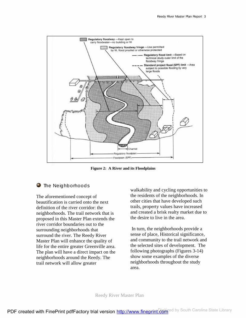
The Riverbed and Its Floodplain A river corridor is more than just the river channel. It also comprises the floodplain area. Technically, this can be divided into four specific areas. TheRiverbed, or channel where the riverwater runs under normal circumstances; the floodway where the banks of the river swell during heavy rainfall; the Regulatory Floodplain where waters typically rise during flooding rainfall;and the Standard Project Flood Limit
(SPF Floodplain) where land is subject to flooding by very large floods. All levels of the floodplain should have specific considerations and regulationsfor development: Floodway: Very environmentallysensitive, the floodway should never be built upon. The floodway area needs to be kept open to carry floodwater throughthe corridor. Regulatory Floodplain: This level of floodplain can be very sensitive to erosion or negative impacts of development. However, there are some circumstances where development maybe feasible with proper filling, flood proofing or other means of protection. The regulations for development should be based on technical study and approvalwith the Engineering Office of the jurisdiction. SPF Floodplain: Although this area is subject to very heavy flooding, it is less endangered by development. Regulations and procedural approvalprocess should be developed for these areas; however, the procedures for SPF areas will be less restrictive than the regulatory floodplain.
Figure 1 shows the various floodplain characteristics.
PDF created with FinePrint pdfFactory trial version http://www.fineprint.comDigitized http://www.fineprint.comDigitized http://www.fineprint.com by South Carolina State Library
Reedy River Master Plan
Reedy River Master Plan Report 3
Figure 2: A River and its Floodplains
The Neighborhoods
The aforementioned concept of beautification is carried onto the nextdefinition of the river corridor: the neighborhoods. The trail network that is proposed in this Master Plan extends the river corridor boundaries out to the surrounding neighborhoods that surround the river. The Reedy River Master Plan will enhance the quality of life for the entire greater Greenville area. The plan will have a direct impact on the neighborhoods around the Reedy. The trail network will allow greater
walkability and cycling opportunities to the residents of the neighborhoods. Inother cities that have developed such trails, property values have increased and created a brisk realty market due to the desire to live in the area.
In turn, the neighborhoods provide a sense of place, Historical significance,and community to the trail network and the selected sites of development. The following photographs (Figures 3-14) show some examples of the diverse neighborhoods throughout the studyarea.
PDF created with FinePrint pdfFactory trial version http://www.fineprint.comDigitized http://www.fineprint.comDigitized http://www.fineprint.com by South Carolina State Library

Reedy River Master Plan
Reedy River Master Plan Report 4
Figure 3: Neighborhoods: Mill town near Renfrew (Sector 1)
Figure 4: Neighborhoods: Mill town near Monaghan Mill (Sector 2)
Figure 5: Neighborhoods: Green Valley Country Club (sector 1)
Figure 6: Neighborhoods: House near Monaghan Mill (Sector 2)
Figure 7: Neighborhoods: Montague Road (Sector One)
Figure 8: Neighborhoods: Homes on 7th
Street (Sector 2)
PDF created with FinePrint pdfFactory trial version http://www.fineprint.comDigitized http://www.fineprint.comDigitized http://www.fineprint.com by South Carolina State Library
Reedy River Master Plan
Reedy River Master Plan Report 5
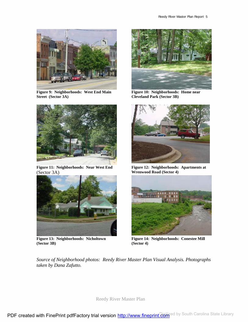
Figure 9: Neighborhoods: West End MainStreet (Sector 3A)
Figure 10: Neighborhoods: Home near Cleveland Park (Sector 3B)
Figure 11: Neighborhoods: Near West End (Sector 3A)
Figure 12: Neighborhoods: Apartments at Wrenwood Road (Sector 4)
Figure 13: Neighborhoods: Nicholtown (Sector 3B)
Figure 14: Neighborhoods: Conestee Mill (Sector 4)
Source of Neighborhood photos: Reedy River Master Plan Visual Analysis. Photographs taken by Dana Zafutto.
PDF created with FinePrint pdfFactory trial version http://www.fineprint.comDigitized http://www.fineprint.comDigitized http://www.fineprint.com by South Carolina State Library

Reedy River Master Plan
Reedy River Master Plan Report 6
The Watersheds Watersheds regions are areas bounded peripherally by a divide that drains, ultimately, to a particular watercourse or body of water (see Figure 15). The Reedy River Watershed consists of more than 167,000 acres of land with 325 miles of streams. Within the ReedyRiver drainage basin, there are thirteen subwatersheds, six of which surround the study areas (see Figure 16).
It is important to consider the watershed area as a definition of the Reedy River for environmental purposes. Basically,the water quality of the Reedy cannot be improved if the water sources that drain into it are not improved as well. The SC DNR process and study; The ReedyRiver Report: Managing a Watershedexplains the importance of watershedsand the policies that manage them.
Source: Lane Council of Governments Figure 15: Graphic Representation of a Watershed
Figure 16: The watersheds of the Reedy River Corridor
Map 1 (next page) shows the waterwaysassociated with the Reedy River studyarea; including the floodway, the floodplains and the tributaries of the Reedy. Maps 2-4 are detailed maps of Travelers Rest, Mayberry Park and LakeConestee; the three key sites of the plan.
PDF created with FinePrint pdfFactory trial version http://www.fineprint.comDigitized http://www.fineprint.comDigitized http://www.fineprint.com by South Carolina State Library

Reedy River Master Plan
Reedy River Master Plan Report 7
Map 1: Hydrography
Hyd
rog
rap
hy
Furman
Conestee Found.
Westside
Sewer
Duke
Western CarolinaSchool
Old Landfill
Stadium
City
Park
Church
YMCA
Equestrian Park
Cemetery
Duke Power
Green. Tech
Old TR High
Berea Middle
Lake Conestee Fo
Poe
County
County Square
Monaghan
Union Bleachery
Beck Elementary
Hyatt
Heritage Green
Mayberry Park
Cleveland Park
Brandon
Soccer Complex
BiLo Center
Amtrak
Duncan Chapel. E
Boys & Girls Club
Woodside
County Park
Conestee Mill
Housing Authorit
Eastern Baptis t
SCDOT
Travellers Rest
Liberty Baptist
Augusta Circle E
Pelham Rd. Bapti
Reedy River Pres
Conestee Church
Public Housing
G'Ville Sewer
WCRSA
Paramount Park
YMCA
SchoolPark
map compiled by Jeff Parkey, Center for Community Growth and Changedata from the City of Greenville, SC; Greenville County, SC; Pinnacle Consulting Group,
Greenville, SC; U.S. Fish and Wildlife Service, National Wetlands Inventoryall data North American Datum 1983
Any responsibility or liability from the use of this map is expressly disclaimed.14 March, 2002
Center for Community Growth and Change, Clemson UniversityCity of Greenville, South CarolinaGreenville County, South Carolina
The Reedy River Master Plan Project
Floodway
Floodplain
100 Year
500 Year
Reedy River
Tributaries
Wetlands
1:800005000 0 5000 10000 Feet
Re
edy
Riv
er
Co
rrid
or
PDF created with FinePrint pdfFactory trial version http://www.fineprint.com Digitized by South Carolina State Library

Reedy River Master Plan
Reedy River Master Plan Report 8
Map 2: Travelers Rest Hydrography
0 2000 4000 Feet
map compiled by Lucy Noth, Center for Community Growth and Changedata from the City of Greenville, SC; Greenville County, SC; Pinnacle Consulting Group, Greenville, SC; U.S. Fish and Wildlife Service, National Wetlands Inventory
all data North American Datum 1983Any responsibility or liability from the use of this map is expressly disclaimed.
14 March, 2002
The
Ree
dy R
iver
Mas
ter P
lan
Pro
ject
Trav
eler
s R
est
Hyd
rogr
aphy
Old TR High
Travellers RestYMCA
Park
MCELHANEY
USHW
Y25
MAIN
T0 EQUESTRIAN PARK
WetlandsTributaries
Reedy River
500 Year100 Year
FloodplainFloodway
(County Floodway information not available)
PDF created with FinePrint pdfFactory trial version http://www.fineprint.com Digitized by South Carolina State Library

Reedy River Master Plan
Reedy River Master Plan Report 9
Map 3: Mayberry Park Hydrography
ACADEMY
W WASHINGTON
CHU
RCH
S M
AIN
BIRNIE ST C
LEVE LAND
0 2000 4000 Feet
Hyd
rogr
aphy
May
berry
Par
kTh
e R
eedy
Riv
er M
aste
r Pla
n P
roje
ct
map compiled by Lucy Noth, Center for Community Growth and Changedata from the City of Greenville, SC; Greenville County, SC; Pinnacle Consulting Group, Greenville, SC; U.S. Fish and Wildlife Service, National Wetlands Inventory
all data North American Datum 1983Any responsibility or liability from the use of this map is expressly disclaimed.
14 March, 2002
WetlandsTributaries
Reedy River
500 Year100 Year
FloodplainFloodway
(County Floodway information not available)
PDF created with FinePrint pdfFactory trial version http://www.fineprint.com Digitized by South Carolina State Library

Reedy River Master Plan
Reedy River Master Plan Report 10
Map 4: Lake Conestee Hydrography
WetlandsTributaries
Reedy River
500 Year100 Year
FloodplainFloodway
(County Floodway information not available)
Lake Conestee
Sewer
Western Carolina
Old Landfill
StadiumCitySoccer
Complex
Conestee Mill
Public Housing
WCRSA
FORK SHOALS
CONESTEE
MAU
LDIN
Hyd
rogr
aphy
Lake
Con
este
eTh
e R
eedy
Riv
er M
aste
r Pla
n P
roje
ct
map compiled by Lucy Noth, Center for Community Growth and Changedata from the City of Greenville, SC; Greenville County, SC; Pinnacle Consulting Group, Greenville, SC; U.S. Fish and Wildlife Service, National Wetlands Inventory
all data North American Datum 1983Any responsibility or liability from the use of this map is expressly disclaimed.
14 March, 2002
0 2000 4000 Feet
PDF created with FinePrint pdfFactory trial version http://www.fineprint.com Digitized by South Carolina State Library

Reedy River Master Plan
Reedy River Master Plan Report 11
Background Studies and Existing Plans
Existing Plans
Many plans have been completed in the Greenville area that concerns the ReedyRiver Master Plan study area. Twenty-five plans are listed below (see Table 1);
categorized by date, title, type(consultants’ report, environmental,official City report, or official Countyreport), and author. Copies of the listed plans may be obtained through the Cityor County Planning Offices. (With the exception of the Kelsey & Guild plan, all are relatively recent.)
Table 1: Existing Plans
Type of Plan Title Author Date Prepared
Consultant Report Beautifying and Improving Greenville, SC
Kelsey & Guild, Landscape Architects (Boston, MA) for the Municipal League of Greenville, SC
January 1907
Consultant Report Conestee: AnExtraordinary UrbanConservation OpportunityThe Pathway from Neglect to CommunityAssetGreenville, SC
Dr. Dave Hargett for Greenville Magazine
March 2001
Consultant Report Design Guidelines for theCentral Business DistrictGreenville, SC
Winter and Company for the City of Greenville
September 2000
Consultant Report Downtown GreenvilleHousing Market AnalysisGreenville, SC
J. Terrence Farris, PhD., AICP for the City of Greenville Economic Dev. Department
1998
PDF created with FinePrint pdfFactory trial version http://www.fineprint.comDigitized http://www.fineprint.comDigitized http://www.fineprint.com by South Carolina State Library
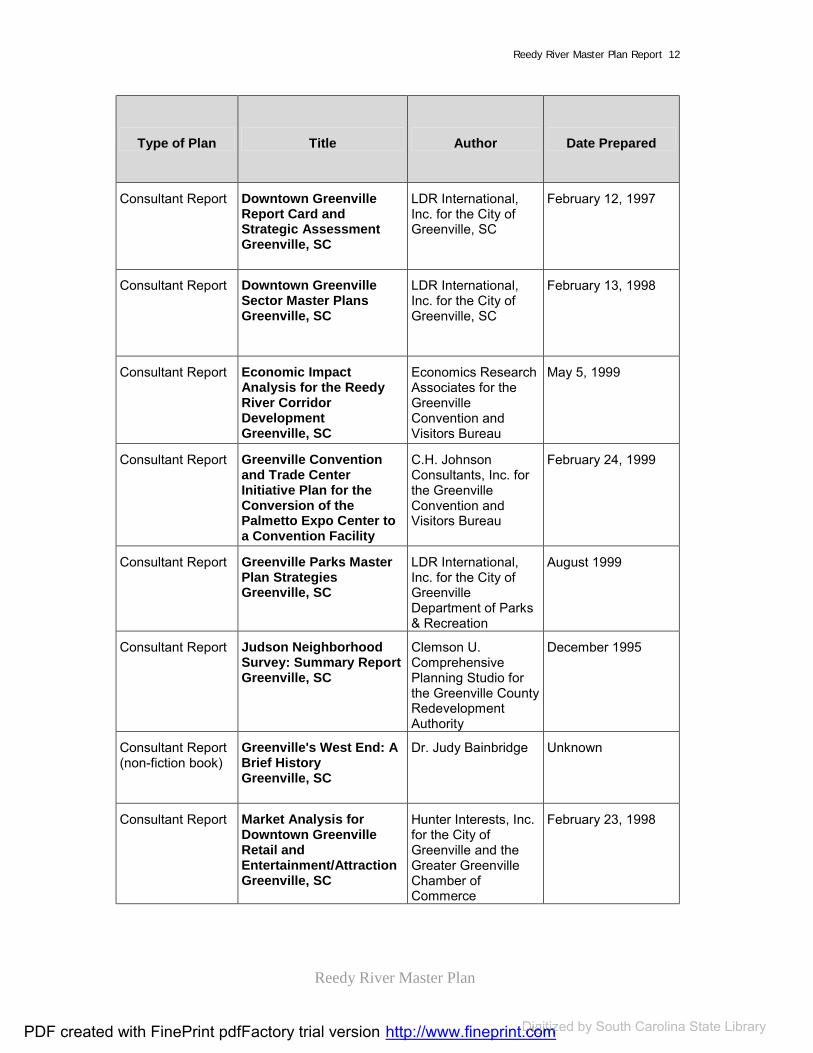
Reedy River Master Plan
Reedy River Master Plan Report 12
Type of Plan Title Author Date Prepared
Consultant Report Downtown GreenvilleReport Card and Strategic AssessmentGreenville, SC
LDR International, Inc. for the City of Greenville, SC
February 12, 1997
Consultant Report Downtown GreenvilleSector Master PlansGreenville, SC
LDR International, Inc. for the City of Greenville, SC
February 13, 1998
Consultant Report Economic ImpactAnalysis for the ReedyRiver Corridor DevelopmentGreenville, SC
Economics Research Associates for the Greenville Convention and Visitors Bureau
May 5, 1999
Consultant Report Greenville Conventionand Trade Center Initiative Plan for the Conversion of the Palmetto Expo Center to a Convention Facility
C.H. Johnson Consultants, Inc. for the Greenville Convention and Visitors Bureau
February 24, 1999
Consultant Report Greenville Parks MasterPlan StrategiesGreenville, SC
LDR International, Inc. for the City of Greenville Department of Parks & Recreation
August 1999
Consultant Report Judson Neighborhood Survey: Summary ReportGreenville, SC
Clemson U. Comprehensive Planning Studio for the Greenville County Redevelopment Authority
December 1995
Consultant Report (non-fiction book)
Greenville's West End: ABrief HistoryGreenville, SC
Dr. Judy Bainbridge Unknown
Consultant Report Market Analysis for Downtown GreenvilleRetail and Entertainment/AttractionGreenville, SC
Hunter Interests, Inc. for the City of Greenville and the Greater Greenville Chamber of Commerce
February 23, 1998
PDF created with FinePrint pdfFactory trial version http://www.fineprint.comDigitized http://www.fineprint.comDigitized http://www.fineprint.com by South Carolina State Library

Reedy River Master Plan
Reedy River Master Plan Report 13
Type of Plan Title Author Date Prepared
Consultant Report Proposed ConventionCenter Hotel MarketFeasibility ReportGreenville, SC
Horwath Hospitality Consulting for the Greenville Convention and Visitor's Bureau
December 1998
Consultant Report Retail BusinessDevelopment Programand RecruitmentStrategy: DowntownGreenville, SC
Development Strategies for the City of Greenville and the Greenville Chamber of Commerce
March 19, 1999
Consultant Report Revitalization StrategiesWestend GreenvilleGreenville, SC
LDR International, Inc. for the City of Greenville, SC and the Westend Association
March 1989
Consultant Report The Reedy River CorridorVision Plan Greenville,SC
Sasaki Assoc. with the City and County of Greenville and the Development Association of Greater Greenville (DAGG).
Summer-Fall 1998
Consultant Report West Washington StreetArea RedevelopmentTraffic Impact StudyGreenville, SC
Sprague & Sprague Consulting Engineers for the City of Greenville
June 1999
Official City Plan Community Developmentand Relations DivisionNeighborhood Report Cards Greenville, SC
The City of Greenville Community Development and Relations Division
November 2001
Official City Plan Greenville, SCComprehensive Plan
The City of Greenville Planning Commission
1999
Official City Plan Pleasantburg DriveCommercial CorridorAssessment and MasterPlan RecommendationsGreenville, SC
The City of Greenville Economic Development Department
July 1999
PDF created with FinePrint pdfFactory trial version http://www.fineprint.comDigitized http://www.fineprint.comDigitized http://www.fineprint.com by South Carolina State Library

Reedy River Master Plan
Reedy River Master Plan Report 14
Type of Plan Title Author Date Prepared
Official City Plan SouthernsideNeighborhood PlanGreenville, SC
The City of Greenville (?)
Unknown
Official County Plan
1993 Neighborhood Conditions StudyGreenville, SC
The Greenville County Redevelopment Authority
1993
Official County Plan
Designing our DestinyGreenville County'sComprehensive PlanExecutive SummaryGreenville, SC
The Greenville County Planning Commission
February 24, 1999
Official County Plan
Designing our DestinyGreenville County'sComprehensive PlanLand Use ElementGreenville, SC
The Greenville County Planning Commission
February 24, 1999
Environmental Report
Reedy River Watershed Study - Draft Version I Greenville and LaurensCounties, SC
The South Carolina Department of Natural Resources
October 3, 2000
In addition, a number of other organizations are concurrently researching within the studyarea. The organizations include:
EPA; DNR; DHEC; Corps of Engineers; City of Greenville; Greenville County; Pinnacle Consulting; Woolpert Consulting; Friends of the Reedy River; and Upstate Forever
PDF created with FinePrint pdfFactory trial version http://www.fineprint.comDigitized http://www.fineprint.comDigitized http://www.fineprint.com by South Carolina State Library

Reedy River Master Plan
Reedy River Master Plan Report 15
Key issues and restraints that were listed in these existing plans are:
Urbanization of the Greenville area;
Flooding and increased stormwater runoff;
Floodplain preservation; Riparian zone preservation; Poor water quality; Pollution along the Reedy
including point source, non-point-source pollutants and litter;
Wetlands preservation; Inconsistent width of the Reedy
River; Lack of recreational
opportunities; Lack of public access; Limited public open space; Zoning; Property rights; Neighborhoods; Historic sites; and Lack of vision within the
Greenville area
Recommendations given in existingplans include: Promote the Reedy River
Corridor in conjunction with historic sites, neighborhoods,redevelopment and revitalized areas and design guidelines;
Establish a comprehensive greenway system in conjunction with historic sites, implementation of an overlaydistrict, and an Open Space Plan; and
Promote the quality of waterwaysin the Saluda watershed and the quality of the Reedy River with appropriate flood controlmeasures, maintained riparian
buffers, soil erosion controls,improved tree protection, and leadership management.
Background Studies
Background studies are an essential element to the start of any plan. TheLandscape Architecture and CityPlanning Department of ClemsonUniversity conducted the followingstudies: Visual Analysis: Summer, 2001 Comprehensive Studies: Fall,
2001 Current Land Use: Summer –
Fall, 2001 Watershed Quality
Considerations: Summer 2001 – Spring, 2002
Visual AnalysisFor planning purposes, the corridor wasdivided into five sectors. Sectors include (see Figure 17):
Sector 1: Northern area (headwaters to Sulphur Springs Road)
Sector 2: Textile Crescent (Sulphur Springs to Academy)
Sector 3A: Downtown (Academy throughCleveland Park)
Sector 3B:Greenville Tech (south of Cleveland Park to I-85)
PDF created with FinePrint pdfFactory trial version http://www.fineprint.comDigitized http://www.fineprint.comDigitized http://www.fineprint.com by South Carolina State Library

Reedy River Master Plan
Reedy River Master Plan Report 16
Sector 4: Lake Conestee Area (I-85 to Conestee)
Figure 17: The Sectors of the study area
Visual analysis is a photo-documentation of the study area. It is important background study for a Master Plan because it creates a log of lasting imagesthat can be used as a reference both during the Master planning phase and in future plans. In addition, a visual analysis helps classify and categorize a study area. This visual analysis helped classify the Reedy river corridor into the five sectors used for this plan.
The analysis includes indexed maps that indicate the location of the photographstaken. The photographs were taken in July of 2001. A copy can be found in your jurisdiction’s planning office.
By studying the visual analysis, the sectors of the Reedy River Master Plan can be generalized in the followingways:
Sector One: Rural in nature and low in density, sector one spans from the Reedyheadwaters in Travelers Rest to Sulphur Springs Road. The town of TravelersRest lies within Sector One. This sector consists mostly of residential housing,the style of which varies from low-income trailer parks to luxury homes.Two golf courses are located along the banks of the Reedy in this sector. Furman University, and its student housing are within this sector. The former Greenville Northern Railroad, a railroad line that is being purchased bythe Greenville County Economic Development Committee, runs throughthis entire sector.
Sector Two: Located between Sulphur Springs Road and Academy Street, this sector is called the “Textile Crescent” because it is the home of several formertextile mills. Surrounding the mills, historic mill villages are examples of the quintessential housing type of Sector Two; small single-family homes, manyof which are in need of repair. The “Shoeless” Joe Jackson Park is located here. The former town of City View; a blighted area, is also within this sector.Along the Reedy, most of the land use in Sector Two is industrial: warehouses,mills, and other types, some of which is abandoned. The condition of the Reedyin this sector is poor: littered and overgrown.
Sector Three A: Sector 3A is the central business district of Greenville. The first sector of two within the Greenville City
LEGEND
Sector Divisions
Major Highways
Reedy River
PDF created with FinePrint pdfFactory trial version http://www.fineprint.comDigitized http://www.fineprint.comDigitized http://www.fineprint.com by South Carolina State Library

Reedy River Master Plan
Reedy River Master Plan Report 17
limits, this sector lies between AcademyStreet and Cleveland Park. The Reedyflows along the attractive downtown area, and at (the soon to be former) Camperdown Bridge, falls down a steep bed of rocks, to create what might be the only natural urban waterfall in the nation. The historic Reedy Falls, the birthplace of the city, dissects the downtown Main Street from the renovated West End. Surrounding the downtown area are quaint, tucked-awayresidential neighborhoods of mostlysingle-family homes. Sector 3A also includes most of the central urban parks;McPherson, Cleveland, Linkey Stone, Historic Reedy Falls, and the Greenville Zoo.
Sector Three B: Primarily residential,Sector 3B lies between Cleveland Park and I-85. Pleasantburg Road and Augusta Road, large commercial strips are within this sector. Greenville Technical College and the Cleveland St. YMCA are two large semi-public lands within Sector 3B.
Sector Four: Located between I-85 andLake Conestee, Sector Four includes many large properties of semi-public and private domain: Lake Conestee,Conestee Mill, the old City Landfill, the Braves’ Stadium, and Western Carolina Sewer Authority are all propertieswithin Sector Four. The town of Conestee is also with the sector boundary. Much of Sector Four, LakeConestee and the landfill are environmentally damaged. The town of Conestee, consisting of primarily single-family homes, lacks identity and is in need of redevelopment
Comprehensive Background Studies
In the Fall semester of 2001, the Comprehensive Planning Studio class of Clemson’s City and Regional PlanningGraduate Studies Program conducted a thorough background studies and draftedelements of a comprehensive plan for the Reedy River study area. The information that the graduate students collected include information in the followingareas: Demographics; Housing; Natural resources; Cultural resources; Economics; Community facilities; Land use; and Redevelopment potential.
Current Land Use
Current land use is an important factor to analyze while performing backgroundstudies. Being familiar with the land use patterns lends an understanding of what type of development should be considered within the study area.
Map 5 shows the current land use of the study area. The following resources provided the current GIS land use information:
County information is from the National Wetlands Inventory;and
City information is from the Cityof Greenville’s GIS database. Itis land use information from 1998.
PDF created with FinePrint pdfFactory trial version http://www.fineprint.comDigitized http://www.fineprint.comDigitized http://www.fineprint.com by South Carolina State Library

Reedy River Master Plan
Reedy River Master Plan Report 18
Map 5: Current Land Use
ê
êê
ê
ê
ê
ê
ê ê
POIN
S ETT
CH
U RC
H
ACADEMY
STONE
AUG
US TA
MA
ULD
I N
AUGUSTA
CONESTEE
MCELHANEY
WEST
OLD
BUN
CO
MBE
FOOT HILLS
POIN
SETT
MA IN
Center for Community Growth and Change, Clemson UniversityCity of Greenville, South CarolinaGreenville County, South Carolina
The Reedy River Master Plan Project
map compiled by Jeff Parkey, Center for Community Growth and Changedata from the City of Greenville, SC; Greenville County, SC; Pinnacle Consulting Group,
Greenville, SC; U.S. Fish and Wildlife Service, National Wetlands Inventoryall data North American Datum 1983
Any responsibility or liability from the use of this map is expressly disclaimed.14 March, 2002
1:80000
Land Uses, Greenville CountyAgricultureCommercial and ServiceForestIndustrialOther UrbanResidentialTransportation and UtilitiesTransitionalWetlandsForested Wetlands
Land Uses, City of GreenvilleCommercialResidentialMixed UseOfficePublicServiceResidentialTransportationVacant
Reedy RiverStudy Area
ê Textile MillsMunicipal Boundaries G
reen
ville
Co
un
ty,
Sou
th C
aro
lina
Ree
dy
Riv
er C
orr
ido
rLa
nd
Use
5000 0 5000 10000 Feet
PDF created with FinePrint pdfFactory trial version http://www.fineprint.com Digitized by South Carolina State Library

Reedy River Master Plan
Reedy River Master Plan Report 19
Map 6: Travelers Rest Current Land Use
MCELHANEY
WEST
OLD
BUN
CO
MBE
FOOT HILLS
MAIN
N. G
reen
ville
RR
Cur
rent
Lan
d U
se
Trav
eler
s R
est
The
Ree
dy R
iver
Mas
ter P
lan
Pro
ject
City of GreenvilleCommercialResidentialMixed useOfficePpublicServiceResidentialTransportationVacant
Greenville CountyAgriculture
ForestIndustrialOther UrbanResidentialTrans. and UtilitiesTransitionalWetlandsForested WetlandsTextile millsê
Commercial and Service
0 2000 4000 Feet
map compiled by Lucy Noth, Center for Community Growth and Changedata from the City of Greenville, SC; Greenville County, SC; Pinnacle Consulting Group, Greenville, SC; U.S. Fish and Wildlife Service, National Wetlands Inventory
all data North American Datum 1983Any responsibility or liability from the use of this map is expressly disclaimed.
14 March, 2002
PDF created with FinePrint pdfFactory trial version http://www.fineprint.com Digitized by South Carolina State Library
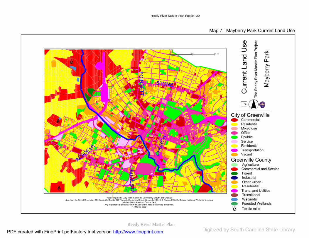
Reedy River Master Plan
Reedy River Master Plan Report 20
Map 7: Mayberry Park Current Land Use
ê
ê
ê
POIN
SET T
CHU
RCH
ACADEMY
STONE
AUG
USTA
0 2000 4000 Feet
map compiled by Lucy Noth, Center for Community Growth and Changedata from the City of Greenville, SC; Greenville County, SC; Pinnacle Consulting Group, Greenville, SC; U.S. Fish and Wildlife Service, National Wetlands Inventory
all data North American Datum 1983Any responsibility or liability from the use of this map is expressly disclaimed.
14 March, 2002
Cur
rent
Lan
d U
se
May
berry
Par
k
The
Ree
dy R
iver
Mas
ter P
lan
Pro
ject
City of GreenvilleCommercialResidentialMixed useOfficePpublicServiceResidentialTransportationVacant
Greenville CountyAgriculture
ForestIndustrialOther UrbanResidentialTrans. and UtilitiesTransitionalWetlandsForested WetlandsTextile millsê
Commercial and Service
PDF created with FinePrint pdfFactory trial version http://www.fineprint.com Digitized by South Carolina State Library

Reedy River Master Plan
Reedy River Master Plan Report 21
Map 8: Lake Conestee Current Land Use
I-85
HIG
HW
AY 25
MAU
LDIN
AUGUSTA
map compiled by Lucy Noth, Center for Community Growth and Changedata from the City of Greenville, SC; Greenville County, SC; Pinnacle Consulting Group, Greenville, SC; U.S. Fish and Wildlife Service, National Wetlands Inventory
all data North American Datum 1983Any responsibility or liability from the use of this map is expressly disclaimed.
14 March, 2002
0 2000 4000 Feet
Cur
rent
Lan
d U
se
Lake
Con
este
e
The
Ree
dy R
iver
Mas
ter P
lan
Pro
ject
City of GreenvilleCommercialResidentialMixed useOfficePpublicServiceResidentialTransportationVacant
Greenville CountyAgriculture
ForestIndustrialOther UrbanResidentialTrans. and UtilitiesTransitionalWetlandsForested WetlandsTextile millsê
Commercial and Service
PDF created with FinePrint pdfFactory trial version http://www.fineprint.com Digitized by South Carolina State Library

Reedy River Master Plan
Reedy River Master Plan Report 22
Water Quality Considerations
Water quality was a major public concern in this process. They were particularlyinterested in flooding, storm water management, water quality, trash in the river, and runoff of pollutants into the river. These issues are a function of current water and storm water treatment systems, as well as land use and development around the river.
City and County regulations (in keepingwith Federal requirements) recognize this, prohibiting construction in the floodway,and limiting construction in the floodplain to one and two foot (county and city) risecertification studies. The City and Countyare currently seeking federal storm water permits. This process will require considerable planning and analysis of the water quality issues noted above, leadingto recommendations that should be consistent with improving water quality in the Reedy River.
The challenges facing the Reedy River are typical, as an urban river. In particular,additional urbanization and growth creates more impervious surface and thus greaterrunoff volume from an even greater urbanarea. Urban runoff is often contaminated with oil and other materials. Without significant riparian buffers, these pollutants enter the river, reducing waterquality. Thus, riparian buffers can provide useful protection for the river.Conveniently, the proposed trail systemhas a dual purpose of providingrecreation/public river access and water quality.
Many sections of the Reedy River contained older mills and other industrial uses that are potential brownfield areas.The exact nature of ground contamination
has not been determined, although the Cityis currently participating in a brownfield pilot study in an area around a section of the Reedy River. Again, maintainingriparian buffers in these areas can be anefficient and safe use of this land.
Public attention has been focused on flood control, water quality and storm water issues around the Reedy River. Clearly,any plan for the river corridor must respect these considerations. The Reedy River Task Force, coordinated by the SC Department of Natural Resources recentlycompleted a two-year study. Their report,The Reedy River Report: Managing a Watershed provides science-basedconsensus on managing this watershed.
The seven task forces of this DNR studydeveloped numerous recommendations.These findings should be incorporated in any plans for trails, parks and development in the watershed. An overview of these recommendations includes the following:
Understand flood and drainageissues through study and planningof the river;
Identify what can be reasonablydone by public and private actionsto control flooding and waterquality;
Control runoff from newdevelopment;
Let flood plains flood; Minimize contaminants entering
the river through riparian buffers; Seek to increase base water flow
where possible; Reduce trash in the Reedy River; Promote aquatic health of the river
through stream rehabilitation and monitoring;
PDF created with FinePrint pdfFactory trial version http://www.fineprint.comDigitized http://www.fineprint.comDigitized http://www.fineprint.com by South Carolina State Library

Reedy River Master Plan
Reedy River Master Plan Report 23
Create and maintain a greenwaysystem round the river and its tributaries; and
Initiate a public education processto make people aware of waterquality issues.
Watershed management programs must take into consideration many factors. The plan should incorporate a complete inventory of watershed conditions, which include:
Water quality; Storm drainage; Infrastructure; Conveyance systems; Point source pollution; Non-point source pollution; Precipitation amounts; Groundwater conditions; Erosion; Soils; Current land use; Future land use; and Population/demographic figures
There are also a number of wetland systems around the Reedy. These are sensitive areas and must be treated carefully. The wetland system in the Mayberry Park area has received a greatdeal of attention, and is being consideredfor a Corps of Engineers study to restore this wetland area.
The Reedy River Master Plan abides bythese recommendations. By creating a greenway /trail system throughout the study area, the following objectives are met: A riparian buffer can be
maintained;
Development can be limited to ecologically sound recreational development;
The development that is planned to take place within the floodplain can have low negative impact on the environment, such as erosionand developmental runoff; and
Water quality, flooding and stormwater concerns raised byresidents can be addressed.
The Reedy River Master Plan has and will continue to encourage public participation in its development and implementation; this is an excellent“hands-on” approach to local development and improvement.
PDF created with FinePrint pdfFactory trial version http://www.fineprint.comDigitized http://www.fineprint.comDigitized http://www.fineprint.com by South Carolina State Library

Reedy River Master Plan
Reedy River Master Plan Report 24
Master Plan Process and Map
Process Overview
The Reedy River Master Plan can be divided into seven steps:
Step One: Public and ExpertInput Public participation and input has been the most important factor of the ReedyRiver Master Plan. Through the courseof public meetings held in July and September, information was gatheredfrom participants. Maps and displayswere created to use at workstations. Inthe meetings, participants worked with meeting facilitators who presentedstandard questions about the study area that could be explained with the maps. Responses of the participants were noteddirectly on the maps and displays. The information was later complied and organized. The concepts gathered arelisted in Public Meeting Summaries section of the plan. A general overview of the public meetings can be found in page 26. Detailed list of comments are included in the appendices.
Also, an extensive series of interviewswere conducted during the summermonths of 2001. Interviewees included: City and County Administrators City and County Council
Members City and County Staff Police Department Education Officials Utilities Officials
Neighborhood Associations Community Leaders and
Organizations Religious Leaders and
Organizations Representatives of Local Arts
Organizations Business Leaders and
Organizations Recreation Officials Others
Table 2 lists the individuals interviews within a classification outline.
Step Two: Trail Network Design Trails are created on public propertywhenever possible. Public properties include public roads and parks. Semi-public properties were used when necessary. Two non-profit properties, the N. Greenville YMCA and the LakeConestee Foundation property areincluded in the design of the trail network with full cooperation of the landowners. There are areas where the trail design passes through property that is privately owned. Efforts will need to be made to negotiate with landowners to explore the possibilities of land use for trail development. Step Five will discuss the procedures of land acquisition.
Step Three: Map Creation Maps are an integral part of anyplanning process. Throughout the project, from the public meetings to the design phases, GIS maps were created to aid in the representation of the plan.
PDF created with FinePrint pdfFactory trial version http://www.fineprint.comDigitized http://www.fineprint.comDigitized http://www.fineprint.com by South Carolina State Library

Reedy River Master Plan
Reedy River Master Plan Report 25
A detailed description of the mappingmethods begins on page 40.
Step Four: Key DevelopmentSite Design
Opportunity Sites for Development, both the recreational land and real estate,were selected by information gathered in combination of the public meetings, the design phase and with guidance from the public planning agencies. These sites are described beginning on page 48.
Step Five: Land Acquisitionand RegulationRecommendationsIn order to implement the Master Plan, close attention needs to be paid to the
type of lands that will be used for its ideas, especially the trail network. It is more convenient and feasible to concentrate on public and semi-public properties, as opposed to private property for site and trail location. This step focuses on the steps that were takento determine how to connect the public lands. In addition, recommendations for land acquisition are listed.
Step Six: ImplementationRecommendations Implementation is perhaps the most challenging phase of a plan’s function. Itis important to phase this process forpolitical and financial feasibility.
PDF created with FinePrint pdfFactory trial version http://www.fineprint.comDigitized http://www.fineprint.comDigitized http://www.fineprint.com by South Carolina State Library

Reedy River Master Plan DRAFT
26
STEP ONE: PUBLIC MEETINGS AND INTERVIEWS
Initial Public Meetings July 8-17, 2001
Between July 8 and 17, five meetingswere held along the 16-mile Reedy River corridor. These sessions were attendedby between 50 and 200 people each, with a total of 500 people participatingin these sessions. They were asked fourquestions: What they liked about the
existing river corridor; What they disliked; What they did want to see
happen in the river corridor, and; What they did not want to see
happen. Public comments were similar amongthe five meetings. The followingsummarizes the themes that were identified in these meetings.
Greenville cares about theReedy River corridor. Desirable elements and places of
beauty need to be preserved,including wildlife, plants, and the river itself.
The river is a critical resourcerunning through the middle of Greenville County that is a potential jewel to be polished byserving as a spine for renewaland redevelopment.
The river is strongly identifiedwith Greenville’s history.
Different sections of the riverhave their own unique character.
Greenville cares about its quality of life.
Additional open space, greenspace and recreationalopportunities are important and needed by Greenville residents.
Greenville wants to maintain, if not improve the quality of life with the Reedy River Plan.
There is a strong desire for connection among different parts of Greenville along the ReedyRiver corridor through a trailsystem that runs the length of the study area along the river, and includes a variety of uses:walking, biking, etc.
Both active and passive recreation should be included in the corridor; there is strongpublic support for keepingBraves Stadium and the Zoowhere they are.
Economic, residential and natural uses can and should be balancedalong the corridor.
Efforts to improve neighborhoods adjacent to the river should be made; Thisincludes CommunityDevelopment activities as well as creating job opportunities.
Access to the river is a critical element of any development along the river.
Both visual and physical accessto the river are important for safe
PDF created with FinePrint pdfFactory trial version http://www.fineprint.comDigitized http://www.fineprint.comDigitized http://www.fineprint.com by South Carolina State Library
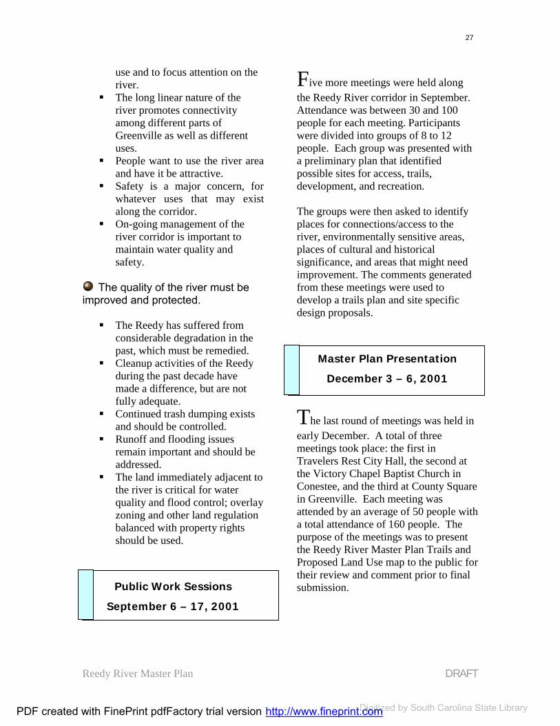
Reedy River Master Plan DRAFT
27
use and to focus attention on the river.
The long linear nature of theriver promotes connectivityamong different parts of Greenville as well as different uses.
People want to use the river areaand have it be attractive.
Safety is a major concern, forwhatever uses that may existalong the corridor.
On-going management of the river corridor is important to maintain water quality andsafety.
The quality of the river must be improved and protected.
The Reedy has suffered from considerable degradation in the past, which must be remedied.
Cleanup activities of the Reedyduring the past decade have made a difference, but are not fully adequate.
Continued trash dumping existsand should be controlled.
Runoff and flooding issues remain important and should be addressed.
The land immediately adjacent to the river is critical for water quality and flood control; overlayzoning and other land regulationbalanced with property rightsshould be used.
Public Work Sessions September 6 – 17, 2001
Five more meetings were held alongthe Reedy River corridor in September.Attendance was between 30 and 100 people for each meeting. Participants were divided into groups of 8 to 12 people. Each group was presented with a preliminary plan that identifiedpossible sites for access, trails,development, and recreation.
The groups were then asked to identifyplaces for connections/access to the river, environmentally sensitive areas, places of cultural and historicalsignificance, and areas that might need improvement. The comments generatedfrom these meetings were used to develop a trails plan and site specific design proposals.
Master Plan Presentation December 3 – 6, 2001
The last round of meetings was held in early December. A total of three meetings took place: the first in Travelers Rest City Hall, the second at the Victory Chapel Baptist Church in Conestee, and the third at County Square in Greenville. Each meeting was attended by an average of 50 people with a total attendance of 160 people. The purpose of the meetings was to present the Reedy River Master Plan Trails and Proposed Land Use map to the public for their review and comment prior to final submission.
PDF created with FinePrint pdfFactory trial version http://www.fineprint.comDigitized http://www.fineprint.comDigitized http://www.fineprint.com by South Carolina State Library

Reedy River Master Plan DRAFT
28
Travelers Rest commentsincluded:
The existing railroad tracks impose a hardship on the businesses downtown.
A tramline may be a goodalternative use for the Greenville Northern Railroad line.
Historic markers and signage forthe crossings over the Reedy areimportant.
It is important that the variouscity and County councilscontinue to work together to seethis plan through itsimplementation.
Conestee Commentsincluded:
Plan implementation shouldoccur in Conestee, not just in the downtown area.
It is imperative that the waterquality and other environmentalfeatures are improved at LakeConestee.
It is important that the city andcounty councils continue to work together to see this plan throughits implementation.
The opportunity for continuedpublic input is desired.
County Square commentsincluded:
Improvements should be fair and equitable for all parts of the studyarea.
It is important that the City and County councils continue to work together to see this plan through its implementation.
Interviews
Interviews were conducted with seventy-one officials and representatives of the study area. In addition, two charrettes were conducted in May 2001: one with the staff of Greenville County and Citygovernments, and the other with selectedlocal professionals.
The following table (Table 2) lists the interviews.
PDF created with FinePrint pdfFactory trial version http://www.fineprint.comDigitized http://www.fineprint.comDigitized http://www.fineprint.com by South Carolina State Library
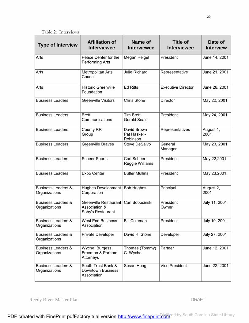
Reedy River Master Plan DRAFT
29
Table 2: Interviews
Type of Interview Affiliation of Interviewee
Name of Interviewee
Title of Interviewee
Date of Interview
Arts Peace Center for the Performing Arts
Megan Reigel President June 14, 2001
Arts Metropolitan Arts Council
Julie Richard Representative June 21, 2001
Arts Historic Greenville Foundation
Ed Ritts Executive Director June 26, 2001
Business Leaders Greenville Visitors Chris Stone Director May 22, 2001
Business Leaders Brett Communications
Tim Brett Gerald Seals
President May 24, 2001
Business Leaders County RR Group
David Brown Pat Haskell-Robinson
Representatives August 1, 2001
Business Leaders Greenville Braves Steve DeSalvo General Manager
May 23, 2001
Business Leaders Scheer Sports Carl Scheer Reggie Williams
President May 22,2001
Business Leaders Expo Center Butler Mullins President May 23,2001
Business Leaders & Organizations
Hughes Development Corporation
Bob Hughes Principal August 2, 2001
Business Leaders & Organizations
Greenville Restaurant Association & Soby's Restaurant
Carl Sobocinski President Owner
July 11, 2001
Business Leaders & Organizations
West End Business Association
Bill Coleman President July 19, 2001
Business Leaders & Organizations
Private Developer David R. Stone Developer July 27, 2001
Business Leaders & Organizations
Wyche, Burgess, Freeman & Parham Attorneys
Thomas (Tommy) C. Wyche
Partner June 12, 2001
Business Leaders & Organizations
South Trust Bank & Downtown Business Association
Susan Hoag Vice President June 22, 2001
PDF created with FinePrint pdfFactory trial version http://www.fineprint.comDigitized http://www.fineprint.comDigitized http://www.fineprint.com by South Carolina State Library

Reedy River Master Plan DRAFT
30
Type of Interview Affiliation of Interviewee
Name of Interviewee
Title of Interviewee
Date of Interview
Business Leaders &Organizations
Donaldson CenterDevelopmentCommission - Donaldson CenterIndustrial Park
Vardry Ramseur Executive Director June 29, 2001
Business Leaders &Organizations
Cleveland Street YMCA
Keith QuickBill Barringer
Executive DirectorVP of YMCA
June 6, 2001
Business Leaders &Organizations
Norfolk SouthernRailroad
Anton Cszar Director May 22, 2001
Business Leaders &Organizations
Western Auto inTravelers Rest (TR)
Mr. Nixon Owner May 8, 2001
Charette Greenville CountyPlanning Commission
Charette Various CommunityRepresentatives
May 29, 2001
Charette City of Greenville Charette Various CommunityRepresentatives
May 30, 2001
City and County General Staff
Greenville County Steve Stewart Administrator April 6, 2001
City and County GeneralStaff
Greenville County Charles Hall County ParksCommission
April 6, 2001
City and County GeneralStaff
City of Greenville Julie Franklin Economic DevelopmentPlanner
April 6, 2001 June 6, 2001
City and County GeneralStaff
Greenville County Jimmy Forbes Planning Commission April 6, 2001
City and County GeneralStaff
Greenville County Jason GillespieAsst. CountyEngineer
Greenville County April 16, 2001
City and County GeneralStaff
Greenville County Steve Brubzinski GC Redevelopment Authority
April 26, 2001
City and County GeneralStaff
Greenville County EMT Chief Marclay Chief May 9, 2001
City and County GeneralStaff
City of Greenville FireDept.
Chief McDowell Fire Chief May 9, 2001
City and County GeneralStaff
County Sheriff’s Office Sam Simmons Sheriff May 11, 2001
City and County GeneralStaff
City of Greenville Police Dept.
Myron Alderman Lieutenant May 10, 2001
City and County GeneralStaff
County EmergencyPreparedness Division
Scott Wendelken Chief May15, 2001
PDF created with FinePrint pdfFactory trial version http://www.fineprint.comDigitized http://www.fineprint.comDigitized http://www.fineprint.com by South Carolina State Library
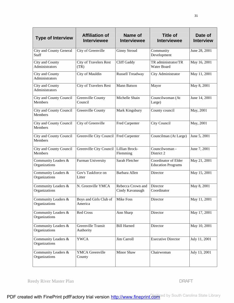
Reedy River Master Plan DRAFT
31
Type of Interview Affiliation of Interviewee
Name of Interviewee
Title of Interviewee
Date of Interview
City and County GeneralStaff
City of Greenville Ginny Stroud Community Development
June 28, 2001
City and CountyAdministrators
City of Travelers Rest (TR)
Cliff Gaddy TR administrator/TRWater Board
May 16, 2001
City and CountyAdministrators
City of Mauldin Russell Treadway City Administrator May 11, 2001
City and County Administrators
City of Travelers Rest Mann Batson Mayor May 8, 2001
City and County CouncilMembers
Greenville CountyCouncil
Michelle Shain Councilwoman (AtLarge)
June 14, 2001
City and County CouncilMembers
Greenville County Mark Kingsbury County council May, 2001
City and County CouncilMembers
City of Greenville Fred Carpenter City Council May, 2001
City and County CouncilMembers
Greenville City Council Fred Carpenter Councilman (At Large) June 5, 2001
City and County CouncilMembers
Greenville City Council Lillian Brock-Flemming
Councilwoman - District 2
June 7, 2001
Community Leaders & Organizations
Furman University Sarah Fletcher Coordinator of Elder Education Programs
May 21, 2001
Community Leaders & Organizations
Gov's Taskforce on Litter
Barbara Allen Director May 15, 2001
Community Leaders & Organizations
N. Greenville YMCA Rebecca Crown and Cindy Kavanaugh
Director Coordinator
May 8, 2001
Community Leaders & Organizations
Boys and Girls Club of America
Mike Foss Director May 11, 2001
Community Leaders & Organizations
Red Cross Ann Sharp Director May 17, 2001
Community Leaders & Organizations
Greenville TransitAuthority
Bill Harned Director May 10, 2001
Community Leaders & Organizations
YWCA Jim Carroll Executive Director July 11, 2001
Community Leaders & Organizations
YMCA GreenvilleCounty
Minor Shaw Chairwoman July 13, 2001
PDF created with FinePrint pdfFactory trial version http://www.fineprint.comDigitized http://www.fineprint.comDigitized http://www.fineprint.com by South Carolina State Library

Reedy River Master Plan DRAFT
32
Type of Interview Affiliation of Interviewee
Name of Interviewee
Title of Interviewee
Date of Interview
Community Leaders & Organizations
Community Planning Council - United Wayof Greenville
Weldon Mikulik Executive Director June 26, 2001
Community Leaders & Organizations
City of Greenville Max Heller Former Mayor June 28, 2001
Education Greenville TechnicalCollege
Joe Cooper Vice President June 19, 2001
Education The School District of Greenville County
Tom Kriese & TerryMills
Project ManagerRepresentative
May 11, 2001
NeighborhoodAssociations
SouthernsideNeighborhoodAssociation
Mary Duckett Representative June 13, 2001
Neighborhood Associations
Gower NeighborhoodAssociation (GENA)
Johston Dantzler & Jim Buschur
President ElectResident and PastPresident
June 28, 2001
Police Department City of Greenville Willie Johnson &Mike Gambrell
Police ChiefSergeant
May 10, 2001
Police Department Greenville CountySheriff's Office
Sam Simmons Sheriff May, 201
Police Department City of Greenville William Marclay PR Chief May, 2001
Recreation The Greenville Zoo & Friends of the Zoo
Lee SimsJan Griffin
DirectorExecutive Director
June 5, 2001
Recreation The Carolina FoothillsGarden Club
Pedrick LoweryCokie Corey
Representatives June 6, 2001
Regional Government Appalachian Council of Governments
Chip Bentley Natural ResourcesPlanner
May 8, 2001
Religious Leaders &Organizations
Springfield Baptist Church (DowntownGreenville)
Dr. Corbitt Minister June 26, 2001
Utilities Metro Water Board Mike Dickson Chief May 6 ,2001
Utilities Berea Water Board George Harrison Chief May, 2001
Utilities Gantt Water Board Carol Elliot Chief May, 2001
PDF created with FinePrint pdfFactory trial version http://www.fineprint.comDigitized http://www.fineprint.comDigitized http://www.fineprint.com by South Carolina State Library
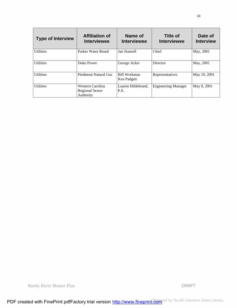
Reedy River Master Plan DRAFT
33
Type of Interview Affiliation of Interviewee
Name of Interviewee
Title of Interviewee
Date of Interview
Utilities Parker Water Board Jan Stansell Chief May, 2001
Utilities Duke Power George Acker Director May, 2001
Utilities Piedmont Natural Gas Bill WorkmanKen Padgett
Representatives May 10, 2001
Utilities Western Carolina Regional SewerAuthority
Lauren Hildebrand, P.E.
Engineering Manager May 8, 2001
PDF created with FinePrint pdfFactory trial version http://www.fineprint.comDigitized http://www.fineprint.comDigitized http://www.fineprint.com by South Carolina State Library

Reedy River Master Plan DRAFT
34
STEP TWO: TRAIL NETWORK DESIGN
Available Easements
After the first round of public meetingsin July, it became obvious that a network of trails connecting the study area to the Reedy River is strongly desired by the public. The designers working on the plan began to explore ways to create atrail network, while avoiding the costlyand lengthy process of acquiring privateland.
The design team investigated the use of public and semi-public lands, as well as utility easements for the trails. The lands available for public use and potential trail site development are the following:
Public Right-Of-Ways (ROW): ROWs are lands that lie adjacent to streets and riverbeds along privateproperty.
Public-Owned Land: Lands that are owned by a municipality,state, or federal agency are public-ownedland.
Utility Easements: Utility easements are properties that are used, but not owned by power, water, or sewer companies. The width of easement varies. The most feasible easements to consider are the wide easements used for metal power poles and sewer lines. The existing easements are for the utilitylines and access for repair and
maintenance. Agreements would have to be made to use these easements for public access.
Semi-Public Land: Owned by non-profit organizations (i.e. they do not need to pay property taxes),this property is considered semi-private property because the owners are responsible for its maintenance; however, it is usually used for public purposes. Examples of a semi-public property are the N. Greenville YMCA, the Boys and Girls Club, and the LakeConestee Foundation. Churches mayalso be considered semi-public property.A financial partnership can be made between the private organization and the public to fund the trail development on their land.
The Greenville NorthernRailroad:The Greenville County EconomicDevelopment Corporation (GCEDC) owns the Greenville Northern Railroad line. According to this Master plan, this pathway would be converted to a path where a motorized, rubber-wheeled tram can run along the pedestrian and bike paths. This pathway will run from Mayberry Park (near downtownGreenville), through Furman Universityand end just north of Travelers Rest. The use of this railroad line depends on the clarification of several legal issues. Theappropriate authorities must process these issues before a new use, such as a tram, may be implemented.
PDF created with FinePrint pdfFactory trial version http://www.fineprint.comDigitized http://www.fineprint.comDigitized http://www.fineprint.com by South Carolina State Library

Reedy River Master Plan DRAFT
35
Trail Availability Analysis
Data were collected from the City andCounty of Greenville Planning Offices and Tax Offices. By creating a map, the available lands were analyzed to find the connections of accessible lands for a trail network. The outcome is described in the following section.
The following series of maps show the process that was followed to analyze two topics: the layout of the public and semi-public properties; and, the availability ofeasements for creating a trail network.The purpose of this analysis is to observe the connectivity of the public lands within the study area and, also, the feasibility of implementing the trail network.
Map 9 shows the public and semi-public properties categorized by property type.The legend on the map shows that the properties were categorized into ownership by city, county state orfederal; school, church or non-profits; textile mills, railroad depots, or miscellaneous ownership.
Map 10 categorizes the trail network according to the ownership of the property where trail easements will need to be arranged. The legend on the map shows the general ownership of the areas where the trails are proposed to be located.
Map 11 shows the trail network’seasements categorized into phases depending on their availability:
Blue: Roads Roads are public property, therefore, readily available. Specifics of Right-of-Way availability may be another issue. Furthermore, because of the sheer amount of trail development that will take place on the roads, it is not feasible to plan the on-street trail construction at one time. It should be considered that the on-street trails construction will take years to accomplish and should be approached with a “do-as-can” project.
Green: Immediately Available Immediately available properties are properties that are already planned for development that complies with the Reedy River Master Plan.
Yellow: Readily Available Properties that are semi-public byorganizations that have offered to cooperate with the Master Plan vision are properties that are readily available.Each organization will need to work with the county or city to organize the details.
Orange: Investigate the Possibility If the trail network lies on semi-public or private property, an agreement of some kind, either an easement or a land purchase/lease will need to be agreedupon. These properties are represented in orange.
Red: Long-range Goals There are several places in the study area that will be difficult to acquire due to their current use. These should be considered to be long-range acquisitiongoals.
An additional note: the Master Plan process is not the point where site-
PDF created with FinePrint pdfFactory trial version http://www.fineprint.comDigitized http://www.fineprint.comDigitized http://www.fineprint.com by South Carolina State Library

Reedy River Master Plan DRAFT
36
specific designs are established.However, there are some trail designguideline recommendations in the Appendices.
PDF created with FinePrint pdfFactory trial version http://www.fineprint.comDigitized http://www.fineprint.comDigitized http://www.fineprint.com by South Carolina State Library

Reedy River Master Plan DRAFT
37
Map 9: Public and Semi-public Lands
YMCA
Furman
Equestrian Park
Old TR High
Duke Power
Berea Middle
Westside
Cleveland Park
Greenville Tech
WCSCA
Old Landfill
Conestee FoundationStadium
Conestee Mill
BrandonWoodside
American SpinningPoe
Monaghan
Union Bleachery
Boys & Gilrs Club
County Square
Amtrak
Pub
lic
and
Sem
i-Pu
bli
c La
nd
s:O
wn
ersh
ip
Center for Community Growth and Change, Clemson UniversityCity of Greenville, South CarolinaGreenville County, South Carolina
The Reedy River Master Plan Project
map compiled by Lucy Noth, Center for Community Growth and Changedata from the City of Greenville, SC; Greenville County, SC; Pinnacle Consulting Group,
Greenville, SC; U.S. Fish and Wildlife Service, National Wetlands Inventoryall data North American Datum 1983
Any responsibility or liability from the use of this map is expressly disclaimed.14 March, 2002
5000 0 5000 10000 Feet1:80000
Public or Semi-public PropertiesCemeteryChurchCityCountyFederalMillMiscNon-ProfitParksRRSchoolStateUtilitiesTrail Network
Re
edy
Riv
er
Co
rrid
or
PDF created with FinePrint pdfFactory trial version http://www.fineprint.com Digitized by South Carolina State Library

Reedy River Master Plan DRAFT
38
Map 10: Trail Easements Ownership
5000 0 5000 10000 Feet
Tra
il an
d E
asem
ent
Ava
ilab
ilit
y:
Ow
ner
ship
Re
edy
Riv
er
Co
rrid
or
1:80000
The Reedy River Master Plan Project
Center for Community Growth and Change, Clemson UniversityCity of Greenville, South CarolinaGreenville County, South Carolina
map compiled by Lucy Noth, Center for Community Growth and Changedata from the City of Greenville, SC; Greenville County, SC; Pinnacle Consulting Group,
Greenville, SC; U.S. Fish and Wildlife Service, National Wetlands Inventoryall data North American Datum 1983
Any responsibility or liability from the use of this map is expressly disclaimed.14 March, 2002
1st BaptistBoys&GirlsCityCountyN. Greenville RailroadDukeFriends of the Reedy River (FORR)Furman UGville Country ClubGville TechLake Conestee Foundation (LCF)McAlister SquarePrivateRoadsS. WeavingSchoolSewer EasementUnknownUtility EasementWCSSAYMCA
Owners
PDF created with FinePrint pdfFactory trial version http://www.fineprint.com Digitized by South Carolina State Library

Reedy River Master Plan DRAFT
39
Map 11: Public Properties and Easements
Ree
dy
Riv
er C
orr
ido
r
Tra
il a
nd
Eas
emen
t A
vail
abil
ity
Center for Community Growth and Change, Clemson UniversityCity of Greenville, South CarolinaGreenville County, South Carolina
The Reedy River Master Plan Project
map compiled by Lucy Noth, Center for Community Growth and Changedata from the City of Greenville, SC; Greenville County, SC; Pinnacle Consulting Group,
Greenville, SC; U.S. Fish and Wildlife Service, National Wetlands Inventoryall data North American Datum 1983
Any responsibility or liability from the use of this map is expressly disclaimed.14 March, 2002
5000 0 5000 10000 Feet
1:80000
Trail Easement AvailabilityImmediately AvailableReadily AvailableInvestigate OpportunitiesLong-range GoalsPublic RoadsPublic or Semi-public PropertiesReedy River
PDF created with FinePrint pdfFactory trial version http://www.fineprint.com Digitized by South Carolina State Library

Reedy River Master Plan DRAFT
40
STEP THREE: CREATION OF THE MAPS
The Analysis Maps
Maps were used throughout the process in order to gather information from the participants.
The maps used for the first public meetings were orthographic photographswith basic and minimal information used for landmark referencing. These maps were designed to pinpoint locations of comments and examples that the participants gave to the four questions asked at the work session: What do you like about the
existing river corridor? What do you dislike? What would you like to see
happen to the river corridor? What would you not like to see
happen to the river corridor?
Figure 18: Map for first Public Meetings
Participants were encouraged to draw and write their comments directly onto the maps.
The maps used in the second round of public meetings represented the public and semi-public lands in the study area. One map showed the available lands in one color to demonstrate theirconnectivity. Afterwards, the lands were classified by colors depending its type(school, church, state-owned property,utilities-owned property, park, etc.). See Map 9 for details. When mapped, the analysis of the public lands was encouraging. The connections of the available lands were relatively consistent throughout the entire study area.
Figure 19: Map for second Public Meetings
County Square
Cleveland Park
SC
HU
RC
H
E WASHINGTON
E NORTH
Governors School
Hyatt
E BROAD
E MCBEESM
AIN
E WASHINGTON
#
Peace Center
PDF created with FinePrint pdfFactory trial version http://www.fineprint.comDigitized http://www.fineprint.comDigitized http://www.fineprint.com by South Carolina State Library

Reedy River Master Plan DRAFT
41
The Master Plan Map
The Master Plan Map (see Map 12) contains the following elements:
The Trail and TransportationNetwork;
Future Land Use Proposals with Proposed Recreational and Real Estate Development Sites;
Existing Parks and Public Properties (to show the connectedness of the trail network); and
Environmental Features: theReedy River, tributaries, otherwater bodies, and the floodplain.
The Trail and TransportationNetwork
There are four types of paths within the network: On-Street Paths: Trails along
the roadways Off-Street Paths: Pathways that
will be constructed on properties that will not lie along roadsides.
Future Off-Street: Pathways that have been included in the Network that run through private property. These parts of thenetwork will need to be obtainedthrough agreements with the property owners.
Tram Path: The railroad line that is owned by the Greenville County Economic DevelopmentCorporation (GCEDC).According to this plan, this pathway would be converted to a path which a motorized, rubber-wheeled tram can run along the pedestrian and bike paths. This
pathway will run from MayberryPark, through Furman Universityand end just north of Travelers Rest. The use of this railroad line depends on the clarification of several legal issues. The legalauthorities must process these issues before a new use, such as a tram, may be implemented.
Future Land Use Proposal withProposed Sites
There are two basic types of development proposed in this plan: recreational and real estate. However, the map specifies the train station and the mill redevelopment sites as separate classifications due to the nature their recommended uses.
Recreational development includes uses such as sport fields, nature paths, gardens, and passive recreation. Specific areas include:
The North Greenville YMCA - a new facility is being built on the Reedy in Travelers Rest. This has the potential of beingconnected to the town as well as the corridor thus spurring potential economic development.
The Boys and Girls Club – the land owned by this non-profitorganization is located between an existing county park and the targeted Mayberry Park area. TheBoys and Girls Club haveexpressed the desire to cooperate with the overall Reedy RiverMaster Plan and would like to see recreational development on the land.
Mayberry Park - the large flood plain is ideal for active and
PDF created with FinePrint pdfFactory trial version http://www.fineprint.comDigitized http://www.fineprint.comDigitized http://www.fineprint.com by South Carolina State Library

Reedy River Master Plan DRAFT
42
passive recreation as describedabove, using significant city-owned land as a start in this project.
The Old City Landfill – just north of Lake Conestee, the area that was once used as a landfill is an ideal location for public openspace and passive recreationalactivities.
Lake Conestee - with the combination of Lake ConesteeFoundation’s land in and aroundthe lake, the City baseballstadium, and other Cityproperties, there is a potential for over 200 acres of recreationalactivities in this area. Thiswould provide a significantregional resource, also spurringpotential for economic development in the Conestee area.
Real estate development includes properties that would be suitable for residential, commercial, or mixed use. The sites proposed for this type of development are:
The Travelers Rest High School– The existing high school will be replaced with a new schooland the property can be reused. Its existing fields can be combined with mixed-usehousing, office and/or retail as well as community spaces.
Properties surrounding the Mayberry Park area - This large floodplain area can be linked to Academy Street and downtown Greenville through the ReedyRiver, with higher intensitymixed use closer to downtown.
Mayberry Park would be expanded to include more playing fields and large openspace adjacent to development at the edge of the flood plain.Mixed use development as the edges of the park would berelated to adjacent neighborhoods.
The Amtrak Station - With the development of high-speed rail through Greenville in the nextdecade, the current station has the potential to become a centerpiece for redevelopment in the West Washington Street area.
Mills - While most of these mills are vacant, mixed use potential may be possible for these unique structures. The targeted millsinclude:
- Poe- American Spinning - Monaghan - Brandon - Woodside
Downtown mixed-use sites - Several sites in downtown Greenville near the river arebeing considered fordevelopment as office, residential and/or commercial uses.
Conestee Mill - Similar to other mills no longer used for production, this mill can be reused in conjunction withrecreation plans for the LakeConestee area.
PDF created with FinePrint pdfFactory trial version http://www.fineprint.comDigitized http://www.fineprint.comDigitized http://www.fineprint.com by South Carolina State Library

Reedy River Master Plan DRAFT
43
Existing Parks, Public and Semi-Public Properties
Existing Parks: The existing parks within the study area are represented in light green. The master plan connects the public parks within the study area withtrails.
Existing public properties: Existingpublic properties are represented as lightyellow on the Master Plan map. These properties include schools, city and county buildings, service buildings, and churches. The purpose of representingthese properties is to consider their potential for public use. Possible uses include parking and rest rooms for trail users. Not every site is appropriate forthis type of cooperation, but many are. Further studies will need to be conducted to determine site feasibility.
Environmental Features
Water Features: The Reedy River andits tributaries are represented as blue lines. Other significant water bodies, such as Lake Conestee, are also represented as solid light blue areas.
Floodplain and floodway: The floodplains in the river corridor are an important feature of the map and are considered an ecologically sensitivearea. It is advised that new construction does not occur within the floodplain area, although the County and City of Greenville regulations permit construction under certain conditions. The light blue-hatched areas representthe 500-year floodplain areas. City andcounty regulations regarding floodplains will be followed. (Exact borders of thesefloodplains can be obtained at the local government engineer’s offices.)
Following the Master Plan map (see Map 12), three sectional maps will provide more detail (Maps 13-15).
PDF created with FinePrint pdfFactory trial version http://www.fineprint.comDigitized http://www.fineprint.comDigitized http://www.fineprint.com by South Carolina State Library
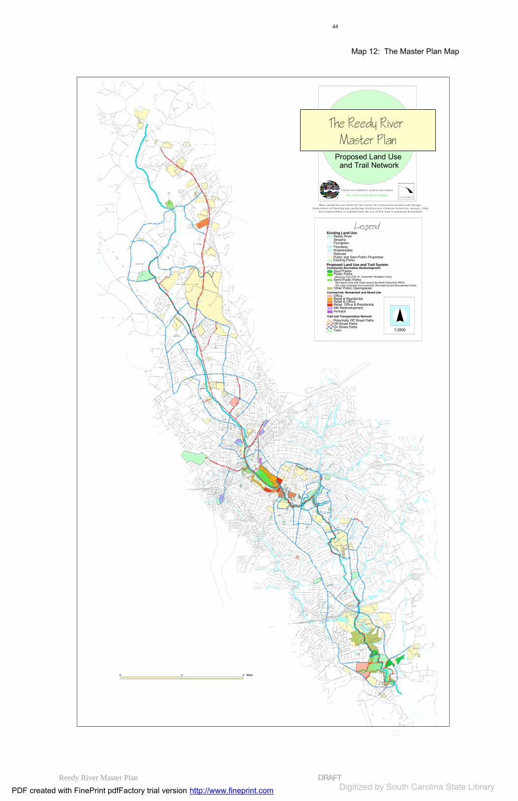
Reedy River Master Plan DRAFT
44
Map 12: The Master Plan Map
#
Equestrian Park
#
Old TR High
I-85
I-38 5
GEER
-
RIDG E
BLUE RIDGE
POI N SE T T
ROE FORD
OL D W
HI TE HORSE
A
LILY
L A UR EN S R D
VALLEY
CEDAR LANE
FORK SH
OALS
INTERSTATE 85
AUGUSTA
KEEL
ER M
ILL
FOW
LER
BR AMLE TT
S P LEA SA NT BU R
G D R
MCE LH
ANEY
DUNCA N
6TH
AUGUSTA ST
D
S
PERR Y
MAINM
A UL D
IN
MAULD IN RD
FOOT HILLS
GIBSON
PAR
KINS
MILL
R D
SETT LE
MENT
FRAN
KLIN
CONES TEE
PELHAM RD
N M
A IN
S TAGNEW
LEDB E TT ER
CRANE
8TH
ARCH
COX
CL
EVE
L AND
ST
PARKER
JAMISON
WA TS ON
HAY
WO O D
RD
MARION
BRUC E
WEST
WHITE HORSE
LINDSE Y LAKE
7TH
RUTHER FO RD RD
E
TIND
AL
MO
NTI S
RI D
G E
RD
B ATSON
WIN N
RIVER BEN D
E NORTH
ST
FA
IRF
OR
ES
T
WY
HUN TS BRIDGE
CIRCLE
FURM
A N
KERNS
HOD
GEN
S
BER EA
MONTAGUE
EDGEMONT
WO
OD
S IDE
PEACE
VERDAE
BLV
D
DAIR
Y
DR
K RIE
GER
WADE H AMPT O N
BL VD
RUTLEDG E LAKE
HAMPTO N
N PLEASANTBURG DR
E FA RIS
RD
DUVAL
L
DR
HUNT
WILLIAMS
LOWNDES H ILL R D
CLEMSON
MEADORS
MCD
ANIE
L
AV
EUN
ICE
W FARIS R
D
ROS E
BOYD
CH
A RLE
S
ROE
SUMT ER
TU CSON
PE NDLETO N ST
CHU
RCH
VIEWMONT
HAL
TON
R
D
LILA
WATKINS
AL I C E
4TH
HIGHLAWN
PLAN O
BA I
L EY
F AI R
CRESTFIELD
DUNCAN CHAPEL
AUGU
STA RD
US
HW
Y 2 7 6
LAD Y
CHUR CHILL
G
RO
VE
R
D
E WASHIN GTON ST
ROGERS
MORGAN
S CH
URCH
ST
TH IRD
ENGE L
FARRS BRIDGE
DOGWOOD
PLEASANT R ETREAT
MA NLEY
VA N
C E
STATE PARK
E PARKINS MILL RD
YM
CA
VILLA R D
HAMMETT
RUBY
M URPHY
ACCE SS
UN KN O W N
FORESTVILLE
SECOND
VALL EY OAK
1 STS
P RU C
E
SHAW
AIRPOR T RD
PI N
E FO
RE
ST
MILL
S
A
V
WEM
BLE
Y
RD
B
PERRY AV
CH I
C K S
P RI N
GS
RD
BER K L E
Y
PENARTH
5T H
HUFF
CAST LE
PALMETTO
ALMA
END
LOV E
JONE S
KIRK
BU RNS
GR
IDLE
Y
U S H W
Y 25
2ND
TOLAR
H ENDERSON
P INE
NEW MCELHANEY
C
OAK
BOW
ERS
W WASHINGTON ST
B R ID W EL L
FERN
LEAF
OLD PARKER
GREEN VAL LEY
BETHANY
INA
S AC ADEMY ST
OLD
RO
E FO
RD
KINGS
TAM PA
NORA
CRESCEN T AV
N CHURCH
ST
VIN E
RAS
O R
LOO P
OLD BLEACHERY
OR
DER
S
NEW PERR Y
WA SH INGTO N
MORRIS
WARW
ICK
WHITE HOR SE RD EXT
OLD B UN CO
MB E
RICH
MOND
MAYO
ROC K QUAR RY
H AMPTON AV
SULPHU R SPR INGS
HIL LTOP
GU
E SS
BU
D
HENDERSON R
D
ROCKY SLOPE R
D
FAIRFIELD
BEN
NETT
ST
WOODS LAKE R D
OLD EASLEY
EA S LE Y B RIDG E
CL UB FOREST
B UNCO MBE ST
LEE
LURA
Y
POE
ROSS
PEND LETON
VI N SON
OD
OM
THOMAS
NIX
BIRNIE ST
SA LE M
SCH
O OL
10TH
SU
MM
IT
D
R
KE ITH DR
ZELM
A
F OXHA
L L
KAY
CL EVEL AND EXT ST
GRE
EN
AV
VER NER
FRO
NTAG
E
TU LAN E
WOODLARK ST
CENT E R
LORR
AINE
FIN L EY
CHU KA
R
STR ATF OR D
NEW CIRC LE
3RD
9TH
BYRD BLVD
HEARD
PARIS VIEW
FIFT
H
HALE
ALBAIN
O R CHID
DUNBAR ST
LAU
REL
LAKE
WOO
D
DON
DR
E LIZA BE
TH
P IT T M AN
CLAR
K
JO
NES
AV
MCCR ARY
HAVE N
VIST A
RIDGEWAY
C LAREN DON
DYE R
HI C KS
POTOMAC AV
ASHLE
Y
SA CO
E ASTVIEW
SCA L YBA RK
GANTT
SM
YTH
E
MINUS
DAVI S
MCNEE SE
PLA
NT
E ST ONE AV
M A E
TRINITY
WOODLAND
WY
ECHOLS
CA
RVE R
TWIN LAKE RD
WILLIS
CO
NYER
S
CLUB
SUNRISE VALLEY
CHA THA M
PINE G ROVE
BURGESS
MONTANA
FOX CREEK
MEYERS DR
DALLAS
DARLINGTO
N
MC MAKIN
RAC
INE
WOOD
ATES VIEW
LAKESID E
MA C
K
BUIST AV
LYN
CHBU
RG
FLET
CHE
RA
L AM
O
MELVIN
WAC O
TH E RES A
DAV
IDSO
N
KENS
INGT
ON
LONG FOREST
FAI R
MON
T
AB E L IA
W ILCUN
G E NTR Y
CO
URT L
A ND
MALOY
ABNEY
ASHLEY AV
WOR
TH
FURM
AN H
ALL
COLONIAL
LOO M
AVE RIL L
TO
WNE
S
S
T
WEN WOOD RD
OLD ANDERSON
SW EE T G UM
CROFT ST
TRAMMELL
SIXTH
TALLEY
ANDREWS
LAW N V IE W
BUTLER
RHETT ST
MEL
V ILL
E
AV
RA W O O D
ALL
EN
ARLINGTON AV
W ATKINS BRIDGE
BA
TES
CR
OS
SIN
G
BUTL
E R S PR
INGS
R
D
JASP
ER
E PARK AVALLEY
BRO O
K S
SPEED
VIC
TOR
LENORE
MARTIN
UNIVERSITY RIDGE
MCBETH
RIC
E
ST
DEERING
OL D
AU G
U ST A
RD
PLEAS
ANTBU
RG
OLD
AU GU
S TA
PE AR
CLUB
DR
HUL L
PARK
N A
CADE
MY
S
T
D ORSEY
MC DOWELL
TREMONT
LAUR
A
SC A
RLE
TT
ST
PI M
L ICO
RD
GOWER ST
LAM A R
BLACKBERRY V
ALLEY
INDUSTRIAL DR
PATTON
LAKE
LANG FO RD
AND
ERSO
N
S
T
ELF
W E ARLE ST
ALTA VISTA
C ORNEL
I A
AC KLEY
RD
BAR C LA Y
BEL VED
ER E
PAR ADE
BYRDLA
ND
DR
SMIT H
ADDIS
A LTA
MO
N T
DOR C
H EST ER
K I NG SB UR Y
PR O S PE R I TY
A V
BR ADL EY
B
L VD
COBB
ASS EM
BLY
LANGSTON
SIR
RI N
E
FENW ICK LIND
A
CAMDEN
HO LM
E S DR
SAA
D
WO
OD L
AND
20TH
COLLINS
FOXW ORTH
DU KE L AN D
GRANDV IEW
MO O
DY
CENTU
RY
DR
11TH
RIV E RS IDE
DR
NORWOOD
P
BARK
TRAN SIT DR
PINE FIE LD
NEW
L AND
WA C
CA M
A W
AV
ELI
P INE
CRE
EK
PE L
ZE R
LIGHT NING
PETTIGRU S
T
PIN CK NE Y ST
W STONE AV
FARMINGTON
LA JUA N
J AMES
LITTLE TEXAS
MONAVIEW
S M
A IN
S T
C REST
HATCH
WHI TE OA K DR
NEWPORT
REGENT
SOUTHWOO D
BEA CO
N
M AU D I E
BE
ATT I
E
NO
RTH C
L IFF
WILLARD ST
SHERMA N
GUE
SS S T
RODNE Y
FRO
S T
BRA NDT
COVINGTON
E MCBEE AV
MCD
ADE
CHILDRES S
EDGEF
IELD
BRA NTF O
R D
ATHENS
BEL AIRE
MAR
LB OR
O
RENFREW
ESTATE
LYDIA
FAIRFAX
MO
RA
GHANA
ST O
N EH
A VE N
D
R
DE C
AT U
R
B ATES VI EW D R
OLD
FORK S
H OAL S
PINCKNEY
RIDGEWO OD
CONEST EE LAKE
WILHE LM WINTE R
DONALD SON
L OUISE
LON G H ILL S T
WE DGE W OOD
DR
OVERBROOK
RD
PARIS M OU NTAIN
JOR DAN
KEENE
B O O NE
HO N O UR
BRYANT
MT VISTA A
V
RAINBOW
A LVI
N
SULLIVAN
EL DORA DO
C LEARVIEW
RU
THE R
FOR
D
ST
LINDE N
TAWBA
MILL
OSCAR ST
BEREA MIDDLE SCHOOL
DUNBAR
WEB
STER
R
D
WARDVIEW
YORK
PARKI NS L AKE RD
MASON
ARNOLD
DUPONT DR
E TALLULAH D
R
WOOD MONT
E BROAD ST
ABE
RDEE
N
DR
CATHEY
ELKHORN
YOUNG
DEL T
A
DEVON SH IRE
PLEASANT RIDGE AV
TRACTION ST
W ILD RO S E
OVER TON
LAKEHURS
T S T
TUBB
S M
OU
NTA
I N
DUN
L AP
ACCESS R
AMP
GOO
D
A ZAL EA CT
OLD PLA ZA
DELAWARE
WILMA
COOL BROO
K
MI L
L CR
EEK
GA L AX
CROSBY
W MOUNTAINVIEW A V
HOYT
BE REA FO R
ES T
LO WND ES AV
MAYBERRY ST
PO RT SMO UT H
ARLE NE
RANDA LL ST
TIND AL AV
C URET ON
WO
RLEY RD
E M A IN ST
S TUR TE
V ANT
SPARTANBURG ST
FOREST
RAVENEL
EDW
ARD S
ELDER ST
ASH F O RD
A
V
ROU
ND H
ILL
TATE
HIA
L EA H
RD
M
CA
L IS
TER
R
D
BUFF
ISBELL LA
S HU
DSON
ST
BRANCH
CAMMER
AV
JENKINS ST
MONAGHA
N
QUAIL
LEL AN D
BRO
OKD AL
E
A
V
HI L
LSI D
E
CALH
OUN
CURE TON
S
T
LEGR
AND BLV D
GAY
H
PINE
MEA
DOW
MO
ORE M
ON
T
MAPLE
COLUMBIA
MEL
ODY
O TIS S
T
M A R BL E
BENNETT
VEST
M
OH A
WK
DR
PINE LAKE
PATROL CLU
B
BEREA HEIGHTS
F OWLE
RVIL
LE
ZAR
LINE
SP ANCO
AGN ES
WATTS AV
SOUTH D R
HALS EY
GA RDENIA
SAD DLEBACK
TIEVOLI
EL PASO
ASBURY AV
SABLE
RIDGECREST
DR
DIL
L ON
SUN
SHIN
E
CAVALIER DR
LAKE C IR CLE
COL E
MAN
ATTU
BROOK SIDE
C IR
SIDNEY
FAIRWOOD
REEVE S
MORRISON
UN NA MED ALL EY
KO
NN
AR
OC
K
COOPER
WORKMAN
LI O
NS
CLU
B OAK H ILL
ALP
INE
W
Y
HICKORY
L IL A
C
CO NL EY
KATIE
O R CH AR D PA RK D R
W BROA
D ST
HELLENE
DUNDEE
BROOKFOREST
COA N
HI WAS SE E
CRESTVIE
W
CHI
S O L M
TR L
FORTNER E EA RLE ST
ROE CE NTE
R
TRAILS END
SMILAX
RICH
ARDS
CA PER S
S T
SELMA
CLARK ST
ELM ST
AIKEN
MCAR THUR
HIL
L SID
E
DR
PI C KE TT
NEELY
WEBB RD
E N ORTH EXT ST
WO ODVALE
AV
BO
X WO
OD
L
A
TO
MAS S
E E
AV
DUK
E
G L EN RO
S E
VIO
LA
ST
EMILE
NASHUA
W ILKINS ST
COLLINS CREEK RD
DER WOOD
LARKSPUR
N LE
ACH
S
T
WENDFIELD
DELLWOOD D R
21ST
MISTLETOE
W PREN TI S
S
AV
GARRETT
GRAYSON
NIC HO L AS
ANDERS
JO R DA N EBE NE ZER
NEUBER
T
UNNAMED STREET
ETHEL RIDGE
MARIE
RID GELAN D D R
FARIS
ST
FRAN
CI S
GR EE
N
SP RING
R IVER
SU LLIVAN ST
GLA SS
PUEBLO
ALICE FARR
MCIVER ST
CAMEL BACK
HOW
E S T
HONE
Y SUC KL
E
E ISENHOWER DR
SYC
AMO
R E
DR
NEW
BERR Y
WO ODS CROSSING R
D
BE L
MO
N T
A
V
BRO
CKM
AN
ALBERTA
QUE
EN
S
T
LANNEAU DR
EBENEZER C
H URCH
BLU E M OU NTAIN
NOT
RE D
AME
HE L
LAM
S
MULBERRY
ST
BADGER
LES TER
DIBY
HA RDWICK
G ILFILLING RD
GALLIVAN ST
TOWER DR
COUR TNE Y
L UL LWATE R RD
WOODBRIAR
BEATTIE PL
D RAYTON ORANGE ST
C OLLINS ON
HAV E NW O OD
AVON
LLOYD
ST
VIN TA
GE
A
V
CAL
L AH
AN
JONQUIL
BEL
K
VA RDRY ST
NANCY
C OPE
C
ON
EST
EE
AV
LAKEVIEW
MO NR
OE
ROCK CRE E K
DR
ELL ENDALE
WIL D TURKEY
LYNW OOD
SAN
TUC
K
RED B UD
CA MILLE AV
MA LON
E
TAZE WE L L
SPRINGS ID
E
GRE
ENAC
RE
R
D
ALA
DD
I N
GILREATH
DR
U ID
ST
OL D A IR PO R T
RD
KIRKSE Y
ANSEL ST
RE
BECC
A
S
T
LOCUST
CODY
PAR
K P
LACE
BL AC K W O O D
WAL
N UT
ST
SCRUGGS
Com
me r
cial
BLA
KE
BAB
BS H
OL L O
W R
D
LAN
DWOO
D
AV
W ELBORN ST
MCPHERSON
L
A
SHELBURN E R D
GIBBS ST
HATHAW AY
THU NDER
PRO SP E RIT Y
VIRGI NI A
NICH OL S T
M ONTGOMERY
ELROD
WALDRO P
DONNYBROOK
BULL DOG
E CAMPER DOWN WY
CAR OLIN A AV
ROCHEST ER
DYKESON
BENSON
ST AR
S C A
LHOU
N
ST
W MCBEE AV
WIL
LIA M
S BU R
G
MONTF
ORD
PET TE E
MIL FORD
PR INCETON
AV
CH
AN DLE R
OT IS
PACI FIC AV
SKYVIEW DR
COLGATE
W CIRCL E AV
BOLING
WELD O
N
E MONTCL AIR AV
CORR INE DR
ARLINGTON
OLD PAR
IS MOU
N TAIN
L IGON
NEWKIRK
MERRILAT
CUM
BER LA
ND
A
V
FARGO
MCD
ONAL
D
ST
ST O
NE
LAKE
D
R
ROOSEVELT
SAPONE E
HEN RY
TOLEDO
BRAGG
BAT ES
WALCO TT
C HOICE HI LL
ORE GO N
S
T
AD EL E
PHILL IPS
HIG
H
BAYNE
WOO
DSID
E
AV
SOUTHC REEK
METTS
FR
ED
ERIC
K
ST
ED G EWO OD
BOR DEN
CHAUC ER
TERRACE
PROVO
CLIFFSIDE
VILLAGE
MC CALL S T
CARMEL
S
T
VICK SB URG
THOM
SPO N
ROC
KWOO
D
DR
DORR
GLENN R D
S TALL
ST
HUDSON
AL AM E DA ST
DAU
G H T RY
HAM
MO
NS
FAI R L AWN
LITT LE CREEK
M I SSIO N ST
BEAVER
MISTY GATE
C O T HRAN
CHERRYDALE
EDEN
CATAWBA
RO
BIN
HO O
D
RD
G RAY
ODESS A
IREN E
GOLDSM
IT H
BUENA VIST A
AV
HAVI LAND
A
V
WIL
S HI R
E
DR
HAWKIN S
TODDS
BLYTH E DR
PACE R
IVER
ST
PHI LL
IPS
LA
W
ES
TFI E
LD
S
T
RU
T LE
DG
E
PLUM
PER R I N
ST
WINT ER B
E RRY C
T
ENDEL
ST
MO
RNING
SID E
B ROO
KSID
E
STO
NO
D R
BU T
LER
AV
PINS LE Y
P LAN
T DR
EXT
QUEENSBURY
WOO DWAR D
PR ANC ER AV
LA K
ECR
EST
D
R
BAKER
PE C O S
HI LL
Y
ST
KE
OW
EE
A
V
GLADYS DR
S LE
ACH
ST
MALLARD
WO
O DM
E D E
ROCKINGHAM
R
D
MCCOY
BEEC HWOO D AV
OCO NEE
CAIN S
T
OAK
VIEW
DR
W HILLC REST DR
ST F RA NC IS DR
CHESTN UT
CA
RTER
ST
SAVANNAH
T OY S
T
WILDERN ESS LA
DOG WO OD LA
BIRCHWOOD
CEDAR
CRE
EK
VERN ER SPRINGS
W PARK AV
FISHER DR
BROU
GHTO
N DR
PARRIS
HAYNIE ST
STE W A RT
ST
DILL
ROUN D
PO ND RD
SUNSET DR
TRAFALGER
OLD C ED AR
LANE
SHARON
BAGW ELL
CHICKASAW
DE OYLEY AV
HARR INGTON AV
OLD S TAN DING
SPR IN GS
SEM INOLE DR
SCO TT
PIPER LA
CR EO LE
GALL O
N
BALDWIN
P IN E Y W O O DS
CLO
VE
R
E AUGUSTA
PL
DOE ST
FER NWOOD LA
CR ESCENT R ID GE DR
HO
LLY R
IDG
E
BRIARCL IF F DR
PIN
E FO
RES
T
D
R
CAL DER
SWANSG ATE P L
FO RTUNE
WINDFIELD RD
WE S
TVIE
W
AV
S TRA
DLE Y
K ELL
Y
BLAIR
S T
CL EVEL AND PARK
DR
SYLVAN WY
BLE
CKL EY
AV
ERSKINE ST
U N EED A
PE NDLETON R D
FOR
EST
L A
CHELSEA
PEARL AV
CROSBY
C IR
NUG
GET
MA L
LARD
ST
WELLINGT O
N AV
REDST ONE
RIDGEOVER
EATON
W HITSITT ST
SUFFOLK
FO NTAINE
RD
BROOKWOO D DR
ALEXANDER
C ONWELL
GLE NN
S T
V ELMA
COLFAX
BLEASE
ME ADOW S T
RI V ERW
O OD
LUTHER ST
SHEM W OO D
L
A
TR AYNHAM
MIDLAND
ST
GR OU SE R I DG E
WILL IA MS S T
LOBLOLLY
EXP
OSITIO
N
DR
MA NLY S T
C A NV AS B AC K
LIPSCOM
BE
GAND Y ST
SCOTCH
MAHON
OG DEN
WHI
TIN
ALT AC RE ST
VERDU N
WHI
TE O
AK
RD
DOUTHIT ST
RO BBIE
GARRAUX ST
DAV ID S T
N A
VOND
A LE
D
R
SE W
A NEE AV
FAIRBANKS
WHYTEMAN
MAR
CHBA
N KS
SEVENTH
LACO NIA
G RIFF IN D R
QUAIL RUN
RO
BIN
S ON
ST
BOY CE AV
PERRIN
PATTERSON
LOTUS
C T
TIM
ROD
W
Y
MCG
ARITY
W A NTR I M D R
HAY
NES
WO
RTH
SIZEMORE
LAV INIA AV
MCGOW ENS
BRE
N DAN
WY
MAP LE CR EEK
CLEVEIRV INE AV
E CIRCLE AV
CA M
BR
IDG
E
DEL
ORE
S
CAGLE S T
BEC K AV
F LEMING
ST
E FIF TH ST
DOUG LAS D
R
HENR IETTA S T
BRO CKMA N HILL
DIN
WID
DL E
WR IGLEY
LI N C OL N CH AP EL
CHA
S TAI
N
FERNCR EST
WEBB CREEK
CONC
ORD
BRIGGS
A
V
EDISTO ST
FRO
NTU S
ST
L OC
KW
OO
D A
V
KIRKWOOD LA
HIGHL AND DR
CHA PM
AN
QU AIL HIL L D R
WA
L LA
CE
HAW
KIN
S C R
EEK
C ITY VIEW
DERA ST
BRUNS ON
S
T
HINDMAN DR
SIRRINE D
R
THOMPSON
FRANK
ST
BA RTO
N
S M
EMM I
N GE R
S
T
CLA Y
NICHOLTOWN RD
ARB OR
TRO
TTE R
ST
N E VIEW
MERR Y D ALE
M AC O ST
LAND'S END
KNOLLWO OD LA
KILBURN
OAK FOREST
PO W E R
DIX
IE
A
V
LOWELL
STA DIUM VI E W DR
DAMERO N AV
VERMONT
LYNCRE
ST
CANTERBUR Y
MIC
HAU
X
D
R
VAN
N OY
ST
CHER
RY LA
UREL
CASTELL
BROOKSI DE AV
RO
WLE
Y
S
T
WI NDMONT
RD
BIRN IE EXT ST
JACQULINE
PROFS
PL
RIC
H LAN
D
WY
VON H
OLL EN
MO
NT R
OSE D R
E ANTRIM
D
R
BURD ETTE ST
SPR IN GER S T
TU NGSTEN P
ONDE
ROSA
R
D
ESSE
X CT
VO C
A TIO
NA L
P INE C
REST
CHE ST
ERF I
ELD
TIM
BER
BILTMO
RE DR
THI
R D
S T
IN DI G O
FLOR IDA
SUM
NER
ST
DR
AP
ER
FARIS C IR
HOLL IS
SIMMONS
AV
BON
D LA
PRESC OTT
ST
C ALVERT
LA
K E F
OR
EST
DR
LANCASTER
MYRON
FLORE NCE
RIC
H AR D
SON
S T
E ELFOR D ST
SANFOR D
HOP
E
ST
ATWOOD
ST
THRUSTON S
T
MILTON
MCKAY ST
COL
UMN
ST
PAR
KWOO
D
DR
WIL LIE
MA
E
BOYCE SPRINGS AV
ARB
U T US
T R
L
WESTBRO OK
GR EENLAND D R
EVE
L YN
AV
PA R
I S V
IEW
DR
AMHE RST
A
V
PR IMROSE LA
ARTHUR
AV
CHAR LBU R Y ST
OA
KL AN
D D
R
NAN
D IN A
GATLI NG AV
W TALLU
LAH
DR
FLEE
TWOO
D
CORTEZ
HAWTHORNE LA
MA RCH A NT
HI LL
SIDE
CIR
MAYFAIR LA
SE V
IER
ST
CR
AI G
WO
OD
RD
E COFFEE ST
SAN DR A
HOLMES
SAG
AMO
RE
L
A
OA K
DAL E
ST ERLING
AMBER DR
LARAM IE
POPLAR
WOODLAND WAY
CIR
INTER
URBAN
LAFAYET TE
MOSSPOINT
ST I
L LW
OOD
D R
BLA
NCH
E
STR
ATHA
M
MER
EDI
TH
LA
DEERPATH
LAYTON
WATERS
AV
FARRS
ELMO
R E ST
GAY
LORD
JIM
MY D
OO
L ITT
LE
DR
KE LLETT PARK DR
HOR
TON
BEC
KER
ST
BEN ST
BOGG
S
LONGV IE W TE R
E B AU G H AV
CO
V ENT
RY
L A
A LST ON
RAYFORD LA
QUE
ST O
VER
D
R
SYLVAN D
R
KENDAL GREEN DR
FA CUL TY R O
W
STARBU RST
BRU
NSW
ICK
DEERFIE
LD
FAIRL AN
E
CIR
BROADUS AV
R E NR IC K D R
SHA
LLOW
FORD
RD
GREENE
ON EAL ST
HO
L IDA Y
MCDANIEL CT
OAK CREST
CT
WEBSTER ST
HAPPY AV
CROSSR IDGE
STAR SD AL E
MAC O TER
HAL L
ST
PROVENCE AV
STR
A WBE
RRY
SP R
ING
DALE
D
R
MCGE E ST
BROOMFIELD
LANG
D ON
WARREN CT
CRANBROOK
SINGLETON
INEEDA
T ASSEL
TR
L IBERTY L A
L AT I M
ER
GLENMO RE
W A
UGUSTA
PL
NOR THWOOD AV
GR AC
ELAN
D
MCKI NLE
Y
WE ST D R
GURLEY
AV
LA M PO
ST
DR
LAUREL CREEK LA
REEDY
WILMONT L
A
ALGONQ UIN
T RL
EVERGR EEN
ROSE AV
BURN
S CR
O SS
WO
ODVA
L LEY
BOSW ELL
BR O
CK
S W AN S O N C T
MT VER
E DR
E PRE NTISS AV
CONWAY DR
WH
ITEH
ALL
S
T
HOLLIE B USH
BEVERLY LA
KIN GS C
T
MIDDLET ON
ALT
AMO
NT
T ER
RA
CE
BO
LT
ST
STENHOUSE DR
WHEAT
STONE
COTTIN GH AM
MIM
S
AV
RH O
N DA
KI LGORE
E HIL LCREST DR
LOIS AV
CRYSTAL AV
WE
SC
EARNHARDT
GATES ST
RA MSE UR
C T
CE L AN D S T
E AST LA N DR
RID
GEW
A Y
AV
KENWOOD LA
A ST
E L A
NN
EAU
DR
A LME NA
DAL E
D
R
I VY ST
BA Y
OU
PO
NC
E D
E L E
ON
DR
HUMMINGBI RD R DG
LI N
D SAY
AV
WAI
TE
S
T
AF T
ON
A V
BRENTW OOD
JACK SON
LORA
REACH ST
WIN NER S
BOWEN
KE LLE T T
D R
PR INCE A V
RID
GEW
AY
DR
FA IRBROOK
LYNN ST
CR OSS POINTE
CLAYTON
CO N G R E SS
HYDE ST
OLD WOODRUFF RD
WARE ST
WINTHROP AV
AR
CAD
IA D
R
PEARCE
AV
CENT URY C IR
BLACK
STON E
BETTY SP ENCER D R
TAWBW
DUCH
E SS
YE LLOWSTONE
WIBERG
MIL
E R
LA
LIN
T ON
ST
DAHLGLEN AV
RO CH
ESTE
R
ST
CHRIS TO PHE R
RI DG E SID E
N L
AURE
NS
ST
FRIA
RT UCK
R
D
LE NO
X
AV
HAYGO OD
FAL LS ST
MA N
N IN G
ST
MCA
D OO
AV
BR
IDW
ELL
A
V
HER
BER
T
MARKET PLACE
DR
RO
OS E
VEL
T
AV
ING LESBY RD
CROSS RIDGE
AN DERSON
UN
IT ED
WY
LOW HILL ST
FOUR
TH
BIG
BY
ST
N HU
DSO
N
ST
IDLEW OOD D R
N PARK DR
W OOD FIN AV
FOREST ST
BR
IAR
ST
BA T
ESLI
NE
WOODBINE
RD
COQUI NA
PINEBROO K
CH
ANEY
ST
MELTO N
JASMINE
MT
ZIO
N
ST
CLO VER DAL E LA
UND
ERW
OOD
A
V
GR AN D AV
MOCKINGBIR
D HIL L
IOLA ST
WINN ST
CA RROLL LA
BARKSDALE RD
AVI
ATIO
N
L A
SHARON DR
PO I NTE CIR
MOSHER
GORDON
AU GUSTA TER
INVERN ESS
EXETE R
AUG U S TA
C
T
LIN COLN ST
CRIGLER ST
MARSHALL AV
CENT ERFI EL D
CLAUSSEN A
V
B ST
WHI
TMIR
E
AIRPARK
C
T
SITKA AV
GR AVE S D R M
ALLO
RY
ST
NEAL ST
OEL A
ND
DR
CHRISTINE
ME
L CA
R
AIRPOR T EXT RD
RANDW
OOD
PO IN S ET T AV
RAMSEY CT
COOPER
ST
KEL
LEY
CT
ROBIN SO N
WHI
TNER
S
T
CEN
TER
ST
MT EUSTIS ST
MIL LS
L A VI STA CT
BOGGS S T
FER
GU
SON
DR
KIM ST
KEAT AV
KING
ST
SKYLAND DR
BRA V E S AV
CAS
EY
ST
A UST IN
S T
AZALEA HILL DR
HUNTCRES T
FEA THE RSTONE
COVE Y HI LL CT
R ETR IE VER LA
CRAIGWOOD C
T
JU D
Y
S T
MA R
TIN
ST
HILL
WA V ERLY
C
T
SCHOO
L S TREE T
RAYB
URN
WACCAMAW
CIR
POINTER LA
ANCHO RAGE DR
MC NEIL CT
HORSE SHOE
LA NE
A V
BUREA H EIGHTS
LOR D F A IR F A X
SKYLAND
ROUND KNOB
WHIT LEE CT
WIUKA AV
DUCKER T
WAT
SO N AV
FAIRFO
REST
PAR KIN S GLEN CT
VIVIAN ST
SIM
MO
NS
C
T
BOYKINS
CO MMUNITY
FA YETHEL
HENRYDALE ST
POST OAK
R
D
CATL IN
CI R
HARCOURT DR
I- 85
D
UN
CAN
S T
SCOTTIE
NE
VER
LAN
D
MER RI T T
ALVINS
AL
PITTLER DR
GRO
CE
ST
ROXBURY
MC
CL U
RE
BEVERLY D R
CLEVELAND CT
B AY BE RRY
N M
E MM
I NG E
R
ST
DIP
LOM
A
D
R
MAPLE CREST
UN IVERSITY ST
TR AFALAGER
T ASHA
DR
ALLE T A
AV
RICHARD
ST
-
2ND
CO X
HEN
DER
SON
U NKNOWN
I-38 5
V IRGIN
IA
UNK
NOW
N
AL LE Y
INTERSTATE 85
A LL EY
ACCESS RAMP
BRIA
RCL IFF
D
R
COLONIAL
WE ST
POINS ETT
-
BUTLER
DUKE
UNKNO WN
MARTIN
-
AI K
EN
OLD WH ITE HOR SE
-
EB ENE ZER CHURCH
RAIN BOW
ACC
E SS
RAM
P
DUN CAN
LOOP
-
-
DUNCAN
JON ES
-
HAW
KINS
A L L EY
INTERSTATE 85
-
-
HENDERSON
-
BLU E RIDGE
-
ACCESS RAMP
-
POPLAR
-
UNKNO
WN
-
1ST
UN N
AME D
ALL
E Y
UNKNOW N
OLD
AUGUS
TA
-
BROOKS
UNKNOW
N
I NT E
RST
ATE
85
-
A L LEY
UNKNOWN
RIDG
E
B EAC
O N
ACC ESS RAMP
C
RIDGEHAW
KIN
S
-
ALL
EY
UNNAMED STREET
FAIRMO
NT
-
HAMMETT
DUNCAN C
H AP EL
ACCESS RA MP
-
MAPLE
UNKNO
WN
GALAX
-
8TH
UNKNOWN
-
-
WHI
TE H
ORSE
-
MONAVIEW
WATSO
N
U NKNOWN
CO
L UM
B IA
-
-
-
ALLEY
-
AL L
EY
-
-
UN
NAM
ED A
LLEY
3RD
7TH
-
ALL
EY
CHU
RC H
-
UNKNOWN
-
-
1ST
-
ALLEY
-
INA
ALLEYAC CESS
UNK
N OW
N
-
-
-
-
UN N A M E D A LL EY
MAUL DIN
-
-
RENFREW
UNNAMED STREET
H U NT
WIL
LIA M
S
ALI
C E
BOWEN
UNK
NOW
N
-
2ND
SMIT
H
M CG ARITY
4TH
-
-
SC
HO
OL
PARK ER
4TH
-
DRAPER
WI LL I S
UNKNOWN
MAI
N
-
OLD BU N
CO
MBE
B
HAYNESWO RTH
-
DUNCAN
-
UNKN OWN
-
LOW NDES HI LL
RD
-
POIN
SETT
PINE CREEK
E NORTH
ST
-
5TH
OLD B UNCO
MBE
CIRCLE
UNNAMED ALLE Y
-
QU EE
NSBUR
Y
OLD STANDING SPRING S
LA UR E L
-
WOODMONT
7TH
-
SETTLEMEN T
UNKNOWN
-
-
PARK
ALLE
Y
KIN
GSB
URY
U
NN
AME
D A
LLE
Y
-
-
HENRY
-
-
NO
RA
FAIRMONT
-
-
-
AL L
E Y
-
SPR
ING
UNK
NOW
N
4TH
-
T AY L O
R
COOPER
-
-
KEELER MIL L
GR
I DLE
Y
EDWAR DS
ALLEY
MAR
I ON
WES T
CH U RC H
SUM
TER
FAIR
MO N
T
6T H
ALLEY
WASH IN GTON
FUR MAN
-
6TH
BIS HOP
-
-
-
B
ALL
EY
YM
C A
UNKNO WN
-
P ARK ER
-
WEST
ACCESS RAM P A CC ES S R AMP
AC CESS R AMP
CROSB Y
4TH
LO VE
UNK NOWN
ACC
E SS
RAM
P
-
PATTON
-
UNKN O
WN
-
-
-
HUNTS
BRI D
GE
4TH
P IN E LA KE
-
-
FR ONTAGE
2ND
1ST
ACC ESS RAMP
AL L
E Y
5TH
-
-
-
9TH
MO
NTA G
U E
ALL
EY
UN NAMED AL LE
Y
3RD
UN KNOWN
UNNAMED ALL EY
-
DUNC
AN
KENS INGT O
N
-
-
BOW ERS
UNK NOWN
AL L
EY
-
RIV
ERW
OO
D
SM
YTHE
S ECO ND
AUGUS
TA
D
LE DBET TER
MAULDIN
-
UNKNOWN
-
FINL
EY
U N NA MED STR EE T
MONT
AGUE
BATSO N
-
-
-
OL D
P AR
K ER
ACCESS R AMP
-
-
BEREA
ALLEY
CLE
MSO
N
UNKN OWN
HI LLTOP
AC CESS R AMP
SM Y
THE
ACC
ESS
R AMP
-
UNKN OW N
3RD
6TH
-
A L LEY
FRONTAGE RD
-
K RIEG
E R
ALSTON
-
A VO
N
UNKNOWN
STANDING SPRING S
UNNAMED STREET
HODGENS
S IXTH
OL D F ORK SHO
ALS
8TH
ALL
EY
AC
CE
SS
RA
MP
WH
ITE
HOR S
E
E ND
D U NCAN
ALL
EY
-
S IXTH
5TH
ACCESS RAMP
US HW
Y 25
-
DUNCAN CHAP EL
U NKNOW N
-
KEIT H D R
P INE
CRE
EK
-
-
WATK INS
-
BOW ERS
ROE
-
MAR
ION
-
CH AR L ES
M A IN
MAIN
A L LEY
INTERSTATE 85
UNNAMED ALLEY
CIRCLE
-
-
UNKNOWN
TH OMPSON
I-85
AL LE Y
U N KNOW
N
RIDGESIDE
UN K N O W N
3RD
GANTT
-
-
UN NAMED ALLEY
-
UNNAM ED ALLEY
-
-
FAIRMO
N T
-
-
4TH
PARK
RCLE
UN KNOWN
-
-
-
CIRCLE
1ST
-
CEDA R LANE
OLD BUNCOMBE
BATSO
N
PA TTON
-
ACC ESS RAMP
#
YMCA
#Furman
#
Berea Middle School
CE NT ER FO R C O M MU N IT Y GRO W TH A N D C HAN G E
M a p c rea ted b y Lucy N o th fo r the C en te r fo r C o m m un ity G ro w th a nd C ha nge , D ep a rtm e n t o f P lann in g and La nd sca pe A rch ite c tu re , C lem so n U n iv e r s it y . J anu ary , 2 0 02
A ny re sp o ns ib il ity o r liab il i ty fro m th e u s e o f th is m a p is ex p re s sly d is c la im e d .
City of Greenville, South Carolina
Reedy River Master Plan Map
0 2 4 Miles
Railroad
Existing Land UseReedy RiverStreamsFloodplain
Waterbodies
Public and Sem-Public PropertiesExisting Parks
Commercial, Residentail and Mixed Use
AmtrackMill RedevelopmentRetail, Office & ResidentialRetail & OfficeRetail & ResidentialOffice
Community Recreation RedevelopmentProposed Land Use and Trail System
Trail and Transportation NetworkPotentially Off Street PathsOff Street PathsOn Street PathsTram
Semi-Public ParksRecreation Area and Trails around the North Greenville YMCAThe Lake Conestee Environemntal, Recreational and Educational Center
Public Parks
Other Public Openspaces
Mayberry Park(The W. Greenville Floodplain Area)
Sport Fields
Legend
Floodway
Proposed Land Use and Trail Network
1:2500
The Reedy River Master Plan
PDF created with FinePrint pdfFactory trial version http://www.fineprint.com Digitized by South Carolina State Library

Reedy River Master Plan DRAFT
45
Map 13: Master Plan Section One
GEER
POIN
SETT
ROE FORD
OLD
WH ITE H
ORSE
KEEL
ER M
ILL
MCELHANEY
DUN
CAN
FOOT HILLS
GIBSON
SETTLEMEN
T
LEDBETTER
COX
JAMISON
WATSON
W EST
WHITE HORSE
LINDSEY LAKE
BATSON
WINN
RIVER BEND
HUNTS BRIDGE
CIRCL E
HODGENS
MONTAGUE
KRIEGER
RUTLEDGE LAKE
HUNT
WILLIAMS
BOYD
ROE
MCCARRELL
PLANO
DUNCAN CHAPEL
US HWY 276
ENG
EL
DOGWOOD
NT RETRE AT
MANLEY
STATE PARK
FORESTVILLE
VALLEY OAK
LOVE
BURNS
US HW
Y 25
TOLAR
NEW MCELHANEY
BOW
ERS
BRIDWELL
FER
NLEA
F
GREEN VALLEY
BETHANY
INA
OLD R
OE FORD
WARW
ICK
OL D B U
NCO
MBE
R ICH
MO
ND
ROCK QUARRY
LURA
Y
VINSO
N
ZELMA
F RO
NTA
GE
TULANE
CENTER
LORR
AIN
E
FINLEY
CHUKA
R
NEW CIRCLE
PARIS VIEW
ELIZ
ABET
H
ASHLEY
SCALYBARK
SUN RIS E VALLEY
FOX CREEK
LYNC
HBUR
G
KENS
INGT
ON
SWEETGUM
TRAMMELL
RAWOOD
WATKINS BRIDGE
BATE
S CR
OSS
ING
BROO
KS
MARTIN
PARK
BLACKBERRY VALL
EY
LAKE
LANGFORD
ALTA VISTA
BARCLAY
ADDIS
KINGSBURY
COLLINS
FOXWORTH
GRANDVIEW
BARK
FARM
INGTO
N
REGENT
NO
RTH
CLIF
F
BRANDT
COVINGTON
ATHENS
RENFREW
WILHELM WINTER
JORDAN
BOONE
SULLIVAN
MILL
BEREA MIDDLE SCHOOL
ELKHORN
DELT A
DE
TUBB
S M
OU
NTA
IN
MI L
L CR
EEK
GALAXPORTSMOUTH
RO
UND
HIL
L
TATE
PIN E
ME
A DO
W
MAPLE
ELO
DY
VEST
FOW
LERV
ILLE
SADDLEBACK
TIEVOLI
COL EM
AN
FAIRW OOD
MORRISON
KONN
ARO
CK
COOPER
HICKORY
DUNDEE
ROE CEN
TER
SMILAX
GLE
NROSE
NASHUA
DERWOOD
WENDFIELD
MISTLETOE
GRAYSON
PUEBLO
CAMELBACK
EBENEZER C
HURCH
NOT
RE D
AME
HAVENWOOD
WILD TURKEY
LYNWOOD
RED BUD
TAZEWELL
KIRKSEY
SCRUGGS
HATHAWA Y
THUNDER
VIRGINIA
WALDROP
ROCHESTER
BENSON
MONTF
ORD
COLGATE
NEWKIRK
ROOSEVELT
PHILLIPS
SOUTHCREEK
TERRACE
VILLAGE
VICKSBURG
DAUGHTR
Y
HAMM
ONS
LITTLE CREE K
MISTY GATE
EDEN
GRAY
BRO
OKS
IDE
QUEENSBURY
PEC OS
MALLARD
CEDAR
CREE
K
TRAFALGER
SHARON
EATON
SUFFOLK
COLFAX
CANVASBACK
LIPSC
OM
BE
ROBBIE
MAR
CHBA
NKS
MCGOWENS
DINW
IDDL
E
LINCOLN CHAPEL
WEBB CREEK
PINE VIEW
LAND'S EN D
KILBURN
LOWELL
TUNGSTEN
PINE CR
EST
BLA
NCH
E
DEERPATH
LAYTON
BROOMFIELD
WOODVA
LLEY
HOLLIE BUSH
BOW
EN
HAYGOOD
EXETER
BOYKINS
MAPLE CREST
CIRCLE
-
-
KEELER MILL
-
-
MONTA
GUE
-
-
BOWERS
-
-
-
DUNC
AN
-
POIN
SETT
WILL IS
-
HENDERSON
KRIE
GER
-
-
-
KIN
GSB
URY
CIRCLE
-
-
-
-
-
GALAX
RENFREW
INA
WEST
-
SMIT
H
KEN
SI N
GT O
N
-
-
OL D BU
NCO
MB
E
BOWEN
SCHOOL
-
QUEE
NSBU
RY
BATSON
-
PARK
-
BOWERS
DUNC
AN C
HAPEL
DUNCA
N
T E H
ORSE
MAIN
-
MO
NTAG
UE
PO
-
-
-
-
CHU R
CH
MAI
N
EDWARDS
CIRCLE
-
-
-
-
CHURCH
-
OLD WHITE HORSE
WHITE H
ORSE
-
r See Illustrated Site Plan
Public and Sem-Public PropertiesExisting Parks
WaterbodiesFloodplainStreamsReedy River
Existing Land Use
OfficeRetail & ResidentialRetail & OfficeRetail, Office & Residential
Mill RedevelopmentAmtrack
Community Recreation Redevelopment
Public Parks
Other Public Openspaces
Semi-Public Parks
Proposed Land Use and Trail System
Trail and Transportation NetworkPotentially Off Street PathsOff Street PathsOn Street PathsTram
Commercial, Residentail and Mixed Use
Mayberry Park (The W. Greenville Floodplain Area)
Sport Fields
0 0.2 0.4 0.6 0.8 Miles
Recreation Area and Trails around the North Greenville YMCAThe Lake Conestee Environemntal, Recreational and Educational Center
Legend
C EN TE R F O R C O M M UN ITY G RO W TH A N D C H A N G E
Ma p comp ila tion by th e Cen t er f o r Com mu n ity G rowth an d Ch ange , De part me nt o f P la nn ing and L andsc a pe A rch ite ctu re, C lem s on U n iv ers ity, A ny res p ons ib il it y o r lia b il ity from t he use o f th i s m ap i s e xpres sly d isc la im ed .
City of Greenville, South Carolina
MAP 1
#
#
YMCA
#
#
The Old Travelers Rest
High School
#
Equestrian Park
#
#
Furman
#
r
The Reedy River Master PlanProposed Land Use and Trail System
PDF created with FinePrint pdfFactory trial version http://www.fineprint.com Digitized by South Carolina State Library

Reedy River Master Plan DRAFT
46
Map 14: Master Plan Map Section Two
PDF created with FinePrint pdfFactory trial version http://www.fineprint.com Digitized by South Carolina State Library

Reedy River Master Plan DRAFT
47
Map 15: Master Plan Section Three
PDF created with FinePrint pdfFactory trial version http://www.fineprint.com Digitized by South Carolina State Library
Reedy River Master Plan DRAFT
48
STEP FOUR: KEY DEVELOPMENT
SITE DESIGNS PRINCIPLES
At the beginning of the design phase of the Master plan, the designers composed a list of design principles to follow while creating the trail network and the sites. The six design principles of the ReedyRiver Master Plan are derived from input from the public meetings and interviews as well as basic design principles that have proven to enhance the environment.
The principles are:
Principle #1: Respect existingland use and physicalcharacteristics
The Reedy River Master Plan suggeststhat a new development should be compatible with the pattern of its surrounding context in order to maintain a cohesive neighborhood environment which depends on the size, shape and location of buildings, open spaces, natural features and roads as well as the uses contained within them.
Proposed design solutions should at least:
A. Relate to the physical characterand scale of the neighborhood;and
B. Enhance linkages to surroundinguses, especially public services and amenities (schools, parks,public transportation).
Principle #2: Facilitate pedestrianfriendly environment
The Reedy River Master Plan suggeststhat new developments should create pleasant, comfortable and safe pedestrian environments.
Proposed design solutions should: A. Locate buildings to define street
edges and corners; B. Enliven street frontages to
enhance the pedestrianexperience;
C. Create safe and memorableplaces for people; and
D. Create pathways that enable pedestrians to interact with the natural environment.
Principle #3: Encourage land use diversity
The Reedy River Master Plan suggestsa rich mix of land uses. Such diversityuses land efficiently, provides for neighborhood convenience and contributes to unique urban experiences. Proposed design solutions should at least:
A. Encourage a compatible mix ofuses at the neighborhood scale;and
B. Identify opportunities for shareduses.
PDF created with FinePrint pdfFactory trial version http://www.fineprint.comDigitized http://www.fineprint.comDigitized http://www.fineprint.com by South Carolina State Library

Reedy River Master Plan DRAFT
49
Principle #4: Increasetransportation diversity
A functional circulation network of street easements, open spaces and trailsin the master plan connects the ReedyRiver environs and neighborhoods. This system should be maintained and improved in ways that accommodate various modes of transportation balanced with needs for pedestrians such as lightrailroad or tram, bike lanes, trails, and other public transportation networks. Proposed design solutions should:
A. Create a balanced circulation system that accommodatesmobility choices (pedestrians,automobiles, bicycles andtransit); and
B. Support public transportation.
Principle #5: Connect thecommunities to and around theriver
The Reedy river master plan proposes improved access between the public, semi-public and residential land uses and the river. Proposed design solutions should:
A. Improve the selected public roadsto accommodate pedestrian andbicycle circulation; and
B. Utilize easements and openspaces to facilitate the connectionto the river with a new trailsystem.
Principle #6: Preserve environmentally sensitive areas
The Reedy river master plan suggests sustainable physical and naturalenvironments to preserve the biologicalintegrity of the landscape.
Proposed design solutions should at least:
A. Minimize disturbance of thewatercourse, the surroundingvegetation, as well as the local drainage patterns that feed the watercourse;
B. Encourage the preservation and restoration of natural wetlands;and
C. Preserve wildlife ecosystems.
PDF created with FinePrint pdfFactory trial version http://www.fineprint.comDigitized http://www.fineprint.comDigitized http://www.fineprint.com by South Carolina State Library

Reedy River Master Plan DRAFT
50
Site Designs
Conceptual site design proposals were developed for three selected sites within the Reedy River Project area.
MAYBERRY PARK SITE DESIGN
Site Description
The Mayberry Park site (see Figure20), bisected by the Reedy River, is located in close proximity to downtown and main street activities and predominantly surrounded by residential areas. Currently the site consists of extensive flood plain, sensitive wetlands, some forested areas, and open fields. Current uses in at the location include active and abandoned warehouses,City’s maintenance facilities, and recreation areas. See Figure 21 for aconceptual site plan of this area with an overlay of the floodplain.
Design Program
The design program was developed based on site conditions and communityneeds. Primary components include:
• Public parks - Sport fields - Passive recreation areas - Picnic areas - Nature trails
• Community Center • Farmers Market • Public transportation
- Tram stop - Tram station
• Mixed Income Residential - Single and multi-family
• Commercial
- Retail - Offices - Restaurants
• Visitor center
Design Concept
The program elements are distributed based on the physical characteristics of the site and its surroundingneighborhoods. The flood plain is used for functions such as open spaces, parks and recreation areas with light structures as the farmer’s market, picnic shelters concession stands.
Organization of the site enhances the linkages to surrounding uses, for example: Tram station at the sport fields
area; Terminal location within five
minutes walking distance from the Peace Center, downtownMain Street, the historic falls,office and commercial activities;
Sidewalks, bike trails/lanes, plazas and contiguous pedestrianspaces;
Parking structures
All buildings interact with the street edges, pedestrian spaces and social places. Spatial organizations of the buildings include: Enhancing the pedestrian
experience and encouragingwalking;
Providing defensible spaces; Responding to the existing urban
elements and spaces; and Creating a sense of identity.
The density gradually transitions between predominantly residential and commercial areas with a distribution of
PDF created with FinePrint pdfFactory trial version http://www.fineprint.comDigitized http://www.fineprint.comDigitized http://www.fineprint.com by South Carolina State Library

Reedy River Master Plan DRAFT
51
mixed retail, commercial and office functions. The Master Plan: Introduces two and three story
town houses; Encourages street level retail
activities with upper floorresidential and office use; and
Integrates the efficiency of multi-level parking into office andretail structures.
The circulation system supportsalternative transportation modes for optimal access to and enjoyment of the park and surrounding communities. The Plan: Integrates the Reedy River Trail
with a network of walking and biking trails; and
Facilitates access to the tram and bus stops.
Improvements are sensitive to the natural environment. The Plan: Preserves existing natural
wetlands; Responds to the floodplain
boundaries; and Stabilizes riverbanks with native
vegetation; and Provides wildlife habitat.
PDF created with FinePrint pdfFactory trial version http://www.fineprint.comDigitized http://www.fineprint.comDigitized http://www.fineprint.com by South Carolina State Library

Reedy River Master Plan DRAFT
52
Figure 20: Mayberry Park Site Design
PDF created with FinePrint pdfFactory trial version http://www.fineprint.com Digitized by South Carolina State Library
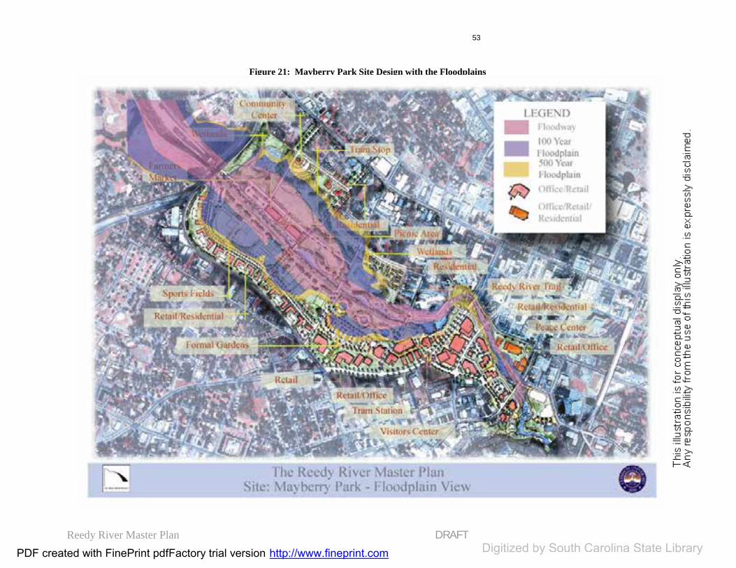
Reedy River Master Plan DRAFT
53
Figure 21: Mayberry Park Site Design with the Floodplains
PDF created with FinePrint pdfFactory trial version http://www.fineprint.com Digitized by South Carolina State Library

Reedy River Master Plan DRAFT
54
LAKE CONESTEE AREA SITEDESIGN
Site Description
Six miles from Greenville, down the Reedy River, is the mill village of Conestee. Vardry McBee constructed the millpond, the mill, and the village to house its workers in the 1830’s. An important and ironic theme to the storyof this village, and its millpond, is that ‘Conestee’ means ‘Land of Beautiful Waters’ in Cherokee.
During the 1940’s and 50’s, the construction of Greenville Army Air Base (Donaldson), and I-85 contributed enormous volumes of sediment to LakeConestee. Likewise, the post-WWIIsuburban development contributed manythousands of tons of silt to LakeConestee. The lake, once 145 acres, with two named islands, is now over 95 percent silted in fewer than 18 acres is covered with water no more than waist-deep.
Aerial photographs from the 1940’s, and since, show that as the Reedy’ssediments progressively filled the lake, wetlands have evolved and bottomland forests have colonized quickly in the silt deposits. Along with sediments from upstream, the residues from the 65 square miles of the Reedy’s watershedupstream, and from the last hundred years of Greenville’s industrial and population growth have been deposited in the lake. Metals from textile dyeingand electroplating operations, PCBs, hydrocarbon derivatives from our automobile society, pesticides from former agricultural operations and from our manicured lawns, and much wastewater sludge from many years of
minimal waste treatment upstream can be found in the sediments of LakeConestee. An abundance of trash from upstream landed in Lake Conestee, and with every new flooding event, tons more are deposited from Greenville’srunoff.
The Lake Conestee Foundation is a non-profit organization of concerned citizenswho sought an answer to the demise of the Lake and, similarly, the mill town that surrounds it. In September of 2000, after several years of planning,negotiations, and many meetings, the Conestee Foundation acquired the lake and dam, using monies from South Carolina’s Colonial Pipeline Settlement.Their goal is to improve the environmental state of the Lake Conestee area while creating a recreational and educational center forthe community.
The Lake Conestee site (see Figure 22), predominately composed of fragilewetland areas and floodplain and former landfill, includes the Greenville Braves stadium, residential areas, the Conestee Mill and Conestee Foundationproperties. See Figure 23 for a conceptual site plan of this area with an overlay of the floodplain.
Design Program The design program was developedbased on site conditions and communityneeds. Primary components include:
Public and private parks with: Sport fields and sport complex Passive recreation areas Picnic areas Nature trails Wildlife observation areas
PDF created with FinePrint pdfFactory trial version http://www.fineprint.comDigitized http://www.fineprint.comDigitized http://www.fineprint.com by South Carolina State Library

Reedy River Master Plan DRAFT
55
Environmental education center Textile museum Visitor center Office parks
- Offices - Restaurants
Design Concept
The program elements are arranged tocomplement natural site conditions,including topography, floodplain,vegetation, and surrounding land uses. The Plan: Provides public access to the
natural resource of LakeConestee;
Locates new developments of office parks in appropriatebuildable areas, clusteringbuildings around open spacewhich relates to the surroundingnatural environment; and
Organizes spaces in visualrelation to existing landmarks, such as Conestee Mill.
Pedestrian circulation, throughsidewalks, boardwalks and nature trails, provides opportunities for experienceswithin the natural environment. The Plan: Provides trails along the
floodplain perimeter to providedirect interaction with a unique environmental setting; and
Enables emergency access to pedestrian trails.
Proposed land uses increase diversityand opportunity within the area. The Master Plan: Introduces new office parks and
a sports complex as economicopportunities;
Proposes additional sports facilities, integrated with theexisting stadium;
Locates an environmenteducation annex in close proximity to neighborhoods; and
Proposes adaptive reuse of the existing mill as a visitor center,museum, retail area and environmental education center.
The Reedy River Trail system connectsLake Conestee to the greater Greenvillecommunity. The Plan: Utilizes existing easements and
public properties for access to and around the river and wetlandareas; and
Utilizes public roads for bicyclelanes and sidewalks.
PDF created with FinePrint pdfFactory trial version http://www.fineprint.comDigitized http://www.fineprint.comDigitized http://www.fineprint.com by South Carolina State Library

Reedy River Master Plan DRAFT
56
Figure 22: Lake Conestee Area Site Design
PDF created with FinePrint pdfFactory trial version http://www.fineprint.com Digitized by South Carolina State Library
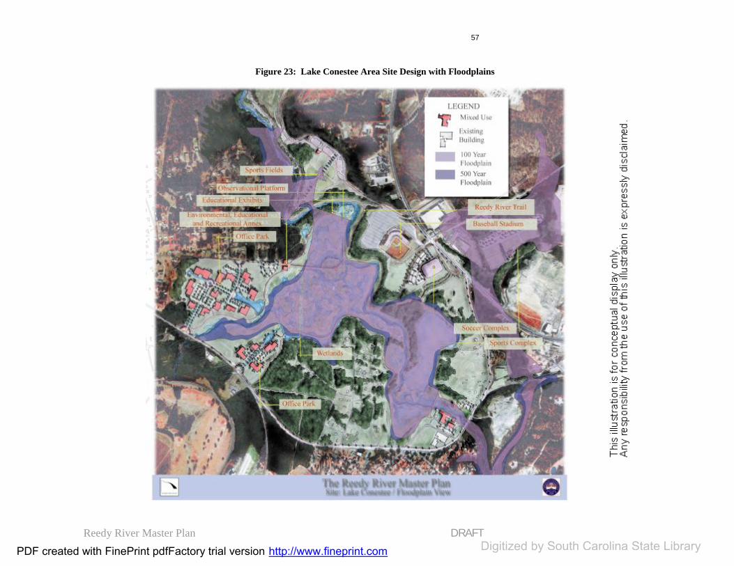
Reedy River Master Plan DRAFT
57
Figure 23: Lake Conestee Area Site Design with Floodplains
PDF created with FinePrint pdfFactory trial version http://www.fineprint.com Digitized by South Carolina State Library
Reedy River Master Plan DRAFT
58
#3-THE NORTH GREENVILLE YMCA
Site Description
The North Greenville YMCA site, located near the headwaters of the ReedyRiver in Travelers Rest, is in a primarilyrural setting. Adjacent land uses include golf courses, low-density residential communities, open fields and wooded areas. Figure 24 depicts the site designand Figure 25 shows a conceptual site plan of this area with an overlay of the floodplain. .Design Program
The design program was developed based on site conditions and communityneeds. Primary components include: •YMCA facilities
Sport fields Passive recreation areas Picnic areas Nature trails Amphitheater Children’s playground
Design Concept
The North Greenville YMCA is designated as the origin of the ReedyRiver Trail. The site is designed to reflect the connection to the larger trail system, utilizing the site’s open spaces, play fields, picnic areas and parking lots.From here, linkages can be made to other parks, downtown Travelers Rest and neighborhoods, and recreationalfacilities along both public access waysand the river way.
PDF created with FinePrint pdfFactory trial version http://www.fineprint.comDigitized http://www.fineprint.comDigitized http://www.fineprint.com by South Carolina State Library

Reedy River Master Plan DRAFT
59
Figure 24: N. Greenville YMCA Site Design
PDF created with FinePrint pdfFactory trial version http://www.fineprint.com Digitized by South Carolina State Library

Reedy River Master Plan DRAFT
60
Figure 25: N. Greenville YMCA Site Design with Floodplains
PDF created with FinePrint pdfFactory trial version http://www.fineprint.com Digitized by South Carolina State Library
Reedy River Master Plan DRAFT
61
STEP FIVE: IMPLEMENTATION
The Reedy River Master Plan is a long-term plan that will take several decades to implement. It is important for land use trends to be considered and predicted while implementing the plan.
The scope of the plan can be divided into four sections that need to be addressed for implementation: Land Use and Zoning; Land Acquisition; Environmental Issues; and Phasing of Implementation.
Land Use and Zoning
Reasons why land use regulations might be created within the study area of the ReedyRiver Master plan include water qualityenhancement/ conservation and economic development. As mentioned earlier, the study area is diverse in character and landuses. It is not pragmatic to develop one simple type of land use regulation for the entire study area. Rather, it is advisable to place overlay districts in specific areas ofthe study area that would benefit either environmentally or economically from such a regulation.
Future Land Use Both the City and County of Greenville are in the process of reviewing and/or revisingtheir land development regulations. A first step would be to bring zoning classifications in line with the above recommendations.Another step is to create overlay districts
around the Reedy River to recognize and enhance its specific character. In particular, overlay districts would be helpful in promoting water quality, reducing flooding,stabilizing the banks of the river, andproviding a foundation for recreation areas, trails and other developments.
Overlay District Zoning Overlay districts are zoning regulations that are placed on specified areas within a zoningdistrict, providing additional restrictions on the specific area. Overlay districts are useful because they can be tailored to provide the desired enhancement or protection that the area needs. The existing zoning district provisions may properly regulate the relevant district, in general, but more specific and targeted provisions contained in an overlay district are defined to accomplish pressing land use objectives. For example,the areas of the Reedy River that contain wetlands may have an overlay district that would prohibit development more strictlythan the immediate surrounding zoned area of which it belongs. In this way, thesurrounding area can maintain the development standards that are consideredappropriate for the area, while the environmentally sensitive area may be protected. Overlay districts may be designed forvarious types of regulatory needs:Watershed Management, Flood Hazard, Historic Preservation, Economic Development, View shed preservation, and Riparian Buffer Zones.
Although all of the aforementioned overlaydistricts may be useful throughout certainsections of the Reedy River Corridor, the
PDF created with FinePrint pdfFactory trial version http://www.fineprint.comDigitized http://www.fineprint.comDigitized http://www.fineprint.com by South Carolina State Library
Reedy River Master Plan DRAFT
62
plan specifically recommends the followingtypes of overlay districts:
Watershed Management and Protection Area Overlay (WMP): are intended to ensure the protection of watersheds surroundingcurrent or potential public water supplyreservoirs. The establishment of these regulations is intended to prevent the causes of degradation of the water supply reservoiras a result of the operation or the accidental malfunctioning of the use of land or its appurtenances within the drainage area of such water sources. This type of overlaydistrict usually establishes regulations on a certain width buffer strip to be maintained along the edge of any tributary stream or reservoir.
In the case of the Reedy River, the WMP overlay district should follow the river and generally extend 200 feet on each side. This width would vary according to local conditions: depending on the floodway and floodplain. Also, a WMP Overlay should be considered for the Reedy’s tributaries. Amore detailed study should be conducted in order to determine an accurate WMP.
Flood Hazard Districts (FH): are intended to protect the citizenry from injury or damage caused by seasonal or periodic flooding and to prevent pollution of the water body (i.e. the Reedy and its tributaries). The district is further intended to establish floodplain management criteriain flood prone areas. The FH district is further intended to regulate land use in portions of zoning districts, which are subject to flooding. This type of overlaydistrict usually establishes regulations within the floodplain areas.
Economic Development Districts (ED): canbe placed around the sites recommended for
development. The ED overlay district can define more explicit design guidelines and can impose more requirements for types of desired commercial use of the sites. This overlay district would typically be placed onthe city blocks that are targeted for redevelopment.
Overlay District Opportunities: Flexibility is the most important feature of an overlaydistrict’s creation. A balance of creating the regulations that are needed without inhibiting future growth and progress is what is desired; and difficult to achieve. Inthe case of this Master Plan, overlay districts could include a flexible zoning classification that would encourage innovative land planning and site design around the river, including mixed use, clustered developmentand open space as appropriate. Sites would be reviewed on a case-by-case basis for coherence. A design overlay district with setbacks, building heights and other features could also be considered. It is advised that an experienced consultant be used to develop the specifics of each overlay district to ensure the task be done correctly.
Land Use and Zoning Recommendations
General land use recommendations bySector: 1: Preserve rural, residentialcharacter and promote connections to Travelers Rest 2: Improve residential character &promote mixed-use in mills 3A: Improve and maintain parks, promote mixed use with residential components 3B: Maintain residential character
PDF created with FinePrint pdfFactory trial version http://www.fineprint.comDigitized http://www.fineprint.comDigitized http://www.fineprint.com by South Carolina State Library

Reedy River Master Plan DRAFT
63
4: Develop recreation complex around Lake Conestee & create linkages to town.
The City and County need to recognizeland use patterns around the river and identify the areas that require new zoning orrezoning. These areas include MayberryPark, the Lake Conestee area, the “TextileCrescent” and the Travelers Rest Business District.
Recommendations for Overlay Zones for the study area include:
Mayberry Park: This recreational site would be an excellent candidate for an overlay district for a couple of reasons: it encompasses a large area of wetlands, and it has a proposed amount of mixed use development that could spur economic benefits in the surrounding neighborhoods.If done correctly, the guidelines of the overlay can help implement both environmental conservation and economic development.
The Old TR High School and MillRedevelopments: As reuse projects, thesesites could benefit from overlay districts inorder to allow a mixed use in the sites morespeedily and with a more clearly definedplan of the methods that will be used for theredevelopment.
Lake Conestee: Like Mayberry Park, theLake Conestee area could benefit from an overlay district that contains guidelines for environmental conservation, recreational purposes, and real estate development of office space.
Strategies to Acquire Land
There are a variety of strategies that should be considered to obtain land for future trails, etc. These strategies fall into two main categories:
Landowner Benefactor Procedures Land Purchasing Procedures
Landowner BenefactorProcedures
Land donation can benefit landowners in a variety of ways: tax benefits, income taxdeductions, and improved quality of life within their neighborhoods.
The process of putting together traileasements requires the following:
A current listing of all propertyowners involved;
The ability to negotiate withlandowners on an individual basis;
Legal assistance; A land trust organization; and The ability to cover costs of surveys,
appraisals, legal fees and other costsassociated with the donation (this isnot a necessary action, but rather anadditional incentive).
Donations will usually fall under two types:
Trail Easements and Land Dedications
Trail Easements Trail easements enable the acquisition of use of land for trail purposes without obtaining
PDF created with FinePrint pdfFactory trial version http://www.fineprint.comDigitized http://www.fineprint.comDigitized http://www.fineprint.com by South Carolina State Library
Reedy River Master Plan DRAFT
64
full ownership of the property. A trail easement is a legally binding agreementbetween a landowner and a private landowner, organization or a public agency.In so doing, the landowner grants rights of public access within the trail area for aspecified period of time or permanently.This period-specific or permanent easement is attached to the title of the land, remainingin force when the property is sold or passed on to future generations of landowners.
The agency or organization that accepts the easement is responsible for monitoring the land (on an annual basis) to ensure the terms of the easement are met. In exchange, local, state and federal governments can provide income and/or other tax incentives.
Land Dedications Landowners and developers may dedicate corridors for trail use. This is typically donewhen property is being subdivided and developed. Dedications involve setting aside the necessary amount of land for trail corridors and conveying the land to the to a government agency or a non-profit land trust organization.
A government agency can require developers to dedicate specified percentageof land as an impact fee. Land may also be dedicated in exchange for incentives to the developer such as exceptions from zoningordinance requirements or an increase in development density.
Land Purchasing Procedures
There are several typical means topurchase land for trails:
Fee-simple Purchase The most expensive means of purchasingland, a fee simple purchase buys the full titleto a property and all rights associated withit.
Bargain Sale A bargain sale is a voluntary sale of the landby the landowner at a below-market valuefor trail development purposes. The benefit of this type of sale is that alandowner may take charitable deductionsfrom federal and state income taxes.
Right of First Refusal This type of purchase enables the agency tomatch a purchase offer received by thelandowner at a future time. This can bedisadvantageous due to potentially higherfuture costs of land.
Lease Purchase This method secures land through a five-, ten- or twenty-year lease, with conveyanceof ownership at the end of the lease term. Itis also possible to pass the land on as a donation at the end of the lease period. This enables the landowner to benefit from real estate income and, ultimately, charitabledonation tax advantages.
Land Acquisition Recommendations
The following are recommendations for theland acquisition process:
1. Compile a list of all landowners along the Reedy and the trailnetwork within the study area. 2. Attempt to meet with as many aspossible on an individual basis.
PDF created with FinePrint pdfFactory trial version http://www.fineprint.comDigitized http://www.fineprint.comDigitized http://www.fineprint.com by South Carolina State Library

Reedy River Master Plan DRAFT
65
3. Investigate all possibilities of trail easement and land donations.4. Purchase land that lies within the floodway and improve buffers zones as funding and other appropriationsarise.
Environmental Issues Recommendations
The following are recommendations for implementation designed to improve the water quality of the area:
1. Implement the recommendations of the Reedy River Task Force and DNR study.
2. Carefully consider andimplement as appropriate the future recommendations of current studies; such as the NPDES (the EPA’sNational Pollutant DischargeElimination System) and futurestudies that pertain the Reedy River environment.
3. Promote the agenda of the City of Greenville’s BrownfieldsStudy.
4. Create a greenway with trailnetwork throughout the 16-milestudy area.
5. Restore and create new riparian buffers.
6. Conduct a scientificallybased environmental study on the soils of the floodplain to determine more exactly the floodwaydimensions and appropriaterequirements for development in the study area.
7. Create a river corridor-wide environmental overlay district that
protects a wider developmentrestriction zone than the establishedfloodplain standards.
8. Purchase buildings that arewithin the floodway and demolishthem to ensure the integrity of the river.
9. Continue and expandvolunteer river corridor clean up program to remove and maintain the tidiness of the river corridor.
10. Develop the proposedEducational Center in the LakeConestee area to promote ecologicalawareness and responsibility.
PDF created with FinePrint pdfFactory trial version http://www.fineprint.comDigitized http://www.fineprint.comDigitized http://www.fineprint.com by South Carolina State Library

Reedy River Master Plan DRAFT
66
Implementation Phasing Recommendations
The Reedy River Master Plan is the result of a twelve-month process coordinated byClemson University's Center for CommunityGrowth & Change. The project emphasized public input and participation in which Clemson served as the facilitator among the public, city and county officials, and other Reedy River stakeholders in an effort to develop a master plan that can serve as a framework for development along thesixteen-mile Reedy River Corridor. As a result, an overarching concept has been created, which has generatedfundamental public support and involved both City and County officials.
While providing a general framework fordevelopment, the master plan also proposes a variety of specific projects, which would be most effectively pursued through coordinated actions by the city, the county,and the private sector. Efforts are proposedin the following areas:
Pathway and park development; Economic development; Using the publicly-owned railroad
corridor for a tram and trail; Promoting water quality; and Continuing public
relations/communication about the corridor.
The Table 3 depicts the progression of the implementation phasing that should occur
within the next decades. Map 16 accompanies the table to show where theimplementation activity will occur. The “Map #” column of the table is identical to the code number on the map.
Implementing the master plan is a long-term process. This process will require: Commitment to and a focus on the
corridor Significant funding from a variety of
sources Close cooperation among city and
county leaders, as well as members of the private sector.
Broad-based public support will also be a critical component for the successful implementation of the Reedy River Master Plan.
In short, significant progress has been madein the past year, as Greenville is moving to a shared vision based on community support and a period of City/County conversationsabout the Reedy area. The master plan summarizes this vision and identifies areas for long-term action as well as specific projects that are the starting point for action.
The city and the county should now consider the next steps in the planning process:
Refine and develop greatercommitment to the master plan
Complete detailed plans for specificprojects
Address the overall management and implementation of the plan.
PDF created with FinePrint pdfFactory trial version http://www.fineprint.comDigitized http://www.fineprint.comDigitized http://www.fineprint.com by South Carolina State Library

Reedy River Master Plan DRAFT
67
Table 3: Implementation Phasing
Conservation Easement Process (A)
Map # (1)
Short-term
1 – 5 yrs.(2)
Mid-term5- 10 yrs. (3)
Long-term 10+ yrs.
A.1 Identifyorganization,process, goals, standards
Thru Out
A.2 Obtaineasements
Thru Out
Trail Network Development (B)
Build Pathways (B1) Map
# (1) Short-
term 1 – 5 yrs.
(2) Medium-term
5 – 10 yrs.
(3) Long-term 10+ yrs.
B1.1 McElhaneyRoad
B1.1 (1)
B1.2 Berea Middle School Loop
B1.2(1)
B1.3 Westside Parkto River
B1.3(1)
B1.4 Linky StonePark to Cleveland Park (esp. path between Historic Falls Park and Cleveland Park)
B1.4(1)
B1.5 ClevelandPark to Greenville Tech.
B1.5(2)
B1.6 City landfill to Conestee Mill
B1.6(2)
B1.7 City soccerfield to ReedyRiver
B1.7(1)
PDF created with FinePrint pdfFactory trial version http://www.fineprint.comDigitized http://www.fineprint.comDigitized http://www.fineprint.com by South Carolina State Library
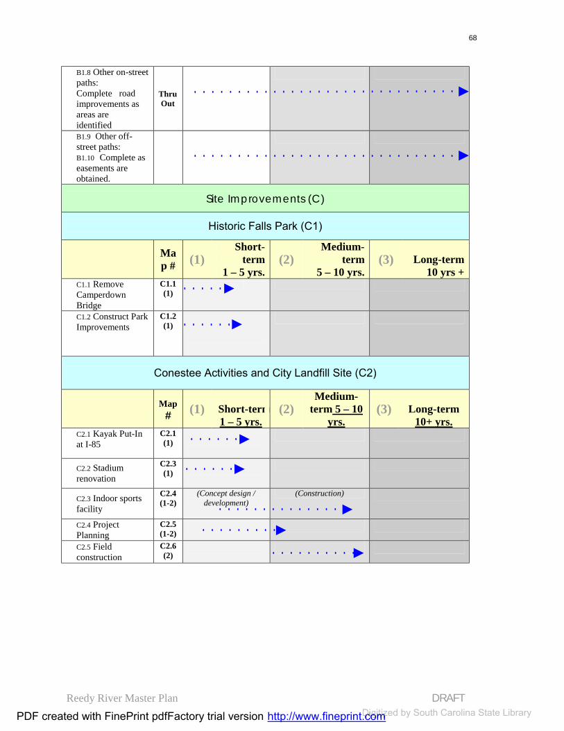
Reedy River Master Plan DRAFT
68
B1.8 Other on-street paths:Complete roadimprovements as areas areidentified
ThruOut
B1.9 Other off-street paths: B1.10 Complete as easements are obtained.
Site Improvements (C)
Historic Falls Park (C1)
Map # (1)
Short-term
1 – 5 yrs.(2)
Medium-term
5 – 10 yrs.(3) Long-term
10 yrs +C1.1 RemoveCamperdownBridge
C1.1 (1)
C1.2 Construct ParkImprovements
C1.2 (1)
Conestee Activities and City Landfill Site (C2)
Map # (1) Short-term
1 – 5 yrs.(2)
Medium-term 5 – 10
yrs.(3) Long-term
10+ yrs.C2.1 Kayak Put-In at I-85
C2.1 (1)
C2.2 Stadiumrenovation
C2.3 (1)
C2.3 Indoor sports facility
C2.4 (1-2)
(Concept design / development)
(Construction)
C2.4 ProjectPlanning
C2.5 (1-2)
C2.5 Fieldconstruction
C2.6 (2)
PDF created with FinePrint pdfFactory trial version http://www.fineprint.comDigitized http://www.fineprint.comDigitized http://www.fineprint.com by South Carolina State Library

Reedy River Master Plan DRAFT
69
Table 3: Implementation Phasing Mayberry Park (C3)
Map #
(1)Short-term
1 – 5 yrs.(2)
Medium-term
5 – 10 yrs.(3)
Long-term 10+ yrs.
C3.1 Corps of Engineers Study
C3.1 (1)
Public Lands (C4) C4.1 Development
planning Thru Out
City Services C4.2 Planning Thru
Out
C4.3 Relocation Thru Out
C4.4 Existing park improvements
Thru Out
C4.5 Propertyacquisition and development
Thru Out
Infrastructure Improvements (C5) Map
# (1)Short-term
1 – 5 yrs.(2) Medium-term
5 – 10 yrs.(3) Long-term
10+ yrs.
C5.1 Streets Thru Out
C5.2 Streetscapes Thru Out
C5.3 Water Thru Out
C5.4 Sewer Thru Out
C5.5 Parks Thru Out
Railroad Lines (C6) Map
# (3)Short-term
1 – 5 yrs.(3)
Medium-term
5 – 10 yrs.(3) Long-term
10+ yrs.C6.1 Private line (CSX spur)
C6.1 (1-3)
(Planning / purchase) (Removal) (Park development)
PDF created with FinePrint pdfFactory trial version http://www.fineprint.comDigitized http://www.fineprint.comDigitized http://www.fineprint.com by South Carolina State Library

Reedy River Master Plan DRAFT
70
Table 3: Implementation Phasing C6.2 GreenvilleCounty line
C6.2 (1-3)
(Planning) (Removal) (Park / tram dev.)
Private Sites (C7) Map
# (3) Short-term 1 – 5 yrs.
(3)Medium-
term 5 – 10 yrs.
(3) Long-term 10+ yrs.
C7.1 Private land development
Thru Out
PDF created with FinePrint pdfFactory trial version http://www.fineprint.comDigitized http://www.fineprint.comDigitized http://www.fineprint.com by South Carolina State Library
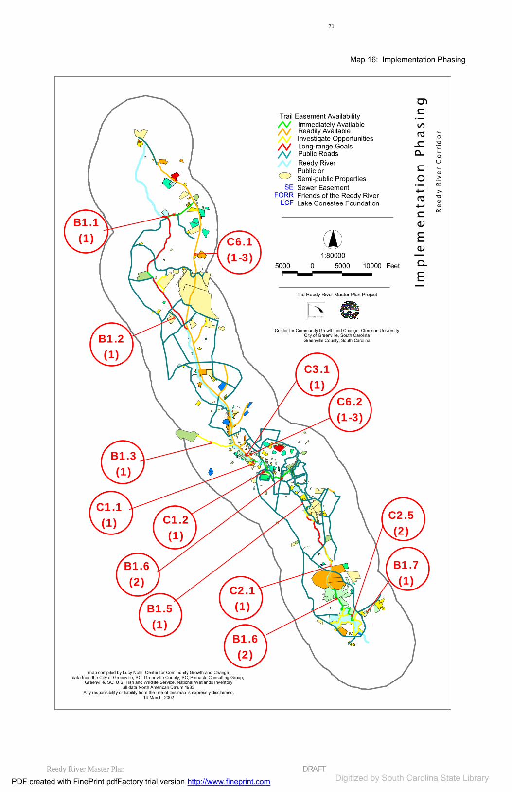
Reedy River Master Plan DRAFT
71
#
C3.1(1)
#
C2.5(2)
#
B1.6(2)
#
B1.7(1)
#
C1.1(1)
#
C2.1(1)
#
C1.2(1)
#
C6.1(1-3)
#
C6.2(1-3)
#
B1.1(1)
#
B1.2(1)
#
B1.3(1)
#
B1.6(2)
#
B1.5(1)
1:800005000 0 5000 10000 Feet
Center for Community Growth and Change, Clemson UniversityCity of Greenville, South CarolinaGreenville County, South Carolina
The Reedy River Master Plan Project
map compiled by Lucy Noth, Center for Community Growth and Changedata from the City of Greenville, SC; Greenville County, SC; Pinnacle Consulting Group,
Greenville, SC; U.S. Fish and Wildlife Service, National Wetlands Inventoryall data North American Datum 1983
Any responsibility or liability from the use of this map is expressly disclaimed.14 March, 2002
Imp
lem
en
tati
on
Ph
asin
gR
eed
y R
ive
r C
orr
ido
r
Trail Easement AvailabilityImmediately AvailableReadily Available
Long-range GoalsPublic RoadsReedy RiverPublic or Semi-public Properties
SEFORR
LCF
Sewer EasementFriends of the Reedy RiverLake Conestee Foundation
Investigate Opportunities
Map 16: Implementation Phasing
PDF created with FinePrint pdfFactory trial version http://www.fineprint.com Digitized by South Carolina State Library

Reedy River Master Plan DRAFT
72
Public / Private Partnerships
If we look elsewhere, we find that manyother riverfront communities have created public-private or public-public partnerships in the form of development corporations to assume the long-termfunctions associated with implementinga riverfront master plan. The River CityCompany in Chattanooga, TN, the Richmond Riverfront Corporation in Richmond, VA, the Riverfront Development Corporation in Memphis, TN, Mecklenburg County’s StormwaterPlan in the Charlotte, NC area, and the Louisville Waterfront Development Corporation in Louisville, KY are examples of carefully definedpartnerships between the public and private sectors to assume the role of master plan implementation. These communities recognized the need to establish formal relationships to solidifylong-term commitments to their projects, obtain necessary funding, and institute the appropriate legal relationships among entities.
A variety of factors must be in place before a community can considercreating a separate managing entity.These prerequisites include widespread commitment to the master plan, a clear funding plan, agreement and trust amongthe relevant public entities (and other parties in any active partnership) and specific plans for corridor improvements.
Applying the Case Studies to Greenville
Greenville is just beginning to explorethe specifics of the master plan, and the City and the County are in the formative stages of building and improving their relationship. This process should continue and specifics of the plan be more thoroughly developed. At this point in the overall process, a separate managing entity is not appropriate to oversee the implementation of the ReedyRiver Master Plan. Redevelopment of the Reedy River Corridor projected in the master plan, will require a long-term, coherent effortin terms of maintaining public support, focusing on site-specific projects, and developing and funding projects as noted in the plan.
However, the master plan identified a number of functions that may be pursued independently, while others will require greater cooperation. Economicdevelopment projects, water qualityissues, park development, and components of the pathways system maybe undertaken by a variety of separateentities. Specifically, both the City andthe County will need to apply for afederal storm water permit to better address water quality issues. In addition, portions of the pathways system can be implemented independently, but creatingthe entire system will require a coordinated effort between City and county governments as well as private sector stakeholders. Raising awarenessand generating public support will also entail cooperation by all parties.
PDF created with FinePrint pdfFactory trial version http://www.fineprint.comDigitized http://www.fineprint.comDigitized http://www.fineprint.com by South Carolina State Library

Reedy River Master Plan DRAFT
73
Next Steps for Greenville
Over the next year Greenville should undertake a number of actions toward improving the Reedy River Corridor using the Master Plan. Some of these actions would be taken independently bycity and county entities. Others will require cooperative initiatives.
Recommendations
1. Independent actions would focus on the specific projects identified by City,County and private entities consistent with the plan for park and pathwayimprovements (as noted in Table 3): Sector 1: Pathways at McElhaney Road &
YMCA construction Sectors 1 & 2 Work with the Greenville County
Economic Development Corporation (GCEDC) on the former Greenville and Northern rail corridor to clarify and rectifythe legal issues that are involved with reusing the Northern rail corridor.
Sector 3A: Removal of Camperdown Bridge
and Historic Falls Improvements Sector 4: Improvements near Lake
Conestee
2. Cooperative corridor-wide tasksshould be continued. These tasks include: Improving relationships and
understanding amongstakeholders;
Refining the master plan Developing trail easements and
pathways; and Maintaining a developing public
support for the corridor plan.
3. In order for the master plan to be implemented, it is proposed that the existing Reedy River SteeringCommittee continue to meet. This group will be responsible for raising awarenessof the plan, generating public support, and education. They would also oversee further refinement of the master plan.Working on these and related issues would also enable working relationships among the various entities to continue to develop.
4. The Steering Committee will need to be an advocate for trail development,while understanding the realities of including outside resources for expertise.Creating an informal task force of Steering Committee members, City and County Recreation staff and members of the community (including Upstate Forever, Friends of the Reedy and others) would be a productive means of understanding and working toward trail development. Other task forces may alsobe useful.
5. The Steering Committee will require staff assistance to support their efforts.While both county and city staff wouldbe involved in the process, a neutral professional resource would be most effective in this role.
PDF created with FinePrint pdfFactory trial version http://www.fineprint.comDigitized http://www.fineprint.comDigitized http://www.fineprint.com by South Carolina State Library


![JEREMIAH REEDY THE FAILURE OF PROGRESSIVE ...reedy/Samos07-ULTIssima-3[1].pdf1 JEREMIAH REEDY THE FAILURE OF PROGRESSIVE EDUCATION AND THE RETURN TO CLASSICAL MODELS “My advice to](https://img.pdfslide.us/doc/110x75/5b01dbf17f8b9a6a2e8ee43c/jeremiah-reedy-the-failure-of-progressive-reedysamos07-ultissima-31pdf1.jpg)