Embed Size (px)
Citation preview

Quirimbas national park
QU
IRIM
BA
S N
AT
ION
AL
PAR
KThe Quirimbas NaTioNal Park
• Extensive coasts with mangrove forests, white sand beaches, shallow water reefs.
• Impressive granite formations emerging from savannah and seasonal forests offering good birdwatching opportunities.
• Cultural heritage of the colonial Ibo Town.
Texts: Rebecca Phillips Marques, Francesco Tomasinelli
Drawings: Lodovico Magistretti
Photos: Francesco Tomasinelli, Muindi Onlus archive, Istockphoto
Layout and graphic design: Anna Dellacà, Francesco Tomasinelli, Lodovico Magistretti
© Copyright Muindi Onlus. All rights reserved
THE QUIRIMBAS NATIONAL PARK
Total area 7506 square km
Marine area 1522 square km
Land area 5984 square km
Freshwater area 220 square km
Date of creation June 2002
Population 120 000 inhabitants
in the Park as a whole,
including 20% on the coast
A Guido

Quirimbas national park

presentation
This guidebook provides an invaluable
insight into the unique natural, cultural
and historical resources of the Quirimbas
National Park: 7500 square kilometres
of woodlands, granite inselbergs, coastal
forests, white beaches and coral reefs, home
to a rich terrestrial and marine wildlife.
The area is inhabited by about 120,000
people, whose livelihoods mostly depend on
natural resource utilisation. Consequently,
the park is committed to working with
local communities and the business
sector to ensure that the benefits and the
responsibilities of managing the natural
resources in a sustainable way is equally
shared among all actors. In this context,
ecotourism is one of the most promising
economic sectors where environmental
conservation and socio-economic
development can be successfully combined.
The Park is therefore extremely grateful to
the Milan Municipality, Muindi Onlus and
its partners (Istituto Oikos and University of
Insubria) for having funded and implemented
3

the project “The treasure of Quirimbas”
whose main objectives were to make the Park
well-known and appreciated in Mozambique
and abroad and to set up and train local
organisations of tour guides.
This guidebook, the first and the only
available for the area, will contribute to
reaching both objectives. It will be a key tool
to promote and serve local and international
tourism. But it will also increase the local
people’s awareness and responsibility about
the key role that they can play as custodians
of the unique historical, cultural and
environmental heritage of the Quirimbas
National Park.
4 presentation
Pieter Jacobs from ‘CI Divers’ for diving
assistance and provision of his library
on fishes of the Quirimbas Islands; and to
Kimble Perry for the language translation.
A particular aknowledgement is due to
the Milan Municipality which
provided funds to run the
project and to prepare
this book, to the main
implementing
partners:
Quirimbas
National
Park,
Istituto
Oikos and
University of Insubria; and to Kaskazini
Travel for the invaluable information
provided and the contribution to promoting
tourism in the Park.
Lastly, Muindi Onlus wishes to thank the
participants in all meetings, discussions and
interviews organised by the project who share
the willingness to make a positive contribution
to the conservation of the Quirimbas National
Park’s natural and cultural resources.
This guidebook is the result of the
collaboration of many organisations and
individuals, from the development, scientific
and institutional worlds, which contributed
to running the project “O tesouro das
Quirimbas: conservação e desenvolvimento
sócio-económico do Parque Nacional das
Quirimbas, Moçambique” and to preparing
this publication. Muindi Onlus wishes to
warmly thank all of them. Special thanks are
due to the project manager, Rebecca Phillips
Marques, who contributed to the preparation
and revision of the text and was an invaluable
guide across the park; to Emilio Scoti and
3zero2tv spa for the promotional video; to
José Dias (Park Warden), Mark Hoekstra,
Eusebio Celestino and João Manuel from the
Quirimbas National Park Headquarters, for
their scientific and technical assistance; to
Anser Sufo for providing the bird monitoring
reports of Kagavero Lake; to Jakob Van
Landsberg from ‘Taratibu Bush Camp’,
Dominik Beissel from ‘Mareja Community
Conservation Project’ and Carlo Fornaciari
from ‘Residencial Reggio Emilia’ for their
suggestions, advices and lodging services; to
acknowledgments
acknowledgments 76

Introduction to the Quirimbas National Park ................. 11
Travel tips ................................................................ 12
Pemba ...................................................................... 15
Quirimbas National Park: coastal areas ..................... 23
Introduction to the environment .............................. 24
The Quirimbas Islands coast.................................. 24
Exploring the mangrove forest: Trees on stilts ....... 26
A refuge for migratory birds.................................. 32
The Fish Sanctuaries ............................................. 35
Diving into the reef ............................................... 37
Travel tips ............................................................... 41
Tourism in the coastal areas .................................. 41
Access to coastal areas ......................................... 54
Ibo history ............................................................ 57
Quirimbas National Park: inland areas ....................... 63
Introduction to the environment ............................... 63
The Park interior ................................................... 63
Climbing an inselberg ............................................ 65
The big gathering around the lake ......................... 70
The conflict between humans and wildlife ............. 74
Travel tips ................................................................ 77
Tourism in the interior of the Park ......................... 77
Lake Bilibiza and Lake Kagavero ............................ 87
Access to internal areas ......................................... 89
summary
9

Introduction to the Quirimbas National Park
The Quirimbas National Park, founded in 2002, is Mozambique’s newest and probably most varied protected area. With 7,500 km2 of miombo woodland, coastal forest, granite inselbergs, mangrove stands, coral rock islands and vast intertidal sand flats, the Park hosts an impressive variety of plants and wildlife, with more than 430 species of birds.The Park is also home to over 120,000 people, whose livelihoods mostly depend on the natural resources around them. As such, the Quirimbas National Park management – with technical assistance from WWF – tries to resolve in the Park the difficult balance between the needs of local population and the protection of wilderness and natural heritage.
11

Travel Tips
When to go
Northern Mozambique has two distinctive seasons. The rainy season is from january to may, with frequent downpours. Most of the 1200 mm of water expected in the area falls during these months. During the rest of the year only scattered rains are observed. Along the coast the weather is usually less harsh, with occasional rains all along the year and beautiful cloud-scattered skies in every season.Typical temperature ranges from 20 to 35 C, the hottest and most humid months being january and february. The period after the end of the rainy season (from may to july) is one of the best to visit the Park, because the miombo forest is lush and green; but it can be more difficult to see bigger animals. The best period to observe them coincides with the end of the dry season, in november and december, when they congregate around water pools. Along the coast, from november to january, big flocks of birds wintering from colder regions can be seen.
What to bring
The coastal section of the Park doesn’t require particular clothes or equipment, but remember to bring good walking sandals (not flip-flops) to move easily on tidal flats covered with dead corals. Sunglasses, sunscreen and a hat are very useful in every season. Snorkeling equipment will be very useful too, because places to rent it are limited and expensive.In the savannah and miombo forest or when climbing inselbergs is better to wear long trousers and long sleeves to prevent mosquito bites and cuts from spiny
12 introduction to the quirimbas national park introduction to the quirimbas national park 13

vegetation. Do not forget an insect repellent too and a light portable headlamp for field trips at night. In this part of the Park light walking shoes are ideal. Wherever you go you will need binoculars, the most essential part of the equipment: animals are quite wary and you will need magnification for a better view.
travel diseases
Malaria prophylaxis is important in the area, especially during the wet season, because of the abundant human population. Other useful vaccines are yellow fever
(quite rare in Mozambique), hepatitis A&B, typhoid. It’s always best to bring an anti-diarrhoea remedy and an insect bite relief.
pembaPemba is the capital city of Cabo Delgado province, in the far North of Mozambique. It is located on a peninsula at the mouth of Pemba Bay, the third largest deep-water bay in the world. The city – then called Porto Amelia – was founded in the early 20th century by Portuguese colonists, around the existing fishing village of Paquitequete. As such, the oldest and most attractive (if very run-down) part of Pemba – the Baixa – is located close to the port and to Paquitequete, but most of the modern town, shops, banks, restaurants, etc. are located on the hills behind the Baixa.
Pemba is small enough to explore on foot, but taxis, chapas (minibuses) and hitching a lift can help to beat the heat. The Pastelaria Flor D’Avenida, on Avenida Eduardo Mondlane, is a convenient central spot to stop for a drink and Portuguese-style pastry. Most of the banks are located on this avenue, but you can also find cash points at the airport and on Wimbe beach. Banking hours are 8 am-3 pm.
14 introduction to the quirimbas national park

Wimbe beach, diving, fishing and snorkelling
Wimbe beach, some 10km outside Pemba town centre, is where you will find most tourism infrastructure, including hotels, restaurants and bars. The beach is attractive with its white sand, clear water and coconut trees, and is also the place to find two of Pemba’s three dive shops – Pemba Dive and CI Divers (at Nautilus Hotel, or find the owner at his guest house/restaurant, Pieter’s Place). Pemba Dive is run by the owners of Pemba Bush Camp – a beautiful property inside the Bay with bungalows, dormitory, camping, a restaurant and a private mangrove-fringed beach. The third dive centre is at the Pemba Beach Hotel’s Clube Naval, where you can also rent canoes, hoby cats and the like, or enjoy the restaurant, bar and swimming pool.
Pemba offers a great range of dive sites suitable for all levels. Shallow coral banks with a large variety of reef fish are ideal for beginners, whilst experienced divers
will enjoy wall and drift diving, where pelagic species and huge coral fans are the main attractions. All three dive shops also offer PADI courses. The snorkeling is also excellent, either off Wimbe Beach or across the Bay at Ponta Saide Ali, making for a pleasant day-trip. Enquire as to whether there are any dhows available for day-sails. These traditional Arab sailing boats are typical of the Swahili Coast in East Africa, and are a wonderful way to explore Pemba Bay and the surrounding area.
Game fishing is another of Pemba’s leading attractions, with the distant Lazarus Banks attracting serious fishermen from around the world. Dorado, yahoo, sailfish, kingfish and tuna are commonly caught, and several operators based in Pemba offer full- and half-day charters.
Large numbers of humpback whales migrate past Pemba between July and November, often accompanied by calves. While they can be observed from the shore, it is also possible to organize whale-watching trips for a closer look, and dolphin safaris are available year-round.
Kaskazini, a local tour operator with an office at the Pemba Beach Hotel, can organize all of these activities, and more, as well as booking accommodation and transfers. Their website is an excellent source of information on Northern Mozambique: www.kaskazini.com.
introduction to the quirimbas national park 17

the southern beaches
Chuiba Beach, 6 km from Wimbe, is a stunning tropical beach of white sand and turquoise waters. Chuiba Palms offers affordable self-catering accommodation and B&B, and its beach-side pool and bar are open to non-residents. Chuiba Bay Lodge is an up-market option, 1km further down the same beach. A larger hotel further along Chuiba Beach will be opening in 2012.
Multinational Murrebué, 3 km to the South of Chuiba, or 20 minutes from Pemba taking the airport road, is a continuation of the same beautiful beach, with a little mangrove for variety, and offers several options for accommodation, including Il Pirata (Italian-owned and the kite-surfing capital of the North), nZuwa Lodge (American/German), Isanja Bungalows (English), Ulala (French), and Upeponi (Mozambican), which also has a restaurant open at week-ends.
lake nikWita
A drive to Lake Nikwita, passing through Mieze and Metuge villages, is an enjoyable day-trip from Pemba. Pack a picnic to enjoy in the shade of the lakeside trees while you watch hundreds of water birds on the lake. An early start will guarantee keen bird-watchers a good variety of species. Local fishermen pole dug-out canoes across the water and will probably take on a passenger wanting a closer look.
transport: car rental and buses
For car rental (also 4x4s), Moti Rent-a-Car, Imperial Car Hire and Sixt are all based at the airport. Juma Rent-a-Car can be found half-way down the hill from the airport into town.
Mecula coaches to Mueda, Mocimboa da Praia, Nampula and Nacala leave from the Mecula depot in town, behind Osman Yacob Supermarket, next to Trak Auto. To secure a seat you must be there at around 4.30 am. Several Tanzanian buses serve the same and other routes.
18 introduction to the quirimbas national park introduction to the quirimbas national park 19

20 introduction to the quirimbas national park introduction to the quirimbas national park 21
lake BilibizaRioMontepuez
Rio Aquite
Rio Menapo
Rio Muaguide
Rio Montepuez
Rio Unculo
Rio Sicoro
MarejaLondo
Namau
Meluco
Taratibu
Muaguide
Bilibiza Mahate
Quissanga
Guludo
MucojoManiaco
Macomia
Namacula
QuilaleaSencar
Mefunvo
Quisiva
Quipaco
Quirimba
Ibo
Matemo
Pemba
Qu
ir
im
ba
sI
sl
an
ds
i n s e l b e r g a r e a
Ilha das Rolas
Ancuabe
Metoro
Macaloe
Metuge
Miezi
Quirimbas National Park 0 10 20 30km
boats
National Park boundary
inselberg area
centres, villages and facilities
paved roads unpaved roads
lakeKagavero
Pangane
to Nampula andIlha de Moçambique
to Montepuez
to Tanzanian border

Quirimbas National Park: coastal areas
Aerial view of Quirimba Island and Ibo Channel

Introduction to the environment
The Quirimbas islands coasTFrom the air the green line of the mangrove and the coastal forest are interrupted only by the outlines of light colored beaches. The shallow surrounding waters pass from turquoise signalling sandy bottoms, to brown, where the depth is at its minimum and the rocks begin to break the water surface. Seen from so high up, the islands of the Quirimbas National Park can only give the impression of a classical tropical paradise.
Upon arrival in the field, surrounded by coastal vegetation, it is easily understood that, though beautiful, this is still a quite wild undomesticated place. Also here, there are spacious beaches, framed by typical tropical island palms. This is not the prevalent scenery, which is instead the one that
The unique mushroom-like
rock formations of Quisiva Island
cedes to extended mangrove growth, the only plants to survive in an area with high tides: up to 4 meters in some areas. This constant tidal rise and fall have shaped the special morphology of this coast line, made up of an immense platform of lime rock, which is what is left of the long dead ancient coral reef, emerging from the water twice a day according to the tidal ebb and flood. At times, like on the island of Quisiva, from this uniform solid extension rise up bold formations of dark lime: like giant dark stone mushrooms that stretch up to even 15 meters tall, with their peaks still covered with vegetation. These spires are products of thousands of years of impact with the sea which has eroded the foundations of the old reef, and left the upper part of the mushroom intact. The sand, brought in by the winds and tide, is everywhere, and in contrast is light colored and very fine, the result of the progressive erosion of the coral banks located out in the open sea. But, before exploring the great expanses of coral, let us take a closer look to the forests of mangroves, one of the most important natural surroundings in the Park.
A young mangrove emerging from a lagoon
A crab eriphia smithii on tidal flats
introduction to the environment 2524

exploring The mangrove foresT: Trees on sTilTsThe Quirimbas islands’ mangrove forests are everywhere along the coastal strip, even though they are more concentrated in the area of Ibo island. Mangroves are very special and peculiar trees, with their long roots raising the tree trunk up from the ground. They have adapted to grow on soft inter-tidal terrain, that is mid-way between solid ground and sea water. Rarely they can grow taller than ten meters (and they are often much shorter) but they make up an essential habitat of the tropical coast: they offer resting places and nesting homes for dozens of bird species, as well as being the preferred environment and nursery for small fish and invertebrates.
Imagine, in early morning, moving along one of the many lagoons which line the coast of the Park. Radiant sun highlights the dense weave of the tree roots, so similar to stilts, which allow the plants to stay well anchored in the mud and the sand of the island. The soft substrate does not permit an
adequate exchange of gasses between the roots and the atmosphere, and for this reason every plant extends its ‘wooden fingers’ (called pneumatophores) out up from the mud, which allow the plant to ‘grab’ the oxygen it needs to breathe.
Gazing up in the direction of the tree canopy, we can see a dense mat of green that sparkles and glistens in the early morning light, and appears to be the border of most of the coast. What seems to be a uniform tract is in reality a mosaic comprised of diverse species: Bruguiera gymnorhiza and Avicennia marina are the most common trees along the shore, while the even more abundant Rhizophora mucronata is more frequent inland. In front of us, towards the open sea, the lagoon stretches out, at this point engaged in low tide. Only a few cm of water cover the long defunct coral reef partly covered in sand. But these ancient coral and rock formations have not been smoothed down; instead, they are another intricate mosaic of holes, crests and ridges, knobbles and twists formed by the erosive lapping of salt water in movement. It is impossible to walk here without proper protection. Only a few steps are required to see one of the most typical inhabitants of this territory in transformation, the serpentine starfish [an Echinoderma of the class Ophiuroidea]. It is a close relative of the ever familiar starfish, with flexible arms with which it gathers up organic material from the sea bottom. Every square meter of coastal rock can host dozens of these diverse species, some that get even bigger than 25 cm in diameter.
The deeper areas, where the water becomes turquoise, are often carpeted by an underwater prairie which needs a constant intake of sun in order to flourish. These temporary ponds are populated by many small fish
A channel in the thick mangrove forest of Ibo
Mangrove roots emerging form an internal lagoon
introduction to the environment 2726 coastal areas

that move as soon as the tide rises. Every so often, in the low tide, some reef fish can end up trapped in one of the larger water holes where they become easy prey for the herons.
A watery thump announces the presence of an osprey just after it has plunged into the shallow waters of the lagoon in the hope of catching a fish near the surface. Lesser crested terns zip and dash around the osprey. These elegant small sea birds, which look similar to little gulls, are formidable small fish predators. Where a layer of rock sticks up out of the water’s surface, the dimorphic egret with its characteristic blue-grey plumage, hunts in the shallow waters for small vertebrates and fish. This is one of the most common birds in this environment,
but to be noted is that it is not the only one to profit from the tide flow to feed itself. In the background, on a beach at the foot of the mangrove forest, dozens of plovers, curlew sandpipers, whimbrels and greenshanks can be seen as they take advantage of the low tide to find small invertebrates in the soft sand. Each bird has its own method for locating its prey: the whimbrels sound the depths of the soft sand with their long curved bill, while the plovers dash forward in spurts to catch up with whatever is moving on the soft damp terrain.Further back towards the dry section of the beach, made of coral sands, a mesh of tracks becomes visible, made by thin parallel grooves, These are the tracks left by the hermit crab (group Coenobita)
Dimorphic egret on tidal flats
Mangrove roots allows the plant to perform gas exchanges in the thick mud
introduction to the environment 2928 coastal areas

during their nocturnal pilgrimages. Thousands can be seen in just a 100 meters of coast line, of every size, some are coin- sized, other rare ones carry shells up to 20 cm long with them. They are fabulous ‘beach sweepers’, capable of consuming most of the organic material marooned on the sands. Other than birds and hermit crabs, larger crabs are the definitive protagonists of the mangroves. The salty surroundings are not really ideal for insects, reptiles, and amphibians, which, in fact, are quite scarce (in comparison to tropical averages), and has freed up space for crustaceans which push their way well inland. The beaches and surrounding rocks are home to the swift ghost crabs who dig very deep holes in the sand. In between the mangrove roots the smaller
fiddler crabs are visible due to their surprising bright colors, allowing one to consider them tiny mobile works of contemporary art. The males are the most colourful, because they have to impress the females in order to convince them to mate. Their single big claw is not a weapon, as many believe, but a tool to increase their seductiveness: it is waved slowly to attract the female’s attention.
Aiming the binoculars towards the row of plants along the coast one can just barely see in the distance the outline of a goliath heron poised in waiting, the biggest heron in the world, almost as tall as a man. The omnipresent dimorphic egrets are part of the scenery as they walk along the embankments. An intense and characteristic trill-like call, comes to our attention. It is the mangrove kingfisher, a beautiful grey and turquoise bird,
who is easier to hear than see. Above, among the mangrove leaves, a yellow-billed stork can be seen ever so vaguely. They nest in trees along the shore and pass the large part of their day hunting in the lagoon, together with the long curved- billed ibis. In the distance up in a dead tree against the light is the silhouette of a large raptor, the African fish eagle, the true sovereign of these coasts. It feeds mainly on fish but if the occasion presents itself it will take the opportunity to hunt down big birds in difficulty. Deeper into the vegetation, our surroundings get denser, thanks especially to the work of the mangrove tree roots towards creating stability for the islands’ coasts. This marks the progression towards the tree-dotted savannah of the central inland areas of the Park.
Many of these mangrove forests were cut down and destroyed in the past, to make way for agriculture and boat landings. Mangrove wood, solid and so dense that it sinks, is also used for wharves, stilt foundations (pallafitte) and boat sections. The role of the forests has heretofore been underestimated, until in 2004, when the well consolidated mangrove forests of South East Asia proved to have contained the tsunami damage wreaked along the large part of the coastal nations. The roots of these plants, in fact, baffled the force of the waves, and at the same time, the tree canopies buffered the strong coastal winds.
A cushion starfish (Culcita schmideliana) in the tidal pools of Quisiva Island
Ghost crab emerging from his hole in the sand on a remote beach
introduction to the environment 3130 coastal areas
Not to mention, in general, the forests’ importance as an environmental refuge and stopover protection for migratory birds passing along the African coasts.
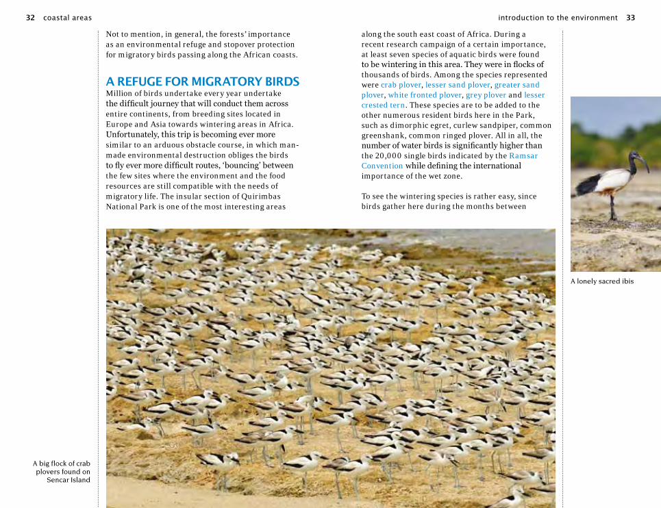
a refuge for migraTory birdsMillion of birds undertake every year undertake the difficult journey that will conduct them across entire continents, from breeding sites located in Europe and Asia towards wintering areas in Africa. Unfortunately, this trip is becoming ever more similar to an arduous obstacle course, in which man-made environmental destruction obliges the birds to fly ever more difficult routes, ‘bouncing’ between the few sites where the environment and the food resources are still compatible with the needs of migratory life. The insular section of Quirimbas National Park is one of the most interesting areas
along the south east coast of Africa. During a recent research campaign of a certain importance, at least seven species of aquatic birds were found to be wintering in this area. They were in flocks of thousands of birds. Among the species represented were crab plover, lesser sand plover, greater sand plover, white fronted plover, grey plover and lesser crested tern. These species are to be added to the other numerous resident birds here in the Park, such as dimorphic egret, curlew sandpiper, common greenshank, common ringed plover. All in all, the number of water birds is significantly higher than the 20,000 single birds indicated by the Ramsar Convention while defining the international importance of the wet zone.
To see the wintering species is rather easy, since birds gather here during the months between
A big flock of crab plovers found on
Sencar Island
A lonely sacred ibis
introduction to the environment 3332 coastal areas

november and february, with an steep increase in the months of december and january. They tend to stay mainly in the lagoon areas during the low tide in order to feed. Matemo, Ibo and Quirimba islands offer an ideal environment with vast expanses of wet mud abounding in food sources. During high tide the birds tend to gather together in their preferred sites above in the trees (shelter or dormitories roosts) while awaiting the tide to subside and expose the food- rich mud flats once again.Monitoring data indicates that 70% of the birds
are distributed among a reduced number of sites which occupy less than 5% of the coast. Total and absolute protection
of these sites is therefore a conservation priority, which in any case does not seem
incompatible with the eco-sustainable development of the Park areas in which villages and traditional fishing activities are concentrated. The current priority is to identify the key areas for the aquatic birds along the northern coast of the country, and with that information to adequately protect them while also training Mozambique personnel in bird survey techniques.
Lesser crested terns in flight along the beach
The fish sancTuariesIn 2007, the Park initiated an experimental project aimed at involving the local population in the management of their fishing resources. The first step was to set up an intricate patchwork of protected areas in which fishing would not be allowed, to be enlarged year by year. The core principle is elementary: when the fish are no longer taken from these protected areas, they exceed the protected territory and expand into the unprotected areas, from which they can be caught. This proves advantageous to the resident fishermen, who will benefit from a larger haul of fish. The initiative has gained the good-will of the people, so much that the fishermen themselves have called for the establishment of new protected areas. Without a doubt, the ground-breaking aspect of this project has been the involvement of the local community. The system has been able to function, however, because the impact of fishing in the Quirimbas is not as devastating as in other areas of Africa. This is because the traditional forms of fishing
A fully grown emperor angelfish in the reef
introduction to the environment 35

diving inTo The reefAll of the archipelago’s islands are essentially in direct connection with the coral reef. On the eastern borders of the archipelago, those facing the open ocean, is where the large part of the coral formations can be found. We see here the ancient reef, defunct and reduced to an irregular outreach of rock extending for hundreds of meters into the tidal zone before dramatically dropping off into the Indian Ocean. In many cases, the rock cedes to vast sandy expanses of seagrass beds, such as Thalassia hemprichii and Thalassodendron ciliatum, which cover the seabed with green fronds. Despite appearing to be seaweed, these are, instead, truly plant forms of life and grow in shallow waters of two to three meters deep. They are fed upon by many life forms, like green turtles. These plants are not everywhere, as soon as the visiting diver moves offshore the coral reef inevitably appears again.
The Quirimbas Islands’ coral formations can be considered to be in healthy condition: they do not suffer from the docking of big ships or the destructive effects of fishing equipment and have not been subject to any serious damage due to
are still being used: small hooks, hand-held harpoons, basket traps and drop nets of smaller dimensions. The large fishing trawlers, indicative of industrialized fishing, are not present in the waters under the Park’s jurisdiction.Currently there are six fish sanctuaries where all types of fishing are forbidden: Ilha das Rolas, Matemo, Ibo, Sencar, Quipaco and Namaco. On the other hand, recreational and touristic activities are allowed in these restricted areas. The Park surveillance and monitoring service, based in Ibo, is responsible for enforcing the restrictions. It must be said that infractions are few because this preservation strategy is shared by the local population. Currently, the Park is looking into the quantification of benefits gained through the establishment and maintenance of the protected areas. Meanwhile, local fishermen have continued to define a new series of protected areas of limited fishing, based on rotational access.
Red-knobbed starfish, Protoreaster linckii, often found in seagrasses and in tidal pools
A green turtle, the most common species in the Quirimbas reef and seagrasses
introduction to the environment 3736 coastal areas

‘bleaching’ (coral death caused by raised water temperatures and other climatic variations) which have occurred in other areas of the Indian Ocean. The morphology of the seabed and the presence of often cloudy waters temper the beauty of the reefs in comparison to other nearby diving localities in Madagascar and the Red Sea. But the richness of fish fauna is surprising anyway. One of the areas home to some better preserved reef are to be found in Quilalea, at the heart of the archipelago, directly in front of Quilalea Lodge, fully furnished with diving equipment. It is easy to imagine oneself diving in the warm waters of the barrier reef, which stay within a constant temperature range of 25 to 30 degrees Celsius. The island’s small beach rapidly falls away to a depth of two meters in a distance of less than ten meters from the shore (taking into account the tide table), where sand gives way to the reef itself.A complex labyrinth of intertwining reef corals takes form down below the water surface. The globular formations of the mushroom corals and the gigantic Porites, similar to enormous sponges, grow in close contact with the spectacular branches of Acropora. In the more protected areas, the whip corals rise up
from the seabed for more than a meter in length, giving life to formations similar to coloured springs. Looking around, the diver can see a continuous dancing of reef fish, to mention a common one: the goldbar wrasse. Below on the seabed, framed by two rocks, an anemone is home to a family of Allard’s clownfish who boldly chase away any fish who come close to their shelter. As a matter of fact, they are so courageous that they will sometimes even challenge divers who get too close.When looking carefully among the coral, each ravine or crevasse holds a surprise, like the younger phase of the emperor angelfish. In their hypnotic livery of concentric circles, blue, white and azure, they are certainly one of the most spectacular fish of the reef. As adults, when bigger than 30 cm, they completely change colours and become grey and azure with a complex mesh of yellow and black strips. An orange-stripped trigger fish systematically explores the smaller corals for any lesions or cracks to make its own dent in the formation, while a group of small two-toned chromis, with their characteristic black and white coloration, shifts away.At the seabottom, a tuft of brown seaweed slowly waves in the current. Something strange is lying
A Mozambican reef in shallow water
Ghost crabs in the waves, found on every major beach
A small fishermen vessel used for short cruises
introduction to the environment 39

Travel tips
Tourism in The coasTal areasEleven of the beautiful Quirim-bas Islands lie within the QNP, and these, along with 100km of undeveloped shoreline, are the Park’s main tourist attractions. A combination of powder white-sand beaches, clear, warm waters and vibrant coral reefs make the QNP an up-and-coming destination for scuba diving and snorkelling. Game fishing is also permitted outside the marine sanctuary areas. Quilalea
and Matemo islands – both offer-ing top-end accommodation – are at the moment the only islands with scuba diving facilities, but both offer exceptional dive sites. The Quilalea home reef – right in front of the main beach – is an easy but beautiful dive, teeming with reef fish and eels. More experienced divers will enjoy the Canyon, where currents attract pelagics and sharks, and drift-diving off neighbouring Sencar Island. Turtles and dolphins are regularly sighted. Matemo offers a number of easy dives and fantastic snorkelling,
With over two meters wing spread and weighing almost four kilos for the female ( the males are smaller by 20%) the African fish eagle is one of the most memorable raptors and one of the continent’s classic symbols. The most evident characteristic is the white head with its yellow beak, quite similar to the American Bald Eagle, making it unique among the predatory birds in the area.
Salt-water fish eagles feed mainly on fish, which they catch with their long curved talons as they skim along the water surface. They usually catch fish weighing less than a kilo but in special circumstances the eagle can seize a fish double the normal size, obliging the bird to plane the prey along the water’s surface, unable to lift it out completely. Their diet is not limited to fish: the fish eagle is a raptor ready to take advantage of any situation, like catching large water birds, reptiles and small mammals. It is also capable of stealing food away from other types of birds, such as herons and storks.
The pairs mate for life and are both sedentary and territorial. The breeding season almost always coincides with the dry season, when water levels are low and makes prey easier to catch.
Where and how: The eagle is common throughout the year along the coastal area of the Park but easier to see in Kagavero and Bilibiza Lakes. The Park’s bird population is less dense in comparison to the African great lakes area. A day-time predator, it is usually seen perched on high, more often than not high up in a dead tree facing the water surface.
description: bird of prey (Accipitriformes), up to 75 cm longdistribution: the entire African sub-Sahara, but always near large water reserves. Found along the coast but more common inland.
african fish eagle Haliaeetus vocifer
among the fronds, and it is not easy to work out what it is. Our gaze runs over all the profiles and green shapes until landing on an eye: one of the most surprising molluscs of the reef, an Octopus cyanea has hidden itself deep in the seaweed. Arch camouflage artist, this sea creature is able to imitate both shapes and colours of the seabed surrounding it. It is more inclined to move about at night, rather than in daytime, while it hunts down other molluscs and crustaceans. The octopus begins moving about slowly by ‘walking on’ its tentacles, but then quickens its pace only to disappear into a crevice in the rocks. It has just seen a 60 cm long peacock grouper come nearby; this is one of the bigger predatory fish which cruises along the edge of the seabed.In the direction of the open ocean, at around a depth of a dozen meters, a wall of circular batfish, with their odd flat forms, comes into our line of vision. The outside margins of the barrier reef are a dangerous place for small fish. We meet up with only animals of a demonstrable size or the microscopic plankton. Only the long-nosed butterfly fish or some small groups of yellowback fusilier dare make a dash into the open waters in order to gather up a small particle of food, only to leap back to the safety of the corals. In this area, in fact, towards the deepest blue waters, the large outer-reef predators criss-cross their perusing paths; the bluefin trevally, the rainbowrunner, and the super-fast wahoo. Sharks are quite rare in these waters, even though once in a while a white-tip reef shark makes an appearance.
travel tips 4140 coastal areas 41

as well as a site known as Rush Hour where huge shoals of game fish ap-pear at the turn of the tides.
Guludo Beach Lodge, an eco-resort situated on a beautiful long beach in the far North of the Park, specialises in diving around Rolas Island and the Zala Atoll. Rolas offers shallow
coral gardens for easy diving, snor-kelling and great photography, while Zala – totally covered with pristine hard and soft corals – is for advanced divers only due to dramatic drop-offs. Sharks, turtles, sting-rays and abundant reef fish all contribute to Guludo’s well-earned reputation as a top destination for divers.
osprey Pandion haliaetus
The osprey is a true specialist when it comes to hunting fish: it skims along the calm water surface gliding along smoothly on its outstretched wings, which can be up to 1.8 meters wide, in search of prey to be singled out under the waves, even up to ten meters away. As soon as its finds its prey the raptor plunges feet first with spread talons, and loudly hits the water with resounding thumps. The osprey’s nostrils close upon impact with the water while the forward slanted jagged scales of its legs insure a better hold on the slippery targets
Adult ospreys mate for life and build a large flat nest in the tops of the highest trees, which are often the seaside mangroves. They could migrate but when an area is favorable they will stay in one area for their whole lives, which means they are known to return to the same nesting places many times.
Where and how: they are sedentary when in the Park, especially along the coastal areas home to the dense growth of mangroves. The best place to see them in action is while they are hunting over water, as they troll the expanses of sea at a dozen meters of altitude. They usually patrol the coast in the mid hours of the day when it is easiest to see deep under the water surface.
description: bird of prey (Accipitriformes), up to 60 cm longdistribution: a cosmopolitan species present in the temperate and tropical regions.
Local fisherman on Matemo Island
travel tips 43

Quissanga
Ibo
Guludo
Pangane
Quilalea
Quirimba
Ibo
Matemo
Ilha das Rolas
Zala Bank
Sao GonçaloBank
Sencar
PontaQuirimísi
PontaPabula
Baía de Montepuez
Quirimbas National ParkNorthern Coastal Region
0 5 10km
boats
centres
National Park boundary
mangroves
roads
beaches
reefs
continental shelf
Qu
ir
im
ba
sI
sl
an
ds
Londo
Mefunvo
Quilalea
Quirimba
Quisiva
Pemba
Qu
i r i m b a s
Is
la
nd
s
PontaNangamba
QuipacoBaía daQuipaco
Ponta doDiabo Apagado
Ponta Saide Ali
Ponta Romero
Sencar
Quirimbas National ParkSouthern Coastal Region
0 5 10km
National Park boundary
boat
centres
mangroves
roads
beaches
reefs
continental shelf
travel tips 4544 coastal areas

Just to the North of Guludo, in the Park’s buffer zone, is Pangane, whose long sandy beaches and dense coco-nut groves make it a favourite with backpackers wanting to hang out for a few stress-free days. Achim’s Campsite, with two small chalets and great home-cooked food, is pretty much the only accommodation on of-fer. Pangane is a good place to catch
a ride in a passenger dhow, as they sail from here to many places within and around the Park.
Ibo IslandVery few visitors fail to succumb to the charm of Ibo Island. The island’s long and turbulent history features early Swahili settlers, Dutch, Mala-gasy, British and French would-be
occupiers, Chinese sailors seeking a safe harbour and fresh water, and from the 16th century onwards Portuguese colonisers. The island’s heyday came in the 19th century when it was made the capital of northern Mozambique, under the Compania do Niassa which governed on behalf of the Portuguese state what are now Cabo Delgado, Niassa and Nam-pula Provinces. Elegant houses, wide avenues and a large church attest to this prosperous period in Ibo’s history, but many of the historic buildings are now ruined, half- consumed by strangler figs, and inhabited by goats and fruit bats. The Old Town remains highly atmos-pheric and extremely photogenic, and it’s easy to find a guide through
the local tour guide association to reveal some of the island’s mysteries.
A number of historic buildings have been restored and converted into accommodation, ranging from the elegant grandeur of Ibo Island Lodge’s waterfront mansions, to modest homestays in local family homes. Cinco Portas and Miti Mwiri are good mid-range options in restored houses in the centre of town, and Panela Africana offers spectacularly good meals thanks to the French chef who owns it, and also has a few charming rooms. Community tourism options include Tikidiri’s cosy chalets, Karibuni’s rooms, chalets and camping (good, cheap meals too) and the above-men-tioned Park-sponsored homestays.
crab plover Dromas ardeola
The Dromas is defined as a ‘plover’ but it is a rather anomalous plover due to its erect posture, not unlike a stork, and its tern-like large robust beak. Its tough beak is just the right instrument for catching crabs and other small invertebrates, found at dawn and dusk along the coast. These gregarious birds, which often gather on the beach in groups of hundreds, breed between April and June in the northern Indian Ocean. They then, towards the end of the year, migrate in a southerly direction in their continual search for new sources of food. Unusually for those of the wafer family, they make their homes in colonies, with nests in tunnels burrowed under the sandy coastal soil, where a single large egg is laid. They rarely lay two eggs. Residency in the nest can last a while and both adults take care of the single chick.
Where and how: Lone individuals can occasionally be seen along the islands’ coasts between August and the end of March. The large colonies with hundreds of birds can be observed only on the remote smaller islands: Sencar and Mogundula. It appears that the crab plover does not breed within Park limits, due to its preference for the Red Sea coast and the Arabian peninsula.
description: wader (Charadriiformes), up to 40 cm longdistribution: coasts of the Indian Ocean
mangrove kingfisher Halcyon senegaloides
With its shimmering turquoise feathers and its bright red beak the Mangrove Kingfisher is one of the most characteristic members of the Park’s coast. It lives either alone or in pairs and it hunts from a perch in the dense forest, from which it can constantly oversee the terrain and water pools below. It feeds on small fish and any crabs which it takes by surprise with its lightning fast plunges into the pools, or into the dense branches of the mangroves. It does not disdain catching insects, even in mid-flight, and small invertebrates that it manages to single out on the ground below. As with all kingfishers, it nests in tunnels carved out in the mud where it lays two or three eggs. The parents create quite a bond with one another and tend to remain a couple even for the following mating seasons.
Where and how: of daytime habits, it can be found in all the mangrove areas of the Park. It is quite a common presence, even near the residential areas. Unfortunately, it is not easy to see, because it spends a large portion of its time hidden in the intricate weave of branches. It is much easier to listen for the characteristic call it makes, distinct for its descending trill no longer than 3 seconds long. The kingfisher is a resident species in the Park all year round.
description: kingfisher (Coraciiformes), up to 25 cm longdistribution: from the African sub-Sahara as far as Eastern Asia, India and China.
travel tips 4746 coastal areas

pied kingfisher Ceryle rudis
This is the most common kingf isher in Africa by a long shot, and it is often found in great numbers along rivers and near lakes, from forest land to semi-desert territories throughout the continent. It hunts for fish, small crustaceans and insects from its perch on high. It is also able to hover above water, lowering itself in stages allowing it to better single out its prey, before making a final decisive dive. Unlike other kingf ishers, it likes company and often gathers into noisy colonies along the river banks and marshes. Each individual
hunts for itself, however. The birds nest in tunnels of single couples, as well as in numerous groups of a handful of individuals, within which the adults collaborate to protect the nests against predators.
Where and how: though a resident species in the Park it can be found only near the wide open areas of water, like the Kagavero and Bilibiza lakes. It is most common near fresh water rather than along the marine coast.
description: kingfisher (Coraciiformes), up to 25 cm longdistribution: Eastern African coastal areas: from Somalia to South Africa
With its long yellow beak and its little red mask it cannot be confused with any other species, also because it is one of the biggest birds in the Park. The yellow-billed stork passes a large part of its time hunting for fish, amphibians and invertebrates while walking along in shallow waters in the marshes, and less often along the marine coast. As soon as it sees its prey, it impales it with a rapid move of its bill, which is also equipped with a network of nerve endings and functions to all effects and purposes as a sensor. Despite its big size, the stork flies very well and is able to migrate long distances.
The yellow -billed stork nests at the tops of tall trees, often in groups of ten individuals and occasionally with other species, commonly with herons. Couples bond and both of the parents help build the nest in which are laid two or three eggs.
Where and how: These storks are resident species but they often move about according to the sea levels, the reserves of water and the whereabouts of prey. Common along the coast and in lakes. It can be easy to locate small groups, particularly in their evening roosts high up in the mangrove trees. It is unusual to see them in groups larger than thirty individuals.
description: stork (Ciconiformes), up to 1 m longdistribution: Eastern African coastal areas: from Somalia to South Africa
yellow billed stork Mycteria ibis
Just like many bee-eaters, this species has a preference for areas near water, where it ably hunts every sort of flying insect, especially dragonflies, bees and wasps. It waits for its prey high upon a perch and darts about in short bursts of flight to intercept it and return to its perch. If the bee-eater finds itself with a dangerous insect it quickly hits it against its perch with its long slender beak in order to kill the insect and rid it of its stinger. At this point the insect is ready to be swallowed. Even though this bird is common in the lake and river areas, it is more easily found along the mangrove forests and on the little islands.
Where and how: this Park resident is easily observed during the day near the mangrove forests or along water courses, where it hunts from a high perch. It is common to see groups with each bird busily hunting.
description: bee-eater (Coraciiformes), up to 25 cm longdistribution: Eastern and southern Africa
madagascar bee-eater Merops superciliosus
To see a heron as tall as a person is quite a startling impression, especially when its wingspan is a generous 2 meters. With this impressive measurement and five kilograms weight, the goliath is the biggest heron in the world. It flies slowly and rhythmically, moved along by powerful flaps of its wings. As it lands the long legs are held in a loosely hanging fashion instead of sticking straight out behind the descending bird, as the smaller herons do.
The goliath heron stays for long periods in shallow waters, especially in the shelter of the mangrove forests, as it waits for some fish to get close enough to precisely harpoon them with its beak. It is the laziest and quietest bird of its kind, but in light of its size, it can prey on other birds and small mammals, reptiles and invertebrates, as well. The adults nest between november and march high up in tall trees near water. Occasionally, they will nest in small colonies but more often they nest off on their own.
Where and how: Unfortunately not very common. It can be found while it hunts alone in the mangrove, but it’s a shy bird and cannot be approached too close. More common along Ibo Island where biggest mangroves forests are found.
description: heron (Pelicaniformes), up to 1.5 m talldistribution: from the African sub-Sahara as far as Eastern Asia, India and China.
goliath heron Ardea goliath
travel tips 4948 coastal areas

Apart from visiting the Old Town and the 18th Century Fort of St. John the Baptist, activities on Ibo include dhow trips to the Songosawi sand-bank for snorkelling, picnics and relaxation on the beach (Ibo has no beaches to speak of), snorkelling off the lighthouse in the North-west, fascinating walks through the man-grove forest to neighbouring Quirim-ba Island at low tide, returning by boat, bird-watching, and cycling around to the unpopulated northern part of the island. Interesting local wildlife include the rare humpback dolphin, which is often visible from the shore in the bay in front of town,
and large flocks of migrating waders which come to feed on the exposed sand flats at low tide. The annual humpback whale migration (july-november) also brings these awe-inspiring visiting giants close to Ibo.
From Ibo it is easy to catch a dhow to Matemo Island, where, apart from Matemo Resort, friendly local resident Dade has a few beach-front cabins and is fast acquiring a repu-tation for exceptional hospitality and good local food (tel. +258 826621704). The owners of Miti Mwiri are also building a small hotel in the South of the island, and com-
dimorphic egret Egretta dimorpha
This name refers to the two possible liveries of this elegant egret, which at times is an elegant blue-grey, or more rarely, completely white. These two versions are not linked to gender but are, instead, color variations, quite typical of this species. It can be very difficult to distinguish the white shape of this egret from the little egret, which has the same black bill and black legs with yellow feet. In any case, the dimorphic egret is one of the more easily observed water birds in the Park. It can be seen near villages as often as in remote mangrove forests. It hunts small fish and invertebrates in shallow waters of just a few centimeters, impaling its prey with fast jabs of its beak. It nests in small colonies among the mangroves and often gathers in noisy large roosts in the evening.
Where and how: it is very common, one can easily observe the bird all day long while it hunts in the marshes and along the beaches. Much more common in saltwater than around lakes, It is a Park resident that can be seen in large numbers throughout the year.
description: heron (Pelicaniformes), up to 65 cm longdistribution: Eastern southern Africa, from Kenya to Madagascar
sacred ibis Threskiornis aethiopicus
The term ‘sacred’ of this bird’s common name refers to an ancient Egyptian tradition in which this species was an important animal as the symbol of the god Thoth, and for this reason it was often mummified and preserved inside the great tombs. Today the ibis is no longer present in Egypt, but it is widespread in tropical and southern Africa, particularly in humid and coastal areas, most of all over wide expanses of tidal mud flats. Here, thanks to its sensitive curved bill, it captures small organisms in the mud, along with little fishes, amphibians and insects. Visitors will often encounter the ibis collectively in small groups, together with other bird species, such as the yellow-billed
stork or herons. Its nests are built in small colonies in tall tree tops, often near other colonies of birds like herons and storks. There are a few small naturalized ibis colonies in southern Europe.
Where and how: as a Park resident, it is quite common. Visitors can easily see the ibis on the bigger islands like Quirimba and Ibo and in lakes, always near water during the daytime. It passes the large part of its time looking for small prey along the muddy embankments, sifting through the terrain with its long bill.
description: wader (Pelecaniformes), up to 70 cm longdistribution: the entire African sub-Saharan and parts of the Middle-East
lesser sand plover Charadrius mongolus
Just like a typical wader, the lesser sand plover moves in small groups along the sandy coast, in search of small marine invertebrates brought in by the tides. The plover catches its prey by dashing ahead in spurts, each halt followed by a precise peck on its target. It passes most of its time feeding on these tidal flats, despite being able to fly very well with strong and fast strokes of its wings.
Its presence in Quirimbas is limited to a single period of the year: the plover is strictly a migratory visitor. The adults breed along the northern ridges of Siberia or in the high mountains of central Asia, from the
Himalayan range to Mongolia. At the end of summer they migrate to various localities along the eastern African coast and Arabian peninsula, where they stop-over until March. Other similar species are found wintering in the Park: the common ringed plover, white-fronted plover and the greater sand plover.
Where and how: this plover can be found in the Park along the beaches and wide coastal mud flats only between October and March, during their wintering time. In the evening, hundreds of birds roost together near the more remote rocky formations, around Ibo island and the Macula Rocks on Quirimba island.
description: wader (Charadriiformes), up to 30 cm longdistribution: it breeds in northern Asia and winters in southern Asia and along the African coasts
travel tips 5150 coastal areas
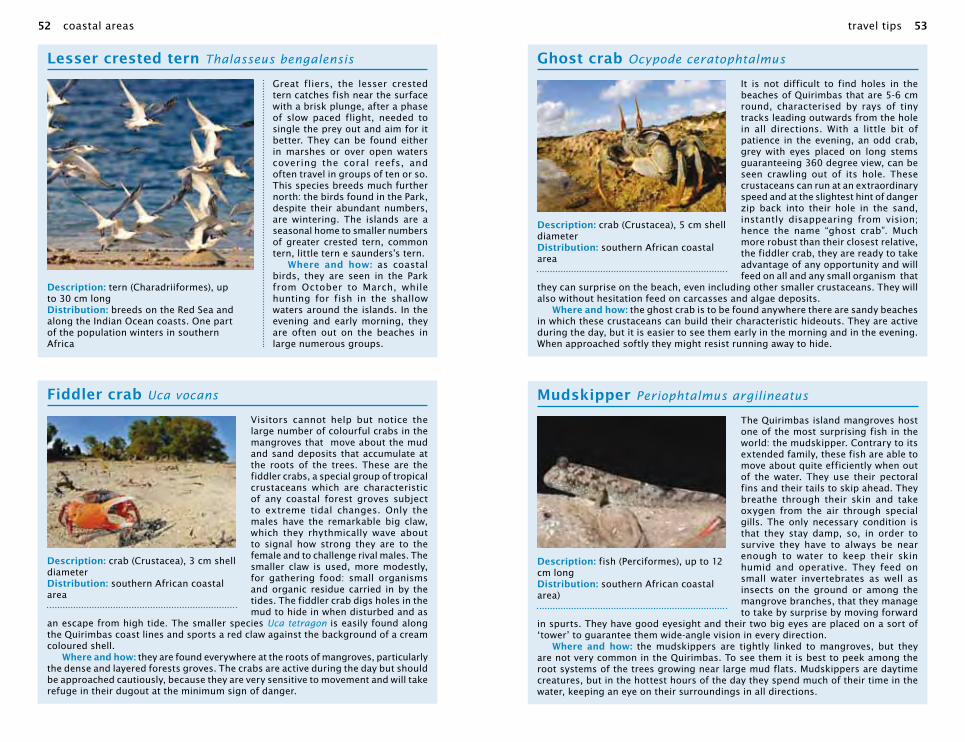
lesser crested tern Thalasseus bengalensis
Great fliers, the lesser crested tern catches fish near the surface with a brisk plunge, after a phase of slow paced flight, needed to single the prey out and aim for it better. They can be found either in marshes or over open waters covering the coral reefs, and often travel in groups of ten or so. This species breeds much further north: the birds found in the Park, despite their abundant numbers, are wintering. The islands are a seasonal home to smaller numbers of greater crested tern, common tern, little tern e saunders’s tern.
Where and how: as coastal birds, they are seen in the Park from October to March, while hunting for fish in the shallow waters around the islands. In the evening and early morning, they are often out on the beaches in large numerous groups.
description: tern (Charadriiformes), up to 30 cm longdistribution: breeds on the Red Sea and along the Indian Ocean coasts. One part of the population winters in southern Africa
fiddler crab Uca vocans
Visitors cannot help but notice the large number of colourful crabs in the mangroves that move about the mud and sand deposits that accumulate at the roots of the trees. These are the fiddler crabs, a special group of tropical crustaceans which are characteristic of any coastal forest groves subject to extreme tidal changes. Only the males have the remarkable big claw, which they rhythmically wave about to signal how strong they are to the female and to challenge rival males. The smaller claw is used, more modestly, for gathering food: small organisms and organic residue carried in by the tides. The fiddler crab digs holes in the mud to hide in when disturbed and as
an escape from high tide. The smaller species Uca tetragon is easily found along the Quirimbas coast lines and sports a red claw against the background of a cream coloured shell.
Where and how: they are found everywhere at the roots of mangroves, particularly the dense and layered forests groves. The crabs are active during the day but should be approached cautiously, because they are very sensitive to movement and will take refuge in their dugout at the minimum sign of danger.
description: crab (Crustacea), 3 cm shell diameter distribution: southern African coastal area
ghost crab Ocypode ceratophtalmus
It is not difficult to find holes in the beaches of Quirimbas that are 5-6 cm round, characterised by rays of tiny tracks leading outwards from the hole in all directions. With a little bit of patience in the evening, an odd crab, grey with eyes placed on long stems guaranteeing 360 degree view, can be seen crawling out of its hole. These crustaceans can run at an extraordinary speed and at the slightest hint of danger zip back into their hole in the sand, instantly disappearing from vision; hence the name “ghost crab”. Much more robust than their closest relative, the fiddler crab, they are ready to take advantage of any opportunity and will feed on all and any small organism that
they can surprise on the beach, even including other smaller crustaceans. They will also without hesitation feed on carcasses and algae deposits.
Where and how: the ghost crab is to be found anywhere there are sandy beaches in which these crustaceans can build their characteristic hideouts. They are active during the day, but it is easier to see them early in the morning and in the evening. When approached softly they might resist running away to hide.
description: crab (Crustacea), 5 cm shell diameter distribution: southern African coastal area
mudskipper Periophtalmus argilineatus
The Quirimbas island mangroves host one of the most surprising fish in the world: the mudskipper. Contrary to its extended family, these fish are able to move about quite efficiently when out of the water. They use their pectoral fins and their tails to skip ahead. They breathe through their skin and take oxygen from the air through special gills. The only necessary condition is that they stay damp, so, in order to survive they have to always be near enough to water to keep their skin humid and operative. They feed on small water invertebrates as well as insects on the ground or among the mangrove branches, that they manage to take by surprise by moving forward
in spurts. They have good eyesight and their two big eyes are placed on a sort of ‘tower’ to guarantee them wide-angle vision in every direction.
Where and how: the mudskippers are tightly linked to mangroves, but they are not very common in the Quirimbas. To see them it is best to peek among the root systems of the trees growing near large mud flats. Mudskippers are daytime creatures, but in the hottest hours of the day they spend much of their time in the water, keeping an eye on their surroundings in all directions.
description: fish (Perciformes), up to 12 cm longdistribution: southern African coastal area)
travel tips 5352 coastal areas

munity-owned beach bungalows may soon be operational at Muanancombo village, on the South coast facing Ibo.
access To coasTal areasby roadTwo main, tarmac roads offer ac-cess to the QNP, along its southern border, and from the Silva Macua turn-off through the centre of the Park. Guludo is close to Mucojo village, 80km along a usually well-maintained dirt road. For Ibo Island, boats leave from Tandanhague, in Quissanga, accessible from a dirt road that passes through Pemba-Metuge (look for the signed turn-off 30km outside Pemba), which is usu-
ally cut off in the rainy season, or via Bilibiza, where the dirt road is open year-round, with one or two tricky spots in the rainy season.
by airIbo, Matemo, and Quirimba Islands all have airstrips with regular small aircraft flights from Pemba. From Quirimba a short boat ride takes guests to Quilalea, and Guludo also transfers guests by boat from Matemo. Luggage is restricted to 15 km per person, in soft bags. The flight from Pemba over the coast and islands is absolutely stunning.
by boatThere are no regular boat services to the islands, but motorised and
green turtle Chelonia mydas
Seeing them glide by gracefully in the shallow waters of the reef, it would not seem that the larger green turtle adults can weigh in at half a ton. Even so, they swim
more swiftly than any diver and can stay underwater for longer than 20 minutes. This species is typical in warmer seas, and they feed on sea grass beds,
found in great underwater ‘plains’ in shallow waters. The young turtles live, instead, in the open sea and are carnivores; they return to the
coast only after 4-5 years. During their lives, green turtles migrate for incredibly long distances, often summing up to thousands
of kilometers. Once the turtles reach breeding age, around 20 years old, the females return to the beach where they
were born in order to lay their eggs in the warm sands. For these reasons it is particularly important to protect and preserve their nesting sites. In the Park are present other species, like hawksbill, olive ridley’s and the rare
leatherback turtle.Where and how: the turtles are
found in the area of the sea grass beds and in the internal lagoons. It is easier to see them near Ibo.
Their nesting sites are mainly found on the beaches of Matemo,
Quirimba and Quilalea, where they lay eggs between october and january.
description: Reptile (Chelones), up to 1,5 m longdistribution: Tropical seas all over the world
allard’s clownfish Amphiprion allardi
The clown fish, famous from the film “Finding Nemo”, is a typical reef inhabitant, and is represented by about thirty different species found in any tropical marine reef bank. Its main characteristic is its close relationship with the anemone, a sea organism which is similar to a jelly fish despite being attached to the substrate. Allard’s clownfish is linked to the purple based anemone, the beaded sea anemone, and Merton’s sea anemone and can be very protective of his site, attacking even scuba divers (but it’s not dangerous at all). This fish lives amidst the stinging tentacles without being killed itself thanks to a particular protective mucous secretion, which guards it from its host’s’ poisonous darts. In this way it has protection from predators and repays the anemone with left-over food, and by keeping the organism clean. Quite often several individuals meet up in the same anemone: the larger one is usually the female, flanked by a pair of males. If the female dies, the dominant male is able to change gender, and by quickly becoming female it is able to keep the family together. The skunk clown fish clownfish (Amphiprion akallopisos) is also found in the Park, it is identifiable by smaller size and by the single line running its dorsal area instead of the white bands.
Where and how: the clown fish is a resident of the reef. It can be seen in shallow waters of just a few meters, and always paired up with anemones. They are more active in the day, while at night they tend to hide away amidst the invertebrate’s tentacles.
description: fish (Perciformes), up to 12 cm longdistribution: eastern coasts of Africa, from Kenya to South Africa)
sheephead parrotfish Scarus gibbus
In the coastal waters of Mozambique more than ten different species of parrot fish can be listed, and this one is the most flashy and common. It is one of the larger reef fish and owes its name to its robust incisor teeth, fused into a solid beak-like feature, which is used for breaking the stony coral, madrepore. The parrot fish feed on the microscopic algae inside the stony coral. The constant erosion of the coral by the fish generates in part the sands at the base of the reef banks. Just like the clown fish, the parrot fish can change gender during its lifetime: the males are bigger, tinted green, blue and purple, with a squared off muzzle; they derived from females who are smaller and yellowish in colour with shades of blue and green on their undersides. The younger fish are, instead, horizontally striped black and white
Where and how: common along the reef walls and near the bottom, particularly in the first twenty meters of water, often travelling in small groups. Similar to all other parrot fish, it is a day-time feeder and sleeps in ravines wrapped in a wadding of mucus, secreted to ward off predators.
description: fish (Perciformes), up to 70 cm longdistribution: eastern coast of Africa and the Red Sea
travel tips 5554 coastal areas

sailing dhows do provide transport from Pemba (Paquitequete beach) depending on demand. The journey can take anything from 8 hours to three days depending on prevailing wind and weather conditions, so it is highly recommended to enquire locally before embarking.
ibo hisToryIbo Island hopes to be awarded for World Heritage status and is re-garded as one of Africa’s best-kept secrets: many people say it was
the highlight of their time spent in Mozambique. Ibo Town is definitely one of the oldest and most interest-ing and atmospheric towns in the country.
Mozambique’s recorded history goes back many centuries. The entire country has been subjected to con-quest and exploitation since time immemorial. As early as AD 600 Arab traders had established contact with Ibo Island and subsequently established fortified trading posts along its coastline. A large com-
sailfish Istiophorus platypterus
There is nothing out in the open seas that can beat the speed of the sailfish: it has been clocked going 110km/h (around 60 knots) in short spurts. This elegant muscular fish is much sought after by sport fisherman. It is the hunter of the open seas, as it feeds on mackerels, sardines, and small squids. The large ‘sail’, an extension of its dorsal fins, is usually kept down flat along its back when it dashes along at top speed. It opens the sail to scare smaller fishes as it encircles them into compact formation in order to facilitate an attack. The fin, together with fluid color changes of its livery, functions as a mean of communication with other
sailfishes during the hunt and breeding. According to certain experts, at some point, the sail fin could also serve as a thermo-regulator of body temperature, as indicated by all the blood vessels therein that get exposure to sun or cooler water.
Where and how: sailfishes are seen only on the open sea, despite the fact that every once in a while they bring themselves to the external borders of the reef to hunt banks of small fish. The best way to see the a sailfish is to go out on a boat trip; sailfish often raise their sail and jump out of the water during their hunting maneuvers, and this can be easily witnessed from a boat.
description: fish (Perciformes), up to 3 m long, including the sword-billdistribution: tropical seas of the Indo-Pacific
humpback whale Megaptera novaeangliae
The humpback whale is the whale-watchers’ symbol, and had a great comeback over the last thirty years, thanks to cetacean hunting limitations. Except for some rare exceptions, these whales are migratory. The individuals seen along the coast of Mozambique are headed toward colder waters of the Antarctica to feed on the abundant plankton and small fish. They will then return to the warmer tropical waters just north of Mozambique’s coast during the winter. Once in the warmer waters the whales eat near to nothing, but the females take advantage of the ideal environment to give birth to their
calves after a very long gestation of almost twelve months. The humpback whales are well-known for their long and articulate underwater vocalizations, the so called ‘whale songs’, which are produced mainly by males during courtship. The sounds they emit are easily heard by people: it is enough to put one’s head under water to listen to whale’ conversations, and this even from a distance of several kilometres.
Where and how: humpback whales pass in front of the Quirimbas on their way to the warmer seas just north of the Park from june to late november to bring their young into the world. They can be seen during boat excursions in Pemba bay or along the Quirimbas Islands.
description: whale (Cetacea), up to 16 m longdistribution: in the oceans the world over
indian humpback dolphin Sousa plumbea
This coastal dolphin can easily be confused with the classic well-known bottle-nosed dolphin; when, in reality, the Indian humpback dolphin is truly a rare species to be found only along the coast of southern Africa. This is where it feeds on small fishes inhabiting the reefs and seagrass beds. Quite often single dolphins will work together in order to locate their prey, which they herd into banks, and then one by one dive into in a coordinated series of attacks. Along the coast, this rare species can often, though briefly, meet up with its distant relative, the bottle-nosed dolphin. The waters of Mozambique, particularly offshore, also contain common dolphins, spinner dolphins, and Risso’s dolphins.
Where and how: Indian humpback dolphins are more common in shallower coastal waters, e.g. less than 50 m. deep. Within the National Quirimbas Park they can be found mainly in the waters surrounding Ibo Island, at the northern area of the archipelago. They can also occasionally be seen in Pemba bay, particularly during boat excursions.
local name: Golfinho-corcundo-do-Indopacíficodescription: Dolphin (Cetacea), up to 2.8 m longdistribution: Eastern coast of Southern Africa
travel tips 5756 coastal areas

mercial network was established in what is now known as the Gulf of Oman, stretching down along the East African coastline, as far as the Quirimbas Archipelago and Ibo, and still further to Ilha de Moçambique and Sofala.
By the 13th century the entire East African seaboard was linked up through a string of thriving ports and city states (Mogadishu, Brava, Malindi, Pemba, Zanzibar, Mombasa, Mafia, Kilwa and Sofala). Large trad-ing dhows would sail down the coast,
using the northerly winds between november to april, and sail back up again on the southerly winds from may to october. These winds are still called the Trade Winds. Iron imple-ments, cloth, glass, and beads were traded for ivory, gold and slaves.
This blend of Arab and African traders created a unique culture, known as ‘Swahili’. These skilled traders’ merchandise would be used to decorate large African mansions with Isfahan carpets and Sung China porcelain. Ibo Island is one of the most an-cient settlements in Mozambique, after Ilha de Moçambique (here just known as ‘Ilha’). The Fort of Forma de Cisterna was constructed by the Arabs on the same site even before the Portuguese occupation.Ibo Island and all the Quirimbas islands that had water have always been able to maintain human set-tlements. At the time of the first
Portuguese contact, these islands were called the Maluane Islands be-cause the local population designed woven cloth, in silk and cotton, called maluane, a much sought after textile on the mainland.When Portuguese explorers first arrived in the Quirimbas, the main trading centre in the archipelago was on the large Quirimba Island, south of Ibo. The Portuguese attacked Quirimba Island in 1522, because the trading Muslims of Quirimba refused to trade with Portuguese Christians, probably intending to eliminate them as trading rivals. The town was set alight and destroyed, dhows sunk, 60 or more Muslims traders were killed and heavy looting took place with large amounts of ivory and other trade goods being seized.
By 1590, seven of the nine biggest islands were ruled by a Portuguese lord, and only two islands by the lo-cal Muslim traders. Ibo Island traded
Ancient alley in Ibo Town
travel tips 5958 coastal areas

in amber, jet, ivory, ambergris and turtle shell. The locals had to pay 5% of their produce to the lord of the island – as well as a contribution to the church. On Ibo, the Portuguese settlers built large rainwater cis-terns which enabled the populace to raise livestock, such as cattle and goats. Meat, millet, rice, beans and palm products were all exported. It seems that even the mighty Ilha de Mozambique had been supplied with goods from Ibo Island. By this time Ibo had become the most important trading centre of all the islands. Slave trading also was rising significantly in this same period, due to the French land owners needing cheap labour for their plantations in Mauritius and Reunion. The Portuguese tried to keep this trade under their control, for economic, not humanitarian, reasons, while, instead the Quirimbas Islands were ideal for clandestine activities. The slave trade brought even more prosperity to Ibo when the slave market switched to furnishing the Brazilian territory, and continued to do so even after slave trading was declared an illegal activity.
After the government of Mozam-bique was separated from the Goan governing body in 1752, the gover-nor-general began the construction of a fort at Ibo, in merit of the town having been raised to the status of municipality. In 1770, the new dis-trict of Cabo Delgado was created (on Ibo) with its own governor. A church and warehouses were built and in 1786 the island became home to a customs house. In 1791 António de Melo e Castro began work on
a new fort. This fine star-shaped building rose up on the mudflats to guard the narrow shipping channel through the reefs into Ibo Island’s harbour. The slave trade bought Ibo much prosperity. Streets of houses were planned and laid out while fine public buildings were erected around the plaza. By the beginning of the 19th century Ibo had become a well-established trading centre. Ibo Island gained municipal status in 1763 and by the end of the 18th cen-tury, Ibo was considered the second most important Portuguese trading centre after Ilha do Mozambique.Throughout the 18th and 19th cen-turies the population of Ibo Island and adjacent regions were constantly under attack from Dutch and Mala-gasy forces. As defence against the attacks Fort of São João Batista (St. John Baptist) was completed in 1791. The little chapel housed inside the fort was built in 1795. Further construction followed with the Fort Santo Antonio (St. Anthony) and Fort of the Bairro de Rituto built in 1847. It wasn’t until 1897, when Ibo Island was integrated into the administra-tion of the Niassa Company that the island and its population were able to find themselves in relative safety and peace.
In the 1920’s the District capital of Cabo Delgado was transferred from Ibo Island to Port Amelia, as called then and currently the city of Pemba, which has remained the capital until today. This administrative change signalled the slow demise of Ibo island, which then eventually led to its total abandonment as a formal trading centre some years later. Young woman from Ibo
60 coastal areas

62 inland areas
Quirimbas National Park: inland areas
Meluco inselberg emerging from miombo forest

Introduction to environment
The Park inTeriorDriving along one of the roads that cross the Quirimbas National Park, quickly reveals how the interior of the protected area is really much larger and varied than the coastal area. The panorama of the savannah whisks across the field of vision through the vehicle’s windows, exposing the tireless expanse of bushes and low trees. A few giant plants, like the baobab and mahogany trees, stand out along the knobbly lay of the land. To tell the truth, in many areas it would seem less like a savannah than a forest with many flat patchy areas. The locals call this area mato, while the English know it as the bush. Actually it is the miombo forest, a particular habitat of southern Africa made up of tree-laden savannah. Surprisingly, the miombo forest covers more than 70% of the Park territory, as varied and diverse as the Park territory might seem. Beyond
The miombo forest of Mareja during
the dry season
the mangrove and coastal woodlands, travellers headed inland find themselves in an acacia dotted prairie which soon takes on the fuller aspect of the savannah which has become denser with a growing number of trees. From within the forest, lying in the western part of the Park, immense rocky rounded granite forms rise up to heights of 500 meters or more. These are called inselbergs and, without a doubt, they form the most unique and impressive landscape within the interior of the Park.
Climbing an inselbergThe undulating profile of the miombo forest is interrupted by the gigantic shape of a mountain. This silhouette is quite unusual, akin to the Italian Christmas cake panettone, measuring at least a kilometre at its base and more than 400 meters tall. At this point we are at Meluco, in the north-western sector of the Park. At its feet a vast area spreads outwards for more than 50 km, and is unusually punctuated by these extraordinary rock formations:
Swallowtail bee-eater resting on an acacia branch
introduction to environment 6564

the inselbergs (from German: mountains like islands in the plains).Let’s imagine ourselves climbing up one of these tall formations at the beginning of the rainy season, in December. This is a particularly important season of transition; both plants and animals living on the savannah anxiously attend its arrival, after having withstood close to six months of very little rain. At the foot of the mountain trees, large and small, having lost all their leaves to limit any loss of precious water, have interlocked tightly enough to force us to zig-zag our way through. On the ground damp from the first rains, the waters have begun to regenerate the underbrush and the red earth begins to take on the initial patches of green in the forms of grass tufts. Big hunting beetles, like the tiger beetles Anthia and Manticora, leave their underground dens and become very active.At the base of the inselberg, thanks to the rich humid earth at its feet, large trees find favourable terrain to sustain their size. Majestic trees, like the baobab (Adansonia digitata), definitely a symbol of Africa, flaunt a stout trunk that is easily 7-8 meters round. Individual trees of that stature can even
be a thousand years old and look like miniature wood fortresses, which, in this season of impending rain, produce large white flowers. Even while they might be the most impressive trees, they are surely not the only ones. The smaller silver cluster leaf, the bush-willows and the acacia surround the larger trees, such as sycamore figs, sausage trees, and lead-woods, all of which give life to an ever denser and intertwined forest. Not far off, the trumpeter hornbill call rings out. This is the largest African hornbill. A small group of samango monkeys keep an eye on us as we wend our way through the forest. Though they are curious, they will not get too close as they halt among the far off branches of a sycamore. The ground is covered by tracks from a small group of elephants: the large circular prints are about 50 cm round, and are typically accompanied by large round globs of excrement, looking like coconuts. In the vegetation of the underbrush a very special flower stands out, made up of a semi-circle of vibrant red about 10 cm round. This is a Schydoxis, known as the harbinger of the rains, because they appear in large numbers at just the right time. On a low lying mango bush branch just behind the flowers, a strange cluster of leaves draws our attention. It happens to be an outlying nest of the fearsome looking weaver ants. These insects are not the only animals to take advantage of leaves for building their homes. There are many species to do so in these regions of
Euphorbia unicornis growing on inselberg slopes
Tiger beetle, Manticora scabra, eating an armored grasshopper
Gecko Lagodactylus luteopicturatus
66 inland areas introduction to environment 67

Africa. In fact, not far away in an acacia, constant chirping signals the presence of a noisy flock of southern masked weavers, a bright yellow bird which habitually nests among the tree tops in vast colonies. Here the males set themselves to building very
particular hanging nests made of grass which dangle from the branches. As we head up the slope, a sudden noise of breaking branches among the bushes makes us all jump. A warthog, having been surprised while it had been rooting around in the soft damp ground, dashes away with its tail held straight up in the air. Only a few steps are needed to meet up with rock underfoot. Its characteristics come to light quite quickly; it is not sandstone, as it might have appeared to be from a distance, it is granite and gneiss. The inselbergs are gigantic masses of igneous and metamorphic rock, meaning sedimentary formations which have undergone various modifications due to enormous geological
pressure. Granite, hard and not easily worn away, has survived the erosion of the surrounding territories for millions of years. The uphill climb is getting a bit difficult: there is not a proper pathway so we climb freely upwards as our feet lead us. Multicoloured lizards (Platysaurus) flee as we pass. As we reach the top, mindful of the attentive gaze of the broadbill roller perched in the baobab branches and watching over its territory, it becomes obvious that trees are becoming more scarce and leaving large parts of the hillside exposed. Splendid formations of Euphorbia
unicornis, with its miniscule pink flowers, together with tufts of Aloe mawii, all decorate the rocky landscape. On the upper hillside a rapid movement catches our eye: a small antelope leaps with agility from one rock to the other, only to abruptly stop and nibble on a leaf of a bush. It is called klipspringer, which in Afrikaans (a South African language) means ‘rock hopper’. There is not far to go to the top, but because of the irregular shape underfoot and all the vegetation, how much will be visible from up high remains an unknown. The sun beats down on the hillside, raising the temperature above
Meluco, on the top of an inselberg
Klipspringer antelope on inselberg wall
introduction to environment 69

30 degrees celsius, which is slightly tempered by a light breeze, making the hike just a bit more pleasant. In only a few minutes the last sheet of rock is behind us and the peak awaits as we approach, gasping for breath. The spectacular view from up high rewards us with an incomparable experience. Towards the west and the south, like huge mushrooms, a dozen or so inselbergs rise up out of the plain. They are visible for at least twenty kilometres and are ‘haloed’ by a thin band of white clouds. A large bateleur eagle glides below us, sailing along the side of the mountain, in suspension on its large black and white wings. Looking down with binoculars, a small herd of five elephants can be seen walking along a path between the two rocky formations. Could they be the elephants which left behind the tracks we saw earlier? We can admire them as they calmly amble along to arrive at a source
of water in the forest: there are three females with two youngsters which are approaching the water’s edge to drink.
The big gaThering around The lakeWater is not an element that the northern part of Mozambique lacks, despite rainfall having diminished in recent years. Usually, the average yearly rate of rainfall is around 1200 mm, whereas, lately it has decreased to about 1000 mm, for the most part falling between december and april. The main river of the Park, the Montepuez, triples in size in this season, and the two main shimmering pools of water, the Bilibiza and the smaller Kagavero
lakes, come back to life. The water surface of the second one diminishes dramatically during the dry season, yet, never to the point of drying up entirely. The ideal starting point for the exploration of the Park wetlands would be the Pemba-Pangane road, conveniently located near the main routes of communication, and one of most exciting areas for bird-watching. Lake Kagavero, at the end of the dry season, looks similar to an irregular square of 500 meters per side, and is surrounded by a wide area of dry mud. This is the best season for a visit, particularly in the late afternoon, when all the thirsty animals are driven to the lake-side by the drought.At the centre of the lake basin, where the water is no deeper than a meter, large yellow flowering lily-pads are already emerging from the uniform strata of Pistia, a floating water-repellent aquatic plant. This is the herons’ hunting territory, and note that the herons do abound in great number. In only a few minutes 4 species can be seen: the tall great egret with its characteristic yellow bill; the smaller lesser egret, always white with its black feet and bill; and the squacco and cattle herons, which both follow any cattle along the lake borders.In the background, a dense flock of yellow-bill storks can be observed, as well as some very dark African
A big baobab tree, more than 5 meter wide at the base
Great white herons and egrets at Kagavero Lake
Malachite kingfisher
70 inland areas introduction to environment 71

open-bills, all searching for molluscs in the shallow waters of the lake. A blue streak crosses the scene and stops at a branch sticking out of the water; it is a malachite kingfisher, the smallest and most colourful of the kingfishers to be seen around the lake. The pied kingfisher is the easiest to find and watch; more difficult is to catch a glimpse of the solitary giant kingfisher, known to be the largest of the African kingfishers. The overhead passing of a large African fish eagle causes some agitation amongst the birds: a flock of white-faced ducks flies away, while the herons halt their search for food. Only the marabou storks, too large to be attacked, pay no attention to the airborne raptor and continue their rest among the branches of a large long-dead tree.The best way to visit the lake, without being too visible and alarming the birds feeding, is to move along the band of bush around the lake perimeter. The border of this sparkling lake is no less interesting than its surface. There is a constant to and fro in the tree tops of golden and red-headed weavers, as well as the tiny sunbirds, like the white bellied sunbird with its iridescent green throat, and the scarlet sunbird with its red throat. What most catches the eye, however, are the bee-eaters which, starting from their perches on dry branches, acrobatically dart about to catch dragon and butterflies in mid-flight. Though the Madagascar and the little bee-eater are the most common ones,
it is not unusual to see one of the most beautiful African birds, the northern carmine bee-eater.The setting sun is about to become a fiery ball on the horizon. At just this moment, a large male kudu appears at the lakeside to quench its thirst before night settles in. Keeping a watch-out, it sidles up to the edge of a water-well and drinks for a minute, only to leap away back into the bush. A young female yellow baboon does exactly the same thing. It is clear that they are scared of the crocodiles, despite the crocodiles being small in size and number in this pool of water. The baboon quenches her thirst in just a few seconds, to then leap back towards the bush while glancing back over her shoulder, just in case. By now the flat-bottomed sun is settled halfway down the horizon. In a few seconds the great orange orb will set completely, tinting the sky with ever darkening violet hues.The noisy sound of wings beating announces the arrival of twenty or more white-faced ducks, which pass over our heads in ‘V’ formation, on the way to their roosts in the tree tops. These are the last coming and goings of the day, ceding its terrain to the inhabitants of the night, the scenery where all the actors and sounds change. The chirping of the birds becomes the grasshoppers’ serenade, while the bats begin to populate the night-time sky. One of these young mammals, out hunting in the last light
Inselberg landscape at Taratibu at theend of the rainyseason
A lone marabù on a dead tree. This species can be found in most inland habitats but it’s quite rare.
Liliac breasted roller
introduction to environment 73

of dusk, is caught unaware and is snatched up in mid-flight by an incredibly fast bat-hawk. Faraway, a strange call echoes out in the night air from a thick tailed bush baby family, the nocturnal primates with big orange eyes.
The ConfliCT beTween humans and wildlifeFor a few reasons, the Quirimbas National Park is a bit different to other large natural parks in Africa. In contrast to what occurs in many of the other protected areas, there are at least 120,000 people who live within its boundaries, in villages of various sizes. The modestly sized local communities live mostly from either small farms or wood-cutting, the wood is then used for producing charcoal and lumber for building in the outer areas of the villages. Farming techniques continue to be very elementary and are based on the use of very simple tools. The owning of animals and farming equipment is a
luxury. Harvests are modest in comparison to what their potential could be, and are, moreover, threatened by invasion from forest animals. Elephants are undoubtedly the most problematic species to deal with: they have often razed harvests to the ground, gravely damaging the communities and its members who do not know how to ward such imposing animals off. Currently, some common lands have been designated, and guarded by armed rangers to scare off the elephants. This approach has been rewarded with good results, but would have to be extended to a larger scale.The damage caused by humans and fauna is, in any case, substantial. Poaching is still rife and widespread throughout the Park. Poachers lay snares and traps for antelopes, the most sought after prey, whose meat is then sold to all the local villages. Since 2010, the illegal killing of elephants has taken hold, due to the enormous profits that can be made from the sale of ivory. The Park has not yet, in late 2011, been able to efficiently contrast this threat.
Elephant herd moving at sunset
74 inland areas introduction to environment 75

Travel tips
Tourism in The inTerior of The ParkWildlife viewing in the QNP is often difficult due to low population densi-ties, thick woodland habitat and shy and elusive animals. However, it is well worth a trip into the interior of the Park to appreciate the fantastic scenery, areas of pristine forest and abundant bird life. Two conserva-tion projects in the southern part of
the Park offer accommodation and guided walks.
Mareja, which is situated in the South-East of the Park, is a com-munity conservation project run in collaboration with a private in-vestor, Dominik. Their intensive efforts against poaching and illegal wood cutting in this 60,000 hectare reserve makes Mareja one of the areas with the best chances of view-ing wildlife, in particular elephants,
A Schidoxys flower emerging from land with the first rains
Nile monitor lizard
77

Rio
Mon
tepuez
Rio Aquite
Rio MenapoMeluco
Taratibu
i n s e l b e r g s
Ravia
Ngura
Miegane
National Park boundary
inselbergs
villages and facilities
unpaved roads
Quirimbas National ParkInselberg Area
0 5 10km
Rio
Mon
tepuez
Rio Aquite
Rio MenapoMeluco
Taratibu
i n s e l b e r g s
Ravia
Ngura
Miegane
National Park boundary
inselbergs
villages and facilities
unpaved roads
Quirimbas National ParkInselberg Area
0 5 10km
travel tips 7978 inland areas

Taratibu, in the South-West of the Park, is another reserve that has benefited from the tireless efforts of a private investor, Jakob, and his team of local rangers. The camp is located among soaring trees in a protected spot at the foot of three beautiful inselbergs (huge, steep-sided granite outcrops) and is sur-rounded by stunning pristine forest and grasslands. Guided walks offer the possibility of elephant viewing, and other wildlife is also present in small quantities. Climb the sur-rounding inselbergs for wonderful views. Birdlife is again abundant and varied, with forest species being the main attraction.Accommodation is in three comforta-ble en-suite bungalows, and there is space for camping. Guests must be prepared for self-catering, with some assistance from the camp staff. Taratibu is a three hour drive
from Pemba, 4x4 is necessary, and bookings through Kaskazini are essential (tel +258 823096990, or [email protected]).Meluco is a small town in the far West of the Park, off the tourist track and with few facilities be-yond a basic but clean guest-house (Pensão Chabane, tel: +258 825063688/820268922) and a local restaurant. However, Meluco is located at the foot of a series of spectacular granite inselbergs, well worth the sometimes strenuous 3 to 4-hour climb. Ask at the guesthouse for local guides who can accompany you to the top, where the views are absolutely breathtaking. The in-selbergs are home to endemic plant species as well as birds and some small mammals. Be sure to carry plenty of water; hat and sunscreen, and decent walking shoes are es-sential.
sable and other antelope, lion (often heard at night) and other small wild-life. Birdwatching in Mareja is very good, with miombo endemics and numerous coastal and forest species.Accommodation in Mareja ranges from stylish eco-rooms (entirely built from local materials), to en-suite rooms in restored out-build-ings, dormitory beds and camping. Meals – served in the half-ruined
old farmhouse – are excellent, and the setting, on a hilltop overlook-ing Pemba Bay to one side and the seemingly endless bush to the other, is unbeatable. Mareja is a 2 ½ hour drive from Pemba, but is not open year-round; for reservations contact Dominik on his mobile +258 82 7058860 or by e-mail at [email protected].
african openbill Anostomus lamelligerus
The most impressive characteristic of this big black bird is its strangely curved bill, with a slit in the middle. What almost appears to be a defect is, instead, a particularity of all the members of this species. What use could such an unusual bill have? It is a formidable instrument for getting molluscs, that the storks feed on, out of their shells. After having singled out their prey in the mud or shallow waters, the openbill manoeuvres the shelled mollusc into the slit in its bill, and with some lateral jaw movements extracts the mollusc from it armour. It occasionally feeds on fishes and frogs, as well.
Adults can be nomads or residents and breed in big colonies on trees over wetlands. They are monogamous and pair for life.
where and how: the openbill is a fresh-water species and, therefore, can only be observed in the vast interior wetlands, where it can easily find its prey. It is commonly seen in the Kagavero and Bilbiza lakes all year round.
local name: Bico abertodescription: stork (Ciconiiformes), up to 85 cm longdistribution: Central and Southern Africa
The unusual name bateleur is a translation from the French word for ‘acrobat’, which a French speaking naturalist used to label this beautiful eagle. As a matter of fact, when watching carefully, the bateleur soars with completely outspread wings, which can be seen to oscillate ever so slightly in the same manner of a tight-rope walker’s balancing bar. From on high, during his regular patrol routes along the plains and above the less dense forests, it searches for small mammals, reptiles and birds moving at ground-level. For the most part, however, it mostly feeds on carcasses. Adults mate for life and build their nests among the higher branches of trees. In the interior areas of the Park, particularly in the inselberg area, one can even encounter, albeit more rarely, the bigger martial and crowned eagles.
where and how: one can easily watch these big birds circling widely in the late morning, as they fly higher and higher upon the rising thermal air-currents. The bateleur are Park residents and are considered one of the more easily observed birds of prey.
local name: aguia bailerinadescription: bird of prey (Accipitriformes), up to 65 cm longdistribution: Central and Southern Africa
bateleur eagle Tharatopius ecaudatus
80 inland areas travel tips 81

broadbilled roller Eurystomus glaucurus
T h e l a r g e r o b u s t yellow bill is one of the distinctive features of this typical bird of the miombo forest. It loves to sit in the larger trees and watch over its territory from up high. Even when it changes its position often, it does usually have a favour i te perch. I t feeds on large winged-insects, such as beetles and grasshoppers , which it catches with precision during its fast flights down from its perch. The mated pairs are quite stable
couples, and nest in the cavities found among the larger trees. The visitor also quite often gets to see the splendid lilac breasted roller, whose habits are similar to the broadbill.
where and how: it is easy to encounter in the midday hours as it perches on the higher branches of the trees that are closest to water. It is an inter-African migratory species that arrives in the Park in September and October only to leave once again around April.
local name: roliero de bico amarelodescription: roller (Coraciiformes), up to 34 cm longdistribution: Southern Africa
Lappet-faced vulture, rarest vulture in the area
The weavers, among which more than ten different species can be counted, are birds which are particularly specialised in life of the ‘condominium’. The males are the ones who build the nests by weaving grass, gathered up from the plains, in a very refined manner. The end result is an elegant sack-like wrap with an entrance in the lower section. The females, who have chosen the nest built in the best position (usually in the center or on the side of the tree), are the ones to take care of sitting on the eggs. The lesser masked weaver feeds on insects, seeds and often on flower nectar which can be found on the high branches of trees.
where and how: as a resident species, it is present in large numbers throughout the Park, in all the open areas, along the coast and in the residential areas of the local human population. They build their nests at the end of the dry season, between November and December.
local name: tecelão pequenho de mascarilhadescription: weaver (Passeriformes), up to 15 cm longdistribution: Southern Africa
lesser masked weaver Ploceus intermedius
82 inland areas travel tips 83

Male lion
Trumpeter hornbill Bycanistes bucinator
The trumpeter hornbill resides in the dense areas of the forests closest to the rivers, and is known for its preference for fruit, even though it is quite ready to catch insects and small reptiles. The male’s typical large bill acts as a resonance chamber when it makes its noisy nasal call, sounding very similar to a child’s cry. These hornbills nest in cavities of the larger tree trunks, such as sycamores. The female hornbill sits on her eggs after having just about completely sealed herself inside the nest with mud carried to her by her mate. She leaves herself only a small opening through which air can pass, as well as food brought to her by her mate. These extreme measures serve as defence against reptiles, tree mammals and specialized raptor birds, like the African harrier hawk. Shortly after the chicks have hatched, their mother breaks out of her refuge and helps feed the offspring.
It is easier to see another less spectacular hornbill, so typical of the sparse areas of the miombo forests: the crowned hornbill with its characteristically large red bill.
where and how: as a resident species, it is mostly found in the areas near the rivers, lakes and at the lower areas of the inselberg, because this is where the forests with the largest trees grow.
local name: calau trompeteirodescription: hornbill (Bucerotiformes), up to 60 cm longdistribution: Southern Africa
84 inland areas travel tips 85

sable Hippotragus niger
The sable is considered one of the most beautiful African antelopes. It is easy to understand why when an adult appears in its black l i ver y and white mask, together with its long curved horns. While both male and female have horns, the male ones are more imposing. Sables avoid the denser forest areas, and, being rather selective grazers, they prefer grass about 10 cm high. All the large fully adult males over 5 years old are very territorial and usually have a small ‘harem’ of females with which they
couple many times over. The bigger and stronger individuals are rarely hunted by lions due to the danger of dealing with the sable’s long pointy horns.
where and how: the best area to observe these antelopes are in the open areas of the miombo forest located at Mareja, in the south-eastern section of the Park. Habitually, sables are more active in the mornings, late afternoons and at dusk.
local name: pala paladescription: antelope (Ungulates), average shoulder height 135 cm, typical male weight 230 kg. distribution: Southern Africa
greater kudu Tragelaphus strepsiceros
T h i s a n t e l o p e ’s m o s t distinguishing characteristic are its ‘corkscrew’ horns and its large ears, which are so closely associated with wooded savannah. Only males have horns and the longest double twisted horns belong to males which are at least six years old. The kudu are very adaptable antelopes; they browse among a wide variety of vegetation, which includes the aloe plant, some euphorbia and small acacia leaves. They do not require much water when their diet includes an abundant amount of green vegetation. They
are not a territorial species and often live in small herds of about 6 8 females and their young; the adult males join these groups between May and August during the mating season.
where and how: widespread throughout the area, except for the coastal areas and the exposed inselberg formations. They are more active in the morning and in the evening, while it has become partially nocturnal in the Park due to the impact of illegal hunting.
local name: cudodescription: antelope (Ungulates), typical shoulder height 140 cm, typical male weight 239 kg.distribution: Southern Africa
lake bilibiza and lake kagaveroLake Bilibiza is a huge body of fresh water located in the heart of the Park, which is essential to the sustenance of wildlife and the local ecosystem. Hippo, buffalo and elephant all de-pend on the lake, which is also home to very large flocks of water birds.
More accessible to visitors, however, is the smaller but very attractive Lake Kagavero, which is found just off the road 5km to the south of Ma-hate, on the way to Quissanga (where boats leave for Ibo Island). Kagavero is notable for the large numbers of waterbirds who gather there year-round, as well as being an evening watering point for elephant and other
african elephant Loxodonta africana
The elephant is surely the symbol species of the Park interior. They number up to around 800 individuals, among which there are a few males of remarkable size. Usually, however, there are small family groups to be found of about ten members, headed by a matriarch. Adult males lead an independent life and come to the groups when the females are in heat. Elephants eat most plants, and the environmental impact of their wide diet is limited due to the year round abundance of vegetation in the Park; this is highlighted by the stark contrast with other areas of Africa. They need water daily, and for this reason they do not stray far from the sources, even when these are only seasonally active. In the Mareja area, for example, they dig out the dry river beds in order to reach the underlying water. Elephants are the most problematic species in the Park: in recent times they have suffered from ivory poachers. Elephants have also been known to devastate the villagers crops.
where and how: though it is possible to see the African elephants in any of the interior areas of the Park, in the dry season, they tend to stay close to water sources and, therefore, remain near lakes Kagavero and Bilibiza, and the river Montepuez.
local name: elefantedescription: elephants (Proboscidea); shoulder height circa 3.5 m; large male weight circa 6 tons distribution: Southern-Central Africa
86 inland areas travel tips 87

Baboons are active during the day in small groups called ‘troops’, and can be considered masters of survival in the hostile savannah environment. They move about almost always in troops comprised of at least a dozen members, some of which, in turns, become the sentinel while troop members hunt for plants, fruit, roots and small animals. The weaker members and the juveniles are kept at the centre of the troop, which at night take refuge up in the taller trees in hard to reach places. In merit of this behaviour, they rarely finish up on the menu of lions and leopards. In some cases baboons can act rather over-familiar, but should not be fed by visitors. Baboons that have become confident with humans can behave in unexpected ways and even become dangerous.
where and how: baboons are easily observed throughout the Park, even in the vicinity of the villages, where they are tolerated. In the evening they can be watched as they take refuge up in and settle for the night in the big trees.
local name: macaco cao amarelodescription: monkey (Primates), up to 85 cm long, excluding the tail; adult male weighs up to 30 kg.distribution: Southern Africa
Yellow baboon Papio cynocephalus
warthog Phacochoerus aethiopicus
Big curved fangs are often found on savannah turf, and at first sight they could be taken for those of a big cat, despite being bigger and less robust. In fact, these fallen teeth are actually warthog tusks. Warthogs are distant relatives to pigs and are typical inhabitants of the savannah. They feed on big quantities of grass, fruit, roots and tubers which they gather while kneeling down on their front legs. They do not hesitate to feed on carcasses, insects and small reptiles and amphibians too. For the most part they are diurnal feeders; they sleep in holes in the ground abandoned by various burrowing species like aardvarks. The adult warthogs enter the burrow backwards, in order to be facing any eventual predators and warn them
off with their big tusks. There is another pig in the Park: the bushpig, whose incisors are much smaller and is nocturnal by habit.
where and how: they are very common, above all in the less dense areas of the forest, though also close to water sources. They can be easily observed in the mornings, and then during the midday hours they withdraw into the density of the forest.
local name: javalidescription: pig (Ungulates), lenght 130 cm; Males weight circa 80 kgdistribution: Southern-Central Africa
vervet monkey Chlorocebus aethiops
The grey form of these monkeys running through the bush is often the first memory of the initial encounter with mammals of the Quirimbas Park. Common and present in most of the environments, except on the islands, the vervet monkey live in small groups of 10-20 members and are headed by a few dominant adults. These monkeys are territorial and feed on fruit and shoots, while occasionally eating insects, squabs and small reptiles. There are times when they become over-familiar, but they should never be fed by visitors.
There is another very similar monkey to be found in the Park, the samango monkey, which is slightly bigger and dark brown. It is more rare and, because arboreal for the most part, it is only encountered in the forests.
where and how: of diurnal habits can be found in every environment of the Park, though it is never far from sources of water. Just like the baboons, they gather together to take refuge in the higher tree branches when preparing to rest for the night.
local name: macaco de cara pretadescription: monkey (Primates), to 60 cm long, excluding the tail, and weighs up to 5 kgdistribution: Southern Africa
wildlife. There is as yet no accom-modation at Kagavero, but there are plans for a community lodge within the not-too-distant future. The lake makes a pleasant stopping-off or picnic spot on the way to or from Ibo. Ask for a local community ranger to show you around.
aCCess To inTernal areas
Only by rOadTwo main, tarmac roads offer ac-cess to the QNP, along its southern border, and from the Silva Macua turn-off through the centre of the
88 inland areas travel tips 89

weaver ants Oechophylla longinoda
Among the branches of the big trees it is not difficult to single out a cluster of leaves brought together in the shape of a bag. These clusters are the odd work of a group of brick-red coloured ants: weaver ants. These ants are wide spread throughout the African savannah and they build nests of leaves using secretions from their larvas as glue. This insect’s success lies in the organizational structure of their colonies, which mirrors a vast federal state. Only the well protected nursery at the centre of the tree holds the queen ant; all the others are for support and contain droves of worker ants, loaded with formic acid and equipped with sharp pointy mandibles. A colony of weaver ants places several trees under its control, including the immediate area surrounding the plants. This dominance manifests itself as they wipe out many insects which appear in their territory. Despite their fearsome aspect, these ants are not dangerous to humans in any way; they do not sting.
where and how: weaver ants make their nests within a large number of trees in every season, though they show a preference for trees with larger more malleable leaves, e.g the mango trees. When looking for a colony all the visitor has to do is follow a long line of worker ants as they head back and forth from the tree trunk.
With its long white abdomen, crossed with longitudinal stripes, the large Nephila inaurata is easily distinguished from the other savannah spiders. And as if that were not enough, it weaves its gigantic web (up to a meter wide) between the lower branches of trees and the ground vegetation of the miombo forest. The central rays are very resistant and the weight-bearing ones are of a particular golden colour. Thanks to these traps the Nephila captures every type of flying insect and, in rare cases, even small birds and bats. The spider quickly immobilises its prey both with a web shroud and some poison with its bites. This non aggressive spider’s poison is not dangerous to humans. Biggest specimens are females and stay at the centre of the web. Males are far smaller and live at a female’s web side.
where and how: these spiders weave their webs within the thick miombo forest all year round. Due to their large size these webs often glisten in the sunlight, allowing the visitor to easily locate them.
local name: aranha gigante de ouro description: spider (Arachinda), up to 3 cm bodydistribution: Southern Africa
giant orb weaver spider Nephila inaurata
local name: Formiga do tecelãodescription: ant (Hymenoptera), worker ants body length circa 7-10 mmdistribution: Southern, Central and West Africa
Park. Taratibu and Mareja are both located at about 30 km off these main roads, on well-maintained dirt tracks. Meluco is 50 km off the
main road along a good dirt road. Kagavero lake is located close to Mahate village, taking the road for Metuge.
Fork tailed drongo at sunset
90 inland areas travel tips 91

Tourist activities and attractions in the QNP
Birdwatching Boat trips (using dhows
and other boats) Mato 4x4 experiences Canoeing Hiking and inselberg
climbing Historic-cultural visits
in Ibo Fishing Visits within mangrove
habitats
Scuba-diving Snorkelling Traditional dances Observation of sea-turtles Visit to villages Whale watching Wildlife spotting
and observation Sailing, wind-surfing
kite-surfing
92 inland areas

Inselberg landscape at Taratibu bush camp

Stampato da Stargrafica, San Mauro (TO)nel mese di luglio 2012