Embed Size (px)
Citation preview

LUCID’s Land Use Change Analysis as an Approach for Investigating Biodiversity Loss and Land Degradation Project
Land Tenure Reform and Changes in Land-Use and Land
Management in Semi-Arid Tharaka, Kenya
LUCID Working Paper Series Number: 11
By
Thomas Smucker
Department of Geography 314 Natural Sciences Building
Michigan State University East Lansing, MI 48824 USA
November 2002
Address Correspondence to: LUCID Project
International Livestock Research Institute P.O. Box 30709 Nairobi, Kenya
E-mail: [email protected] Tel. +254-20-630743
Fax. +254-2-631481/ 631499

Land Tenure Reform and Changes in Land-Use and Land Management in Semi-Arid Tharaka, Kenya
The Land Use Change, Impacts and Dynamics Project
Working Paper Number: 11
By
Thomas Smucker
Department of Geography 314 Natural Sciences Building
Michigan State University East Lansing, MI 48824 USA
November 2002
Address Correspondence to: LUCID Project
International Livestock Research Institute P.O. Box 30709 Nairobi, Kenya
E-mail: [email protected] Tel. +254-20-630743
Fax. +254-2-631481/ 631499

Copyright © 2002 by the: International Livestock Research Institute, Michigan State University Board of Trustees, and United Nations Environment Programme/Division of Global Environment Facility
Coordination. All rights reserved. Reproduction of LUCID Working Papers for non-commercial purposes is encouraged. Working papers may be quoted or reproduced free of charge provided the source is acknowledged and cited. Cite working paper as follows: Author. Year. Title. Land Use Change Impacts and Dynamics (LUCID) Project Working Paper #. Nairobi, Kenya: International Livestock Research Institute. Working papers are available on www.lucideastafrica.org or by emailing [email protected].
LUCID Working Paper 11 ii

TABLE OF CONTENTS A. Introduction.........................................................................................................................1 B. Land Tenure Change and Agricultural Intensification: Theory and Context....................1
1. Customary and Reformed Tenure: Changes in Kenyan Land Tenure..........................2
2. The Social Dynamics of Agricultural Intensification....................................................3
3. The Relationship Between the Individualization of Tenure and Agricultural Intensification .........................................................................................5
C. Methods and Data ................................................................................................................7 D. The Tharaka Context ...........................................................................................................9
1. Pre-Adjudication Land Tenure and Land-Use ......................................................12
2. The Adjudication Process in Tharaka ...................................................................17
3. The Impact of Adjudication in Tharaka................................................................21
a. Modes of Land Acquisition......................................................................21
b. Changes in the Distribution of Landholdings ..........................................23
c. Changing Perceptions of Land Rights......................................................25
d. Changes in Livestock Land-Use ..............................................................26
e. Changes in Agricultural Land-Use...........................................................30
f. Land Development and Productivity .......................................................32 E. Conclusion.........................................................................................................................34 F. References .........................................................................................................................37
LUCID Working Paper 11 iii
FIGURES
Figure 1. Tharaka and Neighboring Districts, Eastern Province, Kenya ..................................8 Figure 2. Agro-Ecological Zones and Sampled Administrative Units Tharaka District ..........9 Figure 3. Frequency Distribution of Crops by Agro-Ecological Zone, Tharaka District .......10 Figure 4. Years of Permanent Use of Parcel Adjacent to Homestead ....................................17 Figure 5. Perceived Secondary Resource Use Rights .............................................................25 Figure 6. Reported Causes of Decline in Livestock Holding .................................................28 Figure 7. Percentage of Livestock-Holding Households That Access Grazing Resources Apart From Own Parcels...................................................................................................................29 Figure 8. Additional Grazing Areas Used By Tharaka Households .......................................29 Figure 9. Frequency Distribution on Investments in Soil and Water Conservation.. .............34
TABLES Table 1. Characteristics of Sampled Locations........................................................................8 Table 2. Population and Land Area by Location ..................................................................11 Table 3. Sources of Household Income by Location .............................................................11 Table 4. Population of Tharaka and Sampled Locations .......................................................15 Table 5. Population Growth Rates for Tharaka and Sampled Locations...............................16 Table 6. Years Since Household Began Permanent Culitvation of Parcel ............................18 Table 7. Mode of Parcel Acquisition by Location .................................................................23 Table 8. Access to Land Per Household ................................................................................24 Table 9. Gini Coefficients of Total Land Access...................................................................24 Table 10. Goat Holdings Per Household by Location ............................................................26 Table 11. Goat Holdings Per Household, Tharaka District ....................................................27 Table 12. Reported Changes in Goat Holdings, 1990-2000 ..................................................27 Table 13. Changes in Percentage of Land Under Fallow and Cultivation..............................31 Table 14. Distribution of Major Land Cover Types on Sampled Parcels ...............................31
LUCID Working Paper 11 iv

A. INTRODUCTION The restructuring of human-land relations has been a central component of social and
environmental change in post-colonial Africa. Numerous African governments have initiated land reform programs with the objective of creating an individualization of land rights. At the same time, a number of social factors have converged to create evolutionary change within customary land tenure systems. In both cases, rules of access, use, and transfer are reformulated in order to adapt to a changing context of rising population densities, agricultural commercialization, land scarcity, and the increasing value of land as it replaces livestock as the primary indicator of wealth in society. The interaction of these dual processes of change, and their implications for changes in land-use and management has emerged as a research focus with important social and environmental implications.
The objective of the individualization of tenure is to increase tenure security through the state-sponsored adjudication of rights, thereby creating incentives for improved land management and increased productivity. Like several other African countries, Kenya’s land reform program has focused on the individualization of land tenure as a means of creating incentives for increasing agricultural productivity. Based on policy formulations established during the colonial era, land demarcation, consolidation, and titling expanded rapidly during the 1960’s and 1970’s in the highland intensive commercial farming zones of Central and Western Kenya. Since the 1980’s, the land reform program has expanded from high potential zones to the semi-arid agro-pastoral zones. The state-sponsored adjudication of land rights in the context of the agro-pastoral land-use systems of the semi-arid lower zones east of Mount Kenya has posed particular challenges for achieving the objectives of the policy while maintaining crucial aspects of local livelihood systems.
This working paper examines changes in land tenure and the impacts of those changes on land-use and land management in Tharaka District, a semi-arid area that lies between the lower slopes of Mount Kenya and the Tana River in Eastern Province, Kenya [See Figure 1]. The first section of the paper examines the theoretical context of the tenure-intensification relationship. The second section provides an overview of Tharaka society and characterizes the land-use system before the implementation of state-sponsored land adjudication within certain administrative units of Tharaka District. The third section examines the process of land adjudication in Tharaka in the context of evolving land rights and changes in human-environment interaction. The fourth section takes a multi-faceted approach to an analysis of the impacts of land adjudication on land-use and land management. The conclusion assesses the impact of land reform on land-use and land management in the context of Tharaka’s changing role in the political economy of eastern Kenya and considers the implications for sustainable development in Kenya’s semi-arid rangelands.
B. LAND TENURE CHANGE AND AGRICULTURAL INTENSIFICATION:
THEORY AND CONTEXT Understanding the social driving forces and impacts of land-use and land-cover
change has emerged as a major objective of the science of global environmental change (IGBP 1997). As a result, a “human dimensions of global change” agenda has emerged which encompasses a concern for understanding the changing dynamics of land-use and land-cover change within various regional settings and the impacts on economic and social development, vulnerability and food security, human health, and peace and security (Stern et al. 1992). Despite the predominately positivist and quantitative approach of early human dimensions research, there is a growing awareness of the limitations of conventional approaches that focus on population growth and technological change to the exclusion of political and socio-cultural dimensions of land-use and land-cover change (Taylor 1997). The importance of such a human-environment agenda has been recognized by the scientific community in numerous documents that seek to set research priorities for the study of global environmental change (Liverman 1998).
Within this context, a growing area of research focuses on land tenure as a key intersection of political, economic, demographic, and social forces. Since the 1980’s, and in some cases long before, market-oriented reforms in African agriculture have raised important
LUCID Working Paper 11 1

questions about the appropriateness of customary land tenure and its contribution to agricultural development. Bassett (1993) correctly pointed out that the 1980’s produced little empirical research on land tenure issues in Africa. However, the 1990’s have witnessed a proliferation of land tenure studies in many African countries. Much of the research has focused on the relationship between land tenure security - a notion often equated with an individualization of land-use decision-making - and investments in agricultural productivity. The relevance of such research to rural East Africa is great given declining per capita food production, the geographical expansion of state power, statutory tenure systems, market relations, and sedentary agricultural systems to many parts of the continent that had been isolated from such forces in the recent past. Likewise, the transformation of highland and savanna landscapes in East Africa has important implications for climate change and biodiversity throughout the region.
Much recent research has found a weak or ambiguous relationship between land tenure status and investments in agricultural productivity. For example, research from Kenya and elsewhere in Africa has not demonstrated a clear relationship between land titling and increased agricultural productivity (e.g. Migot Adholla et al. (1994), and Haugerud (1989) in Kenya; Firmin-Sellers and Sellers (1999) in Cameroon), suggesting that the individualization of land tenure may contribute to an aspect of security without fully encompassing the means by which rural households establish security of resource access within local social relations.
Understanding the impact of land reform in the context of constantly evolving land-use and tenure systems requires that researchers investigate land reform within the broader social and environmental context of evolving land rights. As a theoretical and methodological approach, political ecology can help to clarify the dynamics of tenure change, the implications for land-use change, and more broadly, the social dimensions of land-use and land-cover change in East Africa’s diverse social and environmental landscapes. Political ecology explores changing resource access and use as imbedded within power relations among groups in society (e.g., households, kinship groups, communities, non-governmental organizations, the state). In maintaining the importance of political and economic forces in structuring key aspects of human-environment interaction, the political ecology perspective contributes to a critical understanding the intersections of resource management, development, and poverty. The reform of land tenure provides a critical window through which to examine such social dimensions of environmental change. From the political ecology perspective, land-use and tenure change in Tharaka can be seen as manifestations of a broader political economy of control of and access to resources which are both shaped by and in the process of transforming Kenya's highly variable semi-arid landscapes (Blaikie and Brookfield 1987).
B.1. Customary and Reformed Tenure: Changes in Kenyan Land Tenure
As one component of property relations, land tenure consists of a set of social relations governing the use and disposition of land. These social relations are produced and reproduced through a process of allocating power to individuals or groups over a specified category of resources (Okoth-Ogendo 1989). Land tenure is often considered as a "bundle of rights", indicating that the holder of tenure may possess any of a suite of use rights such as cultivation or extraction of resources (Hahn 1998). The nature of a system of land tenure relations can be characterized with reference to the breadth, duration, and assurance of rights (Place et al. 1994). The breadth of rights refers to uses and resources encompassed and the conditions under which such use is granted. The duration of rights refers to the length of time for which tenure is granted. The assurance of rights consists of the certainty with which land-use and tenure rights that are granted will not be prematurely interrupted or denied. Thus, land tenure need not include exclusivity of rights, absolute rights over all resources on the land (e.g., vegetation, water, and fauna), nor right of transfer.1 Indeed many systems of customary tenure systems do not allot exclusivity of use rights to all resources on a piece of 1 The term land-use rights, or usufruct, is often used to indicate a form of tenure in which such limited and disaggregated rights are allocated.
LUCID Working Paper 11 2

land. In contrast, most state-sponsored adjudication programs entail a consolidation of aggregated rights to resources granted in the form of land title to an individual.
Although sometimes portrayed as a static relic of pre-colonial agriculture, Kenya’s many customary tenure arrangements have evolved in relation to broader social change (Bruce 1988; Mackenzie 1998). Under communal tenure arrangements, the land is held by a larger social unit and use rights are granted to individuals or households. Thus, rights are disaggregated and allotted to individuals. Various societal groups have customary claims to land-use rights. For example, under most systems of customary tenure, the land-use rights of women are ensured through their relationship with their husbands or, if they are separated or widowed, through their relationship with other male kin. In Kenya, as in much of Africa, customary law evolved most notably under colonial rule. Colonial regimes often attempted to integrate customary systems of authority and regulation into the administration of non-scheduled areas. In order to facilitate administration of African areas, customary tenure relations were constructed using the interpretations of local leaders invested with the power to define custom (Berry 1993; Mackenzie 1994). More recently, customary tenure relations have evolved toward greater exclusivity of rights due to the influence of statutory land law and other social, demographic, economic, and political factors (Migot-Adholla and Bruce 1994; Firmin-Sellers and Sellers 1999, Fleuret 1988).
Reform of customary tenure in Kenya was begun during British colonial rule. It is commonly noted that the Swynnerton Plan (Swynnerton 1954), which proposed a strategy for reforming Kenya’s African land tenure system, sought to bring about the intensification of agricultural production in high potential areas through the individualization of land rights, the extension of land secured credit, and the development of a land market. However, the Swynnerton Plan also represented a political strategy aimed at maintaining a highly unequal distribution of land resources between the European settlers and an increasingly stratified African population (Kitching 1980). In addition to creating a class of progressive, relatively wealthy farmers with interests tied to the colonial project, such reforms were viewed as a means for African reserves to attain self-sufficiency in hopes of reducing political pressure for the redistribution of settler farms (Okoth-Ogendo 1991).
Despite significant change in rural economies since Independence, land reform in Kenya continues to be guided by the Swynnerton model under the 1968 Land Adjudication Act. The current process of reform entails the adjudication of land rights to individuals (primarily senior males in each household) and the registration and titling of adjudicated parcels. The implications of these reforms for individual households and for changes in land-use systems continue to be of central importance to rural development in Kenya. Current reform is geographically focused in Kenya’s extensive semi-arid zones. The process and impacts of land reform in the semi-arid zones proceeds in the context of land-use systems and ecological conditions that are vastly different from the high potential, highland zones for which Kenya’s land policy was designed. B.2. The Social Dynamics of Agricultural Intensification
The intensification of agricultural production has been defined and measured in a number of ways including total output per unit area, frequency of cultivation, use of agricultural technologies and implements, and investments in labor-intensive soil and water conservation measures (Kates et al. 1993). Each of these dimensions of agricultural intensification is limited in terms of measurement and comparability between land-use systems. In the broadest terms, the process of intensification involves a sustained increase in labor and capital in the production process. Such increases may entail internally generated innovation or simply increased input of labor or capital (Brookfield 1984). Both are directly linked to expansion of land under cultivation as an alternative production response. However, treatment of intensive and extensive systems as dichotomous obscures the fact that intensification in situ may occur in conjunction with the expansion of the area under cultivation.
Intensification of agricultural production can occur within a wide range of social contexts, demographic structures, and management schemes. The intensification process may
LUCID Working Paper 11 3

be negotiated, resisted, externally imposed, or internally generated within a spectrum of production systems (Berry 1993). Furthermore, intensification may be limited by environmental thresholds beyond which additional applications of labor or capital to the production process are not tenable (Blaikie and Brookfield 1987). Indeed, intensification is not necessarily a progressive process and may lead to growing inequality, marginalization of the poor, and environmental degradation. Perceptions and assessments of the social benefits and environmental sustainability of various paths of intensification vary greatly among groups in society.
The intensification literature on Africa has focused heavily on the ability of rural production systems to respond to population growth and market demand (Pingali and Binswanger 1984; Bilsborrow 1987; Cleaver 1993). A consumption or needs-based approach to agricultural intensification derives it theoretical propositions from Boserup’s (1965) seminal work and later revisions (Boserup 1981, 1985). From this perspective, agricultural change is driven primarily by the changing consumption needs of the local population due to population growth. Initially, labor is absorbed into production by intensifying existing management practices through more frequent cropping, more intensive weeding, or investment in forms of landesque capital such as terraces or erosion ditches aimed at long-term land improvements. Lacking opportunities for colonizing new land, critical thresholds of population density spur technological change that make possible increases in per capita output. Approaches focused on market demand emphasize the notion that the possibility of higher income drives farmers to maximize production (Schutz 1964; Wharton 1969). Households respond by increasing labor or capital investments in agricultural production. However, caveats appear in the context of risk aversion (Lipton 1968) and subsistence ethics (Grigsby 2001, Scott 1976) that prevail in agricultural societies. Others have framed intensification within the context of technological change in society at large. Hayami and Ruttan (1998) assert that that technology available to farmers and the social institutions that permit the most beneficial use of such technologies are dependent on institutional innovation within societies. Thus, the development and application of agricultural research in the public sector and the reform of land rights can be seen as two crucial dimensions of induced innovation, which affect trajectories of agricultural change at broader scales. Cultural and political ecologists have attempted to bridge these perspectives with an analysis of the intersection of consumption, commodity, cultural, and political relations that influence land manager decision-making (Grossman 1984; Blaikie and Brookfield 1989).
Patterns of change in Kenya’s broad historical transition from extensive pastoral and agro-pastoral land-use systems to sedentary intensive agricultural systems reflect political, economic, demographic, and environmental factors. By the 1920’s, the combination of colonial land expropriations and population growth began to create new pressures that constrained extensive land-use systems and encouraged the development of exclusionary land rights in an emerging commercial core in the central highlands. Those well-placed to understand the implications of such changes for future accumulation transformed their wealth from livestock to landholdings, taking advantage of the limited rights of commercial crop production permitted under the colonial government and enforcing new notions of exclusive land rights (Kitching 1980). Throughout Kenya, this initial consolidation and intensification of land-use by “progressive” farmers was followed by state investment in infrastructure creating an emerging national political and economic core. Since Independence, the geographical expansion of intensive agriculture and exclusionary land rights to Kenya’s semi-arid lands has often occurred in a gradual, down slope pattern from high to low potential agro-ecological zones (Bernard et al. 1989; Wisner 1976a).
Recent intensification in Kenya’s semi-arid lands has been characterized by greater sedentarization, reductions in fallow periods, increased investment in soil and water conservation, and the blurring of the distinctions between farming and herding systems (Campbell et al. 2000; Scoones 1996; Smith et al. 1997; Tiffen et al.1994). Shifting cultivation has declined throughout semi-arid Kenya due to land policy and the pressures of population growth and commercialization. Current policy for arid and semi-arid lands (ASAL) continues to seek strategies for drylands development aimed at expansion of food
LUCID Working Paper 11 4
production, diversification of economic activities, and reconciliation of the competing needs of crop, livestock, and wildlife land uses (Kenya 1979). The expansion of both rain-fed and irrigated agriculture has placed unprecedented pressures on Kenya’s semi-arid areas. This is true of the small farmers converting limited land resources to food and cash crops as well as relatively wealthy land owners who invest in cash crop and horticulture production in the wetter margins and irrigated areas of semi-arid lands. (Campbell et al. 2000; Berry et al. 1977; Fleuret 1985).
Research from semi-arid eastern Kenya paints competing images of change. One image claims a success story of small farmer adaptation to population growth through an expansion of cash crop production and soil and water conservation techniques. Tiffen et al. (1994) suggest that the development of sustainable, intensive agricultural in the semi-arid zones of Machakos resulted from population growth combined with market access, and diversification through wage labor participation outside of the district. Zaal and Oostendorp (2000) identify the importance of proximity to major markets and coffee income as two variables that explain investments in land improvements and productivity in Machakos. Given these advantages, Machakos farmers participated widely in the rehabilitation of their rural environment and shared widely in rising incomes associated with increased production and market participation. A second picture of agricultural change in semi-arid Kenya depicts a progressive process of marginalization of semi-arid land-use systems with the expansion of Kenya’s core cash crop economy to the middle zones (Wisner 1976a). This image considers the place of marginal lands within the broader national development context and emphasizes the geographical and political relations that maintain their peripheral economic role. In semi-arid areas, land privatization, declining commodity prices, and disintegrating public services are seen as exacerbating landlessness, poverty, and household vulnerability to drought (Wangari et al. 1996). Furthermore, growing involvement of men in casual labor reduces labor supply, thus hindering improvements in land management and farm productivity while increasing labor demands on women. The second vision of change supports the notion that a myriad of opportunities and constraints unrelated to population growth underlie the successful and sustainable intensification of production. Furthermore, access to the material and natural resources that sustain intensification, determined by social organization and political power, are highly differentiated both within and between rural societies. Thus, different classes of land managers make production decisions within webs of social relations and under a range of material and physical constraints (Brookfield 1984). Tenure reform can be seen as a critical transition during which the entire milieu of physical constraints, material processes, and social relationships governing land-use are reworked. B.3. The Relationship Between the Individualization of Tenure and Agricultural
Intensification The link between the individualization of land tenure and agricultural productivity has been theorized from a range of perspectives that recognize tenure arrangements as a central aspect of the social milieu in which land-use decision-making occurs (Place et al. 1994). Proponents of individualization assert that freehold tenure represents an enhancement of tenure security. From this perspective, greater security of land access encourages investments in land productivity, reduces land conflict, opens avenues for attaining credit, and makes possible a redistribution of land to wealthier and more innovative farmers via the development of a land market. Land titling advocates propose state-sponsored land adjudication and titling as the key to hasten the move away from extensive farming practices typical of many African farming systems, thereby improving the productivity of African agriculture (Falloux 1987; Lewis 1955). The appropriateness of land reform programs aimed at increasing tenure security through individualizing land rights has been the subject of much recent debate. Critics have recognized the flexibility of customary tenure systems, contending that greater individualization of land rights is often achieved through internally generated tenure changes resulting from population growth and changing factor prices in the absence of formal land titling programs (Deninger and Binswanger 1999). Proponents of the evolutionary theory of
LUCID Working Paper 11 5

land rights assert that the growing demand for land for cash crop production and growing scarcity due to population growth tend to encourage land managers to assert increasingly individualized rights, thus creating a demand for institutional innovation that ensures such rights (Boserup 1965, Deninger and Binswanger 1999; Hayami and Ruttan 1984). Dominant approaches to understanding the linkages between land tenure and land-use change have emphasized economic and legal aspects of change at the cost of neglecting the political, cultural, and environmental dimensions of agrarian societies in which land tenure is embedded. In particular, the resilience of a subsistence ethic that is central to a moral economy of peasant resource access may persist, even when state-sponsored individualization is imposed (Grigsby 2002; Scott 1976). Furthermore, local forms of legitimacy interact with de jure rules of tenure such that local notions of legitimacy are central to the interpretation and enacting of land rights. Such interaction of de jure land tenure systems with local notions of legitimacy in the interpretation of land rights illustrates the crucial element of human agency in the interpretation and evolution of de facto land rights (Mackenzie 1998). Interventions aimed at reconfiguring those rights can create an opening for the renegotiation of such rights and the reinterpretation of custom in the context of the evolving social relations of gender, class, ethnicity, and kinship. Major components of land-use and social change that have been associated with the individualization of land tenure, and potential alternative interpretations, are the following (after Bruce 1994; Firmin-Sellers and Sellers 1999; Place et al. 1994; Platteau 1996): • Greater intensity of land-use. With greater security of tenure under freehold tenure,
greater investments in labor and capital in agricultural production may result. This can include greater investment in agricultural inputs as well as more intensive use of land resources as indicated by declining fallow and integration of livestock and herding activities.
• Greater investment in sustainable land management. The existence of overlapping use rights may inhibit investments in landesque capital such as the planting of trees or fencing. Therefore, individualization may encourage greater investments in land productivity and soil and water conservation as beneficial components of intensification. However, customary social obligations may limit such exclusivity in terms of both land management and consumption, even after land reform.
• Changes in the role of livestock in the land-use system. The decline of clan land to which members hold grazing or other extraction rights limits grazing resources available to sustain livestock. Where secondary rights use rights are strictly prohibited, wealthy households alone may succeed in maintaining larger herd sizes through purchase or rental of additional land.
• Changes in the distribution of landholdings and the development of a land market. The development of land markets has been posited as a beneficial outcome of establishing rights of transfer as one component of tenure security. Through land sales and rentals, wealthier farmers outbid poorer farmers, presumably resulting in greater productivity. However, greater inequality in landholdings and the emergence of a class of landless or land poor may lead to social conflict. Additionally, the consolidation of land rights in the hands of senior males may have important gender and generational implications for the land-use rights of women and young men.
• Changes in the nature and frequency of land conflicts. Because all land tenure rights are allotted to the titleholder following adjudication, litigation and rent seeking activities may decline, thus encouraging investments in land productivity. However, the adjudication process may at least temporarily increase the magnitude of land conflicts among neighbors and between communities. Such an increase in conflict would have the effect of delaying the investments resulting from enhanced tenure security.
LUCID Working Paper 11 6

C. METHODS AND DATA Analyses of the impact of land tenure reform on changes in land-use has been
constrained in part by limited time series data that demonstrate change following land tenure reform (Place et al. 1993). Such analyses face difficulties in demonstrating causality between various forms of land tenure security and land-use change due to the myriad of other forces that may drive change in the absence of changes in tenure. As a result, some researchers have approached the question of the impact of tenure reform from a comparative case study approach. Such analyses, however, are weakened by the differences in social and environmental contexts of the case study areas. Geographic comparisons must take into account differences between study areas in terms of political economy, agricultural potential, and the presence of specific government or non-governmental initiatives that might influence land-use. The current study combines these two limited approaches by examining change through time and a carrying out a geographic comparison in order to discern the influence of land tenure individualization on land-use and land management in Tharaka, Kenya.
The analysis is based on a diverse set of data sources, including a household survey, focus group discussions, and feedback seminars carried out in Tharaka District during 2000 and 2001. Secondary sources and primary qualitative data are used to establish a pre-adjudication characterization of the Tharaka land-use system and its evolution before the adjudication. Drawing on the research of Wisner (1976a, 1976b, 1978), Bernard (1969, 1993), and Bernard et al. (1989), and data collected in focus group discussions in Tharaka in July 2001 and January 2002, I will examine the evolution of the Tharaka land-use system and discern the major driving forces of change in the period before land adjudication occurred. This will serve as a means of better understanding the influence of the individualization of land tenure on changes in land-use and management since the adjudication program was implemented.
The second approach to the question of the influence of adjudication will involve a geographical comparison of administrative units in which the adjudication has been implemented with those in which the adjudication has not taken place. In order to account for the agro-ecological differentiation that exists within Tharaka between midland and lowland zones, stratified sampling was used to ensure representation from one adjudicated and one unadjudicated unit within each agro-ecological zone (Table 1, Figure 2).2 In agro-ecological zone LM4, Gikingo is an adjudicated location and Turima is unadjudicated. Because Turima’s recent settlement did not occur along clan lines, village land committees serve the key role of adjudicating land rights in this location. In agro-ecological zones LM5 and IL5, Marimanti has undergone the process of adjudication while land tenure in Chiakariga remains in the hands of local clans. The stratified sampling of 385 households within these four locations ensures representation from the major agro-ecological zones and the major tenure situations that exist within the district.
The analysis of land-use change in Tharaka focuses on changes in fallowing practices and investments in soil and water conservation as the primary indicators of agricultural intensification. These indicators are most appropriate in Tharaka where the existence of credit, the use of pesticides and fertilizers, and other capital investments are minimal. An assessment of changes in area of land under fallow through time is used as a broad measure of intensification. Variation by tenure status in investments in a suite of key agricultural techniques required for sustainable intensification constitutes a second approach to understanding the impacts of adjudication on land-use and management.
2 Sampled households within Chiakariga were located exclusively within LM5. The area classified as LM4 in Chiakariga Location consists primarily of the protected Ntugi Forest.
LUCID Working Paper 11 7

Figure 1. Tharaka and Neighboring Districts, Eastern Province, Kenya
Table 1. Characteristics of Sampled Locations
Location Agro-Ecological Zone Settlement Key Tenure InstitutionsTurima LM4: Marginal Cotton post-1960 Village land committees
Gikingo LM4: Marginal Cotton post-1960 Ministry of Lands and Settlement
Chiakariga LM5: Lower Midland Livestock Zone pre-20th century Clans
Marimanti IL5: Lowland Livestock Millet Zone pre-20th century Ministry of Lands
and Settlement
LUCID Working Paper 11 8

Figure 2. Agro-Ecological Zones and Sampled Administrative Units, Tharaka District
D. THE THARAKA CONTEXT
Tharaka extends from the midland zone on the lower slopes of Mount Kenya in the west to Tana River in the east. It is bounded by the Meru National Park in the north and Mbeere District in the south (Figure 1). The Tharaka landscape is dominated by a semi-arid savanna bushland consisting of two primary vegetation zones: a dry transitional Acacia-Commiphora savanna zone and a Sansevieria-Bush zone. The vegetation zones correspond roughly to two agro-ecological zones, a sub-humid to semi-arid transitional midland zone (agro-ecological zone LM4), and a semi-arid lowland zone (agro-ecological zones LM5 / IL5) (Figure 2). Average annual rainfall for agro-ecological zone LM4 is 1000-1200mm. Total rainfall of 300-450mm occurs in 6 out of 10 years. Average annual rainfall for the LM5 and
LUCID Working Paper 11 9

IL5 zones is 400-1000mm. Total rainfall is 150-300mm in 6 out of 10 years (Jaetzold and Schmidt 1983).
Within the broader context of Kenya’s agro-ecology, these two ones are similar in vegetation and climate. However, there are numerous differences that make residents of the lowland zone more prone to the effects of drought than the midland zone. A rainfall gradient runs from east to west. The difference in rainfall reliability, both temporally and spatially, between the two zones is substantial and can be the difference between low productivity and complete crop failure. Similarly, the lower zone is even further removed from the commercial economy of central Kenya and has even fewer options for developing external linkages to the relatively wealthy highland zones. At the same time, the grasses and bushes of the midland zone are considered poor for goat herding, a factor that further contributes to the dominance of cultivation as an economic activity in the midland zone. Locations in LM 4 such as Gikingo and Turima are characterized by relatively high population densities and less land access per capita as compared with locations in LM5 and IL5 (Table 2). The low population densities and more extensive land-use of the lowland zone corresponds with limits of crop production including low and unreliable rainfall and shallow, infertile soils.
Most Tharaka practice mixed farming, combining goat and cattle herding with crop cultivation. Although crop cultivation has grown in economic importance in the last two decades, both activities remain important to household incomes throughout the district. The dominant grain crops in Tharaka are drought-resistant sorghum (Sorghum bicolor) and bulrush millet (Pennisetum typhoides). A majority of households also grow legumes, including green grams (Vigna radiata) and cowpeas (Vigna unguiculata), both of which perform well in the prevailing semi-arid conditions. Maize (Zea mays) is widely grown in the wetter midland zone. Figure 3 indicates the frequency of crops cultivated in both growing seasons by Tharaka households in the LM4 and LM5/IL5 agro-ecological zones. Approximately 80% of households practice intercropping of two or more crops. The most frequent combinations are millet-sorghum, millet-cowpeas, and maize-green grams. Figure 3. Frequency Distribution of Crops by Agro-Ecological Zone, Tharaka District
������
���
������
����������������������������������������
��������������������������������������������������������������������������������������������������������������������������������������������������
������������������������������������������������������������������������������������
������������������������������������������������������������������������������������������������������������������������
������������������������������������������������������������������������������������������������������������������������������������������������������������������������������������������������������������������
����������������������������������������������������������������������������������������������������������������������������������������������������������������������������������������������������������������������������������������������
��
������
���������������������������
����������������������
����������������������������������������������������������������������������������������������������������������������������������������
������������������������������������������������������������������������������������������������������������������������������������������������������������������
������������������������������������������������������������������������������������������������
����������������������������������������������������������������������������������������������
������������������������������������������������������������������������������������������������������������������������������������������������������������������������������������������������������������������������������������
0% 20% 40% 60% 80% 100%
Cotton
Cassava
Beans
Pidgeon peas
Cowpeas
Green grams
Maize
Sorghum
Bulrush millet
Frequency
����������������
Source: Author's household survey, 2001
LM4
LM5
LUCID Working Paper 11 10

Table 2. Population and Land Area by Location
Sources: 1 Kenya (2001); 2 Author’s household survey 2001
Turima Gikingo Chiakariga Marimanti
Area (km2) 1 50 70 91 118Total population 1 9,772 10,190 6,386 5,826Population density (per km2) 1 197 146 71 49Mean Household size 2 4.83 4.29 4.03 4.25Land Access Per Household 2 7.59 6.44 6.93 9.55Land Access Per Person 2 1.57 1.50 1.72 2.25
AEZ LM4 AEZ LM 5 / IL 5
When crop production is sufficient to meet subsistence needs, many households sell
grains and legumes in order to pay for other domestic needs such as school fees. Crop sales represent a major source of income for nearly all families in all three locations (Table 3). Although farming and herding remain the primary economic activities for the majority of Tharaka households, a range of other activities have emerged as important income sources. Waged non-farm work, primarily in neighboring highland areas, continues to provide income for many households. With the intensification of crop production, waged farm work for weeding and soil and water conservation has emerged as major source of income for relatively poor families. Buying and reselling goods in local markets is an important source of income for many Tharaka, a practice which includes both established kiosks that sell manufactured goods and processed food as well as informal trading network that are exploited by those who are able to access goods in highland markets. Despite the expansion of agriculture that has greatly reduced bushy and scrubland vegetation, both honey and charcoal production maintain economic importance for approximately 10% of Tharaka households. Households in Chiakariga and Marimanti engage in the production of handicrafts such as grass baskets and mats. With the exception of crop sales, market participation tends to intensify during periods of drought or other stresses. Household economic strategies are dynamic with adjustments in strategies and economic activities often dependent on the success of the most recent harvest, the availability of trade and wage labor opportunities, and access to resources for charcoal production. The cyclical nature of these activities as they relate to fluctuating household food stocks will be outlined in greater detail later in this paper. Table 3. Sources of Household Income by Location
Turima Gikingo Chiakariga MarimantiEconomic ActivitiesFarming 95.7 78.0 54.5 80.7Herding 60.9 27.0 47.6 50.6Trading 19.6 22.0 14.1 17.3Waged non-farm work 17.3 8.0 18.2 20.4Waged farm work 15.3 23.0 30.3 11.9Bee keeping 9.8 8.0 7.1 7.5Selling charcoal 9.8 3.0 7.0 7.6Selling handicrafts 5.4 5.0 37.4 15.1
Percent of Households Receiving Income from Activity
Sources: Author’s household survey, 2001
LUCID Working Paper 11 11

The Tharaka are a sub-group of the larger Meru ethnic group, which includes neighboring highland sub-groups of Imenti, Igoji, Igembe, Mwimbi, Chuka, and Tigania. The Tharaka have a historical political and cultural relationship with these groups through participation in a political body, njuri nceke, which governed matters related to trade, drought refuge, and resource access among the groups (Wisner 1976a). Until the recent land tenure reforms, land in areas of long-term Tharaka settlement was held by patrilineal descent groups, miviriga (sing, mũviriga), usually translated as the clan. Clans held the authority to grant and restrict land-use rights to households (mũciĩ).3 Since the colonial period the government has rarely contested the authority of the clans, choosing instead to allow clan elders to maintain their power so long as they cooperated with government appointed chiefs. However, the district administration often imposes restrictions on resource use, particularly with regard to hillside grazing, without consultation with clan councils.
Tharaka is broadly similar in environment and culture to many of Kenya’s semi-arid areas where people balance livestock keeping, cultivation, and non-farm activities, and where drought conditions are a recurrent source of stress on households. As the most marginal of divisions within the former Meru District, Tharaka was the subject of official neglect with little state investment flowing to the region. Like the semi-arid areas of Machakos and Mbeere, Tharaka suffers from a history of government neglect as reflected in the lack of road, school, health and veterinary services, and other basic facilities that would assist in meeting basic human needs. However, Tharaka’s neglect is particularly acute. Recent market reforms in Kenya’s agricultural sector has increased Tharaka’s integration within the eastern Mount Kenya region while maintaining its subordinate status. Highland traders maintain control of the crop and livestock trade between Tharaka and the rest of Kenya such that prices of crops climb when Tharaka are most vulnerable and drop when crops are plentiful. Without control of distribution and marketing of their livestock and produce destined for highland markets, Tharaka farmers appear to receive few of the benefits of market access. At the same time, Tharaka remains far more isolated from external opportunities that might allow the kind of income diversification that has benefited Machakos and Mbeere.4 Shielded by distance and lack of infrastructure, Tharaka has not benefited from the expansion of government, NGO, and research activities that have been significant in supporting sustainable forms of agricultural change in those areas. D.1. Pre-Adjudication Land Tenure and Land-Use
In this section, I draw from secondary sources and qualitative data to provide a broad characterization of the pre-adjudication land tenure and land-use system. I characterize these systems as undergoing a suite of evolutionary changes beginning in the late 1960’s as Tharaka became more integrated into an emerging regional political economy in post-colonial Kenya. In this way, I identify pre-adjudication changes that were underway before the advent of land
3 While clusters of families from the same clan (nyũmba), played a greater role in land-use rights in the past, their contemporary importance as a social unit is minimal. The structure and function of households, and the relationships among households, has evolved greatly in the post-colonial era. During fieldwork in 2000, it was observed that the role and influence of extended families in production and household decision-making was undergoing rapid decline. Such decline in the sharing of land, labor, and agricultural implements among households was derided by elders as an indicator of selfishness and individualism among younger generations. 4 For example, the travel distance from any of three Tharaka markets to Meru Town is more costly, in time and transportation fare, than it is for most residents of Machakos and Mbeere Districts to reach Nairobi. This point is important to understanding Tharaka’s evolution as compared to the record of Machakos as presented by Tiffen et al. (1994).
LUCID Working Paper 11 12

reform and discern the specific impacts of the adjudication on the land-use system through an examination of change through time.5
Historically, the Tharaka have relied on goat and cattle herding on extensive scrubland and grassland areas as a primary subsistence activity. The scrubland vegetation that dominates the semi-arid landscape underlies the Tharaka preference for goat keeping. Thus, goats occupy a central economic and cultural role in Tharaka society that endures to the present. However, geographic variation in Tharaka land-use has likely existed for nearly as long as the Tharaka have been settled in the wetter margins of the LM 4 agro-ecological zone, north of Chiakariga Location and the Kijege Forest. Early colonial accounts of Tharaka’s agricultural geography noted the productivity of Tharaka millet production in the area north of the Kathita River in contrast to the meager crop output reported south of Kijege Forest and near Tana River (Great Britain 1926). In the simplest terms, the productivity of millet cultivation and therefore its economic importance to Tharaka households tended to increase along a gradient as one moved north and west of the original nucleus of Tharaka settlement between Tana River and Kijege Forest. In addition to rainfall differentials, a preference among the Tharaka south of Kijege Forest for hillside settlement, which offered protection from livestock raiding by neighboring Kamba and Mbeere groups, further limited agricultural activities. Among the first directives of the colonial government in Meru was a restriction of settlement on Kijege’s rocky hillsides.
Pre-adjudication livestock herding may not have been transhumant in a strict sense but did involve periodic movements of livestock to upland areas during times of drought or other stresses, particularly among households with large herds.6 For most households, such movements were not seasonal, but were undertaken based on a decision of clan elders to move the clan’s stock during periods of drought. Similarly, a wealthy individual with many animals could undertake a movement of his stock to higher elevation drought refuge areas. Such movements offered access to dense vegetation to nourish livestock and, more importantly, the opportunity to conduct trade with neighboring groups, particularly the highland Imenti, Cuka, and Igoji, with whom the Tharaka share a historical cultural affinity. Separated by a swath of unsettled scrubland forest from the neighboring highland areas of Tigania, Imenti, and Cuka, Tharaka delegations regularly exchanged livestock for grains with highland communities during times of drought (Mwaniki 1974).
The Tharaka herding system relied primarily on local scrubland resources, but also benefited from proximity to the four major rivers and numerous seasonal streams that traverse Tharaka and join Tana River at Tharaka’s eastern extreme. Because population densities were low, few restrictions existed on the location of new settlements. Through the mid-1900s, clan councils (kiamas) intervened little in such decision-making. However, inter-clan boundaries were well established and enforced by clan elders. Political authority was highly localized. Power vested in elders was exercised most often through the creation of ad hoc kiamas to address specific problems or resolve disagreements as they emerged.7
Despite the importance of herding activities, swidden crop cultivation was as important as livestock keeping in determining the organization of pre-adjudication land tenure and settlement patterns. Most Tharaka settled in small clusters consisting of local patrilineal groups (nyũmba) of widely varying depths. Women derived their land-use rights from their fathers until marriage and from their husbands after marriage. The Tharaka are virilocal and 5 In constructing a characterization of the Tharaka land-use system from colonial and personal narratives, one risks extending such a characterization to a static pre-colonial past. This account should be understood to cover only the period immediately preceding the changes that occurred in the early 1970’s. Likewise, it is important to recognize the extent to which such sources of information are both skewed by the limitations of historical narratives and the extent to which the positionality of the individual narrators may shade their accounts. 6 The extent to which Tharaka moved livestock with regularity varied internally. 7 In attempting to identify indigenous political organization through which colonial power could be extended to the semi-arid areas east of Mount Kenya, colonial authorities lamented that Tharaka political organization was characterized by “little cohesion and practically no indigenous authority” (Great Britain 1937).
LUCID Working Paper 11 13

marriage within one’s own clan is forbidden. The location of settlements by individual nyũmba was selected to maximize access to grazing resources and land suitable for millet cultivation. Clearings were cultivated for two to four years, during which time hunting parties scouted new areas for settlement. Once identified, experimental plots in the prospective settlement areas were cleared and the remaining vegetation burned. Males cleared, prepared, and planted such plots, sometimes staying away from the homestead for extended periods of time. Among other factors, the success of crop production on such satellite plots over several growing seasons determined the decision of the entire group to abandon the existing settlement and begin cultivation of a larger space in the new area.
By the early 1970’s, new internal and external forces were bringing about change in Tharaka livelihoods. Externally, changes within the highland and upper midland zones greatly effected Tharaka land-use and economy. The rapid expansion of coffee production by highland farmers in the early 1960’s made Meru District the leading coffee producing district in the colony. 8 The commitment of state resources for agricultural development in the highlands led to land consolidation, rapidly expanding coffee and tea production, and agricultural loans to support the intensification of production and hiring of labor (Bernard 1971). At the same time, population growth in the highlands led to pressures for settlement at lower elevations and the establishment of settlement schemes in the midland zone.
The implications for Tharaka of the expansion of the core of Kenya’s cash crop economy to highland Meru were many. In political terms, the expansion of government administration in highland Meru diminished the power of the customary pan-Meru council of elders, the njuri nceke, within which representatives from each of the Meru sub-groups made political decisions related to land-use and settlement, drought relief, and the broad set of issues social and economic relations among highland and lowland Meru sub-groups. As highland Meru became further integrated into the emerging political and economic core of central Kenya through targeted state investments in infrastructure, agricultural extension, and agricultural credit, Tharaka’s political weight within the political configuration of Meru was greatly diminished (Wisner 1976a). During this period, economic differentiation between Tharaka and its highland neighbors, particularly the coffee and tea production areas of central Imenti, was exacerbated.
With high demand for labor on highland coffee and tea farms, a pattern of migration for wages from Tharaka to the Meru highlands emerged. Bartering with the Imenti was gradually replaced by the wage relationship or, in some cases, work for food arrangements, both of which provided highland farmers with a desperate work force in years of low rainfall in Tharaka.9 Wisner (1976a) reports that three-fourths of Tharaka households had sent at least one household member in search of wage labor in response to drought by the early 1970’s.
The establishment of government settlement in the wetter margins of agro-ecological zone LM4 brought about further changes. Settlements at Nkondi and Mitunguu were created to help fill the national demand for cotton production. Both Tharaka and highland Meru settled in this area and benefited from state subsidies on inputs for crop production. Tharaka in marginal areas benefited little from this expansion of cash crop production. The beginnings of expanded permanent settlement in LM4 created greater land pressures by limiting midland areas of drought refuge and potential future settlement.10 Land pressures
8 By 1964, nearly half of Kenya’s coffee was produced on African-owned farms (Bernard 1969). 9 Although set in motion in the mid-1960’s, it should be noted that the monetization of drought relief and other relations between the Tharaka and highland groups such as the Imenti has proceeded gradually and unevenly. Indeed, some Imenti still provide assistance to Tharaka fleeing drought. The majority of Tharaka migrants, however, must find someone willing to employ them, often in exchange for food and housing. 10 Additional pressures would later lead many from the drier zones of Tharaka to settle in areas adjacent to these schemes, but without the government assistance that made Nkondi and Mitunguu schemes initially attractive.
LUCID Working Paper 11 14

were further increased by the creation of the Meru National Park in Tharaka’s northern plains in 1968.
The participation of Tharaka in the money economy began to bring about changes within Tharaka. In addition to exporting male labor, Tharaka also became a source of raw materials and agricultural goods that complimented the growing specialization of highland agriculture. Extraction of timber, sand, hides, honey, and livestock intensified during this period on terms that exploited the desperation of many Tharaka in the emerging money economy. As such, Tharaka livelihoods were adapting to a new context in an emerging core-periphery relationship with highland Meru (Bernard 1969; Wisner 1976a, 1978)
In addition to this emerging process of peripheralization affecting Tharaka’s role in the regional economy, internal forces were also creating change within Tharaka. Internal population growth increased greatly in the 1970’s (Table 4). Combined with land degradation, population growth began to restrict shifting cultivation and limit fallow periods. Census figures indicate an average annual growth rate of 4.9 for Tharaka Division between 1969-1979. A 1982 study of Tharaka found that 26% of respondents in the district had settled in their current location due to land shortage and an additional 14% cited land degradation as the primary impetus for colonizing new land (Ng’ethe and Chege 1982). Tharaka elders from Chiakariga and the drier parts of Marimanti identify the early 1970’s as the period during which land degradation became a widespread problem. Gully formation, loss of soil fertility, and degradation of grazing resources were widely reported as major drivers of out-migration from places such as Chiakariga to areas north of Kijege Forest.
As has been observed in neighboring Mbeere (Riley and Brokensha 1988), the growing scarcity of land brought conditions conducive to a greater role of the clan in allocating use rights, sanctioning land sales, and resolving conflicts that arose when two lineage groups were interested in use of the same area for settlement and cultivation. This role continued until boundary demarcation activities began in the mid-1980’s as individual inheritance rights emerged and male household heads began asserting the right to divide demarcated land among their sons. Their role continued to grow until the completion of the adjudication exercise.
Table 4. Population of Tharaka and Sampled Locations
Tharaka Chiakariga Marimanti Turima Gikingo1969 Population 37,031 5,805 5,785 -- --Density 24 64 49 -- --
1979Population 50,277 4,859 5,703 -- --Density 32 53 48 -- --
1989Population 74,929 6,386 5,826 9,772 10,190Density 48 70 49 195 146
1999Population 100,992 8,557 6,131 6,612 9,283Density 64 94 52 147 146
AEZ LM5 / IL5 AEZ LM4
Source: Kenya (1970, 1981, 1994, 2001)
LUCID Working Paper 11 15

Table 5. Population Growth Rates for Tharaka and Sampled Locations
Tharaka Chiakariga Marimanti Turima Gikingo1969-1979 3.6 -1.6 -0.1 -- --1979-1989 4.9 3.1 0.2 -- --1989-1999 3.4 3.4 0.5 -3.2 -0.9Source: Author’s household survey
By the late 1970’s, land shortages due to the combination of population growth and
land degradation was a major driving force behind a stream of resettlement from areas of long-term Tharaka settlement to midland areas of higher rainfall, better soil fertility, and greater proximity to the growing commercial economy of highland Meru and its two midland outposts in Mitunguu and Nkondi. This resettlement had the effect of redistributing a significant proportion of the growing population to the midland zone which were largely unsettled. In some areas, Tharaka migrants found the grasses and bushes of the midland zone were deleterious to livestock health as they created gastric stress (Bernard 1969). Some returned to lowland Tharaka, returning livestock to what was perceived as a more favorable environment for herding. Those who remained turned to farming as their primary activity.
The institutional context of this new frontier of permanent settlement was very different from the lowland areas that were dominated by clan and lineage authority. Settlers from lowland Tharaka did not migrate nor settle along clan lines in the midland zone. Village land committees consisting of local elders irrespective of clan affiliation formed in the early 1980’s. While early migrants to this zone were able to demarcate large parcels, the scarcity of labor translated into relatively little ability to cultivate large parcels. As population densities increased rapidly in the 1980’s due to in-migration, village land committees facilitated the sale of small parcels hived off from the large demarcated parcels of early settlers. Through this process of land sales, land tenure in the midland zone developed such that the relatively egalitarian land distributions of lowland Tharaka was reproduced in the midland zone. However, communities in such recently settled area evolved toward a new institutional context in which households were more boundary-conscious and more likely to assert exclusionary use rights. Furthermore, tenure in the midland zone was characterized by a lack of lineage and clan authority in the adjudication of land rights.
Those who settled permanently in these new areas of Tharaka settlement maintained kin ties to their former home areas. Some owned livestock that was kept by kin or other households in the lowland zone, while midland zone farmers began to receive people from the lowland communities during periods of drought. Furthermore, sons who left parents behind in the lowland zone maintained inheritance rights to land in those communities. Reciprocal ties between those who settled Tharaka’s northern frontier and many lowland communities remained strong for at least twenty years following the main thrust of resettlement in the early 1970’s.
The sedentarization of Tharaka agriculture occurred gradually in conjunction with rising population densities, land degradation in lowland zone of long-term settlement, and resettlement in the midland zone. The timing of the process was similar in the lowland and midland zone. 11 Group interviews and survey data indicate that the permanent use of parcels
11 The mean years of permanent use by a single lineage of parcels adjacent to the homestead of the Chiakariga and Marimanti samples are not significantly different from that of the more recently settled midland locations of Turima and Gikingo (P (T ≤ t) = 0.84 at α = 0.05, df=353).
LUCID Working Paper 11 16

by a lineage and its descendants began in the late 1960’s and continued during the 1970’s. Figure 3 indicates that between 10% and 20% of parcels adjacent to the of the homestead of the respondent were in permanently use since 1970. The main thrust of migration of lowland migrants to the midland areas of Turima and Gikingo in the 1970’s is apparent in the high percentage of parcels (21% and 23% respectively) that came under permanent use during the 1970-1980 period. Boundary demarcation continued during the 1980’s and, under government directive, intensified during the early 1990’s as the adjudication process loomed in the immediate future. Figure 4. Years of Permanent Use of Parcel Adjacent to Homestead
����������������������������������������������������������������
��������������������������������������������������������������������������������
������������������������������������������������������������������������
����������������������������������������������������������������������������������������
��������������������������������������������������������
����������������������������������������
����������������������������������������������������������������
����������������������������������������
������������������������������������������������
����������������������������������������
������������������������
����������������
������������������������
��������������������������������
��������������������������������
����������������������������������������0%
10%
20%
30%
40%
50%
60%
Gikingo (n=86) Turima (n=89) Marimanti(n=79)
Chiakariga(n=87)
Perc
enta
ge o
f Par
cels
�����<10
�����
�����
�����
Years
Source: Author's household survey, 2001
10-20
20-30
>30
D.2. The Adjudication Process in Tharaka State-sponsored adjudication has slowly expanded from the high potential areas of
central and western Kenya to the surrounding semi-arid lands, where a similar process of reform is being implemented in a vastly different cultural, economic, ecological, and land-use context. Land adjudication entails a series of legal processes intended to bring about the individualization of land rights. The process begins with boundary demarcation and ends with a final adjudication of rights over individual parcels.12
Although land adjudication represents the replacement of local, “customary” tenure institutions with those of the state, the process itself involves an interaction of customary and statutory legal frameworks in determining the new distribution of land rights. The Land Adjudication Act allows for the appointment of a local land committee13 by the district Lands Officer for each adjudication section in order to determine “rights and interests in Trust land” (Cap. 284). During the process of recording claims to land, the demarcation or recording officer relies on the land committee to resolve overlapping claims to land “in accordance with recognized customary law” (Cap 284, 20(a)). Therefore, local interpretations of custom and local notions of legitimacy as regards land rights enter into the process of introducing
12 The consolidation of multiple household parcels into a single parcel, as called for in the Land Consolidation Act, was undertaken in many areas of Kenya. However, the Act was not applied to Tharaka, a factor affecting the relatively rapid pace of the adjudication in the district. 13 Where they continue to be influential in community land issues, the de facto appointment of the committee is often carried out by male clan elders. The committee itself usually consists of a group of senior clan elders who are considered to be gifted orators and knowledgeable of inter- and intra-clan land issues. As Riley and Brokensha (1988) explain: “the adjudication changed both the structure and function of the Mbeere clans, which had never before had such powers, and which will never again exercise any remotely similar degree of authority”. This statement holds true in the Tharaka case.
LUCID Working Paper 11 17

permanent boundaries into a tenure system in which land-use rights were fluid, often based on negotiation, and sometimes involved overlapping use rights on a single piece of land. Once the district was declared an adjudication area, officials from the district Land Adjudication Office met with clan leaders throughout the district to encourage them to undertake an initial land demarcation exercise in a manner that adheres to customary law. Inter-clan boundaries were first to be demarcated through extensive negotiations among neighboring clans. In some instances, such negotiations lead to small clans being absorbed by larger ones. Once clan boundaries were agreed upon, the more difficult task of establishing individual parcels was undertaken by the land committees.14 Table 6. Years Since Household Began Permanent Cultivation of Parcel
Mean MaximumTurima (n=140) 12.6 37Gikingo (n=123) 11.9 50Marimanti (n=119) 13.9 50Chiakariga (n=106) 13.1 65Source: Author’s household survey, 2001
While the Tharaka often refer to the adjudication as a directive imposed on them by district administrators, a number of factors converged to create conditions that were more favorable for individualization of land tenure and the establishment of freehold tenure. The growth of the human population was one factor that encouraged greater sedentarization in Tharaka, where mobility and flexibility of grazing rights had been important aspect of the land-use system. The district population increased by 100% between 1979 and 1999, largely through natural increase (Table 4). However, it is important to note that this growth concurred in conjunction with a redistribution of the population to the higher elevation areas of the district, particularly the midland locations of Turima, Gikingo, Nkondi, and Nkarini (LM4). Such areas constitute a middle zone between Tharaka and the high potential upland areas of Imenti and Nyambene. Migrants from the lowland areas, particularly Chiakariga and Marimanti, Kamanyaki, and Kamarandi, settled in small groups of households. In the areas of new settlement, the role of the importance of the clan was reduced as people settled in clusters irrespective of clan.
As discussed above, by the late 1970’s, shifting cultivation became constrained by the density of settlement. Despite bringing additional land under cultivation, the Tharaka land-use system was more sedentary and more reliant on crop cultivation than it had been twenty years earlier. Furthermore, the settlers in the upland areas were, on the whole, increasingly boundary conscious by the time the adjudication took place. Increasingly, secondary rights of grazing or cutting trees on land used by someone else could provoke a case before the local chief. In the LM5 and IL5 agro-ecological zones (Table 1), the importance of the herding economy was more resilient. Even as households began to invest more labor in crop cultivation, livestock keeping remained central to the household economy. As such, issues related to grazing rights in the context of a growing human population began to emerge.
Group discussions with Tharaka elders in each location revealed that most communities did not experience an increase in land-use conflicts during the period preceding adjudication, suggesting that there was not an internal demand for tenure change to cope with frequent conflict. Furthermore, when overlapping land claims led to more than one household 14 As in other semi-arid areas, such as Makueni, Baringo, and Machakos, the Tharaka land adjudication program did not involve the application of the Land Consolidation Act (Cap. 283). As such, Tharaka has been spared the contentious process of creating single contiguous holdings with agricultural potential equivalent to a group of scattered plots for each household. Consolidation has been seen as a primary source of conflicts and complaints during the adjudication exercise in other districts, and is the primary reason that national adjudication program has lagged far behind its original timetable for completion.
LUCID Working Paper 11 18

claiming cultivation rights to a given area of land, clan elders or the local land committee most often settled the matter satisfactorily. While it would not be surprising to find that conflicts within a system of flexible and negotiated land-use rights increase under the pressures of population growth and land degradation, local institutions in Tharaka were not overburdened in resolving local conflicts related to contested claims to land for cultivation and grazing.
An important factor that did encourage local-level support for demarcation and adjudication within Tharaka communities was the perceived need to protect land from expropriation by outside elites or the government. Several factors contributed to this perception. A research station established by the Kenyan government in Marimanti Location during the 1980’s resulted in large-scale displacement without compensation of hundreds of households. Furthermore, stories of bogus land sales and other forms of “land grabbing” from other parts of Kenya, particularly Kajiado District, have circulated widely in Tharaka, creating the fear that outsiders might also attempt to claim Tharaka land. As a result, many reluctantly accepted the idea that the official registration of land was the only means of protecting Tharaka land from expropriation from outsiders and elites.
Nonetheless, the process of determining “rights and interest in land” was still problematic and encountered numerous dilemmas in various land-use contexts within Tharaka. One commonality was the primary criteria used to consider a person’s right to a given piece of land. The overarching criteria was a history of use and an investment of labor in improving the land. This proved a difficult task given the mobility of households, and the considerable areas of land that were used as pasture but were without permanent structures. In such cases, even very small makeshift structures designed for herders far from the homestead were used as viable indicators of sustained use of land. A second set of criteria related to the consumption needs and labor supply of households, suggesting that a moral economy of resource distribution played an important role in determining the local-level process of land allocation during boundary demarcation. Third, consideration of one’s claim to land was predicated on providing an offering to the clan elders who were serving on the local land committee. As a farmer from Gikingo Location explained, inequality in land allocation could be justified on several grounds:
Adjudication was not brought to give everyone the same amount of land. The way it worked, some people got very little, while others got large pieces of land. Some received a parcel of stones, others were given good soils. But people consoled themselves because they knew that if they had not failed to give out a goat to those elders [in charge of demarcating boundaries], then the land allotted them was given to them according to how much they could be expected to use.
As discussed in greater detail below, the consumption needs and labor supply of households were additional criteria used during the process of boundary demarcation by local land committees. Payment of tribute to the land committee was crucial, as was a household’s good standing with clan elders more generally. In many cases, significant disputes from the past led to land claims being either ignored or simply given less consideration by the land committee. Unlike areas such as Mbeere and highland Meru, Tharaka was mostly isolated from the larger political questions surrounding land tenure that were central to anti-colonial resistance. As a result, land politics in Tharaka tend to be highly localized and less directly related to questions of collaboration with or opposition to colonial land administration. Clearly, an indicator of sustained use of a parcel of land was the fundamental unit of proof for claims to land in Tharaka. However, the interpretation of physical structures on the landscape was only possible through corroboration by one’s neighbors and, in particular, local elders who could attest to such sustained use. Such corroboration is essential in the Tharaka context, where few had invested in structures outside the cluster of houses and granaries comprising the immediate homestead. This was particularly true for areas of scrubland that were used as pasture for goat herding. In many such places, makeshift herding shelters were
LUCID Working Paper 11 19

the only physical evidence offered as proof of use. Such physical indicators, however, solved neither the problems related to the overlapping nature of use rights to a given parcel, nor the problematic nature of establishing absolute boundaries. Both the demarcation of boundaries and the application of the Land Adjudication Act transformed negotiated, overlapping use rights by endowing individuals with rights of use, transfer, and administration. However, this transformation was often a contentious process.
Although secondary use rights on neighboring parcels have clearly declined, the adjudication further accelerated a historical progression toward the individualization of land rights. This progression toward exclusionary land rights has had an effect on the space economy and the way in which the Tharaka manage their environment. In the simplest terms, it has created pressure to do more with less by restricting use rights to resources not immediately within the boundaries of an adjudicated parcel, leading to constraints on the ability to keep livestock. Secondly, individualization has localized the effects of environmental management such that the consequences of changing soil quality may have very immediate effects on household productivity and livelihood. In this sense, the adjudication process led to a more permanent state of inequality in resource endowments and set households on trajectories of different livelihood strategies relative to such endowments. Disagreements during the process of demarcation and adjudication in Tharaka were common, as they have been in many Kenyan districts. Inter-clan boundaries were marked with little difficulty as, in many cases, boundaries had been established decades earlier. In some cases, smaller clans were absorbed into larger clans. In at least one case, a small clan was asked to vacate an area claimed by a larger clan, apparently because the smaller clan would not agree to merge with the larger clan.
Disputes between individual households were common. Such disputes reflected several characteristics of the changing Tharaka land-use system. As mentioned earlier, pre-adjudication transfers of land were possible, though not common. Land transfers were redeemable such that the seller had the right to annul the sale by repaying all or some amount of the sale price, most often a number of goats. Although land transactions invariably involved several local witnesses, the state of land sales was often the subject of disagreement, as sellers or their male children who attempted to redeem a land sale transacted as long as one generation ago often encountered resistance from the buyer or his heirs, even when the appropriate witnesses were assembled to testify to the original terms of the transfer. In such cases, the extent to which the buyer had made investments and the extent to which his household has come to rely on such land was the crux of the justification for the buyer retaining the land. In this sense, an evolving moral economy of land distribution which recognizes the growing scarcity of land and its integral link to household livelihoods guided the decisions made by clan and village land committees in the local process of boundary demarcation and the resolution of conflicts. This
An additional important source of conflict in Tharaka boundary demarcation and land adjudication exercises arose in cases where multiple use rights were asserted to the same piece of land. As observed in many other cases, individualized and overlapping land-use rights may coexist in an area where intensively used resources involve exclusionary rights while multiple households or groups of households may hold overlapping rights to land of lower agricultural potential. As agriculture became more sedentary, Tharaka exemplified the notion of spatially uneven land rights in that lands immediately adjacent to households were initially demarcated while grazing areas with poor or rocky soils remained subject to overlapping uses from multiple households or groups of households. As population increased during the 1960’s and 1970’s, fallow periods declined as did the areas to which individuals held individual use rights granted by senior elders from the same household or group of households. The reduction in fallow periods accelerated the atrophy of usufruct rights between fallow periods on land that was not extensively used. As a result, the edges of intensively used core areas for household clusters expanded spatially, spurring negotiation, compromise, and occasional conflict in the process of establishing permanent use rights for one household or group over another. However, this recognition of a more permanent set of rights on the part of one household did not negate the resilient notion of overlapping use
LUCID Working Paper 11 20

rights. 15 Therefore, both the process of boundary demarcation and the official process of adjudication contended with a complex set of overlapping and negotiable rights that were not often spatially delimited. As mentioned above, this led to conflicts in the process of establishing a history of sustained use through investments in land improvements or other physical transformations of the landscape, thus demonstrating “rights and interest in land” as specified by the Land Adjudication Act. Overlapping use rights were most often translated into cases for overlapping interests, thus creating a difficult procedure of sorting out land rights and delimiting them spatially. The process was made all of the more difficult by the variation in local soil quality and the prevalence of stony patches of land that have very limited production potential.
The participation of the clan or village land committee in the initial demarcation of household boundaries served to limit the number of cases resolved during the official adjudication process. Among the 191 parcels which were not adjudicated but for which boundaries have been demarcated, 43 (23%) parcel boundaries were the subject of disagreement. Of these, twenty-nine were reported to be fully resolved: twelve by the village land committee, ten through negotiations between the disputing parties, four by the clan, and just two by the chief. Of 210 adjudicated parcels, conflict between prospective claimants occurred over 53 (25%) parcels. Among the 43 land disagreements that were resolved as of May 2001, a village land committee resolved 15, 10 were resolved through negotiations between the disputing parties, 6 were resolved by the district land board, and 4 were resolved by the clan. Thus, despite the use of local institutions to sort out boundary problems according to local custom, the initial process of boundary demarcation provoked high rates of contestation among neighbors as to the appropriate location of boundaries. A considerable number of such agreements remained unresolved by the local land committees and were contested again in the context of the official adjudication process. D.3. The Impact of Adjudication in Tharaka
The identification of the impacts of state-sponsored land adjudication on land-use and land management is a difficult task, given the many societal and environmental factors that drive changes in land-use and land management. For example, changing weed ecology, worsening soil erosion, rapid population growth, and changes in technology could all be considered as additional driving forces of the changes under discussion. Rather than infer a direct causal relationship between the land adjudication and changes in land-use and land management, the analysis proceeds from an understanding that land tenure change and the outcome of the adjudication process are themselves manifestations of the interaction of a myriad other forces driving land-use change. The material conditions of society and environment not only constitute the preconditions of the adjudication but also structure the way in which statutory tenure impacts everyday land-use practices. The land reform process represents a critical moment of interaction between state and local institutions that take place in specific social and environmental contexts that may accelerate or alter the long-term trends in land-use and management. D.3.a. Modes of Land Acquisition As the Tharaka land tenure system moves toward individualization, first through the advent of parcel allocation by senior males to individual male kin and later through both spontaneous and directed boundary demarcation, the certainty with which one held use and transfer rights over a given piece of land has become more complex both spatially and temporally. With sedentarization emerged the practice of bequeathing land to individual adult children, which is currently the norm throughout Tharaka. As indicated in Table 7, Chiakariga is the only location in which clans continue to exercise the right of allocating land to households. This practice is now spatially confined to low population density areas. In the other locations, senior males in the immediate household have exercised the right of 15 Such overlapping rights, however, appear to have undergone greater decline since the official process of land adjudication.
LUCID Working Paper 11 21
allocation to adult heirs for at least a generation. In Marimanti, also an area of long-term Tharaka settlement, inheritance of the father’s land is the most common mode of land acquisition. Throughout Tharaka, current practice holds that the final act of dividing the father’s land should not be undertaken until each son is old enough to recognize the value of land and make his case to receive a fair share. As a result, temporary allocation of the father’s land to married adult sons is common. Older sons are temporarily allocated land until all sons are able to understand the importance of land and represent their own interests in the permanent division of the father’s land. During this period, a married son may make improvements to the land that help to ensure it will be allocated to him, although there is no guarantee he will retain the same parcel.
Although its importance is declining, unassisted settlement has been an important mode of land acquisition throughout Tharaka.16 Such settlement has occurred in two contexts. First, local households may demarcate parcels on unclaimed land over which they hold overlapping rights but which has not been specifically allocated by the clan. As discussed above, the assertion of such claims may be contested immediately or during the process of demarcation and again in the process of adjudication. The second form of unassisted settlement has resulted from the large-scale movement over two decades from lowland areas such as Chiakariga to the midland areas of Turima and Gikingo. Initially, given that such land was largely uninhabited, groups with sufficient labor were able to claim large tracts of land. As migration and settlement did not occur along clan lines, clans did not play the same role in territorial organization and land allocation in the midland zone as they did in the lowland zone. As Turima and Gikingo became more densely populated and land more scarce in the 1980’s, a land market developed such that households with large landholdings could exchange smaller portions of their land for lowland livestock.17 More recently, however, stress-related land sales have increased the total number of land sales, marking a change in the redistributive function of such sales.18 With the exception of the higher potential areas of Tunyai and Nkondi in the Tharaka’s western edge, the movement into and purchase of parcels in the midland zone has been uniquely the domain of Tharaka from the low elevation areas. Lack of rainfall, the prevalence of malaria and water-borne diseases, and Tharaka resistance to outsiders are cited by highland Meru as factors that inhibited their purchase of land and settlement in the transitional midland zone. An additional sub-category of ‘unassisted settlement’ encompasses those who are squatting on public or abandoned land.19 Most squatters in Tharaka are victims of any of a series of land-related conflicts in areas bordering Imenti, Tigania, and Meru National Park. In 1998, approximately 5,000 Tharaka fled attacks by administrative police in Ntoroni Location of Tharaka North in an ongoing dispute regarding the extent of Tharaka territory and the rights of Kamba, Tigania, and Tharaka to settle in the area. Conflicts on a smaller scale in areas of Turima Location that border Meru Central District have also created squatter settlements on demarcated but otherwise unutilized lands. The resettlement of squatters remains a burning issue in Marimanti, Turima, and Gikingo Locations.
16 I use the term unassisted settlement to distinguish such gradual settlement of largely unsettled areas from planned government settlement. 17 In the face of an influx of migrants, it is quite possible that such landholders would have had difficulty maintaining claims to large unused tracts of land. 18 The average landholding for Turima households that have sold land is 4.94 acres, considerably less than the overall average of 7.59. However, Gikingo households that have sold land average 7.43 acres as compared to the location’s average landholding of 6.44. 19 Unfortunately this category was not differentiated from other forms of settlement during the data collection.
LUCID Working Paper 11 22

Table 7. Mode of Parcel Acquisition by Location Chiakariga Gikingo Turima Marimanti
(n=109) (n=125) (n=143) (n=122)Mode of Acquisition
Allocation by clan 36.7 0.0 0.0 0.0Inheritance of father's land 24.8 31.2 28.0 39.3Temporary allocation by father 7.3 15.2 18.9 21.3Unassisted settlement 18.3 12.8 21.0 20.5Borrow from relative or neighbor 8.3 4.0 4.2 8.2Purchase 3.7 33.6 21.7 5.7Rental 0.0 1.6 4.9 3.3Gift 0.0 0.0 0.7 0.0
Percent of Parcels
Source: Author’s household survey D.3.b. Changes in the Distribution of Landholdings Land tenure reform has been associated with a redistribution and greater concentration of landholdings due to the development of a land market. Greater concentration of land among the wealthy in Kenya’s rural areas was seen by the architects of Kenya’s land reform as a necessary step to improve productivity through the allocation of land to the most progressive and innovative farmers. However, it is difficult to compare the distribution of landholdings within Tharaka society before and after land reform due to the changes that have taken place in the means of land allocation and the institutions that regulate land access. One major change relates to the redistributive role of customary tenure institutions in societies such as Tharaka. Before adjudication, clans and village land committees regularly granted land to landless or land poor residents and outsiders during stress periods. Customary use rights, however, were not permanent and land could be reallocated or temporarily divided again in the future. For example, a woman separated from a spouse or an unmarried adult daughter may maintain land rights as part of her father’s lineage and may be granted land by clan elders or a village land committee. However, she may lose the rights to such land upon marriage. Likewise, clan elders and village land committees held power to grant land access to alleviate general or household-specific stresses. The existence of such customary rights and flexibility in the granting of use rights translated into a profile of de facto land access that likely oscillated through time and provided greater assurance for the land poor and others who might have otherwise faced social exclusion.
In all locations, households with access to between one and ten acres of land constitute more than 70% of households (Table 8). At the same time, fewer than 10% of all households have access to more than twenty acres of land. Gini coefficients20 of both owned land and total land to which households have access (i.e., including borrowed and rented land) indicate moderate levels of inequality throughout the district. A trend is neither apparent between adjudicated and unadjudicated locations nor between agro-ecological zones LM4 and IL5/LM5.21
One factor affecting landholding inequality is the existence of a land market. As noted in Table 7, 34% of parcels in Gikingo and 22% of households in Turima were acquired through purchase. The high rates of land sales in Gikingo and Turima relates primarily to those areas within agro-ecological zone LM4 that were initially claimed by settlers from zones LM5 and IL5. In this case, the impact of a continuing stream of migration from the
20 The Gini coefficient is a measure of inequality within a population. The coefficient ranges from 0.0 (perfect equality) to 1.0 (greatest inequality). 21 Hunt’s (1996) study of neighboring Mbeere twenty years after land reform indicates similar levels of inequality in landholdings. Household samples from agro-ecological zone LM4 and LM5 had Gini coefficients of 0.49 and 0.62, respectively.
LUCID Working Paper 11 23

lowland zone may have had a moderating effect on the inequalities that existed on a larger scale in locations such as Turima and Gikingo. Group discussions in both areas indicate that initial farm sizes among early settlers of Turima and Gikingo were large, but that land sales served to diminish inequality between early and more recent groups of settlers. As such, rather than creating greater concentration of landholdings among households, land sales in areas of recent settlement may have had a moderating effect on emerging inequalities. Land sales may have been at least partially responsible for recreating a distribution of landholdings similar to levels of inequality in Tharaka’s lower zone. Of further importance is the fact that land sales in zone LM4 preceded land reform.
A land rental market can also affect de facto distribution of land to which households have access. In some cases, land rentals provide a means for wealthy households with sufficient labor, money, or livestock to expand household production. In other cases, land rental may be the last refuge of landless farmers. In the Tharaka case, it appears that land rental may play a dual role. Small group discussions confirmed the importance of land rentals among wealthy households in gaining access to additional land for maintaining livestock herds and increasing crop production. At the same time, land poor farmers may increasingly be obligated to turn to land rentals as they may no longer be able to appeal to local councils for sufficient land access. The difference between the Gini coefficient for owned land and total land access are small, but indicate that inequality decreases when renting and borrowing is taken into account (Table 9). This suggests that it is the land poor who gain the most through borrowing and renting land. Table 8. Access to Land Per Household1
1 Includes rented and borrowed land
Turima Marimanti Gikingo Chiakariga(n=92) (n=93) (n=97) (n=97)
Acres of land0 1 1 4 2
1-5 54 47 60 596-10 25 23 20 24
11-15 8 6 8 416-20 4 11 3 521-25 3 6 2 0> 26 4 7 3 4
Percent of Households
Source: Author’s household survey, 2001 Table 9. Gini Coefficients of Total Land Access
1 Includes rented and borrowed land
Tharaka Turima Marimanti Gikingo ChiakarigaLand Owned 0.52 0.49 0.56 0.48 0.48Total Land 1 0.50 0.45 0.50 0.47 0.48
Source: Author’s household survey, 2001
LUCID Working Paper 11 24
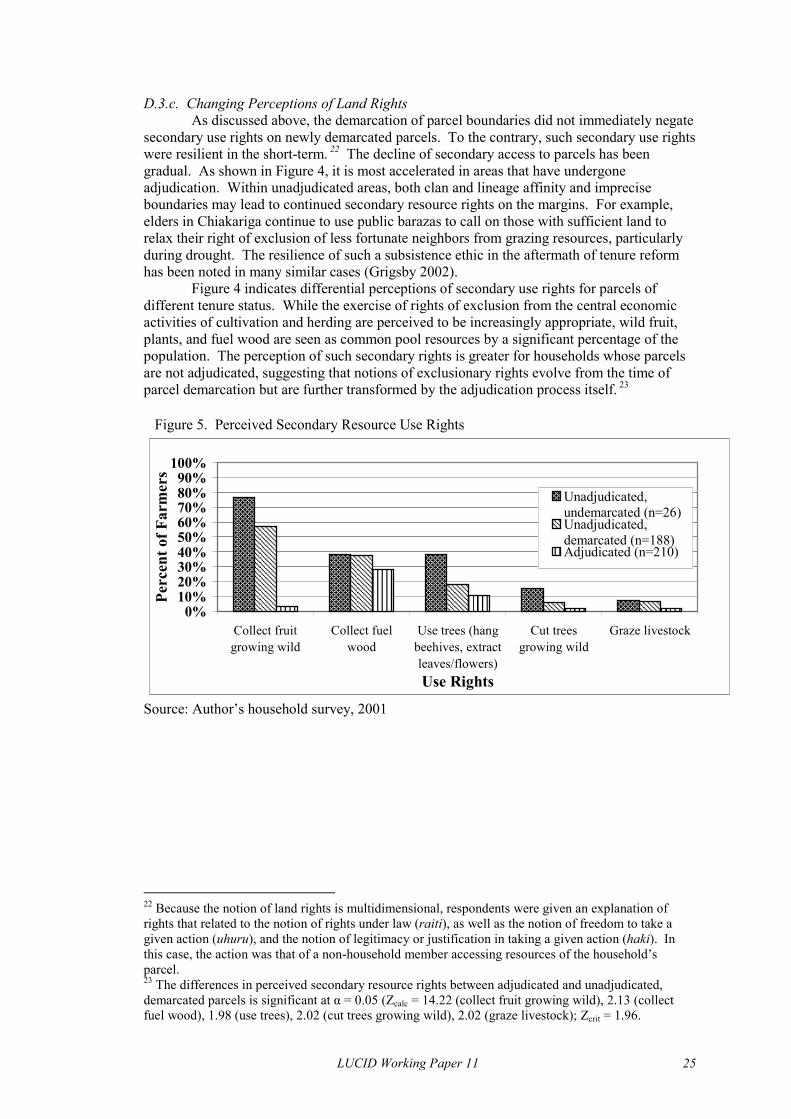
D.3.c. Changing Perceptions of Land Rights As discussed above, the demarcation of parcel boundaries did not immediately negate secondary use rights on newly demarcated parcels. To the contrary, such secondary use rights were resilient in the short-term. 22 The decline of secondary access to parcels has been gradual. As shown in Figure 4, it is most accelerated in areas that have undergone adjudication. Within unadjudicated areas, both clan and lineage affinity and imprecise boundaries may lead to continued secondary resource rights on the margins. For example, elders in Chiakariga continue to use public barazas to call on those with sufficient land to relax their right of exclusion of less fortunate neighbors from grazing resources, particularly during drought. The resilience of such a subsistence ethic in the aftermath of tenure reform has been noted in many similar cases (Grigsby 2002). Figure 4 indicates differential perceptions of secondary use rights for parcels of different tenure status. While the exercise of rights of exclusion from the central economic activities of cultivation and herding are perceived to be increasingly appropriate, wild fruit, plants, and fuel wood are seen as common pool resources by a significant percentage of the population. The perception of such secondary rights is greater for households whose parcels are not adjudicated, suggesting that notions of exclusionary rights evolve from the time of parcel demarcation but are further transformed by the adjudication process itself. 23 Figure 5. Perceived Secondary Resource Use Rights
������������������������������������������������������������������������
������������������������������������
������������������������������������
������������������ ����������
������������������������������������������������������������
������������������������������������
������������������ ��������� ������������������
������������������������������
������������������ ��������� ���������
0%10%20%30%40%50%60%70%80%90%
100%
Collect fruitgrowing wild
Collect fuelwood
Use trees (hangbeehives, extractleaves/flowers)
Cut treesgrowing wild
Graze livestock
Use Rights
Perc
ent o
f Far
mer
s
����Unadjudicated,undemarcated (n=26)
����������������
Source: Author’s household survey, 2001
Unadjudicated,demarcated (n=188)Adjudicated (n=210)
22 Because the notion of land rights is multidimensional, respondents were given an explanation of rights that related to the notion of rights under law (raiti), as well as the notion of freedom to take a given action (uhuru), and the notion of legitimacy or justification in taking a given action (haki). In this case, the action was that of a non-household member accessing resources of the household’s parcel. 23 The differences in perceived secondary resource rights between adjudicated and unadjudicated, demarcated parcels is significant at α = 0.05 (Zcalc = 14.22 (collect fruit growing wild), 2.13 (collect fuel wood), 1.98 (use trees), 2.02 (cut trees growing wild), 2.02 (graze livestock); Zcrit = 1.96.
LUCID Working Paper 11 25

Table 10. Goat Holdings Per Household by Location Turima Marimanti Gikingo Chiakariga
Number of goats0 38 49 66 29
1-10 53 41 38 5111-20 5 8 2 2021-30 3 1 1 431-40 0 1 1 3>40 0 1 0 0
Percent of households
Source: Author’s household survey, 2001 D.3.d. Changes in Livestock Land-Use
A number of general changes in livestock land-use have resulted from the land adjudication. Many of these changes were nascent in the decades before the adjudication and been accelerated as a result of tenure reform. The primary implication of the adjudication for livestock-keeping has been the loss of common grazing lands. An earlier and gradual reduction in land available for goat and cattle grazing has been accelerated by rapid population growth and periodic drought, particularly in the years 1984 and 2000. Coupled with greater access to highland markets via traders, this spatial constraint has transformed the role of livestock in the household economy and further intensified Tharaka’s subordinate economic relationship with the core highland economy. However, it should be noted that the decline of grazing areas since the early 1980’s in many local contexts occurred parallel to the geographic expansion of permanent settlement and livestock keeping to the midland zone.
There are few empirical measures of long-term change in livestock numbers in Tharaka. However, narratives of elders in nearly all communities, particularly lowland areas of long-time settlement, indicate a gradual decline in livestock numbers beginning in the late 1970’s. The locations with the highest percentage of households owning no livestock were Gikingo and Marimanti (Table 10). A comparison of data from 1979 and 2001 indicate a large increase in the percentage of households that do not own any goats as well as households owning fewer than 10 goats (Table 11).24 The percentage of households with large herds has decline significantly over this time period. However, the change between two years must be considered in the context of fluctuating herd sizes that characterize semi-arid land-use systems. The 2001 data reflect a moment at which herd sizes had not recovered from the severe drought of 2000. At least 70% of households sold livestock during the 2000 drought. The extent to which households will succeed in restocking in the context of declining grazing resources is an open question.
That a broad trend toward destocking has occurred is supported by the assessments of changes in household livestock holdings by individual farmers (Table 12). Goat holdings, for example, were reported to have declined significantly for more than 65% of households in each location. In addition to greater than average land access, households that succeeded in enlarging their herd sizes were more likely to be involved in non-farm wage labor and activities such as trading. In this context, outside income provides both the cash to purchase livestock and, in some cases, rented parcels for grazing.
24 A conclusive comparison of the two data sets is difficult due to the differences in sampling techniques undertaken between these two independent studies. The data for the Chege and Ng’ethe (1983) study were collected through a random selection of ten residents in each Tharaka sub-location. The author’s household survey represents a random sample of four representative locations within Tharaka.
LUCID Working Paper 11 26

Table 11. Goat Holdings Per Household, Tharaka District
1 Ng’ethe and Chege (1982), n=142
Number 1979 1 2001 2
0 12 441-10 32 44
11-20 30 821-30 17 231-40 3 141-50 2 0>50 5 0
2 Author’s household survey, 2001, n=384 Table 12. Reported Changes in Goat Holdings, 1990-2000
Households That Own Livestock (%)Significant Increase About the Same Significant Decline
Turima (n=58) 26 7 67Gikingo (n=39) 13 8 80Marimanti (n=48) 21 8 71Chiakariga (n=72) 25 10 65Source: Author’s household survey
At the level of the larger administrative unit, the adjudication process involves partitioning land once used as common grazing land for individual households, schools, churches, markets, and County Council facilities. As such, the total area available for grazing activities has declined drastically. Although changes in the household spatial economy were nascent following boundary demarcation, the effects are felt more acutely as households increasingly assert their exclusionary rights to specific resources on their parcel or parcels. The immediate result of this has been a continuing process of declining grazing areas for cattle and goats, eventually leading to declining livestock numbers. The expansion of both unassisted settlement (e.g., Turima and Gikingo) and government-sponsored settlement schemes (e.g., Nkondi) in LM4 reduced pressures on grazing land in the lowland areas. However, out-migration was not sufficient to counter the demographic and evolutionary tenure changes underway by the 1980’s.
Land tenure reform placed constraints on the ability of households to maintain goat stocks, particularly for those households that were assigned small or degraded plots. The parcels of public land that were set aside during the adjudication are vastly insufficient to provide additional land for grazing during drought periods. As a result, those without the ability to rent grazing land, or those who have not maintained kinship ties with clan members from the higher elevation zones, have little choice but to reduce livestock numbers, a gradual process accelerated by the movement toward individualized land rights and the increased requency of drought in the last twenty years. f
LUCID Working Paper 11 27
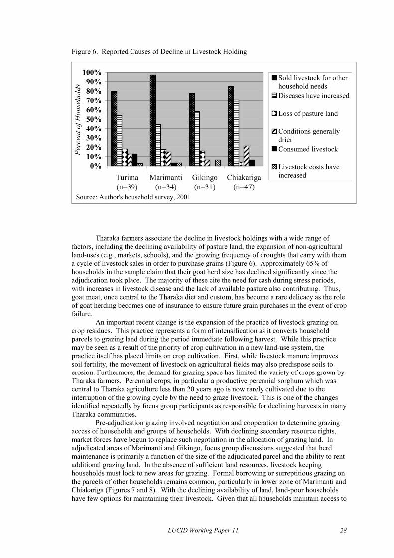
Figure 6. Reported Causes of Decline in Livestock Holding
�������������������������������������������������������
�����������������������������������������������������������������
��������������������������������������������������
�������������������������������������������������������
�����������������������������������
������������������������������
����������������������������������������
���������������������������������������������
���������������
���������������
��������������� �����
����������
���������������
����������
�������������������� �����
����������
0%10%20%30%40%50%60%70%80%90%
100%
Turima(n=39)
Marimanti(n=34)
Gikingo(n=31)
Chiakariga(n=47)
Perc
ent o
f Hou
seho
lds
�������� Sold livestock for other
household needs����
����������������
Consumed livestock��������
Source: Author's household survey, 2001
Diseases have increased
Loss of pasture land
Conditions generallydrier
Livestock costs haveincreased
Tharaka farmers associate the decline in livestock holdings with a wide range of factors, including the declining availability of pasture land, the expansion of non-agricultural land-uses (e.g., markets, schools), and the growing frequency of droughts that carry with them a cycle of livestock sales in order to purchase grains (Figure 6). Approximately 65% of households in the sample claim that their goat herd size has declined significantly since the adjudication took place. The majority of these cite the need for cash during stress periods, with increases in livestock disease and the lack of available pasture also contributing. Thus, goat meat, once central to the Tharaka diet and custom, has become a rare delicacy as the role of goat herding becomes one of insurance to ensure future grain purchases in the event of crop failure.
An important recent change is the expansion of the practice of livestock grazing on crop residues. This practice represents a form of intensification as it converts household parcels to grazing land during the period immediate following harvest. While this practice may be seen as a result of the priority of crop cultivation in a new land-use system, the practice itself has placed limits on crop cultivation. First, while livestock manure improves soil fertility, the movement of livestock on agricultural fields may also predispose soils to erosion. Furthermore, the demand for grazing space has limited the variety of crops grown by Tharaka farmers. Perennial crops, in particular a productive perennial sorghum which was central to Tharaka agriculture less than 20 years ago is now rarely cultivated due to the interruption of the growing cycle by the need to graze livestock. This is one of the changes identified repeatedly by focus group participants as responsible for declining harvests in many Tharaka communities.
Pre-adjudication grazing involved negotiation and cooperation to determine grazing access of households and groups of households. With declining secondary resource rights, market forces have begun to replace such negotiation in the allocation of grazing land. In adjudicated areas of Marimanti and Gikingo, focus group discussions suggested that herd maintenance is primarily a function of the size of the adjudicated parcel and the ability to rent additional grazing land. In the absence of sufficient land resources, livestock keeping households must look to new areas for grazing. Formal borrowing or surreptitious grazing on the parcels of other households remains common, particularly in lower zone of Marimanti and Chiakariga (Figures 7 and 8). With the declining availability of land, land-poor households have few options for maintaining their livestock. Given that all households maintain access to
LUCID Working Paper 11 28

seasonal streams and rivers to water animals, roadside and stream side vegetation have come under increasing pressure of livestock moving between homesteads and water sources. Nonetheless, grazing of miniscule public parcels, roadside vegetation, stream banks, and hillsides are certainly not sufficient as an adaptation to the restrictions of individualized tenure as less than 15% of livestock holding households access currently access such resources (Figure 7).25 Figure 7. Percentage of Livestock-Holding Households That Access Grazing Resources Apart From Own Parcels
������������������������������������������������������������������������������������
����������������������������������������������������
�������������������������������������������������������������������������������������������
���������������������������������������������������������������������������������������������������������������������
������������������������������������������������
�����������������������������������������������������������������
����������������������������������������������������
������������������������������������������������������������������������������
0%
10%
20%
30%
40%
50%
60%
70%
Turima(n=67)
Gikingo(n=44)
Chiakariga(n=80)
Marimanti(n=56)
Perc
enta
ge ����Rarely����
����
Source: Author's household survey, 2001
Often
Chiakariga (n=80)
Turima (n=67)
Gikingo (n=44)
Figure 8. Additional Grazing Areas Used By Tharaka Households
��������������������������������������������������
��������������������
������������
������������
���������������
����������
�������� ����
��������������������������������
����������������
����������
��������
��������
��������
���������������
������������������������������
����������������
������������
���������������
���������������
��������
������������
��������
����������������
���������� ����
��������
0%5%
10%15%20%25%30%35%40%45%
Anothe
r hou
sehold
's parc
el
Relativ
e's pa
rcel
Roadsi
de(pu
blic)
Public
parce
l
Riverba
nk (p
ublic
)
Riverba
nk (p
rivate
)
Hillside
s (pu
blic)
Swamp (
publi
c)
Perc
ent o
f Liv
esto
ck H
oldi
ng H
ouse
hold
s
���� Marimanti (n=56)��������������������
Source: Author's household survey, 2001
25 It can be reasonably assumed that the data on grazing apart from one’s own parcel are very conservative given that the district administration or the chief of the location may restrict access to these grazing resources. As a result, respondents were likely reluctant to admit to engaging in such surreptitious grazing practices.
LUCID Working Paper 11 29

D.3.e. Changes in Agricultural Land-Use One component of agricultural intensification is an increased frequency of cultivation and reduction of fallowing periods. The notion of fallow can encompass a range of meanings in the context of different land-use systems. For example, fallow within a system of shifting cultivation may involve complete abandonment and regrowth of successional vegetation. Within more intensive crop-livestock systems, fallow may involve intensive management and use of fallowed land as pasture. For the purposes of this study, it is important to grasp the transformation of fallow in the context of land demarcation. In Tharaka, the notion of pasture and fallow appear to be converging, such that the Tharaka term ng’ũndũ, which captures the idea of regrowth, increasingly takes on the meaning of pasture. The loss of extensive grazing areas and increasingly severe space limitations has created a more direct association between a category of land cover and a specific land-use. Bernard (1969) estimates the intensity of Tharaka cultivation as four years of cultivation followed by 15 years of fallow. Wisner’s observation from the early 1970’s, just a few years later, indicate a system in transition from rotational bush fallow to short fallow. Wisner’s (1968a) research indicated an agricultural cycle characterized by 3 years of cultivation followed by 10 years of fallow in Marimanti and 5 years of cultivation followed by 10 years of fallow in Chiakariga. Ng’ethe and Chege (1983) report that approximately 60% of Tharaka farmers continued to practice shifting cultivation, while at least 40% of households indicated no use of fallow in 1979. A comparison of Ng’ethe and Chege’s (1983) study with the author’s household survey data indicate an acceleration of the intensification of crop cultivation (Table 13). While only 40% of households in 1979 had no land in fallow, more than 75% of sampled parcels had no area of fallow in 2001. The expansion of crop cultivation was the primary reason for this change. In 1979, 90% of households had less than 30% of their land area under cultivation. By 2001, cultivation covered less than 30% of the area of only 30% of parcels. An additional 30% of parcels have at least 90% crop cover. A transition from bush fallow to permanent cultivation appears to have occurred in as little as twenty years under the multiple pressures described above.
While one might assume a trajectory of population growth and declining fallow, these broad indicators of intensification give little insight into the variation in land-use intensification within Tharaka during the 1970’s, particularly between the LM4 and LM5/IL5 zones. Narrative accounts indicate an intensification of land degradation leading to out-migration from Chiakariga and Marimanti to the midland zone, primarily Gikingo and Turima (Table 4). As such, out-migration may have reduced pressures to intensify production in the lowland areas. In the areas of new settlement, increasingly boundary-conscious farmers marked parcel boundaries and were discouraged from shifting due to the lack of tenure security in a landscape largely lacking in social institutions. Differentiation emerged between the two zones such that farmers in LM5 were increasingly restricted due the abandonment of severely degraded land while rapid population growth and boundary demarcation in LM4 created pressures for intensification.
LUCID Working Paper 11 30

Table 13. Changes in the Percentage of Land Under Fallow and Cultivation
Percent of land area 1979 1 2001 2 1979 1 2001 2
0 40.1 76.3 28.2 9.41-10 10.6 0.4 33.1 3.111-20 16.2 2.3 20.1 6.821-30 7.7 2.1 12.1 8.231-40 9.9 5.4 2.8 10.341-50 8.5 3.7 0 11.351-60 2.1 1.5 0 5.561-70 4.9 2.1 0 5.571-80 0 2.7 0 6.681-90 0 0 0 2.991-100 0 3.5 0 30.4
Fallowed Land Cultivated Land
Sources: 1 Ng’ethe and Chege (1983); 2 Author’s household survey, 2001
The current distribution of major land-use types by location indicates that cropped
land is the dominant land-use class in each location except Marimanti (Table 14). The areas of fallow or pasture land are greatest in Turima, which is also the most intensively cultivated of all locations. This pattern might suggest that fallow as a management technique has emerged in areas of most intensive cultivation. However, Gikingo Location is characterized by a small percentage of the total area under managed fallow. The immediate reason behind this variation within agro-ecological zone LM4 is not apparent. Under less severe land constraints, Chiakariga and Marimanti locations in agro-ecological zone LM5 and IL5 retain the largest percentages of bushland and grassland and smallest percentages of cropland. The differences in the distribution of land-covers between adjudicated and unadjudicated units are not as great as the differences between midland and lowland zones.
Table 14. Distribution of Major Land Cover Types on Sampled Parcels
Turima Marimanti Gikingo Chiakarigan=144 n=124 n=125 n=110
Land Cover TypesCrop 68 36 59 43Fallow / pasture 27 17 8 15Bushland 4 44 30 36Grassland 2 3 4 5
Average parcel size 3.57 6.09 4.84 5.33
Percent of Total Land Area in Sampled Parcels
Source: Author’s household survey, 2001
With the exception of the driest margins of agro-ecological zone LM5, the Tharaka land-use system can be characterized as a system of permanent cultivation with low rates of adoption of managed fallow. While inconsistencies in data collection do not permit a measurement of recent fallow periods or the adoption of crop rotations, group discussions with residents from each sampled administrative unit confirm that the practice of fallow is increasingly rare. At the same time, people recognize fallow as a key soil management technique. The inability to fallow appears to relate two primary factors. First, with the decline in livestock, households are experiencing greater vulnerability to the effects of drought. Where as livestock continue to provide protection against selling other key domestic resources during drought periods, the
LUCID Working Paper 11 31
thinness of this protection is increasingly evident. It is hoped that expanding the area under cultivation will provide sufficient crop production in years of low rainfall and low crop productivity. The factors affecting the use of fallow may also have complex connections with labor supply and agricultural knowledge, as the following narrative of a young female head of household in Gikingo Location attests:
My parents passed away in 1992 and since then we are just three. I am the first-born and I am living with my two younger siblings. In the ten years we have farmed here, we have never left any land fallow. We are farming on two acres, but we also have two acres covered with bush. I know the crops we are getting are few, but if I tried to change the place where we farm by clearing the bushy areas we might not have vegetation for our few livestock. It is also a lot of work. The youngest one cannot work and the other is in school.
An additional factor in declining fallow may be the growth of a land rental market. Land rentals were described in group meetings as important for the maintenance of goat stocks. Expansion of cultivation through purchase or rental is also seen as an important means of avoiding the adverse effects of drought in the future (Smucker and Wisner, forthcoming). With the redistributive functions of the clan replaced by market forces, sufficient access to cropland may become the privilege of those with access to outside income or remittances. The views of an elder male of the pressures effecting the decision to fallow were representative of most areas of agro-ecological zone LM4:
Fallow around here? That one is very rarely practiced. If you leave land fallow, you can expect it to return to its degraded state after only one or two years of use. So it is not really possible to practice the kind of fallow that would allow for a regeneration of soil fertility. On the other hand, you might find someone around who is trying to fallow. Once he has made that decision, he is approached by his land-poor neighbors who pressure him to rent them the land. The temptation of that income is too strong, and he allows the soils to be overworked again.
Although the changing land-population ratio certainly had a gradual effect on the
reduction of fallow periods and the intensification of crop production, boundary demarcation and adjudication have placed new restrictions on resource use and brought about additional pressures to intensify crop production. The transition among households toward greater reliance on crop cultivation has further intensified crop land-use and made the success or failure of a given crop all the more crucial to protecting key domestic assets. D.3.f. Land Development and Productivity A widely used indicator of sustainable agricultural intensification is investment in land productivity, particularly soil and water conservation techniques (Reardon et al. 1998, Tengberg et al. 1999). For Tharaka, the sedentarization of agriculture has brought new challenges in terms of adapting indigenous soil management techniques to a context of more sustained use. Improved land management has been a central argument in favor of land tenure reform in Kenya. In this section I investigate both the variations in investments in these measures among parcels of different tenure status. Because the Tharaka have only recently relied on intensive cultivation for their livelihood, the suite of techniques employed to combat soil erosion are still in transition. Two techniques encompassed the primary investments of the Tharaka in soil and water conservation: log lines and trash lines. While these methods were widely used, there was little incentive for investment of significant amounts of labor in such work in the past. Given abundant land and the possibility of clearing and preparing a new parcel in two to four years
LUCID Working Paper 11 32

time, investments of labor in long-term land productivity was not a necessity for maintaining productivity. However, in relatively short time and with little technical assistance, many Tharaka have adopted a suite of conventional conservation measures. Rates of adoption continue to increase where extension advice is accessible (D. Arimi, pers. comm.). Figure 9 indicates the variation in rates of adoption of major soil and water conservation techniques by tenure status of the parcel. The differences in the rates of adoption between adjudicated and unadjudicated parcels are surprising. The notion that land adjudication spurs greater tenure security and willingness to invest in land productivity does not seem to be supported by the Tharaka case which indicates significantly higher rates of investment on parcels that are not adjudicated, particularly for such core techniques as trash lines and stone bunds.26
Since the advent of demarcation in the late 1980’s, Tharaka farmers have greatly increased their investments in soil and water conservation as evidenced by rates of adoption of stone bunds, tree and shrub planting, and use of manure to increase soil fertility. This marks a major increase in investments as compared to twenty years ago when trash lines and grass strips alone were widely adopted as a preventative measure against erosion (Ng’ethe and Chege 1983). While the relatively high rates of adoption are encouraging, continued reports of declining output per acre and growing erosion problems are worrying. The differences in rates of adoption of soil and water conservation techniques between adjudicated and unadjudicated areas does not support the idea that the adjudication process itself drives such investments. Clearly the range of factors that may drive such investments is great and may include the slope and condition of the parcel, access to extension advice, access to wage and kin labor, involvement in cash cropping, and other dimensions of land tenure, and the extent to the which a given technique may predispose crops to the threat of pests. An additional dynamic that may be relevant to the observed variation in investments is the adjudication process itself, which is ongoing in the district. Given the means by which individualized parcels are adjudicated, it is possible that households with unadjudicated parcels focus their soil and water conservation investments on those that will additionally add to their security of tenure. Through investment in tree planting, terracing, stone bunds, and even trash lines, households create indicators of sustained use on land they intend to claim during the adjudication exercise. A thorough investigation of these factors is necessary before arriving at more conclusive statements regarding the relative important of land adjudication in such investments.
26 The differences in rates of adoption of stone bunds, trash lines, and fruit trees are statistically significant at α = 0.05 (Zcalc = 8.51 (stone bunds), 5.89 (trash lines), and 2.86 (fruit tree planting); Zcrit = 1.96.
LUCID Working Paper 11 33

Figure 9. Frequency Distribution of Investments in Soil and Water Conservation
��������������������������������������������
������������������������������������
��������������
��������������������������������������������
��������������������������������������
���������������
���������������
����������������������
������������������������
���������������������������������������������������������������
����������������������������������������������������������������������������������������������������������������������������������������������������������������������������������������������������
��������������������������������������������������������������������������
��������������
��������
��������������
����������������
�������������������������������������������
������������������������������������������������������������������������
����������������������������������������������������������������������������������������������������
�����������������������������
���������������������������
��������������������������������
���������������
����������������������
����������������������������������������������������������
������������������������������������������������������������������������������������������������������������������������������������������������������������������
��������������������������������������������
�������������������������������������������������������������������������������������������
������������������������
�������������������������������������������������������������������
������������������������������������������������������������������������
������������������������������������������������������������������
��������������������
�������������������
��������������������������������������������������������
��������������������������������������
��������������������������������������������������������������������������
��������������������������������������������������������������������������������������������������������������������������������������������������������������������������������������
��������������������������������������������������������������������������������������������������������������������������������������������������������������������������������������������������������������������������������������������
0% 20% 40% 60% 80% 100%
None
Tree planting (Fruit)
Tree planting (Exotic)
Tree planting (Indigenous)
Log lines
Grass strips
Terracing
Manuring
Shrub planting
Stone bunds
Trash lines
�������� Owner (Unadjudicated)
(n=217)����
��������
����
Source: Author's household survey, 2001
Owner (Adjudicated)(n=220)Renter (n=21)
Borrower (n=37)
E. CONCLUSION
This working paper provides an overview of the recent evolution of the Tharaka land-use system including changes driven more recently by the individualization of land tenure. The analysis explores major aspects of change in Tharaka that have implications for the livelihood system and the prospects for agricultural development. In examining the dynamics and impacts of land tenure reform in the context of the evolution of a semi-arid land-use system in eastern Kenya, the above analysis contributes to understanding of the changes in land-use systems that have been associated with land tenure reform in other areas of Kenya and elsewhere in Africa (see page 8). The results indicate that the impacts of land adjudication are highly dependent on broader social and environmental contexts that impact trajectories of land-use and management.
A central argument in favor of the reform of customary tenure proposes tenure individualization as an impetus for agricultural intensification and improved land management. In Tharaka, where commonage grazing has been a major component of livelihood strategies, land reform has brought about the demarcation of common grazing lands for private and government development and contributed to the decline in secondary resource access. In the adjudicated areas of Marimanti and Gikingo, it has reduced the flexibility that Tharaka communities enjoyed under localized customary tenure. However, even in unadjudicated areas, the process of demarcation and evolutionary change in customary tenure are creating greater exclusivity and less flexibility in land rights. Such flexibility was important to maintaining livestock as it allowed local institutions to regulate resource access to grazing resources that are spatially and temporally variable in Tharaka’s semi-arid landscape. As residual secondary rights decline throughout Tharaka, it can be expected that destocking will continue or even accelerate in the absence of significant government or NGO intervention. As such, a general transition away from livestock keeping
LUCID Working Paper 11 34

and toward more intensive crop production has characterized the majority of households throughout the district. This transition has been most apparent in the adjudicated areas of Gikingo and Marimanti, which exhibit the highest rates of households who do not own livestock.
The intensity of cultivation has increased throughout Tharaka, with the decline of areas of bushland and fallow greatest in the midland LM4 agro-ecological zone. Within the drier IL5 and LM5 zones, cropping intensity has also increased in conjunction with boundary demarcation and adjudication. The continuing decline of secondary resource rights, combined with population growth, can be expected to bring about further intensification. Under such pressures, many Tharaka communities are achieving high rates of adoption of a suite of conservation measures. Tenure status does not appear to explain the variation in adoption of techniques, suggesting the need to examine more closely other social and environmental factors that may drive some to invest in such techniques while inhibiting others. For example, investments in conservation measures and other forms of landesque capital are often important to establishing sustained use of a parcel and can be grounds for asserting exclusionary land rights under both statutory and customary tenure. The dynamics of state-sponsored adjudication may encourage investments before the official adjudication process commences.
Contrary to the expectations of proponents of land tenure reform, land adjudication in Tharaka has not brought about an initial decline in land-related conflicts. By most accounts, pre-adjudication Tharaka society was not characterized by widespread land-use conflicts. Where conflict emerged, local institutions managed land-use conflicts satisfactorily in the absence of reform. While conflicts of access to land may have increased in advance of the demarcation and adjudication exercise, clan adjudication of land rights appears to have solved such conflicts satisfactorily. However, the processes of boundary demarcation and adjudication of “rights and interests” in land were problematic in Tharaka. The demarcation and adjudication processes themselves were associated with high rates of conflict among neighboring land claimants.
Changes in the distribution of landholdings is difficult to measure through time due to changes in the redistributive mechanisms that exist within customary tenure systems in Tharaka. The adjudication seems to have cemented the inequalities that existed due to inequality in land claims between lineages and clans. Currently, land borrowing and renting appear to be important as survival strategies for poor households. When rented and borrowed land are accounted for, inequality is less than it is for the distribution of land ownership. As such, the development of a land market that would permit greater land concentrations and, in turn, pave the way to greater commercialization does not appear likely. To the contrary, even in recently settled Turima and Gikingo, a distribution of landholdings developed that closely resembles areas of long-term Tharaka settlement.
All of the above are important indicators of change in the Tharaka land-use system, and more broadly within the Tharaka livelihood system. The implications of land adjudication for sustainable, intensive agriculture and, in turn, for long-term food security are many. For example, the trend toward destocking limits the possible responses of Tharaka households during drought periods, thus increasing vulnerability to selling key domestic assets such as land. Furthermore, without improvements in crop productivity, stress-related migration to wealthier highland areas may increase, effectively reducing the labor available for the increasingly intensive labor of weeding and soil and water conservation. The evolution of land-use and management must therefore be placed in the broader context of the Tharaka livelihood system and its adaptation to social and environmental change.
The Tharaka case study illustrates the intersection of societal and environmental factors in driving change in a semi-arid area. State-sponsored land adjudication has brought about a new logic of tenure security in communities where reform has been implemented such that local institutions are no longer the primary forum for ensuring security of land access. Nonetheless, state adjudicated land rights must still be seen in the context of their interpretation within local communities, whereby rights of exclusion to certain resources may remain difficult to assert in the context of the multiple stresses on local communities. At the
LUCID Working Paper 11 35

same time, as the eventuality of land reform looms over the extensive unadjudicated areas of semi-arid Kenya, strategies for asserting exclusive land rights and making land claims during the adjudication process may rely on investments in various forms of landesque capital as indicators of “rights and interest in land”. As such, the evolutionary theory of customary tenure change is relevant to the extent that it recognizes areas under customary tenure as part of broader political and cultural spaces in which ideas about land as exclusive property and local notions regarding the legitimacy of local distributions of resource rights interact with broader changes in the regional political economy.
Furthermore, internal variation in the adaptation of the Tharaka land-use system is also shaped by local agro-ecology. While the agro-ecological potential of Kenya’s semi-arid zones is by no means fixed, there are greater limitations in crop productivity and pasture regeneration in Tharaka’s marginal lowland zone (Marimanti and Chiakariga) than in midland areas of recent settlement (Turima and Gikingo). Great variability in soil fertility, including extensive areas of sandy and rocky soils, translates into great variability in resource endowments despite relatively moderate inequality in landholdings. Thus, the returns from additional investments of labor in crop productivity are likely to vary greatly both within and between agro-ecological zones. Local agro-ecology may be as important as land tenure in explaining variation in land management practices.
The analysis of root causes of land-use and cover change requires an approach that considers the interaction of societal groups and their adaptation to internal and external drivers of change. This paper explores place-specific adaptations in Tharaka, linking them to changing tenure policy and broader processes of change within Kenya. The case study supports the notion that although the evolution of land tenure practices represents an important intersection of Tharaka politics, culture, and environment, the existence of state-sponsored land rights alone does not account for variations in land-use and management in Tharaka. As communities continue to struggle with critical social and environmental challenges related to their own livelihoods, the rules of resource access might continue to evolve and adapt to emerging needs. As such, a political ecology of livelihood change in semi-arid Kenya must recognize the multiple pressures that influence land management decisions and the multiple arenas in which land rights are asserted, contested, and maintained.
LUCID Working Paper 11 36

F. REFERENCES Atwood, David A. 1990. Land registration in Africa: the impact on agricultural production.
World Development 18: 659-71. Bassett, Thomas J. 1993. Introduction: the land question and agricultural transformation in
Sub-Saharan Africa. In Land in african agrarian systems, ed., Thomas J. Bassett and Donald E. Crummey, 3-34. Madison: University of Wisconsin Press.
Bernard, Frank E. 1969. Recent agricultural change East of Mount Kenya. Papers in International Studies, Africa Series No. 4. Athens: Ohio Univ. Center for Inter’l St.
Bernard, Frank E. 1993. Increasing variability in agricultural production: Meru district, Kenya, in the twentieth century. In Population growth and agricultural change in Africa, ed. B.L. Turner II, Goran Hyden, and Robert Kates, 80-113. Gainesville: University Press of Florida.
Bernard, Frank E.. Campbell, David J., and Derrick J. Thon. 1989. Carrying capacity of the eastern ecological gradient of Kenya. National Geographic Research 5: 399-421.
Berry, Sara. 1993. No condition is permanent : the social dynamics of agrarian change in sub-Saharan Africa. Madison: University of Wisconsin Press.
Berry, Leonard, David J. Campbell, and Ingemar Emker. 1977. Trends in man-land interaction in the West African Sahel. In Drought in Africa, 2, eds., D. Dalby and F. Bezzaz, 83-91. London: International African Institute.
Bilsborrow, Richard E. 1987. Population pressures and agricultural development in developing countries: a conceptual framework and recent evidence. World Development 15: 183-203.
Blaikie, Piers M. and Brookfield, H. C. 1987. Land degradation and society. New York: Methuen 1987.
Boserup, Ester. 1965. Conditions of agricultural growth: the economics of agrarian change under population pressure. London: George Allen and Unwin.
Boserup, Ester. 1981. Population and technological change. Chicago: Univ. Chicago Press. Boserup, Ester. 1985. Economic and demographic interrelationships in sub-Saharan Africa.
Population and Development Review 11: 383-397. Brookfield, Harold C. Intensification revisited. 1984. Pacific Viewpoint 25: 15-44. Brokensha, David, and Jack Glazier. 1973. Land reform among the Mbeere of Central Kenya.
Africa 43: 182-206. Bruce, John W. 1988. A perspective on indigenous land tenure systems and land
concentrations. In Land and society in contemporary Africa, ed., R.E. Downs and S.P. Reyna, 23-52. Hanover: University Press of New England.
Bruce, John W. Shem E. Migot-Adholla, and Joan Atherton. 1994. The findings and their policy implications: institutional adaptation or replacement. In Searching for land tenure security in Africa, ed., John W. Bruce and Shem E. Migot-Adholla, 251-265. Dubuque: Kendall/Hunt.
Campbell, David J. 1999. Response to drought among farmers and herders in Southern Kajiado District, Kenya: a comparison of 1972-1976 and 1994-1996. Human Ecology 27: 377-416.
Campbell, David J., Helen Gichohi, Albert Mwangi, and Lucy Chege. 2000. Land-use conflict in S.E. Kajiado District, Kenya. Land Use Policy, 17, 4: 337-348, 2000.
Cleaver, Kevin M. 1993. A strategy to develop agriculture in Sub-Saharan Africa and a focus for the World Bank. Washington, D.C.: World Bank.
Deininger, Klaus, and Binswanger, Hans. 1999. The evolution of World Bank’s land policy: principles, experience, and future challenges. The World Bank Research Observer 14(2): 247-76.
Falloux, F. 1987. Land management, titling, and tenancy. In Sustainability issues in agricultural development, ed., T.J. Davis and I.A. Schirmer, 190-208. Washington, D.C.: The World Bank.
Firmin-Sellers, Kathryn, and Patrick Sellers. 1999. Expected failures and unexpected successes of land titling in Africa. World Development 27: 1115-1128.
LUCID Working Paper 11 37

Fleuret, Patrick. 1985. The social organization of water control in the Taita Hills, Kenya. American Ethnologist 12: 103-118.
Fleuret, Anne K. 1988. Some consequences of tenure and agrarian reform in Taita, Kenya. In Land and society in contemporary Africa, ed. R.E. Downs and S.P. Reyna, 136-158. Hanover: University Press of New England.
Great Britain. 1937. Kenya Colony annual report, Meru District. London: H.M.S.O. Grigsby, W.J. 2002. Subsistence and land tenure in the Sahel. Agriculture and Human
Values 19: 161-164. Grossman, Larry C. 1984. Peasants, subsistence ecology, and development in the highlands of
Papua New Guinea. Princeton: Princeton University Press. Hahn, C.M. 1998. Introduction: the embeddedness of property. In Property relations,
ed., C.M. Hahn, 1-47. Cambridge: Cambridge University Press. Haugerud, A. 1989. Land tenure and agrarian change in Kenya. Africa 59: 61-90. Hayami, Yujiro, and Vernon W. Ruttan. 1998. Induced innovation model of agricultural
development. International Agricultural Development, ed., Carl K. Eicher and John M. Staatz, 163-179. Baltimore: John Hopkins University Press.
Hunt, Diana. 1996. The impacts of individual land titling in Mbeere, Eastern Kenya. Discussion Papers in Economics, No. 01/96, University of Sussex.
IGBP. 1995. Land-use and land-cover change science/research plan. IGBP Report 35, IHDP Report 7. Stockholm: International Geosphere-Biosphere Programme.
Jaetzold, Ralph, and Helmut Schmidt. 1983. Farm management handbook of Kenya. Vol. II/C. Nairobi: Ministry of Agriculture.
Kates, Robert W., Goran Hyden, and B.L. Turner II. 1993. Theory, evidence, study design. In Population growth and agricultural change in Africa, ed. B.L. Turner II, Goran Hyden, and Robert Kates, 1-40. Gainesville: University Press of Florida.
Kenya. 1970. Kenya population census, 1969. Nairobi: Central Bureau of Statistics. Kenya. 1979. Arid and semi-arid lands development in Kenya. The framework for
implementation, programme planning, and evaluation. Nairobi: Government Printer. Kenya. 1981. Kenya population census, 1979. Nairobi: Central Bureau of Statistics. Kenya. 1994. Kenya population census, 1989. Nairobi: Central Bureau of Statistics. Kenya. 2001. The 1999 Kenya population and housing census: counting our people for
development. Nairobi: Central Bureau of Statistics. Lewis, W.A. 1955. Theory of economic growth. London: George Allen and Unwin. Lipton, Michael. 1968. The theory of the optimizing peasant. Journal of Development Studies
4: 327-351. Liverman, Diana, ed. 1998. People and pixels : linking remote sensing and social science.
Washington, D.C. : National Academy Press, 1998. Mackenzie, Fiona. 1994. “A piece of land never shrinks”: reconceptualizing land tenure in a
smallholding district, Kenya” In Land in African agrarian systems, ed., Thomas J. Bassett and Donald E. Crummey, 194-221.
Mackenzie, Fiona. 1998. Land, ecology, and resistance in Kenya, 1880-1952. London: Edinburgh University Press.
Migot-Adholla, Shem, Frank Place, and W. Oluoch-Kosura. 1994. Security of tenure and land productivity in Kenya. In Searching for land tenure security in Africa, ed., John W. Bruce and Shem Migot-Adholla, 119-140. Dubuque: Kendall/Hunt.
Mwaniki, Kabeca H.S. 1974. Embu historical texts. Nairobi: East African Literature Bureau. Netting, Robert McC., Glenn Davis Stone, and M. Priscilla Stone. 1993. Agricultural
expansion, intensification, and market participation among the Kofyar, Jos Plateau, Nigeria. In Population growth and agricultural change in Africa. ed., B.L. Turner II, Goran Hyden, and Robert W. Kates, 401-439. Gainesville: University of Florida Press.
Ng’ethe, Njuguna and Fred Chege, ed. 1983. Arid and semi arid lands pre-investment study, Kitui, Embu, and Meru, volume 3: statistical appendix. Nairobi: Institute of Development Studies.
LUCID Working Paper 11 38

Okoth-Ogendo, H.W.O. 1989. Some issues of theory in the study of tenure relations in African agriculture. Africa 59: 6-17.
Okoth-Ogendo, H.W.O. 1989. Some issues in theory in the study of tenure relations in African agriculture. Africa 59: 6-17.
Okoth-Ogendo, H.W.O. 1991. Tenants of the crown : evolution of agrarian law and institutions in Kenya. Nairobi: African Centre for Technology Studies.
Pingali, Prabhu L., and Hans P. Binswanger. 1984. Population density and agricultural intensification: a case study of the evolution of technologies in tropical agriculture. Washington DC: World Bank Discussion Paper, Report No. ARU22.
Place, Frank, Michael Roth, and Peter Hazell.1994. Land tenure security and agricultural performance in Africa: overview of research methodology. In Searching for land tenure security in Africa, ed., John W. Bruce and Shem E. Migot-Adholla, 15-39. Dubuque: Kendall/Hunt.
Platteau, Jean-Philippe. 1996. The evolutionary theory of land rights as applied to sub-Saharan Africa: a critical assessment. Development and Change 27: 29-86.
Reardon, Thomas, Daniel Clay, and Jaakko Kangasniemi. 1998. Sustainable intensification in the highland tropics: Rwandan farmers' investments in land conservation and soil fertility. Economic Development and Cultural Change 46: 351-378.
Rigg, Johnathon. 1986. Innovation and intensification in northeastern Thailand: Brookfield applied. Pacific Viewpoint 27: 29-45.
Riley, Bernard, W. and David Brokensha. 1988. The Mbeere in Kenya, Volume I: Changing rural ecology. Lanham: University Press of America.
Scott, James. 1976. The moral economy of the peasant. New Haven: Yale University Press. Smith, J.W., A. Naazie, A. Larbi, K. Agyemang, and S. Tarawali. 1997. Integrated crop-livestock systems in sub-Saharan Africa: an option or an imperative? Outlook on Agriculture 26: 237-246.
Smucker, Thomas, and Ben Wisner. forthcoming. Changing Household Responses to Drought in Tharak, Kenya: Persistence, Change, Challenge.
Stern, Paul C., Oran R. Young, and Daniel Druckman, eds. 1992. Global environmental change: understanding the human dimensions. Washington: National Academy Press
Taylor, Peter J. 1997. How do we know we have global environmental problems? undifferentiated science-politics and its potential reconstruction. In Changing Life: Genomes, Ecologies, Bodies, Commodities. ed., Peter J. Taylor, Saul E. Halfon, Paul N. Edwards. Minneapolis: University of Minnesota Press.
Tengberg, Anna, Linus Murithi, and Barrack Okoba. 1999. Land management on semi-arid hillsides in Eastern Kenya: learning from farmers's diverse practices. Mountain Research and Development, 19, 4: 354-363.
Tiffen, Mary, Michael Mortimore, and Francis Gichuki. 1994. More people, less erosion: environmental recovery in Kenya. Nairobi: ACTS Press.
Wangari, Esther. 1988. Land registration and its impact on small-scale farming in Kenya : the case of Mbeere in Embu. Nairobi: Institute for Development Studies, University of Nairobi.
Watts, Michael. 1991. The agrarian crisis in Africa: debating the crisis. Progress in Human Geography 17: 252-272.
Wharton, Clifton R., Jr. 1969. Agriculture and economic development. Chicago: Aldine. Wisner, Benjamin. 1976a. The human ecology of drought in eastern Kenya. PhD dissertation.
Worcester: Clark University. Wisner, Benjamin. 1976b. Man-made famine in eastern Kenya: the interrelationship of
environment and development. Discussion paper no. 96 Wisner, Benjamin. 1978. Constriction of a livelihood system: the peasants of Tharaka
Division. Economic Geography 53: 353-357. Zaal, Fred, and Remco H. Oostendorp. 2000. Explaining a miracle: intensification and the
transition towards sustainable small-scale agriculture in dryland Machakos and Kitui Districts, Kenya. World Development: 30: 1271-1287.
LUCID Working Paper 11 39