Embed Size (px)
Citation preview
http://www.thebritishmuseum.ac.uk/egyptian/bmsaes/issue3/favardmeeks.html
The present state of the site of Behbeit el-Hagar
Christine Favard-Meeks
A recent event urges me to inform the scientific community of the current situation at the site ofBehbeit el-Hagar.
1
I returned to the site in early 2002, with the authorisation of the SCA to try andestablish a project for the safeguard of the site and the temple. As it is now, it seems that before pre-paring the reconstruction of the temple, the whole site should be excavated if we want to discover whatis left of the important information it could yield.
The site today
The old plans show a huge temenos.
2
The study of the land-registers since the last war shows the grad-ual encroachment of agricultural land, first on the eastern side, and then on the western side. Thissituation has, in some way, been ratified by the building in 1993 of a brick wall, unfortunately erectedbetween the temple and the ancient wall that is now used as a cemetery and so registered in the land-register.
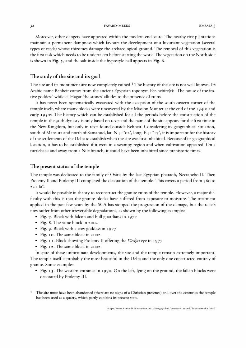
In 2002, the following can be seen:• At the entrance, on the south, the ancient wall on the left is outside the modern one, in the
background (
Fig. 1
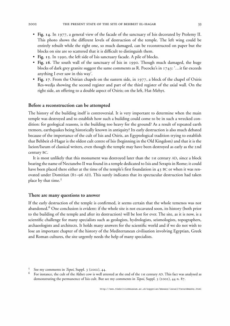
).• On the eastern side, a rice plantation has replaced wheat fields. The temple behind the modern
wall is now completely surrounded by housing (
Fig. 2
). • On the western side, housing has developed on archaeological ground (
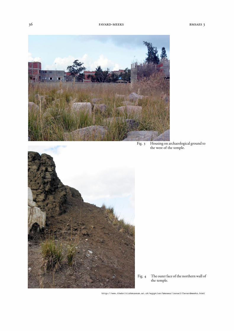
Fig. 3
).More than 50% of the archaeological ground has now been lost.
3
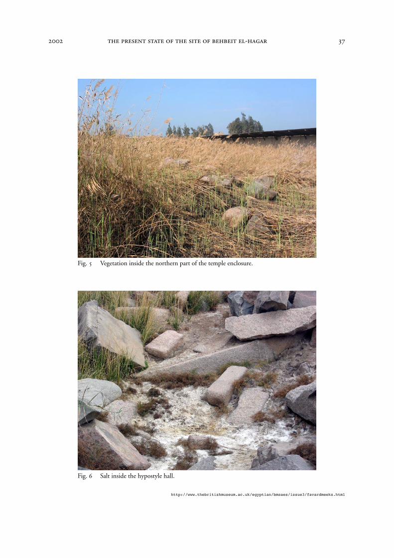
The ancient remains, outside thewall, are in danger.
Fig. 4
shows the outer face of the northern wall. The general situation, considering the agricultural soil is fertile and much in demand, is the conse-
quence of the abandonment of the site by Egyptologists at a time when far more space was availableto prepare a programme of reconstruction.
1
As quite a few relief fragments from blocks intact in 1977 have been on auction sale since 1993, I gave files to theSCA which enabled their provenance to be established. This relates to the blocks which have been damaged (theheads have been cut off ) since the 1977 photographic survey. See below
Figs 7
–
12
. I thank the Supreme Councilof Antiquities who granted me the authorization, in January 2002, for returning to the site. I am most grateful toProf. Dr. Gaballa A. Gaballa, then Principal Secretary of the SCA and Dr. Mohamed Abd-el Maksoud, GeneralDirector of the Department for Egyptian Antiquities of the Delta and Sinai, for the help they have thus given me.The SCA has subsequently been successful in retrieving some of the blocks, see, for example, Al Ahram Weekly4–10 July 2002, no, 593, online at http://www.ahram.org.eg/weekly/2002/593/hr1.htm. Lastly I thank NigelStrudwick for assistance in editing this article.
2
See, for example, Description de l’Égypte, Antiquités-Planches.Tome Cinquième, pl. 30: ‘Delta. Environs deSebennytus, 1 à 9 “Plan topographique et détails d’un temple d’Isis, à Bahbeyt”’. See also references in Lézine,
Kêmi
10 (1949), 49–57; Favard-Meeks,
Archéologia
263 (décembre 1990), 26–33; id.,
Le temple de Behbeit el-Hagara; id.
in Quirke (ed.),
The Temple in Ancient Egypt
, 102–11.
3
Professor Mekkawy and the University of Tanta have been in charge of the site for some time, from 1988onwards. We hope that the results of their work will soon be published
-
http://www.thebritishmuseum.ac.uk/egyptian/bmsaes/issue3/favardmeeks.html
Moreover, other dangers have appeared within the modern enclosure. The nearby rice plantationsmaintain a permanent dampness which favours the development of a luxuriant vegetation (severaltypes of reeds) whose rhizomes damage the archaeological ground. The removal of this vegetation isthe first task which needs to be undertaken before starting the work. The vegetation on the North sideis shown in
Fig. 5
, and the salt inside the hypostyle hall appears in
Fig. 6
.
The study of the site and its goal
The site and its monument are now completely ruined.
4
The history of the site is not well known. ItsArabic name Behbeit comes from the ancient Egyptian toponym Per-hebite(t): ‘The house of the fes-tive goddess’ while el-Hagar ‘the stones’ alludes to the presence of ruins.
It has never been systematically excavated with the exception of the south-eastern corner of thetemple itself, where many blocks were uncovered by the Mission Montet at the end of the 1940s andearly 1950s. The history which can be established for all the periods before the construction of thetemple in the 30th dynasty is only based on texts and the name of the site appears for the first time inthe New Kingdom, but only in texts found outside Behbeit. Considering its geographical situation,south of Mansura and north of Samanud, lat. N 31˚02', long. E 31˚17', it is important for the historyof the settlements of the Delta to establish when the site was first inhabited. Because of its geographicallocation, it has to be established if it were in a swampy region and when cultivation appeared. On aturtleback and away from a Nile branch, it could have been inhabited since prehistoric times.
The present status of the temple
The temple was dedicated to the family of Osiris by the last Egyptian pharaoh, Nectanebo II. ThenPtolemy II and Ptolemy III completed the decoration of the temple. This covers a period from 360 to221
BC
. It would be possible in theory to reconstruct the granite ruins of the temple. However, a major dif-
ficulty with this is that the granite blocks have suffered from exposure to moisture. The treatmentapplied in the past few years by the SCA has stopped the progression of the damage, but the reliefsnow suffer from other irreversible degradations, as shown by the following examples:
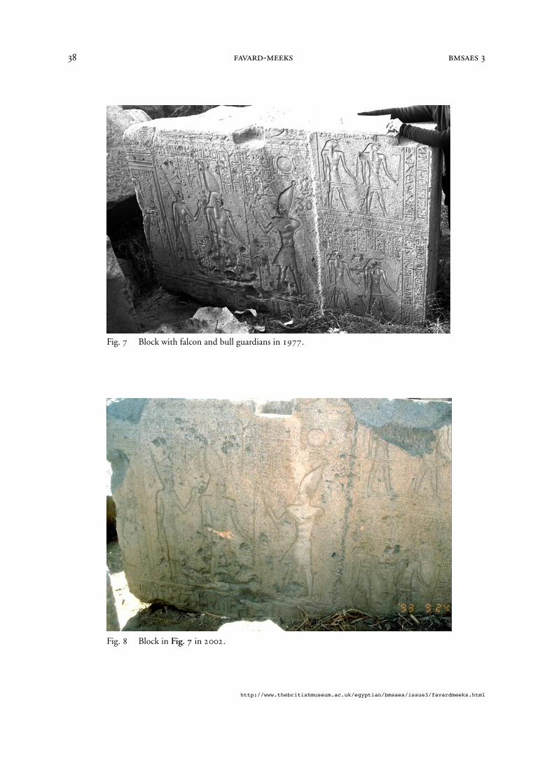
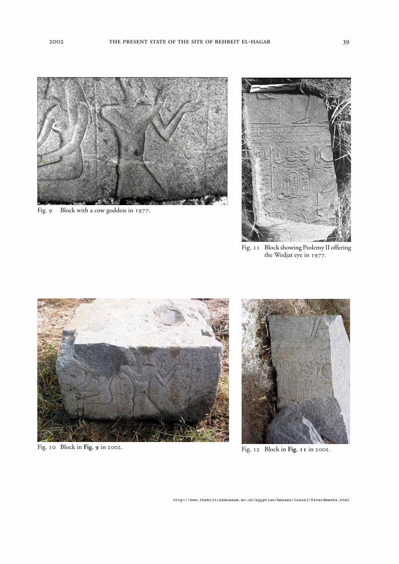
•
Fig. 7
. Block with falcon and bull guardians in 1977•
Fig. 8
. The same block in 2002•
Fig. 9
. Block with a cow goddess in 1977•
Fig. 10
. The same block in 2002•
Fig. 11
. Block showing Ptolemy II offering the
Wedjat
eye in 1977•
Fig. 12
. The same block in 2002.In spite of these unfortunate developments, the site and the temple remain extremely important.
The temple itself is probably the most beautiful in the Delta and the only one constructed entirely ofgranite. Some examples:
•
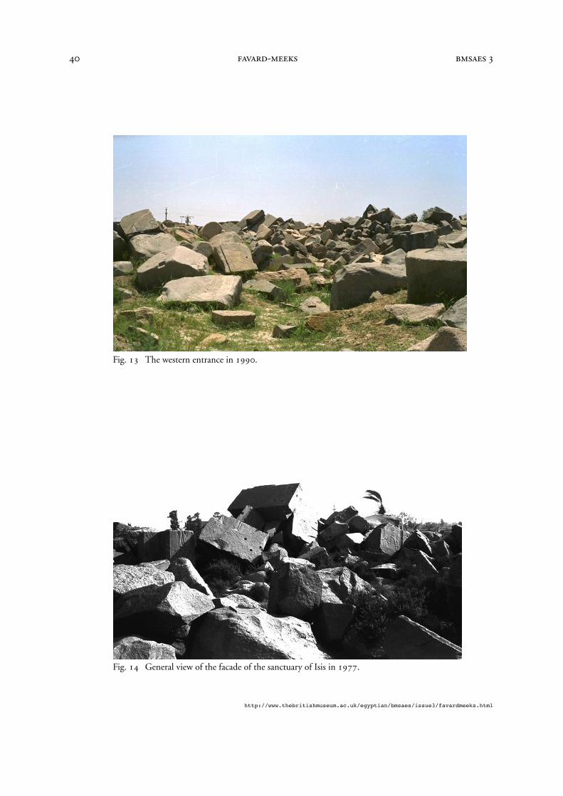
Fig. 13
. The western entrance in 1990. On the left, lying on the ground, the fallen blocks weredecorated by Ptolemy III.
4
The site must have been abandoned (there are no signs of a Christian presence) and over the centuries the templehas been used as a quarry, which partly explains its present state.
-
http://www.thebritishmuseum.ac.uk/egyptian/bmsaes/issue3/favardmeeks.html
•
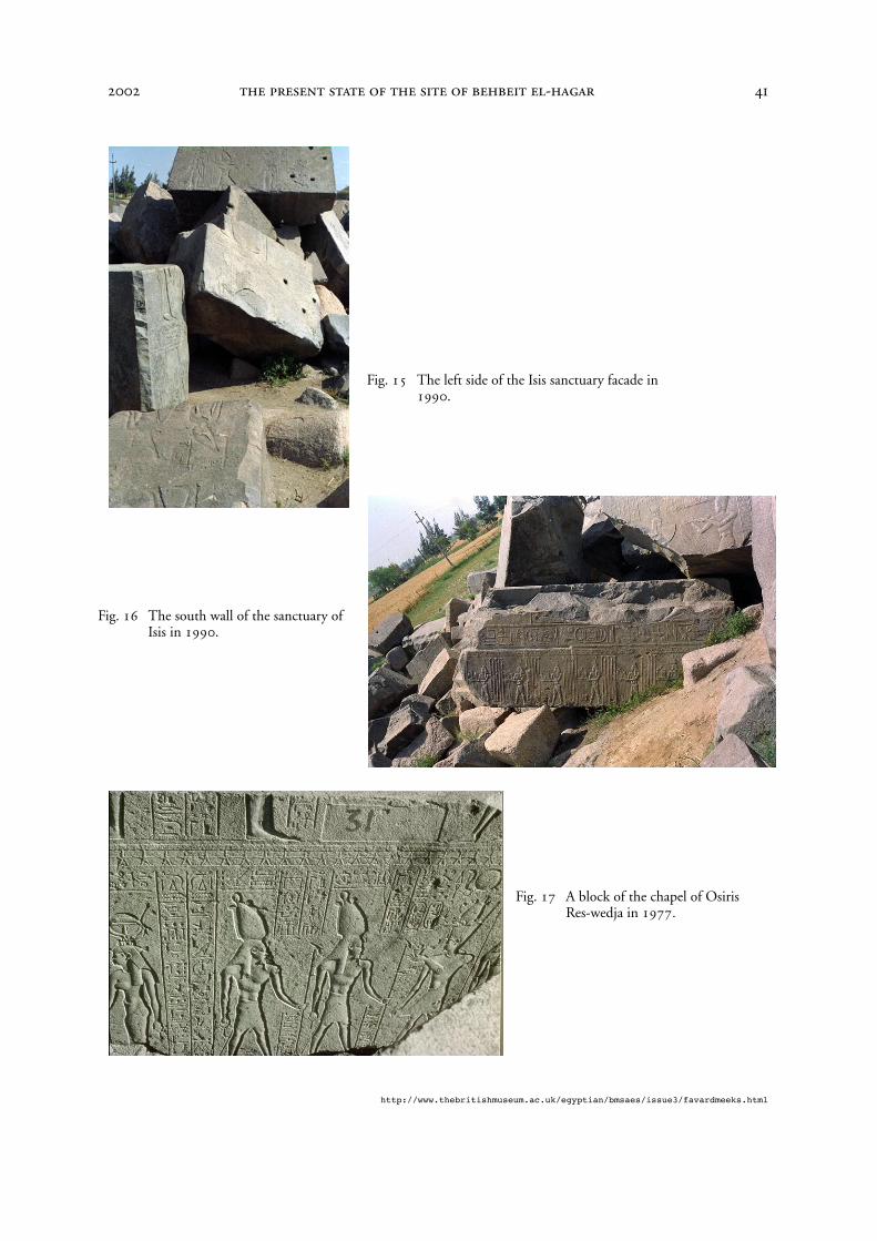
Fig. 14
. In 1977, a general view of the facade of the sanctuary of Isis decorated by Ptolemy II.This photo shows the different levels of destruction of the temple. The left wing could beentirely rebuilt while the right one, so much damaged, can be reconstructed on paper but theblocks on site are so scattered that it is difficult to distinguish them.
•
Fig. 15
. In 1990, the left side of Isis sanctuary facade. A pile of blocks.•
Fig. 16
. The south wall of the sanctuary of Isis in 1990. Though much damaged, the hugeblocks of dark grey granite suggest the same comments as R. Pococke’s in 1743: ‘…it far exceedsanything I ever saw in this way’.
•
Fig. 17
. From the Osirian chapels on the eastern side, in 1977, a block of the chapel of OsirisRes-wedja showing the second register and part of the third register of the axial wall. On theright side, an offering to a double aspect of Osiris; on the left, Hat-Mehyt.
Before a reconstruction can be attempted
The history of the building itself is controversial. It is very important to determine when the maintemple was destroyed and to establish how such a building could come to be in such a wrecked con-dition: for geological reasons, is the building too heavy for the ground? As a result of repeated earthtremors, earthquakes being historically known in antiquity? Its early destruction is also much debatedbecause of the importance of the cult of Isis and Osiris, an Egyptological tradition trying to establishthat Behbeit el-Hagar is the oldest cult centre of Isis (beginning in the Old Kingdom) and that it is theIseion/Iseum of classical writers, even though the temple may have been destroyed as early as the 2ndcentury
BC
.It is most unlikely that this monument was destroyed later than the 1st century
AD
, since a blockbearing the name of Nectanebo II was found in a temple dedicated to Isis and Serapis in Rome; it couldhave been placed there either at the time of the temple’s first foundation in 43
BC
or when it was ren-ovated under Domitian (81–96
AD
). This surely indicates that its spectacular destruction had takenplace by that time.
5
There are many questions to answer
If the early destruction of the temple is confirmed, it seems certain that the whole temenos was notabandoned.
6
One conclusion is evident: if the whole site is not excavated soon, its history (both priorto the building of the temple and after its destruction) will be lost for ever. The site, as it is now, is ascientific challenge for many specialists such as geologists, hydrologists, seismologists, topographers,archaeologists and architects. It holds many answers for the scientific world and if we do not wish tolose an important chapter of the history of the Mediterranean civilisation involving Egyptian, Greekand Roman cultures, the site urgently needs the help of many specialists.
5
See my comments in
Topoi
, Suppl. 3 (2002), 44.
6
For instance, the cult of the Akhet cow is well attested at the end of the 1st century
AD
. This fact was analysed asdemonstrating the permanence of Isis cult. But see my comments in
Topoi
, Suppl. 3 (2002), 44 n. 87.
-
http://www.thebritishmuseum.ac.uk/egyptian/bmsaes/issue3/favardmeeks.html
Bibliography
Description de l’Égypte,
Antiquités-Planches.Tome Cinquième, Paris, Imprimerie de C.L.F. Panckoucke, 1829.
Lézine, A, ‘État présent du temple de Behbeit el hagar’,
Kêmi
10 (1949), 49–57. Favard-Meeks, C, ‘Un temple d’Isis à reconstruire’,
Archéologia
263 (décembre 1990), 26–33. Favard-Meeks, C,
Le temple de Behbeit el-Hagara. Essai de reconstitution et d’interprétation
(
SAK
Beiheft 6, Hamburg, 1991).
Favard-Meeks, C, ‘The Temple of Behbeit el-Hagara’ in S. Quirke (ed.),
The Temple in Ancient Egypt. New Discoveries and Recent Research
(London, British Museum Press 1997), 102–11.Favard-Meeks, C, ‘Les toponymes
Nétjer
et leurs liens avec Behbeit el-Hagara et Coptos’,
Topoi
Sup-plément 3 (2002), 29–45.
Figs 1–7; 9–17 © Christine Favard-Meeks; photo 8 © Maryvonne Chartier-Raymond.
-
http://www.thebritishmuseum.ac.uk/egyptian/bmsaes/issue3/favardmeeks.html
Fig. 1 Area of the entrance to the temple.
Fig. 2 Housing surrounding the temple.
-
http://www.thebritishmuseum.ac.uk/egyptian/bmsaes/issue3/favardmeeks.html
Fig. 3 Housing on archaeological ground to the west of the temple.
Fig. 4 The outer face of the northern wall of the temple.
-
http://www.thebritishmuseum.ac.uk/egyptian/bmsaes/issue3/favardmeeks.html
Fig. 5 Vegetation inside the northern part of the temple enclosure.
Fig. 6 Salt inside the hypostyle hall.
-
http://www.thebritishmuseum.ac.uk/egyptian/bmsaes/issue3/favardmeeks.html
Fig. 7 Block with falcon and bull guardians in 1977.
Fig. 8 Block in
Fig. 7
in 2002.
-
http://www.thebritishmuseum.ac.uk/egyptian/bmsaes/issue3/favardmeeks.html
Fig. 9 Block with a cow goddess in 1977.
Fig. 10 Block in
Fig. 9
in 2002.
Fig. 11 Block showing Ptolemy II offering the Wedjat eye in 1977.
Fig. 12 Block in
Fig. 11
in 2002.
-
http://www.thebritishmuseum.ac.uk/egyptian/bmsaes/issue3/favardmeeks.html
Fig. 13 The western entrance in 1990.
Fig. 14 General view of the facade of the sanctuary of Isis in 1977.
-
http://www.thebritishmuseum.ac.uk/egyptian/bmsaes/issue3/favardmeeks.html
Fig. 15 The left side of the Isis sanctuary facade in 1990.
Fig. 16 The south wall of the sanctuary of Isis in 1990.
Fig. 17 A block of the chapel of Osiris Res-wedja in 1977.


![DOCUMENT NAME/INFORMANT: ALVIN HAGAR TORONTO, … fileinterviewing Mr. Alvin Hagar in his apartment on Bater Street [Avenue] in Toronto on August 9, 1982. Ranald: Mr. Hagar, can you](https://img.pdfslide.us/doc/110x75/5e03810b2f1b1d44a60a0df8/document-nameinformant-alvin-hagar-toronto-mr-alvin-hagar-in-his-apartment-on.jpg)