Embed Size (px)
Citation preview
THE POTENTIAL OF BARRIER REMOVAL TO RECONNECT EUROPE’S RIVERS
THE POTENTIAL FOR BARRIER REMOVAL TO RECONNECT EUROPE’S RIVERS 3
This document has been produced by Ulrich Schwarz, FLUVIUS,Floodplain Ecology and River Basin Management, Vienna, Austria
Lead author: Ulrich Schwarz (FLUVIUS)Design: Doug Dawson (www.dougdawson.co.uk)
Special thanks go to the following people for contributing to this report:
Alexandra Chevalier, Claire Baffert, WWF EPOAndrea Danciu, WWF RomaniaBranka Spanicek, WWF AdriaEva Hernandez, Living European RiversGerhard Egger, WWF AustriaInna Hoch, WWF UkraineJos Debijl, WWF NetherlandsMarek Elas, Piotr Bednarek, WWF PolandMiroslav Očadlík, WWF SlovakiaRafael Seiz Puyuelo, WWF SpainRuedi Bösiger, WWF SwitzerlandStefan Ossyssek, Theresa Schiller, WWF Germany
This publication has been produced with the financial assistance of WWF-Switzerland.
Cover image: Jag_cz
For more information:Claire Baffert, Senior Policy Officer, Water WWF European Policy Office [email protected]
April 2021
1. INTRODUCTION 6
2. METHODOLOGY AND ASSESSMENT 8
2.1 A FOCUS ON THE RECONNECTION POTENTIAL 8
2.2 SCOPE OF THE STUDY: ABOVE-WATER BARRIERS IN LARGER EUROPEAN RIVERS 10
2.3 INVENTORY AND ASSESSMENT OF POTENTIAL CANDIDATES FOR BARRIER REMOVAL 12
3. RESULTS 16
3.1 EUROPE AS A WHOLE 16
3.2 THE EU27 COUNTRIES 20
3.3 REGIONAL RESULTS 20
3.3.1 IBERIAN PENINSULA 22
3.3.2 CENTRAL WESTERN EUROPEAN REGION 24
3.3.3 NORTHERN EUROPEAN REGION, SCANDINAVIA 26
3.3.4 EASTERN EUROPEAN REGION WITH BALTIC COUNTRIES 26
3.3.5 CENTRAL EASTERN EUROPE, DANUBE REGION 28
3.3.6 BALKAN AND EASTERN MEDITERRANEAN REGION 30
3.4 ANALYSIS OF THE RESULTS 32
4. CONCLUSIONS AND RECOMMENDATIONS 34
REFERENCES 36
CONTENTS

THE POTENTIAL FOR BARRIER REMOVAL TO RECONNECT EUROPE’S RIVERS 5
In addition, the analysis also identifies another 7,200 barriers in Europe (6,600 in the EU) with at least a good potential which would allow to reconnect some 42,900 km (37,000 in the EU), while another 11,100 barriers have a moderate potential and would allow to reconnect 38,700 km. The other 11,000 barriers were not prioritised, after review, partly due to incomplete data.
The barriers and candidates for removal are not equally distributed across the continent. While in general the barrier density is the highest in Central and Western Europe, with peaks in the mountainous areas of the Alps, less barriers can be found in Eastern Europe, the Balkan region and Scandinavia, which therefore influences the absolute numbers of prioritised barriers. In the Mediterranean region, a lot of reservoirs have been constructed over decades.
The calculation of the reconnection potential is based on a set of criteria including the length of reconnected river, the land use (natural habitats along the rivers which can be reconnected), the riparian zone (floodplain) along the reconnected river stretch, the protection status of the reconnected river stretch, as well as the position of the barrier inside a protected area. Those criteria illustrate how important it is to consider the benefits of barrier removal not only in term of longitudinal continuity, but also
in terms of hydromorphological improvements and restoration of lateral connectivity (e.g. reconnection of floodplains and wetlands).
Removing the barriers identified with high and good potential can therefore offer significant benefits in terms of restoring natural flow, sediment transport and allowing migration for aquatic species, but also in terms of improving freshwater and riparian habitats. Their removal can make a significant contribution to the achievement of the EU nature restoration target, and the achievement of good ecological status or potential (the EU Water Framework Directive’s main objectives).
The study delivers a first entry point to bring the discussion of barrier removal to a wider audience and to support European and national authorities in the planning of barrier removal. As most of the European water authorities are already engaged in barrier removal, mainly for small rivers, this study can also shed some light onto larger rivers and structures where removal would bring increased benefits.
This study focuses on one dimension of removal: the reconnection potential. Additional studies are recommended to continue improving the prioritisation, including to consider the functionality of barriers in a more granular way, and to include small rivers which are often critical ecosytems.
EXECUTIVE SUMMARYEuropean rivers are the most fragmented in the world, leading to the loss of critical biodiversity, and driving fish and other freshwater species towards extinction.
1. Excluding Russia and Caucasus.
In 2020, the EU-funded AMBER project recorded over 600,000 barriers on rivers and streams across Europe and estimated that the total number of barriers may be more than 1 million. This suggests the necessity of further improvements to the river continuum to overcome the massive fragmentation of rivers.
The removal of river barriers--namely ramps, weirs and dams--is a significant and effective measure to restore the river continuum for biota and sediment, as proposed by the EU Biodiversity Strategy for 2030.
This study proposes an initial assessment of the number of river barriers in Europe which could be prioritised for removal and the expected outcome of such removal, based on a sample of 30,000 barriers (less than 3% of the total estimated number of barriers) in large and medium-sized rivers. The report focuses on the reconnection potential, i.e. the length and the ecological quality of reconnected rivers which could be achieved through barrier removal. Some of the barriers with particular uses, such as drinking water reservoirs or hydropower plant of a capacity > 10MW, are excluded where feasible.
Out of over 30,000 assessed barriers along larger rivers across Europe 1, the study identifies 858 barriers with high reconnection potential in large and medium-sized rivers, which would allow to reconnect about 14,400 km of rivers. In the EU27, this figure would amount to 732 barriers with high reconnection potential, allowing to reconnect 11,500 km of rivers.
Figure 1: Distribution of barriers with reconnection potential in Europe
10,000
20,000
30,000
Reconnection potential
Num
ber
of b
arri
ers/
leng
th o
f rec
onne
cted
riv
er (i
n km
)
40,000
50,000
HIGH GOOD MODERATE
858
7,218
11,100
14,395
42,865
38,700
Number of barriersReconnected length of rivers in km

THE POTENTIAL FOR BARRIER REMOVAL TO RECONNECT EUROPE’S RIVERS 7
1. INTRODUCTION
the main reasons causing the use of article 4(7) exemption to the EU Water Framework Directive and the designation of rivers as Heavily Modified Water Bodies.5 According to the AMBER Atlas of barriers, an estimated 1 million obstacles – dams, weirs, culverts – disturb the free movement of water, sediments, animals and plants across Europe.
While offering a significant opportunity to reconnect and recover rivers through barrier removal, the EU free-flowing rivers restoration targets opens many questions: How many barriers would have to be removed to reach the target of 25,000 km of free-flowing rivers reconnected in the upcoming decade? Most importantly, how are those barriers to be prioritised?
As hinted by the EU Biodiversity Strategy, abandoned or obsolete barriers – amounting to 100,000 across Europe according to AMBER estimates – might offer the most obvious pool of possible candidates for removal. Prioritising obsolete barriers, barriers which could soon become obsolete, or for which the maintenance investments are too high compared with demolition, can indeed ensure that socio-economic trade-offs are minimised and that other
5 Thefirstthreecategoriesofprojectscausingthehighestnumberofarticle4.7exemptionstotheWFDenvironmentalobjectivesaresomehowlinkedtobarriers:impoundmentsfordrinkingwatersupply,floodprotectionschemes,andhydropower.Similarly,twoofthefirstthreeactivitiesforwhichwaterbodiesarebeingdesignatedasHeavilyModifiedWaterBodies(allowingthemtoonlyreach“goodecologicalpotential”insteadof“goodecologicalstatus)arelinkedtobarriers(floodprotectionandhydropower).Source:EuropeanCommission,SWD,“European Overview – River Basin Management Plans”,2019
The removal of dams, weirs and other longitudinal river barriers has progressively emerged in the last two decades in North America and Europe as a valuable tool to restore our critically endangered rivers. This was prompted by three realisations. Firstly, artificial barriers were severely threatening freshwater ecosystems, due to impeded fish migration and the disruption of river flow. Secondly, freshwater ecosystems were found to recover rapidly after a barrier removal.2 Thirdly, many dams are getting old and are left abandoned, without any further use. 3
With the EU 2030 Biodiversity Strategy commitment to restoring connectivity in at least 25,000 km of rivers in the next decade through the removal of primarily obsolete barriers and the restoration of floodplains and wetlands, the European Commission gained further traction. The issues at stake were high: barriers in rivers constitute a significant pressure for about 20 % of European surface water bodies (34% regarding hydromorphological alterations in general) and they are one of the main reasons for rivers failing to reach good ecological status.4 They are also among
2 Hermosoetal(2021),Anaccessibleoptimisationmethodforbarrierremovalplanninginstreamnetworks,ScienceoftheTotalEnvironment.Volume752,141943.
3 Perera,D.,Smakhtin,V.,Williams,S.,North,T.,Curry,A.,2021.AgeingWaterStorageInfrastructure:AnEmergingGlobalRisk.UNU-INWEHReportSeries,Issue11.UnitedNationsUniversityInstituteforWater,EnvironmentandHealth,Hamilton,Canada.
4 EuropeanEnvironmentalAgency,briefingTrackingbarriersandtheirimpactsonEuropeanriverecosystems,February2021.Comment:Outof34%ofsurfacewaterbodieswherehydromorphologicalpressuresareasignificantpressure,20%failedtoreachgoodecologicalstatusbecauseofthepresenceofbarriers.
less conflictive and less impacting alternatives can be considered. Those approaches are absolutely essential. Another – complementary – approach to prioritisation consists in looking at how to maximise the ecological benefits of the restoration.
The current study looks at the whole of Europe and chooses to focus on the ecological quality of the reconnection which can be achieved through the removal of longitudinal barriers. The length of reconnected river stretch, the hydromorphological conditions as well as the position of the barrier within the drainage network and the location in protected areas are taken into account.
The study explains the methodology used for the prioritisation and the steps of the analysis (part 2) and presents the results for Europe, the EU27 countries, as well as the main geographical regions (part 3). Final conclusions are drawn to sort results, show technical limitations and to give further recommendations (part 4).
THE CURRENT STUDY LOOKS AT THE WHOLE OF EUROPE AND CHOOSES TO FOCUS ON THE ECOLOGICAL QUALITY OF THE RECONNECTION WHICH CAN BE ACHIEVED THROUGH THE REMOVAL OF LONGITUDINAL BARRIERS.
THE POTENTIAL FOR BARRIER REMOVAL TO RECONNECT EUROPE’S RIVERS 9
2. METHODOLOGY AND ASSESSMENT
It makes it clear that when considering barrier removal, not only the length of the reconnected river should be considered, but also the ecological quality of the reconnection, including the restoration of connected floodplains, wetlands and riverbanks. It also serves as a complementary approach to the prioritisation of the removal of “obsolete” structures.
Another reason is linked to feasibility: concise data availability on barriers is still low and uneven at European level and must be improved for a further prioritisation.
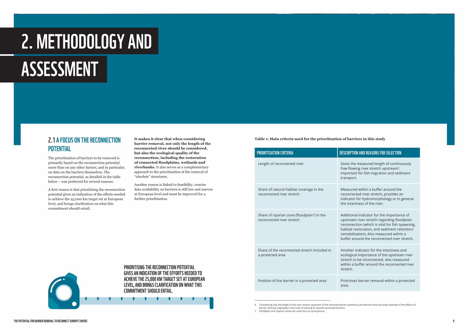
Table 1: Main criteria used for the prioritisation of barriers in this study
PRIORITISATION CRITERIA DESCRIPTION AND REASONS FOR SELECTION
Lengthofreconnectedriver Givesthemeasuredlengthofcontinuouslyfreeflowingriverstretchupstream6,importantforfishmigrationandsedimenttransport.
Shareofnaturalhabitatcoverageinthereconnectedriverstretch
Measuredwithinabufferaroundthereconnectedriverstretch,providesanindicatorforhydromorphologyoringeneraltheintactnessoftheriver.
Shareofriparianzone(floodplain7)inthereconnectedriverstretch
Additionalindicatorfortheimportanceofupstreamriverstretchregardingfloodplainreconnection(whichisvitalforfishspawning,habitatrestoration,andsedimentretention/remobilisation).Alsomeasuredwithinabufferaroundthereconnectedriverstretch.
Shareofthereconnectedstretchincludedinaprotectedarea
Anotherindicatorfortheintactnessandecologicalimportanceoftheupstreamriverstretchtobereconnected,alsomeasuredwithinabufferaroundthereconnectedriverstretch.
Positionofthebarrierinaprotectedarea Prioritisesbarrierremovalwithinaprotectedarea.
6 Consideringonlythelengthoftheriversectionupstreamoftheremovedbarrierseemedtoprovidethemostaccurateestimateoftheeffectsofbarrierremoval,especiallyinthecaseofremovalofseveralsuccessivebarriers.
7 Floodplainandriparianzonesareusedhereassynonymous.
2.1 A FOCUS ON THE RECONNECTION POTENTIALThe prioritisation of barriers to be removed is primarily based on the reconnection potential more than on any other factors, and in particular, on data on the barriers themselves. The reconnection potential, as detailed in the table below – was preferred for several reasons.
A first reason is that prioritising the reconnection potential gives an indication of the efforts needed to achieve the 25,000 km target set at European level, and brings clarification on what this commitment should entail.
PRIORITISING THE RECONNECTION POTENTIAL GIVES AN INDICATION OF THE EFFORTS NEEDED TO ACHIEVE THE 25,000 KM TARGET SET AT EUROPEAN LEVEL, AND BRINGS CLARIFICATION ON WHAT THIS COMMITMENT SHOULD ENTAIL.

11
Although the function of the barriers is a very important factor in the decision of removing a barrier, for feasibility reasons this parameter could only be addressed to a limited extent in this study, through the following filters:• Hydropower plants of a capacity of >10 MW are
excluded in a vast majority of cases; • Drinking and irrigation barrages are also mostly
excluded; • The general conditions, estimation of structures
(good, moderate, poor) were only considered in the initial assessment and for the final screening of the candidates in the highest class.
2.2 SCOPE OF THE STUDY: ABOVE-WATER BARRIERS IN LARGER EUROPEAN RIVERSGeographical scope: The study covers the entire Europe (excluding Caucasus and Russia). It includes several climatic zones and numerous bioregions, and is comprised of a large variety of river types and sizes.
To provide a better overview of the results, 6 subregions were defined (an analysis by country is included in section 3):1. Iberian Peninsula (Andorra, Portugal, Spain) 2. Central Western European region (Belgium,
France, Germany, Ireland, Italy, Luxembourg, Malta, Monaco, the Netherlands, San Marino, Switzerland, United Kingdom)
3. Northern European region, Scandinavia (Denmark, Finland, Iceland, Norway, Sweden)
4. Central Eastern Europe, Danube region (Austria, Czech Republic, Hungary, Romania, Slovakia)
5. Eastern European region with Baltic countries (Belarus, Estonia, Latvia, Lithuania, Moldova, Poland, Ukraine)
6. Balkan and Eastern Mediterranean region (Albania, Bosnia & Herzegovina, Bulgaria, Croatia, Greece, Kosovo, Macedonia, Montenegro, Serbia, Slovenia, Turkey)
Size of rivers: The study focuses on large and medium-sized rivers resulting from several successive confluences since the headwater tributaries (hydrological Strahler order > 3 , as shown by the figure below). The smallest assessed rivers are of approximately 30 km length but most of them are much longer.
Figure 2: Strahler stream order. For the present study, only rivers of order 3 and more are considered.
The focus of this study on large and medium-sized rivers does not mean that small rivers are not important. On the contrary, small rivers are critical ecosystems which provide some of the most abundant and diverse aquatic habitats.
Type of barriers considered: 30,000 barriers are addressed in this study. This corresponds to less than 3% of all river barriers in Europe8, although it covers a majority of the barriers in large and medium size rivers. The study started
8 AMBERproject,https://amber.international/
with a screening of hydropower plants mapped in the 2019 hydropower inventory (Schwarz 2019a), from the river mouth towards upstream, and also includes most of the major barriers serving for other purposes than hydropower such as weirs, ramps, sills or sluices along navigable rivers (no culverts and fords at bridges and road crossings), as further described in section 2.3.
In general, all barriers above 50 cm in height are included (some smaller ones in coastal areas). Medium-sized and large hydropower plants 9 (with a few exceptions as proposed by partners) and drinking water reservoirs (as far as possible) have been excluded at this first stage to ease the comparison between different EU Member States. Also, as these infrastructures are usually sensitive to public opinion and decision-makers, we consider that they are less prone to be removed at this first stage, and we decided to prioritise other more feasible barriers currently. Barriers equipped with operational fish passes are not entirely excluded as in most cases coarse sediment (bed load) cannot pass those structures and the functionality of fish passages is always much lower than a free flowing stretch.
9 Forthisstudy,thefollowingdefinitionsareused:- Smallhydropowerplants:capacity<10MW- Medium-sizedhydropowerplants:capacity10-50MW- Largehydropowerplants:capacity>50MW
Table 2: Type of barriers included in the analysis
THE STUDY INCLUDES THE STUDY DOES NOT INCLUDE
Longitudinalbarriers,builtforvariouspurposes,namelyramps,weirsanddams
Barriers>0,5metersinheight10
Somebarriersequippedwithfishpasses
Hydropowerplantsabove10MW
Drinkingwaterreservoirs
Culvertsandfords(mostlybridgesandroadcrossings)
Lateralbarrierssuchasflooddykes
Barriers<0,5metersheight
10 Wherespecificinformationwasavailable,somebarriers<50cmwereincludedforcoastalareasandlowlands.
1
11
22
2
3
31
1
1
© Marianne Götsch
THE POTENTIAL FOR BARRIER REMOVAL TO RECONNECT EUROPE’S RIVERS 13
• “Validated” AMBER data12 • Detailed data provided by WWF partner
organisations for Austria, Germany, the Netherlands, Romania, Slovakia, Spain and Switzerland for some 100 priority projects.
Due to data availability or heterogeneity of data, some choices had to be made. Only the categories “dams” (about 61,000) and “weirs” (125,000) of the AMBER dataset were used, even though many “others” could be also relevant. Those barriers were further reduced to larger rivers (above Strahler 3 level) to some 11,000 barriers. The quality of AMBER data is very heterogeneous, and the country-specific definitions of categories “dams, weirs and others” can differ significantly. In addition, only for 50% of the structures listed in the AMBER atlas the height of structure is known. Finally, the AMBER dataset was cleaned up (as far as possible and as far as it is relevant for the reduced set of barriers of this study) to avoid having different barriers identified for one obstacle (for instance in the case of a dam and a weir located at the same place).
All together the entry raw barrier dataset contains some 30,000 barriers.
Methodology, step 2: Extended GIS analysis including reconnection, riparian zones and land use
In a second step, an extended GIS analysis was conducted based on the datasets of drainage network, riparian zones, land use and protected areas provided by the EU Copernicus land data system, and on complimentary datasets (if available) for countries outside the EU.
As comparable hydromorphological data is missing for the whole of Europe, a very general approach has be applied to characterize the potentially reconnected river stretch.
The following core data sets were used:• As base drainage/river datasets, European
hydrological data13 (plus some complementary data for Eastern Europe) was used.
• Corine14 land use classes served to estimate the hydromorphological status and natural habitat coverage of reconnected river stretches. If any kind of forests or grasslands prevail for the stretch (>50% cutting area of a 600 m buffer around the rivers), it can be assumed to have better conditions. The following Corine classes are covered:
12 Originallythedatabaseincludes630,000barriers.DuetofieldtestingandcalibrationtheAmberprojectexpects>1millionbarriersinEurope(Bellettietal.2020).
13 https://land.copernicus.eu/imagery-in-situ/eu-hydro/eu-hydro-river-network-database
14 https://land.copernicus.eu/pan-european/corine-land-cover
• Elevation, slope and erodability19 data allow a very general estimation if sediment transport plays a significant role for the respective barrier.
The 30,000 barriers identified at the end of step 1 were subdivided into the six geographical regions (Iberia, CWE, Scandinavia, Baltic and Eastern Europe, CEE/Danube region, Balkan and Eastern Mediterranean).
Using the datasets indicated above, information related to the drainage network, protected areas, riparian zones, land use, and sediment transport was matched to each barrier. River buffer polygon segments of a total width of 600 meters (300 meters on each bank) were defined to cover riparian zones, land use, and protected areas.
For each of the prioritisation criteria, scores were attributed based on the reconnection potential as well as the ecological quality of reconnection lengths, the position of barriers in a protected area, and finally the more detailed proposals of step one and qualitative assessment made by the WWF network, as detailed in the table below.
19 https://esdac.jrc.ec.europa.eu/events/Conferences/2015/SoilErosion_EGU2015.pdf
Even for some of the 30,000 barriers included in this study, some limitations were encountered as data on barrier type and height or even age is very heterogeneous, including in the AMBER data set. The assessment is therefore based on the most important conditions of river stretch upstream to be reconnected, in combination with a final visual interpretation of the barriers (see section 2.3). We recommend expanding the analysis at national and basin level.
For instance, the condition (age and shape) of barriers could only be estimated for some 1,000 barriers (as ”good”, “moderate” or “poor”) as based on visual impression out of the high resolution satellite images and available ground images in Google Earth. It was therefore not included as a criteria for the prioritisation, but only used at the end of the assessment for the individual check of the barriers with high reconnection potential. Likewise, the functionality of the barriers (whether they are obsolete or not; or the level of siltation in reservoirs) could not be estimated. The type of barrier (ramp, weir, dam) was only available for some 40% of all 30,000 barriers assessed in this study, and their purpose (e.g. hydropower, navigation, irrigation, erosion control) for only some 25% of the barriers, so this information was not considered for the prioritisation.
2.3 INVENTORY AND ASSESSMENT OF POTENTIAL CANDIDATES FOR BARRIER REMOVALMethodology, step 1: Inventory and assessment of potential candidates for barrier removal
The study follows a two-step approach. For the first step, an initial assessment was prepared, mainly based on visual interpretation of high resolution images and expert judgment as well as a first qualitative assessment made by the WWF network, which also provides additional candidates.
The initial assessment of the study is based on the following datasets:• Data from the 2019 hydropower inventory
(existing plants and those under construction) of about 23,000 barriers, amended by:
o Individual survey/satellite analysis for 1,150 barriers,
o improved in particular for Mediterranean (reservoirs for other purposes than HPP) by GOODD and GRanD data sets11 (some 500 additional)
11 http://globaldamwatch.org/data/
o All kind of forests (CLC 311-324), sparsely vegetated areas, namely sand and gravel river beds (braided rivers)
o rock faces (CLC 331-335, excluding 334 for burned areas)
o all kind of wetlands (CLC 411-423) o waters, but excluding “standing water/
lakes (including many dam reservoirs)” with exception for Scandinavia where lakes are very frequent naturally within the river continuum (CLC 511-522)
o For the non-EU and “non-Corine” countries Belarus, Ukraine and Moldova the complementary older land use classification Pelcom15 was used. While the resolution is strongly limited with 1 km², but sufficient to allow a general estimation. The classes 11-20 represent all kind of forests and natural grasslands while 80 and 91 cover wetlands and inland waters respectively.
• Riparian zones16 data were served to estimate the occurrence of potential floodplains as general indicator for the ecological importance of the river reach upstream.
• Protected areas data: The Natura 200017 datasets and World Database on Protection Areas (WDPA)18 as well as other categories such as national parks, Ramsar sites, World Heritage sites and Biosphere reserves were used. For a given barrier or river stretch, the highest applicable category of protection was retained.
15 http://www.geo-informatie.nl/projects/pelcom/public/index.htm 16 https://land.copernicus.eu/local/riparian-zones/riparian-zones-
delineation 17 https://www.eea.europa.eu/data-and-maps/data/natura-11 18 https://www.protectedplanet.net/en/thematic-areas/wdpa?tab=WDPA
USING THE DATASETS INDICATED ABOVE, INFORMATION RELATED TO THE DRAINAGE NETWORK, PROTECTED AREAS, RIPARIAN ZONES, LAND USE, AND SEDIMENT TRANSPORT WAS MATCHED TO EACH BARRIER.

THE POTENTIAL FOR BARRIER REMOVAL TO RECONNECT EUROPE’S RIVERS 15
Table 3: How each individual barrier was scored based on the prioritisation criteria
Table 4: Final classification of barriers depending on scoring results
PRIORITISATION CRITERIA RANGES SCORES CALC 1 CALC 2 CALC 3
1–Lengthofreconnectedriver
0.5-<10km 3
Arithmeticmeanoflength(1)andCalc1
IncasebarrierisNOTinsideaPA(3):Calc3=Calc2
IncasebarrierisinsideaPA(3):Calc3=Calc2minus0.1*
10-<20km 2
>20km 1
2a–Shareofnaturalhabitatcoverageofreconnectedriverstretchasindicatorforhydromorphologicalintactnesswithinbuffer
0-<30percentcoverage
3
Arithmeticmeanofallthreereconnectionstretchparameters(2a,2b,2c)
30-<70% 2
70-100% 1
2b–Shareofpotentialriparianzonewithinbuffer
0-<30percentcoverage
3
30-<70% 2
70-100% 1
2c–Shareofthereconnectedstretchincluded in a protectedareawithinbuffer
0-<30percentcoverage
3
30-<70% 2
70-100% 1
3Positionofthebarrierinaprotectedarea
Ifinsideofprotectedarea:bonusof-0.1
*if Calc 2=1 (1-0.1=0.9) the bonus is omitted (=1)
Finally in a third step (calc 3), the result can get a bonus of “-0.1” if the barrier itself is located inside a protected area (which might be facilitating the removal). The final score is between 1 (best result) and 3. Based on the scoring results, barriers were finally put into three assessment categories according to table 4 below.
Methodology, step 3: Final review of barriers with high reconnection potential
The barriers with high reconnection potential were finally checked individually by high resolution images. Large dams (> 10 m height), sluices and huge multipurpose barriers on the one side, but also very small barriers (small sills and shallow ramps which are partly passable) were either excluded from the prioritisation (when they obviously were too big/massive or too small/passable) or downgraded to “good reconnection potential” or “moderate reconnection potential” (when their reconnected stretch upstream receives a high evaluation, but the structure seemed to be more difficult to remove).
After the calculation of length in three classes (1), in a first step (Calc 1) the values for the buffer of reconnection stretches (2a, 2b, 2c) are calculated and summarized as arithmetic mean value (calculation includes only available parameters). In a second step (calc 2) the arithmetic mean is built out of the length (1) and buffer (2a-c) to have the score for the reconnection stretch.
11,000 barriers were excluded from the prioritization into high, good or moderate potential, because of their size (too big/too small/feasibility check after final review) for approximately half of the excluded barriers, and because of missing data for the other half, as the barriers were too close to each other (mainly small barriers coming from AMBER). This does not mean that those barriers have no reconnection potential, just that their potential was not assessed.
Finally the additional indications by the WWF network, as well as those based on the first initial visual assessment were applied to the respective barriers (about 500) and overrule the assessment, but in most cases the assessment matches the proposals.
ASSESSMENT CATEGORIES SCORING RESULTS
Barrierswithhighreconnectionpotential scores1-<1,7
Barrierswithgoodreconnectionpotential scores1,7-<2,3
Barrierswithmoderatereconnectionpotential scores2,3-3

THE POTENTIAL FOR BARRIER REMOVAL TO RECONNECT EUROPE’S RIVERS 17
3. RESULTS
Another 7,200 barriers with at least a modelled good potential which would allow to reconnect 42,900 km of rivers were identified. Finally, another 11,100 of the analysed barriers have a moderate potential, with 38,700 km.
The calculated average length of reconnected rivers per barrier removal drops after the full assessment, from the highest class with 17 km, over the good with 6 km, and then down to the moderate class at 3 km, showing impressively the extremely dense and adverse fragmentation of European rivers.
potential by number is the highest. In Eastern and some northern and south-eastern Europe, rivers are still less interrupted and a lower number of barriers would reconnect often longer river stretches.
The results are organised in four sections. First the overall results for Europe as a whole, secondly for the EU, and thirdly in six geographical regions. Results are discussed in a fourth section.
3.1 EUROPE AS A WHOLEOut of over 30,000 barriers across Europe analysed for this study, nearly 860 barriers are identified with high reconnection potential, which would allow to reconnect 14,400 km of rivers.
The following tables summarize the distribution of potential candidates and reconnection length per country. Unsurprisingly, in western European countries, the density and therefore the removal
Figure 3: Total distribution of barriers with removal potential covered in the analysis
10,000
20,000
30,000
Reconnection potentialN
umbe
r of
bar
rier
s/le
ngth
of r
econ
nect
ed r
iver
(in
km)
40,000
50,000
HIGH GOOD MODERATE
858
7,218
11,100
14,395
42,865
38,700
Number of barriersReconnected length of rivers in km
OUT OF OVER
BARRIERS ACROSS EUROPE ANALYSED FOR THIS STUDY, NEARLY 860 BARRIERS ARE IDENTIFIED WITH HIGH RECONNECTION POTENTIAL, WHICH WOULD ALLOW TO RECONNECT 14,400 KM OF RIVERS.
30,000

THE POTENTIAL FOR BARRIER REMOVAL TO RECONNECT EUROPE’S RIVERS 19
Table 5: Number of barriers with removal potential per country Table 6: River reconnection potential per country (in km)
HIGH GOOD MODERATE TOTAL
Albania 2 49 78 129
Andorra 13 13
Austria 13 438 1685 2136
Belarus 1 3 3 7
Belgium 3 24 51 78
Bosnia&Herzegovina 2 27 64 93
Bulgaria 14 95 62 171
Croatia 2 15 17 34
CzechRepublic 6 197 364 567
Denmark 2 7 15 24
Estonia 1 1 1 3
Finland 18 22 14 54
France 103 832 981 1916
Germany 54 974 2276 3304
Greece 8 26 16 50
Hungary 11 62 31 104
Iceland 1 1
Ireland 10 20 11 41
Italia 25 428 939 1392
Kosovo 1 21 13 35
Latvia 4 7 7 18
Lithuania 6 7 10 23
Luxembourg 2 2 1 5
Moldova 1 6 7
Montenegro 5 9 14
Netherlands 4 5 10 19
NorthMacedonia 1 23 24 48
Norway 24 86 76 186
Poland 57 376 253 686
Portugal 31 152 132 315
Romania 28 116 137 281
Serbia 5 31 39 75
Slovakia 13 44 47 104
Slovenia 3 47 107 157
Spain 239 2209 2975 5423
Sweden 75 522 182 779
Switzerland 15 52 155 222
Turkey 17 36 10 63
Ukraine 20 52 49 121
UnitedKingdom 38 204 236 478
858 7218 11100 19176
HIGH GOOD MODERATE TOTAL
Albania 62 201 289 552
Andorra 24 24
Austria 65 1421 4138 5624
Belarus 44 51 22 117
Belgium 35 216 240 491
Bosnia&Herzegovina 51 236 250 537
Bulgaria 279 714 330 1324
Croatia 37 154 132 322
CzechRepublic 129 1305 1400 2834
Denmark 34 45 87 165
Estonia 41 64 2 107
Finland 393 320 162 875
France 1885 6243 4591 12719
Germany 476 5037 7799 13312
Greece 75 192 83 349
Hungary 312 741 292 1345
Iceland 3 3
Ireland 180 230 45 456
Italia 540 3113 2884 6537
Kosovo 20 118 41 179
Latvia 231 88 92 411
Lithuania 232 148 96 476
Luxembourg 8 5 1 13
Moldova 28 80 108
Montenegro 30 46 76
Netherlands 77 60 58 194
NorthMacedonia 12 129 104 244
Norway 489 663 503 1655
Poland 1459 3506 1321 6286
Portugal 433 830 478 1741
Romania 727 978 582 2288
Serbia 142 287 166 595
Slovakia 143 481 250 873
Slovenia 80 197 333 610
Spain 2261 7544 8101 17906
Sweden 1379 3988 1182 6549
Switzerland 134 281 619 1035
Turkey 619 426 105 1150
Ukraine 595 865 537 1998
UnitedKingdom 718 1932 1231 3881
14395 42865 38700 95961
THE POTENTIAL FOR BARRIER REMOVAL TO RECONNECT EUROPE’S RIVERS 21
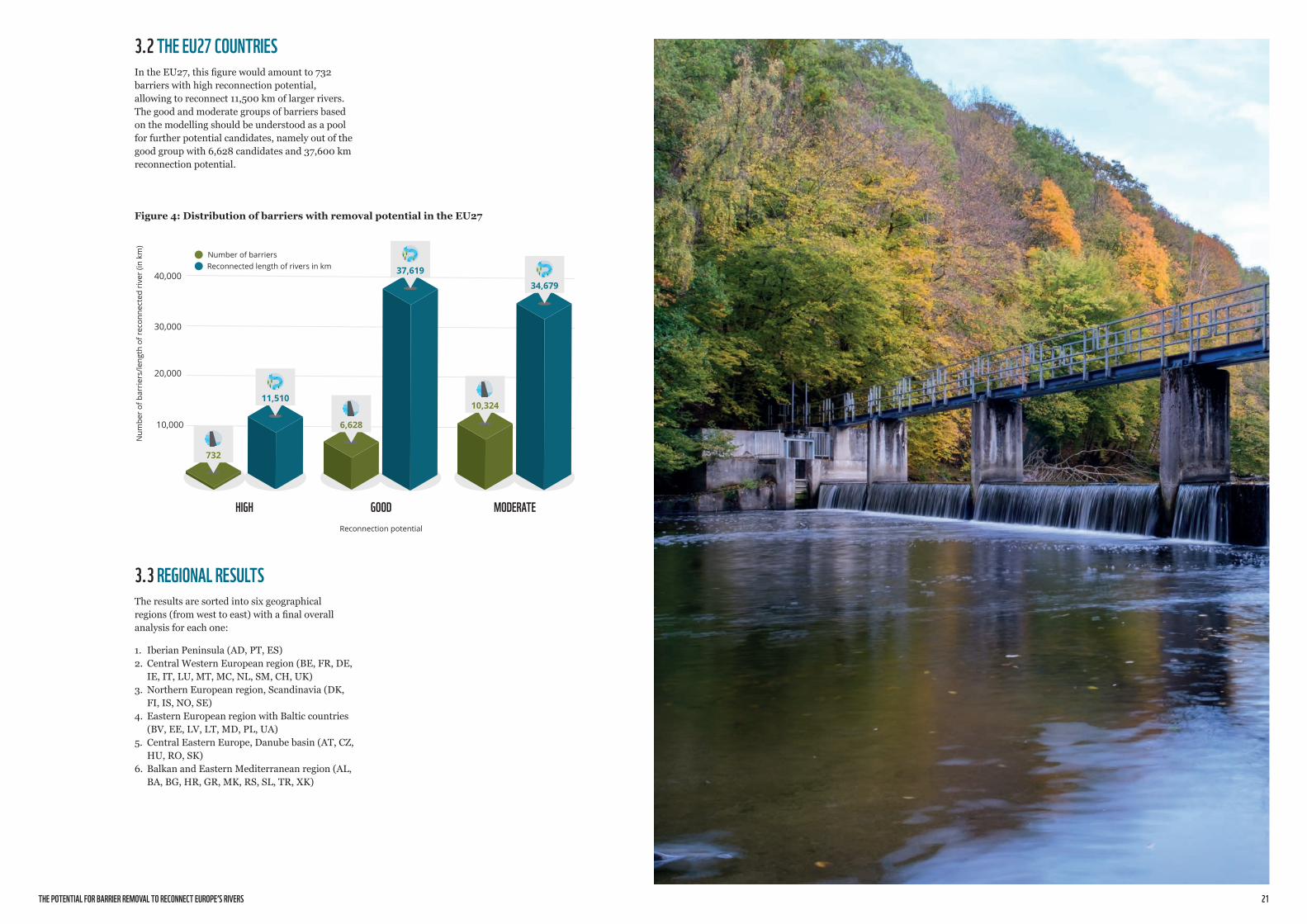
3.2 THE EU27 COUNTRIESIn the EU27, this figure would amount to 732 barriers with high reconnection potential, allowing to reconnect 11,500 km of larger rivers. The good and moderate groups of barriers based on the modelling should be understood as a pool for further potential candidates, namely out of the good group with 6,628 candidates and 37,600 km reconnection potential.
Figure 4: Distribution of barriers with removal potential in the EU27
10,000
20,000
30,000
Reconnection potential
Num
ber
of b
arri
ers/
leng
th o
f rec
onne
cted
riv
er (i
n km
)
40,000
HIGH GOOD MODERATE
732
6,628
10,32411,510
37,619
34,679
Number of barriersReconnected length of rivers in km
3.3 REGIONAL RESULTSThe results are sorted into six geographical regions (from west to east) with a final overall analysis for each one:
1. Iberian Peninsula (AD, PT, ES) 2. Central Western European region (BE, FR, DE,
IE, IT, LU, MT, MC, NL, SM, CH, UK) 3. Northern European region, Scandinavia (DK,
FI, IS, NO, SE)4. Eastern European region with Baltic countries
(BV, EE, LV, LT, MD, PL, UA)5. Central Eastern Europe, Danube basin (AT, CZ,
HU, RO, SK)6. Balkan and Eastern Mediterranean region (AL,
BA, BG, HR, GR, MK, RS, SL, TR, XK)

THE POTENTIAL FOR BARRIER REMOVAL TO RECONNECT EUROPE’S RIVERS 23
BARRIER REMOVAL FOCUS: THE HOZSECA DAM ON THE TAGUS RIVER, SPAIN
TheHozsecadam(intheupperTagusbasin)isanexampleofecologicalfragmentationbyanimpassabletransversebarrier(morethan5metershigh)resultingfromtheexploitationofaminihydropowerplant(<1MWcapacity).Theimpoundmentisheavilycloggedwithsedimentandthewaterrightiscurrentlyunderexpiration.
Inanaturalway,thereisanimportantinfluxoffinesedimentstothechannelsfromstreamsandravines,whichwhendepositedfillandcompacttheriverbed,causingthedecreaseofthebenthichabitat.Theproblemhasbeenincreasinginrecentyearsduetothereductionandchangesinthepatternsofrainfallandtemperaturescausedbyclimatechange.Humanactivitiesinthearea,especiallytwokaolinminesthatcontributetotheinfluxofsedimentsfromnearbytributarycourses,havealsoworsenedthesituation.
Restoringthisriversectionrequirestheremovalofthedamandtheimplementationofnature-basedsolutionsfortheconservationandprotectionoftheHozsecariver,whichisanimportanttributaryoftheUpperTajus.Therecoveryoftheecologicalconnectivity(morethan30kmoffree-flowingriverupstreamanddownstream)andenvironmentalvalueoftheareathroughtheremovalofthisdamandhydroelectricfacilitieswillbenefitthenaturalflowoftheHozsecariver.Itsremovalwillalsocontributetooffseterosionandsedimentationassociatedfromnearbyminingactivities,suchastheprotectionandrestorationofvegetationcoveronthebanksofstreamsandtributaries.
© Rafael Seiz
3.3.1 IBERIAN PENINSULACountries included: Andorra, Portugal and Spain
In the Iberian Peninsula, a massive number of large river barriers are located on the major rivers. In particular, many reservoirs and barrages in the uplands alter almost all larger rivers.
Many obsolete barriers with removal potential can be found in the remote and sparsely settled uplands, including some of the many reservoirs and barrages. Several dams were already removed in the past and new removal projects are in the pipeline (see example below).
Figure 5: Distribution of prioritised barriers for the Iberian peninsula
2,000
4,000
6,000
Reconnection potential
Num
ber
of b
arri
ers/
leng
th o
f rec
onne
cted
riv
er (i
n km
)
8,000
10,000
HIGH GOOD MODERATE
270
2,361
3,1202,694
8,374 8,603
Number of barriersReconnected length of rivers in km
MANY OBSOLETE BARRIERS WITH REMOVAL POTENTIAL CAN BE FOUND IN THE REMOTE AND SPARSELY SETTLED UPLANDS, INCLUDING SOME OF THE MANY RESERVOIRS AND BARRAGES.
THE POTENTIAL FOR BARRIER REMOVAL TO RECONNECT EUROPE’S RIVERS 25
BARRIER REMOVAL FOCUS: THE WURZEN AND PAUSCHWITZ WEIRS ON THE MULDE RIVER, GERMANY
OntheMulderiver,amajorleftwingtributaryoftheElbeinGermany,twoweirsequippedwithhydropowerturbinesareoutoffunction(WehrWurzenandWehrPauschwitz).RemovaloftheWurzenweirwouldreconnectsome12kmofriver.Whiletheseweirswouldhaveagreatpotentialtoundergoacompleteremoval,plansarebeingmadeforresuminghydropowergeneration.InordertoreintroduceAtlanticsalmon,installingproperlyfunctioningfishpasseswillnotbesufficient,andtherestorationofriverhabitatswillberequired.
TheMulderiverreceivesalotofattentionbecauseoftheresearchandprotectionofremainingfreeflowingstreams.Inthefuture,itisnecessarytodevelopregionalinitiativesandtogathercitizens’supportforotheremblematicriversliketheLippeinNorthRhine-Westphalia,wherealreadyentireweirswereremovedandareplannedtoberemoved.
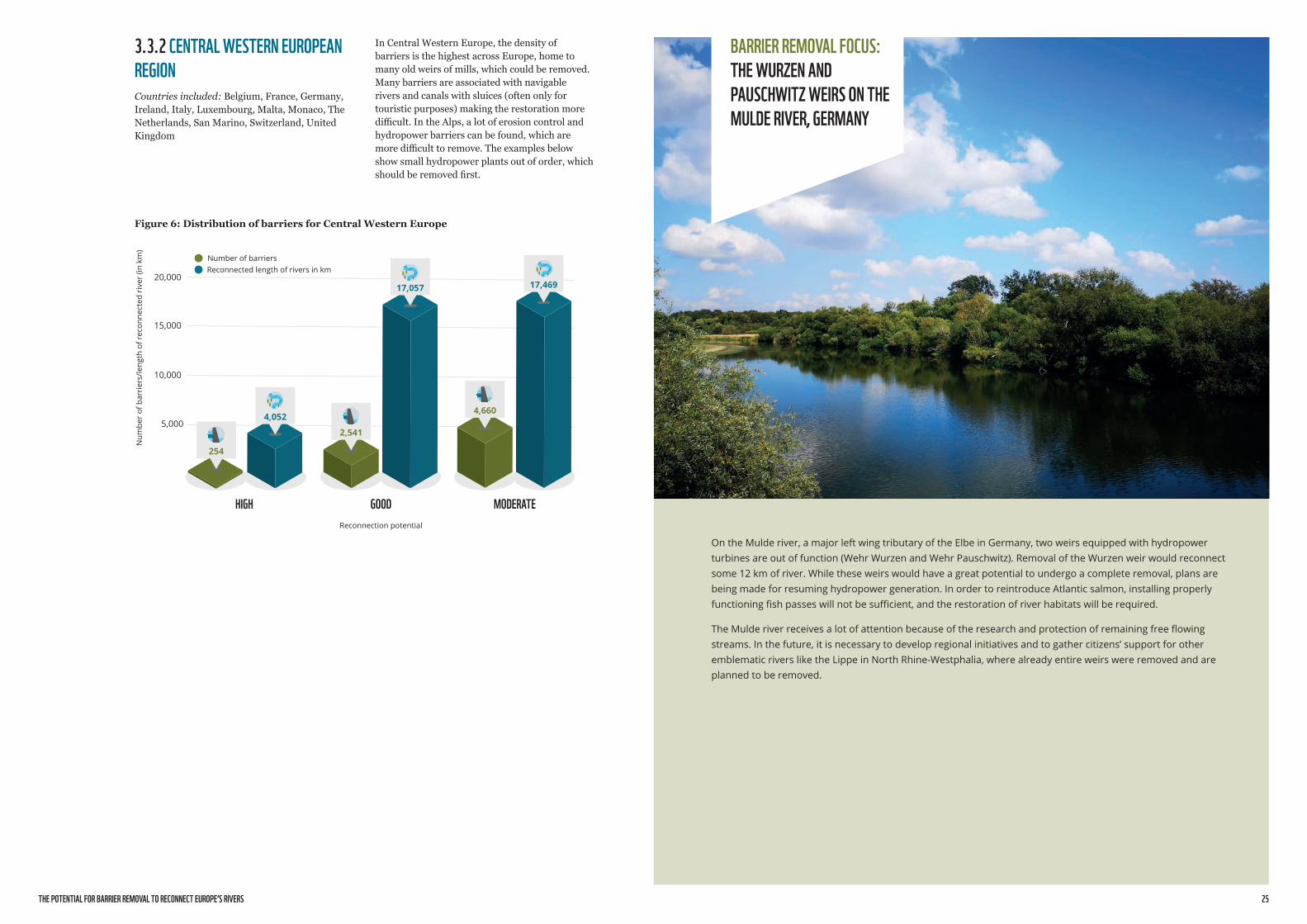
3.3.2 CENTRAL WESTERN EUROPEAN REGION Countries included: Belgium, France, Germany, Ireland, Italy, Luxembourg, Malta, Monaco, The Netherlands, San Marino, Switzerland, United Kingdom
In Central Western Europe, the density of barriers is the highest across Europe, home to many old weirs of mills, which could be removed. Many barriers are associated with navigable rivers and canals with sluices (often only for touristic purposes) making the restoration more difficult. In the Alps, a lot of erosion control and hydropower barriers can be found, which are more difficult to remove. The examples below show small hydropower plants out of order, which should be removed first.
Figure 6: Distribution of barriers for Central Western Europe
5,000
10,000
15,000
Reconnection potential
Num
ber
of b
arri
ers/
leng
th o
f rec
onne
cted
riv
er (i
n km
)
20,000
HIGH GOOD MODERATE
254
2,541
4,6604,052
17,057 17,469
Number of barriersReconnected length of rivers in km

THE POTENTIAL FOR BARRIER REMOVAL TO RECONNECT EUROPE’S RIVERS 27
BARRIER REMOVAL FOCUS: WEIR IN ULANÓW ON THE TANEW RIVER, POLAND
This1,5meterhighweirinUlanówistheonlybarrierforfishmigrationlocatedonthelowerTanewriver,located3kmupstreamfromrivermouth.Itwasbuiltinthe1970sforrecreationalpurposesanddidnothaveanyotherfunction.Theweirrestrictedthemovementofallmigratoryfish,suchastheEuropeannase.Beforethe1970s,theTanewwatershedwasimportantfordiadromousfishsuchastrout,eelandvimba,untiltheirabilitytomigrateintotheTanewwasimpairedbyseveralbarriers,includingthemajorWłocławekdamonthelowerVistula.Theonlyfishspecieshypotheticallyabletopassthisweirnowaretroutandsalmon(Bednarek2020).
Theremovaloftheweirwouldopenupover100kmofthehighlyvaluableTanewriverstretchanduptoca.450kmofriversinthecatchment(tributaries)accordingtoanationalinventoryofbarriersanddatacollectedbyBarrierTrackerusers.AstherearemanynaturalhabitatsandspawninggroundsintheupperTanewwatershed,migratoryfishwouldhavemanykilometersofriverhabitatssuitabletospawnandlive.ItisoneofthemosteffectiveweirremovalopportunitiesinPolandintermsofrestoration.
Theweirisprivatelyowned.Theownerisplanningtokeepitandalthoughthereareplansforrestoringsomekindofrecreationalarea,heiscurrentlynotinfavouroftheremoval.
Source:BednarekP.,2020,FragmentacjarzekwpółnocnejczęściKotlinySandomierskiej.UniwersytetJagielloński.https://doi.org/10.13140/RG.2.2.26410.64968.
© Piotr Bednarek 2019
3.3.3 NORTHERN EUROPEAN REGION, SCANDINAVIA Countries included: Denmark, Finland, Iceland, Norway, Sweden
Scandinavia is very rich in water resources, namely lakes and rivers, resulting in a
3.3.4 EASTERN EUROPEAN REGION WITH BALTIC COUNTRIESCountries included: Belarus, Estonia, Latvia, Lithuania, Moldova, Poland, Ukraine
long tradition of hydropower usage. In the mountainous regions, rivers are naturally intersected, often by cataracts. In the lowlands, rivers often flow through natural postglacial lakes and depressions, making those rivers unique across the continent. Several old facilities, along with those in the lower, more densely settled courses close to the Baltic sea confluences, could be candidates for removal.
As many rivers in Eastern Europe still have long free-flowing reaches with near natural sections, barriers cause the interruption of long and slowly flowing river systems. Therefore obsolete structures should be removed as a priority.
Figure 7: Distribution of barriers for Northern Europe-Scandinavia region
Figure 8: Distribution of barriers for Eastern Europe
1,000
2,000
3,000
Reconnection potential
Num
ber
of b
arri
ers/
leng
th o
f rec
onne
cted
riv
er (i
n km
)
4,000
5,000
6,000
HIGH GOOD MODERATE
119637
288
2,295
5,016
1,935
Number of barriersReconnected length of rivers in km
1,000
2,000
3,000
Reconnection potential
Num
ber
of b
arri
ers/
leng
th o
f rec
onne
cted
riv
er (i
n km
)
4,000
5,000
HIGH GOOD MODERATE
89447 329
2,602
4,750
2,151
Number of barriersReconnected length of rivers in km

THE POTENTIAL FOR BARRIER REMOVAL TO RECONNECT EUROPE’S RIVERS 29
BARRIER REMOVAL FOCUS: THE ROSENBURG HYDROPOWER PLANT ON THE KAMP RIVER, AUSTRIA
ThesmallhydropowerplantofRosenburgonKampriver(<1MWcapacity),aleftwingtributaryoftheDanubeinAustriacutsthroughavalleymeander,leadingtoa3kmresidualriverreachdownstreamanddisconnectssome16kmofriverupstream.Duetoitssoonexpiringlicense(2027),itsoldage(itwasbuiltin1908)andthehighcostsrequiredtorefurbishit,theplantwouldbeaconsensualcandidateforremoval,butthedecisionhasstillnotbeenmade.
Otherplansbytheenergycompanyexploitingtheplantforeseetheremovalofseveraloldsmallhydropowerplants,andtheconstructionofasmallernumberofmoreefficientnewplants.Investmentcostswillbeacriticaldecidingfactor.
© Gerhard Egger
3.3.5 CENTRAL EASTERN EUROPE, DANUBE REGION Countries included: Austria, Czech Republic, Hungary, Romania, Slovakia
The western part of the region, with countries like Austria, Czech Republic and Slovakia has numerous existing barriers, mostly for small
hydropower production, but also for natural hazard control in the mountains or for the former timber floating. Several old ramps and weirs could be removed. While the Hungarian lowlands include many canals for water regulation with limited removal potential on the larger rivers, Romania with the Carpathian mountains and numerous Danube tributaries has more barriers, several with high removal potential.
Figure 9: Distribution of barriers for Central Eastern Europe-Danube region
2,000
Reconnection potential
Num
ber
of b
arri
ers/
leng
th o
f rec
onne
cted
riv
er (i
n km
)
4,000
6,000
8,000
HIGH GOOD MODERATE
857
2.264
6,663
71
1,376
4,926
Number of barriersReconnected length of rivers in km

THE POTENTIAL FOR BARRIER REMOVAL TO RECONNECT EUROPE’S RIVERS 31
BARRIER REMOVAL FOCUS:THE BABA CVETA HYDROPOWER PLANT ON THE ELOVISTA RIVER, BULGARIA
The0.6MWBabaCvetahydropowerplantontheElovistariver,atributarytotheStrumariverinBulgaria,hadtoberemovedduetomissingbuildinglicences.Whilethisisaspecialcase,itisratherimportanttoshowtheneedtolimittheimpactsofnewhydropowerinmanyupperreachesofstillnear-naturalriversoftheBalkans.Thosesmallandineffectiveplantsdependdirectlyonthesubsidiesregimeofeachcountry,whicharealsodrivenbytheEuropeanpublicfinancingpolicies.
IntheratheryoungEUcountriesalongtheBalkans,likeBulgaria,CroatiaandSlovenia,theboomingdevelopmentofhydropowerseemstoslowdownwithmanyriversjoiningtheNatura2000networkandwiththeimplementationofmorestringentenvironmentalpolicies.Butstillmanynewprojectsareplanned(eveninNatura2000areas)andcounteracttheattemptstoreconnectriversinEurope.
3.3.6 BALKAN AND EASTERN MEDITERRANEAN REGION Countries included: Albania, Bosnia-Herzegovina, Bulgaria, Croatia, Greece, Kosovo, Macedonia, Montenegro, Serbia, Slovenia, Turkey
Similarly to Eastern Europe, the density of barriers for this region is rather low (though with an upwards tendency) in comparison with Western Europe. There are however several
obsolete structures to be removed, that could reconnect long river stretches. Therefore, the number of barriers with a high reconnection potential is very low compared to other regions, but would allow the reconnection of larger stretches.
Unfortunately the numerous new hydropower plants constructed in the last 20 years in Albania and Turkey have caused the fragmentation of almost all larger rivers.
Figure 10: Distribution of barriers for the eastern Mediterranean region and Turkey
2,000
1,000
Reconnection potential
Num
ber
of b
arri
ers/
leng
th o
f rec
onne
cted
riv
er (i
n km
)
3,000
HIGH GOOD MODERATE
375 439
1,879
1,376
2,683
55
Number of barriersReconnected length of rivers in km
UNFORTUNATELY THE NUMEROUS NEW HYDROPOWER PLANTS CONSTRUCTED IN THE LAST
IN ALBANIA AND TURKEY HAVE CAUSED THE FRAGMENTATION OF ALMOST ALL LARGER RIVERS.
20 YEARS
After removal in 2021
© Dimiter Koumanov
© Dimiter Koumanov
After construction in 2018
THE POTENTIAL FOR BARRIER REMOVAL TO RECONNECT EUROPE’S RIVERS 33
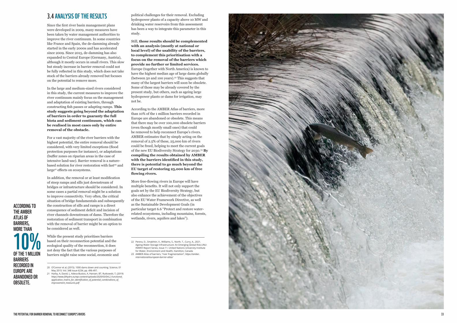
3.4 ANALYSIS OF THE RESULTSSince the first river basin management plans were developed in 2009, many measures have been taken by water management authorities to improve the river continuum. In some countries like France and Spain, the de-damming already started in the early 2000s and has accelerated since 2009. Since 2015, de-damming has also expanded to Central Europe (Germany, Austria), although it mostly occurs in small rivers. This slow but steady increase in barrier removal could not be fully reflected in this study, which does not take stock of the barriers already removed but focuses on the potential to remove more.
In the large and medium-sized rivers considered in this study, the current measures to improve the river continuum mainly focus on the management and adaptation of existing barriers, through constructing fish passes or adapting ramps. This study suggests going beyond the adaptation of barriers in order to guaranty the full biota and sediment continuum, which can be realised in most cases only by entire removal of the obstacle.
For a vast majority of the river barriers with the highest potential, the entire removal should be considered, with very limited exceptions (flood protection purposes for instance), or adaptations (buffer zones on riparian areas in the case of intensive land-use). Barrier removal is a nature-based solution for river restoration with fast20 and large21 effects on ecosystems.
In addition, the removal or at least modification of steep ramps and sills just downstream of bridges or infrastructure should be considered. In some cases a partial removal might be a solution to improve connectivity. Very often, the critical situation of bridge fundamentals and subsequently the construction of sills and ramps is a direct consequence of sediment deficit and incision of river channels downstream of dams. Therefore the restoration of sediment transport in combination with the removal of barrier might be an option to be considered as well.
While the present study prioritises barriers based on their reconnection potential and the ecological quality of the reconnection, it does not deny the fact that the various purposes of barriers might raise some social, economic and
20 O’Connoretal,(2015).1000damsdownandcounting.Science,01May2015:Vol.348Issue6234,pp.496-497.
21 Harby,A,David,L,Adeva-Bustos,A,Hansen,BT,Rutkowski,T,(2019)https://www.fithydro.eu/wp-content/uploads/2020/03/D4.2_Functional_application_matrix_for_identification_of_potential_combinations_of_improvement_measures.pdf
political challenges for their removal. Excluding hydropower plants of a capacity above 10 MW and drinking water reservoirs from this assessment has been a way to integrate this parameter in this study.
Still, those results should be complemented with an analysis (mostly at national or local level) of the usability of the barriers, to complement this prioritisation with a focus on the removal of the barriers which provide no further or limited services. Europe (together with North America) is known to have the highest median age of large dams globally (between 50 and 100 years).22 This suggests that many of the largest barriers will soon be obsolete. Some of those may be already covered by the present study, but others, such as ageing large hydropower plants or dams for irrigation, may not be.
According to the AMBER Atlas of barriers, more than 10% of the 1 million barriers recorded in Europe are abandoned or obsolete. This means that there may be over 100,000 obsolete barriers (even though mostly small ones) that could be removed to help reconnect Europe’s rivers. AMBER estimates that by simply acting on the removal of 2.5% of these, 25,000 km of rivers could be freed, helping to meet the current goals of the new EU Biodiversity Strategy for 2030.23 By compiling the results obtained by AMBER with the barriers identified in this study, there is potential to go much beyond the EU target of restoring 25,000 km of free flowing rivers.
More free-flowing rivers in Europe will have multiple benefits. It will not only support the goals set by the EU Biodiversity Strategy, but also enhance the achievement of the objectives of the EU Water Framework Directive, as well as the Sustainable Development Goals (in particular target 6.6 “Protect and restore water-related ecosystems, including mountains, forests, wetlands, rivers, aquifers and lakes”).
22 Perera,D.,Smakhtin,V.,Williams,S.,North,T.,Curry,A.,2021.AgeingWaterStorageInfrastructure:AnEmergingGlobalRisk.UNU-INWEHReportSeries,Issue11.UnitedNationsUniversityInstituteforWater,EnvironmentandHealth,Hamilton,Canada
23 AMBERAtlasofbarriers,“riverfragmentation”,https://amber.international/european-barrier-atlas/
ACCORDING TO THE AMBER ATLAS OF BARRIERS, MORE THAN
OF THE 1 MILLION BARRIERS RECORDED IN EUROPE ARE ABANDONED OR OBSOLETE.
10%
THE POTENTIAL FOR BARRIER REMOVAL TO RECONNECT EUROPE’S RIVERS 35
● The restoration of free-flowing rivers requires the complete removal of physical, longitudinal barriers. By no means should equipping a barrier with a fish pass be considered sufficient to restore connectivity.
● This study presents some limitations as it concentrates on large and medium-size rivers, and excludes a significant number of specific barriers, such as medium-size and large hydropower plants, drinking water reservoirs, and many, often small barriers for which data was not available. Much higher results could be achieved by increasing the scope of this study.
● This study focuses on longitudinal continuity, which is probably the easiest connectivity to achieve. However, the restoration of free flowing and thus functional rivers also implies transversal (between the main channel, the floodplain and riparian areas), vertical (between the groundwater, the river and the atmosphere) and temporal (seasonality of flows) connectivity.
● The removal of barriers is strongly bound to country authorities from national to local level, but also to the usage licences and the life expectation for barriers.
In many cases licenses expire without companies or public authorities setting up any plan for the decommissioning of the barriers. Barriers are often seen as inevitable and nobody is responsible for the removal after the regular usage. In general, at least
the functionality of barriers, and small rivers, which are critical ecosystems.
● Free-flowing rivers have immense value for biodiversity, climate, and people, and their restoration can help achieve multiple policy goals, improve well-being, and get critical freshwater ecosystems back on track. Actions to remove river barriers at EU, national and local levels should be significantly accelerated without further delay.
● Out of a sample of 30,000 river barriers, this report identifies 858 barriers across larger European rivers including 732 in the EU whose complete removal can offer the greatest benefits in terms of reconnection of ecosystems (“high reconnection potential”). Removing those barriers would allow to achieve nearly half of the target set by the EU Biodiversity Strategy by reconnecting 14,400 km (11,500 km in the EU). Removing barriers with both high and good reconnection potential would allow to double the EU target by reconnecting 57,000 km of rivers (49,000 in the EU).
The results of this study, based on a sample of 3% of existing barriers in Europe, show that the 25,000 km target set by the EU Biodiversity Strategy is a conservative one and that there is potential to go much further by looking at smaller rivers (excluded from the current study) and at a broader range of barriers. It would bring substantial benefits in terms of restoring freshwater and riparian habitats.
● Following the release of the EU Biodiversity Strategy, EU national authorities have started setting national targets for reconnection, sometimes in relation with their third River Basin Management Plans under the EU Water Framework Directive for the period 2022-2027. This inventory shows that assessing the reconnection potential of ecologically valuable river stretches is a major prerequisite to prioritise barrier removal.
the largest barriers should have an agenda and budget for final removal after their life span. We encourage national authorities to take the opportunity of the third cycle of River Basin Management plans to address this issue of accountability for the lifecycle of existing barriers.
● While barrier removal is one important step towards the restoration of free-flowing rivers, it also requires concerted action to avoid constructing new obstacles. It is important to create a culture that values the importance of river connectivity.
● This study is an initial step towards a prioritisation of barriers for removal. Technically this quick analysis could be expanded and improved using a full GIS network analysis environment, including also catchment analysis.
● The results of the present study should stimulate further work and studies on barrier removal across the continent and at national level. The lists and the prioritisation must be sharpened (and will have to be prepared by the competent authorities in the countries and on catchment level to fulfil reconnection tasks).
● We recommend that EU and national water management authorities complement this study with additional ecological data (based on the WFD reporting data, on migratory fish species, on key freshwater biodiversity areas and on sediment balance and hydromorphology). Any prioritisation effort should also consider
4. CONCLUSIONS AND RECOMMENDATIONS
REMOVING BARRIERS WITH BOTH HIGH AND GOOD RECONNECTION POTENTIAL WOULD ALLOW TO DOUBLE THE EU TARGET BY RECONNECTING 57,000 KM OF RIVERS -
IN THE EU.49,000
THE POTENTIAL FOR BARRIER REMOVAL TO RECONNECT EUROPE’S RIVERS 37
REFERENCESAMBER Consortium (2020): The AMBER Barrier Atlas.A Pan-European database of artificial instream barriers. Version 1.0, June 29th 2020. https://amber.international/european-barrier-atlas/
Belletti, B., Garcia de Leaniz, C., Jones, J. et al. More than one million barriers fragment Europe’s rivers. Nature 588, 436–441 (2020). https://doi.org/10.1038/s41586-020-3005-2
European Commission (2007): Towards Sustainable Water Management in the European Union. First stage in the implementation of the EU Water Framework Directive 2000/60/EC. [COM(2007) 128 final][SEC (2007) 363], Bruxelles
European Commission (2018): Natura 2000 sites. DG ENVIRONMENT and European Environment Agency, Kopenhagen.
European Environment Agency (2018): European waters Assessment of status and pressures 2018, Kopenhagen.
GoogleEarth (2020): Satellite images worldwide. DigitalGlobe 2019. http://www.earth.google.com
Liermann, C. R., Nilsson, C., Robertson, J., & Ng, R. Y. (2012). Implications of Dam Obstruction for Global Freshwater Fish Diversity. BioScience, 62(6), 539–548. https://doi.org/10.1525/bio.2012.62.6.5RiverWatch & EuroNatur, Chamberlain, L., Schwarz, U. (2018): Eco-Masterplan for Balkan rivers. For: “Save the Blue Heart of Europe” campain of RiverWatch and EuroNatur, PP. 53 pp. Vienna, Radolfzell.
Schwarz, U. (2019a): Hydropower pressure on European rivers. The story in numbers. For: WWF European programme office. Brussels/Vienna, pp.38
Schwarz, U. (2019b): HPP inventory and river assessment for the Mediterranean region. Hydropower dams and projects, hydromorphology, protected areas and KBA. Report for Euronatur and Geota, Lisboa, Radolfzell, Vienna.
UNEP-WCMC and IUCN (2019), Protected Planet: The World Database on Protected Areas (WDPA), version of September 2019, Cambridge, UK: UNEP-WCMC and IUCN. Available at: www.protectedplanet.net
Vörösmarty, C. J., McIntyre, P. B., Gessner, M. O., Dudgeon, D., Prusevich, A., Green, P., Davies, P. M. (2010). Global threats to human water security and river biodiversity. Nature, 467(7315), 555–561. https://doi.org/10.1038/nature09440

This report is part of the collaborative work undertaken by WWF offices within the Living European Rivers Initiative. Living European Rivers is a WWF-led initiative to bring life back to Europe’s waters for the benefit of people and nature. Involving other civil society organizations, governments, investors, businesses and communities, the initiative aims to protect rivers, lakes and wetlands that are still in good health and restore the ones that have been degraded. To achieve this ambitious goal by 2030, the initiative works to improve water governance, redirect financial flows towards nature-based solutions, remove dams, fight unsustainable hydropower, and raise awareness about the values of freshwater ecosystems.
WWF is part of the Dam Removal Europe Coalition, working together with other international NGOs to restore rivers in Europe that have high natural or cultural importance by removing obsolete barriers and ensure healthy free-flowing rivers.

© 2021 Paper 100% recycled
©1986PandasymbolWWF–WorldWideFundforNature(FormerlyWorldWildlifeFund) ®“WWF”isaWWFRegisteredTrademark. WWFEuropeanPolicyOffice,123rueduCommerce,1000Brussels.
Forcontactdetailsandfurtherinformation,pleasevisitourwebsiteatwww.wwf.eu
OUR MISSION IS TO STOP THE DEGRADATION OF THE EARTH’S NATURAL ENVIRONMENT AND TO BUILD A FUTURE IN WHICH
HUMANS LIVE IN HARMONY WITH NATURE.