Embed Size (px)
Citation preview
funds and coordinates shipping to and from the theater of operations. and par- ticipates in deployment as well recov- ery of mooring systems at sea. It is responsible for all calibration, labora- tory checkouts, and instrument refur- bishment. It maintains a database of real-time and research-quality delayed mode data (10-minute data) for all variables, which will become available in the PIRATA web pages as soon as the data are processed.
The logistical support in terms of ship time for developing and maintain- ing the PIRATA moored array is under the responsibility of Brazil and France (about 90 days per year of ship time for servicing the entire array). The Brazilian R N Antares (DHN) services the western half of the array and the mid-basin mooring at the equator, departing from Fortaleza or Natal. Brazil will install wind and sea-level data collection platforms at St. Peter and St. Paul Archipelago, Ato1 das Rocas, and at the coastal meteorologi- cal buoy (O 0"N-44"W). The French R N Aiztéa (IRD) services the eastern half of the array from Abidjan, Côte d'Ivoire. France maintains a sea-level data collection platform at Sao Tomé island (OS"N-6.5"E).
All the PIRATA daily data are avail- able at PMELNOAA-Seattle via the worldwide web at http://www.pmel.- noaa.gov/pirata, with an electronic link with IRD-Brest at http://www.if- remer. fr/orstom/pirata/piratafr.html and INPE at http://www.cmcd.- inpe.br/pirata.
Interaction with Other Programs As with the TAO program in the
Pacific, the PIRATA program is not conceived as a self-sufficient program. The main role of PIRATA is to offer high quality geographically fixed time series of ocean surface and subsurface measurements, to complement exist- ing Lagrangian measurements offered by other projects in the tropical Atlantic, and to give verifiable ele- ments to future model experiments. Consequently, many scientific interac- tions take place between PIRATA and other climate change programs that are being developed in the tropical Atlantic region (see a partial list below). Such interactions are of mutu- al benefit to PIRATA and these other programs.
International programs: CLIVAR (Climate Variability and Predictabili- ty) and its sub-programs, CLIVAR- Africa, EuroCLIVAR, and VAMOS
(Variability of American Monsoon Systems); GCOS (Global Climate Observing System); and GOOS (Global Ocean Observing System).
Brazilian programs: GOOS-Brazil and its subprograms (e.g., National Drifter Program-PNBoia).
French programs: ECLAT (Etudes Climatiques dans l'Atlantique Tropi- cal) and Clipper-MERCATOR-CORI- OLIS (operational oceanography).
USA programs: ACVE (Atlantic Climate Variability Experiment), PACS (Pan American Climate Stud- ies), and ACCE (Atlantic Climate and Circulation Experiment).
PIRATA Status (August 1999) During the first phase of PIRATA
(autumn 1997 to early 1998), five deployments were made, two in the eastern basin (Gulf of Guinea) and three in the western basin. The eastern equatorial mooring at 0"N-1O"W failed after only two months, therefore an additional deployment was made at OON-OOW, which also failed after ten months. These losses, both along the equator in the Gulf of Guinea, were certainly due to vandalism associated with tuna fisheries, which are very fre- quent in that region. These vandalism issues were debated during the PIRA- TA-5 meeting (9-10 November at Abidjan, Côte d'Ivoire) and the idea to seek international relief banning was advanced. Such a resolution was sub- mitted (November 27, 1998) by the IOC Secretariat to the attention of the XXth session of the IOC Assembly.
During the second phase of PIRATA deployment (autumn 1998 to early 1999), four replacements (three in the west, one in the east) and six new deployments (three in the west and three in the east) were made. The ATLAS system at 0"N-0"W was again vandalized and set adrift (only two months after its second deployment), but fortunately the upper part of the mooring was recovered by a French tuna ship and then discharged in Abid- jan.
High-resolution data from three
Brazilian moorings and one French mooring are now available on the PIRATA web page. Since November 1998, nine deployments have been made, giving a data return statistics around 90 percent, except for one recent failure at 4"N, 38"W. Details may be obtained directly from the PIRATA web page. As of August 1999, the PIRATA array was working as follows: the western and central parts of the PIRATA array are fully operational at 15ON-38"W; 12"N- 38'W, 0°N-35"W, and 0"N-23"W experienced some loss as well; SON- 38"W died off due to anomalous bat- tery drain; 4ON-38"W stopped sudden- ly on June 20 due to possible vandal- ism; the wind sensor at O'N-35"W was vandalized, according to the science crew of the RN Thallassa, which passed by during the 1999 French Equalant Cruise and whose crew tried to refurbish the wind sensor; and three ATLAS systems are operational over the meridional line in the eastern basin (O"N-lO"W, 5"N-10°W, and 10"s- lO'W).
The third (and final) phase of the 1999 PIRATA deployment, scheduled for July 1999-with the instrumenta- tion of two new sites in the eastern basin (2"N-lO'W and 2"s-1O"W) and a third attempt of maintenance at 0"N- O'W-had to be postponed due to problems with the IRD vessel A d a .
An intensive flux measurement (with a meteorological instrumented mast aboard a French research vessel) was done this summer in the vicinity of three PIRATA equatorial sites (one in the westein equatorial basin, two in the eastern basin). This will be useful for calibrating the turbulent &-sea fluxes estimated from the PIRATA observations via the bulk formula, and some data can be checked against the future high resolution data to be retrieved next year. An ADCP mooring (with measurements all along 0-300 meters) is also scheduled to be deployed at the PIRATA O'N-23"W site by March 2000, as well as a mete- orological buoy at 0"N-44"W.
layer To design, deploy, operate, and
maintain a pilot array of moored buoys and island stations, similar to the ones used during the TOGA program in the tropical Pacific
To collect high-resolution (10 minute time steps) data and transmit via satellite in real time a set of quali- ty controlled oceanic and atmospheric daily average data to observe and study the upper ocean and the ocean- atmosphere interface of the tropical Atlantic.
The PIRATA Array PIRATA consists of 12 ATLAS
moorings, four spanning the equator and eight spanning two meridional lines. This specific configuration has been chosen to provide coverage along the equator of regions of strong wind .forcing in the western basin and sig- nificant seasonal-to-interannual vari- ability in SST in the central and east- ern basin. The meridional arrays cover the regions of high SST variability associated with the SSTa dipole mode with the northwestern meridional line cutting across the ITCZ during most of the year. The variables measured are surface winds, SST, sea surface con- ductivity (salinity), air temperature, relative humidity, incoming short- wave radiation, rainfall, subsurface temperature (10 depths in the upper 500 meters), subsurface conductivity (presently three depths in the upper 150 meters, four depths in future moorings), and subsurface pressure (at
PIRATA'S scientific and techni- cal goals are many:
To provide an improved description of the seasonal-to- interannual variability in the upper ocean and at the air-sea interface in the tropical Atlantic
To improve our understanding of the relative contributions of the different components of the sur- face heat and freshwater fluxes, and ocean dynamics, in the for- mation of the oceanic and atmos- pheric mixed layer to be able to understand the seasonal and inter- annual variability of SST within the tropical Atlantic basin via pre- dictive models of the coupled Atlantic climate system
To provide a dataset that can be used to develop and improve this detailed understanding of how basic mass, momentum, heat, and freshwater fluxes couple in the oceanic and atmospheric mixed
300 and 500 meters). An acoustic able in real time from a few equatorial doppler current profiler mooring is sites: Brazil will deploy systems at St. proposed for 0"N-23"W to monitor the Peter and St. Paul Rocks Archipelago vertical current profile variations in (0.7ON-29.2"W) and Ato1 das Rocas the central Atlantic where high zonal (3.9OS-33.5"W) while France will current variability occurs, close to the maintain the tide gauge at Sao Tomé ATLAS mooring sited at 0"N-23"W island (0.5ON-6.5"E). Brazil must also (the 20"W mooring position had to be deploy a coastal meteorological buoy displaced to the west due to difficulties at 0°N-44"W, offshore the State of with local bottom topography). Maranhão.
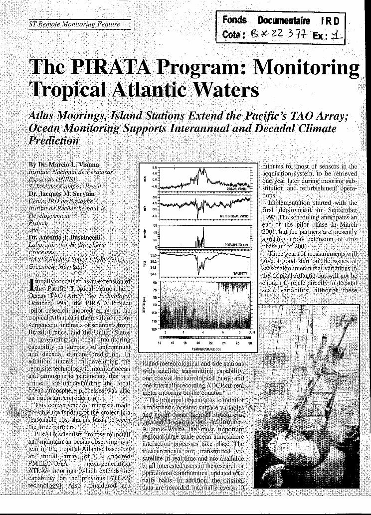
The present importance of obtaining good subsurface temperature and Resource Commitments salinity data, especially in the upper PIRATA is realized as part of a 150 meters, is driven by the need to multinational effort involving Brazil, monitor the influence of shallow with I"E responsible for the national mixed layers (30 meters) occurring coordination, funding, and technical with waters of different temperature work and the ship time furnished by and salinity stratifications (causing the Directory of Hydrography and what is known as a "barrier layer"), Navigation (DHN) of the Brazilian which have impacts on the vertical Navy (which collaborates with the heat transfer in the ocean, affecting most extensive civil oceanographic SST. Mixed layer parameterizations programs in Brazil). for predictive models should take into France involves IRD in the coordi- account such salinity effects, which nation, funding, and ship time and will be even better monitored once the Météo-France and CNRS/INSU with ATLAS moorings to be deployed in funding. the year 2000 will carry conductivity The United States-through the sensors at five depths (1 meter, 20 Pacific Marine Environmental Labora- meters, 40 meters, 80 meters, and 120 tory (N0AAE'MEL)-is responsible meters). The demand for these five for mooring construction, mainte- depths is the result of the observation nance of systems, and support in of barrier layers in the vertical profil- deployment operations, quality control ing with CTDs, which form a neces- and distribution of data through the sary part in the data collection made Internet, construction and mainte- during the deployment cruises. nance of the main PIRATA web page,
The initial ATLAS deployments as well as funding via NOMOGP. were made during 1997-1999. In addi- During the pilot study (1997-2001), tion to the ATLAS mooring observa- all the ATLAS mooring systems are tions, wind measurements and tide- being built by NOAAPMEL at Seat- gauge data are scheduled to be avail- tle, Washington. N O M M E L also
What processes are responsible for changes in the off-equatorial merid- ional SST gradient vs. those changes in SST along the equator and the relat- ed problem of variability of the excur- sions of the Inter-tropical convergence zone (ITCZ)?
To what degree does the tropical Atlantic upper ocean variability affect the coupled ocean-atmosphere-land system of the region and its pre- dictability?
To what extent is the predictability of the equatorial coupled effects affected by the meridional off-equato- rial variability?
To what degree is the predictabili- ty of the coupled system within the tropical Atlantic basin determined by local interactions vs. external influ- ences such as connections with the El
The final phase of the PIRATA experiment (spring 2000 to early 2001) will be mainly dedicated to yearly maintenance of the ATLAS sites and other in-situ observing sys- tems. Thus, an integrated ocean observing system (full PIRATA array + equatorial current measurements + equatorial sea level data + equatorial Met observations) will be operational within (at least) one year.
We expect that at the end of the first pilot phase of PIRATA (basically in 2001), other nations will join in the maintenance and possible expansion of PIRATA (and other types of in-situ oceanic observations) to constitute a tropical Atlantic Ocean “fixed” in-situ observing system in complement to other systems. A dedicated meeting to discuss all of the oceanographic pro- jects and proposals within the tropical Atlantic (Climate Observing System in the tropical Atlantic, COSTA) was hosted by Dr. Sylvia Garzoli at AOML/NOAA in Miami (May 3-1, 1999) where this discussion took place, at the same time of the sixth meeting of PIRATA (PIRATA-6, Miami, 2-3, 1999) where discussions about practical and strategic aspects during the final phases of the PIRATA project have been discussed. To facili- tate the management of this increas- ingly complex implementation, a PIRATA Resources Committee (PRC) is being formed by the major sponsors of the project. It will establish a long- term strategy for funding, logistics, training, and national priorities and interests regarding the future of PIRA-
.
TA (where the ‘‘Y’ will then stand for “permanent.”).
One of the main issues facing PIRA- TA now is the feasibility of participa- tion of other countries as it will con- tinue post-2001 after the first pilot phase ends. Presently there are state- ments from both Brazil and France assuring ship time to the end of this first phase, but discussions will contin- ue the extension of the project feasible up to 2006, including geographical extensions of the array. Some exten- sions are only possible with the entrainment of other countries, some are being proposed by the present part- ners. This issue is also dependent on capacity building in the region in the form of an efficient training and tech- nology transfer program needed to help alleviate the burden being placed on PMEL.
The COSTA meeting was very suc- cessful in producing a first synthesis of all of the scientific issues contem- plated by ongoing, large-scale oceano- graphic projects in the region, under- lying the complementarity between these initiatives. The report of this important meeting may be obtained at the AOML website http://www.aoml.- noaa.gov/phod/COSTA/report/. /st/
Bibliography Servain, J.M, A. J. Busalacchi, M. J.
McPhaden, A. D. Moura, G. Reverdin, M. Vianna, and S. Zebi- ak, “A Pilot Research Moored Array in the Tropical Atlantic,” Bull. Am. Meteorol. Soc. 19:10, pp. 21019-203 1,1998.
,
DI: Marcio Waiina has been conducting research in ïnarine science since 1982, when he participated in the French FOCAL I cruise as a professional divel: His present interest is fociised on the tech- nology of ocean observing systems for cli- ïnate studies and he is an enthusiast of paleoclimate studies. Vianna has been supervising graduate students in ocean science at INPE since 1988, beingpresent- ly the coordinator of PIRATA in Brazil, also serving on the International Science Steering Group for PIRATA.
DI: Jacques Servain has been assistant professor at the University of Brest, Freme, from 1973 to July 1999. He has been conducting research in tropical marine climate from the beginning of the 1980s in association with the Institut de Recherche pour le Développement (IRD, formerly ORSTOM). Servain collaborated in several international projects and pro- grams in climate research such as FOCAL, TOGA, and now CLNAR. He is now frilly, integrated in IRD and leads several activi- ties related to the French participation in CLIWUTropical Atlantic.
DI: Antonio J. Biualacchi received his Ph.D. degree in oceanography fiom Flori- da State University. Since that time he has served as an oceanographer at the NASNGoddard Space Flight Center. In 1991, he was appointed to the senior exec- utive service in the US. government as chief of the NASNGoddard Laboratory for Hydrospheric Processes. Busalacchi’s interests include the development and application of numerical models combined with in situ and space-based ocean obser- vations to study the tropical ocean response to s u ~ a c e fluxes of momentum and heat.