Embed Size (px)
Citation preview

Giulia Annalinda Neglia
The Permanence of Roman Layouts in the Urban Fabric of Aleppo
The cityscape of Aleppo is profoundly stratifed and represents a place of permanence for
its urban symbols and the mutual overlay of many meanings: the place of permanence traces an
urban development that saw Aleppo frst to arise as a spontaneous settlement, then to be
adapted to regional and then imperial urban standards, and fnally, undergo a local dialectical
process that led the city to an individual urban form. What emerges from a structural reading of
Aleppo’s urban fabric is that the actual structure of the city is strictly linked to pre-Islamic
(Hellenistic and Roman) structures that derive from a linear and non–linear typo-morphological
development.
Methodological approach
The analytical method deployed here to reconstruct the diferent phases of
transformation of the urban fabrics and of the building types of Aleppo of Hellenistic-Roman

planning is based on a typological analysis of these processes. The analysis has been carried out as
historical, temporal and spatial analyses of the morpho-typological processes that enclosed the
built areas and the courtyard residential building within the Mamluk walls, following the
traditional methodology of the urban studies developed in Italy since the Sixties of the last
century by S. Muratori and his school.i This methodology of interpretation of the urban structures
is based on the hypothesis according to which a town history is “written” within its building fabric
and in which every urban structure is inseparable from the territorial organism within which it is
situated – depending on both the natural shape of the places and on the elements of the
anthropized territory in the phases preceding the considered ones. Thus, according to such an
approach, it is possible to read the traces of the diferent phases of the anthropic organization of
an urban or territorial entity in the very structure of its urban or agrarian fabric.
In this interpretation, the reading of the orthogonal alignments of the building or agrarian
fabric corresponds to the traces of the diferent phases of critical (planned) anthropic
organization of the urban or territorial organism. Such traces are not necessarily represented by
archaeological remains dating from the considered phase, but can present themselves in the
territory, in property boundaries, routes, rows of trees or canals, in traces of the ancient plots that
have unaltered through time, in new walls built on pre-existing foundations, or along the original
plot boundaries. The measurement of the rhythm of such traces, carried out by adopting the
diferent units of measurement used in the various epochs, is a reference for the attribution of
each phase of development to a certain historical period. The routes correspond to phases of
expansion that, rather than being coordinated by a central organism, are traces of the
organization of a portion of an urban territory by groups of dwellers, phases of extension along
territorial routes, and phases of urban development which, if read in plans , help to delimit their
width.
It is possible to use such a methodology for the reading of the fabric of Aleppo because we
worked with a hypothesis of continuity among the diferent phases of anthropic organization of
its building fabric: here, because of the peculiar urban history, the passage from one phase to
another came about gradually, without any rupture or trauma.ii
The interpretation of the structure of the urban and territorial fabric of Aleppo presented
in this work has been analyzed with respect to the historical-archaeological data provided by the
reference literature in an attempt to attribute the diferent phases to their corresponding epochs.

All the information derived from this reading has been weighed against data derived from
examples of urban fabric with similar structures, including living cities and archaeological sites.
This reading of the urban fabric of Aleppo has been carried out on a cartographical support
represented by the vectorialization of the French cadastral maps of the 1930s. This cartography is
representative of the urban form of the city intra moenia (of the area inside the Mamluk walls)
prior to its being gutted by modern plans for reorganization, and it represents Aleppo’s
consolidated urban form.
From this reading emerge diferent forms of the city of Aleppo in time, corresponding to
diferent phases of urban development and to diferent ideas of the construction of the city.
In this paper I discuss a specifc phase of the Aleppo’s urban development that is attributable to
Roman times and is related to the construction of a specifc form of the city, built according to
the idea of an “expanded city,” which represents the substratum of the Islamic urban fabric.
First phase: limitatio secundum coelum
The frst signifcant phase in the human organization of the territory of Aleppo
corresponds to the Hellenistic period, when Seleucus I founded the city of Beroea in northern
Syria.iii In this phase of development, Beroea’s features were those of a mono-directional city,
with the matrix route (the via recta) set in an east-west direction and linking two pre-existing
sites, the tell and the citadel. Its urban fabric accorded with the celestial orientation. (Fig. 1)
The information of a historical-archaeological nature about the urban structure of Aleppo in the
Roman epoch is scarce, indeed almost non-existent: even if the city seems to have played the role
of provincial center of the region of Antioch, since the conquest of the region and the birth of the
Syrian Province, the Roman presence in Aleppo is witnessed only by a few archaeological fnds.
The favorable geographical position of Aleppo vis-à-vis trafc and commerce makes it
plausible to hypothesize that the town was an important node for trafc and commerce within
the Roman-Syrian urban system and that the form, orientation, and structure of its building
fabric derived from its role at a territorial scale.
The frst exercise toward understanding the extension and the structure of the urban fabric
of Roman Beroea is a reading of the orthogonal alignments of the building
fabriciv laid in a north-south / east–west direction, the direction of the Hellenistic plan.
The orthogonal alignments of the urban fabric in this direction, recognizable in the cadastral
records, are widespread throughout the walled Mamluk city, especially east of the citadel. This

region has not until now been considered a part of systematic city development prior to Ayyubid
times.
It is inferable that the origin of these traces derives from the position of the mosques and
that the urban fabric aligned in this direction was planned together with the construction of the
mosques. In Aleppo, in fact, all the qibla walls are facing the south. By locating the mosques of
the urban fabric it is possible to consider, however, that these alignments are independent of the
position of the mosques themselves.
There are ways to investigate this issue as a new phase of urban development, by
measuring building dimensions, and by considering the routes in the development. Measuring
the walled city with the dimension of the actus = 35,6m (a sub-multiple of centuria and a
dimension used in agrarian and urban planning during Roman times) we note that the two blocks
immediately to the east of the Great Umayyad Mosque, comprised between Suq New Istanbul
and Suq al Sabun – Suq Aslan Dada, have analogous dimensions with respect to the blocks
planned in the Hellenistic period. Their width is 71 meters, a measure which corresponds to two
acta. The same rhythm may be read in the width of the block immediately eastern of this frst
one, comprised of Suq al Sabun and Suq Karamash, and in many routes within the urban fabric.
Owing to the extensive restoration that the building fabric in the heart of the
medina underwent between the 14th and the 19th century, one could posit a diferent
interpretation of this datum and attribute the formation of these fabrics to the Ottoman epoch. It
is possible to verify this hypothesis by measuring the same block using the dimension of the
cubitus,v the unit of measurement used in Ottoman epoch. Due to the small graphic scale of the
cadastral cartography and to the comparatively irregular shape of the block after the
medievalization, which modifed the structure of its fronts, it is possible to make a mistake the
approximation of the order of 2 meters and confuse the dimension of 69 meters with that of 71
meters.
Rather, to better grasp this phase of urban development we have to look at the territory.
Indeed, if we aim at fnding more traces of Roman planning, it is necessary to do a leap of scale
and pass from the 1:2000 scale of the cadastral cartography to the 1:5000 scale of the cartography
charting Aleppo in relation to the area immediately surrounding it. From the reading of this
cartography, it emerges that, in the area encircling Aleppo, the traces of a north-south / east-west
oriented planning are clear. Their dimensions correspond to those of the
centuria or of its submultiples and can be re-read in the structure of the agrarian fabrics (with an

extension equal to ¼ of a centuria) and of the routes running to the south and to the east of the
city. The rhythm of the centuriae and of its subdivisions, both homogeneous and isotropic,
determines the structure of the routes and the division of the felds in the valley of the Quweyq,
difering from the Hellenistic rhythm and structure but strengthening its local urban and agrarian
system. Some of these alignments coincide with those of the Hellenistic
strigatio since the multiples of the Greek foot or of the Roman foot coincide.
The starting point for laying out this centuriation seems to be the intersection between
the Hellenistic via recta, which became the main decumanus of the city during this phase.
This was transformed into a colonnaded street and the route along the eastern boundary of the
frst Roman block next to the Great Mosque became the main cardus (Fig 2). The presence both in
the agrarian and in the urban fabrics of difuse traces of this plan, laid without interruption
outside and inside the city walls built in Mamluk times suggest that, in this phase, the defensive
walls of the Seleucid city were demolished because the town was growing, and that they were not
re-built since they were no longer necessary to defend a city situated in a region of an Empire
whose borders were far and safe.
In this frst phase of the Roman urban expansion, the urban and territorial structures of
Aleppo merge. The open urbanscape of this “expanded” city was articulated in an isotropic
manner, and oriented secundum coelum, according with the celestial
orientation.vi This phase represented a sort of “adaptation” to the previous anthropic structure, a
phase of enlargements and extensions of the conquered urban centers: indeed, they never
contrasted the consolidated anthropic structures, but adapted them in accordance to the Roman
urban canons.
On the basis of the data, resulting from the observation of the morphology of the urban
fabric, we can hypothesize that this phase of urban development secundum coelum of Roman
Beroea is attributable to a period between the 1st century B.C. and the 2nd century A.D. and that it
corresponds to the phase of maximum expansion of the Roman city. It would have occurred during
the frst phase of the second cycle of anthropic organization of the Syrian territory, called the
consolidation cycle. During this phase they took at advantage of the trans-provincial road system,
which linked Syria to the other provinces of the Empire, above all restructuring the existing routes
and adapting them to the new technical necessities represented by the use of the carts for
transports. The construction of these routes represented the frst great Roman operation of

transformation of the Syrian territory. In this phase, the coastal road system was based upon the
axis of the Via Maris, the road which connected the Syrian cities whose shores were lapped by the
Mediterranean sea and which had maritime relations with the other western towns of the Empire –
Beirut, Tripoli, Aradus (Tartus), Laodicea by the Sea, Seleucia. Besides developing the coastal road
system, they built an inland route network to connect the cities located along the main valleys,
whose realization was made easier by the specifc geographical confguration of the territory: to
the stretch of the Via Maris along the Syrian coastline (oriented in a north-south direction)
corresponds, in the inland, along the river Orontes, the stretch Homs-Hama–Apamea which is,
more or less, parallel to it.
Second phase: delineatio secundum naturam
The form of Aleppo described so far, concerning the frst Roman phase of expansion of the
urban fabric and of organization of the territorial organism, is the result of planning which
represented a sort of “squaring,” a general organization of the territorial and urban organism, as a
grid ruling the drawing paper rather than the drawing itself. The drawing of Roman Beroea was
adapted by other geometries and spatial relations which, with diferent logics, added up and
partially superimposed on this pattern traces that emerge from the reading of the urban
morphology and, in particular, the reading of the orthogonal alignments of the building fabric.
The orientation of the urban fabric changes suddenly to the south of the Great Mosque, starting
from the Suq Khan al-Nahassin, one of the organization routes of the Hellenistic city. The axis,
which, starting from this route, leads to Bab Quinnasrin, rotates considerably with respect to the
north-south direction.vii
This rotation is not only very pronounced in relation to the axes of Bab Quinnasrin and Bab
al-Nasr, and in the fabrics to the south of the citadel, but also in the fabrics to the east of the
citadel, in the districts involved in the expansion within the Mamluk city walls, in particular, along
the axis leading to Bab al-Neirab and to Bab al-Ahmar next to the districts of Qalat al-Sharif and
Sahet Bizeh. To the north of the Hellenistic city, this rotation is clearly visible between the districts
of Masaben and Tib Assad Allah. This rotation, if read in relation to the orientation of the building
fabric and not only of the routes, is, thus more widespread than it has been believed so far. Its
direction rotates 18° to the west with regards to the north-south direction. A reading of the
territory of Aleppo shows us the presence of a territorial system based on a grid of a 710 x 710
meter module, rotated according to this direction. The planning of Aleppo in this phase seems to
be based on the organization of a road system on a regional scale, following the direction of the

faultline.viii This reading reveals that many territorial routes are oriented according to this rotation:
the routes towards Antioch and the north and west-oriented caravan routes. Indeed, the work
carried out by the Romans, in their second phase of intervention in Aleppo, was the project of a
major road system that linked Aleppo to other Roman cities in Syria.
It is possible to identify as one of the main axes of this structuring the caravan route on the
basis of which the Hellenistic settlement was founded, which from the central suq of the district
of al-Medina leads to Bab al-Nasr (and its northward extension, outside the Mamluk city walls,
which represented the matrix of the extra moenia settlements of al–Jabbaleh, al–Qawas, Qastal
Musht, al–Bassatina, Qastal Harami). The southward extension of this route, oriented towards the
heart of the medina, crosses the junction of the cardus and the decumanus of the previous phase
(the plan secundum coelum) sited at the crossroads of Suq al–Sabun and Suq
al-‘Attarin. We identify this axis with the cardus of the second Roman structuring of the territory
and of the urban fabric of Aleppo, the hypotenuse of a right-angle triangle with a ratio of
1:3ix with regards to the centurial grid, founded on the groma of the former phase. A parallel to
this axis, positioned at a distance of 71 meters (2 acta) to the west of the cardus, coincides with
the route leading from Suq Khan al Nahassin to Bab Quinnasrin along which it is easier to read
this orientation of the building fabric.
The transverse axis of this system, the decumanus, is not very easily identifable. We can
obtain it by tracing a route orthogonal to the cardus, starting from Bab Antakia, making it
coincide with a ford, a route which branched of Bab Antakia, crossed the river Chalos, to join later
the main territorial route leading to Antioch. These traces are readable in the cartography at the
1:5000 scale of the 1930s, but no longer in the contemporary urban structure of Aleppo since the
fabric outside Bab Antakia was strongly transformed. The decumanus crosses, in the district of
Sahet Bizeh, the center of the space immediately to the south of the acropolis that always
remained unbuilt, as far as we know from history – and thus representing an abnormality of the
compact urban fabric of the medina of Aleppo – used in a diferent manner over time, but always
represented a large empty urban space known as musalla or open air-place to pray,x camel market
or exchange point. The decumanus coincides as an orthogonal with the axis of entrance to the
citadel (built in Ayyubid epoch) and with the matrix route of the fabrics within the citadel. (Fig. 3)
The reading of the building fabric of the district of Bab Quinnasrin is emblematic of this
process: along the main axis of the district, it is still today possible to read the presence of some
organization and connecting routes which were planned in this phase. Some of them were later
transformed into cul-de-sacs. It is immediately evident, for instance, that a road connecting a
route designed in the Hellenistic epoch (which corresponds to the southward extension of Suq al–
Kassabiya leading to the mosque of al-Kuhtali) to a planned building route of the second phase of
the Roman structuring of Aleppo (connecting the Hammam al-Malaha to the gate to Chalcis) is
located at 71 meters from the main axis of the stucture and, thus, at a distance corresponding to
the dimension of two domus houses iso-oriented in an east-west direction. This route, after a frst
analysis, could be classifed among the spontaneous routes and fabrics. From a structural reading
of the building fabric it clearly emerges that it is one of the connection routes attributable to this
phase of the Roman planning that, after the medievalization of the fabrics occurred in later
phases, was subdivided into two aligned cul-de-sacs. (Fig. 4)
It is not without reason that the most substantial traces of this planning are situated in
correspondence of the main roads since this new urban and territorial organization essentially
corresponds to a new layout secundum naturam of the urban and territorial road system, realized
on the basis of what has been named the “squaring” represented by the layout of the territory of
Aleppo of the frst phase of the Roman restructuring secundum coelum.
To this second phase of organization of the urban territory of Aleppo corresponded the
frst gap of the development of the city: this plan, closely connected to the morphology of the
territory at a large and carried out in function of the major routes, occurred according to a
diferent direction with respect to the former ones, and did not accord with pre-existing fabric but
rotated it. The layout of the town in this phase directly derived from that of the territory, from the
direction of the territorial routes along the axis of the Syrian fault, and caused a diferent
orientation of the urban fabric in correspondence of the major axes laid
secundum naturam. The layout of this “second difuse city” of Aleppo was superimposed over the
previous plans, modifying the urban structure, no longer connected to the celestial orientation,
but with the structure of the Syrian territory at a large scale.
We unfortunately do not have historical information to attribute with certainty this plan to
a defnite stage in the transformation of the territory of Aleppo. This stage perhaps corresponded
to the moment in which Septimius Severus in 197 A.D., moved the route leading to the river
Euphrates from Cyrrus through Aleppo. Likewise to this operation corresponded the renovation of
the road system through the building of a transversal system of connection between the coastal
roads of the via Maris system and the inland road system, through the Orontes valley, leading to
the Euphrates.

In the map Tabula Peutingeriana, Aleppo is graphically represented by two little houses one
beside the other and it is identifed with the name of Berya. This map – a street guide
representing the road system of the Empire until the end of the Roman world – provides some
information about the structure of the routes in the Syrian territory in late-ancient epoch,
probably dating back to the 3rd century A.D. and could support this theory. Although the
symbology used in this map to indicate the city and the settlements is still contested, it seems
that in the Tabula Peutingeriana the cities indicated as Aleppo, with the symbol of two small
houses, represented the benchmarks of a map of the world commissioned by the Emperor
Augustus to four geographers, which had to chart the form of the world in imperial epoch, like the
Forma Urbis for Rome.xi
Such a hypothesis would corroborate the present thesis as regards the importance of the
role played by Roman Beroea in the structuring of the Syrian territory, as a relevant node for the
territorial routes. Indeed, although the city in Roman epoch represented a regional center within
the Syrian urban landscape, its importance remained tied to its role of passage nodality and
exchange place, at the junction between the new roads and the pre-existing caravan routes, a
function it still possesses today. It is perhaps no coincidence that the structuring of the urban
fabric occurred in this phase was stronger in the main roads, and in particular to the north in
correspondence of Bab al–Nasr (inside and outside the Mamluk walls), to the west in Bab Antakia,
and to the south of the city in Bab Quinnasrin.
Third phase: delineatio secundum naturam
The planning of the road system of Roman Beroea laid secundum naturam and of the
fabrics on which it was set was closely dependent on the natural structure of the territory but at a
scale too large to allow drainage enough to obtain arable land close to the city and therefore to
make the structure of the agrarian fabric follow the nature of the River Quweyq valley. To a third
phase of Roman planning, in fact, corresponds the actual centuriation of the valley and the
subdivision of the arable areas to adapt the agrarian structure of Aleppo to that of the direction of
the river Quweyq. The traces of this further planning phase are still legible in the urban fabric of
the walled city, of the extra–moenia districts and in the directions of the wall circuit.
A reading of the orthogonal alignments of the urban fabric shows us that within the walled
Mamluk city, along the edge of the walls – which are not orthogonals and do not have the
orientations of which we will speak – the urban fabric rotates at an angle of 10° with respect to

the celestial orientation. This further rotation is not as immediately evident as the one described
above, since it is easily confused with spontaneous urban fabric. It is, however, too widespread
and extensive along the boundary walls to be casual, spontaneous or unplanned.
Moreover, the presence of this plan at the back of the wall circuit both inside and outside it
in the district of Jib Qaraman, al-Shar’asous, Jdeide, al-Ahmar, seems to corroborate the
hypothesis according to which this plan was realized before the building of the medieval walls of
the town. It is unlikely to realize a plan that is a few dozens of meters deep in some zones and
surrounding the whole walled town (of which it occupies the interstitial areas between
consolidated fabrics and the limit represented by the city walls) and whose orientation is found
also in the agrarian fabrics outside the walls themselves. It seems to be more logical to think that
the structure of these fabrics derived from an extensive planning operation realized before the
building of the borders of the walls. Besides, it is interesting to note that this same orientation of
the urban fabric can be found both outside the walls dating back to the Ayyubid and Mamluk
epoch and on the high ground in the neighbourhood of el-Akabé, identifed by J. Sauvaget as the
frst tell of Aleppo.xii This datum would indicate that in this phase the urban fabric of the
tell underwent a renovation too, and was incorporated in the urban structure of the Roman town.
The reading of the orthogonal alignments of the agrarian fabrics in the plain of the River
Quweyq confrmed the actual difuse presence of this plan in the territory of the old river Chalos
valley as well and highlights how this planning was widespread and how it further complicates the
reading of the territorial structure of the Syrian city: it was a centuriation laid
secundum naturam, and therefore followed the directrices of the territory, but was less rotated
with respect to the former, and concerning a phase subsequent to it. Due to the particular
orientation, it seems to have been carried out to adapt the urban and agrarian fabric of Aleppo to
the layout of the River Quweyq and of the valley in which it fows, in other words to the nature of
the site, for drainage reasons, thus, for the drainage of waters. This agrarian structuring was only
later incorporated in the urban extension of the medieval city. For this reason, in the territory of
Aleppo, its traces are more widespread than those of the preceding centuriation, in the area
immediately at the back of the town, in the valley of the river Chalos, and less widespread in the
rest of the territory.
Starting from the network secundum coelum, we can identify the main axis of this further
territorial system (of 710x710 meters), which is rotated by about 10° to the west with respect to

the north-south axis, with the hypotenuse of a triangle with a 1:6 ratio, constructed starting from
the intersection between the cardus and decumanus of the plan set secundum coelum.
The cardus in this system, probably a reverse axis in the urban fabric, is identifable with
an axis passing through Bab Antakia. Near this axis, corresponding to the re-planned fabric of
the tell, are remains of columns, corresponding to the wall alignments that follow this
organization. The decumanus in this system might have been an axis passing near Bab Antakia.
The origin of this new system, that is the place in which the groma is located, would seem to be
along the decumanus of the plan laid secundum coelum, the strata colonnata restructured by the
Romans, near the monumental arch of Bab Antakia (mosque of ash-Shuabiya). (Fig. 5)
This planning phase, the main direction of which follows the axis of the Quweiq river, seems
to be more widespread than the earlier one throughout the valley and seems to have derived from
the need to adapt the agrarian organization of the territory, which would later be integrated in the
urban structure, to the main direction of the valley.xiii This derivation from an agrarian plan makes it
easy to verify the actus as a unit of measurement. In particular, measuring the urban fabric of the
Mamluk city walls according with this direction immediately emerges as the perimeter of the
Mamluk city, whose boundaries were traced on the traces of Byzantines fortifcations, and
coincide with a square of 4 centuriae.
From the reading of the cadastral cartography concerning the area of Bab Quinnasrin, one
among the most nodalized areas of the intra moenia urban fabric of Aleppo, one can observe a
certain coincidence between the grid reconstructing the structure of this Roman planning and the
structure of the district: along the whole internal area of the aggregate and in part along the road
axis of Bab Quinnasrin, it is possible to re-read the traces of the iso-oriented
domus house lots set in an east-west direction and coincide in many points with the lots of the
courtyard building of the cadastral documentation. The orientation of the base cell and the
dimension of the domus are identical to those of the lots attributable to the former planning (to
the second phase of the Roman planning, the frst laid secundum naturam). In particular, the
structure at an architectural scale of the gate and of the khan adjacent to it (Han Fashsah),
coincide with the dimension and with the new direction of this centuriation (continuing inside the
architectural structure of the gate of Quinnasrin, the route of the road axis of the frst
secundum naturam planning) and with the structure of two iso-oriented
domus lots at the sides of the aforementioned route.

Although the traces of this new planning are much more extended in the urban fabric with
respect to those of the preceding plan, in general, the position of the lots deriving from this phase
is not as rigid as the one of the frst secundum naturam planning because, as stated, it
corresponded to a subdivision of the agrarian land only later integrated in the urban one.
The edifcation of the building fabric following this orientation corresponds to the frst
“project of knitting up” or restructuring of the urban fabric of Aleppo realized to keep the diferent
directions of the various phases of the plans together. The lots of this planning, therefore, when
located at the back of the lots planned in the preceding phase, are in slightly diferent position or
have diferent lengths. (Fig. 6)
In the structure of the aggregate of the quarter of Bab Quinnasrin we can read, fnally,
some of the plan and connection routes planned in this phase, pertaining to this lotting and
positioned to link the aggregates of the preceding plans. Some of these routes were transformed
into cul-de-sacs but it is still possible to read their presence today, although the process of
congestion of the building fabric and the renovations have in part changed the structure of the
district.
In particular, the route branching of the axis of Bab Quinnasrin heading towards the
mosque of ar-Rumi (in spite of the fact that the renovation of the building fabric made after the
building of the mosque itself, which transformed the road system and the layout of the lots in the
eastern part of the aggregate, makes the reading more difcult), the route branching of the same
axis heading towards a Hellenistic settlement (corresponding to the south-oriented lengthening
of Suq al–Kassabiya leading to the Mosque al-Kuhtali), in addition to the route tangent to the
Bimaristan al-Arghouni are attributable to this phase.
The reconstructed form of Aleppo in this last phase of the Roman planning corresponds to
the actual building of the town secundum naturam, realized in the function of the main orientation
of the territory within which the town is set and, in particular, according to the direction of the
valley of the River Quweyq. Such planning represented the actual operation of centuriation of the
river valley and was carried out following a certain direction in order to knit up the form resulting
from the sum of the three preceding phases and to incorporate, in this new urban form, not only
the Hellenistic settlement, but also the Tell el-Akabé pre-existing the Seleucid planning.
Probably, in this phase the Roman idea of a “difuse city” was fully realized, the idea of a city
whose borders merged and were indissoluble from those of the surrounding territory and which
from an isotropic and rarefed urban landscape characterizing the fabrics of the Hellenistic and

Roman plans, the strata colonnata, with the specialized building, the citadel, a sanctuary and a
place of the specialized building, and the buildings of the tell stood out.
In the phase of the passage between the end of the Roman Empire and the beginning of
the Byzantine epoch, therefore, the morphology of Aleppo was still that of a “difuse city”, whose
density was plausibly low (conformed by a series of residential areas and by monumental
specialized districts) and whose form appeared rather disordered since it was the result of the
aggregation and often superimposition of new spontaneous fabrics on four diferent plans.
Probably in this phase there was not an horizontal growth of the urban extension of
Aleppo but rather a series of restructuring eforts along the extra-urban and territorial routes of
the Roman plans and the beginning of the process of congestion of the interstitial fabrics among
the preceding plans. The process of medievalization of the urban fabrics of Aleppo began, at an
urban scale, only in the 6th century A.D., when a series of natural catastrophes and invasions put
an end to the period of urban fowering which extended since the Hellenistic re-foundation; the
city was once again enclosed within new walls. (Fig. 7)
Conclusion
This formal reading of the Aleppo’s urban fabric has shown how traces of pre –Islamic
planning phases are clearly readable in the modern city plan. Because of their dependence on
the natural structure of site and territory, these structures have been conserved in time and
represent the substratum of medieval Aleppo’s urban fabric from which the Islamic urban fabric
developed according to a non–linear typo–morphological process. Moreover, through this
reading can be inferred the inaccuracy of certain theories advanced by Orientalists and, in
particular, their theory of Arabs as destroyers of the geometrical and ordered organization of the
“classical” city. Indeed, when Arabs conquered Syria they inherited a complex urban and
territorial structure, which was apparently “disordered,” since it derived from the summation of
diferent plans with diferent layouts, often related to diferent agrarian organizations of the
land. They settled on these previous plans and from that moment the medieval Islamic city
developed, with its own physical and conceptual organization.

i A constant reference has been represented by the essay written by Gianfranco Caniggia. Lettura di una città: Como (Roma: Centro Studi di Storia Urbanistica, 1963).ii From this point of view, the historical datum concerning the sack and destruction of the town by the Mongols in 1260 and the following abandon of the town for about ffty years, should be put back in its right perspective, given the material impossibility to demolish a town made of stone, the reuse of the remains of the destroyed buildings by the resettled inhabitants, the permanence of the plot boundaries and of the main urban structures.iii The plan of Beroea has been described in detail by J. Sauvaget and E. Wirth in their works on Aleppo.
See: Jean Sauvaget. Alep. Essai sur le développement d‘une grande ville syrienne des origines au milieu du XIXe siècle. (Paris: Librairie Orientaliste Paul Geuthner, 1941); Heinz Gaube and Eugen Wirth. Aleppo. Historische und geographische Beiträge zur baulichen Gestaltung, zur sozialen organization und zur wirtschaftlichen Dynamik einer vorderasiatischen Fernhandelsmetropole. (Wiesbaden: Dr. Ludwig Reichert, Beihefte zum TAVO, B, 1984) [no. 58].iv Such reading represents the tool to re-trace the phases of planned growth, that have to be looked into in accordance with the Roman methods of urban and territorial planning.v The dimension of the cubitus has changed over time passing from 45 cm (rare measure used only in a frst phase) to 69 cm (measure to which we refer here, largely used in Ottoman epoch in a phase preceding the adoption of the defnitive measure) until 75cm (the most difuse measure).vi We can assume that this phase of “adaptation” corresponds to the period in between the 1st Century BC and the 1st Century AD when, after the conquest of Syria in 64 BC the transformation of Syrian territory started, according with Roman agricultural methods.vii This rotation of the urban fabric of Aleppo was frs noted by E. Wirth in his book on Aleppo: Heinz Gaube and Eugen Wirth. Aleppo. Historische und geographische Beiträge zur baulichen Gestaltung, zur sozialen organization und zur wirtschaftlichen Dynamik einer vorderasiatischen Fernhandelsmetropole. (Wiesbaden: Dr. Ludwig Reichert, Beihefte zum TAVO, B, 1984), [no.58] , 124 -126 and fg. 22. Wirth attributed a rotation of 23 –32° of the streets southern the citadel and a rotation of 90+23° of the Bab al–Nasr axis to an urban development of the Mamluk period, when this area was enclosed into the new city walls. The same rotation was noticed by A. Gangler in: Ein traditionelles Wohnviertel im Nordosten der Altstadt von Aleppo in Nordsyrien. Tübingen, (Berlin: Wasmuth, 1993), 25. Starting from the same consideration of E. Wirth, she attributed this rotation to the permanence of what she defned as “very ancient urban structures,” but not chronologically determined.viii Historical data regarding this phase of human intervention in the city or territory of Aleppo are almost non-existent. To trace the history of Aleppo in this phase we can use two sources: the Tabula Peutingeriana and the Itinerarii Antonini. On the Tabula Peutingeriana, a map of the viability of territories known by Romans prior the III Century AD, Aleppo is called Bethina and is represented with a symbol of two towers. According to many scholars this symbol indicates the nodal points for the Roman road system. This data, confronted with the information given by the Itinerarii Antonini represent an important source to the defnition of the role that Aleppo had during the Roman times. Indeed, the city played an important role for the Syrian territorial system as a place at the intersection between caravan routes and Roman planned routes.
A reconstruction of the road system in Syria during Roman times, according with the information derived both form the Tabula Peutingeriana and the Itinerarii Antonini has been made by E. Mouterde and A. Poibeard in: Le limes de Chalcis. organization de la steppe en haute Syrie romaine. (Paris: Librairie Orientaliste Paul Geuthner, 1945); Thomas Bauzou. “Les routes romaines de Syrie.” Archéologie et Histoire de la Syrie II. La Syrie de l’époque achéménide à l’avènement de l’Islam. ed. Dentzer, Jean-Marie and Winfried Orthmann. (Saarbrücken: Saarbrücker Druckerei und Verlag, 1989), 205-221.
ix Whose catheti correspond to 1 and 3 modules of the planning grid.x J. Sauvaget in: Alep, p. 76.
xi According to the reconstructive hypothesis of the geography of the Roman world corresponding to the Tabula Peutingeriana, realized in the recent studies of the Architect Paolo Campanelli.xii J. Sauvaget. “Le ‘tell’ d’Alep” Mélanges syriens oferts a monsieur René Dussaud. (Paris: Librairie Orientaliste Paul Geuthner, 1939): 59-63.xiii As a comparative example for centuriation of cities in Syria see research on Homs by W. J. Van Liere in: “Ager Centuriatus of the Roman Colonia of Emesa (Homs)” Les Annales Archéologiques de Syrie. Revue d’Archéologie et d’Histoire Syriennes, Tomes VIII et IX (1958-1959): 55-58.
In this article Van Liere, working on air photographs, found traces of a centuriation of the urban and agrarian fabric of Homs. The scheme of this centuriation is identical to that recognizable in Aleppo: the rotation of the cardus is oriented according to the direction of the axis of the valley of the Oronte, in this case rotated of 10° to the west. The axes of this centuriation intersect in the center of the town.

Fig.1The Hellenistic town1. Tell 2. Citadel3. Agora

Fig.2Scheme of the Roman plan secundum coelum of the city of Aleppo.Dotted are the main axis of the centuriation, dashed is reconstructed theideal grid of land partition based on ¼ of centuria. In black are the orthogonalalignments of the urban fabric NS-EW oriented1. Bab Antakia

Fig.3Scheme of the first Roman plan secundum naturam of the city of Aleppo.Dotted are the main axis of the centuriation, dashed is reconstructed the ideal grid of land partition based on ¼ of centuria. In black are the orthogonal alignments of the urban fabric rotated 18° NS-EW1. Bab al-Nasr2. Bab Quinnasrin

Fig.4Traces in Bab Quinnasrin area of the first Roman plan secundum naturam In gray is reconstructed the road system related to this phase of territorial development, in black are traces of urban fabric related to these routes.

Fig.5Scheme of the second Roman plan secundum naturam of the city of Aleppo.Dotted are the main axis of the centuriation, dashed is reconstructed the ideal grid of land partition based on ¼ of centuria. In black are the orthogonal alignments of the urban fabric rotated 10° NS-EW1. The tell
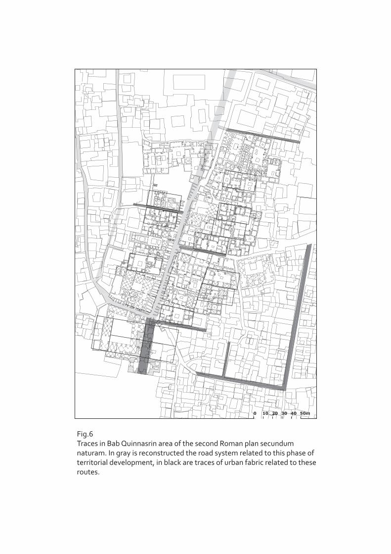
Fig.6Traces in Bab Quinnasrin area of the second Roman plan secundum naturam. In gray is reconstructed the road system related to this phase of territorial development, in black are traces of urban fabric related to these routes.

Fig.7The Byzantine city