Embed Size (px)
Citation preview
The Park Development Division of the Montgomery County Department of Parks
BETHESDA, MARYLAND
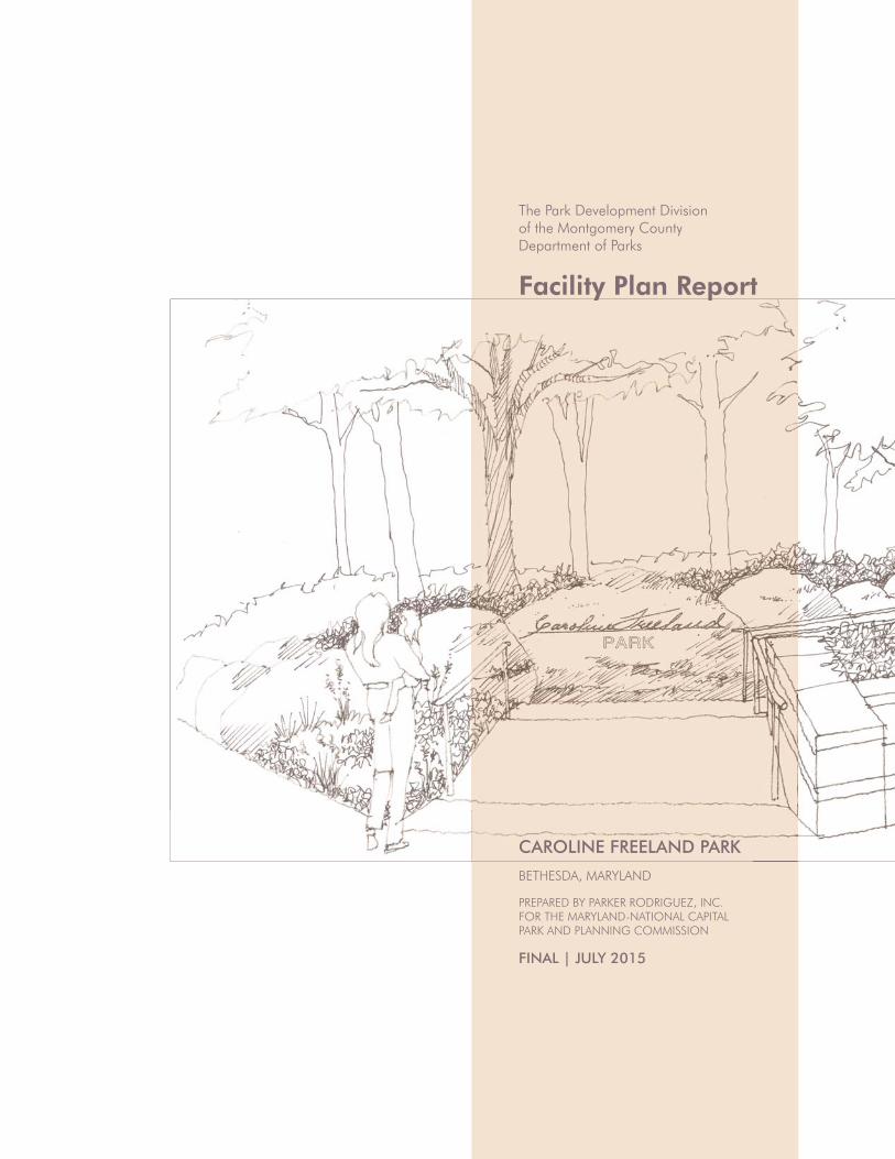
CAROLINE FREELAND PARK
PREPARED BY PARKER RODRIGUEZ, INC. FOR THE MARYLAND-NATIONAL CAPITAL PARK AND PLANNING COMMISSION
FINAL | JULY 2015
Facility Plan Report

TABLE OF CONTENTS
Project Overview
Introduction
Project Goals & Objectives
History of the Park
The Caroline Freeland Story
Master Plan Guidance
Facility Plan Process
Regional Context
Site Analysis
Program of Requirements
Preliminary Program of Requirements
Community Meeting #1
Final Program of Requirements
Plan Alternatives
Early Design Ideas
Option A
Option B
Option C
Community Meeting #2
Recommended Plan
Materials Plan
The Rockery
The Lawn
The Grove
Hampden Lane Promenade
The Playground
Entry Plaza
Arlington Road Streetscape
Stormwater Management
Tree Preservation
Site Lighting
Site Furnishings
5
5
6
8
10
11
13
15
19
31
31
34
36
39
39
40
42
44
46
47
48
51
52
54
55
56
57
58
60
62
64
66

CAROLINE FREELAND PARK 5
1 PROJECT OVERVIEW
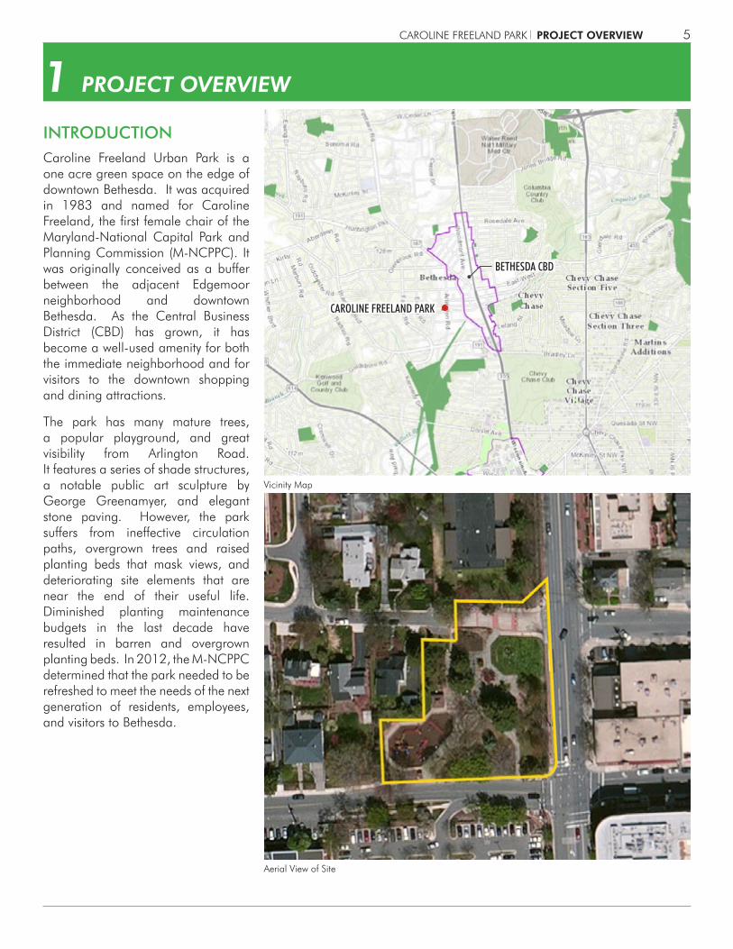
Caroline Freeland Urban Park is a one acre green space on the edge of downtown Bethesda. It was acquired in 1983 and named for Caroline Freeland, the first female chair of the Maryland-National Capital Park and Planning Commission (M-NCPPC). It was originally conceived as a buffer between the adjacent Edgemoor neighborhood and downtown Bethesda. As the Central Business District (CBD) has grown, it has become a well-used amenity for both the immediate neighborhood and for visitors to the downtown shopping and dining attractions.
The park has many mature trees, a popular playground, and great visibility from Arlington Road. It features a series of shade structures, a notable public art sculpture by George Greenamyer, and elegant stone paving. However, the park suffers from ineffective circulation paths, overgrown trees and raised planting beds that mask views, and deteriorating site elements that are near the end of their useful life. Diminished planting maintenance budgets in the last decade have resulted in barren and overgrown planting beds. In 2012, the M-NCPPC determined that the park needed to be refreshed to meet the needs of the next generation of residents, employees, and visitors to Bethesda.
INTRODUCTION
Vicinity Map
Aerial View of Site
PROJECT OVERVIEW
CAROLINE FREELAND PARK
BETHESDA CBD
CAROLINE FREELAND PARK6
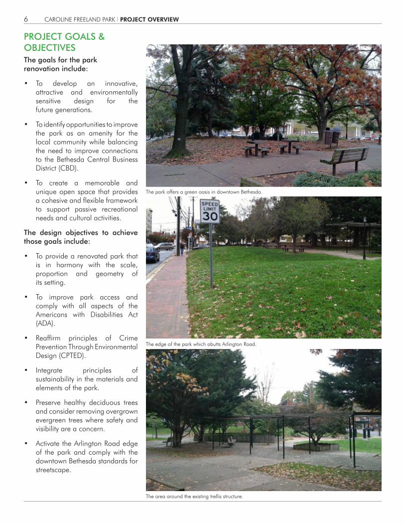
PROJECT GOALS & OBJECTIVESThe goals for the park renovation include:
• To develop an innovative, attractive and environmentally sensitive design for the future generations.
• To identify opportunities to improve the park as an amenity for the local community while balancing the need to improve connections to the Bethesda Central Business District (CBD).
• To create a memorable and unique open space that provides a cohesive and flexible framework to support passive recreational needs and cultural activities.
The design objectives to achieve those goals include:
• To provide a renovated park that is in harmony with the scale, proportion and geometry of its setting.
• To improve park access and comply with all aspects of the Americans with Disabilities Act (ADA).
• Reaffirm principles of Crime Prevention Through Environmental Design (CPTED).
• Integrate principles of sustainability in the materials and elements of the park.
• Preserve healthy deciduous trees and consider removing overgrown evergreen trees where safety and visibility are a concern.
• Activate the Arlington Road edge of the park and comply with the downtown Bethesda standards for streetscape.
The park offers a green oasis in downtown Bethesda.
The edge of the park which abutts Arlington Road.
The area around the existing trellis structure.
PROJECT OVERVIEW
CAROLINE FREELAND PARK 7
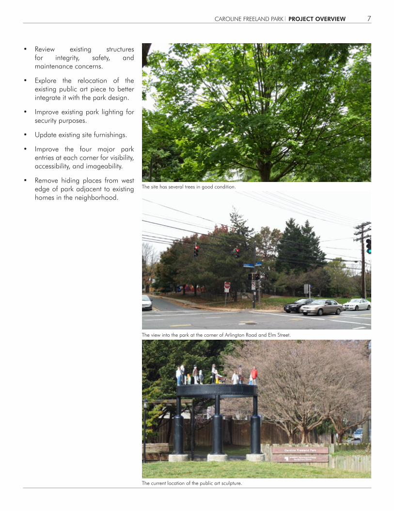
The site has several trees in good condition.
The view into the park at the corner of Arlington Road and Elm Street.
The current location of the public art sculpture.
• Review existing structures for integrity, safety, and maintenance concerns.
• Explore the relocation of the existing public art piece to better integrate it with the park design.
• Improve existing park lighting for security purposes.
• Update existing site furnishings.
• Improve the four major park entries at each corner for visibility, accessibility, and imageability.
• Remove hiding places from west edge of park adjacent to existing homes in the neighborhood.
PROJECT OVERVIEW
CAROLINE FREELAND PARK8
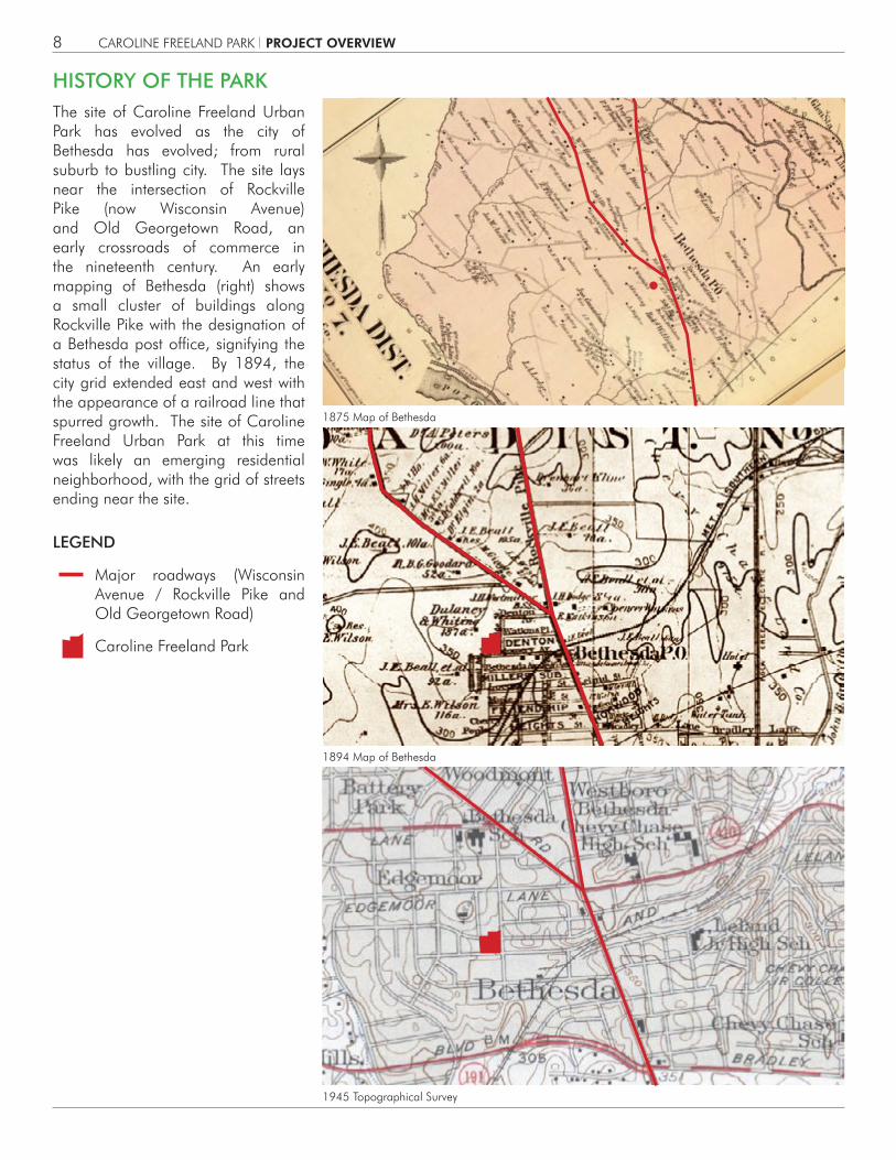
LEGEND
Major roadways (Wisconsin Avenue / Rockville Pike and Old Georgetown Road)
Caroline Freeland Park
1894 Map of Bethesda
1945 Topographical Survey
1875 Map of Bethesda
The site of Caroline Freeland Urban Park has evolved as the city of Bethesda has evolved; from rural suburb to bustling city. The site lays near the intersection of Rockville Pike (now Wisconsin Avenue) and Old Georgetown Road, an early crossroads of commerce in the nineteenth century. An early mapping of Bethesda (right) shows a small cluster of buildings along Rockville Pike with the designation of a Bethesda post office, signifying the status of the village. By 1894, the city grid extended east and west with the appearance of a railroad line that spurred growth. The site of Caroline Freeland Urban Park at this time was likely an emerging residential neighborhood, with the grid of streets ending near the site.
HISTORY OF THE PARK
PROJECT OVERVIEW

CAROLINE FREELAND PARK 9
1937 Sanborn Map
1977 Site Survey
1984 Plan for Caroline Freeland Park
By 1937, Sanborn maps show the site as an area with eight homes, fronting on Elm Street to the south and Hampden lane to the north. A USGS map from 1945 (on the prior page) shows that the site of the park was fully immersed in the Edgemoor neighborhood, with adjacent schools and a fully fleshed out urban grid pattern. By 1977, only one of the eight original homes remained on the site. This map is the precursor to the proposal to acquire the site as an urban park. At that time, the site was entitled “Edgemoor Urban Park”, but was changed to Caroline Freeland Urban Park, in honor of the exemplary public service by Ms. Freeland.
PROJECT OVERVIEW

CAROLINE FREELAND PARK10
Caroline Freeland was a planner who served on the Planning Board of the Maryland-National Capital Park and Planning Commission and rose to become its first female chair. Her service was from 1963 to 1971 and during that time the county expanded its acreage of public parks from 7,600 acres to 16,000 acres. She was a major contributor to the Washington region master plan in 1964, entitled “On Wedges and Corridors,” which postulated distinct areas of growth and preservation of the natural or rural landscape based upon transportation corridors and adequate public infrastructure. This landmark planning tool has served the county well over the past fifty years and has become a national model for land use planning. Her work also included the Master Plan for Bethesda Chevy Chase in 1970, which created another striking pattern of urban growth coupled with neighborhood preservation.
Freeland (seated far left), pictured with officials from the National Park Service on January 29, 1972
THE CAROLINE FREELAND STORY
PROJECT OVERVIEW

2 0 1 2 P A R K , R E C R E A T I O N A N D O P E N S P A C E ( P R O S ) P L A N
J u l y 2 0 1 2
Maryland-National Capital Park and Planning Commission, Department of Parks, Montgomery County
Montgomery County Recreation Department
CAROLINE FREELAND PARK 11
The plan for the renovation of Caroline Freeland Urban Park has incoporated guidance from the following approved master plan & policy documentation:
• Bethesda CBD Master Plan (1994)
• Bethesda / Chevy Chase Master Plan (1990)
• Bikeways Master Plan (2005)
• Vision 2030: Strategic Plan for Parks and Recreation in Montgomery County (2012)
• Parks, Recreation, and Open Space Plan Update (2012)
In particular, the 1994 Bethesda CBD posited the following, with relevance to Caroline Freeland Urban Park :
• Improve pedestrian and bicycle links through the Sector Plan area to the adjacent neighborhoods.
• Reinforce the cultural heritage of Bethesda and emphasize design themes such as “garden” and “cultural district.”
• Enhance the pedestrian environment to encourage walking and social interaction.
• Give special attention to streetscapes.
• Provide buffers for residential neighborhoods with parks and open spaces.
• Promote diverse range of activities in public spaces that are safe and visible.
• Strengthen the urban form with open spaces, gathering places, landmarks, and focal points.
The Bethesda Master Plan is currently under revision and this facility plan responds to their preliminary recommendations as well.
MASTER PLAN GUIDANCE
PROJECT OVERVIEW

CAROLINE FREELAND PARK12
The 2012 Parks, Recreation, and Open Space Plan (PROS) also offered specific recommendations for this region of the county:
• Maintain high level of service for playgrounds and add skate parks and community gardens as requested.
• Provide dog spots, community space, and urban woodlands where feasible.
• In particular, Caroline Freeland Urban Park should serve as a buffer with landscaping, sitting/picnic areas, play areas, courts, and shelters.
• No new basketball courts, tennis courts, or playgrounds are needed in Bethesda (Planning Area 35).
PROJECT OVERVIEW

CAROLINE FREELAND PARK 13
FACILITY PLAN PROCESSSeptember 20, 2012 Request for proposals issued.
November 7, 2012 Proposal responses due.
May 28, 2013 Project Initiation.
June 6, 2013 Project kick-off meeting.
June 24, 2013Site meeting with representatives from the Bethesda Chevy-Chase Regional Services Center and Bethesda Urban Partnership (BUP).
June 25, 2013 PDCO Team site kick-off meeting
July 19, 2013Meeting with Park Managers on previous community coordination.
August 7, 2013 Team Site Visit.
October 22, 2013Site analysis & program team meeting.
November 6, 2013Community Meeting #1 (Site Analysis & Program).
November 22, 2013 Concept plan alternatives charrette at Parker Rodriquez.
December 16, 2013Concept plan alternatives revisions work session.
February 10, 2014PDCO Team Review Meeting #1 – Concept Plan Alternatives
March 12, 2014Community Meeting #2 (Plan Alternatives).
March 21, 2014 Site meeting with adjacent resident.
April 28, 2014Preferred Plan coordination and selection.
May 15, 2014Preferred Plan work session at Parker Rodriquez.
July 23, 2014Draft Preferred Plan sent to PDCO Team for preliminary review
September 10, 2014PDCO Team Review Meeting #2 – Preferred Plan (15% Design).
October 8, 2014Presentation to the Commission on People with Disabilities (CPWD).
October 20, 2014Project Briefing to Department of Parks Upper Management.
November 19, 2014Forest Conservation Plan (FCP) Exemption Approved.
December 19, 2014Geotechnical Borings Site Coordination Meeting.
January 20, 2015Development Review Committee (DRC) ‘Discussion’ Item Meeting.
January 20, 2015Project Briefing to the Edgemoor Civic Association (ECA).
February 6, 2015Meeting with member of ECA on site to discuss downtown public art
March 30, 2015Stormwater Management Concept Approval
April 2, 2015PDCO Team Review Meeting #3 – Recommended Plan (30% Design Draft).
July, 2015Public presentation to the Montgomery County Planning Board
PROJECT OVERVIEW


CAROLINE FREELAND PARK 15
Caroline Freeland Urban Park is located within a half-mile of the heavily-used Capital Crescent and Georgetown Branch trails which connect Silver Spring, Maryland to the Georgetown area of Washington, DC. It is also within a half-mile of the Elm Street Urban Park and the Little Falls Stream Valley Park.
The park is nestled on the edge of the area served by the Edgemoor Civic Association. It lies across Arlington Road from the East Edgemoor Property Owners Association.
Parks Vicinity Map
Civic Associations Map
2 REGIONAL CONTEXT
PARKS VICINITY
CIVIC ASSOCIATIONS
1/2 MILE RADIUS
1/4 MILE RADIUS
1/2 MILE RADIUS
1/4 MILE RADIUS
CAPITAL CRESCENT TRAIL
LITTLE FALLS PARKLITTLE FALLS TRAIL
ELM STREET PARK
EAST BETHESDACITIZENS ASSOCIATION
EDGEMOORCITIZENS ASSOCIATION EAST EDGEMOOR
PROPERTY OWNERS
BATTERY PARK CITIZENS ASSOCIATION
ELM STREET-OAKRIDGE-LYNN CIVIC ASSOCIATION
GEORGETOWN BRANCH TRAIL
REGIONAL CONTEXT
NORTH
NORTH
LEGENDBethesda Urban Partnership (BUP)

CAROLINE FREELAND PARK16
This aerial map depicts the pattern of tree cover around the park, with extensive tree canopy in the Edgemoor neighborhood and more sporadic canopy in the Bethesda CBD across Arlington Road.
Caroline Freeland Park is located in the Willett Branch subwatershed, which is part of the Little Falls watershed. Rain water runoff from the park courses south toward the Potomac River.
Aerial Map/Tree Cover
Subwatersheds/Hydrology Map
TREE COVER
HYDROLOGYBETHESDA MAINSTEM
COQUELIN RUN
LITTLE FALLSUPPER MAINSTEM
WILLETT BRANCH
GLEN ECHO TRIBUTARIES
BOOZE CREEK
REGIONAL CONTEXT
NORTH
NORTH
CAROLINE FREELAND PARK 17
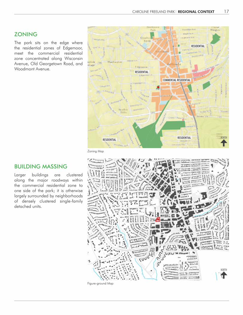
Zoning Map
Figure-ground Map
The park sits on the edge where the residential zones of Edgemoor, meet the commercial residential zone concentrated along Wisconsin Avenue, Old Georgetown Road, and Woodmont Avenue.
Larger buildings are clustered along the major roadways within the commercial residential zone to one side of the park; it is otherwise largely surrounded by neighborhoods of densely clustered single-family detached units.
ZONING
BUILDING MASSING
COMMERCIAL RESIDENTIAL
RESIDENTIAL
RESIDENTIALRESIDENTIAL
RESIDENTIAL
REGIONAL CONTEXT
NORTH
NORTH
CAROLINE FREELAND PARK18
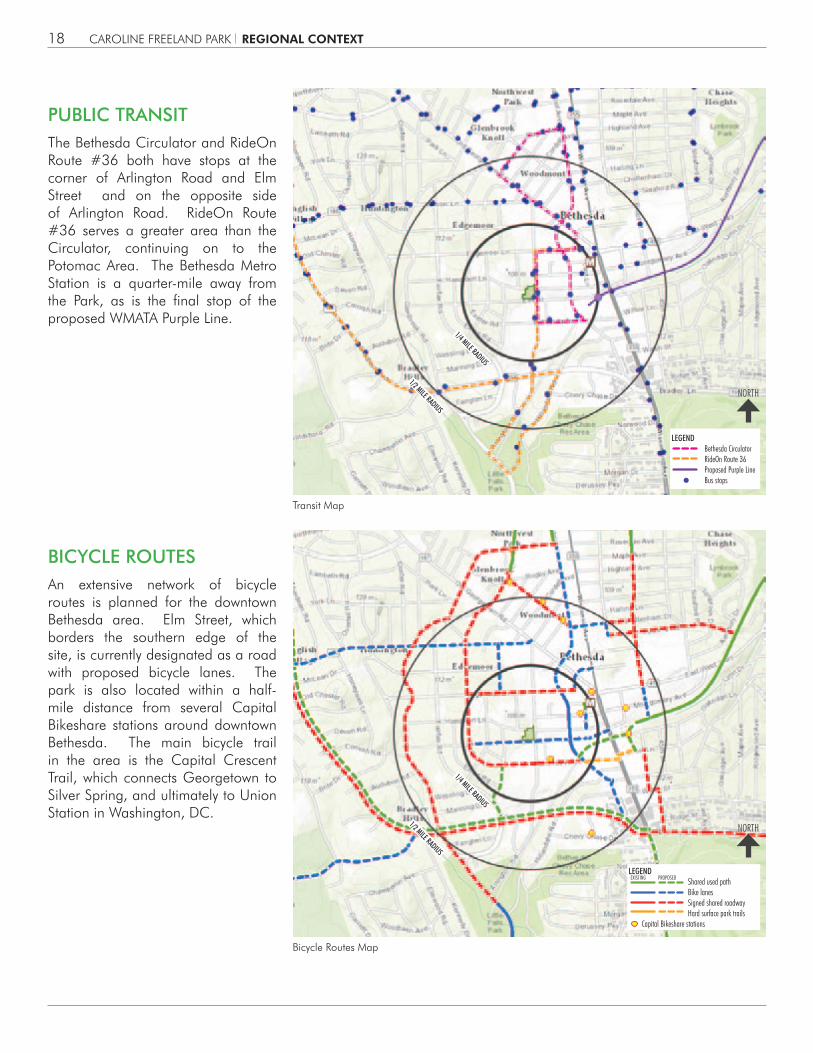
The Bethesda Circulator and RideOn Route #36 both have stops at the corner of Arlington Road and Elm Street and on the opposite side of Arlington Road. RideOn Route #36 serves a greater area than the Circulator, continuing on to the Potomac Area. The Bethesda Metro Station is a quarter-mile away from the Park, as is the final stop of the proposed WMATA Purple Line.
An extensive network of bicycle routes is planned for the downtown Bethesda area. Elm Street, which borders the southern edge of the site, is currently designated as a road with proposed bicycle lanes. The park is also located within a half-mile distance from several Capital Bikeshare stations around downtown Bethesda. The main bicycle trail in the area is the Capital Crescent Trail, which connects Georgetown to Silver Spring, and ultimately to Union Station in Washington, DC.
Transit Map
Bicycle Routes Map
PUBLIC TRANSIT
BICYCLE ROUTES
NORTH
NORTH
LEGENDBethesda CirculatorRideOn Route 36Proposed Purple LineBus stops
LEGENDShared used pathBike lanesSigned shared roadwayHard surface park trails
Capital Bikeshare stations
EXISTING PROPOSED
1/2 MILE RADIUS
1/4 MILE RADIUS
1/2 MILE RADIUS
1/4 MILE RADIUS
REGIONAL CONTEXT

CAROLINE FREELAND PARK 19
Caroline Freeland Park lies at the seam between the commercial core of downtown Bethesda and the residential neighborhood of Edgemoor. It is both destination and passage for residents and users of the CBD and thus serves as the common ground for both. Today the park serves as more of a buffer than a destination for urban activities. The users are more likely to be residents of Edgemoor using the playground, than shoppers seeking a respite. Of note is the adjacent library, which is a significant attraction to the north. To the south is the surface parking lot of a grocery store, which creates an unsightly and ill-formed edge to the park. The major entries to the park lie at its four corners, and each offers an opportunity to welcome users from adjoining areas. Arlington Road is the western edge of the CBD and, as such, will require the downtown Bethesda streetscape standards that define the character of the CBD. The western edge of the park consists of adjoining residential yards and should be buffered appropriately. The east edge of Arlington Road currently features low-rise buildings, but are zoned for higher density.
3 SITE ANALYSIS
NEIGHBORHOOD CONTEXT
SITE ANALYSIS
NORTH
CAROLINE FREELAND PARK20
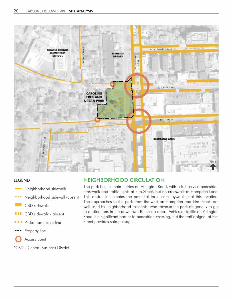
The park has its main entries on Arlington Road, with a full service pedestrian crosswalk and traffic lights at Elm Street, but no crosswalk at Hampden Lane. This desire line creates the potential for unsafe jaywalking at this location. The approaches to the park from the west on Hampden and Elm streets are well-used by neighborhood residents, who traverse the park diagonally to get to destinations in the downtown Bethesda area. Vehicular traffic on Arlington Road is a significant barrier to pedestrian crossing, but the traffic signal at Elm Street provides safe passage.
LEGEND
Neighborhood sidewalk
Neighborhood sidewalk-absent
CBD sidewalk
CBD sidewalk - absent
Pedestrian desire line
Property line
Access point
*CBD - Central Business District
NEIGHBORHOOD CIRCULATION
SITE ANALYSIS
NORTH
CAROLINE FREELAND PARK 21
LEGEND
Excellent condition
Good condition
Fair condition
Poor condition
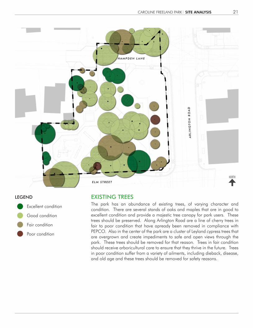
The park has an abundance of existing trees, of varying character and condition. There are several stands of oaks and maples that are in good to excellent condition and provide a majestic tree canopy for park users. These trees should be preserved. Along Arlington Road are a line of cherry trees in fair to poor condition that have apready been removed in compliance with PEPCO. Also in the center of the park are a cluster of Leyland cypress trees that are overgrown and create impediments to safe and open views through the park. These trees should be removed for that reason. Trees in fair condition should receive arboricultural care to ensure that they thrive in the future. Trees in poor condition suffer from a variety of ailments, including dieback, disease, and old age and these trees should be removed for safety reasons.
EXISTING TREES
SITE ANALYSIS
NORTH
CAROLINE FREELAND PARK22
LEGEND
Pervious surfaces
Impervious surfaces
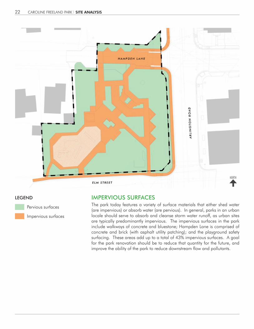
The park today features a variety of surface materials that either shed water (are impervious) or absorb water (are pervious). In general, parks in an urban locale should serve to absorb and cleanse storm water runoff, as urban sites are typically predominantly impervious. The impervious surfaces in the park include walkways of concrete and bluestone; Hampden Lane is comprised of concrete and brick (with asphalt utility patching); and the playground safety surfacing. These areas add up to a total of 43% impervious surfaces. A goal for the park renovation should be to reduce that quantity for the future, and improve the ability of the park to reduce downstream flow and pollutants.
IMPERVIOUS SURFACES
NORTH
SITE ANALYSIS

CAROLINE FREELAND PARK 23
LEGEND
Park entrances
Primary circulation route
Secondary route
Pedestrian street crossing
Vehicular circulation
Site furnishings
Curb ramp
Destinations
The park is both a destination for gathering and passive recreation, and a passage for pedestrians. The playground is the primary destination in the park, while others use the park seating areas for lunctime or gathering with friends.
Many people travel through the park as they make their way to downtown Bethesda, the library or the grocery store. A pair of diagonal walks in the park offers a convenient, if incomplete, pathway from corner to corner. The main entry to the park is at the corner of Arlington Road and Elm Street, and although that intersection has well-marked crosswalks and traffic signals, the entry walk at that point is too steep to be compliant with ADA regulations. This area also suffers from several overgrown pine trees which block views to the park.
Hampden Lane is a former street that has been closed to vehicular traffic. At 20’ wide, the street does not reinforce a pedestrian experience, and it seems empty most of the time. There are some additional walkways in the park that allow users to traverse around the playground and under an existing trellis, but these walks seem underutilized.
PEDESTRIAN CIRCULATION
NORTH
SITE ANALYSIS

CAROLINE FREELAND PARK24
LEGEND
Overhead electrical line
In-ground electrical line
Electrical utility pole
GFCI electrical outlet
Park light
Natural gas line
Stormwater pipe
Stormwater drain
Sanitary sewer line
Sanitary sewer structure
Water line
Water valve/structure
Drinking fountain
Fire Hydrant
Telephone line
CTV line
The park is served by a variety of public utilities including water, power, and storm drain lines. Most of these lines are found along the park perimeter under Elm Street, Hampden Lane and Arlington Road. This means that the utilities are close by, if needed, but do not impose any real constraints to the placement of new park facilities or landscape plantings in the park itself. There are a series of existing light poles and their accompanying underground power lines throughout the park and a drinking fountain near the playground.
UTILITIES
H
NORTH
SITE ANALYSIS
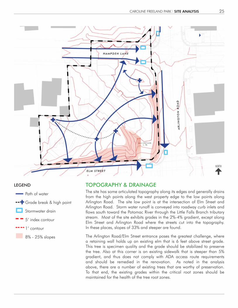
CAROLINE FREELAND PARK 25
LEGEND
Path of water
Grade break & high point
Stormwater drain
5’ index contour
1’ contour
8% - 25% slopes
The site has some articulated topography along its edges and generally drains from the high points along the west property edge to the low points along Arlington Road. The site low point is at the intersection of Elm Street and Arlington Road. Storm water runoff is conveyed into roadway curb inlets and flows south toward the Potomac River through the Little Falls Branch tributary stream. Most of the site exhibits grades in the 2%-4% gradient, except along Elm Street and Arlington Road where the streets cut into the topography. In these places, slopes of 33% and steeper are found.
The Arlington Road/Elm Street entrance poses the greatest challenge, where a retaining wall holds up an existing elm that is 6 feet above street grade. This tree is specimen quality and the grade should be stabilized to preserve the tree. Also at this corner is an existing sidewalk that is steeper than 5% gradient, and thus does not comply with ADA access route requirements and should be remedied in the renovation. As noted in the analysis above, there are a number of existing trees that are worthy of preservation. To that end, the existing grades within the critical root zones should be maintained for the health of the tree root zones.
TOPOGRAPHY & DRAINAGE
NORTH
SITE ANALYSIS

CAROLINE FREELAND PARK26
LEGEND
Attractions
Views
Barriers to View
Vegetative barrier
Existing trees
The park lies prominently at the corner of Elm Street and Arlington Road and is thus visible to thousands of pedestrians and vehicular occupants each day. Generally, the topography and deciduous tree canopy provide for expansive views into the park. This has both an aesthetic value, and also a value for public safety and surveillance. However, there are a number of existing overgrown evergreen trees, pines and Leyland cypresses, that block sightlines. This leads to a perception of an unsafe condition, and thus inhibits some from freely using the park, especially in the evening. While most county parks are day-use facilities, urban parks need to be visually accessible and illuminated into the evening hours for public safety. To that end, some of the existing evergreen trees should be removed or pruned for better site visibility.
VIEW ANALYSIS
NORTH
SITE ANALYSIS

CAROLINE FREELAND PARK 27
LEGEND
Noise pollution The park lies along a major collector street, Arlington Road, and thus absorbs the din of vehicular traffic that passes by as a consequence. Elm Street is much less traveled and Hampden Lane is car-free, so the main nuisance of noise lies along Arlington Road. Some noise may be mitigated by the grade change along Arlington, so this suggests that major use areas in the park design be placed well into the park proper and not right along the street edge, to soften the impact of the traffic noise.
NOISE ANALYSIS
NORTH
SITE ANALYSIS

CAROLINE FREELAND PARK28
LEGEND
Transplanted tree
Steel fence
Steel tube
Cobble curb
Bluestone
Sculpture
The park currently features a variety of materials from the early 1980’s. In a renovation, some demolition and removal is inevitable and will be a part of the design. However, as a part of a sustainability strategy, it is imperative to explore the reuse of materials on site. Such materials in the park include bluestone pavers, granite curb cobbles, steel trellis columns, and steel fencing. Some materials may be repurposed, such as the wood columns on the pavilion shelter structure. Some trees in places with new uses may be transplanted to other locations in the park. The signature sculpture in the northeast quadrant may find a better fit within the new park design. Even trees that are removed for site visibility reasons may be reused for their wood material. The point of this analysis is to consider existing materials as part of the resources of the future park.
REUSE, RECYCLE, REPURPOSE
NORTH
SITE ANALYSIS

CAROLINE FREELAND PARK 29
LEGEND
Essential Elements This analysis is the summation of the prior analyses and offers a set of site features that should remain in place in any design alternative for the park. These elements include the playground location and 13 existing trees. All other elements, materials, and features may be considered for alteration, elimination, or reuse in the design alternatives. The playground location is considered a given as it is the main use area of the park, is well located away from the noise of Arlington Road, and adjoins its user groups in Edgemoor. While that location is a constraint, the actual play apparatus may be updated as elements reach the end of their useful life.
The thirteen trees are all deciduous trees of good to excellent status, with a life expectancy of 20-50 more years of providing shade, shelter, and buffering. These trees form the signature of the park as a mature landscape and great effort should be taken to preserve them.
Of note in this analysis, is the pattern created by the essential elements, a cluster along the south and west side of the park. What is compelling about this pattern is the potential for change in the areas not constrained, along the north and east sides. Herein lies the opportunity for a new urban park that is in tune with its time, its users, and its urban setting.
ESSENTIAL ELEMENTS
NORTH
SITE ANALYSIS


CAROLINE FREELAND PARK 31
PRELIMINARY PROGRAM OF REQUIREMENTSExisting park facilities include playground equipment, picnic areas, a pavilion shelter and trellis structure.
Based on the analysis of existing park facilities, surrounding conditions, policy guidance, and duplication of service, Park Planning Staff recommended the following Preliminary Program of Requirements (PPOR) for facilities to be considered in the renovated park:
1. Community Open Space - Provide a level and un-programmed open area suitable for small gatherings. Open space materials should be designed to accommodate future park activities and general use.
2. Playground - Provide play area that will attract multiple age groups and create aesthetic harmony with the rest of the park. Assess existing playground area to determine if it should be modified to integrate better with the new park design.
3. Community Garden - Provide compact community garden models that integrate with future urban park activities (if requested).
4. Skate-able Elements - While the park is too small for a dedicated skateboarding area, create skate-able objects where appropriate.
4 PROGRAM OF REQUIREMENTS
5. Streetscape Elements Along Arlington Road - Per the Bethesda CBD Master Plan, include undergrounding of utilities, installation of Washington Globe lighting, planting of red oak trees, widening of sidewalk, etc.
6. Bikeway and Sidewalk Improvements - . As recommended in the Bethesda CBD Master Plan.
Following presentation of the PPOR during the first Community Meeting, the Skate-able Elements and Community Garden program uses were not accepted and were subsequently removed from the Final Program of Requirements.
The full Preliminary Program of Requirements Report (PPOR) is available in the Appendices of the Facility Plan Report.
PROGRAM OF REQUIREMENTS

CAROLINE FREELAND PARK32
Background Information
1. Existing Park and Recreation Facilities Nearby
The following identifies nearby existing park and recreation facilities relative to the location of Caroline Freeland Park and are either owned and maintained by the M-NCPPC, by adjacent jurisdictions, or by umbrella agencies like the Bethesda Urban Partnership (BUP).
Since Caroline Freeland Park is not large enough to provide active recreation needs for its immediate surrounding neighborhood, a few locations that contain these facilities have been identified on the map (right) and park facility list (below right). The playing fields, gym, stage and meeting rooms of Bethesda- Chevy Chase High school are available for community use. Bethesda Elementary School’s facilities also provides a recreational resource for residents.
2. Population and Demographics
The Montgomery County Planning Department has estimated that by 2015, 40% of the households in Bethesda will be living in multi-family units. These residents typically have less access to a private backyard and therefore less contact with nature. It will be important to provide passive recreational opportunities in a “green” setting for these residents.
The population of Bethesda is expected to grow from a total of 92,267 in 2005 to 115, 475 in 2020. Due to this increase, there will be more demand placed on the existing open spaces and parks in the area.
PARK NAME DISTANCE FROM CFUP
(FEET)
FACILITIES PRESENT ACREAGE
1. Battery Lane UP 3,101 (1) Tennis court, (1) Basketball court, (1) Playground, HS Paths
1.96
2. Bethesda Swimming Pool 2,565 Aquatic Facility 4.92
3. Capital Crescent Trail SP 1,164 HS Trail 44.10
4. Chase Ave. UP 2,992 HS Paths 0.36
5. Cheltenham Dr. UP 2,564 (1) Playground, HS Paths 0.35
6. East-West Hwy. NCA 5,256 Natural Area 1.76
7. Elm St. UP 2,008 (1) Half-basketball court, (3) Playgrounds, (3) Gazebos, HS Paths
2.10
8. English Court NCA 5,100 Managed Open Space 0.02
Founders Park** 5,124 Managed Open Space, Playground 0.06
10. Greenwich NP 4,898 (2) Tennis courts, (1) Basketball court, (1) Playground, HS Paths, (1) Gazebo
3.69
11. Leland NP 3,007 (2) Tennis courts, (1) Basketball court, (1) Playground, HS Paths, County Rec. Ctr.
3.68
12. Little Falls SVU 2 2,193 (1) Soccer field, HS Paths and Trail 69.01
13. Lynnbrook LP 4,488 (2) Tennis courts, (1) Park activity building, (1) Softball field, (1) Overlay lacrosse field, (1) Playground, HS Paths
6.01
14. Norwood LP 2,174 (5) Tennis courts, (1) Basketball court, (3) Play-grounds, (1) Park activity building, (2) Ancillary buildings, (2) Softball fields, (3) Overlay soccer fields, HS Paths and trail
17.10
Rosemary Cir. Park * 5,230 Managed Open Space 0.26
Rosemary Triangle Park* 5,041 Managed Open Space 0.17
Tarrytown Park* 4,091 Managed Open Space, HS Paths 0.50
Zimmerman Park* 4,740 Managed Open Space 0.68* = Town of Chevy Chase** = Town of Somerset
PROGRAM OF REQUIREMENTS

CAROLINE FREELAND PARK 33
Surveys of Park Use
The actual counts of users and their ages, and the times they use the park were last conducted in 2000. A methodology for the survey is described within the 2000 Park User Survey.
According to user count studies, users per visit increased from 14 in 1995 to 20 in the year 2000 (44%) In 2000, the playground accounted for 68.6% of all park use observed, while passive recreation accounted for 15%.
In the 2000 Park User Survey, it was recognized that the Caroline Freeland Urban Park was popular with lunch time and playground users. These users and activities should be accommodated in the facility plan. The survey also recognized the following usage: weekday use 26%, weekend use 33.7 %. Weekend evening use 40.1%. Biking–2.5%, Picnic–2.5%, hiking, jogging, walking–9.2%, Open shelter use–2.2% Passive recreation–15.1%, playground use–68%.
While this study is outdated and the population of Bethesda has grown, the general trends and types of uses observed in the study seem to be consistent with current use of the park.
The playground is the most used element in the park.
The park also serves as a lunchtime spot for nearby office workers.
PROGRAM OF REQUIREMENTS

CAROLINE FREELAND PARK34
On November 6, 2013, a public meeting was conducted to present the site analysis and to seek input on the program for the park. This information was obtained through two means: a written questionnaire and a visual preference exercise. The questionnaires included seven questions about the character and uses of the existing park and also aspirations for the park in the future. The visual preference survey was comprised of a series of photo boards with park elements, materials, and landscape types that people could signify their like or dislike through the application of red or green dots. The audience was actively involved in the process and the Project Team engaged the entire group in discussions around the outcomes of each exercise. There were some areas of great agreement from the audience and some areas of mixed reaction.
A summary of the consensus from that group follows. For the complete set of responses, see the Appendix.
COMMUNITY MEETING #1
Results from the visual preference exercise on seating options
Attendees participating in the visual preference exercise
PROGRAM OF REQUIREMENTS

CAROLINE FREELAND PARK 35
Results from the visual preference exercise on paving character
Results from the visual preference exercise on planting character
PROGRAM OF REQUIREMENTS
CAROLINE FREELAND PARK36
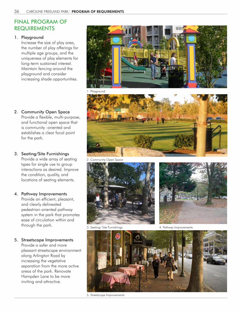
FINAL PROGRAM OF REQUIREMENTS
1. Playground Increase the size of play area, the number of play offerings for multiple age groups, and the uniqueness of play elements for long-term sustained interest. Maintain fencing around the playground and consider increasing shade opportunities.
3. Seating/Site Furnishings Provide a wide array of seating types for single use to group interactions as desired. Improve the condition, quality, and locations of seating elements.
4. Pathway Improvements Provide an efficient, pleasant, and clearly delineated pedestrian-oriented pathway system in the park that promotes ease of circulation within and through the park.
5. Streetscape Improvements Provide a safer and more pleasant streetscape environment along Arlington Road by increasing the vegetative separation from the more active areas of the park. Renovate Hampden Lane to be more inviting and attractive.
2. Community Open Space Provide a flexible, multi-purpose, and functional open space that is community -oriented and establishes a clear focal point for the park.
1. Playground
2. Community Open Space
3. Seating/ Site Furnishings 4. Pathway Improvements
5. Streetscape Improvements
PROGRAM OF REQUIREMENTS
CAROLINE FREELAND PARK 37
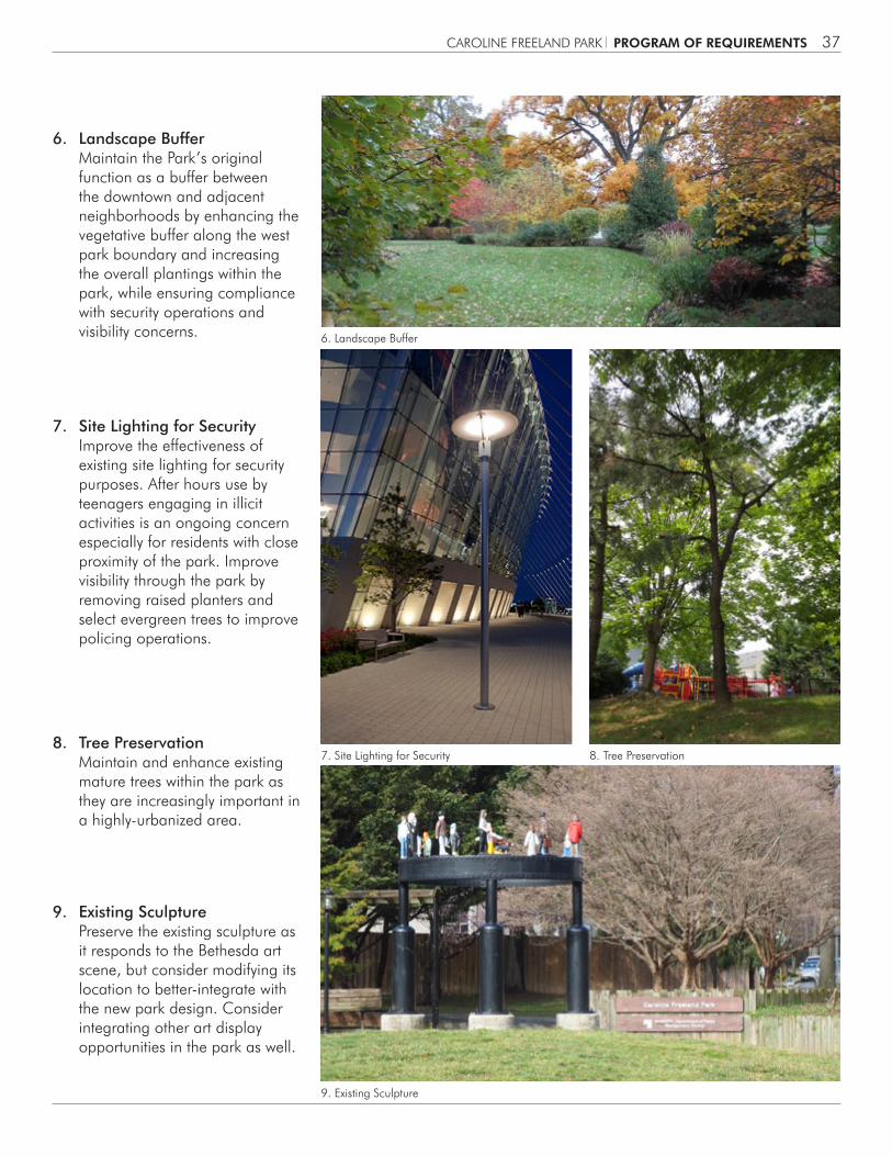
6. Landscape Buffer Maintain the Park’s original function as a buffer between the downtown and adjacent neighborhoods by enhancing the vegetative buffer along the west park boundary and increasing the overall plantings within the park, while ensuring compliance with security operations and visibility concerns.
7. Site Lighting for Security Improve the effectiveness of existing site lighting for security purposes. After hours use by teenagers engaging in illicit activities is an ongoing concern especially for residents with close proximity of the park. Improve visibility through the park by removing raised planters and select evergreen trees to improve policing operations.
8. Tree Preservation Maintain and enhance existing mature trees within the park as they are increasingly important in a highly-urbanized area.
9. Existing Sculpture Preserve the existing sculpture as it responds to the Bethesda art scene, but consider modifying its location to better-integrate with the new park design. Consider integrating other art display opportunities in the park as well.
6. Landscape Buffer
7. Site Lighting for Security 8. Tree Preservation
9. Existing Sculpture
PROGRAM OF REQUIREMENTS


CAROLINE FREELAND PARK 39
EARLY DESIGN IDEASThe early design ideas created for the park arose out of the site analysis, which defines areas suitable for park improvements, and the park program, which recommends facilities and elements that should be included in the park renovation. What was learned from the public process was that the park should remain essentially as a green space, with its mature tree canopy intact, and the playground as a major part of the park activities. Improvements should encourage family activities, discourage overnight park use, and increase the visibility and usefulness of the park spaces. The improved park should be of its time, capturing the dynamic qualities of an urban space, while still serving as a landscape buffer for Edgemoor.
Early concepts for the park each addressed those issues, but provided a variety of forms. These early concepts were advanced into design alternatives for review by the M-NCPPC and the general public at Community Meeting #2.
Charrette concept sketch A
Charrette concept sketch B Charrette concept sketch C
Existing conditions
5 PLAN ALTERNATIVES
PLAN ALTERNATIVES

CAROLINE FREELAND PARK40
OPTION AThis alternative uses the strong desire lines of pedestrian circulation on the diagonals as the driver of a park pattern with a simple triangular lawn panel on the northeast quadrant and a dense wooded grove on the southwest quadrant. The lawn area is sprinkled with trees for shade and edge definition, allowing for free play and flexible use. The shady grove of existing trees in the southwest features an expanded playground, informal seating, and nature-based play. The main entry at the corner of Elm Street and Arlington Road is opened up by removing the existing pine trees and providing a gently rising set of steps up to the lawn. A paved plaza with movable cafe seating and tables for informal gatherings was placed where the main entrance meets the lawn. In this alternative, Hampden Lane is treated as a pedestrian promenade, with an expanded paved area in the center for flexible use. The existing sculpture is proposed to be relocated to the southwest quadrant and positioned along the diagonal walkway to act as an entry pavilion for the playground.
Programming: Option A
Plan: Option A
NORTH
PLAN ALTERNATIVES

CAROLINE FREELAND PARK 41
Axonometric view looking from the northeast: Option A
Proposed entry view from southeastExisting Entry View from southeast
Concept character: diagonal forms Concept character: grove areaConcept character: paved plaza
NORTH
PLAN ALTERNATIVES
CAROLINE FREELAND PARK42
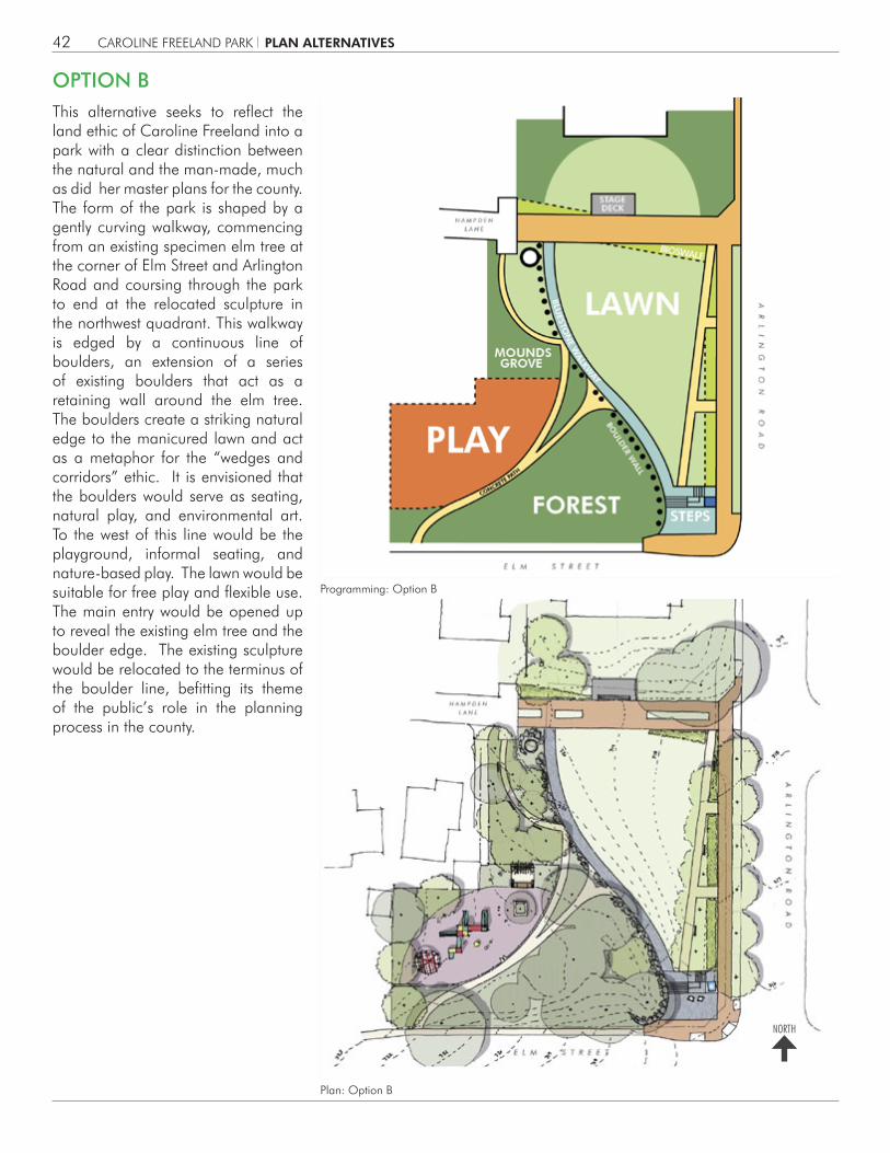
OPTION B
Programming: Option B
Plan: Option B
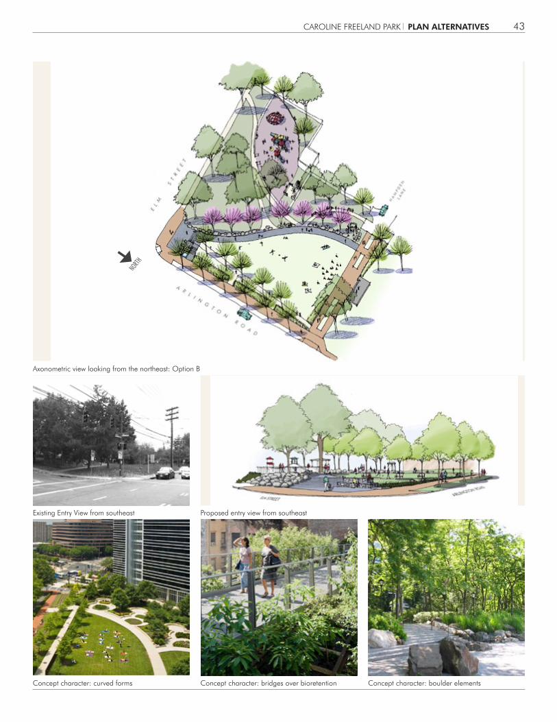
This alternative seeks to reflect the land ethic of Caroline Freeland into a park with a clear distinction between the natural and the man-made, much as did her master plans for the county. The form of the park is shaped by a gently curving walkway, commencing from an existing specimen elm tree at the corner of Elm Street and Arlington Road and coursing through the park to end at the relocated sculpture in the northwest quadrant. This walkway is edged by a continuous line of boulders, an extension of a series of existing boulders that act as a retaining wall around the elm tree. The boulders create a striking natural edge to the manicured lawn and act as a metaphor for the “wedges and corridors” ethic. It is envisioned that the boulders would serve as seating, natural play, and environmental art. To the west of this line would be the playground, informal seating, and nature-based play. The lawn would be suitable for free play and flexible use. The main entry would be opened up to reveal the existing elm tree and the boulder edge. The existing sculpture would be relocated to the terminus of the boulder line, befitting its theme of the public’s role in the planning process in the county.
NORTH
PLAN ALTERNATIVES
CAROLINE FREELAND PARK 43
Concept character: curved forms Concept character: bridges over bioretention Concept character: boulder elements
Axonometric view looking from the northeast: Option B
Proposed entry view from southeastExisting Entry View from southeast
NORTH
PLAN ALTERNATIVES
CAROLINE FREELAND PARK44
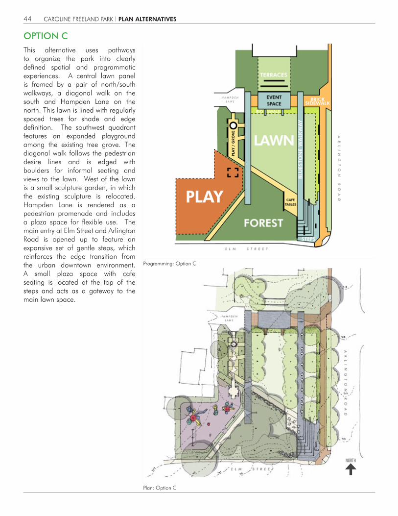
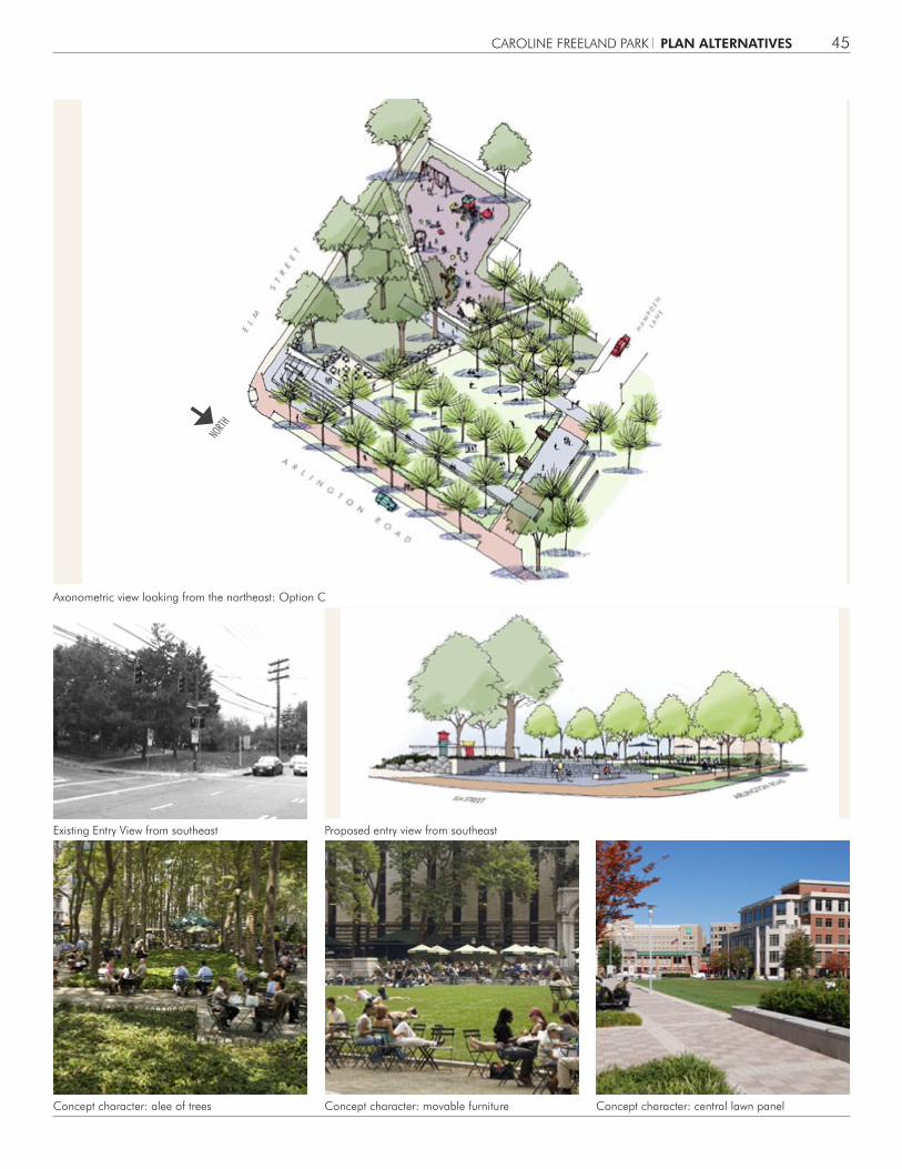
OPTION CThis alternative uses pathways to organize the park into clearly defined spatial and programmatic experiences. A central lawn panel is framed by a pair of north/south walkways, a diagonal walk on the south and Hampden Lane on the north. This lawn is lined with regularly spaced trees for shade and edge definition. The southwest quadrant features an expanded playground among the existing tree grove. The diagonal walk follows the pedestrian desire lines and is edged with boulders for informal seating and views to the lawn. West of the lawn is a small sculpture garden, in which the existing sculpture is relocated. Hampden Lane is rendered as a pedestrian promenade and includes a plaza space for flexible use. The main entry at Elm Street and Arlington Road is opened up to feature an expansive set of gentle steps, which reinforces the edge transition from the urban downtown environment. A small plaza space with cafe seating is located at the top of the steps and acts as a gateway to the main lawn space.
Programming: Option C
Plan: Option C
NORTH
PLAN ALTERNATIVES
CAROLINE FREELAND PARK 45
Concept character: alee of trees Concept character: movable furniture Concept character: central lawn panel
Axonometric view looking from the northeast: Option C
Proposed entry view from southeastExisting Entry View from southeast
NORTH
PLAN ALTERNATIVES
CAROLINE FREELAND PARK46
Option A
Option B
Option C
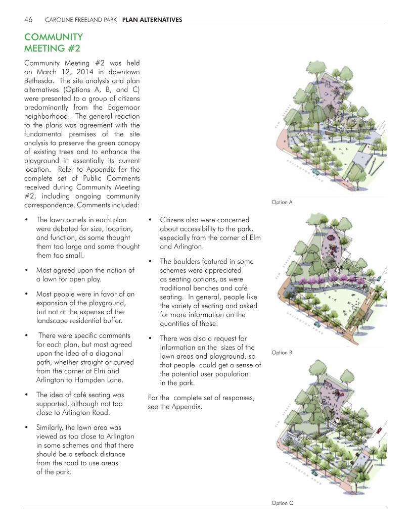
COMMUNITY MEETING #2Community Meeting #2 was held on March 12, 2014 in downtown Bethesda. The site analysis and plan alternatives (Options A, B, and C) were presented to a group of citizens predominantly from the Edgemoor neighborhood. The general reaction to the plans was agreement with the fundamental premises of the site analysis to preserve the green canopy of existing trees and to enhance the playground in essentially its current location. Refer to Appendix for the complete set of Public Comments received during Community Meeting #2, including ongoing community correspondence. Comments included:
• The lawn panels in each plan were debated for size, location, and function, as some thought them too large and some thought them too small.
• Most agreed upon the notion of a lawn for open play.
• Most people were in favor of an expansion of the playground, but not at the expense of the landscape residential buffer.
• There were specific comments for each plan, but most agreed upon the idea of a diagonal path, whether straight or curved from the corner at Elm and Arlington to Hampden Lane.
• The idea of café seating was supported, although not too close to Arlington Road.
• Similarly, the lawn area was viewed as too close to Arlington in some schemes and that there should be a setback distance from the road to use areas of the park.
• Citizens also were concerned about accessibility to the park, especially from the corner of Elm and Arlington.
• The boulders featured in some schemes were appreciated as seating options, as were traditional benches and café seating. In general, people like the variety of seating and asked for more information on the quantities of those.
• There was also a request for information on the sizes of the lawn areas and playground, so that people could get a sense of the potential user population in the park.
For the complete set of responses, see the Appendix.
PLAN ALTERNATIVES

CAROLINE FREELAND PARK 47
6 RECOMMENDED PLAN
After Community Meeting #2, Park Staff met to review the Options in light of public commentary, final program of requirements, and site analysis. From these discussions emerged the Recommended Plan, a synthesis of the best features of the Options. These features included: expansion of the playground; opening up the park entry at the corner of Elm Street and Arlington Road; creating a central lawn panel; providing for clear pathways through the park; and creation of the Rockery as an extension of the cluster of boulders in the southeast corner of the site; and preservation of the major deciduous shade trees throughout the park. The following pages describe in greater detail the elements of the Recommended Plan.
RECOMMENDED PLAN
RECOMMENDED PLAN
THE LAWN
THE GROVE
RESIDENTIAL BUFFER
ENTRY PLAZA
HAMPDEN PROMENADE
ARLINGTON ROAD STREETSCAPE
THE ROCKERY
PLAYGROUND
NORTH
CAROLINE FREELAND PARK48
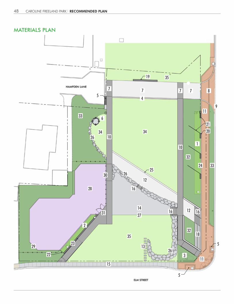
MATERIALS PLAN
25
8
9
4
11
1
33
33
34
35
34
35
32
32
6
7777
11
RECOMMENDED PLAN
18
19
20
24
21
5
16
23
26
26
26
13
16
15
16
14
27
28
30
31
29
12
12
2
3
10
10
5
22
5
CAROLINE FREELAND PARK 49
MATERIALS KEY
STORMWATER MANAGEMENT
1. Micro-bioretention Facility #1
2. Micro-bioretention Facility #2
3. Rain Garden Facility #3
4. Trench Drain
5. Water Quality Inlet
STRUCTURES
6. Salvage/Re-locate Steel Sculpture
VEHICULAR PAVEMENT - HAMPDEN LANE
7. Precast Concrete Unit Paving - Vehicular
8. Brick Paving - Vehicular
9. Vehicular Curb & Gutter
HARDSCAPE MATERIALS (PAVING, WALLS, STEPS)
10. Precast Concrete Unit Paving - Pedestrian
11. Brick Paving - Pedestrian
12. Flagstone Paving
13. Stepping Stones
14. Flexi-pave (Alternate to Crushed Stone Paving)
15. Concrete Sidewalk
16. Stone Stairs
17. Stone Veneer Retaining Walls
18. Stone Veneer Terraces
19. Stone Veneer Seat Wall
20. Stone Plinth at MBF #1
21. Weathering Steel Weir Wall at MBF #1
22. Weathering Steel Wall at MBF #2
23. Stone Veneer Wall at MBF #2
24. Stone Curb at MBF #1
25. Stone Curb at Lawn (with text inscription)
26. Stone Boulders (retaining and at-grade)
27. Steel edging
PLAYGROUND
28. Rubberized Play Surfacing
29. Concrete Curb at playground
30. Playground Fence
31. Playground Gate
LANDSCAPING
32. Low Shrub Mass
33. Groundcovers and Perennials
34. Sod
35. Overseed Existing Lawn
RECOMMENDED PLAN
CAROLINE FREELAND PARK50
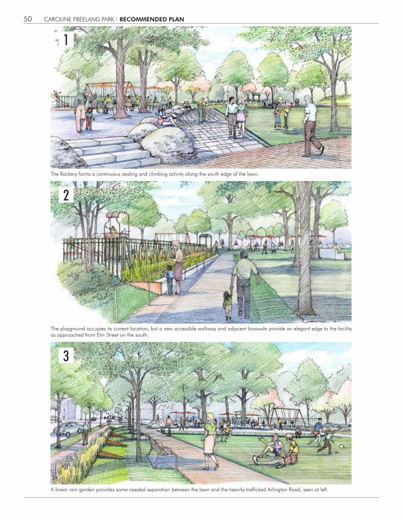
The Rockery forms a continuous seating and climbing activity along the south edge of the lawn.
The playground occupies its current location, but a new accessible walkway and adjacent bioswale provide an elegant edge to the facility as approached from Elm Street on the south.
A linear rain garden provides some needed separation between the lawn and the heavily-trafficked Arlington Road, seen at left.
RECOMMENDED PLAN
1
2
3

NORTH
CAROLINE FREELAND PARK 51
The Rockery forms the southern edge of the lawn. Entry sign - engraved boulder.
Existing rockery at existing elm. Boulders as landscape elments.
Detail plan of the Rockery
The Rockery is a line of natural boulders that course through the park, commencing at the entry near Elm and Arlington, where a series of existing boulders serves as a retaining wall for a specimen Chinese Elm tree. The Rockery extends that existing wall into the park, coursing north and west and ending at the northwest corner of the park, embracing the new location of the existing steel sculpture. The boulders are intended to be 3’-4’ in height and length and act as a linear sculpture and seatwall, as they flow along the walkway and flank the southern edge of the central lawn. In their bold form and material, they become the signature element of the new park design. The boulders represent metaphorically the line between city and nature that is embodied in the “On Wedges and Corridors” plan for the region, that was the signature achievement of Caroline Freeland in her time as Planning Board member and Chair. It is envisioned that children will climb along them, adults will sit upon them, teenagers will gather in groups on the natural perches that the boulders provide. They form a dramatic edge between the lawn and the grove, and their raw natural materiality will create a striking contrast to the clean geometries of the walkways and lawn panel, heightening the appreciation of each in the urban park.
THE ROCKERY
RELOCATED EXISTING SCULPTURE
FLAGSTONE PAVING
STONE BOULDERS
TABLES & CHAIRS (2 PERSON)
EXISTING CHINESE ELM
16’-2
” MAX
.
RECOMMENDED PLAN
2
1
3
NORTH
CAROLINE FREELAND PARK52
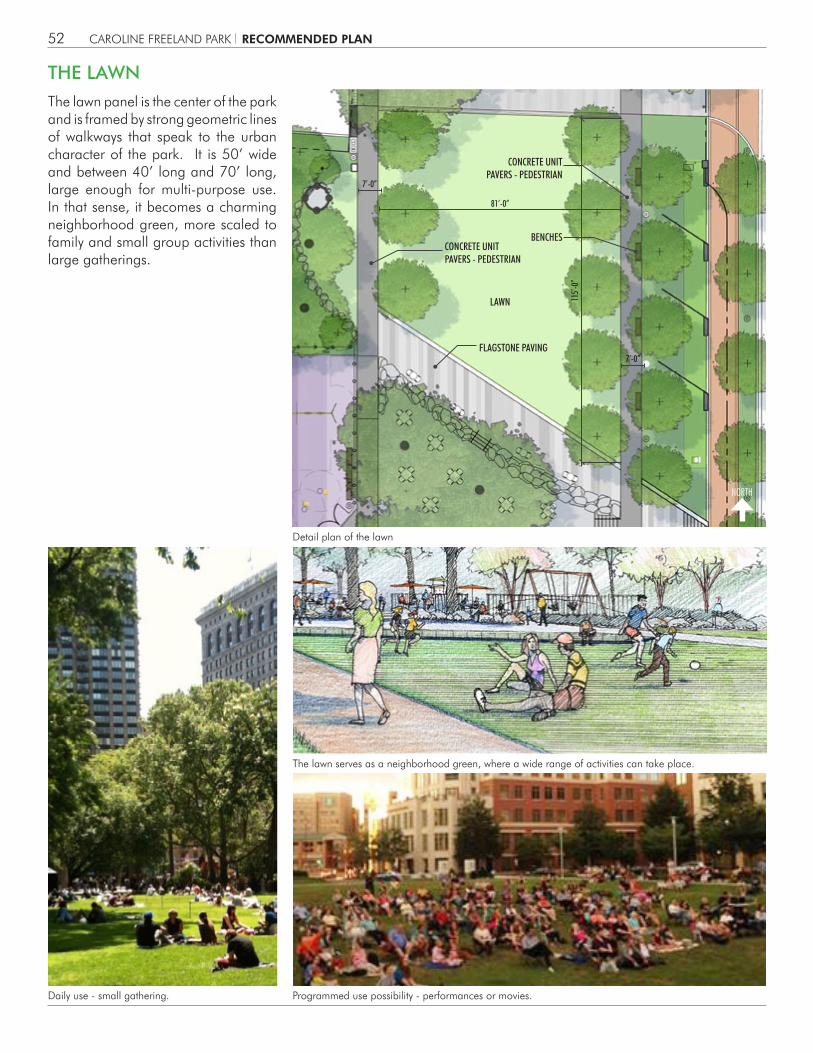
The lawn panel is the center of the park and is framed by strong geometric lines of walkways that speak to the urban character of the park. It is 50’ wide and between 40’ long and 70’ long, large enough for multi-purpose use. In that sense, it becomes a charming neighborhood green, more scaled to family and small group activities than large gatherings.
THE LAWN
The lawn serves as a neighborhood green, where a wide range of activities can take place.
Programmed use possibility - performances or movies.Daily use - small gathering.
Detail plan of the lawn
7’-0”
81’-0”
115’-
0”
7’-0”
LAWN
CONCRETE UNIT PAVERS - PEDESTRIAN
CONCRETE UNIT PAVERS - PEDESTRIAN
FLAGSTONE PAVING
BENCHES
RECOMMENDED PLAN

CAROLINE FREELAND PARK 53
Daily use - informal play.
Programmed use possibility - festivals or markets.
Programmed use possibility - yoga or fitness classes.
The lawn is graded to a 2% pitch from south to north, so it can easily accommodate a variety of informal play and activities. Walkways of concrete unit pavers along each side include benches in the shade of new trees, so that casual observation of activities is easy and comfortable. The Rockery lines the southern edge of the lawn, expanding its seating and viewing opportunities. Between the Rockery and the lawn is a broad angled walkway, composed of bluestone pavers recycled from the existing park paving. In this way, the boulders of the Rockery arise out of a stone pavement, creating a vivid natural setting.
RECOMMENDED PLAN
NORTH
CAROLINE FREELAND PARK54
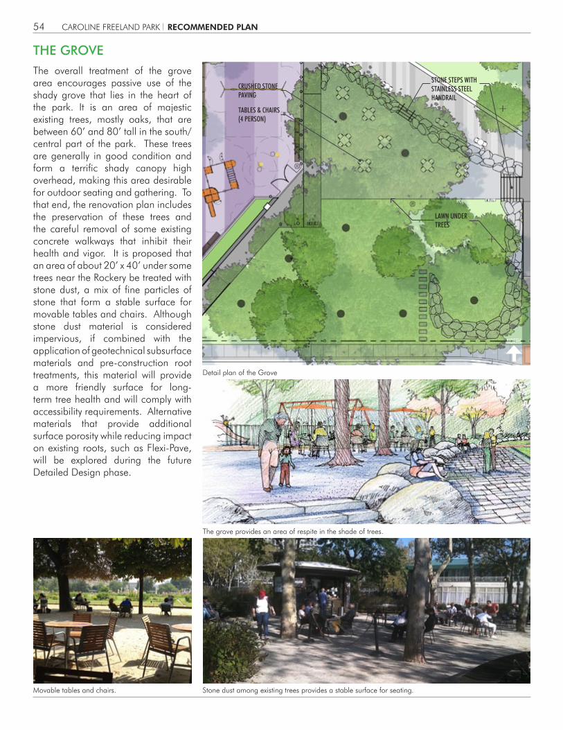
Detail plan of the Grove
The overall treatment of the grove area encourages passive use of the shady grove that lies in the heart of the park. It is an area of majestic existing trees, mostly oaks, that are between 60’ and 80’ tall in the south/central part of the park. These trees are generally in good condition and form a terrific shady canopy high overhead, making this area desirable for outdoor seating and gathering. To that end, the renovation plan includes the preservation of these trees and the careful removal of some existing concrete walkways that inhibit their health and vigor. It is proposed that an area of about 20’ x 40’ under some trees near the Rockery be treated with stone dust, a mix of fine particles of stone that form a stable surface for movable tables and chairs. Although stone dust material is considered impervious, if combined with the application of geotechnical subsurface materials and pre-construction root treatments, this material will provide a more friendly surface for long-term tree health and will comply with accessibility requirements. Alternative materials that provide additional surface porosity while reducing impact on existing roots, such as Flexi-Pave, will be explored during the future Detailed Design phase.
THE GROVE
The grove provides an area of respite in the shade of trees.
Stone dust among existing trees provides a stable surface for seating.Movable tables and chairs.
STONE STEPS WITH STAINLESS STEEL HANDRAIL
LAWN UNDER TREES
CRUSHED STONE PAVING
TABLES & CHAIRS(4 PERSON)
RECOMMENDED PLAN

Detail plan of the Hampden Promenade
HAMPDEN PROMENADE
20’-0
”
STONE VENEER SEAT WALL
DETECTABLE WARNING PAVERS
TRENCH DRAIN
RELOCATEDMAILBOX
CONCRETE UNIT PAVING - VEHICULAR
COLLAPSIBLE BOLLARD
COLLAPSIBLE BOLLARD
CONCRETE UNIT PAVING - VEHICULAR
CAROLINE FREELAND PARK 55
Hampden Road is proposed to be transformed into a pedestrian promenade space, from its current condition as a brick and concrete street that is closed except for emergency vehicles. In the park renovation, this space would still be designed for use by emergency vehicles, featuring removable bollards at each end of the street, so that private vehicles do not enter. The promenade will be paved in concrete unit pavers rendered with a variety of interesting color shades and textures. This promenade would include a stone seat wall, lighting, and trash cans as well, so it functions much like every other path in the park.
RECOMMENDED PLAN
NORTH
CAROLINE FREELAND PARK56
Fort Playground Set
Cirque Playground Set
Detail plan of the Playground
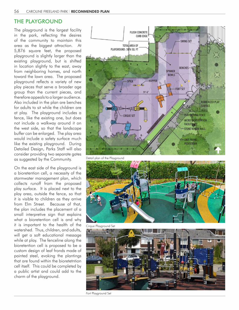
The playground is the largest facility in the park, reflecting the desires of the community to maintain this area as the biggest attraction. At 5,876 square feet, the proposed playground is slightly larger than the existing playground, but is shifted in location slightly to the east, away from neighboring homes, and north toward the lawn area. The proposed playground reflects a variety of new play pieces that serve a broader age group than the current pieces, and therefore appeals to a larger audience. Also included in the plan are benches for adults to sit while the children are at play. The playground includes a fence, like the existing one, but does not include a walkway around it on the west side, so that the landscape buffer can be enlarged. The play area would include a safety surface much like the existing playground. During Detailed Design, Parks Staff will also consider providing two separate gates as suggested by the Community.
On the east side of the playground is a bioretention cell, a necessity of the stormwater management plan, which collects runoff from the proposed play surface. It is placed next to the play area, outside the fence, so that it is visible to children as they arrive from Elm Street. Because of that, the plan includes the placement of a small interpretive sign that explains what a bioretention cell is and why it is important to the health of the watershed. Thus, children, and adults, will get a soft educational message while at play. The fenceline along the bioretention cell is proposed to be a custom design of leaf fronds made of painted steel, evoking the plantings that are found within the bioretetntion cell itself. This could be completed by a public artist and could add to the charm of the playground.
THE PLAYGROUND
SWING SET
HOPPER
FORT SET
CIRQUE SET
SPINNER BOWLS
FLUSH CONCRETE CURB EDGE
MICRO-BIORETENTION FACILITY #2
PLAYGROUND FENCE
RUBBERIZED PLAY SURFACE
TOTAL AREA OFPLAYGROUND: 5876 SQ. FT
BENCHES
STONE VENEER WALL
UNIT PAVING - PEDESTRIAN
SPICA
8’-0”
91’-6”
RECOMMENDED PLAN

NORTH
CAROLINE FREELAND PARK57
The entry sign is the signature of Caroline Freeland Park.
Stone seating terrace.
Detail plan of the Entry Plaza
The main entry to the park is at the corner of Elm Street and Arlington Road. The proposed park plan opens that entry up and makes it universally accessible. Part of the means to that end is the selective removal of a few existing pine trees that are overgrown and restrict views into the park. In so doing, an existing 40-foot high elm tree will become visible at the corner and its beautiful bark, canopy, and structure will become the new feature for the park entry. The existing boulders that cradle the elm tree will remain and be supplanted by dozens more boulders of the Rockery. The plan for the park proposes an innovative entry sign for this location. Instead of the standard wood sign, we propose to engrave the signature of Caroline Freeland into one of the boulders that is at the entry, calling attention to the namesake of the park in a highly personal way. This will also set the tone of the Rockery as the iconic element of the park. Walkways of concrete unit pavers will ascend an accessible ramp here and lead visitors into the park along the Rockery. Also at the corner will be a set of seating terraces and steps, gently picking up the three foot grade change and providing a place to gather or wait for friends. In this way, the new entry will be much more visible, welcoming, and commodious for visitors to the park.
ENTRY PLAZA
STONE VENEERRETAINING WALL
STONE VENEERRETAINING WALL
STONE STEPS WITH STAINLESS STEEL HANDRAIL
UNIT PAVING - PEDESTRIAN
RAMP
STONE VENEER TERRACES
STAINLES STEEL HANDRAILS
RAIN GARDEN FACILITY #3
FLAGSTONE PAVING
BRICK PAVING - PEDESTRIAN
7’-0”
8’-0”
20’-6
”
RECOMMENDED PLAN

NORTH
CAROLINE FREELAND PARK 58
Detail plan of the Arlington Road Streetscape
Bethesda streetscape standards.
As a consequence of the park renovation, the streetscape along Arlington Road will be upgraded to meet the standards of downtown Bethesda. This includes a 6-foot wide lawn panel with street trees, a ten foot wide brick sidewalk, and decorative light fixtures, all to match the rest of Arlington Road. In addition, the plan includes a bioswale on the park side of the sidewalk that conveys stormwater runoff from the park and allows it to filter through planted lenses into the groundwater below. This will both reduce the amount of runoff, but also cleanse the first flush of toxins from that runoff before releasing it into the watershed. As there is a gradient along Arlington Road, sloping down from north to south, the bioswale features a series of weirs to allow the water to step down the slope and further encourage infiltration. These weirs are made of cor-ten steel, a lightweight material with an oxidized or rusted finish. This will make the weirs seem less invasive visually and with the plantings in the bioswales behind them, make them appear as if they are thin planes of exposed earth. At the edge of the sidewalk, will be a concrete curb to act as a visual cue of the presence of the depressed planter that is the bioswale. At each weir, the curb will become a seatwall, so that passersby may pause and rest as they walk past the park.
ARLINGTON ROAD STREETSCAPE
STONE CURB
MICRO-BIORETENTIONFACILITY #1
BRICK PAVING - VEHICULAR
WEATHERING STEEL WEIR WALL
STREET LIGHTS
STONE PLINTH
BRICK SIDEWALK PER “BETHESDA STREETSCAPE STANDARDS”, 45° HERRINGBONE PATTERN
OVERFLOW RISER
INTERPRETIVE PANEL
STREET TREES
BUS STOP
BICYCLE RACKS
DETECTABLE WARNING PAVERS
6’-0”10’-0”
RECOMMENDED PLAN

CAROLINE FREELAND PARK60
NORTH
Storm water runoff is managed in the park plan through the introduction of a series of bioretention basins throughout the park. These facilities will capture rain water and allow it to slowly infiltrate into the groundwater, rather than run off immediately. This will benefit the Little Falls watershed as it will have less runoff during rain events. The basins will be filled with wetland plants that filter the first flush of pollutants from the rain, create habitat, and add beauty to the landscape. The topography of the park has three small watersheds within it and each is provided with a bioretention basin for treatment.
At the playground is another bioretention basin to capture that part of the park watershed. It is linear in nature to avoid impacts to existing trees, coursing along the walkway from Elm Street. Its edge would be defined by a concrete wall with bluestone coping and it would terminate with a cor-ten steel wall, to relate to its counterpart on Arlington Road. At the top of the basin, near the playground entry, is an excellent opportunity for an interpretive sign that can tell the story of the purpose and value of the bioretention, so that adults and children may understand its presence in the park.
STORMWATER MANAGEMENT
Bioretention at playground
Stormwater Plan
RECOMMENDED PLAN

UNIT PAVING
BRICKSIDEWALK
CONCRETE WALL WITH INTEGRAL COLOR TO MATCH BLUESTONE
BLUESTONE COPING
BIORETENTIONPLANTS
MULCHSOIL MIX
SAND
CRUSHED STONE
WET MEADOW PLANTS ON SLOPE
WEATHERING STEEL WEIR WALL
CAROLINE FREELAND PARK 61
Alongside Arlington Road is proposed a set of bioretention basins that flow from north to south through a series of weirs, which is intended to slow the flow. These weirs are proposed to be made of cor- ten steel, so that they are thin in profile and resemble a section of the earth as seen from the sidewalk. They create an elegant rhythm as they appear as a series of diagonal lines in the landscape, parallel to the diagonal path through the heart of the park and filled with wetland plants with colorful flowers and rich textures.
At the main entry to the park at the corner of Elm and Arlington is proposed a small rain garden, a soft edged shallow depression that captures and filters the runoff from the accessible ramp that forms the main entry at that point. It would be filled with a drift of native perennials.
Steel weir diagram
Bioretention along Arlington Road
Bioretention at main entrance
RECOMMENDED PLAN

CAROLINE FREELAND PARK62
TREE PRESERVATIONThe existing mature trees on the site are a valuable resource and the plan for the park includes the preservation of most of the deciduous trees. These are primarily oaks and maples and they lie in the central and western areas of the park. These trees have been surveyed and measured for caliper and critical root zone. The plans for the park reflect these root zones and seek to minimize any new paving or construction within these root zones. In many cases, the plan will remove such existing impediments, improving the health of the trees by introducing more air and water to the root zone.
NORTH
Tree preservation diagram
RECOMMENDED PLAN

CAROLINE FREELAND PARK 63
Tree protection during construction is a critical part of the success in tree preservation. This includes tree protection fencing, the use of small rubber tire construction equipment rather than steel-tracked vehicles, and prohibition of material storage within the critical root zone. The plan for the park also promotes minimal grading within the root zone and selective removal of some paving within those zones. These practices will go far toward the successful preservation of these magnificent trees. That said, many of these trees exhibit some stress, branch dieback, and misshapen canopies, so complete treatment of these trees by a certified arborist should be a part of the renovation plan.
Existing trees to remain adjacent to playground
Existing Evergreen Elm at park entry
Existing oak trees to remain in area of the Grove
Existing trees to remain along Elm street
Existing Leyland cypresses to be removed for safety and visibility
RECOMMENDED PLAN

CAROLINE FREELAND PARK64
SITE LIGHTINGAs a measure to discourage unnecessary pedestrian usage after dark, the lighting fixtures are selected to be as unobtrusive and as few in number as possible. The light sources will be LED to maximize efficiency and will be selected to minimize glare, both for a lower profile and to ensure user comfort. The lighting intent is to create pools of light for pedestrians to follow along the paths with some diffusion for facial recognition in the evening.
Hampden Lane: The northern part of the park, at Hampden Lane will have the most uniform illumination in the entire park. This will encourage pedestrians to walk the shorter length of the Hampden Lane path rather than walking through the entire park interior. It will be lit by a combination of pole-mounted indirect LED fixtures and lights recessed under the bench.
Interior Perimeter Path: The primary source of lighting on the interior paths will be a series of pole-mounted indirect LED fixtures. Pole lights will be positioned near the entrances and exits along the interior paths. The ambient lighting will provide pools of light on the path surface for navigation. The diffused light source from the pole light will provide vertical illumination in the adjacent area for facial recognition.
Interior Diagonal Path: The diagonal path in the center of the park will be lit by in-ground lights that graze over the walking surface. Low wattage in-ground lighting will accent the boulder wall.
Interior Park/Playground: The interior of the park will not be directly lit, to reinforce the impression that the park is closed at nighttime. Lower lighting in the interior will also discourage occupation of the park overnight. Tree uplights will accent one large tree canopy at the southeast corner.
Southeast Entrance: The primary pedestrian entrance during daytime hours will be lit primarily by standard street lighting. Supplemental lighting will be provided on the steps, ramp and sidewalks leading into the park. The ramp will be lit by a series of evenly spaced, low wattage LED fixtures recessed into the wall.
Southwest Entrance: This pedestrian entrance will be designated with a pole light to lead the pedestrian to the next pool of light from a post light. The intention is to create pools of light of the path surface ranging from 0.1fc to 5 fc. It is anticipated that this minimal lighting will help reinforce and discourage usage of the park interior.
Exterior Sidewalk: The exterior sidewalk will be lit by standard street lighting. It is expected that any contribution from the indirect LED pole-mounted fixtures will be minimal in comparison with the street lighting.
NORTH
Ligthing Plan
RECOMMENDED PLAN

CAROLINE FREELAND PARK 65
OL1 - Pole light fixture OL2 - In-grade uplight
OL3 - Recessed wall luminaire OL4 - Floodlight
OL5 - Drive-over in-ground luminaire OL6 - Street light fixture
RECOMMENDED PLAN

CAROLINE FREELAND PARK66
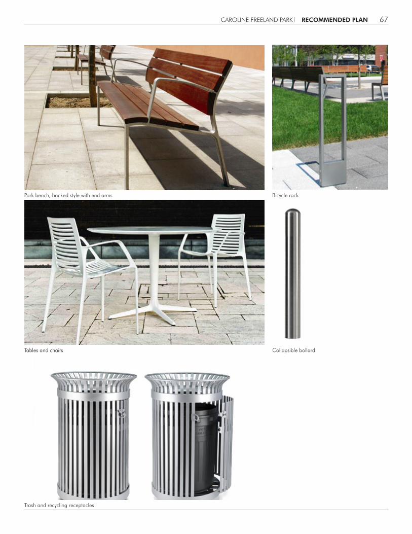
SITE FURNISHINGSAs part of the park’s redesign, the existing site furniture will be removed and updated with newer furnishings. These will include new wood and steel backed benches along the edge of the lawn panel and within the playground, metal tables and chairs beneath the Grove, new trash and recycling receptacles (some movable and fixed), bicycle racks along the Arlington Road streetscape, and collapsible bollards along the edges of the Hampden Promenade in addition to the new playground equipment and site lighting fixtures as previously discussed.
NORTH
Site Furnishing Plan
RECOMMENDED PLAN
TABLE & CHAIRS(4 PERSON)
TABLE & CHAIRS(2 PERSON)
BICYCLE RACKSTRASH & RECYCLING
RECEPTACLES
TRASH & RECYCLING RECEPTACLES
TRASH & RECYCLING RECEPTACLES
TRASH & RECYCLING RECEPTACLES
COLLAPSIBLE BOLLARDS
COLLAPSIBLEBOLLARDS
BENCHES
BENCHES
BENCHES
CAROLINE FREELAND PARK 67
Park bench, backed style with end arms
Trash and recycling receptacles
Collapsible bollardTables and chairs
Bicycle rack
RECOMMENDED PLAN