Embed Size (px)
Citation preview
2
Disaster mitigation
THE ORGANISATION FOR ECONOMICCO-OPERATION AND DEVELOPMENT (OECD)
The OECD is a forum where Members come together to discuss critical issues,opportunities and policy options and to arrive at harmonised approaches through consensus.Established in 1960, it is the successor to the Organisation for European Economic Co-operation, created in 1948 to help with the revitalisation of war-torn economies of WesternEurope. Since its origin, the OECD has promoted democratic, pluralistic institutions andmarket-oriented policies which aim:
— to achieve the highest sustainable economic growth and employment and a risingstandard of living in Member countries, while maintaining financial stability,and thus to contribute to the development of the world economy;
— to contribute to sound economic expansion in Member as well as non-membercountries in the process of economic development; and
— to contribute to the expansion of world trade on a multilateral non-discriminatory basis in accordance with international obligations.
Current Member countries of the OECD are Australia, Austria, Belgium, Canada,Denmark, Finland, France, Germany, Greece, Iceland, Ireland, Italy, Japan, Luxembourg, theNetherlands, New Zealand, Norway, Portugal, Spain, Sweden, Switzerland, Turkey, the UnitedKingdom and the United States. The Commission of the European Communities participatesin OECD work.
THE DEVELOPMENT ASSISTANCE COMMITTEE (DAC)
The Development Assistance Committee (DAC) is a specialised committee of theOECD, whose Members have agreed to secure the expansion of the total volume of resourcesmade available to developing countries and to improve aid effectiveness. Created in 1960, theCommittee undertakes periodic peer reviews that critically analyse aid programmes. Membersalso consult on broader aspects of development policy encompassing a range of economic,financial, trade, environmental and structural issues.
The DAC is the principal international forum where bilateral donors adjust the pattern oftheir aid in light of changing priorities and new perspectives on the development process. In1989 the DAC created a Working Party on environment to strengthen the contribution of aidpolicies and programmes to sustainable development.
As of 1994, the Members of the Development Assistance Committee are Australia,Austria, Belgium, Canada, Denmark, Finland, France, Germany, Ireland, Italy, Japan, TheNetherlands, New Zealand, Norway, Portugal, Spain, Sweden, Switzerland, the UnitedKingdom, the United States and the Commission of the European Communities.
OECD 1994 Cover design: A. Galievsky
Readers are encouraged to reprint this document, giving credit to the original OECD DAC source andproviding a copy to the Publications Co-ordinator, Development Co-operation Directorate, OECD, 2, rueAndré Pascal, Paris, 75016 France.
3
Disaster mitigation
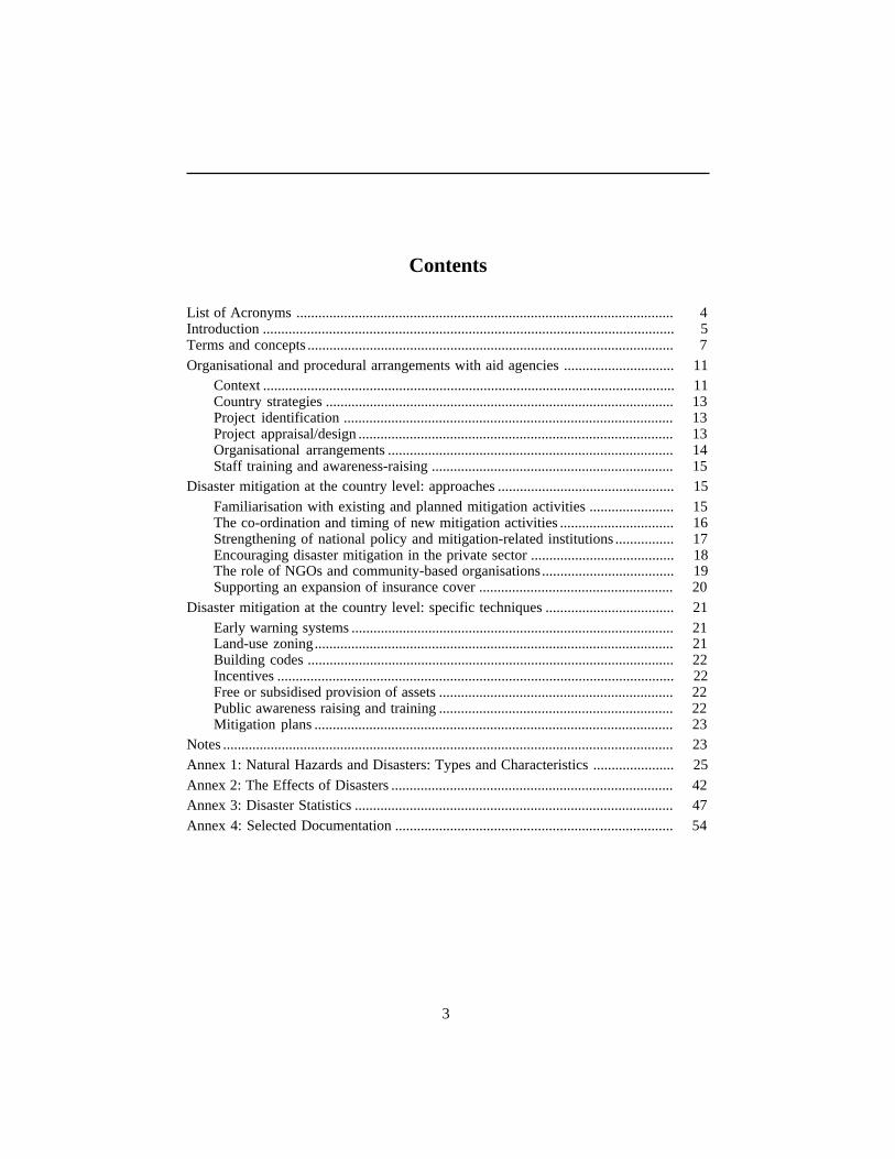
Contents
List of Acronyms ....................................................................................................... 4Introduction ................................................................................................................ 5Terms and concepts .................................................................................................... 7Organisational and procedural arrangements with aid agencies .............................. 11
Context ................................................................................................................ 11Country strategies ............................................................................................... 13Project identification .......................................................................................... 13Project appraisal/design ...................................................................................... 13Organisational arrangements .............................................................................. 14Staff training and awareness-raising .................................................................. 15
Disaster mitigation at the country level: approaches ................................................ 15Familiarisation with existing and planned mitigation activities ....................... 15The co-ordination and timing of new mitigation activities ............................... 16Strengthening of national policy and mitigation-related institutions ................ 17Encouraging disaster mitigation in the private sector ....................................... 18The role of NGOs and community-based organisations.................................... 19Supporting an expansion of insurance cover ..................................................... 20
Disaster mitigation at the country level: specific techniques ................................... 21Early warning systems ........................................................................................ 21Land-use zoning.................................................................................................. 21Building codes .................................................................................................... 22Incentives ............................................................................................................ 22Free or subsidised provision of assets ................................................................ 22Public awareness raising and training ................................................................ 22Mitigation plans .................................................................................................. 23
Notes ........................................................................................................................... 23Annex 1: Natural Hazards and Disasters: Types and Characteristics ...................... 25Annex 2: The Effects of Disasters ............................................................................. 42Annex 3: Disaster Statistics ....................................................................................... 47Annex 4: Selected Documentation ............................................................................ 54
4
Disaster mitigation
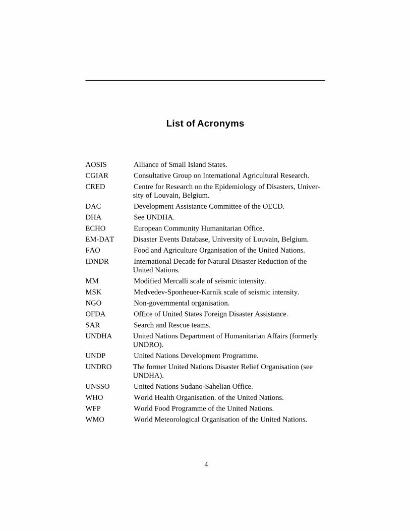
List of Acronyms
AOSIS Alliance of Small Island States.
CGIAR Consultative Group on International Agricultural Research.
CRED Centre for Research on the Epidemiology of Disasters, Univer-sity of Louvain, Belgium.
DAC Development Assistance Committee of the OECD.
DHA See UNDHA.
ECHO European Community Humanitarian Office.
EM-DAT Disaster Events Database, University of Louvain, Belgium.
FAO Food and Agriculture Organisation of the United Nations.
IDNDR International Decade for Natural Disaster Reduction of theUnited Nations.
MM Modified Mercalli scale of seismic intensity.
MSK Medvedev-Sponheuer-Karnik scale of seismic intensity.
NGO Non-governmental organisation.
OFDA Office of United States Foreign Disaster Assistance.
SAR Search and Rescue teams.
UNDHA United Nations Department of Humanitarian Affairs (formerlyUNDRO).
UNDP United Nations Development Programme.
UNDRO The former United Nations Disaster Relief Organisation (seeUNDHA).
UNSSO United Nations Sudano-Sahelian Office.
WHO World Health Organisation. of the United Nations.
WFP World Food Programme of the United Nations.
WMO World Meteorological Organisation of the United Nations.
5
Disaster mitigation
GUIDELINES ON DISASTER MITIGATION
Introduction
Natural hazards are an integral part of the environment in which we live.Extreme atmospheric, hydrological and geophysical events may occur at any timein various parts of the world and, in those economies and societies which arevulnerable to their effects, the events frequently become disasters involvingsubstantial loss of life and social and economic disruption. Many developingcountries are particularly prone to one or more of these types of extreme events(see Maps in Annex 1). In addition, principally as a result of their poverty,developing countries are especially vulnerable to natural hazards. Hazard eventswhich would cause limited damage and few casualties in a rich country often causeextensive damage and substantial loss of life in a developing country context. Thusnatural disasters usually occur with greater severity in developing countries andclaim a higher death toll. One recent estimate is that 95 per cent of all disaster-related deaths occur in developing countries. Disasters also often have a significantnegative impact upon the economies and development prospects of developingcountries because of the destruction of public and private capital, the disruption ofproduction and trade and the diversion of scarce resources to relief andrehabilitation efforts. In some countries where pre-existing social tensions renderthem highly vulnerable, natural hazards can exacerbate such tensions and lead topolitical instability and civil strife.
Whilst a strong correlation exists between per capita income and a country’svulnerability to natural hazards, economic growth per se does not automaticallyreduce the level of vulnerability, and vulnerability may actually increase duringearly stages of development. Developed countries are less vulnerable because theyhave invested in both structural and non-structural measures to mitigate the impactof the natural hazards they face. Whilst developing countries can expect to remainvulnerable to hazards, their level of vulnerability can be substantially reduced bythe adoption of a selection of the mitigation measures developed and in commonuse in more developed countries. The selection and adaptation, where necessary, ofthe particular measures to be introduced or implemented needs to be carefullyconsidered in relation to the type and severity of the natural hazards likely to occurand the anticipated impacts upon the developing country’s society and economy.Whilst such measures will not prevent the occurrence of extreme events, theyshould reduce the frequency and severity of the resultant disasters. The measuresundertaken need not detract from investments in productive sectors of the economy
6
Disaster mitigation
and may often complement and enhance such investments by protecting them fromdamage and destruction and reducing the scale of resource diversion when disastersdo occur.
DAC Members have an important role to play in assisting developingcountries to enhance their capacity to cope with natural hazards for the followingreasons:
— Many DAC member countries possess considerable knowledge andexpertise on natural hazards and how to cope with them, both inrelation to their own countries and in relation to developing countries.Whilst measures appropriate in developed countries may not always bedirectly transferrable to developing countries, it would appear thatmuch greater use could be made of such capacities by aid agencies inmitigating natural disasters and in strengthening the scientific andinstitutional capacities within developing countries.
— By virtue of the resources available through their aid programmesDAC Members can encourage and assist the adoption of measures tomitigate the effect of disasters by the public and private sectors withindeveloping countries. Whereas developing country governments arefrequently preoccupied with short-term considerations and havedifficulty in devoting adequate attention to natural hazards whoseoccurrence is unpredictable, donor organisations are sometimes betterplaced to take a longer-term perspective.
— The performance of aid programmes of DAC Members can benegatively affected by natural hazards. Even in countries which areknown to be particularly prone to certain natural hazards, many aidagencies fail to take sufficient account of the risks posed by suchhazards in their design of projects and programmes. More carefulconsideration of natural hazards by donor organisations in the designof projects and programmes is likely to enhance their overallperformance.
— When disasters occur in developing countries, aid agencies oftenrespond with sizeable allocations of relief and rehabilitationassistance. Frequently, such responses are resourced from funds whichwould otherwise have been expended on regular developmentactivities. In many cases the scale of the post-disaster needs couldhave been reduced if more attention and support had been given tomeasures designed to reduce the impact of the disaster prior to itsoccurrence.
These guidelines are intended to increase awareness among those involved indesigning and implementing development co-operation programmes of the threatsposed by natural hazards and of the range of measures that may be adopted so as toreduce their impacts on developing countries. They are aimed at officialsresponsible for aid policy and those responsible for administering aid programmesin countries which are exposed to a range of natural hazards and which are
7
Disaster mitigation
particularly vulnerable. They assume no prior specialist knowledge in the naturalhazard and disaster field.
The 1990s has been designated as the International Decade for Natural DisasterReduction (IDNDR) by the UN General Assembly through Resolution 42/169 of 1988,in an effort to reduce the impact of disasters on development. The goals of the Decadeare to:
— improve each country’s ability to mitigate the effects of naturaldisasters;
— devise guidelines and strategies for applying existing knowledge;— foster scientific and engineering endeavours to reduce loss of life and
property;— disseminate existing and new information about the assessment,
prediction, prevention and mitigation of natural disasters;— promote programmes of technical assistance and technology transfer,
demonstration projects and education and training tailored to specifichazards and locations.
National IDNDR Committees have been established in many developingcountries and DAC Member states, and under the umbrella of IDNDR a number ofdisaster mitigation initiatives and activities are taking place. It is hoped that theseguidelines will further the goals of the Decade, by increasing awareness amongDAC Members of potential approaches to disaster mitigation and by increasingtheir ability to exploit the opportunities presented by IDNDR.
Terms and concepts
A natural hazard is a natural phenomenon that is potentially damaging. Anatural hazard is not necessarily the event itself but the implied risk to a populationbecause of the potential occurrence of that event. It is therefore a probabilisticconcept1. Some areas of the world are significantly more prone to natural hazardsthan others. For instance, earthquake hazards are effectively limited to knowngeographic zones of seismic activity. Similarly, coastal zones in the tropics aresignificantly more prone to cyclone hazards than inland areas in the upper latitudes(see Maps in Annex 1).
Many natural hazard events do not result in disasters. For instance, acommunity which has adapted itself to cope with storms through reinforcedbuildings, food production systems which can cope with storms, and systems towarn the population to stay indoors may be inconvenienced by a storm but isunlikely to experience substantial damage or casualties. Thus some communitiesare more vulnerable to the effects of natural hazards than others. Those which aremore vulnerable will experience more damage, disruption and casualties. A naturaldisaster may therefore be seen as the impact of a natural hazard upon a populationor area which is vulnerable to such impacts and where the impacts result insubstantial damage, disruption and casualties2. The concept of vulnerability istherefore central to the definition of disasters. Vulnerability is a term which is
8
Disaster mitigation
frequently misused but essentially vulnerability concerns the propensity of asociety to experience substantial damage disruption and casualties as a result of ahazard.
Disaster mitigation concerns those measures taken to reduce the damage,disruption and casualties caused by disasters. Though it is sometimes difficult todraw the line between measures intended to modify the hazard and measures toreduce a society’s vulnerability to the hazard, disaster mitigation, which is theconcern of these guidelines, is essentially about the means by which vulnerabilitymay be reduced. Mitigation is therefore a broad notion and incorporates two otherterms which are often used in the literature, namely disaster prevention, whichconcerns those measures aimed at impeding the occurrence of a hazard event and/or preventing such an event causing damage, disruption and casualties, anddisaster preparedness, which concerns those measures which enable societies torespond rapidly to disasters.
A distinction is often made between ‘man-made’ or ‘human-caused’disasters such as armed conflict or chemical accidents and natural disasters whichare the product of natural hazards such as drought, cyclones and floods. Thedistinction between natural and human-caused disasters has long been regarded bysome as artificial, and the distinction has become increasingly difficult to maintainover recent decades. In part, this is due to the strength and complexity of the humaninfluence upon natural processes. For instance, natural flood events within a rivercatchment may be exacerbated by alterations in the run-off characteristics withinthe catchment as a result of urban expansion or the replacement of forested areaswith grazing areas. Embankments constructed alongside the lower reaches of ariver to prevent flooding may break and the violence of the resultant flooding maycreate a disaster from what would otherwise have remained a hazard. Thedistinction between natural and human-caused is also difficult to maintain becauseof the substantial grey area between what may be regarded as ‘purely’ naturaldisasters and ‘purely’ human-caused disasters. For instance, in Africa conflict anddrought during the 1980s have frequently exacerbated the effects of each other,leading to the development of famines. So intertwined are the effects that it is oftennot possible to separate them. Non-violent human actions may also cause disasters.Thus famines have occurred in areas which did not suffer reductions in cropproduction but where onerous systems of rural taxation have reduced the amount offood which farmers could retain for their own consumption.
Despite the inherent difficulties in distinguishing between natural andhuman-caused disasters, the focus of these guidelines is upon the mitigation ofnatural disasters. Such a focus is not intended to divert attention from conflictwhich, as shown in Annex 3, is responsible for a death toll several times larger thanall the natural disasters combined. Though there are considerable similaritiesbetween the mechanisms by which the international community may providehumanitarian relief in response to conflict and in response to natural disasters, thesimilarities between the mitigation of conflict and the mitigation of naturaldisasters are substantially less. The mitigation of conflict is largely a matter ofdiplomacy, intelligence information, and interventions designed to preserve, makeor enforce peace. Such matters are primarily the preserve of the diplomatic and
9
Disaster mitigation
defence departments of DAC Member governments rather than of development co-operation. In contrast, the mitigation of natural disasters is essentially aboutstructural measures, such as the construction of river embankments andstrengthening buildings, and non-structural measures such as land-use zoning,building codes, insurance systems and public awareness-raising. There is, ofcourse, an overlap between the two in terms of vulnerability. The factors whichmake a particular population vulnerable to the effects of conflict, such as povertyand lack of social cohesion, are the same as those which make them vulnerable tothe effects of a natural hazard.
Within the category of natural disasters, a commonly used distinction is thatbetween sudden-impact and slow-impact disasters, sometimes referred to assudden and slow-onset disasters. Sudden-impact disasters are those which occurwith little or no warning and have an immediate impact, whilst with slow-impactdisasters there is a warning period of days or weeks before they begin to have asignificant impact upon human activity. Earthquakes, cyclones, floods and volcanoeruptions are often included in the sudden-impact category, while droughts are inthe slow-impact category. For instance, rainfall monitoring may reveal a reductionin rainfall (ie. a meteorological drought) in the middle of a crop production cycle,ie. several weeks before the (reduced) harvest. In contrast, an earthquake mayoccur without warning causing widespread devastation within minutes. As mightbe expected, however, such a distinction is problematic. Few disasters occur withno warning whatsoever, and improved monitoring techniques and the greater use ofmonitoring systems are constantly increasing the length and accuracy of warnings.For instance, the monitoring of rainfall, snowmelt and river levels within thecatchment areas of river systems can provide flood warnings hours or even daysahead of the event. Seismic monitoring can provide warnings of increased pressurewithin rock formations likely to result in earthquakes, though it has to be said thatthe occasions on which such monitoring has resulted in accurate predictions of thetiming and intensity of earthquake events have been comparatively rare. Similarly,the development and migration of tropical cyclones may be monitored andreasonably accurate warnings given of their course and intensity. Despite theincreasingly blurred distinction between sudden and slow-impact disasters, thecategorisation continues to be widely used.
Though as much a natural hazard as a cyclone or an earthquake, drought, as aclassic slow-impact phenomenon, is often regarded ambiguously in the naturaldisaster literature. It is not uncommon for reports on natural disasters to omitdrought or to treat it in a cursory manner, despite the evidence that droughts areresponsible for more deaths and often have a greater economic impact than othertypes of natural disaster (see Annexes 1 and 3). Factors which appear to contributeto this underrating of the importance of the hazard posed by drought include:
— sudden-impact disasters which cause sudden damage in geographicallyconcentrated areas have greater visual and emotional effect;
— the organisational arrangements in relation to sudden-impact disastersare often different from those relating to drought3;
10
Disaster mitigation
— disaster terminology does not always comfortably fit slow-impactdisasters — for instance a relief response to reduced rainfall may alsoserve to mitigate its effects;
— the development of the ‘organising theme’ of food security over thelast decade has contributed to a separation of the intellectualapproaches to drought from those to the sudden-impact disasters.
Whilst recognising the special characteristics of the drought hazard, theseguidelines include drought.
Hazard and Vulnerability Assessments play a crucial function in disastermitigation. The objective of hazard assessments (sometimes referred to as riskassessments) is to provide information in a probabilistic form on the nature,severity and frequency of all the potential hazards for all areas of a country. Theinformation used to undertake such assessments are generally scientific data onprevious hazard events, topographical, geological, hydrological and meteorologicalmaps, historical records, local folklore, and specially designed surveys. Aneffective way of presenting hazard assessments is by hazard maps which show thevariations in probability of hazard events of a given level of severity, eg. theprobability of a 50 per cent reduction in annual rainfall or the probability of a riverflood exceeding a level of x metres. The level and sophistication of suchassessments will naturally vary depending on the perceptions of the risks and thelevel of available resources. Some countries may already possess such maps,though they may need updating to take account of recent hazard events or periodswithout such events. In others it will be necessary to compile such maps from rawdata, or even to initiate systems to collect such information, for instance in the caseof potentially hazardous rivers for which there are no existing hydrological records.
Vulnerability assessments should indicate the vulnerability of physicalstructures and of the society to the hazards indicated by the hazard assessment.Physical vulnerability assessments involve the assessment of the ability ofstructures to withstand hazards of different strengths and intensities. Much of thetechnical information and measures upon which such assessments would be basedis already available, if not within the country itself then in other countries. Forinstance, the ability of buildings of different types of construction to withstandearthquakes of different levels of intensity or winds of different strengths has beenmuch studied by architects not only in developed countries, but also in a number ofdeveloping countries. Assessment of the vulnerability of lifeline structures andservices (roads, railways, telecommunications, hospitals, schools, water supply,sewage, etc.) should be given priority within the assessment as it is crucial thatthese services continue to function if not during, then certainly in the periodimmediately following a severe hazard event.
Societal vulnerability assessments involve the assessment of the ability of thelivelihood systems and social structures to withstand the shocks and stresses causedby natural hazards. The notion that societal vulnerability to hazards can be assessedand expressed in a scalar form (high, medium, low) is a recent development and thecurrent techniques for undertaking such assessments are unsophisticated. Whilstpoverty is potentially an important factor, it is by no means the dominant factor.
11
Disaster mitigation
Poor societies which have succeeded in adapting to regular hazards are often lessvulnerable to the effects of such hazards than wealthier societies that have failed tomake the necessary adaptations.
Societal vulnerability depends largely upon the nature of livelihood systemsin an area. If a community or group within the population is dependent on one typeof system which is itself vulnerable, then that community or group will be highlyvulnerable. If, however, the community or group is involved in a number ofdifferent livelihood systems (e.g. mixed arable/pastoral farming supplemented byremitted income from household members in trading and service employment inthe local city or working abroad), its risks will be spread and it will most likely bejudged to be less vulnerable. A critical component of an assessment of societalvulnerability is therefore the identification of livelihood systems, their relativeimportance to different groups within society and some estimation of thevulnerability of those systems to the risks indicated by the hazard assessment.
Societal vulnerability is not simply a question of economic vulnerability.Some societies are more cohesive and better able to organise themselves to copewith periods of shock and stress. Though this is a neglected field of study andcross-cultural measures are not available, social development specialists oranthropologists who are familiar with the country should be able to judge asociety’s approximate ability to cope with disasters.
As with hazard assessments, vulnerability assessments may be presented inmap form. However, care should be taken, as societal vulnerability may varystrongly between social groups and classes. The field in which societalvulnerability mapping is furthest developed is that of food security. Societalvulnerability is, of course, constantly changing and it will be necessary for suchassessments to be undertaken on a regular basis, at least every five years or so.
Organisational and procedural arrangements with aid agencies
Context
Disaster mitigation is currently not well integrated within donor aidprogrammes. Why this should be the case is not entirely clear but a key factor islikely to be the view, which was widely shared among developing countrygovernments and donor officials for much of the last three decades, that disastersrepresent a temporary distraction from efforts directed towards the overall goal ofraising living standards. The persistence of linear notions of development evolvedduring the 1950s and 1960s, a lack of appreciation of the inherently dynamic natureof environmental systems, and a lack of understanding of the economicconsequences of disasters were probably largely responsible for an approach whichtreated disasters as something separate from the development process.
Organisational arrangements for dealing with disasters within donororganisations may reflect, but at the same time exacerbate, this tendency to regarddisasters as something separate from development. Because of the requirement forspeed in responding to many natural disasters, most donor organisations have
12
Disaster mitigation
developed special organisational arrangements and administrative procedures formanaging their response. Often, these have involved the creation of specialistemergency/disaster offices with rapid procurement and transportation procedures,close links with the national armed services, the Red Cross Movement, the UNDepartment of Humanitarian Affairs and NGOs specialising in relief. Because ofthe high political and media profile of emergency aid, such offices often reportdirectly to the Minister responsible for the Aid Programme. Whilst sucharrangements are often highly effective in relation to disaster response, theseparation of relief concerns from mainstream development concerns may haveserved to limit the evolution of disaster mitigation to specific mitigation projectsrather than the full integration of such concerns within the aid programmes of DACMember states.
Whatever the balance of factors contributing to the poor integration ofdisaster mitigation in the past, there is now a growing appreciation among aidagencies of the need for aid programmes to take fuller account of disastermitigation concerns. The shift in attitudes to environmental concerns has led to agreater awareness of the dynamic nature of environmental systems and thevariability which may, on occasion, be extreme. Though analysis of the economicimpacts of disasters remains relatively unsophisticated, there is an increasedappreciation of the potential scale of the economic impacts. Since the African foodcrisis of the mid-1980s aid agencies have also been increasing their expenditureson disaster relief such that this category now represents a not insignificantproportion of the overall Official Development Assistance (ODA) of DACMembers. As a result of these two factors a balanced mitigation and reliefapproach to disasters appears, in many instances, to represent a more efficient useof scarce resources than a generous relief response per se. The designation of the1990s as the International Decade for Natural Disaster Reduction has helpedincrease awareness that a greater emphasis on mitigation is desirable.
Disaster mitigation considerations should be integrated within the planningand allocation procedures of DAC Member states at both the macro level and inrelation to individual programmes and projects. Central to the approach at bothlevels are Hazard and Vulnerability Assessments which should be prepared for alldeveloping countries.
The objectives of such assessments should be to:— identify those countries which are particularly prone to disasters and
vulnerable to their impacts;— provide aid agencies with an objective basis for the estimation of the
risks posed to particular projects and programmes within a country sothat account may be taken of such risks in project appraisal and design;
— provide aid agencies with an objective basis for the estimation of thecosts and benefits of specific disaster mitigation activities.
Rather than DAC Members undertaking such assessments individually, it isdesirable that they are undertaken on a multilateral basis using standardisedmethods and thereby facilitating inter-country comparisons. Because of the UNDepartment of Humanitarian Affairs’ mandate to encourage disaster mitigation

13
Disaster mitigation
activities and the work already undertaken in this field by its predecessor agency(UNDRO), it is logical that the DHA should be supported in further developing themethodology for Hazard and Vulnerability Assessments and in undertaking suchassessments for all developing countries. DAC Members could support such aprogramme of activities through the provision of technical assistance as well asfunding.
Country strategies
Country Strategy Papers which are regularly prepared for individualdeveloping countries by most aid agencies offer an effective means of integratingdisaster mitigation considerations into aid and investment programmes at the macrolevel. Country Strategy Papers should include the main points arising from theavailable Hazard and Vulnerability Assessments and, in the case of particularlyhazard-prone and vulnerable countries, indicate how such considerations areaccounted for within the proposed strategy.
At the level of individual programmes and projects there is a range ofmechanisms by which disaster mitigation considerations may be integrated into theprocess of project identification, appraisal and design.
Project identification
Many aid agencies already undertake some form of risk assessment as part oftheir project identification process. Indeed, an examination of the potential risks toa project form an integral part of the logical framework method. However, the‘risks’ identified are often of a political, economic or project management naturerather than natural hazards. Even where natural hazards are identified as potentialrisks, the assessment of the risks they pose may not be comprehensive or based on afull, scientific assessment of the potential hazards. The availability of a Hazard andVulnerability Assessment would facilitate the inclusion of disaster mitigationconsiderations at the project identification stage. Where Hazard and VulnerabilityAssessments are available, aid agencies should incorporate them into theassessment of potential risks to projects.
Project appraisal/design
Through the various methods of appraising projects (ie. technical, financial,economic, social/distributional and environmental) aid agencies already undertakerisk assessments, though these may not directly consider natural hazards.
In countries which are particularly disaster-prone most technical appraisalsmay already take account of the risks posed by such hazards as earthquakes or highwinds in the design for built structures and the specifications to be used. Suchpractice may reflect the existence of local building codes or, where none exist, theawareness on the part of those undertaking the technical appraisal of the hazard
14
Disaster mitigation
risks. If an aid agency is using local building codes as the basis for the appraisaland design of structures, then it is desirable that an assessment of the buildingcodes should be carried out to determine their appropriateness in relation to naturalhazards. In the case of ‘life-line’ services and structures (roads, railways,telecommunications, major dams, domestic water supplies, irrigation systems,electricity supplies, sewage systems, government offices, emergency servicesfacilities, hospitals, schools and other community buildings) there is a strong casefor the use of more rigorous building specifications to ensure that such services andstructures survive severe hazard events, thereby facilitating both the relief andrecovery efforts. For instance, whilst local building codes may be designed with theobjective of withstanding hazard events with a 1-in-20-year probability, ‘lifeline’services and structures might be designed to withstand a 1-in-50-year event.
Whilst technical appraisals of projects frequently take account of the risksposed by natural hazards, such risks are often not directly addressed by the othermethods used in project appraisal. For instance, as part of the economic appraisalof projects, aid agencies often use sensitivity analysis or risk analysis methods.However, the potential risks and threats often include variability in input andoutput prices during the life of the project rather than natural hazards per se.Environmental assessments undertaken as part of the appraisal process invariablyfocus on the impact of the project upon the environment rather than on the potentialenvironmental impacts upon the project.
Once a Hazard and Vulnerability Assessment is available for the country orarea in which the project is to be implemented, both the economic andenvironmental appraisals should consider the risks posed by natural hazards4.Quantification of the risks for use in economic appraisals may prove problematicbecause of the difficulty of placing values on the likely losses of a hazard event of agiven magnitude. Nevertheless, such estimations should be attempted. With themore extensive use of such assessments by aid agencies it may be expected that thetechniques and accuracy of estimations will improve over time.
Organisational arrangements
The creation of separate emergency/disaster offices was identified earlier as apossible factor contributing to the limited integration of disaster mitigationconsiderations in the aid programmes. If the mechanisms suggested above for theintegration of disaster mitigation into development programmes are adopted, thecontinued separation of the response function from the mitigation function may notbe a significant problem. However, responsibility for overseeing theimplementation of the above mechanisms will need to be clearly identified5.
Staff training and awareness-raising
Because of their limited experience of contact with disaster-related matters,personnel involved in the administration of DAC Members’ developmentprogrammes may benefit from training designed to increase their understanding of
15
Disaster mitigation
disaster types and impacts, the integration of disaster management considerationswithin development programmes, and the preparation and use of Hazard andVulnerability Assessments.
Disaster mitigation at the country level: approaches
Familiarisation with existing and planned mitigation activities
For donor officials unfamiliar with the institutions involved in disastermitigation and the various activities that may already have been undertaken in acountry, it is important that they undergo a process of familiarisation. Because ofthe multi-disciplinary nature of disaster mitigation and the various levels at which itmay be undertaken, it is often difficult to discover the full range of disastermitigation activities being carried out or planned in a country.
In most developing countries there are likely to be a range of sources ofinformation on existing and planned disaster mitigation activities, namely, the UN,the government, the National IDNDR Committee, other donor organisations andmultilateral lending institutions, insurance companies, national and regionalresearch and training institutions, and the local Red Cross/Crescent and otherNGOs.
UN: The UNDP and, if present, the UN Department of Humanitarian Affairswill be important sources of information, particularly for sudden-impact naturaldisasters6. Additional information on drought and food security activities may needto be sought from FAO and WFP representatives. The Disaster ManagementTraining Programme has been developed jointly by UNDP/DHA since 1990 andtraining programmes involving UN and government officials are likely to havealready been run in many developing countries.
Government: Many developing country governments have sectionsresponsible for disaster relief affairs which are also nominally responsible fordisaster mitigation matters. In some countries responsibility for disaster mitigationmatters may be located within a civil defence context.
National IDNDR Committee: As part of the IDNDR, many developingcountries have established National IDNDR Committees involving representativesof the government, universities, private sector companies and the voluntary sector.Because of the breadth of institutions and perspectives represented on suchcommittees and their regular meetings, the National IDNDR Committee may be aparticularly useful source of information.
Other donor organisations and multilateral lending institutions: Somebilateral donor organisations and multilateral lending institutions may already beundertaking or planning disaster mitigation activities. These activities may form acomponent of larger projects and the disaster mitigation element may not beapparent from the project title. The Asian Development Bank has been particularlyactive in the field of disaster mitigation over the last five years and is currentlyinvolved in a range of projects with a substantial or major mitigation component.Enquiries channelled through existing donor co-ordination mechanisms within the
16
Disaster mitigation
country may be directly useful and may also serve to raise awareness of disastermitigation activities within the donor community.
Insurance companies: In some developing countries local and internationalinsurance companies have substantial operations, on the basis of which they havedeveloped a good knowledge of hazard risks and mitigation activities within theprivate sector.
National and regional disaster training institutions: Several developingcountries have developed specialist local research and training capacities indisaster management and related subjects, located either within local universities orrun as separate institutions. Countries without such a local capacity may be servedby one of the regional training facilities developed in Asia (the Asian DisasterPreparedness Centre in Bangkok) and the Americas (the Pan American HealthOrganisation in Washington). Such centres may provide useful informationcomplementary to that which may be available locally.
Red Cross/Crescent Societies and other NGOs: As well as playing animportant role in relief operations at the local level, many Red Cross/CrescentSocieties and other NGOs are involved in disaster mitigation activities and mayprovide useful sources of information.
The co-ordination and timing of new mitigation activities
Given the range of institutions and organisations with an interest and/orinvolvement in disaster mitigation, effective co-ordination is particularly important.Donors should therefore support local co-ordination mechanisms and ensure thatthey are kept informed of any planned initiatives. In many countries separate co-ordination mechanisms have developed for development and disaster relief. Inseeking to support co-ordination it may prove necessary for donors to use co-ordination mechanisms other than those relating to development activities. Becauseof the range of institutions and organisations potentially involved, donors shouldseek to co-ordinate their activities not just with the government, UN agencies,multilateral lending institutions and other bilateral donors, but more broadly amongthe research and training community, the private sector and the NGO community.
Many observers have noted that disasters offer a ‘window of opportunity’ forthe introduction of new mitigation activities as a result of the greatly heightenedawareness of the threat posed by disasters among the government, donors and thepublic, and also because mitigation considerations may be incorporated within thepost-disaster reconstruction and rehabilitation activities. Whilst a number ofambitious and innovative mitigation programmes have been introduced in the wakeof a disaster7, post-disaster ‘windows’ may not be the most beneficial way for adonor to be initiated into mitigation activities. The time-pressured and sometimeschaotic, context of a post-disaster situation increases the possibility that newinitiatives will not be adequately planned or co-ordinated. The slackening ofawareness and interest in disaster mitigation in the period after the disaster maylead to the adoption of approaches which may not prove sustainable in the longer
17
Disaster mitigation
term. Ideally, therefore, donors should not await a disaster before taking an activeinterest in disaster mitigation issues.
Strengthening of national policy and mitigation-related institutions
Some countries already have co-ordinated disaster mitigation policies andprocedures in place. However, in many countries efforts are more often directed atpolicies and procedures in relation to disaster relief rather than disaster mitigation,and consequently mitigation is approached in an ad hoc, poorly co-ordinatedfashion. In developing such policies and procedures it is preferable to have anorganisational structure with clearly allocated responsibilities and lines ofauthority. There are no clear rules as to how countries can best initiate a process ofdevising policies and procedures for disaster mitigation and no blueprints of theideal organisational structure. Each country should devise approaches andorganisational structures appropriate to its own circumstances, such as nationaldisaster plans. In many situations it may be preferable to build upon existinginstitutions rather than create new ones. The examination of approaches adopted byneighbouring countries is one way of helping countries decide what is best suited intheir case.
As part of the IDNDR some governments are reviewing their policies andorganisational arrangements with regard to disaster mitigation. Donors should seekto encourage the initiation of such reviews and to support them in countries wherethey are under way.
Regardless of the organisational structures and approaches adopted, it ispossible for donors to identify those agencies which play a key role in disastermitigation and to seek ways in which they can be supported, perhaps throughfinancial support or the provision of technical assistance. For instance, supportcould be provided to the departments responsible for monitoring and warning ofpotential hazards (meteorology, geology, water authority, etc.) and thoseresponsible for the development and enforcement of building codes and land-usezoning in urban areas or particularly hazardous areas.
Local research capacity in the field of disaster mitigation could also benefitfrom donor support. In the field of food security donors already support efforts todevelop drought-resistant crop strains either on a bilateral or a multilateral basisthrough the CGIAR system. In particularly drought-prone countries, such effortsmay warrant additional support. Similarly, in earthquake- or cyclone-prone areasthe strengthening of research institutions developing improved constructiontechniques could be beneficial. DAC Members with particular capacity in relationto research on earthquake- or cyclone-resistant designs could encourage closerinstitutional linkages or ‘twinning’ arrangements between domestic institutions anddeveloping country research institutions.
Given the ‘infancy’ of the methodology for societal vulnerability assessment,the encouragement of local social science research capacity in this area offersanother opportunity where donor support could be beneficial. Once again this could
18
Disaster mitigation
involve institutional ‘twinning’ arrangements with research institutions in DACMember states.
A key institutional issue in relation to disasters is that of maintaining capacitybetween disasters. A cycle is apparent in many institutional contexts in whichdisasters and their aftermath are periods of heightened awareness and activity.Those institutions involved in the response and in mitigation measures are givengreater recognition and support and should use these periods to correct errors of thepast, so that society can enjoy a greater level of security than before the disasters.In the absence of subsequent disasters, such institutions often experience a falling-off process with the more dynamic staff moving to more interesting jobopportunities and the level of resourcing being gradually reduced in real terms asthe government gives higher priority to other, more immediate concerns. By thetime the next disaster strikes the institutional capacity is significantly reduced. Thesame also applies to those agencies responsible for mitigation measures. Indeed, adisaster may reveal the poor performance of departments responsible formitigation, such as enforcing building codes, and the impacts of the disaster may begreater as a result. Donors should be aware of this process and seek to ensure thatthe institutional capacity is maintained, and even strengthened, between disasters,particularly when public expenditure reviews are under way.
Encouraging disaster mitigation in the private sector
In developing countries disaster mitigation is often perceived to be theprimary responsibility of the public sector rather than the private sector. Stateagencies, often with substantial support from multilateral and bilateral donors, andNGOs invariably shoulder the major share of the burden of providing relief andrecovery assistance in disaster-affected areas. This statist bias has been rightlycriticised8. In undertaking disaster mitigation activities, donors ought actively toencourage the involvement of the private sector, both formal and informal. Privatesector investors should be made fully aware, through either general or targetedawareness campaigns, of the risks involved in locating in particularly hazardouslocations and, where possible, offered incentives to locate elsewhere. Businesseslikely to experience certain hazards should be encouraged, again perhaps usingincentives, to strengthen their buildings to reduce their vulnerability to high windsand flooding. Builders, whether sizeable formal sector companies or small,informal sector concerns, should be offered training programmes to encourage theuse of appropriate construction techniques. Potentially, the private insurance sectorhas an important role to play in encouraging disaster mitigation practices and inproviding post-disaster recovery assistance (see p. 19). The involvement ofrepresentatives of the formal and informal private sectors in committees or TaskForces established to encourage disaster mitigation efforts is desirable.
The availability of credit at uninflated rates of interest in the immediateaftermath of a disaster can play a key role in facilitating a rapid recovery and mayprevent poorer households from having to borrow from local moneylenders atinflated rates of interest, possibly causing long-term indebtedness. The Grameen
19
Disaster mitigation
Bank in Bangladesh has made an important contribution to the recovery efforts ofpoor households living in highly disaster-prone environments, following the floodsand cyclones which regularly affect large areas of the country. The encouragementof banks and lending institutions to increase their coverage of hazard-pronecommunities as well as ensuring that they are able to operate effectively in theimmediate aftermath of disasters, may be an effective form of mitigation as well asrecovery.
The role of NGOs and community-based organisations
Community-based organisations, whether in rural or urban contexts, have akey role to play in disaster mitigation efforts. Such organisations can raiseawareness of the hazard risks at the local level and mobilise the community orgroups within it to take steps to reduce their vulnerability either through localstructural measures, and by pressing for central government involvement in largerstructural measures or through the development and introduction of adaptive orpreparedness measures. The range of activities that can be undertaken by motivatedcommunity organisations is very broad and includes water harvesting schemes indrought-prone areas, local flood or landslide prevention measures, housingimprovement and strengthening schemes, grain banks, credit schemes to fundsmall-scale mitigation or recovery measures, etc. There are numerous instances ofsuch schemes developing spontaneously, without external support.
Many international and local NGOs were initially formed in response to aparticular disaster, and though they often concentrate on development activities,they frequently play an important role in the delivery of relief resources at the locallevel. Through their involvement in relief programmes and their ability to supportcommunity-based organisations, NGOs also have an important role to play indisaster mitigation efforts. Assisting community-based organisations with smallgrants, providing technical advice and exchanging information betweencommunity-based organisations facing similar hazards are all activities in whichmany NGOs are already involved. NGOs are often well-placed to test, develop anddisseminate innovations which may substantially reduce vulnerability at thecommunity or household level. Donors could support NGOs involved in suchactivities and/or encourage other NGOs to become involved. Representatives ofthese NGOs should be encouraged to participate in any committees or Task Forceswhich are established.
Supporting an expansion of insurance cover
Insurance programmes are designed to spread the financial losses resultingfrom hazards beyond those who suffer such losses, be they individuals, privatecompanies, or governments. Compensation for the insured loss, if undertakenpromptly after a disaster, offers an effective mechanism for providing financialassistance to surviving participants in the programme, enabling them to rebuildtheir homes and businesses, perhaps more rapidly than those reliant upon other
20
Disaster mitigation
sources of support. Potentially, therefore, insurance programmes offer analternative mechanism to rehabilitation programmes implemented by governmentagencies and NGOs. With sufficient ‘coverage’ (i.e. proportion of the population ina given area participating in a programme) insurance programmes also offer apotentially powerful method for promoting better disaster mitigation practices,through the mechanism of offering reduced premiums to those adopting hazard-resistance measures.
At a national level the degree of insurance cover correlates strongly withGDP. The average ratio of premiums to GDP in the United States, Canada, Japanand Western Europe was 5.6 per cent in 1986 whereas for 88 developing countriesduring the 1984-86 period it was 1.7 per cent9. Insured losses as a proportion oftotal losses are, as might be expected, substantially higher in the more developedcountries. For instance, insured losses represented only 4 per cent of total lossesdue to Hurricane Fifi which affected Honduras in 1974 compared with 60 per centin the case of Hurricane Tracy which affected Australia in the same year.
Market failure, i.e. lack of effective demand for insurance cover, is largelyresponsible for the low insurance coverage in low-income countries. Though apeasant’s crop or a shanty dweller’s shelter may represent a significant proportionof their capital, their low income prevents the purchase of insurance cover, toinsure against the risks of drought, flooding, wind damage, etc., to their capital.From the perspective of the insurance companies, the administrative costs ofproviding insurance cover to large numbers of resource-poor households, many ofwhom will lack legal collateral, makes the majority of households in low-incomecountries commercially unattractive. Where the value of both the capital and outputenables the taking out of insurance cover, this is done, eg. medium and large-scalemanufacturing enterprises and export crops are often covered against naturaldisasters in many low-income countries. However, another factor which maycontribute to the low insurance cover in developing countries is the restrictednature of the insurance sector in many countries. For instance, in some countriesthe insurance sector is nationalised and foreign companies are prevented fromoperating, and in some, branches and subsidiaries of foreign insurance companiesare excluded whilst in others foreign-owned companies are limited in the classes ofinsurance they are authorised to write. Encouraging increased competition in theinsurance sector may help to reduce premiums and increase coverage.
Through financial incentives and/or state participation in the provision ofinsurance cover, not only private insurance companies but also community-basedand co-operative insurance programmes may be set up, expanded or encouraged tointroduce new schemes extending coverage into geographical areas and humanactivities that had previously been regarded as unprofitable. For instance, manyAsian countries now operate crop insurance schemes, often with substantialparticipation by state agencies. However, crop insurance presents particulartechnical and administrative difficulties and the administrative costs are invariablyhigh. In addition, a high degree of state involvement may not be desirable. There isstrong evidence that publicly-owned crop insurance schemes have often proved notto be a cost-effective instrument for assisting farmers. The removal of constraints
21
Disaster mitigation
on commercial insurers which serve to limit the efficiency of the operations may bethe most appropriate role for governments in this area.
Insurance schemes may be devised which cover particular groups ofvulnerable countries. For instance, the creation of an International InsurancePooling System to provide financial insurance against the consequences of sealevel rise as part of the Framework Convention on Climate Change has beenproposed by the Alliance of Small Island States (AOSIS).
Disaster mitigation at the country level: specific techniques
A broad range of approaches and techniques is available for reducing therisks posed by particular hazards or for mitigating their effects. The options rangefrom measures to reduce the risk posed by the hazard (for instance, through floodprevention measures) to measures designed to reduce physical and societalvulnerability to the hazard through regulatory and incentive measures, directinvestment in vulnerability-reducing measures and public awareness and trainingmeasures.
Early warning systems
Early warning systems can greatly contribute to mitigating the effects ofdisasters by enabling the affected groups to take appropriate counter-measures. Theearly warning system consists of three major phases, which are: the detection of thesigns of impending disasters; the analysis of these signs; the provision ofinformation to potentially affected groups. Provision for each of these phases isimportant.
Land-use zoning
Land-use zoning can be used to prevent certain land uses in areas which areparticularly hazard-prone. The approach involves the identification of areas facingparticular levels of risk as part of macro and micro level hazard assessments.Certain types of land use may then be prevented in those areas through national orlocal legislation or prohibitions. Thus, agriculture but not residential or industrialuses may be allowed on the most hazardous floodplains, slopes prone to landslides,or land on either side of known active faults. However, in many developingcountries land-use zoning practices are subject to problems of being influenced byvested interests and the lack of capacity to enforce zoning regulations.
Building codes
Building codes establish standards of building design and construction whichare intended to improve the quality of new construction so that it is able to resistparticular hazards. Many countries which are prone to earthquakes and cyclones
22
Disaster mitigation
have developed such codes. The level at which they are set needs to be establishedwith reference to notions of ‘acceptable risk’ and ideally in consultation withbuilders, architects and the public. Codes which add substantially to the costs ofbuilding may either severely retard construction activity in a region or,alternatively, may be widely ignored. Codes need to be understandable to buildersand may need to be accompanied by builder training and education programmes.As with land-use zoning methods, building codes are open to problems ofenforcement. These may arise from the lack of enforcement capacity and/or thefact that enforcement officials may be open to influence and corruption. Forinstance, contractors may ‘buy’ building approval certificates rather than incur theadditional construction costs involved in adhering to the codes.
Incentives
A wide range of incentive techniques may be used to encourage a desirablemitigation practice. For instance, in earthquake- or cyclone-prone areas grants maybe given to supplement funds of firms or households to strengthen their existingbuildings or to incorporate certain design features during the construction phase. Ifthe majority of households or businesses in a hazard-prone area pay tax orparticipate in an (obligatory) insurance programme, then their taxes or premiumsmay be reduced if they undertake certain measures such as using drought-resistantcrop varieties in drought-prone areas or securely tying down roofs in cyclone-proneareas.
Free or subsidised provision of assets
Households and communities may be provided with assets which reduce theirvulnerability either free of charge or at subsidised rates. Examples of such assetsare community cyclone shelters, the drilling of deep boreholes to reduce the risk ofa community’s water source drying-up during a drought or a programme of landpreparation for water harvesting with the community making some form ofcontribution.
Public awareness raising and training
Public campaigns to raise awareness of the hazards facing the population andhow their effects might be mitigated can make an important contribution to overalldisaster mitigation efforts. Such campaigns may be tied into campaigns advisingpeople how to respond and cope when hazard events do occur. Training may takedifferent forms and be targeted on different groups. For instance, training might beprovided for government officials on how to integrate mitigation concerns into thedevelopment planning process. Builders might be provided with training onstrengthening features to be included during the design and construction process.
23
Disaster mitigation
Mitigation plans
To facilitate the selection of the most appropriate approaches and techniquesto be used a given context it is essential that the selection be based upon objectiveassessments of the hazards and the vulnerability of the population to the effects ofthose hazards. Since there are various disaster mitigation techniques, as mentionedabove, the choice of the most efficient and effective method depends upon thelikely risk of disasters in the area concerned and its socio-economic situation. It is,therefore, important for efficient disaster mitigation enforcement to devise anappropriate mitigation plan taking regional characteristics into consideration, andto implement the plan systematically.
Notes
1. The UN definition is: the probability of occurrence, within a specific period of time in agiven area, of a potentially damaging natural phenomenon (UNDRO, 1991).
2. The UN definition is: the impact of a natural event upon a vulnerable communityresulting in disruption, damage and casualties which cannot be relieved by the unaidedcapacity of locally mobilised resources (UNDRO, 1991). This definition restricts itselfto natural disasters. The definition also incorporates the notion of the capacity of localresources, however defined, being exceeded and requiring assistance from outside theaffected area.
3. For instance, within the UN system the role of UNDRO in relation to drought wasambiguous throughout its 20-year history, as desertification and food security were theprimary concern of the FAO, WFP and UNSSO. Some bilateral donor organisationsadminister food aid separately from the sections responsible for disaster response, andconsequently drought is often perceived as being the concern of the sections providingfood aid.
4. Alternatively the project appraisal process could include a separate treatment of therisks posed to the project as indicated by the Hazard and Vulnerability Assessment.
5. It is interesting to note that whilst the United States recently brought its Office ofForeign Disaster Assistance within the USAID administrative structure, in part tostrengthen the linkages between relief and development, the EC created a HumanitarianOffice (ECHO) separate from the two Directorates responsible for the administration ofits development co-operation programmes.
6. The predecessor of the Department of Humanitarian Affairs was the UN Disaster ReliefOrganisation (UNDRO) which was created in 1971 and was for two decades the focalpoint within the UN system for disaster mitigation concerns. UNDRO undertooknumerous disaster mitigation studies and projects. Though often somewhat mechanisticin their approach and peripheral to mainstream aid and investment activities, many ofthese studies remain relevant and potentially useful.
7. Two notable examples are the Bangladesh Flood Action Plan initiated after the 1987and 1988 floods and the housing reconstruction programme in Mexico City followingthe 1985 earthquake (Kreimer and Echeverria in Kreimer and Munasinghe, 1991).
8. Andre Natsios, former Director of the Office of US Foreign Disaster Assistance haswritten ‘So long as this [disaster mitigation] is a highly specialised, arcane discipline,separate from the work of business managers, financiers, insurance actuaries, and

24
Disaster mitigation
construction superintendents, it will be ineffective, misunderstood, or, worse,irrelevant.’ (Natsios, in Kreimer and Munasinghe, 1991).
9. UNCTAD, 1990.
25
Disaster mitigation
Annex 1
Natural Hazards and Disasters:Types and Characteristics
Drought
A drought is a temporary reduction in water or moisture availability tosignificantly below the normal or expected amount for a specified period. Periodsof unusual dryness are a normal feature of climate and weather systems in allcountries, including those generally regarded as being wet and cold as well as thearid and semi-arid areas of the tropics normally associated with the term drought.
Within the literature differentiation is frequently made betweenmeteorological drought (involving a reduction in rainfall), hydrological drought(involving a reduction in water resources whether from rivers, snowmelt,groundwater or underground aquifers), agricultural drought (involving moistureavailability falling below the optimum amount required by a crop during its growthcycle resulting in impaired growth and reduced yields)1, and socio-economicdrought (relating the supply and demand of some economic good or service to theoccurrence of meteorological, hydrological and agricultural drought). Suchdefinitional differences reflect the different disciplinary perspectives on droughtand the numerous and complex ways in which human activity is related to waterand moisture availability. Because of these complexities, variations in perspective,and the fact that droughts are temporary phenomenons occurring within climateand weather systems which are themselves constantly changing, droughts areparticularly difficult to define in a way that governments and donor organisationswould find operationally useful. Standardised definitions cannot take account ofthe wide variations in vulnerability to drought arising from the substantialvariations in physical, economic and social conditions between areas and countries.Because of the lack of a standardised definition a map of drought hazards is notavailable and the map used in this report instead shows areas of high inter-annualrainfall variability.
In the absence of standardised, operationally useful definitions, it is importantthat those involved in drought-preparedness and mitigation activities have acommon understanding of what constitutes a drought and the provisos that shouldbe made explicit when using the term.
26
Disaster mitigation
The identification and analysis of drought is particularly sensitive to the timeperiods employed. For instance, a moisture deficiency of as little as two weeksduring a critical stage of crop growth may, in rainfed areas, significantly reduceyields, particularly if the soil moisture retention capacity is low and the periodwithout rain coincides with a period of high temperature. Thus aggregate annual oreven monthly rainfall totals may ‘hide’ significant drought events. For this reason itis now standard practice among meteorologists and agro-meteorologists to measurerainfall in 10-day periods or dekads. Similarly, given the long-term variability ofrainfall in different areas, the period selected as the basis for ‘normal’ rainfall maydetermine whether a rainfall reduction qualifies as a drought. For instance, theWorld Meteorological Organization employs a 30-year meteorological base periodstandard, the current one being the period 1961-90, whereas prior to 1991 the baseperiod used was 1931-60. The West African Sahel experienced a comparatively‘wet’ period during the 1940s and 1950s, but since the mid-1960s has beenexperiencing an increasingly dry rainfall regime. In this context what might havebeen considered a drought year using the 1931-60 base period may now (since1991) be considered to be an average year.
The vulnerability of a population to drought and the effects of drought aredetermined by a wide range of factors. Populations utilising comparatively reliablewater sources (such as underground aquifers or snowmelt) for agricultural,industrial and domestic purposes are substantially less vulnerable than populationsrelying predominantly on rainfed sources in arid and semi-arid areas where rainfallis highly variable. Its reliance upon rainfed agricultural production renders much ofAfrica particularly vulnerable to the effects of drought. Whilst 55 per cent of totalagricultural production in India is from the irrigated sector, the proportion for sub-Saharan Africa is only 4 per cent. Vulnerability to drought may also varysignificantly within those areas dependent upon rainfed farming systems. Themoisture retention characteristics of the predominant soil type in an area will affectthe length of time a crop may survive between falls of rain without its growth beingaffected. The moisture retention capacity of sandy soils is generally significantlylower than that of clay soils. Crop growth characteristics and moisturerequirements vary significantly. For instance, most varieties of sorghum and milletare often more ‘drought-resistant’ than many maize varieties which are in turnmore drought-resistant than many varieties of wheat. Areas where farmers switchfrom more drought-resistant varieties to less resistant varieties (as a result ofchanges in food preference or variations in producer price) can thereforesubstantially increase their vulnerability to drought. Farmers may adapt to anintermittent start to a wet season by replanting either with the same variety or withanother variety with different moisture requirements. The familiarity of farmerswith such methods of adaptive behaviour, or their ability to utilise such methods,may vary significantly between different areas.
Whilst some populations may be able to cope with two or more years ofsuccessive drought and reduced harvests without substantial external assistancethanks to e.g. micro-credit programmes and seed co-operatives, others may be sovulnerable that external assistance is required from the end of the growing seasonduring the first year of drought. In some areas landless agricultural labourers and
27
Disaster mitigation
other groups whose income is directly and immediately dependent upon the normalprogression of the growing season may be affected even before the growing seasonhas ended.
Drought mitigation measures may range from increasing the security of watersupplies through water storage schemes (such as dams or micro-level water-harvesting schemes), increasing the proportion of food production which isirrigated, increasing the efficiency with which available water sources are utilised,introducing or ensuring the retention of crop varieties which are drought-resistant,encouraging the greater use of adaptive strategies by farmers, to diversifying thesources of employment and income in an area into activities which are lessvulnerable to the effects of drought.
The monitoring of rainfall, water levels in rivers and aquifers and the depth ofsnow (in areas where snowmelt is an important source of water) can give warningof imminent or developing droughts. Virtually all countries have functioningrainfall monitoring systems, though in some areas these may have become lesseffective as a result of lack of investment or conflict causing the breakdown ofrecording and reporting systems. Advances in remote sensing mean that satellitescan be used to provide information on approximate rainfall in areas not adequatelycovered by rainfall monitoring systems, and also on the greenness of vegetation inan area. However, it is important that the results of remote sensing systems areregularly ‘ground-truthed’, ie. corroborated and complemented by ground-basedassessments.
Famines
Famine may be defined as widespread and substantially increased morbidityand mortality and other serious consequences resulting from a sequence ofprocesses and events that reduce food availability or food entitlements (afterDowning, 1990). Such increased morbidity and mortality may occur withoutpopulations congregating around feeding centres, as occurred in northern Ethiopiain the 1984-5 famine. Widespread starvation can occur behind closed doors inpeople’s homes and in agriculturally productive areas and may therefore bedifficult for outside observers to recognise.
Until comparatively recently it was generally believed that famines werecaused by a decline in food availability resulting from a reduction in foodproduction through adverse weather (droughts, cyclones, torrential rainfall, highwinds, floods, etc.), disease/pest infestation, the appropriation of farmer’s produceby local authorities, by conflict or through a cutting-off of traditional sources ofsupply. However, there has been a growing realisation over recent decades thatfamines can occur in areas where overall food availability has not declined. In suchsituations famines may be the result of a reduction in the ability of the population orgroups within the population to acquire food (i.e. their ‘entitlements’), for instance,as a result of loss of income or a sudden rise in the price of food relative to theirincome and assets.
28
Disaster mitigation
The ability of some countries to produce substantial agricultural surpluses,plus advances in transport and communications technology and internationalcollaboration mean that famines are now preventable. For a famine to occur in thesecond half of the twentieth century implies that, in addition to the strictly causalfactors, the failure of national governments or the international community to act toprevent or mitigate the famine has to be included as a ‘causal’ factor. Indeed, manyof the greatest famines this century were in part caused by the interests of theaffected population being subsumed beneath that of a higher goal or principle2.Conflict has frequently been an important contributory cause of famines. Conflictmay affect food availability and/or reduce ‘entitlements’ through the directdestruction of life, property, food, animals and crops; the abandonment of land andother productive resources; and the disruption of commerce, freedom of movement,employment opportunities and the option of employing particular ‘copingmechanisms’ (see below). Warring parties often prevent relief food from reachingareas controlled by their opponents, even if it is intended for civilians and beingcarried by the UN and other recognised humanitarian relief agencies.
Faced by the threat of famine, households within the affected population willinvariably utilise a wide range of responses to preserve themselves and theirlivelihoods. Commonly employed responses or ‘coping mechanisms’ include goinginto debt, altering consumption patterns such as switching to less preferred foods,gathering locally available ‘wild foods’, selling off assets (land, furniture,jewellery, cooking utensils) to raise cash, and migrating to relief camps or out ofthe affected area. The particular mechanisms adopted vary widely as a result of theparticular causal factors involved, the nature of the local food production andconsumption systems, cultural factors, the nature of the households affected, localmarket conditions and the presence/absence of relief programmes. Knowledge ofsuch coping mechanisms can be of use not only in the design of relief interventions,but possibly also in the design of programmes intended to prevent faminesdeveloping or to mitigate their impact. Coping mechanisms are therefore thesubject of increasing research, though this remains at a comparatively early stage.
Over the last two decades the concept of food security has emerged as anorganising theme in considering the relationship between food production,distribution and consumption. It is now employed by governments, UN agenciesand donor organisations. The most widely used definition of food security is thatused by the World Bank ie. access by all people at all times to enough food for anactive, healthy life. Differentiation is often made between chronic and transitoryfood insecurity, with famine being an extreme form of the latter. The principalmeasures for maintaining food security during periods of transitory food insecurityare: price stabilisation; food subsidies; employment creation programmes; generalfood distributions; supplementary feeding programmes; special programmes forlivestock and pastoralist populations; complementary water programmes; andcomplementary health programmes.
29
Disaster mitigation
Floods
Floods are excessive accumulations or flows of water which result fromheavy rainfall, snowmelt and other causes such as dam bursts and embankmentfailures. In coastal areas flooding may be caused by exceptionally high tides, seawall ruptures or tsunamis and storm surges (see pages 31, 34). Flash floods arecaused by heavy rainfall in sloping or hilly areas and may either be restricted toriver courses or flow overland. River flooding involves river water spilling overinto adjoining land. Rain water flooding involves the ponding of rainfall run-off inlow-lying areas. Apart from Antarctica and land areas near the North Pole whereprecipitation is always in the form of snow, all land areas, even arid zones, aresubject to flooding. Valley bottoms and floodplains are particularly attractive areasfor human settlement for a variety of reasons (fertile soils, flat land, irrigationwater, drinking water, water transport, etc.) and so floods have been a significanthazard to humans for thousands of years.
The impact of floods, in terms of casualties and damage, is dependent uponthe nature of the event, the topography of the affected area and the nature of thehuman settlement and economic activity in the affected area. Where the waterflows with some force because of either local land gradients or a topographicalfeature or construction which constrains the water and channels it through a narrowgap, the flood is particularly destructive and the ratio between the number ofcasualties and the numbers affected is likely to be high. In the case of river floodingin the floodplain areas of large river systems such as in India, China andBangladesh, the water level usually rises to its flood peak over a period of hours ordays. In such situations people are generally able to take to the roofs of their homesor to higher areas of land locally, sometimes taking valued, moveable possessionswith them. In such situations the numbers affected by floods may be verysubstantial but the actual number of deaths attributable to the flood comparativelylow. For instance, the 1988 floods in Bangladesh covered 60 per cent of the landarea in a country with a total population of 110 million and damaged or destroyedover 7 million homes, but the number of deaths attributable to the flood was only2 400.
River flooding in floodplain areas is a regular event resulting from seasonalrainfall regimes within the catchment area and/or snowmelt in the upper reaches ofthe catchment. Such flooding often performs a valuable function for farmers on thefloodplains by irrigating their land and replenishing the nutrient levels in the soil(by virtue of the minerals carried in the sediment and deposited in the slow movingwater). Flooding may therefore be an integral part of the economy of an area,resulting in high agricultural yields and enabling the area to support highpopulation densities. Often those living in the floodplains will have learnt to livewith ‘normal’ floods and even the risk of an occasional high flood, by constructingtheir homes on stilts or raised land or using locally available materials which areeasily replaceable at low cost after a flood. Mitigation measures which aim toprevent all flooding would be inappropriate in such areas, and the appropriatemeasures are likely to be those which protect the floodplains only from unusually
30
Disaster mitigation
high, ‘disastrous’ floods which may occur with a frequency of less than one year in20 or more.
The hydrological characteristics of rivers and their propensity to flood willdepend upon a number of natural factors such as the variability of rainfall andsnowmelt within the catchment area, the shape of the catchment and the pattern ofrivers within it, the vegetative cover within the catchment and the infiltrationcapacity of the soil. The last two factors are closely related. Soils with theirvegetative cover removed or altered are generally less able to absorb water andrun-off may be increased. Alteration of the vegetative cover through deforestationand grazing by livestock may well increase the flood levels. However, care needsto be taken in assuming that a change in land use automatically increases the floodrisk, as deforested areas may be replaced by land uses which display similar run-offcharacteristics to forested areas3.
Floods may be controlled and/or their effects mitigated through a variety ofstructural and non-structural measures. Flood-control methods include theconstruction of retaining walls or embankments (levées), the construction ofreservoirs and retaining dams to control the peak flow, the widening and/orstraightening of the channel, the setting aside of land of low intensity usage whichmay be used for temporarily ‘storing’ floodwater. Such methods are generallyexpensive and require a substantial planning effort. Unless built to withstand eventhe most extreme event, they cannot guarantee complete protection, and when theircapacity is exceeded by such a rare event, they may have the effect of increasing itsimpact.
Non-structural measures include land-use controls in the floodplain,involving the prohibition of permanent settlement and businesses; the introductionof building codes incorporating flood-resistant designs, and the imposition ofobligatory insurance payments on floodplain users to discourage their occupationof high-risk areas and ensure that they contribute to the costs of their relief andrehabilitation in the event of floods. Alternative options may need to be consideredin low-income countries with high population densities, intense pressures to settleand utilise floodplains, and where the central and local authorities do not have thecapacity to implement such measures. Developing effective warning systems,evacuation procedures and methods to facilitate post-flood recovery (such as seedand cheap credit provision) may be all that can realistically be achieved in somesituations. Examination of the adaptation and coping strategies used by those livingin the floodplain areas may reveal approaches which can be supported and mademore effective, such as raising the height of the plinths on which homes areconstructed.
Tropical cyclones
Tropical cyclones are known as hurricanes in the North Atlantic and SouthPacific, typhoons in the North and Western Pacific and cyclones in the IndianOcean. They consist of strong winds that circulate around a central area ofextremely low pressure called the ‘eye’, the winds circulating clockwise in the
31
Disaster mitigation
southern hemisphere and anti-clockwise in the northern hemisphere. Most tropicalcyclones form between 5 and 30 degrees latitude on both sides of the equator. Theyform over open sea where the surface temperature is at least 26°C, the warm seaprovides the overlying atmosphere with a continuous supply of energy andmoisture, first to generate the cyclone and then to maintain its destructive force as itmigrates forward. On average about 80 tropical cyclones with wind speeds inexcess of 100 kilometres per hour form each year. Fully formed tropical cycloneshave a diameter of 100 to 300 kilometres with gale force winds extending up to600 kilometres from the eyes which are generally 20-40 kilometres in diameter.Wind speeds of 320 km/hr have been recorded in fully formed cyclones. Within theeye wind speeds are light and there is little if any cloud. The average life of atropical cyclone is nine days, and during this period they may migrate up to10 000 kilometres with a forward motion of between 10-50 km/hr. Once over landthe supply of energy from the warm sea is reduced and the cyclones rapidly losetheir destructive power. Because of their small size and location in cyclone-proneareas, small island states in the Pacific and Indian Oceans and the Caribbean areparticularly prone to cyclones and vulnerable to their effects.
Tropical cyclones are capable of causing damage in three ways: by highwinds, heavy rainfall causing inland flooding, and storm-surge flooding in lowlying coastal areas. The latter phenomenon is caused by a combination of generalsea level rises resulting from the extremely low atmospheric pressure and the highwaves whipped up by the winds. The effect is greatest if the passage of the cyclonecoincides with high tides. The ‘funnel’ effect of the coastline around the Bay ofBengal and the general northward migration of cyclones in this area accentuate thegeneral rise in sea level, such that the cyclones of November 1970 and April 1991raised the sea level by 6-9 metres in the coastal areas of Bangladesh. As a result ofthe very high death toll resulting from these two events (225 000 in 1970 and140 000 in 1991), the majority of deaths caused by tropical cyclones are the resultof drowning.
The frequency of cyclones may be predicted for particular geographical areasand time periods through the analysis of historical meteorological and otherrecords. Table 1 shows such information on a monthly basis for the principal oceanareas affected by tropical cyclones. Where the data permit, the probability of aparticular coastal zone being affected by a cyclone of particular severity may beestimated. When combined with additional analysis of sea level and land elevationinformation, risk maps may be prepared.
The duration of cyclones and the comparatively slow speed at which theymigrate enable meteorological services equipped with satellite receiving stations tomonitor the development and track of cyclones and to give warnings to thepopulation in coastal areas. The accuracy of the warnings reduces with the lengthof the forecast, i.e. those for 24 hours ahead are significantly more reliable thanthose for 72 hours ahead. Nevertheless, such capacity, when linked to effectivemethods for communicating the warnings (national and local radio, sirens, mobileloudspeakers), means that populations can be advised to move to higher ground orinto secure buildings. In coastal areas where the risk of storm surge-flooding islimited (either as a result of the configuration of the coastline or the land elevation
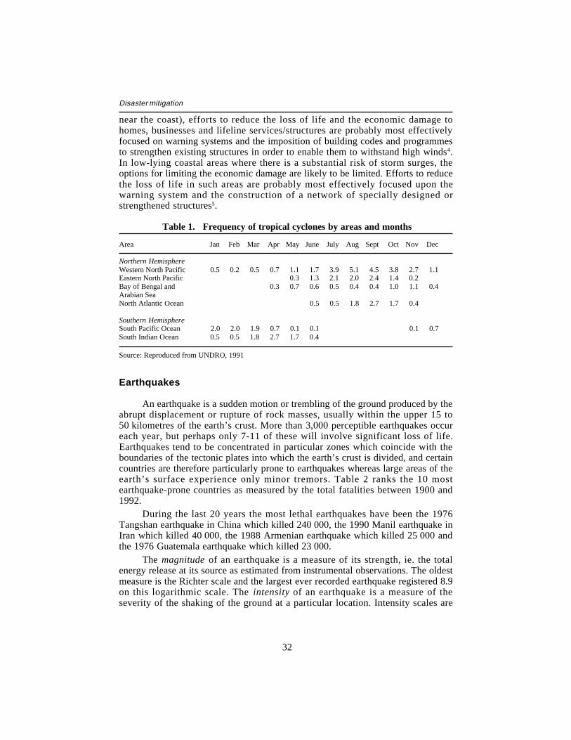
32
Disaster mitigation
near the coast), efforts to reduce the loss of life and the economic damage tohomes, businesses and lifeline services/structures are probably most effectivelyfocused on warning systems and the imposition of building codes and programmesto strengthen existing structures in order to enable them to withstand high winds4.In low-lying coastal areas where there is a substantial risk of storm surges, theoptions for limiting the economic damage are likely to be limited. Efforts to reducethe loss of life in such areas are probably most effectively focused upon thewarning system and the construction of a network of specially designed orstrengthened structures5.
Table 1. Frequency of tropical cyclones by areas and months
Area Jan Feb Mar Apr May June July AugSept Oct Nov Dec
Northern HemisphereWestern North Pacific 0.5 0.2 0.5 0.7 1.1 1.7 3.9 5.1 4.5 3.8 2.7 1.1Eastern North Pacific 0.3 1.3 2.1 2.0 2.4 1.4 0.2Bay of Bengal and 0.3 0.7 0.6 0.5 0.4 0.4 1.0 1.1 0.4Arabian SeaNorth Atlantic Ocean 0.5 0.5 1.8 2.7 1.7 0.4
Southern HemisphereSouth Pacific Ocean 2.0 2.0 1.9 0.7 0.1 0.1 0.1 0.7South Indian Ocean 0.5 0.5 1.8 2.7 1.7 0.4
Source: Reproduced from UNDRO, 1991
Earthquakes
An earthquake is a sudden motion or trembling of the ground produced by theabrupt displacement or rupture of rock masses, usually within the upper 15 to50 kilometres of the earth’s crust. More than 3,000 perceptible earthquakes occureach year, but perhaps only 7-11 of these will involve significant loss of life.Earthquakes tend to be concentrated in particular zones which coincide with theboundaries of the tectonic plates into which the earth’s crust is divided, and certaincountries are therefore particularly prone to earthquakes whereas large areas of theearth’s surface experience only minor tremors. Table 2 ranks the 10 mostearthquake-prone countries as measured by the total fatalities between 1900 and1992.
During the last 20 years the most lethal earthquakes have been the 1976Tangshan earthquake in China which killed 240 000, the 1990 Manil earthquake inIran which killed 40 000, the 1988 Armenian earthquake which killed 25 000 andthe 1976 Guatemala earthquake which killed 23 000.
The magnitude of an earthquake is a measure of its strength, ie. the totalenergy release at its source as estimated from instrumental observations. The oldestmeasure is the Richter scale and the largest ever recorded earthquake registered 8.9on this logarithmic scale. The intensity of an earthquake is a measure of theseverity of the shaking of the ground at a particular location. Intensity scales are
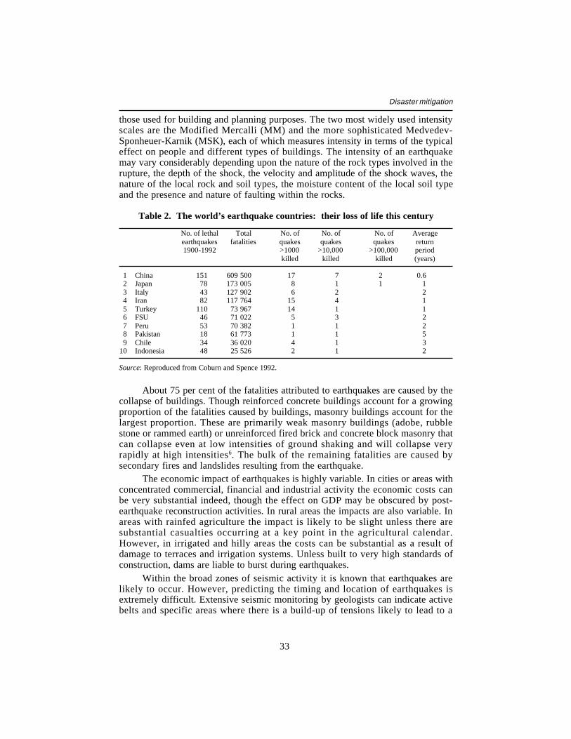
33
Disaster mitigation
those used for building and planning purposes. The two most widely used intensityscales are the Modified Mercalli (MM) and the more sophisticated Medvedev-Sponheuer-Karnik (MSK), each of which measures intensity in terms of the typicaleffect on people and different types of buildings. The intensity of an earthquakemay vary considerably depending upon the nature of the rock types involved in therupture, the depth of the shock, the velocity and amplitude of the shock waves, thenature of the local rock and soil types, the moisture content of the local soil typeand the presence and nature of faulting within the rocks.
Table 2. The world’s earthquake countries: their loss of life this century
No. of lethal Total No. of No. of No. of Averageearthquakes fatalities quakes quakes quakes return1900-1992 >1000 >10,000 >100,000 period
killed killed killed (years)
1 China 151 609 500 17 7 2 0.62 Japan 78 173 005 8 1 1 13 Italy 43 127 902 6 2 24 Iran 82 117 764 15 4 15 Turkey 110 73 967 14 1 16 FSU 46 71 022 5 3 27 Peru 53 70 382 1 1 28 Pakistan 18 61 773 1 1 59 Chile 34 36 020 4 1 3
10 Indonesia 48 25 526 2 1 2
Source: Reproduced from Coburn and Spence 1992.
About 75 per cent of the fatalities attributed to earthquakes are caused by thecollapse of buildings. Though reinforced concrete buildings account for a growingproportion of the fatalities caused by buildings, masonry buildings account for thelargest proportion. These are primarily weak masonry buildings (adobe, rubblestone or rammed earth) or unreinforced fired brick and concrete block masonry thatcan collapse even at low intensities of ground shaking and will collapse veryrapidly at high intensities6. The bulk of the remaining fatalities are caused bysecondary fires and landslides resulting from the earthquake.
The economic impact of earthquakes is highly variable. In cities or areas withconcentrated commercial, financial and industrial activity the economic costs canbe very substantial indeed, though the effect on GDP may be obscured by post-earthquake reconstruction activities. In rural areas the impacts are also variable. Inareas with rainfed agriculture the impact is likely to be slight unless there aresubstantial casualties occurring at a key point in the agricultural calendar.However, in irrigated and hilly areas the costs can be substantial as a result ofdamage to terraces and irrigation systems. Unless built to very high standards ofconstruction, dams are liable to burst during earthquakes.
Within the broad zones of seismic activity it is known that earthquakes arelikely to occur. However, predicting the timing and location of earthquakes isextremely difficult. Extensive seismic monitoring by geologists can indicate activebelts and specific areas where there is a build-up of tensions likely to lead to a

34
Disaster mitigation
sudden displacement. Some earthquakes are preceded by so-called precursors suchas minor tremors and localised deformations in the earth’s surface, and this mayenable reasonably accurate warnings to be issued. Because of Japan’s locationalong an active seismic belt and the belt which runs along the west coast of theUnited States, these two countries have a particularly well-developed capacity forseismic monitoring and systems for the release of information to the public. Bothcountries are therefore well placed to support monitoring activities in developingcountries and indeed already support such programmes. Despite the investment inmonitoring systems the occasions on which geologists have been able accurately topredict an earthquake with sufficient confidence for the local authorities toevacuate towns and cities in the potentially affected area are rare. The mostcelebrated case was the severe Haicheng-Yngou earthquake of 1975 where townsand cities were evacuated two days before the event and only 1 300 people werekilled in an event that might have been expected to have claimed the lives of tens ofthousands.
Because of the difficulty of predicting earthquakes the principal measures formitigation and preparedness are the adoption of earthquake-resistant designs in allforms of construction, the control of land use in areas adjacent to fault lines or onunstable slopes, the institution of public awareness programmes on how to reactwhen an earthquake strikes, and the development and maintenance of local searchand rescue capacity to save those trapped and injured during the crucial day or soafter an earthquake7.
Tsunamis
Tsunamis are sea waves generally caused by earthquakes or volcanic eventsoccurring either under or out to sea. In deep sea such waves can travel at speeds ofapproximately 800 km/hr, but as they approach land they slow down and increasein height. The actual height of the wave depends on the magnitude of the underseaevent and the offshore topography, but waves as high as 15 metres above normalsea level have been recorded. Such waves sweep over low-lying coastal areascausing extensive damage. 90 per cent of damaging tsunamis occur in the PacificBasin at an average of more than two a year. During the period 1967-916 400 people were killed by tsunamis, approximately 3 000 of them by one event inthe Philippines. The majority of destructive tsunamis occur within a few hundredkilometres of the point of landfall and, given the high speeds, there is littleopportunity for warning. For waves travelling long distances warning systems are aviable option. In 1946 the US Government initiated a warning system now knownas the Pacific Tsunami Warning System, which has 23 member nations. The systemis based on a network of tide and seismographic monitoring stations, the hub ofwhich is Honolulu. Within one hour of the detection of a tsunami anywhere in thePacific, warnings, indicating the estimated time of landfall, are issued to over100 dissemination points. Land-use controls in the main risk areas8, evacuationplans, reinforcement of large buildings and sea walls or deflection barriers are theprincipal methods for mitigating the effects of tsunamis.
35
Disaster mitigation
Volcanoes
Volcanic activity is caused by molten material (magma) within the earth’scrust which wells upwards and is emitted at the surface in gaseous, liquid or solidform. Volcanoes are associated with tectonic activity and the majority occur on therim of the Pacific plate (i.e. affecting Central America and western parts of Northand South America, the Aleutians, the Kamchatka Peninsula, Japan, the Philippinesand Papua New Guinea) and along the northern rim of the Indian-Australian plate(principally affecting Indonesia). Because of the high mineral content of the soilformed from historic magma flows, volcanic zones are attractive areas for humansettlement and agriculture. Approximately 10 per cent of the world’s populationlive in or near potentially active volcanoes.
Low-viscosity, easy-flowing magmas escape in effusive eruptions, as ischaracteristic of eruptions in Iceland and Hawaii. Higher viscosity magmas allowpressures to build up leading to explosive eruptions. The principal products ofvolcanoes are ash falls, pyroclastic flows, lava flows and gas emissions. Thecomposition and mix of the products may vary substantially between volcanoes andeven between different eruptions at the same volcano. Because of such differencesit is difficult to generalise about their impacts.
The most lethal eruptions of the last 20 years have been the 1985 Nevado delRuiz eruption in Colombia which killed approximately 22 000 people, the 1982 ElChichon eruption in Mexico which killed approximately 2 000, and the 1986volcanic gas release at Lake Nyos in Cameroon which killed 1 800 people.Explosive eruptions naturally tend to affect a larger area than effusive eruptions.Eruptions producing substantial ashfalls, such as the 1991 Mt Pinatubo eruption inthe Philippines, can destroy crops over large areas and settle on flat roofs and causethem to collapse. Subsequent rainfall may cause dangerous sediment flows knownas lahars and the choking of rivers, possibly forcing changes in their course. Ashand dust forced to high altitudes by an explosive eruption such as Mt Pinatubo orthe 1980 Mt St Helens eruption in the United States can circulate the globe in theupper atmosphere causing discernible alterations in weather patterns and affectingthe operation of remote sensing satellites.
Many volcanoes located in hazardous areas have no more than a 2 per centchance of erupting in a 100-year period and so, unless there is an awareness of arecent event, the local population are unlikely to pay much attention to the potentialrisks involved in living near a volcano. In such a situation the government itselfshould estimate the risks and the costs of mitigation measures. The principalmethods for reducing the risks of living on or near a volcano are land-use zoning,the use of steep pitched roof styles, monitoring the activity of the volcano to givewarnings of eruptions, public awareness programmes and evacuation plans.
Natural hazard maps
The following four maps show the relative vulnerability of various regions inthe world to the hazards of cyclones, earthquakes, volcanoes and rainfall

36
Disaster mitigation
variability. The latter map is based on UNEP’s World Atlas of Desertification(1992), the three other maps on the World Map of Natural Hazards of the MunichReinsurance Company, 2nd edition, 1988 (available from the company, Postbox401320, D-8000 München, Germany).

37
Disaster mitigation

38
Disaster mitigation

39
Disaster mitigation

40
Disaster mitigation
41
Disaster mitigation
Notes
1. Crop yields may also be reduced by such factors as the reduced availability of fertiliser,lack of weeding, the presence of pests and crop diseases, the lack of labour at criticalperiods in the growth cycle, unattractive producer prices, etc. Given the complex andhighly variable nature of the factors affecting crop yields it may be difficult to assessthe relative contribution of a reduction in moisture availability as against other factors.
2. For instance, the famines in the Soviet Union in 1932-4 which claimed approximately5 million lives and that in China in 1958-61 which claimed between 15 and 29 millionlives, were substantially caused by the governments giving higher priority to the goal ofrapid industrialisation.
3. The apparent increase in the frequency of unusual floods in Bangladesh indicated bythe successive floods of 1984, 1987 and 1988 led some observers to attribute theincrease to deforestation in the upper reaches of the catchment areas of the Ganges andBrahmaputra systems. However, there is quite strong evidence that such conclusionsare erroneous and that, whilst the rate of deforestation in Nepal has increased duringrecent decades, the land is often terraced for crop production and the run-offcharacteristics are little different from before (Ives and Messerli, 1989).
4. The differential effect of Hurricane David in 1979 upon Dominica and the nearbyDominican Republic provides a salutary example of the need to link warning systemswith suitably resistant structures. In Dominica there was little advance warning and nochurches or schools were open. Although more than 95 per cent of structures receivedsubstantial damage, fewer than 40 people lost their lives. In the Dominican Republicprior warnings were given and people were encouraged by the civil defence authoritiesto go to larger buildings for protection. Here, over 1,200 lives were lost, almost 60 percent of them in the collapse of unreinforced churches and schools (Cuny, 1983).
5. The case of the April 1991 cyclone in Bangladesh illustrates the need for the warningsystem to achieve high levels of accuracy (many people chose to ignore the warningsbecause previous cyclones had turned out not to be as severe as forecast); the need toprovide specially designed cyclone shelters in sufficient number and carefully sited toenable people to reach them easily; and the difficulties created by insecure land-tenuresystems and the fear of leaving land/homes because of the threat of thieving (WorldDisasters Report, 1993).
6. The belt of seismic activity which runs from Turkey through Syria, the TransCaucasesand Iran to Afghanistan and Pakistan is particularly vulnerable to earthquakes becausethe climate is arid and semi-arid, the days generally hot and the nights cold. Timber forconstruction is in short supply. Local building designs therefore rely strongly on thickmasonry or mud-brick walls and heavy, but poorly supported, roofs for insulation. Suchdesigns are highly liable to collapse and crush their occupants (Alexander, 1993).
7. The effectivenss of search and rescue (SAR) teams from outside the country is knownto be limited, principally because of the time taken for them to reach the affected area.Information on survival rates shows that the majority of trapped survivors die withinone or two days of the event and the survival chances of those rescued after this periodare very slim. Because of the logistical and practical difficulties faced by internationalSAR teams few are able to begin operating in the affected area within the critical firsttwo days. The arrival of many international SAR teams also creates communication andco-ordination problems for the local authorities (Coburn and Spence, 1992).
8. After the devastating tsunamis of 1946 and 1960, the central business district of Hilo,Hawaii was relocated to a safer area and the waterfront and estuarine areas made intopublic open spaces (Alexander, 1993).
42
Disaster mitigation
Annex 2
The Effects of Disasters
The effects of disasters are generally classified into the following categories:— casualties (killed and injured) and numbers affected;— physical damage to housing, infrastructure, ‘lifeline’ systems and
agriculture;— financial and economic consequences;— social consequences such as the trauma experienced by survivors,
broken families, orphans, missed educational opportunities andindebtedness.
Assessment of the effects within each of these categories may beproblematic, particularly in the context of developing countries1. The principalpoints from a disaster mitigation perspective are as follows.
Casualties and numbers affected
Casualties may arise either directly as a result of the hazard event orsubsequently as a result of increased morbidity and mortality attributable to thedisruption and damage caused by the hazard event. Thus, an earthquake may killsome people directly but the destruction of housing and water supply and sewagesystems may result in increased incidence of disease or in epidemics, which maysubstantially increase the death rate unless water, sewage, accommodation andmedical needs are quickly met following the initial disaster. Similarly, famines maydevelop in populations where the hazard event causes a decline in food availabilityin the area. But there may also be a reduction in the ability of people in the area toacquire food, arising from increases in food prices and/or reduction in householdincome resulting from the hazard event.
It is not uncommon in disasters affecting developing countries, particularlythose where the casualty rates are substantial, for the casualty figures to be veryimprecise. Often the initial estimates used by the media are substantiallyexaggerated2. Occasionally the local authorities will exaggerate the casualty ratesin order to increase the level of the response by central government and theinternational community. Alternatively, they may reduce or even deny casualtyrates where the truth may be embarrassing. Famines often take the form ofincreased mortality rates within rural communities which go unregistered by the

43
Disaster mitigation
local administration and health services. Consequently, the death toll of famines isoften subject to estimates which may vary by over 100 per cent. The scale of thedestruction caused by tropical cyclones or floods may be such that many bodies arenot found and the number of known survivors is simply subtracted from estimatesof the pre-disaster population to arrive at an estimate of the approximate number ofdeaths. Where casualty rates form a basis for risk assessments and appropriatedisaster mitigation measures, such figures should be treated with caution and cross-checked wherever possible.
The number affected is a highly ambiguous measure as it places individualswhose lives may have been only slightly affected within the same category as thosewhose lives were substantially altered by the disaster. For instance, floods aredeemed to affect all those who live within the affected area, even if some have losttheir homes, relatives and assets, whilst others have simply been inconvenienced bythe inundation of their homes. Such ambiguity renders this measure of limitedutility for mitigation purposes, and it is preferable that more specific measuresshould be employed.
Physical damage
Similar considerations should apply to assessments of physical damage tohousing, infrastructure, ‘lifeline’ systems and agriculture. Initial estimatesundertaken by the local administration may be based largely on ‘guestimates’ byofficials rather than any rigorous assessment, as a result of communication andlogistical difficulties in the affected area. Crop production estimates areparticularly subject to manipulation by some governments for domestic andinternational political reasons. In most cases, the damage is subsequently assessedin a more rigorous manner by UN agencies or a combination of UN and donoragencies. Such assessments often rely substantially upon information provided bygovernment agencies and perhaps non-governmental organisations, which is cross-checked by UN-led teams visiting parts of the affected area3. The estimates ofdamage produced by such means often serve as the only overall assessment ofdamage. Local assessments may subsequently be undertaken as part of the relief/rehabilitation response which result in revisions to the estimates contained in theUN-led assessments, but it is not common for such revisions to be collated into thefinal estimates of damage. Where damage assessments of previous disasters formthe basis for risk assessments and the design of appropriate disaster mitigationmeasures, such figures should be treated with some caution. Where feasible, themore recent assessments should be subjected to a reassessment to make use of anysubsequent figures.
Financial and economic effects
The financial and economic effects of disasters are complex and oftendifficult to measure. An added difficulty is that current approaches to the
44
Disaster mitigation
measurement of the economic impact of disasters are simplistic and, from theperspective of economists, methodologically weak.
The disaster literature commonly divides the costs attributable to disastersinto direct and indirect costs. In conceptualising this distinction the notion of‘stocks’ and ‘flows’ is helpful, with the direct costs equating with the stock lossesand the indirect costs equating with flow losses within the economy.
Direct costs are the financial costs of replacing or repairing the physicalassets damaged or destroyed by the disaster. Such estimates rely on assessments ofthe physical damage discussed above and care needs to be taken to ensure theaccuracy of such assessments. Differentiation is usually made between the costs ofdamage to public investments (public facilities and infrastructure) and those toprivate investments (factories, business premises and homes). The values used aregenerally the current costs of rebuilding and repairing the damaged structures. Theuse of current costs enables account to be taken of the commonly inflated costs forbuilding materials and services after a disaster. Another useful distinction is thatbetween the loss of productive and unproductive assets.
Indirect costs are the losses of current and future income to the economydirectly attributable to the disaster. The estimation of such effects generallyinvolves a calculation of the value of production and markets. Care is needed inmaking such calculations as losses incurred by one group within a sector may bemirrored by a gain by another group within the same sector. For instance,producers in areas unaffected by the disaster are likely to experience an increaseddemand for their output as a result of reduced production by producers located inthe affected area. Similarly losses within one sector may to a certain extent beoffset by gains within another sector. Aggregate measures of production such asGDP may therefore mask the negative effects within particular sectors andgeographical areas within the economy. Such methodological problems are lessapparent in the case of national exports. Lost export production and access tomarkets represent a genuine loss of national income to the affected country, thoughthey may result in income gains in countries with competing products. However,there may be redistributive effects within the national economy if the loss ofexports results in a deterioration in the balance of payments which would lead toexchange rate depreciation and the re-allocation of income between importers, whowould lose from such a depreciation and exporters who would be gainers per unitof the goods exported.
The financial and economic effects of disasters are often confused within thedisaster literature. For instance, it is not uncommon to see the total financial lossfigure expressed as a proportion of GNP even though this effectively compares‘stocks’ with ‘flows’. Frequently too local replacement costs are misleadinglyexpressed in hard currency terms, even though this may involve a non-convertibleor overvalued currency. In estimating the economic effects of disasters, economicanalysis methods commonly used in the economic appraisal of large projects, suchas the use of border prices and marginal labour costs, should be employed.
Disasters may also have a substantial impact upon government budgets. Taxrevenues may fall as a result of reduced production and trade and this may lead to
45
Disaster mitigation
downward pressure on government expenditure at the very time when the disasteris requiring increased expenditure on health care and the provision of relief andrehabilitation assistance.
The actual economic impact of a disaster will depend not only on its natureand severity, but also on the structure of the economy and the nature of the sectorallinkages within the economy. Thus a disaster impacting heavily upon a sectorwhich has strong linkages with other sectors within the economy may result in anoverall effect upon the economy which is several times greater than its effect on theinitial sector. In contrast, a disaster impacting heavily upon a sector which hasweak linkages with other sectors may result in an overall effect only marginallygreater than its effect on the initial sector. For instance, where the principal impactof a disaster is the destruction of private, locally constructed, housing, this is likelyto have a substantially lower overall economic impact than a disaster which cuts offwater supplies to the industrial sector or deprives the local manufacturing andmarketing sectors of their principal raw material or traded commodity. For thesereasons droughts are likely to have substantially greater ‘knock-on’ effects withinnational economies than other types of natural disaster.
Comparatively little attention has been devoted to the analysis of the financialand economic effects of disasters, and this is reflected in the weakness of thecurrent methodologies. DAC Member aid agencies could usefully support efforts toimprove the understanding of economic processes involved and appropriatemethodological approaches. A better understanding of economic impacts ofdisasters will help ensure an appropriate balance between expenditures onprevention, preparedness and relief approaches, will also ensure that theinvestments selected represent an optimal use of scarce resources, and will increasethe likelihood that the possibility of disasters is taken account of in overalleconomic development plans.
Social effects
Populations within disaster-affected areas may experience a range of socialeffects. Survivors may be traumatised by their experience and suffer from post-traumatic stress disorders or related conditions. Families may be separated eitherby the chaos of the event or by adults migrating in search of work elsewhere, andhave difficulty in tracing each other. Children may be orphaned and needplacement with other families. Most studies of the social consequences of disastershave focused on disasters occurring in developed countries, and so less is knownabout the reactions and adaptations of survivors of disasters in developingcountries. Perhaps as a result of this lack of understanding, the social consequencesof disasters occurring in developing countries are often poorly recorded and arerarely addressed by DAC Member aid agencies in their mitigation and reliefactivities.
Disasters may have a significant effect upon the degree of socialdifferentiation within a community or society. An often overlooked aspect ofdisasters is that there are ‘winners’ as well as ‘losers’. Some groups or individuals

46
Disaster mitigation
may benefit as a result of increased demand for their goods and services in thewake of a disaster, whilst others may be able to exploit a monopolistic position. Tomeet their immediate survival and rehabilitation needs households are oftenobliged to borrow money which, because of the increased demands for credit andthe disruption to existing formal systems of credit provision, is invariably availableonly at very high rates of interest. A common effect of disasters is therefore toforce an increased proportion of families in the area into long-term indebtedness tolocal moneylenders. Subsequent disasters may deepen their indebtedness and/orrender them entirely destitute. A succession of disasters in an area may thereforehave a ‘ratchet’ effect upon particular households or groups within the affectedpopulation.
The effects of disasters may also have a significant gender dimension. Thedeath of male heads of households will increase the number of female-headedhouseholds, which in the absence of access to other income sources will becomepoorer. The disaster may increase the workload of women through the need to carefor the sick and possibly travel further to reach fuel and clean water supplies. Suchincreases in workload may have implications for the nutrition and health of thefamily. The deaths of mothers place a greater workload on daughters, possiblyresulting in curtailed education. In certain societies during times of scarcity, theshare of available resources allocated to male family members may becomeincreasingly disproportionate. The impoverishment of certain households andgroups may lead to females being made more vulnerable to male exploitation andviolence, and some may be obliged to obtain income through prostitution.
Notes
1. A recent analysis of the political economy of large natural disasters states: “Mostdisaster analysis is based on shaky foundations. Institutional bias, political interests andtechnical insufficiencies make disaster statistics unsatisfactory and unreliable” (Albala-Bertrand, 1993).
2. In the Armenian earthquake of December 1988 the first estimates widely published inthe international press were of over 100 000 deaths, but by the end of January 1989 theofficial estimate of actually counted dead and missing people was revised down to justunder 25 000 (Albala-Bertrand, 1993).
3. In the case of sudden-impact disasters such teams are usually led by either or bothUNDP and the Department of Humanitarian Affairs, though the World Bank has beenknown to lead multi-donor assessment teams in certain contexts. In the case of droughtand food security assessments, the FAO and/or the WFP usually lead such teams. In thecase of conflict where medical needs predominate, the WHO may lead the assessments.
47
Disaster mitigation
Annex 3
Disaster Statistics
Databases on hazards and disasters are maintained by a range oforganisations. Unfortunately however partial coverage and the lack ofinternationally agreed definitions and protocols for collecting disaster statisticsmeans that none of the existing databases currently provides a satisfactory basis forthe global analysis of the occurrence and impact of the principal disaster types.Currently the closest approximation to a global database is the EM-DAT DisasterEvents Database developed and maintained by the Centre for Research on theEpidemiology of Disasters (CRED) at the Catholic University of Louvain inBelgium. This utilises data collated from a variety of sources, including the UNDepartment of Humanitarian Affairs, the US Office of Foreign Disaster Assistance,national governments, insurance companies and news agencies. Because of thedifferent sources there are problems of consistency in the definitions used. Inaddition, EM-DAT’s coverage of certain disaster types (notably civil strife anddrought) and disaster effects is incomplete.
Aggregate information on relief expenditures by donor organisations andfrom private sources is also not readily available. Whilst data collated by the DACSecretariat separately identifies non-food emergency aid, unfortunately it does notcurrently distinguish emergency food aid from other categories of food aid.Consequently, a substantial proportion of the resources provided in humanitarianrelief programmes are omitted from the DAC ‘emergency aid’ category. Similarly,whilst DAC does collect data on assistance provided by NGOs based in DACcountries, it does not distinguish between categories of assistance, and theimportant relief contributions by private donors are not identifiable. As part of itsmandate to co-ordinate international relief assistance, the UN Department ofHumanitarian Affairs (formerly the UN Disaster Relief Organisation UNDRO)requests and encourages donor agencies to provide information on all reliefassistance provided in response to disasters. However, the reporting by some donoragencies is not complete, and the aggregate information is considered to contain somany gaps that it is not currently published by DHA. This leaves the informationcompiled by the OFDA as the best available source. However, caution is needed inusing the OFDA data as they appear to contain a degree of both double-countingand under-counting.

48
Disaster mitigation
Disasters and their effects: trends and national vulnerabilities
Because of the lack of a comprehensive and reliable global database, theidentification of trends is problematic. Any trends that may be apparent should betreated with caution. A point of general agreement among existing analyses whichappear to be intuitively correct, is that the number of natural disasters appears to bestable, whilst the number of deaths attributable to such disasters is increasing. Theincrease in populations living in hazard-prone zones is likely to be a principalcontributory factor. Not only is population growth within the hazard-prone areasincreasing the numbers of people living in such zones; population pressure in otherareas is likely to be forcing people, usually poor households with limited alternativeoptions, to move into hazard-prone zones. This process is evident in highly flood-prone areas of Bangladesh and in rapidly growing urban areas where shanty townsare often confined to hazardous flood plains or steep slopes prone to landslides.However, care does need to be taken in making generalisations about complexsocio-environmental processes in widely differing contexts. For instance, a recentstudy of Machakos District in Kenya, which 40-50 years ago experienced highrates of soil erosion and has since experienced high rates of in-migration from themore densely settled highland areas, found that population increase is compatiblewith environmental recovery, provided that market developments make farmingprofitable1.
Of the major disaster types, earthquakes have been the most comprehensivelystudied and data on earthquake fatalities are considerably more accurate andreliable than those for cyclones and droughts and possibly also than those availablefor floods. Analysis of the annual rate of earthquake fatalities suggests that theaverage number over the period 1950-90 has been approximately 14 000 comparedwith 16 000 over the period 1900-502. Much of this reduction can be attributed toimproved mitigation practices such as improvements in building stock in somecountries and successful measures to reduce fire risk in Japanese cities — formerlya common secondary effect of earthquakes. However, there is reason to besceptical about the ability of the present rate of vulnerability reduction to offset therapid rate of population growth. A doubling of the global population every 40 yearswill require the average vulnerability of the world’s building stock to be falling at areciprocal rate and, given current circumstances, this appears unlikely.
Despite the methodological problems associated with the economicconsequences of disasters and serious questions about the coverage and reliabilityof databases purporting to measure the economic consequences, there is strongevidence that, in global terms, the magnitude of the economic consequences ofdisasters is increasing. Intuitively this appears correct. Unless offset by greater useof mitigation measures, the magnitude of economic losses may be expected toincrease as the value of economic activity and assets increases. However, the dataon economic consequences are likely to be highly skewed by the trends indeveloped countries and may obscure trends in developing countries which are lessevident.
What are the major disaster types? Table 1 shows the summary results fordeaths and numbers affected for the period 1967-91 compiled by the EM-DAT
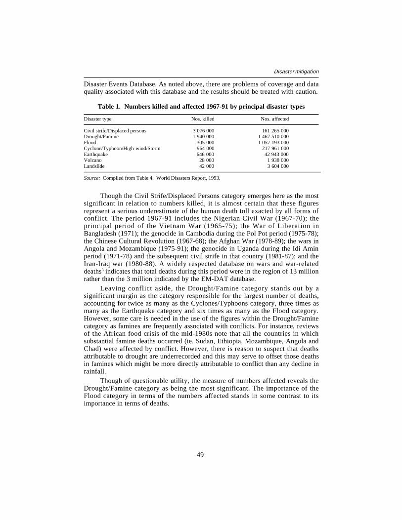
49
Disaster mitigation
Disaster Events Database. As noted above, there are problems of coverage and dataquality associated with this database and the results should be treated with caution.
Table 1. Numbers killed and affected 1967-91 by principal disaster types
Disaster type Nos. killed Nos. affected
Civil strife/Displaced persons 3 076 000 161 265 000Drought/Famine 1 940 000 1 467 510 000Flood 305 000 1 057 193 000Cyclone/Typhoon/High wind/Storm 964 000 217 961 000Earthquake 646 000 42 943 000Volcano 28 000 1 938 000Landslide 42 000 3 604 000
Source: Compiled from Table 4. World Disasters Report, 1993.
Though the Civil Strife/Displaced Persons category emerges here as the mostsignificant in relation to numbers killed, it is almost certain that these figuresrepresent a serious underestimate of the human death toll exacted by all forms ofconflict. The period 1967-91 includes the Nigerian Civil War (1967-70); theprincipal period of the Vietnam War (1965-75); the War of Liberation inBangladesh (1971); the genocide in Cambodia during the Pol Pot period (1975-78);the Chinese Cultural Revolution (1967-68); the Afghan War (1978-89); the wars inAngola and Mozambique (1975-91); the genocide in Uganda during the Idi Aminperiod (1971-78) and the subsequent civil strife in that country (1981-87); and theIran-Iraq war (1980-88). A widely respected database on wars and war-relateddeaths3 indicates that total deaths during this period were in the region of 13 millionrather than the 3 million indicated by the EM-DAT database.
Leaving conflict aside, the Drought/Famine category stands out by asignificant margin as the category responsible for the largest number of deaths,accounting for twice as many as the Cyclones/Typhoons category, three times asmany as the Earthquake category and six times as many as the Flood category.However, some care is needed in the use of the figures within the Drought/Faminecategory as famines are frequently associated with conflicts. For instance, reviewsof the African food crisis of the mid-1980s note that all the countries in whichsubstantial famine deaths occurred (ie. Sudan, Ethiopia, Mozambique, Angola andChad) were affected by conflict. However, there is reason to suspect that deathsattributable to drought are underrecorded and this may serve to offset those deathsin famines which might be more directly attributable to conflict than any decline inrainfall.
Though of questionable utility, the measure of numbers affected reveals theDrought/Famine category as being the most significant. The importance of theFlood category in terms of the numbers affected stands in some contrast to itsimportance in terms of deaths.
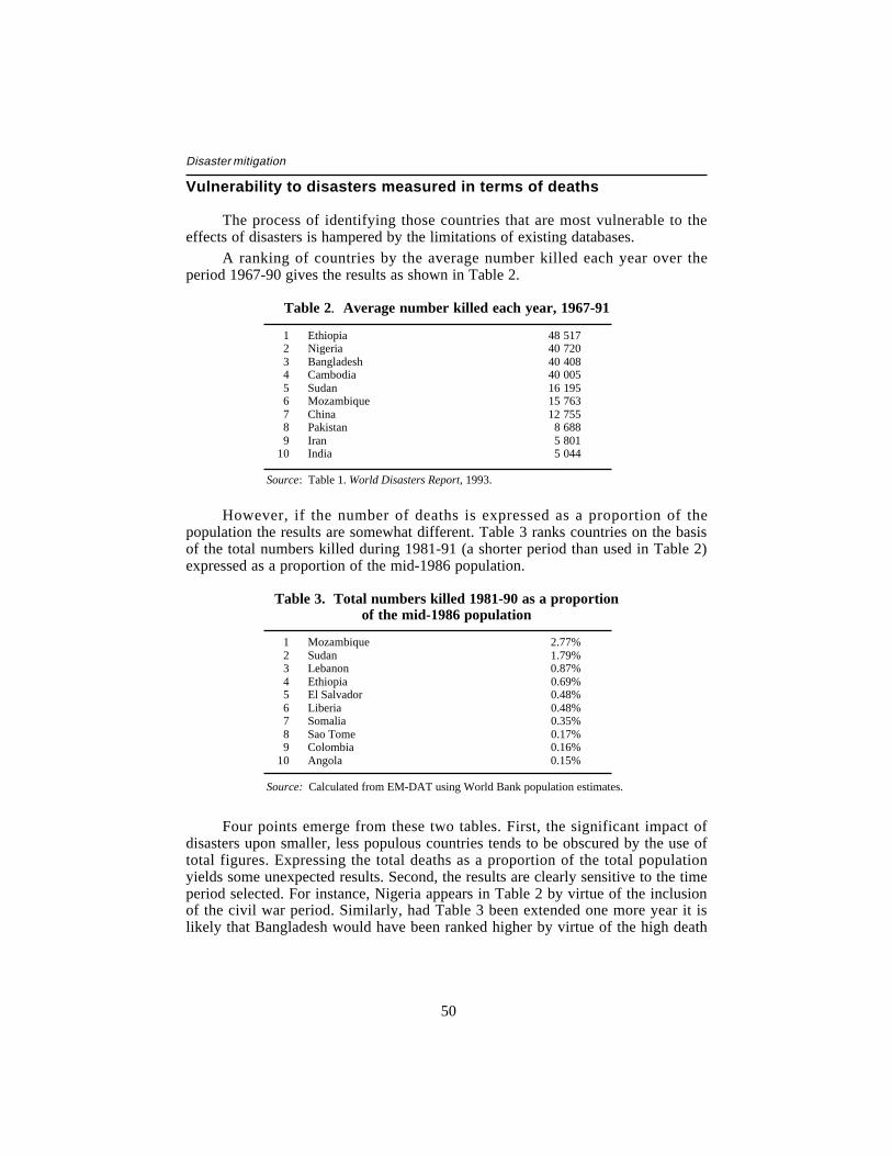
50
Disaster mitigation
Vulnerability to disasters measured in terms of deaths
The process of identifying those countries that are most vulnerable to theeffects of disasters is hampered by the limitations of existing databases.
A ranking of countries by the average number killed each year over theperiod 1967-90 gives the results as shown in Table 2.
Table 2. Average number killed each year, 1967-91
1 Ethiopia 48 5172 Nigeria 40 7203 Bangladesh 40 4084 Cambodia 40 0055 Sudan 16 1956 Mozambique 15 7637 China 12 7558 Pakistan 8 6889 Iran 5 801
10 India 5 044
Source: Table 1. World Disasters Report, 1993.
However, if the number of deaths is expressed as a proportion of thepopulation the results are somewhat different. Table 3 ranks countries on the basisof the total numbers killed during 1981-91 (a shorter period than used in Table 2)expressed as a proportion of the mid-1986 population.
Table 3. Total numbers killed 1981-90 as a proportionof the mid-1986 population
1 Mozambique 2.77%2 Sudan 1.79%3 Lebanon 0.87%4 Ethiopia 0.69%5 El Salvador 0.48%6 Liberia 0.48%7 Somalia 0.35%8 Sao Tome 0.17%9 Colombia 0.16%
10 Angola 0.15%
Source: Calculated from EM-DAT using World Bank population estimates.
Four points emerge from these two tables. First, the significant impact ofdisasters upon smaller, less populous countries tends to be obscured by the use oftotal figures. Expressing the total deaths as a proportion of the total populationyields some unexpected results. Second, the results are clearly sensitive to the timeperiod selected. For instance, Nigeria appears in Table 2 by virtue of the inclusionof the civil war period. Similarly, had Table 3 been extended one more year it islikely that Bangladesh would have been ranked higher by virtue of the high death
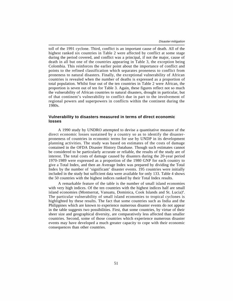
51
Disaster mitigation
toll of the 1991 cyclone. Third, conflict is an important cause of death. All of thehighest ranked six countries in Table 2 were affected by conflict at some stageduring the period covered, and conflict was a principal, if not the major, cause ofdeath in all but one of the countries appearing in Table 3, the exception beingColombia. This reinforces the earlier point about the importance of conflict andpoints to the refined classification which separates proneness to conflict fromproneness to natural disasters. Finally, the exceptional vulnerability of Africancountries is revealed when the number of deaths is expressed as a proportion oftotal population. Whilst four out of the ten countries in Table 2 were African, theproportion is seven out of ten for Table 3. Again, these figures reflect not so muchthe vulnerability of African countries to natural disasters, drought in particular, butof that continent’s vulnerability to conflict due in part to the involvement ofregional powers and superpowers in conflicts within the continent during the1980s.
Vulnerability to disasters measured in terms of direct economiclosses
A 1990 study by UNDRO attempted to devise a quantitative measure of thedirect economic losses sustained by a country so as to identify the disaster-proneness of countries in economic terms for use by UNDP in its developmentplanning activities. The study was based on estimates of the costs of damagecontained in the OFDA Disaster History Database. Though such estimates cannotbe considered to be particularly accurate or reliable, the results of the study are ofinterest. The total costs of damage caused by disasters during the 20-year period1970-1989 were expressed as a proportion of the 1980 GNP for each country togive a Total Index, and then an Average Index was prepared by dividing the TotalIndex by the number of ‘significant’ disaster events. 195 countries were initiallyincluded in the study but sufficient data were available for only 133. Table 4 showsthe 50 countries with the highest indices ranked by their Total Index results.
A remarkable feature of the table is the number of small island economieswith very high indices. Of the ten countries with the highest indices half are smallisland economies (Montserrat, Vanuatu, Dominica, Cook Islands and St. Lucia)4.The particular vulnerability of small island economies to tropical cyclones ishighlighted by these results. The fact that some countries such as India and thePhilippines which are known to experience numerous disaster events do not appearin the table suggests two possibilities. First, that some countries, by virtue of theirsheer size and geographical diversity, are comparatively less affected than smallercountries. Second, some of those countries which experience numerous disasterevents may have developed a much greater capacity to cope with their economicconsequences than other countries.
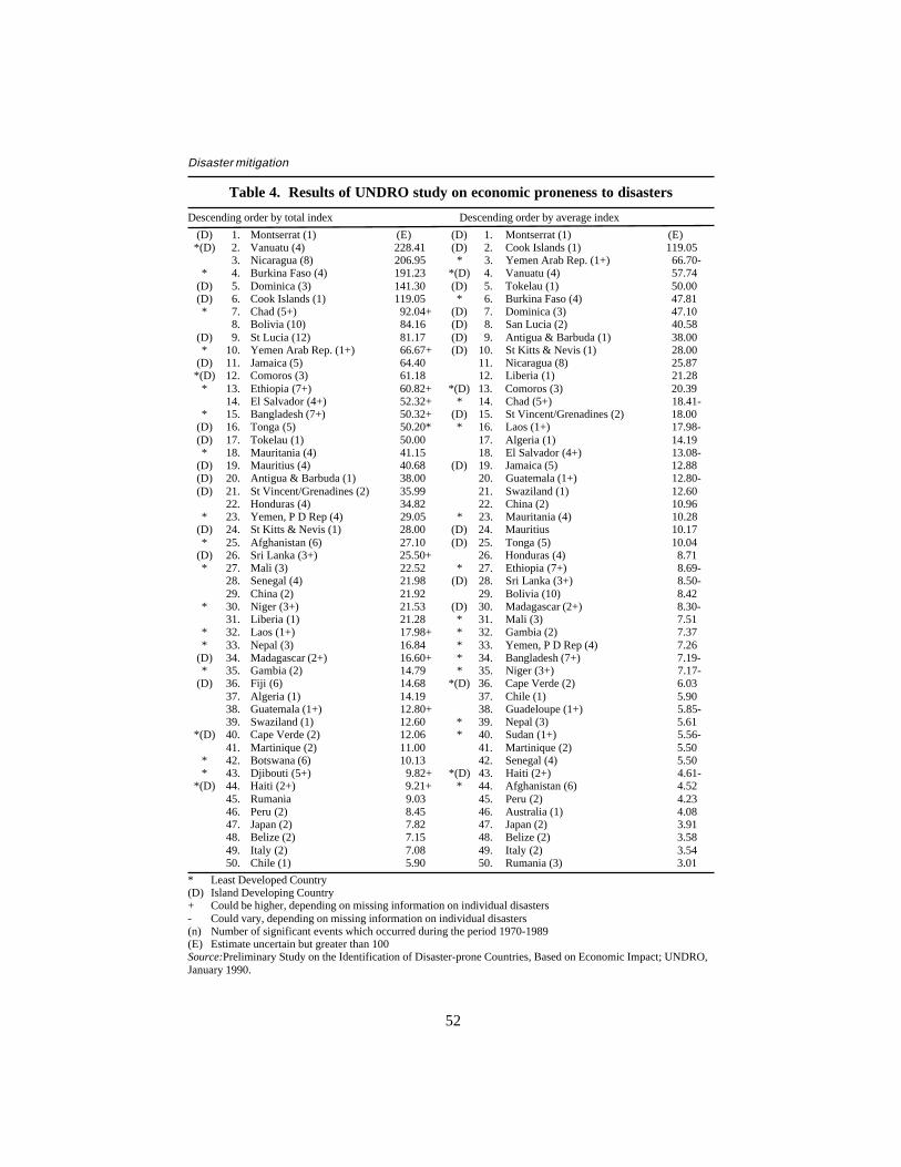
52
Disaster mitigation
Table 4. Results of UNDRO study on economic proneness to disasters
Descending order by total index Descending order by average index
(D) 1. Montserrat (1) (E) (D) 1. Montserrat (1) (E)*(D) 2. Vanuatu (4) 228.41 (D) 2. Cook Islands (1) 119.05
3. Nicaragua (8) 206.95 * 3. Yemen Arab Rep. (1+) 66.70-* 4. Burkina Faso (4) 191.23 *(D) 4. Vanuatu (4) 57.74
(D) 5. Dominica (3) 141.30 (D) 5. Tokelau (1) 50.00(D) 6. Cook Islands (1) 119.05 * 6. Burkina Faso (4) 47.81* 7. Chad (5+) 92.04+ (D) 7. Dominica (3) 47.10
8. Bolivia (10) 84.16 (D) 8. San Lucia (2) 40.58(D) 9. St Lucia (12) 81.17 (D) 9. Antigua & Barbuda (1) 38.00* 10. Yemen Arab Rep. (1+) 66.67+ (D) 10. St Kitts & Nevis (1) 28.00
(D) 11. Jamaica (5) 64.40 11. Nicaragua (8) 25.87*(D) 12. Comoros (3) 61.18 12. Liberia (1) 21.28
* 13. Ethiopia (7+) 60.82+ *(D) 13. Comoros (3) 20.3914. El Salvador (4+) 52.32+ * 14. Chad (5+) 18.41-
* 15. Bangladesh (7+) 50.32+ (D) 15. St Vincent/Grenadines (2) 18.00(D) 16. Tonga (5) 50.20* * 16. Laos (1+) 17.98-(D) 17. Tokelau (1) 50.00 17. Algeria (1) 14.19* 18. Mauritania (4) 41.15 18. El Salvador (4+) 13.08-
(D) 19. Mauritius (4) 40.68 (D) 19. Jamaica (5) 12.88(D) 20. Antigua & Barbuda (1) 38.00 20. Guatemala (1+) 12.80-(D) 21. St Vincent/Grenadines (2) 35.99 21. Swaziland (1) 12.60
22. Honduras (4) 34.82 22. China (2) 10.96* 23. Yemen, P D Rep (4) 29.05 * 23. Mauritania (4) 10.28
(D) 24. St Kitts & Nevis (1) 28.00 (D) 24. Mauritius 10.17* 25. Afghanistan (6) 27.10 (D) 25. Tonga (5) 10.04
(D) 26. Sri Lanka (3+) 25.50+ 26. Honduras (4) 8.71* 27. Mali (3) 22.52 * 27. Ethiopia (7+) 8.69-
28. Senegal (4) 21.98 (D) 28. Sri Lanka (3+) 8.50-29. China (2) 21.92 29. Bolivia (10) 8.42
* 30. Niger (3+) 21.53 (D) 30. Madagascar (2+) 8.30-31. Liberia (1) 21.28 * 31. Mali (3) 7.51
* 32. Laos (1+) 17.98+ * 32. Gambia (2) 7.37* 33. Nepal (3) 16.84 * 33. Yemen, P D Rep (4) 7.26
(D) 34. Madagascar (2+) 16.60+ * 34. Bangladesh (7+) 7.19-* 35. Gambia (2) 14.79 * 35. Niger (3+) 7.17-
(D) 36. Fiji (6) 14.68 *(D) 36. Cape Verde (2) 6.0337. Algeria (1) 14.19 37. Chile (1) 5.9038. Guatemala (1+) 12.80+ 38. Guadeloupe (1+) 5.85-39. Swaziland (1) 12.60 * 39. Nepal (3) 5.61
*(D) 40. Cape Verde (2) 12.06 * 40. Sudan (1+) 5.56-41. Martinique (2) 11.00 41. Martinique (2) 5.50
* 42. Botswana (6) 10.13 42. Senegal (4) 5.50* 43. Djibouti (5+) 9.82+ *(D) 43. Haiti (2+) 4.61-
*(D) 44. Haiti (2+) 9.21+ * 44. Afghanistan (6) 4.5245. Rumania 9.03 45. Peru (2) 4.2346. Peru (2) 8.45 46. Australia (1) 4.0847. Japan (2) 7.82 47. Japan (2) 3.9148. Belize (2) 7.15 48. Belize (2) 3.5849. Italy (2) 7.08 49. Italy (2) 3.5450. Chile (1) 5.90 50. Rumania (3) 3.01
* Least Developed Country(D) Island Developing Country+ Could be higher, depending on missing information on individual disasters- Could vary, depending on missing information on individual disasters(n) Number of significant events which occurred during the period 1970-1989(E) Estimate uncertain but greater than 100Source:Preliminary Study on the Identification of Disaster-prone Countries, Based on Economic Impact; UNDRO,January 1990.
53
Disaster mitigation
Notes
1. Tiffen Mary et al. (1993), More People, Less Erosion: Environmental Recovery inKenya, Wiley, Chichester.
2. Coburn, A and Spence, R. (1992).
3. Sivard, Ruth Leger (1991), World Military and Social Expenditures World Priorities,Washington, DC.
4. It should be pointed out that several countries in Table 4 have high indices on the basisof only one “significant” disaster event during the period, namely Montserrat, CookIslands, St. Kitts/Nevis, Algeria and Liberia.
54
Disaster mitigation
Annex 4
Selected Documentation
The following are a selection of publications and contact points for thosewishing to find out more detailed information on the subject of disasters anddisaster mitigation. The list is not intended to be comprehensive and the inclusionof particular documents or contact points is not meant to indicate that they arebeing recommended over other documents or contact points not listed.
General texts on disasters and disaster mitigation
Asian Development Bank (1991), Disaster Mitigation in Asia and the Pacific.ADB, Manila.
Alexander, David (1993), Natural Disasters. UCL Press, London.Carter, Nick (1992), Disaster Management: A Disaster Manager’s Handbook.
Asian Development Bank, Manila.Cuny, Frederick (1983), Disasters and Development. Oxford University Press,
New York/Oxford.UNDRO (1991), Mitigating Natural Disasters: Phenomena, Effects and Options,
New York/Geneva.Kreimer, Alcira and Munasinghe, Mohan (eds) (1991), Managing Natural
Disasters and the Environment. World Bank, Washington, DC.Maskrey, Andrew (1989), Disaster Mitigation: A Community Based Approach.
Oxfam, Oxford.
Texts on specific disaster types or aspects of disasters
Drought
Borton, J. and Nicholds N. (1991), UN Disaster Management Training ProgrammeDrought and Famine Module. Overseas Development Institute, London.
Wilhite, Donald (ed.) (1993), Drought Assessment, Management and Planning:Theory and Case Studies. Kluwer Academic Publishers, Boston/Dordrecht/London.
55
Disaster mitigation
Economic impacts and insurance
Albala-Bertrand, J.M. (1993), The Political Economy of Large Natural Disasters,Clarendon Press, Oxford.
APO-Asian Productivity Organisation (1991), Agricultural Insurance in Asia.Planning and Practices. Tokyo.
APO-Asian Productivity Organization (1987), Crop Insurance in Asia. Tokyo.Benson, C et al. (1993), The Impact of Drought on Sub-Saharan African
Economies: A Preliminary Examination. Paper prepared for a Work-in-Progress Seminar, The World Bank, ODI, London.
Giarini, O. (ed). (1984), The Geneva Papers on Risk and Insurance. GenevaAssociation, Geneva.
UNCTAD (1990), Statistical Survey on Insurance and Reinsurance Operations inDeveloping Countries 1984-86. UNCTAD, Geneva
Vulnerability
Anderson, Mary and Woodrow, Peter (1989), Rising from the Ashes: DevelopmentStrategies in Times of Disaster. Westview/UNESCO, Boulder, CO/Paris.
Borton, J. and Shoham, J. (1991), Mapping Vulnerability to Food Insecurity:Tentative Guidelines for WFP Country Offices. Study commissioned by theWorld Food Programme. Relief and Development Institute, London.
Chambers, Robert (1989), Vulnerability, Coping and Policy: EditorialIntroduction, IDS Bulletin 20(2), Institute of Development Studies, Brighton,Sussex.
Downing, Thomas (1991), Assessing Socio-Economic Vulnerability to Famine:Frameworks, Concepts andApplications. FEWS Working Paper 2.1. AIDFamine Early Warning System, Washington, DC.
Earthquakes
Coburn, A. and Spence, R. (1992), Earthquake Protection. John Wiley and Sons,Chichester and New York.
Food security
Drèze, Jean and Sen, Amartya (1989), Hunger and Public Action. OxfordUniversity Press, Oxford.
World Bank (1991), Food Security and Disasters in Africa: A Framework forAction (mimeo). Food Security Unit, Africa Technical Department,Washington, DC.
56
Disaster mitigation
Journals/Annual reports
World Disasters Report 1993. International Federation of Red Cross and RedCrescent Societies. Martinus Nijhoff, Dordrecht.
Disasters: the Journal of Disaster Studies and Management, Blackwells/OverseasDevelopment Institute, United Kingdom (a quarterly journal beganpublication in 1977).
STOP DISASTERS (a free newsletter published six times a year on behalf of theIDNDR Secretariat, Palais des Nations, CH 1211 Geneva 10).
Training courses
UN DMTP - DHA-UNDRO, Palais des Nations, Geneva, Switzerland.ADPC - Asian Institute of Technology, PO Box 2754, Bangkok 10501, Thailand.PAHO, 525 Twenty-Third Street NW, Washington DC 20037-2895, United States.