Embed Size (px)
Citation preview

THE ONLY TRUE SITE DESIGN SOFTWAREOpenSite™ DesignerNO COLLECTION. NO IMPOSTER.
THE REAL DEAL.
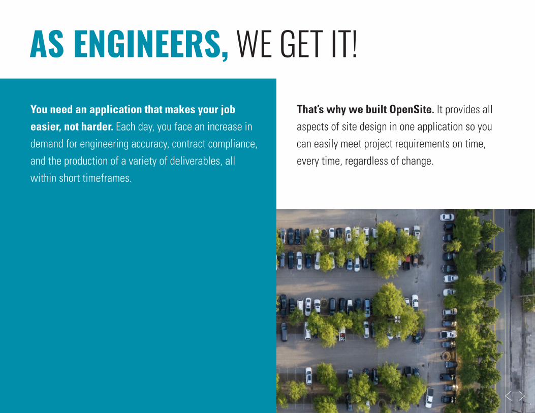
That’s why we built OpenSite. It provides all aspects of site design in one application so you can easily meet project requirements on time, every time, regardless of change.
You need an application that makes your job easier, not harder. Each day, you face an increase in demand for engineering accuracy, contract compliance, and the production of a variety of deliverables, all within short timeframes.
AS ENGINEERS, WE GET IT!

> Why does it have to be so manual and tedious?
> How can I ensure accuracy across thousands of components every time there is a design change?
> How do I know this is going to work with other team members on the project?
> Why do I need multiple applications and data translations for one project?
THERE IS A BETTER WAY…
ENGINEERING IS COMPLICATED.YOUR SOFTWARE DOESN’T HAVE TO BE.

The land development industry is advancing quickly, and you need the right technology
to meet demand and win new business.
ENTER OPENSITE IMPROVE PRODUCTIVITY 20%-30%
> One design application for rapid site modeling and analysis, earthwork optimization and quantification, and drainage and underground utility design.
> Offers dynamic change management.
> Provides an open modeling environment.
> Enables automated project deliverables.
Keep up with OpenSite:

> DATA & DESIGN INTEGRATION You don’t work in a silo and neither should
your software. From integrating existing real-world conditions to collaborating with other project partners, OpenSite makes it easy to work with different data types, disciplines, and distributed teams.
> DETAILED SITE DESIGN OpenSite does it all, from reality
modeling, geotechnical, underground utilities, and stormwater drainage to terrain modeling, detailed drawing production, and visualization.
> VISUALIZATION Experience your designs in real time
with constraint-driven templates, a context-sensitive intuitive interface, and dynamic 3D modeling. Visualize the design at any time and on demand within the modeling workflow.
> 2D, 3D, & BEYOND Whether you need to produce
traditional 2D deliverables, advance to 3D modeling, support digital transformation, or all the above, OpenSite is your choice for site design.
OPENSITE: THE ONLY TRUE SITE DESIGN SOFTWARE

> OPEN MODELING ENVIRONMENT Project team members can incorporate
data types from an array of disciplines,
which means less manual work and fewer
errors. Users benefit from full data and
design transparency.
> IMPORT EXISTING TERRAIN DATA Our Topo Import feature allows users to download terrain data from Esri, USGS, and SRTM in seconds, providing the jump-start you need by using existing topography.
> MANAGE DATA WITH EASE OpenSite’s flexibility offers team members
the ability to organize project files and
data as needed, further removing discipline
and organization silos.
> SHARE THE WEALTH OF DATA OpenSite accommodates today’s project
needs and provides users with accurate
information that benefits team members
throughout the asset’s lifecycle.
DATA & DESIGN INTEGRATIONFrom team-level, work-in-progress collaboration to
project-level, multidiscipline coordination, OpenSite enables
project managers, reviewers, site workers, and inspectors
to view designs, perform virtual walkthroughs, query model
information, and analyze embedded property data.
WATCH VIDEO >>

> START WITH REAL DATA Create accurate, georeferenced 3D models
through seamless integration of reality data,
including LiDAR, photogrammetry, point
clouds, and reality meshes.
> LAYOUT AUTOMATION Automate layout and grading to analyze the feasibility of feature placement and configuration for commercial, industrial, and residential site development.
> GRADING OPTIMIZATION OpenSite’s grading solver runs thousands
of iterations based on designer-defined
constraints for each site layout to optimize
construction costs.
> CREATE, REUSE, AND SAVE TIME Create commonly used configurations
that can maintain constraints and
relationships. Store, access, and place
elements at any time and watch your
design automatically update.
DETAILEDSITE DESIGNWhether you need to produce traditional 2D deliverables
or advance to 3D modeling, OpenSite is the single application
you need. It can handle conceptual design through construction
documentation for any site or land development project.
WATCH VIDEO >>

> DESIGN IN CONTEXT Experience designs in real time with
constraint-driven templates, dynamic
3D modeling, and a context-sensitive,
intuitive interface.
> REALISTIC PROJECT VISUALS Virtually move through the 3D site model and visually inspect it for any design deficiencies or physical conflicts.
> DETAILS MATTER Use rendering features, such as color fill,
material, and shading to improve your
design at any phase and build assurance
in project constructability.
> ENHANCE COMMUNICATION Create models, high-impact visuals,
and animations to effectively communicate
your design intent to stakeholders.
VISUALIZATIONOpenSite not only creates numerous site design alternatives
in a fraction of the time competing software requires,
but also produces the realistic and accurate visualizations
of site design and land development projects.
WATCH VIDEO >>

> ACCELERATE APPROVALS Dynamic change management and
visualization capabilities give you the
confidence to make any design change
and get stakeholder buy-in.
> MAINTAIN DESIGN INTENT Easily maintain rules and relationships, as every design update will reflect the most recent and accurate representation of your project.
> DO MORE WITH LESS Drainage and utilities modeling and
analysis no longer need to be performed
in a separate application as a result of
OpenSite’s inherent OpenFlows capabilities.
> MITIGATE RISK Reduce errors, omissions, and changes
during construction with a model-based
project approach that enables an easy
design, review, and approval process.
Whether it’s 2D or 3D, plans or models, or digital or paper,
OpenSite allows you to work in all these arenas simultaneously,
leveraging information from one to help populate the other.
WATCH VIDEO >>
2D, 3D, & BEYOND

OPENSITE DESIGNER CAPABILITIES AT A GLANCE
SURVEY SITEPLAN PRODUCTION & DOCUMENTATION
> Read/write standard raw survey formats
> Survey data reduction
> Feature coding for custom survey feature connectivity, display, and annotation
> Adjustments: least squares, compass, crandall, and transit
> Dynamic graphical and tabular editing of survey field book data
> Terrain modeling
> Export common data formats
> Reality data integration (point clouds, reality mesh, terrain data, imagery, geospatial information)
> Surface creation, design, and analysis
> Parcel layout
> Grading
> Horizontal and vertical alignments
> Profiles and cross sections
> Terrain modeling and analysis
> Allocate and estimate stormwater loads
> H&H modeling and analysis
> Culvert design and analysis
> Stormwater network design and analysis
> Sanitary network design and analysis
> Plan, profile, and cross section sheet generation
> Quantity and earthwork calculations
> Construction documentation
> BIM deliverables
DRAINAGE & UTILITIES

Engineering firms and contractors are recognizing that over half of new business requests require digital project delivery.
3D modeling and visualization enable your clients to secure projects. In return, you attract new and recurring business.
Users say that BIM advancements influence their ability to offer services and increase their win rates for new work.
Bentley applications support multiple data exchanges, providing benefit across the project lifecycle.
INFRASTRUCTURE INDUSTRY TRENDSWHY SWITCH NOW?

OPENSITE DESIGNER SOFTWARE OF CHOICEFOR SITE DESIGN
15+ 30%YEARS
EXPERIENCETIME SAVED WITH GRADING SOLVER
GAIN IN PRODUCTIVITY
ESRI 1100%DATA WITH
TOPO IMPORTDESIGN WORK DONE
IN OPENSITE TRUE SITE DESIGN APPLICATION
20%

OPENSITE DESIGNER: DO MORE FOR LESS
OPENSITE DESIGNER
LEVERAGE OpenFlows’ STORMWATER MODELING
CAPABILITIES
LEVERAGE LumenRT’s VISUALIZATION CAPABILITIES
LEVERAGE MicroStation’s CAD DESIGN CAPABILITIES
LEVERAGE gINT’s GEOTECHNICAL DESIGN CAPABILITIES
LEVERAGE OpenRoads’ DRAINAGE AND UTILITIES DESIGN AND ANALYSIS CAPABILITIES

You no longer need native desktop apps to share and review design files. iTwin Design Review is web/cloud-based and always current.
> Run reports any time and view historical changes.> View civil quantities from within the tool.> One less deliverable to print.> Accessible to all team members.
Design, analyze, document, and visualize buildings of any size, form, and complexity.
> Model and visualize structural elements.> Create floor plans, sections, elevations, and
schedules for any architectural component.> Analyze building system performance with
conceptual energy analysis.
A cloud-based connected data environment that allows you to easily manage, store, and share information.
> Leverages Microsoft 365 technology.> Makes collaborative BIM accessible
and affordable.> Eliminates paper-based workflows.> Includes third-party PDF review capabilities.
ADDITIONAL SOLUTIONS FOR SITE DESIGN PROJECT DELIVERY
FOR PROJECT MANAGERSiTwin® Design Review
FOR BUILDING DESIGNOpenBuildings™ Designer
FOR COLLABORATIONProjectWise® 365

Your success goes beyond software. It is also dependent on doing business the way that best serves your organization. That is why we have a variety of subscription and license options as well as 24/7/365 support to ensure your software is up and running quickly and continuously.
PARTNERSHIPFOR SUCCESS
Contact Us >
> SEE FOR YOURSELF THE POWER OF OPENSITE DESIGNER
© 2021 Bentley Systems, Incorporated. Bentley, the Bentley logo, gINT, iTwin, iTwin Design Review, LumenRT, MicroStation, OpenBuildings, OpenBuildings Designer, OpenFlows, OpenRoads, OpenSite, OpenSite Designer, and ProjectWise are either registered or unregistered trade-marks or service marks of Bentley Systems, Incorporated or one of its direct or indirect wholly owned subsidiaries. Other brands and product names are trademarks of their respective owners. 1/21
CALL US TO LEARN MORE1 800 236 8539
VISIT US ONLINEwww.bentley.com