Embed Size (px)
Citation preview

LAND USE PLAN AND DESIGN GUIDELINES
Columbus Planning Division
The Northwest Plan

The Northwest PlanLAND USE PLAN AND DESIGN GUIDELINES
Columbus Planning Division50 W. Gay Street, Fourth Floor
Columbus, Ohio 43215
Adopted: December 5, 2016

City CouncilZach Klein, Council PresidentElizabeth C. BrownMitchell J. BrownShannon G. HardinJaiza PageMichael StinzianoPriscilla R. Tyson
Development CommissionMichael J. Fitzpatrick, AIA, ChairJohn A. Ingwersen, AIA, Vice ChairJack A. Cooley, Ph.D.Marty Anderson, Esq.Maria Manta Conroy, Ph.D.Kay Onwukwe, AIA, APA, NCARB
Department of DevelopmentSteven Schoeny, DirectorQuinten L. Harris JD, MPA, Deputy DirectorHannah R. Jones, Deputy DirectorRory McGuiness, Deputy Director
Planning DivisionKevin Wheeler, AdministratorMark Dravillas, AICP, Assistant Administrator
Northwest Plan Project Team
Jackie Yeoman, Senior Planner (Project Lead)Christopher Lohr, Senior PlannerPatrice Allen Brady, Senior PlannerMarc Cerana, GIS AnalystAlexandria Voignier, Senior PlannerChristine Leed, Senior Planner (Former Project Lead)
Northwest Civic AssociationJohn Ehlers, PresidentKyle Hartman, Vice PresidentRosemarie LiskoNick CipitiKellie EhlersMark KrietemeyerGreg MariettiRuth RoyalJulie Schlosser
Far Northwest CoalitionJohn Murley, PresidentKelly Thompson, TreasurerJohn BestPhil Herren

Contents 6 Introduction 7 Planning Area 7 What is a plan and how is it used? 9 Relationship to Existing Plans 9 Plan Process 12 Existing Conditions 13 Earlier Planning Efforts 15 Existing Land Use 17 Existing Zoning 19 Existing Density 20 Recommendations 21 Land Use Plan 28 Land Use Policies 28 Guiding Principles 29 General Land Use Policies 30 Low Density Residential, <4 du/acre 31 Low-Medium Density Residential, 4–6 du/acre 31 Medium Density Residential, 6–10 du/acre 31 Medium-High Density Residential, 10–16 du/acre 32 High Density Residential, 16–24 du/acre 33 Mixed Use 1, <24 du/acre 34 Mixed Use 2, <45 du/acre 35 Commercial 35 Office 36 Institutional 37 Industrial & Warehouse 38 Parks & Recreation 38 Open Space 39 Private Open Space 40 Site Specific Recommendations (Sites A & B) 41 2014 Columbus Recreation And Parks Master Plan Summary 42 Design Guidelines 43 Design Principles 44 Residential Design Guidelines 49 Commercial Design Guidelines 56 Development Review Checklist
List of Figures, Charts, and Tables
8 Figure 1.1 Planning Area 14 Figure 2.1 Existing Land Use Map 15 Chart 2.1 Existing Land Use 16 Figure 2.2 Existing Zoning Map 17 Chart 2.2 Existing Zoning 18 Figure 2.3 Existing Density Map 19 Chart 2.3 Residential Density Pattern 22 Figure 3.1 Recommended Land Use Map 23 Table 3.1 Recommended Land Use
Classification Table 24 Figure 3.2 Recommended Land Use Map:
Northwest Quadrant 25 Figure 3.3 Recommended Land Use Map:
Northeast Quadrant 26 Figure 3.4 Recommended Land Use Map:
Southwest Quadrant 27 Figure 3.5 Recommended Land Use Map:
Southeast Quadrant

6
Introduction
The Introduction section describes the purpose of the Plan, how the Plan
is used, and the planning process. The section includes a summary of
community outreach and public input received throughout the Plan process.
T H E N O R T H W E S T P L A NColumbus Planning Division

7
Planning AreaThe Northwest planning area is located in the northwest portion of the city of Columbus. The area is served by the Northwest Civic Association and the Far Northwest Coalition. The area’s 12,686 acres (approximately 20 square miles) are bounded by the Olentangy River to the east, Henderson Road and the city of Upper Arlington to the south, the Scioto River and the city of Dublin to the west, and the Franklin County line to the north (Figure 1.1). The planning area had a 2014 population of 75,759 residing in 33,300 households (Source: Esri).
What is a plan and how is it used?Area plans address future land use and design. The Plan is primarily used to guide community and city review of future rezoning and variance requests.
Area Plans:
• Provide land use recommendations for the planning area that serve as a framework for zoning and other land use decisions.
• Provide guidelines for the design of new development.
Area Plans Do Not:
• Solve issues unrelated to the built and natural environment, such as health care, code enforcement, and public safety.
• Address traffic, congestion, or storm-water issues. (While these matters are not addressed by the Plan, they are addressed as part of the development review process managed by the Building and Zoning Services Department.)
• Recommend new parks on privately held land unless already identified by Recreation and Parks for acquisition.
• Change zoning or zoning overlays already in place, although the Plan does provide the policy basis for zoning and related development decisions moving forward.
Plan Format
An area plan contains two primary sections: existing conditions and recom-mendations. The recommendation section includes a Land Use Plan and Design Guidelines for commercial and residential development. The Land Use Plan is comprised of Land Use Policy (text) and the associated Recommended Land Use Map (Figure 3.1).
I N T R O D U C T I O N
Northwest Plan: Introduction Steps
Follow four basic steps to review development propos-
als using the Northwest Plan. The Development Review
Checklist found on pages 58–59 is also available to
ensure relevant plan recommendations are considered.
Step 1: Identify the location of the development on the
Recommended Land Use Map located on page 22 of
this document. Refer to the map legend to determine
the recommended land use for the site location. Online
mapping applications are also available at:
www.columbus.gov/planning.
Step 2: Refer to the Recommended Land Use
Classification Table on page 23 for a general description
of the land use recommendation for the site.
Step 3: Locate the Land Use Policy text (pages 29–41)
that corresponds with the land use recommendation for
more specific policy information.
Step 4: Refer to any relevant Design Guidelines for the
proposed development. (Residential Design Guidelines
are located on pages 44–48 and Commercial Design
Guidelines are located on pages 49–55.)

270
31533
Riverside
Dublin-Granville
Dublin
Olentangy R
iver
Bethel
Hard
Snouffer
Dub
lin
Saw
mill
West Case
Ole
ntan
gy R
iver
Ree
d
Lane
Sm
oky Row
God
own
Linworth
Emerald
Ken
ny
Sawbury
Henderson
Billingsley
Cranston
Summit View
Dierker
Wils
on Bridge
Fede
rate
d
High
Davidson
HaydenHayden Run
Frantz
Liberty
Bent Tree
Tuttle
Pos
tlew
aite
Rings
Saw
mill
Henderson
Summit View
Dublin
Saw
mill
Bethel
Henderson
Hard
Linw
orth
Linworth
U P P E R A R L I N G T O N
W O R T H I N G T O N
D U B L I N
0.5
Miles
8T H E N O R T H W E S T P L A NColumbus Planning Division
9
Relationship to Existing PlansThis plan supersedes previously adopted city planning and development policy for the Northwest area, including the Northwest Plan (2007), the Sawmill Corridor Development Standards (1977), and the Bethel Road Development Standards (1980).
Plan ProcessThe planning process included existing conditions research, a review of existing plans, staff analysis and public input. Planning staff engaged with community stakeholders (residents, business owners and local developers) through public meetings, working group meetings, stakeholder interviews, online surveys and social media. A summary of this process for the Northwest Plan is shown below.
Northwest Plan Process Summary
• Winter 2014/15: Review of Existing Conditions
• Throughout 2015: Stakeholder Interviews
• March 5, 2015: Civic Workshop #1
• May 20, 2015, Public Workshop #1: Review of Draft Land Use Plan
• December 8, 2015: Civic Workshop #2
• January 25, 2016, Public Workshop #2: Review of Draft Land Use Policies and Design Guidelines
• May 26, 2016: Civic Workshop #3
• June 7, 2016: Public Open House
• July 27, 2016: Far Northwest Coalition voted to recommend the Northwest Plan to City Council
• August 3, 2016: Northwest Civic Association voted to recommend the Northwest Plan to City Council
• October 13, 2016: Development Commission
• December 5, 2016: Columbus City Council
I N T R O D U C T I O N
Figure 1.1
The Northwest planning area
◀
10T H E N O R T H W E S T P L A NColumbus Planning Division
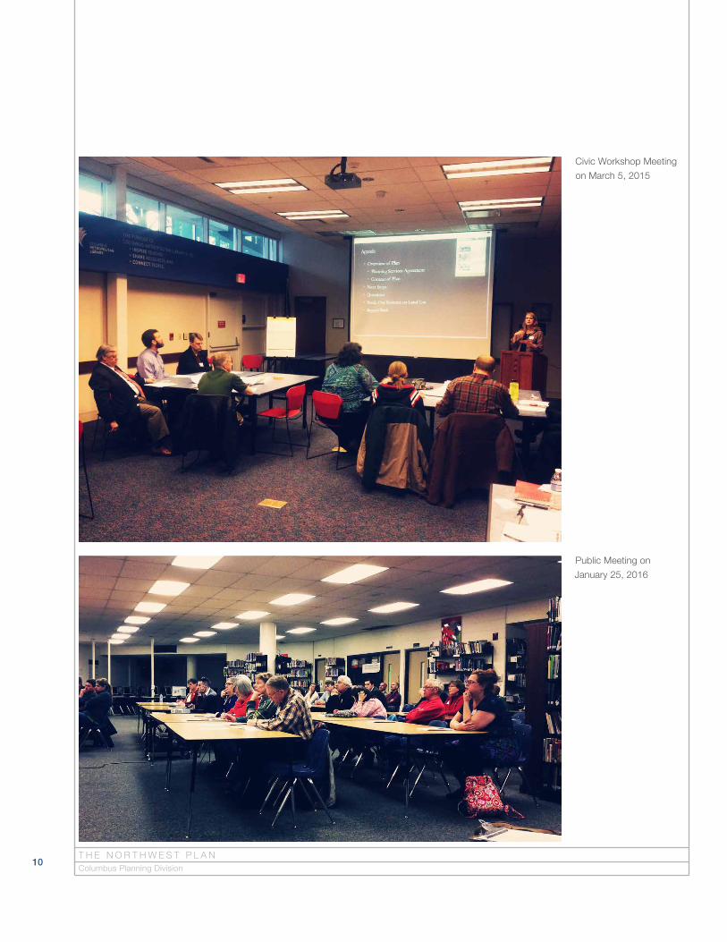
Civic Workshop Meeting
on March 5, 2015
Public Meeting on
January 25, 2016

11
Summary of Public Input
As a part of the larger outreach to the general public, staff held three public meetings with extended public comment periods and received input from over 100 community members. Staff also engaged 19 stakeholders from the civic, institutional, and business communities of the Northwest Area.
During one-on-one conversations, stakeholders recognized that the planning area is in a great location with successful retail locations. They also noted the area is largely built-out, and therefore, most development opportunities will be infill development. Other comments included:
• Retail is overbuilt and existing commercial centers located at key nodes should be strengthened;
• Mixed uses are appropriate with appropriate transitions to existing residential neighborhoods;
• Along primary thoroughfares, roadway improvements are desirable; and
• Natural resources should be preserved via additional parks, open space, and urban trees.
The first public meeting was held on May 20, 2015. Twenty-four members of the public attended the meeting and forty-three participants took the correspond-ing survey. Questions from the public focused on concerns related to traffic, stormwater, and further development of multifamily in the planning area.
The second public meeting was held on January 25, 2016. The workshop provided community members the opportunity to review the draft Land Use Plan and to comment on the draft Design Guidelines. Over 85 people participated through the meeting and the corresponding survey. Specific comments included:
• Preference for front access garages vs. alley access;
• Provide recommendations for height and exterior lighting standards related to the OSU Airport;
• Concerns about extended stay hotels/apartments and impacts on the neighborhood;
• Recommend trees to be provided in open space and limit grass with no landscaping;
• High quality building materials should be provided;
• Concern with the height of multifamily buildings; and
• Concerns about access and traffic on SR 161.
I N T R O D U C T I O N

12
Existing Conditions
The Existing Conditions section provides a summary of the planning area’s
data and trends that inform physical planning. The section reviews the area’s
physical attributes, including land use, zoning, and density.
T H E N O R T H W E S T P L A NColumbus Planning Division

13
Earlier Planning EffortsSawmill Road Development Standards (1977)
The Sawmill Road Development Standards were created to guide future devel-opment of undeveloped land in the study area located west of Sawmill Road roughly between Case and Martin roads. The purpose of the standards were “to achieve a unity and a continuity that would not otherwise be achievable in normal development patterns.” The Standards include Design Guidelines for lighting, graphics, neighborhood commercial standards, traffic and access management, school and park locations, and bikeway and sidewalk standards.
Bethel Road Development Standards (1980)
The Bethel Road Development Standards cover all of Bethel Road from the Olentangy River to the Scioto River. The Standards were created as guide-lines for future development with a goal “to achieve a unity and continuity of functional and aesthetic characteristics that will be advantageous to all prop-erty owners and to the community.” Similar to the Sawmill Road Development Standards, recommendations include Design Guidelines for lighting, graphics, landscaping, traffic and access management and parking standards.
Northwest Plan (2007)
The Northwest Plan was adopted in 2007 to address infill development, commer-cial and office redevelopment, sidewalks and bike paths, parks, and city services. The Plan also provided interim guidance for roadway improvements and land use character along SR 161 (pending the completion of a comprehen-sive traffic analysis for improvements to SR 161) and recommended the adop-tion of the Regional Commercial Overlay and Community Commercial Overlay along primary commercial corridors in the area. The Plan did not include a Land Use Plan for the Northwest area.
E X I S T I N G C O N D I T I O N S
270
31533
Riverside
Dublin-Granville
Dublin
Olentangy R
iver
Bethel
Hard
Snouffer
Dub
lin
Saw
mill
West Case
Ole
ntan
gy R
iver
Ree
d
Lane
Sm
oky Row
God
own
Linworth
Emerald
Ken
ny
Sawbury
Henderson
Billingsley
Cranston
Summit View
Dierker
Wils
on Bridge
Fede
rate
d
High
Davidson
HaydenHayden Run
Frantz
Liberty
Bent Tree
Tuttle
Pos
tlew
aite
Rings
Saw
mill
Henderson
Summit View
Dublin
Saw
mill
Bethel
Henderson
Hard
Linw
orth
Linworth
U P P E R A R L I N G T O N
W O R T H I N G T O N
D U B L I N
0.5
Miles
Single-family
Two–Three-family
Multifamily
Institutional
Mixed Use
Commercial
Of�ce
Warehouse Distribution
Industrial (Light)
Agriculture
Open Space
Parks & Recreation
Utilities & Railroads
Vacant
Land Use Category
14T H E N O R T H W E S T P L A NColumbus Planning Division

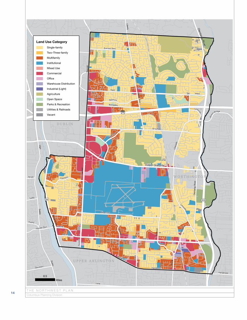
Figure 2.1
Existing land use map
◀
Residential59%
Institutional19%
Parks & Recreation8%
Other8%
Commercial7%
15
Existing Land UseLand use describes the type of activity occurring on a site. Land use can gener-ally be categorized as residential, retail, office, institutional, or industrial and is typically consistent with the zoning district assigned to the parcel. Existing land use in the Northwest area is illustrated in Figure 2.1.
The Northwest planning area contains a mix of existing office, commercial, resi-dential and institutional land uses. Residential uses comprise 59 percent of the area making it the most predominant land use in the Northwest. The majority of residential uses are single-family homes; however, large areas of multifamily exist near Bethel and Sawmill roads and other scattered sites throughout the area. As its own category, multifamily development accounts for 14 percent of the Northwest area. The planning area also includes scattered two-family and three-family units.
Institutional uses represent the second highest land use in the area. The Ohio State University Airport (OSU Airport), located along SR 161 and Sawmill Road, covers a large portion of the planning area and is classified as an institutional land use. Overall, institutional land use accounts for 19 percent of the planning area.
E X I S T I N G C O N D I T I O N S
Chart 2.1
Existing land use measured by percent of total acres per land use category.

270
31533
Riverside
Dublin-Granville
Dublin
Olentangy R
iver
Bethel
Hard
Snouffer
Dub
lin
Saw
mill
West Case
Ole
ntan
gy R
iver
Ree
d
Lane
Sm
oky Row
God
own
Linworth
Emerald
Ken
ny
Sawbury
Henderson
Billingsley
Cranston
Summit View
Dierker
Wils
on Bridge
Fede
rate
d
High
Davidson
HaydenHayden Run
Frantz
Liberty
Bent Tree
Tuttle
Pos
tlew
aite
Rings
Saw
mill
Henderson
Summit View
Dublin
Saw
mill
Bethel
Henderson
Hard
Linw
orth
Linworth
U P P E R A R L I N G T O N
W O R T H I N G T O N
D U B L I N
0.5
Miles
General Zoning Category
Residential
Multifamily
Institutional
Commercial
Manufacturing
Commercial Overlays
16T H E N O R T H W E S T P L A NColumbus Planning Division
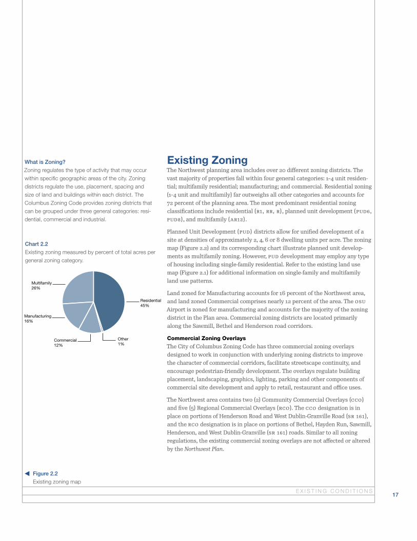
Figure 2.2
Existing zoning map◀
Residential45%
Other1%
Multifamily26%
Manufacturing16%
Commercial12%
17
Existing ZoningThe Northwest planning area includes over 20 different zoning districts. The vast majority of properties fall within four general categories: 1–4 unit residen-tial; multifamily residential; manufacturing; and commercial. Residential zoning (1–4 unit and multifamily) far outweighs all other categories and accounts for 72 percent of the planning area. The most predominant residential zoning classifications include residential (R1, RR, R), planned unit development (PUD6, PUD8), and multifamily (AR12).
Planned Unit Development (PUD) districts allow for unified development of a site at densities of approximately 2, 4, 6 or 8 dwelling units per acre. The zoning map (Figure 2.2) and its corresponding chart illustrate planned unit develop-ments as multifamily zoning. However, PUD development may employ any type of housing including single-family residential. Refer to the existing land use map (Figure 2.1) for additional information on single-family and multifamily land use patterns.
Land zoned for Manufacturing accounts for 16 percent of the Northwest area, and land zoned Commercial comprises nearly 12 percent of the area. The OSU Airport is zoned for manufacturing and accounts for the majority of the zoning district in the Plan area. Commercial zoning districts are located primarily along the Sawmill, Bethel and Henderson road corridors.
Commercial Zoning Overlays
The City of Columbus Zoning Code has three commercial zoning overlays designed to work in conjunction with underlying zoning districts to improve the character of commercial corridors, facilitate streetscape continuity, and encourage pedestrian-friendly development. The overlays regulate building placement, landscaping, graphics, lighting, parking and other components of commercial site development and apply to retail, restaurant and office uses.
The Northwest area contains two (2) Community Commercial Overlays (CCO) and five (5) Regional Commercial Overlays (RCO). The CCO designation is in place on portions of Henderson Road and West Dublin-Granville Road (SR 161), and the RCO designation is in place on portions of Bethel, Hayden Run, Sawmill, Henderson, and West Dublin-Granville (SR 161) roads. Similar to all zoning regulations, the existing commercial zoning overlays are not affected or altered by the Northwest Plan.
What is Zoning?
Zoning regulates the type of activity that may occur
within specific geographic areas of the city. Zoning
districts regulate the use, placement, spacing and
size of land and buildings within each district. The
Columbus Zoning Code provides zoning districts that
can be grouped under three general categories: resi-
dential, commercial and industrial.
E X I S T I N G C O N D I T I O N S
Chart 2.2
Existing zoning measured by percent of total acres per
general zoning category.

270
31533
Riverside
Dublin-Granville
Dublin
Olentangy R
iver
Bethel
Hard
Snouffer
Dub
lin
Saw
mill
West Case
Ole
ntan
gy R
iver
Ree
d
Lane
Sm
oky Row
God
own
Linworth
Emerald
Ken
ny
Sawbury
Henderson
Billingsley
Cranston
Summit View
Dierker
Wils
on Bridge
Fede
rate
d
High
Davidson
HaydenHayden Run
Frantz
Liberty
Bent Tree
Tuttle
Pos
tlew
aite
Rings
Saw
mill
Henderson
Summit View
Dublin
Saw
mill
Bethel
Henderson
Hard
Linw
orth
Linworth
U P P E R A R L I N G T O N
W O R T H I N G T O N
D U B L I N
0.5
Miles
Dwelling Units Per Acre
16 to 45
10 to 16
6 to 10
4 to 6
2 to 4
Less than 2
18T H E N O R T H W E S T P L A NColumbus Planning Division

Figure 2.3
Existing density map
◀
2–4 du/ac
10–16 du/ac
4–6 du/ac
6–10 du/ac
16–45 du/ac
Less than 2 du/ac
44%
14%
13%
8%
3%
18%
19
Existing DensityThe Northwest area is comprised of a range of housing types and units. The density map (Figure 2.3) illustrates the number of units located within a given site or subdivision relative to the acreage of the site. Similar to existing land use in the planning area, the majority of residential units in the Northwest are located on sites that have 4 dwelling units per acre (du/ac) or less. Higher density sites are typically located along the primary commercial corridors (Henderson, Sawmill, and Bethel roads). Medium density sites are scattered throughout the planning area.
E X I S T I N G C O N D I T I O N S
Chart 2.3
Residential density pattern measured by percent of total acres per density category.

20
Recommendations
The Recommendations section includes a Land Use Plan and Design
Guidelines for commercial and residential development. The Land Use Plan
serves as a central element of the Northwest Plan by providing a land use
recommendation for every parcel in the planning area. Classifications are
provided for each land use in the area, including residential, commercial,
office, mixed use, institutional, and industrial uses. The recommendations
of the Land Use Plan are used to review zoning and variance requests for
future development.
T H E N O R T H W E S T P L A NColumbus Planning Division

21
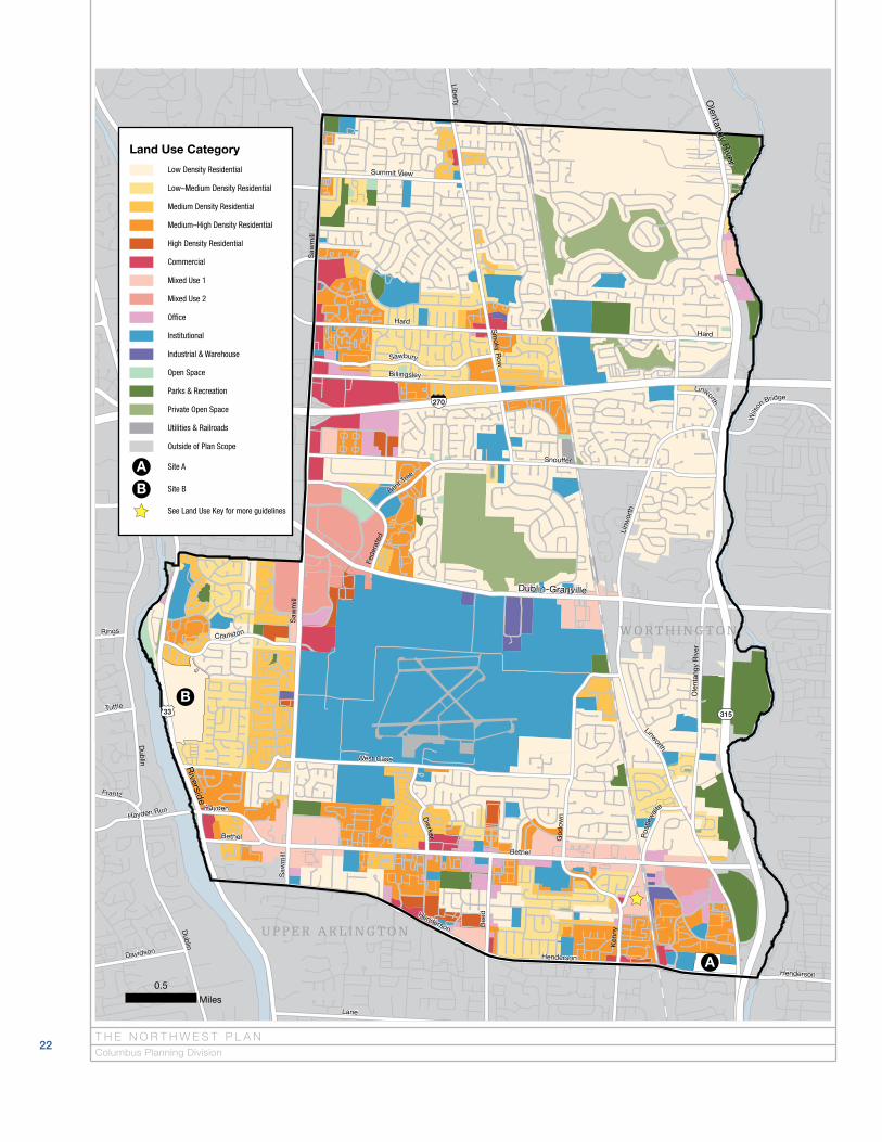
Land Use PlanThe Land Use Plan provides a land use recommendation for each parcel in the Northwest area. It consists of the Recommended Land Use Map (Figure 3.1) and the corresponding text found on pages 29–41. For reference, the Recommended Land Use Map has been enlarged and split into four quadrant maps located on pages 24–27. The map legend (Figure 3.1) corresponds with Table 3.1, which provides generalized descriptions of the recommended land use classifications and density recommendations. The given density ranges are guidelines for future development in an area, but do not guarantee that development propos-als will be approved at the maximum density. Recommendations of this plan do not apply to properties outside the City of Columbus. Land use recommen-dations for areas that are currently not in Columbus are provided in the event they are annexed to the City in the future.
R E C O M M E N D AT I O N S
Anheuser Busch Park
Land Use Plan
270
31533
Riverside
Dublin-Granville
Dublin
Olentangy R
iver
Bethel
Hard
Snouffer
Dub
lin
Saw
mill
West Case
Ole
ntan
gy R
iver
Ree
d
Lane
Sm
oky Row
God
own
Linworth
Emerald
Ken
ny
Sawbury
Henderson
Billingsley
Cranston
Summit View
Dierker
Wils
on Bridge
Fede
rate
d
High
Davidson
HaydenHayden Run
Frantz
Liberty
Bent Tree
Tuttle
Pos
tlew
aite
Rings
Saw
mill
Henderson
Summit View
Dublin
Saw
mill
Bethel
Henderson
Hard
Linw
orth
Linworth
U P P E R A R L I N G T O N
W O R T H I N G T O N
D U B L I N
0.5
Miles
Low Density Residential
Low–Medium Density Residential
Medium Density Residential
Medium–High Density Residential
High Density Residential
Commercial
Mixed Use 1
Mixed Use 2
Of�ce
Institutional
Industrial & Warehouse
Open Space
Parks & Recreation
Private Open Space
Utilities & Railroads
Outside of Plan Scope
Site A
Site B
See Land Use Key for more guidelines
Land Use Category
A
A
B
B
22T H E N O R T H W E S T P L A NColumbus Planning Division

Figure 3.1
Recommended Land Use
Map of the planning area
Table 3.1
Recommended Land Use
Classification Table
◀
▲
23R E C O M M E N D AT I O N S
Classification Density Guideline Map Color General Description, including examples of supportable uses
Low Density Residential Less than 4 du/acrePredominantly single-family development. Refer to the Land Use Policies and Design Guidelines for additional standards regarding new development or redevelopment of low density residential sites.
Low–Medium Density Residential 4–6 du/acre Predominantly single-family development, with limited amounts of multifamily.
Medium Density Residential 6–10 du/acreResidential development including both smaller lot single-family and smaller scale multifamily development.
Medium–High Density Residential 10–16 du/acreA variety of dwelling types, including smaller lot single-family, doubles, townhouses and multifamily development.
High Density Residential 16–24 du/acre Multi-story, multifamily housing.
CommercialRetail, office, or institutional uses. Fuel service stations are supported in this classification.
Mixed Use 1 Less than 24 du/acre
Commercial classification with residential uses supported. Development may include a mix of uses on one site (for example, residential units located either above and/or next to the commercial uses), or it may include only one use per site. The designation does not require a mix of uses, but instead promotes mixed use development where it is a viable development scenario.
For the area designated Mixed Use 1 located on the east side of Kenny Road between Weybridge Road and Bethel Road, the existing Manufacturing uses (M) are recognized and supported. Expansion of a manufacturing use in this area should be supported provided it is consistent with the Industrial and Warehouse classification policies and Commercial Design Guidelines. Additional retail development is not supported in this area.
Mixed Use 2 Less than 45 du/acre
Commercial classification with residential uses supported. Development may include a mix of uses on one site (for example, residential units located either above and/or next to the commercial uses), or it may include only one use per site. The designation does not require a mix of uses, but instead promotes mixed use development where it is a viable development scenario.
Office Office uses.
Institutional
Schools, government property, and places of worship. The Plan recommends institutional land use for existing institutional sites, however, it is recognized that institutional sites may be subject to redevelopment. Refer to the Land Use Policies and Design Guidelines for additional standards regarding the redevel-opment institutional sites.
Industrial and Warehouse Industrial, manufacturing, and warehouse uses.
Open SpaceOpen space refers to natural areas that do not provide recreational facilities. This includes areas with development restrictions, such as cemeteries, regu-lated floodway, and conservation holdings.
Parks and Recreation Publicly owned parks and recreation facilities.
Private Open Space
Golf courses, private sports fields, open space within a development owned by an HOA, or dedicated open space within developments. Refer to the Land Use Policies and Design Guidelines for additional standards regarding the develop-ment of private open space.
Site A: Northwest Corner of Henderson and Olentangy River roads
Office, institutional, medical, and/or multifamily would be appropriate land uses for this 20 acre site. Proposals should follow the Residential and/or Commercial Design Guidelines, as appropriate.
Site B: Properties on Riverside Drive in Perry Township
The Plan supports the existing residential uses at this location, which are currently in Perry Township. In the case that parcels in this area are annexed, office and residential uses would be appropriate. Refer to the Land Use Policies and Design Guidelines for additional standards regarding the redevelopment of low density residential sites including text on buffering and open space.
Note: Density (gross) is typically measured in terms of dwelling units per acre. The calculation includes the area of the entire site including internal roads and vehicular circulation. Density calculations allow for clustering of units on a smaller portion of the developable site to accommodate natural resource preservation and larger open space designations.
Land Use Plan

270
Sutter
Saddle
Seab
right
SummerSe
ddon
Skyline
Plains
Olde Sawmill
Lake
broo
k
Sonnington
Laramie
Farmers
SaltergateStancrest
Stanburn
Queensbridge
Waco
Gallo
Sim
�eld
Bride Water
Ibson
Smoky View
Sawm
ill Place
Worthingwoods
Racher
Oakf
air
Libr
a
Map
lele
af
Severhill
Willis
Am
ur
Downey
Cain
e
Summit Row
Otter
Seth
wic
k
Foxb
oro
Yum
a
Gardenstone
Fern
lea
f
Starford
Breathstone
Rushing
Darrow
Cram
pton
May
broo
k
Bierstad
Berber
Surrywood
Sawmill Forest
Starleaf
Nimitz
Fallhaven
Hightower
Park Village
Dina
HartsdaleElbert
Hamrock
Watertower
Sher
mon
t
Renf
rew
Orin
da
Gallo
p
Smokymill
Benning
Pine
Bar
k
Brookdown
Linkton
Spar
row
Stoneford
Stowbridge
Backbay
Weather Stone
Maroon
Silv
er F
oxPa
lmlea
f
Gray
Gab
les
Lost Valley
Tow
eron
Spru
ce P
ine
Sanford
Ript
on
Thistlewood
Surreygate
Millrow
Shuford
Zebec
Shill
ingt
on
Sandbury
Barnard
Lariat
Greenvale
Scottingham
Flat
Roc
k
Sandy Side
Sout
hwick
Long Horn
Guild
er
Trip
oli
Annelane
Scarsdale
Trillium
Saund e rlan
e
High Ridge
Shallowford
Danb
ury
Sancroft
Stonehurst
Sawmill Meadows
Eel
Dunsworth
Shro
ckto
nSara
hurst
Atherton
Woodspring
Strathm
oore
Woodbluff
Bent Tree
Slaton
Twin Oaks
Sanb
rook
e
Hixson
Edge
rton
Timberside
Ladue
Broadacre
Wolverhampton
Slateshire
Heather�eld
Swansford
Copp
ervi
ew
Brofford
Stratingham
Old
Foxe
Laco
nia
Pick
ett
Pate
Samberl y
San
Boni
ta
Sa
ble
Rosc
oe
Littleleaf
Sarbury
Tyjo
n
Eldorado
Satter�eld
Laredo
Waterstone
Viburnum
Sandstrom
Sco�
eld
Blanca
Salyer
Brigham
Melody
CopperhillGnarled Pine
Sovr on
Oak Leaf
Blue
Fox
Swift
Fincastle
Everton
Wal
ton
Blessing
Schoo lc r aft
Durango
Smoky Meadow
Seas
ons
Cold
stre
am
Boulder
Aspenwood
Gard
envi
ew
Southwold
Warrington
Min
turn
Shirl
ingt
on
Bing
ham
Scho
olw
ay
Fox�
eld
Windi ng
Broo
k
Birch�eld
Starmont
Bouchard
Gard
enga
te
Sandown
Craigside
Henr
y Da
vid
Penw
ood
Dono
ra
Bloo
m�e
ld
Wilm ette
Clov
er
dale
Tina
Lone Prairie
Sum
mer
woo
d
Gant
ry
Winnetk
a
Shillingham
Sill
Torreys
Sagew ood
Sedgebrook
Diamondback
Hath
away
Par
k
Paw
ling
Jam
ey
Selw
yn
Trellage
Rosalie
Gord
on
Decker
Sutcl
iff
Winoak
Pacos
Chiron
Trap
hill
Shadeview
Stanlake
Saw
bury
Fede
rate
d
John
Joh
n
Blac
kjac
k
Boothbay
Sagemeadow
Yate
s Po
int
Crimson
Skyl
ine
Lara
mie
Caine
Seabright
Thistlewood
Merw
in
Orinda
Seve
rhill
Dublin-Granville
Hard
Snouffer
Saw
mill
Sm
oky Row
Sawbury
Billingsley
Summit View
Federated
Saw
mill
2,000
Feet
Northwest Quadrant
24T H E N O R T H W E S T P L A NColumbus Planning Division
Figure 3.2
Please refer to pages 22–23 for land use category classifications
270
315
Mcv
ey
Fairw
ay
Clubview
Bluffway
Merwin
Sycamore
Oakview
Linbrook
Estel
Colon
y
Briarmeadow
Highview
Cross Country
Troon
Bluffview
Edgecliff
Cherry�eld
Darwin
Candlewood
Plum Tree
Firth
Rosebank
Kirk
Werner
Beec
hlake
Millbrae
Kilt
Shet
land
Amol
Loch Ness
Merbrook
Mulberry
Tessier
Gatehouse
Blind Brook
Rowles
Woo
dm
an
Putney
Sout
hvie
w
Oakbourne
Macgregor
Ione
Rutherglen
Durness
Beech
Walnut
Clan
Bluffpoint
Old Woods
Northbridge
Elm
Duffy
Chadbyrne
Laur
en
Mcc
ord
Norh
ill
Glad
e
Lookout Point
Ashler
Merston
Harran
Churchbell
Curleys
Bluff Ridge
Newcomer
Park Ridge
Donwalter
Rutland
Mission Hills
Worthington Heights
Mer
woo
d
Mel
lace
nt
Snowmass
Greenside
Old Oak
Antrim Ridge
Woods
Singing Hills
Baum
oc
k Burn
Black
stone
Elmers
Buttermilk
Crowhurst
Dollivor
Ravine Ridge
Copp
er�e
ld
Donahey
Hutchinson
Bonn
ie Br
ae
Mccleary
Angus
Mar
khav
en
Tiehack
Overlook Pass
Win
ston
Bellich
Shelley
Lorine
Hickory Ridge
Keats
Pipestone
SnoufferSton
e
Maple
Olen h urst
Leicester
Cutter
Tweed
Mason
Verucchio
Leala
nd
Ravens Nest
Adin Trail
Evangeline
Limberlost
Thom
pson
Golfview
Stonewood
May
Varic
k
Terrace Park
Bluffstream
Tennyson
Gables
Circ
le On
The Green
Mt A
ir
Kinnards
Mill
cres
t
Dona
hue
Ma
p l e Hill
Breckenridge
Oak
Bluff Bend
Kelvin
Mac
Pine
Meadow
Ashw
orth
Bucktrout
Hath
erly
Longtimber
Cottonwood
Constitution
Foot
emill
North
way
Whi
tew
ood
Cedar
Loch Lomond
Mcvey
Cand
lew
ood
Clubview
Mulberry
Mcvey
Elm
Merw
in
Colony
Mac
greg
or
Sycamore
Linbrook
Dublin-Granville
Olentangy R
iver
Snouffer
Linw
orth
Hard
Ole
ntan
gy R
iver
Linworth
Hard
W O R T H I N G T O N
2,000
Feet
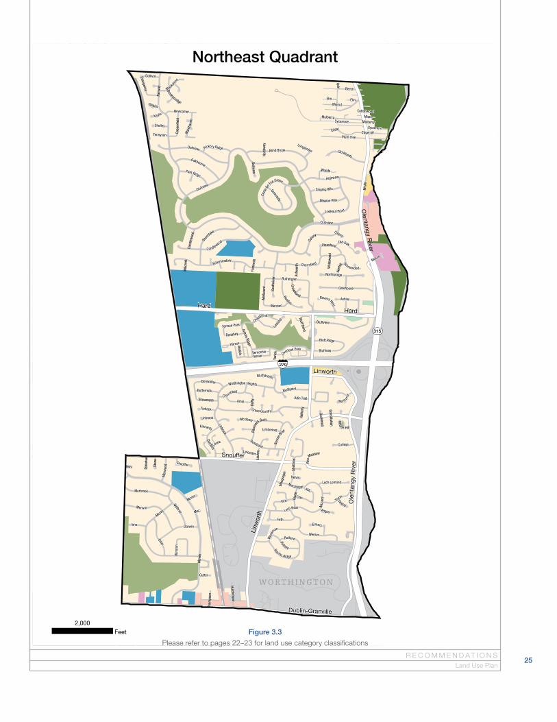
Northeast Quadrant
Figure 3.3
Please refer to pages 22–23 for land use category classifications
25R E C O M M E N D AT I O N S
Land Use Plan

Unkn
own
Dier
ker
Krie
r
Drew
Delburn
Ramblewood
Resler
Brock
Re�e
ctio
ns
That
cher
Abbe
y Ch
urch
Kays
Tuller
Francisco
Quarry
Birc
hton
Atlin
Allister
Delcane
Curtis Knoll
Essington
Rockland
Harv
est
Scottsdale
Amst
on
Ambr
osia
Fraley
Chesley
Caleb
Sawdust
Wigm
ore
Festival
Mck
itric
k
Baf�n
Willoway
Gardenia
Dors
ey
Lila
Dahlia
Saw
toot
h
Embe
rwoo
d
Cora
l Ber
ry
Getty
sbur
g
Welland
Mar
yhur
st
Maxim
Barney
Pick
ford
e
Riverside Green
Antigua
Shiloh
Pons
et
Willington
Millbury
Win
din
gBaneberry
Brampton
Lynnmore
Lang
horn
Wild�ower
Barr
y Tr
ace
Arch
way
Mar
ita
Winona
Natu
revi
ew
Banting
Durkin
Hyacinth
Hedgerow
Mea
dow
sgle
n
Kingst
ree
Coleman
Ren�
eld
Farrel
Hild
enbo
ro
Sove
reig
n
Crown Plaza
New
gate
Stra
thco
na
Arbor
g
Ohio
Sta
te U
nive
rsity
Airp
ort
Canaan
Hend
erso
n He
ight
s
Eppleworth
Mea
dow
hurs
t
Leesville
Bermud a Bay
Stockwell
Payt
on
Bannister
Ruth
ton
Aleshire
Bryn
woo
d
Middleboro
Calais
Frobisher
Martlet
Dumont
Char
lbur
y
Moo
rgat
e
Stillmeadow
Leatherlips
DonnylaneM
alek
a
West Case
Wendys
Royalwood
Woodview
Black Kettle
Monarch
Trotterslane
Wood Run
Creston
Hagerman
Cow
an
Fontenay
Boul
der C
rest
Bren
de
l
Darylane
Chev
y Ch
ase
Mallard
Tins
bury
Jam
esto
wn
Drur
yVictoria Park
Chetwood
Empr
ess
Rimmer
Dublin A
r bor
Lo n glea
t
Cher
ylane
Grey
ston
e
Cobb
le
Cran
ston
King
ham
Bayswater
Buffa
lo H
ead
Country Corners
Cleeve Hill
Kick
ing Bird
Rive
rsid
e Gl
en
Coac
hm
an
Greensboro
Grange Hill
Newbank
Needham
Garylane
Hamden
Dyrham
Burgoyne
A mana
Millridge
Hon bury
Cher
ylbr
ook
Shaf
tsbu
ry
Crown RidgeDartford Trace
Ravine Lake
Ravi
ne
Sunbridge
Rensbury
Saybrook
Gardenbrooke
Pauley
Park
Run
Blic
klin
g
Ri ver
mill
Abbey Chape l
Springridge
Park
cres
t
Montego
Wol
cott
Briarhurst
Castlebar
Slat
ey H
ollo
w
Alderridge
Gree
n Arbor
Robinbrook
Shellwick
Bran
dy O
aks
Capt
ains
Dum
mer
ston
Tam
wor
th
Wilmington
Ston
emill
Duqu
esne
Host
as
RossburyFe
dera
ted
Shel
ton
Linchmere
Royal Crest
Winona
Ram
blew
ood
Festival
Delb
urn
Unknown
Lila
Atlin
Re�ections
Fran
cisc
o
Fral
ey
Riverside
Dublin-Granville
Saw
mill
Bethel
West Case
Dierker
Ree
d
Henderson
Cranston
Hayden
Saw
mill
Bethel
B
2,000
Feet
Southwest Quadrant
26T H E N O R T H W E S T P L A NColumbus Planning Division
Figure 3.4
Please refer to pages 22–23 for land use category classifications
A
315
Slade
Francisco
Unknown
Jasonway
Denbigh
Larw
ell
Scottsdale
Fies
ta
Knightsbrid
ge
Weybridge
Bradshire
Ramblewood
Nich
olas
Win
ters
et
Rocky Rill
Sedgwick
Greenridge
Holli
ster
Rayne
Nantucket
Lorraine
Amy
Shuster
Paula
Meeklynn
Pepperell
Castle
Bunker Hill
Tete
r
Mill
ingt
on
Portl
and
Langland
Mor
elan
d
Southport
Austin
Smallwood
Chev
iot
Brookridge
Lynbrook
Winstead
Tulip
Hill
Rockport
Medinah
Shadow Lake
Deacon
Archda le
Larkstone
Merrimar
Northport
Will
ough
by
Wak
efor
d
Clover
Aqua Bay
Hibb
s
AddyEverwood
Augusta Glen
Marshlyn
Schu
ylki
ll
Answ
orth
Becket
Bent
ley
Sharon Hill
Waterford
Shadow
broo
k
Spring Grove
Lola
Arth
ur
Carruthers
Ross
moo
r
Stoney Creek
Autu
mn
Hill
Litc
h�el
d
Linworth Village
Villa
ge B
rook
Olen
Beechview
Wyn
woo
d
Eber
star
k
Wid
ner
Bridgeway
Courtney
Olde Towne
Mos
s
Kits
une
Keel
ey
Devo
ntry
Briarbank
Mid
dle�
eld
Vinton
Eric
Mcb
ane
Ellin
ger
Middleport
Islan
d Bay
Cam
bria
n
Brittingham
Pebb
le
Dahl
try
Arcwynn
Lanning
Win
som
e
Bushwood
Le Anne Marie
Garla
nd
Moravian
CrestwayBl
air�
eld
Glas
gow
Northcrest
Fenw
ick
Churchill
Aero
s
Circle
Barrington Club
Heath
moo
r
Griffon
SkylarkBr
addo
ck
Banb
ury
Lane On The Lake
Char
ecot
e
Lindsey Marie
Camden Yard
Cloverknoll
Bent
ham
Benchmark Park
Adler
Boscastle
St James
Berrywood
Dory
Rals
ton
A c e vedo
Colhas set
Pres
ton
Woo
ds
Beth
el C
enter
Olentangy Woods
Galto
n
Kempton Run
Tangy
St Albans
Rans
tead
Mendes
Wol
last
er
Slemm o ns
Kenn
y
Bracken House
Co
mmunications
White Willow
Katherines Ridge
Kesw
ick
Cape
Cod
Aveb
ury
Portage
Bethel Woods
Dalm
eny
Cres
sing
ham
Birm
ingh
am
Weybridge
Weybridge
Wid
ner
Heat
hmoo
rRo
ckport
Den b igh
Litch�eld
Wak
efor
d
Portl
and
WeybridgeArth
ur
Millington
Rockport
Rals
ton
Dublin-Granville
Bethel
God
own
Reed
Linworth
Ole
ntan
gy R
iver
Ken
ny
Henderson
West Case
Pos
tlew
aite
Henderson
W O R T H I N G T O N
1,000
Feet
Southeast Quadrant
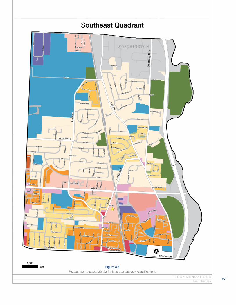
Figure 3.5
Please refer to pages 22–23 for land use category classifications
27R E C O M M E N D AT I O N S
Land Use Plan
28
Land Use PoliciesGuiding PrinciplesThe primary goals of the Land Use Plan are to preserve existing low density residential neighborhoods, strengthen employment centers, and maintain the long-term vitality of the Northwest area. The following principles serve as a foundation for the Land Use Plan policies and recommendations:
1. Land use recommendations are informed by existing zoning, land use, density and other related factors.
2. Neighborhoods within the area should have a mix of uses that provide a variety of housing types, neighborhood services and employment.
3. In general, low density residential neighborhoods should be preserved, and higher density residential development should be located on the primary commercial and mixed-use corridors.
4. Priority is placed on retaining office uses, which serve as important compo-nents of a neighborhood.
5. New retail uses should be developed in a manner consistent with the land use recommendations (Commercial and Mixed Use classifications).
6. Mixed use development should be located along primary corridors or within established commercial centers. Focusing higher density residential development in these areas will strengthen existing retail, promote more walkable neighborhood centers, and reduce development pressure in other areas of the Northwest where lower density development is preferred.
7. Natural areas, open space, and parks provide many benefits in urban and suburban settings including habitat for wildlife, recreation for residents, and encouraging healthy living. Existing publicly owned park and recreation facilities should be maintained and new development should provide open space and preserve natural site features. Opportunities for parkland dedi-cation should be pursued when recommended by the Recreation and Parks Department.
8. Proposals to redevelop existing institutional, residential, office or private park/recreation uses may be supported if the use and design are compatible with surrounding uses.
9. Access to multiple transportation options should be provided, including walking, biking, personal vehicles and public transportation.
What is density?
Density refers to the number of residential units within a
given area. It is calculated by dividing the total number
of residential units on a site by the total acreage of the
site. For example, a development with 100 residential
units on a 10 acre site has a density of 10 dwelling units
per acre (du/ac), or a development with 40 residential
units on a 10 acre site has a density of 4 du/ac. The
density ratio does not differentiate between the type of
residential development (single-family vs. multifamily).
Density calculations allow for clustering of units on a
smaller portion of the developable site to accommodate
natural resource preservation and larger open space
designations.
Do recommendations in the Plan apply to all future
development in the Plan area?
No, recommendations within the Plan only apply when
a property owner initiates a request to change the
current zoning of a site or requests a variance for future
development. Development that is permitted based on
existing zoning does not go through the Plan review
process. Property owners and developers are encour-
aged to review the adopted area plan and implement
the recommendations when possible with future
development.
Why does the Plan provide land use
recommendations when the community
doesn’t want development to occur?
Area plans provide the opportunity to help shape and
direct the development patterns of an area, but they are
not able to prevent future development from occurring.
Providing an informed and appropriate recommenda-
tion for each parcel in the area better equips city staff
and the community to respond to proposals for future
development.
T H E N O R T H W E S T P L A NColumbus Planning Division
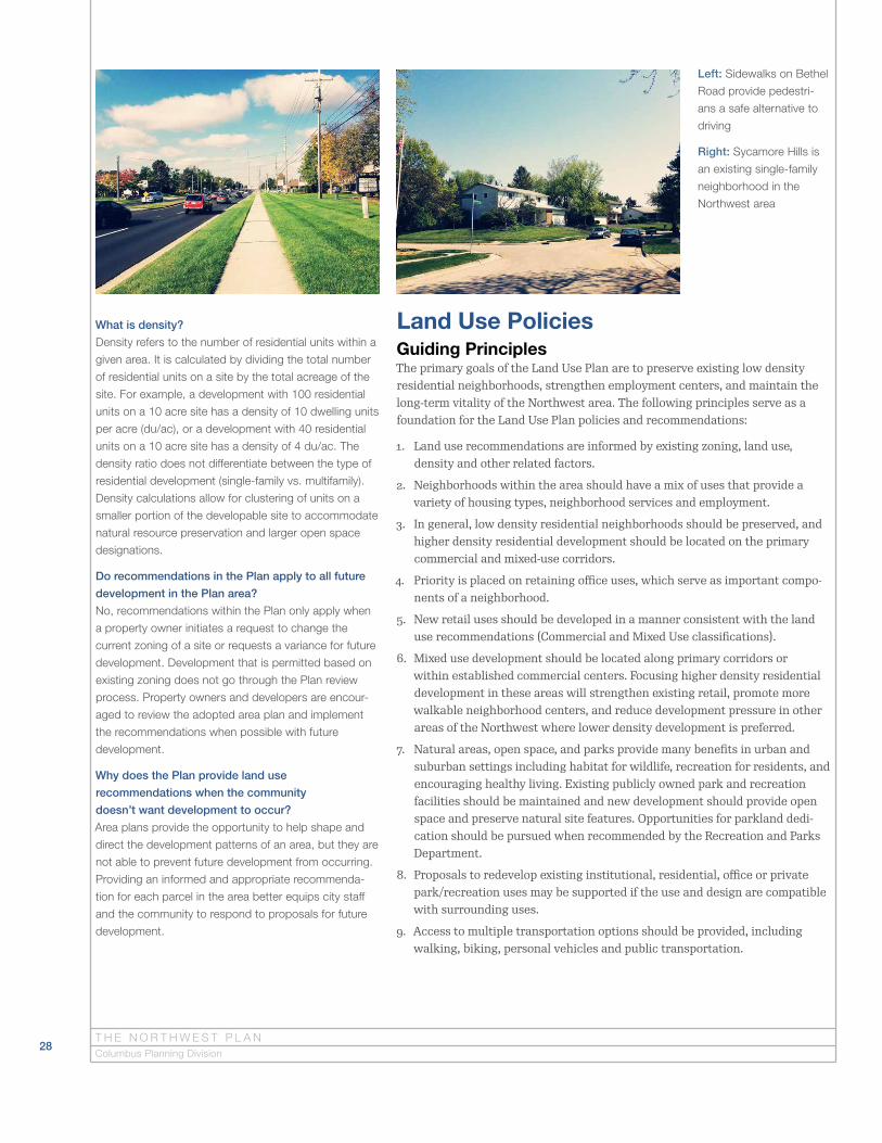
Left: Sidewalks on Bethel
Road provide pedestri-
ans a safe alternative to
driving
Right: Sycamore Hills is
an existing single-family
neighborhood in the
Northwest area

29
General Land Use PoliciesThe general land use policies apply to multiple land use classifications and are used to review development proposals when applicable. It is important to note that area plan recommendations are adopted as city policy, not code. The poli-cies do not replace the zoning code or apply to existing uses that are consistent with the zoning code or legally nonconforming.
1. Development proposals that require a zoning change or variance are reviewed for consistency with land use and density recommendations of the adopted plan.
2. Density is typically measured in terms of dwelling units per acre (i.e. “Gross Density”). The calculation includes the area of the entire site including inter-nal roads and vehicular circulation.
3. Density calculations allow for clustering of units on a smaller portion of the developable site to accommodate natural resource preservation and larger open space designations.
4. Recommendations of this plan do not apply to properties outside Columbus. Land use recommendations for areas that are currently not in Columbus are provided in the event they are annexed to the City in the future.
5. Requests for homebased daycare within residential areas should be reviewed per the State of Ohio standards. Columbus Planning does not consider requests for daycare in residential areas to be a change of use, and therefore does not comment on such requests.
R E C O M M E N D AT I O N S
The Lakes of Worthington is an example of cluster development
Land Use Policies

30
Low Density Residential, <4 du/acreLow density residential development is predominantly comprised of single-fam-ily homes at a density of less than 4 du/acre. This classification applies to the least intense residential portions of the planning area and includes existing low density residential neighborhoods, single-family homes on large lots, and areas of undeveloped land. A primary goal of the Land Use Plan is to preserve low density residential neighborhoods and guide infill development to be compat-ible with existing development patterns of the neighborhood. Within areas designated low density residential, the following applies:
1. Proposals should follow the Residential Design Guidelines.
2. Existing single-family homes on large lots and undeveloped lots are recom-mended for low density residential development in support of the Plan’s goal to preserve existing single-family neighborhoods. It is recognized that large lots and undeveloped lots, particularly those that are located along primary corridors, may be subject to development proposals inconsistent with the land use recommendation in terms of use and/or density. Alternative proposed uses and/or higher density proposals may merit support if they are compatible with adjacent development. In situations where a proposed use is inconsistent with the Low Density Residential recommendation, the following are to be considered:
a. Consideration of densities higher than the recommended land use may be appropriate in instances where more intense uses are present, such as higher density residential, manufacturing, or commercial. In these situations, the proposed net density (not including regulated floodway, floodplain or stream corridor protection zones) will be reviewed for compatibility with adjacent uses, potential impact on natural resources, and other factors.
b. New uses could include office, residential, institutional, recreation, and/or open space, depending on the scale and intensity relative to surrounding uses.
c. Proposals should follow the Design Guidelines for the proposed use.
T H E N O R T H W E S T P L A NColumbus Planning Division
A single-family neighborhood

31
Low-Medium Density Residential, 4–6 du/acreThis classification is similar to the Low Density Residential classification and includes single-family homes and limited amounts of multifamily housing developed at a density of 4–6 du/acre. The classification predominately applies to existing neighborhoods in the Northwest area including subdivisions located west of Sawmill Road, south of Bethel Road and north of Billingsley Road. Proposals should follow the Residential Design Guidelines.
Medium Density Residential, 6–10 du/acreMedium Density Residential is characterized by smaller lot, single-family homes, doubles, townhouses, and smaller scale multifamily housing developed at a density of 6–10 du/acre. In general, areas recommended for this designation are existing multifamily housing developments located on scattered sites throughout the Northwest area. Proposals should follow the Residential Design Guidelines.
Medium-High Density Residential, 10–16 du/acreThis classification is similar to the Medium Density Residential classifica-tion, but with somewhat higher densities. It is characterized by smaller lot, single-family homes, doubles, townhouses, and smaller scale multifamily hous-ing developed at a density of 10–16 du/acre. In general, areas recommended for this designation are existing multifamily housing developments located near Bethel and Henderson roads, the intersection of Sawmill and Hard roads, and to the north of SR 161. Proposals should follow the Residential Design Guidelines.
R E C O M M E N D AT I O N S
Wood Run Place Condominiums
Land Use Policies
32
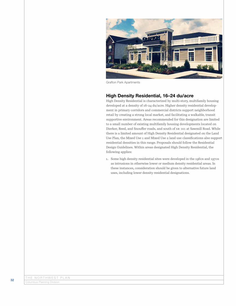
High Density Residential, 16–24 du/acreHigh Density Residential is characterized by multi-story, multifamily housing developed at a density of 16–24 du/acre. Higher density residential develop-ment in primary corridors and commercial districts support neighborhood retail by creating a strong local market, and facilitating a walkable, transit supportive environment. Areas recommended for this designation are limited to a small number of existing multifamily housing developments located on Dierker, Reed, and Snouffer roads, and south of SR 161 at Sawmill Road. While there is a limited amount of High Density Residential designated on the Land Use Plan, the Mixed Use 1 and Mixed Use 2 land use classifications also support residential densities in this range. Proposals should follow the Residential Design Guidelines. Within areas designated High Density Residential, the following applies:
1. Some high density residential sites were developed in the 1960s and 1970s as intrusions in otherwise lower or medium density residential areas. In these instances, consideration should be given to alternative future land uses, including lower density residential designations.
T H E N O R T H W E S T P L A NColumbus Planning Division
Grafton Park Apartments

33
Mixed Use 1, <24 du/acreThis classification supports a mix of land uses, including commercial (retail, office, hotel), institutional, and/or multifamily residential. Development may include a mix of uses on one site (for example, residential units located either above or next to the commercial uses) or only one use per site. Mixed Use 1 areas generally represent the smaller shopping corridors and neighborhood commercial hubs. These areas, in consideration of nearby residential areas, are appropriate for a mix of uses including residential densities less than 24 du per acre. Areas recommended for this designation include the Bethel Road corridor, Kenny Road south of Bethel Road, Sawmill Road south of Krier Road, SR 161 west of Linworth, Snouffer Road at Caine, and Olentangy Valley Center on Olentangy River Road. Within areas designated Mixed Use 1, the following applies:
1. The designation does not require a mix of uses, but instead promotes mixed use development where it is a viable development scenario.
2. For the area designated Mixed Use 1 located on the east side of Kenny Road between Weybridge Road and Bethel Road, the existing Manufacturing uses (M) are recognized and supported. Expansion of a manufacturing use in this area should be supported provided it is consistent with the Industrial and Warehouse classification policies and the Commercial Design Guidelines. Additional retail development is not supported in this area.
3. Proposals should follow the Residential and/or Commercial Design Guidelines, as appropriate.
R E C O M M E N D AT I O N S
The Lane in Upper Arlington is an example of infill mixed use development on a
commercial corridor (Retrieved from http://www.welcometothelane.com/progress/)
Land Use Policies
34
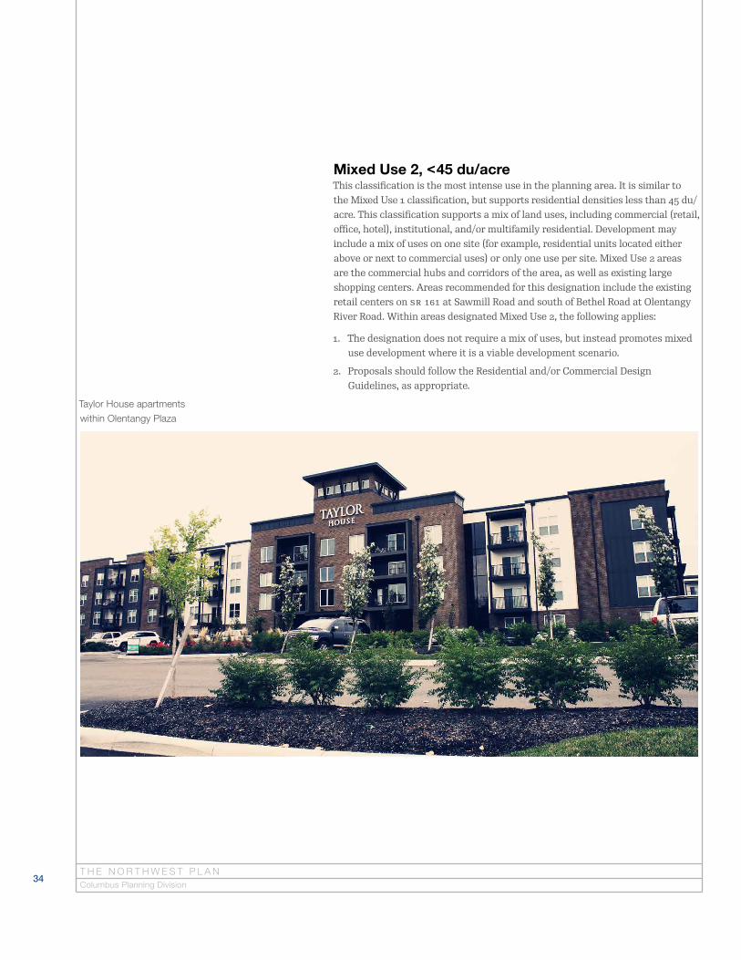
Mixed Use 2, <45 du/acreThis classification is the most intense use in the planning area. It is similar to the Mixed Use 1 classification, but supports residential densities less than 45 du/acre. This classification supports a mix of land uses, including commercial (retail, office, hotel), institutional, and/or multifamily residential. Development may include a mix of uses on one site (for example, residential units located either above or next to commercial uses) or only one use per site. Mixed Use 2 areas are the commercial hubs and corridors of the area, as well as existing large shopping centers. Areas recommended for this designation include the existing retail centers on SR 161 at Sawmill Road and south of Bethel Road at Olentangy River Road. Within areas designated Mixed Use 2, the following applies:
1. The designation does not require a mix of uses, but instead promotes mixed use development where it is a viable development scenario.
2. Proposals should follow the Residential and/or Commercial Design Guidelines, as appropriate.
T H E N O R T H W E S T P L A NColumbus Planning Division
Taylor House apartments
within Olentangy Plaza

35
Medical office building
CommercialThe Commercial classification includes retail, office, or institutional uses. Fuel service stations are also supported in this classification. Areas recommended for this designation are limited to existing commercial developments located on Sawmill Road, Smoky Row Road at Hard Road, Smoky Row Road at Smoky View, Bethel Road, and Henderson Road. Within areas designated Commercial, the following applies:
1. Retail, services, and office uses are important components of neighborhoods and should be clustered where possible for increased viability.
2. Neighborhood plans do not distinguish between types of retail proposals within the commercial land use recommendation.
3. Proposals should follow the Commercial Design Guidelines.
OfficeThe Office classification includes traditional office and medical office uses. Areas recommended for this designation include existing office uses generally located on Sawmill, Bethel, Henderson, and Olentangy River roads. Within areas designated Office, the following applies:
1. Office uses are important centers of employment in the city, and the mainte-nance of office uses is a priority for the City of Columbus.
2. Proposals should follow the Commercial Design Guidelines.
3. Proposals for alternative uses in areas designated for office are generally not supported. In situations where a proposed development is inconsistent with the Office land use recommendation, the following are to be considered:
a. The site is part of a larger development trend in the vicinity, or is other-wise isolated.
b. The site is part of a redevelopment that would better represent the high-est and best use of the parcel.
c. New uses could include residential, institutional, recreation, and/or open space. Retail uses are generally discouraged in existing office locations.
d. Proposals should follow the Design Guidelines for the proposed use.
R E C O M M E N D AT I O N S
Retail located near Sawmill and SR 161
Commercial office building
Land Use Policies
36
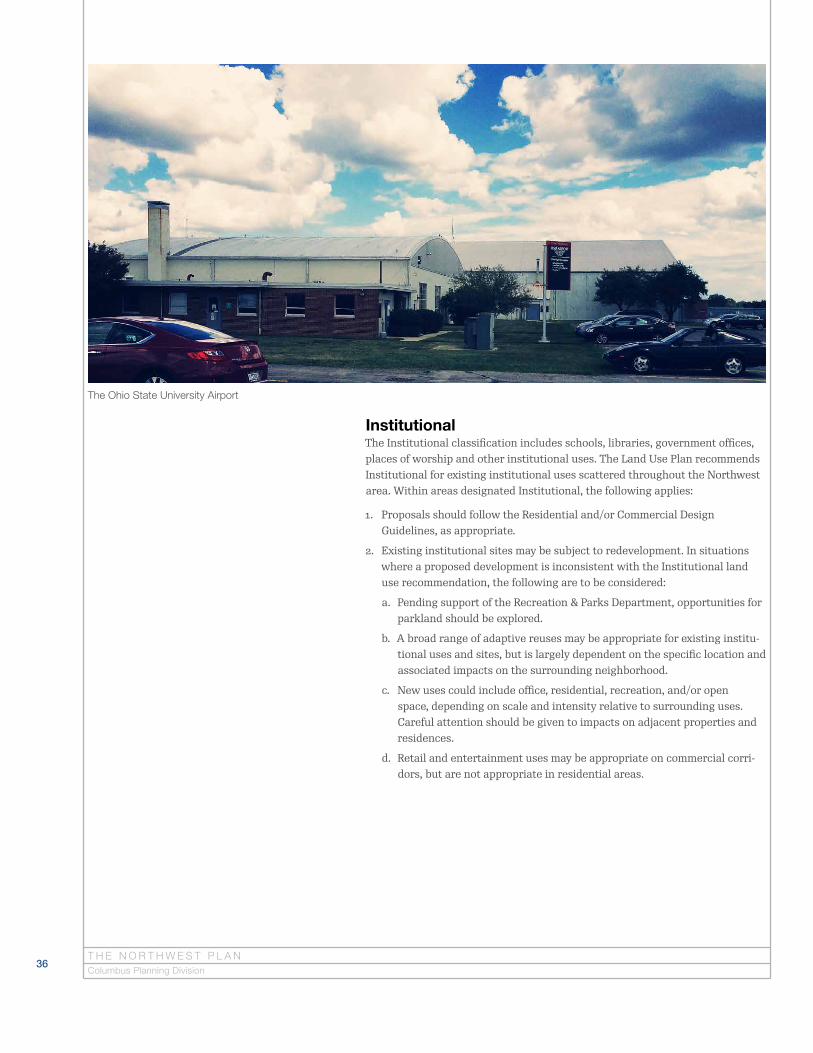
InstitutionalThe Institutional classification includes schools, libraries, government offices, places of worship and other institutional uses. The Land Use Plan recommends Institutional for existing institutional uses scattered throughout the Northwest area. Within areas designated Institutional, the following applies:
1. Proposals should follow the Residential and/or Commercial Design Guidelines, as appropriate.
2. Existing institutional sites may be subject to redevelopment. In situations where a proposed development is inconsistent with the Institutional land use recommendation, the following are to be considered:
a. Pending support of the Recreation & Parks Department, opportunities for parkland should be explored.
b. A broad range of adaptive reuses may be appropriate for existing institu-tional uses and sites, but is largely dependent on the specific location and associated impacts on the surrounding neighborhood.
c. New uses could include office, residential, recreation, and/or open space, depending on scale and intensity relative to surrounding uses. Careful attention should be given to impacts on adjacent properties and residences.
d. Retail and entertainment uses may be appropriate on commercial corri-dors, but are not appropriate in residential areas.
T H E N O R T H W E S T P L A NColumbus Planning Division
The Ohio State University Airport

37
Industrial & WarehouseThe Industrial and Warehouse classification is characterized by industrial, manufacturing, and warehouse uses. Industrial uses play an important role in employment and the economic vitality of the city. Areas recommended for this designation are primarily located on SR 161 and on Bethel Road east of the railroad tracks. Within areas designated Industrial and Warehouse, the following applies:
1. In general, industrial areas should be maintained and supported as job centers.
2. Industrial development should be designed to minimize or mitigate impacts on adjacent uses, especially residential uses, through such means as land-scaping, buffering and enhanced setbacks.
3. In general, building heights should be limited to 35 feet when located adja-cent to a residential area.
4. Less objectionable uses, including but not limited to, warehousing and distribution are preferred. Industrial uses (including types of manufacturing) that have health and environmental impacts must be carefully considered for impacts on the surrounding area.
5. Loading, storage, and other external activities that generate noise and other impacts should not face public rights-of-way or residential or institu-tional uses. In the event that this is not possible, such areas should be fully screened.
6. Proposals should follow applicable Commercial Design Guidelines.
R E C O M M E N D AT I O N S
Industrial site located west of the railroad tracks on Kenny Road
Land Use Policies
38
Parks & RecreationThe Parks and Recreation designation is for publicly owned park and recreation facilities. The Northwest Plan does not provide site specific recommendations for new parks. Instead, a list of strategies identified in the 2014 Columbus Recreation and Parks Master Plan, and a list of projects already identified in the Northwest Area by the Recreation and Parks Department have been docu-mented. Connectivity within and among development to parks and open space should be a design priority. Specific to the Northwest area, the Recreation and Parks Department has planned the following projects:
1. Olentangy Trail: Anheuser-Busch Sports Park Connector (Project start date To Be Determined)
2. Olentangy Trail: Wilson Bridge Road and SR 161 Connector (Project start date To Be Determined)
3. Park improvements: 3-acre park on Cranston Drive (Project start date To Be Determined)
Why doesn’t the Plan recommend areas for Open
Space or Parks?
Providing a land use recommendation of “Park” or
“Open Space” cannot prevent development of a site due
to property owners’ legal right to develop their property
in accordance with the zoning code. The Recreation
and Parks Department is responsible for park planning,
and therefore, it is not within the scope of the Plan to
provide recommendations for Parks or Open Space.
Open SpaceThe Open Space classification refers to natural areas that do not provide recreational facilities and includes areas with development restrictions, such as cemeteries, regulated floodway, and conservation holdings. Rights-of-way controlled by the city or other government bodies are not considered or desig-nated Open Space. Depiction of Open Space on the Recommended Land Use Map is limited to the following scenarios:
1. City and other public agency owned property designated for such use;
2. A conservation easement is in place; or
3. Acquisition is actively underway by a state or local agency, such as the Franklin Soil and Water Conservation District.
T H E N O R T H W E S T P L A NColumbus Planning Division
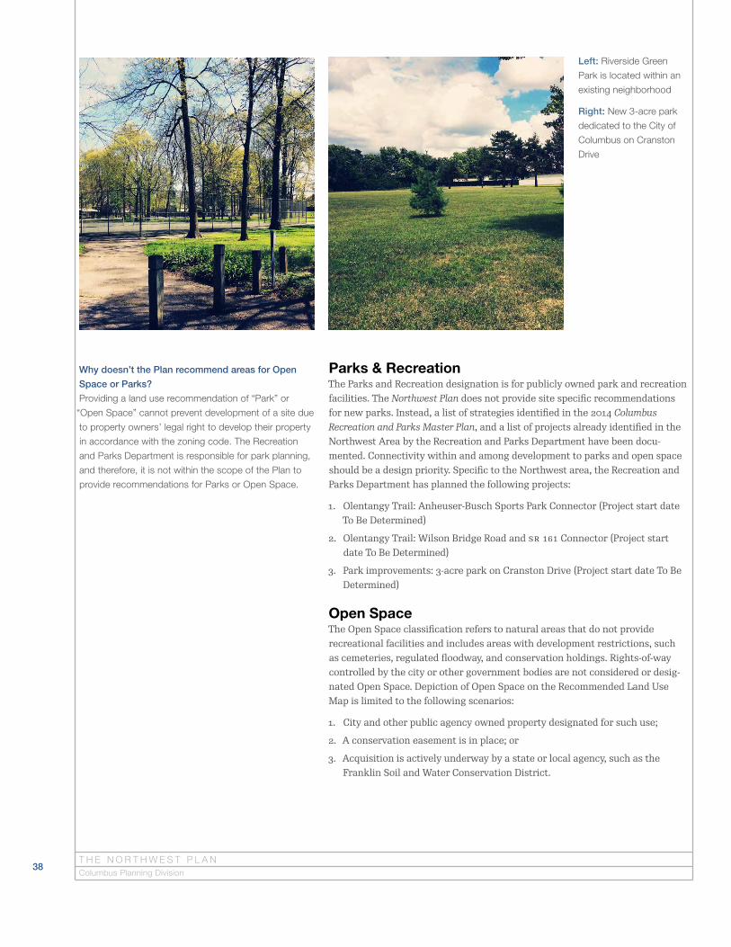
Left: Riverside Green
Park is located within an
existing neighborhood
Right: New 3-acre park
dedicated to the City of
Columbus on Cranston
Drive

39
Private Open SpaceThe Private Open Space classification is characterized by private golf courses and sports fields. It also includes dedicated open space within a development and open space owned by Home Owners Associations. Private Open Space serves to complement existing public parks and recreation facilities. Within areas designated Private Open Space, the following applies:
1. Existing private open space sites may be subject to redevelopment. In situations where a proposed development is inconsistent with the recom-mended land use, but mitigating circumstances merit the consideration of the proposal, the following are to be considered:
a. Pending support of the Recreation & Parks Department, opportunities for parkland should be explored.
b. A broad range of adaptive reuses may be appropriate for existing private open space uses and sites, but is largely dependent on the specific loca-tion and associated impacts on the surrounding neighborhood.
c. New uses could include office, education, housing, recreation, and/or open space, depending on scale and intensity relative to surrounding uses.
d. Retail and entertainment uses may be appropriate on commercial corri-dors, but not in residential neighborhoods.
e. Proposals should follow the Design Guidelines for the proposed use.
R E C O M M E N D AT I O N S
Brookside Golf and
Country Club
Land Use Policies

40T H E N O R T H W E S T P L A NColumbus Planning Division
Site Specific Recommendations (Sites A & B)In certain cases when a site has unique characteristics, a land use recommen-dation is tailored to the conditions of the given site. Two specific cases exist within the Northwest planning area and are described below.
Site A
Site A is located on the northwest corner of Henderson and Olentangy River roads. Office, institutional, medical and/or multifamily are recommended for this 20-acre site. Proposals should follow the Residential and/or Commercial Design Guidelines, as appropriate.
Site B
Site B consists of several large lot residential properties located on Riverside Drive in Perry Township. The recommendations of this plan do not apply to properties outside the city of Columbus, and the land use recommendation for Site B is provided in the event township property is annexed to the city in the future. The Plan supports the existing residential uses at this location. In the case that parcels in this site are annexed, office and residential uses would be appropriate. Refer to the Land Use Policies and Design Guidelines for additional standards regarding the redevelopment of Low Density Residential sites includ-ing text on buffering and open space.
Site A: Twenty-acre site located at the northwest corner of Henderson and Olentangy
River roads
Site B: Large residential lots located on Riverside Drive in Perry Township

41
The 2014 Columbus Recreation and Parks Master Plan provides overall recom-mendations for the City of Columbus in regards to parks and facilities, multi-use trails, blueways, aquatics, recreational centers, programs, and communica-tions. Planning areas covered in the 2014 Master Plan include Central, North, Southeast, In-Town, and Southwest Columbus. Several maps are included in the 2014 Recreation and Parks Master Plan to display and identify specific projects and ideas related to each planning area. For more information, the Plan can be found online at https://columbus.gov/2014MasterPlan/.
The North planning area, as designated in the 2014 Columbus Recreation and Parks Master Plan, covers over 63 square miles of the city of Columbus which includes the Northwest planning area. The following strategies were identified to improve the parks system in the North planning area:
• Update five Neighborhood Parks per year
• Update one Community Park per year
• Update and invest in revenue producing sports fields
• Continue to expand the multi-use trail network
• Make connections to neighborhoods and parks
• Investigate public/private partnerships to meet facility and program needs
• Strive to meet the benchmark of locating Neighborhood Parks within one-half mile of all neighborhoods. Given that some of these locations are in built-out, urban portions of the city and that land acquisition is not always achievable, strategies should be explored to make use of existing city-owned proper-ties and initiatives that could increase the total acreage and distribution of Neighborhood Parks
• Acquire enough land to meet recommended standards for all classifications of parkland; continue to work with neighborhood groups to improve and main-tain parks; remove access and circulation barriers to city parks
• Strategies for Neighborhood Parks
• Make acquiring land for Neighborhood Parks a high priority
• Make acquiring land for Community Parks a high priority
• Strategies for Multi-Use Trails
• Improve access to existing trails from surrounding neighborhoods, business districts and parks
• Strategies for Blueways
• Provide access for different types of watercraft, depending on locations
• Legitimize access, improve ease of use and promote blueways
• Develop educational programming related to river health, sustainability and the river ecosystem
• Install spray grounds in areas where there are gaps in service in the north-east and northwest parts of the city
R E C O M M E N D AT I O N SLand Use Policies
2014 Columbus Recreation And Parks Master Plan Summary

42T H E N O R T H W E S T P L A NColumbus Planning Division
Design GuidelinesThe Design Guidelines apply to new development proposals that require rezon-ing or variance requests, and are intended to provide property owners, tenants, and the design community with an understanding of design expectations for the area. While the guidelines include specific standards for design, they are intended to allow for flexibility in their application and are typically incorpo-rated into the design of a project during the review process or as a condition of approval. The guidelines are intended for use by the community and city staff in reviewing projects throughout the Northwest area.
It is important to note that the guidelines are not regulations and do not replace the zoning code and its legislatively adopted standards. The guidelines also do not replace regulations for traffic management, storm water and sewer management, or parkland dedication. These regulations are managed by the Department of Public Service, Department of Public Utilities, and the Recreation and Parks Department, respectively. Additionally, the guidelines do not replace FAA and State notification requirements for construction in the vicinity of airports. As required by the Ohio Administrative Code, a permit from the Ohio Department of Transportation Office of Aviation must be obtained prior to the start of any construction on or near airports in Ohio that are open to the public. Regulations regarding airports are managed by the FAA and Ohio Department of Transportation.
What are Design Guidelines?
Design Guidelines address the visual component of
development. The guidelines provide recommendations
for the size, placement, height and design of residential
and commercial development, as well as, connectivity,
open space and natural features.

43R E C O M M E N D AT I O N S
Design PrinciplesThe following design principles serve as a foundation for the Northwest Plan Design Guidelines:
1. New development should preserve and enhance the unique characteristics of the community.
2. High-quality development attracts business investment and promotes the economic vitality of commercial areas, while minimizing adverse impacts to adjacent residential neighborhoods.
3. Neighborhoods should have an interconnected street and sidewalk system providing connections to existing and future residential, commercial, and recreational areas.
4. Site design should highlight natural features and open space. Opportunities for parkland dedication should be pursued when supported by the Recreation and Parks Department.
5. Parking should be balanced with the goal of reducing development’s impact on the natural environment, as well as the goal of creating walkable and bikeable neighborhoods and encouraging the use of transit.
Natural features can serve as an integral component to
developmentTrees and landscaping enhance streets and community character
Design Guidelines

44T H E N O R T H W E S T P L A NColumbus Planning Division
Residential Design Guidelines
1. GENERAL
a. Sensitive site design, cluster development and other design approaches should be used to preserve open space, natural resources, and other ecologically sensitive areas.
b. Building materials should be of high quality and durability, such as tradi-tional masonry, stone, stucco, cedar, etc.
c. Windows and doors should constitute no less than 20 percent of the building’s front facade.
d. Development adjacent to parkland should be oriented in such a way that it faces the park (houses should not back up to parkland).
e. Lights should have fully shielded, recessed lamps directed downward to prevent glare and shine above the horizontal plane.
f. Building owners/developers are encouraged to conserve and rehabilitate historic buildings and architectural elements and to consult the Historic Preservation Office regarding best practices in maintaining and rehabili-tating historic structures.
2. SINGLE AND TWO FAMILY
a. New single and two-family housing should be oriented to the street and reflect the prevailing setback and spacing of nearby homes, as appropriate.
b. Front porches are encouraged.
c. Garages facing front elevations should not exceed 40 percent of the home's width (including the garage) and be set back at least two feet from the front elevation.
d. Accessory buildings (including, but not limited to, detached garages) should be located to the rear of the principal building.
e. The scale and proportion of additions should be compatible with the principal and nearby structures.
Top Left: Historic farmhouse on Dierker Road
Top Right: Single-family home with side facing garage
45R E C O M M E N D AT I O N S
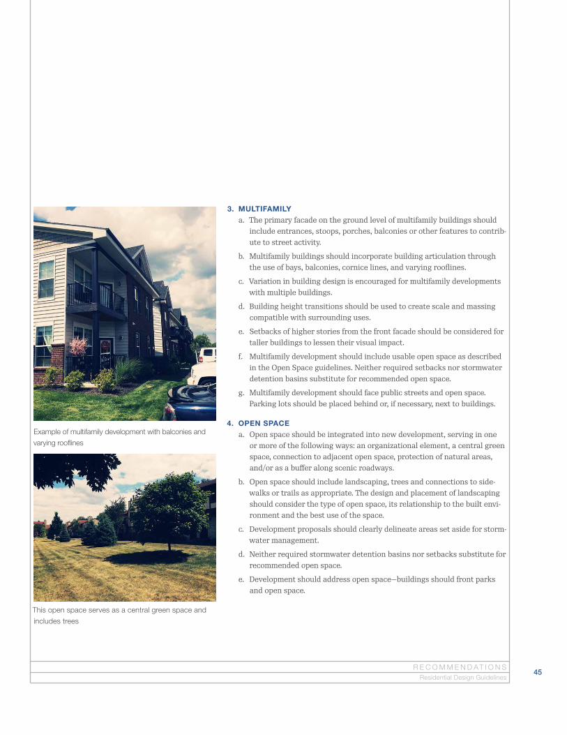
3. MULTIFAMILY
a. The primary facade on the ground level of multifamily buildings should include entrances, stoops, porches, balconies or other features to contrib-ute to street activity.
b. Multifamily buildings should incorporate building articulation through the use of bays, balconies, cornice lines, and varying rooflines.
c. Variation in building design is encouraged for multifamily developments with multiple buildings.
d. Building height transitions should be used to create scale and massing compatible with surrounding uses.
e. Setbacks of higher stories from the front facade should be considered for taller buildings to lessen their visual impact.
f. Multifamily development should include usable open space as described in the Open Space guidelines. Neither required setbacks nor stormwater detention basins substitute for recommended open space.
g. Multifamily development should face public streets and open space. Parking lots should be placed behind or, if necessary, next to buildings.
4. OPEN SPACE
a. Open space should be integrated into new development, serving in one or more of the following ways: an organizational element, a central green space, connection to adjacent open space, protection of natural areas, and/or as a buffer along scenic roadways.
b. Open space should include landscaping, trees and connections to side-walks or trails as appropriate. The design and placement of landscaping should consider the type of open space, its relationship to the built envi-ronment and the best use of the space.
c. Development proposals should clearly delineate areas set aside for storm-water management.
d. Neither required stormwater detention basins nor setbacks substitute for recommended open space.
e. Development should address open space—buildings should front parks and open space.
Example of multifamily development with balconies and
varying rooflines
This open space serves as a central green space and
includes trees
Residential Design Guidelines

46T H E N O R T H W E S T P L A NColumbus Planning Division
5. PARKING
a. Requests for parking reductions, including those beyond that provided by any applicable overlay provisions, will be considered based on:
• the presence of on-street parking,
• mixed use development pattern of surrounding area,
• pedestrian accessibility,
• access to transit,
• extent of variance requested,
• size and nature of use,
• potential impact on adjacent residential uses, and
• provision of pedestrian and bicycle facilities beyond that required by code.
b. Shared parking arrangements are encouraged, particularly between land uses with differing peak hours.
c. The use of green technologies to manage stormwater runoff in parking lots, subject to city engineering requirements, is encouraged. Examples include rain gardens, bio-swales and pervious pavement.
d. Bicycle parking should be incorporated into development projects as required by code. Additional consideration should also be given to including supporting facilities in multifamily, office and mixed use developments.
e. Structured parking, designed to minimize visual impacts and buffered from adjacent residential, should be considered for high density residen-tial, mixed use, office, or institutional projects.
f. Parking structures should not front primary corridors, but should instead be placed at the rear of development.
Bike lanes and sidewalks provide connectivity
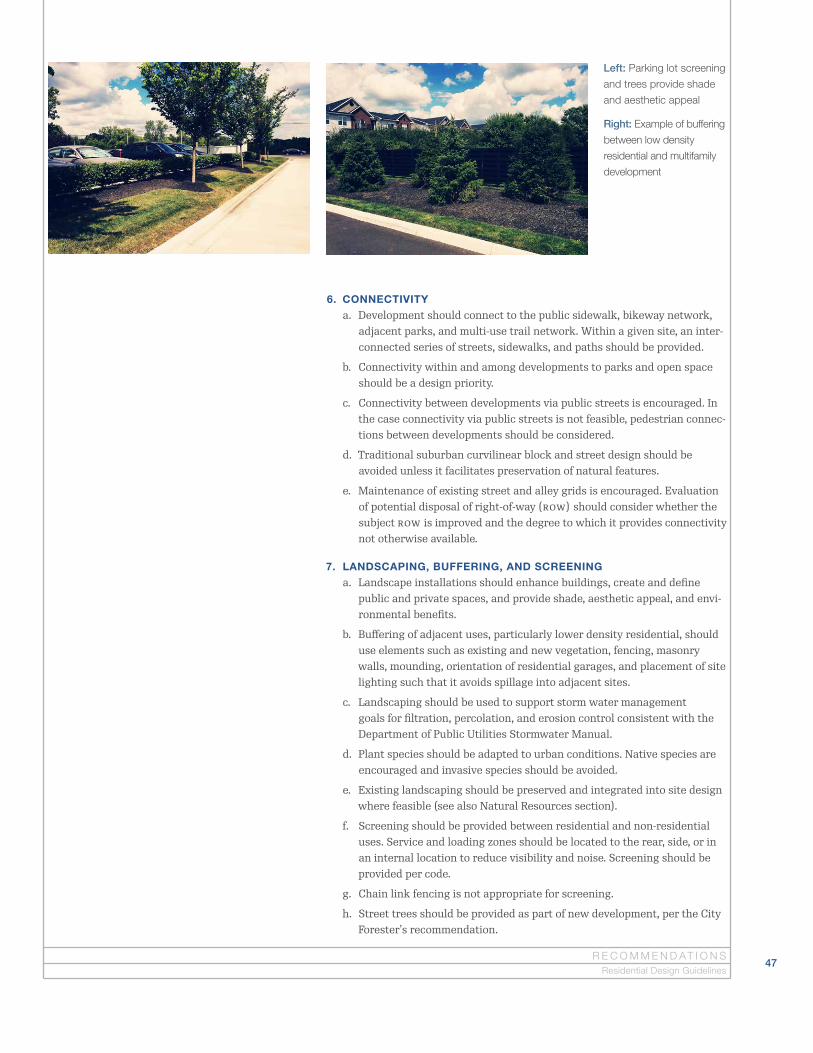
47R E C O M M E N D AT I O N S
Residential Design Guidelines
6. CONNECTIVITY
a. Development should connect to the public sidewalk, bikeway network, adjacent parks, and multi-use trail network. Within a given site, an inter-connected series of streets, sidewalks, and paths should be provided.
b. Connectivity within and among developments to parks and open space should be a design priority.
c. Connectivity between developments via public streets is encouraged. In the case connectivity via public streets is not feasible, pedestrian connec-tions between developments should be considered.
d. Traditional suburban curvilinear block and street design should be avoided unless it facilitates preservation of natural features.
e. Maintenance of existing street and alley grids is encouraged. Evaluation of potential disposal of right-of-way (ROW) should consider whether the subject ROW is improved and the degree to which it provides connectivity not otherwise available.
7. LANDSCAPING, BUFFERING, AND SCREENING
a. Landscape installations should enhance buildings, create and define public and private spaces, and provide shade, aesthetic appeal, and envi-ronmental benefits.
b. Buffering of adjacent uses, particularly lower density residential, should use elements such as existing and new vegetation, fencing, masonry walls, mounding, orientation of residential garages, and placement of site lighting such that it avoids spillage into adjacent sites.
c. Landscaping should be used to support storm water management goals for filtration, percolation, and erosion control consistent with the Department of Public Utilities Stormwater Manual.
d. Plant species should be adapted to urban conditions. Native species are encouraged and invasive species should be avoided.
e. Existing landscaping should be preserved and integrated into site design where feasible (see also Natural Resources section).
f. Screening should be provided between residential and non-residential uses. Service and loading zones should be located to the rear, side, or in an internal location to reduce visibility and noise. Screening should be provided per code.
g. Chain link fencing is not appropriate for screening.
h. Street trees should be provided as part of new development, per the City Forester’s recommendation.
Left: Parking lot screening
and trees provide shade
and aesthetic appeal
Right: Example of buffering
between low density
residential and multifamily
development

48T H E N O R T H W E S T P L A NColumbus Planning Division
8. NATURAL RESOURCES
a. Development should be appropriately sited to conserve natural features as integral components of development or as part of public or private park and recreation systems.
b. Protected natural areas should be clearly delineated from development to prevent encroachment, particularly in the case of single-family homes (e.g. split-rail fencing and bollards).
c. Stream corridors, wetlands, ravines and the 100-year floodplain should be protected in a natural state (more specific methodology is found in the Department of Public Utilities Stormwater Manual).
d. Mature trees provide significant environmental benefits and should be preserved whenever possible. Tree preservation measures should be density neutral.
e. Alternative “green” methods to manage stormwater should be considered (i.e. bio-swales, vegetated swales, native landscaping, naturalized detention and retention basins, pervious surfaces), consistent with Department of Public Utilities Stormwater Manual.
9. PUBLIC AND PRIVATE ART
a. Art placed on city property or within public right-of-way must be approved by and meet the evaluation criteria of the Columbus Art Commission, as provided in City Code.
b. Existing art incorporated into structures should be conserved where feasible.
c. Integration of art in larger development projects is encouraged, as is placement of art in public spaces, such as plazas.
d. Works of art should be designed with consideration to maintenance and durability.
Streams should be protected in a natural state

49R E C O M M E N D AT I O N S
Commercial Design Guidelines
1. GENERAL
a. Buildings should be generally parallel to and facing the street, with an entrance door(s) connected to the public sidewalk. A pedestrian area should be delineated through any parking lot and provide connection to the public sidewalk.
b. A consistent level of detailing and finish should be provided for all sides of a building, allowing for service areas.
c. Building materials should be of high quality and durability, such as tradi-tional masonry, stone, stucco, cedar, etc.
d. Buildings should be articulated by dividing façades into modules or bays, use of piers and columns, recessed and projecting bays, varying rooflines and building setback above cornice line as appropriate.
e. Drive-through pickup windows and coverings should be located to the rear or side of the principal building.
f. Awnings and associated framing systems should be compatible with building design.
g. For multistory buildings, ground floor uses should address and contribute to the street. This can be accomplished through such design elements as door entries, windows, and landscaping.
h. Lights should have fully shielded, recessed lamps directed downward to prevent glare and shine above the horizontal plane.
i. Building owners/developers are encouraged to conserve and rehabilitate historic buildings and architectural elements and to consult the Historic Preservation Office regarding best practices in maintaining and rehabili-tating historic structures.
Best practices include facing buildings parallel to the street and using high quality
building materials
Commercial Design Guidelines
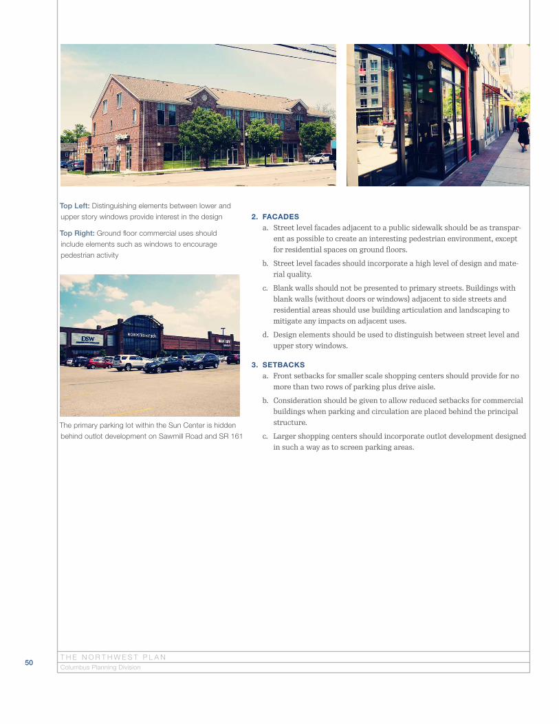
50T H E N O R T H W E S T P L A NColumbus Planning Division
2. FACADES
a. Street level facades adjacent to a public sidewalk should be as transpar-ent as possible to create an interesting pedestrian environment, except for residential spaces on ground floors.
b. Street level facades should incorporate a high level of design and mate-rial quality.
c. Blank walls should not be presented to primary streets. Buildings with blank walls (without doors or windows) adjacent to side streets and residential areas should use building articulation and landscaping to mitigate any impacts on adjacent uses.
d. Design elements should be used to distinguish between street level and upper story windows.
3. SETBACKS
a. Front setbacks for smaller scale shopping centers should provide for no more than two rows of parking plus drive aisle.
b. Consideration should be given to allow reduced setbacks for commercial buildings when parking and circulation are placed behind the principal structure.
c. Larger shopping centers should incorporate outlot development designed in such a way as to screen parking areas.
Top Left: Distinguishing elements between lower and
upper story windows provide interest in the design
Top Right: Ground floor commercial uses should
include elements such as windows to encourage
pedestrian activity
The primary parking lot within the Sun Center is hidden
behind outlot development on Sawmill Road and SR 161

51R E C O M M E N D AT I O N S
4. HEIGHT
a. Support for buildings that require a height variance should be based on such factors as the site size and situation, adjacent uses, quality of archi-tectural design and materials, and parking provision.
b. Building height transitions should be used to create scale and massing compatible with surrounding uses.
c. The use of a setback from the front facade for higher stories or other design strategies should be considered to lessen the visual impact of taller buildings.
5. OPEN SPACE
a. Open space should be integrated into new development, serving in one or more of the following ways: an organizational element, a central green space, connection to adjacent open space, protection of natural areas, and/or as a buffer along scenic roadways.
b. Open space should include landscaping, trees and connections to side-walks or trails as appropriate. The design and placement of landscaping should consider the type of open space, its relationship to the built envi-ronment and the best use of the space.
c. Development proposals should clearly delineate areas set aside for storm-water management.
d. Neither required stormwater detention basins nor setbacks substitute for recommended open space.
e. Development should address open space—buildings should front parks and open space.
Open space can provide opportunities for a community garden
Commercial Design Guidelines
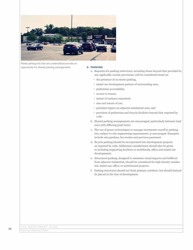
52T H E N O R T H W E S T P L A NColumbus Planning Division
6. PARKING
a. Requests for parking reductions, including those beyond that provided by any applicable overlay provisions, will be considered based on:
• the presence of on-street parking,
• mixed use development pattern of surrounding area,
• pedestrian accessibility,
• access to transit,
• extent of variance requested,
• size and nature of use,
• potential impact on adjacent residential uses, and
• provision of pedestrian and bicycle facilities beyond that required by code.
b. Shared parking arrangements are encouraged, particularly between land uses with differing peak hours.
c. The use of green technologies to manage stormwater runoff in parking lots, subject to city engineering requirements, is encouraged. Examples include rain gardens, bio-swales and pervious pavement.
d. Bicycle parking should be incorporated into development projects as required by code. Additional consideration should also be given to including supporting facilities in multifamily, office and mixed use developments.
e. Structured parking, designed to minimize visual impacts and buffered from adjacent residential, should be considered for high density residen-tial, mixed use, office, or institutional projects.
f. Parking structures should not front primary corridors, but should instead be placed at the rear of development.
Retail parking lots that are underutilized provide an
opportunity for shared parking arrangements
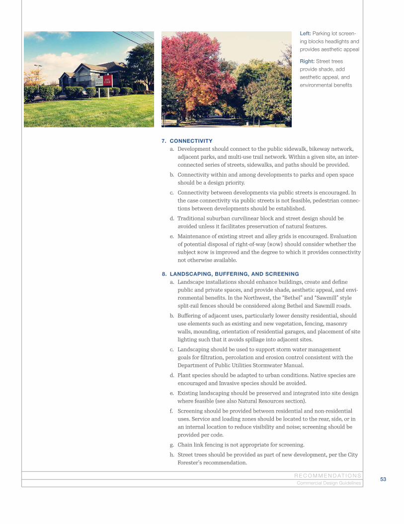
53R E C O M M E N D AT I O N S
Left: Parking lot screen-
ing blocks headlights and
provides aesthetic appeal
Right: Street trees
provide shade, add
aesthetic appeal, and
environmental benefits
Commercial Design Guidelines
7. CONNECTIVITY
a. Development should connect to the public sidewalk, bikeway network, adjacent parks, and multi-use trail network. Within a given site, an inter-connected series of streets, sidewalks, and paths should be provided.
b. Connectivity within and among developments to parks and open space should be a design priority.
c. Connectivity between developments via public streets is encouraged. In the case connectivity via public streets is not feasible, pedestrian connec-tions between developments should be established.
d. Traditional suburban curvilinear block and street design should be avoided unless it facilitates preservation of natural features.
e. Maintenance of existing street and alley grids is encouraged. Evaluation of potential disposal of right-of-way (ROW) should consider whether the subject ROW is improved and the degree to which it provides connectivity not otherwise available.
8. LANDSCAPING, BUFFERING, AND SCREENING
a. Landscape installations should enhance buildings, create and define public and private spaces, and provide shade, aesthetic appeal, and envi-ronmental benefits. In the Northwest, the “Bethel” and “Sawmill” style split-rail fences should be considered along Bethel and Sawmill roads.
b. Buffering of adjacent uses, particularly lower density residential, should use elements such as existing and new vegetation, fencing, masonry walls, mounding, orientation of residential garages, and placement of site lighting such that it avoids spillage into adjacent sites.
c. Landscaping should be used to support storm water management goals for filtration, percolation and erosion control consistent with the Department of Public Utilities Stormwater Manual.
d. Plant species should be adapted to urban conditions. Native species are encouraged and Invasive species should be avoided.
e. Existing landscaping should be preserved and integrated into site design where feasible (see also Natural Resources section).
f. Screening should be provided between residential and non-residential uses. Service and loading zones should be located to the rear, side, or in an internal location to reduce visibility and noise; screening should be provided per code.
g. Chain link fencing is not appropriate for screening.
h. Street trees should be provided as part of new development, per the City Forester’s recommendation.
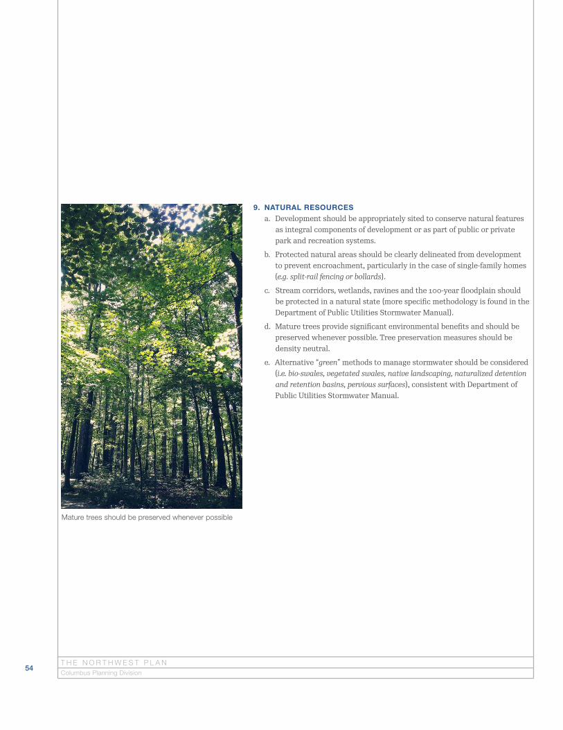
54T H E N O R T H W E S T P L A NColumbus Planning Division
9. NATURAL RESOURCES
a. Development should be appropriately sited to conserve natural features as integral components of development or as part of public or private park and recreation systems.
b. Protected natural areas should be clearly delineated from development to prevent encroachment, particularly in the case of single-family homes (e.g. split-rail fencing or bollards).
c. Stream corridors, wetlands, ravines and the 100-year floodplain should be protected in a natural state (more specific methodology is found in the Department of Public Utilities Stormwater Manual).
d. Mature trees provide significant environmental benefits and should be preserved whenever possible. Tree preservation measures should be density neutral.
e. Alternative “green” methods to manage stormwater should be considered (i.e. bio-swales, vegetated swales, native landscaping, naturalized detention and retention basins, pervious surfaces), consistent with Department of Public Utilities Stormwater Manual.
Mature trees should be preserved whenever possible

55R E C O M M E N D AT I O N S
10. PUBLIC AND PRIVATE ART
a. Art placed on city property or within public right-of-way must be approved by and meet the evaluation criteria of the Columbus Art Commission, as provided in City Code.
b. Existing art incorporated into structures should be conserved where feasible.
c. Integration of art in larger development projects is encouraged, as is placement of art in public spaces, such as plazas.
d. Works of art should be designed with consideration to maintenance and durability.
11. GRAPHICS
a. Signage should be oriented to both pedestrians and vehicles. Monument style signs are recommended and should not be taller than six feet.
b. Wall signs should not obscure or interfere with architectural lines and details and should be sized to fit in with the building’s facade design.
c. New signage should be designed to be a logical and complementary component of the overall design of a storefront.
d. Buildings should not be dominated by graphics. Crowded or cluttered graphics arrangements should be avoided.
e. Signs for storefronts/businesses in the same building/development should be of coordinated design—reinforcing rather than competing with each other.
f. Large commercial developments should utilize integrated signage, with an emphasis on wall signs and central identification signage for the entire development, rather than multiple freestanding signs.
g. Excessively large signs are discouraged.
h. Some types of signs are generally discouraged (or otherwise prohibited in city code), including ad murals, off-premises signs, billboards, signs with flashing lights or bare bulbs, co-op signs, rotating signs, pole signs, automatic changeable copy signs, bench signs, and roof-mounted signs.
Pole signs are generally discouraged
A business with a wall style sign located on Sawmill Road
Commercial Design Guidelines

56T H E N O R T H W E S T P L A NColumbus Planning Division
Development Review Checklist
The development review checklist may be used by the community to review
development proposals for consistency with plan recommendations.

57D E V E L O P M E N T R E V I E W C H E C K L I S T
Development Review ChecklistThe development review checklist is a summary of the development guidelines and recommendations found in the Plan. It is designed for stakeholders to review development proposals that require a rezoning or variance for consis-tency with plan provisions. Guidelines from the Plan are not city code, but as part of a city-adopted plan they serve as city policy. This provides a basis for stakeholders to review development proposals and request the guidelines are considered and included in a proposed development.
While using the checklist, stakeholders should reference the full plan descrip-tion of each element being reviewed. The checklist is not intended to provide a full description of plan recommendations and should be used as a guide in the review process. Additionally, nothing in the checklist is intended to speak to the development proposal’s conformance with other city code requirements and policies.
Recommendations regarding the use of the development review checklist include:
1. Applicants requesting a rezoning and/or variance are encouraged to review the development review checklist and incorporate the Plan’s recommenda-tions in their proposal.
2. The Northwest Civic Association, Far Northwest Coalition, and other stake-holders are encouraged to use the checklist to evaluate development propos-als in their respective areas.
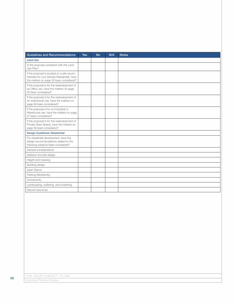
58
Guidelines and Recommendations Yes No N/A Notes
Land Use
Is the proposal consistent with the Land Use Plan?
If the proposal is located on a site recom-mended for Low Density Residential, have the matters on page 30 been considered?
If the proposal is for the redevelopment of an Office use, have the matters on page 35 been considered?
If the proposal is for the redevelopment of an Institutional use, have the matters on page 36 been considered?
If the proposal is for an Industrial or Warehouse use, have the matters on page 37 been considered?
If the proposal is for the redevelopment of Private Open Space, have the matters on page 39 been considered?
Design Guidelines: Residential
For residential development, have the design recommendations related to the following subjects been considered?
General considerations
Setback and site design
Height and massing
Building design
Open Space
Parking (Multifamily)
Connectivity
Landscaping, buffering, and screening
Natural resources
T H E N O R T H W E S T P L A NColumbus Planning Division

59
Guidelines and Recommendations Yes No N/A Notes
Design Guidelines: Commercial
For commercial, mixed use, office and industrial development, have the design recommendations related to the following subjects been considered?
General considerations
Building orientation
Building design
Building facades
Building setbacks
Building height
Open Space
Parking
Connectivity
Landscaping, buffering, and screening
Natural resources
Mixed uses
Design Guidelines: Graphics
Regarding graphics, have the design recommendations related to the following subjects been considered?
Sign style (ground, wall, etc.)
Signage integrated into architecture and site design
Public Art
Regarding public and private art, have the recommendations on page 48 or 55 been considered?
D E V E L O P M E N T R E V I E W C H E C K L I S T