Embed Size (px)
Citation preview

Grade 5- Michigan Colonial America
Jeremiah May – Port Huron High School Page 1 of 9 Wayne County RESA - Library of Congress Grant July 26, 2010
The New Orleans Impact
Lesson Abstract: (summary of main points) Students will analyze and compare a historic map and current map of New Orleans. They will learn of a couple historic places still in existence in the French Quarter of New Orleans. Content Expectations or Standards National Geography Standards Standard 1. How to use maps and other geographic representations, tools, and technologies to acquire, process, and report information from a spatial perspective. Integrated GLCEs U1 USHG ERA 1 – Beginnings to 1620 5 – U1.4.1 Describe the convergence of Europeans, American Indians and Africans in North America after 1492 from the perspective of these three groups. (National Geography Standard 10, p. 162) 5 – U1.4.2 Use primary and secondary sources (e.g., letters, diaries, maps, documents, narratives, pictures, graphic data) to compare Europeans and American Indians who converged in the western hemisphere after 1492 with respect to governmental structure, and views on property ownership and land use. (National Geography Standard 12, p. 167, C, E) Key Concept(s)
• New Orleans was a planned city with a practical layout. • The original street names can still be seen today. • Maps can tell us much about the culture and priorities of these founders.
Instructional Resources
1. Map of New Orleans 1722 – http://hdl.loc.gov/loc.gmd/g4014n.lh000960 2. Map of New Orleans 1764 – http://hdl.loc.gov/loc.gmd/g4014n.ct001039 3. Jackson Square – http://hdl.loc.gov/loc.award/mhsalad.250104 4. Ursuline Academy – http://hdl.loc.gov/loc.pnp/det.4a23702 5. Current Map of the French Quarter in New Orleans – google maps 6. Detroit 1763 - http://www.historydetroit.com/pics/old_map_1763_bellins.jpg
Big Ideas of the Lesson
• The French settlers in New Orleans have a had a lasting impact.
Grade 5- Michigan Colonial America
Jeremiah May – Port Huron High School Page 2 of 9 Wayne County RESA - Library of Congress Grant July 26, 2010
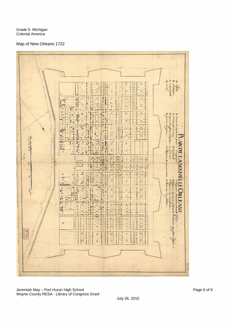
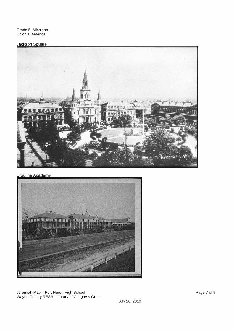
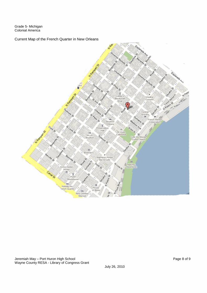
Lesson Sequence 1. Pass out the 1764 map. Explain to the students that this map is made in France right around the time when New Orleans was given to Spain in a treaty. Give them 5 minutes to examine the map. Then ask them to give details of what they see and any guesses on what some of the locations on the map. 2. Project or pass out a copy of the image of Jackson Square. Ask the students to look at this picture and try and guess what type of building it might be. Then ask them to try and find it on the map. Use symbols to help you locate it. - Early New Orleans was originally centered on what was then called the Place d' Armes (have this title on the board). Place d' Armes roughly means Place of Arms. Located and outline this place on the map. After the Battle of New Orleans, in 1814, the Place d' Armes was renamed Jackson Square after general Andrew Jackson. In the center of the park stands a Jackson. 3. Project or pass out a copy of the image of the Ursuline Academy. Tell them the name of the place and then to look for words in the key that might sounds like the name. Then locate the Ursuline Academy. (answer: letter s.- House of the Ursulines) 4. Project or pass out a copy of the present day French Quarter in New Orleans. Ask the students to locate the labels for the Quay. A quay (pronounced "key"), is a structure on the shore of a harbor where ships may dock to load and unload cargo or passengers. Look at the current map. Where would the quay be today? (Students should notice that the shoreline has either moved or the map was drawn to scale when drawing the quay). Read: In the 1600's, France began establishing forts at strategic locations in North America, in order to try to keep the British from moving west out of New England and to establish a monopoly on trade. New Orleans still has reflections of its French heritage. Founded as a military-style grid of seventy squares in 1718 by French Canadian naval officer Jean Baptiste Bienville. Locate the road named after this founder.
Grade 5- Michigan Colonial America
Jeremiah May – Port Huron High School Page 3 of 9 Wayne County RESA - Library of Congress Grant July 26, 2010
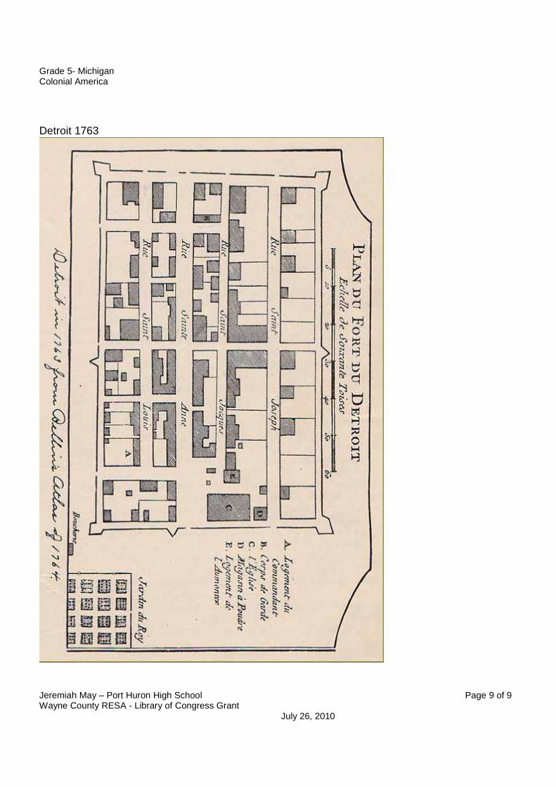
Assessment 1. Have the students compare the street names between the two maps. Ask them to name three changes in street names between the two maps and give one reason why they think these changes happened. Examples: 1. Decatur Street: named after Stephen Decatur (an American hero from the War of 1812) formerly known as "Levee Street" (a levee keeps water from flooding in the streets). 2. Aresenal Street change to Ursiline street. In the 1722 map (included) you can notice that the original spot for the arsenal was in the same block as where the House of the Ursulines is located on the 1764 map. 3. St Louis and Conti are switched places between the two. 2. Pass out the Detroit 1763 map. Instruct the students to find three similarities and three differences between the Detroit 1763 map and the New Orleans 1764 map. Possible answers should include: Similarities
1. Road names 2. Grid layout 3. Building types such as church
Differences
1. size 2. building placement
Grade 5- Michigan Colonial America
Jeremiah May – Port Huron High School Page 4 of 9 Wayne County RESA - Library of Congress Grant July 26, 2010
Extensions Have the students compare the maps of 1722 and 1764. Directions:
1. Name three buildings that are in the same place on both maps. 2. Name three buildings that are on both maps, but are in different places. 3. Name two differences between the maps.
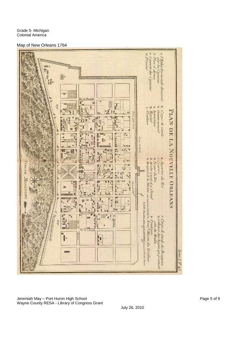
Key New Orleans 1722
1. Eglise / church 2. Presbitaire / presbytery (rectory, the priests' residence) 3. Corps de garde / guardhouse 4. Prison / prison 5. Maison de Commandant gen'al / residence of the military commander 6. Maisons des Directeurs / residences of the directors of the colony 7. Logements des officiers et major de la Place / officers' quarters and the town commander (mayor) 8. Grand magazin qui n'est pas tout à fait achevé / the great magazine (ammunition storage facility) that has not yet been
built 9. Magazin / magazine 10. Hopital / hospital 11. Arcenal / arsenal 12. Cazerne des Ouvriers Suisses / Swiss laborers' barracks 13. Cazerne des Ouvriers Allemands / German laborers' barracks 14. Cazerne des Ouvriers Francois / French laborers' barracks 15. Caserne des Ouvriers Menuifiers / carpenters' barracks 16. Casernes de Soldats / soldiers' barracks 17. Forge / forge 18. Maison qui sert d'Eglise / House which is serving as a church
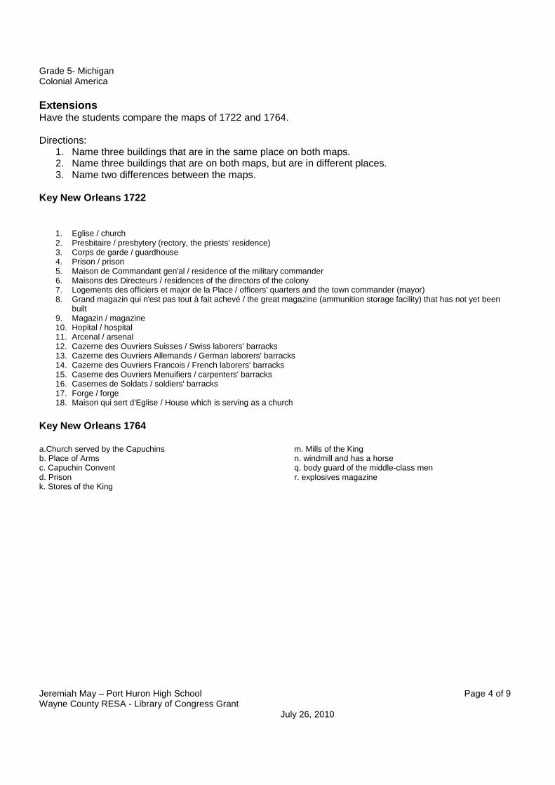
Key New Orleans 1764
a.Church served by the Capuchins b. Place of Arms c. Capuchin Convent d. Prison k. Stores of the King
m. Mills of the King n. windmill and has a horse q. body guard of the middle-class men r. explosives magazine
Grade 5- Michigan Colonial America
Jeremiah May – Port Huron High School Page 5 of 9 Wayne County RESA - Library of Congress Grant July 26, 2010
Map of New Orleans 1764
Grade 5- Michigan Colonial America
Jeremiah May – Port Huron High School Page 6 of 9 Wayne County RESA - Library of Congress Grant July 26, 2010
Map of New Orleans 1722
Grade 5- Michigan Colonial America
Jeremiah May – Port Huron High School Page 7 of 9 Wayne County RESA - Library of Congress Grant July 26, 2010
Jackson Square
Ursuline Academy
Grade 5- Michigan Colonial America
Jeremiah May – Port Huron High School Page 8 of 9 Wayne County RESA - Library of Congress Grant July 26, 2010
Current Map of the French Quarter in New Orleans
Grade 5- Michigan Colonial America
Jeremiah May – Port Huron High School Page 9 of 9 Wayne County RESA - Library of Congress Grant July 26, 2010
Detroit 1763