1
Mungo N.P. Mallee Cliffs N.P. Kinchega N.P. Murray Sunset N.P. Hattah-Kulkyne N.P. Wyperfeld N.P. Billiat Conservation Park Murray River N.P. Little Desert N.P. Grampians N.P. Kinglake N.P. Lake Eildon N.P. Alpine N.P. Maragle State Forest Namadgi N.P. Brindabella N.P. Tinderry Nature Reserve Alpine N.P. Kosciuszko N.P. Yathong State Forest Goobang N.P. Gundabooka N.P. Currawinya N.P. Carnarvon N.P. Culgoa N.P. Mt. Kaputar N.P. Pilliga Nature Reserve Danggali Conservation Park Big Desert Wilderness Park Chesterton Range N.P. Nocoleche Nature Reserve Cocoparra N.P. Mt. Buffalo N.P. Yanga N.P. Oolambeyan N.P. Round Hill Nature Reserve Goonoo State Forest Coolbaggie Nature Reserve Pilliga West State Forest Warrambungle N.P. Torrington State Recreation Area Paroo–Darling State Conservation Area Thrushton National Park G le n e lg R iv e r H o p k i n s R i v e r M itc h e ll R i v e r S n o w y R iv e r S h o alh a v e n R iv e r W ollo n dilly R iv e r H a w k e s b u r y R i v e r H u n t e r R iv e r Hunter River Manning River M a c l e a y R i v e r C l a r e n c e R i v e r M a n n R i v e r B ris b a n e R iv e r B u r n e t t R i v e r A u b u r n R i v e r D a w s o n R i v e r B a r c o o R i v e r B u ll o o R i v e r T h o m s o n R i v e r Cooper C re e k C oo p er C re e k S tiz e le c k i C r e e k L a T r o b e R iv e r Y a rr a R iv e r Goulburn River Kerang Wetlands Barmah Forest Gunbower Forest Werai Forest Riverland Paroo–Darling National Park Currawinya Lakes Macquarie Marshes Narran Lake Fivebough– Tuckerbil Lower Lakes and Coorong Koondrook–Perricoota Forest Millewa Forest Ginini Flats Blue Lake Banrock Station Lake Albacutya Hattah– Kulkyne Lakes NEW SOUTH WALES VICTORIA SOUTH AUSTRALIA QUEENSLAND ACT Gatton Armidale Newcastle Wollongong Goulburn Ballarat Ararat Gawler Lithgow Lock 10 Lock 11 Lock 15 Lock 1 Lock 2 Lock 3 Lock 4 Lock 5 Lock 6 Lock 7 Lock 8 Lock 9 Torrumbarry Weir Yarrawonga Weir Barrages Weir 32 Menindee Main Weir Bourke Weir Melbourne Sydney Adelaide Brisbane Canberra Billabong C re e k Edward River T u ppal C re e k R iv e r M u r r a y D arlin g River M urru m bid g e e R iv e r M itta M itta R iv e r O ve n s R iv e r K i e w a R iv e r B r o k e n R i v e r B r o k e n C r e e k G o u l b u r n R . G o u lb u r n R iv e r C a m p a s p e R i v e r L o d d o n R i v e r A v o c a R i v e r W i m m e r a R i v e r A v o n R i v e r R i c h a r d s o n R i v e r Lachlan River Bogan River P a r o o R iv e r Warrego River T albrag ar Riv e r C a s t l e r e a g h R i v e r Namoi River C o x s C r e e k Severn River (N S W ) M a cin ty r e R iv e r W e ir R iv e r M o o n ie R iv e r C o n d a m in e R iv e r C u lg o a R iv e r N a r r a n R iv e r B ir rie R iv e r M u n g a ll a l a C r e e k N e b i n e C r e e k W a r r e g o R iv e r L a n g l o R i v e r W a r d R i v e r N i v e R i v e r M a r a n o a R i v e r B a l o n n e R i v e r M a c q u a rie R i v e r G w y dir R iv e r M e h i R iv e r M acintyre River B a r w o n R i v e r T u m u t R i v e r D arlin g R iv e r G r e a t D a r l i n g A n a b r a n c h River M urray R i v e r M u r r a y B e e c h a l C r e e k Willandra Creek Bland Creek W a k o o l R i v e r N ie m u r R iv e r R i v e r M u rr a y D u m a r e s q R iv e r B a lo n n e R iv e r B o k h a r a R i v e r S e v e r n R i v e r ( Q L D ) Y a n co C re e k Billab o n g C re e k Murray Bridge Swan Reach Karoonda Morgan Burra Renmark Loxton Pinnaroo Murrayville Mildura Nhill Horsham Halls Gap Hopetoun Maryborough Bendigo Kerang Swan Hill Moulamein Deniliquin Echuca Shepparton Jerilderie Tocumwal Wangaratta Bright Corowa Albury Omeo Khancoban Cabramurra Tumbarumba Henty Lockhart Tumut Wagga Wagga Gundagai Yass Crookwell Boorowa Young Cowra Oberon Grenfell West Wyalong Leeton Hay Griffith Goolgowi Hillston Lake Cargelligo Condobolin Forbes Temora Parkes Orange Portland Rylstone Mudgee Wellington Dubbo Dunedoo Tullamore Tottenham Nyngan Coolah Warren Coonabarabran Gulargambone Coonamble Werris Creek Walgett Wee Waa Narrabri Manilla Tamworth Uralla Bundarra Inverell Warialda Glen Innes Moree Mungindi Dirranbandi Goondiwindi Texas Tenterfield Inglewood Millmerran Stanthorpe Warwick Toowoomba Dalby Tara Surat Miles Chinchilla Roma Mitchell Augathella Charleville St George Cunnamulla Goodooga Brewarrina Bourke Cobar White Cliffs Wilcannia Menindee Broken Hill Ivanhoe Cooma Adaminaby Narrandera Bathurst Gunnedah Balranald Euston Blanchetown Meningie Tailem Bend Ouyen Tooleybuc Seymour Benalla Mansfield Barmera Clayton Barham Lightning Ridge Allora Cootamundra Booligal Pooncarie Hungerford Wanaaring Cheepie Wyandra Morven Condamine Moonie Bollon Enngonia Byrock Louth Sea Lake Mannum Wentworth Goolwa Donald Finley Hattah Wodonga Narromine Eildon Reservoir Winton Wetlands Waranga Basin Eppalock Reservoir Tullaroop Reservoir Cairn Curran Reservoir Lake Nillahcootie Dartmouth Reservoir Hume Reservoir Blowering Reservoir Talbingo Reservoir Burrinjuck Reservoir Wyangala Reservoir Carcoar Reservoir Burrendong Reservoir Windamere Reservoir Lake Albert Lake Alexandrina Lake Victoria Menindee Lakes Narran Lakes Lake George Lake Hindmarsh The Coorong Lake Buloke Hattah Lakes Lake Mulwala Jack Taylor Weir Lake Cargelligo Lake Brewster Lake Cowal Kow Swamp Murray Mouth Willandra Lakes region Great Cumbung Swamp Keepit Reservoir Split Rock Reservoir Chaffey Reservoir Copeton Reservoir Coolmunda Reservoir Pindari Reservoir Beardmore Reservoir State border River/creek River/creek outside MDB Town/city outside MDB Major water storage Wetland or natural lake Legend Reserve/park/forest Irrigation areas (indicative)* Snowy Mountains area Lock and/or weir Salt interception scheme Ramsar wetland City (pop. ≥30,000) City/town (pop. 10,000–29,999) Town (pop. 1,000–9,999) Township (pop. ≤999) 0 50 100 Kilometres N * Combines data provided by the states to give a picture of irrigation districts in Australia. The dataset does not show actual on-ground irrigation but rather administrative boundaries for irrigation. The definitions of irrigation districts for each state differ and as a result boundaries are larger or grouped in some states. 1800 230 067 mdba.gov.au [email protected] Connect with us The Murray–Darling Basin About the Basin More than one million square kilometres Home to 2.6 million people More than 77,000 kilometres of rivers, including four of Australia’s longest More than 30,000 wetlands, 16 internationally recognised 120 species of waterbirds and 46 species of native fish Contains Australia’s largest river red gum forest (66,000 hectares) 9,200 irrigated agriculture businesses $8 billion tourism industry More than 40 Aboriginal Nations © Murray–Darling Basin Authority for and on behalf of the Commonwealth of Australia, 2019. With the exception of the Commonwealth Coat of Arms, the MDBA logo, all photographs, graphics and trade marks, this publication is provided under a Creative Commons Attribution 4.0 licence. MDBA publication number: 13/19 Map produced by the Murray–Darling Basin Authority (MDBA), Canberra (2017). Data acquired from the following sources: State borders, roads, towns, national parks Geoscience Australia Rivers/creeks/streams/reservoirs/lakes/locks: Geoscience Australia Weirs, salt interception schemes: MDBA Basin boundaries: Department of the Environment Geographical coordinates, DATUM: GDA 1994 Ramsar sites: Department of the Environment Snowy Mountains area: CSIRO Office locations Adelaide, Albury–Wodonga, Canberra, Goondiwindi, Toowoomba

The Murray–Darling Basin

  • Upload
    others

  • View
    3

  • Download
    0

Embed Size (px)

Citation preview

Mungo N.P.

Mallee Cliffs N.P.

Kinchega N.P.

Murray Sunset N.P.

Hattah-Kulkyne N.P.

Wyperfeld N.P.

Billiat ConservationPark

Murray River N.P.

Little Desert N.P.

Grampians N.P.Kinglake N.P. Lake Eildon N.P.

Alpine N.P.

Maragle State Forest

Namadgi N.P.

Brindabella N.P.

TinderryNatureReserve

Alpine N.P.

KosciuszkoN.P.

Yathong State Forest

Goobang N.P.

Gundabooka N.P.

Currawinya N.P.

Carnarvon N.P.

Culgoa N.P.

Mt. Kaputar N.P.

PilligaNature

Reserve

DanggaliConservation

Park

Big DesertWilderness

Park

ChestertonRange N.P.

NocolecheNature

Reserve

Cocoparra N.P.

Mt. Buffalo N.P.

Yanga N.P.Oolambeyan N.P.

Round HillNature Reserve

GoonooState

Forest

CoolbaggieNature

Reserve

Pilliga WestState Forest

WarrambungleN.P.

Torrington StateRecreation Area

Paroo–DarlingState Conservation Area

ThrushtonNational

Park

Glenelg River

Hop

kins

Rive

r

Mitchell River

Snowy River

Shoa

lhaven River

Woll

ondil

ly Rive

r

Hawkesbury River

Hunter

River

Hunter River

Manning River

Macleay River

Clarence River

Mann River

Brisbane River

Burnett River

Auburn River

Dawson River

Fitzroy River

Nogoa River

Mac

kenz

ie Rive

r

Alice River

Barcoo River

Bullo

o R

iver

Thom

son

Riv

er

Cooper Creek

Cooper Creek

Stize

leck

i Cre

ek

La Trobe River

Yarra River

Goulburn River

KerangWetlands

Barmah Forest

GunbowerForest

Werai Forest

Riverland

Paroo–DarlingNational Park

Currawinya Lakes

Macquarie Marshes

Narran Lake

Fivebough–Tuckerbil

Lower Lakes andCoorong

Koondrook–PerricootaForest Millewa Forest

GininiFlats

Blue Lake

Banrock Station

Lake Albacutya

Hattah–KulkyneLakes

N E W S O U T H W A L E S

V I C T O R I A

S O U T HA U S T R A L I A

Q U E E N S L A N D

A C T

Gatton

Armidale

Newcastle

Wollongong

Goulburn

Ballarat

Ararat

Gawler

Lithgow

Lock 10

Lock 11

Lock 15

Lock 1

Lock 2Lock 3

Lock 4

Lock 5

Lock 6

Lock 7Lock 8

Lock 9

Torrumbarry Weir

Yarrawonga Weir

Barrages

Weir 32

Menindee Main Weir

Bourke Weir

Melbourne

Sydney

Adelaide

Brisbane

Canberra

Billabong Creek

Edward River

Tuppal Creek

River Murray

Darling River

Murrumbidgee River

Mitta Mitta River

Ovens River

Kiewa River

Broken River

Broken CreekGoulburn R.

Goulburn River

Cam

pasp

e Ri

ver

Loddon River

Avoca River

Wimmera River

Avon River

Rich

ards

on R

iver

Lachlan River

Bogan River

Paro

o Ri

ver

Warrego Rive

r

Talbragar River

Castlereagh River

Namoi River

Coxs

Cre

ek

Severn River (NSW)

Macintyre River

Weir RiverMoonie River

Condamine River

Culgoa River

Narran River

Birrie Rive

r

Mun

galla

la C

reek

Neb

ine

Cree

k

War

rego

Rive

r

Lang

lo R

iver

War

d R

iver N

ive

Rive

r

Maranoa R

iver

Balonne Ri

ver

Macquarie River

Gwydir River

Mehi River Macintyre RiverBarwon River

Tumut River

Darling Rive

r

Gre

at D

arlin

g Anabranch

River Murray

River Murray

Bee

chal

Cre

ek

Willandra Creek

Bland Creek

Wakool River

Niemur River

River Murray

Dumaresq River

Balonne River

Bokhara R

iver

Seve

rn Rive

r (QLD)

Yanco CreekBillabong CreekMurray Bridge

Swan Reach

Karoonda

Morgan

Burra

Renmark

Loxton

PinnarooMurrayville

Mildura

Nhill

Horsham

Halls Gap

Hopetoun

Maryborough

Bendigo

Kerang

Swan Hill

Moulamein

Deniliquin

Echuca

Shepparton

Jerilderie

Tocumwal

Wangaratta

Bright

CorowaAlbury

Omeo

Khancoban

Cabramurra

Tumbarumba

Henty

LockhartTumut

Wagga WaggaGundagai

Yass

CrookwellBoorowaYoung

Cowra OberonGrenfellWest Wyalong

LeetonHay

Griffith

Goolgowi

Hillston

Lake Cargelligo

Condobolin

Forbes

Temora

ParkesOrange

Portland

Rylstone

MudgeeWellington

DubboDunedoo

Tullamore

Tottenham

Nyngan

CoolahWarren

CoonabarabranGulargambone

Coonamble

Werris Creek

WalgettWee Waa

Narrabri

Manilla

Tamworth

Uralla

Bundarra

Inverell

Warialda

Glen InnesMoree

Mungindi

Dirranbandi

Goondiwindi

Texas

Tenterfield

Inglewood

Millmerran

Stanthorpe

Warwick

Toowoomba

Dalby

TaraSurat

MilesChinchilla

RomaMitchell

Augathella

Charleville

St GeorgeCunnamulla

Goodooga

BrewarrinaBourke

Cobar

White Cliffs

Wilcannia

Menindee

Broken Hill

Ivanhoe

CoomaAdaminaby

Narrandera

Bathurst

Gunnedah

BalranaldEuston

Blanchetown

Meningie

Tailem Bend

OuyenTooleybuc

Seymour

Benalla

Mansfield

Barmera

Clayton

Barham

Lightning Ridge

Allora

Cootamundra

Booligal

Pooncarie

Hungerford

Wanaaring

Cheepie

Wyandra

Morven

Condamine

MoonieBollon

Enngonia

ByrockLouth

Sea Lake

Mannum

Wentworth

Goolwa

Donald

Finley

Hattah

Wodonga

Narromine

Eildon Reservoir

Winton Wetlands

Waranga Basin

EppalockReservoir

TullaroopReservoir

CairnCurranReservoir

Lake Nillahcootie

DartmouthReservoir

Hume Reservoir

BloweringReservoir

TalbingoReservoir

BurrinjuckReservoir

Wyangala Reservoir

Carcoar Reservoir

BurrendongReservoir

WindamereReservoir

Lake Albert

Lake Alexandrina

Lake Victoria

MenindeeLakes

Narran Lakes

LakeGeorge

Lake Hindmarsh

The Coorong

Lake Buloke

Hattah Lakes

Lake Mulwala

Jack Taylor Weir

Lake Cargelligo

Lake Brewster

Lake Cowal

Kow Swamp

Murray Mouth

Willandra Lakes region

Great CumbungSwamp

Keepit Reservoir

Split RockReservoir

Chaffey Reservoir

Copeton Reservoir

Coolmunda Reservoir

Pindari Reservoir

Beardmore Reservoir

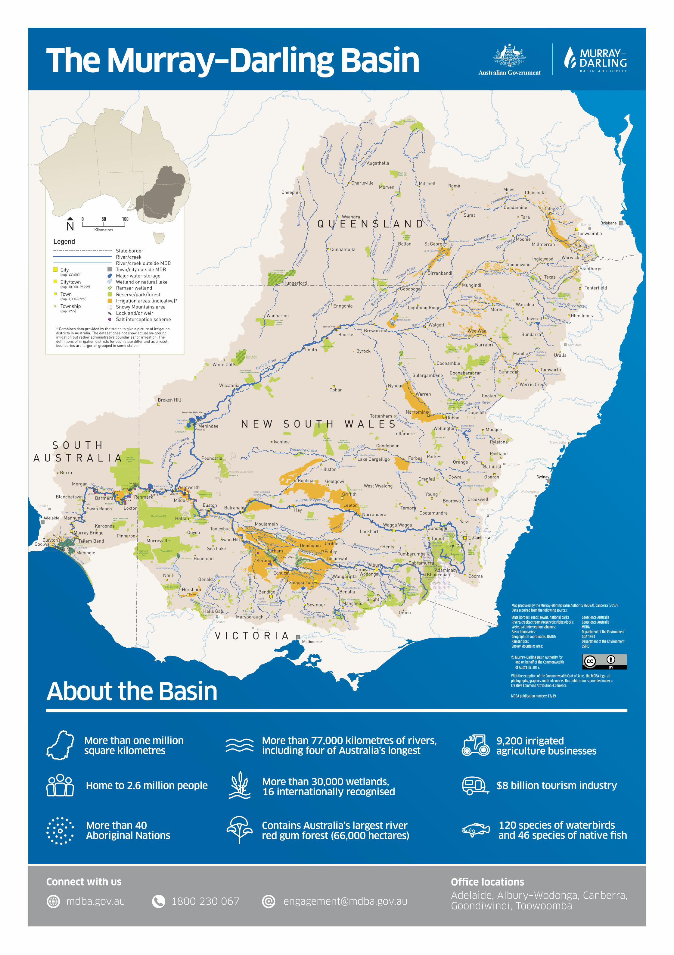
State borderRiver/creekRiver/creek outside MDBTown/city outside MDBMajor water storageWetland or natural lake

Legend

Reserve/park/forestIrrigation areas (indicative)*Snowy Mountains areaLock and/or weirSalt interception scheme

Ramsar wetland

City(pop. ≥30,000)

City/town(pop. 10,000–29,999)

Town(pop. 1,000–9,999)

Township(pop. ≤999)

0 50 100

KilometresN

* Combines data provided by the states to give a picture of irrigation districts in Australia. The dataset does not show actual on-ground irrigation but rather administrative boundaries for irrigation. The definitions of irrigation districts for each state differ and as a result boundaries are larger or grouped in some states.

1800 230 067mdba.gov.au [email protected]

Connect with us

The Murray–Darling Basin

About the Basin

More than one million square kilometres

Home to 2.6 million people

More than 77,000 kilometres of rivers, including four of Australia’s longest

More than 30,000 wetlands,16 internationally recognised

120 species of waterbirds and 46 species of native fish

Contains Australia’s largest river red gum forest (66,000 hectares)

9,200 irrigated agriculture businesses

$8 billion tourism industry

More than 40 Aboriginal Nations

© Murray–Darling Basin Authority for and on behalf of the Commonwealth of Australia, 2019.

With the exception of the Commonwealth Coat of Arms, the MDBA logo, all photographs, graphics and trade marks, this publication is provided under a Creative Commons Attribution 4.0 licence.

MDBA publication number: 13/19

Map produced by the Murray–Darling Basin Authority (MDBA), Canberra (2017). Data acquired from the following sources:

State borders, roads, towns, national parks Geoscience Australia Rivers/creeks/streams/reservoirs/lakes/locks: Geoscience Australia Weirs, salt interception schemes: MDBA Basin boundaries: Department of the Environment Geographical coordinates, DATUM: GDA 1994 Ramsar sites: Department of the Environment Snowy Mountains area: CSIRO

Office locationsAdelaide, Albury–Wodonga, Canberra, Goondiwindi, Toowoomba