Embed Size (px)
Citation preview
THE MISSISSIPPIAN TRANSITION AT THE WASHAUSEN SITE: DEMOGRAPHY AND COMMUNITY AT A TENTH-ELEVENTH CENTURY A.D.
MOUND TOWN IN THE AMERICAN BOTTOM, ILLINOIS
by
Casey R. Barrier
A dissertation submitted in partial fulfillment of the requirements for the degree of
Doctor of Philosophy (Anthropology)
in the University of Michigan 2014
Assistant Professor Robin Andrew Beck, Chair Professor Joyce Marcus Professor Carla M. Sinopoli Associate Professor Michael Witgen

© Casey R. Barrier 2014
ii
ACKNOWLEDGEMENTS
I could not have written this dissertation without the guidance, support, and assistance of
numerous individuals and institutions. First of all, I would like to thank my PhD advisor, Rob
Beck, who has provided unwavering support to me during the last several years. Rob has been
the kind of advisor that has allowed me to grow as an archaeologist, scholar, colleague, and
professional. From the first day Rob became my mentor at the University of Michigan, he
challenged me to view myself as a more than just a graduate student. I would not be where I’m
at today without Rob Beck.
I also would like to thank my other committee members, Joyce Marcus and Carla
Sinopoli, as well as Michael Witgen from the Department of History and Program in American
Culture. These individuals helped guide me through the long journey of dissertation research
and writing. I could not have finished this project without their full support.
My seven years in Ann Arbor as a PhD student at the University of Michigan could never
be replaced. The Department of Anthropology and especially the Museum of Anthropology are
truly special institutions. I want to thank all of my professors and fellow graduate students. I
have had the honor to learn from Rob Beck, Kent Flannery, Joyce Marcus, John O’Shea, Carla
Sinopoli, John Speth, Bob Whallon, Henry Wright, and Norm Yoffee.
I have also learned so very much from my peers – fellow graduate students at the
University of Michigan. I cannot list them all, but the following individuals have been especially
important: Alice Wright, Colin Quinn, Anne Compton, Ashley “Shooby” Schubert, Christina
iii
Perry Sampson, Travis Williams, Shaun Lynch, Andy Gurstelle, Cameron Gokee, Howard Tsai,
Amanda Logan, Jess Beck, Andy White, Ryan Hughes, and Perry Sherouse. Alice Wright
deserves special mention. Alice is not only one of the best archaeologists that I know, but she
instantly became my best friend at Michigan. I am truly lucky to have Alice as a life-long friend
and colleague!
I would also like to very much thank my MA advisor while at the University of Alabama,
John Blitz. John has been an inspiration to me for many years, and he continues to provide
support and guidance for me to this day. There are also several people who helped me early on
that I would like to thank. Two of my earliest mentors were Jim Fenton and Chris Gunn. I had
the pleasure to work for several years for Jim at Wilbur Smith Associates, a CRM firm in
Lexington, Kentucky. I learned from Jim that archaeology was more than just about
excavations, survey, or artifact description. I learned from Jim that archaeology could and
should always be anthropology! Chris Gunn took me under his wing as a young undergraduate
student at the University of Kentucky, and he showed me how to become a junior professional-
scholar. Chris – thanks for spending so many countless hours teaching me how to devise
research, write grant proposals, analyze ceramics, and write reports, conference papers, and
articles. And perhaps most of all, thanks for showing me that archaeology should always be
enjoyable and done with good friends!
There are also a handful of individuals that I met while in the MA program at the
University of Alabama who are truly irreplaceable: Jera Davis, Paul Noe, Alissa Lamb, Blakely
Brooks, Elizabeth Davis, James Stavely, Shelly Hines-Brooks, and Jenny Williams. These
individuals created the perfect graduate school experience for me during those two years spent in
iv
Tuscaloosa. More importantly, they became life-long friends that I will forever consider my
close family and do whatever possible to keep close by.
There are also several people from my CRM days who should be thanked. These
individuals taught me how to do fieldwork, and they strengthened my early conviction that
archaeology should always be a fun endeavor, and one done with good friends. Again, I cannot
list them all, but the following people need special mention: Tracey Sandefur, Pat Trader,
Robert Ball, Howard Beverly, Kurt Rademaker, Dave Buskiewicz, Dona Daugherty, Myrissa
Byrd, Ann Wilkinson, Crista Haag, Steve Culler, Courtney Stoll, and Tanya Peres.
I would not be where I am today with the loving support and guidance of my family. My
parents, David and Janis Barrier, and my sister, Stacey, have always been there for me since Day
1. I cannot thank them enough for everything they give me; all I can do is say, “I love you!” My
wife, Sarah Mulberry, is not only my biggest supporter, but she is also my closest friend.
Anyone who knows Sarah understands how she is responsible for making me something more
than just an archaeologist. Sarah has given me the gift of having a rich and fulfilling life. I only
hope I can give back to her half of what she’s given to me. Sarah – thanks for being a part of my
life – I love you! Sarah’s parents, John and Janice Mulberry, have also provided to me their full
support and love. I don’t really consider them my “in-laws;” they’re just part of my family. And
one more member of my family must be named – my Labrador Retriever and best friend, Orwell.
Orwell has been with me throughout the entire journey of graduate school, and I know he’ll be
right by my side going forward!
The research for this dissertation could not have been conducted without the full support
of many individuals. I would like to especially thank John and Lucretia “Cricket” Kelly for all
they have done for me. John and Cricket made Monroe County, Illinois, feel like home while I
v
was in the field. Katie Parker and Sarah Sherwood also deserve special thanks for their support
and guidance. Tim Horsley, my close friend and colleague, cannot be thanked enough. Tim is
the best archaeo-geophysicist I know, and I know of no one with a bigger heart!
I would also like to very much thank the landowners of the Washausen site, the Hawkins
family, as well as “Mo.” They made fieldwork at Washausen a true pleasure. Also, I could not
have done any of this work without the assistance of many people both in the field and in the lab,
including: Kevin Garrett, Shaun Lynch, Ashley Schubert, James Scott, Jim Mertz, Kathryn
Clappison, Danielle Bridges, Casey Sreenan, Sophia Reini, and Fred Gee.
Institutional support was essential for this research project. Primary funding was
provided by a National Science Foundation Doctoral Dissertation Improvement Grant (BCS-
1339216), and by a James Bennett Griffin Fellowship. Other funding was provided by the
University of Michigan’s Museum of Anthropology, Department of Anthropology, and Rackham
Graduate School.

vi
TABLE OF CONTENTS
ACKNOWLEDGEMENTS……………………………………………………………………….ii LIST OF FIGURES……………………………………………………………………………...vii LIST OF TABLES………………………………………………………………………………..ix ABSTRACT………………………………………………………………………………...…......x CHAPTER 1. THE POLITICAL ECONOMY OF KIN-BASED AGRICULTURAL SOCIETIES: AN EARLY MISSISSIPPIAN CASE STUDY FROM EASTERN NORTH AMERICA………………………………………………………………………….1 CHAPTER 2. HISTORICAL BACKGROUND AND THE 2011 UNIVERSITY OF MICHIGAN-WASHAUSEN ARCHAEOLOGICAL PROJECT……...………………...25 CHAPTER 3. SHIFTING COMMUNITIES: THE SPATIAL ORGANIZATION AND DEMOGRAPHIC DEVELOPMENT OF THE WASHAUSEN COMMUNITY.............45 CHAPTER 4. THE 2011 UM-WAP FIELD INVESTIGATIONS AT WASHAUSEN……77 CHAPTER 5. FEAST, FAMILY, AND FIELD: COMMUNITY CONSTRUCTION DURING THE MISSISSIPPIAN TRANSITION AT WASHAUSEN………………….138 BIBLIOGRAPHY ……………………………………………………………………………...160
vii
LIST OF FIGURES
Figure 1.1. Map of the American Bottom region, with sites mentioned in text highlighted…....14 Figure 1.2. American Bottom chronology (calibrated dates) (adapted from Kelly 2008:Figure 37)…………………………………………………………………………………………….16 Figure 2.1. Photograph of Washausen site locality (foreground) in the American Bottom, with tree-covered limestone bluffs in background (photograph by author)………………………..26 Figure 2.2. 1875 plat map showing location of the Washausen site (red star) along the banks of Fountain Creek prior to construction of the modern levee…………………………………...26 Figure 2.3. Contour map of the Washausen site (courtesy of John Kelly)……………………...32 Figure 2.4. Photographs showing Mound A (top) and Mound B (bottom) at the Washausen site, outlined in red (photograph by author)……………………………………………………….33 Figure 3.1 Gray-scale of processed magnetometer data, plotted from -3.5 nT (white) to +3.5 nT (black) (from the 2011 UM-WAP geophysical survey)……………………………………...47 Figure 3.2. Gray-scale of processed magnetometer data, displaying secondary plaza at Washausen……………………………………………………………………………………50 Figure 3.3. Gray-scale of processed magnetometer data, with yellow arrows referencing buried relict paleochannels…………………………………………………………………………...52 Figure 3.4. Photograph showing 1 x 2 meter unit excavated to clip the edge of a rectangular basin structure (Structure 4, Feature 26), as predicted from the magnetometer data (photograph by author)……………………………………………………………………….65 Figure 3.5. Map of the Washausen settlement, showing distribution of rectangular basin structures (black)……………………………………………………………………………...67 Figure 3.6. Graphs showing village-level demographic changes through time in the central American Bottom at the Washausen and Range Sites; data displayed for Range depict only the largest temporally discrete community for each archaeological phase as presented in Kelly (1990a:Table 9)………………………………………………………………………...74
viii
Figure 4.1. Map showing location of six excavation areas..…………………………………….79 Figure 4.2. Photograph showing excavations of Structure 1 at Washausen (photograph by author)………………………………………………………………………………………...80 Figure 4.3. Profile map of Structure 1 (Feature 5) basin and fill zones (west profile)………….81
Figure 4.4. Photograph showing excavations of Structure 2 at Washausen (photograph by author)………………………………………………………………………………………...82 Figure 4.5. Profile map of Structure 2 (Feature 6) basin and fill zones (west profile)………….83 Figure 4.6. Photographs showing shape of T-shaped structure, Structure 3 (Feature 7), at the base of the plowzone (top-right), and T-wing extension wall posts and circular pit (Feature 48) at structure floor (bottom-left) (photographs by author)…………………………………84 Figure 4.7. Profile map of Feature 48 (composite of northeast and southwest quarter profiles)..86 Figure 4.8. Photographs of hearth (Feature 24) encountered at base of T-shaped structure (Structure 3); top: plan view of hearth, showing bisected and quartered excavation strategy; bottom: profile view showing yellow clay cap overlying thin lens of carbonized organic remains (photographs by author)……………………………………………………………..87 Figure 4.9. Profile map of Structure 4 (Feature 26) basin and fill zones (south profile)………..89 Figure 4.10. Photograph showing oval pit feature (Feature 19) (photograph by author)……….90 Figure 4.11. Profile map of Feature 19 (south profile)………………………………………….90 Figure 4.12. Photograph showing excavation of Structure 4 (Feature 26). Seen in planview is top of bottom major fill zone (photograph by author)………………………………………..95 Figure 4.13. Chipped stone morphological typology (following and adapted from Andrefsky 2005:Figure 4.7)……………………………………………………………………………..133
ix
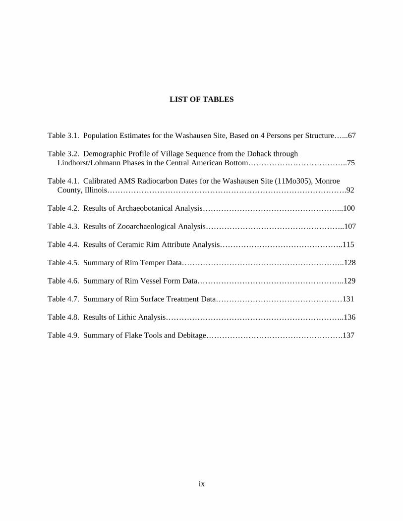
LIST OF TABLES
Table 3.1. Population Estimates for the Washausen Site, Based on 4 Persons per Structure…...67 Table 3.2. Demographic Profile of Village Sequence from the Dohack through Lindhorst/Lohmann Phases in the Central American Bottom………………………………..75 Table 4.1. Calibrated AMS Radiocarbon Dates for the Washausen Site (11Mo305), Monroe County, Illinois……………………………………………………………………………….92 Table 4.2. Results of Archaeobotanical Analysis……………………………………………...100 Table 4.3. Results of Zooarchaeological Analysis……………………………………………..107 Table 4.4. Results of Ceramic Rim Attribute Analysis………………………………………..115 Table 4.5. Summary of Rim Temper Data……………………………………………………..128 Table 4.6. Summary of Rim Vessel Form Data………………………………………………..129 Table 4.7. Summary of Rim Surface Treatment Data…………………………………………131 Table 4.8. Results of Lithic Analysis…………………………………………………………..136 Table 4.9. Summary of Flake Tools and Debitage…………………………………………….137
x
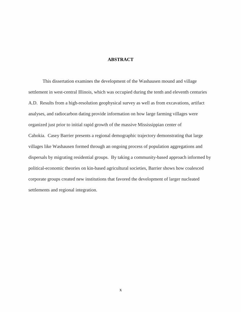
ABSTRACT
This dissertation examines the development of the Washausen mound and village
settlement in west-central Illinois, which was occupied during the tenth and eleventh centuries
A.D. Results from a high-resolution geophysical survey as well as from excavations, artifact
analyses, and radiocarbon dating provide information on how large farming villages were
organized just prior to initial rapid growth of the massive Mississippian center of
Cahokia. Casey Barrier presents a regional demographic trajectory demonstrating that large
villages like Washausen formed through an ongoing process of population aggregations and
dispersals by migrating residential groups. By taking a community-based approach informed by
political-economic theories on kin-based agricultural societies, Barrier shows how coalesced
corporate groups created new institutions that favored the development of larger nucleated
settlements and regional integration.
1
CHAPTER 1 THE POLITICAL ECONOMY OF KIN-BASED AGRICULTURAL SOCIETIES: AN EARLY MISSISSIPPIAN CASE STUDY FROM
EASTERN NORTH AMERICA
Historians have long been fascinated by the idea that human history is the story of how small family groups turned into nations: they imagine that identities were transformed, made, or remade in the process. But we have never stopped living in groups reminiscent of the families, clans, and tribes described by political anthropologists. Stiner, Earle, Smail, and Shryock 2011:247
Introduction: The Origins of the Mississippian World of Eastern North America
The emergence and histories of late pre-Columbian Mississippian societies across the
midwestern and southeastern United States has long been an object of study by archaeologists
working in Eastern North America (Blitz 2010; Cobb 2003; Steponaitis 1986). Although
scholars are now aware that complex social organizations were constituted in the eastern United
States at different times and places stretching as far back as the Archaic Period, research on the
origins of Mississippian is seen as the study of the development of large, complex agricultural
societies that were similar in many ways to the numerous ranked and chiefly societies known
from around the globe (Anderson and Sassaman 2012:152). Today, Mississippian archaeology
benefits from a great diversity of research, ranging from examining the transition from
egalitarian life to societies supporting a host of status differences and social inequalities, to
research on migration, culture contact, gender, religion, and iconography (see Blitz 2010). As
2
part of this long and rich body of scholarly work, my research presented here contributes to the
comparative study of early complex societies through examination of how larger and more
socially complex communities were constructed during the buildup to initial the Mississippian
period in the American Bottom region of west-central Illinois.
The term Mississippian has been used in many ways. Initially defined as a pottery style
by William Henry Holmes (1903), “Mississippian” was later used to refer to a cultural tradition,
a distinct complex of artifacts, an adaptive strategy to a particular ecological niche, a period of
time, and a macro-regionally shared form of political organization representative of the classic
chiefdom (Blitz 2010:3). Mississippian has also been likened to a religion or ideology that was
adopted and altered by local groups at various places throughout eastern North America
(Anderson 1999; Emerson and Pauketat 2008; Pauketat 1997, 2004), and as an “ethnoscape” of
peoples and ideas variously connected at a sub-continental scale (Pauketat 2007:85).
Although use of the term “Mississippian” can mask much of the social and historical
variability that is now understood to have been present across the greater late-pre-Columbian
Southeast, Mississippian is most often used to describe post-A.D. 1000 societies having largely
sedentary populations that constructed platform mounds, relied heavily on maize agriculture,
showed signs of status differentiation between groups and individuals, and shared to varying
extents certain forms of political and religious structures, practices, and beliefs, among other
things (Anderson 1994; Anderson and Sassaman 2012; Cobb and Garrow 1996; Cobb and King
2005; Muller 1997; Smith 1990).
An enduring research focus is distinguishing the origins of initial Mississippian in the
central Mississippi River Valley from the later appearance of distinct but historically-related
Mississippian cultural groups elsewhere in the American Southeast (Smith 2007). Although
3
many scholars no longer focus on chiefdom organizations, David Anderson (1999) has
effectively couched the problem as follows:
care must be taken to differentiate between the evolution and spread of chiefdom organizational forms over the [Southeastern] region and the spread of Mississippian ideology… The former (i.e., chiefdom-like societies) appears to have emerged in the ninth and tenth centuries, if not before, in some areas. The latter (i.e., Mississippian ideology and religion) appears to have developed or crystallized in the tenth and eleventh centuries, after chiefdoms themselves had emerged in a number of areas, and Cahokia seems to have been the primary center where this took place. “Mississippian” increasingly is thus coming to be recognized as an ideological/religious system that a number of the region’s chiefdoms participated in, and whose origin and spread owe a great deal to the early and dramatic emergence of Cahokia [Anderson 1999:227].
Still other scholars have provided models that distinguish between local in-situ
developments of Mississippian culture and the movement of Mississippian sociocultural systems
across the greater Southeast through multiple processes such as migration, interaction,
competitive emulation, and acculturation (Blitz and Lorenz 2006; Boudreaux 2007; Cobb and
Garrow 1996). For example, Blitz and Lorenz (2006; Blitz 1999) write that:
[f]ollowing Jenkins (2003), we distinguish between emergent Mississippian and terminal Woodland. Emergent Mississippian is the autochthonous development of the Middle Mississippi cultural tradition from local, antecedent Late Woodland populations in the central Mississippi River Valley from A.D. 800 to A.D. 1000 (i.e., Kelly 2000). Terminal Woodland refers to Late Woodland populations that interacted with an intrusive Middle Mississippi tradition. This latter process of culture contact is sometimes referred to as “Mississippianization” (Cobb and Garrow 1996:21-22; Pauketat 2004:119-120) [Blitz and Lorenz 2006:124].
Models that distinguish different trajectories of Mississippian developments are useful,
and research on early Mississippian developments within distinct regions of eastern North
America shed light on multiple pathways taken towards complexity. Following Blitz and Lorenz
(2006), Bruce Smith (2007:xxiii) suggests that the study of primary Mississippian developments
4
in the American Bottom region of west-central Illinois may reveal a social trajectory that is
distinct from later Mississippian transitions elsewhere. As Smith argues, historical changes that
occurred in the ninth- through early eleventh-centuries A.D. in the American Bottom chart the
development of greater regional social complexity developing from tribal-like organizations.
Although many American Bottom researchers do not share entirely in Smith’s view (see
Pauketat 2007), knowledge of the growth and development of early Mississippian centers in the
American Bottom region does contribute to a more thorough understanding of how local
inhabitants (including recent immigrants from regions beyond) constructed larger and more
complex communities that undoubtedly influenced the histories of social groups across much of
greater Eastern North American for decades and centuries to come. Or, as recently stated by
Anderson and Sassaman (2012:156-157):
[a] pronounced crystallization of ideology, iconography, and religion, as well as aspects of material culture and community organization apparently took place in the American Bottom in the decades after ca. A.D. 1000, and the resulting constellation of features is what many now think of as Mississippian culture, and what is assumed to have spread [across the American Southeast] [Anderson and Sassaman 2012:156-157].
The research presented here is devised to more thoroughly understand how local groups
were contributing to, and taking part in, sets of social processes involved with changes occurring
with the Mississippian transition in the American Bottom floodplain. In this portion of the
Central Mississippi River Valley, described in some detail in chapter 2, the florescence of
Mississippian cultural expression is seen at the Cahokia settlement by the late eleventh century
A.D. (Beck et al. 2007:842; Pauketat 2004). After its initial growth as a Mississippian center,
Cahokia quickly grew to become the largest and most complex settlement in all of North
America, north of central Mexico.
5
More specifically, I examine aspects of tenth-eleventh century developments in the
American Bottom through an approach that explicitly examines the realm of community
organization through consideration of the relationship between distinct, kin-based corporate
groups and other developing institutions at the Washausen site in the American Bottom
floodplain. Research at Washausen provides evidence for historical developments that occurred
just prior to, and overlapping with, the rapid growth at Cahokia as it transitioned from being a
large village to an expanding urban center (Brown and Kelly 2014; Pauketat 1994, 2004).
Alterations in community organization and the timing of regional settlement
reorganizations remain major issues for understanding the rise of Mississippian Cahokia (Beck et
al. 2007:843-844; Milner 2006:xx-xxi; Pauketat 2004). Archaeologists working at Cahokia have
shown that changes there circa A.D. 1050 – including the reorganization of public, monumental,
and residential space – coincided with the development of new Mississippian social structures
and integrative institutions. Debate exists, however, concerning the extent to which the mid- to
late-eleventh century reorganization signaled a complete social and political transformation, as
well as the applicability of the Cahokia-model to other groups in the greater American Bottom
region.
The Washausen site provides an extraordinary opportunity to examine the Mississippian
emergence in the American Bottom because: (a) it was a relatively small and short-lived mound
center and village, occupied for just a few generations during the decades bracketing the onset of
the Mississippian period at A.D. 1050 (Kelly and Brown 2012:122-124); and (b) modern use of
the landscape has only minimally affected the integrity of the buried pre-Columbian remains. As
elaborated in chapter 2, earlier work at Washausen has included mapping and systematic surface
collections, limited geophysical surveys, and excavations into the northern portion of the site
6
(Bailey 2007; Betzenhauser 2011; Chapman 2005; Kelly 2006b). More recently, I oversaw three
phases of archaeological investigations as director of the University of Michigan-Washausen
Archaeological Project (UM-WAP). This work included large-scale geophysical survey,
excavations, artifact analyses, as well as AMS radiocarbon dating.
In this study, I examine how local changes within political-economic relations set in
motion the development of early Mississippian societies in the American Bottom, while keeping
in mind how these changes may have had long-term consequences for the histories of later
Mississippian groups across eastern North American. I draw from the literature on the political
economies of early farming societies, to consider how the development of new systems of land
tenure and the control of agricultural labor involved the creation of corporate groups and were
intertwined with many of the settlement changes we see archaeologically as larger and more
populous complex communities developed.
In the remainder of this chapter, I lay the foundations for my work by presenting an
overview of research about the political economies of kin-based agricultural societies. This
background sets the stage for my analysis of the development and operation of Mississippian
societies of eastern North America. I then review extant models that have been used to explain
Mississippian origins in the American Bottom. Finally, the communities-based approach used in
this research is laid out. I argue that such an approach allows information from sites like
Washausen to contribute to knowledge about how local communities and corporate groups
participated in and influenced broader changes associated with the Mississippian transition.
7
The Political Economy of Kin-Based Agricultural Societies
The growth of political economy as a scholarly discipline has followed a sinuous
historical trajectory, from diverse academic and critical perspectives, resulting in a plethora of
uses of the concept and term today (Muller 1997:2-10; Roseberry 1988:162-173). In the
broadest sense, political economy can be defined as “an analysis of social relations based on
unequal access to wealth and power” (Roseberry 1989:44, cited in Cobb 1993:44), but it also
deals with central issues surrounding the organization of economic production and social
reproduction (Muller 1997:vii). The development of political-economic theory, going back to
Marx and even earlier economists, grew out of analyses of capitalist and state-level market
economies. A majority of anthropologists and other social scientists and historians who
currently use political-economic theories and analyses remain scholars of present-day nation-
states, recent globalization, or the study of how capitalism spread across the globe. However,
political economy has been utilized increasingly by archaeologists since at least the 1960s to
study both state-level and non-state societies of the past (see Cobb 1993; Sinopoli 2003).
Stemming from its classic origins as a form of analysis in the study of economically
class-based societies, political economic theory as adopted by archaeologists has likewise
traditionally been used by those whose research is focused on early states or to study the
beginnings of pronounced economic inequalities, markets, or non-capitalist forms of political
finance. Earle (2002:1), for example, defines political economy as “the material flow of goods
and labor through a society, channeled to create wealth and to finance institutions of rule.” For
Earle, like many others, political economies develop as a means to generate and funnel surpluses
that support elite political activities and institutions.
8
Although suited to understanding how systems of heightened economic inequalities arose
in the past, political-economic approaches within anthropology and archaeology have been
developed to address a much broader range of questions that have been applied to the study of a
greater range of human societies (McGuire 2002:80-83). Within archaeology specifically, there
now exists a robust literature that considers the political economies of what Cobb (1993) has
grouped as non-stratified societies. Archaeologists have contributed to the growth of political-
economic theory by expanding our knowledge about the ways various social groups in the past
organized their economic activities. Archaeologists are well-positioned to take an historical
approach, a critical element of political-economic scholarship (Roseberry 1988:163).
Archaeologists have even made great strides to an understanding of how economic production
and distribution operate within systems fueled less by elite politics and more by ritual and
ceremonial cycles (Spielmann 2002; Wells 2006; Wells and Davis-Salazar 2007; Wells and
McAnany 2008).
Political Economies of Kin-Based Societies: Models for a Consideration of Mississippian Social Organization
The extent to which stratified political systems and economic-tributary relations were
dominant features of social organization in the Mississippian Southeast has been debated
extensively (see Cobb 2003; Milner 1990, 1998; Muller 1997; Welch and Butler 2006). In this
thesis, I argue that an historical analysis of kin-based societies serves as a useful starting point
for tracking the initial development of Mississippian lifeways in the tenth and eleventh centuries
A.D. (see also Barrier 2011). I draw on Eric Wolf’s (1982:88-96) direct engagement with
political-economic theory, which provides a comprehensive basis for understanding economic
organization and change within what he calls a kin-ordered mode of production. Central to
9
political-economic analysis and Wolf’s expanded conception of the mode of production is the
concept of social or surplus labor, and it is this focus on labor that makes a political-economic
approach productive for the study of non-capitalist societies (Saitta 1994:201).
As Cobb (1993) has stated the position:
A central concern of political economy is with labor, be it labor value, the relations of production, or the deployment of labor. Differential access to wealth and power, the essence of our approach to political economy, is fostered in large part by the ability to manipulate surplus labor to achieve one’s own ends. Therein lies the usefulness for grouping nonstratified societies as a topical area, for the mobilization of surplus labor (in the form of goods or services) in such groups is characteristically conducted under the aegis of the kinship system [Cobb 1993:46].
One of Wolf’s (1982) contributions was to demonstrate that the surplus labor process is
present in all societies (see Barrier 2011; Saitta 1994:Note 1). To quote Wolf himself:
If kinship is a particular way of establishing rights in people and thus laying claim to shares of social labor, it is also true that the ways in which such rights and claims are established vary widely among different culture-bearing populations. Anthropologists have come to recognize that kinship works in basically different ways in two kinds of situations, those in which resources are widely available and open to anyone with the ability to obtain them, and those situations in which access to resources is restricted and available only to claimants with a ‘kinship license.’ In the first case, the ties of kinship grow out of the give-and-take of everyday life and link people who are in habitual interaction with one another. In the second case, the circle of kinship is drawn tightly around the resource base by means of stringent definitions of group membership [Wolf 1982:91].
As Wolf continues:
This contrast defines two variants of the kin-ordered mode, for social labor is deployed differently in the two. The first variant is best exemplified in the anthropological literature by food collector[s]... Under such circumstances the aggregation or dispersion of people, each embodying a share of social labor, follows ecological constraints and opportunities. Upper limits to pooled social labor are set by the interaction of the technology with the local environment, as
10
well as by the group’s ability to manage conflict through consensus formation and informal sanctions… The deployment of social labor works differently in the second variant of the kin-ordered mode. Where nature is subject to transformation through social labor, the environment itself becomes a means of production, an instrument on which labor is expended. A segment of nature is transformed by a set of people – equipped with tools, organization and ideas – so as to produce crops… In such a society, social labor is distributed in social clusters that expend labor cumulatively and transgenerationally upon a particular segment of the environment, accumulating at the same time a transgenerational corpus of claims and counterclaims to social labor… Under these conditions the idiom of filiation and marriage is used to construct transgenerational pedigrees, real or fictitious. These serve to include or exclude people who can claim rights to social labor on the basis of privileged membership [Wolf 1982:91-92].
This distinction in how kin-ordered modes of production can be variously structured has
been applied to explain some major differences between the political economies of Hopewell and
Mississippian groups in eastern North America (Beck and Brown 2012). Beck and Brown draw
a distinction, similar to Wolf’s, between economies based on surplus production and those based
on what they call surplus procurement. As Hopewell groups relied heavily on hunting and
gathering, and to a lesser extent, on small-scale gardening of starchy seed crops, surpluses were
unpredictable and temporally and spatially widely distributed. Hopewell complexity – seen
archaeologically as increased ceremonialism, long-distance exchange networks, support of
crafting and the production of art, large-scale aggregations, monumental constructions, etc. – was
supported through ad hoc or opportunistic procurement of available surpluses (Beck and Brown
2012:74-75). In contrast, Mississippian political economies became based upon the production
of an annually-pulsed and storable, staple cereal crop – maize – thus localizing surpluses both
temporally and spatially.
In the American Bottom region, where Mississippian culture first developed and from
where it subsequently spread, we see the initial development of sedentary villages by the ninth
century A.D., concurrent with maize becoming an important dietary component (Kelly 1992;
11
Fritz 1990; Simon and Parker 2006). Besides a transition from a highly mobile lifestyle to life
centered on sedentary villages, life within these pre-Mississippian villages during the next couple
of centuries was physically structured primarily through the “courtyard group:” the spatial
arrangement of a handful of structures around an open courtyard with central features like pits
and posts (Kelly 1990a, 1990b, 2000). As discussed below, I argue that these courtyard groups
were likely the spatial and material expression of developing kin-based corporate groups,
potentially organized as emerging lineages.
The coeval investment in both a staple cereal crop and permanent village aggregations is
not something unexpected from the perspective of cross-cultural studies of human economies
and social change (Earle 2000). As the importance of maize production increased, Late
Woodland systems of land use and labor organizations would have been transformed, leaving
communities “faced with a radically different set of challenges and opportunities than those
faced by their immediate forebears” (Beck and Brown 2012:79; see also Muller 1997:42).
Unlike earlier Woodland Period political economies, new political-economic relations in the
American Bottom would have become increasingly associated with new notions of property and
land tenure, especially as these related to the preparation and maintenance of new agricultural
fields and the organization of agricultural labor (see Doolittle 2004; Schroeder 1999, 2001).
Earle’s (2000) cross-cultural review of property and use-rights in prehistory led him to
suggest that a strong relationship existed between the intensification of agriculture and the
development of corporate and household rights. Earle (2000:40) defines property as an exclusive
right to things: property is “something possessed, and the exclusive right to hold, use, and/or
dispose of that something.” Property rights, and the jural codes and institutions that establish

12
such rights, extends to both moveable and immoveable property. In developing agricultural
economies, land becomes a key structuring force of the political economy. As Earle writes,
[l]and is inherently set in space, which means people must move to it; however, land is improved by social labor… and the emergence of social groups can in part be explained by a need to defend and allocate land… Property rights in land are secured primarily through original possession, improvement, inheritance, and conquest. Ownership is often based on claims of first possession and of improvements, such as clearing and fencing a field, that change future returns… Inheritance involves transfer of land at death between socially related individuals that results in social continuity… Social groups must maintain control of land, and this control is usually manifest in inheritance rules [Earle 2000:40-41].
Thus, emerging political economies based on immoveable forms of property, like agricultural
fields, predict the development of corporate kin groups like lineages that maintain communal
residence, work and defend land, and see to its transference transgenerationally (Earle 2000:46).
These ideas are used to structure and guide research presented herein on community organization
at Washausen during the Mississippian transition. What follows is a review of extant models
that have been used to explain the origins of Mississippian communities in the American
Bottom. These models both make assumptions about how transitional Mississippian peoples
organized their communities and political economies.
Previous Models of Mississippian Origins in the American Bottom
Researchers working in the American Bottom have identified significant changes in
community organization during the Late Woodland and Mississippian periods (Kelly 1990a,
1990b; Koldehoff and Galloy 2006; Mehrer 1995; Mehrer and Collins 1995; Milner 1998;
Pauketat 1994). These new patterns of settlement planning are associated with the development
13
of new kinds of communities in the region, and they have been used for consideration of the
origins of the earliest Mississippian societies (see Beck et al. 2007; Brown 2006; Emerson 1997;
Kelly 1990b, 2002, 2006a; Milner 1990, 1998; Pauketat 2000a, 2000b, 2004; Schilling 2010).
American Bottom archaeologists have offered two competing models to explain the
transformations that marked the eleventh century Mississippian transition. One model suggests
that early Mississippian communities were an outgrowth of interaction and competition among
pre-existing, kin-based corporate groups, while the other model argues that a completely new
form of Mississippian community was being created that dissolved earlier forms of kin-ordered
communalism. Both positions are based on assumptions about how people organized and
conceived their new communities, focusing in particular on the extent that pre-A.D. 1050 (or
“pre-Mississippian”) institutional relationships played a role in the development of subsequent
Mississippian institutions (Milner 2006:xxi).
American Bottom Sociopolitical Trajectories
Shifts in regional settlement patterns dating to the eleventh century A.D. provide
evidence that significant social changes occurred at this time in the American Bottom. By the
late eleventh century, discrete sedentary villages had been replaced by a regional population
living at a series of smaller settlements dispersed about new monumental mound centers (Figure
1.1). Excavations at Cahokia and at the Range site in the American Bottom have produced the
most complete view of these changes in the region (Brown and Kelly 2014; Kelly 1990a, 1990b;
Kelly et al. 2007; Pauketat 1994, 2004; Mehrer and Collins 1995; Milner 1998). Pre-A.D. 1050
nucleated village life at Range, for example, gave way to occupations that archaeologists refer to
as farmsteads or hamlets that consisted of a few small, co-residential groups or perhaps single
nuclear families. About this same time, the large nucleated village at Cahokia was transformed
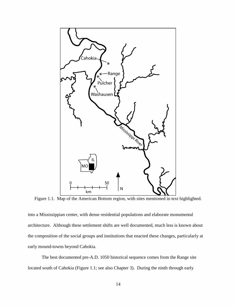
14
Figure 1.1. Map of the American Bottom region, with sites mentioned in text highlighted.
into a Mississippian center, with dense residential populations and elaborate monumental
architecture. Although these settlement shifts are well documented, much less is known about
the composition of the social groups and institutions that enacted these changes, particularly at
early mound-towns beyond Cahokia.
The best documented pre-A.D. 1050 historical sequence comes from the Range site
located south of Cahokia (Figure 1.1; see also Chapter 3). During the ninth through early
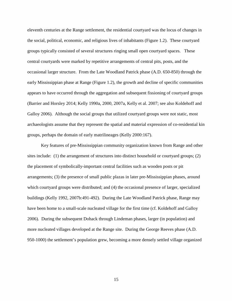
15
eleventh centuries at the Range settlement, the residential courtyard was the locus of changes in
the social, political, economic, and religious lives of inhabitants (Figure 1.2). These courtyard
groups typically consisted of several structures ringing small open courtyard spaces. These
central courtyards were marked by repetitive arrangements of central pits, posts, and the
occasional larger structure. From the Late Woodland Patrick phase (A.D. 650-850) through the
early Mississippian phase at Range (Figure 1.2), the growth and decline of specific communities
appears to have occurred through the aggregation and subsequent fissioning of courtyard groups
(Barrier and Horsley 2014; Kelly 1990a, 2000, 2007a, Kelly et al. 2007; see also Koldehoff and
Galloy 2006). Although the social groups that utilized courtyard groups were not static, most
archaeologists assume that they represent the spatial and material expression of co-residential kin
groups, perhaps the domain of early matrilineages (Kelly 2000:167).
Key features of pre-Mississippian community organization known from Range and other
sites include: (1) the arrangement of structures into distinct household or courtyard groups; (2)
the placement of symbolically-important central facilities such as wooden posts or pit
arrangements; (3) the presence of small public plazas in later pre-Mississippian phases, around
which courtyard groups were distributed; and (4) the occasional presence of larger, specialized
buildings (Kelly 1992, 2007b:491-492). During the Late Woodland Patrick phase, Range may
have been home to a small-scale nucleated village for the first time (cf. Koldehoff and Galloy
2006). During the subsequent Dohack through Lindeman phases, larger (in population) and
more nucleated villages developed at the Range site. During the George Reeves phase (A.D.
950-1000) the settlement’s population grew, becoming a more densely settled village organized
16
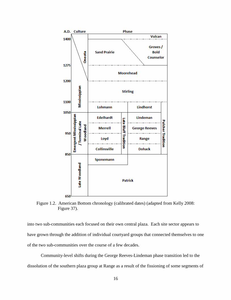
Figure 1.2. American Bottom chronology (calibrated dates) (adapted from Kelly 2008:
Figure 37).
into two sub-communities each focused on their own central plaza. Each site sector appears to
have grown through the addition of individual courtyard groups that connected themselves to one
of the two sub-communities over the course of a few decades.
Community-level shifts during the George Reeves-Lindeman phase transition led to the
dissolution of the southern plaza group at Range as a result of the fissioning of some segments of
17
the community. Most remaining courtyard groups reoriented themselves to a new, single plaza
in the northern portion of the settlement. By sometime in the Lindeman phase (A.D. 1000-
1050), a major population decrease is evident, again likely the result of the fissioning of
individual courtyard groups. By A.D. 1050 the early Mississippian Lindhorst phase settlement at
Range is represented by only a handful of scattered structures.
At this same time (circa A.D. 1050), rapid changes occurred at the large village of
Cahokia, marking the onset of the Mississippian Lohmann phase, which spans from A.D. 1050 to
1100 (Figure 1.2). The relatively rapid adoption of a suite of technological and cultural traits at
Cahokia – including increases in the use of shell-tempered pottery and the introduction of wall
trench architecture – followed on the heels of local population growth, a reorganization of the
settlement’s community plan, and major investments in earth moving and mound and plaza
construction (see Beck et al. 2007; Dalan et al. 2003; Holley et al. 1993; Milner 1998; Pauketat
2004; Schilling 2010). Earlier dwellings that clustered around small courtyards (i.e., courtyard
groups similar to those at the pre-A.D. 1050 Range site) were replaced by larger residential
zones oriented around a series of new plazas and mounds, or around new architectural features
like T-shaped and circular buildings (Brown and Kelly 2014; Collins 1997; Mehrer and Collins
1995; Pauketat 1994). Material evidence of large-scale public feasts indicates that large numbers
of people took part in labor-intensive projects and in ceremonial rites that arguably served to
integrate disparate groups through the construction of mounds and specialized buildings in
politically-charged events (Kelly 2001; Pauketat et al. 2002).
According to one of two competing models, data from Cahokia suggest that new
Mississippian communities emerged through the creation of social institutions no longer focused
on kin-based corporate communalism (Emerson 1997; Pauketat 2000a, 2000b). Advocates of
18
this model posit a disjuncture between earlier forms of community social organization and new
“Mississippianized” communities. Pauketat (2000a, 2000b), for example, sees the development
of Mississippian communities as the politicization of pre-A.D. 1050 forms of communalism.
Whereas domestic and social life were apparently organized around the courtyard group at
earlier regional villages – that is, by a small number of households that shared central public
spaces and communal facilities – the creation of Mississippian communities at A.D. 1050
transposed community identities from the local kin group to the regional political community.
New mound centers became the nexus of new kinds of Mississippianized communities (Pauketat
2000a:30, 33-34). Dissolution of earlier forms of social organization that seemingly revolved
around courtyard group-based kinship ties and the local community were replaced at the moment
of Cahokia’s political centralization at A.D. 1050 (Pauketat 2000b:120). Nuclear families living
at new farmsteads were potentially autonomous in their domestic affairs; they also would have
lacked a local community, as community ties were now reckoned through social relations to
political centers (Pauketat 2000a:34-35).
Other researchers, however, suggest that the new scales of social integration at Cahokia
resulted from intensified interaction and competition among kin-based corporate groups (e.g.,
Beck et al. 2007; Brown 2006; Brown and Kelly 2014; Kelly 2006a; Milner 1998; Trubitt 2000;
Saitta 1994; Welch 2006; Wilson et al. 2006). These researchers see evidence for greater
historical continuity between pre-A.D. 1050 regional developments and early Mississippian
social organizational formations witnessed at Cahokia and elsewhere, particularly in elements of
community plans including the arrangement of living space around central courtyards and later
central plazas. For example, Kelly (2006a) and Brown and Kelly (2014) see the rapid
development of Cahokia after A.D. 1050 as the continued, if not significantly expedited,
19
coalescence of several kin-based corporate groups into this emerging and densely settled
landscape. As Brown and Kelly (2014) state:
[a]t the onset of the Mississippian settlement pattern at Cahokia in the mid-eleventh century, the landscape was abruptly altered by creating a broad north-south occupational and ritual space of urban dimensions to accommodate the planned core or epicenter of the site. After Cahokia was reconfigured, the pre-existing Emergent Mississippian village plan was easily quadrupled. Four monumentally-sized plazas were laid-out as arms of a giant cruciform [Brown and Kelly 2014:562].
Drawing upon ethnographic literature on Siouan-speaking groups from the Midwest,
some scholars have proposed a multi-clan model of social organization for Mississippian
Cahokia (Brown 2006; Brown and Kelly 2014; Kelly 2006a; Welch 2006). This model finds
support in Knight’s (1990) much broader analysis of ethnographic and archaeological
information about the social organization of contact- and early historic-period pan-Eastern
Native groups. Knight’s (1990:3; emphasis original) analysis led him to “propose that structural
features inherent in exogamous ranked clans satisfy the preconditions for the emergence of
social stratification, and that Mississippian social organization arose from that base in late
prehistoric Eastern North America.”
According to Knight (1990:5-6), Eastern North American clans were exogamous social
categories or statuses perpetuated by unifiliation. Unlike clans elsewhere, pan-Eastern clans
were not descent groups in the traditional sense, but rather were based upon biological ties
between living relatives, usually privileging either patri- or matrifiliation. Communities and
villages were composed of several clans, and clan segments were often distributed throughout
multiple villages. Clan membership did not have a strong corporate basis. Rather, “functions of
the clan were instead oriented primarily to the codification of conduct and etiquette among kin,
20
to the settlement of disputes, to rules regarding hospitality to strangers, and to the regulation of
marriage transactions. Clans also performed traditional roles at ceremonies” (Knight 1990:5-6).
Knight’s (1990) analysis also found that economic activities, property, and agricultural
land were under the purview of strongly corporate lineages. In contrast to clans, lineages were
always localized within a village or at a hamlet or farmstead, and several lineages formed larger
clans. As detailed by Knight:
lineages could consist merely of an extended consanguineal family tied to an estate… or at most a localized cluster of closely related families. Such local groups were exogamous by virtue of clan membership… [and] membership was again merely a matter of filiation rather than of descent [Knight 1990:6].
Thus, although both clan and lineage membership was based on direct biological ties, lineages
(at least in the contact- and early historic-periods) were perpetuated only as they maintained
spatial proximity as a distinct household or cluster of households, and while a living matriarch or
patriarch survived. According to Knight, the lineage-clan system that was prominent in the
sixteenth century and later may have been one way that surpluses created in part through a
dispersed settlement system operated to centralize those resources within larger, kin-based social
units.
A Communities-based Approach to Understanding
Early Mississippian Trajectories in the American Bottom
Mississippian archaeologists are well positioned to investigate the scalar relationships
that link local social groups, larger regional polities, and even more geographically expansive
social structures (Blitz 2010:1-3; Cobb and King 2005:169-170). Recently, several scholars have
reinvigorated the concept of local “traditions” and how they endure, change, are replaced
21
outright, or manipulated in the face of local and extra-local cultural variation, competition, or
coercion (Alt 2002, 2006; Blitz and Lorenz 2006; Cobb 2005; Lightfoot 2001; Pauketat 2001a,
2001b, 2001c). Influenced by practice theory, researchers have benefitted by placing local
sociopolitical trajectories squarely within the realm of active agents participating within a larger
structural milieu (Cobb and Garrow 1996:34).
Traditions, like all shared practices, are transformed and remade as individuals, groups,
and institutions reproduce their social communities (Cobb and Drake 2008:86). A diachronic
and multi-scalar approach to social change permits us to understand how communities are
shaped by particular institutions, practices, and patterns of material culture. Such an approach
views communities as (a) dynamic social formations (b) generated by suprahousehold and
institutional interactions that (c) take place within structured spaces over daily to generational
spans of time (Yaeger and Canuto 2000:5). Communities in this sense are not themselves
reducible to spatially defined sets of material traits. Rather, the archaeological record can be
used to infer “instances of communities,” and documented shifts in interactions between various
institutions – from the co-residential household group to suprahousehold institutions at the local
and polity levels – are means to better understand diachronic and long-term social changes
(Yaeger and Canuto 2000:6).
Key issues in the study of the development of regional centers and larger-scale
aggregations include understanding of the social institutions that are created to provide new
opportunities for integration and that help mitigate the challenges of living under conditions of
greater population densities (Quinn and Barrier 2014). Institutions can be defined as “the
socially mediated and communally accepted sets of rules for interaction and conduct… [that]
develop… as means to organize economic, political, or ideological aspects of life” (Quinn and
22
Barrier 2014:2250). Archaeologist Adam Smith (2003:235) states that institutions are
“collectivities bound together by shared histories and interests that shape ingrained values and
routines… [and that] recursively shape their members and, over time, can provide foundations
for stability… and transformation.” Archaeologists can locate the material remains of recurrent
institutional practices through systematic study of distinct spatial, depositional, and architectural
patterning; for example, specialized buildings or places on the landscape used for ritual or
ceremonial purposes (e.g., Flannery 1998). Importantly, the institutions are not the buildings or
places themselves, but the continued and replicated acts of groups or individuals that serve to
regenerate those institutional practices and places (Pauketat 2007:40).
My research seeks to understand how co-residential groups at the transitional
Mississippian Washausen settlement were both contributing to, and taking part in, sets of social
processes involved with rapidly changing conditions documented for the early Mississippian
Period in the American Bottom. A communities-based approach places analytical focus on the
local groups and social institutions at Washausen, and requires examination of how these groups
were constructing more extensively integrated communities at this time. My research
contributes to our understanding of the Mississippian transition in the region, and it also
contributes knowledge about the development of middle-range societies in general.
The extant models of regional Mississippian development, described above, are a useful
heuristic device for conceiving of a series of research questions about Washausen. These
questions can be used to document known instances of community formation and can be used to
frame my major research question: To what extent and how were local co-residential groups
involved in creating more extensively integrated and complex communities in the central
American Bottom during the Mississippian transition?

23
Pauketat (2000a:19) views the active construction of community “as a process of group-
identity formation” and shifts analytical focus to what he calls “moments of interaction” that
occurred surrounding the mid-eleventh century Mississippianizing events at Cahokia. From this
perspective, as he states, the developments of new communities would not have been the
inevitable culmination of antecedent causes. Likewise, the communities-based approach taken
here also places emphasis on the daily interactions of regional inhabitants, and the short-term site
of Washausen can be considered an instance of community that presents a picture of how
community at one of the earliest mound towns in the region was constructed and organized by
local social groups inhabiting the settlement. I posit, however, that this approach, and results
from research at Washausen, enriches a diachronic record that charts social changes through time
in the region, and supports the view that local ways of self-organization (like the courtyard kin
group) were active principles in constructing larger, and eventually Mississippian, communities.
To evaluate this proposition, my major research problem outlined here will be evaluated against
a series of expectations falling under two major dimensions of material culture: (1) architectural-
spatial organization; and (2) commensal events and integrative institutions.
In the following chapters, results of field and laboratory investigations will be presented.
Chapter 2 provides a background to the American Bottom landscape and environment, and
details previous work in the area and at Washausen. Chapter 3 presents results of a large-scale
geophysical survey at Washausen. This survey produced spatial data on the organization of the
Washausen settlement that are utilized for assessing the role of corporate kin-groups in
constructing an early monumental mound town. Results of excavations and radiocarbon dating
and artifact analyses are detailed in Chapter 4. Finally, Chapter 5 discusses all the results of this

24
research, and will consider how changes in the political-economic organization of kin-based
corporate groups were part of Mississippianizing processes in the American Bottom.
25
CHAPTER 2 HISTORICAL BACKGROUND AND THE 2011 UNIVERSITY OF MICHIGAN-
WASHAUSEN ARCHAEOLOGICAL PROJECT The site of Washausen (11Mo305) is located in Monroe County, Illinois, near the small
community of Fountain (Figure 1.1). Here, the American Bottom floodplain is not as wide as the
expansive section of floodplain where Cahokia sits. Whereas the floodplain measures east-to-
west up to 19 km wide in the northern American Bottom, south of the modern-day village of
Dupo the valley measures between 4 and 8 km wide (Milner 1998:35). An east-to-west line (as
drawn today from the eastern banks of the Mississippi River to the eastern bluffs through
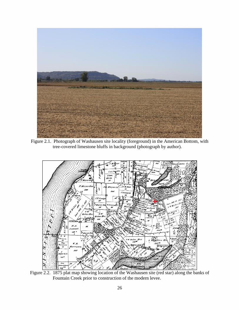
Washausen) measures 7 to 8 km. In the central American Bottom, where Washausen is located,
the eastern bluffs rise between 50 and 100 m from the floodplain valley and in several places are
defined by eroded limestone cliffs (Milner 1998:35) (Figure 2.1).
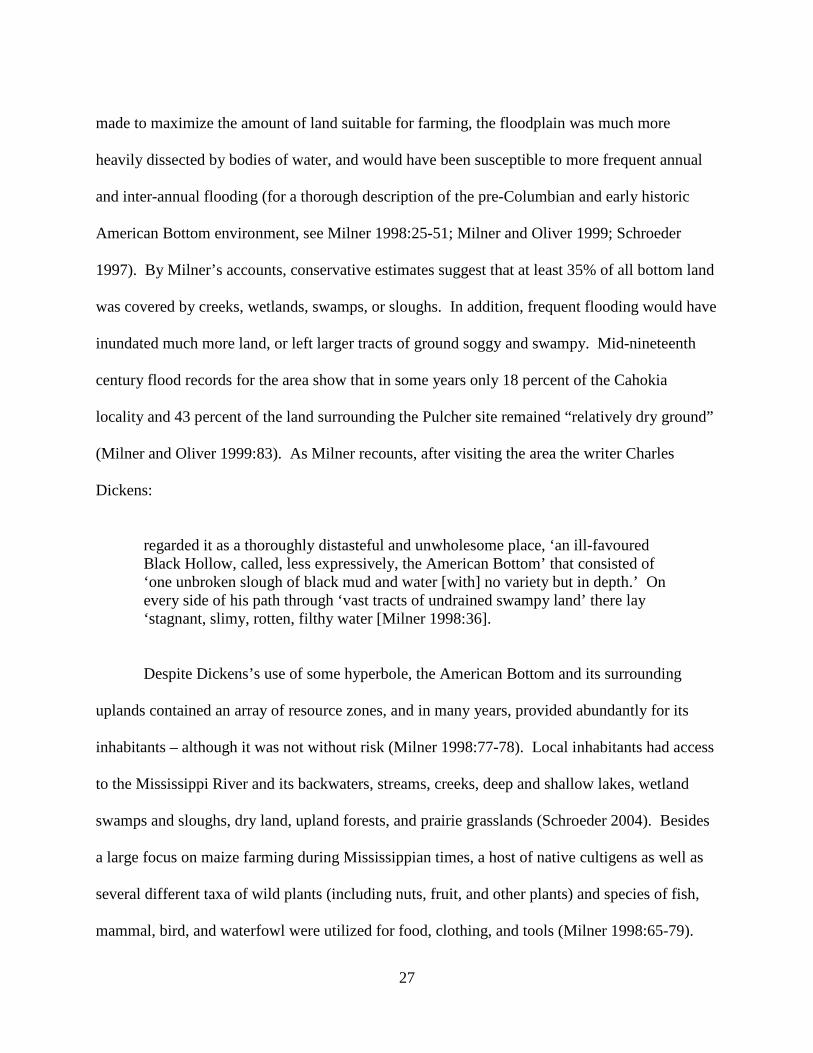
Washausen sits on the south bank of Fountain Creek, which flows in a general southwest
direction from the bluffs to the Mississippi River. Fountain Creek was channelized by levee
construction in the twentieth century, creating a straighter course than it had originally (Figure
2.2). Prior to construction of the levee, the creek turned northeast at Washausen before turning
south again just beyond the Peiper site (11Mo31), which lies roughly 0.6 km from Washausen
and was the location of a Late Woodland occupation with one small mound (Betzenhauser 2011;
Milner 1998:181).
Today, the valley floor in Monroe County is used mainly for cultivation, and consists of
large tracts of farmed land with a few shallow lakes interspersed. Prior to historic alterations
26
Figure 2.1. Photograph of Washausen site locality (foreground) in the American Bottom, with
tree-covered limestone bluffs in background (photograph by author).
Figure 2.2. 1875 plat map showing location of the Washausen site (red star) along the banks of
Fountain Creek prior to construction of the modern levee.
27
made to maximize the amount of land suitable for farming, the floodplain was much more
heavily dissected by bodies of water, and would have been susceptible to more frequent annual
and inter-annual flooding (for a thorough description of the pre-Columbian and early historic
American Bottom environment, see Milner 1998:25-51; Milner and Oliver 1999; Schroeder
1997). By Milner’s accounts, conservative estimates suggest that at least 35% of all bottom land
was covered by creeks, wetlands, swamps, or sloughs. In addition, frequent flooding would have
inundated much more land, or left larger tracts of ground soggy and swampy. Mid-nineteenth
century flood records for the area show that in some years only 18 percent of the Cahokia
locality and 43 percent of the land surrounding the Pulcher site remained “relatively dry ground”
(Milner and Oliver 1999:83). As Milner recounts, after visiting the area the writer Charles
Dickens:
regarded it as a thoroughly distasteful and unwholesome place, ‘an ill-favoured Black Hollow, called, less expressively, the American Bottom’ that consisted of ‘one unbroken slough of black mud and water [with] no variety but in depth.’ On every side of his path through ‘vast tracts of undrained swampy land’ there lay ‘stagnant, slimy, rotten, filthy water [Milner 1998:36].
Despite Dickens’s use of some hyperbole, the American Bottom and its surrounding
uplands contained an array of resource zones, and in many years, provided abundantly for its
inhabitants – although it was not without risk (Milner 1998:77-78). Local inhabitants had access
to the Mississippi River and its backwaters, streams, creeks, deep and shallow lakes, wetland
swamps and sloughs, dry land, upland forests, and prairie grasslands (Schroeder 2004). Besides
a large focus on maize farming during Mississippian times, a host of native cultigens as well as
several different taxa of wild plants (including nuts, fruit, and other plants) and species of fish,
mammal, bird, and waterfowl were utilized for food, clothing, and tools (Milner 1998:65-79).
28
Research by Schroeder (1997; 2000; 2004) shows that the American Bottom floodplain
can be divided into three key landforms types, based upon the distribution of water sources,
terrain, and the spatial patterning of tree taxa and herbaceous plants. She has labeled these three
landforms: (1) deep wetlands; (2) shallow wetlands; and (3) dry land; and notes that “[e]ach of
these landforms typically is characterised by long, narrow, sinuous features running across the
bottomlands” (Schroeder 2004:818). Access to each of these landform types would have
provided a diverse range of resources. As Schroeder describes:
Deep and shallow wetlands are critical components of the bottomland environment of large rivers with broad floodplains, such as the American Bottom segment of the Mississippi. Fish and other aquatic fauna could be efficiently harvested in reasonably large numbers… The edges of swamps support a variety of plants and attract some animals, particularly migratory waterfowl… Starchy seeds… and oily seed… annuals readily grow in such edge environments… At the higher elevations in the floodplain, fertile soils were instrumental in cultivating corn, squash, gourd, as well as the starchy and oily seed native domesticates, and supported or attracted a variety of other terrestrial resources important to these ancient people, including deer [Schroeder 2004:819].
Schroeder’s (1997) study of the American Bottom south of Cahokia, in Monroe and
northern Randolph counties, demonstrated that dry land accounted for 52-60 percent of the
bottoms, 29-35 percent was covered by shallow wetlands, and deep wetlands made up 10-15
percent of the area. She shows that although this composition of landform types presents an
average patterning over much of these two modern counties, a patchy distribution of deep
wetlands into clusters separated by stretches lacking these deeper water sources existed. Further,
Schroeder argues that the location of these deep wetland clusters relates to the locations of larger
mound sites during the Mississippian period (Schroeder 1997:163).
When sites in Monroe and northern Randolph counties were plotted on a map and a one
kilometer catchment area is drawn around each of them, Schroeder (1997) found that
29
exploitation of all three landform types was an important component of pre-Columbian
settlement in the American Bottom. All sites appear to be located with access to deep and
shallow wetlands as well as dry land. In fact, large mound sites (defined as sites with multiple
mounds and long occupation spans) are positioned at locales with more-or-less equal amounts of
all three landform types within their one kilometer catchments. The placement of other sites
(both small-mound sites and non-mound sites) is skewed toward being in close proximity to
shallow wetlands and dry land. That is, all small mound sites (defined as having a few small
mounds and short occupation spans) have 20 percent or less deep wetlands in their catchment
zones (Schroeder 1997:209-214). As Schroeder (1997:213) states, “[p]laces with a balance of
floodplain habitats were better able to offset shortfalls in one resource by increasing the use of
other resources…” especially during droughts or floods.
History of Investigations at Washausen
The Washausen site was identified by an archaeological survey and surface collected in
the early 1970s as part of the Historic Sites Survey (HSS) directed by Porter (1974; Porter and
Linder 1974). Years later, Milner (1998) tabulated ceramics collected from the site’s surface
during the HSS survey. These materials placed the use of the site from the Late Woodland
through Mississippian periods, with the majority of the pottery dating to the Emergent
Mississippian period (Milner 1998:182).
Washausen received no additional archaeological attention until February, 2004, when
John Kelly and colleagues began systematic contour mapping, surface collections, and probing at
the site (Kelly and Brown 2012:122, Figure 6.4; Stahlmann et al. 2004; see also Bailey 2007;
30
Chapman 2005; Kelly 2006b). In April 2004, and again in March 2007, Alleen Betzenhauser
(2008, 2011) oversaw magnetometer and resistivity surveys that targeted the central mound and
plaza area, as well as an area in the northern portion of the site and a strip of land stretching east
from Mound B. In May, 2004, geophysical survey under the direction of Kelly targeted the
site’s central plaza (see Burks 2004; Bailey 2007). Additional geophysical mapping by Kelly
was conducted again in 2005 focusing on an area just west of the projected plaza (John Kelly,
personal communication 2011).
Test unit excavation at Washausen was first conducted in July 2004, as part of a
University of Illinois field school (Betzenhauser 2011:132-133, Figure 5.34). A total of four 1 x
2 meter test units were excavated in the northern portion of the site, adjacent to and extending
into the levee that channels Fountain Creek. No cultural layers were encountered below the
plowzone (although not all units were excavated to sterile subsoil).
Additional test units were excavated by John Kelly in September, 2005 (John Kelly,
personal communication 2011). Due to agricultural use of the area at that time, four 1 x 2 meter
test units were placed in the northeastern portion of the site (in the lawn area where two modern
houses currently stand) that revealed a buried A soil horizon extending approximately 35 cm
below plowzone. Since then, Kelly has overseen the excavation of a handful of test units within
and near to Washausen’s plaza, mainly focused upon understanding the density and distribution
of artifacts in the plowzone, and he has continued opportunistic surface collections targeting
diagnostic materials (John Kelly, personal communication 2011).
In 2007 and 2008, as part of her dissertation research, Alleen Betzenhauser (2011)
conducted more substantial excavations at Washausen in order to target intact, sub-plowzone
features. As part of this phase of her research, Betzenhauser initially placed a total of three 1 x 2
31
meter test units (TU) at the site north of Mound A. Betzenhauser’s TUs 6 and 7 were later
expanded when cultural features were encountered below plowzone (discussed below;
Betzenhauser 2011:Figure 5.34).
In 2011, I conducted archaeological investigations at the Washausen site. These
investigations consisted of two separate seasons. Season 1 took place in February 2011. At this
time, Dr. Timothy Horsley (Northern Illinois University) and I completed a magnetometer
survey covering an area of 8.17 hectares (Barrier and Horsley 2014). Season 2 lasted from July
through December 2011. During this second season, I directed excavations at the site that
targeted five basin structures (and internal features) and one external feature. A total of 54
square meters was opened in six excavation areas. Substantial information is now available
about the Washausen site – from mapping, surface collections, geophysical reconnaissance, and
excavations. In the following section, I describe the history of fieldwork.
Previous Field Investigations at Washausen
As noted above, in 2004 John Kelly and colleagues initiated a project at Washausen that
included contour mapping, surface collections, probing, geophysical survey, and limited test
excavations. Initially, a north-oriented grid was established at the site. Using this site grid, a
contour map was created (Figure 2.3) (assisted by Dr. Robin Machiran of the University of
Missouri-St. Louis). Although the site has been affected by long-term agricultural use and
plowing, two mounds (Mounds A and B) are still visible on the landscape, and a possible third
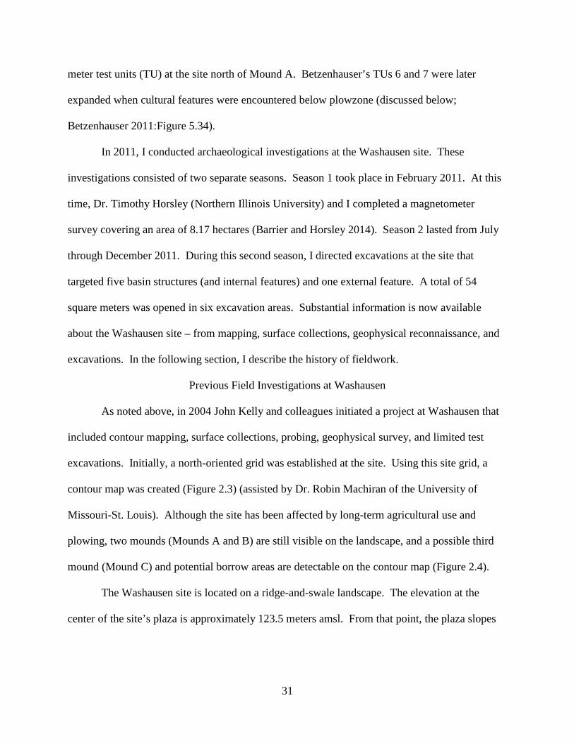
mound (Mound C) and potential borrow areas are detectable on the contour map (Figure 2.4).
The Washausen site is located on a ridge-and-swale landscape. The elevation at the
center of the site’s plaza is approximately 123.5 meters amsl. From that point, the plaza slopes
32
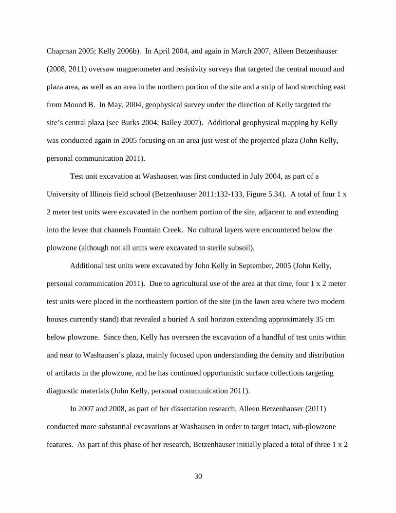
Figure 2.3. Contour map of the Washausen site (courtesy of John Kelly)
downward slightly as one moves north toward Mound A, and rises gently southward towards
Mound B. Today, Mound A stands approximately 0.5-0.7 meters high (124 meters amsl), and
Mound B stands about one meter high (124.6 meters amsl). Originally, both mounds would have
been higher. The remnant of a potential third mound (Mound C) along the eastern edge of the
plaza is barely visible on the landscape today, and measures roughly 0.2-0.3 m above the
surrounding terrain.
The central mound-and-plaza complex is bounded on its northwestern and southeastern
sides by low-lying, swales and depressions. In fact, Mound A, on the northern edge of the plaza,
abuts a swale that today serves to funnel groundwater into an irrigation ditch just to the west. To
the southeast of the plaza, just beyond Mound B, the ground rises to a flat, sandy ridge that runs
in a general southwest-to-northeast direction. Just beyond this ridge to the southeast, the ground
33
Figure 2.4. Photographs showing Mound A (top) and Mound B (bottom) at the Washausen site,
outlined in red (photograph by author).
34
slopes down precipitously (more than a meter), forming another southwest-to-northeast oriented
swale depression (which held standing water at times during my 2011 field season).
North of Mound A and beyond the swale depression north of the mound, the ground
gradually rises again to form a natural ridge. It is on this northern ridge and on the ridge just
south of Mound B, that the extent of pre-Columbian occupation at Washausen is currently
known to have existed (see Chapter 3; Barrier and Horsley 2014; Betzenhauser 2011). It is
possible, however, that occupation at Washausen extended further north and northeast, but the
construction of the Fountain Creek levee has covered the original ground surface.
Evidence of pre-Columbian occupation at the site extends eastward, but the density of
subsurface features and surface materials declines as one moves toward the modern railroad (see
below; Chapter 3). A similar pattern is seen as one moves west from the central site area, as
subsurface features and the density of surface materials drop off significantly as close as 100 m
from the plaza center (see Chapter 3; Bailey 2007; Chapman 2005). Surface remains were
recovered on the sandy ridge about 500-600 m west of Washausen’s center (John Kelly, personal
communication 2011). This area has been given a separate site designation and named the
Hawkins site.
After the creation of a site grid, Kelly laid out a nine hectare grid for systematic surface
collections. Nine 100 meter square blocks (labeled A through I) were laid out. Within each nine
blocks, 100 10 x 10 meter sub-blocks were demarcated (labeled 1 through 100), and each of
these 10 square meter sub-blocks was further subdivided into four 5 x 5 meter collection blocks
(labeled a through d) (see Bailey 2007; Chapman 2005).
Initially, only the southern half of Blocks C and D and the northern half of Block E
received 100 percent collection coverage. After these areas were collected, a ten percent random
35
sampling strategy was used in the remaining 100-square-meter blocks. Researchers later
returned to the site for additional surface collection coverage. As reported by Betzenhauser
(2011:268), 100 percent of Block A was collected, as well as 75 percent of Block B, 50 percent
of Blocks C, D, F, and H, and 25 percent of Blocks G and I. Since 2006, Kelly has continued to
opportunistically piece-plot diagnostic surface materials encountered during subsequent site
visits (John Kelly, personal communication 2011).
The primary objective of the surface collections was to refine understandings of the
chronology of occupation at the site, and to assess the possibility that the area between Mounds
A, B, and C was the location of a plaza at Washausen. Analysis of surface materials have been
conducted by Chapman (2005), Bailey (2007), and Betzenhauser (2011:265-267) (see
Betzenhauser 2011:Figure 6.27), and the results of distributional studies (not including the more
recent opportunistic finds) have been described by these researchers. Summarizing their results,
ceramic surface remains place occupation of Washausen primarily to the local Lindeman through
Early Mississippian Lindhorst phases of the late tenth through early eleventh centuries A.D.
The presence of a public plaza located between the mounds is supported by a lower
density of surface materials within the bounds of the proposed plaza-space, with a much higher
density of artifacts along its margins (Bailey 2007). In addition, the majority of red-slipped
sherds (e.g., especially of the Monks Mound Red type) were located at the western and eastern
margins of the plaza and near the plaza’s center. The areas just to the southeast and southwest of
Mound A also produced high frequencies of surface materials, including fragments of red-
slipped ceramics, Mill Creek chert, sandstone, and basalt.
Geophysical surveys have also been used at Washausen to investigate the site’s spatial
configuration. Initial geophysical survey at Washausen was conducted by Betzenhauser in April
36
of 2004, and again in 2007 (Betzenhauser 2011). John Kelly oversaw geophysical surveys at the
site in May of 2004, and again several months later (see Burks 2004; Bailey 2007). Geophysical
techniques were employed by both researchers in order to assess site layout, including the spatial
relationship between the mounds and plaza. In addition, Betzenhauser (2011) used these survey
techniques to better understand the spatial composition of subsurface features, and to aid
assessment of potential changes in site layout at early Mississippian sites throughout the larger
region.
Betzenhauser (2011) employed both magnetometry and resistivity at Washausen. Her
surveys covered a total of 12,180 m2, an area running from the northern levee, across Mound A
and the plaza, to Mound B. A strip of land running east from Mound B was also surveyed.
Betzenhauser’s resistivity survey was completed over Mound B. Kelly (John Kelly, personal
communication 2011) also utilized both magnetometry and resistivity at the site. His magnetic
surveys focused specifically on the plaza area, and he conducted a resistivity survey over Mound
A.
The geophysical surveys completed by Betzenhauser (2011:128-132) and Kelly (Bailey
2007) lend further support that the area between Mounds A and B was the location of a plaza at
Washausen. Further, their surveys show that both Mounds A and B were originally constructed
as square or rectangular monuments, even though they now appear conical-shaped as a result of
annual plowing. Betzenhauser (2011:128-132) was also able to identify several anomalies that
appear to represent structures, and commented on the potential presence of courtyard group
configurations at the site.
Previous excavations directed by both Betzenhauser and Kelly have provided important
information about the pre-Columbian occupation at the Washausen site. Of particular
37
importance was Betzenhauser’s excavation of two structures (her TU 6 loci) and a midden area
(TU 7) (Betzenhauser 2011:132-139, Figure 5.34). Unit TU 7, a 2 x 2 m unit, was placed
approximately 20-25 meters north of Mound A, and was excavated to a depth of 45 cm below
surface. Below the plowzone, three separate midden fill zones were encountered, described as
dark, organic-rich soils. The excavation of TU 7 was not completed to sterile subsoil; however,
midden fill was noted as running the extent of the unit’s horizontal profile.
Betzenhauser’s TU 6 was placed north of Mound A near the northern levee
(Betzenhauser 2011:Figure 5.34). Excavation of this test unit encountered feature fill and was
subsequently expanded to cover an area of 28 m2 to partially reveal two superimposed basin
structures. Both structures were constructed with individually set wall posts. The lower (older)
structure was labeled Feature 1, and the upper (younger) structure was labeled Feature 2
(Betzenhauser 2011:Figures 5.37-5.41).
Feature 1 has a depth of 46 cm below surface, and a floor area of approximately 8.5 m2.
A total of ten fill zones were identified, composed of light, dark, and burned fills. Evidence
collected by the excavator suggests that this structure was dismantled prior to the construction of
the overlying structure (Feature 2) (Betzenhauser 2011:135-137). Remains of burned thatch
were removed from the fill of Feature 1, likely from the placement of burned materials soon after
this structure was dismantlemed. A radiocarbon date on this thatch produced a calibrated date of
A.D. 960 +/- 70 (Betzenhauser 2011:136). This radiocarbon date places the abandonment of
Feature 1 as early as the Range-George Reeves phases, although the corresponding ceramic
remains suggest a later Lindeman phase (late tenth century) abandonment. As noted by
Betzenhauser (2011:136), the one-sigma error range of the dated sample extends into the
38
Lindeman phase. A width/length ratio of 0.59 for Feature 1 is more similar to Early
Mississippian Lindhorst phase structures at the Range site.
Sometime after the infilling of Feature 1, a later single-set post structure (Feature 2) was
constructed (Betzenhauser 2011:137-139). This later structure was offset just to the west of
Feature 1, but partially extended into Feature 1 fills. Excavations show that Feature 2 was a
smaller structure, with a floor area of 6.6 m2, a basin depth of 38 cm, and a width/length ration of
0.66. The size and shape characteristics of Feature 2 compares to Lindeman-Lindhorst phase
structures at the Range site, as well as to Lindeman phase structures at the nearby Divers site. A
total of six fill layers were identified during excavation of Feature 2. As noted by the excavator
(Betzenhauser 2011:138-139), Feature 2 fills contained fewer artifacts than Feature 1, and may
have accumulated from natural erosion, rather than having been intentionally filled by local
residents.
The 2011 University of Michigan-Washausen Archaeological Project (UM-WAP)
Previous fieldwork conducted at Washausen by John Kelly and his colleagues and Alleen
Betzenhauser provided important information that I drew upon in my field investigations at the
site. As summarized above, their work provided information about site layout and
monumentality, site chronology, and off-mound occupation. Their work has shown that: (a)
Washausen was the location of an early mound-and-plaza center in the central American Bottom;
(b) it was occupied from at least the Lindeman (A.D. 950-1000) through Early Mississippian
Lindhorst (A.D. 1000-1050) phases; and (c) occupants of Washausen maintained living space
beyond the mound-and-plaza complex, possibly in courtyard group configurations.
39
With this information in hand, I recognized that the Washausen site could yield
information about social processes that occurred during the early Mississippian transition in the
central American Bottom. I devised a research strategy for new fieldwork at Washausen, GIS
spatial analyses, artifact analyses, and radiocarbon dating. As director of the University of
Michigan-Washausen Archaeological Project (UM-WAP), I oversaw an extensive geophysical
survey, and directed more than five months of excavations at the site. In the remainder of this
chapter, I will provide an overview of my fieldwork.
Season One – Geophysical Survey
In February 2011, I oversaw an extensive geophysical survey at Washausen covering an
area of 8.17 ha (approximately 81,700 m2; Barrier and Horsley 2014). The survey block was
situated to encompass the entire mound-and-plaza complex as well as significant areas in all
directions. This work was designed as a high resolution survey in order to obtain information
about the entire area of major occupation of the site (Horsley et al. 2014).
Magnetometry was utilized in the 2011 survey that took place over a course of nine days.
Conditions at the time were cold, and a thin layer of ice and snow covered the site.
Magnetometry is commonly applied in archaeological investigations and can be used to detect a
wide range of buried features over large areas (Aspinall et al. 2008; Benech 2007; Clark
1990:64-98; Gaffney and Gater 2003:36-42; Kvamme 2006). A Bartington Grad601-2 dual
fluxgate gradiometer was used. Readings were recorded at 0.125 m intervals along traverses
spaced 0.5 m apart, all collected in zigzag mode using marked guide ropes. This procedure was
carried out across multiple 30 x 30 meter units, with smaller blocks utilized near field edges.
Following data collection, limited data treatment was undertaken. Processing was
restricted to: (1) clipping the data to within 30 nT; (2) sensor de-striping to correct for
40
differences between the two sensor pairs (Horsley and Wilbourn 2009); (3) slight de-staggering
(.06 meters) on a few grids to correct for positional shifts between adjacent transverses (see
Aspinall et al. 2008:124-126); and (4) limited edge-matching to ensure smooth transitions
between adjacent grids. The data were then interpolated to increase the spatial density from a
resolution of 0.5 x 0.125 meters to 0.25 x 0.125 meters (using a non-linear sin(x)/x function) (see
Aspinall et al. 2008:133-134; Scollar et al. 1990:502-504). The resulting image was then
imported into a geographic information system (GIS) database for integration with maps,
satellite images, and other archaeological spatial datasets.
The survey’s traverses were aligned to follow recent plow furrows, roughly parallel to the
northern levee running in a northwest-southeast direction. This strategy was taken in order to
minimize magnetic noise caused by recent plow scars. Our geophysical survey grid was
established using a total station, and shot in at several points to Kelly’s site grid (see above).
After the survey, the geophysical data were converted to Kelly’s grid.
The northern and eastern limits of the geophysical survey were bounded by the northern
levee and the railroad berm to the east. To the south, the survey grid extended approximately
105 m south of Mound B where the surface slopes into a low-lying swale depression. The
survey extended west approximately 165 m. Although magnetic anomalies representing
subsurface features appear to extend north beneath the levee, and a low density of anomalies
likely extend west past the survey limits, the spatial extent of our magnetometer survey appears
to have encompassed the area of major occupation at Washausen.
The results of our geophysical survey and interpretations of the magnetometer data are
presented in Chapter 3. In brief, our results support many of the interpretations of previous
researchers. The central Washausen site appears to have been the location of a mound-and-plaza
41
complex. In many areas beyond these central monuments, subsurface features were identified
that represent the remains of a village at the site.
Our results, owing in part to the “total” coverage of the survey, demonstrates that off-
mound occupation of the site was more substantial than previously recognized, particularly in the
southern and southeastern portions of the site. In addition, the distribution of basin structures
confirms the presence of residential courtyard groups at Washausen around the central mound-
and-plaza complex.
These survey results were instrumental in devising a research design for conducting my
excavations at the site. The magnetometer data helped establish an excavation strategy that
allowed me to target subsurface features to address my research questions. A description of my
excavation methods follows.
Season Two – Excavations
From July through December 2011, I directed excavations at the Washausen site. I
opened a total of 54 square meters, distributed across six excavation loci (see Figure 4.1). Using
information from our geophysical survey, my excavations were designed to sample intact
subsurface features, including (semi-subterranean) basin structures and other features. Time and
available labor allowed for a total of five basin structures (and internal features) to be sampled,
as well as one external pit.
Using a total station, 1 x 1 meter units were placed on top of selected anomalies. The
plowzone deposit from each unit was excavated as one level, and was screened through ½ inch
wire mesh. Below the plowzone, a majority of units (~70%) were hand-excavated to sterile
subsoil, and sub-plowzone sediments were screened through ¼ inch wire mesh. Approximately
42
30 percent of the units were excavated to the base of the plowzone, in order to outline and
expose the spatial dimensions of basin structures.
Artifacts were bagged according to their horizontal and vertical spatial contexts. All
features were excavated following their natural stratigraphy. Within natural zones, smaller
arbitrary levels were sometimes excavated separately. Standardized forms were used to record
information about features, soil/sediment characteristics, artifacts, elevations, and other pertinent
details. Profile and plan-view maps were produced for each completed excavation locus and
digital photographs were taken. Internal features encountered at structure floors, including posts
as well as pits and hearths, were mapped, photographed, and excavated separately. Additional
samples were collected within each excavation locus. A total of 56 soil samples was collected for
water flotation in order to recover botanical and zooarchaeological remains from feature
contexts. Organic remains were collected for AMS radiocarbon dating.
Five basin structures were partially excavated during Season Two. Initially two 1 m-
wide trenches were laid out in a cruciform pattern over three basin structures (Structures 1, 2,
and 3; see Chapter Four). Additional units were then opened over the anomalies to create wider
trenches for more horizontal exposure. Each unit was excavated to the base of the plowzone to
expose the edges of these features in several directions. This method served to ground-truth the
geophysical data, by showing that the magnetic anomalies accurately matched their actual
subsurface locations.
After the dimensions of these three basin structures were mapped at the base of the
plowzone, several contiguous units were excavated through structure fill until I encountered
sterile subsoil or internally-placed floor features. Detailed plans were drawn to record the linear
dimensions of structure floors, including the position and shape of wall posts, pits, and areas of
43
soil disturbance. Profile maps were created to record the stratigraphy of the fill that accumulated
in the basins.
Soil samples for flotation were collected at various depths from structure fill, and soil
samples were collected when zone changes were encountered and from fill layers that contained
higher concentrations of organic materials and artifacts. When soil or radiocarbon samples were
collected from fill layers, they were mapped. Care was given to record their vertical and
horizontal proveniences on profile maps, so they could be linked to specific strata in the basin
fill.
All intramural features (e.g., posts, pits, hearths) encountered at the base of structures
were given individual feature designations and excavated separately. Remains of pits and wall
posts were initially bisected or quartered to reveal their depth and morphology, as well as
internal fill stratigraphy. Each feature was then mapped and photographed, and when possible,
samples were collected from each feature for flotation and radiocarbon dating.
Two additional basin structures were also partially excavated (Structures 4 and 5; see
Chapter 4). Over both of these structures, a 1 x 2 meter unit was laid out to intersect one edge of
each feature, positioned to maximize excavation of feature fill and expose structure floor space.
Similar to the excavation of other structures, the plowzone was removed initially. Then
excavations were carried to subsoil, following methods described above. Internal features
located at the base of these structures were similarly excavated and recorded.
Several magnetic anomalies thought to be the locations of subsurface pit features were
cored using a 7/8 inch diameter soil probe. One feature was then selected for excavation. A 2 x
2 meter unit was laid out and excavated to the base of the plowzone. A oval-shaped feature was
revealed and mapped, and designated Feature 19. Next, Feature 19 was bisected and excavated
44
to sterile subsoil. A profile map was drawn, photographs taken, and a soil sample for flotation
was collected. Feature 19 likely represents the remains of a shallow pit that was cleaned out
prior to being filled via natural erosion. No artifacts other than a handful of small pieces of
burned soil were recovered from within Feature 19.
In the following chapters, I present the results from the 2011 field investigations.
Chapter 3 describes Season One’s geophysical survey. Spatial information about the Washausen
settlement is used to discuss community organization, and demographic information for
Washausen is placed within a regional framework that charts a diachronic trajectory of village
growth and decline leading up through the early Mississippian transition in the region. Chapter 4
presents results of Season Two’s excavations, as well as data produced from artifact analyses and
radiocarbon dating.
45
CHAPTER 3 SHIFTING COMMUNITIES: THE SPATIAL ORGANIZATION AND
DEMOGRAPHIC DEVELOPMENT OF THE WASHAUSEN COMMUNITY In this chapter I provide a description of the spatial organization of the Washausen site
utilizing data collected during the 2011 geophysical survey. The geophysical data are used to
produce a relatively complete map of the site displaying the patterning of distinct, residential
courtyard groups distributed around a centrally located mound-and-plaza complex. First, I
present the spatial organization of Washausen, and I focus on the extent, layout, and arrangement
of monuments, plaza spaces, and structures. Then I consider Washausen’s development within
its local social and environmental landscape, and I feature the arrangement of numerous
courtyard groups around the site’s plazas and mounds. After this, I chart the growth of the
settlement within a regional and diachronic historical framework. The growth of the community
at Washausen illuminates an historical trajectory marked by the development of larger
aggregated village settlements through time in the central American Bottom. The growth and
decline of villages through time, I argue, occurred through a process of serial residential
migrations within the larger region, enacted by the fissioning and re-aggregation of residential
courtyard groups.
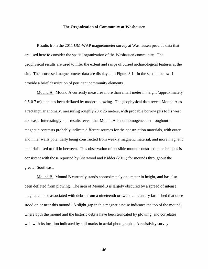
46
The Organization of Community at Washausen
Results from the 2011 UM-WAP magnetometer survey at Washausen provide data that
are used here to consider the spatial organization of the Washausen community. The
geophysical results are used to infer the extent and range of buried archaeological features at the
site. The processed magnetometer data are displayed in Figure 3.1. In the section below, I
provide a brief description of pertinent community elements.
Mound A. Mound A currently measures more than a half meter in height (approximately
0.5-0.7 m), and has been deflated by modern plowing. The geophysical data reveal Mound A as
a rectangular anomaly, measuring roughly 28 x 25 meters, with probable borrow pits to its west
and east. Interestingly, our results reveal that Mound A is not homogeneous throughout –
magnetic contrasts probably indicate different sources for the construction materials, with outer
and inner walls potentially being constructed from weakly magnetic material, and more magnetic
materials used to fill in between. This observation of possible mound construction techniques is
consistent with those reported by Sherwood and Kidder (2011) for mounds throughout the
greater Southeast.
Mound B. Mound B currently stands approximately one meter in height, and has also
been deflated from plowing. The area of Mound B is largely obscured by a spread of intense
magnetic noise associated with debris from a nineteenth or twentieth century farm shed that once
stood on or near this mound. A slight gap in this magnetic noise indicates the top of the mound,
where both the mound and the historic debris have been truncated by plowing, and correlates
well with its location indicated by soil marks in aerial photographs. A resistivity survey
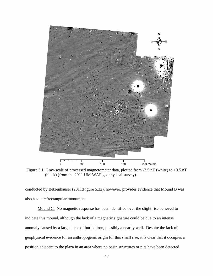
47
Figure 3.1 Gray-scale of processed magnetometer data, plotted from -3.5 nT (white) to +3.5 nT
(black) (from the 2011 UM-WAP geophysical survey). conducted by Betzenhauser (2011:Figure 5.32), however, provides evidence that Mound B was
also a square/rectangular monument.
Mound C. No magnetic response has been identified over the slight rise believed to
indicate this mound, although the lack of a magnetic signature could be due to an intense
anomaly caused by a large piece of buried iron, possibly a nearby well. Despite the lack of
geophysical evidence for an anthropogenic origin for this small rise, it is clear that it occupies a
position adjacent to the plaza in an area where no basin structures or pits have been detected.
48
Plaza. Bounded by Mounds A and B to the north and south, possibly by Mound C to the
east, and occupation features to the west, a rectangular area (measuring approximately 72 x 68
m) with few magnetic anomalies provides strong evidence for the length and width of the plaza.
In the southern half are a small number of magnetic anomalies consistent with large post-pits and
possibly a series of other pits. These results validate the delineation of the plaza based on
surface materials (Baily 2007; Chapman 2005), and also correspond to general designs of late
prehistoric mound-and-plaza layouts across southeastern North America (Kidder 2004; Lewis et
al. 1998).
Circular Anomaly. A large ring, roughly 40-44 m in diameter, is visible in the
magnetometer data west of the main concentration of occupation features. Such a negative
magnetic response usually indicates an earthen bank, and it is clear that in places it has been
truncated by plow damage. No signs of this anomaly are visible from the surface or from aerial
photographs.
Courtyard Groups. The magnetometer data reveal the distribution of semi-subterranean
(basin) structures and other features across the site. Based on comparisons with excavated late-
prehistoric components throughout the American Bottom (Kelly 1990a; Kelly et al. 2007;
Mehrer and Collins 1995; Pauketat 1994, 2003), it is possible to infer the presence of distinct,
residential courtyard groups at Washausen. Courtyard groups typically consist of a number of
structures ringing central spaces marked by pits, posts, and other associated features. Most
common within pre-A.D. 1050 components, courtyard groups have also been recovered at early
Mississippian (post-A.D. 1050) sites in the region (Alt 2001, 2002; Pauketat 2003).
Archaeologists suspect that courtyard groups, in the American Bottom region and elsewhere in
the Mississippian world, are the material expression of extended family kin groups, possibly
49
lineages (Barrier 2011; Kelly 2000:167; Muller 1997:190-192; Wilson 2008:87-90). At
Washausen, basin structures seem to be oriented in a north-northeast to south-southwest or west-
northwest to east-southeast direction, possibly respecting a main spatial axis of the community
and the mound-and-plaza complex.
Secondary Plaza. One grouping of buildings stands out in particular. Highlighted in
Figure 3.2, large basin structures define a square-shaped plaza arrangement located in the south-
central area of the settlement. Buildings marking the perimeter of this plaza are aligned, more-
or-less, in a north-south or east-west direction. In the center of this group is a basin structure
offset about 35-40 degrees from the dominant alignment. This building group appears to align
with a potential site grid, as defined by the site’s central mound-and-plaza complex. The area
delineated by these perimeter buildings measures approximately 50 x 50 meters. This space is
roughly two times larger than the two early plazas at the largest Emergent Mississippian village
at the nearby Range site (Kelly 1990a:Figure 40). Thus, the open space delineated by this
group’s perimeter buildings likely served as a secondary plaza for the community.
Local Development of the Washausen Settlement
My description of various community elements at Washausen is based on the 2011 UM-
WAP geophysical results, as well as targeted excavations at the site. Major elements include the
central mound-and-plaza complex (with two or possibly three earthen mounds flanking the open,
central plaza), a secondary plaza, and several distinct residential courtyard groups. Although
delineation of clear-cut boundaries between inferred residential groups cannot be marked using
geophysical data alone, the relatively “clean” magnetometer results support the short span of site
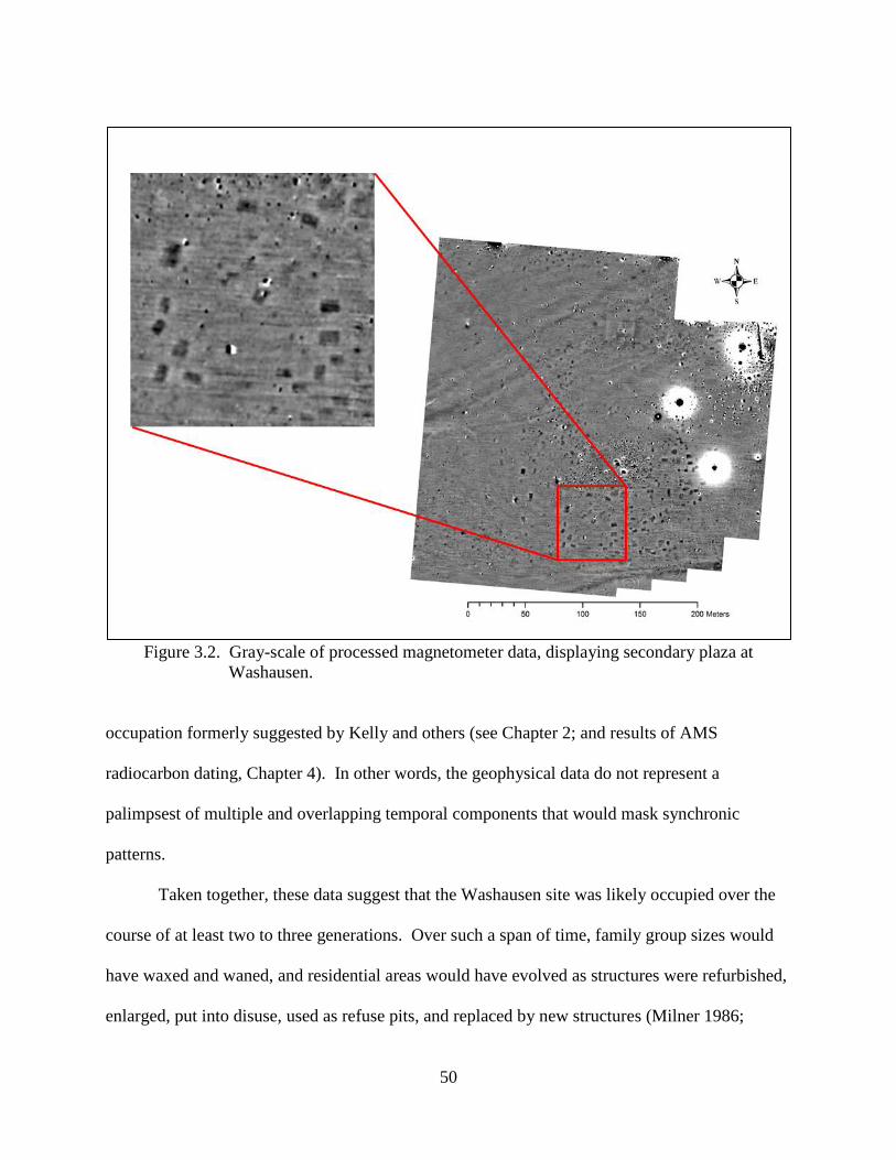
50
Figure 3.2. Gray-scale of processed magnetometer data, displaying secondary plaza at
Washausen.
occupation formerly suggested by Kelly and others (see Chapter 2; and results of AMS
radiocarbon dating, Chapter 4). In other words, the geophysical data do not represent a
palimpsest of multiple and overlapping temporal components that would mask synchronic
patterns.
Taken together, these data suggest that the Washausen site was likely occupied over the
course of at least two to three generations. Over such a span of time, family group sizes would
have waxed and waned, and residential areas would have evolved as structures were refurbished,
enlarged, put into disuse, used as refuse pits, and replaced by new structures (Milner 1986;
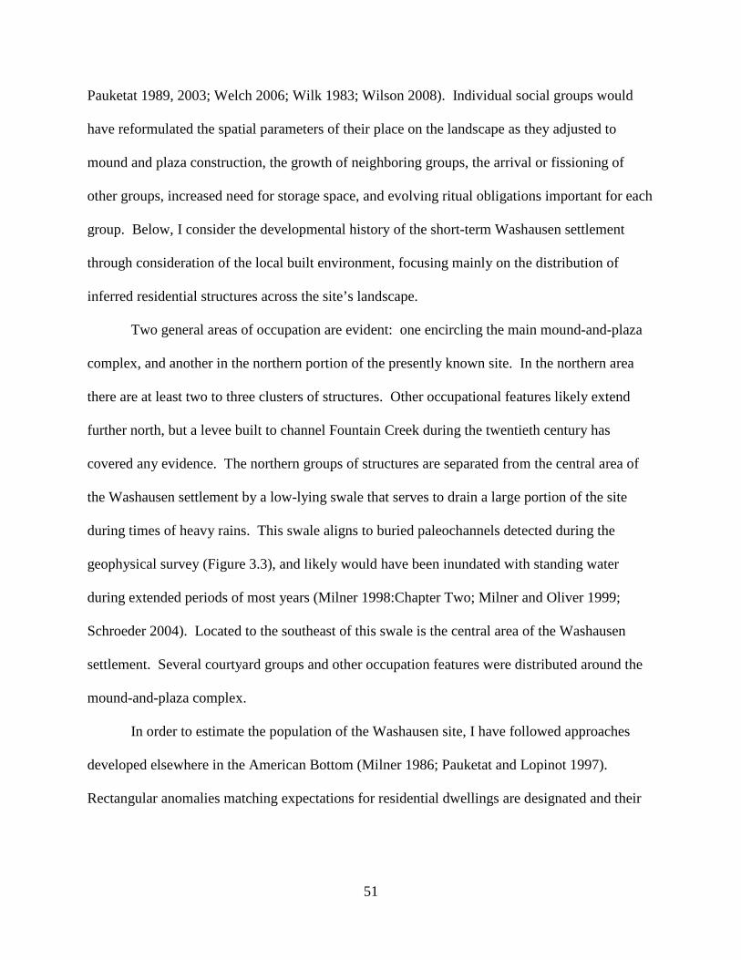
51
Pauketat 1989, 2003; Welch 2006; Wilk 1983; Wilson 2008). Individual social groups would
have reformulated the spatial parameters of their place on the landscape as they adjusted to
mound and plaza construction, the growth of neighboring groups, the arrival or fissioning of
other groups, increased need for storage space, and evolving ritual obligations important for each
group. Below, I consider the developmental history of the short-term Washausen settlement
through consideration of the local built environment, focusing mainly on the distribution of
inferred residential structures across the site’s landscape.
Two general areas of occupation are evident: one encircling the main mound-and-plaza
complex, and another in the northern portion of the presently known site. In the northern area
there are at least two to three clusters of structures. Other occupational features likely extend
further north, but a levee built to channel Fountain Creek during the twentieth century has
covered any evidence. The northern groups of structures are separated from the central area of
the Washausen settlement by a low-lying swale that serves to drain a large portion of the site
during times of heavy rains. This swale aligns to buried paleochannels detected during the
geophysical survey (Figure 3.3), and likely would have been inundated with standing water
during extended periods of most years (Milner 1998:Chapter Two; Milner and Oliver 1999;
Schroeder 2004). Located to the southeast of this swale is the central area of the Washausen
settlement. Several courtyard groups and other occupation features were distributed around the
mound-and-plaza complex.
In order to estimate the population of the Washausen site, I have followed approaches
developed elsewhere in the American Bottom (Milner 1986; Pauketat and Lopinot 1997).
Rectangular anomalies matching expectations for residential dwellings are designated and their
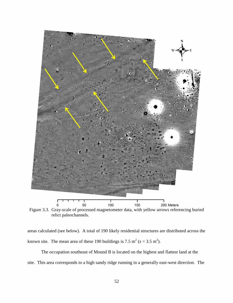
52
Figure 3.3. Gray-scale of processed magnetometer data, with yellow arrows referencing buried relict paleochannels.
areas calculated (see below). A total of 190 likely residential structures are distributed across the
known site. The mean area of these 190 buildings is 7.5 m2 (s = 3.5 m2).
The occupation southeast of Mound B is located on the highest and flattest land at the
site. This area corresponds to a high sandy ridge running in a generally east-west direction. The
53
southeastern most courtyard groups and the buildings flanking the southern perimeter of the
secondary-plaza sit adjacent to a drop-off well over a meter. Another low-lying swale is present
here that held standing water during my fieldwork season in 2011. As one moves north and
northwest of Mound B across the central plaza, the ground surface begins dropping in elevation
and soils become less sandy, composed of higher clay content, and less well-drained.
Mound A’s placement abuts the low-lying swale that separates the central site area from
the occupation structures near the levee. Just to the northwest of Mound A, there is a paucity of
magnetic anomalies that further indicates that this area would have been too wet for sustained
occupation. The construction of Mound A at the edge of a swampy area may be related to the
history of occupations at Washausen, as will be discussed below.
History of Occupation at Washausen
Washausen is one of a handful of the earliest known settlements in the American Bottom
whose residents participated in constructing earthen platform mounds (Kelly 1990b:135; Milner
1998:105-106; Pauketat 2004:59). Little is known about the earliest period of mound building in
the region, however. In the central American Bottom other mound settlements, like the one at
the nearby Pulcher site, may also have been experiencing population growth (Figure 1.1).
Residents at Pulcher eventually constructed up to 13 or 14 mounds (probably between A.D. 1000
and 1200); however, the history and sequence of site occupation and mound construction is
poorly understood (Kelly 1993). From limited excavations and surface reconnaissance, it
appears that the earliest mounds may be attributable to the local pre-A.D. 1050 Lindeman phase,
and it is likely that many of the mounds were constructed during early Mississippian times. As
at early Cahokia, where pre-Mississippian villagers organized into individual courtyard groups
occupied the banks of Cahokia Creek (Pauketat 1994:169), the Pulcher occupation debris lies

54
along the banks of Fish Lake in a series of discontinuous clusters (Griffin 1977; Kelly 1993). As
Kelly has stated:
although defined on the basis of the mounds [present]… the actual definition of Pulcher is still somewhat elusive, especially since the site has not been systematically surveyed. Freimuth (1974:1) suggested it covered ‘500 acres plus’… Fowler (1969:367, 1978) described a site encompassing 300 acres, and Gregg (1975) reduced the area to 100 to 200 acres. While these areas may represent the site as bounded by the mounds, such estimates can be extremely misleading, especially if they are interpreted by others as the area of residential occupation [Kelly 1993:443].
Kelly continues:
It is important to realize that most of the investigations (testing and surface collections) have been restricted to the northwest portion of the central group. Tim Pauketat… who has walked a large portion of the site area, indicates that most of the occupation is along the terrace edge contiguous with Fish Lake and even this is discontinuous, a term Griffin (1977) used to characterize the site. Griffin (1977) also noted that the distribution of the Pulcher mounds is not a typical Mississippian pattern in that they are not arranged about a central plaza [Kelly 1993:443].
With this minimal knowledge of the greater Pulcher site, a few observations can be made.
First, it appears that the early occupation of the site was adjacent to the banks of Fish Lake, along
a high terrace running in a generally north-south direction. Second, areas of residential
occupation are not continuous here, but distributed into clusters, possibly associated with
individual mounds. Third, other mounds were constructed along an elevated ridge extending out
in an eastward direction from Fish Lake, and it is likely that occupation zones and possibly a
central plaza were constructed on this east-west running ridge. Thus, Pulcher may have grown
through the arrival of distinct social groups throughout its history, groups whose residential
spaces were associated with adjacent mounds and possibly with plazas.
55
If mounds and adjacent residential groups are thought of as separate sociopolitical
entities, in line with Blitz’s (1999; Blitz and Lorenz 2006:19) description of “mound-political
units” in his fission-fusion model, then sites like Pulcher should not be viewed as static
settlements. Rather, the histories of settlements’ growth and development can be modeled, and
these models can be tested with archaeological data. In reality, many of the mounds making up
the Pulcher complex may have, at least originally, marked “separate entities” (Kelly 1993:443)
the products of distinct social groups, whose houses and their associated mound spread out along
the highest elevated ridges near productive wetlands and agricultural areas (see Milner and
Oliver 1999; Schroeder 1997, 2004).
Similarly at Washausen, initial occupation areas, composed of distinct courtyard groups,
may have been spread out along high ridges. Thus, the northern occupations would have lined
the banks of Fountain Creek and the most southeastern occupation groups would have clustered
onto the high and flat sandy ridge where Mound B is located. This southeastern occupation zone
appears to have become the most densely populated area at Washausen, and was closely
affiliated with the settlement’s secondary plaza, public ceremonial events, and a rare T-shaped
building that served a specialized (non-domestic) function (see Chapters 4 and 5).
Milner (1986) has noted that through time across the American Bottom floodplain, there
was a general trend for households to relocate to higher elevations. Thus, one scenario for the
history of Washausen’s development would predict that initial use of the site would be around
the central mound-and-plaza complex, on its eastern and western boundaries. If this was the case
at Washausen, the use of the central plaza as defined by two or three mounds would have
maintained its original parameters marking a centrally important public space; that is, mounds
were constructed to mark an extant plaza between the earliest occupied courtyard groups (see
56
Kidder 2004) as residents at Washausen moved to higher ground on the site’s northern and
southeastern ridges.
A more likely scenario, however, is that the earliest arrivals forming residential groups at
Washausen settled on the highest ridges at the site, along the banks of Fountain Creek (the
northern area of the site) and then settled on the ridge southeast of Mound B. As the Washausen
village grew and began attracting more residents, just as they were also being pulled into Pulcher
and Cahokia (Beck et al. 2007:842; Kelly 1990 a, 1990b, 2002, 2007a), these later-arriving
groups would have filled previously unoccupied spaces on gently sloping and less well-drained
soils (around the central mound-and-plaza complex). As such, the act of constructing the
mounds themselves and sanctifying a central ritual ground would have served to better integrate
numerous groups living under conditions of greater nucleation and population densities.
Radiocarbon dates produced from organic samples from the northern and southeastern
ridges at Washausen provide information about the history of occupations at the site, and support
this second scenario (described in detail in Chapter Four). A total of ten AMS dates were run on
organic materials recovered during the 2011 UM-WAP excavations, and one extant radiocarbon
date was given in Betzenhauser (2011). These 11 absolute dates suggest that both ridges were
locations of activity starting during the tenth century A.D. and lasting into the eleventh century,
with perhaps the southeastern ridge being occupied more intensely during the eleventh century.
Under this second scenario of Washausen’s historical development, the construction of
Mound A on the edge of a low-lying swampy area (adjacent to the low-lying, relict
paleochannel) would have fixed the central plaza not upon the highest and flattest ground at
Washausen (where groups were already living), but on gently sloping terrain not being used for
residential space. This scenario is not unlike the emerging picture of Cahokia’s early
57
development. Schilling’s (2010, 2012, 2013) recent work dating the construction of Monks
Mound places its initial construction around A.D. 1100 or later, and it seems to have been
erected in rapid fashion thereafter. He proposes that the placement of Monks Mound was
necessitated by the positioning of several extant, large social kin groups that already maintained
important residential and ritual spaces, plazas, and mounds on the highest grounds. As Schilling
states:
coring located the original ground surface beneath Monks Mound and demonstrates that the premound surface slopes almost three meters from Southeast to Northwest. On the one hand, this slope is not the optimal placement for a large earthen structure and probably exacerbated slumping on the western slope. On the other hand, the Ancient Cahokians may not have had a choice given the necessity to place Monks Mound – the center of the world – in that particular place. Although, conjectural, given the meaning of platform mounds in Eastern North American Indian beliefs, it may have been necessary to put Monks Mound in that specific location in spite of poor topography [Schilling 2010:285].
If the growth and development of Washausen followed a trajectory similar to those
posited for early Pulcher and Cahokia, then the histories of social institutions like the residential
courtyard group must be given a new primacy in the study of Mississippian development. Much
productive research on the emergence and constitution of complex societies has been top-down,
focusing on institutions, groups, or individuals at the apex of political hierarchies; another
productive approach is to study the organization and integration of institutions and groups that
interact to induce dynamically shifting historical arrangements (Crumley 2007). The courtyard
as a kin group undoubtedly had a dynamic history as a core structuring institution of early
Mississippian society, and dramatic shifts through time in the importance of this institution
should not be overlooked.
58
The Mississippian world across the greater Southeast is replete with cases of polity
growth and decline, often through processes of aggregations and dispersals at both previously
occupied and entirely new mound centers (e.g., Boudreaux 2013). In the American Bottom
region, a protracted movement towards greater nucleation and larger scales of both intra- and
inter-site integration is evident when viewed at a gross scale. But from a more time-sensitive
scale, we see the dynamic movement of residential groups across the landscape, and we can chart
recurrent patterns of aggregation and dispersal as nucleated villages and towns developed for
periods of time before being abandoned or becoming the location of smaller settlements (Alt
2001; Emerson 1997; Kelly 1990b, 2002; Milner 1990; Pauketat 2003).
One hypothesis is that Washausen grew through the addition of courtyard groups, which
had broken away from nearby villages like Range (Figure 1.1; see below). Efforts to integrate
larger-scale communal rituals and, perhaps, mitigate political competition are evident in the
creation of the settlement’s secondary plaza and construction of the central mound-and-plaza
complex. However, groups at Washausen were soon drawn even deeper into ongoing regional
processes of aggregation and dispersal (shown below and in Chapter 5). It appears that, within a
few generations of Washausen’s founding, groups began relocating to rapidly growing
settlements like Pulcher or Cahokia, dispersing throughout the floodplain, or even began leaving
the region altogether.
Recent research on other later Mississippian centers in the Southeast demonstrates that
complexity and dramatic historical change resulted in part through the interactions of distinct
corporate kin groups (Barrier 2011; Blitz and Lorenz 2006; Boudreaux 2013; Knight
2010:Chapter 9). Thus, I consider the long-term development of the Washausen settlement as
resulting from the ongoing process of courtyard group aggregation and fissioning. I construct a
59
method for calculating population for Washausen, and place its growth within a trajectory of
village growth and decline in the central American Bottom. Demonstrating that early mound
villages in this region developed through the fission-fusion process underscores the need for
continued research, not only to document the presence and movement of corporate kin groups
across the landscape, but also to explore how their interactions served to enact cultural and
institutional change. Mere documentation of the presence of courtyard groups is not enough;
investigation of how corporate kin groups constructed more highly integrated social communities
will be the focus of later chapters.
Population and Regional Development of the Washausen Community
The last few decades of Mississippian archaeology in the Eastern United States has
provided a clearer picture of the population dynamics associated with the growth and decline of
these complex polities (Blitz 2010:12; Cobb 2003). Whereas earlier accounts suggested
relatively long-lived, stable social systems, subsequent research has demonstrated much more
flux in the occupational histories of Mississippian sites and entire regions (e.g., Anderson 1994;
Beck 2003; Blitz 1999; Blitz and Lorenz 2006; Boudreaux 2013; Cobb and King 2005; Hally
1996; Knight 2010; Knight and Steponaitis 1998; Milner 1990). In many places, it is no longer
assumed that the largest sites (often containing one or more earthen mound and plaza) were
continuously occupied throughout the entire Mississippian sequence. Instead, it is known that
centers of regional power, influence, and population often shifted between neighboring sites.
Researchers working in the American Bottom region have demonstrated that population
sizes were not static throughout the local Late Woodland and Mississippian periods (Alt 2006;
60
Koldehoff and Galloy 2006; Milner 1990, 1998:120-125; Pauketat 2003, 2004; Kelly 1990a,
2002, 2008; Schilling 2010:309). During early Mississippian times (Figure 1.2), especially
beginning in the eleventh century A.D., population increased dramatically at a handful of large
mound settlements. The best evidence is from Cahokia, which during the late eleventh century
grew to become not only the largest settlement in the region, but also the largest and most
complex Mississippian center in Eastern North America (Fowler 1975, 1989; Hall 1975; Milner
1990, 1998; Pauketat 2004).
Archaeologists are aware that late prehistoric population increases in the American
Bottom and at Cahokia resulted in part from immigration from other regions, as well as from
local growth (Cobb 2005:567). In fact, evidence suggests that regional population numbers had
been increasing for several centuries throughout the earlier Late Woodland period (Kelly
1990b:143-144, 1992:187-190, Figure 6.9; see also Buikstra et al. 1986) and likely continued
throughout much of the Mississippian Stirling phase (A.D. 1100-1200) (Milner 1998:120-125;
Pauketat and Lopinot 1997). Cahokia’s population seems to have peaked earlier than overall
regional numbers and were at reduced levels throughout much of the Stirling phase, likely a
result of the movement of segments of Cahokia’s populace to floodplain sites and beyond
(Milner 1998:Figure 6.1; Pauketat and Lopinot 1997:Figure 6.3, Figure 6.4).
Previous Population Estimates for the American Bottom
Determining exact population numbers and demographic change in the past has proven
difficult and challenging to archaeologists, and several techniques have been employed to
produce population estimates from archaeological remains (e.g., Bandy 2005:S110; Curet 1998).
In situations lacking written documentation, archaeologists have used site area, surface debris
61
density, midden accumulation, mortuary remains, food refuse, estimates of labor requirements
for monumental constructions, and architectural information as proxies for the number of people
that occupied a site or region.
There has been much speculation about Cahokia’s population numbers, and several
reviews of this literature exist (see Milner 1986:227-228, 1998:120-121; Muller 1997:218-219;
Pauketat and Lopinot 1997:103-105). Gregg (1975) was the first to put forth estimates using
information about residential architecture from excavations at Cahokia. Since then, most
researchers have similarly used structure densities and domestic building sizes from extant
excavation data to generate population estimates for the site and the greater American Bottom
region (Barrier and Horsley 2014; Kelly 1992; Milner 1986, 1998; Pauketat 2003; Pauketat and
Lopinot 1997). Although published estimates vary, the shared strengths of these approaches are
that they have spelled out assumptions that underlie estimating procedures and they are based on
similar data (Milner 1998:121).
While much of the discussion of the region’s population has centered upon Cahokia
itself, other areas of the greater American Bottom receiving attention have been the floodplain
region south of Cahokia and the adjacent uplands just to the east. Milner’s (1986) calculations
for a large portion of the Mississippi River floodplain south of Cahokia were based on
architectural information from 11 excavated Mississippian sites, each representing non-mound
farmsteads. Only rectangular structures were included, as other building types are considered to
have served non-domestic functions. Rebuilt structures, or buildings with evidence for
significant wall repair, were counted separately, and paired structures were counted as one unit.
A total of 98 rectangular structures were identified, and these were used to calculate the density
of single family residences for all habitable land.
62
Milner’s (1986) methodology also accounted for structure longevity and household size.
Several factors contribute to the length of time a building would have served as a residence,
including but not limited to structural decay, damage from fire, infestations, as well as social and
economic circumstances that contribute to residents’ decisions to relocate (see Pauketat
1989:303). For his study area, Milner (1986) used house longevity estimates of three, five, and
ten years. Pauketat and Lopinot (1997) used estimates of five, ten, fifteen, and twenty years for
Cahokia, and Pauketat (2003) used estimates ranging from ten to seventeen years for upland
Richland Complex villages, with the assumption that buildings at villages and at Cahokia would
have been occupied longer than those at small farmsteads (see Pauketat 2003:47, Note 6).
Information about the number of individuals per house is also a limiting factor in
reconstructions of prehistoric population demography. Following Cook (1972), who assembled
ethnographic data for native groups in the western United States, Milner (1986) calculated the
likely number of individuals per structure based on house size.1 Due to increases in building size
throughout the Mississippian phases in the region, Milner’s estimates ranged from 4.14 to 7.11
persons per structure. Pre-Mississippian buildings, smaller on average than Mississippian
structures, likely housed fewer people. Thus, Kelly (1992:188, Figure 6.9) used an estimate of
2.32 persons per structure for pre-Mississippian settlements in the central American Bottom
region, and Pauketat and Lopinot (1997) used 2.55 as an estimate for pre-Mississippian
Edelhardt phase buildings at Cahokia. Estimates of four and five persons per structure were later
used by Milner (1998:121-124) for Mississippian Period Cahokia and by Pauketat (2003) for
Lohmann to early Stirling phase upland villages.
1 Cook’s (1972:16) methodology for estimating the number of persons per structure is based on the area of living space of residential buildings. He shows that structures housing up to six individuals require 25 ft2 of floor space per individual, and an additional 100 ft2 of floor space is needed for any additional occupant (see also Milner 1986:231; Pauketat and Lopinot 1997:115).
63
Even with the use of these strict methods, there are many uncertainties and unknowns in
calculating population. The major problem in estimating population in the American Bottom is
establishing representativeness of the archaeological samples. According to Milner (1998:123-
124), “[i]nadequate sampling is the greatest single flaw in available data” because excavated
areas are unlikely to provide a perfect representation of occupation density across an entire
settlement. Although the excavated area at Cahokia exceeds that for most sites, the data used to
estimate population have come from excavations of the most densely occupied areas of the site
and from areas excavated in conjunction with recent constructions.2
Sampling for the greater region is even more problematic. Milner (1998:Figure 6.1) has
provided rough population estimates for the American Bottom floodplain region for the four
Mississippian phases. These figures are the sum of estimates extrapolated from excavated areas
at Cahokia and farmsteads, as well as an aggregate estimate for all other mound centers spread
throughout the valley. Known population density figures from excavated, outlying farmstead
sites were multiplied by the total area of the valley floor, minus the river and islands (Milner
1998:125). Then, since minimal occupational data exist for the majority of mound centers,
estimates for Cahokia itself were doubled to stand in for the total combined population of all
other floodplain mound sites. Even as he was developing this methodology, Milner (1998:125)
suggested that it likely overestimated the total floodplain population, in large part due to the
assumption that populations were evenly distributed throughout the entire stretch of the
American Bottom.
2 Milner (1998:Figure 6.1) presents a series of population estimates, ranging from low to high, for the region. His American Bottom floodplain estimates range from about 20,000 to 50,000 for the Stirling phase. For Lohmann phase Cahokia, Milner gives a high-end population estimate of about 8,000 residents. Pauketat and Lopinot (1997:Table 6.3) give a Lohmann phase estimate of about 15,000 for the site. Pauketat (2003:Figure 5) gives slightly higher estimates for Lohmann phase Cahokia based on a 50-year phase duration and a house longevity estimate of 10 years.
64
Methodology for Calculating Population Estimates for Washausen
The results from the 2011 UM-WAP geophysical survey allow a series of population
estimates to be calculated for Washausen and provide demographic information about a pre-
Columbian American Bottom mound center other than Cahokia. Estimates given herein are
calculated using architectural information from the site (following Kelly 1992; Milner 1986,
1998; Pauketat 2003; Pauketat and Lopinot 1997). The number of buildings and their sizes are
derived from interpretation of geophysical data collected during the 2011 magnetometer survey
at Washausen, which were used to create a site map (described above). This method provides
population estimates based on inferred building counts, rather than figures produced from
estimations of site-wide building densities based on limited sampling.
Processed geophysical data were imported into a GIS database and shapefiles were
created with polygons that define the shape of suspected structures. Maps were then produced of
the Washausen settlement. These maps were instrumental in the development of my excavation
strategies. A total of five structures distributed across the site were partially excavated (Figure
2.5). These excavations served to ground-truth geophysical data, demonstrating that the
placements, alignments, and dimensions of inferred structures match with high precision the
actual spatial specifications of basin structures (Figure 3.4).
With the confirmation that rectangular anomalies identified through magnetometry could
reasonably be interpreted as houses, all rectangular basin features that matched expectations for
actual dwellings were included in the demographic modeling. Following previous researchers
(Milner 1986:229-230, 1998; Pauketat and Lopinot 1997), only rectangular structures were used
in calculations, whereas square, round, and T-shaped buildings were omitted. Where clear
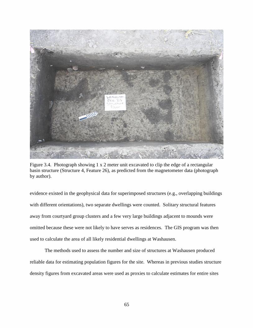
65
Figure 3.4. Photograph showing 1 x 2 meter unit excavated to clip the edge of a rectangular basin structure (Structure 4, Feature 26), as predicted from the magnetometer data (photograph by author). evidence existed in the geophysical data for superimposed structures (e.g., overlapping buildings
with different orientations), two separate dwellings were counted. Solitary structural features
away from courtyard group clusters and a few very large buildings adjacent to mounds were
omitted because these were not likely to have serves as residences. The GIS program was then
used to calculate the area of all likely residential dwellings at Washausen.
The methods used to assess the number and size of structures at Washausen produced
reliable data for estimating population figures for the site. Whereas in previous studies structure
density figures from excavated areas were used as proxies to calculate estimates for entire sites
66
and the region (Milner 1998:123-125), the figures for Washausen are based on a relatively
complete site map.
Population Estimates for Washausen
A total of 190 rectangular basin structures were used in calculations of the population of
the Washausen site (Figure 3.5). As previously discussed, inferred structures and other feature
classes are distributed in clusters that conform to the residential courtyard groups that are typical
of American Bottom village sites at this time (Kelly 1990a, 1990b; Pauketat 1994, 2003). The
patterning of courtyard groups and public architecture, as well as ceramic remains and
radiocarbon dates recovered from the site (Chapter 4; see also Bailey 2007; Betzenhauser 2011;
Kelly 2006b), demonstrate that the major occupation of the Washausen settlement was short-
lived, representing more or less a single-component occupation. Coupled with the relative lack
of disturbance to subsurface features, these data allow for robust estimates of a synchronic
occupation and population.
Four separate population estimates are presented for Washausen because it is unlikely
that all structures were contemporaneously occupied (Table 3.1). Separate calculations are
presented based on the assumptions that structures were occupied for either 10 or 15 years, and
that the site was occupied for either 50 or 75 years. Ten- and 15-year structure longevity
estimates correspond with figures used for Cahokia and other early Mississippian Period upland
villages (Pauketat 2003; Pauketat and Lopinot 1997; see also Milner 1998; Pauketat 1989).
Table 3.1 lists the population estimates calculated for Washausen. These range from 101
to 228 inhabitants, based on an average of four persons per structure. An estimate of four
persons is consistent with estimates used by Milner (1998) for Cahokia and by Pauketat (2003)
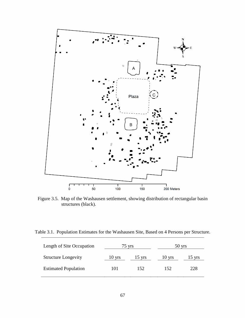
67
Figure 3.5. Map of the Washausen settlement, showing distribution of rectangular basin structures (black).
Table 3.1. Population Estimates for the Washausen Site, Based on 4 Persons per Structure.
Length of Site Occupation 75 yrs
50 yrs
Structure Longevity 10 yrs
15 yrs
10 yrs
15 yrs
Estimated Population
101
152
152
228
68
for the upland, Richland Complex village sites. This average is also similar to the estimate of 3.3
persons per structure that results from calculating the number of individuals based on the mean
area of rectangular structures at Washausen (mean = 7.5 m2, s = 3.5 m2) (from Cook 1972; as
used in Kelly 1992; Milner 1986; Pauketat and Lopinot 1997).
The average number of persons per structure that I used for Washausen is consistent with
figures for a settlement occupied during the Mississippian transition in the American Bottom.
Excavations throughout the region show that basin structures increased in size through time.
Because of this diachronic change in house size, Kelly (1992) calculated an estimate of 2.32
persons per structure for pre-Mississippian villages in the central American Bottom, and
Pauketat and Lopinot (1997) estimated 2.55 persons for Edelhardt phase residences at Cahokia.
Early Mississippian, Lohmann phase buildings at farmsteads and at Cahokia are thought to have
housed an average of 4.14 and 4.60 persons, respectively (Milner 1986; Pauketat and Lopinot
1997).
The 101-228 estimated range is based on architectural data currently available. However,
it is probable that the actual population of the Washausen settlement during its period of major
use was near the high end of this range. This is because, as discussed in Chapter 2, the
occupation at the site may have extended further to the north than currently evident, underneath
the modern-day levee channeling Fountain Creek (see also Betzenhauser 2011). The methods
used here for delineating the number of structures cannot adequately detect repaired walls, which
may have served to extend the use-life of some structures thus increasing the number of
contemporaneously occupied buildings (see Milner 1986, 1998:122; Pauketat 2003; Pauketat and
Lopinot 1997).
69
Washausen Population Estimates and Regional Village Development in the Central American Bottom
These data for the Washausen site contribute the first systematically derived population
estimates for a late prehistoric mound settlement in the American Bottom floodplain outside of
Cahokia. The total population of this transitional Mississippian Period mound-and-plaza village
likely never reached 300 individuals. Although seemingly a small number, especially relative to
estimates for Cahokia that range from several thousand up to 15,000 inhabitants (see Milner
1998:124; Pauketat 2003:47; Pauketat and Lopinot 1997), the Washausen population numbers
are not outside of our general expectations for a Mississippian village of its size (see Anderson
1999:15.2; Muller 1997b:Tables 5.8-5.11). In fact, the population of the much larger
Mississippian mound center of Moundville in Alabama, where nearly 30 earthen mounds were
once constructed, was probably under 2000 people at its height (Steponaitis 1998).
Thus, the Washausen data demonstrate that the earliest villagers in the American Bottom
who constructing monumental mounds and large public spaces, sometime in the early eleventh
century, were living in communities of modest size of at most a few hundred people. The
Edelhardt phase village at Cahokia, and potentially others like Pulcher (Kelly 1993, 2002), had
likely grown larger prior to A.D. 1050 (Pauketat and Lopinot 1997). However, very large local
population sizes do not seem to be a prerequisite for the development of complex,
suprahousehold social organizations and incipient monumentality.
The population data for Washausen are significant beyond revealing the size of early
villages with mounds in the American Bottom. When looked at in a regional context, these data
present a picture of the demographic changes co-occurring with the development of larger
villages and an increased regional emphasis on both maize and native seed crop production (see
70
Fritz and Lopinot 2007). Demographic shifts, undoubtedly, were part and parcel of the social
processes involved with the build-up of larger and more complex polities, as movements of
groups across the landscape (via fissioning and re-aggregation) served to create conditions
conducive to the production of new social communities (Pauketat 2003:43; see also Alt 2006;
Cobb 2005; Cobb and Butler 2006; Cobb and King 2005). These new communities may have
extended beyond the spatial boundaries of early mound settlements (see Yaeger and Canuto
2000) to include year-round or temporary residents of nearby farmsteads, villages, or rural
“nodal” sites (see Emerson 1997; Pauketat Emerson 1997:7-8; Milner 1990:21-23).
The best-known pre-Mississippian village sequence has been produced from expansive
excavations at the Range site (Figure 1.1) in the central American Bottom (see Chapter 1, also
Kelly 1990a, 1990b; 2000). The central American Bottom region has been defined by Kelly
(1990b, 2002) as the area of the floodplain south of the Goose Lake Meander locale and Prairie
du Pont Creek, extending south through much of Monroe County, Illinois, and includes the
Washausen and Pulcher sites. A series of several communities have been delineated at Range,
suggesting that sedentary village life had begun in the region by at least the Dohack phase
(Figure 1.2), sometime during the later decades of the ninth century (Kelly 1990a; Koldehoff and
Galloy 2006). This is also when evidence of maize agriculture first becomes common at Range
and most other regional localities (Kelly 1992; Fritz and Lopinot 2007; Simon and Parker 2006).
The sequence for the Range site documents sedentary communities from at least 150-200
years prior to the start of the regional Mississippian phases at A.D. 1050. In addition,
researchers have demonstrated a fluid and punctuated history of settlement movement and
reorganization at Range. These involved the formation and dissolution of distinct villages
through time, a continuation of shifting landscape-use patterns that were characteristic of the
71
earlier Late Woodland Patrick phase (cf. Kelly 1990a, 1992, 2000; Koldehoff and Galloy 2006).
At the center of these population movements were co-residential courtyard groups.
Kelly (1990a, 1992, 2000) has charted the organization of several sequential village
occupations at the Range site that show an increase in nucleation and occupational density
through time. By the late tenth century, George Reeves phase courtyard groups were configured
around two central plazas, with each individual group maintained its own ritual facilities. This
speaks to the importance of multiple, overlapping integrative institutions under conditions of
increasing nucleation, as each group is expected to have taken on greater roles organizing agricultural
land and labor and key aspects of its ritual and political life. Around A.D. 1000, the fissioning of
courtyard groups led to the dissolution of one of the larger plaza groups. The remaining
courtyard groups reoriented themselves to a new single plaza for a period of time, but by late in
the Lindeman phase, another major population decrease is evident, again the result of fissioning
of individual courtyard groups that were likely relocating to larger centers like the already
growing Washausen and Pulcher settlements (Kelly 1990a, 1990b, 2002).
Thus, the early histories of village life and the development of greater scales of
complexity in the American Bottom resulted in part from processes of fissioning and re-
aggregations (see also Kelly 1990a:108, 1990b, 1992; Pauketat 2003:43). In fact, similar
processes are suspected to have been commonplace across the greater Mississippian world (Blitz
1999; Blitz and Lorenz 2006), and fissioning is seen as a fundamental facet of the social
dynamics of early villages in general worldwide (e.g., see Bandy 2004:322). In the Titicaca
Basin of Bolivia, for example, Bandy (2004) has sketched a similar pattern of village fissioning
and re-aggregations during the Formative Period. In this area, he attributes recurrent episodes of
village fissioning to mechanisms that resolved increasing levels of intra-village conflict
associated with increasing local populations and scalar stress. Subsequent villages that

72
maintained larger populations show evidence for the development of “integrative institutions
capable of mitigating the scale-related stresses that emerged and intensified as [villages]… grew”
(Bandy 2004:330). Bandy (2004:330) demonstrates that the “village fissioning threshold”
increased, going from population estimates of around 170 with village areas of about three
hectares during the Early Chiripa phase, to population estimates of 277 at larger villages
covering around five hectares during the Middle Chiripa.
In a much larger comparative study of 36 early village sequences world-wide, Bandy
(2008) finds a similar pattern of development. In an overwhelming majority of these 36 regions,
Bandy says that “large villages” developed during the first millennium after the onset of
sedentary, agricultural life. In his North American cases (he does not include the American
Bottom) large village development is seen after an average of about 450 years.
From his comparative data, Bandy (2008:335) defined “large villages” as those reaching
approximately 300 occupants covering an area usually greater than three hectares. He states that
with the growth of these large villages, “the development of novel institutions of social
integration at the suprahousehold level could make possible the emergence of villages larger than
the critical population threshold” for fissioning (Bandy 2008:341). That is, when communities
fitting Bandy’s criteria for “large villages” develop, demographic changes are often accompanied
by the development of public institutions that served to integrate newly arrived groups and
increasingly competitive factions. In his Titicaca Basin case, these integrative institutions are
marked by the appearance of public ceremonialism and architecture (e.g., sunken courts) in large
Middle Chiripa villages, and later by the growth of a regional religious tradition by the Late
Chiripa phase, a time witnessing the growth of even larger and more stable villages (Bandy
2004).
73
The Range and Washausen site sequences in the central American Bottom support
Bandy’s (2004, 2008) model for large, agricultural village development through recurrent
episodes of fissioning and re-aggregations, and the construction of integrative ritual facilities like
mounds and plazas (Figure 3.6 and Table 3.2).3 Although the largest Dohack phase village at
Range is slightly larger than the subsequent Range phase villages, the largest George Reeves
phase community was at least doubled in size, with an estimated population of 105 individuals
covering an area of 1.2 hectares (Kelly 1990a). After the fissioning of several courtyard groups,
and the dissolution of one of the site’s larger plaza groups, the resulting Lindeman phase village
at Range had a reduced population of around 61 individuals in a village space that extended for
less than one hectare.
At this time during the Lindeman phase, by A.D. 1000 or slightly earlier, major
occupation at Washausen began (Figure 1.2). Washausen villagers who still primarily organized
themselves into courtyard and plaza groups, in ways similar to the George Reeves phase
community members at Range, were active in creating new community-scale identities –
identities shared by the multiple residential groups living at Washausen and potentially by others
at nearby farmsteads. The Lindeman-Lindhorst phase (late tenth- through early eleventh-
century) community at Washausen was marked by the construction of earthen, platform mounds
demarcating a large, open public plaza. This mound-and-plaza ceremonial complex would have
brought together individuals and groups in large-scale gatherings, helping to shape community
3 At the Range site, Kelly (1990a:74) identified “a sequence of at least 28 temporally discrete communities for the 500 year span” stretching from the Late Woodland Patrick phase through the Early Mississippian Lindeman phase (cf. Koldehoff and Galloy 2006 for the Late Woodland Patrick phase). Throughout this sequence community sizes fluctuated, reflecting recurrent cycles of residential group fissioning and re-aggregation. In Figure 3.6, only data for the largest aggregations for each archaeological phase at Range are graphed, which masks much greater population and community dynamics for the Range locality.
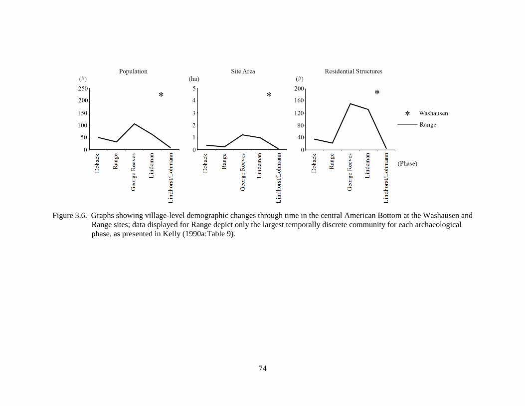
74
Figure 3.6. Graphs showing village-level demographic changes through time in the central American Bottom at the Washausen and
Range sites; data displayed for Range depict only the largest temporally discrete community for each archaeological phase, as presented in Kelly (1990a:Table 9).
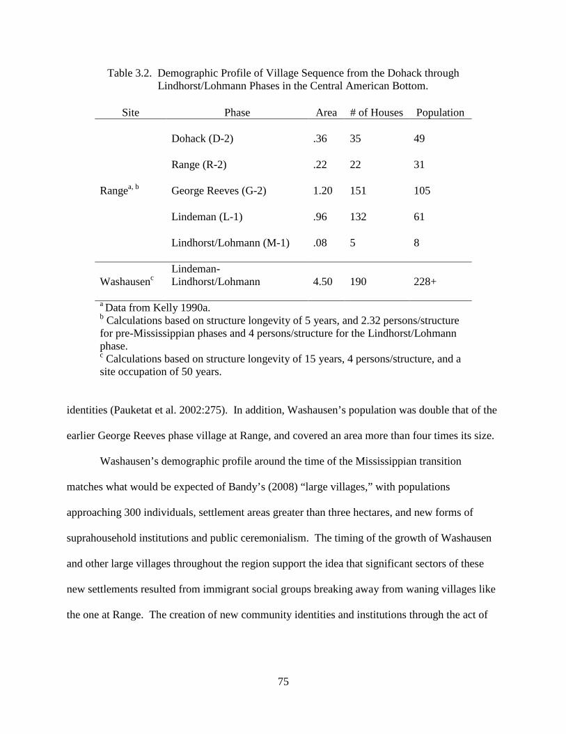
75
Table 3.2. Demographic Profile of Village Sequence from the Dohack through Lindhorst/Lohmann Phases in the Central American Bottom.
Site Phase Area # of Houses Population
Rangea, b
Dohack (D-2)
.36
35
49
Range (R-2)
.22
22
31
George Reeves (G-2)
1.20
151
105
Lindeman (L-1)
.96
132
61
Lindhorst/Lohmann (M-1)
.08
5
8
Washausenc
Lindeman-Lindhorst/Lohmann
4.50
190
228+
a Data from Kelly 1990a. b Calculations based on structure longevity of 5 years, and 2.32 persons/structure for pre-Mississippian phases and 4 persons/structure for the Lindhorst/Lohmann phase. c Calculations based on structure longevity of 15 years, 4 persons/structure, and a site occupation of 50 years.
identities (Pauketat et al. 2002:275). In addition, Washausen’s population was double that of the
earlier George Reeves phase village at Range, and covered an area more than four times its size.
Washausen’s demographic profile around the time of the Mississippian transition
matches what would be expected of Bandy’s (2008) “large villages,” with populations
approaching 300 individuals, settlement areas greater than three hectares, and new forms of
suprahousehold institutions and public ceremonialism. The timing of the growth of Washausen
and other large villages throughout the region support the idea that significant sectors of these
new settlements resulted from immigrant social groups breaking away from waning villages like
the one at Range. The creation of new community identities and institutions through the act of
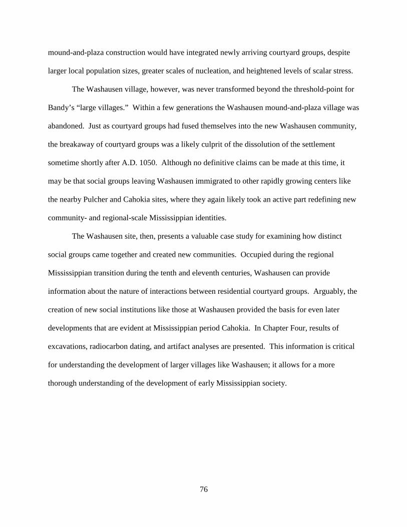
76
mound-and-plaza construction would have integrated newly arriving courtyard groups, despite
larger local population sizes, greater scales of nucleation, and heightened levels of scalar stress.
The Washausen village, however, was never transformed beyond the threshold-point for
Bandy’s “large villages.” Within a few generations the Washausen mound-and-plaza village was
abandoned. Just as courtyard groups had fused themselves into the new Washausen community,
the breakaway of courtyard groups was a likely culprit of the dissolution of the settlement
sometime shortly after A.D. 1050. Although no definitive claims can be made at this time, it
may be that social groups leaving Washausen immigrated to other rapidly growing centers like
the nearby Pulcher and Cahokia sites, where they again likely took an active part redefining new
community- and regional-scale Mississippian identities.
The Washausen site, then, presents a valuable case study for examining how distinct
social groups came together and created new communities. Occupied during the regional
Mississippian transition during the tenth and eleventh centuries, Washausen can provide
information about the nature of interactions between residential courtyard groups. Arguably, the
creation of new social institutions like those at Washausen provided the basis for even later
developments that are evident at Mississippian period Cahokia. In Chapter Four, results of
excavations, radiocarbon dating, and artifact analyses are presented. This information is critical
for understanding the development of larger villages like Washausen; it allows for a more
thorough understanding of the development of early Mississippian society.
77
CHAPTER 4 THE 2011 UM-WAP FIELD INVESTIGATIONS AT WASHAUSEN
This chapter presents results from the 2011 UM-WAP excavations at Washausen, as well
as information produced from analyses of artifacts that reveal activities that took place at the site.
As discussed in Chapter 3, major settlement at Washausen begun in the tenth century A.D.
(Figure 1.2). The settlement remained a center of occupation until at least the mid-eleventh
century, and was likely completely abandoned during the decades immediately following A.D.
1050.
I first describe my excavations and then discuss the archaeological deposits. Then, I
present the results of radiocarbon dating to date site occupations and activities. After
radiocarbon dates are discussed, I present results from artifact analyses. Analyses were
conducted on zooarchaeological, botanical, ceramic, and lithic materials. Data from artifact
analyses, alongside results presented in Chapter 3, will be used in Chapter 5 to evaluate the
evidence for social institutions and public activities that would have supported increased
integration of aggregated residential courtyard groups.
2011 UM-WAP Excavations at Washausen
Excavation methods utilized during the 2011 field investigations at Washausen are
discussed in Chapter Two. Here, I summarize the excavated features. As noted earlier, I opened
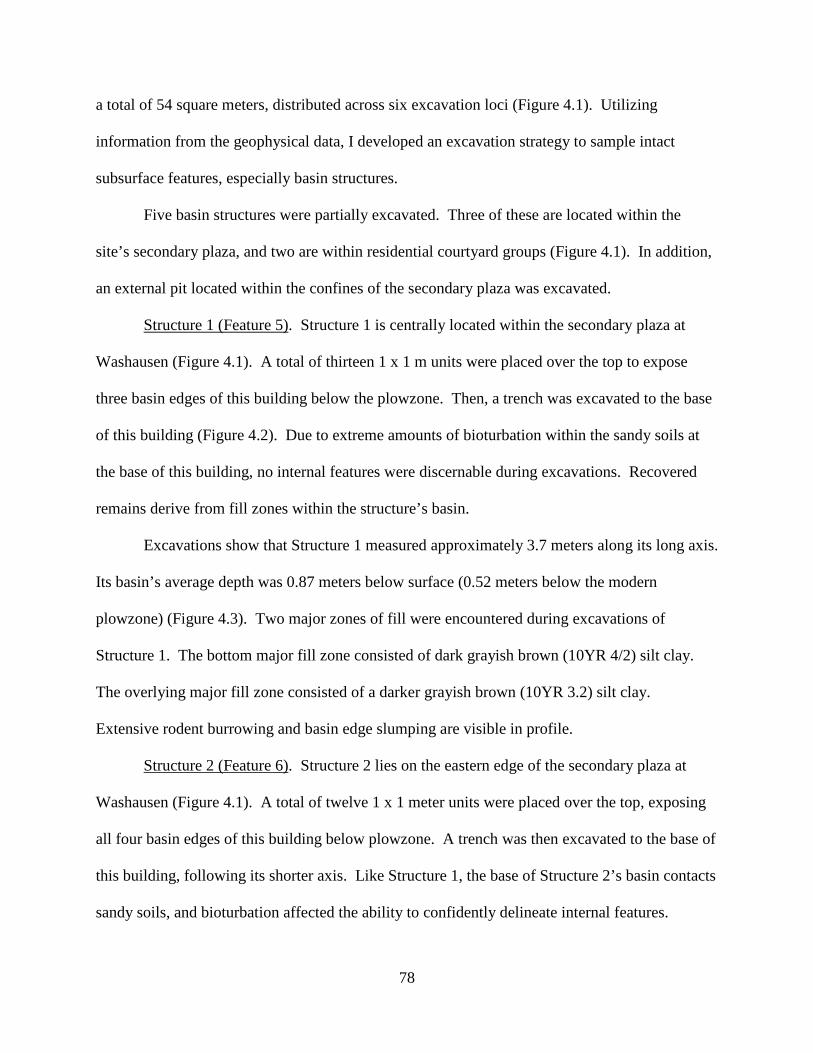
78
a total of 54 square meters, distributed across six excavation loci (Figure 4.1). Utilizing
information from the geophysical data, I developed an excavation strategy to sample intact
subsurface features, especially basin structures.
Five basin structures were partially excavated. Three of these are located within the
site’s secondary plaza, and two are within residential courtyard groups (Figure 4.1). In addition,
an external pit located within the confines of the secondary plaza was excavated.
Structure 1 (Feature 5). Structure 1 is centrally located within the secondary plaza at
Washausen (Figure 4.1). A total of thirteen 1 x 1 m units were placed over the top to expose
three basin edges of this building below the plowzone. Then, a trench was excavated to the base
of this building (Figure 4.2). Due to extreme amounts of bioturbation within the sandy soils at
the base of this building, no internal features were discernable during excavations. Recovered
remains derive from fill zones within the structure’s basin.
Excavations show that Structure 1 measured approximately 3.7 meters along its long axis.
Its basin’s average depth was 0.87 meters below surface (0.52 meters below the modern
plowzone) (Figure 4.3). Two major zones of fill were encountered during excavations of
Structure 1. The bottom major fill zone consisted of dark grayish brown (10YR 4/2) silt clay.
The overlying major fill zone consisted of a darker grayish brown (10YR 3.2) silt clay.
Extensive rodent burrowing and basin edge slumping are visible in profile.
Structure 2 (Feature 6). Structure 2 lies on the eastern edge of the secondary plaza at
Washausen (Figure 4.1). A total of twelve 1 x 1 meter units were placed over the top, exposing
all four basin edges of this building below plowzone. A trench was then excavated to the base of
this building, following its shorter axis. Like Structure 1, the base of Structure 2’s basin contacts
sandy soils, and bioturbation affected the ability to confidently delineate internal features.
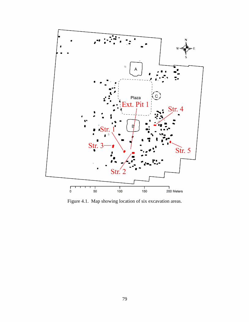
79
Figure 4.1. Map showing location of six excavation areas.
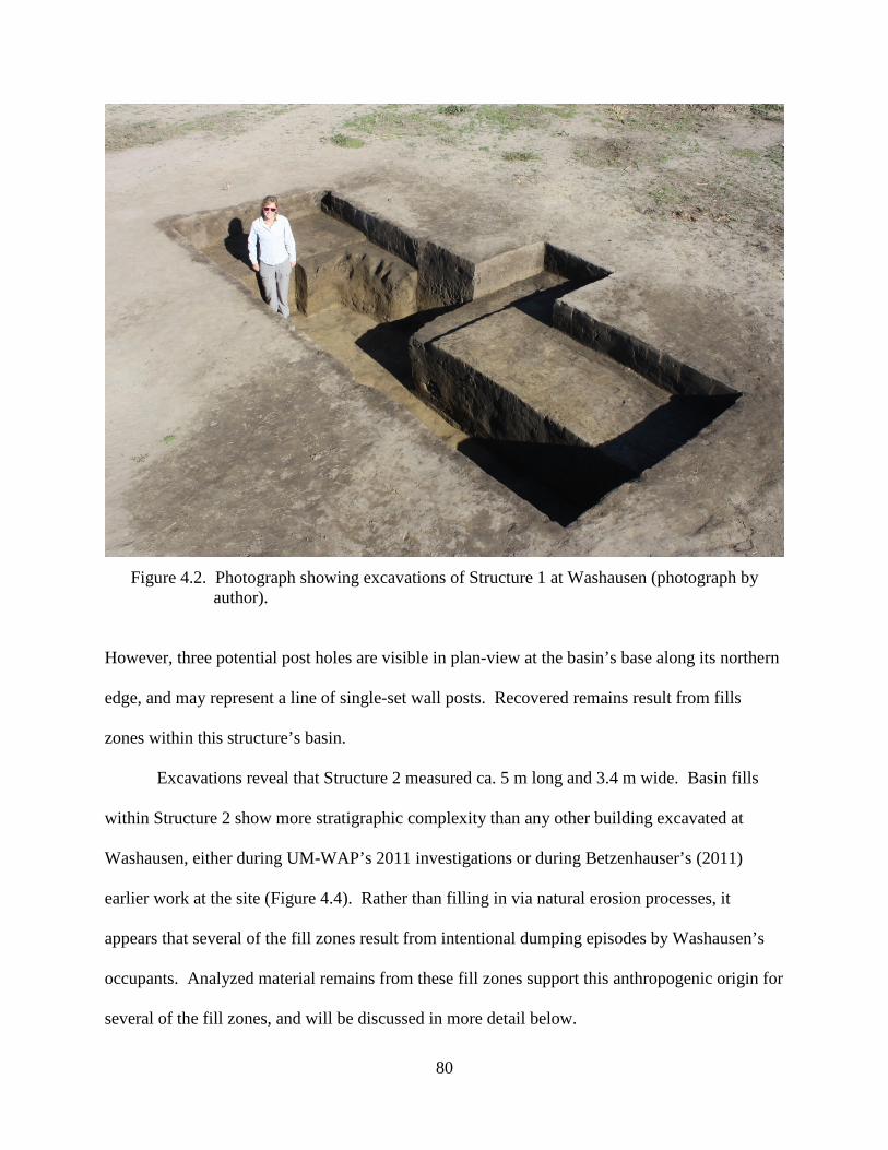
80
Figure 4.2. Photograph showing excavations of Structure 1 at Washausen (photograph by
author).
However, three potential post holes are visible in plan-view at the basin’s base along its northern
edge, and may represent a line of single-set wall posts. Recovered remains result from fills
zones within this structure’s basin.
Excavations reveal that Structure 2 measured ca. 5 m long and 3.4 m wide. Basin fills
within Structure 2 show more stratigraphic complexity than any other building excavated at
Washausen, either during UM-WAP’s 2011 investigations or during Betzenhauser’s (2011)
earlier work at the site (Figure 4.4). Rather than filling in via natural erosion processes, it
appears that several of the fill zones result from intentional dumping episodes by Washausen’s
occupants. Analyzed material remains from these fill zones support this anthropogenic origin for
several of the fill zones, and will be discussed in more detail below.
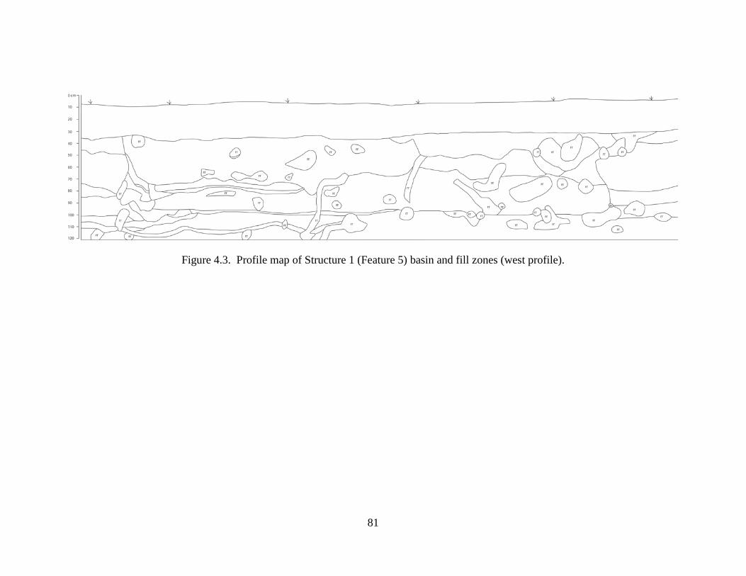
81
Figure 4.3. Profile map of Structure 1 (Feature 5) basin and fill zones (west profile).
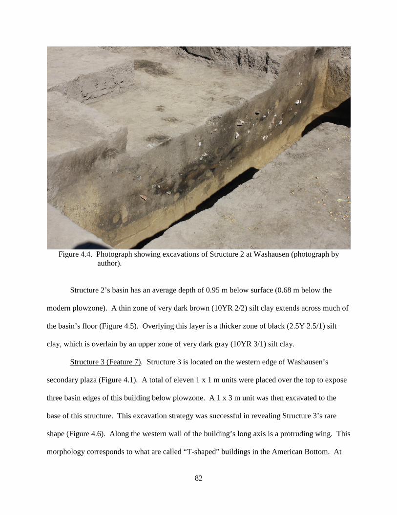
82
Figure 4.4. Photograph showing excavations of Structure 2 at Washausen (photograph by
author).
Structure 2’s basin has an average depth of 0.95 m below surface (0.68 m below the
modern plowzone). A thin zone of very dark brown (10YR 2/2) silt clay extends across much of
the basin’s floor (Figure 4.5). Overlying this layer is a thicker zone of black (2.5Y 2.5/1) silt
clay, which is overlain by an upper zone of very dark gray (10YR 3/1) silt clay.
Structure 3 (Feature 7). Structure 3 is located on the western edge of Washausen’s
secondary plaza (Figure 4.1). A total of eleven 1 x 1 m units were placed over the top to expose
three basin edges of this building below plowzone. A 1 x 3 m unit was then excavated to the
base of this structure. This excavation strategy was successful in revealing Structure 3’s rare
shape (Figure 4.6). Along the western wall of the building’s long axis is a protruding wing. This
morphology corresponds to what are called “T-shaped” buildings in the American Bottom. At
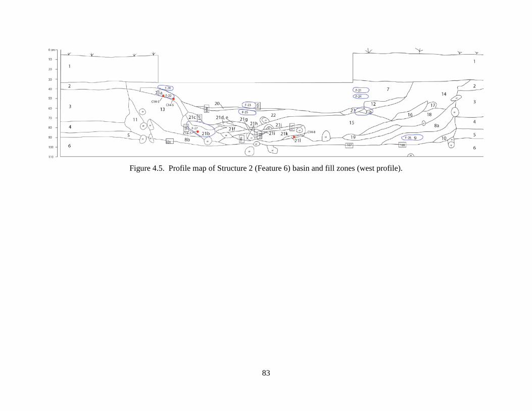
83
Figure 4.5. Profile map of Structure 2 (Feature 6) basin and fill zones (west profile).
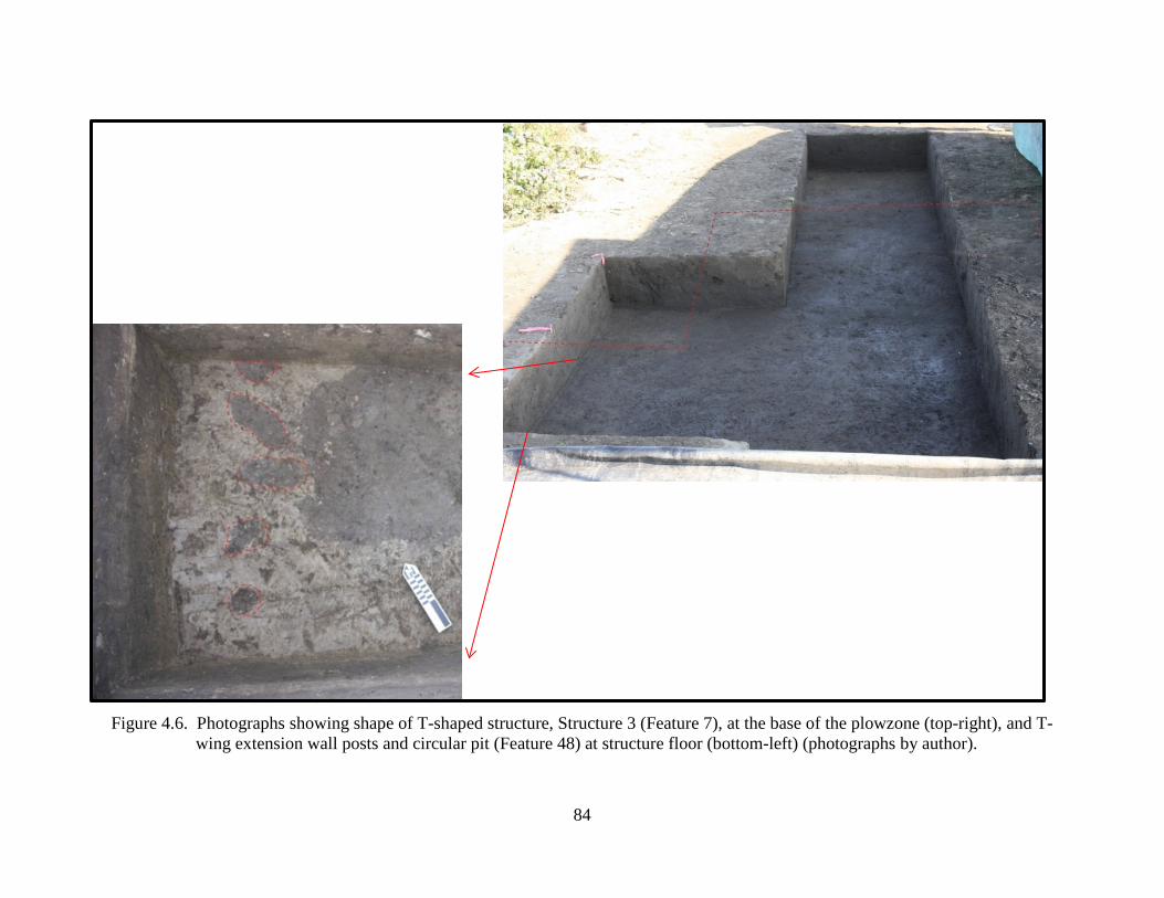
84
Figure 4.6. Photographs showing shape of T-shaped structure, Structure 3 (Feature 7), at the base of the plowzone (top-right), and T- wing extension wall posts and circular pit (Feature 48) at structure floor (bottom-left) (photographs by author).
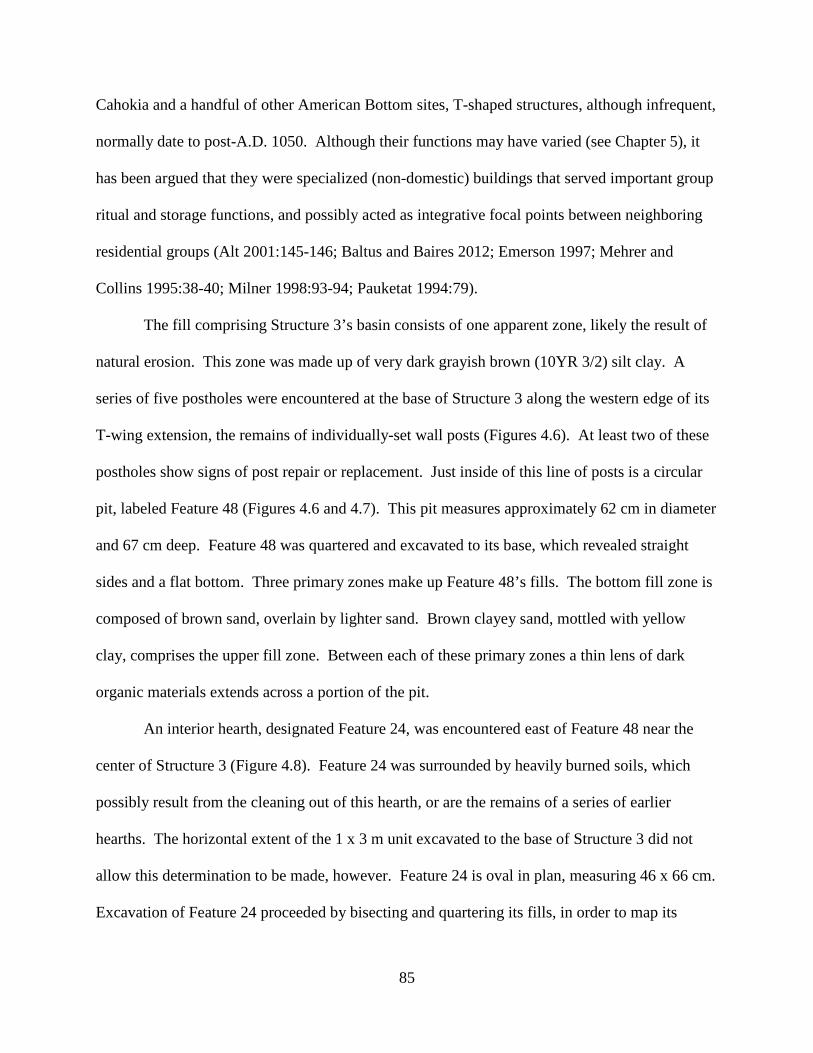
85
Cahokia and a handful of other American Bottom sites, T-shaped structures, although infrequent,
normally date to post-A.D. 1050. Although their functions may have varied (see Chapter 5), it
has been argued that they were specialized (non-domestic) buildings that served important group
ritual and storage functions, and possibly acted as integrative focal points between neighboring
residential groups (Alt 2001:145-146; Baltus and Baires 2012; Emerson 1997; Mehrer and
Collins 1995:38-40; Milner 1998:93-94; Pauketat 1994:79).
The fill comprising Structure 3’s basin consists of one apparent zone, likely the result of
natural erosion. This zone was made up of very dark grayish brown (10YR 3/2) silt clay. A
series of five postholes were encountered at the base of Structure 3 along the western edge of its
T-wing extension, the remains of individually-set wall posts (Figures 4.6). At least two of these
postholes show signs of post repair or replacement. Just inside of this line of posts is a circular
pit, labeled Feature 48 (Figures 4.6 and 4.7). This pit measures approximately 62 cm in diameter
and 67 cm deep. Feature 48 was quartered and excavated to its base, which revealed straight
sides and a flat bottom. Three primary zones make up Feature 48’s fills. The bottom fill zone is
composed of brown sand, overlain by lighter sand. Brown clayey sand, mottled with yellow
clay, comprises the upper fill zone. Between each of these primary zones a thin lens of dark
organic materials extends across a portion of the pit.
An interior hearth, designated Feature 24, was encountered east of Feature 48 near the
center of Structure 3 (Figure 4.8). Feature 24 was surrounded by heavily burned soils, which
possibly result from the cleaning out of this hearth, or are the remains of a series of earlier
hearths. The horizontal extent of the 1 x 3 m unit excavated to the base of Structure 3 did not
allow this determination to be made, however. Feature 24 is oval in plan, measuring 46 x 66 cm.
Excavation of Feature 24 proceeded by bisecting and quartering its fills, in order to map its
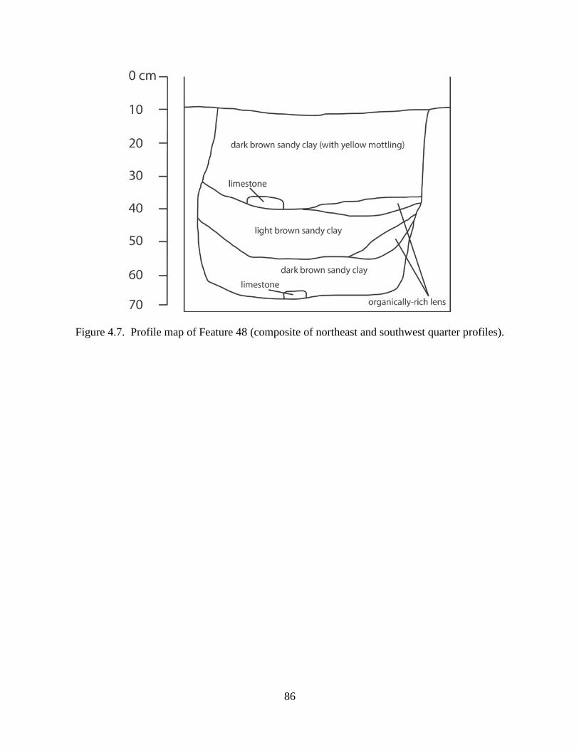
86
Figure 4.7. Profile map of Feature 48 (composite of northeast and southwest quarter profiles).
87
Figure 4.8. Photographs of hearth (Feature 24) encountered at base of T-shaped structure
(Structure 3); top: plan view of hearth, showing bisected and quartered excavation strategy; bottom: profile view showing yellow clay cap overlying thin lens of carbonized organic remains (photographs by author).
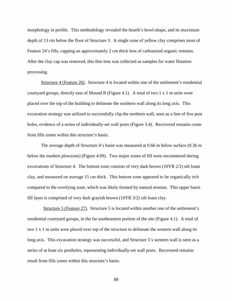
88
morphology in profile. This methodology revealed the hearth’s bowl-shape, and its maximum
depth of 13 cm below the floor of Structure 3. A single zone of yellow clay comprises most of
Feature 24’s fills, capping an approximately 2 cm thick lens of carbonized organic remains.
After the clay cap was removed, this thin lens was collected as samples for water flotation
processing.
Structure 4 (Feature 26). Structure 4 is located within one of the settlement’s residential
courtyard groups, directly east of Mound B (Figure 4.1). A total of two 1 x 1 m units were
placed over the top of the building to delineate the northern wall along its long axis. This
excavation strategy was utilized to successfully clip the northern wall, seen as a line of five post
holes, evidence of a series of individually-set wall posts (Figure 3.4). Recovered remains come
from fills zones within this structure’s basin.
The average depth of Structure 4’s basin was measured at 0.66 m below surface (0.36 m
below the modern plowzone) (Figure 4.09). Two major zones of fill were encountered during
excavations of Structure 4. The bottom zone consists of very dark brown (10YR 2/2) silt loam
clay, and measured on average 15 cm thick. This bottom zone appeared to be organically rich
compared to the overlying zone, which was likely formed by natural erosion. This upper basin
fill layer is comprised of very dark grayish brown (10YR 3/2) silt loam clay.
Structure 5 (Feature 27). Structure 5 is located within another one of the settlement’s
residential courtyard groups, in the far southeastern portion of the site (Figure 4.1). A total of
two 1 x 1 m units were placed over top of the structure to delineate the western wall along its
long axis. This excavation strategy was successful, and Structure 5’s western wall is seen as a
series of at least six postholes, representing individually-set wall posts. Recovered remains
result from fills zones within this structure’s basin.
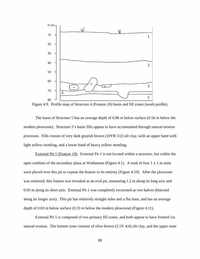
89
Figure 4.9. Profile map of Structure 4 (Feature 26) basin and fill zones (south profile).
The basin of Structure 5 has an average depth of 0.86 m below surface (0.56 m below the
modern plowzone). Structure 5’s basin fills appear to have accumulated through natural erosion
processes. Fills consist of very dark grayish brown (10YR 3/2) silt clay, with an upper band with
light yellow mottling, and a lower band of heavy yellow mottling.
External Pit 1 (Feature 19). External Pit 1 is not located within a structure, but within the
open confines of the secondary plaza at Washausen (Figure 4.1). A total of four 1 x 1 m units
were placed over this pit to expose the feature in its entirety (Figure 4.10). After the plowzone
was removed, this feature was revealed as an oval pit, measuring 1.2 m along its long axis and
0.93 m along its short axis. External Pit 1 was completely excavated as two halves (bisected
along its longer axis). This pit has relatively straight sides and a flat base, and has an average
depth of 0.63 m below surface (0.33 m below the modern plowzone) (Figure 4.11).
External Pit 1 is composed of two primary fill zones, and both appear to have formed via
natural erosion. The bottom zone consists of olive brown (2.5Y 4/4) silt clay, and the upper zone
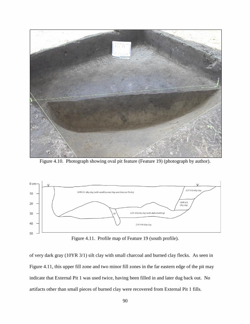
90
Figure 4.10. Photograph showing oval pit feature (Feature 19) (photograph by author).
Figure 4.11. Profile map of Feature 19 (south profile).
of very dark gray (10YR 3/1) silt clay with small charcoal and burned clay flecks. As seen in
Figure 4.11, this upper fill zone and two minor fill zones in the far eastern edge of the pit may
indicate that External Pit 1 was used twice, having been filled in and later dug back out. No
artifacts other than small pieces of burned clay were recovered from External Pit 1 fills.
91
Radiocarbon Dates from Washausen
A total of ten AMS radiocarbon dates were processed after my excavations at
Washausen, and Betzenhauser (2011) presents one additional radiocarbon date for the site (Table
4.1). All eleven samples were organic remains recovered from structure basin fills or intramural
features at the site. These dates, and their excavation contexts, are presented below, followed by
a discussion of their bearing on the dating of occupations and activities at the settlement. The
UM-WAP radiocarbon dating procedure was designed to produce two AMS dates for each of the
five excavated structures (described above). Nine of these dates were run on annual botanical
remains (e.g., seeds, maize, grass stems) and one on a fragment of oak charcoal.
Table 4.1 provides information about the ten AMS radiocarbon dates resulting from the
2011 UM-WAP excavations at Washausen, as well as the earlier reported date for the site. Both
uncalibrated and calibrated dates are presented, as well as information about each sample and
their excavated context. All ten new UM-WAP dates were submitted to the University of
Arizona’s Accelerator Mass Spectrometry Laboratory. Calibration of the UM-WAP dates were
performed using the University of Oxford’s OxCal online calibration program, version 4.2
(Bronk Ramsey 2009), and the InCal13 calibration curve (Reimer et al. 2013). The date
presented by Betzenhauser (2011) was submitted to the University of Illinois’ Institute of Natural
Resource Sustainability. The ten UM-WAP dates are herein reported as samples 11WAP201
through 11WAP210.
Sample 11WAP201. Sample 201 produced a calibrated date of A.D. 1090 +/- 73 (A.D.
1017-1163). This sample originates from basin fills of Structure 1. Sample 201 was run on
grass stem fragments from a small concentration of carbonized thatch located near the bottom of
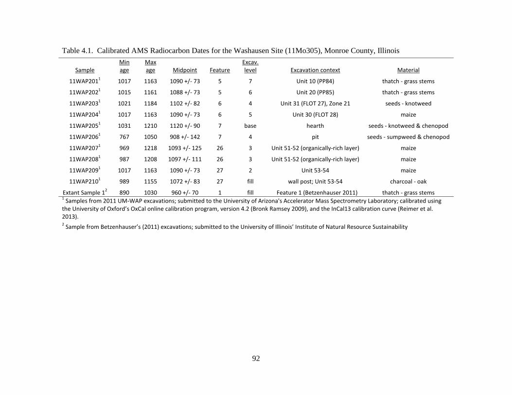
92
Table 4.1. Calibrated AMS Radiocarbon Dates for the Washausen Site (11Mo305), Monroe County, Illinois
Sample Min age
Max age Midpoint Feature
Excav. level Excavation context Material
11WAP2011 1017 1163 1090 +/- 73 5 7 Unit 10 (PP84) thatch - grass stems
11WAP2021 1015 1161 1088 +/- 73 5 6 Unit 20 (PP85) thatch - grass stems
11WAP2031 1021 1184 1102 +/- 82 6 4 Unit 31 (FLOT 27), Zone 21 seeds - knotweed
11WAP2041 1017 1163 1090 +/- 73 6 5 Unit 30 (FLOT 28) maize
11WAP2051 1031 1210 1120 +/- 90 7 base hearth seeds - knotweed & chenopod
11WAP2061 767 1050 908 +/- 142 7 4 pit seeds - sumpweed & chenopod
11WAP2071 969 1218 1093 +/- 125 26 3 Unit 51-52 (organically-rich layer) maize
11WAP2081 987 1208 1097 +/- 111 26 3 Unit 51-52 (organically-rich layer) maize
11WAP2091 1017 1163 1090 +/- 73 27 2 Unit 53-54 maize
11WAP2101 989 1155 1072 +/- 83 27 fill wall post; Unit 53-54 charcoal - oak
Extant Sample 12 890 1030 960 +/- 70 1 fill Feature 1 (Betzenhauser 2011) thatch - grass stems 1 Samples from 2011 UM-WAP excavations; submitted to the University of Arizona's Accelerator Mass Spectrometry Laboratory; calibrated using the University of Oxford’s OxCal online calibration program, version 4.2 (Bronk Ramsey 2009), and the InCal13 calibration curve (Reimer et al. 2013). 2 Sample from Betzenhauser’s (2011) excavations; submitted to the University of Illinois’ Institute of Natural Resource Sustainability
93
this building’s basin, possibly from wall fall. Therefore, this sample provides a terminal date for
use of this structure, just prior to or concurrent with initial infilling.
Sample 11WAP202. Sample 202 produced a calibrated date of A.D. 1088 +/- 73 (A.D.
1015-1161). This sample originates from basin fills of Structure 1. Sample 202 was run on
grass stem fragments from remains of carbonized thatch located between the two primary fill
zone layers. This sample should, then, give a date sometime after initial infilling of this basin
was begun.
Sample 11WAP203. Sample 203 produced a calibrated date of A.D. 1102 +/- 82 (A.D.
1021-1184). This sample originates from basin fills of Structure 2. Sample 203 was run on
seeds of erect knotweed (Polygonum erectum) recovered from Zone 21 of basin fills. As will be
discussed later in this chapter, Zone 21 likely results from anthropogenic deposition related to
public commensal events at Washausen, potentially having taken place within the settlement’s
secondary plaza. Thus, this date corresponds to specific activities that occurred late in the site’s
history.
Sample 11WAP204. Sample 204 produced a calibrated date of A.D. 1090 +/- 73 (A.D.
1017-1163). This sample originates from basin fills of Structure 2. Sample 203 was run on
maize fragments originating from an organically rich zone directly overlying the floor of this
basin. Therefore, this sample provides a date for initial infilling of this structure’s basin.
Sample 11WAP205. Sample 205 produced a calibrated date of A.D. 1120 +/- 90 (A.D.
1031-1210). This sample originates from the hearth (Feature 24) centrally located in the floor of
Structure 3, a T-shaped building on the western edge of the settlement’s secondary plaza.
Sample 205 was run on seeds of erect knotweed (Polygonum erectum) and chenopodium
(Chenopodium berlandieri) recovered from the thin lens of organic remains lining the base of
94
this hearth (in direct association with recovered tobacco seeds) (Figure 4.8). As discussed above,
it is possible that remains of earlier hearths are present in this T-shaped structure, but only
Feature 24’s status as a hearth could be confirmed during excavations. If other hearths were
used and filled in, Feature 24 represents the last utilized hearth in this building. Thus, Sample
205 produces a date corresponding with terminal use of this T-shaped structure.
Sample 11WAP206. Sample 206 produced a calibrated date of A.D. 908 +/- 142 (A.D.
767-1050). This sample originates from the circular pit (Feature 48) encountered in the floor of
Structure 3’s T-wing extension, located on the western edge of Washausen’s secondary plaza.
Sample 206 was run on seeds of chenopodium (Chenopodium berlandieri) and sumpweed (Iva
annua var. macrocarpa), recovered from a thin lens of dark organic materials near the base of
this pit, directly overlaying its bottom fill zone (Figure 4.7). Sample 206 provides either a
terminal date for Feature 48 as the pit was filled in and put into disuse, or provides a date
referencing early use of this pit.
Sample 11WAP207. Sample 207 produced a calibrated date of A.D. 1093 +/- 111 (A.D.
969-1218). This sample was run on maize fragments that originate from the initial zone of fill
within Structure 4’s basin, a building located within one of the settlement’s residential courtyard
groups, directly east of Mound B. This roughly 15-cm-thick zone of fill produced increased
amounts of artifacts relative to directly overlying fill zones, and may have accumulated via
anthropogenic activities rather than through natural erosion (Figure 4.12). Thus, Sample 207
likely dates initial infilling of Structure 4’s basin soon after occupation of this building was
terminated.
Sample 11WAP208. Sample 208 produced a calibrated date of A.D. 1097 +/- 125 (A.D.
987-1208). This sample was run on maize fragments that, like Sample 207, originate from the
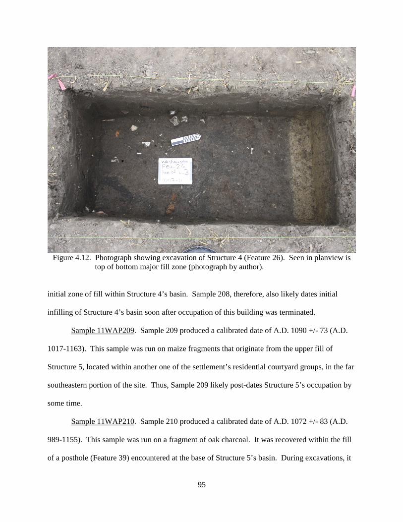
95
Figure 4.12. Photograph showing excavation of Structure 4 (Feature 26). Seen in planview is
top of bottom major fill zone (photograph by author). initial zone of fill within Structure 4’s basin. Sample 208, therefore, also likely dates initial
infilling of Structure 4’s basin soon after occupation of this building was terminated.
Sample 11WAP209. Sample 209 produced a calibrated date of A.D. 1090 +/- 73 (A.D.
1017-1163). This sample was run on maize fragments that originate from the upper fill of
Structure 5, located within another one of the settlement’s residential courtyard groups, in the far
southeastern portion of the site. Thus, Sample 209 likely post-dates Structure 5’s occupation by
some time.
Sample 11WAP210. Sample 210 produced a calibrated date of A.D. 1072 +/- 83 (A.D.
989-1155). This sample was run on a fragment of oak charcoal. It was recovered within the fill
of a posthole (Feature 39) encountered at the base of Structure 5’s basin. During excavations, it
96
appeared that the original wall post was removed and subsequently filled in. Therefore, Sample
210 likely dates the initial dismantling of Structure 5.
Extant Sample 1. An extant radiocarbon sample for the Washausen site is reported by
Betzenhauser (2011:135-136). This sample produced a calibrated date of A.D. 960 +/- 70 (A.D.
890-1030). Extant Sample 1 was run on grass and giant cane (Arundinaria gigantea) stem
fragments from thatch remains related to abandonment and infilling of a structure
(Betzenhauser’s Feature 1) located in the northern portion of the Washausen settlement, north of
Mound A and the low-lying relict paleochannel. After this building was dismantled and filled in,
a later structure was constructed in this same area, superimposed upon the older dated structure.
Thus, Extant Sample 1 dates use of a northern residential courtyard group at Washausen, and
pre-dates initial construction of the later superimposed structure.
Discussion of Radiocarbon Dates
Radiocarbon dates for the Washausen settlement provide evidence about the history of
occupations at the site, as well as certain activities that took place there. A total of 11
radiocarbon dates currently exist, including ten AMS dates run from samples recovered during
the 2011 UM-WAP excavations. These ten samples date various features located within the
settlement’s secondary plaza and two residential courtyard groups in the southeastern portion of
the site, situated along an elevated ridge. A previously published date (Betzenhauser 2011)
results from the basin fills of a structure located within a courtyard group in the northern part of
the site, north of the central mound-and-plaza complex and separated from the southern
occupation areas by a low-lying swale. Thus, these 11 dates allow for a consideration of the
timing of occupation across the entire Washausen settlement.
97
Previous examinations of materials recovered from the Washausen site led researchers to
place major occupations of the settlement to the tenth and eleventh centuries A.D. (Figure 1.2),
or to the local George Reeves, Lindeman, and Lindhorst phases (Bailey 2007; Betzenhauser
2011; Kelly 2006b). The 11 radiocarbon dates now assembled from excavations at Washausen
support this temporal placement. Initial occupation of the site likely occurred as early as the late
tenth century (George Reeves phase) or slightly earlier. A majority of the settlement appears to
have been abandoned by sometime during the late eleventh century (Lindhorst phase), with a few
locations of the site being used – potentially – into the early twelfth century (Stirling phase).
Therefore, these radiocarbon dates support the view that the Washausen mound settlement was
occupied during the regional Mississippian transition, which is traditionally dated to the mid-
eleventh century at A.D. 1050.
The earliest and latest dates from Washausen both originate from Structure 3, the T-
shaped building on the western edge of the settlement’s secondary plaza. Sample 206’s date of
A.D. 908 +/- 142, from the building’s internal pit, suggests this building was constructed during
the tenth century, although its 2-sigma error range extends forward in time into the mid-eleventh
century. The latest date from the site is A.D. 1120 +/- 90, which was recovered from the hearth
in the center of Structure 3. This date suggests that use of the T-shaped building lasted
potentially into the early twelfth century, although its 2-sigma range extends back in time into
the first half of the eleventh century, and overlaps with the error range produced by Sample 206.
Assuming these two dates’ midpoints are good estimations for length of use implies that
Structure 3 was maintained for at least two centuries, a rather long use-life for pre-Columbian
wooden buildings in this region (cf. Milner 1986, 1998; Pauketat 1989; 2003; Pauketat and
Lopinot 1997). Therefore, it is likely that Structure 3 was built later in the tenth century, and that
98
final use of the building’s hearth occurred sometime in the late eleventh century, a period of time
more congruent with the other nine dates from the site.
Absolute dating of organic remains from other structures in both the southeastern and
northern portions of the site suggest that initial occupation of both of these areas took place
sometime during the late tenth century, or during the first half of the eleventh century at the
latest. The earliest (and only) radiocarbon date for the northern portion of the site places disuse
of an early structure at A.D. 960 +/- 70, as reported by Betzenhauser (2011). Sometime after
filling in of this structure, a more recent building was constructed over top. The superimposed
placement of this overlying building means that occupations in the northern portion of the site
(near the modern-day levee) continued into the eleventh century, contemporaneous to major
occupation of the elevated ridge in the southeast portion of the site near Mound B. Betzenhauser
(2011:135-136) reports that the earlier (dated) building’s morphology and the ceramic
assemblage from its fills are more consistent with a Lindeman phase, or early eleventh century,
component.
The remaining eight AMS dates originate from contexts that are associated with the
infilling of four structures in the southeastern portion of the site (Structures 1, 2, 4, and 5). These
calibrated dates, with midpoints ranging from A.D. 1072 to 1102, suggest that abandonment of
the Washausen settlement took place during the late eleventh century, during the early
Mississippian Lindhorst phase. The second-youngest date for the site, calibrated at A.D. 1102
+/- 73, was run on materials from fill zones within Structure 2 that, as is discussed later in this
chapter and in Chapter Five, relate to commensal events that occurred late in the settlement’s
history. With this information obtained from radiocarbon dating, a description of material
remains recovered during the 2011 UM-WAP is given below.
99
Results of Material Analyses
A variety of material artifacts were recovered during the 2011 UM-WAP excavations at
Washausen. As noted in Chapter Two, remains were collected using various techniques,
including hand collection of artifacts during screening, piece-plotting of certain artifacts, and
from samples collected for water flotation.
Archaeobotanical Remains4
Botanical remains from the Washausen site were recovered primarily from processed
sediment samples after water flotation (Table 4.2). A few botanical specimens were hand
collected during excavations, including suspected remains of thatch or preserved clumps of
grasses/cane. A total of 413 liters of flotation processed sediment yielded a diverse array of
floral remains. A total of 14.02 g of wood and nutshell were recovered, equivalent to an average
density of 0.03 g/liter. Seeds and maize fragments were recovered at higher frequencies – 8.0
seeds/liter and 7.5 maize fragments/liter. The overwhelming majority of maize and seed
remains, however, originate from samples collected from Structures 2 and 3.
Wood. A total of 256 fragments of wood were identified, diffusely scattered throughout
samples recovered across the site. Oak (both red and white subgroups) dominated, followed by
hickory. These two taxa make up 72% of the wood assemblage. Tree taxa with minor
representation include willow/poplar, maple, honey locust, elm, and ash. The wood
assemblage’s composition is typical of late prehistoric assemblages throughout the American
Bottom.
4 Archaeobotanical remains were analyzed and summarized by Kathyn Parker (2013; Kathryn Parker Archaeobotany).

100
Table 4.2. Results of Archaeobotanical Analysis.
Taxon Str.
1 Str.
2 Str.
3 Str.
4 Str.
5 Ext. Pit 1 Taxon Total
Wood Acer sp. (maple) 5 0 0 0 0 0 5
Carya sp. (hickory) 4 14 5 5 10 0 38
Fraxinus sp. (ash) 1 0 0 0 0 0 1
Gleditsia triacanthos (honey locust) 5 0 0 0 0 0 5
Quercus sp. (oak) 27 34 78 13 9 0 161
Q. sp., subgenus Erythrobalanus (red oak group) 8 7 3 0 0 0 18
Q. sp., subgenus Lepidobalanus (white oak group) 0 1 4 0 0 0 5
Salix/Populus spp. (willow or poplar) 1 14 3 1 0 0 19
Ulmaceae (elm family) 0 4 0 0 0 0 4
Gymnosperm 1 2 0 0 0 0 3
Bark 1 13 8 3 1 0 26
Diffuse porous 3 8 3 1 3 0 18
Ring porous 24 28 20 9 4 0 85
Unidentifiable 33 30 41 14 0 0 118
Wood Total 113 155 165 46 27 0 506
Nutshell Carya sp. (hickory) 6 46 7 2 0 0 61
C. illinoensis (pecan) 2 4 1 0 0 0 7
Corylus americana (hazelnut) 6 3 1 9 0 0 19
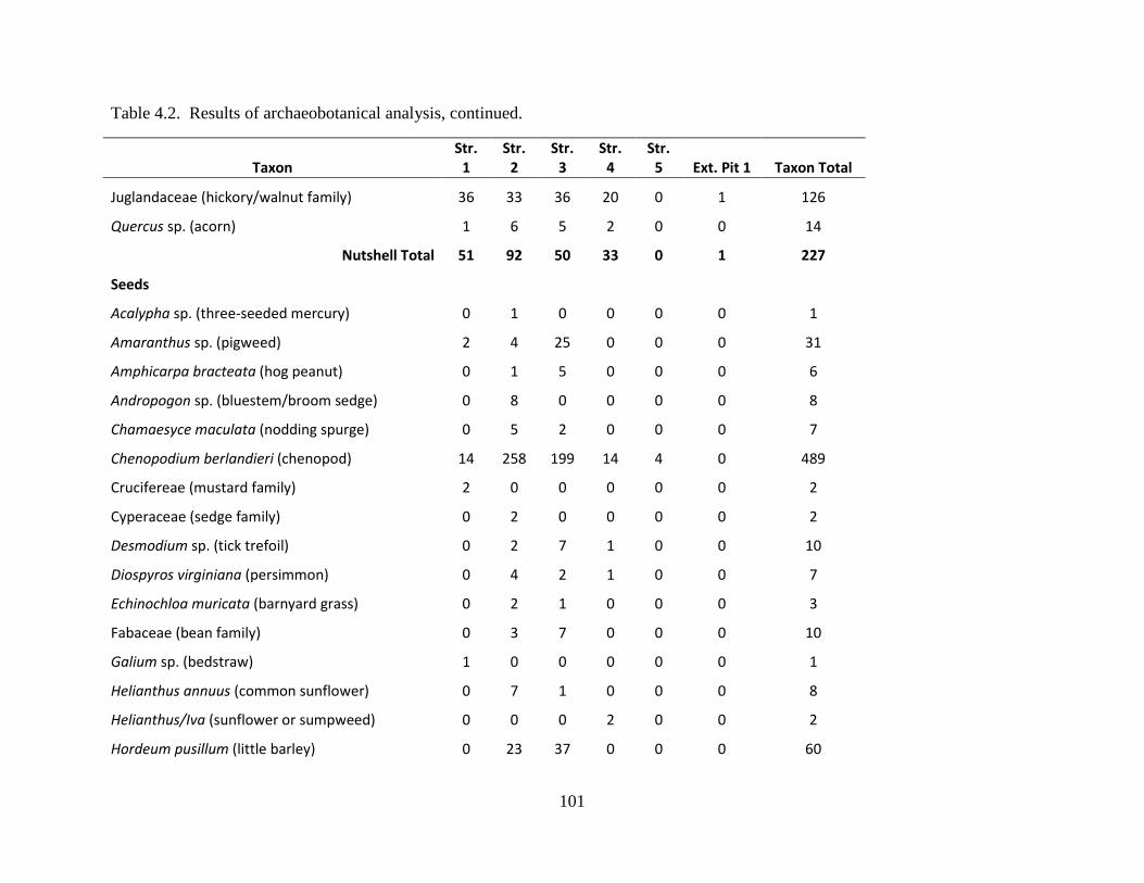
101
Table 4.2. Results of archaeobotanical analysis, continued.
Taxon Str.
1 Str.
2 Str.
3 Str.
4 Str.
5 Ext. Pit 1 Taxon Total
Juglandaceae (hickory/walnut family) 36 33 36 20 0 1 126
Quercus sp. (acorn) 1 6 5 2 0 0 14
Nutshell Total 51 92 50 33 0 1 227
Seeds Acalypha sp. (three-seeded mercury) 0 1 0 0 0 0 1
Amaranthus sp. (pigweed) 2 4 25 0 0 0 31
Amphicarpa bracteata (hog peanut) 0 1 5 0 0 0 6
Andropogon sp. (bluestem/broom sedge) 0 8 0 0 0 0 8
Chamaesyce maculata (nodding spurge) 0 5 2 0 0 0 7
Chenopodium berlandieri (chenopod) 14 258 199 14 4 0 489
Crucifereae (mustard family) 2 0 0 0 0 0 2
Cyperaceae (sedge family) 0 2 0 0 0 0 2
Desmodium sp. (tick trefoil) 0 2 7 1 0 0 10
Diospyros virginiana (persimmon) 0 4 2 1 0 0 7
Echinochloa muricata (barnyard grass) 0 2 1 0 0 0 3
Fabaceae (bean family) 0 3 7 0 0 0 10
Galium sp. (bedstraw) 1 0 0 0 0 0 1
Helianthus annuus (common sunflower) 0 7 1 0 0 0 8
Helianthus/Iva (sunflower or sumpweed) 0 0 0 2 0 0 2
Hordeum pusillum (little barley) 0 23 37 0 0 0 60
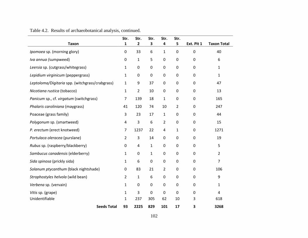
102
Table 4.2. Results of archaeobotanical analysis, continued.
Taxon Str.
1 Str.
2 Str.
3 Str.
4 Str.
5 Ext. Pit 1 Taxon Total
Ipomoea sp. (morning glory) 0 33 6 1 0 0 40
Iva annua (sumpweed) 0 1 5 0 0 0 6
Leersia sp. (cutgrass/whitegrass) 1 0 0 0 0 0 1
Lepidium virginicum (peppergrass) 1 0 0 0 0 0 1
Leptoloma/Digitaria spp. (witchgrass/crabgrass) 1 9 37 0 0 0 47
Nicotiana rustica (tobacco) 1 2 10 0 0 0 13
Panicum sp., cf. virgatum (switchgrass) 7 139 18 1 0 0 165
Phalaris caroliniana (maygrass) 41 120 74 10 2 0 247
Poaceae (grass family) 3 23 17 1 0 0 44
Polygonum sp. (smartweed) 4 3 6 2 0 0 15
P. erectum (erect knotweed) 7 1237 22 4 1 0 1271
Portulaca oleracea (purslane) 2 3 14 0 0 0 19
Rubus sp. (raspberry/blackberry) 0 4 1 0 0 0 5
Sambucus canadensis (elderberry) 1 0 1 0 0 0 2
Sida spinosa (prickly sida) 1 6 0 0 0 0 7
Solanum ptycanthum (black nightshade) 0 83 21 2 0 0 106
Strophostyles helvola (wild bean) 2 1 6 0 0 0 9
Verbena sp. (vervain) 1 0 0 0 0 0 1
Vitis sp. (grape) 1 3 0 0 0 0 4 Unidentifiable 1 237 305 62 10 3 618
Seeds Total 93 2225 829 101 17 3 3268
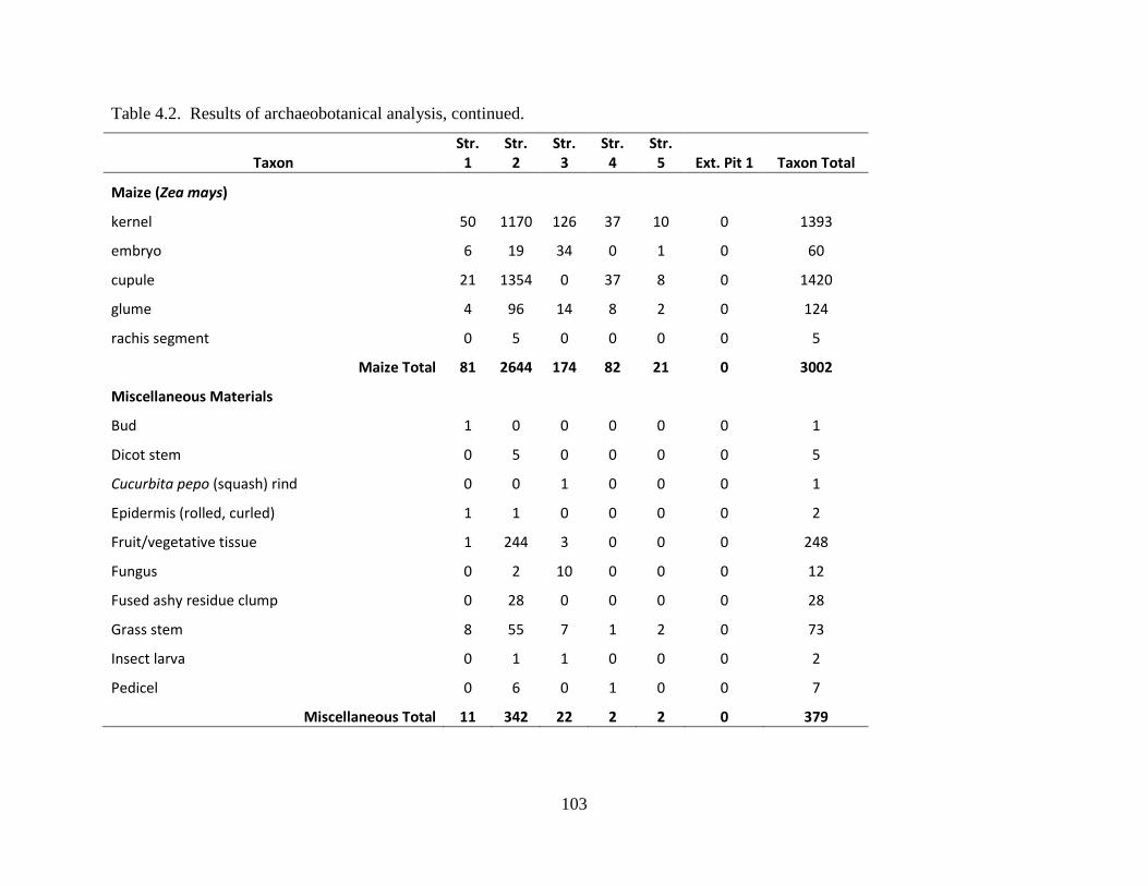
103
Table 4.2. Results of archaeobotanical analysis, continued.
Taxon Str.
1 Str.
2 Str.
3 Str.
4 Str.
5 Ext. Pit 1 Taxon Total
Maize (Zea mays) kernel 50 1170 126 37 10 0 1393
embryo 6 19 34 0 1 0 60
cupule 21 1354 0 37 8 0 1420
glume 4 96 14 8 2 0 124
rachis segment 0 5 0 0 0 0 5
Maize Total 81 2644 174 82 21 0 3002
Miscellaneous Materials Bud 1 0 0 0 0 0 1
Dicot stem 0 5 0 0 0 0 5
Cucurbita pepo (squash) rind 0 0 1 0 0 0 1
Epidermis (rolled, curled) 1 1 0 0 0 0 2
Fruit/vegetative tissue 1 244 3 0 0 0 248
Fungus 0 2 10 0 0 0 12
Fused ashy residue clump 0 28 0 0 0 0 28
Grass stem 8 55 7 1 2 0 73
Insect larva 0 1 1 0 0 0 2
Pedicel 0 6 0 1 0 0 7
Miscellaneous Total 11 342 22 2 2 0 379
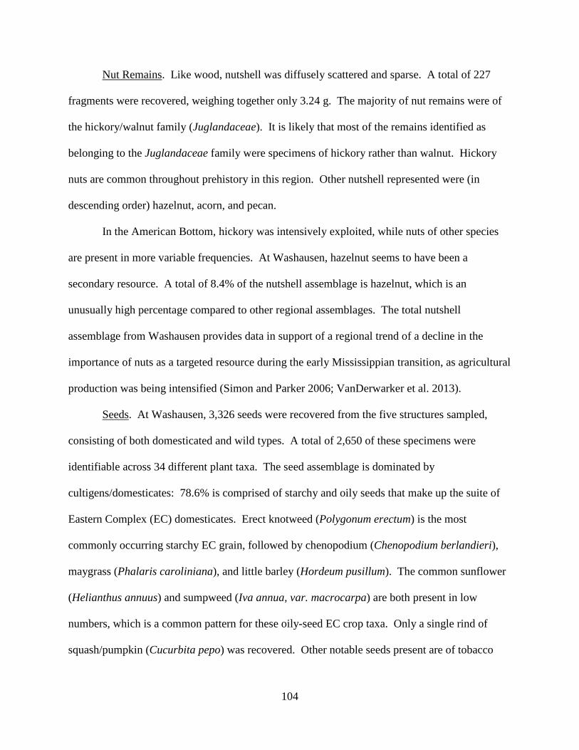
104
Nut Remains. Like wood, nutshell was diffusely scattered and sparse. A total of 227
fragments were recovered, weighing together only 3.24 g. The majority of nut remains were of
the hickory/walnut family (Juglandaceae). It is likely that most of the remains identified as
belonging to the Juglandaceae family were specimens of hickory rather than walnut. Hickory
nuts are common throughout prehistory in this region. Other nutshell represented were (in
descending order) hazelnut, acorn, and pecan.
In the American Bottom, hickory was intensively exploited, while nuts of other species
are present in more variable frequencies. At Washausen, hazelnut seems to have been a
secondary resource. A total of 8.4% of the nutshell assemblage is hazelnut, which is an
unusually high percentage compared to other regional assemblages. The total nutshell
assemblage from Washausen provides data in support of a regional trend of a decline in the
importance of nuts as a targeted resource during the early Mississippian transition, as agricultural
production was being intensified (Simon and Parker 2006; VanDerwarker et al. 2013).
Seeds. At Washausen, 3,326 seeds were recovered from the five structures sampled,
consisting of both domesticated and wild types. A total of 2,650 of these specimens were
identifiable across 34 different plant taxa. The seed assemblage is dominated by
cultigens/domesticates: 78.6% is comprised of starchy and oily seeds that make up the suite of
Eastern Complex (EC) domesticates. Erect knotweed (Polygonum erectum) is the most
commonly occurring starchy EC grain, followed by chenopodium (Chenopodium berlandieri),
maygrass (Phalaris caroliniana), and little barley (Hordeum pusillum). The common sunflower
(Helianthus annuus) and sumpweed (Iva annua, var. macrocarpa) are both present in low
numbers, which is a common pattern for these oily-seed EC crop taxa. Only a single rind of
squash/pumpkin (Cucurbita pepo) was recovered. Other notable seeds present are of tobacco
105
(Nicotiana rustica) and morning glory (Ipomea sp.), recovered from Structures 2 and 3 located in
the settlement’s secondary plaza.
Uncultivated seed types recovered belong to a broad array of plant species. Wild plant
foods include five taxa of fleshy fruits and berries. These include black nightshade, persimmon,
grape, raspberry/blackberry, and elderberry. The majority of fruit seeds identified (n=124) are
black nightshade. Seeds from members of the bean family have also been identified, especially
from the hearth area within Structure 3. Of these, wild bean and hog peanut, as well as tick
trefoil, are well represented.
Specimens of wild grasses and grass-like sedges make up about 13% of the site-wide
seed assemblage (n=124). The most common grass is switchgrass/panic grass, followed by
witchgrass/crabgrass, representatives of the grass family Poaceae, bluestem/beardgrass, barnyard
grass, members of the sedge family, and cutgrass.
Maize. A total of 3,103 fragments of maize (combined weight of 24.64 g) were
recovered, including cupules, glumes, kernels, embryos, and rachis segments. Samples from
Structure 2 fill, Zone 21 (Figure 4.5), produced a high frequency of maize remains, alongside
elevated amounts of certain EC cultigens and other plant remains. Five rachis segments from
Structure 2 fills show cupule angles that range from 45-75 degrees, which suggests cobs with ten
to 16 rows of small pyramidal-shaped kernels. This maize assemblage, therefore, matches
expectations for the types of maize normally recovered in the region at this time, and
demonstrates that regional inhabitants during the period of occupations at Washausen were full
participants in maize agriculture alongside continued production of EC cultigens (see Simon and
Parker 2006).
106
Faunal Remains5
Faunal remains from the Washausen site were recovered during excavations as well as
from sediment samples after water flotation (Table 4.3). A total of 1,003 vertebrate and
invertebrate remains are present in this assemblage. Structure 2’s basin fills produced a majority
(75.8%) of the faunal assemblage. Faunal specimens, as reported herein, were identified to the
most specific taxonomic level possible. Structure 2 and Structure 4 produced the greatest
number of identifiable specimens. Structures 1, 3, and 5 yielded few animal bones, the majority
of which are unidentifiable below the level of taxonomic class. What follows is a description of
faunal remains from Structures 1, 2, and 4.
Structure 1 (Feature 5). Remains of four animal taxa were identifiable from the fills of
Structure 1, including deer (Odocoileus virginianus), bird (waterfowl), and fish. A total of
70.1% of all faunal remains were burned, a majority of these being calcined. Most specimens
from Structure 1 were unidentifiable either to the level of, or below, class.
Deer remains from Structure 1 consist of 12 specimens, including tooth fragments as well
as an ischium, a vertebra, and a metapodial fragment. The metapodial fragment comes from a
distal shaft that has been grooved and snapped, suggesting its use during tool manufacture.
Waterfowl are represented by goose (Anserinae) and duck (Anatinae). The goose specimen is a
bone from its wing tip, and compares to a small-sized individual. A distal humerus fragment
from a duck would have belonged to a medium-sized individual. Only one fish bone was
identified, belonging to a species within the sucker family (Catostomidae).
Structure 2 (Feature 6). An overwhelming majority of all zooarchaeological remains
were recovered from the fill zones of Structure 2. In total, 690 vertebrate and 76 invertebrate
specimens were identified. Four different taxa of mammals are present. Deer is the most 5 Zooarchaeological remains were analyzed and summarized by Lucretia Kelly (2013; Washington University).

107
Table 4.3. Results of Zooarchaeological Analysis.
Taxon
Str. 1 Str. 2 Str. 3 Str. 4 Str. 5
NISP MNI NISP MNI NISP MNI NISP MNI NISP MNI
Mammals (excavated)
Rodentia
2 1
Geomys bursarius
1 1
Sciurus sp.
7 2
1 1
Ondatra zibethicus
1 1
Odocoileus virginianus 12 1 54 3
1 1
large mammal 6
101
1
6
1
medium-large mammal 15
84
medium mammal
1
Mammals (floated)
Rodentia
2 1
1
Odocoileus virginianus
12 1
Total Mammals 33 1 263 9 1 11 3 1
Mammal or Bird (excavated) 14
Birds (excavated)
cf. Podilymbus podiceps
3 1
Anseriformes
1
Anserinae 1 1 2 1
large Anatinae
3 1
medium-large Anatinae
5 1

108
Table 4.3. Results of zooarchaeological analysis, continued.
Str. 1 Str. 2 Str. 3 Str. 4 Str. 5
Taxon NISP MNI NISP MNI NISP MNI NISP MNI NISP MNI
medium Anatinae 1 1 5
small Anatinae
4
medium Anas sp.
2 1
Anas discors/carolinensis
10 2
Aythya sp.
1 1
Tympanuchus cupido
3 2
Buteo sp.
2 1
Passeriformes
3 1
medium-large bird 1
32
medium bird 1
18
3
medium-small bird
8
Birds (floated)
cf. Podilymbus podiceps
1
Olor buccinator
1 1
medium Anatinae
2 1
1
Colinus virginianus
1 1
Total Birds 4 2 107 15 4
Fish (excavated)
Polydon spathula
3 1
Lepisosteus sp.
5 1
1 1
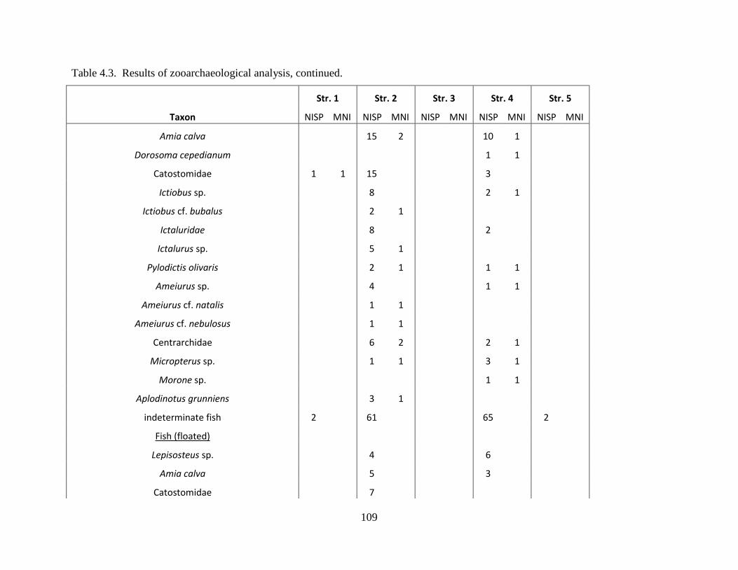
109
Table 4.3. Results of zooarchaeological analysis, continued.
Str. 1 Str. 2 Str. 3 Str. 4 Str. 5
Taxon NISP MNI NISP MNI NISP MNI NISP MNI NISP MNI
Amia calva
15 2
10 1
Dorosoma cepedianum
1 1
Catostomidae 1 1 15
3
Ictiobus sp.
8
2 1
Ictiobus cf. bubalus
2 1
Ictaluridae
8
2
Ictalurus sp.
5 1
Pylodictis olivaris
2 1
1 1
Ameiurus sp.
4
1 1
Ameiurus cf. natalis
1 1
Ameiurus cf. nebulosus
1 1
Centrarchidae
6 2
2 1
Micropterus sp.
1 1
3 1
Morone sp.
1 1
Aplodinotus grunniens
3 1
indeterminate fish 2
61
65
2
Fish (floated)
Lepisosteus sp.
4
6
Amia calva
5
3
Catostomidae
7
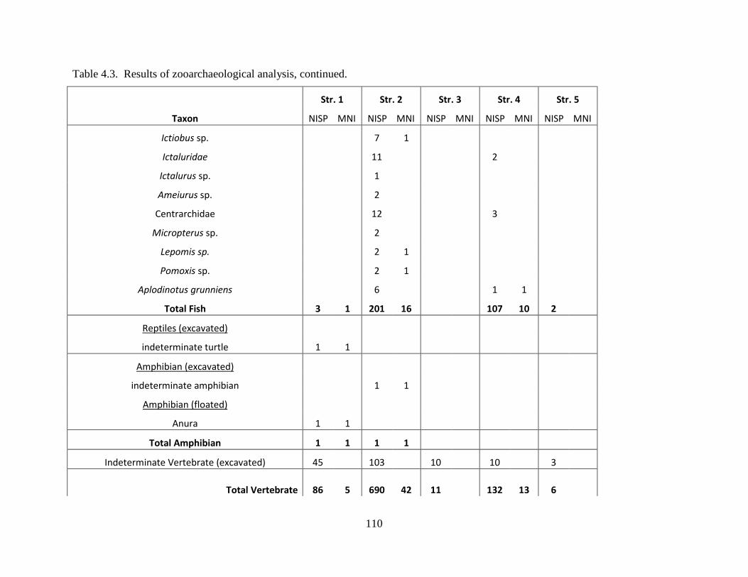
110
Table 4.3. Results of zooarchaeological analysis, continued.
Str. 1 Str. 2 Str. 3 Str. 4 Str. 5
Taxon NISP MNI NISP MNI NISP MNI NISP MNI NISP MNI
Ictiobus sp.
7 1
Ictaluridae
11
2
Ictalurus sp.
1
Ameiurus sp.
2
Centrarchidae
12
3
Micropterus sp.
2
Lepomis sp.
2 1
Pomoxis sp.
2 1
Aplodinotus grunniens
6
1 1
Total Fish 3 1 201 16 107 10 2
Reptiles (excavated)
indeterminate turtle 1 1
Amphibian (excavated)
indeterminate amphibian
1 1
Amphibian (floated)
Anura 1 1
Total Amphibian 1 1 1 1
Indeterminate Vertebrate (excavated) 45 103 10 10 3
Total Vertebrate 86 5 690 42 11 132 13 6
111
Table 4.3. Results of zooarchaeological analysis, continued. Str. 1 Str. 2 Str. 3 Str. 4 Str. 5
Taxon NISP MNI NISP MNI NISP MNI NISP MNI NISP MNI Invertebrate (excavated)
indeterminate mussel 1 76 1
Grand Total 87 5 766 42 11 133 13 6
112
common (NISP=66), followed by small numbers of tree squirrel (Sciurus sp., n=7), Plains pocket
gopher (Geomys bursarius, n=1), and muskrat (Ondatra zibethicus, n=1).
Deer remains from Structure 2 comprise an MNI of four. All body parts are represented,
but elements from the head and extremities are under-represented, suggesting that complete
bodies were not brought to the site for processing. In contrast, axial and forelimb areas are over-
represented by more than twice the expected number, while hindquarter elements are present at
expected frequencies.
One mandible with intact teeth was recovered. For this specimen, a likely age estimate of
2.5 to 3.5 years is consistent with the number of erupted molars present and extent of tooth wear
(Schwartz and Schwartz 1981). Young deer are also present in the assemblage, represented by at
least 2 MNI. Identified were a total of 11 elements that compare to a full-term fetal comparative
specimen, and two elements that compare to a very young individual less than five to eight
months of age (Purdue 1983). One individual compares to specimens that are younger than 23-
29 months, based on an estimate of epiphyseal fusion, and another specimen was likely older
than 29 months. An additional quantity of specimens (n=101) are only identified as large
mammal, many of which likely represent deer remains.
At least 12 taxa of bird are identified, the majority of which are waterfowl, including
ducks and geese. A wing bone (carpometacarpus) from a trumpeter swan (Olor buccinator) was
recovered from Zone 21 of Structure 2’s fills. This specimen is a distal fragment with light cut
marks near its break. Swan remains are rarely recovered in the American Bottom region, but
their distributional pattern suggests these birds were of symbolic significance (Kelly and Kelly
2007). A tentatively identified specimen of pied-billed grebe (cf. Podilymbus podiceps) is also
present in the assemblage.
113
Remains of terrestrial birds have also been identified. Four taxa are represented,
including greater prairie chicken (Tympanuchus cupido), bob-white quail (Colinus virginianus),
buteo hawk (Buteo sp.), and passerines/perching birds (Passeriformes). Prairie chicken and bob-
whites were likely eaten. Hawks, however, were potentially used in ritual and have not been a
commonly recovered species in the American Bottom (Kelly 2010). A total of two hawk wing
specimens (a humerus and an ulna fragment) were recovered from Structure 2 fills, Zone 21.
Structure 2 samples also produced remains from 17 fish taxa from various families. Fish
from the sucker family (Catostomidae) are the most common (27.9%). Catfish (Ictaluridae) was
the second most common fish family represented (25.0%), including both large river catfish and
backwater bullheads. A flathead catfish (Pylodictis olivaris) individual compared well with a
30-pound comparative specimen. Other large catfish include channel or blue catfish (Ictalurus
sp.), one that would have weighed at least 30 pounds and another perhaps 70 pounds.
Other fish include members of the sunfish family (Centrarchiae), which make up 17.9%
of the fish assemblage, including bass (Micropterus sp.), crappie (Pomoxis sp.), and sunfish
(Lepomis sp.). Elements from bowfin (Amia calva) make up 14.3% of the fish remains identified
below the taxonomic level of class, and gar (Lepisosteus sp.) and freshwater drum (Aplodinotus
grunniens) both comprise 6.4% of the assemblage. A rarely identified fish that makes of 2.1% of
the remains is the paddlefish (Polydon spathula). Paddlefish are open-water fish that are found
in quiet waters, but require access to spawning areas that consist of gravel bars in free-flowing
river waters.
Structure 4 (Feature 26). Structure 4 fill zones produced a total of 132 vertebrate NISP
and one invertebrate NISP. Three mammalian taxa were identified, including rodents
114
(Rodentia), tree squirrel, and white-tailed deer. Additionally, one specimen could be identified
as bird, an element from a medium-sized duck.
Most numerous within the Structure 4 assemblage is fish remains, comprising 42 NISP
identifiable below the taxonomic level of class. The composition of fish remains differs from
that from Structure 2, however. Here, bowfin is most frequently represented (31.0%), followed
by bass (19.0%), gar (16.7%), catfish (14.3%), suckers (11.9%), freshwater drum (2.4%), gizzard
shad (Dorosoma cepedianum, 2.4%), and temperate bass.
Ceramic Remains
The majority of ceramic remains retrieved during the 2011 UM-WAP field season at
Washausen were recovered during excavations and screening; a portion of the total rim sherds
were retrieved as individual piece plots. All ceramic artifacts were analyzed following
established methods for the region (see Kelly et al. 2007; Ozuk 1987). This approach allows
Washausen ceramic artifacts to be easily compared to other local assemblages from other sites.
A total of 7,851 sherds were recovered from Washausen during the 2011 UM-WAP
excavations. Of these, 207 rims were identified. Temper type was determined for all sherds. An
attribute analysis was used to collect additional data from rim sherds. Attributes recorded for
rims include the following: form; weight; temper; interior and exterior surface treatment; other
decoration; lip type; rim type; rim length; rim thickness; orifice diameter; percent of orifice-arc
present; neck height; presence/absence of cord-marking, and if present, cord twist direction and
cord width. Table 4.4 presents results of the rim attribute analysis.
Several different temper types were used for the production of pottery during the decades
surrounding the Mississippian transition (Kelly 2002). In the Washausen assemblage most
sherds were tempered with crushed limestone (81.8%). Shell was the second-most used
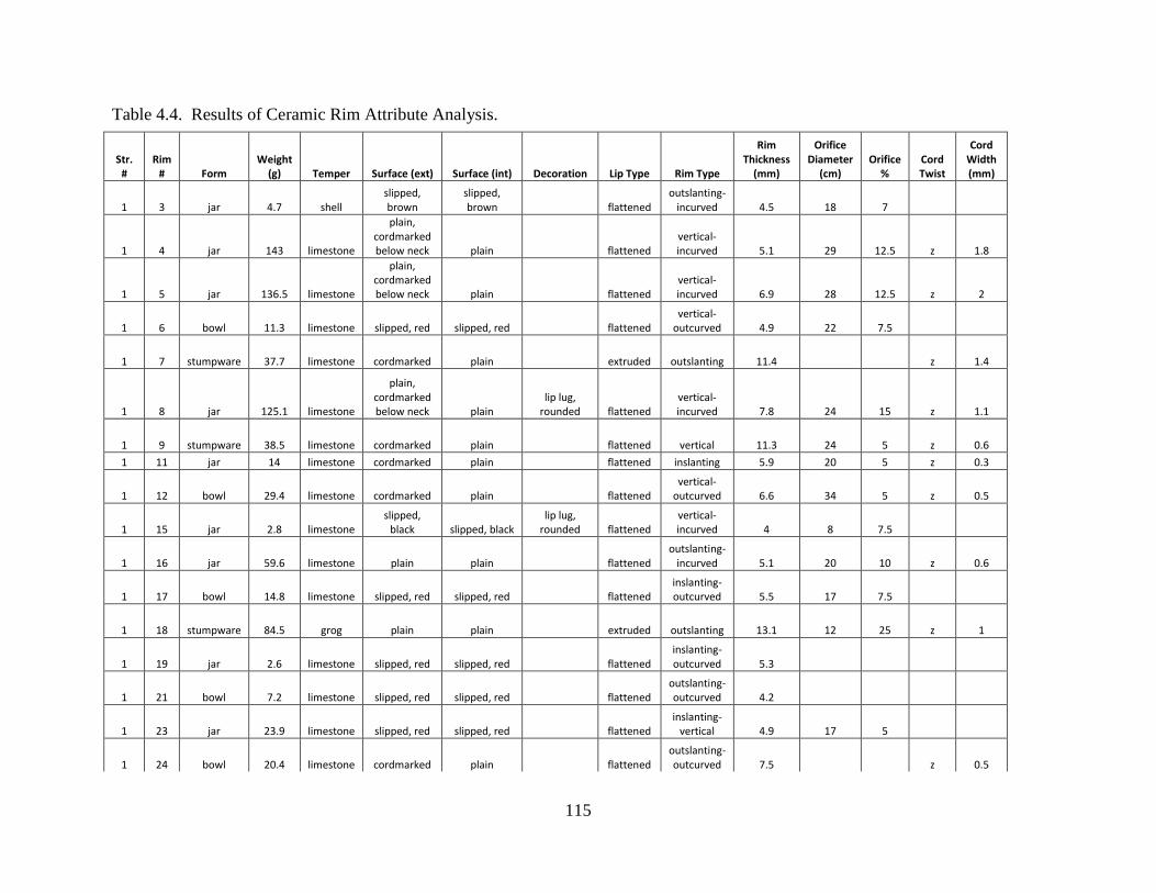
115
Table 4.4. Results of Ceramic Rim Attribute Analysis.
Str. #
Rim # Form
Weight (g) Temper Surface (ext) Surface (int) Decoration Lip Type Rim Type
Rim Thickness
(mm)
Orifice Diameter
(cm) Orifice
% Cord Twist
Cord Width (mm)
1 3 jar 4.7 shell slipped, brown
slipped, brown flattened
outslanting-incurved 4.5 18 7
1 4 jar 143 limestone
plain, cordmarked below neck plain flattened
vertical-incurved 5.1 29 12.5 z 1.8
1 5 jar 136.5 limestone
plain, cordmarked below neck plain flattened
vertical-incurved 6.9 28 12.5 z 2
1 6 bowl 11.3 limestone slipped, red slipped, red flattened vertical-
outcurved 4.9 22 7.5
1 7 stumpware 37.7 limestone cordmarked plain extruded outslanting 11.4 z 1.4
1 8 jar 125.1 limestone
plain, cordmarked below neck plain
lip lug, rounded flattened
vertical-incurved 7.8 24 15 z 1.1
1 9 stumpware 38.5 limestone cordmarked plain flattened vertical 11.3 24 5 z 0.6 1 11 jar 14 limestone cordmarked plain flattened inslanting 5.9 20 5 z 0.3
1 12 bowl 29.4 limestone cordmarked plain flattened vertical-
outcurved 6.6 34 5 z 0.5
1 15 jar 2.8 limestone slipped,
black slipped, black lip lug,
rounded flattened vertical-incurved 4 8 7.5
1 16 jar 59.6 limestone plain plain flattened outslanting-
incurved 5.1 20 10 z 0.6
1 17 bowl 14.8 limestone slipped, red slipped, red flattened inslanting-outcurved 5.5 17 7.5
1 18 stumpware 84.5 grog plain plain extruded outslanting 13.1 12 25 z 1
1 19 jar 2.6 limestone slipped, red slipped, red flattened inslanting-outcurved 5.3
1 21 bowl 7.2 limestone slipped, red slipped, red flattened outslanting-outcurved 4.2
1 23 jar 23.9 limestone slipped, red slipped, red flattened inslanting-
vertical 4.9 17 5
1 24 bowl 20.4 limestone cordmarked plain flattened outslanting-outcurved 7.5 z 0.5
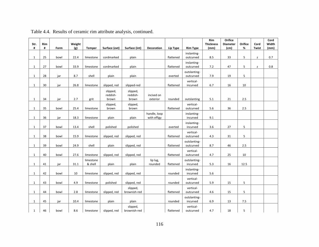
116
Table 4.4. Results of ceramic rim attribute analysis, continued.
Str. #
Rim # Form
Weight (g) Temper Surface (ext) Surface (int) Decoration Lip Type Rim Type
Rim Thickness
(mm)
Orifice Diameter
(cm) Orifice
% Cord Twist
Cord Width (mm)
1 25 bowl 22.4 limestone cordmarked plain flattened inslanting-outcurved 8.5 33 5 z 0.7
1 27 bowl 33.9 limestone cordmarked plain flattened inslanting-outcurved 7.2 47 5 z 0.8
1 28 jar 8.7 shell plain plain everted outslanting-outcurved 7.9 19 5
1 30 jar 26.8 limestone slipped, red slipped-red flattened vertical-incurved 6.7 16 10
1 34 jar 2.7 grit
slipped, reddish-brown
slipped, reddish-brown
incised on exterior rounded outslanting 5.1 21 2.5
1 35 bowl 25.4 limestone slipped, brown
slipped, brown flattened
vertical-outcurved 5.6 36 2.5
1 36 jar 18.3 limestone plain plain handle, loop with effigy
inslanting-incurved 9.1
1 37 bowl 13.4 shell polished polished everted inslanting-incurved 3.6 27 5
1 38 bowl 15.9 limestone slipped, red slipped, red flattened vertical-
outcurved 4.3 31 5
1 39 bowl 24.9 shell plain slipped, red flattened outslanting-outcurved 8.7 46 2.5
1 40 bowl 27.6 limestone slipped, red slipped, red flattened vertical-
outcurved 4.7 25 10
1 41 jar 31.1 limestone
& shell plain plain lip lug,
rounded flattened outslanting-
incurved 5.3 16 12.5
1 42 bowl 10 limestone slipped, red slipped, red rounded inslanting-incurved 5.6
1 43 bowl 4.9 limestone polished slipped, red rounded vertical-
outcurved 5.9 15 5
1 44 bowl 2.8 limestone slipped, red slipped,
brownish-red flattened vertical-
outcurved 4.6 15 5
1 45 jar 10.4 limestone plain plain rounded outslanting-
incurved 6.9 13 7.5
1 46 bowl 8.6 limestone slipped, red slipped,
brownish-red flattened vertical-
outcurved 4.7 18 5
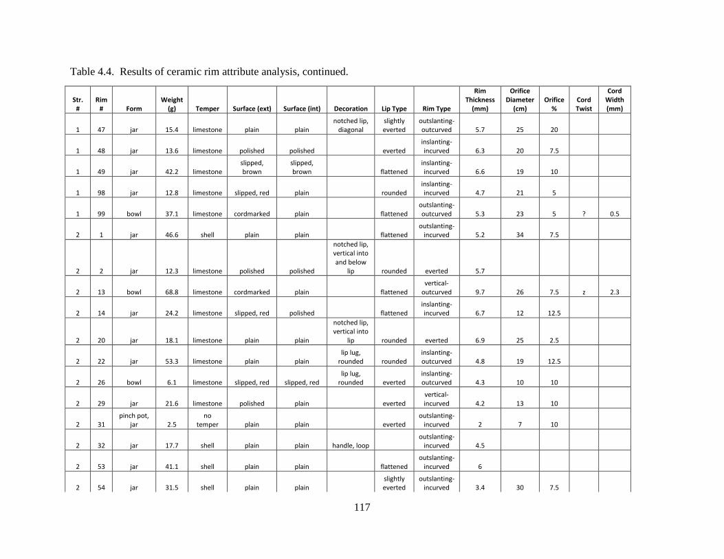
117
Table 4.4. Results of ceramic rim attribute analysis, continued.
Str. #
Rim # Form
Weight (g) Temper Surface (ext) Surface (int) Decoration Lip Type Rim Type
Rim Thickness
(mm)
Orifice Diameter
(cm) Orifice
% Cord Twist
Cord Width (mm)
1 47 jar 15.4 limestone plain plain notched lip,
diagonal slightly everted
outslanting-outcurved 5.7 25 20
1 48 jar 13.6 limestone polished polished everted inslanting-incurved 6.3 20 7.5
1 49 jar 42.2 limestone slipped, brown
slipped, brown flattened
inslanting-incurved 6.6 19 10
1 98 jar 12.8 limestone slipped, red plain rounded inslanting-incurved 4.7 21 5
1 99 bowl 37.1 limestone cordmarked plain flattened outslanting-outcurved 5.3 23 5 ? 0.5
2 1 jar 46.6 shell plain plain flattened outslanting-
incurved 5.2 34 7.5
2 2 jar 12.3 limestone polished polished
notched lip, vertical into and below
lip rounded everted 5.7
2 13 bowl 68.8 limestone cordmarked plain flattened vertical-
outcurved 9.7 26 7.5 z 2.3
2 14 jar 24.2 limestone slipped, red polished flattened inslanting-incurved 6.7 12 12.5
2 20 jar 18.1 limestone plain plain
notched lip, vertical into
lip rounded everted 6.9 25 2.5
2 22 jar 53.3 limestone plain plain lip lug,
rounded rounded inslanting-outcurved 4.8 19 12.5
2 26 bowl 6.1 limestone slipped, red slipped, red lip lug,
rounded everted inslanting-outcurved 4.3 10 10
2 29 jar 21.6 limestone polished plain everted vertical-incurved 4.2 13 10
2 31 pinch pot,
jar 2.5 no
temper plain plain everted outslanting-
incurved 2 7 10
2 32 jar 17.7 shell plain plain handle, loop outslanting-
incurved 4.5
2 53 jar 41.1 shell plain plain flattened outslanting-
incurved 6
2 54 jar 31.5 shell plain plain slightly everted
outslanting-incurved 3.4 30 7.5
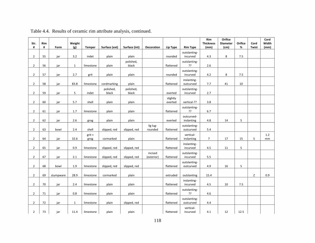
118
Table 4.4. Results of ceramic rim attribute analysis, continued.
Str. #
Rim # Form
Weight (g) Temper Surface (ext) Surface (int) Decoration Lip Type Rim Type
Rim Thickness
(mm)
Orifice Diameter
(cm) Orifice
% Cord Twist
Cord Width (mm)
2 55 jar 3.2 indet plain plain rounded outslanting-
incurved 4.3 8 7.5
2 56 jar 1 limestone plain polished,
black flattened outslanting-
?? 2.6
2 57 jar 2.7 grit plain plain rounded outslanting-
incurved 4.2 8 7.5
2 58 jar 83.8 limestone cordmarking plain flattened inslanting-outcurved 7.7 41 10
2 59 jar 5 indet polished,
black polished,
black everted outslanting-
incurved 2.7
2 60 jar 5.7 shell plain plain slightly everted vertical-?? 3.8
2 61 jar 1.7 limestone plain plain flattened outslanting-
?? 6.7
2 62 jar 2.6 grog plain plain everted outcurved-inslanting 4.8 14 5
2 63 bowl 2.4 shell slipped, red slipped, red lig lug-
rounded flattened outslanting-outcurved 5.4
2 64 jar 32.6 grit + grog cormarked plain flattened
vertical-inslanting 7 17 15 S
1.2 mm
2 65 jar 0.9 limestone slipped, red slipped, red flattened inslanting-incurved 4.5 11 5
2 67 jar 2.1 limestone slipped, red slipped, red incised
(exterior) flattened outslanting-
incurved 5.5
2 68 bowl 1.9 limestone slipped, red slipped, red flattened outslanting-outcurved 4.9 16 5
2 69 stumpware 28.9 limestone cormarked plain extruded outslanting 15.4 Z 0.9
2 70 jar 2.4 limestone plain plain flattened inslanting-incurved 4.5 10 7.5
2 71 jar 0.8 limestone plain plain flattened outslanting-
?? 4.6
2 72 jar 1 limestone plain slipped, red flattened outslanting-outcurved 4.4
2 73 jar 11.4 limestone plain plain flattened vertical-incurved 4.1 12 12.5
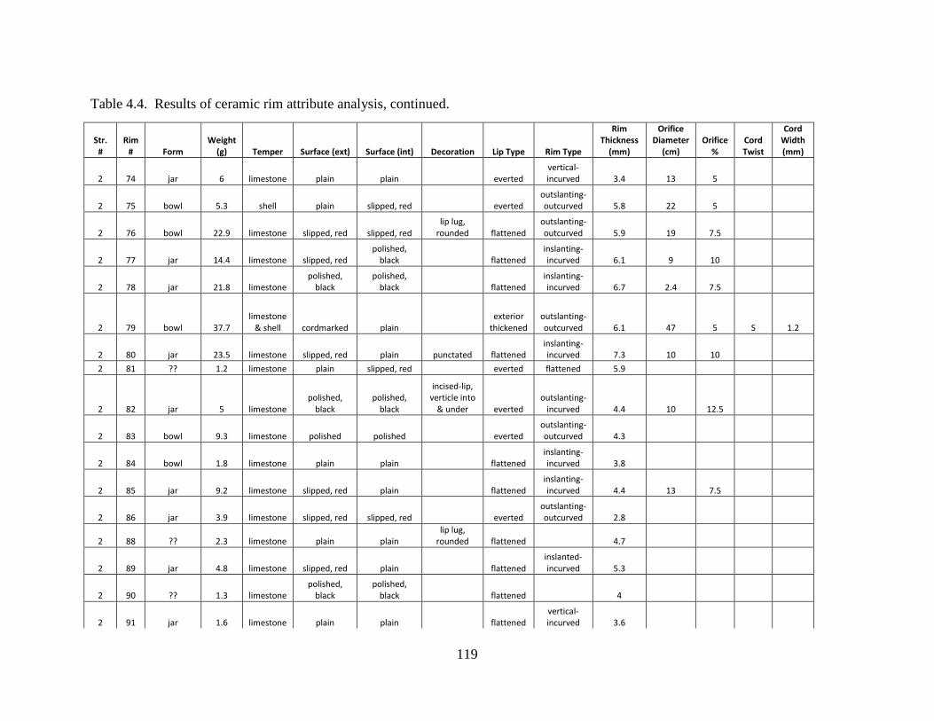
119
Table 4.4. Results of ceramic rim attribute analysis, continued.
Str. #
Rim # Form
Weight (g) Temper Surface (ext) Surface (int) Decoration Lip Type Rim Type
Rim Thickness
(mm)
Orifice Diameter
(cm) Orifice
% Cord Twist
Cord Width (mm)
2 74 jar 6 limestone plain plain everted vertical-incurved 3.4 13 5
2 75 bowl 5.3 shell plain slipped, red everted outslanting-outcurved 5.8 22 5
2 76 bowl 22.9 limestone slipped, red slipped, red lip lug,
rounded flattened outslanting-outcurved 5.9 19 7.5
2 77 jar 14.4 limestone slipped, red polished,
black flattened inslanting-incurved 6.1 9 10
2 78 jar 21.8 limestone polished,
black polished,
black flattened inslanting-incurved 6.7 2.4 7.5
2 79 bowl 37.7 limestone
& shell cordmarked plain exterior
thickened outslanting-outcurved 6.1 47 5 S 1.2
2 80 jar 23.5 limestone slipped, red plain punctated flattened inslanting-incurved 7.3 10 10
2 81 ?? 1.2 limestone plain slipped, red everted flattened 5.9
2 82 jar 5 limestone polished,
black polished,
black
incised-lip, verticle into
& under everted outslanting-
incurved 4.4 10 12.5
2 83 bowl 9.3 limestone polished polished everted outslanting-outcurved 4.3
2 84 bowl 1.8 limestone plain plain flattened inslanting-incurved 3.8
2 85 jar 9.2 limestone slipped, red plain flattened inslanting-incurved 4.4 13 7.5
2 86 jar 3.9 limestone slipped, red slipped, red everted outslanting-outcurved 2.8
2 88 ?? 2.3 limestone plain plain
lip lug, rounded flattened 4.7
2 89 jar 4.8 limestone slipped, red plain flattened inslanted-incurved 5.3
2 90 ?? 1.3 limestone polished,
black polished,
black flattened 4
2 91 jar 1.6 limestone plain plain flattened vertical-incurved 3.6
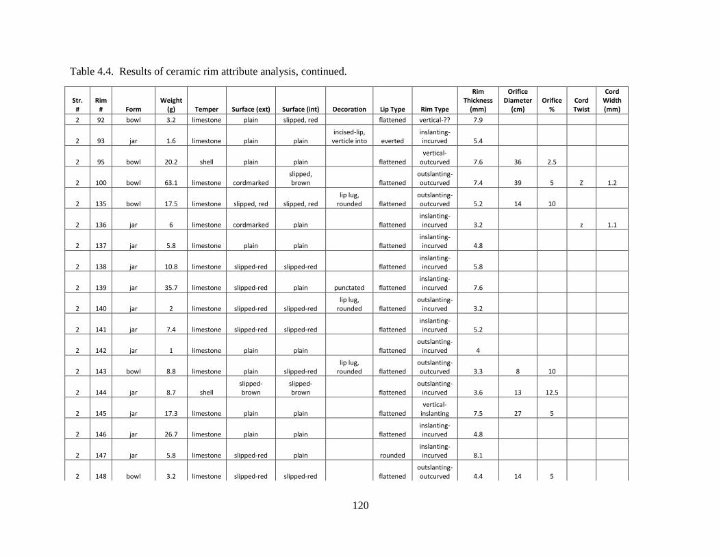
120
Table 4.4. Results of ceramic rim attribute analysis, continued.
Str. #
Rim # Form
Weight (g) Temper Surface (ext) Surface (int) Decoration Lip Type Rim Type
Rim Thickness
(mm)
Orifice Diameter
(cm) Orifice
% Cord Twist
Cord Width (mm)
2 92 bowl 3.2 limestone plain slipped, red flattened vertical-?? 7.9
2 93 jar 1.6 limestone plain plain incised-lip,
verticle into everted inslanting-incurved 5.4
2 95 bowl 20.2 shell plain plain flattened vertical-
outcurved 7.6 36 2.5
2 100 bowl 63.1 limestone cordmarked slipped, brown flattened
outslanting-outcurved 7.4 39 5 Z 1.2
2 135 bowl 17.5 limestone slipped, red slipped, red lip lug,
rounded flattened outslanting-outcurved 5.2 14 10
2 136 jar 6 limestone cordmarked plain flattened inslanting-incurved 3.2 z 1.1
2 137 jar 5.8 limestone plain plain flattened inslanting-incurved 4.8
2 138 jar 10.8 limestone slipped-red slipped-red flattened inslanting-incurved 5.8
2 139 jar 35.7 limestone slipped-red plain punctated flattened inslanting-incurved 7.6
2 140 jar 2 limestone slipped-red slipped-red lip lug,
rounded flattened outslanting-
incurved 3.2
2 141 jar 7.4 limestone slipped-red slipped-red flattened inslanting-incurved 5.2
2 142 jar 1 limestone plain plain flattened outslanting-
incurved 4
2 143 bowl 8.8 limestone plain slipped-red lip lug,
rounded flattened outslanting-outcurved 3.3 8 10
2 144 jar 8.7 shell slipped-brown
slipped-brown flattened
outslanting-incurved 3.6 13 12.5
2 145 jar 17.3 limestone plain plain flattened vertical-
inslanting 7.5 27 5
2 146 jar 26.7 limestone plain plain flattened inslanting-incurved 4.8
2 147 jar 5.8 limestone slipped-red plain rounded inslanting-incurved 8.1
2 148 bowl 3.2 limestone slipped-red slipped-red flattened outslanting-outcurved 4.4 14 5
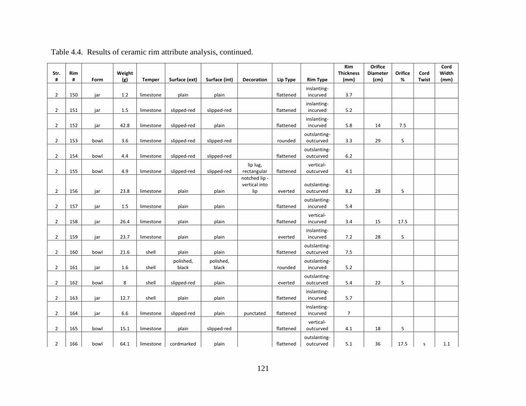
121
Table 4.4. Results of ceramic rim attribute analysis, continued.
Str. #
Rim # Form
Weight (g) Temper Surface (ext) Surface (int) Decoration Lip Type Rim Type
Rim Thickness
(mm)
Orifice Diameter
(cm) Orifice
% Cord Twist
Cord Width (mm)
2 150 jar 1.2 limestone plain plain flattened inslanting-incurved 3.7
2 151 jar 1.5 limestone slipped-red slipped-red flattened inslanting-incurved 5.2
2 152 jar 42.8 limestone slipped-red plain flattened inslanting-incurved 5.8 14 7.5
2 153 bowl 3.6 limestone slipped-red slipped-red rounded outslanting-outcurved 3.3 29 5
2 154 bowl 4.4 limestone slipped-red slipped-red flattened outslanting-outcurved 6.2
2 155 bowl 4.9 limestone slipped-red slipped-red lip lug,
rectangular flattened vertical-
outcurved 4.1
2 156 jar 23.8 limestone plain plain
notched lip - vertical into
lip everted outslanting-outcurved 8.2 28 5
2 157 jar 1.5 limestone plain plain flattened outslanting-
incurved 5.4
2 158 jar 26.4 limestone plain plain flattened vertical-incurved 3.4 15 17.5
2 159 jar 23.7 limestone plain plain everted inslanting-incurved 7.2 28 5
2 160 bowl 21.6 shell plain plain flattened outslanting-outcurved 7.5
2 161 jar 1.6 shell polished,
black polished,
black rounded outslanting-
incurved 5.2
2 162 bowl 8 shell slipped-red plain everted outslanting-outcurved 5.4 22 5
2 163 jar 12.7 shell plain plain flattened inslanting-incurved 5.7
2 164 jar 6.6 limestone slipped-red plain punctated flattened inslanting-incurved 7
2 165 bowl 15.1 limestone plain slipped-red flattened vertical-
outcurved 4.1 18 5
2 166 bowl 64.1 limestone cordmarked plain flattened outslanting-outcurved 5.1 36 17.5 s 1.1
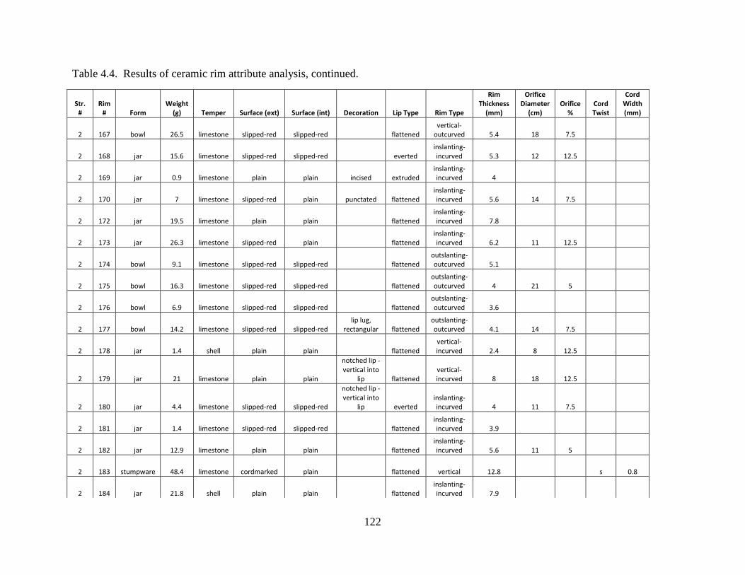
122
Table 4.4. Results of ceramic rim attribute analysis, continued.
Str. #
Rim # Form
Weight (g) Temper Surface (ext) Surface (int) Decoration Lip Type Rim Type
Rim Thickness
(mm)
Orifice Diameter
(cm) Orifice
% Cord Twist
Cord Width (mm)
2 167 bowl 26.5 limestone slipped-red slipped-red flattened vertical-
outcurved 5.4 18 7.5
2 168 jar 15.6 limestone slipped-red slipped-red everted inslanting-incurved 5.3 12 12.5
2 169 jar 0.9 limestone plain plain incised extruded inslanting-incurved 4
2 170 jar 7 limestone slipped-red plain punctated flattened inslanting-incurved 5.6 14 7.5
2 172 jar 19.5 limestone plain plain flattened inslanting-incurved 7.8
2 173 jar 26.3 limestone slipped-red plain flattened inslanting-incurved 6.2 11 12.5
2 174 bowl 9.1 limestone slipped-red slipped-red flattened outslanting-outcurved 5.1
2 175 bowl 16.3 limestone slipped-red slipped-red flattened outslanting-outcurved 4 21 5
2 176 bowl 6.9 limestone slipped-red slipped-red flattened outslanting-outcurved 3.6
2 177 bowl 14.2 limestone slipped-red slipped-red lip lug,
rectangular flattened outslanting-outcurved 4.1 14 7.5
2 178 jar 1.4 shell plain plain flattened vertical-incurved 2.4 8 12.5
2 179 jar 21 limestone plain plain
notched lip - vertical into
lip flattened vertical-incurved 8 18 12.5
2 180 jar 4.4 limestone slipped-red slipped-red
notched lip - vertical into
lip everted inslanting-incurved 4 11 7.5
2 181 jar 1.4 limestone slipped-red slipped-red flattened inslanting-incurved 3.9
2 182 jar 12.9 limestone plain plain flattened inslanting-incurved 5.6 11 5
2 183 stumpware 48.4 limestone cordmarked plain flattened vertical 12.8 s 0.8
2 184 jar 21.8 shell plain plain flattened inslanting-incurved 7.9
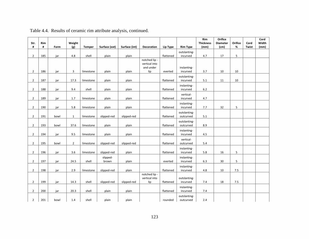
123
Table 4.4. Results of ceramic rim attribute analysis, continued.
Str. #
Rim # Form
Weight (g) Temper Surface (ext) Surface (int) Decoration Lip Type Rim Type
Rim Thickness
(mm)
Orifice Diameter
(cm) Orifice
% Cord Twist
Cord Width (mm)
2 185 jar 4.8 shell plain plain flattened outslanting-
incurved 4.7 17 5
2 186 jar 3 limestone plain plain
notched lip - vertical into and under
lip everted inslanting-incurved 3.7 10 10
2 187 jar 17.3 limestone plain plain flattened outslanting-
incurved 5.1 11 10
2 188 jar 9.4 shell plain plain flattened inslanting-incurved 6.2
2 189 jar 1.7 limestone plain plain flattened vertical-incurved 4.7
2 190 jar 5.8 limestone plain plain flattened inslanting-incurved 7.7 32 5
2 191 bowl 1 limestone slipped-red slipped-red flattened outslanting-outcurved 5.1
2 193 bowl 37.6 limestone plain plain flattened outslanting-outcurved 8.9
2 194 jar 9.5 limestone plain plain flattened inslanting-incurved 4.5
2 195 bowl 2 limestone slipped-red slipped-red flattened vertical-
outcurved 5.4
2 196 jar 3.6 limestone slipped-red plain flattened inslanting-incurved 5.8 16 5
2 197 jar 24.5 shell slipped-brown plain everted
inslanting-incurved 6.3 30 5
2 198 jar 2.9 limestone slipped-red plain flattened inslanting-incurved 4.8 10 7.5
2 199 jar 14.3 shell slipped-red slipped-red
notched lip - vertical into
lip flattened outslanting-
incurved 7.4 18 7.5
2 200 jar 20.3 shell plain plain flattened inslanting-incurved 7.4
2 201 bowl 1.4 shell plain plain rounded outslanting-outcurved 2.4
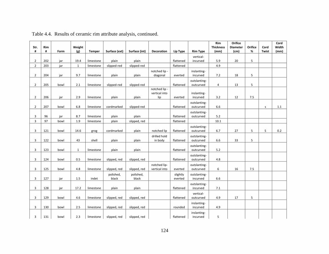
124
Table 4.4. Results of ceramic rim attribute analysis, continued.
Str. #
Rim # Form
Weight (g) Temper Surface (ext) Surface (int) Decoration Lip Type Rim Type
Rim Thickness
(mm)
Orifice Diameter
(cm) Orifice
% Cord Twist
Cord Width (mm)
2 202 jar 19.4 limestone plain plain flattened vertical-incurved 5.9 20 5
2 203 jar 1 limestone slipped-red slipped-red flattened 4.9
2 204 jar 9.7 limestone plain plain notched lip -
diagonal everted inslanting-incurved 7.2 18 5
2 205 bowl 2.1 limestone slipped-red slipped-red flattened outslanting-outcurved 4 13 5
2 206 jar 2.9 limestone plain plain
notched lip - vertical into
lip everted inslanting-incurved 3.2 12 7.5
2 207 bowl 6.8 limestone cordmarked slipped-red flattened outslanting-outcurved 6.6 s 1.1
3 96 jar 8.7 limestone plain plain flattened outslanting-outcurved 5.2
3 97 bowl 1.9 limestone plain slipped, red flattened 10.1
3 121 bowl 14.6 grog cordmarked plain notched lip flattened outslanting-outcurved 6.7 27 5 S 0.2
3 122 bowl 43 shell plain plain drilled hold
in body flattened outslanting-outcurved 6.6 33 5
3 123 bowl 1 limestone plain plain flattened outslanting-outcurved 5.2
3 124 bowl 0.5 limestone slipped, red slipped, red flattened outslanting-outcurved 4.8
3 125 bowl 4.8 limestone slipped, red slipped, red notched lip-vertical into everted
outslanting-outcurved 6 16 7.5
3 127 jar 1.5 indet polished,
black polished,
black slightly everted
outslanting-incurved 6.6
3 128 jar 17.2 limestone plain plain flattened outslanting-
incurved 7.1
3 129 bowl 4.6 limestone slipped, red slipped, red flattened vertical-
outcurved 4.9 17 5
3 130 bowl 2.5 limestone slipped, red slipped, red rounded inslanting-incurved 4.9
3 131 bowl 2.3 limestone slipped, red slipped, red flattened inslanting-incurved 5
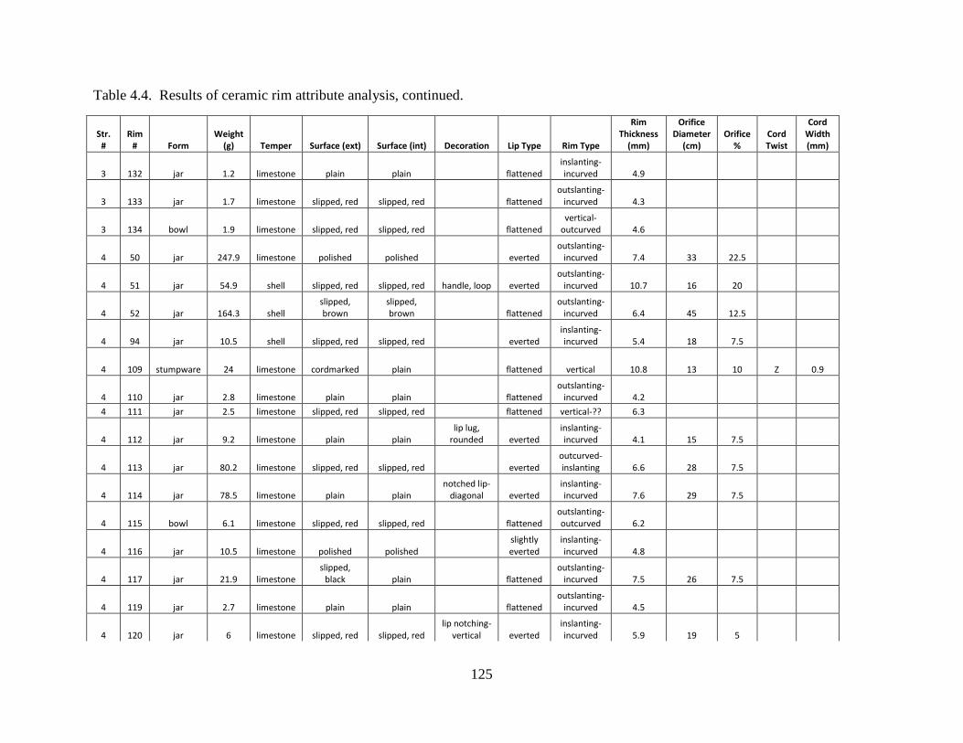
125
Table 4.4. Results of ceramic rim attribute analysis, continued.
Str. #
Rim # Form
Weight (g) Temper Surface (ext) Surface (int) Decoration Lip Type Rim Type
Rim Thickness
(mm)
Orifice Diameter
(cm) Orifice
% Cord Twist
Cord Width (mm)
3 132 jar 1.2 limestone plain plain flattened inslanting-incurved 4.9
3 133 jar 1.7 limestone slipped, red slipped, red flattened outslanting-
incurved 4.3
3 134 bowl 1.9 limestone slipped, red slipped, red flattened vertical-
outcurved 4.6
4 50 jar 247.9 limestone polished polished everted outslanting-
incurved 7.4 33 22.5
4 51 jar 54.9 shell slipped, red slipped, red handle, loop everted outslanting-
incurved 10.7 16 20
4 52 jar 164.3 shell slipped, brown
slipped, brown flattened
outslanting-incurved 6.4 45 12.5
4 94 jar 10.5 shell slipped, red slipped, red everted inslanting-incurved 5.4 18 7.5
4 109 stumpware 24 limestone cordmarked plain flattened vertical 10.8 13 10 Z 0.9
4 110 jar 2.8 limestone plain plain flattened outslanting-
incurved 4.2 4 111 jar 2.5 limestone slipped, red slipped, red flattened vertical-?? 6.3
4 112 jar 9.2 limestone plain plain lip lug,
rounded everted inslanting-incurved 4.1 15 7.5
4 113 jar 80.2 limestone slipped, red slipped, red everted outcurved-inslanting 6.6 28 7.5
4 114 jar 78.5 limestone plain plain notched lip-
diagonal everted inslanting-incurved 7.6 29 7.5
4 115 bowl 6.1 limestone slipped, red slipped, red flattened outslanting-outcurved 6.2
4 116 jar 10.5 limestone polished polished slightly everted
inslanting-incurved 4.8
4 117 jar 21.9 limestone slipped,
black plain flattened outslanting-
incurved 7.5 26 7.5
4 119 jar 2.7 limestone plain plain flattened outslanting-
incurved 4.5
4 120 jar 6 limestone slipped, red slipped, red lip notching-
vertical everted inslanting-incurved 5.9 19 5
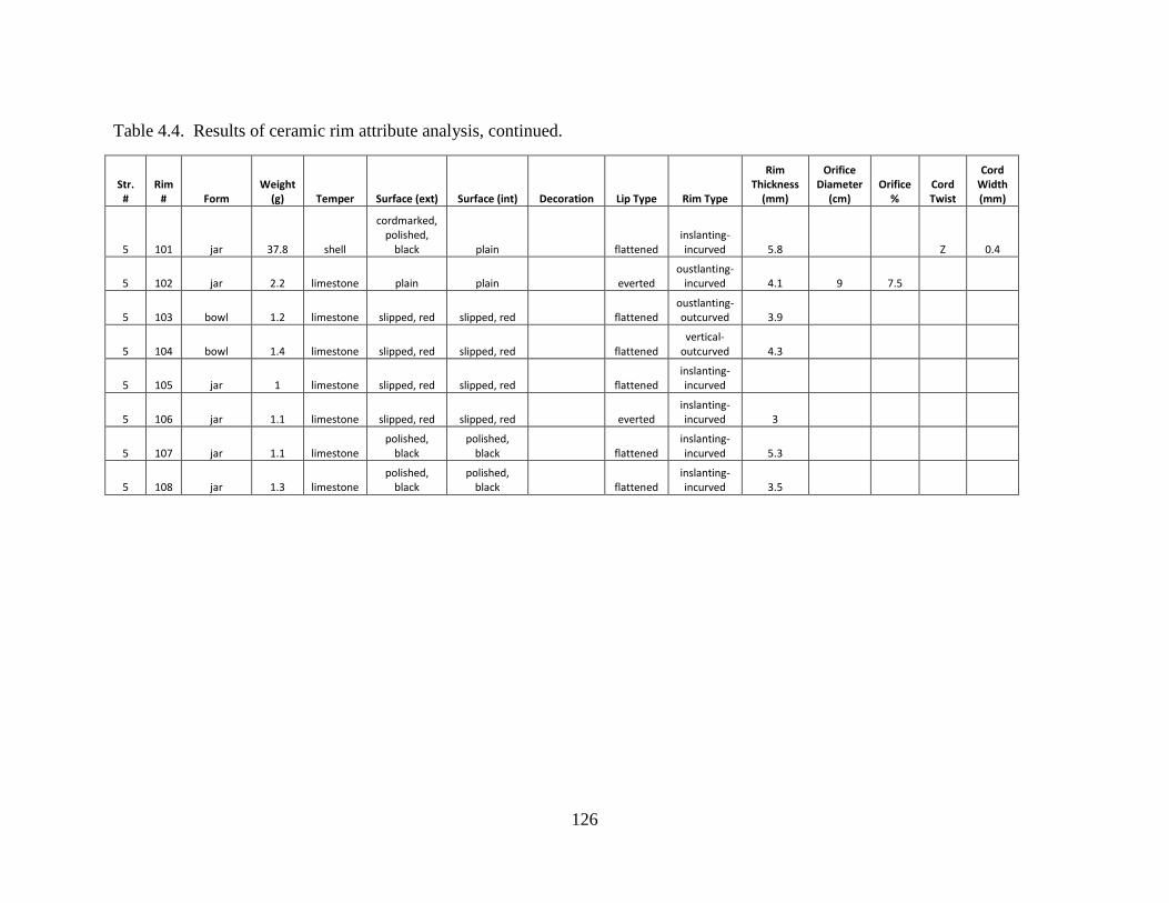
126
Table 4.4. Results of ceramic rim attribute analysis, continued.
Str. #
Rim # Form
Weight (g) Temper Surface (ext) Surface (int) Decoration Lip Type Rim Type
Rim Thickness
(mm)
Orifice Diameter
(cm) Orifice
% Cord Twist
Cord Width (mm)
5 101 jar 37.8 shell
cordmarked, polished,
black plain flattened inslanting-incurved 5.8 Z 0.4
5 102 jar 2.2 limestone plain plain everted oustlanting-
incurved 4.1 9 7.5
5 103 bowl 1.2 limestone slipped, red slipped, red flattened oustlanting-outcurved 3.9
5 104 bowl 1.4 limestone slipped, red slipped, red flattened vertical-
outcurved 4.3
5 105 jar 1 limestone slipped, red slipped, red flattened inslanting-incurved
5 106 jar 1.1 limestone slipped, red slipped, red everted inslanting-incurved 3
5 107 jar 1.1 limestone polished,
black polished,
black flattened inslanting-incurved 5.3
5 108 jar 1.3 limestone polished,
black polished,
black flattened inslanting-incurved 3.5
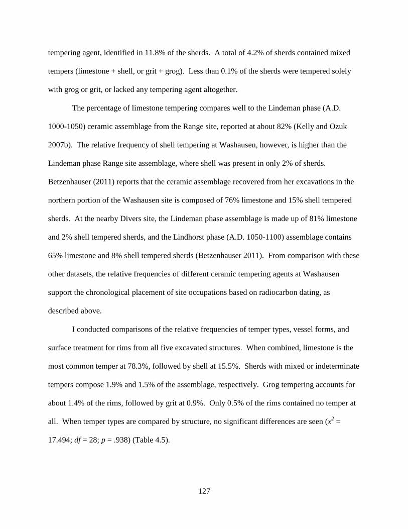
127
tempering agent, identified in 11.8% of the sherds. A total of 4.2% of sherds contained mixed
tempers (limestone + shell, or grit + grog). Less than 0.1% of the sherds were tempered solely
with grog or grit, or lacked any tempering agent altogether.
The percentage of limestone tempering compares well to the Lindeman phase (A.D.
1000-1050) ceramic assemblage from the Range site, reported at about 82% (Kelly and Ozuk
2007b). The relative frequency of shell tempering at Washausen, however, is higher than the
Lindeman phase Range site assemblage, where shell was present in only 2% of sherds.
Betzenhauser (2011) reports that the ceramic assemblage recovered from her excavations in the
northern portion of the Washausen site is composed of 76% limestone and 15% shell tempered
sherds. At the nearby Divers site, the Lindeman phase assemblage is made up of 81% limestone
and 2% shell tempered sherds, and the Lindhorst phase (A.D. 1050-1100) assemblage contains
65% limestone and 8% shell tempered sherds (Betzenhauser 2011). From comparison with these
other datasets, the relative frequencies of different ceramic tempering agents at Washausen
support the chronological placement of site occupations based on radiocarbon dating, as
described above.
I conducted comparisons of the relative frequencies of temper types, vessel forms, and
surface treatment for rims from all five excavated structures. When combined, limestone is the
most common temper at 78.3%, followed by shell at 15.5%. Sherds with mixed or indeterminate
tempers compose 1.9% and 1.5% of the assemblage, respectively. Grog tempering accounts for
about 1.4% of the rims, followed by grit at 0.9%. Only 0.5% of the rims contained no temper at
all. When temper types are compared by structure, no significant differences are seen (x2 =
17.494; df = 28; p = .938) (Table 4.5).
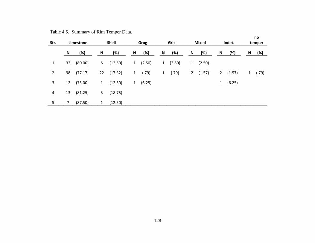
128
Table 4.5. Summary of Rim Temper Data.
Str. Limestone Shell Grog Grit Mixed Indet. no
temper
N (%)
N (%)
N (%)
N (%)
N (%)
N (%)
N (%)
1
32 (80.00)
5 (12.50)
1 (2.50)
1 (2.50)
1 (2.50)
2
98 (77.17)
22 (17.32)
1 (.79)
1 (.79)
2 (1.57)
2 (1.57)
1 (.79)
3
12 (75.00)
1 (12.50)
1 (6.25)
1 (6.25)
4
13 (81.25)
3 (18.75)
5 7 (87.50) 1 (12.50)
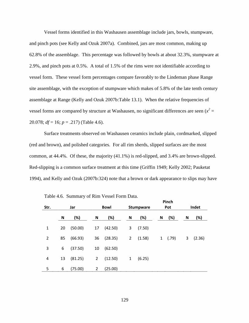
129
Vessel forms identified in this Washausen assemblage include jars, bowls, stumpware,
and pinch pots (see Kelly and Ozuk 2007a). Combined, jars are most common, making up
62.8% of the assemblage. This percentage was followed by bowls at about 32.3%, stumpware at
2.9%, and pinch pots at 0.5%. A total of 1.5% of the rims were not identifiable according to
vessel form. These vessel form percentages compare favorably to the Lindeman phase Range
site assemblage, with the exception of stumpware which makes of 5.8% of the late tenth century
assemblage at Range (Kelly and Ozuk 2007b:Table 13.1). When the relative frequencies of
vessel forms are compared by structure at Washausen, no significant differences are seen (x2 =
20.078; df = 16; p = .217) (Table 4.6).
Surface treatments observed on Washausen ceramics include plain, cordmarked, slipped
(red and brown), and polished categories. For all rim sherds, slipped surfaces are the most
common, at 44.4%. Of these, the majority (41.1%) is red-slipped, and 3.4% are brown-slipped.
Red-slipping is a common surface treatment at this time (Griffin 1949; Kelly 2002; Pauketat
1994), and Kelly and Ozuk (2007b:324) note that a brown or dark appearance to slips may have
Table 4.6. Summary of Rim Vessel Form Data.
Str. Jar Bowl Stumpware Pinch Pot Indet
N (%)
N (%)
N (%)
N (%)
N (%)
1
20 (50.00)
17 (42.50)
3 (7.50)
2
85 (66.93)
36 (28.35)
2 (1.58)
1 (.79)
3 (2.36)
3
6 (37.50)
10 (62.50)
4
13 (81.25)
2 (12.50)
1 (6.25)
5 6 (75.00) 2 (25.00)
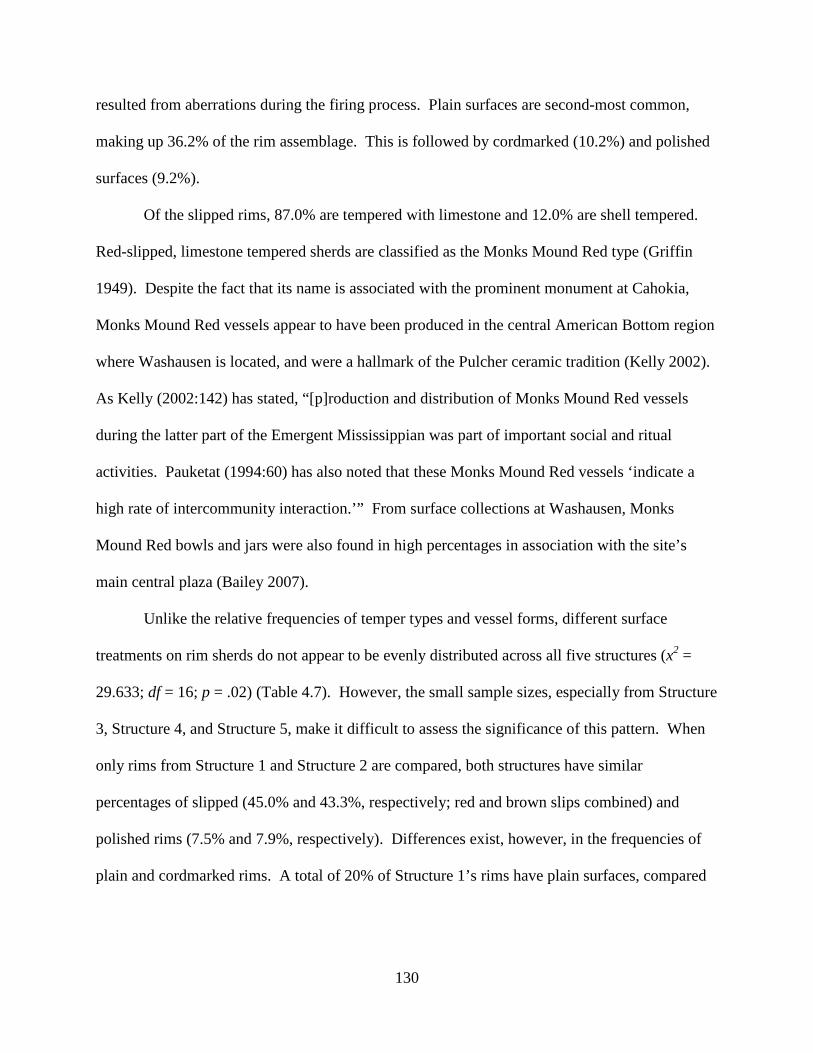
130
resulted from aberrations during the firing process. Plain surfaces are second-most common,
making up 36.2% of the rim assemblage. This is followed by cordmarked (10.2%) and polished
surfaces (9.2%).
Of the slipped rims, 87.0% are tempered with limestone and 12.0% are shell tempered.
Red-slipped, limestone tempered sherds are classified as the Monks Mound Red type (Griffin
1949). Despite the fact that its name is associated with the prominent monument at Cahokia,
Monks Mound Red vessels appear to have been produced in the central American Bottom region
where Washausen is located, and were a hallmark of the Pulcher ceramic tradition (Kelly 2002).
As Kelly (2002:142) has stated, “[p]roduction and distribution of Monks Mound Red vessels
during the latter part of the Emergent Mississippian was part of important social and ritual
activities. Pauketat (1994:60) has also noted that these Monks Mound Red vessels ‘indicate a
high rate of intercommunity interaction.’” From surface collections at Washausen, Monks
Mound Red bowls and jars were also found in high percentages in association with the site’s
main central plaza (Bailey 2007).
Unlike the relative frequencies of temper types and vessel forms, different surface
treatments on rim sherds do not appear to be evenly distributed across all five structures (x2 =
29.633; df = 16; p = .02) (Table 4.7). However, the small sample sizes, especially from Structure
3, Structure 4, and Structure 5, make it difficult to assess the significance of this pattern. When
only rims from Structure 1 and Structure 2 are compared, both structures have similar
percentages of slipped (45.0% and 43.3%, respectively; red and brown slips combined) and
polished rims (7.5% and 7.9%, respectively). Differences exist, however, in the frequencies of
plain and cordmarked rims. A total of 20% of Structure 1’s rims have plain surfaces, compared
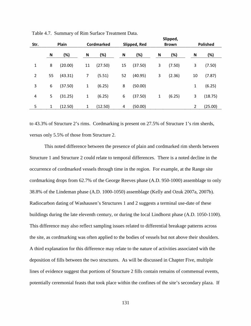
131
Table 4.7. Summary of Rim Surface Treatment Data.
Str. Plain Cordmarked Slipped, Red Slipped, Brown Polished
N (%)
N (%)
N (%)
N (%)
N (%)
1
8 (20.00)
11 (27.50)
15 (37.50)
3 (7.50)
3 (7.50)
2
55 (43.31)
7 (5.51)
52 (40.95)
3 (2.36)
10 (7.87)
3
6 (37.50)
1 (6.25)
8 (50.00)
1 (6.25)
4
5 (31.25)
1 (6.25)
6 (37.50)
1 (6.25)
3 (18.75)
5 1 (12.50) 1 (12.50) 4 (50.00) 2 (25.00)
to 43.3% of Structure 2’s rims. Cordmarking is present on 27.5% of Structure 1’s rim sherds,
versus only 5.5% of those from Structure 2.
This noted difference between the presence of plain and cordmarked rim sherds between
Structure 1 and Structure 2 could relate to temporal differences. There is a noted decline in the
occurrence of cordmarked vessels through time in the region. For example, at the Range site
cordmarking drops from 62.7% of the George Reeves phase (A.D. 950-1000) assemblage to only
38.8% of the Lindeman phase (A.D. 1000-1050) assemblage (Kelly and Ozuk 2007a, 2007b).
Radiocarbon dating of Washausen’s Structures 1 and 2 suggests a terminal use-date of these
buildings during the late eleventh century, or during the local Lindhorst phase (A.D. 1050-1100).
This difference may also reflect sampling issues related to differential breakage patterns across
the site, as cordmarking was often applied to the bodies of vessels but not above their shoulders.
A third explanation for this difference may relate to the nature of activities associated with the
deposition of fills between the two structures. As will be discussed in Chapter Five, multiple
lines of evidence suggest that portions of Structure 2 fills contain remains of commensal events,
potentially ceremonial feasts that took place within the confines of the site’s secondary plaza. If
132
so, the increased presence of plain vessels may speak to their role as serving vessels during
public events that are known to have been taking place at this time regionally (Pauketat et al.
2002).
Chipped Stone Remains
Lithic artifacts retrieved during the 2011 UM-WAP field season at Washausen were
recovered during excavations and screening. Chipped stone was analyzed following the
classification scheme presented by Andrefsky (2005). This methodology allowed all chipped
stone artifacts to be sorted into specific types that reduced lithic assemblage variability into
heuristic classes that facilitate comparison to other assemblages (Andrefsky 2005:61).
The typology presented here is based on morphological attributes of all chipped stone
remains (see Andrefsky 2005:61-85). As such, these types do not necessarily reflect the function
of artifacts; rather, these typological classes are based on artifact shapes, and are specific enough
to create mutually exclusive types. The benefit of this approach is that “[t]his kind of basic
typology can be modified, collapsed, or expanded to address specific questions put forward by
specific researchers” (Andrefsky 2005:75).
Figure 4.13 displays the morphological typology used here, displayed in flow chart form
(see also Andrefsky 2005:75-84). All chipped stone specimens were first sorted into the general
categories of tool or debitage. Tools are defined as objects either intentionally modified or
modified as a result of use (Andrefsky 2005:76). Debitage is defined as items that have resulted
from objective pieces from the act of shaping those objects.
Tools were further separated into classes of biface or nonbiface. Bifacial tools are those
that have been modified extensively by removal of flakes from both sides of the objective piece
to form an edge circumscribing the whole artifact (Andrefsky 2005:77). Bifaces were then
133
Chipped Stone
tool
debitage
biface
nonbiface
flake
nonflake
flake tool
core tool
hafted biface
unhafted biface
proximal flake
flake shatter
angular shatter
unimarginal bimarginal unidirectional multidirectional
Figure 4.13. Chipped stone morphological typology (following and adapted from Andrefsky 2005:Figure 4.7).
134
further separated into hafted and unhafted types. Hafts are elements that may appear on bifacial
tools that were created for attachment to a shaft as part of a composite tool.
Non-bifacial tools were grouped as either flake tool or core tool. Flakes are items that are
removed during modification of a piece and that have both a dorsal and ventral face, as well as a
striking platform and both distal and proximal ends (on complete flakes) (Andrefsky 2005:78).
Flakes that have been used (either for cutting or scraping) and show signs of further modification
or use-wear are classed as tools themselves. The flake tool class is sub-divided into unimarginal
and bimarginal categories. Unimarginal flake tools show signs of retouch or use-wear on only
the ventral or dorsal surface, or on both surfaces but at different locations. Bimarginal flake
tools are those that have been retouched or display use-wear on both surfaces at the same
location.
Core tools are artifacts that show signs of modification and that cannot be classified as
bifaces or flake tools (Andrefsky 2005:81-82). Following Andrefsky, all cores are classified as
core tools because they were modified and used as objective pieces. Thus, a core tool is a non-
flake or non-bifacial item that has had flakes removed; core tools can represent chunks of raw
material utilized for the removal or utilizable pieces, and they can also be blocky pieces that have
had flakes removed for cutting, scraping, or chopping purposes. All core tools were further
classified as either unidirectional or multidirectional cores. This distinction merely designates
how flakes were removed from the objective piece. Unidirectional cores are tools having flakes
removed in only one direction, whereas multidirectional core tools show evidence that flakes
were removed in more than one direction.
All non-tool, chipped stone pieces were classed as debitage. Debitage “represents the
discarded and unused detached pieces of lithic material produced from the reduction of an
135
objective piece” (Andrefsky 2005:82). All debitage was initially sorted into flake and nonflake
sub-categories (Andrefsky 2005:82-84). Flakes were further classified as proximal flakes or
flake shatter. Proximal flakes are whole or broken flakes that maintain a striking platform where
force was applied for removal of the flake piece. The flake shatter category subsumes all pieces
of broken flakes other than those maintaining the proximal end.
Non-flake debitage is designated angular shatter (Andrefsky 2005:84). Angular shatter
designates items removed from objective pieces that do not contain the recognizable dorsal or
ventral faces of flakes, and can range from sizeable blocky chunks to small shattered items.
Angular shatter can result during the modification of materials early on or late in the reduction
stage.
A total of 3,194 chipped stone lithic artifacts was recovered from Washausen during the
2011 UM-WAP excavations. Table 4.8 displays sub-totals for each morphological type, grouped
by feature. The majority of lithic remains (82.4%) were recovered from Structure 1 (n=1,480)
and Structure 2 (n=1153). Very few bifaces are present in the total assemblage (n=6), only three
from Structure 1, one from Structure 2, and two from Structure 4. Few cores are also present
(n=47), the majority of which (87.2%) were recovered from Structure 1 and Structure 2.
A total of 2,672 flakes was identified in the total assemblage. Of these, 958 (35.9%) are
flake tools, 933 (34.9%) are proximate flakes, and 781 (29.2%) are flake shatter. The angular
shatter category accounts for 469 pieces of the total assemblage. Only 14 chipped stone artifacts
were recovered in association with excavation of External Pit 1 (Feature 19), all of which came
from the overlying plowzone. Therefore, discussion of lithic artifacts below will only involve
those recovered from the five excavated structures.

136
Table 4.8. Results of Lithic Analysis.
Str. Biface
(hafted) Biface
(unhafted) Flake Tool
(unimarginal) Flake Tool
(bimarginal) Core Tool
(unidirectional) Core Tool
(multidirectional) Flake
(proximal) Flake
Shatter Angular Shatter
1
3 428 31 8 16 378 450 166
2 1
294 50 1 16 371 243 177
3
53 6
2 54 43 22
4 1 1 73 1
4 85 37 76
5
19 1
39 8 22
Ext. Pit 11 2 6 6 1All lithic artifacts from External Pit 1 originated from the plowzone.
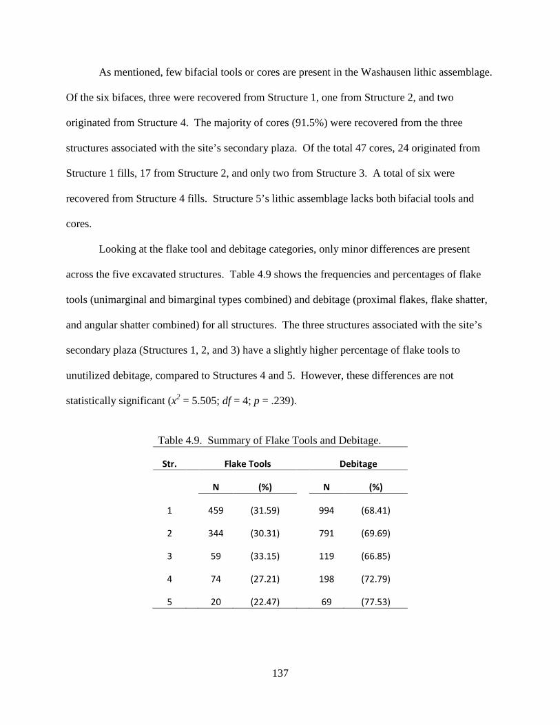
137
As mentioned, few bifacial tools or cores are present in the Washausen lithic assemblage.
Of the six bifaces, three were recovered from Structure 1, one from Structure 2, and two
originated from Structure 4. The majority of cores (91.5%) were recovered from the three
structures associated with the site’s secondary plaza. Of the total 47 cores, 24 originated from
Structure 1 fills, 17 from Structure 2, and only two from Structure 3. A total of six were
recovered from Structure 4 fills. Structure 5’s lithic assemblage lacks both bifacial tools and
cores.
Looking at the flake tool and debitage categories, only minor differences are present
across the five excavated structures. Table 4.9 shows the frequencies and percentages of flake
tools (unimarginal and bimarginal types combined) and debitage (proximal flakes, flake shatter,
and angular shatter combined) for all structures. The three structures associated with the site’s
secondary plaza (Structures 1, 2, and 3) have a slightly higher percentage of flake tools to
unutilized debitage, compared to Structures 4 and 5. However, these differences are not
statistically significant (x2 = 5.505; df = 4; p = .239).
Table 4.9. Summary of Flake Tools and Debitage.
Str. Flake Tools Debitage
N (%)
N (%)
1
459 (31.59)
994 (68.41)
2
344 (30.31)
791 (69.69)
3
59 (33.15)
119 (66.85)
4
74 (27.21)
198 (72.79)
5 20 (22.47) 69 (77.53)
138
CHAPTER 5 FEAST, FAMILY, AND FIELD: COMMUNITY CONSTRUCTION DURING THE
MISSISSIPPIAN TRANSITION AT WASHAUSEN
The Washausen site represents a short-term mound and village settlement occupied
during the Mississippian transition in the American Bottom region of west-central Illinois.
Major occupations of this early mound town occurred during the tenth and eleventh centuries
A.D., most intensively during the late George Reeves, Lindeman, and early Lindhorst phases
(Figure 1.2). Initial residence at the Washausen locality took place at a time when Cahokia was
no more than a village – albeit likely the largest and most rapidly growing village in the region –
prior to the construction of Cahokia’s unprecedentedly large mounds and plazas (see Chapter 3).
Washausen experienced a period of growth and the construction of plazas and earthen
mounds at the same time that villagers at Cahokia, and probably at a handful of other sites like
Pulcher, also began reorganizing their communities around large, central public spaces and
monuments. Thus, Washausen was a center of activity and residence in the central portion of the
American Bottom at A.D. 1050, a date Pauketat has termed the “Big Bang” at Cahokia (Pauketat
1997; 2004:65-66) and considered the start of the local Mississippian period (Fortier et al. 2006;
Hall 1991). Washausen was abandoned by the end of the eleventh century when Cahokia’s (and
likely Pulcher’s) local population was nearing its peak. The abandonment of Washausen also
corresponds to the initial construction of Monks Mound (Schilling 2013), the largest constructed
monument north of central Mexico, and the third largest in all of the Americas, outsized only by
the Mexican pyramid at Cholula and Teotihuacan’s Pyramid of the Sun (Iseminger 2010).
139
Although some researchers have placed the start of construction of Monks Mound in the tenth
century (see Dalan et al. 2003; Fowler 1997), new evidence suggests a start date of A.D. 1100 or
later (Schilling 2010, 2013; see also Kelly and Brown 2014).
This regional sequence reinforces the view that knowledge of the histories of settlements
like Washausen is important if we are to better understand the development of large and highly
complex social formations like Mississippian Cahokia. In fact, with the recent acknowledgment
that Cahokia represents a possible case of Native North American urbanism (Kelly and Brown
2014; Pauketat 2007), we benefit from understanding the full extent of social processes that were
ongoing throughout the course of regional developments prior to, during, as well as after
Cahokia’s prominence as a major population center. This position rests on the starting-point that
the development of Cahokia and the cultural complex termed “Mississippian” were neither the
result of slow evolutionary developments nor one-time events. Rather, changing notions of
identity and community were an ongoing process, not static or temporally bounded categories
(Bernardini 2011; Lightfoot 2001; Pauketat 2001a, 2001b).
In Chapters 3 and 4, I presented data from my 2011 field investigations at Washausen.
Chapter 3 discussed results of a high-resolution geophysical survey that were used to produce a
map of the site, revealing information about community organization (see also Barrier and
Horsley 2014; Horsley et al. 2014). These geospatial data allowed me to discuss Washausen’s
spatial layout, and I gave a description of distinct spatial elements of the community. The tenth-
eleventh century community at Washausen was composed of numerous residential courtyard
groups, each made up of several structures around small open courtyards. These courtyard
groups were aligned around one of the earliest mound-and-plaza complexes in the American
Bottom. Two, and potentially three, earthen mounds were built along the borders of a central
140
plaza that measured approximately 72 x 68 m. Just south of the site’s Mound B, the Washausen
settlement also includes what I have called a secondary plaza. This secondary plaza was
surrounded by several peripheral buildings, including a T-shaped structure along its western
border. In its center was a rectangular building aligned 35-40 degrees offset from the alignment
of the site’s main and secondary plazas.
Chapter 3 also presented data that I used to construct a population estimate for
Washausen. I compared population estimates and site-spatial information for Washausen to data
for earlier villages located nearby at the Range site, as well as to global village sequences
provided by Bandy (2004, 2008). The demographic profile that I constructed for the central
American Bottom demonstrates a pattern of village growth and decline in the area after the onset
of sedentism and agricultural intensification (Barrier and Horsley 2014). These data show that
the development of larger communities resulted from frequent population movements as village
segments fissioned and later aggregated at new communities.
In Chapter 4, I presented results of my 2011 excavations at Washausen. I detailed the
results of artifact analyses, giving information about the botanical, zooarchaeological, ceramic,
and lithic assemblages. In this chapter I also presented ten new AMS radiocarbon dates for the
site, and provided a discussion of the dating of occupations and activities at Washausen.
In this chapter, I combine these multiple lines of evidence and consider how Washausen’s
residents constructed their local community during the tenth through eleventh centuries A.D., a
time that corresponds to the Mississippian transition in the American Bottom. I take an historical
approach by placing the Washausen mound town within a regional diachronic framework, one
showing demographic changes that occurred through a fission-fusion process enacted by
residential courtyard group migrations. As I have argued in Chapter 3, population numbers at
141
Washausen reached levels that would have required the development of new forms of
institutional integration to allow settlement nucleation at this scale.
Here, the data I presented in Chapter 4 are used to investigate the operation of some of
these institutions. Drawing upon my discussions from Chapter 1, I place these results within a
theoretical framework focused on the political economies of kin-based agricultural societies. I
argue that the histories of places like Washausen should inform our models about the
development of the larger American Bottom centers, like Pulcher and Cahokia, and that they
were part of the buildup to events sparking the historical transformations that archaeologists
identify as “Mississippian” across much of eastern North America.
Community Construction in the American Bottom: The Washausen Case
In Chapter 3, I presented a series of population estimates for the transitional
Mississippian period Washausen mound town. Population estimates were calculated using
information about the remains of residential dwellings at the site, as known from an extensive
geophysical survey. The geophysical data produced a relatively complete map of the site
displaying a clear pattern of distinct, residential courtyard groups distributed about a centrally-
located mound-and-plaza complex. This work demonstrates that the use of high-resolution,
broad-scale geophysical techniques to survey entire sites (and even larger landscapes) can offer a
productive method to complement more traditional archaeological approaches of data collection,
and can be used in the formulation and assessment of anthropological research questions about
the past (Horsley et al. 2014; Kvamme 2003; Thompson et al. 2011).
142
Together, demographic data for Washausen and earlier villages illuminate a punctuated
history of village growth and decline that occurred through persistent population movements of
residential courtyard groups, possible at time-scales approaching generational or even sub-
generational scales (compare to Cobb and King 2005). Recurrent population movements are
now more than ever recognized as prominent factors in the historical development of
Mississippian communities in the American Bottom (Cobb 2005; Pauketat 2003:58) and the
larger Mississippian world more generally (Blitz 1999:590). From this point of view, the short-
lived Washausen site is an important part of the longer-term Mississippian history of the
American Bottom.
This sketch of early village developments in the American Bottom also contributes to
larger comparative studies that seek to understand the growth of large complex polities as a
global phenomenon. The early village sequence that I presented in Chapter 3 for the Range and
Washausen sites matches demographic expectations provided by Bandy’s (2004; 2008) model
for early village developments and farming communities. The Range and Washausen village
sequences demonstrate a diachronic shift towards greater settlement nucleation and larger scales
of integration, enacted through a protracted process of transformative community aggregations
and dispersals.
Kelly (1990a; 1992) has discussed the development and operation through time of social
institutions at the Range site during the centuries leading up to the Mississippian transition.
Various institutions at distinct village occupations at Range are recognizable through the
appearance of new architectural-spatial arrangements, specialized buildings, feature clusters, and
particular material assemblages. These include the construction and use of larger buildings
within and between courtyard groups that may have served socio-political functions, early
143
temple-like buildings with central hearths and from which are recovered artifacts showing
religious symbolism, quadripartite arrangements of pits and central wooden posts within open
courtyards, and later on, central plazas between distinct courtyard groups. As Kelly (1992:186)
states, villages at Range represent “the coalescence of various communities in the immediate
area at a single location… In many respects the symbolism and affiliated ceremonies [at Range]
were important in unifying disparate communities and hence served to mitigate against the…
fission of settlements.”
After A.D. 1050 at Cahokia, new institutional relations are evident as the settlement was
undergoing unforeseen levels of transformation and community reorganization, and as major
investments were being made in earth moving, plaza construction, and mound building (Dalan et
al. 2003; Milner 1998; Pauketat 1994, 2004; Schilling 2010). Monumental wooden posts and
circular “woodhenges” were raised in public view (Pauketat and Alt 2005; Smith 1992), and
extravagant burials were placed in unique ridge-top mounds as part of large-scale public
performances (cf. Brown 2006; Emerson 1997; Fowler et al. 1999; Pauketat 2009; Zimmermann
Holt 2009). Earlier residential spaces inhabited by small courtyard groups were replaced by
larger residential zones distributed about plazas and mounds, and around new forms of
architecture including T-shaped and circular buildings (Collins 1997; Mehrer and Collins 1995;
Pauketat 1994, 2004). There is also evidence of large-scale public feasts indicating that great
numbers of people were taking part in labor-intensive projects and ceremonial rites that arguably
served to integrate disparate groups through commensal and politically-charged events (Kelly
2001; Pauketat et al. 2002).
If, as I have argued, the changes at Cahokia were part of larger ongoing processes, then
what evidence exists at Washausen for the presence of social institutions indicative of new forms
144
of local interaction and integration at this early mound town? In addition to Washausen’s central
mound-and-plaza complex, residents also constructed and used the settlement’s secondary plaza.
As described in Chapter 3, Washausen’s secondary plaza was defined by a number of structures
that marked the perimeter of a roughly 50 x 50 m space (Figure 3.2). In the center of this space
was a structure offset about 35-40 degrees (Structure 1). The secondary plaza and its perimeter
buildings appear to align to a potential site grid, as defined by the central mound-and-plaza
complex. Washausen’s secondary plaza, used throughout the tenth and eleventh centuries,
measures approximately two times larger than the two early plazas at the George Reeves phase
(A.D. 950-1000) Range site.
Across the Southeast United States and elsewhere, archaeologists have demonstrated that
plazas were locations for a range of activities that often included public gatherings,
performances, and inclusive ritual ceremonies that served to encourage a sense of community
identity (Kidder 2004; Knight 1986; Lewis et al. 1998; Wesson 1998). Following Kidder
(2004:515), “[a] plaza can be defined as a public area in a community or as an open space
surrounded by or adjacent to buildings.” As he states, however, “[p]lazas cannot simply be
thought of as empty spaces that developed because architecture enclosed an open area; they must
be understood as one of the central design elements of community planning and intrasite spatial
organization” (Kidder 2004:515).
Thus, inference of the presence of a secondary plaza at Washausen is strengthened by
consideration of the activities that established a community plaza-space, in addition to plotting
the surrounding architecture. Like the main mound-and-plaza complex at Washausen, the
settlement’s secondary plaza, its buildings, and the public activities that took place there give us
145
a glimpse at some of the institutions created by Washausen’s residents as they constructed their
mound-town community.
With a regional demographic trajectory of village development charted for the region,
results from my 2011 excavations at Washausen provide insights into some of the new
institutions created by Washausen residents and the social practices they used to integrate greater
numbers of arriving courtyard groups. As detailed in Chapter 4, excavation of Structure 2,
located on the eastern edge of the settlement’s secondary plaza, revealed the presence of
organically-rich fill zones that appear to have formed via intentional human infilling (Figures 4.4
and 4.5). Nine soil samples, totaling 91 liters of sediment, were removed from Structure 2’s fills.
A subset of these samples produced an overwhelming majority of the recovered botanical and
faunal remains from the site. Structure 2’s basin fills produced about two-thirds of all seeds,
roughly 80% of all Eastern Complex (EC) cultigens, and almost 90% of all maize remains. More
interesting is the deposit identified as Zone 21 (Figure 4.5). Two soil samples (Samples 22 and
27) produced about half of all recovered seeds, nearly two-thirds of all EC cultigens, and almost
75% of all maize recovered from the site – all from just 21 liters of floated sediment.
Also identified within Structure 2’s fills were 33 of a total of 40 recovered morning glory
seeds. Twenty-six of these seeds were identified from the two samples removed from Zone 21.
The hallucinogenic properties of morning glory seeds, and the ethnohistoric record of their use
by native groups, suggest their role during ceremonial and communal events. For example,
sources depict the use of morning glory among native groups for medicinal purposes, often as a
purgative (King 1984; Moerman 1985:235-236; Steyermark 1981:1216; Yanovsky 1936:53), and
herbal guides today link the consumption of morning glory to rapid and violent emptying of the
bowels (Lust 1974). In the American Bottom region, morning glory has been recovered from a
146
handful of other locations that together support the interpretation that the plant was utilized as a
specialized or ceremonial item. For example, specimens of morning glory have been identified
within assemblages excavated from early Mississippian mound or nodal centers like the Pfeffer,
WalMart, Olszewski, and Lehmann-Sommers sites (Dunavan 1990:401-402; Parker 1998). At
Lehmann-Sommers specifically, morning glory seeds were directly associated with a T-shaped
temple building (Parker 2002).
Structure 2’s fills also produced the overwhelming majority of faunal remains collected
during my excavations at Washausen. In many ways, Structure 2’s faunal assemblage is similar
to other contemporary American Bottom sites where faunal assemblages have been analyzed.
However, it differs in some telling ways. For example, deer remains comprise a larger
percentage of Structure 2’s assemblage (85.7% mammalian NISP) compared to other
contemporary sites. At the Range site, deer remains comprised between 30-35% of the
mammalian remains from pre-A.D. 1050 assemblages (Kelly et al. 2007). For the early
Mississippian feature clusters studied at Range, they varied between zero to nearly 50% of
identified mammalian NISP, with muskrat remains many times outnumbering deer.
Fish taxa identified from Washausen are those that would be expected from a floodplain
site and one located adjacent to a major creek. However, Structure 2’s assemblage did produce a
few noteworthy specimens. Three catfish MNI are from large individuals. Two would have
weighed around 30 pounds each, and remains from one individual suggest that it weighed at least
70 pounds. Remains of paddlefish were also identified from Structure 2’s fills. Paddlefish has
rarely been identified in American Bottom assemblages. This oddly-shaped fish has a long
paddle-shaped snout, and it is possible that this fish conveyed some special meaning, as
147
evidenced by a rock art pictograph known from the Petty Jean and Arkansas rivers area (Fritz
and Ray 1982).
Two bird taxa identified from Structure 2 are also rare. One is trumpeter swan. A wing
bone (distal carpometacarpus) recovered from Zone 21 has light cut marks just above the break.
Swan remains have a patterned distribution in the American Bottom during the Mississippian
period, where they are concentrated at Cahokia and appear to have had symbolic significance
(Kelly and Kelly 2007). Outside of Cahokia during the Lohmann phase (A.D. 1050-1100), wing
bones have been recovered from two other mound centers (East St. Louis and Horseshoe Lake).
At the upland Richland Complex Halliday site, a number of unmodified swan bones have been
recovered, but none were wing elements. Kelly and Kelly (2007) note that the wings of swan
may have been used for ritual performances during the early Mississippian period.
Two buteonine hawk wing bones were also recovered from levels 4 and 5 of Structure 2.
Raptor bones are not commonly found at American Bottom sites, but do occasionally occur. The
hawk has been linked to Mississippian ritual (Kelly 2010) and its occurrence here within
Structure 2’s unique material assemblage supports this view. Raptors, and the falcon
specifically, are among the most commonly occurring images depicted in Mississippian
iconography across the Southeast (Brown 2007:56). In more recent times, the hawk was an
important component of Osage symbolism and material culture, as it was associated with the
warrior and its skin curated as a sacred component of specific clan bundles (Bailey 1995; La
Flesche 1921).
Across the secondary plaza from Structure 2, excavation of Structure 3 revealed its
unique T-shape (see Chapter 4). Baltus and Baires (2012) class T-shaped structures together
with a few other specialized building forms (L- and cruciform-shaped, and larger rectangular
148
structures) that they call Cahokian “ritual structures.” Besides their unique shapes, larger
dimensions, and placement associated with mounds, plazas, or mortuary facilities, excavations
have revealed that these buildings contain sets of material items and internal features that are not
ordinarily found within domestic structures. Baltus and Baires state that these specialized
buildings were likely associated with religious or priestly activities. Such structures often
contain storage pits and hearths. In addition to some domestic debris normally recovered from
this class of buildings, a variety of rare items are also variously found, including certain
minerals, carved pipes and figurines, the wing bones of large birds (e.g., swan), miniature
vessels, and tobacco seeds (Baltus and Baires 2012:177).
Baltus and Baires (2012:Table 2) list a total of eight T-shaped structures that have been
located in the greater American Bottom – three at Cahokia itself, one at the Sponemann and East
St. Louis sites, as well as one each at the Pfeffer, Grossman, and Halliday sites in the Richland
Complex uplands. Within many of these ritual buildings, the repeated use of fire in sub-floor
hearths and surrounding burned-floor areas appears to have been a common practice. Their
thorough review of the use of fire in the Cahokia area and elsewhere in eastern North America
led Baltus and Baires (2012:168) to “argue that fire was a means of animating and transforming
spaces and objects, and, in doing so, transferring power to particular social agents within the
Cahokian polity" and that fire “was used and experienced by Cahokians as both an object and an
agent of power: meaning ancestors, mounds, and ancestral temples were created, manipulated,
and transformed as persons and places of power in conjunction with or at the hands of fire”
(Baltus and Baires 2012:172-173). Kelly (1992:176) also discusses the link between the
placement of internal hearths and the ceremonial role of fire, going back in the region as far as
the late ninth century. Kelly notes that by the tenth century at Range, internal hearths (or those
149
“with fire”) were placed within the largest buildings that were centrally located within
settlements, and that these structures show signs of re-building through time.
As detailed in Chapter 4, my excavation of Structure 3 on the western edge of
Washausen’s secondary plaza revealed that it contains several of the distinctive traits that Baltus
and Baires (2012) and Kelly (1992) associate with specialized ritual buildings or temples. In
addition to its location, rare T-shape, and the deep pit within the floor of its T-wing extension, a
sub-floor hearth and surrounding burned soils were located in its center. Samples from these
intramural features exhibited unusually high botanical diversity, with seeds from a minimum of
19 cultivated and wild plants. Maize fragments were few by comparison to the highly diverse
seed taxa. The thin lens of carbonized materials lining the base of the interior hearth (that was
capped by a layer of yellow clay) produced seeds of tobacco (10 of the 13 recovered from
Washausen).
Tobacco was an important ceremonial and medicinal plant used by native North
American groups (Haberman 1984; Swanton 1946; Wagner 2000). An exotic specialty plant,
tobacco was also likely used for ceremonial purposes in the American Bottom from the Late
Woodland through early Mississippian periods (Simon and Parker 2006). Like morning glory,
tobacco may have been valued during ritual events for its potential hallucinogenic effects.
In the American Bottom, tobacco has been recovered from non-domestic contexts at
Cahokia (including the sub-Mound 51 feasting deposits, see below), Sponemann, and several
other early Mississippian sites that served “nodal” or ceremonial functions (Emerson 1997;
Pauketat et al. 2002; Pauketat and Emerson 1997; Simon and Parker 2006). Within Washausen’s
T-shaped structure, samples from the burned sediments surrounding the hearth produced one
tobacco seed along with specimens from at least 18 other plant taxa, an unusually diverse roster
150
from such a small area. Activities in this T-shaped building likely centered around the interior
hearth and involved Eastern Complex domesticates and wild edible resources, including the
represented wild bean, hog peanut, fruits of persimmon and black nightshade, and of course,
tobacco.
The fact that the T-shaped Structure 3 was used (and likely rebuilt) throughout the
duration of major occupations at Washausen supports the hypothesis that this building did hold a
specialized role for the community. As I reported in Chapter 4, both the earliest and latest AMS
radiocarbon dates for the site come from Structure 3’s internal features. Following Baltus and
Baires (2012) and Kelly (1992), the remains recovered within Structure 3 and its unique
morphology and placement at the edge of the settlement’s secondary plaza are used to infer that
Structure 3 was a temple building at Washausen, and its repeated use was a central feature of
community integration. An important institution at early Mississippian places like Cahokia,
religious/ritual practices that repeatedly took place within T-shaped temples were already being
performed by individuals or groups at pre-Mississippian Washausen.
Feast, Family, and Field: Political Economy at Washausen
In this dissertation, I have detailed a regional sequence of village developments that took
place after the onset of sedentism and agricultural production in the American Bottom. What is
somewhat unexpected from this case study is the speed at which these developments took place.
In Bandy’s (2008) comparative dataset, his “large villages” like Washausen did not develop, on
average, for several centuries after the onset of local, sedentary agricultural life. In the American
Bottom, “large villages” appear within 200 years or less after the founding of the first
151
agricultural villages. Further, the expansive urbanization of Cahokia during its height took place
within a mere 300 years after regional farming villages were first constituted (Kelly and Brown
2014; Pauketat 2007).
From a comparative perspective, this is a rapid sequence, but one that was nonetheless
drawn out across generations (Beck et al. 2007:842-844). What this points toward is greater
appreciation that in the American Bottom people may have had reasons to abandon their
communities other than the commonly mentioned development of intra-settlement competition
and factionalism (e.g., Brumfiel and Fox 1994; see also Brown 2006; Pauketat et al. 2002;
Zimmermann Holt 2009) – although local conflicts were also likely factors during family’s
decisions to abandon their homes and migrate elsewhere. These conflict-natured explanations
for village fragmentation assume that communities were pushed apart internally. However, at
the same time, communities may have experienced external forces that acted to pull them apart
as well.
As Beck et al. (2007:842) state: “Cahokia was built to attract people.” Indeed, the rapid
population growth at early Mississippian Cahokia occurred at a time when many pre-
Mississippian villages were being abandoned or were significantly diminished in size and
population, as well as at a time when groups originating from far beyond the American Bottom
migrated to Cahokia and to the region (Alt 2006; Beck 2006; Cobb 2005; Emerson 1997; Kelly
1990b; Pauketat 2003).
However, as my research demonstrates, the Washausen settlement – although dwarfed by
Mississippian Cahokia by practically any measure – also represented a new way of constructing
community through coalescence during the tenth and early eleventh centuries A.D. in the
American Bottom. By demographic measures, village populations reached previously unseen
152
levels at Washausen (although, as noted, Cahokia was probably growing larger by this time).
Earthen mounds were being built at Washausen, likely by sometime in the early eleventh century
or before. And, as I argue below, the activities that took place within the settlement’s secondary
plaza and within its buildings are testaments to the creation of new scales of institutional
integration, linking together numerous families (i.e., courtyard groups) within a newly-
envisioned community. In many ways, then, it is also productive to think of Washausen as a
community that was being built to attract others, and potentially an important lens into the
processes that also shaped early Mississippian Cahokia.
During the late eleventh century at Cahokia, massive deposits relating to large-scale
feasts dating to the early Mississippian Lohmann phase have been recovered from pits beneath
the site’s Mound 51 (Kelly 2001; Pauketat et al. 2002). These commensal events, assumed to
have taken place within the settlement’s central Grand Plaza, were attended by large numbers of
individuals (and social groups) who took part in festivities and labor projects linked to mound
construction and temple rebuilding, among other things. Pauketat et al. (2002) argue that these
recurrent events were part of a larger participatory process whereby diverse and previously
unrelated groups took active part in constructing Cahokia’s Mississippian community, laying the
foundations for social and political transformations at the settlement. As they state:
the sub-Mound 51 [feasting-related] pit dates to the earliest phase of the youngest and largest Mississippian polity in North America and may encapsulate the process whereby people accepted or accommodated (or even resisted) a Cahokian organization, identity, or way of life. That process seems to have involved a dramatically enlarged and centralized sense of community, polity, and economy… That coordinated practices may have been components of a collective cultural process may be central to explaining how people accommodated the social and demographic shifts thought to have attended the [early Mississippian] Lohmann phase region in the Greater Cahokia area [Pauketat et al. 2002:275].
153
Likewise at Washausen: the act of building mounds and plazas, the inclusion of religious
or ceremonial activities centered upon a new form of ritual temple and participation in public
commensal events were ways that newly arriving social groups actively built their community
that included greater numbers of people than was previously the norm. In many ways, the large-
scale feasts at early Mississippian Cahokia could be described as quasi-potluck events. That is,
many of the kinds of remains within the sub-Mound 51 deposits appear in ordinary domestic
assemblages, like ceramic vessels used for cooking and many of the food items shared and eaten
(Pauketat et al. 2002:275).
Studies of feasting have been a productive part of research that examines the
development and expression of social relations and integrative practices and institutions in
complex societies (Blitz 1993a, 1993b; Dietler 1996; Dietler and Hayden 2001; Hayden 1996;
LeCount 2001; VanDerwarker 1999; VanDerwarker et al. 2007; Welch and Scarry 1995).
Variation in material remains and depositional processes have been used to elucidate special
deposits related to commensal events. Research on feasting has shown that both the types of
foods prepared and consumed, as well as the scale at which consumption or feasting occurred,
can vary based on where meals were taken (i.e., “private” versus “public” settings), the social
status of the groups attending or hosting, or the extent of local sociopolitical complexity. Several
lines of material evidence have been used to demonstrate variability in foodways and feasting,
including: the presence of specialized foods; the scales at which foods were prepared,
consumed, or discarded; and the types and sizes of ceramic vessels used for preparation and
serving.
From early Mississippian Cahokia’s sub-Mound 51 feasting deposits, it appears that
people from throughout Cahokian society attended these events, and brought with them many of
154
the resources consumed during the feasts (Pauketat et al. 2002). But at the same time, the sub-
Mound 51 deposits are unlike domestic refuse in many ways. Differences exist in the overall
quantities of food remains, in the paucity of corn and barley grass, in the high frequencies of
purslane, grapes, persimmons, and other fruits, and in the high frequency of tobacco seeds. Also,
deer was overly represented in the sub-Mound 51 deposits, fish remains were from large
individuals, and birds like swan and prairie chicken were abundant.
The assemblage described for Washausen’s Structure 2, located on the eastern edge of the
settlement’s secondary plaza, similarly attests to its unique composition. Although they do not
match entirely Cahokia’s sub-mound 51 deposits (especially when it comes to scale), I argue that
stratified layers within Structure 2’s fill accrued through the deposition of debris from public
commensal events that took place at Washausen, and that they appear in many ways to have been
held quasi-potluck style. Notable extraordinary inclusions are hallucinogenic morning glory
seeds, increased numbers of deer and large fish, as well swan, hawk, and prairie chicken. Unlike
Cahokia’s late eleventh century feasts, however, feasting events at Washausen included
consumption of maize. Thus, it appears that while local courtyard groups were intensifying their
agricultural economies, these groups were also funneling a part of their surpluses into new
institutions that included communal feasting.
This convergence of multiple lines of evidence portrays what Dietler (1996, 2001) calls
commensal politics. In this realm, feasts are a particular form of ritual activity that articulates
social relationships and action. He states that feasts “create and maintain social relations that
bind people together in various intersecting groups and networks on a wide range of scales, from
the local household cluster to the regional political community” (Dietler 2001:68-69).
155
Importantly, as Dietler (2001:69) also points out, feasts “also provide a crucial mechanism for
the process of labor mobilization that underlies the political economy.”
Commensal events at Washausen likely involved the numerous courtyard group families
living there, and provided venues for each corporate group to provision large-scale public
festivities. In these situations, otherwise communal gatherings have the potential to take on a
political life as some groups may, over time, be more successful providing foods and services,
and may even take on roles as hosts. Through time, the integrative institution of feasting in kin-
based political economies can become more highly competitive ventures. As some groups may
be able to continuously serve as hosts, systems of debt and reciprocal obligations can develop
(Dietler 2001:79). Within this type of political-economic situation, kin groups must intensify
agricultural production to continue their participation. In the Mississippian case, agricultural
intensification relied on enlarging access to productive lands and more laborers (Beck and
Brown 2012; Smith 1978). Otherwise, less productive households and groups risked falling into
a relationship marked by long-term indebtedness. Indebted corporate groups could also choose
to relocate elsewhere, as was often the case across the Mississippian world (Anderson 1994;
Blitz 1999). As Dietler (2001:77; emphasis original) is right to point out, the polysemic political
nature of feasts give them the power to “both unite and divide at the same time.”
An argument along these very lines has recently been put forward by Brown and Kelly
(2014). Discussing the development of social inequalities at Mississippian Cahokia, they write:
that communal feasting in a kin-ordered society sets up the conditions for social stratification when the number of participating social units climbs past a certain threshold. Social surplus plays a key part in this process because large communal feasts are invariably underwritten by the combined efforts of the surplus labor of each unit [Brown and Kelly 2014:2; emphasis original].
156
Although commensal feasts at Washausen appear to have been small-scale events relative to the
massive feasts that took place at Cahokia, I stress the point that the process of participatory
engagement that involved communal feasting was occurring at early mound towns like
Washausen and, potentially, at multiple locales and scales within such settlements. These new
institutional practices were ongoing as previous demographic thresholds were being crossed; that
is, as more and more courtyard groups aggregated to new mound town communities, these
families were actively creating avenues for political transformation that we see in hypertrophic
form at early Mississippian Cahokia.
Thus, it was through ongoing transformations in a kin-based political-economic system
that villages developed into larger and more complexly-organized communities in the American
Bottom. As Brown and Kelly (2014) argue, emerging leaders at early Mississippian Cahokia
would have sought to attract laborers and their surpluses that could be used during increasingly
competitive communal events. More broadly, Beck (2003, 2006) has proposed a model that
describes how regional consolidation can occur through population aggregation in regions and at
specific settlements. Of importance here is Beck’s “persuasive aggregation,” a concept that he
uses to contrast the development of many Mississippian polities with other hierarchically
organized polities that develop under conditions of coercive expansion. As Beck states:
[l]ocal leaders striving to expand [chiefly] institutions must increase the production of surplus, a goal that may be achieved (1) by promoting the intensification of production technologies… or (2) by attracting new followers to augment their pool of human labor available for surplus production [Beck 2006:20-22].
Within a Mississippian context dominated by field agricultural regimes organized by kin-
based corporate groups (Muller 1997:394-396), requirements for sustained accumulation of
157
surpluses would have made aggregations desirable, as access to labor was restricted to those with
claims of kinship. Beck (2006) argues that persuasive politics likely accounts for the growth of
large Mississippian centers like Cahokia, as corporate groups would not have been bound to
specific field technologies like irrigation systems. Rather, Mississippian “farmers enjoyed
relatively open mobility… [and leaders] seeking to expand their political economies – unable to
do so by coercive expansion – competed with one another to persuasively aggregate more
followers than their rivals” (Beck 2006:25).
My research has demonstrated that indeed, within the American Bottom region, farming
families maintained high levels of residential mobility, and large villages and communities both
grew and were abandoned in part due to the itinerant predispositions of corporate farming
groups. A similar scenario has been discussed for the late prehistoric American Southwest,
where archaeologists have referred to the fluid social landscapes there by terms such as “short-
term sedentism” and “serial migration” (Bernardini 2005; Nelson and LeBlanc 1986).
Bernardini (2005) describes migration events by household groups as ways that clans could grow
in size and importance at new Hopi villages. He states that Hopi
clans are not corporate groups united in their control of land and ceremony. Rather, a clan consists of a core household surrounded by a number of other household groups in an ‘orbital’ arrangement of dependence and support (Connelly 1979). Offices and privileges are thus held ‘not in the clan as a whole, but in a maternal family or lineage in the clan’ (Parsons 1933:23) [Bernardini 2005:38].
He goes on to state that:
Migration in this type of landscape was not an event but an ongoing process (Duff 1998) in which the most recent place of residence would be a relatively narrow description of a person’s identity. That is, labeling an immigrant as an ‘Anasazi,’ or a ‘Silver Creek’ person or even a ‘Cottonwood Pueblo person’ would be of
158
little use in summarizing his or her identity because as little as a generation ago he, his parents, or his grandparents likely lived in a different (possibly even several different) village, region, or culture area [Bernardini 2005:39; emphasis original].
I do not intend to suggest that the courtyard groups at settlements like Range and
Washausen or the groups living within the larger residential districts at Cahokia can be
considered strict equivalents of the lineages and clans described by Knight (1990) for the early
historic period, as described in Chapter 1. However, using Knight’s analysis as a starting point
for thinking about the migrating groups in the American Bottom before, during, and after the
Mississippian transition lends support to the multi-clan model for early Mississippian Cahokia.
This line of reasoning also dovetails with models that see Cahokia as a place that was built to
attract people (Beck et al. 2007). But we could alternatively phrase this as: it was the actual
attraction of people to this rapidly growing settlement that built Cahokia.
For two- to three-hundred years before the start of the Mississippian period in the
American Bottom, residential courtyard groups regularly moved across the landscape,
constructing houses and forming and dissolving new villages. Through time, this ongoing
process of group fissioning and re-aggregation led to the development of larger communities that
also saw the active construction of new institutions that enabled larger nucleated settlements to
exist. Fissioning of courtyard groups likely occurred due to increasing levels of local
competition and factionalism within each new village, but it also likely occurred at times because
corporate groups were being pulled into larger “clan”-like collectivities that allowed for the
pooling of surpluses and for the support of increasingly important ceremonial responsibilities.
The Washausen site represents one short slice of time where we are witness to the
unfolding of this ongoing historical process. While Washausen community members were living
159
at population levels that only then were being reached (at Washausen as well as a handful of
other villages like Cahokia), they were also building central mounds and plazas, creating new
religious institutions like those centered upon novel T-shaped temples, and participating in
commensal feasting events.
The Washausen mound town community would not last long, however. By the late
eleventh century, the settlement was abandoned, either through the independent fissioning of
courtyard groups or through the movement of the Washausen community as a whole to an
emerging center like Pulcher or even Cahokia itself.
At the start of Chapter 1, I outlined a variety of ways that scholars have defined
“Mississippian,” going back to Holmes’s (1903) original use of the word. Today, archaeologists
use the term in a more general way to describe a variety of historically connected yet diverse set
of late pre-Columbian societies across eastern North America. It is possible that Washausen
residents may not have considered themselves “Mississippian” in any way similar to how
archaeologists have employed the term. A distinctive “Mississippian” identity may not have
materialized until later at Cahokia. However, my research has demonstrated that Washausen’s
residents were contributing to, and taking active part in, sets of social processes involved with
rapidly changing demographic and institutional conditions that were involved with the
“Mississippian” transition in the American Bottom.
160
BIBLIOGRAPHY
Alt, Susan M. 2001 Cahokian Change and the Authority of Tradition. In The Archaeology of Traditions: Agency and History Before and After Columbus, edited by Timothy R. Pauketat, pp. 141- 156. University Press of Florida, Gainesville. 2002 Identities, Traditions, and Diversity in Cahokia’s Uplands. Midcontinental Journal of Archaeology 27:217-235. 2006 The Power of Diversity: The Roles of Migration and Hybridity in Culture Change. In Leadership and Polity in Mississippian Society, edited by Brian M. Butler and Paul D. Welch, pp. 289-308. Occasional Paper No. 33. Center for Archaeological Investigations, Southern Illinois University, Carbondale. Anderson, David G. 1994 The Savannah River Chiefdoms: Political Change in the Late Prehistoric Southeast. University of Alabama Press, Tuscaloosa. 1999 Examining Chiefdoms in the Southeast: An Application of Multiscalar Analysis. In Great Towns and Regional Polities in the Prehistoric American Southwest and Southeast, edited by Jill E. Neitzel, pp. 215-241. University of New Mexico Press, Albuquerque. Anderson, David G, and Kenneth E. Sassaman 2012 Recent Developments in Southeastern Archaeology: From Colonization to Complexity. Society for American Archaeology Press, Washington, D.C. Andrefsky, William, Jr. 2005 Lithics: Macroscopic Approaches to Analysis. 2nd ed. Cambridge University Press, Cambridge. Aspinall, Arnold, Chris Gaffney, and Armin Schmidt 2008 Magnetometry for Archaeologists. AltaMira, Walnut Creek, California. Bailey, Garrick A. 1995 The Osage and the Invisible World: From the Works of Francis La Flesche. University of Oklahoma Press, Norman.
161
Bailey, Katri Susanna 2007 Washausen Mound Center (11MO305) Ceramic Assemblage: Broken Pots from the Plaza. Unpublished Master’s thesis, Department of Anthropology, Washington University, Saint Louis, Missouri. Baltus, Melissa R., and Sarah E. Baires 2012 Elements of Ancient Power in the Cahokian World. Journal of Social Archaeology 12:167-192. Bandy, Matthew S. 2004 Fissioning, Scalar Stress, and Social Evolution in Early Village Societies. American Anthropologist 106:322-333. 2005 New World Settlement Evidence for a Two-Stage Neolithic Demographic Transition. Current Anthropology 46(S):S109-S115. 2008 Global Patterns of Early Village Development. In The Neolithic Demographic Transition and its Consequences, edited by Jean-Pierre Bocquet-Appel and Ofer Bar-Yosef, pp. 333- 357. Springer, New York. Barrier, Casey R. 2011 Storage and Relative Surplus at the Mississippian Site of Moundville. Journal of Anthropological Archaeology 30:206-219. Barrier, Casey R., and Timothy J. Horsley 2014 Shifting Communities: Demographic Profiles of Early Village Population Growth and Decline in the Central American Bottom. American Antiquity, in press. Beck, Robin A., Jr. 2003 Consolidation and Hierarchy: Chiefdom Variability in the Mississippian Southeast. American Antiquity 68:641-661. 2006 Persuasive Politics and Domination at Cahokia and Moundville. In Leadership and Polity in Mississippian Society, edited by Brian M. Butler and Paul D. Welch, pp. 19-42. Occasional Paper No. 33. Center for Archaeological Investigations, Southern Illinois University, Carbondale. Beck, Robin A., Jr., Douglas J. Bolender, James A. Brown, and Timothy K. Earle 2007 Eventful Archaeology: The Place of Space in Structural Transformation. Current Anthropology 48:833-860. Beck, Robin A., Jr., and James A. Brown 2012 Political Economy and the Routinization of Religious Movements: A View from the Eastern Woodlands. Archaeological Papers of the American Anthropological Association 21:72-88.
162
Benech, Christophe 2007 New Approach to the Study of City Planning and Domestic Dwellings in the Ancient Near East. Archaeological Prospection 14:87-103. Bernardini, Wesley R. 2011 Migration in Fluid Social Landscapes. In Rethinking Anthropological Perspectives on Migration, edited by Graciela S. Cabana and Jeffery J. Clark, pp. 31-44. University Press of Florida, Gainesville. Betzenhauser, Alleen 2008 Washausen Site Investigations. Illinois Antiquity 43(2):8. 2011 Creating the Cahokian Community: The Power of Place in Early Mississippian Political Dynamics. Unpublished Ph.D. dissertation, Department of Anthropology, University of Illinois, Urbana. Blitz, John H. 1993a Ancient Chiefdoms of the Tombigbee. University of Alabama Press, Tuscaloosa. 1993b Big Pots for Big Shots: Feasting and Storage in a Mississippian Community. American Antiquity 58:80-96. 1999 Mississippian Chiefdoms and the Fission-Fusion Process. American Antiquity 64:577- 592. 2010 New Perspectives in Mississippian Archaeology. Journal of Archaeological Research 18:1-39. Blitz, John H., and Karl G. Lorenz 2006 The Chattahoochee Chiefdoms. University of Alabama Press, Tuscaloosa. Boudreaux, Edmond A., III 2007 The Archaeology of Town Creek. University of Alabama Press, Tuscaloosa. 2013 Community and Ritual within the Mississippian Center at Town Creek. American Antiquity 78:483–501. Bronk Ramsey, C. 2009 Bayesian Analysis of Radiocarbon Dates. Radiocarbon 51(1):337-360. Brown, James A. 2006 Where’s the Power in Mound Building? An Eastern Woodlands Perspective. In Leadership and Polity in Mississippian Society, edited by Brian M. Butler and Paul D. Welch, pp. 197-213. Occasional Paper No. 33. Center for Archaeological Investigations, Southern Illinois University, Carbondale.
163
2007 On the Identity of the Birdman within Mississippian Period Art. In Ancient Objects and Sacred Realms: Interpretations of Mississippian Iconography, vol. I, edited by F. Kent Reilly, III, and J. Garber, pp. 56-106. University of Texas Press, Austin. Brown, James A., and John E. Kelly 2014 Surplus Labor, Ceremonial Feasting and Social Inequality at Cahokia – A Study in Social Process. In Surplus: The Politics of Production and the Strategies of Everyday Life, edited by Christopher T. Morehart and Krisin De Lucia. University Press of Colorado, Boulder, in press. Brumfiel, Elizabeth M., and J.W. Fox (editors) 1994 Factional Competition and Political Development in the New World. Cambridge University Press, Cambridge. Buikstra, Jane E., Lyle W. Konigsberg, and Jill Bullington 1986 Fertility and the Development of Agriculture in the Prehistoric Midwest. American Antiquity 51:528-546. Burks, Jarod 2004 Results from a Small Magnetic Survey at the Washausen Site, Monroe County, Illinois. Report No. 2004-27. Ohio Valley Archaeological Consultants. Submitted to John E. Kelly, Central Mississippi Valley Archaeological Research Institute, Columbia, Illinois. Chapman, Ellen 2005 Analysis of the Washausen Mississippian Mound Site (11MO305) Using Distribution Maps. Unpublished Bachelors’s thesis, Department of Anthropology, Washington University, Saint Louis, Missouri. Clark, Anthony 1990 Seeing Beneath the Soil: Prospecting Methods in Archaeology. B.T. Batsford, London. Cobb, Charles R. 1993 Archaeological Approaches to the Political Economy of Nonstratified Societies. In Archaeological Method and Theory, vol. 5, edited by Michael B. Schiffer, pp. 43-99. University of Arizona Press, Tucson. 2003 Mississippian Chiefdoms: How Complex? Annual Review of Anthropology 32:63-84. 2005 Archaeology and the “Savage Slot”: Displacement and Emplacement in the Premodern World. American Anthropologist 107:563-574. Cobb, Charles R., and Brian M. Butler 2006 Mississippian Migration and Emplacement in the Lower Ohio Valley. In Leadership and Polity in Mississippian Society, edited by Brian M. Butler and Paul D. Welch, pp. 328-347. Occasional Paper No. 33. Center for Archaeological Investigations, Southern Illinois University, Carbondale.
164
Cobb, Charles R., and Eric Drake 2008 The Colour of Time: Head Pots and Temporal Convergences. Cambridge Archaeological Journal 18:85-93. Cobb, Charles R., and Patrick H. Garrow 1996 Woodstock Culture and the Question of Mississippian Emergence. American Antiquity 61:21-37. Cobb, Charles R., and Adam King 2005 Re-Inventing Mississippian Tradition at Etowah, Georgia. Journal of Archaeological Method and Theory 12:167-192. Collins, James M. 1997 Cahokia Settlement and Social Structures as Viewed from the ICT-II. In Cahokia: Domination and Ideology in the Mississippian World, edited by Timothy R. Pauketat and Thomas E. Emerson, pp. 124-140. University of Nebraska Press, Lincoln. Connelly, J.C. 1979 Hopi Social Organization. In Handbook of North American Indians, vol. 9, edited by A. Ortiz, pp. 539-543. Smithsonian Institution, Washington D.C. Cook, Sherburne F. 1972 Prehistoric Demography. Addison-Wesley Modular Publications 16:1-42. Crumley, Carole 2007 Notes on a New Paradigm. In Socialising Complexity: Structure, Interaction, and Power in Archaeological Discourse, edited by Sheila Kohring and Stephanie Wynne-Jones, pp. 30- 36. Oxbow Books, Oxford. Curet, L. Antonio 1998 New Formulae for Estimating Prehistoric Populations for Lowland South America and the Caribbean. Antiquity 72:359-375. Dalan, Rinita A., George R. Holley, W. Woods, and J.A. Koepke 2003 Envisioning Cahokia: A Landscape Perspective. Northern Illinois University Press, DeKalb. Dietler, Michael 1996 Feasts and Commensal Politics in the Political Economy: Food, Power, and Status in Prehistoric Europe. In Food and the Status Quest, edited by Polly Wiessner and W. Schiefenhovel, pp. 87-125. Berghahn Books, Oxford. 2001 Theorizing the Feast: Rituals of Consumption, Commensal Politics, and Power in African Contexts. In Feasts: Archaeological and Ethnographic Perspectives on Food, Politics, and Power, edited by Michael Dietler and Brian Hayden, pp. 65-114. Smithsonian Institution Press, Washington D.C.
165
Dietler, Michael, and Brian Hayden (editors) 2001 Feasts: Archaeological and Ethnographic Perspectives on Food, Politics, and Power. Smithsonian Institution Press, Washington D.C. Doolittle, William E. 2004 Permanent vs. Shifting Cultivation in the Eastern Woodlands of North America Prior to European Contact. Agriculture and Human Values 21:181-189. Duff, Andrew I. 1998 The Process of Migration in the Late Prehistoric Southwest. In Migration and Reorganization: The Pueblo IV Period in the American Southwest, edited by Katherine A. Spielmann, pp. 31-52. Anthropological Research Papers 51, Arizona State University, Tempe. Dunavan, Sandra L. 1990 Floral Remains. In Selected Early Mississippian Household Sites in the American Bottom, edited by D. K. Jackson and N. H. Hanenberger, pp. 389-403. American Bottom Archaeology FAI-270 Site Reports, vol. 22. University of Illinois Press, Urbana. Earle, Timothy K. 2000 Archaeology, Property, and Prehistory. Annual Review of Anthropology 29:39-60. 2002 Political Economies of Chiefdoms and Agrarian States. In Bronze Age Economics: The Beginnings of Political Economies, edited by Timothy K. Earle, pp. 1-18. Westview Press, Boulder, Colorado. Emerson, Thomas E. 1997 Cahokia and the Archaeology of Power. University of Alabama Press, Tuscaloosa. Emerson, Thomas E., and Timothy R. Pauketat 2008 Historical-Processual Archaeology and Culture Making: Unpacking the Southern Cult and Mississippian Religion. In Belief in the Past: Theoretical Approaches to the Archaeology of Religion, edited by Kelley Hays-Gilpin and David S. Whitley, pp. 167-188. Left Coast Press, Walnut Creek, California. Flannery, Kent V. 1998 The Ground Plans of Archaic States. In Archaic States, edited by Gary M. Feinman and Joyce Marcus, pp. 15-57. School of American Research Press, Santa Fe, New Mexico. Fowler, Melvin L. 1969 The Cahokia Site. In Explorations into Cahokia Archaeology, edited by Melvin L. Fowler, pp. 1-30. Bulletin 7. Illinois Archaeological Survey, Urbana. 1975 A Pre-Columbian Urban Center on the Mississippi. Scientific American 233:93-101. 1997 The Cahokia Atlas: A Historical Atlas of Cahokia Archaeology. Studies in Archaeology, no. 2. Illinois Transportation Archaeological Research Program, University of Illinois, Urbana.
166
1989 The Cahokia Atlas: A Historical Atlas of Cahokia Archaeology. Studies in Illinois Archaeology 6. Illinois Historic Preservation Agency, Springfield. Folwer, Melvin L., Jerome Rose, Barbara Vander Leest, and Steven A. Ahler 1999 The Mound 72 Area: Dedicated and Sacred Space in Early Cahokia. Illinois State Museum, Reports of Investigations, no. 54. Springfield. Fortier, A.C., Thomas E. Emerson, and D. L. McElrath 2006 Calibrating and Reassessing American Bottom Culture History. Southeastern Archaeology 25:170-211. Freimuth, Glen Alois 1974 The Lunsford-Pulcher Site: An Examination of Selected Traits and their Social Implications in American Bottom Prehistory. Unpublished pre-dissertation paper, Department of Anthropology, University of Illinois, Urbana. Fritz, Gayle J. 1990 Multiple Pathways to Farming in Precontact Eastern North America. Journal of World Prehistory 4:387-435. Fritz, Gayle J., and Robert Ray 1982 Rock Art Sites in the Southern Arkansas Ozarks and Arkansas River Valley. In Arkansas Archaeology in Review, edited by Neal Trubowitz and Marvin Jeter, pp. 240-276. Arkansas Archeological Survey Research Series 15. Fayetteville, Arkansas. Fritz, Gayle J., and Neal H. Lopinot 2007 Native Crops at Early Cahokia: Comparing Domestic and Ceremonial Contexts. Illinois Archaeology 15&16:90-111. Gaffney, Chris, and James Gater 2003 Revealing the Buried Past: Geophysics for Archaeologists. Tempus, Stroud. Gregg, Michael L. 1975 A Population Estimate for Cahokia. In Perspectives in Cahokia Archaeology, pp. 126- 136. Bulletin 10. Illinois Archaeological Survey, Urbana. Griffin, James B. 1949 The Cahokia Ceramic Complexes. In Proceedings of the Fifth Plains Conference for Archaeology, edited by J. Champe, pp. 44-58. University of Nebraska, Lincoln. 1977 The University of Michigan Excavations at the Pulcher Site in 1970. American Antiquity 42:462-488. Haberman, T. W. 1984 Evidence for Aboriginal Tobaccos in Eastern North America. American Antiquity 49:269-287.
167
Hall, Robert L. 1975 Chronology and Phases at Cahokia. In Perspectives in Cahokia Archaeology, edited by Melvin L. Fowler, pp. 15-31. Bulletin 10. Illinois Archaeological Survey, Urbana. 1991 Cahokia Identity and Interaction Models of Cahokia Mississippian. In Cahokia and the Hinterlands: Middle Mississippian Cultures of the Midwest, edited by Thomas E. Emerson and R. Barry Lewis, pp. 3-34. University of Illinois Press, Urbana. Hally, David J 1996 Platform Mound Construction and the Instability of Mississippian Chiefdoms. In Political Structure and Change in the Prehistoric Southeastern United States, edited by John F. Scarry, pp. 92-127. University Press of Florida, Gainesville. Hayden, Brian 1996 Feasting in Prehistoric and Traditional Societies. In Food and the Status Quest, edited by Polly Wiessner and W. Schiefenhovel, pp. 127-148. Berghahn Books, Oxford. Holley, George R., Rinita A. Dalan, and Philip A. Smith 1993 Investigations in the Cahokia Site Grand Plaza. American Antiquity 58:306-319. Holmes, William H. 1903 Aboriginal Pottery of the Eastern United States. In Twentieth Annual Report of the Bureau of American Ethnology, pp. 1-201. Smithsonian Institution Press, Washington D.C. Horsley, Timothy J., and D. Wilbourn 2009 Destriping Linears – A New Approach to an Old Problem. ISAP News – The Newsletter of the International Society for Archaeological Prospection 21:3-5. Horsley, Timothy J., Alice P. Wright, and Casey R. Barrier. 2014 Prospecting for New Questions: Integrating Geophysics to Define Anthropological Research Objectives and Inform Excavation Strategies at Monumental Sites. Archaeological Prospection 21:75-86. Iseminger, William 2010 Cahokia Mounds: America’s First City. The History Press, Charleston, South Carolina. Jenkins, Ned J. 2003 The Terminal Woodland/Mississippian Transition in West and Central Alabama. Journal of Alabama Archaeology 49:1-62. Kelly, John E. 1990a Range Site Community Patterns and the Mississippian Emergence. In The Mississippian Emergence, edited by Bruce D. Smith, pp. 67-112. Smithsonian Institution Press, Washington D.C.
168
1990b The Emergence of Mississippian Culture in the American Bottom Region. In The Mississippian Emergence, edited by Bruce D. Smith, pp. 113-152. Smithsonian Institution Press, Washington D.C. 1992 The Impact of Maize on the Development of Nucleated Settlements: An American Bottom Example. In Late Prehistoric Agriculture: Observations from the Midwest, edited by William I. Woods, pp. 167-197. Studies in Illinois Archaeology 8. Illinois Historic Preservation Agency, Springfield. 1993 The Pulcher Site: An Archaeological and Historical Overview. Illinois Archaeology 5:434-451. 2000 The Nature and Context of Emergent Mississippian Cultural Dynamics in the Greater American Bottom. In Late Woodland Societies: Tradition and Transformation across the Midcontinent, edited by Thomas E. Emerson, Dale L. McElrath, and Andrew C. Fortier, pp. 163-175. University of Nebraska Press, Lincoln. 2002 The Pulcher Tradition and the Ritualization of Cahokia: A Perspective from Cahokia’s Southern Neighbor. Southeastern Archaeology 21:136-148. 2006a The Ritualization of Cahokia: The Structure and Organization of Early Cahokia Crafts. In Leadership and Polity in Mississippian Society, edited by Brian M Butler and Paul D. Welch, pp. 236-263. Occasional Paper No. 33. Center for Archaeological Investigations, Southern Illinois University, Carbondale. 2006b Washausen and the “Big Bang”: Understanding the Context of the Ripple Effect. Paper presented at the 63rd Annual Meeting of the Southeastern Archaeological Conference, Little Rock, Arkansas. 2007a An Interpretation of the Lindeman Phase Occupation of the Range Site. In The Range Site 4: George Reeves and Lindeman Phase Occupations, edited by John E. Kelly, Steven J. Ozuk, and Joyce A. Williams, pp. 469-489. Transportation Archaeological Research Reports No. 18. Illinois Transportation Archaeological Research Program. University of Illinois, Urbana-Champaign. 2007b Conclusions. In The Range Site 4: George Reeves and Lindeman Phase Occupations, edited by John E. Kelly, Steven J. Ozuk, and Joyce A. Williams, pp. 491-494. Transportation Archaeological Research Reports No. 18. Illinois Transportation Archaeological Research Program. University of Illinois, Urbana-Champaign. 2008 Contemplating Cahokia’s Collapse. In Global Perspectives on the Collapse of Complex Systems, edited by James A. Railey and Richard Martin Reycraft, pp. 147-168. Maxwell Museum of Anthropology, Albuquerque, New Mexico.
169
Kelly, John E., and James A. Brown 2012 In Search of Cosmic Power: Contextualizing Spiritual Journeys between Cahokia and the St. Francois Mountains. In Archaeology of Spiritualities, edited by Kathryn Rountree, Christine Morris, and Alan A.D. Peatfield, pp. 107-129. Springer, New York 2014 Cahokia: The Processes and Principles of the Creation of an Early Mississippian City. In Making Ancient Cities: Space and Place in Early Urban Societies, edited by Andrew T. Creekmore III and Kevin D. Fisher. Cambridge University Press, in press. Kelly, Lucretia S., and John E. Kelly 2007 Swans in the American Bottom during the Emergent Mississippian and Mississippian. Illinois Archaeology 15-15:112-141. Kelly, John E., and Steven J. Ozuk 2007a George Reeves Phase Ceramics. In The Range Site 4: George Reeves and Lindeman Phase Occupations, edited by John E. Kelly, Steven J. Ozuk, and Joyce A. Williams, pp. 89-139. Transportation Archaeological Research Reports No. 18. Illinois Transportation Archaeological Research Program. University of Illinois, Urbana-Champaign. Kelly, John E., and Steven J. Ozuk 2007b Lindeman Phase Ceramics. In The Range Site 4: George Reeves and Lindeman Phase Occupations, edited by John E. Kelly, Steven J. Ozuk, and Joyce A. Williams, pp. 319-391. Transportation Archaeological Research Reports No. 18. Illinois Transportation Archaeological Research Program. University of Illinois, Urbana-Champaign. Kelly, John E., Steven J. Ozuk, and Joyce A. Williams (editors) 2007 The Range Site 4: George Reeves and Lindeman Phase Occupations. Transportation Archaeological Research Reports No. 18. Illinois Transportation Archaeological Research Program. University of Illinois, Urbana-Champaign. Kelly, Lucretia S. 2001 A Case of Ritual Feasting at the Cahokia Site. In Feasts: Archaeological and Ethnographic Perspectives on Food, Politics, and Power, edited by Michael Dietler and Brian Hayden, pp. 334-367. Smithsonian Institution Press, Washington D.C. 2010 A Bird’s Eye View of Ritual at the Cahokia Site. In Anthropological Approaches to Zooarchaeology: Complexity, Colonialism, and Animal Transformations, edited by D. Campana, P. Crabtree, S.D. deFrance, J. Lev-tov, and A. Choyke, pp. 1-11. Oxbow Books, London. 2013 Report of Faunal Remains from the Washausen Site (11MO305), Monroe County, IL. Submitted to Casey R. Barrier, Department of Anthropology, University of Michigan, Ann Arbor. Kidder, Tristram R. 2004 Plazas as Architecture: An Example from the Raffman Site, Northeast Louisiana. American Antiquity 69:514-532.
170
King, F. B. 1984 Plants, People, and Paleoecology: Biotic Communities and Aboriginal Plant Usage in Illinois. Illinois State Museum Scientific Papers, vol. 20. Springfield, Illinois. Knight, Vernon James, Jr. 1986 The Institutional Organization of Mississippian Religion. American Antiquity 51:675- 687. 1990 Social Organization and the Evolution of Hierarchy in Southeastern Chiefdoms. Journal of Anthropological Research 46:1-23. 2010 Mound Excavations at Moundville: Architecture, Elites, and Social Order. University of Alabama Press, Tuscaloosa. Knight, Vernon James, Jr., and Vincas P. Steponaitis 1998 A New History of Moundville. In Archaeology of the Moundville Chiefdom, edited by Vernon James Knight, Jr. and Vincas P. Steponaitis, pp. 1-25. Smithsonian University Press, Washington D.C. Koldehoff, Brad, and Joseph M. Galloy 2006 Late Woodland Frontiers in the American Bottom Region. Southeastern Archaeology 25:275-300. Kvamme, Kenneth L. 2003 Geophysical Surveys as Landscape Archaeology. American Antiquity 68:435-457. 2006 Magnetometry: Nature’s Gift to Archaeology. In Remote Sensing in Archaeology: An Explicitly North American Perspective, edited by Jay Johnson, pp. 205-234. University of Alabama Press, Tuscaloosa. La Flesche, Francis 1921 The Osage Tribe: Rite of the Chiefs; Sayings of the Ancient Men. 36th Annual Report of the Bureau of American Ethnology, 1914-1915, pp. 35-597. Smithsonian Institution, Washington, D.C. LeCount, Lisa J. 2001 Like Water for Chocolate: Feasting and Political Ritual among the Late Classic Maya at Xunatunich, Belize. American Anthropologist 103:935-953. Lewis, R. Barry, Charles Stout, and Cameron B. Wesson 1998 The Design of Mississippian Towns. In Mississippian Towns and Sacred Spaces: Searching for an Archaeological Grammar, edited by R. Barry Lewis and Charles Stout, pp. 1-21. University of Alabama Press, Tuscaloosa.
171
Lightfoot, Kent G. 2001 Traditions as Cultural Production: Implications for Contemporary Archaeological Research. In The Archaeology of Traditions: Agency and History Before and After Columbus, edited by Timothy R. Pauketat, pp. 237-252. University Press of Florida, Gainesville. Lust, John 1974 The Herb Book. Bantam Books, New York. McGuire, Randall H. 2002 A Marxist Archaeology. Reprint, Percheron Press, Clinton Corners, New York. Originally published 1992, Academic Press, New York. Mehrer, Mark W. 1995 Cahokia’s Countryside. Northern Illinois University Press, DeKalb. Mehrer, Mark W., and James M. Collins 1995 Household Archaeology at Cahokia and its Hinterlands. In Mississippian Communities and Households, edited by J. Daniel Rogers and Bruce D. Smith, pp. 32-57. University of Alabama Press, Tuscaloosa. Milner, George R. 1986 Mississippian Period Population Density in a Segment of the Central Mississippi River Valley. American Antiquity 51:227-238. 1990 The Late Prehistoric Cahokia Cultural System of the Mississippi River Valley: Foundations, Florescence, and Fragmentation. Journal of World Prehistory 4:1-43. 1998 The Cahokia Chiefdom: The Archaeology of a Mississippian Society. Smithsonian Institution Press, Washington D.C. 2006 Introduction to the 2006 Paperback Edition. In The Cahokia Chiefdom: The Archaeology of a Mississippian Society. Reprinted. University Press of Florida, Gainesville. Originally published 1998, Smithsonian Institution Press, Washington, D.C. Milner, George R., and James S. Oliver 1999 Late Prehistoric Settlements and Wetlands in the Central Mississippi Valley. In Settlement Pattern Studies in the Americas: Fifty Years since Virú, edited by Brian R. Billman and Gary M. Feinman, pp. 79-95. Smithsonian Institution Press, Washington D.C. Moerman, Daniel E. 1986 Medicinal Plants of Native America. Research Reports in Ethnobotany, Contribution 2, Technical Reports 9. Museum of Anthropology, University of Michigan, Ann Arbor. Muller, Jon 1997 Mississippian Political Economy. Plenum Press, New York.
172
Nelson, B., and S. LeBlanc 1986 Short-term Sedentism in the American Southwest: The Mimbres Valley Salado. University of New Mexico Press, Albuquerque. Ozuk, Steven J. 1987 Patrick Phase Ceramics. The Range Site: Archaic Through Late Woodland Occupations, edited by John E. Kelly, Andrew C. Fortier, Steven J. Ozuk, and Joyce A. Williams, pp. 230-304. American Bottom Archaeology FAI-270 Site Reports, vol. 20. University of Illinois Press, Urbana. Parsons, E. C. 1933 Hopi and Zuni Ceremonialism. American Anthropological Association Memoirs 39. Menasha, Wisconsin. Parker, Kathryn 1998 Plant Remains from Archaeological Investigations at the Wal-Mart Site. In The Wal- Mart Site (11MS1369): A Lohmann Phase Occupation in the Northern American Bottom, edited by Charles L. Rohrbaugh. 2002 Botanical Remains from the Lehmann-Sommers Site (11-S-1415). Report submitted to John E. Kelly, Central Mississippi Valley Archaeological Research Institute, Columbia Illinois. 2013 Report of Archaeobotanical Remains from the Washausen Site (11MO305), Monroe County, IL. Submitted to Casey R. Barrier, Department of Anthropology, University of Michigan, Ann Arbor. Pauketat, Timothy R. 1989 Monitoring Mississippian Homestead Occupation Span and Economy Using Ceramic Refuse. American Antiquity 54:288-310. 1994 The Ascent of Chiefs: Cahokia and Mississippian Politics in Native North America. University of Alabama Press, Tuscaloosa. 1997 Cahokian Political Economy. In Cahokia: Domination and Ideology in the Mississippian World, edited by Timothy R. Pauketat and Thomas E. Emerson, pp. 30-51. University of Nebraska Press, Lincoln. 2000a Politicization and Community in the Pre-Columbian Mississippi Valley. In The Archaeology of Communities: A New World Perspective, edited by Marcello A. Canuto and Jason Yaeger, pp. 16-43. Routledge, London. 2000b The Tragedy of the Commoners. In Agency in Archaeology, edited by Marcia Anne Dobres and John Robb, pp. 113-129. Routledge, London.

173
2001a A New Tradition in Archaeology. In The Archaeology of Traditions: Agency and History Before and After Columbus, edited by Timothy R. Pauketat, pp. 1-16. University Press of Florida, Gainesville. 2001b Concluding Thoughts on Tradition, History, and Archaeology. In The Archaeology of Traditions: Agency and History Before and After Columbus, edited by Timothy R. Pauketat, pp. 253-256. University Press of Florida, Gainesville. 2001c Practice and History in Archaeology: An Emerging Paradigm. Anthropological Theory 1:73-98. 2003 Resettled Farmers and the Making of a Mississippian Polity. American Antiquity 68:39- 66. 2004 Ancient Cahokia and the Mississippians. Cambridge University Press. 2007 Chiefdoms and Other Archaeological Delusions. AltaMira, Lanham, Maryland. 2009 Cahokia: Ancient America’s Great City on the Mississippi. Viking, New York. Pauketat, Timothy R., and Susan M. Alt 2005 Agency in a Postmold? Physicality and the Archaeology of Culture-Making. Journal of Archaeological Method and Theory 12:213-236. Pauketat, Timothy R., and Thomas E. Emerson 1997 Introduction: Domination and Ideology in the Mississippian World. In Cahokia: Domination and Ideology in the Mississippian World, edited by Timothy R. Pauketat and Thomas E. Emerson, pp. 1-29. University of Nebraska Press, Lincoln. Pauketat, Timothy R., Lucretia S. Kelly, Gayle J. Fritz, Neal H. Lopinot, Scott Elias, and Eve Hargrave 2002 The Residues of Feasting and Public Ritual at Early Cahokia. American Antiquity 67:257-279. Pauketat, Timothy R., and Neil H. Lopinot 1997 Cahokian Population Dynamics. In Cahokia: Domination and Ideology in the Mississippian World, edited by Timothy R. Pauketat and Thomas E. Emerson, pp. 103-123. University of Nebraska Press, Lincoln. Porter, James W. 1974 Cahokia Archaeology as Viewed from the Mitchell Site: A Satellite Community at A.D. 1150-1200. Unpublished Ph.D. dissertation, Department of Anthropology, University of Wisconsin, Madison.
174
Porter, James W., and Jean Linder 1974 An Archaeological Survey of the Mississippi Valley in St. Clair, Monroe, and Randolph Counties. In Preliminary Report of the 1973 Historic Sites Survey Archaeological Reconnaissance of Selected Areas in the State of Illinois, p. 28-34. Illinois Archaeological Survey, Urbana. Purdue, James A. 1983 Epiphyseal Closure in White-tailed Deer. Journal of Wildlife Management 47:1207- 1213. Quinn, Colin P., and Casey R. Barrier 2014 Early Regional Centers: Evolution and Organization. In Encyclopedia of Global Archaeology, edited by Claire Smith, pp. 2248-2260. Springer, New York. Reimer, Paula J., Edouard Bard, Alex Bayliss, J. Warren Beck, Paul G. Blackwell, Christopher Bronk Ramsey, Caitlin E. Buck, Hai Cheng, R. Lawrence Edwards, Michael Friedrich, Pieter M. Grootes, Thomas P. Guilderson, Haflidi Haflidason, Irka Hajdas, Christine Hatté, Timothy J. Heaton, Dirk L. Hoffmann, Alan G. Hogg, Konrad A. Hughen, K. Felix Kaiser, Bernd Kromer, Sturt W. Manning, Mu Niu, Ron W. Reimer, David A. Richards, E. Marian Scott, John R. Southon, Richard A. Staff, Christian S. M. Turney, Johannes van der Plicht 2013 IntCal13 and Marine13 Radiocarbon Age Calibration Curves 0-50,000 Years cal BP. Radiocarbon 55(4):1869-1887. Roseberry, William 1988 Political Economy. Annual Review of Anthropology 17:161-185. Saitta, Dean J. 1994 Agency, Class, and Archaeological Interpretation. Journal of Anthropological Archaeology 13:201-227. Schilling, Timothy 2010 An Archaeological Model of the Construction of Monks Mound and Implications for the Development of Cahokian Society (800-1400 A.D.). Unpublished Ph.D. dissertation, Department of Anthropology, Washington University, Saint Louis, Missouri. 2012 Building Monks Mound, Cahokia, Illinois, A.D. 800-1400. Journal of Field Archaeology 37:302-313. 2013 The Chronology of Monks Mound. Southeastern Archaeology 32:14-28. Schroeder, Sissel 1997 Place, Productivity, and Politics: The Evolution of Cultural Complexity in the Cahokia Area. Unpublished Ph.D. dissertation, Department of Anthropology, The Pennsylvania State University, University Park.
175
1999 Maize Productivity in the Eastern Woodlands and Great Plains of North America. American Antiquity 64:499-516. 2000 Settlement Patterns and Cultural Ecology in the Southern American Bottom. In Mounds, Modoc, and Mesoamerica: Papers in Honor of Melvin L. Fowler, edited by S. R. Ahler, pp. 171-191. Illinois State Museum Scientific Papers, vol. 28. Springfield, Illinois. 2001 Understanding Variation in Prehistoric Agricultural Productivity: The Importance of Distinguishing among Potential, Available, and Consumptive Yields. American Antiquity 66:517-525. 2004 Power and Place: Agency, Ecology, and History in the American Bottom, Illinois. Antiquity 78:812-827. Schwartz, Charles W., and Elizabeth R. Schwartz 1981 The Wild Mammals of Missouri. University of Missouri Press, Columbia. Sherwood, Sarah C., and Tristram R. Kidder 2011 The DaVincis of Dirt: Geoarchaeological Perspectives on Native American Mound Building in the Mississippi River Basin. Journal of Anthropological Archaeology 30:69-87. Simon, Mary L., and Kathryn E. Parker 2006 Prehistoric Plant Use in the American Bottom: New Thoughts and Interpretations. Southeastern Archaeology 25:212-257. Sinopoli, Carla M. 2003 The Political Economy of Craft Production: Crafting Empire in South India, c. 1350- 1650. Cambridge University Press, Cambridge. Smith, Adam T. 2003 The Political Landscape: Constellations of Authority in Early Complex Polities. University of California Press, Berkeley. Smith, Bruce D. 1978 Variation in Mississippian Settlement Patterns. In Mississippian Settlement Patterns, edited by Bruce D. Smith, pp. 479-503. Academic Press, New York. 1990 Introduction: Research on the Origins of Mississippian Chiefdoms in Eastern North America. In The Mississippian Emergence, edited by Bruce D. Smith, pp. 1-8. Smithsonian Institution Press, Washington, D.C. 1992 Mississippian Elites and Solar Alignments: A Reflection of Managerial Necessity, or the Levers of Social Inequality. In Lords of the Southeast: Social Inequality and the Native Elites of Southeastern North America, edited by Alex W. Barker and Timothy R. Pauketat, pp. 11-30. Archaeological Papers of the American Anthropological Association 3. Washington, D.C.
176
2007 Preface to the New Edition. In The Mississippian Emergence, edited by Bruce D. Smith, pp. xix-xxxi. Reprint, University of Alabama Press, Tuscaloosa. Originally published 1990, Smithsonian Institution Press, Washington, D.C. Spielmann, Katherine A. 2002 Feasting, Craft Specialization, and the Ritual Mode of Production in Small-scale Societies. American Anthropologist 104:195-207. Stahlman, Kathleen, Jarrod Burks, John E. Kelly, Jim Mertz, and Toi Haaker 2004 Washausen: Recent Investigations at a Small Pulcher Tradition Mound Center and its Implications on the Emergence of the Mississippian Tradition. Paper presented at the 61st Annual Meeting of the Southeastern Archaeological Conference, Saint Louis, Missouri. Steponaitis, Vincas P. 1986 Prehistoric Archaeology in the Southeastern United States, 1970-1986. Annual Review of Anthropology 15:363-404. 1998 Population Trends at Moundville. In Archaeology of the Moundville Chiefdom, edited by Vernon James Knight, Jr., and Vincas P. Steponaitis, pp. 26-43. Smithsonian Institution Press, Washington D.C. Steyermark, J. A. 1981 Flora of Missouri. Iowa State University Press, Ames. Stiner, Mary C., Timothy Earle, Daniel Lord Smail, and Andrew Shryock 2011 Scale. In Deep History: The Architecture of the Past and Present, edited by Andrew Shyrock and Daniel Lord Smail, pp. 242-272. University of California Press, Berkeley. Swanton, John R. 1946 The Indians of the Southeastern United States. Bureau of American Ethnology Bulletin, no. 137. Government Printing Office, Washington, D.C. Thompson, Victor D., Philip J. Arnold III, Thomas J. Pluckhahn, and Amber M. Vanderwarker 2011 Situating Remote Sensing in Anthropological Archaeology. Archaeological Prospection 18:195-213. Trubitt, Mary Beth D. 2000 Mound Building and Prestige Goods Exchange: Changing Strategies in the Cahokia Chiefdom. American Antiquity 65:669-690. VanDerwarker, Amber M. 1999 Feasting and Status at the Toqua Site. Southeastern Archaeology 18:24-34. VanDerwarker, Amber M., C. Margaret Scarry, and Jane M. Eastman 2007 Menus for Families and Feasts: Household and Community Consumption of Plants at Upper Saratown, North Carolina. In The Archaeology of Food and Identity, edited by Katheryn C. Twiss, pp. 16-49. Occasional Paper No. 34. Center for Archaeological Investigations, University of Southern Illinois, Carbondale.
177
VanDerwarker, Amber M., Gregory D. Wilson, and Dana Bardolph 2013 Maize Adoptin and Intensification in the Central Illinois River Valley: An Analysis of Archaeobotanical Data from the Late Woodland through Early Mississippian Periods (AD 400-1200). Southeastern Archaeology32:147-168. Wagner, Gail E. 2000 Tobacco in Prehistoric Eastern North America. In Tobacco Use by Native North Americans, edited by J. C. Winter, pp. 185-201. University of Oklahoma Press, Norman. Welch, Paul D. 2006 Interpreting Anomalous Rural Mississippian Settlements: Leadership from Below. In Leadership and Polity in Mississippian Society, edited by Brian M Butler and Paul D. Welch, pp. 214-235. Occasional Paper No. 33. Center for Archaeological Investigations, Southern Illinois University, Carbondale. Welch, Paul D., and C. Margaret Scarry 1995 Status-Related Variation in Foodways in the Moundville Chiefdom. American Antiquity 60:397-419. Wells, E. Christian 2006 Recent Trends in Theorizing Prehispanic Mesoamerican Economies. Journal of Archaeological Research 14:265-312. Wells, E. Christian, and Karla L. Davis-Salazar (editors) 2007 Mesoamerican Ritual Economy: Archaeological and Ethnological Perspectives. University Press of Colorado, Boulder. Wells, E. Christian, and Patricia A. McAnany (editors) 2007 Dimensions of Ritual Economy. Research in Economic Anthropology, vol. 27. Emerald, Bingley, England. Wesson, Cameron B. 1998 Mississippian Sacred Landscapes: The View from Alabama. In Mississippian Towns and Sacred Spaces: Searching for an Archaeological Grammar, edited by R. Barry Lewis and Charles Stout, pp. 93-122. University of Alabama Press, Tuscaloosa. Wilk, Richard R. 1983 Little House in the Jungle: The Causes of Variation in House Size among Modern Kekchi Maya. Journal of Anthropological Archaeology 2:99-116. Wilson, Gregory D. 2008 The Archaeology of Everyday Life at Early Moundville. University of Alabama Press, Tuscaloosa.
178
Wilson, Gregory D., Jon Marcoux, and Brad Koldehoff 2006 Square Pegs in Round Holes: Organizational Diversity between Early Moundville and Cahokia. In Leadership and Polity in Mississippian Society, edited by Brian M. Butler and Paul D. Welch, pp. 43-72. Occasional Paper No. 33. Center for Archaeological Investigations, Southern Illinois University, Carbondale. Wolf, Eric 1982 Europe and the People Without History. University of California Press, Berkeley. Yaeger, Jason, and Marcello A. Canuto 2000 Introducing an Archaeology of Communities. In The Archaeology of Communities, edited by Marcello A. Canuto and Jason Yaeger, pp. 1-15. Routledge, London. Yanovsky, E. 1936 Food Plants of the North American Indians. U.S. Department of Agriculture, Miscellaneous Publication 237. Washington, D.C. Zimmermann Holt, Julie 2009 Rethinking the Ramey State: Was Cahokia the Center of a Theater State? American Antiquity 74:231-254.