Embed Size (px)
Citation preview
Journal of Coastal Development ISSN : 5217-4710 Volume 13, Number 3, June 2010 : 148-159 Accredited : 83 / Dikti /Kep / 2009
148
THE METHAMORPHOSIS OF A COASTAL CITY (Case study SEMARANG METROPOLITAN)
Bambang Setioko
Department of Architecture - Faculty of Engineering - Diponegoro University. Jl.Prof.Soedharto SH. Tembalang, Semarang 50275, Indonesia
Received : January, 20, 2010 ; Accepted : MaRCH, 2, 2010
ABSTRACT
Many empirical researches on urban growth have been carried out in megapolitan cities like Jakarta, and Surabaya. Most theoretical studies in this particular problem have been concerned about the expanding urban areas. This study differs firstly, concerning urban growth in a coastal city named Semarang, and secondly using superimposed and descriptive analysis based on old city-map and field survey data. Base on mapping analysis and field survey, Semarang urban fringe areas indicated dualistic characteristics, a mixing of formal and informal, planned and un-planned settlements. Most of them are incrementally spreading, mixed and growth simultaneously. Semarang as a port and ex- Dutch colonial city just has been on the earlier stages of spatial and structural evolution. This stage has been characterized as “spill over and specialization” occurred in fringe areas and it would lead to poly-centric metropolis. New urban infrastructure network has a contribution to the mono-centric fragmenting and metamorphosing into a poly-centric metropolis. The main activities at urban core have been move sporadically and incrementally to fringe area. Middle class migrated out of the city centre into sprawl settlements on the fringe areas. The role of central city decline while fringe areas increase. These conditions raise complicated social problems. Keyword : Fringe area, Poly-centric, dualistic characteristics, coastal city Correspondence : Phone : +62-24-7470690; +62-24-747069 ; E-mail: [email protected] INTRODUCTION. In the global context, urban population growth has become a strategic issue. During the period of 1920 - 1980’s world urban population increased by fifth fold from 360 million to 1,807 millions people. By the end of 2000, the urban population reached 78 percent became 3,208 millions. In the same period, urban population in developed countries rise up to 300 percent, however urban population in developing countries increased nearly 1000 percent from 100 millions to 972 millions people. The United Nation estimates the urban population of the developing countries in the
year of 2020 will reach 2,116 million people (Hauser, 1982).
According to Janice Pearlman (Firman, 1991), the increasing urban population percentage in the world follows four transformation phenomena of global settlements during 21st century. The transformation phenomena’s are: [1] transforming from rural to urban. [2] transforming from developed to developing countries. [3] transforming from formal socio economic activity to the informal one. [4] transforming from cities to megacities. The
Review
Journal of Coastal Development ISSN : 5217-4710 Volume 13, Number 3, June 2010 : 148-159 Accredited : 83 / Dikti /Kep / 2009
149
United Nation has been predicted by the year of 2015, it will be 358 millions cities in the world and 153 millions cities are located in Asia. Urban area development is very rapid and it grows horizontally, occupied rural surrounding areas, therefore rural-urban distinction seems to be blurred. City has gigantic scale cover hundreds kilometers square and very hard to distinguish the border between rural and urban area, so it might be call “the borderless city”.
The growth on fringe areas of the cities is becoming world-wide phenomenon. An ever-expanding metropolitan region; that is the most suitable region occurred in the developed and wealthy countries; is often portrayed as an inevitable feature of large cities in the developing countries. As a matter of fact, physical growth in fringe areas is dominated by sprawl development. In North America the declining centrality of urban core and increasing fringe areas has occurred in the most metropolitan cities. Statistical data of urban population density can explain that phenomenon. If current trends continue, about four-fifths of US nation growth might be living in suburbs (Gillham, 2002). During the period of 1960s - 1970s the white middle class migrated out of the city centre into the fringe areas, looked for safer neighbourhood and better environment. According to the 2000’s census the phenomenon “white flight” has remain occurred, making social, racial and income segregation more pronounced than ever before. Hal and Hay (1980) summarized the growth trend moving: [1] from larger to smaller metropolitan areas; [2] from metropolitan cores to fringes; [3] from urban to rural areas; [4] from older manufacturing areas to newer service areas (Kivell, 1993). When suburbs were booming and urban core seemed to be collapse, inner city was portrayed as poor and filled with minorities lived in shanty towns. In the contrary fringe areas might described as being white and affluent. Gentrification at the urban core and sprawl
development at the fringe areas have been flipside of the same coin.
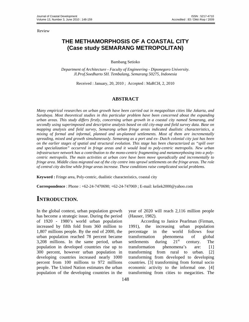
Currently, Indonesia faces urbanization tension. Population statistics show by the year of 2008 in the first time urban population reached 50.5 percent. By the year of 2025, this share is expected to reach 65.05 percent, indicating that almost two third of Indonesia’s urban population live in metropolitan cities (Fig.1). in 1971 only three cities were classified as metropolitan cities: Jakarta, Bandung, and Surabaya. During 1980 – 1990, four other large- sized cities grew enough to be classified as metropolitan cities. The number of metropolitan cities has increased by more than double to eight included Semarang. With respect to urban growth in Java Island, the high percentage of urbanization mostly occurred in coastal city (Fig 2).
This paper will discuss and explore the metamorphosis of Semarang city, from the perspective of physical growth. The main idea is deeply understanding of urban growth trend through the identification gradual change of urban form. The urban growth analysis is carried out via superimposed method and link simultaneously to the historical process of urban growth. This method can easily distinguish the change of urban form. Metamorphosis of the city has three indicators: [1] the change of internal structure; [2] the change of land use and spatial function; [3] the change of urban spatial characteristics and appearance. FROM DUTCH COLONIAL PORT CITY TO METROPOLITAN. History of Semarang starts on 1547 AD as a trade and port city. At this time the city of Semarang consists of several groups of indigenous Javanese settlement, Chinese settlement and a Dutch fortress. In this early period Semarang population growth rate was insignificant. At the mid of eighteenth century
Journal of Coastal Development ISSN : 5217-4710 Volume 13, Number 3, June 2010 : 148-159 Accredited : 83 / Dikti /Kep / 2009
150
Fig.1. Indonesian Urban Population vs. Rural Population Source: Dirjen Penataan Ruang - Departemen Pekerjaan Umum
Fig 2: The Growth of Urban Areas in Java 2000-2005. Source: Dirjen Penataan Ruang - Departemen Pekerjaan Umum. Semarang flourished as an entrepot of exported commodities from outer island to be sent to foreign countries. Many foreigners such as Dutch, Chinese and East Asian people (Indian and Gujarat) migrated to Semarang for trading. As a result the city grew very fast, and Semarang becomes the third largest harbour on Java Island. Under Dutch colonial authority, Semarang administrative boundary has been expanded three times, by the year of 1886, year of 1894 and year of 1902 (Colombijn, 2005).
Base on old maps, we can see clearly the city of Semarang was configured along the Semarang River, which was the primary element of the city. Most of settlements and trading activities was conducted along Semarang River, hence determined the location sub-centres of the city such as Johar market, Chinese quarter and Sabandaran. The morphology of the city existed along the river. High sedimentation caused Semarang River shallow. During 1900 century city tram and roadways network were built, connecting the
Journal of Coastal Development ISSN : 5217-4710 Volume 13, Number 3, June 2010 : 148-159 Accredited : 83 / Dikti /Kep / 2009
151
city and the suburbs. River transportation was replaced with road and railways transportation network, caused sub-centres along the river shifts to another location. From the old map we can see the Semarang had extended to the south. Internal structure of the city was change radically.
By the year of 1901, urban disaster was occurred. Many diseases such as dysentery, typhus, cholera, stroke the slum areas caused many victims (Liem, 1933). Ethical movement and high mortality rate forced municipal government change strategy of city development. Physical growth of the city directed to the hilly area in the South named Nieuw Tjandi (Candi Baru); avoid swampy area which lies in the North. Ir.Thomas Karsten, person in charge as advisory for Semarang city planning change radically the old concept of racial separation that divided former urban settlements into Dutch, Chinese and indigenous Javanese districts. In his new concept, Thomas Karsten divided zoning area base on economic classes rather than ethnic segregation. But in fact the three ethnic groups were also divided into three economic classes. The Dutch and a few rich Chinese were in the highest economic class, in the middle-class category were Chinese and the majority of the Javanese were in lowest class category (Pratiwo in Colombijn, 2005). The new concept of zoning devision has changed land use and spatial function.
By the year of 1976 the municipal administrative boundary was expanded. The city area boosted from 99. 60 km2 to 373. 67 km2, becomes the second largest city after Jakarta. The zone which is lies between old and new city administrative boundary mostly had rural characteristics. This area called expanded area and categorized as fringe area. At the last of 20th century, most of housing estates were located in this area. One of several reasons this phenomenon triggered by sharp differentiation between land price in urban core and urban fringe. In addition the motor cycle possession
were sharply increase, made longer travel distances, greater freedom of choice destination and extended scale of accessibility. This condition triggered development of remote areas in country side. Due to the lack of land pricing policy, detail planning and law enforcement, the growth of fringe area was dominated by sprawl development.
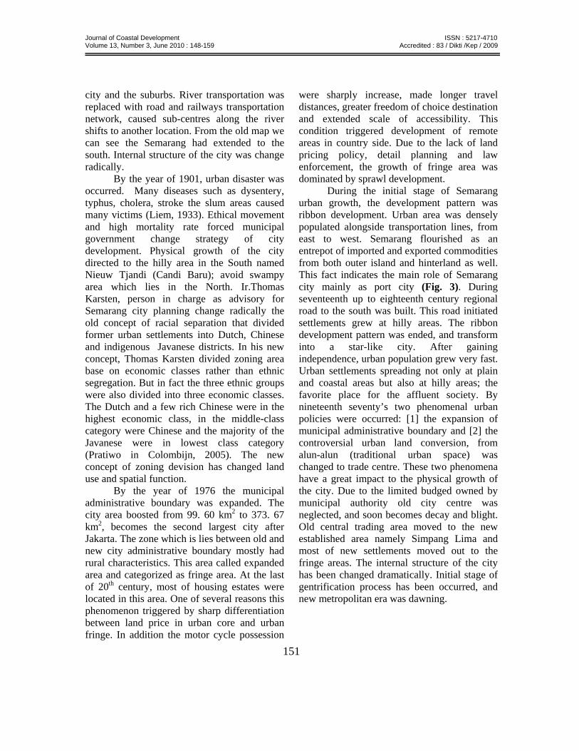
During the initial stage of Semarang urban growth, the development pattern was ribbon development. Urban area was densely populated alongside transportation lines, from east to west. Semarang flourished as an entrepot of imported and exported commodities from both outer island and hinterland as well. This fact indicates the main role of Semarang city mainly as port city (Fig. 3). During seventeenth up to eighteenth century regional road to the south was built. This road initiated settlements grew at hilly areas. The ribbon development pattern was ended, and transform into a star-like city. After gaining independence, urban population grew very fast. Urban settlements spreading not only at plain and coastal areas but also at hilly areas; the favorite place for the affluent society. By nineteenth seventy’s two phenomenal urban policies were occurred: [1] the expansion of municipal administrative boundary and [2] the controversial urban land conversion, from alun-alun (traditional urban space) was changed to trade centre. These two phenomena have a great impact to the physical growth of the city. Due to the limited budged owned by municipal authority old city centre was neglected, and soon becomes decay and blight. Old central trading area moved to the new established area namely Simpang Lima and most of new settlements moved out to the fringe areas. The internal structure of the city has been changed dramatically. Initial stage of gentrification process has been occurred, and new metropolitan era was dawning.
Journal of Coastal Development ISSN : 5217-4710 Volume 13, Number 3, June 2010 : 148-159 Accredited : 83 / Dikti /Kep / 2009
152
Year 1700 Year 1800 Year 1850
Year 1890 Year 1920 Year 1935.
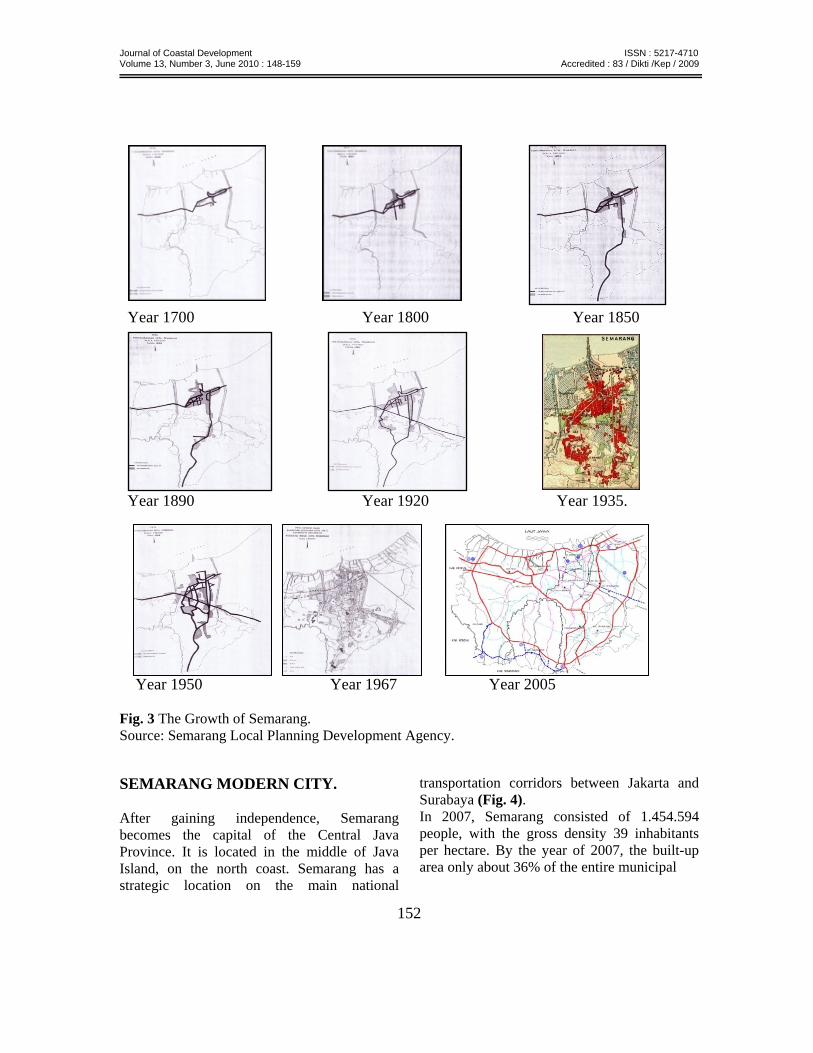
Year 1950 Year 1967 Year 2005 Fig. 3 The Growth of Semarang. Source: Semarang Local Planning Development Agency. SEMARANG MODERN CITY. After gaining independence, Semarang becomes the capital of the Central Java Province. It is located in the middle of Java Island, on the north coast. Semarang has a strategic location on the main national
transportation corridors between Jakarta and Surabaya (Fig. 4). In 2007, Semarang consisted of 1.454.594 people, with the gross density 39 inhabitants per hectare. By the year of 2007, the built-up area only about 36% of the entire municipal
Journal of Coastal Development ISSN : 5217-4710 Volume 13, Number 3, June 2010 : 148-159 Accredited : 83 / Dikti /Kep / 2009
153
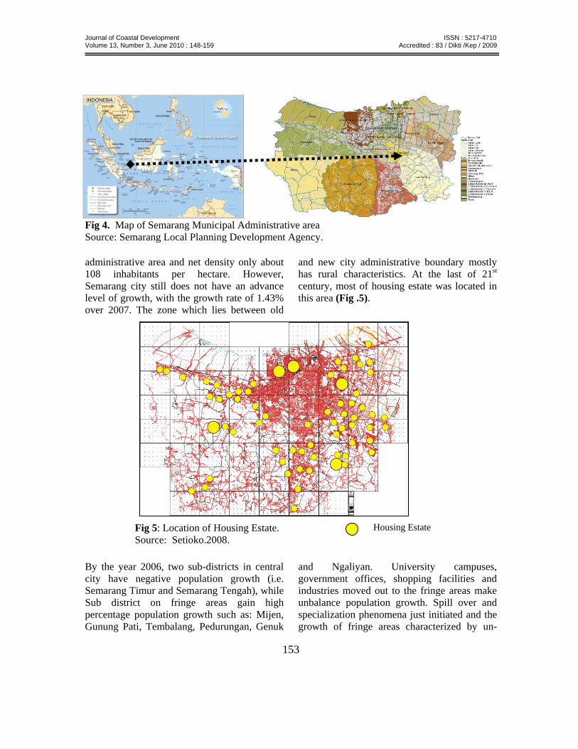
Fig 4. Map of Semarang Municipal Administrative area Source: Semarang Local Planning Development Agency. administrative area and net density only about 108 inhabitants per hectare. However, Semarang city still does not have an advance level of growth, with the growth rate of 1.43% over 2007. The zone which lies between old
and new city administrative boundary mostly has rural characteristics. At the last of 21st century, most of housing estate was located in this area (Fig .5).
By the year 2006, two sub-districts in central city have negative population growth (i.e. Semarang Timur and Semarang Tengah), while Sub district on fringe areas gain high percentage population growth such as: Mijen, Gunung Pati, Tembalang, Pedurungan, Genuk
and Ngaliyan. University campuses, government offices, shopping facilities and industries moved out to the fringe areas make unbalance population growth. Spill over and specialization phenomena just initiated and the growth of fringe areas characterized by un-
Housing Estate Fig 5: Location of Housing Estate. Source: Setioko.2008.
Journal of Coastal Development ISSN : 5217-4710 Volume 13, Number 3, June 2010 : 148-159 Accredited : 83 / Dikti /Kep / 2009
154
structural sprawl development. The problem of urban sprawl also occurs in most suburban areas, especially when the settlement areas do not integrate with the main functional urban areas. The scattered location causes a problem in service provision and produced an expensive requirement for an urban infrastructures and public facilities.
According to the study conducted by the “Department of Human Settlements and Regional Infrastructure” (2003) for urban and suburban areas of Semarang city, it can be said that generally urban sprawl in Semarang is fuelled more by fast growing housing estate as an impact of abundant housing supply. Based on 2007’s Semarang statistical data the
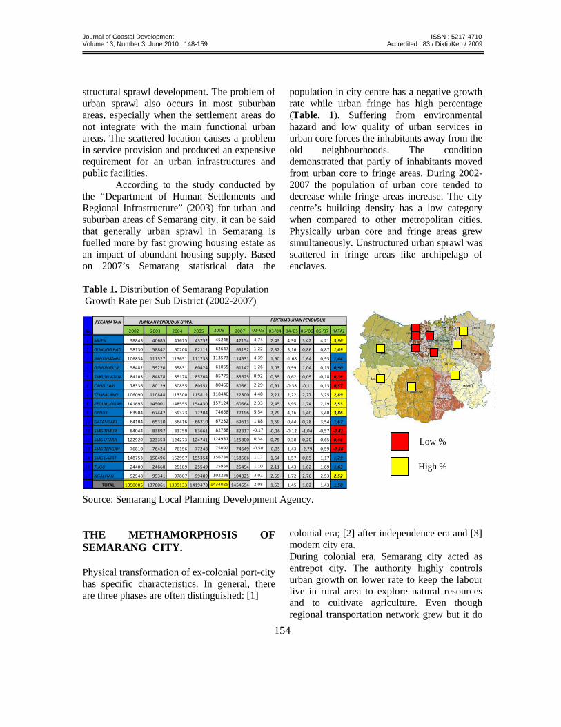
population in city centre has a negative growth rate while urban fringe has high percentage (Table. 1). Suffering from environmental hazard and low quality of urban services in urban core forces the inhabitants away from the old neighbourhoods. The condition demonstrated that partly of inhabitants moved from urban core to fringe areas. During 2002-2007 the population of urban core tended to decrease while fringe areas increase. The city centre’s building density has a low category when compared to other metropolitan cities. Physically urban core and fringe areas grew simultaneously. Unstructured urban sprawl was scattered in fringe areas like archipelago of enclaves.
Table 1. Distribution of Semarang Population Growth Rate per Sub District (2002-2007)
Source: Semarang Local Planning Development Agency. THE METHAMORPHOSIS OF SEMARANG CITY. Physical transformation of ex-colonial port-city has specific characteristics. In general, there are three phases are often distinguished: [1]
colonial era; [2] after independence era and [3] modern city era. During colonial era, Semarang city acted as entrepot city. The authority highly controls urban growth on lower rate to keep the labour live in rural area to explore natural resources and to cultivate agriculture. Even though regional transportation network grew but it do
KECAMATAN
No 2002 2003 2004 2005 2006 2007 02‐'03 03‐'04 04‐'05 05‐'06 06‐'07 RATA2
1 MIJEN 38843 40685 41675 43752 45248 47154 4,74 2,43 4,98 3,42 4,21 3,96
2 GUNUNG PATI 58130 58842 60208 62111 62647 63192 1,22 2,32 3,16 0,86 0,87 1,69
3 BANYUMANIK 106834 111527 113651 111738 113573 114631 4,39 1,90 ‐1,68 1,64 0,93 1,44
4 GJMUNGKUR 58482 59220 59831 60424 61055 61147 1,26 1,03 0,99 1,04 0,15 0,90
5 SMG SELATAN 84103 84878 85178 85704 85779 85625 0,92 0,35 0,62 0,09 ‐0,18 0,36
6 CANDISARI 78336 80129 80855 80551 80460 80561 2,29 0,91 ‐0,38 ‐0,11 0,13 0,57
7 TEMBALANG 106090 110848 113300 115812 118446 122300 4,48 2,21 2,22 2,27 3,25 2,89
8 PEDURUNGAN 141695 145001 148555 154430 157124 160564 2,33 2,45 3,95 1,74 2,19 2,53
9 GENUK 63904 67442 69323 72204 74658 77196 5,54 2,79 4,16 3,40 3,40 3,86
10 GAYAMSARI 64104 65310 66416 66710 67232 69613 1,88 1,69 0,44 0,78 3,54 1,67
11 SMG TIMUR 84044 83897 83759 83661 82788 82317 ‐0,17 ‐0,16 ‐0,12 ‐1,04 ‐0,57 ‐0,41
12 SMG UTARA 122929 123353 124273 124741 124987 125800 0,34 0,75 0,38 0,20 0,65 0,46
13 SMG TENGAH 76810 76424 76156 77248 75092 74649 ‐0,50 ‐0,35 1,43 ‐2,79 ‐0,59 ‐0,56
14 SMG BARAT 148753 150496 152957 155354 156734 158566 1,17 1,64 1,57 0,89 1,17 1,29
15 TUGU 24400 24668 25189 25549 25964 26454 1,10 2,11 1,43 1,62 1,89 1,63
16 NGALIYAN 92548 95341 97807 99489 102238 104825 3,02 2,59 1,72 2,76 2,53 2,52
TOTAL 1350005 1378061 1399133 1419478 1434025 1454594 2,08 1,53 1,45 1,02 1,43 1,50
JUMLAH PENDUDUK (JIWA) PERTUMBUHAN PENDUDUK
Low %
High %
Journal of Coastal Development ISSN : 5217-4710 Volume 13, Number 3, June 2010 : 148-159 Accredited : 83 / Dikti /Kep / 2009
155
not emerge new growth centre. The centrality of existing port city is maintained to guarantee continuing supply of natural resources from hinterland areas. In this early period, Semarang was a stagnant city. (Colombijn.2005).
After independence era, percentage of urban population growth was very high. Modern urban infrastructure is established, such as airport, regional road and other transportation facilities. The vast development of hinterland areas push ex-colonial port-city becomes regional growth centre. The internal structure of Semarang metropolitan becomes extraordinary intricate, so difficult to generalized. Currently master plan of Semarang metropolitan tends to a project orientation plan than a comprehensive and a strategic plan. Urban development approach more pragmatic and address perceived local problems rather than utopian or visionary. Increasing social resistance to highway or toll-road projects, airport, and other large scale construction projects make planners scepticism. In case of distribution of authority between central and local government, have an indication that the local governments feel uncomfortable exerting control over its territory in terms of capital investment. All of them has destroyed the idea of comprehensive urban planning and contributed to the splintered model of urban infrastructure development (Graham and Marvin, 2001).
Today we have seen in Semarang metropolitan cannot be fitted into orderly patterns. There are too much flow, flux and constant change within the region. Master plan of Semarang metropolitan fail to established urban fabrics, urban cohesion and urban coherence on a complex city. Semarang city become collage of fragmented spaces and archipelago of enclaves. New urban infrastructure network has a contribution to the mono-centric fragmenting and
metamorphosing into a poly-centric metropolis. This change exposed an anomaly of urban landscape where the marginal can be central, on the contrary centrality can be on fringe areas. In addition, the development transportation network is contributing to change urban form from compact city to spread city. Old city centre is rapidly losing their “centrality”. Many urban activities, such as: universities, offices and shopping facilities exodus to the fringe areas caused the role of city centre declining.
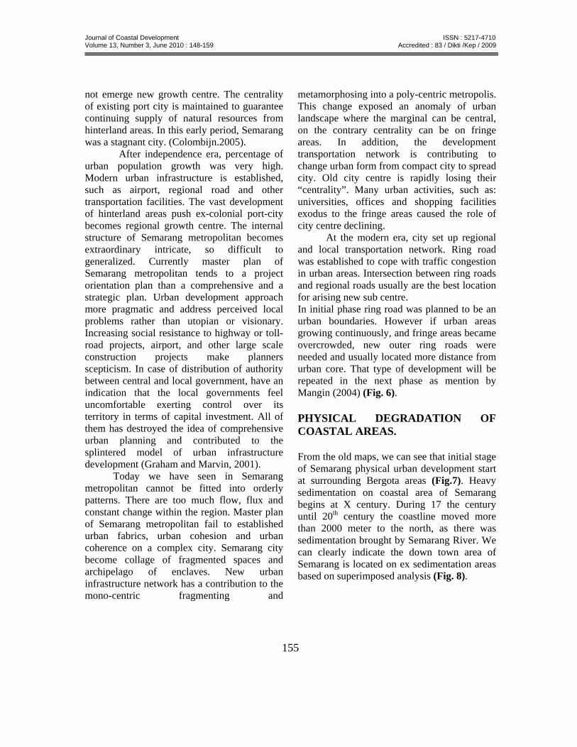
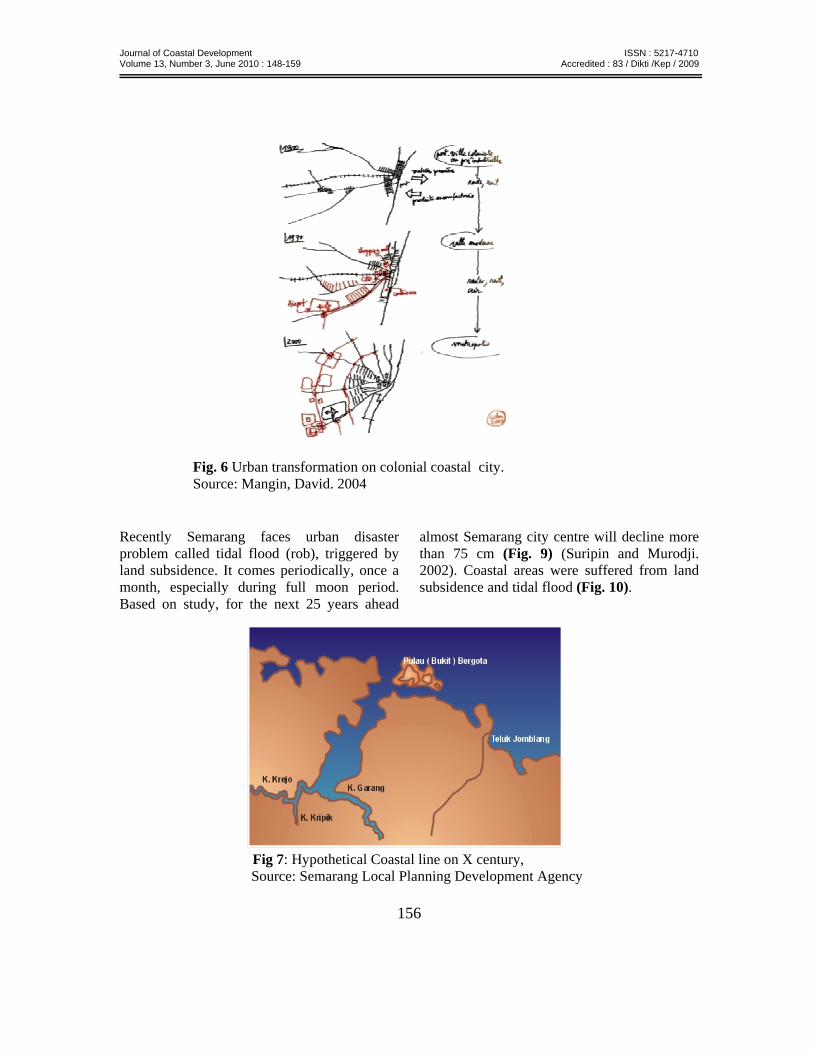
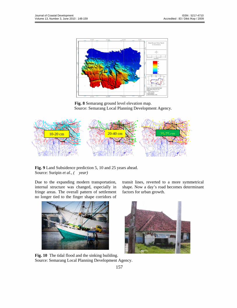
At the modern era, city set up regional and local transportation network. Ring road was established to cope with traffic congestion in urban areas. Intersection between ring roads and regional roads usually are the best location for arising new sub centre. In initial phase ring road was planned to be an urban boundaries. However if urban areas growing continuously, and fringe areas became overcrowded, new outer ring roads were needed and usually located more distance from urban core. That type of development will be repeated in the next phase as mention by Mangin (2004) (Fig. 6). PHYSICAL DEGRADATION OF COASTAL AREAS. From the old maps, we can see that initial stage of Semarang physical urban development start at surrounding Bergota areas (Fig.7). Heavy sedimentation on coastal area of Semarang begins at X century. During 17 the century until 20th century the coastline moved more than 2000 meter to the north, as there was sedimentation brought by Semarang River. We can clearly indicate the down town area of Semarang is located on ex sedimentation areas based on superimposed analysis (Fig. 8).
Journal of Coastal Development ISSN : 5217-4710 Volume 13, Number 3, June 2010 : 148-159 Accredited : 83 / Dikti /Kep / 2009
156
Recently Semarang faces urban disaster problem called tidal flood (rob), triggered by land subsidence. It comes periodically, once a month, especially during full moon period. Based on study, for the next 25 years ahead
almost Semarang city centre will decline more than 75 cm (Fig. 9) (Suripin and Murodji. 2002). Coastal areas were suffered from land subsidence and tidal flood (Fig. 10).
Fig 7: Hypothetical Coastal line on X century, Source: Semarang Local Planning Development Agency
Fig. 6 Urban transformation on colonial coastal city. Source: Mangin, David. 2004
Journal of Coastal Development ISSN : 5217-4710 Volume 13, Number 3, June 2010 : 148-159 Accredited : 83 / Dikti /Kep / 2009
157
Fig. 8 Semarang ground level elevation map. Source: Semarang Local Planning Development Agency.
Fig. 9 Land Subsidence prediction 5, 10 and 25 years ahead. Source: Suripin et al., ( year) Due to the expanding modern transportation, internal structure was changed, especially in fringe areas. The overall pattern of settlement no longer tied to the finger shape corridors of
transit lines, reverted to a more symmetrical shape. Now a day’s road becomes determinant factors for urban growth.
Fig. 10 The tidal flood and the sinking building. Source: Semarang Local Planning Development Agency.
20-40 cm 10-20 cm 25-75 cm
Journal of Coastal Development ISSN : 5217-4710 Volume 13, Number 3, June 2010 : 148-159 Accredited : 83 / Dikti /Kep / 2009
158
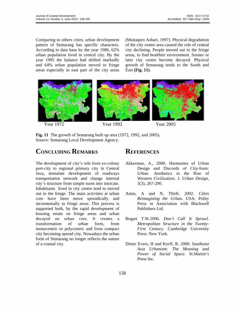
Comparing to others cities, urban development pattern of Semarang has specific characters. According to data base by the year 1986, 62% urban population lived in central city. By the year 1995 the balance had shifted markedly and 64% urban population moved to fringe areas especially in east part of the city areas
(Muttaqien Ashari, 1997). Physical degradation of the city centre area caused the role of central city declining. People moved out to the fringe areas, to find healthier environment. Sooner or later city centre become decayed. Physical growth of Semarang tends to the South and East (Fig. 11).
Year 1972 Year 1992 Year 2005
Fig. 11 The growth of Semarang built up area (1972, 1992, and 2005). Source: Semarang Local Development Agency.
CONCLUDING REMARKS The development of city’s role from ex-colony port-city to regional primary city in Central Java, stimulate development of roadways transportation network and change internal city’s structure from simple turns into intricate. Inhabitants lived in city centre tend to moved out to the fringe. The main activities at urban core have been move sporadically and incrementally to fringe areas. This process is supported both, by the rapid development of housing estate on fringe areas and urban decayed on urban core. It creates a transformation of urban form, from monocentric to polycentric and from compact city becoming spread city. Nowadays the urban form of Semarang no longer reflects the nature of a coastal city.
REFERENCES Akkerman, A., 2000. Harmonies of Urban
Design and Discords of City-form: Urban Aesthetics in the Rise of Western Civilization. J. Urban Design, 5(3), 267-290.
Amin, A and N, Thirft. 2002. Cities
Reimagining the Urban. USA: Polity Press in Association with Blackwell Publishers Ltd.
Bogart T.W.2006. Don’t Call It Sprawl.
Metropolitan Structure in the Twenty-First Century. Cambridge University Press. New York.
Dieter Evers, H and Korff, R. 2000. Southeast
Asia Urbanism: The Meaning and Power of Social Space. St.Martin’s Press Inc.
Journal of Coastal Development ISSN : 5217-4710 Volume 13, Number 3, June 2010 : 148-159 Accredited : 83 / Dikti /Kep / 2009
159
Bruegmann, R., 2005. Sprawl: a compact history. USA: The University of Chicago Press.
Bulkin, I., 1995. Infrastructure requirements
under condition of development: The Dynamic of Urbanization in Indonesia. Unpublished PhD dissertation, Cornell University.
Colombijn, F., 2005. Kota lama, kota baru:
Sejarah Kota-kota di Indonesia Sebelum dan Sesudah Kemerdekaan. Yogyakarta: Ombak.
Gillham, O., 2002. The Limitless City, A
primer on the Urban Sprawl Debate. USA: Island Press.
Graham, S and Marvin, S., 2001. Splintering
Urbanism. London: Routledge. Hall, P and Pfeiffer, U. 2000. Urban Future 21,
A Global Agenda for Twenty-First Century Cities. The Federal Ministry of Transport, Building and Housing of the Republic of Germany.
Houser, M, P., et.al., 1982. Population and Urban Future. New York: State University Press.
Kivel, P., 1993. Land and the City. London:
Routledge. Knox. L., P., 1994. Urbanization, An
Introduction to Urban Geography. USA: Prentice Hall, Inc.
Liem Thian J., 1933. Riwajat Semarang (Dari
Djamannja Sam Poo sampe Terhapoesnja Konkoan). Boekhandel Ho Kim Yoe. Semarang. Batavia.
Yan S., 2005. Smart Growth and Urban
Development Pattern: A Comparative Study. In. Reg. Sci. Rev. 28, 2: 239–265 (April 2005).
Zhao, P., et.al., 2003. Conflicts in urban fringe
in the transformation era: An examination of performance of the metropolitan growth management in Beijing. Habitat International; Oct 2009, Vol 33.