Embed Size (px)
Citation preview

Master’s Degree programme
in Ancient Civilisations: Literature, History and Archaeology
“Second Cycle (D.M. 270/2004)”
Final Thesis
The Meroitic palace B1500
at Napata – Jebel Barkal
An architectural perspective
Supervisor
Ch. Prof. Emanuele M. Ciampini
Assistant supervisors
Ch. Dr. Marc Maillot Ch. Prof. Luigi Sperti
Graduand
Silvia Callegher
Matriculation Number 832836
Academic Year
2016/2017
1
Index Index ............................................................................................................................................ 1
General introduction .................................................................................................................. 3
1. Historical introduction ........................................................................................................... 6
2. Other palatial structures at Jebel Barkal ........................................................................... 16
2.1 B1200 ............................................................................................................................... 16
2.2 B100 ................................................................................................................................. 20
2.3 B1700 .............................................................................................................................. 24
2.4 B2400 ............................................................................................................................... 24
2.5 B3200 ............................................................................................................................... 28
3. The entrances of palace B1500 ............................................................................................ 31
3.1 Northern access ................................................................................................................ 31
3.2 Western access ................................................................................................................. 32
3.3 Eastern access ................................................................................................................... 33
3.4 Southern access ................................................................................................................ 33
4. The foundation platform...................................................................................................... 37
4.1 The foundation platform of B1500 ................................................................................... 38
4.1.1 The exterior wall decoration ..................................................................................... 38
4.1.2 The masonry ............................................................................................................. 40
4.1.3 The plan .................................................................................................................... 41
4.2 Examples of cellular construction in Egypt ...................................................................... 45
4.2.1 Structures related to sacred areas ............................................................................... 45
4.2.1.a Shena wab(w) .................................................................................................... 46
4.2.1.b Tanis ................................................................................................................. 48
4.2.1.c Saqqara ............................................................................................................. 48
4.2.1.d Medamud .......................................................................................................... 49
4.2.1.e El-Kab .............................................................................................................. 49
4.2.2 Citadels and fortifications.......................................................................................... 50
4.2.2.a Defenna ............................................................................................................. 50
4.2.2.b Naukratis ........................................................................................................... 51
4.2.2.c Tell el-Balamun ................................................................................................ 52
4.2.2.d Tell Qedwa ....................................................................................................... 53
4.2.3 Domestic structures ................................................................................................... 55
4.2.3.a Mendes .............................................................................................................. 55
4.2.3.b Tell el-Fara’in (Buto)......................................................................................... 55
4.2.4 Royal palaces ............................................................................................................ 56
4.2.4.a Deir el-Ballas ..................................................................................................... 56

2
4.2.4.b Memphis ............................................................................................................ 58
4.2.4.c Tell el-Daba (Avaris) ........................................................................................ 60
4.3 Examples of cellular construction in Meroitic structures .................................................. 63
4.3.1 Wad Ben Naga palace ............................................................................................... 63
4.3.2 Muweis palace ........................................................................................................... 65
4.3.3 Meroe palaces M294-295 .......................................................................................... 68
4.3.4 Meroe palace M750 ................................................................................................... 69
4.4 Casemates and platforms: some considerations ................................................................ 70
5. The peristyle: a paradigm of syncretism ............................................................................ 74
5.1 Peristyle court in B1500 ................................................................................................... 74
5.1.1 Ground-floor colonnade ............................................................................................ 74
5.1.2 First-floor colonnade ................................................................................................. 75
5.2 Peristyle courts in Hellenistic palaces............................................................................... 78
5.2.1 Ptolemaic Kingdom ................................................................................................... 79
5.2.1.a Araq el-Emir ...................................................................................................... 79
5.2.1.b Ptolemais ........................................................................................................... 81
5.2.2 The Seleucid Kingdom .............................................................................................. 84
5.2.2.a Dura Europos ..................................................................................................... 84
5.2.3 Macedonia ................................................................................................................. 86
5.2.3.a Vergina .............................................................................................................. 86
5.2.3.b Pella ................................................................................................................... 87
5.2.4 Pergamon .................................................................................................................. 89
5.2.5 The models ................................................................................................................ 90
5.3 Hellenistic influences in Meroitic and Egyptian architecture ........................................... 92
6. The Meroitic synthesis: creating a new model .................................................................. 95
List of abbreviatons................................................................................................................ 100
Bibliography ........................................................................................................................... 102
Tables ...................................................................................................................................... 112
Images ..................................................................................................................................... 117

3
General introduction
The following dissertation intends to delve into the architectural description of the
major features characterizing the Meroitic palace B1500 at Napata (modern town of
Karima, North Sudan), located at the foot of the Jebel Barkal, the “Sacred Mountain”.
One of the most interesting aspects concerning this building is certainly the
absorbability of Hellenistic influences reflected in its architecture and decoration, which
show a strong capability of developing new formal elaborations.
In order to accomplish this purpose, it was necessary to proceed to a preliminary
collection of the available data which, to this date, has yet to be gathered in a single
publication. Starting from that, the description of the palace has been divided into three
different sections corresponding to specific architectural components of the edifice: the
entrances, the foundation platform, and the peristyle. This scheme has been adopted to
facilitate a comparative approach capable of revealing possible models and points of
contact between B1500 and other Meroitic and Hellenistic structures.
While traces of the ancient Napata were first recognized at least in the Nineteenth
Century, the first archaeological expeditions started only in 1916, when George Reisner
arrived at the site on behalf of Harvard University and the Museum of Fine Arts of Boston.
The activity of the Italian Archaeological Mission at the site, initially directed by
Sergio Donadoni of the University “La Sapienza” of Rome, dates back to the 1970s. In
1973 the first two structures, identified as temples (B1300 and B1400), were brought to
light at the edges of the cultivated fields adjacent to the Nile.
The palace of Natakamani became the major focus of the Mission since its
discovery in 1978, when the excavation area was moved at the foot of the mountain,
where it is currently located.
In 2006 the direction of the Mission was entrusted to Alessandro Roccati
(University of Turin), who concentrated the research on some areas situated in the vicinity
of the palace in order to better clarify the layout of the structures adjacent to it.
Finally, the excavations of B1500 resumed few years later, in 2011, when the
direction of the Mission turned over to Prof. E. M. Ciampini of the Ca’ Foscari University
of Venice, which currently supports the expedition together with the Italian Ministry of
Foreign Affairs. Moreover, since the 2014-2015 season, the Mission is part of the Qatar-
Sudan Archaeological Project (project QSAP.A.34), which is also fundamental in
sustaining the archaeological activity.

4
From the resumption of the dig in the palatial area, one of the main aims of the
Mission has been the outlining of the outer perimeter walls of the edifice, in order to
complete the plan in all its sectors. As the excavations proceed, the main walls composing
the structure emerging from the ground are being restored to preserve them: the result is
a better visibility of the walls composing the foundation platform of the edifice (cf. infra).
During the last campaigns, the deepening of the excavation in the inner structure
of the palace unexpectedly brought to light the presence of a massive pre-existing wall
related to an older building. In order to better investigate this evidence, the last season
(2016/2017) focused on digging the western side of the palace, reaching its foundation
level both in correspondence to the perimeter wall and to the inner ones composing the
platform.
The main premise which needs to be outlined when ancient palatial architecture
is involved is certainly the very definition of the word “palace” itself. The term is
nowadays commonly used when referring to large, monumental buildings functioning as
dwelling places for kings and/or high officials. Nevertheless, when speaking about an
ancient context, specifically the Meroitic one in our case, we should first define the limits
of such a word.
In this respect, the Meroitic written sources are not useful, lacking a specific
corresponding expression capable of orientating the path of this research1. Turning our
attention to the archaeological data, we find out that tracing a model collecting a series of
homogenous architectural traits is equally ineffectual2. For example, important
characteristics used as criteria for the designation of a building as “palace” have often
been its imposing dimensions, the symmetry of its layout, and its localization in a specific
context3; nevertheless, such an ensemble of parameters leaves inevitably out of the picture
a number of cases where these features are only partially present.
Another key point which has usually been considered fundamental in the
recognising of the “palatial” character of an edifice is its antithetic relation to the temples.
Nevertheless, in the Meroitic context, this aspect requires an even more careful approach,
considering that the nature of the relationship between these two institutions has yet to be
properly understood4.
1 MAILLOT 2016B, p. 24. 2 MAILLOT 2016B, pp. 27-30. 3 Ibid. 4 MAILLOT 2016B, p. 28.
5
The effort to connect a group of specific and systematic features to the concept of
“palace” could therefore seem vain. Nonetheless, a reverse approach may perhaps
represent a partial solution to this issue. In fact, instead of starting from the definition of
the term, we should first bring our attention to the archaeological evidence and gain from
it the greatest possible amount of data capable of reflecting the nature of the building on
an empirical basis5.
In the case of building B1500, the designation of “palace of Natakamani” was the
consequence of the discovery, in 1984, of a stela bearing the names of Amanitore and
Arikankharor, respectively wife and son of the Meroitic king Natakamani. Although it
was not preserved, it is likely that the name of the king was originally engraved on the
first line of the stela, now completely erased6.
As the excavation progressed, the royal character of the building was even more
clear, as pointed out by the monumental character of the central rooms of the structure
and the features of their decoration (cf. infra).
After an opening introduction outlining the historical context of the ancient
Napata, the dissertation proceeds to a description of the other palatial structures located
on the site. The proper description of palace B1500 will follow, divided into its most
characterizing features. A synthesis of the remarks emerged during the discussion will
finally close the dissertation presenting a series of future perspectives on the research.
5 MAILLOT 2016B, p. 26. 6 TIRADRITTI 1992, pp. 69-70.

6
1. Historical introduction
The palace of Natakamani is located near the eastern slope of the Jebel Barkal:
the “Pure Mountain”, a massif of red sandstone at the South-Western limits of the Nubian
Desert tableland. The Jebel lies on the right bank of the Nile – which here flows from
North-East to South-West – in the vicinity of the modern town of Karima (about 400 km
north of Khartoum)7. In this region, the fertile land makes the cultivation possible
nowadays as it did in ancient times; however, this fecundity extends for just a few
kilometres, starting again only near the town of Kawa.
As far as we know8, the ancient town of Napata acquired royal connotation as
early as the New Kingdom, when the Egyptian expansionism reached its maximum in the
East to consolidate the Levantine frontiers, and in the South towards Nubia, a crucial
region for trading. Here in fact several caravan routes started directed to Ethiopia, the Red
Sea, and central Africa which were great sources of raw materials and exotic products.
Furthermore, Nubia was also a primary source for gold: while the mining sites of the
region were already known during the Old Kingdom9, their exploitation peaked only in
the second half of the II millennium BC, when the Egyptian conquest reached the Wadi
Allaqi and the Western Desert, and allowed for a more systematic utilization of the
resources10.
During the reign of Thutmose III (about 1460 BC), the Egyptian domain – whose
first stages began in the XVIII dynasty – reached the IV cataract of the Nile11; when
Thutmose arrived to Jebel Barkal, he founded the town of Napata along the lines of the
Egyptian Thebes12, and decided to set in this place the southernmost frontier of his
domain.
This choice was surely motivated by the strategic position of the area: the region
between the IV and the V cataracts – called Kry in the Egyptian textual evidence13 – was
in fact an unoccupied zone useful to exert control over the little chiefdoms who in turn
retained authority on the lands further south14; furthermore, all the products going North
7 For a close topographical examination of the region cf. MITCHELL 1999. 8 Considering that the older levels have not been excavated yet, the royal connotation of the city could be
older than known so far. 9 TÖRÖK 1997A, p. 34. 10 Cf. KLEMM ET AL. 2001, in particular pp. 649-654. VERCOUTTER 1959, pp. 120-153. 11 TÖRÖK 1997A, pp. 92-101. 12 For the importance of Thebes in this period as paradigm of model city, cf. KEMP 2006, pp. 264-265 and
GARDINER 1905, pp. 20-22. 13 TÖRÖK 1997A, p. 115. 14 TÖRÖK 1997A, p. 94.
7
had to transit here to reach their destination. However, another reason for choosing this
site was surely of symbolic nature: the mountain was in fact considered a sacred place by
the Nubians, who associated it with the cult of an ancient ram-headed god15; these traits
probably led to its identification with the Theban Amun, the dynastic god par
excellence16. In particular, in this mythological scenario, the mountain was considered
the god’s dwelling.
Also the textual evidence seems to confirm the ancient interpretation of the
mountain as Amun’s birthplace. The papyrus P. Cairo 5803817 (Boulaq 17, XVII din.)
opens with the claim:
Hail, Amun-Re
lord of the Throne of the Two lands, prince of Karkak
Bull of his mother, who stands before his fields
who steps widely, first one of Upper Egypt
lord of the Medjay and ruler of Punt
great one of heaven, eldest of the earth
lord of all that exists, who remains in the possession of all things18
It is likely that the phrase “Throne of the Two lands” already indicated the Jebel
Barkal at this time, as illustrated also by the later text carved in the Thutmose III stela,
discovered by Reisner in Napata inside the B500 temple19:
My [Majesty speaks(?):] Hear ye, O people of the Southland who are
at the Holy Mount, which was called "Thrones-of-the-Two-Lands"
among the people (the Egyptians?) when it was not (yet?) known, that
ye may learn the wonderful deed of [Amun-Rā] before the face of all
the Two Lands20
The text’s apparent purpose is to provide an association between the Amun of
Thebes – called “Lord of the Throne(s) of the Two Lands” already during the Middle
Kingdom – and the Jebel Barkal21; in the stela, in fact, the mountain is said to be the
15 VINCENTELLI 1999, p. 94.; TÖRÖK 1997A, pp. 303-309; also BONNET; VALBELLE 2004, pp. 158-159. 16 In Egypt, Amun was usually represented in human form (head and body) with a headcloth on the top of
which stood two vertical feathers; nevertheless, he was frequently associated with the ram (TOSI 2011, pp.
15-16). 17 ASSMANN 1995, p. 121. 18 Ibid.: ỉnḏ ḥr.k Imn-Rʿw – nb nst tȝwy ḫnty Ipt swt – Kȝ-mwt.f ḫnty sḥt.f – pḏ nmtt ḫnty tȝ-šmʿ – nb mḏȝw
ḥqȝ pwnt – wr n pt smsw n tȝ – nb ntỉ mn ỉḫt nbt. 19 REISNER G.A.; REISNER M.B. 1933, pp. 24-39. Cf. p. 24 for further details about the place of discovery. 20 REISNER G.A.; REISNER M.B. 1933, p. 35: [16.85 cm missing: ḏd(?) ḥm].ỉ sḏmw rmṯ ḫnty-tȝ nty m pȝ ḏw-
wʿb ḏdw r.f nswt-tȝwy m rmṯ n rḫ.tw.f ỉḫ rḫ.ṯn tȝ byȝyt nt [ỉmn-rʿ] ḫft ḥr n tȝwy tmw. 21 A similar association was made also at Naga: TÖRÖK 2002, pp. 40-41.
8
epithet’s birthplace, and consequently the god’s one too. Recognising the mountain as the
dynastic god’s First residence implies not only a legitimation of his cult, but also a
legitimation of the king’s power over the territory.
It is not surprising then that from this moment onwards the area around the jebel
was deeply tied to the cult by the construction of several temples. The most important one
is surely the B500, dedicated to Amun of Napata. The first excavations, led by G. A.
Reisner in 1916, brought to light the ruins of the structure, immediately recognised by the
archaeologist as “manifestly in its day the most important monument at Gebel Barkal”22.
It is likely that its first foundations were laid by Thutmose III because, in his
already mentioned stela, he refers to a “resthouse of eternity” (ḫnw n nḥḥ) dedicated to
Amun; even though its remains have yet to be found, we can assume that it laid under
what would later be the official temple of the god23; the discovery of a mud-brick structure
below the B500 temple seems to validate this theory24.
From its first foundation to the Third Intermediate Period (1069 B.C ca.) different
Egyptian pharaohs restored and expanded the edifice25. The temple was built in stone for
the first time probably during Amenhotep III’s reign – later Akhenaton, 1352 BC: the use
of talatat masonry26 clearly points at this age. In a second phase, probably at the end of
the XVIII dyn.27, the temple was enlarged adding a new court. Sethi I partially roofed the
open court leaving the central axis open, and his son Ramses II started building a massive
hypostyle hall which remained unfinished; had it been completed it would have reached
104 metres in length28. Only minor restorations were made during the XX dynasty, and
in the following years any working activity connected to the temple ceased.
The building activity related to edifice B500 may be interpreted as a reflection of
the political context of the time; in fact, while many conservative interventions were
performed during the New Kingdom, with the arrival of the Third Intermediate Period29
both the Egyptian hegemony and the building activity apparently came to an end30. It is
22 REISNER 1917, p. 215. 23 KENDALL 2016, p. 36. 24 Ibid. 25 For a detailed report about the interventions on the temple, cf. KENDALL 2016, pp. 35-82. 26 Fof further details about this kind of masonry, cf. PECK 1999, p. 234 and REDFORD 1999 pp. 469-473 in
the same volume); ARNOLD 2003, p. 238. 27 KENDALL 2016, p. 39. 28 KENDALL 2016, p. 45. 29 TÖRÖK 1997A, pp. 101-109; GRIMAL 2011, pp. 379-380. 30 This is suggested by the current available data, new excavations could change our understanding of this
process.
9
not surprising then that we must wait for the emergence of the XXV dynasty, the so-called
“Nubian” one, to notice a new blooming of Amun’s cult at Jebel Barkal.
The political and administrative void left by the Egyptian withdrawal from Nubia
made space for the appearance of local political entities, never completely stifled by the
Egyptian domain. Since the first stages of the conquest, in fact, the native political
structures were incorporated into the Egyptian administration of Nubia in the form of
vassals subordinated to the Viceroy of Kush, in charge of tax collecting31. Moreover, the
chiefs’ sons were usually taken to the Egyptian court to be educated before being sent
back to Nubia to be reinstated in their local administrative position: a position which
remained hereditary32.
Therefore, the Egyptian domain over Nubia was more an administrative and
commercial expansion rather than an exploitative, colonial one33. Following Török’s
interpretation, while the governmental structure was based on the network of the temple-
towns rotating around a specific cult, the production and redistribution system was left in
the hands of local chiefs34.
It was precisely this integration in the Egyptian managing system that made
possible, after the withdrawal from Nubia, the emergence of independent political
structures recalling that same pharaonic model they had come to depend on.
The Kurru chiefdom – from the necropolis’ toponym where ancestors and rulers
of the XXV dynasty were buried – was actually the result of the end of the Egyptian
control35.
Even though the lack of evidence really undermines our understanding of
Egyptian and Nubian history in this period, the origin of the “Aithiopian Dynasty36”
which will re-unify Egypt by binding itself to pharaonic ideology is probably found at
this point.
The leader of this process was Piankhi, third ruler of the 25th dynasty (747-716
BC), who reported the account of his campaign on a stela inside the B500 temple37. With
Piankhi this edifice returns to be an important cultic centre: a massive restoration began
and to the temple were added a new outer wall and a new throne room; the hypostyle hall
31 TÖRÖK 1997A, p. 100. 32 Ibid. 33 TÖRÖK 1997A, pp. 99-101. 34 TÖRÖK 1997A, p. 111. 35 TÖRÖK 1997A, pp. 110-112. 36 On the origin of this designation cf. TÖRÖK 1997A, p. 41 and DE ROMANIS 1999, p. 84-87. 37 For a recent edition of the stela, cf. GRIMAL 1981; for the account on the historical events related to the
25th dyn., cf. instead TÖRÖK 1997A, pp.131-188.
10
was finally completed following Ramses II’s model and was appointed a larger outer
court and fronted by a new pylon. These renovations brought the temple to a total length
of 156 metres38.
To emphasise the connection between the current Nubian and the previous
Egyptian dynasties, the access to the temple was decorated with ram statues coming from
the temple of Soleb. This one, built by Amenhotep III during the XVIII dynasty, had
become through the centuries a model for temple architecture; its accesses were adorned
with lion-headed and ram-headed sphinxes, a prevailing iconographical motif during the
Twenty-Fifth Dynasty due to their divine and royal connotations39. The choice of using
statues coming from a paradigmatic pharaonic temple is significant for the legitimation
of the new dynasty, interested to appear as the direct heir of the Egyptian rulers.
In this period originated some themes connected with the concept of royalty,
which prove fundamental to understand some of the aspects related to Meroitic ideology.
When a king died, the inauguration of a new sovereign was certainly one of the most
important moments in the management of power: the acquisition of kingship was in fact
the result of a long process centred on the concept of divine legitimation. The death of
the king meant entering a state of bewilderment the only remedy to which was the
identification of a new guarantor.
Aspelta’s Election Stela40 illustrates these dynamics:
Come, let us cause our lord to appear (in procession), (for we are) like
a herd of cattle without their drover. [...]
Our lord is here with us, (but) we do not know him! Would that we
might know him, that we might enter under him and serve him, as Two-
lands served Horus son of Isis, after he rested upon the throne of his
father Osiris, and give praise to his Two Uraei. [...]
But there is (still) this god Amen-Rê, lord of the Thrones of Two-lands,
who resides in Pure-mountain (Gebel Barkal)—he is a god of Kush.
Come, let us go to him. We cannot accomplish anything without him;
(for) an affair carried out without him cannot be good, while an event
in the hand of the god is successful.
He has been the god of the kings of Kush since the time of Rê. It is he
that guides us.
The kings of Kush have (always) been in his hands. He has (always)
given (it) to (his) son whom he loves.
Let us give praise to him, kiss the ground on their (sic) bellies, and say
in his presence,
38 KENDALL 2016, pp. 47-51. 39 ROCCATI 1999, pp. 82-83. 40 TÖRÖK 1997A, pp. 218-219; FHN I, n. 37, p. 235-238.

11
‘We are come to you, O Amûn, that you may give us our lord to vivify
us, to build temples for all the gods and goddesses of South-land and
North-land, and to institute their endowments.
The text continues describing the arrival of the high officials to the temple of
Amun: after having performed the ritual purification acts, the army chiefs, and the palace
officials enter the temple with the sons of the dead king; they are placed in front of the
god (=his statue) so that he can choose the new king. It is interesting to note that this
oracular practice explicitly recalls some divination techniques already used for the
legitimation of royal power during the New Kingdom41.
Moreover, the stela's text clearly highlights some important aspects connected to
the establishment of the new king: the dynastic succession of the heirs and divine consent.
In this way, the election of a new ruler was justified both on the human and on the divine
sphere42.
After this first phase the enthronement process continued through a kind of ritual
pilgrimage performed by the king by visiting the most important Amun temples inside
his kingdom: Napata, Kawa, and Pnubs43. Considering the original political
fragmentations that characterized the Kushite region before the unification, the multiple
investitures in these different cult centres can be interpreted as a commemorative recall
of the ancient governmental forms44. The motif of “ambulatory kingship”45 will be a
central concept for the Meroitic royal ideology as well.
The first foundation of the temple B800 at Napata roots at the origins of the
Nubian dynasty (second half 8th cent. BC) 46; it was built with mud-bricks to replace the
B500, whose first phases of the restoration had just started. The necessity to build a new
structure for the cult of Amun of Napata, in temporary absence of its historic place, clearly
indicates the importance of the cult of this god. To decorate the temple, some sandstone
statues representing rams (currently at the local Museum of Karima) were commissioned
to native craftsmen47; these statues confirm the edifice’s attribution to house of Amun.
41 Cf. ČERNÝ 1962, pp. 35-48. On the concept of royal legitimation see also MAILLOT 2016 B, pp. 274-277;
on the oracular practice connected to kingship celebration at Napata see also CIAMPINI 2013B, pp. 26-46. 42 TÖRÖK 1997A, pp. 216-220. 43 TÖRÖK 1997A, pp. 220-221. 44 TÖRÖK 1997A, pp. 230-234; POPE 2014, pp. 35-42. 45 TÖRÖK 1997A, p. 230; 46 REISNER 1920, pp. 247-259. 47 KENDALL 2016, pp. 110-111.

12
Since in the late 7th century Anlamani ordered it to be re-built in stone, it is likely
that its original temporary function did not subsist anymore: it has been supposed that, at
this time, the temple B800 was dedicated to Amun’s cult in his Theban form48.
The underscoring of the architectural aspects connected to the places of the cult
of Amun offered so far is due to the importance of this cult in the shaping of the
ideological motifs related to the concept of royalty in Napata, both in Napatean and
Meroitic times.
After the conquest of Egypt by Alexander, in 332 BC, the kingdom of Kush
reacted with a series of incursions in Lower Nubia and Upper Egypt against the Ptolemaic
domination: the response was a military campaign intended to strengthen the Egyptian
rule between the First and Second cataracts.
The resulting political stability laid the foundations for a new market based on
luxury products and exotic animals; other goods could also have been involved, but
nothing certain can be affirmed without a proper study of the ceramic material. This trade
moved in both directions: the Nubian region exported mostly gold, elephants, ivory,
ebony and African spices, while from Egypt came artefacts and prestige goods49. The
discovery of some of these in territories far from the traditional centres of power is
peculiar. The case of the modern Sennar (about 300 km south of Khartoum) is a prime
example: in the 1920s a Meroitic necropolis with several precious objects of Hellenistic
origin was found here50.
On the wave of this season of prosperity, an intense building activity spread
throughout the kingdom, especially in those places strictly connected with the Kushite
domain: Napata, Meroe, Musawwarat es Sufra51.
It was in this scenario that one of the most important moments of Nubian history
took place: the transition from the Napatean (7th -3rd cent. BC) to the Meroitic (3rd BC –
3rd AD) age, traditionally associated with the relocation of the capital from Napata to
Meroe. In reality, it was not the capital that was moved, but only the royal necropolis: the
tomb of Arkakamani (Ergamenes I) – to whom the sources ascribe the event – is in fact
located near Meroe city, between the Fifth and Sixth cataracts.
Nevertheless, it is quite clear that his reign was perceived as a crucial transition period,
highlighted by the rising of a new dynasty.
48 KENDALL 2016, p. 111. 49 TÖRÖK 1997A, p. 436; SIST 1999, p.114. 50 DIXON 1963, pp. 227-234. 51 TÖRÖK 1997A, p. 436.
13
Agatarchides of Cnidus – a Greek author who lived at the Ptolemaic court during
the 2nd cent. BC52 – tells us that Ergamenes I was the first to rebel against the authority of
the Amun priesthood of Napata by slaughtering all the priests inside “the golden temple
of Aithiopians”53.
Not wishing to indagate about the plausibility of this episode, what is really
important is to underline that the rise to power of Ergamene was interpreted as a violent
turning point in Nubian history.
The Roman conquest of Alexandria and Egypt, in 30 BC, caused the same reaction
that occurred in the occasion of the Alexandrine one. In Upper Egypt, there was an anti-
Roman uprising in which Meroe was also involved. However, the arrival of Cornelius
Gallus, first praefectus of Egypt54, soon ended the revolt and his actions were put in
writing on a trilingual granite stela (hieroglyphic, Latin, and Greek) found at Philae in
1896, in front of Augustus’ temple55.
The following is an extract from the Latin version:
[…] after having cau[gh]t the leaders of their revolts and [brou]ght the
army beyond the Nile Cataract, a region to which neither the Roman
people nor the kings of Egypt ha[d mar]ched, and having subjected the
Thebaid, the common horror of a[l]l the kings, given audience to
ambass[adors from the ki]ng of the Aithiopians at Philae, received the
sa[me] king under his protection, and installed a ruler (tyrannus) over
the Tr[iacontas]choenus on Aithiopian territory, gave (this) gift to the
ancestral go[ds] and to the Nil[e his help]er56
The stela is dated to 29 BC and lists chronologically all the different phases
through which C. Gallus re-established order into the Thebaid, the centre of the revolt.
While the claim that First Cataract had never been reached before is false and only
propagandistic, what follows is instead plausible. The “ambassadors from the king of
52 FHN II, n. 142, p. 639-640. 53 FHN II, n. 142, p. 647. 54 TÖRÖK 1997A, p. 448. For a detailed account of Cornelius Gallus’ figure and his stela, cf. ROHR, CIAMPINI
2015. For the hieroglyphic text, complete with transliteration e translation, cf. HOFFMANN 2009. 55 Used in origin as foundation for the altar, the stela had been broken – in ancient times – in two
symmetrical halves; this indicates a voluntary act of destruction of the central part, which bore the figure
of a horseman, victim of damnatio memoriae. Even though E. BRESCIANI (1989) reconstructed the name of
Cornelius on the broken hieroglyphic caption, his name itself is never mentioned directly on the stela,
despite he is the main character of the narrated events. The absence of a direct reference is understandable
by thinking that his authority derives directly from Octavian, which is mentioned in the titles: cf. CIAMPINI
2015, p. 30. 56 FHN II n. 163, p. 691.

14
Aithiopians” are the emissaries of Meroe, whose involvement in the conflict was surely
an attempt to expand its own influence over Lower Nubia57.
However, C. Gallus was aware of this intent and appointed a local ruler (tyrannus in the
text) under his influence to control the Triacontaschoenus, the region between the First
and Second cataracts. It is likely that this measure was the first step taken by the Roman
administration towards a future annexation of the whole kingdom58.
The submission to the new taxation system imposed by the Roman domination
caused, four years later, a new insurrection: in the autumn of 25 BC., the Meroitic troops
crossed the First cataract assaulting Philae, Aswan, and Elephantine; this was possible
because at that time the Roman army was engaged on the Arabic front59.
Petronius, third praefectus of Egypt, intervened facing the Meroitic contingent of
King Teriteqas in Dakka, 200 Km south of Aswan; here the Meroitic troops were defeated
and war prisoners were conducted before Augustus by late winter 24 BC60. Petronius
continued his campaign sieging and conquering the fortress of Qasr Ibrim before setting
forth for Napata where, Strabo tells us, he razed the town to the ground, ignoring Queen
Amanirenas’– Teriteqas’ successor – peace offer.
Nevertheless, in 1977 Inge Hofmann61 questioned the veracity of the episode by
pointing out that it would have been impossible to travel from Alexandria to Napata and
back again in such a short time. We know for sure in fact that Petronius engaged the
Meroitic troops soon after the autumn of 25 BC and that prisoners were already in Rome
by winter of 24.
It is likely that the episode of the conquest was added by Strabo for propagandistic
purposes, to emphasise the expansion of Roman power in such remote and exotic lands.
What probably really happened instead was the establishment of a military garrison at
Qasr Ibrim with provisions for two years, as a device to supervise the just re-pacified
lands. However, as soon as the provisions started to be in short supply, the Meroitic troops
attacked the fortress forcing Petronius to the negotiation of a new peace which took place
on the Island of Samos, in the winter of 21 or 20 BC. As a result, the Nubians obtained
the remission of the taxes imposed upon them, while the Romans took over of the
Dodecaschoenus, with the border established near the present-day town of Maharraqa62.
57 FHN II, n. 163, p. 693 58 TÖRÖK 1997A, p. 450. 59 TÖRÖK 1997A, p. 450-451. 60 TÖRÖK 1997A, p. 452. 61 HOFMANN 1977, pp. 189-205. 62 TÖRÖK 1997A, pp. 454-455.
15
When the palace B1500 was built, between the 1st cent. BC and the 1st cent. AD,
the international political situation was stable and the Nubian region was not affected by
conflicts with Rome anymore. Natakamani’s kingdom coincides with one of the most
flourishing periods in Meroitic history, mirrored also by an intense building activity
accompanied by a season of cultural maturation63.
In the town of Naga, 100 km south of Meroe, two new temples were built: one for
Amun and one for Apedemak64, a Meroitic warrior god with leonine features whose cult
acquired an increasing importance during Natakamani’s reign.
Moreover, the old temple of Amun in Meroe was restored and the same occurred
in Napata to the B500 temple. The latter, perhaps heavily damaged by Psamtik II
expedition to Napata in the mid-4th cent. BC65, was restored during Natakamani and
Amanitore’s regency. The two pylons of the temple were re-carved adding new reliefs;
in forecourt 501 Piankhi’s reliefs were repainted and a new kiosk, probably a bark station,
was raised in the same court66.
Once more the Amun temple became a place of special interest for the royal
family, as they saw in it the reflexion of ancient rulers’ glorious past. Because of this, the
edifice was chosen as a primary location in enthronement ceremonies and as treasury for
regalia in this period too67. This representative role acquired by the town might also
explain the propagandistic tone used in the classical sources when referring to the
conquest of Napata.
Both Meroe and Napata underwent a major planned urban development, based on
the progressive emergence of new political and cultural requirements.
In this prosperous climate, balancing innovation and tradition, the external
cultural influxes were embraced and reshaped in new, original forms. The contact with
the Hellenistic world had introduced a season of open-mindedness and assimilation which
resulted in a sensible and aware elaboration, both cultural and formal, of foreign models.
It is not surprising then that in Napata, the royal town in the shade of the Sacred
Mountain, was erected one of the most important Meroitic palaces.
63 Cf. Tables pp. 113-114. 64 TÖRÖK 1997A, pp. 461-462. 65 GRIMAL 2011, pp. 461-462. 66 KENDALL 2016, p. 52. 67 Ibid.

16
2. Other palatial structures at Jebel Barkal
2.1 B1200
B1500 is not the only palatial structure built at Jebel Barkal: the first
archaeological evidence of a palatial building is associated to B1200, whose remains were
partially excavated by Reisner between the end of 1918 and the beginning of 1919;
nevertheless, the function of the structure was not clearly understood by the excavator,
who first referred to it as a “palace”68 and later as an edifice with some “temporary
structures” interpreted as coronation halls69 (Fig. 1).
The digging of B1200 resumed only in 1996 with the Boston Museum of Fine
Arts mission directed by T. Kendall; he eventually identified the building as a palace on
the basis of its spatial relationship to B800, i.e. the Amun temple (Fig. 2). The latter in
fact lies perpendicular to the mountain and to B1200 itself, which is situated to the right
coming out of the temple. According to O’ Connor’s observations on how temples and
palaces were spatially related during the New Kingdom70, this kind of layout indicates
that B1200 could actually be a palace (Fig. 3). The measurements of what remained of
the mud brick walls of B1200 resulted in a total dimension of 45 x 70 metres for the whole
structure, composed of a number of different rooms. Moreover, comparing the new data
with Reisner’s older documentation, it was clear that B1200 went through several re-
building phases; among these, at present, four are better attested but there may have been
at least eight of them, starting from the Ramesside to the early Meroitic period, as new
soundings revealed71.
The first level related to the 25th dynasty is connected to the reign of Kashta (mid
8th cent. BC) and must have been in use throughout the early Napatan period.
Archaeological evidence suggests that this palace collapsed before a new structure was
built over its remains, probably by Aspelta, as some inscriptions seem to indicate72. This
phase is one of the most documented since, in 2007, Kendall and his team continued the
digging started in 1996, adding new interesting data to the context previously outlined.
The major focus of the campaign was the excavation of the so-called Aspelta
“throne room”: a single large room of 8.5 x 11.25 m, identified by the excavators as
68 KENDALL 1997, p. 321. The definition of “palace” comes from Reisner’s Diary. 69 REISNER 1920, p. 262. 70 O’CONNOR 1989, pp. 78-82. 71 KENDALL 2016, p. 122. 72 KENDALL 1997, p. 322; KENDALL 2007, p. 82.

17
B1200ASP-01 to distinguish it from Reisner’s designation73; likewise, to avoid every
possible misunderstanding, all the other rooms related to Aspelta palace were numbered
starting from 02.
The hall was covered by a roof made of parallel reed bundles and rafters on
which the reeds laid across; furthermore, the ceiling was coated with mud plaster74 and
supported by four sandstone columns which made it reach a height of about 5 metres. The
walls of the room were built of sand/gravel- tempered mud bricks of 32 x 16 x 9 cm75 and
were 1.35 m thick.76
A wooden structure was probably located in the north-east side of the room: a
baldachin or a platform on which the king stood facing the main entrance. This
assumption is supported by the discovery of four sandstone sockets into the floor,
disposed to form a rectangle, each with circular holes in the centre (Fig. 5)77.
The decoration of the stone columns, shaped in the form of the Egyptian papyrus
bud, is peculiar: it consisted of two registers of goddesses connected to the advent of the
New Year. The columns were composed of seven drums of which only three were carved
with the divinities and related utterances, while the others were just smoothed and painted.
Above the capital two more drums were sculpted with addorsed ram heads crowned with
sun-disks and uraei; moreover, each column was painted with red, blue, and yellow
details on a white background (cf. Fig. 5, Fig. 6, Fig. 7)78.
All these elements suggest that this room was an audience hall in which the king
sat during his stay in Napata; furthermore, the peculiar decoration points out that here
took place the rituals related to the passage to the New Year: a dangerous time in which
the king needed protection against negative forces and potential disaster, in order to
maintain balance and control over the flood and his domain in a moment of maximum
vulnerability79.
Before being painted, all the ASP-01 walls had been plastered with a 2 cm thick
layer of mud; many fragments were found during the excavation, bearing traces of
different colours: red, white, blue, grey, black and yellow. Among these, some belonged
73 Cf. Fig. 1 and Fig. 4. 74 KENDALL 2007, pp. 84-87. 75 It is interesting to note that this measure strictly reminds the Meroitic module which will be predominant
in the later masonry (cf. infra). 76 KENDALL 2007, p. 84. 77 Ibid. 78 KENDALL 1997, p. 326. 79 TÖRÖK 2002, p. 29; KENDALL 1997, pp. 330-331.

18
to the ceiling and could be distinguished from the wall ones by observing their back,
where the impressions of the roof reeds were still visible (Fig. 8)80.
A thick layer (from 10 to 20 cm) of ashes and coals covered the floor of the
room, and was surmounted by another layer of mud fallen from the roof. This data clearly
indicates that the hall – and probably the whole palace as well – was destroyed by fire.
This is even more interesting when considering that, except for the reeds and the organic
material composing the ceiling, all the other elements were not flammable, as they
consisted of mud bricks and stone.
Moreover, no pottery or fragmentary objects were found on the floor, suggesting
that a general removal of items occurred before the fire burnt down the edifice; a looting
taking place just before the fire could be an explanation81.
These elements, united with the fact that the collapse was not accidental, are
indicative of a violent destruction of the palace which most scholars attribute to Psamtik
II’s invasion in 593 BC82; nevertheless, Török disagrees with this interpretation claiming
that in none of Psamtik’s commemoration stelas appears the name of Napata, and
moreover they seem to indicate that the army went no further than the Third cataract83.
At the moment, the issue related to the end of the Aspelta palace cannot be solved
without new evidence.
However, the burning event resulted useful as it made possible to collect organic
samples for 14C dating. Two of them were extracted respectively from a beam and some
bundles of reed, and gave the following results: 840-760 BC (2 sigma calibrated, 95%
probability; 800 BC if intercepted with calibration curve) the former, and 760-400 BC (2
sigma calibrated, 95% probability; 530 BC if intercepted with calibration curve) the
latter84; considering that this one could not have been reused, it is likely that it reflects
closely the dating of the construction. Even though this result cannot give any clue about
the destruction of the palace, it confirms that this level was erected around the mid-6th
century, and thus an attribution to Aspelta could be justified.
The reconstruction of the palace after the fire did not take place immediately, in
fact – as some evidence suggests85 – it did not start until at least right before the end of
80 KENDALL 2007, p. 86. 81 KENDALL 2007, p. 87. 82 KENDALL 2007, p. 87. The arrival of Psamtik II to Napata is supposed also by GRIMAL 2011, p. 462. 83 TÖRÖK 1997A, pp. 371-374. 84 KENDALL 2007, p. 86. 85 In particular, this has been deducted by the state of conservation of the surfaces of the columns that were
not covered by the layer below; the terminus post quem for the hypothetical dating is supposed on the basis

19
the 6th cent. BC, when a new earth foundation was created to cover the rubble of the
previous occupation layer. Limited information is available about the new structure: it
was built following a different plan than the previous one, and it was probably the same
palace Irike-amanote visited in his coronation journey86 in the mid-5th cent. BC.
The circumstances of its destruction are unknown either, but Harsiotef tells us in
his stela87 that, at his time: “the royal residence has collapsed, there not being any place
into which people go”. Thus he built a new “royal residence and chambers in Napata,
chambers, 60” and he “had the enclosure wall surround (it) as well.”. Considering that
this document has been dated at the first half of 4th century BC, it appears that the former
palace had to be rebuilt less than a century after its foundation.
Finally, the last phase of B1200 seems connected to Amanislo’s reign, mid-3rd
century, since some red granite lions bearing his name88 have been found in its north side.
One of the most interesting pieces of evidence comes from Reisner’s dumps that
Kendall excavated in 1996. After an initial stratigraphic approach, the team understood
that the material was too mixed to proceed in this way; nevertheless, the findings inside
the debris were significant enough to deserve a close examination. They came from palace
rooms numbered from 1201 to 1206 and consisted mainly of: charred and broken animal
bones belonging to cattle, goats, and fowl (some river shellfish was also present); a large
amount of flakes used as blades for cutting and skinning and finally a great quantity of
pottery in various forms whose typology associates it to the Napatan period89. All these
elements clearly indicate that in rooms 1201-1206 a kitchen was set. Reisner was the first
who argued the existence of such a room here, as he wrote in his diary:
The space 1202 was manifestly used for fires for cooking purposes.
Four hearths are distinctly visible, one in the ‘NW’ corner which has
burned the walls. The debris to the lowest depth all over the site
contains coals, bones of cattle, ashes and potsherds – other than the
burnt layer over the Aspelta floor90
of stylistic affinities of a shabti found in the debris during the excavation and some other exemplars coming
from Nuri, cf. KENDALL 2007, p. 87. 86 FHN II, n. 71, pp. 400-428: “Then he arrived at Pure-mountain (Gebel Barkal) in the third [month] of
Sum[mer, 2]8th day. Off he went His Majesty to the royal residence that he might be given the ceremonial
cap [of Bow-Land (Nubia)]”. 87 FHN II, n. 78, pp. 438-464. 88 KENDALL 1997, p. 323. 89 KENDALL 1997, pp. 325-326. 90 Extract from Reisner’s Diary, January 11, 1919, quoted in KENDALL 1997, p. 334, n. 29.

20
To recap, B1200 was a quite large palatial structure of rectangular shape, with
regard to the excavated area91, which was located near the Amun temple (B800) and
formed with it a right angle, possibly following a New Kingdom custom. New soundings
revealed that the first foundations of the palace date back to the Ramesside period, but it
was mostly in use during the Napatan one. Aspelta built a large throne room rich in
colours and decorations in which, apparently, a ritual connected to the New Year royal
confirmation was performed every year. Perhaps during his reign, the palace was heavily
damaged and destructed by fire. The west wing of the palace – corresponding to rooms
1201-1206 – was probably equipped as a kitchen area, as the related findings indicate;
nevertheless, the chronology of this part of the building is not clear since the material
could not be stratigraphically investigated.
After the destruction, the palace was not immediately reconstructed, and a new
foundation level was created only in the end of the 6th century BC. We know that this last
edifice was still in use when Irike-amanote visited it in the middle of the 5th century BC,
but it had collapsed by Harsiotef’s reign in the first half of the 4th century BC.
Finally, the last piece of evidence about its occupation is related to Amanislo –
mid-3rd cent., Early Meroitic period, probably the last king to use it as a royal residence.
2.2 B100
In Meroitic times, another palace was built about 60 m further south-east of
B1200, being this latter not used anymore. Since this new palace was the first structure
excavated by Reisner at Jebel Barkal, it was called B100 (Fig. 10).
The digging was carried out between January and March 1916 and resulted in
the clearing of the levels pertaining to the ground floor of the edifice, whose record
comprised photographs, field diaries, finds lists and survey plans92. This material, which
has never been published by Reisner, was fortunately preserved in the archives of the
current Department of the Art of Ancient Worlds of the Museum of Fine Arts, in Boston;
91 Cf. KENDALL 2014, p. 67, Fig. 9 in this work: the magnetometry survey conducted in 2006 seems to
indicate a square plan rather than a rectangular one. 92 KENDALL 2014, p. 65.
21
the last effort to present an overview of Reisner’s work by analysing his field
documentation has been pursued by Kendall in a recent article93. Since in 1919 Reisner
decided to use the B100 site as a dump for his new excavations on B500, in fact, no actual
direct evidence of the structure is available nowadays94.
In a letter dated April 29, 1916, Reisner wrote to Griffith F. Ll. about the field
work in B100:
[…] The preliminary clearing was finished about Feb. 14th (i.e. down
to the first preserved floor). This building, numbered [B] 100, was some
sort of administrative building, to judge by the plan and absence of
household utensils. The date was clearly Meroitic […]95
Even though Reisner identified it as an administrative structure, it was later
recognised as a palace on the basis of its plan and its topographic relationship with the
temple B500. These two buildings, indeed, reflect the same spatial pattern existent
between the palace B1200 and the temple B800, with the gateway of the temple placed at
a right angle on the left coming out from the palace96.
This parallelism clarifies that B100 and B500 were in tight connection, deeply
inserted in that cult landscape which so strongly characterized the area. B100 was oriented
with its corners directed to the natural cardinal points, in such a way that its axis, from
South-West to North-East, resulted perpendicular to the temple’s entrance.
The Meroitic dating of the palace seems to be confirmed primarily by three facts:
the square plan of the edifice (Fig. 11) – a common feature among the palaces of the
period (cf. infra); the abandonment condition of the palace B1200 after the Early Meroitic
age – and the consequent need of a new one; and the presence of older – Early Meroitic
or late Napatan – buildings below the palace level.
These were the remains of the mud brick foundations of some little edifices,
probably houses (Fig. 11), pertaining to a lower layer found below the bases of the walls
of the palace, as Reisner states in the final part of the previous letter97. The floor level
related to this layer was 80 cm below that of the palace; considering that a deeper ground
level would have been flooded by the Nile, it is reasonable to assume that these structures
are the oldest which can be found at the site.
93 KENDALL 2014. 94 KENDALL 2016, p. 10. 95 KENDALL 2014, p. 69. 96 Cf. Fig. 2. 97 KENDALL 2014, p. 69.
22
At present, it is difficult to obtain a more precise dating for the B100 palace.
Kendall supposes that it could be contemporaneous with the B1500, surely dated to
Natakamani reign, in I cent. AD and bases this supposition on the fact that – due to its
connection to the B500 – the B100 could have the function of a ceremonial palace, while
the B1500 would be a residential one. Nevertheless, the earlier construction of B100 is
certain and the masonry, as well as the general layout of the building, fits in well with an
Early Meroitic dating. Moreover, it is very likely that B100 functioned as an architectural
model for B1500 which was planned to replace it98. Although the two edifices could have
co-existed for some time, a relation of contemporaneity with a strict functional
differentiation seems unlikely.
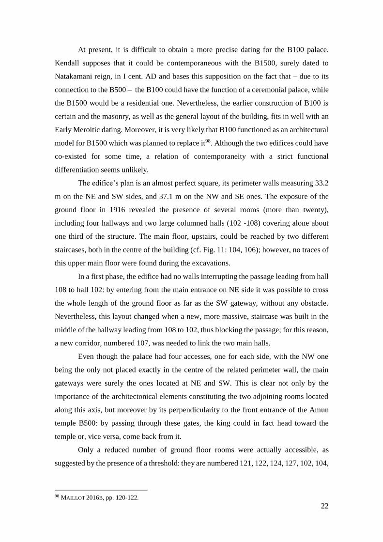
The edifice’s plan is an almost perfect square, its perimeter walls measuring 33.2
m on the NE and SW sides, and 37.1 m on the NW and SE ones. The exposure of the
ground floor in 1916 revealed the presence of several rooms (more than twenty),
including four hallways and two large columned halls (102 -108) covering alone about
one third of the structure. The main floor, upstairs, could be reached by two different
staircases, both in the centre of the building (cf. Fig. 11: 104, 106); however, no traces of
this upper main floor were found during the excavations.
In a first phase, the edifice had no walls interrupting the passage leading from hall
108 to hall 102: by entering from the main entrance on NE side it was possible to cross
the whole length of the ground floor as far as the SW gateway, without any obstacle.
Nevertheless, this layout changed when a new, more massive, staircase was built in the
middle of the hallway leading from 108 to 102, thus blocking the passage; for this reason,
a new corridor, numbered 107, was needed to link the two main halls.
Even though the palace had four accesses, one for each side, with the NW one
being the only not placed exactly in the centre of the related perimeter wall, the main
gateways were surely the ones located at NE and SW. This is clear not only by the
importance of the architectonical elements constituting the two adjoining rooms located
along this axis, but moreover by its perpendicularity to the front entrance of the Amun
temple B500: by passing through these gates, the king could in fact head toward the
temple or, vice versa, come back from it.
Only a reduced number of ground floor rooms were actually accessible, as
suggested by the presence of a threshold: they are numbered 121, 122, 124, 127, 102, 104,
98 MAILLOT 2016B, pp. 120-122.

23
106, 101, 107, and 108 in the plan (cf. Fig. 11); the remaining ones had no openings in
the walls surrounding them, and consequently must had only a structural function, serving
as casemates (cf. infra); furthermore, these were filled with debris to better sustain the
upper floor99.
The south-eastern area of the palace was composed of two – almost specular –
sections, divided by the corridor 101; neither of these was accessible, but inside the rooms
113 and 111 two square structural foundation pillars in mud bricks were found, probably
marking the position of some heavy structures in the main floor above100. In particular,
such pillars could have functioned as supports for an hypothetical vault covering of the
room101.
As regards the ground floor, it could have assumed a ceremonial function
concretised in the walking of the king through the columned halls, going or returning
from the temple. The sandstone columns, disposed in two rows of three, had an open
papyrus, or bell-shaped, capital and were plastered and, originally, painted102.
The walls of the various rooms were made both of mud and red bricks, the
presence of which was fundamental to contain the damage caused by the floods103.
Kendall states that the columned halls, probably, rose to the full height of the two
levels and were illuminated through some clerestory windows104.
Another possible interpretation is that the two ground halls could be used as
courtyards with porticos, with no roof or upper floors above them. If that was the case, to
reach the south-eastern wing one should have probably used the 104 stairways and walk
through the south-western wing. Unfortunately, since no evidence at all remains of the
upper storey, only suppositions can be done about it.
Anyway, the available evidence allows to argue with some confidence that we are
dealing with a large Meroitic royal palace, built on two floors, with one of its major focus
– the columned halls – located on the ground floor.
99 KENDALL 2014, p. 69. 100 Ibid. 101 MAILLOT 2016B, p. 121. 102 KENDALL 2014, p. 70. 103 KENDALL 2014, pp. 68-69. 104 KENDALL 2014, p. 72.
24
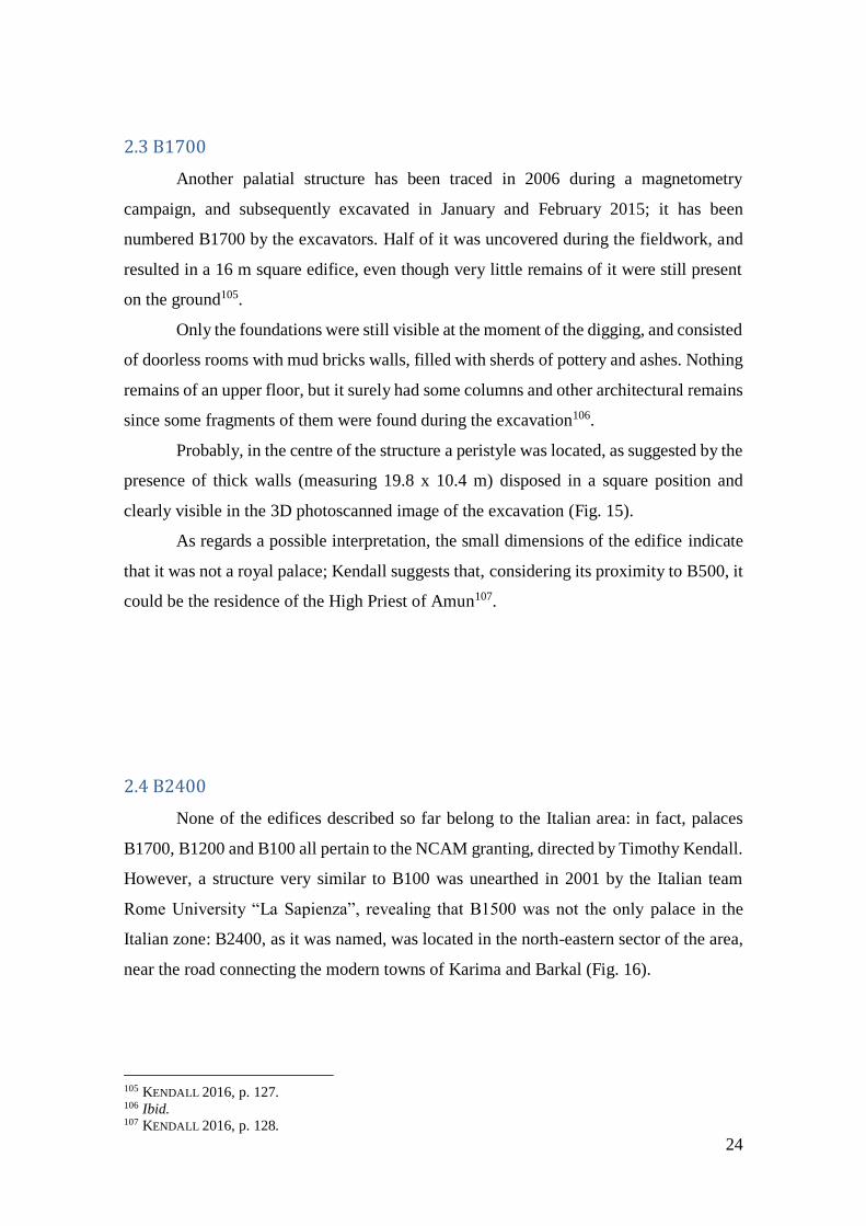
2.3 B1700
Another palatial structure has been traced in 2006 during a magnetometry
campaign, and subsequently excavated in January and February 2015; it has been
numbered B1700 by the excavators. Half of it was uncovered during the fieldwork, and
resulted in a 16 m square edifice, even though very little remains of it were still present
on the ground105.
Only the foundations were still visible at the moment of the digging, and consisted
of doorless rooms with mud bricks walls, filled with sherds of pottery and ashes. Nothing
remains of an upper floor, but it surely had some columns and other architectural remains
since some fragments of them were found during the excavation106.
Probably, in the centre of the structure a peristyle was located, as suggested by the
presence of thick walls (measuring 19.8 x 10.4 m) disposed in a square position and
clearly visible in the 3D photoscanned image of the excavation (Fig. 15).
As regards a possible interpretation, the small dimensions of the edifice indicate
that it was not a royal palace; Kendall suggests that, considering its proximity to B500, it
could be the residence of the High Priest of Amun107.
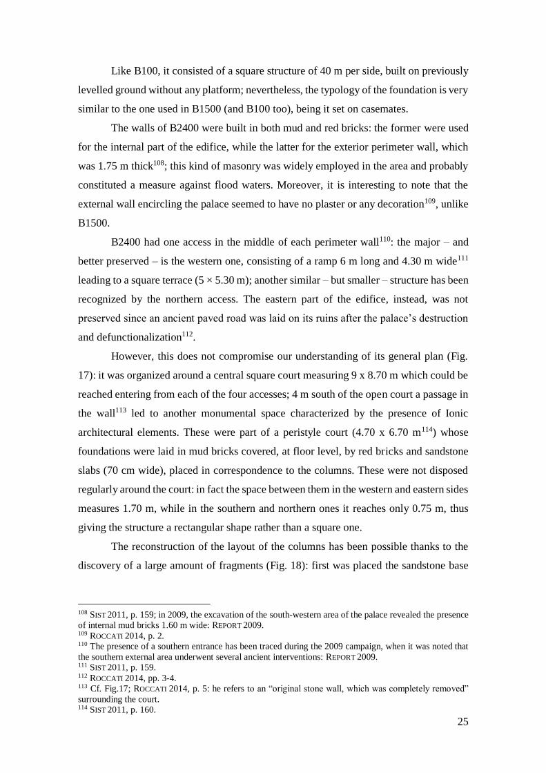
2.4 B2400
None of the edifices described so far belong to the Italian area: in fact, palaces
B1700, B1200 and B100 all pertain to the NCAM granting, directed by Timothy Kendall.
However, a structure very similar to B100 was unearthed in 2001 by the Italian team
Rome University “La Sapienza”, revealing that B1500 was not the only palace in the
Italian zone: B2400, as it was named, was located in the north-eastern sector of the area,
near the road connecting the modern towns of Karima and Barkal (Fig. 16).
105 KENDALL 2016, p. 127. 106 Ibid. 107 KENDALL 2016, p. 128.
25
Like B100, it consisted of a square structure of 40 m per side, built on previously
levelled ground without any platform; nevertheless, the typology of the foundation is very
similar to the one used in B1500 (and B100 too), being it set on casemates.
The walls of B2400 were built in both mud and red bricks: the former were used
for the internal part of the edifice, while the latter for the exterior perimeter wall, which
was 1.75 m thick108; this kind of masonry was widely employed in the area and probably
constituted a measure against flood waters. Moreover, it is interesting to note that the
external wall encircling the palace seemed to have no plaster or any decoration109, unlike
B1500.
B2400 had one access in the middle of each perimeter wall110: the major – and
better preserved – is the western one, consisting of a ramp 6 m long and 4.30 m wide111
leading to a square terrace (5 × 5.30 m); another similar – but smaller – structure has been
recognized by the northern access. The eastern part of the edifice, instead, was not
preserved since an ancient paved road was laid on its ruins after the palace’s destruction
and defunctionalization112.
However, this does not compromise our understanding of its general plan (Fig.
17): it was organized around a central square court measuring 9 x 8.70 m which could be
reached entering from each of the four accesses; 4 m south of the open court a passage in
the wall113 led to another monumental space characterized by the presence of Ionic
architectural elements. These were part of a peristyle court (4.70 x 6.70 m114) whose
foundations were laid in mud bricks covered, at floor level, by red bricks and sandstone
slabs (70 cm wide), placed in correspondence to the columns. These were not disposed
regularly around the court: in fact the space between them in the western and eastern sides
measures 1.70 m, while in the southern and northern ones it reaches only 0.75 m, thus
giving the structure a rectangular shape rather than a square one.
The reconstruction of the layout of the columns has been possible thanks to the
discovery of a large amount of fragments (Fig. 18): first was placed the sandstone base
108 SIST 2011, p. 159; in 2009, the excavation of the south-western area of the palace revealed the presence
of internal mud bricks 1.60 m wide: REPORT 2009. 109 ROCCATI 2014, p. 2. 110 The presence of a southern entrance has been traced during the 2009 campaign, when it was noted that
the southern external area underwent several ancient interventions: REPORT 2009. 111 SIST 2011, p. 159. 112 ROCCATI 2014, pp. 3-4. 113 Cf. Fig.17; ROCCATI 2014, p. 5: he refers to an “original stone wall, which was completely removed”
surrounding the court. 114 SIST 2011, p. 160.
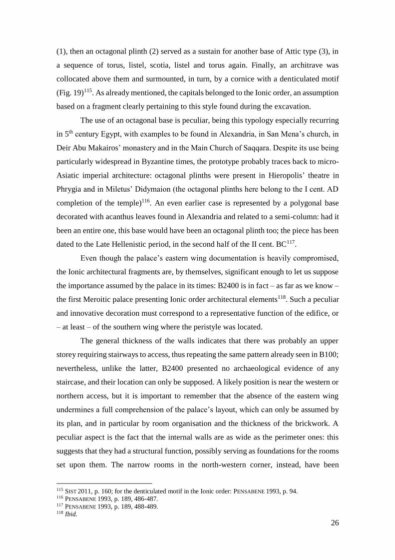
26
(1), then an octagonal plinth (2) served as a sustain for another base of Attic type (3), in
a sequence of torus, listel, scotia, listel and torus again. Finally, an architrave was
collocated above them and surmounted, in turn, by a cornice with a denticulated motif
(Fig. 19)115. As already mentioned, the capitals belonged to the Ionic order, an assumption
based on a fragment clearly pertaining to this style found during the excavation.
The use of an octagonal base is peculiar, being this typology especially recurring
in 5th century Egypt, with examples to be found in Alexandria, in San Mena’s church, in
Deir Abu Makairos’ monastery and in the Main Church of Saqqara. Despite its use being
particularly widespread in Byzantine times, the prototype probably traces back to micro-
Asiatic imperial architecture: octagonal plinths were present in Hieropolis’ theatre in
Phrygia and in Miletus’ Didymaion (the octagonal plinths here belong to the I cent. AD
completion of the temple)116. An even earlier case is represented by a polygonal base
decorated with acanthus leaves found in Alexandria and related to a semi-column: had it
been an entire one, this base would have been an octagonal plinth too; the piece has been
dated to the Late Hellenistic period, in the second half of the II cent. BC117.
Even though the palace’s eastern wing documentation is heavily compromised,
the Ionic architectural fragments are, by themselves, significant enough to let us suppose
the importance assumed by the palace in its times: B2400 is in fact – as far as we know –
the first Meroitic palace presenting Ionic order architectural elements118. Such a peculiar
and innovative decoration must correspond to a representative function of the edifice, or
– at least – of the southern wing where the peristyle was located.
The general thickness of the walls indicates that there was probably an upper
storey requiring stairways to access, thus repeating the same pattern already seen in B100;
nevertheless, unlike the latter, B2400 presented no archaeological evidence of any
staircase, and their location can only be supposed. A likely position is near the western or
northern access, but it is important to remember that the absence of the eastern wing
undermines a full comprehension of the palace’s layout, which can only be assumed by
its plan, and in particular by room organisation and the thickness of the brickwork. A
peculiar aspect is the fact that the internal walls are as wide as the perimeter ones: this
suggests that they had a structural function, possibly serving as foundations for the rooms
set upon them. The narrow rooms in the north-western corner, instead, have been
115 SIST 2011, p. 160; for the denticulated motif in the Ionic order: PENSABENE 1993, p. 94. 116 PENSABENE 1993, p. 189, 486-487. 117 PENSABENE 1993, p. 189, 488-489. 118 Ibid.
27
interpreted as storerooms119 accessible from the upper floor, considering the lack of any
door; nevertheless, a structural function is more likely.
In this respect, it is interesting to note the resemblance they bear with some rooms
in both Muweis and Wad Ben Naga palaces (Fig. 20). Despite the orientation120 and the
dimensions121 being different here, the cluster of rooms forming the northern corner of
these palaces (the “A” zone in the Muweis plan, and the highlighted area in the Wad Ben
Naga one) has the same layout of the corresponding rooms in B2400: the pattern is rather
similar, consisting of long and narrow rooms flanked by smaller ones.
In Wad Ben Naga, the two northernmost rooms of this cluster have been identified
as casemates, due to the lack of entrances, that are present, instead, in the three southern
rooms, where a vestibule was also created by means of a protruding wall. Doors and
vestibules are also absent in Muweis122, where, furthermore, a particular kind of mortar
has been found on the walls of the “A” cluster (especially on F 60): being not uniformly
distributed, it seems to have been used to reinforce some sensitive points in the walls
rather than as a coating; its physical composition, moreover, makes it unsuitable for a
living space, since it tends to disintegrate in small white grains123. All these elements
seem to point out that the rooms in Muweis had only a structural function and therefore
must correspond to casemates, despite the clear resemblance with the storerooms in Wad
Ben Naga.
Considering the similarities between the rooms in Muweis and B2400’s northern ones, it
is likely that we are dealing with casemates rather than storing places here as well; the
same structural function seems to be reflected also by the wide rooms built west of the
Ionic hall.
The thin mud brick walls dividing the hallway west of the central court, visible on
the plan, mark the original presence of three rooms whose thresholds must have been
placed in the middle of the walls, thus creating a hallway leading to the centre of the
edifice.
Concerning the chronological attribution, we can assume that the edifice relates
to the Meroitic period: the square plan with accesses on every side and the columned
119 ROCCATI 2014, p. 5. 120 NW/SE in Wad Ben Naga and Muweis; NE-SW in B2400. 121 About 14 m in Wad Ben Naga and Muweis (MAILLOT 2014B, p. 785) and less than 10 m in B2400 (cf.
Fig. 20). 122 At Muweis, a vestibule could possibly be present in room 31 and 32, but no openings in the walls were
found: MAILLOT 2014B, p. 785. 123 MAILLOT 2014B, p. 785.

28
rooms are common features among the Meroitic palatial architecture (cf. B100 for a
comparison). An earlier dating than that of B1500 has been proposed on the basis of the
presence of the Ionic architectural elements and their different orientation in space124, but
no evidence remains for a more precise placement in time.
2.5 B3200
Another noteworthy structure pertinent to the Italian area is B3200: although it is not a
palace, this edifice surely bears a royal connotation which connects it with the
surrounding buildings.
The diggings, started in 2002 and ended in 2004, brought to light a mud-brick
structure located between the palaces B1500 and B2400, 50 m north of the former and 30
m west of the latter (Fig. 21). Also in this case, the structure has a square plan (about 25
m per side)125 (Fig. 22), but peculiarly organised around a central cell, probably higher
than the other rooms: it measures 8.40 x 7.50 m with walls reaching an average thickness
of 80 cm, and red bricks at the angles used probably as a strengthening device. The cell
had three entrances in the middle of its western, northern, and southern walls: no traces
of a fourth one were found on the eastern side. The inner wall, visible on the plan, is a
later addition which reduced the internal space in the cell and closed all the accesses
except for western one; the thresholds were 1,40 m wide and reinforced, once again, with
red bricks jambs126.
Two white sandstone columns sustained the roof of the cell, as proved by the
discovery of their bases inside the room (68 x 68 x 28 cm); as it concerns the columns’
capitals, they most likely were pertinent to the Corinthian order, made in sandstone and
painted in red, light blue and yellow127. These colours are the same used for the interior
and exterior walls of the cell, where a decoration with stripes and wavy lines was also
124 ROCCATI 2014, p. 5. 125 The excavation did not reach the entire extension of the structure, and cleared only the eastern part of it.
At any rate, the disposition of the walls and the general planimetric layout let the excavators suppose that
the western wing had the same features of the eastern one, cf. also SIST 2011, p. 162. 126 SIST 2011, p. 161. 127 Ibid.

29
present. The Hellenistic features of the capitals counterbalance the outside topping of the
building, consisting of a more traditional torus and Egyptian cornice128.
The cell is enclosed by a 2.70 m wide corridor on its northern and southern sides
and by a 2.40 m one on its western and eastern sides, where a 1.40 m door wide was also
discovered in the middle of the outer wall (Fig. 22). Various fragments of sandstone have
permitted the reconstruction of its jambs and architrave, which was surmounted by a
frieze decorated with the motif of the winged solar disc and uraeus129 (Fig. 23). Not one,
but three entrances were found instead on both the northern and the southern sides: here
the central door was aligned to that of the cell and measured 1.40 m as well, while the
two lateral ones were 10 cm smaller; the thresholds, discovered during the excavation,
consisted of red bricks.
Another outer corridor was built around the first one, thus giving the structure a
sort of concentric layout, developed around the central cell. It was larger than the first
one, reaching a width of 3.20 m and enclosed by a 1 m thick wall which was strengthened
by means of sandstone slabs, at least in the south-east corner, where some fragments have
been found: the use of stone and red bricks for the corners is probably an expedient to
shield the edifice from flood waters. Two square rooms measuring 3.30 m per side were
located at the south-eastern and north-eastern corners130, and access to them was granted
by a 1.15 m wide a passage in the walls of the outer corridor. In the southern room,
moreover, a mud-brick floor has been found in good conditions (Fig. 24), indicating that
this was probably a roofed place.
The doors’ scheme used for the perimeter wall is reversed to that of the inner
corridor, with the single entrance posed in correspondence to the triple one on the inner
wall, and vice versa.
Not providing the structure with a functional layout of rooms, this intricate system of
gateways probably served a ceremonial purpose: the fine decorations of the walls (painted
plaster was present both on the cell and the first corridor), the Hellenistic artistic influence
(the capitals of the cell), combined with the typical Egyptian architectural features (the
cavetto cornice) and iconographical motifs (the sun-disk with uraei) clearly emphasise
the importance of this building.
128 Ibid. 129 Ibid. 130 SIST 2011, p. 162.

30
Due to its topographical position, so close to the palaces B1500 and B2400, it is
very likely that B3200 was intended as a sort of pavilion inserted in the new urbanistic
context wanted by the Meroitic architects. In particular, it could be part of a monumental
dromos which led to the palace and, from there, to the temples area; the idea of such a
processional way fits in well with the Hellenistic architectural conception of sacred
places: we found an example of this also at Philae, which was surely known to the
Meroitic architects of the time.
The spatial relation between Natakamani’s palace and B3200 seems confirmed
also by their reciprocal location. In fact, supposing that edifice B3200 was structured in
order to emphasise its N-S axis131 and virtually extending this axis towards the palace, it
appears clear that the buildings were connected, being the southern gateway of B3200
directly headed toward the northern entrance of the palace.
131 As the position of the columns seems to indicate.
31
3. The entrances of palace B1500
Like the other Meroitic palaces described so far, B1500 also had four accesses
located approximately at the centre of each perimeter wall. In particular, even if the
southern and northern entrances appear to be symmetrical to each other, the same cannot
be said for the eastern and western ones, which do not lie on the same axis. On these sides,
in fact, the entrances do not divide the perimeter wall into two halves, but they instead
break the symmetry of the façade creating two parts of different length (about 25 and 31
m). The reason of this mismatch must be ascribed to the fact that each access belongs to
a different building phase.
The southern and the eastern ones, in fact, were probably built earlier than the
others, since the perimeter wall they lean on was plastered only after their completion; on
the west and north sides, contrariwise, the entrances were constructed after the walls of
the palace had already been plastered132.
3.1 Northern access
The first entrance to be excavated, in 1982, was the northern one: in that occasion,
seven stone slabs were recognised as the steps of a monumental staircase that led from
the ground to the top of the platform, where the access to the edifice was located.
Considering the width of these steps (0.40 m), together with the fact that traces of the
monumental structure were found up to 9 m away from the platform, it is likely that the
staircase in question was originally composed of about twenty slabs (Fig. 26)133.
On top of the platform, and abutting it, a square terrace measuring 4.40 m (in
width) x 4 m (in depth) was placed just in front of the portal: this pattern is not exclusive
to the northern side, but is repeated on every façade. The monumentality of the access
was confirmed also by the discovery of some134 lion statues on the ground just below the
terrace where they were placed before falling down; 1,5 m high, they were depicted
seated, and bore traces of yellow and blue paint135. No elements remain to deduce how
they were originally disposed, but the presence of several column drums and capitals in
132 ROCCATI 1997, p. 12. 133 DONADONI 1993, p. 103. 134 DONADONI (1993, p. 103) wrote about two recovered statues and a third one yet to be recuperated, thus
hypnotizing the original presence of two couples of lion on the terrace. 135 Ibid.

32
the same place where the lions were found indicates that some sort of columned structure
had to be present on the terrace136 (Fig. 27).
Not much evidence remains either about the actual portal which gave access to
the palace’s inner rooms, but some fragments of its threshold and architrave showed the
typical Egyptian decoration with the winged sun disk. Concerning its dimension, even if
no data can help us in the definition of the height, we can at least assume that this gateway
was about 2 m wide137.
On the northern side of the palace, another structure was unearthed about seven
metres east of the central terrace, consisting of a small staircase of which only three brick
steps remained. Due to its size (7.70 x 1.80 m), and orientation (parallel to the façade and
not perpendicular to it), this structure was interpreted as a service passage138 and does not
recur on any other side.
3.2 Western access
A terrace and a ramp to access it were also present on the western side but, unlike
the other cases, no lion statues were found here. Nevertheless, this is not surprising
considering the different disposition of this entrance compared to the others: the ramp, in
fact, is not perpendicular to the façade but parallel to it. This peculiar orientation is
justified by the presence of the sacred area to the south: descending from the western
access, in fact, the king found himself directly on the path that led to the temples.
Another dromos139 connecting the palatial area to the religious sector can perhaps be
imagined here as well: an architectural arrangement of the open space outside the palace
would be functional to the celebration of ceremonies performed by the king on his way
to the temples140.
Also of ceremonial nature was probably the podium found in 2012 just south of
the western staircase (Fig. 28): a rectangular building with plastered and yellow-painted
walls. Traces of plaster were also present on several red bricks found on the ground during
the excavation which probably formed the cover of the structure, access to which had to
be granted by some sort of staircase, now completely lost141.
136 Ibid. 137 Ibid: due to the presence of some traces on the ground. 138 DONADONI 1993, p. 104. 139 Another droms probably developed on the eastern side of the palace, as already seen when describing
the edifice B3200. 140 CIAMPINI 2013, p. 55; REPORT 2012. 141 REPORT 2012.
33
The podium was built following the typical Meroitic masonry for civil
architecture, with red bricks on the outer part and mud bricks on the inside; on the
contrary, being composed of stone, the foundations of the structure deviated from the
architectural tradition. In no other Meroitic edifice excavated at Jebel Barkal so far, in
fact, such an expedient was present142. Excluding a ritual meaning, another possible
explanation could be of more practical nature connected to the drainage of water.
The use of stone with this function is evident in Muweis, where some ferruginous
sandstone slabs were found in the foundations of the south-eastern area of the palace143;
moreover, here these stone slabs were often accompanied by the presence of red brick
fragments – sometimes mixed with vitrified brick ones – coming from halves or thirds of
entire bricks. The foundations of wall F65 (Fig. 25), for example, consisted of one lower
layer of red fired bricks on which more than twelve layers of overlapping stone slabs were
placed144. The latter, which is the result of a natural process of disaggregation, had
different forms and were about 20 cm long and 2-3 cm thick, and their disposition was
carefully planned to limit the spaces among them, later filled with clay145.
3.3 Eastern access
In 1995, the first traces of the presence of an entrance were found in this side as
well. The following year the excavations were completed and another terrace with a ramp
was unearthed together with some lion statues, thus confirming the general pattern.
3.4 Southern access
The southern entrance, excavated in 1995, was quite similar to the northern one,
even though, as previously underlined, it was built earlier. Not only did they have similar
dimensions146, but also the staircase, the terrace and the lion statues were features
common to both. A major point of contrast however is the orientation: unlike the northern
one, the southern access was clearly aligned with the central peristyle of the palace.
142 During the excavations conducted in 2009 on palace B 2400, a sounding in the N-W corner of the
building revealed at a deep level (1.80 m from the floor) a red brick coating together with some foundation
stones, cf. REPORT 2012. In addition, the 2013 campaign found the presence of some stones in the
foundation of the south-west corner of the platform., cf. REPORT 2013. The foundations of the podium
however indicate a systematic use of stone. 143 MAILLOT 2014B, 787-788. 144 MAILLOT 2014B, p. 787. 145 BAUD 2011, p. 354. 146 The entrance here is slightly wider, measuring 5 m.
34
Its meridional position connected it to the processional way that led to the sacred
area, and this gateway seems to point directly to the Amon temple B500, a fact that would
be confirmed also by the 3° bend of the staircase towards that building147; moreover, one
of the lion statues that were located here was found with its head turned, facing the temple
(Fig 29). Its fine and accurate workmanship is another feature which distinguishes this
exemplar from the others, depicted instead on their backs and looking straight in front of
them. This piece is reminiscent of two other lion statues found at Jebel Barkal, the so-
called “Prudhoe lions”, now at the British Museum, where Lord Prudhoe presented them
in 1835148 (Fig. 30): two granite statues of lions originally coming from the temple of
Soleb erected by Amenhotep III, and brought to Jebel Barkal probably together with the
already mentioned rams reused in the Amon temple B 500. These lions are depicted lying
on their sides with the forepaws crossed and their muzzles turned; doubtless, their
naturalistic traits and anatomical details indicate a very fine workmanship. At Napata they
were reused to decorate the entrance of palace B1200 in Napatan times and Amansilo was
the last king to incise his cartouches on their surface149.
Undoubtedly, being them present at the site, they served as models for the
sculptors who created the “southern lion” in Meroitic times: this renewal of a well-known
ancient model was not limited to a mere imitation of its iconographic style, but also
reminded of the ideological values embodied by the lion statues in pharaonic times.
An interesting comparison can be made with the already repeatedly quoted
Meroitic palace of Wad Ben Naqa, ascribed to queen Amanishakhete (I cent. BC)150. Also
in this case, the structure had several accesses. The most monumental one was probably
reserved for the eastern façade where, in a way very similar to B 1500, the entrance was
reached via a ramp leading to a square terrace151. On the western side, two smaller
accesses led to rooms S and Z (cf. infra). Although the architectural arrangement of the
eastern entrance qualifies it as the main access, the presence of a hypostyle hall of six
columns on the southern side of the palace suggests an important role of this entrance as
well152. The principal characteristics of this palace will be discussed later in detail.
147 ROCCATI 1997, p. 13. 148 ROCCATI 2015, p. 390. 149 Photographs of the Prudhoe lions together with an accurate description are present on the British
Museum’s website:
http://www.britishmuseum.org/research/collection_online/collection_object_details/collection_image_gal
lery.aspx?partid=1&assetid=775539001&objectid=117626. 150 VERCOUTTER 1962, p. 282 -283. 151 MAILLOT 2016B, p. 80. 152 Ibid.

35
Very peculiar, also considering the chronological affinity between B1500 and Wad Ben
Naga’s palace, is the discovery in the latter of some clay figurines depicting animals.
They were found inside a narrow room just to the right of the columned hall in the south
(Fig. 31): among them, two represent a hawk and five a sitting lion153. The function of
these little statues is not clear but they surely testify the importance of the iconography
associated with the lion all over the Meroitic kingdom. It must be remembered, in fact,
that in these centuries the cult of Apedemak – the lion-headed deity – reached its peak, as
confirmed also by the building of its temple at Naga during the reign of Natakamani154.
This discovery is even more interesting since it proves that the recurrence of the leonine
motif was not limited to the cultic sphere but was widespread in the palatial one as well,
whether it was in the form of a statue protecting the entrances or in the form of a little
figurine.
A monumental arrangement of the entrances closely corresponding to the one of
palace B1500 is not present in any other Meroitic edifice: even though accesses on every
façade are a common feature (cf. B100, B2400, Wad Ben Naga), the layout consisting of
big terraces reached by a wide staircase and decorated with lion statues was not a
systematic feature among Meroitic palaces.
A resembling model can be observed at Philae, where the access to the temple in
correspondence to the First Pylon – still visible as reconstructed on the island of Agilkia
– is formed of a ramp and a square terrace, on which stand two granite lion statues looking
in front of them. The connection between Philae and the Meroitic Kingdom is well known
through several sources and covers the entire length of the latter’s duration, from 3rd cent.
BC to 3rd cent. AD155; for example, a hymn of the temple of Isis has been found inside the
Lion Temple at Musawwarat es-Sufra (IIIrd BC), and several Meroitic inscriptions left by
pilgrims have been recognised in different structure related to the sanctuary especially
between the 1st and the 3rd centuries AD156
The terrace and the staircase leading to the main court of the temple appear to
have been set in a later moment than the Pylon they lean on: in fact, if the latter was built
together with the Second one during the reign of Ptolomy VI157, the access seems rather
contemporaneous to the layout of the dromos, surely arranged in Roman times.
153 VERCOUTTER 1962, pp. 285-286. 154 TÖRÖK 1997A, pp. 461-462. 155 ROCCATI 2010, pp. 164-165; ROCCATI 2005, pp. 4-5. 156 ROCCATI 2010, p. 164. 157 GIAMMARUSTI; ROCCATI 1980, p. 68.

36
Considering the similarities between Philae and Napata (the “Meroitic” pose of the lions,
the dimension of the terrace, the staircase) it is impossible not to notice some sort of
architectural – and possibly ideological – connection between them158.
This correlation proved to be useful to propose a plausible dating for the
arrangement of the access of Philae – namely the reign of Domitian (81-96 AD),
contemporary of Natakamani159 – but does not provide any help in understating the
origins of this “Meroitic” model for the entrances, whose major elaboration is reflected
in Natakamani’s palace B1500.
158 CIAMPINI 2011, pp. 186-187. 159 ROCCATI 2010, p. 165.

37
4. The foundation platform
Certainly, a distinctive feature of palace B1500 is its foundation platform. It
consists of a square structure of 61 m per side, whose walls are the only remains of the
entire palace: preserved to a height of 1.80 m, they allow to reconstruct the original layout
of the edifice, at least as far as it concerns its lower level.
The platform was intended as an expedient to raise the height of the palace both
for practical and visibility reasons: it ensured protection against water, stability for the
upper storeys, and permitted to elevate the edifice above the surrounding ground.
For static purposes, the platform was internally divided into a number of rooms
called casemates whose framework reflected, in some cases, the arrangement of the upper
floor: the walking level of the palace, where the royal activities took place, laid in fact
just above the top of the platform.
This foundation technique, also called cellular construction160, was especially
used for large edifices built in mud brickwork masonry. The name derives from the grid
of rooms resulting from the intersection of different brick walls inside the platform: the
cellars thus created were usually filled with rubble, debris or sand to increase the stability
of the whole structure.
The platform-foundation, particularly used in Meroitic civil architecture (cf.
infra), was also known in Egypt. Even if the first prototypes probably trace back to earlier
times (Old and Middle Kingdom161), evidence for its use is mostly attested starting from
the New Kingdom onwards.
After the description of the specific characteristics of the platform of palace
B1500, a general picture of the known evidence related to foundation platforms both in
Egypt and Nubia will follow. The analysis has been divided into different sections
according to geographical, chronological, and typological patterns.
160 ARNOLD 2003, pp. 49-50. 161 ARNOLD 2003, p. 49.
38
4.1 The foundation platform of palace B1500
The platform is a square structure with a side of 61 m and a height of 1.80 m, built
using mud bricks (8 × 17 × 34 cm) for the interior and red bricks for the outer layer of the
enclosing wall, 2.50 m thick162. Built as a casemate structure, it represents the foundation
level of the palace, whose walls entirely collapsed leaving no trace of the upper floor. At
the moment of the excavation, the inner grid of casemates was found heavily
compromised by the removal of its mud bricks, stolen in ancient as well modern times to
be used as fertiliser; in particular, the southern part of the platform is the most damaged
of the whole building.
4.1.1 The exterior wall decoration
Although the destruction of the walls deprived us of a better understanding of the
original layout of the palace, it has helped to preserve the outer coating of the building,
sometimes impressed on the collapsed bricks and sometimes protected by them: in some
parts of the edifice, in fact, the exterior decoration was found still in place, covered and
preserved by the fallen bricks. Therefore it has been possible to identify the composition
of the coating, consisting of a very hard whitewashed plaster of chalk and pebbles.
The outer surface of the perimeter wall was characterised by the presence of two
different kinds of decorative motif: a simple buttress created by a protruding brick, and a
more complex one composed of a pillar plus three vertical rows (tori) made using peculiar
bricks with a round end (Fig. 69). The first one, painted blue, was regularly disposed on
every façade at a distance of about 2.20 m; it seems that this jutting motif did not
characterise the whole height of the wall, but stopped at about 1.40 m, where a stone
“mensola” was placed163. The second motif was composed of three rounded bands 1.10
m wide, painted red, blue, and yellow; these rows were not parallel to each other but
converged instead towards the top of the platform, thus creating a sort of trapezoidal
structure which could perhaps recall the shape of a pylon164.
162 DONADONI 1993, p. 101. 163 DONADONI 1993, pp. 101-102: Donadoni suppose this ledge was meant to indicate the walking level on
the inside of the platform; nevertheless, considering that the platform is used as a foundation for the upper
level, we must assume this latter was located on a higher height than 1.80 m; ROCCATI 2011, p. 67. Cf. also
REPORT 2012. 164 Ibid.
39
Although the top of the wall is not preserved, it is likely that it consisted of a
typical Egyptian cavetto cornice, as suggested by the discovery of some moulded and
painted bricks165.
On its upper part, the outer perimeter wall was then decorated with a series of
glazed terracotta (faience) tiles, mostly rounded, featuring different subjects and colours:
busts of women holding grapes and crowns, the god Apedemak with the lunar crescent, a
series of sȝ signs arranged in a circle and others (Fig. 70); the simplest examples were just
15 cm wide monochrome plates. Most of these tiles have been found partially fragmented
under the brick rubble of the walls which had covered them after the destruction of the
palace. Even if there is no evidence to argue the pattern used in their disposition on the
wall, the fact that fragments have been found in front of every façade of the palace
indicates that some sort of regular arrangement should have existed. We also know that
they were roughly inserted in the fresh mortar from which they fell soon after the pose,
as proved by the presence of plaster on some of them.
In conclusion, the available data suggest the following reconstruction of the outer
wall of the palace: a white background was enriched by the presence of several colourful
alternating lesenas, the simpler ones regularly disposed all around the wall and the
composite ones used especially near the corners and the accesses; a significant number of
faience tiles with Dionysiac and sometimes Egyptian themes decorated the upper part of
the wall following a non-identified pattern; finally, a cavetto cornice enriched by
Hellenizing elements closed the top of the wall. The presence of Hellenizing architectural
elements was noted mostly during the 2012 and 2013 campaigns, when a painted lesena
capital in alexandrine style and a stone covered in painted plaster belonging to the top of
the wall were found (Fig. 71).
Also in 2012, an interesting variation in the level of the outer coating was detected
while investigating the missing western side of the perimeter wall of the platform. It was
noted that in correspondence to the podium found just south of the west entrance (cf.
infra, Fig. 28), the level of the plaster applied on the platform rose, reaching the same
height of that applied to the podium and the base of the staircase of the western access
(Fig. 72). Taking into account that in the rest of the palace the floor level is lower, such a
difference could be due to an elevation of the ground – connected to a sloping terrain –
165 ROCCATI 2011, p. 67.

40
which consequently led to the raising of the foundations of both the platform and the
podium166.
The decision of setting the palace on an elevated platform together with its
location on raised ground is indicative of a careful preliminary planning aimed at the
preservation of the edifice from the damage caused by the flood.
4.1.2 The masonry
As already mentioned, the masonry of the platform is characterised by the use of
mud bricks for the inner parts of the structure and red bricks for the external surface of
the perimeter wall, where a stronger resistance against flood waters was obviously
required. During the 2011 campaign, the south-western section of the wall was unearthed,
revealing massive destruction caused by the brick-removal activity perpetrated by the
sebbakhin. Nevertheless, the absence of mud bricks made it easier to expose the
foundations of the wall, where at least one layer of red bricks was identified (Fig. 73)167;
undoubtedly, this expedient contributed to seal the wall against the flood, and may thus
indicate a greater need for waterproofing in this area of the palace. The presence of red
bricks just under the foundations has also been traced in 2015 during the excavation of
the eastern part of the same tract of the wall. The apparent absence of this technical device
in other areas of the structure could be due just to the lower level reached by the previous
excavations.
Another particular technical arrangement characterising this section is the use of
stones in the foundation of the south-western corner of the platform, where some rows of
blocks of local stone were identified during the 2013 campaign (Fig. 74)168. The presence
of durable materials such as stone and red bricks conveys once again the idea of an area
particularly prone to flooding and consequently requiring a higher capability of drainage
of the masonry built upon it.
The thickness of the internal walls of the platform ranges approximately from 1.60
to 1.90 m, creating a solid grid of empty rooms whose stability had been increased with
a fill of mud and debris mostly composed of broken red bricks. The nature of this filling,
whose components came from the demolition of ancient buildings, indicates that it was a
166 CIAMPINI 2013A, pp. 54-55. 167 REPORT 2011. 168 REPORT 2013.

41
structural intentional device rather than a consequence of the collapse of the palace, as in
the case of Muweis169.
4.1.3 The plan
Before proceeding with the description of the plan of the edifice, it is necessary
to take into account some remarks. First, the map of B1500 is incomplete in its south-
western corner, where the first excavations have started only in 2011 and are currently
still being carried out170. Nevertheless, the profiles of the casemates have been outlined
in 2015 in a preliminary sketch and are partially visible also in the orthophotos took
during the last campaign (Fig. 75). At the same time, it is important to underline that the
investigation undertaken by the first excavators in the previous 50 years was aimed
mainly at the recognition of the upper level of the casemates walls, thus leaving undug
most of the content of the rooms.
In the previous chapter, we saw how the remaining evidence of the northern access
qualifies it as the most likely main access to the palace; nevertheless, we must remember
that the poor state of conservation of the south side of the building could affect our
understanding of the importance of the related entrance171. What is certain is that the
ceremonial life of the palace took place mostly on the north-south axis of the building,
where the monumental chambers were situated.
The first circulation level was located at about 2 m from the ground and was
reachable by means of a ramp. In particular, the north entrance gave access to a room [A
– cf. Fig. 68] (about 9.60 × 8.80 m) where six columns were originally disposed into two
rows, as testified by their stone bases (80 × 80 × 35 cm) found still in situ172; for their
part, the bases were standing on a foundation layer of red bricks. The identification of the
two rows of columns as porches is confirmed by the concrete matrix of the floor of the
room: the presence of a waterproof material fits well with an open, unroofed place.
Moreover, it was by the south-western corner of this chamber that the stela bearing the
names of Natakamani and Amanitore was found in 1984 (Fig. 76).
Walking south, a small rectangular room [B] (about 2.80 × 2.10 m) functioned as
a vestibule leading to the next chamber. Looking at the plan, the small room appears to
169 MAILLOT 2016B, pp. 95-96. 170 REPORT 2011-2016. 171 ROCCATI 2008, pp. 256-257. 172 DONADONI 1993, p. 103: only half of them was found still in place during the excavation.

42
be aligned with other two cells of the same size, but only the central one bore traces of a
threshold towards room C: the lateral ones also had an opening, but they were accessible
only from the inside of chamber C.
The idea that this vestibule was not simply a hallway, but rather an important –
and maybe symbolic – passage point was conveyed by the discovery in it of fragments of
leaf gold, originally covering the plastered walls of the room173.
The preciously decorated chamber led to another hall [C] (about 7.60 × 9.60 m)
characterised by the presence of porches. Here, in fact, other stone bases (70 × 70 × 40
cm) mark the existence of six columns arranged in two parallel rows. Unlike room A,
where no traces of the columns remained, several pieces of evidence were found here:
three bases still bore the circular marks left by the drums set upon them; being it cut from
the same stone, on two of them the bottom of the column was present; and finally, some
drums were found with a 70 cm diameter174.
Again, despite the resemblance with room A, this chamber was probably a roofed
hall, as suggested by both the lack of a waterproof floor and the presence of some blocks
with a likely sustaining function. Furthermore, the discovery of some fragments of glazed
tiles let us suppose a rich decoration of its walls, which would fit well with a path
characterised by ceremonial purposes leading to what has been called the “Reception
Hall” of the palace175.
Nevertheless, the most monumental hall of the edifice was certainly the central
court D, which stands out for the presence of its peristyle on two levels. The latter,
interpreted as a kiosk by Donadoni, underwent a detailed architectonical analysis which
will be discussed in detail in the next chapter.
We will just emphasise here the spatial relation existing between the court and the
rest of the palace: indeed, while the rooms described so far result slightly misaligned to
the west with respect to the centre of the edifice, court D lies exactly on the convergence
of the main axis of the palace.
Access to the upper floor was granted, in the western wing of the edifice, by a
staircase reachable from a passage opened in the middle of the western wall of hall C and
lined with stone slabs176. Next to this, dividing room E in two halves, a foundation layer
of red bricks was detected, serving as a support for three columns or pillars of which only
173 DONADONI 1993, pp. 104-105. 174 DONADONI 1993, p. 105. 175 Ibid. 176 DONADONI 1993, p. 106.

43
the stone bases (80 × 80 cm) remained. The presence of the row of columns can be
explained considering the wideness of the room, measuring 6.40 × 8.60 m: given these
dimensions, a central support was necessary to sustain the beams composing the roof177.
During the dig of the room, a great quantity of ash and the presence of many
fireplaces led the excavators to think they were in front of the cooking area of the building;
however, the discovery of some architectural elements under the ashes proved this layer
have come after the period of occupation of the palace178. Not much evidence remained
to deduce the original function of this chamber in the wider palatial context except for the
findings in two near small rooms (F-G), which would suggest an organizational purpose
for this area of the building.
These rooms, further south from room E, had, in fact, a different fill than the rest
of the casemates – as already seen, usually composed of mud and debris; in this case, they
contained mainly broken sherds of pottery, pieces of blue and yellow pigment used in the
decoration of the walls, and fragments of bronze tools probably connected to the
maintenance of the building. Other interesting findings were discovered here during the
Eightie, testifying an elaborate craftsmanship: this is the case, for example, of the censer
decorated with human heads or the incised granite basin (Fig. 77) – lost after the flood of
1988 – and a great amount of cretulae resulting from the sealing activity of stored jars
and goods179.
Within room F and G a total of 5.000 clay sealings were collected and, among
these, about 1.800 bore seal prints180. The stratification of the sealings suggested that they
were the result of accumulation in a short time span rather than the consequence of
operations related to the whole life of the palace. The clay sealings had been applied to
different kinds of objects: amphorae, wooden chests, cloth and leather bags, straw baskets
and the locks used for the doors themselves. The imported amphorae bearing the print of
the potter in Latin characters are an interesting discovery which testifies a long-distance
trade with the northern regions, perhaps even up to the coast of the Mediterranean,
through mediation of Egypt181.
The impressions left on some of them comprehend about 70 different motifs
mostly referred to royal or religious themes such as representations of the king or
177 DONADONI 1993, p. 107. 178 Ibid. 179 Ibid; VINCENTELLI 1993, pp. 116-141; VINCENTELLI 1992, pp. 106-121. 180 VINCENTELLI 1992, p. 108. 181 VINCENTELLI 1992, p. 107. The international character of trades is also attested by the discovery of a
bronze handle depicting a Faun’s head, clearly reminding a Hellenistic influence.

44
Apedemak and other deities (Fig. 78)182. The stamps, probably made using a metal matrix
and/or signet-rings, were generally oval or circular.
Considering the nature of the findings, it is likely that this area of the palace had
to be devoted to the storage of products used in its administration, thus confirming an
actual residential function of the building, at least for a limited time. It is nonetheless true
that the conspicuous presence of religious motifs could also hint at a preparation area for
ceremonial purposes connected to royal celebrations183.
On the south side of the peristyle, two thresholds in red bricks were detected:
while the eastern one led to a closed and unroofed room [H], as indicated by its floor lined
with a hard white cover, the western passage conducted to the southern entrance of the
edifice passing through an oblong room parallel [I] to the unroofed chamber.
A similar corridor connecting chamber D with the eastern access has been
recognized on the east wing of the palace for the presence of two doorsteps; interestingly,
they result perfectly aligned with another threshold located on the north-western corner
of the peristyle and leading to the west entrance via room E. Likewise, the already
mentioned southern gateway lies on the same axis of the northern one which starts from
the entrance and reaches the central court; in other words, a person who entered from the
northern or southern access could easily cross the entire length of the palace without any
interposed obstacle.
182 VINCENTELLI 1992, p. 108. 183 Cf. MAILLOT 2016B, p. 100.
45
4.2 Examples of foundation platform in Egypt
In the known examples, the platform was usually built in bricks and divided, on
the inside, into rooms with no passages between them, filled with gravel or sand. The
building set upon it was reachable by means of a ramp starting at ground level and
reaching the top of the platform184.
The inner layout of the structure, consisting of several adjoining rooms, often
induced scholars to think they were in front of storehouses185: even if the lack of doors
could be explained by assuming the presence of an access from the top186, in most cases
these rooms had only a structural purpose.
Nevertheless, Petrie was one of the first who recognised their true nature in 1901
writing about a mud-brick building found during the excavations of Ptolemaic and Roman
layers at Hu (Diospolis Parva):
[…] The building seems therefore to have been for some public
purpose; and I carefully cleared out all the chambers, but without
finding anything. What remains of it is only the substructure (i.e. the
platform), sunk through 7 or 8 feet of town rubbish to a rock basis;
without any doorways between the chambers, which were merely cellar
pits under the apparent floor level.187
4.2.1 Structures related to sacred areas
In Egypt, several small buildings bearing traces of cellular construction located in
the vicinity of temples have received, because of their reduced dimensions, less attention
than the larger edifices that will be discussed later. This has often led to a general
misinterpretation of their function and to a superficial classification, mainly as platform-
foundations for bark stations or peripteral temples, given the presence of the stone
decoration for the walls and the shrines at the bottom of the edifice188.
Their connection to the sacred area is unquestionable and made clear by their
location within the temple precincts; however, in many cases, they appeared to serve an
184 SPENCER 1979, p. 120. 185 Ibid. 186 Cf. VERCOUTTER 1962, p. 281 (about the palace of Wad Ben Naqa): “De plus, beaucoup de ces salles
n'ont pas d'accès les unes avec les autres, ni avec les pièces qui les bordent […] on ne pouvait y pénétrer
qu'à partir de l'étage supérieur en y descendant au moyen d'échelles; tout ceci confirme que les salles du
bas […] ne constituaient que les dépendances du palais et que les salles d'habitation et de réception étaient
bien situées a l'étage.” 187 PETRIE 1901, pp. 55-56. 188 SMOLÁRIKOVÁ 2008, p. 101.
46
economic rather than religious function, having been identified as šnꜤ Ꜥȝ wꜤb, or “pure
storehouse”189.
4.2.1.a Shena wab(w) (Smoláriková 2008)
The shena wab of Psammuthis (29th dynasty) – Karnak, precinct of the temple of Amun
(Fig. 32).
The attribution to Psammuthis has been expressed on the basis of a block found
here bearing his name, but it is likely that a similar structure was already present in the
same place during the 26th dyn. and later simply renewed.
The building (45.5 × 55.5 m) stood on an elevated platform 4.5 m high and is one
of the largest of its kind. The main floor, where the activities took place, was separated
into two main parts: a front, occupied by an outer court with portico, and an inner complex
composed of several storing rooms facing three different corridors, each accessible, in
turn, by three monumental gates. The function of these rooms has been confirmed by
some inscriptions found on their walls together with offering scenes stating their status of
šnꜤ Ꜥ ȝ wꜤ b r ḫrp ḥtpw-nṯr ỉm.f rꜤ nb (great and pure storehouse for managing the offerings
every day).
The shena wab of Monthu-Re (30th dynasty(?), depiction of Nectanebo II) – Karnak,
precinct of the temple of Month (Fig. 33).
Also in this case the edifice was located on a platform, but much lower than the
previous one, being it only 2.5 m high. The approaching ramp was found here as well: it
was adorned by means of a stone kiosk with six columns placed just in front of the main
entrance, at the top of the platform.
The entrance gave access to the edifice, composed – also in this case – of a
forecourt leading to the main part of the building where the storerooms were located; in
the middle of the structure, a corridor lying on the same axis of the entrance permitted to
reach every room.
189 SMOLÁRIKOVÁ 2008, p. 101.
47
The shena wab of Khonsu (3rd cent. BC: restoration, inscription of Ptolemy III; original
building: 25th dynasty, maybe Taharqa) – Karnak, precinct of the temple of Khonsu (Fig.
34).
Despite the poor state of conservation of this building, its mud-brick platform was
still recognisable and preserved to a height of 2.7 m. The frontal part of the edifice is
considerably more compromised than the rest, but it was surely reached by a ramp and
embellished by a portico of four columns. Seven storerooms composed the inner part of
the building and, among these, four faced the central corridor coming from the entrance.
The shena wab of Mut (original building: 25th dynasty, maybe Taharqa) – Karnak,
precinct of the temple of Mut (Fig. 35).
The layout seen so far for this kind of building repeats itself also here with a ramp
reaching the entrance at the centre of the platform, an outer part composed of a portico
and at least five rooms used as storerooms in the inner part of the edifice: two other rooms
visible on the plan do not present an access and their storing function is consequently
dubious.
To sum up, the presence of a shena wab seems to be a typical element within the
enclosures of the temples of Karnak at least from the 25th dynasty onwards. Its cultic and
storing purpose became clear after the recognition of hieroglyphic inscriptions on its walls
explicitly stating their functional status within the cultic context.
As seen in the given examples, these buildings shared a series of features, such as
the presence of a portico, an approach ramp, a (variable) number of internal rooms
appointed for storage facing a central corridor usually leading to a shrine in the rear of
the edifice. In the proposed examples, being the living floor (namely the actual building)
still present, no detailed information is available on the platform itself, except that it was
built in mud bricks and reached a height between 2.5 m – for the smaller buildings – and
4.5 m – for the bigger ones. An exhaustive knowledge of its layout and masonry would
be certainly useful in order to investigate the architectural features of the whole complex.

48
4.2.1.b Tanis (Spencer 1979; Smoláriková 2008)
At the site of Tanis190, in the eastern Delta (Fig. 36), two great enclosure walls –
the inner and earlier one attributed to Pseusennes I, the outer one to Sheshonq III –
delimited the sacred area dominated by the Great Temple of Amun.
Within this temenos, a building called by Montet “L’Edifice en Briques Crues”191 (Fig.
37) was found during his excavations, carried out between 1921 and 1951192.
Since traces of foundation rituals similar to the ones found beneath the great walls
were discovered in it, it is likely that the edifice was completed during the 21st or the 22nd
dynasty as well. It is built in brickwork and divided into several inner compartments. The
mere structural function of these is made clear once again by the absence of doors between
the rooms and the lack – within them – of any evidence of a possible occupation; it is
likely that they were filled up with gravel and/or sand to create a uniform and solid level.
A ramp, directed towards the northern wall of the Great Temple, was placed on
the southern side of the edifice to ascend to the top of it, where the entrance to the actual
floor level was located. Even if no evidence remained, we could assume that it pertained
to some sort of religious building, probably connected to the temple. If this was the case,
and considering the sacred context in which it is inserted, the architectural expedient by
which a building is elevated from the ground by means of a podium-like platform could
also reflect the Egyptian religious concept of the primaeval mound. Such an ideological
interpretation could perhaps be applied also to the south-western corner of palace B1500,
where some stone foundations were found (cf. infra).
Being the layout of the platform very similar to that of other sites in the Delta, the
structure was dated to the Saite Period193.
4.2.1.c Saqqara (Emery 1969; Martin 1973; Spencer 1979)
In the late Sixties, the excavations conducted by W.H. Emery on the northern part
of the site led to the discovery of a great brick platform near a large courtyard, soon
recognised by the excavator himself as a “rubble-built enclosure which would form a
platform of some large building since destroyed”194 (Fig. 38). Indeed, at the time of the
190 Cf. Fig. 36 and ff. 191 SPENCER 1979, p. 71. 192 WILKINSON 2000, p. 112. 193 SMOLÁRIKOVÁ 2008, p. 118. 194 EMERY 1967, p. 144.

49
first digs, the only remains left on the upper part of the platform were connected to a later
re-use of the platform and consisted of traces of houses of the Christian Period.
Nevertheless, after the campaign of 1968, it was clear that the platform was the foundation
of the temple of Isis erected by Nectanebo II in the 4th cent. BC; such an assumption was
possible thanks to the discovery of some limestone cornice blocks incised with the
cartouches of the king and reused as foundation for the Christian settlement.
Being the platform-foundation just an enclosure wall filled with gravel, to
counterbalance the thrust against the retaining walls of the structure a large buttress made
of bricks was built on the western wall of the platform (Fig. 39).
Also in this case, access to the temple was granted by a ramp – on the west side –
consisting of two parallel walls filled with sand and paved with bricks.
The temple of Nectanebo was not the only building found by Emery featuring a
foundation platform. Not far from it some buildings probably connected with the cult of
Apis stood upon a platform within which a series of cross-walls created a grid of rooms
with no doors connecting them.
These rooms were originally filled with debris to create a flat surface suitable for
sustaining a building above it.
4.2.1.d Medamud (Spencer 1979; Smoláriková 2008)
During the excavations undertaken at the site in the first half of the twentieth
century, a building with a platform foundation was found lying in the temple area (Fig.
40). The structure was built in bricks and was composed of several narrow rooms which
led the excavators to think they had unearthed some sort of storehouse. Nevertheless, the
ramp connected to the building resulted in the identification of the rooms as casemates;
this is also confirmed by the lack of doors and the absence of any sign of occupation. The
presence of some architectural elements suggesting the original presence of a kiosk
decorated with a four-column portico rather implies its use as a shena was, thus
connecting this edifice to the already seen typology.
4.2.1.e El-Kab (Spencer 1979)
Another example of cellular construction is found within the second enclosure
wall (attributed to Nectanebo I), where a platform has been recognised as the foundation
level of a temple.

50
4.2.2 Citadels and Fortifications
4.2.2.a Defenna (Petrie 1888; Smoláriková 2008)
The military settlement of Defenna, probably founded during the Ramesside
Period, was later renewed under Psamtek I given its strategic position on the Sinai
border195. The new arrangement of the military settlement, whose garrison was composed
mainly of Greek troupes, was probably implemented soon after the end of the campaign
in 664 BC196.
It is interesting to note that according to Petrie, who worked at the site at the end
of the 19th century, the main building (plan in Fig. 41) was a palace-fort rather than a
simple military base: a place where the ruler himself could live together with his troops197.
Despite the fact that Smoláriková has questioned the traditional designation as “fort” of
this structure, its defensive purpose remains still indisputable198.
The main edifice where the actual living quarters were located is lost, and once
again the only evidence of the structure is represented by its mud-brick foundation-
platform (45 m per side). Among its remaining walls, the highest reached about 7 m, thus
implying a possible original height of 10 m (cross-section in Fig. 41).
Evidence of springing line (namely, in architecture, the point from which the arch
rises from the wall support) was found on the best-preserved wall parts of the structure
and suggests that at least some of the rooms composing the platform were roofed with
domes. Furthermore, Petrie believed the doomed rooms to be accessible from the top via
an opening in their vaulted ceiling and were thus used as store-rooms; this would also be
confirmed by the discovery of some objects inside certain rooms (sculptured chips and
statuettes).
Other rooms, as frequently seen, were filled with sand or brickwork to sustain a
massive building on the upper level: this could be the case, for example, of the large
southern compartment just above room 39. The vast room just north of this one could be
either empty and vaulted or, more likely, an open, unroofed space, considering the
presence of large fallen stone blocks at its bottom.
195 ARNOLD 2003, p. 66. 196 PETRIE 1888, p. 48: the pottery found at the site clearly indicates Greek manufactures. It is also likely
that this fort hosted the Greek soldiers used by Psamtek to conquer the country, cf. GRIMAL 2011, p. 452.
For the dating: PETRIE 1888, pp. 48, 53. 197 PETRIE 1888, p. 53. 198 SMOLÁRIKOVÁ 2008, pp. 14-15.

51
Most of the compartments were dug down to their foundations confirming that the
majority of them were just filled using sand and debris for structural purposes. In the
remaining rooms some objects, or fragments, were found perhaps indicating a different
function: room 35 (flakes from an inscribed block, room 40 (upper part of the statuette
cited above, depicting a prisoner), room 30 (several poorly made jars, some of them found
under the foundation of the wall).
To reach the fort at the top of the platform a ramp or a staircase was certainly
needed, but no evidence of such a structure has been found during the excavations.
Considering that the later access was placed on the north side of the edifice, we can
suppose that it was located here even in earlier times. A removable wooden stairway has
been hypothesised based on the observation of the entrance of Naukratis.
4.2.2.b Naukratis (Petrie 1886; Smoláriková 2008)
At the site of Naukratis, a colony founded by Greek traders during the 26th dynasty
which became very important for its influence on commercial traffic under the reign of
Amasis in the 6th cent. BC199, another building discovered inside the great temenos (Fig.
42) was clearly recognised as characterised by cellular construction (Fig. 43).
Despite the fact that both Petrie and Hogarth connected the first phases of this
building to the Saite Period, Muhs proposed a Ptolemaic dating for the whole edifice,
given the discovery of Ptolemaic objects in the filling of some cells200; nevertheless, their
presence here is fully justifiable considering the significant restoring process the area
underwent during the Ptolemaic Period.
The building was just one of the two edifices that were originally included within
the enclosure, but of the second one only some traces remained on the ground and it was
not possible to investigate its features.
As for the building of interest to us, it measured about 55 m on its northern and
southern sides, 54.5 m on the eastern and 54 on the western one, thus giving the edifice a
generally square plan. Regarding its original height, Petrie suggested at least 15 m on the
basis of the remaining walls, 10 m high.
The edifice standing upon the platform was divided into two halves by a long
corridor from which different minor hallways departed reaching the rooms thus
199 WILKINSON 2000, p. 107. 200 MUHS 1994, p. 104.

52
composing the first floor. The walking level of the first storey was indicated by the
wooden floor found inside these chambers, at the height of about 5 m above the ground.
The mud-brick platform on which the building stood was instead composed of the
usual closed-off cellars that therefore could be reached only from the first floor and
reflected the same symmetrical layout seen for the dwelling floor. This arrangement led
Petrie to think that a storing function could be expected for the basement, in order to
protect the valuable wares present at the site, it being an international emporium; in
general, a defensive purpose was ascribed to the whole structure.
At the height of the living floor, 5 m from the ground, Petrie also found traces of
two ledges placed one above the other (about 1 m apart) that Spencer interpreted as the
level for the springing of the vault covering the casemates (the lower) and the level for
the posing of the wooden floor (the upper).
As concerns the entrance of the structure we can assume it was placed 5 m above
the ground in correspondence to the floor level and reached, as already seen, via a wooden
structure that could be removed since no evidence for a permanent structure was found.
4.2.2.c Tell el-Balamun (Smoláriková 2008)
At the site of Tell el-Balamun the sacred area is characterised by the presence of
two walls – the inner one related to the 26th dynasty and the outer one to the 30th –
enclosing several temples and a building directly integrated into the southern corner of
the inner wall (Figs. 44-45).
The edifice had an almost square plan with sides of 54.15 m × 61.10 m and an
internal division in compartments filled with different type of materials. The layout of the
casemates in the two halves of the structure is in this case strictly symmetrical, being the
north-eastern half of the edifice the exact reproduction of the south-western one: these
two halves were separated by a corridor placed in the middle of the building and
delimited, in turn, by two long walls 3.25 m thick, running its full length. On both sides,
a grid of cellars was created by means of intercepting cross-walls of different lengths,
poorly constructed compared to the other masonry used in the building: once again, this
internal division of space reflects an architectural search for stability, which also explains
the inner filling of the cellars of brick rubble, earth, mud bricks, fragments of pottery and

53
traces of limestone201. The presence of the latter is not surprising since at least the lower
courses of the external bricks were probably reinforced with limestone blocks, as
suggested by the presence of this material on the exterior walls.
The organisation of the space within the edifice followed a regular pattern: each
half of the building was in fact divided into three blocks composed in turn of three rooms
(two square-shaped and a long rectangular one) separated by long and narrow corridors.
It is likely that the latter reflected the presence of corresponding passages located on the
first floor to access the rooms.
This level was reached by a very long ramp, made of mud brick walls containing
an earth infill, placed at 9.70 m from the north corner of the building and measuring 63.50
m. Being the mud bricks composing the structure of the same kind used for the building,
we can assume that they are contemporaneous.
The same can probably be said for the annexe whose front was located about 60
m northeast of the main building and laid exactly on the line of the lower end of the ramp.
The presence of two very narrow doors to access it combined with the thickness of it
walls (2-4 m) let us suppose its defensive nature, maybe connected to the control of the
activities related to the main building. Therefore, this apparent defensive purpose of the
compound would confirm the identification of the foundation-platform as pertinent to a
fort or citadel.
4.2.2.d Tell Qedwa (Oren 1984; Smoláriková 2008)
During the 1970’s and 1980’s an archaeological expedition led by the Ben-Gurion
University brought to light a massive fortified structure at the edge of the eastern Delta
plain (Fig. 36), consisting of a large square mud-brick enclosure wall measuring 200 m
per side (Fig. 46). The wall is characterised by the presence, on three sides, of five
bastions equally spaced between themselves (only the central three, not considering the
ones being part of the corners); the general thickness of the wall on these sides is about
13.5 m and reaches 17.5 m in correspondence to the bastions. Moreover, small
compartments measuring 3×2 m were built at regular intervals inside the walls. This
arrangement was not applied on the east wall where the general layout is completely
201 SPENCER 1996, p. 52; SMOLÁRIKOVÁ 2008, p. 66.
54
different, with an increased thickness of about 20 m and the presence, in all its length, of
rectangular compartments flanked by long and narrow inner corridors.
In some of these chambers and corridors – both in the east wall and the others –
excavations were carried out revealing no evidence of doorways, floors, or any trace of
use (storerooms, dwelling): most of them contained fragments of bricks, stone or pottery
sherds randomly disposed.
According to E. D. Oren, the whole system of compartments responds to the
engineering need for stability and drainage on a soil marked by dampness and a very
highwater table such as the Delta’s. Moreover, the internal chamber division would be
necessary to counteract the pressure resulting from the huge masses of brickwork202.
Within the enclosure, some buildings were found and partially unearthed: mostly,
installations for storage and industry often related to groups of large storage jars set into
the ground and whose upper part had been cut off. Close to these jars stone pounders and
grinders had usually been found, sometimes with evidence of copper slag indicating
metallurgic activity.
As clearly visible on the plan of the fortress, no gate(s) were present in the
enclosure and no traces remain either to indicate the original access of the structure;
nevertheless, a location on the north-eastern corner of the enclosure has been proposed
after discovery of the presence of the moat on this side of the fort. This led to the
conclusion that at Tell Qedwa the entrance to the fort was granted by a ramp possibly
built in mud bricks, then disappeared perhaps because of water erosion.
The presence of a ramp is even more likely considering the contemporaneous
Saite fortress of Dorginarti, in Lower Nubia: here the enclosure wall, whose layout
composed of bastions is very reminiscent of the one of Tell Qedwa, presents two gates
on the north-western and western sides. As concerns the dating of the fortress, the
collected material – in which an international influence is clearly recognisable –
confirmed that the first phases of the building date back to the beginning of the Saite
Period.
202 OREN 1984, p. 13.
55
4.2.3 Domestic structures (?)
4.2.3.a Mendes (Smoláriková 2008)
Several casemates structures have been found at the site of Mendes, but one, in
particular, is relevant for our purposes (Fig. 47). Located in the southern part of the site,
it measured 11 m per side and was built using concave walls strengthened by wood beams.
Among the nine casemates composing it, some were covered by domes on which the base
for the upper floor was probably set. Given the lack of communication between the
subterranean cellars, it is doubtless that we are in the presence of a platform foundation
with no storage purpose. Nevertheless, no evidence was found capable of shedding any
light on the building standing on the of it. The only certainty is that it was not related to
religious purposes, thus letting us suppose a domestic function for the structure.
4.2.3.b Tell el-Fara’in (Buto) (Smoláriková 2008)
The same nature has been hypothesized for the casemates structures at the site of
Tell el-Fara’in, where some small buildings, the larger one measuring 22.5 × 22.5 m, have
been found presenting a platform-foundation probably connected to official buildings
(Fig. 48). Their location on the plan would confirm this interpretation: it results in fact,
in an assemblage of edifices not far from each other, separated only by narrow corridors.
Despite being placed inside the settlement, no other information can be argued about them
except for their probable dating to the 26th dynasty.
Their original function is moreover harder to detect considering that some of the
casemates were reused in later times as burials.
56
4.2.4 Royal palaces
4.2.4. a Deir el-Ballas (Lacovara 1990; Lacovara 1997)
Since the years of the first excavations203, the site of Deir el-Ballas has revealed
an Egyptian settlement, dating to the late Second Intermediate Period – early 18th dynasty,
organized around a large, royal palace. The site was laid on virgin ground, at the edge of
the desert line and clusters of houses were located north and south of the palace together
with several administrative buildings and storerooms; curiously, no evidence of a temple
has been found so far, despite the significant extension reached by the excavations204.
The main palace and its enclosure, called North Palace (Fig. 49) to distinguish it
from a smaller, southern one, occupied an area of about 45.000 m2. The masonry of the
building is characterized by the employment of roughly bonded mud bricks measuring
54×27×18 cm while the core of the edifice was placed on an elevated platform composed
of casemates (Fig. 50), some of which still preserved their walls to a height of 5 m.
Intended to support the upper storey where the living quarters of the palace were
located, the structural function of the casemates was misinterpreted by the first excavators
who dug their fill and their covering levels, mainly consisting of sterile gravel, rock, and
brick rubble.
Despite the fact that the later Roman and Coptic re-occupation of the site
compromised the integrity of the New Kingdom’s palace features, traces of the original
decoration of the façade testify the presence of wall paintings and faience tiles, a pattern
very similar to the one found in B1500.
At the southern end of the site, the remains of the already mentioned Southern
Palace (Fig. 51) were found. Also in this case, the edifice was built on a rectangular
platform measuring 100 × 44 m and constructed on casemates. The height of the platform,
5.5 m, is similar to that of the Northern palace and its top was reached by means of a
broad staircase. Also the masonry is analogous to the one employed in the main palace,
with large mud bricks occasionally bonded using layers of matting.
203 The first campaign was undertaken in 1900-1901 by the Hearst Expedition from the University of
California, under the direction of G. Reisner, cf. LAVOCARA 1990, p. 1. 204 LACOVARA 1997, pp. 81-82. As stated by the author, however, such an absence is justifiable considering
that the typical redistributive role associated to the temple was here carried out by the palace itself.
Moreover, small chapels located on the South Hill could sufficiently meet the requirements of the cult of a
small community. This does not exclude, however, a discovery of further evidence related to a hypothetical
temple in the future; to ascertain the presence of a major sacred structure in this context would require a
deepen investigation to detect the possible relationship existing between the palace and the temple.

57
Without any doubt, this structure represents the foundation level of a building
whose function is not clear, since only a few elements related to a possible occupation
have been found; considering this, a residential purpose has been excluded in favour of a
military one: its position atop of a high hill makes the recognition of this edifice as an
observation spot an apt one. The only evidence left of the original building consisted of a
several metres high debris accumulation of mud-brick rubble and gypsum plaster.

58
4.2.4.b Memphis (Petrie 1909; Kemp 1977; Smoláriková 2008)
On the northern side of Memphis, traces of a royal palace ascribed to Apries (26th
dyn.) initially found in 1909 were further investigated during the Seventies, when a brief
survey conducted by B. Kemp more clearly defined the layout of the building (Fig. 52).
Despite the bad state of preservation of the site, heavily damaged also by the
activity of the modern sebbakhin205, it was clear that the original building stood upon a
foundation-platform built on casemates, of which only a minimal part remained. The
gradual destruction of the mound caused the exposure of large sections of the site, thus
contributing, at least, to the outlining of its stratigraphy. It was clear, indeed, that all the
major vertical walls descended unbroken through the mound, with the spaces between
them deliberately filled up with earth rubble.
None of the exposed sections extended enough to reveal the bottom of the walls,
but on the northern part of the building the deepest identifiable ones reached 12 m of
depth, thus giving an estimation of the minimum height originally reached by the
structure. The layout of this northern area, called mandara by Petrie206, is peculiar since
traces of a series of massive columns were found probably referred to a columned hall, a
fact that led the excavator to its identification as a reception hall. The presence of the
columns could also explain the particular layout the brick cells of the casemates assume
in this northern area, being oval in plan and thus probably domed: such an arrangement
would indeed guarantee a better support for a heavy upper floor, like a columned hall
(Fig. 53).
The filling of the casemates was composed mainly of earth with varying quantities
of brick rubble; pieces of mud with palm leaf ribs impressions (probably from a roof),
fragments of burnt bricks, sherds, and a few cylindrical bread moulds were also present,
pointing out that part of this material likely came from a previous level of occupation.
Atop most of the casemates, a layer of mud bricks was laid to sustain, in turn, the
superimposed limestone floor: many stone chips were found indicating that this floor
probably covered the whole surface of the structure. The situation, however, is once again
different in the northern part where, as seen, elongated domes supported by ledges were
created to cover the cells. It seems that they were filled only to half their height, thus
leaving some space in the upper part. On top of the earth filling the presence of brick
fragments can be attributed to the collapse of both domes and walls.
205 The mud bricks are often dug out from the ancient buildings to be used as fertilisers. 206 PETRIE 1909, p. 2.
59
Even though no actual traces of it laid on the ground, it is likely that a ramp granted
access to the top of the platform; its presence has been deduced on the basis of the traces
of some enclosures placed south of the palace: shallow trenches crossing east to west and
north to south probably marked the original presence of massive containing walls now
disappeared. Taking into account that the central axis of this hypothetical structure
appears to be aligned to the probable entrance of the palace, supposing the presence of a
ramp is even more likely.

60
4.2.4.c Tell el-Daba (Avaris) (Bietak 2005)
The site of ancient Avaris presents some very well documented examples of
palatial structures set on casemates (Fig. 54). One of these is palace “F”, dating to the
early 18th dynasty, of which only the 7m-high foundation platform remains: it measures
70.5 × 47 m and is built with the usual mud-brick wall grid filled with soil and brick
fragments, moreover some pot sherds related to the late Hyksos Period were also found207.
The proper edifice atop the platform, whose corners were aligned with the four
cardinal directions (Fig. 55), was reached by a ramp 6.40 m wide located on the north-
eastern side; it is likely that the doorway blocks found more than a century ago bearing
the name of the king Amenemhat I were originally placed at the end of this ramp, in
correspondence to the access of the edifice208.
The similarity of layout and dimension with the already cited “Southern Palace”
of Deir el-Ballas has been used as an argument to hypothesize the original presence of a
palace on top of the platform209. However, as already seen, the function of the southern
edifice of Deir el-Ballas has not been clarified yet and such a comparison would need
further investigation. Nevertheless, the presence, here, of incised blocks ascribed to King
Amenemhat – if their original location has been correctly reconstructed – would fit the
palatial function of the structure.
If this is the case, the casemate layout allows us to suggest a possible interpretation
of the missing living floor as follows, being the grid of walls composed, in fact, of several
rooms of different dimensions: on the eastern part of the edifice – excluding the four
casemates constituting the foundation for the ramp on the far west side – a series of
rectangular rooms varying in size (about 10 x 20 m the larger, 3 x 6 m the smaller)
probably formed the foundation for a courtyard which the ramp led to, flanked by three
small rooms on the northern part. The presence of a staircase is also recognisable in the
very narrow room visible on the plan (Fig. 56). The central part of the edifice would be
characterised, instead, by the presence of a bigger, open square court possibly decorated
with a central peristyle; this area would be then surrounded by a series of wide corridors
leading to the western part of the palace. Such an arrangement is suggested by the long
rectangular casemates (measuring, on average, about 20 × 5 m) built around a central
207 For a reference on casemate-foundations in the Hyksos palatial architecture, see VAN SETERS 1966, pp.
38-41. 208 It must be highlighted here that using inscribed blocks as a chronological indicator is a questionable
procedure considering the wide reuse phenomenon undergoing in that peculiar historical context.
Nevertheless, the dating seems quite plausible in this case. 209 http://www.auaris.at/html/ez_helmi_en.html
61
square one (12 × 12 m). On the contrary, the western area is marked by a cluster of rather
small square rooms (4 m per side) flanked, on the north and south side, by two long
narrow corridors serving as foundation for the stairways. Consequently, this part of the
platform has been interpreted as the foundation for an upper throne room decorated with
columns, whose location would correspond to the intersections of the casemate walls
since this expedient would guarantee the stability needed to sustain such a heavy element
on the upper floor.
More similar to the “Northern Palace” of Deir el-Ballas is instead the bigger
palace of Avaris, called “G” (168 × 78.75 m), now reduced to its mud-brick foundation
platform (Fig. 57). The inner walls of the structure had an average thickness ranging from
2.15 to 4.30 m and created a grid of long and narrow casemates filled with earth, debris
and mud bricks. The finding of storage jars and arrow tips in some rooms let us suppose
that not all of them had a mere structural function, but, on the contrary, could actually be
used as magazines, especially in the south-eastern part of the edifice; nevertheless, the
architectural purpose of the majority of the rooms is confirmed by the absence of any
finishing or floor within them.
The variation in thickness of the walls has been used to reconstruct the lost upper
storey (Fig. 58): the thicker walls would thus be the load-bearing elements, while the
thinner ones would indicate the position of columns on the ceremonial and living quarters
above. The latter were reached by means of a ramp located on the north-eastern side of
the building, culminating on a terrace like in palace B1500. In addition, the length of the
ramp (36.75 m) has permitted to calculate 7.35 m as the original height of the platform.
At the base of the ramp, a narrow passage visible on the plan gave access to the left wing
of the palace; it is therefore likely that this non-monumental access was reserved for the
personnel of the palace.
Always according to the platform layout, the major entrance gave access to a large
square courtyard surrounded by columns on three sides: to the west, the line of columns
was repeated two more times thus creating a portico composed of three rows of columns.
This area led then to a vestibule, probably roofed, in which two rows of columns were
present as well.
The western half of the palace, instead, seems characterised by an ideological bi-
partition reflected in the architecture of the edifice: coming from the entrance, the left
wing of the building would be dedicated to the king, while the right one to the god, most
likely Amun. The three northern rectangular rooms entering from the vestibule would

62
remind, in this hypothesis, the typical tripartite temple layout of the Thutmoside period
with a sanctuary located in the rear, here corresponding to the rectangular room orientated
north-west/south-east (Fig. 59). Behind this, a two-rows columned hall led, in turn, to
another tripartite element composed of three small rooms.
On the other side, the left wing of this area would testify the presence of a throne
room also decorated with four rows of columns and leading to a more private area of the
palace reflected by a series of minor rooms; these were probably accessible via the throne
room and a small entrance located on the southern perimeter wall which led, through a
staircase, to the upper floor. Some weapons were found in the cellars below this part of
the building, therefore accessible from the small entrance and a staircase on the first floor.
The presence of a temple inside a palace, which here would explain the southern
position of the throne room, is not a common feature in Egyptian architecture, but rather
reflects a Near Eastern model in which the idea of the god living with the kings is present.
Considering the history of the site of Avaris, the persistence of this ideological custom in
later Egyptian architecture could not be so unlikely. In addition, such a close relationship
between a dwelling place and a cultic one is also attested in Egypt at the site of Amarna,
where big mansions were usually built in tight connection with solar chapels.
Finally, another interesting feature of the palace is the presence of baths with stone
basins just before the access ramp.

63
4.3 Examples of cellular construction in Meroitic structures
4.3.1 Wad Ben Naga palace (Vercoutter 1962; Baud 2011; Maillot 2016b)
Located on the right bank of the Nile, about 100 km south of Meroe, the already
mentioned site of Wad Ben Naga has preserved the remains of a royal palace ascribed to
queen Amanishakhete and therefore dated between the 1st cent. BC and the 1st cent. AD210,
then identified with the name Wad Ben Naga 100 (Figs. 20 and 60).
The building is characterised by a square plan measuring 61 m per side enclosing
a grid of narrow rooms which are only partially accessible. The presence within some of
these of valuable objects – ivory, ebony, but also jars, clay figurines, and pottery – testifies
their use as storage rooms, most likely accessible from the upper floor211. Nevertheless,
the identification of the entire building as a storing place should be rejected since some
of the narrow rooms visible on the plan are actually casemates, as indicated by the lack
of any door or access in them. Indeed, while an access from the upper floor would be an
acceptable explanation for the conservation of valuable materials, such a model surely
could not be applied this widely, since it would inevitably affect the movements and the
operations inside the rooms212.
The topographical position of the edifice (strictly related to the near temples), the
findings, and the architectural layout all convey the idea of a royal palace. In this regard,
the presence of architectural elements used for the decoration of the monumental rooms
is not surprising. Room A on the southern part of the edifice, for example, was composed
of two rows of three columns which created a hypostyle hall on the ground floor of the
palace as well as serving as support for an open terrace on the upper floor. While the
access to the hypostyle room (A) on the ground level was probably granted by means of
a small external ramp on the southern side of the edifice, the upper storey was reached
internally via a L-shaped ramp (R-C’) leading to the room located just above chamber
C213. The finding of several composite capitals within the latter has permitted to identify
the rectangular walls of this room as supports for a colonnade lying on the upper floor,
then collapsed to this level after the destruction of the palace. Therefore, the presence of
another hypostyle hall can be reconstructed also on the first floor of the building, which
could be reached via ramp R; from here, the little vestibule corresponding to the lower
room B gave access to the open terrace mentioned above. Even though, as clearly
210 VERCOUTTER 1962, p. 282-284; MAILLOT 2016B, p. 83. 211 VERCOUTTER 1962, pl. XX; MAILLOT 2016B, p. 80. 212 BAUD 2011, p. 349. 213 MAILLOT 2016B, p. 80.
64
displayed on the plan, rooms B and C were accessible on the ground floor, their primary
function of support of the upper level is quite unquestionable.
Another room featuring three pillars in a row was also found just by the central
door of the western façade and was reached via a small ramp. On this side, three other
smaller ground-level entrances gave access to the north-western corner of the structure,
where the storerooms containing ivory, wood, ebony, and jars were located.
In addition, at least three other hypostyle halls situated on the upper floor can be
imagined in correspondence to the ground-floor rooms Z, W, and N, where the presence
of rectangular structures similar to those seen in chamber C suggests this hypothesis.
Before delving into the characteristics of the cellular construction of the edifice,
it is necessary to underline the fact that the level dug by Vercoutter – to which the plan
refers – could just be the lowest level to have been excavated, and not, therefore, the
foundation one, on which it would consequently lie214. This hypothesis appears to be
endorsed by the comparison with the central rooms’ cluster of the foundation level of
Muweis, where the rooms numbered 1 through 8 bear a strict resemblance to the
corresponding ones in Wad Ben Naga (B-C-C’-R). The rectangular supporting structures
within room C would thus represent nothing but the first-floor development of the
casemates set on the lower storey, never dug so far at Wad Ben Naga; in the same way,
the two north-south walls creating the three central rooms of Muweis (5-6-7) would be,
as a result, the lower structural devices meant to support a columned hall two floors up,
according to the following scheme: foundation level – casemates walls; first (or ground)
floor – rectangular structures; second floor – columned hall (Fig. 62).
It is interesting to stress, at this point, also the homogeneity which exists between
the construction technique seen in the palace of Avaris and the one used here: as described
above, at Tell el-Daba the thickness of the walls has proved to be essential to distinguish
between load-bearing walls and simpler supports for the columns; applying the same
model on the central rooms of Muweis – and comparing them with the rectangular pillars
seen at Wad Ben Naga – we can affirm that the same technique persist in this Meroitic
context.
If the hypothesis of an unearthed level is correct, the actual foundation platform
of the palace of Wad Ben Naga has yet to be excavated, and no clue about its layout can
be drawn without leaning on the plan of Muweis. Nevertheless, the presence of casemates
214 MAILLOT 2016B, p. 82.
65
has been verified and testifies the use of a cellular construction also for this level of the
edifice. As shown in Fig. 20 (in which the casemates are coloured black) they were placed
at the corners and in the central area of the palace: the large rectangular casemate in the
centre (about 5.10 × 12.6 m) corresponded probably to an open space on higher level,
also considering that its huge dimension prevented it from being covered with a vaulted
system; this open hall would thus guarantee the necessary light intake to lighten ramp R-
C’.
This floor of the palace of Wad Ben Naga would thus serve a dual-purpose
enclosing in itself both structural casemates and functional chambers such as columned
halls and storerooms; the same commixture that we have found in palaces B100 and
B2400 at Jebel Barkal.
4.3.2 Muweis palace (Baud 2011; Maillot 2014a-b; Maillot 2015; Maillot 2016a-b)
Also in this case the palace – dated between the end of the 1st cent. BC and the
early 1st AD215 – is characterised by a square structure which, despite being heavily
damaged on its eastern and southern sides, had to reach an original length of 60 m per
side (Fig. 25). As already seen, the remaining evidence of the architecture of the palace
is here related to its foundation level, namely its foundation platform.
A long internal wall (F17) oriented east-west divides the palace into two parts,
north and south, measuring 24 × 61 m and 37 × 61 m respectively. These two halves have
been further divided into other six clusters of rooms named from A to F216. Group A is
composed of a total of 9 rooms, of which 5, oriented east-west, have the same length and
vary only in wideness, with an average dimension of 13.85 × 2.9 m; they are flanked on
their west side by other 4 chambers oriented in the opposite way and with different length,
included between a minimum of 1.85 m and a maximum of 5.9 m (the wideness, of 2.80
m, is the same for all). The lack of any passage connecting them suggests that they are
casemates rather than functional places; moreover, their location at the north-western
corner of the palace corresponds, at least partially, to the location of the casemates of the
palace of Wad Ben Naga: indeed, rooms 28, 29, and 30 are identical to the casemates seen
in the previous paragraph. Despite the close resemblance of the layout of these sectors in
the two palaces, no evidence of a storing function has been found at Muweis unlike how
215 MAILLOT 2016B, pp. 89-90. 216 Cf. MAILLOT 2016B, pp. 85-89.

66
it happened for Wad Ben Naga, where the presence of ivory, wood and jars within some
rooms revealed their storing nature. Nevertheless, this could be explained considering
that at Muweis the excavated level corresponds to the foundation platform of the palace,
while at Wad Ben Naga it probably coincides with the ground floor of the edifice.
The B cluster, covering the middle area of the northern half, is composed of a
large room (40) measuring about 8 × 16 m and probably originally divided into smaller
parts by some walls now lost; between room 40 and perimeter wall F31 a smaller room
(39) is interposed, thus closing this portion of the palace. These two rooms are then
flanked on their west side by other 5 smaller chambers (34-38), the arrangement of which
is peculiar since their dimension progressively decreases from north to south. This
particular feature could be explained hypothesising that they were used as a foundation
for a ramp: the increasing height of the ramp would correspond to a decreasing dimension
of the room sustaining it217. The distinctive masonry of the walls in this area seems to
confirm this conclusion: for example, some soundings made in 2011 on the walls have
revealed that wall F24 was composed at its base of four courses of mud bricks disposed
in header/stretcher pattern topped with other three courses of red bricks; in addition, its
foundation, cut into the virgin soil, was laid on a 20-cm thick layer of fragmented red
bricks. Other soundings made on the wall closing the series of rooms on their east side
(F151) permitted to establish its stratigraphic relationship with the main wall F17, since
the first covers the latter’s foundation. Even more recent is finally wall F28, probably
built as an extra support218.
Of the eastern area (C) almost nothing related to the palatial phase remains, being
this corner of the palace the most damaged; nevertheless, this lack of evidence has
permitted to verify the presence of an early Meroitic settlement below the palatial layers
(Fig. 61)219.
Within sector D, a series of long (10.9 m) and narrow (2.20-3.20 m) chambers
have been identified as storerooms, while the larger room 9 (about 6.5 m wide) probably
served another function considering its dimensions. The remaining rooms of the area (15-
18) are too compromised to detect any layout.
Area E, at the centre of the south area, is composed of a big rectangular room on
its north end measuring 12.20 × 5.10 m, a long and narrow room or corridor (2.60 × 16.60)
217 MAILLOT 2014B, p. 786. 218 Ibid. 219 Cf. MAILLOT 2016A.

67
on its west side, and a series of smaller rooms for the remaining part. Among this cluster
of chambers, two are oriented east-west (2-8) and three north-south (5-6-7). The lack of
passages in the walls of this central part of the building is certain, since some of them
were preserved to a height of about 2 m above the foundation having no traces of doors;
in addition, only room 6 bore traces of a floor, and no significant coatings were found on
the walls, thus suggesting a structural (casemates) rather than functional (storerooms)
function of these spaces. The case of room 6 could be different given the presence in it of
a floor made of several layers of whitewashed clay surfaces covered by a layer of sand
and clay heavily cracked because of the use of water in the mixture; the stratification of
the floor indicates subsequent stages of use for the room, traceable also in the presence
of pottery and animal bones. Considering the lack of other material, this room has been
interpreted as a place for the production of coatings.
Following the Wad Ben Naga model, this central cluster of rooms would reflect
the presence on the upper storey of several columns, the alignment of which would
correspond to the walls F8 and F7.
Finally, sector F, to the west, is composed of 5 chambers of which 4 oriented east-
west and another, larger one, oriented north-south. The layout of chambers 22 and 23
suggests their structural nature as casemates, probably serving as a support for a large
room on the upper floor.
Concerning the matter of the filling of the casemates, most of it consists of broken
bricks, sometimes coated red ones, resulting from the collapse of the edifice rather than
from voluntary action; this suggests that the casemates were originally empty, unlike
other given examples of cellular construction where the filling was often essential to
assure enough stability to set an upper floor on the platform. Therefore, to counterbalance
the absence of inner material, the presence of a vaulted roof can be perhaps supposed, the
architectural structure of which would permit to distribute the weight of the overlying
load.
The structural function of most of the rooms is confirmed also by the lack of
coatings on the walls or floors. Nevertheless, not all the rooms were casemates: the
narrow chambers of the D cluster have been identified as warehouses after the discovery
within them of floors covered with potsherds and animal bones; even though there is no
evidence of any doors in here either, considering the occupational evidence, this absence
could be explained by either the bad state of preservation of the area or an access from
the upper floor.

68
4.3.3 Meroe palaces M294-295 (Török 1997b; Maillot 2016b)
The city of Meroe, by virtue of its political importance starting from the 3rd cent.
BC onwards, is characterised by the presence of numerous palatial and official buildings.
One of these is edifice M294, about which few data is available because of the
limited amount of documentation220. Nonetheless, enough evidence remains to argue its
square layout with a 55m-long side and its topographical position: located within the great
enclosure (Fig. 63), it occupies the southern portion of the area, together with another
other palace (M295), and is placed in a very tight spatial relationship – and probably
ideological too –with the Amun temple M260, which is located just outside the enclosure
wall.
After the discovery of a cachette under its foundations, palace M294 has been
dated between the 1st cent. BC and the early 2nd cent. AD221.
The royal character of the building has been deduced through the observation of
its square plan; it has been compared also to palace B1500 arguing the common presence
in both buildings of a monumental element placed in the centre222.
It is clear that the remaining walls of the edifice constitute its foundation platform,
within which different rooms probably serving as casemates – given the absence of doors
– are distinguishable.
The same can be said about the adjacent palace M295, once again a square
structure measuring 52 × 52 m and preserved only for its north-eastern part. This consist
of a grid of rooms of varying size, likely serving as casemates and composing a
foundation platform on which the upper storey (or storeys) could be set. It is nonetheless
true that some of these could possibly be used as storerooms, maybe with an access via
the circulation floor above.
The discovery of several bricks bearing traces of deep fingerprints nearby the
building could suggest a covering by vault, since in this kind of masonry, the groove left
by the finger is a way to help mortar adhere better to the brick.
220 TÖRÖK 1997B, p. 153. 221 MAILLOT 2016B, p. 71. 222 MAILLOT 2016B, p. 69, n.5; TÖRÖK 1997B, p. 162.

69
4.3.4 Meroe palace M750 (Török 1997b; Maillot 2016b)
Palace M750 is located very close to temple M60-280 suggesting a strong
correlation between the two. The building has a rectangular plan measuring 80 × 48 m
which is characterised by the presence of a central open courtyard dividing the building
into two wings, north and south. The north hall is a square structure with a 26-m long side
with a series of rooms disposed around an elongated central court which probably
represent the foundation level of a columned hall on the upper floor.
The southern hall is equally organised around a central element, but this time it
consists of a square room (9 × 9 m) serving as a foundation for a peristyle. The rooms are
here disposed symmetrically north and south with respect to the central hall and the
presence of two stairways has provided evidence of an upper floor.
More than one interpretation of this plan has been proposed: in one of these the
northern wing would be the official area while the southern one would be residential.
Hinkel and Sievertsen argued instead that the northern part was a temple thus confining
the palatial function to the southern area; they further suggested a different orientation for
the main axis (east-west)223.
Considering the above-mentioned topographical relationship between temple
M260 and building M750 is nevertheless more likely that we are dealing with a palace in
all wings of the structure. Only a more extensive excavation of the edifice will enable a
better investigation of this issue.
It is sure, nonetheless, that the building stood upon a foundation made of cellars
filled with debris and accessible from the upper floor224. The main entrance of the palace,
finally, had to be placed at its northern end since this is the direction of the processional
way directed to the temple; the apparent presence of a monumental access arranged as a
pylon seems to sustain this hypothesis225.
Most significantly, the foundation of the walls is composed of reused stone blocks,
sometimes decorated, carefully laid. They bear a different kind of iconographic themes
and styles and some of them consist of cornice blocks decorated with uraei or friezes of
stars226.
223 MAILLOT 2016B, p. 74. 224 MAILLOT 2016B, p. 75. 225 TÖRÖK 1997B, p. 182. 226 Ibid.

70
4.4 Casemates and platforms: some considerations
The examples mentioned above clearly indicate that the use of cellular
construction is a predominant feature in Meroitic palatial architecture. How M. Maillot
has demonstrated there is a very tight correlation between the dimensions of a palace and
the presence of casemates: in particular, the Meroitic palaces having a surface bigger than
3.000 m2 – which correspond to the 55% of the sample analysed – appear to be always
characterized by cellular construction. It is interesting to note that this already
conspicuous percentage increase to 82% adding those structures where the presence of
casemates is likely but not archaeologically proven227. The same model, even if on a
smaller scale, seems to repeat itself in the case of Meroitic large residences as well, where
the buildings exceeding 1000 m2 present casemates in their foundations228.
From a structural point of view, these results are widely justified considering the
extent of the surface covered by the palaces. The foundation on casemates, in fact, permits
to discharge the weight of the massive masonry composing the upper floor(s) on a self-
supporting structure whose internal grid of walls is necessary to contribute to the stability
of the whole building229.
In addition, it is important to underline the tight correlation existing between this
technique and the material used in the construction process230. Cellular construction, in
fact, is always connected to edifices built in mud bricks, whose low resistance to weather
condition and heavy loads had to be balanced by a solid foundation; by contrast, a
building assembled in red bricks or stone did not require such a massive understructure
given the high carrying capacity of the material. In this respect, it may be worth noting
that a change in the colour of the mud bricks could reflect an use of a different kind of
raw material for different portions of the building. In the Muweis palace, for example, the
lowest courses of mud bricks present different characteristics than the upper ones: the
former in fact appear darker and with fewer inclusions than the latter231. Given the general
uniformity of this pattern, a shift due to phenomena of natural erosion has been rejected
in favour of a deliberate decision dictated by structural needs; therefore, it is likely that a
227 MAILLOT 2016B, pp. 97-98, cf. also Graphs IV and VII. 228 MAILLOT 2016B, p. 98, cf. also Graphs XII and XV. 229 Cf. LECLÈRE 2008, p. 631. 230 Cf. MAILLOT 2016A, p. 183-190. 231 It has been noted that dark grey mud bricks are associated with alluvial clay, while lighter grey and
yellowish mud bricks appear to be made primarily using clay and sand coming from desertic areas: Cf.
DAVOLI 1998, p. 356.
71
more loading capacity is associated to the darker bricks used in the foundations.232 Of
course, a deep archaeometrical analysis of this material would significantly increase our
comprehension of the whole building process from the provision of the resources to their
processing and assemblage.
Throughout this chapter, it has been highlighted that a key issue concerning
casemates is to determine to what extent they are pure structural rather than functional
spaces, in such a case mostly used for storing. Whereas the lack of doors in the walls has
reasonably been used as a proof to argue a non-functional condition, it is correct to point
out that an access from the upper floor can not be excluded a priori233. Examples of this
solution are widely attested in the Greco-Roman domestic architecture of the Fayyum,
where underground cellars have proved to be a common feature amidst the excavated
houses, although varying in size and number234. In most cases the cellars – among these,
some were just small spaces directly cut into the foundation of the house – were reachable
only by means of trapdoors located on the ground floor, from whence the descent was
made possible using hollows on the wall specifically made for this purpose235. It is
interesting to note that this solution was always connected to vaulted roofs; in contrast,
in fact, bigger and communicating underground rooms, usually reached via staircases
with one or more ramps, generally had a flat roof236. Nevertheless, while this model can
be profitably applied in a smaller context such as a domestic one, it would be useless in
larger buildings, where the presence of a conspicuous number of not easily accessible
storing rooms would inevitably compromise their functionality237. Moreover, in the
presence of a systematic storing function of the platforms238 – whether in the case of
Meroitic palaces or Egyptian buildings – it would be reasonable to expect them to be
composed of communicating rooms with relative accesses and staircase – possibly more
than one – in order to boost the availability239.
The presence of an intentional filling of debris is another indicator pointing to a
structural function of the casemates240; at Naukratis, for instance, some rooms had a fill
which almost reached the height of the first floor, thus leaving no doubt about their non-
232 MAILLOT 2016A, pp.183-184. 233 MAILLOT 2015, p. 82. 234 DAVOLI 1998, p. 355. 235 DAVOLI 1998, p. 141. 236 DAVOLI 1998, p. 355. 237 MAILLOT 2016B, p. 95. 238 As Vercoutter argued for the palace of Wad Ben Naga, cf. MAILLOT 2016B, p. 95 and note 10. 239 SPENCER 1996, pp. 57-58. 240 LECLÈRE 2008, p. 632.
72
functional purpose241; an intentional fill aimed to strengthen the structure was present
within the casemates of B1500 as well, as mentioned above. The most common materials
used for this purpose consisted mainly of mud, sand and fragments of bricks (often fired)
which could be sourced from older edifices or from the waste material belonging to the
structure itself242.
Nevertheless, excluding a warehousing purpose for the whole platform does not
imply that any room could serve this function. To give an illustration, the concurrent
presence of functional rooms flanked by structural ones has been found in the palace of
Muweis during the 2001 campaign: fragments of pottery, animal bones and traces of fire
were discovered on the surface of some floors (an indicator of actual use of the room by
itself) in the south-eastern area of the structure (rooms 9-12)243; the stratified floor levels
contained an accumulation of potsherds which resulted in a chronological sequence
pointing to a continuous occupation of the area from the 1st cent. BC to the 1st cent. AD244.
In this case, lacking any door, an access from the upper floor, perhaps similar to the ones
mentioned above, is the most likely assumption.
As mentioned in the relative paragraph, other pieces of evidence were also found
in the centre of the palace (room 6), where a 3-4 cm thick layer of clay mixed with water
showed that this area was probably connected to the production of coating245.
A similar line of argument can be applied to palace B1500, where the presence of
storing places, probably linked to the management of goods, were discovered in the
western area of the building, not far from the access (cf. supra). It is interesting to
highlight that this particular sector of the building proved to be a storage also during the
last campaign, when the excavation was undertaken in a new inner area of the edifice,
just south of the west access246. In that occasion, several structures related to cooking and
warehousing activities were found, although not all related to the same chronological
phase. In particular, in the middle of the examined area, a series of orthogonal walls
enclosed a square space probably intended to prepare and preserve food (Fig. 79). It has
to be noted, though, that this assumption is based mainly on the observation of a near
cooking structure, added to the corner of the room at a later time. This was composed of
three large jars, containing other three smaller pots, placed upside down on the soil and
241 SPENCER 1996, pp. 57-58. 242 LECLÈRE 2008, p. 632. 243 MAILLOT 2014A, p. 76.; MAILLOT 2014B, p. 790. 244 MAILLOT 2014A, p. 76. 245 Ibid. 246 Cf. REPORT 2016.
73
enclosed on both sides by two narrow walls, thus creating a narrow corridor reaching the
south-eastern corner of the square room. The identification of this assembly with a
cooking station was made clear by the presence, on the surrounding ground, of a large
amount of ashes and charcoals, not to mention the evident burn marks left on the pots
themselves; that said, not having found traces of animal bones or seeds, which would be
expected around the hearths247, is peculiar. Despite the absence of clear chronological
data, a connection to the palatial phase can be argued on the basis of the correspondent
level of the foundations both of the casemates and the walls composing the square room.
Notwithstanding, considering that the former and the latter are not perfectly aligned, we
can assume that the square room is a later enhancement – occurred during the time lapse
of the palace occupation – which was then implemented by the cooking structure located
at its corner. Unfortunately, not enough clues remain to establish a more precise relative
chronology.
Ascertaining the presence of considerable stocking areas within the palace is not
important only on an architectural level as they permit to achieve a better understanding
of the socioeconomic role of these buildings in the wider Meroitic cultural context.
Premising that the archaeological evidence available is susceptible to improvement over
the next years, the data gathered so far appears to suggest that no storing facilities were
systematically planned in relation to the palatial – and cultic – area; the only exception is
represented by the structure M740 at Meroe – contemporary to the palace M750 – which
was inserted in the temenos of temple M260 serving as a warehouse248. The presence of
independent granaries linked to the two major institutions of the city (temple and palace)
in the context of the Meroitic settlement would inevitably remind the Egyptian
administrative model249, thus implying an ideological proximity as well. Unless new
evidence will emerge from the future excavations, the current state of research seems
rather to indicate a leading role of the palace alone in the administrative scenario of the
city accomplished through its storing and redistributive functions.
247 Cf. REPORT 2016. 248 MAILLOT 2016B, p. 100: another example has perhaps to be found at Wad Ben Naga, where a circular
structure connected to the palace could possibly function as a storehouse. 249 Cf. KEMP 2006, pp. 257-259.

74
5. The peristyle: a paradigm of syncretism
5.1 The peristyle court in B1500
As already mentioned in the previous chapter, a major architectural feature
characterizing the palace is certainly its central peristyle. More than any other element
discovered so far, this structure bears evidence of an undisputable Hellenizing influence
coming from the North. To better understand the cultural implications related to this
phenomenon, it is necessary to outline first an architectural description of the concerned
courtyard.
The analysis carried out by Barberini250 has produced a final reconstruction
depicting a structure built on two levels, each marked by an equal number of columns,
which delimited a central open space serving as the main outer court of the palace (Fig.
80).
5.1.1 Ground-floor colonnade
The lower level of the peristyle was originally composed of 18 columns laid out
to enclose a rectangular space: 5 on the southern and northern sides and 6 on the western
and eastern ones. Their stone bases, made of local sandstone, stood on a foundation of
red bricks encircling the whole area of the portico (10 × 8 m), which was about 10 cm
higher than the sandstone floor of the court251. The square bases, measuring 70 × 70 × 35
cm, were painted red, blue, and yellow, thus recreating the same polychromatic effect of
the outer façade252 (cf. supra). The original diameter of the drums composing the columns
(54-55 cm) was deduced considering the dimensions of their bases and those of the drums
whose beginnings were cut in the same stone of the pedestal, sole evidence of this lower
level. Given this lack of remains, the original height of the columns too had to be inferred
indirectly through a calculation of the length of the nearby chamber containing the
staircase and the thickness of the walls surrounding it, resulting in an estimate of about
6.45 m for the height of the first floor and 4.30 m for the column shaft253 (Fig. 81). A
fragment found north of the palace, but originally placed in the peristyle, permitted to
identify the papyrus shaping of the capitals of this level and to reconstruct their original
dimensions: about 110 cm wide (considering their widest part) and 55 cm high254.
250 BARBERINI 2010. 251 DONADONI 1993, p. 105; BARBERINI 2010, p. 169. 252 DONADONI 1993, p. 105. 253 BARBERINI 2010, p. 172. 254 BARBERINI 2010, p. 169.
75
5.1.2 First-floor colonnade
If almost no evidence remained about the lower level, all the tumble which
covered the court proved to be related to the upper storey of the peristyle (Fig. 83).
Looking at the plan, it was clear that most of the collapsed elements could be reunited
into clusters according to their original position on the upper floor. The analysis of the
dynamics of the fall, in fact, made it possible to recognize a pattern for the architectural
arrangement of the first-floor colonnade: organized as a reflection of the lower storey, it
was composed of 18 columns divided by a screen wall forming a sort of parapet, the
presence of which was clearly recognizable on the plan as it fell down quite compactly
(Fig. 82). Nevertheless, the tumble covering the courtyard was not homogeneous, being
it apparently related just to the west and south sides of the peristyle; moreover, the fallen
pieces aligned west-to-east255 – corresponding to the directrixes starting from column
bases 2, 3, and 4 on the lower floor (Fig. 84) – seemed to have fallen down earlier than
their south-northern counterparts, since they were found lying directly over the sandstone
floor. In a second time, the colonnade forming the upper south side of the structure
collapsed too, covering the debris already present in the area. Even if no pieces related to
the northern or eastern portions of the colonnade were found during the examination of
the tumble, it is reasonable to imagine the presence of the same pattern in each side256.
Such an assumption seems also confirmed by the discovery of two corner-elements (Fig.
85) (their function is indicated by the 90-degree angle made by the device predisposed as
a hook to the parapet) pertaining to the upper level and indicating the presence of at least
three sides of the colonnade. The lack of debris may therefore be explained assuming that
the pieces found on the floor represented only those elements of the structure which fell
after the destruction of the palace; the other two sides of the portico likely remained in
their original position until they were finally dismantled to be reused at a later time257.
The large amount of red bricks covered in blue plaster found in the tumble led
Donadoni to hypothesize the presence of a structure on the ground floor, namely a kiosk,
located in the centre of the courtyard and circled by the ground-level columns258.
However, the study conducted by Barberini demonstrated the unsuitability of this
255 Notably this was the same orientation followed by the perimeter wall in its collapse, at least in
correspondence to the outer platform, west side of the palace. 256 Not all the columns related to the south and west sides were present either: the number of capitals found
in the tumble was limited to seven while ten would be expected counting all the columns composing the
south and the west sides: Cf. BARBERINI 2010, p. 172. 257 Ibid. 258 DONADONI 1993, p. 106.

76
assumption, given the absence of any trace of foundations possibly related to such a
building259.
The second level of the peristyle has been therefore reconstructed as follows: the
18 columns of the ground-floor served to support a wooden floor located at about 6.45 m
above the ground floor and now completely lost. On this floor, other 18 columns, perfectly
in line with their ground-level counterparts, rose to a height 3.05 m. Similarly to the ones
seen at the lower level, these had papyrus-shaped capitals with smaller dimensions, being
40 cm high and 80 cm wide (Fig. 86); furthermore, they were characterized by a blue
plastering which ranged from a minimum thickness of 4 to a maximum of 25 mm260. On
top of them, traces of grained wood testified the presence of a pulvino supporting a
trabeation also made of wood. The whole structure was then topped by a wall of red bricks
(with the typical Meroitic module: 17 × 34 cm) characterized by an undulatory motif
obtained using scraped bricks placed horizontally (Figs. 87-88)261: coated and painted in
a sequence of yellow, red and light blue, the final result should have been similar to a
coloured series of vertical rounded ribs. Finally, the uppermost element of the structure
consisted of a typical Egyptian cornice facing the inner court, built with bricks disposed
on their edge262.
The major point of contrast between the upper and lower level of the peristyle –
excluding the obvious variation in size of the respective elements – is certainly the
presence, on the upper floor, of the parapet wall. This was built using four courses of
sandstone blocks, moulded to create a decorative motif and joined together in a very
peculiar way: to prevent any horizontal movement, the blocks were appositely cut in order
to leave an oblong void between two adjoining pieces, meant to be filled with mortar (cf.
Fig. 85, top left)263.
While the columns of the lower level were free to develop in all their roundness,
the presence of a screen wall inevitably affected the layout of the drums inserted between
them, which resulted compressed by the blocks of stone; this implied that the drums
became fully round only above the parapet, where their diameter reached up to 50 cm
before decreasing to a minimum of 40 at the top264.
259 BARBERINI 2010, p. 172. 260 BARBERINI 2010, p. 176. 261 BARBERINI 2010, p. 178. 262 Ibid. 263 BARBERINI 2010, p. 173. 264 BARBERINI 2010, pp. 173-176.

77
Placed at the heart of the edifice, it is not surprising that this hall represents – at
least as far as we know – the most monumental room of the entire palace. The
combination of colours used for its decoration is also interesting, with the presence of the
typical Meroitic palette (ground colonnade, upper moulded wall) separated by a series of
columns and capitals painted with a homogeneous blue.

78
5.2 Peristyle courts in Hellenistic palaces
While the origins of the peristyle courtyards certainly have to be traced to the
Hellenizing architecture265, and to the Hellenistic one in particular, more difficult is to
argue whether a precise model was followed by the Meroitic architects in the construction
of the central hall of palace B1500.
Considering the secular history of political, economic, and cultural interactions
between Egypt and Nubia (cf. Ch. 1), it is not surprising to find traces of Hellenistic
influences in a territory located so far from the Mediterranean shores. The Egyptian
mediation, in fact, permeated with Alexandrine culture, assumed a fundamental role in
the transmission of Hellenistic culture to its southern neighbour.
Although the truthfulness of some traditions arguing an active presence of
Alexander in Nubia – mostly in the form of diplomatic missions – is not proven by any
source so far, it is nonetheless true that contacts between Hellenistic Egypt and the
kingdom of Meroe already existed before Ptolemy II and king Arkamaniqo
(Ergamene)266. In fact, in the Hellenistic literature, the first references mentioning the
kingdom of Meroe appeared around the IV cent. BC, especially in those texts focalized
on geographic and ethnographic issues267.
It is therefore natural to start our research from those areas directly interested by
the Ptolemaic control. The lack of proper archaeological sources related to the royal
palace(s) of Alexandria, and to the palatial architecture of the Ptolemies in general,
compels us to search for models in those regions which, albeit governed by the Ptolemies,
were located outside of Egypt and whose monumental buildings were consequently
mostly destined to officials.
265 SIST 2006, p. 475; ROCCATI 2004, p. 385; SIST 2000, p. 253. 266 TÖRÖK 2011, p. 19. 267 In his Naturalis historia, Pliny the Elder referred to a series of older works concerning the first travels
to the Nubian region which are now lost; in the same way, most of the authors of such texts are known
only because mentioned by Pliny himself: cf. TÖRÖK 2011, p. 19; FHN II, n. 100, pp. 541-542. To deepen
the subject of the Hellenization of Egypt cf. also MOYER 2011.
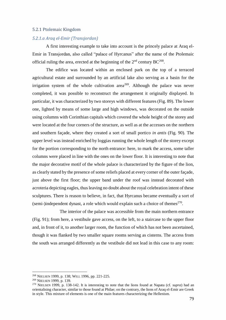
79
5.2.1 Ptolemaic Kingdom
5.2.1.a Araq el-Emir (Transjordan)
A first interesting example to take into account is the princely palace at Araq el-
Emir in Transjordan, also called “palace of Hyrcanus” after the name of the Ptolemaic
official ruling the area, erected at the beginning of the 2nd century BC268.
The edifice was located within an enclosed park on the top of a terraced
agricultural estate and surrounded by an artificial lake also serving as a basin for the
irrigation system of the whole cultivation area269. Although the palace was never
completed, it was possible to reconstruct the arrangement it originally displayed. In
particular, it was characterized by two storeys with different features (Fig. 89). The lower
one, lighted by means of some large and high windows, was decorated on the outside
using columns with Corinthian capitals which covered the whole height of the storey and
were located at the four corners of the structure, as well as at the accesses on the northern
and southern façade, where they created a sort of small portico in antis (Fig. 90). The
upper level was instead enriched by loggias running the whole length of the storey except
for the portion corresponding to the north entrance: here, to mark the access, some taller
columns were placed in line with the ones on the lower floor. It is interesting to note that
the major decorative motif of the whole palace is characterized by the figure of the lion,
as clearly stated by the presence of some reliefs placed at every corner of the outer façade,
just above the first floor; the upper band under the roof was instead decorated with
acroteria depicting eagles, thus leaving no doubt about the royal celebration intent of these
sculptures. There is reason to believe, in fact, that Hyrcanus became eventually a sort of
(semi-)independent dynast, a role which would explain such a choice of themes270.
The interior of the palace was accessible from the main northern entrance
(Fig. 91); from here, a vestibule gave access, on the left, to a staircase to the upper floor
and, in front of it, to another larger room, the function of which has not been ascertained,
though it was flanked by two smaller square rooms serving as cisterns. The access from
the south was arranged differently as the vestibule did not lead in this case to any room:
268 NIELSEN 1999, p. 138; WILL 1996, pp. 221-225. 269 NIELSEN 1999, p. 139. 270 NIELSEN 1999, p. 138-142. It is interesting to note that the lions found at Napata (cf. supra) had an
orientalising character, similar to those found at Philae; on the contrary, the lions of Araq el-Emir are Greek
in style. This mixture of elements is one of the main features characterizing the Hellenism.
80
this layout was perhaps only an architectural arrangement built to give a symmetrical
layout to the façades of the building271.
The use of coarse materials for the construction of the lower floor272 indicates that
this level of the palace was not the official one, but was rather dedicated to service
purposes: in fact, excluding the vestibules with their adjoining rooms, it consisted only of
four rooms encircled by a U-shaped corridor arranged to give access to them (Fig. 92)273.
On the first floor, which was by exclusion the one related to official activities and
domestic use, the plan of the ground floor was probably repeated with some
modifications. In particular, it is likely that the four rooms of the lower level were here
replaced by a single large chamber reserved for audiences or banquets274.
The arrangement of the entrance, composed of a wide but short portico flanked
by two smaller rooms, could easily remind the model of the so-called Bit-Hilani, a term
used to indicate a kind of palace widespread in northern Syria between the 9th and the 7th
cent. BC275. This type of building was characterized by the presence of two long narrow
rooms parallel to the façade and consisting of a portico leading to an inner main room; a
series of smaller chambers, mostly arranged in a row, could be present in the rear of the
edifice (Fig. 93). As in the case of the palace of Hyrcanus, moreover, the Bit-Hilani
usually had stairs to reach the first floor located in a room flanking the portico276. Once
again, this represents an example of a commixture of elements coming from different
cultural area and merged together to create new patterns.
Another comparison can be made between the arrangement of the loggia of the
palace of Araq el-Emir and that of the Macedonian ones, where the upper floor usually
had plinth-zones with smaller columns277.
To sum up, the palace appears to be conceived as a synthesis of different
influences. In fact, if the plan and the building method are reminiscent of ancient local
layouts, the architectural elements and the style of the sculptured animals are Greek278.
To be more specific, it is very likely that the model for this palace came directly from the
271 In fact, also here two smaller rooms were located at the sides of the vestibule, one of these contained the
staircase to the upper level, thus reflecting the same pattern of the northern access. 272 The first floor was built using regularly cut and decorated stone blocks while the lower floor was built
using rough-hewn blocks, cf. WILL 1996, p. 223. 273 NIELSEN 1999, p. 143. 274 Ibid.; WILL 1996, p. 223. 275 FRANKFORT 1952, p. 120. 276 FRANKFORT 1952, pp. 120-121. 277 NIELSEN 1999, pp. 143-144. 278 NIELSEN 1999, p. 142.

81
now-lost palace of Alexandria, namely the closest – both geographically and culturally –
Hellenistic capital. Considering the official role held by Hyrcanus, it would not be
surprising to imagine that, during one of his trips to the Royal Court, he saw in the palace
of Alexandria a valid architectural model for his own.
The choice of discussing this peculiar example of Hellenistic palatial architecture
is thus justified by a series of architectural – and maybe also ideological – affinities with
palace B1500.
In both buildings, indeed, we witness a syncretistic architectural phenomenon
aimed at the creation of a model capable of combining local and foreign traditions. The
palace of Araq el-Emir is even more interesting in this respect because, besides
representing one of the first prototypes of architectural adaptation during Hellenistic
times, it also clearly reminds of a peristyle structure. In fact, despite not having an actual
internal court arranged with peripteral columns, it can be said that the whole palace, with
its columniation completely encircling the first floor, is conceived following a peristyle
model.
5.2.1.b Ptolemais
A real peristyle court is instead found in the so-called “Palazzo delle Colonne” at
Ptolemais, in Cyrenaica. Built in the 1st cent. BC, it was probably the residence of a local
governor ruling the area on behalf of the Ptolemies279. The original core of the palace thus
has to be attributed to the official in charge of the city at the beginning of the century,
even if the structure underwent some modifications in later times280.
The palace, rectangular in plan, measured about 87 × 35 m and was characterized
by the presence of two peristyles: the “Great Peristyle” measuring 17.30 × 19.50 m in the
southern wing, and a smaller one (called “Small Peristyle” to distinguish it from the
former281), located on the northern sector of the building (Figs. 94-95). The former, which
at the moment of the excavation still preserved 18 columns built in local sandstone all
pertaining to the Ionic order, has been reconstructed as follows: two pillars with semi-
columns were located at the NE and NW corners and at the SE and SW corners282; eight
279 NIELSEN 1999, p. 146. 280 Ibid; for further detailed considerations about the chronology of the palace, cf. GASPARINI 2014, pp.
1069-1070. 281 PESCE 1950, p. 60. 282 These latter were nonetheless of a different kind than the former.
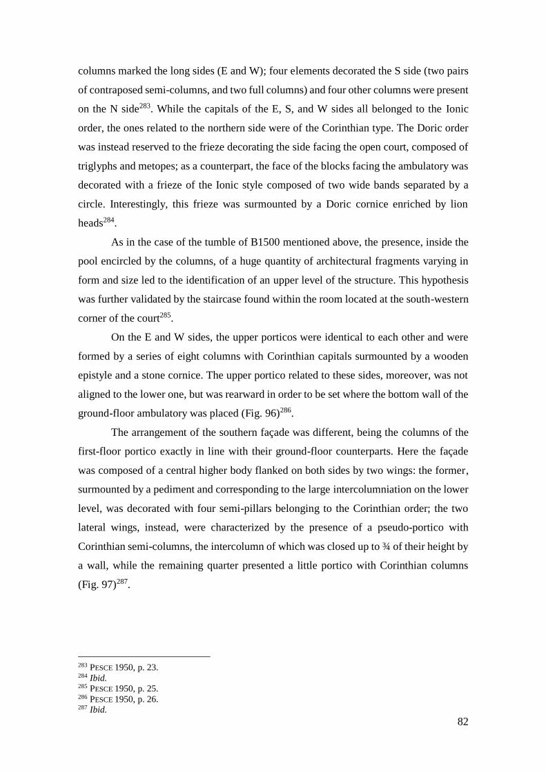
82
columns marked the long sides (E and W); four elements decorated the S side (two pairs
of contraposed semi-columns, and two full columns) and four other columns were present
on the N side283. While the capitals of the E, S, and W sides all belonged to the Ionic
order, the ones related to the northern side were of the Corinthian type. The Doric order
was instead reserved to the frieze decorating the side facing the open court, composed of
triglyphs and metopes; as a counterpart, the face of the blocks facing the ambulatory was
decorated with a frieze of the Ionic style composed of two wide bands separated by a
circle. Interestingly, this frieze was surmounted by a Doric cornice enriched by lion
heads284.
As in the case of the tumble of B1500 mentioned above, the presence, inside the
pool encircled by the columns, of a huge quantity of architectural fragments varying in
form and size led to the identification of an upper level of the structure. This hypothesis
was further validated by the staircase found within the room located at the south-western
corner of the court285.
On the E and W sides, the upper porticos were identical to each other and were
formed by a series of eight columns with Corinthian capitals surmounted by a wooden
epistyle and a stone cornice. The upper portico related to these sides, moreover, was not
aligned to the lower one, but was rearward in order to be set where the bottom wall of the
ground-floor ambulatory was placed (Fig. 96)286.
The arrangement of the southern façade was different, being the columns of the
first-floor portico exactly in line with their ground-floor counterparts. Here the façade
was composed of a central higher body flanked on both sides by two wings: the former,
surmounted by a pediment and corresponding to the large intercolumniation on the lower
level, was decorated with four semi-pillars belonging to the Corinthian order; the two
lateral wings, instead, were characterized by the presence of a pseudo-portico with
Corinthian semi-columns, the intercolumn of which was closed up to ¾ of their height by
a wall, while the remaining quarter presented a little portico with Corinthian columns
(Fig. 97)287.
283 PESCE 1950, p. 23. 284 Ibid. 285 PESCE 1950, p. 25. 286 PESCE 1950, p. 26. 287 Ibid.

83
Finally, the northern side of the upper level of the peristyle displayed once again
a different arrangement: here not a porch but a series of three aedicules each decorated
with four semi-pillars were topped with a trabeation and a fronton (Fig. 96)288.
The smaller peristyle, located in the north-western area of the palace, was also
rectangular in plan and measured 8.25 × 6.60 m. It was composed of fourteen columns:
five on the longer sides (E-O) and four on the shorter ones (S-N), counting also the
elements composing the corners. The order of the columns was Doric, but the trabeation
was Ionic in style (Fig. 98).
While the rooms adjacent to the Great Peristyle were probably dedicated to
official and residential functions, the ones surrounding the southern court were intended
for administration and service purposes related to the management of the palace289. The
main open court of the north side is very likely where audiences, trials, councils, and
banquets took place, considering the monumental arrangement of the room and its
dimensions.
288 Ibid. 289 NIELSEN 1999, p. 146.
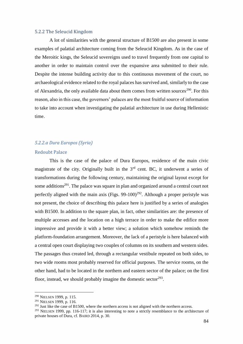
84
5.2.2 The Seleucid Kingdom
A lot of similarities with the general structure of B1500 are also present in some
examples of palatial architecture coming from the Seleucid Kingdom. As in the case of
the Meroitic kings, the Seleucid sovereigns used to travel frequently from one capital to
another in order to maintain control over the expansive area submitted to their rule.
Despite the intense building activity due to this continuous movement of the court, no
archaeological evidence related to the royal palaces has survived and, similarly to the case
of Alexandria, the only available data about them comes from written sources290. For this
reason, also in this case, the governors’ palaces are the most fruitful source of information
to take into account when investigating the palatial architecture in use during Hellenistic
time.
5.2.2.a Dura Europos (Syria)
Redoubt Palace
This is the case of the palace of Dura Europos, residence of the main civic
magistrate of the city. Originally built in the 3rd cent. BC, it underwent a series of
transformations during the following century, maintaining the original layout except for
some additions291. The palace was square in plan and organized around a central court not
perfectly aligned with the main axis (Figs. 99-100)292. Although a proper peristyle was
not present, the choice of describing this palace here is justified by a series of analogies
with B1500. In addition to the square plan, in fact, other similarities are: the presence of
multiple accesses and the location on a high terrace in order to make the edifice more
impressive and provide it with a better view; a solution which somehow reminds the
platform-foundation arrangement. Moreover, the lack of a peristyle is here balanced with
a central open court displaying two couples of columns on its southern and western sides.
The passages thus created led, through a rectangular vestibule repeated on both sides, to
two wide rooms most probably reserved for official purposes. The service rooms, on the
other hand, had to be located in the northern and eastern sector of the palace; on the first
floor, instead, we should probably imagine the domestic sector293.
290 NIELSEN 1999, p. 115. 291 NIELSEN 1999, p. 116. 292 Just like the case of B1500, where the northern access is not aligned with the northern access. 293 NIELSEN 1999, pp. 116-117; it is also interesting to note a strictly resemblance to the architecture of
private houses of Dura, cf. BAIRD 2014, p. 30.

85
Citadel Palace
Remaining at Dura Europos, another governor’s palace is worth mentioning
because of its mixture of Oriental and Hellenistic characteristics. Interpreted as the
dwelling place of the governor of Dura, the so-called “Citadel Palace” was built over the
remains of an older building of which almost no evidence has survived; on the contrary,
the second phase of the edifice dating to the 2nd cent. BC was preserved enough to
reconstruct its original plan294.
From an architectural point of view, it appears divided into two parts reflecting
two different styles: “Oriental” in the north wing and “Greek” in the southern one (Fig.
101). While the former is represented by the same functional distribution of the rooms
already seen in the previous example (an official sector limited to broad rooms on the
south and west wing; service rooms on the east side), the latter is clearly emphasised by
the peristyle marking the central area of the palace295. Probably reached by the northern
entrance of the palace296, this main court led towards a large southern room provided with
five columns (or pillars) – excluding the three columns in antis opening onto the court –
which probably served as a hall for audiences: a scheme which would clearly remind the
arrangement of the Redoubt Palace, with the main court replaced here by the peristyle297.
294 NIELSEN 1999, p. 119. 295 Unfortunately, the available data only permitted to reconstructed a partial plan of the edifice, so that we
do not know the original arrangement and extension of the structure. 296 NIELSEN 1999, p. 120. 297 NIELSEN 1999, pp. 119-120.
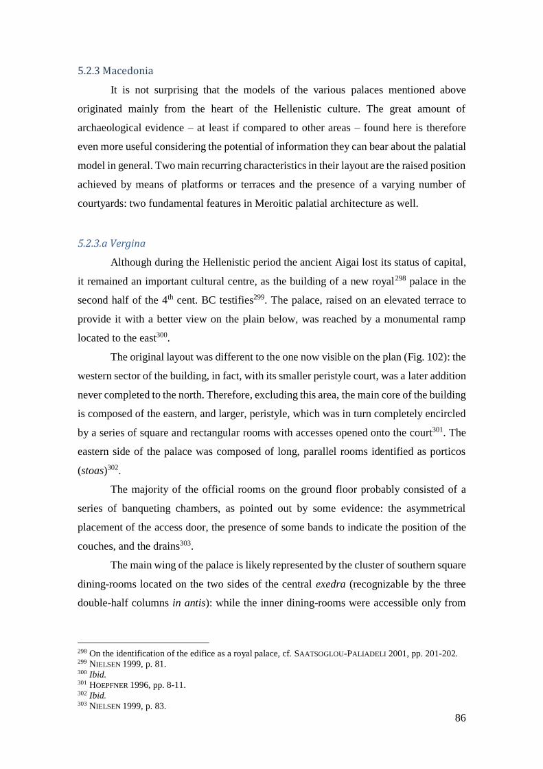
86
5.2.3 Macedonia
It is not surprising that the models of the various palaces mentioned above
originated mainly from the heart of the Hellenistic culture. The great amount of
archaeological evidence – at least if compared to other areas – found here is therefore
even more useful considering the potential of information they can bear about the palatial
model in general. Two main recurring characteristics in their layout are the raised position
achieved by means of platforms or terraces and the presence of a varying number of
courtyards: two fundamental features in Meroitic palatial architecture as well.
5.2.3.a Vergina
Although during the Hellenistic period the ancient Aigai lost its status of capital,
it remained an important cultural centre, as the building of a new royal298 palace in the
second half of the 4th cent. BC testifies299. The palace, raised on an elevated terrace to
provide it with a better view on the plain below, was reached by a monumental ramp
located to the east300.
The original layout was different to the one now visible on the plan (Fig. 102): the
western sector of the building, in fact, with its smaller peristyle court, was a later addition
never completed to the north. Therefore, excluding this area, the main core of the building
is composed of the eastern, and larger, peristyle, which was in turn completely encircled
by a series of square and rectangular rooms with accesses opened onto the court301. The
eastern side of the palace was composed of long, parallel rooms identified as porticos
(stoas)302.
The majority of the official rooms on the ground floor probably consisted of a
series of banqueting chambers, as pointed out by some evidence: the asymmetrical
placement of the access door, the presence of some bands to indicate the position of the
couches, and the drains303.
The main wing of the palace is likely represented by the cluster of southern square
dining-rooms located on the two sides of the central exedra (recognizable by the three
double-half columns in antis): while the inner dining-rooms were accessible only from
298 On the identification of the edifice as a royal palace, cf. SAATSOGLOU-PALIADELI 2001, pp. 201-202. 299 NIELSEN 1999, p. 81. 300 Ibid. 301 HOEPFNER 1996, pp. 8-11. 302 Ibid. 303 NIELSEN 1999, p. 83.

87
the latter, having no doorways on their court-faced sides, the two external rooms could
be entered only from the peristyle.
The west sector of the palace was characterized by three large square rooms the
thresholds of which were not recognisable unlike their function, clearly indicated by the
bands for couches mentioned above. In the east wing, we find a tholos – which has given
rise to a series of different hypothesis concerning its purpose304 – and two banqueting
halls facing the open court. The conspicuous presence of this type of room all over the
palace has been explained hypothesizing that chambers of different sizes and arrangement
were reserved to different kind of guests on the basis of their social status.305
Finally, as regards the north side, the bad state of preservation does not permit to
hypothesize its use: whether a residential purpose could be a solution, no evidence
remains to ascertain such a function, which could also be reserved to the second storey of
the palace306, as attested in other mentioned examples.
5.2.3.b Pella
The royal palace of Pella was located on the acropolis of the capital and the whole
complex covered an impressive total surface of about 60.000 m2. While the original
layout of the edifice dates back to the second half of the 4th cent. BC, it was later modified
and enlarged in the following centuries307.
The proper palatial building corresponded to the eastern part of this complex and
comprehended four open courtyards provided with peristyles (Fig. 104). Among these,
the southern ones (called peristyle I and II) represented the official part of the structure,
while the northern sector of the edifice (with peristyles IV and V) was reserved for
residential purposes. This eastern sector was completed to the west with another very
large peristyle (III), flanked by a series of small rooms probably intended for
administration308.
Peristyle I had a lower and an upper storey, composed of columns respectively of
the Doric and Ionic order, the latter with reduced dimensions. The axiality displayed in
the disposition of the three rooms fronting the northern portico – which on this side is
304 NIELSEN 1999, p. 83 305 Ibid. 306 Ibid. 307 NIELSEN 1999, p. 88. 308 NIELSEN 1999, p. 89.
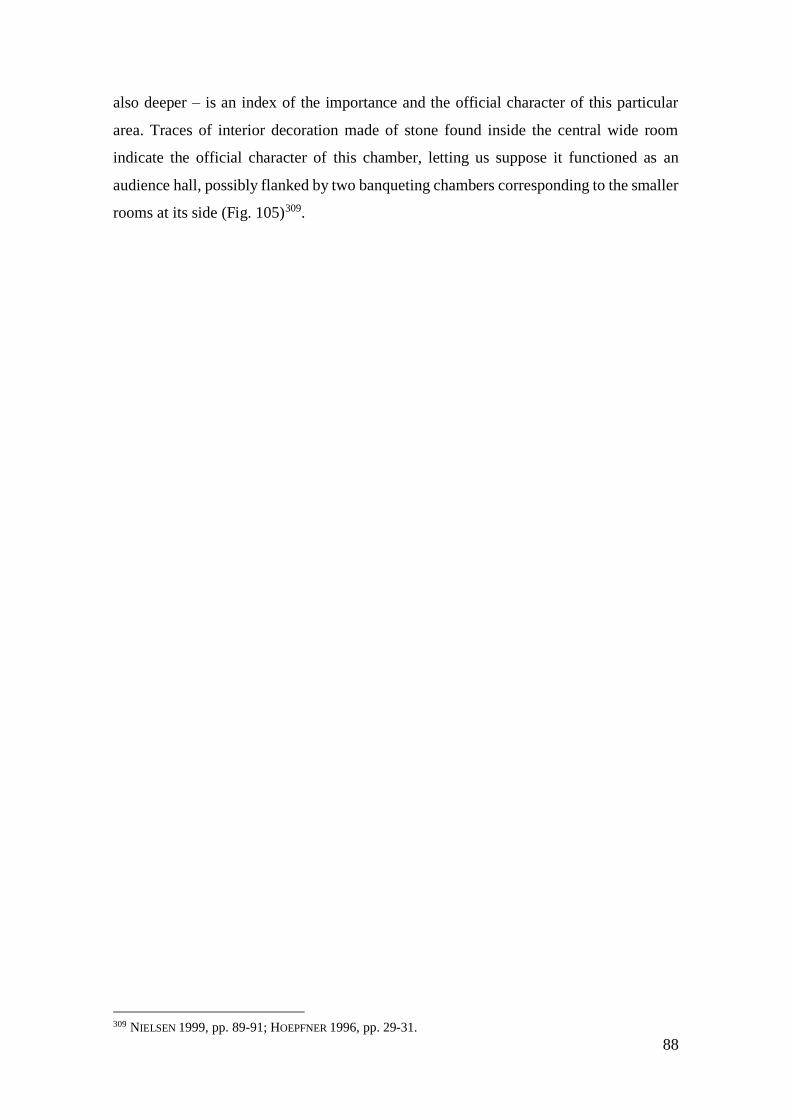
88
also deeper – is an index of the importance and the official character of this particular
area. Traces of interior decoration made of stone found inside the central wide room
indicate the official character of this chamber, letting us suppose it functioned as an
audience hall, possibly flanked by two banqueting chambers corresponding to the smaller
rooms at its side (Fig. 105)309.
309 NIELSEN 1999, pp. 89-91; HOEPFNER 1996, pp. 29-31.

89
5.2.4 Pergamon
Reminiscent of the layout of Citadel Palace at Dura Europos are two royal palaces
built at Pergamon following a peristyle model and dating to the first half of the 2nd cent.
BC310.
Called Palace IV and Palace V (Figs. 106-107), they both were located atop the
acropolis, together with some of the most important public and religious buildings of the
town. Placed one beside the other, different data prove them to belong to the same
building phase, thus excluding a relation of anteriority or posteriority between them. If
this was the case, it would imply a differentiation in the use of these buildings, with the
smaller likely used for residential purposes and the larger for official ones311.
Palace IV was organized around a central paved courtyard provided with a
peristyle the presence of which was recognizable only because of some sockets cut in the
floor, so there is no possibility to reconstruct the aspect of the columns. Despite the bad
state of preservation of the buildings in general, the remaining traces of thresholds
indicated that most of the rooms encircling the peristyle were facing it and no connections
between them was present312.
Considering the size of the rooms and the portico situated on the northern area, it
is reasonable to imagine this as the main wing of the palace. The easternmost of these
rooms presented a fine mosaic floor provided with a band in coarse white tesserae, an
asymmetrical location of the door and a general fine decoration, which made it the most
suitable location for a dining-room.
The largest room on the north wing had possibly the same function, given the
presence of other fine mosaic floors and a drain channel. Finally, the remaining rooms
were probably used for living, as was the case for the second storey of the edifice,
assuming its existence313.
Palace V was also characterized by a peristyle court surrounded by a series of
square rooms of varying size. Unlike Palace IV, which was about half its size, in this case,
it was possible to identify the columns of the peristyle as belonging to the Doric order314.
310 NIELSEN 1999, p. 103. 311 NIELSEN 1999, pp. 104-105. 312 NIELSEN 1999, p. 105. 313 Ibid. 314 Ibid.

90
Once again, the north wing of the palace had to be the main one, given the
presence of a large room opening onto the court characterized by a rich decoration. Its
walls bore, in fact, a series of polychrome marble elements and its floor had to display a
mosaic similar to the one found in the adjacent room. Here, in fact, the mosaic floor was
better preserved and showed a diverse selection of motifs encircled by a broad white
border pointing out its use as a dinner-room315.
The same kinds of floor and wall decorations were repeated also within at least
one of the rooms of the north wing, while the bad state of preservation of the south area
of the palace lets us only suppose their function as banqueting-halls. Considering the lack
of any floor covering the surface of the peristyle, a garden has perhaps to be imagined
here, thus providing the dining-rooms with a view316.
The presence of another storey is very likely, as suggested by some comparisons
made with local private houses situated in the Lower Agora. Furthermore, these were
structured around a central peristyle in two storeys in the Doric (lower level) and Ionic
order (upper level)317.
5.2.5The models
Another key thing to remember is that royal palaces, wherever they were located
and whenever they were built, inevitably reflected the society which produced them.
Therefore, the study of the architectural features characterizing such buildings, far from
being just a mere display of technical data, is an opportunity to shed some light on the
culture itself revolving around this institution.
As far as Hellenistic palaces are concerned, it is important to highlight that they
were the result of two main different political conceptions about royalty and management
of power. In fact, while Macedonia was characterized by a governmental system based
on the concept of primus inter pares, with a local dynasty ruling over an area from which
they originated, other kingdoms such as the Ptolemaic, the Seleucid, and the Attalid one
were all connected to a personal and absolutistic view of power318. In this second case,
some characters such as a marked monumentality, a higher position and the presence of
315 NIELSEN 1999, pp. 106, cf. also p. 108. 316 NIELSEN 1999, p. 107. 317 Ibid. 318 NIELSEN 1996, p. 209.

91
monumental access seem to be significantly present in the architectural layout of the royal
palaces319.
This scheme clearly reminds the arrangement of Persian palaces, which probably
had to be identified – at least to some extent - as the actual precursors of the Hellenistic
palaces. While the buildings organized around a peristyle court have rightly been ascribed
to a Greek, if not Macedonian, architectural model, it has to be noted that the core of the
Oriental palaces also consisted of courtyards already in the 5th century BC320.
For sure the appearance of the royal Achaemenid palaces was known to Alexander
and his successors, and their impact on the palatial architectural development of the
Hellenistic times had to bear a significant role in the elaboration of their formal layout321.
319 Ibid. 320 NIELSEN 1996, p. 211. 321 NIELSEN 1999, pp. 35-36.
92
5.3 Hellenistic influences in Meroitic and Egyptian architecture
Returning now to the Meroitic kingdom with a picture of the Hellenistic palatial
architecture in mind, we can try to trace a path capable of connecting this model to those
displayed in the Nubian region.
As stated by Török, the peristyle house type is not part of the domestic or palatial
architectural tradition of either Nubia or Egypt, but it rather shows diverse affinities with
Hellenistic urban house type as found in Priene or Dura322.
In this respect, the comparison between the Hellenistic house 33 at Priene (Asia
Minor) and the house M998323 in Meroe is one of the most compelling (Fig. 107): looking
at the plans of these two structures, the major point of contact is represented by the
presence of an entrance corridor leading to the south-eastern corner of a central court324.
This same pattern can also be observed in palace B1500 and palace OBN 100 at
Wad Ben Naga, where, indeed, the main entrance leads towards the central open area of
the building325.
The application of such a foreign model was likely the result of a mediated contact
with Hellenistic palaces, villas and domestic architecture in general as known from the
Hellenistic Egyptian cities, primarily Alexandria326.
The villa (or palace) of Diotimos in Philadelphia (Fayyum, Kom el-Kharaba el-
Kebir), although known only from a written source327, represents a rather faithful
transposition of the Vitruvius’s description of the Greek house328. In particular, after an
entrance portico, a vestibule led into two interior courts each opening onto a banqueting
room; finally, an exedra was also present329.
Nevertheless, although the search for Hellenistic models is widely justified, such
a trend tends to limit the evaluation of those examples where a foreign model was adapted
to an Egyptian one.
Remaining in Philadelphia, the arrangement of a private structure – considered as
the archetype of the local private house330 – found within the insula D 6 is explicative of
322 TÖRÖK 2011, pp. 132-133. 323 Cf. TÖRÖK 1997B, p. 229. 324 TÖRÖK 2011, p. 133. 325 MAILLOT 2016B, p. 107. 326 TÖRÖK 2011, p. 133; concerning the Classical-style buildings or models in domestic building
architecture of the Fayyum see DAVOLI 2011, p. 82. 327 Cf. VANDERBORGHT 1942. 328 TÖRÖK 2011, p. 133; cf. PESANDO 1989, pp. 193-206. Vitr., De Architectura, 6.7. 329 TÖRÖK 2011, p. 133. 330 MAILLOT 2016B, p. 105.

93
this kind of architectural merging. In particular, we find here the presence of casemates
in relation with a typical Greek layout of the living quarters (Fig. 108)331.
The reception of the Hellenistic housing model332 has also been traced in other
two sites located in the Fayyum: Theadelphia (Kharabet Ihrit) and Narmouthis (Kom
Medinet Madi). At Theadelphia (Fig. 109), one of the excavated edifices – probably
belonging to an important official of the city – was organized around a central rectangular
open court connecting it to the other rooms composing the building. Among these, the
most important was probably the south-eastern chamber (6 × 5 m), as confirmed by the
decoration of the walls333. A staircase located in the north-western corner of the edifice
led to the lower floor of the structure, thus repeating that scheme based on the
juxtaposition of cellars and living quarters which proved to be very common among the
domestic architecture of the Fayyum (cf. supra).
At Narmouthis (Fig. 110), a big structure (13 × 22.50 m) divided into 16 rooms,
3 staircases, and 6 cellars also rose on a plan with clear Hellenistic influences334. The
main access was probably located on the northern side, where a corridor divided the house
into two parts: on the inside of this vestibule, two columns on the left marked the access
to the eastern part, while two pillars on the right led to the western half of the edifice. The
latter gave access to a large room (5.20 × 5.75 m) which probably had an official character
given the presence of numerous niches on every side of the chamber. The importance of
the building seems also confirmed by the richness of the architectural elements decorated
in Hellenistic style. Once again, the house was provided with a series of vaulted cellars
located under the main body and reachable by means of trapdoors situated on the upper
floor 335.
The chronology of these structures is rather similar having been both dated
between the 1st cent. AD and the 4th cent. AD: in particular, a period of occupation going
331 MAILLOT 2016B, p. 107. In general, the description of the lower floors of the houses at Philadelphia is
interesting as it strictly reminds the arrangement of the structures set on casemates: “Queste, [the rooms
pertaining to the lower floor of the structures] che furono interpretate come cantine o magazzini, mancavano
quasi sempre di porte e di finestre che davano direttamente all'esterno ed erano raggiungibili dall'interno
della casa per mezzo di scale; i loro soffitti erano costruiti in forma di volta a botte o con travi di legno di
palma con o senza l'ausilio di incannicciati. Le cantine avevano muri divisori di grande spessore e spesso
le stanze erano piccolissime, simili a corridoi”: DAVOLI 1998, p. 140. 332 In particular, the transposition of the prostas-oikos model of the Hellenistic house: MAILLOT 2016B, p.
107. 333 DAVOLI 1998, p. 282. 334 DAVOLI 1998, p. 232. 335 DAVOLI 1998, pp. 232-233.

94
from the 2nd cent. to the 4th cent. for the building at Theadelphia336, and going from the
1st to the 4th for that of Narmouthis337.
To the same time period belong also some houses at Marina el-Alamein displaying
peristyle courts built in stone which, considering the proximity to Alexandria (c.100 km
to the east), could also be a reflection of this latter urban architecture338.
As Maillot has clearly pointed out339, the Meroitic buildings having a peristyle
court, or a central court in general, all follow the same pattern with the non-official rooms
developing around this central core which results, in turn, mainly accessible from south
by means of a narrow corridor. Considerably, the structures which follows this model
tend almost systematically to be connected to a foundation system based on casemates.
This is particularly true for palaces, where the percentage of those having a court exceeds
the 50% – this rate increases to 82% if counting also those cases where the presence of a
central court is only probable and not archaeologically proven340. These data are even
more compelling if considering, as seen in the previous chapter, that this is exactly the
percentage of palaces having a casemates foundation.
336 DAVOLI 1998, p. 282. 337 DAVOLI 1998, p. 233. 338 MAILLOT 2016B, p. 108; TÖRÖK 2011, p. 133. 339 MAILLOT 2016B, p. 110. 340 Ibid.
95
6. The Meroitic synthesis: creating a new model
The peristyle was not the only element of Hellenistic derivation characterizing the
palace. As already mentioned, the external façade of the building was marked by a
mixture of features coming from different architectural traditions. For example, we find
some sandstone Corinthian capitals with a decoration made of volutes and stylized
acanthus leaves, combined with a floral motif recalling a pharaonic papyrus design341
(Fig. 71). Even though there is no evidence to establish their exact original location, they
were probably placed at the corners of the building, where they joined the uppermost part
of the façade composed of a polychrome Egyptian cavetto cornice342. The result was
consequently an original style which merged together two different traditions according
to a new pattern.
A clear Hellenizing influence is also found in the motifs recurring on the
decorative tiles applied on the exterior perimeter wall. Among them, those bearing an
anthropomorphic subject often display the image of a woman’s bust in a frontal position,
with the face slightly tilted towards the shoulder and the eyes looking up. The hair is
represented in a schematic way while the dress consists of a chiton with wide folds. In
some examples, the figures hold grapes or floral garlands343. The only available
comparisons in a Meroitic context have been found in the water sanctuary complex at
Meroe (M95-M194-M195)344; here Török supposed them to represent the Maenads from
the thiasos of Dionysos, an interpretation which would fit well in a palatial context,
considering the connection of this deity to the concept of kingship during the Hellenistic
period345.
The international nature of the Hellenistic culture emerges distinctly especially in
border areas, where the juxtaposition of complementary elements enhances their
differences. For instance, the island of Philae (cf. supra) – crucial interface between the
kingdom of Meroe and Hellenistic and Roman Egypt – is an emblematic example of
merging of Egyptian style with Hellenistic conception of space346. Significantly, this is
the same model applied to the palace of Natakamani.
341 SIST 2006, p. 475. 342 Ibid. 343 SIST 2006, pp. 476-477. 344 Cf. TÖRÖK 1997B, pp. 63-91. 345 SIST 2006, p. 477. 346 CIAMPINI 2011, pp. 187-188; cf. GIAMMARUSTI; ROCCATI 1980.
96
At Napata, decidedly, the new architectural elaborations were the product of one
of the most prosperous periods of Meroitic history. In fact, the intense building activity
undertaken by king Natakamani and his co-regent Amanitore is testified by the great
amount of monuments they built or restored during their regency all over the reign
(Napata, Meroe, Naga, Amara, Wad Ben Naga)347.
Although the impressive prosperity that emerged during the rule of Natakamani
had to inevitably be the result of fruitful social, cultural, and economic developments, the
data related to this phenomenon are rather limited and deduced mostly on the basis of the
apparently increasing (both in quality and quantity) trade with Egypt348. Such a
flourishing was probably the consequence of the stable political condition achieved after
the peace treaty of Samos, stipulated a few decades earlier (21 or 20 BC)349, and now
reaching its apex.
At Napata, in particular, we assist to a re-arrangement of the urban settlement
which is mainly reflected in the apparent relocation of the town monumental core. As we
already saw in the first part of this work, indeed, for centuries the focal point of the city
had been situated in the immediate surroundings of the Amun temple B500, at the foot of
the mountain. This is also confirmed by the location of the oldest palaces of the site,
namely B1200 and B100, whose connection to the cultic area was moreover highlighted
by their orthogonal position in relation to the temples.
In particular, palace B100 is an interesting expression of that transitional phase
leading to the development of a new palatial architectural model which will finally
converge in the Wad Ben Naga, Muweis, and B1500 palaces350. A square plan, accesses
on every side of the edifice (although not all symmetrical), a structural arrangement based
on casemates (with some chambers likely functioning as storerooms), the presence of a
second storey, and columned halls located on the main axis of the building are all common
features among the above mentioned Meroitic palaces.
This new architectural arrangement, diverging from the previous example
displayed in B1200, appears to revolve around a central monumentalized hall – replaced
by the peristyle in the ultimate model – which therefore had to be conceived as the first
element of the building. The same conclusion is also suggested by the layout of palace
347 FHN III, n. 211, p. 899. 348 FHN III, n. 211, pp. 899-900. 349 FHN III, n. 211, p. 900. 350 MAILLOT 2016B, p. 120.
97
B1500, where the central peristyle was doubtlessly intended as the fulcrum of the whole
architectural composition, as proved by its alignment with the southern, and older, access.
Moreover, this kind of structuring developing from a central core by means of a
subsequent addition of units is reminiscent of the Hellenistic architectural layout used in
palatial and domestic buildings. A court – often provided with a peristyle – connecting
the other rooms around it was indeed one of the basic elements of these structures (cf.
supra).
The fullest expression of this model has to be found in our palace: the construction
of B1500 is, indeed, the consequence of a careful and precise planning reflected in the
organization of the foundation platform and the arrangement of its monumental area.
Significantly, the undeniable Hellenistic legacy shown by the peristyle is here
adapted to local forms (papyrus-shaped capitals, cavetto cornice) and techniques
(stoneworking peculiarities of the upper storey).
Considering the chronology of the palace, we must not forget, however, also the
potential Roman influences with which the Meroitic kings could have come in contact.
In Roman architecture, indeed, the function of the peristyle was often connected to the
celebration of prestige and social status more than it was in Hellenistic times351. This
interpretation would be suitable for a palace like B1500, one of the primary function of
which was probably connected to the enhancement of the royal status of the king.
In this respect, it is worth lingering over some observations on the concept of
“ambulatory kingship” mentioned in the historical introduction. As we saw, in fact, the
process of legitimation of the new king after the death of his predecessor implied a sort
of coronation journey of the sovereign taking place in the most important cities under his
jurisdiction. The ceremonies connected with the celebration of kingship were performed
both in the palace and in the temples352, passing through a series of minor buildings
characterized by a ceremonial function, corresponding for example to B3200 and B100
at Napata and M 251-253 at Meroe353.
The presence of numerous palaces all over the kingdom has been interpreted as a
confirmation of this kind of ritual journey: the palatial buildings would correspond in this
scenario to the temporary residence of the king during his visit.
351 MAILLOT 2016B, p. 256; for the circulation of iconographic models pertaining to the Roman Imperial
sphere see CIAMPINI 2011, p. 189. 352 Cf. CIAMPINI 2011, p. 183. 353 Cf. MAILLOT 2016 B, pp. 72-73.
98
Nevertheless, while this scheme applies well to the major cities like Napata and
Meroe – located miles apart – in the Butana region the presence of several palaces situated
only a few kilometres away from each other (Wad Ben Naga, Muweis) force us to
reconsider their function in this “ambulatory” context354. In particular, it is more likely
that these palaces were destined to local officials or governors appointed by the king and
ruling on his behalf, and were not actual stages of his ritual journey355. This assumption
appears to be confirmed also by the poorer quality of the masonry characterizing these
buildings, together with the replacement of the central peristyle with a simpler open court.
Nevertheless, the architectural similarities between these palaces and the proper royal
ones – which therefore would correspond, from this perspective, just to the palaces of
Meroe and Napata, where the actual coronation journey took place – could be explained
by the local governors’ will, or demand, to emulate the royal model par excellence
represented by B1500356.
The importance of the building described in this dissertation goes beyond its
impressive dimensions and its monumental nature. The palace of Natakamani is the
reflection of the Meroitic culture itself as it appeared during one of the most flourishing
periods in its history. The archaeological sources tell us about a season of political,
economic, and most of all cultural enrichment provoked, among other things, by the
intensification of commerce directed and coming from Greco-Roman Egypt. In this
general atmosphere of openness, the foreign influences were received and revised into
new, original syncretistic models capable of combining different features and transmitting
new messages. The external influences, far from being uncritically accepted, were
reformulated through a process of revision and discarding aimed to their adaptation to
local needs and customs.
In this respect, it is fundamental to underline that we are not dealing with a
“mélange of borrowed concepts, forms and styles or a collection of ‘quotations’ meant to
assert an identity based on pretension”357, but with an original elaboration made by a
society deeply conscious of its cultural identity.
354 MAILLOT 2016 B, pp. 290-291. 355 MAILLOT 2016 B, p. 291. 356 Ibid. 357 TÖRÖK 2011, p. 40.
99
With this in mind, the perspectives of future research are multiple. As regards the
Meroitic palatial architecture, the search for architectural models (foundation systems,
decorative patterns, inner layout, etc…) clearly remains open to new close examinations
as the excavations proceed all over the ancient Meroitic territory.
The acquisition of new data will inevitably affect our understanding of the palatial
institution in the wider urban context in which it is inserted. In this respect, an increasing
emphasis on the role of Meroitic urban archaeology would be desirable to extend the
scope of the research.
As concerns the Italian Archaeological Mission at Jebel Barkal, the recently
emerged evidence related to older structure(s) guides the investigation towards the
origins of that urban re-arrangement of the royal district ascribed to Natakamani.
Moreover, while a considerable amount of data has been gathered about palace B1500,
the adjoining area has yet to be outlined in detail.
Despite the many years of activity of the Mission at Napata, its work is still
fundamental to provide new evidence about this ancient capital describing its relationship
with the Meroitic and “international” context.
The archaeological research thus represents a favoured tool in raising stimulating
questions capable of moving the research forward.

100
List of abbreviations
FHN I = Fontes Historiae Nubiorum: Textual Sources for the History of the Middle Nile
Region between the Eighth Century BC and the Sixth Century AD. Vol.1: From the
Eighth to the Mid-Fifth Century BC. University of Bergen.
FHN II = Fontes Historiae Nubiorum: Textual Sources for the History of the Middle Nile
Region between the Eighth Century BC and the Sixth Century AD. Vol. 2: From the Mid-
Fifth to the First Century BC. University of Bergen.
FHN III = Fontes Historiae Nubiorum: Textual Sources for the History of the Middle
Nile Region between the Eighth Century BC and the Sixth Century AD. Vol. 3: From the
First to the Sixth Century AD. University of Bergen.
REPORT 2009 = The Italian Archaeological Expedition in the Sudan (University of Torino
& University of Venice “Ca’ Foscari”)
REPORT 2011 = E. M. Ciampini. The Italian Archaeological Mission in Sudan. Report for
the Season 2011. Unpublished. University Ca’ Foscari, Venice.
REPORT 2012 = E. M. Ciampini. The Italian Archaeological Mission in Sudan. Report for
the Season 2012. Unpublished. University Ca’ Foscari, Venice.
REPORT 2013 = E. M. Ciampini. The Italian Archaeological Mission in Sudan. Report for
the Season 2013. Unpublished. University Ca’ Foscari, Venice.
REPORT 2014 = E. M. Ciampini. The Italian Archaeological Mission in Sudan. Report for
the Season 2014-2015. Unpublished. University Ca’ Foscari, Venice.
REPORT 2015 = E. M. Ciampini. The Italian Archaeological Mission in Sudan. Report for
the Season 2015-2016. Unpublished. University Ca’ Foscari, Venice.
REPORT 2016 = E. M. Ciampini. The Italian Archaeological Mission in Sudan. Report for
the Season 2016-2017. Unpublished. University Ca’ Foscari, Venice.

101
Sudan & Nubia = Sudan & Nubia: Bulletin of the Sudan Archaeological Research
Society. London.
102
Bibliography
ARNOLD, D. 2003. The Encyclopaedia of Ancient Egyptian Architecture. London; New
York: I. B. Tauris.
ASSMANN, J. 1995. Egyptian solar religion in the New Kingdom: Re, Amun and the crisis
of polytheism in New Kingdom Egypt. Trad. by: Anthony Alcock. London; New York:
Kegan Paul.
BAIRD, J. A. 2014. The Inner Lives of Ancient Houses: An Archaeology of Dura-Europos.
New York: Oxford University Press.
BARBERINI, S. 2010. «Gebel Barkal (season 1998): Reconstruction of the courtyard in
B1500». In: Godlewski, W. and Lajtar, A. (eds.), Between the Cataracts, PAM
Supplement Series 2/2 = Proceedings of the 11th International Conference for Nubian
Studies (Warsaw, August 27-September 2 2006). Warsaw, pp. 169-180.
BAUD, M. 2011. «Premières données sur le palais royal de Mouweis». In: Rondot, V.;
Alpi, F.; Villeneuve, F. (eds.), La pioche et la plume: Autour du Soudan, du Liban et de
la Jordanie. Hommages archéologiques à Patrice Lenoble. Paris: PUPS, pp. 339-357.
BIETAK, M. 2005. «Neue Paläste aus der 18. Dynastie». In: Jánosi, P. (ed.), Structure and
Significance. Thoughts on Ancient Egyptian Architecture. Wien: Verlag der
Osterreichischen Akademie der Wissenschaften, pp. 131-168.
BONNET, C.; VALBELLE D. 2004. Le temple principal de la ville de Kerma et son quartier
religieux: Mission archéologique de l'université de Genève à Kerma (Soudan). Paris:
Errance.
BRANDS, G. 1996. «Halle, Propylon und Peristyl – Elemente hellenistischer
Palastfassaden in Makedonien». In: Hoepfner W.; Brands G. (eds.), Basileia: Die Paläste
der hellenistischen Könige: internationals Symposion in Berlin vom 16. 12. 1992 bis 20.
12. 1992. Mainz: von Zabern, pp. 62-72.
103
BRESCIANI, E. 1989. «La stele trilingue di Cornelio Gallo: una rilettura egittologica».
EVO, 12, pp. 93-98.
ČERNÝ, J. 1962. «Egyptian Oracles». In: Parker, R. A. (ed.), A Saite oracle papyrus from
Thebes in the Brooklyn Museum: papyrus Brooklyn 47. 218. 3. Providence: Brown
University Press, pp. 35-48.
CIAMPINI, E. M, 2011. «Riflessi imperiali in Sudan: i complessi palatini del Gebel Barkal
(Napata)». In: Nogales, T.; Rodà, I. (eds.), Roma y las provincias: Modelo y difusión.
Rome: L'Erma di Bretschneider, pp. 183-189.
CIAMPINI, E. M. 2013A. «Gli scavi italiani al Jebel Barkal (North Sudan)». In: Zanovello,
P.; Ciampini, E. M. (eds.), Egitto in Veneto. Padua: CLEUP, pp. 49-56.
CIAMPINI, E. M. 2013B. «Oracoli e regalità a Napata». Studi e materiali di storia delle
religioni (SMSR), 79, pp. 26-46.
DAVOLI, P. 1998. Archeologia urbana nel Fayyum di età ellenistica e romana. Napoli:
Procaccini.
DAVOLI, P. 2011. «Reflections on Urbanism in Graeco-Roman Egypt: A Historical and
Regional Perspective». In: Subías, E.; Azara, P; Carruesco; Fiz, I.; Cuesta, R. (eds.), The
Space of the City in Graeco-Roman Egypt: Image and Reality. Tarragona: Institut Català
d'Arqueologia Clàssica, pp. 69-92.
DE ROMANIS, F. 1999. «‘Aithiopes’ e Pigmei da Omero ad Aristotele». In: Roccati, A.
(ed.), Napata e Meroe: Templi d’oro sul Nilo = Catalogo della mostra (Turin, March 27-
June 27 1999). Milan: Electa, pp. 84-87.
DIXON, D. M. 1963. «A Meroitic Cemetery at Sennar (Makwar)». Kush, XI, pp. 227-234.
DONADONI, S. 1993. «Excavation of University of Rome at Natakamani palace (Jebel
Barkal)». Kush, XVI, pp. 101- 115.
104
EMERY, W. B. 1967. «Preliminary Report on the Excavations at North Saqqâra, 1966-7».
JEA, 53, pp. 141-145.
EMERY, W. B. 1969. «Preliminary Report on the Excavations at North Saqqâra, 1968».
JEA, 55, pp. 31-35.
FAULKNER, H. 1952. «The Origin of the Bît Hilani». Iraq, 14 (2), pp. 120-131.
GARDINER, A. H. 1905. «Hymns to Amon from a Leiden Papyrus». ZÄS, 42, pp. 11-42.
GASPARINI, E. 2014. «Il Palazzo delle Colonne di Tolemaide: Una rilettura». In: Álvarez,
J. M.; Nogales, T; Rodà, I. (eds.), CIAC = Proceedings of the XVIIIth International
Congress of Classical Archaeology, vol. 2. Merida: Museo Nacional de Arte Romano,
pp. 1069-1072.
GIAMMARUSTI, A.; ROCCATI, A. 1980. File: Storia e vita di un santuario egizio. Novara:
Istituto geografico De Agostini.
GRIMAL, N. 1981. «La stèle triomphale de Pi('ankh)y au Musée du Caire: JE 48862 et
47086-47089». MIFAO, 105.
GRIMAL, N. 2011. Storia dell’antico Egitto. 9th ed. Rome; Bari: Laterza.
HOEPFNER, W. 1996. «Zum Typus der Basileia und der königlichen Andrones». In:
Hoepfner W.; Brands G. (eds.), Basileia: Die Paläste der hellenistischen Könige:
internationals Symposion in Berlin vom 16. 12. 1992 bis 20. 12. 1992. Mainz: von Zabern,
pp. 1-43.
HOFFMANN, F.; MINAS-NERPEL, M.; PFEIFER, S. 2009. Die dreisprachige Stele des C.
Cornelius Gallus: Übersetzung und Kommentar. Berlin: Walter De Gruyter.
HOFMANN, I. 1977. «Der Feldzug des C. Petronius nach Nubien und seine Bedeutung für
die meroitische Chronologie». In: Endesfelder E. et al. 1977 (eds.), Ägypten und Kusch.
Berlin: Akademie-Verlag.

105
KEMP, B. J. 1977. «The Palace of Apries at Memphis». MDAIK, 33, pp. 101-108.
KEMP, B. J. 2006. Ancient Egypt: Anatomy of a Civilization. 2nd ed. London; New York:
Routledge.
KENDALL, T. 1997. «Excavations at Gebel Barkal, 1996. Report of the Museum of Fine
Arts, Boston, Sudan Mission». Kush, XVII, pp. 320-354.
KENDALL, T. 2007. «Excavations in the Palace of Aspelta at Jebel Barkal, March 2007».
Sudan & Nubia, 11, pp. 82-88.
KENDALL, T. 2014. «B 100: A little-known Meroitic palace at Jebel Barkal». Orientalia,
83 (11), pp. 63-75.
KENDALL, T. 2016. A Visitor's Guide to The Jebel Barkal Temples: The NCAM Jebel
Barkal Mission. http://www.jebelbarkal.org/frames/VisGuide.pdf.
KLEMM, D.; KLEMM, R.; MURR, A. 2001. «Gold of the Pharaohs – 6000 years of gold
mining in Egypt and Nubia». African Earth Sciences, 33, pp. 643–659.
LACOVARA, P. 1990. Deir el-Ballas: Preliminary Report on the Deir el-Ballas Expedition,
1980-1986. Winona Lake: Eisenbrauns.
LACOVARA, P. 1997. The New Kingdom Royal City. London; New York: Kegan Paul
International.
LECLÈRE, F. 2008. Les villes de Basse Égypte au Ier millénaire av. J.-C.: Analyse
archéologique et historique de la topographie urbaine. Cairo: Institut Français
d’Archéologie Orientale.
MAILLOT, M. 2014A. «The palace of Muweis in the Shendi reach: a case study». In:
Marchi, S. (ed.), Les maisons-tours en Égypte durant la Basse Époque, les Périodes
Ptolémaïque et Romaine = Actes de la table-ronde de Paris (Paris, 29-30 November
2012). Nehet 2, pp. 69-84.

106
MAILLOT, M. 2014B. «The Palace of Muweis in the Shendi Reach: A Comparative
Approach». In: Anderson J. R.; D. A. Welsby (eds.), The Fourth Cataract and Beyond =
Proceedings of the 12th International Conference for Nubian Studies (London, 1-6 August
2010). Leuven [etc.]: Peeters, pp. 783-795.
MAILLOT, M. 2015. «The Meroitic Palace and Royal City». Sudan & Nubia, 19, pp. 80-
87.
MAILLOT, M. 2016A. «The Palace of Muweis and the Early Meroitic Levels: The
Contribution of Technological Analysis to the Architectural Study». Dotawo: A Journal
of Nubian Studies 3 (10), pp. 179-200.
MAILLOT, M. 2016B. Palais et grandes demeures du royaume de Méroé. Paris: PUPS.
MARTIN, G. T. 1973. «Excavations in the Sacred Animal Necropolis at North Saqqâra,
1971-2: Preliminary Report». JEA, 59, pp. 5-15.
MITCHELL, E. 1996. «Redazione preliminare della carta archeologica del Jebel Barkal».
Vicino Oriente, 10, pp. 297-316.
MOYER, I. S. 2011. Egypt and the limits of Hellenism. Cambridge: Cambridge University
Press.
MUHS, B. 1994. «The Great Temenos of Naukratis». JARCE, 31, pp. 99-113.
NIELSEN, I. 1996. «Oriental models for Hellenistic Palaces?». In: Hoepfner W.; Brands
G. (eds.), Basileia: Die Paläste der hellenistischen Könige: internationals Symposion in
Berlin vom 16. 12. 1992 bis 20. 12. 1992. Mainz: von Zabern, pp. 209-212.
NIELSEN, I. 1999. Hellenistic Palaces: Tradition and Renewal. Aarhus: Aarhus University
Press.
O’CONNOR, D. 1989. «City and Palace in New Kingdom Egypt». CRIPEL, 11, pp. 73-87.

107
OREN, E. D. 1984. «Migdol: A New Fortress on the Edge of the Eastern Nile Delta».
BASOR, 256, pp. 7-44.
PECK, W.H. 1999. «Cult temples, construction techniques». In: BARD, K.A. (ed.),
Encyclopedia of the Archaeology of Ancient Egypt. London: Routledge, pp. 232-235.
PENSABENE, P. 1993. Elementi architettonici di Alessandria e di altri siti egiziani. Rome:
L'Erma di Bretschneider.
PESANDO, F. 1989. La casa dei Greci. Milan: Longanesi.
PESCE, G. 1950. Il “Palazzo delle Colonne” in Tolemaide di Cirenaica. Rome: L’Erma
di Bretschneider.
PETRIE, W. M. F., 1888. Tanis: Part II. Nebesheh (Am) and Defenneh (Tahpanhes).
London: Trübner & Co.
PETRIE, W. M. F., 1901. Diospolis Parva: the cemeteries of Abadiyeh and Hu, 1898-99.
London: Egypt Exploration Fund.
PETRIE, W. M. F., 1909. The Palace of Apries (Memphis II). London: School of
archaeology in Egypt.
PETRIE, W. M. F.,1886. Naukratis: Part I., 1884-5. London: Trübner & Co.
POPE, J. 2014. The Double Kingdom under Taharqo: Studies in the History of Kush and
Egypt. Leiden; Boston: Brill.
REDFORD, D. B. 1999. «Karnak, Akhenaten temples». In: BARD, K.A. (ed), Encyclopedia
of the Archaeology of Ancient Egypt. London: Routledge, pp. 469-473.
REISNER, G.A. 1917. «The Barkal Temples in 1916». JEA, 4 (4), pp. 213-227.
108
REISNER, G.A. 1920. «The Barkal Temples in 1916: V. The Buildings B 800 and B 900
(Continued)». JEA, 6 (4), pp. 247-261.
REISNER, G.A.; REISNER, M.B. 1933. «Inscribed monuments from Gebel Barkal, Part 2:
The Granite Stela of Thutmosis III». ZÄS, 69, pp. 24-39.
ROCCATI, A. 1997. «Excavating the Palace of Natakamani at Napata: The Entrances».
Kush, XVII, pp. 12-18.
ROCCATI, A. 1999. «Occupazione e interpretazione egizia della Nubia». In: Roccati, A.
(ed.), Napata e Meroe: Templi d’oro sul Nilo = Catalogo della mostra (Turin, 27 March
– 27 June 1999). Milan: Electa, pp. 80-84.
ROCCATI, A. 2003. «Napata, the destroyed city. A method for plundering». In: Liverani,
M. (ed.), Arid lands in Roman times: papers from the International conference (Rome,
July, 9th-10th 2001). Florence: All'insegna del Giglio, pp. 59-64.
ROCCATI, A. 2004. «Hellenism at Napata». In: Kendall, T. (ed.), Nubian Studies 1998 =
Proceedings of the Ninth Conference of the International Society of Nubian Studies
(Boston, 21-16 August 1998). Boston: Northeastern University, pp. 384-388.
ROCCATI, A. 2005. I templi di File. Roma: Aracne.
ROCCATI, A. 2008. «The Italian archaeological expedition to Jebel Barkal/Napata». In:
Between the Cataracts = Proceedings of the 11th Conference for Nubian Studies
(Warsaw, 27 August – 2 September 2006). Warsaw: PAM Supplement Series volume 2
part 1, pp. 249-261.
ROCCATI, A. 2010. «Un sincronismo approssimativo tra File e Napata». In: Atti
dell'Accademia delle Scienze di Torino, 144, pp. 161-170.
ROCCATI, A. 2011. «Orizzonti culturali di Napata». In: Lippolis, C; de Martino, S. (eds.),
Un impaziente desiderio di scorrere il mondo: Studi in onore di Antonio Invernizzi per il
suo settantesimo compleanno. Firenze: Le lettere, pp. 61-70.

109
ROCCATI, A. 2014. «B 2400: A New Page in Meroitic Architecture». In: Lohwasser, A.;
Wolf P. (eds.), Der antike Sudan. Mitteilungen der Sudanarchäologischen Gesellschaft
zu Berlin e.V. Sonderheft (Festschrift Wenig). Berlin: Sudanarchäologische Gesellschaft,
pp. 1-6.
ROCCATI, A. 2015. «Dating the Meroitic sector at Napata». In: H. Zach, M. (ed.), The
Kushite World = Proceedings of the 11th International Conference for Meroitic Studies
(Wien, 1-4 September 2008). Vienna: Citypress, pp. 389-393.
ROHR VIO, F.; CIAMPINI, E. M. (eds.) 2015. La lupa sul Nilo: Gaio Cornelio Gallo tra
Roma e l’Egitto. Venice: Edizioni Ca’ Foscari.
SAATSOGLOU-PALIADELI, C. 2001. «The Palace of Vergina-Aegae and its Surroundings».
In: Nielsen, I. (ed.), The Royal Palace Institution in the First Millennium BC: Regional
Development and Cultural Interchange between East and West. Athens: The Danish
Institute at Athens, pp. 201-213.
SIST, L. 1999. «Influssi ellenistici». In: Roccati, A. (ed.), Napata e Meroe: Templi d’oro
sul Nilo = Catalogo della mostra (Turin, 27 March – 27 June 1999). Milan: Electa, pp.
113-116.
SIST, L. 2000. «Natakamni e l’Ellenismo: alcune considerazioni sul palazzo B 1500 a
Gebel Barkal». In: Russo, S. (ed.), Atti del V Convegno Nazinale di Egittologia e
Papirologia (Florence, 10-12 December 1999). Florence: Istituto papirologico G. Vitelli,
pp. 253-257.
SIST, L. 2006. «Motivi ellenistici nell’architettura meroitica: nuove scoperte a Napata».
In: Caneva, I.; Roccati, A. (eds.), Acta Nubica = Proceedings of the X International
Conference of Nubian Studies (Rome, 9-14 September 2002). Rome: Libreria dello Stato,
Istituto Poligrafico e Zecca dello Stato, pp. 475-481.
SIST, L. 2011. «Preliminary notes on two royal buildings discovered in Napata». Vicino
& Medio Oriente, 15, pp. 159-166.
110
SMOLÁRIKOVÁ, K. 2008. Saite forts in Egypt: Political-military history of the Saite
Dynasty. Prague: Czech Institute of Egyptology.
SPENCER, A. J. 1979. Brick architecture in ancient Egypt. Warminster: Aris & Phillips.
SPENCER, A. J. 1996. Excavations at Tell el-Balamun 1991-1994. London: published for
the Trustees of the British Museum by British Museum Press.
TIRADRITTI, F. 1992. «Stele di Amanitore e Arikankharor dal “Palazzo di Natakamani” al
Gebel Barkal». Vicino Oriente, 8, pp. 69-75.
TÖRÖK, L. 1992. «Ambulatory Kingship and Settlement History: A Study on the
Contribution of Archaeology to Meroitic History». In: Bonnet, C. (ed.), Études
Nubiennes: conférence de Gèneve. Actes du VII Congrès international d'études nubiennes
= Proceedings of the 7th International Conference of Nubian Studies (Geneve, 3-8
September 1990). Pp. 111-126.
TÖRÖK, L. 1997A. The Kingdom of Kush: Handbook of the Napatan-Meroitic Civilization.
Leiden; New York; Colonia: Brill.
TÖRÖK, L. 1997B. Meroe City, an ancient African capital: John Gargstang’s excavations
in the Sudan. London: Egypt Exploration Society.
TÖRÖK, L. 2002. The Image of the Ordered World in Ancient Nubian Art: The
Construction of the Kushite Mind, 800 BC-300 AD. Leiden [etc.]: Brill.
TÖRÖK, L. 2011. Hellenizing Art in Ancient Nubia 300 BC–AD 250 and its Egyptian
Models. Leiden; Boston: Brill.
TOSI, M. 2011. Dizionario delle divinità dell’Antico Egitto: Le divinità, l’iconografia, i
rituali. Turin: Ananke.
VAN SETERS, J. 1966. The Hyksos: A new investigation. New Haven; London: Yale
University Press.
111
VANDERBORGHT, É. 1942. «La maison de Diotimos, à Philadelphie». CdÉ, 33, pp. 117-
126.
VERCOUTTER, J, 1962. «Un Palais des "Candaces", contemporain d'Auguste (Fouilles à
Wad-ban-Naga 1958-1960)». Syria, 39 (3/4), pp. 263-299.
VERCOUTTER, J. 1959. «The Gold of Kush: Two Gold-washing Stations at Faras East».
Kush, VII, pp. 120-153.
VINCENTELLI, I. 1992. «A Group of Figurated Clay Sealings from Jebel Barkal (Sudan)».
Orientalia, 61 (2), pp. 106-121.
VINCENTELLI, I. 1993. «A discharge of clay sealings from the Natakamani palace». Kush,
XVI, pp. 116-141.
VINCENTELLI, I. 1999. «L’egemonia di Napata». In: Roccati, A. (ed.), Napata e Meroe:
Templi d’oro sul Nilo = Catalogo della mostra (Turin, 27 March – 27 June 1999). Milan:
Electa, pp. 93-103.
WILKINSON, R. H. 2000. The Complete Temples of Ancient Egypt. London: Thames &
Hudson.
WILL, E. 1996. «Le château du Tobiade Hyrcan à ʼIraq Al Amir». In: Hoepfner W.;
Brands G. (eds.), Basileia: Die Paläste der hellenistischen Könige: internationals
Symposion in Berlin vom 16. 12. 1992 bis 20. 12. 1992. Mainz: von Zabern, pp. 221-225.

112
Tables

113
King Natakamani: titles (FHN III, n. 211) Label: EH = Egyptian hieroglyphs MH = Meroitic hieroglyphs CM = cursive Meroitic Fgm. = fragment
Source Object/Monument Localisation Titles
1 Barque stand Wad Ben Naga/ Temple of Isis
• Throne name (EH)
• Son of Ra name (MH)
1a Two smaller stands “ “
1b Fragment of an altar “ “
2 Pylon Jebel Barkal/ Amun temple
B500 • Throne name
(EH)
3 Stray block Jebel Barkal/ Amun temple
B500
• Son of Ra name (EH) (Fgm.)
4 Jamb and thickness,
entrance to Hypostyle
Jebel Barkal/ Amun temple B500 (B514)
• Son of Ra name (EH)
5 Naga/ Apedemak temple • Son of Ra name
(MH)
6 Naga/Temple of Amun
• Throne name (EH)
• Son of Ra name (MH)
7 Amara/Temple of Amun • Son of Ra name
(MH)
8 Sandstone block found in
secondary context in building M 281
Meroe • Son of Ra name
(EH)
9 Kiosk M 279 Meroe/ Temple of Amun • Son of Ra name
(MH)
10 Stela Unknown • Son of Ra name
(CM)
11 South + West (fgm.) walls of mortuary cult chapel
Meroe (Begarawiga)/ Beg. N. 22
• Throne name (EH)
• Son of Ra name (EH)

114
Queen Amanitore: titles (FHN III, n. 212; TIRADRITTI 1992)
Source Object/Monument Localisation Titles
1 Barque stand Wad Ben Naga/ Temple of Isis • Throne name (EH)
• Daughter of Ra name (MH + EH)
2 Blocks Jebel Barkal/ Amon temple
B500 (?) • Throne name (EH)
• Daughter of Ra (EH)
3 Pylon Naga/Apedemak temple • Daughter of Ra
name (MH)
4 Naga/Amun temple • Throne name (EH)
• Daughter of Ra (MH)
5 Amara/temple of Amun • Daughter of Ra (MH)
6 Block from M 281 Meroe • Daughter of Ra (MH)
7 Block from kiosk
M 279 Meroe/forecourt of Amun
temple M 260 • Daughter of Ra (MH)
8 Kiosk M 280 Meroe/in front of Amun temple
M 260 • Throne name (EH)
• Daughter of Ra (MH)
9 Stela Unknown • Daughter of Ra (CM)
10 Blocks from mortuary
chapel Meroe (Begarawiga)/Beg. N.1
• Title (EH)
• Daughter of Ra name (EH)
11 West wall of mortuary
chapel Meroe (Begarawiga)/ Beg. N. 1 • Daughter of Ra (MH)
12 Stela Jebel Barkal/B1500 • Daughter of Ra (CM)
• Title (CM)
115
Structures characterized by cellular construction
Edifice Site Function Date Platform
dimensions Platform
height
Shena wab of Amun Karnak Shena wab
29th dyn. (predecessor
from 26th dyn.)
45.5 x 55.5 4.5
Shena wab of Monthu-Re Karnak Shena wab
30th dyn. (?) 14 x 13 2.5
Shena wab of Khonsu Karnak Shena wab
3rd BC (original
build. 25th
dyn.)
? 2.7
Shena wab of Mut Karnak Shena wab
25th dyn. original build.
30 x 30 ?
Shena wab (?) Medamud Shena
wab (?) 3rd BC 26 x 26 ?
“Edifice en Briques Crues” Tanis Religious building
(?)
21st-22nd
dyn. ? 50 x 30
3-3.50 – 6
Temple of Isis Saqqara Temple 30th dyn. 65 x 40 4
Edifice Site Function Date Platform dimensions
Platform height
Brick module
Fortification Defenna Military
fort Saite period 45 x 45 7
Fortification Naukratis Military
fort Saite period 55 x 54.5 5
Fortification Tell el-Balamun Military
fort Saite period
54.15 x 61.10
? 41 x 21 x 12
Fortification Tell Qedwa Military
enclosure Saite period 13.5-17.5 3.2 min.
40/44 x 20 x 12/15

116
*The measurement refers to what remained of the building as surveyed by Kemp in 1977.
* Referred to the maximum height of the preserved walls.
*2 Despite the connection to king Natakamani suggests this dating for the palace, we have no evidence relating the precise chronology of its
foundation, a dating between the 1st cent. BC and the 1st cent. AD is at any rate the more suitable.
Edifice Site Date Platform dimensions
Platform height
Brick module
Palace Deir el-Ballas
(North) New Kingdom
18th Dyn (?) ? 5 ?
Palace Deir el-Ballas
(South) New Kingdom
(?) 100 x 44 5.5 ?
Palace Memphis Saite Period
26th Dyn 117 x 70* 12
Min. 29 x 14 x 10 Max. 46 x 22 x 12.5
Palace Tell el-Daba
(F) New Kingdom
18th Dyn 70.5 x 47 ? ?
Palace Tell el-Daba
(G) New Kingdom 168 x 78.75 7.35 ?
Edifice Site Date Dimensions Height of the remaining walls*
Brick module
Palace Wad Ben
Naga
Meroitic period
1st BC-1st AD 61 x 61
Palace Muweis Meroitic period
1st BC-1st AD 60 x 60 2 35 x 18 x 8
Palace B100 Jebel Barkal
Meroitic period 1st BC?
33 x 37
Palace B1500 Jebel Barkal
Meroitic period
1st AD*2
61 x 61 1.80 34 x 17 x 8
Palace B2400 Jebel Barkal
Meroitic period
late 1st BC?
40 x 40
Palace M750 Meroe Meroitic period
1st-2nd AD 80 x 48
Palaces M294-295 Meroe Meroitic period
1st -2nd AD
55 x 55 (M294) 52 x 52 (M295)

117
Images
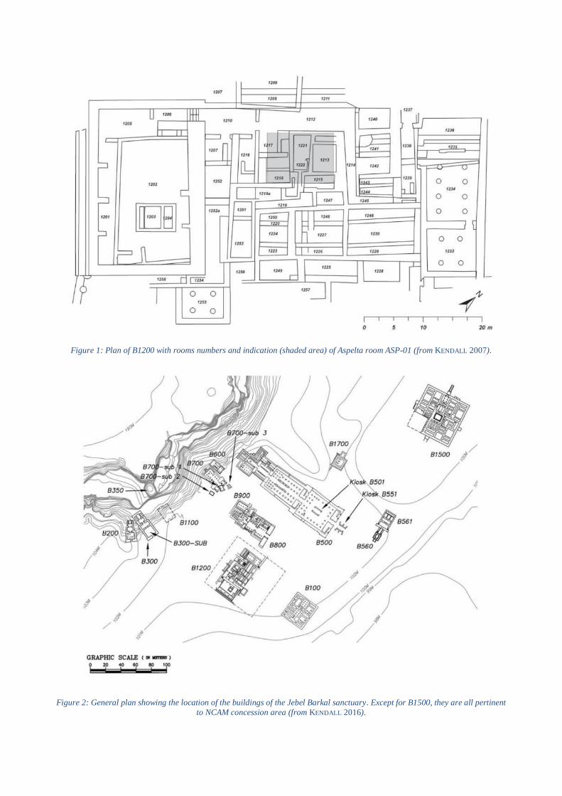
Figure 1: Plan of B1200 with rooms numbers and indication (shaded area) of Aspelta room ASP-01 (from KENDALL 2007).
Figure 2: General plan showing the location of the buildings of the Jebel Barkal sanctuary. Except for B1500, they are all pertinent
to NCAM concession area (from KENDALL 2016).
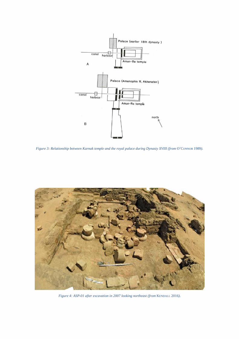
Figure 3: Relationship between Karnak temple and the royal palace during Dynasty XVIII (from O’CONNOR 1989).
Figure 4: ASP-01 after excavation in 2007 looking northeast (from KENDALL 2016).
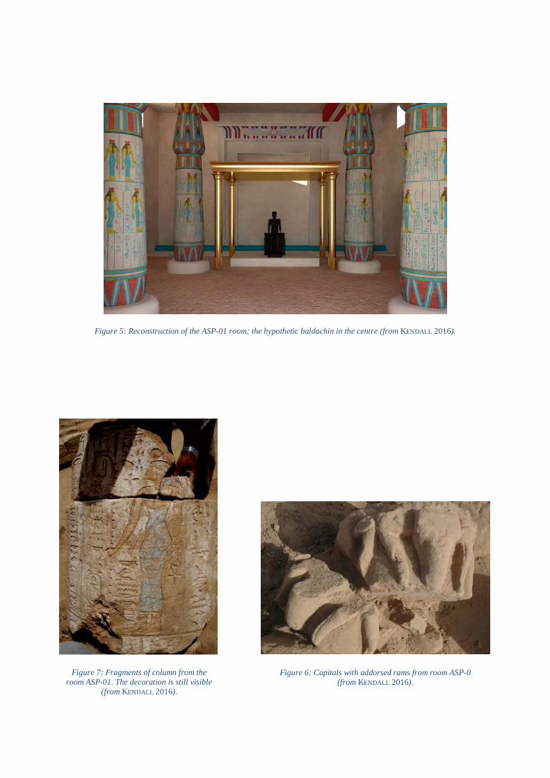
Figure 5: Reconstruction of the ASP-01 room; the hypothetic baldachin in the centre (from KENDALL 2016).
Figure 7: Fragments of column from the
room ASP-01. The decoration is still visible
(from KENDALL 2016).
Figure 6: Capitals with addorsed rams from room ASP-0
(from KENDALL 2016).

Figure 9: Magnetic image showing the real
extension of B1200 (from KENDALL 2014). Figure 8: Fragments of painted plaster from the
ceiling of ASP-01 –reversed and obverse sides
(from KENDALL 2007).
Figure 10: View of the palaces B1200 (foreground) and B100 (background) from the top of Jebel Barkal. The picture was taken in
1919 after the Reisner’s excavations (from KENDALL 2016).

Figure 11: Plan of building B100 with room numbers – derived from Reisner’s notes and measured map. Older structures are visible
in dashed line. In blue are highlighted the accessible rooms (plan from KENDALL 2014, modified by the author).
Figure 12: B100, Photograph taken in 1916 after Reisner’s excavation – view from the South (from KENDALL 2014).
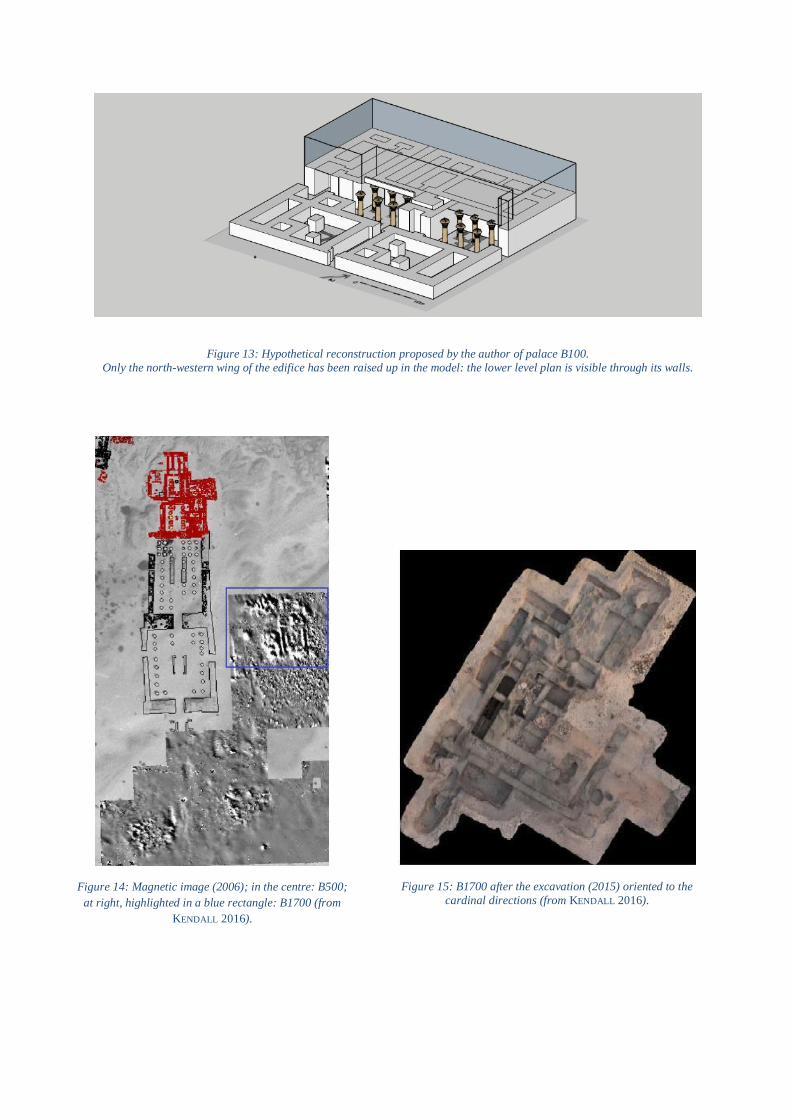
Figure 13: Hypothetical reconstruction proposed by the author of palace B100.
Only the north-western wing of the edifice has been raised up in the model: the lower level plan is visible through its walls.
Figure 14: Magnetic image (2006); in the centre: B500;
at right, highlighted in a blue rectangle: B1700 (from
KENDALL 2016).
Figure 15: B1700 after the excavation (2015) oriented to the
cardinal directions (from KENDALL 2016).
Figure 16: Italian excavations area with structures from B1800 to B2200. The palace B2400’s area can be seen on the right
(from MITCHELL 1996).
Figure 17: Plan of B2400 (from ROCCATI 2014).

Figure 19: Fragment of architrave with denticulated motif from B2400 (photograph: G. Lovera)
Figure 18: Upper left: reconstruction of a column from B2400 (numbers
added by the author); upper right: the fragment of the Ionic capital; on the
left: architectural details of the column (from SIST 2011).

Figure 20: Plans of Muweis (left) and Wad Ben Naga (right) palaces: room clusters are highlighted in distinct colours; blue frame
on the right added by the author (from MAILLOT 2014B).
Figure 21: Plan of the northern area of the site showing the topographical disposition of structures B1500 (left),
B3200 (centre) and B2400 (bottom right). Unpublished.
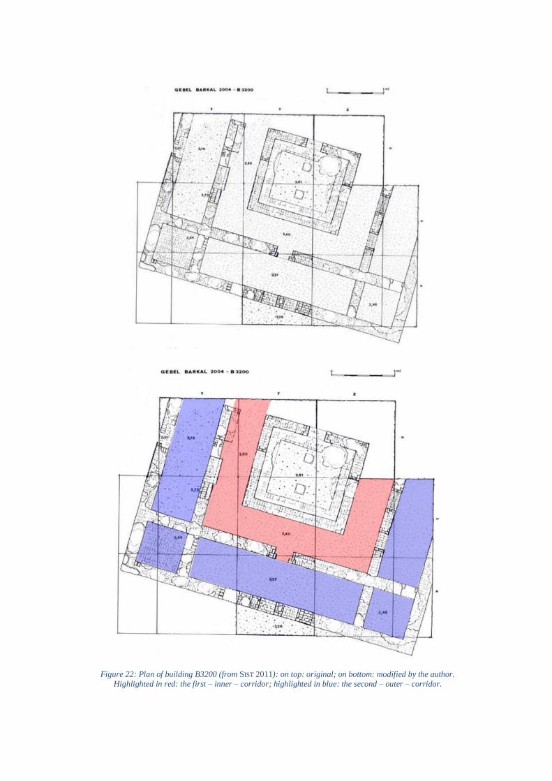
Figure 22: Plan of building B3200 (from SIST 2011): on top: original; on bottom: modified by the author.
Highlighted in red: the first – inner – corridor; highlighted in blue: the second – outer – corridor.

Figure 25: Plan of the palace of Muweis with walls and rooms numbers (from MAILLOT 2014B).
Figure 23: Reconstruction of the architrave related to the door in the eastern wall of the
first corridor (from SIST 2011).
Figure 24: The mud-brick floor inside the south-eastern corner
room of B3200 (from SIST 2011).

Figure 26: B1500 - North entrance, stairway
(original photograph from the excavation). Figure 27: B1500 - Lions statues and fragments of columns found during
the excavation of the northern entrance (photograph G. Lovera).
Figure 28: B1500 - The podium found in 2012 south of the western
entrance of the palace (from REPORT 2012).
Figure 29: B1500 - The lion statue from the southern
entrance (photograph G. Lovera).

Figure 30: The so-called Prudhoe Lions, now at the British Museum (photographs from the British Museum website).
Figure 31 Two clay figurines representing a seated lion found in the palace of Wad Ben Naga (from VERCOUTTER 1962).
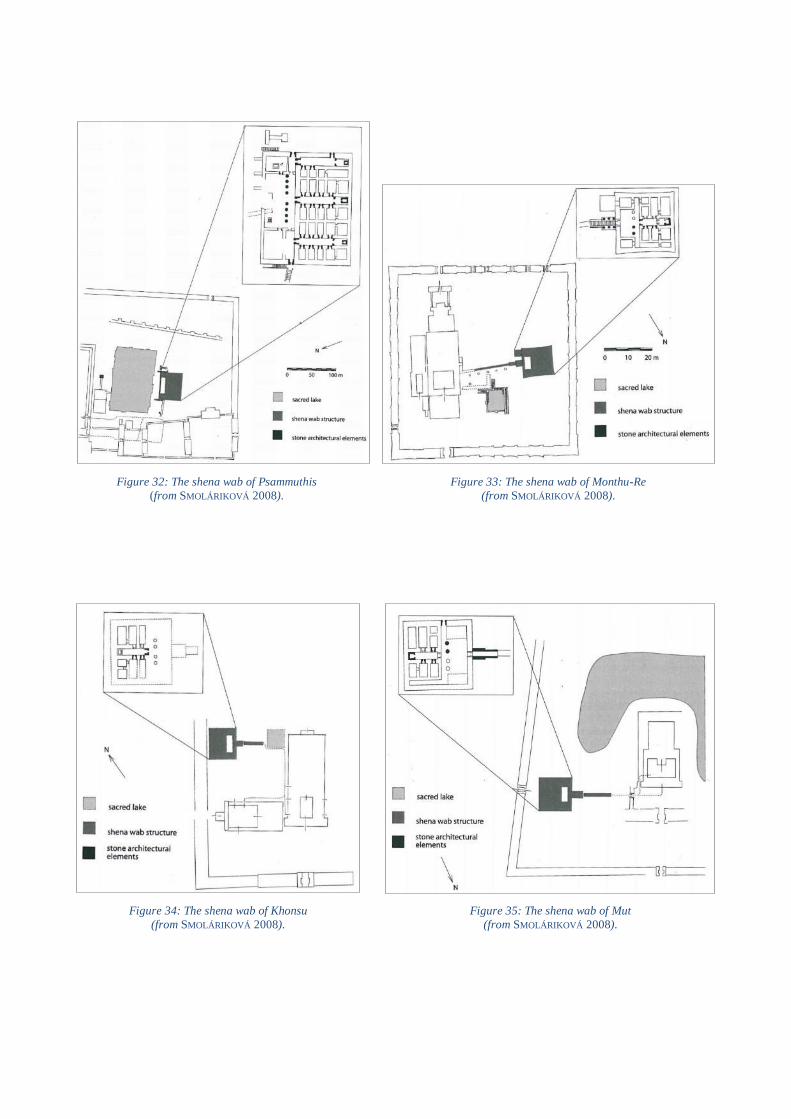
Figure 34: The shena wab of Khonsu
(from SMOLÁRIKOVÁ 2008). Figure 35: The shena wab of Mut
(from SMOLÁRIKOVÁ 2008).
Figure 33: The shena wab of Monthu-Re
(from SMOLÁRIKOVÁ 2008).
Figure 32: The shena wab of Psammuthis
(from SMOLÁRIKOVÁ 2008).

Figure 38: Edifice on platform at Saqqara, plan
(from EMERY 1968).
Figure 37: North-west corner of the temenos at Tanis, plan. The edifice mentioned in the text is visible on the top
(from LECLÈRE 2008).
Figure 36: Map of the Delta showing some of the sites mentioned in the text (from SMOLÁRIKOVÁ 2008).

Figure 39: Abutting element of the platform at Saqqara
(from EMERY 1967). Figure 40: Edifice on platform at Medamud
(from SMOLÁRIKOVÁ 2008).
Figure 41: Edifice on platform at Defenna, plan
(from PETRIE 1888). Figure 42: Great temenos of Naukratis, plan
(from PETRIE 1886).
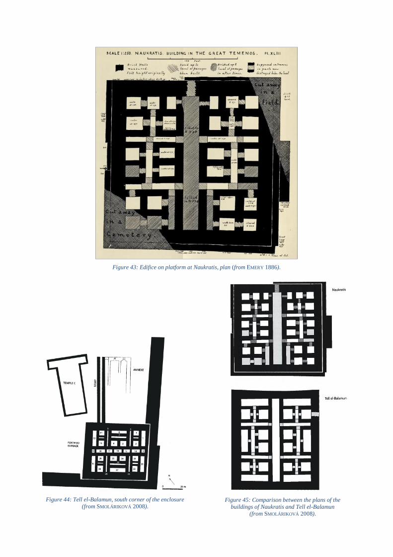
Figure 43: Edifice on platform at Naukratis, plan (from EMERY 1886).
Figure 44: Tell el-Balamun, south corner of the enclosure
(from SMOLÁRIKOVÁ 2008). Figure 45: Comparison between the plans of the
buildings of Naukratis and Tell el-Balamun
(from SMOLÁRIKOVÁ 2008).

Figure 47: Domestic structures (?) at Mendes,
plan (from SMOLÁRIKOVÁ 2008). Figure 48: Domestic structures (?) at Tell el-
Fara’in-Buto, plan (from SMOLÁRIKOVÁ 2008).
Figure 46: Fortified structure at Tell Qedwa, plan
(from SMOLÁRIKOVÁ 2008).
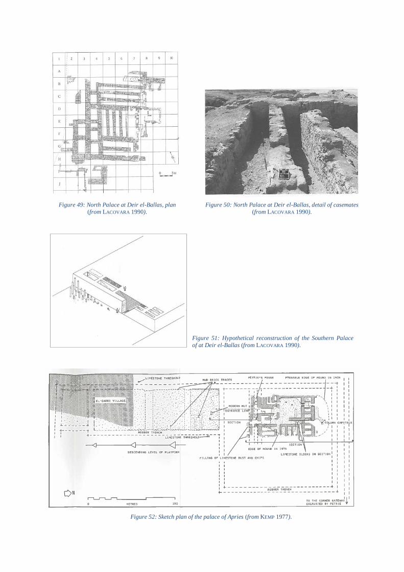
Figure 49: North Palace at Deir el-Ballas, plan
(from LACOVARA 1990). Figure 50: North Palace at Deir el-Ballas, detail of casemates
(from LACOVARA 1990).
Figure 51: Hypothetical reconstruction of the Southern Palace
of at Deir el-Ballas (from LACOVARA 1990).
Figure 52: Sketch plan of the palace of Apries (from KEMP 1977).

Figure 53: Sketch plan of the brick platform at the north end of the palace of Apries (top);
isometric reconstruction (bottom) – (from
KEMP 1977).
Figure 54: Palace district at Tell el-Daba, plan (from
http://www.auaris.at/html/ez_helmi_en.html).
Figure 55: Palace F platform, plan (from
http://www.auaris.at/html/ez_helmi_en.html).
Figure 56: Palace F, reconstruction of the plan of the upper floor
(from http://www.auaris.at/html/ez_helmi_en.html).

Figure 57: Palace G, platform, plan (from
http://www.auaris.at/html/ez_helmi_en.html).
Figure 58: Palace G, reconstruction
of the plan of the upper floor
(from http://www.auaris.at/html/ez_helmi_en.html).
Figure 59: Scheme showing analogies between the right wing of the palace
and the first Thutmosid temples of Medinet Habu (from BIETAK 2005).
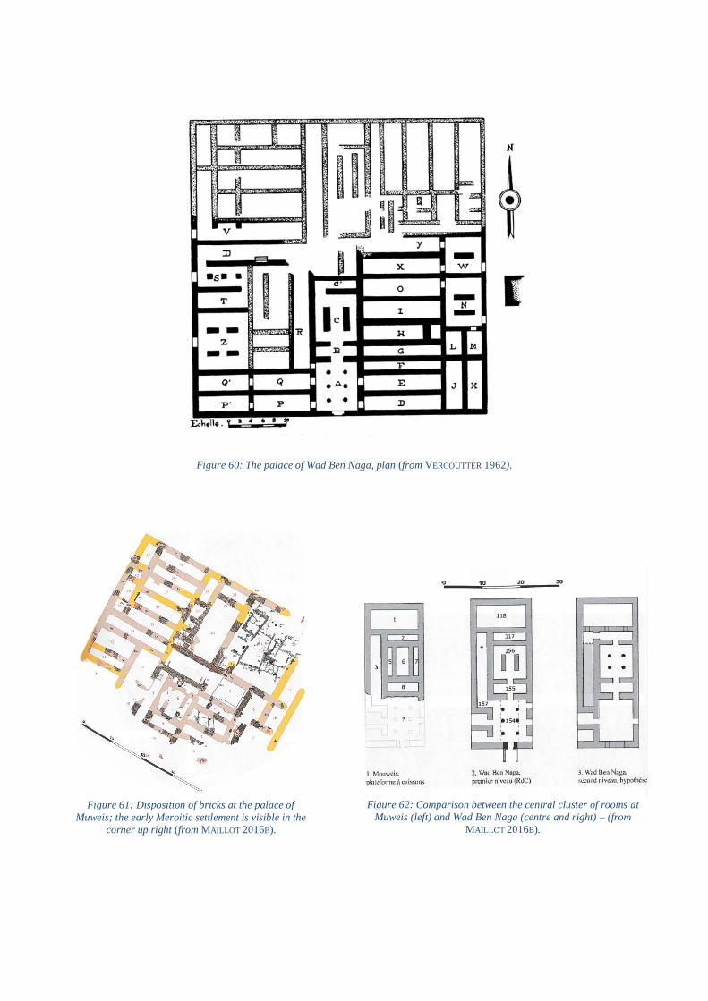
Figure 61: Disposition of bricks at the palace of
Muweis; the early Meroitic settlement is visible in the
corner up right (from MAILLOT 2016B).
Figure 62: Comparison between the central cluster of rooms at
Muweis (left) and Wad Ben Naga (centre and right) – (from
MAILLOT 2016B).
Figure 60: The palace of Wad Ben Naga, plan (from VERCOUTTER 1962).

Figure 64: Meroe, plan of palaces M294-295
(from MAILLOT 2016B).
Figure 66: Palace M750, plan
(from MAILLOT 2016B).
Figure 63: Great enclosure of Meroe with related buildings
(from MAILLOT 2016B).
Figure 65: Plan of the town centre of Meroe (from MAILLOT
2016B).
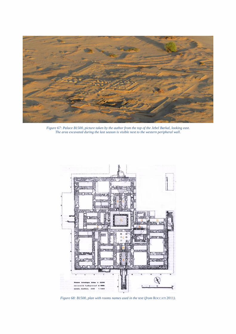
Figure 67: Palace B1500, picture taken by the author from the top of the Jebel Barkal, looking east.
The area excavated during the last season is visible next to the western peripheral wall.
Figure 68: B1500, plan with rooms names used in the text (from ROCCATI 2011).

Figure 69: The exterior decoration of the palace with the two
kinds of lesenas (from REPORT 2012).
Figure 70: Some of tiles originally placed as a decoration on the outer surface of the perimeter wall
(photographs: G. Lovera).
Figure 71: Left: capital in alexandrine style found in 2012 south of the external podium of the west side (from REPORT
2012). Right: Capital with Hellenistic influences from the palace found during the previous campaigns (from SIST 2006).

Figure 72: Hypothetical schematic reconstruction of the plaster-level situation on the western side of
the palace: the level of the coating is marked white on the palace surface and yellow on the podium.
Graphic proposal by the author.
Figure 73: Layer for red bricks at the bottom of the
southern perimeter wall (from REPORT 2011). Figure 74: Stone-lined south-western corner of the palace
(from REPORT 2013).
Figure 75: Plan of B1500
supplemented with recent
(season 2016) orthophotographs
of the newly excavated area
(from REPORT 2016).
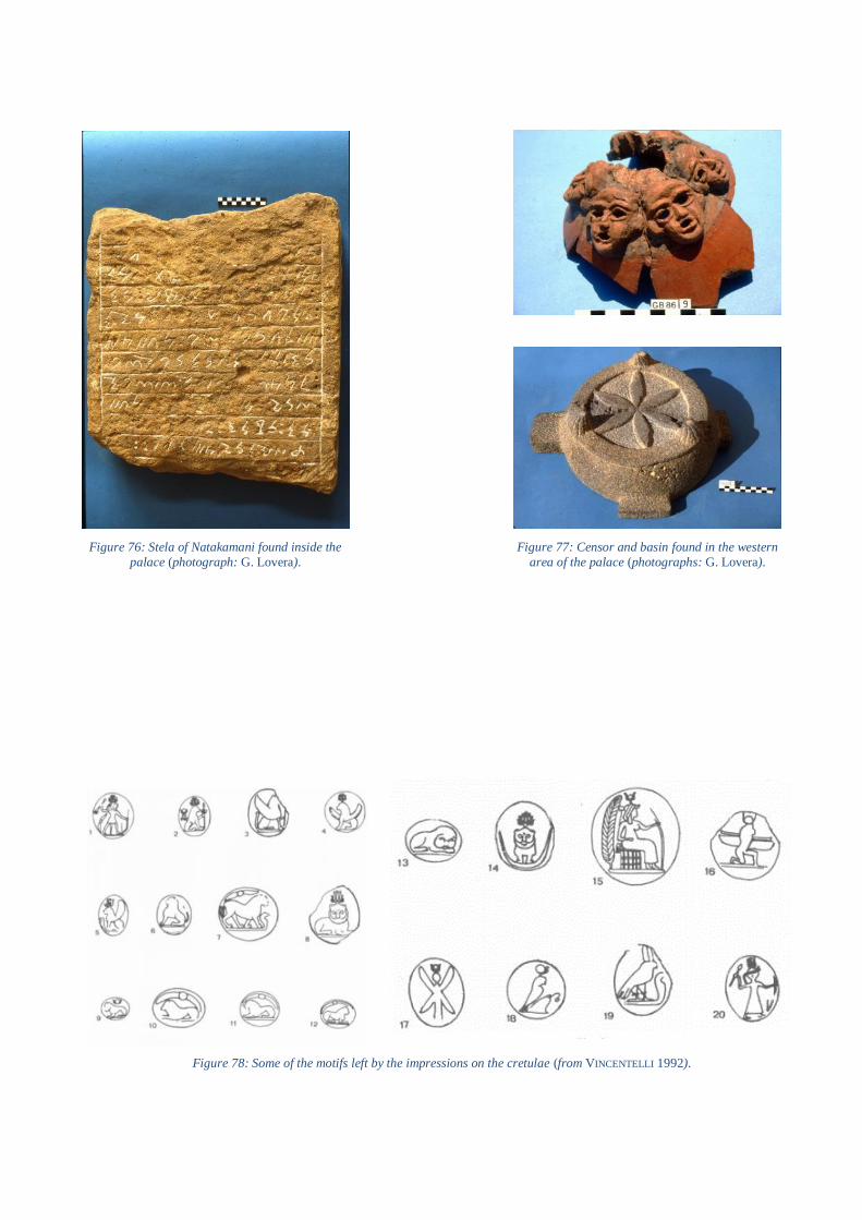
Figure 77: Censor and basin found in the western
area of the palace (photographs: G. Lovera).
Figure 78: Some of the motifs left by the impressions on the cretulae (from VINCENTELLI 1992).
Figure 76: Stela of Natakamani found inside the
palace (photograph: G. Lovera).

Figure 79: Orthophotos showing the so-called “square room” (top) and the later cooking structure (bottom) – (from REPORT 2016).
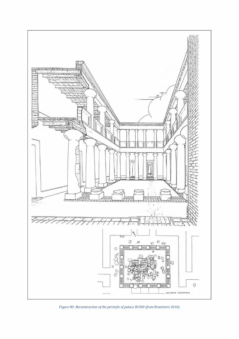
Figure 80: Reconstruction of the peristyle of palace B1500 (from BARBERINI 2010).

Figure 81: Cross-sectional drawing and axonometric view based on the reconstruction of the peristyle of B1500 (from BARBERINI
2010).
Figure 82: Elements of the parapet collapsed in the courtyard, found in situ during the excavation
(from BARBERINI 2010).
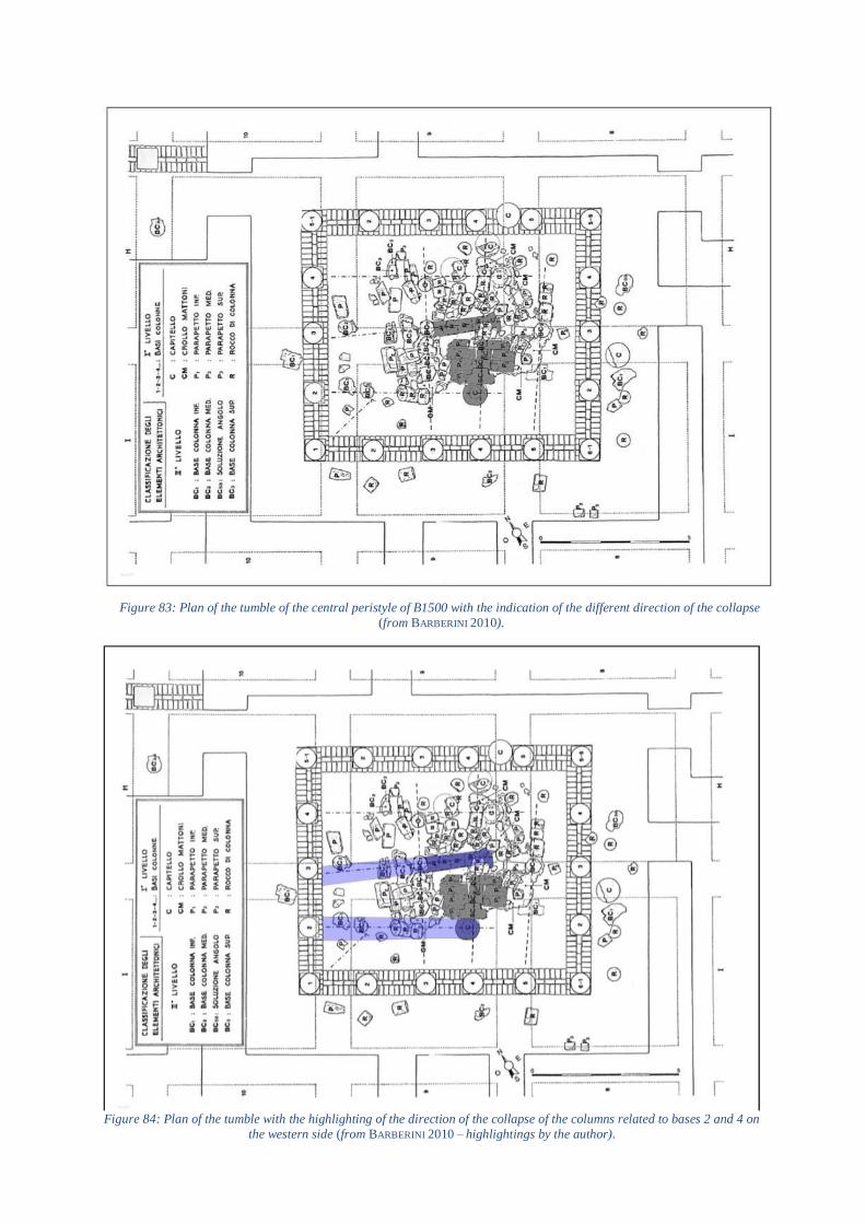
Figure 83: Plan of the tumble of the central peristyle of B1500 with the indication of the different direction of the collapse
(from BARBERINI 2010).
Figure 84: Plan of the tumble with the highlighting of the direction of the collapse of the columns related to bases 2 and 4 on
the western side (from BARBERINI 2010 – highlightings by the author).
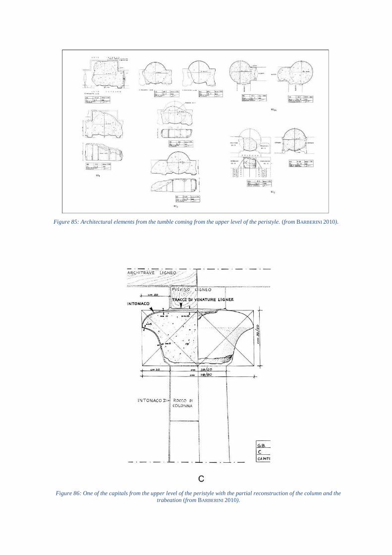
Figure 85: Architectural elements from the tumble coming from the upper level of the peristyle. (from BARBERINI 2010).
Figure 86: One of the capitals from the upper level of the peristyle with the partial reconstruction of the column and the
trabeation (from BARBERINI 2010).

Figure 87: Cross-section through the red-brick wall crowning peristyle (from BARBERINI 2010).
Figure 88: Right: reconstruction of the elements making up a column together with parapet wall of the upper level of the structure. Left: the plan of the tumble with the numbers connecting the elements to the related
original position supposed on the reconstruction (from BARBERINI 2010).

Figure 89: Reconstruction of the so-called palace of Hyrcanus at Araq el-Emir (from NIELSEN 1999).
Figure 90: Axonometric view of the northern access of the palace (from WILL 1996).
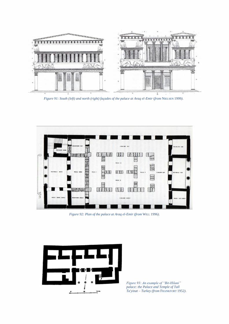
Figure 91: South (left) and north (right) façades of the palace at Araq el-Emir (from NIELSEN 1999).
Figure 92: Plan of the palace at Araq el-Emir (from WILL 1996).
Figure 93: An example of “Bit-Hilani” palace: the Palace and Temple of Tall
Ta'yinat – Turkey (from FRANKFORT 1952).

Figure 95: Ptolemais, general
reconstruction of the palace, view
from North (from PESCE 1950).
Figure 94: Ptolemais, schematic plan of the reconstructed building called “Palazzo delle Colonne” (from PESCE 1950).

Figure 96: Ptolemais, northern façade of the Great Peristyle seen from the inside (from PESCE 1950).
Figure 97: Ptolemais, southern façade of the Great Peristyle seen from the inside (from PESCE 1950).
Figure 98: Ptolemais, cross-sectional drawing of the portion of the palace with the Small Peristyle on the right
(from PESCE 1950).
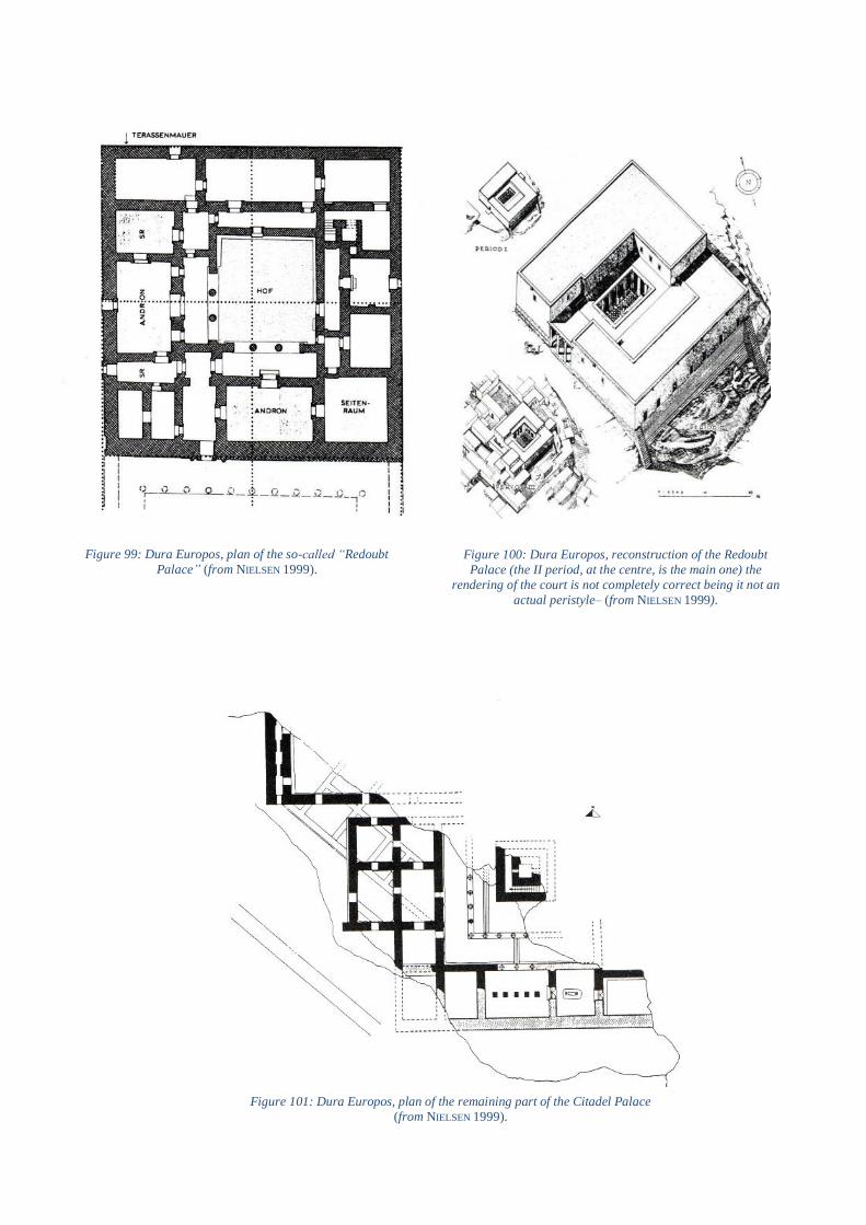
Figure 99: Dura Europos, plan of the so-called “Redoubt
Palace” (from NIELSEN 1999).
Figure 101: Dura Europos, plan of the remaining part of the Citadel Palace
(from NIELSEN 1999).
Figure 100: Dura Europos, reconstruction of the Redoubt
Palace (the II period, at the centre, is the main one) the
rendering of the court is not completely correct being it not an
actual peristyle– (from NIELSEN 1999).

Figure 103: Vergina, reconstruction drawing of the royal palace, view from North (from NIELSEN 1999).
Figure 102: Vergina, plan of the palace (from NIELSEN 1999).

Figure 104: Pella, plan of the royal palace (from NIELSEN 1999).
Figure 105: Pella, plan of the sector of the palace characterized by Peristyle I: reconstructed plan on
the top; plan from the excavation on the bottom
(from NIELSEN 1999).
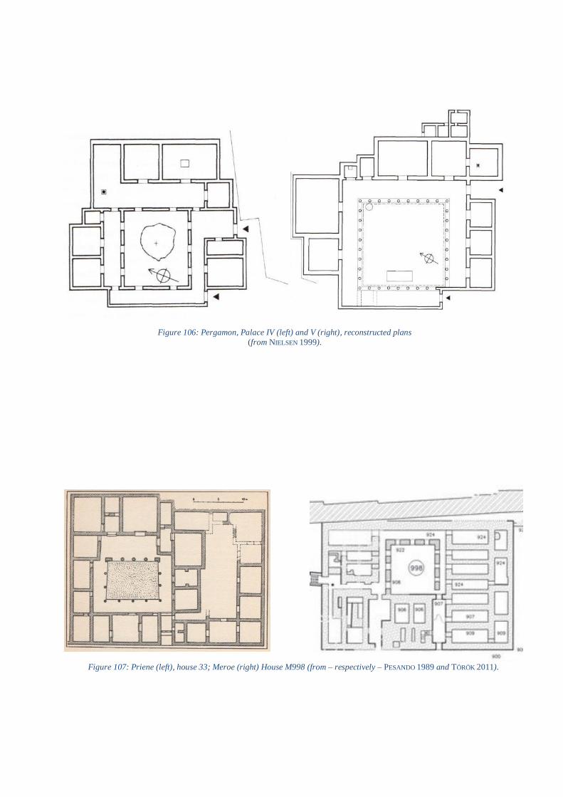
Figure 106: Pergamon, Palace IV (left) and V (right), reconstructed plans
(from NIELSEN 1999).
Figure 107: Priene (left), house 33; Meroe (right) House M998 (from – respectively – PESANDO 1989 and TÖRÖK 2011).

Figure 108: Philadelphia, plan of one of the houses of the insula D 6 (from DAVOLI 1998).
Figure 109: Theadelphia, plan of a private house (from DAVOLI 1998).

Figure 110: Narmouthis, plan of edice, probably with an official character: top,
original layout; bottom, later modifications (from DAVOLI 1998).

Generel map of the Nubian Territory (from Sudan&Nubia 2015, 19).
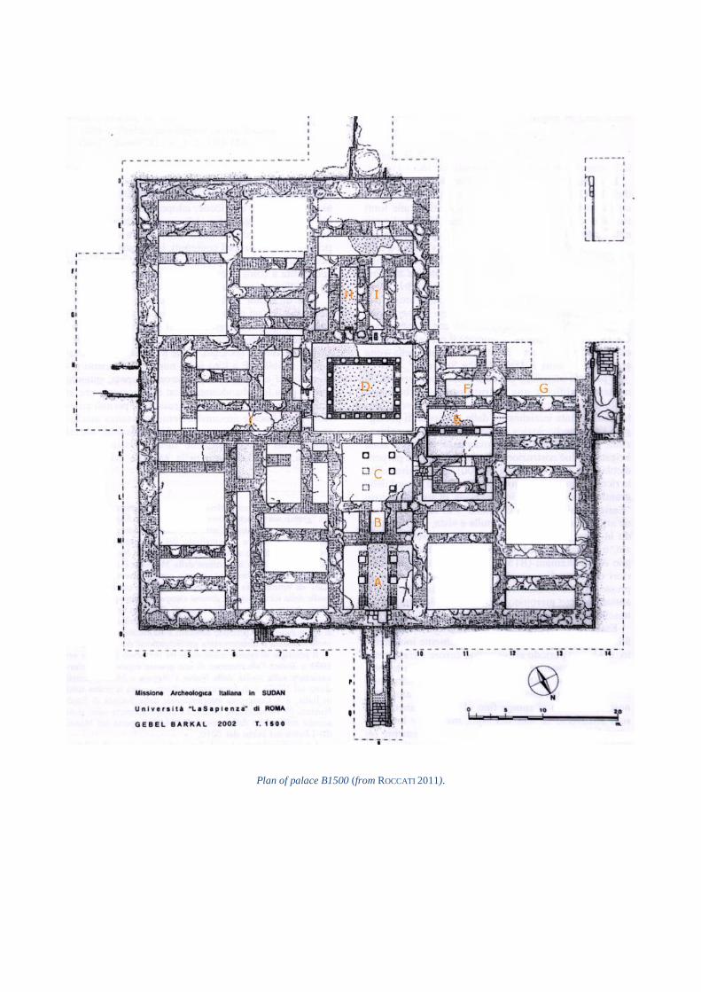
Plan of palace B1500 (from ROCCATI 2011).
General map showing the location of the Hellenistic sites mentioned in the text (from NIELSEN 1999).